gadgil-understanding indian monsoon
DESCRIPTION
Understanding Indian Monsoon and its variability by Sulochana GadgilTRANSCRIPT
Understanding the Indian monsoon and
its variability
Sulochana Gadgil
Clouds, climate and Tropical Meteorology
ICTS,CAOS
23 January 2013
• In India, the word monsoon in
common parlance refers to the
system that visits the continent every
year and gives us rain.
• The commencement of the ‘rainy
season’ is associated with the onset
of the monsoon and the end of the
rainy season with the retreat of the
monsoon.
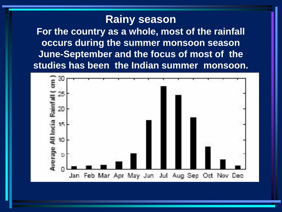
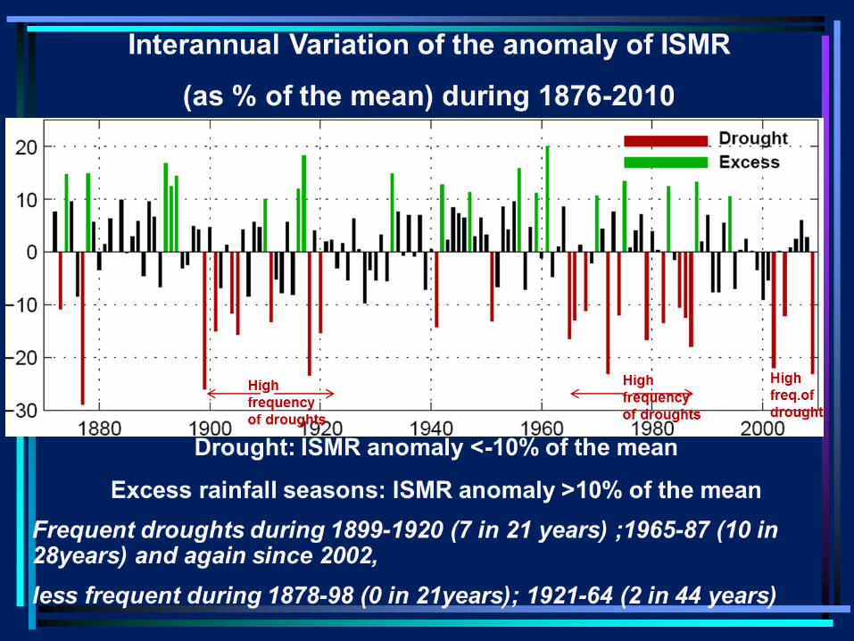
Rainy season For the country as a whole, most of the rainfall
occurs during the summer monsoon season
June-September and the focus of most of the
studies has been the Indian summer monsoon.
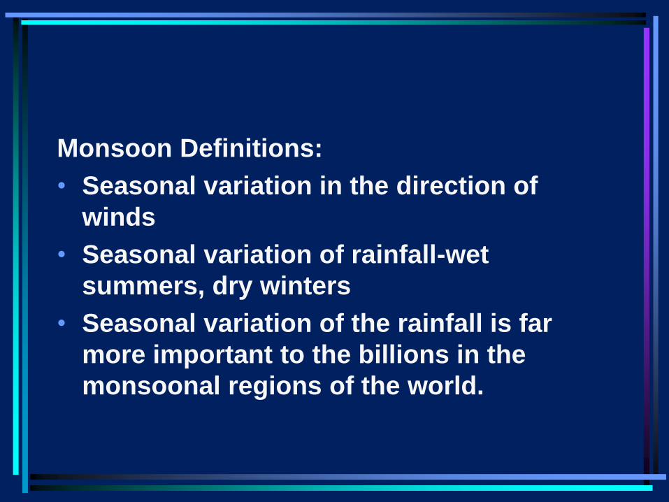
Monsoon Definitions:
• Seasonal variation in the direction of
winds
• Seasonal variation of rainfall-wet
summers, dry winters
• Seasonal variation of the rainfall is far
more important to the billions in the
monsoonal regions of the world.
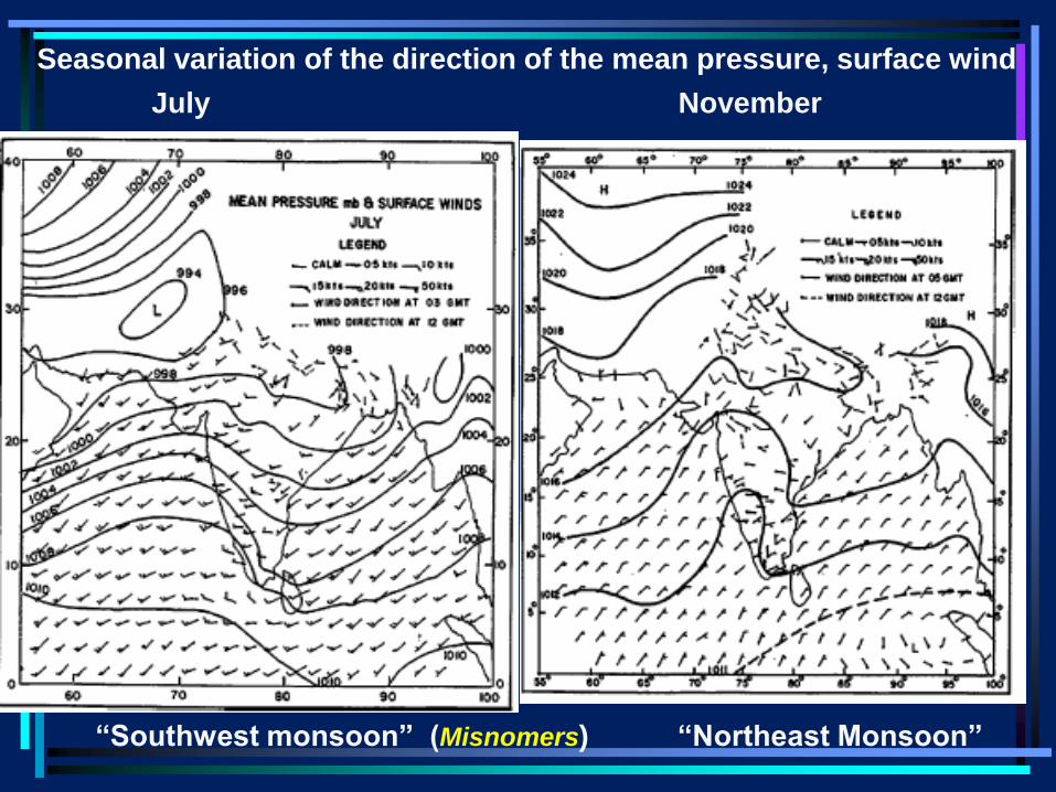
“Southwest monsoon” (Misnomers) “Northeast Monsoon”
July November
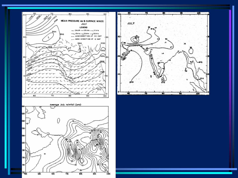
Seasonal variation of the direction of the mean pressure, surface wind
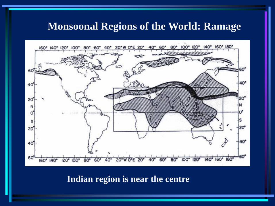
Indian region is near the centre
Monsoonal Regions of the World: Ramage
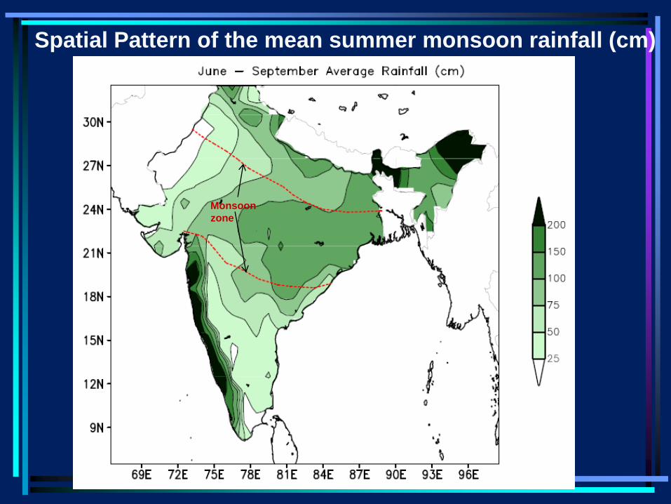
Spatial Pattern of the mean summer monsoon rainfall (cm)
Monsoon
zone
•It is seen that the mean rainfall pattern during the
summer monsoon is characterized by a major rain-
belt over the ‘monsoon zone’ (marked by the red-
dashed line), with the rainfall decreasing
northwestward from the maximum over the eastern
part. Identifying the system responsible for this
large-scale monsoon rainfall has been addressed
since 1686. I shall talk about our understanding of
this critical issue today.
•In addition, heavy rainfall occurs along the west
coast of the peninsula and over the northeastern
region.
•.
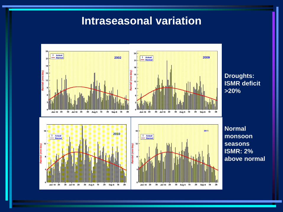
Intraseasonal variation
2010
Droughts:
ISMR deficit
>20%
Normal
monsoon
seasons
ISMR: 2%
above normal
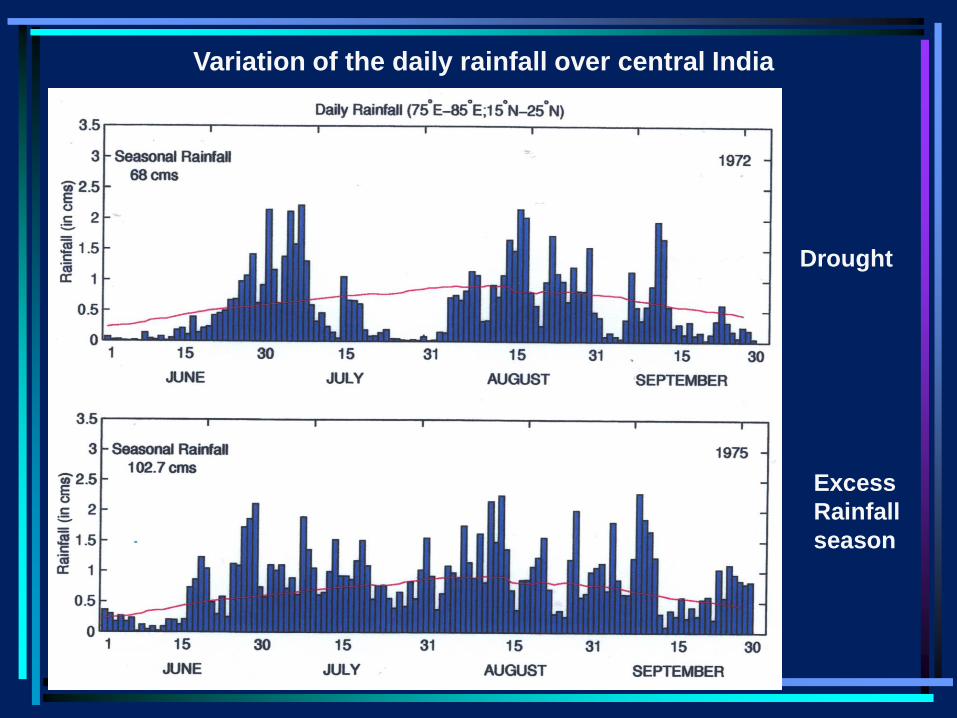
Variation of the daily rainfall over central India
Drought
Excess
Rainfall
season
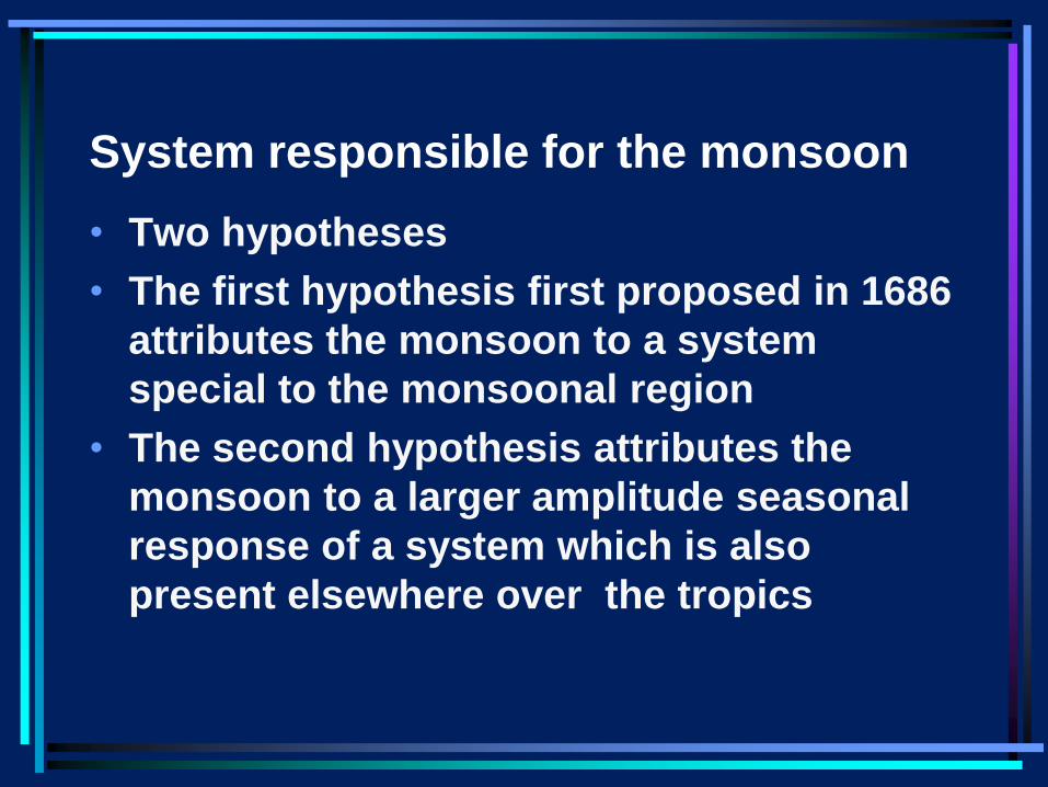
System responsible for the monsoon
• Two hypotheses
• The first hypothesis first proposed in 1686
attributes the monsoon to a system
special to the monsoonal region
• The second hypothesis attributes the
monsoon to a larger amplitude seasonal
response of a system which is also
present elsewhere over the tropics
First Hypothesis Over three hundred years ago, in 1686, Edmund
Halley (better known for the comet named after him) published a paper entitled
“An historical account of the trade-winds and monsoons observable in the seas between and near the tropics with an attempt to assign the physical cause of the said winds”
Phil. Trans. Roy. Soc. London vol16, p153-168 (1686)
in which he suggested that the primary cause of the monsoon was the differential heating between ocean and land.
Differential heating, according to Halley, would cause pressure differences in the atmosphere and winds blowing from the high pressure to the low pressure.
• Halley and many scientists after him considered
the monsoon to be a gigantic land-sea breeze in
which the ascent of air (and hence clouds and
rainfall) over the heated land is generated by the
land-ocean temperature contrast.
• In 1735 Hadley modified the theory to incorporate
the impact of the Coriolis force arising from the
rotation of the earth, (which is important for the
spatial scales of thousands of kilometers
characterizing the monsoon circulation) on the
direction of the winds .
• Thus the zeroth order model is
Monsoon – A Gigantic Land-Sea Breeze?
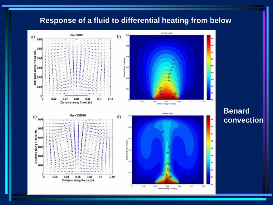
Response of a fluid to differential heating from below
Benard
convection
Implications for variability: expect the
ascent/rainfall to increase with increasing land-
ocean temperature contrast.
However, observations of the space-time variations
of the monsoon over the Indian region are not
consistent with this expectation.
This was first pointed out by G. Simpson
(‘The South-West Monsoon’, QJRMS, Vol.17,
pp.150–73, 1921 ). In his words
“I believe very few educated people would have any
difficulties in giving an answer to the question what
is the cause of the monsoon?
• They would refer to the high temperature over the
land compared with that over the surrounding
seas; would speak of ascending currents of air
causing an indraft of sea-air towards the interior
of the country.
• It is only when one points out that India is much
hotter in May before the monsoon sets in than in
July , when it is at its height – or draws attention
to the fact that the hottest part of India – the
northwest gets no rain at all during the monsoon
–
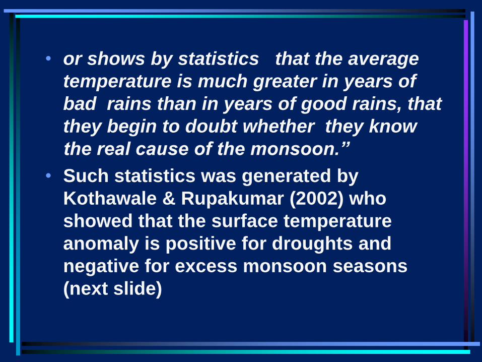
• or shows by statistics that the average
temperature is much greater in years of
bad rains than in years of good rains, that
they begin to doubt whether they know
the real cause of the monsoon.”
• Such statistics was generated by
Kothawale & Rupakumar (2002) who
showed that the surface temperature
anomaly is positive for droughts and
negative for excess monsoon seasons
(next slide)
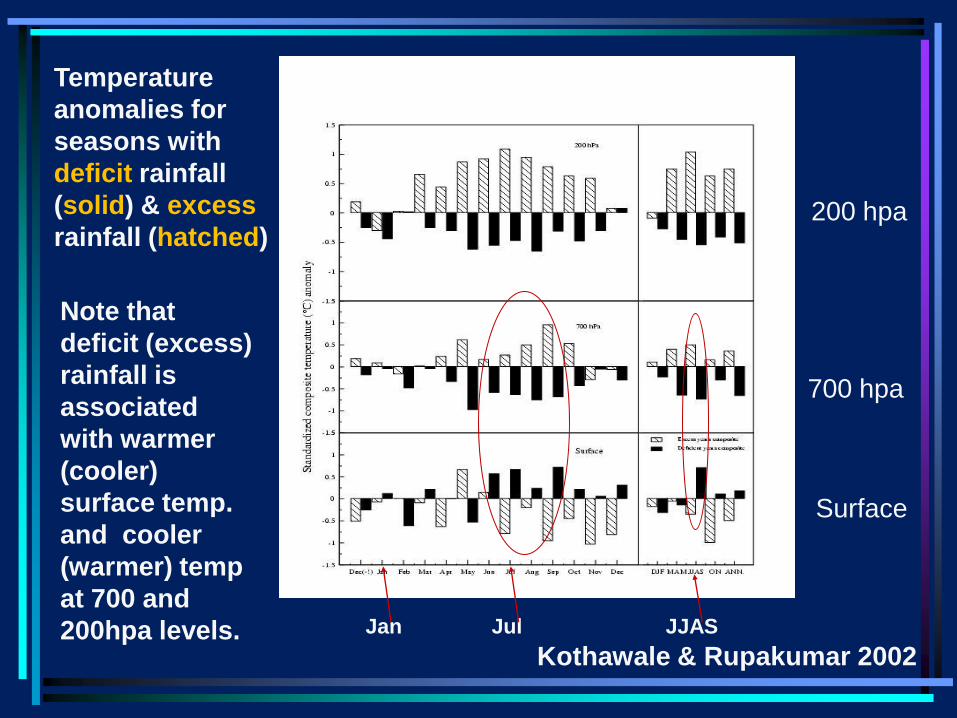
Temperature
anomalies for
seasons with
deficit rainfall
(solid) & excess
rainfall (hatched) 200 hpa
700 hpa
Surface
Note that
deficit (excess)
rainfall is
associated
with warmer
(cooler)
surface temp.
and cooler
(warmer) temp
at 700 and
200hpa levels. Jan Jul JJAS
Kothawale & Rupakumar 2002
This is consistent with our experience in the rainy
season, that days without rain are hotter than rainy
days. Clearly, rather than the land surface
temperature determining the amount of rainfall via the
impact on the difference between land and ocean
temperature, the land temperature is determined by
the rainfall (or lack thereof).
Thus, the observations suggest that the land surface
temperature varies in response to the variation in
rainfall and it is not appropriate to consider land-
ocean temperature contrast as a cause of the
monsoon rains. In other words, the observations are
not consistent with the land-sea breeze hypothesis.
Several scientists, to this day consider the
differential heating between land and ocean to be
the primary cause of the monsoon.
For example :
1. ‘The elementary monsoon’ by P J Webster in
‘Monsoons’ edited by J. Fein and Pamela Stephens
Wiley- Interscience 1987;
2.‘Effect of tropical topography on global climate’
by G. A. Meehl, Ann. Rev. Earth Planet. Sci 1992
It is also thus discussed included in most textbooks
e.g. James, I. N. Introduction to circulating
atmospheres, Cambridge University Press 1994
Webster* (1987) considered the zeroth order
model of the monsoon to be a response to
the differential heating associated with land-
ocean temperature contrast.
Then he added the effects of moisture and
rotation.
*‘The elementary monsoon’ P J Webster
(1987) in Monsoons edited by Fein and
Stephens.
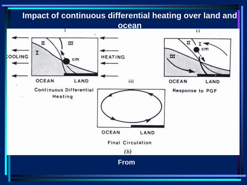
Impact of continuous differential heating over land and
ocean
From
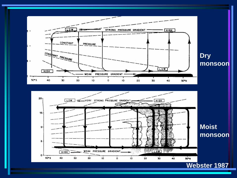
Dry
monsoon
Moist
monsoon
Webster 1987
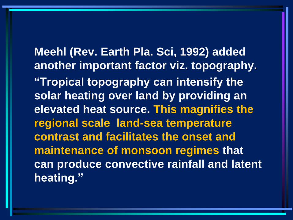
Meehl (Rev. Earth Pla. Sci, 1992) added
another important factor viz. topography.
“Tropical topography can intensify the
solar heating over land by providing an
elevated heat source. This magnifies the
regional scale land-sea temperature
contrast and facilitates the onset and
maintenance of monsoon regimes that
can produce convective rainfall and latent
heating.”
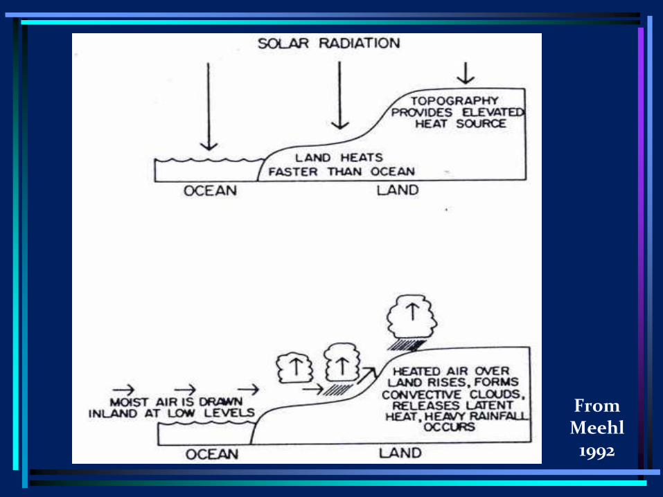
From Meehl
1992
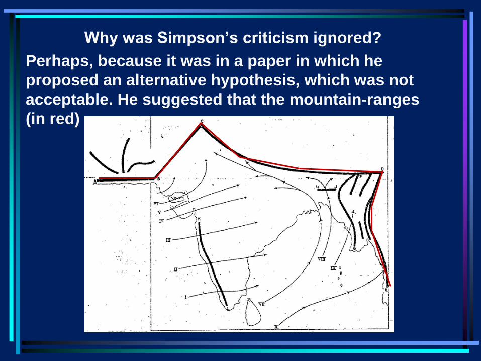
Why was Simpson’s criticism ignored?
Perhaps, because it was in a paper in which he
proposed an alternative hypothesis, which was not
acceptable. He suggested that the mountain-ranges
(in red)
are equivalent to two sides of a box into which the
air streams through the other two sides. There are
no openings in these two sides.
According to him ‘the heavy rain (characterizing the
monsoon) is caused by the inflow of large
quantities of damp warm air into a region where, on
account of the peculiar distribution of mountain
ranges, it is forced to ascend and in consequence
deposit its moisture as rain.’
The actual temperature over the Indian land area is
not directly responsible for the ascensial currents
which cause the rain; on the contrary in the regions
where the rainfall is prevented, the temperature is
abnormally high, while the greatest rainfall is
accompanied by low temperatures.’
In any event, Simpson’s valid criticism of
the land-sea breeze model for the monsoon
appears to have been ignored by almost all
the scientists.
Not surprisingly, in several papers (e.g.
Ramanathan et al for aerosol impact) it is
claimed that since there is an impact on the
land-sea temperature contrast, there will be
an impact on the Indian monsoon.
Alternative hypothesis
• According to the second hypothesis, the
monsoon is a manifestation of the seasonal
variation of the tropical circulation in response to
the seasonal variation of the solar radiation.
• The monsoon is attributed to the seasonal
migration of the ITCZ (a la Charney) or the
equatorial trough (a la Riehl) or near equatorial
trough (a la Ramage) i.e. rising limb of the Hadley
cell, onto the monsoonal region in the summer.
• I believe that this was Charney and Riehl’s
perception of the monsoon since 1970s.
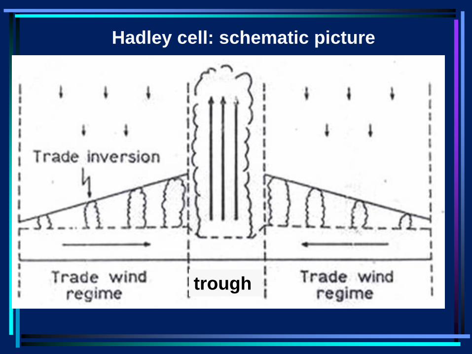
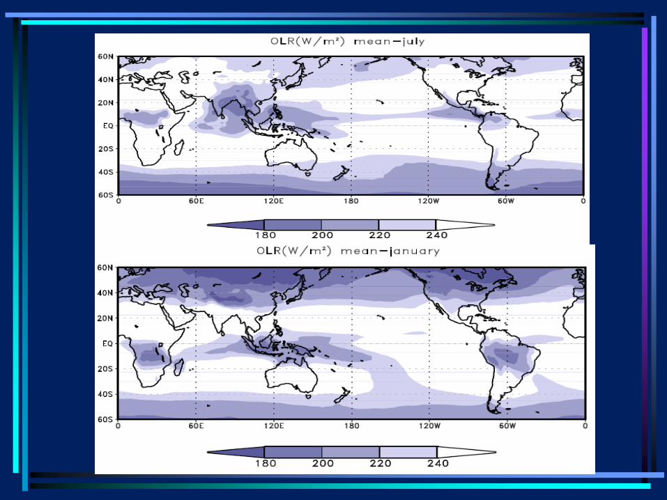
Hadley cell: schematic picture
trough
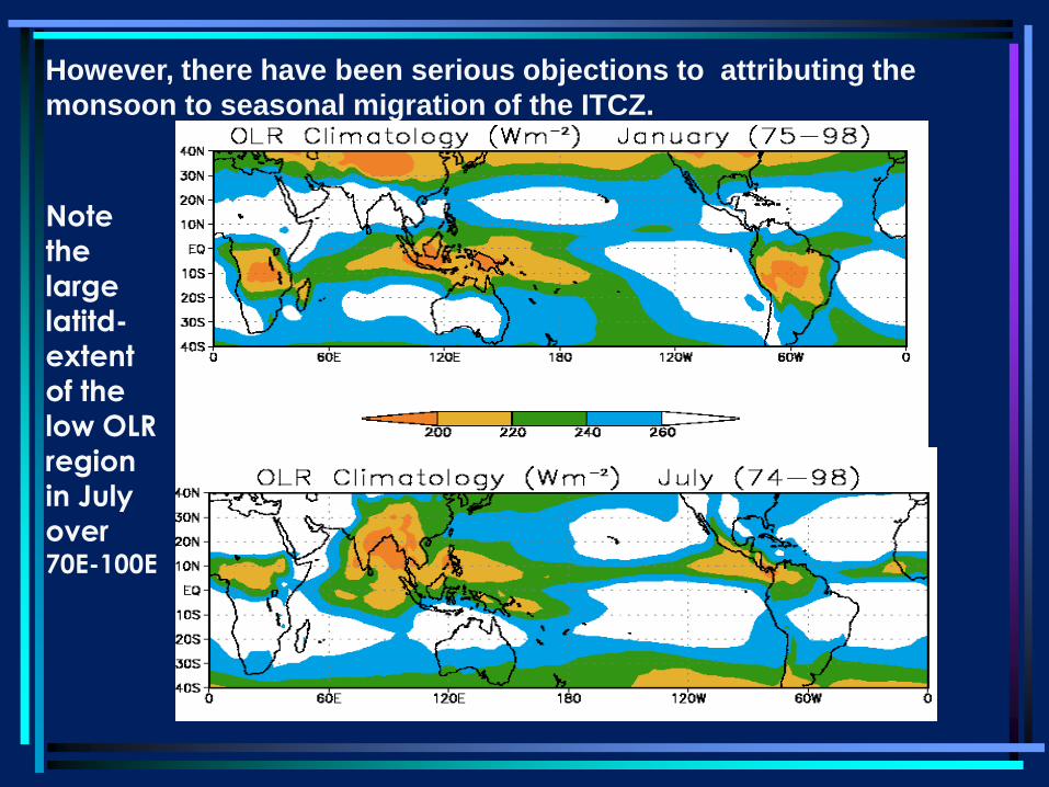
Note
the
large
latitd-
extent
of the
low OLR
region
in July
over 70E-100E
However, there have been serious objections to attributing the
monsoon to seasonal migration of the ITCZ.
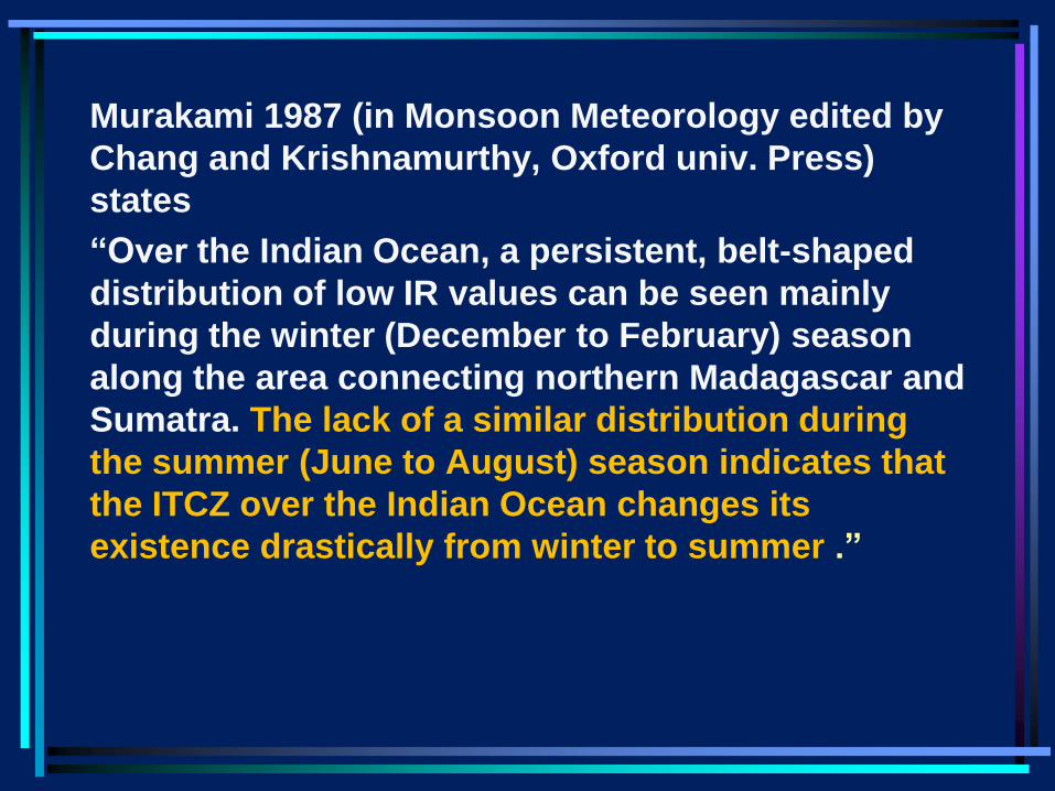
Murakami 1987 (in Monsoon Meteorology edited by
Chang and Krishnamurthy, Oxford univ. Press)
states
“Over the Indian Ocean, a persistent, belt-shaped
distribution of low IR values can be seen mainly
during the winter (December to February) season
along the area connecting northern Madagascar and
Sumatra. The lack of a similar distribution during
the summer (June to August) season indicates that
the ITCZ over the Indian Ocean changes its
existence drastically from winter to summer .”
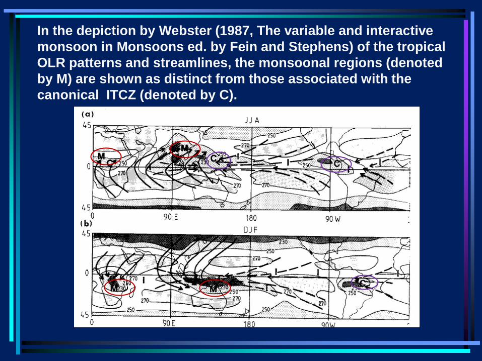
In the depiction by Webster (1987, The variable and interactive
monsoon in Monsoons ed. by Fein and Stephens) of the tropical
OLR patterns and streamlines, the monsoonal regions (denoted
by M) are shown as distinct from those associated with the
canonical ITCZ (denoted by C).
Asian monsoon
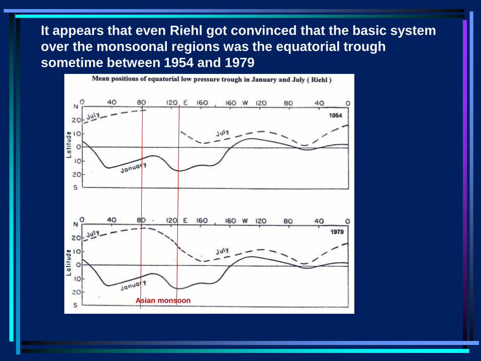
It appears that even Riehl got convinced that the basic system
over the monsoonal regions was the equatorial trough
sometime between 1954 and 1979
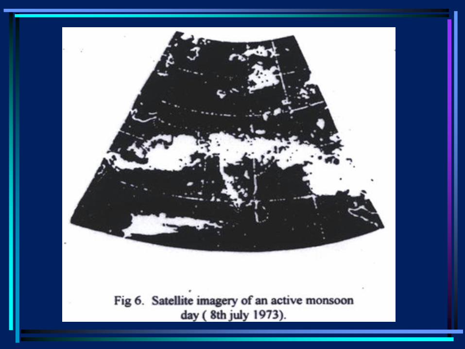
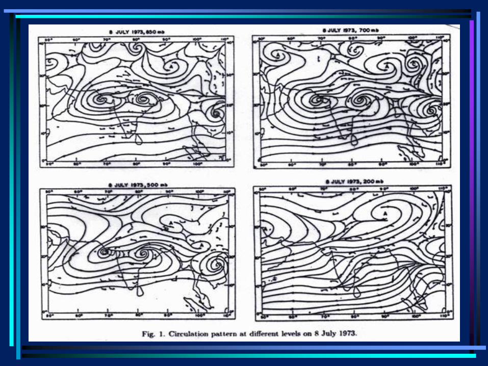
• Sikka and Gadgil’s* (1980) study of the daily (i)
satellite imagery over the Indian longitudes and
(ii) the variation of the 700 mb trough, an
important feature of the monsoon circulation
which is associated with moist convection,
showed that the organized moist convection
associated with the monsoon trough can be
attributed to a continental ITCZ over the region.
• *Sikka DR and Sulochana Gadgil, 1980. On the
maximum cloud zone and the ITCZ over India
longitude during the Southwest monsoon. Mon.
Weather Rev.,108, 1840-53
Indian monsoon
• Sikka and Gadgil (henceforth SG) showed that:
• (i) In satellite imagery the cloud-band over the
Indian region during the summer monsoon looks
very similar to that associated with the classic
ITCZ over the Pacific and also that over the
equatorial Indian Ocean in the pre-Monsoon
(April) .

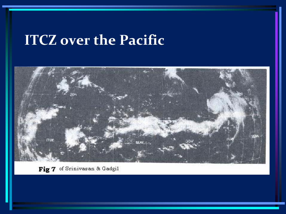
ITCZ over the Pacific
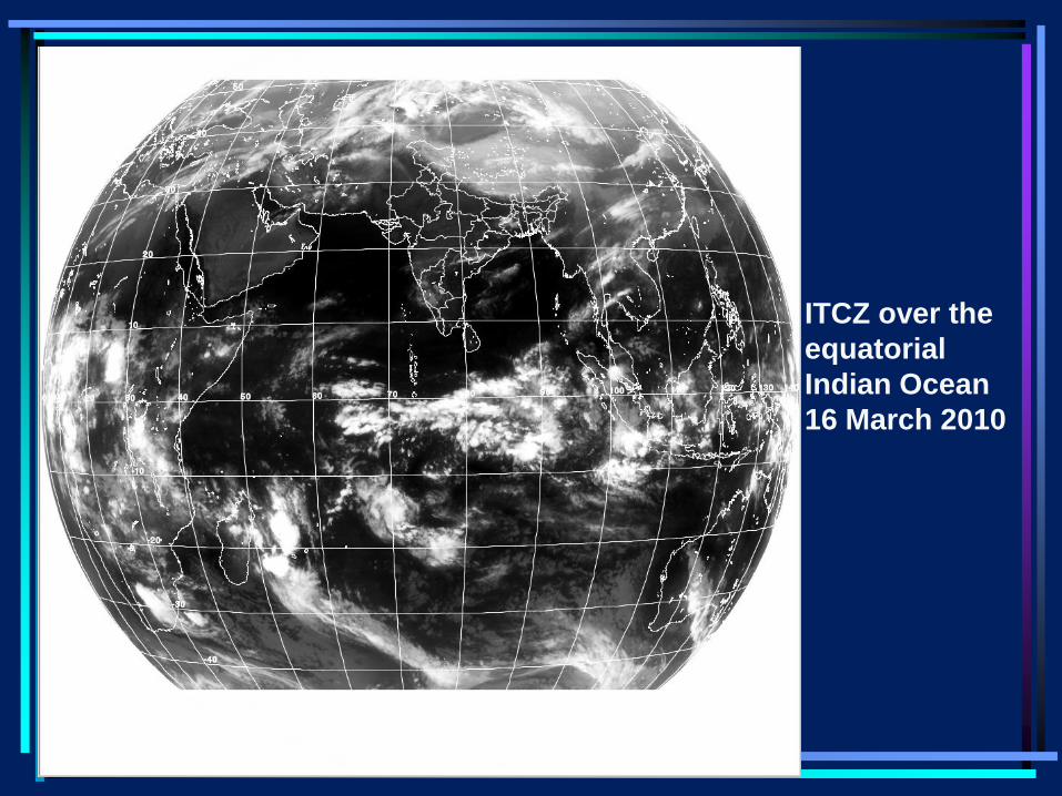
ITCZ over the
equatorial
Indian Ocean
16 March 2010
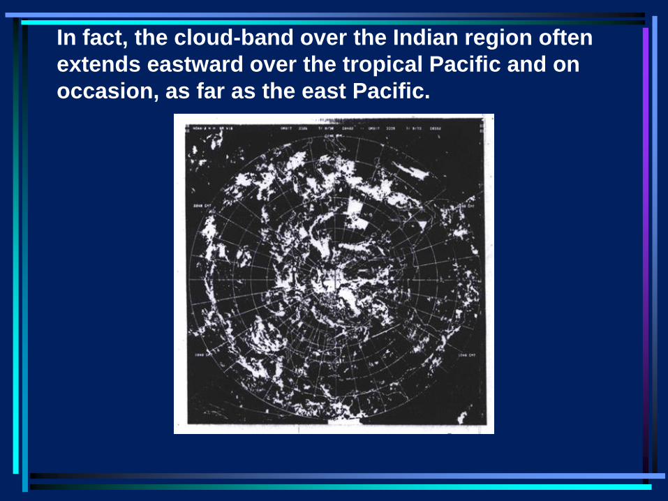
In fact, the cloud-band over the Indian region often
extends eastward over the tropical Pacific and on
occasion, as far as the east Pacific.
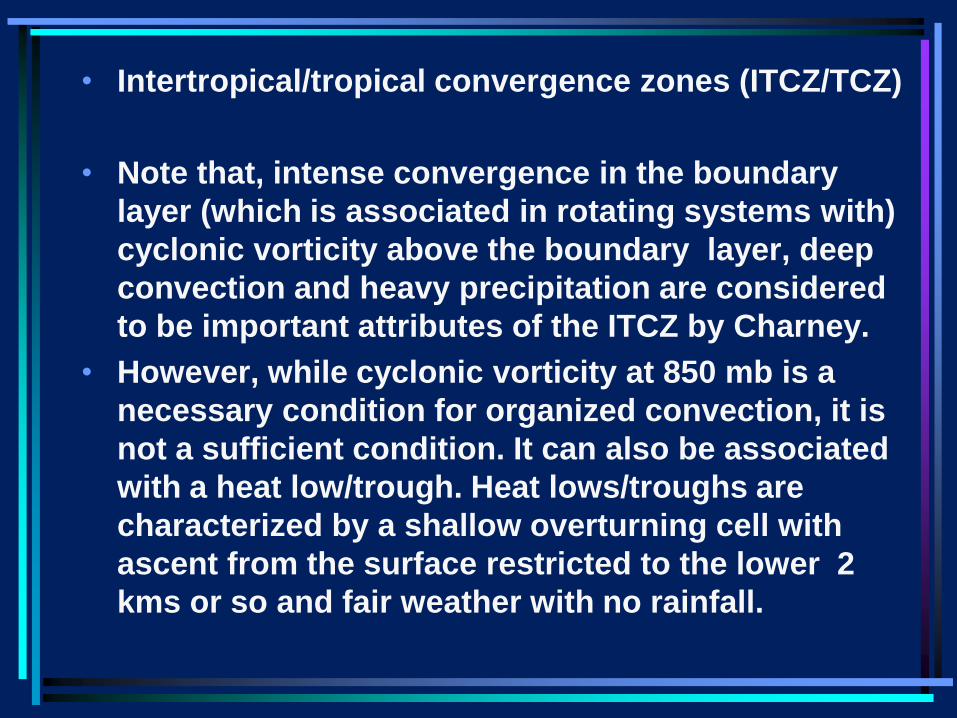
• Intertropical/tropical convergence zones (ITCZ/TCZ)
• Note that, intense convergence in the boundary
layer (which is associated in rotating systems with)
cyclonic vorticity above the boundary layer, deep
convection and heavy precipitation are considered
to be important attributes of the ITCZ by Charney.
• However, while cyclonic vorticity at 850 mb is a
necessary condition for organized convection, it is
not a sufficient condition. It can also be associated
with a heat low/trough. Heat lows/troughs are
characterized by a shallow overturning cell with
ascent from the surface restricted to the lower 2
kms or so and fair weather with no rainfall.
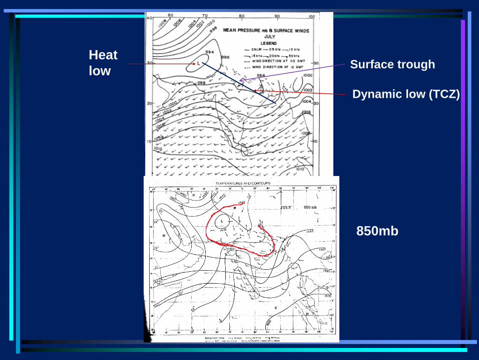
Heat
low
Dynamic low (TCZ)
Surface trough
850mb
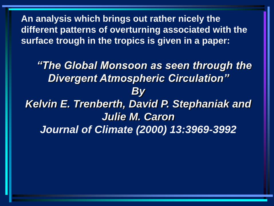
An analysis which brings out rather nicely the
different patterns of overturning associated with the
surface trough in the tropics is given in a paper:
“The Global Monsoon as seen through the
Divergent Atmospheric Circulation”
By
Kelvin E. Trenberth, David P. Stephaniak and
Julie M. Caron
Journal of Climate (2000) 13:3969-3992
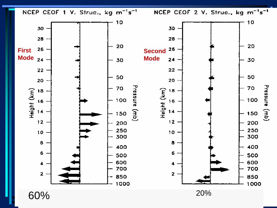
60% 20%
First
Mode Second
Mode
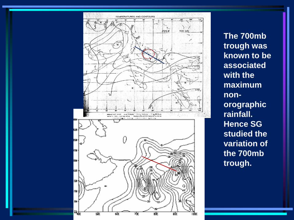
The 700mb
trough was
known to be
associated
with the
maximum
non-
orographic
rainfall.
Hence SG
studied the
variation of
the 700mb
trough.
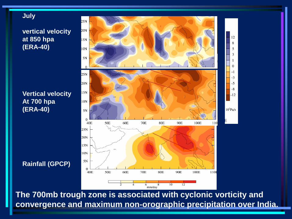
July
vertical velocity
at 850 hpa
(ERA-40)
Vertical velocity
At 700 hpa
(ERA-40)
Rainfall (GPCP)
The 700mb trough zone is associated with cyclonic vorticity and
convergence and maximum non-orographic precipitation over India.
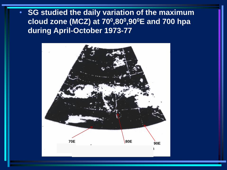
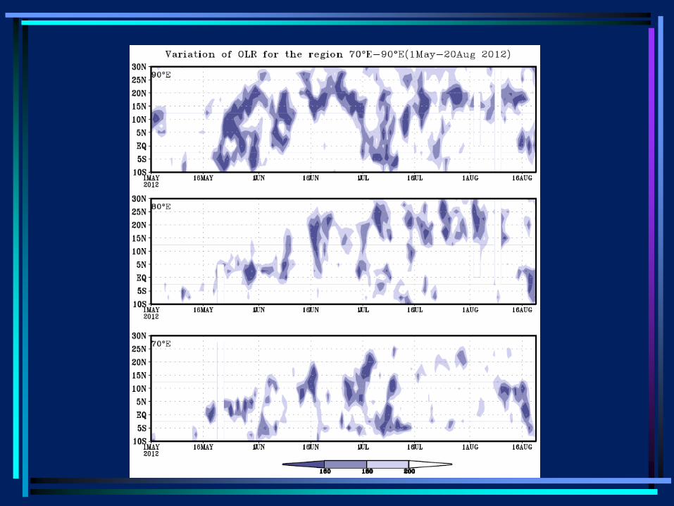
• SG studied the daily variation of the maximum
cloud zone (MCZ) at 700,800,900E and 700 hpa
during April-October 1973-77
90E 70E 80E
• The MCZ is taken to be that cloud band which
has the maximum brightness, which is
predominantly zonal, and has a longitudinal
extent of at least 100 (e.g. next slide).
• Daily values of the latitudes of the northern limit
the axis and the southern limit of the MCZ were
read off at longitudes 700,800,900E from the cloud
mosaics for the period April to October for 1973-
1977.
• The latitudinal position of the 700 mb trough at
these longitudes was obtained from the daily
weather charts prepared by the Poona Weather
Central of IMD. The 700hpa level was chosen so
that the heat trough at lower levels were not
included.
• Important results
• I: Firstly, during June-September, there are two
favourable locations for the cloud bands, one
over the heated subcontinent and another over
the warm waters of the equatorial Indian Ocean.
• The low-frequency belt between 7and 130 N
separates the northern MCZ from the southern
one. SG took the minimum occurrence along 900E
in this band i.e. 70N in June and September and
130 and 110 in July and August, respectively, as
the dividing latitude between the two MCZs.
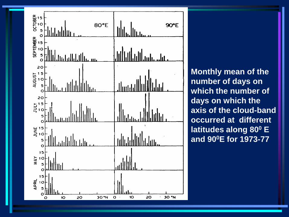
Monthly mean of the
number of days on
which the number of
days on which the
axis of the cloud-band
occurred at different
latitudes along 800 E
and 900E for 1973-77
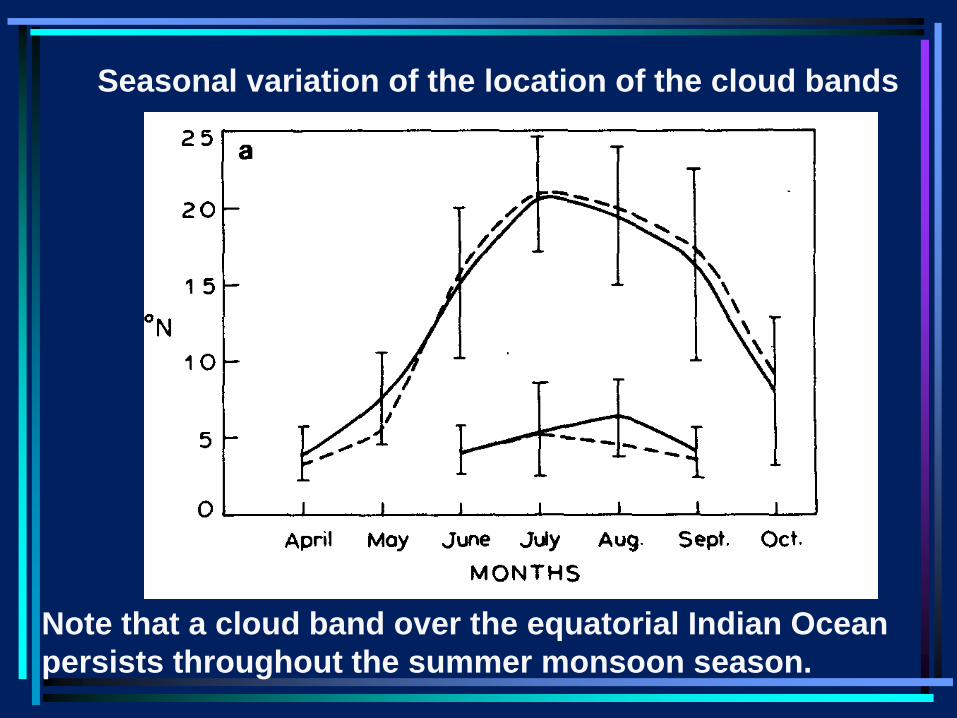
Seasonal variation of the location of the cloud bands
Note that a cloud band over the equatorial Indian Ocean
persists throughout the summer monsoon season.
• II: The most prominent feature of the daily
variation of the MCZ is a series of
northward propagations of the cloud
bands from the equatorial Indian Ocean
onto the Indian region.
• These propagations are also seen in the
daily variation of the 700hpa trough. There
is a high correlation between the axes of
the MCZ and the 700 hpa trough on a day-
to day basis.
• Rate of northward propagations about
1degree per day i.e. a little over 1 m/sec
i.e. of the same order of magnitude as
MJO.
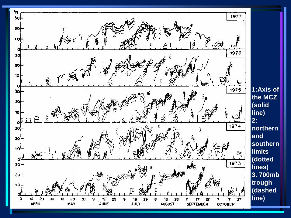
1:Axis of
the MCZ
(solid
line)
2:
northern
and
southern
limits
(dotted
lines)
3. 700mb
trough
(dashed
line)
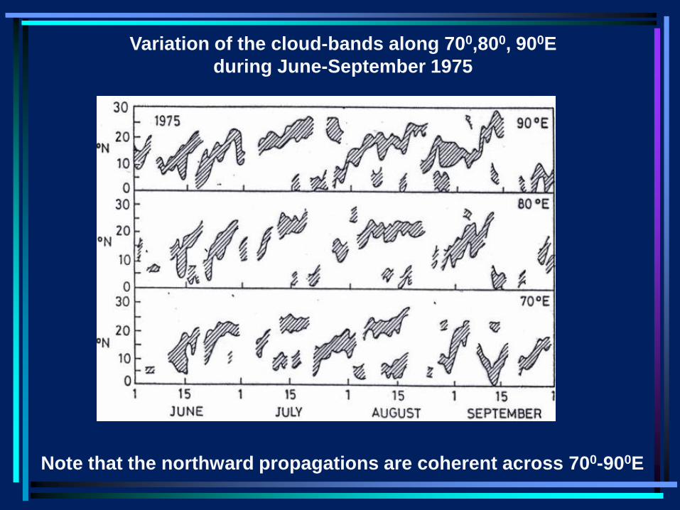
Variation of the cloud-bands along 700,800, 900E
during June-September 1975
Note that the northward propagations are coherent across 700-900E
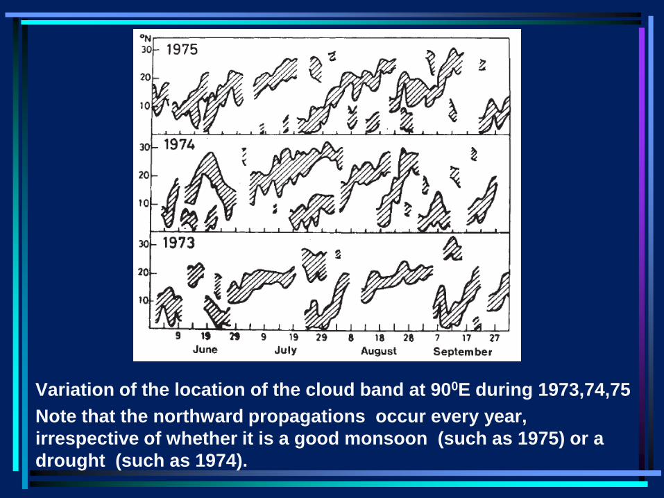
Variation of the location of the cloud band at 900E during 1973,74,75
Note that the northward propagations occur every year,
irrespective of whether it is a good monsoon (such as 1975) or a
drought (such as 1974).
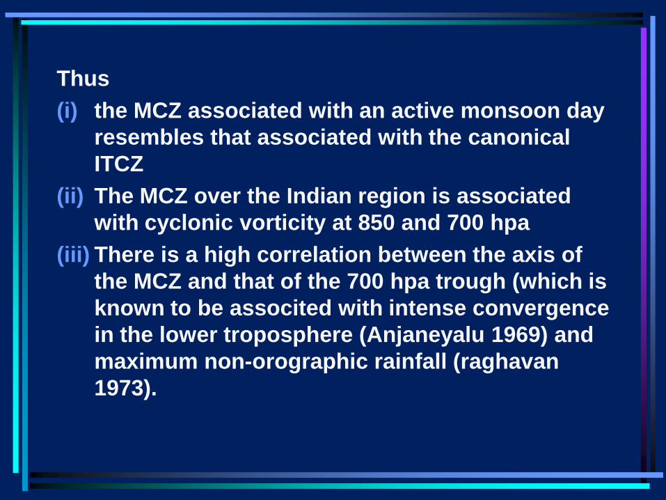
Thus
(i) the MCZ associated with an active monsoon day
resembles that associated with the canonical
ITCZ
(ii) The MCZ over the Indian region is associated
with cyclonic vorticity at 850 and 700 hpa
(iii) There is a high correlation between the axis of
the MCZ and that of the 700 hpa trough (which is
known to be associted with intense convergence
in the lower troposphere (Anjaneyalu 1969) and
maximum non-orographic rainfall (raghavan
1973).
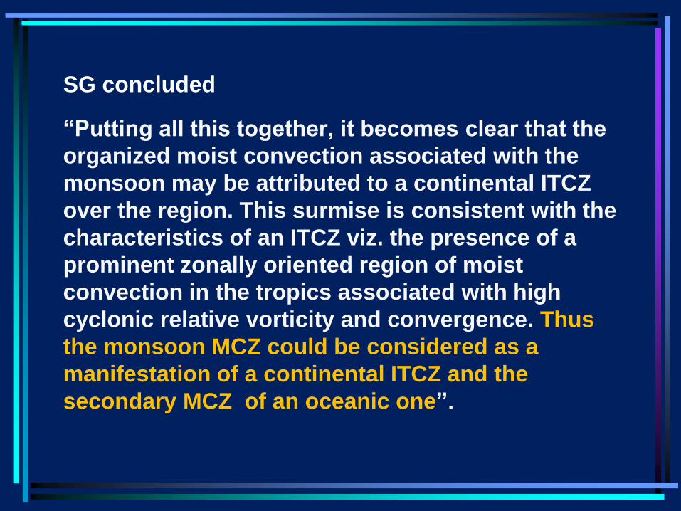
SG concluded
“Putting all this together, it becomes clear that the
organized moist convection associated with the
monsoon may be attributed to a continental ITCZ
over the region. This surmise is consistent with the
characteristics of an ITCZ viz. the presence of a
prominent zonally oriented region of moist
convection in the tropics associated with high
cyclonic relative vorticity and convergence. Thus
the monsoon MCZ could be considered as a
manifestation of a continental ITCZ and the
secondary MCZ of an oceanic one”.
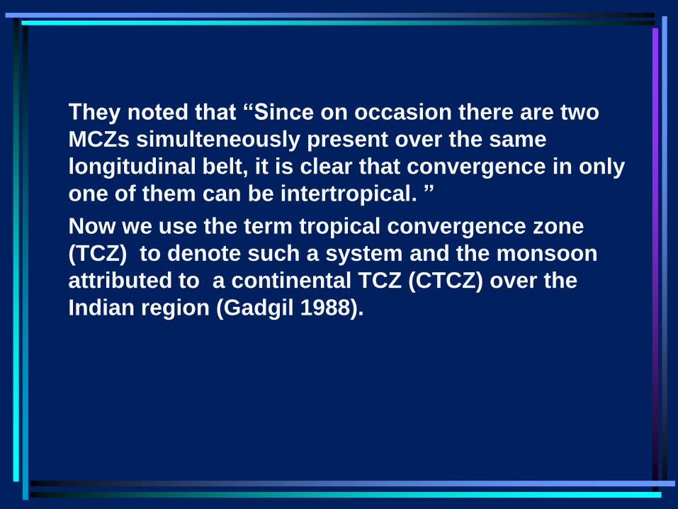
They noted that “Since on occasion there are two
MCZs simulteneously present over the same
longitudinal belt, it is clear that convergence in only
one of them can be intertropical. ”
Now we use the term tropical convergence zone
(TCZ) to denote such a system and the monsoon
attributed to a continental TCZ (CTCZ) over the
Indian region (Gadgil 1988).
• If the monsoon is indeed associated with a CTCZ
over the Indian region (as suggested by SG), why
does the mean July OLR pattern indicate a low
OLR region of much larger latitudinal extent than
over the Indian longitudes in the boreal summer
than the low OLR regions elsewhere or in the
boreal winter as pointed out by Murakami?
• This is because of two special features of the
intraseasonal variation over the Indian longitudes
during the summer monsoon: the presence of two
TCZs-the oceanic as well as the continental one
and northward propagations of the oceanic TCZ.
• Thus intraseasonal variation plays an important
role in determining the monthly/seasonal patterns
over this region.
• The MCZ is associated with intense
cyclonic vorticity at 850 and 700 mb and
moist convection and rainfall (Sikka 1977,
Gadgil 1988).
• Note the presence of synoptic scale
systems embedded in the MCZ.
• Northward propagations often involve
propagations of synoptic systems over
the Arabian Sea and Bay of Bengal which
get connected with a zonal band.
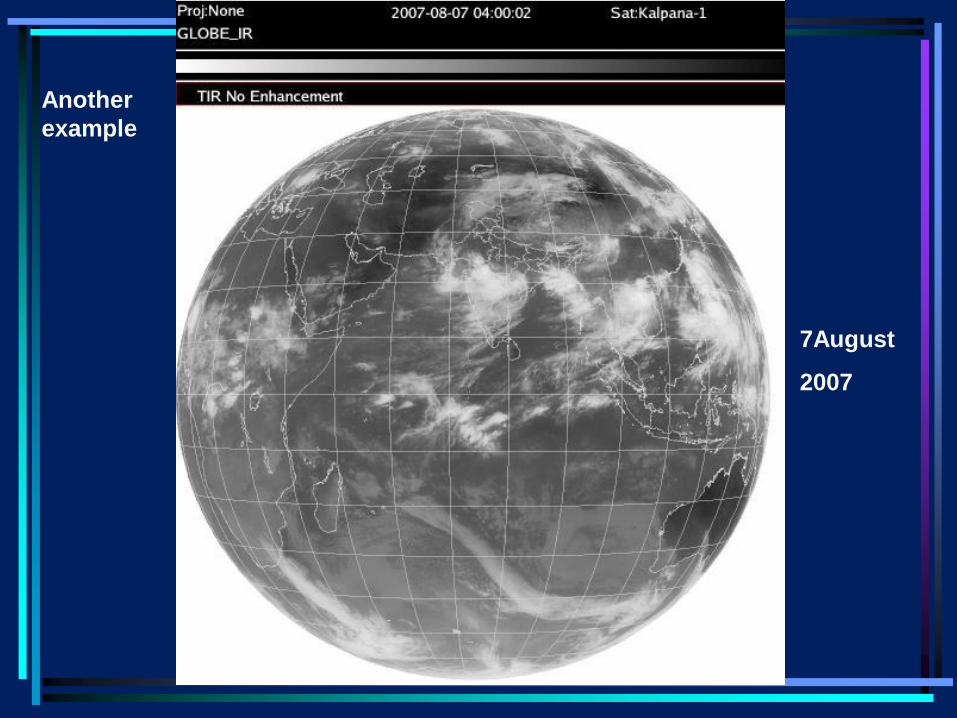
7August
2007
Another
example
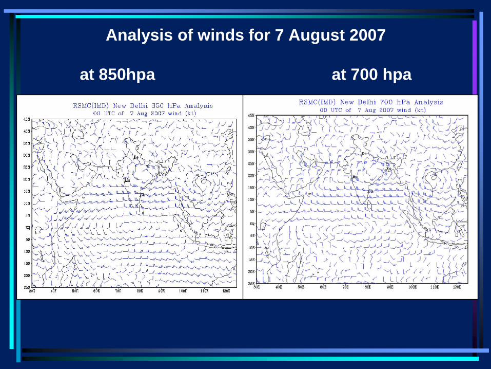
Analysis of winds for 7 August 2007
at 850hpa at 700 hpa
Multi-scale
• The synoptic scale systems embedded in
the TCZ generally have meso-scale
systems embedded in them.
• This monsoon season we saw meso-scale
systems in isolation as well.
• Riehl’s remark about ITCZ versus
hurricanes can be extended to meso-scale
systems as well
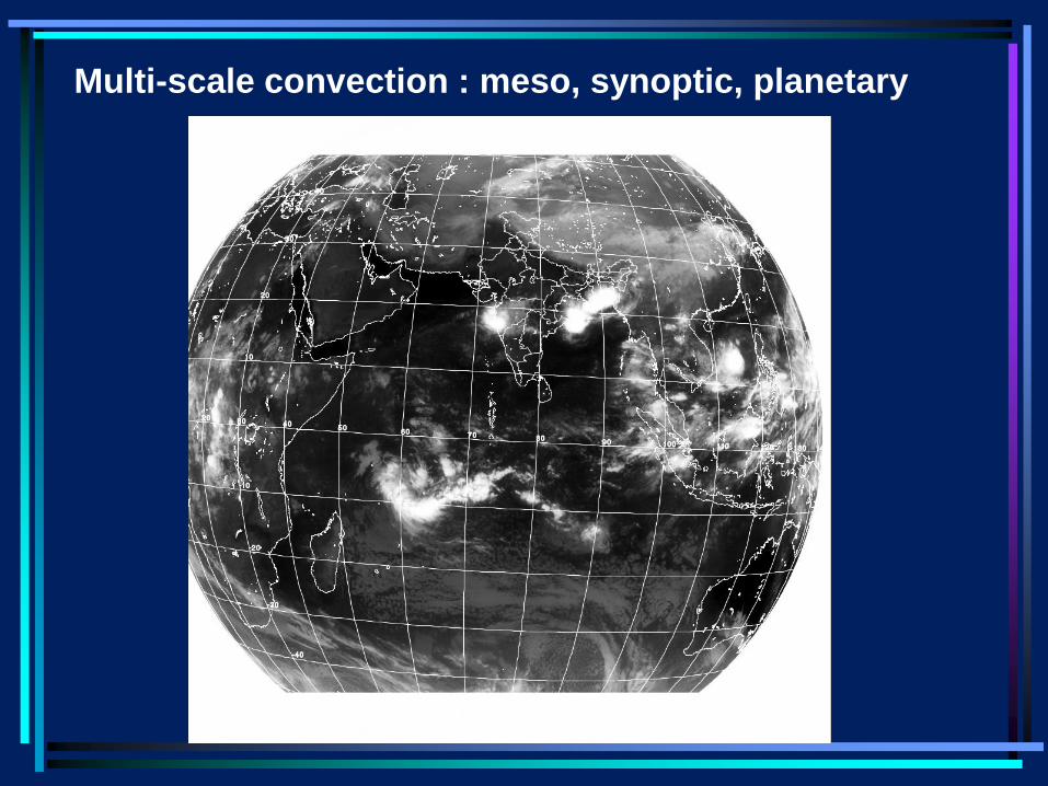
Multi-scale convection : meso, synoptic, planetary
• Why two TCZs over the same longitudinal
belt?
• Multiple equilibria-
• Over the heated subcontinent or warm
equatorial Indian Ocean
• Nature chooses a combination of the two.
• However, a solution with only the oceanic
TCZ and desert (like the Sahara) over the
Indian monsoon zone is a valid solution.
e.g. UKMET, MeteoFrance models
• Role of moist pre-conditioning? Role of
Tibetanorography?
• The SG study showed that the equatorial TCZ
plays an important role in maintaining the CTCZ
over the monsoon zone. However, the
relationship of the CTCZ to the equatorial TCZ is
complex. There is competition between the two
TCZs over the same longitudes.
• This complex relationship has important
implications for monsoon variability on
intraseasonal and interannual scales . One
example is the role of EQUINOO in interannual
variation of the monsoon. Another is the role of
EEIO convection in breaks.
Variability of the CTCZ
• Processes which lead to variability of
oceanic TCZs e.g. cloud heating of mid-
troposphere leading to a decrease in
CAPE etc. + processes special to CTCZ
such as land surface processes.
• Interactions with the TCZs over the eq.
Indian Ocean, central Pacific and Western
Pacific
• It appears that Blanford first suggested in
1886 (i.e. 200 years after Halley) that the
monsoon is associated with the
occurrence of a system which is seen over
the equatorial Indian Ocean in the spring
(i.e. ITCZ or equatorial trough).
Rainfall of India : A Monograph
by
Henry F Blanford,
Meteorological Reporter to the Government of
India
Indian Meteorological Memoirs, 1886
• “During these spring months , on the Bay of Bengal
and the Arabian Sea , the winds are light, frequently
alternating with calms and somewhat variable; ----
• The change that ensues at the end of May or in June,
when the surrounding seas are swept by a strong
monsoon current, and heavy and continued rain sets
in on the coasts of India, is very marked, and has
long been recognized in popular language as ‘the
burst of the monsoon’.
• The essential cause of the change appears to be that
during the spring months , the sea-winds which feed
the storms of that season are the relatively damp but
by no means saturated air of the surrounding seas;
or if saturated, at least not so to any considerable
vertical height above the sea surface .
• But in more southerly latitudes, in the
neighbourhood of the equator, is a belt of the
atmosphere corresponding to the doldrums of
the Atlantic, into which the southeast trades of
the South Indian Ocean pour a steady supply of
almost saturated air.
• At all times of the year, more or less convection
goes on in this belt*, as proved by its raininess
in all the seasons; and consequently it affords a
great reservoir of air, which, up to an indefinite
height above the sea surface, borders at all
times on a state of saturation.
• *what we refer to as the ITCZ or the equatorial
trough
• Now it appears to be the eventual rush of this air
towards the region of low pressure, developed
over India gradually during the spring months,
that constitutes the burst of the monsoon. Once
started , the energy of its movement is sustained
by the condensation of its own copious vapour;
by the latent heat so set free.
• The energy of convection furnished by the heated
atmosphere of the plains, is competent only to
keep up the feebler indraught that obtains during
the spring months; and indeed even this
indraught is maintained partly by the moderate
condensation of cumulus and local
thunderstorms, fed by the vapour it brings.
• The solar heat , directly absorbed by the dry land
atmosphere or taken up from the heated ground,
bears much the same relation to the general air
movement, as the pull on the trigger does to the
propulsion of the rifle ball.
• It determines the disturbance of atmospheric
equilibrium but it does not furnish the energy of
the of the resulting air stream. That energy is
supplied in the latent heat of the indrawn vapour.
• So long as this supply is small and limited to the
shallow stratum of air immediately fed by the
evaporating surface beneath it, so long is the air
movement feeble and interrupted.
• And it is only when the barometric gradient from
south to north has become sufficiently great to
tap the great reservoir of latent energy, supplied
by the evaporation of the southeast trade zone ,
that the air current becomes strong and
sustained, constituting the summer monsoon;
sustained, too, long after the heated land surface
has been in a great measure quenched and
cooled by the rainfall.” (p119)
• Thus, more than 125 years ago, Blanford had
first suggested that the Indian summer
monsoon is associated with the appearance
over the Indian region of the TCZ from the
equatorial Indian Ocean.
• It is surprising that neither Simpson nor the
following generations of meteorologists
including Webster, Meehl etc. took note of this
hypothesis by Blanford (which I believe, was
also conceived independently by Riehl and
Charney in the late 70s) nor of Sikka and
Gadgil’s proof of the validity of this hypothesis
and to this day we teach Halley’s theory of the
monsoon as a gigantic land-sea breeze.

Thank you
Blanford was thus a proponent of what I have
called the second hypothesis. However, he did not
believe that the monsoon was a manifestation of
the seasonal migration of the equatorial rainy belt.
Rather in his view, ‘the equatorial belt of constant
rainfall exists across the monsoon region and is
not bodily transferred northward to India and
southward to Australia with the annual March of
the sun in declination is a well established fact---
rainfall registers of the Malay Archipelago show
that while in the neighbourhood of the equator the
season of the heaviest and most frequent rainfall is
from November to January, there is no month in
which the precipitation does not amount to at least
3 to 4% of the annual total. In fact during the
monsoon, the whole region between the equator
and the Himalayas is more or less one of
precipitation and may be regarded rather as an
extension and broadening out of the normal
equatorial rainy zone, with a northward transfer of
its maximum and a partial concentration in
northern India, rather than a bodily transfer of the
zone northward to Southern Asia.’ (page 74)
This remains a rather apt description of the low
OLR region over the Indian longitudes during the
summer monsoon which Murakami also
commented on.