fundamental physical geography
DESCRIPTION
Complete Book of Geography...!For all..just freely download and read it...!TRANSCRIPT

CONTENTS
FOREWORD iii
UNIT I : GEOGRAPHY AS A DISCIPLINE 1-12
1. Geography as a Discipline 2
UNIT II : THE EARTH 13-38
2. The Origin and Evolution of the Earth 14
3. Interior of the Earth 21
4. Distribution of Oceans and Continents 30
UNIT III : LANDFORMS 39-74
5. Minerals and Rocks 40
6. Geomorphic Processes 45
7. Landforms and their Evolution 58
UNIT IV : CLIMATE 75-110
8. Composition and Structure of Atmosphere 76
9. Solar Radiation, Heat Balance and Temperature 79
10. Atmospheric Circulation and Weather Systems 88
11. Water in the Atmosphere 98
12. World Climate and Climate Change 103
UNIT V : WATER (OCEANS) 111-125
13. Water (Oceans) 112
14. Movements of Ocean Water 120
UNIT VI : LIFE ON THE EARTH 126-140
15. Life on the Earth 127
16. Biodiversity and Conservation 135
GLOSSARY 141-144

GEOGRAPHY AS A DISCIPLINE
This unit deals with
• Geography as an integrating discipline; as a science of spatialattributes
• Branches of geography; importance of physical geography
UNIT
I

You have studied geography as one of thecomponents of your social studies courseupto the secondary stage. You are
already aware of some of the phenomena ofgeographical nature in the world and itsdifferent parts. Now, you will study ‘Geography’as an independent subject and learn about thephysical environment of the earth, humanactivities and their interactive relationships.Therefore, a pertinent question you can ask atthis stage is — Why should we studygeography? We live on the surface of the earth.Our lives are affected by our surroundings inmany ways. We depend on the resources tosustain ourselves in the surrounding areas.Primitive societies subsisted on ‘natural meansof subsistence’, i.e. edible plants and animals.With the passage of time, we developedtechnologies and started producing our foodusing natural resources such as land, soil andwater. We adjusted our food habits andclothing according to the prevailing weatherconditions. There are variations in the naturalresource base, technological development,adaptation with and modification of physicalenvironment, social organisations and culturaldevelopment. As a student of geography, youshould be curious to know about all thephenomena which vary over space. You learnabout the diverse lands and people. Youshould also be interested in understanding thechanges which have taken place over time.Geography equips you to appreciate diversityand investigate into the causes responsible forcreating such variations over time and space.You will develop skills to understand the globeconverted into maps and have a visual sense
of the earth’s surface. The understanding andthe skills obtained in modern scientifictechniques such as GIS and computercartography equip you to meaningfullycontribute to the national endeavour fordevelopment.
Now the next question which you may liketo ask is — What is geography? You know thatearth is our home. It is also the home of manyother creatures, big and small, which live onthe earth and sustain. The earth’s surface isnot uniform. It has variations in its physicalfeatures. There are mountains, hills, valleys,plains, plateaus, oceans, lakes, deserts andwilderness. There are variations in its socialand cultural features too. There are villages,cities, roads, railways, ports, markets andmany other elements created by human beingsacross the entire period of their culturaldevelopment.
This variation provides a clue to theunderstanding of the relationship between thephysical environment and social/culturalfeatures. The physical environment hasprovided the stage, on which human societiesenacted the drama of their creative skills withthe tools and techniques which they inventedand evolved in the process of their culturaldevelopment. Now, you should be able toattempt the answer of the question posedearlier as to “What is geography”? In verysimple words, it can be said that geographyis the description of the earth. The termgeography was first coined by Eratosthenese,a Greek scholar (276-194 BC.). The word hasbeen derived from two roots from Greeklanguage geo (earth) and graphos (description).
GEOGRAPHY AS A DISCIPLINE
C H A P T E R

GEOGRAPHY AS A DISCIPLINE 3
Put together, they mean description of the earth.The earth has always been seen as the abodeof human beings and thus, scholars definedgeography as, “the description of the earth asthe abode of human beings”. You are aware ofthe fact that reality is always multifaceted andthe ‘earth’ is also multi-dimensional, that iswhy many disciplines from natural sciencessuch as geology, pedology, oceanography,botany, zoology and meteorology and anumber of sister disciplines in social sciencessuch as economics, history, sociology, politicalscience, anthropology, etc. study differentaspects of the earth’s surface. Geography isdifferent from other sciences in its subjectmatter and methodology but at the same time,it is closely related to other disciplines.Geography derives its data base from all thenatural and social sciences and attempts theirsynthesis.
We have noted that there exist variationsover the surface of the earth in its physical aswell as cultural environment. A number ofphenomena are similar and many are dissimilar.It was, therefore, logical to perceive geographyas the study of areal differentiation. Thus,geography was perceived to study all thosephenomena which vary over space.Geographers do not study only the variationsin the phenomena over the earth’s surface(space) but also study the associations withthe other factors which cause these variations.For example, cropping patterns differ fromregion to region but this variation in croppingpattern, as a phenomenon, is related tovariations in soils, climates, demands in themarket, capacity of the farmer to invest andtechnological inputs available to her/him.Thus, the concern of geography is to find outthe causal relationship between any twophenomena or between more than onephenomenon.
A geographer explains the phenomena ina frame of cause and effect relationship, as itdoes not only help in interpretation but alsoforesees the phenomena in future.
The geographical phenomena, both thephysical and human, are not static but highlydynamic. They change over time as a result ofthe interactive processes between ever
changing earth and untiring and ever-activehuman beings. Primitive human societies weredirectly dependent on their immediateenvironment. Geography, thus, is concernedwith the study of Nature and Humaninteractions as an integrated whole. ‘Human’is an integral part of ‘nature’ and ‘nature’ hasthe imprints of ‘human’. ‘Nature’ has influenceddifferent aspects of human life. Its imprints canbe noticed on food, clothing, shelter andoccupation. Human beings have come to termswith nature through adaptation andmodification. As you already know, the presentsociety has passed the stage of primitivesocieties, which were directly dependent ontheir immediate physical environment forsustenance. Present societies have modifiedtheir natural environment by inventing andusing technology and thus, have expanded thehorizon of their operation by appropriating andutilising the resources provided by nature. Withthe gradual development of technology, humanbeings were able to loosen the shackles of theirphysical environment. Technology helped inreducing the harshness of labour, increasedlabour efficiency and provided leisure tohuman beings to attend to the higher needs oflife. It also increased the scale of productionand the mobility of labour.
The interaction between the physicalenvironment and human beings has been verysuccinctly described by a poet in the followingdialogue between ‘human’ and ‘nature’ (God).You created the soil, I created the cup, youcreated night, I created the lamp. You createdwilderness, hilly terrains and deserts; Icreated flower beds and gardens. Humanbeings have claimed their contribution usingnatural resources. With the help of technology,human beings moved from the stage ofnecessity to a stage of freedom. They have puttheir imprints everywhere and created newpossibilities in collaboration with nature. Thus,we now find humanised nature andnaturalised human beings and geographystudies this interactive relationship. The spacegot organised with the help of the means oftransportation and communication network.The links (routes) and nodes (settlements of alltypes and hierarchies) integrated the space and

FUNDAMENTALS OF PHYSICAL GEOGRAPHY4
gradually, it got organised. As a social sciencediscipline, geography studies the ‘spatialorganisation’ and ‘spatial integration’.
Geography as a discipline is concerned withthree sets of questions:
(i) Some questions are related to theidentification of the patterns of naturaland cultural features as found over thesurface of the earth. These are thequestions about what?
(ii) Some questions are related to thedistribution of the natural and human/cultural features over the surface of theearth. These are the questions aboutwhere?
Taken together, both these questions takecare of distributional and locational aspects ofthe natural and cultural features. Thesequestions provided inventorised information ofwhat features and where located. It was a verypopular approach during the colonial period.These two questions did not make geographya scientific discipline till the third question wasadded. The third question is related to theexplanation or the causal relationshipsbetween features and the processes andphenomena. This aspect of geography is relatedto the question, why?
Geography as a discipline is related tospace and takes note of spatial characteristicsand attributes. It studies the patterns ofdistribution, location and concentration ofphenomena over space and interprets themproviding explanations for these patterns. Ittakes note of the associations and inter-relationships between the phenomena overspace and interprets them providingexplanations for these patterns. It also takesnote of the associations and inter-relationshipsbetween the phenomena resulting from thedynamic interaction between human beingsand their physical environment.
GEOGRAPHY AS AN INTEGRATING DISCIPLINE
Geography is a discipline of synthesis. Itattempts spatial synthesis, and historyattempts temporal synthesis. Its approach isholistic in nature. It recognises the fact thatthe world is a system of interdependencies. The
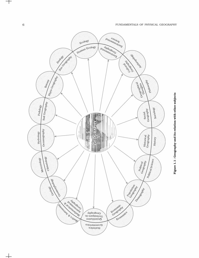
present world is being perceived as a globalvillage. The distances have been reduced bybetter means of transportation increasingaccessibility. The audio-visual media andinformation technology have enriched the database. Technology has provided better chancesof monitoring natural phenomena as well asthe economic and social parameters.Geography as an integrating discipline hasinterface with numerous natural and socialsciences. All the sciences, whether natural orsocial, have one basic objective, ofunderstanding the reality. Geographyattempts to comprehend the associations ofphenomena as related in sections of reality.Figure 1.1 shows the relationship of geographywith other sciences. Every discipline, concernedwith scientific knowledge is linked withgeography as many of their elements vary overspace. Geography helps in understanding thereality in totality in its spatial perspective.Geography, thus, not only takes note of thedifferences in the phenomena from place toplace but integrates them holistically whichmay be different at other places. A geographeris required to have a broad understanding ofall the related fields, to be able to logicallyintegrate them. This integration can beunderstood with some examples. Geographyinfluences historical events. Spatial distanceitself has been a very potent factor to alter thecourse of history of the world. Spatial depthprovided defence to many countries,particularly in the last century. In traditionalwarfare, countries with large size in area, gaintime at the cost of space. The defence providedby oceanic expanse around the countries ofthe new world has protected them from warsbeing imposed on their soil. If we look at thehistorical events world over, each one of themcan be interpreted geographically.
In India, Himalayas have acted as greatbarriers and provided protection but thepasses provided routes to the migrants andinvaders from Central Asia. The sea coast hasencouraged contact with people from East andSoutheast Asia, Europe and Africa. Navigationtechnology helped European countries tocolonise a number of countries of Asia andAfrica, including India as they got accessibility

GEOGRAPHY AS A DISCIPLINE 5
through oceans. The geographical factors havemodified the course of history in different partsof the world.
Every geographical phenomenon undergoeschange through time and can be explainedtemporally. The changes in landforms, climate,vegetation, economic activities occupations andcultural developments have followed a definitehistorical course. Many geographical featuresresult from the decision making process bydifferent institutions at a particular point oftime. It is possible to convert time in terms ofspace and space in terms of time. For example,it can be said that place A is 1,500 km fromplace B or alternately, it can also be said thatplace A is two hours away (if one travels byplane) or seventeen hours away (if one travelsby a fast moving train). It is for this reason,time is an integral part of geographical studiesas the fourth dimension. Please mention otherthree dimensions?
Figure1.1 amply depicts the linkages ofgeography with different natural and socialsciences. This linkage can be put under twosegments.
Physical Geography and Natural Sciences
All the branches of physical geography, asshown in Figure 1.1, have interface with naturalsciences. The traditional physical geographyis linked with geology, meteorology, hydrologyand pedology, and thus, geomorphology,climatology, oceanography and soil geographyrespectively have very close link with thenatural sciences as these derive their data fromthese sciences. Bio-Geography is closely relatedto botany, zoology as well as ecology as humanbeings are located in different locational niche.
A geographer should have some proficiencyin mathematics and art, particularly in drawingmaps. Geography is very much linked with thestudy of astronomical locations and deals withlatitudes and longitudes. The shape of the earthis Geoid but the basic tool of a geographer is amap which is two dimensional representationof the earth. The problem of converting geoidsinto two dimensions can be tackled byprojections constructed graphically ormathematically. The cartographic andquantitative techniques require sufficientproficiency in mathematics, statistics and
econometrics. Maps are prepared throughartistic imagination. Making sketches, mentalmaps and cartographic work requireproficiency in arts.
Geography and Social Sciences
Each social science sketched in Figure 1.1hasinterface with one branch of geography. Therelationships between geography and historyhave already been outlined in detail. Everydiscipline has a philosophy which is the raisond’etre for that discipline. Philosophy providesroots to a discipline and in the process of itsevolution, it also experiences distinct historicalprocesses. Thus, the history of geographicalthought as mother branch of geography isincluded universally in its curricula. All thesocial science disciplines, viz. sociology,political science, economics and demographystudy different aspects of social reality. Thebranches of geography, viz. social, political,economic and population and settlements areclosely linked with these disciplines as eachone of them has spatial attributes. The coreconcern of political science is territory, peopleand sovereignty while political geography isalso interested in the study of the state as aspatial unit as well as people and their politicalbehaviour. Economics deals with basicattributes of the economy such as production,distribution, exchange and consumption. Eachof these attributes also has spatial aspects andhere comes the role of economic geography tostudy the spatial aspects of production,distribution, exchange and consumption.Likewise, population geography is closelylinked with the discipline of demography.
The above discussion shows thatgeography has strong interface with naturaland social sciences. It follows its ownmethodology of study which makes it distinctfrom others. It has osmotic relationship withother disciplines. While all the disciplines havetheir own individual scope, this individualitydoes not obstruct the flow of information as incase of all cells in the body that have individualidentity separated by membranes but the flowof blood is not obstructed. Geographers usedata obtained from sister disciplines and
FUNDAMENTALS OF PHYSICAL GEOGRAPHY6
Fig
ure
1.1
: G
eogr
aphy a
nd its
rel
atio
n w
ith o
ther
subje
cts

GEOGRAPHY AS A DISCIPLINE 7
attempt synthesis over space. Maps are veryeffective tools of geographers in which thetabular data is converted into visual form tobring out the spatial pattern.
BRANCHES OF GEOGRAPHY
Please study Figure 1.1 for recapitulation. It hasvery clearly brought out that geography is aninterdisciplinary subject of study. The study ofevery subject is done according to someapproach. The major approaches to studygeography have been (i) Systematic and(ii) Regional. The systematic geography approachis the same as that of general geography. Thisapproach was introduced by Alexander VonHumboldt, a German geographer (1769-1859)while regional geography approach wasdeveloped by another German geographer and acontemporary of Humboldt, Karl Ritter(1779-1859).
In systematic approach (Figure 1.2), aphenomenon is studied world over as a whole,and then the identification of typologies orspatial patterns is done. For example, if one isinterested in studying natural vegetation, thestudy will be done at the world level as a firststep. The typologies such as equatorial rainforests or softwood conical forests or monsoonforests, etc. will be identified, discussed anddelimited. In the regional approach, the worldis divided into regions at different hierarchicallevels and then all the geographical phenomenain a particular region are studied. Theseregions may be natural, political or designatedregion. The phenomena in a region are studiedin a holistic manner searching for unity indiversity.
Dualism is one of the main characteristicsof geography which got introduced from thevery beginning. This dualism depended on theaspect emphasised in the study. Earlier scholarslaid emphasis on physical geography. Buthuman beings are an integral part of the earth’ssurface. They are part and parcel of nature. Theyalso have contributed through their culturaldevelopment. Thus developed humangeography with emphasis on human activities.
BRANCHES OF GEOGRAPHY (BASED ON
SYSTEMATIC APPROACH)
1. Physical Geography
(i) Geomorphology is devoted to the studyof landforms, their evolution and relatedprocesses.
(ii) Climatology encompasses the study ofstructure of atmosphere and elementsof weather and climates and climatictypes and regions.
(iii) Hydrology studies the realm of waterover the surface of the earth includingoceans, lakes, rivers and other waterbodies and its effect on different lifeforms including human life and theiractivities.
(iv) Soil Geography is devoted to study theprocesses of soil formation, soil types,their fertility status, distribution anduse.
2. Human Geography
(i) Social/Cultural Geography encom-passes the study of society and itsspatial dynamics as well as the culturalelements contributed by the society.
(ii) Population and Settlement Geography(Rural and Urban). It studies populationgrowth, distribution, density, sex ratio,migration and occupational structureetc. Settlement geography studies thecharacteristics of rural and urbansettlements.
(iii) Economic Geography studies economicactivities of the people includingagriculture, industry, tourism, trade,and transport, infrastructure andservices, etc.
(iv) Historical Geography studies thehistorical processes through which thespace gets organised. Every region hasundergone some historical experiencesbefore attaining the present day status.The geographical features alsoexperience temporal changes and theseform the concerns of historicalgeography.

FUNDAMENTALS OF PHYSICAL GEOGRAPHY8
Figure 1.2 : Branches of geography based on systematic approach
(v) Political Geography looks at the spacefrom the angle of political events andstudies boundaries, space relationsbetween neighbouring political units,delimitation of constituencies, electionscenario and develops theoreticalframework to understand the politicalbehaviour of the population.
3. Biogeography
The interface between physical geographyand human geography has lead to thedevelopment of Biogeography whichincludes:(i) Plant Geography which studies the
spatial pattern of natural vegetation intheir habitats.

GEOGRAPHY AS A DISCIPLINE 9
(ii) Zoo Geography which studies thespatial patterns and geographiccharacteristics of animals and theirhabitats.
(iii) Ecology /Ecosystem deals with thescientific study of the habitatscharacteristic of species.
(iv) Environmental Geography concernsworld over leading to the realisation ofenvironmental problems such as landgradation, pollution and concerns forconservation has resulted in theintroduction of this new branch ingeography.
BRANCHES OF GEOGRAPHY BASED ON REGIONAL
APPROACH (FIGURE1.3)
1. Regional Studies/Area StudiesComprising Macro, Meso and MicroRegional Studies
2. Regional PlanningComprising Country/Rural and Town/Urban Planning
3. Regional Development4. Regional Analysis
There are two aspects which are commonto every discipline, these are:(i) Philosophy
(a) Geographical Thought(b) Land and Human Interaction/
Human Ecology(ii) Methods and Techniques
(a) Cartography including ComputerCartography
(b) Quantitative Techniques/StatisticalTechniques
(c) Field Survey Methods(d) Geo-informatics comprising
techniques such as RemoteSensing, GIS, GPS, etc.
The above classification gives acomprehensive format of the branches ofgeography. Generally geography curricula istaught and learnt in this format but thisformat is not static. Any discipline is boundto grow with new ideas, problems, methodsand techniques. For example, what was oncemanual cartography has now beentransformed into computer cartography.Technology has enabled scholars to handlelarge quantum of data. The internet providesextensive information. Thus, the capacity toattempt analysis has increased tremendously.GIS has further opened vistas of knowledge.GPS has become a handy tool to find out exactlocations. Technologies have enhanced thecapacity of attempting synthesis with soundtheoretical understanding.
You will learn some preliminary aspects ofthese techniques in your book, Practical workin Geography – Part I (NCERT, 2006). You willcontinue to improve upon your skills andlearn about their application.
PHYSICAL GEOGRAPHY AND ITS IMPORTANCE
This chapter appears in the book entitledFundamentals of Physical Geography. Thecontents of the book clearly reflect its scope.It is therefore, appropriate to know theimportance of this branch of geography.
Figure 1.3 : Branches of geography based on regional approach
FUNDAMENTALS OF PHYSICAL GEOGRAPHY10
Physical geography includes the study oflithosphere (landforms, drainage, relief andphysiography), atmosphere (its composition,structure, elements and controls of weatherand climate; temperature, pressure, winds,precipitation, climatic types, etc.), hydrosphere(oceans, seas, lakes and associated featureswith water realm) and biosphere ( life formsincluding human being and macro-organismand their sustaining mechanism, viz. foodchain, ecological parameters and ecologicalbalance). Soils are formed through the processof pedogenesis and depend upon the parentrocks, climate, biological activity and time.Time provides maturity to soils and helps inthe development of soil profiles. Each elementis important for human beings. Landformsprovide the base on which human activities arelocated. The plains are utilised for agriculture.Plateaus provide forests and minerals.Mountains provide pastures, forests, touristspots and are sources of rivers providing waterto lowlands. Climate influences our housetypes, clothing and food habits. The climatehas a profound effect on vegetation, croppingpattern, livestock farming and someindustries, etc. Human beings have developedtechnologies which modify climatic elementsin a restricted space such as air conditionersand coolers. Temperature and precipitationensure the density of forests and quality ofgrassland. In India, monsoonal rainfall sets theagriculture rhythm in motion. Precipitationrecharges the ground water aquifers whichlater provides water for agriculture anddomestic use. We study oceans which are thestore house of resources. Besides fish and other
sea-food, oceans are rich in mineral resources.India has developed the technology forcollecting manganese nodules from oceanicbed. Soils are renewable resources, whichinfluence a number of economic activities suchas agriculture. The fertility of the soil is bothnaturally determined and culturally induced.Soils also provide the basis for the biosphereaccommodating plants, animals and microorganisms.
The study of physical geography isemerging as a discipline of evaluating andmanaging natural resources. In order toachieve this objective, it is essential tounderstand the intricate relationship betweenphysical environment and human beings.Physical environment provides resources, andhuman beings utilise these resources andensure their economic and culturaldevelopment. Accelerated pace of resourceutilisation with the help of modern technologyhas created ecological imbalance in the world.Hence, a better understanding of physicalenvironment is absolutely essential forsustainable development.
What is Geography?
Geography is concerned with the descriptionand explanation of the areal differentiation ofthe earth’s surface.
Richard Hartshorne
Geography studies the differences ofphenomena usually related in different partsof the earth’s surface.
Hettner
EXERCISES
1. Multiple choice questions.
(i) Which one of the following scholars coined the term ‘Geography’?
(a) Herodotus (c) Galileo
(b) Erathosthenese (d) Aristotle
(ii) Which one of the following features can be termed as ‘physical feature’?
(a) Port (c) Plain
(b) Road (d) Water park

GEOGRAPHY AS A DISCIPLINE 11
(iii) Make correct pairs from the following two columns and mark the correctoption.
1. Meteorology A. Population Geography
2. Demography B. Soil Geography
3. Sociology C. Climatology
4. Pedology D. Social Geography
(a) 1B,2C,3A,4D (c) 1D,2B,3C,4A
(b) 1A,2D,3B,4C (d) 1C,2A,3D,4B
(iv) Which one of the following questions is related to cause-effect relationship?
(a) Why (c) What
(b) Where (d) When
(v) Which one of the following disciplines attempts temporal synthesis?
(a) Sociology (c) Anthropology
(b) Geography (d) History
2. Answer the following questions in about 30 words.
(i) What important cultural features do you observe while going to school?Are they similar or dissimilar? Should they be included in the study ofgeography or not? If yes, why?
(ii) You have seen a tennis ball, a cricket ball, an orange and a pumpkin.Which one amongst these resembles the shape of the earth? Why haveyou chosen this particular item to describe the shape of the earth?
(iii) Do you celebrate Van Mahotsava in your school? Why do we plant so manytrees? How do the trees maintain ecological balance?
(iv) You have seen elephants, deer, earthworms, trees and grasses. Where dothey live or grow? What is the name given to this sphere? Can you describesome of the important features of this sphere?
(v) How much time do you take to reach your school from your house? Hadthe school been located across the road from your house, how much timewould you have taken to reach school? What is the effect of the distancebetween your residence and the school on the time taken in commuting?Can you convert time into space and vice versa?
3. Answer the following questions in about 150 words.
(i) You observe every day in your surroundings that there is variation innatural as well as cultural phenomena. All the trees are not of the samevariety. All the birds and animals you see, are different. All these differentelements are found on the earth. Can you now argue that geography isthe study of “areal differentiation”?
(ii) You have already studied geography, history, civics and economics asparts of social studies. Attempt an integration of these disciplineshighlighting their interface.

FUNDAMENTALS OF PHYSICAL GEOGRAPHY12
Project Work
Select forest as a natural resource.
(i) Prepare a map of India showing the distribution of different types of forests.
(ii) Write about the economic importance of forests for the country.
(iii) Prepare a historical account of conservation of forests in India with focuson Chipko movements in Rajasthan and Uttaranchal.

THE EARTH
This unit deals with
• Origin and evolution of the earth; Interior of the earth; Wegener’scontinental drift theory and plate tectonics; earthquakes andvolcanoes
UNIT
II

Do you remember the nursery rhyme“…Twinkle, Twinkle little star…”?
Starry nights have always attracted us sincethe childhood. You may also have thought ofthese stars and had numerous questions inyour mind. Questions such as how many starsare there in the sky? How did they come intoexistence? Can one reach the end of the sky?May be many more such questions are stillthere in your mind. In this chapter, you willlearn how these “twinkling little stars” wereformed. With that you will eventually also readthe story of origin and evolution of the earth.
ORIGIN OF THE EARTH
Early Theories
A large number of hypotheses were put forthby different philosophers and scientistsregarding the origin of the earth. One of theearlier and popular arguments was by Germanphilosopher Immanuel Kant. MathematicianLaplace revised it in 1796. It is known asNebular Hypothesis. The hypothesis consideredthat the planets were formed out of a cloud ofmaterial associated with a youthful sun, whichwas slowly rotating. Later in 1900, Chamberlainand Moulton considered that a wandering starapproached the sun. As a result, a cigar-shapedextension of material was separated from thesolar surface. As the passing star moved away,the material separated from the solar surfacecontinued to revolve around the sun and itslowly condensed into planets. Sir James Jeansand later Sir Harold Jeffrey supported this
THE ORIGIN AND EVOLUTION
OF THE EARTH
C H A P T E R
argument. At a later date, the argumentsconsidered of a companion to the sun to havebeen coexisting. These arguments are calledbinary theories. In 1950, Otto Schmidt inRussia and Carl Weizascar in Germanysomewhat revised the ‘nebular hypothesis’,though differing in details. They considered thatthe sun was surrounded by solar nebulacontaining mostly the hydrogen and heliumalong with what may be termed as dust. Thefriction and collision of particles led toformation of a disk-shaped cloud and theplanets were formed through the process ofaccretion.
Modern Theories
However, scientists in later period took up theproblems of origin of universe rather than thatof just the earth or the planets. The mostpopular argument regarding the origin of theuniverse is the Big Bang Theory. It is also calledexpanding universe hypothesis. EdwinHubble, in 1920, provided evidence that theuniverse is expanding. As time passes, galaxiesmove further and further apart. You canexperiment and find what does the expandinguniverse mean. Take a balloon and mark somepoints on it to represent the galaxies. Now, ifyou start inflating the balloon, the pointsmarked on the balloon will appear to be movingaway from each other as the balloon expands.Similarly, the distance between the galaxies isalso found to be increasing and thereby, theuniverse is considered to be expanding.However, you will find that besides the increasein the distances between the points on the

THE ORIGIN AND EVOLUTION OF THE EARTH 15
balloon, the points themselves are expanding.This is not in accordance with the fact.Scientists believe that though the spacebetween the galaxies is increasing, observationsdo not support the expansion of galaxies. So,the balloon example is only partially correct.
Figure 2.1 : The Big Bang
The Big Bang Theory considers thefollowing stages in the development of theuniverse.
(i) In the beginning, all matter forming theuniverse existed in one place in the formof a “tiny ball” (singular atom) with anunimaginably small volume, infinitetemperature and infinite density.
(ii) At the Big Bang the “tiny ball” explodedviolently. This led to a huge expansion.It is now generally accepted that theevent of big bang took place 13.7 billionyears before the present. The expansioncontinues even to the present day. As itgrew, some energy was converted intomatter. There was particularly rapidexpansion within fractions of a secondafter the bang. Thereafter, theexpansion has slowed down. Within firstthree minutes from the Big Bang event,the first atom began to form.
(iii) Within 300,000 years from the BigBang, temperature dropped to 4,500 Kand gave rise to atomic matter. Theuniverse became transparent.
The expansion of universe means increasein space between the galaxies. An alternativeto this was Hoyle’s concept of steady state. Itconsidered the universe to be roughly the sameat any point of time. However, with greaterevidence becoming available about theexpanding universe, scientific community atpresent favours argument of expandinguniverse.
The Star Formation
The distribution of matter and energy was noteven in the early universe. These initial densitydifferences gave rise to differences ingravitational forces and it caused the matterto get drawn together. These formed the basesfor development of galaxies. A galaxy containsa large number of stars. Galaxies spread overvast distances that are measured in thousandsof light-years. The diameters of individualgalaxies range from 80,000-150,000 lightyears. A galaxy starts to form by accumulationof hydrogen gas in the form of a very largecloud called nebula. Eventually, growingnebula develops localised clumps of gas. Theseclumps continue to grow into even densergaseous bodies, giving rise to formation ofstars. The formation of stars is believed to havetaken place some 5-6 billion years ago.
A light year is a measure of distance andnot of time. Light travels at a speed of300,000 km/second. Considering this,the distances the light will travel in oneyear is taken to be one light year. Thisequals to 9.461×10¹² km. The meandistance between the sun and the earthis 149,598,000 km. In terms of lightyears, it is 8.311 minutes of a year.
Formation of Planets
The following are considered to be the stagesin the development of planets :
(i) The stars are localised lumps of gaswithin a nebula. The gravitational forcewithin the lumps leads to the formationof a core to the gas cloud and a hugerotating disc of gas and dust developsaround the gas core.

FUNDAMENTALS OF PHYSICAL GEOGRAPHY16
(ii) In the next stage, the gas cloud startsgetting condensed and the matteraround the core develops into small-rounded objects. These small-roundedobjects by the process of cohesion developinto what is called planetesimals.Larger bodies start forming by collision,and gravitational attraction causes thematerial to stick together. Planetesimalsare a large number of smaller bodies.
(iii) In the final stage, these large numberof small planetesimals accrete to forma fewer large bodies in the form ofplanets.
OUR SOLAR SYSTEM
Our Solar system consists of nine planets. Thetenth planet 2003 UB
313 has also been recently
sighted. The nebula from which our Solarsystem is supposed to have been formed,started its collapse and core formation sometime 5-5.6 billion years ago and the planetswere formed about 4.6 billion years ago. Oursolar system consists of the sun (the star), 9planets, 63 moons, millions of smaller bodieslike asteroids and comets and huge quantityof dust-grains and gases.
Out of the nine planets, mercury, venus,earth and mars are called as the inner planetsas they lie between the sun and the belt ofasteroids the other five planets are called the outerplanets. Alternatively, the first four are calledTerrestrial, meaning earth-like as they are madeup of rock and metals, and have relatively highdensities. The rest five are called Jovian or GasGiant planets. Jovian means jupiter-like. Most
of them are much larger than the terrestrialplanets and have thick atmosphere, mostly ofhelium and hydrogen. All the planets were formedin the same period sometime about 4.6 billionyears ago. Some data regarding our solar systemare given in the box below.
Why are the inner planets rocky whileothers are mostly in gaseous form?
The difference between terrestrial and jovianplanets can be attributed to the followingconditions:
(i) The terrestrial planets were formed inthe close vicinity of the parent starwhere it was too warm for gases tocondense to solid particles. Jovianplanets were formed at quite a distantlocation.
(ii) The solar wind was most intense nearerthe sun; so, it blew off lots of gas anddust from the terrestrial planets. Thesolar winds were not all that intense tocause similar removal of gases from theJovian planets.
(iii) The terrestrial planets are smaller andtheir lower gravity could not hold theescaping gases.
The Moon
The moon is the only natural satellite of theearth. Like the origin of the earth, there havebeen attempts to explain how the moon wasformed. In 1838, Sir George Darwin suggestedthat initially, the earth and the moon formed asingle rapidly rotating body. The whole mass
The Solar System
Mercury Venus Earth Mars Jupiter Saturn Uranus Neptune Pluto
Distance* 0.387 0.723 1.000 1.524 5.203 9.539 19.182 30.058 39.785
Density@ 5.44 5.245 5.517 3.945 1.33 0.70 1.17 1.66 0.5-0.9
Radius# 0.383 0.949 1.000 0.533 11.19 9.460 4.11 3.88 -0.3
Satellites 0 0 1 2 16 about 18 about 17 8 1
* Distance from the sun in astronomical unit i.e. average mean distance of the earth is 149,598,000 km = 1@ Density in gm/cm3
# Radius: Equatorial radius 6378.137 km = 1

THE ORIGIN AND EVOLUTION OF THE EARTH 17
became a dumb-bell-shaped body andeventually it broke. It was also suggested thatthe material forming the moon was separatedfrom what we have at present the depressionoccupied by the Pacific Ocean.
However, the present scientists do notaccept either of the explanations. It is nowgenerally believed that the formation of moon,as a satellite of the earth, is an outcome of ‘giantimpact’ or what is described as “the big splat”.A body of the size of one to three times that ofmars collided into the earth sometime shortlyafter the earth was formed. It blasted a largepart of the earth into space. This portion ofblasted material then continued to orbit theearth and eventually formed into the presentmoon about 4.44 billion years ago.
EVOLUTION OF THE EARTH
Do you know that the planet earth initially wasa barren, rocky and hot object with a thinatmosphere of hydrogen and helium. This isfar from the present day picture of the earth.Hence, there must have been some events–processes, which may have caused this changefrom rocky, barren and hot earth to a beautifulplanet with ample amount of water andconducive atmosphere favouring the existenceof life. In the following section, you will findout how the period, between the 4,600 millionyears and the present, led to the evolution oflife on the surface of the planet.
The earth has a layered structure. Fromthe outermost end of the atmosphere to thecentre of the earth, the material that exists isnot uniform. The atmospheric matter has theleast density. From the surface to deeperdepths, the earth’s interior has different zonesand each of these contains materials withdifferent characteristics.
How was the layered structure of theearth developed?
Development of Lithosphere
The earth was mostly in a volatile state duringits primordial stage. Due to gradual increasein density the temperature inside hasincreased. As a result the material inside
started getting separated depending on theirdensities. This allowed heavier materials (likeiron) to sink towards the centre of the earthand the lighter ones to move towards thesurface. With passage of time it cooled furtherand solidified and condensed into a smaller size.This later led to the development of the outersurface in the form of a crust. During theformation of the moon, due to the giant impact,the earth was further heated up. It is throughthe process of differentiation that the earthforming material got separated into differentlayers. Starting from the surface to the centralparts, we have layers like the crust, mantle,outer core and inner core. From the crust to thecore, the density of the material increases. Weshall discuss in detail the properties of each ofthis layer in the next chapter.
Evolution of Atmosphere and Hydrosphere
The present composition of earth’s atmosphereis chiefly contributed by nitrogen and oxygen.You will be dealing with the composition andstructure of the earth’s atmosphere in Chapter 8.
There are three stages in the evolution ofthe present atmosphere. The first stage ismarked by the loss of primordial atmosphere.In the second stage, the hot interior of the earthcontributed to the evolution of the atmosphere.Finally, the composition of the atmosphere wasmodified by the living world through theprocess of photosynthesis.
The early atmosphere, with hydrogen andhelium, is supposed to have been stripped offas a result of the solar winds. This happenednot only in case of the earth, but also in all theterrestrial planets, which were supposed tohave lost their primordial atmosphere throughthe impact of solar winds.
During the cooling of the earth, gases andwater vapour were released from the interiorsolid earth. This started the evolution of thepresent atmosphere. The early atmospherelargely contained water vapour, nitrogen,carbon dioxide, methane, ammonia and verylittle of free oxygen. The process through whichthe gases were outpoured from the interior iscalled degassing. Continuous volcaniceruptions contributed water vapour and gases

FUNDAMENTALS OF PHYSICAL GEOGRAPHY18
to the atmosphere. As the earth cooled, thewater vapour released started gettingcondensed. The carbon dioxide in theatmosphere got dissolved in rainwater and thetemperature further decreased causing morecondensation and more rains. The rainwaterfalling onto the surface got collected in thedepressions to give rise to oceans. The earth’soceans were formed within 500 million yearsfrom the formation of the earth. This tells us
that the oceans are as old as 4,000 millionyears. Sometime around 3,800 million yearsago, life began to evolve. However, around2,500-3,000 million years before the present,the process of photosynthesis got evolved. Lifewas confined to the oceans for a long time.Oceans began to have the contribution ofoxygen through the process of photosynthesis.Eventually, oceans were saturated with oxygen,and 2,000 million years ago, oxygen began toflood the atmosphere.
Eons Era Period Epoch Age/ Years Life/ Major EventsBefore Present
Quaternary Holocene 0 - 10,000 Modern ManPleistocene 10,000 - 2 million Homo Sapiens
Tertiary Pliocene 2 - 5 million Early Human AncestorMiocene 5 - 24 million Ape: Flowering Plants
and TreesOligocene 24 - 37 Ma Anthropoid ApeEocene 37 - 58 Million Rabbits and HarePalaeocene 57 - 65 Million Small Mammals :
Rats – Mice
Cretaceous 65 - 144 Million Extinction of DinosaursJurassic 144 - 208 Million Age of DinosaursTriassic 208 - 245 Million Frogs and turtles
Permian 245 - 286 Million Reptile dominate-replaceamphibians
Carboniferous 286 - 360 Million First Reptiles:Vertebrates: Coal beds
Devonian 360 - 408 Million AmphibiansSilurian 408 - 438 Million First trace of life on land:
PlantsOrdovician 438 - 505 Million First FishCambrian 505 - 570 Million No terrestrial Life :
Marine InvertebrateProterozoic 570 - 2,500 Million Soft-bodied arthropodsArchean 2,500 - 3,800 Million Blue green Algae:
Unicellular bacteriaHadean 3,800 - 4,800 Million Oceans and Continents
form – Ocean andAtmosphere are rich inCarbon dioxide
Origin of 5,000 Million Origin of the sunStars
Supernova 12,000 Million Origin of the universe
Big Bang 13,700 Million
Cainozoic(From 65
million yearsto the
presenttimes)
Mesozoic65 - 245Million
Mammals
Palaeozoic245 - 570
Million
Pre-Cambrian
570 Million- 4,800Million
5,000 -13,700Million
Geological Time Scale

THE ORIGIN AND EVOLUTION OF THE EARTH 19
Origin of Life
The last phase in the evolution of the earthrelates to the origin and evolution of life. It isundoubtedly clear that the initial or even theatmosphere of the earth was not conducive forthe development of life. Modern scientists referto the origin of life as a kind of chemicalreaction, which first generated complex organicmolecules and assembled them. Thisassemblage was such that they could duplicatethemselves converting inanimate matter into
living substance. The record of life that existedon this planet in different periods is found inrocks in the form of fossils. The microscopicstructures closely related to the present formof blue algae have been found in geologicalformations that are much older than these weresome 3,000 million years ago. It can beassumed that life began to evolve sometime3,800 million years ago. The summary ofevolution of life from unicellular bacteria to themodern man is given in the Geological TimeScale on page 18.
EXERCISES
1. Multiple choice questions.
(i) Which one of the following figures represents the age of the earth?
(a) 4.6 million years (c) 4.6 billion years
(b) 13.7 billion years (d) 13.7 trillion years
(ii) Which one of the following has the longest duration?
(a) Eons (c) Era
(b) Period (d) Epoch
(iii) Which one of the following is not related to the formation or modificationof the present atmosphere?
(a) Solar winds (c) Degassing
(b) Differentiation (d) Photosynthesis
(iv) Which one of the following represents the inner planets?
(a) Planets between the sun and the earth
(b) Planets between the sun and the belt of asteroids
(c) Planets in gaseous state
(d) Planets without satellite(s)
(v) Life on the earth appeared around how many years before the present?
(a) 13.7 billion (c) 4.6 billion
(b) 3.8 million (d) 3.8 billion
2. Answer the following questions in about 30 words.
(i) Why are the terrestrial planets rocky?
(ii) What is the basic difference in the arguments related to the origin of theearth given by :
(a) Kant and Laplace
(b) Chamberlain and Moulton

FUNDAMENTALS OF PHYSICAL GEOGRAPHY20
(iii) What is meant by the process of differentiation?
(iv) What was the nature of the earth surface initially?
(v) What were the gases which initially formed the earth’s atmosphere?
3. Answer the following questions in about 150 words.
(i) Write an explanatory note on the ‘Big Bang Theory’.
(ii) List the stages in the evolution of the earth and explain each stage inbrief.
Project Work
Collect information about the project “Stardust” (website: www.sci.edu/public.htmland www.nasm.edu) along the following lines.
(i) Which is the agency that has launched this project?
(ii) Why are scientists interested in collecting Stardust?
(iii) Where from has the Stardust been collected?

What do you imagine about the natureof the earth? Do you imagine it to bea solid ball like cricket ball or a
hollow ball with a thick cover of rocks i.e.lithosphere? Have you ever seen photographsor images of a volcanic eruption on thetelevision screen? Can you recollect theemergence of hot molten lava, dust, smoke, fireand magma flowing out of the volcanic crater?The interior of the earth can be understood onlyby indirect evidences as neither any one has norany one can reach the interior of the earth.
The configuration of the surface of the earthis largely a product of the processes operatingin the interior of the earth. Exogenic as well asendogenic processes are constantly shapingthe landscape. A proper understanding of thephysiographic character of a region remainsincomplete if the effects of endogenic processesare ignored. Human life is largely influencedby the physiography of the region. Therefore,it is necessary that one gets acquainted withthe forces that influence landscapedevelopment. To understand why the earthshakes or how a tsunami wave is generated, itis necessary that we know certain details of theinterior of the earth. In the previous chapter,you have noted that the earth-formingmaterials have been distributed in the form oflayers from the crust to the core. It is interestingto know how scientists have gatheredinformation about these layers and what arethe characteristics of each of these layers. Thisis exactly what this chapter deals with.
INTERIOR OF THE EARTH
SOURCES OF INFORMATION ABOUT THE INTERIOR
The earth’s radius is 6,370 km. No one canreach the centre of the earth and makeobservations or collect samples of the material.Under such conditions, you may wonder howscientists tell us about the earth’s interior andthe type of materials that exist at such depths.Most of our knowledge about the interior ofthe earth is largely based on estimates andinferences. Yet, a part of the information isobtained through direct observations andanalysis of materials.
Direct Sources
The most easily available solid earth materialis surface rock or the rocks we get from miningareas. Gold mines in South Africa are as deepas 3 - 4 km. Going beyond this depth is notpossible as it is very hot at this depth. Besidesmining, scientists have taken up a number ofprojects to penetrate deeper depths to explorethe conditions in the crustal portions. Scientistsworld over are working on two major projectssuch as “Deep Ocean Drilling Project” and“Integrated Ocean Drilling Project”. Thedeepest drill at Kola, in Arctic Ocean, has sofar reached a depth of 12 km. This and manydeep drilling projects have provided largevolume of information through the analysis ofmaterials collected at different depths.
Volcanic eruption forms another source ofobtaining direct information. As and when themolten material (magma) is thrown onto thesurface of the earth, during volcanic eruptionit becomes available for laboratory analysis.However, it is difficult to ascertain the depth ofthe source of such magma.
C H A P T E R

FUNDAMENTALS OF PHYSICAL GEOGRAPHY22
Indirect Sources
Analysis of properties of matter indirectlyprovides information about the interior. Weknow through the mining activity thattemperature and pressure increase with theincreasing distance from the surface towardsthe interior in deeper depths. Moreover, it isalso known that the density of the material alsoincreases with depth. It is possible to find therate of change of these characteristics. Knowingthe total thickness of the earth, scientists haveestimated the values of temperature, pressureand the density of materials at different depths.The details of these characteristics withreference to each layer of the interior arediscussed later in this chapter.
Another source of information are themeteors that at times reach the earth. However,it may be noted that the material that becomesavailable for analysis from meteors, is not fromthe interior of the earth. The material and thestructure observed in the meteors are similarto that of the earth. They are solid bodiesdeveloped out of materials same as, or similarto, our planet. Hence, this becomes yet anothersource of information about the interior of theearth.
The other indirect sources includegravitation, magnetic field, and seismic activity.The gravitation force (g) is not the same atdifferent latitudes on the surface. It is greaternear the poles and less at the equator. This isbecause of the distance from the centre at theequator being greater than that at the poles.The gravity values also differ according to themass of material. The uneven distribution ofmass of material within the earth influencesthis value. The reading of the gravity at differentplaces is influenced by many other factors.These readings differ from the expected values.Such a difference is called gravity anomaly.Gravity anomalies give us information aboutthe distribution of mass of the material in thecrust of the earth. Magnetic surveys alsoprovide information about the distribution ofmagnetic materials in the crustal portion, andthus, provide information about thedistribution of materials in this part. Seismicactivity is one of the most important sources of
information about the interior of the earth.Hence, we shall discuss it in some detail.
Earthquake
The study of seismic waves provides a completepicture of the layered interior. An earthquakein simple words is shaking of the earth. It is anatural event. It is caused due to release ofenergy, which generates waves that travel inall directions.
Why does the earth shake?
The release of energy occurs along a fault. Afault is a sharp break in the crustal rocks.Rocks along a fault tend to move in oppositedirections. As the overlying rock strata pressthem, the friction locks them together. However,their tendency to move apart at some point oftime overcomes the friction. As a result, theblocks get deformed and eventually, they slidepast one another abruptly. This causes arelease of energy, and the energy waves travelin all directions. The point where the energy isreleased is called the focus of an earthquake,alternatively, it is called the hypocentre. Theenergy waves travelling in different directionsreach the surface. The point on the surface,nearest to the focus, is called epicentre. It isthe first one to experience the waves. It is a pointdirectly above the focus.
Earthquake Waves
All natural earthquakes take place in thelithosphere. You will learn about differentlayers of the earth later in this chapter. It issufficient to note here that the lithosphere refersto the portion of depth up to 200 km from thesurface of the earth. An instrument called‘seismograph’ records the waves reaching thesurface. A curve of earthquake waves recordedon the seismograph is given in Figure 3.1. Notethat the curve shows three distinct sectionseach representing different types of wavepatterns. Earthquake waves are basically of twotypes — body waves and surface waves. Bodywaves are generated due to the release of energyat the focus and move in all directions travellingthrough the body of the earth. Hence, the name

INTERIOR OF THE EARTH 23
body waves. The body waves interact with thesurface rocks and generate new set of wavescalled surface waves. These waves move alongthe surface. The velocity of waves changes asthey travel through materials with differentdensities. The denser the material, the higheris the velocity. Their direction also changes asthey reflect or refract when coming acrossmaterials with different densities.
propagation. As a result, it creates densitydifferences in the material leading to stretchingand squeezing of the material. Other threewaves vibrate perpendicular to the direction ofpropagation. The direction of vibrations ofS-waves is perpendicular to the wave directionin the vertical plane. Hence, they create troughsand crests in the material through which theypass. Surface waves are considered to be themost damaging waves.
Emergence of Shadow Zone
Earthquake waves get recorded in seismo-graphs located at far off locations. However,there exist some specific areas where the wavesare not reported. Such a zone is called the‘shadow zone’. The study of different eventsreveals that for each earthquake, there existsan altogether different shadow zone. Figure 3.2(a) and (b) show the shadow zones of P andS-waves. It was observed that seismographslocated at any distance within 105° from theepicentre, recorded the arrival of both P andS-waves. However, the seismographs locatedbeyond 145° from epicentre, record the arrivalof P-waves, but not that of S-waves. Thus, azone between 105° and 145° from epicentre wasidentified as the shadow zone for both the typesof waves. The entire zone beyond 105° does notreceive S-waves. The shadow zone of S-wave ismuch larger than that of the P-waves. Theshadow zone of P-waves appears as a bandaround the earth between 105° and 145° awayfrom the epicentre. The shadow zone of S-wavesis not only larger in extent but it is also a littleover 40 per cent of the earth surface. You candraw the shadow zone for any earthquakeprovided you know the location of the epicentre.(See the activity box on page 28 to know how tolocate the epicentre of a quake event).
Types of Earthquakes
(i) The most common ones are the tectonicearthquakes. These are generated due tosliding of rocks along a fault plane.
(ii) A special class of tectonic earthquake issometimes recognised as volcanicearthquake. However, these are confinedto areas of active volcanoes.
Figure 3.1 : Earthquake Waves
There are two types of body waves. Theyare called P and S-waves. P-waves move fasterand are the first to arrive at the surface. Theseare also called ‘primary waves’. The P-wavesare similar to sound waves. They travelthrough gaseous, liquid and solid materials.S-waves arrive at the surface with some timelag. These are called secondary waves. Animportant fact about S-waves is that they cantravel only through solid materials. Thischaracteristic of the S-waves is quiteimportant. It has helped scientists tounderstand the structure of the interior of theearth. Reflection causes waves to reboundwhereas refraction makes waves move indifferent directions. The variations in thedirection of waves are inferred with the help oftheir record on seismograph. The surfacewaves are the last to report on seismograph.These waves are more destructive. They causedisplacement of rocks, and hence, the collapseof structures occurs.
Propagation of Earthquake Waves
Different types of earthquake waves travel indifferent manners. As they move or propagate,they cause vibration in the body of the rocksthrough which they pass. P-waves vibrateparallel to the direction of the wave. This exertspressure on the material in the direction of the

FUNDAMENTALS OF PHYSICAL GEOGRAPHY24
(v) The earthquakes that occur in the areasof large reservoirs are referred to asreservoir induced earthquakes.
Measuring Earthquakes
The earthquake events are scaled eitheraccording to the magnitude or intensity of theshock. The magnitude scale is known as theRichter scale. The magnitude relates to theenergy released during the quake. Themagnitude is expressed in absolute numbers,0-10. The intensity scale is named afterMercalli, an Italian seismologist. The intensityscale takes into account the visible damagecaused by the event. The range of intensity scaleis from 1-12.
EFFECTS OF EARTHQUAKE
Earthquake is a natural hazard. The followingare the immediate hazardous effects ofearthquake:
(i) Ground Shaking(ii) Differential ground settlement(iii) Land and mud slides(iv) Soil liquefaction(v) Ground lurching(vi) Avalanches(vii) Ground displacement(viii) Floods from dam and levee failures(ix) Fires(x) Structural collapse(xi) Falling objects(xii) Tsunami
The first six listed above have some bearingsupon landforms, while others may beconsidered the effects causing immediateconcern to the life and properties of people inthe region. The effect of tsunami would occuronly if the epicentre of the tremor is belowoceanic waters and the magnitude issufficiently high. Tsunamis are wavesgenerated by the tremors and not anearthquake in itself. Though the actual quakeactivity lasts for a few seconds, its effects aredevastating provided the magnitude of thequake is more than 5 on the Richter scale.
Figure 3.2 (a) and (b) : Earthquake Shadow Zones
(iii) In the areas of intense mining activity,sometimes the roofs of undergroundmines collapse causing minor tremors.These are called collapse earthquakes.
(iv) Ground shaking may also occur due tothe explosion of chemical or nucleardevices. Such tremors are called explosionearthquakes.

INTERIOR OF THE EARTH 25
Frequency of Earthquake Occurrences
The earthquake is a natural hazard. If a tremorof high magnitude takes place, it can causeheavy damage to the life and property ofpeople. However, not all the parts of the globenecessarily experience major shocks. We shallbe discussing the distribution of earthquakesand volcanoes with some details in the next
STRUCTURE OF THE EARTH
The Crust
It is the outermost solid part of the earth. It isbrittle in nature. The thickness of the crustvaries under the oceanic and continental areas.Oceanic crust is thinner as compared to thecontinental crust. The mean thickness ofoceanic crust is 5 km whereas that of thecontinental is around 30 km. The continentalcrust is thicker in the areas of major mountainsystems. It is as much as 70 km thick in theHimalayan region.
It is made up of heavier rocks havingdensity of 3 g/cm3. This type of rock found inthe oceanic crust is basalt. The mean densityof material in oceanic crust is 2.7 g/cm3.
The Mantle
The portion of the interior beyond the crust iscalled the mantle. The mantle extends fromMoho’s discontinuity to a depth of 2,900 km.The upper portion of the mantle is calledasthenosphere. The word astheno meansweak. It is considered to be extending upto 400km. It is the main source of magma that finds
chapter. Note that the quakes of highmagnitude, i.e. 8+ are quite rare; they occuronce in 1-2 years whereas those of ‘tiny’ typesoccur almost every minute.
A view of the damaged Aman Setu at the LOCin Uri, due to an earthquake

FUNDAMENTALS OF PHYSICAL GEOGRAPHY26
its way to the surface during volcaniceruptions. It has a density higher than thecrust’s (3.4 g/cm3). The crust and theuppermost part of the mantle are calledlithosphere. Its thickness ranges from 10-200 km.The lower mantle extends beyond theasthenosphere. It is in solid state.
The Core
As indicated earlier, the earthquake wavevelocities helped in understanding theexistence of the core of the earth. The core-mantle boundary is located at the depth of2,900 km. The outer core is in liquid state whilethe inner core is in solid state. The density ofmaterial at the mantle core boundary is around5 g/cm3 and at the centre of the earth at 6,300km, the density value is around 13g/cm3. Thecore is made up of very heavy material mostlyconstituted by nickel and iron. It is sometimesreferred to as the nife layer.
VOLCANOES AND VOLCANIC LANDFORMS
You may have seen photographs or pictures ofvolcanoes on a number of occasions. A volcanois a place where gases, ashes and/or moltenrock material – lava – escape to the ground. Avolcano is called an active volcano if thematerials mentioned are being released or have
been released out in the recent past. The layerbelow the solid crust is mantle. It has higherdensity than that of the crust. The mantlecontains a weaker zone called asthenosphere.It is from this that the molten rock materialsfind their way to the surface. The material inthe upper mantle portion is called magma.Once it starts moving towards the crust or itreaches the surface, it is referred to as lava.The material that reaches the ground includeslava flows, pyroclastic debris, volcanic bombs,ash and dust and gases such as nitrogencompounds, sulphur compounds and minoramounts of chlorene, hydrogen and argon.
Volcanoes
Volcanoes are classified on the basis of natureof eruption and the form developed at thesurface. Major types of volcanoes are as follows:
Shield Volcanoes
Barring the basalt flows, the shield volcanoesare the largest of all the volcanoes on the earth.The Hawaiian volcanoes are the most famous
Figure 3.4 : The interior of the earth
Shield Volcano
Cinder Cone

INTERIOR OF THE EARTH 27
examples. These volcanoes are mostly madeup of basalt, a type of lava that is very fluidwhen erupted. For this reason, these volcanoesare not steep. They become explosive ifsomehow water gets into the vent; otherwise,they are characterised by low-explosivity. Theupcoming lava moves in the form of a fountainand throws out the cone at the top of the ventand develops into cinder cone.
Composite Volcanoes
These volcanoes are characterised byeruptions of cooler and more viscous lavasthan basalt. These volcanoes often result inexplosive eruptions. Along with lava, largequantities of pyroclastic material and ashesfind their way to the ground. This materialaccumulates in the vicinity of the vent openingsleading to formation of layers, and this makesthe mounts appear as composite volcanoes.
more than 50 m. Individual flows may extendfor hundreds of km. The Deccan Traps fromIndia, presently covering most of theMaharashtra plateau, are a much larger floodbasalt province. It is believed that initially thetrap formations covered a much larger areathan the present.
Mid-Ocean Ridge Volcanoes
These volcanoes occur in the oceanic areas.There is a system of mid-ocean ridges morethan 70,000 km long that stretches throughall the ocean basins. The central portion of thisridge experiences frequent eruptions. We shallbe discussing this in detail in the next chapter.
VOLCANIC LANDFORMS
Intrusive Forms
The lava that is released during volcaniceruptions on cooling develops into igneousrocks. The cooling may take place either onreaching the surface or also while the lava isstill in the crustal portion. Depending on thelocation of the cooling of the lava, igneous rocksare classified as volcanic rocks (cooling at thesurface) and plutonic rocks (cooling in thecrust). The lava that cools within the crustalportions assumes different forms. These formsare called intrusive forms. Some of the formsare shown in Figure 3.5.Composite Volcano
Caldera
These are the most explosive of the earth’svolcanoes. They are usually so explosive thatwhen they erupt they tend to collapse onthemselves rather than building any tallstructure. The collapsed depressions are calledcalderas. Their explosiveness indicates thatthe magma chamber supplying the lava is notonly huge but is also in close vicinity.
Flood Basalt Provinces
These volcanoes outpour highly fluid lava thatflows for long distances. Some parts of theworld are covered by thousands of sq. km ofthick basalt lava flows. There can be a series offlows with some flows attaining thickness of Figure 3.5 : Volcanic Landforms

FUNDAMENTALS OF PHYSICAL GEOGRAPHY28
Activity : Locating an Epicentre
For this you will need
Data from 3 seismograph stations about the time of arrival of P-waves, S-waves.
Procedure1. Find the time of arrival of P and S-waves of the given quake for the three stations for which
you have the data.2. Compute the time lag between the arrival of P and S-waves for each station; it is called time
lag. (Note that it is directly related to the distance of the seismograph from the focus.)
A. Basic rule : For every second of time lag, the earthquake is roughly 8 km away from you.
3. Using the rule quoted above, convert the time lag into distance ( # seconds of time lag * 8)for each station.
4. On a map locate the seismograph stations.5. Draw circles, taking the seismograph stations as the centre, with the radius equal to the
distance you have calculated in the previous step. (Do not forget to convert distance as perthe map scale.)
6. These circles will intersect each other in a point. This point is the location of the epicentre.
In normal practice, the epicentres are located using computer models. They take into accountthe structure of the earth’s crust. The locations with accuracy within a few hundred metrescan be achieved. The procedure outlined here is a much simplified version of what is normallydone, although the principle is the same.
In the following diagram, the epicentre is located using this procedure. It also contains atable giving necessary data. Why don’t you try for yourself ?
Batholiths
A large body of magmatic material that coolsin the deeper depth of the crust develops in theform of large domes. They appear on the surfaceonly after the denudational processes removethe overlying materials. They cover large areas,and at times, assume depth that may be severalkm. These are granitic bodies. Batholiths arethe cooled portion of magma chambers.
Lacoliths
These are large dome-shaped intrusive bodieswith a level base and connected by a pipe-like
conduit from below. It resembles the surfacevolcanic domes of composite volcano, onlythese are located at deeper depths. It can beregarded as the localised source of lava thatfinds its way to the surface. The Karnatakaplateau is spotted with domal hills of graniterocks. Most of these, now exfoliated, areexamples of lacoliths or batholiths.
Lapolith, Phacolith and Sills
As and when the lava moves upwards, aportion of the same may tend to move in ahorizontal direction wherever it finds a weak
Data
Arrival time ofStation P-waves S-waves
Hour Min. Sec. Hour Min. Sec.
S1 03 23 20 03 24 45
S2 03 22 17 03 23 57
S3 03 22 00 03 23 55
Scale of the map 1cm = 40km

INTERIOR OF THE EARTH 29
EXERCISES
1. Multiple choice questions.
(i) Which one of the following earthquake waves is more destructive?
(a) P-waves (c) Surface waves
(b) S-waves (d) None of the above
(ii) Which one of the following is a direct source of information about theinterior of the earth?
(a) Earthquake waves (c) Gravitational force
(b) Volcanoes (d) Earth magnetism
(iii) Which type of volcanic eruptions have caused Deccan Trap formations?
(a) Shield (c) Composite
(b) Flood (d) Caldera
(iv) Which one of the following describes the lithosphere:
(a) upper and lower mantle (c) crust and core
(b) crust and upper mantle (d) mantle and core
2. Answer the following questions in about 30 words.
(i) What are body waves?
(ii) Name the direct sources of information about the interior of the earth.
(iii) Why do earthquake waves develop shadow zone?
(iv) Briefly explain the indirect sources of information of the interior of theearth other than those of seismic activity.
3. Answer the following questions in about 150 words.
(i) What are the effects of propagation of earthquake waves on the rock massthrough which they travel?
(ii) What do you understand by intrusive forms? Briefly describe variousintrusive forms.
plane. It may get rested in different forms. Incase it develops into a saucer shape, concaveto the sky body, it is called lapolith. A wavymass of intrusive rocks, at times, is found atthe base of synclines or at the top of anticlinein folded igneous country. Such wavy materialshave a definite conduit to source beneath inthe form of magma chambers (subsequentlydeveloped as batholiths). These are called thephacoliths.
The near horizontal bodies of theintrusive igneous rocks are called sill orsheet, depending on the thickness of thematerial. The thinner ones are called sheets
while the thick horizontal deposits arecalled sills.
Dykes
When the lava makes its way through cracksand the fissures developed in the land, itsolidifies almost perpendicular to the ground.It gets cooled in the same position to develop awall-like structure. Such structures are calleddykes. These are the most commonly foundintrusive forms in the western Maharashtra area.These are considered the feeders for the eruptionsthat led to the development of the Deccan traps.

In the previous chapter, you have studied theinterior of the earth. You are already familiarwith the world map. You know that continentscover 29 per cent of the surface of the earthand the remainder is under oceanic waters.The positions of the continents and the oceanbodies, as we see them in the map, have notbeen the same in the past. Moreover, it is nowa well-accepted fact that oceans andcontinents will not continue to enjoy theirpresent positions in times to come. If this isso, the question arises what were their positionsin the past? Why and how do they change theirpositions? Even if it is true that the continentsand oceans have changed and are changingtheir positions, you may wonder as to howscientists know this. How have they determinedtheir earlier positions? You will find the answersto some of these and related questions in thischapter.
CONTINENTAL DRIFT
Observe the shape of the coastline of the AtlanticOcean. You will be surprised by the symmetryof the coastlines on either side of the ocean. Nowonder, many scientists thought of thissimilarity and considered the possibility of thetwo Americas, Europe and Africa, to be oncejoined together. From the known records of thehistory of science, it was Abraham Ortelius, aDutch map maker, who first proposed such apossibility as early as 1596. Antonio Pellegrinidrew a map showing the three continents together.However, it was Alfred Wegener—a Germanmeteorologist who put forth a comprehensiveargument in the form of “the continental drift
DISTRIBUTION OF OCEANS
AND CONTINENTS
C H A P T E R
theory” in 1912. This was regarding thedistribution of the oceans and the continents.
According to Wegener, all the continentsformed a single continental mass, a mega oceansurrounded by the same. The super continentwas named PANGAEA, which meant all earth.The mega-ocean was called PANTHALASSA,meaning all water. He argued that, around 200million years ago, the super continent,Pangaea, began to split. Pangaea first brokeinto two large continental masses as Laurasiaand Gondwanaland forming the northern andsouthern components respectively. Subse-quently, Laurasia and Gondwanalandcontinued to break into various smallercontinents that exist today. A variety of evidencewas offered in support of the continental drift.Some of these are given below.
Evidence in Support of the Continental Drift
The Matching of Continents (Jig-Saw-Fit)
The shorelines of Africa and South Americafacing each other have a remarkable andunmistakable match. It may be noted that amap produced using a computer programmeto find the best fit of the Atlantic margin waspresented by Bullard in 1964. It proved to bequite perfect. The match was tried at 1,000-fathom line instead of the present shoreline.
Rocks of Same Age Across the Oceans
The radiometric dating methods developed inthe recent period have facilitated correlating therock formation from different continents across

DISTRIBUTION OF OCEANS AND CONTINENTS 31
the vast ocean. The belt of ancient rocks of2,000 million years from Brazil coast matcheswith those from western Africa. The earliestmarine deposits along the coastline of SouthAmerica and Africa are of the Jurassic age.This suggests that the ocean did not exist priorto that time.
Tillite
It is the sedimentary rock formed out ofdeposits of glaciers. The Gondawana systemof sediments from India is known to have itscounter parts in six different landmasses of theSouthern Hemisphere. At the base the systemhas thick tillite indicating extensive andprolonged glaciation. Counter parts of thissuccession are found in Africa, Falkland Island,Madagascar, Antarctica and Australia besidesIndia. Overall resemblance of the Gondawanatype sediments clearly demonstrates that theselandmasses had remarkably similar histories.The glacial tillite provides unambiguousevidence of palaeoclimates and also of driftingof continents.
Placer Deposits
The occurrence of rich placer deposits of goldin the Ghana coast and the absolute absenceof source rock in the region is an amazing fact.The gold bearing veins are in Brazil and it isobvious that the gold deposits of the Ghanaare derived from the Brazil plateau when thetwo continents lay side by side.
Distribution of Fossils
When identical species of plants and animalsadapted to living on land or in fresh water arefound on either side of the marine barriers, aproblem arises regarding accounting for suchdistribution. The observations that Lemursoccur in India, Madagascar and Africa led someto consider a contiguous landmass “Lemuria”linking these three landmasses. Mesosauruswas a small reptile adapted to shallow brackishwater. The skeletons of these are found onlyin two localities : the Southern Cape provinceof South Africa and Iraver formations of Brazil.The two localities presently are 4,800 km apartwith an ocean in between them.
Force for Drifting
Wegener suggested that the movementresponsible for the drifting of the continentswas caused by pole-fleeing force and tidal force.The polar-fleeing force relates to the rotationof the earth. You are aware of the fact that theearth is not a perfect sphere; it has a bulge atthe equator. This bulge is due to the rotationof the earth. The second force that wassuggested by Wegener—the tidal force—is dueto the attraction of the moon and the sun thatdevelops tides in oceanic waters. Wegenerbelieved that these forces would becomeeffective when applied over many million years.However, most of scholars considered theseforces to be totally inadequate.
Post-Drift Studies
It is interesting to note that for continental drift,most of the evidence was collected from thecontinental areas in the form of distribution offlora and fauna or deposits like tillite. A numberof discoveries during the post-war periodadded new information to geological literature.Particularly, the information collected from theocean floor mapping provided new dimensionsfor the study of distribution of oceans andcontinents.
Convectional Current Theory
Arthur Holmes in 1930s discussed thepossibility of convection currents operating inthe mantle portion. These currents aregenerated due to radioactive elements causingthermal differences in the mantle portion.Holmes argued that there exists a system ofsuch currents in the entire mantle portion. Thiswas an attempt to provide an explanation tothe issue of force, on the basis of whichcontemporary scientists discarded thecontinental drift theory.
Mapping of the Ocean Floor
Detailed research of the ocean configurationrevealed that the ocean floor is not just a vastplain but it is full of relief. Expeditions to mapthe oceanic floor in the post-war periodprovided a detailed picture of the ocean reliefand indicated the existence of submerged

FUNDAMENTALS OF PHYSICAL GEOGRAPHY32
mountain ranges as well as deep trenches,mostly located closer to the continent margins.The mid-oceanic ridges were found to be mostactive in terms of volcanic eruptions. The datingof the rocks from the oceanic crust revealedthe fact that the latter is much younger thanthe continental areas. Rocks on either side ofthe crest of oceanic ridges and having equi-distant locations from the crest were found tohave remarkable similarities both in terms oftheir constituents and their age.
Ocean Floor Configuration
In this section we shall note a few things relatedto the ocean floor configuration that help us inthe understanding of the distribution ofcontinents and oceans. You will be studyingthe details of ocean floor relief in Chapter13. The ocean floor may be segmented intothree major divisions based on the depthas well as the forms of relief. These divisionsare continental margins, deep-sea basins andmid-ocean ridges.
Abyssal Plains
These are extensive plains that lie between thecontinental margins and mid-oceanic ridges.The abyssal plains are the areas where thecontinental sediments that move beyond themargins get deposited.
Mid-Oceanic Ridges
This forms an interconnected chain ofmountain system within the ocean. It is thelongest mountain-chain on the surface of theearth though submerged under the oceanicwaters. It is characterised by a central riftsystem at the crest, a fractionated plateau andflank zone all along its length. The rift systemat the crest is the zone of intense volcanicactivity. In the previous chapter, you have beenintroduced to this type of volcanoes as mid-oceanic volcanoes.
Distribution of Earthquakes and Volcanoes
Study the maps showing the distribution ofseismic activity and volcanoes given in Figure4.2. You will notice a line of dots in the centralparts of the Atlantic Ocean almost parallel tothe coastlines. It further extends into the IndianOcean. It bifurcates a little south of the Indiansubcontinent with one branch moving intoEast Africa and the other meeting a similar linefrom Myanmar to New Guiana. You will noticethat this line of dots coincides with the mid-oceanic ridges. The shaded belt showinganother area of concentration coincides withthe Alpine-Himalayan system and the rim ofthe Pacific Ocean. In general, the foci of theearthquake in the areas of mid-oceanic ridgesare at shallow depths whereas along theAlpine-Himalayan belt as well as the rim of thePacific, the earthquakes are deep-seated ones.The map of volcanoes also shows a similarpattern. The rim of the Pacific is also called rimof fire due to the existence of active volcanoes inthis area.
CONCEPT OF SEA FLOOR SPREADING
As mentioned above, the post-drift studiesprovided considerable information that was not
Figure 4.1 : Ocean Floor
Continental Margins
These form the transition between continentalshores and deep-sea basins. They includecontinental shelf, continental slope, continentalrise and deep-oceanic trenches. Of these, thedeep-sea trenches are the areas which are ofconsiderable interest in so far as thedistribution of oceans and continents isconcerned.

DISTRIBUTION OF OCEANS AND CONTINENTS 33
available at the time Wegener put forth hisconcept of continental drift. Particularly, themapping of the ocean floor and palaeomagneticstudies of rocks from oceanic regions revealedthe following facts :(i) It was realised that all along the mid-
oceanic ridges, volcanic eruptions arecommon and they bring huge amounts oflava to the surface in this area.
(ii) The rocks equidistant on either sides of thecrest of mid-oceanic ridges showremarkable similarities in terms of periodof formation, chemical compositions andmagnetic properties. Rocks closer to themid-oceanic ridges are normal polarity andare the youngest. The age of the rocksincreases as one moves away from thecrest.
(iii) The ocean crust rocks are much youngerthan the continental rocks. The age of rocksin the oceanic crust is nowhere more than200 million years old. Some of the continentalrock formations are as old as 3,200 millionyears.
(iv) The sediments on the ocean floor areunexpectedly very thin. Scientists wereexpecting, if the ocean floors were as oldas the continent, to have a completesequence of sediments for a period of muchlonger duration. However, nowhere was thesediment column found to be older than200 million years.
(v) The deep trenches have deep-seatedearthquake occurrences while in the mid-oceanic ridge areas, the quake foci haveshallow depths.
These facts and a detailed analysis of magneticproperties of the rocks on either sides of themid-oceanic ridge led Hess (1961) to proposehis hypothesis, known as the “sea floorspreading”. Hess argued that constanteruptions at the crest of oceanic ridges causethe rupture of the oceanic crust and the newlava wedges into it, pushing the oceanic cruston either side. The ocean floor, thus spreads.The younger age of the oceanic crust as wellas the fact that the spreading of one ocean doesnot cause the shrinking of the other, made Hess
Figure 4. 2 : Distribution of earthquakes and volcanoes

FUNDAMENTALS OF PHYSICAL GEOGRAPHY34
think about the consumption of the oceaniccrust. He further maintained that the oceanfloor that gets pushed due to volcaniceruptions at the crest, sinks down at theoceanic trenches and gets consumed.
The basic concept of sea floor spreading hasbeen depicted in Figure 4.3.
PLATE TECTONICS
Since the advent of the concept of sea floorspreading, the interest in the problem ofdistribution of oceans and continents wasrevived. It was in 1967, McKenzie and Parkerand also Morgan, independently collected theavailable ideas and came out with another
Figure 4. 3 : Sea floor spreading
Figure 4.4 : Position of continents through geological past
The motions of the continents during the past 540million years. 1. Africa; 2. South America;3. Antarctica; 4. Australia; 5. India; 6. China; 7. NorthAmerica; 8. Europe; 9. and 10. Siberia (Emilani, 1992)

DISTRIBUTION OF OCEANS AND CONTINENTS 35
concept termed Plate Tectonics. A tectonicplate (also called lithospheric plate) is amassive, irregularly-shaped slab of solid rock,generally composed of both continental andoceanic lithosphere. Plates move horizontallyover the asthenosphere as rigid units. Thelithosphere includes the crust and top mantlewith its thickness range varying between 5-100km in oceanic parts and about 200 km in thecontinental areas. A plate may be referred toas the continental plate or oceanic platedepending on which of the two occupy a largerportion of the plate. Pacific plate is largely anoceanic plate whereas the Eurasian plate may becalled a continental plate. The theory of platetectonics proposes that the earth’s lithosphere isdivided into seven major and some minor plates.Young Fold Mountain ridges, trenches, and/orfaults surround these major plates (Figure 4.5).The major plates are as follows :
(i) Antarctica and the surrounding oceanicplate
Figure 4.5 : Major and minor plates of the world
(ii) North American (with western Atlanticfloor separated from the South Americanplate along the Caribbean islands) plate
(iii) South American (with western Atlanticfloor separated from the North Americanplate along the Caribbean islands) plate
(iv) Pacific plate(v) India-Australia-New Zealand plate(vi) Africa with the eastern Atlantic floor plate(vii) Eurasia and the adjacent oceanic plate.
Some important minor plates are listedbelow:
(i) Cocos plate : Between Central Americaand Pacific plate
(ii) Nazca plate : Between South Americaand Pacific plate
(iii) Arabian plate : Mostly the Saudi Arabianlandmass
(iv) Philippine plate : Between the Asiatic andPacific plate

FUNDAMENTALS OF PHYSICAL GEOGRAPHY36
(v) Caroline plate : Between the Philippineand Indian plate (North of New Guinea)
(vi) Fuji plate : North-east of Australia.These plates have been constantly moving
over the globe throughout the history of theearth. It is not the continent that moves asbelieved by Wegener. Continents are part of aplate and what moves is the plate. Moreover, itmay be noted that all the plates, withoutexception, have moved in the geological past,and shall continue to move in the future periodas well. Wegener had thought of all thecontinents to have initially existed as a supercontinent in the form of Pangaea. However,later discoveries reveal that the continentalmasses, resting on the plates, have beenwandering all through the geological period,and Pangaea was a result of converging ofdifferent continental masses that were partsof one or the other plates. Scientists using thepalaeomagnetic data have determined thepositions held by each of the present continentallandmass in different geological periods.Position of the Indian sub-continent (mostlyPeninsular India) is traced with the help of therocks analysed from the Nagpur area.
There are three types of plate boundaries:
Divergent Boundaries
Where new crust is generated as the plates pullaway from each other. The sites where theplates move away from each other are calledspreading sites. The best-known example ofdivergent boundaries is the Mid-Atlantic Ridge.At this, the American Plate(s) is/are separatedfrom the Eurasian and African Plates.
Convergent Boundaries
Where the crust is destroyed as one plate divedunder another. The location where sinking ofa plate occurs is called a subduction zone.There are three ways in which convergence canoccur. These are: (i) between an oceanic andcontinental plate; (ii) between two oceanicplates; and (iii) between two continentalplates.
Transform Boundaries
Where the crust is neither produced nordestroyed as the plates slide horizontally pasteach other. Transform faults are the planes ofseparation generally perpendicular to the mid-oceanic ridges. As the eruptions do not takeall along the entire crest at the same time, thereis a differential movement of a portion of theplate away from the axis of the earth. Also, therotation of the earth has its effect on theseparated blocks of the plate portions.
How do you think the rate of platemovement is determined?
Rates of Plate Movement
The strips of normal and reverse magnetic fieldthat parallel the mid-oceanic ridges helpscientists determine the rates of platemovement. These rates vary considerably. TheArctic Ridge has the slowest rate (less than 2.5cm/yr), and the East Pacific Rise near EasterIsland, in the South Pacific about 3,400 kmwest of Chile, has the fastest rate (more than15 cm/yr).
Force for the Plate Movement
At the time that Wegener proposed his theoryof continental drift, most scientists believedthat the earth was a solid, motionless body.However, concepts of sea floor spreading andthe unified theory of plate tectonics haveemphasised that both the surface of the earthand the interior are not static and motionlessbut are dynamic. The fact that the plates moveis now a well-accepted fact. The mobile rockbeneath the rigid plates is believed to bemoving in a circular manner. The heatedmaterial rises to the surface, spreads andbegins to cool, and then sinks back into deeperdepths. This cycle is repeated over and over togenerate what scientists call a convection cellor convective flow. Heat within the earth comesfrom two main sources: radioactive decay andresidual heat. Arthur Holmes first considered
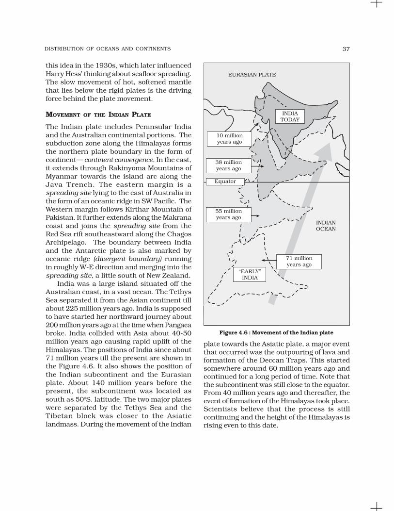
DISTRIBUTION OF OCEANS AND CONTINENTS 37
Figure 4.6 : Movement of the Indian plate
this idea in the 1930s, which later influencedHarry Hess’ thinking about seafloor spreading.The slow movement of hot, softened mantlethat lies below the rigid plates is the drivingforce behind the plate movement.
MOVEMENT OF THE INDIAN PLATE
The Indian plate includes Peninsular Indiaand the Australian continental portions. Thesubduction zone along the Himalayas formsthe northern plate boundary in the form ofcontinent— continent convergence. In the east,it extends through Rakinyoma Mountains ofMyanmar towards the island arc along theJava Trench. The eastern margin is aspreading site lying to the east of Australia inthe form of an oceanic ridge in SW Pacific. TheWestern margin follows Kirthar Mountain ofPakistan. It further extends along the Makranacoast and joins the spreading site from theRed Sea rift southeastward along the ChagosArchipelago. The boundary between Indiaand the Antarctic plate is also marked byoceanic ridge (divergent boundary) runningin roughly W-E direction and merging into thespreading site, a little south of New Zealand.
India was a large island situated off theAustralian coast, in a vast ocean. The TethysSea separated it from the Asian continent tillabout 225 million years ago. India is supposedto have started her northward journey about200 million years ago at the time when Pangaeabroke. India collided with Asia about 40-50million years ago causing rapid uplift of theHimalayas. The positions of India since about71 million years till the present are shown inthe Figure 4.6. It also shows the position ofthe Indian subcontinent and the Eurasianplate. About 140 million years before thepresent, the subcontinent was located assouth as 50oS. latitude. The two major plateswere separated by the Tethys Sea and theTibetan block was closer to the Asiaticlandmass. During the movement of the Indian
plate towards the Asiatic plate, a major eventthat occurred was the outpouring of lava andformation of the Deccan Traps. This startedsomewhere around 60 million years ago andcontinued for a long period of time. Note thatthe subcontinent was still close to the equator.From 40 million years ago and thereafter, theevent of formation of the Himalayas took place.Scientists believe that the process is stillcontinuing and the height of the Himalayas isrising even to this date.
FUNDAMENTALS OF PHYSICAL GEOGRAPHY38
EXERCISES
1. Multiple choice questions.
(i) Who amongst the following was the first to consider the possibility ofEurope, Africa and America having been located side by side.
(a) Alfred Wegener (c) Abraham Ortelius
(b) Antonio Pellegrini (d) Edmond Hess
(ii) Polar fleeing force relates to:
(a) Revolution of the Earth (c) Rotation of the earth
(b) Gravitation (d) Tides
(iii) Which one of the following is not a minor plate?
(a) Nazca (c) Philippines
(b) Arabia (d) Antarctica
(iv) Which one of the following facts was not considered by those whilediscussing the concept of sea floor spreading?
(a) Volcanic activity along the mid-oceanic ridges.
(b) Stripes of normal and reverse magnetic field observed in rocks of oceanfloor.
(c) Distribution of fossils in different continents.
(d) Age of rocks from the ocean floor.
(v) Which one of the following is the type of plate boundary of the Indian platealong the Himalayan mountains?
(a) Ocean-continent convergence
(b) Divergent boundary
(c) Transform boundary
(d) Continent-continent convergence
2. Answer the following questions in about 30 words.
(i) What were the forces suggested by Wegener for the movement of thecontinents?
(ii) How are the convectional currents in the mantle initiated and maintained?
(iii) What is the major difference between the transform boundary and theconvergent or divergent boundaries of plates?
(iv) What was the location of the Indian landmass during the formation of theDeccan Traps?
3. Answer the following questions in about 150 words.
(i) What are the evidences in support of the continental drift theory?
(ii) Bring about the basic difference between the drift theory and Platetectonics.
(iii) What were the major post-drift discoveries that rejuvenated the interestof scientists in the study of distribution of oceans and continents?
Project Work
Prepare a collage related to damages caused by an earthquake.

LANDFORMS
This unit deals with
• Rocks and minerals — major types of rocks and theircharacteristics
• Landforms and their evolution
• Geomorphic processes — weathering, mass wasting, erosionand deposition; soils — formation
UNIT
III

MINERALS AND ROCKS
C H A P T E R
The earth is composed of various kindsof elements. These elements are in solidform in the outer layer of the earth and
in hot and molten form in the interior.About 98 per cent of the total crust of the
earth is composed of eight elements likeoxygen, silicon, aluminium, iron, calcium,sodium, potassium and magnesium (Table 5.1),and the rest is constituted by titanium,hydrogen, phosphorous, manganese, sulphur,carbon, nickel and other elements.
Table 5.1 : The Major Elements of the Earth’s Crust
Sl. No. Elements By Weight(%)
1. Oxygen 46.602. Silicon 27.723. Aluminium 8.134. Iron 5.005. Calcium 3.636. Sodium 2.837. Potassium 2.598. Magnesium 2.099. Others 1.41
The elements in the earth’s crust are rarelyfound exclusively but are usually combined withother elements to make various substances.These substances are recognised as minerals.
Thus, a mineral is a naturally occurring
inorganic substance, having an orderly
atomic structure and a definite chemical
composition and physical properties. A
mineral is composed of two or more
elements. But, sometimes single element
minerals like sulphur, copper, silver, gold,graphite etc. are found.
Though the number of elements makingup the lithosphere are limited they arecombined in many different ways to make upmany varieties of minerals. There are at least2,000 minerals that have been named andidentified in the earth crust; but almost all thecommonly occurring ones are related to sixmajor mineral groups that are known as majorrock forming minerals.
The basic source of all minerals is the hotmagma in the interior of the earth. Whenmagma cools, crystals of minerals appear anda systematic series of minerals are formed insequence to solidify so as to form rocks.Minerals such as coal, petroleum and naturalgas are organic substances found in solid,liquid and gaseous forms respectively.
A brief information about some importantminerals in terms of their nature and physicalcharacteristics is given below :
PHYSICAL CHARACTERISTICS
(i) External crystal form — deter-mined by internal arrangement ofthe molecules — cubes, octahe-drons, hexagonal prisms, etc.
(ii) Cleavage — tendency to break ingiven directions producingrelatively plane surfaces — resultof internal arrangement of themolecules — may cleave in one ormore directions and at any angleto each other.
MINERALS AND ROCKS 41
(iii) Fracture — internal moleculararrangement so complex there areno planes of molecules; the crystalwill break in an irregular manner,not along planes of cleavage.
(iv) Lustre — appearance of a materialwithout regard to colour; eachmineral has a distinctive lustre likemetallic, silky, glossy etc.
(v) Colour — some minerals havecharacteristic colour determinedby their molecular structure —malachite, azurite, chalcopyrite etc.,and some minerals are coloured byimpurities. For example, becauseof impurities quartz may be white,green, red, yellow etc.
(vi) Streak — colour of the ground powderof any mineral. It may be of thesame colour as the mineral or maydiffer — malachite is green and givesgreen streak, fluorite is purple orgreen but gives a white streak.
(vii) Transparency — transparent: lightrays pass through so that objectscan be seen plainly; translucent— light rays pass through but willget diffused so that objects cannotbe seen; opaque — light will not passat all.
(viii) Structure — particular arrange-ment of the individual crystals;fine, medium or coarse grained;fibrous — separable, divergent,radiating.
(ix) Hardness — relative resistancebeing scratched; ten minerals areselected to measure the degree ofhardness from 1-10. They are:1. talc; 2. gypsum; 3. calcite;4. fluorite; 5. apatite; 6. feldspar;7. quartz; 8. topaz; 9. corundum;10. diamond. Compared to this forexample, a fingernail is 2.5 andglass or knife blade is 5.5.
(x) Specific gravity — the ratio betweenthe weight of a given object andthe weight of an equal volume ofwater; object weighed in air andthen weighed in water and divideweight in air by the difference of thetwo weights.
SOME MAJOR MINERALS ANDTHEIR CHARACTERISTICS
Feldspar
Silicon and oxygen are common elements inall types of feldspar and sodium, potassium,calcium, aluminium etc. are found in specificfeldspar variety. Half of the earth’s crust iscomposed of feldspar. It has light cream tosalmon pink colour. It is used in ceramics andglass making.
Quartz
It is one of the most important components ofsand and granite. It consists of silica. It is ahard mineral virtually insoluble in water. It iswhite or colourless and used in radio and radar.It is one of the most important components ofgranite.
Pyroxene
Pyroxene consists of calcium, aluminum,magnesium, iron and silica. Pyroxene forms10 per cent of the earth’s crust. It is commonlyfound in meteorites. It is in green or blackcolour.
Amphibole
Aluminium, calcium, silica, iron, magnesiumare the major elements of amphiboles. Theyform 7 per cent of the earth’s crust. It is ingreen or black colour and is used in asbestosindustry. Hornblende is another form ofamphiboles.
Mica
It comprises of potassium, aluminium,magnesium, iron, silica etc. It forms 4 per centof the earth’s crust. It is commonly found inigneous and metamorphic rocks. It is used inelectrical instruments.
Olivine
Magnesium, iron and silica are major elementsof olivine. It is used in jewellery. It is usually agreenish crystal, often found in basaltic rocks.
Besides these main minerals, other mineralslike chlorite, calcite, magnetite, haematite,bauxite and barite are also present in somequantities in the rocks.

FUNDAMENTALS OF PHYSICAL GEOGRAPHY42
Metallic Minerals
These minerals contain metal content and canbe sub-divided into three types:
(i) Precious metals : gold, silver, platinumetc.
(ii) Ferrous metals : iron and other metalsoften mixed with iron to form variouskinds of steel.
(iii) Non-ferrous metals : include metalslike copper, lead, zinc, tin, aluminiumetc.
Non-Metallic Minerals
These minerals do not contain metal content.Sulphur, phosphates and nitrates are examplesof non-metallic minerals. Cement is a mixtureof non-metallic minerals.
ROCKS
The earth’s crust is composed of rocks. Arock is an aggregate of one or more minerals.Rock may be hard or soft and in variedcolours. For example, granite is hard, soapstoneis soft. Gabbro is black and quartzite can bemilky white. Rocks do not have definitecomposition of mineral constituents.Feldspar and quartz are the most commonminerals found in rocks.
Petrology is science of rocks. A petrologiststudies rocks in all their aspects viz.,mineral composition, texture, structure,origin, occurrence, alteration andrelationship with other rocks.
As there is a close relation between rocksand landforms, rocks and soils, a geographerrequires basic knowledge of rocks. There aremany different kinds of rocks which aregrouped under three families on the basis oftheir mode of formation. They are: (i) IgneousRocks — solidified from magma and lava;(ii) Sedimentary Rocks — the result ofdeposition of fragments of rocks by exogenousprocesses; (iii) Metamorphic Rocks — formed outof existing rocks undergoing recrystallisation.
Igneous Rocks
As igneous rocks form out of magma and lavafrom the interior of the earth, they are knownas primary rocks. The igneous rocks (Ignis –in Latin means ‘Fire’) are formed when magmacools and solidifies. You already know whatmagma is. When magma in its upwardmovement cools and turns into solid form it iscalled igneous rock. The process of cooling andsolidification can happen in the earth’s crustor on the surface of the earth.
Igneous rocks are classified based ontexture. Texture depends upon size andarrangement of grains or other physicalconditions of the materials. If molten materialis cooled slowly at great depths, mineral grainsmay be very large. Sudden cooling (at thesurface) results in small and smooth grains.Intermediate conditions of cooling would resultin intermediate sizes of grains making upigneous rocks. Granite, gabbro, pegmatite,basalt, volcanic breccia and tuff are some ofthe examples of igneous rocks.
Sedimentary Rocks
The word ‘sedimentary’ is derived from the Latinword sedimentum, which means settling. Rocks(igneous, sedimentary and metamorphic) of theearth’s surface are exposed to denudationalagents, and are broken up into various sizesof fragments. Such fragments are transportedby different exogenous agencies anddeposited. These deposits through compactionturn into rocks. This process is calledlithification. In many sedimentary rocks, thelayers of deposits retain their characteristicseven after lithification. Hence, we see a numberof layers of varying thickness in sedimentaryrocks like sandstone, shale etc.
Depending upon the mode of formation,sedimentary rocks are classified into three majorgroups: (i) mechanically formed — sandstone,conglomerate, limestone, shale, loess etc. areexamples; (ii) organically formed — geyserite,chalk, limestone, coal etc. are some examples;(iii) chemically formed — chert, limestone, halite,potash etc. are some examples.

MINERALS AND ROCKS 43
Metamorphic Rocks
The word metamorphic means ‘change of form’.These rocks form under the action of pressure,volume and temperature (PVT) changes.Metamorphism occurs when rocks are forceddown to lower levels by tectonic processes orwhen molten magma rising through the crustcomes in contact with the crustal rocks or theunderlying rocks are subjected to greatamounts of pressure by overlying rocks.Metamorphism is a process by which alreadyconsolidated rocks undergo recrystallisationand reorganisation of materials within originalrocks.
Mechanical disruption and reorganisationof the original minerals within rocks due tobreaking and crushing without anyappreciable chemical changes is called dynamicmetamorphism. The materials of rockschemically alter and recrystallise due tothermal metamorphism. There are two typesof thermal metamorphism — contact meta-morphism and regional metamorphism. Incontact metamorphism the rocks come incontact with hot intruding magma and lavaand the rock materials recrystallise under hightemperatures. Quite often new materials formout of magma or lava are added to the rocks.In regional metamorphism, rocks undergorecrystallisation due to deformation caused bytectonic shearing together with hightemperature or pressure or both. In the processof metamorphism in some rocks grains orminerals get arranged in layers or lines. Suchan arrangement of minerals or grains inmetamorphic rocks is called foliation orlineation. Sometimes minerals or materials ofdifferent groups are arranged into alternatingthin to thick layers appearing in light and darkshades. Such a structure in metamorphicrocks is called banding and rocks displayingbanding are called banded rocks. Types ofmetamorphic rocks depend upon originalrocks that were subjected to metamorphism.Metamorphic rocks are classified into two
major groups — foliated rocks and non-foliatedrocks. Gneissoid, granite, syenite, slate, schist,marble, quartzite etc. are some examples ofmetamorphic rocks.
ROCK CYCLE
Rocks do not remain in their original form forlong but may undergo transformation. Rockcycle is a continuous process through whichold rocks are transformed into new ones.
Igneous rocks are primary rocks and otherrocks (sedimentary and metamorphic) formfrom these primary rocks. Igneous rocks canbe changed into metamorphic rocks. Thefragments derived out of igneous andmetamorphic rocks form into sedimentary
rocks. Sedimentary rocks themselves can turninto fragments and the fragments can be asource for formation of sedimentary rocks. Thecrustal rocks (igneous, metamorphic andsedimentary) once formed may be carrieddown into the mantle (interior of the earth)through subduction process (parts or wholeof crustal plates going down under anotherplate in zones of plate convergence) and thesame melt down due to increase intemperature in the interior and turn intomolten magma, the original source forigneous rocks (Figure 5.1).
Fig 5.1 : Rock Cycle

FUNDAMENTALS OF PHYSICAL GEOGRAPHY44
EXERCISES
1. Multiple choice questions.
(i) Which one of the following are the two main constituents of granite?
(a) Iron and nickel (c) Silica and aluminium
(b) Iron and silver (d) Iron Oxide and potassium
(ii) Which one of the following is the salient feature of metamorphic rocks?
(a) Changeable (c) Crystalline
(b) Quite (d) Foliation
(iii) Which one of the following is not a single element mineral?
(a) Gold (c) Mica
(b) Silver (d) Graphite
(iv) Which one of the following is the hardest mineral?
(a) Topaz (c) Quartz
(b) Diamond (d) Feldspar
(v) Which one of the following is not a sedimentary rock?
(a) Tillite (c) Breccia
(b) Borax (d) Marble
2. Answer the following questions in about 30 words.
(i) What do you mean by rocks? Name the three major classes of rocks.
(ii) What is an igneous rock? Describe the method of formation andcharacteristics of igneous rock.
(iii) What is meant by sedimentary rock? Describe the mode of formation ofsedimentary rock.
(iv) What relationship explained by rock cycle between the major type of rock?
3. Answer the following questions in about 150 words.
(i) Define the term ‘mineral’ and name the major classes of minerals withtheir physical characteristics.
(ii) Describe the nature and mode of origin of the chief types of rock at theearth’s crust. How will you distinguish them?
(iii) What are metamorphic rocks? Describe the types of metamorphic rockand how are they formed?
Project Work
Collect different rock samples and try to recognise them from their physicalcharacteristics and identify their family.
GEOMORPHIC PROCESSES
C H A P T E R
After learning about how the earth wasborn, how it evolved its crust and otherinner layers, how its crustal plates
moved and are moving, and other informationon earthquakes, the forms of volcanism andabout the rocks and minerals the crust iscomposed of, it is time to know in detail aboutthe surface of the earth on which we live. Letus start with this question.
Why is the surface of the earth uneven?
First of all, the earth’s crust is dynamic. Youare well aware that it has moved and movesvertically and horizontally. Of course, it moveda bit faster in the past than the rate at which itis moving now. The differences in the internalforces operating from within the earth whichbuilt up the crust have been responsible forthe variations in the outer surface of the crust.The earth’s surface is being continuouslysubjected to external forces induced basicallyby energy (sunlight). Of course, the internalforces are still active though with differentintensities. That means, the earth’s surface isbeing continuously subjected to by externalforces originating within the earth’s atmosphereand by internal forces from within the earth.The external forces are known as exogenicforces and the internal forces are known asendogenic forces. The actions of exogenicforces result in wearing down (degradation) ofrelief/elevations and filling up (aggradation) ofbasins/depressions, on the earth’s surface. Thephenomenon of wearing down of reliefvariations of the surface of the earth througherosion is known as gradation. The endogenic
forces continuously elevate or build up partsof the earth’s surface and hence the exogenicprocesses fail to even out the relief variationsof the surface of the earth. So, variations remainas long as the opposing actions of exogenic andendogenic forces continue. In general terms,the endogenic forces are mainly land buildingforces and the exogenic processes are mainlyland wearing forces. The surface of the earth issensitive. Humans depend on it for theirsustenance and have been using it extensivelyand intensively. So, it is essential to understandits nature in order to use it effectively withoutdisturbing its balance and diminishing itspotential for the future. Almost all organismscontribute to sustain the earth’s environment.However, humans have caused over use ofresources. Use we must, but must also leave itpotential enough to sustain life through thefuture. Most of the surface of the earth had andhas been shaped over very long periods of time(hundreds and thousands of years) andbecause of its use and misuse by humans itspotential is being diminished at a fast rate. Ifthe processes which shaped and are shapingthe surface of the earth into varieties of forms(shapes) and the nature of materials of whichit is composed of, are understood, precautionscan be taken to minimise the detrimental effectsof human use and to preserve it for posterity.
GEOMORPHIC PROCESSES
You would like to know the meaning ofgeomorphic processes. The endogenic andexogenic forces causing physical stresses andchemical actions on earth materials and

FUNDAMENTALS OF PHYSICAL GEOGRAPHY46
bringing about changes in the configurationof the surface of the earth are known asgeomorphic processes. Diastrophism andvolcanism are endogenic geomorphicprocesses. These have already been discussedin brief in the preceding unit. Weathering, masswasting, erosion and deposition are exogenicgeomorphic processes. These exogenicprocesses are dealt with in detail in this chapter.
Any exogenic element of nature (like water,ice, wind, etc.,) capable of acquiring andtransporting earth materials can be called ageomorphic agent. When these elements ofnature become mobile due to gradients, theyremove the materials and transport them overslopes and deposit them at lower level.Geomorphic processes and geomorphic agentsespecially exogenic, unless stated separately,are one and the same.
A process is a force applied on earthmaterials affecting the same. An agent is amobile medium (like running water, moving icemasses, wind, waves and currents etc.) whichremoves, transports and deposits earthmaterials. Running water, groundwater,glaciers, wind, waves and currents, etc., canbe called geomorphic agents.
Do you think it is essential to distinguishgeomorphic agents and geomorphicprocesses?
Gravity besides being a directional forceactivating all downslope movements of matteralso causes stresses on the earth’s materials.Indirect gravitational stresses activate wave andtide induced currents and winds. Withoutgravity and gradients there would be nomobility and hence no erosion, transportationand deposition are possible. So, gravitationalstresses are as important as the othergeomorphic processes. Gravity is the force thatis keeping us in contact with the surface and itis the force that switches on the movement ofall surface material on earth. All the movementseither within the earth or on the surface of theearth occur due to gradients — from higherlevels to lower levels, from high pressure to lowpressure areas etc.
ENDOGENIC PROCESSES
The energy emanating from within the earth isthe main force behind endogenic geomorphicprocesses. This energy is mostly generated byradioactivity, rotational and tidal friction andprimordial heat from the origin of the earth.This energy due to geothermal gradients andheat flow from within induces diastrophismand volcanism in the lithosphere. Due tovariations in geothermal gradients and heat flowfrom within, crustal thickness and strength,the action of endogenic forces are not uniformand hence the tectonically controlled originalcrustal surface is uneven.
Diastrophism
All processes that move, elevate or build upportions of the earth’s crust come underdiastrophism. They include: (i) orogenicprocesses involving mountain buildingthrough severe folding and affecting long andnarrow belts of the earth’s crust; (ii) epeirogenicprocesses involving uplift or warping of largeparts of the earth’s crust; (iii) earthquakesinvolving local relatively minor movements;(iv) plate tectonics involving horizontalmovements of crustal plates.
In the process of orogeny, the crust isseverely deformed into folds. Due to epeirogeny,there may be simple deformation. Orogeny isa mountain building process whereasepeirogeny is continental building process.Through the processes of orogeny, epeirogeny,earthquakes and plate tectonics, there can befaulting and fracturing of the crust. All theseprocesses cause pressure, volume andtemperature (PVT) changes which in turninduce metamorphism of rocks.
Epeirogeny and orogeny, cite thedifferences.
Volcanism
Volcanism includes the movement of moltenrock (magma) onto or toward the earth’ssurface and also formation of many intrusiveand extrusive volcanic forms. Many aspects ofvolcanism have already been dealt in detail

GEOMORPHIC PROCESSES 47
processes and their respective driving forces.It should become clear from this chart that foreach process there exists a distinct driving forceor energy.
As there are different climatic regions onthe earth’s surface owing to thermal gradientscreated by latitudinal, seasonal and land andwater spread variations, the exogenicgeomorphic processes vary from region toregion. The density, type and distribution ofvegetation which largely depend upon
under volcanoes in the Unit II and underigneous rocks in the preceding chapter in thisunit.
What do the words volcanism andvolcanoes indicate?
EXOGENIC PROCESSES
The exogenic processes derive their energyfrom atmosphere determined by the ultimateenergy from the sun and also the gradientscreated by tectonic factors.
Why do you think that the slopes orgradients are created by tectonic factors?
Gravitational force acts upon all earthmaterials having a sloping surface and tend toproduce movement of matter in down slopedirection. Force applied per unit area is calledstress. Stress is produced in a solid by pushingor pulling. This induces deformation. Forcesacting along the faces of earth materials areshear stresses (separating forces). It is thisstress that breaks rocks and other earthmaterials. The shear stresses result in angulardisplacement or slippage. Besides thegravitational stress earth materials becomesubjected to molecular stresses that may becaused by a number of factors amongst whichtemperature changes, crystallisation andmelting are the most common. Chemicalprocesses normally lead to loosening of bondsbetween grains, dissolving of soluble mineralsor cementing materials. Thus, the basic reasonthat leads to weathering, mass movements,erosion and deposition is development ofstresses in the body of the earth materials.
As there are different climatic regions onthe earth’s surface the exogenic geomorphicprocesses vary from region to region.Temperature and precipitation are the twoimportant climatic elements that controlvarious processes.
All the exogenic geomorphic processes arecovered under a general term, denudation. Theword ‘denude’ means to strip off or to uncover.Weathering, mass wasting/movements, erosionand transportation are included in denudation.The flow chart (Figure 6.1) gives the denudation
precipitation and temperature exert influenceindirectly on exogenic geomorphic processes.Within different climatic regions there may belocal variations of the effects of different climaticelements due to altitudinal differences, aspectvariations and the variation in the amount ofinsolation received by north and south facingslopes as compared to east and west facingslopes. Further, due to differences in windvelocities and directions, amount and kind ofprecipitation, its intensity, the relation betweenprecipitation and evaporation, daily range oftemperature, freezing and thawing frequency,depth of frost penetration, the geomorphicprocesses vary within any climatic region.
What is the sole driving force behind allthe exogenic processes?
Climatic factors being equal, the intensityof action of exogenic geomorphic processesdepends upon type and structure of rocks. Theterm structure includes such aspects of rocksas folds, faults, orientation and inclination ofbeds, presence or absence of joints, beddingplanes, hardness or softness of constituentminerals, chemical susceptibility of mineralconstituents; the permeability or impermeability
Figure 6.1 : Denudational processes and theirdriving forces

FUNDAMENTALS OF PHYSICAL GEOGRAPHY48
etc. Different types of rocks with differences intheir structure offer varying resistances tovarious geomorphic processes. A particularrock may be resistant to one process and non-resistant to another. And, under varyingclimatic conditions, particular rocks mayexhibit different degrees of resistance togeomorphic processes and hence they operateat differential rates and give rise to differencesin topography. The effects of most of theexogenic geomorphic processes are small andslow and may be imperceptible in a short timespan, but will in the long run affect the rocksseverely due to continued fatigue.
Finally, it boils down to one fact that thedifferences on the surface of the earth thoughoriginally related to the crustal evolutioncontinue to exist in some form or the other dueto differences in the type and structure of earthmaterials, differences in geomorphic processesand in their rates of operation.
Some of the exogenic geomorphic processeshave been dealt in detail here.
WEATHERING
Weathering is action of elements of weather andclimate over earth materials. There are anumber of processes within weathering whichact either individually or together to affect theearth materials in order to reduce them tofragmental state.
Weathering is defined as mechanicaldisintegration and chemical decom-position of rocks through the actions ofvarious elements of weather and climate.
As very little or no motion of materialstakes place in weathering, it is an in-situ oron-site process.
Is this little motion which can occursometimes due to weathering synonymouswith transportation? If not, why?
Weathering processes are conditioned bymany complex geological, climatic, topographicand vegetative factors. Climate is of particularimportance. Not only weathering processesdiffer from climate to climate, but also the depthof the weathering mantle (Figure 6.2).
Figure 6.2 : Climatic regimes and depth of weatheringmantles (adapted and modified from Strakhov, 1967)
Activity
Mark the latitude values of differentclimatic regimes in Figure 6.2 andcompare the details.
There are three major groups of weatheringprocesses : (i) chemical; (ii) physical ormechanical; (iii) biological weathering processes.Very rarely does any one of these processes everoperate completely by itself, but quite often adominance of one process can be seen.
Chemical Weathering Processes
A group of weathering processes viz; solution,carbonation, hydration, oxidation andreduction act on the rocks to decompose,dissolve or reduce them to a fine clastic statethrough chemical reactions by oxygen, surfaceand/or soil water and other acids. Water andair (oxygen and carbon dioxide) along withheat must be present to speed up all chemicalreactions. Over and above the carbon dioxidepresent in the air, decomposition of plants andanimals increases the quantity of carbondioxide underground. These chemicalreactions on various minerals are very muchsimilar to the chemical reactions in a laboratory.
Solution
When something is dissolved in water or acids,the water or acid with dissolved contents is

GEOMORPHIC PROCESSES 49
called solution. This process involves removalof solids in solution and depends uponsolubility of a mineral in water or weak acids.On coming in contact with water many solidsdisintegrate and mix up as suspension inwater. Soluble rock forming minerals likenitrates, sulphates, and potassium etc. areaffected by this process. So, these minerals areeasily leached out without leaving any residuein rainy climates and accumulate in dryregions. Minerals like calcium carbonate andcalcium magnesium bicarbonate present inlimestones are soluble in water containingcarbonic acid (formed with the addition ofcarbon dioxide in water), and are carried awayin water as solution. Carbon dioxide producedby decaying organic matter along with soilwater greatly aids in this reaction. Commonsalt (sodium chloride) is also a rock formingmineral and is susceptible to this process ofsolution.
Carbonation
Carbonation is the reaction of carbonate andbicarbonate with minerals and is a commonprocess helping the breaking down offeldspars and carbonate minerals. Carbondioxide from the atmosphere and soil air isabsorbed by water, to form carbonic acid thatacts as a weak acid. Calcium carbonates andmagnesium carbonates are dissolved incarbonic acid and are removed in a solutionwithout leaving any residue resulting in caveformation.
Why are clay minerals easily erodible?
Hydration
Hydration is the chemical addition of water.Minerals take up water and expand; thisexpansion causes an increase in the volume ofthe material itself or rock. Calcium sulphatetakes in water and turns to gypsum, which ismore unstable than calcium sulphate. Thisprocess is reversible and long, continuedrepetition of this process causes fatigue in therocks and may lead to their disintegration.
Many clay minerals swell and contract duringwetting and drying and a repetition of thisprocess results in cracking of overlyingmaterials. Salts in pore spaces undergo rapidand repeated hydration and help in rockfracturing. The volume changes in mineralsdue to hydration will also help in physicalweathering through exfoliation and granulardisintegration.
Oxidation and Reduction
In weathering, oxidation means a combinationof a mineral with oxygen to form oxides orhydroxides. Oxidation occurs where there isready access to the atmosphere andoxygenated waters. The minerals mostcommonly involved in this process are iron,manganese, sulphur etc. In the process ofoxidation rock breakdown occurs due to thedisturbance caused by addition of oxygen. Redcolour of iron upon oxidation turns to brownor yellow. When oxidised minerals are placedin an environment where oxygen is absent,reduction takes place. Such conditions existusually below the water table, in areas ofstagnant water and waterlogged ground. Redcolour of iron upon reduction turns to greenishor bluish grey.
These weathering processes are inter-related. Hydration, carbonation and oxidationgo hand in hand and hasten the weatheringprocess.
Can we give iron rusting as an exampleof oxidation? How essential is water inchemical weathering processes? Canchemical weathering processes dominatein water scarce hot deserts?
Physical Weathering Processes
Physical or mechanical weathering processesdepend on some applied forces. The appliedforces could be: (i) gravitational forces such asoverburden pressure, load and shearing stress;(ii) expansion forces due to temperaturechanges, crystal growth or animal activity;(iii) water pressures controlled by wetting and

FUNDAMENTALS OF PHYSICAL GEOGRAPHY50
drying cycles. Many of these forces are appliedboth at the surface and within different earthmaterials leading to rock fracture. Most of thephysical weathering processes are caused bythermal expansion and pressure release. Theseprocesses are small and slow but can causegreat damage to the rocks because ofcontinued fatigue the rocks suffer due torepetition of contraction and expansion.
Unloading and Expansion
Removal of overlying rock load because ofcontinued erosion causes vertical pressurerelease with the result that the upper layers ofthe rock expand producing disintegration ofrock masses. Fractures will develop roughlyparallel to the ground surface. In areas ofcurved ground surface, arched fractures tendto produce massive sheets or exfoliation slabsof rock. Exfoliation sheets resulting fromexpansion due to unloading and pressurerelease may measure hundreds or eventhousands of metres in horizontal extent. Large,smooth rounded domes called exfoliationdomes (Figure 6.3) result due to this process.
temperatures, this internal movement amongthe mineral grains of the superficial layers ofrocks takes place regularly. This process ismost effective in dry climates and highelevations where diurnal temperature changesare drastic. As has been mentioned earlierthough these movements are very small theymake the rocks weak due to continued fatigue.The surface layers of the rocks tend to expandmore than the rock at depth and this leads tothe formation of stress within the rock resultingin heaving and fracturing parallel to thesurface. Due to differential heating andresulting expansion and contraction of surfacelayers and their subsequent exfoliation fromthe surface results in smooth rounded surfacesin rocks. In rocks like granites, smoothsurfaced and rounded small to big boulderscalled tors form due to such exfoliation.
What is the difference between exfoliationdomes and exfoliated tors?
Freezing, Thawing and Frost Wedging
Frost weathering occurs due to growth of icewithin pores and cracks of rocks duringrepeated cycles of freezing and melting. Thisprocess is most effective at high elevations inmid-latitudes where freezing and melting isoften repeated. Glacial areas are subject to frostwedging daily. In this process, the rate offreezing is important. Rapid freezing of watercauses its sudden expansion and high pressure.The resulting expansion affects joints, cracksand small inter granular fractures to becomewider and wider till the rock breaks apart.
Salt Weathering
Salts in rocks expand due to thermal action,hydration and crystallisation. Many salts likecalcium, sodium, magnesium, potassium andbarium have a tendency to expand. Expansionof these salts depends on temperature andtheir thermal properties. High temperatureranges between 30 and 50oC of surfacetemperatures in deserts favour such saltexpansion. Salt crystals in near-surface pores
Figure 6.3 : A large exfoliation dome in granite rocknear bhongir (Bhuvanagiri) town in Andhra Pradesh
Temperature Changes and Expansion
Various minerals in rocks possess their ownlimits of expansion and contraction. With risein temperature, every mineral expands andpushes against its neighbour and astemperature falls, a corresponding contractiontakes place. Because of diurnal changes in the

GEOMORPHIC PROCESSES 51
cause splitting of individual grains withinrocks, which eventually fall off. This process offalling off of individual grains may result ingranular disintegration or granular foliation.
Salt crystallisation is most effective of allsalt-weathering processes. In areas withalternating wetting and drying conditions saltcrystal growth is favoured and the neighbouringgrains are pushed aside. Sodium chloride andgypsum crystals in desert areas heave upoverlying layers of materials and with the resultpolygonal cracks develop all over the heavedsurface. With salt crystal growth, chalk breaksdown most readily, followed by limestone,sandstone, shale, gneiss and granite etc.
BIOLOGICAL ACTIVITY AND WEATHERING
Biological weathering is contribution to orremoval of minerals and ions from theweathering environment and physical changesdue to growth or movement of organisms.Burrowing and wedging by organisms likeearthworms, termites, rodents etc., help inexposing the new surfaces to chemical attackand assists in the penetration of moisture andair. Human beings by disturbing vegetation,ploughing and cultivating soils, also help inmixing and creating new contacts between air,water and minerals in the earth materials.Decaying plant and animal matter help in theproduction of humic, carbonic and other acidswhich enhance decay and solubility of someelements. Algae utilise mineral nutrients forgrowth and help in concentration of iron andmanganese oxides. Plant roots exert atremendous pressure on the earth materialsmechanically breaking them apart.
SOME SPECIAL EFFECTS OF WEATHERING
This has already been explained underphysical weathering processes of unloading,thermal contraction and expansion and saltweathering. Exfoliation is a result but not aprocess. Flaking off of more or less curvedsheets of shells from over rocks or bedrockresults in smooth and rounded surfaces(Figure 6.4). Exfoliation can occur due toexpansion and contraction induced by
temperature changes. Exfoliation domes andtors result due to unloading and thermalexpansion respectively.
SIGNIFICANCE OF WEATHERING
Weathering processes are responsible forbreaking down the rocks into smallerfragments and preparing the way for formationof not only regolith and soils, but also erosionand mass movements. Biomes and bio-diversity is basically a result of forests(vegetation) and forests depend upon the depthof weathering mantles. Erosion cannot besignificant if the rocks are not weathered. Thatmeans, weathering aids mass wasting, erosionand reduction of relief and changes inlandforms are a consequence of erosion.Weathering of rocks and deposits helps in theenrichment and concentrations of certainvaluable ores of iron, manganese, aluminium,copper etc., which are of great importance forthe national economy. Weathering is animportant process in the formation of soils.
When rocks undergo weathering, somematerials are removed through chemicalor physical leaching by groundwater andthereby the concentration of remaining(valuable) materials increases. Withoutsuch a weathering taking place, theconcentration of the same valuablematerial may not be sufficient andeconomically viable to exploit, process andrefine. This is what is called enrichment.
Fig.6.4 : Exfoliation (Flacking) and granulardisintegration

FUNDAMENTALS OF PHYSICAL GEOGRAPHY52
the three forms of movements. Figure 6.5 showsthe relationships among different types of massmovements, their relative rates of movementand moisture limits.
Figure 6.5 : Relationships among different types ofmass movements, their relative rates of movement
and moisture limits (after Whitehead, 2001)
MASS MOVEMENTS
These movements transfer the mass of rockdebris down the slopes under the directinfluence of gravity. That means, air, water orice do not carry debris with them from place toplace but on the other hand the debris maycarry with it air, water or ice. The movementsof mass may range from slow to rapid,affecting shallow to deep columns of materialsand include creep, flow, slide and fall. Gravityexerts its force on all matter, both bedrock andthe products of weathering. So, weathering isnot a pre-requisite for mass movement thoughit aids mass movements. Mass movements arevery active over weathered slopes rather thanover unweathered materials.
Mass movements are aided by gravity andno geomorphic agent like running water,glaciers, wind, waves and currents participatein the process of mass movements. That meansmass movements do not come under erosionthough there is a shift (aided by gravity) ofmaterials from one place to another. Materialsover the slopes have their own resistance todisturbing forces and will yield only when forceis greater than the shearing resistance of thematerials. Weak unconsolidated materials,thinly bedded rocks, faults, steeply dippingbeds, vertical cliffs or steep slopes, abundantprecipitation and torrential rains and scarcityof vegetation etc., favour mass movements.
Several activating causes precede massmovements. They are : (i) removal of supportfrom below to materials above through naturalor artificial means; (ii) increase in gradient andheight of slopes; (iii) overloading throughaddition of materials naturally or by artificialfilling; (iv) overloading due to heavy rainfall,saturation and lubrication of slope materials;(v) removal of material or load from over theoriginal slope surfaces; (vi) occurrence ofearthquakes, explosions or machinery;(vii) excessive natural seepage; (viii) heavydrawdown of water from lakes, reservoirs andrivers leading to slow outflow of water fromunder the slopes or river banks; (ix) indis-criminate removal of natural vegetation.
Heave (heaving up of soils due to frostgrowth and other causes), flow and slide are
Mass movements can be grouped underthree major classes: (i) slow movements;(ii) rapid movements; (iii) landslides.
Slow Movements
Creep is one type under this category whichcan occur on moderately steep, soil coveredslopes. Movement of materials is extremelyslow and imperceptible except throughextended observation. Materials involved canbe soil or rock debris. Have you ever seen fenceposts, telephone poles lean downslope fromtheir vertical position and in their linearalignment? If you have, that is due to the creepeffect. Depending upon the type of materialinvolved, several types of creep viz., soil creep,talus creep, rock creep, rock-glacier creep etc.,can be identified. Also included in this groupis solifluction which involves slow downslopeflowing soil mass or fine grained rock debrissaturated or lubricated with water. This processis quite common in moist temperate areaswhere surface melting of deeply frozen groundand long continued rain respectively, occurfrequently. When the upper portions getsaturated and when the lower parts areimpervious to water percolation, flowing occursin the upper parts.

GEOMORPHIC PROCESSES 53
Rapid Movements
These movements are mostly prevalent inhumid climatic regions and occur over gentleto steep slopes. Movement of water-saturatedclayey or silty earth materials down low-angleterraces or hillsides is known as earthflow.Quite often, the materials slump making step-like terraces and leaving arcuate scarps at theirheads and an accumulation bulge at the toe.When slopes are steeper, even the bedrockespecially of soft sedimentary rocks like shaleor deeply weathered igneous rock may slidedownslope.
Another type in this category is mudflow.In the absence of vegetation cover and withheavy rainfall, thick layers of weatheredmaterials get saturated with water and eitherslowly or rapidly flow down along definitechannels. It looks like a stream of mud withina valley. When the mudflows emerge out ofchannels onto the piedmont or plains, they canbe very destructive engulfing roads, bridgesand houses. Mudflows occur frequently on theslopes of erupting or recently erupted volcanoes.Volcanic ash, dust and other fragments turninto mud due to heavy rains and flow down astongues or streams of mud causing greatdestruction to human habitations.
A third type is the debris avalanche, whichis more characteristic of humid regions withor without vegetation cover and occurs innarrow tracks on steep slopes. This debrisavalanche can be much faster than themudflow. Debris avalanche is similar to snowavalanche.
In Andes mountains of South Americaand the Rockies mountains of NorthAmerica, there are a few volcanoes whicherupted during the last decade and verydevastating mudflows occurred downtheir slopes during eruption as well asafter eruption.
Landslides
These are known as relatively rapid andperceptible movements. The materials involvedare relatively dry. The size and shape of thedetached mass depends on the nature of
discontinuities in the rock, the degree ofweathering and the steepness of the slope.Depending upon the type of movement ofmaterials several types are identified in thiscategory.
Slump is slipping of one or several units ofrock debris with a backward rotation withrespect to the slope over which the movementtakes place (Figure 6.6). Rapid rolling or sliding
of earth debris without backward rotation ofmass is known as debris slide. Debris fall isnearly a free fall of earth debris from a verticalor overhanging face. Sliding of individual rockmasses down bedding, joint or fault surfacesis rockslide. Over steep slopes, rock sliding isvery fast and destructive. Figure 6.7 showslandslide scars over steep slopes. Slides occuras planar failures along discontinuities likebedding planes that dip steeply. Rock fall isfree falling of rock blocks over any steep slopekeeping itself away from the slope. Rock fallsoccur from the superficial layers of the rock
Figure 6.6 : Slumping of debris with backward rotation
Figure 6.7 : Landslide scars in Shiwalik Himalayan rangesnear river Sarada at India-Nepal border, Uttar Pradesh

FUNDAMENTALS OF PHYSICAL GEOGRAPHY54
face, an occurrence that distinguishes it fromrockslide which affects materials up to asubstantial depth.
Between mass wasting and massmovements, which term do you feel ismost appropriate? Why? Can solifluctionbe included under rapid flow movements?Why it can be and can’t be?
In our country, debris avalanche andlandslides occur very frequently in theHimalayas. There are many reasons forthis. One, the Himalayas are tectonicallyactive. They are mostly made up ofsedimentary rocks and unconsolidatedand semi-consolidated deposits. Theslopes are very steep. Compared to theHimalayas, the Nilgiris borderingTamilnadu, Karnataka, Kerala and theWestern Ghats along the west coast arerelatively tectonically stable and aremostly made up of very hard rocks; but,still, debris avalanches and landslidesoccur though not as frequently as in theHimalayas, in these hills. Why? Manyslopes are steeper with almost verticalcliffs and escarpments in the WesternGhats and Nilgiris. Mechanical weatheringdue to temperature changes and rangesis pronounced. They receive heavyamounts of rainfall over short periods.So, there is almost direct rock fall quitefrequently in these places along withlandslides and debris avalanches.
EROSION AND DEPOSITION
Erosion involves acquisition and transportationof rock debris. When massive rocks break intosmaller fragments through weathering andany other process, erosional geomorphicagents like running water, groundwater,glaciers, wind and waves remove andtransport it to other places depending uponthe dynamics of each of these agents. Abrasionby rock debris carried by these geomorphicagents also aids greatly in erosion. By erosion,relief degrades, i.e., the landscape is worndown. That means, though weathering aids
erosion it is not a pre-condition for erosion totake place. Weathering, mass-wasting anderosion are degradational processes. It iserosion that is largely responsible forcontinuous changes that the earth’s surface isundergoing. As indicated in Figure 6.1,denudational processes like erosion andtransportation are controlled by kinetic energy.The erosion and transportation of earthmaterials is brought about by wind, runningwater, glaciers, waves and ground water. Ofthese the first three agents are controlled byclimatic conditions.
Can you compare the three climaticallycontrolled agents?
They represent three states of matter —gaseous (wind), liquid (running water) andsolid (glacier) respectively. The erosion can bedefined as “application of the kinetic energyassociated with the agent to the surface of theland along which it moves”. Kinetic energy iscomputed as KE = 1/
2 mv2 where ‘m’ is the mass
and ‘v’ is the velocity. Hence the energyavailable to perform work will depend on themass of the material and the velocity withwhich it is moving. Obviously then you will findthat though the glaciers move at very lowvelocities due to tremendous mass are moreeffective as the agents of erosion and wind,being in gaseous state, are less effective.
The work of the other two agents of erosion-waves and ground water is not controlled byclimate. In case of waves it is the location alongthe interface of litho and hydro sphere —coastal region — that will determine the workof waves, whereas the work of ground water isdetermined more by the lithological characterof the region. If the rocks are permeable andsoluble and water is available only then karsttopography develops. In the next chapter weshall be dealing with the landforms producedby each of the agents of erosion.
Deposition is a consequence of erosion. Theerosional agents loose their velocity and henceenergy on gentler slopes and the materialscarried by them start to settle themselves. Inother words, deposition is not actually the workof any agent. The coarser materials get

GEOMORPHIC PROCESSES 55
deposited first and finer ones later. Bydeposition depressions get filled up. The sameerosional agents viz., running water, glaciers,wind, waves and groundwater act asaggradational or depositional agents also.
What happens to the surface of the earthdue to erosion and deposition is elaborated inthe next chapter on landforms and theirevolution.
There is a shift of materials in massmovements as well as in erosion from oneplace to the other. So, why can’t both betreated as one and the same? Can therebe appreciable erosion without rocksundergoing weathering?
SOIL FORMATION
Soil and Soil Contents
You see plants growing in soils. You play inthe ground and come into contact with soil.You touch and feel soil and soil your clotheswhile playing. Can you describe it?
A pedologist who studies soils defines soilas a collection of natural bodies on the earth’ssurface containing living matter andsupporting or capable of supporting plants.
Soil is a dynamic medium in which manychemical, physical and biological activities goon constantly. Soil is a result of decay, it is alsothe medium for growth. It is a changing anddeveloping body. It has many characteristicsthat fluctuate with the seasons. It may bealternatively cold and warm or dry and moist.Biological activity is slowed or stopped if thesoil becomes too cold or too dry. Organic matterincreases when leaves fall or grasses die. Thesoil chemistry, the amount of organic matter,the soil flora and fauna, the temperature andthe moisture, all change with the seasons aswell as with more extended periods of time.That means, soil becomes adjusted toconditions of climate, landform and vegetationand will change internally when thesecontrolling conditions change.
Process of Soil Formation
Soil formation or pedogenesis depends first onweathering. It is this weathering mantle (depth
of the weathered material) which is the basicinput for soil to form. First, the weatheredmaterial or transported deposits are colonisedby bacteria and other inferior plant bodies likemosses and lichens. Also, several minororganisms may take shelter within the mantleand deposits. The dead remains of organismsand plants help in humus accumulation. Minorgrasses and ferns may grow; later, bushes andtrees will start growing through seeds broughtin by birds and wind. Plant roots penetratedown, burrowing animals bring up particles,mass of material becomes porous and sponge-like with a capacity to retain water and to permitthe passage of air and finally a mature soil, acomplex mixture of mineral and organicproducts forms.
Is weathering solely responsible for soilformation? If not, why?
Pedology is soil science. A pedologist is asoil-scientist.
Soil-forming Factors
Five basic factors control the formation of soils:(i) parent material; (ii) topography; (iii) climate;(iv) biological activity; (v) time. In fact soilforming factors act in union and affect theaction of one another.
Parent Material
Parent material is a passive control factor insoil formation. Parent materials can be any in-situ or on-site weathered rock debris (residualsoils) or transported deposits (transportedsoils). Soil formation depends upon the texture(sizes of debris) and structure (disposition ofindividual grains/particles of debris) as wellas the mineral and chemical composition of therock debris/deposits.
Nature and rate of weathering and depth ofweathering mantle are important considerationunder parent materials. There may bedifferences in soil over similar bedrock anddissimilar bedrocks may have similar soilsabove them. But when soils are very youngand have not matured these show strong links

FUNDAMENTALS OF PHYSICAL GEOGRAPHY56
with the type of parent rock. Also, in case ofsome limestone areas, where the weatheringprocesses are specific and peculiar, soils willshow clear relation with the parent rock.
Topography
Topography like parent materials is anotherpassive control factor. The influence oftopography is felt through the amount ofexposure of a surface covered by parentmaterials to sunlight and the amount ofsurface and sub-surface drainage over andthrough the parent materials. Soils will be thinon steep slopes and thick over flat uplandareas. Over gentle slopes where erosion is slowand percolation of water is good, soil formationis very favourable. Soils over flat areas maydevelop a thick layer of clay with goodaccumulation of organic matter giving the soildark colour. In middle latitudes, the southfacing slopes exposed to sunlight have differentconditions of vegetation and soils and the northfacing slopes with cool, moist conditions havesome other soils and vegetation.
Climate
Climate is an important active factor in soilformation. The climatic elements involved in soildevelopment are : (i) moisture in terms of itsintensity, frequency and duration ofprecipitation - evaporation and humidity;(ii) temperature in terms of seasonal anddiurnal variations.
Precipitation gives soil its moisture contentwhich makes the chemical and biologicalactivities possible. Excess of water helps in thedownward transportation of soil componentsthrough the soil (eluviation) and deposits thesame down below (illuviation). In climates likewet equatorial rainy areas with high rainfall,not only calcium, sodium, magnesium,potassium etc. but also a major part of silica isremoved from the soil. Removal of silica fromthe soil is known as desilication. In dry climates,because of high temperature, evaporationexceeds precipitation and hence ground wateris brought up to the surface by capillary actionand in the process the water evaporates leavingbehind salts in the soil. Such salts form into acrust in the soil known as hardpans. In tropical
climates and in areas with intermediateprecipitation conditions, calcium carbonatenodules (kanker) are formed.
Temperature acts in two ways — increasingor reducing chemical and biological activity.Chemical activity is increased in highertemperatures, reduced in cooler temperatures(with an exception of carbonation) and stopsin freezing conditions. That is why, tropical soilswith higher temperatures show deeper profilesand in the frozen tundra regions soils containlargely mechanically broken materials.
Biological Activity
The vegetative cover and organisms that occupythe parent materials from the beginning and alsoat later stages help in adding organic matter,moisture retention, nitrogen etc. Dead plantsprovide humus, the finely divided organic matterof the soil. Some organic acids which formduring humification aid in decomposing theminerals of the soil parent materials.
Intensity of bacterial activity shows updifferences between soils of cold and warmclimates. Humus accumulates in cold climatesas bacterial growth is slow. With undecomposedorganic matter because of low bacterial activity,layers of peat develop in sub-arctic and tundraclimates. In humid tropical and equatorialclimates, bacterial growth and action is intenseand dead vegetation is rapidly oxidised leavingvery low humus content in the soil. Further,bacteria and other soil organisms take gaseousnitrogen from the air and convert it into achemical form that can be used by plants. Thisprocess is known as nitrogen fixation.Rhizobium, a type of bacteria, lives in the rootnodules of leguminous plants and fixes nitrogenbeneficial to the host plant. The influence of largeanimals like ants, termites, earthworms, rodentsetc., is mechanical, but, it is neverthelessimportant in soil formation as they rework thesoil up and down. In case of earthworms, asthey feed on soil, the texture and chemistry ofthe soil that comes out of their body changes.
Time
Time is the third important controlling factorin soil formation. The length of time the soilforming processes operate, determines

GEOMORPHIC PROCESSES 57
maturation of soils and profile development. Asoil becomes mature when all soil-formingprocesses act for a sufficiently long timedeveloping a profile. Soils developing fromrecently deposited alluvium or glacial till areconsidered young and they exhibit no horizonsor only poorly developed horizons. No specificlength of time in absolute terms can be fixedfor soils to develop and mature.
Is it necessary to separate the process of
soil formation and the soil forming control
factors?
Why are time, topography and parent
material considered as passive control
factors in soil formation?
EXERCISES
1. Multiple choice questions.
(i) Which one of the following processes is a gradational process?
(a) Deposition (c) Volcanism
(b) Diastrophism (d) Erosion
(ii) Which one of the following materials is affected by hydration process?
(a) Granite (c) Quartz
(b) Clay (d) Salts
(iii) Debris avalanche can be included in the category of:
(a) Landslides (c) Rapid flow mass movements
(b) Slow flow mass movements (d) Subsidence
2. Answer the following questions in about 30 words.
(i) It is weathering that is responsible for bio-diversity on the earth. How?
(ii) What are mass movements that are real rapid and perceptible? List.
(iii) What are the various mobile and mighty exogenic geomorphic agents andwhat is the prime job they perform?
(iv) Is weathering essential as a pre-requisite in the formation of soils? Why?
3. Answer the following questions in about 150 words.
(i) “Our earth is a playfield for two opposing groups of geomorphic processes.”Discuss.
(ii) Exogenic geomorphic processes derive their ultimate energy from the sun’sheat. Explain.
(iii) Are physical and chemical weathering processes independent of eachother? If not, why? Explain with examples.
(iv) How do you distinguish between the process of soil formation and soil-forming factors? What is the role of climate and biological activity as twoimportant control factors in the formation of soils?
Project Work
Depending upon the topography and materials around you, observe and recordclimate, possible weathering process and soil contents and characteristics.

LANDFORMS AND THEIR
EVOLUTION
C H A P T E R
A fter weathering processes have hadtheir actions on the earth materialsmaking up the surface of the earth, the
geomorphic agents like running water, groundwater, wind, glaciers, waves perform erosion.It is already known to you that erosion causeschanges on the surface of the earth. Depositionfollows erosion and because of deposition too,changes occur on the surface of the earth.
As this chapter deals with landforms andtheir evolution first start with the question,what is a landform? In simple words, small tomedium tracts or parcels of the earth’s surfaceare called landforms.
If landform is a small to medium sized partof the surface of the earth, what is a landscape?
Several related landforms together makeup landscapes, (large tracts of earth’s surface).Each landform has its own physical shape, size,materials and is a result of the action of certaingeomorphic processes and agent(s). Actionsof most of the geomorphic processes andagents are slow, and hence the results take along time to take shape. Every landform has abeginning. Landforms once formed maychange in their shape, size and nature slowlyor fast due to continued action of geomorphicprocesses and agents.
Due to changes in climatic conditions andvertical or horizontal movements of land-masses, either the intensity of processes or theprocesses themselves might change leading tonew modifications in the landforms. Evolutionhere implies stages of transformation of eithera part of the earth’s surface from one landforminto another or transformation of individuallandforms after they are once formed. That
means, each and every landform has a historyof development and changes through time. Alandmass passes through stages ofdevelopment somewhat comparable to thestages of life — youth, mature and old age.
What are the two important aspects ofthe evolution of landforms?
The evolutionary history of the continuallychanging surface of the earth is essential to beunderstood in order to use it effectively withoutdisturbing its balance and diminishing itspotential for the future. Geomorphology dealswith the reconstruction of the history of thesurface of the earth through a study of itsforms, the materials of which it is made up ofand the processes that shape it.
Changes on the surface of the earth owemostly to erosion by various geomorphicagents. Of course, the process of deposition too,by covering the land surfaces and filling thebasins, valleys or depressions, brings changesin the surface of the land. Deposition followserosion and the depositional surfaces too areultimately subjected to erosion. Running water,ground-water, glaciers, wind and waves arepowerful erosional and depositional agentsshaping and changing the surface of the earthaided by weathering and mass wastingprocesses. These geomorphic agents actingover long periods of time produce systematicchanges leading to sequential development oflandforms. Each geomorphic agent producesits own assemblage of landforms. Not only this,each geomorphic process and agent leave theirdistinct imprints on the landforms they

LANDFORMS AND THEIR EVOLUTION 59
produce. You know that most of thegeomorphic processes are imperceptiblefunctions and can only be seen and measuredthrough their results. What are the results?These results are nothing but landforms andtheir characteristics. Hence, a study oflandforms, will reveal to us the process andagent which has made or has been makingthose landforms.
Most of the geomorphic processes areimperceptible. Cite a few processes whichcan be seen and a few which can’t beseen.
As the geomorphic agents are capable oferosion and deposition, two sets — erosionalor destructional and depositional orconstructional — of landforms are producedby them. Many varieties of landforms developby the action of each of the geomorphic agentsdepending upon especially the type andstructure i.e. folds, faults, joints, fractures,hardness and softness, permeability andimpermeability, etc. come under structure ofrocks. There are some other independentcontrols like (i) stability of sea level; (ii) tectonicstability of landmasses; (iii) climate, whichinfluence the evolution of landforms. Anydisturbance in any of these three controllingfactors can upset the systematic andsequential stages in the development andevolution of landforms.
In the following pages, under each of thegeomorphic regimes i.e. running water;groundwater, glaciers, waves, and winds, firsta brief discussion is presented as to howlandmasses are reduced in their relief througherosion and then, development of some of theerosional and depositional landforms is dealtwith.
RUNNING WATER
In humid regions, which receive heavy rainfallrunning water is considered the mostimportant of the geomorphic agents inbringing about the degradation of the landsurface. There are two components of runningwater. One is overland flow on general landsurface as a sheet. Another is linear flow as
streams and rivers in valleys. Most of theerosional landforms made by running waterare associated with vigorous and youthfulrivers flowing along gradients. With time,stream channels over steep gradients turngentler due to continued erosion, and as aconsequence, lose their velocity, facilitatingactive deposition. There may be depositionalforms associated with streams flowing oversteep slopes. But these phenomena will be ona small scale compared to those associatedwith rivers flowing over medium to gentleslopes. The gentler the river channels ingradient or slope, the greater is the deposition.When the stream beds turn gentler due tocontinued erosion, downward cutting becomesless dominant and lateral erosion of banksincreases and as a consequence the hills andvalleys are reduced to plains.
Is complete reduction of relief of a highland mass possible?
Overland flow causes sheet erosion.Depending upon irregularities of the landsurface, the overland flow may concentrate intonarrow to wide paths. Because of the sheerfriction of the column of flowing water, minoror major quantities of materials from thesurface of the land are removed in the directionof flow and gradually small and narrow rillswill form. These rills will gradually develop intolong and wide gullies; the gullies will furtherdeepen, widen, lengthen and unite to give riseto a network of valleys. In the early stages,down-cutting dominates during whichirregularities such as waterfalls and cascadeswill be removed. In the middle stages, streamscut their beds slower, and lateral erosion ofvalley sides becomes severe. Gradually, thevalley sides are reduced to lower and lowerslopes. The divides between drainage basinsare likewise lowered until they are almostcompletely flattened leaving finally, a lowlandof faint relief with some low resistant remnantscalled monadnocks standing out here andthere. This type of plain forming as a result ofstream erosion is called a peneplain (an almostplain). The characteristics of each of the stagesof landscapes developing in running waterregimes may be summarised as follows:
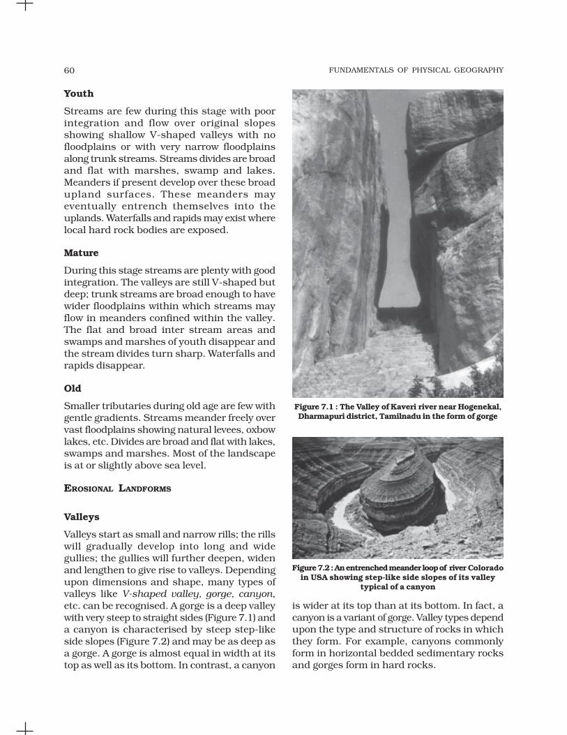
FUNDAMENTALS OF PHYSICAL GEOGRAPHY60
Youth
Streams are few during this stage with poorintegration and flow over original slopesshowing shallow V-shaped valleys with nofloodplains or with very narrow floodplainsalong trunk streams. Streams divides are broadand flat with marshes, swamp and lakes.Meanders if present develop over these broadupland surfaces. These meanders mayeventually entrench themselves into theuplands. Waterfalls and rapids may exist wherelocal hard rock bodies are exposed.
Mature
During this stage streams are plenty with goodintegration. The valleys are still V-shaped butdeep; trunk streams are broad enough to havewider floodplains within which streams mayflow in meanders confined within the valley.The flat and broad inter stream areas andswamps and marshes of youth disappear andthe stream divides turn sharp. Waterfalls andrapids disappear.
Old
Smaller tributaries during old age are few withgentle gradients. Streams meander freely overvast floodplains showing natural levees, oxbowlakes, etc. Divides are broad and flat with lakes,swamps and marshes. Most of the landscapeis at or slightly above sea level.
EROSIONAL LANDFORMS
Valleys
Valleys start as small and narrow rills; the rillswill gradually develop into long and widegullies; the gullies will further deepen, widenand lengthen to give rise to valleys. Dependingupon dimensions and shape, many types ofvalleys like V-shaped valley, gorge, canyon,etc. can be recognised. A gorge is a deep valleywith very steep to straight sides (Figure 7.1) anda canyon is characterised by steep step-likeside slopes (Figure 7.2) and may be as deep asa gorge. A gorge is almost equal in width at itstop as well as its bottom. In contrast, a canyon
is wider at its top than at its bottom. In fact, acanyon is a variant of gorge. Valley types dependupon the type and structure of rocks in whichthey form. For example, canyons commonlyform in horizontal bedded sedimentary rocksand gorges form in hard rocks.
Figure 7.1 : The Valley of Kaveri river near Hogenekal,Dharmapuri district, Tamilnadu in the form of gorge
Figure 7.2 : An entrenched meander loop of river Coloradoin USA showing step-like side slopes of its valley
typical of a canyon

LANDFORMS AND THEIR EVOLUTION 61
Potholes and Plunge Pools
Over the rocky beds of hill-streams more or lesscircular depressions called potholes formbecause of stream erosion aided by the abrasionof rock fragments. Once a small and shallowdepression forms, pebbles and boulders getcollected in those depressions and get rotatedby flowing water and consequently thedepressions grow in dimensions. A series of suchdepressions eventually join and the streamvalley gets deepened. At the foot of waterfallsalso, large potholes, quite deep and wide, formbecause of the sheer impact of water androtation of boulders. Such large and deep holesat the base of waterfalls are called plunge pools.These pools also help in the deepening of valleys.Waterfalls are also transitory like any otherlandform and will recede gradually and bringthe floor of the valley above waterfalls to thelevel below.
INCISED OR ENTRENCHED MEANDERS
In streams that flow rapidly over steepgradients, normally erosion is concentrated onthe bottom of the stream channel. Also, in thecase of steep gradient streams, lateral erosionon the sides of the valleys is not much whencompared to the streams flowing on low andgentle slopes. Because of active lateral erosion,streams flowing over gentle slopes, developsinuous or meandering courses. It is commonto find meandering courses over floodplainsand delta plains where stream gradients arevery gentle. But very deep and wide meanderscan also be found cut in hard rocks. Suchmeanders are called incised or entrenchedmeanders (Figure 7.2). Meander loops developover original gentle surfaces in the initial stagesof development of streams and the same loopsget entrenched into the rocks normally due toerosion or slow, continued uplift of the landover which they start. They widen and deepenover time and can be found as deep gorges andcanyons in hard rock areas. They give anindication on the status of original landsurfaces over which streams have developed.
What are the differences between incisedmeanders and meanders over flood anddelta plains?
River Terraces
River terraces are surfaces marking old valleyfloor or floodplain levels. They may be bedrocksurfaces without any alluvial cover or alluvialterraces consisting of stream deposits. Riverterraces are basically products of erosion asthey result due to vertical erosion by the streaminto its own depositional floodplain. There canbe a number of such terraces at differentheights indicating former river bed levels. Theriver terraces may occur at the same elevationon either side of the rivers in which case theyare called paired terraces (Figure 7.3).
Figure 7.3 : Paired and unpaired river terraces
When a terrace is present only on one sideof the stream and with none on the other sideor one at quite a different elevation on the otherside, the terraces are called non-pairedterraces. Unpaired terraces are typical in areasof slow uplift of land or where the water columnchanges are not uniform along both the banks.The terraces may result due to (i) receding waterafter a peak flow; (ii) change in hydrologicalregime due to climatic changes; (iii) tectonicuplift of land; (iv) sea level changes in case ofrivers closer to the sea.
DEPOSITIONAL LANDFORMS
Alluvial Fans
Alluvial fans (Figure 7.4) are formed whenstreams flowing from higher levels break intofoot slope plains of low gradient. Normally verycoarse load is carried by streams flowing overmountain slopes. This load becomes too heavyfor the streams to be carried over gentler

FUNDAMENTALS OF PHYSICAL GEOGRAPHY62
gradients and gets dumped and spread as abroad low to high cone shaped deposit calledalluvial fan. Usually, the streams which flowover fans are not confined to their originalchannels for long and shift their position acrossthe fan forming many channels calleddistributaries. Alluvial fans in humid areasshow normally low cones with gentle slope from
as a low cone. Unlike in alluvial fans, thedeposits making up deltas are very well sortedwith clear stratification. The coarsest materialssettle out first and the finer fractions like siltsand clays are carried out into the sea. As thedelta grows, the river distributaries continueto increase in length (Figure 7.5) and deltacontinues to build up into the sea.
Floodplains, Natural Levees and Point Bars
Deposition develops a floodplain just aserosion makes valleys. Floodplain is a majorlandform of river deposition. Large sizedmaterials are deposited first when streamchannel breaks into a gentle slope. Thus,normally, fine sized materials like sand, silt andclay are carried by relatively slow movingwaters in gentler channels usually found in theplains and deposited over the bed and whenthe waters spill over the banks during floodingabove the bed. A river bed made of riverdeposits is the active floodplain. The floodplainabove the bank is inactive floodplain. Inactivefloodplain above the banks basically containtwo types of deposits — flood deposits andchannel deposits. In plains, channels shiftlaterally and change their courses occasionallyleaving cut-off courses which get filled upgradually. Such areas over flood plains builtup by abandoned or cut-off channels containcoarse deposits. The flood deposits of spilledwaters carry relatively finer materials like siltand clay. The flood plains in a delta are calleddelta plains.
Natural levees and point bars (Figure 7.6)are some of the important landforms foundassociated with floodplains. Natural levees arefound along the banks of large rivers. They arelow, linear and parallel ridges of coarse depositsalong the banks of rivers, quite often cut intoindividual mounds. During flooding as thewater spills over the bank, the velocity of thewater comes down and large sized and highspecific gravity materials get dumped in theimmediate vicinity of the bank as ridges. Theyare high nearer the banks and slope gentlyaway from the river. The levee deposits arecoarser than the deposits spread by floodwaters away from the river. When rivers shiftlaterally, a series of natural levees can form.
Figure 7.4 : An alluvial fan deposited by a hill streamon the way to Amarnath, Jammu and Kashmir
head to toe and they appear as high cones withsteep slope in arid and semi-arid climates.
Deltas
Deltas are like alluvial fans but develop at adifferent location. The load carried by the riversis dumped and spread into the sea. If this loadis not carried away far into the sea or distributedalong the coast, it spreads and accumulates
Figure 7.5 : A satellite view of part of Krishna riverdelta, Andhra Pradesh

LANDFORMS AND THEIR EVOLUTION 63
Point bars are also known as meander bars.They are found on the convex side of meandersof large rivers and are sediments deposited ina linear fashion by flowing waters along thebank. They are almost uniform in profile and inwidth and contain mixed sizes of sediments. Ifthere more than one ridge, narrow and elongateddepressions are found in between the point bars.Rivers build a series of them depending uponthe water flow and supply of sediment. As therivers build the point bars on the convex side,the bank on the concave side will erode actively.
In what way do natural levees differ frompoint bars?
Meanders
In large flood and delta plains, rivers rarely flowin straight courses. Loop-like channel patternscalled meanders develop over flood and deltaplains (Figure 7.7).
Figure 7.7 : A satellite scene showing meanderingBurhi Gandak river near Muzaffarpur, Bihar, showing
a number of oxbow lakes and cut-offs
Meander is not a landform but is only atype of channel pattern. This is because of(i) propensity of water flowing over very gentlegradients to work laterally on the banks;(ii) unconsolidated nature of alluvial depositsmaking up the banks with many irregularitieswhich can be used by water exerting pressurelaterally; (iii) coriolis force acting on the fluidwater deflecting it like it deflects the wind. Whenthe gradient of the channel becomes extremelylow, water flows leisurely and starts workinglaterally. Slight irregularities along the banksslowly get transformed into a small curvaturein the banks; the curvature deepens due todeposition on the inside of the curve anderosion along the bank on the outside. If thereis no deposition and no erosion or undercutting,the tendency to meander is reduced. Normally,in meanders of large rivers, there is activedeposition along the convex bank andundercutting along the concave bank.
Figure 7.8 : Meander growth and cut-off loops andslip-off and undercut banks
Figure 7.6 : Natural levee and point bars

FUNDAMENTALS OF PHYSICAL GEOGRAPHY64
The concave bank is known as cut-off bankwhich shows up as a steep scarp and theconvex bank presents a long, gentle profile andis known as slip-off bank (Figure 7.8). Asmeanders grow into deep loops, the same mayget cut-off due to erosion at the inflection pointsand are left as ox-bow lakes.
Braided Channels
When rivers carry coarse material, there can beselective deposition of coarser materials causingformation of a central bar which diverts the flowtowards the banks; and this flow increaseslateral erosion on the banks. As the valleywidens, the water column is reduced and moreand more materials get deposited as islandsand lateral bars developing a number ofseparate channels of water flow. Depositionand lateral erosion of banks are essential forthe formation of braided pattern. Or,alternatively, when discharge is less and load
is more in the valley, channel bars and islandsof sand, gravel and pebbles develop on the floorof the channel and the water flow is dividedinto multiple threads. These thread-like streamsof water rejoin and subdivide repeatedly to givea typical braided pattern (Figure 7.9).
Figure 7.9 : Satellite scenes showing braided channelsegments of Gandak (left) and Son (right) rivers
Arrows show the direction of flow
Figure 7.10 : Various karst features

LANDFORMS AND THEIR EVOLUTION 65
GROUNDWATER
Here the interest is not on groundwater as aresource. Our focus is on the work ofgroundwater in the erosion of landmasses andevolution of landforms. The surface waterpercolates well when the rocks are permeable,thinly bedded and highly jointed and cracked.After vertically going down to some depth, thewater under the ground flows horizontallythrough the bedding planes, joints or throughthe materials themselves. It is this downwardand horizontal movement of water whichcauses the rocks to erode. Physical ormechanical removal of materials by movinggroundwater is insignificant in developinglandforms. That is why, the results of the workof groundwater cannot be seen in all types ofrocks. But in rocks like limestones or dolomitesrich in calcium carbonate, the surface wateras well as groundwater through the chemicalprocess of solution and precipitationdeposition develop varieties of landforms. Thesetwo processes of solution and precipitation areactive in limestones or dolomites occurringeither exclusively or interbedded with otherrocks. Any limestone or dolomitic regionshowing typical landforms produced by theaction of groundwater through the processesof solution and deposition is called Karsttopography after the typical topographydeveloped in limestone rocks of Karst regionin the Balkans adjacent to Adriatic sea.
The karst topography is also characterisedby erosional and depositional landforms.
EROSIONAL LANDFORMS
Pools, Sinkholes, Lapies andLimestone Pavements
Small to medium sized round to sub-roundedshallow depressions called swallow holes formon the surface of limestones through solution.Sinkholes are very common in limestone/karstareas. A sinkhole is an opening more or lesscircular at the top and funnel-shapped towardsthe bottom with sizes varying in area from afew sq. m to a hectare and with depth from aless than half a metre to thirty metres or more.Some of these form solely through solutionaction (solution sinks) and others might start
as solution forms first and if the bottom of asinkhole forms the roof of a void or caveunderground, it might collapse leaving a largehole opening into a cave or a void below(collapse sinks). Quite often, sinkholes arecovered up with soil mantle and appear asshallow water pools. Anybody stepping oversuch pools would go down like it happens inquicksands in deserts. The term doline issometimes used to refer the collapse sinks.Solution sinks are more common than collapsesinks. Quite often the surface run-off simplygoes down swallow and sink holes and flow asunderground streams and re-emerge at adistance downstream through a cave opening.When sink holes and dolines join togetherbecause of slumping of materials along theirmargins or due to roof collapse of caves, long,narrow to wide trenches called valley sinks orUvalas form. Gradually, most of the surface ofthe limestone is eaten away by these pits andtrenches, leaving it extremely irregular with amaze of points, grooves and ridges or lapies.Especially, these ridges or lapies form due todifferential solution activity along parallel tosub-parallel joints. The lapie field mayeventually turn into somewhat smoothlimestone pavements.
Caves
In areas where there are alternating beds ofrocks (shales, sandstones, quartzites) withlimestones or dolomites in between or in areaswhere limestones are dense, massive andoccurring as thick beds, cave formation isprominent. Water percolates down eitherthrough the materials or through cracks andjoints and moves horizontally along beddingplanes. It is along these bedding planes thatthe limestone dissolves and long and narrowto wide gaps called caves result. There can bea maze of caves at different elevationsdepending upon the limestone beds andintervening rocks. Caves normally have anopening through which cave streams aredischarged. Caves having openings at both theends are called tunnels.
Depositional Landforms
Many depositional forms develop within thelimestone caves. The chief chemical in limestone
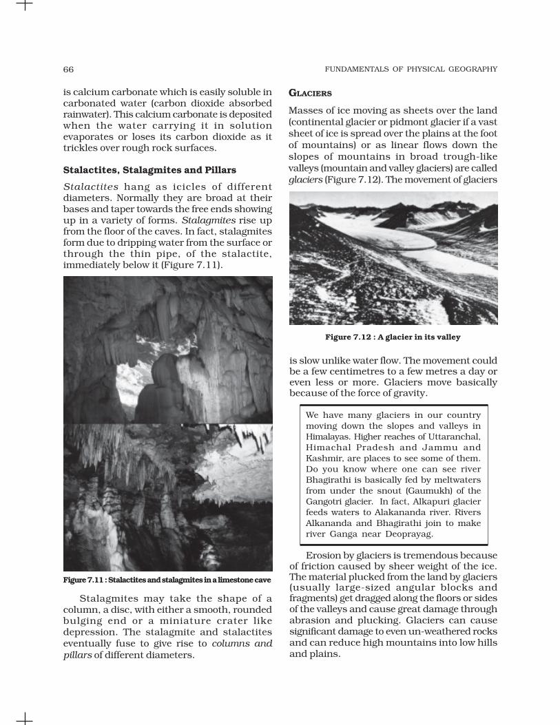
FUNDAMENTALS OF PHYSICAL GEOGRAPHY66
is calcium carbonate which is easily soluble incarbonated water (carbon dioxide absorbedrainwater). This calcium carbonate is depositedwhen the water carrying it in solutionevaporates or loses its carbon dioxide as ittrickles over rough rock surfaces.
Stalactites, Stalagmites and Pillars
Stalactites hang as icicles of differentdiameters. Normally they are broad at theirbases and taper towards the free ends showingup in a variety of forms. Stalagmites rise upfrom the floor of the caves. In fact, stalagmitesform due to dripping water from the surface orthrough the thin pipe, of the stalactite,immediately below it (Figure 7.11).
GLACIERS
Masses of ice moving as sheets over the land(continental glacier or pidmont glacier if a vastsheet of ice is spread over the plains at the footof mountains) or as linear flows down theslopes of mountains in broad trough-likevalleys (mountain and valley glaciers) are calledglaciers (Figure 7.12). The movement of glaciers
Figure 7.12 : A glacier in its valley
is slow unlike water flow. The movement couldbe a few centimetres to a few metres a day oreven less or more. Glaciers move basicallybecause of the force of gravity.
We have many glaciers in our countrymoving down the slopes and valleys inHimalayas. Higher reaches of Uttaranchal,Himachal Pradesh and Jammu andKashmir, are places to see some of them.Do you know where one can see riverBhagirathi is basically fed by meltwatersfrom under the snout (Gaumukh) of theGangotri glacier. In fact, Alkapuri glacierfeeds waters to Alakananda river. RiversAlkananda and Bhagirathi join to makeriver Ganga near Deoprayag.
Erosion by glaciers is tremendous becauseof friction caused by sheer weight of the ice.The material plucked from the land by glaciers(usually large-sized angular blocks andfragments) get dragged along the floors or sidesof the valleys and cause great damage throughabrasion and plucking. Glaciers can causesignificant damage to even un-weathered rocksand can reduce high mountains into low hillsand plains.
Figure 7.11 : Stalactites and stalagmites in a limestone cave
Stalagmites may take the shape of acolumn, a disc, with either a smooth, roundedbulging end or a miniature crater likedepression. The stalagmite and stalactiteseventually fuse to give rise to columns andpillars of different diameters.

LANDFORMS AND THEIR EVOLUTION 67
As glaciers continue to move, debris getsremoved, divides get lowered and eventuallythe slope is reduced to such an extent thatglaciers will stop moving leaving only a massof low hills and vast outwash plains along withother depositional features. Figures 7.13 and7.14 show various glacial erosional anddepositional forms described in the text.
EROSIONAL LANDFORMS
Cirque
Cirques are the most common of landforms inglaciated mountains. The cirques quite oftenare found at the heads of glacial valleys. Theaccumulated ice cuts these cirques whilemoving down the mountain tops. They aredeep, long and wide troughs or basins withvery steep concave to vertically dropping highwalls at its head as well as sides. A lake of watercan be seen quite often within the cirques after
the glacier disappears. Such lakes are calledcirque or tarn lakes. There can be two or morecirques one leading into another down belowin a stepped sequence.
Horns and Serrated Ridges
Horns form through head ward erosion of thecirque walls. If three or more radiating glacierscut headward until their cirques meet, high,sharp pointed and steep sided peaks calledhorns form. The divides between cirque sidewalls or head walls get narrow because ofprogressive erosion and turn into serrated orsaw-toothed ridges sometimes referred to asarêtes with very sharp crest and a zig-zagoutline.
The highest peak in the Alps, Matterhornand the highest peak in the Himalayas,Everest are in fact horns formed throughheadward erosion of radiating cirques.
Figure 7.13 : Some glacial erosional and depositional forms (adapted and modified from Spencer, 1962)
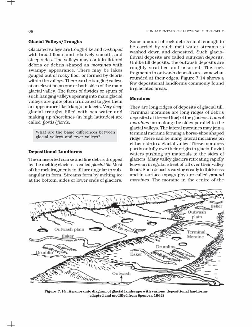
FUNDAMENTALS OF PHYSICAL GEOGRAPHY68
Glacial Valleys/Troughs
Glaciated valleys are trough-like and U-shapedwith broad floors and relatively smooth, andsteep sides. The valleys may contain littereddebris or debris shaped as moraines withswampy appearance. There may be lakesgouged out of rocky floor or formed by debriswithin the valleys. There can be hanging valleysat an elevation on one or both sides of the mainglacial valley. The faces of divides or spurs ofsuch hanging valleys opening into main glacialvalleys are quite often truncated to give theman appearance like triangular facets. Very deepglacial troughs filled with sea water andmaking up shorelines (in high latitudes) arecalled fjords/fiords.
What are the basic differences betweenglacial valleys and river valleys?
Depositional Landforms
The unassorted coarse and fine debris droppedby the melting glaciers is called glacial till. Mostof the rock fragments in till are angular to sub-angular in form. Streams form by melting iceat the bottom, sides or lower ends of glaciers.
Some amount of rock debris small enough tobe carried by such melt-water streams iswashed down and deposited. Such glacio-fluvial deposits are called outwash deposits.Unlike till deposits, the outwash deposits areroughly stratified and assorted. The rockfragments in outwash deposits are somewhatrounded at their edges. Figure 7.14 shows afew depositional landforms commonly foundin glaciated areas.
Moraines
They are long ridges of deposits of glacial till.Terminal moraines are long ridges of debrisdeposited at the end (toe) of the glaciers. Lateralmoraines form along the sides parallel to theglacial valleys. The lateral moraines may join aterminal moraine forming a horse-shoe shapedridge. There can be many lateral moraines oneither side in a glacial valley. These morainespartly or fully owe their origin to glacio-fluvialwaters pushing up materials to the sides ofglaciers. Many valley glaciers retreating rapidlyleave an irregular sheet of till over their valleyfloors. Such deposits varying greatly in thicknessand in surface topography are called groundmoraines. The moraine in the centre of the
Figure 7.14 : A panoramic diagram of glacial landscape with various depositional landforms(adapted and modified from Spencer, 1962)

LANDFORMS AND THEIR EVOLUTION 69
glacial valley flanked by lateral moraines iscalled medial moraine. They are imperfectlyformed as compared to lateral moraines.Sometimes medial moraines are indistinguishablefrom ground moraines.
Eskers
When glaciers melt in summer, the water flowson the surface of the ice or seeps down alongthe margins or even moves through holes inthe ice. These waters accumulate beneath theglacier and flow like streams in a channelbeneath the ice. Such streams flow over theground (not in a valley cut in the ground) withice forming its banks. Very coarse materials likeboulders and blocks along with some minorfractions of rock debris carried into this streamsettle in the valley of ice beneath the glacierand after the ice melts can be found as asinuous ridge called esker.
Outwash Plains
The plains at the foot of the glacial mountainsor beyond the limits of continental ice sheetsare covered with glacio-fluvial deposits in theform of broad flat alluvial fans which may jointo form outwash plains of gravel, silt, sand andclay.
Distinguish between river alluvial plainsand glacial outwash plains.
Drumlins
Drumlins are smooth oval shaped ridge-likefeatures composed mainly of glacial till withsome masses of gravel and sand. The long axesof drumlins are parallel to the direction of icemovement. They may measure up to 1 km inlength and 30 m or so in height. One end ofthe drumlins facing the glacier called the stossend is blunter and steeper than the other endcalled tail. The drumlins form due to dumpingof rock debris beneath heavily loaded icethrough fissures in the glacier. The stoss endgets blunted due to pushing by moving ice.Drumlins give an indication of direction ofglacier movement.
What is the difference between till andalluvium?
WAVES AND CURRENTS
Coastal processes are the most dynamic andhence most destructive. So, don’t you think itis important to know about the coastalprocesses and forms?
Some of the changes along the coasts takeplace very fast. At one place, there can beerosion in one season and deposition inanother. Most of the changes along the coastsare accomplished by waves. When waves break,the water is thrown with great force onto theshore, and simultaneously, there is a greatchurning of sediments on the sea bottom.Constant impact of breaking waves drasticallyaffects the coasts. Storm waves and tsunamiwaves can cause far-reaching changes in ashort period of time than normal breakingwaves. As wave environment changes, theintensity of the force of breaking waves changes.
Do you know about the generating forcesbehind waves and currents? If not, referto the chapter on movements in oceanwaters.
Other than the action of waves, the coastallandforms depend upon (i) the configurationof land and sea floor; (ii) whether the coast isadvancing (emerging) seaward or retreating(submerging) landward. Assuming sea level tobe constant, two types of coasts are consideredto explain the concept of evolution of coastallandforms: (i) high, rocky coasts (submergedcoasts); (ii) low, smooth and gently slopingsedimentary coasts (emerged coasts).
HIGH ROCKY COASTS
Along the high rocky coasts, the rivers appearto have been drowned with highly irregularcoastline. The coastline appears highlyindented with extension of water into the landwhere glacial valleys (fjords) are present. Thehill sides drop off sharply into the water. Shoresdo not show any depositional landformsinitially. Erosion features dominate.

FUNDAMENTALS OF PHYSICAL GEOGRAPHY70
Along high rocky coasts, waves break withgreat force against the land shaping the hillsides into cliffs. With constant pounding bywaves, the cliffs recede leaving a wave-cutplatform in front of the sea cliff. Wavesgradually minimise the irregularities along theshore.
The materials which fall off, and removedfrom the sea cliffs, gradually break into smallerfragments and roll to roundness, will getdeposited in the offshore. After a considerableperiod of cliff development and retreat whencoastline turns somewhat smooth, with theaddition of some more material to this depositin the offshore, a wave-built terrace woulddevelop in front of wave-cut terrace. As theerosion along the coast takes place a goodsupply material becomes available to longshorecurrents and waves to deposit them as beachesalong the shore and as bars (long ridges of sandand/or shingle parallel to the coast) in thenearshore zone. Bars are submerged featuresand when bars show up above water, they arecalled barrier bars. Barrier bar which get keyedup to the headland of a bay is called a spit.When barrier bars and spits form at the mouthof a bay and block it, a lagoon forms. Thelagoons would gradually get filled up bysediments from the land giving rise to a coastalplain.
LOW SEDIMENTARY COASTS
Along low sedimentary coasts the rivers appearto extend their length by building coastalplains and deltas. The coastline appearssmooth with occasional incursions of water inthe form of lagoons and tidal creeks. The landslopes gently into the water. Marshes andswamps may abound along the coasts.Depositional features dominate.
When waves break over a gently slopingsedimentary coast, the bottom sediments getchurned and move readily building bars,barrier bars, spits and lagoons. Lagoonswould eventually turn into a swamp whichwould subsequently turn into a coastal plain.The maintenance of these depositional featuresdepends upon the steady supply of materials.
Storm and tsunami waves cause drasticchanges irrespective of supply of sediments.Large rivers which bring lots of sediments builddeltas along low sedimentary coasts.
The west coast of our country is a highrocky retreating coast. Erosional formsdominate in the west coast. The eastcoast of India is a low sedimentary coast.Depositional forms dominate in the eastcoast.
What are the various differences betweena high rocky coast and a low sedimentarycoast in terms of processes andlandforms?
EROSIONAL LANDFORMS
Cliffs, Terraces, Caves and Stacks
Wave-cut cliffs and terraces are two formsusually found where erosion is the dominantshore process. Almost all sea cliffs are steepand may range from a few m to 30 m or evenmore. At the foot of such cliffs there may be aflat or gently sloping platform covered by rockdebris derived from the sea cliff behind. Suchplatforms occurring at elevations above theaverage height of waves is called a wave-cutterrace. The lashing of waves against the baseof the cliff and the rock debris that getssmashed against the cliff along with lashingwaves create hollows and these hollows getwidened and deepened to form sea caves. Theroofs of caves collapse and the sea cliffs recedefurther inland. Retreat of the cliff may leavesome remnants of rock standing isolated assmall islands just off the shore. Such resistantmasses of rock, originally parts of a cliff or hillare called sea stacks. Like all other features,sea stacks are also temporary and eventuallycoastal hills and cliffs will disappear becauseof wave erosion giving rise to narrow coastalplains, and with onrush of deposits from overthe land behind may get covered up byalluvium or may get covered up by shingle orsand to form a wide beach.

LANDFORMS AND THEIR EVOLUTION 71
DEPOSITIONAL LANDFORMS
Beaches and Dunes
Beaches are characteristic of shorelines that aredominated by deposition, but may occur aspatches along even the rugged shores. Most ofthe sediment making up the beaches comesfrom land carried by the streams and rivers orfrom wave erosion. Beaches are temporaryfeatures. The sandy beach which appears sopermanent may be reduced to a very narrowstrip of coarse pebbles in some other season.Most of the beaches are made up of sand sizedmaterials. Beaches called shingle beachescontain excessively small pebbles and evencobbles.
Just behind the beach, the sands lifted andwinnowed from over the beach surfaces will bedeposited as sand dunes. Sand dunes forminglong ridges parallel to the coastline are verycommon along low sedimentary coasts.
Bars, Barriers and Spits
A ridge of sand and shingle formed in the seain the off-shore zone (from the position of lowtide waterline to seaward) lying approximatelyparallel to the coast is called an off-shore bar.An off-shore bar which is exposed due tofurther addition of sand is termed a barrierbar. The off-shore bars and barriers commonlyform across the mouth of a river or at theentrance of a bay. Sometimes such barrier barsget keyed up to one end of the bay when theyare called spits (Figure 7.15). Spits may also
develop attached to headlands/hills. Thebarriers, bars and spits at the mouth of thebay gradually extend leaving only a smallopening of the bay into the sea and the baywill eventually develop into a lagoon. Thelagoons get filled up gradually by sedimentcoming from the land or from the beach itself(aided by wind) and a broad and wide coastalplain may develop replacing a lagoon.
Do you know, the coastal off-shore barsoffer the first buffer or defence againststorm or tsunami by absorbing most oftheir destructive force. Then come thebarriers, beaches, beach dunes andmangroves, if any, to absorb thedestructive force of storm and tsunamiwaves. So, if we do anything whichdisturbs the ‘sediment budget’ and themangroves along the coast, these coastalforms will get eroded away leaving humanhabitations to bear first strike of stormand tsunami waves.
WINDS
Wind is one of the two dominant agents in hotdeserts. The desert floors get heated up toomuch and too quickly because of being dryand barren. The heated floors heat up the airdirectly above them and result in upwardmovements in the hot lighter air withturbulence, and any obstructions in its pathsets up eddies, whirlwinds, updrafts anddowndrafts. Winds also move along the desertfloors with great speed and the obstructionsin their path create turbulence. Of course, thereare storm winds which are very destructive.Winds cause deflation, abrasion and impact.Deflation includes lifting and removal of dustand smaller particles from the surface of rocks.In the transportation process sand and silt actas effective tools to abrade the land surface.The impact is simply sheer force of momentumwhich occurs when sand is blown into oragainst a rock surface. It is similar to sand-blasting operation. The wind action creates anumber of interesting erosional anddepositional features in the deserts.
In fact, many features of deserts owe theirFigure 7.15 : A satellite picture of a part of Godavari
river delta showing a spit

FUNDAMENTALS OF PHYSICAL GEOGRAPHY72
formation to mass wasting and running wateras sheet floods. Though rain is scarce in deserts,it comes down torrentially in a short period oftime. The desert rocks devoid of vegetation,exposed to mechanical and chemicalweathering processes due to drastic diurnaltemperature changes, decay faster and thetorrential rains help in removing the weatheredmaterials easily. That means, the weathereddebris in deserts is moved by not only windbut also by rain/sheet wash. The wind movesfine materials and general mass erosion isaccomplished mainly through sheet floods orsheet wash. Stream channels in desert areasare broad, smooth and indefinite and flow fora brief time after rains.
EROSIONAL LANDFORMS
Pediments and Pediplains
Landscape evolution in deserts is primarilyconcerned with the formation and extension ofpediments. Gently inclined rocky floors closeto the mountains at their foot with or withouta thin cover of debris, are called pediments.Such rocky floors form through the erosion ofmountain front through a combination oflateral erosion by streams and sheet flooding.
Erosion starts along the steep margins ofthe landmass or the steep sides of thetectonically controlled steep incision featuresover the landmass. Once, pediments are formedwith a steep wash slope followed by cliff or freeface above it, the steep wash slope and free faceretreat backwards. This method of erosion istermed as parallel retreat of slopes throughbackwasting. So, through parallel retreat ofslopes, the pediments extend backwards at theexpense of mountain front, and gradually, themountain gets reduced leaving an inselbergwhich is a remnant of the mountain. That’s howthe high relief in desert areas is reduced to lowfeatureless plains called pediplains.
Playas
Plains are by far the most prominent landformsin the deserts. In basins with mountains andhills around and along, the drainage is towardsthe centre of the basin and due to gradual
deposition of sediment from basin margins, anearly level plain forms at the centre of thebasin. In times of sufficient water, this plain iscovered up by a shallow water body. Suchtypes of shallow lakes are called as playaswhere water is retained only for short durationdue to evaporation and quite often the playascontain good deposition of salts. The playaplain covered up by salts is called alkali flats.
Deflation Hollows and Caves
Weathered mantle from over the rocks or baresoil, gets blown out by persistent movementof wind currents in one direction. This processmay create shallow depressions calleddeflation hollows. Deflation also createsnumerous small pits or cavities over rocksurfaces. The rock faces suffer impact andabrasion of wind-borne sand and first shallowdepressions called blow outs are created, andsome of the blow outs become deeper andwider fit to be called caves.
Mushroom, Table and Pedestal Rocks
Many rock-outcrops in the deserts easilysusceptible to wind deflation and abrasion areworn out quickly leaving some remnants ofresistant rocks polished beautifully in theshape of mushroom with a slender stalk and abroad and rounded pear shaped cap above.Sometimes, the top surface is broad like a tabletop and quite often, the remnants stand outlike pedestals.
List the erosional features carved out bywind action and action of sheet floods.
Depositional Landforms
Wind is a good sorting agent. Depending uponthe velocity of wind, different sizes of grains aremoved along the floors by rolling or saltationand carried in suspension and in this processof transportation itself, the materials get sorted.When the wind slows or begins to die down,depending upon sizes of grains and theircritical velocities, the grains will begin to settle.So, in depositional landforms made by wind,good sorting of grains can be found. Since

LANDFORMS AND THEIR EVOLUTION 73
wind is there everywhere and wherever thereis good source of sand and with constant winddirections, depositional features in arid regionscan develop anywhere.
Sand Dunes
Dry hot deserts are good places for sand duneformation. Obstacles to initiate dune formation
are equally important. There can be a greatvariety of dune forms (Figure 7.16).
Barchans
Crescent shaped dunes called barchans withthe points or wings directed away from winddirection i.e., downwind, form where the winddirection is constant and moderate and wherethe original surface over which sand is movingis almost uniform. Parabolic dunes form whensandy surfaces are partially covered withvegetation. That means parabolic dunes arereversed barchans with wind direction beingthe same. Seif is similar to barchan with a smalldifference. Seif has only one wing or point. Thishappens when there is shift in wind conditions.The lone wings of seifs can grow very long andhigh. Longitudinal dunes form when supplyof sand is poor and wind direction is constant.They appear as long ridges of considerablelength but low in height. Transverse dunesare aligned perpendicular to wind direction.These dunes form when the wind direction isconstant and the source of sand is anelongated feature at right angles to the winddirection. They may be very long and low inheight. When sand is plenty, quite often, theregular shaped dunes coalesce and lose theirindividual characteristics. Most of the dunesin the deserts shift and a few of them will getstabilised especially near human habitations.
Figure 7.16 : Various types of sand dunesArrows indicate wind direction
EXERCISES
1. Multiple choice questions.
(i) In which of the following stages of landform development, downward cuttingis dominated?
(a) Youth stage (c) Early mature stage
(b) Late mature stage (d) Old stage
(ii) A deep valley characterised by steep step-like side slopes is known as
(a) U-shaped valley (c) Blind valley
(b) Gorge (d) Canyon
(iii) In which one of the following regions the chemical weathering process ismore dominant than the mechanical process?
(a) Humid region (c) Arid region(b) Limestone region (d) Glacier region

FUNDAMENTALS OF PHYSICAL GEOGRAPHY74
(iv) Which one of the following sentences best defines the term ‘Lapies’ ?
(a) A small to medium sized shallow depression
(b) A landform whose opening is more or less circular at the top andfunnel shaped towards bottom
(c) A landform forms due to dripping water from surface
(d) An irregular surface with sharp pinnacles, grooves and ridges
(v) A deep, long and wide trough or basin with very steep concave high wallsat its head as well as in sides is known as:
(a) Cirque (c) Lateral Moraine
(b) Glacial valley (d) Esker
2. Answer the following questions in about 30 words.
(i) What do incised meanders in rocks and meanders in plains of alluviumindicate?
(ii) Explain the evolution of valley sinks or uvalas.
(iii) Underground flow of water is more common than surface run-off inlimestone areas. Why?
(iv) Glacial valleys show up many linear depositional forms. Give theirlocations and names.
(v) How does wind perform its task in desert areas? Is it the only agentresponsible for the erosional features in the deserts?
3. Answer the following questions in about 150 words.
(i) Running water is by far the most dominating geomorphic agent in shapingthe earth’s surface in humid as well as in arid climates. Explain.
(ii) Limestones behave differently in humid and arid climates. Why? What isthe dominant and almost exclusive geomorphic process in limestone areasand what are its results?
(iii) How do glaciers accomplish the work of reducing high mountains into lowhills and plains?
Project Work
Identify the landforms, materials and processes around your area.

CLIMATE
This unit deals with
• Atmosphere — compositions and structure; elements of weatherand climate
• Insolation — angle of incidence and distribution; heat budgetof the earth — heating and cooling of atmosphere (conduction,convection, terrestrial radiation, advection); temperature — factorscontrolling temperature; distribution of temperature — horizontaland vertical; inversion of temperature
• Pressure — pressure belts; winds-planetary seasonal and local,air masses and fronts; tropical and extra tropical cyclones
• Precipitation — evaporation; condensation — dew, frost, fog,mist and cloud; rainfall — types and world distributon
• World climates — classification (Koeppen), greenhouse effect,global warming and climatic changes
UNIT
IV

COMPOSITION AND STRUCTURE
OF ATMOSPHERE
C an a person live without air? We eatfood two - three times a day and drinkwater more frequently but breathe
every few seconds. Air is essential to thesurvival of all organisms. Some organisms likehumans may survive for some time withoutfood and water but can’t survive even a fewminutes without breathing air. That shows thereason why we should understand theatmosphere in greater detail. Atmosphere is amixture of different gases and it envelopes theearth all round. It contains life-giving gases likeoxygen for humans and animals and carbondioxide for plants. The air is an integral part ofthe earth’s mass and 99 per cent of the totalmass of the atmosphere is confined to theheight of 32 km from the earth’s surface. Theair is colourless and odourless and can be feltonly when it blows as wind.
Can you imagine what will happento us in the absence of ozone in theatmosphere?
COMPOSITION OF THE ATMOSPHERE
The atmosphere is composed of gases, watervapour and dust particles. Table 8.1 showsdetails of various gases in the air, particularlyin the lower atmosphere. The proportion ofgases changes in the higher layers of theatmosphere in such a way that oxygen will bealmost in negligible quantity at the height of120 km. Similarly, carbon dioxide and watervapour are found only up to 90 km from thesurface of the earth.
Table 8.1 : Permanent Gases of the Atmosphere
Constituent Formula Percentage by Volume
Nitrogen N2 78.08Oxygen O2 20.95Argon Ar 0.93Carbon dioxide CO2 0.036Neon Ne 0.002Helium He 0.0005Krypto Kr 0.001Xenon Xe 0.00009
Hydrogen H2 0.00005
Gases
Carbon dioxide is meteorologically a veryimportant gas as it is transparent to theincoming solar radiation but opaque to theoutgoing terrestrial radiation. It absorbs a partof terrestrial radiation and reflects back somepart of it towards the earth’s surface. It islargely responsible for the green house effect.The volume of other gases is constant but thevolume of carbon dioxide has been rising inthe past few decades mainly because of theburning of fossil fuels. This has also increasedthe temperature of the air. Ozone is anotherimportant component of the atmosphere foundbetween 10 and 50 km above the earth’ssurface and acts as a filter and absorbs theultra-violet rays radiating from the sun andprevents them from reaching the surface of theearth.
Water Vapour
Water vapour is also a variable gas in theatmosphere, which decreases with altitude. Inthe warm and wet tropics, it may account for
C H A P T E R

COMPOSITION AND STRUCTURE OF ATMOSPHERE 77
four per cent of the air by volume, while in thedry and cold areas of desert and polar regions,it may be less than one per cent of the air. Watervapour also decreases from the equatortowards the poles. It also absorbs parts of theinsolation from the sun and preserves theearth’s radiated heat. It thus, acts like a blanketallowing the earth neither to become too coldnor too hot. Water vapour also contributes tothe stability and instability in the air.
Dust Particles
Atmosphere has a sufficient capacity to keepsmall solid particles, which may originate fromdifferent sources and include sea salts, fine soil,smoke-soot, ash, pollen, dust and disintegratedparticles of meteors. Dust particles aregenerally concentrated in the lower layers ofthe atmosphere; yet, convectional air currentsmay transport them to great heights. Thehigher concentration of dust particles is foundin subtropical and temperate regions due todry winds in comparison to equatorial andpolar regions. Dust and salt particles act ashygroscopic nuclei around which water vapourcondenses to produce clouds.
STRUCTURE OF THE ATMOSPHERE
The atmosphere consists of different layers withvarying density and temperature. Density ishighest near the surface of the earth anddecreases with increasing altitude. The columnof atmosphere is divided into five differentlayers depending upon the temperaturecondition. They are: troposphere, stratosphere,mesosphere, ionosphere and exosphere.
The troposphere is the lowermost layer ofthe atmosphere. Its average height is 13 kmand extends roughly to a height of 8 km nearthe poles and about 18 km at the equator.Thickness of the troposphere is greatest at theequator because heat is transported to greatheights by strong convectional currents. Thislayer contains dust particles and water vapour.All changes in climate and weather take placein this layer. The temperature in this layerdecreases at the rate of 1°C for every 165m ofheight. This is the most important layer for allbiological activity.
The zone separating the tropsophere fromstratosphere is known as the tropopause. Theair temperature at the tropopause is aboutminus 800C over the equator and about minus45oC over the poles. The temperature here isnearly constant, and hence, it is called thetropopause. The stratosphere is found abovethe tropopause and extends up to a height of50 km. One important feature of thestratosphere is that it contains the ozone layer.This layer absorbs ultra-violet radiation andshields life on the earth from intense, harmfulform of energy.
The mesosphere lies above the stratosphere,which extends up to a height of 80 km. In thislayer, once again, temperature startsdecreasing with the increase in altitude andreaches up to minus 100°C at the height of 80km. The upper limit of mesosphere is knownas the mesopause. The ionosphere is locatedbetween 80 and 400 km above the mesopause.It contains electrically charged particles knownas ions, and hence, it is known as ionosphere.Radio waves transmitted from the earth arereflected back to the earth by this layer.Temperature here starts increasing with height.The uppermost layer of the atmosphere above
Figure 8.1 : Structure of atmosphere

FUNDAMENTALS OF PHYSICAL GEOGRAPHY78
the ionosphere is known as the exosphere. Thisis the highest layer but very little is known aboutit. Whatever contents are there, these areextremely rarefied in this layer, and it graduallymerges with the outer space. Although alllayers of the atmosphere must be exercisinginfluence on us, geographers are concernedwith the first two layers of the atmosphere.
Elements of Weather and Climate
The main elements of atmosphere which aresubject to change and which influence humanlife on earth are temperature, pressure, winds,humidity, clouds and precipitation. Theseelements have been dealt in detail in Chapters9, 10 and 11.
EXERCISES
1. Multiple choice questions.
(i) Which one of the following gases constitutes the major portion of theatmosphere?
(a) Oxygen (c) Argon
(b) Nitrogen (d) Carbon dioxide
(ii) Atmospheric layer important for human beings is:
(a) Stratosphere (c) Troposphere
(b) Mesosphere (d) Ionosphere
(iii) Sea salt, pollen, ash, smoke soot, fine soil — these are associated with:
(a) Gases (c) Water vapour
(b) Dust particles (d) Meteors
(iv) Oxygen gas is in negligible quantity at the height of atmosphere:
(a) 90 km (c) 100 km
(b) 120 km (d) 150 km
(v) Which one of the following gases is transparent to incoming solar radiationand opaque to outgoing terrestrial radiation?
(a) Oxygen (c) Helium
(b) Nitrogen (d) Carbon dioxide
2. Answer the following questions in about 30 words.
(i) What do you understand by atmosphere?
(ii) What are the elements of weather and climate?
(iii) Describe the composition of atmosphere.
(iv) Why is troposphere the most important of all the layers of the atmosphere?
3. Answer the following questions in about 150 words.
(i) Describe the composition of the atmosphere.
(ii) Draw a suitable diagram for the structure of the atmosphere and label itand describe it.

SOLAR RADIATION, HEAT BALANCE
AND TEMPERATURE
D o you feel air around you? Do youknow that we live at the bottom of ahuge pile of air? We inhale and exhale
but we feel the air when it is in motion. It meansair in motion is wind. You have already learntabout the fact that earth is surrounded by airall around. This envelop of air is atmospherewhich is composed of numerous gases. Thesegases support life over the earth’s surface.
The earth receives almost all of its energyfrom the sun. The earth in turn radiates backto space the energy received from the sun. Asa result, the earth neither warms up nor doesit get cooled over a period of time. Thus, theamount of heat received by different parts ofthe earth is not the same. This variation causespressure differences in the atmosphere. Thisleads to transfer of heat from one region to theother by winds. This chapter explains theprocess of heating and cooling of theatmosphere and the resultant temperaturedistribution over the earth’s surface.
SOLAR RADIATION
The earth’s surface receives most of its energyin short wavelengths. The energy received bythe earth is known as incoming solar radiationwhich in short is termed as insolation.
As the earth is a geoid resembling a sphere,the sun’s rays fall obliquely at the top of theatmosphere and the earth intercepts a verysmall portion of the sun’s energy. On anaverage the earth receives 1.94 calories per sq.cm per minute at the top of its atmosphere.
The solar output received at the top of theatmosphere varies slightly in a year due to thevariations in the distance between the earth andthe sun. During its revolution around the sun,the earth is farthest from the sun (152 millionkm on 4th July). This position of the earth iscalled aphelion. On 3rd January, the earth isthe nearest to the sun (147 million km). Thisposition is called perihelion. Therefore, theannual insolation received by the earth on 3rdJanuary is slightly more than the amountreceived on 4th July. However, the effect of thisvariation in the solar output is masked byother factors like the distribution of land andsea and the atmospheric circulation. Hence, thisvariation in the solar output does not havegreat effect on daily weather changes on thesurface of the earth.
Variability of Insolation atthe Surface of the Earth
The amount and the intensity of insolation varyduring a day, in a season and in a year. The factorsthat cause these variations in insolation are : (i)the rotation of earth on its axis; (ii) the angle ofinclination of the sun’s rays; (iii) the length of theday; (iv) the transparency of the atmosphere; (v)the configuration of land in terms of its aspect.The last two however, have less influence.
The fact that the earth’s axis makes an angleof 66½ with the plane of its orbit round the sunhas a greater influence on the amount ofinsolation received at different latitudes. Note thevariations in the duration of the day at differentlatitudes on solstices given in Table 9.1.
C H A P T E R

FUNDAMENTALS OF PHYSICAL GEOGRAPHY80
The second factor that determines theamount of insolation received is the angle of
inclination of the rays. This depends on thelatitude of a place. The higher the latitude theless is the angle they make with the surface ofthe earth resulting in slant sun rays. The areacovered by vertical rays is always less than theslant rays. If more area is covered, the energygets distributed and the net energy receivedper unit area decreases. Moreover, the slant raysare required to pass through greater depth ofthe atmosphere resulting in more absorption,scattering and diffusion.
Figure 9.1 : Summer Solstice
Latitude 0° 20° 40° 60° 90°
December 22 12h 00m 10h 48m 9h 8m 5h 33m 0
June 21 12 h 13h 12m 14h 52m 18h 27m 6 months
Table 9.1 : Length of the Day in Hours and Minutes on Winter and Summer Solstices in the Northern Hemisphere
colour of the sky are the result of scattering oflight within the atmosphere.
The Passage of Solar Radiationthrough the Atmosphere
The atmosphere is largely transparent to shortwave solar radiation. The incoming solarradiation passes through the atmospherebefore striking the earth’s surface. Within thetroposphere water vapour, ozone and othergases absorb much of the near infraredradiation.
Very small-suspended particles in thetroposphere scatter visible spectrum both tothe space and towards the earth surface. Thisprocess adds colour to the sky. The red colourof the rising and the setting sun and the blue
Spatial Distribution of Insolationat the Earth’s Surface
The insolation received at the surface variesfrom about 320 Watt/m2 in the tropics to about70 Watt/m2 in the poles. Maximum insolationis received over the subtropical deserts, wherethe cloudiness is the least. Equator receivescomparatively less insolation than the tropics.Generally, at the same latitude the insolationis more over the continent than over the oceans.In winter, the middle and higher latitudesreceive less radiation than in summer.
HEATING AND COOLING OF ATMOSPHERE
There are different ways of heating and coolingof the atmosphere.
The earth after being heated by insolationtransmits the heat to the atmospheric layers nearto the earth in long wave form. The air in contactwith the land gets heated slowly and the upperlayers in contact with the lower layers also getheated. This process is called conduction.Conduction takes place when two bodies ofunequal temperature are in contact with oneanother, there is a flow of energy from the warmerto cooler body. The transfer of heat continues untilboth the bodies attain the same temperature orthe contact is broken. Conduction is importantin heating the lower layers of the atmosphere.
The air in contact with the earth risesvertically on heating in the form of currentsand further transmits the heat of theatmsphere. This process of vertical heating ofthe atmosphere is known as convection. Theconvective transfer of energy is confined onlyto the troposphere.
The transfer of heat through horizontalmovement of air is called advection. Horizontalmovement of the air is relatively more important

SOLAR RADIATION, HEAT BALANCE AND TEMPERATURE 81
accumulate or loose heat. It maintains itstemperature. This can happen only if theamount of heat received in the form of insolationequals the amount lost by the earth throughterrestrial radiation.
Consider that the insolation received at thetop of the atmosphere is 100 per cent. Whilepassing through the atmosphere some amountof energy is reflected, scattered and absorbed.Only the remaining part reaches the earthsurface. Roughly 35 units are reflected backto space even before reaching the earth’ssurface. Of these, 27 units are reflected backfrom the top of the clouds and 2 units from thesnow and ice-covered areas of the earth. Thereflected amount of radiation is called thealbedo of the earth.
The remaining 65 units are absorbed, 14units within the atmosphere and 51 units bythe earth’s surface. The earth radiates back51 units in the form of terrestrial radiation.Of these, 17 units are radiated to spacedirectly and the remaining 34 units areabsorbed by the atmosphere (6 unitsabsorbed directly by the atmosphere, 9 unitsthrough convection and turbulence and 19units through latent heat of condensation).48 units absorbed by the atmosphere(14 units from insolation +34 units from
than the vertical movement. In middle latitudes,most of dirunal (day and night) variation indaily weather are caused by advection alone.In tropical regions particularly in northernIndia during summer season local winds called‘loo’ is the outcome of advection process.
Terrestrial Radiation
The insolation received by the earth is in shortwaves forms and heats up its surface. The earthafter being heated itself becomes a radiatingbody and it radiates energy to the atmospherein long wave form. This energy heats up theatmosphere from below. This process is knownas terrestrial radiation.
The long wave radiation is absorbed by theatmospheric gases particularly by carbondioxide and the other green house gases. Thus,the atmosphere is indirectly heated by theearth’s radiation.
The atmosphere in turn radiates andtransmits heat to the space. Finally the amountof heat received from the sun is returned tospace, thereby maintaining constant temperatureat the earth’s surface and in the atmosphere.
Heat Budget of the Planet Earth
Figure 9.2 depicts the heat budget of the planetearth. The earth as a whole does not
Figure 9.2 : Heat budget of the earth

FUNDAMENTALS OF PHYSICAL GEOGRAPHY82
terrestrial radiation) are also radiated backinto space. Thus, the total radiationreturning from the earth and the atmosphererespectively is 17+48=65 units whichbalance the total of 65 units received fromthe sun. This is termed the heat budget orheat balance of the earth.
This explains, why the earth neither warmsup nor cools down despite the huge transfer ofheat that takes place.
Variation in the Net Heat Budget at theEarth’s Surface
As explained earlier, there are variations in theamount of radiation received at the earth’ssurface. Some part of the earth has surplusradiation balance while the other part hasdeficit.
Figure 9.3 depicts the latitudinal variationin the net radiation balance of the earth — theatmosphere system. The figure shows thatthere is a surplus of net radiation balancebetween 40 degrees north and south and theregions near the poles have a deficit. Thesurplus heat energy from the tropics isredistributed pole wards and as a result thetropics do not get progressively heated up dueto the accumulation of excess heat or the highlatitudes get permanently frozen due to excessdeficit.
Figure 9.3 : Latitudinal variation in net radiation balance
heat which is measured in terms oftemperature. While heat represents themolecular movement of particles comprising asubstance, the temperature is the measurementin degrees of how hot (or cold) a thing (or aplace) is.
Factors Controlling Temperature Distribution
The temperature of air at any place is influencedby (i) the latitude of the place; (ii) the altitudeof the place; (iii) distance from the sea, the air-mass circulation; (iv) the presence of warm andcold ocean currents; (v) local aspects.
The latitude : The temperature of a placedepends on the insolation received. It has beenexplained earlier that the insolation variesaccording to the latitude hence thetemperature also varies accordingly.
The altitude : The atmosphere is indirectlyheated by terrestrial radiation from below.Therefore, the places near the sea-level recordhigher temperature than the places situatedat higher elevations. In other words, thetemperature generally decreases withincreasing height. The rate of decrease oftemperature with height is termed as thenormal lapse rate. It is 6.5°C per 1,000 m.
Distance from the sea : Another factor thatinfluences the temperature is the location of aplace with respect to the sea. Compared to land,the sea gets heated slowly and loses heatslowly. Land heats up and cools down quickly.Therefore, the variation in temperature over thesea is less compared to land. The placessituated near the sea come under themoderating influence of the sea and landbreezes which moderate the temperature.
Air-mass and Ocean currents : Like the landand sea breezes, the passage of air masses alsoaffects the temperature. The places, whichcome under the influence of warm air-massesexperience higher temperature and the placesthat come under the influence of cold air-masses experience low temperature. Similarly,
Temperature
The interaction of insolation with theatmosphere and the earth’s surface creates

SOLAR RADIATION, HEAT BALANCE AND TEMPERATURE 83
the places located on the coast where the warmocean currents flow record higher temperaturethan the places located on the coast where thecold currents flow.
Distribution of Temperature
The global distribution of temperature can wellbe understood by studying the temperaturedistribution in January and July. Thetemperature distribution is generally shownon the map with the help of isotherms. TheIsotherms are lines joining places having equaltemperature. Figure 9.4 (a) and (b) show thedistribution of surface air temperature in themonth of January and July.
In general the effect of the latitude ontemperature is well pronounced on the map,as the isotherms are generally parallel to thelatitude. The deviation from this general trendis more pronounced in January than in July,especially in the northern hemisphere. In the
northern hemisphere the land surface area ismuch larger than in the southern hemisphere.Hence, the effects of land mass and the oceancurrents are well pronounced. In January theisotherms deviate to the north over the oceanand to the south over the continent. This canbe seen on the North Atlantic Ocean. Thepresence of warm ocean currents, Gulf Streamand North Atlantic drift, make the NorthernAtlantic Ocean warmer and the isotherms bendtowards the north. Over the land thetemperature decreases sharply and theisotherms bend towards south in Europe.
It is much pronounced in the Siberianplain. The mean January temperature along60° E longitude is minus 20° C both at 80° Nand 50° N latitudes. The mean monthlytemperature for January is over 27° C, inequatorial oceans over 24° C in the tropicsand 2° C - 0° C in the middle latitudesand –18° C to –48° C in the Eurasiancontinental interior.
Figure 9.4 (a) : The distribution of surface air temperature in the month of January

FUNDAMENTALS OF PHYSICAL GEOGRAPHY84
Figure 9.5 : The range of temperature between January and July
Figure 9.4 (b) : The distribution of surface air temperature in the month of July

SOLAR RADIATION, HEAT BALANCE AND TEMPERATURE 85
EXERCISES
1. Multiple choice questions.
(i) The sun is directly overhead at noon on 21st June at:
(a) The equator (c) 23.5° N
(b) 23.5° S (d) 66.5° N
(ii) In which one of the following cities, are the days the longest?
(a) Tiruvanantpuram (c) Hyderabad
(b) Chandigarh (d) Nagpur
(iii) The atmosphere is mainly heated by the:
(a) Short wave solar radiation (c) Long wave terrestrial radiation
(b) Reflected solar radiation (d) Scattered solar radiation
(iv) Make correct pairs from the following two columns.
(i) Insolation (a)The difference between the meantemperature of the warmest and the coldestmonths
(ii) Albedo (b) The lines joining the places of equaltemperature
(iii) Isotherm (c) The incoming solar radiation
(iv) Annual range (d) The percentage of visible light reflected byan object
(v) The main reason that the earth experiences highest temperatures in thesubtropics in the northern hemisphere rather than at the equator is :
(a) Subtropical areas tend to have less cloud cover than equatorialareas.
(b) Subtropical areas have longer day hours in the summer than theequatorial.
(c) Subtropical areas have an enhanced “green house effect” comparedto equatorial areas.
(d) Subtropical areas are nearer to the oceanic areas than the equatoriallocations.
The effect of the ocean is well pronouncedin the southern hemisphere. Here the isothermsare more or less parallel to the latitudes andthe variation in temperature is more gradualthan in the northern hemisphere. The isothermof 20° C, 10° C, and 0° C runs parallel to 35° S,45° S and 60° S latitudes respectively.
In July the isotherms generally runparallel to the latitude. The equatorial oceansrecord warmer temperature, more than 27°C.Over the land more than 30°C is noticed in
the subtropical continental region of Asia,along the 30° N latitude. Along the 40° N runsthe isotherm of 10° C and along the 40° S thetemperature is 10° C.
Figure 9.5 shows the range oftemperature between January and July. Thehighest range of temperature is more than 60°C over the north-eastern part of Eurasiancontinent. This is due to continentality. Theleast range of temperature, 3°C, is foundbetween 20° S and 15° N.

FUNDAMENTALS OF PHYSICAL GEOGRAPHY86
2. Answer the following questions in about 30 words.
(i) How does the unequal distribution of heat over the planet earth in spaceand time cause variations in weather and climate?
(ii) What are the factors that control temperature distribution on the surfaceof the earth?
(iii) In India, why is the day temperature maximum in May and why not afterthe summer solstice?
(iv) Why is the annual range of temperature high in the Siberian plains?
3. Answer the following questions in about 150 words.
(i) How do the latitude and the tilt in the axis of rotation of the earth affectthe amount of radiation received at the earth’s surface?
(ii) Discuss the processes through which the earth-atmosphere systemmaintains heat balance.
(iii) Compare the global distribution of temperature in January over thenorthern and the southern hemisphere of the earth.
Project Work
Select a meteorological observatory located in your city or near your town. Tabulatethe temperature data as given in the climatological table of observatories :
(i) Note the altitude, latitude of the observatory and the period for which themean is calculated.
(ii) Define the terms related to temperature as given in the table.
(iii) Calculate the daily mean monthly temperature.
(iv) Draw a graph to show the daily mean maximum, the daily mean minimumand the mean temperature.
(v) Calculate the annual range of temperature.
(vi) Find out in which months the daily range of temperature is the highestand the lowest.
(vii) List out the factors that determine the temperature of the place andexplain the possible causes for temperature variation in the months ofJanuary, May, July and October.
Example
Observatory : New Delhi (Safdarjung)
Latitude : 28°35°’ N
Based on observations : 1951 - 1980
Altitude above mean sea level : 216 m
Month Mean of Mean of Highest LowestDaily Daily Recorded RecordedMax.(°C) Min.(°C) (°C) (°C)
January 21.1 7.3 29.3 0.6
May 39.6 25.9 47.2 17.5

SOLAR RADIATION, HEAT BALANCE AND TEMPERATURE 87
Daily mean monthly temperature
JanuaryO21.1+7.3
= 14.2 C2
MayO39.6+25.9
= 32.75 C2
Annual range of temperature
Mean Max. Temperature in May - Mean Temperature in January
Annual range of temperature = 32.75°C – 14.2°C = 18.55°C

ATMOSPHERIC CIRCULATION
AND WEATHER SYSTEMS
E arlier Chapter 9 described the unevendistribution of temperature over thesurface of the earth. Air expands when
heated and gets compressed when cooled. Thisresults in variations in the atmosphericpressure. The result is that it causes themovement of air from high pressure to lowpressure, setting the air in motion. You alreadyknow that air in horizontal motion is wind.Atmospheric pressure also determines whenthe air will rise or sink. The wind redistributesthe heat and moisture across the planet,thereby, maintaining a constant temperaturefor the planet as a whole. The vertical rising ofmoist air cools it down to form the clouds andbring precipitation. This chapter has beendevoted to explain the causes of pressuredifferences, the forces that control theatmospheric circulation, the turbulent patternof wind, the formation of air masses, thedisturbed weather when air masses interactwith each other and the phenomenon of violenttropical storms.
ATMOSPHERIC PRESSURE
Do you realise that our body is subjected to alot of air pressure. As one moves up the airgets varified and one feels breathless.
The weight of a column of air contained ina unit area from the mean sea level to the topof the atmosphere is called the atmosphericpressure. The atmospheric pressure isexpressed in units of mb and Pascals. Thewidely used unit is kilo Pascal written as hPa.At sea level the average atmospheric pressureis 1,013.2 mb or 1,013.2 hPa. Due to gravity
the air at the surface is denser and hence hashigher pressure. Air pressure is measured withthe help of a mercury barometer or the aneroidbarometer. Consult your book, Practical Workin Geography — Part I (NCERT, 2006) andlearn about these instruments. The pressuredecreases with height. At any elevation it variesfrom place to place and its variation is theprimary cause of air motion, i.e. wind whichmoves from high pressure areas to lowpressure areas.
Vertical Variation of Pressure
In the lower atmosphere the pressuredecreases rapidly with height. The decreaseamounts to about 1 mb for each 10 m increasein elevation. It does not always decrease at thesame rate. Table 10.1 gives the averagepressure and temperature at selected levels ofelevation for a standard atmosphere.
Table 10.1 : Standard Pressure and Temperature atSelected Levels
Level Pressure in mb Temperature °C
Sea Level 1,013.25 15.2
1 km 898.76 8.7
5 km 540.48 –17. 3
10 km 265.00 – 49.7
The vertical pressure gradient force is muchlarger than that of the horizontal pressuregradient. But, it is generally balanced by anearly equal but opposite gravitational force.Hence, we do not experience strong upwardwinds.
C H A P T E R

ATMOSPHERIC CIRCULATION AND WEATHER SYSTEMS 89
Horizontal Distribution of Pressure
Small differences in pressure are highlysignificant in terms of the wind direction and
purposes of comparison. The sea level pressuredistribution is shown on weather maps.
Figure 10.1 shows the patterns of isobarscorresponding to pressure systems. Low-pressure system is enclosed by one or moreisobars with the lowest pressure in the centre.High-pressure system is also enclosed by oneor more isobars with the highest pressure inthe centre.
World Distribution of Sea Level Pressure
The world distribution of sea level pressure inJanuary and July has been shown in Figures10.2 and 10.3. Near the equator the sea levelpressure is low and the area is known asequatorial low. Along 30° N and 30o S arefound the high-pressure areas known as thesubtropical highs. Further pole wards along60o N and 60o S, the low-pressure belts aretermed as the sub polar lows. Near the polesthe pressure is high and it is known as the polarhigh. These pressure belts are not permanent
Figure 10.2 : Distribution of pressure (in millibars) — January
Figure 10.1 : Isobars, pressure and wind systems inNorthern Hemisphere
velocity. Horizontal distribution of pressure isstudied by drawing isobars at constant levels.Isobars are lines connecting places havingequal pressure. In order to eliminate the effectof altitude on pressure, it is measured at anystation after being reduced to sea level for
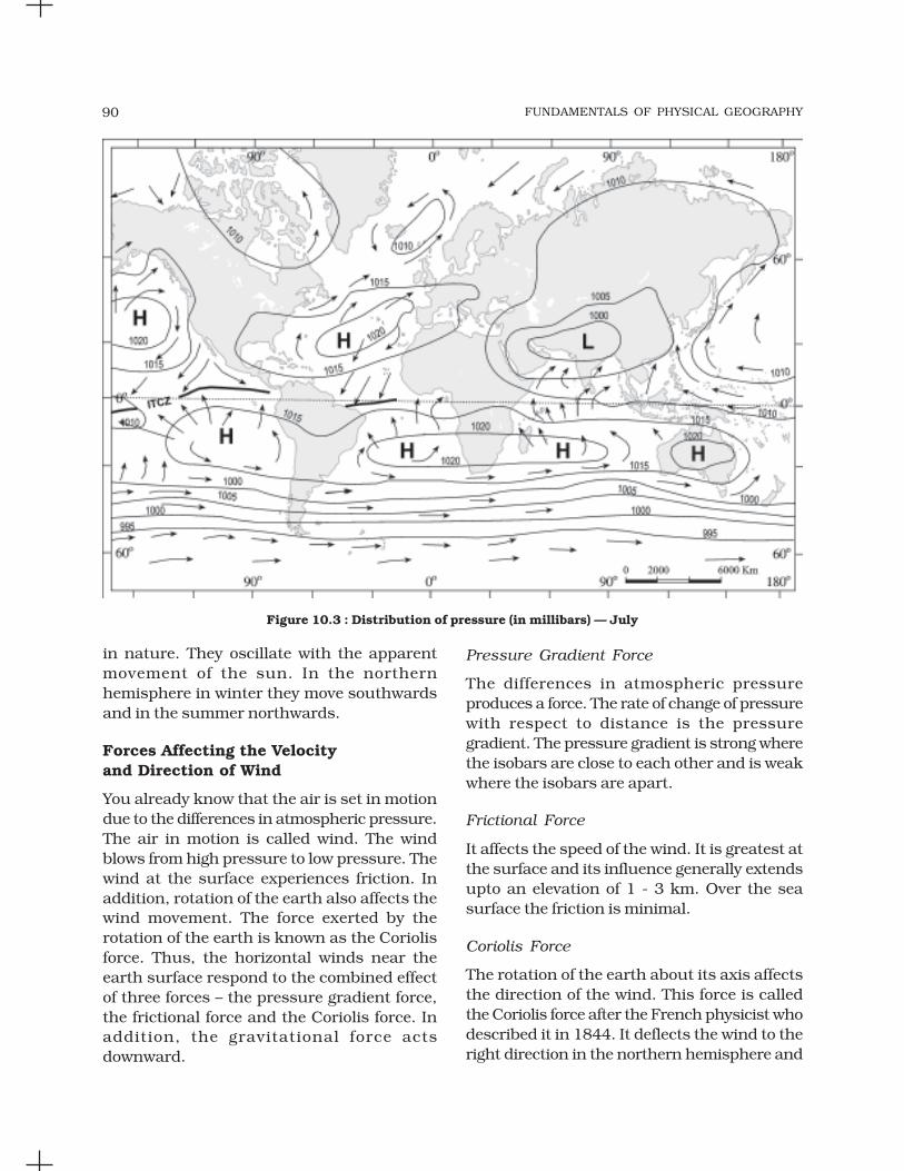
FUNDAMENTALS OF PHYSICAL GEOGRAPHY90
Pressure Gradient Force
The differences in atmospheric pressureproduces a force. The rate of change of pressurewith respect to distance is the pressuregradient. The pressure gradient is strong wherethe isobars are close to each other and is weakwhere the isobars are apart.
Frictional Force
It affects the speed of the wind. It is greatest atthe surface and its influence generally extendsupto an elevation of 1 - 3 km. Over the seasurface the friction is minimal.
Coriolis Force
The rotation of the earth about its axis affectsthe direction of the wind. This force is calledthe Coriolis force after the French physicist whodescribed it in 1844. It deflects the wind to theright direction in the northern hemisphere and
in nature. They oscillate with the apparentmovement of the sun. In the northernhemisphere in winter they move southwardsand in the summer northwards.
Forces Affecting the Velocityand Direction of Wind
You already know that the air is set in motiondue to the differences in atmospheric pressure.The air in motion is called wind. The windblows from high pressure to low pressure. Thewind at the surface experiences friction. Inaddition, rotation of the earth also affects thewind movement. The force exerted by therotation of the earth is known as the Coriolisforce. Thus, the horizontal winds near theearth surface respond to the combined effectof three forces – the pressure gradient force,the frictional force and the Coriolis force. Inaddition, the gravitational force actsdownward.
Figure 10.3 : Distribution of pressure (in millibars) — July

ATMOSPHERIC CIRCULATION AND WEATHER SYSTEMS 91
to the left in the southern hemisphere. Thedeflection is more when the wind velocity ishigh. The Coriolis force is directly proportionalto the angle of latitude. It is maximum at thepoles and is absent at the equator.
The Coriolis force acts perpendicular to thepressure gradient force. The pressure gradientforce is perpendicular to an isobar. The higherthe pressure gradient force, the more is thevelocity of the wind and the larger is thedeflection in the direction of wind. As a result ofthese two forces operating perpendicular to eachother, in the low-pressure areas the wind blowsaround it. At the equator, the Coriolis force iszero and the wind blows perpendicular to theisobars. The low pressure gets filled instead ofgetting intensified. That is the reason why tropicalcyclones are not formed near the equator.
Pressure and Wind
The velocity and direction of the wind are thenet result of the wind generating forces. Thewinds in the upper atmosphere, 2 - 3 km abovethe surface, are free from frictional effect of thesurface and are controlled by the pressuregradient and the Coriolis force. When isobarsare straight and when there is no friction, thepressure gradient force is balanced by theCoriolis force and the resultant wind blowsparallel to the isobar. This wind is known asthe geostrophic wind (Figure 10.4).
Table 10.2 : Pattern of Wind Direction in Cyclones and Anticyclones
Pressure System Pressure Condition Pattern of Wind Direction
at the Centre Northern Hemisphere Southern Hemisphere
Cyclone Low Anticlockwise Clockwise
Anticyclone High Clockwise Anticlockwise
The wind circulation around a low iscalled cyclonic circulation. Around a highit is called anti cyclonic circulation. Thedirection of winds around such systemschanges according to their location indifferent hemispheres (Table 10.2).
The wind circulation at the earth’s surfacearound low and high on many occasions isclosely related to the wind circulation at higherlevel. Generally, over low pressure area the airwill converge and rise. Over high pressure areathe air will subside from above and diverge atthe surface (Figure10.5). Apart fromconvergence, some eddies, convectioncurrents, orographic uplift and uplift alongfronts cause the rising of air, which is essentialfor the formation of clouds and precipitation.
Figure 10.4 : Geostropic Wind
General circulation of the atmosphere
The pattern of planetary winds largely dependson : (i) latitudinal variation of atmosphericheating; (ii) emergence of pressure belts; (iii)the migration of belts following apparent pathof the sun; (iv) the distribution of continentsand oceans; (v) the rotation of earth. The patternof the movement of the planetary winds iscalled the general circulation of theatmosphere. The general circulation of theatmosphere also sets in motion the ocean watercirculation which influences the earth’s
Figure 10.5 : Convergence and divergence of winds
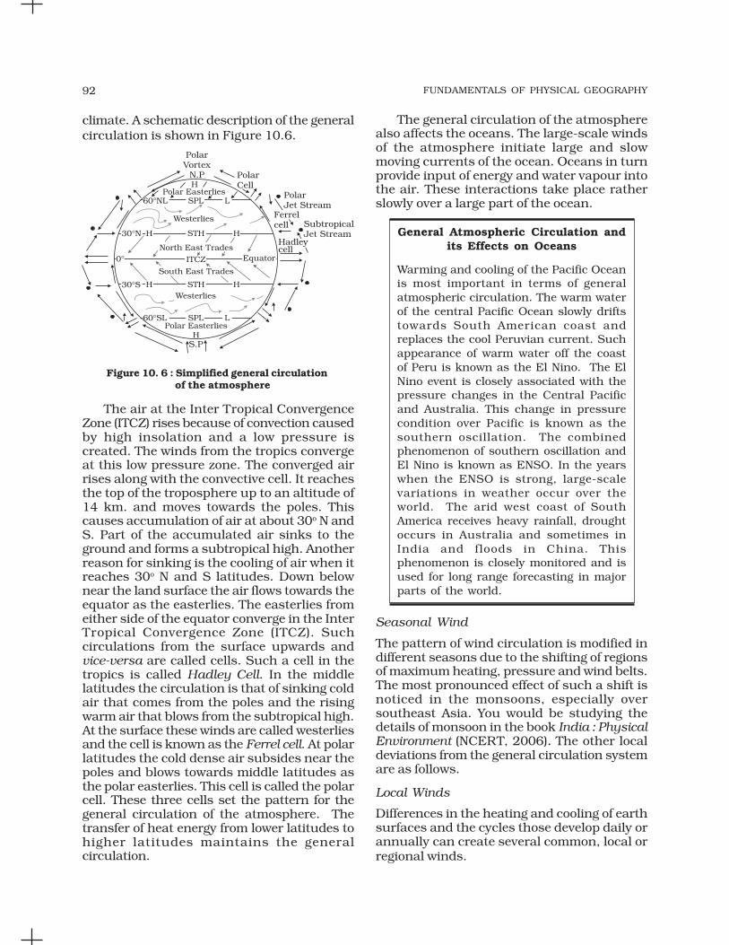
FUNDAMENTALS OF PHYSICAL GEOGRAPHY92
climate. A schematic description of the generalcirculation is shown in Figure 10.6.
The general circulation of the atmospherealso affects the oceans. The large-scale windsof the atmosphere initiate large and slowmoving currents of the ocean. Oceans in turnprovide input of energy and water vapour intothe air. These interactions take place ratherslowly over a large part of the ocean.
General Atmospheric Circulation andits Effects on Oceans
Warming and cooling of the Pacific Oceanis most important in terms of generalatmospheric circulation. The warm waterof the central Pacific Ocean slowly driftstowards South American coast andreplaces the cool Peruvian current. Suchappearance of warm water off the coastof Peru is known as the El Nino. The ElNino event is closely associated with thepressure changes in the Central Pacificand Australia. This change in pressurecondition over Pacific is known as thesouthern oscillation. The combinedphenomenon of southern oscillation andEl Nino is known as ENSO. In the yearswhen the ENSO is strong, large-scalevariations in weather occur over theworld. The arid west coast of SouthAmerica receives heavy rainfall, droughtoccurs in Australia and sometimes inIndia and floods in China. Thisphenomenon is closely monitored and isused for long range forecasting in majorparts of the world.
Seasonal Wind
The pattern of wind circulation is modified indifferent seasons due to the shifting of regionsof maximum heating, pressure and wind belts.The most pronounced effect of such a shift isnoticed in the monsoons, especially oversoutheast Asia. You would be studying thedetails of monsoon in the book India : PhysicalEnvironment (NCERT, 2006). The other localdeviations from the general circulation systemare as follows.
Local Winds
Differences in the heating and cooling of earthsurfaces and the cycles those develop daily orannually can create several common, local orregional winds.
Figure 10. 6 : Simplified general circulation of the atmosphere
The air at the Inter Tropical ConvergenceZone (ITCZ) rises because of convection causedby high insolation and a low pressure iscreated. The winds from the tropics convergeat this low pressure zone. The converged airrises along with the convective cell. It reachesthe top of the troposphere up to an altitude of14 km. and moves towards the poles. Thiscauses accumulation of air at about 30o N andS. Part of the accumulated air sinks to theground and forms a subtropical high. Anotherreason for sinking is the cooling of air when itreaches 30o N and S latitudes. Down belownear the land surface the air flows towards theequator as the easterlies. The easterlies fromeither side of the equator converge in the InterTropical Convergence Zone (ITCZ). Suchcirculations from the surface upwards andvice-versa are called cells. Such a cell in thetropics is called Hadley Cell. In the middlelatitudes the circulation is that of sinking coldair that comes from the poles and the risingwarm air that blows from the subtropical high.At the surface these winds are called westerliesand the cell is known as the Ferrel cell. At polarlatitudes the cold dense air subsides near thepoles and blows towards middle latitudes asthe polar easterlies. This cell is called the polarcell. These three cells set the pattern for thegeneral circulation of the atmosphere. Thetransfer of heat energy from lower latitudes tohigher latitudes maintains the generalcirculation.

ATMOSPHERIC CIRCULATION AND WEATHER SYSTEMS 93
Land and Sea Breezes
As explained earlier, the land and sea absorband transfer heat differently. During the day theland heats up faster and becomes warmer thanthe sea. Therefore, over the land the air risesgiving rise to a low pressure area, whereas thesea is relatively cool and the pressure over seais relatively high. Thus, pressure gradient fromsea to land is created and the wind blows fromthe sea to the land as the sea breeze. In the nightthe reversal of condition takes place. The landloses heat faster and is cooler than the sea. Thepressure gradient is from the land to the seaand hence land breeze results (Figure 10.7).
Figure 10.7 : Land and sea breezes
Mountain and Valley Winds
In mountainous regions, during the day theslopes get heated up and air moves upslopeand to fill the resulting gap the air from thevalley blows up the valley. This wind is known
as the valley breeze. During the night theslopes get cooled and the dense air descendsinto the valley as the mountain wind. The coolair, of the high plateaus and ice fields draininginto the valley is called katabatic wind. Anothertype of warm wind occurs on the leeward sideof the mountain ranges. The moisture in thesewinds, while crossing the mountain rangescondense and precipitate. When it descendsdown the leeward side of the slope the dry airgets warmed up by adiabatic process. This dryair may melt the snow in a short time.
Air Masses
When the air remains over a homogenous areafor a sufficiently longer time, it acquires thecharacteristics of the area. The homogenousregions can be the vast ocean surface or vastplains. The air with distinctive characteristicsin terms of temperature and humidity is calledan airmass. It is defined as a large body of airhaving little horizontal variation in temperatureand moisture. The homogenous surfaces, overwhich air masses form, are called the sourceregions.
The air masses are classified according tothe source regions. There are five major sourceregions. These are: (i) Warm tropical andsubtropical oceans; (ii) The subtropical hotdeserts; (iii) The relatively cold high latitudeoceans; (iv) The very cold snow coveredcontinents in high latitudes; (v) Permanentlyice covered continents in the Arctic andAntarctica. Accordingly, following types of air-masses are recognised: (i) Maritime tropical(mT); (ii) Continental tropical (cT); (iii) Maritimepolar (mP); (iv) Continental polar (cP);(v) Continental arctic (cA). Tropical air massesare warm and polar air masses are cold.
Fronts
When two different air masses meet, theboundary zone between them is called a front.The process of formation of the fronts is knownas frontogenesis. There are four types offronts: (a) Cold; (b) Warm; (c) Stationary;(d) Occluded [(Figure10.8 (a), (b), (c)]. When thefront remains stationary, it is called astationary front. When the cold air moves

FUNDAMENTALS OF PHYSICAL GEOGRAPHY94
towards the warm air mass, its contact zone iscalled the cold front, whereas if the warm airmass moves towards the cold air mass, thecontact zone is a warm front. If an air mass isfully lifted above the land surface, it is calledthe occluded front. The fronts occur in middlelatitudes and are characterised by steep gradientin temperature and pressure. They bringabrupt changes in temperature and cause theair to rise to form clouds and cause precipitation.
Extra Tropical Cyclones
The systems developing in the mid and highlatitude, beyond the tropics are called themiddle latitude or extra tropical cyclones. Thepassage of front causes abrupt changes in theweather conditions over the area in the middleand high latitudes.
Extra tropical cyclones form along the polarfront. Initially, the front is stationary. In thenorthern hemisphere, warm air blows from thesouth and cold air from the north of the front.When the pressure drops along the front, thewarm air moves northwards and the cold airmove towards, south setting in motion an
anticlockwise cyclonic circulation. The cycloniccirculation leads to a well developed extratropical cyclone, with a warm front and a coldfront. The plan and cross section of a welldeveloped cyclone is given in Figure 10.9.There are pockets of warm air or warm sectorwedged between the forward and the rear coldair or cold sector. The warm air glides over thecold air and a sequence of clouds appear overthe sky ahead of the warm front and causeprecipitation. The cold front approaches thewarm air from behind and pushes the warmair up. As a result, cumulus clouds developalong the cold front. The cold front moves fasterthan the warm front ultimately overtaking thewarm front. The warm air is completely liftedup and the front is occluded and the cyclonedissipates.
The processes of wind circulation both atthe surface and aloft are closely interlinked.The extra tropical cyclone differs from thetropical cyclone in number of ways. The extratropical cyclones have a clear frontal system
Figure 10.8 : Vertical Sections of : (a) Warm Front;(b) Cold Front; (c) Occluded Front
Figure 10. 9 : Extra tropical cyclones

ATMOSPHERIC CIRCULATION AND WEATHER SYSTEMS 95
which is not present in the tropical cyclones.They cover a larger area and can originate overthe land and sea. Whereas the tropical cyclonesoriginate only over the seas and on reachingthe land they dissipate. The extra tropicalcyclone affects a much larger area ascompared to the tropical cyclone. The windvelocity in a tropical cyclone is much higherand it is more destructive. The extra tropicalcyclones move from west to east but tropicalcyclones, move from east to west.
Tropical Cyclones
Tropical cyclones are violent storms thatoriginate over oceans in tropical areas andmove over to the coastal areas bringing aboutlarge scale destruction caused by violentwinds, very heavy rainfall and storm surges.This is one of the most devastating naturalcalamities. They are known as Cyclones in theIndian Ocean, Hurricanes in the Atlantic,Typhoons in the Western Pacific and SouthChina Sea, and Willy-willies in the WesternAustralia.
Tropical cyclones originate and intensifyover warm tropical oceans. The conditionsfavourable for the formation and intensificationof tropical storms are: (i) Large sea surface withtemperature higher than 27° C; (ii) Presenceof the Coriolis force; (iii) Small variations in thevertical wind speed; (iv) A pre-existing weak-low-pressure area or low-level-cycloniccirculation; (v) Upper divergence above the sealevel system.
The energy that intensifies the storm, comesfrom the condensation process in the toweringcumulonimbus clouds, surrounding thecentre of the storm. With continuous supplyof moisture from the sea, the storm is furtherstrengthened. On reaching the land themoisture supply is cut off and the stormdissipates. The place where a tropical cyclonecrosses the coast is called the landfall of thecyclone. The cyclones, which cross 20o Nlatitude generally, recurve and they are moredestructive.
A schematic representation of the verticalstructure of a mature tropical cyclonic stormis shown in Figure 10.10.
A mature tropical cyclone is characterisedby the strong spirally circulating wind aroundthe centre, called the eye. The diameter of thecirculating system can vary between 150 and250 km.
The eye is a region of calm with subsidingair. Around the eye is the eye wall, where thereis a strong spiralling ascent of air to greaterheight reaching the tropopause. The windreaches maximum velocity in this region,reaching as high as 250 km per hour.Torrential rain occurs here. From the eye wallrain bands may radiate and trains of cumulusand cumulonimbus clouds may drift into theouter region. The diameter of the storm overthe Bay of Bengal, Arabian sea and Indianocean is between 600 - 1200 km. The systemmoves slowly about 300 - 500 km per day.The cyclone creates storm surges and theyinundate the coastal low lands. The stormpeters out on the land.
Figure 10.10 : Vertical section of the tropical cyclone(after Rama Sastry)

FUNDAMENTALS OF PHYSICAL GEOGRAPHY96
EXERCISES
1. Multiple choice questions.
(i) If the surface air pressure is 1,000 mb, the air pressure at 1 km above thesurface will be:
(a) 700 mb (c) 900 mb
(b) 1,100 mb (d) 1,300 mb
(ii) The Inter Tropical Convergence Zone normally occurs:
(a) near the Equator (b) near the Tropic of Cancer
(c) near the Tropic of Capricorn (d) near the Arctic Circle
(iii) The direction of wind around a low pressure in northern hemisphere is:
(a) clockwise (c) anti-clock wise
(b) perpendicular to isobars (d) parallel to isobars
(iv) Which one of the following is the source region for the formation of airmasses?
(a) the Equatorial forest (c) the Siberian Plain
(b) the Himalayas (d) the Deccan Plateau
2. Answer the following questions in about 30 words.
(i) What is the unit used in measuring pressure? Why is the pressure measuredat station level reduced to the sea level in preparation of weather maps?
(ii) While the pressure gradient force is from north to south, i.e. from thesubtropical high pressure to the equator in the northern hemisphere,why are the winds north easterlies in the tropics.
(iii) What are the geotrophic winds?
(iv) Explain the land and sea breezes.
Thunderstorms and Tornadoes
Other severe local storms are thunderstormsand tornadoes. They are of short duration,occurring over a small area but are violent.Thunderstorms are caused by intenseconvection on moist hot days. A thunderstormis a well-grown cumulonimbus cloudproducing thunder and lightening. When theclouds extend to heights where sub-zerotemperature prevails, hails are formed and theycome down as hailstorm. If there is insufficientmoisture, a thunderstorm can generate dust-storms. A thunderstorm is characterised byintense updraft of rising warm air, whichcauses the clouds to grow bigger and rise to
greater height. This causes precipitation. Later,downdraft brings down to earth the cool airand the rain. From severe thunderstormssometimes spiralling wind descends like atrunk of an elephant with great force, with verylow pressure at the centre, causing massivedestruction on its way. Such a phenomenon iscalled a tornado. Tornadoes generally occurin middle latitudes. The tornado over the seais called water sprouts.
These violent storms are the manifestationof the atmosphere’s adjustments to varyingenergy distribution. The potential and heatenergies are converted into kinetic energy inthese storms and the restless atmosphere againreturns to its stable state.

ATMOSPHERIC CIRCULATION AND WEATHER SYSTEMS 97
3. Answer the following questions in about 150 words.
(i) Discuss the factors affecting the speed and direction of wind.
(ii) Draw a simplified diagram to show the general circulation of theatmosphere over the globe. What are the possible reasons for the formationof subtropical high pressure over 30o N and S latitudes?
(iii) Why does tropical cyclone originate over the seas? In which part of thetropical cyclone do torrential rains and high velocity winds blow and why?
Project Work
(i) Collect weather information over media such as newspaper, TV and radiofor understanding the weather systems.
(ii) Read the section on weather in any newspaper, preferably, one having amap showing a satellite picture. Mark the area of cloudiness. Attempt toinfer the atmospheric circulation from the distribution of clouds. Comparethe forecast given in the newspaper with the TV coverage, if you haveaccess to TV. Estimate, how many days in a week was the forecast wereaccurate.

WATER IN THE ATMOSPHERE
Y ou have already learnt that the aircontains water vapour. It varies fromzero to four per cent by volume of the
atmosphere and plays an important role in theweather phenomena. Water is present in theatmosphere in three forms namely – gaseous,liquid and solid. The moisture in theatmosphere is derived from water bodiesthrough evaporation and from plants throughtranspiration. Thus, there is a continuousexchange of water between the atmosphere, theoceans and the continents through theprocesses of evaporation, transpiration,condensation and precipitation.
Water vapour present in the air is knownas humidity. It is expressed quantitatively indifferent ways. The actual amount of the watervapour present in the atmosphere is known asthe absolute humidity. It is the weight of watervapour per unit volume of air and is expressedin terms of grams per cubic metre. The abilityof the air to hold water vapour depends entirelyon its temperature. The absolute humiditydiffers from place to place on the surface of theearth. The percentage of moisture present inthe atmosphere as compared to its full capacityat a given temperature is known as the relativehumidity. With the change of air temperature,the capacity to retain moisture increases ordecreases and the relative humidity is alsoaffected. It is greater over the oceans and leastover the continents.
The air containing moisture to its fullcapacity at a given temperature is said to besaturated. It means that the air at the giventemperature is incapable of holding anyadditional amount of moisture at that stage.The temperature at which saturation occursin a given sample of air is known as dew point.
EVAPORATION AND CONDENSATION
The amount of water vapour in the atmosphereis added or withdrawn due to evaporation andcondensation respectively. Evaporation is aprocess by which water is transformed fromliquid to gaseous state. Heat is the main causefor evaporation. The temperature at which thewater starts evaporating is referred to as thelatent heat of vapourisation.
Increase in temperature increases waterabsorption and retention capacity of the givenparcel of air. Similarly, if the moisture contentis low, air has a potentiality of absorbing andretaining moisture. Movement of air replacesthe saturated layer with the unsaturated layer.Hence, the greater the movement of air, thegreater is the evaporation.
The transformation of water vapour intowater is called condensation. Condensation iscaused by the loss of heat. When moist air iscooled, it may reach a level when its capacityto hold water vapour ceases. Then, the excesswater vapour condenses into liquid form. If itdirectly condenses into solid form, it is knownas sublimation. In free air, condensation resultsfrom cooling around very small particlestermed as hygroscopic condensation nuclei.Particles of dust, smoke and salt from the oceanare particularly good nuclei because theyabsorb water. Condensation also takes placewhen the moist air comes in contact with somecolder object and it may also take place whenthe temperature is close to the dew point.Condensation, therefore, depends upon theamount of cooling and the relative humidity ofthe air. Condensation is influenced by thevolume of air, temperature, pressure andhumidity. Condensation takes place: (i) when
C H A P T E R

WATER IN THE ATMOSPHERE 99
the temperature of the air is reduced to dewpoint with its volume remaining constant; (ii)when both the volume and the temperature arereduced; (iv) when moisture is added to the airthrough evaporation. However, the mostfavourable condition for condensation is thedecrease in air temperature.
After condensation the water vapour or themoisture in the atmosphere takes one of thefollowing forms — dew, frost, fog and clouds.Forms of condensation can be classified on thebasis of temperature and location.Condensation takes place when the dew pointis lower than the freezing point as well ashigher than the freezing point.
Dew
When the moisture is deposited in the form ofwater droplets on cooler surfaces of solidobjects (rather than nuclei in air above thesurface) such as stones, grass blades and plantleaves, it is known as dew. The ideal conditionsfor its formation are clear sky, calm air, highrelative humidity, and cold and long nights.For the formation of dew, it is necessary thatthe dew point is above the freezing point.
Frost
Frost forms on cold surfaces whencondensation takes place below freezing point(00C), i.e. the dew point is at or below thefreezing point. The excess moisture is depositedin the form of minute ice crystals instead ofwater droplets. The ideal conditions for theformation of white frost are the same as thosefor the formation of dew, except that the airtemperature must be at or below the freezingpoint.
Fog and Mist
When the temperature of an air masscontaining a large quantity of water vapour fallsall of a sudden, condensation takes place withinitself on fine dust particles. So, the fog is a cloudwith its base at or very near to the ground.Because of the fog and mist, the visibilitybecomes poor to zero. In urban and industrialcentres smoke provides plenty of nuclei whichhelp the formation of fog and mist. Such a
condition when fog is mixed with smoke, isdescribed as smog. The only difference betweenthe mist and fog is that mist contains moremoisture than the fog. In mist each nucelicontains a thicker layer of moisture. Mists arefrequent over mountains as the rising warmair up the slopes meets a cold surface. Fogsare drier than mist and they are prevalent wherewarm currents of air come in contact with coldcurrents. Fogs are mini clouds in whichcondensation takes place around nucleiprovided by the dust, smoke, and the saltparticles.
Clouds
Cloud is a mass of minute water droplets ortiny crystals of ice formed by the condensationof the water vapour in free air at considerableelevations. As the clouds are formed at someheight over the surface of the earth, they takevarious shapes. According to their height,expanse, density and transparency oropaqueness clouds are grouped under fourtypes : (i) cirrus; (ii) cumulus; (iii) stratus;(iv) nimbus.
Cirrus
Cirrus clouds are formed at high altitudes(8,000 - 12,000m). They are thin and detatchedclouds having a feathery appearance. They arealways white in colour.
Cumulus
Cumulus clouds look like cotton wool. Theyare generally formed at a height of 4,000 -7,000 m. They exist in patches and can be seenscattered here and there. They have a flat base.
Stratus
As their name implies, these are layered cloudscovering large portions of the sky. These cloudsare generally formed either due to loss of heator the mixing of air masses with differenttemperatures.
Nimbus
Nimbus clouds are black or dark gray. Theyform at middle levels or very near to the surface

FUNDAMENTALS OF PHYSICAL GEOGRAPHY100
of the earth. These are extremely dense andopaque to the rays of the sun. Sometimes, theclouds are so low that they seem to touch theground. Nimbus clouds are shapeless massesof thick vapour.
Precipitation
The process of continuous condensation in freeair helps the condensed particles to grow insize. When the resistance of the air fails to holdthem against the force of gravity, they fall on tothe earth’s surface. So after the condensationof water vapour, the release of moisture isknown as precipitation. This may take placein liquid or solid form. The precipitation in theform of water is called rainfall, when thetemperature is lower than the 00C, precipitationtakes place in the form of fine flakes of snowand is called snowfall. Moisture is released inthe form of hexagonal crystals. These crystalsform flakes of snow. Besides rain and snow,other forms of precipitation are sleet and hail,though the latter are limited in occurrence andare sporadic in both time and space.
Sleet is frozen raindrops and refrozenmelted snow-water. When a layer of air withthe temperature above freezing point overliesa subfreezing layer near the ground,precipitation takes place in the form of sleet.Raindrops, which leave the warmer air,encounter the colder air below. As a result, theysolidify and reach the ground as small pelletsof ice not bigger than the raindrops from whichthey are formed.
Sometimes, drops of rain after beingreleased by the clouds become solidified intosmall rounded solid pieces of ice and whichreach the surface of the earth are calledhailstones. These are formed by the rainwaterpassing through the colder layers. Hailstoneshave several concentric layers of ice one overthe other.
Types of Rainfall
On the basis of origin, rainfall may be classifiedinto three main types – the convectional,orographic or relief and the cyclonic or frontal.
Conventional Rain
The, air on being heated, becomes light andrises up in convection currents. As it rises, itexpands and loses heat and consequently,condensation takes place and cumulousclouds are formed. With thunder and lightening,heavy rainfall takes place but this does not last
A combination of these four basic types cangive rise to the following types of clouds: highclouds – cirrus, cirrostratus, cirrocumulus;middle clouds – altostratus and altocumulus;low clouds – stratocumulus and nimbostratusand clouds with extensive verticaldevelopment – cumulus and cumulonimbus.
Identify these cloud types which areshown in Figure 11.1 and 11.2.
Figure 11.1
Figure 11.2

WATER IN THE ATMOSPHERE 101
long. Such rain is common in the summer orin the hotter part of the day. It is very commonin the equatorial regions and interior parts ofthe continents, particularly in the northernhemisphere.
Orographic Rain
When the saturated air mass comes across amountain, it is forced to ascend and as it rises,it expands; the temperature falls, and themoisture is condensed. The chief characteristicof this sort of rain is that the windward slopesreceive greater rainfall. After giving rain on thewindward side, when these winds reach theother slope, they descend, and theirtemperature rises. Then their capacity to takein moisture increases and hence, these leewardslopes remain rainless and dry. The areasituated on the leeward side, which gets lessrainfall is known as the rain-shadow area. Itis also known as the relief rain.
Cyclonic Rain
You have already read about extra tropicalcyclones and cyclonic rain in Chapter 10.Please consult Chapter 10 to understandcyclonic rainfall.
World Distribution of Rainfall
Different places on the earth’s surface receivedifferent amounts of rainfall in a year and thattoo in different seasons.
In general, as we proceed from the equatortowards the poles, rainfall goes on decreasingsteadily. The coastal areas of the world receivegreater amounts of rainfall than the interior of
the continents. The rainfall is more over theoceans than on the landmasses of the worldbecause of being great sources of water.Between the latitudes 350 and 400 N and S ofthe equator, the rain is heavier on the easterncoasts and goes on decreasing towards thewest. But, between 450 and 650 N and S ofequator, due to the westerlies, the rainfall isfirst received on the western margins of thecontinents and it goes on decreasing towardsthe east. Wherever mountains run parallel tothe coast, the rain is greater on the coastalplain, on the windward side and it decreasestowards the leeward side.
On the basis of the total amount of annualprecipitation, major precipitation regimes of theworld are identified as follows.
The equatorial belt, the windward slopesof the mountains along the western coasts inthe cool temperate zone and the coastal areasof the monsoon land receive heavy rainfall ofover 200 cm per annum. Interior continentalareas receive moderate rainfall varying from100 - 200 cm per annum. The coastal areas ofthe continents receive moderate amount ofrainfall. The central parts of the tropical landand the eastern and interior parts of thetemperate lands receive rainfall varyingbetween 50 - 100 cm per annum. Areas lyingin the rain shadow zone of the interior of thecontinents and high latitudes receive very lowrainfall-less than 50 cm per annum. Seasonaldistribution of rainfall provides an importantaspect to judge its effectiveness. In someregions rainfall is distributed evenlythroughout the year such as in the equatorialbelt and in the western parts of cool temperateregions.
EXERCISES
1. Multiple choice questions.
(i) Which one of the following is the most important constituent of theatmosphere for human beings?
(a) Water vapour (c) Dust particle
(b) Nitrogen (d) Oxygen

FUNDAMENTALS OF PHYSICAL GEOGRAPHY102
(ii) Which one of the following process is responsible for transforming liquidinto vapour?
(a) Condensation (c) Evaporation
(b) Transpiration (d) Precipitation
(iii) The air that contains moisture to its full capacity :
(a) Relative humidity (c) Absolute humidity
(b) Specific humidity (d) Saturated air
(iv) Which one of the following is the highest cloud in the sky?
(a) Cirrus (c) Nimbus
(b) Stratus (d) Cumulus
2. Answer the following questions in about 30 words.
(i) Name the three types of precipitation.
(ii) Explain relative humidity.
(iii) Why does the amount of water vapour decreases rapidly with altitude?
(iv) How are clouds formed? Classify them.
3. Answer the following questions in about 150 words.
(i) Discuss the salient features of the world distribution of precipitation.
(ii) What are forms of condensation? Describe the process of dew and frostformation.
Project Work
Browse through the newspaper from 1st June to 31st December and note the newsabout extreme rainfall in different parts of the country.

WORLD CLIMATE AND
CLIMATE CHANGE
T he world climate can be studied byorganising information and data onclimate and synthesising them in
smaller units for easy understanding,description and analysis. Three broadapproaches have been adopted for classifyingclimate. They are empirical, genetic andapplied. Empirical classification is based onobserved data, particularly on temperatureand precipitation. Genetic classificationattempts to organise climates according to theircauses. Applied classification is for specificpurpose.
KOEPPEN’S SCHEME OF CLASSIFICATION
OF CLIMATE
The most widely used classification of climateis the empirical climate classification schemedeveloped by V. Koeppen. Koeppen identifieda close relationship between the distributionof vegetation and climate. He selected certainvalues of temperature and precipitation and
related them to the distribution of vegetationand used these values for classifying theclimates. It is an empirical classification basedon mean annual and mean monthlytemperature and precipitation data. Heintroduced the use of capital and small lettersto designate climatic groups and types.Although developed in 1918 and modified overa period of time, Koeppen’s scheme is stillpopular and in use.
Koeppen recognised five major climaticgroups, four of them are based on temperatureand one on precipitation. Table 12.1 lists theclimatic groups and their characteristicsaccording to Koeppen. The capital letters : A,C,D and E delineate humid climates and B dryclimates.
The climatic groups are subdivided intotypes, designated by small letters, based onseasonality of precipitation and temperaturecharacteristics. The seasons of dryness areindicated by the small letters : f, m, w and s,where f corresponds to no dry season,
Table 12.1 : Climatic Groups According to Koeppen
Group Characteristics
A - Tropical Average temperature of the coldest month is 18° C or higher
B - Dry Climates Potential evaporation exceeds precipitation
C - Warm Temperate The average temperature of the coldest month of the (Mid-latitude) climatesyears is higher than minus 3°C but below 18°C
D - Cold Snow Forest Climates The average temperature of the coldest month is minus 3° C or below
E - Cold Climates Average temperature for all months is below 10° C
H - High Land Cold due to elevation
C H A P T E R

FUNDAMENTALS OF PHYSICAL GEOGRAPHY104
m - monsoon climate, w- winter dry season ands - summer dry season. The small letters a, b,c and d refer to the degree of severity oftemperature. The B- Dry Climates aresubdivided using the capital letters S for steppeor semi-arid and W for deserts. The climatictypes are listed in Table 12.2. The distributionof climatic groups and types is shown inTable 12.1.
Group A : Tropical Humid Climates
Tropical humid climates exist between Tropicof Cancer and Tropic of Capricorn. The sunbeing overhead throughout the year and thepresence of Inter Tropical Convergence Zone(INTCZ) make the climate hot and humid.Annual range of temperature is very low andannual rainfall is high. The tropical group isdivided into three types, namely (i) Af- Tropicalwet climate; (ii) Am - Tropical monsoon climate;(iii) Aw- Tropical wet and dry climate.
Tropical Wet Climate (Af)
Tropical wet climate is found near the equator.The major areas are the Amazon Basin in SouthAmerica, western equatorial Africa and the
islands of East Indies. Significant amount ofrainfall occurs in every month of the year asthunder showers in the afternoon. Thetemperature is uniformly high and the annualrange of temperature is negligible. Themaximum temperature on any day is around30°C while the minimum temperature isaround 20°C. Tropical evergreen forests withdense canopy cover and large biodiversity arefound in this climate.
Tropical Monsoon Climate (Am)
Tropical monsoon climate (Am) is found overthe Indian sub-continent, North Eastern partof South America and Northern Australia.Heavy rainfall occurs mostly in summer. Winteris dry. The detailed climatic account of thisclimatic type is given in the book on India:Physical Environment.
Tropical Wet and Dry Climate (Aw)
Tropical wet and dry climate occurs north andsouth of Af type climate regions. It borders withdry climate on the western part of the continentand Cf or Cw on the eastern part. ExtensiveAw climate is found to the north and south ofthe Amazon forest in Brazil and adjoining parts
Table 12.2 : Climatic Types According to Koeppen
Group Type Letter Code Characteristics
Tropical wet Af No dry season
Tropical monsoon Am Monsoonal, short dry season
Tropical wet and dry Aw Winter dry season
Subtropical steppe BSh Low-latitude semi arid or dry
Subtropical desert BWh Low-latitude arid or dry
Mid-latitude steppe BSk Mid-latitude semi arid or dry
Mid-latitude desert BWk Mid-latitude arid or dry
Humid subtropical Cfa No dry season, warm summer
Mediterranean Cs Dry hot summer
Marine west coast Cfb No dry season, warm and cool summer
Humid continental Df No dry season, severe winter
Subarctic Dw Winter dry and very severe
Tundra ET No true summer
Polar ice cap EF Perennial ice
Highland H Highland with snow cover
A-Tropical HumidClimate
B-Dry Climate
C-Warmtemperate (Mid-
latitude) Climates
D-Cold Snow-forest Climates
E-Cold Climates
H-Highland

WORLD CLIMATE AND CLIMATE CHANGE 105
of Bolivia and Paraguay in South America,Sudan and south of Central Africa. The annualrainfall in this climate is considerably less thanthat in Af and Am climate types and is variablealso. The wet season is shorter and the dryseason is longer with the drought being moresevere. Temperature is high throughout theyear and diurnal ranges of temperature are thegreatest in the dry season. Deciduous forest andtree-shredded grasslands occur in this climate.
Dry Climates : B
Dry climates are characterised by very lowrainfall that is not adequate for the growth ofplants. These climates cover a very large areaof the planet extending over large latitudes from15° - 60° north and south of the equator. Atlow latitudes, from 15° - 30°, they occur in thearea of subtropical high where subsidence andinversion of temperature do not producerainfall. On the western margin of thecontinents, adjoining the cold current,particularly over the west coast of SouthAmerica, they extend more equatorwards andoccur on the coast land. In middle latitudes,from 35° - 60° north and south of equator, theyare confined to the interior of continents wheremaritime-humid winds do not reach and toareas often surrounded by mountains.
Dry climates are divided into steppe orsemi-arid climate (BS) and desert climate (BW).They are further subdivided as subtropicalsteppe (BSh) and subtropical desert (BWh) atlatitudes from 15° - 35° and mid-latitudesteppe (BSk) and mid-latitude desert (BWk) atlatitudes between 35° - 60°.
Subtropical Steppe (BSh) and SubtropicalDesert (BWh) Climates
Subtropical steppe (BSh) and subtropicaldesert (BWh) have common precipitation andtemperature characteristics. Located in thetransition zone between humid and dryclimates, subtropical steppe receives slightlymore rainfall than the desert, adequate enoughfor the growth of sparse grasslands. The rainfallin both the climates is highly variable. Thevariability in the rainfall affects the life in thesteppe much more than in the desert, more
often causing famine. Rain occurs in shortintense thundershowers in deserts and isineffective in building soil moisture. Fog iscommon in coastal deserts bordering coldcurrents. Maximum temperature in the summeris very high. The highest shade temperature of58° C was recorded at Al Aziziyah, Libya on13 September 1922. The annual and diurnalranges of temperature are also high.
Warm Temperate (Mid-Latitude) Climates-C
Warm temperate (mid-latitude) climates extendfrom 30° - 50° of latitude mainly on the easternand western margins of continents. Theseclimates generally have warm summers withmild winters. They are grouped into four types:(i) Humid subtropical, i.e. dry in winter andhot in summer (Cwa); (ii) Mediterranean (Cs);(iii) Humid subtropical, i.e. no dry season andmild winter (Cfa); (iv) Marine west coast climate(Cfb).
Humid Subtropical Climate (Cwa)
Humid subtropical climate occurs poleward ofTropic of Cancer and Capricorn, mainly inNorth Indian plains and South China interiorplains. The climate is similar to Aw climateexcept that the temperature in winter is warm.
Mediterranean Climate (Cs)
As the name suggests, Mediterranean climateoccurs around Mediterranean sea, along thewest coast of continents in subtropical latitudesbetween 30° - 40° latitudes e.g. — CentralCalifornia, Central Chile, along the coast insouth eastern and south western Australia.These areas come under the influence of subtropical high in summer and westerly wind inwinter. Hence, the climate is characterised byhot, dry summer and mild, rainy winter. Monthlyaverage temperature in summer is around25° C and in winter below 10°C. The annualprecipitation ranges between 35 - 90 cm.
Humid Subtropical (Cfa) Climate
Humid subtropical climate lies on the easternparts of the continent in subtropical latitudes.In this region the air masses are generally
FUNDAMENTALS OF PHYSICAL GEOGRAPHY106
unstable and cause rainfall throughout theyear. They occur in eastern United States ofAmerica, southern and eastern China,southern Japan, northeastern Argentina,coastal south Africa and eastern coast ofAustralia. The annual averages of precipitationvary from 75-150 cm. Thunderstorms insummer and frontal precipitation in winter arecommon. Mean monthly temperature insummer is around 27°C, and in winter it variesfrom 5°-12° C. The daily range of temperatureis small.
Marine West Coast Climate (Cfb)
Marine west coast climate is located polewardfrom the Mediterranean climate on the westcoast of the continents. The main areas are:Northwestern Europe, west coast of NorthAmerica, north of California, southern Chile,southeastern Australia and New Zealand. Dueto marine influence, the temperature ismoderate and in winter, it is warmer than forits latitude. The mean temperature in summermonths ranges from 15°-20°C and in winter4°-10°C. The annual and daily ranges oftemperature are small. Precipitation occursthroughout the year. Precipitation variesgreatly from 50-250cm.
Cold Snow Forest Climates (D)
Cold snow forest climates occur in the largecontinental area in the northern hemispherebetween 40°-70° north latitudes in Europe,Asia and North America. Cold snow forestclimates are divided into two types: (i) Df- coldclimate with humid winter; (ii) Dw- cold climatewith dry winter. The severity of winter is morepronounced in higher latitudes.
Cold Climate with Humid Winters (Df)
Cold climate with humid winter occurspoleward of marine west coast climate and midlatitude steppe. The winters are cold andsnowy. The frost free season is short. Theannual ranges of temperature are large. Theweather changes are abrupt and short.Poleward, the winters are more severe.
Cold Climate with Dry Winters (Dw)
Cold climate with dry winter occurs mainlyover Northeastern Asia. The development ofpronounced winter anti cyclone and itsweakening in summer sets in monsoon likereversal of wind in this region. Polewardsummer temperatures are lower and wintertemperatures are extremely low with manylocations experiencing below freezing pointtemperatures for up to seven months in a year.Precipitation occurs in summer. The annualprecipitation is low from 12-15 cm.
Polar Climates (E)
Polar climates exist poleward beyond 70°latitude. Polar climates consist of two types:(i) Tundra (ET); (ii) Ice Cap (EF).
Tundra Climate (ET)
The tundra climate (ET) is so called after thetypes of vegetation, like low growing mosses,lichens and flowering plants. This is the regionof permafrost where the sub soil is permanentlyfrozen. The short growing season and waterlogging support only low growing plants.During summer, the tundra regions have verylong duration of day light.
Ice Cap Climate (EF)
The ice cap climate (EF) occurs over interiorGreenland and Antartica. Even in summer, thetemperature is below freezing point. This areareceives very little precipitation. The snow andice get accumulated and the mounting pressurecauses the deformation of the ice sheets andthey break. They move as icebergs that float inthe Arctic and Antarctic waters. Plateau Station, Antarctica ,79°S, portray this climate.
Highland Climates (H)
Highland climates are governed by topography.In high mountains, large changes in meantemperature occur over short distances.Precipitation types and intensity also varyspatially across high lands. There is verticalzonation of layering of climatic types withelevation in the mountain environment.

WORLD CLIMATE AND CLIMATE CHANGE 107
CLIMATE CHANGE
The earlier chapters on climate summarisedour understanding of climate as it prevails now.The type of climate we experience now mightbe prevailing over the last 10,000 years withminor and occasionally wide fluctuations. Theplanet earth has witnessed many variations inclimate since the beginning. Geological recordsshow alteration of glacial and inter-glacialperiods. The geomorphological features,especially in high altitudes and high latitudes,exhibit traces of advances and retreats ofglaciers. The sediment deposits in glacial lakesalso reveal the occurrence of warm and coldperiods. The rings in the trees provide cluesabout wet and dry periods. Historical recordsdescribe the vagaries in climate. All theseevidences indicate that change in climate is anatural and continuous process.
India also witnessed alternate wet and dryperiods. Archaeological findings show that theRajasthan desert experienced wet and coolclimate around 8,000 B.C. The period 3,000-1,700 B.C. had higher rainfall. From about2,000-1,700 B.C., this region was the centreof the Harappan civilisation. Dry conditionsaccentuated since then.
In the geological past, the earth was warmsome 500-300 million years ago, through theCambrian, Ordovician and Silurian periods.During the Pleistocene epoch, glacial andinter-glacial periods occurred, the last majorpeak glacial period was about 18,000 yearsago. The present inter-glacial period started10,000 years ago.
Climate in the recent past
Variability in climate occurs all the time. Thenineties decade of the last century witnessedextreme weather events. The 1990s recordedthe warmest temperature of the century andsome of the worst floods around the world. Theworst devastating drought in the Sahel region,south of the Sahara desert, from 1967-1977is one such variability. During the 1930s,severe drought occurred in southwestern GreatPlains of the United States, described as thedust bowl. Historical records of crop yield or
crop failures, of floods and migration of peopletell about the effects of changing climate. Anumber of times Europe witnessed warm, wet,cold and dry periods, the significant episodeswere the warm and dry conditions in the tenthand eleventh centuries, when the Vikingssettled in Greenland. Europe witnessed “LittleIce Age” from 1550 to about 1850. From about1885-1940 world temperature showed anupward trend. After 1940, the rate of increasein temperature slowed down.
Causes of Climate Change
The causes for climate change are many. Theycan be grouped into astronomical andterrestrial causes. The astronomical causes arethe changes in solar output associated withsunspot activities. Sunspots are dark andcooler patches on the sun which increase anddecrease in a cyclical manner. According tosome meteorologists, when the number ofsunspots increase, cooler and wetter weatherand greater storminess occur. A decrease insunspot numbers is associated with warm anddrier conditions. Yet, these findings are notstatistically significant.
An another astronomical theory isMillankovitch oscillations, which infer cyclesin the variations in the earth’s orbitalcharacteristics around the sun, the wobblingof the earth and the changes in the earth’s axialtilt. All these alter the amount of insolationreceived from the sun, which in turn, mighthave a bearing on the climate.
Volcanism is considered as another causefor climate change. Volcanic eruption throwsup lots of aerosols into the atmosphere. Theseaerosols remain in the atmosphere for aconsiderable period of time reducing the sun’sradiation reaching the Earth’s surface. After therecent Pinatoba and El Cion volcaniceruptions, the average temperature of the earthfell to some extent for some years.
The most important anthropogenic effecton the climate is the increasing trend in theconcentration of greenhouse gases in theatmosphere which is likely to cause globalwarming.

FUNDAMENTALS OF PHYSICAL GEOGRAPHY108
Global Warming
Due to the presence of greenhouse gases, theatmosphere is behaving like a greenhouse. Theatmosphere also transmits the incoming solarradiation but absorbs the vast majority of longwave radiation emitted upwards by the earth’ssurface. The gases that absorb long waveradiation are called greenhouse gases. Theprocesses that warm the atmosphere are oftencollectively referred to as the greenhouse effect.
The term greenhouse is derived from theanalogy to a greenhouse used in coldareas for preserving heat. A greenhouseis made up of glass. The glass which istransparent to incoming short wave solarradiation is opaque to outgoing long waveradiation. The glass, therefore, allows inmore radiation and prevents the longwave radiation going outside the glasshouse, causing the temperature insidethe glasshouse structure warmer thanoutside. When you enter a car or a bus,during summers, where windows areclosed, you feel more heat than outside.Likewise during winter the vehicles withclosed doors and windows remain warmerthan the temperature outside. This isanother example of the greenhouse effect.
Greenhouse Gases(GHGs)
The primary GHGs of concern today are carbondioxide (CO
2), Chlorofluorocarbons (CFCs),
methane (CH4), nitrous oxide (N
2O) and ozone
(O3). Some other gases such as nitric oxide (NO)
and carbon monoxide (CO) easily react withGHGs and affect their concentration in theatmosphere.
The effectiveness of any given GHGmolecule will depend on the magnitude of theincrease in its concentration, its life time in theatmosphere and the wavelength of radiationthat it absorbs. The chlorofluorocarbons(CFCs) are highly effective. Ozone whichabsorbs ultra violet radiation in thestratosphere is very effective in absorbingterrestrial radiation when it is present in thelower troposphere. Another important point tobe noted is that the more time the GHGmolecule remains in the atmosphere, the longer
it will take for earth’s atmospheric system torecover from any change brought about by thelatter.
The largest concentration of GHGs in theatmosphere is carbon dioxide. The emissionof CO
2 comes mainly from fossil fuel
combustion (oil, gas and coal). Forests andoceans are the sinks for the carbon dioxide.Forests use CO
2 in their growth. So,
deforestation due to changes in land use, alsoincreases the concentration of Co2. The timetaken for atmospheric CO2 to adjust to changesin sources to sinks is 20-50 years. It is risingat about 0.5 per cent annually. Doubling ofconcentration of CO
2 over pre-industrial level
is used as an index for estimating the changesin climate in climatic models.
Chlorofluorocarbons (CFCs) are productsof human activity. Ozone occurs in thestratosphere where ultra-violet rays convertoxygen into ozone. Thus, ultra violet rays donot reach the earth’s surface. The CFCs whichdrift into the stratosphere destroy the ozone.Large depletion of ozone occurs over Antarctica.The depletion of ozone concentration in thestratosphere is called the ozone hole. Thisallows the ultra violet rays to pass through thetroposphere.
International efforts have been initiated forreducing the emission of GHGs into theatmosphere. The most important one is theKyoto protocol proclaimed in 1997. Thisprotocol went into effect in 2005, ratified by141 nations. Kyoto protocol bounds the 35industrialised countries to reduce theiremissions by the year 2012 to 5 per cent lessthan the levels prevalent in the year 1990.
The increasing trend in the concentrationof GHGs in the atmosphere may, in the longrun, warm up the earth. Once the globalwarming sets in, it will be difficult to reverse it.The effect of global warming may not beuniform everywhere. Nevertheless, the adverseeffect due to global warming will adversely affectthe life supporting system. Rise in the sea leveldue to melting of glaciers and ice-caps andthermal expansion of the sea may inundatelarge parts of the coastal area and islands,leading to social problems. This is anothercause for serious concern for the world

WORLD CLIMATE AND CLIMATE CHANGE 109
community. Efforts have already been initiatedto control the emission of GHGs and to arrestthe trend towards global warming. Let us hopethe world community responds to this challengeand adopts a lifestyle that leaves behind alivable world for the generations to come.
One of the major concerns of the worldtoday is global warming. Let us look at howmuch the planet has warmed up from thetemperature records.
Temperature data are available from themiddle of the 19th century mostly for westernEurope. The reference period for this study is1961-90. The temperature anomalies for theearlier and later periods are estimated from theaverage temperature for the period 1961-90.The annual average near -surface airtemperature of the world is approximately14°C. The time series show anomalies of
annual near surface temperature over landfrom 1856-2000, relative to the period1961-90 as normal for the globe.
An increasing trend in temperature wasdiscernible in the 20th century. The greatestwarming of the 20th century was during thetwo periods, 1901-44 and 1977-99. Over eachof these two periods, global temperatures roseby about 0.4°C. In between, there was a slightcooling, which was more marked in theNorthern Hemisphere.
The globally averaged annual meantemperature at the end of the 20th century wasabout 0.6°C above that recorded at the end ofthe 19th century. The seven warmest yearsduring the 1856-2000 were recorded in thelast decade. The year 1998 was the warmestyear, probably not only for the 20th centurybut also for the whole millennium.
Write an explanatory noteon “global warming”.

FUNDAMENTALS OF PHYSICAL GEOGRAPHY110
EXERCISES
1. Multiple choice questions.
(i) Which one of the following is suitable for Koeppen’s “A” type of climate?
(a) High rainfall in all the months
(b) Mean monthly temperature of the coldest month more than freezingpoint
(c) Mean monthly temperature of all the months more than 18o C
(d) Average temperature for all the months below 10° C
(ii) Koeppen’s system of classification of climates can be termed as :
(a) Applied (b) Systematic (c) Genetic (d) Empirical
(iii) Most of the Indian Peninsula will be grouped according to Koeppen’s systemunder:
(a) “Af” (b) “BSh” (c) “Cfb” (d) “Am”
(iv) Which one of the following years is supposed to have recorded the warmesttemperature the world over?
(a) 1990 (b) 1998 (c) 1885 (d) 1950
(v) Which one of the following groups of four climates represents humidconditions?
(a) A—B—C—E
(b) A—C—D—E
(c) B—C—D—E
(d) A—C—D—F
2. Answer the following questions in about 30 words.
(i) Which two climatic variables are used by Koeppen for classification of theclimate?
(ii) How is the “genetic” system of classification different from the “empiricalone”?
(iii) Which types of climates have very low range of temperature?
(iv) What type of climatic conditions would prevail if the sun spots increase?
3. Answer the following questions in about 150 words.
(i) Make a comparison of the climatic conditions between the “A” and “B”types of climate.
(ii) What type of vegetation would you find in the “C” and “A” type(s) of climate?
(iii) What do you understand by the term “Greenhouse Gases”? Make a list ofgreenhouse gases.
Project Work
Collect information about Kyoto declaration related to global climate changes.

WATER (OCEANS)
This unit deals with
• Hydrological Cycle
• Oceans — submarine relief; distribution of temperature andsalinity; movements of ocean water-waves, tides and currents
UNIT
V

WATER (OCEANS)
the ocean to land and land to ocean. Thehydrological cycle describes the movement ofwater on, in, and above the earth. The watercycle has been working for billions of yearsand all the life on earth depends on it. Next toair, water is the most important elementrequired for the existence of life on earth. Thedistribution of water on earth is quite uneven.Many locations have plenty of water whileothers have very limited quantity. Thehydrological cycle, is the circulation of waterwithin the earth’s hydrosphere in differentforms i.e. the liquid, solid and the gaseousphases. It also refers to the continuousexchange of water between the oceans,
C H A P T E R
Figure 13.1 : Hydrological Cycle
Can we think of life without water? It issaid that the water is life. Water is anessential component of all life forms that
exist over the surface of the earth. The creatureson the earth are lucky that it is a water planet,otherwise we all would have no existence. Wateris a rare commodity in our solar system. Thereis no water on the sun or anywhere else in thesolar system. The earth, fortunately has anabundant supply of water on its surface. Hence,our planet is called the ‘Blue Planet’.
HYDROLOGICAL CYCLE
Water is a cyclic resource. It can be used andre-used. Water also undergoes a cycle from

WATER (OCEANS) 113
atmosphere, landsurface and subsurface andthe organisms.
Table 13.1 shows distribution of water onthe surface of the earth. About 71 per cent ofthe planetary water is found in the oceans. Theremaining is held as freshwater in glaciers andicecaps, groundwater sources, lakes, soilmoisture, atmosphere, streams and within life.Nearly 59 per cent of the water that falls onland returns to the atmosphere throughevaporation from over the oceans as well asfrom other places. The remainder runs-off onthe surface, infiltrates into the ground or a partof it becomes glacier (Figure 13.1).
It is to be noted that the renewable wateron the earth is constant while the demand isincreasing tremendously. This leads to water
crisis in different parts of the world — spatiallyand temporally. The pollution of river watershas further aggravated the crisis. How can youintervene in improving the water quality andaugmenting the available quantity of water?
RELIEF OF THE OCEAN FLOOR
The oceans are confined to the greatdepressions of the earth’s outer layer. In thissection, we shall see the nature of the oceanbasins of the earth and their topography. Theoceans, unlike the continents, merge sonaturally into one another that it is hard todemarcate them. The geographers have dividedthe oceanic part of the earth into four oceans,namely the Pacific, the Atlantic, the Indian andthe Arctic. The various seas, bays, gulfs andother inlets are parts of these four large oceans.
A major portion of the ocean floor is foundbetween 3-6 km below the sea level. The ‘land’under the waters of the oceans, that is, theocean floor exhibits complex and variedfeatures as those observed over the land(Figure 13.2). The floors of the oceans arerugged with the world’s largest mountainranges, deepest trenches and the largest plains.These features are formed, like those of thecontinents, by the factors of tectonic, volcanicand depositional processes.
Divisions of the Ocean Floors
The ocean floors can be divided into four majordivisions: (i) the Continental Shelf; (ii) theContinental Slope; (iii) the Deep Sea Plain;(iv) the Oceanic Deeps. Besides, these divisionsthere are also major and minor relief featuresin the ocean floors like ridges, hills, seamounts, guyots, trenches, canyons, etc.
Continental Shelf
The continental shelf is the extended marginof each continent occupied by relativelyshallow seas and gulfs. It is the shallowest partof the ocean showing an average gradient of1° or even less. The shelf typically ends at avery steep slope, called the shelf break.
The width of the continental shelves varyfrom one ocean to another. The average width
Table 13.1 : Water on the Earth’s surface
Reservoir Volume Percentage(Million of the TotalCubic km )
Oceans 1,370 97.25
Ice Caps 29 2.05
and GlaciersGroundwater 9.5 0.68
Lakes 0.125 0.01
Soil Moisture 0.065 0.005
Atmosphere 0.013 0.001
Streams 0.0017 0.0001and Rivers
Biosphere 0.0006 0.00004
Table 13.2 : Components and Processes of the Water Cycle
Components Processes
Water storage Evaporationin oceans Evapotranspiration
Sublimation
Water in the Condensationatmosphere Precipitation
Water storage in Snowmelt runoffice and snow to streams
Surface runoff Stream flow freshwaterstorage infiltration
Groundwater storage Groundwaterdischarge springs

FUNDAMENTALS OF PHYSICAL GEOGRAPHY114
of continental shelves is about 80 km. Theshelves are almost absent or very narrow alongsome of the margins like the coasts of Chile,the west coast of Sumatra, etc. On the contrary,the Siberian shelf in the Arctic Ocean, thelargest in the world, stretches to 1,500 km inwidth. The depth of the shelves also varies. Itmay be as shallow as 30 m in some areas whilein some areas it is as deep as 600 m.
The continental shelves are covered withvariable thicknesses of sediments broughtdown by rivers, glaciers, wind, from the landand distributed by waves and currents. Massivesedimentary deposits received over a long timeby the continental shelves, become the sourceof fossil fuels.
Continental Slope
The continental slope connects the continentalshelf and the ocean basins. It begins where thebottom of the continental shelf sharply dropsoff into a steep slope. The gradient of the sloperegion varies between 2-5°. The depth of theslope region varies between 200 and 3,000 m.The slope boundary indicates the end of thecontinents. Canyons and trenches are observedin this region.
Deep Sea Plain
Deep sea plains are gently sloping areas of theocean basins. These are the flattest andsmoothest regions of the world. The depthsvary between 3,000 and 6,000m. These plainsare covered with fine-grained sediments likeclay and silt.
Oceanic Deeps or Trenches
These areas are the deepest parts of the oceans.The trenches are relatively steep sided, narrowbasins. They are some 3-5 km deeper thanthe surrounding ocean floor. They occur at thebases of continental slopes and along islandarcs and are associated with active volcanoesand strong earthquakes. That is why they arevery significant in the study of platemovements. As many as 57 deeps have beenexplored so far; of which 32 are in the PacificOcean; 19 in the Atlantic Ocean and 6 in theIndian Ocean.
Minor Relief Features
Apart from the above mentioned major relieffeatures of the ocean floor, some minor butsignificant features predominate in differentparts of the oceans.
Mid-Oceanic Ridges
A mid-oceanic ridge is composed of two chainsof mountains separated by a large depression.The mountain ranges can have peaks as highas 2,500 m and some even reach above theocean’s surface. Iceland, a part of the mid-Atlantic Ridge, is an example.Figure 13.2 : Relief features of ocean floors

WATER (OCEANS) 115
Seamount
It is a mountain with pointed summits, risingfrom the seafloor that does not reach the surfaceof the ocean. Seamounts are volcanic in origin.These can be 3,000-4,500 m tall. The Emperorseamount, an extension of the Hawaiian Islandsin the Pacific Ocean, is a good example.
Submarine Canyons
These are deep valleys, some comparable tothe Grand Canyon of the Colorado river. Theyare sometimes found cutting across thecontinental shelves and slopes, often extendingfrom the mouths of large rivers. The HudsonCanyon is the best known canyon in the world.
Guyots
It is a flat topped seamount. They showevidences of gradual subsidence throughstages to become flat topped submergedmountains. It is estimated that more than10,000 seamounts and guyots exist in thePacific Ocean alone.
Atoll
These are low islands found in the tropicaloceans consisting of coral reefs surroundinga central depression. It may be a part of thesea (lagoon), or sometimes form enclosing abody of fresh, brackish, or highly saline water.
TEMPERATURE OF OCEAN WATERS
This section deals with the spatial and verticalvariations of temperature in various oceans.Ocean waters get heated up by the solar energyjust as land. The process of heating and coolingof the oceanic water is slower than land.
Factors Affecting Temperature Distribution
The factors which affect the distribution oftemperature of ocean water are :
(i) Latitude : the temperature of surface waterdecreases from the equator towards thepoles because the amount of insolationdecreases poleward.
(ii) Unequal distribution of land and water :the oceans in the northern hemisphere
receive more heat due to their contact withlarger extent of land than the oceans inthe southern hemisphere.
(iii) Prevailing wind : the winds blowing fromthe land towards the oceans drive warmsurface water away form the coastresulting in the upwelling of cold waterfrom below. It results into the longitudinalvariation in the temperature. Contrary tothis, the onshore winds pile up warmwater near the coast and this raises thetemperature.
(iv) Ocean currents : warm ocean currentsraise the temperature in cold areas whilethe cold currents decrease thetemperature in warm ocean areas. Gulfstream (warm current) raises thetemperature near the eastern coast ofNorth America and the West Coast ofEurope while the Labrador current (coldcurrent) lowers the temperature near thenorth-east coast of North America.
All these factors influence the temperatureof the ocean currents locally. The enclosed seasin the low latitudes record relatively highertemperature than the open seas; whereas theenclosed seas in the high latitudes have lowertemperature than the open seas.
Horizontal and Vertical Distributionof Temperature
The temperature-depth profile for the oceanwater shows how the temperature decreaseswith the increasing depth. The profile shows aboundary region between the surface watersof the ocean and the deeper layers. Theboundary usually begins around 100 - 400 mbelow the sea surface and extends severalhundred of m downward (Figure 13.3). Thisboundary region, from where there is a rapiddecrease of temperature, is called thethermocline. About 90 per cent of the totalvolume of water is found below the thermoclinein the deep ocean. In this zone, temperaturesapproach 0° C.
The temperature structure of oceans overmiddle and low latitudes can be described asa three-layer system from surface to the bottom.
The first layer represents the top layer of

FUNDAMENTALS OF PHYSICAL GEOGRAPHY116
The third layer is very cold and extendsupto the deep ocean floor. In the Arctic andAntartic circles, the surface water temperaturesare close to 0° C and so the temperature changewith the depth is very slight. Here, only onelayer of cold water exists, which extends fromsurface to deep ocean floor.
The average temperature of surface waterof the oceans is about 27°C and it graduallydecreases from the equator towards the poles.The rate of decrease of temperature withincreasing latitude is generally 0.5°C perlatitude. The average temperature is around22°C at 20° latitudes, 14° C at 40° latitudesand 0° C near poles. The oceans in the northern
hemisphere record relatively higher temperaturethan in the southern hemisphere. The highesttemperature is not recorded at the equator butslightly towards north of it. The average annualtemperatures for the northern and southernhemisphere are around 19° C and 16° Crespectively. This variation is due to theunequal distribution of land and water in thenorthern and southern hemispheres. Figure13.4 shows the spatial pattern of surfacetemperature of the oceans.
It is a well known fact that the maximumtemperature of the oceans is always at theirsurfaces because they directly receive the heatfrom the sun and the heat is transmitted tothe lower sections of the oceans through theprocess of conduction. It results into decreaseof temperature with the increasing depth, butthe rate of decrease is not uniform throughout.The temperature falls very rapidly up to thedepth of 200 m and thereafter, the rate ofdecrease of temperature is slowed down.
SALINITY OF OCEAN WATERS
All waters in nature, whether rain water orocean water, contain dissolved mineral salts.Salinity is the term used to define the totalcontent of dissolved salts in sea water(Table 13.4). It is calculated as the amount ofsalt (in gm) dissolved in 1,000 gm (1 kg) ofseawater. It is usually expressed as parts perthousand (o/oo) or ppt. Salinity is an importantproperty of sea water. Salinity of 24.7 o/oo hasbeen considered as the upper limit todemarcate ‘brackish water’.
Factors affecting ocean salinity arementioned below:
(i) The salinity of water in the surface layerof oceans depend mainly on evaporationand precipitation.
(ii) Surface salinity is greatly influenced incoastal regions by the fresh water flowfrom rivers, and in polar regions by theprocesses of freezing and thawing of ice.
(iii) Wind, also influences salinity of an areaby transferring water to other areas.
(iv) The ocean currents contribute to thesalinity variations. Salinity, temperatureand density of water are interrelated.Hence, any change in the temperature ordensity influences the salinity of an area.
Figure 13.3 : Thermocline
warm oceanic water and it is about 500m thickwith temperatures ranging between 20° and25° C. This layer, within the tropical region, ispresent throughout the year but in midlatitudes it develops only during summer.
The second layer called the thermoclinelayer lies below the first layer and is characterisedby rapid decrease in temperature with increasingdepth. The thermocline is 500 -1,000 m thick.

WATER (OCEANS) 117
Red Sea, it is as high as 41o/oo, while in theestuaries and the Arctic, the salinity fluctuatesfrom 0 - 35 o/
oo, seasonally. In hot and dry
regions, where evaporation is high, the salinitysometimes reaches to 70 o/
oo.
The salinity variation in the Pacific Oceanis mainly due to its shape and larger arealextent. Salinity decreases from 35 o/
oo - 31 o/
oo
on the western parts of the northernhemisphere because of the influx of meltedwater from the Arctic region. In the same way,after 15° - 20° south, it decreases to 33 o/oo .
The average salinity of the Atlantic Oceanis around 36 o/
oo. The highest salinity is
recorded between 15° and 20° latitudes.Maximum salinity (37 o/
oo) is observed between
20° N and 30° N and 20° W - 60° W. It graduallydecreases towards the north. The North Sea,in spite of its location in higher latitudes,records higher salinity due to more saline waterbrought by the North Atlantic Drift. Baltic Searecords low salinity due to influx of river watersin large quantity. The Mediterranean Sea
Figure 13.4 : Spatial pattern of surface temperature (°C) of the oceans
Table 13.4 : Dissolved Salts in Sea Water(gm of Salt per kg of Water)
Chlorine 18.97Sodium 10.47Sulphate 2.65Magnesium 1.28Calcium 0.41Potassium 0.38Bicarbonate 0.14Bromine 0.06Borate 0.02Strontium 0.01
Highest salinity in water bodiesLake Van in Turkey (330 o/
oo),
Dead Sea (238 o/oo),Great Salt Lake (220 o/
oo)
HORIZONTAL DISTRIBUTION OF SALINITY
The salinity for normal open ocean rangesbetween 33o/
oo and 37 o/
oo. In the land locked

FUNDAMENTALS OF PHYSICAL GEOGRAPHY118
records higher salinity due to high evaporation.Salinity is, however, very low in Black Sea dueto enormous fresh water influx by rivers. Seethe atlas to find out the rivers joining Black Sea.
The average salinity of the Indian Ocean is35 o/
oo. The low salinity trend is observed in
the Bay of Bengal due to influx of river waterby the river Ganga. On the contrary, theArabian Sea shows higher salinity due to highevaporation and low influx of fresh water. Figure13.5 shows the salinity of the World’s oceans.
Vertical Distribution of Salinity
Salinity changes with depth, but the way itchanges depends upon the location of the sea.Salinity at the surface increases by the loss of
Figure13.5 : Surface salinity of the World’s Oceans
water to ice or evaporation, or decreased bythe input of fresh waters, such as from therivers. Salinity at depth is very much fixed,because there is no way that water is ‘lost’, orthe salt is ‘added.’ There is a marked differencein the salinity between the surface zones andthe deep zones of the oceans. The lower salinitywater rests above the higher salinity densewater. Salinity, generally, increases with depthand there is a distinct zone called the halocline,where salinity increases sharply. Other factorsbeing constant, increasing salinity of seawatercauses its density to increase. High salinityseawater, generally, sinks below the lowersalinity water. This leads to stratification bysalinity.
EXERCISES
1. Multiple choice questions.
(i) Identify the element which is not a part of the hydrological cycle
(a) Evaporation (c) Precipitation
(b) Hydration (d) Condensation

WATER (OCEANS) 119
(ii) The average depth of continental slope varies between
(a) 2-20m (c) 20-200m
(b) 200-2,000m (d) 2,000-20,000m
(iii) Which one of the following is not a minor relief feature in the oceans:
(a) Seamount (c) Oceanic Deep
(b) Atoll (d) Guyot
(iv) Salinity is expressed as the amount of salt in grams dissolved in seawater per
(a) 10 gm (c) 100 gm
(b) 1,000 gm (d) 10,000 gm
(v) Which one of the following is the smallest ocean:
(a) Indian Ocean (c) Atlantic Ocean
(b) Arctic Ocean (d) Pacific Ocean
2. Answer the following questions in about 30 words.
(i) Why do we call the earth a Blue Planet?
(ii) What is a continental margin?
(iii) List out the deepest trenches of various oceans.
(iv) What is a thermocline?
(v) When you move into the ocean what thermal layers would you encounter?Why the temperature varies with depth?
(vi) What is salinity of sea water?
3. Answer the following questions in about 150 words.
(i) How are various elements of the hydrological cycle interrelated?
(ii) Examine the factors that influence the temperature distribution of theoceans.
Project Work
(i) Consult the atlas and show ocean floor relief on the outline of the worldmap.
(ii) Identify the areas of mid oceanic ridges from the Indian Ocean.

MOVEMENTS OF OCEAN WATER
T he ocean water is dynamic. Its physicalcharacteristics like temperature,salinity, density and the external
forces like of the sun, moon and the windsinfluence the movement of ocean water. Thehorizontal and vertical motions are commonin ocean water bodies. The horizontal motionrefers to the ocean currents and waves. Thevertical motion refers to tides. Ocean currentsare the continuous flow of huge amount ofwater in a definite direction while the wavesare the horizontal motion of water. Water movesahead from one place to another through oceancurrents while the water in the waves does notmove, but the wave trains move ahead. Thevertical motion refers to the rise and fall of waterin the oceans and seas. Due to attraction ofthe sun and the moon, the ocean water is raisedup and falls down twice a day. The upwellingof cold water from subsurface and the sinkingof surface water are also forms of verticalmotion of ocean water.
WAVES
Waves are actually the energy, not the wateras such, which moves across the ocean surface.Water particles only travel in a small circle as awave passes. Wind provides energy to thewaves. Wind causes waves to travel in the oceanand the energy is released on shorelines. Themotion of the surface water seldom affects thestagnant deep bottom water of the oceans. Asa wave approaches the beach, it slows down.This is due to the friction occurring betweenthe dynamic water and the sea floor. And, whenthe depth of water is less than half the
wavelength of the wave, the wave breaks. Thelargest waves are found in the open oceans.Waves continue to grow larger as they moveand absorb energy from the wind.
Most of the waves are caused by the winddriving against water. When a breeze of twoknots or less blows over calm water, smallripples form and grow as the wind speedincreases until white caps appear in thebreaking waves. Waves may travel thousandsof km before rolling ashore, breaking anddissolving as surf.
A wave’s size and shape reveal its origin.Steep waves are fairly young ones and areprobably formed by local wind. Slow andsteady waves originate from far away places,possibly from another hemisphere. Themaximum wave height is determined by thestrength of the wind, i.e. how long it blows andthe area over which it blows in a single direction.
Waves travel because wind pushes thewater body in its course while gravity pulls thecrests of the waves downward. The falling waterpushes the former troughs upward, and the
Figure14.1 : Motion of waves and water molecules
C H A P T E R
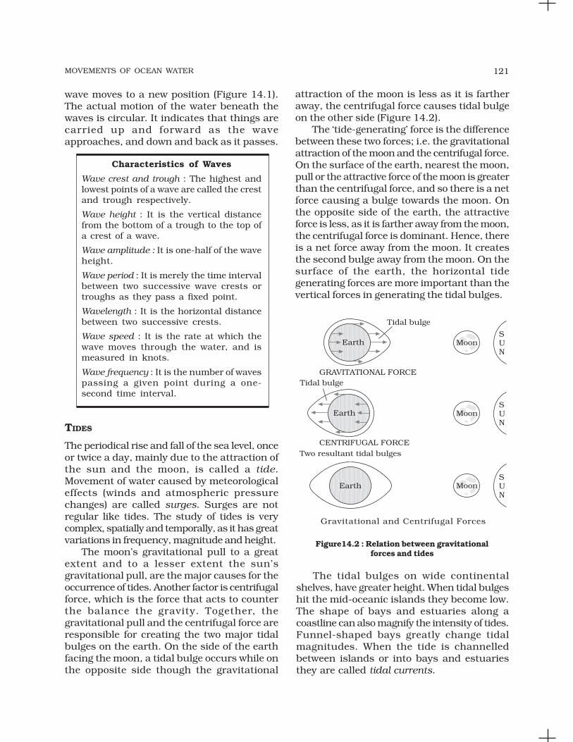
MOVEMENTS OF OCEAN WATER 121
wave moves to a new position (Figure 14.1).The actual motion of the water beneath thewaves is circular. It indicates that things arecarried up and forward as the waveapproaches, and down and back as it passes.
Characteristics of Waves
Wave crest and trough : The highest andlowest points of a wave are called the crestand trough respectively.
Wave height : It is the vertical distancefrom the bottom of a trough to the top ofa crest of a wave.
Wave amplitude : It is one-half of the waveheight.
Wave period : It is merely the time intervalbetween two successive wave crests ortroughs as they pass a fixed point.
Wavelength : It is the horizontal distancebetween two successive crests.
Wave speed : It is the rate at which thewave moves through the water, and ismeasured in knots.
Wave frequency : It is the number of wavespassing a given point during a one-second time interval.
TIDES
The periodical rise and fall of the sea level, onceor twice a day, mainly due to the attraction ofthe sun and the moon, is called a tide.Movement of water caused by meteorologicaleffects (winds and atmospheric pressurechanges) are called surges. Surges are notregular like tides. The study of tides is verycomplex, spatially and temporally, as it has greatvariations in frequency, magnitude and height.
The moon’s gravitational pull to a greatextent and to a lesser extent the sun’sgravitational pull, are the major causes for theoccurrence of tides. Another factor is centrifugalforce, which is the force that acts to counterthe balance the gravity. Together, thegravitational pull and the centrifugal force areresponsible for creating the two major tidalbulges on the earth. On the side of the earthfacing the moon, a tidal bulge occurs while onthe opposite side though the gravitational
attraction of the moon is less as it is fartheraway, the centrifugal force causes tidal bulgeon the other side (Figure 14.2).
The ‘tide-generating’ force is the differencebetween these two forces; i.e. the gravitationalattraction of the moon and the centrifugal force.On the surface of the earth, nearest the moon,pull or the attractive force of the moon is greaterthan the centrifugal force, and so there is a netforce causing a bulge towards the moon. Onthe opposite side of the earth, the attractiveforce is less, as it is farther away from the moon,the centrifugal force is dominant. Hence, thereis a net force away from the moon. It createsthe second bulge away from the moon. On thesurface of the earth, the horizontal tidegenerating forces are more important than thevertical forces in generating the tidal bulges.
Figure14.2 : Relation between gravitationalforces and tides
The tidal bulges on wide continentalshelves, have greater height. When tidal bulgeshit the mid-oceanic islands they become low.The shape of bays and estuaries along acoastline can also magnify the intensity of tides.Funnel-shaped bays greatly change tidalmagnitudes. When the tide is channelledbetween islands or into bays and estuariesthey are called tidal currents.

FUNDAMENTALS OF PHYSICAL GEOGRAPHY122
Tides of Bay of Fundy, Canada
The highest tides in the world occur inthe Bay of Fundy in Nova Scotia, Canada.The tidal bulge is 15 - 16 m. Becausethere are two high tides and two low tidesevery day (roughly a 24 hour period); thena tide must come in within about a sixhour period. As a rough estimate, the tiderises about 240 cm an hour (1,440 cmdivided by 6 hours). If you have walkeddown a beach with a steep cliff alongside(which is common there), make sure youwatch the tides. If you walk for about anhour and then notice that the tide iscoming in, the water will be over yourhead before you get back to where youstarted!
Types of Tides
Tides vary in their frequency, direction andmovement from place to place and also fromtime to time. Tides may be grouped into varioustypes based on their frequency of occurrencein one day or 24 hours or based on their height.
Tides based on Frequency
Semi-diurnal tide : The most common tidalpattern, featuring two high tides and two lowtides each day. The successive high or low tidesare approximately of the same height.
Diurnal tide : There is only one high tide andone low tide during each day. The successivehigh and low tides are approximately of thesame height.
Mixed tide : Tides having variations in heightare known as mixed tides. These tides generallyoccur along the west coast of North Americaand on many islands of the Pacific Ocean.
Tides based on the Sun, Moon and the EarthPositions
The height of rising water (high tide) variesappreciably depending upon the position ofsun and moon with respect to the earth.Spring tides and neap tides come under thiscategory.
Spring tides : The position of both the sun andthe moon in relation to the earth has directbearing on tide height. When the sun, the moonand the earth are in a straight line, the heightof the tide will be higher. These are called springtides and they occur twice a month, one onfull moon period and another during new moonperiod.
Neap tides : Normally, there is a seven dayinterval between the spring tides and neaptides. At this time the sun and moon are atright angles to each other and the forces of thesun and moon tend to counteract one another.The Moon’s attraction, though more than twiceas strong as the sun’s, is diminished by thecounteracting force of the sun’s gravitationalpull.
Once in a month, when the moon’s orbit isclosest to the earth (perigee), unusually highand low tides occur. During this time the tidalrange is greater than normal. Two weeks later,when the moon is farthest from earth (apogee),the moon’s gravitational force is limited andthe tidal ranges are less than their averageheights.
When the earth is closest to the sun(perihelion), around 3rd January each year,tidal ranges are also much greater, withunusually high and unusually low tides. Whenthe earth is farthest from the sun (aphelion),around 4th July each year, tidal ranges aremuch less than average.
The time between the high tide and low tide,when the water level is falling, is called the ebb.The time between the low tide and high tide,when the tide is rising, is called the flow or flood.
Importance of Tides
Since tides are caused by the earth-moon-sunpositions which are known accurately, thetides can be predicted well in advance. Thishelps the navigators and fishermen plan theiractivities. Tidal flows are of great importancein navigation. Tidal heights are very important,especially harbours near rivers and withinestuaries having shallow ‘bars’ at the entrance,which prevent ships and boats from enteringinto the harbour. Tides are also helpful in

MOVEMENTS OF OCEAN WATER 123
desilting the sediments and in removingpolluted water from river estuaries. Tides areused to generate electrical power (in Canada,France, Russia, and China). A 3 MW tidalpower project at Durgaduani in Sunderbansof West Bengal is under way.
OCEAN CURRENTS
Ocean currents are like river flow in oceans.They represent a regular volume of water in adefinite path and direction. Ocean currents areinfluenced by two types of forces namely :(i) primary forces that initiate the movement ofwater; (ii) secondary forces that influence thecurrents to flow.
The primary forces that influence thecurrents are: (i) heating by solar energy;(ii) wind; (iii) gravity; (iv) coriolis force. Heatingby solar energy causes the water to expand.That is why, near the equator the ocean wateris about 8 cm higher in level than in the middlelatitudes. This causes a very slight gradientand water tends to flow down the slope. Windblowing on the surface of the ocean pushes thewater to move. Friction between the wind andthe water surface affects the movement of thewater body in its course. Gravity tends to pullthe water down to pile and create gradientvariation. The Coriolis force intervenes andcauses the water to move to the right in thenorthern hemisphere and to the left in thesouthern hemisphere. These large accumulationsof water and the flow around them are calledGyres. These produce large circular currentsin all the ocean basins.
Differences in water density affect verticalmobility of ocean currents. Water with highsalinity is denser than water with low salinityand in the same way cold water is denser thanwarm water. Denser water tends to sink, whilerelatively lighter water tends to rise. Cold-waterocean currents occur when the cold water atthe poles sinks and slowly moves towards theequator. Warm-water currents travel out fromthe equator along the surface, flowing towardsthe poles to replace the sinking cold water.
Types of Ocean Currents
The ocean currents may be classified based ontheir depth as surface currents and deep watercurrents : (i) surface currents constitute about10 per cent of all the water in the ocean, thesewaters are the upper 400 m of the ocean;(ii) deep water currents make up the other 90per cent of the ocean water. These waters movearound the ocean basins due to variations inthe density and gravity. Deep waters sink intothe deep ocean basins at high latitudes, wherethe temperatures are cold enough to cause thedensity to increase.
Ocean currents can also be classifiedbased on temperature : as cold currents andwarm currents: (i) cold currents bring coldwater into warm water areas. These currentsare usually found on the west coast of thecontinents in the low and middle latitudes(true in both hemispheres) and on the eastcoast in the higher latitudes in the NorthernHemisphere; (ii) warm currents bring warmwater into cold water areas and are usuallyobserved on the east coast of continents in thelow and middle latitudes (true in bothhemispheres). In the northern hemispherethey are found on the west coasts of continentsin high latitudes.
Major Ocean Currents
Major ocean currents are greatly influenced bythe stresses exerted by the prevailing winds andcoriolis force. The oceanic circulation patternroughly corresponds to the earth’s atmosphericcirculation pattern. The air circulation over theoceans in the middle latitudes is mainlyanticyclonic (more pronounced in the southernhemisphere than in the northern hemisphere).The oceanic circulation pattern alsocorresponds with the same. At higher latitudes,
Characteristics of Ocean Currents
Currents are referred to by their “drift”.Usually, the currents are strongest nearthe surface and may attain speeds overfive knots. At depths, currents aregenerally slow with speeds less than 0.5knots. We refer to the speed of a currentas its “drift.” Drift is measured in termsof knots. The strength of a current refersto the speed of the current. A fast currentis considered strong. A current is usuallystrongest at the surface and decreasesin strength (speed) with depth. Mostcurrents have speeds less than or equalto 5 knots.

FUNDAMENTALS OF PHYSICAL GEOGRAPHY124
where the wind flow is mostly cyclonic, theoceanic circulation follows this pattern. Inregions of pronounced monsoonal flow, themonsoon winds influence the currentmovements. Due to the coriolis force, the warmcurrents from low latitudes tend to move to theright in the northern hemisphere and to theirleft in the southern hemisphere.
The oceanic circulation transports heatfrom one latitude belt to another in a mannersimilar to the heat transported by the generalcirculation of the atmosphere. The cold watersof the Arctic and Antarctic circles move towardswarmer water in tropical and equatorialregions, while the warm waters of the lowerlatitudes move polewards. The major currentsin the different oceans are shown in Figure14.3.
Prepare a list of currents which arefound in Pacific, Atlantic and IndianOceans.How is the movement of currents isinfluenced by prevailing winds? Givesome examples from Figure14.3.
Effects of Ocean Currents
Ocean currents have a number of direct andindirect influences on human activities. Westcoasts of the continents in tropical andsubtropical latitudes (except close to theequator) are bordered by cool waters. Theiraverage temperatures are relatively low with anarrow diurnal and annual ranges. There isfog, but generally the areas are arid. West coastsof the continents in the middle and higherlatitudes are bordered by warm waters whichcause a distinct marine climate. They arecharacterised by cool summers and relativelymild winters with a narrow annual range oftemperatures. Warm currents flow parallel tothe east coasts of the continents in tropical andsubtropical latitudes. This results in warm andrainy climates. These areas lie in the westernmargins of the subtropical anti-cyclones. Themixing of warm and cold currents help toreplenish the oxygen and favour the growth ofplanktons, the primary food for fish population.The best fishing grounds of the world existmainly in these mixing zones.
Fig.14.3 : Major currents in the Pacific, Atlantic and Indian oceans

MOVEMENTS OF OCEAN WATER 125
EXERCISES
1. Multiple choice questions.
(i) Upward and downward movement of ocean water is known as the :
(a) tide (c) wave
(b) current (d) none of the above
(ii) Spring tides are caused :
(a) As result of the moon and the sun pulling the earth gravitationallyin the same direction.
(b) As result of the moon and the sun pulling the earth gravitationallyin the opposite direction.
(c) Indention in the coast line.
(d) None of the above.
(iii) The distance between the earth and the moon is minimum when the moonis in :
(a) Aphelion (c) Perihelion
(b) Perigee (d) Apogee
(iv) The earth reaches its perihelion in:
(a) October (c) July
(b) September (d) January
2. Answer the following questions in about 30 words.
(i) What are waves?
(ii) Where do waves in the ocean get their energy from?
(iii) What are tides?
(iv) How are tides caused?
(v) How are tides related to navigation?
3. Answer the following questions in about 150 words.
(i) How do currents affect the temperature? How does it affect the temperatureof coastal areas in the N. W. Europe?
(ii) What are the causes of currents?
Project Work
(i) Visit a lake or a pond and observe the movement of waves. Throw a stoneand notice how waves are generated. Draw the diagram of a wave andmeasure its length, distance and amplitude and record them in your note.
(ii) Take a globe and a map showing the currents of the oceans. Discuss whycertain currents are warm or cold and why they deflect in certain placesand examine the reasons.

LIFE ON THE EARTH
This unit deals with
• Biosphere — importance of plants and other organisms;ecosystems, bio-geo chemical cycle and ecological balance;biodiversity and conservation
UNIT
VI

LIFE ON THE EARTH
By now you might have realised that allunits of this book have acquainted youwith the three major realms of the
environment, that is, the lithosphere, theatmosphere and the hydrosphere. You knowthat living organisms of the earth, constitutingthe biosphere, interact with other environmentalrealms. The biosphere includes all the livingcomponents of the earth. It consists of all plantsand animals, including all the micro-
ECOLOGY
You have been reading about ecological andenvironmental problems in newspapers andmagazines. Have you ever thought whatecology is? The environment as you know, ismade up of abiotic and biotic components. Itwould be interesting to understand how thediversity of life-forms is maintained to bring akind of balance. This balance is maintained ina particular proportion so that a healthyinteraction between the biotic and the abioticcomponents goes on.
The interactions of a particular group oforganisms with abiotic factors within aparticular habitat resulting in clearly definedenergy flows and material cycles on land, waterand air, are called ecological systems.
C H A P T E R
Life on the earth is found almosteverywhere. Living organisms are foundfrom the poles to the equator, from thebottom of the sea to several km in theair, from freezing waters to dry valleys,from under the sea to underground waterlying below the earth’s surface.
organisms that live on the planet earth and theirinteractions with the surrounding environment.Most of the organisms exist on the lithosphereand/or the hydrosphere as well as in theatmosphere. There are also many organismsthat move freely from one realm to the other.
The biosphere and its components are verysignificant elements of the environment. Theseelements interact with other components of thenatural landscape such as land, water andsoil. They are also influenced by theatmospheric elements such as the temperature,rainfall, moisture and sunlight. Theinteractions of biosphere with land, air andwater are important to the growth,development and evolution of the organism.
The term ecology is derived from the Greekword ‘oikos’ meaning ‘house’, combinedwith the word ‘logy’ meaning the ‘scienceof’ or ‘the study of ’. Literally, ecology isthe study of the earth as a ‘household’,of plants, human beings, animals andmicro-organisms. They all live togetheras interdependent components. AGerman zoologist Ernst Haeckel, whoused the term as ‘oekologie’ in 1869,became the first person to use the term‘ecology’. The study of interactionsbetween life forms (biotic) and thephysical environment (abiotic) is thescience of ecology. Hence, ecology can bedefined as a scientific study of theinteractions of organisms with theirphysical environment and with each other.

FUNDAMENTALS OF PHYSICAL GEOGRAPHY128
A habitat in the ecological sense is the totalityof the physical and chemical factors thatconstitute the general environment. A systemconsisting of biotic and abiotic components isknown as ecosystem. All these components inecosystem are inter related and interact witheach other. Different types of ecosystems existwith varying ranges of environmentalconditions where various plants and animalspecies have got adapted through evolution.This phenomenon is known as ecologicaladaptation.
Types of Ecosystems
Ecosystems are of two major types: terrestrialand aquatic. Terrestrial ecosystem can befurther be classified into ‘biomes’. A biome is aplant and animal community that covers alarge geographical area. The boundaries ofdifferent biomes on land are determined mainlyby climate. Therefore, a biome can be definedas the total assemblage of plant and animalspecies interacting within specific conditions.These include rainfall, temperature, humidityand soil conditions. Some of the major biomesof the world are: forest, grassland, desert andtundra biomes. Aquatic ecosystems can beclassed as marine and freshwater ecosystems.Marine ecosystem includes the oceans, coastalestuaries and coral reefs. Freshwater
Figure 15.1 : Structure and functions of ecosystems
ecosystem includes lakes, ponds, streams,marshes and bogs.
Structure and Functions of Ecosystems
The structure of an ecosystem involves adescription of the available plant and animalspecies. From a structural point of view, allecosystems consist of abiotic and biotic factors.Abiotic factors include rainfall, temperature,sunlight, atmospheric humidity, soilconditions, inorganic substances (carbondioxide, water, nitrogen, calcium, phosphorus,potassium, etc.). Biotic factors include theproducers, (primary, secondary, tertiary) theconsumers and the decomposers. Theproducers include all the green plants, whichmanufacture their own food throughphotosynthesis. The primary consumersinclude herbivorous animals like deer, goats,mice and all plant-eating animals. Thecarnivores include all the flesh-eating animalslike snakes, tigers and lions. Certain carnivoresthat feed also on carnivores are known as topcarnivores like hawks and mongooses.Decomposers are those that feed on deadorganisms (for example, scavengers likevultures and crows), and further breakingdown of the dead matter by other decomposingagents like bacteria and various micro-organisms.

LIFE ON THE EARTH 129
The producers are consumed by theprimary consumers whereas the primaryconsumers are, in turn, being eaten by thesecondary consumers. Further, the secondaryconsumers are consumed by the tertiaryconsumers. The decomposers feed on the deadat each and every level. They change them intovarious substances such as nutrients, organicand inorganic salts essential for soil fertility.Organisms of an ecosystem are linked togetherthrough a foodchain (Figure 15.1). Forexample, a plant eating beetle feeding on apaddy stalk is eaten by a frog, which is, in turn,eaten by a snake, which is then consumed bya hawk. This sequence of eating and beingeaten and the resultant transfer of energy fromone level to another is known as the food-chain.Transfer of energy that occurs during theprocess of a foodchain from one level toanother is known as flow of energy. However,food-chains are not isolated from one another.For example, a mouse feeding on grain maybe eaten by different secondary consumers(carnivores) and these carnivores may be eatenby other different tertiary consumers (topcarnivores). In such situations, each of thecarnivores may consume more than one typeof prey. As a result, the food- chains getinterlocked with one another. This inter-connecting network of species is known as foodweb. Generally, two types of food-chains arerecognised: grazing food-chain and detritusfood-chain. In a grazing food-chain, the firstlevel starts with plants as producers and endswith carnivores as consumers as the last level,with the herbivores being at the intermediatelevel. There is a loss of energy at each levelwhich may be through respiration, excretionor decomposition. The levels involved in a food-chain range between three to five and energyis lost at each level. A detritus food-chain isbased on autotrophs energy capture initiatedby grazing animals and involves thedecomposition or breaking down of organicwastes and dead matter derived from thegrazing food-chain.
Types of Biomes
In the earlier paragraphs, you have learnt themeaning of the term ‘biome’. Let us now try toidentify the major biomes of the world. Thereare five major biomes — forest, desert, grassland,
aquatic and altitudinal biomes. Some featuresof these biomes are given in Table 15.1.
Biogeochemical Cycles
The sun is the basic source of energy on whichall life depends. This energy initiates lifeprocesses in the biosphere throughphotosynthesis, the main source of food andenergy for green plants. During photosynthesis,carbon dioxide is converted into organiccompounds and oxygen. Out of the total solarinsolation that reaches the earth’s surface, onlya very small fraction (0.1 per cent) is fixed inphotosynthesis. More than half is used for plantrespiration and the remaining part istemporarily stored or is shifted to otherportions of the plant.
Life on earth consists of a great variety ofliving organisms. These living organisms existand survive in a diversity of associations. Suchsurvival involves the presence of systemic flowssuch as flows of energy, water and nutrients.These flows show variations in different partsof the world, in different seasons of the yearand under varying local circumstances. Studieshave shown that for the last one billion years,the atmosphere and hydrosphere have beencomposed of approximately the same balanceof chemical components. This balance of thechemical elements is maintained by a cyclicpassage through the tissues of plants andanimals. The cycle starts by absorbing thechemical elements by the organism and isreturned to the air, water and soil throughdecomposition. These cycles are largelyenergised by solar insolation. These cyclicmovements of chemical elements of thebiosphere between the organism and theenvironment are referred to as biogeochemicalcycles. Bio refers to living organisms and geoto rocks, soil, air and water of the earth.
There are two types of biogeochemicalcycles : the gaseous and the sedimentary cycle.In the gaseous cycle, the main reservoir ofnutrients is the atmosphere and the ocean. Inthe sedimentary cycle, the main reservoir is thesoil and the sedimentary and other rocks ofthe earth’s crust.
The Water Cycle
All living organisms, the atmosphere and thelithosphere maintain between them a

FUNDAMENTALS OF PHYSICAL GEOGRAPHY130
Table 15.1 : World Biomes
Biomes
Forest
Subtypes RegionsClimatic
Characteristics Soil Flora and Fauna
A. Tropical1. Equitorial2. DeciduousB. TemperateC. Boreal
Desert A. Hot and Drydesert
B. Semi ariddesert
C. Coastaldesert
D. Cold desert
Grassland A. TropicalSavannah
B. TemperateSteppe
A1. 10° N-SA2. 10°-25° N-SB. Eastern North
America, N.E.Asia, Westernand CentralEurope
C. Broad belt ofEurasia andNorth America,parts ofSiberia,Alaska,Canada andScandinavia
A. S a h a r a ,K a l a h a r i ,Marusthal i ,Rub-el-Khali
B. Marginal areasof hot deserts
C. AtacamaD. Tundra climatic
regions
A. Large areasof A f r i c a ,Australia,SouthAmerica andIndia
B. Par t s ofEurasia andNorth America
A1. Temp. 20-25°C,evenly distributed
A2. Temp. 25-30°C,Rainfall, ave. ann.1,000mm, seasonal
B. Temp. 20-30° C,Rainfall evenlydistributed 750-1,500mm, Well-defined seasonsand distinct winter.
C. Short moist moder-ately warmsummers and longcold dry winter;very lowtemperatures.Precipitation mostlysnowfall400 -1,000mm
A. Temp. 20 - 45°C.B. 21 - 38°C.C. 15 - 35°C.D. 2 - 25°CA-D Rainfall is less than
50 mm
A. Warm hotclimates, Rainfall500-1,250 mm
B. Hot summers andcold winter.Rainfall 500 -900 mm
A1. Acidic,poor innutrients
A2. Rich innutrients
B. Fertile,en-richedwithdecayinglitter
C. Acidic andpoor innutrients,thin soilcover
Rich innutrients withlittle or noorganic matter
A. Porous withthin layer ofhumus.
B. Thin floccu-lated soil,rich in bases
A1. Mult i - layeredcanopy tall andlarge trees
A2. Less dense, treesof medium height;many varieties co-exist. Insects,bats, birds andmammals arecommon speciesin both
B. Moderately densebroad leaved trees.With less diversityof plant species.Oack, Beach,Maple etc. aresome commonspecies. Squirrels,rabbits, skunks,birds, black bears,mountain lions etc.
C. Evergreen coniferslike pine, fur andspruce etc. Woodpeckers, hawks,bears, wolves,deer, hares andbats are commonanimals
A-C. Scanty vege-tation; few largem a m m a l s ,insects, reptilesand birds
D. Rabbits, rats,antelopesand groundsquirrels
A. Grasses; treesand large shrubsabsent; giraffeszebras, buffalos,leopards, hyenas,elephants, mice,moles, snakesand worms etc.,are commonanimals
B. Grasses; occ-asional treessuch as cotton-woods, oaks andwillows; gazelles,zebras, rhin-

LIFE ON THE EARTH 131
Figure 15.2 : Carbon Cycle
circulation of water in solid, liquid or gaseousform referred to as the water or hydrologic cycle(Chapter 13 of this book).
The Carbon Cycle
Carbon is one of the basic elements of all livingorganisms. It forms the basic constituent ofall the organic compounds. The biospherecontains over half a million carbon compoundsin them. The carbon cycle is mainly theconversion of carbon dioxide. This conversionis initiated by the fixation of carbon dioxidefrom the atmosphere through photosynthesis.Such conversion results in the production ofcarbohydrate, glucose that may be convertedto other organic compounds such as sucrose,starch, cellulose, etc. Here, some of thecarbohydrates are utilised directly by the plantitself. During this process, more carbon dioxideis generated and is released through its leavesor roots during the day. The remainingcarbohydrates not being utilised by the plantbecome part of the plant tissue. Plant tissuesare either being eaten by the herbivorousanimals or get decomposed by the micro-organisms. The herbivores convert some of theconsumed carbohydrates into carbon dioxidefor release into the air through respiration. Themicro-organisms decompose the remainingcarbohydrates after the animal dies. Thecarbohydrates that are decomposed by themicro-organisms then get oxidised into carbon
dioxide and are returned to the atmosphere(Figure 15.2).
Aquatic A. FreshwaterB. Marine
Altitudinal ———
A. Lakes, streams,rivers andwetlands
B. Oceans, coralreefs, lagoonsand estuaries
Slopes of highmountain rangeslike the Himalayas,the Andes and theRockies
A-B Temperatures varywidely with cooler airtemperatures andhigh humidity
A. Water, swampsand marshes
B.Water, tidalswamps andmarshes
Algal and other aquaticand marine plantcommunities withvarieties of waterdwelling animals
oceros, wildhorses, lions,varieties of birds,worms, snakesetc., are commonanimals
Temperature andprecipitation varydepending uponlatitudinal zone
Regolith overslopes
Deciduous to tundravegetation varyingaccording to altitude
The Oxygen Cycle
Oxygen is the main by-product ofphotosynthesis. It is involved in the oxidationof carbohydrates with the release of energy,carbon dioxide and water. The cycling ofoxygen is a highly complex process. Oxygenoccurs in a number of chemical forms andcombinations. It combines with nitrogen toform nitrates and with many other mineralsand elements to form various oxides such asthe iron oxide, aluminium oxide and others.Much of oxygen is produced from thedecomposition of water molecules by sunlight
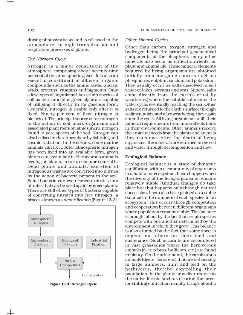
FUNDAMENTALS OF PHYSICAL GEOGRAPHY132
during photosynthesis and is released in theatmosphere through transpiration andrespiration processes of plants.
The Nitrogen Cycle
Nitrogen is a major constituent of theatmosphere comprising about seventy-nineper cent of the atmospheric gases. It is also anessential constituent of different organiccompounds such as the amino acids, nucleicacids, proteins, vitamins and pigments. Onlya few types of organisms like certain species ofsoil bacteria and blue green algae are capableof utilising it directly in its gaseous form.Generally, nitrogen is usable only after it isfixed. Ninety per cent of fixed nitrogen isbiological. The principal source of free nitrogenis the action of soil micro-organisms andassociated plant roots on atmospheric nitrogenfound in pore spaces of the soil. Nitrogen canalso be fixed in the atmosphere by lightning andcosmic radiation. In the oceans, some marineanimals can fix it. After atmospheric nitrogenhas been fixed into an available form, greenplants can assimilate it. Herbivorous animalsfeeding on plants, in turn, consume some of it.Dead plants and animals, excretion ofnitrogenous wastes are converted into nitritesby the action of bacteria present in the soil.Some bacteria can even convert nitrites intonitrates that can be used again by green plants.There are still other types of bacteria capableof converting nitrates into free nitrogen, aprocess known as denitrification (Figure 15.3).
Other Mineral Cycles
Other than carbon, oxygen, nitrogen andhydrogen being the principal geochemicalcomponents of the biosphere, many otherminerals also occur as critical nutrients forplant and animal life. These mineral elementsrequired by living organisms are obtainedinitially from inorganic sources such asphosphorus, sulphur, calcium and potassium.They usually occur as salts dissolved in soilwater or lakes, streams and seas. Mineral saltscome directly from the earth’s crust byweathering where the soluble salts enter thewater cycle, eventually reaching the sea. Othersalts are returned to the earth’s surface throughsedimentation, and after weathering, they againenter the cycle. All living organisms fulfill theirmineral requirements from mineral solutionsin their environments. Other animals receivetheir mineral needs from the plants and animalsthey consume. After the death of livingorganisms, the minerals are returned to the soiland water through decomposition and flow.
Ecological Balance
Ecological balance is a state of dynamicequilibrium within a community of organismsin a habitat or ecosystem. It can happen whenthe diversity of the living organisms remainsrelatively stable. Gradual changes do takeplace but that happens only through naturalsuccession. It can also be explained as a stablebalance in the numbers of each species in anecosystem. This occurs through competitionand cooperation between different organismswhere population remains stable. This balanceis brought about by the fact that certain speciescompete with one another determined by theenvironment in which they grow. This balanceis also attained by the fact that some speciesdepend on others for their food andsustenance. Such accounts are encounteredin vast grasslands where the herbivorousanimals (deer, zebras, buffaloes, etc.) are foundin plenty. On the other hand, the carnivorousanimals (tigers, lions, etc.) that are not usuallyin large numbers, hunt and feed on theherbivores, thereby controlling theirpopulation. In the plants, any disturbance inthe native forests such as clearing the forestfor shifting cultivation usually brings about aFigure 15.3 : Nitrogen Cycle
LIFE ON THE EARTH 133
change in the species distribution. This changeis due to competition where the secondaryforest species such as grasses, bamboos orpines overtakes the native species changingthe original forest structure. This is calledsuccession.
Ecological balance may be disturbed dueto the introduction of new species, naturalhazards or human causes. Human interferencehas affected the balance of plant communitiesleading to disturbances in the ecosystems.Such disturbances bring about numeroussecondary successions. Human pressure onthe earth’s resources has put a heavy toll on
EXERCISES
1. Multiple choice questions.
(i) Which one of the following is included in biosphere?
(a) only plants (c) only animals
(b) all living and non-living organisms (d) all living organisms
(ii) Tropical grasslands are also known as :
(a) the prairies (c) the steppes
(b) the savannas (d) none of the above
(iii) Oxygen combines with iron found in the rocks to form :
(a) iron carbonate (c) iron oxides
(b) iron nitrites (d) iron sulphate
(iv) During photosynthesis, carbon dioxide combines with water in thepresence of sunlight to form :
(a) proteins (c) carbohydrates
(b) amino acids (d) vitamins
2. Answer the following questions in about 30 words.
(i) What do you understand by the term ‘ecology’?
(ii) What is an ecological system? Identify the major types of ecosystems inthe world.
(iii) What is a food-chain? Give one example of a grazing food-chain identifyingthe various levels.
(iv) What do you understand by the term ‘food web’? Give examples.
(v) What is a biome?
the ecosystem. This has destroyed its originalityand has caused adverse effects to the generalenvironment. Ecological imbalances havebrought many natural calamities likefloods, landslides, diseases, erratic climaticoccurrences, etc.
There is a very close relationship betweenthe plant and animal communities withinparticular habitats. Diversity of life in aparticular area can be employed as anindicator of the habitat factor. Properknowledge and understanding of such factorsprovide a strong base for protecting andconserving the ecosystems.

FUNDAMENTALS OF PHYSICAL GEOGRAPHY134
3. Answer the following questions in about 150 words.
(i) What are bio-geochemical cycles? Explain how nitrogen is fixed in theatmosphere.
(ii) What is an ecological balance? Discuss the important measures neededto prevent ecological imbalances.
Project Work
(i) Show the distribution of the different biomes on the outline map of theworld with a note highlighting the important characteristics of each biome.
(ii) Make a note of trees, shrubs and perennial plants in your school campusand devote half a day to observe the types of birds which come to thegarden. Can you describe the diversity of birds?

BIODIVERSITY AND CONSERVATION
You have already learnt about thegeomorphic processes particularlyweathering and depth of weathering
mantle in different climatic zones. See theFigure 6.2 in Chapter 6 in order to recapitulate.You should know that this weathering mantleis the basis for the diversity of vegetation andhence, the biodiversity. The basic cause forsuch weathering variations and resultantbiodiversity is the input of solar energy andwater. No wonder that the areas that are richin these inputs are the areas of wide spectrumof biodiversity.
Biodiversity as we have today is the resultof 2.5-3.5 billion years of evolution. Beforethe advent of humans, our earthsupported more biodiversity than in anyother period. Since, the emergence ofhumans, however, biodiversity has beguna rapid decline, with one species afteranother bearing the brunt of extinctiondue to overuse. The number of speciesglobally vary from 2 million to 100 million,with 10 million being the best estimate.New species are regularly discoveredmost of which are yet to be classified (anestimate states that about 40 per cent offresh water fishes from South Americaare not classified yet). Tropical forests arevery rich in bio-diversity.
Biodiversity is a system in constantevolution, from a view point of species, as wellas from view point of an individual organism.The average half-life of a species is estimatedat between one and four million years, and 99per cent of the species that have ever lived on
the earth are today extinct. Biodiversity is notfound evenly on the earth. It is consistentlyricher in the tropics. As one approaches thepolar regions, one finds larger and largerpopulations of fewer and fewer species.
Biodiversity itself is a combination of twowords, Bio (life) and diversity (variety). Insimple terms, biodiversity is the number andvariety of organisms found within a specifiedgeographic region. It refers to the varieties ofplants, animals and micro-organisms, thegenes they contain and the ecosystems theyform. It relates to the variability among livingorganisms on the earth, including thevariability within and between the species andthat within and between the ecosystems.Biodiversity is our living wealth. It is a resultof hundreds of millions of years of evolutionaryhistory.
Biodiversity can be discussed at threelevels : (i) Genetic diversity; (ii) Species diversity;(iii) Ecosystem diversity.
Genetic Diversity
Genes are the basic building blocks of variouslife forms. Genetic biodiversity refers to thevariation of genes within species. Groups ofindividual organisms having certainsimilarities in their physical characteristics arecalled species. Human beings geneticallybelong to the homo sapiens group and alsodiffer in their characteristics such as height,colour, physical appearance, etc., considerably.This is due to genetic diversity. This geneticdiversity is essential for a healthy breeding ofpopulation of species.
C H A P T E R
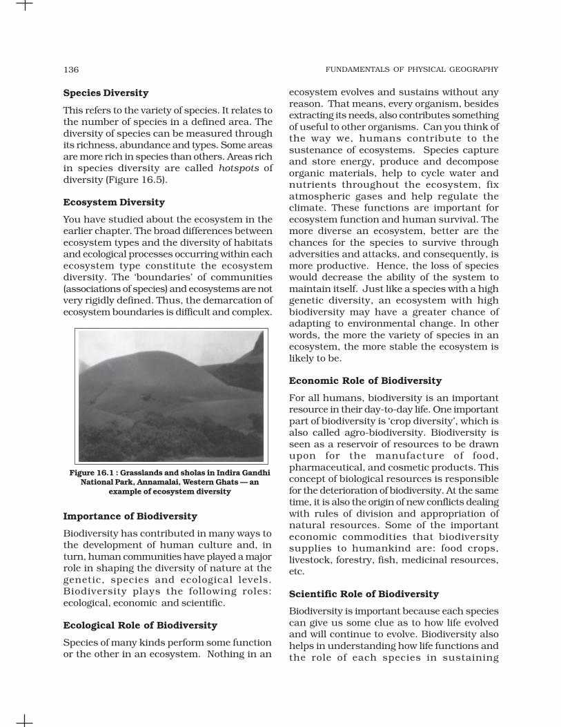
FUNDAMENTALS OF PHYSICAL GEOGRAPHY136
Species Diversity
This refers to the variety of species. It relates tothe number of species in a defined area. Thediversity of species can be measured throughits richness, abundance and types. Some areasare more rich in species than others. Areas richin species diversity are called hotspots ofdiversity (Figure 16.5).
Ecosystem Diversity
You have studied about the ecosystem in theearlier chapter. The broad differences betweenecosystem types and the diversity of habitatsand ecological processes occurring within eachecosystem type constitute the ecosystemdiversity. The ‘boundaries’ of communities(associations of species) and ecosystems are notvery rigidly defined. Thus, the demarcation ofecosystem boundaries is difficult and complex.
ecosystem evolves and sustains without anyreason. That means, every organism, besidesextracting its needs, also contributes somethingof useful to other organisms. Can you think ofthe way we, humans contribute to thesustenance of ecosystems. Species captureand store energy, produce and decomposeorganic materials, help to cycle water andnutrients throughout the ecosystem, fixatmospheric gases and help regulate theclimate. These functions are important forecosystem function and human survival. Themore diverse an ecosystem, better are thechances for the species to survive throughadversities and attacks, and consequently, ismore productive. Hence, the loss of specieswould decrease the ability of the system tomaintain itself. Just like a species with a highgenetic diversity, an ecosystem with highbiodiversity may have a greater chance ofadapting to environmental change. In otherwords, the more the variety of species in anecosystem, the more stable the ecosystem islikely to be.
Economic Role of Biodiversity
For all humans, biodiversity is an importantresource in their day-to-day life. One importantpart of biodiversity is ‘crop diversity’, which isalso called agro-biodiversity. Biodiversity isseen as a reservoir of resources to be drawnupon for the manufacture of food,pharmaceutical, and cosmetic products. Thisconcept of biological resources is responsiblefor the deterioration of biodiversity. At the sametime, it is also the origin of new conflicts dealingwith rules of division and appropriation ofnatural resources. Some of the importanteconomic commodities that biodiversitysupplies to humankind are: food crops,livestock, forestry, fish, medicinal resources,etc.
Scientific Role of Biodiversity
Biodiversity is important because each speciescan give us some clue as to how life evolvedand will continue to evolve. Biodiversity alsohelps in understanding how life functions andthe role of each species in sustaining
Importance of Biodiversity
Biodiversity has contributed in many ways tothe development of human culture and, inturn, human communities have played a majorrole in shaping the diversity of nature at thegenetic, species and ecological levels.Biodiversity plays the following roles:ecological, economic and scientific.
Ecological Role of Biodiversity
Species of many kinds perform some functionor the other in an ecosystem. Nothing in an
Figure 16.1 : Grasslands and sholas in Indira GandhiNational Park, Annamalai, Western Ghats — an
example of ecosystem diversity

BIODIVERSITY AND CONSERVATION 137
ecosystems of which we are also a species. Thisfact must be drawn upon every one of us sothat we live and let other species also live theirlives.
It is our ethical responsibility to considerthat each and every species along with us havean intrinsic right to exist. Hence, it is morallywrong to voluntarily cause the extinction of anyspecies. The level of biodiversity is a goodindicator of the state of our relationships withother living species. In fact, the concept ofbiodiversity is an integral part of many humancultures.
LOSS OF BIODIVERSITY
Since the last few decades, growth in humanpopulation has increased the rate ofconsumption of natural resources. It hasaccelerated the loss of species and habitationin different parts of the world. Tropical regionswhich occupy only about one-fourth of thetotal area of the world, contain about three-fourth of the world human population. Over-exploitation of resources and deforestationhave become rampant to fulfil the needs of largepopulation. As these tropical rain forestscontain 50 per cent of the species on the earth,destruction of natural habitats have proveddisastrous for the entire biosphere.
Natural calamities such as earthquakes,floods, volcanic eruptions, forest fires,droughts, etc. cause damage to the flora andfauna of the earth, bringing change thebiodiversity of respective affected regions.Pesticides and other pollutants such ashydrocarbons and toxic heavy metals destroythe weak and sensitive species. Species whichare not the natural inhabitants of the localhabitat but are introduced into the system, arecalled exotic species. There are manyexamples when a natural biotic community ofthe ecosystem suffered extensive damagebecause of the introduction of exotic species.During the last few decades, some animals liketigers, elephants, rhinoceros, crocodiles, minksand birds were hunted mercilessly by poachersfor their horn, tusks, hides, etc. It has resultedin the rendering of certain types of organismsas endangered category.
The International Union of Conservation ofNature and Natural Resources (IUCN) hasclassified the threatened species of plants andanimals into three categories for the purposeof their conservation.
Endangered Species
It includes those species which are in dangerof extinction. The IUCN publishes informationabout endangered species world-wide as theRed List of threatened species.
Vulnerable Species
This includes the species which are likely tobe in danger of extinction in near future if thefactors threatening to their extinction continue.Survival of these species is not assured as theirpopulation has reduced greatly.
Figure 16.3 : Zenkeria Sebastinei — a criticallyendangered grass in Agasthiyamalai peak (India)
Figure 16.2 : Red Panda — an endangered species
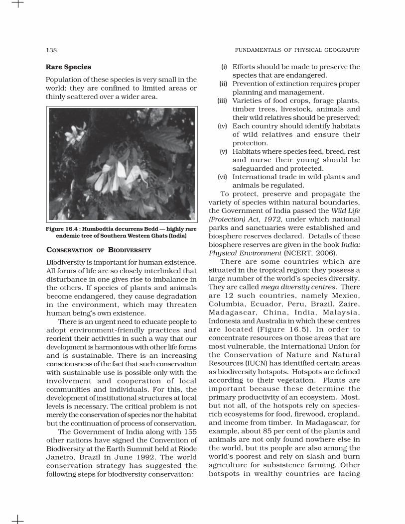
FUNDAMENTALS OF PHYSICAL GEOGRAPHY138
Rare Species
Population of these species is very small in theworld; they are confined to limited areas orthinly scattered over a wider area.
(i) Efforts should be made to preserve thespecies that are endangered.
(ii) Prevention of extinction requires properplanning and management.
(iii) Varieties of food crops, forage plants,timber trees, livestock, animals andtheir wild relatives should be preserved;
(iv) Each country should identify habitatsof wild relatives and ensure theirprotection.
(v) Habitats where species feed, breed, restand nurse their young should besafeguarded and protected.
(vi) International trade in wild plants andanimals be regulated.
To protect, preserve and propagate thevariety of species within natural boundaries,the Government of India passed the Wild Life(Protection) Act, 1972, under which nationalparks and sanctuaries were established andbiosphere reserves declared. Details of thesebiosphere reserves are given in the book India:Physical Environment (NCERT, 2006).
There are some countries which aresituated in the tropical region; they possess alarge number of the world’s species diversity.They are called mega diversity centres. Thereare 12 such countries, namely Mexico,Columbia, Ecuador, Peru, Brazil, Zaire,Madagascar, China, India, Malaysia,Indonesia and Australia in which these centresare located (Figure 16.5). In order toconcentrate resources on those areas that aremost vulnerable, the International Union forthe Conservation of Nature and NaturalResources (IUCN) has identified certain areasas biodiversity hotspots. Hotspots are definedaccording to their vegetation. Plants areimportant because these determine theprimary productivity of an ecosystem. Most,but not all, of the hotspots rely on species-rich ecosystems for food, firewood, cropland,and income from timber. In Madagascar, forexample, about 85 per cent of the plants andanimals are not only found nowhere else inthe world, but its people are also among theworld’s poorest and rely on slash and burnagriculture for subsistence farming. Otherhotspots in wealthy countries are facing
CONSERVATION OF BIODIVERSITY
Biodiversity is important for human existence.All forms of life are so closely interlinked thatdisturbance in one gives rise to imbalance inthe others. If species of plants and animalsbecome endangered, they cause degradationin the environment, which may threatenhuman being’s own existence.
There is an urgent need to educate people toadopt environment-friendly practices andreorient their activities in such a way that ourdevelopment is harmonious with other life formsand is sustainable. There is an increasingconsciousness of the fact that such conservationwith sustainable use is possible only with theinvolvement and cooperation of localcommunities and individuals. For this, thedevelopment of institutional structures at locallevels is necessary. The critical problem is notmerely the conservation of species nor the habitatbut the continuation of process of conservation.
The Government of India along with 155other nations have signed the Convention ofBiodiversity at the Earth Summit held at RiodeJaneiro, Brazil in June 1992. The worldconservation strategy has suggested thefollowing steps for biodiversity conservation:
Figure 16.4 : Humbodtia decurrens Bedd — highly rareendemic tree of Southern Western Ghats (India)

BIODIVERSITY AND CONSERVATION 139
EXERCISES
1. Multiple choice questions.
(i) Conservation of biodiversity is important for :
(a) Animals (c) Plants
(b) Animals and plants (d) All organisms
(ii) Threatened species are those which :
(a) threaten others
(b) Lion and tiger
(c) are abundant in number
(d) are suffering from the danger of extinction
(iii) National parks and sanctuaries are established for the purpose of :
(a) Recreation (c) Pets
(b) Hunting (d) Conservation
Figure 16.5 : Ecological ‘hotspots’ in the world
different types of pressures. The islands ofHawaii have many unique plants and animals
that are threatened by introduced species andland development.

FUNDAMENTALS OF PHYSICAL GEOGRAPHY140
(iv) Biodiversity is richer in :
(a) Tropical Regions (c) Temperate Regions
(b) Polar Regions (d) Oceans
(v) In which one of the following countries, the ‘Earth Summit’ was held?
(a) the UK (c) Brazil
(b) Mexico (d) China
2. Answer the following questions in about 30 words.
(i) What is biodiversity?
(ii) What are the different levels of biodiversity?
(iii) What do you understand by ‘hotspots’?
(iv) Discuss briefly the importance of animals to human kind.
(v) What do you understand by ‘exotic species’?
3. Answer the following questions in about 150 words.
(i) What are the roles played by biodiversity in the shaping of nature?
(ii) What are the major factors that are responsible for the loss of biodiversity?What steps are needed to prevent them?
Project Work
Collect the names of national parks, sanctuaries and biosphere reserves of thestate where your school is located and show their location on the map of India.

Abiotic : Non-living thing. Usually refers to the physical and chemical componentsof an organism’s environment.
Adiabatic Lapse Rate : The rate of change of temperature by an ascending ordescending airmass. If no other non-adiabatic processes (i.e. no heat enters orleaves the system) occur (like condensation, evaporation and radiation), expansioncauses the parcel of air to cool at a set rate of 0.98° per 100 m. The opposite occurswhen a parcel of air descends in the atmosphere. The air in a descending parcelbecomes compressed. Compression causes the temperature within the parcel toincrease at a rate of 0.98° per 100 m.
Air Mass : A body of air whose temperature and humidity characteristics, acquiredin source region, remain relatively constant over a horizontal distance of hundredsto thousands of km. Air masses develop their climatic characteristics by remainingstationary over a source region for a number of days. Air masses are classifiedaccording to their temperature and humidity characteristics.
Aphelion : It is the point in the Earth’s orbit when it is farthest from the sun (152.5million km). Aphelion occurs on the 3rd or 4th of July.
Asthenosphere : Zone in the Earth’s mantle that exhibits plastic properties. Locatedbelow the lithosphere at between 100 and 200 km.
Atmospheric Pressure : Weight of the atmosphere on a surface. At sea-level, theaverage atmospheric pressure is 1013.25 mb. Pressure is measured by a devicecalled a barometer.
Aurora : Multicoloured lights that appear in the upper atmosphere (ionosphere)over the polar regions and visible from locations in the middle and high latitudes.Caused by the interaction of solar wind with oxygen and nitrogen gas in theatmosphere. Aurora in the Northern Hemisphere are called aurora borealis andaurora australis in the Southern Hemisphere.
Bajada : Consecutive series of alluvial fans forming along the edge of a linear mountainrange. Surface of this feature undulates in a rolling fashion as one moves from thecentre of one alluvial fan to another. Normally occur in arid climates.
Batholith : A large mass of subsurface intrusive igneous rock that has its originsfrom mantle magma.
Big Bang : Theory about the origin of universe. It suggests that about 15 billionyears ago all of the matter and energy in the Universe was concentrated into anarea smaller than an atom. At this instant, matter, energy, space and time werenot existant. Then suddenly with a bang, the Universe began to expand at anincredible rate and matter, energy, space and time came into being. As the Universeexpanded, matter began to coalesce into gas clouds, and then stars and planets.Some scientists believe that this expansion is finite and will one day cease. Afterthis point in time, the Universe will begin to collapse until a Big Crunch occurs.
Biodiversity : The diversity of different species (species diversity), genetic variabilityamong individuals within each species (genetic diversity), and variety of ecosystems(ecosystem diversity).
Biomass : The weight of living tissues usually measured per unit area over a
GLOSSARY

FUNDAMENTALS OF PHYSICAL GEOGRAPHY142
particular time interval. Can include the dead parts of organisms like bark, hair,and nails.
Biome : Largest recognisable assemblage of animals and plants on the Earth. Thedistribution of the biomes is controlled mainly by climate.
Calcification : A dry environment soil-forming process that results in theaccumulation of calcium carbonate in surface soil layers.
Caldera Volcano : Explosive type of volcano that leaves a large circular depression.Some of these depressions can be as large as 40 km in diameter. These volcanoesform when wet granitic magma quickly rises to the surface of the Earth.
Chlorofluorocarbons (CFCs) : Is an artificially created gas that has becomeconcentrated in the Earth’s atmosphere. This very strong greenhouse gas is releasedfrom aerosol sprays, refrigerants, and the production of fumes.
Cirrocumulus Clouds : Patchy white high altitude cloud composed of ice crystals.Found in an altitude range from 5,000 - 18,000 m.
Cirrostratus Clouds : High altitude sheet like clouds composed of ice crystals.These thin clouds often cover the entire sky. Found in an altitude range from5,000 - 18,000 m.
Cold Front : A transition zone in the atmosphere where an advancing cold air massdisplaces a warm air mass.
Continental Crust : Granitic portion of the Earth’s crust that makes up thecontinents. Thickness of the continental crust varies between 20 - 75 km. See siallayer.
Coriolis Force : An apparent force due to the Earth’s rotation. Causes movingobjects to be deflected to the right in the Northern Hemisphere and to the left inthe Southern hemisphere. Coriolis force does not exist on the equator. This force isresponsible for the direction of flow in meteorological phenomena like mid-latitudecyclones, hurricanes, and anticyclones.
Cumulus Cloud : Large clouds with relatively flat bases. These are found in analtitude range from 300 - 2,000 m.
Cumulonimbus Cloud : A well developed vertical cloud that often has top shapedlike an anvil. These clouds can extend in altitude from a few hundred m abovethe surface to more than 12,000 m.
Desert Pavement : A veneer of coarse particles left on the ground after the erosionof finer particles by wind.
Earthquake : A sudden motion or shaking in the Earth. The motion is caused bythe quick release of slowly accumulated energy in the form of seismic waves.
Earthquake Focus : Point of stress release in an earthquake (also known ashypocentre).
Ebb Tide : Time during the tidal period when the water level in the sea is falling.
Ecosystem : A system consisting of biotic and abiotic components. Both thesegroups are interrelated and interacting.
El Nino : The name given to the occasional development of warm ocean surface watersalong the coast of Ecuador and Peru. Recently this phenomenon has been used forforecasting of climatic conditions in different parts of the world. The El Nino normallyoccurs around Christmas and lasts usually for a few weeks to a few months.

GLOSSARY 143
Epicentre : A place on the surface of the earth located at the shortest distancefrom the focus of the earthquake, the point at which the seismic energy getsreleased.
Global Warming : Warming of the Earth’s average global temperature because of anincrease in the concentration of greenhouse gases.
Geomagnetism : A property of magnetically susceptible minerals to get aligned tothe earth’s magnetic field during the period of rock formation.
Geostrophic Wind : Horizontal wind in the upper atmosphere that moves parallelto isobars. Results from a balance between pressure gradient force and Coriolisforce.
Greenhouse Effect : The greenhouse effect causes the atmosphere to trap moreheat energy at the Earth’s surface and within the atmosphere by absorbing andre-emitting longwave energy.
Greenhouse Gases : Gases responsible for the greenhouse effect. These gasesinclude: carbon dioxide (CO2); methane (CH4); nitrous oxide (N2O); chlorofluorocarbons(CFC); and tropospheric ozone (O3).
Habitat : Location where a plant or animal lives.
Hail : It is a type of precipitation received in the form of ice pellets or hail stones.The size of hailstones can be between 5 and 190 mm in diameter.
Halocline : The dinstinct zone in the ocean below which the salinity increasessharply.
Hydration : A form of chemical weathering that involves the rigid attachment of H+and OH- ions to the atoms and molecules of a mineral.
Hydrolysis : Chemical weathering process that involves the reaction between mineralions and the ions of water (OH- and H+), and results in the decomposition of therock surface by forming new compounds.
Infiltration : A portion of the precipitation which reaches the earth surface seepsinto the ground in the permeable strata. This process is known as infiltration.
Insolation : Incoming solar radiation in short wave form.
Inter Tropical Convergence Zone (ITCZ) : Zone of low atmospheric pressure andascending air located at or near the equator. Rising air currents are due to globalwind convergence and convection from thermal heating.
Katabatic Wind : Any wind blowing down the slope of a mountain.
Land Breeze : Local thermal circulation pattern found at the interface between landand water. In this circulation system, surface winds blow from land to water duringthe night.
La Nina : Condition opposite of an El Nino. In a La Nina, the tropical Pacific tradewinds become very strong and an abnormal accumulation of cold water occurs inthe central and eastern Pacific Ocean.
Latent Heat : It is the energy required to change a substance to a higher state ofmatter (solid > liquid > gas). This same energy is released from the substancewhen the change of state is reversed (gas > liquid > solid).
Neap Tide : Tide that occurs every 14 - 15 days and coincides with the first andlast quarter of the moon. This tide has a small tidal range because the gravitationalforces of the moon and sun are perpendicular to each other.

FUNDAMENTALS OF PHYSICAL GEOGRAPHY144
Nimbostratus Clouds : Dark, gray low altitude cloud that produces continuousprecipitation in the form of rain or snow. Found in an altitude range from the surfaceto 3,000 m.
Occluded Front : A transition zone in the atmosphere where an advancing cold airmass sandwiches a warm air mass between another cold air mass pushing thewarm air into the upper atmosphere.
Ozone : Tri-atomic oxygen that exists in the earth’s atmosphere as a gas. Ozone ishighest in concentration in the stratosphere (10-50 km above the earth’s surface)where it absorbs the sun’s ultraviolet radiation. Stratospheric ozone is producednaturally and helps to protect life from the harmful effects of solar ultravioletradiation.
Ozone Hole : It is a sharp seasonal decrease in stratospheric ozone concentrationthat occurs over Antarctica in the spring. First detected in the late 1970s, theozone hole continues to appear as a result of complex chemical reaction in theatmosphere that involves CFCs.
Palaeomagnetism : The alignment in terms of inclination from horizon acquiredby magnetically susceptible minerals in the rock during the period of their formation.
Photosynthesis : It is the chemical process where plants and some bacteria cancapture and organically fix the energy of the sun.
Plate Tectonics : Theory suggesting that the earth’s surface is composed of anumber of oceanic and continental plates. Driven by convection currents in themantle, these plates have the ability to slowly move across the earth’s plasticasthenosphere.
Precipitation : Showering of the raindrops, snow or hailstones from the cloudsonto the surface of the earth. Rainfall, snowfall, cloud burst and hailstones areforms of precipitation.
Runoff : It is the flow of water over land through different channels.
Solar Wind : Mass of ionised gas emitted to space by the sun. Plays a role in theformation of auroras.
Subsurface flow : It is the movement of water below the surface of the earth. Afterinfiltration, the subsurface water returns to the surface through seepage into thestreams or eventually goes into the ocean. The subsurface water flow is influencedby land slope, rainfall, intensity of groundwater extraction, etc.
Thermocline : Boundary in a body of water where the greatest vertical change intemperature occurs. This boundary is usually the transition zone between the layerof warm water near the surface that is mixed and the cold deep water layer.