freetown reconnaissance report - mass.gov heritage landscape inventory program 3 freetown...
TRANSCRIPT

FREETOWN RECONNAISSANCE REPORT
TAUNTON RIVER LANDSCAPE INVENTORY
MASSACHUSETTS HERITAGE LANDSCAPE INVENTORY PROGRAM
Massachusetts Department of Conservation and Recreation
Taunton River Wild & Scenic Study Committee
Southeastern Regional Planning and Economic Development District

PROJECT TEAM Massachusetts Department of Conservation and Recreation Jessica Rowcroft, Preservation Planner Division of Planning and Engineering Southeastern Regional Planning and Economic Development District Nancy Durfee, Environmental Planner Bill Napolitano, Principal Environmental Planner Project Consultants Shary Page Berg Gretchen G. Schuler Virginia Adams, PAL Local Project Coordinator Althea Brady Local Heritage Landscape Participants Althea Brady Nancy Durfee Lynwood H. French Kate Gorman Paul Zioblo October 2005

Massachusetts Heritage Landscape Inventory Program 1 Freetown Reconnaissance Report
INTRODUCTION Heritage landscapes are places that are created by human interaction with the natural environment. They are dynamic and evolving; they reflect the history of the community and provide a sense of place; they show the natural ecology that influenced land use patterns; and they often have scenic qualities. This wealth of landscapes is central to each community’s character; yet heritage landscapes are vulnerable and ever changing. For this reason it is important to take the first steps towards their preservation by identifying those landscapes that are particularly valued by the community – a favorite local farm, a distinctive neighborhood or mill village, a unique natural feature or the Taunton River corridor. To this end, the Massachusetts Department of Conservation and Recreation (DCR), the Southeastern Regional Planning and Economic Development District (SRPEDD) and the Taunton Wild & Scenic Study Committee have collaborated to bring the Heritage Landscape Inventory program (HLI) to communities along the Taunton River. The primary goal of the program is to help communities identify a wide range of landscape resources, particularly those that are significant and unprotected. The focus is on landscapes that have not been identified in previous survey efforts in a given community. Another important goal of the program is to provide communities with strategies for preserving heritage landscapes. The methodology for the Heritage Landscape Inventory program was developed in a pilot project conducted in three watersheds southeast Massachusetts in 2002. This project is outlined in the DCR publication Reading the Land. Experience from the 15 communities in the pilot project provided guidance for a similar program in 24 Essex County municipalities. Now the program has been extended to six communities along the Taunton River: Berkley, Fall River, Freetown, Raynham, Somerset and Taunton. Each participating community appoints a Local Project Coordinator (LPC) to assist the DCR-SRPEDD consulting team. The LPC organizes a heritage landscape identification meeting at which interested residents and town officials offer community input by identifying potential heritage landscapes. This meeting is followed by a fieldwork session including the consulting team and the LPC, usually accompanied by other community members. This group visits the priority landscapes identified in the meeting and gathers information about the community. The final product is the Reconnaissance Report, prepared for each participating community. It outlines the history of the community; identifies the resources and documentation that provide background information; provides a short description of the priority heritage landscapes visited; discusses planning issues identified by the community; and concludes with a brief discussion of survey and planning recommendations. A list of all of the heritage landscapes identified by the community is included in the Appendix.
Massachusetts Heritage Landscape Inventory Program 2 Freetown Reconnaissance Report
FREETOWN HISTORY
The presence of the Pocassets, a sub-group of the Wampanoag tribe, in the Freetown area is documented by many confirmed native sites, with concentration near the Assonet and Taunton Rivers and Long Pond. North and South Main Streets (Route 79, historically known as Rhode Island Road) are believed to follow the route of a Native American trail.
In 1659 a group of English settlers purchased a large tract from the Wampanoags which encompassed much of present day Freetown and Fall River. Initially the area was used primarily as farmland by the 26 original owners of the Freemen’s purchase. Freetown was established as a town in 1683. Boundaries with Tiverton (RI), Fall River and Fairhaven fluctuated as late as 1815.
Early English settlement was initially concentrated near the mouth of the Assonet River where there was a diverse food supply, a convenient waterway and waterpower to operate a mill. By the Revolutionary War there were two distinct village centers, Assonet and East Freetown. Rivers remained important regional transportation routes although roads were also established in the 18th century. Around 1764 Old Freetown had a native population of 59, probably on the Indian Reservation established in the eastern portion of present-day Fall River. Old Freetown, which included Fall River until 1803, had a population of 1,492 descendants of European settlers in 1765. Agriculture was the mainstay of the colonial economy, with several small mills and a tannery along the Assonet River as well as mills in East Freetown. There was also a Quaker community in the Friend Street area of Berkley and Freetown, with a surviving Quaker cemetery.
A shipbuilding and shipping industry was established at Assonet Village in the western part of Freetown after the Revolutionary War. In the 19th century the forge established in East Freetown in 1704 grew into a major foundry that produced scythes, axes and other tools, and later machine castings for the textile industry.
Freetown’s shipbuilding and shipping industry declined by the middle of the 19th century, in part because of the arrival of the railroad and also because ships were becoming too large for the upstream location. During this period Freetown reverted to an agricultural base with produce now easier to ship to urban markets via railroad. The population remained largely stable through the 19th century, then rose with an increasing number of immigrants towards the turn of the century, many of whom came to work in the mills in nearby Fall River. By the late 19th century a major part of Freetown’s economy was producing bleach used for processing cloth made in Fall River. Forest production was important in the early 20th century, as was poultry, milk production, cranberry growing and hatchery grown trout. A small summer colony was established on the east side of Long Pond in East Freetown in the late 19th century. Freetown-Fall River State Forest was established in 1934 and now occupies over 5,000

Massachusetts Heritage Landscape Inventory Program 3 Freetown Reconnaissance Report
acres, primarily in Freetown, including an outstanding collection of Civilian Conservation Corps waterholes. Construction of Route 24 through the western part of town and Route 140 through the eastern part of town in the mid-20th century made Freetown much more accessible from the north and the south. The industrial base of the community also changed with the closure of the bleachery and other industries by the mid 20th century. Like most other southeastern Massachusetts communities, Freetown saw a dramatic increase in population in the second half of the 20th century with a current population of roughly 8,500.
RESOURCES AND DOCUMENTATION This section of the Reconnaissance Report identifies planning documents and tools that provide information relevant to the Heritage Landscape Inventory program. Inventory of Historic Assets The Massachusetts Historical Commission’s (MHC) Inventory of Historic and Archaeological Assets is a statewide list that identifies significant historic resources throughout the Commonwealth. In order to be included in the inventory, a property must be documented on an MHC inventory form, which is then entered into the MHC database. This searchable database, known as MACRIS, is now available online at http://www.sec.state.ma.us/mhc. The MHC inventory for Freetown was begun in the 1970s and updated in 1999 as part of the National Register nomination for Assonet Village and East Freetown. Nearly 200 residential properties are documented, including a large number of pre-1850 houses. Other resources that have been documented include 35 burial grounds as well as bridges, industrial structures, a cattle pound and CCC work at the state forest. State and National Registers of Historic Places The National Register of Historic Places is the official federal list of districts, sites, buildings, structures and objects that have been determined significant in American history, architecture, archaeology, engineering and culture. All National Register properties are automatically listed in the State Register of Historic Places. Freetown has two National Register districts, the Assonet Historic District and the East Freetown Historic District, both established in 1999. Also listed in the State Register are those properties protected by a preservation restriction, drawn up in accordance with MGL Chapter 183, Sections 31-33. A preservation restriction (PR) runs with the deed and is one of the strongest preservation strategies available. All properties which have preservation restrictions filed under the state statute are automatically listed in the State

Massachusetts Heritage Landscape Inventory Program 4 Freetown Reconnaissance Report
Register. Freetown has two properties with preservation restrictions, the Merrick Cemetery and the Terry Burial Ground, both on South Main Street. A local non-profit, The Friends of Historic Preservation, maintains a website www.assonetriver.com that includes a list of properties located in the town’s two National Register districts, as well as the narrative for the nomination.
Planning Documents, Bylaws and Other Tools Freetown does not have an open space plan or a master plan. Its land use regulations in addition to a traditional zoning bylaw include overlay zoning, village center zoning and a slope protection bylaw. Special permits are required for most uses other than single family residences. Freetown also has a demolition delay bylaw that allows the Historical Commission to invoke a one-year delay on demolition of significant older buildings.
An important regional planning document is the 2004 Taunton River Stewardship Plan prepared by the Taunton Wild & Scenic River Study Committee to substantiate the need for designation of the Taunton River as a National Wild & Scenic River. The plan includes extensive information on the hydrology of the river as well as related natural and cultural resources; it also identifies key river management issues and offers detailed recommendations for river protection that have been endorsed by all communities along the Taunton River corridor. A key recommendation of the plan is to form partnerships among the watershed communities to work towards the goal of preserving and restoring the Taunton River corridor.

Massachusetts Heritage Landscape Inventory Program 5 Freetown Reconnaissance Report
PRIORITY HERITAGE LANDSCAPES
The Freetown Heritage Landscape Identification meeting, attended by a small group of residents, was held on July 11, 2005. During the meeting a list of Freetown’s heritage landscapes was compiled. Once the comprehensive list was created, community members identified priority landscapes, which were visited by the consulting team and local residents during the fieldwork. Each is highly valued, contributes to community character and is not permanently protected or preserved. The following text describes the priority heritage landscapes that are the focus of the reconnaissance work in Freetown. In some instances intensive survey work will be needed to fully document the physical characteristics and historical development of each area. The landscapes, which are listed in alphabetical order, represent a range of scales and types. In some cases a single property is listed, in other cases a category of property, such as burial grounds, is discussed. Assonet Village including Hathaway Park Assonet Village has recently been listed in the National Register of Historic Places. The Assonet Historic District focuses on the area historically known as Assonet Four Corners, and includes properties on the major roads radiating from it: North Main Street, Mill Street, Elm Street, South Main Street and Water Street. This well-preserved village, one of two centers in Freetown, was the site of the shipbuilding, milling and gun manufacturing industries. It is also significant as the religious, commercial and civic center of the community. The location at the furthest navigable point of the Assonet River gave the area access to coastal shipping and commercial opportunities that allowed the community to flourish. The district has a fine collection of buildings dating from the early 18th century through the early 20th century, including Georgian, Federal and Gothic Revival residences and two 19th century stone bridges. The area east of the current village center along the north side of the Assonet River, which is included in the historic district, was the site of Freetown’s shipping and shipbuilding industry. The narrow roadways and historic houses along Water Street evoke the past, while Hathaway Park serves as an anchor and public gathering place. Loss of trees along Water Street is one issue of concern to local residents. North Main Street, which is in the district, contains a mix of historic and contemporary houses, while Pleasant Street, which lies largely outside the district, has mostly modern houses. The area between Pleasant and North Main remains largely undeveloped but is vulnerable to change. The area surrounding the historic district also contributes significantly to the character of the town center. North and South Main Streets from Route 24 to the center are important gateways to the community that retain a scenic character with stone walls, historic houses and a general rural landscape quality. This is in sharp contrast to the strip development that characterizes portions of South Main Street south of Route 24 towards Fall River.
Massachusetts Heritage Landscape Inventory Program 6 Freetown Reconnaissance Report
East Freetown (Furnace Village) East Freetown was established in 1727 when Philip Rounsevell built his homestead there. The area, which developed along the Fall Brook and its mill pond, is now a National Register district which includes houses, church, library, former stores, cemeteries, stone arched bridges, industrial sites and dams which collectively reflect the development of the area over time. The historic district is located along Gurney, Washburn and County Roads with residences on the roadways and historic industrial sites at the falls of Fall Brook. The houses are primarily of wood construction while the industrial buildings and bridges were made of granite quarried from a nearby pit. Many of the houses have granite foundations. Granite is also used in fieldstone walls and porch supports. The Christian Congregational Church on Washburn Road, the only large building in the district, is a focal point. The East Freetown Historic District includes the approximate area of the village shown on the 1871 map. The district remains a cohesive unit that is evocative of the early years of the village. Its buildings, cemeteries and bridges are unified by the network of narrow rural roads that see relatively little traffic. Route 140 runs north-south through the district but as it passes overhead on tall pylons it seems removed from the district. However, there is evidence of impending change. One contemporary industrial use is already located adjacent to the bridge at Gurney Road and the mixed uses further south along Gurney Road reflect the relaxed zoning regulations in Freetown.
Long Pond Area Long Pond, a part of the Assawompsett Pond complex that is located primarily in Lakeville, was an important Native American area and is valued today for recreational use and as backup water supply. A distinctive residential neighborhood is the Lakeside area, a cottage community located on the east side of the lake on both sides of Middleboro Road just south of the Middleboro border. It is a compact late 19th century neighborhood with small picturesque houses on compact irregular lots. A series of informal private alleys that lead to the water provides access to most of the houses. Immediately to the south is the state boat ramp which provides public boat access to the lake. Land on the east side of Middleboro Road which is not part of the cottage community is well-maintained municipally owned watershed land. Further south on Middleboro Road is Cathedral Camp, a summer camp owned by the Diocese of Fall River which includes valuable pond frontage and also has a collection of late 19th century farm buildings. The town beach off County Road is municipally owned open space that provides access for Freetown residents to the pond and also includes ball fields.
Massachusetts Heritage Landscape Inventory Program 7 Freetown Reconnaissance Report
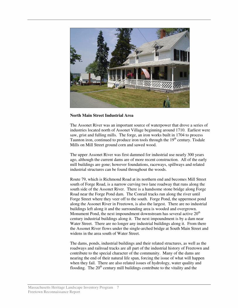
North Main Street Industrial Area The Assonet River was an important source of waterpower that drove a series of industries located north of Assonet Village beginning around 1710. Earliest were saw, grist and fulling mills. The forge, an iron works built in 1704 to process Taunton iron, continued to produce iron tools through the 19th century. Tisdale Mills on Mill Street ground corn and sawed wood. The upper Assonet River was first dammed for industrial use nearly 300 years ago, although the current dams are of more recent construction. All of the early mill buildings are gone; however foundations, raceways, spillways and related industrial structures can be found throughout the woods. Route 79, which is Richmond Road at its northern end and becomes Mill Street south of Forge Road, is a narrow curving two lane roadway that runs along the south side of the Assonet River. There is a handsome stone bridge along Forge Road near the Forge Pond dam. The Conrail tracks run along the river until Forge Street where they veer off to the south. Forge Pond, the uppermost pond along the Assonet River in Freetown, is also the largest. There are no industrial buildings left along it and the surrounding area is wooded and overgrown. Monument Pond, the next impoundment downstream has several active 20th century industrial buildings along it. The next impoundment is by a dam near Water Street. There are no longer any industrial buildings along it. From there the Assonet River flows under the single-arched bridge at South Main Street and widens in the area south of Water Street. The dams, ponds, industrial buildings and their related structures, as well as the roadways and railroad tracks are all part of the industrial history of Freetown and contribute to the special character of the community. Many of the dams are nearing the end of their natural life span, forcing the issue of what will happen when they fail. There are also related issues of hydrology, water quality and flooding. The 20th century mill buildings contribute to the vitality and the

Massachusetts Heritage Landscape Inventory Program 8 Freetown Reconnaissance Report
industrial base of Freetown but can also pose a challenge to the town’s infrastructure, particularly roads and utilities. Peace Haven Peace Haven is the site of 11,000 years of settlement by Native Americans ending with the Pocassets in the Colonial era. The site south of Winslow Point along the east side of the Taunton River was chosen because it was readily accessible by water, had a rich aquatic environment that provided a wide variety of food sources and was well suited to agriculture. It is also the site of a glacial esker. An archaeological investigation by Roy Athearn in the 1950s identified many artifacts associated with Native American use. Today the privately owned site is largely wooded and offers rich habitat to a variety of wildlife. There are trails through the area but no vehicular access. It is considered vulnerable to industrial development. Porter Shore Porter Shore is town-owned conservation land on the north shore of Assonet Bay. The wooded site includes ornamental species as well as forest and provides improved public access that is used primarily by fishermen. It is not widely known. Currently this section of shoreline is largely undeveloped but that could easily change. There is a neglected burial ground nearby. Profile Rock Profile Rock is a large outcrop reputed to have the appearance of a human profile. The area has Native America significance. The park area surrounding the rock is owned by the Department of Conservation and Recreation and administered as part of Freetown-Fall River State Forest. It includes an entry drive, parking lot, picnic area and trail to Profile Rock and links with other trails that are part of the state forest. Lack of maintenance and potential for vandalism at this unsecured site are the primary concerns.
PLANNING RECOMMENDATIONS Preservation Strategies Freetown is one of the most rural towns in southeastern Massachusetts but like many communities, it has changed dramatically in the past 20 years and will continue to change as development pressure intensifies. Through the Heritage Landscape Inventory program, Freetown is looking beyond the traditional historic resources to the landscapes, villages, roads and other natural and cultural assets that define the overall fabric of the community. Preservation planning is a three-step process involving identification, evaluation and protection. Four general documents to consult before beginning to implement preservation strategies are the Massachusetts Historical Commission’s

Massachusetts Heritage Landscape Inventory Program 9 Freetown Reconnaissance Report
Survey Manual and Preservation through Bylaws and Ordinances; the Department of Conservation and Recreation’s Reading the Land; and the Taunton Wild & Scenic River Study Committee’s Taunton River Stewardship Plan. The National Register nominations for the town’s two historic districts also provide valuable information on local history and significant buildings and structures. Each publication provides necessary information for the identification, evaluation and preservation of the rich cultural heritage of a community. Recommendations The primary recommendations are the most important actions that Freetown can take to preserve the heritage landscape identified by the community as well as other scenic, historic and natural assets. They are listed in the order in which they are most logically addressed when applying the three-step preservation planning process described above. Thus the goal will be to (1) identify, (2) evaluate and (3) protect.
Inventory and National Register The vital first step in developing preservation strategies for heritage landscapes is to record information about resources valued by the community. It is important to know what the features of a landscape are and which features the community treasures in order to make a case for preservation of these landscapes. Freetown has already done extensive inventory in the two National Register districts but other areas are not as well documented. Thus, using the Massachusetts Historical Commission survey methodology, record Freetown’s heritage landscapes.
� Compile a list of resources that are under-represented or not sufficiently documented, beginning with the priority heritage landscapes listed in this report. Document unprotected resources first, beginning with threatened areas.
� Update existing MHC inventory forms as needed to meet current
standards for documentation, especially burial grounds. Prepare inventory forms for previously undocumented burial grounds that have been in use for more than 50 years.
� Develop a National Register listing plan for properties determined
eligible during the survey work, taking into consideration a property’s integrity and vulnerability. Properties that are in need of recognition in order to advance preservation strategies should be given priority.
Local Historic Districts Local historic district designation (MGL Chapter 40C) is one of the most poplar and effective neighborhood preservation tools. It is also the strongest form of protection for the preservation of historic resources. Local historic districts are a

Massachusetts Heritage Landscape Inventory Program 10 Freetown Reconnaissance Report
local initiative, adopted by a 2/3 vote of Town Meeting and administered by a district commission, appointed by the Selectmen.
� Adopt a local historic district bylaw and designate historically
significant neighborhoods, such as Freetown’s National Register districts, Assonet Village and East Freetown, as local historic districts to preserve individual properties as well as neighborhood character. In a local historic district, any proposed changes to exterior architectural features visible from a public right-of-way are reviewed by the locally appointed historic district commission.
Burial Grounds and Cemeteries
Freetown has over 40 burial grounds and cemeteries, including Native American burial areas. Many are small family burial grounds located on private property. Primary concerns are general burial ground care and long-term stone maintenance. The DCR publication Preservation Guidelines for Municipally Owned Historic Burial Grounds and Cemeteries provides guidance on developing preservation plans for burial grounds including identification and evaluation of the resources as well as preservation strategies. Using this guide Freetown should:
� Develop preservation and management plans for town-owned burial
grounds taking into consideration repair of stone markers, stone walls and stone fencing related to cemeteries, repair of iron work, removal of invasive growth and on-going maintenance of plant material.
Scenic Roads Scenic roads are an integral part of the historic fabric of the community. They are highly valued by Freetown residents and visitors alike. Yet roads must also accommodate modern transportation needs and decisions regarding roadways are often made with travel requirements as the only consideration. Under the Scenic Roads Act (MGL Chapter 40-15C) Freetown can adopt a scenic roads bylaw that addresses the removal of trees and stone walls that are within the right-of-way. In addition to roadway issues, much of what we value about scenic roads – the stone walls, views across open fields – is not within the public right-of-way. Furthermore, numbered routes which are the gateways to Freetown cannot be designated scenic roads under this bylaw. The preservation and protection of scenic roads therefore requires more than one approach.
� Complete an inventory with descriptions and photo documentation of each of the roads in Freetown including the character defining features that should be retained.
� Review and amend zoning measures that minimize the impact of
commercial and residential development along gateway roads by considering setbacks, screening and height requirements.

Massachusetts Heritage Landscape Inventory Program 11 Freetown Reconnaissance Report
� Adopt a scenic roads bylaw and add design criteria to consider when
reviewing removal of trees and stone walls and other criteria such as a provision allowing only one driveway cut per property on scenic roads. Designate rural and village roads that are scenic such as those that have significant trees. Coordinate procedures between Highway Department and Planning Board.
� Develop policies and implementation standards for road maintenance
and reconstruction, including bridge reconstructions, which address the scenic and historic characteristics while also addressing safety. This is an important public process in which the town may have to accept responsibility for some costs to implement certain standards that are not acceptable to projects funded by Mass. Highway Department. Such standards should have a section addressing the way in which the local Highway Department maintains roads, for example requiring a public hearing if any additional pavement is to be added to a town road during reconstruction or repair. Policies can be adopted by local boards having jurisdiction over roads, or can be adopted at Town Meeting through a bylaw. In developing policies consider factors such as road width, clearing of shoulders, walking paths, posted speeds. A delicate balance is required.
Water Resources The primary goals are to control pollution and provide waterfront access. The coalition that has been established to advocate for the designation of the Taunton River as a National Wild & Scenic River already knows the important strategies for preservation of this rich resource. Continue to work towards solutions in the following ways.
� Define ownership of each segment of the waterfront including beaches, wetlands and marshes.
� Define public ways and parking areas for access to the river and the
landings.
� Form public-private partnerships with neighborhood groups to develop stewardship programs for access points.
� Develop a public landings brochure to remind abutters and town
residents of the public access to these landings, particularly the town-owned landings.
� Adopt and enforce strict conservation and zoning bylaws that
regulate pollution. These may be strategies such as wastewater treatment and stormwater run off that is more restrictive than is minimally acceptable under Title V.

Massachusetts Heritage Landscape Inventory Program 12 Freetown Reconnaissance Report
Funding of Preservation Projects Funding for preservation projects is an important aspect of implementing preservation strategies. Both the MHC and the DCR have had funding programs to assist communities in preservation related issues including:
� Survey and Planning Grants administered by the MHC support survey, National Register and preservation planning work.
� The Massachusetts Preservation Projects Fund (MPPF) administered
by the MHC funds restoration and rehabilitation projects.
� The Historic Landscape Preservation Grant Program (HLPGP) administered by DCR funds planning, rehabilitation, education and stewardship projects focused on historic landscapes.
Funding for these programs varies from year to year. When planning Freetown’s heritage landscape inventory program, contact relevant agencies to determine whether funding currently is available. Towns that have adopted the Community Preservation Act find it to be an excellent funding source for many heritage landscape projects; however Freetown first would have to adopt the Act. While tricky to pass in lean economic times, the number and types of projects that are benefiting across the Commonwealth is worthy of consideration. The CPA establishes a mechanism by which towns can develop a fund dedicated to historic preservation, open space and affordable housing. Funds are collected through a .5% to 3% surcharge on each annual real estate tax bill. The Commonwealth has established a dedicated fund which is used to match the municipality’s collections under the CPA. Adoption of the Community Preservation Act, by a majority vote on a ballot question, fosters partnerships among historic preservationists, conservationists and affordable housing advocates. At least 10% of the funds must be used to

Massachusetts Heritage Landscape Inventory Program 13 Freetown Reconnaissance Report
preserve historic resources; at least 10% must be used to protect open space; and at least 10% must be used to advance affordable housing. The remaining 70% must be used for one of these three uses as well as recreational needs and can be distributed in varying proportions depending upon the projects that the town believes are appropriate and beneficial to the municipality.
CONCLUSION The Freetown Reconnaissance Report is a critical tool in starting to identify the rich and diverse heritage landscapes in Freetown and in beginning to think about preservation strategies. However, it is only the first step in the planning process. Landscapes identified in this report, especially the priority landscapes, will typically need further documentation on MHC inventory forms. The documentation in turn can be used in publicity efforts to build consensus and gather public support for their preservation. Implementation of recommendations will require a concerted effort and partnerships with municipal boards and agencies, local non-profits, and state agencies and commissions. Distribution of this Reconnaissance Report to town land use boards and commissions will assist in making this one of the planning documents that guides Freetown in preserving important features of the community’s character. The tasks that are recommended will require cooperation and coordination among boards and commissions, particularly Freetown’s Historical Commission, the Planning Board and Conservation Commission. It also is advisable to present this information to the Board of Selectmen. Finally distribution of the report to the Freetown Historical Society, neighborhood associations and other preservation minded organizations will enhance Freetown’s heritage landscapes.

Massachusetts Heritage Landscape Inventory Program 14 Freetown Reconnaissance Report
APPENDIX: HERITAGE LANDSCAPES IDENTIFIED BY COMMUNITY This list is a summary of all landscapes discussed at the Heritage Landscape Identification meeting held in Freetown on July 11, 2005 and follow-up fieldwork the same day. This is a working list and can be updated by the community. There may be other heritage landscapes that were not identified at the HLI meeting noted above. Landscapes are grouped by type. The chart has two columns – the name of the resource and the location are in the first and notes about the resource are in the second.
Archaeological/Ethnographic
Peace Haven * Along Taunton River near Winslow Point
Native American agricultural site dating back 11,000 years. Located in the southwestern part of town on a peninsula jutting out into the Taunton River.
Indian Reservation State Forest
There are reported Native American sites in the state forest. Local tribes own some land within the state forest boundaries which they use for ceremonial purposes.
Burial Grounds and Cemeteries
Burial Ground at Porter Shore
Not visible, not maintained. Part of town-owned Porter Shore conservation land on Assonet Bay.
Center/Village
Assonet Village * Elm and Main Streets
Historic village center extending along the Assonet River, listed in the National Register. Town center area also includes land on the west side of North Main Street, including Hathaway Park and the Village School. Also includes cattle pound on High Street.
East Freetown * Washburn Road and Gurney Road
Also known as Furnace Village. Listed in National Register.
Industrial
Bleachery Site Off Narrows Road
Site of important 19th century industry in southwestern part of town along Rattlesnake Brook near South Main Street. Bleaching of fabric made in Fall River mills was a major Freetown industry at one time. Bleachery building burned in the 1950s. Area is now wooded. Stop and Shop distribution center nearby is changing the character of the area.
Forge Pond and Dam * Richmond Road and Forge Road
Area first dammed around 1710. Man-made pond, site of varied industry for 200 years. Dam and two spillways still extant. Railroad runs along side. Former buildings included ice houses, slaughter house, etc. Monument marks the site.
Monument Pond and Dam * Mill Street
Pond was originally dammed in 1710 with Wilson grist mill on one side, sawmill (1820) on the other side.
Massachusetts Heritage Landscape Inventory Program 15 Freetown Reconnaissance Report
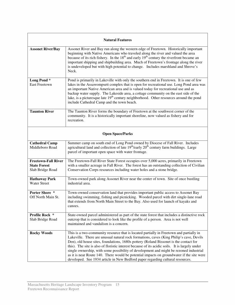
Natural Features Assonet River/Bay Assonet River and Bay run along the western edge of Freetown. Historically important
beginning with Native Americans who traveled along the river and valued the area because of its rich fishery. In the 18th and early 19th century the riverfront became an important shipping and shipbuilding area. Much of Freetown’s frontage along the river is undeveloped but with high potential to change. Includes marshland and Shrove’s Neck.
Long Pond * East Freetown
Pond is primarily in Lakeville with only the southern end in Freetown. It is one of few lakes in the Assawompsett complex that is open for recreational use. Long Pond area was an important Native American area and is valued today for recreational use and as backup water supply. The Lakeside area, a cottage community on the east side of the lake, is a picturesque late 19th century neighborhood. Other resources around the pond include Cathedral Camp and the town beach.
Taunton River The Taunton River forms the boundary of Freetown at the southwest corner of the community. It is a historically important shoreline, now valued as fishery and for recreation.
Open Space/Parks
Cathedral Camp Middleboro Road
Summer camp on south end of Long Pond owned by Diocese of Fall River. Includes agricultural land and collection of late 19th/early 20th century farm buildings. Large parcel of important open space with water frontage.
Freetown-Fall River State Forest Slab Bridge Road
The Freetown-Fall River State Forest occupies over 5,000 acres, primarily in Freetown with a smaller acreage in Fall River. The forest has an outstanding collection of Civilian Conservation Corps resources including water holes and a stone bridge.
Hathaway Park Water Street
Town-owned park along Assonet River near the center of town. Site of once bustling industrial area.
Porter Shore * Off North Main St.
Town-owned conservation land that provides important public access to Assonet Bay including swimming, fishing and picnicking. Wooded parcel with dirt single-lane road that extends from North Main Street to the Bay. Also used for launch of kayaks and canoes.
Profile Rock * Slab Bridge Road
State-owned parcel administered as part of the state forest that includes a distinctive rock outcrop that is considered to look like the profile of a person. Area is not well maintained and vandalism is a concern.
Rocky Woods This is a two-community resource that is located partially in Freetown and partially in Lakeville. There are unusual natural rock formations, caves (King Philip’s cave, Devils Den), old house sites, foundations, 1680s pottery (Roland Bissonet is the contact for this). The site is also of floristic interest because of its acidic soils. It is largely under single ownership, with some possibility of development and might be rezoned industrial as it is near Route 140. There would be potential impacts on groundwater if the site were developed. See 1934 article in New Bedford paper regarding cultural resources.

Massachusetts Heritage Landscape Inventory Program 16 Freetown Reconnaissance Report
State Boat Ramp Off Middleboro Road
Public boat access to Long Pond in East Freetown.
Town Beach * Long Pond Road
Part of Long Pond area. Town Beach is on Long Pond in East Freetown, with parking lot and recreational fields. Important pond access for Freetown residents but there is no longer funding for lifeguards.
Residential/Neighborhood
Assonet Bay Shores Causeway Road
Mid-20th century neighborhood of small houses on peninsula jutting out into Assonet Bay. Size of houses is becoming much larger. There is no public sewer in this environmentally sensitive area.
Lakeside Neigborhood * Middleboro Road
Part of Long Pond area. Cottage community on the east side of the pond near Middleboro border.
Transportation
Chace Road Scenic route running east-west through central part of town. Wooden guardrails, handsome stone walls, open views of adjacent fields.
Gideon’s Lane Wide lane with impressive stone walls.
Mill Bridge Gurney Road
Over Fall Brook in East Freetown. First bridge built 1822. Single arch stone bridge in East Freetown Historic District. Also known as Gurney Bridge.
Mowry Path Old Pocasset path near Long Pond. It was King Philip’s route of escape from the Battle of the Pocasset Cedar Swamp during King Philip’s War.
Single-Arch Bridge North Main Street
Stone bridge in National Register district.
Three Arch Bridge Elm Street
Stone three-arched bridge carries Elm Street over the Assonet River in the center of Assonet. In National Register District.

!(79
1.
2.3.
6.4.
7.
5.
SLAB BRIDGE ROAD
HIGH
STRE
ET
CHACE ROAD
AMVE
TS M
EMOR
IAL H
IGHW
AY
BULLOCK ROAD
QUANAPOAG ROAD
AMVETS MEMORIAL HIGHWAY
BRAL
EY R
OAD
CHIPAWAY ROAD
COUNTY ROAD
ALF RE D B E SS ETTE MEMORIAL HIGHWAY
HOWLAND ROAD
FREETOWNOPENSPACE & HISTORIC RESOURCES
1. Assonet Village2. East Freetown3. Long Pond Area4. North Main St. Industrial Area5. Peace Haven (Unmapped Archaeological Site)6. Porter Shore7. Profile Rock 0 0.5 1 Miles
DCRDCRS/DFGDFGOther StateCountyMunicipalFederalLand TrustNon-ProfitConservation RestrictionAgricultural Preservation RestrictionCR/APR CombinationOther Legal InterestState Historic ResourcesStateLocal RoadInterstate
Note: Default Legend,all categories may not appear on the map.
¯