free range broiler farm a n o on n · free range broiler farm, arapohue: assessment of effects on...
TRANSCRIPT

Free Range Broiler Farm,Arapohue:Assessment of effects on
the environment
Prepared for
Tegel Foods Ltd
Date
October 2017
Job Number
1003839

Distribution:
Tegel Foods Ltd 1 copy
Northland Regional Council 1 copy
Kaipara District Council 1 copy
Tonkin & Taylor Ltd (FILE) 1 copy

Tonkin & Taylor Ltd Free Range Broiler Farm, Arapohue - Assessment of effects on the environment Tegel Foods Ltd
October 2017 Job No: 1003839
Table of contents
1 Introduction 1 1.1 Background 1 1.2 Overview of proposed works 1 1.3 Applicant and property details 1 1.4 Overview of resource consent requirements 3
1.4.1 Kaipara District Plan 3 1.4.2 Regional Water and Soil Plan for Northland 3 1.4.3 Regional Air Quality Plan for Northland 3 1.4.4 Proposed Regional Plan for Northland 4
1.5 Bundling 4 1.6 Consent duration 5 1.7 Report Structure 5
2 Strategic Overview 6 2.1 Company overview 6 2.2 Sustainability initiatives (within Tegel) 7 2.3 Chicken production process 8 2.4 Legal requirements/statutes 9
2.4.1 Introduction 9 2.4.2 Biosecurity Act 1993 10 2.4.3 Animal Welfare Act 1999 10
2.5 Kaipara District Long Term Plan 2015-2025 11 2.6 Tai Tokerau Northland Economic Action Plan 11
3 Environmental setting 12 3.1 Site location and surrounding area 12 3.2 Site description 13 3.3 Adjacent land uses 14 3.4 Site access and traffic 16
3.4.1 State Highway 12 traffic and accidents 16 3.4.2 Road environment 17
3.5 Geology, hydrogeology and hydrology 17 3.5.1 Site geology 17 3.5.2 Existing water supply on the site 18 3.5.3 Groundwater levels and flow direction 18 3.5.4 Surface water 19
3.6 Flooding 19 3.7 Meteorological conditions 19 3.8 Archaeology 20
4 Description of proposed works 21 4.1 Overview 21 4.2 Construction and development 21
4.2.1 Poultry sheds and ancillary buildings 21 4.2.2 Energy Centre building 22 4.2.3 Workers accommodation and associated facilities 23 4.2.4 Construction of bund 23 4.2.5 Construction of access way and internal roads 24 4.2.6 Earthworks 25
4.3 Farm Operation 25 4.3.1 Details of staff 25 4.3.2 Operation cycles and transport 26

Tonkin & Taylor Ltd Free Range Broiler Farm, Arapohue - Assessment of effects on the environment Tegel Foods Ltd
October 2017 Job No: 1003839
4.3.3 Shed cleaning and litter removal 26 4.3.4 Energy Centre building 27 4.3.5 Control and management of hazardous substances 28
4.4 Water supply 28 4.4.1 Water requirements 28 4.4.2 Water source 29 4.4.3 Overall water supply system and treatment for the poultry farm 30
4.5 Construction of wastewater and stormwater system 30 4.5.1 Wastewater 30 4.5.2 Washwater 31 4.5.3 Stormwater disposal 31
5 Resource consent requirements 32 5.1 Introduction 32 5.2 Regional Plans 33
5.2.1 Regional Water and Soil Plan for Northland 33 5.2.2 Regional Air Quality Plan for Northland 34 5.2.3 Proposed Regional Plan for Northland 34
5.3 Kaipara District Plan 36 5.4 Existing resource consents 37 5.5 Other consents and approvals required 38
6 Assessment of effects on the environment 39 6.1 Introduction 39 6.2 Permitted baseline 39 6.3 Positive effects 40
6.3.1 Positive economic effects 40 6.3.2 Positive social effects 40 6.3.3 Positive environmental effects 41
6.4 Air and odour 42 6.4.1 Odour 42 6.4.2 Combustion Products 42 6.4.3 Operational Dust 42 6.4.4 Conclusion 43
6.5 Flooding effects 43 6.5.1 Flood mitigation measures 43 6.5.2 Effects on flood levels within the site 43 6.5.3 Effects on flood levels outside of the site 43
6.6 Traffic effects 44 6.6.1 Traffic volumes 44 6.6.2 Safety and access 44 6.6.3 Construction traffic 45
6.7 Effects on groundwater 45 6.7.1 Groundwater drawdown and stream depletion 45 6.7.2 Saline intrusion 45 6.7.3 Groundwater contamination 46 6.7.4 Effect on groundwater availability 46
6.8 Landscape and visual amenity effects 46 6.8.1 Landscape effects 46 6.8.2 Visual amenity effects 47
6.9 Geotechnical effects 47 6.10 Noise 48 6.11 Effects on archaeology and cultural heritage 48

Tonkin & Taylor Ltd Free Range Broiler Farm, Arapohue - Assessment of effects on the environment Tegel Foods Ltd
October 2017 Job No: 1003839
6.11.1 Archaeology 48 6.11.2 Cultural effects 49
6.12 Hazardous substances 49 6.13 Construction effects 50
6.13.1 Erosion and sedimentation 50 6.13.2 Dust 50
6.14 Conclusions 50 7 Statutory assessment 52
7.1 RMA assessment 52 7.1.1 Part 2 of the RMA 52 7.1.2 Resource Management (National Environmental Standards for Air Quality)
Regulations 2004 54 7.1.3 Resource Management (Measurement and Reporting of Water Takes)
Regulations 2010 54 7.1.4 National Policy Statements 55 7.1.5 Regional Policy Statement 57 7.1.6 Regional Plan assessment 59 7.1.7 District Plan assessment 64
7.2 Section 105 66 7.3 Notification 66
7.3.1 Public notification 66 8 Consultation 67
8.1 Kaipara District Council 67 8.2 Northland Regional Council 67 8.3 Mana Whenua 67
8.3.1 Kāpehu marae 67 8.3.2 Te Roroa 68
8.4 New Zealand Transport Agency 68 8.5 Affected Parties 68
9 Conclusion 70
10 Applicability 71
Appendix A: Resource consent application forms
Appendix B: Certificates of Title
Appendix C : Planning maps
Appendix D: Drawings
Appendix E: Maungaraho Rock values
Appendix F: Permitted activities
Appendix G : Existing consent
Appendix H : Proposed conditions of consent
Appendix I: Assessment of objectives and policies
Appendix J : Assessment criteria
Appendix K : Consultation
Appendix L : Written approval forms
Appendix M : Cultural Impact Assessment

Tonkin & Taylor Ltd Free Range Broiler Farm, Arapohue - Assessment of effects on the environment Tegel Foods Ltd
October 2017 Job No: 1003839
Glossary of abbreviations
Abbreviation Definition
AADT Annual Average Daily Traffic
AEE Assessment of Effects on the Environment
CMP Construction Management Plan
ECM Equivalent Car Movements
ESCP Erosion and Sediment Control Plan
GD05 Auckland Council Guideline Document 2016/GD05
KDC Kaipara District Council
KDP Kaipara District Plan
LGA Local Government Act
LTP Long Term Plan
NESAQ National Environmental Standards for Air Quality
NPS National Policy Statement
NRC Northland Regional Council
NZCPS New Zealand Coastal Policy Statement
NZTA New Zealand Transport Agency
ONF Outstanding Natural Feature
ONL Outstanding Natural Landscape
PRP Proposed Regional Plan for Northland
RAQP Regional Air Quality Plan for Northland
RMA Resource Management Act
RPS Regional Policy Statement for Northland
RWSP Regional Water and Soil Plan for Northland
SH12 State Highway 12
BPO Best Practicable Option (As defined in the RMA)

Tonkin & Taylor Ltd Free Range Broiler Farm, Arapohue - Assessment of effects on the environment Tegel Foods Ltd
October 2017 Job No: 1003839
Executive summary
Tegel Foods Limited (Tegel) is seeking to obtain resource consents for the construction and operation of a free range broiler poultry farm in Arapohue, Dargaville. This Assessment of Effects on the Environment (AEE) report has been prepared to support resource consent applications for the construction and operation of the poultry farm and its supporting activities. Tegel seeks a 35 year term for its regional consents.
Tegel has been in the business of developing and operating poultry farms in New Zealand since 1961. Over this period of time they have built the business up to be a market leader employing over 2300 people nationwide and with revenue of over $600 million a year. This growth in the business has resulted in broad business interests with Tegel operating a range of facilities across the production process including feed mills, breeder farms, hatcheries, broiler farms (barn and free range) and processing plants. This longevity in the poultry business has given the company considerable experience in operating farms in accordance with the highest industry standards.
Tegel is now at a point where they need to move into the next phase of poultry production and implement new technologies to further advance truly sustainable poultry farm operations. This is necessary to keep up with a changing world and demand for free range sustainably produced food sources. In order to implement a number of these new technologies at the farm – which include the use of litter burners to combust waste and provide a renewable energy source to the farm and the implementation of a rain harvesting system to capture and treat water to reduce reliance on ground water supply – the farm needs to be of a size that can support these features. This results in a free range farm that is bigger than any developed before in New Zealand, which in itself presents challenges in the operation and management of the farm. This application has carefully considered these challenges and the end result is a design, layout and operating method that seeks to address these challenges while providing positive outcomes which ultimately result in an application that is sustainable management at work.
As part of assessing the development and operation of the new free range farm, an assessment has been made of the activity both in regards to its construction and development (which are temporary effects) and how it will operate into the future. Key areas that were assessed and the resulting conclusions are briefly outlined below:
Civil Engineering: an assessment of earthworks and associated erosion and sediment control; stormwater and wastewater. A Construction Management Plan (CMP) will be prepared prior to works commencing which will outline specific measures to manage effects. Stormwater and wastewater has been designed in accordance with engineering standards and is managed to ensure adverse effects are avoided.
Geotechnical: an assessment of the ground conditions at the site and whether the site is suitable for the development of the proposed poultry farm. The assessment concludes that the site is not expected to be subjected to liquefaction related effects in a 100 year or 500 year period. Furthermore the risk of consequential effects of settlement are considered to be low.
Air and Odour: an assessment of the air discharges at the farm and the likely dispersion of potential odour and dust. Atmospheric dispersion modelling was undertaken to assess the emissions from the site on air quality. The report concludes that at the seven closest sensitive receptors there is a risk that odours could be experienced at a frequency and intensity that may cause a significant nuisance. At the time of lodgement, written approvals have been obtained from three of these parties.
Flooding: the site is recorded within both the District and Regional Plans as being subject to potential flooding risk. For this reason flood mitigation has been proposed to provide

Tonkin & Taylor Ltd Free Range Broiler Farm, Arapohue - Assessment of effects on the environment Tegel Foods Ltd
October 2017 Job No: 1003839
protection to the site during a 2 % AEP inundation event and a 1 % AEP rainfall flood event. The measures include the establishment of a bund to mitigate against flooding risk and pumps within the bund to remove excess water build up. Furthermore rain harvesting on site assists with capturing and diverting water before it reaches the ground and reduces the volume of water within the bund. Finished floor levels within the bund will be a minimum of 300 mm above the 1 % AEP flood levels. These measures are appropriate to manage flooding risk on the site and the bunding of the site is not expected to increase peak flood levels to surrounding properties during a coastal flooding event.
Hydrogeology: an assessment of groundwater flows at the site and consideration of available water supply to supplement the rain water harvesting. The site lies in two mapped surface water catchments. Groundwater at the site is predominantly recharged by rainfall infiltration. The assessment confirms that there is ample groundwater available in the catchment for allocation and that the proposed water take is able to be provided without resulting in adverse effects.
Hazardous substances: an assessment of the hazardous substances stored on the site. All bulk hazardous substances will be stored in a secure dangerous goods store and that secondary containment bunding will also be in place. An emergency spill response plan will be prepared prior to the operation of the farm. These proposed mitigation measures will ensure that the potential effects on human health and environment through the use, storage and transport of hazardous substances will be less than minor.
Noise: an assessment of potential noise effects on sensitive receptors from the development and operation of the poultry farm. During construction of the farm the works will comply with the New Zealand construction noise standard. The assessment demonstrates that while the proposed farm will increase the background noise levels, the proposed poultry farm operation will comply with the operational noise limits set out in the District Plan at all of the surrounding dwellings.
Traffic: an assessment of traffic impacts shows that the proposed poultry farm is expected to increase average daily traffic by 41 vehicles per day. These movements will be spread throughout the day which will result in around a 2 % increase in normal traffic flows. This is insignificant in operational terms. The access to the site will be relocated approximately 25 m north along the State Highway. The new access point will improve the access to the site and result in a safer operation.
Landscape and visual: an assessment of the landscape character of the site and wider locality and the potential visual effects of the proposed poultry farm. This included consideration of the effects of the proposal on Mt Maungaraho, which is a nearby Outstanding Natural Landscape/Feature (ONFL) feature. It is considered that the proposed land use is still inherently rural in nature and would continue to be reflective of the rural qualities and values of the surrounding context. The integration of the project elements, including the planted earth bunds and recessive sheds, will mitigate potential adverse visual effects. Overall the potential adverse effects in relation to landscape character and visual amenity are considered to be minor.
Archaeology: an investigation was undertaken to determine whether there were any archaeological features on the site. No archaeological evidence was identified on the flat land or any pre-European settlement or land use in the hills. There are two recorded pa sites located within the hilly area to the east of the subject site. There are no works proposed within close proximity to these identified features.
Consultation: the applicant has undertaken consultation with the community and local iwi. As an outcome of this consultation, a number of written approvals have been provided by surrounding neighbours, including 5793 State Highway 12, 65 Whakahara Road and 89

Tonkin & Taylor Ltd Free Range Broiler Farm, Arapohue - Assessment of effects on the environment Tegel Foods Ltd
October 2017 Job No: 1003839
Whakahara Road. Consultation with Te Roroa (who are mana whenua to the area) is ongoing and a cultural impact assessment is currently being prepared for the proposal.
Overall, the proposal fulfils the intent and purpose of the Resource Management Act 1991 (RMA) in that it will allow for the development of a New Zealand first, sustainably operated poultry farm, which provides for the social, environmental, cultural and economic wellbeing of the community.

Schedule 4 requirements
Schedule 4 of the RMA sets out the information required in an application for a resource consent. All relevant matters required to be included have been addressed in the assessments and descriptions in this AEE. The following table provides a summary of the information required in Schedule 4 and a quick reference to its location in this report.
Schedule 4 Item Location within report
A description of the activity Section 1 and 4
A description of the site at which the activity is to occur Section 3
The full name and address of each owner or occupier of the site Section 1.3
A description of any other activities that are part of the proposal to which the application relates
Section 4
A description of any other resource consents required for the proposal to which the application relates
Section 5
An assessment of the activity against the matters set out in Part 2 Section 7
An assessment of the activity against any relevant provisions of a document referred to in Section 104(1)(b). This must include:
Any relevant objectives, policies, or rules in a document; Section 7 and Appendix I
Any relevant requirements, conditions, or permissions in any rules in a document; and
Any other relevant requirements in a document (for example, in a national environmental standard or other regulations).
Section 7
An assessment of the activity’s effects on the environment that includes the following information:
If it is likely that the activity will result in any significant adverse effect on the environment, a description of any possible alternative locations or methods for undertaking the activity;
N/A
An assessment of the actual or potential effect on the environment of the activity;
Section 6
If the activity includes the use of hazardous substances and installations, an assessment of any risks to the environment that are likely to arise from such use;
Technical Report F
If the activity includes the discharge of any contaminant, a description of— The nature of the discharge and the sensitivity of the
receiving environment to adverse effects; and Any possible alternative methods of discharge, including
discharge into any other receiving environment.
Section 6 and Technical Report E
A description of the mitigation measures (including safeguards and contingency plans where relevant) to be undertaken to help prevent or reduce the actual or potential effect.
Section 6 and accompanying technical reports (Volume 2)
Identification of the persons affected by the activity, any consultation undertaken, and any response to the views of any person consulted;
Section 7.3 and Section 8
If the scale and significance of the activity's effects are such that monitoring is required, a description of how and by whom the effects will be monitored if the activity is approved; and

Schedule 4 Item Location within report
If the activity will, or is likely to, have adverse effects that are more than minor on the exercise of a protected customary right, a description of possible alternative locations or methods for the exercise of the activity (unless written approval for the activity is given by the protected customary rights group).
An assessment of the activity’s effects on the environment that addresses the following matters:
Any effect on those in the neighbourhood and, where relevant, the wider community, including any social, economic, or cultural effects;
Section 6
Any physical effect on the locality, including any landscape and visual effects;
Section 6 and Technical Report J
Any effect on ecosystems, including effects on plants or animals and any physical disturbance of habitats in the vicinity;
Any effect on natural and physical resources having aesthetic, recreational, scientific, historical, spiritual, or cultural value, or other special value, for present or future generations;
Section 6
Any discharge of contaminants into the environment, including any unreasonable emission of noise, and options for the treatment and disposal of contaminants; and
Any risk to the neighbourhood, the wider community, or the environment through natural hazards or the use of hazardous substances or hazardous installations.
For applications involving permitted activities
If any permitted activity is part of the proposal to which the application relates, a description of the permitted activity that demonstrates that it complies with the requirements, conditions, and permissions for the permitted activity (so that a resource consent is not required for that activity under Section 87A(1)).
Appendix F

1
Tonkin & Taylor Ltd Free Range Broiler Farm, Arapohue - Assessment of effects on the environment Tegel Foods Ltd
October 2017 Job No: 1003839
1 Introduction
1.1 Background
Tegel Foods Ltd (Tegel) is the largest producer of poultry products in New Zealand and is involved in breeding, hatching, processing, marketing, sales and distribution of poultry products across New Zealand and to selected international markets. Tegel processes approximately 58 million birds per year, with key processing and distribution facilities located in Auckland, Christchurch and New Plymouth. All of Tegel’s poultry are either cage free (barn raised) or free range, with no added hormones. In addition, all Tegel farms are independently audited to ensure they meet or exceed the requirements of the New Zealand Code of Welfare. Tegel has been in operation since 1961 and currently has approximately 2,300 employees nationwide.
1.2 Overview of proposed works
Tegel has entered into a sale and purchase agreement for a site at 5763 State Highway 12, Arapohue, Dargaville (‘the site’) and is proposing to develop a free range broiler chicken farm on the site. Poultry broiler farms operate for the purpose of growing chickens for meat and Tegel will operate the farm once it has been constructed.
The construction of the proposed poultry farm will include the development of 32 free range poultry sheds on the site that will be clustered in four groups of eight. Each shed’s dimensions will be approximately 20 m long x 138 m wide x 4.5 m in height. The sheds are proposed to be located on the flat, western portion of the site. Developing the proposed farm will require earthworks, the construction of the foundations and sheds, installation of infrastructure, including an Energy Centre building powered by litter combustion, stormwater management devices, wastewater treatment and disposal, rainwater storage tanks, installation of groundwater bores, water reticulation and a water treatment plant. In addition, the proposed poultry farm development will require construction of associated facilities, such as workers’ accommodation, utility sheds and vehicle tracks around the sheds connecting to a new access off SH12. A planted bund is proposed to be constructed around the sheds to mitigate against flooding and provide screening. The farm would be stocked with up to approximately 1.32 million chickens at a time. The chickens would be raised on site and then transported to the Tegel processing facility in Henderson, Auckland.
As well as seeking resource consents relating to the development of the farm, Tegel is applying for consents for the on-going operation of the farm following construction. Operation of the farm requires consents for ongoing water takes, discharges to air and the storage of hazardous substances.
This report has been prepared in fulfilment of Section 88 of the Resource Management Act 1991 (RMA), and in accordance with our letter of engagement dated 2 August 2017.
1.3 Applicant and property details
Table 1.1: Applicant and property details
Applicant Tegel Foods Ltd
Owner of application site Riversedge Limited Michael Shane Lardner, Beverly Elaine
Lardner and Derek Charles Halse
Site address / map reference 5763 State Highway 12, Arapohue, Dargaville 5802 State Highway 12, Arapohue, Dargaville

2
Tonkin & Taylor Ltd Free Range Broiler Farm, Arapohue - Assessment of effects on the environment Tegel Foods Ltd
October 2017 Job No: 1003839
Site area 247 ha 4 ha
Legal description Allotment 145 Parish of Arapohue, Lot 1 DP 80493, Allotment 9 Parish of Whakahara, Part Northern Part Allotment 6 Parish of Whakahara, Part Middle Part Allotment 6 Parish of Whakahara, Part Southern Part Allotment 6 Parish of Whakahara, Part North Easter Part Allotment 8 Parish of Whakahara, Allotment 146 Parish of Arapohue, Lot 2 DP 207822, Lot 2 DP 210260, DP 25585, Part South Western Portion Allotment 8 Parish of Whakahara, Part North Western Part Allotment 1 Parish of Arapohue
Lot 1 DP 207822
Certificate of Title reference NA13C/33, NA35D/624, NA40C/224, NA75C/734, NA136B/367, NA138B/554, NA663/222, NA736/1, NA1117/42
NA136B/366
District Council / Plans Kaipara District Council
Operative Kaipara District Plan (November 2013)
Regional Council / Plans Northland Regional Council
Regional Water and Soil Plan for Northland1 Regional Air Quality Plan for Northland2 Proposed Regional Plan for Northland (September 2017)
Address for service during consent processing Tonkin & Taylor Ltd PO Box 5271, Wellesley Street Auckland 1141 Attention: Andrea Brabant Phone: 09 359 2759 Email: [email protected]
Address for service during consent implementation and invoicing
Tegel Foods Ltd 100 Carlton Gore Road Private Bag 99927, Newmarket Auckland 1023 Attention: Emma Coote Phone: 09 977 9088 Email: [email protected]
1 Consolidated Regional Water and Soil Plan for Northland as at 2014 – updated 2016 (web) 2 Regional Air Quality Plan for Northland incorporating PC1 and 2 (web)

3
Tonkin & Taylor Ltd Free Range Broiler Farm, Arapohue - Assessment of effects on the environment Tegel Foods Ltd
October 2017 Job No: 1003839
1.4 Overview of resource consent requirements
1.4.1 Kaipara District Plan
Resource consent is required from Kaipara District Council under the following provisions of the Kaipara District Plan (KDP):
Rule 12.10.1a – Excavation and Fill in the Rural Zone. The site is subject to flood hazards and the volume of earthworks exceeds the permitted volumes of 5,000 m3 or 1,000 m3 within 6 m of the bank of a river. Therefore consent is required as a restricted discretionary activity.
Rule 12.10.4 – Commercial and Industrial Buildings. The proposed poultry sheds are considered commercial buildings under the KDP. Three of the proposed sheds in the south-western corner of the site do not meet the permitted activity standards and therefore consent is required as a restricted discretionary activity.
Rule 12.10.7 – Setbacks in the Rural Zone. Three of the sheds located in the south-western corner of the site, as well as the proposed bund, do not meet the 300 m setback distance from the intersection of SH12 and Whakahara Road. Therefore consent is required as a restricted discretionary activity.
Rule 12.10.21 – Hazardous Substances. The storage of LPG, detergents and sanitisers exceed the permitted volumes under Appendix 25D of the KDP and therefore consent is required as a discretionary activity.
Rule 11.10.2 – Road construction and works in or on a road not undertaken by the Council or NZ Transport Agency. Approval for works on SH12 has not yet been obtained by NZTA or KDC and therefore consent is required as a restricted discretionary activity.
1.4.2 Regional Water and Soil Plan for Northland
Resource consent is required from Northland Regional Council under the following provisions of the Regional Water and Soil Plan for Northland (RWSP): Rule 25.1.1 – The taking and use of groundwater from an aquifer. The proposed farm requires
a maximum daily groundwater take of 350 m3/day, which exceeds the permitted volumes of 10 m3. Therefore consent is required as a discretionary activity.
Rule 26.3.1 – Construction or alteration of a bore. The applicant is proposing to construct up to eight bores on site and therefore consent is required as a restricted discretionary activity.
Rule 27.3.3 – Any activity associated with land drainage or flood control which does not comply with any condition on a permitted activity rule, or any standard or term on a controlled activity rule, but which is not expressly classified as a discretionary, or non-complying activity, is a discretionary activity. The proposed bund is a flood control activity and is not specifically provided for in the RWSP. Therefore, consent is required as a discretionary activity.
Rule 34.3.1 – Any activity which cannot comply with, or is outside the scope of, the permitted rules, or is not a non-complying activity. A small volume of earthworks required for the construction of a culvert will be undertaken within the Riparian Management Zone, however all other earthworks are outside the Riparian Management Zone. The volume of earthworks exceed the permitted volumes of 1,000 m3 and therefore consent is required as a discretionary activity.
1.4.3 Regional Air Quality Plan for Northland
Resource consent is required from Northland Regional Council under the following provisions of the Regional Air Quality Plan for Northland (RAQP):

4
Tonkin & Taylor Ltd Free Range Broiler Farm, Arapohue - Assessment of effects on the environment Tegel Foods Ltd
October 2017 Job No: 1003839
Rule 10.1.7 – The discharge of odour or particulates to air from activities associated with factory farming of animals, namely poultry. The proposed poultry farm could generate odour that may be considered offensive or objectionable beyond the boundary of the subject property at certain times. Therefore, consent is required as a discretionary activity.
Rule 9.3.2 – Any discharge of contaminants to air which is not permitted, controlled, or prohibited or fails to comply with, Rules 9.1(1), (2), (3), (4), (6), (7), (8), (9), (10) and Rule 9.2(1). The proposed Energy Centre shall discharge contaminants into air from combustion of used litter and LPG to provide heat for the operation. This is not specifically provided for in the RAQP and therefore consent is required as a discretionary activity.
1.4.4 Proposed Regional Plan for Northland
Resource consent is required from Northland Regional Council under the following provisions of the Proposed Regional Plan for Northland (PRP):
Rule C.2.1.14 – A new flood defence scheme or an addition to an existing flood defence. The proposed bund is a new flood defence scheme for the site and therefore consent is required as a discretionary activity.
Rule C.3.8 – The placement of obstructions including structures, within flood hazard areas (including high risk flood hazard areas), overland flow paths, rivers or artificial watercourses that divert water onto other property. The proposed bund will divert water onto other properties and therefore consent is required as a discretionary activity.
Rule C.4.5 – In an existing drainage district, the taking, diversion and discharge of drainage water associated with the drainage of land. The site is located within an existing drainage district and the applicant proposes to divert and discharge drainage water. Therefore, consent is required as a discretionary activity.
Rule C.5.1.10 – The taking and use of fresh water from an aquifer. The proposed farm will require a maximum daily groundwater take of 350 m3/day. Therefore, consent is required as a discretionary activity.
Rule C.7.1.8 – The discharge of contaminants into air from burning. The proposed Energy Centre shall discharge contaminants into air from combustion of used litter and LPG to provide heat for the operation. Therefore consent is required as a discretionary activity.
Rule C.7.2.7 – The discharge of contaminants into air that is not a permitted, controlled, restricted discretionary, non-complying or prohibited activity. The proposed poultry farm could generate odour that may be considered offensive or objectionable beyond the boundary of the subject property at certain times. Therefore, consent is required as a discretionary activity.
Rule C.8.3.3 – Earthworks that is not a controlled activity. The earthworks exceed the permitted and controlled activity volumes. Therefore consent is required as a discretionary activity.
Rule C.8.5.3 – Construction or alteration of a bore. The applicant is proposing to construct up to eight bores on site and therefore consent is required as a controlled activity.
For the avoidance of doubt, Tegel Foods Ltd is seeking resource consents under the rules identified in Section 1.4 and any other rules which may apply to the activity, even if not specifically noted.
1.5 Bundling
As the farm will operate as one integrated site and all components of the farm that require consent are interconnected it is appropriate that the consent is bundled and an overall assessment is made as a discretionary activity.

5
Tonkin & Taylor Ltd Free Range Broiler Farm, Arapohue - Assessment of effects on the environment Tegel Foods Ltd
October 2017 Job No: 1003839
1.6 Consent duration
Resource consent is sought for a duration of 35 years for the regional consents.
1.7 Report Structure
The purpose of this AEE is to describe the proposed works associated with the development and operation of the free range broiler farm at 5763 State Highway 12, Arapohue and to assess the potential effects on the environment from the construction and operation of the farm. The report also assesses the farm against the relevant statutory documents.
Table 1.2 below outlines the structure of this report, including the associated technical reports and drawings.
Table 1.2: AEE structure
Dargaville Free Range Broiler Farm Development – Assessment of Effects on the Environment
Volume 1 Assessment of Effects on the Environment
Appendix A Resource consent application forms
Appendix B Certificates of Title
Appendix C Planning maps
Appendix D Drawings
Appendix E Maungaraho Rock values
Appendix F Permitted activities
Appendix G Existing consent
Appendix H Proposed conditions of consent
Appendix I Assessment of objectives and policies
Appendix J Assessment criteria
Appendix K Consultation documentation
Appendix L Written approval forms
Volume 2 Technical Reports
Technical Report A Geotechnical Assessment Technical Report B Flooding Assessment Technical Report C Groundwater Assessment Technical Report D Civil Preliminary Design Technical Report E Air Quality Impact Assessment Technical Report F Hazardous Substances Assessment Technical Report G Integrated Transport Assessment Technical Report H Archaeological assessment Technical Report I Acoustics (Noise) Assessment Technical Report J Landscape and Visual Amenity Assessment Technical Report K Erosion and Sediment Control Plan

6
Tonkin & Taylor Ltd Free Range Broiler Farm, Arapohue - Assessment of effects on the environment Tegel Foods Ltd
October 2017 Job No: 1003839
2 Strategic Overview
2.1 Company overview
Tegel is New Zealand’s leading poultry producer, established in 1961. A New Zealand heritage brand, Tegel was publicly listed on the New Zealand Stock Exchange (NZX) and the Australian Stock Exchange (ASX) in May 2016.
Tegel processes approximately 58 million birds per year, across vertically integrated operations from feed procurement and feedmilling to breeders, hatcheries, farms, processing facilities, and distribution. The company’s main processing and distribution facilities are located in Auckland, Christchurch and New Plymouth. Tegel produces high quality poultry products that are 100 % New Zealand-raised, cage-free, with no added hormones. This is supported by New Zealand’s strong biosecurity controls. Tegel is a trusted New Zealand brand with a well-recognised product range including fresh and frozen goods, smoked small goods, dairy deli and hot cooked products. Tegel is focused on the continued growth and development of export markets, including those that demand premium, safe, high quality poultry products. To meet the needs of international markets, all Tegel processing plants are HALAAL certified.
Tegel employs over 2,300 people nationwide. During the 2016 Financial Year, the company’s revenue exceeded $600 million. Construction of the proposed farm, if approved, is expected to generate approximately $72 million in overall revenue per year. The proposed poultry farm would result in 32 operational jobs and between approximately 20 and a peak of 64 construction jobs over the three year construction period.
Tegel is a proud supporter of many causes and charity organisations that are important to New Zealanders both locally in the communities where the company operates, and nationally. These include Ronald McDonald House, Iron Maori, Salvation Army, City Mission and Just Cook, as well as a range of school and community projects. Tegel is focused on working with organisations that are aligned with the company purpose of “Helping Families Eat Well Everyday”.
Figure 2.1: Location of Tegel operations throughout NZ, Source: Tegel Annual Report, 2017

7
Tonkin & Taylor Ltd Free Range Broiler Farm, Arapohue - Assessment of effects on the environment Tegel Foods Ltd
October 2017 Job No: 1003839
Figure 2.2: Tegel’s key markets Source: Tegel Annual Report, 2017
2.2 Sustainability initiatives (within Tegel)
Poultry meat production has a significantly smaller environmental footprint than other types of meat protein. It is an environmentally efficient protein when considering such factors as greenhouse gas emissions, feed and water usage. Tegel aims to strengthen these credentials through the way it operates its business.
Tegel has embedded a number of systems and processes into its operations to assist it to address and improve its sustainable business challenges. In particular Tegel operate under an integrated Environment, Health and Safety (EHS) system which applies to all of its sites. The system incorporates all of its legal requirements and its aspirational goals for people and the environment. Tegels legal requirements are managed through a bespoke compliance database and each site sets annual KPIs of which two – three must be directly related to national sustainability objectives. This year the focus is on water use and energy use with regional work on waste minimisation and diversion. All of these systems are supported by the adoption of a SIMPLIFY business ethos. SIMPLIFY establishes tools that allow Tegel to always look for a better way and drive operational excellence throughout its facilities and activities. The proposed poultry farm development presents an exciting opportunity to construct a sustainable farm using innovative technology. Some of the key sustainable features proposed as part of the development are depicted in Figure 2.3 below. The proposed sustainability initiatives were derived from work undertaken within Tegel identifying what a sustainable poultry farm may look like in the future. Tegel believes that a sustainable poultry farm would:
Be of benefit to the community it operates in; Sit easily within the landscape in which it is developed and utilise local materials for
construction and operation; Be energy independent; Produce zero waste;

8
Tonkin & Taylor Ltd Free Range Broiler Farm, Arapohue - Assessment of effects on the environment Tegel Foods Ltd
October 2017 Job No: 1003839
Enhance biodiversity; Improve the quality of the land and water bodies around it; An opportunity for this farm to show case Tegel business; and Minimise traffic movements to and from it.
These objectives have been taken into account in the design of the proposed farm.
Figure 2.3: Sustainable initiatives proposed as part of the poultry farm development.
A central feature of the proposed farm is the litter burner technology. Not only does this provide a renewable energy source it also addresses the farm’s key waste challenge. The largest volume of waste generated on a poultry farm is the used bedding material (litter), comprising poultry manure and wood shavings. In New Zealand this is regarded as a good, slow release fertiliser for the dairy industry and as such is spread to land. However, the proposed farm will remove the need to transport it offsite for land application, which in some areas is nutrient stressed, instead utilising the litter as a fuel in the burner. The burner will also receive any mortalities from the farm, again avoiding offsite disposal.
The litter burners also support the company’s desire to reduce its reliance on fossil fuels and to improve its carbon footprint. The fluidised bed, low pressure burners use litter to generate hot water to heat each of the sheds. The litter from one cycle is sufficient to meet the heating needs of the next cycle and removes the need for direct LPG combustion heating within sheds. LPG will be used as a backup fuel only.
The proposed farm will also benefit from solar energy to generate electricity for ventilation, lighting and equipment requirements. The roofs of the shed are ideal for solar panels.
This uptake of technology and sustainable initiatives is largely made possible by the scale of the farm. The capital investment required to introduce this technology and infrastructure to New Zealand can only be justified on a large farm where the savings and projected revenue provide a good return on investment. In time it is anticipated that the availability of the technology will increase and also become feasible for smaller operations thereby creating a step change in the environmental performance of the industry.
2.3 Chicken production process
Tegel operates a vertically integrated business model to achieve efficiency and control at all stages of production. As mentioned above Tegel’s operations include feed procurement and manufacture, breeder farms, hatcheries, broiler (meat growing) farms, processing plants and distribution centres (refer to Figure 2.4 below). Each of these facilities plays a critical role in the overall poultry supply chain.

9
Tonkin & Taylor Ltd Free Range Broiler Farm, Arapohue - Assessment of effects on the environment Tegel Foods Ltd
October 2017 Job No: 1003839
Breeder farms produce fertile eggs into the hatcheries in order to provide chicks into the broiler farms. With over forty such farms across New Zealand, these are the basis for Tegel’s business. Breeder farms have high levels of biosecurity to limit the risk of exposing the pedigree stock to pathogens that can threaten the health of the chicks and microorganisms that can cause problems for the offspring. Ideally, breeder farms are located in close proximity to hatcheries to reduce travel time and to maintain animal welfare standards.
Hatcheries take the fertilised eggs, incubate them, and produce day old broiler chicks. Incubation takes approximately 21 – 25 days. Once the chicks are hatched, the birds are inspected, sorted by sex and then transported to the broiler farms on the same day. Specialised climate-controlled trucks are typically used to transport the birds.
Tegel broiler farms are either free range farms or barn raised, cage free farms. The birds are grown from day old chicks to approximately 38-42 days old. For free range facilities young birds are kept safe and warm inside until they are approximately 20 days old and have plumage. At this point the sides of the sheds can be opened and the birds are free to range during day light. When they have reached the required weight they are removed from the sheds and transported to the processing plant for processing and ultimately distribution. Under the Ministry for Primary Industries, Animal Welfare (Meat Chickens) Code of Welfare 2012 there are maximum travel times for transporting of birds. To comply with these standards, and in accordance with best practice, all Tegel broiler farms are located within a maximum three hour truck travel time from the processing plants. Restrictions on travel times to maintain a high standard of poultry care was a key factor in the proposed farm site selection. The subject site is located approximately 2.5 hours from Auckland’s Henderson processing plant.
Figure 2.4: Tegel’s vertically integrated business model Source, Tegel Annual Report, 2017
2.4 Legal requirements/statutes
2.4.1 Introduction
There are other governing statutes in NZ beyond the RMA that regulate the development and operation of a free range broiler farm. These include laws that manage and control the movement of organisms into and out of the country and the protection of the welfare of animals.

10
Tonkin & Taylor Ltd Free Range Broiler Farm, Arapohue - Assessment of effects on the environment Tegel Foods Ltd
October 2017 Job No: 1003839
2.4.2 Biosecurity Act 1993
The purpose of the Biosecurity Act is to enable “exclusion, eradication, and effective management of pests and unwanted organisms”. The Act provides the framework for border controls aimed at preventing unwanted organisms from entering the country, for establishing surveillance to detect organisms once they have arrived, and for the control and eradication of pests once they have become established.
New Zealand’s strict bio-security controls, quality control process and geographic isolation have resulted in New Zealand’s world leading avian health status. New Zealand is free from the majority of the avian illnesses found in other countries. Maintaining the superior health status of the national poultry flock and native birds from any type of infectious agent, viral, bacterial, fungal or parasitic is critical. Maintaining the health status of all stock at all of Tegel’s sites is also important to ensure optimal performance and productivity of the overall business. Tegel works closely with Ministry for Primary Industries (MPI) to develop and implement controls for the industry that establish a global benchmark for biosecurity. These controls are set out in Tegel’s Livestock manuals and Whole of Flock Welfare and Health Programme and include:
Control of human traffic; Control of rodents, insects and wild birds; Control of vehicular traffic; Control of equipment movement; Control of stock movement; Efficient clean down and sanitation procedures; Use of a suitable bird health care programme; Use of a suitable sampling and testing programme; and Implementation of a suitable action plan should any infectious agent become evident in a
flock.
2.4.3 Animal Welfare Act 1999
The 2012 Animal Welfare (Meat Chicken) Code of Welfare was developed as a minimum standard for all poultry operators under the Animal Welfare Act 1999. All of Tegel farms meet or exceed these standards, and are part of a programme where any farm can be independently audited at any time to ensure these standards are consistently met.
Tegel’s farming practices adhere to the “Five Freedoms” principles of animal welfare. These are;
• Freedom from hunger and thirst;
• Freedom from discomfort;
• Freedom from pain, injury or disease;
• Freedom to express normal behaviour; and
• Freedom from fear and distress.
A key aspect of animal welfare is the density at which the birds are stocked. All Tegel farms adhere to the Code’s density levels and are audited against that. In addition all birds have access to appropriate food and water and are housed in optimal conditions for their health and wellbeing.
Although a specific legislative code for free range broiler farms has not been developed, Tegel operate their farms at the highest international standards and are independently audited by Asure Quality.

11
Tonkin & Taylor Ltd Free Range Broiler Farm, Arapohue - Assessment of effects on the environment Tegel Foods Ltd
October 2017 Job No: 1003839
2.5 Kaipara District Long Term Plan 2015-2025
The Local Government Act 2000 (LGA) requires every council to produce a Long Term Plan (LTP) every three years. Kaipara District Council’s LTP remains current until the new LTP (2018-2028) is adopted in June 2018. The LTP outlines KDC activities and priorities for the next ten years, providing a long-term focus for decision-making.
The LTP sets out three community outcomes KDC wish to work with the community to achieve. Community Outcome 3 is to “aspire to being a district that has sufficient economic activity to support the well-being of our communities and residents”. Kaipara’s economy is currently and will continue to remain securely founded on its primary industries supported by the manufacturing sector. Population in communities to the west of the Kaipara District, including Dargaville, is reported as declining with unemployment rising. As a population, Kaipara is reliant on rural industries. In 2013 the primary sector provided 2,200 jobs making it the largest employing industry in Kaipara, accounting for 28.7 % of total employment.
As mentioned above, the proposed farm development is consistent with this community outcome and will not only create jobs, but career opportunities in the poultry industry in a community where the local population is declining.
Another key vision set out in the LTP is the KDC strategic vision to become a district that values innovation and self-sufficiency to create a more sustainable future. The proposed poultry farm will be the first of its kind in New Zealand, leading the way in innovative technologies to minimise the farm's environmental footprint, maximising the farms sustainability, and benefiting the community in which it operates.
2.6 Tai Tokerau Northland Economic Action Plan
The Tai Tokerau Northland Economic Action Plan 2016 (the Action Plan) is a 10 year plan that aims to strengthen Northland’s economy through increasing jobs, income and investments in selected regions and through identified key business sectors. The Action Plan was developed and is being implemented, by Northland Inc (Regional Economic Development Agency), the Ministry of Business, Innovation and Employment, the Ministry for Primary Industries, iwi, Northland Regional Council and local business.
Agriculture is one of the identified key business sectors. One of the Action Plan objectives is to “identify and develop opportunity for more productive use of land and water resource across a range of primary industry sectors”. The proposed poultry farm development represents a more productive use of the subject sites land and water resources. The proposed poultry farm development is proposing to service the majority of the farm's water supply from rainwater, the poultry litter will be used to supply the heating requirements of the site, and solar is proposed to generate the power required to service the farm. The reduction of dairy cows farmed on site from 650 to approximately 150 will see a significant reduction of nitrogen loading to land. Additionally, currently the existing dairy farm employs two full time and two part time staff. The proposed poultry farm once operational will result in 32 operational jobs. Thus, the poultry farm offers an opportunity to expand capabilities and opportunities within the poultry industry in Northland, another identified goal in the Action Plan.

12
Tonkin & Taylor Ltd Free Range Broiler Farm, Arapohue - Assessment of effects on the environment Tegel Foods Ltd
October 2017 Job No: 1003839
3 Environmental setting
3.1 Site location and surrounding area
The site is located at 5763 State Highway 12, Arapohue, approximately 12 km south of the Dargaville township, as shown in Figure 3.1. Dargaville is built along the edge of the Wairoa River, a wide navigable estuary which flows 40 km from Dargaville into the northern end of the Kaipara Harbour. The population of Dargaville was approximately 4,250 according to the 2013 Census (Statistics New Zealand, 2013). The area around Dargaville is predominantly a farming region and supports extensive dairy, beef and sheep farms, as well as plantation forestry. Dargaville also produces around two thirds of New Zealand’s kumara.
Land use in the Arapohue district is predominantly rural – residential, with a mix of horticultural and pastoral farming activities. Limestone is also quarried in this area, with a number of quarries located throughout the district. Arapohue Primary School is located approximately 1.5 km from the edge of the site on Mititai Road. Along this road is also a church (which is identified as a heritage resource in the KDP – map reference: H01), a bowling club, a community hall and a showgrounds. Kāpehu marae is located on Sills Road, adjacent to the north-eastern corner of the site.
To the west of the river is the small community Te Kopuru, located approximately 1.5 km from the site in a direct line. Te Kopuru is predominantly residential in nature and contains a primary school, a small church and a small number of rural businesses and community facilities.
To the east of the site is Maungaraho Rock, which is identified as an Outstanding Natural Landscape (ONL) in both the KDP (Map reference: ONL 10) and the RPS (Map reference: 91), and an Outstanding Natural Feature (ONF) in the RPS. Maungaraho Rock is approximately 200 m high and therefore is a very prominent and recognisable feature in the landscape. A copy of the Northland Regional Council Landscape Assessment Worksheet of the Maungaraho Rock is attached in Appendix E.
Figure 3.1: Location plan Source: Google Maps, 2017
The site
Wairoa River
Mititai Road
Maungaraho Rock

13
Tonkin & Taylor Ltd Free Range Broiler Farm, Arapohue - Assessment of effects on the environment Tegel Foods Ltd
October 2017 Job No: 1003839
3.2 Site description
Figure 3.2: Site boundary and features Source: Northland Regional Council Local Maps, 2017
The site is zoned Rural in the Kaipara District Plan and is approximately 250 hectares in size. It currently operates as a dairy farm, with four existing dwellings on site to house the farm workers. Tegel has entered into a sale and purchase agreement to purchase the site (CT references: NA13C/33, NA35D/624, NA40C/224, NA75C/734, NA136B/367, NA138B/554, NA663/222, NA736/1, NA1117/42). There is also a neighbouring property that Tegel has entered into a sale and purchase agreement on in order to expand the farm, which has an existing dwelling, located in the north-western corner (CT reference: NA136B/366) (refer Figure 3.2). This makes the total number of dwellings on the subject site to be five. Figure 3.2 outlines the appropriate site boundary, including the aforementioned titles.
The existing farm buildings on site include a 50 bale rotary milking shed, calf rearing sheds, and an implement shed. Currently, there are approximately 650 cows on the farm. Tegel will retain a much smaller herd on site of approximately 150 cattle to graze, and will retain the existing infrastructure on site to service the reduced herd.
Dairy shed
Main site entrance
SH 12
Limestone quarry
Whakahara Road
Key
Dwelling on the site Site boundary Dwelling outside of the site Marae
Urupa Reserve management units
Existing pond River
14
Tonkin & Taylor Ltd Free Range Broiler Farm, Arapohue - Assessment of effects on the environment Tegel Foods Ltd
October 2017 Job No: 1003839
The topography at the site can be divided into the flat area to the west, and the hilly area to the east. The western area of the site comprises an alluvial flood plain and ranges in elevation from 1.5 to 2.0 mRL. The eastern portion of the site is hilly and ranges from 2.0 mRL to 70 mRL. The site is located within the KDP flood susceptibility area, as well as being identified as Northland flood susceptible land in the RWSP. It should be noted however, that the site is not shown to be within the NRC 10 and 100 year flood hazard areas. It is also outside of the coastal environment as identified in the RPS maps.
A limestone quarry is located in the north-eastern corner of the site and is approximately 70 m by 50 m and around 5 m in depth. The material being quarried is a sheared, chalky limestone and is the same material which is gravelling the farm races.
There are four main existing farm drains on site, which run perpendicular to State Highway 12 from the hill catchment and ultimately to the Wairoa River. The drains are typically 2 m wide and approximately 800 mm deep. They run alongside the metalled races, which are raised approximately 250 mm above the surrounding paddocks.
3.3 Adjacent land uses
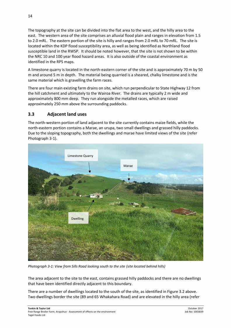
The north-western portion of land adjacent to the site currently contains maize fields, while the north-eastern portion contains a Marae, an urupa, two small dwellings and grassed hilly paddocks. Due to the sloping topography, both the dwellings and marae have limited views of the site (refer Photograph 3-1).
Photograph 3-1: View from Sills Road looking south to the site (site located behind hills)
The area adjacent to the site to the east, contains grassed hilly paddocks and there are no dwellings that have been identified directly adjacent to this boundary.
There are a number of dwellings located to the south of the site, as identified in Figure 3.2 above. Two dwellings border the site (89 and 65 Whakahara Road) and are elevated in the hilly area (refer
Limestone Quarry
Marae
Dwelling

15
Tonkin & Taylor Ltd Free Range Broiler Farm, Arapohue - Assessment of effects on the environment Tegel Foods Ltd
October 2017 Job No: 1003839
Photograph 3-2). As discussed in Section 3.2 above, Tegel is in the process of purchasing both of these properties for use as farm manager’s dwellings. Written approvals have also been obtained from both parties and are attached in Appendix L.
There are three dwellings located at 5590 State Highway 12, and one of these dwellings is accessed via Whakahara Road. There is also another dwelling located further south of the site at 5562 State Highway 12. One of these dwellings (5590 SH12 – Lot 2 DP 508222) is elevated and has views of the site. As discussed below in Section 8, Tegel are in consultation with the owners and occupiers of these dwellings as potentially affected parties. The dwellings at 134 and 136 Whakahara Road (refer Figure 3.2) have limited views of the site due to the sloping topography and vegetation.
Photograph 3-2: View from the site entrance, showing location of dwellings on Whakahara Road, Source: Google Maps, 2017
There is one dwelling (and its associated sheds) located opposite State Highway 12 to the west of the site and Tegel is in the process of purchasing this property. Written approval has been obtained from the owners/occupiers of this property and are attached in Appendix L. This area is relatively flat, much like the western portion of the site. There are also two reserve management units, as identified in the KDP (Map numbers: RMU374 and RMU383), which border the site near the Wairoa River (refer figure 3.2).
Dwelling at 89 Whakahara Road Dwelling at 65 Whakahara Road

16
Tonkin & Taylor Ltd Free Range Broiler Farm, Arapohue - Assessment of effects on the environment Tegel Foods Ltd
October 2017 Job No: 1003839
Photograph 3-3: View from SH12, showing the site entrance Source, Google Maps, 2017
3.4 Site access and traffic
The site has five vehicle accessways off State Highway 12, one servicing the dwelling to the west of the State Highway, three servicing the dwellings to the east, and one servicing the dairy shed which is the main site entrance (refer Photograph 3-3). The main entrance is a gravel surface to the state highway seal edge, with minimal shoulders on approach (<0.5 m). There is also a box culvert cattle underpass which also appears to double as a stormwater drainage culvert (refer Photograph 3-4).
There is one milk tank pick-up at the site per day during the summer months (start of August to end of April) and no collections during May or June. Additionally, the staff at the dairy farm live in the four on-site houses, so no commuter traffic is heading to the site at present.
As Dargaville is the closest population centre, we consider that the majority of domestic and service trips are to the north, resulting in a predominantly right turn out and left turn in movement at the site access.
The farm’s position between two Fonterra plants means the tanker route can vary. It is estimated that this results in a 50 % split generally in directional tanker traffic, and therefore a 50 % split of in / out movements, being left or right turning.
3.4.1 State Highway 12 traffic and accidents
State Highway 12 has an Annual Average Daily Traffic (AADT) count of 1804 veh/day (vehicles per day), with 10 % being heavy. This is a two-way count total for the road between Mititai Road to the north of the site, and Whakahara Road to the south. The existing farm is estimated to contribute 18 veh/day, or 26 ecm (equivalent car movements).
The Crash Analysis System (CAS) was searched for accidents along the 3 km stretch of road between Mititai Road and Whakahara Road, for a ten year period from 2006 to 2016. The full results of this can be found in Volume 2, Technical Report G. In summary, a total of nine accidents have been recorded on this stretch of road over a ten year period, with the causes ranging from; fatigue, hitting a stray animal, attention diverted looking for an intersection, turning right in heavy rain and swerving to avoid another vehicle. During the assessment period (2006-2016), no recorded crashes have occurred due to turning at any access on this stretch of State Highway 12; the only incident
Existing milking shed Maungaraho Rock
Main access off SH12

17
Tonkin & Taylor Ltd Free Range Broiler Farm, Arapohue - Assessment of effects on the environment Tegel Foods Ltd
October 2017 Job No: 1003839
involving this access was a run-off-road due to fatigue that ended up impacting the box culvert underpass.
3.4.2 Road environment
SH12 is classified as a Primary Collector under the One Network Road Classification (ONRC). The existing alignment is straight and reasonably level between the Mititai Road and Whakahara Road intersections (refer Photograph 3-4 and 3-5), however the road environment is quite unforgiving due to a lack of shoulders, and hazards very close to the existing edge of seal such as power poles, drainage ditches, a stock underpass, and trees at various points along the road section.
The road condition appears to be reasonable given the traffic volumes, however flushing is starting to show up on the approaches to the accessway, and the Mititai Road and Whakahara Road intersections. There also appears to be severe edge-break occurring at several unsealed vehicle accesses.
Photograph 3-4: Sightlines of SH12 looking North from the existing access, Source: Google Maps, 2017
Photograph 3-5: Sightlines of SH12 looking south from the existing access, Source: Google Maps, 2017
3.5 Geology, hydrogeology and hydrology
3.5.1 Site geology
The site falls within the Main Northland Aquifer: Kaipara Flats management area. Published geological mapping of the site1 shows that four main geological units are present on the site. Each of these have been described below in terms of structure and groundwater potential.
3.5.1.1 Alluvial deposits
A large portion of the site, consisting of the low relief land adjacent and inland of SH12 is underlain by alluvial deposits associated with alluvial flood plains of the Wairoa River. The alluvial deposits are indicated to consist of unconsolidated to poorly consolidated mud, sand, gravel and peat deposits. Groundwater within the alluvial material is expected to exist as a relatively shallow, unconfined aquifer. Measured groundwater levels within the plains area were measured at levels between approximately 0.2 m and 0.8 m below ground surface, consistent with a shallow unconfined aquifer.
1 Edbrooke, S.W.; Brook, F.J. (compilers) 2009: Geology of the Whangarei area. Institute of Geological & Nuclear Sciences 1:250 000 geological map 2. 1 sheet + 68 p. Lower Hutt, New Zealand. GNS Science.
Box culvert underpass
18
Tonkin & Taylor Ltd Free Range Broiler Farm, Arapohue - Assessment of effects on the environment Tegel Foods Ltd
October 2017 Job No: 1003839
3.5.1.2 Northland allocthon
To the east of the alluvial flood plains and inland of the Wairoa River, geological mapping indicates that the site is generally underlain by the Northern Allochthon, comprising a matrix of Mangakahia Complex mudstones, with included tectonic blocks of Motatau Complex limestone and Tangihua Complex basaltic pillow lava and sheet flows. The Northern Allochthon is expected to extend westwards, underlying the Wairoa alluvial flood plain at depth. The Northern Allochthon is generally a low permeability geological unit and generally accepted to yield low quantities of groundwater.
3.5.1.3 Intrusive andesite
Geological mapping indicates that two localised intrusions of basalt or andesite rock are present on the site, both located to the east of the main dairy shed. Visual observations and geotechnical investigations suggested that there may be two further intrusions (refer Groundwater Assessment Report – Volume 2, Technical Report C). The extent of these are not currently well defined and has been inferred. The andesite is expected to have intruded up through the Northern Allochthon (i.e. is younger) and is therefore likely to be laterally bounded by the lower permeability Allochthon material. To the west, where the andesite abuts the alluvial flood plain, there may be some hydraulic connection between the rock and the alluvial deposits.
The permeability of volcanic rock such as andesite is typically controlled by the degree of fracturing or weathering of the rock. We expect that groundwater yields from the andesite rock are likely to be comparatively higher than the other three geological units mapped on the site (subject to further investigation).
3.5.1.4 Awhitu ground sandstone
An area of Awhitu Group sandstone consisting of cemented, dune-bedded sand is also mapped within the south-eastern portion of the site. The nature and extent of the sandstone is not currently well defined. Pump testing within this unit has been undertaken in other regions which identify the Awhitu Group sandstone as a potential groundwater source rock.
3.5.2 Existing water supply on the site
Information provided suggests that the existing site water supply is sourced from a combination of site dams and two out of three water supply bores. The location of the known water bores are provided in the Groundwater Assessment (Volume 2, Technical Report C). The three existing bores were drilled historically by a local driller, however there is no clear indication of their age. At ground surface the bores typically consist of 100 mm diameter PVC riser pipe and currently do not have bore head security measures installed (concrete pad, animal exclusion or secure headworks). The farm operator has advised that the two bores in use are used for dairy shed wash down and stock watering. Based on discussions with the farm manager, the majority of groundwater abstracted from the site is from bore one (EB 1) (250 m east of dairy shed), estimated at approximately 25 m3/day. The farm manager indicated that the second bore (EB 2) (400 m northeast of dairy shed) was relatively low yielding (up to 7m3/day) and suffers from a decline in yield if excessively pumped.
3.5.3 Groundwater levels and flow direction
Groundwater levels were measured during pump testing within the pumped bore and a series of piezometers installed to monitor drawdown effects. A groundwater contour plan is attached with the Groundwater Assessment report (Volume 2, Technical Report C). These contours are based on measured groundwater levels prior to pumping. The groundwater measurements indicate that the water level within the andesite is approximately RL 2 m. The groundwater level measured within the alluvial deposits indicate a groundwater level of around RL 1.5 m near the base of the hills with a groundwater level of RL 1 m measured within EB 1. The hydraulic gradient is assessed as 3.33 x 10⁻³.

19
Tonkin & Taylor Ltd Free Range Broiler Farm, Arapohue - Assessment of effects on the environment Tegel Foods Ltd
October 2017 Job No: 1003839
Based on measured groundwater levels and topography across the site, we expect that groundwater flows in a west to south-west direction, towards the Wairoa River. Groundwater flows within the alluvial deposits are expected to be very low due to the low permeability nature of the underlying soils and shallow hydraulic gradient toward the Wairoa River.
3.5.4 Surface water
There are three small ponds located on the site (refer figure 3.2) and there are no works proposed in these areas. The main pond that is located in the elevated area of the site flows into the main watercourse which traverses through the middle of the site, which ultimately flows into the Wairoa River. This watercourse is classified as a river2 under the RWSP and KDP definitions. All other drains traversing through the site are man-made farm drainage canals and are excluded from the definition of a river under the RWSP and KDP. The farm drains on the site have been identified as permanently flowing drains3 under the definition of the Proposed Regional Plan and have not been identified as rivers on the proposed maps.
3.6 Flooding
As specified above, the subject site is located in a flood susceptibility area. As outlined in the Flooding Assessment (Volume 2, Technical Report B), flooding at the existing site can occur from the following sources:
Coastal flooding from the Wairoa River due to extreme tide, barometric and wind conditions. The low lying areas on site would be inundated by up to 1.8 m during a 2 % AEP coastal flood event in the year 2065. This flood level is likely to overtop the existing stop bank on the Wairoa River and the SH12 road.
Fluvial flooding which occurs from rainfall off site, but is conveyed towards the site by the Wairoa River. Such flooding is typically overtopping type flooding where drains and waterways ‘burst their banks’ and cause flooding of adjacent land. It is considered unlikely that flood levels from fluvial flooding would be higher than that caused by coastal flooding.
Pluvial flooding which occurs when rainfall at the site is unable to drain away effectively, and results in localised ponding. The existing drains on site have limited capacity to convey flood flows due to their flat grade (approximately 0.1 %) and high tailwater levels within the Wairoa River. The inverts of the drains at the downstream end of site are approximately at mean sea level, limiting their ability to convey flows during high tide. It is likely that the existing site is drained during normal rainfall events relatively quickly. However, we expect the site to drain flood flows over a period of time resulting in some inundation of low lying areas as higher flows are not able to leave site during high tide.
Groundwater flooding, especially that which may accompany a sea level rise in the future.
3.7 Meteorological conditions
The Dargaville meteorological station is located approximately 12 km to the north-northwest of the site. The wind rose frequency analysis of wind speed and directions observed here from 2013 to 2015 shows a reasonably strong prevalence of winds from the south-southwest, a moderate secondary prevalence for wind from the northeast and a low frequency of winds from the southeast
2 Definition of river in RWSP and KDP: A continually or intermittently, flowing body of fresh water; and includes a stream and modified water course; but does not include any artificial watercourse (including an irrigation canal, water supply race, canal for the supply of water for electricity power generation and farm drainage canal). 3 Definition of permanently flowing drain in the PRP: Rivers, streams and drains that permanently contain water and are wider than one metre at any point within or immediately adjacent to the boundary of a property. Width and depth is measured when the river, stream or drain is at its annual fullest flow without overtopping its banks.

20
Tonkin & Taylor Ltd Free Range Broiler Farm, Arapohue - Assessment of effects on the environment Tegel Foods Ltd
October 2017 Job No: 1003839
quadrant. Although local variations in terrain and the proximity of the Wairoa River will likely result in localised differences in wind patterns, wind conditions measured at Dargaville are likely to be broadly representative of regional wind patterns in the area.
3.8 Archaeology
As identified on the New Zealand Archaeological Association's Archaeological Site Recording Scheme (ArchSite), there are two recorded archaeological sites (pa sites) located on the property (P08/28 and P08/32). Both of these sites were recorded by Tony Walton in 1982 using aerial photography, and no further information about the sites has been recorded. The applicant has recently engaged an archaeologist (CFG Heritage Ltd) to undertake a field survey of the recorded sites and the surrounding area. A full report and a map of the pa site locations is attached in Volume 2, Technical Report H. There are no works proposed within 50 m of these identified pa sites.
In summary, the archaeologist has identified P08/28 as a small pit and terrace site, which may have originally been a pa, but has been partially damaged by farm tracks and probably erosion. P08/32 is located at the top of a hill, where two water tanks are currently located. This area is slightly uneven which could be evidence of infilled kumara pits, however this is uncertain. The water tank installation may have damaged archaeological features here, however subsurface evidence still exists.

21
Tonkin & Taylor Ltd Free Range Broiler Farm, Arapohue - Assessment of effects on the environment Tegel Foods Ltd
October 2017 Job No: 1003839
4 Description of proposed works
4.1 Overview
Tegel propose to develop a 32 shed free range broiler farm over an estimated construction period of 36 months. Developing the proposed farm will require earthworks, the construction of the foundations and sheds, installation of infrastructure, including an Energy Centre building powered by litter combustion, stormwater management devices, wastewater treatment and disposal, rainwater storage tanks, installation of groundwater bores, water reticulation and a water treatment plant. In addition, the proposed poultry farm development will require construction of associated facilities, such as workers’ accommodation, utility sheds and vehicle tracks around the sheds connecting to a new access off SH12.
The sheds will be located within the flat, western portion of the site and planted bunds will be constructed around the sheds to mitigate against flooding and provide screening. The bunds will be constructed from on-site material, and therefore quarrying will be required. The farm will be stocked with a maximum of 1.32 million chickens at any one time. The chickens would be raised on site and then transported to the Tegel processing facility in Henderson, Auckland.
As outlined earlier in the report, the site is currently used to operate a dairy farm of approximately 650 cows. It is proposed that the dairy operation will remain, however reduced in size to approximately 150 cows. The existing infrastructure on site to service the reduced herd will be retained.
This consent application covers both the development of the sheds, associated buildings and infrastructure, and the operation of the farm, following construction. This includes required water takes, discharges to air, the storage of hazardous substances and operational traffic movements.
The proposed drawings of the development are provided in Volume 1, Appendix D, with technical reports to support the application provided in Volume 2.
4.2 Construction and development
4.2.1 Poultry sheds and ancillary buildings
The proposed 32 poultry sheds will be clustered into four groups of eight, with shed dimensions of approximately 20 m long x 138 m wide x 4.5 m in height. The farm will operate as four separate farms (eight sheds per farm manager). The sheds are to be located on the flat portion of the site being the western end of the site abutting State Highway 12 (SH12).
In summary, each shed is separated by a free range area approximately 42 m wide. Each shed has a small (3 m x 3 m) annex room, this will be used to house pumps and electrical equipment to service the poultry sheds.
Associated with each shed are 4 silos and a silo pad. Four 8 m by 21 m utility sheds are also proposed between the 32 sheds as well as two 15 m by 15 m storage containers. The utility sheds will contain staff office facilities and storage areas. There will be four water tanks per poultry shed. Photographs 4-1 and 4-2 below provide a general indication of the proposed shed, silo layout (although only three silos per shed are shown) and bund around the perimeter of the farm. While the type of shed shown is not free range, it is indicative of the newer design of shed that Tegel are adopting for future farms.
Each shed includes a ‘winter garden’, which is a 2.5 m wide, sheltered area with transparent cladding, which will function as a sunroom, when weather conditions do not allow for the chickens to go outside.

22
Tonkin & Taylor Ltd Free Range Broiler Farm, Arapohue - Assessment of effects on the environment Tegel Foods Ltd
October 2017 Job No: 1003839
Photograph 4-1: Example of a standard broiler poultry sheds with a recently established bund around the farms perimeter.
Photograph 4-2: Example of standard broiler poultry sheds and silos from an existing Tegel poultry farm
4.2.2 Energy Centre building
An Energy Centre building is proposed on site. This building will be used to store litter and to house the litter burners. Litter will be transported to the Energy Centre and burnt to produce heat energy

23
Tonkin & Taylor Ltd Free Range Broiler Farm, Arapohue - Assessment of effects on the environment Tegel Foods Ltd
October 2017 Job No: 1003839
to heat the poultry sheds. The building will have a floor area of 47 m by 50 m (2,350 m2). This includes three litter bays (6.46 m x 50 m) in one section, and the litter burners and associated equipment in another taller section of the building. The maximum height of the Energy Centre is 14.543 m at the apex. However as the floor of the building is going to be cut into the slope of the hill, the height of the building will comply with the 10 m height limit of the zone (refer Volume 1, Appendix D). The building will be located to the east of the broiler sheds (behind Farm 2). The operation of the energy centre is described in Section 4.3.4.
4.2.3 Workers accommodation and associated facilities
Tegel propose to construct four three bedroom dwellings on the site which will be used as workers accommodation. The additional dwellings are considered necessary due to the size of the farm and the number of staff that will be required to live on site.
The indicative building sites for these dwellings are shown on the site plan. They are located on the hilly area of the site to the east, positioned along existing internal roads and well separated from the proposed poultry sheds.
As described above, each farm will have its own utility shed which will provide toilet facilities and a small kitchen.
The new dwellings will be self-sufficient for water supply, with their demands met from individual roof tanks. Water supply for the utility sheds will be sourced from roofwater and supplemented with groundwater as outlined in Section 4.4. On-site wastewater disposal is proposed for the new dwellings and utility sheds and is outlined in Section 4.5.1.
4.2.4 Construction of bund
In order to mitigate against flooding (including coastal inundation, pluvial and ground water flooding) on the developed site and to provide a 2 % AEP level of service with a 50 year future horizon it is proposed to construct a bund around the buildings. The proposed bund will have the following design parameters:
Crest elevation of 4 m RL (including a 200 mm allowance for future settlement); 1V:3H side slopes; 2.5 m wide crest; and 300 mm thick topsoil layer.
With a natural ground level of 1.5 m RL – 2.0 m RL, this will result in a bund reaching a maximum height of 2.5 m.
The northern bund will include Farm 1 and 2 and the Energy Centre building, and the southern bund will include Farm 3 and 4. Both of the proposed bunds will tie into the existing hillside at the bund crest level. The bunds are to be constructed to withstand 2 m of static head over a minimum period of six hours. In addition the following is also proposed:
Pipe existing drains through the bund with flap gate installed to prevent negative (or reverse) flow, but allow for gravity drainage under low tide conditions;
Retain or enhance the capacity of the existing drainage network on site; and Install pumps to enable flood water or ground water to be pumped over the bund for periods
during which drainage is required against high tide conditions.
The bunds are to be constructed from limestone available on-site.

24
Tonkin & Taylor Ltd Free Range Broiler Farm, Arapohue - Assessment of effects on the environment Tegel Foods Ltd
October 2017 Job No: 1003839
Adverse effects caused by flooding within the bunded areas is managed by ensuring finished floor levels of the buildings are a minimum 300 mm above the 1 % AEP flood levels. Floor levels of the poultry sheds will range from 1.9 m RL to 2.0 m RL. The Energy Centre floor level will be cut into the slope of an existing hill at a 4.0 m RL.
Further details of the proposed bund and its construction is described in Section 4.1 of the Civil Preliminary Design report (Volume 2, Technical Report D). Further detail regarding flood mitigation measures are provided in the Flooding Assessment (Volume 2, Technical Report B).
4.2.5 Construction of access way and internal roads
4.2.5.1 Upgrade of intersection
The property’s main existing access onto SH12 will be relocated approximately 25 m north along the State Highway. The reasoning behind this is that the existing access and farm races are located too close to the proposed bunds and would not allow sufficient turning space for the trucks to cross over the bund. In addition, to improve safety, the accessway will need to be widened and it is both impractical and unsafe to widen the road at the location of the existing access, due to the box culvert situated at this point. As the safety of the intersection is a priority, the best option is to relocate the access.
The proposed site access will be treated as a ‘T intersection’ (refer Volume 1, Appendix D). The design includes a right turn bay into the site, a give-way sign at the exit of the site, widening the shoulders of the road and a guard rail around the box culvert.
4.2.5.2 Internal road network
All traffic associated with the poultry farm and dairy farm will utilise the new accessway. The access will be situated centrally on site, which will service the 16 sheds to the north and the 16 sheds to the south via an internal road network. As the sheds will be bunded, the vehicles will need to cross the 2.5 m high flood-prevention bunds at one point for each bund. The milking facilities on site will remain at their current location and a new internal road will be constructed parallel to the existing farm race to the milking shed.
The ‘spine’ of the internal network is a two-lane (8 m wide) road starting at the gateway to the site and running alongside the main open drain for the site. The two-lane configuration is retained heading east up until the right-turn over the southern bund, where this road becomes a single-lane track heading to the Energy Centre building.
The three dwellings on site located to the east of SH12 and the dwelling located to the west of SH12 will retain their existing accesses.
4.2.5.3 Parking and loading on site
Parking for cars and light vehicles is provided at dwellings (12 spaces) for staff who live on site and at strategic locations on site; i.e. milking sheds (3 spaces), Energy Centre (10 spaces) and between the sheds adjacent to the utility buildings (40 spaces). Visitors will be limited for biosecurity reasons and visitor parking can be accommodated by the 10 parks at the Energy Centre. The total number of available parking spaces on site is 65.
In addition to this, delivery and collection trucks will circulate the blocks of sheds, delivering shavings, feed, and picking up chickens. They will park in the loading areas adjacent to each shed they visit. Widening of the internal roadway is provided to accommodate this. A total of 24 bays are situated around the sheds.

25
Tonkin & Taylor Ltd Free Range Broiler Farm, Arapohue - Assessment of effects on the environment Tegel Foods Ltd
October 2017 Job No: 1003839
Small vehicles such as forklifts, quad bikes, and other site restricted mobile plant will be stored in sheds and used as required throughout the day.
4.2.6 Earthworks
Construction of the proposed development will require earthworks in various locations across the site. The proposed earthworks locations and extents are detailed in Volume 1, Appendix D.
Approximately 428, 000 m3 of earthworks (cut and fill) is proposed. The majority of this is in relation to the limestone extraction proposed in order to form the bunds. Full details of the proposed earthworks are provided in Volume 2, Technical Report D.
In summary, the bund requires approximately 60,000 m3 of fill material which will be excavated from the quarry area on site. It is proposed to expand the existing quarry towards the north east (instead of the south west), thereby retaining much of the existing ridgeline on which the existing quarry is located adjacent to (towards the west). Material excavated from the quarry will be used for construction of the bund core, shed foundations and internal roading.
Topsoil is required for the finished surface of the bund and to contour the shed ranging areas. This material will be won from topsoil stripping in the proposed shed and internal roading areas. Additional topsoil will be sourced from the surface layers of selected paddocks if required.
Earthworks are proposed to be carried out in a staged approach with farms one, two and associated infrastructure being constructed over an estimated two year period and farms three or four being completed in a subsequent two year construction period.
An Erosion and Sediment Control Plan (ESCP) has been prepared and is provided in Volume 2, Technical Report K. Specific erosion and sediment control measures will be in place before any construction tasks are commenced and for the duration of the works until such time that the exposed surfaces have been stabilised appropriately.
4.3 Farm Operation
4.3.1 Details of staff
As described in Section 4.2.1, the farm will operate as four eight shed farms, each with their own manager, asset manager and two additional full time staff. In addition, there will be a catch manager, five full-time catchers and two truck drivers. A services manager, groundsman and three full-time cleaning crew will be required. Two staff will continue to run the smaller dairy farm operation. Figure 4.1 provides an overview of the staff structure below.
Figure 4.1: Proposed farm staff structure

26
Tonkin & Taylor Ltd Free Range Broiler Farm, Arapohue - Assessment of effects on the environment Tegel Foods Ltd
October 2017 Job No: 1003839
4.3.2 Operation cycles and transport
The sheds will be stocked at a density of up to approximately 15 birds per m2, with up to approximately 41,400 birds per shed. Across 32 sheds, the maximum number of birds would be approximately 1.32 million at any one time.
One cycle is approximately 56 days. Chickens grow for 42 days, with sheds being empty for 14 days between cycles. This allows for the sheds to be cleaned, heated and dried out in preparation for the next cycle.
Chickens will be brought to the farm from a Tegel hatchery. The farm will be operated on a seven to eight week cycle with different sheds at a different point in the cycle at any one time. Catching will occur six days a week between 8pm and 4am. The birds will be transported by truck to the processing plant in Henderson, Auckland. There will be additional truck movements to deliver feed to the farm. The farm will operate on a 24 hour basis over three shifts. A summary of vehicle movements is presented in Table 4.1 below:
Table 4.1: Vehicle movement summary by operation
Operation Times Staff Vehicles
Catching 22:00 to 07:00 5 5 light vehicles 11 Chicken Truck & Trailer 1 Chicken Truck
Cleaning 22:00 to 07:00 3 3 light vehicles 3 Shavings Truck & Trailer
Daily operation 06:00 to 15:00 16 10 light vehicles 3 Chick Trucks 2 Feed Truck & trailer
14:00 to 23:00 15 10 light vehicles 3 Feed Truck & Trailer 2 Tankers (gas and fuel)
The provision of on-site accommodation will effectively avoid commuting trips for staff. There are expected to be approximately 14 domestic trips per day.
The dairy farm employs two staff with milking occurring early in the morning. A single milk tanker will visit the site on a daily basis, usually between 5am and 6am.
Full details of the traffic generation to the site is included in the Integrated Transport Assessment contained in Volume 2, Technical Report G.
4.3.3 Shed cleaning and litter removal
At the start of each cycle, each of the sheds is lined with bedding material, which typically comprises wood shavings. During each cycle within a shed, litter material builds up, consisting of bedding material, feathers, poultry litter and spilt feed.
At the end of the cycle following depletion of the chickens, the bulk of the litter is removed and then the sheds are washed down to remove any residual litter. To wash down the sheds, a high pressure, low volume water blaster is used before the shed is sanitised. The washwater is disposed of into the wastewater system described below in Section 4.5.2. The sheds are left to dry prior to the next cycle of bedding material and chickens being brought in.

27
Tonkin & Taylor Ltd Free Range Broiler Farm, Arapohue - Assessment of effects on the environment Tegel Foods Ltd
October 2017 Job No: 1003839
The farm will utilise a range of detergents and sanitising products for cleaning the sheds including the walls, floors and ceilings. The site uses a combination of sanitisers including chlorine and iodine based substances.
4.3.4 Energy Centre building
Once the chickens are removed from a shed at the end of a cycle, the litter is pushed into a pile. The litter piles are transferred into covered trucks using a small bobcat and transported from the poultry sheds to the Energy Centre building to be converted to useful energy.
The Energy Centre building, where the litter is received and stored, is enclosed and maintained at negative pressure to prevent the fugitive release of dust and odour from the building. Inlet air to the combustion appliances is sourced from within the building, providing the draw on the building (to maintain slight negative pressure). The use of air extracted from the building as inlet air to the burners provides thermal destruction of odour prior to discharge.
The trucks will enter via automated doors and deliver the litter to one of three litter bays. The litter stored in the litter bays is conveyed to the burners via a toploading fuel handling system (refer Figure 4.2).
Figure 4.2: Image of a BHSL Series Toploader (the current application only proposes three litter bays (rather than five) and smaller vehicles will be used for transportation (Source: www.bhsl.com).
The litter is combusted in burners with a total thermal heat output capacity of approximately 4.0 MW. The burner units will be a heat supply only configuration, utilising the thermal heat output to provide up to 4.0 MW of heat for the site as hot water.
The burner units will utilise a fluidised bed combustion system. This system requires preheating at start-up, prior to introduction of litter fuel. The start-up pre-heating of the units will be provided by LPG burners.
The Energy Centre will operate continuously 24 hours a day and will utilise 40 tonnes per day of litter to provide energy for the site. Up to six weeks’ storage of litter will be provided within the building (approximately 1,700 tonnes).

28
Tonkin & Taylor Ltd Free Range Broiler Farm, Arapohue - Assessment of effects on the environment Tegel Foods Ltd
October 2017 Job No: 1003839
4.3.5 Control and management of hazardous substances
The proposed farm will use and store hazardous substances for a number of on-site activities, including:
LPG for pre-heating of the litter burners and as a fuel for on-site mobile plant; detergents and sanitisers for cleaning the sheds; truck and vehicle cleaning and sanitising; water treatment chemicals; and small quantities of materials used for rodent and insect control.
LPG will be stored in bulk tanks. The amount of LPG to be used and stored on site is much smaller than if the LPG was being used as the primary source of fuel for heating the sheds.
Hazardous substances will be delivered to the site and unloaded next to the main dangerous goods store located within the Energy Centre. The unloading area will be sealed and goods will be unloaded by forklift before being transferred to the dangerous goods store. The secondary containment (bunding) at the Energy Centre will be designed to contain a minimum of 110 % of the maximum container size (anticipated to be 1,000 L). This will be achieved by providing a raised lip at the door, with a concrete nib around the store. A spill kit will be located at the dangerous goods store, which will include booms and equipment to contain a spill.
Cleaning chemicals and sanitising agents will be moved around the site on a small truck, or tractor and trailer to individual farms as required. Any containers larger than 20 L will be secured during transit on-site.
The water treatment plant will also include bunding to contain any spill or leaks from the storage of operation of the treatment plant.
Secondary containment will be provided for any hazardous substances that need to be stored at the individual farms through the use of portable plastic spill pellets or trays or within small sheds with a bunded base. The spill response plan will include any smaller storage areas.
The Hazardous Substance Assessment (Volume 2, Technical Report F) provides further detail regarding the management of hazardous substances on-site.
4.4 Water supply
4.4.1 Water requirements
To operate the proposed free range poultry farm, the volume of water required is outlined below.
Drinking water for poultry 243 m³/day; Shed washdown water required for cleaning of the sheds; 7.2 m³/day Make-up for the hot water heating system required to heat the sheds; 0 m³/day Staff drinking and cleaning water; 1.3 m³/day Shed cooling system (mist); and 25 m³/day Treatment losses 14 to 28 m³/day
Based on the above, the average treated water demand is approximately 283 m3/day, with an adopted raw water demand for design of 300 m3/day for the poultry operation. In addition to the water demands described above there will be a number of houses on site and an operational dairy farm. It is intended that the houses be self-sufficient for water supply, with their demands met from individual roof tanks. Tegel has advised that the water demand for the dairy farm will be 50 m3/day.

29
Tonkin & Taylor Ltd Free Range Broiler Farm, Arapohue - Assessment of effects on the environment Tegel Foods Ltd
October 2017 Job No: 1003839
The 50 m3/day required to supply the dairy farm operation and the proposed dwelling water supply is not proposed to be treated, and therefore will not be supplied from the main water supply system.
Rationale behind the water requirements is outlined in Volume 2, Technical Report C and D.
4.4.2 Water source
Tegel propose to supply the majority of the poultry farm water demands from rainfall harvesting and storage (pre and post treatment storage) from the roofs of the poultry sheds. The rainwater harvesting infrastructure has been designed to supply approximately 75 % of the poultry farm water supply requirements based on a long term average. On an annual basis this is expected to vary between approximately 60 % and 87 %, depending on rainfall. However, during dry periods there may be periods of 2 to 3 months where most of the water supply comes from the groundwater bores and storage.
Predicted monthly and annual rainfall rates for the site, based on 60 years of historical data, vary significantly. Due to the variability in rainfall and to provide for extreme drought conditions, a groundwater consent is sought to authorise abstraction of the farms full water supply needs from the bores. Modelling suggests that during dry periods, the full farm water demand may be required to be sourced from groundwater for up to three months continuously.
The dairy farm supply will continue to be entirely sourced from groundwater.
As such, the bore water system must have sufficient capacity to meet the average total demand of 300 m3/day to supply the poultry farm operation and 50 m3/day to supply the dairy farm operation, being total of 350 m3/day.
It is proposed to abstract groundwater at a rate of up to 350 m3/day, with an annual maximum groundwater take of 63,250 m3/year. A maximum abstraction rate of 4.9 L/s is proposed. Tegel propose to install up to three production bores located within areas of andesite found on the site. Each bore would be designed to pump up to 160 m3/day. It is expected that up to five investigation bores may also need to be installed to confirm the three sites for production purposes. Accordingly, the resource consent application has included an application for drilling up to eight boreholes at five locations across the site. The proposed locations are shown in Volume 1, Appendix D.
It should be noted however, that not all eight may need to be constructed. Tegel will follow one of two bore field development strategies. They will either expand the bore field incrementally until sufficient groundwater abstraction (350 m3/day) can be achieved, or they may choose to undertake a full investigation phase of five bores and install production bores to target the most productive areas.
In addition to this, Tegel may need to alter two of the existing bores on site to upgrade the bore head security measures. If existing bores on site are not retained by Tegel, bores will be decommissioned in accordance with Section 2.7 of New Zealand Standard Environmental Standard for Drilling of Soil and Rock (NZS 4411:2001).
Refer to Volume 2, Technical Report C for further detail regarding the proposed groundwater supply and determination of bore locations.
The rainwater harvesting system for the site has been developed to exclude collection of high intensity rainfall events, while capturing a large proportion of the water that falls on the shed roofs. High intensity rainfall events would overflow to the stormwater system. Raw water storage of 4,000 m3 is required.

30
Tonkin & Taylor Ltd Free Range Broiler Farm, Arapohue - Assessment of effects on the environment Tegel Foods Ltd
October 2017 Job No: 1003839
4.4.3 Overall water supply system and treatment for the poultry farm
Overall, the water supply system would comprise:
A single 30 m3 tank at the end of each shed into which the gutters discharge. These tanks serve a useful purpose for pump control and will help collect some higher intensity rainfall events;
A common 250 mm dia PN6 uPVC pipe delivering rainwater from eight sheds to pumps (maximum rate 70 L/s);
Two pump stations, one per each 16 sheds, delivering rainwater to the raw water storage tank at a rate of approximately 140 L/s maximum, through a 250 mm dia (266 ID) uPVC rising main;
A single 4,000 m3 raw water storage tank; Water from bore supplies operating between approximately 35% and 60% tank full to top up
the rainwater supply with groundwater; Treatment plant designed to produce 283 m3/day of treated water; Treated water storage tank of approximately 1,500 m3 capacity to provide for fluctuations in
demand over the 42 day growing period; and Gravity reticulation of treated water to the points of use.
Refer to Volume 2, Technical Report D for further detail regarding the proposed water supply and treatment described above.
4.5 Construction of wastewater and stormwater system
4.5.1 Wastewater
The site has no access to a reticulated wastewater system, therefore on-site wastewater disposal is proposed. Separate systems are proposed for the utility sheds and dwellings.
The following assumptions have been made for the purpose of estimating the wastewater generation for the site;
The new dwellings will be three bedroom dwellings providing accommodation for up to five persons;
The proposed development has been split into four farms, each farm has its own utility shed with toilet facilities and a small kitchen; and
Each farm has four permanent staff. Other ancillary staff, such as catching staff and maintenance staff, will move between all of the farms. These staff have been split across the four farms to provide a design population of eight persons per farm.
The wastewater generation for the site has been estimated based on AS/NZS 1547:2012 – On-site Wastewater Disposal Systems.
The wastewater flows from both the dwellings and utility sheds are proposed to receive primary and secondary treatment, to suit disposal by drip irrigation. Refer to drawings in Volume 1, Appendix D for wastewater treatment and disposal details. The proposed volumes of wastewater and washwater are significantly less when compared to the current volumes of wastewater discharged to land from the existing dairy operation.

31
Tonkin & Taylor Ltd Free Range Broiler Farm, Arapohue - Assessment of effects on the environment Tegel Foods Ltd
October 2017 Job No: 1003839
4.5.2 Washwater
4.5.2.1 Washwater generation
Washwater is considered any water that enters the catchpits and associated drainage system located on the shed foundation pads. It is expected that the washwater will include some chicken waste, litter solids and other contaminants. However, the majority of chicken waste and solid material will have been removed as solid waste prior to washing the sheds.
Based on current operational information provided by Tegel, approximately 10 m3 of washwater will be generated during the shed washing process and each shed will be washed 7 times per year giving a total washwater generation of 70 m3 per shed per year.
Washwater will be disposed of by spray irrigation to a grassed field. The disposal system will consist of:
Pump station connected to the storage tanks. Farms 1 and 2 will have independent pump stations while Farms 3 and 4 will have a combined storage and pumping system;
HDPE rising main to the irrigation field; and K line spray irrigation system (or similar) set out within the designated irrigation field.
4.5.3 Stormwater disposal
The proposed stormwater design will provide a drainage network throughout the site which efficiently conveys runoff away from the proposed site development and into the existing downstream network. The design aims to avoid increasing peak flows from the site area and minimise ponding on new grassed areas. Where practicable, the design will utilise the existing drainage network of open channel drains and culverts. The proposed stormwater layout is shown on Drawings 1003819-100 - 102 attached in Volume 1, Appendix D. Refer to Volume 2, Technical Report D for full detail regarding the proposed open channel system.
Roof water will be collected via guttering on each side of the building to storage tank then pumped to an on-site treatment facility for use as potable water.
Stormwater from the internal roading network will be discharged to the grassed areas either side of the road prior to entering the open channel drain network.
Stormwater will discharge from the bunded site areas, via culverts installed under the bund, when the tide levels permit gravity drainage.
Due to the low elevation of the site, high ground water table, restricted gravity drainage and requirement for dry ranging areas for the chickens, stormwater pump stations are proposed in both the northern and southern bunded areas. The pumps will assist the gravity drainage system to remove the stormwater volume from the site catchment following a rainfall event. The stormwater pumping system is described in detail in the Volume 2, Technical Report D.

32
Tonkin & Taylor Ltd Free Range Broiler Farm, Arapohue - Assessment of effects on the environment Tegel Foods Ltd
October 2017 Job No: 1003839
5 Resource consent requirements
5.1 Introduction
As summarised in Section 1.4, the requirements for resource consents are determined by the rules in the Regional Water and Soil Plan for Northland (RWSP), the Regional Air Quality Plan for Northland (RAQP), the Proposed Regional Plan for Northland (PRP) and the Kaipara District Plan (KDP). The rules which apply are determined by the zoning of the site, any identified limitations in the plan and the nature of the activities proposed. The following sub sections set out the specific resource consents requirements. In addition to these consent requirements, Volume 1, Appendix F identifies the relevant permitted activity rules and criteria.
The site is identified on the KDP Plan planning map 13.
The general zoning and planning limitations that apply to the site under the planning instruments are set out in Table 5.1.
Table 5.1: Zoning and planning limitations
Zoning / planning limitation Comment
Regional Water and Soil Plan for Northland
Main Northland Aquifers The site is located within the Main Northland Aquifers.
Northland Flood Susceptible Land
The site is located in a low lying area in close proximity to the Northern Wairoa River and has therefore been identified as flood susceptible land. This overlay applies to the flat, western portion of the site.
Northland Highly Versatile Soils
The site has been identified as having highly productive and versatile soils. This overlay covers the majority of the site.
Proposed Regional Plan for Northland
District Council Drainage Districts
These are statutorily recognised areas that district councils have rights and responsibilities for managing land drainage within. Land drainage activities include culverts, drains, flood gates, bunds and stop banks. This overlay covers the entire site.
Highly Erodible Land Land defined as land use capability units VIe17, VIe19, VIIe1 - VIIe10, VIIIe1 - VIIIe3, and VIIIs1. This overlay covers only portions of the site in the hilly areas.
Livestock exclusion areas Land defined as having a dominant slope of between 0-15 degrees (lowland areas) and greater than 15 degrees (hill country areas).
Kaipara District Plan
Rural Zone The site is located in the Rural Zone, which recognises farming activities as the defining feature of the area.
Flood Susceptibility Area The site is located in a low lying area in close proximity to the Northern Wairoa River and has therefore been identified as a flood susceptibility area. This overlay applies to the flat, western portion of the site.

33
Tonkin & Taylor Ltd Free Range Broiler Farm, Arapohue - Assessment of effects on the environment Tegel Foods Ltd
October 2017 Job No: 1003839
5.2 Regional Plans
5.2.1 Regional Water and Soil Plan for Northland
The RWSP was made operative on 28 August 2004 and is intended to manage the effects of land use activities on water and soil in Northland above the line of mean high water springs.
Table 5.2 identifies the resource consent requirements under the RWSP. Overall, resource consent is required from NRC under the RWSP as a discretionary activity.
Table 5.2: Resource consents required under the RWSP
Activity Rule reference Comment
Groundwater take 25.1.1 The taking and use of groundwater from an aquifer
To operate the proposed poultry and dairy farm operation, a maximum daily groundwater take of 350 m3/day at 4.9 litres per second, with an annual maximum groundwater take of 63,250 m3/year is required. The proposed limits exceed the permitted volumes of 10 m3/day. The proposed groundwater takes are being taken within 100 m from an existing groundwater discharge point (spring) located within the hills to the east of the site. All other permitted activity standards will be complied with. Therefore, consent is required as a discretionary activity.
Construction of bores
26.3.1 Construction or alteration of a bore
The development of the farm will require the installation of up to three production bores. Each bore would be designed to abstract up to 160 m3/day at a maximum rate of 4.9 litres per second. It is also proposed to construct up to five investigation bores to confirm the location of the three permanent production bore sites. The proposed five investigation bores may not be decommissioned within 14 days of construction and therefore do not comply with Rule 26.1.1. Therefore the investigation bores and production bores fall within Rule 26.3.1 and consent is required as a restricted discretionary activity.
Construction of bunds
27.3.3 Any activity associated with land drainage or flood control which does not comply with any condition on a permitted activity rule, or any standard or term on a controlled activity rule, but which is not expressly classified as a discretionary, or non-complying activity, is a discretionary activity.
Two separate bunds are proposed to be constructed around the perimeter of the northern and southern poultry farm sites. The purpose of the proposed bunds is to mitigate against flooding on site and are therefore considered a flood control activity. Construction of a bund is not specifically provided for in the Plan. Therefore, consent is required as a discretionary activity.
Earthworks 34.3.1 Any activity which cannot comply with, or is outside the scope of, the permitted rules, or is not a non-complying activity, is a discretionary activity.
The proposed earthworks volumes for the site are 428, 000 m3 (cut and fill volumes), which exceeds the permitted volumes. Construction of one culvert across the river traversing through the site is required to form an internal

34
Tonkin & Taylor Ltd Free Range Broiler Farm, Arapohue - Assessment of effects on the environment Tegel Foods Ltd
October 2017 Job No: 1003839
road. Construction of this culvert will require small volumes of earthworks within the Riparian Management Zone. All other earthworks, are outside the Riparian Management Zone. Therefore, consent is required as a discretionary activity.
5.2.2 Regional Air Quality Plan for Northland
The RAQP was made operative on 1 August 2005 and identifies the significant air quality issues for the Northland region, excluding the coastal marine area, and sets objectives, policies and a rule framework for discharges to air.
Table 5.3 identifies the resource consent requirements under the RAQP. Overall, resource consent is required from NRC under the RAQP as a discretionary activity.
Table 5.3: Resource consents required under the RAQP
Activity Rule reference Comment
Discharge of odour into air from poultry
10.1.7 The discharge of odour or particulates to air from activities associated with factory farming of animals, namely: 1 poultry Which is a permitted activity provided that the discharge shall not result in any offensive or objectionable odour or dust, beyond the boundary of the subject property. If the permitted provisions cannot be met then consent is required under Rule 10.3 as a discretionary activity.
The proposed poultry farm will house up to a maximum of 1.32 million chickens on site. The operation of the site will generate odour that may be considered offensive or objectionable beyond the boundary of the site from time to time. Therefore, consent is required as a discretionary activity.
Discharge of contaminants to air from the litter burner
9.3.2 Any discharge of contaminants to air which is not permitted, controlled or prohibited or fails to comply with, Rules 9.1(1), (2), (3), (4), (6), (7), (8), (9), (10) and Rule 9.2(1)
The proposed development includes a litter burner for the disposal of waste. This burner combusts the chicken litter waste and is not provided for as a permitted waste process. Therefore, consent is required as a discretionary activity.
5.2.3 Proposed Regional Plan for Northland
The Northland Regional Council notified the PRP on the 6th September 2017. The PRP is a combined regional air, land, water and coastal plan and is intended to replace the suite of existing regional plans.
Under Section 86B of the RMA any rules in a proposed plan that protect or relate to water, air or soil have immediate legal effect. Therefore the provisions contained under the new Regional Plan have

35
Tonkin & Taylor Ltd Free Range Broiler Farm, Arapohue - Assessment of effects on the environment Tegel Foods Ltd
October 2017 Job No: 1003839
been considered and applied for as part of this consent application as they specifically relate to water, air and soil and therefore form part of the regulatory framework even at this early stage in the process.
As the PRP is at a very early stage in the process, having only just been notified, the provisions could be subject to change through the submission, further submissions and hearings process. For this reason we have placed more emphasis on the operative plan provisions in our assessment. However we note that the application triggers similar rules under both the operative (2) and proposed plans and therefore our assessment covers the spectrum of issues.
Table 5.4 identifies the resource consent requirements under the PRP. Overall, resource consent is required from NRC under the PRP as a discretionary activity.
Table 5.4: Resource consents required under the PRP
Activity Rule reference Comment
Construction of bund C.2.1.14 A new flood defence or an addition to an existing flood defence
The proposed bund is a new flood defence scheme for the site. It is not located in an outstanding freshwater body, or mapped as an ONF, ONC, historic heritage area or site of significance to Tangata Whenua. Therefore consent is required as a discretionary activity.
Construction of bund C.3.8 The placement of obstructions, including structures, within flood hazard areas (including high risk flood hazard areas), overland flow paths, rivers or artificial watercourses that divert water onto other property
The proposed bund will divert some water onto adjacent sites. Therefore, consent is required as a discretionary activity.
Diversion of drainage water
C.4.6 Land drainage or flood control work (including new land drainage or flood control schemes and new structures within schemes) that is not a permitted activity
The site is located within an existing drainage district and the applicant proposes to take, divert and discharge drainage water from the poultry ranging areas. The work will not be carried out by a local authority or a group of land owners who have assumed control under the Local Government Act. Therefore consent is required as a discretionary activity.
Groundwater take C.5.1.10 The taking and use of fresh water from an aquifer
The proposed farm will require a maximum daily groundwater take of 350 m3/day. This will exceed the permitted volumes of 1 m3/day. Therefore consent is required as a discretionary activity.
Discharges into air from combustion of used litter
C.7.1.8 The discharge of contaminants into air from burning
The proposed development includes a litter burner for the disposal of waste. Therefore consent is required as a discretionary activity.
Discharge of odour from poultry
C.7.2.7 The discharge of contaminants into air not a
The proposed poultry farm will house up to a maximum of 1.32 million chickens on

36
Tonkin & Taylor Ltd Free Range Broiler Farm, Arapohue - Assessment of effects on the environment Tegel Foods Ltd
October 2017 Job No: 1003839
permitted, controlled, restricted discretionary, non-complying or prohibited activity
site. The operation of the site will generate odour that may be offensive or objectionable beyond the boundary of the site from time to time. Therefore consent is required as a discretionary activity.
Earthworks and quarrying
C.8.3.3 Earthworks that is not a controlled activity
The proposed volumes for the site are, 428,000 m3 (cut and fill volumes), which exceeds the permitted volumes. Therefore consent is required as a discretionary activity.
Construction of a bore C.8.5.3 Construction or alteration of a bore
The development of the farm will require the installation of up to three production bores. Each bore would be designed to abstract up to 160 m3/day at a maximum rate of 4.9 litres per second. It is also proposed to construct up to five investigation bores to confirm the location of the three permanent production bore sites. Therefore consent is required as a controlled activity.
5.3 Kaipara District Plan
The KDP was made operative on 1 November 2013. Table 5.5 identifies the resource consent requirements under the KDP. Overall, consent is required from KDC under the KDP as a discretionary activity.
Table 5.5: Resource consents required under the KDP
Activity Rule reference Comment
Earthworks and Quarrying
12.10.1a Excavation and Fill The site is subject to flood hazards and the volume of earthworks will exceed 5,000 m3 as indicated in (1)(a). The construction of the bund will also require earthworks to be undertaken within 6 m of the main river drain and these volumes will exceed 1,000 m3. All other performance standards can be complied with. Therefore, consent is required as a restricted discretionary activity.
Construction of sheds and Energy Centre building
12.10.4 Commercial and Industrial Buildings
The proposed poultry farm development is defined as a commercial activity under the KDP Intensive Farming definition4, therefore the proposed poultry farm sheds are required to
4 Definition of intensive farming: The rearing and/or breeding of animals for commercial purposes which is not dependent on the soil characteristics of the site on which it is located and/or which is mainly under building cover, and/or which is dependent on the importation of energy or materials onto the site to sustain its viability and includes such activities as poultry, pig and rabbit farming and dog breeding. This definition does not include the keeping of animals or any of the above activities on a non-commercial basis as an accessory use and does not include activities such as the rearing of calves which occur for a limited time only and are part of normal pastoral farming activities.

37
Tonkin & Taylor Ltd Free Range Broiler Farm, Arapohue - Assessment of effects on the environment Tegel Foods Ltd
October 2017 Job No: 1003839
be assessed as commercial buildings under this standard. The sheds meet the permitted size standards of this provision (less than 5000 m2 or 10% of site area). However 3 of the 32 proposed poultry sheds, located to the south of the development, do not comply with the minimum 300 m setback distance from the intersection of SH12 and Whakahara Road (Rule 12.10.7). Therefore these three sheds require consent under Rule 12.10.4. The proposed poultry sheds have been designed to comply with all of the other permitted activity performance standards. Therefore, consent is required as a restricted discretionary activity for these three sheds.
Construction of shed and bund
12.10.7 Setbacks As mentioned above, three of the 32 proposed poultry sheds, located to the south of the development, do not comply with the minimum 300 m setback distance from the intersection of SH12 and Whakahara Road. Additionally, the proposed bund is considered a building under the District Plan and this does not meet the 300 m setback from the intersection. Therefore, consent is required as a restricted discretionary activity.
Storage of hazardous substances
12.10.21 Hazardous Substances The hazardous substances stored on site exceed the permitted volumes in Appendix 25D, for LPG with 16,000 kg proposed, and for detergents and sanitisers with 2,000 L proposed. All other performance standards can be complied with. Therefore, consent is required as a discretionary activity.
Works undertaken on SH12
11.10.2 Road construction and works in or on a road not undertaken by the Council or NZ Transport Agency (where Rule 11.10.1 does not apply)
Works are required to be undertaken on SH12 to upgrade the access onto the site. While discussions have occurred with Council and NZTA, written approval has not yet been obtained by either party. Therefore, consent is required as a restricted discretionary activity.
5.4 Existing resource consents
The site is subject to an existing resource consent granted by NRC on 3 May 2011 to discharge treated farm dairy wastewater from a dairy shed, feed pad and calf shed to an unnamed tributary of the Northern Wairoa River on Pt Allotment NW1 Blk VI Tokatoka SD, at or about location co-ordinates 1685397 E 6012529 N. This consent was assessed based on the consent holder milking a maximum of 700 cows each day and undertaking a spring calving regime.
A copy of this consent is attached in Volume 1, Appendix G.

38
Tonkin & Taylor Ltd Free Range Broiler Farm, Arapohue - Assessment of effects on the environment Tegel Foods Ltd
October 2017 Job No: 1003839
5.5 Other consents and approvals required
Tegel will apply for building consent for the construction of the sheds and ancillary buildings, concurrently with this application.
Tegel has also applied to NZTA for an access approval given the upgrade of the access for the site onto the State Highway and the change in the nature of traffic entering SH12 from the site. This approval will be provided to KDC once received.
As noted in Section 3.8 above, no archaeological authority is considered to be required as no works are proposed within 50 m of the identified pa sites on the property.
No other approvals are required for the proposed works.

39
Tonkin & Taylor Ltd Free Range Broiler Farm, Arapohue - Assessment of effects on the environment Tegel Foods Ltd
October 2017 Job No: 1003839
6 Assessment of effects on the environment
6.1 Introduction
The following assessment identifies and assesses the types of effects that may arise from the proposed works. Table 6.1 below outlines these effects and identifies the technical reports (refer Volume 2) in which the conclusions in the following subsections have been drawn from. This section also outlines the measures that the applicant proposes to avoid, remedy or mitigate any potential adverse effects on the environment.
Table 6.1: Actual and potential effects
Actual and potential effects Technical report
Positive effects AEE Report
Effects on air quality Technical Report E, Air Quality Assessment
Flooding effects Technical Report B, Flooding Assessment
Traffic effects Technical Report G, Integrated Transport Assessment
Effects on groundwater Technical Report C, Groundwater Assessment
Landscape and visual amenity effects Technical Report J, Landscape Assessment
Geotechnical effects Technical Report A, Geotechnical Assessment Report
Effects of noise Technical Report I, Noise Assessment
Effects on archaeology and cultural heritage Technical Report H, Archaeological Assessment
Effects on the storage and use of hazardous substances
Technical Report F, Hazardous Substances Assessment
Construction effects Technical Report D, Civil Preliminary Design Report
6.2 Permitted baseline
The permitted baseline defines the environment against which the degree of adverse environmental effects of a proposed activity will be considered. In accordance with Sections 104(2) of the RMA, when forming an opinion for the purposes of subsection (1)(a), a consent authority may disregard an adverse effect of the activity on the environment if a national environmental standard or the plan permits an activity with that effect.
In this case the relevant permitted activities are:
Construction of new dwellings on site (up to a maximum of one per 12 ha); The activity of operating an intensive poultry farm within the rural zone; Construction of poultry sheds; Buildings on site up to 10 m in height; Buildings that meet the yard setbacks; No restriction on building coverage on site; Traffic generation of up to 60 one way movements per day is permitted from the site; and Discharge of contaminants to air that does not result in any offensive or objectionable odour
or dust beyond the boundary of the site is permitted.
The site is located within the rural zone and is approximately 250 ha in area. Within the zone the activity of intensive poultry farming is permitted as is the establishment of dwellings as long as they meet the performance standards. Inherent with these activities is an associated type of effects that

40
Tonkin & Taylor Ltd Free Range Broiler Farm, Arapohue - Assessment of effects on the environment Tegel Foods Ltd
October 2017 Job No: 1003839
occur as part of the normal operation of these activities. This includes the presence of chickens in the landscape, planting and ranging areas associated with the farm, internal access roads, poultry sheds, silos, farm equipment and staff on site. It is considered that the general presence of these features and the change in the appearance of the site is consistent with the permitted baseline.
Specifically in relation to built form and therefore visual and rural character effects - the subject site is able to accommodate up to 20 dwellings as a permitted activity and can accommodate an unlimited amount of other rural buildings within a certain envelope of bulk and location controls. These controls include a maximum height of 10 m and yard setbacks. Buildings meeting the performance standards of the zone are able to be constructed without resource consent for the built structure and will generate a certain level of effects in relation to visual changes to the appearance of the site and surrounding locality. This visual change also changes the rural character of the area, changing it from a more open pastoral landscape with few built structures, to a more intensive rural setting which is more modified and dominated by rural buildings. While it is accepted that this results in a change of effects, it is considered that the plan anticipates this level of effect by providing for this activity and its associated buildings as a permitted activity as long as the performance standards are met.
Consideration of this permitted baseline is useful when considering the effects from the poultry farm.
6.3 Positive effects
6.3.1 Positive economic effects
The proposed free range chicken farm will be constructed and operated in a way that ensures the use and development of natural and physical resources are sustainably managed and so that people and communities are able to provide for their social and economic wellbeing.
The proposed farm will provide increased employment in the Northland region, resulting in between 20 and a peak of 64 construction jobs over a three year construction period. Construction of the proposed farm will inject tens of millions dollars into the local construction and contracting industry, with the overall capital cost of the project estimated to be approximately $80 million. Once operational, the farm will employ approximately 32 full time staff. Further, the proposed poultry farm will enable the production of approximately 12,800,000 kgs of chicken products per year which will significantly contribute to the domestic and international poultry market that is experiencing growing demand.
6.3.2 Positive social effects
As mentioned above, the proposed poultry farm development will result in increased job opportunities within the Dargaville area. In the KDC Long Term Plan 2015-2025 Dargaville is described as having a declining population with increasing unemployment levels. As outlined in Section 2, Tegel’s business is a vertically integrated business with facilities and operations starting at the feed procurement and feed manufacturing process, through to farms, processing plants and distribution centres. The job opportunities associated with this farm could lead to careers within the poultry industry beyond just this site.
It is also considered that the introduction of new businesses such as the proposed farm into the local area allows opportunities for residents to continue to work and live in and around Dargaville which helps to provide for their social well-being as it allows them to stay close to family/whanau. Additionally, the proposed poultry farm development will provide eight onsite dwellings that will house eight staff and their families allowing these families to live in close proximity to work.
41
Tonkin & Taylor Ltd Free Range Broiler Farm, Arapohue - Assessment of effects on the environment Tegel Foods Ltd
October 2017 Job No: 1003839
6.3.3 Positive environmental effects
The proposed free range poultry farm will be developed in a manner which sustains the potential of the land and water resources of the site and within the vicinity of the site, in order to meet the reasonable foreseeable needs of future generations.
Poultry meat production has a significantly smaller environmental footprint than other types of meat protein. It is an environmentally efficient protein when considering such factors as greenhouse gas emissions, feed and water usage. The reduction of dairy cows from approximately 650 to 150 farmed on site will further reduce the farms carbon footprint and also improves the nutrient loading to land currently experienced.
The proposed litter burner will also contribute to significantly reducing the proposed poultry farms carbon footprint and reliance on fossil fuels by replacing the traditional LPG fired heaters that are typically used in New Zealand poultry sheds. Burning the litter to generate heat is a sustainable alternative to spreading the poultry litter to land as it will significantly reduce the levels of greenhouse gas emissions and nutrient loading to the site. Burning the litter and farm bird mortalities on site will also significantly reduce the volume of traffic movements associated with transporting these materials offsite.
Solar panels are proposed to be installed to supply the majority of the farms electrical needs. The proposed solar power systems provide a renewable sustainable, clean, pure form of energy, helping to further reduce the farms greenhouse gas footprint.
To reduce the farms dependence on groundwater, and to provide for the sustainable use and development of natural resources, Tegel is proposing to service the majority of the poultry farm water supply needs from the collection and treatment of rainwater. During periods of low rain fall, or extreme drought conditions, it is proposed to supplement the poultry farm water supply with groundwater. Dependence on groundwater to service the farms full water supply is only expected to occur for up to three months continuously and only during extreme drought conditions. Thus, through capturing and harvesting rainwater to service the majority of the farms water supply reduces the demand on groundwater aquifers, safeguarding the life-supporting capacity of groundwater and associated ecosystems.
Wastewater generated from the poultry farm is proposed to be irrigated to the planted bunds around the perimeter of the farms. Irrigating wastewater to the bunds maximises the benefits from evapotranspiration and the filtration properties of the bund material thereby minimising any nutrient loading to surrounding land or water bodies.
The proposed earthworks quantities onsite are balanced. All hardfill and topsoil required as part of the development are proposed to be sourced from onsite. This will reduce traffic volumes and carbon emissions associated with construction.
The proposed bunds are to be planted with native species. The establishment of native trees and shrubs on site will enhance wildlife values and biodiversity.
Approval of the proposed development will enable Tegel to construct a sustainable farm using innovative technology, which is consistent with Part 2 of the RMA. Development of this farm will also set a precedent for the poultry industry encouraging other New Zealand poultry producers to adopt similar innovations for the betterment of the environment. Overall, it is considered that the proposed free range farm will be developed and operated in a way that contributes to the economic, social and environmental wellbeing of the community thereby meeting the sustainable management purpose of the Act.

42
Tonkin & Taylor Ltd Free Range Broiler Farm, Arapohue - Assessment of effects on the environment Tegel Foods Ltd
October 2017 Job No: 1003839
6.4 Air and odour
6.4.1 Odour
A range of odour management measures will be implemented at the site to minimise odours from poultry operations. These measures include:
Use of European designed, climate controlled sheds to maintain internal climate conditions that retard anaerobic degradation;
Heating of the sheds to ensure the litter remains dry which further inhibits anaerobic degradation; and
Use of ceiling vents to increase dispersion when the sheds are closed. Atmospheric dispersion modelling has been used to predict the potential impacts of the estimated odour emissions on odour levels in the local area. Odour dispersion details and findings are described in the Air Quality Assessment (Volume 2, Technical Report E). Odour modelling predictions indicate that the risk of odour impacts at most locations in the receiving environment is low but will be elevated at the following four dwellings, located in close proximity to the site (aside from those that have given written approval to the application): 5590 State Highway 12 (Lot 1 DP 508222); 5590 State Highway 12 (Lot 2 DP 508222); 5590 State Highway 12 (Accessed via Whakahara Road – Lot 1 DP 474711) 5562 State Highway 12;
The dispersion modelling assessment therefore highlights a potential for offensive or objectionable odour at these sensitive locations.
6.4.2 Combustion Products
A number of contaminants emitted from combustion of litter and LPG in the Energy Centre (including fine particulate, NOx, CO and SO2) have the potential to cause adverse health effects if people are exposed at sufficiently high concentrations.
The impacts of emissions of these products of combustion on local air quality have been assessed using atmospheric dispersion modelling.
Combustion emissions from the Energy Centre will be well managed through the use of a baghouse and the Energy Centre location is well separated from the site boundary. As a result, impacts on off-site air quality are predicted to be minimal and no discernible adverse effects on human health are anticipated.
6.4.3 Operational Dust
Dust may be generated by operational farm activities including traffic movements on unsealed access roads and the clearing and handling of litter.
A dust management plan will be provided outlining measures to manage dust emissions from these activities in accordance with Ministry for the Environment’s Good Practice Guide for Assessing and Managing the Environmental Effects of Dust Emissions (MfE, 2001).
Dust generating site activities are well separated from sensitive off-site locations and any effects relating to operational dust are expected to be less than minor.

43
Tonkin & Taylor Ltd Free Range Broiler Farm, Arapohue - Assessment of effects on the environment Tegel Foods Ltd
October 2017 Job No: 1003839
6.4.4 Conclusion
Overall the air quality assessment indicates that a high standard of management of emissions to air is proposed and that at most locations the potential for adverse air quality effects as a result of the proposed poultry farm (and ancillary activities) is low. However, the assessment also indicates that there is an elevated risk of odour effects at four dwellings located in close proximity to the site to the south (aside from those that have given written approval to the application). Tegel has been in discussions with the owners and occupiers of these properties as potentially affected parties.
6.5 Flooding effects
6.5.1 Flood mitigation measures
Flood mitigation has been proposed to provide protection to the developed site during a 2 % AEP inundation event and a 1 % AEP rainfall flood event. The proposed mitigation measures set out in Section 4.2.4 and the accompanying Flood Management Plan attached as Technical Report B will ensure the welfare of chickens and the safety of people within the site.
6.5.2 Effects on flood levels within the site
Adverse effects caused by flooding within the bunded areas will be remedied by ensuring finished floor levels of the buildings are a minimum 300 mm above the 1 % AEP flood levels. The minimum finished floor levels for the northern bunded area is 2.0 m OTP (One Tree Point) and 1.9 m OTP for the southern bunded area.
The flooding effects that bunding the northern and southern areas has on the unbunded portion of the site is an increase in the 1 % AEP flood level from 1.8 m RL to 1.9 m RL. The lost storage volume within the bunded areas has been displaced to the unbunded areas on the site. Although there is some increase in water level within the unbunded areas, the level is still below the minimum SH12 crest level of 2.35 m RL. It should be noted that the estimated flood levels are also conservative as they do not allow for the floodplain storage outside of the site boundaries.
Roof runoff being harvested to storage has also not been included in the calculations. This storage would provide a small reduction in total flood volume and levels.
6.5.3 Effects on flood levels outside of the site
6.5.3.1 During a coastal flooding event
The volume of water available for inundation in a coastal flooding event is essentially limitless. Therefore any loss in floodplain storage (i.e. bunding of the site) in the coastal flooding scenario has no effect on the peak flood levels able to be achieved on adjacent flood prone land.
6.5.3.2 During a 1 % AEP rainfall event
In the developed situation there is an increase in peak flowrate through the SH12 main culvert from 11.5 m3/s to 12.6 m3/s due to a small increase in headwater level. A small portion of the flood volume within the unbunded portion of the site, will be displaced faster to the low lying floodplain area downstream of SH12 in the developed situation. This may result in a small increase in flood level, downstream of SH12, if it were to occur during high tide. This is estimated to be approximately 10 mm over a short period of time over land between SH12 and the Wairoa River. We expect no increase in peak flood levels to surrounding properties during a coastal flooding event due to the bunding of the sites.

44
Tonkin & Taylor Ltd Free Range Broiler Farm, Arapohue - Assessment of effects on the environment Tegel Foods Ltd
October 2017 Job No: 1003839
6.6 Traffic effects
6.6.1 Traffic volumes
6.6.1.1 State Highway 12 capacity
The proposed poultry farm is expected to result in 58 vehicles per day visiting the site, increasing average daily traffic on SH12 by 41 vehicles per day. Due to the proposed phasing of the production cycle between different poultry sheds, the farm will not result in noticeable peak traffic movements, rather traffic movements to and from the site will be evenly distributed. The accompanying Integrated Transport Assessment (refer Volume 2, Technical Report G) shows that the maximum trip intensity occurs once a week when fuel and gas are delivered to the site, increasing the typical daily trips by one movement (from 58 to 59 one way movements).
The maximum number of trucks visiting the site will be 20, which is 40 trips to and from the site. This is spread over three shifts with concentrations at around 7am, 3pm, and 10pm. The peak traffic movements on SH12 occur between 3pm and 4pm.
The effects in terms of safety and efficiency to road users will be minimal as the majority of traffic do not share the same travel times. With the proposed mitigation measures (intersection construction), it is considered that the potential to increase risk of conflict, delay and frustration is effectively removed.
6.6.1.2 Local impacts
The arrival and departure of vehicles associated with the activity is generally spread throughout the day and amounts to around a 2 % increase in normal traffic flows. We consider this to be insignificant in overall operational terms and only immediate neighbours within 500 m of the entrance would be aware of any intensification of vehicle movements. Beyond this distance traffic will be moving at highway speeds and indistinguishable from existing background traffic. The nearest occupied dwelling, not associated with the operation of the site, is 750 m north of the entrance.
Overall, we consider that the traffic generated through this proposal is unlikely to have an adverse effect on the local traffic environment.
6.6.2 Safety and access
The property’s main existing access onto SH12 will be relocated approximately 25 m north along the State Highway in order to accommodate the design and layout of the proposed bunding and sheds. The construction of a new accessway, coupled with an increase in traffic volumes to the site, has the potential to have adverse effects on safety for road users. Through detailed design of the proposed intersection, we consider that any effects on safety will be less than minor. Specific mitigation measures for the intersection include:
A designated turning bay to protect right-turning vehicles and reduce traffic delays; Widening of the road on SH12 to allow traffic to pass turning vehicles safely; Wider shoulders to provide additional space to assist trucks turning left into and out of the
site without disrupting traffic; A Give-Way control located at the exit lane of the site; and Extension of the box culvert and installation of a guard rail surrounding the box culvert to
improve safety for vehicles if they swerve off the road. The intersection has been modelled to predict the number of injury crashes per year. The current intersection/ driveway configuration has a predicted crash rate of 0.06, whereas the proposed

45
Tonkin & Taylor Ltd Free Range Broiler Farm, Arapohue - Assessment of effects on the environment Tegel Foods Ltd
October 2017 Job No: 1003839
arrangement has a predicted crash rate of 0.01 per year. Therefore, with the mitigation measures put in place for the proposed access, we consider that any adverse effects of upgrading the intersection will be less than minor, if not an improvement to the current situation.
6.6.3 Construction traffic
The proposal will generate additional vehicle movements to the site during construction over a 3 year period. It is expected that the majority of this traffic will stay on site for extended periods of time to undertake earthworks within the site boundaries. The construction works are only expected to affect the State Highway during specific deliveries such as concrete during slab pouring, or steel prior to building erection, and these can be co-ordinated to be at off-peak times of day as much as possible.
A Construction Management Plan (CMP) will be submitted to Council prior to construction commencing, which will provide further detail and mitigation measures for construction traffic.
Considering the points above, it is expected that any effects relating to construction traffic will be less than minor.
6.7 Effects on groundwater
6.7.1 Groundwater drawdown and stream depletion
There are currently three bores on site, two of which may need to be upgraded as part of the site development to improve well head security. Tegel propose to install up to three production bores located within areas of andesite found on the site. Each bore would be designed to pump up to 160 m3/day, with a combined total abstraction rate of up to 350 m3 /day. It is expected that up to five investigation bores may need to be installed to confirm the three sites for production purposes.
Pump testing did not show any measurable drawdown of groundwater levels beyond the andesite rock. These results suggest that there is very little, or no hydraulic connection between the andesite and the alluvial sediments and therefore, any potential groundwater drawdown effects are likely to be confined to within the areas of andesite rock. Consequently, pumping of water from each of the bores to supply the farm at rates of up to 200 m³/day each is not expected to result in groundwater drawdown beyond the site boundary.
On this basis, the depletion effect on Wairoa River flows and potential interference effects on other groundwater users caused by groundwater abstraction from within the andesite rock is assessed as less than measurable.
6.7.2 Saline intrusion
Saline intrusion can occur when saline water moves laterally inland from the coast (or saline waterway) into an aquifer. Saline intrusion can also occur when saline water beneath the site moves vertically upward to a pumping bore from over pumping (referred to as saline upconing).
The assessment in the Groundwater Assessment Report (Volume 2, Technical Report C), estimates that the boundary between fresh and saline water in the andesite is more than 70 m below mean sea level and that the maximum yield available from a borehole before the occurrence of saline upconing is 2,200 m3/day. As the proposed groundwater take is only 350 m3/day, and from up to three separate locations within the site, the likelihood of saline upconing into the andesite is assessed as very small.
Based on the pump test data, the effects from the proposed groundwater take are expected to be confined to within the andesite rock. Accordingly, the risk of saline intrusion from saline water moving laterally in from the coast or Wairoa River is also assessed as very small.

46
Tonkin & Taylor Ltd Free Range Broiler Farm, Arapohue - Assessment of effects on the environment Tegel Foods Ltd
October 2017 Job No: 1003839
6.7.3 Groundwater contamination
Groundwater bores will be installed at least 20 m away from any onsite wastewater disposal fields. Suitable wellhead protection will be installed to meet NRC guidelines and to minimise the risk of surface or subsurface contamination reaching the pumping bore. Therefore, we consider that any adverse effects to groundwater quality will be less than minor.
6.7.4 Effect on groundwater availability
The site lies in two mapped surface water catchments comprising an area of 86 km2. Groundwater at the site is dominantly recharged by rainfall infiltration. Groundwater recharge is assessed as 114 mm/year, based on 10 % of average annual rainfall.
On this basis groundwater recharge is assessed as 4,924 m3/day from the two surface water catchments. Applying appropriate limits (i.e. 35 % of rainfall recharge) confirms that up to 1720 m3/day and 629,000 m3/year of groundwater is available for allocation.
There are no groundwater or surface water take consents recorded in these two surface water catchments. Allowing for up to 500 m3/day for stock drinking purposes and permitted activity takes (in accordance with Section 14 of the RMA) within the catchment means that over 1200 m3/day (459,000 m3/year) of groundwater is available for allocation.
On this basis there is sufficient water to allocate up to 350 m3/day and 63,250 m3/year for dairy and poultry support. Therefore, we consider that any adverse effects on groundwater availability in the areas resulting from the groundwater take will be less than minor.
6.8 Landscape and visual amenity effects
6.8.1 Landscape effects
The anticipated landscape effects will result from earthworks, expansion of the existing quarry, loss of pastoral land, and change of one rural land use to another. Earthworks relating to the project would be associated with site infrastructure (e.g. roads, bunds and the quarry), as well as building platforms for proposed structures. Although the landscape is already modified (through productive uses), the lowland floodplain and rising topographical characteristics will still remain. The greatest change to the topography through earthworks would be the creation of planted bunds and the expansion of the existing limestone quarry. Due to the close proximity of the quarry to Kāpehu Marae and urupā, the expansion of the quarry will be highly visible to the visitors to the marae and urupā. However, with the site already containing a limestone quarry and being located in a floodplain, where mounding and flood defences are already evident in the broader context, it is considered that this is an appropriate proposal within the existing character of the area.
The proposed planting of the bunds, reflecting the local species, seen along the river margins, would provide a response in keeping with the surrounding context and landscapes relationship with the river. A list of recommended native species is provided in Volume 2, Technical Report J. Establishment of native trees and shrubs on the bunds will also enhance biodiversity on site.
The scale of the proposal will also ‘fit’ with the current grain of the existing land uses, in that the proposal will be arranged within small paddock boundaries and maintain consistency of paddock sizes.
Overall it is considered that the proposed earthworks, including the expansion of the quarry, would result in landscape effects considered to be less than minor.
Located within pastoral land the impact on vegetation is largely limited to isolated pine clearance for the rain water storage and treatment tanks in addition to the removal of pasture. No indigenous

47
Tonkin & Taylor Ltd Free Range Broiler Farm, Arapohue - Assessment of effects on the environment Tegel Foods Ltd
October 2017 Job No: 1003839
vegetation will be removed as part of this proposal. It is therefore considered that the effects on vegetation would result in landscape effects which are less than minor. Additional native vegetation is proposed to the east of the Energy Centre building within the sloped pastures, to provide a soft backdrop, and expand the existing area of indigenous vegetation.
With regard to landscape character, it is considered that the proposed land use is still inherently rural in nature and would continue to be reflective of the rural qualities and values of the surrounding context.
There will be no direct biophysical effects associated with the Outstanding Natural Landscape/Feature (ONFL) of Mt Maungaraho. There will be, however, some sensory/aesthetic and associative effects associated with those values that underpin this ONFL. However, based on the current rural character and the permissive nature of the zoning provisions regarding rural buildings in the landscape, it is considered that the proposal will have less than minor effects to the ONFL.
6.8.2 Visual amenity effects
Visual effects resultant from the project can be determined from public and private viewing audiences. The primary public viewing audiences are road users of the surrounding roads (including SH12), and walkers up Mt Maungaraho. Road users along SH12 would have transient, glimpsed views of the project to the east and therefore they would only experience temporary visual effects. Walkers of Mt Maungaraho and visitors to the Kāpehu Marae Cemetery would have a high sensitivity to change, however this viewing audience would have a wide outlook across the surrounding landscape, for a short duration. Overall it is considered the visual effects for these viewing audiences would be less than minor.
Private viewing audiences of the project include residents located within the immediate vicinity. This includes residents along SH12, Mititai Road, Whakahara Road and within the township of Te Kopuru. Due to their distance and low elevation, residents in Te Kopuru would experience less than minor adverse visual effects. Surrounding residents located along Mititai Road and Whakahara Road would experience minor visual effects due to their elevated partial views towards the site. Residents along SH12 would also experience visual effects due to their proximity to the site and low elevation views interrupted by the proposed development. Most residents however, have wide outlooks which are not focused on the site.
In summary, the successful integration of the project elements (such as the planted earth bunds and sheds), within this rural landscape requires consideration of the final appearance of the structures and the ability to mitigate potential adverse landscape and visual effects in relation to the surrounding activities, and viewing audiences. Landscape effects would result from the removal of pastoral land, the change of one rural land use for another, expansion of the quarry and minor sensory/aesthetic and associative effects upon Mt Maungaraho. Visual effects will predominantly result from the presence of built structures including the sheds and Energy Centre. Contextually appropriate planting and treatment to the structures will help to mitigate the landscape and visual effects overall. However, from private view shafts located along Mititai Road and Whakahara Road, the proposed development would result in minor landscape and visual effects due to these properties elevated view shaft across the proposed development. The owners/occupiers of 5793 SH12, 69 Whakahara Road and 85 Whakahara Road have provided their written approval to the application (attached Appendix L).
6.9 Geotechnical effects
The proposed poultry farm development will involve large volumes of earthworks and the development of structures on land known to be on soft ground. Accordingly, Tegel commissioned

48
Tonkin & Taylor Ltd Free Range Broiler Farm, Arapohue - Assessment of effects on the environment Tegel Foods Ltd
October 2017 Job No: 1003839
T+T to undertake geotechnical assessment and investigation of the site (refer to Volume 2, Geotechnical Assessment Report, Technical report A).
The geotechnical investigations concluded that the site is suitable for the proposed poultry farm development, subject to additional investigations undertaken as part of detailed design. The flat portion of the site consists of soft alluvial soils that are at risk of primary and secondary consolidation settlement. Due to the light weight of the proposed poultry sheds, the sheds and associated structures can be designed and operated to tolerate a degree of settlement. Consequently the risk of consequential effects of settlement is considered acceptably low.
The geotechnical investigations found two types of rock material in the geological Allochthon units in the hills to the east of the site; limestone and andesite. There is a large limestone deposit located to the north of the site that is currently being used by the farm owner to form and maintain the sites internal roading. The limestone deposit is suitable for temporary water retaining structures and therefore is suitable material to be used to form the proposed flooding bunds and internal roading.
The andesite material found within the site is a significantly hard material that provides a solid and consistent base to construct the Energy Centre and water supply infrastructure on.
The site is not expected to be subjected to liquefaction related effects, either in a 100 year or 500 year return period seismic loading. This is because the alluvial deposits are typically too fine grained to liquefy, and the Allochthon rock is not susceptible.
6.10 Noise
During construction, the proposed works will comply with New Zealand Standard 6803:1999 Acoustics – Construction Noise.
Marshall Day Acoustics has undertaken an acoustics assessment to assess the potential noise impacts associated with the poultry farms operations (refer to Technical Report I in Volume 2). The noise assessment found that the subject site and surrounds experience low ambient and background noise levels during still winter conditions. During still winter nights when background noise levels are at their lowest, noise from the proposed free range farm will be up to 31 dB LAeq at the nearest receiver that is adjacent to the State Highway. The noise level at the receivers to the east of the proposed farm will be in the order of 26 to 28 dB LAeq. These noise levels will be similar to or marginally greater than the existing ambient noise levels at these locations. The noise levels will be greater than the existing background noise level at times, but are expected to be within 10 dBA of the existing background noise levels even during quiet still conditions.
Overall, the assessment concludes that whilst the proposed farm will increase the background noise levels, the proposed poultry farm operation will comply with the operational noise limits set out in the KDP at all of the surrounding dwellings. Therefore, it is considered that operation of the proposed poultry farm will result in less than minor noise effects.
6.11 Effects on archaeology and cultural heritage
6.11.1 Archaeology
The majority of the proposed farm development will be located on the flat area in the western portion of the site. As part of the archaeological investigation undertaken by CFG Heritage Ltd, an archaeological survey was undertaken on the flat land where the proposed sheds are to be located. No archaeological evidence was identified on the flat land. The archaeologist noted that due to the poor drainage on these flat areas, it is unlikely that any subsurface archaeological material would be found in these paddocks. Further, no pre-European settlement or land use, such as milling and gum digging, was identified within the flat area on site or in the hills to the east.

49
Tonkin & Taylor Ltd Free Range Broiler Farm, Arapohue - Assessment of effects on the environment Tegel Foods Ltd
October 2017 Job No: 1003839
6.11.2 Cultural effects
There are two recorded pa sites (P08/28 and P08/32) located within the hilly area to the east of the subject site. Details of these pa sites, including information on the sites current condition is provided in the accompanying Archaeological assessment and Cultural Impact Assessment attached as appendix M to Volume 1.
The four proposed dwellings and the water supply infrastructure proposed to be constructed within the hilly area to the east will be situated at least 100 m away from P08/32. The proposed bores will also be located at least 50 m away from either pa sites. No land disturbance associated with the construction of the poultry farm development will be located within 50 m of the identified pa sites. In addition, all works subject to the application will be undertaken in accordance with an Accidental Discovery Protocol (refer to conditions of consent attached as Volume 1, Appendix H), which will ensure that works will cease immediately if any unexpected archaeological features are discovered.
Te Roroa Cultural Impact Assessment also refers to a possible collapsed tomo located approximately 100 metres north east of the existing cow shed at the foot of a hill where there is a small area of existing trees. Taoho Tane, Te Roroa General Manager, and Dawn Birch, Te Roroa Archaeology assistant, inspected this area during their site visit but did not identify any tomo or other undiscovered archaeological remains. Accordingly, the Cultural Impact Assessment recommends an Accidental Discovery Protocol and occasional monitoring to be put in place. As mentioned above, an accidental discovery protocol is proposed as a condition of consent.
There are no wastewater, stormwater or potable water supply discharges proposed directly to water. The proposed poultry farm development seeks to minimise discharges to land through burning the poultry litter to generate heat to supply the poultry sheds. All other discharges will be to the proposed planted bund or land. This is consistent with Mana Whenua values.
Therefore, it is considered that any adverse effects on the archaeological at the site will be less than minor.
6.12 Hazardous substances
The storage and use of hazardous substances on site has the potential to be harmful to workers on the poultry farm and has the potential for adverse effects on the environment. In particular, there are fire and explosion hazards associated with the use and storage of LPG and potential risks to human health and the environment through spills and leaks of detergents, sanitisers and water treatment chemicals. These effects are largely controlled through other legislation, such as the Hazardous Substances and New Organisms Act.
The LPG bulk tanks will be subject to a range of controls to mitigate the risk of fire/explosion, including prevention of ignition sources and maintaining an adequate separation distance will be secured safely away from other hazardous substances.
All bulk hazardous substances will be stored in a secure dangerous goods store within the Energy Centre building. The Energy Centre building floor level is proposed to be established at 4.0 m RL, to avoid the risk of flooding. Secondary containment (bunding) will also be in place to contain any spills or leaks from the storage or use of all hazardous substances. An emergency spill response plan will be prepared prior to the operation of the poultry farm and will be implemented should a spill occur. Spill kits will also be located at the dangerous goods store, within vehicles used to transport chemicals around the site and any other areas of the site which will hold or store hazardous substances.
The mitigation measures proposed will ensure that the potential effects on human health and the environment through the use, storage and transport of hazardous substances will be less than minor.

50
Tonkin & Taylor Ltd Free Range Broiler Farm, Arapohue - Assessment of effects on the environment Tegel Foods Ltd
October 2017 Job No: 1003839
6.13 Construction effects
6.13.1 Erosion and sedimentation
Construction of the proposed development will require earthworks in various locations across the site (refer Drawing 1003839-030 – 041, Volume 1, Appendix D). The total volume of earthworks proposed for the site is 428,000 m3 (cut and fill).
Erosion and sediment control measures are proposed to be implemented in order to minimise the extent of soil erosion and sediment yield from the site during the works. The erosion and sediment control measures have been designed in accordance with Auckland Council Guideline Document 2016/005 (GD05): Erosion and Sediment Control Guide for Land Disturbing Activities in the Auckland Region, as per the advice from NRC. An Erosion and Sediment Control Plan (ESCP) has been prepared (refer Volume 2, Technical Report K), which outlines general mitigation measures that will be put in place, including; clean water diversions, a stabilised entrance way, silt fences, progressive stabilisation and diversion, dewatering, temporary fluming and dust control.
A Construction Management Plan (CMP) will be prepared prior to works commencing, which shall outline specific measures to be put in place for the duration of works. Considering these points, any potential effects on the environment arising from erosion and sedimentation are expected to be less than minor.
6.13.2 Dust
The temporary discharges of dust from construction activities associated with the development, including earthworks and operation of the on-site quarry, are considered to be a permitted activity under the RAQP.
Nevertheless, a dust management plan is offered as a condition of consent to ensure permitted activity requirements are met through the construction process. This will include dust suppression measures such as dampening of exposed surfaces.
6.14 Conclusions
In summary, the proposed free range broiler farm will generate a number of positive economic, social and environmental effects. In particular the farm will increase employment and job opportunities in the Northland region which will largely benefit the local community. The proposed scale of the farm allows the adoption of sustainability measures, including the use of solar panels, roof water (supplemented with groundwater) and the conversion of litter to heat energy. Not only will this reduce adverse effects on the environment and reliability on natural resources, but also help encourage other businesses to adopt similar innovations for the betterment of the environment.
As discussed above, it is considered that the effects relating to flooding, traffic, groundwater noise, the storage of hazardous substances and construction effects will be less than minor. This has been through careful consideration in regards to the design of the poultry farm and mitigation measures offered as conditions of consent.
In regards to cultural effects, two recorded pa sites have been identified, and the development and any associated infrastructure is proposed to be setback from these sites. There are no wastewater, stormwater or potable water supply discharges proposed directly to water. This is consistent with Mana Whenua values.
With regard to landscape character, it is considered that the proposed land use is still inherently rural in nature, and would continue to be reflective of the rural qualities and values of the surrounding context. The proposed works in regard to landscape effects are considered to be less than minor. However from private view shafts located along Mititai Road and Whakahara Road, the

51
Tonkin & Taylor Ltd Free Range Broiler Farm, Arapohue - Assessment of effects on the environment Tegel Foods Ltd
October 2017 Job No: 1003839
proposed development would result in minor landscape and visual amenity effects due to these properties elevated view shafts across the proposed development.
In regards to air and odour it is considered that the effects on surrounding properties could be more than minor.

52
Tonkin & Taylor Ltd Free Range Broiler Farm, Arapohue - Assessment of effects on the environment Tegel Foods Ltd
October 2017 Job No: 1003839
7 Statutory assessment
7.1 RMA assessment
Section 104 of the RMA sets out the matters to which a consent authority must have regard to, subject to Part 2 of the RMA, when considering an application for resource consent. These are:
Any actual and potential effects on the environment of allowing the activity (refer Section 6 above);
Any relevant provisions of: a national environmental standard; other regulations; a national policy statement; a New Zealand coastal policy statement; a regional policy statement or proposed regional policy statement; and a plan or proposed plan;
Any other matter the consent authority considers relevant and reasonably necessary to determine the application.
7.1.1 Part 2 of the RMA
7.1.1.1 Section 5 – Purpose
Section 5(1) states that the purpose of the RMA is to promote the sustainable management of natural and physical resources, with sustainable management defined in Section 5(2).
The proposal is consistent with the overall purpose of the Act and the reasons for this assessment are summarised below:
The farm will be developed and operated in a way which sustains the potential of the land and underlying groundwater, as natural resources, to meet the reasonably foreseeable needs of future generations. The rainwater harvesting infrastructure has been designed to supply approximately 75 % of the poultry farm water supply requirements based on a long term average. On an annual basis this is expected to vary between approximately 60 % and 87 %, depending on rainfall. However, during dry periods there may be periods of two to three months where most of the water supply comes from the bores and storage. In addition to this, it has been assessed that there is ample availability within the catchment to provide for the 350 m3/day of groundwater abstraction proposed;
The application is proposing to operate the farm in a way which mitigates potential adverse effects on the environment, as described throughout Section 6 of this report;
A number of sustainability initiatives are proposed as part of the development, including solar panel roofing, litter burners to dispose of waste and generate the farm's heat, rain water harvesting, and will result in the significant increase of onsite native planting that will enhance biodiversity on site as outlined in Section 2.2; and
The development of the proposed farm will provide employment opportunities for the local construction and contracting industry, as well as operational employment opportunities at the farm and along the supply chain. This will enable people and communities to provide for their economic wellbeing.

53
Tonkin & Taylor Ltd Free Range Broiler Farm, Arapohue - Assessment of effects on the environment Tegel Foods Ltd
October 2017 Job No: 1003839
7.1.1.2 Section 6 – Matter of National Importance
Matters of national importance, which are to be recognised and provided for, are set out in Section 6 of the RMA. The management of significant risks from natural hazards is relevant to this proposal, as the site is susceptible to coastal flooding from the Wairoa River due to extreme tide, barometric and wind conditions. The farm has been developed to mitigate against flooding, by ensuring finished floor levels meet the appropriate standards under the Regional Policy Statement for Northland and through the construction of a bund around the sheds. This will ensure the safety of people and buildings within the site.
The proposal also recognises the relationship of Maori with their ancestral lands and water, and ongoing consultation is occurring with the local iwi.
7.1.1.3 Section 7 – Other Matters
Section 7 of the Act sets out other matters to which particular regard must be had when exercising functions and powers under the RMA. Of particular relevance to this proposal are:
a kaitiakitanga; aa the ethic of stewardship; b the efficient use and development of natural and physical resources; c the maintenance and enhancement of amenity values; f maintenance and enhancement of the quality of the environment; g any finite characteristics of natural and physical resources; i the effects of climate change; and j the benefits to be derived from the use and development of renewable energy.
Having regard to these matters, the following points are noted:
Tegel is engaging with local iwi to help identify and address any potential effects of the proposal on kaitiakitanga.
The locations of the sheds and associated infrastructure on the site have been designed to maintain the quality of the environment and the amenity values for the surrounding properties. Careful consideration has been given to the expansion of the quarry and the creation of planted bunds in the context of the character of the site and its surrounds.
The proposal has regard to the finite characteristics of natural and physical resources and will ensure the efficient use of those resources, as the farm will incorporate rainwater harvesting which will be supplemented with groundwater takes. In addition, solar panel roofing and a litter burner to generate the heat required for the poultry sheds is proposed, reducing reliability on other forms of energy.
The design of the bund and flood control schemes on site have had regard to the effects of climate change, as they have been influenced by Northland Regional Council’s allowance of sea level rise, as indicated in the flooding assessment report (Volume 2, Technical Report B).
The proposed farm design will utilise renewable energy sources, by incorporating solar panels into the shed designs and operating a litter burner to generate heat to the sheds. These alternative uses of energy are a positive step in reducing the effects of climate change. As a backup, this will be supplemented by LPG and electricity from the national grid.
In summary, the proposal is consistent with the provisions of Section 7 of the Act.

54
Tonkin & Taylor Ltd Free Range Broiler Farm, Arapohue - Assessment of effects on the environment Tegel Foods Ltd
October 2017 Job No: 1003839
7.1.1.4 Section 8 – Treaty of Waitangi
Section 8 requires those exercising powers or functions under the RMA to take into account the principles of the Treaty of Waitangi. Tegel is engaging with iwi to ensure that their culture and traditions, and their ancestral land and water are considered and that the principles of the Treaty of Waitangi are taken into account. The record of consultation is provided in Section 8 of this AEE. All proposed development is greater than 50 m from two recorded pa sites on the site.
7.1.2 Resource Management (National Environmental Standards for Air Quality) Regulations 2004
The National Environmental Standards for Air Quality (NESAQ) place restrictions on discharges of a number of combustion-derived contaminants and are therefore relevant to the Energy Centre discharge. Of relevance to this application are Regulations 17, 20 and 21.
Regulation 17
Regulation 17 of the NESAQ restricts the granting of resource consent for new or increased discharges of PM10. The restrictions apply if the discharge would be likely to increase 24-hour average PM10 concentrations in a “polluted” airshed by more than 2.5 µg/m3 unless the new emissions can be offset by equivalent reductions in PM10 emissions within the airshed.
The application site is located outside of the airsheds gazetted by the NRC and therefore lies within the airshed comprising the remainder of the region. This airshed does not meet the definition of “polluted” and regardless off-site impacts of Energy Centre emissions on PM10 concentrations are predicted to be well below the specified threshold. As such, there are no restrictions to the granting of consent for the PM10 discharge under Regulation 17.
Regulations 20 and 21
Regulation 20 restricts the granting of consent applications for the discharge of CO and NOx (as well as volatile organic compounds) where the discharge is likely to be a principal source of those contaminants in the airshed and the discharge is likely to cause a breach of the relevant ambient air quality standard.
Regulation 20 restricts the granting of consent applications for the discharge of SO2 where the discharge is likely to cause a breach of the ambient air quality standards for SO2.
The proposed discharges of CO, NOx and SO2 are relatively small in scale and are predicted to have little impact on ambient off-site concentrations, which are predicted to remain well within the corresponding standards.
As such there is no impediment to the granting of consent for the discharges under Regulations 20 and 21 and the National Environmental Standards for Air Quality overall.
7.1.3 Resource Management (Measurement and Reporting of Water Takes) Regulations 2010
The proposal includes an application for a water take permit, which will not exceed a rate of 4.9 litres/second. The Water Take Regulations must be considered if the water permit is 5 litres/second or greater. Therefore, the regulations are not considered relevant to the proposal.

55
Tonkin & Taylor Ltd Free Range Broiler Farm, Arapohue - Assessment of effects on the environment Tegel Foods Ltd
October 2017 Job No: 1003839
7.1.4 National Policy Statements
7.1.4.1 NPS for Freshwater Management
The National Policy Statement for Freshwater Management (NPS Freshwater) came into effect in July 2014 and applies given the water take and farming activities proposed on the site. An assessment of the proposal against the provisions of the NPS Freshwater is set out in Table 7.1 below.
Table 7.1: Assessment against NPS Freshwater
Reference Objective/policy Comment
Objective A1 To safeguard: a the life-supporting capacity, ecosystem
processes and indigenous species including their associated ecosystems, of fresh water;
The construction and operation of the farm will be managed to ensure the life-supporting capacity of freshwater will be safeguarded. The distance to ground and surface water, as well as approaches to disposing wastewater, will minimise potential effects on fresh water.
Objective B1 To safeguard the life-supporting capacity, ecosystem processes and indigenous species including their associated ecosystems of fresh water, in sustainably managing the taking, using, damming, or diverting of fresh water.
The life-supporting capacity, ecosystem processes and indigenous species associated with the taking of water will be safeguarded. As outlined in the Groundwater Assessment, there is sufficient water to allocate up to 350 m3/day and 63,250 m3/year. No surface water is proposed to be affected by the proposal.
Objective B3 To improve and maximise the efficient allocation and efficient use of water.
The majority of the poultry farm operations will be serviced by rainwater harvesting and supplemented by groundwater abstraction. The take and use of water on site for the proposed activity is considered to be an efficient allocation and use of freshwater, considering the significant groundwater recharge volumes which have been outlined in the Groundwater Assessment Report (Volume 2, Technical Report C).
Overall, the proposal is considered to be consistent with the Freshwater NPS.
7.1.4.2 New Zealand Coastal Policy Statement
The NZCPS came into effect on 3 December 2010 and applies to areas at risk from coastal hazards as described in Policy 1 of the NZCPS. The site is not considered to be within the coastal environment under the Regional Policy Statement for Northland but is subject to coastal hazards. As such, the assessment against the NZCPS has been against provisions relating to coastal hazard risk in particular, as provided in Table 7.2 below.

56
Tonkin & Taylor Ltd Free Range Broiler Farm, Arapohue - Assessment of effects on the environment Tegel Foods Ltd
October 2017 Job No: 1003839
Table 7.2: Assessment against NZCPS
Reference Objective/policy Comment
Objective 5 To ensure that coastal hazard risks taking account of climate change, are managed by: locating new development away from areas prone to such risks; considering responses, including
managed retreat, for existing development in this situation; and
protecting or restoring natural defences to coastal hazards.
The proposed dwellings are located on the elevated portion of the site and are protected from coastal hazard risk. No proposed habitable buildings are located within the area of the site subject to coastal hazard risk. Risk management techniques include providing adequate freeboard to building floor levels, bunding the site to mitigate against coastal inundation, and including the option to further protect the site from floodwater by installing dewatering pumps.
Policy 1 2 Recognise that the coastal environment includes:
d areas at risk from coastal hazards
As the site is at risk from coastal hazards an assessment against the provisions of the NZCPS has been undertaken. A Flooding Assessment (Volume 2, Technical Report B) was undertaken to determine the level of coastal hazard risk.
Policy 24 1 Identify areas in the coastal environment that are potentially affected by coastal hazards (including tsunami), giving priority to the identification of areas at high risk of being affected. Hazard risks, over at least 100 years, are to be assessing, having regard to:
a physical drivers and processes and that cause coastal change including sea level rise;
b short-term and long-term natural dynamic fluctuations of erosion and accretion;
c geomorphological character; d the potential for inundation of the
coastal environment, taking into account potential sources, inundation pathways and overland extent;
e cumulative effects of sea level rise, storm surge and wave height under storm conditions;
f influences that human have had or are having on the coast;
g the extent and permanence of built development; and
h the effects of climate change on: i matters (a) to (g) above; ii storm frequency, intensity and
surges; and iii coastal sediment dynamics;
As outlined in the Flooding Assessment (Volume 2, Technical Report B), the site has been identified as being at risk from coastal flooding. The low lying areas on the site would be inundated by up to 1.8 m during a 2 % AEP coastal flood event in the year 2065. The assessment of potential flood hazards on the site is based on the latest reports available to NRC and KDC and current design guidelines accounting for climate change and sea level rise.

57
Tonkin & Taylor Ltd Free Range Broiler Farm, Arapohue - Assessment of effects on the environment Tegel Foods Ltd
October 2017 Job No: 1003839
taking into account national guidance and the best available information on the likely effects of climate change on the region or district.
Policy 25 In areas potentially affected by coastal hazards over at least the next 100 years: a avoid increasing the risk of social,
environmental and economic harm from coastal hazards;
b avoid redevelopment, or change in land use, that would increase the risk of adverse effects from coastal hazards;
c encouraging redevelopment, or change in land use, where that would reduce the risk of coastal hazards, including managed retreat by relocation or removal of existing structures or their abandonment in extreme circumstances, and designing for relocatability or recoverability from hazard events;
d encourage the location of infrastructure away from area of hazard risk where practicable;
e discourage hard protection structures and promote the use of alternatives to them, including natural defences, and
f consider the potential effects of tsunami and how to avoid or mitigate them.
The four proposed dwellings are located on the elevated portion of the site and therefore will avoid coastal hazard risk. No new habitable buildings are proposed to be located within the area of the site subject to coastal hazard risk. It is considered that the development is suitably resilient to the flood hazard and associated risks as outlined below. Risk management techniques include providing adequate freeboard to building floor levels, bunding the site to mitigate against coastal inundation, and including the option to further protect the site from floodwater by installing dewatering pumps. The bunding proposed is classified as a hard protection structure and is used to reduce risk to the buildings and grazing areas on site during a 2 % AEP coastal inundation event. This level of protection cannot be achieved through soft protection options. The existing stopbank along the Wairoa River and SH12 are likely to be overtopped during a 2 % AEP coastal inundation event and therefore cannot be relied on to adequately manage risk to the site. The proposed bunding and stormwater pumps are considered an effective method of controlling floodwaters on the site and will ensure the safety of people and buildings. We expect no increase in peak flood levels to surrounding properties during a coastal flooding event due to the bunding of the sites.
Overall, the proposal is considered to be consistent with the NZCPS in relation to coastal hazards.
7.1.5 Regional Policy Statement
The Regional Policy Statement was made operative on 9 May 2016 and provides a broad direction and framework for managing Northland’s natural and physical resources. These include land, water, air, soil, minerals, plants, animals and all built structures. Table 7.3 assesses the proposal against the key themes of the relevant objectives and policies of the RPS. A full assessment is contained in Volume 1, Appendix I.
Overall, the application is consistent with the objectives and policies of the NRPS.
Table 7.3: Assessment against RPS objectives and policies
Key theme Relevant objectives/policies
Comment
Groundwater resources
Objective 3.10, Policy 4.3.4,
As indicated in the Groundwater Assessment Report (Volume 2, Technical Report C), it has been assessed that there is over 1,200 m3/day of groundwater available for

58
Tonkin & Taylor Ltd Free Range Broiler Farm, Arapohue - Assessment of effects on the environment Tegel Foods Ltd
October 2017 Job No: 1003839
allocation within the two identified water catchments. The proposed poultry farm will require a maximum take of 350 m3/day, as a supplement to rainwater harvesting. This means there is a sufficient amount of groundwater available for the farm and for additional users. It is also noted that there are no current groundwater or surface water take consents recorded in the two surface water catchments. The Groundwater Assessment Report also sets out Tegel’s water consumption model for the proposed poultry farm, which is based on efficient use while meeting animal welfare and other regulatory requirements.
Economic development
Objective 3.5 The proposed farm will provide increased employment in the Northland region, resulting in approximately 64 construction jobs during the peak of the construction period over a three year construction period. Construction of the proposed farm will inject tens of millions dollars into the construction and contracting industry, with the overall capital cost of the project estimated to be approximately $80 million. Once operational, the farm will employ approximately 32 full time staff and is expected to generate approximately $72 million in overall revenue per year.
Renewable energy Policy 5.2.1, Policy 5.4.1,
Tegel intend to use sustainable and innovative technology for the proposed poultry farm. This includes the use of solar panel roofing to provide electricity for the farm; an Energy Centre to generate the heating to the poultry sheds from the combustion of litter; and rainwater harvesting to reduce the volume of groundwater abstraction. The Energy Centre provides opportunity for the efficient use of waste, as the burning of litter provides better environmental outcomes, as opposed to spreading the poultry litter to land. Tegel believes that through investing in innovative technology such as the proposed litter burner, it will not only help Tegel to achieve the company sustainability initiatives but will also set a precedent for the poultry industry encouraging other New Zealand poultry producers to adopt similar innovations to maintain the quality of the environment.
Natural hazards/ flooding
Objective 3.13, Policy 7.1.1, Policy 7.1.2, Policy 7.1.6, Policy 7.2.2
The assessment of potential flood hazards on the site is based on the latest reports available to NRC and KDC and current design guidelines accounting for climate change and sea level rise. Risk management techniques include providing adequate freeboard to building floor levels, bunding the site to mitigate against coastal inundation, and including the option to further protect the site from floodwater by installing dewatering pumps. The bunding proposed is classified as a hard protection structure and is used to reduce risk to the buildings and grazing areas on site during a 2 % AEP coastal inundation event. This level of protection cannot be achieved through non-structural options. The existing stopbank along the Wairoa River and SH12 are likely to be overtopped during a 2 % AEP coastal inundation event and therefore cannot be relied on to adequately manage risk to the site. It is considered that the development is appropriate for the type of land on the site. This is because the proposed

59
Tonkin & Taylor Ltd Free Range Broiler Farm, Arapohue - Assessment of effects on the environment Tegel Foods Ltd
October 2017 Job No: 1003839
development is suitably resilient to the flood hazard and associated risks.
Tangata whenua Objective 3.12 During initial consultation with Margaret Mutu (Chair of Kāpehu marae), the primary concern was that there were no proposed discharges to the Wairoa River. Tegel is not proposing to discharge wastewater or stormwater directly into the River to align with both mana whenua values and environmental outcomes. Margaret’s intention was to discuss the proposed poultry farm development with her hapū and recommended to Tegel to undertake consultation with Te Roroa, who are mana whenua to the area. Consultation between Tegel and Te Roroa is currently ongoing. Taoho Tanoe of Te Roroa undertook a site visit on 18 September 2017 and is currently preparing a cultural impact assessment for the proposed development. Tegel will continue to consult with the mana whenua of the area to ensure they have involvement in monitoring the use, development and protection of resources within the area.
7.1.6 Regional Plan assessment
7.1.6.1 Regional Water and Soil Plan for Northland
The proposal requires resource consent from NRC under the RWSP. Key themes of the relevant objectives and policies of the RWSP are set out in Table 7.4. A full assessment is contained in Volume 1, Appendix I. In addition, Volume 1, Appendix J contains an assessment of the proposed works against the relevant assessment criteria.
Overall, the application is consistent with the objectives and policies and assessment criteria of the RWSP.
Table 7.4: Assessment against key themes of RWSP objectives and policies
Key Theme Relevant objectives/policies
Comment
Tangata whenua Objective 6.3.1, Policy 6.4.1, Policy 6.4.3, Policy 10.5.8, Policy 12.6.12
The proposed poultry farm development seeks to minimise discharges to land through burning the poultry litter to generate heat to supply the poultry sheds. All other discharges will be to the proposed planted bund or land. There are also no wastewater, stormwater or potable water supply discharges directly to water. This is consistent with Mana Whenua values. In addition, there are no works proposed within 50 m of the identified pa sites on the property, in order to maintain the cultural and archaeological values of this land.
Water quality Objective 10.4.1, Objective 10.5.1, Policy 12.6.2, Policy 8.11.1, Policy 10.5.10
Based on the pump test data from the site, it has been assessed that the likelihood of saline upconing or saline intrusion into the proposed pumping bores is unlikely to occur. In addition, any future effluent and washwater disposal fields and site water supply bores are proposed to be installed at least 20 m apart, to reduce the risk of groundwater contamination. The washwater irrigation fields have a gradient of less than 10 % which will reduce the risk

60
Tonkin & Taylor Ltd Free Range Broiler Farm, Arapohue - Assessment of effects on the environment Tegel Foods Ltd
October 2017 Job No: 1003839
of overland flow into watercourses. In addition, an ESCP plan has been prepared to manage erosion and sedimentation effects (refer Volume 2, Technical Report K).
Groundwater quantity and water conservation
Objective 10.4.1, Objective 10.4.2, Policy 9.5.15, Policy 10.5.1, Policy 10.5.10
As indicated in the Groundwater Assessment Report (Volume 2, Technical Report C), it has been assessed that there is over 1,200 m3/day of groundwater available for allocation within the two identified water catchments. The proposed poultry farm will require a maximum take of 350 m3/day, as a supplement to rainwater harvesting. This means there is a sufficient amount of groundwater available for additional users. It is also noted that there are no current groundwater or surface water take consents recorded in the two surface water catchments. The Groundwater Assessment Report (Volume 2, Technical Report C) sets out Tegel’s water consumption model for the proposed poultry farm, which is based on efficient use.
Land subsidence Objective 10.4.3, Policy 10.5.9
Given the expected stiffness of the andesite rock, the amount of land subsidence caused by pumping groundwater from the andesite intrusions is considered negligible over the alluvial floodplain and beneath the areas of andesite. Effects off-site are also not expected to be observed.
Effluent discharges Objective 8.6.1, Policy 8.7.1, Policy 8.7.3, Policy 8.7.4, Policy 8.9.1
All new and existing discharges of sewage will be disposed of to the planted bund and will not be disposed of to any watercourse or within 20 m of any watercourse or bore. This is consistent with mana whenua values and will also ensure that there are no adverse effects on the quality of surface water or groundwater.
Stormwater management
Policy 8.17.1, Policy 8.17.6
Stormwater will be conveyed on site via a network of new and existing farm drainage canals. In addition, stormwater pump stations are proposed in both the northern and southern bunded areas. This will assist the gravity drainage system to remove the stormwater volume from the site catchment during a rainfall event to provide safeguards against flooding. The stormwater will be disposed of into the existing downstream network.
Natural hazards / flooding
Objective 11.4.2, Policy 11.5.5, Policy 11.5.9
The proposed bunding and stormwater pumps are considered an effective method of controlling floodwaters on the site and will ensure the safety of people and buildings. We expect no increase in peak flood levels to surrounding properties during a coastal flooding event due to the bunding of the sites.
Erosion and sedimentation
Policy 12.6.2, Policy 12.6.3
An Erosion and Sediment Control Plan (ESCP) has been prepared for the site (refer Volume 2, Technical Report K). The ESCP outlines general mitigation measures to avoid the discharge of sediment to surface water on the site and maintain water quality. In the absence of any specific Northland Guideline documents this has been designed in accordance with Auckland Council Guideline Document 2016/005 (GD05): Erosion and Sediment Control Guide for Land Disturbing Activities in the Auckland Region. All earthworks will also be setback appropriately from existing surface water.

61
Tonkin & Taylor Ltd Free Range Broiler Farm, Arapohue - Assessment of effects on the environment Tegel Foods Ltd
October 2017 Job No: 1003839
A Construction Management Plan (CMP) shall be prepared prior to works commencing, which shall outline specific measures to be put in place for the duration of works. The site is not identified as erosion prone land in the RWSP.
7.1.6.2 Regional Air Quality Plan for Northland
The proposal requires resource consent from NRC under the RAQP. Key themes of the relevant objectives and policies of the RAQP are set out in Table 7.5. A full assessment is contained in Volume 1, Appendix I. In addition, Volume 1, Appendix J contains an assessment of the proposed works against the relevant assessment criteria.
Overall, the application is not contrary to the objectives and policies and assessment criteria of the RAQP.
Table 7.5: Assessment against key themes of RAQP objectives and policies
Key Theme Relevant objectives/policies
Comment
Maintenance of ambient air quality and amenity
Objective 6.6.1, Objective 6.6.2, Policy 6.7.1
Existing air quality in the vicinity of the proposed farm is expected to be good. The discharges of products of combustion from litter burning have the potential for adverse health effects if people are exposed to sufficiently high concentrations. These discharges will be minimised by the use of a baghouse and mitigated by the location of the Energy Centre towards the centre of the site, well away from sensitive receptors. Consequently, the effects of these discharges will be minimal with respect to the NZ ambient air quality guidelines. Air quality will be maintained beyond the site boundary. While there is the possibility that the discharges of odour may alter the rural amenity of the area, the farm will use the latest technology in regards to shed design and operation, which will mitigate and remedy adverse discharge effects on the environment. Aside from those that have given their written approval, the assessment has identified four properties in close proximity to the south of the site where there is a risk of offensive and objectionable odour effects. However the majority of the environment surrounding the proposed development will not experience significant effects of odour.
Avoid, remedy or mitigate adverse effects on receiving environments
Objective 6.6.2, Policy 6.7.2, Policy 6.7.4
There are not expected to be any cumulative or synergistic/interactive effects of the discharges to air. As discussed above, the potential adverse effects of discharges to air of hazardous, noxious and dangerous contaminants will be appropriately remedied or mitigated.

62
Tonkin & Taylor Ltd Free Range Broiler Farm, Arapohue - Assessment of effects on the environment Tegel Foods Ltd
October 2017 Job No: 1003839
Best practicable option Policy 6.7.6 The proposed farm includes the adoption of best international practice poultry farming technology to minimise discharges to air and mitigate potential effects. The combination of proposed engineering and management controls is considered to represent the best practical option for the site.
7.1.6.3 Proposed Regional Plan
The proposal requires resource consent from NRC under the PRP. Key themes of the relevant objectives and policies of the PRP are set out in Table 7.6. A full assessment is contained in Volume 1, Appendix I.
Overall, it is considered that the proposed poultry farm development is not contrary to the PRP air quality objectivities and is considered consistent with the other relevant objectives and policies of the PRP.
Table 7.6: Assessment against key themes of the PRP
Key Theme Relevant objectives/policies Comment
Social, cultural and economic benefits
Objective F.0.1, Policy D.2.2 Refer to Section 7.1.1 of the AEE, which provides an assessment against Part 2 of the RMA.
Council should have particular regard to an operative plan / consultation
Policy D.2.5 An assessment of the operative regional plans (RWSP and RAQP) is contained within this AEE. Tegel is currently undertaking consultation with Te Roroa, who are mana whenua to the area, as outlined in Section 8 of the AEE.
Air quality Policy D.3.1, Policy D.3.2, Policy D.3.3,
The poultry farm includes an Energy Centre which houses litter burners. These burners are established on site as a waste disposal system. This system is leading edge technology in the poultry industry and is very clean burning. It is also a renewable Energy Centre, as the combustion of the litter generates heat in the form of hot water which is then reticulated to each of the sheds to heat them rather than utilising LPG for heating. This technology is beneficial both to the operation of the farm and to reducing NZ’s reliance on non-renewable energy sources. The odour dispersion modelling has identified four properties in close proximity to the south of the site where there is a risk of offensive and objectionable odour effects (aside from those that have provided their written approval). However the majority of the environment surrounding the proposed development will not experience significant effects of odour. A proposed condition of consent is for an odour management plan to be prepared within the overall Farm Management Plan. This plan will provide all of the matters listed in Policy D.3.3 and will ensure that the farm is operated in

63
Tonkin & Taylor Ltd Free Range Broiler Farm, Arapohue - Assessment of effects on the environment Tegel Foods Ltd
October 2017 Job No: 1003839
accordance with best odour management practices.
Groundwater Policy D.4.13, Policy D.4.17, Policy D.4.18, Policy D.4.22, Policy D.4.23
It is not proposed to take any water from the sub-aquifers within the Aupouri management unit or within a coastal aquifer. As assessed in the Groundwater Assessment report (Volume 2, Technical Report C), the allocation limit has been assessed using a 35 % average annual recharge rate. It has not been identified that there is a direct hydraulic connection between the river and the production aquifer and it has been assessed that there is sufficient groundwater available for allocation.
Earthworks Policy D.4.31 An Erosion and Sediment Control Plan (ESCP) has been prepared for the site (refer Volume 2, Technical Report K). The ESCP outlines general mitigation measures to avoid the discharge of sediment to surface water on the site and maintain water quality. As per the recommendations from Northland Regional Council, this has been designed in accordance with Auckland Council Guideline Document 2016/005 (GD05): Erosion and Sediment Control Guide for Land Disturbing Activities in the Auckland Region. All earthworks will also be setback appropriately from existing surface water. A Construction Management Plan (CMP) shall be prepared prior to works commencing, which shall outline specific measures to be put in place for the duration of works.
Flood protection Policy D.6.1, Policy D.6.2, Policy D.6.4, Policy D.6.5
The existing stopbank along the Wairoa River and SH12 are likely to be overtopped during a 2 % AEP coastal inundation event and therefore cannot be relied on to adequately manage risk to the site. The proposed bunding has been located as far landward as practically possible to be able to develop the site. The proposed bunding option has been designed and will be constructed by a suitably qualified and experienced professional. The 2 % AEP coastal inundation level in the design is based on the Tonkin and Taylor report “Coastal Flood Hazard Zones for Selected Northland Sites” May 2016. The level allows for a sea level rise of 0.4 m over a 50 year planning horizon (2065). The 1 % AEP flood level in the design allows for climate adjusted rainfall depths over a 100 year planning horizon (2090) as per the Kaipara District Council Engineering Standards (2011).

64
Tonkin & Taylor Ltd Free Range Broiler Farm, Arapohue - Assessment of effects on the environment Tegel Foods Ltd
October 2017 Job No: 1003839
7.1.7 District Plan assessment
The proposal requires resource consent from KDC under the KDP. Key themes of the relevant objectives and policies of the KDP are set out in Table 7.7. A full assessment is contained in Volume 1, Appendix I. In addition, Volume 1, Appendix J contains an assessment of the proposed works against the relevant assessment criteria.
Overall, the application is consistent with the objectives and policies and assessment criteria of the KDP with the exception of Objective 12.5.2 which seeks to maintain the amenity values of the rural environment. The odour modelling has indicated that there is a risk of offensive or objectionable odour at seven dwellings located in close proximity to the farm, three of which have provided their written approval. These dwellings will experience a reduced level of amenity, however the majority of the environment surrounding the proposed development will not experience significant effects of odour. Therefore the application is considered not contrary to objectives and policies.
Table 7.7: Assessment against key themes of KDP objectives and policies
Key Theme Relevant objectives/policies
Comment
Transport network Objective 11.5.1, Policy 11.6.1, Policy 12.6.16, Policy 12.6.17
The change in land use at the site will result in an increase in the AADT count of SH12 by approximately 41 veh/day. It is considered that SH12 has the capacity to support this increase as the vehicles will be staggered over a 24 hour period and the majority of SH12 traffic does not share the same travel times. The access to the site has been improved to ensure the safety of the road environment is maintained. In addition, the implementation of a right turn bay into the site will reduce conflict and delays between turning vehicles and traffic on SH12, which will maintain the efficiency of the Transport Network.
Rural character and amenity
Objective 12.5.2, Objective 12.5.5, Policy 12.6.15
The proposed poultry farm development will result in a change to the character of the site and the immediately adjoining environment. This is due to the introduction of built structures onto a site which is currently largely free of buildings and is characterised by open pasture. While the character has been altered, it is considered that the overall sense of being in a rural area has been retained and that the character is still rural in nature. This is through the use of structures and buildings that are rural in appearance, the retention of large areas of open pasture and the use of planting, including the planted bund and recessive materials and colours to reduce the dominance of the structures in the landscape. Furthermore existing vegetation on site will be largely retained. The odour dispersion modelling predictions indicate that there is the risk of an adverse effects on amenity at four dwellings located in close proximity to the site (aside from those that have provided their written approval). These dwellings will experience a reduced level of amenity, however the majority of the environment surrounding the proposed development will not experience significant effects of odour.

65
Tonkin & Taylor Ltd Free Range Broiler Farm, Arapohue - Assessment of effects on the environment Tegel Foods Ltd
October 2017 Job No: 1003839
Provision of farming in the Rural Zone
Objective 12.5.7, Objective, 12.5.5
The provision of farming is an integral aspect of the Rural Zone in the Kaipara District. The proposed farm will provide increased employment in the Northland region, resulting in approximately 64 construction jobs during the peak of the construction period over a three year construction period. Construction of the proposed farm will inject tens of millions of dollars into the construction and contracting industry, with the overall capital cost of the project estimated to be approximately $80 million. Once operational, the farm will employ approximately 32 full time staff and is expected to generate approximately $72 million in overall revenue per year.
Reverse sensitivity effects
Objective 12.5.6, Policy 12.6.11
The sites directly adjoining the subject site are low intensity dairy or cropping operations. The proposed poultry farm is not introducing sensitive elements onto the site that would result in reverse sensitivity effects to neighbouring properties.
On-site services Policy 12.6.13 The site is not connected to a public water supply, wastewater disposal system or stormwater disposal system. As indicated in the Civil Preliminary Design Report (Volume 2, Technical Report D) suitable provision can be made for wastewater, washwater and stormwater disposal, and there is sufficient groundwater available (to supplement rainwater harvesting) to use for the water supply to the site. The wastewater from both the dwellings and utility sheds are proposed to receive primary and secondary treatment, which will be disposed by drip irrigation to the planted bund. Washwater will be disposed of by spray irrigation to a grassed field. Stormwater will be disposed of through new and existing farm drainage canals which will then be disposed of into the existing downstream network. The proposed disposal areas for wastewater and washwater will be located at least 15 m from any surface water and at least 20 m from any groundwater bores. This will ensure water quality is maintained and will protect the health and safety of residents.
Natural hazards/ flooding
Objective 7.5.1, Objective 7.5.4, Policy 7.6.3, Policy 7.6.4
The natural hazards that have been identified for the site include coastal flooding from the Wairoa River; fluvial flooding, which occurs from rainfall offsite but is conveyed to the site by the Wairoa River; pluvial flooding, where rainfall at the site is unable to be effectively drained; and groundwater flooding. The volume of water available for inundation in a coastal flooding event is essentially limitless. Therefore any loss in floodplain storage volume from developing and bunding the site will not exacerbate the peak flood levels able to be achieved on adjacent flood prone land. During a 1 % AEP rainfall event we expect a small increase in peak flood level of approximately 10 mm, over a short period of time over land between SH12 and the Wairoa River.
Hazardous substances
Objective 8.5.1, Objective 8.5.2, Policy 8.6.1, Policy
All hazardous substances will be stored in bulk in secure storage areas within the Energy Centre building, with LPG being stored in bulk tanks away from other hazardous substances. In addition, secondary containment will be in

66
Tonkin & Taylor Ltd Free Range Broiler Farm, Arapohue - Assessment of effects on the environment Tegel Foods Ltd
October 2017 Job No: 1003839
8.6.2, Policy 8.6.3, Policy 8.6.4
place around the Energy Centre building and water treatment plant. Any storage at individual farms will be bunded through the use of portable plastic spill pellets or trays within small sheds with a bunded base. A spills kit will be located at the dangerous goods store, which will include booms and equipment to contain a spill. Staff will also be appropriately trained in the procedures for storage and handling hazardous substances, including managing chemical spills and fires. It is considered that any potential adverse effects on human health and safety and the environment can be mitigated through the proposed management procedures above.
Tangata whenua Objective 5.5.2, Policy 5.6.1
There are two recorded pa sites that have been identified on the property. No works are proposed within 50 m of these pa sites to ensure any archaeological evidence is retained. In addition, Tegel has undertaken initial consultation with Margaret Mutu of Ngāti Kahu, Te Rarawa, Ngāti Whātua, Chair of Kāpehu marae on 16 August. Consultation with Te Roroa who are mana whenua to the area is also ongoing. Details of the consultation are outlined in Section 8.
7.2 Section 105
Section 105 is relevant to applications for air discharges under Section 15 of the RMA. Section 105 requires the consent authority to have regard to the nature of the discharge and the sensitivity of the receiving environment, the applicant’s reasons for the proposed choice and possible alternative methods of discharge. These matters have been addressed throughout this report, particularly in Section 3 which describes the receiving environments and Section 6 which assesses the effects on the environment. An Air Quality Assessment (Volume 2, Technical Report E) has also been prepared which outlines alternative methods of discharge.
Overall, it is considered that the proposal is consistent with Section 105 of the RMA.
7.3 Notification
7.3.1 Public notification
Section 95A of the RMA is relevant when a consent authority is considering whether a consent application should be considered with or without public notification.
Due to the significance of this project to the Dargaville area in both its size and economic contribution the applicant requests that the application is publicly notified to enable the local community to be informed of the project and provide feedback.
Therefore, in accordance with section 95A(2)(a) and 95A(3)(a), public notification is mandatory and should proceed.
67
Tonkin & Taylor Ltd Free Range Broiler Farm, Arapohue - Assessment of effects on the environment Tegel Foods Ltd
October 2017 Job No: 1003839
8 Consultation
8.1 Kaipara District Council
KDC regulatory team will be responsible for managing and processing the land use consent application for the proposed development. As part of engaging with KDC and assisting with the process, Tegel met with Jess Hollis, Acting Manager Resource Consents and Dean Nuralli, Regulatory Manager of KDC on 25 July to discuss the proposed works. During this meeting, the sustainable attributes of the proposed poultry farm development were discussed along with the likely resource consent requirements and technical reports KDC would expect to accompany the application. Key technical reports specifically requested by KDC to accompany the application included noise, landscape, and assessment of the proposed development against the Natural Hazards objectives and policies of the KDP. Tegel requested guidance from KDC on the appropriate mana whenua to consult in the area, specifically for contact details for Kāpehu marae. KDC passed on Snow Tane contact details who Tegel has contacted (refer to Section 8.3.2 below).
Since meeting with KDC, a summary of the likely consent requirements was sent to Jess Hollis for review and various discussions with KDC specialist has been undertaken to confirm likely consent requirements and proposed mitigation. Liaison with Wayne Crump regarding the proposed flooding mitigation has also occurred and is ongoing.
8.2 Northland Regional Council
NRC regulatory team will be responsible for managing and processing the regional consent application for the proposed development. As part of engaging with NRC and assisting with the process, Tegel met with Jessica Crawford, Consents Officer – Generalists and Stuart Savill, Consents Manager of NRC on 25 July to discuss the proposed works. During this meeting, the sustainable attributes of the proposed poultry farm development were discussed along with the likely resource consent requirements and technical reports NRC would expect to accompany the application. Key technical reports specifically requested by NRC to accompany the application included flooding and air quality assessment. Tegel requested guidance from NRC on the appropriate mana whenua to consult in the area, specifically for contact details for Kāpehu marae. NRC were not able to pass on contact details for Kāpehu marae but informed Tegel that at time of lodgement a list of mana whenua groups will be notified of the application.
Since meeting with NRC, T+T flooding engineers have consulted with Toby Kay, Natural Hazards Advisor of NRC regarding the proposed flood mitigation concept and whether 2D modelling will be required to accompany the report or if calculation would be sufficient. Toby Kay confirmed that based on the information provided to date, he did not have any concerns regarding the proposed flooding mitigation and that calculations would be sufficient.
8.3 Mana Whenua
8.3.1 Kāpehu marae
Tegel met with Margaret Mutu of Ngāti Kahu, Te Rarawa, Ngāti Whātua, Chair of Kāpehu marae on 16 August. Kāpehu marae adjoins the site to the north (refer to Section 3 above). During the meeting, Tegel provided an overview of the proposed development. Key aspects of the proposed development discussed included;
• Pā sites located on the site;
• Litter burner;
• Rainwater harvesting supplemented by groundwater take;

68
Tonkin & Taylor Ltd Free Range Broiler Farm, Arapohue - Assessment of effects on the environment Tegel Foods Ltd
October 2017 Job No: 1003839
• Proposed bund design;
• Waste water and washwater disposal;
• Limestone quarry; and
• Employment opportunities.
Margaret’s intention was to discuss the proposed poultry farm development with her hapū. Margaret initial feedback was her primary concern is that there are no proposed discharges to the Wairoa River. Tegel confirmed this was not the case. Margaret was supportive of the sustainable aspects of the farm's design, including rain water harvesting, burning of the poultry litter to generate heat, use of solar and disposal of wastewater to the planted bund. Margaret also recognised the economic benefits this type of development would bring to the local community. Margaret had no knowledge of the Pā sites. Margaret informed Tegel that currently, Kāpehu marae relied on the supply of limestone from the existing limestone quarry on site to maintain the driveway servicing the Kāpehu marae and urupā. Tegel plans to continue to supply limestone to Kāpehu marae.
Margaret also suggested to Tegel to undertake consultation with Te Roroa as they are mana whenua to the area. Te Rūnanga-ā-Iwi o Ngāti Kahu is mana whenua to the Far North. Margaret also suggested contacting other maraes in the surrounding area to discuss the proposed development.
8.3.2 Te Roroa
Consultation with Taoho Tanoe of Te Roroa is ongoing. Tegel spoke to Taoho Tanoe on 30 August to provide a summary of the proposed poultry farm development and to confirm Te Roroa’s interest in the development. Following confirmation that the site is located with Te Roroa rohe, Tegel emailed Taoho Tanoe a summary of the proposed works, draft site plan and a copy of the Archaeological assessment prepared by CFG Heritage. Upon review of this information Te Roroa confirmed a Cultural Impact Assessment was required. A copy of Te Roroa cultural impact assessment is attached as Appendix M of Volume 1.
8.4 New Zealand Transport Agency
NZTA is the owner and operator of SH12, which is the main route that provides access to the proposed development site. Discussions have been held with Sunit Patel, NZTA Planner, regarding the proposed development and proposed widening of SH12 as a form of mitigation to maintain the safety and efficiency of SH12. Sunit indicated that the level of mitigation proposed is generally what NZTA would be expecting for this scale and type of development. However, NZTA couldn’t confirm, the mitigation was acceptable until the application is formally lodged and NZTA has reviewed the application in detail. Sunit advised that NZTA has appointed a consultant to process this application on their behalf and that the consultant undertook a site visit on 22 August. Consultation with NZTA is ongoing.
8.5 Affected Parties
While it is considered that the potential for adverse effects on the wider environment are likely to be minor, the odour modelling predictions indicate that the risk of odour impacts will be elevated at the following seven dwellings, located in close proximity to the site (refer to Section 6.4):
5590 State Highway 12 (Lot 1 DP 508222); 5590 State Highway 12 (Lot 2 DP 508222); 5590 State Highway 12 (Accessed via Whakahara Road – Lot 1 DP 474711) 5562 State Highway 12; 5793 State Highway 12;

69
Tonkin & Taylor Ltd Free Range Broiler Farm, Arapohue - Assessment of effects on the environment Tegel Foods Ltd
October 2017 Job No: 1003839
65 Whakahara Road; and 89 Whakahara Road.
The dispersion modelling assessment therefore highlights a potential for offensive or objectionable odour at these sensitive locations. These odour effects are likely to be sporadic and will not occur consistently due to varying factors such as the weather conditions and the production cycle.
As discussed in Section 6.8, the proposed development will result in minor landscape and visual effects to private view shafts of properties located along Mititai Road and Whakahara Road. Conversely, the visual effects are more likely to be constant, however again could vary over time with changes in the surrounding environment and landscape.
Tegel has consulted with the owners/occupiers of each of these dwellings and has obtained written approvals from the parties at 5793 State Highway 12, 65 Whakahara Road and 89 Whakahara Road. The written approval forms can be found in Appendix L. Ongoing consultation is also occurring with the parties located at 5590 State Highway (three dwellings) and 5562 State Highway 12.

70
Tonkin & Taylor Ltd Free Range Broiler Farm, Arapohue - Assessment of effects on the environment Tegel Foods Ltd
October 2017 Job No: 1003839
9 Conclusion
This AEE report has been prepared on behalf of Tegel Foods Ltd to accompany a resource consent application to KDC and NRC for the establishment and operation of a free range broiler chicken farm.
The proposal involves the construction of 32 sheds, an Energy Centre containing litter burners, workers accommodation and a number of ancillary buildings. A planted bund is proposed around the poultry sheds to mitigate against flooding, which will be constructed from limestone from an extension to the existing quarry. The proposal also includes stormwater management devices, wastewater treatment and disposal, rainwater storage tanks, installation of groundwater bores, water reticulation and a water treatment plant.
The proposed works require resource consent from KDC and NRC as a discretionary activity under the Regional Water and Soil Plan for Northland, the Regional Air Quality Plan for Northland, the Proposed Northland Regional Plan and the Kaipara District Plan.
This AEE report draws the following conclusions:
The works are consistent with Part 2 of the Resource Management Act 1991; The works are consistent with the majority of the relevant objectives and policies of the
Regional Water and Soil Plan for Northland, the Proposed Northland Regional Plan and the Kaipara District Plan;
The works are considered not contrary to the relevant objectives and policies of the Regional Air Quality Plan for Northland;
The proposal will have a more than minor effect on the seven identified properties located to the east and south of the proposed development environment and less than minor adverse effects on the wider surrounding environment; and
Written approvals have been obtained from three properties surrounding the site.
The activity has the potential to have adverse effects on surrounding properties that are more than minor. Furthermore due to the significance of this project to the Dargaville area in both its size and economic contribution the applicant requests that the application is publicly notified to enable the local community to be informed of the project and provide feedback.
Accordingly, we respectfully request that this resource consent application be notified. Proposed consent conditions are provided in Volume 1, Appendix H.

71
Tonkin & Taylor Ltd Free Range Broiler Farm, Arapohue - Assessment of effects on the environment Tegel Foods Ltd
October 2017 Job No: 1003839
10 Applicability
This report has been prepared for the exclusive use of our client Tegel Foods Ltd , with respect to the particular brief given to us and it may not be relied upon in other contexts or for any other purpose, or by any person other than our client, without our prior written agreement.
Tonkin & Taylor Ltd
Environmental and Engineering Consultants
Report prepared by: Authorised for Tonkin & Taylor Ltd by:
.......................................................... ...........................….......…...............
Andrea Brabant Jenny Simpson Principal Planner Project Director
19-Oct-17
\\ttgroup.local\files\aklprojects\1003839\workingmaterial\planning\aee\final aee 19.10.2017.docx

Appendix A: Resource consent application forms


Consent No.: .......................................... General – AEE 11
ASSESSMENT OF ENVIRONMENTAL EFFECTS AEE11 MAY 2012 (REVISION 4)
Part B
Assessment of
Environmental
Effects –
General
Putting Northland first Whāngārei Office Phone: (09) 470 1200 Fax: (09) 470 1202 Kaitāia Office Phone: (09) 408 6600 Ōpua Office Phone: (09) 402 7516 Dargaville Office Phone: (09) 439 3300 Free Phone 0800 002 004 Email [email protected] Website www.nrc.govt.nz
This application is made under Section 88/Section 127 of the Resource Management Act 1991
To: Consents Department Northland Regional Council Private Bag 9021 Whāngārei Mail Centre Whāngārei 0148
PART B – ASSESSMENT OF ENVIRONMENTAL EFFECTS Your application must include an Assessment of Effects on the Environment. This form is a guide to help you prepare it. An assessment of effects is required so that you and others can understand what happens to the environment when you carry out the proposed activity. This will help you to propose ways to minimise those effects to the Regional Council’s satisfaction. For applications of a complex nature with considerable effects, a full Assessment of Effects in terms of the Fourth Schedule of the Resource Management Act 1991 is required. Depending on the scale of the proposed activity and the potential effects of the proposal on the environment, a report prepared by a suitably qualified person may be required. Please note that the word “environment” can include the surrounding coastal water, adjoining land, any surrounding resource users, and local iwi. It is advised that you make an appointment with a Council Officer to discuss your application prior to lodging it. This will help you supply all the required information at the onset and ensure the efficient processing of your application.
A. Description of the Proposed Activity A.1 Provide a detailed description of the proposed activity:
Construction of a free range poultry broiler farm - refer to section 4 of the AEE for a full description of the proposed works

General – AEE 11
ASSESSMENT OF ENVIRONMENTAL EFFECTS AEE11 MAY 2012 (REVISION 4)
2
A.2 You must attach a map or aerial photograph that clearly shows the following:
the location of the proposed activity,
the legal boundaries of the property, and neighbouring properties,
roads,
the location of any water bodies, ie. wetlands, streams or rivers, drains, groundwater and coastal
water,
the location of any other resource user in the surrounding area, and
any significant landmarks.
If the proposed activity involves buildings or structures, then detailed plans of the proposed buildings or structures are also required.
B. Actual and Potential Effects on the Surrounding Environment
Provide details of the actual and potential effects of the proposed activity on the surrounding environment. Please refer to the Fourth Schedule of the Resource Management Act in the information requirement booklet.
Refer to section 6 of the AEE.

General – AEE 11
ASSESSMENT OF ENVIRONMENTAL EFFECTS AEE11 MAY 2012 (REVISION 4)
3
C. Positive Effects
What positive effects will the proposed activity have?
Refer to section 6.2 of the AEE.
D. Monitoring
What, if any, monitoring do you propose to carry out to ensure that the proposed activity does not have any adverse effect on the environment?
Refer to proposed conditions attached in Appendix H.

General – AEE 11
ASSESSMENT OF ENVIRONMENTAL EFFECTS AEE11 MAY 2012 (REVISION 4)
4
E. Affected Parties Will the proposed activity have an effect on any resource user, or property owner in the surrounding area?
No, explain why not?
Yes, who?
The odour modelling assessment indicates that the risk of odour impacts at some of the surrounding dwellings will be above 5 odour units. These properties include; 5590 SH12 (three dwellings), 5562 SH12, 89 Whakahara Road, 65 Whakahara Road and 5793 SH12.
If written approvals are obtained from all parties that may be affected by the proposed activity and the effects of your proposed activity are minor, then the Regional Council is likely to process your application without public notification. If written approval cannot be obtained, please suggest ways to reduce the effect on resource users and neighbouring property owners (mitigation measures).
Written approvals have been obtained from the parties at 89 Whakahara Road, 65 Whakahara Road and 5793 SH12. Occuring consultation is occuring with the remainder of the affected parties.
Have you consulted with the people/parties who may be affected by your activity? Yes No
Property owners/occupiers in the surrounding area (including neighbours)
Other resource users in the area
Department of Conservation (if relevant)
Fish & Game Council (if relevant)
Ministry of Fisheries (if associated with marine farms)
Maritime Safety Authority (if associated with activities in the Coastal Marine area)
Local iwi (specify): Ngati Kahu and Te Roroa
Other (specify): NZTA and KDC and NRC
Please attach a record of the consultation taken place. The Northland Regional Council can supply you with written approval forms to aid you with this consultation.
General – AEE 11
ASSESSMENT OF ENVIRONMENTAL EFFECTS AEE11 MAY 2012 (REVISION 4)
5
F. Mitigation of Effects on the Surrounding Environment
Suggest ways to reduce any adverse effects on the environment or any potentially affected person/party (mitigation measures).
Refer to section 6 of the AEE.
G. Alternatives
List any alternatives to the proposed activity that you may have considered, and the reason why the alternatives were not chosen ie. alternative location or methods of achieving your objectives.
Section 6 of the AEE and Technical Report F 'Hazardous Substance Assessment'.
Please ensure all the relevant questions on this form have been answered fully. If you have any queries relating to information requirements or wish to meet with a Council Consents Officer, please contact the Northland Regional Council. Northland Regional Council Offices:
Whāngārei Office Dargaville Office Kaitāia Office Ōpua Office 36 Water Street Whāngārei 0110 Phone: (09) 470 1200 or 0800 002 004 Fax: (09) 470 1202 [email protected] www.nrc.govt.nz
61B Victoria Street Dargaville 0310 Phone: (09) 439 3300
192 Commerce Street Kaitāia 0410 Phone: (09) 408 6600
Unit 10 Industrial Marine Park Ōpua 0200 Phone: (09) 402 7516

Consent No.: .......................................... Earthworks (Minor Effects) – AEE 6
ASSESSMENT OF ENVIRONMENTAL EFFECTS AEE6 MAY 2012 (REVISION 5)
Part B
Assessment of
Environmental
Effects –
Earthworks
(Minor Effects)
Putting Northland first Whāngārei Office Phone: (09) 470 1200 Fax: (09) 470 1202 Kaitāia Office Phone: (09) 408 6600 Ōpua Office Phone: (09) 402 7516 Dargaville Office Phone: (09) 439 3300 Free Phone 0800 002 004 Email [email protected] Website www.nrc.govt.nz
This application is made under Section 88/Section 127 of the Resource Management Act 1991
To: Consents Department Northland Regional Council Private Bag 9021 Whāngārei Mail Centre Whāngārei 0148
PART B – ASSESSMENT OF ENVIRONMENTAL EFFECTS Your application must include an Assessment of Effects on the Environment. This form is a guide to help you prepare it. An assessment of effects is required so that you and others can understand what happens to the environment when you undertake earthworks (ie. building site works, roading and tracking, quarrying and mining). This will help you to propose ways to minimise those effects to the Regional Council’s satisfaction. The degree of detail required is in proportion to the scale of the environmental effects of your proposal. If the size of your proposed activity or the scale of its potential effects is significant, a report by a professional advisor in support of your application may be required. Please note that the word “environment” includes the surrounding coastal water, adjoining land, any surrounding resource users, and local iwi. The diversion and discharge of stormwater runoff from earthworks activities may also require permits from the Northland Regional Council. It is advised that you make an appointment with an appropriate Council Officer to discuss your application prior to lodging it. This will help you supply all the required information at the onset and ensure the efficient processing of your application.
A. Description of the Proposed Activity
A.1 Describe the type of earthworks you propose to carry out. (use an additional sheet if required)
Refer to section 4.2 of the AEE and Section 4 of Volume 2 Technical Report D 'Civil Preliminary Design Report'.

Earthworks (Minor Effects) – AEE 6
ASSESSMENT OF ENVIRONMENTAL EFFECTS AEE6 MAY 2012 (REVISION 5)
2
A.2 How will the work be carried out (ie. what machinery will be used)?
This will be confirmed in the Construction Management Plan (CMP) for the works to be provided as a Condition of Consent
A.3 Who will be undertaking the work?
This will be confirmed in the Construction Management Plan (CMP) for the works to be provided as a Condition of Consent
A.4 What date do you propose to start the earthworks? September 2018 A.5 When do you expect to complete the earthworks? September 2021
A.6 Will the work be carried out in stages?
No
Yes, describe each stage and indicate the number of weeks required for the completion of each
stage.
The proposed site layout includes two separate bunded areas, one to the north which includes farms 1 and 2 and one to the south which includes farms 3 and 4. It is anticipated that construction of the development will be staged with the northern part of the site being constructed first. It is expected that construction of the poultry farm will take three years.
A.7 What is the approximate volume of the proposed earthworks? 428,000 (including cut
and fill) cubic metres
A.8 What is the approximate area that the earthworks will affect? 336,500 square metres
A.9 Describe any cut or fill batters, or both (include height of batter, depth of excavation or fill, slope of batter and extent)
Please refer to the drawings in Appendix D of the AEE, specifically 1003839-030 - 1003839-053
A.10 Will you be stockpiling any material?
No
Yes, describe the dimension, location and duration of stockpiles.

Earthworks (Minor Effects) – AEE 6
ASSESSMENT OF ENVIRONMENTAL EFFECTS AEE6 MAY 2012 (REVISION 5)
3
Earthworks (Minor Effects) – AEE 6
ASSESSMENT OF ENVIRONMENTAL EFFECTS AEE6 MAY 2012 (REVISION 5)
4
If your proposed earthworks are associated with a minor quarrying or mining operation, provide the following details in A.11 to A.14, otherwise go to Section B – Site Details. A.11 What is the volume of overburden to be removed annually? N/A m³/year A.12 How much of this material is to be retained within the quarry area? N/A m³
A.13 If overburden is to be removed from the site, please provide details of the likely placement of this material (eg. sold offsite or spread on paddocks etc).
A.14 What is the estimated maximum volume of rock to be extracted per year? 117,500 total m³/year
B. Site Details
B.1 You must attach a map that shows the following:
the location of the proposed earthworks showing any face heights and bench widths, access roads
and tracks
the legal boundaries of the property and the proposed separation distance from the proposed
activity
the location of any springs, wetlands and surface water resources (including coastal water) within
500 metres of the proposed earthworks
B.2 You must attach a detailed plan of the proposed earthworks which shows the:
location and dimensions of any cut and fill areas
location and dimensions of any proposed overburden dump site(s)
location and dimensions of proposed sediment detention ponds, plus any other sediment control
works (eg. diversion drains)
an indication of the proposed overland flow pathways of any surface runoff from all working areas
areas of instability and areas affected by flooding
B.3 What is the topography of the area (eg. flat, rolling or steep)?
The western extent of the subject site is flat where a majority of the development is located, the rises reasonably steeply towards the eastern boundary. Please refer to the existing site plan in Appendix D, drawing 1003839-010

Earthworks (Minor Effects) – AEE 6
ASSESSMENT OF ENVIRONMENTAL EFFECTS AEE6 MAY 2012 (REVISION 5)
5
B.4 What is the soil/rock type?
A Geotechnical Assessment has been carried out on the site, please refer the report included in the Technical reports.
B.5 What type of vegetation currently covers the site?
The site is currently covered in grazing pasture, with localised stands of trees in the hill towards the eastern boundary.
B.6 Is the proposed site of the earthworks located in an area that is likely to flood (ie. within a floodplain)?
Yes No
B.7 What is the approximate catchment area draining onto or through the proposed earthworks site?
Upstream catchment Approximately 790,000
m²
B.8 Is there a watercourse or wetland within 200 metres of the site?
No, go to Section C – Assessment of Effects.
Yes, provide details on the following.
What is the approximate distance of the watercourse(s) or wetlands from the site of the earthworks activity?
3 metres
What is the name of the watercourse(s), or the name of the stream into which it flows?
The river runs through the site and into the Wairoa River
Does this watercourse flow for most of the year? Yes No

Earthworks (Minor Effects) – AEE 6
ASSESSMENT OF ENVIRONMENTAL EFFECTS AEE6 MAY 2012 (REVISION 5)
6
C. Assessment of Effects on the Environment An assessment of effects should be proportional to the scale and significance of the proposed activity. Where the proposed earthworks could have an adverse effect on the environment, a detailed environmental assessment is required.
C.1 Affected Parties
Will the proposed earthworks have an effect on any other people in the surrounding area eg. land movements on adjacent properties, silt affecting downstream water users, or dust blowing onto other properties?
No, why not?
An Erosion & Sediment Contol Report and Plans have been developed for the site works to minimise the effects of the works on the surrounding environment
Yes, provide details of the affected people/parties and how the proposed activity may affect
them.
If written approvals are obtained from all parties that may be affected by the earthworks, and the effects of your proposed earthworks are minor, then the Regional Council is likely to process your application without public notification.
If written approval cannot be obtained, suggest ways to reduce the effect on neighbours (mitigation measures).
C.2 Consultation
If written approvals are obtained from all parties that may be affected by the earthworks and the effects of the proposed works are minor, then the Regional Council is likely to process your application without public notification.
Written approvals regarding your proposal are normally required from the adjoining land owners/occupiers and others who may be affected by your works.
Please see attached explanatory notes for details of who needs to be consulted.
The Northland Regional Council can supply you with written approval forms to aid you with the consultation.
Have you consulted with any of the following potentially affected parties: Yes No
Neighbours Other nearby people who may be affected Department of Conservation (if relevant) Fish and Game Council (if relevant) Local iwi (specify): Ngati Kahu and Te Roroa Other (specify): NZTA, KDC and NRC
Any letters of concern/support or comment from persons consulted should be attached to this application form.

Earthworks (Minor Effects) – AEE 6
ASSESSMENT OF ENVIRONMENTAL EFFECTS AEE6 MAY 2012 (REVISION 5)
7
C.3 Effects on Nearby Waterways
Please ensure that all waterbodies (springs, streams, lakes and rivers) and/or wetlands within 200 metres of your proposed earthworks are shown on the location map. Measure accurately the distance between your proposed earthworks site and any waterbodies and show the distances on the map. Are there any of the following in the waterbodies in the vicinity of the proposed earthworks activity?
Present Yes No
Obvious signs or known aquatic biota (eg. eels, other fish, insects, aquatic plants)?
Areas where food is gathered (eg. watercress, eels, wildfowl)
Waste discharges (eg. dairy sheds, industrial, treatment plants)
Recreational activities (eg. swimming, fishing, canoeing)
Areas of special aesthetic value (eg. waterfalls)
Areas of significance to iwi
If you have answered Yes to any of the above, describe what effect the proposed earthworks may have and the steps you propose to take to minimise (ie. mitigate) these effects (attach a separate sheet if necessary).
Where domestic wastewater is to be disposed of onsite, we have maintained the required minimum separation distances from waterbodies of 20m
C.4 Effects on Land
Are there any of the following in the vicinity of the proposed earthworks? Present Yes No
Areas of indigenous vegetation or habitats of indigenous fauna
Areas of significance to iwi
Areas of slope instability
If you have answered Yes to any of the above, describe what effect your proposed earthworks may have and the steps you propose to take to minimise (ie. mitigate) these effects (attach a separate sheet if necessary):
The site has two Pa sites locatedin the hills towards the eastern boundary. These sites have been identified on the existing site plan (drawing 1003839-010) and a minimum exclusion radius of 50m has been included

Earthworks (Minor Effects) – AEE 6
ASSESSMENT OF ENVIRONMENTAL EFFECTS AEE6 MAY 2012 (REVISION 5)
8
C.5 Are you proposing to topsoil and revegetate bare areas of land at the completion of earthworks?
No
Yes, propose details of the revegetation and time frames
The site will be revegetated upon completion of the works. This will be through a mixture of grassing and planting.
C.6 Are you proposing any sediment retention or sediment control methods?
No
Yes, provide details of proposed control methods including dimensions
Please refer the Erosion & Sediment control plan attached as Technical Report K and associated drawings 1003839-050 - 1003839-052.
C.7 Other Adverse Effects
Will your earthworks have any other adverse effects on the environment (ie. noise and dust generation)?
No, why not?
Yes, how will these effects be mitigated? Construction and in particular the Quarrying works may generate dust. Should this occur
water trucks will be used to wet surfaces and supress dust
C.8 Positive Effects
What positive effects will the proposed earthworks have?
Refer to section 6.2 of the AEE regarding positive effects. Importantly, earthworks will allow for the construction of the poultry farm development (which has positive economic, social and environmental effects). In particular the earhtowks will allow for appopriate flood mitigation.

Earthworks (Minor Effects) – AEE 6
ASSESSMENT OF ENVIRONMENTAL EFFECTS AEE6 MAY 2012 (REVISION 5)
9
C.9 Alternative Earthworks
Have you considered any alternative method or sites for the proposed earthworks?
No
Yes, provide details
C.10 Monitoring
What, if any, monitoring do you propose to carry out to ensure that the proposed earthworks does not have any adverse effect on the environment?
All erosion and sediment controls will be inspected by the Engineer, the contractor will be responsible for ensuring all controls are inspected and maintained at regular intervals
Please ensure that all of the relevant questions on this form have been answered fully. If you have any queries relating to information requirements or wish to meet with a Council Consents Officer, please contact the Northland Regional Council. Northland Regional Council Offices:
Whāngārei Office Dargaville Office Kaitāia Office Ōpua Office 36 Water Street Whāngārei 0110 Phone: (09) 470 1200 or 0800 002 004 Fax: (09) 470 1202 [email protected] www.nrc.govt.nz
61B Victoria Street Dargaville 0310 Phone: (09) 439 3300
192 Commerce Street Kaitāia 0410 Phone: (09) 408 6600
Unit 10 Industrial Marine Park Ōpua 0200 Phone: (09) 402 7516


Consent No.: .......................................... Take or Use Groundwater – AEE 2
ASSESSMENT OF ENVIRONMENTAL EFFECTS AEE2 MAY 2012 (REVISION 4)
Part B
Assessment of
Environmental
Effects –
Take or Use
Groundwater
Putting Northland first Whāngārei Office Phone: (09) 470 1200 Fax: (09) 470 1202 Kaitāia Office Phone: (09) 408 6600 Ōpua Office Phone: (09) 402 7516 Dargaville Office Phone: (09) 439 3300 Free Phone 0800 002 004 Email [email protected] Website www.nrc.govt.nz
This application is made under Section 88/Section 127 of the Resource Management Act 1991
To: Consents Department Northland Regional Council Private Bag 9021 Whāngārei Mail Centre Whāngārei 0148
PART B – ASSESSMENT OF ENVIRONMENTAL EFFECTS Your application must include an Assessment of Effects on the Environment. This form is a guide to help you prepare it.
An assessment of effects is required so that you and others can understand what happens to the environment when you take water from a water body (eg. river, stream, lake and groundwater resource). This will help you to propose ways to minimise those effects to the Regional Council’s satisfaction. The degree of detail required is in proportion to the scale of the environmental effects of your proposal. If the size of your proposed activity or the scale of its potential effects is significant, a report by a professional advisor in support of your application may be required. Please note that the word “environment” includes the surrounding coastal water, adjoining land, any surrounding resource users, and local iwi. It is advised that you make an appointment with an appropriate Council Officer to discuss your application prior to lodging it. This will help you supply all the required information at the onset and ensure the efficient processing of your application.
A. Description of the Proposed Activity
A.1 Do you propose to:
take water from an existing bore? Yes No
take water from a new bore? Yes No
If you propose to drill a new bore, please contact the Regional Council. You may need to apply for a Resource Consent to drill the bore (Make, Alter or Install a Bore).

Take or Use Groundwater – AEE 2
ASSESSMENT OF ENVIRONMENTAL EFFECTS AEE2 MAY 2012 (REVISION 4)
2
A.2 Details of the bore(s) from which taking is proposed.
Northland Regional Council Bore
Number (if known)
Depth (m)
Diameter (mm)
Depth to Top of Screen
(m)
Depth at which Submersible or Surface
Pump is Mounted
Refer to attached site plan for proposed bore locations
EB1, EB3, PB1-PB5.
(Water is proposed to be taken from up to 3 of these bores (production bores). Other bores will be temporary investigation bores).
A.3 What quantity of water do you propose to take? 350 m³ per day
63,250 m³ per year A.4 How have you calculated the amount of water that you propose to take? (attach separate sheet if required) Yes, refer to section 4.4 of the AEE and Volume 2, Technical Report C 'Groundwater
Assessment' (section 4) and Volume 2, Technical Report D 'Civil Report' (section 7)
A.5 Provide information to justify the quantity of water applied for (see attached “Information Requirements” booklet) Refer to section 4.4 of the AEE and Volume 2, Technical Report C 'Groundwater
Assessment' (section 4) and Volume 2, Technical Report D 'Civil Report' (section 7)
A.6 How many hours per day is water to be taken? (typical) 24 (max) A.7 What is the pump type and model? TBC A.8 At what rate is water to be taken? 4.9 L/s maximum litres per second A.9 Is there a water meter fitted to measure the amount of water taken? Yes No
A.10 Which months do you expect to take water? (tick appropriate boxes)
Aug Sep Oct Nov Dec Jan Feb Mar Apr May Jun Jul
Usually x x x x x x x x x x x x

Take or Use Groundwater – AEE 2
ASSESSMENT OF ENVIRONMENTAL EFFECTS AEE2 MAY 2012 (REVISION 4)
3
Sometimes
A.11 During what part of the day will you typically be taking water?
During the daytime During the night
24 hours “On demand”

Take or Use Groundwater – AEE 2
ASSESSMENT OF ENVIRONMENTAL EFFECTS AEE2 MAY 2012 (REVISION 4)
4
A.12 What will the water be used for? (tick appropriate box and answer those questions)
Pasture Irrigation
How many hectares of pasture will be irrigated? ha
What type of irrigation system will be used? (ie. spray, trickle etc)
How many hectares will be irrigated on any one day of the irrigation rotation?
ha
How many days between irrigating the same block of land? days
Horticultural Irrigation
What is the total area to be irrigated? ha
If glass/plastic houses are used, how many square metres? m²
What types of crop will be irrigated?
Avocados ha
Citrus ha
Kiwifruit ha
Pip fruit ha
Stone fruit ha
Market garden ha
Flowers ha
Nursery ha
Other (specify): ha
What type of irrigation system will be used?
Trickle
Sprinkler
Other (specify):
Industrial Use
What type of industry/process will be using the water?
Shed wash down for cleaning on the sheds Shed cooling system
Private Water Supply
What type of institution uses the water?
Households: number of houses supplied
Campground: maximum number of visitors
School: number of students and staff
Other (specify): Staff drinking and cleaning water
Public Water Supply
What population is served by the supply?
Stock
What type and how much stock will be supplied with water?
Dairy cows 150
Beef cattle
Sheep
Other (specify): Poulty (1.32 million)

Take or Use Groundwater – AEE 2
ASSESSMENT OF ENVIRONMENTAL EFFECTS AEE2 MAY 2012 (REVISION 4)
5
B. Site Details B.1 You must attach a map that shows the following:
the location of the proposed take bore
the legal boundaries of the property
the location of any springs, wetlands and surface water resources (including coastal water) within
500 metres of the groundwater, and the separation distances from the take bore
the location of any existing bores within 500 metres of your take
the location of any other water takes within 500 metres of your take
the location and description of any land based effluent disposal system within 50 metres (eg. septic
tank disposal fields) B.2 What is the predominant geology from which the groundwater is to be taken?
(ie. sand, gravel, greywacke, volcanic)
Andesite B.3 What is the land use in the vicinity of the take point? (tick more than one box if appropriate)
Agriculture
Horticulture
Exotic forestry
Native forest/bush
Residential/industrial (urban) Other (specify):
C. Assessment of Effects on the Environment An assessment of effects should be proportional to the scale and significance of the proposed activity. Where your take could have an adverse effect on the environment, a detailed environmental assessment is required. This may require a pump test and analysis of results to be completed, and a water balance estimation for the groundwater system.
C.1 Effect on the Groundwater Resource
What effect will your take, along with other takes, have on the groundwater levels in the area?
Refer to section 6 of the AEE and section 7 of Volume 2, Technical Report C ' Groundwater Assesssment'.
If there is a potential effect on long-term water levels, or there is insufficient information to be certain that effects will be minor, please suggest ways to reduce this effect (mitigation measures).
Refer to section 6 of the AEE and section 7 of Volume 2, Technical Report C ' Groundwater Assesssment
Take or Use Groundwater – AEE 2
ASSESSMENT OF ENVIRONMENTAL EFFECTS AEE2 MAY 2012 (REVISION 4)
6
C.2 Contamination of Groundwater
The Regional Council has evidence of saltwater being drawn into groundwater aquifers in parts of the region. If your bore is close to the coast, you should check whether there is likely to be any connection between your bore and the sea. Also, the proposed take may draw water from contaminated sites or layers of poor water quality.
Is the pumping of the bore likely to cause contamination of the groundwater resource?
No, why not? Refer to section 6.7 of the AEE and section 7.3 of the Groundwater Assessment
Yes, how will this effect be mitigated? (eg. you could reduce your pump rate or cease pumping below specified groundwater levels)
C.3 Effects on Nearby Waterways
Please ensure that all waterways including springs within 500 metres are indicated on the location map. Please measure the distance between your bore and any waterways accurately and show the distances on the map.
Will pumping from your bore/well reduce the flow in nearby waterways? (eg. springs, streams, lakes and rivers)
No, why not?
Refer to section 6.7 of the AEE and section 7.3 of the Groundwater Assessment.
Yes, how will this effect be mitigated? (eg. you could reduce your pump rate or cease pumping below specified groundwater levels)

Take or Use Groundwater – AEE 2
ASSESSMENT OF ENVIRONMENTAL EFFECTS AEE2 MAY 2012 (REVISION 4)
7
C.4 Affected Parties
Will the taking of water have an effect on the water available to any nearby property?
No, why not?
It has been identified that there is sufficient groundwater available in the catchment for allocation. Refer to section 6.7 of the AEE
Yes, who?
Please ensure all bores within 500 metres are indicated on the location map. Please measure the distance between your bore and any nearby bores accurately and show the distances on the map. If written approvals are obtained from all parties that may be affected by the water take and the effects of your proposed water take are minor, then the Regional Council is likely to process your application without public notification. If written approval cannot be obtained, please suggest ways to reduce the effect on neighbouring bores (mitigation measures).
C.5 Consultation
Written approvals regarding your proposal are normally required from the adjoining land owners/occupiers and neighbouring water users.
Please see attached information requirement booklet for details of who needs to be consulted.
Any letters of concern/support or comment from persons consulted should be attached to this application form.
The Northland Regional Council can supply you with written approval forms to aid you with the consultation.
Have you consulted with any of the following potentially affected parties: Yes No
Neighbours Other nearby water users Department of Conservation Local iwi (specify): Ngati Kahu and Te Roroa Other (specify):

Take or Use Groundwater – AEE 2
ASSESSMENT OF ENVIRONMENTAL EFFECTS AEE2 MAY 2012 (REVISION 4)
8
C.6 Other Adverse Effects
Will your take have any other adverse effects on the environment? For example will the noise of pumping disturb neighbours? Will water be able to pass from one aquifer to another? Could your pumping cause aquifer subsidence?
No, why not? Refer to section 6.7 of the AEE
Yes, how will these effects be mitigated?
C.7 Positive Effects
What positive effects will the proposed take have?
Refer to 6.2 of the AEE. In summary, the water take is vital for the operation of the poulty farm when roofwater is insufficient in times of low rainfall. The operation of the poulty farm has a number of positive effects relating to economic, social and environmental effects as described in section 6.2.
C.8 Efficient Use
What measures are you proposing to minimise the wastage of water? (tick as many as are considered appropriate)
Irrigating at night to minimise loss by evaporation
Measuring soil moisture levels and using these as a trigger for irrigation
Undertaking regular leak detection inspections and tests
Using dripper irrigation Other (specify): Justification has been provided for the water take - as such no water over
and above what is needed will be taken.
C.9 Alternative Sources of Water
Have you considered the option of using any alternative sources of water?
Yes (specify): The main source of water is roofwater. However, this cannot be relied on in times of low
rainfall. As such the water take provides a back-up water supply for the poultry farm. Surfave water Surface water
No
Explain why you have decided to use the water resource applied for in this application rather than any of the alternatives:
Surface water from two onsite dams was also considered, however, rainwater and groundwater are considered to be a better quality of water supply, providing a more secure source in terms of water quality. Further invesigation regarding the size of the dams as will as rainfall-runoff into the dams would also be needed to detemine whether it would be a reliable/sustainable source of water.

Take or Use Groundwater – AEE 2
ASSESSMENT OF ENVIRONMENTAL EFFECTS AEE2 MAY 2012 (REVISION 4)
9

Take or Use Groundwater – AEE 2
ASSESSMENT OF ENVIRONMENTAL EFFECTS AEE2 MAY 2012 (REVISION 4)
10
C.10 Monitoring
What, if any, monitoring do you propose to carry out to ensure that your take does not have any adverse effect on the environment?
Refer to Appendix H of the AEE for proposed conditions.
Please ensure all the relevant questions on this form have been answered fully. If you have any queries relating to information requirements or wish to meet with a Council Consents Officer, please contact the Northland Regional Council. Northland Regional Council Offices:
Whāngārei Office Dargaville Office Kaitāia Office Ōpua Office 36 Water Street Whāngārei 0110 Phone: (09) 470 1200 or 0800 002 004 Fax: (09) 470 1202 [email protected] www.nrc.govt.nz
61B Victoria Street Dargaville 0310 Phone: (09) 439 3300
192 Commerce Street Kaitāia 0410 Phone: (09) 408 6600
Unit 10 Industrial Marine Park Ōpua 0200 Phone: (09) 402 7516

ORIGINAL IN COLOUR 105 Carlton Gore Road, Newmarket, Auckland
www.tonkintaylor.co.nz
L:\1003839\W
orkingM
aterial\CAD
\FIG
\1003839-ISD
-F1.dw
g, F1, 7/09/2017 2:16:29 PM
, rbs

Appendix B: Certificates of Title

Identifier
Search Copy
Land Registration DistrictDate Issued 17 November 1967
North Auckland
COMPUTER FREEHOLD REGISTERUNDER LAND TRANSFER ACT 1952
NA13C/33
Prior ReferencesNAPR2054/25
InterestsSubject to Section 59 Land Act 1948D429780.1 Certificate pursuant to Section 94C Transit New Zealand Act 1989 declaring part of State Highway 12Bradleys Land East Road to Tokatoka Road to be a limited access road - 13.9.1999 at 2.00 pmD470561.1 Notice pursuant to Section 91 Transit New Zealand Act 1989 - 19.1.2000 at 12.45 pm6454031.4 Mortgage to Bank of New Zealand - 10.6.2005 at 9:00 am10136775.2 Variation of Mortgage 6454031.4 - 31.7.2015 at 2:21 pm
ProprietorsRiversedge Limited
Estate Fee SimpleArea 9.6174 hectares more or lessLegal Description Allotment 145 Parish of Arapohue
Transaction Id 51678808Client Reference cmacdonald001
Search Copy Dated 18/09/17 3:44 pm, Page 1 of 1Register Only


Identifier
Search Copy
Land Registration DistrictDate Issued 15 June 1977
North Auckland
COMPUTER FREEHOLD REGISTERUNDER LAND TRANSFER ACT 1952
NA35D/624
Prior ReferencesNA774/22
InterestsD429780.1 Certificate pursuant to Section 94C Transit New Zealand Act 1989 declaring that part of StateHighway 12 Bradlelys Land East Road to Tokatoka Road to be a limited access road - 13.9.1999 at 2.00 pmD470563.1 Notice pursuant to Section 91 Transit New Zealand Act 1989 - 19.1.2000 at 12.45 pm6454031.4 Mortgage to Bank of New Zealand - 10.6.2005 at 9:00 am10136775.2 Variation of Mortgage 6454031.4 - 31.7.2015 at 2:21 pm
ProprietorsRiversedge Limited
Estate Fee SimpleArea 13.1780 hectares more or lessLegal Description Lot 1 Deposited Plan 80493
Transaction Id 51678808Client Reference cmacdonald001
Search Copy Dated 18/09/17 3:47 pm, Page 1 of 1Register Only
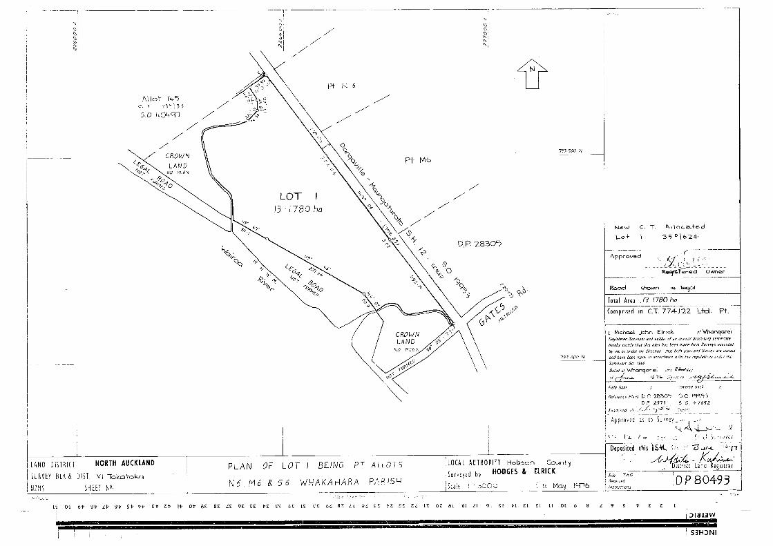

Identifier
Search Copy
Land Registration DistrictDate Issued 01 January 1870
North Auckland
COMPUTER FREEHOLD REGISTERUNDER LAND TRANSFER ACT 1952
NA40C/224
Prior ReferencesNA774/22
InterestsB193866.2 Memorandum of Priority making Mortgages B193866 and B118628.1 first and second mortgagesrespectively - 12.7.1983 at 9.08 amD429780.1 Certificate pursuant to Section 94C Transit New Zealand Act 1989 certifying part of State Highway 12Bradleys Land East Road to Tokatoka Road to be a limited access road - 13.9.1999 at 2.00 pmD469496.1 Notice pursuant to Section 91 Transit New Zealand Act 1989 - 14.1.2000 at 11.22 amD665999.1 Compensation Certificate pursuant to Section 115 Public Works Act 1981 by Kaipara District Council- 14.12.2001 at 9.00 am6454031.5 Mortgage to Bank of New Zealand - 10.6.2005 at 9:00 am
ProprietorsRiversedge Limited
Estate Fee SimpleArea 59.7476 hectares more or lessLegal Description Allotment 9 Parish of Whakahara, Part
Northern Part Allotment 6 Parish ofWhakahara, Part Middle Part Allotment 6Parish of Whakahara, Part Southern PartAllotment 6 Parish of Whakahara and PartNorth Eastern Part Allotment 8 Parish ofWhakahara
Transaction Id 51678808Client Reference cmacdonald001
Search Copy Dated 18/09/17 3:49 pm, Page 1 of 1Register Only


Identifier
Search Copy
Land Registration DistrictDate Issued 09 May 1990
North Auckland
COMPUTER FREEHOLD REGISTERUNDER LAND TRANSFER ACT 1952
NA75C/734
Prior ReferencesNA51B/685
InterestsDPL embodied in the Register NA51B/685Subject to Part IV A Conservation Act 1987D429780.1 Notice pursuant to Section 94C Transit New Zealand Act 1989 declaring the adjoining State Highway12 to be a limited access road - 13.9.1999 at 2.00 pmD469686.1 Notice pursuant to Section 91 Transit New Zealand Act 1989 - 14.1.2000 at 3.46 pm6454031.4 Mortgage to Bank of New Zealand - 10.6.2005 at 9:00 am10136775.2 Variation of Mortgage 6454031.4 - 31.7.2015 at 2:21 pm
ProprietorsRiversedge Limited
Estate Fee SimpleArea 1.5271 hectares more or lessLegal Description Allotment 146 Parish of Arapohue
Transaction Id 51678808Client Reference cmacdonald001
Search Copy Dated 18/09/17 3:50 pm, Page 1 of 1Register Only


Identifier
Search Copy
Land Registration DistrictDate Issued 01 October 2001
North Auckland
COMPUTER FREEHOLD REGISTERUNDER LAND TRANSFER ACT 1952
NA136B/366
Prior ReferencesNA1056/235
InterestsSubject to a pipeline right over part marked A on DP 207822 created by Transfer 494372D429780.1 Notice pursuant to Section 94C Transit New Zealand Act 1989 declaring the adjoining State Highway12 to be a limited access road - 13.9.1999 at 2.00 pmD469499.1 Notice pursuant to Section 91 Transit New Zealand Act 1989 - 14.1.2000 at 11.22 am
ProprietorsMichael Shane Lardner, Beverley Elaine Lardner and Derek Charles Halse
Estate Fee SimpleArea 4.0110 hectares more or lessLegal Description Lot 1 Deposited Plan 207822
Transaction Id 51678808Client Reference cmacdonald001
Search Copy Dated 18/09/17 4:02 pm, Page 1 of 1Register Only


Identifier
Search Copy
Land Registration DistrictDate Issued 01 October 2001
North Auckland
COMPUTER FREEHOLD REGISTERUNDER LAND TRANSFER ACT 1952
NA136B/367
Prior References61D/210-212 NA1056/235
InterestsSubject to a pipeline right over part marked B on DP 207822 created by Transfer 494372D429780.1 Notice pursuant to Section 94C Transit New Zealand Act 1989 declaring the adjoining State Highway12 to be a limited access road - 13.9.1999 at 2.00 pmD469499.1 Notice pursuant to Section 91 Transit New Zealand Act 1989 - 14.1.2000 at 11.22 amD613562.2 Encumbrance to Northpower Limited - produced 15.6.2001 at 1.58 pm and entered 1.10.2001 at 9.00 amD618013.2 Consent Notice pursuant to Section 221(1) Resource Management Act 1991 - produced 2.7.2001 at2.08 pm and entered 1.10.2001 at 9.00 am6454031.6 Mortgage to Bank of New Zealand - 10.6.2005 at 9:00 am
ProprietorsRiversedge Limited
Estate Fee SimpleArea 70.3652 hectares more or lessLegal Description Lot 2 Deposited Plan 207822
Transaction Id 51678808Client Reference cmacdonald001
Search Copy Dated 18/09/17 4:06 pm, Page 1 of 1Register Only

