forest stewardship plan - new jersey · 1 executive summary this plan seeks to guide wildlife...
TRANSCRIPT

FOREST STEWARDSHIP PLAN
2012 TO 2022
Weldon Brook Wildlife Management Area
NJ Department of Environmental Protection, Division of Fish & Wildlife ATTN: Bureau of Land Management
805 Pequest Road Oxford, NJ 07883
(908) 637-4125
Prepared by: Gracie & Harrigan Consulting Foresters, Inc.
for NJ DEP Division of Fish & Wildlife
December 2012 Last revised: April 2013
WOODLAND ACREAGE: 1,424.2 ACRES
TOTAL ACREAGE: 1,548.9 ACRES
TOWNSHIP OF SPARTA
SUSSEX COUNTY
___________________________ for Division of Fish & Wildlife
___________________________
for State Forester

TABLE OF CONTENTSPage
Executive summary………….. .................................................................................................................11.0 Introduction....................... .................................................................................................................2
1.1 History of NJ Highlands forests and natural disturbance regimes………….............2Fig. 1 Forest Types Map...... ................................................................................. .............3
1.2 History of Weldon Brook Wildlife Management Area………… .............. .............71.3 Other interests in the WMA……................................................................ .............91.4 Planning process……................................................................................. .............91.5 Goals and objectives…................................................................................. .............91.6 Significant planning issues…… ................................................................ ...........101.7 Adaptive management…………................................................................ ...........121.8 Applicable Laws and Regulations…………...........................................................131.9 Applicable State Policies………................................................................ ...........13
1.9.1 Wildlife Action Plan…................................................................ ...........131.9.2 Forest Action Plan……................................................................ ...........151.9.3 Land Management Review Policy…………..........................................16
1.10 Highlands Water Protection and Planning Act……… ..........................................162.0 Resource assessment………...............................................................................................................18
2.1 Water quality…………................................................................................. ...........182.2 Soils…… ...............................................................................................................18
Fig. 2 Watershed Map………................................................................................. ...........19Fig. 3 Soils Map………….. ................................................................................. ...........20
2.3 Wildlife resources……................................................................................. ...........222.3.1 Golden-winged warbler…………...........................................................242.3.2 Indiana bat……………................................................................ ...........252.3.3 Forest interior birds…................................................................ ...........252.3.4 Wildlife dependent on vernal pools……… ..........................................262.3.5 Wildlife dependent on wetlands and surface water…….............. ...........272.3.6 Wildlife dependent on oak-dominated forests………….............. ...........28
2.4 Forest Inventory........ ................................................................................. ...........31Fig. 4 Map showing locations of sampling points ...........................................................32Fig. 5 Stocking guide example…………................................................................ ...........35
2.5 Endangered and rare plants…… ................................................................ ...........362.6 Recreation & aesthetics description……… ...........................................................372.7 Cultural resources……................................................................................. ...........382.8 Forested wetlands and vernal pools……… ...........................................................38
Fig. 6 Vernal pools map……................................................................................. ...........392.9 Forest description and findings…................................................................ ...........40
Fig. 7 Woodland Vegetation Map…… ................................................................ ...........412.10 High conservation value (HCV) forests……...........................................................502.11 Landscape description and findings……… ...........................................................50
Fig. 8 Forestland ownerships and constraints……...........................................................51

2.12 Stakeholder and public review and comment on the assessment and plan…...........533.0 Land management area guidelines…………………................................................................ ...........54
3.1 Deer herbivory considerations…................................................................ ...........543.2 Exotic invasive plants and other competing vegetation considerations……...........553.3 Common silvicultural prescriptions………...........................................................553.4 Forested wetlands considerations…………...........................................................60
3.4.1 Vernal pools…………................................................................ ...........603.4.2 Forested wetlands……................................................................ ...........603.4.3 Riparian areas……… ................................................................ ...........62
Fig. 9&10 Topographical maps…................................................................................. ...........63Fig. 11 Riparian areas map… ................................................................................. ...........65
3.5 Wildlife considerations…………................................................................ ...........663.6 Endangered and rare plant considerations…...........................................................683.7 Recreation & aesthetics considerations……...........................................................693.8 Landscape-scale considerations…................................................................ ...........703.9 Old-growth considerations………................................................................ ...........71
3.10 Forest health considerations……................................................................ ...........713.11 Climate change considerations…................................................................ ...........723.12 Prescribed burning considerations…………...........................................................743.13 Land management areas………. ................................................................ ...........75
3.13.1 Future old growth forest management area ..........................................753.13.2 Visual quality and constrained management area…….............. ...........763.13.3 Golden-winged warbler management area…..........................................763.13.4 Riparian buffer management area…………..........................................783.13.5 General forest management area…………...........................................803.13.6 Other management areas……… ...........................................................82
Fig. 12 Land management areas map……................................................................ ...........834.0 Forest management……………………................................................................................. ...........84
4.1 Forest management narrative……................................................................ ...........844.2 Forest growth and yield……….................................................................. ...........884.3 Recommended activity schedule…………............................................................894.4 Monitoring program…................................................................................. ...........91
Fig. 13 Activity schedule map…………................................................................ ...........924.5 Public participation and notification………...........................................................95
5.0 References cited……………...............................................................................................................976.0 Plan amendments………….............................................................................................................106
6.1 Recent developments ................................................................................. .........107
Stand Data Analysis................. .....................................................................................................appendix
List of Blocks and Lots……… .....................................................................................................appendixEndangered and Rare plant occurrence information [NONPUBLIC INFORMATION]………….appendix

1
Executive Summary This Plan seeks to guide wildlife conservation projects for the Division of Fish and Wildlife (DFW), in accordance with State laws and policies, in order to foster a variety of habitat types to encourage a greater diversity for wildlife and conditions that benefit known existing populations of threatened and endangered species on this Wildlife Management Area (WMA). This Plan analyzes the WMA, ultimately recommending courses of action appropriate for the land and the scope of the challenges ahead. The plan seeks to balance the diversity of age classes found on the WMA. The resource assessment found that 99.7% of the upland forest is aged between 85 and 100 years. Such a forest offers almost no opportunity for wildlife dependent on early successional forests, generally aged between 0 and 20 years. Thus, this Plan details proven forestry techniques to create suitable early successional habitat, improve forest health in terms of improving growth and vigor of overstory trees as well as improving understory vegetation, and aiding in the creation of conditions necessary to mimic old-growth ecosystems. Whenever possible, the most relevant and useful scientific information has been utilized to guide management activities, including recent predictive models regarding forest regeneration in the light of deer herbivory and competing understory vegetation. A robust monitoring program has been included to ensure the proper feedback of data to implement true adaptive management on this WMA. Wildlife dependent on early-successional forest habitat are in serious decline in New Jersey. The most significant example of decline within these species is the golden-winged warbler. Only about 25 breeding pairs of this bird remain within the State. The DEP Division of Fish and Wildlife operates the Weldon Brook Wildlife Management Area, and many other WMAs within the remaining range of the golden-winged warbler. The Legislature through the Endangered and Nongame Species Conservation Act declared “That species or subspecies of wildlife indigenous to the State which may be found to be endangered should be accorded special protection in order to maintain and to the extent possible enhance their numbers” (NJSA 23:2A-2b). The Division has determined that action is necessary and through the production of this Forest Stewardship Plan endeavors to create habitat for the golden-winged warbler on a suitable scale as to maintain and enhance this and other species dependent on early successional forest. Specifically, over 75 acres of golden-winged warbler habitat will be created over the course of the next 10 years on this WMA. This Plan takes a logical approach to reach its management recommendations. First, the history of the WMA and region are considered, as are relevant laws and policies. Significant emphasis is placed on the Wildlife Action Plan prepared by the Division’s Endangered and Nongame Species Program. Secondly, an assessment of the resources contained within or near this WMA has been conducted. This includes not only a formal, detailed forest inventory, but also a review of known water, soil, wildlife, cultural, recreational, and aesthetic resources. Considerations were provided for protected and/or significant resources such as threatened and endangered species with conflicting habitat requirements, protection of water quality, protection of vernal pools and other wetlands and the wildlife that depend on them, and significant recreational use. Consideration was also given to problems with deer herbivory and exotic invasive plants, and also to the need to create old-growth forest conditions within the forest matrix. On a landscape level, the recommendations contained within this Plan benefit a variety of wildlife both in the creation of transient – and disappearing – habitat, while ensuring the connectivity between ecosystems and adequate habitat for forest interior birds. By practicing forestry on this WMA, the Division seeks to mimic the natural disturbances that would cause early successional forest to be created, while generating income from forest products to offset the costs of creating habitat and other management activities suggested herein.

2
1.0 Introduction This Forest Management Plan was developed to assist the DFW with the management of Weldon Brook WMA, located in the Township of Sparta, in Sussex County. The property is situated along State Route 15, Blue Heron Road, State Route 181, and Pascoe Road, and encompasses 1,548.9 acres, of which 1,424.2 acres are woodland, 53.3 acres are ponds, 61.4 acres are in connection with a high-tension powerline rights-of-way, and the remaining 10.0 acres are in connection with a former railroad bed. A Forest Types Map is provided on page 3 for location of the woodland and other property features. A list of block and lot numbers is provided in Appendix C. Forest Type Acreage Oak-Dominated 1,038.0 Northern Hardwoods 104.0 Flooded Red Maple 108.9 Riparian Maple-Ash 99.8 Emergent Wetlands 72.3 Oak-White Pine 1.2 1,424.2 acres total forest The study provides a current inventory, mapping and analysis of the woodland to form the basis for future management, to resume the implementation of a sound and active forestry program. Management will work to improve the quality, health and vigor of the forest, and can additionally aid in the generation of periodic income from the harvest and sale of wood products. Copies of this Plan shall be filed with the DFW, and with the New Jersey Forest Service for approval by the State Forester. The Weldon Brook WMA serves a broad spectrum of the public, particularly hunters and anglers, as well as mountain bikers who connect with trails on the adjacent Mahlon Dickerson Reservation owned and operated by the Morris County Park Commission. To date, various user groups have utilized this WMA satisfactorily, and similar conditions exist on nearby Division properties such as Sparta Mountain WMA, Rockaway River WMA, Berkshire Valley WMA, and Hamburg Mountain WMA. 1.1 History of NJ Highlands Forests and Natural Disturbance Regimes Pre-settlement Prior to and during the early years of colonization, the Lenni Lenape were an integral part of the forests and plantations of northern New Jersey. Lenni Lenape was a general name given to the Delaware tribe of native Americans, a fairly diverse group who shared the same general type of language, but were separated into different groups geographically and had distinct dialects of language.


4
The Delaware lived in permanent settlements surrounded by agriculture, but also travelled seasonal circuits within their region to hunt wild game. Members of this tribe participated in fire-drives, in which several different areas of forest were burned simultaneously in order to drive deer into a central location for greater hunting efficiency. The cycle of burning the understory, possibly supplemented by planting, led to the chestnut and oak forest present at the time of European settlement in north Jersey. Their seasonal circuits or travels may have included rockshelters, which in the northern Highlands would have likely been in the form of an overhanging rock ledge gradually improved over time (Weslager 1989, Kraft 1986, Kraft 1984). Various historical sources describe the forest of the eastern and northeastern United States at or just after the time of discovery as having moderate canopy closure, limited understory, and being dominated by chestnut, oak, and hickory. Such intentional manipulation by the Native Americans provided additional nutrition to supplement maize grown in close proximity to settlements. From settlement through the 1880’s The initial settlement of New Jersey progressed from the late 1600’s through the beginning of the Revolution. During the initial construction of the settler’s house, gardens were fashioned to provide sustenance for the family, and for preserves for the winter. Following construction of the original house, labor could focus on the clearing of land for agriculture. Trees were cut. Good logs were cut to length for later construction. Smaller material was cut and split for firewood. The remainder was piled on top of the stumps and burned. Now, attention could be paid to planting of crops and the construction of a permanent home. From the days of settlement through the mid-1800’s, logs were removed from the forest not only for the sustenance of the landowner, but to be sold to sawmills for lumber products needed by society, and to provide a return to the landowner. In the time after the Civil War, life began to change dramatically. The First Industrial Revolution that had begun in England prior to the war for independence had spread to America in the years following. The Second Industrial Revolution had an even greater impact, beginning in the early 1830’s. Greater use of machinery, improvement of manufacturing processes, and dramatic advancements in transportation and communications permanently changed America, and also the communities of northern New Jersey. Agricultural change began somewhat slowly, with farms becoming more specialized. This change favored large farms to the detriment of the many small sustenance farms that existed in the region. Abandonment of small farms or marginal farm fields began as early as the 1850’s. The preferred energy source for much of the industry of the era was charcoal, and also coal. Charcoal was created from the incomplete burning of wood, and would produce more energy per unit of volume than raw wood. In order to create charcoal, trees were cut within a forest, and the workmen would create large pyramids of tightly stacked wood. These piles were mostly covered with sod, then lit on fire from the inside. The sod would have the effect of starving the fire of oxygen, causing the pile to smolder rather than blaze. After the burn, the charcoal would be shipped to the factory for use, or port or railroad staging area where it would be shipped to its

5
final destination. Iron furnaces were major consumers of charcoal. Charcoal was used mostly between 1760 and 1895, although the highest production came after the Civil War. Public knowledge of the connection between forests and water quality, albeit anecdotal, predates the establishment of scientific forestry in America. The unsustainable and heavy-handed exploitation of the forest resource in the latter part of the 19th century was pronounced and unmistakable. In the NJ Highlands region (as well as Pennsylvania and southern New York), demand from sawmills and for charcoal resulted in dramatic cutting. Erosion, particularly after forest fires had swept through harvest areas, had a severe impact on water resources. That impact on drinking water and, to a lesser extent, scenery, helped to drive forest protection legislation on federal and state levels, particularly in the decade between 1892 and 1911. The beginnings of forestry Beginning with the emigration of professionally-trained German foresters in the 1880’s, and gaining momentum with the return of Gifford Pinchot from the French National School of Water and Forests, scientific forestry began to take root in America. The year 1900 would include the founding of the Society of American Foresters. However, due to market conditions and the problems endemic with a new science, scientific forestry did not take hold on private land in many regions until well into the 20th century. With the establishment of the USDA Forest Service and the initial and subsequent cadre of foresters interested in the relationships between forests and water, came watershed research. These scientific experiments began in Colorado in 1911. For the eastern US, the lion’s share of scientific data has come from the USDA Forest Service’s Forest Experiment Stations in Hubbard Brook, NH; Fernow, WV; and Coweeta, NC. The USDA Forest Service’s studies in the east have been conducted more or less continuously since 1940. Further, the Society of American Foresters currently holds less than 48 colleges and universities to have accredited professional forestry degree programs. Many, if not most, of these institutions as well as other universities and land grant colleges also provide valuable research for the greater forestry community. The USDA Forest Service also maintains a Research and Development group, which staffs and guides research at various Forest Experiment Research Stations throughout the nation. Forestry in New Jersey Active forest management in New Jersey dates back to 1905, with the creation of the Forest, Park and Reservation Commission, and the purchase of the five original State forests and parks. During the Great Depression, extensive forestry work, primarily on public lands, was accomplished by the 49 or so Civilian Conservation Corps companies organized within New Jersey (1933-41). A total of, 13 companies were stationed in the NJ Highlands region. From that point forward for the next 50 years, government policy fostered acceptance of contemporary forestry on public and private lands. Through technical outreach, the NJ Forest Service planned reforestation, marked forest thinnings, and planned and executed timber sales on private and public lands throughout the Highlands region.
6
Most of the forests of New Jersey date back to the turn of the 20th century through the 1920’s. At that point, the chestnut and oak forests were growing back after the heavy and widespread cutting for charcoal. However, an exotic fungus known as the chestnut blight would sweep through the region, eliminating the dominant chestnut overstory, leaving the oak-dominated forest present in much of northern New Jersey today. Other forest age classes were created from later abandonment of agricultural lands, and from forest regeneration harvests, as well as from natural events such as severe wind events, fire, and severe insect infestation. That mosaic of different age classes and cover types supports the high species biodiversity of the region, according to the 2002 USDA Forest Service report on the NJ Highlands. On many DEP-owned lands, management plans were developed, executed and revised at twenty to twenty-five year cycles. Although there had been a pronounced decline in public lands management for a period starting in the early- or mid-1980’s, recent strides have been made within DEP Natural and Historic Resources (which includes the Division of Parks and Forestry and Division of Fish and Wildlife). This Plan as well as new Plans for several other WMA’s in the NJ Highlands have been produced largely as a reaction to steep declines in early successional wildlife populations, especially the golden-winged warbler (Vermivora chrysoptera), hereafter “GWWA.” The Farmland Assessment program has brought deep incentives for private landowners to manage their forests. This program became even more important after the 1986 revision to the Farmland Assessment law that standardized treatment of private forests by municipal tax assessors. While private forest management is very important within the State, many private forests are constrained by size. With many of the larger tracts having been purchased through various Green Acres projects over the course of the past 20 years, and with parcelization being a significant trend among remaining private ownerships, the average size of a forest ownership under Farmland Assessment in the NJ Highlands is believed to be between 35 to 45 acres. While most species that breed in early successional forest are not area-sensitive, the amount of forest in the surrounding landscape plays a role in the suitability of early successional forest for many species, including the golden-winged warbler. Thus, small woodland parcel size can hamper the ability of landowners to manage the forest at sufficient scale to impact wildlife populations. Sustainable Forestry and Forest Stewardship Sustainability has been synonymous with forestry since the first trained foresters arrived in America. To this end, the term “sustainable forestry” would have been seen as redundant. However, beginning in the 1990’s, industrial forestry, particularly in the American west, was challenged by advocacy groups claiming that the forest lands were being harvested in an unsustainable fashion. Company foresters’ claims to the contrary were viewed skeptically by some due to their economic interest in defending their employer. The term “sustainable forestry” was coined to describe forestry practices that have been certified as being sustainable for commodity and non-commodity (including water and protected flora and fauna) uses by a third party. Forest Stewardship Council and Sustainable Forestry Initiative have led the way with regard to third-party verification standards on industrial and public forest lands throughout the United States for the last 10 years. Recently, the Tree Farm program of the American Forest Foundation
7
has established a similar program designed specifically for non-industrial private forest land owners, such as those found in the northern half of the state. 1.2 History of Weldon Brook Wildlife Management Area This property, currently understood to be 1,548.9 acres, was assembled from several transactions over the course of the last 20 years. The largest of the acquisitions were purchases from Athena Portfolio Investors, LP of 829 acres, and from the Preston and Hunsicker families (also known as the Buyack Group) of 276 acres cumulatively. Blue Heron Road had formerly transected this property. It is not clear if this was a public or private road, but it is now gated by the Division. This road runs from the interchange on Route 15 in a general northeast direction to the Pine Swamp and abandoned railroad at the boundary of the Mahlon Dickerson Reservation. There is extensive evidence of past agricultural activity on both sides of this road, encompassing a significant area of the upland of the northern two-thirds of the WMA. Such evidence includes extensive stonewalls, evidence of old foundations and ruins of homesites, small impoundments on streams and wetlands, old wells, and a small lime kiln. From the measured age of the forest of this property, it appears as though the vast majority of this land was abandoned for open-field agricultural pursuits by the 1920’s, if not sooner. One small area (Stand 1-1-8) was abandoned at a later period, perhaps during the 1950’s. Pascoe Road also stretched through this property, running from Weldon Road in Jefferson Township to Blue Heron Road near the center of this property. Historically, there was evidence of surface mining, likely for iron, in small portions of the WMA at the northern end, and also south of Blue Heron Lake. Additional activity was noted in the portion of the WMA that is south of Route 15. In addition, the eastern boundary of this WMA is the former Ogden Mine Railroad which brought iron ore south from the former Edison mines near Sparta Mountain. As such, there are many old roads that connect these pits with the former Blue Heron Road and Pascoe Road. Following its abandonment for open-field farming, the lands appear to have been used for a combination of active and passive recreation. At one point, a Girl Scout camp called the Blue Heron Camp was established at the present Blue Heron Lake. The lake includes a dam at its southwestern end. The camp included a number of small cabins and other structures that have since been demolished. Ruins of other small structures that were leantos or small hunting camps were also noted on this property. Two high-tension electricity rights-of-way run parallel in a roughly north-south direction through this property. One of these power lines was installed prior to 1930, with the second added at a later point. Access roads for construction and maintenance were likely added at about 1930. Athena Portfolio Investors, LP purchased this property from Midlantic National Bank in 1994. Prior to Midlantic’s ownership, this property had been extensively logged in the 1970’s. Under that previous ownership, many of the interior forest roads were improved as well. No records are known to exist from those activities. Such cutting would have occurred over the vast majority of the upland forest of that tract, and clear evidence of logging from that time period exist
8
throughout Stands 1-1-1 and 1-1-2. During the Midlantic and Athena ownerships, forest management on this property was guided by Gracie & Harrigan Consulting Foresters, Inc. (formerly Richard D. Goodenough Associates, Inc.). During that time, one or two small timber harvests were conducted, of which no records have been found. The vast majority of the property was sold to the Green Acres program in about 1996, with some lands along Glen Road having been developed. Preston and Hunsicker owned most of the land around Blue Heron Lake. Formal forest management on that property began in 1990 with the assistance of forester John Grab. At that time Mr. Grab prepared a Forest Management Plan for the property that focused on the harvest of overmature trees for timber and low quality trees for pulpwood. Records show that three harvests were conducted; one in 1991, the second in 1993 and the third in 1994. The volume of wood harvested and income generated are not available from the 1991 harvest. In July of 1993, 172,500 board feet of timber and 78 cords of pulpwood were harvested from portions of Stands 1-1-1 and 1-1-2 in the northwestern portion of the property by William Mott of Beach Lake, Pennsylvania. Mr. Mott paid a lump sum price of $37,007 for the timber and pulpwood. In January of 1994, Mr. Mott purchased additional timber for a lump sum of $23,247 from Stands 1-1-1, 1-1-2, and 1-1-3 east and northeast of Blue Heron Lake and also north of the gate on Blue Heron Road, although records are not available of the volume or number of trees harvested. In 1998, Gracie & Harrigan Consulting Foresters, Inc. was retained to continue to guide forest management on this property. In that year, a ten-year Forest Management Plan was completed. During the term of the 1998 Plan, four forest stand improvement programs were completed over a total of 17 acres. This was accomplished in Stands 1-1-1 and 1-1-3 immediately west and northeast of Blue Heron Lake. In 2002, that Plan was amended to reflect the sale of about 200 acres to Green Acres. In 2006 or 2007, the remainder of the property was sold to Green Acres. Although no records have yet been found regarding past forest management activities on the remainder of the WMA (mostly the southwestern portion of the property and the land near Arapaho Pond), evidence of large and small stumps suggest a similar management history of cutting for timber or firewood at some point during the last 40 years over the majority of the upland forest in those sections. This included Stands 1-1-1 and 1-1-2. Significant evidence of past gypsy moth damage and mortality exists on this tract, particularly at higher elevations and within Stand 1-1-2. It is not clear whether this damage was from the 1987-1989 infestation, later infestations, or a combination thereof. Extensive beaver activity was also noted on this property, particularly within the past ten years. It is clear from historical aerial photography that a large amount of the open water and emergent wetlands (Stand 1-1-6) on this property are a result of beaver activity. Some of these activities have damaged some of the interior forest roads on this property in two places. In 2012, Gracie & Harrigan Consulting Foresters, Inc. was retained by the Division to complete a forest inventory and lead in the preparation of this Forest Stewardship Plan. This Plan contains an inventory, soils information, statistical analysis, and recommendations for management over a ten-year period. This Plan will assist with the continuation of an active forestry and wildlife management program to improve the quality, composition, and value of the forest (in terms of wildlife, overall forest health, and economics). Records of activities will be kept by the Division

9
on an ongoing basis to serve as a history of management and future reference for monitoring purposes. 1.3 Other Interests in the WMA A review of the acquisition files was made during the preparation of this Plan. The State holds all rights to this WMA, including mineral rights. Both JCP&L and PSE&G own rights-of-way for high-tension electrical transmission lines as shown on the map on page 3. No other significant interests were noted. This is not a legal opinion. 1.4 Planning Process This is the first Forest Stewardship Plan developed for this WMA for the Division. This Plan was developed by a Planning Team assembled by the Division’s Bureau of Land Management, under the direction of Miriam Dunne, which included Steven Kallesser of Gracie & Harrigan Consulting Foresters, Inc., and Sharon Petzinger of the Division’s Endangered and Nongame Species Program. This Plan has gone through the DEP land manager review process. As part of that process, the Plan has been reviewed by the NJ Forest Service, the Division’s Endangered and Nongame Species Program, the Office of Natural Lands Management, the Historic Preservation Office, and the NJ Forest Fire Service. Public input will also be accepted on an ongoing basis. The Division and Gracie & Harrigan Consulting Foresters, Inc. acknowledge the Maryland Forest Service and their Sustainable Forest Management Plan for the Chesapeake State Forest, which helped form a general context for the production of this Plan. One of Maryland’s goals for the Chesapeake State Forest is that it is viewed as a national model of sustainable forest management, and it has served to help provide a framework for reasoned decision-making in the light of current data and known constraints. 1.5 Goals and Objectives Goal 1: Provide high quality, diverse scrub/shrub and early successional habitat.
� Objective 1.1: Increase scrub/shrub along the powerline rights-of-way through timber harvest, girdling, and/or spraying.
� Objective 1.2: Control problem invasives and set back succession through selective herbiciding, hydroaxing, and/or mowing in existing scrub/shrub, if any.
� Objective 1.3: Conduct regeneration harvests in mid-successional forest. Goal 2: Maintain forest health, diversity and integrity.
� Objective 2.1: Balance successional stages across the WMA so that there is a mix of early-, mid-successional and older growth forest. Up to 20% of the land area of this WMA would be considered for early successional habitat (including utility rights-of-way, emergent wetlands, and existing forest aged less than 20 years).

10
� Objective 2.2: Identify regions that will be managed as "older growth". Conduct forest stand improvement that favors closed canopy and maintains intact stands for 20% of forested area.
� Objective 2.3: Protect cavity trees that are favored by barred owls and other cavity users. � Objective 2.4: Prevent widespread distribution of invasives through selective herbiciding. � Objective 2.5: Identify stands of unique or important value (e.g. hemlock) and conduct
forest stand improvement to maintain their health and productivity. � Objective 2.6: Prevent illegal off-road use through use of barricades. � Objective 2.7: Maintain diversity of tree heights and favor tall canopy trees to benefit
cerulean warblers. � Objective 2.8: If timber harvests are recommended, conserve trees favored by bats
including trees with exfoliating bark and cavities. Goal 3: Protect streams, springs, seeps and water resources.
� Objective 3.1: Prevent illegal off-road use through use of barricades. � Objective 3.2: Use established forestry and wetlands Best Management Practices for
activities in regulated riparian, wetland, or buffer areas including appropriate streamside management zones, crossings, and recommendations for coarse woody debris.
Goal 4: Restore wetlands to enable full ecological functioning and enhance wildlife diversity.
� Objective 4.1: Control problem invasives through selective herbiciding, hydroaxing, and/or mowing.
� Objective 4.2: Where appropriate, thin canopy in wetlands to favor habitat for basking turtles and other wildlife.
� Objective 4.3: Maintain a forested buffer around vernal pools and wetlands, where this does not conflict with projects to improve threatened or endangered wildlife or plants.
Goal 5: Inventory and monitor priority wildlife populations and habitats to support adaptive management decisions.
� Objective 5.1: Monitor wildlife response to habitat improvement activities and adjust activities accordingly.
1.6 Significant Planning Issues The primary species and habitat to manage for on this WMA is the GWWA and the early successional habitat it needs. This warbler is currently listed as endangered by the State of New Jersey – only about 25 breeding pairs are left within the state. The federal government has been petitioned to list this species because, according to the breeding bird survey, the GWWA population has declined 2.3% per year for the last 40 years, and this decline is even sharper (6-10%) in the Appalachian states, including NJ. While many reasons are thought to contribute to this dramatic decline, to of them can be addressed in NJ: loss of habitat on breeding grounds, and competition/hybridization with the blue-winged warbler. GWWA needs early successional forests within forest-dominated landscapes at higher elevations (generally 950’ and greater), although in NJ golden-winged warblers can be found breeding at

11
elevations above 500 feet and there is no elevation in NJ where breeding blue-winged warblers are lacking. This habitat is commonly created by practicing forestry under even-aged management, however the amount of cutting necessary has meant that this practice, and therefore this habitat type, has been very unpopular for the past 40 years. This has been particularly true on the over 715,000 acres of State Forests, State Parks, Wildlife Management Areas, and Natural Lands Trust properties. The golden-winged warbler is one of the focal species of this plan because it is one of the more particular species in terms of nesting habitat needs, as well as one of the rarest species that breed in shrubby/young forest habitat. The creation of openings in the forest that are allowed to regenerate into young forest will also provide breeding habitat for a suite of bird species (ruffed grouse, prairie warbler, wild turkey, eastern towhee, cerulean warbler) and insects (northern metalmark, Arogos skipper, Leonard's skipper, bronze copper) as well as foraging habitat for many forest species (wood thrush, black-throated green warbler, bobcat, barred owl, red-shouldered hawk, a variety of dragonflies). Secondly, this WMA is located within 10 miles of a major known winter hibernaculum of Indiana bat (Myotis sodalis). This bat is listed as endangered under both the federal Endangered Species Act, and the NJ Endangered and Nongame Species Act. The US Fish & Wildlife Service and the Division’s Endangered and Nongame Species Program have been asked to consult on this Plan. As part of the resource assessment for this Plan, no mines, or other suitable hibernacula were found on this WMA. One cave was identified on this property, and its location was shared with the Division’s staff. No evidence of use by Indiana bat was found. Generally, these bats will have maternal colonies in forests within 10 miles of a known winter hibernaculum that contains at least 16 suitable roost trees per acre. Such suitable trees would include shaggy-barked trees including but not limited to shagbark hickory (Carya ovata), white oak (Quercus alba), red maple (Acer rubrum), American elm (Ulmus americana), and dead trees with loose bark. Activities that would disturb breeding or rearing of young pups, such as felling of trees or operation of heavy equipment will be prohibited during potential breeding and rearing periods within suitable stands regardless of known presence of these bats, and suitable roost trees will be conserved to the greatest extent possible. Lastly, this WMA is located partially within the watershed of the Wallkill River, identified as C-1 trout production waters. These are critical water quality areas for which regulated riparian areas would normally be 300 feet from the edge of the stream channel or wetland edge. The remainder of this property is also considered Exceptional Resource Value, but has regulated riparian areas of 150 feet. Such areas in proximity to state open waters and wetlands are regulated by the NJ Freshwater Wetlands Protection Act and the NJ Flood Hazard Area Control Act, associated regulations, and DEP guidance documents including the forestry and wetlands Best Management Practices (Cradic 1995). Due to the fact that prime GWWA habitat specifically would include managing such buffer areas and that water quality is of paramount concern, forestry and wetlands Best Management Practices and associated regulations and guidance documents are given full treatment later in this Plan. The vision for this WMA is one that demonstrates a wide variety of management conditions and approaches that will result in sustainable forestry. Public interaction and interest will likely

12
continue, ranging from the occasional roadside viewers and visitors to hunters, anglers, trappers, logging contractors, local businesses, industry, and government leaders. Expectations will be diverse, often conflicting, and changing. The plan and its subsequent implementation are therefore challenged to:
� Be consistent with the physical facts, biological potentials, economic constraints, and environmental conditions affecting these forests;
� Contribute to a set of public expectations that are reasonable in light of the situation at hand;
� Be open and transparent about what is most likely to result from various management options, what tradeoffs exist, and, in retrospect, what actually results from activities.
Meeting these challenges involves:
� Developing and maintaining the best resource assessment possible under the limits of time and funds;
� Assembling and updating a broad, interdisciplinary base of scientific knowledge and theory to support management decisions;
� Creating an integrated system of field data gathering, monitoring, information feedback, and data analysis that can learn from research and field experience to support constant improvement in resource assessment, scientific understanding, and management technique;
� Creating an adaptive management process that enables managers to flexibly respond to surprises and unforeseen disturbances, including a significant degree of flexibility for future plan amendments or adjustments;
� Potentially involving third-party certification as part of the regular management regime, so that the environmental performance of field activities is evaluated regularly and management adjustments made as necessary; and,
� Creating a well-defined decision-making process, and a clear line of authority and responsibility for management of the forests.
1.7 Adaptive Management One of the key concepts in this Plan is that of adaptive management – land management that relies on good information, testing, feedback, and response to change or new learning. This Plan envisions an adaptive system with feedback, learning, and the flexibility to respond to unexpected results. Adaptive management involves learning from on-the-ground results, including both successes and mistakes. The learning and adapting process must take place in real time, responding to changes in situation that can, sometimes, be unforeseen yet serious. This requires accurate data to identify baseline conditions and sound scientific theory to predict how these systems will respond to different disturbances or management actions. The fact is, there is never enough data or unquestioned scientific theory to answer every possible question, so an action plan must use the best available. The associated assumption is that continuing efforts to monitor and collect data, refine assumptions, improve models, and learn from the land itself, are essential to the implementation of this process and to achieving the vision. This is viewed as an ambitious and

13
experimental effort, one that will challenge the Division in many ways, and may involve unforeseen results and future adjustments. 1.8 Applicable Laws and Regulations This Plan is guided and/or constrained by certain statutes of the State of New Jersey and regulations promulgated by those statutes. The following is a list of applicable laws, regulations, and, where applicable, guidance documents issued by DEP to clarify emergent issues associated with those regulations.
� Authorizing legislation for the Department of Environmental Protection’s Division of Fish and Game, and the Fish and Game Council, as amended (NJSA 23:8 et seq.)
� NJ Freshwater Wetlands Protection Act (NJSA 13:9B-1 et seq.) and (NJAC 7:7A-1 et seq.)
� NJ Flood Hazard Area Control Act (NJSA 58:16A-50 et seq.) and (NJAC 7:13-1.1 et seq.)
� NJ Endangered and Nongame Species Act (NJSA 23:2A-1 et seq.) � NJ Endangered Plant Species List Act (NJSA 13:1B-15.151 et seq.) and (NJAC 7:38-1.1
et seq.) In addition, a DEP guidance document titled “Forest Management Plans and DEP Division of Land Use Regulation Permits” dated August 24, 2009 clarifies language contained in the NJ Freshwater Wetlands Protection Act and NJ Flood Hazard Area Control Act in terms of stated exemptions, documents and conditions for obtaining exemptions and permits-by-rule, and standardized definitions. The NJ Freshwater Wetlands Protection Act was written in order to create a State-operated regime for regulating freshwater wetlands within the State in accordance with the federal Clean Water Act. Another consequence of the federal Clean Water Act has been the publication of forestry and wetlands Best Management Practices (discussed below). These statutes and regulations have been reviewed during the production of this Plan, and activities recommended herein are in accordance with those statutes and regulations. 1.9 Applicable State Policies 1.9.1 Wildlife Action Plan The Division, with help from the general public, the state's conservation groups and other stakeholders, has developed a blueprint for the future conservation of our state's species of greatest conservation need. This blueprint is called the Wildlife Action Plan. In order to qualify for federal funding under the State Wildlife Grants program, each state was required to submit a Wildlife Action Plan to the US Fish & Wildlife Service by October 1, 2005. The Wildlife Action Plan (DEPDFW 2008) was submitted to the U.S. Fish & Wildlife Service on October 1, 2005, and received conditional approval due to a limited public comment period. The Division extended the public comment period into January 2006, incorporating

14
recommendations made by the public, stakeholders, and internal reviews, resubmitted the document (dated 07/26/06) to the USFWS on August 4, 2006, for final approval, and continues to refine the Wildlife Action Plan as it is a living (or dynamic) document. The Wildlife Action Plan lays the foundation for better coordination of wildlife research and management among programs within the Division, state and federal agencies and many partners in the conservation community. The conservation strategies from states throughout the nation will collectively provide a strong argument to Congress to work toward providing a stable and permanent funding source for rare-species conservation. Specifically, this WMA is located within Zone 22 of the Wildlife Action Plan, the Northern Highlands. Those conservation actions listed as primary importance with relevance to this Plan are listed below.
� Protect critical forest and forested wetlands habitats identified in the Landscape Project o Increase the number of forests managed to contain a mix of seral (successional)
stages to provide habitat for a wide range of forest-dwelling species within large contiguous tracts while maintaining suitability for area-sensitive species per the Forest Management Guidelines for Nongame Species in New Jersey (in progress).
o Use GIS measures, other remote sensing tools, and surveys to identify and assess core forested wetland and riparian/floodplain habitat for forest-dependent breeding species: forest raptors, forest-interior songbirds, bobcats, and Indiana bats. Take action to minimize habitat loss by restoring, enhancing and/or protecting habitat on public and private lands through programs such as fee purchases, conservation easements, landowner incentives, and/or forest management and stewardship plans.
� Protect critical wetland habitats identified in the Landscape Project o Increase the effective size and connectivity of wetlands on permanently protected
public lands and surrounding private lands through incentive programs and targeted land acquisition through local land use policy and planning. Use GIS measures, other remote sensing tools, and surveys to identify important corridors that connect wetland habitats and target these areas for acquisition or work with public and private landowners to enhance and restore the corridors.
o Maintain optimal biological buffers (beyond regulatory requirements) around wetlands, riparian, and floodplain areas and minimize destruction per the NJ DEP Wetland Buffer Guidelines for Species of Conservation Concern in New Jersey (in prep). Stabilize wetland buffers and streambanks by encouraging plantings of native vegetation through public education, volunteer programs, and land managers to stabilize wetland buffers and stream banks and prevent erosion.
� Prevent, stabilize, and reverse declines of wildlife, rare freshwater mussels, and rare freshwater fish species
o Research the intensity and characteristics of threats to wildlife species of conservation concern and their habitats, including the causes and effects of habitat loss, degradation, and alteration, edge, disturbance, predation, disease, food availability, contaminants, water quality, competition by invasive plants and animals, and hybridization.

15
o Develop and implement habitat conservation goals that will meet the recovery needs of endangered and threatened wildlife populations that depend on forest habitats. These include guidelines for forest silviculture on public and private lands to enhance forest maturity and canopy, and replanting to reduce fragmentation.
o Research the habitat requirements for species of conservation concern and implement planned silviculture to enhance forests for these species and species suites.
o Work with public and private landowners and manager with significant bog and wood turtle, timber rattlesnake, longtail salamander, cavity-nester, freshwater wetland bird, grassland bird, woodland raptor, and scrub-shrub/open field bird populations to enhance targeted wildlife habitat through the implementation of best management practices and incentive programs.
� Preserve the ecological quality and integrity of vernal pool communities o Locate potential vernal pools through aerial imagery and surveys, conduct species
surveys, and integrate certified vernal pool data into the DEP regulations database and Landscape Project.
o Work with public agencies and private landowners to maintain optimal biological buffers (beyond regulatory requirements) to preserve the integrity of vernal pools and the surrounding upland habitat for vernal pool dependent amphibians. Stabilize wetland buffers and streambanks by encouraging plantings of native vegetation through public education, volunteer programs, and land managers to stabilize wetland buffers and stream banks and prevent erosion.
� Maintain the ecological integrity of natural communities and regional biodiversity by controlling invasive species and overabundant wildlife
o Identify areas where invasive, non-indigenous plants and animals are either already established or are becoming established through GIS, surveys, public participation, and through the creation of a system for reporting and qualifying new locations of invasive species. Prioritize areas for control measures according to the potential level of impact on the ecosystem and species of conservation concern and the likelihood of success.
o Work with public and private landowners and managers to employ appropriate physical, chemical, or biological control measures, or a combination of these, to reduce invasive non-indigenous plants and animals in areas that are identified as providing critical habitat for endangered, threatened, or priority wildlife species and are being threatened by invasive non-indigenous plants.
1.9.2 Forest Action Plan As Congress worked to re-authorize the federal Farm Bill in 2008 they re-evaluated the importance of stewardship on the nation’s non-federal forest resources and coordinating federal and state efforts toward the proper stewardship of these resources. Congress inserted amendments in the Bill that require states to conduct an assessment of their forest resources and to formulate strategies for their protection and management. The Statewide Assessment of New Jersey’s forest resources and the forest resource strategies were prepared pursuant to this Farm Bill’s mandate, and is referred to as the Forest Action Plan (DEPDPF 2010).
16
The intent and scale of the Forest Action Plan is not necessarily developed to pinpoint on the ground activities as in our annual work plans but to give an overview of the state’s forest resources and to provide a practical and measurable approach for management opportunities. Those strategies described in the Forest Action Plan that are relevant to this Plan are listed below:
� Conserve working forest lands o Identify and conserve high priority forest ecosystems and landscapes
� Protect forests from harm o Identify, manage and reduce threats to forest and ecosystem health (gypsy moths,
hemlock wooly adelgid, exotic invasive plant species) � Enhance public benefit from trees and forests
o Protect and enhance water quality and quantity o Maintain and enhance the economic benefits and values of trees and forests o Protect, conserve and enhance wildlife and fish habitat o Connect people to trees and forests, and engage them in environmental
stewardship activities o Manage trees and forests to mitigate and adapt to global climate change
Great care has been taken to ensure that the recommendations contained within this Plan are consistent with the overarching policies of the DEP as contained within the Wildlife Action Plan and the Forest Action Plan. 1.9.3 Land Management Review Policy DEP Natural and Historic Resources Directive 2008-1 specifies the policy for internal DEP review of plans and projects proposed by DEP staff. The land manager proposing the plan or activity conducts a screening to determine which offices within DEP would review the proposal. For this WMA, reviewers include the Division of Parks and Forestry’s State Forestry Services, Forest Fire Service, and Office of Natural Lands Management, and also the Endangered and Nongame Species Program (dependent on the resources in the area and the nature of the activity.) This policy further states that management activities may not be conducted at the expense of existing populations and occurrences of endangered, threatened, or rare wildlife species, or endangered or rare plant species as defined by the Endangered and Nongame Species Program and the Office of Natural Lands Management. 1.10 Highlands Water Protection and Planning Act Section 30(a)7 of the Act contains an exemption for an activity conducted in accordance with an approved woodland management plan pursuant to section 3 of P.L.1964, c.48 (C.54:4-23.3) or the normal harvesting of forest products in accordance with a forest management plan approved by the State Forester. Such activities conducted in accordance with such a plan are exempt from the provisions of the Act, the regional master plan, any rules or regulations adopted by the DEP pursuant to the Act, or any amendments to a master plan, development regulations, or other regulations adopted by a local government unit to specifically conform them to the regional master plan.

17
This Plan greatly exceeds the minimum requirements for a woodland management plan pursuant to section 3 of P.L.1964, c.48 (C.54:4-23.3). In addition, the recommended harvesting of forest products contained within this Plan would be considered normal in the context of generally accepted silvicultural practices (including specialty silvicultural practices for the GWWA), past forest management history of this tract and of forestland in the region, and the history of Wildlife Management Areas operated by the Division. The general term “forest management plan” is synonymous with the term “Forest Stewardship Plan.” Activities recommended within this Plan must adhere to requirements under the NJ Freshwater Wetlands Protection Act, NJ Flood Hazard Area Control Act, the federal Clean Water Act, and their associated regulations.

18
2.0 Resource Assessment This chapter includes the results of the forest inventory, wildlife information gathered by the Division, and a review of other information gathered during the research of this WMA or noted during the time of inventory. A discussion of the considerations of select resources may be found in the Land Management Area Guidelines chapter. 2.1 Water Resources Weldon Brook is located within two major watersheds. The northern portion of this property is located within the watershed of the Wallkill River, noted C-1 trout production waters. The southern half of this property drains to the Upper Delaware River, including the Weldon Brook, whose headwaters begin on this WMA. All of the watersheds on this property are considered Exceptional Resource Value. This, and the fact that this property is located within the Highlands Preservation Area, makes this area a focal point for water quality issues. The watershed for Morris Lake and Glen Lake (the water supply for the Town of Newton) represents a significant area within this WMA. Watersheds and streams found on this property are depicted on page 19. 2.2 Soils A description and mapping of the soils on this property were derived from the Soil Survey and the Soil Survey Geographic Database (SSURGO) of Sussex County. Soil characteristics and capabilities will dictate, in part, what types of species grow best on a given site, and knowledge of these characteristics is useful in management decisions. Soils of the Rockaway, Rock outcrop, Chatfield, and Hollis series dominate this property, with lesser amounts of Catden, Hibernia, Alden, Udorthents, and Urban land soils also present. Topography is generally moderately sloping, with the landscape punctuated with rock outcrops and large flat areas of flooded forest or emergent wetlands. Individual soil types present include: Alden mucky silt loam, gneiss till substratum, 0 to 8% slopes, extremely stony (AhcBc) Catden mucky peat, 0 to 2% slopes (CatbA) Chatfield-Hollis-Rock outcrop complex, 0 to 15% slopes (ChkC) Hibernia loam, 0 to 8% slopes, extremely stony (HhmBc) Hollis-Rock outcrop-Chatfield complex, 15 to 35% slopes (HncD) Rockaway loam, thin fragipan, 0 to 8% slopes, extremely stony (RoefBc) Rockaway loam, thin fragipan, 8 to 15% slopes, extremely stony (RoefCc) Rockaway loam, thin fragipan, 15 to 35% slopes, extremely stony (RoefDc) Rockaway-Chatfield-Rock outcrop complex, 15 to 35% slopes (RokD) Rockaway-Urban land complex, thin fragipans, 0 to 15% slopes (RooC) Udorthents, 0 to 3% slopes, smoothed (UdaB) Udorthents-Urban land complex, 0 to 8% slopes (UdauB) Urban land-Chatfield-Rock outcrop complex, 0 to 15% slopes (USCHRC)


21
A digest of the hazards of erosion and general suitability for various mechanized forestry activities taken from the NRCS county soil survey can be found in Appendix B. Generally speaking, operational issues are few, as road systems associated with previous land use exist (even where not specifically identified on the woodland vegetation map). All of the soils present on this WMA are considered slightly erodible soils, meaning that they have a low erodibility potential (Kf < 0.23). A non-technical description of each soil series follows. ROCKAWAY SERIES The Rockaway series consists of deep, gently sloping to very steep, well drained and moderately well drained soils that have a moderately developed fragipan. They formed in glacial till that was comprised mainly by granitic material. Coarse fragments, shallow root zone, moderate to low available water capacity, and irregular topography restrict the use of these soils for cultivated crops and pasture. Rockaway soils are primarily wooded. ROCK OUTCROP This land type consists of 50 to 90 percent outcrops of bedrock and 10 to 50 percent Rockaway soils. Slopes range from 25 to 35 percent. This unit has such a high proportion of rock outcroppings, and is so steep, that it is unsuitable for farming or pasture. Woodland production is generally poor. CHATFIELD SERIES This soil type is composed of moderately deep, gently sloping to strongly sloping soils whose parent material consists of coarse, loamy till derived from granite and gneiss. The soil is well-drained, and permeability is moderate. Available water capacity is low. The soil is not suited for cultivated crops. Common tree species include upland oaks, sugar maple, and black birch. HOLLIS SERIES The Hollis series consists of moderately shallow, nearly level to sloping, well-drained stony soils. They formed in loamy glacial till derived largely from granite and gneiss. Permeability is moderate, and the available water capacity is very low. These soils are not suited to cultivated crops. Nearly all areas of Hollis soils are covered with oak, birch, ash, and sugar maple. CATDEN SERIES The Catden series consists of nearly level, very poorly drained muck which is at least 60 inches deep. The available water capacity is very high and the hazard from erosion is slight. The soil has severe limitations for cultivation unless drainage is improved. The soils are poorly suited to woodland. Wood production is poor, and adapted species (such as red maple) have low value. HIBERNIA SERIES: The Hibernia series consists of deep, gently sloping to steep, somewhat poorly drained soils that occupy undulating and hilly glacial landscapes and concave drainageways. Soil permeability is moderate to slow, and available water capacity and fertility are moderate. Areas that have been cleared of stones are suited to common crops. Stony soils are more commonly wooded. The natural forest vegetation includes such species as white ash, red maple, tulip poplar, and elm.

22
ALDEN SERIES The Alden series consists of deep, nearly level, very poorly drained organic soils, underlain by silty and fine-loamy substratum. These soils are in depressions between ridges that may have been ponds at one time. Permeability is slow, and available water capacity is very high. The water table is at or above the surface most of the time. The native vegetation is either marsh sedges and reeds, or wetland trees such as red maple, ash, elm, and tamarack. UDORTHENTS Soils of the Udorthents series consist of deep to moderately deep, nearly level, well drained to somewhat poorly drained soils that formed in stratified or graded sandy or loamy fill material that are up to 35% gravel. These soils have been disturbed in some way, mainly by filling or cutting an excessively drained to very poorly drained area. Udorthents, clayey substratum is composed of regraded clay pits or borrow areas. The soils are widely variable and on site investigation is needed to determine the suitability of any given area for various uses. URBAN LAND Urban land consists mostly of areas that are either paved or built upon. The soils in the remaining open spaces have been reworked to the extent that the original profile cannot be recognized. The characteristics of the material are variable. Urban land is in areas that are mostly well drained, deep sandy, gravelly, or stony material of assorted glacial deposits. The areas are on uplands that mostly range from gently sloping to strongly sloping. The surface has been smoothed and in most places leveled. 2.3 Wildlife Resources A variety of wildlife species are found in the general area of this tract. (Focal species are addressed in the following section.) Four critical factors determine the abundance of wildlife populations on the property: food, water, shelter and living space. Since food and shelter requirements vary widely for different wildlife species, forest management practices should endeavor to enhance conditions which will improve habitat for a great many species, instead of focusing on one particular species. Wildlife benefits from an actively managed forest, with different age classes, in different areas. A variety of habitat and food are the key to abundance and diversity. Young stands of trees and shrubs provide cover, nesting areas and browse. Mature forests provide roosting and denning sites. The hard mast (nut) crops from oak, beech, hickory and walnut are a valuable food source for deer, bear, turkeys, and squirrels. Soft mast, such as fruit and berries from cherry, serviceberry, dogwood, black gum, cedar, sassafras, brambles, fox grape, poison ivy and Virginia creeper, are eaten by a wide variety of songbirds, game birds and other animals. Dead and dying trees, called snags, provide nesting, feeding and perching sites for a wide variety of birds. Hollow trees are used by raccoons, squirrels, owls, wood ducks, and other wildlife for nesting. Generally, management will seek to leave at least two such high value wildlife trees per acre.

23
Harvesting of forest products can frequently accomplish the realization of economic goals, the creation of better browse and cover for wildlife, and the encouragement of new trees to grow in the space created. Management activities that can accomplish the above objectives in unison include girdling trees, creating brush piles from twigs and branches of felled trees (in accordance with forest fire recommendations), and designating wildlife crop trees based on habitat attributes. One way of accomplishing a forest improvement program, while also creating wildlife habitat, is to girdle poor and inferior trees as marked by the foresters. Girdling a tree involves cutting a concentric ring approximately 1 to 2 inches deep into the bark of the main tree stem. This action cuts off the flow of water and nutrients from the roots of the tree to the leaves. As trees gradually die, they provide valuable habitat for birds and other animals. Insects that burrow into and consume wood are a food source to such birds as various woodpeckers, flycatchers, and flickers. Cavities created by fallen branches or woodpeckers provide nesting areas for birds and small mammals. Girdled trees along edges provide perches for raptors. These standing dead trees season on the stump and can eventually be harvested for firewood. Woodland thinnings can also be accomplished by felling trees. When this method is implemented the stems and larger branches of the trees are utilized for firewood. Wood that is unsuitable for firewood or other products can be felled and slashed to encourage the decomposition process so the wood can readily recycle to soil. Although slashed trees and branches may appear temporarily unsightly, coarse wood material and branches provide immediate browse and seed for birds and animals. Branches gathered into piles provide cover and habitat for reptiles and insects as well as deter deer from browsing seedlings. In the long run, wood material will decompose through the action of microorganisms, fungi, insects, and weather, and will enrich the forest soils. In addition, wood residue from the felling of trees can help to stabilize soils, particularly on steeper slopes. In addition to the above techniques, management can further encourage wildlife through the designation of wildlife crop trees based on habitat attributes. For example, trees that have cavities, are fruit or nut producing, or provide cover, can be encouraged in conjunction with future forest improvement programs. Vines that are growing on poor and inferior trees can be designated for wildlife food and cover, while vines that are interfering with the growth of higher quality trees can be controlled by cutting, at the lower stem base. Patches of bramble in certain areas of the forest can be designated for wildlife food and cover. These management activities can be implemented to improve both the health and vitality of the forest, while simultaneously improving habitat for wildlife. In preparation for the forest inventory, it was necessary to develop an understanding of threatened, endangered, or wildlife species of concern that may potentially be located within this forest. To this end, Division made a search of its records regarding this WMA. That search provided results taken from direct observation and from the Division’s Landscape Project (version 3.1). In addition, a request was made to the US Department of Interior’s Fish and Wildlife Service for a list of potential federally threatened and endangered species that may be found on this property or in the vicinity of the property. The results are shown below. Common name Scientific name Status Indiana bat Myotis sodalis Federal endangered

24
Bobcat Lynx rufus State endangered Bronze copper Lycaena hyllus State endangered Golden-winged warbler Vermivora chrysoptera State endangered Northern goshawk Accipiter gentilis State endangered Red-shouldered hawk Buteo lineatus State endangered Timber rattlesnake Crotalus horridus State endangered Barred owl Strix varia State threatened Longtail salamander Eurycea longicauda l. State threatened Wood turtle Glyptemys insculpta State threatened Black-billed cuckoo Coccyzus erythropthalmus State species of concern Blackburnian warbler Dendroica fusca State species of concern Black-throated blue warbler Dendroica caerulescens State species of concern Black-throated green warbler Dendroica virens State species of concern Blue-headed vireo Vireo solitarius State species of concern Canada warbler Wilsonia canadensis State species of concern Cooper’s hawk Accipiter cooperii State species of concern Eastern box turtle Terrapene carolina c. State species of concern Great blue heron Ardea herodias State species of concern Hooded warbler Wilsonia citrina State species of concern Least flycatcher Empidonax minimus State species of concern Northern copperhead Agkistrodon contortrix m. State species of concern Northern parula Parula americana State species of concern Spatterdock darner Rhionaeschna mutata State species of concern Veery Catharus fuscescens State species of concern Winter wren Troglodytes troglodytes State species of concern Wood thrush Hylocichla mustelina State species of concern Worm-eating warbler Helmitheros vermivorum State species of concern 2.3.1 Golden-Winged Warbler Based on this species’ conservation status in New Jersey and regionally, one of the key objectives of management within this WMA is to increase the GWWA population by creating additional suitable habitat. Best Management Practices for GWWA have been developed for Pennsylvania and Maryland (Bakernans et al 2011). This, along with other information provided by researchers elsewhere in the Appalachians, and firsthand empirical information gathered by the Division’s Endangered and Nongame Species Program provide the planning basis for GWWA habitat needs in this Plan. Specifically, it is currently believed the following provides critical habitat necessary for successful GWWA reproduction:
1) 70% of the landscape within ½ mile of the project area is forested; 2) The project area is generally aged 0-20 years; 3) The project area is 950 feet in elevation or higher (although GWWA may exist at
elevations from 500 feet to 950 feet as well); 4) The project area is less than one mile from another suitable stand; 5) The project area contains residual trees of less than 20% of forest canopy; or 10-40
sq.ft./acre of basal area; or 10-15 trees per acre > 9” DBH;

25
6) The project area includes or is immediately adjacent to a wetland area or stream; 7) The project area contains a mixture of forbs and grasses at 45% +/- 10% cover, saplings,
seedlings and other small woody vegetation, and residual trees giving the stand a very diverse and stratified vegetation pattern, however woody vegetation should generally be in the range of 2,300 stems/acre +/- 1,000 stems/acre, and
8) The project area contains a large amount of edge and is generally complex in shape. 2.3.2 Indiana bat Although this WMA is within 10 miles of known winter hibernacula utilized by Indiana bat, no observation of this bat has been made on or adjacent to this property since at least 1980. This is despite active monitoring programs undertaken by US Fish & Wildlife Service and the Division’s Endangered and Nongame Species Program. Regardless, since Indiana bat is listed as endangered at the federal and state levels, given the proximity to known winter hibernacula, and given recent population declines due to white-nose syndrome, strict measures are being taken to ensure that management activities will not harm Indiana bats that could possibly be present but undetected. Unless Anabat sensors are deployed with a negative finding for Indiana bats, harvesting activities that could potentially harm bats will be conducted between November 16 and April 1. According to the US Fish & Wildlife Service, summer habitat for Indiana bats would include at least 16 suitable roost trees/acre. Suitable roost trees would have loose or shaggy bark, crevices, or hollows and would include any of the following:
� Living shagbark hickories over 9” in diameter at breast height (DBH); � Lightning-struck trees over 9” DBH; � Dead, dying, or damaged trees of any species over 9” DBH with at least 10% exfoliating
bark; � Den trees, broken trees, or stumps over 9” DBH and over 9 feet in height; � Living trees of any species over 26” DBH.
Trees as small as 5” DBH have been used as maternity roosts and trees as small as 3” DBH have been used by roosting males; therefore, smaller-diameter trees with the aforementioned characteristics should be retained if larger-diameter suitable roost trees are not present. 2.3.3 Forest interior birds The Division’s Endangered and Nongame Species Program was consulted on forest interior birds and their management. In general forest interior bird habitat is defined as contiguous forested blocks with interior forest habitat (forest at least 300' from nearest edge) comprising at least 25% of said forest area. These blocks can range from 100 to over 500 acres and ideally contain a perennial stream. Area-sensitive species require a minimum amount of interior, or "core", habitat for successful breeding, and this minimum can vary depending on the habitats in the surrounding matrix. For forest species, core habitat is the forest habitat at least 90 meters (conservatively, 300 feet) inward from the forest edge. The minimum core required to provide suitable breeding habitat for area-sensitive species is 24.7 acres (10 ha) for forest (Franklin 1993, Faaborg et al. 1995,

26
Dawson et al. 1993, Dawson et al. 1998) and area-sensitive birds tend not to occur in forests (or grasslands) that lack core habitat (Forman et al. 2002, McCollin 1998). Although forest interior birds prefer to nest at least 300’ from the nearest edge, these species often prefer canopy breaks resulting in patches of early successional habitat within or adjacent to forest for cover and foraging during the post-fledging period (Vitz and Rodewald 2006) as well as during migration. The definition of habitat fragmentation by Faaborg et al. (1995) is the process of converting a large, contiguous patch of a similar vegetation type into smaller patches of different vegetation types in a way that only scattered remnants of the original vegetation type remains. A large corn field, housing development, and even a double-wide ROW maintained every 2-3 years will fragment a forest and reduce the abundance and nesting success of many forest birds, but it is not fragmentation when creating a disturbance in small patches of forest to promote regeneration of young forest, or forest stand improvement (forest thinning). It is possible to create small patches of young forest – within the forest matrix – in close enough proximity to each other to allow for the movement of early successional species between patches, while maintaining the integrity of the forest patch for forest interior birds. When assessing the impacts of forest fragmentation from a landscape perspective, the Division has looked at the size and number of habitat patches left in the area, how far apart these patches are from each other (degree of isolation), how different the surrounding area (matrix) is from the habitat type, the type and duration of disturbance, and whether there is any type of connectivity or corridor between patches to aid animals in moving from patch to patch (Wiens 1996, Marzluff & Ewing 2001). 2.3.4 Wildlife dependent on vernal pools Vernal pools are small, nontidal palustrine forested wetlands with a well-defined, discrete basin and the lack of a permanent, above ground outlet. The basin overlies a clay hardpan or some other impermeable soil or rock layer that impedes drainage. As the water table rises in fall and winter, the basin fills, forming a shallow pool. By spring, the pool typically reaches maximum depth following snowmelt and the onset of spring rains. By mid-late summer, the pool usually dries up completely, although some surface water may persist in relatively deep basins, especially in years with above average precipitation. This periodic, seasonal drying prevents fish populations from becoming established, an important biotic feature of vernal pools. Many species of plants and animals have evolved to use these temporary, fish-free wetlands. Some are obligate vernal pools species, so called because they require a vernal pool to complete all or part of their life cycle. While vernal pools are typically associated with forested habitats, they can also occur in other landscape settings, both vegetated and un-vegetated, such as meadows, pastures, and agricultural fields. Vernal pool basin substrate typically consists of dense mats of submerged leaf litter and scattered, coarse woody debris. During dry periods the presence of a vernal pool is often denoted by blackened leaf litter, a sign of seasonally anaerobic conditions, and stained tree trunks. Herbaceous vegetation is usually absent to sparse in and around the basin, although small sphagnum patches may occur along the basin edge. A dense shrub layer may occur along the shoreline or in small patches within the basin.

27
As described later in this chapter, vernal pools were searched for on this property and mapped in order to assist in the planning process. One amphibian species identified by the Landscape Project is strongly associated with vernal pools, namely the longtail salamander (Eurycea longicauda l.). Best management practices have been written in regards to forestry (Calhoun and deMaynadier 2004, NHESP 2007) to minimize impact on vernal pools and associated wildlife. Vernal pool biology has been studied intensively, with a vast array of research available to the researcher. Much less studied, however, are the state-listed threatened and endangered species that specifically rely on vernal pools for habitat in the New Jersey Highlands region. Unfortunately, no study has been done on these species to determine where these populations are most likely to be found in relation to the vernal pools. Ideally, isopleths for each species would be determined by a peer-reviewed scientific study (see Semlitsch 1998). (In this context, an isopleth is a distance from the edge of a vernal pool where a certain percentage of a population would be expected to occur. For example, a 95% isopleth of 534 feet and a 50% isopleth of 411 feet would mean that 95% of the population would be expected to be found within 534 feet of the high-water mark of the vernal pool, while 50% of the population would be expected to be found within 411 feet of the high-water mark of the vernal pool.) The only study of note regarding the longtail salamander and its location in relation to vernal pools was included in Anderson and Martino (1966), which discussed a 100-foot range from the shoreline of the vernal pool. In the absence of such specific studies, the Division is left to extract information from other studies on these species, and also on the judgments made by others who have investigated the same problem. Best Management Practices relating to vernal pools are Calhoun and deMaynadier (2004) and NHESP (2007). All of these Best Management Practices were based on two distinct components, namely the distance from the high-water mark of the vernal pool to be protected, and the amount of forest cover to remain after the proposed action. All of these Best Management Practices also called for more forest cover to remain in close proximity to the vernal pool. 2.3.5 Wildlife dependent on wetlands and surface water A significant portion of this property is considered wetlands. Such areas can be noted on the Woodland Vegetation Map as Stands 1-1-4, 1-1-5, 1-1-6, and 2-1-3. Although a formal wetlands delineation exceeds the scope of this document, conservative estimations have been made in the delineations of these stands based on evidence of standing water or presence of hydrophilic vegetation. In general, these wetlands range from forested lands with some evidence of seasonal wetness, to frequently flooded red maple swamps, to emergent wetlands. Initially, areas of interest were noted on aerial photographs and the county soil survey. Each area of interest was visited to determine if a wetland was present. Granted, all wildlife requires reasonably clean water for their survival. However, protected wildlife species that would be strongly dependent on wetlands and surface water that were identified through the Landscape Project include bald eagle, bobcat (particularly areas with dense brush), barred owl, red-shouldered hawk, Cooper’s hawk, longtail salamander, and wood

28
turtle. Although no bald eagles are known to exist on this WMA, it would most likely be near large open waters with significant fish populations. On this property, this would include Blue Heron Lake. Perch trees along the shoreline and dominant or “super-canopy” trees for nesting within proximity to the shoreline would be critical habitat for bald eagle. 2.3.6 Wildlife dependent on oak-dominated forests Oak trees are a keystone ecological species on this WMA. The presence of oak-dominated forests today is due to the creation of temporary forest canopy openings in the past. Temporary forest canopy openings are caused by various natural processes including wind events, ice storms, fire, and insect and disease outbreaks, or by human activities. Silvicultural techniques seek to simulate these natural processes in order to release or stimulate the growth of the next cohort of trees to fill that canopy opening. By repeating this process over time in increments across a large forest, a mosaic of various age classes and ecological characteristics is developed, which should serve the habitat needs of the largest number of fauna and flora. Ecological integrity is enhanced by biodiversity. For the past decade or two, the task of producing forests with various age classes and ecological characteristics had been indefinitely postponed by public land managers within the state. During the same period, parcelization (or reduction in the average size of ownership) has increased on private lands. A review of woodland properties within the Highlands was prepared in 2004 by Gracie and Harrigan Consulting Foresters, Inc., based on 420 Farmland Assessed properties. They found that the median amount of non-appurtenant woodland owned was less than 45 acres per property. This was validated by Frank Hennion of the NJ Forest Service, who kept tract of property acreage on Farmland Assessment inspections in the northern region for an entire year (Hennion, pers. comm.). Thus, even-age regeneration techniques such as clearcuts, seed-tree harvests, and shelterwood harvests have dramatically decreased on private lands, in favor of techniques more appropriate for smaller ownerships, including group selection or individual tree selection. Habitat needs of certain species which require forests aged 0-20 years may not be met under these systems. In addition, regeneration of oak, prized by wildlife because of its acorns, is very difficult under group selection, and minimal under individual tree selection. Specifically, the Division is concerned about the conclusions of Rodewald and Abrams, that “a regional change from oak- to maple-dominated forests may strongly affect avian community structure and populations of some common bird species associated with eastern deciduous forests” (2002). Further,
“Our study is the first to provide evidence that a regional shift in forest composition from oak- to maple-dominated forests may reduce species richness and abundance within forest bird communities and may negatively influence certain species. In particular, long-distance migrants, residents, and bark-gleaning species may be the most affected because of their foraging strategies.”

29
As parcelization continues and as acquisition of private lands by public agencies continues, active management of public lands may soon be the only appropriate avenue to create such habitat in the Highlands region. Such forces led the Nature Conservancy, in 2005, to endorse plans by the Indiana Department of Natural Resources to increase the amount of regeneration harvests on public land, given certain conditions are met.
“It is widely accepted that oak-hickory forests throughout Indiana are declining in abundance in the absence of disturbance – being replaced instead by a beech-maple forest. Since we no longer have the ecologically important process of fire on the landscape to promote oak, careful forest management, including the disturbance caused by timber harvesting, can create conditions needed to ensure oak continues to be abundant in the forest.” (in Wilent, 2005)
The issue has been raised that certain creation of edge habitat can result in the decrease in and nesting success of area-sensitive forest interior songbirds due to increased nest predation (Sullivan and Brittingham, 1994; Wilcove, 1988). However, many forests within the Highlands already contain multiple forest stands of varying ages, due to differing periods of forest establishment from clearing for charcoal, the abandonment of marginal agricultural lands, and past forest regeneration harvests. For species that require unbroken canopy of a certain extent, this Plan recommends that forest planning for forest area birds reflect a minimum requirement, not an absolute requirement that all forest somehow ceases development for the benefit of a small number of species, to the detriment of other species. In tackling this same question in Indiana, the Nature Conservancy explained:
“There is agreement among biologists that many of our songbirds are in decline. The reasons are not fully clear but habitat probably plays a very important role. Some of these declining songbirds such as the wood thrush, hooded warbler and eastern wood-pewee require older, mature forests to successfully nest. Other declining birds such as woodcock, ruffed grouse, yellow-breasted chat and eastern towhee require very young, wooded thickets to survive. More birds in this latter group have shown significant declines over the last few decades than their mature forest counterparts. In 2001 W.C. Hunter and his co-authors published data in an issue of the Wildlife Society Bulletin under the title, Conservation of Disturbance-dependent Birds in Eastern North America, showing that approximately 70% of birds associated with shrub-scrub habitats in the eastern US were undergoing declines. Biologist Frank Thompson and others in their paper, Status of Neotropical Migrant Landbirds in the Midwest: Identifying Species of Management Concern, point out that ‘Birds in shrub-sapling habitats [are] of high management concern probably because their habitat is more spatially and temporally limited than older forest habitats.’ Interestingly, some birds require both habitat types such as the whip-poor-will and worm-eating warbler. Birds in this

30
group sometimes nest in older forest, but forage in younger thickets… Finally, Dr. Rodewald cites a recent study in the forests in Pennsylvania which revealed ‘total abundance and species richness of birds was 50-200% greater within oak-dominated stands than in maple dominated stands in at least one season.’ She concludes, ‘Moreover, the distribution, abundance, and behavior of numerous wildlife species, ranging from bears to warblers, are linked to oaks. So when faced with compelling evidence that oaks will be less abundant in many forests within the next several decades, biologists and land managers need to carefully consider how current management approaches will affect the persistence of oak forests and their associated biota. Ultimately, management scenarios that discourage oak regeneration may negatively impact some wildlife species and, at the very least, are expected to influence wildlife community structure and interactions among species.’” (Nature Conservancy, 2006)
Such young forests are critical habitat for a variety of wildlife including ruffed grouse (Sargent and Carter, 1999), golden-winged warbler, and bobcat (NJDEP, 2004a), among other species. Management for ruffed grouse entails the creation or improvement of four different types of habitat: breeding, nesting, winter, and habitat for hens with broods. Grouse can live their entire lives in an area of 40 acres or less, if all four habitats are present in adequate quality. However, in established woodlots, this would involve the regeneration of between 5 and 20 acre blocks of forest at a time, up to 40 acres if the block were irregularly shaped (Fearer, 1999). Regenerating Oak Dominated Stands: Descriptions, Predictive Models, and Guidelines (Gould, 2005) serves as an excellent guide for determining outcomes based on present inventory data. If at all possible, those data collection methods and predictive models should be employed prior to harvest in order to greatly increase the probability of regeneration success, given factors such as deer impact and competing vegetation. Competing vegetation such as exotic invasive species within harvest sites will be controlled before and/or after harvest. Where necessary, artificial regeneration of forest stands is addressed by Gould. References on mechanical, chemical, and biological treatment on invasive species are too numerous to cite, however, the NJ Forest Service has distributed and received positive comments on the Southeast Exotic Pest Plant Council Invasive Plant Manual (2003). The Gould study also specifically addresses the problem of deer browse on successful forest regeneration. By applying the results of a pre-harvest regeneration inventory to predictive models in Gould, a land manager would therefore be able to predict regeneration success without directly measuring the deer density in that area. This is of tremendous benefit to the Highlands region, where deer densities can vary dramatically within several square miles based on land use and presence and activity of hunting. The Gould models, although Pennsylvanian, are appropriate to NJ Highlands forests, based on similar average annual minimum temperature (USDA Hardiness Zone), rainfall totals, soils, and cover type. Data on forest parameters necessary for the Gould model was collected during the forest inventory of this WMA, and is more fully described later in this Plan.

31
2.4 Forest Inventory A forest inventory was performed on this WMA in accordance with the Minimum Data Required for State Forest Inventory published by the NJ Forest Service in order to form a basis for a sound management program. All of the data collected during this inventory was directly overseen by either Steven Kallesser, Heather Gracie, or Christina Harrigan. In order to conduct a reliable inventory, the property was first divided into stands or forest types. A stand is a grouping of trees of similar size and characteristics. A map of the forest stands was prepared and is included on page 41, where the stands are identified using the Block-Compartment-Stand method. This WMA was divided into two blocks, one northeast of Route 15, and one south of Route 15. Each block contained one compartment. For example, the ninth forest stand within the first block is referred to as Stand 1-1-9, and the first forest stand within the second block is referred to as Stand 2-1-1. Sample points were then designed for select stands. The point sampling technique was used. For systematic sampling, the initial point center was randomly located within the WMA. The topography of the WMA was analyzed, with the resulting grid of subsequent point centers being laid out perpendicular to the prevailing slope of the property, in accordance with generally accepted forestry practices. Hereafter, plots were mechanically spaced at uniform intervals of 660 feet in a grid running east-west according to the NJ State Plane Grid System. Point centers were permanently marked in the forest with a galvanized metal tent stake with flagging tape attached, flagging tape attached to the nearest tree or bush to the tent stake, and often with blue tree marking paint on the nearest tree. No points were taken in open water, under the high-tension powerline rights-of-way, within the old railroad bed, or areas of extreme wetness. One point at the extreme southern end of Block 1 was also omitted because extreme steepness and adjacency of property boundaries prevented proper sampling. Where a point was initially located in close proximity to an edge, where the foresters felt that edge effect would create unacceptable error within the sample, then information was not taken at the original point. That point center was moved further into the forest stand, and the sampling information at the new point was recorded. A map showing all point centers can be found on page 32. This inventory included a tally of both acceptable and unacceptable growing stock (further divided between timber and firewood trees) present by one-tenth inch diameter classes and species. Three height measurements were taken for each sampled tree, namely total height, height-to-crown, and merchantable height. Heights were measured to within the nearest foot. In order to obtain such detailed information efficiently, a Criterion RD-1000 unit (Laser Technology 2005) was coupled with a Tru-Pulse 200 laser rangefinder (Laser Technology 2010). The standard of error for the laser rangefinder is +/- 6 inches, and the standard of error for the Criterion unit is 0.1 inches and 1 foot, for DBH and heights, respectively.


33
The devices were placed on a tripod over the plot center. The Criterion unit was used to determine which trees would be sampled at a basal area factor of 10 square feet per acre for all points. The Criterion unit automatically corrects for slope during point sampling. The horizontal distance to each sampled tree was measured using the laser rangefinder. The information was ported to the Criterion unit. Using methods fully described in the owner’s manual, the DBH, and various heights were then measured using the Criterion unit. Each attribute was recorded on a paper tally sheet for each point. In addition, the tree canopy or crown class was also recorded, as was the estimated origin of each sampled tree (coppice or seed origin). Presence or absence of protected species was noted at each point. At every fifth point, a representative tree was measured to determine age. This was accomplished using an increment borer at 4.5 feet above ground level. Seven years was added to the number of tree rings observed to account for the time it took for the tree to reach 4.5 feet in height. Height and species for each such tree was also recorded. Advanced regeneration was measured at each point using a 1/50th acre plot, whose center was also the point center. Species and approximate height was recorded for each tree seedling or sapling less than 2” DBH. Approximate height was recorded using the following height classes: 6 inches, 1 foot, 2 foot, 3 foot, 4 foot, and 5 foot. All trees larger than 5 foot but less than 2” DBH were included in the 5 foot category. Although recording the height of the advance regeneration exceeded the Minimum Data Required for State Forest Inventory, Gracie & Harrigan Consulting Foresters, Inc. felt strongly that this information was necessary for utilizing the Gould model to determine the quality of advance regeneration in regards to competing vegetation and deer herbivory concerns. Ground vegetation was measured using a 1/500th acre plot, whose center was also the point center. This information was recorded as a percent cover of each fern, herbaceous plant, moss, woody vine, shrub, or lichen species. This information was further segregated by height class (>15 foot, 3-15 foot, or <3 foot). Where flora could not be identified to the species, identification of the genus or family was made. Also recorded at each point was certain information regarding plot dynamics, such as elevation (measured by a Garmin 76 GPS using WAAS correction), aspect, slope, slope position (recorded as either summit, shoulder, backslope, footslope, or toeslope), damaging agents, canopy cover (recorded as a percent using ocular estimation), the date and the persons recording the information at that place. At and between points, fuel loading information was recorded in accordance with the procedures published in the Exams software’s Data Recording and Collection Manual. Specifically, Method 1C found on page 4-112 was utilized. Fuel loading transects were unable to be run on all transects due to presence of open water, extreme wetness, or other practical issues. Much of the raw data was then reduced through the use of the NED-2 software (Twery et al 2011), written by the USDA Forest Service’s Northeastern Research Station, in order to generate the data results contained in the Appendix herein.

34
The point data taken in each stand resulted in about five pages of data per stand. The first page of data is essentially a summary of specific data totals on the subsequent pages. Shown are the stand number, the date of field data collection, and the acreage of the stand. Next listed is the number of trees per acre. Basal area is the amount of square feet of ground per acre covered by the stems of growing trees. By itself, basal area is not particularly useful from a practical standpoint, but it is the figure from which most other data is derived, and so it is important. Next shown are relative density (which is a measure of stand stocking, described later) and canopy closure. Under stand characteristics, there is a very brief description of the nature of the stand, including results for stand age and site index. The next page is a stand species list, showing the common and scientific names of each species. Information on plant species noted during transects has not been entered into NED-2, and does not appear in this table. The next page is a listing of the total number of trees in the stand broken down by diameter class, and then again by species. It should be noted that trees less than 2.0 inches DBH are not included in this table, but are included in either the understory or ground species composition and diversity report later in the same appendix. The following pages list further important information in terms of individual tree species. It begins with species composition information, displayed in terms of basal area, as a percentage of basal area, and lastly in terms of trees per acre. Next, several different measures of average diameter are displayed. It is important to note that when the text of this plan references average diameter, it is referring to the quadratic mean DBH. After this, a measure of stand structure is shown in terms of q-factor. The q-factor has very little utility in even-aged stands of shade-intolerant species, but it should be noted that the lower the q-factor, the higher the proportion of larger-diameter trees. Relative density is shown next. Relative density is measured as a percentage of the average maximum stocking expected in undisturbed stands of similar size and species of trees. It is generally a measure of stand stocking. Lastly, volumes of standing trees are listed. Appraisal values for standing timber and cordwood can be determined by applying recent market values to the volumes listed, and values in New Jersey typically range from $200 to $2,500 per acre. Additional pages follow that include information on the understory flora and statistical analysis of the data, including 95% confidence intervals for certain stand measurements. A good idea of a stand’s condition can be seen by the study of the stocking guide which has been specifically developed for this part of the country. The dot indicated on the guide displayed on page 35 for Stand 1-1-2 shows the position of the stand in relation to generally suggested ideals. If the dot falls above the “A” line, the stand is overstocked. There are too many trees growing too closely together to utilize the site optimally. If the dot falls below the “B” line, it is the opposite, and regarded as understocked. In stands short of maturity, it is often suggested that good site utilization involves the careful manipulation of the dot up and down between the “A” and “B” lines over a period of years, thinning as the dot approaches the “A” line. The difference between the location of the dot and a parallel location on the “B” line is the amount of basal area which can safely be removed in a thinning. Referring to the original data allows one to decide in which diameter classes, and in which species that thinning might best occur. The data necessary to make all of these determinations is contained in this Plan.


36
In accordance with GIS Stand Plot Reporting Standards published by NJ Forest Service, two ESRI shapefiles were published containing critical information for this WMA. The first is known as “plot_centers,” which shows the location of all point centers. Included within this data layer is the Block-Compartment-Stand number for each point, the unique plot identification number, and whether or not tree age was recorded at that point. Following the conclusion of data entry, all of the data sheets used in this forest inventory were scanned as PDF files and uploaded to the internet. Also included in that data layer is a hyperlink to the actual data sheet used at each point. The second data layer is known as “stands,” which shows the delineation of all forest stands and major property features such as open water and utility rights-of-way. Included within this data layer is the area in acres, the Block-Compartment-Stand number, the year and month that the point information was recorded, the number of points taken in each stand, the stand type, quadratic mean diameter for live trees, percent canopy closure, basal area of living trees, basal area of dead trees, live trees per acre, dead trees per acre, quadratic mean diameter for dead trees, non-technical description of forest structure, whether or not the stand is a plantation, average age, average growth rate, identification of which points ages were measured, average total tree height, total live tons per acre, total live cords per acre, total live oak tons per acre, total live oak cords per acre, total live pine tons per acre, total live pine cords per acre, total merchantable sawtimber per acre, total merchantable sawtimber in the stand, number of hardwood seedlings per acre, number of softwood seedlings per acre, number of hardwood saplings per acre, number of softwood saplings per acre, and total plant species richness, overstory species richness, and understory species richness. (Here, species richness is recorded as the total number of all unique species found in both the understory and overstory plots.) Also recorded within this data layer, exceeding the minimum reporting standards, are relative density, site index, aggregate oak regeneration height per acre (measured in feet), and expected 30-year oak stocking. Expected 30-year oak stocking is one of the results of the Gould model, further described in Chapter 3.1. 2.5 Endangered and Rare Plants Prior to the forest inventory, the Division made a request to the DEP Natural Heritage Program for a list of plants located on this WMA that are listed as endangered under the NJ Endangered Plant Species List Act, or as a species of concern in accordance with the regulations promulgated under that Act. Said species are listed below: Common name Scientific name Status Spiny coontail Ceratophyllum echinatum State endangered plant Fernald’s false manna grass Torreyochloa pallid State plant of concern Humped bladderwort Utricularia gibba State plant of concern A second list of such plants observed in the immediate vicinity of the project site was also obtained: Common name Scientific name Status Creeping snowberry Gaultheria hispidula State endangered plant Dwarf mistletoe Arceuthobium pusillum State endangered plant

37
Rosy twisted-stalk Streptopus roseus State endangered plant Small cranberry Vaccinium oxycoccus State plant of concern Gracie & Harrigan Consulting Foresters, Inc. also procured an expanded list of listed endangered plants and plant species of concern that are located in Sussex County and Morris County. For the species listed above, pictures and descriptions of the plants were printed out and brought into the field. A search was made for these plants at sampling points, during transects, and during other travels within this WMA. No observations of any additional occurences of protected plants were made during the course of this inventory. In addition, a hemlock-hardwood swamp, which is considered an “S2” ecological community was thought to be on this property. After an exhaustive search, it was determined that no such community exists on this WMA. Instead, the hemlock-hardwood swamp was found on the adjacent Mahlon Dickerson Reservation. All of the protected plants listed as being on this property have been observed or reconfirmed since 2009. 2.6 Recreation & Aesthetics Description This WMA is used by a variety of recreationists, primarily hunters, anglers, and mountain bikers. Many of these users have had positive interactions with Division staff over time, and Gracie & Harrigan staff during the course of the forest inventory. A significant amount of the hunting use on this property is focused on deer, turkey, small game, and bear. The amount of hunting of waterfowl and trapping is less clear. Hunting access is generally from Pascoe Road in Jefferson Township, and also from the designated parking area at the Blue Heron Road gate. Evidence of hunting by neighboring landowners also exists. Use by anglers is primarily focused on Blue Heron Lake. Although a large amount of open water exists on this property, most of this is recent due to beaver activity, and it is not clear whether permanent fish populations have established. Mountain biking activity is very significant, although localized. The vast majority of mountain biking is limited to the abandoned Blue Heron Road and Pascoe Road, which would provide access to the adjacent Mahlon Dickerson Reservation. A small loop made by an old logging trail in Stand 1-1-3 immediately northwest of Blue Heron Road is also significantly utilized for this activity. Damage caused by mountain biking is minimal, though present. Other off-road vehicle use, such as ATV use, was present, although such unauthorized use appeared to be seasonal in nature. A review of visual impacts was made, primarily focused on views from Route 15 northbound, and adjacent viewsheds in Mahlon Dickerson Reservation and Sparta Glen Park, based on maps provided by the NY/NJ Trail Conference. Due to general topography, and the road cut of Route 15, visibility into the forest of the WMA is limited to the first 50 feet or less, with fleeting visibility to up to 100 feet from that highway. Views from the Headley Overlook on Mahlon Dickerson Reservation do not face this WMA. Views from Sparta Glen Park do, but due to the
38
rugged topography in between Sparta Glen and this WMA, it is not believed that any significant visual impact would occur as a result of forestry recommendations made within this Plan. 2.7 Cultural Resources As was described in the History of Weldon Brook Wildlife Management Area section of this Plan, a long history of land use is associated with this WMA. However, as a result of the research associated with this Plan, no significant cultural or historical (including prehistoric) resources exist on this WMA. Cultural resources that were noted include approximately eleven former quarry areas, several old foundations likely of former homesteads, ruins of a lime kiln, stonerows, roads, “borrow” areas associated with the maintenance of those roads, skid trails, foundations associated with former Girl Scout camp facilities, and ruins of several structures assumed to have been hunting shacks. To the extent practical, forestry practices will not degrade any remaining cultural or historical resources, including stonerows. The vast majority of stonerows on this WMA have gaps in them associated with past farming or logging activity. Care will be taken to utilize such openings if mechanized forestry operations are suggested in an area where stonerows are present. The Division maintains GIS records of most of the cultural resources noted during the resource assessment, should the State Historic Preservation Office desire to review these locations. 2.8 Forested Wetlands and Vernal Pools Certain portions of this WMA remain wet during particular periods throughout the year, and may be classified as freshwater wetlands. Regulated waterways may also exist. These include the majority of Stands 1-1-4, 1-1-5, 1-1-6, and 2-1-3, and areas of Stand 1-1-1 especially adjacent to the streams, ponds, and swamps. Wetness may be a result of soil properties, a seasonal high water table, low position in the landscape, or close proximity to a stream or river. These areas were mapped conservatively, based on the presence of either evidence of standing water or presence of hydrophilic vegetation. A significant effort was made to identify all vernal pools on this WMA in order to properly guide management on this property. The foresters identified areas of interest based on aerial photography. Each of these areas were visited at some point during the forest inventory. Areas positively identified as vernal pools were recorded and mapped. As a result of this search, ten vernal pools were identified. Locations of these vernal pools are shown on the map on page 39. Riparian areas may extend 300 or 150 feet from state open waters on or near this property, and may be considered of “Exceptional Resource Value.” Wetland areas serve an important role in protecting the quality of water, retarding soil erosion, and protecting the neighboring environment and ecosystems downstream from damaging flood waters. Wetland areas also provide critical habitat to a wide variety of wildlife and migratory waterfowl. These areas were mapped in order to guide future management.


40
2.9 Forest Description and Findings At the conclusion of the forest reconnaissance and inventory, it was determined the total woodland consists of 1,424.2 acres and is represented by 12 forest stands, or vegetation types, that are similar based on species composition, age categories, soil characteristics, past management and management potential. The following includes a general description and analysis of the forest. A Woodland Vegetation Map shown on page 41 has been prepared to illustrate the location of each forest stand along with other property features. Additional reference can be made to Stand Data Analyses in the Appendix for a more detailed description. Stand Acreage Rel. density Age Description 1-1-1 481.5 ac. 93% 87 Mature sugar maple-upland oak 1-1-2 516.0 ac. 90% 93 Mature upland oak with advance oak regeneration 1-1-3 87.5 ac. 87% 93 Mature northern hardwoods 1-1-4 93.0 ac. 93% 85 Mature sugar maple-red maple-white ash 1-1-5 108.9 ac. High Unk. Red maple swamp 1-1-6 72.3 ac. Open N/A Emergent wetlands 1-1-7 3.3 ac. 48% 90 Disturbed area near former campground 1-1-8 4.0 ac. 74% 50 Maturing northern hardwoods 1-1-9 1.2 ac. 140% 90 Mature upland oak-eastern white pine 2-1-1 40.5 ac. 74% 100 Mature upland oak with advance oak regeneration 2-1-2 9.2 ac. 99% 100 Overmature black birch-sugar maple 2-1-3 6.8 ac. 79% 100 Riparian ash-maple Stand 1-1-1: This management area represents 481.5 acres of mature forest dominated by upland oak and sugar maple. Upland oaks include red oak, chestnut oak, black oak, and white oak. Other inventoried tree species include red maple, mockernut hickory, black birch, tulip poplar, white ash, American beech, yellow birch, pignut hickory, shadbush, hemlock, sassafras, shagbark hickory, basswood, and black cherry. The understory is dense (23% shrub cover, 37% ground cover), primarily composed of sugar maple seedlings, witch hazel, mapleleaf viburnum, and Pennsylvania sedge. This stand is located on loamy Rockaway, Chatfield, Rock outcrop, and Hollis soils. Hemlock is generally limited to the northern portion of this property, just south of Arapaho Pond. It is generally confined to only several acres, where most of the hemlock trees are standing dead. Residual hemlock has been irreversibly weakened by hemlock wooly adelgid infestations.


42
Data generated from the inventory shows an average of 224 stems and 119 square feet of basal area per acre. The relative density is high, at 93%. Canopy closure is 77%. The diameter distribution of trees, measured at a height of 4.5 feet above the forest floor, ranges from 2 to 30 inches. The average diameter is 9.7 inches. Trees yield an average volume of 3,046 board-feet to the acre, and 27 cords to the acre. Aggregate oak regeneration height is 1,246 feet/acre. This stand has a history of selective logging from the 1970’s through the 1990’s. These activities likely had the effect of decreasing the proportion of oak within this stand versus sugar maple, red maple, and black birch (particularly in areas that did not receive forest stand improvement thinning). An objective for this stand is to decrease the amount of maple and birch in the overstory and understory, in favor of upland oak, primarily through forest stand improvement and individual tree selection. Stand 1-1-2: This stand represents 516.0 acres of mature trees dominated by upland oak. Upland oaks include chestnut oak, red oak, black oak, white oak, and scarlet oak. Other inventoried species include black birch, mockernut hickory, red maple, sugar maple, shadbush, white ash, pignut hickory, beech, hophornbeam, yellow birch, basswood, bigtooth aspen, black gum, tulip poplar, shagbark hickory, hemlock, and black cherry. The understory is dense (39% ground cover), primarily composed of lowbush blueberry, chestnut oak, Canada mayflower, mapleleaf viburnum, and Pennsylvania sedge. This stand is located on well-drained Rockaway, Rock outcrop, Hollis, and Chatfield soils.
SPECIES COMPOSITION: STAND 1-1-1
CHS OAK12%
SUG MAP30%
TUL POP3%
WHT ASH3%
WHT OAK6%
RED MAP10%
MCK HIC9%
HEMLK1%
SHG HIC1%
PIG HIC1%
BLK BIR9%
SASS1%
OTHER1%
BEECH1%
BLK OAK8%
YEL BIR1%

43
Data generated from the inventory shows an average of 232 stems and 110 square feet of basal area per acre. The relative density is high, at 90%. Canopy closure is 74%. The diameter distribution of trees, measured at a height of 4.5 feet above the forest floor, ranges from 2 to 32 inches. The average diameter is 9.3 inches. Trees yield an average volume of 2,794 board-feet to the acre, and 24 cords to the acre. Aggregate oak regeneration height is 3,108 feet/acre. This stand has a history of selective logging from the 1970’s through the 1990’s. These activities likely had the effect of decreasing canopy closure, increasing the amount of sunlight reaching the forest floor, and producing excellent advance regeneration. An objective for this stand is to release quality advance regeneration in a sustainable manner to increase the diversity of age classes present on the WMA, and to encourage additional advance regeneration in areas of this stand where currently inadequate. Stand 1-1-3: This woodland area represents 87.5 acres of mature trees dominated by sugar maple. Other inventoried species include red maple, white ash, black cherry, black birch, shagbark hickory, sassafras, red oak, scarlet oak, pignut hickory, black oak, bigtooth aspen, black gum, and beech. The understory is dense (63% ground cover), primarily composed of spicebush, Canada mayflower, sugar maple, common blue violet, and Pennsylvania sedge. Significant amounts of Japanese barberry were observed in certain sections of this stand. This stand is located on loamy Rockaway, Rock outcrop, Hollis, and Chatfield soils.
SPECIES COMPOSITION: STAND 1-1-2
RED OAK20%
WHT OAK6%
BLK OAK5%
CHS OAK27%
OTHER6%
BEECH1%
BLK BIR9%
MCK HIC8%
PIG HIC1%
YEL BIR1%
SCR OAK1%
SUG MAP5% WHT ASH
2%
RED MAP8%

44
Data generated from the inventory shows an average of 172 stems and 130 square feet of basal area per acre. The relative density is moderately high, at 87%. Canopy closure is 85%. The diameter distribution of trees, measured at a height of 4.5 feet above the forest floor, ranges from 2 to 30 inches. The average diameter is 11.8 inches. Trees yield an average volume of 2,699 board-feet to the acre, and 32 cords to the acre. Aggregate oak regeneration height is negligible. This stand has a history of limited logging during the 1990’s. Generally closed canopy conditions and moderately high relative density reflects this history. An objective for this stand is to manage it for shade-tolerant species using uneven-aged methods, such as group selection harvests. Stand 1-1-4: This management unit represents 93.0 acres of mature trees dominated by sugar maple, red maple, and white ash. Other inventoried species include black birch, chestnut oak, white oak, yellow birch, red oak, beech, hemlock, tulip poplar, American elm, basswood, black oak, white pine, butternut, mockernut hickory, and shadbush. The understory is dense (20% shrub cover, 49% ground cover), primarily composed of Canada mayflower, sugar maple, mosses, spicebush, and American beech. This stand is located on somewhat poorly drained Hibernia, Alden, and Catden soils.
SPECIES COMPOSITION: STAND 1-1-3
SUG MAP38%
WHT ASH10%
SCR OAK3%
BLK OAK1%
BEECH1%
RED OAK3%
RED MAP14%
PIG HIC3%
SHG HIC4%
BLK BIR9%
SASS3%BLK CHY
9%
ASPEN1%
BLK GUM1%
SPECIES COMPOSITION: STAND 1-1-4
SUG MAP39%
OTHER1%
RED MAP19%
WHT ASH12%
TUL POP1%
CHS OAK4%
BLK OAK1%
WHT OAK4%
RED OAK3%
WHT PIN1%
MCK HIC1%
HEMLK1%
YEL BIR3%
BEECH3%
BASS1%
BLK BIR5%
ELM1%

45
Data generated from the inventory shows an average of 271 stems and 129 square feet of basal area per acre. The relative density is high, at 93%. Canopy closure is 87%. The diameter distribution of trees, measured at a height of 4.5 feet above the forest floor, ranges from 2 to 24 inches. The average diameter is 9.3 inches. Trees yield an average volume of 2,413 board-feet to the acre, and 29 cords to the acre. Aggregate oak regeneration height is negligible. This stand has a very limited history of active management. Generally closed canopy conditions and high relative density reflects this history. An objective for this stand is to improve aggregate forest health by reducing stand stocking, primarily through forest stand improvement. Stand 1-1-5: Stand 1-1-5 represents 108.9 acres of red maple swamp. Other observed species include white ash, yellow birch, and black gum. The understory is dense, primarily composed of highbush blueberry, hummock sedge, sphagnum moss, skunk cabbage, and cinnamon fern. This stand is located on mucky Catden and Alden soils. Relative density is variable, but generally semi-open to low. The diameter distribution of trees, measured at a height of 4.5 feet above the forest floor, ranges from 2 to 16 inches. Aggregate oak regeneration height is negligible. This wetland stand did not receive any forestry activity in recent years. An objective for this stand is to manage it for the benefit of wildlife dependent on forested wetlands, including GWWA. Stand 1-1-6: This vegetated area represents 72.3 acres of emerging wetland. Some red maple trees were observed in this stand, with stunted growth form and growing in open conditions. The understory is dense, primarily composed of hummock sedge, phragmites, cattail, highbush blueberry, and speckled alder. This stand is located on mucky Catden and Alden soils. Stocking is open. The diameter distribution of trees, measured at a height of 4.5 feet above the forest floor, ranges from 2 to 12 inches. Aggregate oak regeneration height is negligible. This wetland stand did not receive any forestry activity in recent years. An objective for this stand is to manage it for the benefit of wildlife dependent on emergent wetlands, including GWWA. Stand 1-1-7: Stand 1-1-7 represents 3.3 acres of disturbed forest in and adjacent to a former campground. Inventoried tree species include sugar maple, red maple, and white oak. Norway spruce was also observed. The understory is composed of a variable layer (77% ground cover) of New York fern, hayscented fern, Canada mayflower, starflower, and Virginia creeper. Some areas of multiflora rose were noted adjacent to former camp facilities. This stand is located on well-drained Rockaway, Chatfield, and Rock outcrop soils.

46
Data generated from the inventory shows an average of 170 stems and 60 square feet of basal area per acre. The relative density is low, at 48%. Canopy closure is 70%. The diameter distribution of trees, measured at a height of 4.5 feet above the forest floor, ranges from 2 to 12 inches, with occasional wolf trees reaching 28 inches in diameter. The average diameter is 8.0 inches. Trees yield an average volume of 12 cords to the acre. Aggregate oak regeneration height is negligible. Although forest management during its tenure as a Girl Scout camp is unknown, this area had previously been utilized for active recreation for a number of years. An objective for this stand is to reduce the amount of exotic invasive species to reduce the seed source for the remainder of the WMA. Stand 1-1-8: This forested area represents 4.0 acres of maturing forest dominated by white ash and black birch. Other inventoried tree species include red oak, pignut hickory, and bigtooth aspen. Black cherry was also observed. The understory is dense (67% ground cover), primarily composed of hornbeam, mapleleaf viburnum, wild sarsaparilla, Virginia creeper, and perfoliate bellwort. This stand is located on loamy Rockaway soils.
SPECIES COMPOSITION: STAND 1-1-7
WHT OAK17%
SUG MAP50%
RED MAP33%
SPECIES COMPOSITION: STAND 1-1-8
RED OAK17%
WHT ASH25%
PIG HIC16%
ASPEN17%
BLK BIR25%
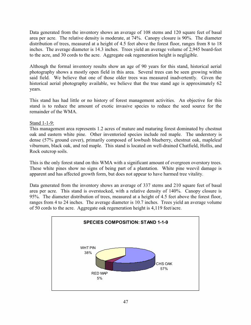
47
Data generated from the inventory shows an average of 108 stems and 120 square feet of basal area per acre. The relative density is moderate, at 74%. Canopy closure is 90%. The diameter distribution of trees, measured at a height of 4.5 feet above the forest floor, ranges from 8 to 18 inches. The average diameter is 14.3 inches. Trees yield an average volume of 2,945 board-feet to the acre, and 30 cords to the acre. Aggregate oak regeneration height is negligible. Although the formal inventory results show an age of 90 years for this stand, historical aerial photography shows a mostly open field in this area. Several trees can be seen growing within said field. We believe that one of those older trees was measured inadvertently. Given the historical aerial photography available, we believe that the true stand age is approximately 62 years. This stand has had little or no history of forest management activities. An objective for this stand is to reduce the amount of exotic invasive species to reduce the seed source for the remainder of the WMA. Stand 1-1-9: This management area represents 1.2 acres of mature and maturing forest dominated by chestnut oak and eastern white pine. Other inventoried species include red maple. The understory is dense (57% ground cover), primarily composed of lowbush blueberry, chestnut oak, mapleleaf viburnum, black oak, and red maple. This stand is located on well-drained Chatfield, Hollis, and Rock outcrop soils. This is the only forest stand on this WMA with a significant amount of evergreen overstory trees. These white pines show no signs of being part of a plantation. White pine weevil damage is apparent and has affected growth form, but does not appear to have harmed tree vitality. Data generated from the inventory shows an average of 337 stems and 210 square feet of basal area per acre. This stand is overstocked, with a relative density of 140%. Canopy closure is 95%. The diameter distribution of trees, measured at a height of 4.5 feet above the forest floor, ranges from 4 to 24 inches. The average diameter is 10.7 inches. Trees yield an average volume of 50 cords to the acre. Aggregate oak regeneration height is 4,119 feet/acre.
SPECIES COMPOSITION: STAND 1-1-9
CHS OAK57%
RED MAP5%
WHT PIN38%

48
This stand has had little or no history of forest management activities. An objective for this stand is to retain a maximum number of white pine trees over time, likely through forest stand improvement thinning to reduce the amount of maple and oak. STAND 2-1-1: Stand 2-1-1 represents 40.5 acres of mature and maturing forest dominated by upland oak. Upland oaks include chestnut oak, red oak, black oak, and white oak. Other inventoried species include sugar maple, red maple, and black birch. The understory is moderate (39% ground cover), primarily composed of lowbush blueberry, mapleleaf viburnum, shadbush, various hickories, and chestnut oak. This stand is located on well-drained Hollis, Rock outcrop, and Chatfield soils.
Data generated from the inventory shows an average of 136 stems and 92 square feet of basal area per acre. Relative density is moderate, at 74%. Canopy closure is 68%. The diameter distribution of trees, measured at a height of 4.5 feet above the forest floor, ranges from 2 to 24 inches. The average diameter is 11.2 inches. Trees yield an average volume of 2,995 board-feet to the acre, and 23 cords to the acre. Aggregate oak regeneration height is 4,586 feet/acre. Management history within this stand is unclear. Some stumps were observed within this stand. The relatively open nature of the forest suggests a combination of factors including light thinning and gypsy moth mortality. An objective for this stand is to release quality advance regeneration in a sustainable manner to increase the diversity of age classes present on the WMA, and to encourage additional advance regeneration in areas of this stand where currently inadequate. Management is currently constrained by the presence of several small inholdings, quality access to this block would need to be arranged with an adjacent private landowner, and said access might involve a stream crossing. Stand 2-1-2: This mapping unit represents 9.2 acres of mature trees dominated by black birch and sugar maple. Other inventoried species include tulip poplar and white ash. The understory is moderate (37% ground cover), primarily composed of sugar maple, Canada mayflower, white ash, smooth Solomon’s seal, and white wood aster. This stand is located on rocky Rockaway, Chatfield, Rock outcrop, and Alden soils.
SPECIES COMPOSITION: STAND 2-1-1
RED OAK19%
WHT OAK6%
BLK OAK11%
CHS OAK38%
SUG MAP16%
RED MAP5%
BLK BIR5%

49
Data generated from the inventory shows an average of 467 stems and 160 square feet of basal area per acre. Relative density is very high, at 99%. Canopy closure is 95%. The diameter distribution of trees, measured at a height of 4.5 feet above the forest floor, ranges from 2 to 24 inches, with occasional larger trees ranging up to 34 inches. The average diameter is 7.9 inches. Trees yield an average volume of 2,646 board-feet to the acre, and 39 cords to the acre. Aggregate oak regeneration height is negligible. Management history within this stand is unclear. Some small stumps were observed within this stand. Generally closed canopy conditions and moderately high relative density reflects this history. An objective for this stand is to manage it for shade-tolerant species using uneven-aged methods, such as group selection harvests. Stand 2-1-3: This stand represents 6.8 acres of riparian forest dominated by white ash and sugar maple. Other inventoried species include red maple. The understory is dense (91% ground cover), primarily composed of Japanese stiltgrass, Virginia creeper, Jack in the pulpit, hogpeanut, and poison ivy. This stand is located on rocky Hibernia soils.
SPECIES COMPOSITION: STAND 2-1-2
TUL POP6%
SUG MAP32%
BLK BIR56%
WHT ASH6%
SPECIES COMPOSITION: STAND 2-1-3
WHT ASH46%
SUG MAP39%
RED MAP15%

50
Data generated from the inventory shows an average of 272 stems and 130 square feet of basal area per acre. Relative density is moderate, at 79%. Canopy closure is 75%. The diameter distribution of trees, measured at a height of 4.5 feet above the forest floor, ranges from 4 to 20 inches. The average diameter is 9.4 inches. Trees yield an average volume of 1,400 board-feet to the acre, and 29 cords to the acre. Aggregate oak regeneration height is negligible. This wetland stand did not receive any forestry activity in recent years. An objective for this stand is to manage it for the benefit of wildlife dependent on forested wetlands, with consideration to be made regarding the control of Japanese stiltgrass. 2.10 High Conservation Value (HCV) Forests When considering whether any portion of this WMA would qualify as an HCV forest, the Division reviewed the most recent High Conservation Value Forest Assessment Framework (FSC-US, 2010). As a result of the review of this framework in the light of the forest inventory and other resources previously discussed, it was determined that no HCV forests currently exist on this WMA. Some areas of HCV exist near this WMA and are identified by the Office of Natural Lands Management as Natural Heritage Priority Sites with rankings of B3 or higher (e.g. Pine Swamp within the Mahlon Dickerson Reservation). After having reviewed the framework, it is entirely possible that the early successional habitat created by following the recommendations of this Plan may result in the creation of HCV forest, owing to the improvement of biodiversity within these areas. It is therefore recommended that in addition to any monitoring protocols suggested later in this Plan, that the Division’s Endangered and Nongame Species Program and the Office of Natural Lands Management conduct an analysis of said areas at 4 years post-activity in consultation with the Division to determine if HCV occurs in these areas as specifies within the FSC-US framework. If HCV is determined to be present, this Plan may be amended to detail how those values would be maintained, enhanced, and monitored. 2.11 Landscape Description and Findings As part of the resource assessment of this Plan, the landscape surrounding this WMA was examined to provide a landscape-scale assessment. By examining landscape-scale forest resources, the Division aims to adequately plan for ecosystem-level issues that may be overlooked if the only property- or stand-scale needs are addressed. Questions asked included, but were not limited to:
� Is this property unique within the landscape in ways other than defined within HCV forest framework (i.e. is the landscape dominated by agriculture and/or development making this property an island within an otherwise severely fragmented forest ecosystem)?
� Is the type of habitat required by focal species (GWWA and other early-successional species) common or rare within the landscape? If so, does this suggest other issues other than habitat creation should be addressed?
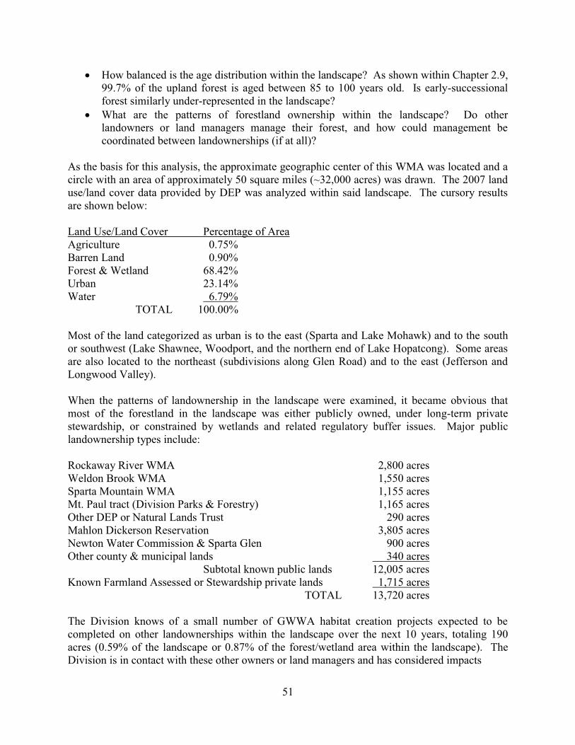
51
� How balanced is the age distribution within the landscape? As shown within Chapter 2.9, 99.7% of the upland forest is aged between 85 to 100 years old. Is early-successional forest similarly under-represented in the landscape?
� What are the patterns of forestland ownership within the landscape? Do other landowners or land managers manage their forest, and how could management be coordinated between landownerships (if at all)?
As the basis for this analysis, the approximate geographic center of this WMA was located and a circle with an area of approximately 50 square miles (~32,000 acres) was drawn. The 2007 land use/land cover data provided by DEP was analyzed within said landscape. The cursory results are shown below: Land Use/Land Cover Percentage of Area Agriculture 0.75% Barren Land 0.90% Forest & Wetland 68.42% Urban 23.14% Water 6.79% TOTAL 100.00% Most of the land categorized as urban is to the east (Sparta and Lake Mohawk) and to the south or southwest (Lake Shawnee, Woodport, and the northern end of Lake Hopatcong). Some areas are also located to the northeast (subdivisions along Glen Road) and to the east (Jefferson and Longwood Valley). When the patterns of landownership in the landscape were examined, it became obvious that most of the forestland in the landscape was either publicly owned, under long-term private stewardship, or constrained by wetlands and related regulatory buffer issues. Major public landownership types include: Rockaway River WMA 2,800 acres Weldon Brook WMA 1,550 acres Sparta Mountain WMA 1,155 acres Mt. Paul tract (Division Parks & Forestry) 1,165 acres Other DEP or Natural Lands Trust 290 acres Mahlon Dickerson Reservation 3,805 acres Newton Water Commission & Sparta Glen 900 acres Other county & municipal lands 340 acres Subtotal known public lands 12,005 acres Known Farmland Assessed or Stewardship private lands 1,715 acres TOTAL 13,720 acres The Division knows of a small number of GWWA habitat creation projects expected to be completed on other landownerships within the landscape over the next 10 years, totaling 190 acres (0.59% of the landscape or 0.87% of the forest/wetland area within the landscape). The Division is in contact with these other owners or land managers and has considered impacts
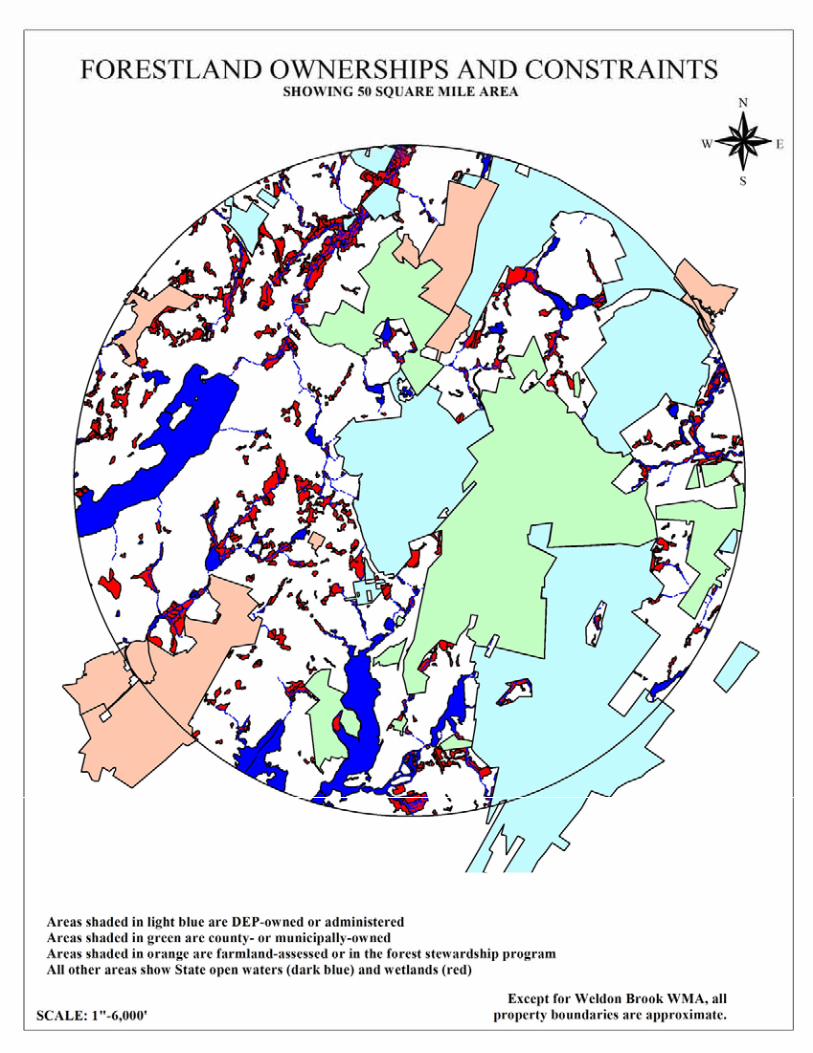

53
associated from edge effects from those activities. Approximately 37 acres of GWWA habitat is known to have been created in this area since 2007, and is therefore not included within the 2007 Land Use/Land Cover data set. When the Division examined the amount of known habitat available to GWWA within the landscape, it examined areas identified within the 2007 Land Use/Land Cover GIS data layer as Deciduous Brush/Shrubland, Deciduous Forest (10-50% canopy closure), Mixed Scrub/Shrub, Mixed Forest (10-50% canopy closure), and Old Field (<25% brush). The total area of all of these areas is 831 acres (2.60% of the landscape or 3.80% of the forest/wetland area within the landscape). In order to provide a context for these figures, suppose that the upland forested area within the landscape (18,285 acres) were dedicated to old-growth management (33% of the upland forested area or 6,095 acres) and the remainder otherwise evenly distributed between age classes between 0 and 100 years. Under such a scenario, 2,438 acres would be considered early successional upland forest (7.62% of the landscape or 11.16% of the forest/wetland area within the landscape). A variety of different factors may also be considered when evaluating the data above. First, other types of categories within the Land Use/Land Cover data may be incorporated into GWWA habitat, such as Upland Rights of Way (Undeveloped), Deciduous Shrub/Scrub Wetlands, Herbaceous Wetlands, Mixed Shrub/Scrub Wetlands, and Wetland Rights of Way. However, these areas may lack the vertical structure necessary for GWWA, or may be too wet for GWWA nesting. Some of these areas (as well as the potentially suitable upland areas described previously) may be located outside of the forest matrix necessary for critical GWWA habitat as explained in Chapter 2.3.1. In addition, assuming a normal age distribution within the potential identified upland early successional forest, 50% of said area (415 acres) is expected to mature into mid-successional forest during the term of this Plan. Based on this information, early successional habitat is judged to be significantly underrepresented in the landscape, and maturing significantly faster than it is being replaced. Although a complete forest inventory of the landscape is far beyond the scope of this Plan, the Division has examined forest inventories of adjacent properties and historic aerial photography and has determined that the vast majority of the upland forest in the core of this landscape is 90 years old (+/- 10 years). 2.12 Stakeholder and Public Review and Comment on the Assessment and Plan Stakeholder input was solicited regarding resources of concern. This Plan is posted on the Division’s website for access by the public and comment through the Division’s Bureau of Land Management. Public comment is accepted through the Division’s website.

54
3.0 Land Management Area Guidelines This chapter contains descriptions of common silvicultural prescriptions, considerations made during the planning process regarding certain protected or important resources, and a description of the broad categories of land management that will be utilized on this WMA. For a detailed description of forest management recommendations, please see the Forest Management chapter. 3.1 Deer Herbivory Considerations All living things have a life expectancy. While the oaks that dominate the vast majority of this WMA can attain ages of several hundred years, this is true only for the most healthy and dominant trees within a given forest. It is the current understanding that many such trees have already been removed from the forest as a result of past gypsy moth infestations or selective logging. As such, the remaining forest contains a significant number of trees of undesirable growth form, trees that have rot and other structural issues, and those trees that were once in the intermediate or overtopped growth classes, and thus have lower vitality, growth rates, and secondary metabolic compounds contained in the wood and foliage that would work to repel fungal and insect diseases. In addition, the gypsy moth infestations of the 1970’s and 1980’s, combined with a high deer population can promote an increased amount of black birch, red maple, and black gum in a given forest. When planning regeneration harvests, foresters and other land managers often use predictive models for assessing current vegetation as a future indicator of the type of forest that will result from given activities. Such models usually require multiple inputs to assess the quantity and quality of regeneration from seed origin, expected regeneration from stump-sprout origin, and other vegetation present including competing understory vegetation. The most useful of these models in this region have focused on aggregate seedling height: the total height of desirable regeneration in a given area. Aggregate seedling height of preferentially-browsed species, such as oak, can be used as a proxy for deer herbivory impact (or the lack thereof) in the absence of other measurements. Several scientific, peer-reviewed sources contain predictive models and guidelines for regenerating oak forest in the Central Appalachian region, and thus serve as excellent guides for determining outcomes based on present inventory data (Steiner et al, 2008; Gould, 2005; Brose et al, 2008). Data collection methods included that data necessary to utilize the predictive models that would be employed prior to harvest in order to greatly increase the probability of regeneration success in the light of difficulty with regeneration oak-dominated forests in regards to competing vegetation and deer herbivory. Based on the aforementioned studies, and anecdotal information from foresters and conservationists in New Jersey, it has been shown that it is crucial that advance regeneration be present prior to overstory removal. Surveys of competing vegetation, including rhizomous ferns, exotic invasive plants, mountain laurel, and others were minimal in Stand 1-1-2, somewhat elevated in Stand 1-1-1, and moderately high in Stand 1-1-3. Furthermore, aggregate oak regeneration height was excellent in Stands 1-1-2 and 2-1-1, low in Stand 1-1-1, and non-existent in Stand 1-1-3. Stand 1-1-3

55
already has a very low oak component and is likely unsuitable for major oak regeneration in the future. While it is important to remember that the aforementioned studies were specifically developed for pre-harvest planning, and that the data collected during this forest inventory was across entire stands, entering the data into the model provides some generalized results. Results of the models suggest that Stands 1-1-2 and 2-1-1 can be easily regenerated into a well-stocked oak forest with little more than a simple overstory removal. Should Stand 1-1-2 be considered for regeneration, and the Division desire its replacement with another oak-dominated forest, the models would suggest understory vegetation treatment (discussed later), deer exclusion fencing, and intermediate cutting to improve light conditions to the forest floor or a shelterwood cut. It is strongly recommended that pre-harvest data collection in accordance with protocols mentioned in the studies be accomplished during pre-harvest planning in order to guide future management. 3.2 Exotic Invasive Plants and Other Competing Vegetation Considerations According to the forest inventory, exotic invasive plants are present only within small areas of this WMA. Given the highly invasive nature of many of these plants and large areas of significant soil moisture on this WMA, this situation is expected to deteriorate over time unless control measures are taken. Other competing understory vegetation was also observed on this WMA, and has been taken into consideration using predictive models as described above. Further discussion of competing vegetation is found below. 3.3 Common Silvicultural Prescriptions Competing understory vegetation control During the course of this inventory, small amounts of exotic invasive plants including garlic mustard, Japanese barberry, multiflora rose, Oriental bittersweet, Japanese stiltgrass, ailanthus, phragmites, mugwort, and Japanese angelica tree (Aralia elata) were observed in portions of Stands 1-1-1, 1-1-2, 1-1-3, 1-1-4, 1-1-6, 1-1-7, 1-1-8, 2-1-2, and 2-1-3, as well as in areas within the utility rights-of-way. These plants have the potential to seriously degrade the integrity of the ecology of the forest understory, degrade the recreation value within affected areas, prevent forest regeneration, and restrict access into sections of the property. Having evolved outside of North America, these plants have few, if any, natural enemies, and thus can spread unchecked. In addition, most are seldom browsed by white-tail deer. While these exotic invasive species have taken residence within a closed canopy forest, additional openings of the forest canopy in areas where these plants have become established will dramatically increase their growth, seed production, and thus further propagation within the forest. In addition, certain native understory plants can also cause difficulties with properly regenerating a given forest stand. Such plants include various rhizomous ferns, mountain laurel, and other
56
plants that are creating unfavorable shade conditions or otherwise competing with desirable vegetation. Control of such vegetation could take several forms depending on the severity of the problem. For areas with minor (<15% cover) non-native and native non-fern understory competition problems, selective herbicide treatment would be appropriate. Such selective herbicide treatment could be foliar, basal, or cut-stump method, and could be accomplished without heavy machinery. Two weeks after application, these areas should be reviewed for effectiveness and, if necessary, be retreated. Further evaluation should take place 3 years after the initial application. For upland areas with major (>30% cover) non-native understory competition, mechanical treatment followed by a selective herbicide treatment would be appropriate. Such treatment would consist of cutting said vines and brush, ideally during the late spring. This would be followed by foliar herbicide application, ideally between the late summer and the first frost. By spraying only the undesirable vegetation that has resprouted, the amount of herbicide needed and the potential for affecting desirable vegetation will be greatly reduced. Broadcast herbicide would only be appropriate in very limited circumstances, such as major rhizomous fern competition problems over at least 5 acres. Similarly, large-scale mowing should only be utilized in very limited circumstances, such as major non-native competition problems over at least 5 acres, in coordination with herbicide application during or after mowing. To the extent practical, the Division will utilize biological controls for competing vegetation so long as such controls can be expected to reliably control such vegetation within the schedule provided within this Plan. The Division may utilize any EPA- and DEP-approved herbicide in accordance with its label, and whatever methods described on such label, as long as that chemical is not listed on the Highly Hazardous Chemicals list maintained by the Forest Stewardship Council or another similar list maintained by another third-party verification system. This Plan is not a replacement for sound judgment of Division staff, and cannot describe every possible scenario that may be encountered on this WMA, in terms of percent cover and species, presence of wetlands, excessive rockiness of soils, and condition of adjacent desirable vegetation. A pre-application inventory will be conducted during the growing season to ensure that no protected plants are located within any suggested herbicide application area. Forest stand improvement thinning Portions of this WMA currently support maturing to overmature upland hardwoods that are fully stocked, where higher-quality, more desirable trees are competing with inferior trees for essential growth needs, principally sunlight. Such extensive competition between trees in the canopy may be creating low-light conditions on the forest floor, limiting the amount of regeneration and other plant growth. This would include Stands 1-1-1, 1-1-2, 1-1-3, 1-1-4, 1-1-5, 1-1-8, 1-1-9, 2-1-1, 2-1-2, and 2-1-3. Forest management can work toward improving growth conditions of these sites through a forest stand improvement program. This program works toward improving growth conditions in a manner similar to weeding a garden, although on a

57
much larger scale. The selective removal of undesirable trees (such as some of those that are dying, deformed and diseased), or trees spaced too closely together, helps to channel growth potential to the higher quality, more desirable trees and create improved light conditions to the forest floor. Desirable species are those that would be the most beneficial for focal species. More specifically, management should work toward favoring higher quality oak, shagbark hickory and sugar maple trees, as well as other well-formed, desirable trees or select trees with high wildlife value, through the selective cutting of inferior red maple, black birch, and other poor trees. Vines that are interfering with the growth of higher quality trees should be controlled by cutting at the lower stem base. Other native vines should be designated for wildlife habitat. As a result of the thinning process, the residual stand of trees will be of higher quality, will be better spaced, and will be able to grow with greater efficiency. As more sunlight is captured by the foliage, more secondary metabolic compounds are produced, many of which assist the tree or plant in defense mechanisms against pathogens and pests. Additionally, the more energy generated by the tree, the more seeds it will produce. This is particularly important for wildlife dependent on hard mast such as acorns. The timber stand improvement program should be applied with a target of a reduction in relative density by at least 10%, or to the level of relative density at the “B” line of the appropriate stocking guide. Trees to be cut should be marked by foresters to assure that only the necessary trees and/or volumes are removed, and to assure that a diversity of species is maintained for forest health and wildlife habitat. Trees that are suitable for firewood can be removed and sold, while wood that is unsuitable as firewood, can be felled and left to decompose and return nutrients to the forest soils, or be chipped for mulch. However, it is highly likely that forest stand improvement programs within this WMA will be non-commercial, meaning that no wood will be sold or removed as a result. The timing of such a program will ultimately depend upon wildlife considerations, available markets, labor, equipment, soil conditions, access and the volume of wood marked in each unit. Girdling, instead of felling, is an acceptable form of forest stand improvement. However, felling would still be recommended for certain species, such as red maple, that are resistant to girdling techniques. Individual tree selection harvest Portions of this WMA currently support maturing to overmature upland hardwoods that are fully stocked, where higher-quality, more desirable trees are competing with inferior trees for essential growth needs, principally sunlight. Such extensive competition between trees in the canopy may be creating low-light conditions on the forest floor, limiting the amount of regeneration and other plant growth. Some of the trees desired for removal may have significant economic value. This would include Stands 1-1-1, 1-1-2, 1-1-3, 1-1-4, 1-1-9, 2-1-1, and 2-1-3. The opportunity exists to continue to selectively harvest trees for timber during the course of this Plan in the form of an individual tree selection system. Many of the dominant and codominant trees are mature and have now begun to exceed both economic and physical development. Once maturity is reached, growth is slowed and trees become more susceptible to fungal rot, insect infestations, disease and storm damage.
58
A timber harvest using the individual tree selection system would entail the harvest of approximately 7 to 9 trees per acre. At this level of removal, additional sunlight will become available to residual trees and will also allow limited additional sunlight to the understory for new trees and understory plants to grow. However, given the past management history that has strongly relied on similar harvests, and a primary objective of the Division being to encourage a wide diversity of age classes within this WMA, this harvest system is of limited utility. Potential uses of this system may include selective harvest of sugar maple from Stand 1-1-1 to improve conditions for residual oak trees and future oak regeneration, as well as a one-time harvest within areas designated for old-growth habitat in order to create the necessary forest structure. If timber sales are suitable, trees would be individually marked and measured by foresters to assure that only the necessary trees are included in the harvest. The Division would provide for solicitation of bids, contract preparation, collection of timber fees and inspection of work in progress. Group selection harvest A group selection harvest would work to harvest both timber and firewood within areas of 0.1 acre to 1 acre to allow for complete openings within the forest canopy which would be more favorable for understory regeneration than either forest stand improvement or individual tree selection harvests. Openings would also filter more sunlight into adjacent forested areas. Such a system would be beneficial for forest health and certain wildlife considerations on the property. With the group selection program, some superior trees can be left for aesthetics and seed source. Group selection harvests are of somewhat limited utility on this WMA, given that the focal wildlife species, GWWA, usually requires larger early-successional habitat. However, some situations where group selection harvests may be appropriate would include cutting within a riparian buffer management area adjacent to suitable wetland habitat for GWWA, uneven-aged management of shade-tolerant tree species within Stands 1-1-3 and 2-1-2, a one-time cutting within an area designated for old-growth habitat to release advance regeneration or for the promotion of protected species, and limited disturbance of forest canopy for wildlife purposes within a forested wetland area (Stands 1-1-4 and 1-1-5). If timber sales are suitable, trees would be individually marked and measured by foresters to assure that only the necessary trees are included in the harvest. The Division would provide for solicitation of bids, contract preparation, collection of timber fees and inspection of work in progress. Shelterwood harvest The primary purpose of a shelterwood harvest is to regenerate the forest by creating or providing favorable conditions for saplings, seedlings, and stump sprouts. The goal of such a harvest would be to create a new age class of moderately shade-intolerant tree species, such as oak, and in doing so create habitat for wildlife dependent on early-successional forests. Individual

59
shelterwood harvest sites can range in size from two to forty acres. Shelterwood harvests are generally carried out in two steps. The first cut of the shelterwood method involves cutting the overstory in such a way as to reduce relative density to between 55% and 60%. Care will be taken during the harvest to cut shade-tolerant, undesirable trees prior to cutting desirable trees, so that the residual overstory will be of adequate genetic quality to provide a good seed source for future regeneration. Competing understory vegetation may also be treated and deer exclusion fencing may be considered, in accordance with pre-harvest planning utilizing the Gould model and Division and other professional expertise. The second cut of the shelterwood method would occur years after the first, once advance regeneration has been deemed acceptable for release. Traditionally, the second cut of the shelterwood harvest would completely remove the residual overstory. A variant on the second cut of the shelterwood method could be used, particularly in Golden-winged warbler management areas where a planned harvest may include an area where the nearest edge is more than 250 feet away. This variant method would involve girdling or felling much of the residual overstory trees, while retaining enough residual trees to meet BMP’s or other accepted GWWA habitat recommendations, and also Indiana bat considerations. If timber sales are suitable, trees would be individually marked and measured by foresters to assure that only the necessary trees are included in the harvest. The Division would provide for solicitation of bids, contract preparation, collection of timber fees and inspection of work in progress. Modified seed tree harvest The primary purpose of a seed tree harvest is to regenerate the forest by providing favorable conditions for saplings, seedlings, and stump sprouts of shade-intolerant species, such as tulip poplar, while retaining enough trees to provide a seed source for new seedling growth. Individual seed tree harvest sites can range in size from two to forty acres. The seed tree harvest involves cutting to reduce the overstory to an average of 8 to 12 trees per acre. Care will be taken during the harvest to cut shade-tolerant, undesirable trees prior to cutting desirable trees, so that the residual overstory will be of adequate genetic quality to provide a good seed source for future regeneration. Residual trees would be selected on the basis of excellent health and crown quality to ensure post-harvest survival and maximum seed production. Competing understory vegetation may also be treated and deer exclusion fencing may be considered, in accordance with pre-harvest planning utilizing the appropriate models and Division and other professional expertise. Desirable species are those that would be the most beneficial for focal species. It is possible to harvest residual overstory trees once advance regeneration has been deemed acceptable. However, epicormic sprouting on the trunks of residual trees may reduce wood quality to make this unfeasible.

60
A variant on the seed tree harvest could be used, particularly in Golden-winged warbler management areas where the quality of advanced regeneration is such that an overstory removal is recommended under the Gould model, and a planned harvest may include an area where the nearest edge is more than 250 feet away. This modified seed tree harvest would retain enough residual trees to meet BMP’s or other accepted GWWA habitat recommendations, and also Indiana bat considerations. In doing so, slightly more trees per acre would be retained than under a normal seed tree harvest. If timber sales are suitable, trees would be individually marked and measured by foresters to assure that only the necessary trees are included in the harvest. The Division would provide for solicitation of bids, contract preparation, collection of timber fees and inspection of work in progress. 3.4 Forested Wetlands Considerations 3.4.1 Vernal pools For a background regarding vernal pools, and a discussion of vernal pool resources on this WMA, please see Chapter 2.3.4 and Chapter 2.8. In regards to forest management, a wealth of information exists concerning vernal pools in proximity to forestry activities and how to minimize impacts. Vernal pools surrounded by at least 70% coverage of forest with 70% canopy closure (at least within 328 feet of the high-water mark) will likely persist longer than pools with greater canopy removal and will provide better habitat for terrestrial adults (DiMauro and Hunter 2002). There is a complete review of pre-1995 literature by deMayandier and Hunter (1995). Additional information regarding impacts of forest management can be found in Windmiller (1996), deMaynadier and Hunter (1999), and Fox et al (in Guldin, ed. 2004). Finally, the 70%/70% recommendations of DiMauro and Hunter were accepted by the Commonwealth of Massachusetts’ Natural Heritage and Endangered Species Program as their forestry Best Management Practices for vernal pools (NHESP 2007). Forest management should follow the Best Management Practices set forth in Calhoun and deMaynadier (2004). Specifically, a “protection zone” in which minimal tree cutting is permitted should be delineated from 0 to 100 feet from the edge of the vernal pool, and an “amphibian life zone” in which 75% of the forest cover should be retained should be delineated from 100 to 400 feet from the edge of the vernal pool. Of the retained forest cover within the amphibian life zone, canopy closure should be 70% or higher. 3.4.2 Forested wetlands Freshwater wetland areas, transition areas, riparian areas, and floodplain areas are protected in New Jersey by the Freshwater Wetlands Protection Act of 1987, and also by the Flood Hazard Area Control Act. Forestry and silvicultural activities are exempted under these Acts (or have permits-by-rule under regulations promulgated under these Acts) provided that forestry activities follow a Forest Stewardship Plan or woodland management plan approved by the State Forester, and the provisions set forth in the New Jersey Forestry and Wetlands Best Management Practices Manual (Cradic 1995) are followed. These practices guide management within

61
wetland and other regulated areas in order to prevent impact or help limit the impact on a wetland site. Recommended practices which help minimize impact on wetlands during forest management include the creation of streamside management zones, well-timed tree removal, and careful planning of stream crossings. Streamside management zones, where limited tree cutting and mechanized activity occurs, should be observed along streams, ponds, and emergent wetlands in order to protect and stabilize stream banks. The felling or girdling of trees can occur at any time throughout the year, however, removal of wood products should be timed when soils are driest in the late summer and early fall, or when frozen in winter (unless otherwise constrained by protected wildlife considerations). The crossing of brooks and streams should be avoided. However, if stream crossing is the only option for wood removal, it should be timed when the water flow is at its lowest, or frozen, and where the banks are low and the steam bed is firm and rocky. If the potential exists for the erosion of silt into water resources, hay bales should be placed where needed temporarily into streams to filter out sediment. Filling in, or changing the drainage of a wetland area for whatever reason is not exempt under the forestry clause of the Freshwater Wetlands Protection Act. Proper forest management executed during optimal seasons and using best management practices can benefit the health of the forest and the stability of the wetlands ecosystem as a whole. Managed forests help to protect wetland areas by providing a healthier group of trees which are better able to prevent soil erosion, aid in water and air purification, help maintain water temperature, and provide food and habitat to wildlife populations. Carefully planned forestry activities can work to benefit wetlands and the surrounding ecosystems. The following are answers to the requirements listed within pages vii-viii of the New Jersey Forestry and Wetlands Best Management Practices Manual. A copy of the most recent version (1995) of this manual has been given to the owner, and is available at www.state.nj.us/dep.
1) See the cover page of this Plan. 2) Same as #1. 3) Not applicable. 4) See Woodland Vegetation Map for (a), (b), (e), and (g). See Soils section and Soils Map
for (c) and (d). Not applicable for (f). Please note that future timber harvests will be addressed in Practice Plans, which will describe the location of any loading decks or proposed skid trails.
5) See Forest Management section of this Plan. Please note that future timber harvests will be addressed in Practice Plans, which will describe the precise volumes and descriptions of wood being sold.
6) See Forest Management section of this Plan. 7) See Forest Management section of this Plan and Harvest Schedule Map. Please note that
future timber harvests will be addressed in Practice Plans, which will describe the exact location of future harvests.
8) Seed trees will be marked in paint with a large “S” on at least two faces using orange tree marking paint at DBH, and on at least one point on the base of the tree in the same manner, unless stated otherwise in the Practice Plan.
9) The individual BMP’s to be used include:
62
a) Streamside Management Zones (Section I). Hereafter “SMZ” shall uniformly be 70 feet from the streambank, or edge of pond or marsh, thus meeting or exceeding the recommended requirement. Except for utilizing currently existing forest roads or skid trails, machinery shall not enter SMZ. The sole exception shall be SMZ within Golden-winged warbler management areas at the edge of Stand 1-1-6 or non-Category-1 streams. There, pre-harvest planning will determine the minimum SMZ allowable, with filter strips (brush barriers) to be included in the design if necessary. To the maximum extent practicable, machinery shall not enter the aforementioned SMZ.
b) Filter Strips (Section II), as needed, particularly including brush barriers as described above. The establishment of SMZ will also create a natural filter strip.
c) Stream Crossings (Section III), as needed, to be planned as dictated by recommendations 1 – 15 in the manual, and will utilize the five existing culverts, and ten existing stream crossings as shown on the Woodland Vegetation Map. In addition, several culverts are present within the former railroad bed.
d) Access Roads (Section IV), existing access roads will be used as much as possible. The majority of new forest access within riparian and wetland buffer areas shall be temporary in nature. Any new forest access will not be placed in between a vernal pool and its nearest wetland. The creation of new access roads shall follow recommendations 1-28 in the manual.
e) Timber Harvesting (Section V), will be addressed, as needed, in Annual Work Plans to filed prior to such a harvest.
f) Site Preparation (Section VI), if needed, would follow recommendations 1, 2, 9, 10, 11, 12, 13, and 14. Sections 3, 4, 5, 6, 7, and 8 deal specifically with drum chopping and site prep on extensive areas, which are not applicable in this case.
g) Forest Pesticides (Section VII), applications will follow recommendations 1 – 10 in the manual.
h) Reforestation (Section VIII), if needed, will follow recommendations 1 – 5 in the manual.
i) Forest Protection (Section IX), deals with prescribed fire, which this Plan does not recommend within areas affected by forestry and wetlands Best Management Practices.
10) See Protected Species Considerations section of this Plan. 11) There will be no impact on reach and flow of any water courses. See paragraph 3 of this
section for further recommendations. 12) See paragraph 1 of this section and the Woodland Vegetation Map of this Plan.
3.4.3 Riparian areas For the purposes of this section, please note that riparian area is used as the phrase is commonly understood (a terrestrial area of variable width adjacent to and influenced by a perennial or intermittent body of water), not as defined by current regulations under the Flood Hazard Area Control Act. Considerations regarding riparian areas were discussed in-depth in the previous subsection. However, given that riparian areas serve certain distinct functions related to water quality than many wetland buffers, it is necessary to elaborate further.


66
The primary goal of riparian forest buffers in this WMA is to maintain and improve the quality of water flowing into the streams and rivers of the NJ Highlands. Riparian forests also provide critical habitat that is an essential element of the associated aquatic ecosystem and the diversity of wildlife that utilizes riparian areas, some of which are highly dependent on disturbances in or near riparian areas. Therefore, the management goals for riparian forest buffers are:
1) To remove sediments, nutrients, and other potential pollutants from surface and groundwater flows;
2) To maintain shade cover for streams and aquatic systems to regulate temperature and dissolved oxygen;
3) To provide a source of detritus and woody debris for aquatic systems; 4) To provide riparian habitat and travel corridors for wildlife; and, 5) To maintain or establish native plant communities.
In developing the land management areas described later in this chapter, significant consideration was given to placing all or most of the riparian areas associated with Category 1 waters into areas designated for future old growth forest. Additional consideration was given to connectivity between different watersheds to facilitate and conserve wildlife corridors between the Wallkill River watershed and the Weldon Brook watershed. Conversely, the known locations of GWWA were considered when choosing which riparian areas would be located within Golden-winged warbler management areas. Regardless of the management area in which a given riparian area is placed, forestry and wetlands Best Management Practices will be followed in order to protect water quality. 3.5 Wildlife Considerations Golden-winged warbler considerations For a further description of GWWA habitat and resources, please refer to Chapter 2.3.1. The known locations of GWWA were considered when choosing what land would be located within Golden-Winged Warbler Management Areas. Lands within 0.2 miles of locations were given very strong priority, lands within 1 mile of locations were given high priority, and lands within 2 miles of locations were given medium priority. Areas where 70% of the landscape within ½ mile are considered forest (including utility rights-of-way) were given high priority. It is the opinion of the Division’s Endangered and Nongame Species Program that having wetland areas (Stands 1-1-4, 1-1-5, 1-1-6, and 2-1-3 on this WMA) within or immediately adjacent to GWWA project areas will increase the likelihood of GWWA using the area to breed in the absence of blue-winged warblers. Competition and hybridization between the two species are believed to be significant factors to the GWWA decline. Thus, lands within 500 feet of said stands were given high priority. Lands within 100 feet of vernal pools were removed from consideration.

67
Pre- and post-harvest planning for timber harvests or other habitat manipulation will follow Best Management Practices or the most recent and relevant scientific information available regarding GWWA. Indiana bat considerations For a further description of Indiana bat habitat and resources, please refer to Chapter 2.3.2. In accordance with recommendations made by the US Fish & Wildlife Service, at least 16 suitable roost trees per acre (on average) will remain within any harvest area greater than one acre. (This shall not apply to group selection harvests ranging between 0.1 acre and 1 acre.) Please note in accordance to the description of roost trees in Chapter 2.3.2, that certain dead trees and trees less than 9 inches could qualify as suitable roost trees. In Golden-Winged Warbler Management Areas, an average of 15 suitable roost trees per acre shall be living trees and an average of one suitable roost tree per acre shall be dead or less than 9 inches. This shall be accomplished to conform with GWWA BMPs. Forest interior bird considerations For a further description of forest interior bird habitat and resources, please refer to Chapter 2.3.3. When planning which lands would be contained within the Future Old Growth Forest Management Area, consideration was given to habitat requirements for forest interior birds. Specifically, high priority was placed on having a Future Old Growth Forest Management Area of at least 285 acres, in accordance with the objectives of this Plan. When planning the geometry of said management area, the same priority was given to interior forest habitat (forest at least 300' from nearest edge) comprising at least 25% of the Future Old Growth Forest Management Area. Since the sites to be managed for GWWA habitat are small relative to the surrounding forest and understory and residual overstory trees will remain in these areas, the negative aspects of edge effects on the forest and forest interior songbirds will be minimal, temporary, and diminish as the sites regenerate. Other rare, threatened, or endangered species considerations For a further description of said species habitat and resources, please refer to Chapters 2.3 through 2.3.7. Known occurrences of rare, threatened, or endangered species were considered when planning which lands would be included in the various land management areas, depending on the specific habitat needs of the species. Searches for protected fauna and flora were not conducted in Stands 1-1-5 and 1-1-6 as part of the forest inventory, but may have been done as part of other Division monitoring efforts. If forestry or other wildlife management activities are to be carried out in these stands, then recent records of Division monitoring activities should be inspected to determine if such a search of

68
said area has been made. If not, a pre-activity search should be made for likely species in accordance with generally accepted practices. This is particularly important for possible bronze copper populations. When planning which lands would be included in the Future Old Growth Forest Management Area, high priority was given to forestlands surrounding Blue Heron Lake to conserve potential bald eagle habitat. When planning which lands would be included in the General Forest Management Area and Golden-Winged Warbler Management Area, areas of significant rock outcrops were given medium priority in order to encourage ideal habitat for timber rattlesnakes. When planning future competing understory vegetation control, consideration was given to retaining nearby dense, native brush to conserve bobcat habitat. Bobcat habitat will also be improved within other areas receiving regeneration harvests such as group selection, shelterwood, and modified seed tree harvests. As described previously, forestry and wetlands Best Management Practices will be followed in order to conserve wood turtle and longtail salamander habitat. Additional considerations were given to vernal pools to conserve longtail salamander habitat. During harvests or other tree cutting activities, adequate numbers of trees with cavities (or likely to develop cavities) will be retained to conserve barred owl habitat. The Division recommends that any forestry activities involving the cutting or removal of trees occur between November 15 through to March 31 to avoid disruption to the courting, breeding and feeding cycles of red-shouldered hawk and northern goshawk (as well as GWWA and Indiana bat). For habitat specialists or species with limited dispersal capabilities, the presence of corridors may provide an effective means to enhance dispersal, thus reducing the effects of isolation and fragmentation on a population (Collinge 1996, Beier & Noss 1998, Simberloff & Cox 1987, Haddad 1999). Habitat corridors are defined as “a linear landscape element that provides for movement between habitat patches” (Rosenberg & Noon 1997) and are predicted to be more beneficial to populations when connecting large patches of habitat (Haas 1995, Desrochers & Hannon 1997, Haddad 2000, Hudgens & Haddad 2003). When planning the location of treatment areas, none of the proposed treatment areas will separate one patch of forest from another, and forest corridors between vernal pools and other wetlands will be maintained. 3.6 Endangered and Rare Plant Considerations For a further description of said species habitat and resources, please refer to Chapter 2.5. Searches for protected flora were not conducted in Stands 1-1-5 and 1-1-6 as part of the forest inventory, but may have been done as part of other Division monitoring efforts. If forestry or other wildlife management activities are to be carried out in these stands, then recent records of

69
Division monitoring activities should be inspected to determine if such a search of said area has been made. If not, a pre-activity search should be made for likely species in accordance with generally accepted practices. This is particularly important for possible occurrences of Fernald’s false manna grass. No protected plant species were located on this property during the forest inventory at sampling locations, transects, or other travels within the WMA. Regardless, pre-activity planning will include a search of activity areas for protected plants. 3.7 Recreation & Aesthetics Considerations For a further description of current use and viewshed analysis, please refer to Chapter 2.6. As previously stated, views into the WMA from common public viewsheds are extremely limited. Therefore, in terms of protecting viewsheds from viewpoints located off-property, such as Route 15, it is recommended that a 50 foot buffer be placed around the exterior perimeter boundary lines of this WMA. The buffer would be expanded to 100 feet along the northern boundary where the WMA borders residential development. A 100-foot buffer was also placed on the old railroad bed, as this is also extensively used for hiking and mountain biking. A 25-foot buffer would apply around the inholdings in Block 2 (southwest of Route 15). Said buffers would serve several purposes, namely visual, safety, and account for any potential boundary marking errors. Recreational uses are primarily hunting and fishing, with considerable mountain bike use. Given considerations previously given to Blue Heron Lake and other riparian areas, there will be minimal to no impact on anglers. Given that due to timber harvest timing restrictions for Indiana bat and other protected species will cause some overlap with deer and bear seasons, the potential exists for some conflict. Given the improvement to game habitat provided by forest regeneration regimes, the temporary nature of harvesting activities, and the limited area in which harvests will occur at any given time, it is believed that such recreational impacts will be minimal. Steps taken to avoid negative interactions may include avoiding work during the opening week of deer season, and distribution of harvesting maps in Division communications with hunters, and through the Division’s website. Other recreational uses, such as mountain biking, hiking, nature observation, and others are permitted within the WMA, so long as those activities are compatible with hunting, angling, and wildlife management activities. Given that the activities recommended within this Plan are being undertaken to improve habitat for wildlife (with the focal species being GWWA, an endangered species), the Division anticipates the opportunity to educate such users on forestry and wildlife management. The Division expects possible impacts to mountain biking and hiking experiences on the former Blue Heron Road to be minimal. This is because most of the land adjacent to said road is contained within buffers for Category 1 waters, for which consideration has already been given.

70
The Division expects greater impact to mountain biking and hiking experiences along the former Pascoe Road, primarily in an area identified as Stand 1-1-2 northwest of the utility rights-of-way. This area contains some of the best opportunities for GWWA habitat improvement projects due to the presence of advance oak regeneration, limited competing understory vegetation, and proximity to wetlands. Steps considered to minimize negative interactions include posting educational material at the gates on Blue Heron Road and Pascoe Road explaining GWWA and the actions being taken by the Division to save GWWA; posting copies of maps produced during the production of this Plan at entry points and the Division website to let users know what other trails are available; development of self-guiding interpretive trails through the WMA; and encouraging use of the WMA by local schools, user groups, and conservation and wildlife organizations as a “living laboratory” or “outdoor classroom.” 3.8 Landscape-Scale Considerations When planning which lands would be assigned to various land management areas, consideration was given to landscape-scale management. This WMA is located within a very large matrix of public lands under various ownerships that stretches from Interstate 80 at Berkshire Valley WMA and Rockaway River WMA to Mahlon Dickerson Reservation (Morris County Parks). Said lands stretch northwards from Newton Water Commission lands and the Mount Paul Division of Parks and Forestry property, through Sparta Mountain WMA, Pequannock Watershed (Newark WCDC), Hamburg Mountain WMA, and other watershed lands reaching up to Wawayanda State Park and the New York State line. The Rockaway River WMA also adds connectivity to other large forested tracts to the east. Conversely, to the southwest, this property connects through lands of PSE&G and JCP&L to the Weldon quarry lands, and the lands generally referred to as The Hudson Farm. Through The Hudson Farm, other private lands, and Township of Byram lands, this forest also connects to Allamuchy Mountain State Park. Although this Plan only addresses this WMA, the goal of the Division is to implement landscape-scale management within this region by planning forest management activities in accordance with the Wildlife Action Plan. Such activities would maintain or create a mix of successional stages for a wide range of forest-dwelling species while maintaining suitability for area-sensitive species. Such activities would also maintain or increase effective connectivity of habitats. A landscape-scale assessment of early-successional forest can be found in Chapter 2.11. Proposed and completed GWWA habitat restoration projects on other properties within the landscape has been considered when formulating management on this WMA. Riparian Buffer Management Areas and Future Old Growth Forest Management Areas have been designed to ensure connectivity between watersheds and between adjacent public ownerships. Forestry activities within Golden-Winged Warbler Management Areas and General Forest Management Areas will be designed, within reason, to ensure that said connectivity exists in terms of areas of contiguous forest canopy, particularly to major adjacent private land ownerships to the south and southwest.

71
3.9 Old Growth Considerations Currently, old growth forests in New Jersey are located in small patches that are limited in size, connectivity, and forest vegetation type. To achieve the desired vision of enhancing old growth ecosystem functionality, the current “patch” arrangement of old growth needs to be developed into a larger, connected “network” of old growth forest across the landscape. On this WMA, no old growth forests exist. The conservation of functional old growth forest ecosystems is the goal. Simply protecting patches of old-growth forest does not result in a functional old-growth ecosystem. A functional system provides a multitude of values and is the desired outcome of the Division for old growth forests. While patches of old growth forest contain essential elements of an old growth system, the Division seeks to manage old growth ecosystems in significantly larger units. Herein, old growth considerations intersect with riparian area, forested wetland, and landscape-scale considerations to create connectivity between this WMA and other public lands to bring this vision to reality. It is important to note that the age of a given forest stand is less of a determinant of old-growth status than the actual structure of the forest. True old-growth forests are often multilayered, with multiple age classes existing within close proximity, with large dominant trees also present. Old-growth forests are also generally characterized by the presence of a significant number of snags, and a general abundance of coarse woody debris. A forest stand can be quite old, but if it contains only one age class, is overstocked, and has little coarse woody debris present, then it is not a functional old-growth forest. Given the manipulation needed to make such a change, it may be necessary to employ forestry techniques of certain types in order to aid in the eventual creation of functional old-growth forest out of the roughly 90-year-old forest that currently exists within this WMA. This may be counterintuitive to many who perceive old-growth forest as a virgin, uncut forest. Consideration has been given to the characteristics of the land being considered for Future old growth forest management area, and its likelihood to develop into functional old growth forest given minimal intervention. 3.10 Forest Health Considerations One of the key aspects for maintaining forest health is to keep the forest actively growing and not let the forest stagnate. This can be accomplished by implementing a thinning program that releases selected trees for rapid and vigorous growth. This will improve forest health through reducing plant stress and competition for sunlight and, to a lesser extent, moisture and nutrients. By maintaining actively growing trees they are less likely to be impacted by forest insect infestations and secondary fungal or bacterial diseases that would otherwise be resisted by healthier trees. The primary damaging agent to this WMA has been gypsy moth. Gypsy moth caterpillars defoliate trees during the late spring and early summer, with favored hosts being upland oak trees and also white pine during extreme infestations. Healthy oak trees will be able to grow a new
72
“flush” of leaves during the same growing season. However, the period between defoliation and the flush out represents a critical loss of energy to the tree where sugars generated through photosynthesis should have been transported to the root systems to be used in the next year’s growth, or otherwise stored within the tree’s wood. Large-scale mortality of oaks usually occurs after two or three consecutive growing seasons of defoliation. At this point, secondary pests such a two-lined chestnut borer and rootlace fungus can easily kill weakened trees. (These secondary pests are native and endemic, and usually only kill suppressed trees.) This WMA has likely never been treated for gypsy moths. While gypsy moth populations are not currently a problem, and are not expected to be a problem in the immediate future, it is important to plan for the future. Generally speaking, when analyzing data from the 1960’s through the present, gypsy moth populations have spiked approximately once every 7 years. It is recommended that oak-dominated forest stands should be considered for spraying for the eradication of gypsy moth in the event of a new infestation. It is currently Division policy not to spray WMA lands to control gypsy moth infestations. An emerging threat also exists for white ash trees within this WMA. White ash is a minor component of overstory stands, but a significant component of riparian stands, such as Stands 1-1-4 and 2-1-3. This threat exists from growing damage caused by ash yellows, a mycoplasma-like organism, which continues to spread throughout northern New Jersey and eastern Pennsylvania. No effective treatment is known to exist. Mortality rates are believed to be 100%. The second imminent threat to white ash is the emerald ash borer, which is an exotic invasive insect with active infestations in Bucks County, PA, and in Orange County, NY. Given the vast damage to white ash trees within New Jersey caused by ash yellows, a discussion of emerald ash borers is moot. Nectria canker of birch was observed throughout much of the upland forest within this WMA. This disease causes large, open wounds in black birch. The diffuse-porous cankers can girdle trees. These open wounds expose birch wood to fungi, which can then cause the tree to rot and fail mechanically. Forest stand improvement, group selection, shelterwood harvests, and modified seed tree harvests will work to cut much of the canker-damaged trees from the forest, but retain adequate numbers of said trees for select wildlife purposes. No healthy eastern hemlock trees were observed on this WMA. This was primarily due to hemlock wooly adelgid. What hemlock trees remain are beyond the point where treatment would be effective. 3.11 Climate Change and Carbon Sequestration Considerations Research has speculated how forests and their management could be affected by a changing climate. According to some of these studies, there are two major forest-related shifts that may result from the common climate-change scenarios. One, resulting warmer temperatures will likely cause a species distribution shift. Within this scenario some species may benefit while others will experience a range reduction. Certain forest-types such as oak-hickory would

73
probably benefit from dryer conditions while those requiring a more moist site will not. (McKenney-Easterling et al. 2000) The second response identified is the result of more severe weather events and the forest management implications that would result from these events.
“Second, we used a survey to gather information on the types of extreme weather events that are currently problematic for forest land managers, and the types of impacts they cause to forests and forestry operations. Respondents indicated that high winds and precipitation-related events have been more problematic than extreme temperatures alone, based on experiences over the past decade. Types of major impacts include operational impacts (in particular, altered access to forest areas) as well as structural impacts (direct damage to trees) and biological impacts (mortality, and increased problems with insects, disease and fire). This information, in conjunction with our results from the tree species distribution modeling, was used to make inferences about the potential impacts of extreme events in the future. We note that climate change may lead to alterations in the frequency, severity and duration of extreme events such that the past is an imperfect predictor of the future.” (ibid)
Notwithstanding any debate on the possible anthropogenic cause for warming trends, based on existing research and emerging case studies, a well-managed forest is better for reducing atmospheric carbon dioxide (CO2) than a poorly managed forest. Besides growing faster and taking up more CO2 from the atmosphere, managed forests yield abundant timber products that store CO2 while in use, and those products may be produced with less energy from fossil fuels than competing products such as aluminum or concrete. The following information was provided by the NJ Forest Service regarding forestry and CO2:
• There are 3 basic ways to reduce atmospheric CO2 through forestry: increase the amount of carbon stored on land and in soil; use harvested wood for durable products; and substitute biomass for fossil fuels.
• The best combination of these 3 approaches is not the same everywhere. Existing forest conditions and landowner objectives will determine the best mix.
• Poorly managed forests are usually not growing biomass to the full potential of the site. Improved management can increase the rate of CO2 removal from the atmosphere.
• Forests damaged from large-scale disturbances such as insects, wildfire, or wind may emit significant quantities of CO2 from decaying wood and disturbed soils. Good carbon management includes utilizing the damaged wood for products or energy, and most importantly, restoring the sites.
• Incentive programs or an active carbon trading market that includes forestry activities will be necessary to induce landowners to improve forest and carbon management.

74
• Some additional research is required to develop and identify the specific “best practices” that are optimal for both forest and carbon management, and to develop efficient methods to monitor and verify changes in forest and wood products carbon.
• Forests of the U.S. remove about 700 million tons of CO2 from the atmosphere each year and store the carbon in biomass, soils, and wood products. This offsets about 10% of U.S. emissions from using fossil fuels.
• Electricity use of the average U.S. household emits 6 tons CO2 per year. • An average acre of forest land in Pennsylvania removes about 3 tons of CO2 from the
atmosphere each year. Much higher rates are possible with intensive management. • Using more forest biomass for fuel and wood products from existing forests could
increase the current forest offset from 10% to 18% of fossil carbon emissions. • Ecological analyses indicate that there is the potential to increase carbon uptake of
U.S. forests by 170%. • In aggregate, forests could offset one-fourth of current CO2 emissions.
Management activities addressed in this Plan will result in greater carbon sequestration and retention. Improvements in tree stocking levels will enhance tree growth and overall forest health. Releasing existing advance regeneration will ensure trees for the future. Healthy, well stocked and more vigorous trees will continue to improve this forests ability to sequester carbon, individually and on a landscape level. Although a quantification of carbon sequestration is beyond the scope of this Plan, a discussion regarding the annual growth rate in the light of the annual (or periodic) harvest rate is discussed in Chapter 4.2. 3.12 Prescribed Burning Considerations The local forests were historically shaped by a regime of frequent, low-intensity wildfires, done primarily by Native Americans who used fire as their primary management tool to gain forest products such as game and edible plants. Prescribed fire can re-introduce ecological processes such as seed release and nutrient cycling that may not be possible, or inefficient, in its absence, and can have beneficial effects on wildlife habitat through the re-distribution of nutrients and vegetation. However, with the urbanizing landscape, fire will be difficult to re-introduce on this WMA and will require careful planning. The Division will need to designate areas where significant re-introductions of prescribed fire can be tested and results measured. In implementing these projects, close collaboration between the Division and the NJ DEP Forest Fire Service would be advantageous. In addition to the positive aspects of prescribed fire noted above, such activities would have the benefit of girdling certain thin-barked, non-fire-adapted trees such as black birch and red maple. Such fire may also be utilized to reduce the above-ground amount of exotic invasive plants in advance of competing understory vegetation control. However, despite the large amount of publicly-owned forestland in this region, a significant amount of residential development exists, primarily to the north and west of this WMA. Of course, Route 15 also runs through this WMA. All prescribed burning applications will be implemented using smoke management practices. Prescribed burns will not take place if smoke conditions impact sensitive areas such as roads,

75
airports, hospitals, homes, or schools. A prescribed fire should be kept at least 1,000 feet from any occupied privately-owned building (unless permission can be obtained from the owner), unless otherwise prescribed as necessary for reducing fuel loads. Fire line construction, and all other aspects of prescribed fire, will follow forestry and wetlands Best Management Practices. Any area considered for prescribed fire will be searched for protected plant species. 3.13 Land Management Areas Management areas are listed below in the order they were delineated. Management Area Acreage Future old growth forest management area (RSA) 514.0 Visual quality and constrained management area 117.0 Golden-winged warbler management area 628.9 Riparian buffer management area 24.0 General forest management area 141.0 Ponds 53.0 Utility rights-of-way 61.0 Old railroad grade 10.0 Total area 1,548.9 3.13.1 Future Old Growth Forest Management Area (RSA) As used within this Plan, Future old growth forest management area shall be synonymous with Representative Sample Areas (RSA) as defined by the Forest Stewardship Council, or other reserves as defined by other third-party verification systems. These management areas (514.0 acres in total) will be managed to protect and enhance habitat for forest interior birds, to create a functional old-growth ecosystem over time, and to conserve representative samples of forestland in an unmanaged condition for future reference. Certain portions of this forest (432 acres) will not receive further forestry activities. These include all wetlands and associated buffers within this management area. Further, representative samples of existing forest stands have been selected, which will also receive no further management. The remainder of the area (82 acres) shall be managed for old-growth characteristics insofar as management would not be deleterious to forest interior birds. As such, only uneven-aged management activities would be permitted within this management area. To that end, group selection harvests would be scheduled at the minimum sizes necessary to regenerate tree species within said gaps in the forest canopy (e.g. ¼ acre). Forest stand improvement thinning may be permitted where canopy closure levels are too high relative to desired old-growth forest characteristics. The preference is for maximum coarse woody debris to remain on-site with certain trees girdled if adequate snags are not present. Competing understory vegetation control may occur if the target species is an emerging exotic invasive plant threat, or if exotic invasive plants reach 30% ground cover in localized areas.

76
Said remainder of the area shall be managed for a maximum age of 150 years. As such, 2 ¾ acres shall be cut every 5 years. The preference is for significant coarse woody debris to remain on-site. At any point during the term of this Plan, the Division may choose not to proceed with a regeneration harvest within the Old growth forest management area if in its discretion, cutting would result in an understocked forest 20 years post-harvest, or is not cost-effective in comparison to the benefits gained from harvesting or in the light of costs involved with deer exclusion fencing. Group selection cuts are also allowed within the 432 acre section at a maximum size of ¼ acre if 10,000 feet/acre of oak regeneration exists and in the Division’s opinion, such regeneration will be harmed by retaining the canopy over a 10-year period. New stream crossings shall not be permitted within this management area. One trail near the westernmost boundary with three stream crossings will be designated for foot traffic only, in order to prevent further damage from mountain biking. It is desired to install one culvert at an existing stream crossing to continue to allow mountain biking traffic on one particularly scenic trail that runs northeast from the old Blue Heron Road several hundred feet from the designated parking area. Said culvert should be properly sized, but need only be rated to handle bike traffic. 3.13.2 Visual Quality and Constrained Management Area These management areas (117 acres) will be managed as visual buffers along public roads and adjacent residential developments to protect existing views that may exist. Said areas will also serve as safety buffers and would also serve as protection against boundary marking errors. This management area will be composed of a 50 foot buffer within the exterior perimeter boundary lines of this WMA. The buffer would be expanded to 100 feet along the northern boundary where the WMA borders residential development. A 25-foot buffer would apply around the inholdings in Block 2 (southwest of Route 15). Certain other areas with deeply constrained access (usually due to extreme steepness) were also included in this area. Other than maintenance of existing forest roads and access trails, no management will take place within this management area. 3.13.3 Golden-Winged Warbler Management Area These management areas (labeled as GW on the Management Areas Map) will be managed to create habitat for GWWA. Other early successional forest species will also utilize harvest areas for up to 20 years, however all planning for harvests within this management area shall consider the GWWA as the focal species for management. The total acreage of this management area is 628.9 acres. 491 acres of upland forest exist within this management area. Given a rotation age of 80 years within this management area, 30.7 acres of upland forest shall be regenerated once every five years. These upland stands shall be managed for the perpetuation of an oak-dominated forest (excepting Stand 1-1-3).

77
As such, pre-harvest planning will assess individual harvest areas for the potential of developing into new oak-dominated forests (expected 30-year oak stocking > 50%), in accordance with procedures described in Steiner et al (2008), Gould (2005), or Brose et al (2008). For areas within this management area recommended for immediate harvest, it is currently understood that adequate advance oak regeneration is present to properly regenerate the forest through a modified seed tree harvest. Certain areas may require competing understory vegetation control (pre-harvest) and/or installation of a deer exclosure fence (post-harvest). Otherwise it is recommended that course woody debris from harvesting activities (i.e. tree tops) be left at shoulder-height or slightly higher instead of being reduced lower as is standard operating procedure. Such debris can serve as a deterrent for deer herbivory. The following describes the cycle of an area selected for regeneration from harvest to maturity. During the harvest, a pollinator seed mix of native plants may be seeded into harvest areas to encourage forbs and grasses if the Division believes that the cover composition of the resulting stand will be less than 45% grasses and forbs during the first growing season. During year 1, the harvest area will be monitored to observe growth and determine if the cover type meets GWWA habitat requirements. Forest stand improvement or competing understory vegetation control may be accomplished to ensure GWWA habitat requirements are met as soon as possible. Monitoring for GWWA, other wildlife species, and quality of forest regeneration shall also begin. During year 3, the area will be monitored for competing understory vegetation, and treated if necessary. During year 5, forest regeneration monitoring shall conclude. If models predict that the resulting forest will be understocked at year 20, then corrective measures may be taken, such as installation of a deer exclosure fence, tree planting within said fence, and/or competing understory vegetation control. During year 20, this area may receive forest stand improvement thinning (non-commercial), dependent on the results of the most recent forest inventory. Said forest stand improvement thinning shall reduce relative density by at least 10% or to the level of relative density at the “B” line on the relevant stocking guide for the forest type. During year 45, this area may receive forest stand improvement thinning (likely non-commercial), dependent on the results of the most recent forest inventory. Said forest stand improvement thinning shall reduce relative density by at least 10% or to the level of relative density at the “B” line on the relevant stocking guide for the forest type. During year 70, this area will be examined to determine whether adequate advance regeneration will exist at year 80 in order to properly regenerate an oak-dominated forest. A light forest stand improvement (commercial or non-commercial) may occur if advance regeneration is predicted to be of sufficient quality. This forest stand improvement thinning may be paired with inhibiting understory vegetation treatment, if needed. If adequate advance regeneration is not predicted to regenerate the stand properly within 10 years, then several corrective actions may occur,

78
specifically: inhibiting understory vegetation control, installation of a deer exclosure fence, and/or the first harvest of the shelterwood method. During year 80, the final harvest shall occur, in the form of a modified seed tree harvest. At any point during this cycle, competing understory vegetation control may occur if the target species is an emerging exotic invasive plant threat, or if exotic invasive plants reach 30% ground cover in localized areas. Forestry and wetlands Best Management Practices, vernal pool considerations described previously, and pre-activity protected flora and fauna searches shall be incorporated into project planning within this management area. During the next 5 years, areas scheduled for harvest in 2018 and 2013 will be evaluated to determine whether adequate advance regeneration will exist at those years in order to properly regenerate an oak-dominated forest. A light forest stand improvement may occur if advance regeneration is predicted to be of sufficient quality. This forest stand improvement thinning may be paired with inhibiting understory vegetation treatment, if needed. If adequate advance regeneration is not predicted to regenerate the stand properly on schedule, then several corrective actions may occur, specifically: inhibiting understory vegetation control, installation of a deer exclosure fence, and/or the first harvest of the shelterwood method. Areas within this management area that have high relative densities may receive forest stand improvement or an individual tree selection harvest in order to reduce relative density and canopy closure to levels more conducive to advance regeneration of oak. This management area will also include wetlands (Stands 1-1-4, 1-1-5, 1-1-6, and 2-1-3). Said areas of Stands 1-1-4 and 1-1-5 may receive limited forest stand improvement thinning in areas immediately adjacent or near to uplands being harvested to create GWWA habitat. In addition, interior areas of Stands 1-1-4, 1-1-5, and 2-1-3 may receive some forest stand improvement thinning to increase basking habitat or other habitat for certain protected species. Any such activities would require strict compliance with forestry and wetlands Best Management Practices. Ensuring that a native shrub component exists within regenerated areas is important to GWWA habitat as previously described. Most of the native shrubs vigorously resprout if cut, and based on the quality of the understory observed during the forest inventory for those areas considered for regeneration, a suitable seed bank exists within the soil. These responses will be adequate to achieve the Division’s objectives. 3.13.4 Riparian Buffer Management Area These management areas (24.0 acres in total) will be managed to protect water quality and to promote connectivity between habitats. This management area shall be designated as 150 feet from all streams, open water, emergent wetlands, and forested wetlands not previously designated Visual Quality and Constrained Management Area, Golden-Winged Warbler Area, or Future Old Growth Forest Management Area. Said management area also includes the 100-foot

79
protection zone from the edge of vernal pools that have not yet been assigned to a management area. The total size of this management area may appear small given the large amount of wetlands and other water resources present on this property. This is due to the fact that, by design, most wetlands and streams had already been assigned to the Golden-Winged Warbler Management Area or the Future Old Growth Forest Management Area. In the case of the Golden-Winged Warbler Management Area, those wetland or riparian features are critical to the creation or maintenance of endangered species habitat. Also, in the case of the Future Old Growth Forest Management Area, protections provided to riparian areas are greater than those provided within this management area. Other than maintenance of existing forest roads and access trails, no management will take place within SMZ or vernal pool protection zones (14 acres). SMZ width will be field-verified if management will occur within 200 feet of the edge of a stream, open water, or marsh (emergent wetland). Competing understory vegetation control may take place within the SMZ if the target species is an emerging exotic invasive plant threat, or if exotic invasive plants reach 30% ground cover in localized areas. Such treatment may not be mechanized. In non-SMZ Riparian buffer management areas (10 acres), management will follow uneven-aged management practices. Regeneration harvests shall occur within 0.1 acre to 0.5 acre groups suitable for the proper regeneration of forest stands of similar type to what is being harvested. Said remainder of the area shall be managed for a rotation age of 100 years. As such, up to 0.5 acres shall be cut every 5 years. The preference is for maximum coarse woody debris to be removed from the site. No new forest roads or access trails shall be constructed within Riparian buffer management areas, although nothing contained within this Plan precludes mechanized equipment from working within Riparian buffer management areas in ways consistent with forestry and wetlands Best Management Practices. Pre-harvest planning will assess individual harvest areas for the potential of developing into new oak-dominated forests (expected 30-year oak stocking > 50%), in accordance with procedures described in Steiner et al (2008), Gould (2005), or Brose et al (2008). For areas within this management area recommended for immediate harvest, it is currently understood that adequate advance oak regeneration is present to properly regenerate the forest through a modified seed tree harvest. Certain areas may require competing understory vegetation control (pre-harvest) and/or installation of a deer exclosure fence (post-harvest). Otherwise, pre-harvest planning and silvicultural prescriptions for the group selection harvest areas within this area shall generally follow the management recommendations for the General forest management area as described below. At any point during the term of this Plan, the Division may choose not to proceed with a regeneration harvest within the non-SMZ Riparian buffer management areas if in its discretion, cutting would result in an understocked forest 20 years post-harvest, or is not cost-effective in comparison to the benefits gained from harvesting or in the light of costs involved with deer exclusion fencing.
80
Forest stand improvement thinning, individual tree selection harvests are appropriate activities in this area (outside of SMZ) if relative density or canopy coverage figures are too high relative to the objectives for the given stand. Competing understory vegetation control may occur if the target species is an emerging exotic invasive plant threat, or if exotic invasive plants reach 30% ground cover in localized areas. Maintenance of existing forest roads and access trails is permitted throughout this management area. 3.13.5 General Forest Management Area These management areas will be managed to balance successional stages across the WMA so that there is a mix of early-, mid-successional and mature forest. Early successional forest species will utilize harvest areas for up to 20 years. It is entirely possible that GWWA may utilize harvest areas within this management area, given what is known about the species. A significant portion of this area is within one mile of known occurrences of GWWA. There, the difference between Golden-winged warbler management areas and General forest management area is only that the former is located within 500 feet of a wetland or stream. Thus, all regeneration harvests within the General forest management area shall include considerations for GWWA. 141 acres of upland forest exist within this management area. Given a rotation age of 100 years within this management area, 7 acres of upland forest shall be regenerated once every five years. These upland stands shall be managed for the perpetuation of an oak-dominated forest (excepting Stand 1-1-3). As such, pre-harvest planning will assess individual harvest areas for the potential of developing into new oak-dominated forests (expected 30-year oak stocking > 50%), in accordance with procedures described in Steiner et al (2008), Gould (2005), or Brose et al (2008). For areas within this management area recommended for immediate harvest, it is currently understood that adequate advance oak regeneration is present to properly regenerate the forest through a modified seed tree harvest. Certain areas may require competing understory vegetation control (pre-harvest) and/or installation of a deer exclosure fence (post-harvest). Otherwise it is recommended that course woody debris from harvesting activities (i.e. tree tops) be left at shoulder-height or slightly higher instead of being reduced lower as is standard operating procedure. Such debris can serve as a deterrent for deer herbivory. The following describes the cycle of an area selected for regeneration from harvest to maturity. During the harvest, a pollinator seed mix of native plants may be seeded into harvest areas to encourage forbs and grasses if the Division believes that the cover composition of the resulting stand will be less than 45% grasses and forbs during the first growing season. During year 1, the harvest area will be monitored to observe growth and determine if the cover type meets GWWA habitat requirements. Forest stand improvement or competing understory vegetation control may be accomplished to ensure GWWA habitat requirements are met as soon as possible. Monitoring for GWWA, other wildlife species, and quality of forest regeneration shall also begin.

81
During year 3, the area will be monitored for competing understory vegetation, and treated if necessary. During year 5, forest regeneration monitoring shall conclude. If models predict that the resulting forest will be understocked at year 20, then corrective measures may be taken, such as installation of a deer exclosure fence, tree planting within said fence, and/or competing understory vegetation control. During year 20, this area may receive forest stand improvement thinning (non-commercial), dependent on the results of the most recent forest inventory. Said forest stand improvement thinning shall reduce relative density by at least 10% or to the level of relative density at the “B” line on the relevant stocking guide for the forest type. During year 55, this area may receive forest stand improvement thinning (likely non-commercial), dependent on the results of the most recent forest inventory. Said forest stand improvement thinning shall reduce relative density by at least 10% or to the level of relative density at the “B” line on the relevant stocking guide for the forest type. During year 90, this area will be examined to determine whether adequate advance regeneration will exist at year 100 in order to properly regenerate an oak-dominated forest. A light forest stand improvement (commercial or non-commercial) may occur if advance regeneration is predicted to be of sufficient quality. This forest stand improvement thinning may be paired with inhibiting understory vegetation treatment, if needed. If adequate advance regeneration is not predicted to regenerate the stand properly within 10 years, then several corrective actions may occur, specifically: inhibiting understory vegetation control, installation of a deer exclosure fence, and/or the first harvest of the shelterwood method. During year 100, the final harvest shall occur, in the form of a modified seed tree harvest. At any point during this cycle, competing understory vegetation control may occur if the target species is an emerging exotic invasive plant threat, or if exotic invasive plants reach 30% ground cover in localized areas. Forestry and wetlands Best Management Practices, vernal pool considerations described previously, and pre-activity protected flora and fauna searches shall be incorporated into project planning within this management area. During the next 5 years, areas scheduled for harvest in 2018 and 2013 will be evaluated to determine whether adequate advance regeneration will exist at those years in order to properly regenerate an oak-dominated forest. A light forest stand improvement may occur if advance regeneration is predicted to be of sufficient quality. This forest stand improvement thinning may be paired with inhibiting understory vegetation treatment, if needed. If adequate advance regeneration is not predicted to regenerate the stand properly on schedule, then several corrective actions may occur, specifically: inhibiting understory vegetation control, installation of a deer exclosure fence, and/or the first harvest of the shelterwood method.

82
Areas within this management area that have high relative densities may receive forest stand improvement or an individual tree selection harvest in order to reduce relative density and canopy closure to levels more conducive to advance regeneration of oak. Ensuring that a native shrub component exists within regenerated areas is important to wildlife habitat. Most of the native shrubs vigorously resprout if cut, and based on the quality of the understory observed during the forest inventory for those areas considered for regeneration, a suitable seed bank exists within the soil. These responses will be adequate to achieve the Division’s objectives. 3.13.6 Other management areas The remainder of the management areas are: ponds (53 acres), powerline rights-of-way (61 acres), and old railroad grade (10 acres). Competing understory vegetation control (for exotic invasive plants), prescribed burning, and use, maintenance, and improvement of forest access, are permitted within these management areas consistent with forestry and wetlands Best Management Practices and other considerations previously described. Dam safety operations are permitted. To the extent practicable, small areas (less than 4 acres) were merged into nearby management areas with similar characteristics or objectives.


84
4.0 Forest Management This chapter contains the management activities prescribed in accordance with the aforementioned goals and objectives of this WMA, and overarching policies of the DEP; in the light of the resources identified through the forest inventory and general resource assessment conducted by the Division; and given the previously stated considerations for critical and protected resources as previously elaborated. Forest Cover Type Acreage (%) in Future old growth forest management area (RSA) Oak-Dominated 306 ac. (29.5%) Northern Hardwoods 74 ac. (71.2%) Flooded Red Maple 59 ac. (54.2%) Riparian Maple-Ash 73 ac. (73.1%) Emergent Wetlands 1 ac. (1.4%) Oak-White Pine 1 ac. (100%) Total area in RSA: 514 ac. (36.1%) 4.1 Forest Management Narrative This WMA currently supports maturing to mature trees that are growing in moderately high to highly stocked conditions, where higher quality trees are competing with inferior trees for essential growth needs. Portions of the forest understory support a light to heavy cover of non-native and invasive species, which inhibit the development of new trees and shrubs. Forest management over the course of the coming 10 years will work to properly regenerate healthy forests necessary for the continued survival of wildlife dependent on early successional habitat such as GWWA; conserve critical forest areas for forest interior birds, create functional old-growth forest ecosystems over time, and other uses; improve growth conditions through continued forest stand improvement to weed and thin the forest of lower quality trees; and non-native and invasive species control to encourage native understory species. Said management will include even-aged and uneven-aged management systems. Access maintenance and improvement and boundary line identification will also be included in future management activities. As the Division’s objectives develop and change, and as information gained from monitoring is analyzed by the Division, management recommendations may be altered in accordance with adaptive management. The three greatest threats to the sustainability of the WMA are (1) the extirpation of GWWA and other early successional species from the WMA through habitat loss, (2) the gradual decline of the oak component of the forest and its replacement with less desirable black birch, red maple, and sugar maple, and (3) continued proliferation of non-native invasive plants. It is the goal of this Plan to provide a set of clear instructions to address the short-term issues regarding the immediate exotic invasive species problem, set a course for stewarding ideal GWWA habitat on this WMA in perpetuity, as well as improving the aggregate health of this forest.

85
Improve educational materials available The Division must communicate its message of wildlife management to the general public clearly and effectively. By following the recommendations of this Plan, the Division should be able to reverse the dramatic decline of one of the most imperiled wildlife species in the State. It will be doing so without compromising its other objectives, as clearly stated within the goals and objectives of this Plan, the Wildlife Action Plan, or the Forest Action Plan. The Division’s Bureau of Land Management maintains a website where maps of each WMA and critical information can be downloaded by hunters, anglers, and other users of these public lands. This website will also host a copy of this Plan, maps contained herein, a one-page plain language fact sheet regarding this Plan and the planning process, and a one-page plain language fact sheet regarding immediate proposed forestry activities – particularly those benefitting GWWA. Trailhead resources and interpretation should be improved at the Blue Heron Road gate, the Pascoe Road entry, and possibly at the point where the old Blue Heron Road meets the former Ogden Mine Railroad bed. As time and labor allow, community outreach should be undertaken with groups in or near the Township of Sparta, hunter and angler groups, schools, mountain biking groups, and conservation organizations. Competing understory vegetation control During the course of this inventory, exotic invasive plants were observed including Japanese barberry, multiflora rose, wineberry, garlic mustard, Japanese stiltgrass, ailanthus, Oriental bittersweet, phragmites, and Japanese stiltgrass in Stands 1-1-3, 1-1-6, 1-1-7, 1-1-8, and 2-1-3, as well as smaller portions of other stands along forest roads and access trails and areas with slightly elevated soil moisture. An emerging exotic invasive plant threat, Japanese angelica tree, was also identified in a small area in Stand 1-1-1. The current problem of exotic invasive plants within this WMA is currently manageable, but rapidly growing. It is thus recommended that during the term of this Plan, the entire known population of these exotic invasive species should be controlled using chemical methods, as recommended in USDA Forest Service resource materials (SEPPC 2003 and others). The approach should be to first control exotic invasive plants and other undesirable understory vegetation in all proposed regeneration areas (and for exotic invasive plants, 300 foot buffers around the same) and eliminate the aforementioned Japanese angelica infestation. Desirable species are those that would be the most beneficial for golden-winged warblers for nesting and foraging (grasses and forbs, deciduous shrubs and trees) with minimum risk of dominating the understory to the extent that the site would be of inadequate quality for focal species. Secondly, areas where ground cover is currently 30% or more in exotic invasive plants should be controlled. Thirdly, regeneration areas should be treated several years post-harvest. Lastly, exotic invasive plants should be treated within corridors such as forest roads, access trails, and riparian/wetland areas and buffers. It is currently estimated that treatment would be 20 acres/year, given this approach.
86
Two weeks after spraying, these areas should be reviewed for effectiveness and, if necessary, be retreated. Further evaluation should take place 9-12 months after the initial spraying and beyond to eliminate any of these plants which have resprouted or have established from further seed sources. Prescribed fire Prescribed burning may be recommended for site preparation or to assist in the control of competing understory vegetation and encourage regeneration of native fire-adapted plants. Procedures for establishing the prescription for a burn include evaluating the site for fuel load, ability to carry a burn, locations of fire breaks, and potential hazards of smoke to surrounding locations. Prescribed burn plans may be prepared by the NJ DEP Forest Fire Service. The Division shall evaluate all sites after burning to determine if the burn met the stated objectives. Even-aged management and regeneration This Plan describes a methodology for the careful manipulation of the present forest, in favor of the creation of a new, healthy, and rapidly growing forest capable of managing GWWA and other wildlife dependent on early-successional forests. 30.7 acres located within the Golden-Winged Warbler Management Area and 7.0 acres within the General Forest Management Area will be cut in 2013 under a modified seed tree harvest system. This area includes portions of Stands 1-1-1 and 1-1-2. Care has been exercised to select areas with adequate advance regeneration. Depending on pre-harvest planning, some of these areas may receive deer exclusion fencing. In 2018, 37.7 acres located within the Golden-Winged Warbler Management Area and the General Forest Management Area will be cut under a modified seed tree harvest system. This area includes portions of Stand 1-1-2. Care has been exercised to select areas with some advance regeneration. Depending on pre-harvest planning, some of these areas may receive deer exclusion fencing. In accordance with Objective 2.1, up to 20% of the land area of this WMA would be considered for early-successional habitat, including rights-of-way and emergent wetlands. As defined in the previous sentence, early-successional habitat on this WMA is currently 133.7 acres. An additional 75.4 acres are planned to be created, as described above. Therefore, 14% of the land area of the WMA could be considered early-successional habitat at the end of the term of this Plan. Uneven-age management and regeneration The following describes a methodology for the careful manipulation of the present forest, in favor of the creation of a new, healthy, and rapidly growing forest. The methods described below are recommended for those areas recommended for uneven-aged management within the Riparian Buffers Management Area, and Future Old Growth Forest Management Area. Up to 0.5 acres located within the Riparian Buffer Management Area and 2.75 acres within the Future Old Growth Forest Management Area will be cut in 2013 under a group selection system. This area includes portions of Stands 1-1-1, 1-1-2, 1-1-3, and 1-1-4. Care has been exercised to

87
select areas with adequate advance regeneration. Depending on pre-harvest planning, some of these areas may receive deer exclusion fencing. In 2018, up to 3.25 acres located within the Riparian Buffer Management Area and Future Old Growth Forest Management Area will be cut under a group selection system at a rate of ½ acre per group and ¼ acre per group, respectively. This area includes portions of Stands 1-1-1, 1-1-2, 1-1-3, and 1-1-4. Care has been exercised to select areas with adequate advance regeneration. Depending on pre-harvest planning, some of these areas may receive deer exclusion fencing. Protection of unique ecosystem The area shown on the Woodland Vegetation Map as Stand 1-1-9 contained the only forest stand on the WMA with a significant amount of evergreen canopy vegetation. During the term of this Plan, the 1.2 acres of this stand should receive a light forest stand improvement thinning to benefit white pine. Forest stand improvement thinning/Individual tree selection harvest Some oak-dominated areas not receiving regeneration activities or thinning as described above are characterized as having numbers of desirable trees, including upland oaks, and yellow poplar directly competing with undesirable trees including red maple, black birch, and sugar maple. As time and labor allow, thinning can extend into certain overstocked and highly stocked stands including Stands 1-1-1, 1-1-2, and 2-1-1 within the Golden-Winged Warbler Management Area, General Forest Management Area, and non-SMZ portions of Riparian Buffer Management Areas. It is recommended that 45 acres of such thinning be accomplished in 2013, 50 acres in 2018, and 15 acres annually during the remainder of the term of the Plan. While much of this work may be non-commercial in nature, some of the sugar maple trees designated for removal may be of suitable commercial value to be included in concurrent timber sales associated with regeneration harvests in other portions of the WMA. Said forest stand improvement thinning or individual tree selection harvest shall reduce relative density by 10% or to the level of relative density at the “B” line on the relevant stocking guide for the forest type. Certain areas of wetland stands, such as Stands 1-1-4 and 1-1-5 may also benefit from forest stand improvement thinning to improve basking habitat or other protected wildlife goals. This work will be accomplished on an as-needed basis. This cutting is best suited to said areas, but may serve specific purposes in the Future Old Growth Forest Management Area as well. Boundary marking/Access improvement Currently, the boundaries of the WMA are marked with official signs provided by the Division. Over the course of the term of this Plan, boundaries should be inspected with replacement signs added where needed at least every 5 years. In addition, paint marks should be placed on trees in any areas where signs are habitually removed. Access throughout this woodland is currently excellent given the extensive management history of this WMA, as previously described. Three existing stream crossings are recommended for stabilization in the Future Old Growth Forest Management area, as previously described. In

88
addition, one existing stream crossing in the same management area is proposed to be replaced with a culvert in order to properly accommodate mountain biking on a particularly attractive access trail. Otherwise, one area of pothole damage is in need of repair on the former Pascoe Road about 1,500 feet southeast of the former Blue Heron Road. One access trail is in need of minor restoration in Stand 1-1-1 near a boundary line just south of a residential development. Also, a former skid road that runs generally from the old Pascoe Road southwest into the south-central portion of Block 1 is in need of minor repair and cutting of downed trees. This old trail should not be restored to the point it crosses a stream south of a beaver pond. (Said old trail is drawn on the map as a small dashed line.) In terms of access improvement, access to the southern section of Block 1 is necessary to accomplish the GWWA habitat projects previously described. This new access trail will follow forestry and wetlands Best Management Practices, vernal pool considerations, soils considerations, and where possible utilize former skid trails or old quarry access roads that may exist but were not mapped. Seeding of native grasses will be accomplished to aid in stabilization. 4.2 Forest Growth and Yield According to results derived from data collected during the forest inventory, upland areas contained within the Golden-Winged Warbler Management Area and General Forest Management Area are currently producing 1.14 tons/acre/year. (The Riparian Buffer Management Area, Visual Quality and Constrained Management Area, and Future Old Growth Forest Management Area growth rates have not been included due to the extremely limited amount of commercial harvests planned for these areas.) Given the forest management recommendations contained in this Plan, the aforementioned areas are expected to yield 338 MBF and 1,168 cords over the course of the next 10 years. Conversion from MBF and cords to tons, and dividing that estimate by ten, and again by the acreage of the upland area of the given management areas gives the annual removal rate of 0.56 tons/acre/year. Thus, the growth rate exceeds the removal rate. (For the purposes of producing a conservative estimate for the removal rate, the weights per cord and per MBF for upland oak were used in the calculation above. If the true blend of oak, maple, and birch were calculated, the reported removal rate would have been slightly less.) It is highly probable that the true growth rate is significantly higher than the calculated value. This is because certain inputs into the growth model were unavailable, mainly a complete description of the amount of forest products removed from the property during the course of private ownership, and the amount of timber trees killed by previous gypsy moth infestations. Given that the largest trees were likely preferentially removed by such events, (1) site index calculations were likely skewed negatively, and (2) the stand volumes including previous removals were likely underestimated. Thus, it is believed that properly regenerated forest stands will be more productive than currently estimated.

89
4.3 Recommended Activity Schedule This schedule is for informational/summary purposes only. Please refer to Chapter 4.1 for a more complete description of management activities. 2012 to 2013
A. Plan approvals/Plan adoption B. Publish educational and outreach materials to WMA users and the general public.
2013 to 2014 A. Pre-harvest planning, including possible competing understory vegetation control on up
to 20 acres in Stands 1-1-2, and preparation of Practice Plan. B. Conduct modified seed tree harvests over 37.7 acres in Stands 1-1-1 and 1-1-2 in the
Golden-Winged Warbler Management Area and the General Forest Management Area. C. Conduct group selection cutting on up to 3.25 acres in Stands 1-1-2 and 1-1-3 in the
Riparian Buffer Management Area and the Future Old Growth Forest Management Area. D. Install deer exclosure fencing where necessary in the aforementioned areas. E. Conduct forest stand improvement thinning and/or individual tree selection harvests on
45 acres within Stands 1-1-1 in the Golden-Winged Warbler Management Area, General Forest Management Area, and the Riparian Buffer Management Area.
F. Monitor harvest areas for regeneration success, understory vegetation in accordance with GWWA habitat recommendations, and wildlife utilization.
2014 to 2015 A. Accomplish 20 acres of competing understory vegetation control in Stands 1-1-6. B. Mark and complete 15 acres of forest stand improvement thinning within Stand 1-1-1 in
the Golden-Winged Warbler Management Area, General Forest Management Area, and the Riparian Buffer Management Area.
C. Monitor harvest areas for regeneration success, understory vegetation in accordance with GWWA habitat recommendations, and wildlife utilization.
D. Improve access into the southern end of Stand 1-1-2 in the Golden-Winged Warbler Management Area and General Forest Management Area, including seedling for stabilization.
E. Improve existing stream crossing to better accommodate use by mountain bikers. 2015 to 2016
A. Accomplish 20 acres of competing understory vegetation control in Stand 1-1-3. B. Mark and complete 15 acres of forest stand improvement thinning within Stands 1-1-1
and 1-1-2 in the Golden-Winged Warbler Management Area, General Forest Management Area, and the Riparian Buffer Management Area.
C. Monitor harvest areas for regeneration success, understory vegetation in accordance with GWWA habitat recommendations, and wildlife utilization.
2016 to 2017 A. Accomplish 20 acres of competing understory vegetation control in Stands 1-1-6 and 1-1-
3. B. Mark and complete 15 acres of forest stand improvement thinning within Stands 1-1-1
and 1-1-2 in the Golden-Winged Warbler Management Area, General Forest Management Area, and the Riparian Buffer Management Area.

90
C. Monitor harvest areas for regeneration success, understory vegetation in accordance with GWWA habitat recommendations, and wildlife utilization.
2017 to 2018 A. Accomplish 20 acres of competing understory vegetation control in Stand 1-1-3. B. Mark and complete 15 acres of forest stand improvement thinning within Stands 1-1-1
and 1-1-2 in the Golden-Winged Warbler Management Area, General Forest Management Area, and the Riparian Buffer Management Area.
C. Monitor harvest areas for regeneration success, understory vegetation in accordance with GWWA habitat recommendations, and wildlife utilization.
2018 to 2019 A. Pre-harvest planning, including preparation of Practice Plan. B. Conduct modified seed tree harvests over 37.7 acres in Stand 1-1-2 in the Golden-
Winged Warbler Management Area and the General Forest Management Area. C. Conduct group selection cutting on up to 3.25 acres in Stands 1-1-2 and 1-1-3 in the
Riparian Buffer Management Area and the Future Old Growth Forest Management Area. D. Install deer exclosure fencing where necessary in the aforementioned areas. E. Conduct forest stand improvement thinning and/or individual tree selection harvests on
50 acres within Stands 1-1-1 and 1-1-2 in the Golden-Winged Warbler Management Area, General Forest Management Area, and the Riparian Buffer Management Area.
F. Monitor harvest areas for regeneration success, understory vegetation in accordance with GWWA habitat recommendations, and wildlife utilization.
G. Accomplish 20 acres of competing understory vegetation control in any stand where needed.
2019 to 2020 A. Accomplish 20 acres of competing understory vegetation control in any stand where
needed. B. Mark and complete 15 acres of forest stand improvement thinning within Stands 1-1-1
and 1-1-2 in the Golden-Winged Warbler Management Area, General Forest Management Area, and the Riparian Buffer Management Area.
C. Monitor harvest areas for regeneration success, understory vegetation in accordance with GWWA habitat recommendations, and wildlife utilization.
2020 to 2021 A. Accomplish 20 acres of competing understory vegetation control in any stand where
needed. B. Mark and complete 15 acres of forest stand improvement thinning within Stands 1-1-1
and 1-1-2 in the Golden-Winged Warbler Management Area, General Forest Management Area, and the Riparian Buffer Management Area.
C. Monitor harvest areas for regeneration success, understory vegetation in accordance with GWWA habitat recommendations, and wildlife utilization.
2021 to 2022 A. Accomplish 20 acres of competing understory vegetation control in any stand where
needed. B. Mark and complete 15 acres of forest stand improvement thinning within Stands 1-1-1
and 1-1-2 in the Golden-Winged Warbler Management Area, General Forest Management Area, and the Riparian Buffer Management Area.

91
C. Monitor harvest areas for regeneration success, understory vegetation in accordance with GWWA habitat recommendations, and wildlife utilization.
D. Begin preparations for a new forest inventory/resource assessment, and new Plan. E. Conduct forest inventory.
2012 to 2022
A. Continue to maintain and/or improve property access trails. B. Continue to maintain property boundary lines in some visible manner. C. Monitor for gypsy moth infestations, and spray when necessary. D. Continue land acquisition strategy, in particular for inholdings within Block 2, and
generally for lands south and southwest of the WMA. 4.4 Monitoring Program One of the goals of this Plan is to demonstrate that public forests can be sustained on an economic and environmental basis. Sustainability includes no soil deterioration or nutrient loss, no decline in water quality from activities, no loss or decline of species, the protection of special areas, an acceptable flow of jobs and revenue, and reasonable stakeholder satisfaction with results. Monitoring is crucial to the success of the Division’s efforts on this WMA. Monitoring is necessary to document sustainable practices, and provide information to adapt management. The Division may also seek out third-party certification at a later time, and any monitoring program would need to carry out elements required for certification as a sustainable forest by the Sustainable Forestry Initiative (SFI) and/or Forest Stewardship Council (FSC). FSC specifically identifies monitoring and assessment as one of its ten Principles, and monitoring data are needed to meet a number of SFI Core Indicators. Evaluation of the range of elements being sustained relies on an interdisciplinary plan that monitors a wide range of aquatic and terrestrial features. A monitoring project on this scale provides opportunities for scientific study, collaboration, and external funding. It also provides challenges, such as the need for an efficient, coordinating structure for the monitoring program and limits to the involvement of current staff in the project. This critical component will not be successful unless support continues to be adequate, whether financed by forest product income or other sources. The monitoring plan supports the needs of this WMA using a multi-tiered approach:
� Tier I: a landscape-scale data � Tier II: a stand/WMA inventory, and � Tier III: project-specific assessment and research.
In order to more efficiently use resources, data collection is coordinated as much as possible among the Division and other DEP staff. The exact number of points to be sampled will depend on the number of points falling within multiple strata, and potentially on the cost/effort for sampling. Power analysis and community dynamics models will be used to help determine the appropriate number of samples to allow trends in population changes to be detected. Data obtained from the monitoring has been used to update GIS data layers for this WMA, and potentially integrated with other data layers provided by DEP.


93
Data reviewed in Tier I inventory includes data collected from resource assessments from other DEP-owned lands in the region, as well as other public lands where forest inventories and resource assessments have been carried out. Extensive private forestland ownerships are also included where said landowners have agreed to share such data with the Division. Most of the data collected for Tier I inventory will be from aerial photography of the region. Currently, the State produces aerial photography for planning purposes approximately once every five years. The focus of Tier I monitoring is overall biodiversity and ecosystem health. It provides the basic information for landscape-level considerations and water quality over physiographic and hydro-geomorphic regions. This WMA is somewhat limited in area compared with other public land ownership units, so a complete landscape-scale inventory or a review of statewide forestry and wetlands Best Management Practices are far outside the scope of this Plan. However, external data sources are periodically consulted, with particular emphasis on landscape-level considerations. During the fourth or fifth year of the term of this Plan, the Division anticipates reviewing landscape-scale data discussed above. The level of monitoring within Tier II is used to give more specific information on: 1) Occurrence and management needs for rare, threatened, or endangered species, 2) Areas where invasive species threaten populations of rare species, 3) Stands or complexes where information is needed to support production of wood product, or 4) Other species or areas of interest that occurs across several stands.
Emphasis will be placed on sites that need to be protected, enhanced, or restored to maintain healthy native communities. Factors assessed at this scale include water quality and sensitive resources, including species presence, richness, and diversity. In the Golden-winged warbler management area and the General forest management area, more frequent and more intensive forest stand data may be needed to inform management options. Additional Tier II data may be gathered during the course of conducting activities during the term of this Plan, particularly information regarding new or previously unmapped areas of exotic invasive plant species. A new forest inventory (Tier II) will be conducted prior to formulating a new Plan as this Plan nears the end of its term. A complete description of forest inventory methods used as part of this Plan development can be found in the Forest Inventory section. Monitoring at the Tier III level measures responses to management activities at a finer scale, including silvicultural treatments, restoration projects, and public uses that may affect a portion of a stand or the whole stand. This level of monitoring includes updates of stand-level information to reflect recent management actions and some focused scientific studies, with monitoring occurring on both control and experimental areas before and after the manipulation. Measurement and monitoring of soil quality, water quality, and species presence, richness, and diversity allow us to monitor these indicators of sustainability on the WMA over the long term. At present, the Division plans to monitor for Indiana bats and for various species of birds within areas recommended for modified seed tree harvests. As described in previous chapters, additional monitoring of forest regeneration quality, exotic invasive plants, and presence of protected species will also be conducted within modified seed tree harvest areas, group selection

94
areas, and forest stand improvement areas. As described previously, areas in which herbicides or mowing are recommended will be monitored for protected plant species. Sample plots are chosen randomly or systematically within appropriate control (reference) and experimental areas (areas to be manipulated). Where possible, at least 3 replicates are sampled for each type, with more than one sample taken in each plot. Potential experimental area treatments include prescribed burns, herbicide applications, harvest systems and practices, watershed restoration and improvement projects, and ESA restoration activities. Measurements of stand health, biodiversity, productivity, soil fertility, water quality, and species-specific responses are most appropriate for this level of monitoring. A more complete description of pre- and post-activity monitoring is described in the Land Management Areas section and also in the Common Silvicultural Prescriptions section of this Plan. In addition, a search for cultural resources (including prehistoric sites that may include rockshelters) will be conducted as part of Tier III pre-activity planning for activities that would involve heavy equipment. Those monitoring protocols notwithstanding, the Division expects to invite the Office of Natural Lands Management to review even-aged and uneven-aged harvest areas at year 4 post-harvest to review the resulting plant communities and to search for protected plant species. The Division also expects to invite its Endangered and Nongame Species Program to review the same areas during the first nesting season post-harvest to review habitat quality and to search for protected animal species. Nothing contained in this Plan would prevent either agency from reviewing any area of this WMA before, during, or after an activity. Nothing contained within this Plan would prevent the public from gathering data within the WMA in a non-destructive fashion in order to verify the data collected by the Division, or to search for resources of concern. All of the activity areas where manipulation of the forest overstory is expected (>= 0.5 acres) is shown on the Activity Schedule Map on page 92. However, while certain activities are in progress, certain areas of the WMA will be closed to the public for their own safety. The Division, the Office of Natural Lands Management, and the Endangered and Nongame Species Program each maintain discretion to accept, verify, or not accept information from outside sources based on any one of a number of factors. All thinning and regeneration harvest operations are checked for compliance with Best Management Practices. The harvest area selection occurred with consultations made between the Division and the Division’s Endangered and Nongame Species Program. In the future, silvicultural prescriptions may be modified based on the following:
� Presence of protected species (existing database and field surveys); � Riparian buffers (later identified and flagged in the field); � Expanded understanding of or location of significant previously unknown cultural sites; � Natural disturbances; � Presence or absence of adequate advanced regeneration.

95
All forestry activities will be preceded by pre-activity surveys and monitoring, with post-activity monitoring commensurate with the activity undertaken. Pre- and post-activity monitoring has been discussed in previous sections of this Plan. As discussed, such monitoring will follow generally accepted procedures for the specific resource being measured. Tier III will also include monitoring of timber harvest operations. Practice Plans to be submitted prior to activities will include a checklist to be used by the Division during monitoring of such activities. As previously discussed, this Plan has been approved using the DEP internal Land Manager Review system. The Division’s Bureau of Land Management and the Division’s Endangered and Nongame Species Program continue to work together closely on this WMA, and ENSP staff will continue to be consulted on an ongoing basis. 4.5 Public Participation and Notification The Division’s goal for this Plan is that it will be viewed as a state-wide model of sustainable forest management on DEP-owned lands, and that the Division will increase the public’s awareness concerning the importance of sustainable forest management and its connection to the health of the State’s forests, particularly publicly owned lands within the Highlands. This WMA is thus seen as a “living laboratory” or “outdoor classroom” where resource professionals and the public can learn. Therefore, education and the development of forestry activity areas will be very important. This goal will be achieved by:
� Update of the Division’s website in regard to activities on this WMA; � The development of brochures and other written material about the Forest; � Tours and other public forums for educating the public about the Forest.
The website (http://www.njfishandwildlife.com) has been and will continue to be an invaluable mechanism for communicating with the public. It will be used to share information regarding upcoming forestry activities with the general public. Early in the planning process, a list of stakeholders was developed and these individuals and groups were invited to offer input on significant resources found on the WMA that should be considered in the plan. Several people responded and their suggestions were taken under advisement. When the early drafts of the plan were available, stakeholders were notified via email that the plan was available to view on the Gracie & Harrigan Consulting Foresters, Inc. website. A 30-day comment period was opened. Several comments were received within that time frame, and the comment period was left open for an additional several weeks to accommodate late submissions. Comments and the authors’ response to them are published in a separate document that will reside on the Division’s website. The contents of that document are thus incorporated into this Plan by reference. The Division should consider the placement of interpretive markers or informational kiosks at the public use areas experiencing the highest visitation. These kiosks would include a map and
96
information on the WMA and sustainable forest management. Examples have been previously described in the Forest Management Narrative section. Forest management field days can be held that educate the public in the values of sustainable forest management and working landscapes. These field days could be targeted to the public that are using the WMA as a way for them to be educated and understand the Division’s approach to forest management and the relationship of their use to this management. The Division should consider sponsoring cooperative research projects as part of the implementation of the Monitoring Program section of this Plan. Possible partners could include universities, conservation organizations, and local community service organizations. In addition, the Division may involve local school groups, Scouting and other youth development organizations, and local environmental groups in the implementation of projects identified in this Plan. At present, the Division anticipates conducting additional stakeholder outreach during year 5 of the term of this Plan.

97
5.0 References Cited References Cited Anderson, J.D. and P.J. Martino. 1966. The life history of Eurycea l. longicauda associated with ponds. American Midland Naturalist 75:257–279. Bakermans, M. H., J. L. Larkin, B. W. Smith, T. M. Fearer, and B. C. Jones. 2011. Golden-winged Warbler Habitat Best Management Practices for Forestlands in Maryland and Pennsylvania. American Bird Conservancy. The Plains, Virginia. 26 pp. (found at: http://www.abcbirds.org/abcprograms/domestic/pdf/GWWA_bmp_FinalSmall.pdf) Beier, P. and R. F. Noss. 1998. Do habitat corridors provide connectivity? Conservation Biology 12(6):2352-1252. Calhoun, A.J.K. and P. deMaynadier. 2004. Forestry habitat management guidelines for vernal pool wildlife. MCA Technical Paper No.6, Metropolitan Conservation Alliance, Wildlife Conservation Society, Bronx, NY. Collinge, S. 1996. Ecological consequences of habitat fragmentation: implications for landscape architecture and planning. Landscape and Urban Planning 36:59-77.
Cradic, A. (ed.) 1995. New Jersey forestry and wetlands best management practices manual. NJ Department of Environmental Protection, Trenton, NJ, 31pp. (found at http://www.nj.gov/dep/parksandforests/forest/materials.htm) Dawson, D. K., L. J. Darr, C. S. Robbins. 1993. Predicting the distribution of breeding forest birds in a fragmented landscape. Trans. 58th North American Wildl. and Nat. Resour. Conf. Pgs.35-43. Dawson, D. K., C. S. Robbins, and L. J. Darr. 1998. Effects of urbanization on the distribution of area-sensitive forest birds in Prince George’s County, Maryland. Pages 207-213 in G. D. Therres (ed.), Conservation of Biological Diversity: A Key to the Restoration of the Chesapeake Bay Ecosystem and Beyond. Maryland Department of Natural Resources, Annapolis, MD. deMaynadier, P.G. and M.L. Hunter, Jr. 1995. The relationship between forest management and amphibian ecology: A review of the North American literature. Environmental Reviews 3: 230- 261. deMaynadier, P.G. and M.L. Hunter, Jr. 1999. Forest canopy closure and juvenile emigration by pool-breeding amphibians in Maine. Journal of Wildlife Management 63: 441-450. DEPDFW. 2008 (last revision). New Jersey wildlife action plan for wildlife of greatest conservation need. NJ Department of Environmental Protection, Trenton, NJ. (found at: http://www.state.nj.us/dep/fgw/ensp/wap/pdf/wap_draft.pdf)

98
DEPDPF. 2010. New Jersey statewide forest resource assessment and resource strategies. NJ Department of Environmental Protection, Trenton, NJ. (found at: http://www.stateforesters.org/files/NJ-Assess-Strategy-20100810.pdf) Desrochers, A. and S. Hannon. 1997. Gap crossing decisions by forest songbirds during the post-fledgling period. Conservation Biology 11(5):1204-1210. DiMauro, D. and M.L. Hunter, Jr. 2002. Reproduction of amphibians in natural and anthropogenic temporary pools in managed forests. Forest Science 48: 397-406. Fearer, T.M. 1999. Relationship of ruffed grouse home range size and movement to landscape characteristics in southwestern Virginia (thesis). Virginia Polytechnic Institute and State University, Blacksburg, VA. (found at http://scholar.lib.vt.edu/theses/available/etd-060899-151705/unrestricted/etdversion.pdf) Faaborg, J., M. Brittingham, T. Donovan, et al. 1995. Habitat fragmentation in the temperate zone. Pages 357-380 in Martin, T. E. and D. M. Finch (eds.) Ecology and Management of Neotropical migratory birds: A synthesis and review of critical issues. Oxford University Press, New York. Forman, R., B. Reinaking, and A. Hersperger. 2002. Road traffic and nearby grassland bird patterns in a suburbanizing landscape. Environmental Management 29(6):782-800. Fox, S.F., P.A. Shipman, R.E. Thill, J.P. Phelps, and D.M. Leslie, Jr. 2004. Amphibian communities under diverse forest management in the Ouachita Mountains, Arkansas. In Guldin, J.M., tech. comp. 2004. Ouachita and Ozark Mountains symposium: ecosystem management research. Gen. Tech. Rep. SRS-74. Asheville, NC: US Department of Agriculture, Forest Service, Southern Research Station. Pages 164-173. (found at: http://www.treesearch.fs.fed.us/pubs/6471) Franklin, J. 1993. Preserving biodiversity: Species, ecosystems, or landscapes? Ecological Applications 3(2):202-205. Gould, P.J. 2005. Regenerating oak dominated stands: descriptions, predictive models, and guidelines. (Ph.D thesis) Pennsylvania State University, College Park, PA. Gracie and Harrigan Consulting Foresters, Inc. 2004. Far Hills, NJ. (See also page 19 of http://www.njleg.state.nj.us/legislativepub/pubhear/senaen041504.pdf) Haas. C. 1995. Dispersal and use of corridors by birds in wooded patches on an agricultural landscape. Conservation Biology 9(4):845-854. Haddad, N. 1999. Corridor use predicted from behaviors at habitat boundaries. The American Naturalist 153(2):215-227.

99
Haddad, N. 2000. Corridor length and patch colonization by a butterfly, Junonia coenia. Conservation Biology 14(3):738-745. Hennion, F. Personal Communication. NJ DEP Forest Service, Andover, NJ. Hudgens, B. R. and N. M. Haddad. 2003. Predicting which species will benefit from corridors in fragmented landscapes from population growth models. American Naturalist 161(5):808-820. Kraft, H.C. (ed.). 1984. The Lenape Indian: a symposium. Seton Hall University Museum, Archaeological Research Center: publication #7. South Orange, NJ. 82pp. Kraft, H.C. 1986. The Lenape: Archaeology, History, and Ethnography. New Jersey Historical Society. Newark, NJ. 303pp. Laser Technology, Inc. 2005. Criterion RD-1000 user’s manual 2nd edition. Centennial, CO. Laser Technology, Inc. 2010. Tru-Pulse 200/200B user’s manual 3rd edition. Centennial, CO. Marzluff, J. M. and K. Ewing. 2001. Restoration of fragmented landscapes for the conservation of birds: A general framework and specific recommendations for urbanizing landscapes. Restoration Ecology 9(3):280-292. McCollin, D. 1998. Forest edges and habitat selection in birds: a functional approach. Ecography 21:247-260. McKenney-Easterling, M., et al. 2000. The potential impacts of climate change and variability on forests and forestry in the Mid-Atlantic Region. Climate Research 14:195- 206. Natural Heritage and Endangered Species Program, Massachusetts Division of Fisheries and Wildlife, Westborough, MA. (found at: http://www.mass.gov/dfwele/dfw/nhesp/regulatory_review/pdf/mole_salamander_cmp.pdf) Nature Conservancy, Indiana Chapter. 2006. Position on DNR forest strategy plan. (http://www.nature.org/wherewework/northamerica/states/indiana/news/news1770.html) New Jersey Department of Environmental Protection. 2004a. Fact sheet: bobcat. (found at http://www.nj.gov/dep/fgw/ensp/pdf/end-thrtened/bobcat.pdf) Natural Heritage and Endangered Species Program (NHESP). 2007. Massachusetts Forestry Conservation Management Practices for MESA-listed mole salamanders. Version 2007.1. Niles, L.J., M. Valent, P. Winkler and P. Woerner. 2004. New Jersey’s Landscape Project, Version 2.0. New Jersey Department of Environmental Protection, Division of Fish and Wildlife, Endangered and Nongame Species Program. pp. 58. (found at http://www.nj.gov/dep/fgw/ensp/landscape/lp_report.pdf)

100
Rodewald, A.D. and M.D. Abrams. 2002. Floristics and avian community structure: Implications for regional changes in eastern forest composition. For.Sci. 48(2):267-272 (Found at http://saf.publisher.ingentaconnect.com/search/advanced) Rosenberg, D. K. and B. R. Noon. 1997. Biological corridors: Form, function, and efficacy. Bioscience 47(10). Sargent, M.S. and K.S. Carter (ed.). 1999. Managing Michigan wildlife: a landowner’s guide. Michigan Conservation Clubs, East Lansing, MI. 297 pp. (found at http://www.dnr.state.mi.us/publications/pdfs/huntingwildlifehabitat/Landowners_Guide/Species_Mgmt/Ruffed_Grouse.htm) Semlitsch, R.D. 1998. Biological delineation of terrestrial buffer zones for pond-breeding amphibians. Conservation Biology 12: 1113-1119. Simberloff, D., and J. Cox. 1987. Consequence and costs of conservation corridors. Conservation Biology 1:63-71. Southeast Exotic Pest Plant Council. 2003. Southeast Exotic Pest Plant Council Invasive Plant Manual. (also found at http://www.invasive.org/eastern/eppc/) Twery, M.J., P.D. Knopp, S.A. Thomasma, and D.E. Nute. 2011. NED-2 user’s guide. USDA Forest Service, Northern research station. Newtown Square, PA. Gen. Tech. Rep. NRS-85. 193pp. (found at: http://nrs.fs.fed.us/pubs/39537) Vitz, A.C. and A.D. Rodewald. 2006. Can regeneration clearcuts benefit mature-forest songbirds? An examination of post-breeding ecology. Biological Conservation 127:477-286. Weslager, C.A. 1972. The Delaware Indians. Rutgers Univerity Press. New Brunswick, NJ. 546pp. Wiens, J. A. 1996. Wildlife in patchy environments: Metapopulations, mosaics, and management. In D. R. McCullough (ed.), Metapopulations and Wildlife Conservation. Island Press, Washington, D. C. Wilcove, D.S. 1988. Changes in the avifauna of the Great Smoky Mountains: 1947-1983. Wilson Bull. 100:256-271. Wilent, S. 2005. Indiana forest plan draws support, suit from environmentalists. The Forestry Source. December edition. Society of American Foresters, Bethesda, MD. (See also http://www.nature.org/wherewework/northamerica/states/indiana/news/news1770.html) Windmiller, B.S. 1996. The pond, the forest, and the city: Spotted salamander ecology and conservation in human-dominated landscape. Ph.D. dissertation, Tufts University, Medford, MA. (found at: http://www.hyla-ecological.com/pdfs/windmiller_dissertation.pdf)

101
Bibliography Although not specifically cited in the text, the following were reviewed during the production of this Plan. Askins, R. A. 1993. Population trends in grassland, shrubland, and forest birds in eastern North America. Current Ornithology 11:1-34. Avery, T.E. and H.E. Burkhardt. 1983. Forest measurements. McGraw-Hill, Inc., New York, NY. 331pp. Bevers, M. and J. Hof. 1999. Spatially optimizing wildlife habitat edge effects in forest management linear and mixed-integer programs. Forest Science. 45(2):249-258. (found at http://saf.publisher.ingentaconnect.com/search/advanced) Buehler, D.A., A.M. Roth, R. Vallender, T.C. Will, J.L. Confer, R.A. Canterbury, S.B. Swarthout, K.V. Rosenberg, and L.P. Bullock. 2007. Status and conservation priorities of golden-winged warbler (Vermivora chrysoptera) in North America. The Auk:124(4):1439-1445. Burns, R.M. 1983. Silvicultural systems for the major forest types of the United States. USDA Forest Service. Agriculture Handbook No. 445. 191pp. Chunko, S.E. and W. Wolfe. 1997. Forest stewardship best management practices for Pennsylvania forests, bulletin #12. Pennsylvania State University, University Park, PA. 12 pp. (found at http://pubs.cas.psu.edu/FreePubs/pdfs/uh102.pdf) Clark, G.M., D.K. Mueller, and M.A. Mast. 2000. Nutrient concentrations and yields in undeveloped stream basins of the United States. Journal of the American Water Resources Association 36(4):849-860. (found at http://water.usgs.gov/nawqa/nutrients/pubs/awra_v36_no4/report.pdf) Davis, L.S. and K.N. Johnson. 1987. Forest management. McGraw-Hill, Inc. New York, NY. 790pp. Division of Taxation (NJ). 1998. Agricultural and horticultural acres under the Act for the years 1969 to 1998. Department of Treasury, State Farmland Evaluation Advisory Committee, Trenton, NJ. Douglass, J.E. and W.T. Swank. 1975. Effects of management practices on water quality and quantity: Coweeta Hydrologic Laboratory, North Carolina. In: Municipal Watershed Management Symposium Proceedings, USDA Forest Service, General Technical Report, NE-13, pp1-12. Dyrness, C.T. 1965. Erodibility and erosion potential of forest watersheds. In: Forest Hydrology: Proceedings of a National Science Foundation Advanced Science Seminar at Pennsylvania State

102
University, University Park, PA, August 29-September 10, 1965. Edited by Sopper, W.E. and H.W. Lull, Pergamon Press, London, pp 559-611. Environmental Protection Agency. 1993. Management measures for forestry. EPA-840-B-92-002. Government Printing Office, Washington, DC. (found at http://www.epa.gov/nps/MMGI/Chapter3/index.html) Forbes, R.D. 1955. Forestry handbook. John Wiley & Sons, Inc. New York, NY. 950pp. Franklin, J.F., R.J. Mitchell, and B.J. Palik. 2007. Natural disturbance and stand development principles for ecological forestry. USDA Forest Service Northern research station. General Technical Report NRS-19. Goodenough, R.D. 1986. Personal notes. Gracie & Harrigan Consulting Foresters, Inc., Far Hills, NJ. Hamel, P.B., K.V. Rosenberg, D.A. Buehler. 2005. Is management for golden-winged warblers and cerulean warblers compatable? USDA Forest Service Gen. Tech. Rep. PSW-GTR-191. Helms, J.A. (ed.) 1998. The dictionary of forestry. Society of American Foresters, Bethesda, MD. 210pp. Hoganson, M. and G. Borges. 1998. Using dynamic programming and overlapping subproblems to address adjacency in large harvest scheduling problems. Forest Science. 44(1):526-538. (found at http://saf.publisher.ingentaconnect.com/search/advanced) Hornbeck, J.W., R.S. Pierce, G.E. Likens, and C.W. Martin. 1975. Moderating the impact of contemporary forest cutting on hydrologic and nutrient cycles. In: The Hydrological Characteristics of River Basins Symposium, IAHS-AISH Publication No. 117, pp423-433. Hunter, W.C., D.A. Buehler, R.A. Canterbury, J.L. Confer and P.B. Hamel. 2001. Conservation of disturbance-dependent birds in eastern North America. Wildlife Society Bulletin. 29:440-455. (found at http://www.wildlife.org/publications/index.cfm?tname=bulletin) Ice, G.G. and J.D. Stednick (eds.). 2004. A century of forest and wildland watershed lessons. Society of American Foresters, Bethesda, MD. 287pp. Kapos, V., I. Lysenko and R. Lesslie. 2000. Assessing forest integrity and naturalness in relation to biodiversity. UNEP-WCMC/FAO. Cambridge, UK. 75pp. (found at http://www.fao.org/documents/show_cdr.asp?url_file=/docrep/006/ad654e/ad654e00.htm) Kenefic, L.S. and R.D. Nyland. 2005. Diameter-limit cutting and silviculture in Northeast forests: a primer for landowners, practitioners, and policymakers. USDA Forest Service NA-TP-02-05. Government Printing Office, Washington, DC. 18pp. (found at http://treesearch.fs.fed.us/pubs/21092)

103
Kochenferder, J.N. and G.M. Aubertin. 1975. Effects of management practices on water quality and quantity: Fernow Experimental Forest, West Virginia. In: Municipal Watershed Management Symposium Proceedings, USDA Forest Service, General Technical Report, NE-13. p.14-24 Kyker-Snowman, T. 2004. Sudbury Reservoir Forest Management Plan. Massachusetts Department of Conservation and Recreation, Belchertown, MA. (found at http://www.mass.gov/dcr/waterSupply/watershed/sudburylmp.htm) Lathrop, Richard G. (ed.). 2011. The Highlands: Critical Resources, Treasured Landscapes. Rutgers University Press, New Brunswick, NJ. 352pp. Lichstein, J.W., T.R. Simons, and K.E. Franzkreb. 2002. Landscape effects on breeding songbird abundance in managed forest. Ecological Applications. 12(3):836-857. (found at http://www4.ncsu.edu/unity/users/s/simons/www/Lichstein%20et%20al%20Ecol%20Applic.pdf) Mann, C.C. 2005. 1491. Alfred A. Knopf, New York, NY. 465pp. McMartin, Barbara. 1994. The great forest of the Adirondacks. North Country Books, Utica, NY. 240pp. More, M.E. and J.W. Soper. 1990. GEIR forestland management practices. Massachusetts Department of Environmental Management, EOEA File Number 6307. 475pp. National Association of Civilian Conservation Corps Alumni. 2006. “Index of States/Camp Listings.” (found at http://www.cccalumni.org/states/index.html) National Association of State Foresters. 2004. The connection between healthy forests and clean and abundant water. Policy resolution #2004-07. Washington, DC. (found at http://www.stateforesters.org/positions/2004.Water.pdf) New Jersey Department of Environmental Protection. 2004b. Fact sheet: red-headed woodpecker. (found at http://www.nj.gov/dep/fgw/ensp/pdf/end-thrtened/redhdwdpckr.pdf) Pallone, R.S. and A.H. Todd (eds.). 1997. Chesapeake Bay riparian handbook: a guide for establishing and maintaining riparian forest buffers. USDA Forest Service, NA-TP-02-97, Radnor, PA. Patton, L.L., D.S. Maehr, J.E. Duchamp, S. Fei, J.W. Gassett, and J.L. Larkin. 2010. Do the golden-winged warbler and blue-winged warbler exhibit species-specific differences in their breeding habitat use? Avian Conservation and Ecology - Écologie et conservation des oiseaux 5(2): 2. [online] URL: http://www.ace-eco.org/vol5/iss2/art2/ Perkey, A.W., B.L. Wilkins, and H.C. Smith. 1993. Crop tree management in Eastern hardwoods. USDA Forest Service Northeastern area state and private forestry. Morgantown, WV. NA-TP-19-93.

104
Phelps, M.G. and M.C. Hoppe. 2002. New York-New Jersey Highlands regional study: 2002 update. NA-TP-02-03. USDA Forest Service, Newtown Square, PA. 171 pp. (found at http://www.na.fs.fed.us/highlands/maps_pubs/regional_study/regional_study.shtm) Pinchot, G. 1905. A primer on forestry. USDA Printing Office, Washington, DC. (found at http://www.sfws.auburn.edu/sfnmc/class/pinchot.html) Reyes, J. and W. Mates. 2004. The economic value of New Jersey state parks and forests. NJ Department of Environmental Protection, Division of Science, Research and Technology, Trenton, NJ. 42 pp. (found at http://njedl.rutgers.edu/ftp/PDFs/3534.pdf) Rich, T. D., C. J. Beardmore, H. Berlanga, P. J. Blancher, M. S. W. Bradstreet, G. S. Butcher, D. W. Demarest, E. H. Dunn, W. C. Hunter, E. E. Iñigo-Elias, J. A. Kennedy, A. M. Martell, A. O. Panjabi, D. N. Pashley, K. V. Rosenberg, C. M. Rustay, J. S. Wendt, T. C. Will. 2004. Partners in Flight North American Landbird Conservation Plan. Cornell Lab of Ornithology. Ithaca, NY. Partners in Flight website. http://www.partnersinflight.org/cont_plan/ (VERSION: March 2005). Simmons, F.C. 1979. Handbook for eastern timber harvesting. USDA Forest Service Northeastern area state and private forestry. Broomall, PA. Stock Number 001-001-00443-0. Smith, D.M. 1986. The practice of silviculture. John Wiley & Sons, Inc. New York, NY. 527pp. State Farmland Evaluation Advisory Committee. 2004. Forty-first report of the state farmland evaluation advisory committee. Department of Treasury, Division of Taxation, Trenton, NJ. 11 pp. Stone, E.L., W.T. Swank, and J.W. Hornbeck. 1979. Clearcutting versus alternative timber harvest and regeneration systems: impacts on soils and streamflow in the eastern deciduous region. USDA Forest Service. Sullivan, K. and M. Brittingham. 1994. Forest Stewardship: Wildlife. University Park, Pa.: The Pennsylvania State University. Synder, S. and C. ReVelle. 1996. The grid packing problem: selecting a harvesting pattern in an area with forbidden regions. Forest Science. 42(1):27-34. (found at http://saf.publisher.ingentaconnect.com/search/advanced) Thompson, F. R., S. J. Lewis, J. Green, and D. Ewert. 1993. Status of Neotropical migrant landbirds in the Midwest: Identifying species of management concern. Pages 145-158 in Status and management of Neotropical migratory birds (D. M. Finch and P. W. Stangel, Eds.). U.S. Forest Service General Technical Report RM-229, Fort Collins, Colorado. Tilghman, N.G. 1989. Impacts of white-tailed deer on forest regeneration in northwest Pennsylvania. Journal of Wildlife Management. 53(3):524-532.

105
USDA Forest Service. 2010. Forest inventory and analysis data. Washington, DC. 20090-6090. (found at: http://apps.fs.fed.us/fido/standardrpt.html) US Fish and Wildlife Service. 1999. Biological opinion on the effects of the land and resource forest management plan and other activities on threatened and endangered species in the Green Mountain National Forest and Incidental Take Statement. New England Field Office, Concord, NH. 52 pp. Verry, E.S. 1972. Effect of an aspen clearcutting on water yield and quality in northern Minnesota. In: National Symposium on Watersheds in Transition, 276-84. American Water Resources Association, Bethesda, MD. Verry, E.S., J.R. Lewis, and K.N. Brooks. 1983. Aspen clearcutting increases snowmelt and storm flow peaks in north central Minnesota. Water Resources Bulletin 19(1):59-67. Vitousek, P.M. 1985. Community turnover and ecosystem nutrient dynamics. Chapter 18 In: The ecology of natural disturbance and patch dynamics. Pickett, S.T.A. and P.S. White (eds.), Academic Press. 472pp. Ward, J.S., M.E. Montgomery, C.A. Cheah, B.P. Onken, and R.W. Cowles. 2004. Eastern Hemlock Forests: Guidelines to Minimize the Impacts of Hemlock Wooly Adelgid. USDA Forest Service, NA State & Private Forestry. NA-TP-03-04. 28 pp. Weiss, H.B. 1964. Life in early New Jersey: Volume 26 of New Jersey historical series. Van Nostrand, New York, NY. 169pp. Zon, R. 1912. Forests and water in the light of scientific investigation. In: U.S. National Waterways Commission, Final Report, Appendix V, 203-302. Government Printing Office, Washington, DC.
106
6.0 Plan Amendments December 2012: Original version of Forest Stewardship Plan published. A copy of that version can be found at www.gracieharrigan.com/images/wbwma/plan_v1-0-0.pdf March 2013: Plan revised based on public comments received during early 2013. This is version 1.0.1. Changes included:
(1) Insert table of forest types and acreages within chapter 1.0, (2) Map on page 3 changed to show forest types rather than stand numbers and a
legend was added, (3) Chapter 1.1 was edited to include additional information regarding rockshelters
and additional citations, (4) Chapter 1.3 was inserted and subsequent subchapters were renumbered, (5) Chapter 1.4 was edited to improve clarity, (6) Objective 2.1 within chapter 1.5 was edited for clarification purposes, (7) Chapter 1.6 was edited to provide additional information regarding other species
that would benefit from GWWA habitat, (8) Chapter 1.8 was inserted and subsequent subchapters were renumbered, (9) Chapter 1.9 was retitled and reorganized, and new chapter 1.9.3 was added, (10) Chapter 2.2 was edited slightly to include a brief description of
topography and operational issues, (11) Chapter 2.3.3 was edited to include additional information regarding forest
interior birds and additional citations, (12) Chapter 2.4 was edited to more fully describe information contained in the
appendix regarding understory flora and statistical analysis, (13) Chapter 2.7 was edited to discuss the nature of the cultural resources
known to exist on this WMA, (14) The maps on pages 39 and 65 were edited. During further inspection by
Division biologists, one of the previously identified vernal pools was shown not to exist,
(15) The map now on page 41 was moved from page 3, (16) Chapter 2.10 was inserted and subsequent subchapters were renumbered, (17) Chapter 2.11 was inserted and subsequent subchapters were renumbered, (18) Chapter 3.1 was edited to include additional citations regarding predictive
models and guidelines for regenerating oak-dominated forests, (19) Chapter 3.3 was edited to reference the Highly Hazardous Chemicals list
maintained by Forest Stewardship Council, (20) Chapter 3.4.3 was edited to address native shrubs in regeneration areas, (21) Chapter 3.4.5 was edited to address native shrubs in regeneration areas, (22) Chapter 3.5 was edited to specifically state that known occurrences of
protected species were considered when delineating land management areas, to provide additional information on connectivity between various habitats, and to reflect Endangered and Nongame Species Program’s opinion that modified seed tree harvests will have a much smaller effect on forest interior birds than originally thought,
(23) Chapter 3.8 was revised to reflect the analysis in Chapter 2.11,

107
(24) Chapter 3.10 was revised to reflect current Division policy regarding spraying of gypsy moths,
(25) Chapter 3.12 was edited to provide additional clarification, (26) Chapter 3.13 was reorganized to clarify the order in which management
areas were given priority during delineation, (27) A typographical error was corrected in Chapter 3.13.4, (28) Chapter 4.0 was edited to include a table showing forest cover types and
the amount and percentage in reserves, (29) Chapter 4.1 was edited to include a definition of the word “undesirable,” (30) The map on page 92 was amended to reflect conditions on the ground.
During pre-activity planning, a small seep that had not been previously identified was noted within a modified seed tree harvest area. The boundary of that activity area was slightly altered in order to avoid a stream or wetland crossing.
(31) The map formerly on page 83 was removed as to reflect Endangered and Nongame Species Program’s opinion that modified seed tree harvests will have a much smaller effect on forest interior birds than originally thought,
(32) Chapter 4.4 was edited to clarify monitoring activities and interagency cooperation, to specifically include searches for cultural (including prehistoric) resources during pre-activity planning, and to state specifically that treatments may be reevaluated if natural disturbances significantly alter this WMA,
(33) Chapter 4.5 was edited to specify regularity of additional stakeholder outreach, and additional information regarding stakeholder outreach,
(34) Chapter 5.0 was edited to include additional references cited, and to eliminate extraneous bibliographical sources,
(35) Chapter 6.0 and Chapter 6.1 were added to reflect changes to the Plan and developments since Plan approval.
6.1 Recent developments “Superstorm” Sandy caused major damage to the greater New Jersey area in late October 2012. Afterward, this WMA was visited by the Planning Team members, independent of each other. The damage noted on the property was typical of damage to other hardwood forests in Sussex County, namely individual trees blown down or damaged, with little or no change in the forest canopy. The unanimous decision was that the recommendations within this Plan would not need to be altered as a result of the storm damage.