flint distrobution brooks range, alaska
DESCRIPTION
Flint and Obsidian distribution in the Brooks Range of Alaska. Survival in the Arctic often depended upon securing flint and obsidian for spear points etc.TRANSCRIPT
August 30,1995 Price: $2.00
Division of Geological & Geophysical Surveys
PUBLIC-DATA FILE 95-32
THE GEOLOGICAL DISTRIBUTION OF CHERT IN THE BROOKS RANGE
by
C.G. Mull
August 1995
THIS REPORT HAS NOT BEEN REVIEWED FOR TECHNICAL CONTENT (EXCEPT AS NOTED IN TEXT) OR FOR
CONFORMITY TO THE EDITORIAL STANDARDS OF DGGS.
Released by
STATE OF ALASKA DEPARTMENT OF NATURAL RESOURCES
Division of Geological & Geophysical Surveys 794 University Avenue, Suite 200 Fairbanks, Alaska 99709-3645

THE GEOLOGICAL DISTRIBUTION OF QHERT IN THE BROOKS RANGE
CONTENTS
ABSTRACT
THE ORIGIN OF CHERT IN THE BROOKS RANGE
DISTRIBUTION OF CHERT IN THE BROOKS RANGE
Banded Cav to black chert fLisburne Group)
Jet black chert (Akmalik C h e d
Gray and m-wn chert @JcsIkpuJs Fo-atchak CheN . . . . n
Tan to gray to black banded chert fOt& Formation)
Bri~ht red, maroon. and gem chert
SUMMARY
FIGURES
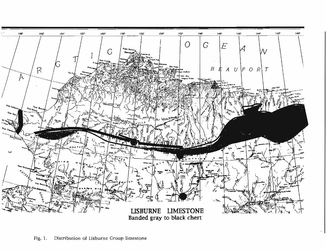
Fig. 1. Distribution of Lisburne Group limestone
Fig. 2. Distribution of Akrnalik Chert.
Fig. 3. Distribution of Siksikpuk Fonnation and Imnaitchiak Chert
Fig. 4. Distribution of Otuk Formation.
Fig. 5. Distribution of red and green chert

THE GEOLOGICAL DISTRIBUTION OF CHERT IN THE BROOKS RANGE
Text of a paper read at Alaska Anthropological Association 22nd Annual Meeting, March 23-25,1995, Anchorage, Alaska
ABSTRACT
Geological mapping in the Brooks Range shows that high quality chert for tool making
is abundant in sedimentary rocks in a number of areas along the northern flank and particularly
in the foothills of the central and western Brooks Range. These cherts are dominantly black, light
to dark gray, greenish gray, banded gray to black, or tan. Some distinctive chert colors can be
correlated with specific rock units and the geographic distribution of these formations has been
mapped; this may help narrow the search for sources of specific lithic types. Minor gray, brown
to reddish brown, or bright turquoise blue-green chert is associated with basalt in a few areas on
the north side of the range. On the south side of the mountains, minor gray to black chert pebbles
in conglomerate are probably derived from a linear belt of basalt. Except in a few isolated
localities, chert is not present in the main part of the range itself.
ORIGIN OF CHERT IN THE BROOKS RANGE
To the geologist, chert is considered to be a hard, dense rock composed of
microcrystalline or ayptocrystalline silica--Si02--or silicon dioxide--that breaks with a
conchoidal fracture and has a vitreous or glassy luster. This material, when not highly fractured,
may yield good raw material for tool making. The term "chertw is also sometimes broadly and
loosely used by geologists to describe other dense siliceous rocks that fracture with a dull and
somewhat granular appearance, but these rocks are more properly considered silicified mudstone
or limestone and do not yield as high a quality of material for tool making. Chert is found
dominantly associated and interbedded with fine grained sedimentary rocks that were deposited
slowly on the ocean floor, and occasionally is found interbedded with fine grained igneous rock
such as basalt that was extruded in the ocean. Chert is not normally found interbedded with
coarse grained sediments such as sandstone or conglomerate, nor is it associated with igneous
rocks such as granite, or with metamorphic rocks that have been intensely deformed by heat and
pressure. Although extrusive basalt with some associated chert is present in the Brooks Range
foothills, obsidian, which is an extrusive igneous rock deposited on land, is not known in the
Brooks Range.

The original source of the silica in chert is generally thought to be from siliceous
sediment derived from micro-organisms such as radiolaria and some varieties of sponges that use
silica as skeletal material. Other cherts appear to have formed by replacement of fine-grained
limestone or mudstone by silica that migrated through the sediment as it was being compacted
and lithified through geological time. Chert is not present in sandstone or conglomerate, except
sometimes as pebbles or cobbles recycled from older rocks, because sandstone and conglomerate
are deposited rapidly in settings in which the slow rain of silica-bearing organisms is diluted by
the abundance of coarse detritus.
The chert in the Brooks Range is commonly found as scattered nodules or elongate
lenses in limestone, or as evenly thin bedded and occasionally nodular units interbedded with
less silicified thin shale, mudstone, or limestone. The limestone with nodular and lenticular
chert is found along the northern flank of the British, Rornanzof, Philip Smith, and eastern
Endicott Mountains of the eastern and east-central Brooks Range. The thin-bedded cherts and
interbedded silicified units are widespread in the foothills along the north side of the Endicott
and DeLong Mountains of the central and western Brooks Range. All of these are areas in which
the streams flow northward to the Beaufort or Chukchi Sea and may contain chert pebbles and
cobbles in the alluvium
Most of the southern Brooks Range is composed of coarse clastic rocks, metamorphic
rocks, and igneous rocks such as granite. None of these rocks contain chert, and the sedimentary
rocks in the basins on the south side of the range were derived largely from these noncherty
rocks. However, limestone with chert nodules is present in some of the headwaters of the
south-flowing Junjik, East Fork Chandalar, Sheenjek, and Coleen Rivers in the southeastern
Brooks Range. Chert-bearing limestone is also present in the headwaters of some of the south-
flowing streams that are tributaries of the Noatak River and the Wulik River in the western
DeLong Mountains of the western Brooks Range. The alluvium in these drainages may contain
chert pebbles and cobbles that could be a source of lithic material. And finally, limestone with
chert nodules that could be a source of tool making material is widespread in the Lisburne Hills
between Cape Thompson and Cape Lisburne at the extreme western end of the Brooks Range. In
addition, a linear belt composed dominantly of basalt that forms the southern flankof the range
may contain minor amounts of gray or black chert.
The drainages that flow through the areas of chert-bearing sediments have been
emphasized, because although chert outcrops are abundant in some areas, it seems reasonable
that the most likely source of most of the tool-making material for the prehistoric inhabitants of
Banded gray to black chert
Fig. 1. llistribution of Idsburne Group limestone
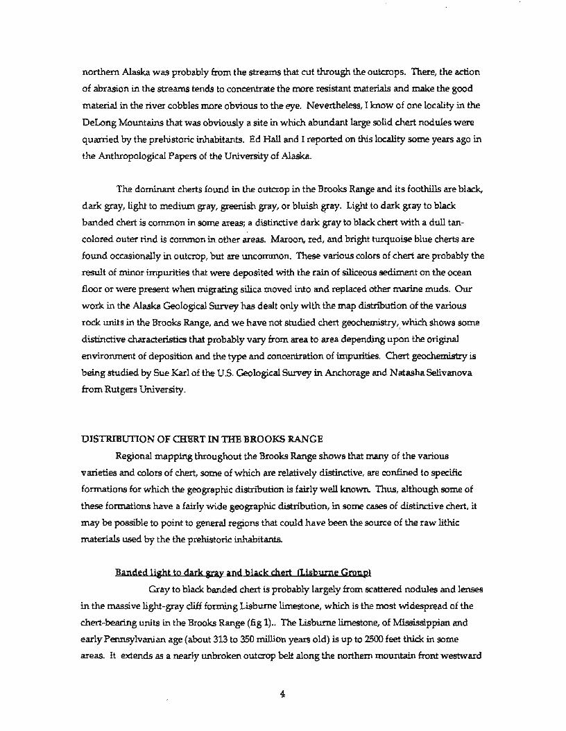
northern Alaska was probably from the streams that cut through the outcrops. There, the action
of abrasion in the streams tends to concentrate the more resistant materials and make the good
material in the river cobbles more obvious to the eye. Nevertheless, I know of one locality in the
DeLong Mountains that was obviously a site in which abundant large solid chert nodules were
quarried by the prehistoric inhabitants. Ed Hall and I reported on this locality some years ago in
the Anthropological Papers of the University of Alaska.
The dominant cherts found in the outcrop in the Brooks Range and its foothills are black,
dark gray, light to medium gray, greenish gray, or bluish gray. Light to dark gray to black
banded chert is common in some areas; a distinctive dark gray to black chert with a dull tan-
colored outer rind is common in other areas. Maroon, red, and bright turquoise blue cherts are
found occasionally in outcrop, but are uncommon. These various colors of chert are probably the
result of minor impurities that were deposited with the rain of siliceous sediment on the ocean
floor or were present when migrating silica moved into and replaced other marine muds. Our
work in the Alaska Geological Survey has dealt only with the map distribution of the various
rock units in the Brooks Range, and we have not studied chert geochemistry, which shows some
distinctive characteristics that probably vary from area to area depending upon the original
environment of deposition and the type and concentration of impurities. Chert geochemistry is
being studied by Sue Karl of the US. Geological Survey in Anchorage and Natasha Selivanova
from Rutgers University.
DISTRIBUTION OF CHERT IN THE BROOKS RANGE
Regional mapping throughout the Brooks Range shows that many of the various
varieties and colors of chert, some of which are relatively distinctive, are confined to specific
formations for which the geographic distribution is fairly well known. Thus, although some of
these formations have a fairly wide geographic distribution, in some cases of distinctive chert, it
may be possible to point to general regions that could have been the source of the raw lithic
materials used by the the prehistoric inhabitants.
B a n d u e h t - to dark mav and black chert (Lisburne Group)
Gray to black banded chert is probably largely from scattered nodules and lenses
in the massive light-gray cliff forming Lisburne limestone, which is the most widespread of the
chert-bearing units in the Brooks Range (fig I).. The Lisburne limestone, of Mississippian and
early Pennsylvanian age (about 313 to 350 million years old) is up to 2500 feet thick in some
areas. It extends as a nearly unbroken outaop belt along the northern mountain front westward

Fig. 2. Distribution of Akrnalik Chert.

from the Barn Mountains in the northern Yukon Territory to west of Kurupa Lake in the central
Endicott Mountains, near the Mesa Site in the western Killik River quadrangle. It is also present
in the south-flowing Kugunuok, Kelly, and Wulik Rivers areas in the western DeLong
Mountains, in the Lisburne Hills near Pount Hope, and in the upper Junjik, East Fork Chandalar,
and Sheenjek River areas in the southeastern Brooks Range.
A word of caution: Large areas in parts of the southern Brooks Range contain
conspicuous cliff forming limestone of the Skajit Limestone and the Baird Group. These rocks are
particularly prominent between the Dietrich River and East Fork of the Chandalar east of the
Dalton Highway, between the John River and the Ambler River and at the head of the Noatak
River in the Schwatka Mountains, and in the Igichuk Hills north of Kotzebue. Although these
limestones superficially resemble the Lisburne, they are much older and one of their
characteristics is the absence of chert. Lithic material found in these areas is almost certainly
imported.
Jet black chert (AknnarLik Ql&
Deep black chert with no mottling or banding in common along the central
Brooks Range mountain front. When examined with a hand lens, it often can be seen to contain
scattered finely disseminated spots of pyrite. This distinctive high quality chert is derived from
the Akmalik Chert, also of Mississippian age (in this case, about 340-355 million years old). This
distinctive formation is relatively thin-less than 250 feet thick--but is composed entirely of thin
bedded chert. It is found discontinuously in a relatively narrow band in the foothas from the
Okpikruak River at the central Endicott Mountains front (eastern Killik River quadrangle)
westward to the Kukpowruk River in the western DeLong Mountains (fig. 2). It is particularly
abundant west of the Killik River in the Imnaitchiak Creek and Kurupa Hills areas in thecentral
Brooks Range foothills, and also in the DeLong Mountains foothills from NoLuck Lake and the
Nuka River area to the upper Utukok River. It is also present in one isolated local area near
Porcupine Lake near the head of the Marsh Fork of the Canning River in the eastern Philip Smith
Mountains.
ionl
Light to dark gray, greenish gray, steel gray, and mottled maroon to pale green
cherts of seem to be confined mostly to the Siksikpuk Formation of Permian age (270-300 million
years) and Imnaitchiak Chert of Triassic to mid-Pennsylvanian age (about 220-320 million years).
Both of these formations are relatively thin (less than 300 feet thick) and contain relatively fw
solid chert beds but occasional zones with large solid nodules. Discontinuous exposures of

Fig. 3. Distribution of Siksikpuk Formation and Imnaitchiak Chert

cherty beds in these formations are present at the mountain front and in the foothills from just
west of the Anaktuvuk River in the central Endicott Mountains west to the Wulik Peaks in the
western Dehng Mountains (fig.3). Imnaitchiak Chert is particularly abundant in the foothills
west of the Killik River, in the Irnnaitchiak Creek and Kurupa Lake area of the central Brooks
Range. The quany site in the DeLong Mountains mentioned previously is in these rocks near the
head of the Kelly River and contains a distinctive high quality gray chert with a very uniform
color and texture.
Cherts of this age of a quality for tool making are not known in the eastern Brooks
Range foothills or mountain front east of the Anaktuvuk River. Siliceous rocks of this age are
present on the southern side of the eastern Brooks Range in the Christian River area southeast of
Arctic Village, but I do not know if high quality chert is present in these rocks.
Tan to m v to black ba nded chert (Otuk Formation)
Thin bedded, banded tan to black chert with wispy mottling is widespread in the
central Brooks Range foothills. It commonly has distinctive light gray to tan or cream-colored
upper and lower bedding surfaces that grade to black in the bed centers. When examined closely
with a hand lens, the tan to gray upper and lower bands can commonly be seen to contain tiny
translucent light gray spherules about the size of a small pin head. These small spherules are
recrystalized radiolaria; although radiolaria are present in other cherts in northern Alaska, they
are most visible in the Otuk Formation This distinctive chert is confined to the limestone member
of the Otuk Formation of middle and late Triassic age (215-240 million years). This unit is usually
less than 50 feet thick but contains a number of 2" to 6" thick beds of the banded chert and
limestone; it is relatively resistant and fonns conspicuous tan-weathering slopes and hillsides
covered with chert rubble. Fossil pelecypod shell fragments are common on some bedding
surfaces but are not common in the better quality chert. A lower chert member of the Otuk
Formation consists of thin bedded black chert and silicified limestone, but appears to be too
intensely fractured to yield good tool making material.
The cherty beds in the Otuk Formation are present discontinuously in many areas along
the mountain front and foothills of the Endicott Mountains from the Anaktuvuk River west to the
Kuna River area in the western Howard Pass quadrangle (fig. 4).. The Otuk Formation is also
present in the DeLong Mountains foothills, but I have not observed high quality chert in the
formation in this area. Triassic cherts of a quality adequate for tool making do not appear to be
present in the eastern Brooks Range or foothills east of the Anaktuvuk River.

Fig. 4. Distribution of Otuk Formation.


Black chert in the Otuk Formation closely resembles the black chert from the
Mississippian Akmalik Formation. In absence of the wispy mottling or black and tan banding
that is characteristic of the Otuk cherts, or absence of fine pyrite flecks that are characteristic of
the Akrnalik chert, the origin of small black tools and flakes may be difficult to determine.
&&&t red. maroon. and turauoise seen chert:
Distinctive brighly colored red, maroon, and turquoise green chert is uncommon
in the Brooks Range foothills, but is conspicuous where present. This chert seems to be closely
associated with basalt that is locally present in scattered small isolated exposures in the Endicott
Mountains foothills from the Anaktuvuk River west to the Kuna River (fig. 5).
SUMMARY
Chert of a variety of distinctive color and textures is widespread in the northern Brooks
Range and foothills, and some distinctive characteristics can be identified with specific
formations for which the general distribution is fairly well known. Some of these formations are
widely distributed in the Brooks Range and foothills, and identification of the source of much of
the chert can probably be narrowed down only to general areas. In addition, there is overlap in
the color and textural ranges in some of the cherts, and identification of the source formations of
these lithic materials can be given only as a best guess. Nevertheless, in specific cases, our
knowledge of the distribution of the siliceous rocks in the Brooks Range may allow closer
identification of some of the lithic sources and prehistoric trade routes in northern Alaska.