fleet dispostion systems with vehicle probe data abstractelib.dlr.de/46848/1/artikel_gor.pdf ·...
TRANSCRIPT
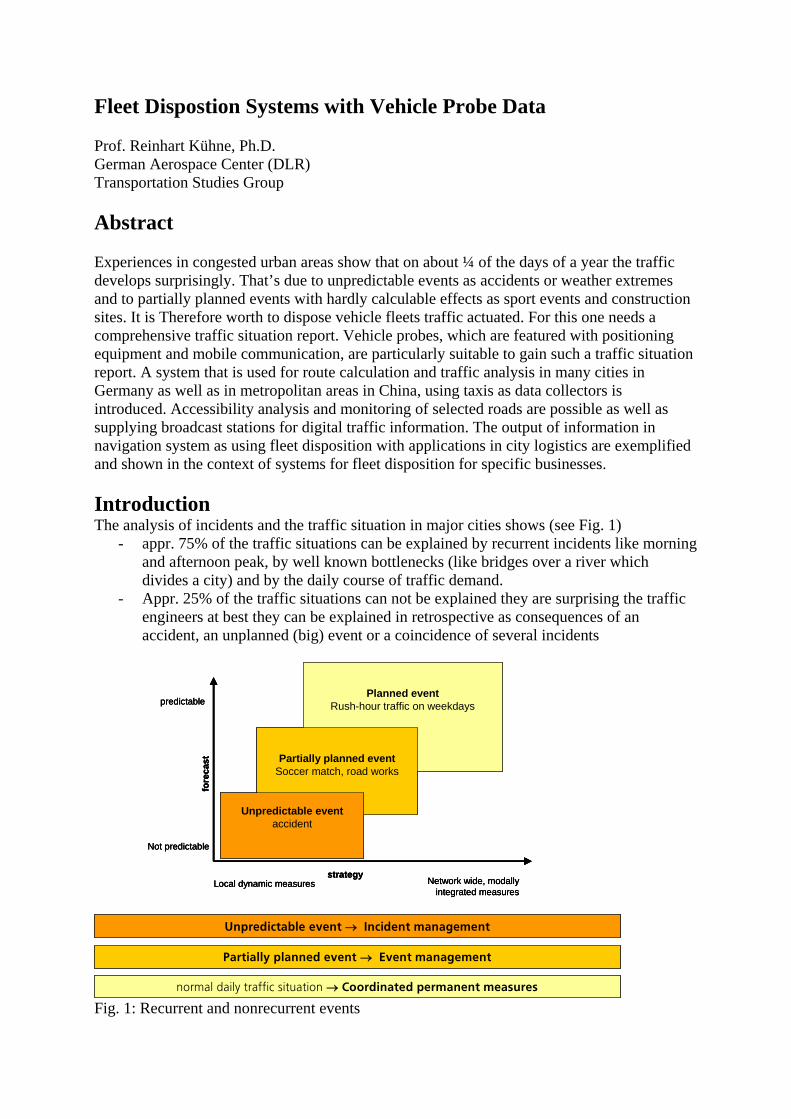
Fleet Dispostion Systems with Vehicle Probe Data Prof. Reinhart Kühne, Ph.D. German Aerospace Center (DLR) Transportation Studies Group Abstract Experiences in congested urban areas show that on about ¼ of the days of a year the traffic develops surprisingly. That’s due to unpredictable events as accidents or weather extremes and to partially planned events with hardly calculable effects as sport events and construction sites. It is Therefore worth to dispose vehicle fleets traffic actuated. For this one needs a comprehensive traffic situation report. Vehicle probes, which are featured with positioning equipment and mobile communication, are particularly suitable to gain such a traffic situation report. A system that is used for route calculation and traffic analysis in many cities in Germany as well as in metropolitan areas in China, using taxis as data collectors is introduced. Accessibility analysis and monitoring of selected roads are possible as well as supplying broadcast stations for digital traffic information. The output of information in navigation system as using fleet disposition with applications in city logistics are exemplified and shown in the context of systems for fleet disposition for specific businesses. Introduction The analysis of incidents and the traffic situation in major cities shows (see Fig. 1)
- appr. 75% of the traffic situations can be explained by recurrent incidents like morning and afternoon peak, by well known bottlenecks (like bridges over a river which divides a city) and by the daily course of traffic demand.
- Appr. 25% of the traffic situations can not be explained they are surprising the traffic engineers at best they can be explained in retrospective as consequences of an accident, an unplanned (big) event or a coincidence of several incidents
Planned eventRush-hour traffic on weekdays
Partially planned eventSoccer match, road works
Unpredictable eventaccident
predictable
Not predictable
Network wide, modallyintegrated measures
Local dynamic measures
fore
cast
strategy
Unpredictable event → Incident management
Partially planned event → Event management
normal daily traffic situation → Coordinated permanent measures
Planned eventRush-hour traffic on weekdays
Partially planned eventSoccer match, road works
Unpredictable eventaccident
predictable
Not predictable
Network wide, modallyintegrated measures
Local dynamic measures
predictable
Not predictable
Network wide, modallyintegrated measures
Local dynamic measures
fore
cast
strategy
fore
cast
strategy
Unpredictable event → Incident management
Partially planned event → Event management
normal daily traffic situation → Coordinated permanent measures Fig. 1: Recurrent and nonrecurrent events
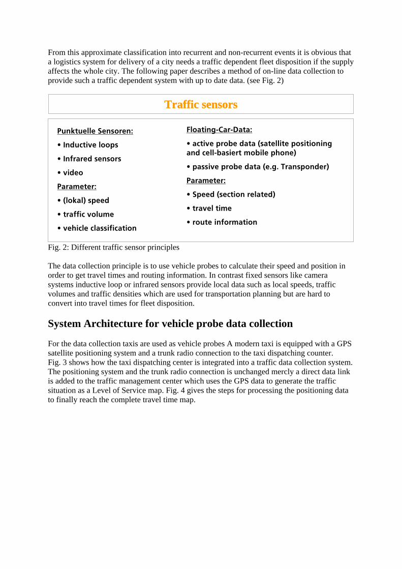
From this approximate classification into recurrent and non-recurrent events it is obvious that a logistics system for delivery of a city needs a traffic dependent fleet disposition if the supply affects the whole city. The following paper describes a method of on-line data collection to provide such a traffic dependent system with up to date data. (see Fig. 2)
Traffic sensors
Punktuelle Sensoren:
• Inductive loops
• Infrared sensors
• video
Parameter:
• (lokal) speed
• traffic volume
• vehicle classification
Floating-Car-Data:
• active probe data (satellite positioningand cell-basiert mobile phone)
• passive probe data (e.g. Transponder)
Parameter:
• Speed (section related)
• travel time
• route information
Fig. 2: Different traffic sensor principles The data collection principle is to use vehicle probes to calculate their speed and position in order to get travel times and routing information. In contrast fixed sensors like camera systems inductive loop or infrared sensors provide local data such as local speeds, traffic volumes and traffic densities which are used for transportation planning but are hard to convert into travel times for fleet disposition. System Architecture for vehicle probe data collection For the data collection taxis are used as vehicle probes A modern taxi is equipped with a GPS satellite positioning system and a trunk radio connection to the taxi dispatching counter. Fig. 3 shows how the taxi dispatching center is integrated into a traffic data collection system. The positioning system and the trunk radio connection is unchanged mercly a direct data link is added to the traffic management center which uses the GPS data to generate the traffic situation as a Level of Service map. Fig. 4 gives the steps for processing the positioning data to finally reach the complete travel time map.

Client
Traffic Management Control Center
ISDNXML
Head quarter
Unchanged
Vehicle with GPS and wirelesscommunication
Use of GPS data from fleet management
Client
Traffic Management Control Center
ISDNXML
Head quarter
Unchanged
Vehicle with GPS and wirelesscommunication
Use of GPS data from fleet management
Fig. 3. Integrated Fleet Management (taxi dispatch center) and Traffic Data Collection System
• collection of taxi positions calculation of trajectories
4 map-matching and routing
• matching of trajectories on digital road maps
• estimation of traveled routes and segment velocities
4 adding historic vehicle probe data historical data of the same week day and time
4 adding assumptions e.g. typical daily course of the street category
Stuttgart city centre, Tuesday, June 1, 2003, 5-6 p.m.
Fig. 4 Processing of Taxi vehicle probe data Travel Time Surveillance and Accessibility Analysis First we show 2 transportation planning applications of the travel time calculation using vehicle probes as data sources. One is a travel time surveillance on scheduled routes. The webservice of the city of Vienna offers a specific service on a selected number of routes leading from well known points of interest to the city center. The routes are described shortly as “entry West” or “entry from the airport” followed by the average travel time to the requested time and day and an point out of the deviations if longer than given threshold the deviation is marked by red colour. (see Fig. 5)
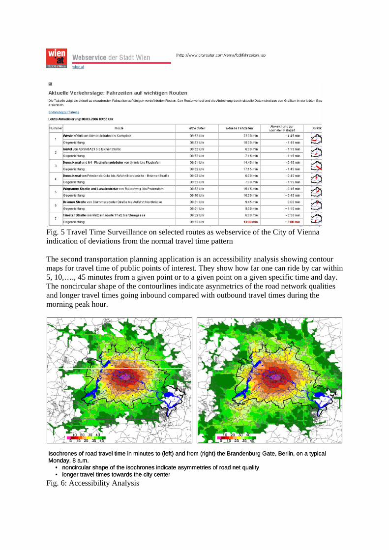
Fig. 5 Travel Time Surveillance on selected routes as webservice of the City of Vienna indication of deviations from the normal travel time pattern The second transportation planning application is an accessibility analysis showing contour maps for travel time of public points of interest. They show how far one can ride by car within 5, 10,…., 45 minutes from a given point or to a given point on a given specific time and day. The noncircular shape of the contourlines indicate asynmetrics of the road network qualities and longer travel times going inbound compared with outbound travel times during the morning peak hour.
Isochrones of road travel time in minutes to (left) and from (right) the Brandenburg Gate, Berlin, on a typical Monday, 8 a.m.
• noncircular shape of the isochrones indicate asymmetries of road net quality• longer travel times towards the city center
Isochrones of road travel time in minutes to (left) and from (right) the Brandenburg Gate, Berlin, on a typical Monday, 8 a.m.
• noncircular shape of the isochrones indicate asymmetries of road net quality• longer travel times towards the city center
Fig. 6: Accessibility Analysis
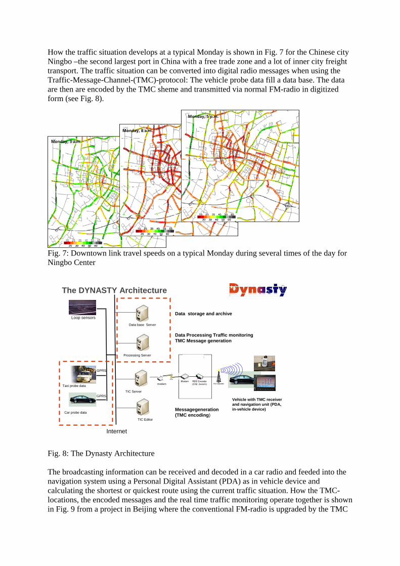
How the traffic situation develops at a typical Monday is shown in Fig. 7 for the Chinese city Ningbo –the second largest port in China with a free trade zone and a lot of inner city freight transport. The traffic situation can be converted into digital radio messages when using the Traffic-Message-Channel-(TMC)-protocol: The vehicle probe data fill a data base. The data are then are encoded by the TMC sheme and transmitted via normal FM-radio in digitized form (see Fig. 8).
Monday, 3 a.m.
Monday, 8 a.m.
Monday, 5 p.m.
Monday, 3 a.m.
Monday, 8 a.m.
Monday, 5 p.m.
Fig. 7: Downtown link travel speeds on a typical Monday during several times of the day for Ningbo Center
The DYNASTY Architecture
Loop sensors
Taxi probe data
Car probe data
GPRS
GPRS
Internet
TIC Server
Data base Server
TIC Editor
Processing Server
modem
Vehicle with TMC receiverand navigation unit (PDA, in-vehicle device)
Data storage and archive
Data Processing Traffic monitoringTMC Message generation
Messagegeneration(TMC encoding)
Fig. 8: The Dynasty Architecture The broadcasting information can be received and decoded in a car radio and feeded into the navigation system using a Personal Digital Assistant (PDA) as in vehicle device and calculating the shortest or quickest route using the current traffic situation. How the TMC-locations, the encoded messages and the real time traffic monitoring operate together is shown in Fig. 9 from a project in Beijing where the conventional FM-radio is upgraded by the TMC
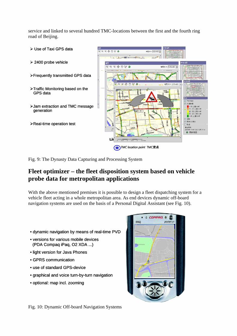
service and linked to several hundred TMC-locations between the first and the fourth ring road of Beijing.
Use of Taxi GPS data
2400 probe vehicle
Frequently transmitted GPS data
Traffic Monitoring based on theGPS data
Jam extraction and TMC messagegeneration
Real-time operation test
Link velocities on Dec 5, 6:36 pm
TMC location point TMC定点
Use of Taxi GPS data
2400 probe vehicle
Frequently transmitted GPS data
Traffic Monitoring based on theGPS data
Jam extraction and TMC messagegeneration
Real-time operation test
Link velocities on Dec 5, 6:36 pmLink velocities on Dec 5, 6:36 pm
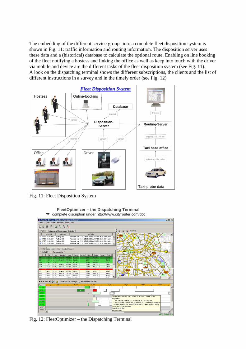
TMC location point TMC定点TMC location point TMC定点 Fig. 9: The Dynasty Data Capturing and Processing System Fleet optimizer – the fleet disposition system based on vehicle probe data for metropolitan applications With the above mentioned premises it is possible to design a fleet dispatching system for a vehicle fleet acting in a whole metropolitan area. As end devices dynamic off-board navigation systems are used on the basis of a Personal Digital Assistant (see Fig. 10).
• dynamic navigation by means of real-time PVD
• versions for various mobile devices (PDA Compaq iPaq, O2 XDA ...)
• light version for Java Phones
• GPRS communication
• use of standard GPS-device
• graphical and voice turn-by-turn navigation
• optional: map incl. zooming
• dynamic navigation by means of real-time PVD
• versions for various mobile devices (PDA Compaq iPaq, O2 XDA ...)
• light version for Java Phones
• GPRS communication
• use of standard GPS-device
• graphical and voice turn-by-turn navigation
• optional: map incl. zooming
Fig. 10: Dynamic Off-board Navigation Systems
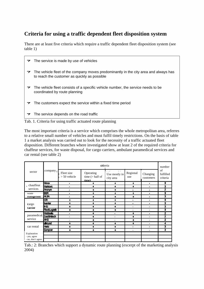
The embedding of the different service groups into a complete fleet disposition system is shown in Fig. 11: traffic information and routing information. The disposition server uses these data and a (historical) database to calculate the optional route. Enabling on line booking of the fleet notifying a hostess and linking the office as well as keep into touch with the driver via mobile and device are the different tasks of the fleet disposition system (see Fig. 11). A look on the dispatching terminal shows the different subscriptions, the clients and the list of different instructions in a survey and in the timely order (see Fig. 12)
Taxi head office
Routing-Server
private mobile radio
Internet, HTTP/FTP
Internet
Taxi-probe data
Disposition-Server
Database
GPRS GPRSInternet
Internet
Hostess
GPRS
Office Driver
Fleet Disposition SystemOnline-booking
Fleet Disposition System
Fig. 11: Fleet Disposition System
FleetOptimizer – the Dispatching Terminalcomplete discription under http://www.cityrouter.com/doc
Fig. 12: FleetOptimizer – the Dispatching Terminal
Criteria for using a traffic dependent fleet disposition system There are at least five criteria which require a traffic dependent fleet disposition system (see table 1)
The service is made by use of vehicles
The vehicle fleet of the company moves predominantly in the city area and always has to reach the customer as quickly as possible
The vehicle fleet consists of a specific vehicle number, the service needs to becoordinated by route planning
The customers expect the service within a fixed time period
The service depends on the road traffic
Tab. 1. Criteria for using traffic actuated route planning The most important criteria is a service which comprises the whole metropolitan area, referres to a relative small number of vehicles and must fulfil timely restrictions. On the basis of table 1 a market analysis was carried out to look for the necessity of a traffic actuated fleet disposition. Different branches where investigated show at least 2 of the required criteria for chaffeur services, for waste disposal, for cargo carriers, ambulant paramedical services and car rental (see table 2)
stimmt zu
a) Flottengröße (mehr als 50 Fahrzeuge)
b) Einsatzzeiten (mehr als die Hälfte der Zeit)
c) Einsatz auf dem größten Teil des Stadtgebietes
d) regionales Einsatzgebiet
e) wechselnder Kundenstamm
Minex - + + + - 3Markovic - + + + - 3Anonym - + + - - 2BSR - + + + - 3ALBA - + + + - 3GTI + + + - - 3Iwanter + + + - - 3IHG + + + - - 3RieckLogistik + + + - - 3Mediavita - + - + - 2Just&Wäsch - + - + - 2AHG - + - + - 2allround + + + + - 4Hertz + + + - - 3Europcar + + + - - 3
Erläuterung:- stimmt nicht zu+
Anzahl der zutreffenden Kriterien
Spedition
ambulante Pflegedienste
Autovermietung
Kriterien
UnternehmenBranche
Chauffeurdienst
Entsorgung
sector company
chauffeurservices
wastemanagement
cargocarrier
paramedicalservice
car rental
criteria
Explanation- yes, agree- no, don‘t agree
Fleet size> 50 vehicle
Operatingtime (> half of time)
Use mostly in city area
Regionaluse
Changingcustomers
numberof fulfilledcriteria
stimmt zu
a) Flottengröße (mehr als 50 Fahrzeuge)
b) Einsatzzeiten (mehr als die Hälfte der Zeit)
c) Einsatz auf dem größten Teil des Stadtgebietes
d) regionales Einsatzgebiet
e) wechselnder Kundenstamm
Minex - + + + - 3Markovic - + + + - 3Anonym - + + - - 2BSR - + + + - 3ALBA - + + + - 3GTI + + + - - 3Iwanter + + + - - 3IHG + + + - - 3RieckLogistik + + + - - 3Mediavita - + - + - 2Just&Wäsch - + - + - 2AHG - + - + - 2allround + + + + - 4Hertz + + + - - 3Europcar + + + - - 3
Erläuterung:- stimmt nicht zu+
Anzahl der zutreffenden Kriterien
Spedition
ambulante Pflegedienste
Autovermietung
Kriterien
UnternehmenBranche
Chauffeurdienst
Entsorgung
sector company
chauffeurservices
wastemanagement
cargocarrier
paramedicalservice
car rental
criteria
Explanation- yes, agree- no, don‘t agree
Fleet size> 50 vehicle
Operatingtime (> half of time)
Use mostly in city area
Regionaluse
Changingcustomers
stimmt zu
a) Flottengröße (mehr als 50 Fahrzeuge)
b) Einsatzzeiten (mehr als die Hälfte der Zeit)
c) Einsatz auf dem größten Teil des Stadtgebietes
d) regionales Einsatzgebiet
e) wechselnder Kundenstamm
Minex - + + + - 3Markovic - + + + - 3Anonym - + + - - 2BSR - + + + - 3ALBA - + + + - 3GTI + + + - - 3Iwanter + + + - - 3IHG + + + - - 3RieckLogistik + + + - - 3Mediavita - + - + - 2Just&Wäsch - + - + - 2AHG - + - + - 2allround + + + + - 4Hertz + + + - - 3Europcar + + + - - 3
Erläuterung:- stimmt nicht zu+
Anzahl der zutreffenden Kriterien
Spedition
ambulante Pflegedienste
Autovermietung
Kriterien
UnternehmenBranche
Chauffeurdienst
Entsorgung
sector company
chauffeurservices
wastemanagement
cargocarrier
paramedicalservice
car rental
criteria
Explanation- yes, agree- no, don‘t agree
Fleet size> 50 vehicle
Operatingtime (> half of time)
Use mostly in city area
Regionaluse
Changingcustomers
numberof fulfilledcriteria
Tab.: 2: Branches which support a dynamic route planning (excerpt of the marketing analysis 2004)
International standardisation of delivery and procurement data, transportation and accountingdata in electronic data transferAutomatic disposition of consignments and means of transport, automatic tracking of thesedata and accounting proceeduresFurther development of city logistics
use of newtechnologies
cargo carriers, logistics
Fleet management with satellites and mobile communication, automation and dispositionsystems, on route monitoring of vehicles and safety components (WEB-EDI, Online systems and –networks)
New techniques and methods of transportation, delivery, stock and consolidationservices
road, rail, cargocarrier, logistics,
Tab. 3: Innovation lines in freight transportation and logistics Conclusion The described system shows the already existing broad scale of innovations for fleet disposition using vehicle probes as data collectors. The innovation road map for freight transport and logistics is shown in table 3. It is a concise survey of fleet management and procurement services which innovates freight transport and supply chain management. Mobil communication internet and modern techniques of data collection give fleet disposition a new character. Literature WANG, JIAJIE; FANG, TINGJIAN; Schäfer, Ralf-Peter (2005): The First FCD Application in China at Ningbo City., ITS World Conference 2006, San Francisco, CA (USA), 2005-11-6 - 2005-11-10 Lorkowski, Stefan; Mieth, Peter; Schäfer, Ralf-Peter (2005): New ITS applications for metropolitan areas based on Floating Car Data. ECTRI Young Researcher Seminar, Den Haag (NL), 2005-05-11 - 2005-05-13 Kühne, Reinhart; Schäfer, Ralf-Peter; Mieth, Peter; Lorkowski, Stefan; Bei, Xiaoxu (2005): Vehicle Probes as Data Collectors for Asian Metropolitan Areas. 4th Asia Pacific Conference, Xi'an, China, 2005-11-08 - 2005-11-10 Lorkowski, Stefan; Mieth, Peter; Thiessenhusen, Kai-Uwe; Chauhan, Dhiraj; Passfeld, Bert; Schäfer, Ralf-Peter (2004): Towards area-wide traffic monitoring-applications derived from probe vehicle data. In: Kumares, C. Sinha; T. F., Fwa; Ruey, L. Cheu; Der-Horng, Lee [Hrsg.]: Proceedings of the 8th International Conference on Applications of Advanced Technologies in Transportation Engineering, ASCE, S. 389 - 394, AATT 2004, Beijing (China), 2004-05-26 - 2004-05-28, ISBN 0-7844-0730-4 Ernst, Ines; Hetscher, Matthias; Zuev, Sergey; Thiessenhusen, Kai-Uwe; Ruhé, Martin (2005): New approaches for real time traffic data acquisition with airborne systems. In: TRB Transportation Research Board, TRB 2005, Washington, January 2005

Ernst, Ines; Hetscher, Matthias; Lehmann, Steffi; Lippok, Artur; Ruhé, Martin (2005): USE OF GIS METHODOLOGY FOR ONLINE URBAN TRAFFIC MONITORING. In: ISPRS
rsg.]: Proceedings of the ISPRS WG VII/1 Human Settlement and Impact analysis, Remote
tzten
[HSensing and Data Fusion over Urban Areas - URBAN 2005, Tempe, Arizon (USA), 2005.03.14 - 2005.03.16 Kühne, Reinhart; Ruhé, Martin; Bonert, Michael (2005): Anwendungen der luftgestüVerkehrsdatenerfassung bei Großveranstaltungen. Verkehrswissenschaftliche Tage, Dresden,
005-09-19 - 2005-09-20 2 Kühne, Reinhart (2005): Verkehrssteuerung aus dem All - neue Entwicklungen zur luft- und raumgestützten Verkehrsdatenerfassung und -lenkung. Verkehrstelematiktagung, Magdeburg,
005-06-162