fishing pier design guidance - florida dep · fishing pier design guidance . part 1: historical...
TRANSCRIPT

Fishing Pier Design Guidance
Part 1: Historical Pier Damage in Florida
Ralph R. Clark Florida Department of Environmental Protection Bureau of Beaches and Coastal Systems May 2010


Table of Contents
Foreword ............................................................................................................................. i Table of Contents ............................................................................................................... ii Chapter 1 – Introduction ................................................................................................... 1 Chapter 2 – Ocean and Gulf Pier Damages in Florida ................................................... 4 Chapter 3 – Three Major Hurricanes of the Late 1970’s ............................................... 6 September 23, 1975 – Hurricane Eloise ...................................................................... 6 September 3, 1979 – Hurricane David ........................................................................ 6 September 13, 1979 – Hurricane Frederic .................................................................. 7 Chapter 4 – Two Hurricanes and Four Storms of the 1980’s ........................................ 8 June 18, 1982 – No Name Storm .................................................................................. 8 November 21-24, 1984 – Thanksgiving Storm ............................................................ 8 August 30-September 1, 1985 – Hurricane Elena ...................................................... 9 October 31, 1985 – Tropical Storm Juan ....................................................................11 November 21, 1985 – Hurricane Kate .........................................................................11 November 23, 1988 – Tropical Storm Keith ...............................................................11 Chapter 5 – Four Hurricanes and Two Storms of the 1990’s ........................................12 October 31, 1991 – Halloween Northeaster ................................................................12 August 24, 1992 – Hurricane Andrew .........................................................................13 October 4, 1995 – Hurricane Opal ..............................................................................13 October 7, 1996 – Tropical Storm Josephine .............................................................15 September 25, 1998 – Hurricane Georges...................................................................16 September 15, 1999 – Hurricane Floyd .......................................................................16 Chapter 6 – Major Storms of 2000 through 2003 ...........................................................18 September 17, 2000 – Hurricane Gordon ...................................................................18 September 14, 2001 – Tropical Storm Gabrielle ........................................................18 September 26, 2002 – Tropical Storm Isidore ............................................................18 Chapter 7 – Four Hurricanes of 2004 ..............................................................................20 August 13, 2004 – Hurricane Charley .........................................................................20 September 5, 2004 – Hurricane Frances .....................................................................20 September 16, 2004 – Hurricane Ivan .........................................................................24 September 26, 2004 – Hurricane Jeanne ....................................................................25 Chapter 8 – Two Hurricanes of 2005 ...............................................................................26 July 10, 2005 – Hurricane Dennis ................................................................................26 October 24, 2005 – Hurricane Wilma .........................................................................28 References ...........................................................................................................................30
ii

Chapter 1 – Introduction The nearshore waters of the Atlantic Ocean and Gulf of Mexico are host to a wide variety of fish species that are sought after by coastal recreational fishermen around the State of Florida. There are roughly 35 ocean and gulf fishing piers along the barrier beaches of Florida, which offer safe and stable recreational platforms to access this important coastal fishery (Table 1). Unfortunately, these fishing piers are subject to severe damage and total destruction during hurricanes and major storms that impact the coast (Photo 1). It has become increasingly important to construct these piers to resist, to the extent practical, the damages associated with major storms.
Photo 1. The Sebastian Inlet State Park Fishing Pier being impacted by the waves of Hurricane Jeanne [Bureau of Beaches & Coastal Systems Photo Files] The design and construction of ocean fishing piers has evolved with an increased understanding of the forces under which the structures are subjected. The most critical forces affecting the survivability of ocean fishing piers are caused by wind generated waves. Fishing piers should be designed to withstand the forces of breaking waves expected to occur at their location during major storms. With the selection of a design storm event, it is important to determine the storm tide elevation across which the storm waves will propagate. Equally important as determining a design storm tide level is considering the beach and nearshore profile change caused by the erosion of the design storm event as well as the additional localized scour expected at the individual foundation piles. A geotechnical investigation with core borings is necessary for any pier construction in order to determine adequate pile penetration and breakout resistance resulting from the soil characteristics.
1
2
Pier construction techniques will likewise be important particularly when the dead loads of a construction crane need to be considered in the design of the foundation and structural members. Wind loads are specifically important for any canopies or concession buildings located on a pier. Pier decks and rails have additional design considerations. Fishing Pier Design Guidance is divided into two documents. Its purpose is to identify and provide some basic guidance in the design of ocean and gulf fishing piers in Florida. Many of the same concepts are applicable for pier design in coastal inlets and estuaries or along the Florida Keys. Part 1: Historical Pier Damage in Florida discusses the history of pier damages during recent coastal storm events in Florida. Damages are chronicled for various major storm events between 1975 and the present. Part 2: Methodologies for Design and Construction discusses the major issues in fishing pier design and construction.

Table 1. Ocean and Gulf Fishing Piers in Florida
Piers on the Gulf of Mexico
Pier County Location 1 Year2 Length (ft) Material3
Pensacola Beach Escambia R120.5 2001 1470 C
Navarre Beach Santa Rosa R209 1974 (2010) 1545 C Okaloosa County Okaloosa R13.9 1998 1260 C Russell-Fields,Panama City Beach Bay R40.5 1977 (2009) 1500 C MB Miller, Bay County Bay R57.3 1968 (2010) 1500 C St Andrews State Park Bay R92.8 1959 600 W Mexico Beach Bay R129.2 1956 (2010) 816 W Big Pier 60, Clearwater Beach Pinellas R44 1962 1116 C Private Pier, Indian Shores Pinellas R98.4 n.a. 250 W Redington Long Pinellas R104.2 1962 1021 W Andrew Potter, Ft. Desoto Park Pinellas R179.8 1964 (2002) 1027 C Manatee County Manatee R20.6 n.a. 300 C Venice Municipal Pier Sarasota R131 1966 696 C Ft Myers Beach Lee R180.7 1974 560 C Naples Collier R74.4 1961 1000 W
Piers on the Atlantic Ocean Ft Clinch State Park Nassau R9 1980 2409 C Amelia by the Sea Condominium Nassau R39 1948 775 W Jacksonville Beach Duval R65.2 2004 1300 C St Augustine Beach St Johns R142 1986 604 C Flagler Beach Flagler R79 1928 800 W Daytona Beach Volusia R84 1925 744 W Sunglow, Daytona Beach Shores Volusia R117.7 1960 818 W Lighthouse Point Park Volusia R147 1991 1056 C Canaveral Inlet Jetty Park Brevard R1 1997 464 C Canaveral Pier, Cocoa Beach Brevard R16 1963 706 W Sebastian Inlet State Park Brevard R219 1970 (2003) 490 C Sea Quay Condominium Indian River R75 2008 600 C Juno Beach Palm Beach R31.2 1998 993 C Lake Worth Palm Beach R128.5 1972 (2008) 940 C South Lake Worth Inlet Palm Beach R151 1967 410 C Deerfield Beach Broward R2.7 1963 (1992) 949 C Pompano Beach Municipal Pier Broward R33.7 1963 829 C Anglin’s, Lauderdale-by-the-Sea Broward R50.5 1963 876 C Dania Broward R98.3 1962 928 C Sunny Isles Dade R16.4 1936 (2012) 777 W 1. Location relative to the nearest FDEP reference monument established by the CCCL program. 2. Dates in parentheses are anticipated reconstruction dates or recently completed reconstruction dates. 3. C – Concrete; W – Wood
3

Chapter 2 – Ocean and Gulf Pier Damages in Florida The history of fishing pier damage in Florida parallels the history of major storm events that have impacted the state. Unfortunately, documentation of pier damage is rather limited prior to 1970. Commencing in 1979, the Department of Natural Resources, Bureau of Beaches and Shores initiated detailed post-storm damage assessments following major coastal storms. These coastal construction damage assessments continue today by the Bureau of Beaches and Coastal Systems, Department of Environmental Protection. Post-storm reports have been prepared for 22 major storms. Reports on at least 12 of these storms are available from the Bureau’s web site – http://www.dep.state.fl.us/beaches/publications. Many of the older Florida piers were impacted by major storms of the 1960’s, including Hurricane Donna (1960) in southwest Florida, the Ash Wednesday Northeaster (1962) (Photo 2) along the entire east coast, Hurricane Dora (1964) in northeast Florida (Photos 3 and 4), Hurricane Betsy (1965) in southeast Florida, and the fringe impact of Hurricane Camille (1969) in northwest Florida. Hurricane Alma (1970) and Hurricane Agnes (1972) impacted the coastal region near Apalachicola where no gulf piers existed to be damaged. Chapters 3 through 8 chronicle the documented storm damages to fishing piers in Florida since 1975.
Photo 2. Deerfield Beach Pier damaged during the Ash Wednesday Storm of 1962 [BBCS Photo Files]
4
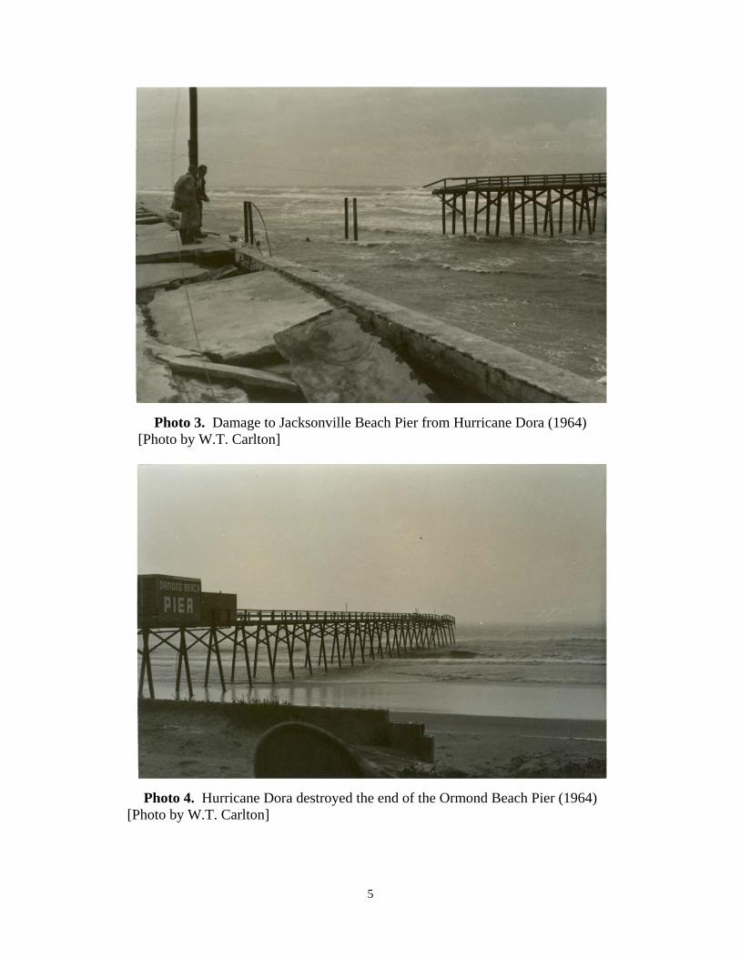
Photo 3. Damage to Jacksonville Beach Pier from Hurricane Dora (1964) [Photo by W.T. Carlton]
Photo 4. Hurricane Dora destroyed the end of the Ormond Beach Pier (1964) [Photo by W.T. Carlton]
5

Chapter 3 – Three Major Hurricanes of the Late 1970’s September 23, 1975 – Hurricane Eloise Hurricane Eloise made landfall at Dune Allen, about two miles west of Grayton Beach, as a strong category three hurricane with sustained winds of 127 miles per hour and measured storm tides with wave up-rush of +13.8 feet NGVD in Dune Allen and +14.9 feet NGVD in Panama City Beach. 1. A new 300-foot extension and a portion of the original section of the Okaloosa Island Pier, constructed of concrete in 1972 on eastern Santa Rosa Island near Ft. Walton Beach, was destroyed. 2. The M.B. Miller Pier in Panama City Beach, constructed of wood in 1968, sustained major damage losing the pier’s end section. 3. The wooden fishing pier at St. Andrews State Park was substantially destroyed. 4. The Mexico Beach Pier, constructed of wood in 1956, was substantially damaged at its terminal end section. Reference: U.S. Army Engineer District, Mobile, Corps of Engineers, 1976. Post-disaster
Report, Hurricane Eloise, 16-23 September 1975, 130 p. September 3, 1979 – Hurricane David Hurricane David made landfall in northern Palm Beach County at Jupiter Inlet while tracking northward along the Florida east coast and exiting near New Smyrna Beach. David was a category one hurricane in Florida with maximum sustained winds above 85 miles per hour. 1. The wooden St. Augustine Beach fishing pier was destroyed (Photo 5). 2. The wooden Sunglow Fishing Pier in Daytona Beach Shores lost a 50-foot section landward of the terminal platform. Numerous piles were damaged at the seaward end.
Photo 5. St. Augustine Beach Fishing Pier destroyed by Hurricane David (1979)
6
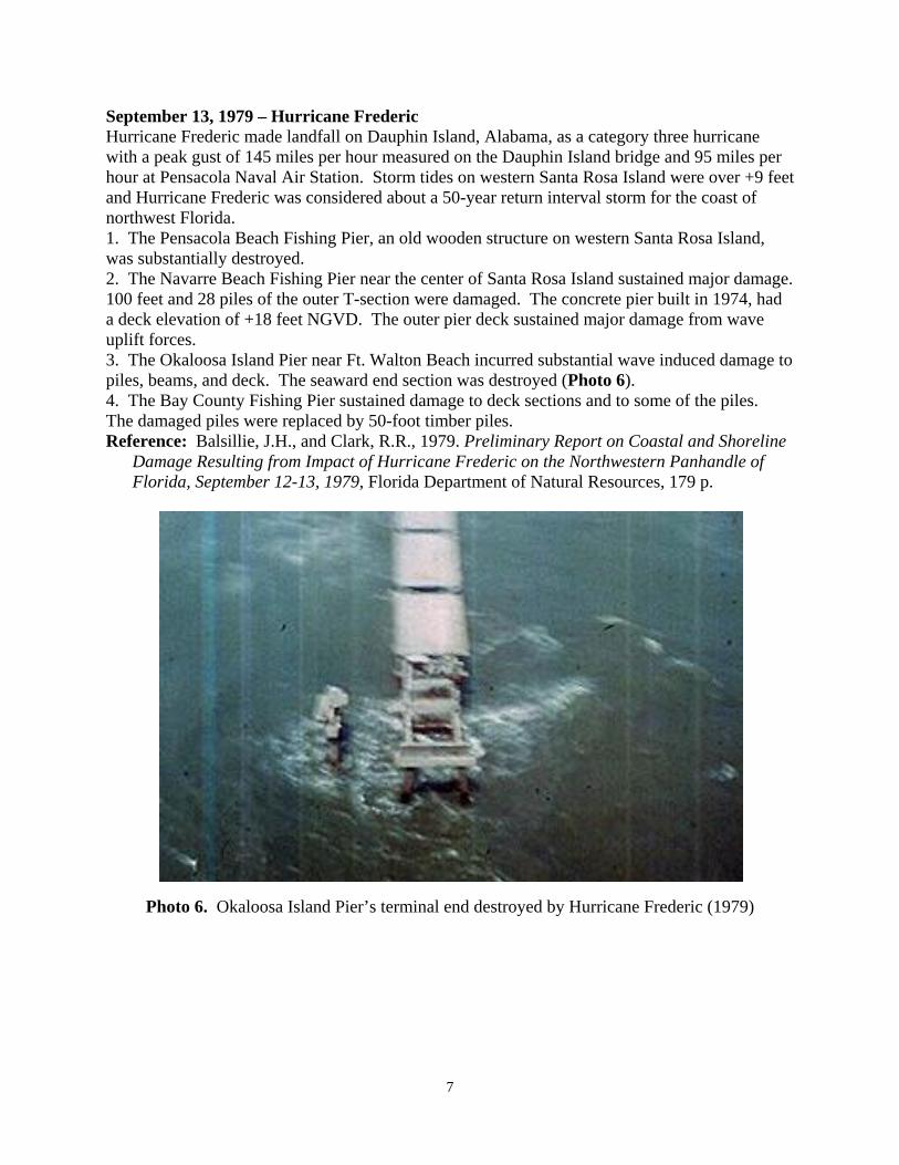
September 13, 1979 – Hurricane Frederic Hurricane Frederic made landfall on Dauphin Island, Alabama, as a category three hurricane with a peak gust of 145 miles per hour measured on the Dauphin Island bridge and 95 miles per hour at Pensacola Naval Air Station. Storm tides on western Santa Rosa Island were over +9 feet and Hurricane Frederic was considered about a 50-year return interval storm for the coast of northwest Florida. 1. The Pensacola Beach Fishing Pier, an old wooden structure on western Santa Rosa Island, was substantially destroyed. 2. The Navarre Beach Fishing Pier near the center of Santa Rosa Island sustained major damage. 100 feet and 28 piles of the outer T-section were damaged. The concrete pier built in 1974, had a deck elevation of +18 feet NGVD. The outer pier deck sustained major damage from wave uplift forces. 3. The Okaloosa Island Pier near Ft. Walton Beach incurred substantial wave induced damage to piles, beams, and deck. The seaward end section was destroyed (Photo 6). 4. The Bay County Fishing Pier sustained damage to deck sections and to some of the piles. The damaged piles were replaced by 50-foot timber piles. Reference: Balsillie, J.H., and Clark, R.R., 1979. Preliminary Report on Coastal and Shoreline
Damage Resulting from Impact of Hurricane Frederic on the Northwestern Panhandle of Florida, September 12-13, 1979, Florida Department of Natural Resources, 179 p.
Photo 6. Okaloosa Island Pier’s terminal end destroyed by Hurricane Frederic (1979)
7

Chapter 4 – Two Hurricanes and Four Storms of the 1980’s June 18, 1982 – No Name Storm This subtropical storm made landfall on the southwest gulf coast of Florida impacting the beaches between Naples and Clearwater and having maximum sustained winds of 70 miles per hour. Storm tides ranged from +4 to +5 feet NGVD. 1. The Venice Municipal Fishing Pier, constructed of concrete in 1966, sustained substantial damage to its end T-section due to wave loads. Reference: Clark, R.R., 1982. Coastal Damage Associated with Subtropical Storm, June 18,
1982, Florida Department of Natural Resources, Division of Beaches and Shores, 33 p. November 21-24, 1984 – Thanksgiving Storm The Thanksgiving Northeaster of 1984 was a strong persistent extratropical storm that impacted the entire Atlantic Ocean coastline of the United States, including Florida. Storm tides of +5 to +6 feet NGVD occurred for three days during several peak astronomical high tides. 1. The newly constructed St. Augustine Beach Fishing Pier on Anastasia Island had been open to the public for a few weeks before it was substantially destroyed, losing 600 feet of its 1,000-foot length (Photo 7). Catastrophic collapse of the pier was caused by substantial profile lowering due to the extreme erosion conditions, which resulted in inadequate pile penetration that had been specified for 20 feet.
Photo 7. Remains of the new St. Augustine Beach Pier following the Thanksgiving Storm, 1984
2. The Flagler Beach Pier, an old wood fishing pier constructed in 1928, lost 432 feet of its approximately 800 feet of length. Continued storm wave loads for several days coupled with inadequate pile penetration led to its catastrophic collapse.
8

3. The wooden Sunglow Fishing Pier in Daytona Beach Shores had its seaward end destroyed (Photo 8).
Photo 8. Sunglow Fishing Pier lost its seaward end during Thanksgiving Storm, 1984 4. The 500-foot long Juno Beach Fishing Pier located in northern Palm Beach County, and constructed of wood and concrete in 1950, was totally destroyed. Continued storm wave loads for several days coupled with inadequate pile penetration led to its catastrophic collapse. Reference: Balsillie, J.H., 1985. Post-Storm Report: the Florida East Coast Thanksgiving
Holiday Storm of 21-24 November 1984, Florida Department of Natural Resources, Division of Beaches and Shores, Post-Storm Report No. 85-1, 74 p.
August 30-September 1, 1985 – Hurricane Elena On Labor Day weekend in 1985, Hurricane Elena traversed the eastern Gulf of Mexico and stalled offshore from Cedar Key before tracking westward and making landfall in Mississippi. Hurricane Elena was a category three hurricane with maximum sustained winds of 125 miles per hour. Storm tides of +3 to +5 feet NGVD persisted along the southwest Florida coast and a peak storm tide of +10 feet NGVD was measured at Apalachicola. 1. The wooden Pensacola Beach Fishing Pier, rebuilt after its destruction during Hurricane Frederic in 1979, lost approximately 137 feet from a middle section of the 600-foot long structure. 2. The 1,200-foot concrete Navarre Beach Pier lost approximately 160 feet off its gulfward end. In addition, a 60-foot section of pier deck landward of the destroyed section was damaged due to settlement and damage to a group of supporting piles. 3. A private wooden fishing pier on Indian Peninsula in Gulf County sustained major damage with storm tides measured to be +7 feet NGVD. 4. The wooden Trade Winds Pier at the Ochlockonee Bay Entrance in Wakulla County sustained major damage with storm tides measured to be +9 feet NGVD.
9
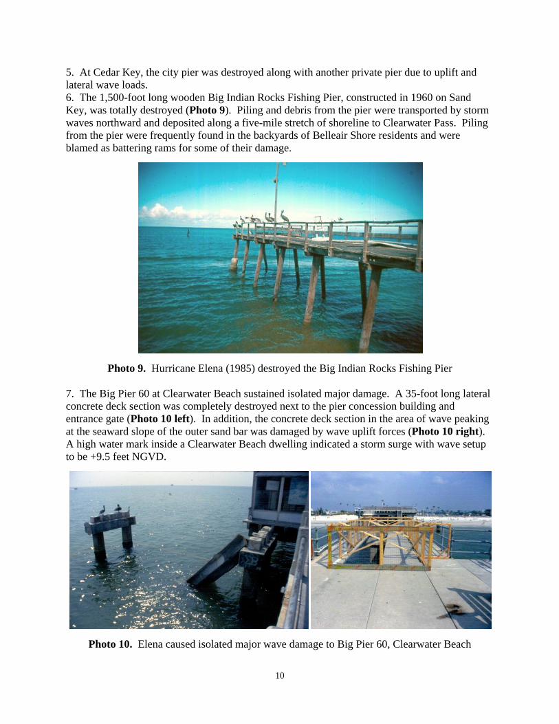
5. At Cedar Key, the city pier was destroyed along with another private pier due to uplift and lateral wave loads. 6. The 1,500-foot long wooden Big Indian Rocks Fishing Pier, constructed in 1960 on Sand Key, was totally destroyed (Photo 9). Piling and debris from the pier were transported by storm waves northward and deposited along a five-mile stretch of shoreline to Clearwater Pass. Piling from the pier were frequently found in the backyards of Belleair Shore residents and were blamed as battering rams for some of their damage.
Photo 9. Hurricane Elena (1985) destroyed the Big Indian Rocks Fishing Pier 7. The Big Pier 60 at Clearwater Beach sustained isolated major damage. A 35-foot long lateral concrete deck section was completely destroyed next to the pier concession building and entrance gate (Photo 10 left). In addition, the concrete deck section in the area of wave peaking at the seaward slope of the outer sand bar was damaged by wave uplift forces (Photo 10 right). A high water mark inside a Clearwater Beach dwelling indicated a storm surge with wave setup to be +9.5 feet NGVD.
Photo 10. Elena caused isolated major wave damage to Big Pier 60, Clearwater Beach
10
11
8. In the Town of Indian Rocks Beach, 150 feet of the end of a newly constructed and private wooden pier was destroyed. 9. In the Town of Indian Shores, a private wooden pier was destroyed and another private wooden pier was substantially damaged. Reference: Clark, R.R., 1986a. The Impact of Hurricane Elena and Tropical Storm Juan on
Coastal Construction in Florida, Florida Department of Natural Resources, Division of Beaches and Shores, Post-storm Report No. 85-3, 142 p.
October 31, 1985 - Tropical Storm Juan Tropical Storm Juan made landfall as a category one hurricane in New Orleans, Louisiana, prior to stalling at the coast and moving back out into the gulf. After weakening to tropical storm strength, it remained stationary and moved slowly eastward for three days before dissipating over Alabama. Sustained wind and storm waves spawned by Tropical Storm Juan impacted the southwest coast of Florida made vulnerable by Hurricane Elena. 1. In the Town of Indian Rocks Beach, the remaining 100 feet of a private wooden pier was destroyed. Elena had destroyed its outer 150 feet. Reference: Clark, R.R., 1986a. The Impact of Hurricane Elena and Tropical Storm Juan on
Coastal Construction in Florida, Florida Department of Natural Resources, Division of Beaches and Shores, Post-storm Report No. 85-3, 142 p.
November 21, 1985 – Hurricane Kate Hurricane Kate made landfall on Crooked Island near Mexico Beach with a peak gust of 85 miles per hour measured in Apalachicola. A storm tide of +8.4 feet NGVD was measured near Money Bayou on Indian Peninsula. 1. The Bay County Pier in Panama City Beach sustained major damage to its seaward end. 2. A 500-foot long, private wooden pier on Indian Peninsula was destroyed. 3. The outer 125 feet of the wooden Trade Winds Pier on the Ochlockonee River Entrance near Mashes Sands was destroyed. Reference: Clark, R.R., 1986b. Hurricane Kate, November 15-23, 1985, Florida Department of
Natural Resources, Division of Beaches and Shores, Post-storm Report 86-1, 114 p. http://bcs.dep.state.fl.us/reports/kate/kate1985.pdf November 23, 1988 – Tropical Storm Keith Tropical Storm Keith made landfall near Sarasota with maximum sustained winds of 63 miles per hour and a maximum storm tide of about +6 feet NGVD in Lee County. 1. The wooden Naples Pier, built in 1961, sustained major damage losing piles and decking at its seaward end. Reference: Clark, 1988 (unpublished field inspection).

Chapter 5 – Four Hurricanes and Two Storms of the 1990’s October 31, 1991 – Halloween Northeaster The Halloween Northeaster impacted the entire eastern seaboard of the United States including Florida, where it brought persistent high tides and prolonged gale force winds and storm waves. 1. The Lake Worth Pier, built in 1972, sustained major damage with the seaward 200 feet being destroyed (Photos 11 & 12).
Photo 11. Wave impact loads on the Lake Worth Pier during the Halloween Northeaster (1991) [BBCS Photo Files]
Photo 12. Lake Worth Pier damage from the Halloween Northeaster (1991) [BBCS Photo Files]
12
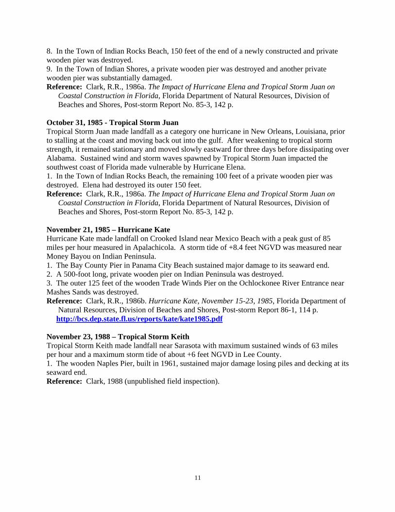
August 24, 1992 – Hurricane Andrew Hurricane Andrew made landfall near Florida City as a category five hurricane with catastrophic impacts to southern Dade County. The highest storm tide was measured at the Burger King Headquarters on Biscayne Bay to be +16.9 feet NGVD. 1. The Haulover Beach Pier in northern Dade County sustained major structural damage due to storm waves and a storm tide measured to be +6.1 feet NGVD at Bakers Haulover Inlet (Photo 13). Two interior pier sections were destroyed. Reference: Schmidt, D.V., Taplin, K.A., and Clark, R.R., 1993. Hurricane Andrew Storm
Summary and Impacts on the Beaches of Florida, Special Report, U.S. Army Corps of Engineers, Jacksonville District, and Florida Department of Natural Resources, Division of Beaches and Shores, 103 p.
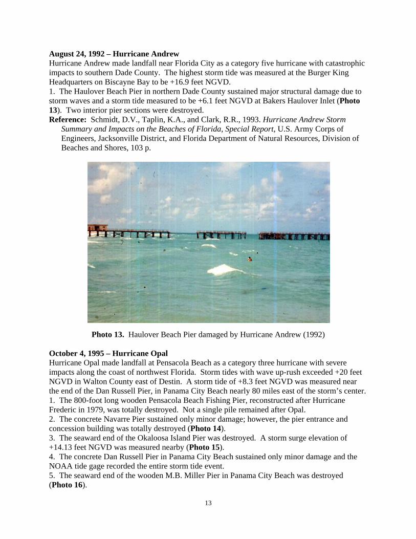
Photo 13. Haulover Beach Pier damaged by Hurricane Andrew (1992) October 4, 1995 – Hurricane Opal Hurricane Opal made landfall at Pensacola Beach as a category three hurricane with severe impacts along the coast of northwest Florida. Storm tides with wave up-rush exceeded +20 feet NGVD in Walton County east of Destin. A storm tide of +8.3 feet NGVD was measured near the end of the Dan Russell Pier, in Panama City Beach nearly 80 miles east of the storm’s center. 1. The 800-foot long wooden Pensacola Beach Fishing Pier, reconstructed after Hurricane Frederic in 1979, was totally destroyed. Not a single pile remained after Opal. 2. The concrete Navarre Pier sustained only minor damage; however, the pier entrance and concession building was totally destroyed (Photo 14). 3. The seaward end of the Okaloosa Island Pier was destroyed. A storm surge elevation of +14.13 feet NGVD was measured nearby (Photo 15). 4. The concrete Dan Russell Pier in Panama City Beach sustained only minor damage and the NOAA tide gage recorded the entire storm tide event. 5. The seaward end of the wooden M.B. Miller Pier in Panama City Beach was destroyed (Photo 16).
13

6. The seaward end of the wooden St. Andrews State Park pier was destroyed. An estimated 135 feet of the pier was lost (Photo 17). Reference: Leadon, M.E., Nguyen, N.T., and Clark, R.R., 1998. Hurricane Opal: Beach and
Dune Erosion and Structural Damage along the Panhandle Coast of Florida, Florida Department of Environmental Protection, Report No. BCS-98-01.
http://bcs.dep.state.fl.us/reports/opal-rpt.pdf
Photo 14. Navarre Pier concession and entrance building totally destroyed by Opal (1995)
Photo 15. Seaward end of the Okaloosa County Pier destroyed by Opal (1995)
14
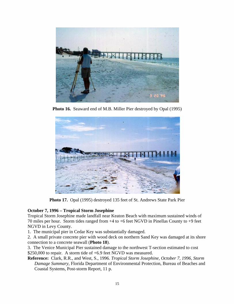
Photo 16. Seaward end of M.B. Miller Pier destroyed by Opal (1995)
Photo 17. Opal (1995) destroyed 135 feet of St. Andrews State Park Pier October 7, 1996 – Tropical Storm Josephine Tropical Storm Josephine made landfall near Keaton Beach with maximum sustained winds of 70 miles per hour. Storm tides ranged from +4 to +6 feet NGVD in Pinellas County to +9 feet NGVD in Levy County. 1. The municipal pier in Cedar Key was substantially damaged. 2. A small private concrete pier with wood deck on northern Sand Key was damaged at its shore connection to a concrete seawall (Photo 18). 3. The Venice Municipal Pier sustained damage to the northwest T-section estimated to cost $250,000 to repair. A storm tide of +6.9 feet NGVD was measured. Reference: Clark, R.R., and West, S., 1996. Tropical Storm Josephine, October 7, 1996, Storm
Damage Summary, Florida Department of Environmental Protection, Bureau of Beaches and Coastal Systems, Post-storm Report, 11 p.
15

Photo 18. Northern Sand Key pier damaged by Tropical Storm Josephine (1996) September 25, 1998 – Hurricane Georges Hurricane Georges crossed Key West with maximum sustained winds of 104 miles per hour and a storm tide of +5 to +6 feet NGVD. 1. A private wooden pier in Key West was substantially damaged. 2. Three private fishing piers were destroyed at Key Colony Beach. Reference: Clark, R.R., 1998. The Impact of Hurricane Georges on the Carbonate Beaches of
the Florida Keys, Florida Department of Environmental Protection Post-storm Report, 7 p. September 15, 1999 – Hurricane Floyd Hurricane Floyd passed 95 nautical miles off the coast of Cape Canaveral as a category four hurricane bringing gale force winds and high storm waves along the entire Florida east coast. Peak wind gusts of 69 miles per hour were measured at Daytona Beach. A NOAA buoy off Cape Canaveral also measured significant wave heights of over 50 feet. Half of the major structures damaged along the Florida coast were fishing piers that were subjected to the extreme wave forces. 1. The 1,000-foot wooden Jacksonville Beach Fishing Pier, constructed in 1959, lost 140 feet off its seaward end and had another 75 feet substantially damaged. 2. The 800-foot wooden Flagler Beach Fishing Pier, constructed in 1928, lost 75 feet off its seaward end. 3. The 1,050-foot wooden Ocean Casino Pier in Daytona Beach, constructed in 1925, lost 300 feet off its seaward end (Photo 19). Piling and deck debris from this pier extended 12 miles south to the Ponce de Leon Inlet north jetty. 4. The Sunglow Fishing Pier in Daytona Beach Shores sustained decking damage, but no major structural damage. 5. The Lighthouse Point Park Pier at Ponce de Leon Inlet constructed over the north jetty sustained pier deck railing damage.
16

Photo 19. Hurricane Floyd (1999) destroyed 300 feet of the Daytona Beach Pier 6. The seaward 50 feet of the Sebastian Inlet State Park Pier constructed over the north jetty, was substantially damaged. Steel deck grates along the pier’s length were also dislodged by the wave up-lift forces. 7. The 600-foot Sea Quay Pier in Vero Beach lost 400 feet off its seaward end (Photo 20). Reference: Clark, R.R., 2000. The Impact of Hurricane Floyd and Hurricane Irene on the
Florida East Coast, Department of Environmental Protection Report No. BCS-00-01, 42 p.
Photo 20. Hurricane Floyd destroyed 400 feet of the Sea Quay Pier, Vero Beach
17

Chapter 6 – Major Storms of 2000 through 2003 September 17, 2000 – Hurricane Gordon Hurricane Gordon was a category one hurricane in the Gulf of Mexico offshore from Tampa with maximum sustained winds of 80 miles per hour, before weakening as a minimal tropical storm at landfall north of Cedar Key. A NOAA buoy in the gulf measured a significant wave height of 19 feet. 1. The Venice Municipal Pier sustained damage to the northwest T-section estimated to cost $600,000 to repair. About 20 feet of the northwest end collapsed and wood decking blew out due to wave up-lift forces. Reference: West, S., 2000. Field Inspection Report on Hurricane Gordon, Florida Department
of Environmental Protection, Bureau of Beaches and Coastal Systems. September 14, 2001 – Tropical Storm Gabrielle Tropical Storm Gabrielle made landfall in southwest Florida as a tropical storm and intensified to hurricane strength after exiting northeast Florida. 1. The Flagler Beach Fishing Pier lost one piling and support bracing. 2. The Jacksonville Beach Fishing Pier sustained additional major damage. 3. The Naples Municipal Pier sustained minor damage, losing some decking and knee rails. 4. The Venice Municipal Pier lost additional piling from the north half of the T-section. Reference: Nelson, B., 2001. Field Inspection Report on Tropical Storm Gabrielle, Florida
Department of Environmental Protection, Bureau of Beaches and Coastal Systems. September 26, 2002 – Tropical Storm Isidore Tropical Storm Isidore made landfall in Louisiana as a strong tropical storm after making landfall in Yucatan as a category three hurricane. 1. The newly constructed concrete Pensacola Beach Fishing Pier was impacted by wave heights that reached to at least +28 feet NAVD88. The deck elevation of the new pier is +26 feet NAVD88. Wave up-lift forces dislodged six of the 300-pound breakaway deck panels, but caused no structural damage (Photo 21). 2. The concrete Navarre Beach Fishing Pier, with a solid fixed concrete deck, sustained deck and structural damage due to waves at its seaward end. Reference: Clark, R.R., 2002. Field Inspection Report on Tropical Storm Isidore, Florida
Department of Environmental Protection, Bureau of Beaches and Coastal Systems.
18

Photo 21. Tropical Storm Isidore’s wave uplift forces dislodged deck panels on Pensacola Beach Pier (2002)
19

Chapter 7 – Four Hurricanes of 2004 August 13, 2004 – Hurricane Charley Hurricane Charley made landfall on the southwest coast of Florida at Charlotte Harbor as a category four hurricane with significant effects to the nine Lee County coastal barrier islands. Storm tides of between +9 feet on North Captiva Island and +8.2 to +9.4 feet on Estero Island were experienced. 1. Although considerable loss of beach occurred at the Ft. Myers Beach Fishing Pier on Estero Island, only superficial damage occurred to the structure (Photo 22). This structure is the only pier fronting directly on the gulf in Lee County, although another pier is sited immediately inside of Sanibel Island at Ybor Point. Reference: Clark, R.R. and LaGrone, J.W., 2004. Hurricane Charley: Post-storm Beach
Conditions and Coastal Impact Report with Recommendations for Recovery and Modifications of Beach Management Strategies, Florida Department of Environmental Protection, Bureau of Beaches and Coastal Systems, 34 pp.
http://www.dep.state.fl.us/beaches/publications/pdf/charley.pdf
Photo 22. Little damage to Ft. Myers Beach Fishing Pier by Hurricane Charley September 5, 2004 – Hurricane Frances Hurricane Frances made landfall on south Hutchinson Island as a category two hurricane with maximum sustained winds of 105 miles per hour and storm tides reaching +12 feet NGVD. 1. The wooden Flagler Beach Fishing Pier sustained structural collapse to the outer 30 feet of the pier due to storm wave loads (Photo 23). 2. The wooden Sunglow Fishing Pier in Daytona Beach Shores had its seaward end destroyed due to storm wave loads.
20

3. The concrete fishing pier constructed over the north jetty at Sebastian Inlet State Park lost about 40 to 50 of the metal breakaway deck grates due to wave uplift forces, but sustained no significant structural damage (Photo 24). The pier was substantially restored in 2003 after sustaining major damage from Hurricane Floyd in 1999. 4. The wooden fishing pier at the Sea Quay Condominium in Vero Beach was destroyed (Photo 25). 5. The concrete Juno Beach Fishing Pier, constructed in 1998 in northern Palm Beach County, sustained decking damage but no structural damage. 6. The 940-foot concrete Lake Worth Fishing Pier, constructed in 1972, sustained major structural damage. Complete sections of the pier were destroyed, including the loss of piles, bents, beams, and decking (Photo 26). 7. The Deerfield Beach Pier sustained decking damage. 8. The Pompano Beach Municipal Pier sustained decking damage. 9. The Anglin’s Pier in Lauderdale-by-the-Sea had its shore segment destroyed along with extensive decking damage throughout its length (Photo 27). 10. The wooden Sunny Isles Fishing Pier sustained decking damage. Reference: Clark, R.R. et al, 2004. Hurricane Frances & Hurricane Jeanne: Post-storm Beach
Conditions and Coastal Impact Report with Recommendations for Recovery and Modifications of Beach Management Strategies, Florida Department of Environmental Protection, Bureau of Beaches and Coastal Systems, 93 pp. http://bcs.dep.state.fl.us/reports/franjean/Hurricanes_Frances_&_Jeanne/Full_Report/Full_Report.pdf
Photo 23. Hurricane Frances destroyed end of Flagler Beach Fishing Pier [BBCS Photo Files]
21

Photo 24. Sebastian Inlet State Park Fishing Pier lost 40-50 breakaway deck grates to Hurricane Frances [BBCS Photo Files]
Photo 25. Hurricane Frances destroyed the Sea Quay Pier, Vero Beach
22

Photo 26. The Lake Worth Pier sustained major destruction during Hurricane Frances [BBCS Photo Files]
Photo 27. Hurricane Frances destroyed the shore section of the Anglin’s Pier, Lauderdale-by-the-Sea [BBCS Photo Files]
23
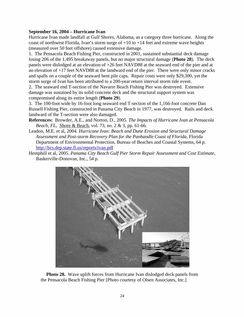
September 16, 2004 – Hurricane Ivan Hurricane Ivan made landfall at Gulf Shores, Alabama, as a category three hurricane. Along the coast of northwest Florida, Ivan’s storm surge of +10 to +14 feet and extreme wave heights (measured over 50 feet offshore) caused extensive damage. 1. The Pensacola Beach Fishing Pier, constructed in 2001, sustained substantial deck damage losing 206 of the 1,495 breakaway panels, but no major structural damage (Photo 28). The deck panels were dislodged at an elevation of +26 feet NAVD88 at the seaward end of the pier and at an elevation of +17 feet NAVD88 at the landward end of the pier. There were only minor cracks and spalls on a couple of the seaward bent pile caps. Repair costs were only $29,300, yet the storm surge of Ivan has been attributed to a 200-year return interval storm tide event. 2. The seaward end T-section of the Navarre Beach Fishing Pier was destroyed. Extensive damage was sustained by its solid concrete deck and the structural support system was compromised along its entire length (Photo 29). 3. The 100-foot wide by 16-foot long seaward end T-section of the 1,166-foot concrete Dan Russell Fishing Pier, constructed in Panama City Beach in 1977, was destroyed. Rails and deck landward of the T-section were also damaged. References: Browder, A.E., and Norton, D., 2005. The Impacts of Hurricane Ivan at Pensacola
Beach, FL, Shore & Beach, vol. 73, no. 2 & 3, pp. 61-66. Leadon, M.E. et al, 2004. Hurricane Ivan: Beach and Dune Erosion and Structural Damage
Assessment and Post-storm Recovery Plan for the Panhandle Coast of Florida, Florida Department of Environmental Protection, Bureau of Beaches and Coastal Systems, 64 p.
http://bcs.dep.state.fl.us/reports/ivan.pdf Hemphill et al, 2005. Panama City Beach Gulf Pier Storm Repair Assessment and Cost Estimate,
Baskerville-Donovan, Inc., 54 p.
Photo 28. Wave uplift forces from Hurricane Ivan dislodged deck panels from the Pensacola Beach Fishing Pier [Photo courtesy of Olsen Associates, Inc.]
24

Photo 29. Before and after (April and September 2004) aerial views of the solid concrete Navarre Beach Fishing Pier showing damage from Hurricane Ivan [BBCS Photo Files]
September 26, 2004 – Hurricane Jeanne Hurricane Jeanne made landfall on south Hutchinson Island as a category three hurricane with maximum sustained winds of 120 miles per hour and inflicting severe beach and dune erosion and damage to coastal structures along the Florida east coast left vulnerable by Hurricane Frances three weeks earlier (see Photo 1 in Chapter 1). 1. The wooden Sunglow Fishing Pier in Daytona Beach Shores sustained additional structural damage to its seaward end. 2. The wooden Canaveral Pier sustained major wave damage to some of the foundation cross-bracing at the pier’s seaward end and some minor decking damage, but no apparent pile damage. 3. A remnant section of the wooden Sea Quay Pier in Vero Beach was destroyed. Reference: Clark, R.R. et al, 2004. Hurricane Frances & Hurricane Jeanne: Post-storm Beach
Conditions and Coastal Impact Report with Recommendations for Recovery and Modifications of Beach Management Strategies, Florida Department of Environmental Protection, Bureau of Beaches and Coastal Systems, 93 pp. http://bcs.dep.state.fl.us/reports/franjean/Hurricanes_Frances_&_Jeanne/Full_Report/Full_Report.pdf
25

Chapter 8 – Two Hurricanes of 2005 July 10, 2005 – Hurricane Dennis Hurricane Dennis made landfall on Santa Rosa Island between Pensacola Beach and Navarre Beach as a category three hurricane with maximum sustained winds of 115 to 120 miles per hour. Peak measured storm tides ranged between +15.5 feet NAVD88 at Navarre Beach at the maximum wind field and +11.7 feet NAVD88 at the St. Marks lighthouse over 200 miles to the east of the point of landfall of the hurricane’s eye. 1. The Pensacola Beach Fishing Pier lost most of its breakaway deck panels along its length to wave up-lift forces exceeding the deck elevation of +26 feet NAVD88, but the pier once again sustained no major structural damage (Photo 30).
Photo 30. Before and after aerial views of the Pensacola Beach Fishing Pier showing that Hurricane Dennis’ wave uplift forces removed deck panels without major structural damage [BBCS Photo Files] 2. The concrete Navarre Beach Fishing Pier damaged by Hurricane Ivan a year earlier, sustained complete destruction to two sections. The piles and beams of the sixth and seventh bents from the seaward end of the pier were destroyed including the complete loss of three bays of the pier. A landward section at the shoreline was also lost as well as the remnants of the terminal T-section (Photo 31). 3. The concrete Dan Russell Pier in Panama City Beach lost an additional 50 feet off its seaward end landward of the T-section lost during Hurricane Ivan. Major damage was sustained to another 250 feet of pier, and moderate to minor damage was sustained to an additional 400 feet (Photos 33). 4. The 600-foot wooden fishing pier at St. Andrews State Park sustained damage to its seaward cross-bracing. 5. The wooden fishing pier at Mashes Sands Park at the entrance to Ochlockonee Bay lost its interior ramp section and a portion of the deck and railing (Photo 32). A storm tide was measured at Mashes Sands Park of +9.1 feet NAVD88. 6. A private wooden pier was destroyed near Mashes Sands at the entrance to Ochlockonee Bay.
26

References: Clark, R.R., and LaGrone, J.W., 2006. Hurricane Dennis & Hurricane Katrina: Final Report on 2005 Hurricane Season Impacts to Northwest Florida, Florida Department of Environmental Protection, Bureau of Beaches and Coastal Systems, 116 pp. http://bcs.dep.state.fl.us/reports/2005/2005hurr.pdf
Hemphill et al, 2005. Panama City Beach Gulf Pier Storm Repair Assessment and Cost Estimate, Baskerville-Donovan, Inc., 54 p.
Photo 31. Hurricane Dennis destroyed three sections of the solid concrete Navarre Beach Fishing Pier at the seaward end, a mid-section, and at the shoreline [BBCS Files]
Photo 33. Hurricane Dennis damaged the shore-section of the Mashes Sands Park Fishing Pier [BBCS Photo Files]
27

Photo 32. Hurricane Dennis removed an additional 50 feet off the end of the Dan Russell Pier at Panama City Beach and inflicted major damage to another 250 feet [Photos provided by Al Shortt, P.E., City Engineer, Panama City Beach] October 24, 2005 – Hurricane Wilma Hurricane Wilma made landfall near Cape Romano as a category three hurricane with maximum sustained winds of 125 miles per hour and a 10-foot storm surge in the Florida Everglades National Park. 1. The concrete White Street Pier in Key West sustained minor damage, losing some of its rails to the storm surge and waves (Photo 34). 2. At the west end of Clarence Higgs Beach in Key West, a concrete public fishing pier was substantially damaged and lost all its wood deck. 3. Between Rest Beach and Truman Annex on Key West, six piers were substantially damaged or destroyed. 4. A pier near Mallory Square adjacent to the Key West Ship Channel was also destroyed. Reference: Clark, R.R., LaGrone, J.W., and Koch, J.L., 2006. Hurricane Wilma – Post-
storm Beach Conditions and Coastal Impact Report, Florida Department of Environmental Protection, Bureau of Beaches and Coastal Systems, 98 pp.
http://bcs.dep.state.fl.us/reports/wilma/wilma.pdf
28

Photo 34. The White Street Pier in Key West following Hurricane Wilma [BBCS Photo Files]
29

References
Balsillie, J.H., 1985. Post-Storm Report: the Florida East Coast Thanksgiving Holiday Storm of 21-24 November 1984, Florida Department of Natural Resources, Division of Beaches and Shores, Post-Storm Report No. 85-1, 74 p.
Balsillie, J.H., and Clark, R.R., 1979. Preliminary Report on Coastal and Shoreline
Damage Resulting from Impact of Hurricane Frederic on the Northwestern Panhandle of Florida, September 12-13, 1979, Florida Department of Natural Resources, 179 p.
Browder, A.E., and Norton, D., 2005. The Impacts of Hurricane Ivan at Pensacola
Beach, FL, Shore & Beach, vol. 73, no. 2 & 3, pp. 61-66. Clark, R.R., 1982. Coastal Damage Associated with Subtropical Storm, June 18, 1982,
Florida Department of Natural Resources, Division of Beaches and Shores, 33 p. Clark, R.R., 1986a. The Impact of Hurricane Elena and Tropical Storm Juan on Coastal
Construction in Florida, Florida Department of Natural Resources, Division of Beaches and Shores, Post-storm Report No. 85-3, 142 p.
Clark, R.R., 1986b. Hurricane Kate, November 15-23, 1985, Florida Department of
Natural Resources, Division of Beaches and Shores, Post-storm Report 86-1, 114 p. Clark, R.R., 1998. The Impact of Hurricane Georges on the Carbonate Beaches of the
Florida Keys, Florida Department of Environmental Protection Post-storm Report, 7 p.
Clark, R.R., 2000. The Impact of Hurricane Floyd and Hurricane Irene on the Florida
East Coast, Department of Environmental Protection Report No. BCS-00-01, 42 p. Clark, R.R., 2002. Field Inspection Report on Tropical Storm Isidore, Florida
Department of Environmental Protection, Bureau of Beaches and Coastal Systems. Clark, R.R. and LaGrone, J.W., 2004. Hurricane Charley: Post-storm Beach Conditions
and Coastal Impact Report with Recommendations for Recovery and Modifications of Beach Management Strategies, Florida Department of Environmental Protection, Bureau of Beaches and Coastal Systems, 34 pp.
Clark, R.R., and LaGrone, J.W., 2006. Hurricane Dennis & Hurricane Katrina: Final
Report on 2005 Hurricane Season Impacts to Northwest Florida, Florida Department of Environmental Protection, Bureau of Beaches and Coastal Systems, 116 pp.
Clark, R.R., LaGrone, J.W., and Koch, J.L., 2006. Hurricane Wilma – Post-storm Beach
Conditions and Coastal Impact Report, Florida Department of Environmental Protection, Bureau of Beaches and Coastal Systems, 98 pp.
30

31
Clark, R.R., and West, S., 1996. Tropical Storm Josephine, October 7, 1996, Storm
Damage Summary, Florida Department of Environmental Protection, Bureau of Beaches and Coastal Systems, Post-storm Report, 11 p.
Clark, R.R. et al, 2004. Hurricane Frances & Hurricane Jeanne: Post-storm Beach
Conditions and Coastal Impact Report with Recommendations for Recovery and Modifications of Beach Management Strategies, Florida Department of Environmental Protection, Bureau of Beaches and Coastal Systems, 93 pp.
Hemphill et al, 2005. Panama City Beach Gulf Pier Storm Repair Assessment and Cost
Estimate, Baskerville-Donovan, Inc., 54 p. Leadon, M.E. et al, 2004. Hurricane Ivan: Beach and Dune Erosion and Structural
Damage Assessment and Post-storm Recovery Plan for the Panhandle Coast of Florida, Florida Department of Environmental Protection, Bureau of Beaches and Coastal Systems, 64 p.
Leadon, M.E., Nguyen, N.T., and Clark, R.R., 1998. Hurricane Opal: Beach and Dune
Erosion and Structural Damage along the Panhandle Coast of Florida, Florida Department of Environmental Protection, Report No. BCS-98-01.
Nelson, B., 2001. Field Inspection Report on Tropical Storm Gabrielle, Florida
Department of Environmental Protection, Bureau of Beaches and Coastal Systems. Schmidt, D.V., Taplin, K.A., and Clark, R.R., 1993. Hurricane Andrew Storm Summary
and Impacts on the Beaches of Florida, Special Report, U.S. Army Corps of Engineers, Jacksonville District, and Florida Department of Natural Resources, Division of Beaches and Shores, 103 p.
U.S. Army Engineer District, Mobile, Corps of Engineers, 1976. Post-disaster Report,
Hurricane Eloise, 16-23 September 1975, 130 p. West, S., 2000. Field Inspection Report on Hurricane Gordon, Florida Department of
Environmental Protection, Bureau of Beaches and Coastal Systems.