fisheries (coastal communities) (amendment) regulations 2017 · fisheries (coastal communities)...
TRANSCRIPT

C T
FISHERIES (COASTAL COMMUNITIES)
(AMENDMENT) REGULATIONS 2017


Fisheries (Coastal Communities) (Amendment) Regulations 2017 Arrangement of Sections
to Page 3
C T
FISHERIES (COASTAL COMMUNITIES)
(AMENDMENT) REGULATIONS 2017
Arrangement of Sections
Regulation
1 Short Title and Interpretation ................................................................................. 5 2 Schedule I amended ............................................................................................... 5


Fisheries (Coastal Communities) (Amendment) Regulations 2017 Regulation 1
to Page 5
C T
FISHERIES (COASTAL COMMUNITIES)
(AMENDMENT) REGULATIONS 2017
FISHERIES MANAGEMENT ACT 2002
IN EXERCISE of the powers conferred by section 15(1) and 101(2)(b) of the
Fisheries Management Act 2002, the Minister responsible for Fisheries makes
the following Regulations -
1 Short Title and Interpretation
(1) 'These Regulation may be cited as the Fisheries (Coastal Communities)
(Amendment) Regulations 2017.
(2) In these Regulations, the Fisheries (Coastal Communities) Regulations 2009,
as amended, shall be referred to as the “Principal Regulations”.
2 Schedule I amended
Schedule I of the Principal Regulations is amended –
(a) by inserting the following after item 11 of the list of coastal communities –
“12 Fafa Coastal Community
13. Holonga Coastal Community (Tongatapu)
14. Lapaha Coastal Community
15. Nukuleka Coastal Community
16. Pangaimotu Coastal Community (Tongatapu)
Regulation 2 Fisheries (Coastal Communities) (Amendment)
Regulations 2017
Page 6 to
17. Ha’atafu Coastal Community
18. ‘Utulei Coastal Community
19. ‘Utungake Coastal Community
20. Talihau Coastal Community
21. Falevai Coastal Community
22. Koloa Coastal Community
23. ‘Eueiki Island (Vava’u)
24. Lape Coastal Community
25. Hunga Coastal Community
26. Ofu Coastal Community
27. Mango Coastal Community
28. Fonoi Coastal Community
29. Matuku Coastal Community”; and
(2) by inserting the following after the Map of the Kolonga Special Management
Area –
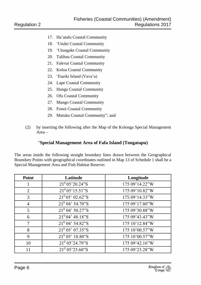
“Special Management Area of Fafa Island (Tongatapu)
The areas inside the following straight boundary lines drawn between the Geographical
Boundary Points with geographical coordinates outlined in Map 13 of Schedule 1 shall be a
Special Management Area and Fish Habitat Reserve:
Point Latitude Longitude
1 210 05’20.24”S 175 09’14.22”W
2 210 05’15.51”S 175 09’10.82”W
3 210 05’ 02.62”S 175 09’14.33”W
4 210 04’ 54.70”S 175 09’17.80”W
5 210 04’ 50.27”S 175 09’30.88”W
6 210 04’ 48.18”S 175 09’43.43”W
7 210 04’ 54.82”S 175 10’12.84”W
8 210 05’ 07.35”S 175 10’00.57”W
9 210 05’ 18.80”S 175 10’00.57”W
10 210 05’24.79”S 175 09’42.16”W
11 210 05’25.60”S 175 09’23.28”W
Fisheries (Coastal Communities) (Amendment) Regulations 2017 Regulation 2
to Page 7
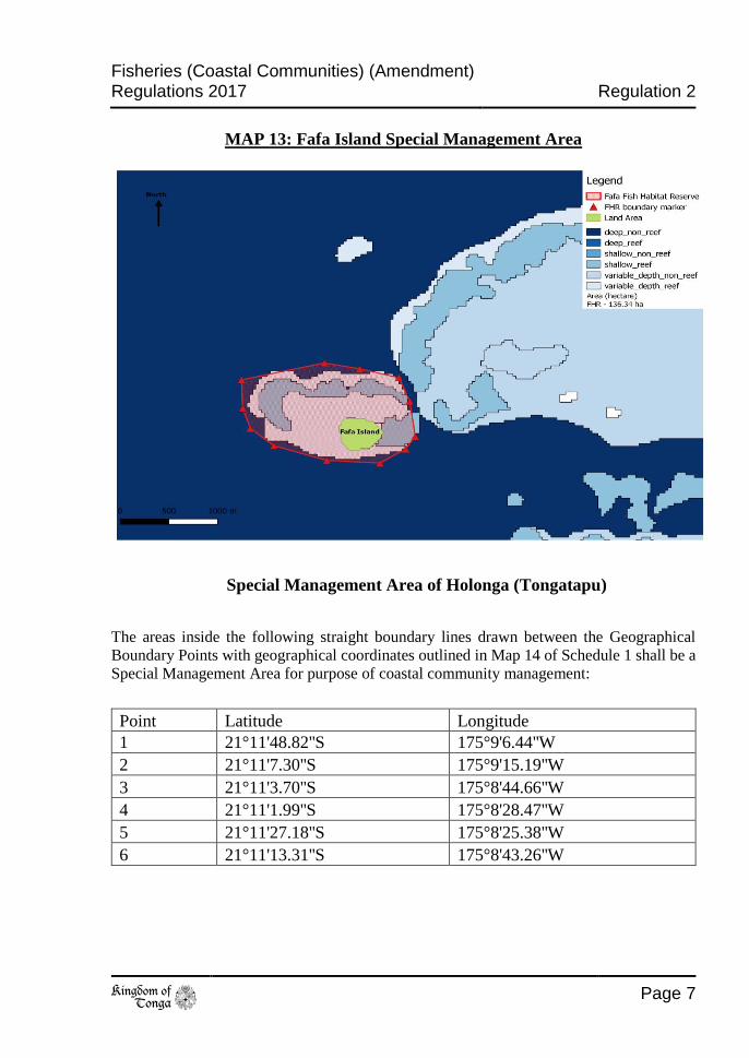
MAP 13: Fafa Island Special Management Area
Special Management Area of Holonga (Tongatapu)
The areas inside the following straight boundary lines drawn between the Geographical
Boundary Points with geographical coordinates outlined in Map 14 of Schedule 1 shall be a
Special Management Area for purpose of coastal community management:
Point Latitude Longitude
1 21°11'48.82''S 175°9'6.44''W
2 21°11'7.30''S 175°9'15.19''W
3 21°11'3.70''S 175°8'44.66''W
4 21°11'1.99''S 175°8'28.47''W
5 21°11'27.18''S 175°8'25.38''W
6 21°11'13.31''S 175°8'43.26''W

Regulation 2 Fisheries (Coastal Communities) (Amendment)
Regulations 2017
Page 8 to
The areas inside the following straight boundary lines drawn between the
Geographical Boundary Points with geographical coordinates outlined in Map 14 of
Schedule 1 shall be Fish Habitat Reserve:
Point Latitude Longitude
3 21°11'3.70''S 175°8'44.66''W
4 21°11'1.99''S 175°8'28.47''W
5 21°11'27.18''S 175°8'25.38''W
6 21°11'13.31''S 175°8'43.26''W
MAP 14: Holonga Special Management Area
Special Management Area of Lapaha (Tongatapu)
The areas inside the following straight boundary lines drawn between the Geographical
Boundary Points with geographical coordinates outlined in Map 15 of Schedule 1 shall be a
Special Management Area for purpose of coastal community management:
Point Latitude Longitude
1 21°10'25.32"S 175° 7'1.54"W
2 21°10'45.97"S 175° 7'18.36"W

Fisheries (Coastal Communities) (Amendment) Regulations 2017 Regulation 2
to Page 9
3 21°10'37.52"S 175° 7'35.41"W
4 21°10'26.51"S 175° 7'55.03"W
5 21° 9'54.70"S 175° 7'45.00"W
6 21°10'7.95"S 175° 7'26.28"W
7 21°10'24.50''S 175°7'6.90''W
10 21°10'38.15''S 175°7'17.62
The areas inside the following straight boundary lines drawn between the Geographical
Boundary Points with geographical coordinates outlined in Map 15 of Schedule 1 shall be a
Fish Habitat Reserve:
Point Latitude Longitude
7 21°10'24.50"S 175° 7'6.90"W
8 21°10'16.19"S 175° 7'22.22"W
9 21°10'32.86"S 175° 7'31.32"W
10 21°10'38.15"S 175° 7'17.62"W

Regulation 2 Fisheries (Coastal Communities) (Amendment)
Regulations 2017
Page 10 to
MAP 15: Lapaha Special Management Area
Special Management Area of Nukuleka (Tongatapu)
The areas inside the following straight boundary lines drawn between the Geographical
Boundary Points with geographical coordinates outlined in Map 16 of Schedule 1 shall be a
Special Management Area for purpose of coastal community management:
Point Latitude Longitude
1 21°8'30.30''S 175°8'11.24''W
2 21°9'38.68''S 175°8'22.72''W
3 21°9'39.68''W 175°7'11.22''W
The areas inside the following straight boundary lines drawn between the Geographical
Boundary Points with geographical coordinates outlined in Map 16 of Schedule 1 shall be a
Fish Habitat Reserve:
Point Latitude Longitude
1 21°8'44.47''S 175°7'26.27''W
2 21°8'37.25''S 175°7'47.05''W
3 21°9'6.76''S 175°7'53.41''W
4 21°9'6.58''S 175°7'40.74''W

Fisheries (Coastal Communities) (Amendment) Regulations 2017 Regulation 2
to Page 11
MAP 16: Nukuleka Special Management Area
Special Management Area of Pangaimotu Island (Tongatapu)
The areas inside the following straight boundary lines drawn between the Geographical
Boundary Points with geographical coordinates outlined in Map 17 of Schedule 1 shall be a
Special Management Area and Fish Habitat Reserve:
Point Latitude Longitude
1 21° 7'52.25"S 175° 9'26.19"W
2 21° 7'13.48"S 175° 9'11.64"W
3 21° 7'12.53"S 175° 9'20.57"W
4 21° 6'58.64"S 175° 9'44.07"W
5 21° 7'4.52"S 175°10'9.44"W
6 21° 7'12.89"S 175°10'12.42"W
Regulation 2 Fisheries (Coastal Communities) (Amendment)
Regulations 2017
Page 12 to
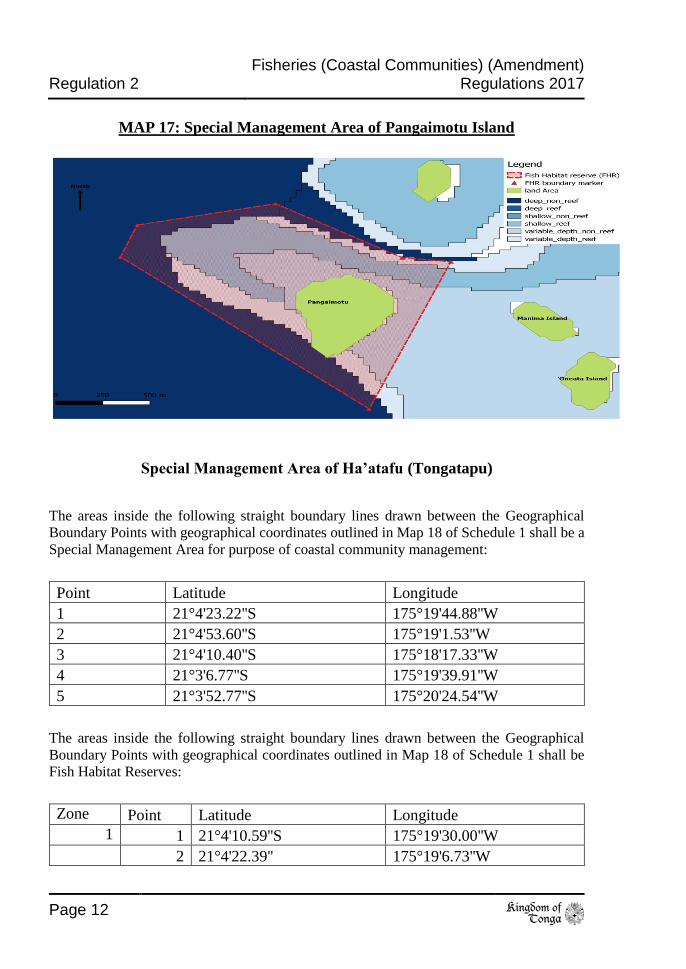
MAP 17: Special Management Area of Pangaimotu Island
Special Management Area of Ha’atafu (Tongatapu)
The areas inside the following straight boundary lines drawn between the Geographical
Boundary Points with geographical coordinates outlined in Map 18 of Schedule 1 shall be a
Special Management Area for purpose of coastal community management:
Point Latitude Longitude
1 21°4'23.22''S 175°19'44.88''W
2 21°4'53.60''S 175°19'1.53''W
3 21°4'10.40''S 175°18'17.33''W
4 21°3'6.77''S 175°19'39.91''W
5 21°3'52.77''S 175°20'24.54''W
The areas inside the following straight boundary lines drawn between the Geographical
Boundary Points with geographical coordinates outlined in Map 18 of Schedule 1 shall be
Fish Habitat Reserves:
Zone Point Latitude Longitude
1 1 21°4'10.59''S 175°19'30.00''W
2 21°4'22.39'' 175°19'6.73''W

Fisheries (Coastal Communities) (Amendment) Regulations 2017 Regulation 2
to Page 13
3 21°4'9.18''S 175°19'7.07''W
4 21°3'59.16''S 175°19'25.73''W
2 5 21°4'9.91''S 175°20'2.85''W
6 21°3'58.21''S 175°19'53.77''W
7 21°3'49.05''S 175°20'2.09''W
8 21°4'1.23''S 175°20'14.49''W
MAP 18: Special Management Area of Ha’atafu
Special Management Area of ‘Utulei (Vava’u)
The areas inside the following straight boundary lines drawn between the Geographical
Boundary Points with geographical coordinates outlined in Map 19 of Schedule 1 shall be a
Special Management Area for the purpose of coastal community management:
Point Latitude Longitude
1 18°40'39.41"S 173°59'58.45"W
2 18°40'46.54"S 173°59'56.17"W
3 18°40'26.90"S 173°59'36.10"W
4 18°40'9.00"S 173°59'11.80"W
5 18°39'56.70"S 173°59'12.40"W
6 18°39'41.00"S 173°59'19.00"W
7 18°39'17.50"S 173°59'29.00"W

Regulation 2 Fisheries (Coastal Communities) (Amendment)
Regulations 2017
Page 14 to
8 18°39'8.10"S 173°59'31.50"W
9 18°39'7.20"S 173°59'36.90"W
10 18°39'8.10"S 173°59'43.40"W
11 18°39'10.50"S 173°59'48.80"W
12 18°39'18.60"S 173°59'56.50"W
13 18°39'31.30"S 174° 0'19.40"W
14 18°39'38.10"S 174° 0'27.60"W
15 18°39'44.56"S 174° 0'22.42"W
The areas inside the following straight boundary lines drawn between the Geographical
Boundary Points with geographical coordinates outlined in Map 19 of Schedule 1 shall be a
Fish Habitat Reserve:
Point Latitude Longitude
12 18°39'18.60"S 173°59'56.50"W
13 18°39'31.30"S 174° 0'19.40"W
16 18°39'34.29"S 174° 0'15.96"W
17 18°39'19.56"S 173°59'48.18"W
MAP 19: Special Management Area of ‘Utulei

Fisheries (Coastal Communities) (Amendment) Regulations 2017 Regulation 2
to Page 15
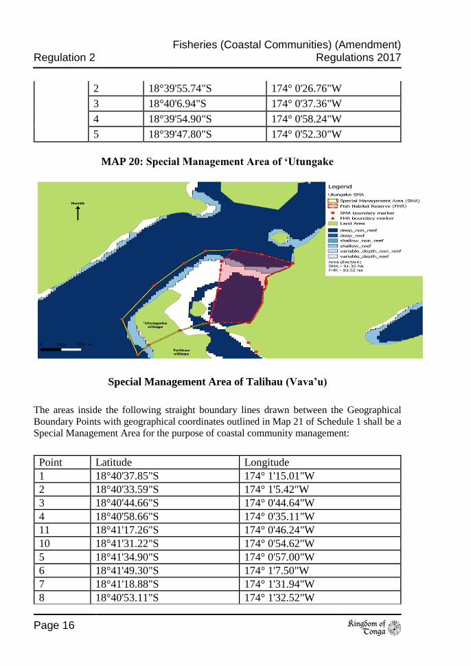
Special Management Area of ‘Utungake (Vava’u)
The areas inside the following straight boundary lines drawn between the Geographical
Boundary Points with geographical coordinates outlined in Map 20 of Schedule 1 shall be a
Special Management Area for the purpose of coastal community management:
Point Latitude Longitude
1 18°39'50.40"S 174° 0'41.70"W
2 18°39'55.74"S 174° 0'26.76"W
3 18°40'6.94"S 174° 0'37.36"W
4 18°39'54.90"S 174° 0'58.24"W
5 18°39'47.80"S 174° 0'52.30"W
6 18°39'48.70"S 174° 1'5.00"W
7 18°39'56.50"S 174° 1'14.00"W
8 18°40'10.30"S 174° 1'26.30"W
9 18°40'31.30"S 174° 1'39.50"W
10 18°40'53.11"S 174° 1'32.52"W
11 18°40'47.12"S 174° 1'28.11"W
12 18°40'37.85"S 174° 1'15.01"W
13 18°40'33.59"S 174° 1'5.42"W
14 18°40'32.93"S 174° 1'2.92"W
18 18°40'34.22"S 174° 0'43.31"W
17 18°40'8.35"S 174° 0'37.30"W
The areas inside the following straight boundary lines drawn between the Geographical
Boundary Points with geographical coordinates outlined in Map 20 of Schedule 1 shall be
Fish Habitat Reserves:
Zone Point Latitude Longitude
1 14 18°40'32.93"S 174° 1'2.92"W
15 18°40'12.38"S 174° 0'59.51"W
16 18°39'59.84"S 174° 0'58.43"W
17 18°40'8.35"S 174° 0'37.30"W
18 18°40'34.22"S 174° 0'43.31"W
2 1 18°39'50.40"S 174° 0'41.70"W
Regulation 2 Fisheries (Coastal Communities) (Amendment)
Regulations 2017
Page 16 to
2 18°39'55.74"S 174° 0'26.76"W
3 18°40'6.94"S 174° 0'37.36"W
4 18°39'54.90"S 174° 0'58.24"W
5 18°39'47.80"S 174° 0'52.30"W
MAP 20: Special Management Area of ‘Utungake
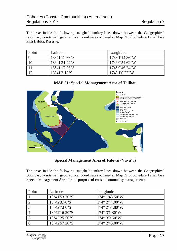
Special Management Area of Talihau (Vava’u)
The areas inside the following straight boundary lines drawn between the Geographical
Boundary Points with geographical coordinates outlined in Map 21 of Schedule 1 shall be a
Special Management Area for the purpose of coastal community management:
Point Latitude Longitude
1 18°40'37.85"S 174° 1'15.01"W
2 18°40'33.59"S 174° 1'5.42"W
3 18°40'44.66"S 174° 0'44.64"W
4 18°40'58.66"S 174° 0'35.11"W
11 18°41'17.26"S 174° 0'46.24"W
10 18°41'31.22"S 174° 0'54.62"W
5 18°41'34.90"S 174° 0'57.00"W
6 18°41'49.30"S 174° 1'7.50"W
7 18°41'18.88"S 174° 1'31.94"W
8 18°40'53.11"S 174° 1'32.52"W
Fisheries (Coastal Communities) (Amendment) Regulations 2017 Regulation 2
to Page 17
The areas inside the following straight boundary lines drawn between the Geographical
Boundary Points with geographical coordinates outlined in Map 21 of Schedule 1 shall be a
Fish Habitat Reserve:
Point Latitude Longitude
9 18°41'12.66"S 174° 1'14.86"W
10 18°41'31.22"S 174° 0'54.62"W
11 18°41'17.26"S 174° 0'46.24"W
12 18°41'3.18"S 174° 1'0.23"W
MAP 21: Special Management Area of Talihau
Special Management Area of Falevai (Vava’u)
The areas inside the following straight boundary lines drawn between the Geographical
Boundary Points with geographical coordinates outlined in Map 22 of Schedule 1 shall be a
Special Management Area for the purpose of coastal community management:
Point Latitude Longitude
1 18°41'53.70"S 174° 1'48.50"W
2 18°42'3.70"S 174° 2'44.00"W
3 18°42'7.80"S 174° 2'54.80"W
4 18°42'16.20"S 174° 3'1.30"W
5 18°42'25.50"S 174° 3'0.60"W
6 18°42'57.20"S 174° 2'45.80"W

Regulation 2 Fisheries (Coastal Communities) (Amendment)
Regulations 2017
Page 18 to
7 18°43'12.70"S 174° 2'31.00"W
8 18°43'26.30"S 174° 2'13.10"W
9 18°43'16.24"S 174° 1'58.50"W
The areas inside the following straight boundary lines drawn between the Geographical
Boundary Points with geographical coordinates outlined in Map 22 of Schedule 1 shall be a
Fish Habitat Reserve:
Point Latitude Longitude
6 18°42'57.20"S 174° 2'45.80"W
7 18°43'12.70"S 174° 2'31.00"W
10 18°43'6.20"S 174° 2'15.70"W
11 18°42'47.30"S 174° 2'30.60"W
MAP 22: Special Management Area of Falevai (Vava’u)
Special Management Area of Koloa (Vava’u)
The areas inside the following straight boundary lines drawn between the Geographical
Boundary Points with geographical coordinates outlined in Map 23 of Schedule 1 shall be a
Special Management Area for the purpose of coastal community management:
Point Latitude Longitude
1 18°38'44.00"S 173°55'25.70"W
2 18°39'20.50"S 173°54'59.60"W

Fisheries (Coastal Communities) (Amendment) Regulations 2017 Regulation 2
to Page 19
3 18°39'49.40"S 173°55'52.40"W
4 18°39'3.40"S 173°56'25.50"W
5 18°38'26.60"S 173°56'19.10"W
6 18°38'10.20"S 173°55'51.70"W
7 18°38'22.28"S 173°55'42.56"W
The areas inside the following straight boundary lines drawn between the Geographical
Boundary Points with geographical coordinates outlined in Map 23 of Schedule 1 shall be
Fish Habitat Reserves:
Zone Point Latitude Longitude
1 8 18°38'41.70"S 173°56'13.80"W
9 18°38'47.50"S 173°56'19.50"W
10 18°38'52.80"S 173°56'14.90"W
11 18°38'46.70"S 173°56'8.50"W
2 12 18°39'3.30"S 173°55'56.00"W
13 18°39'12.40"S 173°56'7.30"W
14 18°39'26.80"S 173°56'1.90"W
15 18°39'17.90"S 173°55'50.00"W
Regulation 2 Fisheries (Coastal Communities) (Amendment)
Regulations 2017
Page 20 to
MAP 23: Special Management Area of Koloa (Vava’u)
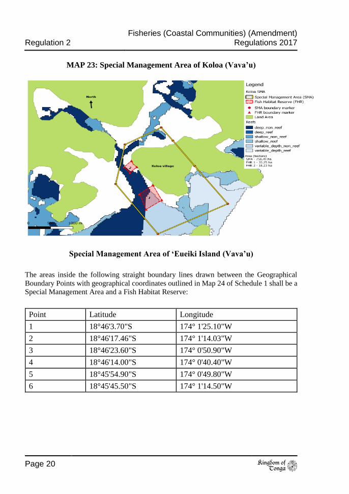
Special Management Area of ‘Eueiki Island (Vava’u)
The areas inside the following straight boundary lines drawn between the Geographical
Boundary Points with geographical coordinates outlined in Map 24 of Schedule 1 shall be a
Special Management Area and a Fish Habitat Reserve:
Point Latitude Longitude
1 18°46'3.70"S 174° 1'25.10"W
2 18°46'17.46"S 174° 1'14.03"W
3 18°46'23.60"S 174° 0'50.90"W
4 18°46'14.00"S 174° 0'40.40"W
5 18°45'54.90"S 174° 0'49.80"W
6 18°45'45.50"S 174° 1'14.50"W

Fisheries (Coastal Communities) (Amendment) Regulations 2017 Regulation 2
to Page 21
MAP 24: Special Management Area of ‘Eueiki Island (Vava’u)
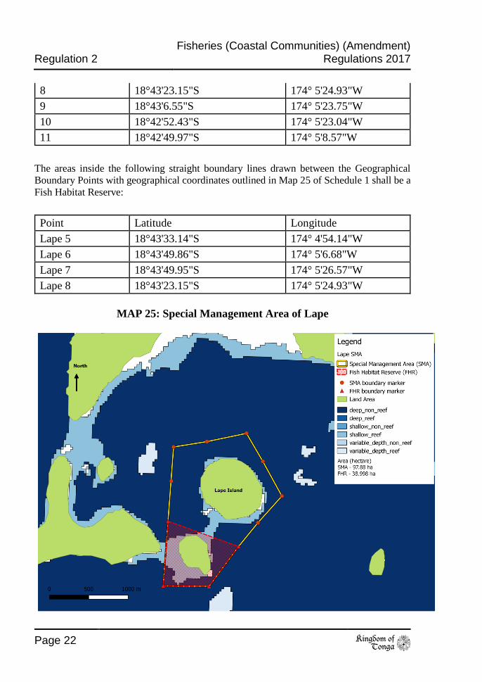
Special Management Area of Lape (Vava’u)
The areas inside the following straight boundary lines drawn between the Geographical
Boundary Points with geographical coordinates outlined in Map 25 of Schedule 1 shall be a
Special Management Area for the purpose of coastal community management:
Name Latitude Longitude
1 18°42'46.30"S 174° 4'51.50"W
2 18°42'57.80"S 174° 4'44.20"W
3 18°43'12.00"S 174° 4'35.70"W
4 18°43'23.20"S 174° 4'45.90"W
5 18°43'33.14"S 174° 4'54.14"W
6 18°43'49.86"S 174° 5'6.68"W
7 18°43'49.95"S 174° 5'26.57"W
Regulation 2 Fisheries (Coastal Communities) (Amendment)
Regulations 2017
Page 22 to
8 18°43'23.15"S 174° 5'24.93"W
9 18°43'6.55"S 174° 5'23.75"W
10 18°42'52.43"S 174° 5'23.04"W
11 18°42'49.97"S 174° 5'8.57"W
The areas inside the following straight boundary lines drawn between the Geographical
Boundary Points with geographical coordinates outlined in Map 25 of Schedule 1 shall be a
Fish Habitat Reserve:
Point Latitude Longitude
Lape 5 18°43'33.14"S 174° 4'54.14"W
Lape 6 18°43'49.86"S 174° 5'6.68"W
Lape 7 18°43'49.95"S 174° 5'26.57"W
Lape 8 18°43'23.15"S 174° 5'24.93"W
MAP 25: Special Management Area of Lape
Fisheries (Coastal Communities) (Amendment) Regulations 2017 Regulation 2
to Page 23
Special Management Area of Hunga (Vava’u)
The areas inside the following straight boundary lines drawn between the Geographical
Boundary Points with geographical coordinates outlined in Map 26 of Schedule 1 shall be a
Special Management Area for the purpose of coastal community management:
Point Latitude Longitude
1 18°43'38.00"S 174° 8'36.60"W
2 18°42'29.10"S 174° 7'20.70"W
3 18°41'8.00"S 174° 6'1.70"W
4 18°40'17.70"S 174° 4'52.30"W
5 18°39'54.90"S 174° 6'25.00"W
6 18°40'18.30"S 174° 7'32.50"W
7 18°41'29.90"S 174° 8'29.70"W
8 18°42'4.50"S 174° 8'45.10"W
9 18°42'46.40"S 174° 9'8.70"W
10 18°43'8.60"S 174° 9'9.30"W
The areas inside the following straight boundary lines drawn between the Geographical
Boundary Points with geographical coordinates outlined in Map 26 of Schedule 1 shall be
Fish Habitat Reserves:
Zone Point Latitude Longitude
1 8 18°42'4.50"S 174° 8'45.10"W
9 18°42'46.40"S 174° 9'8.70"W
11 18°42'59.10"S 174° 8'45.50"W
12 18°42'48.90"S 174° 8'26.20"W
13 18°42'30.20"S 174° 8'17.90"W
2 14 18°42'20.80"S 174° 7'54.60"W
15 18°42'2.20"S 174° 8'1.20"W
16 18°41'47.00"S 174° 7'56.10"W
17 18°41'27.40"S 174° 7'45.80"W
18 18°41'19.80"S 174° 7'22.90"W

Regulation 2 Fisheries (Coastal Communities) (Amendment)
Regulations 2017
Page 24 to
MAP 26: Special Management Area of Hunga (Vava’u)
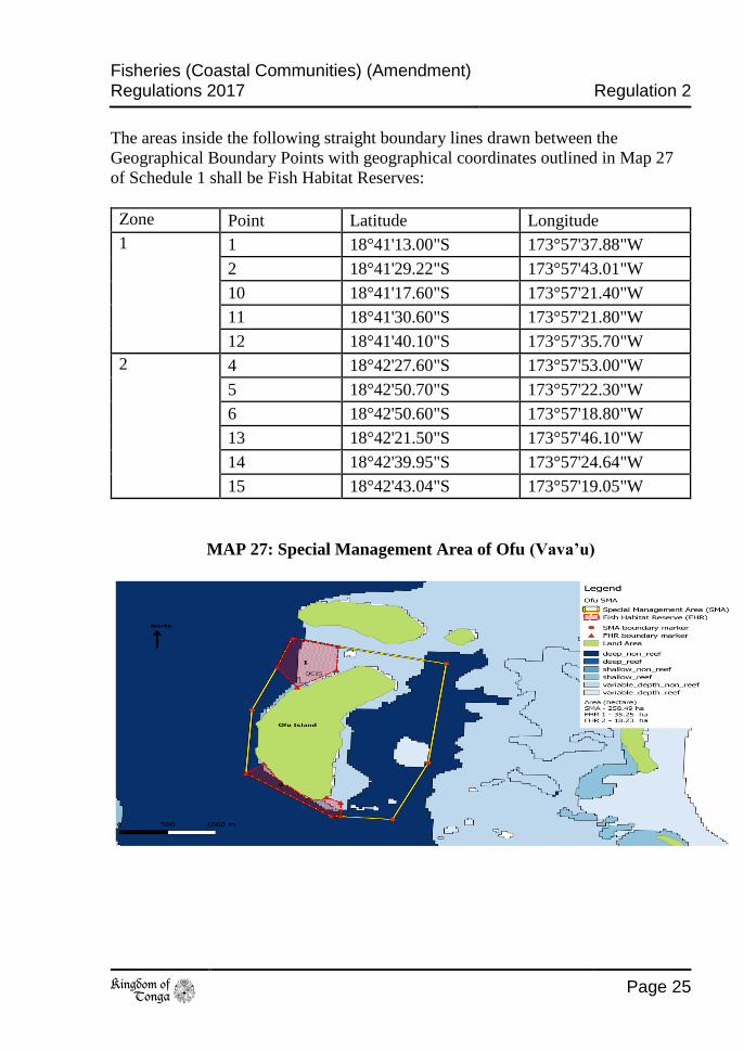
Special Management Area of Ofu (Vava’u)
The areas inside the following straight boundary lines drawn between the Geographical
Boundary Points with geographical coordinates outlined in Map 27 of Schedule 1 shall be a
Special Management Area for the purpose of coastal community management:
Point Latitude Longitude
1 18°41'13.00"S 173°57'37.88"W
2 18°41'29.22"S 173°57'43.01"W
3 18°41'52.80"S 173°57'51.50"W
4 18°42'27.60"S 173°57'53.00"W
5 18°42'50.70"S 173°57'22.30"W
6 18°42'50.60"S 173°57'18.80"W
7 18°42'52.00"S 173°57'0.50"W
8 18°42'20.80"S 173°56'48.30"W
9 18°41'26.36"S 173°56'42.90"W
10 18°41'17.60"S 173°57'21.40"W
Fisheries (Coastal Communities) (Amendment) Regulations 2017 Regulation 2
to Page 25
The areas inside the following straight boundary lines drawn between the
Geographical Boundary Points with geographical coordinates outlined in Map 27
of Schedule 1 shall be Fish Habitat Reserves:
Zone Point Latitude Longitude
1 1 18°41'13.00"S 173°57'37.88"W
2 18°41'29.22"S 173°57'43.01"W
10 18°41'17.60"S 173°57'21.40"W
11 18°41'30.60"S 173°57'21.80"W
12 18°41'40.10"S 173°57'35.70"W
2 4 18°42'27.60"S 173°57'53.00"W
5 18°42'50.70"S 173°57'22.30"W
6 18°42'50.60"S 173°57'18.80"W
13 18°42'21.50"S 173°57'46.10"W
14 18°42'39.95"S 173°57'24.64"W
15 18°42'43.04"S 173°57'19.05"W
MAP 27: Special Management Area of Ofu (Vava’u)
Regulation 2 Fisheries (Coastal Communities) (Amendment)
Regulations 2017
Page 26 to
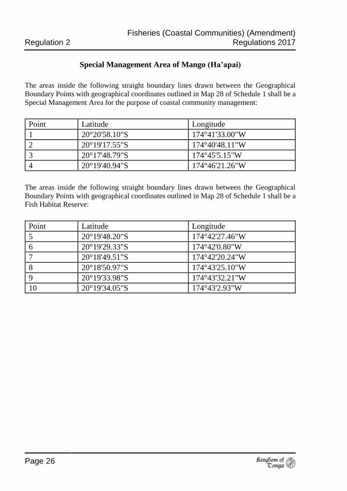
Special Management Area of Mango (Ha’apai)
The areas inside the following straight boundary lines drawn between the Geographical
Boundary Points with geographical coordinates outlined in Map 28 of Schedule 1 shall be a
Special Management Area for the purpose of coastal community management:
Point Latitude Longitude
1 20°20'58.10"S 174°41'33.00"W
2 20°19'17.55"S 174°40'48.11"W
3 20°17'48.79"S 174°45'5.15"W
4 20°19'40.94"S 174°46'21.26"W
The areas inside the following straight boundary lines drawn between the Geographical
Boundary Points with geographical coordinates outlined in Map 28 of Schedule 1 shall be a
Fish Habitat Reserve:
Point Latitude Longitude
5 20°19'48.20"S 174°42'27.46"W
6 20°19'29.33"S 174°42'0.80"W
7 20°18'49.51"S 174°42'20.24"W
8 20°18'50.97"S 174°43'25.10"W
9 20°19'33.98"S 174°43'32.21"W
10 20°19'34.05"S 174°43'2.93"W

Fisheries (Coastal Communities) (Amendment) Regulations 2017 Regulation 2
to Page 27
MAP 28: Special Management Area of Mango (Ha’apai)
Special Management Area of Fonoifua (Ha’apai)
The areas inside the following straight boundary lines drawn between the Geographical
Boundary Points with geographical coordinates outlined in Map 29 of Schedule 1 shall be a
Special Management Area for the purpose of coastal community management:
Point Latitude Longitude
1 20°18'28.29"S 174°38'21.63"W
2 20°18'21.83"S 174°37'13.98"W
3 20°16'53.25"S 174°36'15.92"W
4 20°15'26.65"S 174°36'46.79"W
5 20°15'45.88"S 174°39'13.28"W
The areas inside the following straight boundary lines drawn between the Geographical
Boundary Points with geographical coordinates outlined in Map 29 of Schedule 1 shall be a
Fish Habitat Reserve:
Point Latitude Longitude
6 20°16'40.88"S 174°37'24.57"W
7 20°16'26.88"S 174°37'17.13"W

Regulation 2 Fisheries (Coastal Communities) (Amendment)
Regulations 2017
Page 28 to
8 20°16'38.78"S 174°36'58.04"W
9 20°17'3.50"S 174°36'54.37"W
10 20°16'59.79"S 174°37'45.70"W
11 20°16'47.66"S 174°37'45.04"W
MAP 29: Special Management Area of Fonoifua (Ha’apai)
Special Management Area of Matuku (Ha’apai)
The areas inside the following straight boundary lines drawn between the Geographical
Boundary Points with geographical coordinates outlined in Map 30 of Schedule 1 shall be a
Special Management Area for the purpose of coastal community management:
Point Latitude Longitude
1 19°57'54.75"S 174°46'12.96"W
2 19°55'16.07"S 174°46'9.87"W
3 19°55'24.49"S 174°43'44.50"W
4 19°56'23.55"S 174°44'2.52"W
5 19°57'46.11"S 174°44'24.59"W
6 19°58'0.26"S 174°45'10.77"W
11 19°57'10.42"S 174°44'13.20"W
12 19°57'36.75"S 174°44'20.34"W

Fisheries (Coastal Communities) (Amendment) Regulations 2017 Regulation 2
to Page 29
The areas inside the following straight boundary lines drawn between the Geographical
Boundary Points with geographical coordinates outlined in Map 30 of Schedule 1 shall be a
Fish Habitat Reserve:
Point Latitude Longitude
7 19°57'37.31"S 174°44'30.87"W
8 19°57'27.90"S 174°44'38.56"W
9 19°57'16.06"S 174°44'36.09"W
10 19°57'8.81"S 174°44'24.84"W
11 19°57'10.42"S 174°44'13.20"W
12 19°57'36.75"S 174°44'20.34"W
MAP 30: Special Management Area of Matuku (Ha’apai)
”
Made at Nuku’alofa this 29th day of June 2017.
Hon. Semisi Fakahau
Minister for Agriculture, Food, Forests and Fisheries