first step for safer life in local communites - caritas · first step for safer life in local...
TRANSCRIPT

First step for safer life in local communites


FIRST STEP FOR SAFER LIFE IN LOCAL COMMUNITES
1
INTRODUCTION
Responding to disasters and providing huma-nitarian aid are important fields of activity for Caritas organizations, not only in SE Europe, but all over the world. Natural disasters have a long history in this part of the world, frequently affecting almost all of the countries in the regi-on.
In the 1990s various parts of the region were ex-periencing armed conflicts, wars and refugee cri-ses. The international Caritas network responded to this situation with a broad range of programs for humanitarian aid and reconstruction. In the same period, national Caritas organizations were founded in every country in SE Europe (except Greece and Turkey, where these organizations had already existed for a long time). Responding to disasters soon became one of the principal ac-tivities of these Caritas organizations.
Natural disasters affect almost every part of the world and cause enormous losses of human life, suffering and economic damages. The most fre-quent events in the region are connected to hy-dro-meteorological hazards: floods affect almost every country in the region (depending on the country averaging between once a year and eve-ry four years). There are also frequent droughts, cold waves and wild fires. Earthquakes represent another important hazard, since there are sev-eral active seismic regions in SE Europe. Strong earthquakes do not happen as often as floods, but their consequences may be even more dis-astrous.
People working in humanitarian agencies fre-quently deal with disasters and their effects. They know how people are affected by disasters and what has to be done to improve their situation. Nevertheless, even for them it may be difficult to
FIRST STEP FOR SAFER LIFE IN LOCAL COMMUNITES

2
give a clear definition of a disaster. Of course the situation is very clear in cases of major disasters like the tsunami in the Indian Ocean or the Haiti earthquake. But with smaller events, it is not so easy to decide if it is a disaster which justifies and asks for a response by a humanitarian agency or if it is just a local event or accident.
Vulnerability map gives a clear picture/location about people, their natural surroundings and material goods in risk from potential natural dis-asters, events which can cause death, injuries, pollution or some other sort of damage. These maps are developed in combination of different type’s information risks.
Vulnerability maps are often made on com-puter supported by programme which is called geographic information system (GIS) as well as equipment made for these kind of purposes. Moreover, these maps can be made with hand, by using known maps as satellite maps, boards,
road maps or topographic maps. In these cases municipalities needs to be involved, as well as of-fices which can offer these kind of information.
Risk and hazards maps offers better communi-cation about risks and hazards which are threat. It offers better overview and understanding of risks and vulnerabilities, and the decision about the methods and resources for protection of the area in the simplest way. Therefore, these maps are insuring measures for evacuation to decrease number of victims, injures and damages in sur-rounding before disaster strikes the area. The risk group for evacuation have to be taken in consid-eration before for example floods affect the area. These preoperational maps could anticipate floods and stability of certain areas, how much they are in risk or not. The information offered to owner about possible prevention as measure of protection from possible floods are helpful.

FIRST STEP FOR SAFER LIFE IN LOCAL COMMUNITES
3
MAPPING METHODS OF RISKS AND HAZARDS IN LOCAL COMMUNITIES USED FOR MAPPING BOSNIA AND HERZEGOVINA LOCAL COMMUNITIES
Method Transect Walk
Situation in which the method can be used:
• When the project facilitator is first getting in contact with the community and wants to get in closer contact with the community.
• After forming a group of volunteers, as a first field activity.
Results
• The project facilitator and other people coming to the community for the first time will have an overview about the situation of the community. This overview will be a kind of “inside view”, since community members are pre-senting what is important for them.
• Community members look in a new and more systematic way at their own community. They have to decide what to present to their visitors.
• Improvement of the relations between community members and the project facilitator. During the walk there is a lot of time to discuss. People are often proud to present their village and talk about their situation in a place where they feel at home and they are more likely to open up here than in a formal discussion.
Description:
1. Gather a group of people from the community who are willing to walk with you through the village and present it to you. This may be either a homogenous group, like pupils/students, or a mixed group including people of different ages and roles in the community (may also include formal or informal leaders).
2. Explain the idea of the transect walk to the participants. If there are any special subjects you would like to follow up, discuss this also with the participants. If you think it could be useful to take notes (especially if you are doing the transect walk a bit later in the project implementation with attention to a certain subject), decide who will be responsible to write down the observations.
3. Make a plan together with all participants about where to start the walk and what the end destination is. In some cases transect walks are done in a straight line through the village, which could give a more representative picture, but this is not always possible or necessary.
4. Start the walk: observe, let the participants explain, ask questions, talk with people you meet along the walk, take pictures.
5. After finishing the walk sit down with all the participants, draw conclusions and thank the participants for coming with you.
Necessary resources• No special resources are needed.
• Eventually a notebook and a camera.
4
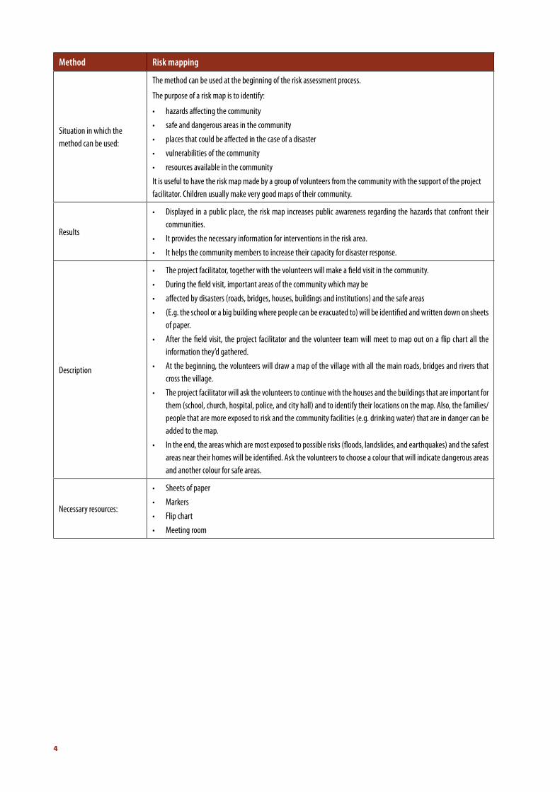
Method Risk mapping
Situation in which the method can be used:
The method can be used at the beginning of the risk assessment process.
The purpose of a risk map is to identify:
• hazards affecting the community
• safe and dangerous areas in the community
• places that could be affected in the case of a disaster
• vulnerabilities of the community
• resources available in the community
It is useful to have the risk map made by a group of volunteers from the community with the support of the project facilitator. Children usually make very good maps of their community.
Results
• Displayed in a public place, the risk map increases public awareness regarding the hazards that confront their communities.
• It provides the necessary information for interventions in the risk area.
• It helps the community members to increase their capacity for disaster response.
Description
• The project facilitator, together with the volunteers will make a field visit in the community.
• During the field visit, important areas of the community which may be
• affected by disasters (roads, bridges, houses, buildings and institutions) and the safe areas
• (E.g. the school or a big building where people can be evacuated to) will be identified and written down on sheets of paper.
• After the field visit, the project facilitator and the volunteer team will meet to map out on a flip chart all the information they’d gathered.
• At the beginning, the volunteers will draw a map of the village with all the main roads, bridges and rivers that cross the village.
• The project facilitator will ask the volunteers to continue with the houses and the buildings that are important for them (school, church, hospital, police, and city hall) and to identify their locations on the map. Also, the families/people that are more exposed to risk and the community facilities (e.g. drinking water) that are in danger can be added to the map.
• In the end, the areas which are most exposed to possible risks (floods, landslides, and earthquakes) and the safest areas near their homes will be identified. Ask the volunteers to choose a colour that will indicate dangerous areas and another colour for safe areas.
Necessary resources:
• Sheets of paper
• Markers
• Flip chart
• Meeting room
FIRST STEP FOR SAFER LIFE IN LOCAL COMMUNITES
5
The clime in Bosnia and Herzegovina are con-ditioned with basic clime factors: geographical position, geological surface, coverage with veg-etation and Mediterranean closeness. Beside ba-sic factors, extreme factors also influence entire clime picture of Bosnia and Herzegovina. In a first place there are the subtropics stream zone, high air pressure and subpolar zone, low air pressure, which has the consequence of shifting polar and tropic air masses. After it comes the air mass of polar origin, the masses from Atlantic sea, cy-clones from Mediterranean and Adriatic Sea as well as anticyclones come from continental part of Asia. All of these circulating-radiative process-es in a high measure is disturbed by relieve which is in position of modification. All mentioned fac-tors are cause on Bosnia and Herzegovina terri-tory to have two basic clime characters: north and south with the line which divides them from Bihać to Sarajevo and in the end Foča. In north region clime has continental character with very cold winter and hot summers. In south region its meditereanen clime with hot summers and wet winters. The line of devision who divide south and north region is an area between high moun-tains, the plateau, pit and canyon in which we have typical mountain clime. In this area winters are cold, summer fresh with high intesitiy of rain-fall through year, while the temperature is differ-ent and depends on hights.
Moderately continental clime, covers north area of Bosnia and the vallay of Una, Sanam Vrbas, Bosna and Dina rivers to Višegrad. Summers are worm. The average air temperature in July as the on of the hottest month is between 20 and 22 de-grees, while winters are mostly moderately cold. The average temperature in the coldiest month January are from -1 to -2. The average yearly tem-
operature is more than 10 degrees. Autumn and spring temperatures are equal. The summer tem-peratures can be more than 40 degrees, while in winter time tempeatures can drop up to -35 degrees. Avarege yearly rainfall are between 700 mm on east and 1500 mm to west. The winds are rare and weak, but when they appear are coming from north and north-west direction. The moun-tain clime takes middle area of our country. This type of clime is the most visible in area of Oštrelj, Travnik, Sarajevo and Foča. It is most likely to be descibred as short summers, cold and snowly winters. The avarge temperatures in January are from -3,5 to -6,8 degrees, and in July average from 14,8 to 16,9 degrees. The apsolute minimum temperatures are from -24 to -34, and apsolute max from 30 to 36 degrees. The exception are canyon in which we have various temperatures. Those areas are known as point for freezing; one of them is mountain Igman on which in January 1963 the min. temperature was 43,5 degrees. The thermal fluctuation are from 20 to 21 degree. The autum is wormer than spring. Rainfalls are 1200 mm equaly divided through year. The fog is com-mon and there is a fog through the whole year. The coverage with clouds is more than 50%.
The mediterenian clime exist in low and high Her-zegovina. We can make distinguish of two types of mediterenian clime. The area of low Herzego-vina, which is in low flow of Neretva River with karst fieldlower than 1000 m of high: Ljubuški, Imotski, Mostar and Stolac area. This type of clime from low Herzegovina is coming from a fact that her space is under direct influence of sea air. The Adriatic Sea during the winter time is radiat-ing accumulated heat during the summer time, and temperature are slitely higher. The average January temperature in Mostar is 4,6 degrees, in Stolac 4,3 degrees and in Ljubuški 4,7 degrees. In
MAPPED RISKS AND HAZARD IN 30 LOCAL COMMUNITIES

6
the summer the influence of Adriatic Sea is neg-libigle, because of limestones, which get warm and change the temperature of the area. The summers are very dry and warm. Temperature fluctuaition are from 20 to 21 degrees. The autum is warmer than spring. The avarage minimum temperatures are from -4,9 to – 8,7 degrees, but those minimum are droping even up to 17 de-gres. In this case very strong wind is dominante, with south wind shifts. The calmest month is Oc-tober and the windiest is February. The month with the large rainfall is October, 200 mm aver-age. The snow almost doesn’t exist. Yearly quan-tity of rainfall is from 1000 to 5000 mm. Chang-able mediterenain clime has higher Herzegovina close to mountain clime but with some meditere-nian marks. The air temperature drops with raise of high and with the sea distance. With every 10 km distance from a Sea the temperature drops from 0,6 to 0,8 degrees. The winters are strong and with absolute tempretatures from -14 to -25 degrees. Avarage January temperatures are from -1,8 to -6 degrees. Avarage absolute max. , tem-
perature can raise to 40 degrees. Like in low Her-zegovina the autumn is warmer than spring, but the temperatures flowtaction are bigger. Yearly in this area the winds are strong, and rainfalls are up to 1800 mm. Very strong cold wind is seen in win-ter with very strong saddles. The higher is clud-ness in relation with low Herzegovina.
Territory of Bosnia and Herzegovina is one of the most active seismological parts of Balkan. Beside natural earthquakes, it is often to experience an artificial earthquake as a result of building the hydro-accumulation - water-gate which is reg-istries in Bočac, Grabovica, Grančarevo, Rama and others. On the map has been extracted the areas with maximum intensity of 7,8 and 9 MCS scale. Average probability for natural earthquake is based in Banja Luka city, Ljubinje, Grahovina, Tihaljina and mountain Treskavica. The most risky is area of Banja Luka city, than Tihaljina, Grahovo and Ljubinje, and in the end Treskavica Mountain.

FIRST STEP FOR SAFER LIFE IN LOCAL COMMUNITES
7
and very long, snowly and hard winters. Spring and autumn are very short here. From Septem-ber there are snow with very large snow cover-ing, which slowly desapear from May. December, Janary and February always have temperatures below zero. In summer these tempreatures are up to 20 degrees, average 15. The average tem-perature is 7,2. During the year average rainfall is 1480 mm, but in colder time of year these rain-falls are more than one quarter or even fifth.
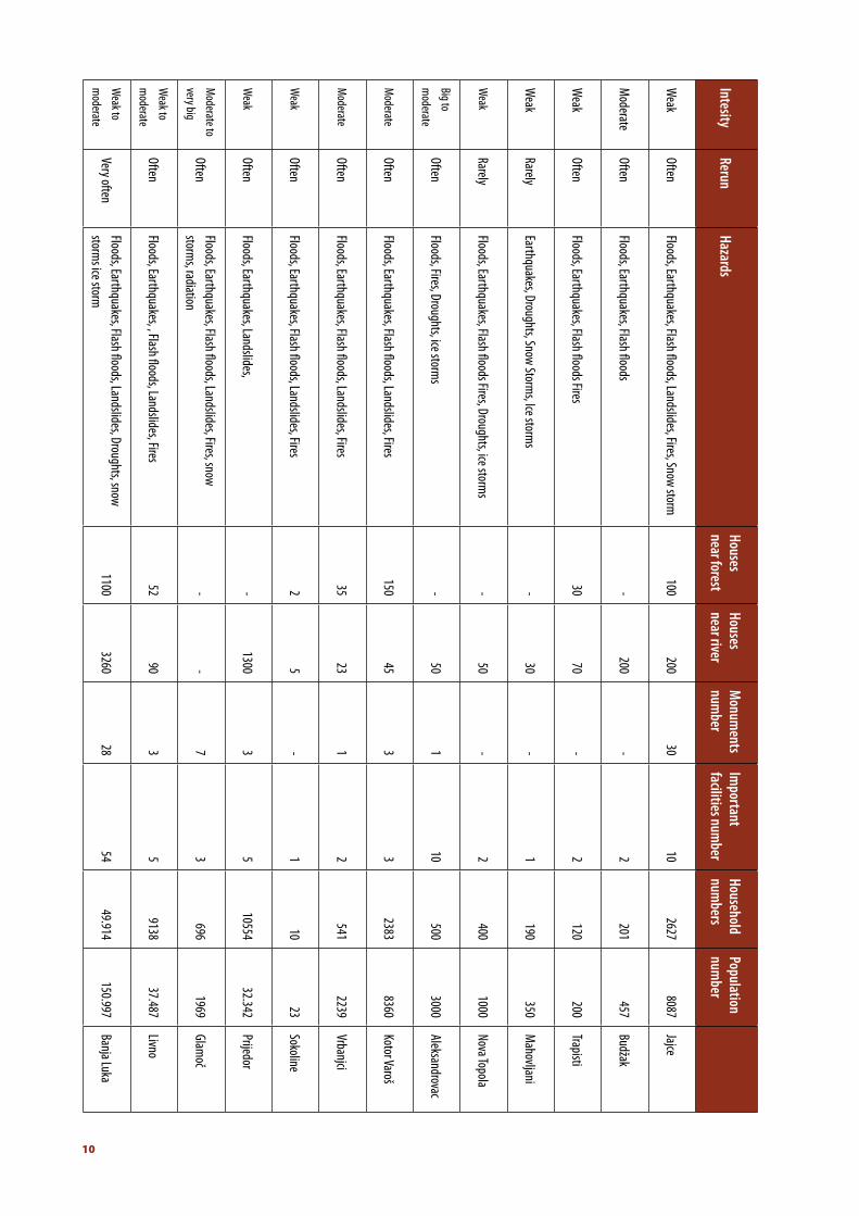
Diocesan Caritas Banja Luka
Mapped communities: Kotor Varoš, Prijedor, Glamoč, Banja Luka (2 communities – city com-munity and Trapisti), Livno, Budžak, Nova Topola (communities Nova Topola, Mahovljani and Alek-sandrovac), Jajce, Bosansko Grahovo and Drvar.
Community Kotor Varoš is settled in central part of Bosnia and Herzegovina, southwest part of Banja Luka region, with mountains around them Uzlomac on north-east, Borje on East, Čemernica on west and Vlašić on south part. The area is dominating with river Vrbanja, as agricultural and energetical potential with natural beauty and rareites, as well as basic cordor of all travel ways intresting for Municipality, is known as area which has been developing.
Prijedor je is town on west part of Bosnia and Herzegovina, near Sana River, and small hills on which the mountain Kozara is going to Prijedor valley. The area has 834 km2, and only city is set-tled in 135m height. The municipality Prijedor is second in Republic of Srpska and sixth in Bosnia and Herzegovina according the number of peo-ple living in it.
Glamoč city is the center of this municipality in south-west part of Bosnia and Herzegovina, and one of the most developed municipalities in Li-vanjski Canton. The basic hydrometeorological caracteristis of this area in relation with neigh-bours are the lack of water, tipical rubble picture, a big space medows and large forest complexs. The water in this area is the biggest problem, and limited factor for the municipality. According the annual rainfall the water is more than necessary; the problem is rainfall concentrated in winter while in summer drought affects the area. Peo-ple are using wells as a source for water. These waters are rarely filtrating and very often people get sick. Only few rural estates has developed solution for water problem. The largest lake in Glamoč region is Lake Hrast 25.000 sqare metars. There are also two smaller Lakes: Šator Lake and 8.000 sqare metars and Busija lake 4.000 sqare metars. According the clime in Glamoč region the whole area belongs to mountain clime which means short, not very hot and drought summers

8
Banja Luka is a town in west part of Bosnia and Herzegovina, settled on River Vrbas. By the size this is a second town in Bosnia and Herzegovina, and for large number of people is the most beau-tiful town. The town is a center of Republic of Srp-ska as well as agricultural and cultural center of Bosnian Krajina. It is settled in valley, on 164 m hight and on transfer between Dinara Mountain and Panonia pool on north. The town belongs to middle European time zone and has moderately
continental clime, with influence of Panonia area. Middle yearly temperature is 10,7 degrees, mid-dle January is 0,8 degrees and average tempera-ture is 21,3 degrees. Mapping has been conduct-ed in city of Banja Luka and also in a part of this area called Trapisti.
Livno is municipality in west part of Bosnia and Herzegovina. The most important town in Her-zegovina region, with cultural and agricultural center. The clime is moderately continental with strong winds. The average temperature in last 57 years is 9,3 degrees. The summer are long and very sunny, and winter are covered with snow.
Nova Topola is a place near Bosanska Gradiška in Bosnia and Herzegovina, as the largest estate in this Municipality. Mahovljani and Aleksandro-vac are located in the region of Republic Srpska. Mahovljani place close to Banja Luka is known since airport is settled in this place. These two places every summer are faced with droughts and very hard ice storms when rain falls.The agri-cultural products are very often damaged or de-stroyed.
Jajce is a town in a middle Bosnia, in Bosnia and Herzegovina, on confluence of River Pliva in Vr-bas. Avarage temperature of air is 18 degrees, and avarage January temperature is 1,8 degrees. In hydografical sense the territory Jajce belongs to blacksea basin areas, River Vrbas and her af-fluent Pliva. The cascade relief influenced the ap-pearance of waterfalls, as well as sediment tuff. Municipality Jajce belongs to euro sibirian areas, in frame which we can abstract wet forests of oak and scope of ash, as well as beech and beech-fir

FIRST STEP FOR SAFER LIFE IN LOCAL COMMUNITES
9
forests with eco systems. The area of Jajce mu-nicipality, in his geographical position had mod-erately continental clime, which influence comes from Vrbas from Panonia valley, with specificly caused localy relief.
Bosansko Grahovo town is a centre of the same municipality in west part of Bosnia and Herzego-vina. The surface of this municipality is one of the biggiest but when we talk about population she is on the last place with population number. On huge area, with very rich forests and very good agricultural fields, before the war there were 9.000 people. From a sea side she is far only twen-ty kilometars, but the area has a real continental clime, with very cold and snow covered winters and very fresh and short summers. Plateaue is surrounded with huge mountain and their mas-sifs like Dinara, Šator, Straetine, Jadovnik and Ui-lice whose peaks high is between 1650 and 2000 metars.
Municipality Drvar is settled on northwest part of Bosnia and Herzegovina near border with Re-public of Croatia. It is settled in mountain area on 700 to 1200 metars hight. On area Drvar mu-nicipality it is a unique bifurcation of river for this part of Europe. In place called Prekaja there is a Lake Prekaj appeared with rearrangements of Unca. It served for industrial purposes. This lake has surface of 2 square kilometars with very large number of fish. A large surface are covered with forests and grassland, while agricultural surfaces are less presented. Clime is continental – moun-tained with long and cold winters.
***
In communities it is obvious repeting some events caused by disasters from very often to often, exept two communities which have rarly repeting. However, it is very interesting for inten-sity to vary from weak to very big. Hazards which have been mapped are mostly: floods, earth-quakes, droughts, ice storms, landslides, snow storms, flash floods and fires.
10
Jajce
Budžak
Trapisti
Mahovljani
Nova Topola
Aleksandrovac
Kotor Varoš
Vrbanjci
Sokoline
Prijedor
Glamoč
Livno
Banja Luka
Population num
ber8087
457
200
350
1000
3000
8360
223923
32.342
1969
37.487
150.997
Household num
bers2627
201
120
190
400
500
2383
54110
10554
696
9138
49.914
Important
facilities number1022121032153554
Monum
ents num
ber
30----131-37328
Houses near river200
2007030505045235
1300-90
3260
Houses near forest100-30---
150352--52
1100
Hazards
Floods, Earthquakes, Flash floods, Landslides, Fires, Snow storm
Floods, Earthquakes, Flash floods
Floods, Earthquakes, Flash floods Fires
Earthquakes, Droughts, Snow Storms, Ice storm
s
Floods, Earthquakes, Flash floods Fires, Droughts, ice storms
Floods, Fires, Droughts, ice storms
Floods, Earthquakes, Flash floods, Landslides, Fires
Floods, Earthquakes, Flash floods, Landslides, Fires
Floods, Earthquakes, Flash floods, Landslides, Fires
Floods, Earthquakes, Landslides,
Floods, Earthquakes, Flash floods, Landslides, Fires, snow storm
s, radiation
Floods, Earthquakes, , Flash floods, Landslides, Fires
Floods, Earthquakes, Flash floods, Landslides, Droughts, snow storm
s ice storm
Rerun
Often
Often
Often
Rarely
Rarely
Often
Often
Often
Often
Often
Often
Often
Very often
Intesity
Weak
Moderate
Weak
Weak
Weak
Big to
moderate
Moderate
Moderate
Weak
Weak
Moderate to
very big
Weak to
moderate
Weak to
moderate
FIRST STEP FOR SAFER LIFE IN LOCAL COMMUNITES
11
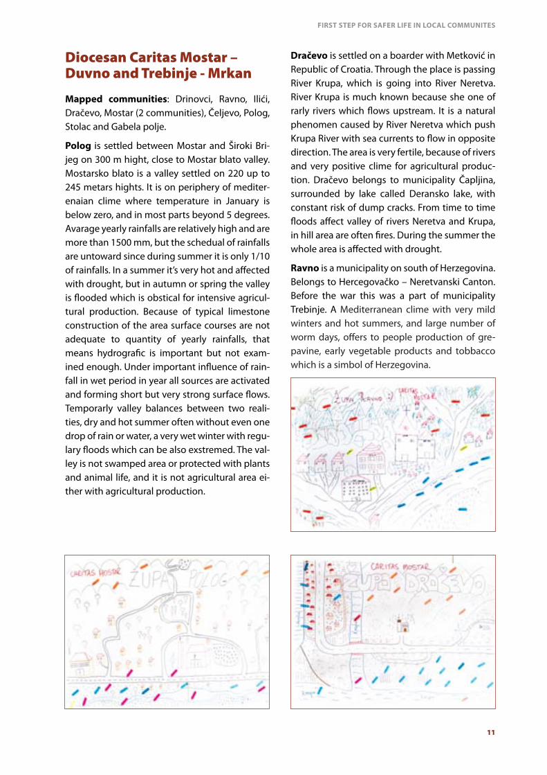
Diocesan Caritas Mostar – Duvno and Trebinje - Mrkan
Mapped communities: Drinovci, Ravno, Ilići, Dračevo, Mostar (2 communities), Čeljevo, Polog, Stolac and Gabela polje.
Polog is settled between Mostar and Široki Bri-jeg on 300 m hight, close to Mostar blato valley. Mostarsko blato is a valley settled on 220 up to 245 metars hights. It is on periphery of mediter-enaian clime where temperature in January is below zero, and in most parts beyond 5 degrees. Avarage yearly rainfalls are relatively high and are more than 1500 mm, but the schedual of rainfalls are untoward since during summer it is only 1/10 of rainfalls. In a summer it’s very hot and affected with drought, but in autumn or spring the valley is flooded which is obstical for intensive agricul-tural production. Because of typical limestone construction of the area surface courses are not adequate to quantity of yearly rainfalls, that means hydrografic is important but not exam-ined enough. Under important influence of rain-fall in wet period in year all sources are activated and forming short but very strong surface flows. Temporarly valley balances between two reali-ties, dry and hot summer often without even one drop of rain or water, a very wet winter with regu-lary floods which can be also exstremed. The val-ley is not swamped area or protected with plants and animal life, and it is not agricultural area ei-ther with agricultural production.
Dračevo is settled on a boarder with Metković in Republic of Croatia. Through the place is passing River Krupa, which is going into River Neretva. River Krupa is much known because she one of rarly rivers which flows upstream. It is a natural phenomen caused by River Neretva which push Krupa River with sea currents to flow in opposite direction. The area is very fertile, because of rivers and very positive clime for agricultural produc-tion. Dračevo belongs to municipality Čapljina, surrounded by lake called Deransko lake, with constant risk of dump cracks. From time to time floods affect valley of rivers Neretva and Krupa, in hill area are often fires. During the summer the whole area is affected with drought.
Ravno is a municipality on south of Herzegovina. Belongs to Hercegovačko – Neretvanski Canton. Before the war this was a part of municipality Trebinje. A Mediterranean clime with very mild winters and hot summers, and large number of worm days, offers to people production of gre-pavine, early vegetable products and tobbacco which is a simbol of Herzegovina.

12
Cim – Ilići and Zalik are parts of Mostar munici-pality in Federation of Bosnia and Herzegovina. Mostar is city in Bosnia and Herezgovina, and cul-tural and agricultural center of Herzegovina. The name comes from a bridge keepers on a Neretva River. Mostar is in south of Bosnia and Herzegovi-na, in a middle of Herzegovina. Through center of the city is canyon Neretva, and Mostar is known as City on the river. The most popular hills around Mostar are Hum, Stolac, Fortica, Žovnica and Br-kan hill. Two the most known mountains close to Mostar are Velež and Prenj. The clime in Mo-star is moderated medditerranien with mild but cold winters (with little bit of snow or none) and very hot summers, with temperatures beyond 45 degrees in shade. In 1901, it was recoreded tem-perature of 46,2 degrees. Mostar is the warmest city in Bosnia and Herzegovina. Before the clime was exstremly dry, today the clime is more and more wet, and this cause summer unbearable and very often are on board for emergency an-
nouncement. However, Mostar has very confort-able clime for production of fruits. In autumn and spring Mostar is very often covered with rainfall.
Čeljevo is settled in valley of Neretva and Bregava Rivers in moderated clime zone. The temperature schedule is equaly spred through four seasons. Geograficly the location and relief influence on local differences in temperatures, winter are not very cold but either summer are not very hot. The coldiest months are December and January and wormest are June and July. Total number of sun-ny hours are 2700 during the year. The majority of rainfalls are between October and March and less in period April – September. Mostly we are talking about rain, and snow is very rare and for a very short time period. The problem is that rain fall when nature is not in need for it, therefore the agriculture in summer depends on irrigation. The wind is strong in winter, its northwind and wind from south as well as southeast wind.

FIRST STEP FOR SAFER LIFE IN LOCAL COMMUNITES
13
Drinovci is a part of Grude municipality in Bosnia and Herzegovina. On southeast side of Imotski valley. It is relatively big surface, and it is put in the line of bigger rural places in Herzegovina. The municipality belongs to sub-mediterenien clime humid forms. Avarage rainfall is 1300 mm which shows that municipality is settled in near-by adritatic hinterland. This Adriatic nearby posi-tion gave medditerenien clime even more visible than in other areas of West Herzegovina. During the summer this area is known by arid summer months and shows that in time when plants and fruits should be ripen it’s too dry and need irri-gation. Vegetation season last from Febrary up to November and sometimes even till the end of December. Avarage temperature in Decem-ber is 5, 5 degrees. The temperatures below zero are from December up to beginning of April. The snow is rare and if falls, it lasts very short time of period. During the year there are two regional winds: south from valley of Neretva and Adri-atic Sea and north from north continental hin-terland. During the year there are more halcyon than cloudy days. The whole area is under large number of sunny days. This enables agriculture production, as very important aspect for families living in it.
Stolac is a town settled in southeast part of Bos-nia and Herzegovina, in the end of Herzegovina Canton. Near the town Bregava River is flowting, and around town there are Hrgud Mountain and Vidovo valley with other surroundings. From west there is Dubravska hill, which is known as good area for production of peaches and greapvines, and much known vines.
Gabela polje is a part of Čapljina municipality on the border with Croatia and city Metković. Gabela polje is in big risk of often and very often floods, caused by human factors. During the floods ag-riculture, greenhouses and houses are affected.
A mapped communities are mixture of rural and city areas.
14
Every Diocese has his own characteristics, and Dio-cese Mostar – Duvno and Trebinje – Mrkan is not exception. The characteristics of hazards in this di-ocese are very often repeting the same hazards in certain communities with moderaty intesitiy from very often to often. The hazards dependes of geo-graphical site but the most common hazards are fires, floods, but also snow storms and earthquakes.
Archdiocesan Caritas Vrhbosna
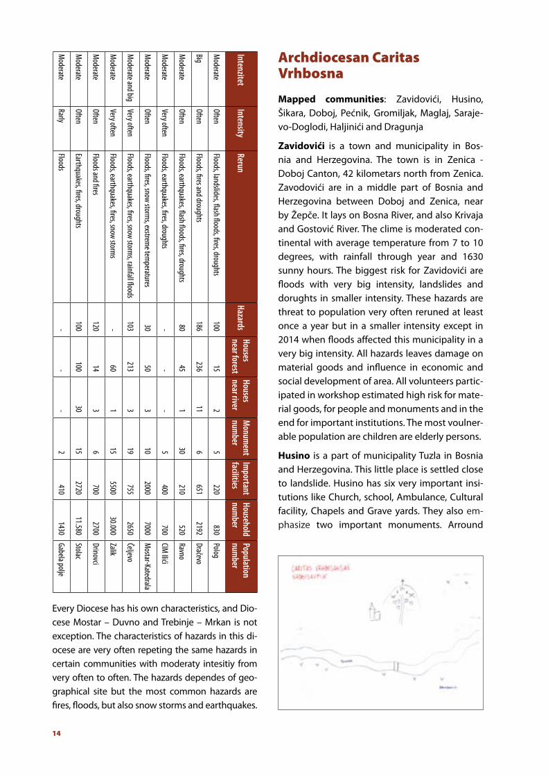
Mapped communities: Zavidovići, Husino, Šikara, Doboj, Pećnik, Gromiljak, Maglaj, Saraje-vo-Doglodi, Haljinići and Dragunja
Zavidovići is a town and municipality in Bos-nia and Herzegovina. The town is in Zenica - Doboj Canton, 42 kilometars north from Zenica. Zavodovići are in a middle part of Bosnia and Herzegovina between Doboj and Zenica, near by Žepče. It lays on Bosna River, and also Krivaja and Gostović River. The clime is moderated con-tinental with average temperature from 7 to 10 degrees, with rainfall through year and 1630 sunny hours. The biggest risk for Zavidovići are floods with very big intensity, landslides and dorughts in smaller intensity. These hazards are threat to population very often reruned at least once a year but in a smaller intensity except in 2014 when floods affected this municipality in a very big intensity. All hazards leaves damage on material goods and influence in economic and social development of area. All volunteers partic-ipated in workshop estimated high risk for mate-rial goods, for people and monuments and in the end for important institutions. The most voulner-able population are children are elderly persons.
Husino is a part of municipality Tuzla in Bosnia and Herzegovina. This little place is settled close to landslide. Husino has six very important insi-tutions like Church, school, Ambulance, Cultural facility, Chapels and Grave yards. They also em-phasize two important monuments. Arround
Population num
ber
Polog
Dračevo
Ravno
CIM Ilići
Mostar-Katedrala
Čeljevo
Zalik
Drinovci
Stolac
Gabela polje
Household num
ber830
2192
520
700
7000
2650
30.000
2700
11.580
1430
Important
facilities 220
651
210
400
2000
755
5500
700
2720
410
Monum
ent num
ber
563051019156152
Houses near river2111-331330-
Houses near forest
15
23645-50
2136014
100-
Hazards
100
18680-30
103-
120
100-
Rerun
Floods, landslides, flash floods, fires, droughts
Floods, fires and droughts
Floods, earthquakes, flash floods, fires, droughts
Floods, earthquakes, fires, droughts
Floods, fires, snow storms, exstrem
e temperatures
Floods, earthquakes, fires, snow storms, rainfall floods
Floods, earthquakes, fires, snow storms
Floods and fires
Earthquakes, fires, droughts
Floods
Intensity
Often
Often
Often
Very often
Often
Very often
Very often
Often
Often
Rarly
Intenzitet
Moderate
Big
Moderate
Moderate
Moderate
Moderate and big
Moderate
Moderate
Moderate
Moderate
FIRST STEP FOR SAFER LIFE IN LOCAL COMMUNITES
15
the place forest and smaller river are surrouding the place. The River is called Ljubiča. Number of houses in risk are around 80, and from this num-ber of those in risk of floods and forest are 30. The most important hazards are floods, landslides and fires. All hazards are rerun often, while land-slides are large scaled. These natural risks affects to security of population and also their material goods.
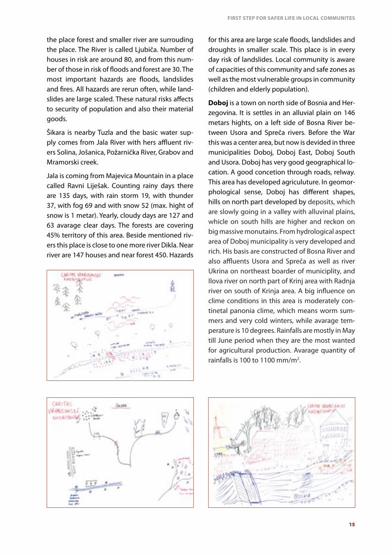
Šikara is nearby Tuzla and the basic water sup-ply comes from Jala River with hers affluent riv-ers Solina, Jošanica, Požarnička River, Grabov and Mramorski creek.
Jala is coming from Majevica Mountain in a place called Ravni Liješak. Counting rainy days there are 135 days, with rain storm 19, with thunder 37, with fog 69 and with snow 52 (max. hight of snow is 1 metar). Yearly, cloudy days are 127 and 63 avarage clear days. The forests are covering 45% territory of this area. Beside mentioned riv-ers this place is close to one more river Dikla. Near river are 147 houses and near forest 450. Hazards
for this area are large scale floods, landslides and droughts in smaller scale. This place is in every day risk of landslides. Local community is aware of capacities of this community and safe zones as well as the most vulnerable groups in community (children and elderly population).
Doboj is a town on north side of Bosnia and Her-zegovina. It is settles in an alluvial plain on 146 metars hights, on a left side of Bosna River be-tween Usora and Spreča rivers. Before the War this was a center area, but now is devided in three municipalities Doboj, Doboj East, Doboj South and Usora. Doboj has very good geographical lo-cation. A good concetion through roads, relway. This area has developed agriculuture. In geomor-phological sense, Doboj has different shapes, hills on north part developed by deposits, which are slowly going in a valley with alluvinal plains, whicle on south hills are higher and reckon on big massive monutains. From hydrological aspect area of Doboj municipality is very developed and rich. His basis are constructed of Bosna River and also affluents Usora and Spreča as well as river Ukrina on northeast boarder of municiplity, and Ilova river on north part of Krinj area with Radnja river on south of Krinja area. A big influence on clime conditions in this area is moderately con-tinetal panonia clime, which means worm sum-mers and very cold winters, while avarage tem-perature is 10 degrees. Rainfalls are mostly in May till June period when they are the most wanted for agricultural production. Avarage quantity of rainfalls is 100 to 1100 mm/m2.
16
Pećnik is a part of municiplity Vukosavlje in Bos-nia and Herezgovina, close to Odžak. This rural area has 110 citizens, with school, Church, grave-yard and two Insistutions. Also this area has one monument. Surronded by forest this place is very close to Bosna River. Number of houses very close to river is five, but the main risks and natural resource for the village is forest. This area in a past time had a few small scale floods, but the hazards are also cyclones, landslides and drought in sum-mer on a small scale intesity. Once a year this place is affected with snow storms, but people are mostly prepared for the storm and marked this hazard as moderatly scale. This place be-longs to Posavina valley and it is close to Vučjak monutain also. The land is natural resurces and clean water from their own source Točak. People are not aware of their capacities, or safe places in village for emergency purposes.
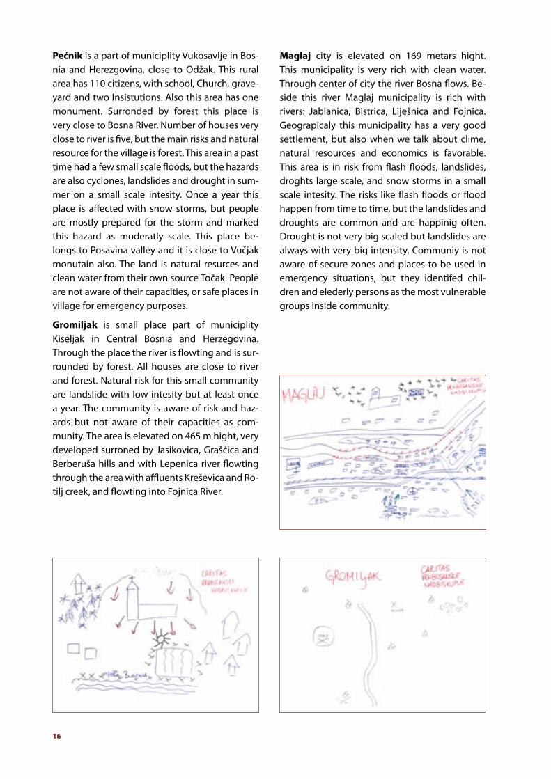
Gromiljak is small place part of municiplity Kiseljak in Central Bosnia and Herzegovina. Through the place the river is flowting and is sur-rounded by forest. All houses are close to river and forest. Natural risk for this small community are landslide with low intesity but at least once a year. The community is aware of risk and haz-ards but not aware of their capacities as com-munity. The area is elevated on 465 m hight, very developed surroned by Jasikovica, Grašćica and Berberuša hills and with Lepenica river flowting through the area with affluents Kreševica and Ro-tilj creek, and flowting into Fojnica River.
Maglaj city is elevated on 169 metars hight. This municipality is very rich with clean water. Through center of city the river Bosna flows. Be-side this river Maglaj municipality is rich with rivers: Jablanica, Bistrica, Liješnica and Fojnica. Geograpicaly this municipality has a very good settlement, but also when we talk about clime, natural resources and economics is favorable. This area is in risk from flash floods, landslides, droghts large scale, and snow storms in a small scale intesity. The risks like flash floods or flood happen from time to time, but the landslides and droughts are common and are happinig often. Drought is not very big scaled but landslides are always with very big intensity. Communiy is not aware of secure zones and places to be used in emergency situations, but they identifed chil-dren and elederly persons as the most vulnerable groups inside community.

FIRST STEP FOR SAFER LIFE IN LOCAL COMMUNITES
17
Haljinići is a place part of municipality Kakanj in Bosnia and Herzegovina. It is settled on Trstion-ica River which flow into Bosna River. Risk for hazarads like floods, flash floods, snow storms, droughts and landslides are estimated to be very often and some of them are repeting after 3 or 6 months every year. Intensity is moderate. Main natural risks in this area is water, level of water very often raising and cases landslides because of many pits and deep mines which causes the landslides. The houses and material good around are in risk, as well as agriculture which affects economic situation of population living in this area. The most vulnerable community members are children and elderly people as well as sick population. The community is aware of secured zones if disaster affects, but the capacity to use resources are still missing.
Dragunja not so far from Majevica mountain, only 25 km from Tuzla and 19 km from Srebrenik in Tuzla Canton. Almost all houses are close to forest and river and there is a risk of floods and landslides. One landslide has been set in mon-tion in May 2014. The landslide set of an econom-ic and social concequences and direct damages. It is estimated that flood are rare hazards but the high scale even in rare situation put them in pri-ority for preparedness. The community is active, has authority very strong but the capacity is not used, and needs to be facilitated in the future.
Sarajevo – Doglodi is a small part of Sarajevo Canton, belongs to Ilidža municipality, 12 km from centre of Sarajevo. The relief of Ilidža area is atypical valeey with high mountains. The area is surrounded by Igman Mountain from southwest side. A Saraj valley is known of alluvial plains. The hazards for this area is characteristic because it happen every day large scale floods and snow storms and smaller scale droughts. Sarajevo is stteled between tectonic panels and has risk for earthquakes. The last one last year recorded was 4, 3 Richter. This is a city area and there are a lot of monuments, insitutions, schools and other im-portant facilities. The community of Doglodi has never recognized their own capacities to react after the disaster.

18
Donja Dragunja
Doboj
Ilidža Sarajevo
Maglaj – župa
St. Leopold
Pećnik
Gromiljak
Husino
Haljinići near Kaknja
Zavidovići – je-dan dio - župa
Šikara
Number of
population300
50.000
3500
820
11040
100074
137
1542
Number of
households
111
unknown
306
2056716
48033
105
692
Number of
important objects717-26157107
Number of
monum
ents14-11-3193
Number houses
near river
54
unknown
100
200516561026
147
Number of house
near forest
54
unknown--all163010-
450
Hazards
Floods and landslides
Floods, Drought, Snow storms, Unexploded or-
dnance
Floods
Floods, Landslides, snow storms, droughts
Floods, cyclone, landslides, drought, Snow storms
Landslides
Fires and landslides
Floods, Flash floods, landslides, droughts snow storm
s
Floods, Drought, Landslides
Floods, Drought, Landslides
Repetition
Rarely
Often
Often
Often
Often
Often
Often
Very often
Rarely
Very often
Intesity
Moderate
Large scale
Medial
Moderate
and medial
Moderate
Low scale
Large scale
Moderate
Large scale
Large scale

FIRST STEP FOR SAFER LIFE IN LOCAL COMMUNITES
19
Conclusion
Mapped hazards, risks and descover of local com-munity capacities is a first step to goal of Caritas, to make local community more prepared and re-silient to hazards and risks caused by disaster as a concequences of clime changes and human irre-sponsibility. In a past five months we have been searching for volunteers in local communities, who will be commited to develop preparedness capacities of local community.
We have been asking ourselves where we were, which results do we have after the research and what are the plans for future work, or better where we want to be in a year from now.
On workshop we tried to answer these questions and we came to conclusion that our results are meeting needs and average are 80 to 100 pro-cent coherent. This means, a first step for safer and more resiliant community has been done.

20


Caritas Bosnia and Herzegovina
Mehmed bega Kapetanovića Ljubušaka 6 71000 Sarajevo
Tel: +387 33 206 441 Fax: +387 33 206 668
E-mail: [email protected] www.caritas.ba
Caritas Archdiocese Vrhbosna
Nikole Šopa 50a 71210 Ilidža, BiH
Tel: +387 33 544 688 Fax: +387 33 544 687
E-mail: [email protected] www.caritas-sarajevo.ba
Caritas dioceses Mostar-Duvno and Trebinje-Mrkan
Zagrebačka 5A 88000 Mostar, BiH Tel: +387 36 328 916 Fax: +387 36 328 917 E-mail: [email protected] www.caritas-mostar.ba
Caritas diocese Banja Luka
Kralja Petra I. Karađorđevića 125 78000 Banja Luka, BiH Tel: +387 51 312 149 Fax: +387 51 300 890 E-mail: [email protected] www.biskupija-banjaluka.org/caritas.html