first hgs/eage conference on latin america latin... · subduction beneath the northern south...
TRANSCRIPT
South American Petroleum Plays for Future Decades of the Third Millennium
www.hgs.org | www.eage.org
19 -20 NOVEMBER 2019 • NORRIS CENTER , HOUSTON TX , UNITED STATES
FIRST HGS/EAGE CONFERENCE ON
LATIN AMERICA

FIRST HGS/EAGE CONFERENCE ON LATIN AMERICA19-20 NOVEMBER 2019
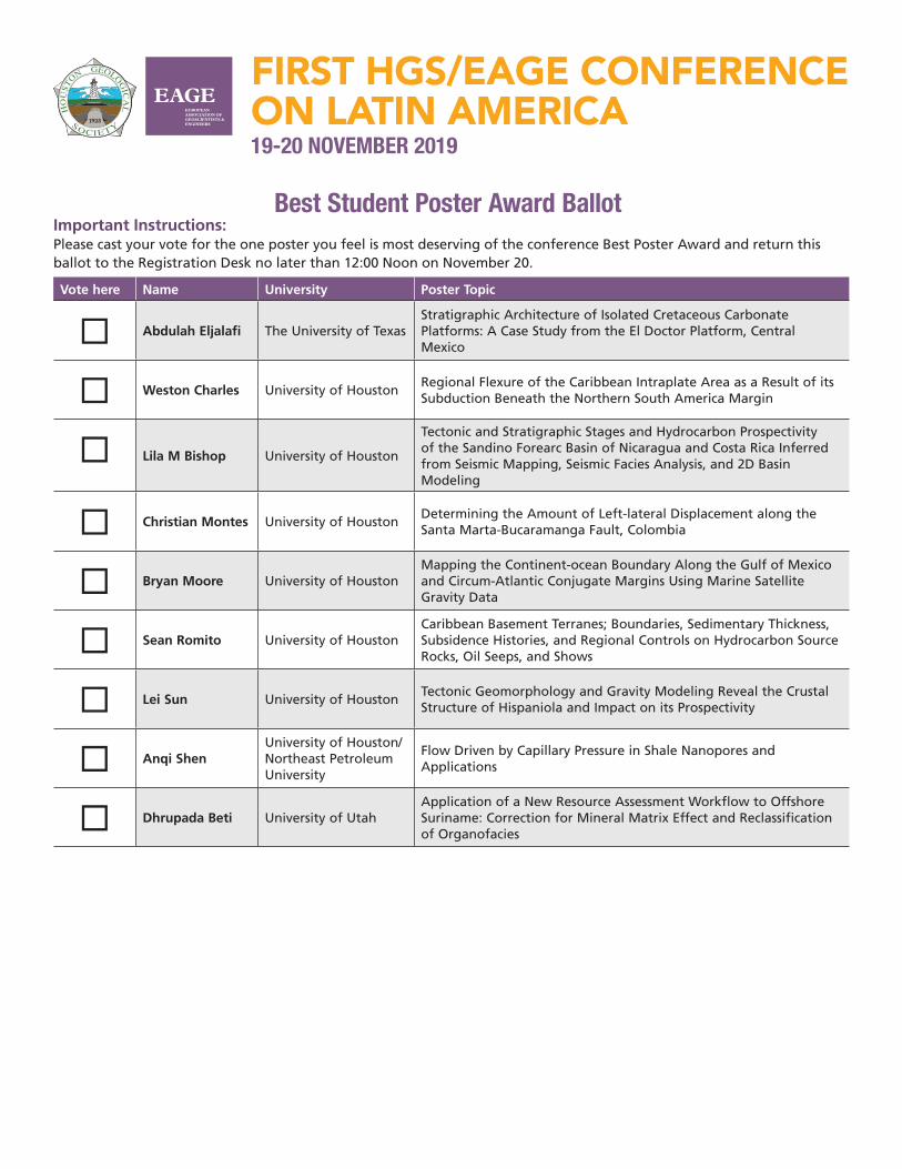
Best Student Poster Award BallotImportant Instructions: Please cast your vote for the one poster you feel is most deserving of the conference Best Poster Award and return this ballot to the Registration Desk no later than 12:00 Noon on November 20.
Vote here Name University Poster Topic
Abdulah Eljalafi The University of TexasStratigraphic Architecture of Isolated Cretaceous Carbonate Platforms: A Case Study from the El Doctor Platform, Central Mexico
Weston Charles University of HoustonRegional Flexure of the Caribbean Intraplate Area as a Result of its Subduction Beneath the Northern South America Margin
Lila M Bishop University of Houston
Tectonic and Stratigraphic Stages and Hydrocarbon Prospectivity of the Sandino Forearc Basin of Nicaragua and Costa Rica Inferred from Seismic Mapping, Seismic Facies Analysis, and 2D Basin Modeling
Christian Montes University of HoustonDetermining the Amount of Left-lateral Displacement along the Santa Marta-Bucaramanga Fault, Colombia
Bryan Moore University of HoustonMapping the Continent-ocean Boundary Along the Gulf of Mexico and Circum-Atlantic Conjugate Margins Using Marine Satellite Gravity Data
Sean Romito University of HoustonCaribbean Basement Terranes; Boundaries, Sedimentary Thickness, Subsidence Histories, and Regional Controls on Hydrocarbon Source Rocks, Oil Seeps, and Shows
Lei Sun University of HoustonTectonic Geomorphology and Gravity Modeling Reveal the Crustal Structure of Hispaniola and Impact on its Prospectivity
Anqi ShenUniversity of Houston/Northeast Petroleum University
Flow Driven by Capillary Pressure in Shale Nanopores and Applications
Dhrupada Beti University of UtahApplication of a New Resource Assessment Workflow to Offshore Suriname: Correction for Mineral Matrix Effect and Reclassification of Organofacies

FIRST HGS/EAGE CONFERENCE ON LATIN AMERICA19-20 NOVEMBER 2019
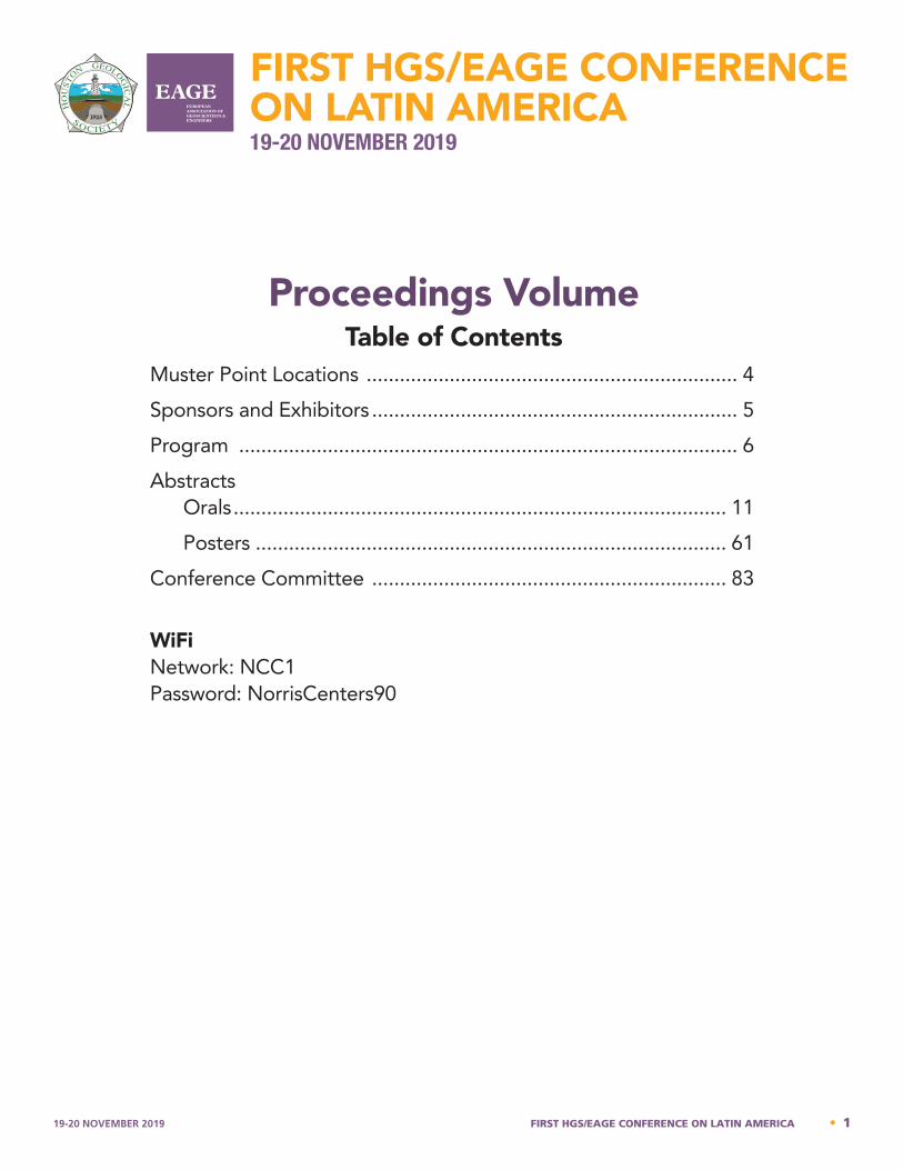
Proceedings VolumeTable of Contents
Muster Point Locations ................................................................... 4Sponsors and Exhibitors .................................................................. 5Program .......................................................................................... 6Abstracts
Orals ......................................................................................... 11Posters ..................................................................................... 61
Conference Committee ................................................................ 83
WiFiNetwork: NCC1Password: NorrisCenters90
19-20 NOVEMBER 2019 FIRST HGS/EAGE CONFERENCE ON LATIN AMERICA • 1
2 • FIRST HGS/EAGE CONFERENCE ON LATIN AMERICA 19-20 NOVEMBER 2019
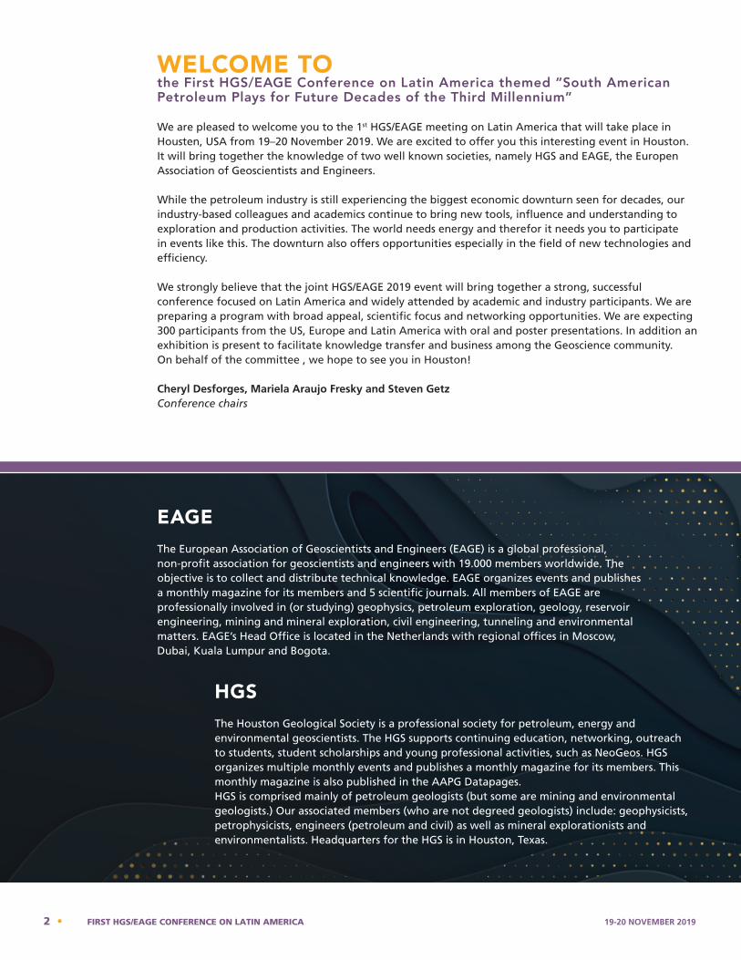
WELCOME TO the First HGS/EAGE Conference on Latin America themed “South American Petroleum Plays for Future Decades of the Third Millennium”
We are pleased to welcome you to the 1st HGS/EAGE meeting on Latin America that will take place in Housten, USA from 19–20 November 2019. We are excited to offer you this interesting event in Houston. It will bring together the knowledge of two well known societies, namely HGS and EAGE, the Europen Association of Geoscientists and Engineers.
While the petroleum industry is still experiencing the biggest economic downturn seen for decades, our industry-based colleagues and academics continue to bring new tools, influence and understanding to exploration and production activities. The world needs energy and therefor it needs you to participate in events like this. The downturn also offers opportunities especially in the field of new technologies and efficiency.
We strongly believe that the joint HGS/EAGE 2019 event will bring together a strong, successful conference focused on Latin America and widely attended by academic and industry participants. We are preparing a program with broad appeal, scientific focus and networking opportunities. We are expecting 300 participants from the US, Europe and Latin America with oral and poster presentations. In addition an exhibition is present to facilitate knowledge transfer and business among the Geoscience community.On behalf of the committee , we hope to see you in Houston!
Cheryl Desforges, Mariela Araujo Fresky and Steven GetzConference chairs
EAGE The European Association of Geoscientists and Engineers (EAGE) is a global professional, non-profit association for geoscientists and engineers with 19.000 members worldwide. The objective is to collect and distribute technical knowledge. EAGE organizes events and publishes a monthly magazine for its members and 5 scientific journals. All members of EAGE are professionally involved in (or studying) geophysics, petroleum exploration, geology, reservoir engineering, mining and mineral exploration, civil engineering, tunneling and environmental matters. EAGE’s Head Office is located in the Netherlands with regional offices in Moscow, Dubai, Kuala Lumpur and Bogota.
HGSThe Houston Geological Society is a professional society for petroleum, energy and environmental geoscientists. The HGS supports continuing education, networking, outreach to students, student scholarships and young professional activities, such as NeoGeos. HGS organizes multiple monthly events and publishes a monthly magazine for its members. This monthly magazine is also published in the AAPG Datapages.HGS is comprised mainly of petroleum geologists (but some are mining and environmental geologists.) Our associated members (who are not degreed geologists) include: geophysicists, petrophysicists, engineers (petroleum and civil) as well as mineral explorationists and environmentalists. Headquarters for the HGS is in Houston, Texas.

19-20 NOVEMBER 2019 FIRST HGS/EAGE CONFERENCE ON LATIN AMERICA • 3
Join us!
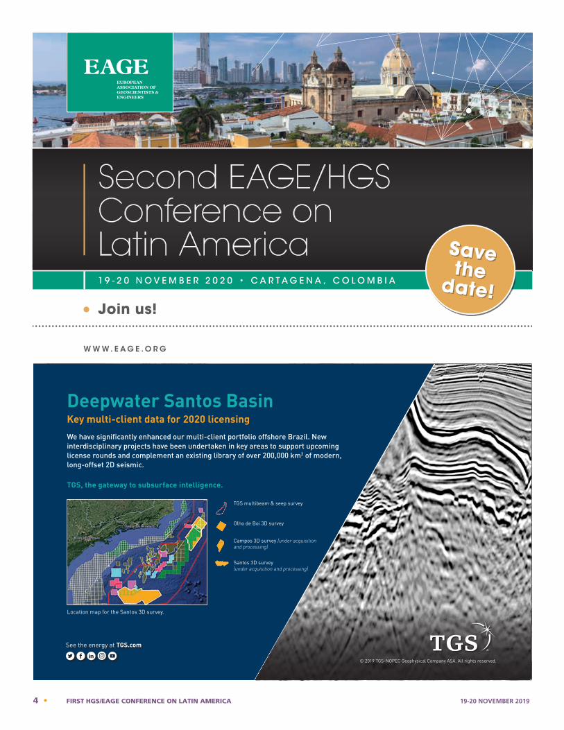
1 9 - 2 0 N O V E M B E R 2 0 2 0 • C A R T A G E N A , C O L O M B I A
WWW. E AG E .O RG
Second EAGE/HGS Conference on Latin America Save
the date!
-2000.000
-3000.000
-4000.000
-5000.000
-6000.000
-7000.000
-8000.000
-9000.000
-10000.000
-11000.000
cianorei@CR-COREILLY01
07/19/19 15:48:09
Offset:
-2000.000
-3000.000
-4000.000
-5000.000
-6000.000
-7000.000
-8000.000
-9000.000
-10000.000
-11000.000
4 • FIRST HGS/EAGE CONFERENCE ON LATIN AMERICA 19-20 NOVEMBER 2019
FIRST HGS/EAGE CONFERENCE ON LATIN AMERICA19-20 NOVEMBER 2019
Thanks to our Sponsors
Our Exhibitors
19-20 NOVEMBER 2019 FIRST HGS/EAGE CONFERENCE ON LATIN AMERICA • 5
FIRST HGS/EAGE CONFERENCE ON LATIN AMERICA19-20 NOVEMBER 2019
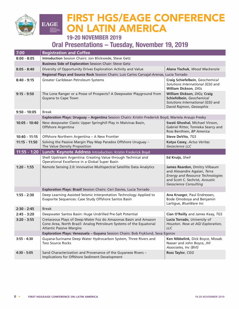
Oral Presentations – Tuesday, November 19, 2019 7:00 Registration and Coffee8:00 - 8:05 Introduction Session Chairs: Jon Blickwede, Steve Getz
Business Side of Exploration Session Chair: Steve Getz
8:05 - 8:40 Diversity of Opportunity Drives Exploration Activity and Value Alana Tischuk, Wood Mackenzie
Regional Plays and Source Rock Session Chairs: Luis Carlos Carvajal-Arenas, Lucia Torrado
8:40 - 9:15 Greater Caribbean Petroleum Systems Craig Schiefelbein, Geochemical Solutions International (GSI) and William Dickson, DIGs
9:15 - 9:50 The Lone Ranger or a Posse of Prospects? A Deepwater Playground from Guyana to Cape Town
William Dickson, DIGs; Craig Schiefelbein, Geochemical Solutions International (GSI) and David Rajmon, Geosophix
9:50 - 10:05 Break
Exploration Plays: Uruguay – Argentina Session Chairs: Kristin Frederick Boyd, Mariela Araujo Fresky
10:05 - 10:40 New deepwater Clastic Upper Springhill Play in Malvinas Basin, Offshore Argentina
Swati Ghoshal, Michael Vinson, Gabriel Ritter, Tomieka Searcy and Ross Benthien, BP America
10:40 - 11:15 Offshore Northern Argentina – A New Frontier Steve DeVito, TGS
11:15 - 11:50 Solving the Passive Margin Play Map Paradox Offshore Uruguay – The Value Density Proposition
Katya Casey, Actus Veritas Geoscience LLC
11:55 - 1:20 Lunch: Keynote Address Introduction: Kristin Frederick Boyd
Shell Upstream Argentina: Creating Value through Technical and Operational Excellence in a Global Super Basin
Ed Kruijs, Shell
1:20 - 1:55 Remote Sensing 2.0: Innovative Multispectral Satellite Data Analytics James Reardon, Dmitry Vilbaum and Alexandre Agaian, Terra Energy and Resource Technologies and Scott C. Sechrist, Acoustic Geoscience Consulting
Exploration Plays: Brazil Session Chairs: Ceri Davies, Lucia Torrado
1:55 - 2:30 Deep Learning Assisted Seismic Interpretation Technology Applied to Evaporite Sequences: Case Study Offshore Santos Basin
Ana Krueger, Paul Endressen, Bode Omoboya and Benjamin Lartigue, BlueWare Inc
2:30 - 2:45 Break
2:45 - 3:20 Deepwater Santos Basin: Huge Undrilled Pre-Salt Potential Cian O’Reilly and James Keay, TGS
3:20 - 3:55 Cretaceous Plays of Deep-Water Foz do Amazonas Basin and Amazon Cone Area, North Brazil: Analog Petroleum Systems of the Equatorial Atlantic Passive Margins
Lucia Torrado, University of Houston. Now at AGI Exploration, LLC
Exploration Plays: Venezuela – Guyana Session Chairs: Bob Fryklund, Seva Egorov
3:55 - 4:30 Guyana-Suriname Deep Water Hydrocarbon System, Three Rivers and Two Source Rocks
Ken Nibbelink, Dick Boyce, Mosab Nasser and John Boyce, JHI Associates, Inc (BVI)
4:30 - 5:05 Sand Characterization and Provenance of the Guyanese Rivers – Implications for Offshore Sediment Development
Ross Taylor, CGG
6 • FIRST HGS/EAGE CONFERENCE ON LATIN AMERICA 19-20 NOVEMBER 2019

FIRST HGS/EAGE CONFERENCE ON LATIN AMERICA19-20 NOVEMBER 2019
Oral Presentations – Wednesday, November 20, 2019 7:00 Registration and Coffee8:00 - 8:05 Introduction Session Chair: Pete Emmet
Business Side of Exploration Session Chair: Pete Emmet
8:05 - 8:40 Common Pitfalls in Seismic Imaging in Overthrust Geology and How to Address Them – a Collection of Case Studies from South America
Thomas Fieseler, TEECsolutions GmbH
Exploration Plays: Venezuela – Guyana Session Chairs: Bob Fryklund, Seva Egorov
8:40 - 9:15 The Cretaceous Source Rocks from East Venezuela, Trinidad, Guyana/Suriname Basins, NE South America
Francia Galea Alvarez, Actus Veritas Geoscience, LLC
9:15 - 9:50 Insights into the Geological Framework of Northeastern South America Marel Sanchez, Actus Veritas Geoscience, LLC
9:50 - 10:05 Break
Regional Plays of the Caribbean Session Chairs: Bob Weiner, Carolina Mejia
10:05 - 10:40 The Case for Paleogene Convergent Tectonism Along Northern South America BEFORE Diachronous Oblique Caribbean Collision
Jim Pindell and Diego Villagomez, Tectonic Analysis Ltd
10:40 - 11:15 An Emerging Play in the Caribbean: Tertiary Carbonate Buildups Peter Lanzarone, Carlos Louzada, Stefan Punnette, Hui Jin, Michael Vinson, Jesse Koch and Scott Lepley, BP America
11:15 - 11:50 Character of the Caribbean Crust Revealed: Observations of New and Reprocessed Seismic Data
Kyle Reuber, Jim Pindell, Antara Goswami, Mattie Friday, Chuck Campbell, Andy Bliss and Brian Horn; ION E&P Advisors and Tectonic Analysis Ltd
11:55 - 1:20 Lunch: Keynote Address Introduction: Steve Getz
Energy Opportunities in Latin America: Investing Through the Political Cycles
Richard Chuchla, Energy and Earth Resources Graduate Program, Jackson School, UT Austin
Western Caribbean Session Chairs: Steve Getz, Carolina Mejia
1:20 - 1:55 Petroleum Potential of the Colombia Basin: Insights from New Rock Evaluation Analyses for Regional Seismic Observations
Luis Carlos Carvajal-Arenas and Lucia Torrado, University of Houston. Now at AGI Exploration, LLC, and Paul Mann, Earth and Atmospheric Sciences, The University of Houston
1:55 - 2:30 Structural Evolution and Hydrocarbon Prospectivity in Offshore Panama in the Caribbean
Antara Goswami, Jim Pindell, Robert Erlich, Kyle Reuber, Tim Matava and Andy Bliss, ION E&P Advisors, Tectonic Analysis Ltd and Cayo Energy LP
2:30 - 2:45 Break
2:45 - 3:20 Exploration Potential of the Northern Offshore Region of Jamaica Gregg H. Blake, Blake Geological Services, LLC, and Raymond Thompson, Herona Thompson and Brian Richardson, Dept of Oil and Gas, PCJ
Central America Session Chairs: Pete Emmet, Hector San-Martin
3:20 - 3:55 Late Cretaceous–Cenozoic Paleogeographic Evolution of the Nicaraguan Platform, Western Caribbean Sea: Implications for Hydrocarbon Potential
Lucia Torrado and Luis Carlos Carvajal-Arenas, University of Houston. Now at AGI Exploration, LLC
3:55 - 4:30 The Petroleum Geology of Offshore Honduras Christopher Matchette-Downes, CaribX (UK) Limited
4:30 - 5:05 Petroleum Geology and Potential of Guatemala Mark R. Bitter, Marbit Geoconsulting, LLC
19-20 NOVEMBER 2019 FIRST HGS/EAGE CONFERENCE ON LATIN AMERICA • 7
FIRST HGS/EAGE CONFERENCE ON LATIN AMERICA19-20 NOVEMBER 2019
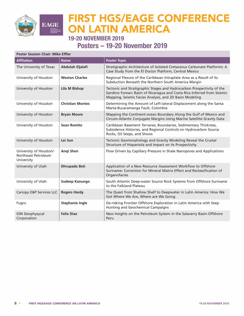
Posters – 19-20 November 2019 Poster Session Chair: Mike Effler
Affliation Name Poster Topic
The University of Texas Abdulah Eljalafi Stratigraphic Architecture of Isolated Cretaceous Carbonate Platforms: A Case Study from the El Doctor Platform, Central Mexico
University of Houston Weston Charles Regional Flexure of the Caribbean Intraplate Area as a Result of its Subduction Beneath the Northern South America Margin
University of Houston Lila M Bishop Tectonic and Stratigraphic Stages and Hydrocarbon Prospectivity of the Sandino Forearc Basin of Nicaragua and Costa Rica Inferred from Seismic Mapping, Seismic Facies Analysis, and 2D Basin Modeling
University of Houston Christian Montes Determining the Amount of Left-lateral Displacement along the Santa Marta-Bucaramanga Fault, Colombia
University of Houston Bryan Moore Mapping the Continent-ocean Boundary Along the Gulf of Mexico and Circum-Atlantic Conjugate Margins Using Marine Satellite Gravity Data
University of Houston Sean Romito Caribbean Basement Terranes; Boundaries, Sedimentary Thickness, Subsidence Histories, and Regional Controls on Hydrocarbon Source Rocks, Oil Seeps, and Shows
University of Houston Lei Sun Tectonic Geomorphology and Gravity Modeling Reveal the Crustal Structure of Hispaniola and Impact on its Prospectivity
University of Houston/Northeast Petroleum University
Anqi Shen Flow Driven by Capillary Pressure in Shale Nanopores and Applications
University of Utah Dhrupada Beti Application of a New Resource Assessment Workflow to Offshore Suriname: Correction for Mineral Matrix Effect and Reclassification of Organofacies
University of Utah Sudeep Kanungo South Atlantic Deep-water Source Rock Systems from Offshore Suriname to the Falkland Plateau
Canopy E&P Services LLC Rogers Hardy The Quest from Shallow Shelf to Deepwater in Latin America: How We Got Where We Are, Where are We Going
Fugro Stephanie Ingle De-risking Frontier Offshore Exploration in Latin America with Seep Hunting and Geochemical Campaigns
ION Geophysycal Corporation
Felix Diaz New Insights on the Petroleum System in the Salaverry Basin-Offshore Peru
8 • FIRST HGS/EAGE CONFERENCE ON LATIN AMERICA 19-20 NOVEMBER 2019

Notes
_______________________________________________________________________________________________________________________
_______________________________________________________________________________________________________________________
_______________________________________________________________________________________________________________________
_______________________________________________________________________________________________________________________
_______________________________________________________________________________________________________________________
_______________________________________________________________________________________________________________________
_______________________________________________________________________________________________________________________
_______________________________________________________________________________________________________________________
_______________________________________________________________________________________________________________________
_______________________________________________________________________________________________________________________
_______________________________________________________________________________________________________________________
_______________________________________________________________________________________________________________________
_______________________________________________________________________________________________________________________
_______________________________________________________________________________________________________________________
_______________________________________________________________________________________________________________________
_______________________________________________________________________________________________________________________
_______________________________________________________________________________________________________________________
_______________________________________________________________________________________________________________________
_______________________________________________________________________________________________________________________
_______________________________________________________________________________________________________________________
_______________________________________________________________________________________________________________________
_______________________________________________________________________________________________________________________
_______________________________________________________________________________________________________________________
_______________________________________________________________________________________________________________________
_______________________________________________________________________________________________________________________
_______________________________________________________________________________________________________________________
_______________________________________________________________________________________________________________________
_______________________________________________________________________________________________________________________
19-20 NOVEMBER 2019 FIRST HGS/EAGE CONFERENCE ON LATIN AMERICA • 9

Notes
_______________________________________________________________________________________________________________________
_______________________________________________________________________________________________________________________
_______________________________________________________________________________________________________________________
_______________________________________________________________________________________________________________________
_______________________________________________________________________________________________________________________
_______________________________________________________________________________________________________________________
_______________________________________________________________________________________________________________________
_______________________________________________________________________________________________________________________
_______________________________________________________________________________________________________________________
_______________________________________________________________________________________________________________________
_______________________________________________________________________________________________________________________
_______________________________________________________________________________________________________________________
_______________________________________________________________________________________________________________________
_______________________________________________________________________________________________________________________
_______________________________________________________________________________________________________________________
_______________________________________________________________________________________________________________________
_______________________________________________________________________________________________________________________
_______________________________________________________________________________________________________________________
_______________________________________________________________________________________________________________________
_______________________________________________________________________________________________________________________
_______________________________________________________________________________________________________________________
_______________________________________________________________________________________________________________________
_______________________________________________________________________________________________________________________
_______________________________________________________________________________________________________________________
_______________________________________________________________________________________________________________________
_______________________________________________________________________________________________________________________
_______________________________________________________________________________________________________________________
_______________________________________________________________________________________________________________________
10 • FIRST HGS/EAGE CONFERENCE ON LATIN AMERICA 19-20 NOVEMBER 2019

FIRST HGS/EAGE CONFERENCE ON LATIN AMERICA19-20 NOVEMBER 2019
AbstractsOral Presentations
Day One19 November 2019
Norris Center
Houston, Texas
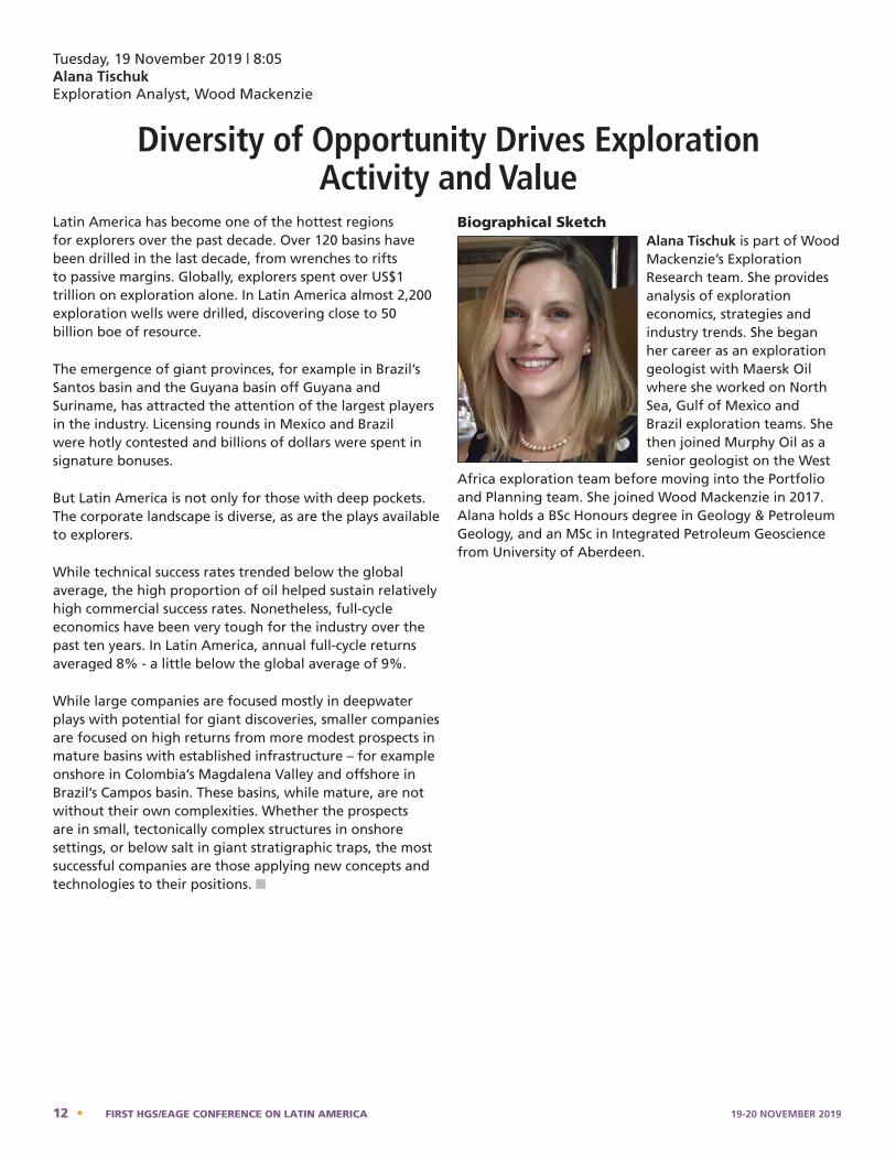
Tuesday, 19 November 2019 | 8:05Alana Tischuk Exploration Analyst, Wood Mackenzie
Diversity of Opportunity Drives Exploration Activity and Value
Latin America has become one of the hottest regions for explorers over the past decade. Over 120 basins have been drilled in the last decade, from wrenches to rifts to passive margins. Globally, explorers spent over US$1 trillion on exploration alone. In Latin America almost 2,200 exploration wells were drilled, discovering close to 50 billion boe of resource.
The emergence of giant provinces, for example in Brazil’s Santos basin and the Guyana basin off Guyana and Suriname, has attracted the attention of the largest players in the industry. Licensing rounds in Mexico and Brazil were hotly contested and billions of dollars were spent in signature bonuses.
But Latin America is not only for those with deep pockets. The corporate landscape is diverse, as are the plays available to explorers.
While technical success rates trended below the global average, the high proportion of oil helped sustain relatively high commercial success rates. Nonetheless, full-cycle economics have been very tough for the industry over the past ten years. In Latin America, annual full-cycle returns averaged 8% - a little below the global average of 9%.
While large companies are focused mostly in deepwater plays with potential for giant discoveries, smaller companies are focused on high returns from more modest prospects in mature basins with established infrastructure – for example onshore in Colombia’s Magdalena Valley and offshore in Brazil’s Campos basin. These basins, while mature, are not without their own complexities. Whether the prospects are in small, tectonically complex structures in onshore settings, or below salt in giant stratigraphic traps, the most successful companies are those applying new concepts and technologies to their positions. n
Biographical SketchAlana Tischuk is part of Wood Mackenzie’s Exploration Research team. She provides analysis of exploration economics, strategies and industry trends. She began her career as an exploration geologist with Maersk Oil where she worked on North Sea, Gulf of Mexico and Brazil exploration teams. She then joined Murphy Oil as a senior geologist on the West
Africa exploration team before moving into the Portfolio and Planning team. She joined Wood Mackenzie in 2017. Alana holds a BSc Honours degree in Geology & Petroleum Geology, and an MSc in Integrated Petroleum Geoscience from University of Aberdeen.
12 • FIRST HGS/EAGE CONFERENCE ON LATIN AMERICA 19-20 NOVEMBER 2019
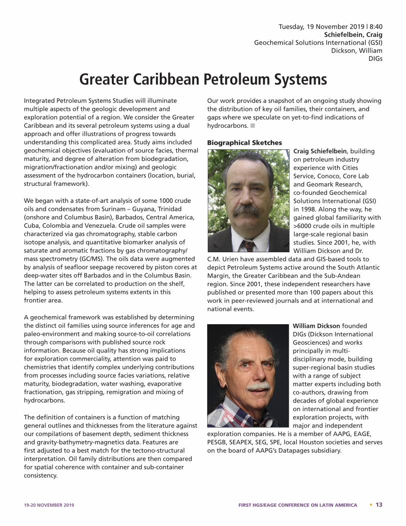
Tuesday, 19 November 2019 | 8:40Schiefelbein, Craig
Geochemical Solutions International (GSI)Dickson, William
DIGs
Greater Caribbean Petroleum SystemsIntegrated Petroleum Systems Studies will illuminate multiple aspects of the geologic development and exploration potential of a region. We consider the Greater Caribbean and its several petroleum systems using a dual approach and offer illustrations of progress towards understanding this complicated area. Study aims included geochemical objectives (evaluation of source facies, thermal maturity, and degree of alteration from biodegradation, migration/fractionation and/or mixing) and geologic assessment of the hydrocarbon containers (location, burial, structural framework).
We began with a state-of-art analysis of some 1000 crude oils and condensates from Surinam – Guyana, Trinidad (onshore and Columbus Basin), Barbados, Central America, Cuba, Colombia and Venezuela. Crude oil samples were characterized via gas chromatography, stable carbon isotope analysis, and quantitative biomarker analysis of saturate and aromatic fractions by gas chromatography/mass spectrometry (GC/MS). The oils data were augmented by analysis of seafloor seepage recovered by piston cores at deep-water sites off Barbados and in the Columbus Basin. The latter can be correlated to production on the shelf, helping to assess petroleum systems extents in this frontier area.
A geochemical framework was established by determining the distinct oil families using source inferences for age and paleo-environment and making source-to-oil correlations through comparisons with published source rock information. Because oil quality has strong implications for exploration commerciality, attention was paid to chemistries that identify complex underlying contributions from processes including source facies variations, relative maturity, biodegradation, water washing, evaporative fractionation, gas stripping, remigration and mixing of hydrocarbons.
The definition of containers is a function of matching general outlines and thicknesses from the literature against our compilations of basement depth, sediment thickness and gravity-bathymetry-magnetics data. Features are first adjusted to a best match for the tectono-structural interpretation. Oil family distributions are then compared for spatial coherence with container and sub-container consistency.
Our work provides a snapshot of an ongoing study showing the distribution of key oil families, their containers, and gaps where we speculate on yet-to-find indications of hydrocarbons. n
Biographical SketchesCraig Schiefelbein, building on petroleum industry experience with Cities Service, Conoco, Core Lab and Geomark Research, co-founded Geochemical Solutions International (GSI) in 1998. Along the way, he gained global familiarity with >6000 crude oils in multiple large-scale regional basin studies. Since 2001, he, with William Dickson and Dr.
C.M. Urien have assembled data and GIS-based tools to depict Petroleum Systems active around the South Atlantic Margin, the Greater Caribbean and the Sub-Andean region. Since 2001, these independent researchers have published or presented more than 100 papers about this work in peer-reviewed journals and at international and national events.
William Dickson founded DIGs (Dickson International Geosciences) and works principally in multi-disciplinary mode, building super-regional basin studies with a range of subject matter experts including both co-authors, drawing from decades of global experience on international and frontier exploration projects, with major and independent
exploration companies. He is a member of AAPG, EAGE, PESGB, SEAPEX, SEG, SPE, local Houston societies and serves on the board of AAPG’s Datapages subsidiary.
Craig Schiefelbein - Bio
Craig Schiefelbein, building on petroleum industry experience with Cities Service, Conoco, Core Lab and Geomark Research, co-founded Geochemical Solutions International (GSI) in 1998. Along the way, he gained global familiarity with >6000 crude oils in multiple large-scale regional basin studies. Since 2001, he, with William Dickson and Dr. C.M. Urien have assembled data and GIS-based tools to depict Petroleum Systems active around the South Atlantic Margin, the Greater Caribbean and the Sub-Andean region. Since 2001, these independent researchers have published or presented more than 100 papers about this work in peer-reviewed journals and at international and national events.
William Dickson – Bio
William Dickson founded DIGs (Dickson International Geosciences) and works principally in multi-disciplinary mode, building super-regional basin studies with a range of subject matter experts including both co-authors, drawing from decades of global experience on international and frontier
exploration projects, with major and independent exploration companies. He is a member of AAPG, EAGE, PESGB, SEAPEX, SEG, SPE, local Houston societies and serves on the board of AAPG's Datapages subsidiary.
19-20 NOVEMBER 2019 FIRST HGS/EAGE CONFERENCE ON LATIN AMERICA • 13
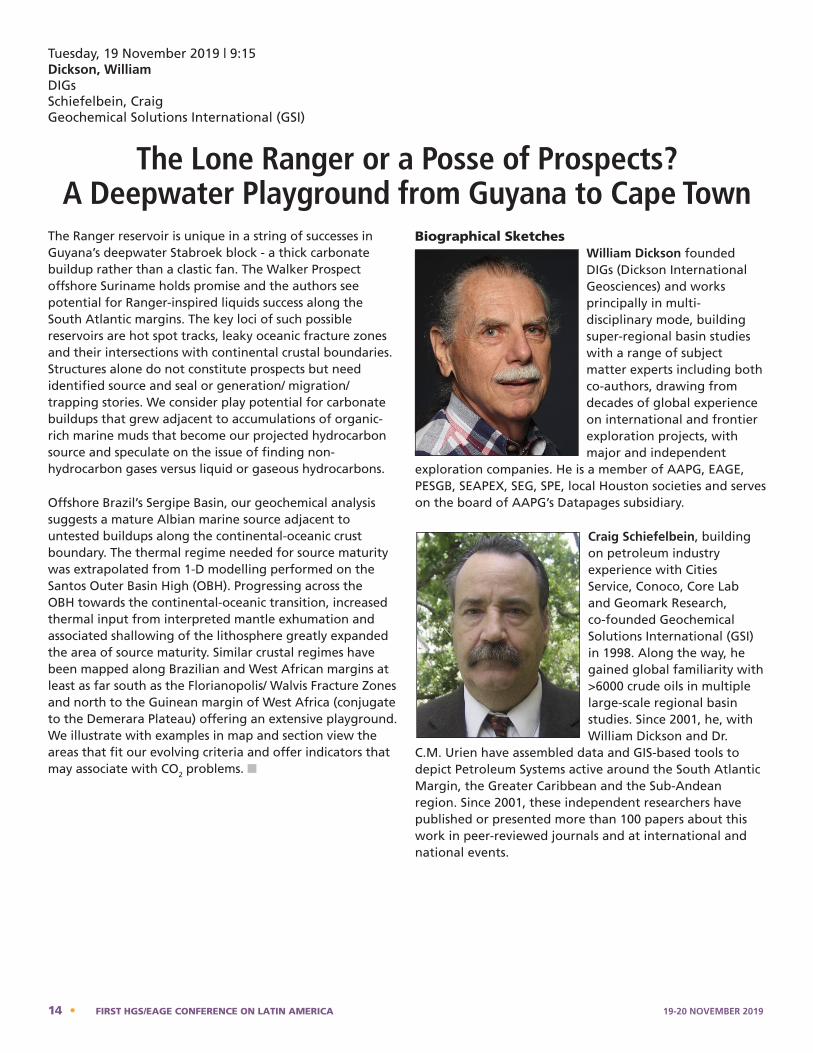
Tuesday, 19 November 2019 | 9:15Dickson, WilliamDIGsSchiefelbein, Craig Geochemical Solutions International (GSI)
The Lone Ranger or a Posse of Prospects? A Deepwater Playground from Guyana to Cape Town
The Ranger reservoir is unique in a string of successes in Guyana’s deepwater Stabroek block - a thick carbonate buildup rather than a clastic fan. The Walker Prospect offshore Suriname holds promise and the authors see potential for Ranger-inspired liquids success along the South Atlantic margins. The key loci of such possible reservoirs are hot spot tracks, leaky oceanic fracture zones and their intersections with continental crustal boundaries. Structures alone do not constitute prospects but need identified source and seal or generation/ migration/ trapping stories. We consider play potential for carbonate buildups that grew adjacent to accumulations of organic-rich marine muds that become our projected hydrocarbon source and speculate on the issue of finding non-hydrocarbon gases versus liquid or gaseous hydrocarbons.
Offshore Brazil’s Sergipe Basin, our geochemical analysis suggests a mature Albian marine source adjacent to untested buildups along the continental-oceanic crust boundary. The thermal regime needed for source maturity was extrapolated from 1-D modelling performed on the Santos Outer Basin High (OBH). Progressing across the OBH towards the continental-oceanic transition, increased thermal input from interpreted mantle exhumation and associated shallowing of the lithosphere greatly expanded the area of source maturity. Similar crustal regimes have been mapped along Brazilian and West African margins at least as far south as the Florianopolis/ Walvis Fracture Zones and north to the Guinean margin of West Africa (conjugate to the Demerara Plateau) offering an extensive playground. We illustrate with examples in map and section view the areas that fit our evolving criteria and offer indicators that may associate with CO2 problems. n
Biographical SketchesWilliam Dickson founded DIGs (Dickson International Geosciences) and works principally in multi-disciplinary mode, building super-regional basin studies with a range of subject matter experts including both co-authors, drawing from decades of global experience on international and frontier exploration projects, with major and independent
exploration companies. He is a member of AAPG, EAGE, PESGB, SEAPEX, SEG, SPE, local Houston societies and serves on the board of AAPG’s Datapages subsidiary.
Craig Schiefelbein, building on petroleum industry experience with Cities Service, Conoco, Core Lab and Geomark Research, co-founded Geochemical Solutions International (GSI) in 1998. Along the way, he gained global familiarity with >6000 crude oils in multiple large-scale regional basin studies. Since 2001, he, with William Dickson and Dr.
C.M. Urien have assembled data and GIS-based tools to depict Petroleum Systems active around the South Atlantic Margin, the Greater Caribbean and the Sub-Andean region. Since 2001, these independent researchers have published or presented more than 100 papers about this work in peer-reviewed journals and at international and national events.
William Dickson – Bio
William Dickson founded DIGs (Dickson International Geosciences) and works principally in multi-disciplinary mode, building super-regional basin studies with a range of subject matter experts including both co-authors, drawing from decades of global experience on international and frontier
exploration projects, with major and independent exploration companies. He is a member of AAPG, EAGE, PESGB, SEAPEX, SEG, SPE, local Houston societies and serves on the board of AAPG's Datapages subsidiary.
Craig Schiefelbein - Bio
Craig Schiefelbein, building on petroleum industry experience with Cities Service, Conoco, Core Lab and Geomark Research, co-founded Geochemical Solutions International (GSI) in 1998. Along the way, he gained global familiarity with >6000 crude oils in multiple large-scale regional basin studies. Since 2001, he, with William Dickson and Dr. C.M. Urien have assembled data and GIS-based tools to depict Petroleum Systems active around the South Atlantic Margin, the Greater Caribbean and the Sub-Andean region. Since 2001, these independent researchers have published or presented more than 100 papers about this work in peer-reviewed journals and at international and national events.
14 • FIRST HGS/EAGE CONFERENCE ON LATIN AMERICA 19-20 NOVEMBER 2019
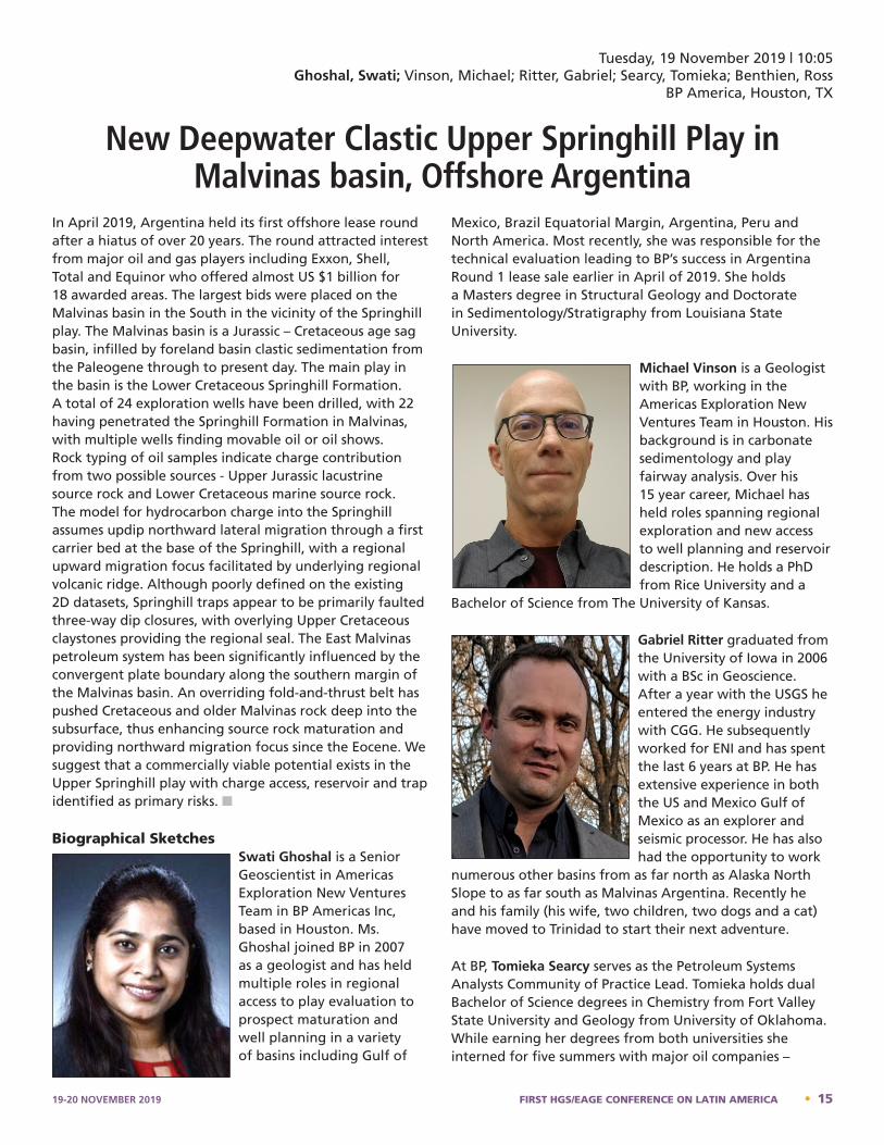
Tuesday, 19 November 2019 | 10:05Ghoshal, Swati; Vinson, Michael; Ritter, Gabriel; Searcy, Tomieka; Benthien, Ross
BP America, Houston, TX
New Deepwater Clastic Upper Springhill Play in Malvinas basin, Offshore Argentina
In April 2019, Argentina held its first offshore lease round after a hiatus of over 20 years. The round attracted interest from major oil and gas players including Exxon, Shell, Total and Equinor who offered almost US $1 billion for 18 awarded areas. The largest bids were placed on the Malvinas basin in the South in the vicinity of the Springhill play. The Malvinas basin is a Jurassic – Cretaceous age sag basin, infilled by foreland basin clastic sedimentation from the Paleogene through to present day. The main play in the basin is the Lower Cretaceous Springhill Formation. A total of 24 exploration wells have been drilled, with 22 having penetrated the Springhill Formation in Malvinas, with multiple wells finding movable oil or oil shows. Rock typing of oil samples indicate charge contribution from two possible sources - Upper Jurassic lacustrine source rock and Lower Cretaceous marine source rock. The model for hydrocarbon charge into the Springhill assumes updip northward lateral migration through a first carrier bed at the base of the Springhill, with a regional upward migration focus facilitated by underlying regional volcanic ridge. Although poorly defined on the existing 2D datasets, Springhill traps appear to be primarily faulted three-way dip closures, with overlying Upper Cretaceous claystones providing the regional seal. The East Malvinas petroleum system has been significantly influenced by the convergent plate boundary along the southern margin of the Malvinas basin. An overriding fold-and-thrust belt has pushed Cretaceous and older Malvinas rock deep into the subsurface, thus enhancing source rock maturation and providing northward migration focus since the Eocene. We suggest that a commercially viable potential exists in the Upper Springhill play with charge access, reservoir and trap identified as primary risks. n
Biographical SketchesSwati Ghoshal is a Senior Geoscientist in Americas Exploration New Ventures Team in BP Americas Inc, based in Houston. Ms. Ghoshal joined BP in 2007 as a geologist and has held multiple roles in regional access to play evaluation to prospect maturation and well planning in a variety of basins including Gulf of
Mexico, Brazil Equatorial Margin, Argentina, Peru and North America. Most recently, she was responsible for the technical evaluation leading to BP’s success in Argentina Round 1 lease sale earlier in April of 2019. She holds a Masters degree in Structural Geology and Doctorate in Sedimentology/Stratigraphy from Louisiana State University.
Michael Vinson is a Geologist with BP, working in the Americas Exploration New Ventures Team in Houston. His background is in carbonate sedimentology and play fairway analysis. Over his 15 year career, Michael has held roles spanning regional exploration and new access to well planning and reservoir description. He holds a PhD from Rice University and a
Bachelor of Science from The University of Kansas.
Gabriel Ritter graduated from the University of Iowa in 2006 with a BSc in Geoscience. After a year with the USGS he entered the energy industry with CGG. He subsequently worked for ENI and has spent the last 6 years at BP. He has extensive experience in both the US and Mexico Gulf of Mexico as an explorer and seismic processor. He has also had the opportunity to work
numerous other basins from as far north as Alaska North Slope to as far south as Malvinas Argentina. Recently he and his family (his wife, two children, two dogs and a cat) have moved to Trinidad to start their next adventure.
At BP, Tomieka Searcy serves as the Petroleum Systems Analysts Community of Practice Lead. Tomieka holds dual Bachelor of Science degrees in Chemistry from Fort Valley State University and Geology from University of Oklahoma. While earning her degrees from both universities she interned for five summers with major oil companies –
Swati Ghoshal – Bio
Swati Ghoshal is a Senior Geoscientist in Americas Exploration New Ventures Team in BP Americas Inc, based in Houston. Ms. Ghoshal joined BP in 2007 as a geologist and has held multiple roles in regional access to play evaluation to prospect maturation and well planning in a variety of basins including Gulf of Mexico, Brazil Equatorial Margin, Argentina, Peru and North America. Most recently, she was responsible for the technical evaluation leading to BP’s success in Argentina Round 1 lease sale earlier in April of 2019. She holds a Masters degree in Structural Geology and Doctorate in Sedimentology/Stratigraphy from Louisiana State University.
Michael Vinson – Bio
Michael Vinson is a Geologist with BP, working in the Americas Exploration New Ventures Team in Houston. His background is in carbonate sedimentology and play fairway analysis. Over his 15 year career, Michael has held roles spanning regional exploration and new access to well planning and reservoir description. He holds a Ph.D. from Rice University and a Bachelor of Science from The University of Kansas.
Gabriel Ritter – Bio
Gabriel Ritter graduated from the University of Iowa in 2006 with a BSc in Geoscience. After a year with the USGS he entered the energy industry with CGG. He subsequently worked for ENI and has spent the last 6 years at BP. He has extensive experience in both the US and Mexico Gulf of Mexico as an explorer and seismic processor. He has also had the opportunity to work numerous other basins from as far north as Alaska North Slope to as far south as Malvinas Argentina. Recently he and his family (his wife, two children, two dogs and a cat) have moved to Trinidad to start their next adventure.
Tomieka Searcy – Bio
At BP, Tomieka Searcy serves as the Petroleum Systems Analysts Community of Practice Lead. Tomieka holds dual Bachelor of Science degrees in Chemistry from Fort Valley State University and Geology from University of Oklahoma. While earning her degrees from both universities
19-20 NOVEMBER 2019 FIRST HGS/EAGE CONFERENCE ON LATIN AMERICA • 15

Texaco, Shell and BP. She went on to obtain her Master of Science degree in Geology at The University of Oklahoma. Upon graduation, she joined BP in Houston. Her nearly 15 years at BP, she worked as a Geologist and now specializes in petroleum systems analyses. Tomieka has worked in various basins and play types within Western Wyoming, Gulf of Mexico, Mediterranean, North
Sea (UK and Norway), and South America. In addition to her career at BP, she currently serves as National Secretary for National Association of Black Geoscientists.
Ross Benthien is a geologist with 32 years of oil and gas experience with a focus on exploration and appraisal in multiple basins throughout North and South America, plus Egypt. He received a BS in geology from the University of Wisconsin (1984) and a MS in geology from the University of Oklahoma (1987). Ross started his career at Marathon Oil before moving to Vastar
Resources and now BP.
Gabriel Ritter – Bio
Gabriel Ritter graduated from the University of Iowa in 2006 with a BSc in Geoscience. After a year with the USGS he entered the energy industry with CGG. He subsequently worked for ENI and has spent the last 6 years at BP. He has extensive experience in both the US and Mexico Gulf of Mexico as an explorer and seismic processor. He has also had the opportunity to work numerous other basins from as far north as Alaska North Slope to as far south as Malvinas Argentina. Recently he and his family (his wife, two children, two dogs and a cat) have moved to Trinidad to start their next adventure.
Tomieka Searcy – Bio
At BP, Tomieka Searcy serves as the Petroleum Systems Analysts Community of Practice Lead. Tomieka holds dual Bachelor of Science degrees in Chemistry from Fort Valley State University and Geology from University of Oklahoma. While earning her degrees from both universities
she interned for five summers with major oil companies - Texaco, Shell and BP. She went on to obtain her Master of Science degree in Geology at The University of Oklahoma. Upon graduation, she joined BP in Houston. Her nearly 15 years at BP, she worked as a Geologist and now specializes in petroleum systems analyses. Tomieka has worked in various basins and play types within Western Wyoming, Gulf of Mexico, Mediterranean, North Sea (UK and Norway), and South America. In addition to her career at BP, she currently serves as National Secretary for National Association of Black Geoscientists.
Ross Benthien – Bio
Ross Benthien is a geologist with 32 years of oil and gas experience with a focus on exploration and appraisal in multiple basins throughout North and South America, plus Egypt. He received a BS in geology from the University of Wisconsin (1984) and a MS in geology from the University of Oklahoma (1987). Ross started his career at Marathon Oil before moving to Vastar Resources and now BP.
16 • FIRST HGS/EAGE CONFERENCE ON LATIN AMERICA 19-20 NOVEMBER 2019
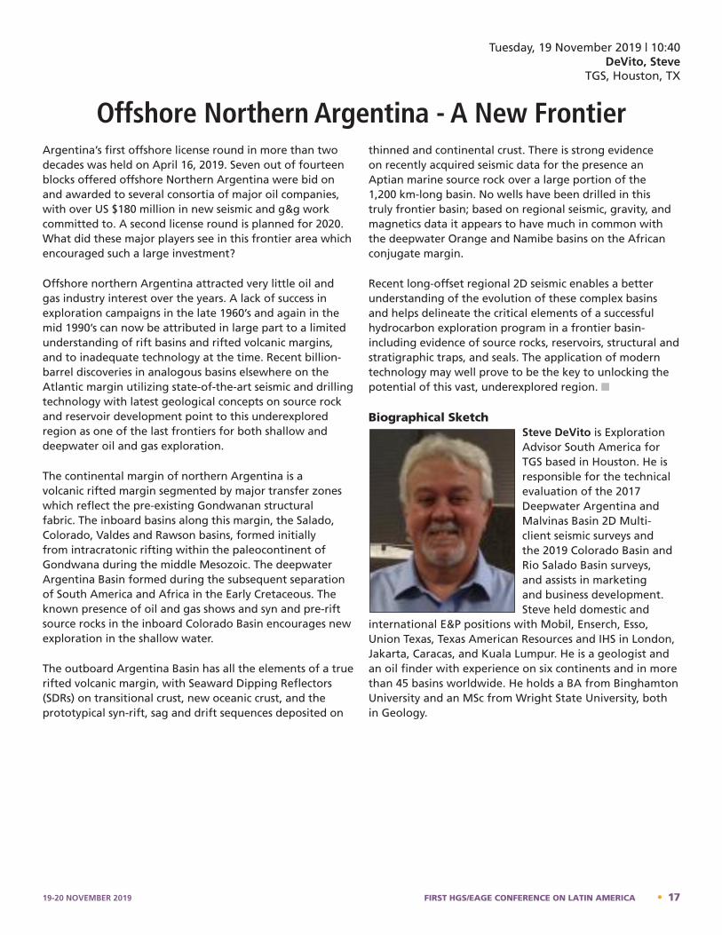
Tuesday, 19 November 2019 | 10:40DeVito, Steve
TGS, Houston, TX
Offshore Northern Argentina - A New FrontierArgentina’s first offshore license round in more than two decades was held on April 16, 2019. Seven out of fourteen blocks offered offshore Northern Argentina were bid on and awarded to several consortia of major oil companies, with over US $180 million in new seismic and g&g work committed to. A second license round is planned for 2020. What did these major players see in this frontier area which encouraged such a large investment?
Offshore northern Argentina attracted very little oil and gas industry interest over the years. A lack of success in exploration campaigns in the late 1960’s and again in the mid 1990’s can now be attributed in large part to a limited understanding of rift basins and rifted volcanic margins, and to inadequate technology at the time. Recent billion-barrel discoveries in analogous basins elsewhere on the Atlantic margin utilizing state-of-the-art seismic and drilling technology with latest geological concepts on source rock and reservoir development point to this underexplored region as one of the last frontiers for both shallow and deepwater oil and gas exploration.
The continental margin of northern Argentina is a volcanic rifted margin segmented by major transfer zones which reflect the pre-existing Gondwanan structural fabric. The inboard basins along this margin, the Salado, Colorado, Valdes and Rawson basins, formed initially from intracratonic rifting within the paleocontinent of Gondwana during the middle Mesozoic. The deepwater Argentina Basin formed during the subsequent separation of South America and Africa in the Early Cretaceous. The known presence of oil and gas shows and syn and pre-rift source rocks in the inboard Colorado Basin encourages new exploration in the shallow water.
The outboard Argentina Basin has all the elements of a true rifted volcanic margin, with Seaward Dipping Reflectors (SDRs) on transitional crust, new oceanic crust, and the prototypical syn-rift, sag and drift sequences deposited on
thinned and continental crust. There is strong evidence on recently acquired seismic data for the presence an Aptian marine source rock over a large portion of the 1,200 km-long basin. No wells have been drilled in this truly frontier basin; based on regional seismic, gravity, and magnetics data it appears to have much in common with the deepwater Orange and Namibe basins on the African conjugate margin.
Recent long-offset regional 2D seismic enables a better understanding of the evolution of these complex basins and helps delineate the critical elements of a successful hydrocarbon exploration program in a frontier basin- including evidence of source rocks, reservoirs, structural and stratigraphic traps, and seals. The application of modern technology may well prove to be the key to unlocking the potential of this vast, underexplored region. n
Biographical SketchSteve DeVito is Exploration Advisor South America for TGS based in Houston. He is responsible for the technical evaluation of the 2017 Deepwater Argentina and Malvinas Basin 2D Multi-client seismic surveys and the 2019 Colorado Basin and Rio Salado Basin surveys, and assists in marketing and business development. Steve held domestic and
international E&P positions with Mobil, Enserch, Esso, Union Texas, Texas American Resources and IHS in London, Jakarta, Caracas, and Kuala Lumpur. He is a geologist and an oil finder with experience on six continents and in more than 45 basins worldwide. He holds a BA from Binghamton University and an MSc from Wright State University, both in Geology.
program in a frontier basin- including evidence of source rocks, reservoirs, structural and stratigraphic traps, and seals. The application of modern technology may well prove to be the key to unlocking the potential of this vast, underexplored region. Steve DeVito – Bio
Steve DeVito is Exploration Advisor South America for TGS based in Houston. He is responsible for the technical evaluation of the 2017 Deepwater Argentina and Malvinas Basin 2D Multi-client seismic surveys and the 2019 Colorado Basin and Rio Salado Basin surveys, and assists in marketing and business development. Steve held domestic and international E&P positions with Mobil, Enserch, Esso, Union Texas, Texas American Resources and IHS in London, Jakarta, Caracas, and Kuala Lumpur. He is a geologist and an oil finder with experience on six continents and in more than 45 basins worldwide. He holds a BA from Binghamton University and an MSc from Wright State University, both in Geology.
19-20 NOVEMBER 2019 FIRST HGS/EAGE CONFERENCE ON LATIN AMERICA • 17
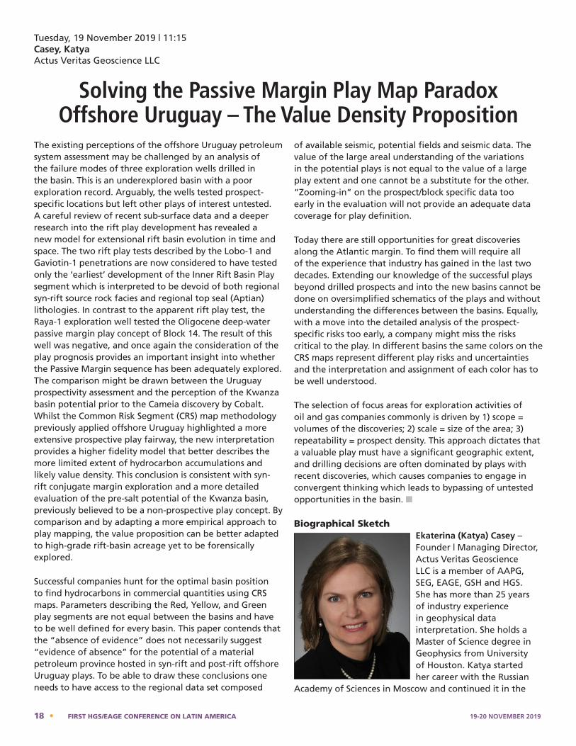
Tuesday, 19 November 2019 | 11:15Casey, KatyaActus Veritas Geoscience LLC
Solving the Passive Margin Play Map Paradox Offshore Uruguay – The Value Density Proposition
The existing perceptions of the offshore Uruguay petroleum system assessment may be challenged by an analysis of the failure modes of three exploration wells drilled in the basin. This is an underexplored basin with a poor exploration record. Arguably, the wells tested prospect-specific locations but left other plays of interest untested. A careful review of recent sub-surface data and a deeper research into the rift play development has revealed a new model for extensional rift basin evolution in time and space. The two rift play tests described by the Lobo-1 and Gaviotin-1 penetrations are now considered to have tested only the ‘earliest’ development of the Inner Rift Basin Play segment which is interpreted to be devoid of both regional syn-rift source rock facies and regional top seal (Aptian) lithologies. In contrast to the apparent rift play test, the Raya-1 exploration well tested the Oligocene deep-water passive margin play concept of Block 14. The result of this well was negative, and once again the consideration of the play prognosis provides an important insight into whether the Passive Margin sequence has been adequately explored. The comparison might be drawn between the Uruguay prospectivity assessment and the perception of the Kwanza basin potential prior to the Cameia discovery by Cobalt. Whilst the Common Risk Segment (CRS) map methodology previously applied offshore Uruguay highlighted a more extensive prospective play fairway, the new interpretation provides a higher fidelity model that better describes the more limited extent of hydrocarbon accumulations and likely value density. This conclusion is consistent with syn-rift conjugate margin exploration and a more detailed evaluation of the pre-salt potential of the Kwanza basin, previously believed to be a non-prospective play concept. By comparison and by adapting a more empirical approach to play mapping, the value proposition can be better adapted to high-grade rift-basin acreage yet to be forensically explored.
Successful companies hunt for the optimal basin position to find hydrocarbons in commercial quantities using CRS maps. Parameters describing the Red, Yellow, and Green play segments are not equal between the basins and have to be well defined for every basin. This paper contends that the “absence of evidence” does not necessarily suggest “evidence of absence” for the potential of a material petroleum province hosted in syn-rift and post-rift offshore Uruguay plays. To be able to draw these conclusions one needs to have access to the regional data set composed
of available seismic, potential fields and seismic data. The value of the large areal understanding of the variations in the potential plays is not equal to the value of a large play extent and one cannot be a substitute for the other. “Zooming-in” on the prospect/block specific data too early in the evaluation will not provide an adequate data coverage for play definition.
Today there are still opportunities for great discoveries along the Atlantic margin. To find them will require all of the experience that industry has gained in the last two decades. Extending our knowledge of the successful plays beyond drilled prospects and into the new basins cannot be done on oversimplified schematics of the plays and without understanding the differences between the basins. Equally, with a move into the detailed analysis of the prospect-specific risks too early, a company might miss the risks critical to the play. In different basins the same colors on the CRS maps represent different play risks and uncertainties and the interpretation and assignment of each color has to be well understood.
The selection of focus areas for exploration activities of oil and gas companies commonly is driven by 1) scope = volumes of the discoveries; 2) scale = size of the area; 3) repeatability = prospect density. This approach dictates that a valuable play must have a significant geographic extent, and drilling decisions are often dominated by plays with recent discoveries, which causes companies to engage in convergent thinking which leads to bypassing of untested opportunities in the basin. n
Biographical SketchEkaterina (Katya) Casey – Founder | Managing Director, Actus Veritas Geoscience LLC is a member of AAPG, SEG, EAGE, GSH and HGS. She has more than 25 years of industry experience in geophysical data interpretation. She holds a Master of Science degree in Geophysics from University of Houston. Katya started her career with the Russian
Academy of Sciences in Moscow and continued it in the
Katya Casey - Bio
Ekaterina (Katya) Casey - Founder | Managing Director, Actus Veritas Geoscience LLC is a member of AAPG, SEG, EAGE, GSH and HGS. She has more than 25 years of industry experience in geophysical data interpretation. She holds a Master of Science degree in Geophysics from University of Houston. Katya started her career with the Russian Academy of Sciences in Moscow and continued it in the United States where she worked for Amoco Petroleum, Vastar Resources, BHP Billiton, Apache and Murphy Oil companies. Currently she is one of three managing directors at Actus Veritas Geoscience, LLC established in 2016.
She applies her passion, expertise and experience in basin prospectivity assessments, evaluation and development of play concepts, assessments of prospects within the plays, identification and evaluation of play/prospect risks using relevant data and technologies.
She is known in the petroleum industry for designing and implementing multiple geoscience technologies and innovations. She was among early promoters of Geographic Information Systems (GIS) in the petroleum industry. In one of her roles at BHP Billiton she was a visionary leader of a global geographically spread team of geoscience computing specialists and data
18 • FIRST HGS/EAGE CONFERENCE ON LATIN AMERICA 19-20 NOVEMBER 2019
United States where she worked for Amoco Petroleum, Vastar Resources, BHP Billiton, Apache and Murphy Oil companies. Currently she is one of three managing directors at Actus Veritas Geoscience, LLC established in 2016.
She applies her passion, expertise and experience in basin prospectivity assessments, evaluation and development of play concepts, assessments of prospects within the plays, identification and evaluation of play/prospect risks using relevant data and technologies.
She is known in the petroleum industry for designing and implementing multiple geoscience technologies and innovations. She was among early promoters of Geographic Information Systems (GIS) in the petroleum industry. In one of her roles at BHP Billiton she was a visionary leader of a global geographically spread team of geoscience computing specialists and data management.
She developed and implemented GIS-based workflows into project evaluations at BHP Billiton Petroleum and designed an enterprise architecture to support the new technology.
She is adept at project definition and optimization of team dynamics. She provides mentorship and develops early career geoscientists and colleagues through publications, training, teaching, and industry forum presentations.
Katya is a respected technical speaker. She has coauthored papers and presented on geospatial, geophysical methods and technologies, play-based exploration, and use of her findings from regional studies in the value assessment of exploration blocks.
She received an Award in “Leadership in Technology” from the Association of Women in Computing in 2008 and an Honorary Membership Award from the Geophysical Society of Houston in 2018.
19-20 NOVEMBER 2019 FIRST HGS/EAGE CONFERENCE ON LATIN AMERICA • 19
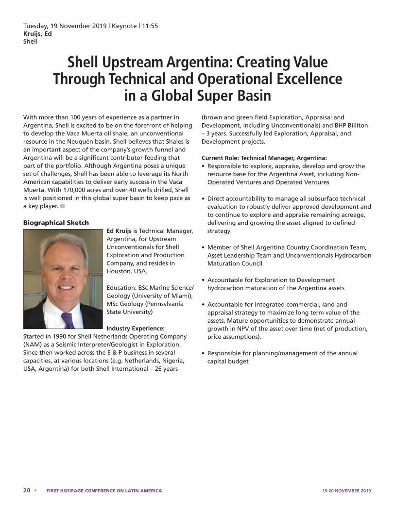
Tuesday, 19 November 2019 | Keynote | 11:55Kruijs, Ed Shell
Shell Upstream Argentina: Creating Value Through Technical and Operational Excellence
in a Global Super BasinWith more than 100 years of experience as a partner in Argentina, Shell is excited to be on the forefront of helping to develop the Vaca Muerta oil shale, an unconventional resource in the Neuquén basin. Shell believes that Shales is an important aspect of the company’s growth funnel and Argentina will be a significant contributor feeding that part of the portfolio. Although Argentina poses a unique set of challenges, Shell has been able to leverage its North American capabilities to deliver early success in the Vaca Muerta. With 170,000 acres and over 40 wells drilled, Shell is well positioned in this global super basin to keep pace as a key player. n
Biographical SketchEd Kruijs is Technical Manager, Argentina, for Upstream Unconventionals for Shell Exploration and Production Company, and resides in Houston, USA.
Education: BSc Marine Science/Geology (University of Miami), MSc Geology (Pennsylvania State University)
Industry Experience:Started in 1990 for Shell Netherlands Operating Company (NAM) as a Seismic Interpreter/Geologist in Exploration. Since then worked across the E & P business in several capacities, at various locations (e.g. Netherlands, Nigeria, USA, Argentina) for both Shell International – 26 years
(brown and green field Exploration, Appraisal and Development, including Unconventionals) and BHP Billiton – 3 years. Successfully led Exploration, Appraisal, and Development projects.
Current Role: Technical Manager, Argentina:• Responsible to explore, appraise, develop and grow the
resource base for the Argentina Asset, including Non-Operated Ventures and Operated Ventures
• Direct accountability to manage all subsurface technical evaluation to robustly deliver approved development and to continue to explore and appraise remaining acreage, delivering and growing the asset aligned to defined strategy
• Member of Shell Argentina Country Coordination Team, Asset Leadership Team and Unconventionals Hydrocarbon Maturation Council
• Accountable for Exploration to Development hydrocarbon maturation of the Argentina assets
• Accountable for integrated commercial, land and appraisal strategy to maximize long term value of the assets. Mature opportunities to demonstrate annual growth in NPV of the asset over time (net of production, price assumptions).
• Responsible for planning/management of the annual capital budget
Ed Kruijs - Bio
Ed Kruijs is Technical Manager, Argentina, for Upstream Unconventionals for Shell Exploration and Production Company, and resides in Houston, USA.
Education: BSc Marine Science/Geology (University of Miami), MSc Geology (Pennsylvania State University) Industry Experience: Started in 1990 for Shell Netherlands Operating Company (NAM) as a Seismic Interpreter/Geologist in Exploration. Since then worked across the E & P business in several capacities, at various locations (e.g. Netherlands, Nigeria, USA, Argentina) for both Shell International – 26 years (brown and green field Exploration, Appraisal and Development, including Unconventionals) and BHP Billiton – 3 years. Successfully led Exploration, Appraisal, and Development projects. Current Role: Technical manager, Argentina:
• Responsible to explore, appraise, develop and grow the resource base for the Argentina Asset, including Non-Operated Ventures and Operated Ventures
20 • FIRST HGS/EAGE CONFERENCE ON LATIN AMERICA 19-20 NOVEMBER 2019

Tuesday, 19 November 2019 | 1:55Reardon, James M.
Terra Energy & Resource Technologies, Inc.Sechrist, Scott C.
Acoustic Geoscience ConsultingVilbaum, Dmitry; Agaian, Alexandre
Terra Energy & Resource Technologies, Inc.
Remote Sensing 2.0: Innovative Multispectral Satellite Data Analytics
Terra Energy & Resource Technologies, Inc. (Terra) is introducing new remote sensing tools into the oil & natural gas exploration market which identify source rock, migration pathways, faults, uplifts/trapping features, hydrocarbon charge and depth … all before any boots hit the ground. This is next generation remote sensing, featuring innovative processing, calculative application, analysis and interpretation of multispectral satellite data. We call it Remote Sensing 2.0 because we invert from patterns in surface data to image the subsurface. Especially helpful in early exploration, it acts like a bird dog, delineates high-value leads, informs on trap, hydrocarbon charge and depth, focusing exploration spending on the highest-probability targets in the AOI.
Through decades of scientific method (pre-drill studies and post-drill analysis), Terra’s geoscientists have empirically established the connections between certain patterns and
relief constructs and subsurface genesis. The anomalies can be calculated from multispectral satellite data (digital spectral and elevation data), using special algorithms. We operate on the simple premise that the surface (physically and energetically) reflects subsurface, in the same way that passive seismic reveals subsurface geobodies. Our geoscientists have made advances in identifying these surface manifestations (effect) connected to subsurface processes (cause).
Traditional geology, geophysics and potential fields methods also model the subsurface from data gathered at the surface, or from the capture of energy arriving at the surface (induced or naturally occurring). Gravity, magnetic and electromagnetic studies are all examples of potential field methods which tie subsurface cause to surface effect.
The Terra multimethod approach is similar but works
iv. Pattern recognition studies applied to multispectral satellite data identify oil and gas structures, faults, hydrocarbon signatures, and depth;
v. AI geo-tools applied to G&G and remotely sensed data to inform on prospectivity.
Terra will present the premise behind the respective methods and show several examples of results associated with work performed in recent years in Argentina. one study, Terra’s negative assessment of the southwest corner, a heavily volcanized area devoid of any signs of hydrocarbons according to Terra’s studies, was instrumental in the customer cancelling an expensive seismic acquisition campaign which been planned for 600 KM2 in that area. The final, integrated mapping results of this study, covering 15,000 KM2, are shown below.
19-20 NOVEMBER 2019 FIRST HGS/EAGE CONFERENCE ON LATIN AMERICA • 21
from different data sets including multispectral satellite data, digital elevation mapping (DEM) and Digital Terrain Model (DTM). Each of the different methods answers a different geological question and varies in the respective processes and calculations. Data is gathered from commercial libraries, the algorithmic processing is applied to develop the geologic imaging, additional algorithms and calculations are made to invert to depth, and then analysis and interpretation follow. The deliverables include maps of 2D contours for regional and local studies with low to medium resolution data. Studies using medium to high resolution data deliver maps with cross-sections and 3D voxel models. Whether regional exploration in frontier areas, prospect-generation in locally-high-graded areas, or pre-drill studies assessing third party prospects, Terra’s multimethod approach reduces the time, cost and risk of oil and gas exploration and lifts ROI. These methods are particularly helpful in areas with limited seismic coverage and limited well control. Terra’s suite of remote sensing tools can be grouped into five categories and add value in early, intermediate and late-stage exploration. These tools offer material exploration advantages:
i. Geodynamic studies based on a new, discrete model of the Earth’s tectonic framework, map favorable conditions from continental to regional scale;
ii. Traditional photogeology, thermal mapping, mineral indexing point to leads;
iii. Digital elevation data mapping to find paleo depocenters, migration pathways, local highs and uplifts in varying geo-epochs;
iv. Pattern recognition studies applied to multispectral satellite data identify oil and gas structures, faults, hydrocarbon signatures, and depth;
v. AI geo-tools applied to G&G and remotely sensed data to inform on prospectivity.
Terra will present the premise behind the respective methods and show several examples of results associated with work performed in recent years in Argentina. one study, Terra’s negative assessment of the southwest corner, a heavily volcanized area devoid of any signs of hydrocarbons according to Terra’s studies, was instrumental in the customer cancelling an expensive seismic acquisition campaign which been planned for 600 KM2 in that area. The final, integrated mapping results of this study, covering 15,000 KM2, are shown on the previous page. n
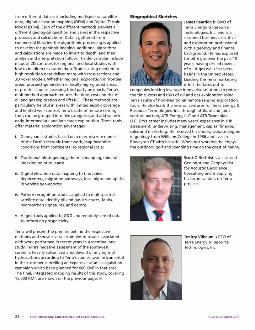
Biographical SketchesJames Reardon is CMO of Terra Energy & Resource Technologies, Inc. and is a seasoned business executive and exploration professional with a geology and finance background. He has explored for oil & gas over the past 10 years, having drilled dozens of oil & gas wells in several basins in the United States. Leading the Terra marketing effort, he faces out to
companies looking leverage innovative solutions to reduce the time, costs and risks of oil and gas exploration using Terra’s suite of non-traditional remote sensing exploration tools. He also leads the new oil ventures for Terra Energy & Resource Technologies, Inc. through affiliate and joint venture partner, ATR Energy, LLC and ATR Tasmanian, LLC. Jim’s career includes many years’ experience in risk assessment, underwriting, management, capital finance, sales and marketing. He received his undergraduate degree in geology from Williams College in 1986 and lives in Rowayton CT with his wife. When not working, he enjoys the outdoors, golf and spending time on the coast of Maine.
Scott C. Sechrist is a Licensed Geologist and Geophysicist for Acoustic Geoscience Consulting and is applying his technical skills on Terra projects.
Dmitry Vilbaum is CEO of Terra Energy & Resource Technologies, Inc.
James Reardon – Bio
James Reardon is CMO of Terra Energy & Resource Technologies, Inc. and is a seasoned business executive and exploration professional with a geology and finance background. He has explored for oil & gas over the past 10 years, having drilled dozens of oil & gas wells in several basins in the United States. Leading the Terra marketing effort, he faces out to companies looking leverage innovative solutions to reduce the time, costs and risks of oil and gas exploration using Terra’s suite of non-traditional remote sensing exploration tools. He also leads the new oil ventures for Terra Energy & Resource Technologies, Inc. through affiliate and joint venture partner, ATR Energy, LLC and ATR Tasmanian, LLC. Jim’s career includes many years' experience in risk assessment, underwriting, management, capital finance, sales and marketing. He received his undergraduate degree in geology from Williams College in 1986 and lives in Rowayton CT with his wife. When not working, he enjoys the outdoors, golf and spending time on the coast of Maine.
Scott C. Sechrist – Bio
Scott C. Sechrist is a Licensed Geologist and Geophysicist for Acoustic Geoscience Consulting and is applying his technical skills on Terra projects.
Dmitry Vilbaum – Bio
Dmitry Vilbaum is CEO of Terra Energy & Resource Technologies, Inc. Alexandre Agaian – Bio
22 • FIRST HGS/EAGE CONFERENCE ON LATIN AMERICA 19-20 NOVEMBER 2019

Alexandre Agaian, PhD, is President and Board Chair of Terra Energy & Resource Technologies, Inc.
Alexandre Agaian, PhD, is President and Board Chair of Terra Energy & Resource Technologies, Inc.
19-20 NOVEMBER 2019 FIRST HGS/EAGE CONFERENCE ON LATIN AMERICA • 23
Tuesday, 19 November 2019 | 1:55Krueger, Ana; Endressen, Paul; Omoboya, Bode; Lartigue, Benjamin BluWare Inc
Deep Learning Assisted Seismic Interpretation Technology Applied to Evaporite Sequences:
A Case Study from Offshore Santos Basin in BrazilBrazil has the longest north-south coastline in the world, extending from the southern Pelotas Basin to the equatorial margin. Currently, more than 90% of the country’s oil are produced in the post- and pre-salt reservoirs of the Campos and Santos basins, and the proportion of pre-salt production is increasing steadily in the past few years, and according to the ANP reports, more than 50% of the country’s total hydrocarbon production is now related to the pre-salt reservoirs (ANP, 2018). Pre-salt fields reserves located deep in the Atlantic Ocean under a thick layer of salt, are currently increasing its importance in the mix. The Lula field, will likely breach 1 MMbpd output this year, making it one the world’s largest offshore oilfields, behind only Safaniyah in Saudi Arabia. The Brazilian surge comes at the right time as the world’s oil market is hungry for the kind of oil that the pre-salt fields pump: medium-heavy crude, ideal for refining into diesel.
Seismic resolution of deeper strata below the salt is key, for the development of these plays. Seismic imaging offshore Brazil has improved substantially with state-of-the-art technologies employed in data acquisition, data processing and data interpretation. During seismic imaging salt has to be interpreted multiple times in order to achieve the best possible imaging results. Today, seismic interpretation is fastidious and time consuming. Usually an interpreter must spend weeks or months to fully interpret this type and volume of survey. In this paper, we propose a method to accelerate such interpretations using Deep Learning while putting the Geoscientist in complete control.
Using a combination of already available software innovations that include data compression, random data access and an optimized Convolutional Neural Network (CNN), interactive deep learning is within the reach of the interpreter. The deep neural network acts as an extension of the interpreter to assist in mapping sub-surface geological features, like evaporitic sequences, using single amplitude or co-rendered attribute volumes.
Deep learning approaches with sophisticated neural network architecture has a lot of promise when applied to these tedious seismic imaging and interpretation tasks (LeCun et al., 2015; Bandura et al., 2018. We present an interactive approach to machine learning with training
and inference in real time to assist interpreters in tedious tasks such as salt and fault mapping. In this scenario, the disadvantage of rigorous data preparation is circumvented. The additional burden of intensive QC is avoided, as the interpreter can keep training until the desired inference is reached. In an evaporite detection scenario, the mathematical approach is a binary classification. The areas where there is no salt will be classified as zero and areas with salt as one. The most optimal input to the CNN requires the following: 1) patches from the seismic (features) and input label by the seismic interpreter. 2) Random access to the seismic features and interpreter label pairs. The latter must be truly three-dimensional. 3) Equal and sequential number of truth and non-truth samples.
We present a custom Deep Learning model that reduces the dimension between the features (seismic data) and labels (interpreter input). This reduction also uses “valid padding” during the convolutions in order to get as much information as possible for the CNN computation. This Deep learning model was designed to have a small number of layers that allows for fast and accurate results. Thanks to this, we can operate it interactively, giving speedy responses to the interpreter. The loss function is also built to give positive feedback to the network. The deep learning methodology presented here acts as an extension of an experienced seismic interpreter. The interpreter keeps training and observing the inference in real time until the result is desirable. These tools have a potential to eventually become enablers for day to day E&P operations, ultimately improving interpretations while helping to reduce human error. In our case study offshore Santos basin we have been able to accelerate seismic interpretation at least 20 times with comparable results to human interpretation. n
ReferencesBandura, L., S. Halpert, and Z. Zhang, 2018, Machine Learning in the Interpreter’s toolbox: unsupervised, supervised, and deep learning applications. 88th Annual SEG Expo.
LeCun, Y., Y. Bengio, and G. Hinton, 2015, Deep Learning, Nature. 521, 436.
24 • FIRST HGS/EAGE CONFERENCE ON LATIN AMERICA 19-20 NOVEMBER 2019
Biographical SketchesDr. Ana Krueger is a Geoscientist with 20 years of experience in oil and gas exploration. She has held positions at mid-size independents including Devon Energy and Murphy Oil as well as a start-up called PetroRio. Krueger is currently working in development of new technology at Bluware. Her research is driven by her interest in applying
interactions of tectonics and sedimentation to understand and characterize the various aspects of conventional and unconventional petroleum systems (reservoirs, source rocks, seals and traps, as well as mechanic stratigraphy). Her passion is new technology, in particular, deep learning to solve complex geological problems. She received a PhD in Geology from the University of Houston, an MS in Geophysics from The Brazilian National Observatory, and a BS in Oceanography from Rio de Janeiro State University.
Paul Endresen, Chief Technology Officer of Bluware, started his career in 1994, working for Nintendo through game developer FUNCOM. He co-founded game company, Innerloop Studios AS in 1996, creating three major titles for the PC and console market including Joint Strike Fighter, SEGA Extreme Sports, and Project IGI. He scaled the
company to a team of approximately 30 employees and sold it in 2000.
In 2001, Mr. Endresen co-founded Hue AS in Norway and was lead software architect and co-inventor of the compression, visualization, and compute engine. He designed the platform as industry agnostic from the very beginning. In 2011, Endresen moved to Houston to head up the U.S. side of Hue as Director and Lead Architect. He focused on driving the cloud native platform and architecture.
Following the merger of Hue AS, Headwave, and Bluware, Endresen became Chief Technology Officer in October 2017, directing the technology platform as a cloud and machine learning platform.
Benjamin Lartigue joined Bluware as a Data Scientist in 2018. Lartigue received a Master of Science in Computer Science Engineering from Ecole Internationale des Sciences et du Traitement de L’Information [4] where he majored in Data Science. Additionally, he received a Master of Science in Computer Science Engineering from Paris-Dauphine [5] where
he majored in Informatics, Intelligent System MIDO. His skills are focused on developing efficient machine learning methods to solve problems for the oil and gas industry. Lartigue is currently developing a deep learning framework at Bluware. His research is focused on interactive deep learning research and development and seismic/well detection by designing networks.
Bode Omoboya, Geoscience Advisor at Bluware, is a geophysicist with nearly 10 years of experience in seismic imaging, AvO and interpretation. Mr. Omoboya received a Master of Science and PhD in geophysics from the University of Houston. His research interest includes deep learning assisted seismic imaging and interpretation. He is currently working in
deep learning research and development at Bluware.
19-20 NOVEMBER 2019 FIRST HGS/EAGE CONFERENCE ON LATIN AMERICA • 25
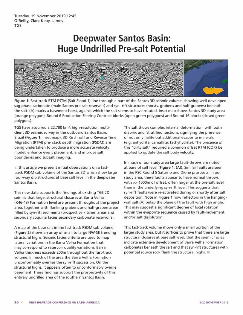
TGS have acquired a 22,700 km2, high-resolution multi-client 3D seismic survey in the outboard Santos Basin, Brazil (Figure 1, inset map). 3D Kirchhoff and Reverse Time Migration (RTM) pre- stack depth migration (PSDM) are being undertaken to produce a more accurate velocity model, enhance event placement, and improve salt boundaries and subsalt imaging.
In this article we present initial observations on a fast-track PSDM sub-volume of the Santos 3D which show large four-way dip structures at base salt level in the deepwater Santos Basin.
This new data supports the findings of existing TGS 2D seismic that large, structural closures at Barra Velha (K46-48) Formation level are present throughout the project area, together with flanking grabens and half-graben areas filled by syn-rift sediments (prospective kitchen areas and secondary coquina facies secondary carbonate reservoirs).
A map of the base salt in the fast-track PSDM sub-volume (Figure 2) shows an array of small to large NW-SE trending structural highs. Seismic facies criteria are used to map lateral variations in the Barra Velha Formation that may correspond to reservoir quality variations. Barra Velha thickness exceeds 200m throughout the fast-track volume. In much of the area the Barra Velha Formation unconformably overlies the syn-rift succession. On the structural highs, it appears often to unconformably overlie basement. These findings support the prospectivity of this entirely undrilled area of the southern Santos Basin.
The salt shows complex internal deformation, with both diapiric and ‘stratified’ sections, signifying the presence of not only halite but additional evaporite minerals (e.g. anhydrite, carnallite, tachyhydrite). The presence of this “dirty salt” required a common offset RTM (COR) be applied to update the salt body velocity.
In much of our study area large fault-throws are noted at base of salt level (Figure 1; (A)). Similar faults are seen in the PSC Round 5 Saturno and Dione prospects. In our study area, these faults appear to have normal throws, with >> 1000m of offset, often larger at the pre-salt level than in the underlying syn-rift level. This suggests that syn-rift faults were re-activated during or shortly after salt deposition. Note in Figure 1 how reflectors in the hanging-wall salt (A) onlap the plane of the fault with high angle. This may suggest a significant degree of local rotation within the evaporite sequence caused by fault-movement and/or salt dissolution.
This fast-track volume shows only a small portion of the larger study area, but it suffices to prove that there are large structural closures at base salt level, that the seismic facies indicate extensive development of Barra Velha Formation carbonates beneath the salt and that syn-rift structures with potential source rock flank the structural highs. n
structures with potential source rock flank the structural highs.
Figure 1: Fast-track RTM PSTM (Salt Flood 1) line through a part of the Santos 3D seismic volume, showing well-developed sag-phase carbonate (main Santos pre-salt reservoir) and syn- rift structures (horsts, grabens and half-grabens) beneath the salt. (A) marks a basement horst, against which the salt seems to have rotated. Inset map shows Santos 3D study area (orange polygon), Round 6 Production Sharing Contract blocks (open green polygons) and Round 16 blocks (closed green polygons).
Figure 2: Base of salt map for the Santos 3D fast-track PSDM Validation Cube
Tuesday, 19 November 2019 | 2:45O’Reilly, Cian; Keay, James TGS
Deepwater Santos Basin: Huge Undrilled Pre-salt Potential
Figure 1: Fast-track RTM PSTM (Salt Flood 1) line through a part of the Santos 3D seismic volume, showing well-developed sag-phase carbonate (main Santos pre-salt reservoir) and syn- rift structures (horsts, grabens and half-grabens) beneath the salt. (A) marks a basement horst, against which the salt seems to have rotated. Inset map shows Santos 3D study area (orange polygon), Round 6 Production Sharing Contract blocks (open green polygons) and Round 16 blocks (closed green polygons).
26 • FIRST HGS/EAGE CONFERENCE ON LATIN AMERICA 19-20 NOVEMBER 2019
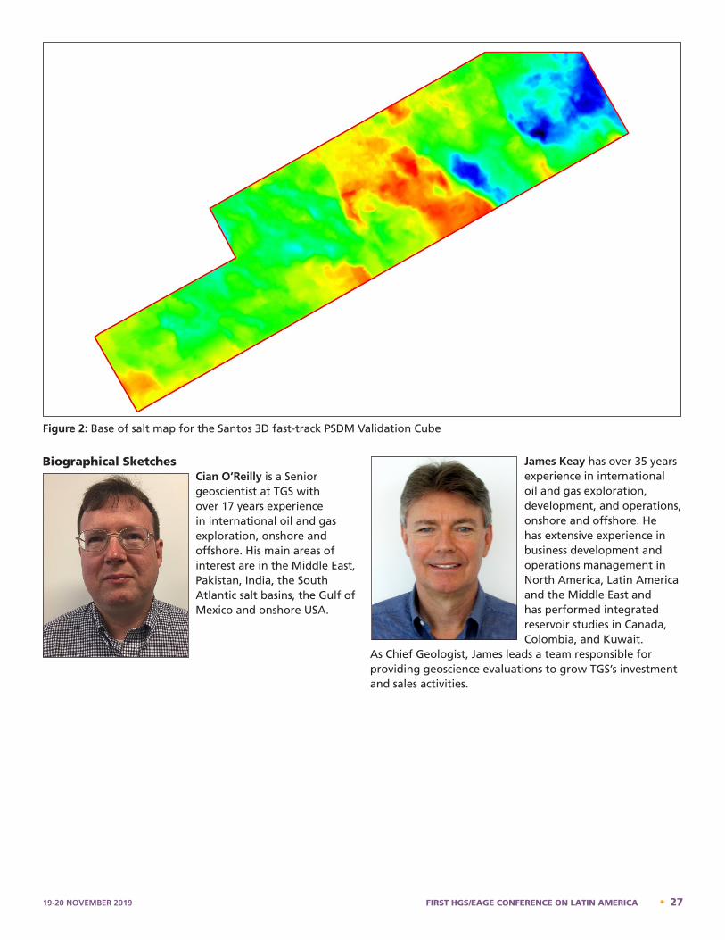
structures with potential source rock flank the structural highs.
Figure 1: Fast-track RTM PSTM (Salt Flood 1) line through a part of the Santos 3D seismic volume, showing well-developed sag-phase carbonate (main Santos pre-salt reservoir) and syn- rift structures (horsts, grabens and half-grabens) beneath the salt. (A) marks a basement horst, against which the salt seems to have rotated. Inset map shows Santos 3D study area (orange polygon), Round 6 Production Sharing Contract blocks (open green polygons) and Round 16 blocks (closed green polygons).
Figure 2: Base of salt map for the Santos 3D fast-track PSDM Validation Cube
Figure 2: Base of salt map for the Santos 3D fast-track PSDM Validation Cube
Biographical SketchesCian O’Reilly is a Senior geoscientist at TGS with over 17 years experience in international oil and gas exploration, onshore and offshore. His main areas of interest are in the Middle East, Pakistan, India, the South Atlantic salt basins, the Gulf of Mexico and onshore USA.
James Keay has over 35 years experience in international oil and gas exploration, development, and operations, onshore and offshore. He has extensive experience in business development and operations management in North America, Latin America and the Middle East and has performed integrated reservoir studies in Canada, Colombia, and Kuwait.
As Chief Geologist, James leads a team responsible for providing geoscience evaluations to grow TGS’s investment and sales activities.
Cian O'Reilly – Bio
Cian O'Reilly is a Senior geoscientist at TGS with over 17 years experience in international oil and gas exploration, onshore and offshore. His main areas of interest are in the Middle East, Pakistan, India, the South Atlantic salt basins, the Gulf of Mexico and onshore USA. James Keay – Bio
James Keay has over 35 years experience in international oil and gas exploration, development, and operations, onshore and offshore. He has extensive experience in business development and operations management in North America, Latin America and the Middle East and has performed integrated reservoir studies in Canada, Colombia, and Kuwait. As Chief Geologist, James leads a team responsible for providing geoscience evaluations to grow TGS’s investment and sales activities.
19-20 NOVEMBER 2019 FIRST HGS/EAGE CONFERENCE ON LATIN AMERICA • 27
Tuesday, 19 November 2019 | 3:20Torrado, Lucia AGI Exploration LLC, Houston,TX
Cretaceous Plays of the Deepwater, Foz do Amazonas Basin and Amazon Cone Area, Northern Brazil: Analog Petroleum Systems of the Equatorial
Atlantic Passive MarginsIn the last decade, the Equatorial Atlantic margin of South America has become an attractive area for hydrocarbon exploration due to world-class discoveries like ExxonMobil’s Liza field in the Stabroek block (5.5 Bboe) in offshore Guyana, and Tullow Oil’s 2011 Zaedyus discovery (P10=700 MMbbl) in offshore French Guiana. Both of these discoveries are associated with the same play of Cenomanian-Turonian age source rocks charging Late Cretaceous deep-water fan reservoirs, and the same play has been drilled in the Liberian conjugate margin in West Africa.
The study area corresponds to the deep-water portion of the Foz do Amazonas basin, the northernmost basin of Brazil located next to French Guyana. I conducted seismic interpretation, 1D basin modeling and basin analysis using 21,369 km of 2D depth-converted seismic tied to three exploration wells, in order to evaluate potential Cretaceous hydrocarbon plays in the unexplored deepwater Foz do Amazonas basin and the Amazon Cone, located in the southern portion of the basin.
The Early Cretaceous plays consist of syn-rift, Aptian-Albian, deltaic sandstone charged by Aptian, lacustrine source rocks and overlain by Cenomanian-Turonian shale. Traps include: 1) pull-apart basins, grabens, and half-grabens; 2) anticlines and positive flower structures formed by Late Albian (?) inversion; 3) sediment pinch-out again the underlying basement, and 4) a combination of structural and stratigraphic traps.
On the other hand, the Late Cretaceous plays -similar to ExxonMobil’s Liza play- consist of deep-water fans of
Turonian to Campanian (?) turbidite sandstone charged by Cenomanian-Turonian source rocks and sealed by intraformational shale packages preserved during a sag phase. The deep-water fans are characterized by: 1) upper slope fans interpreted as sand-prone, channel-levee complexes; and 2) basin floors fans seen as high-amplitude, continuous reflection packages (HARPs) of sand sheets with little to no structural deformation. In the southern flank of the deep-water Foz do Amazonas basin, Late Cretaceous traps consist of roll-over anticlines and thrusting caused by Cenozoic gravity-sliding associated with the formation of the Amazon Cone.
Basin modeling shows Cretaceous source rocks are within the oil window in the northern area of the deep-water Foz do Amazonas basin, while towards the south, areas with up to 10-km of overburden are prone to be overmatured. n
Biographical SketchLucia Torrado is a geoscientist with a BS from the National University of Colombia, and an MS and PhD from the University of Houston. Her research consists of integrating seismic interpretation, sequence stratigraphy, basin analysis, and reservoir characterization to evaluate hydrocarbon prospectivity of onshore Colombia, the Nicaraguan
Rise, and the Foz do Amazonas, Brazil.
Lucia Torrado - Bio
Lucia Torrado is a geoscientist with a B.S. from the National University of Colombia, and an M.S. and Ph.D. from the University of Houston. Her research consists of integrating seismic interpretation, sequence stratigraphy, basin analysis, and reservoir characterization to evaluate hydrocarbon prospectivity of onshore Colombia, the Nicaraguan Rise, and the Foz do Amazonas, Brazil.
28 • FIRST HGS/EAGE CONFERENCE ON LATIN AMERICA 19-20 NOVEMBER 2019
Tuesday, 19 November 2019 | 3:55Nibbelink, Ken; Boyce, Dick; Nasser, Mosab and Boyce, John
JHI Associates, Inc (BVI)
Guyana-Suriname Deep Water Hydrocarbon System, Three Rivers and Two Source Rocks
The deep water hydrocarbon system of the Guyana/Suriname Basin can be summarized by understanding the interaction between three river systems and two source rocks. We define these three river systems as an Aptian aged “Demerara System”, an Upper Cretaceous “Berbice System” and finally the Miocene/Pliocene aged “Amazon System”. The two deep water source rocks are the 108 ma Lower Albian (Oceanic Anoxic Event, OAE-1) and the 90 ma Cenomanian/Turonian (OAE-2).
Jurassic to Lower Cretaceous (200 to 108 ma)The Guyana/Suriname basin is located at the southern end of the North Atlantic rift. Thick carbonate platforms rim the deep water, Jurassic oceanic crust of the basin. The South Atlantic rift valley that formed as South America and Africa drifted apart was the location of the massive Aptian, Demerara river system flowing to the northwest draining highlands in both Africa and South America. This resulted in deposition of 2-3 seconds of clastic sediments forming a huge deltaic system in the deep water basin of Suriname. This thick deltaic sediment wedge underlies the western part of present day Demerara Plateau. A little later, the Lower Albian source (OAE-1, 108ma) was deposited in a deep water marine setting in Eastern Guyana and Western Suriname. This source settled in localized bathymetric lows, filling down warps or sags over pre-existing Jurassic and Aptian pull-apart rifts and resting on the Jurassic Oceanic Crust found between the Aptian Demerara deltaic system and the Lower Cretaceous/Jurassic Carbonate platform rim that surrounds the Guyana/Suriname Basin. While not yet proven by well control locally around the basin margin, this Lower Albian source rock is present throughout much of the Atlantic Basin and is readily mapped using the high quality 2D seismic in Guyana and Suriname. The Cenomanian/Turonian source (OAE-2, 90 ma) known locally as the Canje Shale was subsequently deposited in a more regional distribution across the entire deep water portion of the Guyana/Suriname Basin.
Upper Cretaceous, (98 to 67 ma)The rift shoulders left behind from the opening of the South Atlantic provided topographic relief along the northern coast. The Berbice river was the only drainage system to breach these rift shoulders and it was draining the entire northern part of South America, an area larger than the current day Orinoco River basin. The Berbice
Canyon then cut across the shelf and delivered over one second of sediments from this single point source to the deep water, which profoundly impacted the hydrocarbon system. The larger Berbice drainage system supplied second cycle sediments from a Pre-Cambrian Quartzite provenance for the excellent quality deep water Campanian/Maastrichtian reservoirs. This Berbice, Upper Cretaceous sediment also provided the significant overburden necessary to push the Lower Albian, OAE-1, source rock into the oil generation window when both reservoirs and top seals are present.
Lower Tertiary, (67 to 30 ma) The rift shoulders are eroded and the large Berbice drainage system is captured and reorganized into a series of smaller river systems more representative of the present day rivers. The sediment from these rivers is stored in the fluvial, near shore and shelf environment, so the deep water basin is starved and receives a very low sedimentation rate. The reservoirs of the Lower Tertiary are delivered to the deep water through a series of canyons along the entire shelf edge. The Berbice deep water sediment allows the OAE-1 source to start generating hydrocarbons at 50ma and then the very low sedimentation rate caused by capture of the Berbice by smaller rivers allows continuous oil generation from the OAE-1 source for 40 million years. During this 40 million year period, the Campanian/Maastrichtian reservoirs are buried at a depth below mud line, BML, which is below the oil biodegradation risk and above the reservoir cementation risk.
Miocene/Pliocene, (10 ma to present)The South American plate moves further north allowing the mouth of the present day the Amazon River to exit north of the equator. The strong equatorial, northwesterly shelf currents sweep the Amazon sediments into the Guyana/Suriname Basin. Devonian palynological evidence present in Miocene/Pliocene sediments in wells from both Foz de Amazonas and Guyana support the theory that almost half of the present day sediment load found in Guyana is less than 6 million years old and that sediment has been transported down the Amazon drainage where Devonian outcrop exist[1]. It is this recent overburden that finally pushes the Cenomanian/Turonian, OAE-2 source into the oil window over the deeper parts of the Guyana/Suriname Basin, around 6 ma.
19-20 NOVEMBER 2019 FIRST HGS/EAGE CONFERENCE ON LATIN AMERICA • 29
The robust Guyana/Suriname Basin deep water hydrocarbon system is driven by four key elements: 1) The massive Aptian, Demerara clastic system and Lower Cretaceous/Jurassic carbonate platform defining the location of the Lower Albian, OAE-1 deep water source in Eastern Guyana and Western Suriname. 2) The significantly larger Upper Cretaceous, Berbice system supplied excellent quality Campanian/Maastrichtian reservoirs and provided overburden to mature the OAE-1 source. 3) The Lower Tertiary capture of the Berbice by smaller drainage systems and a low sedimentation rate in deep water, which allowed 40 million years of oil migration from the OAE-1 source and preserved excellent reservoir quality for effective DHI’s AVO, flat events and down dip conformance. 4) The Miocene/Pliocene, Amazon system transported by strong shelf currents, providing the overburden to mature the Cenomanian/Turonian, OAE-2 deep water source and put the Campanian/Maastrichtian reservoirs in water depths that current technology can economically exploit. n
Reference[1] Mapes, R and Torres, V, ExxonMobil, Paleodrainage Evolution of Northern South America and Its Impact on Exploration Success in the Guyana Basin, Poster Presented at the AAPG, GTW Georgetown, Guyana, Nov. 2017. n
Biographical SketchesKen Nibbelink has spent 40 years working “Hydrocarbon Systems in Unconformity Sequences of the Greater Atlantic Basin Jurassic to Pliocene”, including West Africa, South America, Europe and the Gulf of Mexico and Cretaceous Seaway in the Rocky Mountains. He has worked at Amoco, Devon Energy, Hyperdynamics and is now the VP of Exploration
for JHI Associates (BVI) in Guyana. He has a BA in Geology from Western State College of Colorado, an MS in Geology from Colorado State University and an MS in Finance from University of Houston. He is a member of the RMAG, AAPG, HGS, GSL and PESGB.
Dick Boyce has 40 years in worldwide oil and gas development as geoscientist and engineer. Former Chief Geophysicist for Hunt Oil with significant deep water exploration expertise including Nigeria, Sao Tome and Principe, Sierra Leon and Togo and India.
Mosab Nasser has 20 years exploration experience with Shell, Maersk and Hess following a PhD in Physics. Industry expert on 3D and 4D quantitative seismic interpretation, rock physics, AVO and inversion. Former Chairman of Editorial Board of Leading Edge. 50+ published technical papers in various peer-reviewed journals, scientific magazines
and international conferences.
Jack Boyce has 10 years experience in geological and geophysical interpretation, domestic and international. Key experience in Permian Basin, Mid-Continent, East Texas and North Louisiana. Interpretation platforms include Petrel, SMT Kingdom and Petra workstation systems.
Ken Nibbelink – Bio
Ken Nibbelink has spent 40 years working “Hydrocarbon Systems in Unconformity Sequences of the Greater Atlantic Basin Jurassic to Pliocene”, including West Africa, South America, Europe and the Gulf of Mexico and Cretaceous Seaway in the Rocky Mountains. He has worked at Amoco, Devon Energy, Hyperdynamics and is now the VP of Exploration for JHI Associates (BVI) in Guyana. He has a BA in Geology from Western State College of Colorado, and MS in Geology from Colorado State University and an MS in Finance from University of Houston. He is a member of the RMAG, AAPG, HGS, GSL and PESGB.
Dick Boyce – Bio
Dick Boyce has 40 years in worldwide oil and gas development as geoscientist and engineer. Former Chief Geophysicist for Hunt Oil with significant deep water exploration expertise including Nigeria, Sao Tome and Principe, Sierra Leon and Togo and India.
Mosab Nasser – Bio
Mosab Nasser has 20 years exploration experience with Shell, Maersk and Hess following a PhD in Physics. Industry expert on 3D and 4D quantitative seismic interpretation, rock physics, AVO and inversion. Former Chairman of Editorial Board of Leading Edge. 50+ published technical papers in various peer-reviewed journals, scientific magazines and international conferences.
John “Jack” Boyce – Bio
Jack Boyce has 10 years experience in geological and geophysical interpretation, domestic and international. Key experience in Permian Basin, Mid-Continent, East Texas and North Louisiana. Interpretation platforms include Petrel, SMT Kingdom and Petra workstation systems.
30 • FIRST HGS/EAGE CONFERENCE ON LATIN AMERICA 19-20 NOVEMBER 2019
Tuesday, 19 November 2019 | 4:30Taylor, Ross
CGG Reservoir Americas
Sand Characterization and Provenance of the Guyanese Rivers – Implications for
Offshore Sediment DevelopmentGuyanese rivers draining the Guyana Shield vary in their catchment size, hypsometry, sediment yield and sand character. Studying the modern day catchments and the sediment deposited along and at the mouth of their fluvial pathways provides important analogue information (texture and provenance) for understanding the paleo-drainage systems which fed reservoirs offshore.
In this paper we present initial findings from our tectonic geomorphological evaluation of the modern day catchments (including stream order, basin hypsometry and peneplain distribution) and an analytical appraisal of the sand character deposited (automated mineralogy, XRF-ICPMS and detrital zircon age dates) within the selected Guyanese rivers. This helps us to understand how the various terrains present within catchments are finally expressed within the sediments deposited within the lower reaches of the axial fluvial systems.
Digital elevation models (SRTM), geological maps and aerial photographs were utilized in refining the tectonic geomorphological belts of Guyana.
Over 60 sediment samples were collected from the Takutu, Essequibo, Potaro, Cuyuni, Mazaruni, Demerara and Berbice rivers. Automated mineralogy (ROQSCAN™) of bulk sediment samples and the heavy mineral fraction (>2.95g/cc) were combined with petrographic evaluation (lithic grain types, angularity and sorting) of the sediments to describe sand character for the respective samples. XRF-ICPMS and detrital zircon age data was also generated for each sample to confidently link alluvial sediments with their provenance terrain(s).
Alluvial sediment sampled from cross-channel bars, point bars and side-attached bars all typically yield compositionally mature arenitic sandstones (<5% feldspar). However, the grains are angular and are rich in strained and polycrystalline quartz. Also, the concentration and distribution of heavy mineral lags and/or laterite/bauxite lags is hugely variable within and between the analyzed rivers. This suggests that provenance impacts upon sediment character.
Preliminary results suggest that the Cuyuni and Mazaruni rivers have comparable provenance terrains. Although both rivers’ headwaters drain uplifted terrains formed by
Roraima Group (Proterozoic ~1.7-1.9Ga) peneplains, these signatures are not represented in the fluvial sediments. Coarse grained, cross-channel bars, which are occasionally gravelly (granitic pebbles, cobbles and laterite pebbles), have zircon populations consistent with draining of the Younger Granite (2.05-2.2Ga) suite, which outcrops in the middle to lower reaches of their systems.
Analysis from the remaining rivers (Takutu, Essequibo, Potaro, Demerara, Berbice) is on-going and will be integrated in the final paper. n
Biographical SketchRoss Taylor graduated with a degree in Geology and Petroleum Geology and did his PhD at the University of Aberdeen. His PhD involved the study of extra-basinally derived intra-basaltic sediments deposited during the initiation of large igneous provinces. Sedimentological, petrography, geochemistry and palynology data was used to develop predictive depositional models for
fluvial reservoir sands encased in basalts in the Faroe-Shetland Basin, UK.
Ross worked as a formation damage geologist for Corex UK from 2010-2012, working on projects assessing the impacts of simulated drilling, completion and production processes on reservoir properties. Following the completion of his PhD in 2015, Ross joined CGG-Robertson in Llandudno. As part of the African regional team Ross worked on exploration of low resistivity pay Silurian sands in the Berkine Basin, Algeria, as well as a suite of other sedimentology and stratigraphy projects across Europe and America. In 2018 Ross moved to the Houston office to work in CGG’s Reservoir Americas team. Here he has worked on the sedimentology and stratigraphy of the on-shore U.S. petroleum basins. For the past year Ross has technically lead a source to sink project constraining the timing of the exhumation of the Guiana Shield, and the implications for the quality and volume of sands delivered to the Guyana-Suriname Basin in the Mesozoic and Cenozoic.
Dr Ross Taylor Geologist CGG Reservoir Americas
Ross graduated with a degree in Geology and Petroleum Geology and did his PhD at the University of Aberdeen. His PhD involved the study of extra-basinally derived intra-basaltic sediments deposited during the initiation of large igneous provinces. Sedimentological, petrography, geochemistry and palynology data was used to develop predictive depositional models for fluvial reservoir sands encased in basalts in the Faroe-Shetland Basin, UK. Ross worked as a formation damage geologist for Corex UK from 2010-2012, working on projects assessing the impacts of simulated drilling, completion and production processes on reservoir properties. Following the completion of his PhD in 2015, Ross joined CGG-Robertson in Llandudno. As part of the African regional team Ross worked on exploration of low resistivity pay Silurian sands in the Berkine Basin, Algeria, as well as a suite of other sedimentology and stratigraphy projects across Europe and America. In 2018 Ross moved to the Houston office to work in CGG’s Reservoir Americas team. Here he has worked on the sedimentology and stratigraphy of the on-shore US petroleum basins. For the past year Ross has technically lead a source to sink project constraining the timing of the exhumation of the Guiana Shield, and the implications for the quality and volume of sands delivered to the Guyana-Suriname Basin in the Mesozoic and Cenozoic.
19-20 NOVEMBER 2019 FIRST HGS/EAGE CONFERENCE ON LATIN AMERICA • 31

Notes
_______________________________________________________________________________________________________________________
_______________________________________________________________________________________________________________________
_______________________________________________________________________________________________________________________
_______________________________________________________________________________________________________________________
_______________________________________________________________________________________________________________________
_______________________________________________________________________________________________________________________
_______________________________________________________________________________________________________________________
_______________________________________________________________________________________________________________________
_______________________________________________________________________________________________________________________
_______________________________________________________________________________________________________________________
_______________________________________________________________________________________________________________________
_______________________________________________________________________________________________________________________
_______________________________________________________________________________________________________________________
_______________________________________________________________________________________________________________________
_______________________________________________________________________________________________________________________
_______________________________________________________________________________________________________________________
_______________________________________________________________________________________________________________________
_______________________________________________________________________________________________________________________
_______________________________________________________________________________________________________________________
_______________________________________________________________________________________________________________________
_______________________________________________________________________________________________________________________
_______________________________________________________________________________________________________________________
_______________________________________________________________________________________________________________________
_______________________________________________________________________________________________________________________
_______________________________________________________________________________________________________________________
_______________________________________________________________________________________________________________________
_______________________________________________________________________________________________________________________
_______________________________________________________________________________________________________________________
32 • FIRST HGS/EAGE CONFERENCE ON LATIN AMERICA 19-20 NOVEMBER 2019
FIRST HGS/EAGE CONFERENCE ON LATIN AMERICA19-20 NOVEMBER 2019
AbstractsOral Presentations
Day Two20 November 2019
Norris Center
Houston, Texas
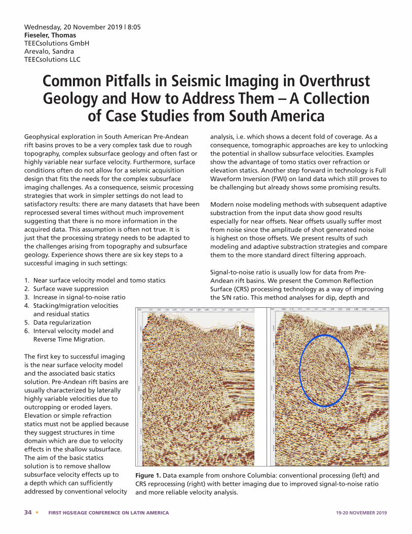
Wednesday, 20 November 2019 | 8:05Fieseler, Thomas TEECsolutions GmbHArevalo, SandraTEECsolutions LLC
Common Pitfalls in Seismic Imaging in Overthrust Geology and How to Address Them – A Collection
of Case Studies from South AmericaGeophysical exploration in South American Pre-Andean rift basins proves to be a very complex task due to rough topography, complex subsurface geology and often fast or highly variable near surface velocity. Furthermore, surface conditions often do not allow for a seismic acquisition design that fits the needs for the complex subsurface imaging challenges. As a consequence, seismic processing strategies that work in simpler settings do not lead to satisfactory results: there are many datasets that have been reprocessed several times without much improvement suggesting that there is no more information in the acquired data. This assumption is often not true. It is just that the processing strategy needs to be adapted to the challenges arising from topography and subsurface geology. Experience shows there are six key steps to a successful imaging in such settings:
1. Near surface velocity model and tomo statics 2. Surface wave suppression 3. Increase in signal-to-noise ratio 4. Stacking/migration velocities
and residual statics 5. Data regularization6. Interval velocity model and
Reverse Time Migration.
The first key to successful imaging is the near surface velocity model and the associated basic statics solution. Pre-Andean rift basins are usually characterized by laterally highly variable velocities due to outcropping or eroded layers. Elevation or simple refraction statics must not be applied because they suggest structures in time domain which are due to velocity effects in the shallow subsurface. The aim of the basic statics solution is to remove shallow subsurface velocity effects up to a depth which can sufficiently addressed by conventional velocity
analysis, i.e. which shows a decent fold of coverage. As a consequence, tomographic approaches are key to unlocking the potential in shallow subsurface velocities. Examples show the advantage of tomo statics over refraction or elevation statics. Another step forward in technology is Full Waveform Inversion (FWI) on land data which still proves to be challenging but already shows some promising results.
Modern noise modeling methods with subsequent adaptive substraction from the input data show good results especially for near offsets. Near offsets usually suffer most from noise since the amplitude of shot generated noise is highest on those offsets. We present results of such modeling and adaptive substraction strategies and compare them to the more standard direct filtering approach.
Signal-to-noise ratio is usually low for data from Pre-Andean rift basins. We present the Common Reflection Surface (CRS) processing technology as a way of improving the S/N ratio. This method analyses for dip, depth and
Stacking velocity analysis, residual statics and migration velocity analysis benefit from all steps described so far. With a proper basic statics, denoising and signal-to-noise enhancement any velocity analysis and residual statics delivers more reliable results. We present examples showing the impact of more reliable analysis results on the seismic image. Data regularization may have a big impact on migration results. Rough topography often causes irregularity in shot and/or receiver locations. Such irregularity is the reason for irregular fold of coverage which may result in migration artifacts due to data gaps. CRS processing along with 5D interpolation are modern regularization techniques with CRS even working in areas where 5D often fails such as low signal-to-noise ratio, low fold of coverage and steep dips. Examples will show how regularization helps in improving the seismic image. Finally, correct positioning is mandatory in seismic depth imaging. However, ray-based depth migration techniques such as Kirchhoff or Beam may not be sufficient to solve travel times correctly for the complex velocity models associated with the Pre-Andean rift basins. We propose to use Reverse Time Migration (RTM) instead which can accommodate for any complexity in the velocity model. A workflow making use of RTM surface-offset gathers for velocity model update will be presented along with results of Kirchhoff and RTM images.
Fig. 1 Data example from onshore Colombia: conventional processing (left) and CRS reprocessing (right) with better imaging due to improved signal-to-noise ratio and more reliable velocity analysis.
Figure 1. Data example from onshore Columbia: conventional processing (left) and CRS reprocessing (right) with better imaging due to improved signal-to-noise ratio and more reliable velocity analysis.
34 • FIRST HGS/EAGE CONFERENCE ON LATIN AMERICA 19-20 NOVEMBER 2019
curvature of subsurface reflection elements. In this manner energy from within the Fresnel zone can be used to form a CRS trace which then contains more reflection content and reduced noise. Such traces can be used in further processing for velocity analysis, pre-stack time and depth migration as well as reservoir characterization. Figure 1 shows an example of the impact of CRS processing and the associated improvement in signal-to-noise ratio on a seismic prestack time migrated image from onshore Colombia.
Stacking velocity analysis, residual statics and migration velocity analysis benefit from all steps described so far. With a proper basic statics, denoising and signal-to-noise enhancement any velocity analysis and residual statics delivers more reliable results. We present examples showing the impact of more reliable analysis results on the seismic image.
Data regularization may have a big impact on migration results. Rough topography often causes irregularity in shot and/or receiver locations. Such irregularity is the reason for irregular fold of coverage which may result in migration artifacts due to data gaps. CRS processing along with 5D interpolation are modern regularization techniques with CRS even working in areas where 5D often fails such as low signal-to-noise ratio, low fold of coverage and steep dips. Examples will show how regularization helps in improving the seismic image.
Finally, correct positioning is mandatory in seismic depth imaging. However, ray-based depth migration techniques such as Kirchhoff or Beam may not be sufficient to solve travel times correctly for the complex velocity models associated with the Pre-Andean rift basins. We propose to use Reverse Time Migration (RTM) instead which can accommodate for any complexity in the velocity model. A workflow making use of RTM surface-offset gathers for velocity model update will be presented along with results of Kirchhoff and RTM images. n
Biographical SketchesThomas Fieseler is a Senior Seismic Processing Geophysicist. He received his diploma in Geophysics in 2010 from Muenster University, Germany before starting his industrial career at TEECsolutions GmbH in Hannover, Germany. He is a member of EAGE, SEG, and AMGE (Asociación Mexicana de Geofísicos de Exploración). Thomas worked successfully
on numerous challenging 2D and 3D land seismic projects in geologically complex areas like e.g. Mexico, Colombia, and
Bolivia. He’s an expert in signal processing, statics, and CRS processing as well as time and depth imaging. In 2016 he relocated to Villahermosa, Mexico where he currently holds the position of Country Manager and Senior Geophysicist at TEECsolutions.
Sandra R. Arévalo is a geologist and geophysicist with over 25 years of experience in both the hydrocarbon and the mining industries. Sandra started her career in seismic acquisition and processing in Colombia where she worked in several regions of the country. She moved to Europe and the United States to follow post graduate
studies in geosciences and on her return to Colombia she worked for several years in the oil and mining industries, in the areas of prospect evaluation, resources development and commercialization. After her transfer to the United States she continued working in the hydrocarbon industry in the area of reservoir characterization in projects in Mexico, Colombia and the US as well as in offshore seismic processing projects for Pemex in Mexico while working with CGG and with Geokinetics. She has provided support in the areas of seismic processing worldwide as part of the velocity model building group. Since 2016 Sandra works for TEECsolutions LLC, Houston in the development of seismic processing projects in several countries both in North America and in Latin America, championing the application of the CRS technology in which the TEEC group has significant experience. Sandra holds a bachelor’s degree in Geosciences from the Universidad Nacional de Colombia, and another bachelor’s degree in mining engineering from the Fundacion Tecnológica del Area Andina in Bogotá, Colombia. She also has attended post graduate courses in geophysics at Texas Tech University in Lubbock, Tx, USA. She is a member of SEG, AAPG, ACGGP (Asociacion Colombiana de Geólogos y Geofisicos del Petróleo), EAGE, and The SEG Women’s Network Committee (WNC).
Thomas Fieseler – Bio
Thomas Fieseler is a Senior Seismic Processing Geophysicist. He received his diploma in Geophysics in 2010 from Muenster University, Germany before starting his industrial career at TEECsolutions GmbH in Hannover, Germany. He is a member of EAGE, SEG, and AMGE (Asociación Mexicana de Geofísicos de Exploración). Thomas worked successfully on numerous challenging 2D and 3D land seismic projects in geologically complex areas like e.g. Mexico, Colombia, and Bolivia. He’s an expert in signal processing, statics, and CRS processing as well as time and depth imaging. In 2016 he relocated to Villahermosa, Mexico where he currently holds the position of Country Manager and Senior Geophysicist at TEECsolutions. Sandra Arevalo – Bio
Sandra R. Arévalo is a geologist and geophysicist with over 25 years of experience in both the hydrocarbon and the mining industries. Sandra started her career in seismic acquisition and processing in Colombia where she worked in several regions of the country. She moved to Europe and the United States to follow post graduate studies in geosciences and on her return to Colombia she worked for several years in the oil and mining industries, in the areas of prospect evaluation, resources development and commercialization. After her transfer to the United States she continued working in the hydrocarbon industry in the area of reservoir characterization in projects in Mexico, Colombia and the US as well as in offshore seismic processing projects for Pemex in Mexico while working with CGG and with Geokinetics. She has provided support in the areas of seismic processing worldwide as part of the velocity model building group. Since 2016 Sandra works for TEECsolutions LLC, Houston in the development of seismic processing projects in several countries both in North America and in Latin America, championing the application of the CRS technology in which the TEEC group has significant experience. Sandra holds a bachelor’s degree in Geosciences from the Universidad Nacional de Colombia, and another bachelor’s degree in mining engineering from the Fundacion Tecnológica del Area Andina in Bogotá, Colombia. She also has attended post graduate courses in geophysics at Texas Tech University in Lubbock, Tx, USA. She is a member of SEG, AAPG, ACGGP (Asociacion Colombiana de Geólogos y Geofisicos del Petróleo), EAGE, and The SEG Women’s Network Committee (WNC).
19-20 NOVEMBER 2019 FIRST HGS/EAGE CONFERENCE ON LATIN AMERICA • 35
Wednesday, 20 November 2019 | 8:40Galea Alvarez, Francia A. Actus Veritas Geoscience, LLC
The Cretaceous Source Rocks from East Venezuela – Trinidad – Guyana/Suriname Basins, NE South America
The major contribution to the oil fields in East Venezuela and Trinidad are Cretaceous source rocks, Late Albian – Santonian in age. The Querecual Formation, from the Guayuta Group, is the source rock of the oil and gas from the giant and super giant oil fields like Carito, Furrial, Musipan, Quiriquire, Great Oficina, Anaco Trend, and Santa Barbara oil fields, among others. The Orinoco Belt huge deposits of oil are aromatic-asphaltic oils biodegraded interpreted as originated in organic rich carbonate sediments, with some components of siliciclastic, deposited in an anoxic environment such as the one described for the Querecual Formation at the type section and outcrops around the Pozuelos Bay, northern Anzoátegui state, southwest of the Cariaco Basin.
Studies at the type section of the Querecual Formation describe black shales, limestones and marls, rich in foraminifers and other macrofossils, which were used to identify biostratigraphic zones from late Albian to Santonian, and a hiatus at the early Cenomanian. Paleowater depths were interpreted as middle to upper bathyal (based on microfossils content). Mainly microlaminated foraminiferal microfacies were linked to anoxic-dysoxic levels. Total carbon (TC), Total organic Carbon (TOC), inorganic carbon (Cinorg), and total Sulfur (tS), and the calcium carbonate concentration (CaCO3) were measured and interpreted: high values of CaCO3, of the TOC and planktonic foraminifers decreases from base to top, and were identified in strata from late Cenomanian, late Turonian, Coniacian and Santonian. High sulfur concentrations are associated to laminated microfacies of foraminifers and linked to high values of TOC, which average is 2.41 %, and range from 0.1 to 7.2 %. Siliciclastic material was observed for first time at beds of Coniacian age, from where the ratio of benthic/planktic foraminifers is increasing, probably an indication of more oxygenated levels. The kerogen is type II.
The main source rock identified in Trinidad is the Naparima Hill Formation or the combination of Naparima Hill-Gauthier Formations. These rocks are of the same age of the Querecual Formation and its geochemical characteristics
are similar. Naparima Hill outcrops in a few areas but has been reached by several offshore wells (South, West and East). It consists of well bedded, occasionally bituminous mudstones and shales, with some marls and bituminous limestones, deposited under low oxygen conditions. The upper part is made of silicified siltstones/claystones with abundant cherts. Studies of the siliceous facies exhibit evidence of formation of biogenic chert, within environments with limited terrigenous input, deposition above the carbonate compensation depth, and with very abundant siliceous organisms (Opal-A). The TOC values are ranging from 3.8 to 5.0 %, and amorphous type II kerogen has been identified.
The Guyana – Suriname basin discoveries indicate that the main source rock is the Canje Formation, Late Albian/Cenomanian – Santonian in age. Several offshore wells have penetrated this Cretaceous formation, equivalent of the Querecual and Naparima Hill formations from Venezuela and Trinidad, respectively. The marine shales have TOC ranging from 4-7 % and kerogen type II. Since this area is still a high target for exploration, more studies will improve the characteristics of this source rock.
A better known Late Cretaceous source rock in Texas is the Eagle Ford Formation, composed of organic matter-rich fossiliferous marine dark shales with some interbedded limestones. Aftermany years of conventional production from the overlying Austin Chalk or the Albian Edwards Limestone formation, this is now a non-conventional reservoir, which has been characterized with detailed seismic, petrophysics, and geochemistry to better understand the reservoir quality and the production optimization.
Considering tectono-stratigraphic uncertainties in the region, detailed sedimentology, high resolution biostratigraphy, and all the comprehensive seismic, petrophysics and chemostratigraphic studies that have been done for the Eagle Ford Formation can be successfully applied to the Late Cretaceous source rocks from offshore new exploration areas, North East South America. n
36 • FIRST HGS/EAGE CONFERENCE ON LATIN AMERICA 19-20 NOVEMBER 2019
Biographical SketchFrancia, aka FAGA, evolved from “Me and my field geology” to wellsite micropaleontologist when joined Maraven, S.A., a former affiliate of Petroleos de Venezuela. Next “evolution” came from “Me, the well samples and my microscope” to regional leading stratigrapher and industry researcher, at Corpoven, S.A., former affiliate of Petroleos
de Venezuela. Succeeding moves were to Exploration sharing learned lessons and best practices to Technology management, all at Petroleos de Venezuela, S.A. An important change was to be Specialist Geologist, member of the N Kuwait Reservoir Studies team, Kuwait Oil Co. Last but not the least, FAGA is with the Multidisciplinary Consultant Team, Actus Veritas Geoscience, LLC., as Geological Advisor. PhD in Geology at the Vrije Universiteit Amsterdam -VU Amsterdam, (1985); MSc Petroleum Geology, (1980) and Geological Engineer (1976), both at Central University of Venezuela – UCV, is member of the Venezuelan Geological Society, SPE and Emeritus member of SEPM Sedimentary Geology
Francia Galea Alvarez - Bio
Francia, aka FAGA, evolved from “Me and my field geology” to wellsite micropaleontologist when joined Maraven, S.A., a former affiliate of Petroleos de Venezuela. Next “evolution” came from “Me, the well samples and my microscope” to regional leading stratigrapher and industry researcher, at Corpoven, S.A., former affiliate of Petroleos de Venezuela. Succeeding moves were to Exploration sharing learned lessons and best practices to Technology management, all at Petroleos de Venezuela, S.A. An important change was to be Specialist Geologist, member of the N Kuwait Reservoir Studies team, Kuwait Oil Co. Last but not the least, FAGA is with the Multidisciplinary Consultant Team, Actus Veritas Geoscience, LLC., as Geological Advisor. PhD in Geology at the Vrije Universiteit Amsterdam -VU Amsterdam, (1985); MSc Petroleum Geology, (1980) and Geological Engineer (1976), both at Central University of Venezuela – UCV, is member of the Venezuelan Geological Society, SPE and Emeritus member of SEPM Sedimentary Geology
19-20 NOVEMBER 2019 FIRST HGS/EAGE CONFERENCE ON LATIN AMERICA • 37
Wednesday, 20 November 2019 | 9:15Sanchez, Marel Actus Veritas Geoscience, LLC
Insights into the Geological Framework of Northeastern South America
The Northeastern South American margin is defined by the Eastern Venezuelan and Guyana Basins bound to the south by the Guayana Shield and Demerara Plateau. The margin is emerging as a potential major petroleum province with recent discoveries made in the new play types in the Guyana basin with a prolific Cenomanian-Turonian source rock and mostly clastic reservoirs of Cretaceous age. Hydrocarbon production from mostly clastic reservoirs in the Eastern Venezuelan Basin onshore has been under way for more than 100 years but there has not been any recent exploration activity offshore. The current production is coming from only 25% of the total area of the Eastern Venezuelan Basin, which is geologically connected with the Guyana Basin. It is not surprising that 75% of the total onshore and offshore Venezuela remains unexplored because of the political climate in the country.
The country needs to be rebuilt and hydrocarbon resources are important to the financial future of Venezuela. In this paper the attempt will be made to extend the knowledge from the Guyana Basin and from available data in Venezuela into untapped territory of the Venezuelan passive margin. Tectonic and stratigraphic evolution of the Northeastern South American margin during Central Atlantic opening has to be analyzed as a conjugate to the Mauritania, Senegal, Gambia, Guinea Bissau and Guinea Conakry (MSGBC) basins.
Development of the Central Atlantic Margin started with a continental breakup between North America and Africa during the Triassic and continued with the Jurassic opening of the Central Atlantic Ocean. The growth of thick Jurassic carbonate sequences along the passive margin of the opening ocean was due to gradual subsidence of the margin and slow sea level rise during Jurassic and Early Cretaceous, which provided the carbonates with a significant accommodation space. Carbonate buildups were also developed on the volcanic features along the margin
and some continued to grow during the Early Cretaceous.
During the Early Cretaceous with the active South Atlantic opening and initiation of the Equatorial Atlantic opening, South America rotated with respect to Africa producing compression and uplift of the Demerara and Guinea Plateaus. The compressional event is recorded in massive erosion observed on seismic data available over both plateaus and in the drilled exploration wells. The uplift provided a source for large volumes of the eroded material to be deposited into the basins. Africa and South America separated with the release of the compressional pressure after the Late Albian causing the collapse of the edges of the plateaus.
The northeastern part of South America was the location of a severe tectonic reorganization which resulted from an oceanic triple junction that formed between the North America, South America and Africa plates since the Jurassic. Evolution of the offshore northeastern basins of South America as passive margin was modified by the eastward movement of the Caribbean plate creating a series of diachronous foredeep basins along the northern margin of South America during the Neogene. The Orinoco Delta began to form in the Late Cretaceous and migrated progressively eastward through time. The present-day deposition of the Orinoco delta offshore extends toward the north covering a significant area of the Southern Caribbean margin and onto the floor of the Atlantic Ocean.
Multiple petroleum systems are documented along the northeastern margin of South America with ages ranging from Paleozoic to Neogene. Developing new play concepts based on the acquisition of new seismic data, and the use of emerging technologies to improve data quality and to uplift the utility of the current data, could open up untapped new opportunities along the margin. n
38 • FIRST HGS/EAGE CONFERENCE ON LATIN AMERICA 19-20 NOVEMBER 2019
Biographical SketchMarel Sanchez is a Managing Director of Actus Veritas Geoscience, LLC. – geoscientist, business intelligence analyst, risk assessment and project manager. She is highly experienced in the international oil and gas industry, able to lead agile organizational changes, entrepreneur and startup founder. Following her BS degree as Geophysical
Engineer at Simon Bolivar University in Caracas, Venezuela, she entered the oil and gas industry in 1994 joining Corpoven, SA, a Venezuelan National Oil Company, which became PDVSA (Petroleos de Venezuela) later. She worked there for almost 10 years supporting geophysical operations
and delivering seismic interpretation projects. She got her Master’s degree in Geology at University of Texas at Austin, USA in 2001. She continued her career with Petrobras (2004), Repsol (2010) and Murphy Oil (2013). She built her knowledge through projects that required integration of geologic and geophysical information in opportunity assessment and risk evaluation in different geological settings offshore Mexico – U.S. GOM, Caribbean, South American West African, Central and Equatorial Atlantic Margin, North African and Mediterranean basins. She has contributed to the industry as a volunteer with non-profit professional organizations. She offers consulting services for opportunities assessment and risk evaluation to support profitable decisions in oil and gas companies, based on multidisciplinary collaborative approach and best practices for full life cycle opportunities. Contact Marel Sanchez at [email protected], or visit our website at www.actusveritas.com
Marel Sanchez - Bio
Marel Sanchez is a Managing Director of Actus Veritas Geoscience, LLC. - geoscientist, business intelligence analyst, risk assessment and project manager. She is highly experienced in the international oil and gas industry, able to lead agile organizational changes, entrepreneur and startup founder. Following her BS’s degree as Geophysical Engineer at Simon Bolivar University in Caracas, Venezuela, she entered the oil and gas industry in 1994 joining Corpoven, SA, a Venezuelan National Oil Company, which became PDVSA (Petroleos de Venezuela) later. She worked there for almost 10 years supporting geophysical operations and delivering seismic interpretation projects. She got her mMaster’s degree in Geology at University of Texas at Austin, USA in 2001. She continued her career with Petrobras (2004), Repsol (2010) and Murphy Oil (2013). She built her knowledge through projects that required integration of geologic and geophysical information in opportunity assessment and risk evaluation in different geological settings offshore Mexico - US GOM, Caribbean, South American West African, Central and Equatorial Atlantic Margin, North African and Mediterranean basins. She has contributed to the industry as a volunteer with non-profit professional organizations. She offers consulting services for opportunities assessment and risk evaluation to support profitable decisions in oil and gas companies, based on multidisciplinary collaborative approach and best practices for full life cycle
19-20 NOVEMBER 2019 FIRST HGS/EAGE CONFERENCE ON LATIN AMERICA • 39
Wednesday, 20 November 2019 | 10:05Pindell, Jim Tectonic Analysis Ltd, West Sussex, UK and Rice University, Houston, TXVillagomez, DiegoTectonic Analysis Ltd.
The Case for Paleogene Convergent Tectonism Along Northern South America Before
Diachronous Oblique Caribbean Collisionplate positions, etc.) are now well known, having been repeated several times by different teams with little dispute. Further, most aspects of Atlantic opening history have been satisfactorily correlated with geological developments along the passive margins. However, at least one aspect of Atlantic opening history has gone under-appreciated in terms of recognition of its geological manifestation, namely the phase of roughly N-S plate convergence between North and South America in the Caribbean region since the Paleocene (Pindell et al., 1988; Müller et al., 1999; several others since). The total Cenozoic magnitude of this inter-American convergence is on the order of 400 km at the longitude of Guajira Peninsula and 250 km at the longitude of Trinidad (Pindell et al., 1988; Müller et al., 1999), so the kinematic and geologic implications are not trivial. However, any inter-American Paleogene plate boundary development was overprinted by the younger, oblique Caribbean collision. This paper explores how this plate convergence might be manifested in the geology of the circum-Caribbean margins.
For the few workers who still question whether the Caribbean is far-travelled, a possible answer is that North America-South America convergence has caused most of the well-known contractional structures along northern South America. However, for those who recognise the Pacific origin of the Caribbean Plate, it must be acknowledged that the inter-American convergence was underway while the Caribbean Plate was still some 1200 km west of its present position with respect to the Americas. Thus, a significant portion of the inter-American convergence must be taken up on structures that are not Caribbean-related.
Mantle seismic tomography shows convincingly that the Atlantic oceanic lithosphere dives westward beneath the eastern Caribbean Plate by at least 1500 km (van der Hilst, 1990; Levander et al., 2014; van Bentham, 2013; van Bentham et al., 2013). This imaged lithosphere represents that of the Proto-Caribbean Seaway that once separated the Americas before Caribbean relative migration from the west, and may be restored to surface to approximate early Cenozoic paleogeography. At an average rate of 20 mm/yr, deduced from the advance of circum-Caribbean foredeep
basins (Pindell et al., 1988; Pindell, 1991; Pindell et al. 1991; Pindell and Kennan, 2007), the 1500 km long slab would take some 75 m.y. to subduct. Accordingly, Pacific-origin plate tectonic models place the Caribbean lithosphere between Mexico and Colombia prior to the Cenozoic (e.g., Pindell and Kennan, 2009). In truth, the Caribbean had originated from much farther west as shown by subduction-related Caribbean arc rocks and HP-LT metamorphic rocks of the frontal Caribbean sutures dating back to the Early Cretaceous (Stöckhert et al., 1995; Maresch et al., 2009; Sisson et al., 2005; Smith et al., 1999).
Although today’s imaged slab is continuous from the Atlantic Ocean basin, a closer examination of the southern flank of the subducted slab shows that it is no longer attached to South America. Instead, the Proto-Caribbean oceanic (subductable) lithosphere has been torn free from the South American continental crust, and its southern torn edge now hangs down very steeply beneath the Gulf of Paria and eastern Venezuela (Vandecar et al., 2003; Clark et al., 2008). There are two options for explaining how this slab may have been torn. One option is to consider that the relative migration of the Caribbean Plate along South America has driven a progressive tearing of the Proto-Caribbean crust from South America, directly beneath the SE corner of the Caribbean Plate as it advances (Clark et al., 2008). However, this option does NOT account for the fact that inter-American convergence began well before the Caribbean Plate had moved east of Guajira Peninsula.
The second and, in my opinion, more feasible option is that an inter-American convergent plate boundary formed that had little to do with the Caribbean Plate. Quantitative plate reconstructions demonstrate that at least 100 km of inter-American convergence had occurred along northern South America at any geographic point along the margin prior to the ensuing collision of the Caribbean Plate at that point. For example, 100 km of inter-American convergence had accumulated at the longitude of Trujillo, western Venezuela prior to Late Eocene Caribbean collision there, and 100 km of inter-American convergence had accumulated at the longitude of the Paria Peninsula, prior to Middle Miocene Caribbean collision there. Therefore, Pindell et al. (1991;
40 • FIRST HGS/EAGE CONFERENCE ON LATIN AMERICA 19-20 NOVEMBER 2019
2006) and Pindell and Kennan (2007; 2009) have proposed that the northern South American margin had been converted to a convergent margin prior to the arrival of the Caribbean Plate along it. If so, the Caribbean Plate did not collide obliquely with a passive margin (as put forward by Pindell, 1985; Pindell et al., 1988), but rather with a previously convergent margin (Pindell et al., 1991 and later papers).
One hundred km of shortening imposed upon the Proto-Caribbean passive margin slope and rise sedimentary wedge with a probable stratigraphic thickness of 5 to 8 km is of first-order tectonic significance. Depending on the detachment level, this could: produce a significant foldbelt comprising South America-derived strata, mostly offshore and with roughly W-E fold axes and thrusts; cause hydrocarbon maturation, over-maturation and even metamorphism within the shortened wedge; and complicate our perception of clastic transfer from onshore South America into the Proto-Caribbean and Caribbean, and thus impact our models for the evolution of the Barbados prism (Pindell et al., 2009). In my opinion, better documenting this inter-American, pre-Caribbean, contractional belt is probably the largest challenge remaining for Caribbean research.
In addition to the mantle tomography, a variety of surface observations may pertain to the manifestation of this plate convergence. First, the 080°-trending basement trough NE of Barbados may be the eastern continuation of the basement break along northern South America that drove the shortening. This trough cross-cuts Cretaceous fracture zones and ties into western Atlantic magnetic anomalies 25-31, which are the age of initial convergence; hence, the trough forms a simple triple junction with the Paleogene Atlantic plate boundary system (Pindell and Kennan, 2007; 2009). Second, metamorphic ages in Mesozoic strata along northern South America that arguably represent the former South American passive margin (e.g., Paria Peninsula and Northern Range, Trinidad) appear to be older than would be predicted had the oblique Caribbean collision in those positions caused the metamorphism. Third, the Puerto Cabello (coastal Venezuela) eclogites have recently been dated as Tertiary in age, and thus have been attributed to Proto-Caribbean (not Caribbean) shortening (Viete et al., 2015a,b). Fourth, the “old Barbados Prism” comprising the Scotland Formation with ENE-WSW fold axes (orthogonal to inter-American shortening direction, but not to Caribbean shortening), may have formed only 200-300 km west of its position today, and been accreted to the Caribbean Plate only in the Miocene, thus driving the 200-300 km of shortening recognized in the younger prism ahead of it since that time.
Because of the overprinting by the subsequent Caribbean collision, sorting out the details of the older event, and
separating them from Caribbean developments will require very careful work. Knowing more about this piece of history will affect petroleum modelling, including maturation history, assessment of catchment areas for migration, the relative timing of traps vs maturation, and inclusion of a northern clastic source (the inter-American foldbelt) for models of reservoir development (Pindell et al., 2009). n
References CitedClark, S., et al., 2008, Eastern Venezuelan tectonics driven by lithospheric tear geodynamics, not oblique collision. Geochem. Geophys. Geosyst. 9, Q11004 http://dx.doi.org/10.1029/2008GC002084.
Levander, A., Bezada, M., Niu, F., Humphreys, E.D., Palomeras, I., Thurner, S.M., Masy, J., Schmitz, M., Gallart, J., Carbonell, R., and Miller, M.S., 2014, Subduction-driven recycling of continental margin lithosphere, Nature, 515, 253-256.
Maresch, W. V., Kluge, R., Baumann, A., Pindell, J., Krückhans-Lueder, G., and Stanek, K., 2009. The occurrence and timing of high-pressure metamorphism on Margarita Island, Venezuela: a constraint on Caribbean-South America interaction. In: JAMES, K. H., LORENTE, M. A. & PINDELL, J. L. (eds) The Origin and Evolution of the Caribbean Plate. Geological Society, London, Special Publications, 328, 705–741.
Müller, R. D., Royer, J.-Y., Cande, S. C., Roest, W. R. & Maschenkov, S. 1999. New constraints on the Late Cretaceous/Tertiary plate tectonic evolution of the Caribbean. In: MANN, P. (ed.) Caribbean Basins. Sedimentary Basins of the World, 4. Elsevier Science, Amsterdam, 33–59.
Pindell, J. and Kennan, L., 2009, Tectonic evolution of the Gulf of Mexico, Caribbean and northern South America in the mantle reference frame: an update. In: James, K. H., Lorente, M. A. & Pindell, J. L. (eds) The Origin and Evolution of the Caribbean Plate. Geological Society, London, Special Pub., 328, 1-54.
Pindell, J., and Kennan, L., 2007, Cenozoic kinematics and dynamics of oblique collision between two convergent plate margins: the Caribbean-South America collision in eastern Venezuela, Trinidad, and Barbados, in Kennan, L., Pindell, J., and Rosen, N., eds., Proceedings, 27th GCSSEPM Bob F. Perkins Research Conference, Houston, Tx., p. 458-553.
Pindell, J. L., Cande, S., Pitman III, W. C., Rowley, D. B., Dewey, J. F., LaBrecque, J., and Haxby, W., 1988, A plate-kinematic framework for models of Caribbean evolution, Tectonophysics, 155, 121-138.
Pindell, J. L., Erikson, J. P., and Algar, S. T., 1991, The relationship between plate motions and sedimentary basin
19-20 NOVEMBER 2019 FIRST HGS/EAGE CONFERENCE ON LATIN AMERICA • 41
development in northern South America: from Mesozoic passive margin to Cenozoic eastwardly-progressive transpressional orogen, in Gillezeau, ed., 2nd Geological Conference, Geological Society of Trinidad and Tobago, p. 191-202.
Pindell, J., Kennan, L., Stanek, K., Maresch, W., and Draper, G., 2006, Foundations of Gulf of Mexico and Caribbean evolution: Eight controversies resolved, Geologica ACTA, 4, 89-128.
Pindell, J., Kennan, L., Wright, D. & Erikson, J. 2009. Clastic domains of sandstones in central/eastern Venezuela, Trinidad and Barbados: heavy mineral and tectonic constraints on provenance and palaeogeography. In: James, K. H., Lorente, M. A. & Pindell, J. L. (eds) The Origin and Evolution of the Caribbean Plate. Geological Society, London, Special Publications, 328, 739-794.
Sisson, V. B., Avé Lallemant, H. G., et al., 2005. Overview of radiometric ages in three allochthonous belts of northern Venezuela: old ones, new ones, and their impact on regional geology. In: Ave´ Lallemant, H.G. & Sisson, V. B. (eds) Caribbean–South American Plate Interactions, Venezuela. Geological Society of America, Special Paper, 394, 91–118.
Smith, C. A., Sisson, V. B., Avé Lallemant, H. G. & Copeland, P., 1999. Two contrasting pressure– temperature–time paths in the Villa de Cura blueschist belt, Venezuela; possible evidence for Late Cretaceous initiation of subduction in the Caribbean. Geological Society of America Bulletin, 111, 831–848.
Stöckhert, B., Maresch, W. V., et al., 1995. Crustal history of Margarita Island (Venezuela) in detail: constraint on the Caribbean Plate-tectonic scenario. Geology, 23, 787–790.
Van Bentham, S., 2013, Plate dynamics, mantle structure and tectonic evolution of the Caribbean region, Utrecht Studies in Earth Sciences, 004, Netherlands, 128pp.
Van Bentham, S., Govers, R., Spakman, W., and Wortel, R., 2013, Tectonic evolution and mantle structure of the Caribbean, JGR Solid Earth, 118, 1–18.
VanDecar, J. C., R. M. Russo, D. E. James, W. B. Ambeh, and M. Franke, 2003, Aseismic continuation of the Lesser Antilles slab beneath continental South America, J. Geophys. Res., 108 (B1), 2043, doi:10.1029/2001JB000884.
Van der Hilst, R., 1990. Tomography with P, PP, pP delay-time data and the three-dimensional mantle structure below the Caribbean region. PhD thesis, University of Utrecht.
Viete, D., Kylander-Clark, A., and Hacker, B., 2015a, Single-shot laser ablation split stream (SS-LASS) petrochronology deciphers multiple, short-duration metamorphic events, Chemical Geology 415, 70–86.
Viete, D., Hacker, B., Kylander-Clark, A., Viete, H., Seward, G., Allen, M., and Urbani, F., 2015b, U–Pb petrochronology of eclogite–amphibolites from Puerto Cabello, Venezuela: rapid exhumation following Late Eocene, Proto-Caribbean (Atlantic)? Subduction, Poster Presentation, Mérida University, Venezuela (cancelled meeting).
Biographical SketchJim Pindell integrates plate tectonic data with local geology to create regional evolutionary syntheses and to constrain aspects of petroleum systems. Concurrently, directs industry-sponsored research teams through Tectonic Analysis Ltd. and has held academic research positions at Lamont Earth Observatory, Dartmouth College, Rice University, and
Cardiff University (Wales). Jim has a PhD in geology from the University of Durham, England (1985), a MS from SUNY Albany (1982), and a BA from Colgate University (1979). Jim’s research programs and teaching focus on Colombia, Venezuela, Trinidad, Barbados, the Andes, the Atlantic and its margins, the Caribbean islands, Mexico, and the Gulf of Mexico. Jim has published about 80 papers and articles on these regions, and has been studying passive margin development with ION Geophysical in Houston since 2010.
Jim Pindell – Bio
Jim Pindell integrates plate tectonic data with local geology to create regional evolutionary syntheses and to constrain aspects of petroleum systems. Concurrently, directs industry-sponsored research teams through Tectonic Analysis Ltd. and has held academic research positions at Lamont Earth Observatory, Dartmouth College, Rice University, and Cardiff University (Wales). Jim has a PhD in geology from the University of Durham, England (1985), a MS from SUNY Albany (1982), and a BA from Colgate University (1979). Jim’s research programs and teaching focus on Colombia, Venezuela, Trinidad, Barbados, the Andes, the Atlantic and its margins, the Caribbean islands, Mexico, and the Gulf of Mexico. Jim has published about 80 papers and articles on these regions, and has been studying passive margin development with ION Geophysical in Houston since 2010.
42 • FIRST HGS/EAGE CONFERENCE ON LATIN AMERICA 19-20 NOVEMBER 2019
This study investigates the play potential of Tertiary carbonate reservoirs in the Caribbean. Successes at the Perla field in Venezuela and the Orca field in Columbia present working analogs for this play in the region. Other analogs are found in both onshore and offshore settings, and have been tested in Nicaragua, Puerto Rico, Aruba, Trinidad, and Jamaica, where there has been recent renewed activity but little success at the time of writing. These systems have been identified in a variety of structural settings, where regional structural highs and local uplifted fault blocks have facilitated carbonate production with respect to changing sea level throughout the Tertiary period. Geochemical analyses of wells in the region and basin modeling indicate that a mature Tertiary source rock may form a potential source for this play; however, charge access remains a key uncertainty due to the prevalence of biogenic gas which makes up the predominant fluid type for shallower clastic reservoirs in our study area.
Extensive mapping was carried out using 2D and 3D reflection seismic data, where internal and external seismic geometries suggest the presence of potential carbonate features. An alternate model associates the mapped features as clastic erosional remnants. To assist our interpretation, we use a series of identification criteria to benchmark our observations with known carbonate systems. This helps to reduce uncertainty for reservoir presence and quality. Finally, we integrate seismic observations with well data, resulting in the construction of gross depositional environment maps used to high-grade the play, and outline the location of discrete carbonate buildups. n
Biographical SketchesPeter Lanzarone is a Geophysicist with BP, working in the Americas New Ventures Exploration Team in Houston. His specialty is in seismic interpretation and quantitative seismic analysis for basin access, exploration and appraisal. Previously, he held roles in North America Gas Unconventionals Development and Production, Gulf of Mexico Exploration
and Appraisal and the Global Concepts Team. He attended
the University of Georgia for his graduate work, utilizing ground-penetrating radar to understand near surface stratigraphy at fossil sites in eastern Africa.
Carlos Louzada a Senior Exploration Geoscientist with BP, working in the Americas Exploration New Ventures Team in Houston. Over more than 2 decades, he gained extensive experience covering multiple basins, in deep-water clastics, marine carbonate costal systems and lacustrine carbonates in rift basins. He received a 5 years degree (Msc equivalent) in Geology,
with a Sedimentology major, from Lisbon Classic University.
Stefan Punnette is a Geologist – Petroleum Systems Analyst with BP, working in the Americas New Ventures Exploration Team in Houston. He specializes in geochemistry, basin modelling and integration across multidisciplinary teams. Prior to working the Americas region, he held roles in the Gulf of Mexico Reservoir Development and the Brazil Access and Exploration team. He attended the University of Texas - Austin for his graduate work, pursuing sequence stratigraphy and regional tectonics in the SE Caribbean.
Hui Jin a Petroleum System Analyst with BP, working in the Exploration Technical Center in Houston. He is specialized in basin modeling and geochemistry for basin access, exploration and appraisal. Previously, he held roles in Unconventional Access and Gulf of Mexico Exploration. He received his PhD degree from Colorado School of Mines in 2014 and
focused on geochemical evaluation of Bakken shales for source rock potential and characteristics, and his MS degree from Indiana University in 2009, with a focus on coalbed gas characterization.
Peter Lanzarone is a Geophysicist with BP, working in the Americas New Ventures Exploration Team in Houston. His specialty is in seismic interpretation and quantitative seismic analysis for basin access, exploration and appraisal. Previously, he held roles in North America Gas Unconventionals Development and Production, Gulf of Mexico Exploration and Appraisal and the Global Concepts Team. He attended the University of Georgia for his graduate work, utilizing ground-penetrating radar to understand near surface stratigraphy at fossil sites in eastern Africa.
Carlos Louzada is a Senior Exploration Geoscientist with BP, working in the Americas Exploration New Ventures Team in Houston. Over more than 2 decades, he gained extensive experience covering multiple basins, in deep-water clastics, marine carbonate costal systems and lacustrine carbonates in rift basins. He received a 5 years degree (Msc equivalent) in Geology, with a Sedimentology major, from Lisbon Classic University.
(Stefan Punnette, no photo)
Stefan Punnette is a Geologist – Petroleum Systems Analyst with BP, working in the Trinidad Shelf Exploration and Americas New Ventures Exploration Teams in Houston. He specializes in geochemistry, basin modelling and integration across multidisciplinary teams. Prior to working the Trinidad region, he held roles in the Gulf of Mexico Reservoir Development and the Brazil Access and Exploration team. He attended the University of Texas - Austin for his graduate work, pursuing sequence stratigraphy and regional tectonics in the SE Caribbean.
Hui Jin is a Petroleum System Analyst with BP, working in the Exploration Technical Center in Houston. He is specialized in basin modeling and geochemistry for basin access, exploration and appraisal. Previously, he held roles in Unconventional Access and Gulf of Mexico Exploration. He received his PhD degree from Colorado School of Mines in 2014 and focused on geochemical evaluation of Bakken shales for source rock potential and characteristics, and his MS degree from Indiana University in 2009, with a focus on coalbed gas characterization.
Michael Vinson is a Geologist with BP, working in the Americas New Ventures Exploration Team in Houston. His background is in carbonate sedimentology and play fairway analysis. Over his 15 year career, Michael has held roles spanning regional exploration and new access to well
Wednesday, 20 November 2019 | 10:40Lanzarone, Peter
Louzada, Carlos; Punnette, Stefan; Jin, Hui; Vinson, Michael; Koch, Jesse; Lepley, ScottBP America, Houston, TX
An Emerging Play in the Caribbean: Tertiary Carbonate Buildups
19-20 NOVEMBER 2019 FIRST HGS/EAGE CONFERENCE ON LATIN AMERICA • 43
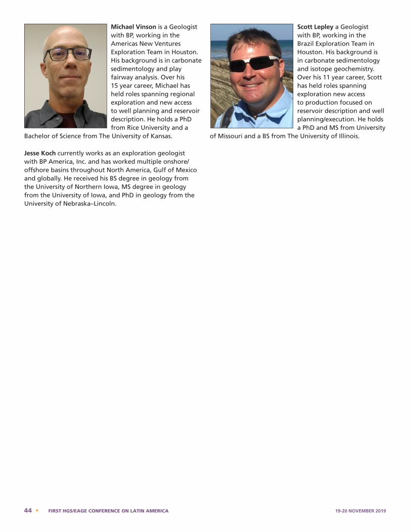
Michael Vinson is a Geologist with BP, working in the Americas New Ventures Exploration Team in Houston. His background is in carbonate sedimentology and play fairway analysis. Over his 15 year career, Michael has held roles spanning regional exploration and new access to well planning and reservoir description. He holds a PhD from Rice University and a
Bachelor of Science from The University of Kansas.
Jesse Koch currently works as an exploration geologist with BP America, Inc. and has worked multiple onshore/offshore basins throughout North America, Gulf of Mexico and globally. He received his BS degree in geology from the University of Northern Iowa, MS degree in geology from the University of Iowa, and PhD in geology from the University of Nebraska–Lincoln.
Scott Lepley a Geologist with BP, working in the Brazil Exploration Team in Houston. His background is in carbonate sedimentology and isotope geochemistry. Over his 11 year career, Scott has held roles spanning exploration new access to production focused on reservoir description and well planning/execution. He holds a PhD and MS from University
of Missouri and a BS from The University of Illinois.
planning and reservoir description. He holds a Ph.D. from Rice University and a Bachelor of Science from The University of Kansas.
(Jesse Kock, no photo)
Jesse Koch currently works as an exploration geologist with BP America, Inc. and has worked multiple onshore/offshore basins throughout North America, Gulf of Mexico and globally. He received his B.S. degree in geology from the University of Northern Iowa, M.S. degree in geology from the University of Iowa, and Ph.D. in geology from the University of Nebraska–Lincoln.
Scott Lepley is a Geologist with BP, working in the Brazil Exploration Team in Houston. His background is in carbonate sedimentology and isotope geochemistry. Over his 11 year career, Scott has held roles spanning exploration new access to production focused on reservoir description and well planning/execution. He holds a Ph.D. and M.S. from University of Missouri and a B.S. from The University of Illinois.
44 • FIRST HGS/EAGE CONFERENCE ON LATIN AMERICA 19-20 NOVEMBER 2019
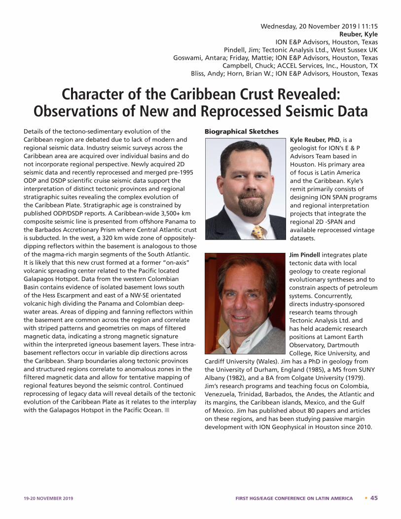
Details of the tectono-sedimentary evolution of the Caribbean region are debated due to lack of modern and regional seismic data. Industry seismic surveys across the Caribbean area are acquired over individual basins and do not incorporate regional perspective. Newly acquired 2D seismic data and recently reprocessed and merged pre-1995 ODP and DSDP scientific cruise seismic data support the interpretation of distinct tectonic provinces and regional stratigraphic suites revealing the complex evolution of the Caribbean Plate. Stratigraphic age is constrained by published ODP/DSDP reports. A Caribbean-wide 3,500+ km composite seismic line is presented from offshore Panama to the Barbados Accretionary Prism where Central Atlantic crust is subducted. In the west, a 320 km wide zone of oppositely-dipping reflectors within the basement is analogous to those of the magma-rich margin segments of the South Atlantic. It is likely that this new crust formed at a former “on-axis” volcanic spreading center related to the Pacific located Galapagos Hotspot. Data from the western Colombian Basin contains evidence of isolated basement lows south of the Hess Escarpment and east of a NW-SE orientated volcanic high dividing the Panama and Colombian deep-water areas. Areas of dipping and fanning reflectors within the basement are common across the region and correlate with striped patterns and geometries on maps of filtered magnetic data, indicating a strong magnetic signature within the interpreted igneous basement layers. These intra-basement reflectors occur in variable dip directions across the Caribbean. Sharp boundaries along tectonic provinces and structured regions correlate to anomalous zones in the filtered magnetic data and allow for tentative mapping of regional features beyond the seismic control. Continued reprocessing of legacy data will reveal details of the tectonic evolution of the Caribbean Plate as it relates to the interplay with the Galapagos Hotspot in the Pacific Ocean. n
Biographical SketchesKyle Reuber, PhD, is a geologist for ION’s E & P Advisors Team based in Houston. His primary area of focus is Latin America and the Caribbean. Kyle’s remit primarily consists of designing ION SPAN programs and regional interpretation projects that integrate the regional 2D -SPAN and available reprocessed vintage datasets.
Jim Pindell integrates plate tectonic data with local geology to create regional evolutionary syntheses and to constrain aspects of petroleum systems. Concurrently, directs industry-sponsored research teams through Tectonic Analysis Ltd. and has held academic research positions at Lamont Earth Observatory, Dartmouth College, Rice University, and
Cardiff University (Wales). Jim has a PhD in geology from the University of Durham, England (1985), a MS from SUNY Albany (1982), and a BA from Colgate University (1979). Jim’s research programs and teaching focus on Colombia, Venezuela, Trinidad, Barbados, the Andes, the Atlantic and its margins, the Caribbean islands, Mexico, and the Gulf of Mexico. Jim has published about 80 papers and articles on these regions, and has been studying passive margin development with ION Geophysical in Houston since 2010.
Kyle Reuber – Bio
Kyle Reuber, PhD, is a geologist for ION’s E & P Advisors Team based in Houston. His primary area of focus is Latin America and the Caribbean. Kyle’s remit primarily consists of designing ION SPAN programs and regional interpretation projects that integrate the regional 2D -SPAN and available reprocessed vintage datasets.
Jim Pindell – Bio
Wednesday, 20 November 2019 | 11:15Reuber, Kyle
ION E&P Advisors, Houston, TexasPindell, Jim; Tectonic Analysis Ltd., West Sussex UK
Goswami, Antara; Friday, Mattie; ION E&P Advisors, Houston, TexasCampbell, Chuck; ACCEL Services, Inc., Houston, TX
Bliss, Andy; Horn, Brian W.; ION E&P Advisors, Houston, Texas
Character of the Caribbean Crust Revealed: Observations of New and Reprocessed Seismic Data
Jim Pindell – Bio
Jim Pindell integrates plate tectonic data with local geology to create regional evolutionary syntheses and to constrain aspects of petroleum systems. Concurrently, directs industry-sponsored research teams through Tectonic Analysis Ltd. and has held academic research positions at Lamont Earth Observatory, Dartmouth College, Rice University, and Cardiff University (Wales). Jim has a PhD in geology from the University of Durham, England (1985), a MS from SUNY Albany (1982), and a BA from Colgate University (1979). Jim’s research programs and teaching focus on Colombia, Venezuela, Trinidad, Barbados, the Andes, the Atlantic and its margins, the Caribbean islands, Mexico, and the Gulf of Mexico. Jim has published about 80 papers and articles on these regions, and has been studying passive margin development with ION Geophysical in Houston since 2010.
19-20 NOVEMBER 2019 FIRST HGS/EAGE CONFERENCE ON LATIN AMERICA • 45
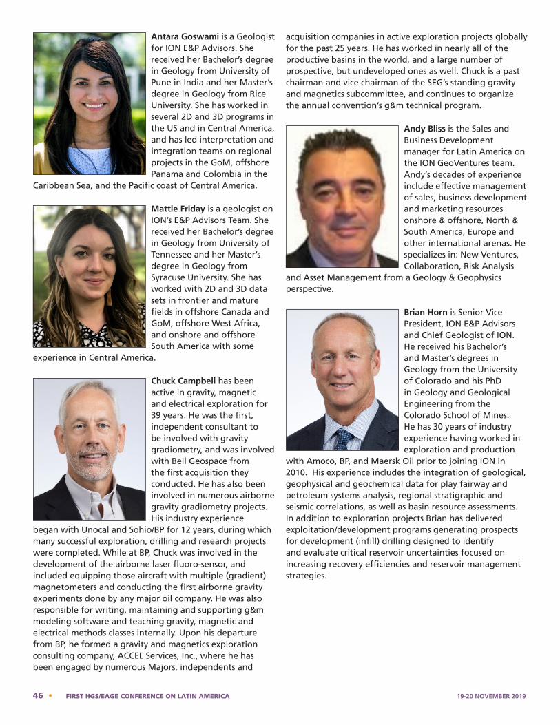
Antara Goswami is a Geologist for ION E&P Advisors. She received her Bachelor’s degree in Geology from University of Pune in India and her Master’s degree in Geology from Rice University. She has worked in several 2D and 3D programs in the US and in Central America, and has led interpretation and integration teams on regional projects in the GoM, offshore Panama and Colombia in the
Caribbean Sea, and the Pacific coast of Central America.
Mattie Friday is a geologist on ION’s E&P Advisors Team. She received her Bachelor’s degree in Geology from University of Tennessee and her Master’s degree in Geology from Syracuse University. She has worked with 2D and 3D data sets in frontier and mature fields in offshore Canada and GoM, offshore West Africa, and onshore and offshore South America with some
experience in Central America.
Chuck Campbell has been active in gravity, magnetic and electrical exploration for 39 years. He was the first, independent consultant to be involved with gravity gradiometry, and was involved with Bell Geospace from the first acquisition they conducted. He has also been involved in numerous airborne gravity gradiometry projects. His industry experience
began with Unocal and Sohio/BP for 12 years, during which many successful exploration, drilling and research projects were completed. While at BP, Chuck was involved in the development of the airborne laser fluoro-sensor, and included equipping those aircraft with multiple (gradient) magnetometers and conducting the first airborne gravity experiments done by any major oil company. He was also responsible for writing, maintaining and supporting g&m modeling software and teaching gravity, magnetic and electrical methods classes internally. Upon his departure from BP, he formed a gravity and magnetics exploration consulting company, ACCEL Services, Inc., where he has been engaged by numerous Majors, independents and
acquisition companies in active exploration projects globally for the past 25 years. He has worked in nearly all of the productive basins in the world, and a large number of prospective, but undeveloped ones as well. Chuck is a past chairman and vice chairman of the SEG’s standing gravity and magnetics subcommittee, and continues to organize the annual convention’s g&m technical program.
Andy Bliss is the Sales and Business Development manager for Latin America on the ION GeoVentures team. Andy’s decades of experience include effective management of sales, business development and marketing resources onshore & offshore, North & South America, Europe and other international arenas. He specializes in: New Ventures, Collaboration, Risk Analysis
and Asset Management from a Geology & Geophysics perspective.
Brian Horn is Senior Vice President, ION E&P Advisors and Chief Geologist of ION. He received his Bachelor’s and Master’s degrees in Geology from the University of Colorado and his PhD in Geology and Geological Engineering from the Colorado School of Mines. He has 30 years of industry experience having worked in exploration and production
with Amoco, BP, and Maersk Oil prior to joining ION in 2010. His experience includes the integration of geological, geophysical and geochemical data for play fairway and petroleum systems analysis, regional stratigraphic and seismic correlations, as well as basin resource assessments. In addition to exploration projects Brian has delivered exploitation/development programs generating prospects for development (infill) drilling designed to identify and evaluate critical reservoir uncertainties focused on increasing recovery efficiencies and reservoir management strategies.
Antara Goswami is a Geologist for ION E&P Advisors. She received her Bachelor’s degree in Geology from University of Pune in India and her Master’s degree in Geology from Rice University. She has worked in several 2D and 3D programs in the US and in Central America, and has led interpretation and integration teams on regional projects in the GoM, offshore Panama and Colombia in the Caribbean Sea, and the Pacific coast of Central America.
Mattie Friday – Bio
Formatted: Space After: 0 pt
Mattie Friday is a geologist on ION’s E&P Advisors Team. She received her Bachelor’s degree in Geology from University of Tennessee and her Master’s degree in Geology from Syracuse University. She has worked with 2D and 3D data sets in frontier and mature fields in offshore Canada and GoM, offshore West Africa, and onshore and offshore South America with some experience in Central America.
Chuck Campbell – Bio
Andy Bliss – Bio
Andy is the Sales and Business Development manager for Latin America on the ION GeoVentures team. Andy’s decades of experience include effective management of sales, business development and marketing resources onshore & offshore, North & South America, Europe and other international arenas. He specializes in: New Ventures, Collaboration, Risk Analysis and Asset Management from a Geology & Geophysics perspective.
Brian W. Horn – Bio
Chuck Campbell has been active in gravity, magnetic and electrical exploration for 39 years. He was the first, independent consultant to be involved with gravity gradiometry, and was involved with Bell Geospace from the first acquisition they conducted. He has also been involved in numerous airborne gravity gradiometry projects. His industry experience began with Unocal and Sohio/BP for 12 years, during which many successful exploration, drilling and research projects were completed. While at BP, Chuck was involved in the development of the airborne laser fluoro-sensor, and included equipping those aircraft with multiple (gradient) magnetometers and conducting the first airborne gravity experiments done by any major oil company. He was also responsible for writing, maintaining and supporting g&m modeling software and teaching gravity, magnetic and electrical methods classes internally. Upon his departure from BP, he formed a gravity and magnetics exploration consulting company, ACCEL Services, Inc., where he has been engaged by numerous Majors, independents and acquisition companies in active exploration projects globally for the past 25 years. He has worked in nearly all of the productive basins in the world, and a large number of prospective, but undeveloped ones as well. Chuck is a past chairman and vice chairman of the SEG’s standing gravity and magnetics subcommittee, and continues to organize the annual convention’s g&m technical program.
Brian Horn is Senior Vice President, ION E&P Advisors and Chief Geologist of ION. He received his Bachelor’s and Master’s degrees in Geology from the University of Colorado and his PhD in Geology and Geological Engineering from the Colorado School of Mines. He has 30 years of industry experience having worked in exploration and production with Amoco, BP, and Maersk Oil prior to joining ION in 2010. His experience includes the integration of geological, geophysical and geochemical data for play fairway and petroleum systems analysis, regional stratigraphic and seismic correlations, as well as basin resource assessments. In addition to exploration projects Brian has delivered exploitation/development programs generating prospects for development (infill) drilling designed to identify and evaluate critical reservoir uncertainties focused on increasing recovery efficiencies and reservoir management strategies.
46 • FIRST HGS/EAGE CONFERENCE ON LATIN AMERICA 19-20 NOVEMBER 2019

Latin America offers amazing scale, variety and numbers of investment opportunities for exploration, development and production of oil and natural gas. This region hosts the country with the largest hydrocarbon resource base in the world (Venezuela), the country with the most prolific deepwater oil discoveries and remaining potential in the world (Brazil), and two emerging exploration and development hotspots; one conventional (deepwater Guyana) and one unconventional (Neuquen basin, Argentina). One Latin American country, Mexico, recently became one of the last countries in the world to end its state monopoly of the oil business and must be the only country in the world that counts its nationalization of the oil and gas business in 1938 as a state holiday.
Growth of the oil business in Latin America has certainly not been hampered by the region’s rich endowment. Rather, it is challenged by political cycles which do not accommodate the very long term investment cycles of the oil and gas business. A century of learnings by private industry and host governments may portend a new and more stable direction. But the greatest promise for longer term stability will continue to come from global competition. Investors have many options and the destination of their future investments will be dictated by fiscal regimes which offer long term stability and adequate returns. Likewise, host countries have many successful global examples to follow in fine tuning their fiscal regimes to maximize their rent but ensure the stability that investors seek. n
Biographical SketchRichard Chuchla was born and raised in Chile. He received his undergraduate degree in geology from Cornell and his Master’s degree from The University of Texas at Austin. He retired as an executive from ExxonMobil in 2015 after a 35-year career with the company. Richard has broad experience in minerals (base and precious metals), coal, oil and gas exploration,
development, research and management, including a corporate assignment as upstream strategic advisor to ExxonMobil’s Management Committee and CEO. Richard worked in basins and has participated in discoveries around the world in deepwater and onshore (unconventional and conventional resources) with a significant part of his career spent in Latin America. He was appointed as the Director of the Energy and Earth Sciences (EER) graduate program and the Leslie Bowling Professor in Geological Sciences at the University of Texas-Austin in 2016. EER is a multidisciplinary program administered by the Jackson School of Geosciences with faculty from the Cockrell School of Engineering, the McCombs School of Business, the LBJ School of Public Affairs, the School of Law and the Energy Institute.
Richard Chuchla - Bio
Richard Chuchla was born and raised in Chile. He received his undergraduate degree in geology from Cornell and his Master’s degree from the University of Texas at Austin. He retired as an executive from ExxonMobil in 2015 after a 35-year career with the company. Richard has broad experience in minerals (base and precious metals), coal, oil and gas exploration, development, research and management, including a corporate assignment as upstream strategic advisor to ExxonMobil’s Management Committee and CEO. Richard worked in basins and has participated in discoveries around the world in deepwater and onshore (unconventional and conventional resources) with a significant part of his career spent in Latin America. He was appointed as the Director of the Energy and Earth Sciences (EER) graduate program and the Leslie Bowling Professor in Geological Sciences at the University of Texas-Austin in 2016. EER is a multidisciplinary program administered by the Jackson School of Geosciences with faculty from the Cockrell School of Engineering, the McCombs School of Business, the LBJ School of Public Affairs, the School of Law and the Energy Institute.
Wednesday, 20 November 2019 | Keynote | 11:55Chuchla, Richard J.
Director; Energy and Earth Resources Graduate ProgramJackson School, The University of Texas at Austin
Energy Opportunities in Latin America: Investing Through the Political Cycles
19-20 NOVEMBER 2019 FIRST HGS/EAGE CONFERENCE ON LATIN AMERICA • 47
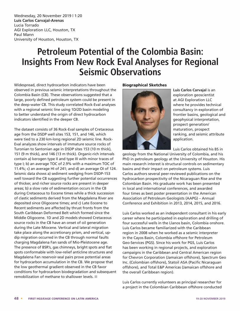
Widespread, direct hydrocarbon indicators have been observed in previous seismic interpretations throughout the Colombia Basin (CB). These observations suggested that a large, poorly defined petroleum system could be present in the deep-water CB. This study correlated Rock-Eval analyses with a regional seismic line using 1D/2D basin modeling to better understand the origin of direct hydrocarbon indicators identified in the deeper CB.
The dataset consists of 36 Rock-Eval samples of Cretaceous age from the DSDP well sites 153, 151, and 146, which were tied to a 230 km-long regional 2D seismic line. Rock-Eval analyzes show intervals of immature source rocks of Turonian to Santonian age in DSDP sites 153 (10 m thick), 151 (9 m thick), and 146 (13 m thick). Organic-rich intervals contain a) kerogen type II and type III with minor traces of type I; b) an average TOC of 2.9% with a maximum TOC of 11.4%; c) an average HI of 241; and d) an average OI of 124. Seismic data shows a) sediment wedging from DSDP-153 well toward the CB suggesting further potential occurrences of thicker, and richer source rocks are present in deeper areas; b) a slow rate of sedimentation occurs in the CB during Cretaceous to Eocene times while a thick succession of clastic sediments derived from the Magdalena River are deposited since Oligocene times; and c) Late Eocene to Recent sediments are affected by thrust fronts from the South Caribbean Deformed Belt which formed since the Middle Oligocene. 1D and 2D models showed Cretaceous source rocks in the CB have an onset of oil generation during the Late Miocene. Vertical and lateral migration take place along the accretionary prism, and vertical, up-dip migration occurred in the CB through normal faults charging Magdalena Fan sands of Mio-Pleistocene age. The presence of BSR’s, gas chimneys, bright spots and flat spots conformable with low-relief anticline structures and Magdalena Fan reservoir-seal pairs prove potential areas for hydrocarbon accumulation in the CB. We propose that the low geothermal gradient observed in the CB favor conditions for hydrocarbon biodegradation and subsequent remobilization of methane to shallower levels. n
Biographical SketchesLuis Carlos Carvajal is an exploration geoscientist at AGI Exploration LLC where he provides technical consultancy in exploration of frontier basins, geological and geophysical interpretation, prospect generation/maturation, prospect ranking, and seismic attribute application.
Luis Carlos obtained his BS in geology from the National University of Colombia, and his PhD in petroleum geology at the University of Houston. His main research interest is structural controls on sedimentary basins and their impact on petroleum systems. Luis Carlos authors several peer-reviewed publications on the hydrocarbon prospectivity of the Nicaraguan Rise and the Colombian Basin. His graduate work has been presented in local and international conferences, and awarded four times as best poster presentation in the American Association of Petroleum Geologists (AAPG) – Annual Conference and Exhibition in 2013, 2014, 2015, and 2016.
Luis Carlos worked as an independent consultant in his early career where he participated in exploration and drilling of four successful wells in the Llanos basin, Colombia onshore. Luis Carlos became familiarized with the Caribbean region in 2008 when he worked as a seismic interpreter in the Cayos Basin, Colombia offshore for Petroleum Geo-Services (PGS). Since his work for PGS, Luis Carlos has been working in regional projects, and exploration campaigns in the Caribbean and Central American region for Chevron Corporation (Jamaican offshore), Spectrum Geo Inc. (Colombian offshore), Statoil ASA (Pacific Nicaraguan offshore), and Total E&P Americas (Jamaican offshore and the overall Caribbean region).
Luis Carlos currently volunteers as principal researcher for a project in the Colombian Caribbean offshore conducted
Luis Carlos Carvajal-Arenas – Bio Luis Carlos Carvajal is an exploration geoscientist at AGI Exploration LLC where he provides technical consultancy in exploration of frontier basins, geological and geophysical interpretation, prospect generation/maturation, prospect ranking, and seismic attribute application. Luis Carlos obtained his B.S. in geology from the National University of Colombia, and his Ph.D. in petroleum geology at the University of Houston. His main research interest is structural controls on sedimentary basins and their impact on petroleum systems. Luis Carlos authors several peer-reviewed publications on the hydrocarbon prospectivity of the Nicaraguan Rise and the Colombian Basin. His graduate work has been presented in local and international conferences, and awarded four times as best poster presentation in the American Association of Petroleum Geologists (AAPG) – Annual Conference and Exhibition in 2013, 2014, 2015, and 2016. Luis Carlos worked as an independent consultant in his early career where he participated in exploration and drilling of four successful wells in the Llanos basin, Colombia onshore. Luis Carlos became familiarized with the Caribbean region in 2008 when he worked as a seismic interpreter in the Cayos Basin, Colombia offshore for Petroleum Geo-Services (PGS). Since his work for PGS, Luis Carlos has been working in regional projects, and exploration campaigns in the Caribbean and Central American region for Chevron Corporation (Jamaican offshore), Spectrum Geo Inc. (Colombian offshore), Statoil ASA (Pacific Nicaraguan offshore), and Total E&P Americas (Jamaican offshore and the overall Caribbean region). Luis Carlos currently volunteers as principal researcher for a project in the Colombian Caribbean offshore conducted by the Marine Direction of Colombia (DIMAR), and as treasurer-elect at the Society of Independent Professional Earth Scientists (SIPES).
Wednesday, 20 November 2019 | 1:20Luis Carlos Carvajal-ArenasLucia TorradoAGI Exploration LLC, Houston, TXPaul Mann University of Houston, Houston, TX
Petroleum Potential of the Colombia Basin: Insights From New Rock Eval Analyses for Regional
Seismic Observations
48 • FIRST HGS/EAGE CONFERENCE ON LATIN AMERICA 19-20 NOVEMBER 2019
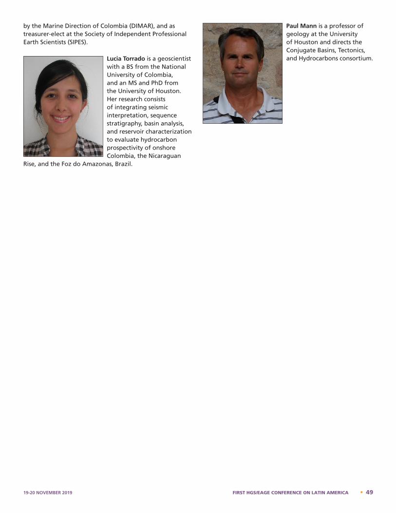
by the Marine Direction of Colombia (DIMAR), and as treasurer-elect at the Society of Independent Professional Earth Scientists (SIPES).
Lucia Torrado is a geoscientist with a BS from the National University of Colombia, and an MS and PhD from the University of Houston. Her research consists of integrating seismic interpretation, sequence stratigraphy, basin analysis, and reservoir characterization to evaluate hydrocarbon prospectivity of onshore Colombia, the Nicaraguan
Rise, and the Foz do Amazonas, Brazil.
Paul Mann is a professor of geology at the University of Houston and directs the Conjugate Basins, Tectonics, and Hydrocarbons consortium.
Lucia Torrado - Bio
Lucia Torrado is a geoscientist with a B.S. from the National University of Colombia, and an M.S. and Ph.D. from the University of Houston. Her research consists of integrating seismic interpretation, sequence stratigraphy, basin analysis, and reservoir characterization to evaluate hydrocarbon prospectivity of onshore Colombia, the Nicaraguan Rise, and the Foz do Amazonas, Brazil. Paul Mann – Bio
Paul Mann is a professor of geology at the University of Houston and directs the Conjugate Basins, Tectonics, and Hydrocarbons consortium.
19-20 NOVEMBER 2019 FIRST HGS/EAGE CONFERENCE ON LATIN AMERICA • 49
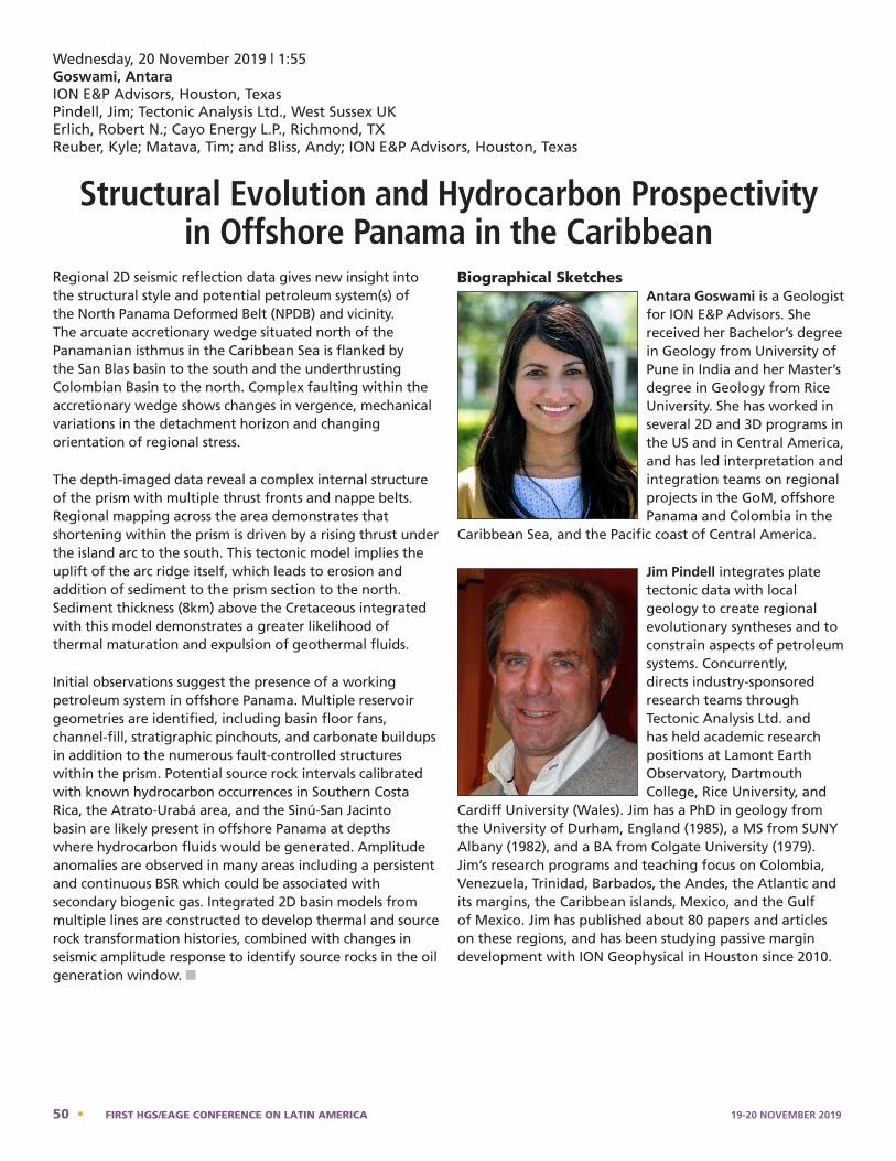
Regional 2D seismic reflection data gives new insight into the structural style and potential petroleum system(s) of the North Panama Deformed Belt (NPDB) and vicinity. The arcuate accretionary wedge situated north of the Panamanian isthmus in the Caribbean Sea is flanked by the San Blas basin to the south and the underthrusting Colombian Basin to the north. Complex faulting within the accretionary wedge shows changes in vergence, mechanical variations in the detachment horizon and changing orientation of regional stress.
The depth-imaged data reveal a complex internal structure of the prism with multiple thrust fronts and nappe belts. Regional mapping across the area demonstrates that shortening within the prism is driven by a rising thrust under the island arc to the south. This tectonic model implies the uplift of the arc ridge itself, which leads to erosion and addition of sediment to the prism section to the north. Sediment thickness (8km) above the Cretaceous integrated with this model demonstrates a greater likelihood of thermal maturation and expulsion of geothermal fluids.
Initial observations suggest the presence of a working petroleum system in offshore Panama. Multiple reservoir geometries are identified, including basin floor fans, channel-fill, stratigraphic pinchouts, and carbonate buildups in addition to the numerous fault-controlled structures within the prism. Potential source rock intervals calibrated with known hydrocarbon occurrences in Southern Costa Rica, the Atrato-Urabá area, and the Sinú-San Jacinto basin are likely present in offshore Panama at depths where hydrocarbon fluids would be generated. Amplitude anomalies are observed in many areas including a persistent and continuous BSR which could be associated with secondary biogenic gas. Integrated 2D basin models from multiple lines are constructed to develop thermal and source rock transformation histories, combined with changes in seismic amplitude response to identify source rocks in the oil generation window. n
Biographical SketchesAntara Goswami is a Geologist for ION E&P Advisors. She received her Bachelor’s degree in Geology from University of Pune in India and her Master’s degree in Geology from Rice University. She has worked in several 2D and 3D programs in the US and in Central America, and has led interpretation and integration teams on regional projects in the GoM, offshore Panama and Colombia in the
Caribbean Sea, and the Pacific coast of Central America.
Jim Pindell integrates plate tectonic data with local geology to create regional evolutionary syntheses and to constrain aspects of petroleum systems. Concurrently, directs industry-sponsored research teams through Tectonic Analysis Ltd. and has held academic research positions at Lamont Earth Observatory, Dartmouth College, Rice University, and
Cardiff University (Wales). Jim has a PhD in geology from the University of Durham, England (1985), a MS from SUNY Albany (1982), and a BA from Colgate University (1979). Jim’s research programs and teaching focus on Colombia, Venezuela, Trinidad, Barbados, the Andes, the Atlantic and its margins, the Caribbean islands, Mexico, and the Gulf of Mexico. Jim has published about 80 papers and articles on these regions, and has been studying passive margin development with ION Geophysical in Houston since 2010.
Wednesday, 20 November 2019 | 1:55Goswami, AntaraION E&P Advisors, Houston, TexasPindell, Jim; Tectonic Analysis Ltd., West Sussex UKErlich, Robert N.; Cayo Energy L.P., Richmond, TXReuber, Kyle; Matava, Tim; and Bliss, Andy; ION E&P Advisors, Houston, Texas
Structural Evolution and Hydrocarbon Prospectivity in Offshore Panama in the Caribbean
Jim Pindell – Bio
Jim Pindell integrates plate tectonic data with local geology to create regional evolutionary syntheses and to constrain aspects of petroleum systems. Concurrently, directs industry-sponsored research teams through Tectonic Analysis Ltd. and has held academic research positions at Lamont Earth Observatory, Dartmouth College, Rice University, and Cardiff University (Wales). Jim has a PhD in geology from the University of Durham, England (1985), a MS from SUNY Albany (1982), and a BA from Colgate University (1979). Jim’s research programs and teaching focus on Colombia, Venezuela, Trinidad, Barbados, the Andes, the Atlantic and its margins, the Caribbean islands, Mexico, and the Gulf of Mexico. Jim has published about 80 papers and articles on these regions, and has been studying passive margin development with ION Geophysical in Houston since 2010.
Antara Goswami is a Geologist for ION E&P Advisors. She received her Bachelor’s degree in Geology from University of Pune in India and her Master’s degree in Geology from Rice University. She has worked in several 2D and 3D programs in the US and in Central America, and has led interpretation and integration teams on regional projects in the GoM, offshore Panama and Colombia in the Caribbean Sea, and the Pacific coast of Central America.
Mattie Friday – Bio
Formatted: Space After: 0 pt
50 • FIRST HGS/EAGE CONFERENCE ON LATIN AMERICA 19-20 NOVEMBER 2019
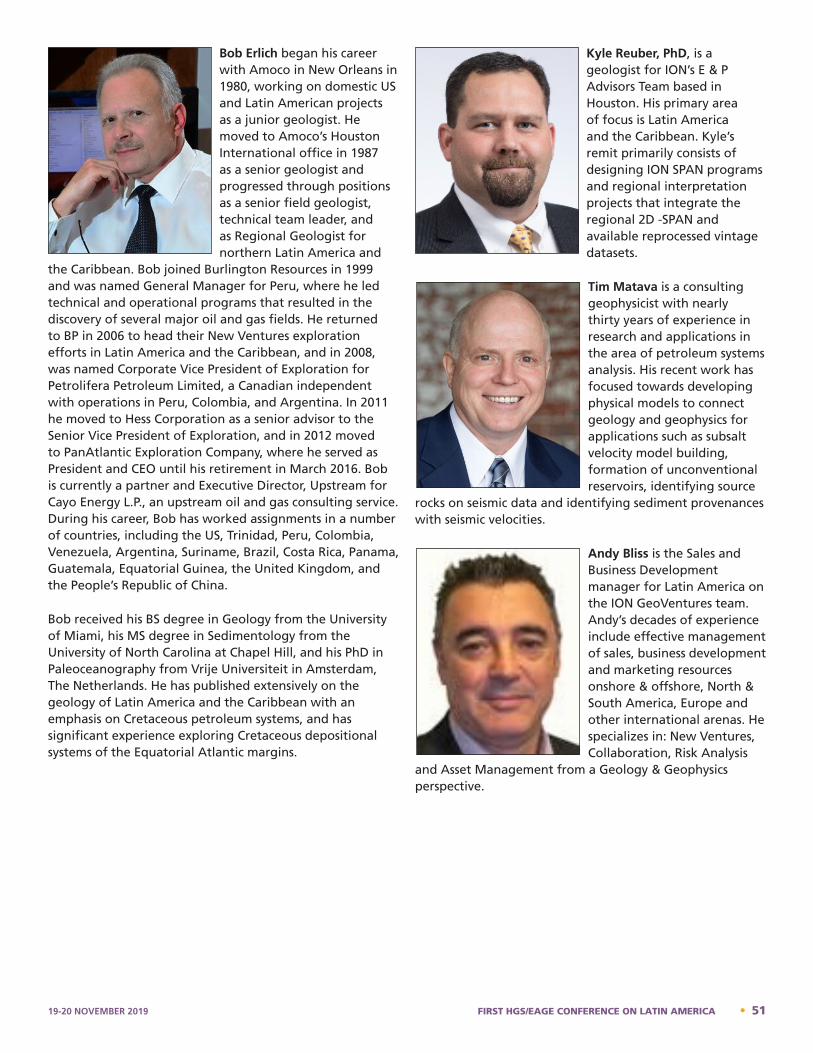
Bob Erlich began his career with Amoco in New Orleans in 1980, working on domestic US and Latin American projects as a junior geologist. He moved to Amoco’s Houston International office in 1987 as a senior geologist and progressed through positions as a senior field geologist, technical team leader, and as Regional Geologist for northern Latin America and
the Caribbean. Bob joined Burlington Resources in 1999 and was named General Manager for Peru, where he led technical and operational programs that resulted in the discovery of several major oil and gas fields. He returned to BP in 2006 to head their New Ventures exploration efforts in Latin America and the Caribbean, and in 2008, was named Corporate Vice President of Exploration for Petrolifera Petroleum Limited, a Canadian independent with operations in Peru, Colombia, and Argentina. In 2011 he moved to Hess Corporation as a senior advisor to the Senior Vice President of Exploration, and in 2012 moved to PanAtlantic Exploration Company, where he served as President and CEO until his retirement in March 2016. Bob is currently a partner and Executive Director, Upstream for Cayo Energy L.P., an upstream oil and gas consulting service. During his career, Bob has worked assignments in a number of countries, including the US, Trinidad, Peru, Colombia, Venezuela, Argentina, Suriname, Brazil, Costa Rica, Panama, Guatemala, Equatorial Guinea, the United Kingdom, and the People’s Republic of China.
Bob received his BS degree in Geology from the University of Miami, his MS degree in Sedimentology from the University of North Carolina at Chapel Hill, and his PhD in Paleoceanography from Vrije Universiteit in Amsterdam, The Netherlands. He has published extensively on the geology of Latin America and the Caribbean with an emphasis on Cretaceous petroleum systems, and has significant experience exploring Cretaceous depositional systems of the Equatorial Atlantic margins.
Kyle Reuber, PhD, is a geologist for ION’s E & P Advisors Team based in Houston. His primary area of focus is Latin America and the Caribbean. Kyle’s remit primarily consists of designing ION SPAN programs and regional interpretation projects that integrate the regional 2D -SPAN and available reprocessed vintage datasets.
Tim Matava is a consulting geophysicist with nearly thirty years of experience in research and applications in the area of petroleum systems analysis. His recent work has focused towards developing physical models to connect geology and geophysics for applications such as subsalt velocity model building, formation of unconventional reservoirs, identifying source
rocks on seismic data and identifying sediment provenances with seismic velocities.
Andy Bliss is the Sales and Business Development manager for Latin America on the ION GeoVentures team. Andy’s decades of experience include effective management of sales, business development and marketing resources onshore & offshore, North & South America, Europe and other international arenas. He specializes in: New Ventures, Collaboration, Risk Analysis
and Asset Management from a Geology & Geophysics perspective.
Kyle Reuber – Bio
Kyle Reuber, PhD, is a geologist for ION’s E & P Advisors Team based in Houston. His primary area of focus is Latin America and the Caribbean. Kyle’s remit primarily consists of designing ION SPAN programs and regional interpretation projects that integrate the regional 2D -SPAN and available reprocessed vintage datasets.
Jim Pindell – Bio
Andy Bliss – Bio
Andy is the Sales and Business Development manager for Latin America on the ION GeoVentures team. Andy’s decades of experience include effective management of sales, business development and marketing resources onshore & offshore, North & South America, Europe and other international arenas. He specializes in: New Ventures, Collaboration, Risk Analysis and Asset Management from a Geology & Geophysics perspective.
Brian W. Horn – Bio
Bio - Tim Matava
Tim Matava is a consulting geophysicist with nearly thirty years of experience in research and applications in the area of petroleum systems analysis. His recent work has focused towards developing physical models to connect geology and geophysics for applications such as subsalt velocity model building, formation of unconventional reservoirs, identifying source rocks on seismic data and identifying sediment provenances with seismic velocities.
Andy Bliss – Bio
Bob Erlich began his career with Amoco in New Orleans in 1980, working on domestic US and Latin American projects as a junior geologist. He moved to Amoco’s Houston International office in 1987 as a senior geologist and progressed through positions as a senior field geologist, technical team leader, and as Regional Geologist for northern Latin America and the Caribbean. Bob joined Burlington Resources in 1999 and was named General Manager for Peru, where he led technical and operational programs that resulted in the discovery of several major oil and gas fields. He returned to BP in 2006 to head their New Ventures exploration efforts in Latin America and the Caribbean, and in 2008, was named Corporate Vice President of Exploration for Petrolifera Petroleum Limited, a Canadian independent with operations in Peru, Colombia, and Argentina. In 2011 he moved to Hess Corporation as a senior advisor to the Senior Vice President of Exploration, and in 2012 moved to PanAtlantic Exploration Company, where he served as President and CEO until his retirement in March 2016. Bob is currently a partner and Executive Director, Upstream for Cayo Energy L.P., an upstream oil and gas consulting service. During his career, Bob has worked assignments in a number of countries, including the US, Trinidad, Peru, Colombia, Venezuela, Argentina, Suriname, Brazil, Costa Rica, Panama, Guatemala, Equatorial Guinea, the United Kingdom, and the People’s Republic of China.
19-20 NOVEMBER 2019 FIRST HGS/EAGE CONFERENCE ON LATIN AMERICA • 51
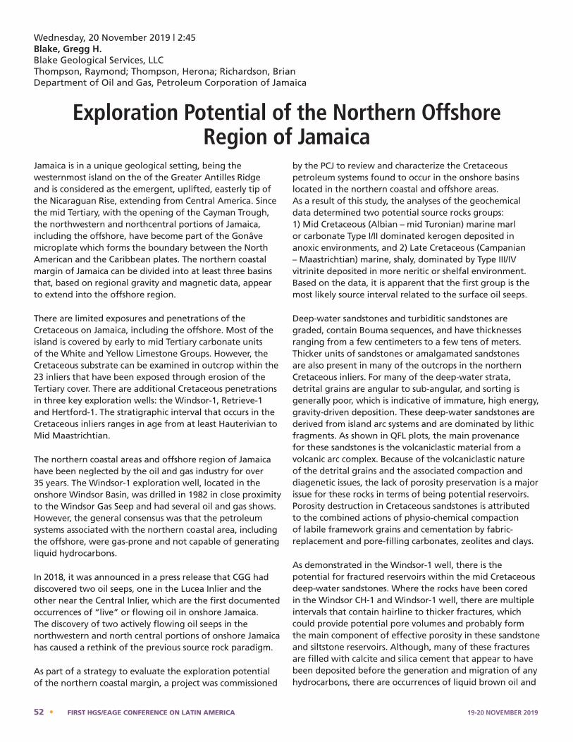
Jamaica is in a unique geological setting, being the westernmost island on the of the Greater Antilles Ridge and is considered as the emergent, uplifted, easterly tip of the Nicaraguan Rise, extending from Central America. Since the mid Tertiary, with the opening of the Cayman Trough, the northwestern and northcentral portions of Jamaica, including the offshore, have become part of the Gonâve microplate which forms the boundary between the North American and the Caribbean plates. The northern coastal margin of Jamaica can be divided into at least three basins that, based on regional gravity and magnetic data, appear to extend into the offshore region.
There are limited exposures and penetrations of the Cretaceous on Jamaica, including the offshore. Most of the island is covered by early to mid Tertiary carbonate units of the White and Yellow Limestone Groups. However, the Cretaceous substrate can be examined in outcrop within the 23 inliers that have been exposed through erosion of the Tertiary cover. There are additional Cretaceous penetrations in three key exploration wells: the Windsor-1, Retrieve-1 and Hertford-1. The stratigraphic interval that occurs in the Cretaceous inliers ranges in age from at least Hauterivian to Mid Maastrichtian.
The northern coastal areas and offshore region of Jamaica have been neglected by the oil and gas industry for over 35 years. The Windsor-1 exploration well, located in the onshore Windsor Basin, was drilled in 1982 in close proximity to the Windsor Gas Seep and had several oil and gas shows. However, the general consensus was that the petroleum systems associated with the northern coastal area, including the offshore, were gas-prone and not capable of generating liquid hydrocarbons.
In 2018, it was announced in a press release that CGG had discovered two oil seeps, one in the Lucea Inlier and the other near the Central Inlier, which are the first documented occurrences of “live” or flowing oil in onshore Jamaica. The discovery of two actively flowing oil seeps in the northwestern and north central portions of onshore Jamaica has caused a rethink of the previous source rock paradigm.
As part of a strategy to evaluate the exploration potential of the northern coastal margin, a project was commissioned
by the PCJ to review and characterize the Cretaceous petroleum systems found to occur in the onshore basins located in the northern coastal and offshore areas. As a result of this study, the analyses of the geochemical data determined two potential source rocks groups: 1) Mid Cretaceous (Albian – mid Turonian) marine marl or carbonate Type I/II dominated kerogen deposited in anoxic environments, and 2) Late Cretaceous (Campanian – Maastrichtian) marine, shaly, dominated by Type III/IV vitrinite deposited in more neritic or shelfal environment. Based on the data, it is apparent that the first group is the most likely source interval related to the surface oil seeps.
Deep-water sandstones and turbiditic sandstones are graded, contain Bouma sequences, and have thicknesses ranging from a few centimeters to a few tens of meters. Thicker units of sandstones or amalgamated sandstones are also present in many of the outcrops in the northern Cretaceous inliers. For many of the deep-water strata, detrital grains are angular to sub-angular, and sorting is generally poor, which is indicative of immature, high energy, gravity-driven deposition. These deep-water sandstones are derived from island arc systems and are dominated by lithic fragments. As shown in QFL plots, the main provenance for these sandstones is the volcaniclastic material from a volcanic arc complex. Because of the volcaniclastic nature of the detrital grains and the associated compaction and diagenetic issues, the lack of porosity preservation is a major issue for these rocks in terms of being potential reservoirs. Porosity destruction in Cretaceous sandstones is attributed to the combined actions of physio-chemical compaction of labile framework grains and cementation by fabric-replacement and pore-filling carbonates, zeolites and clays.
As demonstrated in the Windsor-1 well, there is the potential for fractured reservoirs within the mid Cretaceous deep-water sandstones. Where the rocks have been cored in the Windsor CH-1 and Windsor-1 well, there are multiple intervals that contain hairline to thicker fractures, which could provide potential pore volumes and probably form the main component of effective porosity in these sandstone and siltstone reservoirs. Although, many of these fractures are filled with calcite and silica cement that appear to have been deposited before the generation and migration of any hydrocarbons, there are occurrences of liquid brown oil and
Wednesday, 20 November 2019 | 2:45Blake, Gregg H.Blake Geological Services, LLCThompson, Raymond; Thompson, Herona; Richardson, Brian Department of Oil and Gas, Petroleum Corporation of Jamaica
Exploration Potential of the Northern Offshore Region of Jamaica
52 • FIRST HGS/EAGE CONFERENCE ON LATIN AMERICA 19-20 NOVEMBER 2019
gas bubbles in the core taken in the Windsor-1 which show that hydrocarbons had migrated into the fractures before deposition of the calcite cements and there are reports of oil bleeding from the fractures when the core was taken. In addition, there is evidence from the mudlog that both oil and gas had migrated into these reservoirs as further proof of the potential for fractured porosity.
In contrast to the Campanian and older deepwater sandstones, the Maastrichtian and younger sandstones are typically epiclastic in origin, derived from upthrown emergent blocks of older Cretaceous volcanic extrusive flows, sediments and igneous intrusives. These sandstones, in general, vary from immature to sub-mature litharenites to feldspathic litharenite. There appears to be a general increase in mineralogical and textural maturity of the epiclastics with decreasing age through the Maastrichtian to the middle Eocene potential reservoirs deposited in the northern and central basins.
It is evident from the onshore data that there are potential petroleum systems working in the northern coastal and offshore areas that may contain commercial accumulations of oil or gas. Based on the results of recent technical evaluations, the northern coastal margin and associated offshore basins are attractive exploration areas, however, these are very frontier areas that require further geologic and geophysical studies to constrain the exploration risk. In the future, with additional data and interpretations along with the discovery of two live oil seeps, this northern to northwestern offshore region, which has been overlooked for several years, could become a bright spot for future exploration activity in Jamaica. n
Biographical SketchGregg H. Blake, President of Blake Geological Services, LLC, graduated with a BA in Geological Sciences from University of California, Santa Barbara and received an MS and PhD in Geological Sciences from the University of Southern California with a specialty in Marine Geology and Micropaleontology. After graduation he worked for the Union Oil Company
of California (Unocal) for over 29 years, 15 years based in Ventura, CA, exploring in California and Alaska providing biostratigraphic interpretations and depositional systems analysis. After a transfer to Sugar Land, TX, he spent the last 14 years as part of the International New Ventures group at Unocal and worked on exploration opportunities in several basins in Southeast Asia, Latin America, West Africa, North Africa and the FSU.
After the acquisition of Unocal by Chevron, he moved to Murphy Oil Corporation and worked as a Senior Geological Advisor in the International New Ventures and Exploration group. He worked on resource assessment teams looking at exploration potential mostly along both margins of the Atlantic Ocean, especially in West Africa, Suriname-Guyana and Brazil. he also had the chance to review exploration opportunities in northeastern Canada, the Caribbean, western and central Mediterrean, and Europe.
After 12 years at Murphy and 42 years in the oil & gas industry he decided to retire from the typical 24/7 pace of multiple exploration projects and started Blake Geological Services, LLC, a consulting company that is focused on providing technical help to more specific geologic projects, specializing in basinal studies, depositional systems and the integration of biostratigraphic and lithostratigraphic interpretations with geologic and seismic projects. For the last 8 months, he had the opportunity to work with the Exploration Team at the Petroleum Corporation of Jamaica working on a basin assessment project of the northern coastal margin and offshore areas of Jamaica.
Gregg Blake - Bio
Gregg H. Blake, President of Blake Geological Services, LLC, graduated with a BA in Geological Sciences from University of California, Santa Barbara and received an MS and PhD in Geological Sciences from the University of Southern California with a specialty in Marine Geology and Micropaleontology. After graduation he worked for the Union Oil Company of California (Unocal) for over 29 years, 15 years based in Ventura, CA, exploring in California and Alaska providing biostratigraphic interpretations and depositional systems analysis. After a transfer to Sugar Land, TX, he spent the last 14 years as part of the International New Ventures group at Unocal and worked on exploration opportunities in several basins in Southeast Asia, Latin America, West Africa, North Africa and the FSU. After the acquisition of Unocal by Chevron, he moved to Murphy Oil Corporation and worked as a Senior Geological Advisor in the International New Ventures and Exploration group. He worked on resource assessment teams looking at exploration potential mostly along both margins of the Atlantic Ocean, especially in West Africa, Suriname-Guyana and Brazil. he also had the chance to review exploration opportunities in northeastern Canada, the Caribbean, western and central Mediterrean, and Europe. After 12 years at Murphy and 42 years in the oil & gas industry he decided to retire from the typical 24/7 pace of multiple exploration projects and started Blake Geological Services, LLC, a consulting 19-20 NOVEMBER 2019 FIRST HGS/EAGE CONFERENCE ON LATIN AMERICA • 53
Late Cretaceous–to–present-day mixed carbonate–clastic deposition along the Nicaraguan platform, western Caribbean Sea, has evolved from a tectonically controlled, rifted upper Eocene shallow–to–deep-marine carbonate–siliciclastic shelf to an upper Miocene–to–present-day tectonically stable shallow-marine carbonate platform and passive margin.
By integrating subsurface data of 287 two-dimensional seismic lines and 27 wells, we interpret the Cenozoic stratigraphic sequence as 3 cycles of transgression and regression beginning with an upper Eocene rhodolitic–algal carbonate shelf that interfingered with marginal siliciclastic sediments derived from exposed areas of Central America bordering the margin to the west.
During the Middle Eocene, a carbonate platform was established with both rimmed reefs and isolated patch reefs. A Late Eocene forced regression produced widespread erosion and subaerial exposure across much of the platform and was recorded by a regional unconformity. The Oligocene–upper Miocene sedimentary record includes a southeastward prograding delta of the proto-Coco river, which drained the emergent area of what is now northern Nicaragua. The late Miocene–to–present-day marks a period of strong subsidence with the development of small pinnacle reefs.
We describe favorable petroleum system elements of the Nicaraguan platform that include (1) Eocene fossiliferous limestone source rocks documented as thermally mature in vintage exploration wells and seen as active gas chimneys emanating from inferred carbonate reservoirs; (2) upper–to–middle Eocene reservoirs in patch and pinnacle reefs, middle Eocene calcareous slumps, and Oligocene fluvial-deltaic facies documented in wells; and (3) regional seal intervals that consist of both regional unconformities and Eocene–Oligocene intraformational shale. n
Biographical SketchesLucia Torrado is a geoscientist with a BS from the National University of Colombia, and an MS and PhD from the University of Houston. Her research consists of integrating seismic interpretation, sequence stratigraphy, basin analysis, and reservoir characterization to evaluate hydrocarbon prospectivity of onshore Colombia, the Nicaraguan
Rise, and the Foz do Amazonas, Brazil.
Luis Carlos Carvajal is an exploration geoscientist at AGI Exploration LLC where he provides technical consultancy in exploration of frontier basins, geological and geophysical interpretation, prospect generation/maturation, prospect ranking, and seismic attribute application.
Luis Carlos obtained his BS in geology from the National University of Colombia, and his PhD in petroleum geology at the University of Houston. His main research interest is structural controls on sedimentary basins and their impact on petroleum systems. Luis Carlos authors several peer-reviewed publications on the hydrocarbon prospectivity of the Nicaraguan Rise and the Colombian Basin. His graduate work has been presented in local and international conferences, and awarded four times as best poster presentation in the American Association of Petroleum Geologists (AAPG) – Annual Conference and Exhibition in 2013, 2014, 2015, and 2016.
Luis Carlos worked as an independent consultant in his early career where he participated in exploration and drilling of four successful wells in the Llanos basin, Colombia onshore.
Luis Carlos Carvajal-Arenas – Bio Luis Carlos Carvajal is an exploration geoscientist at AGI Exploration LLC where he provides technical consultancy in exploration of frontier basins, geological and geophysical interpretation, prospect generation/maturation, prospect ranking, and seismic attribute application. Luis Carlos obtained his B.S. in geology from the National University of Colombia, and his Ph.D. in petroleum geology at the University of Houston. His main research interest is structural controls on sedimentary basins and their impact on petroleum systems. Luis Carlos authors several peer-reviewed publications on the hydrocarbon prospectivity of the Nicaraguan Rise and the Colombian Basin. His graduate work has been presented in local and international conferences, and awarded four times as best poster presentation in the American Association of Petroleum Geologists (AAPG) – Annual Conference and Exhibition in 2013, 2014, 2015, and 2016. Luis Carlos worked as an independent consultant in his early career where he participated in exploration and drilling of four successful wells in the Llanos basin, Colombia onshore. Luis Carlos became familiarized with the Caribbean region in 2008 when he worked as a seismic interpreter in the Cayos Basin, Colombia offshore for Petroleum Geo-Services (PGS). Since his work for PGS, Luis Carlos has been working in regional projects, and exploration campaigns in the Caribbean and Central American region for Chevron Corporation (Jamaican offshore), Spectrum Geo Inc. (Colombian offshore), Statoil ASA (Pacific Nicaraguan offshore), and Total E&P Americas (Jamaican offshore and the overall Caribbean region). Luis Carlos currently volunteers as principal researcher for a project in the Colombian Caribbean offshore conducted by the Marine Direction of Colombia (DIMAR), and as treasurer-elect at the Society of Independent Professional Earth Scientists (SIPES).
Wednesday, 20 November 2019 | 3:20Lucia Torrado Luis Carlos Carvajal-ArenasAGI Exploration LLC, Houston, TX
Late Cretaceous–Cenozoic Paleogeographic Evolution of the Nicaraguan Platform, Western Caribbean Sea:
Implications for Hydrocarbon PotentialLucia Torrado - Bio
Lucia Torrado is a geoscientist with a B.S. from the National University of Colombia, and an M.S. and Ph.D. from the University of Houston. Her research consists of integrating seismic interpretation, sequence stratigraphy, basin analysis, and reservoir characterization to evaluate hydrocarbon prospectivity of onshore Colombia, the Nicaraguan Rise, and the Foz do Amazonas, Brazil. Paul Mann – Bio
Paul Mann is a professor of geology at the University of Houston and directs the Conjugate Basins, Tectonics, and Hydrocarbons consortium.
54 • FIRST HGS/EAGE CONFERENCE ON LATIN AMERICA 19-20 NOVEMBER 2019

Luis Carlos became familiarized with the Caribbean region in 2008 when he worked as a seismic interpreter in the Cayos Basin, Colombia offshore for Petroleum Geo-Services (PGS). Since his work for PGS, Luis Carlos has been working in regional projects, and exploration campaigns in the Caribbean and Central American region for Chevron Corporation (Jamaican offshore), Spectrum Geo Inc. (Colombian offshore), Statoil ASA (Pacific Nicaraguan offshore), and Total E&P Americas (Jamaican offshore and the overall Caribbean region).
Luis Carlos currently volunteers as principal researcher for a project in the Colombian Caribbean offshore conducted by the Marine Direction of Colombia (DIMAR), and as treasurer-elect at the Society of Independent Professional Earth Scientists (SIPES).
19-20 NOVEMBER 2019 FIRST HGS/EAGE CONFERENCE ON LATIN AMERICA • 55
CaribX and British Gas (BG) have explored the Main Cape Concession offshore eastern Honduras since 2009. BG was acquired by Shell International in 2016, Shell then departed the region and CaribX’s position was subsequently fully ratified. The 35,000 sq km concession has few wells and a limited seismic grid. The exploration program conceived by CaribX and implemented by BG was very thorough and included Full Tensor Gravity (FTG), magnetics, sea bed coring and modern long offset 2D.
The exploration effort has defined three basins, the Niobe (Miocene and younger), the Patuca (mainly Miocene) and the Mosquitia (Upper Cretaceous to Paleogene). Our analysis has permitted the mapping of several large Miocene carbonate structures in the Patuca basin and this is first conference where this new play is fully described. The Patuca basin is elongate from west to east on the northern flank of the Upper Nicaraguan Rise, and descends through a series of smaller downthrown sub-basins to the younger Niobe basin and then on into the Cayman Trench to the north. The broader and older Mosquitia basin lies to the south across the Mosquitia High which forms a shallow broad Cretaceous feature separating the Patuca and Mosquitia basins. There are no wells within Patuaca basin, however flanking wells drilled in the 1960’s & 70’s and recent and extensive seabed coring, seismic, high resolution bathymetry, FTG, satellite work programs and regional geology provide sufficient context and information to determine the nature and likely origin of hydrocarbons found on and offshore North Eastern Honduras.
Two petroleum systems are evident. The Mosquitia basin has a proven petroleum system of Middle Eocene age, perhaps lacustrine, that was documented by the drilling of Main Cape #1 at the toe of a large structure by Union Oil in 1973, and this well recorded over 100bbls of 31⁰ API oil from 3 drill stem tests. An adjacent well Coca Marina #1 drilled in 1969 also encountered oil shows and 770m of rich Middle Eocene source rock, the Punta Gorda Formation. This interval is believed to be the time equivalent of the Litchfield-Chapleton Formation, also a thick and robust source unit encountered in the Content #1 well onshore Jamaica. Punta Gorda source rocks have also been penetrated in several wells to the south in Nicaragua. Biomarker data from seeps and cores indicates a second distinctly different source is
also present though yet to be sampled in the offshore. This second source is likely, based on maturity considerations, biomarker data and the regional petroleum geology to be Upper Cretaceous in age and is perhaps more regionally extensive than the Eocene source which appears best developed in the inter-block basins which are a feature the Nicaraguan Rise. n
Biographical SketchChristopher John Matchette-Downes [email protected]
2010 to present day: CaribX (UK) Limited, Director and petroleum geochemist
• Thirty eight years global exploration experience; petroleum geology, wellsite, business development and project management
• Built G&G teams; bid on, secured & worked up UKCS, African and Caribbean acreage.
• Set up and promoted Jamaica’s 1st and 2nd oil & gas exploration rounds
• Managing for TPDC, the promotion of the 3rd Tanzanian round
• Founder and director of MDOIL Ltd, CaribX Ltd, Helium Resources Ltd and Adamantine Energy Ltd
• Founder member of EAX
• Former Non-Executive director of Cluff Natural Resources
• Advisor to petroleum geochemical consultancy APT
• Identified, confirmed and pursued exploration opportunities for the Lower Mesozoic Western Indian Ocean oil & gas play and the Upper Nicaraguan Rise oil & gas play
• CGEOL, MSc, BSc
Wednesday, 20 November 2019 | 3:55Matchette-Downes, Christopher CaribX (UK) Limited
Late Cretaceous–Cenozoic Paleogeographic Evolution of the Nicaraguan Platform, Western Caribbean Sea:
Implications for Hydrocarbon Potential
Christopher John Matchette-Downes
Personal details Email: [email protected] Age 59, Married, 2 children, UK Citizen Profile & key information 2010 to present day: CaribX (UK) Limited, Director and petroleum geochemist
• Thirty eight years global exploration experience; petroleum geology, wellsite, business development and project management
• Built G&G teams; bid on, secured & worked up UKCS, African and Caribbean acreage. • Set up and promoted Jamaica’s 1st and 2nd oil & gas exploration rounds • Managing for TPDC, the promotion of the 3rd Tanzanian round • Founder and director of MDOIL Ltd, CaribX Ltd, Helium Resources Ltd and
Adamantine Energy Ltd • Founder member of EAX • Former Non-Executive director of Cluff Natural Resources • Advisor to petroleum geochemical consultancy APT • Identified, confirmed and pursued exploration opportunities for the Lower Mesozoic
Western Indian Ocean oil & gas play and the Upper Nicaraguan Rise oil & gas play • CGEOL, MSc, BSc.
56 • FIRST HGS/EAGE CONFERENCE ON LATIN AMERICA 19-20 NOVEMBER 2019
Wednesday, 20 November 2019 | 4:30Bitter, Mark R.
Marbit Geoconsulting, LLC
Petroleum Geology and Potential of GuatemalaGuatemala has been commercially producing oil since 1974 and remains the most productive country in Central America with current production of about 10,000 bbls/day. Guatemala has three main sedimentary basins: the Petén Basin in northern Guatemala, the offshore Pacific Basin, and the Amatique Basin (an eastern pull-apart along the Motagua-Polochic fault system). To date, the country has only been lightly explored, and total production has been less than 165 MMbbls from 10 different fields – all located in the Petén Basin. The majority of the fields discovered to date are small <10 MMBbls, although the Xan field, which has produced over 130 MMbbls, illustrates that the potential for larger fields does exist in Guatemala. In spite of many years of production, Guatemala remains relatively underexplored with only about 60 exploration wells in the Petén basin, 3 in the Pacific Basin, and 5-7 wells in the Tertiary pull-aparts in the Amatique Basin.
All production to date has come from the Cretaceous Cobán carbonates, which are either basin margin buildups (Xan Field) or fractured, vuggy dolomites interbedded with sabkha evaporites. Much of the older stratigraphic section remains underexplored. This includes the lower Cretaceous (Barremian-Aptian) carbonates of the Cobán D and the clastic sequences of the Todos Santos (Jurassic-Lower Cretaceous). Many of the productive structures of the southern Petén Basin are salt-related popup folds. The salt appears to be a southeastern extension of the Jurassic salt basin developed to the north in the Bay of Campeche. Structures can be very complex, related to decollements in the salt and Cretaceous anhydrites, and also due to multiple tectonic events that have impacted the area since the early Cretaceous.
Oil and source rock studies indicate that the majority of the oil discovered to date is sourced from intraformational source rocks interbedded with the reservoirs. These include basinal facies associated with transgressive system tracts, similar to those of the Xan reservoir, and microbial/algal mats that were deposited in hypersaline sabkha environments for most of the smaller fields. The youngest reservoir is the Xan (Cobán B), and it also produces the heaviest gravity oil (17 API). In contrast, the oldest reservoir (Cobán D or Hillbank) produces gas and condensate (Ocultún field in Guatemala and the Nazareth and Ocotal discoveries on trend in Mexico) as well as light crude (Spanish Lookout and Never Delay fields in Belize).
There are many reasons that Guatemala remains underexplored in spite of having produced oil for nearly
45 years. For many years during and after the initial oil discoveries, the area was part of a conflict zone between indigenous groups and the Guatemalan government. While this conflict has been resolved, other challenges include poor quality seismic data, associated with both surface karsting and weathering as well as difficult terrain, especially in the southern Petén Basin. Drilling for deeper targets in existing fields has been hampered by the existence of numerous alternating high and normal pressure zones. In addition much of the Petén lies in environmentally sensitive rainforests, and large areas are protected from development, especially in the northern Petén.
There is little doubt that more discoveries will be made in Guatemala with additional investment and exploration efforts. A variety of plays remain unexplored or underexplored. These include additional discoveries within the Cobán dolomites on salt structures similar to existing fields (Rubelsanto, Tierra Blanca, etc), and structural-stratigraphic plays similar to Xan in the North Petén. These types of basin margin carbonate plays may also exist within the stratigraphically older Cobán D/Hillbank reservoir. Another underexplored play consists in salt flank and salt margin traps. Flank traps have proved productive around the Tortugas salt dome and could be explored around additional salt structures and deeper stratigraphic intervals, especially the Cobán D, which appears to be absent over many salt structures. Active halokinesis during deposition of the Cobán D carbonates may have led to the formation of carbonate buildups around the flanks of salt structures, similar to the carbonate lentils of the La Popa Basin in northern Mexico. In addition, seismic sections hint at the existence of uplifted fault blocks below the salt which could prove productive from the siliciclastics of the Todos Santos Formation. n
Biographical SketchMark Bitter received a BSc in Geology from Brigham Young University in 1983, and an MSc in Geology from the University of Kansas in 1985, where he studied under Dr. Paul Enos who introduced Mark to the geology of Mexico and the Chicontepec Formation in the Tampico-Misantla Basin. After graduating from the University of Kansas, Mark began his career as an
There is little doubt that more discoveries will be made in Guatemala with additional investment and exploration efforts. A variety of plays remain unexplored or underexplored. These include additional discoveries within the Cobán dolomites on salt structures similar to existing fields (Rubelsanto, Tierra Blanca, etc), and structural-stratigraphic plays similar to Xan in the North Petén. These types of basin margin carbonate plays may also exist within the stratigraphically older Cobán D/Hillbank reservoir. Another underexplored play consists in salt flank and salt margin traps. Flank traps have proved productive around the Tortugas salt dome and could be explored around additional salt structures and deeper stratigraphic intervals, especially the Cobán D, which appears to be absent over many salt structures. Active halokinesis during deposition of the Cobán D carbonates may have led to the formation of carbonate buildups around the flanks of salt structures, similar to the carbonate lentils of the La Popa Basin in northern Mexico. In addition, seismic sections hint at the existence of uplifted fault blocks below the salt which could prove productive from the siliciclastics of the Todos Santos Formation.
Bio – Mark R Bitter
19-20 NOVEMBER 2019 FIRST HGS/EAGE CONFERENCE ON LATIN AMERICA • 57
exploration geologist with Marathon Oil Company and gained diverse experience working in the Gulf of Mexico, California, Alaska, offshore Colombia and West Africa. In the early 90’s he began an assessment of the exploration potential of Central America and the Caribbean basin, focusing on Guatemala. From that experience, he began working for several years in business development with an
emphasis on Mexico. For the rest of his career at Marathon Oil, he worked as a development geologist and reservoir modeller for Marathon’s fields in West Texas, the North Sea, Angola and Norway. Mark retired from Marathon Oil in 2015 and has since been consulting, from time to time, with Roxanna Oil on the redevelopment of fields in Guatemala for Exploración Petrolera del Istmo (EPI).
58 • FIRST HGS/EAGE CONFERENCE ON LATIN AMERICA 19-20 NOVEMBER 2019

Notes
_______________________________________________________________________________________________________________________
_______________________________________________________________________________________________________________________
_______________________________________________________________________________________________________________________
_______________________________________________________________________________________________________________________
_______________________________________________________________________________________________________________________
_______________________________________________________________________________________________________________________
_______________________________________________________________________________________________________________________
_______________________________________________________________________________________________________________________
_______________________________________________________________________________________________________________________
_______________________________________________________________________________________________________________________
_______________________________________________________________________________________________________________________
_______________________________________________________________________________________________________________________
_______________________________________________________________________________________________________________________
_______________________________________________________________________________________________________________________
_______________________________________________________________________________________________________________________
_______________________________________________________________________________________________________________________
_______________________________________________________________________________________________________________________
_______________________________________________________________________________________________________________________
_______________________________________________________________________________________________________________________
_______________________________________________________________________________________________________________________
_______________________________________________________________________________________________________________________
_______________________________________________________________________________________________________________________
_______________________________________________________________________________________________________________________
_______________________________________________________________________________________________________________________
_______________________________________________________________________________________________________________________
_______________________________________________________________________________________________________________________
_______________________________________________________________________________________________________________________
_______________________________________________________________________________________________________________________
19-20 NOVEMBER 2019 FIRST HGS/EAGE CONFERENCE ON LATIN AMERICA • 59

Notes
_______________________________________________________________________________________________________________________
_______________________________________________________________________________________________________________________
_______________________________________________________________________________________________________________________
_______________________________________________________________________________________________________________________
_______________________________________________________________________________________________________________________
_______________________________________________________________________________________________________________________
_______________________________________________________________________________________________________________________
_______________________________________________________________________________________________________________________
_______________________________________________________________________________________________________________________
_______________________________________________________________________________________________________________________
_______________________________________________________________________________________________________________________
_______________________________________________________________________________________________________________________
_______________________________________________________________________________________________________________________
_______________________________________________________________________________________________________________________
_______________________________________________________________________________________________________________________
_______________________________________________________________________________________________________________________
_______________________________________________________________________________________________________________________
_______________________________________________________________________________________________________________________
_______________________________________________________________________________________________________________________
_______________________________________________________________________________________________________________________
_______________________________________________________________________________________________________________________
_______________________________________________________________________________________________________________________
_______________________________________________________________________________________________________________________
_______________________________________________________________________________________________________________________
_______________________________________________________________________________________________________________________
_______________________________________________________________________________________________________________________
_______________________________________________________________________________________________________________________
_______________________________________________________________________________________________________________________
60 • FIRST HGS/EAGE CONFERENCE ON LATIN AMERICA 19-20 NOVEMBER 2019
FIRST HGS/EAGE CONFERENCE ON LATIN AMERICA19-20 NOVEMBER 2019
Poster Presentations
19-20 November 2019
Norris Center
Houston, Texas
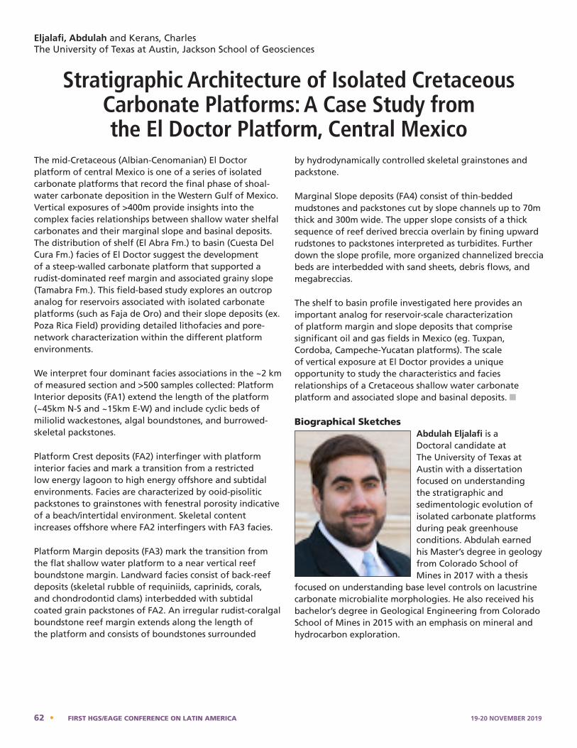
The mid-Cretaceous (Albian-Cenomanian) El Doctor platform of central Mexico is one of a series of isolated carbonate platforms that record the final phase of shoal-water carbonate deposition in the Western Gulf of Mexico. Vertical exposures of >400m provide insights into the complex facies relationships between shallow water shelfal carbonates and their marginal slope and basinal deposits. The distribution of shelf (El Abra Fm.) to basin (Cuesta Del Cura Fm.) facies of El Doctor suggest the development of a steep-walled carbonate platform that supported a rudist-dominated reef margin and associated grainy slope (Tamabra Fm.). This field-based study explores an outcrop analog for reservoirs associated with isolated carbonate platforms (such as Faja de Oro) and their slope deposits (ex. Poza Rica Field) providing detailed lithofacies and pore-network characterization within the different platform environments.
We interpret four dominant facies associations in the ~2 km of measured section and >500 samples collected: Platform Interior deposits (FA1) extend the length of the platform (~45km N-S and ~15km E-W) and include cyclic beds of miliolid wackestones, algal boundstones, and burrowed-skeletal packstones.
Platform Crest deposits (FA2) interfinger with platform interior facies and mark a transition from a restricted low energy lagoon to high energy offshore and subtidal environments. Facies are characterized by ooid-pisolitic packstones to grainstones with fenestral porosity indicative of a beach/intertidal environment. Skeletal content increases offshore where FA2 interfingers with FA3 facies.
Platform Margin deposits (FA3) mark the transition from the flat shallow water platform to a near vertical reef boundstone margin. Landward facies consist of back-reef deposits (skeletal rubble of requiniids, caprinids, corals, and chondrodontid clams) interbedded with subtidal coated grain packstones of FA2. An irregular rudist-coralgal boundstone reef margin extends along the length of the platform and consists of boundstones surrounded
by hydrodynamically controlled skeletal grainstones and packstone.
Marginal Slope deposits (FA4) consist of thin-bedded mudstones and packstones cut by slope channels up to 70m thick and 300m wide. The upper slope consists of a thick sequence of reef derived breccia overlain by fining upward rudstones to packstones interpreted as turbidites. Further down the slope profile, more organized channelized breccia beds are interbedded with sand sheets, debris flows, and megabreccias.
The shelf to basin profile investigated here provides an important analog for reservoir-scale characterization of platform margin and slope deposits that comprise significant oil and gas fields in Mexico (eg. Tuxpan, Cordoba, Campeche-Yu catan platforms). The scale of vertical exposure at El Doctor provides a unique opportunity to study the characteristics and facies relationships of a Cretaceous shallow water carbonate platform and associated slope and basinal deposits. n
Biographical SketchesAbdulah Eljalafi is a Doctoral candidate at The University of Texas at Austin with a dissertation focused on understanding the stratigraphic and sedimentologic evolution of isolated carbonate platforms during peak greenhouse conditions. Abdulah earned his Master’s degree in geology from Colorado School of Mines in 2017 with a thesis
focused on understanding base level controls on lacustrine carbonate microbialite morphologies. He also received his bachelor’s degree in Geological Engineering from Colorado School of Mines in 2015 with an emphasis on mineral and hydrocarbon exploration.
Eljalafi, Abdulah and Kerans, CharlesThe University of Texas at Austin, Jackson School of Geosciences
Stratigraphic Architecture of Isolated Cretaceous Carbonate Platforms: A Case Study from the El Doctor Platform, Central Mexico
exposure at El Doctor provides a unique opportunity to study the characteristics and facies relationships of a Cretaceous shallow water carbonate platform and associated slope and basinal deposits.
Abdulah Eljalafi - Bio
Abdulah Eljalafi is a Doctoral candidate at the University of Texas at Austin with a dissertation focused on understanding the stratigraphic and sedimentologic evolution of isolated carbonate platforms during peak greenhouse conditions. Abdulah earned his Master’s degree in geology from Colorado School of Mines in 2017 with a thesis focused on understanding base level controls on lacustrine carbonate microbialite morphologies. He also received his bachelor’s degree in Geological Engineering from Colorado School of Mines in 2015 with an emphasis on mineral and hydrocarbon exploration.
Charles Kerans - Bio
62 • FIRST HGS/EAGE CONFERENCE ON LATIN AMERICA 19-20 NOVEMBER 2019
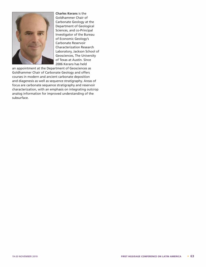
Charles Kerans is the Goldhammer Chair of Carbonate Geology at the Department of Geological Sciences, and co-Principal Investigator of the Bureau of Economic Geology’s Carbonate Reservoir Characterization Research Laboratory, Jackson School of Geosciences, The University of Texas at Austin. Since 2006 Kerans has held
an appointment at the Department of Geosciences as Goldhammer Chair of Carbonate Geology and offers courses in modern and ancient carbonate deposition and diagenesis as well as sequence stratigraphy. Areas of focus are carbonate sequence stratigraphy and reservoir characterization, with an emphasis on integrating outcrop analog information for improved understanding of the subsurface.
Charles Kerans is the Goldhammer Chair of Carbonate Geology at the Department of Geological Sciences, and co-Principal Investigator of the Bureau of Economic Geology's Carbonate Reservoir Characterization Research Laboratory, Jackson School of Geosciences, The University of Texas at Austin. Since 2006 Kerans has held an appointment at the Department of Geosciences as Goldhammer Chair of Carbonate Geology and offers courses in modern and ancient carbonate deposition and diagenesis as well as sequence stratigraphy. Areas of focus are carbonate sequence stratigraphy and reservoir characterization, with an emphasis on integrating outcrop analog information for improved understanding of the subsurface.
19-20 NOVEMBER 2019 FIRST HGS/EAGE CONFERENCE ON LATIN AMERICA • 63
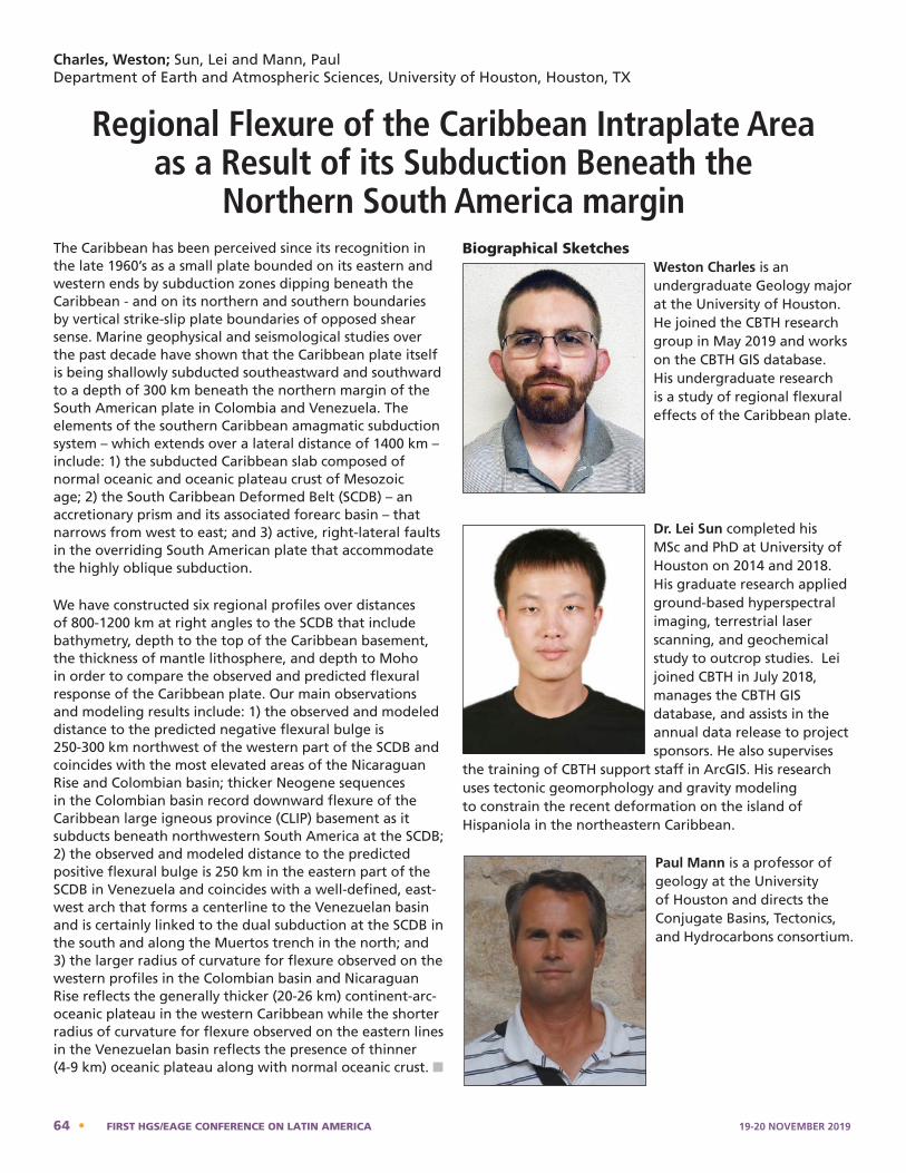
Charles, Weston; Sun, Lei and Mann, PaulDepartment of Earth and Atmospheric Sciences, University of Houston, Houston, TX
Regional Flexure of the Caribbean Intraplate Area as a Result of its Subduction Beneath the
Northern South America marginThe Caribbean has been perceived since its recognition in the late 1960’s as a small plate bounded on its eastern and western ends by subduction zones dipping beneath the Caribbean - and on its northern and southern boundaries by vertical strike-slip plate boundaries of opposed shear sense. Marine geophysical and seismological studies over the past decade have shown that the Caribbean plate itself is being shallowly subducted southeastward and southward to a depth of 300 km beneath the northern margin of the South American plate in Colombia and Venezuela. The elements of the southern Caribbean amagmatic subduction system – which extends over a lateral distance of 1400 km – include: 1) the subducted Caribbean slab composed of normal oceanic and oceanic plateau crust of Mesozoic age; 2) the South Caribbean Deformed Belt (SCDB) – an accretionary prism and its associated forearc basin – that narrows from west to east; and 3) active, right-lateral faults in the overriding South American plate that accommodate the highly oblique subduction.
We have constructed six regional profiles over distances of 800-1200 km at right angles to the SCDB that include bathymetry, depth to the top of the Caribbean basement, the thickness of mantle lithosphere, and depth to Moho in order to compare the observed and predicted flexural response of the Caribbean plate. Our main observations and modeling results include: 1) the observed and modeled distance to the predicted negative flexural bulge is 250-300 km northwest of the western part of the SCDB and coincides with the most elevated areas of the Nicaraguan Rise and Colombian basin; thicker Neogene sequences in the Colombian basin record downward flexure of the Caribbean large igneous province (CLIP) basement as it subducts beneath northwestern South America at the SCDB; 2) the observed and modeled distance to the predicted positive flexural bulge is 250 km in the eastern part of the SCDB in Venezuela and coincides with a well-defined, east-west arch that forms a centerline to the Venezuelan basin and is certainly linked to the dual subduction at the SCDB in the south and along the Muertos trench in the north; and 3) the larger radius of curvature for flexure observed on the western profiles in the Colombian basin and Nicaraguan Rise reflects the generally thicker (20-26 km) continent-arc-oceanic plateau in the western Caribbean while the shorter radius of curvature for flexure observed on the eastern lines in the Venezuelan basin reflects the presence of thinner (4-9 km) oceanic plateau along with normal oceanic crust. n
Biographical SketchesWeston Charles is an undergraduate Geology major at the University of Houston. He joined the CBTH research group in May 2019 and works on the CBTH GIS database. His undergraduate research is a study of regional flexural effects of the Caribbean plate.
Dr. Lei Sun completed his MSc and PhD at University of Houston on 2014 and 2018. His graduate research applied ground-based hyperspectral imaging, terrestrial laser scanning, and geochemical study to outcrop studies. Lei joined CBTH in July 2018, manages the CBTH GIS database, and assists in the annual data release to project sponsors. He also supervises
the training of CBTH support staff in ArcGIS. His research uses tectonic geomorphology and gravity modeling to constrain the recent deformation on the island of Hispaniola in the northeastern Caribbean.
Paul Mann is a professor of geology at the University of Houston and directs the Conjugate Basins, Tectonics, and Hydrocarbons consortium.
Weston Charles – Bio
Weston Charles is an undergraduate Geology major at the University of Houston. He joined the CBTH research group in May 2019 and works on the CBTH GIS database. His undergraduate research is a study of regional flexural effects of the Caribbean plate. Lei Sun – Bio
Dr. Lei Sun completed his MSc and PhD at University of Houston on 2014 and 2018. His graduate research applied ground-based hyperspectral imaging, terrestrial laser scanning, and geochemical study to outcrop studies. Lei joined CBTH in July 2018, manages the CBTH GIS database, and assists in the annual data release to project sponsors. He also supervises the training of CBTH support staff in ArcGIS. His research uses tectonic geomorphology and gravity modeling to constrain the recent deformation on the island of Hispaniola in the northeastern Caribbean.
Paul Mann – Bio
64 • FIRST HGS/EAGE CONFERENCE ON LATIN AMERICA 19-20 NOVEMBER 2019
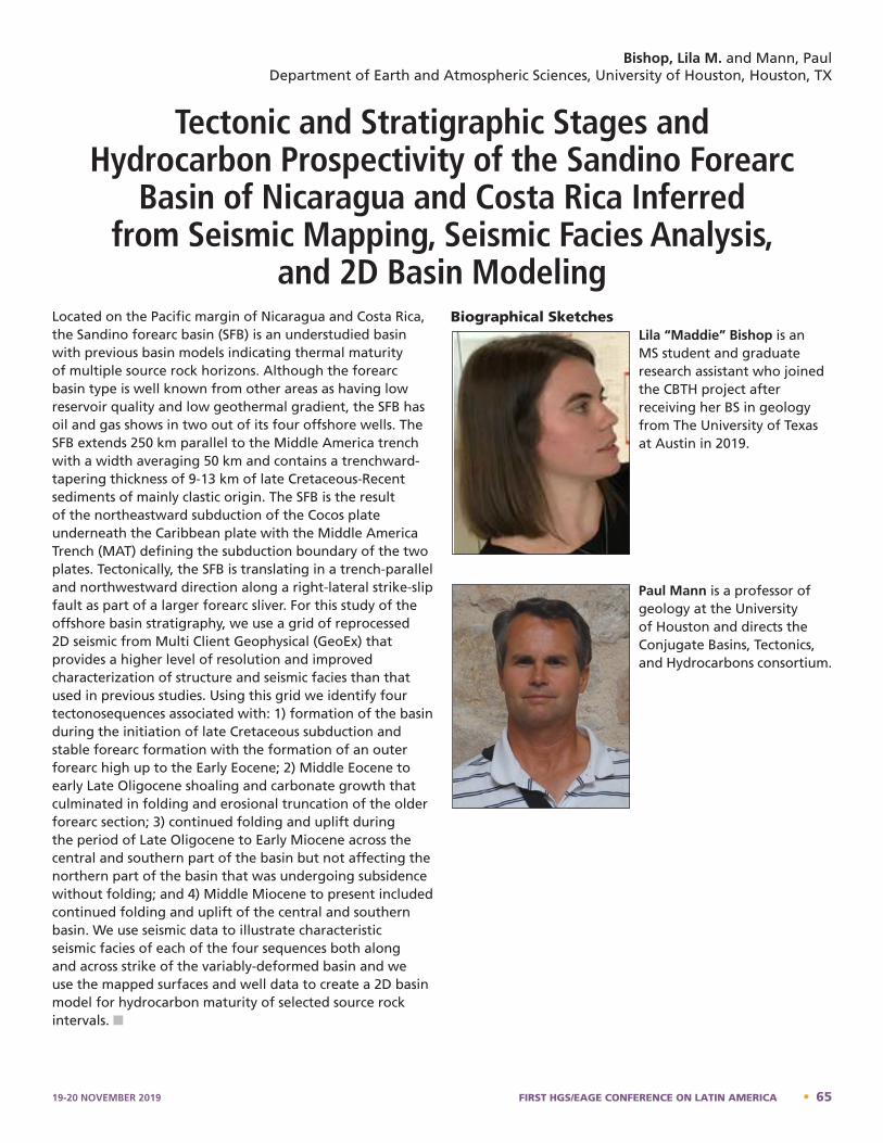
Located on the Pacific margin of Nicaragua and Costa Rica, the Sandino forearc basin (SFB) is an understudied basin with previous basin models indicating thermal maturity of multiple source rock horizons. Although the forearc basin type is well known from other areas as having low reservoir quality and low geothermal gradient, the SFB has oil and gas shows in two out of its four offshore wells. The SFB extends 250 km parallel to the Middle America trench with a width averaging 50 km and contains a trenchward-tapering thickness of 9-13 km of late Cretaceous-Recent sediments of mainly clastic origin. The SFB is the result of the northeastward subduction of the Cocos plate underneath the Caribbean plate with the Middle America Trench (MAT) defining the subduction boundary of the two plates. Tectonically, the SFB is translating in a trench-parallel and northwestward direction along a right-lateral strike-slip fault as part of a larger forearc sliver. For this study of the offshore basin stratigraphy, we use a grid of reprocessed 2D seismic from Multi Client Geophysical (GeoEx) that provides a higher level of resolution and improved characterization of structure and seismic facies than that used in previous studies. Using this grid we identify four tectonosequences associated with: 1) formation of the basin during the initiation of late Cretaceous subduction and stable forearc formation with the formation of an outer forearc high up to the Early Eocene; 2) Middle Eocene to early Late Oligocene shoaling and carbonate growth that culminated in folding and erosional truncation of the older forearc section; 3) continued folding and uplift during the period of Late Oligocene to Early Miocene across the central and southern part of the basin but not affecting the northern part of the basin that was undergoing subsidence without folding; and 4) Middle Miocene to present included continued folding and uplift of the central and southern basin. We use seismic data to illustrate characteristic seismic facies of each of the four sequences both along and across strike of the variably-deformed basin and we use the mapped surfaces and well data to create a 2D basin model for hydrocarbon maturity of selected source rock intervals. n
Biographical SketchesLila “Maddie” Bishop is an MS student and graduate research assistant who joined the CBTH project after receiving her BS in geology from The University of Texas at Austin in 2019.
Paul Mann is a professor of geology at the University of Houston and directs the Conjugate Basins, Tectonics, and Hydrocarbons consortium.
Bishop, Lila M. and Mann, PaulDepartment of Earth and Atmospheric Sciences, University of Houston, Houston, TX
Tectonic and Stratigraphic Stages and Hydrocarbon Prospectivity of the Sandino Forearc
Basin of Nicaragua and Costa Rica Inferred from Seismic Mapping, Seismic Facies Analysis,
and 2D Basin Modeling
Lila Bishop – Bio
Lila "Maddie" Bishop is an MS student and graduate research assistant who joined the CBTH project after receiving her BS in geology from The University of Texas at Austin in 2019. Paul Mann – Bio
19-20 NOVEMBER 2019 FIRST HGS/EAGE CONFERENCE ON LATIN AMERICA • 65
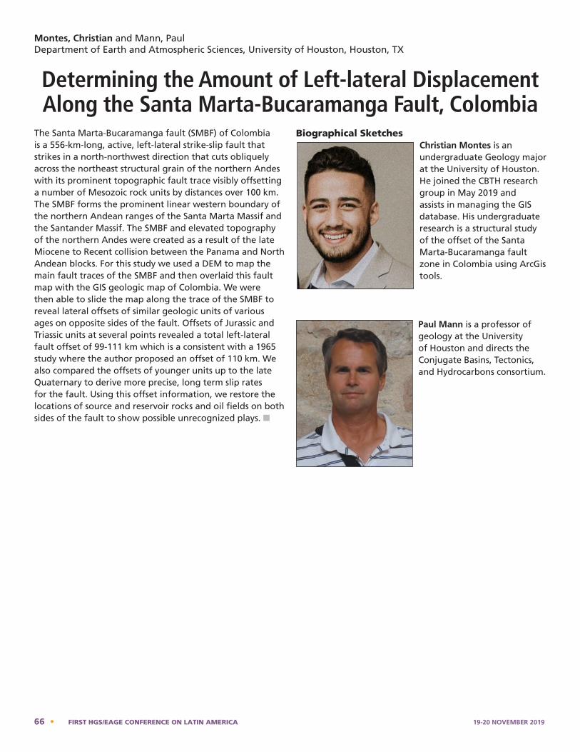
Montes, Christian and Mann, PaulDepartment of Earth and Atmospheric Sciences, University of Houston, Houston, TX
Determining the Amount of Left-lateral Displacement Along the Santa Marta-Bucaramanga Fault, Colombia
The Santa Marta-Bucaramanga fault (SMBF) of Colombia is a 556-km-long, active, left-lateral strike-slip fault that strikes in a north-northwest direction that cuts obliquely across the northeast structural grain of the northern Andes with its prominent topographic fault trace visibly offsetting a number of Mesozoic rock units by distances over 100 km. The SMBF forms the prominent linear western boundary of the northern Andean ranges of the Santa Marta Massif and the Santander Massif. The SMBF and elevated topography of the northern Andes were created as a result of the late Miocene to Recent collision between the Panama and North Andean blocks. For this study we used a DEM to map the main fault traces of the SMBF and then overlaid this fault map with the GIS geologic map of Colombia. We were then able to slide the map along the trace of the SMBF to reveal lateral offsets of similar geologic units of various ages on opposite sides of the fault. Offsets of Jurassic and Triassic units at several points revealed a total left-lateral fault offset of 99-111 km which is a consistent with a 1965 study where the author proposed an offset of 110 km. We also compared the offsets of younger units up to the late Quaternary to derive more precise, long term slip rates for the fault. Using this offset information, we restore the locations of source and reservoir rocks and oil fields on both sides of the fault to show possible unrecognized plays. n
Biographical SketchesChristian Montes is an undergraduate Geology major at the University of Houston. He joined the CBTH research group in May 2019 and assists in managing the GIS database. His undergraduate research is a structural study of the offset of the Santa Marta-Bucaramanga fault zone in Colombia using ArcGis tools.
Paul Mann is a professor of geology at the University of Houston and directs the Conjugate Basins, Tectonics, and Hydrocarbons consortium.
Christian Montes – Bio
Christian Montes is an undergraduate Geology major at the University of Houston. He joined the CBTH research group in May 2019 and assists in managing the GIS database. His undergraduate research is a structural study of the offset of the Santa Marta-Bucaramanga fault zone in Colombia using ArcGis tools.
Paul Mann – Bio
66 • FIRST HGS/EAGE CONFERENCE ON LATIN AMERICA 19-20 NOVEMBER 2019
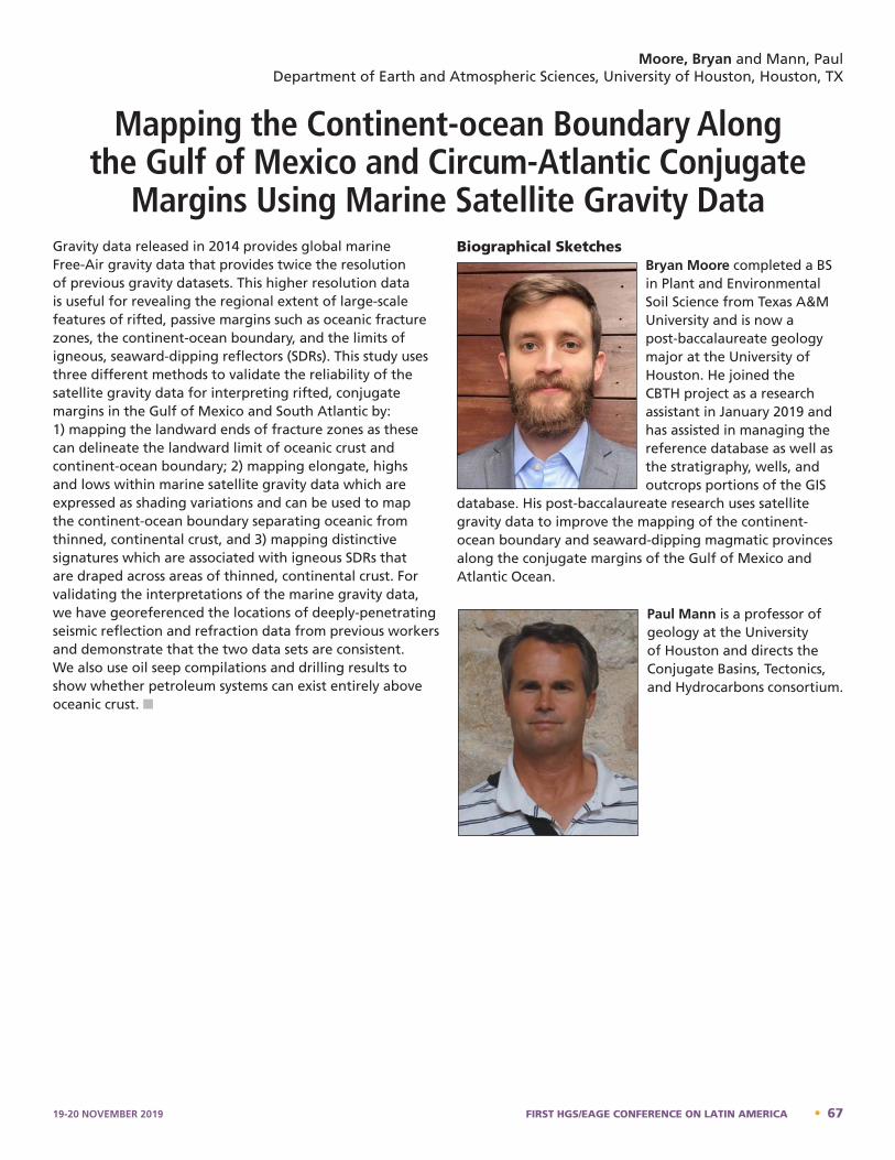
Gravity data released in 2014 provides global marine Free-Air gravity data that provides twice the resolution of previous gravity datasets. This higher resolution data is useful for revealing the regional extent of large-scale features of rifted, passive margins such as oceanic fracture zones, the continent-ocean boundary, and the limits of igneous, seaward-dipping reflectors (SDRs). This study uses three different methods to validate the reliability of the satellite gravity data for interpreting rifted, conjugate margins in the Gulf of Mexico and South Atlantic by: 1) mapping the landward ends of fracture zones as these can delineate the landward limit of oceanic crust and continent-ocean boundary; 2) mapping elongate, highs and lows within marine satellite gravity data which are expressed as shading variations and can be used to map the continent-ocean boundary separating oceanic from thinned, continental crust, and 3) mapping distinctive signatures which are associated with igneous SDRs that are draped across areas of thinned, continental crust. For validating the interpretations of the marine gravity data, we have georeferenced the locations of deeply-penetrating seismic reflection and refraction data from previous workers and demonstrate that the two data sets are consistent. We also use oil seep compilations and drilling results to show whether petroleum systems can exist entirely above oceanic crust. n
Biographical SketchesBryan Moore completed a BS in Plant and Environmental Soil Science from Texas A&M University and is now a post-baccalaureate geology major at the University of Houston. He joined the CBTH project as a research assistant in January 2019 and has assisted in managing the reference database as well as the stratigraphy, wells, and outcrops portions of the GIS
database. His post-baccalaureate research uses satellite gravity data to improve the mapping of the continent-ocean boundary and seaward-dipping magmatic provinces along the conjugate margins of the Gulf of Mexico and Atlantic Ocean.
Paul Mann is a professor of geology at the University of Houston and directs the Conjugate Basins, Tectonics, and Hydrocarbons consortium.
Moore, Bryan and Mann, PaulDepartment of Earth and Atmospheric Sciences, University of Houston, Houston, TX
Mapping the Continent-ocean Boundary Along the Gulf of Mexico and Circum-Atlantic Conjugate
Margins Using Marine Satellite Gravity DataBryan Moore – Bio
Bryan Moore completed a BS in Plant and Environmental Soil Science from Texas A&M University and is now a post-baccalaureate geology major at the University of Houston. He joined the CBTH project as a research assistant in January 2019 and has assisted in managing the reference database as well as the stratigraphy, wells, and outcrops portions of the GIS database. His post-baccalaureate research uses satellite gravity data to improve the mapping of the continent-ocean boundary and seaward-dipping magmatic provinces along the conjugate margins of the Gulf of Mexico and Atlantic Ocean.
Paul Mann – Bio
19-20 NOVEMBER 2019 FIRST HGS/EAGE CONFERENCE ON LATIN AMERICA • 67
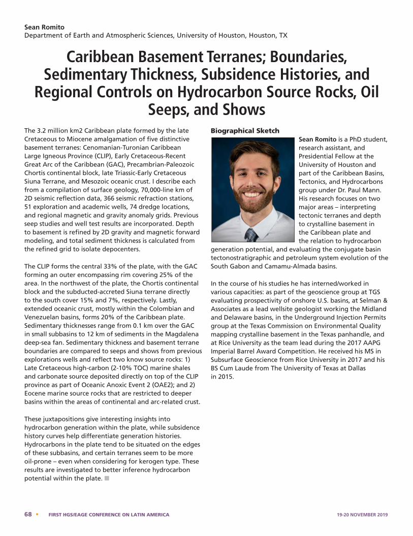
Sean RomitoDepartment of Earth and Atmospheric Sciences, University of Houston, Houston, TX
Caribbean Basement Terranes; Boundaries, Sedimentary Thickness, Subsidence Histories, and
Regional Controls on Hydrocarbon Source Rocks, Oil Seeps, and Shows
The 3.2 million km2 Caribbean plate formed by the late Cretaceous to Miocene amalgamation of five distinctive basement terranes: Cenomanian-Turonian Caribbean Large Igneous Province (CLIP), Early Cretaceous-Recent Great Arc of the Caribbean (GAC), Precambrian-Paleozoic Chortis continental block, late Triassic-Early Cretaceous Siuna Terrane, and Mesozoic oceanic crust. I describe each from a compilation of surface geology, 70,000-line km of 2D seismic reflection data, 366 seismic refraction stations, 51 exploration and academic wells, 74 dredge locations, and regional magnetic and gravity anomaly grids. Previous seep studies and well test results are incorporated. Depth to basement is refined by 2D gravity and magnetic forward modeling, and total sediment thickness is calculated from the refined grid to isolate depocenters.
The CLIP forms the central 33% of the plate, with the GAC forming an outer encompassing rim covering 25% of the area. In the northwest of the plate, the Chortis continental block and the subducted-accreted Siuna terrane directly to the south cover 15% and 7%, respectively. Lastly, extended oceanic crust, mostly within the Colombian and Venezuelan basins, forms 20% of the Caribbean plate. Sedimentary thicknesses range from 0.1 km over the GAC in small subbasins to 12 km of sediments in the Magdalena deep-sea fan. Sedimentary thickness and basement terrane boundaries are compared to seeps and shows from previous explorations wells and reflect two know source rocks: 1) Late Cretaceous high-carbon (2-10% TOC) marine shales and carbonate source deposited directly on top of the CLIP province as part of Oceanic Anoxic Event 2 (OAE2); and 2) Eocene marine source rocks that are restricted to deeper basins within the areas of continental and arc-related crust.
These juxtapositions give interesting insights into hydrocarbon generation within the plate, while subsidence history curves help differentiate generation histories. Hydrocarbons in the plate tend to be situated on the edges of these subbasins, and certain terranes seem to be more oil-prone – even when considering for kerogen type. These results are investigated to better inference hydrocarbon potential within the plate. n
Biographical SketchSean Romito is a PhD student, research assistant, and Presidential Fellow at the University of Houston and part of the Caribbean Basins, Tectonics, and Hydrocarbons group under Dr. Paul Mann. His research focuses on two major areas – interpreting tectonic terranes and depth to crystalline basement in the Caribbean plate and the relation to hydrocarbon
generation potential, and evaluating the conjugate basin tectonostratigraphic and petroleum system evolution of the South Gabon and Camamu-Almada basins.
In the course of his studies he has interned/worked in various capacities: as part of the geoscience group at TGS evaluating prospectivity of onshore U.S. basins, at Selman & Associates as a lead wellsite geologist working the Midland and Delaware basins, in the Underground Injection Permits group at the Texas Commission on Environmental Quality mapping crystalline basement in the Texas panhandle, and at Rice University as the team lead during the 2017 AAPG Imperial Barrel Award Competition. He received his MS in Subsurface Geoscience from Rice University in 2017 and his BS Cum Laude from The University of Texas at Dallas in 2015.
Sean Romito - Bio
Sean Romito is a PhD student, research assistant, and Presidential Fellow at the University of Houston and part of the Caribbean Basins, Tectonics, and Hydrocarbons group under Dr. Paul Mann. His research focuses on two major areas – interpreting tectonic terranes and depth to crystalline basement in the Caribbean plate and the relation to hydrocarbon generation potential, and evaluating the conjugate basin tectonostratigraphic and petroleum system evolution of the South Gabon and Camamu-Almada basins. In the course of his studies he has interned/worked in various capacities: as part of the geoscience group at TGS evaluating prospectivity of onshore US basins, at Selman & Associates as a lead wellsite geologist working the Midland and Delaware basins, in the Underground Injection Permits group at the Texas Commission on Environmental Quality mapping crystalline basement in the Texas panhandle, and at Rice University as the team lead during the 2017 AAPG Imperial Barrel Award Competition. He received his M.S. in Subsurface Geoscience from Rice University in 2017 and his B.S. Cum Laude from the University of Texas at Dallas in 2015.
68 • FIRST HGS/EAGE CONFERENCE ON LATIN AMERICA 19-20 NOVEMBER 2019
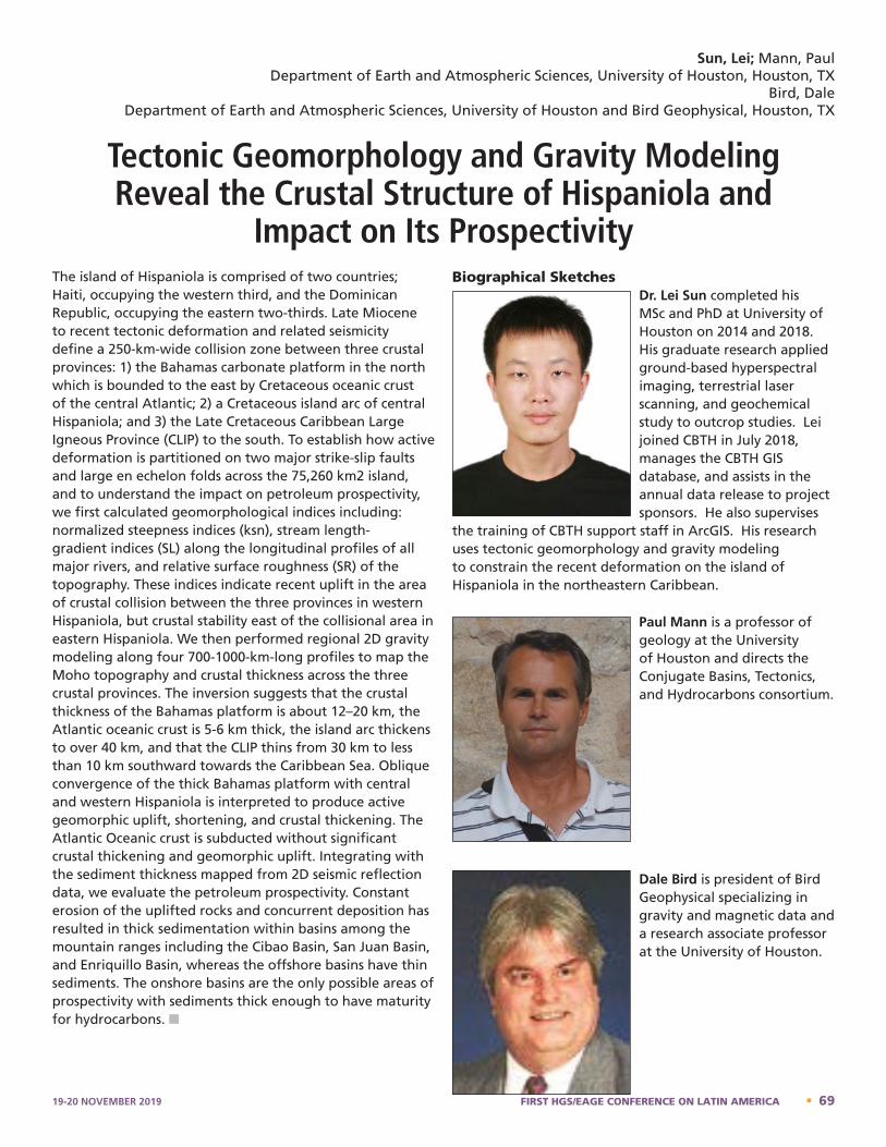
The island of Hispaniola is comprised of two countries; Haiti, occupying the western third, and the Dominican Republic, occupying the eastern two-thirds. Late Miocene to recent tectonic deformation and related seismicity define a 250-km-wide collision zone between three crustal provinces: 1) the Bahamas carbonate platform in the north which is bounded to the east by Cretaceous oceanic crust of the central Atlantic; 2) a Cretaceous island arc of central Hispaniola; and 3) the Late Cretaceous Caribbean Large Igneous Province (CLIP) to the south. To establish how active deformation is partitioned on two major strike-slip faults and large en echelon folds across the 75,260 km2 island, and to understand the impact on petroleum prospectivity, we first calculated geomorphological indices including: normalized steepness indices (ksn), stream length-gradient indices (SL) along the longitudinal profiles of all major rivers, and relative surface roughness (SR) of the topography. These indices indicate recent uplift in the area of crustal collision between the three provinces in western Hispaniola, but crustal stability east of the collisional area in eastern Hispaniola. We then performed regional 2D gravity modeling along four 700-1000-km-long profiles to map the Moho topography and crustal thickness across the three crustal provinces. The inversion suggests that the crustal thickness of the Bahamas platform is about 12–20 km, the Atlantic oceanic crust is 5-6 km thick, the island arc thickens to over 40 km, and that the CLIP thins from 30 km to less than 10 km southward towards the Caribbean Sea. Oblique convergence of the thick Bahamas platform with central and western Hispaniola is interpreted to produce active geomorphic uplift, shortening, and crustal thickening. The Atlantic Oceanic crust is subducted without significant crustal thickening and geomorphic uplift. Integrating with the sediment thickness mapped from 2D seismic reflection data, we evaluate the petroleum prospectivity. Constant erosion of the uplifted rocks and concurrent deposition has resulted in thick sedimentation within basins among the mountain ranges including the Cibao Basin, San Juan Basin, and Enriquillo Basin, whereas the offshore basins have thin sediments. The onshore basins are the only possible areas of prospectivity with sediments thick enough to have maturity for hydrocarbons. n
Biographical SketchesDr. Lei Sun completed his MSc and PhD at University of Houston on 2014 and 2018. His graduate research applied ground-based hyperspectral imaging, terrestrial laser scanning, and geochemical study to outcrop studies. Lei joined CBTH in July 2018, manages the CBTH GIS database, and assists in the annual data release to project sponsors. He also supervises
the training of CBTH support staff in ArcGIS. His research uses tectonic geomorphology and gravity modeling to constrain the recent deformation on the island of Hispaniola in the northeastern Caribbean.
Paul Mann is a professor of geology at the University of Houston and directs the Conjugate Basins, Tectonics, and Hydrocarbons consortium.
Dale Bird is president of Bird Geophysical specializing in gravity and magnetic data and a research associate professor at the University of Houston.
Sun, Lei; Mann, PaulDepartment of Earth and Atmospheric Sciences, University of Houston, Houston, TX
Bird, DaleDepartment of Earth and Atmospheric Sciences, University of Houston and Bird Geophysical, Houston, TX
Tectonic Geomorphology and Gravity Modeling Reveal the Crustal Structure of Hispaniola and
Impact on Its Prospectivity
Dale Bird – Bio
Dale Bird is president of Bird Geophysical specializing in gravity and magnetic data and a research associate professor at the University of Houston.
Dr. Lei Sun completed his MSc and PhD at University of Houston on 2014 and 2018. His graduate research applied ground-based hyperspectral imaging, terrestrial laser scanning, and geochemical study to outcrop studies. Lei joined CBTH in July 2018, manages the CBTH GIS database, and assists in the annual data release to project sponsors. He also supervises the training of CBTH support staff in ArcGIS. His research uses tectonic geomorphology and gravity modeling to constrain the recent deformation on the island of Hispaniola in the northeastern Caribbean.
Paul Mann – Bio
19-20 NOVEMBER 2019 FIRST HGS/EAGE CONFERENCE ON LATIN AMERICA • 69
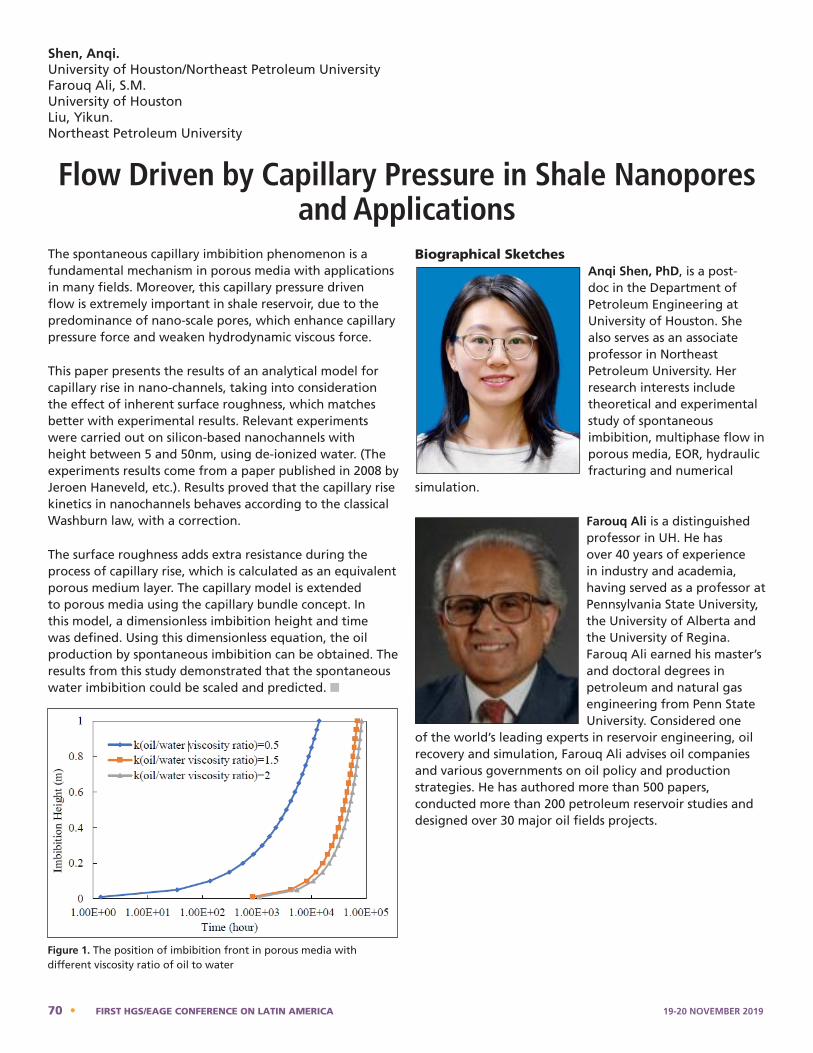
Shen, Anqi.University of Houston/Northeast Petroleum UniversityFarouq Ali, S.M.University of HoustonLiu, Yikun.Northeast Petroleum University
Flow Driven by Capillary Pressure in Shale Nanopores and Applications
The spontaneous capillary imbibition phenomenon is a fundamental mechanism in porous media with applications in many fields. Moreover, this capillary pressure driven flow is extremely important in shale reservoir, due to the predominance of nano-scale pores, which enhance capillary pressure force and weaken hydrodynamic viscous force.
This paper presents the results of an analytical model for capillary rise in nano-channels, taking into consideration the effect of inherent surface roughness, which matches better with experimental results. Relevant experiments were carried out on silicon-based nanochannels with height between 5 and 50nm, using de-ionized water. (The experiments results come from a paper published in 2008 by Jeroen Haneveld, etc.). Results proved that the capillary rise kinetics in nanochannels behaves according to the classical Washburn law, with a correction.
The surface roughness adds extra resistance during the process of capillary rise, which is calculated as an equivalent porous medium layer. The capillary model is extended to porous media using the capillary bundle concept. In this model, a dimensionless imbibition height and time was defined. Using this dimensionless equation, the oil production by spontaneous imbibition can be obtained. The results from this study demonstrated that the spontaneous water imbibition could be scaled and predicted. n
Biographical SketchesAnqi Shen, PhD, is a post-doc in the Department of Petroleum Engineering at University of Houston. She also serves as an associate professor in Northeast Petroleum University. Her research interests include theoretical and experimental study of spontaneous imbibition, multiphase flow in porous media, EOR, hydraulic fracturing and numerical
simulation.
Farouq Ali is a distinguished professor in UH. He has over 40 years of experience in industry and academia, having served as a professor at Pennsylvania State University, the University of Alberta and the University of Regina. Farouq Ali earned his master’s and doctoral degrees in petroleum and natural gas engineering from Penn State University. Considered one
of the world’s leading experts in reservoir engineering, oil recovery and simulation, Farouq Ali advises oil companies and various governments on oil policy and production strategies. He has authored more than 500 papers, conducted more than 200 petroleum reservoir studies and designed over 30 major oil fields projects.
Anqi Shen - Bio
Anqi Shen, PhD, is a post-doc in the Department of Petroleum Engineering at University of Houston. She also serves as an associate professor in Northeast Petroleum University. Her research interests include theoretical and experimental study of spontaneous imbibition, multiphase flow in porous media, EOR, hydraulic fracturing and numerical simulation. Farouq Ali - Bio
Farouq Ali is a distinguished professor in UH. He has over 40 years of experience in industry and academia, having served as a professor at Pennsylvania State University, the University of Alberta and the University of Regina. Farouq Ali earned his master’s and doctoral degrees in petroleum and natural gas engineering from Penn State University. Considered one of the world’s leading experts in reservoir engineering, oil recovery and simulation, Farouq Ali advises oil companies and various governments on oil policy and production strategies. He has authored more than 500 papers, conducted more than 200 petroleum reservoir studies and designed over 30 major oil fields projects.
Flow Driven by Capillary Pressure in Shale Nanopores and Applications
Shen, Anqi. University of Houston/Northeast Petroleum University Farouq Ali, S.M. University of Houston
Liu, Yikun. Northeast Petroleum University The spontaneous capillary imbibition phenomenon is a fundamental mechanism in porous media with applications in many fields. Moreover, this capillary pressure driven flow is extremely important in shale reservoir, due to the predominance of nano-scale pores, which enhance capillary pressure force and weaken hydrodynamic viscous force. This paper presents the results of an analytical model for capillary rise in nano-channels, taking into consideration the effect of inherent surface roughness, which matches better with experimental results. Relevant experiments were carried out on silicon-based nanochannels with height between 5 and 50nm, using de-ionized water. (The experiments results come from a paper published in 2008 by Jeroen Haneveld, etc.). Results proved that the capillary rise kinetics in nanochannels behaves according to the classical Washburn law, with a correction. The surface roughness adds extra resistance during the process of capillary rise, which is calculated as an equivalent porous medium layer. The capillary model is extended to porous media using the capillary bundle concept. In this model, a dimensionless imbibition height and time was defined. Using this dimensionless equation, the oil production by spontaneous imbibition can be obtained. The results from this study demonstrated that the spontaneous water imbibition could be scaled and predicted.
Fig.1 The position of imbibition front in porous media with different viscosity ratio of oil to water Figure 1. The position of imbibition front in porous media with different viscosity ratio of oil to water
70 • FIRST HGS/EAGE CONFERENCE ON LATIN AMERICA 19-20 NOVEMBER 2019
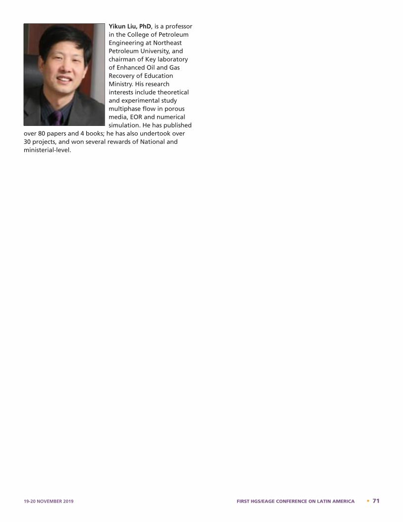
Yikun Liu, PhD, is a professor in the College of Petroleum Engineering at Northeast Petroleum University, and chairman of Key laboratory of Enhanced Oil and Gas Recovery of Education Ministry. His research interests include theoretical and experimental study multiphase flow in porous media, EOR and numerical simulation. He has published
over 80 papers and 4 books; he has also undertook over 30 projects, and won several rewards of National and ministerial-level.
Yikun Liu - Bio
Yikun Liu, PhD, is a professor in the College of Petroleum Engineering at Northeast Petroleum University, and chairman of Key laboratory of Enhanced Oil and Gas Recovery of Education Ministry. His research interests include theoretical and experimental study multiphase flow in porous media, EOR and numerical simulation. He has published over 80 papers and 4 books; he has also undertook over 30 projects, and won several rewards of National and ministerial-level.
19-20 NOVEMBER 2019 FIRST HGS/EAGE CONFERENCE ON LATIN AMERICA • 71
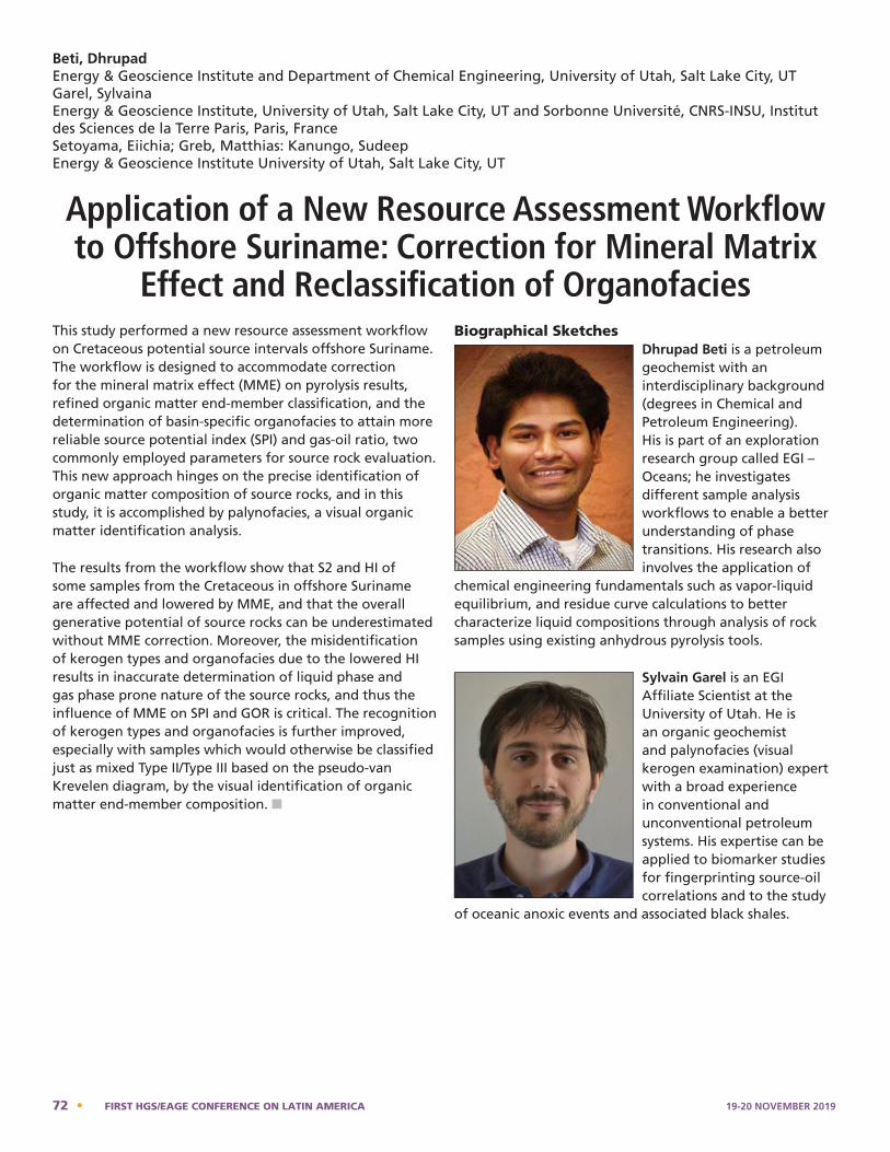
This study performed a new resource assessment workflow on Cretaceous potential source intervals offshore Suriname. The workflow is designed to accommodate correction for the mineral matrix effect (MME) on pyrolysis results, refined organic matter end-member classification, and the determination of basin-specific organofacies to attain more reliable source potential index (SPI) and gas-oil ratio, two commonly employed parameters for source rock evaluation. This new approach hinges on the precise identification of organic matter composition of source rocks, and in this study, it is accomplished by palynofacies, a visual organic matter identification analysis.
The results from the workflow show that S2 and HI of some samples from the Cretaceous in offshore Suriname are affected and lowered by MME, and that the overall generative potential of source rocks can be underestimated without MME correction. Moreover, the misidentification of kerogen types and organofacies due to the lowered HI results in inaccurate determination of liquid phase and gas phase prone nature of the source rocks, and thus the influence of MME on SPI and GOR is critical. The recognition of kerogen types and organofacies is further improved, especially with samples which would otherwise be classified just as mixed Type II/Type III based on the pseudo-van Krevelen diagram, by the visual identification of organic matter end-member composition. n
Biographical SketchesDhrupad Beti is a petroleum geochemist with an interdisciplinary background (degrees in Chemical and Petroleum Engineering). His is part of an exploration research group called EGI – Oceans; he investigates different sample analysis workflows to enable a better understanding of phase transitions. His research also involves the application of
chemical engineering fundamentals such as vapor-liquid equilibrium, and residue curve calculations to better characterize liquid compositions through analysis of rock samples using existing anhydrous pyrolysis tools.
Sylvain Garel is an EGI Affiliate Scientist at the University of Utah. He is an organic geochemist and palynofacies (visual kerogen examination) expert with a broad experience in conventional and unconventional petroleum systems. His expertise can be applied to biomarker studies for fingerprinting source-oil correlations and to the study
of oceanic anoxic events and associated black shales. Sylvain Garel is an EGI Affiliate Scientist at the University of Utah. He is an organic geochemist and palynofacies (visual kerogen examination) expert with a broad experience in conventionaland unconventional petroleum systems. His expertise can be applied to biomarker studies for fingerprinting source-oil correlations and to the study of oceanic anoxic events and associatedblack shales.
Beti, DhrupadEnergy & Geoscience Institute and Department of Chemical Engineering, University of Utah, Salt Lake City, UTGarel, Sylvaina Energy & Geoscience Institute, University of Utah, Salt Lake City, UT and Sorbonne Université, CNRS-INSU, Institut des Sciences de la Terre Paris, Paris, FranceSetoyama, Eiichia; Greb, Matthias: Kanungo, SudeepEnergy & Geoscience Institute University of Utah, Salt Lake City, UT
Application of a New Resource Assessment Workflow to Offshore Suriname: Correction for Mineral Matrix
Effect and Reclassification of OrganofaciesDhrupad Beti - Bio
Dhrupad Beti is a petroleum geochemist with an interdisciplinary background (degrees in Chemical and Petroleum Engineering). His is part of an exploration research group called EGI – Oceans; he investigates different sample analysis workflows to enable a better understandingof phase transitions. His research also involves the application of chemical engineering fundamentals such as vapor-liquid equilibrium, and residue curve calculations to better characterize liquid compositions through analysis of rock samples using existing anhydrous pyrolysis tools.
Sylvain Garel - Bio
72 • FIRST HGS/EAGE CONFERENCE ON LATIN AMERICA 19-20 NOVEMBER 2019
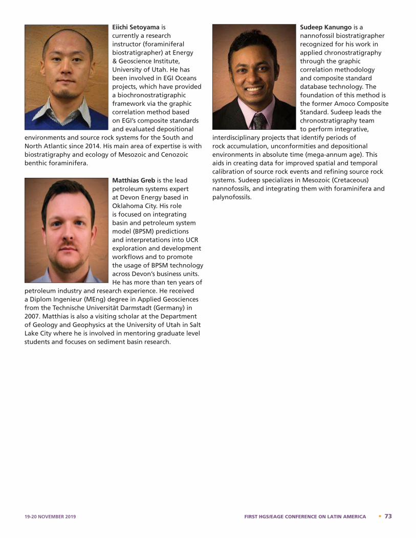
Eiichi Setoyama is currently a research instructor (foraminiferal biostratigrapher) at Energy & Geoscience Institute, University of Utah. He has been involved in EGI Oceans projects, which have provided a biochronostratigraphic framework via the graphic correlation method based on EGI’s composite standards and evaluated depositional
environments and source rock systems for the South and North Atlantic since 2014. His main area of expertise is with biostratigraphy and ecology of Mesozoic and Cenozoic benthic foraminifera.
Matthias Greb is the lead petroleum systems expert at Devon Energy based in Oklahoma City. His role is focused on integrating basin and petroleum system model (BPSM) predictions and interpretations into UCR exploration and development workflows and to promote the usage of BPSM technology across Devon’s business units. He has more than ten years of
petroleum industry and research experience. He received a Diplom Ingenieur (MEng) degree in Applied Geosciences from the Technische Universität Darmstadt (Germany) in 2007. Matthias is also a visiting scholar at the Department of Geology and Geophysics at the University of Utah in Salt Lake City where he is involved in mentoring graduate level students and focuses on sediment basin research.
Sudeep Kanungo is a nannofossil biostratigrapher recognized for his work in applied chronostratigraphy through the graphic correlation methodology and composite standard database technology. The foundation of this method is the former Amoco Composite Standard. Sudeep leads the chronostratigraphy team to perform integrative,
interdisciplinary projects that identify periods of rock accumulation, unconformities and depositional environments in absolute time (mega-annum age). This aids in creating data for improved spatial and temporal calibration of source rock events and refining source rock systems. Sudeep specializes in Mesozoic (Cretaceous) nannofossils, and integrating them with foraminifera and palynofossils.
Eiichi Setoyama - Bio
Eiichi Setoyama is currently a research instructor (foraminiferal biostratigrapher) at Energy & Geoscience Institute, University of Utah. He has been involved in EGI Oceans projects, which have provided a biochronostratigraphic framework via the graphic correlation method based on EGI's composite standards and evaluated depositional environments and source rock systems for the South and North Atlantic since 2014. His main area of expertise is with biostratigraphy and ecology of Mesozoic and Cenozoic benthic foraminifera. Matthias Greb – Bio
Sudeep Kanungo is a nannofossil biostratigrapher recognized for his work in applied chronostratigraphy through the graphic correlation methodology and composite standard database technology. The foundation of this method is the former Amoco Composite Standard. Sudeep leads the chronostratigraphy team to perform integrative, interdisciplinary projects that identify periods of rock accumulation, unconformities and depositional environments in absolute time (mega-annum age). This aids in creating data for improved spatial and temporal calibration of source rock events and refining source rock systems. Sudeep specializes in Mesozoic (Cretaceous) nannofossils, and integrating them with foraminifera and palynofossils.
Matthias is the lead petroleum systems expert at Devon Energy based in Oklahoma City. His role is focused on integrating basin and petroleum system model (BPSM) predictions and interpretations into UCR exploration and development workflows and to promote the usage of BPSM technology across Devon’s business units. He has more than ten years of petroleum industry and research experience. He received a Diplom Ingenieur (MEng) degree in Applied Geosciences from the Technische Universität Darmstadt (Germany) in 2007. Matthias is also a visiting scholar at the Department of Geology and Geophysics at the University of Utah in Salt Lake City where he is involved in mentoring graduate level students and focuses on sediment basin research. Sudeep Kanungo - Bio
19-20 NOVEMBER 2019 FIRST HGS/EAGE CONFERENCE ON LATIN AMERICA • 73
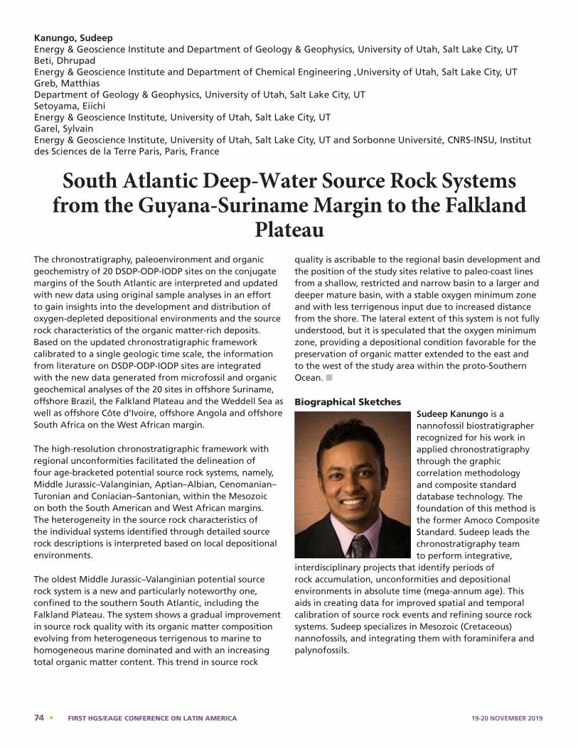
The chronostratigraphy, paleoenvironment and organic geochemistry of 20 DSDP-ODP-IODP sites on the conjugate margins of the South Atlantic are interpreted and updated with new data using original sample analyses in an effort to gain insights into the development and distribution of oxygen-depleted depositional environments and the source rock characteristics of the organic matter-rich deposits. Based on the updated chronostratigraphic framework calibrated to a single geologic time scale, the information from literature on DSDP-ODP-IODP sites are integrated with the new data generated from microfossil and organic geochemical analyses of the 20 sites in offshore Suriname, offshore Brazil, the Falkland Plateau and the Weddell Sea as well as offshore Côte d’Ivoire, offshore Angola and offshore South Africa on the West African margin.
The high-resolution chronostratigraphic framework with regional unconformities facilitated the delineation of four age-bracketed potential source rock systems, namely, Middle Jurassic–Valanginian, Aptian–Albian, Cenomanian–Turonian and Coniacian–Santonian, within the Mesozoic on both the South American and West African margins. The heterogeneity in the source rock characteristics of the individual systems identified through detailed source rock descriptions is interpreted based on local depositional environments.
The oldest Middle Jurassic–Valanginian potential source rock system is a new and particularly noteworthy one, confined to the southern South Atlantic, including the Falkland Plateau. The system shows a gradual improvement in source rock quality with its organic matter composition evolving from heterogeneous terrigenous to marine to homogeneous marine dominated and with an increasing total organic matter content. This trend in source rock
quality is ascribable to the regional basin development and the position of the study sites relative to paleo-coast lines from a shallow, restricted and narrow basin to a larger and deeper mature basin, with a stable oxygen minimum zone and with less terrigenous input due to increased distance from the shore. The lateral extent of this system is not fully understood, but it is speculated that the oxygen minimum zone, providing a depositional condition favorable for the preservation of organic matter extended to the east and to the west of the study area within the proto-Southern Ocean. n
Biographical SketchesSudeep Kanungo is a nannofossil biostratigrapher recognized for his work in applied chronostratigraphy through the graphic correlation methodology and composite standard database technology. The foundation of this method is the former Amoco Composite Standard. Sudeep leads the chronostratigraphy team to perform integrative,
interdisciplinary projects that identify periods of rock accumulation, unconformities and depositional environments in absolute time (mega-annum age). This aids in creating data for improved spatial and temporal calibration of source rock events and refining source rock systems. Sudeep specializes in Mesozoic (Cretaceous) nannofossils, and integrating them with foraminifera and palynofossils.
Kanungo, SudeepEnergy & Geoscience Institute and Department of Geology & Geophysics, University of Utah, Salt Lake City, UTBeti, Dhrupad Energy & Geoscience Institute and Department of Chemical Engineering ,University of Utah, Salt Lake City, UTGreb, MatthiasDepartment of Geology & Geophysics, University of Utah, Salt Lake City, UTSetoyama, EiichiEnergy & Geoscience Institute, University of Utah, Salt Lake City, UTGarel, SylvainEnergy & Geoscience Institute, University of Utah, Salt Lake City, UT and Sorbonne Université, CNRS-INSU, Institut des Sciences de la Terre Paris, Paris, France
South Atlantic Deep-Water Source Rock Systems from the Guyana-Suriname Margin to the Falkland
Plateau
Sudeep Kanungo is a nannofossil biostratigrapher recognized for his work in applied chronostratigraphy through the graphic correlation methodology and composite standard database technology. The foundation of this method is the former Amoco Composite Standard. Sudeep leads the chronostratigraphy team to perform integrative, interdisciplinary projects that identify periods of rock accumulation, unconformities and depositional environments in absolute time (mega-annum age). This aids in creating data for improved spatial and temporal calibration of source rock events and refining source rock systems. Sudeep specializes in Mesozoic (Cretaceous) nannofossils, and integrating them with foraminifera and palynofossils.
74 • FIRST HGS/EAGE CONFERENCE ON LATIN AMERICA 19-20 NOVEMBER 2019
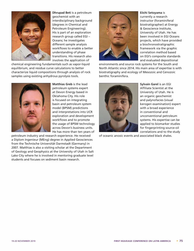
Sylvain Garel is an EGI Affiliate Scientist at the University of Utah. He is an organic geochemist and palynofacies (visual kerogen examination) expert with a broad experience in conventional and unconventional petroleum systems. His expertise can be applied to biomarker studies for fingerprinting source-oil correlations and to the study of oceanic anoxic events and associated black shales.
Dhrupad Beti - Bio
Dhrupad Beti is a petroleum geochemist with an interdisciplinary background (degrees in Chemical and Petroleum Engineering). His is part of an exploration research group called EGI – Oceans; he investigates different sample analysis workflows to enable a better understanding of phase transitions. His research also involves the application of chemical engineering fundamentals such as vapor-liquid equilibrium, and residue curve calculations to better characterize liquid compositions through analysis of rock samples using existing anhydrous pyrolysis tools. Sylvain Garel - Bio
Dhrupad Beti is a petroleum geochemist with an interdisciplinary background (degrees in Chemical and Petroleum Engineering). His is part of an exploration research group called EGI – Oceans; he investigates different sample analysis workflows to enable a better understanding of phase transitions. His research also involves the application of
chemical engineering fundamentals such as vapor-liquid equilibrium, and residue curve calculations to better characterize liquid compositions through analysis of rock samples using existing anhydrous pyrolysis tools.
Matthias Greb is the lead petroleum systems expert at Devon Energy based in Oklahoma City. His role is focused on integrating basin and petroleum system model (BPSM) predictions and interpretations into UCR exploration and development workflows and to promote the usage of BPSM technology across Devon’s business units. He has more than ten years of
petroleum industry and research experience. He received a Diplom Ingenieur (MEng) degree in Applied Geosciences from the Technische Universität Darmstadt (Germany) in 2007. Matthias is also a visiting scholar at the Department of Geology and Geophysics at the University of Utah in Salt Lake City where he is involved in mentoring graduate level students and focuses on sediment basin research.
Eiichi Setoyama is currently a research instructor (foraminiferal biostratigrapher) at Energy & Geoscience Institute, University of Utah. He has been involved in EGI Oceans projects, which have provided a biochronostratigraphic framework via the graphic correlation method based on EGI’s composite standards and evaluated depositional
environments and source rock systems for the South and North Atlantic since 2014. His main area of expertise is with biostratigraphy and ecology of Mesozoic and Cenozoic benthic foraminifera.
Sylvain Garel is an EGI Affiliate Scientist at the University of Utah. He is an organic geochemist and palynofacies (visual kerogen examination) expert with a broad experience in conventional and unconventional petroleum systems. His expertise can be applied to biomarker studies for fingerprinting source-oil correlations and to the study
of oceanic anoxic events and associated black shales.
Eiichi Setoyama - Bio
Eiichi Setoyama is currently a research instructor (foraminiferal biostratigrapher) at Energy & Geoscience Institute, University of Utah. He has been involved in EGI Oceans projects, which have provided a biochronostratigraphic framework via the graphic correlation method based on EGI's composite standards and evaluated depositional environments and source rock systems for the South and North Atlantic since 2014. His main area of expertise is with biostratigraphy and ecology of Mesozoic and Cenozoic benthic foraminifera. Matthias Greb – Bio
Matthias is the lead petroleum systems expert at Devon Energy based in Oklahoma City. His role is focused on integrating basin and petroleum system model (BPSM) predictions and interpretations into UCR exploration and development workflows and to promote the usage of BPSM technology across Devon’s business units. He has more than ten years of petroleum industry and research experience. He received a Diplom Ingenieur (MEng) degree in Applied Geosciences from the Technische Universität Darmstadt (Germany) in 2007. Matthias is also a visiting scholar at the Department of Geology and Geophysics at the University of Utah in Salt Lake City where he is involved in mentoring graduate level students and focuses on sediment basin research. Sudeep Kanungo - Bio
19-20 NOVEMBER 2019 FIRST HGS/EAGE CONFERENCE ON LATIN AMERICA • 75
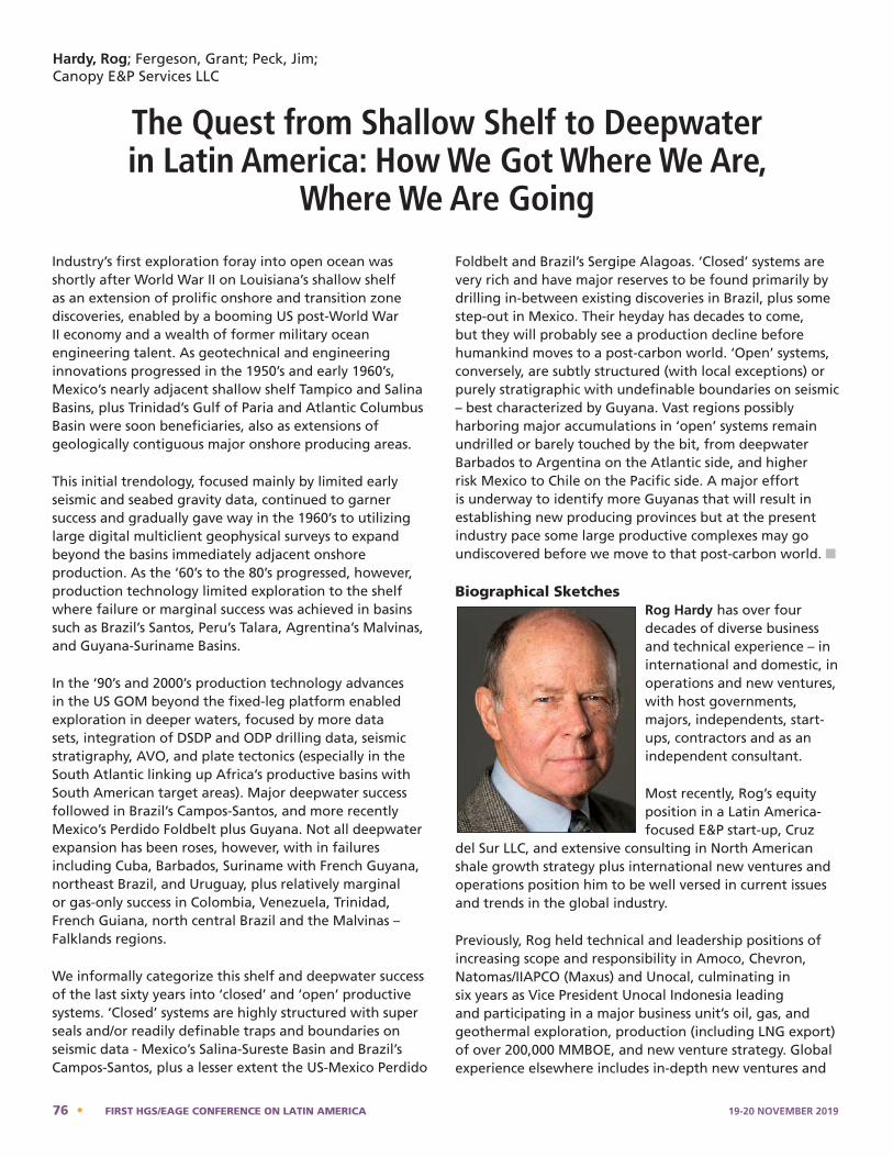
Industry’s first exploration foray into open ocean was shortly after World War II on Louisiana’s shallow shelf as an extension of prolific onshore and transition zone discoveries, enabled by a booming US post-World War II economy and a wealth of former military ocean engineering talent. As geotechnical and engineering innovations progressed in the 1950’s and early 1960’s, Mexico’s nearly adjacent shallow shelf Tampico and Salina Basins, plus Trinidad’s Gulf of Paria and Atlantic Columbus Basin were soon beneficiaries, also as extensions of geologically contiguous major onshore producing areas.
This initial trendology, focused mainly by limited early seismic and seabed gravity data, continued to garner success and gradually gave way in the 1960’s to utilizing large digital multiclient geophysical surveys to expand beyond the basins immediately adjacent onshore production. As the ‘60’s to the 80’s progressed, however, production technology limited exploration to the shelf where failure or marginal success was achieved in basins such as Brazil’s Santos, Peru’s Talara, Agrentina’s Malvinas, and Guyana-Suriname Basins.
In the ‘90’s and 2000’s production technology advances in the US GOM beyond the fixed-leg platform enabled exploration in deeper waters, focused by more data sets, integration of DSDP and ODP drilling data, seismic stratigraphy, AVO, and plate tectonics (especially in the South Atlantic linking up Africa’s productive basins with South American target areas). Major deepwater success followed in Brazil’s Campos-Santos, and more recently Mexico’s Perdido Foldbelt plus Guyana. Not all deepwater expansion has been roses, however, with in failures including Cuba, Barbados, Suriname with French Guyana, northeast Brazil, and Uruguay, plus relatively marginal or gas-only success in Colombia, Venezuela, Trinidad, French Guiana, north central Brazil and the Malvinas – Falklands regions.
We informally categorize this shelf and deepwater success of the last sixty years into ‘closed’ and ‘open’ productive systems. ‘Closed’ systems are highly structured with super seals and/or readily definable traps and boundaries on seismic data - Mexico’s Salina-Sureste Basin and Brazil’s Campos-Santos, plus a lesser extent the US-Mexico Perdido
Foldbelt and Brazil’s Sergipe Alagoas. ‘Closed’ systems are very rich and have major reserves to be found primarily by drilling in-between existing discoveries in Brazil, plus some step-out in Mexico. Their heyday has decades to come, but they will probably see a production decline before humankind moves to a post-carbon world. ‘Open’ systems, conversely, are subtly structured (with local exceptions) or purely stratigraphic with undefinable boundaries on seismic – best characterized by Guyana. Vast regions possibly harboring major accumulations in ‘open’ systems remain undrilled or barely touched by the bit, from deepwater Barbados to Argentina on the Atlantic side, and higher risk Mexico to Chile on the Pacific side. A major effort is underway to identify more Guyanas that will result in establishing new producing provinces but at the present industry pace some large productive complexes may go undiscovered before we move to that post-carbon world. n
Biographical SketchesRog Hardy has over four decades of diverse business and technical experience – in international and domestic, in operations and new ventures, with host governments, majors, independents, start-ups, contractors and as an independent consultant.
Most recently, Rog’s equity position in a Latin America-focused E&P start-up, Cruz
del Sur LLC, and extensive consulting in North American shale growth strategy plus international new ventures and operations position him to be well versed in current issues and trends in the global industry.
Previously, Rog held technical and leadership positions of increasing scope and responsibility in Amoco, Chevron, Natomas/IIAPCO (Maxus) and Unocal, culminating in six years as Vice President Unocal Indonesia leading and participating in a major business unit’s oil, gas, and geothermal exploration, production (including LNG export) of over 200,000 MMBOE, and new venture strategy. Global experience elsewhere includes in-depth new ventures and
Hardy, Rog; Fergeson, Grant; Peck, Jim;Canopy E&P Services LLC
The Quest from Shallow Shelf to Deepwater in Latin America: How We Got Where We Are,
Where We Are Going
76 • FIRST HGS/EAGE CONFERENCE ON LATIN AMERICA 19-20 NOVEMBER 2019
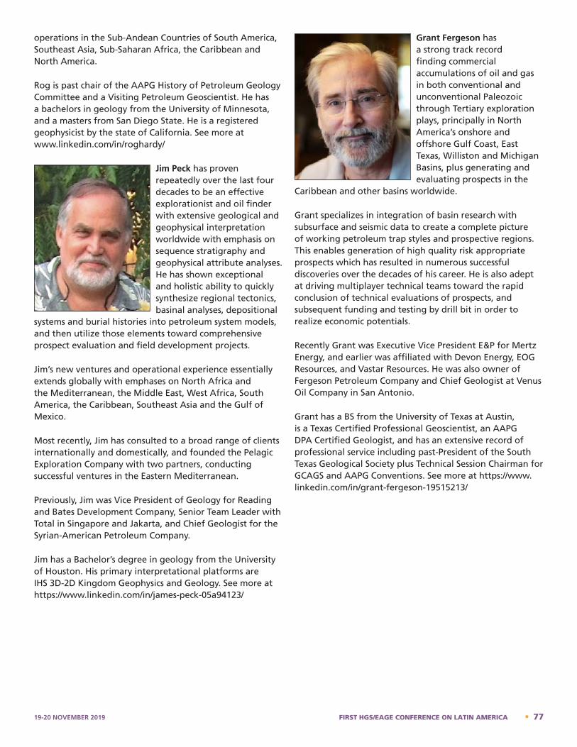
operations in the Sub-Andean Countries of South America, Southeast Asia, Sub-Saharan Africa, the Caribbean and North America.
Rog is past chair of the AAPG History of Petroleum Geology Committee and a Visiting Petroleum Geoscientist. He has a bachelors in geology from the University of Minnesota, and a masters from San Diego State. He is a registered geophysicist by the state of California. See more at www.linkedin.com/in/roghardy/
Jim Peck has proven repeatedly over the last four decades to be an effective explorationist and oil finder with extensive geological and geophysical interpretation worldwide with emphasis on sequence stratigraphy and geophysical attribute analyses. He has shown exceptional and holistic ability to quickly synthesize regional tectonics, basinal analyses, depositional
systems and burial histories into petroleum system models, and then utilize those elements toward comprehensive prospect evaluation and field development projects.
Jim’s new ventures and operational experience essentially extends globally with emphases on North Africa and the Mediterranean, the Middle East, West Africa, South America, the Caribbean, Southeast Asia and the Gulf of Mexico.
Most recently, Jim has consulted to a broad range of clients internationally and domestically, and founded the Pelagic Exploration Company with two partners, conducting successful ventures in the Eastern Mediterranean.
Previously, Jim was Vice President of Geology for Reading and Bates Development Company, Senior Team Leader with Total in Singapore and Jakarta, and Chief Geologist for the Syrian-American Petroleum Company.
Jim has a Bachelor’s degree in geology from the University of Houston. His primary interpretational platforms are IHS 3D-2D Kingdom Geophysics and Geology. See more at https://www.linkedin.com/in/james-peck-05a94123/
Grant Fergeson has a strong track record finding commercial accumulations of oil and gas in both conventional and unconventional Paleozoic through Tertiary exploration plays, principally in North America’s onshore and offshore Gulf Coast, East Texas, Williston and Michigan Basins, plus generating and evaluating prospects in the
Caribbean and other basins worldwide.
Grant specializes in integration of basin research with subsurface and seismic data to create a complete picture of working petroleum trap styles and prospective regions. This enables generation of high quality risk appropriate prospects which has resulted in numerous successful discoveries over the decades of his career. He is also adept at driving multiplayer technical teams toward the rapid conclusion of technical evaluations of prospects, and subsequent funding and testing by drill bit in order to realize economic potentials.
Recently Grant was Executive Vice President E&P for Mertz Energy, and earlier was affiliated with Devon Energy, EOG Resources, and Vastar Resources. He was also owner of Fergeson Petroleum Company and Chief Geologist at Venus Oil Company in San Antonio.
Grant has a BS from the University of Texas at Austin, is a Texas Certified Professional Geoscientist, an AAPG DPA Certified Geologist, and has an extensive record of professional service including past-President of the South Texas Geological Society plus Technical Session Chairman for GCAGS and AAPG Conventions. See more at https://www.linkedin.com/in/grant-fergeson-19515213/
19-20 NOVEMBER 2019 FIRST HGS/EAGE CONFERENCE ON LATIN AMERICA • 77
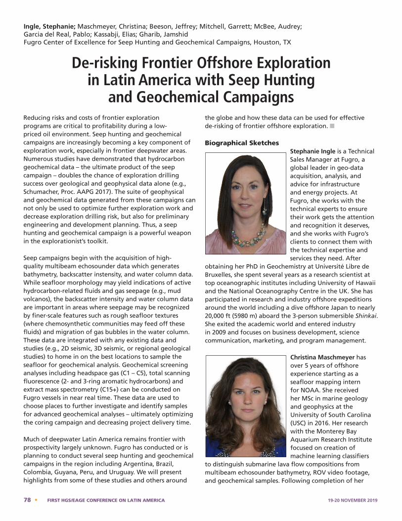
Reducing risks and costs of frontier exploration programs are critical to profitability during a low-priced oil environment. Seep hunting and geochemical campaigns are increasingly becoming a key component of exploration work, especially in frontier deepwater areas. Numerous studies have demonstrated that hydrocarbon geochemical data – the ultimate product of the seep campaign – doubles the chance of exploration drilling success over geological and geophysical data alone (e.g., Schumacher, Proc. AAPG 2017). The suite of geophysical and geochemical data generated from these campaigns can not only be used to optimize further exploration work and decrease exploration drilling risk, but also for preliminary engineering and development planning. Thus, a seep hunting and geochemical campaign is a powerful weapon in the explorationist’s toolkit.
Seep campaigns begin with the acquisition of high-quality multibeam echosounder data which generates bathymetry, backscatter instensity, and water column data. While seafloor morphology may yield indications of active hydrocarbon-related fluids and gas seepage (e.g., mud volcanos), the backscatter intensity and water column data are important in areas where seepage may be recognized by finer-scale features such as rough seafloor textures (where chemosynthetic communities may feed off these fluids) and migration of gas bubbles in the water column. These data are integrated with any existing data and studies (e.g., 2D seismic, 3D seismic, or regional geological studies) to home in on the best locations to sample the seafloor for geochemical analysis. Geochemical screening analyses including headspace gas (C 1 – C5), total scanning fluorescence (2- and 3-ring aromatic hydrocarbons) and extract mass spectrometry (C15+) can be conducted on Fugro vessels in near real time. These data are used to choose places to further investigate and identify samples for advanced geochemical analyses – ultimately optimizing the coring campaign and decreasing project delivery time.
Much of deepwater Latin America remains frontier with prospectivity largely unknown. Fugro has conducted or is planning to conduct several seep hunting and geochemical campaigns in the region including Argentina, Brazil, Colombia, Guyana, Peru, and Uruguay. We will present highlights from some of these studies and others around
the globe and how these data can be used for effective de-risking of frontier offshore exploration. n
Biographical SketchesStephanie Ingle is a Technical Sales Manager at Fugro, a global leader in geo-data acquisition, analysis, and advice for infrastructure and energy projects. At Fugro, she works with the technical experts to ensure their work gets the attention and recognition it deserves, and she works with Fugro’s clients to connect them with the technical expertise and services they need. After
obtaining her PhD in Geochemistry at Université Libre de Bruxelles, she spent several years as a research scientist at top oceanographic institutes including University of Hawaii and the National Oceanography Centre in the UK. She has participated in research and industry offshore expeditions around the world including a dive offshore Japan to nearly 20,000 ft (5980 m) aboard the 3-person submersible Shinkai. She exited the academic world and entered industry in 2009 and focuses on business development, science communication, marketing, and program management.
Christina Maschmeyer has over 5 years of offshore experience starting as a seafloor mapping intern for NOAA. She received her MSc in marine geology and geophysics at the University of South Carolina (USC) in 2016. Her research with the Monterey Bay Aquarium Research Institute focused on creation of machine learning classifiers
to distinguish submarine lava flow compositions from multibeam echosounder bathymetry, ROV video footage, and geochemical samples. Following completion of her
Ingle, Stephanie; Maschmeyer, Christina; Beeson, Jeffrey; Mitchell, Garrett; McBee, Audrey; Garcia del Real, Pablo; Kassabji, Elias; Gharib, JamshidFugro Center of Excellence for Seep Hunting and Geochemical Campaigns, Houston, TX
De-risking Frontier Offshore Exploration in Latin America with Seep Hunting
and Geochemical Campaigns
Christina Maschmeyer has over 5 years of offshore experience starting as a seafloor mapping intern for NOAA. She received her MSc in marine geology and geophysics at the University of South Carolina (USC) in 2016. Her research with the Monterey Bay Aquarium Research Institute focused on creation of machine learning classifiers to distinguish submarine lava flow compositions from multibeam echosounder bathymetry, ROV video footage, and geochemical samples. Following completion of her degree, Ms. Maschmeyer held the role of Lead Scientist for the Earth Sciences and Resources Institute at USC where she oversaw a BOEM grant for wind energy exploration offshore South Carolina. She joined Fugro USA Marine, Inc. in 2017 and currently serves as a Lead Geoscientist for Fugro Seep Hunting Campaigns around the world. Jeffrey Beeson – Bio
Stephanie Ingle – Bio
Stephanie Ingle is a Technical Sales Manager at Fugro, a global leader in geo-data acquisition, analysis, and advice for infrastructure and energy projects. At Fugro, she works with the technical experts to ensure their work gets the attention and recognition it deserves, and she works with Fugro’s clients to connect them with the technical expertise and services they need. After obtaining her PhD in Geochemistry at Université Libre de Bruxelles, she spent several years as a research scientist at top oceanographic institutes including University of Hawaii and the National Oceanography Centre in the UK. She has participated in research and industry offshore expeditions around the world including a dive offshore Japan to nearly 20,000 ft (5980 m) aboard the 3-person submersible Shinkai. She exited the academic world and entered industry in 2009 and focuses on business development, science communication, marketing, and program management. Christina Maschmeyer – Bio
78 • FIRST HGS/EAGE CONFERENCE ON LATIN AMERICA 19-20 NOVEMBER 2019
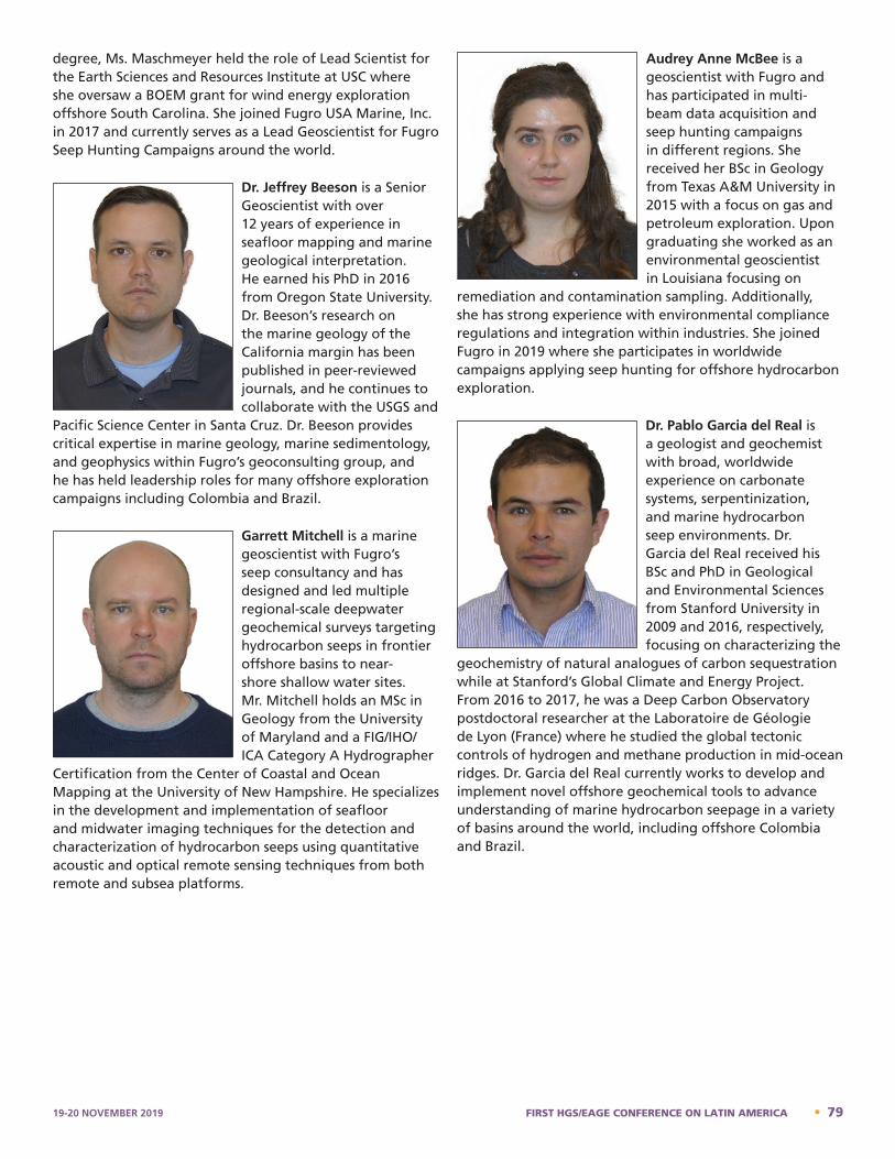
degree, Ms. Maschmeyer held the role of Lead Scientist for the Earth Sciences and Resources Institute at USC where she oversaw a BOEM grant for wind energy exploration offshore South Carolina. She joined Fugro USA Marine, Inc. in 2017 and currently serves as a Lead Geoscientist for Fugro Seep Hunting Campaigns around the world.
Dr. Jeffrey Beeson is a Senior Geoscientist with over 12 years of experience in seafloor mapping and marine geological interpretation. He earned his PhD in 2016 from Oregon State University. Dr. Beeson’s research on the marine geology of the California margin has been published in peer-reviewed journals, and he continues to collaborate with the USGS and
Pacific Science Center in Santa Cruz. Dr. Beeson provides critical expertise in marine geology, marine sedimentology, and geophysics within Fugro’s geoconsulting group, and he has held leadership roles for many offshore exploration campaigns including Colombia and Brazil.
Garrett Mitchell is a marine geoscientist with Fugro’s seep consultancy and has designed and led multiple regional-scale deepwater geochemical surveys targeting hydrocarbon seeps in frontier offshore basins to near-shore shallow water sites. Mr. Mitchell holds an MSc in Geology from the University of Maryland and a FIG/IHO/ICA Category A Hydrographer
Certification from the Center of Coastal and Ocean Mapping at the University of New Hampshire. He specializes in the development and implementation of seafloor and midwater imaging techniques for the detection and characterization of hydrocarbon seeps using quantitative acoustic and optical remote sensing techniques from both remote and subsea platforms.
Audrey Anne McBee is a geoscientist with Fugro and has participated in multi-beam data acquisition and seep hunting campaigns in different regions. She received her BSc in Geology from Texas A&M University in 2015 with a focus on gas and petroleum exploration. Upon graduating she worked as an environmental geoscientist in Louisiana focusing on
remediation and contamination sampling. Additionally, she has strong experience with environmental compliance regulations and integration within industries. She joined Fugro in 2019 where she participates in worldwide campaigns applying seep hunting for offshore hydrocarbon exploration.
Dr. Pablo Garcia del Real is a geologist and geochemist with broad, worldwide experience on carbonate systems, serpentinization, and marine hydrocarbon seep environments. Dr. Garcia del Real received his BSc and PhD in Geological and Environmental Sciences from Stanford University in 2009 and 2016, respectively, focusing on characterizing the
geochemistry of natural analogues of carbon sequestration while at Stanford’s Global Climate and Energy Project. From 2016 to 2017, he was a Deep Carbon Observatory postdoctoral researcher at the Laboratoire de Géologie de Lyon (France) where he studied the global tectonic controls of hydrogen and methane production in mid-ocean ridges. Dr. Garcia del Real currently works to develop and implement novel offshore geochemical tools to advance understanding of marine hydrocarbon seepage in a variety of basins around the world, including offshore Colombia and Brazil.
Christina Maschmeyer has over 5 years of offshore experience starting as a seafloor mapping intern for NOAA. She received her MSc in marine geology and geophysics at the University of South Carolina (USC) in 2016. Her research with the Monterey Bay Aquarium Research Institute focused on creation of machine learning classifiers to distinguish submarine lava flow compositions from multibeam echosounder bathymetry, ROV video footage, and geochemical samples. Following completion of her degree, Ms. Maschmeyer held the role of Lead Scientist for the Earth Sciences and Resources Institute at USC where she oversaw a BOEM grant for wind energy exploration offshore South Carolina. She joined Fugro USA Marine, Inc. in 2017 and currently serves as a Lead Geoscientist for Fugro Seep Hunting Campaigns around the world. Jeffrey Beeson – Bio
Audrey Anne McBee is a geoscientist with Fugro and has participated in multi-beam data acquisition and seep hunting campaigns in different regions. She received her BSc in Geology from Texas A&M University in 2015 with a focus on gas and petroleum exploration. Upon graduating she worked as an environmental geoscientist in Louisiana focusing on remediation and contamination sampling. Additionally, she has strong experience with environmental compliance regulations and integration within industries. She joined Fugro in 2019 where she participates in worldwide campaigns applying seep hunting for offshore hydrocarbon exploration. Pablo Garcia del Real – Bio
Dr. Pablo Garcia del Real is a geologist and geochemist with broad, worldwide experience on carbonate systems, serpentinization, and marine hydrocarbon seep environments. Dr. Garcia del Real received his BSc and PhD in Geological and Environmental Sciences from Stanford University in 2009 and 2016, respectively, focusing on characterizing the geochemistry of natural analogues of carbon
Dr. Jeffrey Beeson is a Senior Geoscientist with over 12 years of experience in seafloor mapping and marine geological interpretation. He earned his PhD in 2016 from Oregon State University. Dr. Beeson’s research on the marine geology of the California margin has been published in peer-reviewed journals, and he continues to collaborate with the USGS and Pacific Science Center in Santa Cruz. Dr. Beeson provides critical expertise in marine geology, marine sedimentology, and geophysics within Fugro’s geoconsulting group, and he has held leadership roles for many offshore exploration campaigns including Colombia and Brazil.
Garrett Mitchell – Bio
Mr. Mitchell is a marine geoscientist with Fugro’s seep consultancy and has designed and led multiple regional-scale deepwater geochemical surveys targeting hydrocarbon seeps in frontier offshore basins to near-shore shallow water sites. Mr. Mitchell holds an MSc in Geology from the University of Maryland and a FIG/IHO/ICA Category A Hydrographer Certification from the Center of Coastal and Ocean Mapping at the University of New Hampshire. He specializes in the development and implementation of seafloor and midwater imaging techniques for the detection and characterization of hydrocarbon seeps using quantitative acoustic and optical remote sensing techniques from both remote and subsea platforms.
Audrey McBee – Bio
19-20 NOVEMBER 2019 FIRST HGS/EAGE CONFERENCE ON LATIN AMERICA • 79
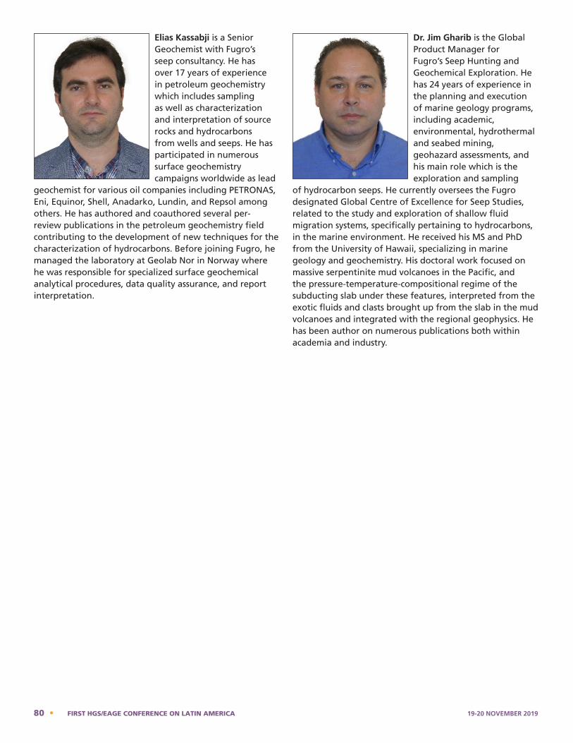
Elias Kassabji is a Senior Geochemist with Fugro’s seep consultancy. He has over 17 years of experience in petroleum geochemistry which includes sampling as well as characterization and interpretation of source rocks and hydrocarbons from wells and seeps. He has participated in numerous surface geochemistry campaigns worldwide as lead
geochemist for various oil companies including PETRONAS, Eni, Equinor, Shell, Anadarko, Lundin, and Repsol among others. He has authored and coauthored several per-review publications in the petroleum geochemistry field contributing to the development of new techniques for the characterization of hydrocarbons. Before joining Fugro, he managed the laboratory at Geolab Nor in Norway where he was responsible for specialized surface geochemical analytical procedures, data quality assurance, and report interpretation.
Dr. Jim Gharib is the Global Product Manager for Fugro’s Seep Hunting and Geochemical Exploration. He has 24 years of experience in the planning and execution of marine geology programs, including academic, environmental, hydrothermal and seabed mining, geohazard assessments, and his main role which is the exploration and sampling
of hydrocarbon seeps. He currently oversees the Fugro designated Global Centre of Excellence for Seep Studies, related to the study and exploration of shallow fluid migration systems, specifically pertaining to hydrocarbons, in the marine environment. He received his MS and PhD from the University of Hawaii, specializing in marine geology and geochemistry. His doctoral work focused on massive serpentinite mud volcanoes in the Pacific, and the pressure-temperature-compositional regime of the subducting slab under these features, interpreted from the exotic fluids and clasts brought up from the slab in the mud volcanoes and integrated with the regional geophysics. He has been author on numerous publications both within academia and industry.
sequestration while at Stanford’s Global Climate and Energy Project. From 2016 to 2017, he was a Deep Carbon Observatory postdoctoral researcher at the Laboratoire de Géologie de Lyon (France) where he studied the global tectonic controls of hydrogen and methane production in mid-ocean ridges. Dr. Garcia del Real currently works to develop and implement novel offshore geochemical tools to advance understanding of marine hydrocarbon seepage in a variety of basins around the world, including offshore Colombia and Brazil.
Elias Kassabji – Bio
Elias Kassabji is a Senior Geochemist with Fugro’s seep consultancy. He has over 17 years of experience in petroleum geochemistry which includes sampling as well as characterization and interpretation of source rocks and hydrocarbons from wells and seeps. He has participated in numerous surface geochemistry campaigns worldwide as lead geochemist for various oil companies including PETRONAS, Eni, Equinor, Shell, Anadarko, Lundin, and Repsol among others. He has authored and coauthored several per-review publications in the petroleum geochemistry field contributing to the development of new techniques for the characterization of hydrocarbons. Before joining Fugro, he managed the laboratory at Geolab Nor in Norway where he was responsible for specialized surface geochemical analytical procedures, data quality assurance, and report interpretation. Jamshid Gharib – Bio
Dr. Jim Gharib is the Global Product Manager for Fugro's Seep Hunting and Geochemical Exploration. He has 24 years of experience in the planning and execution of marine geology programs, including academic, environmental, hydrothermal and seabed mining, geohazard assessments, and his main role which is the exploration and sampling of hydrocarbon seeps. He currently oversees the Fugro designated Global Centre of Excellence for Seep Studies, related to the study and exploration of shallow fluid migration systems, specifically pertaining to hydrocarbons, in the marine environment. He received his MS and PhD from the University of Hawaii, specializing in marine geology and geochemistry. His doctoral work focused on massive serpentinite mud volcanoes in the Pacific, and the pressure-temperature-compositional regime of the subducting slab under these features, interpreted from the exotic fluids and clasts brought up from the slab in the mud volcanoes and integrated with the regional geophysics. He has been author on numerous publications both within academia and industry.
80 • FIRST HGS/EAGE CONFERENCE ON LATIN AMERICA 19-20 NOVEMBER 2019
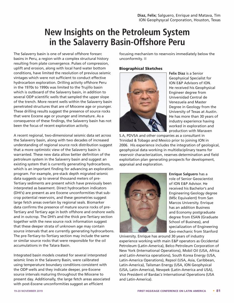
The Salaverry basin is one of several offshore forearc basins in Peru, a region with a complex structural history resulting from plate convergence. Pulses of compression, uplift and erosion, along with local hard water bottom conditions, have limited the resolution of previous seismic vintages which were not sufficient to conduct effective hydrocarbon exploration. Drilling activity offshore Peru in the 1970s to 1990s was limited to the Trujillo basin which is outboard of the Salaverry basin, in addition to several ODP scientific wells that sampled the upper slope of the trench. More recent wells within the Salaverry basin penetrated structures that are of Miocene age or younger. These drilling results suggest the presence of source rocks that were Eocene age or younger and immature. As a consequence of these findings, the Salaverry basin has not been the focus of recent exploration activity.
A recent regional, two-dimensional seismic data set across the Salaverry basin, along with two decades of increased understanding of regional source rock distribution suggest that a more optimistic view of the Salaverry basin is warranted. These new data allow better definition of the petroleum system in the Salaverry basin and suggest an existing system that is currently generating hydrocarbons, which is an important finding for advancing an exploration program. For example, pre-stack depth migrated seismic data suggests up to several thousand meters of pre-Tertiary sediments are present which have previously been interpreted as basement. Direct hydrocarbon indicators (DHI’s) are present as are Eocene unconformities that sub-crop potential reservoirs, and these geometries suggest large fetch areas overlain by regional seals. Biomarker data confirms the presence of mature source rocks of pre-Tertiary and Tertiary age in both offshore and onshore wells and in outcrop. The DHI’s and the thick pre-Tertiary section together with the new source rock information suggest that these deeper strata of unknown age may contain source intervals that are currently generating hydrocarbons. The pre-Tertiary-to-Tertiary section may include the same or similar source rocks that were responsible for the oil accumulations in the Talara Basin.
Integrated basin models created for several interpreted seismic lines in the Salaverry Basin, were calibrated using temperature boundary conditions consistent with the ODP wells and they indicate deeper, pre-Eocene source intervals maturing throughout the Miocene to present day. Additionally, the large fetch areas associated with post-Eocene unconformities suggest an efficient
focusing mechanism to reservoirs immediately below the unconformity. n
Biographical SketchesFelix Diaz is a Senior Geophysical Specialist for ION E&P Advisors of ION. He received his Geophysical Engineer degree from Universidad Central de Venezuela and Master Degree in Geology from the University of Texas at Austin. He has more than 30 years of industry experience having worked in exploration and production with Maraven
S.A, PDVSA and other companies as a consultant in Trinidad & Tobago and Mexico prior to joining ION in 2006. His experience includes the integration of geological, geophysical data working in multidisciplinary teams for reservoir characterization, reserves determination and field exploitation plan generating prospects for development, appraisal and exploration.
Enrique Salguero has a role of Senior Geoscientist of ION E&P Advisor. He received his Bachelor’s and Engineering Geology degree (MSc Equivalent) from San Marcos University. Enrique has an addition Business and Economy postgraduate degree from ESAN (Graduate School of Business), and specialization of Engineering Geo-mechanic from Stanford
University. Enrique has around 30 years of industry experience working with main E&P operators as Occidental Petroleum (Latin-America), Belco Petroleum Corporation of New York (International Operations), Mobil Oil (USA, Africa and Latin-America operations), South Korea Energy (USA, Latin-America Operations), Repsol (USA, Asia, Caribbean, Latin-America), Talisman Energy (USA, ION Geophysical (USA, Latin-America), Newpek (Latin-America and USA), Vice President of Bardas’z International Operations (USA and Latin-America).
Diaz, Felix; Salguero, Enrique and Matava, TimION Geophysycal Corporation, Houston, Texas
New Insights on the Petroleum System in the Salaverry Basin-Offshore Peru
3
Enrique Salguero has a role of Senior Geoscientist of ION E&P Advisor. He received his Bachelor’s and Engineering Geology degree (MSc. Equivalent) from San Marcos University. Enrique has an addition Business and Economy postgraduate degree from ESAN (Graduate School of Business), and specialization of Engineering Geo-mechanic from Stanford University. Enrique has around 30 years of industry experience working with main E&P operators as Occidental Petroleum (Latin-America), Belco Petroleum Corporation of New York (International Operations), Mobil Oil (USA, Africa and Latin-America operations), South Korea Energy (USA, Latin-America Operations), Repsol (USA, Asia, Caribbean, Latin-America), Talisman Energy (USA, ION Geophysical (USA, Latin-America), Newpek (Latin-America and USA), Vice President of Bardas’z International Operations (USA and Latin-America). Bio - Tim Matava
2
Bio - Felix A. Diaz
Felix Diaz is a Senior Geophysical Specialist for ION E&P Advisors of ION. He received his Geophysical Engineer degree from Universidad Central de Venezuela and Master Degree in Geology from the University of Texas at Austin. He has more than 30 years of industry experience having worked in exploration and production with Maraven S.A, PDVSA and other companies as a consultant in Trinidad & Tobago and Mexico prior to joining ION in 2006. His experience includes the integration of geological, geophysical data working in multidisciplinary teams for reservoir characterization, reserves determination and field exploitation plan generating prospects for development, appraisal and exploration. Bio - Enrique Salguero
19-20 NOVEMBER 2019 FIRST HGS/EAGE CONFERENCE ON LATIN AMERICA • 81

Tim Matava is a consulting geophysicist with nearly thirty years of experience in research and applications in the area of petroleum systems analysis. His recent work has focused towards developing physical models to connect geology and geophysics for applications such as subsalt velocity model building, formation of unconventional reservoirs, identifying source
rocks on seismic data and identifying sediment provenances with seismic velocities.
4
Tim Matava is a consulting geophysicist with nearly thirty years of experience in research and applications in the area of petroleum systems analysis. His recent work has focused towards developing physical models to connect geology and geophysics for applications such as subsalt velocity model building, formation of unconventional reservoirs, identifying source rocks on seismic data and identifying sediment provenances with seismic velocities.
82 • FIRST HGS/EAGE CONFERENCE ON LATIN AMERICA 19-20 NOVEMBER 2019
FIRST HGS/EAGE CONFERENCE ON LATIN AMERICA19-20 NOVEMBER 2019
Conference Committee ListAlvarez, Lorena – EAGE
Araujo Fresky, Mariela – Shell
Blickwede, Jon – Teyra GeoConsulting, LLC
Davies, Ceri – CGG
Deming, Mike – Consultant
Desforges, Cheryl – Consultant
Effler, Mike – Retired Exxon
Egorov, Vsevolod – GeoExpera
Emmet, Pete – Brazos Valley GeoServices, Inc.
Fryklund, Bob – IHS Markit
Getz, Steve – Getz Exploration Consultants Inc.
Ghorpade, Sachin – Baker Hughes
James, Huw – Internal Geo Services
Patino, Laura Juliana – EAGE
Peoples, Andrea – HGS
San-Martin, Hector – Petroleum & Minerals, LLC
Tiwari, Upendra – Conoco Phillips
Ward, Chris – Baker Hughes
Wiener, Bob – Goh Exploration, Inc.
19-20 NOVEMBER 2019 FIRST HGS/EAGE CONFERENCE ON LATIN AMERICA • 83