final project plan heathers cove - san antonio · city of san antonio, texas housing and...
TRANSCRIPT
CITY OF SAN ANTONIO, TEXAS
Housing and Neighborhood Services Department
HEATHERS COVE
Tax Increment Reinvestment Zone Twenty-one
Final Project Plan
March 15, 2007
- 2 -
TABLE OF CONTENTS
EXECUTIVE SUMMARY ........................................................................................................... 3 1. POLICY AND PROGRAM ........................................................................................... 4 2. DESIGNATION AND PARTICIPATION ................................................................... 8 3. EXISTING CONDITIONS .......................................................................................... 10 4. PROJECT INFORMATION ....................................................................................... 15 5. PROJECT FEASIBILITY .......................................................................................... 20 6. DEPARTMENTAL REVIEW..................................................................................... 26 7. APPENDIX: INFRASTRUCTURE COST ESTIMATES (NOT INCLUDING
MEDINA BASE ROAD & PARK IMPROVEMENTS) ........................................... 27 8. EXHIBITS..................................................................................................................... 28

- 3 -
Executive Summary The City of San Antonio’s Tax Increment Reinvestment Zone (TIRZ) Twenty-one will facilitate the construction of a residential neighborhood with a small commercial section, in addition to Medina Base Road improvements and Park amenities. The TIRZ is approximately 47 acres in size.
The TIRZ is located in the Secondary Target Area as defined in the City’s 2004 TIF Guidelines, within which the City may participate by contributing up to 90% of its tax increment for up to 20 years. The TIRZ is located inside Loop 410 off Medina Base Road in City Council District 4, and straddles the North Side and South West Independent School Districts. The developer of the property, HLH Developments LP, is requesting the participation of the City of San Antonio and other taxing entities in the Tax Increment Reinvestment Zone.
This TIRZ will directly enhance the quality of life for the existing residents of the neighborhood by financing new trails and other amenities in a City Park and by helping to make Medina Base Road safer for drivers, pedestrians, and cyclists.
The residential area will comprise 173 single-family houses with an average estimated sales price $102,000. The commercial section, located at the intersection of Loop 410 and Medina Base Road, is 5.76 acres in size.
The cost of the public infrastructure improvements is estimated at $2,610,460, of which $643,730 are set aside for Medina Base Road. Financing costs are $659,619, and administrative expenses are $360,000, bringing the total estimated TIRZ costs to $3,630,079. The public infrastructure improvements for this project include: park improvements, Medina Base Road improvements, site work, storm water pollution prevention, streets and drainage, sewer, water, street lights/signs, electrical, lift station, and off-site water connections.
The Board of Directors for Heathers Cove TIRZ 21 met on February 20, 2007 and approved the Final Project Plan and Final Financing Plans. The life of the Tax Increment Reinvestment Zone is projected to be 19.80 years with the TIRZ being in existence through fiscal year 2024.
- 4 -
1. Policy and Program
A. POLICY The City of San Antonio is dedicated to the revitalization of inner-city neighborhoods and commercial districts, particularly in those areas located inside Loop 410 and south of Highway 90. A tiered system of incentive tools, including Tax Increment Financing (TIF), has been structured to meet the City’s revitalization and reinvestment goals. Development projects supported by a Tax Increment Reinvestment Zones should act as economic stimuli to surrounding areas. By leveraging private investment for certain types of development within a targeted area, TIF can be used to assist in financing needed public improvements and enhancing infrastructure.
B. PROGRAM San Antonio’s TIF Program strategy to support development and redevelopment is unique in the State. The TIF Program has evolved since 1998 to ensure that the incentive is used today to provide full support to the City’s three primary revitalization mechanisms: Economic Development, Community Development and Urban Design Standards. TIF seeks to directly promote recommendations made in the City’s Master Plan, CRAG Report, Neighborhood Plans, Community Plans, Corridor and Area Plans, and Housing Master Plan. For instance, the TIF Program is designed to help implement Master Plan Growth Management Policy 1g: Continue to make physical improvements in the inner city to encourage redevelopment and infill development.
TIF GUIDELINES
The City of San Antonio (City) adopted amended Guidelines and Criteria for TIF by Ordinance No. 98663 on January 8, 2004. The original Guidelines were established by the City in 1998 by Ordinance No. 88196, and were amended by Ordinance No. 92552 in 2000 and Ordinance No. 92710 in 2002. The
Tax Increment Reinvestment Zones Highlights:
• TIF is an incentive tool that local governments can use to finance public improvements and enhance infrastructure within a defined area, called a Tax Increment Reinvestment Zone (TIRZ)
• Tax Increment Financing is governed by the TIF Act found in Chapter 311 of the Texas Tax Code
• The TIF Act specifies that areas to be designated as a TIRZ must be economically distressed, unproductive, underdeveloped, or blighted, and impair the City’s growth because of these factors
• Each taxing entity that collects taxes against the property within a TIRZ has an opportunity to contribute future tax revenues to a TIRZ fund to reimburse developers for the cost of public infrastructure improvements in the TIRZ
- 5 -
Guidelines serve as policy direction to City staff and interested parties regarding the Application for Redevelopment with Tax Increment Financing, which supports certain types of development in targeted areas of the city. TIRZ may be designated either through (1) a City-initiated project following a Request for Proposals and the submission of an Application for Redevelopment to the City pursuant to these Guidelines, or (2) the independent submission of an Application for Redevelopment to the City pursuant to these Guidelines in conjunction with the petition of a property owner as detailed in Section 311.005 (a)(5) of the Texas Tax Code. All TIRZ are governed by the Guidelines in effect at the time of the TIRZ creation by City Council. Heathers Cove was designated following the submission of a petition from the property owner, and is governed by the 2004 Guidelines.
TARGETED ECONOMIC DEVELOPMENT
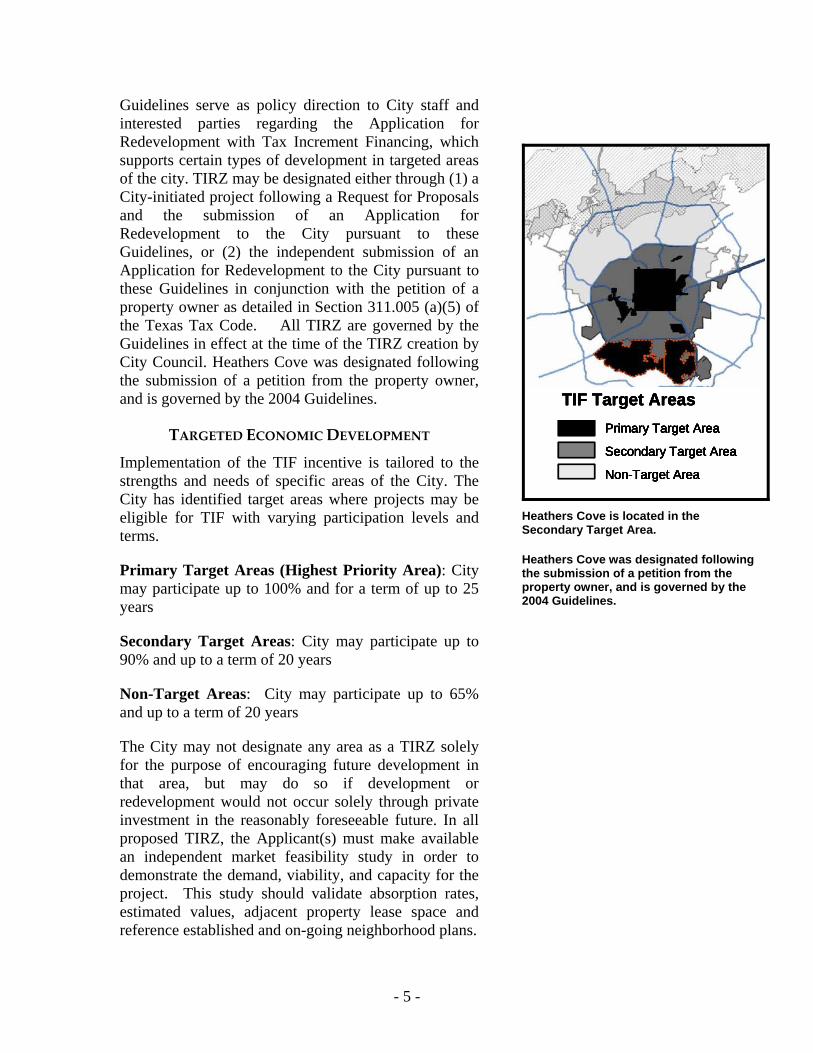
Implementation of the TIF incentive is tailored to the strengths and needs of specific areas of the City. The City has identified target areas where projects may be eligible for TIF with varying participation levels and terms.
Primary Target Areas (Highest Priority Area): City may participate up to 100% and for a term of up to 25 years
Secondary Target Areas: City may participate up to 90% and up to a term of 20 years
Non-Target Areas: City may participate up to 65% and up to a term of 20 years
The City may not designate any area as a TIRZ solely for the purpose of encouraging future development in that area, but may do so if development or redevelopment would not occur solely through private investment in the reasonably foreseeable future. In all proposed TIRZ, the Applicant(s) must make available an independent market feasibility study in order to demonstrate the demand, viability, and capacity for the project. This study should validate absorption rates, estimated values, adjacent property lease space and reference established and on-going neighborhood plans.
Primary Target Area
Secondary Target Area
Non-Target Area
TIF Target Areas
Primary Target Area
Secondary Target Area
Non-Target Area
Primary Target Area
Secondary Target Area
Non-Target Area
TIF Target Areas
Primary Target Area
Secondary Target Area
Non-Target Area
TIF Target Areas
Primary Target Area
Secondary Target Area
Non-Target Area
Primary Target Area
Secondary Target Area
Non-Target Area
TIF Target Areas
Heathers Cove is located in the Secondary Target Area.
Heathers Cove was designated following the submission of a petition from the property owner, and is governed by the 2004 Guidelines.
- 6 -
COMMUNITY DEVELOPMENT
TIF Applicants must demonstrate how the planned investment will contribute to revitalization activities in the community of which the TIRZ is a part. The Applicant must also indicate how the input of nearby neighborhood residents, businesses, and schools has influenced the project planning process. All proposals must communicate and demonstrate how the project achieves objectives of the City’s Master Plan, Southside Initiative and/or the CRAG.
DESIGN QUALITY
All projects supported by TIF should add long-term value to the public realm. Accordingly, projects must be built according to design principles that prioritize the safety and comfort of all public infrastructure users – whether they are walking, jogging, riding or driving. The City’s Unified Development Code (UDC) sets out a menu of approaches to help designers and developers meet the program’s Urban Design Goals.
While development in the Heathers Cove TIRZ was exempted from the Urban Design requirements in the 2004 Guidelines' Section VI(C), the developer agreed to plan amendments that increase pedestrian and vehicular connectivity, as detailed in the Project Information Section of this document.
Projects must also consider the long-term value of the private improvements supported by TIF. Specifically, the Master Plan calls for efforts to facilitate the provisions of choice in housing for special needs populations (Neighborhoods: Policy 4d). Efforts to meet this policy include ensuring homes are visitable or easily adaptable to disabled persons. Policy 4i requires the community to explore the full range of options to allow people to remain in their homes throughout their lives.
The City of San Antonio adopted a Universal Design Policy (Ord. No. 95641) on April 18, 2002, requiring that any person receiving financial assistance from city, state, or federal funds administered by the City of San Antonio for the construction of new single family homes, duplexes, or triplexes, shall construct the units in accordance with specific features including entrance with no steps, wider doorways (2’ 8”), lever door handles, lever controls on kitchen and lavatory faucets, and light switches and electrical receptacles within reachable height.
The Heathers Cove TIRZ contribution to the payment of public infrastructure improvements requires the housing development to comply with the City’s Universal Design requirements (UD), located in the City Code, Chapter 6, Article XII. According to a compromise agreement reached with the Developer, 104 units in Phase 1 and 2 do not comply with UD, but only nine (9) non-compliant units will be deducted from the
The Heathers Cove TIRZ contributes to wider revitalization activities including park improvements and Medina Base Road improvements.
Nearby neighborhood associations and both school districts played active roles in crafting the final development plan.
Heathers Cove implements the following Master Plan Policies:
Neighborhoods Policy 3a: Protect the character and quality of neighborhoods by maintaining and enhancing their open spaces and parks.
Neighborhoods Policy 4a: Preserve and revitalize housing and promote targeted infill housing in neighborhoods, particularly older neighborhoods located inside Loop 410.
- 7 -
captured appraised value of real property taxable by a taxing unit for each year, resulting in the reduction of the projected captured appraised value by $1,205,910. The tax increment collection attributable to the reduction of captured appraised value is estimated to be $7,027 annually, which will not be deposited to the Heathers Cove TIRZ fund but will instead be retained by the Participating Taxing Entities (the City, Bexar County, and San Antonio River Authority). The remaining 23 units in Phase 2 and 46 units in Phase 3 shall comply with the Universal Design requirements. If it is discovered that any of the remaining 69 units in Phase II and Phase III do not comply, those non-compliant units will also be deducted from the captured appraised value.
ENVIRONMENTAL PROTECTION
The TIF Program supports the Master Plan's Natural Resources Goal 1: to preserve the unique, rare and significant features of San Antonio's natural environment. The health of the Edwards Aquifer is of particular concern to San Antonio residents. In accordance with Natural Resources Policy 1b (see sidebar), the TIF program has established specific policies that strictly limit the use of TIF over the Aquifer.
The 2004 Guidelines do not allow applications for TIF where all or part of the proposed project falls over the Edwards Aquifer Recharge Zone.
The Heathers Cove TIRZ is not located over any part of the Edwards Aquifer.
Natural Resources Policy 1b: Develop and implement a management plan for land use activities which includes the best management practices, based on scientific study that will protect the recharge and drainage zones of the Edwards Aquifer from pollution.

- 8 -
2. Designation and Participation The long-term success of any Tax Increment Reinvestment Zone is contingent on the participation of a number of taxing entities and the long-term commitment of the applicant. Accordingly, the TIF program implements the Master Plan's Neighborhoods Policy 4f, to maximize the leverage of private investment by lenders and builders or developers. In addition to the City of San Antonio, the Heathers Cove project developers have secured commitments from Bexar County and the San Antonio River Authority to participate in this TIF project.
TIF MECHANISM
Base Values in a TIRZ continue to be collected by taxing entities – only the new values (the increment) are collected in the TIRZ Fund.
Once a TIRZ has been established, the increase in real property taxes resulting from new construction, public improvements, and redevelopment efforts (the increment) is deposited in a TIRZ Fund. The City of San Antonio enters into a written agreement with all participating taxing entities to specify: (1) the conditions for payment of the tax increment into a TIRZ Fund, (2) the portion of tax increment to be paid by each entity into the TIF Fund, and (3) term of the agreement. Participating taxing entities continue to collect taxes on the base value, while taxing entities that do not participate in the TIRZ, such as local school districts, collect taxes on both the base and the increment.
- 9 -
CITY OF SAN ANTONIO
The City of San Antonio’s Housing and Neighborhood Services Department TIF Unit is responsible for the administration of the TIF Program. The TIF Unit's responsibilities include the following:
• Pre-application consultation • Application review and analysis • Statutory presentations • TIRZ Board administration • TIRZ Fund administration and review of invoices for reimbursement • Ongoing monitoring of construction and TIRZ performance
The City of San Antonio will contribute 90% of its increment to the Heather Cove TIRZ. The balance of the increment (10%) will be dedicated to the Highest Priority Areas Infrastructure Fund. The life of the Heathers Cove TIRZ is projected to be 19.80 years, meaning the TIRZ will be in existence through fiscal year 2024.
BEXAR COUNTY
On May 12, 2004, Bexar County Commissioners Court approved TIF Guidelines and Criteria for TIRZ within Bexar County. In accordance with their Guidelines, the participation level for the County does not exceed 80% and the term of participation is capped at 25 years. The City of San Antonio made a statutorily-required presentation to Bexar County in November 2004 regarding the Heathers Cove TIRZ. The County set their participation level for this project at 50% of the Operations and Maintenance portion of the tax rate. County participation shall not extend beyond September 30, 2024.
SAN ANTONIO RIVER AUTHORITY
On November 16, 2005, the Board of Directors of the San Antonio River Authority approved a resolution No. R-1264 in support of participation in the Heathers Cove TIRZ. This resolution set the Authority's participation level at 25%, and waived the authority's statutory right to the sixty (60) day notice period as prescribed by Chapter 311.003(e) of the Texas Tax Code.
DEVELOPER
Project Developer is HLH Developments LP, formed over six years ago to develop residential products for the affordable housing market. The principal operations officer is Harry Hausman. The limited partnership is owned by Harry Hausman and his family, which has completed four subdivisions over the past five years. Developer’s responsibilities include the provision of quarterly reports (project status reports) to the City’s TIF Unit (due the 15th of October, January, April and July or the first business day thereafter). These quarterly reports are made up of copies of publicly bid documents for public improvements, detailed invoices related to project costs, disclosure of relevant changes in project, ownership, financial stability, or any anticipated assignment.

- 10 -
3. Existing Conditions
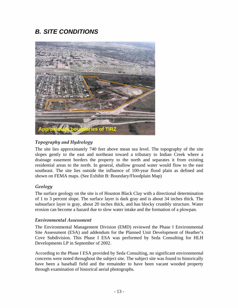
A. REGIONAL CONTEXT The Heathers Cove TIRZ is located in the southwest quadrant of the City of San Antonio, inside Loop 410 off of Medina Base Road. The site is within the Lower Leon Creek Watershed, one edge of which follows the alignment of SW Loop 410.
In this part of San Antonio, Loop 410 runs between Lackland Air Force Base and Lackland Annex. Neighborhoods have been built in relatively narrow strips along both sides of Loop 410. Existing development is primarily suburban residential, with some incipient commercial development at a few intersections. A significant amount of acreage in the area has remained undeveloped for decades. Highway frontage, in particular, has failed to develop into the commercial uses that may have been originally prefigured to serve adjacent single-family districts. Today, that vacant frontage is being reconceived primarily for additional residential uses.
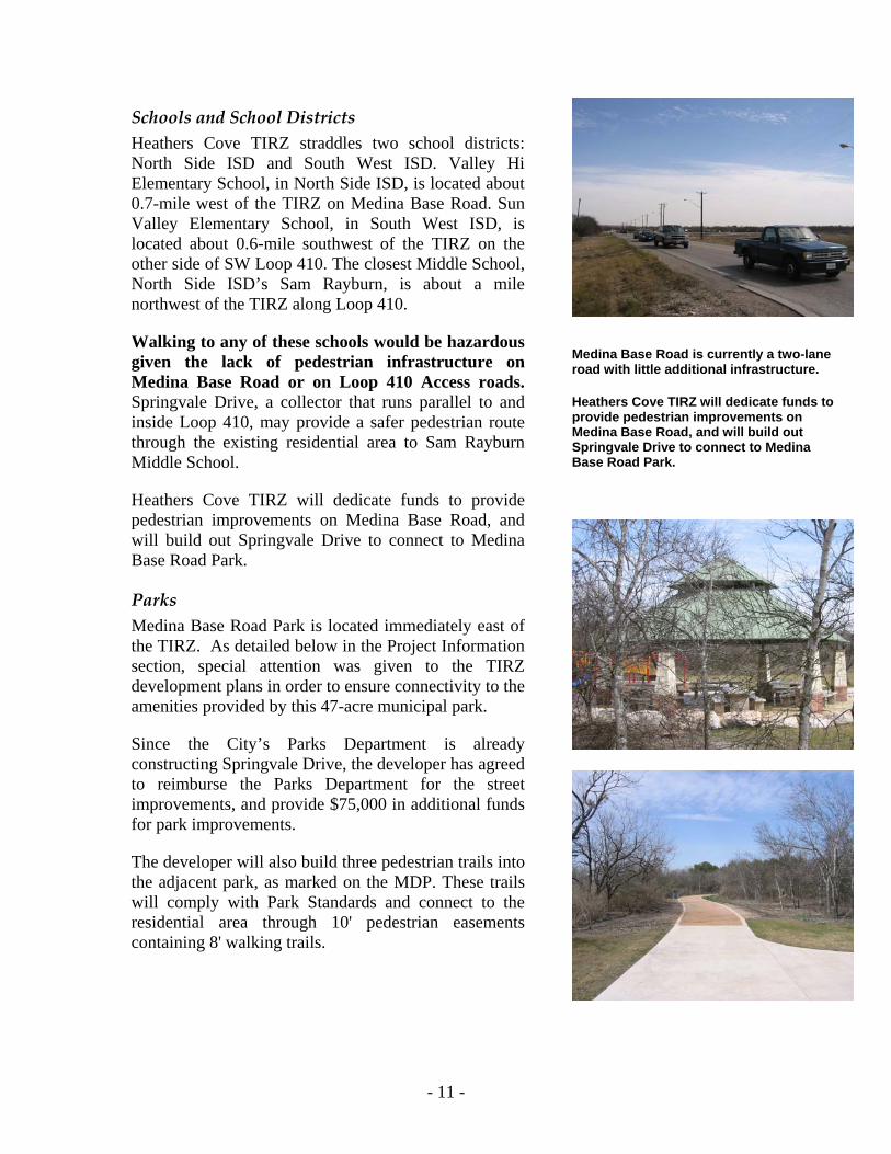
In addition to SW Loop 410, Medina Base Road is the transportation artery that provides regional access to Heathers Cove TIRZ. Classified as a Secondary Arterial Type A in the Major Thoroughfare Plan, Medina Base Road is currently a two-lane road with a bar ditch drainage system and no sidewalks.
- 11 -
Schools and School Districts Heathers Cove TIRZ straddles two school districts: North Side ISD and South West ISD. Valley Hi Elementary School, in North Side ISD, is located about 0.7-mile west of the TIRZ on Medina Base Road. Sun Valley Elementary School, in South West ISD, is located about 0.6-mile southwest of the TIRZ on the other side of SW Loop 410. The closest Middle School, North Side ISD’s Sam Rayburn, is about a mile northwest of the TIRZ along Loop 410.
Walking to any of these schools would be hazardous given the lack of pedestrian infrastructure on Medina Base Road or on Loop 410 Access roads. Springvale Drive, a collector that runs parallel to and inside Loop 410, may provide a safer pedestrian route through the existing residential area to Sam Rayburn Middle School.
Heathers Cove TIRZ will dedicate funds to provide pedestrian improvements on Medina Base Road, and will build out Springvale Drive to connect to Medina Base Road Park.
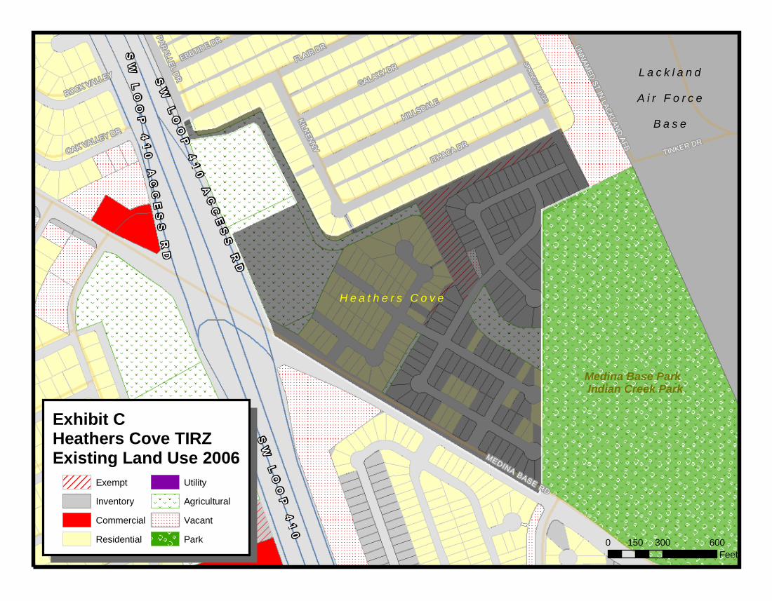
Parks Medina Base Road Park is located immediately east of the TIRZ. As detailed below in the Project Information section, special attention was given to the TIRZ development plans in order to ensure connectivity to the amenities provided by this 47-acre municipal park.
Since the City’s Parks Department is already constructing Springvale Drive, the developer has agreed to reimburse the Parks Department for the street improvements, and provide $75,000 in additional funds for park improvements.
The developer will also build three pedestrian trails into the adjacent park, as marked on the MDP. These trails will comply with Park Standards and connect to the residential area through 10' pedestrian easements containing 8' walking trails.
Medina Base Road is currently a two-lane road with little additional infrastructure.
Heathers Cove TIRZ will dedicate funds to provide pedestrian improvements on Medina Base Road, and will build out Springvale Drive to connect to Medina Base Road Park.
- 12 -
Emergency Services The Heathers Cove TIRZ can be reached by Station #36 in the standard 4.25-minute response time. Station #36 is located at 5826 Ray Ellison, and provides both Firefighting and Emergency Medical Services.
Neighborhood Plans and Associations The nearest neighborhood plan, the United Southwest Communities land use plan, does not include the TIRZ properties. However, several elements of the draft plan relate to the area of the TIRZ.
Neighborhood residents have requested the installation of a stoplight at Medina Base Road and Palm Valley – which is the entrance to the park. Public Works has reviewed this intersection and found that it meets the warrant criteria for a stoplight, but have not identified a funding source.
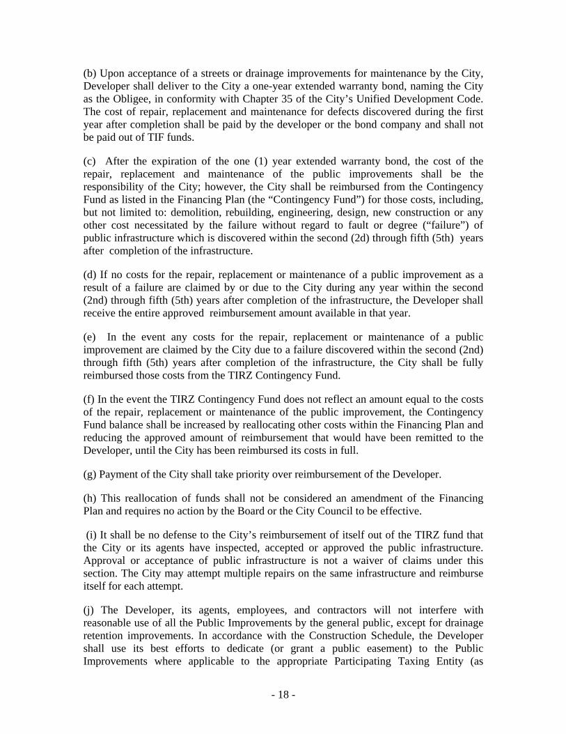
Residents and the City’s Planning Department have also requested that TIRZ funds should be considered for the future reconstruction and widening of Medina Base Road east of Loop 410.
As detailed in the Project Information section below, Heathers Cove TIRZ will dedicate funds to the installation of a stoplight at Medina Base Road and Palm Valley, as well as for the overall reconstruction of Medina Base Road.
- 13 -
B. SITE CONDITIONS
Approximate boundaries of TIRZ
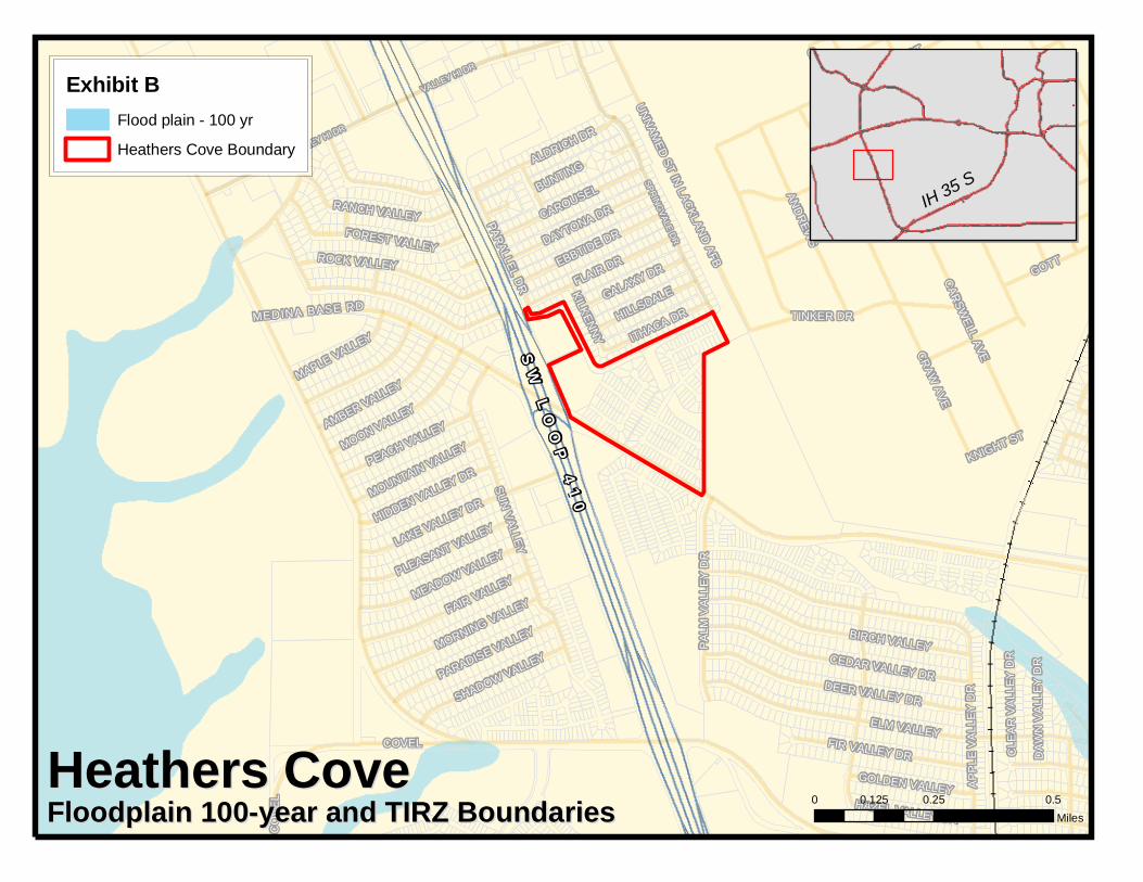
Topography and Hydrology The site lies approximately 740 feet above mean sea level. The topography of the site slopes gently to the east and northeast toward a tributary to Indian Creek where a drainage easement borders the property to the north and separates it from existing residential areas to the north. In general, shallow ground water would flow to the east southeast. The site lies outside the influence of 100-year flood plain as defined and shown on FEMA maps. (See Exhibit B: Boundary/Floodplain Map)
Geology The surface geology on the site is of Houston Black Clay with a directional determination of 1 to 3 percent slope. The surface layer is dark gray and is about 34 inches thick. The subsurface layer is gray, about 20 inches thick, and has blocky crumbly structure. Water erosion can become a hazard due to slow water intake and the formation of a plowpan.
Environmental Assessment The Environmental Management Division (EMD) reviewed the Phase I Environmental Site Assessment (ESA) and addendum for the Planned Unit Development of Heather’s Cove Subdivision. This Phase I ESA was performed by Seda Consulting for HLH Developments LP in September of 2002.
According to the Phase I ESA provided by Seda Consulting, no significant environmental concerns were noted throughout the subject site. The subject site was found to historically have been a baseball field and the remainder to have been vacant wooded property through examination of historical aerial photographs.
- 14 -
EMD conducted a field visit to the subject site on April 14, 2005. No evidence was found of significant environmental concerns throughout the subject site. The native subgrade material was visually observed to be “fat” expansive clay, possibly with a very high Potential Vertical Rise (PVR) value.
Historic Use and Existing Vegetation Early aerial photography of the site (1938) shows farmland. The 1966 aerial reveals a baseball field, which was in use up until recently. Existing vegetation on the site outside the ballfield was a mix of native trees and grasses.
C. DEMOGRAPHICS Heathers Cove TIRZ is located in Census Tract 161600, and is immediately bounded by Tracts 161401, 161502, and 161800. These four Census Tracts are within a quarter-mile of the project boundaries, and were used to analyze demographics and property values for the TIRZ.
Education According to the 2000 U.S. Census (DP-2. Profile of Selected Social Characteristics. 2000 Data Set: Census 2000 Summary File 3 (SF 3) - Sample Data), the percentage of San Antonio’s population without a high school degree is 24.9%. The Heathers Cove Census Tracts show a slightly better percentage than the San Antonio average, at 23.5%.
Health The Metropolitan Health District publishes an annual listing of the County’s unhealthy zip codes. These zip codes are chosen for high rates of teen births, drop-outs, sexually transmitted diseases, domestic violence cases, juvenile probation cases, stray animal calls, elevated blood lead levels, juvenile asthma cases, EMS calls, and infant deaths. Heathers Cove TIRZ is in zip code 78227, which is listed as unhealthy by the latest Metropolitan Health District report.
Poverty The 2000 Census (QT-P34. Poverty Status in 1999 of Individuals: 2000 Data Set: Census 2000 Summary File 3 (SF 3) - Sample Data) describes San Antonio’s percentage of population living below poverty level at 17.3%. Heathers Cove Census Tracts’ percentage of population living below poverty level is slightly higher than the City average: 19.1%.
Employment The 2000 Census (QT-P24. Employment Status by Sex: 2000 Data Set: Census 2000 Summary File 3 (SF3) Sample Data) reports San Antonio’s percentage of unemployed civilians at 6.2%. Heathers Cove Census Tracts’ unemployment percentage is better than the City average, at 3.2%.

- 15 -
4. Project Information
- 16 -
A. CONCEPT Heathers Cove TIRZ is about 47 acres in size and will finance the construction of the public infrastructure in a new residential neighborhood. The majority of the construction is residential, made up of 173 single-family detached houses, a well-connected local street network, drainage work and pedestrian connections into the neighboring park. The TIRZ will also finance the construction of a street through a 5.76-acre commercial section, as well as Medina Base Road improvements and Park amenities. The commercial area is conceived as 58,000 square feet of mixed commercial/retail.
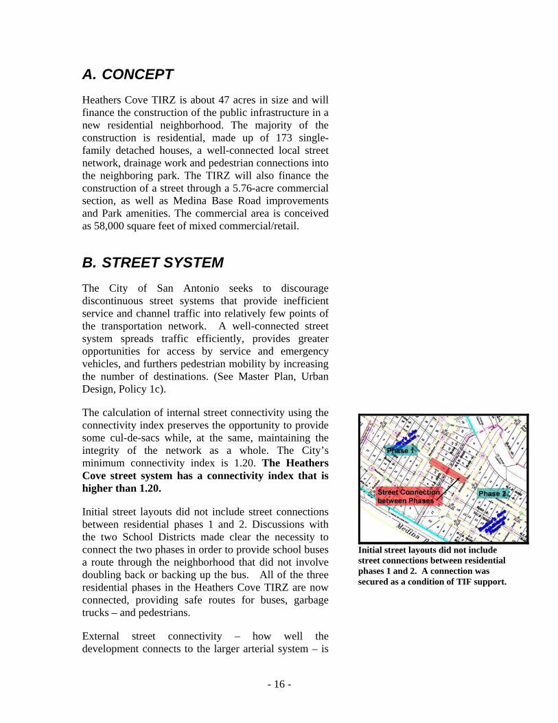
B. STREET SYSTEM The City of San Antonio seeks to discourage discontinuous street systems that provide inefficient service and channel traffic into relatively few points of the transportation network. A well-connected street system spreads traffic efficiently, provides greater opportunities for access by service and emergency vehicles, and furthers pedestrian mobility by increasing the number of destinations. (See Master Plan, Urban Design, Policy 1c).
The calculation of internal street connectivity using the connectivity index preserves the opportunity to provide some cul-de-sacs while, at the same, maintaining the integrity of the network as a whole. The City’s minimum connectivity index is 1.20. The Heathers Cove street system has a connectivity index that is higher than 1.20.
Initial street layouts did not include street connections between residential phases 1 and 2. Discussions with the two School Districts made clear the necessity to connect the two phases in order to provide school buses a route through the neighborhood that did not involve doubling back or backing up the bus. All of the three residential phases in the Heathers Cove TIRZ are now connected, providing safe routes for buses, garbage trucks – and pedestrians.
External street connectivity – how well the development connects to the larger arterial system – is
Initial street layouts did not include street connections between residential phases 1 and 2. A connection was secured as a condition of TIF support.
- 17 -
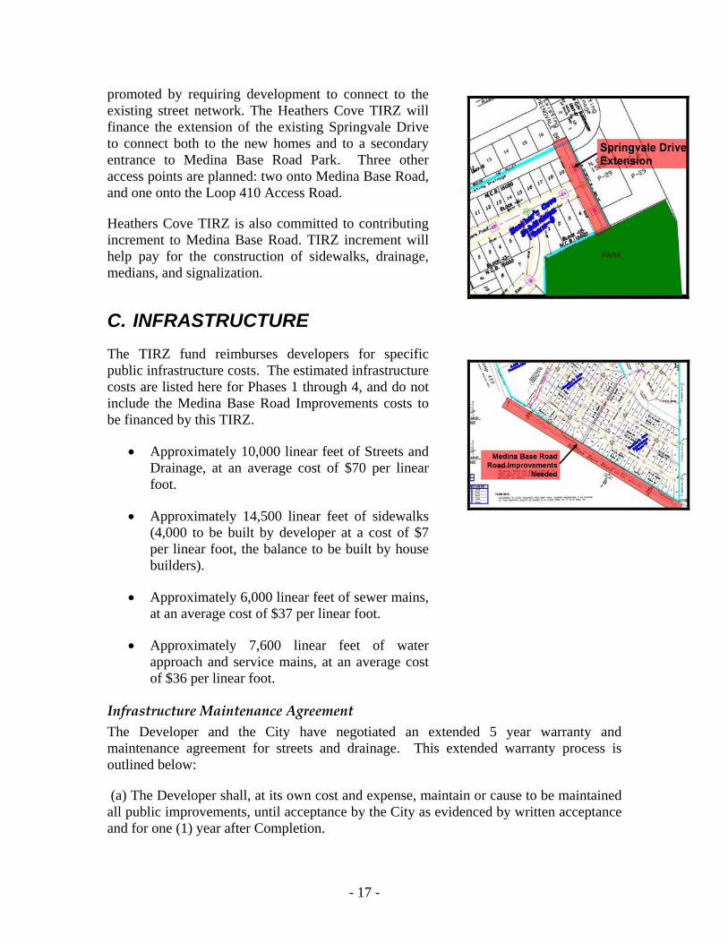
promoted by requiring development to connect to the existing street network. The Heathers Cove TIRZ will finance the extension of the existing Springvale Drive to connect both to the new homes and to a secondary entrance to Medina Base Road Park. Three other access points are planned: two onto Medina Base Road, and one onto the Loop 410 Access Road.
Heathers Cove TIRZ is also committed to contributing increment to Medina Base Road. TIRZ increment will help pay for the construction of sidewalks, drainage, medians, and signalization.
C. INFRASTRUCTURE The TIRZ fund reimburses developers for specific public infrastructure costs. The estimated infrastructure costs are listed here for Phases 1 through 4, and do not include the Medina Base Road Improvements costs to be financed by this TIRZ.
• Approximately 10,000 linear feet of Streets and Drainage, at an average cost of $70 per linear foot.
• Approximately 14,500 linear feet of sidewalks (4,000 to be built by developer at a cost of $7 per linear foot, the balance to be built by house builders).
• Approximately 6,000 linear feet of sewer mains, at an average cost of $37 per linear foot.
• Approximately 7,600 linear feet of water approach and service mains, at an average cost of $36 per linear foot.
Infrastructure Maintenance Agreement The Developer and the City have negotiated an extended 5 year warranty and maintenance agreement for streets and drainage. This extended warranty process is outlined below:
(a) The Developer shall, at its own cost and expense, maintain or cause to be maintained all public improvements, until acceptance by the City as evidenced by written acceptance and for one (1) year after Completion.
- 18 -
(b) Upon acceptance of a streets or drainage improvements for maintenance by the City, Developer shall deliver to the City a one-year extended warranty bond, naming the City as the Obligee, in conformity with Chapter 35 of the City’s Unified Development Code. The cost of repair, replacement and maintenance for defects discovered during the first year after completion shall be paid by the developer or the bond company and shall not be paid out of TIF funds.
(c) After the expiration of the one (1) year extended warranty bond, the cost of the repair, replacement and maintenance of the public improvements shall be the responsibility of the City; however, the City shall be reimbursed from the Contingency Fund as listed in the Financing Plan (the “Contingency Fund”) for those costs, including, but not limited to: demolition, rebuilding, engineering, design, new construction or any other cost necessitated by the failure without regard to fault or degree (“failure”) of public infrastructure which is discovered within the second (2d) through fifth (5th) years after completion of the infrastructure.
(d) If no costs for the repair, replacement or maintenance of a public improvement as a result of a failure are claimed by or due to the City during any year within the second (2nd) through fifth (5th) years after completion of the infrastructure, the Developer shall receive the entire approved reimbursement amount available in that year.
(e) In the event any costs for the repair, replacement or maintenance of a public improvement are claimed by the City due to a failure discovered within the second (2nd) through fifth (5th) years after completion of the infrastructure, the City shall be fully reimbursed those costs from the TIRZ Contingency Fund.
(f) In the event the TIRZ Contingency Fund does not reflect an amount equal to the costs of the repair, replacement or maintenance of the public improvement, the Contingency Fund balance shall be increased by reallocating other costs within the Financing Plan and reducing the approved amount of reimbursement that would have been remitted to the Developer, until the City has been reimbursed its costs in full.
(g) Payment of the City shall take priority over reimbursement of the Developer.
(h) This reallocation of funds shall not be considered an amendment of the Financing Plan and requires no action by the Board or the City Council to be effective.
(i) It shall be no defense to the City’s reimbursement of itself out of the TIRZ fund that the City or its agents have inspected, accepted or approved the public infrastructure. Approval or acceptance of public infrastructure is not a waiver of claims under this section. The City may attempt multiple repairs on the same infrastructure and reimburse itself for each attempt.
(j) The Developer, its agents, employees, and contractors will not interfere with reasonable use of all the Public Improvements by the general public, except for drainage retention improvements. In accordance with the Construction Schedule, the Developer shall use its best efforts to dedicate (or grant a public easement) to the Public Improvements where applicable to the appropriate Participating Taxing Entity (as

- 19 -
determined by the City), at no additional cost or expense to the City or any other Participating Taxing Entity within sixty (60) days after completion and acceptance of the improvements.
(k) Reimbursement of the developer shall not be unreasonably denied provided the improvement has reached “Completion” under Subsection (a) or (b) above, and provided that the City has no active claim for reimbursement under this section.
(l) The requirements of the contract cannot be waived or modified in any way by an engineer, employee or other official of the City or its subordinate agency with responsibility for inspecting or certifying public infrastructure. The actions of a city employee or agent do not work an estoppel against the City under the contract or the Unified Development Code.
D. PARKS The TIRZ will reimburse Parks for street improvements on Springvale Drive, which provides a direct connection to the park's rear entrance from existing residential areas as well as from the new development. In addition, the project developer will provide additional funds for park improvements in the amount of $75,000.
The developer will also build three pedestrian trails into the adjacent park, as marked on the MDP, to connect to the main Park loop trail. The trails will be built as 10' pedestrian easements containing an 8' walking trail, and will comply with Park Standards.
E. FINANCIAL INFORMATION HLH Developments LP has arranged the financing for this project through Plaza Bank for all infrastructure and site improvements.
Analysis performed by the Management and Budget Department show that the Heathers Cove TIRZ generates $449,364 for the City through FY 2029. There is never a year where the City loses money on operations. No police officers were generated by this TIF development
More detailed financial information is available in the Final Financing Plan.
- 20 -
5. Project Feasibility 1
Market Conditions Ranked as one of the tenth largest cities in the United States, San Antonio is considered one of the fastest growing metropolitan areas, between 2000 and 2003 it was the third fastest growing area in the United States in addition, it offers close proximity to the major Texas population centers, with the north-south and east-west interstate highways connecting San Antonio with all the major Texas cities, the entire United States and Mexico. San Antonio, strategically located in south central Texas, along the Interstate 35 (I-35) corridor, has historically served as the economic hub of the region, which has resulted in the development of a diverse economy. The economy is a mix of anchoring business services, including a growing medical and health delivery sector, various manufacturing facilities, convention and visitor industry, and the military.
The San Antonio area has seen significant growth during the last 30 years enjoying an average annual growth rate of 3.5%. Based on the Texas Comptroller’s economic model of Texas, employment in the San Antonio region is projected to continue to grow at a 1.6% annual rate through 2005. During this time, the population, as well as per capita incomes of the San Antonio area, has also grown and is expected to continue. According to the Greater San Antonio Chamber of Commerce Economic Analysis Panel, local business activity has remained steady in the first quarter of 2004. San Antonio has posted an 11,161 net job gain and a .9% unemployment rate drop between January 2004 and May 2004.
The housing market in San Antonio offers variety in price and location. The average price for a pre-owned house in the San Antonio area in 1997 was $106,000, while the median price was approximately $86,000 according to the Real Estate Center at Texas A&M University. In 2003, those figure increased respectively to $138,300 and $113,800. The areas in San Antonio experiencing marked growth generally stretch northward toward Boerne and north/northeast along the United States 281 and I-35 corridor and include single and multifamily developments serving higher-income family households. New housing product in the other sectors of the City remains relatively limited with an even more limited number of newly constructed affordable housing products citywide.
In the period from 1999 – 2004, the City of San Antonio’s average total value (land plus improvements) increased 44%. In the same time period, the values of the Heathers Cove TIRZ Census Tracts increased only 28%.
1 Information in this section was provided to the City by applicant as part of TIF application.

- 21 -
According to studies done by the TIRZ applicant, home values in the adjacent subdivision have remained stagnant and in some cases declined in value over the last three years.
Responding to the demand of the target market for additional housing units, the proposed Heathers Cove development should provide an affordable alternative to recent and ongoing market housing developments.
Target Market The target market, defined for the purposes of this study, is a 1.5-mile circumference around the property. This area consists primarily of households in the San Antonio area who earn above the area median, adjusted for family size. For a family of four, the 2002 median income for San Antonio is $46,200. The current median age for the residents in this area is 23.37 years, well below the national median age of 36.2. The average household income for the target market is estimated to be $45,642, and is expected to increase 15.9% to $52,899 over the next five years, based on Claritas projections.
Effective Market Area For the purposes of this analysis, the Primary Market Area (PMA) is a .5-mile diameter and the Secondary Market Area (SMA) is a 1.5-mile diameter around the development. Major arteries for the Primary and Secondary Market Area include Loop 410 and Highway 90. The PMA and SMA were selected based on residential movement that is expected within the San Antonio area.
Population The population growth in the San Antonio area has been consistently above national averages for the past ten years ranging from 1.6% to 2.3% since 1991. The Texas State Data Center projects that the population will increase from the Census estimate between 2000 and 2005 by an average gain of approximately 39,000 per year.
Demand for Housing San Antonio experienced the formation of 108,925 households between 1990 and 2000 Censuses, equating to an annual average of approximately 10,900 households. This implies a correlation between population growth and household formation of about two people for every one marginal household. Applying this ratio suggests that over 8,500 households will be formed in 2002. Historically, demand for new single-family housing within Bexar County has averaged 6,311 units annually over the past five years, with an overall demand of 8,431 units in 2003. It is anticipated that actual totals will be higher as job creation recovers in the wake of the recent series of lay-offs by major San Antonio employers and the closure of Kelly Air Force Base.
The median home price was approximately $112,100 in the first quarter of 2004 with 63.4% of households living in owner-occupied housing, slightly below the national average of 64.2%. Due to the improving economy in 2004, a relatively low interest rate, and a steady supply of single-family housing, it is anticipated that the propensity to own will increase over this year and the next. Single-family absorption varies geographically

- 22 -
in San Antonio, with areas north of US Highway 90 and outside Loop 410 capturing the largest share over the past five years.
New Single Family Absorption Chart NEW SINGLE FAMILY ABSORPTION (INNER CITY) BY PRICE RANGE 1996-2000
Price Range
1996
1997
1998
1999
2000
1996-2000
1996-2000
(AVG)
Percent of Total
Less than $60,000 10 118 104 121 204 557 111 47.8%
60,000 to $79000$ 2 2 2 21 49 76 15 6.6%
$80,000 t0 $99,000 0 1 21 99 63 184 37 16.1%
$100,000 to $124,000 0 0 2 33 44 79 16 6.9%
$125,000 to $199,999 15 17 12 8 12 64 13 5.6%
$200,000 and over 29 24 27 51 53 184 37 16.1%
TOTAL 56 162 168 333 425 1144 229 100.0%
Numerical Change 106 6 165 92
Percent Change 189.3% 3.7% 98.2% 27.6%
Source: Housing Market Analysis City of San Antonio 2001
NEW SINGLE FAMILY ABSORPTION (INNER CITY) BY PRICE RANGE 2001-2005
Price Range
2001
2002
2003
2004
2005
2001-2005
2001-2005
(AVG)
Percent of Total
Less than $60,000 215 218 214 207 2019 1062 212 48.7%
60,000 to $79000$ 29 30 29 28 29 145 29 6.6%
$80,000 t0 $99,000 71 72 71 68 69 351 70 16.1%
$100,000 to $124,000 30 31 30 29 30 151 30 6.9%
$125,000 to $199,999 25 25 25 24 24 122 24 5.6%
$200,000 and over 71 72 71 68 69 351 70 16.1%
TOTAL 441 447 439 425 429 2181 436 100.0%
Numerical Change 16 6 -8 -14 4
Percent Change 3.8% 1.4% -1.8% -3.2% 0.9%
Source: Housing Market Analysis City of San Antonio 2001
Over the past twelve months absorption of new apartments units increased, however in the 2nd quarter of 2004 there were more units added to inventory than were absorbed. Overall occupancy rates dropped during the second quarter from 91.75% to 91.69%. Class-A and new apartments continued to lease well with losses occurring in Class-B and C complexes According to the Texas A&M Real Estate Research Center there are currently over 5,000 units under construction with an additional 4,400 units expected to break ground in the next 12 months. The continued addition of large numbers of new Class A units will continue to impact B and C Class units with an increasing number of projects becoming economically infeasible to keep open.
- 23 -
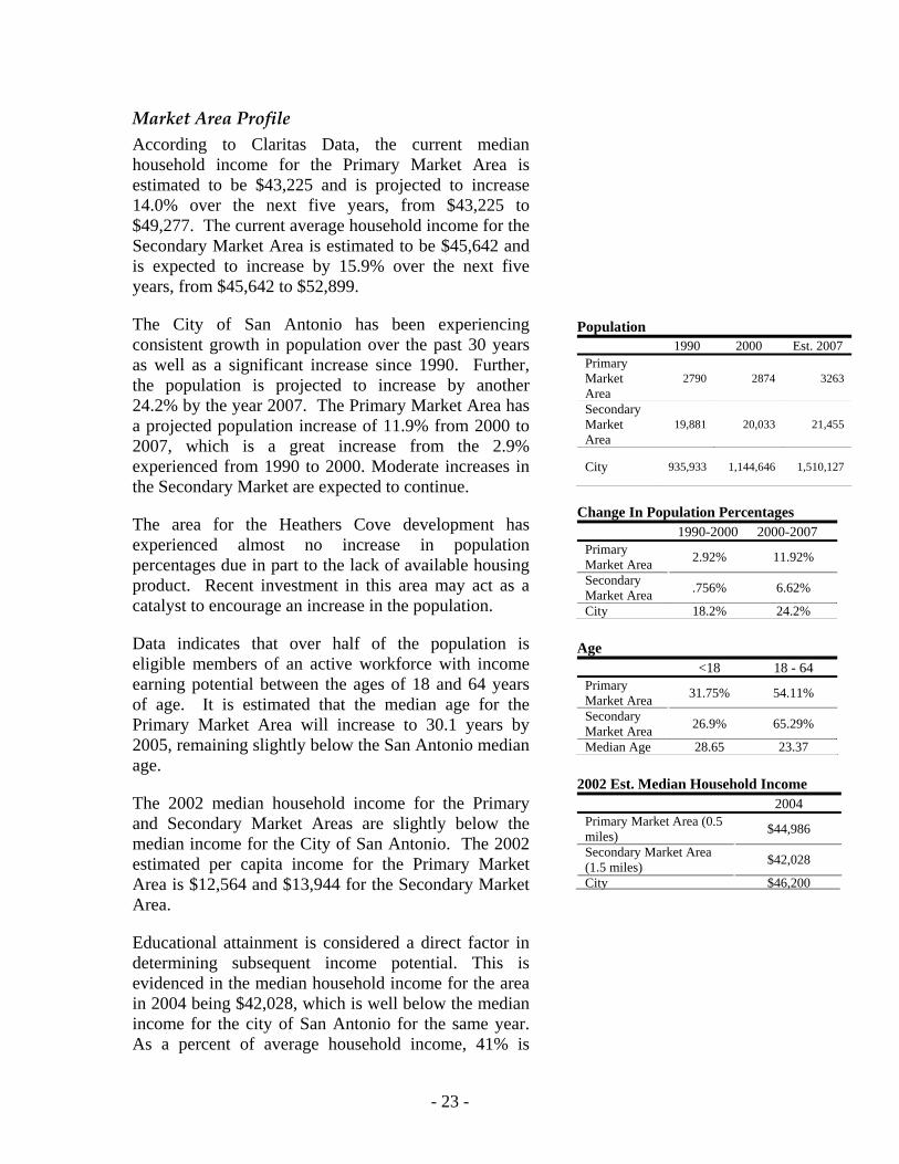
Market Area Profile According to Claritas Data, the current median household income for the Primary Market Area is estimated to be $43,225 and is projected to increase 14.0% over the next five years, from $43,225 to $49,277. The current average household income for the Secondary Market Area is estimated to be $45,642 and is expected to increase by 15.9% over the next five years, from $45,642 to $52,899.
The City of San Antonio has been experiencing consistent growth in population over the past 30 years as well as a significant increase since 1990. Further, the population is projected to increase by another 24.2% by the year 2007. The Primary Market Area has a projected population increase of 11.9% from 2000 to 2007, which is a great increase from the 2.9% experienced from 1990 to 2000. Moderate increases in the Secondary Market are expected to continue.
The area for the Heathers Cove development has experienced almost no increase in population percentages due in part to the lack of available housing product. Recent investment in this area may act as a catalyst to encourage an increase in the population.
Data indicates that over half of the population is eligible members of an active workforce with income earning potential between the ages of 18 and 64 years of age. It is estimated that the median age for the Primary Market Area will increase to 30.1 years by 2005, remaining slightly below the San Antonio median age.
The 2002 median household income for the Primary and Secondary Market Areas are slightly below the median income for the City of San Antonio. The 2002 estimated per capita income for the Primary Market Area is $12,564 and $13,944 for the Secondary Market Area.
Educational attainment is considered a direct factor in determining subsequent income potential. This is evidenced in the median household income for the area in 2004 being $42,028, which is well below the median income for the city of San Antonio for the same year. As a percent of average household income, 41% is
Population
1990 2000 Est. 2007 Primary Market Area
2790 2874 3263
Secondary Market Area
19,881 20,033 21,455
City 935,933 1,144,646 1,510,127
Change In Population Percentages
1990-2000 2000-2007 Primary Market Area 2.92% 11.92%
Secondary Market Area .756% 6.62%
City 18.2% 24.2% Age
<18 18 - 64 Primary Market Area 31.75% 54.11%
Secondary Market Area 26.9% 65.29%
Median Age 28.65 23.37 2002 Est. Median Household Income
2004 Primary Market Area (0.5 miles) $44,986
Secondary Market Area (1.5 miles) $42,028
City $46,200

- 24 -
typically dedicated to mortgages and related household expenses. This would result in the average homebuyer in this area being able to afford $1436 a month dedicated to housing.
Employment Lackland Air Force Base is the primary industry within the primary and secondary areas surrounding the proposed development. Other area employers include: Sun Valley, Valley Hi, and Lackland City Elementary Schools; Rayburn Middle School; and the retail complex anchored by HEB at the intersection of Valley Hi Drive and Loop 410. There are no large retail, office or commercial users within either the primary or secondary market areas.
Current Housing Stock The majority of area housing units, over 93%, are single-family detached structures. In the Primary Market Area, it is estimated that 67.15% of the units were built between 1960 and 1969. According to the 2002 Clarita data, over 80% of the homes in the PMA are valued at $74,999 or less, with an ownership rate of 71.9%. In the Secondary Market area, it is estimated that 47.74% of the units were built between 1960 and 1969. Over three-quarters, 78.28%, of the homes in this area are valued at $74,999 or less, with an ownership rate of 52.21%.
The proposed Heathers Cove development would initially provide homes ranging in cost from $89,000 to $129,000 and would enhance the current housing stock and market activity, and would promote the development of affordable and market rate housing in the area.
According to resale activity obtained from the San Antonio Board of Realtors, there were 45 sales in 2003. Sales for 2004 through May were 18 with 1 pending sale. In 2003 homes sold at an average of 97.3% of the asking price while in 2004 homes were selling on average of 99.6% of the asking price with 10 homes being sold at a price greater than the initial listing price. The average asking price for the 14 homes listed for sale is $63,079 and $54.04/square foot. The projected increase of $8.35/square foot since 2003 indicates a
Educational Attainment
High School + Primary Market Area (0.5 miles) 75.07%
Secondary Market Area (1.5 miles) 75.79%
City 75.51% YTD Sales Closed for Closest Market Area
2003 2004 YTD Average Sales Price $53,679 $57,865
Sales Price Per sq ft $45.69 $48.04
New Listings 28 6
Active Listings 20 14
Pending Sales 5 1
Days on Market 80 8
- 25 -
sellers market for housing in the market area. Figures indicate that there is a demand for housing product in this location and price range as evidenced by the increase in asking price for homes, the price per square foot and the incredible decrease in days on market from 80 to 8. The increased asking price also reflects seller’s knowledge that the Toyota opening will increase demand for area housing.
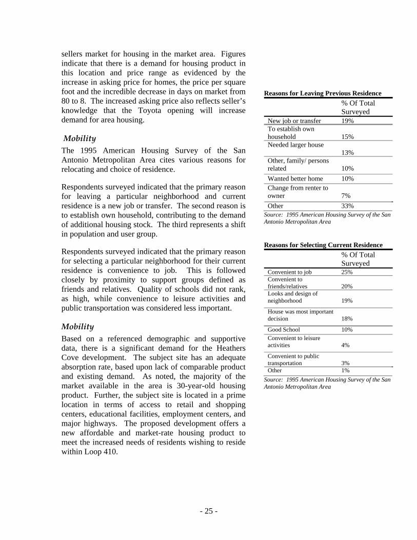
Mobility The 1995 American Housing Survey of the San Antonio Metropolitan Area cites various reasons for relocating and choice of residence.
Respondents surveyed indicated that the primary reason for leaving a particular neighborhood and current residence is a new job or transfer. The second reason is to establish own household, contributing to the demand of additional housing stock. The third represents a shift in population and user group.
Respondents surveyed indicated that the primary reason for selecting a particular neighborhood for their current residence is convenience to job. This is followed closely by proximity to support groups defined as friends and relatives. Quality of schools did not rank, as high, while convenience to leisure activities and public transportation was considered less important.
Mobility Based on a referenced demographic and supportive data, there is a significant demand for the Heathers Cove development. The subject site has an adequate absorption rate, based upon lack of comparable product and existing demand. As noted, the majority of the market available in the area is 30-year-old housing product. Further, the subject site is located in a prime location in terms of access to retail and shopping centers, educational facilities, employment centers, and major highways. The proposed development offers a new affordable and market-rate housing product to meet the increased needs of residents wishing to reside within Loop 410.
Reasons for Leaving Previous Residence
% Of Total Surveyed
New job or transfer 19% To establish own household
15%
Needed larger house 13%
Other, family/ persons related
10%
Wanted better home 10% Change from renter to owner
7%
Other 33% Source: 1995 American Housing Survey of the San Antonio Metropolitan Area Reasons for Selecting Current Residence
% Of Total Surveyed
Convenient to job 25% Convenient to friends/relatives
20%
Looks and design of neighborhood
19%
House was most important decision
18%
Good School 10% Convenient to leisure activities
4%
Convenient to public transportation
3%
Other 1% Source: 1995 American Housing Survey of the San Antonio Metropolitan Area

- 26 -
6. Departmental Review A team of various departments analyzed the viability and feasibility of the project, evaluating the Application for Redevelopment submitted to the City expressing interest in TIF.
To ensure that the criteria set forth in the City’s Tax Increment Financing and Reinvestment Zone Guidelines & Criteria has been met along with other City policies, the respective departments review and coordinate with the developer and TIF coordinating department, information related to the project that assists in the analysis from their perspective.
Upon final analysis, each participating department submits a narrative review of the project. The City departments that comprise the team for analysis of the Mission Creek project are: City Attorney’s Office; Development Services; Environmental Services; Finance; Fire; Housing and Neighborhood Services; Management & Budget; Parks & Recreation; Planning; and Public Works.

- 27 -
7. Appendix: Infrastructure Cost Estimates (Not including Medina Base Road & Park Improvements)
Heather’s Cove Subdivision Phase-1 Description Total L.F. Total Cost Cost Per L.F. Streets & Drainage 2,936 $210,767.09 $71.79 Water System 3,234 $104,888.36 $32.43 Sewer System 1,753 $54,982.53 $31.36 Sidewalks & Approaches 3,707 Done By Home Builders Heather’s Cove Subdivision Phase-2 Description Total L.F. Total Cost Cost Per L.F. Streets & Drainage 3,229 $232,368.40 $71.96 Water System 2,403 $85,974.25 $35.78 Sewer System 2,077 $79,641.40 $38.34 Sidewalks & Approaches 4,631 Done By Home Builders Heather’s Cove Subdivision Phase-3 Description Total L.F. Total Cost Cost Per L.F. Streets & Drainage 3,268 $216,000.00 $66.10 Water System 2,001 $77,000.00 $38.48 Sewer System 1,744 $70,000.00 $40.14 Sidewalks & Approaches 4,274 $28,000.00 $6.55 Heather’s Cove Subdivision Phase-4 Description Total L.F. Total Cost Cost Per L.F. Streets & Drainage 624 $44,903.04 $71.96 Water System 2 EUD’s $2,704.00 $1,352 Per EDU Sewer System 367 $14,070.78 $38.34 Sidewalks & Approaches 1,889 Done By Home Builders

- 28 -
8. Exhibits
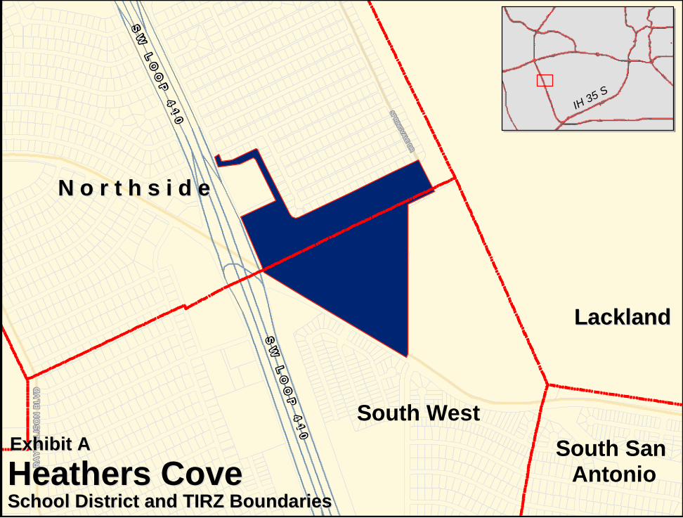
N o r t h s i d eN o r t h s i d e
LacklandLackland
SW
LO
OP
41
0
SW
LO
OP
41
0
RA
Y E
LLIS
ON
BL
VD
SPRINGVALE DR
IH 35 S
Heathers CoveHeathers CoveSchool District and TIRZ BoundariesSchool District and TIRZ Boundaries
Exhibit AExhibit A South San Antonio
South West
MEDINA BASE RD
SPRINGVALE DR
VALLEY HI DR
NEW VALLEY HI DR
HUGH
ES
CRAW AVE
ELM VALLEY
SELFRIDGE
CARSWELL AVE
SUN
VALLEY
PATRICK ST
AP
PLE
VA
LLE
Y D
R
ANDREWS
TINKER DR
BIRCH VALLEY
BARNES AVE
CO
VE
LFLAIR DR
GOTT
DEER VALLEY DR
CEDAR VALLEY DR
CAROUSEL
FAIR VALLEY
ROCK VALLEY EBBTIDE DR
ALDRICH DR
LAKE VALLEY DR
WURTSMITH
FIR VALLEY DR
DAYTONA DR
PA
LM V
ALL
EY
DR
MOON VALLEY
GEO
RG
E AVE
FOREST VALLEY
UNNAMED ST IN LACKLAND AFB
ITHACA DRHILLSDALE
RANCH VALLEY
MORNING VALLEYMEADOW VALLEY
PARADISE VALLEY
AMBER VALLEY
GALAXY DR
PEACH VALLEY
SHADOW VALLEY
CHELI LN
PARALLEL DR
PLEASANT VALLEY
MOUNTAIN VALLEY
GOLDEN VALLEY
HIDDEN VALLEY DR
MAPLE VALLEY
KILKENNY
HAZEL VALLEY DR
CASTLE
BUNTING
KNIGHT ST
GOETTER
SARNOSKY
CLE
AR
VA
LLE
Y D
R
DA
WN
VA
LLE
Y D
R
COVEL
IH 35 S
Heathers CoveHeathers CoveFloodplain 100-year and TIRZ BoundariesFloodplain 100-year and TIRZ Boundaries
Exhibit BFlood plain - 100 yr
Heathers Cove Boundary
SW
LO
OP
41
0
0 0.25 0.50.125Miles
Indian Creek ParkMedina Base Park
SW
LO
OP
41
0
SW
LO
OP
41
0 A
CC
ES
S R
D
SW
LO
OP
41
0 A
CC
ES
S R
D
MEDINA BASE RD
SPRINGVALE DR
ITHACA DR
HILLSDALE
FLAIR DR
GALAXY DR
KILKENNY
TINKER DROAK VALLEY DR
PARALLEL DR
EBBTIDE DR
ROCK VALLEY
UNNAMED ST IN LACKLAND AFB
0 300 600150Feet
Exhibit CHeathers Cove TIRZExisting Land Use 2006
Exempt
Inventory
Commercial
Residential
Utility
Agricultural
Vacant
Park
H e a t h e r s C o v e
L a c k l a n dA i r F o r c e
B a s e