fifth five-year review report for uravan uranium project ... · martin hestmark five-year review...
TRANSCRIPT
Martin Hestmark
Five-Year Review Report
Fifth Five-Year Review Report for
Uravan Uranium Project (Union Carbide) EPA ID COD007063274
Uravan Montrose County, Colorado
September 2015
Prepared By: United States Environmental Protection Agency
Region 8 Denver, Colorado
Assistant Regional Administrator Office of Ecosystems Protection
and Remediation
i
Table of Contents
List of Acronyms .......................................................................................................................... iii
Executive Summary ..................................................................................................................... iv
Five-Year Review Summary Form ............................................................................................. vi
1.0 Introduction ............................................................................................................................. 1
2.0 Site Chronology ....................................................................................................................... 2
3.0 Background ............................................................................................................................. 2
3.1 PHYSICAL CHARACTERISTICS .......................................................................................... 2 3.2 LAND AND RESOURCE USE .............................................................................................. 8 3.3 HISTORY OF CONTAMINATION ......................................................................................... 8 3.4 INITIAL RESPONSE ........................................................................................................... 9
3.5 BASIS FOR TAKING ACTION ............................................................................................. 9
4.0 Remedial Actions .................................................................................................................... 8
4.1 REMEDY SELECTION ...................................................................................................... 10 4.2 REMEDY IMPLEMENTATION ........................................................................................... 14 4.3 OPERATION AND MAINTENANCE (O&M) ....................................................................... 19
5.0 Progress Since the Last Five-Year Review ......................................................................... 20
6.0 Five-Year Review Process .................................................................................................... 22
6.1 ADMINISTRATIVE COMPONENTS .................................................................................... 22 6.2 COMMUNITY INVOLVEMENT .......................................................................................... 22 6.3 DOCUMENT REVIEW ...................................................................................................... 23
6.4 DATA REVIEW ............................................................................................................... 28
6.5 SITE INSPECTION ............................................................................................................ 29 6.6 INTERVIEWS ................................................................................................................... 30
7.0 Technical Assessment ........................................................................................................... 31
7.1 QUESTION A: IS THE REMEDY FUNCTIONING AS INTENDED BY THE DECISION
DOCUMENTS? ............................................................................................................... 31
7.2 QUESTION B: ARE THE EXPOSURE ASSUMPTIONS, TOXICITY DATA, CLEANUP LEVELS AND
REMEDIAL ACTION OBJECTIVES (RAOS) USED AT THE TIME OF REMEDY SELECTION
STILL VALID? ............................................................................................................... 32 7.3 QUESTION C: HAS ANY OTHER INFORMATION COME TO LIGHT THAT COULD CALL INTO
QUESTION THE PROTECTIVENESS OF THE REMEDY? ...................................................... 32
7.4 TECHNICAL ASSESSMENT SUMMARY ............................................................................. 32
8.0 Issues, Recommendations and Follow-up Actions ............................................................. 32
9.0 Protectiveness Statement ...................................................................................................... 33
10.0 Next Review ......................................................................................................................... 33
List of Appendices
Appendix A: List of Documents Reviewed ................................................................................ A-1
Appendix B: Press Notice ........................................................................................................... B-1
Appendix C: Interview Forms .................................................................................................... C-1

ii
Appendix D: Site Inspection Checklist ....................................................................................... D-1
Appendix E: Photographs from Site Inspection Visit .................................................................. E-1
List of Tables
Table 1: Chronology of Site Events ................................................................................................ 2 Table 2: July 2003 Groundwater ACLs ........................................................................................ 14 Table 3: Annual O&M Costs ........................................................................................................ 20 Table 4: Progress on Recommendations from the 2010 FYR ...................................................... 21
Table 5: Previous and Current Standards for Soil COCs .............................................................. 24 Table 6: Summary of Groundwater Protection Standards Evaluation .......................................... 24 Table 7: Summary of Surface Water Standards Used in the ACL Development ......................... 25 Table 8: Institutional Control (IC) Summary Table ..................................................................... 26 Table 9: Mean Constituent Concentration Comparison with ACLs ............................................. 29
Table 10: Current Site Issues and Recommendations................................................................... 33
List of Figures Figure 1: Site Location Map ........................................................................................................... 5
Figure 2: Detailed Site Map ............................................................................................................ 6 Figure 3: 1987 RAP Reclamation of Existing Facilities Uravan Mill Map .................................... 7
Figure 4: Draft Land Status Map with Proposed Land Transfer Boundaries ............................... 27 Figure 5: B-Plant Repository Settlement, 2008 to 2015 ............................................................... 28

iii
List of Acronyms 226Ra radium-226
ACL Alternate Concentration Level
AEC Atomic Energy Commission
ALARA As Low As Reasonably Achievable
ARAR Applicable or Relevant and Appropriate Requirement
bgs below ground surface
BLM Bureau of Land Management
CDOT Colorado Department of Transportation
CDPHE Colorado Department of Public Health and Environment
CERCLA Comprehensive Environmental Response, Compensation, and Liability Act
CFR Code of Federal Regulations
CIC Community Involvement Coordinator
cm centimeter
COC Contaminant of Concern
CRP Club Ranch Evaporation Pond
DOE Department of Energy
EPA U.S. Environmental Protection Agency
FYR Five-Year Review
IC Institutional Control
mg/L milligram per liter
NCP National Contingency Plan
NPL National Priorities List
NRC United States Nuclear Regulatory Commission
O&M Operation and Maintenance
PCB polychlorinated biphenyl
pCi/g picocuries per gram
pCi/L picocuries per liter
PRP Potentially Responsible Party
RAO Remedial Action Objective
RAP Remedial Action Plan
RI/FS Remedial Investigation/Feasibility Study
ROD Record of Decision
RPM Remedial Project Manager
TBC To-Be-Considered
UCC Union Carbide Corporation
UMTRCA Uranium Mill Tailings Radiation Control Act
USV U.S. Vanadium Corporation

iv
Executive Summary
The Uravan Uranium Project (Union Carbide Corp.) site (Site) is located in Montrose County,
Colorado. It covers about 680 acres. A radium-recovery plant began operating on Site in 1912.
From the 1930s until 1984, the plant was a uranium and vanadium processing facility.
Operations at the Site left behind a large volume of wastes that contaminated air, soil and
groundwater near the plant and the San Miguel River. Solid wastes totaled over 10 million cubic
yards and contained radioactive elements, metals and inorganic compounds. Liquid wastes from
seepage collection and groundwater extraction systems totaled over 350 million gallons at the
end of 2004.
Contaminants included radioactive products, including raffinates (liquid wastes from the
uranium processing operations), raffinate crystals (primarily ammonium sulfate compounds), and
mill tailings containing uranium and radium. Other chemicals in the tailings and groundwater
included heavy metals (lead, arsenic, cadmium and vanadium), thorium and residual salts. The
U.S. Environmental Protection Agency (EPA) listed the Site on the National Priorities List
(NPL) in 1986. The majority of the work at this Site was conducted as a State-lead Site under a
Consent Decree/Remedial Action Plan (RAP) (Civil Action No. 83-C-2384) between the State of
Colorado, Union Carbide Corporation and Umetco Minerals Corporation (Umetco), lodged in
February 1987. EPA was not a party to the Consent Decree. Cleanup remedies from the 1987
RAP, as amended, included:
Capping and revegetating nearly 10 million cubic yards of radioactive tailings.
Disposing of 530,000 cubic yards of radioactive raffinate crystals on Site.
Eliminating process ponds.
Pumping and treating contaminated groundwater.
Securing 12 million yards of tailings waste along the San Miguel River.
Dismantling the two mills and placing all old building demolition materials in a secure
area.
Excavating and disposing of contaminated soil in a secure location and replanting
excavated areas.
Dismantling and cleaning up the town of Uravan.
The wastes are contained on Site, releases to the San Miguel River are under control, and there is
no longer any residential exposure to radiation from raffinates, raffinate crystals and mill tailings
containing uranium, thorium and radium. On February 18, 2005, EPA did a partial deletion of
9.84 acres of the Site that previously contained two historic structures – the Boarding House and
the Community Center – from the NPL. On September 4, 2007, EPA did a partial deletion of a 7-
acre portion of the Site along Colorado Highway 141. The triggering action for this five-year
review (FYR) is the signing of the previous FYR on September 28, 2010.
The remedy at the Site currently protects human health and the environment. Contaminated
materials have been excavated from areas of the Site and placed in capped landfills on Site and

v
contaminated groundwater has been pumped and treated to protect the river. For the remedy to
be protective over the long term, the following actions need to be taken:
Finalize the Site remedy in a Record of Decision (ROD) and implement the institutional
controls consistent with the ROD.
Determine extent of coal ash contamination and determine if remediation is necessary.
Determine if settlement at the B-Plant Repository is affecting the cap.
vi
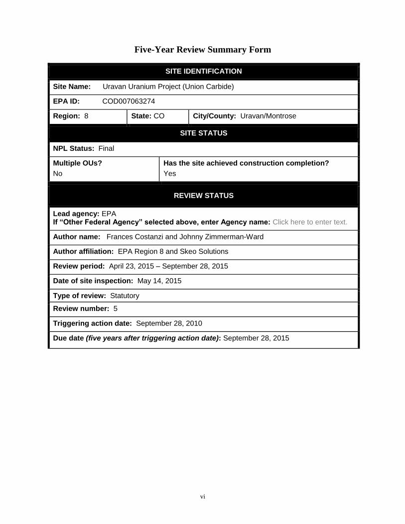
Five-Year Review Summary Form
SITE IDENTIFICATION
Site Name: Uravan Uranium Project (Union Carbide)
EPA ID: COD007063274
Region: 8 State: CO City/County: Uravan/Montrose
SITE STATUS
NPL Status: Final
Multiple OUs?
No
Has the site achieved construction completion?
Yes
REVIEW STATUS
Lead agency: EPA If “Other Federal Agency” selected above, enter Agency name: Click here to enter text.
Author name: Frances Costanzi and Johnny Zimmerman-Ward
Author affiliation: EPA Region 8 and Skeo Solutions
Review period: April 23, 2015 – September 28, 2015
Date of site inspection: May 14, 2015
Type of review: Statutory
Review number: 5
Triggering action date: September 28, 2010
Due date (five years after triggering action date): September 28, 2015

vii
Five-Year Review Summary Form (continued)
Issues/Recommendations
OU(s) without Issues/Recommendations Identified in the Five-Year Review:
None
Issues and Recommendations Identified in the Five-Year Review:
OU(s): Sitewide Issue Category: Remedy Performance
Issue: No ROD is yet in place and no institutional controls are in place restricting land and groundwater use.
Recommendation: Finalize the site remedy in a ROD and implement institutional controls consistent with the ROD.
Affect Current Protectiveness
Affect Future Protectiveness
Implementing Party
Oversight Party
Milestone Date
No Yes EPA/State EPA 09/30/2017
OU(s): Sitewide Issue Category: Changed Site Conditions
Issue: Coal ash, a non-licensed material, contamination was found when Umetco built a bridge across the San Miguel River at Montrose County Road EE-22.
Recommendation: Determine extent of coal ash contamination and determine if remediation is necessary.
Affect Current Protectiveness
Affect Future Protectiveness
Implementing Party
Oversight Party
Milestone Date
No Yes PRP EPA/State 09/30/2016
OU(s): Sitewide Issue Category: Remedy Performance
Issue: There has been a slight, steady increase in settlement since 2008 at the three surface settlement monuments installed on the completed top surface of the B-Plant Repository.
Recommendation: Determine if settlement at the B-Plant Repository is affecting the cap.
Affect Current Protectiveness
Affect Future Protectiveness
Implementing Party
Oversight Party
Milestone Date
No Yes EPA/State EPA 09/30/2016
viii
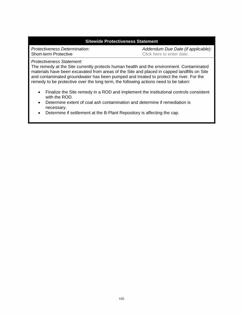
Sitewide Protectiveness Statement
Protectiveness Determination: Short-term Protective
Addendum Due Date (if applicable): Click here to enter date.
Protectiveness Statement: The remedy at the Site currently protects human health and the environment. Contaminated materials have been excavated from areas of the Site and placed in capped landfills on Site and contaminated groundwater has been pumped and treated to protect the river. For the remedy to be protective over the long term, the following actions need to be taken:
Finalize the Site remedy in a ROD and implement the institutional controls consistent with the ROD.
Determine extent of coal ash contamination and determine if remediation is necessary.
Determine if settlement at the B-Plant Repository is affecting the cap.
1
Fifth Five-Year Review Report
for
Uravan Uranium Project (Union Carbide) Superfund Site
1.0 Introduction
The purpose of a five-year review (FYR) is to evaluate the implementation and performance of a
remedy in order to determine if the remedy is protective of human health and the environment.
FYR reports document FYR methods, findings and conclusions. In addition, FYR reports
identify issues found during the review, if any, and document recommendations to address them.
The United States Environmental Protection Agency (EPA) prepares FYRs pursuant to the
Comprehensive Environmental Response, Compensation and Liability Act (CERCLA) Section
121 and the National Oil and Hazardous Substances Pollution Contingency Plan (NCP).
CERCLA Section 121 states:
If the President selects a remedial action that results in any hazardous substances,
pollutants, or contaminants remaining at the site, the President shall review such remedial
action no less often than each 5 years after the initiation of such remedial action to assure
that human health and the environment are being protected by the remedial action being
implemented. In addition, if upon such review it is the judgment of the President that
action is appropriate at such site in accordance with section [104] or [106], the President
shall take or require such action. The President shall report to the Congress a list of
facilities for which such review is required, the results of all such reviews, and any
actions taken as a result of such reviews.
EPA interpreted this requirement further in the NCP, 40 Code of Federal Regulations (CFR)
Section 300.430(f)(4)(ii), which states:
If a remedial action is selected that results in hazardous substances, pollutants, or
contaminants remaining at the site above levels that allow for unlimited use and
unrestricted exposure, the lead agency shall review such action no less often than every
five years after initiation of the selected remedial action.
Skeo Solutions, an EPA Region 8 contractor, conducted the FYR and prepared this report
regarding the remedy implemented at the Uravan Uranium Project (Union Carbide) Superfund
site (the Site) in Uravan, Montrose County, Colorado. EPA’s contractor conducted this FYR
from April 23, 2015 to September 2015. The Colorado Department of Public Health and
Environment (CDPHE) is the lead agency for developing and implementing the remedy for the
potentially responsible party (PRP)-financed cleanup at the Site. CDPHE, as the agency
representing the State of Colorado, has reviewed all supporting documentation and provided
input to EPA during the FYR process.
This is the fifth FYR for the Site. The triggering action for this statutory review is the previous
FYR. The FYR is required because hazardous substances, pollutants or contaminants remain at

2
the Site above levels that allow for unlimited use and unrestricted exposure. The Site consists of
one operable unit, which is addressed in this FYR.
2.0 Site Chronology
Table 1 lists important events at the Site.
Table 1: Chronology of Site Events
Event Date
Standard Chemical Company built radium-recovery plant 1912
Town of Uravan established 1936
Initial discovery of contamination April 1, 1980
Operations ceased at the Site 1984
All Uravan residents relocated 1986
EPA and Colorado Memorandum of Agreement signed April 2, 1986
National Priorities List (NPL) listing June 10, 1986
Consent decree signed December 19, 1986
Remedial design started January 30, 1987
Consent decree and Remedial Action Plan (RAP) lodged by U.S. District
Court and State of Colorado
February 12, 1987
Remedial action started May 1, 1987
First FYR signed September 4, 1994
Soil Cleanup Program Methodology Report finalized June 1999
Remedial design completed June 1, 1999
Second FYR signed March 20, 2000
RAP amended 2001
Application for Alternate Concentration Limits July 2003
RAP amended 2005
Partial NPL deletion (area of former Boarding House and Community
Center) finalized
February 18, 2005
Third FYR signed September 28, 2005
Partial NPL deletion (part of the Site along Colorado Highway 141)
finalized
September 4, 2007
Alternate Soil Standard Application submitted September 2007
Remedial action completed, close-out and construction complete September 29, 2008
Fourth FYR signed September 28, 2010
U.S. Nuclear Regulatory Commission (NRC) approved Alternate Soil
Standard Application
May 18, 2012
Radioactive Materials License Amendment (Colorado License No. 660-
02, Amendment No. 13)
January 22, 2013
3.0 Background
3.1 Physical Characteristics
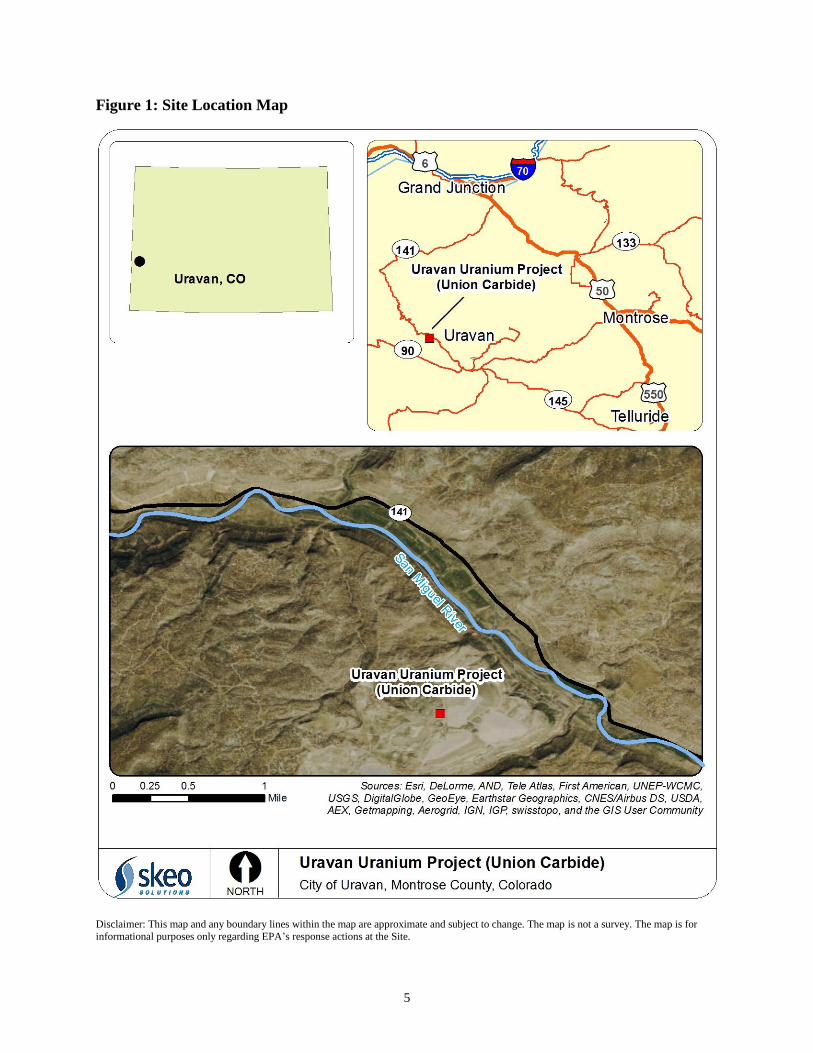
The approximately 680-acre Site is located in the western portion of Montrose County,
Colorado, along Colorado Highway 141. The Site is about 13 miles northwest of the town of
Nucla, Colorado; 81 miles south of the town of Whitewater, Colorado, in Mesa County; and 50
miles southwest of Grand Junction, Colorado (Figure 1). The area around the Site is rural with
3
very few residences nearby. The offices of the PRP, Umetco Minerals Corporation (Umetco), are
the only remaining buildings on Site. Site habitat is characterized by an arid climate, sparse
vegetation and rugged topography. The Site’s topographic features are dominated by broad
mesas and incised canyons. The Site is within the incised San Miguel River Valley and on the
Club Mesa. The Site contained over 10 million cubic yards of byproduct wastes, including
radioactive elements, metals and inorganic compounds. From 1987 until 2004, over 350 million
gallons of liquid waste were collected from seepage collection and groundwater extraction
systems.
The majority of the work at this Site was conducted as a State-lead Site under a Consent
Decree/Remedial Action Plan (CD/RAP) (Civil Action No. 83-C-2384) between the State of
Colorado, Union Carbide Corporation and Umetco Minerals Corporation (Umetco), lodged in
February 1987. EPA was not a party to the Consent Decree. The 1987 RAP, as amended, defined
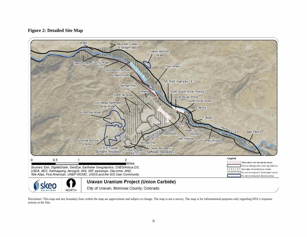
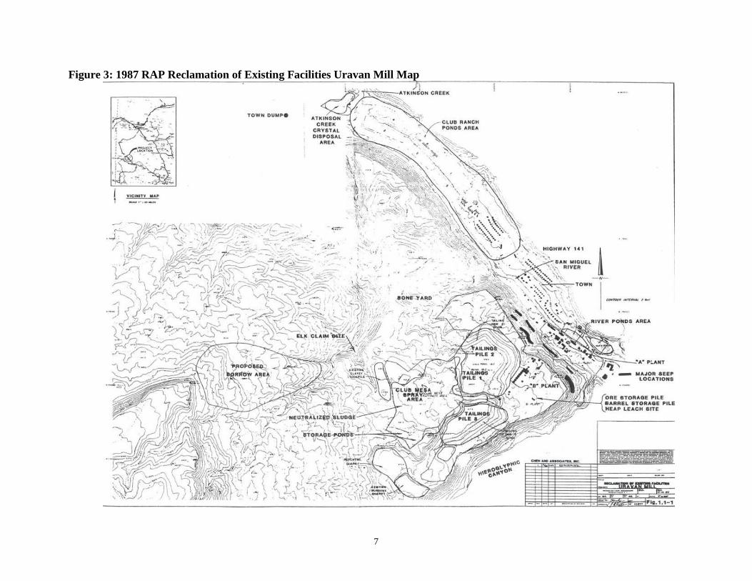
nine areas for solids remediation (Figure 2 shows the current Site area. Figure 3 shows the Site
layout in 1987):
Atkinson Creek Crystal Disposal Area
o Covered, unlined repository containing raffinate crystals, adjacent to Colorado
Highway No. 141.
Club Ranch Ponds (CRPs) Area
o Consisted of six unlined evaporation ponds containing primarily raffinate crystals
and ponded liquids adjacent to and above the San Miguel River.
River Ponds Area
o Consisted of seven small ponds containing settles solids and tailings along the San
Miguel River next to the mill.
Tailings Piles
o Consisted of three Tailings Piles containing over 10,000,000 tons of tailings on
Club Mesa above the San Miguel River.
Club Mesa Area
o Located upslope from Tailings Piles 1, 2 and 3. Includes two clay-lined storage
ponds, a neutralized sludge storage area, an area used for the spray evaporation of
raffinate liquid, and an adjacent area of soils contaminated by spray from the
evaporation procedure.
Mill Areas
o The A- and B- Plant areas, an ore stockpile area, a barrel storage area, a heap
leach site, a yard (bone yard) for scrap equipment and adjacent contaminated
materials.
Town and Adjacent Areas
o Consisted of the town of Uravan, town dump, adjacent drainage ways (Atkinson
Creek, San Miguel River, Hieroglyphic Canyon and dry washes) and remnant
waste materials previously used in near-Site construction activities.
Burbank Quarry
o Borrow pit for rock and random fill during cleanup and reclamation activities. It
was the designated final repository site for raffinate crystals.
4
Borrow Areas on Club Mesa
o The Borrow Areas on Club Mesa were not contaminated. They were used as
sources of the clayey soils and random backfill during remedial activities.
The RAP also defined contaminated liquids subject to remedial actions to include tailings
seepage (hillside and toe berm), tailings dewatering liquids, ponded liquids, surface runoff and
groundwater.
Groundwater in the region is transmitted via secondary (joint) permeability and primary
(intergranular) permeability. Secondary permeability in the region tends to be directional and
highly variable. The RAP indicated that the Chinle Formation, which underlies the Kayenta-
Wingate Aquifer, was the first hydrogeologic unit of concern for the Site. The RAP stated that all
geologic units below this aquitard, which underlies the deepest water-bearing zone of concern,
should not be affected by the migration of contaminated liquids. The RAP, as amended, provides
further descriptions of the hydrogeologic units. The groundwater system in the San Miguel River
valley is a complex, fractured aquifer that maintains a recharge-discharge relationship with the
San Miguel River.
5
Figure 1: Site Location Map
Disclaimer: This map and any boundary lines within the map are approximate and subject to change. The map is not a survey. The map is for
informational purposes only regarding EPA’s response actions at the Site.
6
Figure 2: Detailed Site Map
Disclaimer: This map and any boundary lines within the map are approximate and subject to change. The map is not a survey. The map is for informational purposes only regarding EPA’s response actions at the Site.
7
Figure 3: 1987 RAP Reclamation of Existing Facilities Uravan Mill Map
8
3.2 Land and Resource Use
Mining operations in this area of Colorado began in the early 1900s. In 1912, the Standard
Chemical Company built a radium mill on the valley floor along the San Miguel River; this area
later became known as “A-Plant.” The mill produced radium until 1919. From the 1930s to 1984,
the plant processed uranium and vanadium.
Due to radioactive contamination in the area, the RAP required that all residents of the town of
Uravan vacate their residences by December 31, 1986. The RAP stated that Union Carbide
Corporation (UCC)/Umetco could not allow any building or improvement at the Site to be
constructed or occupied as a residence. The only building currently on Site is the Umetco offices.
The PRP performs an annual survey of land use within five miles of the Site. Recreational
activities in the area include, but are not limited to, hunting, fishing, camping and rafting.
Limited mine reclamation and exploration drilling activities were observed from 2010 to 2014.
Cattle, although not dairy cattle, graze during the spring and fall. There are no gardens or fruit
trees in restricted areas of the Site. Mine dumps and sub-ore stockpiles were identified as having
the potential to affect reclamation activities.
The San Miguel River flows northwest with pronounced seasonal fluctuations. This stream flow
pattern is characteristic of rivers whose flow is derived primarily from snowmelt runoff. Peak
discharges on the San Miguel River generally occur in late spring or early summer.
Umetco expects to transfer portions of the Site to the Department of Energy (DOE)’s Legacy
Management program, to Montrose County for institutional control management and to the
Bureau of Land Management (BLM).
3.3 History of Contamination
In 1928, UCC purchased the Standard Chemical Company holdings in Colorado through its
subsidiary U.S. Vanadium Corporation (USV). UCC expanded the “A-Plant” in 1934,
constructing a mill and roasting plant to recover vanadium from carnotite ore. UCC added
uranium recovery circuits shortly thereafter. The town of Uravan was established in 1936 to
house workers at the mill and mine facilities, and their families. USV sold the recovered
vanadium and uranium concentrates to the U.S. Army. Construction began in 1943 for a new
plant at Uravan (termed the WSP Plant) near the existing USV mill (termed the WAA Plant).
USV’s WAA Plant was under government contract by June 1944. Operations at the
government’s WSP Plant at Uravan began in July 1943 and ended in 1945. USV subsequently
dismantled the plant. In 1945, USV’s WAA mill reverted to private operations. The “B-Plant”
was constructed in 1955 on a bench on Club Mesa, several hundred feet above the San Miguel
River.
The Uravan mill’s capacity continued to expand in the 1950s to meet U.S. government weapons
programs’ demand for uranium, pursuant to a contractual agreement between USV and the U.S.
Atomic Energy Commission (AEC). The Uravan mill received uranium/vanadium ores from
9
over 200 mines in the area. The mill operated under a series of licenses issued by AEC
(subsequently regulated by the U.S. Nuclear Regulatory Commission, or NRC) and the State of
Colorado from 1948 to the present. The Site currently operates under Colorado License No. 660-
02, Amendment 13, which expires January 31, 2018.
Between 1936 and 1984, when UCC operated the mill complex, the companies produced about
42 million pounds of uranium oxide and 222 million pounds of vanadium oxide. Umetco, a
subsidiary of UCC (later, a subsidiary of Dow Chemical) has maintained the Site since its
closure in 1984.
Byproduct wastes at Uravan comprised milling and cleanup residues that included mill tailings,
evaporation crystals and sludges, milling refuse and mill debris. These wastes totaled over 10
million cubic yards and contained radioactive elements, metals and inorganic compounds. Liquid
wastes from seepage collection and groundwater extraction systems totaled over 350 million
gallons at the end of 2004. These liquids also contained radioactive elements, metals and
inorganic compounds.
Most of the Site work falls under the 1978 Uranium Mill Tailings Radiation Control Act
(UMTRCA) Title II program. UMTRCA Title I sites were inactive prior to 1978; Title II sites
were or are active after the act was in place. A small portion of the Site is Title I (Burbank
Quarry Repository). Most of the Site is Title II.
3.4 Initial Response
In December 1983, the State of Colorado filed a CERCLA natural resources damages claim
against UCC and Umetco. Operations ceased at the Site in 1984. EPA proposed the Site for
listing on the National Priorities List (NPL) on October 15, 1984. EPA finalized the listing on
June 10, 1986. On April 2, 1986, EPA and the State of Colorado entered into a Memorandum of
Agreement, through which CDPHE became the lead oversight agency. The effects of Uravan
operations on the natural resources of the State precipitated the December 1986 filing of Civil
Action 83-C-2384 against UCC/Umetco by the State of Colorado. The State and UCC/Umetco
subsequently assigned representatives to develop an agreement regarding remedial actions at
Uravan. The joint group developed a RAP in 1987. The RAP was based on reassessment of
previous reclamation and studies performed for UCC/Umetco, and analysis of data from recent
field work. The RAP stated that UCC/Umetco would cause all residents of the town of Uravan to
vacate their residences by December 31, 1986. It also stated that UCC/Umetco would not allow
any building or improvement at the Site to be constructed for or occupied as a residence.
3.5 Basis for Taking Action
The RAP indicated that mining, milling and waste disposal practices had resulted in:
Wind and surface water dispersal of tailings materials and uncontrolled release of radon
from the tailings piles.
Seepage of contaminated liquids into soils and groundwater from several areas in the mill
complex and waste disposal areas.

10
Large quantities of waste in locations that posed a risk to public health and the
environment, based on considerations of the potential for release of hazardous materials
to the environment.
The RAP identified threatened, endangered and sensitive species in the area of the Site, including
birds of prey such as peregrine falcons and bald eagles.
The June 1999 Soil Cleanup Methodology Report included a risk assessment. The report
indicated that if soil cleanup levels could not be met in an area, additional detailed soil risk
assessments would be performed. Specific exposure routes of concern include incidental
ingestion of soil, dermal contact (uranium [toxicity endpoint] and metals), inhalation of
resuspended soil particulates, external gamma radiation, and ingestion of beef associated with
ranching (cattle grazing) activities. Risk-based soil cleanup objectives were developed for three
exposure scenarios: recreational hikers, on-Site monitoring workers and ranchers – meat
ingestion.
4.0 Remedial Actions
In 1985, the State of Colorado and UCC/Umetco began discussions regarding clean-up activities
to be conducted at the Site. Following these discussions, the State of Colorado and UCC/Umetco
prepared a Consent Decree and associated RAP. The RAP was considered at the time to be the
functional equivalent of an EPA remedial investigation/feasibility study (RI/FS) and Record of
Decision (ROD). The U.S. District Court for the District of Colorado lodged the Consent Decree
and RAP on February 12, 1987. A ROD will be written to finalize the Site remedy, because the
RAP is no longer considered to be functionally equivalent to an agency decision document. EPA
has determined that a decision document is needed to accurately reflect the activities and cleanup
standards associated with the Site.
4.1 Remedy Selection
Under the Consent Decree, Umetco was required to complete clean-up activities specified in the
RAP, as amended. Umetco prepared design and construction, health and safety, and other related
environmental documents. Umetco submitted the documents to the State of Colorado for review
and approval. As remedial activities progressed, Umetco and CDPHE periodically modified and
approved these documents to reflect changing Site conditions. These documents formed the basis
for conducting, monitoring and assessing the remedial activities and determining if the selected
remedy is protective of human health and the environment.
Under the Consent Decree, Umetco completed the following general remedial activities specified
in the RAP, as amended:
Remove and clean up dispersed materials and contaminated soil from about 400
acres.
Relocate more than 3 million cubic yards of mill wastes and contaminated
materials to secure repositories on Club Mesa.
11
Construct waste and tailing repository covers, liquid evaporation and retention
ponds, and permanent runoff control structures, using more than 1.7 million cubic
yards of earthen materials.
Construct five double-lined ponds (totaling 40 acres) for the evaporation of hillside
seepage, tailing pile seepage and extracted groundwater.
Construct and use a new repository in the “B-Plant” area capable of containing
more than 1.8 million cubic yards of evaporative pond demolition debris and
radioactive waste.
Demolish and remove about 50 major mill facility structures and buildings,
including the process systems and circuits, and remove over 260 buildings in the
town of Uravan.
Collect over 70 million gallons of hillside and tailing seepage, containing about
6,000 tons of inorganic compound contamination. Hillside and tailing seepage that
was collected was transferred to CRPs for management by evaporation.
Extract about 245 million gallons of contaminated liquids from the groundwater
and remove about 14,500 tons of contaminated inorganic compounds.
Contaminated groundwater collected was transferred to CRPs for management by
evaporation.
Remove contaminated materials from the Old and New Town Dumps with
placement in the Club Mesa tailing repository.
Atkinson Creek Crystal Disposal Area
In the RAP, CDPHE selected a remedy for the Atkinson Creek Disposal Area that would
excavate and dispose of the raffinate crystals in the on-Site Burbank Quarry (an approved
raffinate crystal storage area) and dispose of other contaminated soils in the Tailings Piles on
Club Mesa. The objectives of this remedy were to remove the source of potential future
groundwater and surface water contamination by raffinate crystal dissolution or erosion.
Club Ranch Ponds Area
In the RAP, CDPHE selected a remedy for the CRPs Area that would excavate and dispose of
raffinate crystals in the on-Site Burbank Quarry and dispose of other contaminated soils in the
Tailings Piles on Club Mesa. The objectives of this remedy were to remove the source of
potential future contamination of the Kayenta-Wingate Aquifer and the San Miguel River.
River Ponds Area
In the RAP, CDPHE selected a remedy for the River Ponds Area that would excavate and
dispose of all sludges and tailings on Site in the Tailings Piles of Club Mesa. The objectives of
this remedy were to remove the source of potential future contamination of the groundwater and
the San Miguel River.
12
Tailings Piles
In the RAP, CDPHE selected a remedy for the Tailings Piles that would cease discharge to the
Tailings Piles, remove the liquids and cover the slopes of the Tailings Piles before final
reclamation. The objectives of this remedy were to minimize surface water infiltration, seepage
from the Tailings Piles, wind and water erosion, and radon emanation from the Tailings Piles
after contaminated materials were placed there.
Club Mesa Area
In the RAP, CDPHE selected a remedy for the Club Mesa Area that would excavate and dispose
of raffinate crystals in the on-Site Burbank Quarry, and dispose of other contaminated soils in the
Tailings Piles on the Club Mesa. The objective of this remedy was to remove the source of future
potential contamination of surrounding soils and the underlying soils and bedrock.
Mill Areas
In the RAP, CDPHE selected excavation and on-Site disposal of contaminated equipment,
structure, waste materials, contaminated soils and ancillary contaminated materials into the
Tailings Piles, the Burbank Quarry or a disposal site in the Elk Claim Area as the remedy for the
Mill Areas. The objectives of this remedy were to remove the source of future potential
contamination of surrounding soils and the underlying soils and bedrock.
Town and Adjacent Areas
In the RAP, CDPHE selected a remedy for the Town and Adjacent Areas that would excavate
and dispose of town-area contaminated materials, waste from the town dumps, remnant tailings,
streams and stormwater drainage deposits, and wind-blown material into the on-Site Tailings
Piles repositories, the on-Site Burbank Quarry or on-Site disposal site in the Elk Creek Claim
Area. The objectives of this remedy were to remove the source of future potential contamination
of surrounding soils, underlying soils, groundwater and surface water.
Burbank Quarry
The Burbank Quarry was originally intended to be the source of riprap for remedial activities.
Random fill and clays were mined from the quarry pit for use in remedial construction. The
Burbank Quarry (now known as the Burbank Repository) was used as the raffinate repository
and was available to serve as the repository for other wastes as approved by CDPHE.
In the RAP, as amended, CDPHE selected a remedy that placed the raffinate crystals removed
from the Atkinson Creek Crystal Disposal Area, the CRPs and the Club Mesa Spray Area in
below-grade Burbank Quarry locations. Raffinate crystals were to be dispersed in clay-lined cells
that would be capped by earthen materials and riprapped for erosion control and protection.
Umetco designed the Burbank Quarry cap systems in consideration of the probable maximum
precipitation events and maximum credible earthquakes.
13
Hillside Seepage and Tailings Liquids
Seepage had been occurring intermittently along about 4,600 linear feet of the Club Mesa rim.
Seepage occurred near the contact between the Summerville and Salt Wash Formations. It exited
the valley walls of Hieroglyphic Canyon and the San Miguel River above the “A-Plant” Area.
The seepage was composed of geochemically modified tailings solutions from the Tailings Piles
and the Club Mesa Spray Area.
The dewatering and consolidation process forced liquids from the Tailings Piles during this
process, and for some time before and after final reclamation activities. Seepage was collected by
a toe drain system at the base of the Tailings Pile slopes and conveyed to the CRPs with the
Hillside Seepage System liquids. Remediation activities minimized the potential for discharge of
contaminated surface waters from the Site into the San Miguel River.
Ponded Liquids
Contaminated liquid in the CRPs consisted primarily of toe drain and hillside seepage collected
since 1985 and raffinate solution. These liquids seeped into the subsurface at an undetermined
rate. Remediation activities minimized the potential for contaminated surface water to be
released into the underlying bedrock and aquifer.
Surface Runoff
Surface water runoff from the Site will continue after Umetco completes remediation and
reclamation activities. Hydrology studies for existing and reclaimed facilities were conducted.
Section 5.3.3 of the RAP governs quality of the stormwater runoff.
Remediation activities minimized the potential for contaminated surface water to be released into
the San Miguel River. CDPHE chose a remedy for surface water management to create
stormwater control features to convey stormwater away from remediated features, collect
stormwater from within the RAP Boundary for management at the CRPs until Site remediation
and reclamation activities finished, and collect stormwater runoff from repository surface areas
to preclude erosion damage.
Groundwater
The RAP required extraction and evaporation of Kayenta-Wingate groundwater in the CRPs
Area. The goal of the RAP activities for Kayenta-Wingate Aquifer restoration was to remove and
manage fractured bedrock contamination and improve groundwater in the Kayenta-Wingate
Formation to a beneficial use. As stated in the RAP, achieving this goal, coupled with the
removal of raffinate crystals and ponded liquids from the San Miguel River valley, substantially
reduced the contaminated non-point load to the river.
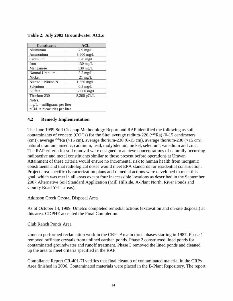
Umetco monitored groundwater wells in accordance with the requirements of the Uravan
Groundwater Monitoring Procedure E-11 and the ACL application dated July 2003. The ACL
report established ACLs for groundwater at Uravan as shown in Table 2 below.
14
Table 2: July 2003 Groundwater ACLs
Constituent ACL
Aluminum 7.9 mg/L Ammonium 6,900 mg/L Cadmium 0.26 mg/L Iron 130 mg/L Manganese 130 mg/L Natural Uranium 5.5 mg/L Nickel 21 mg/L Nitrate + Nitrite-N 1,360 mg/L Selenium 0.5 mg/L Sulfate 32,600 mg/L Thorium-230 8,200 pCi/L Notes:
mg/L = milligrams per liter
pCi/L = picocuries per liter
4.2 Remedy Implementation
The June 1999 Soil Cleanup Methodology Report and RAP identified the following as soil
contaminants of concern (COCs) for the Site: average radium-226 (226Ra) (0-15 centimeters
(cm)), average 226Ra (>15 cm), average thorium-230 (0-15 cm), average thorium-230 (>15 cm),
natural uranium, arsenic, cadmium, lead, molybdenum, nickel, selenium, vanadium and zinc.
The RAP criteria for soil removal were designed to achieve concentrations of naturally occurring
radioactive and metal constituents similar to those present before operations at Uravan.
Attainment of these criteria would ensure no incremental risk to human health from inorganic
constituents and that radiological doses would meet EPA standards for residential construction.
Project area-specific characterization plans and remedial actions were developed to meet this
goal, which was met in all areas except four inaccessible locations as described in the September
2007 Alternative Soil Standard Application (Mill Hillside, A-Plant North, River Ponds and
County Road Y-11 areas).
Atkinson Creek Crystal Disposal Area
As of October 14, 1999, Umetco completed remedial actions (excavation and on-site disposal) at
this area. CDPHE accepted the Final Completion.
Club Ranch Ponds Area
Umetco performed reclamation work in the CRPs Area in three phases starting in 1987. Phase 1
removed raffinate crystals from unlined earthen ponds. Phase 2 constructed lined ponds for
contaminated groundwater and runoff treatment. Phase 3 removed the lined ponds and cleaned
up the area to meet criteria specified in the RAP.
Compliance Report CR-401-7I verifies that final cleanup of contaminated material in the CRPs
Area finished in 2006. Contaminated materials were placed in the B-Plant Repository. The report
15
also details the cleanup activities. Umetco completed grading activities by June 2007 and
revegetation activities by November 2007. Umetco installed permanent fencing between October
22 and November 5, 2007.
CDPHE, EPA and NRC approved alternative soil standards for four inaccessible locations where 226Ra is above the soil cleanup criteria. These areas are the Mill Hillside, A-Plant North, River
Ponds and County Road Y-11. These areas are within the area to be transferred to DOE for long-
term surveillance activities. The 2007 Alternative Soil Standards Application describes the
alternative standard areas and supports the application for alternative soil standards.
River Ponds Area
Complete removal of the River Ponds started in 1988 and finished in mid-1989. These materials
were placed into Tailings Piles 1, 2 and 3. Excavation was completed to the water table and all
contaminated soil was removed. Umetco subsequently constructed rock berms to trap sediment
carried by the San Miguel River during high flows. Vegetation has reestablished itself in the
River Ponds Area. The RAP called for final reclamation by December 31, 1991. Umetco
submitted a final construction report to the CDPHE in mid-1993. With the acceptance of the final
construction report, remediation of the River Ponds Area was complete as of December 1993.
Tailings Piles
Remedial activities in the RAP for the tailings piles of Club Mesa included dewatering, pile
reshaping, buttress protection, toe drain system maintenance, top and side slope cover
construction, and stormwater drainage diversion.
Umetco has placed the side and top covers on Tailings Piles 1, 2 and 3. The stormwater diversion
channel system has been constructed for Tailings Piles 1, 2 and 3. Geotechnical instrumentation
was installed in the Tailings Piles. The top of Tailings Piles 1 and 2 is the final repository for
tailings and contaminated soils from the valley areas and Club Mesa. Umetco completed
placement of contaminated soils and other materials on Tailings Piles 1 and 2.
Umetco began B-Plant Repository construction, operations and placement of contaminated
materials in 1998. A toe drain system was also installed in the B-Plant Repository Area. This
capped repository accepted contaminated materials from final reclamation of the CRPs. It has a
designed capacity of about 1.8 million cubic yards.
Club Mesa Area
Pursuant to the RAP, removal of neutralized sludge and other contaminated material began in
June 1989 and finished in 1992. Initial removal of raffinate crystals from the Club Mesa began in
summer 1990 and finished in mid-1992. Final removal of raffinate crystals resting on the
bedrock finished in 1994. About 3,750,000 cubic yards of contaminated material were removed
from the Club Mesa Area. Mines and portals encountered were sealed with earthen materials.
This activity was completed by December 31, 1997, with CDPHE acceptance of the construction
completion report. Final closure activities for the Club Mesa Area included construction of a
16
stormwater diversion structure and sediment collection areas, placement of clean fill rock mulch,
and reseeding of the fill areas.
During 2000, Umetco drilled 17 borings into the mine workings on Club Mesa to evaluate and
manage contained contaminated liquids. Five borings were selected for pumping and conveyance
of mine workings liquid. Umetco extracted and transferred raffinate solution in the mine
workings to the CRPs for evaporation. About 500,000 gallons of raffinate-contaminated liquid
was pumped from the mine workings in 2000 and 2001.
Mill Areas
Remedial activities in the Mill Area began in 1987. Initial activities included removal of 160,000
cubic yards of Ore Stockpile, Barrel Storage, Heap Leach site and Bone Yard materials. Uranium
and/or vanadium ores and mill reagents were processed at the NRC-licensed White Mesa
uranium/vanadium mill in Utah. These activities are complete.
The mill process area consisted of the “A-Plant” and “B-Plant.” It included uranium and/or
vanadium milling systems and ancillary facilities located along the San Miguel River valley floor
at the base of Club Mesa and the facilities on the canyon face and lower bench next to the
Tailings Piles. Mill decommissioning was conducted in accordance with a detailed plan
approved by CDPHE. Decommissioning included management and handling of polychlorinated
biphenyls (PCBs) and asbestos-containing materials, and demolition of over 50 major Uravan
mill Site buildings and operations support structures.
Umetco began decommissioning the mill process systems in 1995. This involved demolition of
mill circuits, ancillary mill operations facilities and structural foundations, and removal and
cleanup of associated contaminated soils. Mill demolition and contaminated soils removal are
both complete. Umetco completed contaminated soil removal in the A-Plant Area during the
second quarter of 1999 and in the B-Plant Area in the third quarter of 1999. In 1998, Umetco
constructed replacement runoff control ponds in the A-Plant Area. Umetco remediated and
renovated the Community Center Building and the Boarding House in 2000. These buildings
were later destroyed due to mold issues.
Tailings materials under County Road EE-22 were removed during 2001. Following removal
activities, the area was inspected and approved by the CDPHE on-Site coordinator. The roadway
was reestablished with borrow fill and placement of road-base gravel material. 4,760 cubic yards
of contaminated materials were removed from the roadbed and placed in the B-Plant Repository.
Mill Area remediation continued with removal of contaminated soils during 2002. Contaminated
soils and materials were placed in the B-Plant Repository. A-Plant Area and B-Plant Area
confirmation investigation reports were approved and final reclamation grading and drainage
activities finished in 2003.

17
Town and Adjacent Areas
All Uravan residents were relocated as of 1986. From 1987 to 1994, Umetco removed all
housing structures (about 260 structures) from the town of Uravan and removed and transported
contaminated soils (about 210,000 cubic yards) to the Tailings Piles. Umetco graded and
revegetated the Town Area in 2000, after soil verification studies were completed and accepted.
A historic kiosk and overlook parking lot were constructed for public viewing and information.
Materials in the Town Dumps were characterized in accordance with the RAP requirements.
Mill-related contamination was identified in the Town Dumps. Umetco excavated, removed and
placed these materials (about 260,000 cubic yards) in the B-Plant Repository. Final grading and
seeding of the area finished in 2000.
Umetco identified about 65,000 cubic yards of dispersed deposits next to Uravan. These areas
include portions of Colorado Highway 141, Montrose County Road Y-11 and EE-22, the Mill
Hillside, and Water Storage Ponds next to Hieroglyphic Canyon. Umetco removed and disposed
of these deposits in the B-Plant Repository. Umetco excavated and removed remnant tailings
from the entrance road to the Site and Town of Uravan, and from within the Town of Uravan.
Umetco placed these tailings in the B-Plant Repository. Remediation and reclamation of these
areas is complete. In 2006, in a coordinated effort between the CDOT, CDPHE and Umetco, a
significant source of contamination was removed from beneath Colorado Highway 141.
Simultaneously, CDOT reconfigured the road to improve safety. In addition, a series of process
ponds next to Colorado Highway 141 were remediated. EPA partially deleted the Colorado
Highway 141 portion of the Site from the NPL in the spring of 2007.
Stream and stormwater drainage deposits include sediments in Atkinson Creek and Hieroglyphic
Canyon streambeds. Radiological surveys indicate no significant contamination within the
Atkinson Creek Streambed. Remediation of contaminated materials in the Hieroglyphic Canyon
streambed near its confluence with the San Miguel River was finished in 1994. Assessment of
the upper reach of Hieroglyphic Canyon indicates no significant contamination in the streambed.
Excavation of streambed contaminated materials would result in significant environmental
impacts to the waterway and its ecology. Umetco identified discrete deposits of radioactive soils
near the mouth of Hieroglyphic Canyon. They were excavated, removed and placed in the Club
Mesa Tailings Repositories. Umetco characterized windblown material north and south of the
Tailings Piles footprints.
A land transfer/Omnibus Agreement was executed between Montrose County and Umetco
during the second quarter of 2012. Parcel No. 1 (Ball Park Parcel) was transferred to Montrose
County during the third quarter of 2012. As part of the Agreement, a new bridge was constructed
to provide access from Colorado Highway 141 to Montrose County Road EE-22. The new bridge
opened on December 23, 2014. According to the 2014 Annual Report, a small amount of non-
licensed material (coal ash), with radiation levels slightly above background, were uncovered
during County Road EE-22 bridge replacement activities. The report indicated occupational dose
monitoring was not conducted during the removal of the coal ash materials. These materials were
determined to not be licensed materials, they were below the subsurface background levels for

18
226Ra, and they did not have the potential to generate exposures above 10 percent of the annual
occupational limits due to the material’s radiation levels and the short duration of work activities.
Burbank Quarry
Umetco began placing raffinate crystals in the Burbank Quarry in 1989 and completed the work
in 1992. Umetco capped the raffinate crystals with an earthen cover in accordance with the RAP.
The side slope was completed in 1993. The toe drain was installed in 1998. The top cover was
completed in 1999. The Burbank Quarry – Uravan UMTRCA Title II activity was completed by
2000.
DOE used the upper portion of the Burbank Quarry Repository for disposing of Title I
radioactive materials from the nearby Naturita processing site. About 600,000 cubic yards of
radioactive materials were placed in the Burbank Quarry repository. A multi-layered cover,
identical to the Uravan Tailings Piles covers, was constructed on top of the contaminated
materials. Permanent drainage diversion structures and control features were constructed for
stormwater management. The Burbank Quarry Repository – DOE UMTRCA Title I activity was
completed in 1998.
Borrow Areas on Club Mesa
The Site has three borrow areas. Two are located on Club Mesa, including one above the
Burbank Repository. The third is located in the San Miguel River Valley on the east side of
Colorado Highway 141, across from the CRPs. The borrow areas on Club Mesa, which includes
the Kaiser Quarry, were expanded in 1992, 1997, 2002 and 2003.
The Kaiser Quarry produces sandstone suitable for erosion protection materials. The Kaiser
Quarry is west of the Club Mesa Area within Umetco’s patented Kaiser Claim Boundary. All of
the borrow areas are operated in compliance with the Mine Land Reclamation Permits.
Hillside Seepage and Tailings Liquids
Umetco improved the Hillside Seepage Collection System in 1998. When seepage collection was
complete, it was decommissioned in 2003. This system intercepted over 38 million gallons of
seepage. The toe drain collection system was capped and sealed. Compliance Report CR-426-4
indicates that concrete from ditches and diversion ponds was removed and at least two feet of
sandstone rock rubble was placed to prevent erosion.
Ponded Liquids
CRPs were constructed to manage liquids from the Tailings Areas, Toe Berm Seepage and
Tailings Dewatering Liquids Collection System, Hillside Seepage Collection System, and any
other contaminated liquid collected as part of remedial activities. Umetco collected liquids and
transferred them to the CRPs for evaporation. Umetco has fully remediated the Club Ranch
Ponds and River Area Ponds.
19
Surface Runoff
The Site’s stormwater management system manages surface runoff. The sizing and materials of
construction are consistent with the requirements of the RAP.
Groundwater
Umetco installed the groundwater extraction system in 1991. Umetco upgraded it in 1996 and
1998. Groundwater pumping began in 1991. In 1997, the groundwater cleanup effort was
evaluated and an optimized system developed to extract contaminated liquids from low-
permeability zones in the Kayenta-Wingate Aquifer. The change in groundwater withdrawal
successfully reduced contaminant concentrations.
The groundwater extraction and CRP System has removed about 15,000 tons of contaminants
from the groundwater flow regime. This action has helped reduce contaminant loading to the San
Miguel River system. Throughout the groundwater remedial action, Umetco modified the
groundwater monitoring procedures with CDPHE approval to ensure optimum performance of
the extraction program and to monitor compliance with groundwater protection standards.
The Kayenta-Wingate Aquifer reached steady state conditions by 2002. The groundwater
performance evaluations showed that future groundwater extraction would not significantly
enhance aquifer restoration. In 2003, CDPHE approved a groundwater ACL application. ACLs
were proposed for 11 groundwater constituents at the Site. The ACLs were developed using a
point of exposure in the San Miguel River. The ACL application implemented a monitoring
program that consisted of quarterly monitoring with annual performance evaluations for a period
of three years. After three years of monitoring and annual evaluations, the program showed that
there were no contaminants in the Kayenta-Wingate Aquifer above the ACLs. The ACL
monitoring program was terminated. Currently, as required by the ACL application, groundwater
is monitored in accordance with the anticipated DOE long-term monitoring for the Site.
DOE will implement long-term monitoring of groundwater when it assumes ownership of the
Site. The monitoring will ensure that the groundwater plume under the CRPs Area continues to
naturally attenuate in accordance with the groundwater mixing model and that the ACLs are not
exceeded. DOE will assess the effectiveness of groundwater remediation in the future.
Partial Deletions
On February 18, 2005, EPA deleted a portion of the Site from the NPL. This partial deletion
pertains to 9.84 acres containing two historic structures, the Boarding House and the Community
Center. On September 4, 2007, EPA deleted a one mile section of Colorado Highway 141
between mile posts 75 and 76 from the NPL, totaling approximately 7 acres.
4.3 Operation and Maintenance (O&M)
The RAP includes Addendum A: Outline for Quality Control/Quality Assurance, Monitoring and
Performance Evaluation Plan, which describes the groundwater monitoring schedule for the Site.

20
Addendum A also describes quality control and quality assurance for soil and water remedies.
Based on discussions with CDPHE, a revised groundwater sampling program began during the
first quarter of 2008. Wells CRP-1, CRP-25 and CRP-19A would be sampled annually during the
third quarter. Surface water is monitored at three locations. The RAP, individual quality plans by
project number, the Soil Cleanup Methodology Manual and the Uravan ACL Application outline
the requirements for verifying the remedial activities. The sampling program included:
Conducting exposure surveys.
Acquiring confirmatory soil sample(s) for all Site contaminants, wherever
contamination was suspected or known to occur.
Complete sampling of borrow materials for all Site contaminants.
Sampling of groundwater and surface water for Site contaminants.
Monitoring results have been documented by individual project area as the segments were
completed.
No O&M costs were estimated in the RAP, as amended. The PRP’s contractor, AECOM,
provided annual O&M costs (Table 3).
Table 3: Annual O&M Costs
Year Amount
2010 $261,688.85
2011 $281,928.95
2012 $273,534.73
2013 $230,967.67
2014 $239,173.34
5.0 Progress Since the Last Five-Year Review
The protectiveness statement from the 2010 FYR for the Site stated the following:
The remedy at the Site is currently protective of human health and the environment. Remedial
activities have:
Capped and revegetated radioactive tailings.
Disposed of raffinate crystals.
Eliminated process ponds.
Pumped and treated groundwater.
Secured tailing waste along the San Miguel River.
Dismantled two mills and placed all old building demolition materials in a secure area.
Excavated contaminated soil, disposed of them in a secure area and replanted the area.
Dismantled and cleaned up the town of Uravan.

21
The Site is unused and secured. Two recently identified areas with elevated radiological activity
are not easily accessed due to fencing and location. In order for the remedy to remain protective
in the long term, the following issues must be addressed:
EPA should assess the Site to determine what institutional controls are necessary to
prevent inappropriate land uses that could compromise the repository caps and to
restrict groundwater use.
For licensing purposes, NRC should approve the alternative soil standards application in
the areas where remedial activities did not meet soil cleanup goals.
Umetco should complete a characterization investigation of the two areas found with
elevated radiological activity.
Groundwater ACLs should be re-evaluated based on new state standards for
molybdenum and uranium.
EPA has made a determination that a decision document is needed to accurately reflect and
document all of the activities and cleanup goals associated with the Site.
The 2010 FYR included five issues and recommendations. This report summarizes each
recommendation and its current status below.
Table 4: Progress on Recommendations from the 2010 FYR
Recommendations Party
Responsible
Milestone
Date Action Taken and Outcome
Date of
Action
Evaluate the Site to
determine what
institutional controls to
restrict land uses may be
appropriate.
EPA, DOE,
CDPHE, Umetco,
Montrose County
09/30/2012
Institutional controls will be
addressed after the forthcoming
ROD and during transfer of the
Site to DOE and Montrose
County.
Incomplete
Evaluate the Site to
determine what
institutional controls to
restrict groundwater
uses may be
appropriate.
EPA
DOE 09/30/2012
Institutional controls will be
addressed after the forthcoming
ROD and during transfer of the
Site to DOE and Montrose
County.
Incomplete
NRC should approve the
soil alternative standard
application for licensing
purposes.
NRC 09/30/2011
NRC approved the soil
alternative standard application. 5/18/2012

22
Recommendations Party
Responsible
Milestone
Date Action Taken and Outcome
Date of
Action
Complete a
characterization
investigation of the
areas with elevated
radiological activity.
Umetco 01/01/2011
Small amounts of licensed
materials identified in
Hieroglyphic Canyon and the F
Block area were removed during
first quarter of 2014 and placed
at the Energy Solutions
repository in Tooele, Utah.
Removal activities were
conducted under a Radiation
Work Permit with appropriate
occupational monitoring to
ensure exposures are maintained
as low as reasonably achievable
(ALARA). The volume of
material removed during 2014
was about 340 cubic yards.
3/5/2015
The groundwater ACLs
were based on effects to
the river and need to be
re-evaluated based on
the new uranium and
molybdenum standards.
CDPHE 09/30/2011
CDPHE modified the
molybdenum standard in 2012 to
0.21 milligrams per liter (mg/L)
and uranium was not re-
evaluated since the ACLs were
based on effects to the river.
Incomplete
6.0 Five-Year Review Process
6.1 Administrative Components
EPA Region 8 initiated the FYR in January 2015. The EPA remedial project manager (RPM)
Frances Costanzi led the EPA Site review team, which also included the EPA community
involvement coordinator (CIC) Cynthia Peterson and contractor support provided to EPA by
Skeo Solutions. In March 2015, EPA held a scoping call with the review team to discuss the Site
and items of interest as they related to the protectiveness of the remedy currently in place. The
review schedule established consisted of the following activities:
Community notification.
Document review.
Data collection and review.
Site inspection.
Local interviews.
FYR Report development and review.
6.2 Community Involvement
In September 2015, EPA published a public notice in the Daily Sentinel newspaper announcing
the commencement of the FYR process for the Site, providing contact information for Cynthia
Peterson, EPA, and Warren Smith, CDPHE, and inviting community participation. The press
notice is available in Appendix B. No one contacted EPA as a result of the advertisement.

23
EPA will make the FYR report available to the public once it has been finalized. Copies of this
document will be placed in the Site information repository: EPA Superfund Records Center,
located at 1595 Wynkoop Street, Denver, CO 80202-1129. The Naturita library is only 15 miles
away, and will be considered as an additional Site information repository. Upon completion of
the FYR, EPA will place a public notice in the Grand Junction, Colorado Daily Sentinel
newspaper to announce the availability of the final FYR report in the Site’s information
repository. A copy of the report will also be posted to EPA Region 8’s Uravan Web page
(http://www2.epa.gov/region8/uravan-uranium-project-union-carbide), along with the previous
FYRs.
6.3 Document Review
This FYR included a review of relevant, Site-related documents including the Consent Decree,
RAP and recent monitoring data. Appendix A includes a complete list of the documents
reviewed.
ARAR Review
Section 121 (d)(2)(A) of CERCLA specifies that Superfund remedial actions must meet any
federal standards, requirements, criteria or limitations that are determined to be ARARs. ARARs
are those standards, criteria or limitations promulgated under federal or state law that specifically
address a hazardous substance, pollutant, contaminant, remedial action, location or other
circumstance at a CERCLA site. To-Be-Considered criteria (TBCs) are non-promulgated
advisories and guidance that are not legally binding, but should be considered in determining the
necessary level of cleanup for protection of human health or the environment. While TBCs do
not have the status of ARARs, EPA's approach to determining if a remedial action is protective
of human health and the environment involves consideration of TBCs along with ARARs.
Chemical-specific ARARs are specific numerical quantity restrictions on individually listed
contaminants in specific media. Examples of chemical-specific ARARs include the maximum
contaminant levels specified under the Safe Drinking Water Act as well as the ambient water
quality criteria enumerated under the Clean Water Act. The remedy selected for this Site was
designed to meet or exceed all chemical-specific ARARs and meet location- and action-specific
ARARs.
Soil Cleanup Levels
According to the RAP, as amended, cleanup levels for soil COCs were based on 40 CFR 192.
Subpart D of 40 CFR 192 established radioactivity limits for uranium byproduct materials
pursuant to Section 84 of the Atomic Energy Act of 1954, as amended. The soil cleanup level for 226Ra established in the RAP was compared to the current standards 40 CFR 192, Subpart D
(Table 5). Cleanup levels were designed to achieve concentrations of naturally occurring
radioactive and toxic constituents similar to those before operations at the Site. Nevertheless, the
RAP notes that the as low as reasonably achievable (ALARA) principle applies to soil radium

24
cleanup at the Site. This review did not find evidence suggesting any of the assumptions used in
the development of soil cleanup levels have changed since the RAP.
Table 5: Previous and Current Standards for Soil COCs
COC RAP Cleanup Levela
(pCi/g)
Current Standardb
(pCi/g) ARARs Change
226Ra (0-15 cm bgs)c 5 5 None 226Ra (>15 cm bgs)d 15 15 None
Notes:
pCi/g = picocuries per gram
bgs = below ground surface
a. Values are relative to background level averaged over an area of 100 square meters.
b. 40 CFR 192 Subpart D obtained at: http://www.ecfr.gov/cgi-
bin/retrieveECFR?gp=&SID=c69e617ee8b863dca06458e3bfef993f&mc=true&n=sp40.25.192.d&r=SUBPAR
T&ty=HTML, accessed 5/15/15.
c. The concentration criterion for surface soil (0-15 cm bgs) averaged over an area of 100 square meters is a
health-based standard.
d. The concentration criterion for subsurface soil (greater than 15 cm bgs) was developed to allow use of field
measurements to locate and remediate discrete deposits of high-activity tailings (typically 300 pCi/g to 1,000
pCi/g) in subsurface locations.
Groundwater Cleanup Levels
According to the RAP, cleanup levels for groundwater COCs were based on 40 CFR
192.32(a)(2). In 2001, the RAP was updated and 12 contaminants were removed from the list of
groundwater COCs. CDPHE updated the RAP again in 2005, reducing the list of groundwater
COCs further to include cadmium, fluoride, nickel, selenium, uranium (natural), vanadium, zinc, 226Ra and gross alpha. As shown in Table 6, current groundwater protection standards for
cadmium and selenium have become more stringent since the 2005 RAP Amendment. However,
the more stringent standards do not affect current protectiveness. Groundwater is not currently in
use at the Site. The groundwater discharges to the San Miguel River.
Table 6: Summary of Groundwater Protection Standards Evaluation
COC 2005 RAP Standarda (mg/L) Current Federal Standardb (mg/L) Change in ARARs
Cadmium 0.05 0.01 more stringent
Fluoride 4.0 4.0d None
Nickel backgroundc NA NA
Selenium 0.05 0.01 more stringent
Natural Uranium 0.044 0.044 None
Vanadium backgroundc NA NA
Zinc 5.0 5.0d None
Radium-226 5 pCi/L 5 pCi/Le None
Gross Alpha 15 pCi/L 15 pCi/L None

25
COC 2005 RAP Standarda (mg/L) Current Federal Standardb (mg/L) Change in ARARs
Notes:
a. Values obtained from Table 5.4.3.2-2 from 2005 RAP which cites the values are consistent with federal regulation
40 CFR 192.
b. Values obtained from 40 CFR 192 subpart A Standards for the Control of Residual Radioactive Materials from
Inactive Uranium Processing Sites, accessed 5/8/15 at: http://www.ecfr.gov/cgi-bin/text-
idx?SID=8caedef1df9be4d133de157eb310cb8c&mc=true&node=ap40.25.192_104.1&rgn=div9.
c. Background to be determined by methodology adopted pursuant to Addendum A of the 2005 RAP.
d. In absence of a value from 40 CFR 264 value obtained from EPA’s National Primary Drinking Water
Regulations, accessed 5/8/15 at: http://water.epa.gov/drink/contaminants/index.cfm.
e. Combined radium-226 and radium-228.
NA = not applicable as a standard has not been established.
In 2003, CDPHE approved a groundwater ACL application for 11 contaminants at the Site. The
ACLs were based on protection of surface water quality in the San Miguel River. To determine if
the ACLs remain valid, the surface water quality criteria used as the basis of the ACLs were
reviewed. As shown in Table 7, the surface water quality standards have not changed since the
2005 RAP Amendment.
Table 7: Summary of Surface Water Standards Used in the ACL Development
COCa 2005 RAP Standarda (mg/L) Current Standardb (mg/L) ARARs Change
Aluminum 0.087 0.087 None
Ammonia 0.06 0.06 None
Cadmium 0.002 0.002 None
Iron 1.0 1.0 None
Manganese 1.0 1.0 None
Nickel 0.16 0.16 None
Nitrite +
Nitrate 100 100
None
Selenium 0.005 0.005 None
Sulfate 576 576 None
Thorium-230 60 60 None
Uranium
(natural) 3.2 3.2
None
Notes:
a. COC and surface water criteria from the Application for ACL Limits, Uravan Project Site, Umetco Minerals
Corporation, July 2003, and adopted in the 2005 RAP.
b. Current surface water quality criteria obtained at:
https://www.colorado.gov/pacific/sites/default/files/Regulation-31.pdf (accessed 5/11/15).
According to the RAP, CDPHE also applied the agricultural use criteria for monitoring the
groundwater remediation for the River Valley-Kayenta-Wingate Aquifer. A comparison of
agriculture use criteria in the RAP to the current criteria show that, except for molybdenum, none
of the criteria has changed. CDPHE modified the molybdenum standard in 2012 to 0.21 mg/L.
Institutional Control Review
Table 8 lists the institutional controls associated with areas of interest at the Site. No institutional
controls are currently in place at the Site to restrict groundwater or land use, though waste
remains in place on the Site. Institutional control requirements will be finalized in the
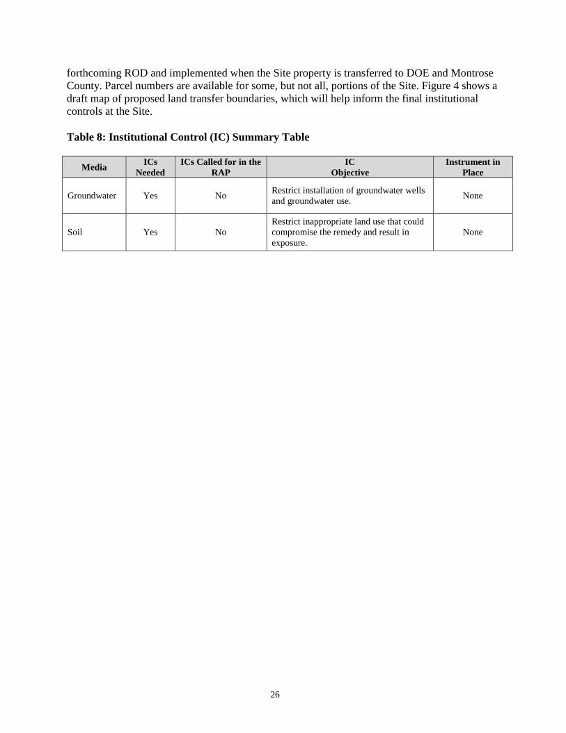
26
forthcoming ROD and implemented when the Site property is transferred to DOE and Montrose
County. Parcel numbers are available for some, but not all, portions of the Site. Figure 4 shows a
draft map of proposed land transfer boundaries, which will help inform the final institutional
controls at the Site.
Table 8: Institutional Control (IC) Summary Table
Media ICs
Needed
ICs Called for in the
RAP
IC
Objective
Instrument in
Place
Groundwater Yes No Restrict installation of groundwater wells
and groundwater use. None
Soil Yes No
Restrict inappropriate land use that could
compromise the remedy and result in
exposure.
None

27
Figure 4: Draft Land Status Map with Proposed Land Transfer Boundaries
.
28
6.4 Data Review
Tailings Pile 1, 2, 3, B-Plant Repository and Burbank Repository
According to the 2010-2014 annual reports, PRP inspections of Tailings Piles 1, 2 and 3 and
Burbank and B-Plant Repositories indicated no settlement or slope stability anomalies. All
erosion protection and runoff dispersion/diversion installations are performing as designed with
no damage or flaws detected.
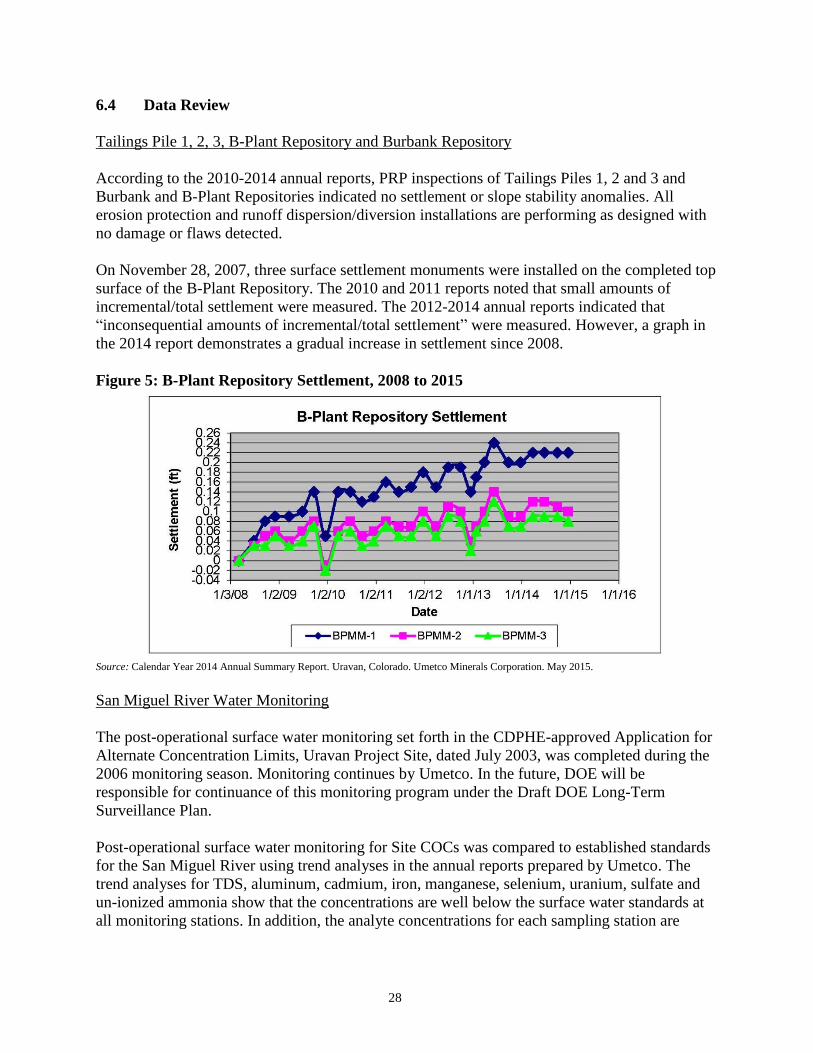
On November 28, 2007, three surface settlement monuments were installed on the completed top
surface of the B-Plant Repository. The 2010 and 2011 reports noted that small amounts of
incremental/total settlement were measured. The 2012-2014 annual reports indicated that
“inconsequential amounts of incremental/total settlement” were measured. However, a graph in
the 2014 report demonstrates a gradual increase in settlement since 2008.
Figure 5: B-Plant Repository Settlement, 2008 to 2015
Source: Calendar Year 2014 Annual Summary Report. Uravan, Colorado. Umetco Minerals Corporation. May 2015.
San Miguel River Water Monitoring
The post-operational surface water monitoring set forth in the CDPHE-approved Application for
Alternate Concentration Limits, Uravan Project Site, dated July 2003, was completed during the
2006 monitoring season. Monitoring continues by Umetco. In the future, DOE will be
responsible for continuance of this monitoring program under the Draft DOE Long-Term
Surveillance Plan.
Post-operational surface water monitoring for Site COCs was compared to established standards
for the San Miguel River using trend analyses in the annual reports prepared by Umetco. The
trend analyses for TDS, aluminum, cadmium, iron, manganese, selenium, uranium, sulfate and
un-ionized ammonia show that the concentrations are well below the surface water standards at
all monitoring stations. In addition, the analyte concentrations for each sampling station are
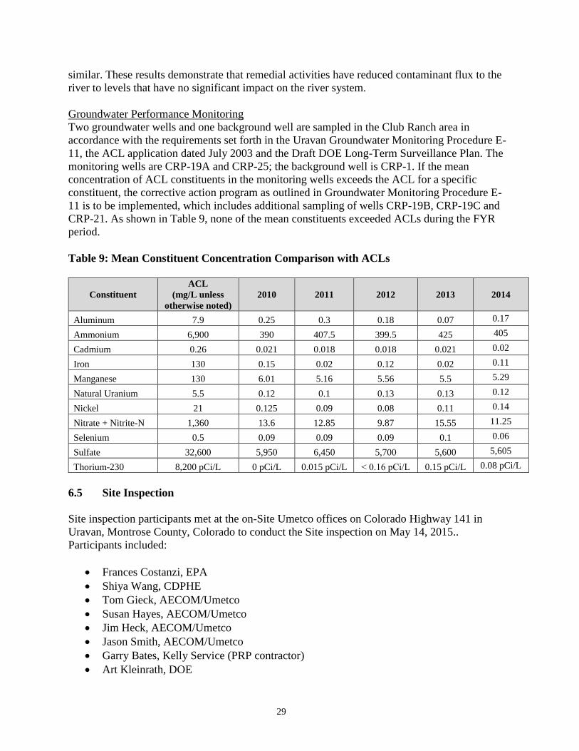
29
similar. These results demonstrate that remedial activities have reduced contaminant flux to the
river to levels that have no significant impact on the river system.
Groundwater Performance Monitoring
Two groundwater wells and one background well are sampled in the Club Ranch area in
accordance with the requirements set forth in the Uravan Groundwater Monitoring Procedure E-
11, the ACL application dated July 2003 and the Draft DOE Long-Term Surveillance Plan. The
monitoring wells are CRP-19A and CRP-25; the background well is CRP-1. If the mean
concentration of ACL constituents in the monitoring wells exceeds the ACL for a specific
constituent, the corrective action program as outlined in Groundwater Monitoring Procedure E-
11 is to be implemented, which includes additional sampling of wells CRP-19B, CRP-19C and
CRP-21. As shown in Table 9, none of the mean constituents exceeded ACLs during the FYR
period.
Table 9: Mean Constituent Concentration Comparison with ACLs
Constituent
ACL
(mg/L unless
otherwise noted)
2010 2011 2012 2013
2014
Aluminum 7.9 0.25 0.3 0.18 0.07 0.17
Ammonium 6,900 390 407.5 399.5 425 405
Cadmium 0.26 0.021 0.018 0.018 0.021 0.02
Iron 130 0.15 0.02 0.12 0.02 0.11
Manganese 130 6.01 5.16 5.56 5.5 5.29
Natural Uranium 5.5 0.12 0.1 0.13 0.13 0.12
Nickel 21 0.125 0.09 0.08 0.11 0.14
Nitrate + Nitrite-N 1,360 13.6 12.85 9.87 15.55 11.25
Selenium 0.5 0.09 0.09 0.09 0.1 0.06
Sulfate 32,600 5,950 6,450 5,700 5,600 5,605
Thorium-230 8,200 pCi/L 0 pCi/L 0.015 pCi/L ˂ 0.16 pCi/L 0.15 pCi/L 0.08 pCi/L
6.5 Site Inspection
Site inspection participants met at the on-Site Umetco offices on Colorado Highway 141 in
Uravan, Montrose County, Colorado to conduct the Site inspection on May 14, 2015..
Participants included:
Frances Costanzi, EPA
Shiya Wang, CDPHE
Tom Gieck, AECOM/Umetco
Susan Hayes, AECOM/Umetco
Jim Heck, AECOM/Umetco
Jason Smith, AECOM/Umetco
Garry Bates, Kelly Service (PRP contractor)
Art Kleinrath, DOE

30
David Traub, SN3 (DOE contractor)
Todd Bragdon, CDM Smith (EPA Contractor)
Derek Wintle, CDM Smith (EPA Contractor)
Treat Suomi, Skeo Solutions (EPA Contractor)
Johnny Zimmerman-Ward, Skeo Solutions (EPA Contractor)
A completed Site inspection checklist is available in Appendix D.
Umetco personnel gave a safety briefing and a brief history of the Site using available historical
photographs to show changes in Site conditions and point out areas of interest. Umetco personnel
drove participants around the Site and on a neighboring mesa to observe the Site and take
photographs. Site photographs are available in Appendix E.
The Site lies on both sides of the San Miguel River. The Umetco offices are the only buildings
on Site. Portions of the Site are fenced and labeled with radioactive waste signs. Tailings piles
are fenced and covered with stone caps. Fences were secure and the caps appeared to be
functioning as designed.
6.6 Interviews
The FYR process included interviews with parties affected by the Site, including the current
landowners and regulatory agencies involved in Site activities or aware of the Site. The purpose
was to document the perceived status of the Site and any perceived problems or successes with
the phases of the remedy implemented to date. All of the interviews took place after the Site
inspection via email. The interviews are summarized below. Appendix C provides the complete
interviews.
Frances Costanzi: Frances Costanzi is the EPA RPM for the Site. She indicated that the project is
complex with multiple overlapping authorities and that the monitoring data supports that the
remediation has performed well. She believes a lot of good work has been completed at the Site
and that the project team is now working on the final aspects of the remediation. Ms. Costanzi
stated that institutional controls are the main remaining area where work needs to be done, both
to select institutional controls in a decision document, and then to implement the selected
institutional controls. Ms. Costanzi has received no complaints or inquiries regarding the Site.
Shiya Wang: Shiya Wang is the CDPHE project manager for the Site. She believes the remedy
currently in place is performing well based on routine monitoring results and Site inspections
under the Radioactive Materials License. She noted that all remedial work required under the
Consent Decree and RAP has been completed and is well documented. Ms. Wang indicated
discussions regarding long-term institutional controls and future land uses between the State,
Umetco, EPA, DOE, Montrose County and BLM are ongoing. Ms. Wang has received no
complaints or inquiries regarding the Site since the 2010 FYR.
Thomas Gieck: Thomas Gieck is an AECOM employee and the Remediation Leader for the Site.
Mr. Gieck stated that the project has gone well and that any construction issues that came up
were resolved during implementation of the remedy. He indicated that the Site will be transferred

31
to the state or federal government for long-term care and some parcels satisfying cleanup criteria
will be transferred to Montrose County.
Jason Smith: Jason Smith is the contractor for the PRP. Mr. Smith stated that the remediation has
gone very well and that the remediation has resulted in long lasting protection for human health
and the environment.
7.0 Technical Assessment
7.1 Question A: Is the remedy functioning as intended by the decision documents?
Yes. The RAP, as amended, acted as the functional equivalent of an EPA RI/FS and ROD during
remediation. EPA has determined that a decision document is needed to accurately reflect the
activities and cleanup standards associated with the Site, as well as to document selection of
institutional controls. The review of Site documents and the Site inspection indicate that the
remedy is functioning as intended by the RAP, as amended, and Consent Decree. On February
18, 2005, EPA deleted a portion of the Site from the NPL. This partial deletion pertains to 9.84
acres previously containing two historic structures, the Boarding House and the Community
Center. On September 4, 2007, EPA deleted the 7-acre Colorado Highway 141 portion of the
Site from the NPL.
To date, remedial activities have capped and revegetated nearly 10 million cubic yards of
radioactive tailings; disposed of 530,000 cubic yards of raffinate crystals; eliminated process
ponds; pumped and treated groundwater; secured 12 million yards of tailing waste along the San
Miguel River; dismantled two mills and placed old building demolition materials in a secure
area; excavated contaminated soil, disposed of it in a secure area and replanted the area; and
dismantled and cleaned up the town of Uravan. There has been a slight, steady increase in
settlement since 2008 at the three surface settlement monuments installed on the completed top
surface of the B-Plant Repository.
The RAP, as amended, did not call for institutional controls. They will be assessed during the
finalization of the ROD because waste is left in place on Site and no administrative mechanisms
currently prevent inappropriate future uses at the Site. Umetco intends to transfer large portions
of the Site to the DOE Legacy Management program, which will potentially address the land use
control issue in the future because this will include the areas where contamination remains above
acceptable levels. Portions of the Site without contamination are also anticipated to be
transferred to BLM, which intends to allow access to its portion of the Site. A small portion of
the Site, primarily along roadways, will be transferred to Montrose County once institutional
controls are in place.
According to the 2014 Annual Report, a small amount of non-licensed material (coal ash), with
radiation levels slightly above background, was uncovered during County Road EE-22 bridge
replacement activities. The report indicated occupational dose monitoring was not conducted
during the removal of the coal ash materials because these materials were determined to not be
licensed materials, they were below the subsurface background levels for 226Ra, and they did not
32
have the potential to generate exposures above 10 percent of the annual occupational limits due
to the material’s radiation levels and the short duration of work activities.
7.2 Question B: Are the exposure assumptions, toxicity data, cleanup levels and
remedial action objectives (RAOs) used at the time of remedy selection still valid?
Yes. CDPHE updated the RAP in 2005, reducing the list of the groundwater COCs to include
cadmium, fluoride, nickel, selenium, uranium (natural), vanadium, zinc, 226Ra and gross alpha.
Current groundwater protection standards for cadmium and selenium have become more
stringent since the 2005 RAP Amendment. However, the more stringent standards do not impact
current protectiveness. Groundwater is not currently in use at the Site. The groundwater
discharges to the San Miguel River and meets the alternate concentration limits.
The PRP excavated and placed contaminated soils above cleanup level in a capped landfill on
Site. These cleanup levels remain valid. Four discrete, inaccessible areas of the Site (about 40
acres total) could not meet the soil cleanup level of 5/15 pCi/g 226Ra in soil. A September 2007
Alternate Soils Standards Application from CDPHE to the NRC stated that CDPHE believes the
areas were cleaned to a level that is ALARA and protective of public health; EPA and NRC
approved the application. Three of the areas are in the footprint of the area to be transferred to
the DOE Legacy Management program. The fourth area, a county road, will also be under an
institutional control with the county. Final exact outer boundaries of the area to be transferred to
the DOE Legacy Management program are still being negotiated by the county, BLM and DOE
based on road access and uranium leases in the area.
The EPA is reviewing exposure assumptions, toxicity data, cleanup levels and RAOs in the
forthcoming RI/FS.
7.3 Question C: Has any other information come to light that could call into question
the protectiveness of the remedy?
No other information has come to light that could call into question the protectiveness of the
remedy.
7.4 Technical Assessment Summary
The RAP, as amended, acted as the functional equivalent of an EPA RI/FS and ROD during
remediation. EPA has determined that a decision document is needed to accurately reflect
activities and cleanup levels associated with the Site. The review of Site documents and the Site
inspection indicate that the remedy is functioning as intended by the RAP, as amended, and
Consent Decree. Contaminated materials have been excavated from areas of the Site and placed
in capped landfills on Site. The ROD will include a requirement for institutional controls, which
will be implemented as the property is transferred to DOE and BLM.
8.0 Issues, Recommendations and Follow-up Actions
Table 10 provides recommendations to address the current Site issues.

33
Table 10: Current Site Issues and Recommendations
Issue Recommendation /
Follow-Up Action
Party
Responsible
Oversight
Agency
Milestone
Date
Affects
Protectiveness?
Current Future
No ROD is yet in
place and no
institutional controls
are in place restricting
land and groundwater
use.
Finalize the site
remedy in a ROD and
implement
institutional controls
consistent with the
ROD.
EPA and
CDPHE EPA 09/30/2017 No Yes
Coal ash, a non-
licensed material,
contamination was
found when Umetco
built a bridge across
the San Miguel River
at Montrose County
Road EE-22.
Determine extent of
coal ash
contamination and
determine if
remediation is
necessary.
PRP EPA and
CDPHE 09/30/2016 No Yes
There has been a
slight, steady increase
in settlement since
2008 at the three
surface settlement
monuments installed
on the completed top
surface of the B-Plant
Repository.
Determine if
settlement at the B-
Plant Repository is
affecting the cap.
PRP EPA and
CDPHE 09/30/2016 No Yes
9.0 Protectiveness Statement
The remedy at the Site currently protects human health and the environment. Contaminated
materials have been excavated from areas of the Site and placed in capped landfills on Site and
contaminated groundwater has been pumped and treated to protect the river. For the remedy to
be protective over the long term, the following actions need to be taken:
Finalize the Site remedy in a ROD and implement the institutional controls consistent
with the ROD.
Determine extent of coal ash contamination and determine if remediation is necessary.
Determine if settlement at the B-Plant Repository is affecting the cap.
10.0 Next Review
The next FYR will be due within five years of the signature/approval date of this FYR.
A-1
Appendix A: List of Documents Reviewed
Alternative Soil Standards Application. Uravan, Colorado. Umetco Minerals Corporation. Grand
Junction, Colorado. September 2007.
Appendix to the Confirmation Investigation Report. A-Plant North. Uravan, Colorado. Umetco
Minerals Corporation. October 2007.
Calendar Year 2010 Annual Summary Report. Uravan, Colorado. Umetco Minerals Corporation.
March 2011.
Calendar Year 2011 Annual Summary Report. Uravan, Colorado. Umetco Minerals Corporation.
March 2012.
Calendar Year 2012 Annual Summary Report. Uravan, Colorado. Umetco Minerals Corporation.
May 2013.
Calendar Year 2013 Annual Summary Report. Uravan, Colorado. Umetco Minerals Corporation.
May 2014.
Calendar Year 2014 Annual Summary Report. Uravan, Colorado. Umetco Minerals Corporation.
May 2015.
Final Close-Out Report. Uravan Mill and Adjacent Areas Montrose County, Colorado.
September 29, 2008.
Final Construction and Soil Confirmation Investigation Report. Colorado Department of
Transportation Highway 141. Uravan, Colorado. Umetco Minerals Corporation. September
2006.
Fourth Five-Year Review Report. Umetco Minerals Corporation Uravan Superfund Site. Uravan,
Colorado. Frontier Environmental Services, Inc. September 28, 2005.
Partial Deletion Federal Register Notice. Uravan Superfund Site. 75847-75850 Federal Register.
Vol. 69, No. 243. December 20, 2004.
Quarterly Progress Reports 1st Quarter 2010-1st Quarter 2015. Colorado vs. Union Carbide
Corporation/Umetco Minerals Corporation, Civil Action No. 83-C-2384. 2010-2015.
Second Five-Year Review Report. Umetco Minerals Corporation Uravan Superfund Site.
Uravan, Colorado. Morrison Kundsey Corporation. March 13, 2000.
Soil Cleanup Program Methodology for Uravan, Colorado. Umetco Minerals Corporation. June
1999.

A-2
Third Five-Year Review Report. Umetco Minerals Corporation Uravan Superfund Site. Uravan,
Colorado. Frontier Environmental Services, Inc. September 28, 2005.
Umetco- Uravan. Colorado License No. 660-02, Amendment 13. CDPHE. Radioactive Materials
License. January 2013.
Uravan Remedial Action Plan (RAP) (With tracking of changes 1986-2005). (83-C-2384 Final
Consent Decree, Order, Judgment and Reference to Special Master, with Appendices). Umetco
Minerals Corporation. Revised May 2005.

B-1
Appendix B: Press Notice
Five-Year Review Planned for
the Uravan Uranium Project Superfund Site
The U.S. Environmental Protection Agency (EPA) and the Colorado Department of Public Health and
Environment (CDPHE) are conducting the fifth five-year review of the remedy for the Uravan Uranium Project
Superfund site (Site) in Montrose County, Colorado. The purpose of the five-year review is to ensure that the
selected cleanup actions effectively protect human health and the environment. The five-year review is
scheduled for completion by September 2015.
The 680-acre Site is the location of a former radium-recovery plant that began operations in 1912. From the
1940s to 1984, the plant operated as a uranium and vanadium processing facility.
Cleanup remedies at the Site include: capping and revegetating nearly 10 million cubic yards of radioactive
tailings; disposal of 530,000 cubic yards of radioactive raffinate crystals; eliminating process ponds; pumping
and treating contaminated groundwater; securing 12 million yards of tailings waste along the San Miguel River;
dismantling the two mills and placing all building demolition materials in a secure area; excavating and
disposing of contaminated soil in a secure area; replanting these areas; and dismantling and cleaning up the
town of Uravan.
More information is available on the EPA’s Website at: http://www2.epa.gov/region8/uravan-uranium-
project-union-carbide
To request copies of administrative record documents contact: 1) EPA Record Center at 303-312-7273 or toll
free (Region 8 only) at 800-227-8917 ext. 312-7273; or 2) CDPHE Hazardous Materials and Waste
Management Division Records Center at 303-692-3331 or toll free (outside the 303 or 720 area codes) at 1-888-
569-1831, ext. 3331, or email [email protected].
EPA and CDPHE invite community participation in the five-year review process: Community members
are encouraged to contact EPA and CDPHE staff with any information that may help the agencies make their
determination regarding the protectiveness and effectiveness of the remedies at the site.
Warren Smith
CDPHE Community Involvement Manager
303-692-3373 or 1-888-569-1831 ext. 3373
Email: [email protected]
Cynthia Peterson
EPA Community Involvement Coordinator
303-312-6879 or 1-800-227-8917 ext. 312-6879
Email: [email protected]
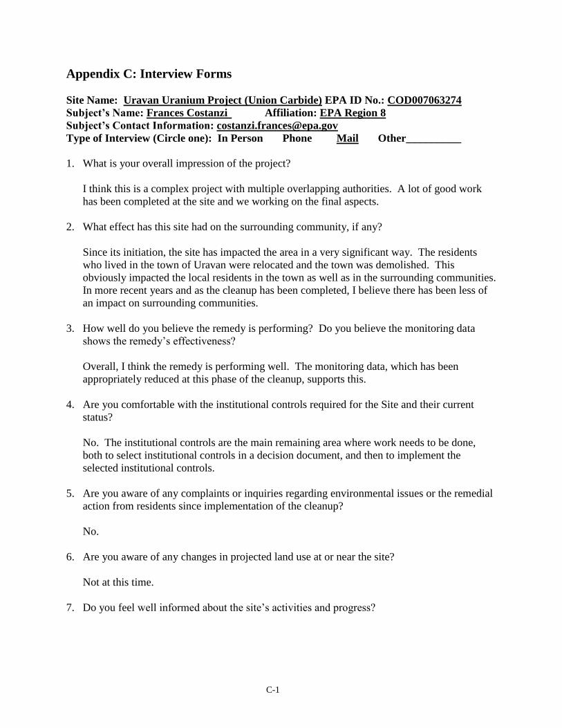
C-1
Appendix C: Interview Forms
Site Name: Uravan Uranium Project (Union Carbide) EPA ID No.: COD007063274
Subject’s Name: Frances Costanzi Affiliation: EPA Region 8
Subject’s Contact Information: [email protected]
Type of Interview (Circle one): In Person Phone Mail Other__________
1. What is your overall impression of the project?
I think this is a complex project with multiple overlapping authorities. A lot of good work
has been completed at the site and we working on the final aspects.
2. What effect has this site had on the surrounding community, if any?
Since its initiation, the site has impacted the area in a very significant way. The residents
who lived in the town of Uravan were relocated and the town was demolished. This
obviously impacted the local residents in the town as well as in the surrounding communities.
In more recent years and as the cleanup has been completed, I believe there has been less of
an impact on surrounding communities.
3. How well do you believe the remedy is performing? Do you believe the monitoring data
shows the remedy’s effectiveness?
Overall, I think the remedy is performing well. The monitoring data, which has been
appropriately reduced at this phase of the cleanup, supports this.
4. Are you comfortable with the institutional controls required for the Site and their current
status?
No. The institutional controls are the main remaining area where work needs to be done,
both to select institutional controls in a decision document, and then to implement the
selected institutional controls.
5. Are you aware of any complaints or inquiries regarding environmental issues or the remedial
action from residents since implementation of the cleanup?
No.
6. Are you aware of any changes in projected land use at or near the site?
Not at this time.
7. Do you feel well informed about the site’s activities and progress?
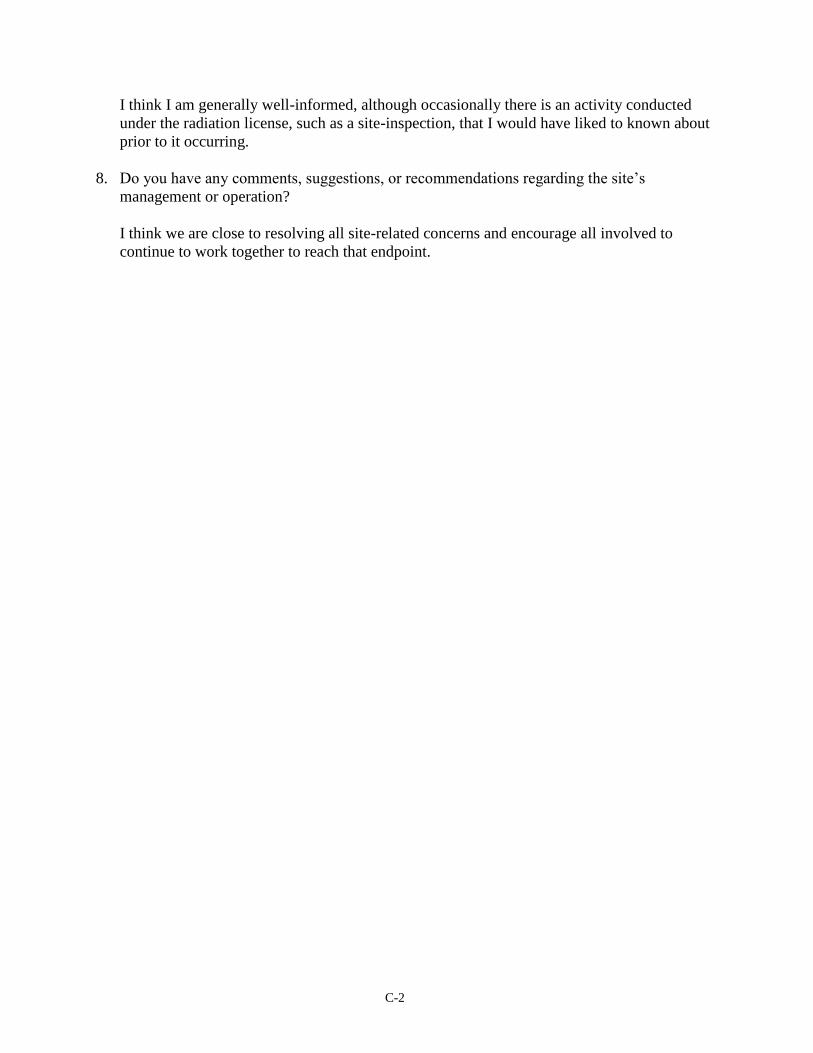
C-2
I think I am generally well-informed, although occasionally there is an activity conducted
under the radiation license, such as a site-inspection, that I would have liked to known about
prior to it occurring.
8. Do you have any comments, suggestions, or recommendations regarding the site’s
management or operation?
I think we are close to resolving all site-related concerns and encourage all involved to
continue to work together to reach that endpoint.

C-3
Site Name: Uravan Uranium Project (Union Carbide) EPA ID No.: COD007063274
Subject’s Name: Shiya Wang Affiliation: CDPHE
Subject’s Contact Information: [email protected]
Date: June 1, 2015
Type of Interview (Circle one): In Person Phone Mail Other: Email
1. What is your overall impression of the project?
It is a complex project involving multiple regulatory authorities and involvement. It is
also a very interesting project with its unique importance in history.
2. How well do you believe the remedy is performing?
The remedy is performing very well based on the routine monitoring results and site
inspections under the Radioactive Materials License. All remedial work required under
the Consent Decree and RAP have been completed and are well documented. Things
have been moving forward to closing out the project and the Site.
3. Are you comfortable with the institutional controls required for the Site and the current status
of their implementation?
Yes. The controls currently in place are working well. The discussion for necessary long-
term institutional controls and future land uses continues between the State, Umetco,
EPA, DOE, Montrose County and BLM.
4. Are you aware of any complaints or inquiries regarding environmental issues or the remedial
action from residents in the last five years?
No.
5. Has your office conducted any site-related activities or communications in the last five
years? If so, please give purpose and results of these activities.
Yes, the Site is currently regulated by the State of Colorado under a Radioactive
Materials License. They were mostly related to routine licensing and inspection activities,
and the ongoing works for closing out the Site.
6. Are you aware of any changes to state laws or regulations that might affect the protectiveness
of the remedy? Are you aware of any changes in projected land use at the site?
I am not aware of any changes to the state laws or regulations since the last five-year
review that might affect the remedy. The interagency discussion continues regarding the
future land uses of the Site.
7. Do you feel well informed about the Site’s activities and progress?

C-4
Yes.
8. Do you have any comments, suggestions, or recommendations regarding the Site’s
management or operation?
No.
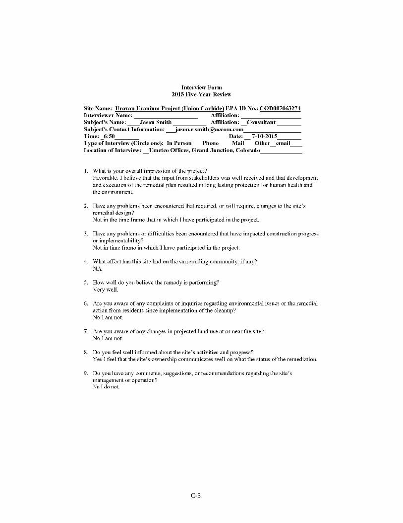
C-5

C-6
Site Name: Uravan Uranium Project (Union Carbide) EPA ID No.: COD007063274
Subject’s Name: Thomas Gieck Affiliation: Umetco Minerals Corp./AECOM
Subject’s Contact Information: 970-256-8889; [email protected]
Time: 9:30 AM Date: July 13, 2015
Type of Interview (Circle one): In Person Phone Mail Other__________
1. What is your overall impression of the project?
Good, Completed
2. Have any problems been encountered that required, or will require, changes to the site’s
remedial design?
Not that I am aware of.
3. Have any problems or difficulties been encountered that have impacted construction progress
or implementability?
Not that I am aware of – all construction issues were resolved during implementation.
4. What effect has this site had on the surrounding community, if any?
It has been positive as long as I have been involved.
5. How well do you believe the remedy is performing?
Very well – as designed.
6. Are you aware of any complaints or inquiries regarding environmental issues or the remedial
action from residents since implementation of the cleanup?
No
7. Are you aware of any changes in projected land use at or near the site?
No, statue/regulations require transfer of site to Federal Government or State for long-term
care. Some parcels satisfying cleanup criteria will be transferred to Montrose County. No
changes from 2010 FYR.
8. Do you feel well informed about the site’s activities and progress?
Yes
9. Do you have any comments, suggestions, or recommendations regarding the site’s
management or operation?
No
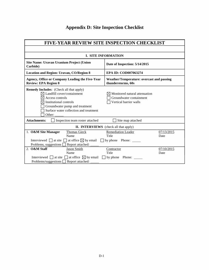
D-1
Appendix D: Site Inspection Checklist
FIVE-YEAR REVIEW SITE INSPECTION CHECKLIST
I. SITE INFORMATION
Site Name: Uravan Uranium Project (Union
Carbide) Date of Inspection: 5/14/2015
Location and Region: Uravan, CO/Region 8 EPA ID: COD007063274
Agency, Office or Company Leading the Five-Year
Review: EPA Region 8
Weather/Temperature: overcast and passing
thunderstorms, 60s
Remedy Includes: (Check all that apply)
Landfill cover/containment Monitored natural attenuation
Access controls Groundwater containment
Institutional controls Vertical barrier walls
Groundwater pump and treatment
Surface water collection and treatment
Other:
Attachments: Inspection team roster attached Site map attached
II. INTERVIEWS (check all that apply)
1. O&M Site Manager Thomas Gieck
Name
Remediation Leader
Title
07/13/2015
Date
Interviewed at site at office by email by phone Phone:
Problems, suggestions Report attached:
2. O&M Staff Jason Smith
Name
Contractor
Title
07/10/2015
Date
Interviewed at site at office by email by phone Phone:
Problems/suggestions Report attached:

D-2
3. Local Regulatory Authorities and Response Agencies (i.e., state and tribal offices, emergency
response office, police department, office of public health or environmental health, zoning office,
recorder of deeds, or other city and county offices). Fill in all that apply.
Agency CDPHE
Contact Shiya Wang
Name
Title
6/1/2015
Date
Phone No.
Problems/suggestions Report attached:
Agency
Contact Name
Title
Date
Phone No.
Problems/suggestions Report attached:
Agency
Contact
Name
Title
Date
Phone No.
Problems/suggestions Report attached:
Agency
Contact
Name
Title
Date
Phone No.
Problems/suggestions Report attached:
Agency
Contact
Name
Title
Date
Phone No.
Problems/suggestions Report attached:
4. Other Interviews (optional) Report attached:
III. ON-SITE DOCUMENTS AND RECORDS VERIFIED (check all that apply)
1. O&M Documents
O&M manual Readily available Up to date N/A
As-built drawings Readily available Up to date N/A
Maintenance logs Readily available Up to date N/A
Remarks: Follow the RAP requirements.
2. Site-Specific Health and Safety Plan Readily available Up to date N/A
Contingency plan/emergency response
plan
Readily available Up to date N/A
Remarks: Contingency plan/emergency response plan is under revision and the draft is with CDPHE.
3. O&M and OSHA Training Records Readily available Up to date N/A
Remarks:
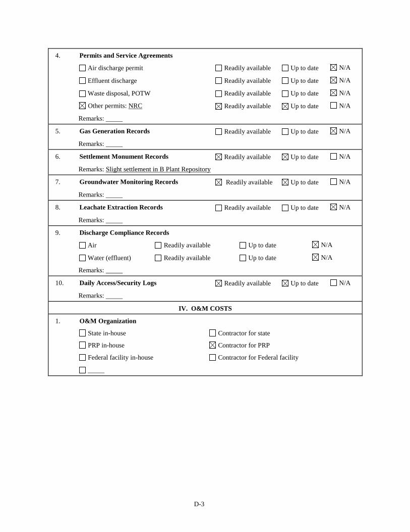
D-3
4. Permits and Service Agreements
Air discharge permit Readily available Up to date N/A
Effluent discharge Readily available Up to date N/A
Waste disposal, POTW Readily available Up to date N/A
Other permits: NRC Readily available Up to date N/A
Remarks:
5. Gas Generation Records Readily available Up to date N/A
Remarks:
6. Settlement Monument Records Readily available Up to date N/A
Remarks: Slight settlement in B Plant Repository
7. Groundwater Monitoring Records Readily available Up to date N/A
Remarks:
8. Leachate Extraction Records Readily available Up to date N/A
Remarks:
9. Discharge Compliance Records
Air Readily available Up to date N/A
Water (effluent) Readily available Up to date N/A
Remarks:
10. Daily Access/Security Logs Readily available Up to date N/A
Remarks:
IV. O&M COSTS
1. O&M Organization
State in-house Contractor for state
PRP in-house Contractor for PRP
Federal facility in-house Contractor for Federal facility

D-4
2. O&M Cost Records
Readily available Up to date
Funding mechanism/agreement in place Unavailable
Original O&M cost estimate: Breakdown attached
Total annual cost by year for review period if available
From: 01/01/2010
Date
To: 12/31/2010
Date
Total cost
Breakdown attached
From: 01/01/2011
Date
To: 12/31/2011
Date
Total cost
Breakdown attached
From: 01/01/2012
Date
To: 12/31/2012
Date
Total cost
Breakdown attached
From: 01/01/2013
Date
To: 12/31/2013
Date
Total cost
Breakdown attached
From: 01/01/2014
Date
To: 12/31/2014
Date
Total cost
Breakdown attached
3. Unanticipated or Unusually High O&M Costs during Review Period
Describe costs and reasons:
V. ACCESS AND INSTITUTIONAL CONTROLS Applicable N/A
A. Fencing
1. Fencing Damaged Location shown on site map Gates secured N/A
Remarks:
B. Other Access Restrictions
1. Signs and Other Security Measures Location shown on site map N/A
Remarks: Signage on site
C. Institutional Controls (ICs)
D-5
1. Implementation and Enforcement
Site conditions imply ICs not properly implemented Yes No N/A
Site conditions imply ICs not being fully enforced Yes No N/A
Type of monitoring (e.g., self-reporting, drive by):
Frequency:
Responsible party/agency:
Contact mm/dd/yyyy
Name Title Date Phone no.
Reporting is up to date Yes No N/A
Reports are verified by the lead agency Yes No N/A
Specific requirements in deed or decision documents have been met Yes No N/A
Violations have been reported Yes No N/A
Other problems or suggestions: Report attached
2. Adequacy ICs are adequate ICs are inadequate N/A
Remarks: Institutional controls will be finalized when the site property is transferred to BLM, County and
DOE.
D. General
1. Vandalism/Trespassing Location shown on site map No vandalism evident
Remarks:
2. Land Use Changes On Site N/A Remarks:
3. Land Use Changes Off Site N/A Remarks:
VI. GENERAL SITE CONDITIONS
A. Roads Applicable N/A
1. Roads Damaged Location shown on site map Roads adequate N/A
Remarks:
B. Other Site Conditions
Remarks: Site is in good condition.
VII. LANDFILL COVERS Applicable N/A
A. Landfill Surface
1. Settlement (low spots) Location shown on site map Settlement not evident
Arial extent: Depth:
Remarks: Slight settlement in B Plant Repository
2. Cracks Location shown on site map Cracking not evident
Lengths: Widths: Depths:
Remarks:
D-6
3. Erosion Location shown on site map Erosion not evident
Arial extent: Depth:
Remarks:
4. Holes Location shown on site map Holes not evident
Arial extent: Depth:
Remarks:
5. Vegetative Cover Grass Cover properly established
No signs of stress Trees/shrubs (indicate size and locations on a diagram)
Remarks: Some small, native shrubs and plants on caps
6. Alternative Cover (e.g., armored rock, concrete) N/A
Remarks:
7. Bulges Location shown on site map Bulges not evident
Arial extent: Height:
Remarks:
8. Wet Areas/Water
Damage
Wet areas/water damage not evident
Wet areas Location shown on site map Arial extent:
Ponding Location shown on site map Arial extent:
Seeps Location shown on site map Arial extent:
Soft subgrade Location shown on site map Arial extent:
Remarks:
9. Slope Instability Slides Location shown on site map
No evidence of slope instability
Arial extent:
Remarks:
B. Benches Applicable N/A
(Horizontally constructed mounds of earth placed across a steep landfill side slope to interrupt the slope in
order to slow down the velocity of surface runoff and intercept and convey the runoff to a lined channel.)
1. Flows Bypass Bench Location shown on site map N/A or okay
Remarks:
2. Bench Breached Location shown on site map N/A or okay
Remarks:
3. Bench Overtopped Location shown on site map N/A or okay
Remarks:
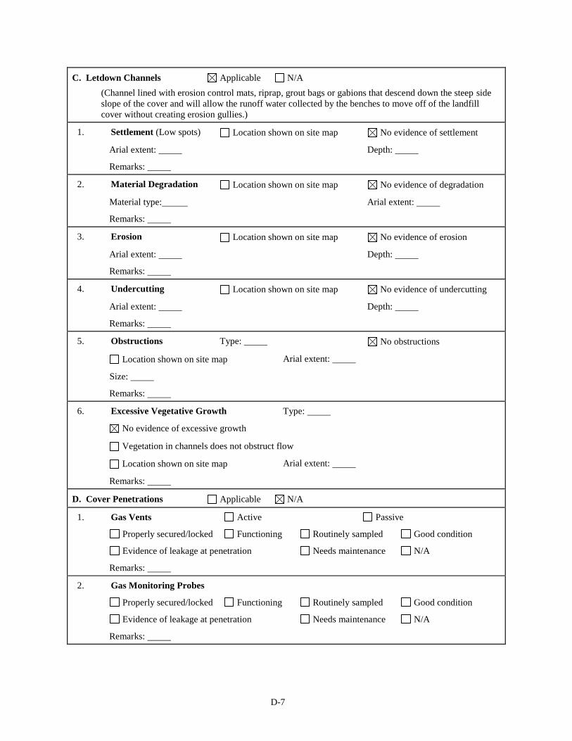
D-7
C. Letdown Channels Applicable N/A
(Channel lined with erosion control mats, riprap, grout bags or gabions that descend down the steep side
slope of the cover and will allow the runoff water collected by the benches to move off of the landfill
cover without creating erosion gullies.)
1. Settlement (Low spots) Location shown on site map No evidence of settlement
Arial extent: Depth:
Remarks:
2. Material Degradation Location shown on site map No evidence of degradation
Material type: Arial extent:
Remarks:
3. Erosion Location shown on site map No evidence of erosion
Arial extent: Depth:
Remarks:
4. Undercutting Location shown on site map No evidence of undercutting
Arial extent: Depth:
Remarks:
5. Obstructions Type: No obstructions
Location shown on site map Arial extent:
Size:
Remarks:
6. Excessive Vegetative Growth Type:
No evidence of excessive growth
Vegetation in channels does not obstruct flow
Location shown on site map Arial extent:
Remarks:
D. Cover Penetrations Applicable N/A
1. Gas Vents Active Passive
Properly secured/locked Functioning Routinely sampled Good condition
Evidence of leakage at penetration Needs maintenance N/A
Remarks:
2. Gas Monitoring Probes
Properly secured/locked Functioning Routinely sampled Good condition
Evidence of leakage at penetration Needs maintenance N/A
Remarks:
D-8
3. Monitoring Wells (within surface area of landfill)
Properly secured/locked Functioning Routinely sampled Good condition
Evidence of leakage at penetration Needs maintenance N/A
Remarks:
4. Extraction Wells Leachate
Properly secured/locked Functioning Routinely sampled Good condition
Evidence of leakage at penetration Needs maintenance N/A
Remarks:
5. Settlement Monuments Located Routinely surveyed N/A
Remarks:
E. Gas Collection and Treatment Applicable N/A
1. Gas Treatment Facilities
Flaring Thermal destruction Collection for reuse
Good condition Needs maintenance
Remarks:
2. Gas Collection Wells, Manifolds and Piping
Good condition Needs maintenance
Remarks:
3. Gas Monitoring Facilities (e.g., gas monitoring of adjacent homes or buildings)
Good condition Needs maintenance N/A
Remarks:
F. Cover Drainage Layer Applicable N/A
1. Outlet Pipes Inspected Functioning N/A
Remarks:
2. Outlet Rock Inspected Functioning N/A
Remarks:
G. Detention/Sedimentation Ponds Applicable N/A
1. Siltation Area extent: Depth: N/A
Siltation not evident
Remarks:
2. Erosion Area extent: Depth:
Erosion not evident
Remarks:
3. Outlet Works Functioning N/A
Remarks:

D-9
4. Dam Functioning N/A
Remarks:
H. Retaining Walls Applicable N/A
1. Deformations Location shown on site map Deformation not evident
Horizontal displacement: Vertical displacement:
Rotational displacement:
Remarks:
2. Degradation Location shown on site map Degradation not evident
Remarks:
I. Perimeter Ditches/Off-Site Discharge Applicable N/A
1. Siltation Location shown on site map Siltation not evident
Area extent: Depth:
Remarks:
2. Vegetative Growth Location shown on site map N/A
Vegetation does not impede flow
Area extent: Type:
Remarks:
3. Erosion Location shown on site map Erosion not evident
Area extent: Depth:
Remarks:
4. Discharge Structure Functioning N/A
Remarks:
VIII. VERTICAL BARRIER WALLS Applicable N/A
1. Settlement Location shown on site map Settlement not evident
Area extent: Depth:
Remarks:
2. Performance Monitoring Type of monitoring:
Performance not monitored
Frequency: Evidence of breaching
Head differential:
Remarks:
IX. GROUNDWATER/SURFACE WATER REMEDIES Applicable N/A
A. Groundwater Extraction Wells, Pumps and Pipelines Applicable N/A
D-10
1. Pumps, Wellhead Plumbing and Electrical
Good condition All required wells properly operating Needs maintenance N/A
Remarks:
2. Extraction System Pipelines, Valves, Valve Boxes and Other Appurtenances
Good condition Needs maintenance
Remarks:
3. Spare Parts and Equipment
Readily available Good condition Requires upgrade Needs to be provided
Remarks:
B. Surface Water Collection Structures, Pumps and Pipelines Applicable N/A
1. Collection Structures, Pumps and Electrical
Good condition Needs maintenance
Remarks:
2. Surface Water Collection System Pipelines, Valves, Valve Boxes and Other Appurtenances
Good condition Needs maintenance
Remarks:
3. Spare Parts and Equipment
Readily available Good condition Requires upgrade Needs to be provided
Remarks:
C. Treatment System Applicable N/A
1. Treatment Train (check components that apply)
Metals removal Oil/water separation Bioremediation
Air stripping Carbon absorbers
Filters:
Additive (e.g., chelation agent, flocculent):
Others:
Good condition Needs maintenance
Sampling ports properly marked and functional
Sampling/maintenance log displayed and up to date
Equipment properly identified
Quantity of groundwater treated annually:
Quantity of surface water treated annually:
Remarks:
D-11
2. Electrical Enclosures and Panels (properly rated and functional)
N/A Good condition Needs maintenance
Remarks:
3. Tanks, Vaults, Storage Vessels
N/A Good condition Proper secondary containment Needs maintenance
Remarks:
4. Discharge Structure and Appurtenances
N/A Good condition Needs maintenance
Remarks:
5. Treatment Building(s)
N/A Good condition (esp. roof and doorways) Needs repair
Chemicals and equipment properly stored
Remarks:
6. Monitoring Wells (pump and treatment remedy)
Properly secured/locked Functioning Routinely sampled Good condition
All required wells located Needs maintenance N/A
Remarks:
D. Monitoring Data
1. Monitoring Data
Is routinely submitted on time Is of acceptable quality
2. Monitoring Data Suggests:
Groundwater plume is effectively contained Contaminant concentrations are declining
E. Monitored Natural Attenuation
1. Monitoring Wells (natural attenuation remedy)
Properly secured/locked Functioning Routinely sampled Good condition
All required wells located Needs maintenance N/A
Remarks:
X. OTHER REMEDIES
If there are remedies applied at the site and not covered above, attach an inspection sheet describing the physical
nature and condition of any facility associated with the remedy. An example would be soil vapor extraction.
XI. OVERALL OBSERVATIONS
A. Implementation of the Remedy
Describe issues and observations relating to whether the remedy is effective and functioning as designed.
Begin with a brief statement of what the remedy is designed to accomplish (e.g., to contain contaminant
plume, minimize infiltration and gas emissions).
Contaminated materials have been excavated from areas of the Site and placed in capped landfills on site.
Contaminated groundwater has been pumped and treated. The Site no longer has active remediation and
the site property will be transferred to DOE, BLM and the County for long-term management.
B. Adequacy of O&M

D-12
Describe issues and observations related to the implementation and scope of O&M procedures. In
particular, discuss their relationship to the current and long-term protectiveness of the remedy.
No issues were identified with O&M.
C. Early Indicators of Potential Remedy Problems
Describe issues and observations such as unexpected changes in the cost or scope of O&M or a high
frequency of unscheduled repairs that suggest that the protectiveness of the remedy may be compromised
in the future.
No remedy problems were identified. Institutional controls will need to be implemented to ensure long-
term protectiveness.
D. Opportunities for Optimization
Describe possible opportunities for optimization in monitoring tasks or the operation of the remedy.
None.

E-1
Appendix E: Photographs from Site Inspection Visit
Groundwater monitoring well at Club Ranch Ponds along the San Miguel River.
San Miguel River in foreground, looking towards Atkinson Creek Area.
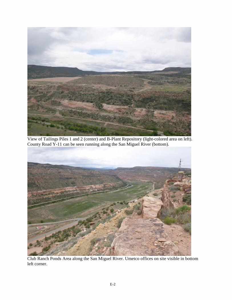
E-2
View of Tailings Piles 1 and 2 (center) and B-Plant Repository (light-colored area on left).
County Road Y-11 can be seen running along the San Miguel River (bottom).
Club Ranch Ponds Area along the San Miguel River. Umetco offices on site visible in bottom
left corner.

E-3
Umetco offices on site along Highway 141, with County Road Y-11 and tailings piles on
opposite side of the San Miguel River.
New County Road EE-22 bridge over the San Miguel River, looking toward F Block.
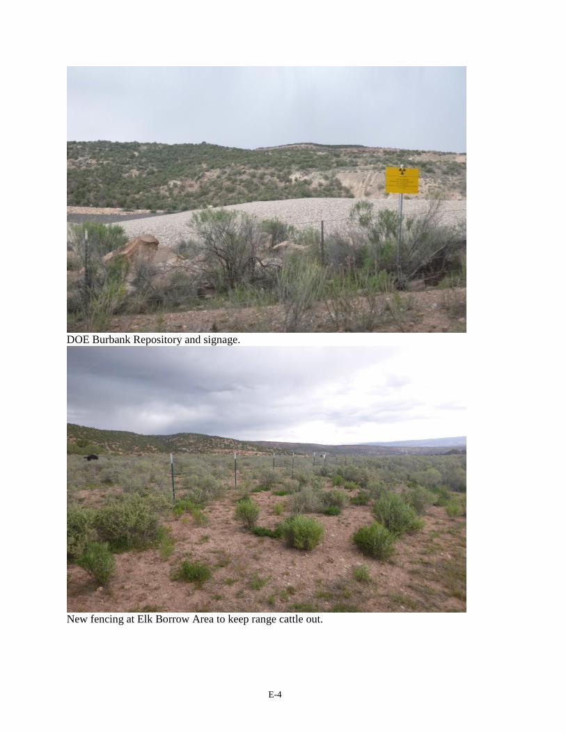
E-4
DOE Burbank Repository and signage.
New fencing at Elk Borrow Area to keep range cattle out.
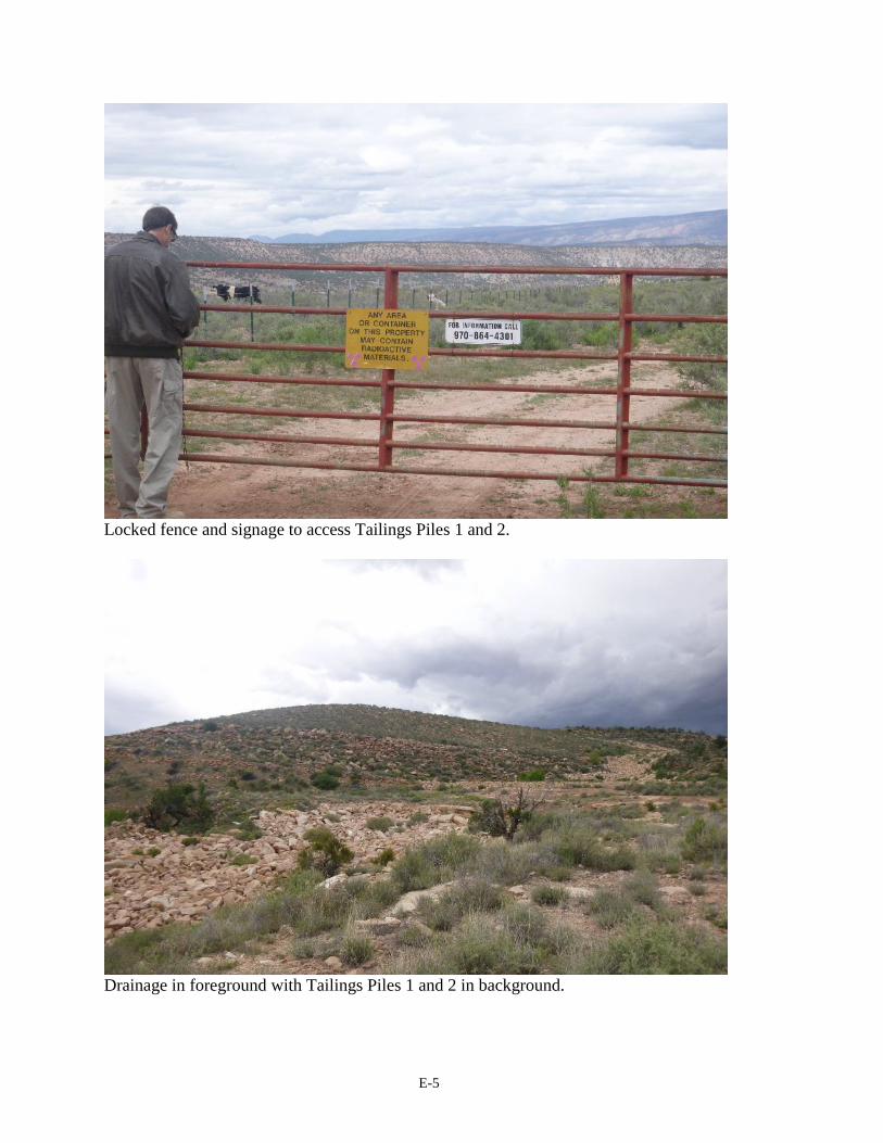
E-5
Locked fence and signage to access Tailings Piles 1 and 2.
Drainage in foreground with Tailings Piles 1 and 2 in background.