field trip guide book - pr01 - home-it trip guide book - pr01 florence - italy ... itinerary will...
TRANSCRIPT
Fie
ld T
rip
Gu
ide B
oo
k -
PR
01
Florence - ItalyAugust 20-28, 2004 Prestige Field Trip PR01
32nd INTERNATIONAL GEOLOGICAL CONGRESS
A GEOLOGICAL TRANSECT FROM THE INDIAN PLATE TO THE EAST HINDU KUSH, PAKISTAN
Leaders:M. Gaetani, J.P. Burg, A. Zanchi, Q.M. Jan
Volume n° 1 - from PR01 to B15
PR01_copertina_R_OK C 28-05-2004, 18:45:41

The scientific content of this guide is under the total responsibility of the Authors
Published by: APAT – Italian Agency for the Environmental Protection and Technical Services - Via Vitaliano Brancati, 48 - 00144 Roma - Italy
Series Editors:Luca Guerrieri, Irene Rischia and Leonello Serva (APAT, Roma)
English Desk-copy Editors:Paul Mazza (Università di Firenze), Jessica Ann Thonn (Università di Firenze), Nathalie Marléne Adams (Università di Firenze), Miriam Friedman (Università di Firenze), Kate Eadie (Freelance indipendent professional)
Field Trip Committee: Leonello Serva (APAT, Roma), Alessandro Michetti (Università dell’Insubria, Como), Giulio Pavia (Università di Torino), Raffaele Pignone (Servizio Geologico Regione Emilia-Romagna, Bologna) and Riccardo Polino (CNR, Torino)
Acknowledgments:The 32nd IGC Organizing Committee is grateful to Roberto Pompili and Elisa Brustia (APAT, Roma) for their collaboration in editing.
Graphic project:Full snc - Firenze
Layout and press:Lito Terrazzi srl - Firenze
PR01_copertina_R_OK D 24-05-2004, 15:46:48
Florence - ItalyAugust 20-28, 2004
Prestige Field Trip
32nd INTERNATIONAL GEOLOGICAL CONGRESS
Volume n° 1 - from PR01 to B15
A GEOLOGICAL TRANSECT FROM THE INDIAN PLATE TO THE EAST
HINDU KUSH, PAKISTAN
AUTHORS:M. Gaetani1, J.P. Burg 2, A. Zanchi3, Q.M. Jan4
1 Dipartimento di Scienze della Terra “A. Desio”, Università di Milano - Italy2 Geologisches Institut, ETH Zürich - Switzerland3 Dipartimento di Scienze dell’Ambiente e del Territorio, Università di Milano-Bicocca - Italy4 Centre of Excellence in Geology, University of Peshawar - Pakistan
PR01
PR01_R_OK A 24-05-2004, 15:50:31

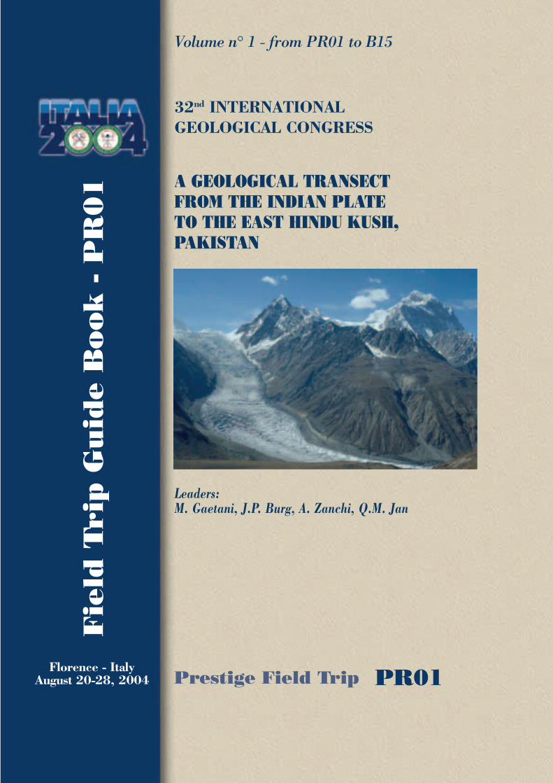
Front Cover: Panoramic view of the Chateboy Glacier and Koyo Zom (6871) from the Vidiakot area (Baroghil, upper Yarkhun Valley, Pakistan)
PR01_R_OK B 24-05-2004, 15:50:33
A GEOLOGICAL TRANSECT FROM THE INDIAN PLATE TO THE E HINDU KUSH, PAKISTAN P
R0
1
3 - PR01
Vo
lum
e n
° 1
-
fro
m P
RO
1 t
o B
15
Leaders: M. Gaetani, J.P. Burg, A. Zanchi, Q.M. Jan
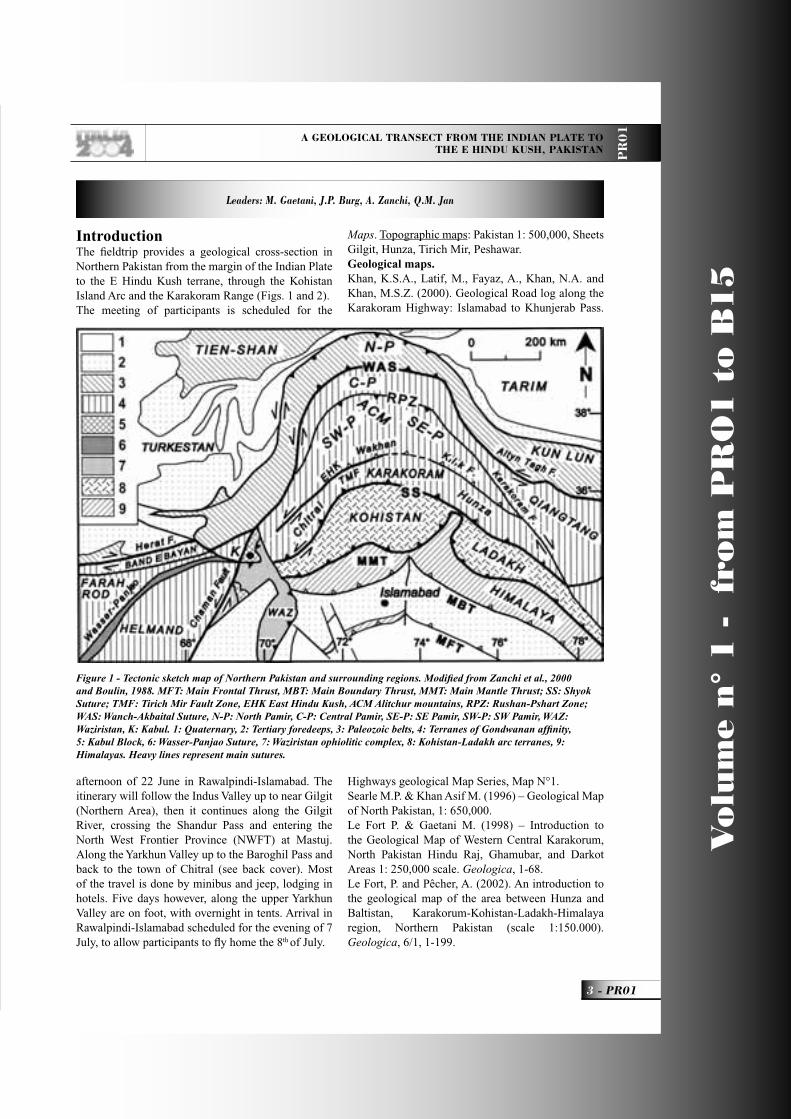
IntroductionThe fi eldtrip provides a geological cross-section in Northern Pakistan from the margin of the Indian Plate to the E Hindu Kush terrane, through the Kohistan Island Arc and the Karakoram Range (Figs. 1 and 2).The meeting of participants is scheduled for the
afternoon of 22 June in Rawalpindi-Islamabad. The itinerary will follow the Indus Valley up to near Gilgit (Northern Area), then it continues along the Gilgit River, crossing the Shandur Pass and entering the North West Frontier Province (NWFT) at Mastuj. Along the Yarkhun Valley up to the Baroghil Pass and back to the town of Chitral (see back cover). Most of the travel is done by minibus and jeep, lodging in hotels. Five days however, along the upper Yarkhun Valley are on foot, with overnight in tents. Arrival in Rawalpindi-Islamabad scheduled for the evening of 7 July, to allow participants to fl y home the 8th of July.
Maps. Topographic maps: Pakistan 1: 500,000, Sheets Gilgit, Hunza, Tirich Mir, Peshawar.Geological maps. Khan, K.S.A., Latif, M., Fayaz, A., Khan, N.A. and Khan, M.S.Z. (2000). Geological Road log along the Karakoram Highway: Islamabad to Khunjerab Pass.
Highways geological Map Series, Map N°1.Searle M.P. & Khan Asif M. (1996) – Geological Map of North Pakistan, 1: 650,000.Le Fort P. & Gaetani M. (1998) – Introduction to the Geological Map of Western Central Karakorum, North Pakistan Hindu Raj, Ghamubar, and Darkot Areas 1: 250,000 scale. Geologica, 1-68.Le Fort, P. and Pêcher, A. (2002). An introduction to the geological map of the area between Hunza and Baltistan, Karakorum-Kohistan-Ladakh-Himalaya region, Northern Pakistan (scale 1:150.000). Geologica, 6/1, 1-199.
Figure 1 - Tectonic sketch map of Northern Pakistan and surrounding regions. Modifi ed from Zanchi et al., 2000 and Boulin, 1988. MFT: Main Frontal Thrust, MBT: Main Boundary Thrust, MMT: Main Mantle Thrust; SS: Shyok Suture; TMF: Tirich Mir Fault Zone, EHK East Hindu Kush, ACM Alitchur mountains, RPZ: Rushan-Pshart Zone; WAS: Wanch-Akbaital Suture, N-P: North Pamir, C-P: Central Pamir, SE-P: SE Pamir, SW-P: SW Pamir, WAZ: Waziristan, K: Kabul. 1: Quaternary, 2: Tertiary foredeeps, 3: Paleozoic belts, 4: Terranes of Gondwanan affi nity, 5: Kabul Block, 6: Wasser-Panjao Suture, 7: Waziristan ophiolitic complex, 8: Kohistan-Ladakh arc terranes, 9: Himalayas. Heavy lines represent main sutures.
PR01_R_OK 3 24-05-2004, 15:50:58
Vo
lum
e n
° 1
-
fro
m P
RO
1 t
o B
15
PR01 -
Leaders: M. Gaetani, J.P. Burg, A. Zanchi, Q.M. Jan
PR
01
Zanchi A., Gaetani M., Angiolini L., (in press) – Geological Map of the NW Karakoram and E Hindu Kush, 1:100,000 scale. A pre-print copy will be provided to the participants.
Regional geologic setting
The Indian Plate marginThe northernmost parts of the Indian continent crop out between the Main Boundary Thrust (MBT), to the south, and the Indus Suture to the North. Northern metamorphic units and a southern, fold-and-thrust sedimentary belt constitute the so-called Lower- (or Lesser-) Himalaya of Pakistan (Chaudhry et al. 1997). Altogether, it is a low-grade assemblage of a 20 km thick, imbricate thrust pile of Mesozoic sequences originally deposited on the Indian continental crust represented by mid-Proterozoic and Paleozoic gneisses and sediments. Cambrian stromatolitic dolomites record the epicontinental marine transgression on 1.5 - 2.2 Ga old remobilised gneisses. Around 500 Ma old granitoids, which have been deformed into orthogneiss (Le Fort et al., 1980, Anczkiewicz 1998, DiPietro & Isachsen 2001), record the widespread magmatic event of that time, which is documented on all Gondwana-derived continental blocks.
Much of the Phanerozoic shelf sequence (shales, sandstones and limestones) is of Gondwana type, starting in the Middle-Paleozoic. Early-Permian magmatic ages of metabasaltic dikes and granite-gneiss intrusive into older Indian gneiss are evidence of pervasive magmatism during rifting (Anczkiewicz 1998, DiPietro & Isachsen 2001), which is associated with the break-up of Gondwana. Rifting produced a suite of alkaline intrusions, including carbonatites (Kazmi & Jan 1997). Sedimentary records indicate that the onset of extension tectonics is Early Carboniferous (Pogue et al. 1992, Pogue et al. 1999). Marine shelf sedimentation was re-established in the Late Triassic. The Mesozoic sedimentary history is that of carbonates deposited during thermal subsidence of a continental margin, on the southern side of Neo-Tethys.All these rocks were deformed and metamorphosed between 75 and 40 Ma (Treloar et al. 1989, Chamberlain et al. 1991). Subduction of at least parts of the Indian craton to depths equivalent to 27-32 kbars at ca. 50 Ma is indicated from the occurrence, in the Kaghan Valley, of coesite-bearing eclogites likely derived from basaltic Permian dykes (Tonarini et al. 1993, O’Brien et al. 2001, Kaneko et al. 2003). Thermochronologic studies suggest that before 13 Ma most of the Lower Himalaya rocks were located
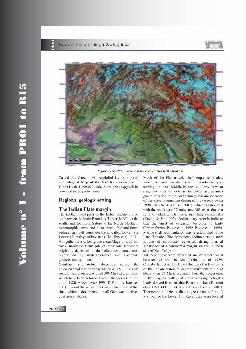
Figure 2 - Satellite overview of the area crossed by the fi eld trip.
PR01_R_OK 4 24-05-2004, 15:59:53
A GEOLOGICAL TRANSECT FROM THE INDIAN PLATE TO THE EAST HINDU KUSH, PAKISTAN P
R0
1
5 - PR01
Vo
lum
e n
° 1
-
fro
m P
RO
1 t
o B
15
either beneath a paleo-foreland basin or beneath Main Central Thrust (MCT)-related nappes. Molasse conglomerates siltstones and shales (termed Siwalik or Sub-Himalaya sediments) lap onto the Indian Shield. In detail the discontinuous series comprises most of the Cenozoic but there was a general lack of sedimentation during the Late Eocene and almost the entire Oligocene. This unconformity of 15-20 Myr may refl ect an important change in orogenic processes. One interpretation involves the passage of a fl exural forebulge migrating southward through India. Late Oligocene to Early Miocene fl uvial formations record the emergence of the Himalaya Mountains.
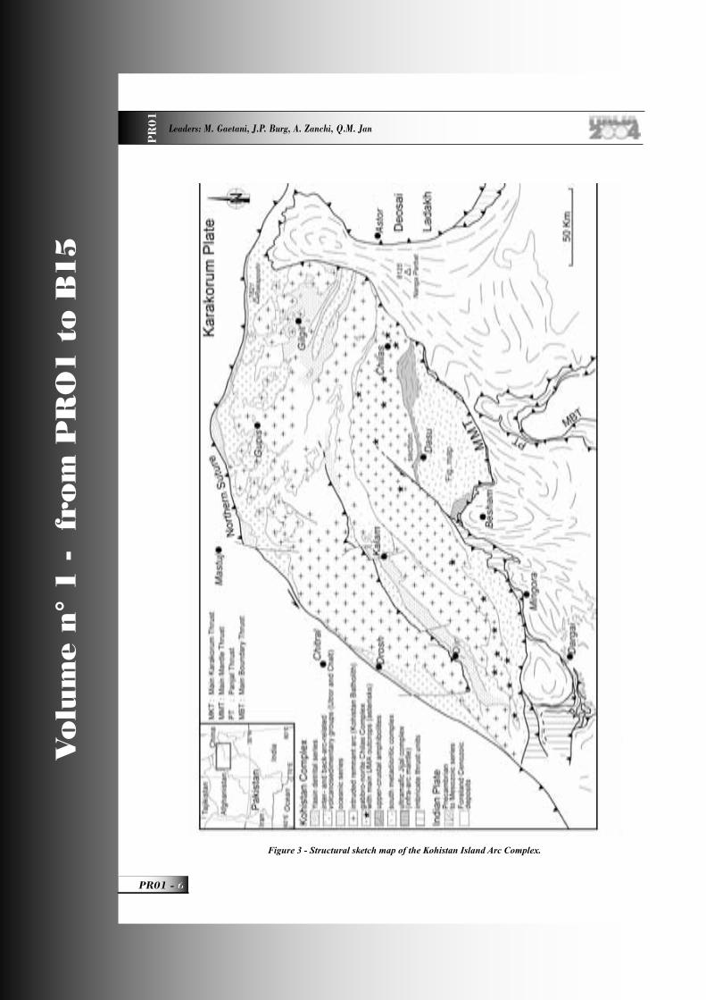
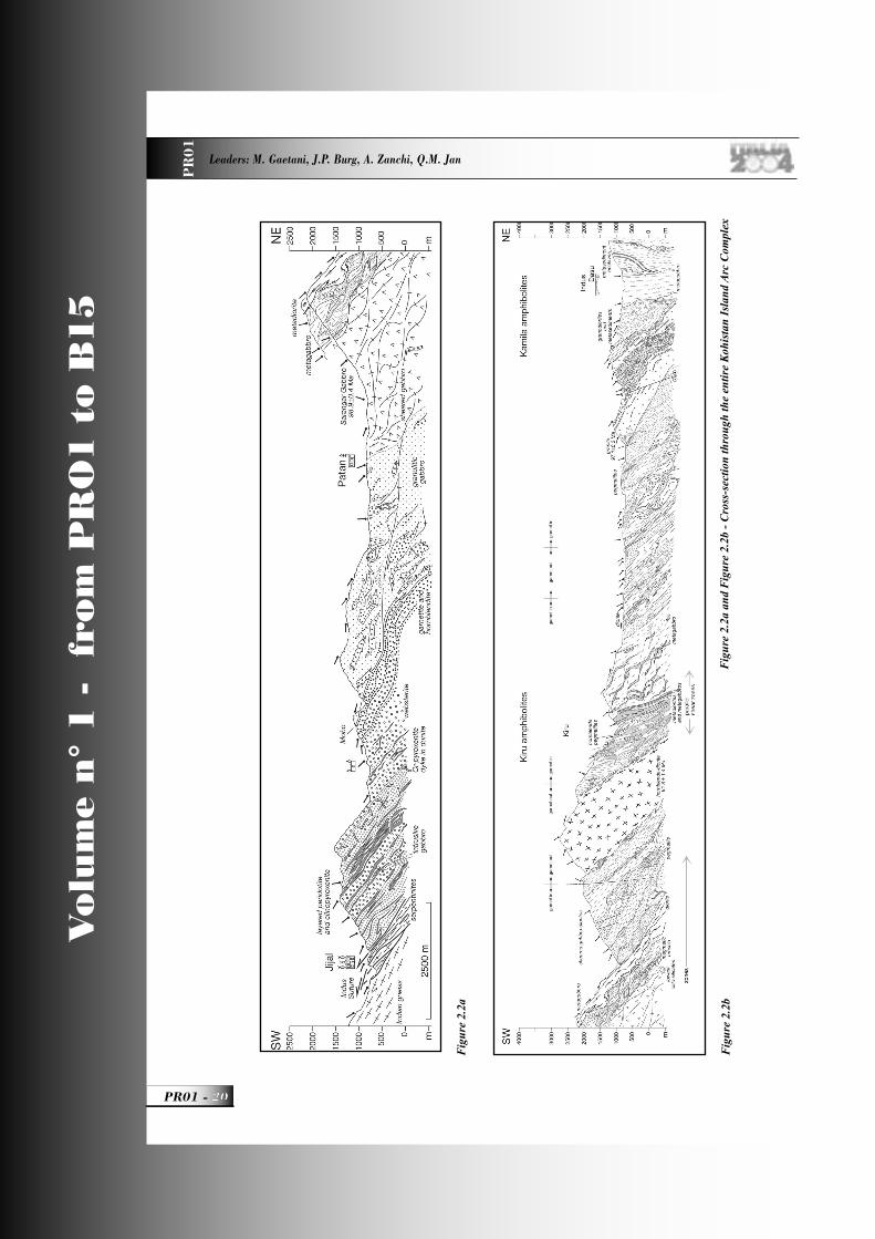
The Kohistan Island Arc Complex: Outline The Kohistan terrane in NE Pakistan (Fig. 3) is regarded as a fossil island arc obducted between the collided Indian and Asian plates (Bard et al. 1980, Tahirkheli et al., 1979). Owing to the admirable quality of exposures, the Kohistan offers an unrivalled opportunity to investigate the structure of an island arc and related subduction processes (Bard 1983, Searle et al., 1999, Treloar et al., 1996). In particular, numerous time markers in the form of intrusive bodies make the Kohistan an exceptional place to study the signifi cance of magmatic structures in the deep crust of an arc system.(Fig.3)
The Kohistan sequence displays a structurally coherent section of an island arc terrane, comprised of a 30 to 40 km thick section of metamorphosed, plutonic, volcanic and sedimentary rocks. This succession is interpreted as plutons intrusive into an oceanic crust and overlain by the calc-alkaline lavas and associated sediments. Accordingly, the interpretation is an intra-oceanic arc that developed during the Cretaceous through a north-dipping subduction in the equatorial area of the Tethys Ocean (Yoshida et al. 1996). Six main rock assemblages from north to south, i.e. downward sequence, are present.
UPPER CRUSTUpper crustal sequences pertain to two geographically distinct domains. - Just south of the Northern Suture, they consist of interlayered volcanoclastic sediments, volcanites and rather immature turbidites deposited in a deep-water environment. Sediments (so-called Yasin Group) are shales,
graywackes and volcanoclastic rocks form a probable back-arc basin of Cretaceous age. They grade upward into fi ne grained shales and tuffs and contain limestones with an Albian-Aptian fauna (Pudsey et al. 1985).Volcanites (Chalt Volcanites) are calc-alkaline andesites to rhyolites succeeding to andesitic lavas, tuffs and agglomerates of Early Cretaceous age. Exceptionally well-preserved pillow lavas are primitive island-arc-type, tholeiitic lavas that possibly represent part of an ophiolite assemblage obducted during the Kohistan-Asian collision. The size of this oceanic back arc basin (with respect to the Kohistan) is conjectural.- To the Southwest and within the Kohistan Complex, metasedimentary sequence of deep marine origin (Dir, Utror and Kalam Groups) yielded Eocene fossils in upper-level limestones. Depositional models point to rapid subsidence in Paleocene times in an extensional, restricted basin. Associated volcanic and volcanoclastic series are calc-alkaline basalts, basaltic andesites and andesites, emphasising an arc environment (Sullivan et al. 1993).
PLUTONIC CRUSTKohistan batholith: is a name that gathers intrusive calc-alkaline granitoids. The fi rst plutonic stage is dated at ca 105 Ma. Stages 2 and 3 are dated between 85 and 26 Ma. Stage 1 and early stage 2 plutons have isotopic signatures characteristic of a mantle derivation. The isotopic signatures of younger plutons show evidence of an increasing crust to mantle ratio, with the latest magmas being entirely crustally derived. This evolution is interpreted as the result of arc thickening and lower arc melting following suturing to Asia (Petterson & Windley 1985, 1991).
Gabbronorites: a massive body of locally layered gabbronorites marks the axis of the arc. It is the more than 8 km thick and 300 km long Chilas complex thought to be a layered magma chamber intruded into the arc in Cretaceous times. In detail, it is a stratiform complex of norites, noritic gabbros and a string of lenses of diverse ultramafi c-mafi c-anorthosite (UMA) association. The UMA represent apices of intra-arc mantle diapirs that served as porous fl ow conduits to feed the gabbro-norite. The gabbro-norite cooled and equilibrated at 600-800°C and 6-8 kbar. A Sm-Nd internal isochron yields an age of c. 70 Ma, consistent with the conventional zircon U-Pb age of 84 Ma (Schaltegger et al. 2002).
PR01_R_OK 5 24-05-2004, 15:53:23
Vo
lum
e n
° 1
-
fro
m P
RO
1 t
o B
15
PR01 -
Leaders: M. Gaetani, J.P. Burg, A. Zanchi, Q.M. Jan
PR
01
Figure 3 - Structural sketch map of the Kohistan Island Arc Complex.
PR01_R_OK 6 24-05-2004, 15:53:26
A GEOLOGICAL TRANSECT FROM THE INDIAN PLATE TO THE EAST HINDU KUSH, PAKISTAN P
R0
1
7 - PR01
Vo
lum
e n
° 1
-
fro
m P
RO
1 t
o B
15
Meta- gabbros to tonalites: (so-called Kamila amphibolites) form a thick pile of imbricated calc-alkaline laccoliths variably sheared in amphibolite facies conditions. Small inliers of metasediments and metavolcanic rocks screen these laccoliths and rare granites belong to the plutonic association. Few intrusion ages are available. They span from 99 to 82 Ma, giving evidence for a succession of short-lived plutonic events; 82 Ma-old rocks are kyanite-bearing pegmatites produced by partial remelting of deeper lithologies in the arc (Schaltegger et al., 2002). Ar-Ar cooling ages on hornblendes cluster around 80 Ma, hence providing evidence that this part of the Kohistan island arc complex was cooled below c. 500°C in the Late Cretaceous (Treloar et al., 1989). Shear strain localisation took place continuously from magmatic emplacement to solid state deformation during cooling of the gabbroic and dioritic plutons, between 100 and 83 Ma (Arbaret et al., 2000). The related shear strain probably represents arc-related deformation during subduction of the Tethys oceanic lithosphere below the Kohistan Arc Complex.
MANTLEThe so-called Jijal-Patan Complex, is composed of more than 3 km thick ultramafi c rocks overlain by garnet-plagioclase granulites. Garnet- and plagioclase-free peridotites and a few pyroxenites dominate the lowest section. The Jijal peridotites represent the sub-arc mantle (Burg et al., 1998).The sharp contact between the ultramafi c rocks and the overlying granulites, with well-preserved igneous structures, is the intrusive contact of lower crustal, calc-alkaline garnet-gabbros (the granulites) within mantle rocks (Burg et al., 1998). The contact is also the lower boundary of the arc crust, i.e. the arc-Moho. In the granulitic gabbro, metamorphic overprint essentially marks isobaric cooling within granulite facies conditions (starting T > 1150°C at depth > 50 km although early metamorphic pressures may have increased. The granulitic gabbros have later re-equilibrated at >700°C and 15 + 4 kbar, which are pressure conditions similar to those calculated from the underlying ultramafi c rocks (Ringuette et al., 1998). Sm-Nd isochrons at c. 95 Ma date cooling and provide the minimum age of the Jijal ultramafi c sequence (Anczkiewicz & Vance 2000, Yamamoto & Nakamura 2000).
Arc splittingThe calc-alkaline Chilas norites and noritic gabbros were fi rst interpreted as having crystallised in the
sub-arc magma chamber (Bard et al., 1980). Later geochemical analyses suggested that it was generated by intra-arc rifting and subsequent mantle diapirism (Khan et al., 1993). The latter interpretation is consistent with the gabbro-norites having intruded volcanic and sedimentary components of the arc. Petro-structural observation supportively suggests that the ultramafi c-mafi c-anorthosite associations occurring as a string of lenses over the >300km length of the gabbro-norite represent apices of intra-arc mantle diapirs that served as porous fl ow conduits to feed the gabbro-norite (Burg et al., 1998). According to the zircon U/Pb age of gabbronorites, rifting is about 85 Ma old (Schaltegger et al., 2002).The Chilas suite of mantle diapirs points to splitting of the Kohistan arc, with initial rifting taking place at the island arc as documented in modern island systems (e.g. Rocas Verdes). The UMA outcrops point to mantle diapirism as a key mechanism in opening back-arc basins between a volcanic and a remnant arc, the latter perhaps now seen as rocks screening the Kohistan Batholith.
Obduction - metamorphic recordThe Kohistan Arc and India were assembled during closure of Tethys, which produced thrusting along the Indus Suture. Within the Suture, a discontinuous but up to 20 km wide zone of imbricated ophiolites, greenschists and blueschists is locally referred to as “mélange unit”. It is a dominantly fore-arc related assemblage obducted onto the Indian plate (Anczkiewicz et al. 1998). In the footwall, the geology of the northern margin of the Indian plate is remarkably uniform. However, two high-pressure metamorphic events have accompanied the India-Kohistan convergence: blueschist facies metamorphism at ca. 80 Ma is linked to oceanic subduction, eclogite facies metamorphism at ca. 50 Ma is linked to continental subduction.
PRE-COLLISION EVENTSBlueschists imbricated within the suture between India and the Kohistan Arc yielded 40Ar-39Ar and Rb-Sr, phengite and Na-amphibole ages at ca. 80 Ma and thus record a pre-collisional, Early/Late Cretaceous metamorphism during subduction of the Tethys oceanic lithosphere (Anczkiewicz et al. 2000). Rapid exhumation and cooling of these high-pressure metamorphic rocks probably took place in an accretionary prism system dominated by corner fl ow processes.
PR01_R_OK 7 24-05-2004, 15:53:28
Vo
lum
e n
° 1
-
fro
m P
RO
1 t
o B
15
PR01 -
Leaders: M. Gaetani, J.P. Burg, A. Zanchi, Q.M. Jan
PR
01
COLLISION-RELATED EVENTSCollision with India developed Barrovian metamorphism in the Indian sequences.U-Pb ages of syn-metamorphic granites and Nd-Sm ages of eclogites indicate that at about 50 Ma the northern margin of India was deeply buried and being metamorphosed in high-pressure conditions (Spencer et al. 1995).Ar/Ar mineral ages of the metamorphosed sequences on the Indian plate give cooling ages of hornblende at 38 Ma and muscovite cooling ages of 30 Ma (Treloar et al. 1989). The metamorphic and related structural fabrics in these rocks, therefore, record an important part of the collisions and the fi nal emplacement of the Kohistan Arc against this segment of the Indian plate. The post-Eocene thrust directions generated complex, refolded thrust patterns, large slab folding and rapid uplift with associated brittle faulting and seismic activity. No signifi cant movement has taken place along the Indus Suture since 20 Ma, as indicated by similar fi ssion track ages on both sides of the Suture (Zeitler 1985).
The North-Kohistan Suture Zone The North-Kohistan Suture marks the fault contact between the Karakoram margin of the Eurasian Plate, to the North, and the Kohistan Paleo-Island Arc Complex, to the South. The North-Kohistan and Indus Sutures were two branches of the Neotethys Ocean and, as such, are western continuations of the Tsangpo Suture, in southern Tibet. As such the North-Kohistan Suture Zone eastward becomes the Shyok Suture, which separates the Ladakh Arc from the Karakoram. It has been inferred that the North-Kohistan Suture closed in the Late-Cretaceous on the basis of two arguments. 1) Undeformed subalkaline plutons of Eocene age are found on both sides of the Suture (Debon et al., 1987, Coward et al., 1987) and 2) pillow lavas next to the suture were deformed before intrusion of a 75 Ma old, mafi c dyke, (unpublished Ar-Ar age on hornblende by D. Rex, in (Petterson & Windley 1985) and mean age despite excess Argon in (Treloar et al., 1989). However, a signifi cant amount of the Karakoram granitoids is 25 Ma old, or younger (Debon et al., 1986, Parrish & Tirrul 1989). (Brookfi eld & Reynolds 1981) and (Reynolds et al., 1983) suggested that the eastern continuation of the North-Kohistan Suture, the Shyok Suture in India, did not close before the Miocene. The age of this closure remains unsettled, probably because suturing involved multiple events.
In Pakistan, early geological information is due to (Desio 1964, Desio & Martina 1972). The suture zone turns from its SW-NE trend, along the western Kohistan boundary to nearly E-W along the northern boundary (Fig. 3). The North-Kohistan Suture is described as a mélange containing blocks of serpentinite derived mostly from harzburgites, greenstones derived from both volcanic and volcano-sedimentary formations and sediments that include limestones, red shales, conglomerates and quartzites in a turbiditic, slate-dominated matrix (Pudsey et al. 1985a, Pudsey 1986). The “mélange” separates volcanic and sedimentary rocks of the Kohistan Arc Complex, to the south, from shelf sediments of the Karakoram to the north. The so-called mélange is a 1-7 km wide imbricate zone in which slices with well-defi ned lithologies are bounded by a series of anastomosing, brittle faults that have faulted away the original suture (Coward et al. 1986, Searle et al., 1989). Sinistral faults with a minor reverse component dominate the western segment. The reverse component is more important along the E-W segment. North and south vergent structures are found on both sides and within the suture. The North-Kohistan Suture Zone displays polyphase deformation. At least three ductile deformation events have been recognised, represented by (1) the stretching lineations in conglomerates and marbles, (2) curved fold axes in green schists and (3) crenulation lineations in black schists and slates. Brittle deformation is principally represented by recent sinistral strike-slip faulting with the reverse component. In the Drosh area, to the west youngest fi ssion track ages on apatite and zircon from the north of the suture, are 11 Ma and 20 Ma, respectively. They are 13Ma (apatite) and 20Ma (zircon) south of the suture. Similar apatite ages on both sides of the suture show that the rocks on either side passed the apatite partial annealing zone together, around 11-13Ma; accordingly, no or little vertical differential movement has taken place along this fault zone since the late Miocene.No high-pressure rocks have been found along the North-Kohistan suture whose real markers are therefore the serpentinites considered to derive from the Neotethys oceanic lithosphere (oceanic back-arc basin?). The systematic organisation of the lithologic slices, which may represent a reactivated accretionary prism, leads to redefi ne the main lithological units according to their presumed tectonic origin. This classifi cation is tentative and thus must be considered
PR01_R_OK 8 24-05-2004, 15:53:30
A GEOLOGICAL TRANSECT FROM THE INDIAN PLATE TO THE EAST HINDU KUSH, PAKISTAN P
R0
1
9 - PR01
Vo
lum
e n
° 1
-
fro
m P
RO
1 t
o B
15
with caution or even suspicion, in particular because of the lack of ages.
Neotethys rocksThe North-Neotethys Ocean lithologies are composed of low-grade pelagic to hemipelagic sediments, banded cherts, pillow lavas, calcschists, black shales, serpentinites and talc-magnesite schists derived mostly from harzburgites. However, no typical ophiolitic sequence has been recognised. Serpentinites occur either as massive lenticular and fault-bounded blocks or (mainly) as thin schistose shreds along major faults. Gabbros have locally intruded serpentinites. The meta-ultramafi c rocks locally occur as talc-magnesite felsen and schists, indicating circulation of CO
2 fl uids within the suture
fault system. The mineral parageneses indicate greenschist facies metamorphism.
North Kohistan rocksThe northern margin of the Kohistan Arc comprises greenschist-facies basaltic and andesitic volcanites, volcanodetritic and shelf-type sediments that overlie turbiditic red shales, sandstones and conglomerates,
and the calc-alkaline mylonitic gabbros and amphibolitic metavolcanodetritics of the Kohistan Batholith. Pebbles in low-grade red conglomerates are elongated, hence defi ning a stretching lineation with variable directions.Fossiliferous (rudists, orbitolinoids) reef-limestone sequences occur within green basaltic to andesitic volcanites (Pudsey et al., 1985b). It is not clear yet, whether this unit, squeezed within the suture zone, derived from the Karakoram or Kohistan terrane, or both.
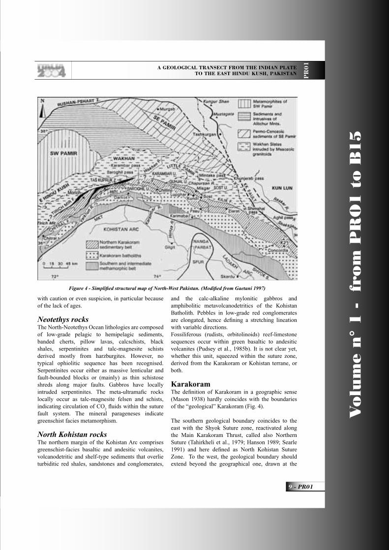
KarakoramThe defi nition of Karakoram in a geographic sense (Mason 1938) hardly coincides with the boundaries of the “geological” Karakoram (Fig. 4).
The southern geological boundary coincides to the east with the Shyok Suture zone, reactivated along the Main Karakoram Thrust, called also Northern Suture (Tahirkheli et al., 1979; Hanson 1989; Searle 1991) and here defi ned as North Kohistan Suture Zone. To the west, the geological boundary should extend beyond the geographical one, drawn at the
Figure 4 - Simplifi ed structural map of North-West Pakistan. (Modifi ed from Gaetani 1997)
PR01_R_OK 9 24-05-2004, 15:53:31
Vo
lum
e n
° 1
-
fro
m P
RO
1 t
o B
15
PR01 -
Leaders: M. Gaetani, J.P. Burg, A. Zanchi, Q.M. Jan
PR
01
Karambar Valley. The Hindu Raj Range should be included because both magmatic and sedimentary units continue, fairly homogeneously, through to the Yarkhun Valley and beyond. The western boundary of the “geological” Karakoram is set at Tirich Mir Boundary Zone (Gaetani et al., 1996; Zanchi et al., 2000). To the north, the boundary with the Little Pamir is poorly defi ned, but access to the Wakhan (Afghan Pamir) is presently hampered. A sound limit is along the Kilik Fault in Chapursan (Fig. 4), where the Misgar Slates are thrust over the Permo-Cretaceous sediments of Northern Karakoram (Zanchi 1993). This lineament, can be traced through the Wakhan (Kafarskyi & Abdullah 1976) and probably linked to the Tirich Mir Fault (Buchroithner & Gamerith 1986; Zanchi et al., 2000). In this interpretation, the E Hindu Kush lies north of the Karakoram and merges into the Little Pamir.
Karakoram margin rocksIn the southernmost Karakoram, lithologies are generally represented by brown and black shales in greenschist facies, shelf type sediments like micritic limestones and white marbles intruded by nearly undeformed calc-alkaline plutons of Cretaceous to Neogene age farther north of the suture. The metamorphic grade is here signifi cantly lower than in the eastern continuation of the southern Karakoram (the so-called “Southern Metamorphic Belt” in Hunza, Baltistan and Ladakh). Volcano-lithic sandstones and conglomerates interlayered with greenish volcanites are also attributed to the Karakoram active margin. Locally, wedges of mylonitic gabbros and diorites and amphibolite facies metapelites display a main, suture-parallel and steeply NW dipping foliation subparallel to bedding and SE verging thrusts.
The Karakoram RangeIT consists of fi ve belts, from south to north, respectively: 1) To the south and only in the west, a meta-sedimentary unit, composed of slates and arenites with intercalation of conglomerate, and bryozoan- and brachiopod-bearing limestone, is overlain by Lower Cretaceous detritic and partly volcanic formations. To the East, this unit merges with the belt 3), from which it is hardly distinguishable because of the increase of the metamorphic grade along the Hunza and Baltoro transects.2) the Ghamubar crystalline mass is composed of plutonic rocks also varying from diorite to granite in composition, and intruding into a large northern
strip of gneisses and migmatites. This unit disappears moving to the east in the Hunza Valley, 3) the intermediate sedimentary unit, the Darkot unit, is composed of low-grade meta-sedimentary formations, including arenites, slates, and limestones in which Upper Paleozoic bryozoans and brachiopods have been found (Hayden, 1915; Ivanac et al., 1956) and Mesozoic bivalves (Le Fort & Gaetani 1998);4) the northern crystalline mass, the Karakorum Batholith (KB) is mainly made up of plutonic rocks varying from diorite to granite in composition, the granite being in the centre, fl anked to the north and south by the mafi c plutonic rocks. Meta-sedimentary formations may be included as squeezed strips or inclusions;5) the northern, mostly sedimentary belt, forming the Northern Karakoram. It consists of a crystalline basement covered by an Ordovician to Cretaceous sedimentary succession up to 4-5 km thick, bound to the NW by a belt of volcanic basalts and dolostones of unknown age and by low grade phyllites.The boundary against the E Hindu Kush is made of the Tirich Mir Boundary Zone (TMBZ). During the fi eldtrip we will observe with some details rocks of the Karakoram Batholith and of the Northern Karakoram.
Karakoram Batholith It is a composite body made up by the juxtaposition of large plutonic units displaying major differences in age, chemical-mineralogical composition, and tectonometamorphic history (Debon et al., 1987a). These plutonic intrusions form the back-bone of the Karakoram Range.Different transects through the range cross different plutons with different composition and different emplacement age.The Hunza transect, from south to north, crosses the Hunza Plutonic Complex, basically a granodiorite, reliably dated at 95± 5 Ma (U-Pb, zircon) (Le Fort et al., 1983; Crawford and Searle 1992). To the north of it the Batura Plutonic Complex outcrops with metaluminous or slighlty peraluminous granites and adamellites, and also with quartzmonzodiorites and quartz monzonites (Debon 1995). A small gabbroic body is also found. Rb/Sr isochrons give ages from 63.4 ± 2 Ma to 42.8 ± 5.6 Ma (Debon 1995). Northwards, intruded in the Northern Karakorum sedimentary belt and in the Misgar Slates are bimodal plutons: Mg-K metaluminous granitoids with biotite and amphibole, and two-mica peraluminous granitoids. Dating of this bimodal plutonism by K-Ar
PR01_R_OK 10 24-05-2004, 15:53:39
A GEOLOGICAL TRANSECT FROM THE INDIAN PLATE TO THE EAST HINDU KUSH, PAKISTAN P
R0
1
11 - PR01
Vo
lum
e n
° 1
-
fro
m P
RO
1 t
o B
15
amphibole and biotite ages, suggests primary cooling ages around 110/105 Ma (Debon et al., 1996).The Karambar transect to the west of Hunza also shows a large development of the non-alkaline Hunza Plutonic Complex in the southern and central part, followed to the north by a subalkaline porphyritic granite (Warghut granite) and then by a composite group of fi ne grained granitoids with mafi c enclaves. Peculiar to this transect is the Koz-Sar alkaline complex that from monzonite and quartz monzonites gave a Rb/Sr isochron of 88± 4 Ma. (Debon and Khan 1996).The Yarkhun gorge transect will be visited during the fi eld trip and also displays three plutonic bodies.Of them, the Darkot Pass porphyritic granite gave a Rb/Sr isochron of 111±6 (Debon et al. 1987; Le Fort and Gaetani 1998).This complex of intrusive bodies spans in age from mid-Cretaceous to Eocene and refl ects the northward subduction of the Neotethys oceanic crust below the Asian margin and the following collision related phenomena.
Northern KarakoramThe Northern Karakoram includes a metamorphic crystalline basement (Le Fort et al., 1994) and a sedimentary cover spanning from the Ordovician to the Cretaceous (Gaetani 1997).The Crystalline basement of Karakoram consists of low-grade quartzites and migmatites, which are in turn intruded by a granodiorite.The quartzites (Chikar quartzites) consist of dark-grey siltstones and quartzites, largely derived from greenschist-facies metamorphism of poorly sorted subarkoses. This metaterrigenous unit forms km-wide open folds, and is transformed into hard spotted schists and massive hornfels-like rocks close to the contact with the granodiorite. Granitic dikes intrude the metasediments.The migmatites occur to the SE of Chikar, and up the right bank of the Darkot Pass glacier, where the metasediments become increasingly intruded by granitic dikes. In a few km, the injected metasediments seem to gradually give way to migmatites, and into anatectic granite engulfi ng masses of nebulitic gneisses and agmatitic amphibolites.The granodiorites occur in aphophyses 4-5 km wide (Kishmanja, Ishkarwaz) and in thrusted sheets and slices, 4 to 10 km long (in front of Kan Khun). The granite bears biotite and frequent amphibole, almost totally altered. According to the Debon and Le Fort classifi cation (1988), the granitoid is a dark-colored
adamellite, alumino-cafemic with a calc-alkaline affi nity (Le Fort et al. 1994). For geochemistry refer to Le Fort in Le Fort & Gaetani (1998).
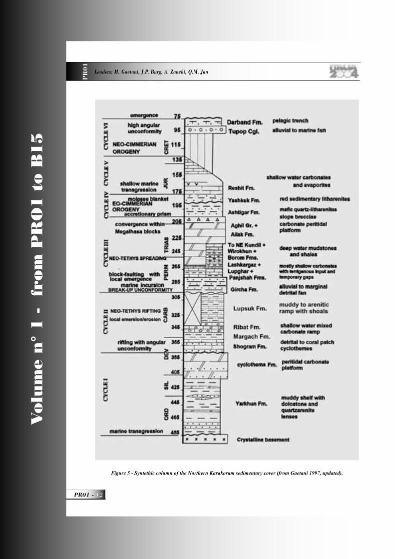
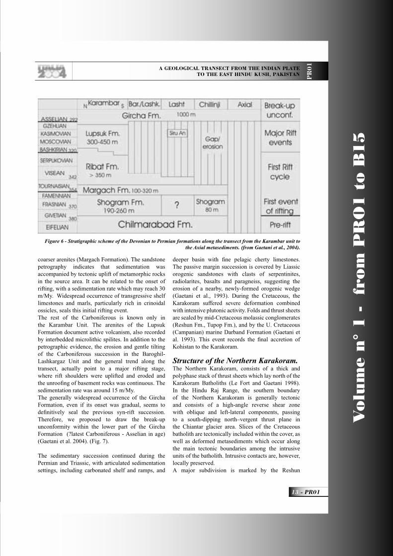
The Northern Karakoram sedimentary succession (Fig. 5)It is arranged in several stacked thrust sheets with internal stratigraphy partially different. Transgression onto the crystalline basement occurred under frank marine conditions and a muddy shelf environment extended through the whole Ordovician and Silurian (Le Fort et al., 1994). Arkosic sands were deposited as coastal bars. Sedimentation rate was low, usually not exceeding 10 m/Ma. Carbonate sedimentation was episodic, because of terrigenous pollution, the fairly southern paleoposition of the Northern Karakoram in the southern hemisphere, and because of cold marine currents originating from the polar regions (Tongiorgi et al., 1994). The Paleozoic sedimentary successions grow in thickness and are most complete when moving from south to north in present coordinates. In the Axial Zone the Permian arenites of the Gircha lie directly above the slates of the Lower Paleozoic Baroghil Group (Gaetani et al., 1996). In the Chillinji Zone, dolostones, hybrid arenites and coral baffl estones (Chilmarabad and Shogram Formations – Devonian) are interposed between the slates of the Baroghil Group and the Carboniferous-Permian terrigenous succession (Fig. 6). In the Baroghil-Lashkargaz thrust sheets the Devonian succession is represented by the two members of the Chilmarabad Fm. and only the lowermost part of the Carboniferous succession is preserved. It is unconformably overlain by the Gircha Formation. In the Karambar thrust sheet the succession reaches its maximum thickness with the Lower Devonian Vandanil Fm. interposed between the Baroghil group and Chilmarabad Fm. The Devonian-Carboniferous sections exceed 2000 m in thickness and also contain Upper Carboniferous rocks.We interpret this Paleozoic transect as a part of the continental margin of the Karakoram Terrane, facing a deeper basin mostly fi lled by the Wakhan/Misgar Slates.The fi rst step of the margin evolution is traced back to the Devonian, when the peritidal platform of the Chimarabad Formation emerged (Givetian?) and was covered by the conglomerates at the base of the Shogram Formation. The Shogram Formation had a sedimentation rate of 10/15 m/My. Upwards, the terrigenous input becomes abundant with spells of
PR01_R_OK 11 24-05-2004, 15:53:41
Vo
lum
e n
° 1
-
fro
m P
RO
1 t
o B
15
PR01 -
Leaders: M. Gaetani, J.P. Burg, A. Zanchi, Q.M. Jan
PR
01
Figure 5 - Syntethic column of the Northern Karakoram sedimentary cover (from Gaetani 1997, updated).
PR01_R_OK 12 24-05-2004, 15:53:43
A GEOLOGICAL TRANSECT FROM THE INDIAN PLATE TO THE EAST HINDU KUSH, PAKISTAN P
R0
1
13 - PR01
Vo
lum
e n
° 1
-
fro
m P
RO
1 t
o B
15
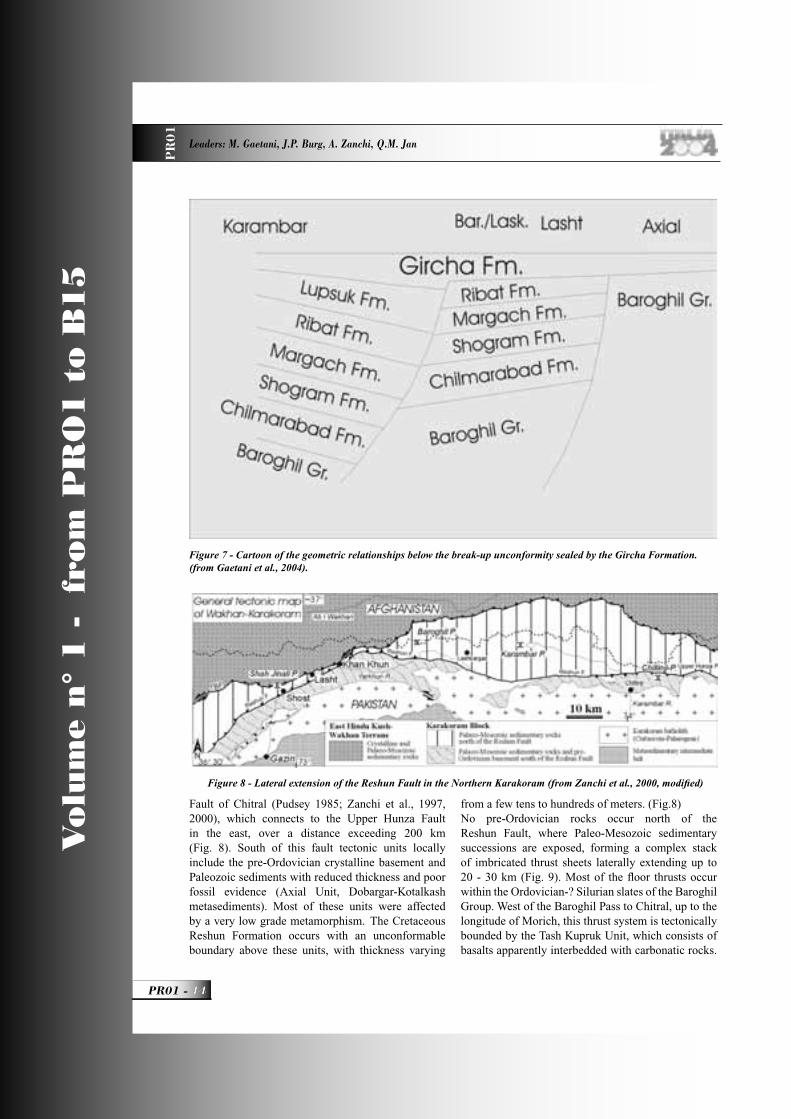
coarser arenites (Margach Formation). The sandstone petrography indicates that sedimentation was accompanied by tectonic uplift of metamorphic rocks in the source area. It can be related to the onset of rifting, with a sedimentation rate which may reach 30 m/My. Widespread occurrence of transgressive shelf limestones and marls, particularly rich in crinoidal ossicles, seals this initial rifting event. The rest of the Carboniferous is known only in the Karambar Unit. The arenites of the Lupsuk Formation document active volcanism, also recorded by interbedded microlithic spilites. In addition to the petrographic evidence, the erosion and gentle tilting of the Carboniferous succession in the Baroghil-Lashkargaz Unit and the general trend along the transect, actually point to a major rifting stage, where rift shoulders were uplifted and eroded and the unroofi ng of basement rocks was continuous. The sedimentation rate was around 15 m/My. The generally widespread occurrence of the Gircha Formation, even if its onset was gradual, seems to defi nitively seal the previous syn-rift succession. Therefore, we proposed to draw the break-up unconformity within the lower part of the Gircha Formation (?latest Carboniferous - Asselian in age) (Gaetani et al. 2004). (Fig. 7).
The sedimentary succession continued during the Permian and Triassic, with articulated sedimentation settings, including carbonated shelf and ramps, and
deeper basin with fi ne pelagic cherty limestones. The passive margin succession is covered by Liassic orogenic sandstones with clasts of serpentinites, radiolarites, basalts and paragneiss, suggesting the erosion of a nearby, newly-formed orogenic wedge (Gaetani et al., 1993). During the Cretaceous, the Karakoram suffered severe deformation combined with intensive plutonic activity. Folds and thrust sheets are sealed by mid-Cretaceous molassic conglomerates (Reshun Fm., Tupop Fm.), and by the U. Cretaceous (Campanian) marine Darband Formation (Gaetani et al. 1993). This event records the fi nal accretion of Kohistan to the Karakoram.
Structure of the Northern Karakoram.The Northern Karakoram, consists of a thick and polyphase stack of thrust sheets which lay north of the Karakoram Batholiths (Le Fort and Gaetani 1998). In the Hindu Raj Range, the southern boundary of the Northern Karakoram is generally tectonic and consists of a high-angle reverse shear zone with oblique and left-lateral components, passing to a south-dipping north–vergent thrust plane in the Chiantar glacier area. Slices of the Cretaceous batholith are tectonically included within the cover, as well as deformed metasediments which occur along the main tectonic boundaries among the intrusive units of the batholith. Intrusive contacts are, however, locally preserved.A major subdivision is marked by the Reshun
Figure 6 - Stratigraphic scheme of the Devonian to Permian formations along the transect from the Karambar unit to the Axial metasediments. (from Gaetani et al., 2004).
PR01_R_OK 13 24-05-2004, 15:53:51
Vo
lum
e n
° 1
-
fro
m P
RO
1 t
o B
15
PR01 -
Leaders: M. Gaetani, J.P. Burg, A. Zanchi, Q.M. Jan
PR
01
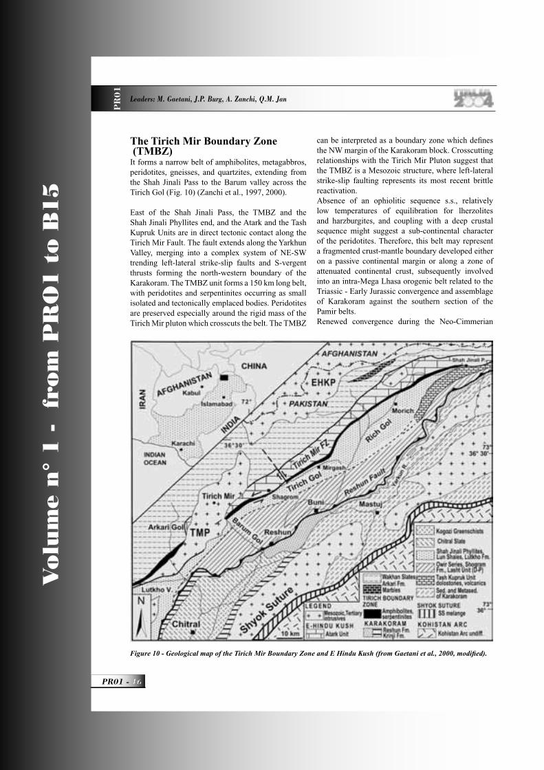
Fault of Chitral (Pudsey 1985; Zanchi et al., 1997, 2000), which connects to the Upper Hunza Fault in the east, over a distance exceeding 200 km (Fig. 8). South of this fault tectonic units locally include the pre-Ordovician crystalline basement and Paleozoic sediments with reduced thickness and poor fossil evidence (Axial Unit, Dobargar-Kotalkash metasediments). Most of these units were affected by a very low grade metamorphism. The Cretaceous Reshun Formation occurs with an unconformable boundary above these units, with thickness varying
from a few tens to hundreds of meters. (Fig.8)No pre-Ordovician rocks occur north of the Reshun Fault, where Paleo-Mesozoic sedimentary successions are exposed, forming a complex stack of imbricated thrust sheets laterally extending up to 20 - 30 km (Fig. 9). Most of the fl oor thrusts occur within the Ordovician-? Silurian slates of the Baroghil Group. West of the Baroghil Pass to Chitral, up to the longitude of Morich, this thrust system is tectonically bounded by the Tash Kupruk Unit, which consists of basalts apparently interbedded with carbonatic rocks.
Figure 8 - Lateral extension of the Reshun Fault in the Northern Karakoram (from Zanchi et al., 2000, modifi ed)
Figure 7 - Cartoon of the geometric relationships below the break-up unconformity sealed by the Gircha Formation. (from Gaetani et al., 2004).
PR01_R_OK 14 24-05-2004, 15:53:55

A GEOLOGICAL TRANSECT FROM THE INDIAN PLATE TO THE EAST HINDU KUSH, PAKISTAN P
R0
1
15 - PR01
Vo
lum
e n
° 1
-
fro
m P
RO
1 t
o B
15
To the north of the Tash Kupruk outcrop the Shah Jinali Phyllites, including a monotonous succession of greenschist facies quartzite-bearing metapelites, garnet-chlorite and chloritoid-chlorite phyllites.
From the eastern Chitral to the upper reaches of the river Karambar, thrust sheets mostly consist of Paleozoic successions, the youngest sediments being Early Jurassic in age. On the contrary, along the eastern side of the range (Chapursan Valley – Hunza region), thrust sheets include rocks not older than Permian or possibly Upper Carboniferous (Gaetani et al. 1990; Zanchi and Gaetani 1994).
The main tectonostratigraphic Units north of the Reshun Fault are as follows. The Lasht Unit, which east of the Shah Jinali Pass the hanging wall of the Reshun Fault consists of Devonian to Permian and possibly Mesozoic carbonatic to terrigenous successions. E-W trending folds and faults make the structural setting very complex, especially in the Siru Gol area, where the unit is intensively sliced and tectonically repeated. East of Lasht, the Lasht Unit is tectonically elided by left-lateral NE-SW trending strike-slip reverse faults which form the eastern continuation of the Reshun Fault. The Baroghil-Lashkargaz Unit occurs in the central part of the area visited around the Baroghil Pass
and Lashkargaz. It consists of a Ordovician to Jurassic succession about 4-5 km thick (Gaetani et al., 1996). It is bound to the south by the Axial Unit through a complex system of reverse-oblique faults including conglomerates of the Reshun Formation and intensively deformed marble slices. The central-southern part of this unit is poorly deformed, showing continuous sedimentary successions. On the contrary, its northern boundary is intensively deformed, showing E-W trending overturned and recumbent folds and south-vergent thrusts. The Karambar Unit extends north and east of the Baroghil-Lashkargaz Unit, between the Chiantar Glacier and southern Wakhan, largely occurring north of the Pakistani border. This unit will be observed in the distance looking northward and eastward from the Baroghil region. It is mentioned here as it contains the most complete and thick Paleozoic succession of the area. The southern sector of the Karambar Unit is extremely folded and abruptly cut by the Reshun Fault. The unit is split by a large NNE-SSW trending tear fault extending from the Chiantar Glacier to the east of the Karambar Lake with a left-lateral throw of some kilometres. The western and northern sectors of the Karambar unit show NNW-SSE to NW-SE trending West-vergent folds and thrusts, whereas the eastern part shows E-W south-dipping thrust structures.
Figure 9 - The main thrust sheets in the Northern Karakoram (From Gaetani et al. 2004, modifi ed).
PR01_R_OK 15 24-05-2004, 15:54:00
Vo
lum
e n
° 1
-
fro
m P
RO
1 t
o B
15
PR01 -
Leaders: M. Gaetani, J.P. Burg, A. Zanchi, Q.M. Jan
PR
01
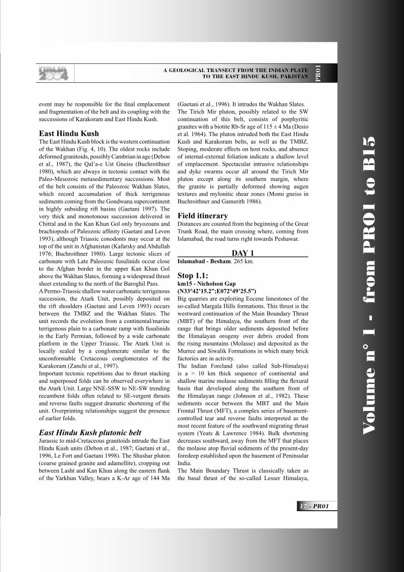
The Tirich Mir Boundary Zone (TMBZ) It forms a narrow belt of amphibolites, metagabbros, peridotites, gneisses, and quartzites, extending from the Shah Jinali Pass to the Barum valley across the Tirich Gol (Fig. 10) (Zanchi et al., 1997, 2000). East of the Shah Jinali Pass, the TMBZ and the Shah Jinali Phyllites end, and the Atark and the Tash Kupruk Units are in direct tectonic contact along the Tirich Mir Fault. The fault extends along the Yarkhun Valley, merging into a complex system of NE-SW trending left-lateral strike-slip faults and S-vergent thrusts forming the north-western boundary of the Karakoram. The TMBZ unit forms a 150 km long belt, with peridotites and serpentinites occurring as small isolated and tectonically emplaced bodies. Peridotites are preserved especially around the rigid mass of the Tirich Mir pluton which crosscuts the belt. The TMBZ
can be interpreted as a boundary zone which defi nes the NW margin of the Karakoram block. Crosscutting relationships with the Tirich Mir Pluton suggest that the TMBZ is a Mesozoic structure, where left-lateral strike-slip faulting represents its most recent brittle reactivation. Absence of an ophiolitic sequence s.s., relatively low temperatures of equilibration for lherzolites and harzburgites, and coupling with a deep crustal sequence might suggest a sub-continental character of the peridotites. Therefore, this belt may represent a fragmented crust-mantle boundary developed either on a passive continental margin or along a zone of attenuated continental crust, subsequently involved into an intra-Mega Lhasa orogenic belt related to the Triassic - Early Jurassic convergence and assemblage of Karakoram against the southern section of the Pamir belts. Renewed convergence during the Neo-Cimmerian
Figure 10 - Geological map of the Tirich Mir Boundary Zone and E Hindu Kush (from Gaetani et al., 2000, modifi ed).
PR01_R_OK 16 24-05-2004, 15:54:03
A GEOLOGICAL TRANSECT FROM THE INDIAN PLATE TO THE EAST HINDU KUSH, PAKISTAN P
R0
1
17 - PR01
Vo
lum
e n
° 1
-
fro
m P
RO
1 t
o B
15
event may be responsible for the fi nal emplacement and fragmentation of the belt and its coupling with the successions of Karakoram and East Hindu Kush.
East Hindu Kush The East Hindu Kush block is the western continuation of the Wakhan (Fig. 4, 10). The oldest rocks include deformed granitoids, possibly Cambrian in age (Debon et al., 1987), the Qal’a-e Ust Gneiss (Buchroithner 1980), which are always in tectonic contact with the Paleo-Mesozoic metasedimentary successions. Most of the belt consists of the Paleozoic Wakhan Slates, which record accumulation of thick terrigenous sediments coming from the Gondwana supercontinent in highly subsiding rift basins (Gaetani 1997). The very thick and monotonous succession delivered in Chitral and in the Kan Khun Gol only bryozoans and brachiopods of Paleozoic affi nity (Gaetani and Leven 1993), although Triassic conodonts may occur at the top of the unit in Afghanistan (Kafarsky and Abdullah 1976; Buchroithner 1980). Large tectonic slices of carbonate with Late Paleozoic fusulinids occur close to the Afghan border in the upper Kan Khun Gol above the Wakhan Slates, forming a widespread thrust sheet extending to the north of the Baroghil Pass.A Permo-Triassic shallow water carbonatic terrigenous succession, the Atark Unit, possibly deposited on the rift shoulders (Gaetani and Leven 1993) occurs between the TMBZ and the Wakhan Slates. The unit records the evolution from a continental/marine terrigenous plain to a carbonate ramp with fusulinids in the Early Permian, followed by a wide carbonate platform in the Upper Triassic. The Atark Unit is locally sealed by a conglomerate similar to the unconformable Cretaceous conglomerates of the Karakoram (Zanchi et al., 1997). Important tectonic repetitions due to thrust stacking and superposed folds can be observed everywhere in the Atark Unit. Large NNE-SSW to NE-SW trending recumbent folds often related to SE-vergent thrusts and reverse faults suggest dramatic shortening of the unit. Overprinting relationships suggest the presence of earlier folds. East Hindu Kush plutonic beltJurassic to mid-Cretaceous granitoids intrude the East Hindu Kush units (Debon et al., 1987; Gaetani et al., 1996, Le Fort and Gaetani 1998). The Shushar pluton (coarse grained granite and adamellite), cropping out between Lasht and Kan Khun along the eastern fl ank of the Yarkhun Valley, bears a K-Ar age of 144 Ma
(Gaetani et al., 1996). It intrudes the Wakhan Slates. The Tirich Mir pluton, possibly related to the SW continuation of this belt, consists of porphyritic granites with a biotite Rb-Sr age of 115 ± 4 Ma (Desio et al. 1964). The pluton intruded both the East Hindu Kush and Karakoram belts, as well as the TMBZ. Stoping, moderate effects on host rocks, and absence of internal-external foliation indicate a shallow level of emplacement. Spectacular intrusive relationships and dyke swarms occur all around the Tirich Mir pluton except along its southern margin, where the granite is partially deformed showing augen textures and mylonitic shear zones (Momi gneiss in Buchroithner and Gamerith 1986).
Field itineraryDistances are counted from the beginning of the Great Trunk Road, the main crossing where, coming from Islamabad, the road turns right towards Peshawar.
DAY 1 Islamabad - Besham. 265 km.
Stop 1.1:km15 - Nicholson Gap (N33°42’15.2”;E072°49’25.5”)Big quarries are exploiting Eocene limestones of the so-called Margala Hills formations. This thrust is the westward continuation of the Main Boundary Thrust (MBT) of the Himalaya, the southern front of the range that brings older sediments deposited before the Himalayan orogeny over debris eroded from the rising mountains (Molasse) and deposited as the Murree and Siwalik Formations in which many brick factories are in activity.The Indian Foreland (also called Sub-Himalaya) is a > 10 km thick sequence of continental and shallow marine molasse sediments fi lling the fl exural basin that developed along the southern front of the Himalayan range (Johnson et al., 1982). These sediments occur between the MBT and the Main Frontal Thrust (MFT), a complex series of basement-controlled tear and reverse faults interpreted as the most recent feature of the southward migrating thrust system (Yeats & Lawrence 1984). Bulk shortening decreases southward, away from the MFT that places the molasse atop fl uvial sediments of the present-day foredeep established upon the basement of Peninsular India.The Main Boundary Thrust is classically taken as the basal thrust of the so-called Lesser Himalaya,
PR01_R_OK 17 24-05-2004, 15:54:09
Vo
lum
e n
° 1
-
fro
m P
RO
1 t
o B
15
PR01 -
Leaders: M. Gaetani, J.P. Burg, A. Zanchi, Q.M. Jan
PR
01
a usually low-grade assemblage of a 20 km thick, imbricate thrust pile of mid-Proterozoic to Mesozoic sequences originally deposited on Indian continental crust. Cambrian stromatolitic dolomites record the epicontinental marine transgression on 1.5 - 2.2 Ga old gneisses and 500 Ma old granitoids that have produced orthogneiss. Focal mechanism solutions defi ne a planar zone from a depth of about 10 km and 20 km, which is interpreted as the present-day MBT, with an apparent dip of 15° N (Seeber & Armbruster 1979, Seeber et al., 1981). Late Oligocene to early Miocene fl uvial formations, resting on Lesser Himalaya rock units, record the emergence of the main Himalaya Mountains, to the north (Burbank & Johnson 1982).Thermochronologic studies suggest that before 13 Ma most of the Lower Himalaya rocks were located either beneath a paleo-foreland basin or beneath MCT-related nappes. Late Oligocene to Early Miocene fl uvial formations record the emergence of the Himalaya Mountains.In the distant landscape after this stop, one may observe essentially Mesozoic (Jurassic to Eocene) sediments that have been folded and thrust southward on the Main Boundary Thrust. Folding shows a broad range of styles with most folds having rather angular hinges and fl at limbs (kink-like folds). Opposite-facing directions refl ect conjugate axial planes. Regional transpression is responsible for this fold-and-thrust belt.
Stop 1.2:km 89 - Tanaki boulders (N34°06’06.6”;E073°10’15.5”)Cambrian conglomerates rest unconformably on low grade Precambrian Hazara slates. The conglomerate to breccia consists of angular debris from the underlying slates, probably deposited in a debris fl ow or other rapidly accumulated subaerial deposit. Topography of the unconformity, which can be seen in the landscape, shows that a mature hilly landscape existed at the time that the Tanaki was deposited. The matrix of the conglomerate is not foliated, in contrast to pebbles of Hazara slates. This confi rms a late Precambrian or early Paleozoic orogeny on this part of the Indian Shield.
Stop 1.3: km 124 - Mansehra granite and (Permian?) basic dykes (N34°20’54.9”; E073°12’44.9”)Manserah City occupies a fault valley fi lled with
sediments derived from the erosion of deep soils. Pass the main city, and, in the northern suburb, take the road on the right towards Naram for about 1km.The Mansehra granite is a coarse porphyritic granite characterised by large K-feldspar crystals that defi ne its magmatic fabric. Its mineral composition includes cordierite and tourmaline. It is therefore typically derived from melting of crustal rocks (S-type granite). A whole rock Rb/Sr isochron on the porphyritic granite gives an age of 516±16 Ma (Le Fort et al. 1980). The granite intrudes unfossiliferous metasediments (pelites and psammites). Basic dykes have intruded the granite; they possibly belong to the Permo-Trias Panjal formation, which is related to the break-up of Gondwana.The generally greenschist facies, Barrovian metamorphism increases northward (successively chlorite, biotite, garnet, staurolite, kyanite isograds) to amphibolite facies. Some authors believe the metamorphism to be Himalayan (Treloar et al., 1989b) but the rocks are probably polymetamorphic.Then the road rises through a pine forest to a small pass, then down and through the wide, open, rich Chattar plain on deeply weathered rock and thick relict saprolitic soils, where volume for volume replacement of material has occurred so most igneous structures in the granite are preserved in rotten rocks. Soil believed to have developed between 20 and 5 My. Since the soil did not slide, it probably predates the recent uplift of the area.
Stop 1.4:km 181 - Oghi Orthogneiss (N34°37’57.8”; E73°05’21.2”)Strongly foliated and folded orthogneiss with orthogneiss contain foliated and folded pegmatitic and aplitic veins. Asymmetric tails on K-feldspar porphyroclasts indicate southward shear, attributed to southward Himalayan thrusting.
The road goes through the wide and open valley of Battagram city. Then it enters the deeply incised valley of the Nandinar Khwar, with its many small terraces above the narrow river channel.
Stop 1.5:km 214 - Thakot Fault (N34°46’19.2”;E72°56’08.7”)Instable slopes in gneisses delineate the approximate location of a NS fault, which is considered to be an important contact in the basement rocks. Note the
PR01_R_OK 18 24-05-2004, 15:54:11
A GEOLOGICAL TRANSECT FROM THE INDIAN PLATE TO THE EAST HINDU KUSH, PAKISTAN P
R0
1
19 - PR01
Vo
lum
e n
° 1
-
fro
m P
RO
1 t
o B
15
abundance of secondary graphite.
Road reaches the Indus crossed at Thakot Bridge (km 217).
Stop 1.6:km 230 - Besham Gneiss (N34°50’53.4”;E072°58’16.7”)Gneiss and pegmatites pertain to the so-called Besham Complex. These rocks represent the Precambrian Indian Shield. Apatite and zircon fi ssion track ages from garnet-schists sampled near or at this outcrop are 5.2±1.8 and 19.6±1.9 Ma, respectively (Zeitler 1985). Instable slopes in gneisses delineate the approximate location of a NS fault, which is considered to be an important contact in the basement rocks. Note the abundance of secondary graphite.View on the Indus, fl uvial deposits in meanders, tilted terraces across the river. Torrents and cones are spectacular.
Further north along the road (km 252) look across the Indus at a hanging valley created by recent rapid down cutting of this segment of the Indus faster than side valleys. Eventually stop near the village of Shang, @ N34°52’27”;E072°54?07” where a hornblende-biotite granodiorite gneiss yielded a U-Pb zircon, upper intercept age of 1864±4 Ma (lower intercept 153±51 Ma, (DiPietro & Isachsen 2001).
Stay in Besham, km 265.
DAY 2Besham - Dasu. 72 km.
Besham group metasediments, orthogneiss and pegmatites are well exposed at the Besham KKH Bridge. Point 0 is taken in the Besham township, at the intersection with the road to Swat.5 km farther the KKH turns into a deep side valley where the road fords the stream. On the opposite side of the Indus a very coarse boulder rim marks the edge of an impressive debris fl ow/avalanche down a steep channel, above.
Stop 2.1:km 8 - Besham Gneiss (N34°58’24.4”;E072°53’59.6”) opposite the end of a jeep road on the far side of the Indus River and by a house with a white defence tower.
Amphibolite facies, biotite-rich and graphitic metasediments with large, north-plunging folds. Amphibolites represent metabasic rocks (basaltic dykes?). The gneiss sequence includes a variety of foliated orthogneiss and quartzo-feldspatic layers. Pegmatites cut the sequence.The spectacular yet monotonous pile is exposed on the slopes of the mountain on the other side of the Indus, looking north. The geomorphology of this section of the Indus Valley refl ects rapid and recent uplift (concave downward slopes). Steep walls have some terraces and a moderate amount of bottom land. Side valleys display knock points. Minor tributary drainage form hanging valleys suspended 400m or more above the Indus. This morphology is observed further along the KKH, passing the Chaki Police station next to PSO Petrol Station at km11.
Stop 2.2:km19 - Dubair Granodiorite - Left to north exit of Dubair Township (km 18) (N35°02’36.1”;E072°53’83.5”)This metagranodiorite (biotite – hornblende) belongs to the Precambrian “Besham Group”. This metadiorite deformed heterogeneously, and displays unfoliated facies with angular xenoliths. The foliation intensity varies from almost none to pronounced into mylonitic bands.Its U/Pb zircon age is 1858.8 ±7.2 Ma. Zircon and apatite fi ssion-track ages are 23± Ma and 3.7± Ma, respectively (Zeilinger 2002, PhD Thesis, ETH-Zurich).
Stop 2.3: km 21 - Indus Suture (N35°02’19.5”;E072°55’18.5”)Just before reaching Jijal at a sharp bend in the road see mylonitic gneisses belonging to the Indian Shield with metres-scale, NNE-trending folds whose axes are parallel to the mineral and stretching lineation. Asymmetric structures (in particular tails on K-feldspar porphyroclasts) demonstrate SSE-ward shear.Walking around the road bend allows us to cross slicken-sided serpentinites that mark the Indus Suture. Serpentinites, talc-carbonate schists and imbricate gneiss lenses are folded around north-plunging folds and contain WNW-ENE-trending open folds. The Suture is also exposed on the other side of the Indus River (panorama, serpentinites on the left bank).
PR01_R_OK 19 24-05-2004, 15:54:12
Vo
lum
e n
° 1
-
fro
m P
RO
1 t
o B
15
PR01 -
Leaders: M. Gaetani, J.P. Burg, A. Zanchi, Q.M. Jan
PR
01
Fig
ure
2.2a
Fig
ure
2.2b
Fig
ure
2.2a
and
Fig
ure
2.2b
- C
ross
-sec
tion
thro
ugh
the
entir
e K
ohis
tan
Isla
nd A
rc C
ompl
ex
PR01_R_OK 20 24-05-2004, 15:54:14
A GEOLOGICAL TRANSECT FROM THE INDIAN PLATE TO THE EAST HINDU KUSH, PAKISTAN P
R0
1
21 - PR01
Vo
lum
e n
° 1
-
fro
m P
RO
1 t
o B
15
Stop 2.4:km 22 - Bottom Kohistan peridotites and clinopyroxenitesDrive past Jijal town and stop just after the mosque, on the right-hand side of the road. Tectonic slivers of garnet- and plagioclase-free peridotites and a few pyroxenites, some of the latter containing tiny garnet crystals, dominate the lowest section. Intracrystalline strain features and exsolution lamellae in pyroxene indicate high temperature deformation. These rocks have undergone little deformation that can be attributed to obduction-related shear. 50 m to the North of the mosque, a tectonic contact marks the actual lower boundary of the Kohistan terrane. Only a weak north-dipping foliation appears over 200 m above the Indus Suture, but quickly decreases in intensity and disappears upward.
Stop 2.5:km 25-26 - Mantle Rocks - 1 km walk along the KKH (N35°03’00.3”; E072°56’56.5”)The road goes through N-dipping, more or less serpentinised peridotites “interlayered” with pyroxenites. Park about where, across the Indus valley to the east, there is a major side stream going down its hanging valley with cultivated terraces, and a knick point where the steep current profi le begins.The usually fi ne-grained pyroxenites form cm- to m-thick layers in dunites and wehrlites. Chromite schlieren, pods and layers are randomly distributed (Jan & Windley 1990). The proportion of pyroxenites gradually increases up-section, and we observe the intermingled occurrence of dunites, wehrlites, subordinate harzburgites, websterites, hornblendites and garnetites. The websterites are coarse-grained and virtually undeformed. They constitute layers up to a few tens of meters thick that gradually predominate over peridotites. Dykes of bright-green Cr-diopside pyroxenites locally build networks below websterite layers and have welded the country rocks. Similar dykes are known only in association with refractory mantle rocks (Orberger et al., 1995, Varfaly et al., 1996), and indicate that the Jijal peridotites represent the mantle. A noteworthy feature is the occurrence of elongated fl ames, streaks and wisps of dunite in websterites. All transitions are observed between i) websterites with a “gneissic” appearance due to the diffuse layering of cm-thick peridotite fl ames through ii) websterite containing sparse relics of dunite to iii) olivine-free, massive websterite. Relict host
peridotite precludes websterites forming as cumulates in magma chambers. More likely, these rocks have replaced mantle peridotites. The process is a magma-consuming, metasomatic reaction between melt and peridotite at P-T conditions close to the peridotite solidus. During cooling, interstitial melts become saturated in pyroxene (± aluminous and/or hydrous phases) and react with olivine to produce secondary clinopyroxene and orthopyroxene (± spinel, amphibole and/or garnet). Depending on melt distribution, the reaction results in fertilising the peridotites either pervasively or within pyroxene-rich layers (websterites). Websterites with relict olivine fl ames record transitional reaction stages whereas olivine-free websterites (± spinel, amphibole and/or garnet) are fi nal reaction products whose formation requires high melt/rock proportions (Burg et al., 1998). Accordingly, and because of the near-solidus conditions, this process occurs atop the asthenospheric mantle where melts are refracted, channelled and eventually accumulated along the permeability barrier formed by the base of the lithosphere.
Stop 2.6:km 23 - Mantle/crust transition (N35°04’19.9”; E072°57’55.5”)The sharp contact between garnet-hornblende pyroxenites, with metasomatic textures as described above, and the overlying two-pyroxene granulites, with well preserved igneous structures (Miller et al., 1991), locally displays interdigitations and coincides with the last occurrence of dunite fl ames in websterites and hornblendites. The granulite margin along the gently dipping contact is fi ne grained; the lower crustal (granulite facies) calc-alkaline garnet-gabbros have intruded hornblendites and garnetites attributed to the mantle. This contact is the lower boundary of the arc crust (i.e. the arc-Moho). At a map scale it is nearly parallel to the pyroxenite-peridotite layering.Walking back a few hundred meters, the upper part of the ultramafi c-mafi c section is comprised of garnet-hornblende pyroxenites whose irregular layering (cm to several m thick) is marked by variations in content of these mineral phases. Wisps of dunite are found, although their abundance and size decrease upward. This is further evidence for a derivation of the ultramafi c-mafi c sequence from upper mantle peridotites modifi ed by pervasive reaction with melts. The gradual development of amphibole may be explained by the evolution of volatile-rich, residual melt fractions that were left after websterite
PR01_R_OK 21 24-05-2004, 15:54:17
Vo
lum
e n
° 1
-
fro
m P
RO
1 t
o B
15
PR01 -
Leaders: M. Gaetani, J.P. Burg, A. Zanchi, Q.M. Jan
PR
01
crystallisation and raised through conductively cooling peridotites (Bedini et al., 1997, Kelemen et al., 1995a).Walking up from the contact, the granulite facies, garnet-rich metagabbro forms the ’crustal’ unit of the Jijal Complex (Yamamoto 1993; Ringuette et al., 1999). It is intrusive into hornblendites found as enclaves, and has been intruded by a large hornblendite body. Pods of large Mg-chloritite can be seen.
Stop 2.7:km 32.5 - Garnet Granulites with large garnetsThese rocks represent a medium to coarse-grained gabbro metamorphosed at granulite facies conditions. Magmatic layering is locally defi ned by banded variations in the modal proportions of these mineral species. The garnet-gabbro is intrusive into, and has been intruded by hornblendites. Cogenetic felsic veins that intersect the foliation are common, with concentrations of large euhedral garnets both in and near these veins, suggesting late garnet growth.Main mineral phases include garnet, clinopyroxene,
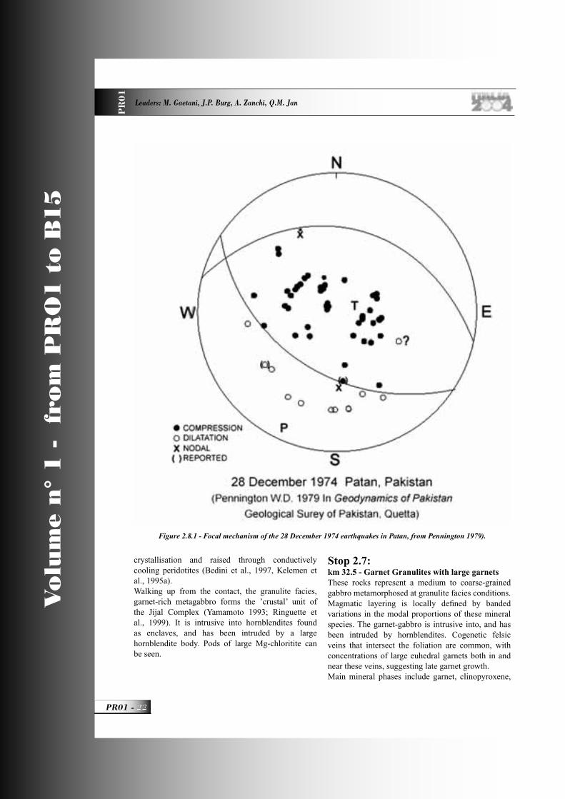
Figure 2.8.1 - Focal mechanism of the 28 December 1974 earthquakes in Patan, from Pennington 1979).
PR01_R_OK 22 24-05-2004, 15:54:19
A GEOLOGICAL TRANSECT FROM THE INDIAN PLATE TO THE EAST HINDU KUSH, PAKISTAN P
R0
1
23 - PR01
Vo
lum
e n
° 1
-
fro
m P
RO
1 t
o B
15
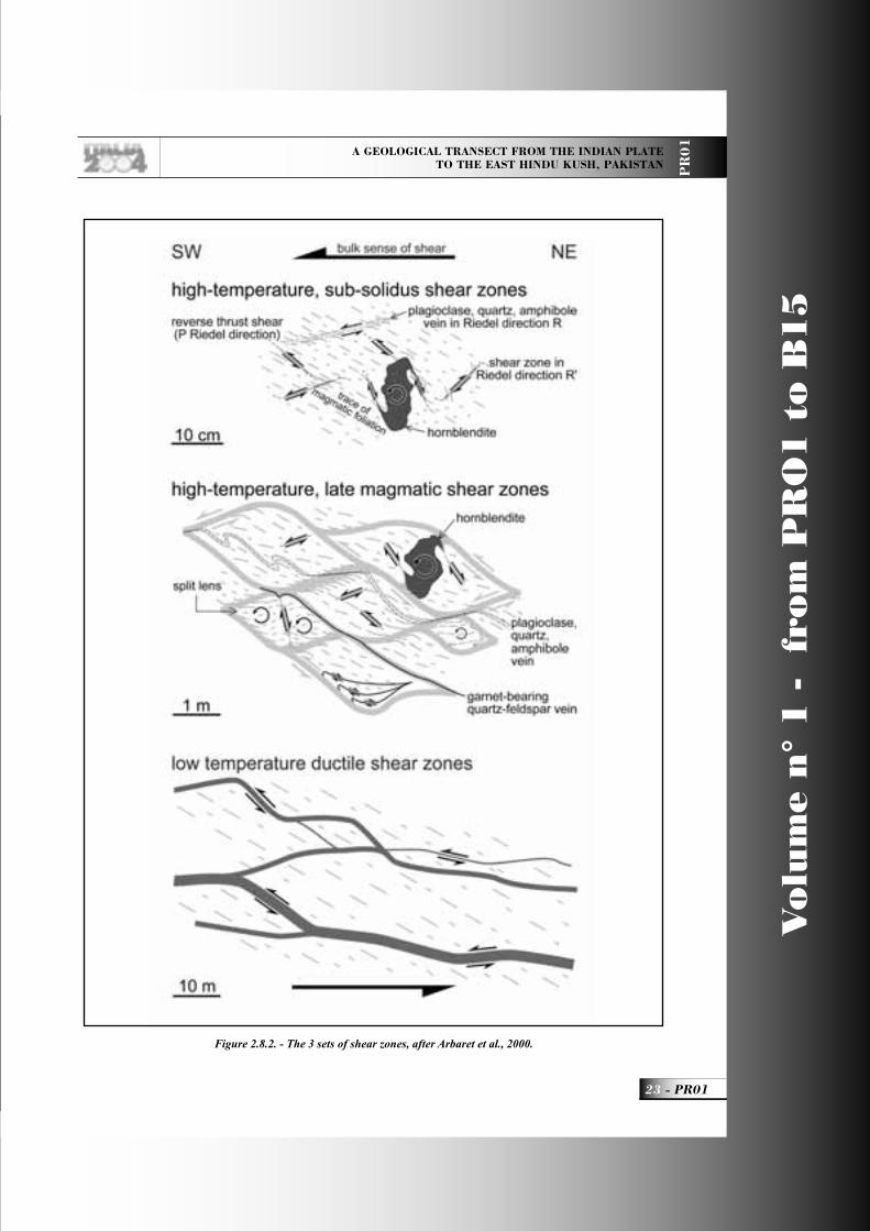
Figure 2.8.2. - The 3 sets of shear zones, after Arbaret et al., 2000.
PR01_R_OK 23 24-05-2004, 15:54:21
Vo
lum
e n
° 1
-
fro
m P
RO
1 t
o B
15
PR01 -
Leaders: M. Gaetani, J.P. Burg, A. Zanchi, Q.M. Jan
PR
01
amphiboles, plagioclase, with minor or accessory quartz, epidote, zoisite, clinozoisite, paragonite, chlorite, opaque oxides, spinel, rutile, and titanite. Sporadic occurrence of orthopyroxene, K-feldspar, scapolite, apatite, calcite, and biotite is also noted. A bulk analysis of a typical garnet-bearing sample yields a high-alumina basalt to gabbro-anorthosite composition with low-Ti (TiO
2 = 0.65 wt%),
high-Al (Al2O
3 = 18.87 wt%), and An
62 normative
plagioclase. Petrographic observations and geothermobarometric calculations show that garnet-bearing assemblages consist of a mosaic of magmatic and metamorphic equilibria that successively formed in response to changing P and T conditions. Crystallization of garnet-bearing magmatic assemblages started at pressures from 1.8 to 2.7 GPa and temperatures between 1200 and 1450 °C (Ringuette et al., 1998). These conditions represent a depth in excess of 50 km, either at the base of a thickened arc-type crust or within rising magmatic batches in the upper mantle. Quasi-isobaric cooling of magmatic assemblages occurred in the high-P, high-T granulite fi eld without reaching the eclogite fi eld. Accordingly, the petrological arc-’Moho’ was probably buried to depths of more than 50 km (17 kbars) and subsequently re-equilibrated in granulite-facies conditions. Subsequently, the above assemblages were partly retrograded under amphibolite- to greenschist-facies conditions. This succession of equilibria attests to a switch from a high-P quasi-isobaric cooling regime (750°C, 1.8 GPa) to a major decompression followed by fi nal cooling at the upper-crustal level (550°C, 0.33 GPa).Sm-Nd isochrons at 91±6 (Yamamoto & Nakamura 1996) and 96±3 Ma (Anczkiewicz & Vance 1997) date cooling.
Stop 2.8:km 39-40 - Sheared gabbros - 1 km walk along the KKH. (Dated gabbro at N 35°07’12’’;E 73°01’35’’)Pass Patan city at km 36, and possibly enjoy some tea in the busy bazaar. The city is built on a major landslide. It is known for the magnitude 6.0 earthquake on 28.12.1974, with an epicentre depth of 15km on a reverse fault striking 076, dipping 49N (plane of motion of the focal mechanism).(Fig. 2.8.1).About 1 km after Patan, road cuts expose
anastomosing ductile shear zones enclosing lensoid bodies of little to undeformed, medium to coarse grained, amphibole-rich gabbros with well preserved magmatic fabrics (Arbaret et al., 2000). Shear zones display a wide variety of structures and have been classifi ed into 3 sets (Fig. 2.8.2).The sheared rocks represent the pile of metamorphic gabbroic and dioritic dykes and sills that have intruded and cover the Jijal Complex. This association was in turn intruded by partial melts of mantle origin (hornblendites, gabbros, tonalites, granitoids) during arc build-up. Rare calc-silicate enclaves imply that these rocks have intruded sediments; their presence further suggests that some amphibolite xenoliths found in any plutonic body may derive from basalts. The plagioclase-quartz±am-phibole veins comprise syn-magmatic differentiation veins containing the same mineralogical components as the bulk rock. The petrography and geochemistry of the plutonic rocks have been described by Jan & Howie (1981), Treloar et al. (1990), Miller et al., (1991), Yamamoto (1993), Yoshino et al., (1998). All authors agree that they represent calc-alkaline magmas emplaced during the arc activity from a partially molten mantle source with MORB-type isotopic characteristics (Schaltegger et al., 2002).The sub-granulitic. bottom gabbro yielded a precise age of 98.9 ± 0.4 (U-Pb zircon dating, Schaltegger et al., 2002). The dated rock shows a fabric that is dominantly re-equilibrated in amphibolite facies. Relictic clinopyroxene shows breakdown to amphibole and quartz symplectites. The mineralogical composition is hornblende, plagioclase, rutile, garnet, epidote, quartz, apatite and clinozoisite (Yoshino et al., 1998). Some of the plagioclase show anorthite richer cores that are interpreted as relicts of magmatic origin. Garnet is intergrown with rutile along plagioclase rich domains. Clinozoisite is growing as a metamorphic phase within plagioclase clusters. Initial Hf isotopic compositions of all dated zircon microfractions dated here and mentioned later in this guide are indistinguishable within their error limits and amount to an epsilon Hf value of +14, indicating an unchanged source for all melts.
Stop 2.9:km 54- Diorite (N 35°10’39“;E 73°06’29“) Light coloured, coarse-grained hornblende diorite with a magmatic fabric defi ned by the preferred orientation of hornblende grains. The mineral composition
PR01_R_OK 24 24-05-2004, 15:54:24
A GEOLOGICAL TRANSECT FROM THE INDIAN PLATE TO THE EAST HINDU KUSH, PAKISTAN P
R0
1
25 - PR01
Vo
lum
e n
° 1
-
fro
m P
RO
1 t
o B
15
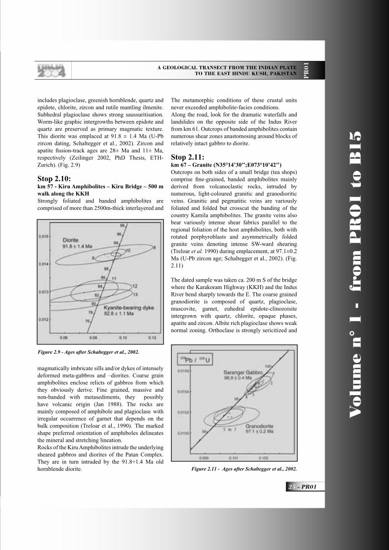
includes plagioclase, greenish hornblende, quartz and epidote, chlorite, zircon and rutile mantling ilmenite. Subhedral plagioclase shows strong saussuritisation. Worm-like graphic intergrowths between epidote and quartz are preserved as primary magmatic texture. This diorite was emplaced at 91.8 ± 1.4 Ma (U-Pb zircon dating, Schaltegger et al., 2002). Zircon and apatite fi ssion-track ages are 28± Ma and 11± Ma, respectively (Zeilinger 2002, PhD Thesis, ETH-Zurich). (Fig. 2.9)
Stop 2.10:km 57 - Kiru Amphibolites – Kiru Bridge – 500 m walk along the KKHStrongly foliated and banded amphibolites are comprised of more than 2500m-thick interlayered and
magmatically imbricate sills and/or dykes of intensely deformed meta-gabbros and –diorites. Coarse grain amphibolites enclose relicts of gabbros from which they obviously derive. Fine grained, massive and non-banded with metasediments, they possibly have volcanic origin (Jan 1988). The rocks are mainly composed of amphibole and plagioclase with irregular occurrence of garnet that depends on the bulk composition (Treloar et al., 1990). The marked shape preferred orientation of amphiboles delineates the mineral and stretching lineation. Rocks of the Kiru Amphibolites intrude the underlying sheared gabbros and diorites of the Patan Complex. They are in turn intruded by the 91.8+1.4 Ma old hornblende diorite.
The metamorphic conditions of these crustal units never exceeded amphibolite-facies conditions.Along the road, look for the dramatic waterfalls and landslides on the opposite side of the Indus River from km 61. Outcrops of banded amphibolites contain numerous shear zones anastomosing around blocks of relatively intact gabbro to diorite.
Stop 2.11:km 67 – Granite (N35°14’30’’;E073°10’42’’)Outcrops on both sides of a small bridge (tea shops) comprise fi ne-grained, banded amphibolites mainly derived from volcanoclastic rocks, intruded by numerous, light-coloured granitic and granodioritic veins. Granitic and pegmatitic veins are variously foliated and folded but crosscut the banding of the country Kamila amphibolites. The granite veins also bear variously intense shear fabrics parallel to the regional foliation of the host amphibolites, both with rotated porphyroblasts and asymmetrically folded granite veins denoting intense SW-ward shearing (Treloar et al. 1990) during emplacement, at 97.1±0.2 Ma (U-Pb zircon age; Schaltegger et al., 2002). (Fig. 2.11)
The dated sample was taken ca. 200 m S of the bridge where the Karakoram Highway (KKH) and the Indus River bend sharply towards the E. The coarse grained granodiorite is composed of quartz, plagioclase, muscovite, garnet, euhedral epidote-clinozoisite intergrown with quartz, chlorite, opaque phases, apatite and zircon. Albite rich plagioclase shows weak normal zoning. Orthoclase is strongly sericitized and
Figure 2.11 - Ages after Schaltegger et al., 2002.
Figure 2.9 - Ages after Schaltegger et al., 2002.
PR01_R_OK 25 24-05-2004, 15:54:26
Vo
lum
e n
° 1
-
fro
m P
RO
1 t
o B
15
PR01 -
Leaders: M. Gaetani, J.P. Burg, A. Zanchi, Q.M. Jan
PR
01
shows perthitic exsolution. Narrow sheets are foliated but the intrusions crosscut the banding of the country amphibolites.
Dasu, bridge on the Indus River, Visit the Bazaar. Km 72.
DAY 3 Dasu - Chilas. 132 km.Point zero is taken at the bridge.
Stop 3.1:km 5 - Metasediments (N35°17’42.9”;E073°12’33.7”)The top level, the Kamila Amphibolites s.s. is a sequence of various plutonic bodies with gabbroic to tonalitic compositions, which have intruded into a sequence of fi nely banded, fi ne grained amphibolites interpreted as volcanic and volcanoclastic metasediments (basaltic tuffs?); they contain and are interlayered with calc-silicate lenses and layers. They have been intruded by coarser grained dykes of dioritic composition. The Kamila Amphibolites were strongly deformed during contact metamorphism along their northern boundary with the intrusive Chilas gabbronorite and associated gabbros and tonalites. The lack of a strong and pronounced mineral or rodding lineation and the absence of systematically asymmetric structures in the metasediments and associated metavolcanites points to a high fl attening component during deformation. Intense vertical crenulation in places marks the transition to constriction. The alternation of strongly deformed volcano-sediments and undeformed plutonic units suggests that regional deformation is essentially due to emplacement of different intrusions into the island-arc. This is also probably true for the strain of the deeper crustal levels.
Stop 3.2:km 24 - walk 1km up the road - Contact (N35°26’36.3”; E073°13’08.9”)In front of the mouth of the Kandia river. Fault zone separating diorites and hornblende-gabbros that have intruded the Kamila metasediments, to the south, from the main gabbronorite to the north.Pegmatite with huge amphiboles. Look at the narrow entrance of the Kandia valley.The whole complex was again penetrated by mantle melts (gabbronorite to granitoid dykes) during rifting (stage 2).
Stop 3.3:PegmatitesPegmatites with some tens of centimetres long amphiboles, late products of the Chilas gabbronorite. Those or similar pegmatites yielded 39Ar-40Ar ages of 80-90 Ma (D. Rex 1985 in Coward et al., 1987).
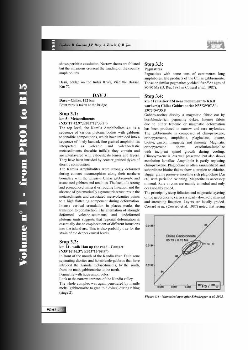
Stop 3.4:km 31 (marker 324 near monument to KKH workers); Chilas Gabbronorite N35°29’07.3”; E073°54’35.8Gabbro-norites display a magmatic fabric cut by hornblende-rich pegmatite dykes. Intense fabric due to either tectonic or magmatic deformation has been produced in narrow and rare mylonites. The gabbronorite is composed of clinopyroxene, orthopyroxene, amphibole, plagioclase, quartz, biotite, zircon, magnetite and ilmenite. Magmatic orthopyroxene shows exsolution-lamellae with incipient spinel growth during cooling. Clinopyroxene is less well preserved, but also shows exsolution lamellae. Amphibole is partly replacing clinopyroxene. Plagioclase is often saussuritized and subordinate biotite fl akes show alteration to chlorite. Bigger grains preserve anorthite rich plagioclase (An 60) with pericline twinning. Magnetite is accessory mineral. Rare zircons are mainly anhedral and only occasionally zoned.The principally steep foliation and magmatic layering of the gabbronorite carries a nearly down-dip mineral and stretching lineation. Layers are locally graded. Coward et al. (Coward et al. 1987) noted that facing
Figure 3.4 - Numerical ages after Schaltegger et al. 2002.
PR01_R_OK 26 24-05-2004, 15:54:31
A GEOLOGICAL TRANSECT FROM THE INDIAN PLATE TO THE EAST HINDU KUSH, PAKISTAN P
R0
1
27 - PR01
Vo
lum
e n
° 1
-
fro
m P
RO
1 t
o B
15
directions imply that the Chilas Complex is a large, tight antiform. The axial plane of this antiform is nearly vertical and runs along the Complex-axis. The gabbro-norite cooled and equilibrated at 600-800°C and 6-8 kbar (Bard 1983, Yamamoto 1993). A Sm-Nd internal isochron yields an age of c. 70 Ma (Yamamoto & Nakamura 1996), a cooling age consistent with the conventional zircon U-Pb age of 84 Ma (Schaltegger et al. 2002, Zeitler et al. 1980). (Fig. 3.4). The fi ssion track ages are apatite = 7.3±2 and zircon 16.5±1.5 (Zeitler 1985).
Stop 3.5:km 54 - Shatial-Darel Moraine (N35°32’02.4”; E073°28’20.8”)Stop at the beginning of a wide valley. Across the Indus we can see the middle Pleistocene till left by the furthest advance down the Indus of Pleistocene ice. Tills are overlain by valley-fi ll sediments at both ends and eroded out in mega ripples produced by jokulhlaups (ice-dam breakout fl oods) in late Pleistocene. An ice dam from the Darel valley emplaced a huge moraine with fresh landforms on the south side of the Indus in the re-entrant valley above Shatial village (PSO petrol station).
Stop 3.6:Hornblendite – Dam site (N35°30’57.4”;E073°44’48.8”)Thick hornblendite dyke cutting layered gabbronorite. View of the dam site.
Stop 3.7:km 97 - Chilas Gabbronorite and Landscape - 1 km beyond police station at entrance to Khanburi Valley (N35°29’07.3”; E073°54’35.8”)Clear magmatic layers are due to turbidity currents in the otherwise fresh, granular and equant gabbronorite.Observe the landscape till and lake sediments plastered against gabbronorite walls, present from the late Pleistocene dam at Darel-Shatial.
Stop 3.8: km 106 - Turli ultrabasites (N35°29’07.3”;E073°54’35.8”)Khan et al., (Khan et al. 1989) identifi ed two main rock associations: “the rather uniform gabbro-norite ... and the more diverse ultramafi c-mafi c-anorthosite (UMA) association”, the latter occurring as a string of lenses within the gabbro-norite over the >300km
length of the Complex. Ultramafi c rocks, pyroxenites alternating with troctolites and anorthosites. This small body is one of the UMA lenses. Mainly dunites and peridotites with minor pyroxenites contain lenticular anorthositic impregnations and diffuse intrusions of gabbro-norite. Conversely, angular blocks of peridotite are found in gabbro-norite. These relationships indicate intrusion of ultramafi c rocks under subsolidus conditions (with interstitial liquid) in partially consolidated norites which, in turn, have intruded the ultrabasic rocks (Niida et al. 1996), anorthosites troctolites (plagioclase + olivine).
Stop 3.9:km 116 - Huder BridgeView of Nanga Parbat. Walk a few hundred meters along the road to see graded layers in gabbronorite.
Stop 3.10:km 121 - ViewBest view of Nanga Parbat (if weather conditions are good)Overnight at Chilas, km 132.
DAY 4 Chilas - Gilgit. 128 km.Point 0 at Chilas Inn
Stop 4.1:km 4-5 - Chilas UMA association - 1 to 2 km walk along the KKH (from about 800 m after Thak Nulla Bridge on Indus: N35°24’39.5”;E074°08’17.1”)At this point, observe coarse carbonate pegmatite, then walk the section to observe layered gabbronorite and inter-intrusion relationships with UMA components of the Chilas Complex. Walk may stop on nice gabbro layers @ 35°24’27.3”;E074°08’41.4, in front of hornblendite body.The road goes across a series of ultramafi c bodies and gabbro norites. Gabbro-norites display magmatic/cumulitic textures. Ultramafi c rocks show porphyroclastic textures in wehrlites and coarse-grain textures in plagioclase-bearing dunites. The contact between peridotites (mostly dunites, wehrlites and websterites) and gabbro-norites is in places a several meters-thick, steeply dipping transition zone underlined by strongly metasomatic rocks, such as hornblende and/or plagioclase pyroxenites. Metasomatic aureoles indicate extensive reaction between peridotites and infi ltrated melt,
PR01_R_OK 27 24-05-2004, 15:54:34
Vo
lum
e n
° 1
-
fro
m P
RO
1 t
o B
15
PR01 -
Leaders: M. Gaetani, J.P. Burg, A. Zanchi, Q.M. Jan
PR
01
implying that the ultrabasic rocks were intruded at high, near-solidus conditions within partially consolidated norites. Plagioclase at triple point junctions between several cm-size olivine crystals in dunites (i.e. traces of interstitial magma) and diffuse impregnations of gabbro-norite are further indication of magma percolation in peridotites. Abundant clinopyroxene, amphibole, Al-spinel and Ti-oxides indicate high temperature reactional contacts. Thereafter, upon cooling, the peridotites were fractured, intruded by magma dikes and eventually brecciated and fi nely dispersed in the gabbro-norite, hornblendites and hornblende-plagioclase rich rocks. Steeply dipping, intrusive gabbro-norite layers in peridotites, blocks of peridotites in gabbro-norites and olivine xenocrysts in graded cumulate layers exemplify these stages. The cumulate layers describe a large antiform. To integrate small (reactional and intrusive contacts) and large (antiformal) scale observations, the Chilas ultramafi c bodies are interpreted as apices of intra-arc mantle diapirs that served as porous fl ow conduits to feed the gabbro-norite. These mantle diapirs indicate rifting of the Kohistan arc (Khan et al., 1993; Burg et al., 1998). Facing directions deduced from graded gabbronorite layers refl ect differently facing margins of smaller scale intrusive diapirs.The Jijal garnet-gabbro has been interpreted as the granulitic root of the Kohistan Island Arc at higher pressures than the Chilas Complex (Coward et al., 1986). Petro-structural observation suggests that both complexes display melt-consuming reactions between mantle rocks and infi ltrated, volatile-rich magmas. However, they represent two distinct crust/mantle boundaries that crystallised under different conditions, at different times. These arguments are four-fold: - At Jijal a shallow dipping, sharp contact between a ultramafi c-mafi c sequence and garnet-gabbros versus a steep and transitional contact between Chilas ultramafi c rocks and gabbro-norites. - Medium-grained dunite and wehrlite, with dispersed Cr-spinel crystals, chromitite lenses and Cr-diopside clinopyroxenite dikes at Jijal where dunites also occur as relict fl ames in replacive websterite. - Harzburgites and coarse-granular dunites, with interstitial impregnation of plagioclase, pyroxene, amphibole, Al-spinel and Ti-oxides at Chilas. Some dunite facies are strongly recrystallized in fi ne-grained granuloblastic rocks showing textural equilibrium between olivine and “secondary” phases. Dunites also
appear as relict xenoliths in intrusive norites as well as xenocrysts in banded gabbro-noritic cumulates. - The precipitated minerals include clino- and ortho-pyroxenes, Cr-spinel, amphibole and garnet at Jijal, vs. clino- and ortho-pyroxenes, plagioclase, Al-spinel, Ti-oxides and amphibole at Chilas. This suggests that melt-rock reactions took place at higher pressures in Jijal than in Chilas. On the other hand, the early appearance of orthopyroxene at Chilas and the spatial relationship of the ultramafi c rocks with quartz-bearing norites indicate that the reactant melt was more silicic.
Stop 4.2:km 21 - Overturned Jalipur sequence.Early Pleistocene, glacial and glacio-fl uvial deposits are inverted into a NW-SE-trending syncline apparently related to deformation near the growing Nanga Parbat – Haramosh anticline. Lower Jalipur beds are diamictite.
Stop 4.3:km 47 - Fault scarpNearly 1km after the bridge to Drang, view on a fault scarp that cuts talus cone with hot springs along the active fault trace. The scarp has been modifi ed by erosion and landsliding so that it looks like a normal fault. In reality the motion is reverse and related to the Raikot Fault, the western boundary of the Nanga Parbat – Haramosh half window.
Stop 4.4:km 53 - Hot springs(N35°28’49.1”;E074°33’58.0”)Sulfur-smelling (and tasting) hot springs delineate the trace of the active Raikot Fault. Slicken sides may be seen in glacial till. A prominent, 3-5 m high fault scarp possibly formed during the 1841 landslide-generating earthquake. The Raikot Fault is responsible for slickensides and fault breccias in the hanging wall, strongly altered gneiss. The Nanga Parbat gneisses are high-grade metasediments and metaplutonic rocks of Precambrian age, a part of the Indian Shield.
Stop 4.5:km55 - Raikot Bridge (N35°29’42”; E074°35’14”)The Raikot Fault is the western boundary of the Nanga Parbat – Haramosh half window. It is an active fault that separates high-grade, tonalitic gneiss derived from the Indian crust from rocks of the Kohistan
PR01_R_OK 28 24-05-2004, 15:54:36
A GEOLOGICAL TRANSECT FROM THE INDIAN PLATE TO THE EAST HINDU KUSH, PAKISTAN P
R0
1
29 - PR01
Vo
lum
e n
° 1
-
fro
m P
RO
1 t
o B
15
Terrane. The gneisses and associated pelitic and calcareous metasediments, metabasites and granitic-pegmatitic veins are strongly retrogressed, chloritised and often cataclastic. Probably anastomosing gouges are frequent and often hydrothermally altered. The dominantly reverse fault has a right lateral strike slip component. Sense of slip criteria indicate NW-directed thrusting of the Nanga Parbat massif onto Kohistan. The vertical movement is more than 15 km, calculated from the metamorphic recrystallisation depth of the Nanga Parbat gneiss. Fission track dating in the Nanga Parbat area (Zeitler et al. 1982; Zeitler 1985) indicates that uplift continues, with removal of about 6 km of rocks from above the Nanga Parbat in the past 1.3 Myr.
Stop 4.6:km 63 - 1841 landslideViewpoint on the 1841 landslide. One rockslide at below Hattu Pir, the peak east of the river, fell in the December 1840 or January 1841 earthquake (likely on the Raikot Fault which passes under the middle of the scarp) from a rock spur of Nanga Parbat. The vertical drop of the rockslide was 1900m, and the horizontal transport is 3.5 km.On the west side of the river hummocky topography is present from debris deposited by the landslide. It overrode a cemented Jalipur diamictite and a younger unconsolidated sandy diamicton. It dammed the Indus to a depth of 150-300 m until June 1841 and formed a lake that reached up the Gilgit River to the mouth of the Hunza River. As the landslip dam failed the fl oodwaters produced scour marks and four megaripples with a wavelength of about 110 m and an amplitude of 2 to 3 m. This catastrophic fl ood destroyed many villages along the Indus and a Sikh army unfortunately camped on the Chach fl ood plain near the Attock Bridge.
Stop 4.7:km70 - View of Nanga ParbatA south-looking view, weather permitting.
Stop 4.8:km75 - Jaglot sediments and volcanites (N35°38’09.2”; E074°36’34.8”)Metasediments with noticeable abundance of pelites and calc-alkaline metavolcanites screen the so-called Kohistan Batholith. Non-plutonic rocks screening the “Batholith” are devided into three Formations: The bottom Gilgit formation, which consists
mainly of schists and paragneisses, the intermediate Gashu-Confl uence volcanites, and the top Thelichi Formation, essentially metasedimentary (Khan et al., 1996). This succession has been defi ned into the large “Jaglot” syncline underlined by thick marble layers, up in the mountains. This outcrop displays rocks of the Gashu-Confl uence (strongly deformed pillow basalts and pyroclastites) and Thelichi Formations (calc-silicate layers are common above the pillowed amphibolites). These rocks represent relatively shallow, supra-crustal levels before intrusion of the surrounding “Batholith” (Khan et al., 1994). 39Ar-40Ar ages from this sequence are around 60 Ma (Treloar et al., 1989a).
Stop 4.9:km 90-91 - Confl uence granite - 1 km walk along the KKH (N35°44’54.4”;E074°36’59.8”)Stop at the monument to three great mountain ranges coming together.The Gilgit River joins the Indus River. Leucogranite sheets are intrusive into older diorites, in turn intrusive into tonalitic gneisses. Looking north observe similar Kohistan gabbros extensively intruded by pegmatite and trondjhemitic sills, which are the youngest intrusions of the area (ca 30 Ma, Rb/Sr age) (Petterson & Windley 1985). Apatite and zircon fi ssion track ages are 4.1±1.8 and 10.6±1.1, respectively (Zeitler 1985).Note the U-shape of upper Indus valley with lower V-shape.
Stop 4.10: – + a few km - Gilgit metasediments.The apparently deepest sediments known in the region are sillimanite-garnet bearing metaturbidites, with easily identifi ed primary bedding of interstratifi ed metapelites and metasandstones. They locally are intercalated with calc-silicates and fi ne-grained amphibolites that represent basic tuffs and volcanic fl ows
Stay in Gilgit, km 128.DAY 5
Gilgit - Yasin
Pay a visit to the several meters-high Buddha carved in the rocks, near Gilgit, if there is time.
PR01_R_OK 29 24-05-2004, 15:54:37
Vo
lum
e n
° 1
-
fro
m P
RO
1 t
o B
15
PR01 -
Leaders: M. Gaetani, J.P. Burg, A. Zanchi, Q.M. Jan
PR
01
Stop 5.1:about km21 - Granitoids - SE Shirot (N36°02’01”;E 074°09’01”)Stop on stage 2 granitoids dated between 85 and 40 Ma. Basic to intermediate composition Intruding older stage 1 gabbros and diorites dated ca. 110-90 Ma (Petterson & Windley 1985, 1991). Zircon fi ssion track ages yielded 14.6±1.3 Ma (Zeitler 1985). Stop 5.2:Metasediments – ca. 5 km west of Sher Qila (N36°02’01”;E 073°51’02”)Intruded hornfels facies metasediments, thinly bedded mafi c tuffs and volcanites (including pillowed basalts) of Northern Kohistan display large wavelength/amplitude folds with dominantly northward vergence. The sequence is usually well sorted and regularly layered. Some layers are weakly graded and thinly laminated tuffs may represent distal water-lain ash fall sequences (Petterson & Treloar 2003). This generally steeply dipping sequence dominates the landscape until the road reaches more plutonites. Basic dykes locally cut the layers.
Stop 5.3:K-feldspar granite - Jai Bargu (N36°15,020’;E073°41,585’)This granitoid intrusion of the Kohistan Batholith is coarse-grained and contains phenocrysts and xenoliths defi ning the magmatic fabric, which is consistent with structures in the rocks in this country.
Stop 5.4:Yasin – (Resthouse@ N36°22’43.1”;E073°19’48.3”, eleva-tion 2400m)Drive reasonably fast and spend time around Yasin visiting the North-Kohistan suture. Walk to the west through the village and climb a few meters to the south between the last houses. Outcrops are carbonaceous turbidites. Walking southeast along the water channel, above the village, visit tectonic contacts between carbonate rich turbidites and rudist-bearing, in-situ reef deposited onto volcanoclastic sandstones. The unconformity of red sandstones on plutonites and metabasalts of the Kohistan batholith can be reached beyond a large cone of scree, where metalavas are mostly massive fl ows and/or sills of basalt and andesite with no intervening sediments.
Walking down, a coarse breccia represents proximal facies of explosive Strombolian-Vulcanian activity.
Stop 5.5:Northern Kohistan Suture.We can drive to the north of Yasin to cross the Suture and reach Karakoram quartzites @ N36°27’29.3”; E073°22’39.6”. See one of the suture contacts: black shales over green shales + mylonitic marbles, walk up-hill @ N36°24’49.5”; E073°20’54.4”.
Stay in Yasin.
DAY 6 Gupis – Mastuj
Stop 6.1:few km - Intrusive relationshipsView of intrusive contact
Stop 6.2:Metasediments - West of Khalti Lake(N36°14’38.1”; E073°20’27.2”)The road cut exposes steeply dipping, graded bedded volcanoclastic sediments (tuffs and pyroclastic layers) and volcanic agglomerates pointing to explosive volcanism with deposition and sediment reworking in both subaerial and subaqueous environments (Petterson & Treloar 2003). Rocks are low-grade, garnet-epidote hornfels. Sequence contains conglomerates and sandstones; Walk ~350m S and reach an intrusive contact to leucocratic granite with mafi c dykes.
Stop 6.3:Metabasalts – Dehimal suspended bridge (N36°11”56.9”; E073°14’38.4”) Steeply dipping amphibolites intruded by leucocratic dykes derive from basalts (locally pillowed), basaltic andesites and andesites.
Stop 6.4:Turbidites (N 36°23’11.3”;E073°19’46.5”)Low-grade, volcanoclastic turbidites with clear younging directions.
Stop 6.5:Conglomerates (N 36°10’10.9”;E073°04’43.2”)Conglomerate boulders brought by torrent from the south, i.e. the Kohistan Terrane. Limestone pebbles contain fossils. Other pebbles are various plutonites, volcanites, slates and quartzites. Boulders show that these conglomerates are intruded by leucocratic granites.
PR01_R_OK 30 24-05-2004, 15:54:39
A GEOLOGICAL TRANSECT FROM THE INDIAN PLATE TO THE EAST HINDU KUSH, PAKISTAN P
R0
1
31 - PR01
Vo
lum
e n
° 1
-
fro
m P
RO
1 t
o B
15
Stop 6.6:Turbidites - W of Shamran (N36°10”47.2”; E072°59’21.1”) Dark green, massive (volcanic) meta-turbidites (meta-volcanodetritics), local ignimbrites. Amphibolites with deformed garnet-epidote bearing pebbles, shallow porphyric volcanic dyke cross-cutting the metasedimentsLong drive with red sediments in landscape.
Stop 6.7:Shandur Pass (N36°05’17.0”;E072°32’46.1”; elevation: 3725m)Glacial morphology landscape and tea stop.N of the Pass: Kohistan sheared metagabbros and diorites (intruding migmatitic metavolcandetritic sediments)S of the Pass: Kohistan volcanosediments, overlain by mafi c volcanites (view to SE).
Stop 6.8:Sheared metagabbros - Above bridge acrossthe Mastuj River to Rizhun, (NW of Laspur. N36°03’35.2”; E072°27’10.6”)Amphibolite facies rocks of the Kohistan Block. Strongly foliated and folded metagabbros are typical of the northern boundary of the Kohistan Terrane. Garnet is present in the metamorphic paragenesis. These rocks are cut by hornblende-quartz-bearing pegmatites. Host rocks of the meta gabbros are amphibolite facies, locally migmatitic volcanoclastic sediments, basaltic tuffs and basalts. Stop 6.9:Landscape - View on Rizhun and Gol and the North-Kohistan Suture from little hill above and to the E of the road (N36°04’06.6”;E072°27’02.1”)S side of the valley: Kohistan metagabbros and metabasalts: E side of the valley (from bottom (SE) to top peaks (NW): Kohistan basalts, fault zone (marked by orange bands), red clastics as marker horizon (red to violet sandstones, shales and conglomerates); few metres of serpentinites (little pass); grey Karakoram limestones, faults (marked by another pass); Karakoram black slates with minor quartzites in the background
Stop 6.10:Shales and quartzites of the Karakoram Block(N36°14’51”;E072°30’54”)
Anywhere along the road down to Mastuj. Black and dark-brown shales, slates with minor quartzites, are better seen in the landscape on opposite side of the river, towards SE. Rocks are low metamorphic grade. Some large lenses of “amphibolite” probably represent basaltic dykes.Stay in Mastuj
DAY 7Mastuj - Lasht.
Itinerary: Mastuj, Gazin, Dobargar, Shost, Lasht along the “jeepable” road.Theme: Karakoram Range. The metasediments of the Intermediate Sedimentary Belt, the KK Batholith and the Reshun Fault. The intinerary is developed along the Yarkhun Valley.
Moving from Mastuj to the ENE we may observe in the distance on the south side of the valley the Intermediate (Darkot) Metasedimentary Belt. In this belt three major units have been distinguished within the Darkot Group (Le Fort & Gaetani 1998).
The Gum formation, which forms the prominent horizon in the landscape. Its apparent thickness exceeds 1000 m and it consists mainly of two lithologies: - thin bedded grey dark limestones, often intercalated with slates and marls, to build packages of some 50-100 m. On the left side of the Qalandar Gum glacier, a badly preserved fauna dominated by bryozoans and subordinate brachiopods of Permian aspect was found;- grey and light grey limestones, sometimes dolomitised, forming the spectacular cliffs of this belt. They may consists either of thin bedded platy grey limestones packed in thickened layers, more frequently in thick massive grey limestones and dolostones, rising on the highest crests of the mountains, often deformed in tight folds. Due to this deformation, the thickness is diffi cult to assess, but a fi gure of at least 700 m is not impossible. Most important is the fi nding in several places of thick shelled bivalves which may be identifi ed with megalodontids and possibly also with the Lithiotis group. Also possible rudists were observed. If confi rmed, the Gum formation not only spans from the Permian to Triassic, but even Cretaceous beds could occur.The Barum formation mainly consists of grey dark
PR01_R_OK 31 24-05-2004, 15:54:41
Vo
lum
e n
° 1
-
fro
m P
RO
1 t
o B
15
PR01 -
Leaders: M. Gaetani, J.P. Burg, A. Zanchi, Q.M. Jan
PR
01
sandstones slightly metamorphosed in 10 to 50 cm-thick beds, often amalgamated, intercalated with siltstones and slates. The sandstones, mostly litharenites rich in quartz, rarely contain seams of microconglomerates, but no black chert pebbles have been observed. Total thickness is uncertain for internal folding, but a fi gure between 300 and 500 m could be suggested. No fossils have been found. The Rawat formation consisting of splinterly dark slates, and dark limestones, locally interbedded with silty to fi ne arenitic, dm-thick layers. In the Darkot village area this unit contains fusulinids, bryozoans and brachiopods relative to the Permian.
Stop 7.1:anchimetamorphosed limestones in front of Pauer.A rare opportunity to touch the massive bedded grey limestone, verticaly dipping, of the Gum formation.On the northern side of the valley, a few km after Brep, at the top of the lateral valleys of Vanga and Pauer, a red unit may be observed in the distance. It is the Reshun Conglomerate, which unconformably covers the most internal unit of the Northern Sedimentary Belt. It will be observed directly later in the day.
From Gazin the valley turns to the north and we enter the Ishpirin Gorge, carved mostly in the Karakoram Batholith. (KB) In the ~ 9 km long NS section along the gorges, three types of granitoid are present (Fig. 7.1), corresponding to three different plutons. The batholith complex has been studied by P. Le Fort (in Gaetani et al., 1966) and Le Fort & Gaetani (1998). Fig. 7.1
The southern contact of the batholith is not visible in the gorge section; it lies under the scree of the Yarkhun River bed. To the east, high in the mountains, the batholith intrudes the metasediments of the intermediate belt.
Stop 7.2:Shulkuch monzodiorite.The Shulkuch monzodiorite is a heterogeneous dark biotite- and amphibole-bearing monzodiorite with an irregular scattering of K-feldspar crystals, a medium-grained to microgranular texture, generally presenting conspicuous foliation. At the scale of the outcrop, the unit looks like an irregular mixture of clear-colored porphyritic granite-forming puffs or fl ames of K-feldspar-rich material in dark-colored micaceous material. It sometimes results in
imbibition-like banding of the granitoid. In some places, the clear-colored veinlets show a continuous fi lm of micas at the contact with the dark≠-colored granitoid, forming a sort of restitic selvage, as if partial melting had occurred at the contact. In other cases, small pegmatitic veins develop. In general, the contact between the two different colored granitoids is diffuse and it is diffi cult to tell which granitoid is younger. Foliation is quite conspicuous everywhere. To the south, it is sometimes also refolded into tight crenulations, and elsewhere it is sheared along tiny NE-SW shear zones, that are occasionally chloritised. The most mafi c rock, a diorite, bears a magmatic quartz-plagioclase-biotite-amphibole-pyroxene paragenesis.
Stop 7.3:Contact between Darkot Pass porphyritic granite and the Shulkuch monzodiorite.The Darkot Pass porphyritic granite forms the back bone of the Hindu Raj range and some of its major peaks. Along the Yarkun Valley it intrudes the Shulkuch monzodiorite as shown by the numerous dikes and pods of porphyritic granite crosscutting the monzodiorite, becoming progressively more abundant and voluminous southwards. The massive granitoid is amphibole- and biotite-bearing (often chloritised) and lighter-colored towards the center of the body. The megacrysts of K≠feldspar are a few centimeters long and often zoned. The granodiorite bears abundant microgranular enclaves usually a centimeter- to a half-meter≠ in length. Foliation is always present, generally marked by biotite, but sometimes also by the alignment of feldspar megacrysts. In addition to this magmatic foliation, most outcrops present a pervasive schistosity, generally more extensive towards E-W, and linked to the advanced chloritisation of the granodiorite.
Stop 7.4:Dobargar. Landscape.From the village of Dobargar the Dobargar metasediments can be seen in the distance. They form a narrow band of slightly metamorphic sedimentary rocks, almost vertically dipping. The rocks on both sides, usually Sakirmul granodiorite or Darkot Pass porphyritic granite to the south, and the Chikar formation or again Sakirmul granodiorite to the north, are intensely deformed. The band itself is made of grey thick-bedded dolostones with ghosts of crinoids, splintery slate, and massive white to reddish
PR01_R_OK 32 24-05-2004, 15:54:43
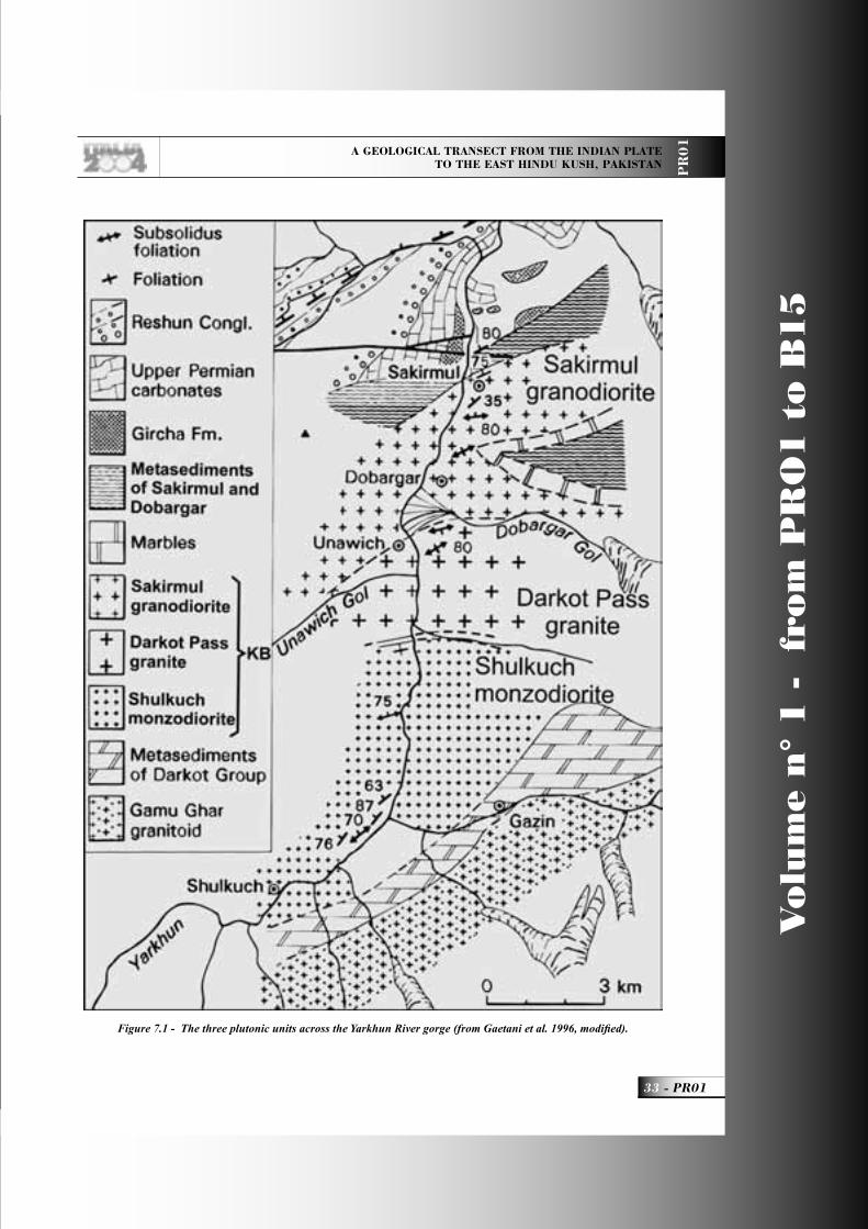
A GEOLOGICAL TRANSECT FROM THE INDIAN PLATE TO THE EAST HINDU KUSH, PAKISTAN P
R0
1
33 - PR01
Vo
lum
e n
° 1
-
fro
m P
RO
1 t
o B
15
Figure 7.1 - The three plutonic units across the Yarkhun River gorge (from Gaetani et al. 1996, modifi ed).
PR01_R_OK 33 24-05-2004, 15:54:44
Vo
lum
e n
° 1
-
fro
m P
RO
1 t
o B
15
PR01 -
Leaders: M. Gaetani, J.P. Burg, A. Zanchi, Q.M. Jan
PR
01
quartzites, fi ne banded limestone, and fractured slab of amphibole- and biotite-bearing granodiorite.The band stretches from the Darkot glacier to the right bank of the Yarkhun Valley, opposite Dobargar.
Stop 7.5:Sakirmul Granodiorite and its northern contact.A few hundred m south of the village of Sakirmul, the plutonic body and its northern contact crops out.The Shakirmul granodiorite is extremely heterogeneous and appears to be shattered at all scales. The granodiorite, when fresh, contains nests of euhedral green hornblende and biotite, and abundant microgranular enclaves. It contains numerous magmatic and tectonic sedimentary inclusions, including a large pinched refolded syncline of marbles and quartzitic material On the outcrop scale, the granodiorite contains abundant xenoliths of fi ne-grained psammitic banded quartzites and minor amphibolite intercalations cut by dikes and veins of clear-colored granitic material. The most mafi c rocks include a magmatic quartz-plagioclase-biotite-amphibole-pyroxene paragenesis. Very strong tectonisation has transformed most of the body in meter-thick alternations of mylonitised orthogneiss and metasedimentary quartzites. Innumerable faults accompanied by quartz and calcite veins crosscut the granodiorite, causing widespread foliation, and greenschist facies retrogressions. In several places, a late folding episode with N 50’E trend is present and accompanied by a small crenulation cleavage.The northern contact of the batholith occurs amidst tectonic slices of laminated granodiorite and sheared metaquartzites. After the last occurrence of granodiorite, a few decimeter-thick granitic dikes occur, soon replaced by boudinaged dikes of quartz. The northern boundary of the Karakoram Batholith corresponds to a zone of shearing; however, the amount of movement that has occurred along it is diffi cult to determine.
Stop 7.6:The sedimentary succession of the Axial Zone south of the Shost Bridge One km walk along the jeep road, to observe the section.
North of the batholith, the fi rst thrust slice of the Northern Karakoram sedimentary belt outcrops, named in Gaetani et al., (1996) Axial Unit, because in contact with the ”Axial Batholith”, now named
Karakoram Batholith. The succession is as follows, bottom to top.a) A unit of dark grey slates, greenish when altered. At the top of this unit there are a few tens of meters of non-metamorphosed quartzarenites, probably to be referred to the Gircha Fm. (Permian). The unit has a total thickness of at least 1000 m , but isoclinal folding may be present. b) A middle unit consisting mostly of carbonate, cliff-forming, several hundred m-thick. It consists of massive grey dolostones and dolomitic limestones. South of Shost, dark grey thick-bedded limestones contain a rich fauna of small foraminifers, Late Permian in age (Chapursan Group, Gaetani et al., 1995). In a sample from this unit, collected on the road trench towards the new bridge, Perri et al., (2004) found the conodonts Hindeodus parvus, Isarcicella lobata, I. staeschei, I. turgida, species that characterize the earliest Triassic.c) The uppermost unit consists of conglomerates, equivalent of the Reshun Conglomerate of Chitral (Hayden, 1915). At the base there is an erosion surface. However, no spectacular angular unconformity (max 10-15°) is observed around Shost. In the basal part coarse reddish sandstones and red shales prevail, whilst upwards conglomeratic layers are also present. The clast-supported Reshun Cgl. consists of moderately rounded pebbles of sedimentary rocks, with average clast size between 5 and 15 cm. Carbonate pebbles commonly prevail over sandstone pebbles. The matrix is mostly red. The unit is usually tectonically-thinned, but it may reach several hundred metres in thickness like west of Shost and in the upper Yarkhun Valley. No direct age assignement could be made, but conglomerates are probably Cretaceous in age, younger than the Orbitolina limestones, since clasts containing those foraminifers have been observed. A few hundred meters before the Shost bridge, on the opposite side of the river, a pop-up structure displacing the contact between the carbonatic unit and the overlying, sheared Reshun Conglomerate is well exposed (Fig. 7.2). The unconformity between the Permo-Mesozoic carbonates and the Reshun Fm. is better exposed on the cliffs on the opposite side of the valley and runs along the ridge forming the watershed (Fig. 7.3).
The Reshun Fault, a major structure running through most of western and central Karakoram can be distinguished in the landscape but it can hardly
PR01_R_OK 34 24-05-2004, 15:54:53
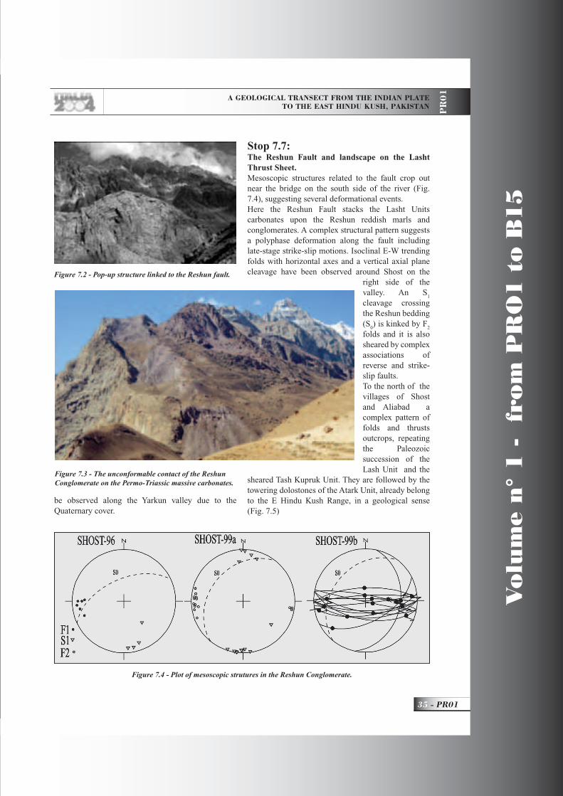
A GEOLOGICAL TRANSECT FROM THE INDIAN PLATE TO THE EAST HINDU KUSH, PAKISTAN P
R0
1
35 - PR01
Vo
lum
e n
° 1
-
fro
m P
RO
1 t
o B
15
be observed along the Yarkun valley due to the Quaternary cover.
Stop 7.7:The Reshun Fault and landscape on the Lasht Thrust Sheet.Mesoscopic structures related to the fault crop out near the bridge on the south side of the river (Fig. 7.4), suggesting several deformational events.Here the Reshun Fault stacks the Lasht Units carbonates upon the Reshun reddish marls and conglomerates. A complex structural pattern suggests a polyphase deformation along the fault including late-stage strike-slip motions. Isoclinal E-W trending folds with horizontal axes and a vertical axial plane cleavage have been observed around Shost on the
right side of the valley. An S
1
cleavage crossing the Reshun bedding (S
0) is kinked by F
2
folds and it is also sheared by complex associations of reverse and strike-slip faults.To the north of the villages of Shost and Aliabad a complex pattern of folds and thrusts outcrops, repeating the Paleozoic succession of the Lash Unit and the
sheared Tash Kupruk Unit. They are followed by the towering dolostones of the Atark Unit, already belong to the E Hindu Kush Range, in a geological sense (Fig. 7.5)
Figure 7.4 - Plot of mesoscopic strutures in the Reshun Conglomerate.
Figure 7.2 - Pop-up structure linked to the Reshun fault.
Figure 7.3 - The unconformable contact of the Reshun Conglomerate on the Permo-Triassic massive carbonates.
PR01_R_OK 35 24-05-2004, 15:59:28
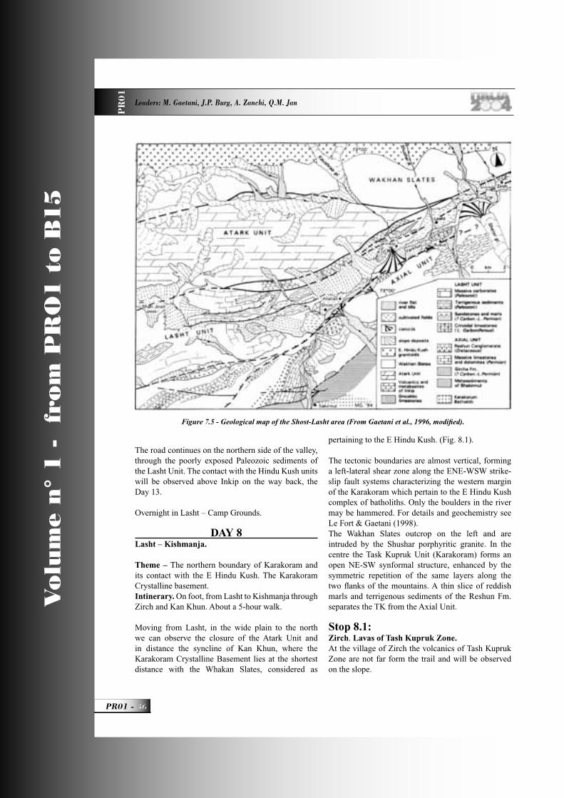
Vo
lum
e n
° 1
-
fro
m P
RO
1 t
o B
15
PR01 -
Leaders: M. Gaetani, J.P. Burg, A. Zanchi, Q.M. Jan
PR
01
The road continues on the northern side of the valley, through the poorly exposed Paleozoic sediments of the Lasht Unit. The contact with the Hindu Kush units will be observed above Inkip on the way back, the Day 13. Overnight in Lasht – Camp Grounds.
DAY 8Lasht – Kishmanja.
Theme – The northern boundary of Karakoram and its contact with the E Hindu Kush. The Karakoram Crystalline basement.Intinerary. On foot, from Lasht to Kishmanja through Zirch and Kan Khun. About a 5-hour walk.
Moving from Lasht, in the wide plain to the north we can observe the closure of the Atark Unit and in distance the syncline of Kan Khun, where the Karakoram Crystalline Basement lies at the shortest distance with the Whakan Slates, considered as
pertaining to the E Hindu Kush. (Fig. 8.1).
The tectonic boundaries are almost vertical, forming a left-lateral shear zone along the ENE-WSW strike-slip fault systems characterizing the western margin of the Karakoram which pertain to the E Hindu Kush complex of batholiths. Only the boulders in the river may be hammered. For details and geochemistry see Le Fort & Gaetani (1998). The Wakhan Slates outcrop on the left and are intruded by the Shushar porphyritic granite. In the centre the Task Kupruk Unit (Karakoram) forms an open NE-SW synformal structure, enhanced by the symmetric repetition of the same layers along the two fl anks of the mountains. A thin slice of reddish marls and terrigenous sediments of the Reshun Fm. separates the TK from the Axial Unit.
Stop 8.1:Zirch. Lavas of Tash Kupruk Zone.At the village of Zirch the volcanics of Tash Kupruk Zone are not far form the trail and will be observed on the slope.
Figure 7.5 - Geological map of the Shost-Lasht area (From Gaetani et al., 1996, modifi ed).
PR01_R_OK 36 24-05-2004, 15:55:14
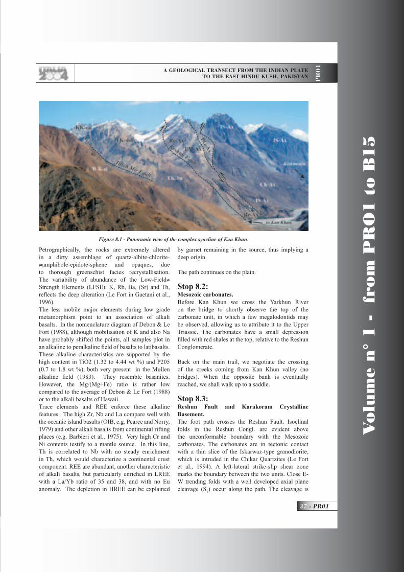
A GEOLOGICAL TRANSECT FROM THE INDIAN PLATE TO THE EAST HINDU KUSH, PAKISTAN P
R0
1
37 - PR01
Vo
lum
e n
° 1
-
fro
m P
RO
1 t
o B
15
Petrographically, the rocks are extremely altered in a dirty assemblage of quartz-albite-chlorite-≠amphibole-epidote-sphene and opaques, due to thorough greenschist facies recrystallisation. The variability of abundance of the Low-Field≠ Strength Elements (LFSE): K, Rb, Ba, (Sr) and Th, refl ects the deep alteration (Le Fort in Gaetani et al., 1996).The less mobile major elements during low grade metamorphism point to an association of alkali basalts. In the nomenclature diagram of Debon & Le Fort (1988), although mobilisation of K and also Na have probably shifted the points, all samples plot in an alkaline to peralkaline fi eld of basalts to latibasalts. These alkaline characteristics are supported by the high content in TiO2 (1.32 to 4.44 wt %) and P205 (0.7 to 1.8 wt %), both very present in the Mullen alkaline fi eld (1983). They resemble basanites. However, the Mg/(Mg+Fe) ratio is rather low compared to the average of Debon & Le Fort (1988) or to the alkali basalts of Hawaii. Trace elements and REE enforce these alkaline features. The high Zr, Nb and La compare well with the oceanic island basalts (OIB, e.g. Pearce and Norry, 1979) and other alkali basalts from continental rifting places (e.g. Barbieri et al., 1975). Very high Cr and Ni contents testify to a mantle source. In this line, Th is correlated to Nb with no steady enrichment in Th, which would characterize a continental crust component. REE are abundant, another characteristic of alkali basalts, but particularly enriched in LREE with a La/Yb ratio of 35 and 38, and with no Eu anomaly. The depletion in HREE can be explained
by garnet remaining in the source, thus implying a deep origin.
The path continues on the plain.
Stop 8.2:Mesozoic carbonates.Before Kan Khun we cross the Yarkhun River on the bridge to shortly observe the top of the carbonate unit, in which a few megalodontids may be observed, allowing us to attribute it to the Upper Triassic. The carbonates have a small depression fi lled with red shales at the top, relative to the Reshun Conglomerate.
Back on the main trail, we negotiate the crossing of the creeks coming from Kan Khun valley (no bridges). When the opposite bank is eventually reached, we shall walk up to a saddle.
Stop 8.3:Reshun Fault and Karakoram Crystalline Basement.The foot path crosses the Reshun Fault. Isoclinal folds in the Reshun Congl. are evident above the unconformable boundary with the Mesozoic carbonates. The carbonates are in tectonic contact with a thin slice of the Iskarwaz-type granodiorite, which is intruded in the Chikar Quartzites (Le Fort et al., 1994). A left-lateral strike-slip shear zone marks the boundary between the two units. Close E-W trending folds with a well developed axial plane cleavage (S
1) occur along the path. The cleavage is
Figure 8.1 - Panoramic view of the complex syncline of Kan Khun.
PR01_R_OK 37 24-05-2004, 15:58:57
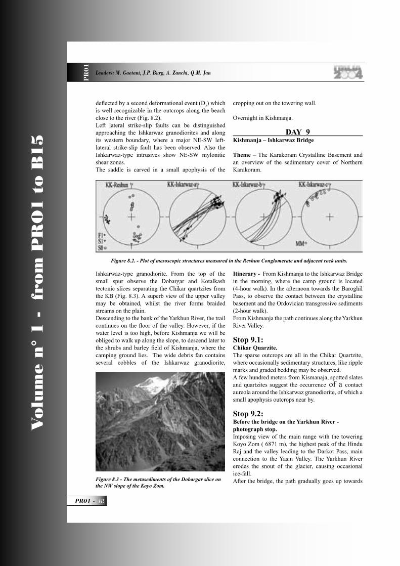
Vo
lum
e n
° 1
-
fro
m P
RO
1 t
o B
15
PR01 -
Leaders: M. Gaetani, J.P. Burg, A. Zanchi, Q.M. Jan
PR
01
defl ected by a second deformational event (D2) which
is well recognizable in the outcrops along the beach close to the river (Fig. 8.2).Left lateral strike-slip faults can be distinguished approaching the Ishkarwaz granodiorites and along its western boundary, where a major NE-SW left-lateral strike-slip fault has been observed. Also the Ishkarwaz-type intrusives show NE-SW mylonitic shear zones. The saddle is carved in a small apophysis of the
Ishkarwaz-type granodiorite. From the top of the small spur observe the Dobargar and Kotalkash tectonic slices separating the Chikar quartzites from the KB (Fig. 8.3). A superb view of the upper valley may be obtained, whilst the river forms braided streams on the plain.Descending to the bank of the Yarkhun River, the trail continues on the fl oor of the valley. However, if the water level is too high, before Kishmanja we will be obliged to walk up along the slope, to descend later to the shrubs and barley fi eld of Kishmanja, where the camping ground lies. The wide debris fan contains several cobbles of the Ishkarwaz granodiorite,
cropping out on the towering wall.
Overnight in Kishmanja.
DAY 9Kishmanja – Ishkarwaz Bridge
Theme – The Karakoram Crystalline Basement and an overview of the sedimentary cover of Northern Karakoram.
Itinerary - From Kishmanja to the Ishkarwaz Bridge in the morning, where the camp ground is located (4-hour walk). In the afternoon towards the Baroghil Pass, to observe the contact between the crystalline basement and the Ordovician transgressive sediments (2-hour walk).From Kishmanja the path continues along the Yarkhun River Valley.
Stop 9.1:Chikar Quarzite.The sparse outcrops are all in the Chikar Quartzite, where occasionally sedimentary structures, like ripple marks and graded bedding may be observed. A few hundred meters from Kismanaja, spotted slates and quartzites suggest the occurrence of a contact aureola around the Ishkarwaz granodiorite, of which a small apophysis outcrops near by.
Stop 9.2:Before the bridge on the Yarkhun River - photograph stop.Imposing view of the main range with the towering Koyo Zom ( 6871 m), the highest peak of the Hindu Raj and the valley leading to the Darkot Pass, main connection to the Yasin Valley. The Yarkhun River erodes the snout of the glacier, causing occasional ice-fall. After the bridge, the path gradually goes up towards
Figure 8.2. - Plot of mesoscopic structures measured in the Reshun Conglomerate and adjacent rock units.
Figure 8.3 - The metasediments of the Dobargar slice on the NW slope of the Koyo Zom.
PR01_R_OK 38 24-05-2004, 15:55:33
A GEOLOGICAL TRANSECT FROM THE INDIAN PLATE TO THE EAST HINDU KUSH, PAKISTAN P
R0
1
39 - PR01
Vo
lum
e n
° 1
-
fro
m P
RO
1 t
o B
15
the village of Chikar. Close folds in the quartzites and huge shear zones occur before reaching the Ishkarwaz granodiorite.
Stop 9. 3:Saddle Chikar-Ishkarwaz.When on the saddle, a wide panorama on the Baroghil area and the Darkot Pass. To the north, the steep slope of the mountain consists of folded Chikar Quartzite intruded by the Ishkarwaz granodiorite. At the top, the black strip corresponds to the Ordovician Yarkhun Fm. of the Baroghil Group, transgressive on the Crystalline Basement.
Camp ground near the Ishkarwaz Bridge. Lunch and camping duties.In the afternoon, a walk towards the Baroghil Pass, the lowest pass of the whole range, from where the Tibetan army entered Chitral and Yasin in the VIII century.
Stop 9.4:Along the trail sparse outcrops of shattered Ishkarwaz granodioriteThe Ishkarwaz granodiorite (Le Fort et al., 1994; Le Fort and Gaetani 1998) is a middle-grained rock that contains biotite turned to chlorite, and amphibole almost totally altered. It is classifi ed as a dark-coloured adamellite, forming an alumino-cafemic ferriferous asociation with a calc-alkaline affi nity. Enclaves are mainly of microgranular type, but close to the rim of the granitoid, enclaves of quartzite and folded micaschist are frequent. The granodiorite usually has a dark rusty to purple patina. The whole pluton is severely affected by fracturation; fractures are often accompanied by millimetre-thick veins of quartz, calcite, chlorite, and sometimes barytine.
Stop 9.5:Contact between the Ishkarwaz granodiorite and the Baroghil Group.Before the Baroghil meadows the contact crops out (Le Fort et al., 1994; Tongiorgi et al., 1994). The contact is fairly fl at, and the granodiorite has no alteration cap. Both the granite and the sedimentary series are affected by a foliation dipping some 70° to the north, which is greater than the dip of the bedding plane of some 15°. Above the main contact and the succession described here, there are at least two thrusted slices, of crushed granitic material, about 25 m thick; the fi rst one has preserved the
upper transgressive contact with a conglomeratic sandstone. The transgressive arkoses and slates contain a fairly rich assemblage of acritarchs of Arenigian age (Early Ordovician), belonging to the Peri-Gondwana biogeographic province (Le Fort et al., 1994; Tongiorgi et al., 1994; Quintavalle et al., 2000). (Fig. 9.1).
The age of the two detected assemblages (CK 1 and CK 2) obtained through correlation to graptolite and conodont zones, are reported in Fig. 9.2
Return to camp at the Ishkarwaz bridge.
DAY 10Vidiakot and Baroghil ridges.
Theme - The Lower Paleozoic succession and the structure of the Northern Karakoram.Itinerary – From the camp towards the Baroghil Pass and turning West up towards the Vidiakot crest (4300 m). Later, down towards the Baroghil Pass and to the ridge to the East, facing the uppermost Yarkhun Valley.
Stop 10.1:The Yarkhun FormationThe Vidiakot section was measured along the eastern side of the slope of the main ridge, from 4050 m a.s.l., where the fi rst part of the section in the Yarkhun Fm. is well exposed (locality Purshui) (Fig. 10.1). It is notable for its Acritarch content and the intense burrowing of some beds with nice Cruziana trails Also a single conodont sample delivered fauna (Talent et al., 1981, 1999). Imposing view on the Koio Zom and the whole Hindu Raj Range.The age of the acritarch assemblages are reported in Fig. 9.2.
Stop 10.2:Vidiakot RidgeA prominent bed (light coarse sandstone and microconglomerates) enables correlation of the section up to the crest at 4300 m a.s.l. Walking along this bed, we climb up to the ridge. The upper limit of the Yarkhun Formation is located along the crest, at 4305 m a.s.l. (top of bed 13). Immediately succeeding the Yarkhun Formation are splintery black slates with siltstones nodules or with very fi ne sandstone intercalations. The intense
PR01_R_OK 39 24-05-2004, 15:55:38
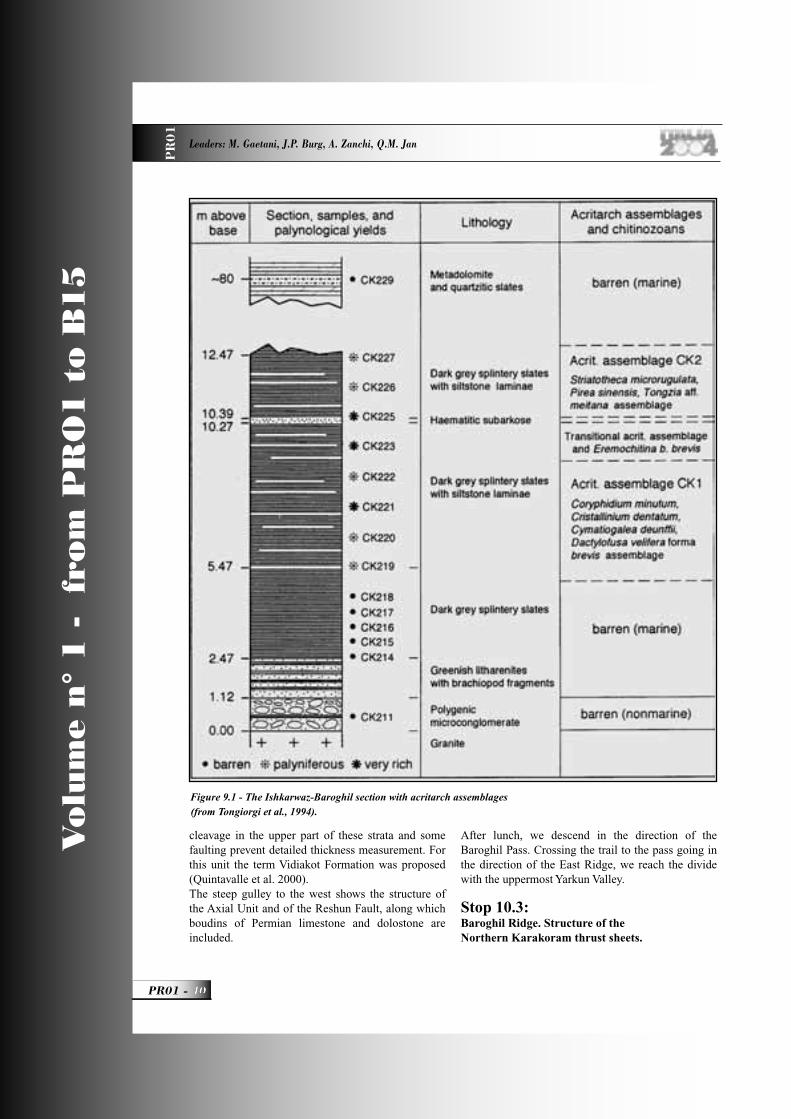
Vo
lum
e n
° 1
-
fro
m P
RO
1 t
o B
15
PR01 -
Leaders: M. Gaetani, J.P. Burg, A. Zanchi, Q.M. Jan
PR
01
cleavage in the upper part of these strata and some faulting prevent detailed thickness measurement. For this unit the term Vidiakot Formation was proposed (Quintavalle et al. 2000).The steep gulley to the west shows the structure of the Axial Unit and of the Reshun Fault, along which boudins of Permian limestone and dolostone are included.
After lunch, we descend in the direction of the Baroghil Pass. Crossing the trail to the pass going in the direction of the East Ridge, we reach the divide with the uppermost Yarkun Valley.
Stop 10.3:Baroghil Ridge. Structure of the Northern Karakoram thrust sheets.
Figure 9.1 - The Ishkarwaz-Baroghil section with acritarch assemblages (from Tongiorgi et al., 1994).
PR01_R_OK 40 24-05-2004, 15:55:39
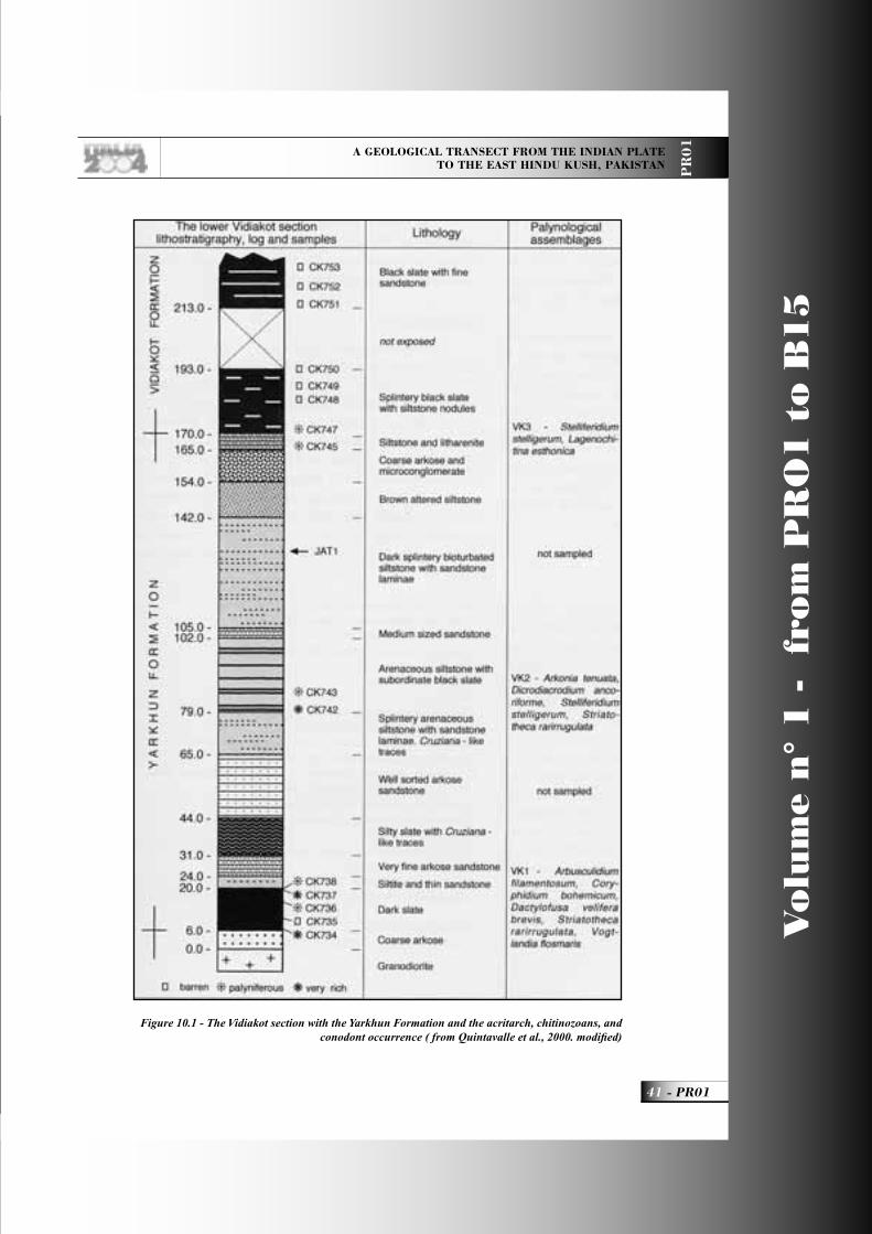
A GEOLOGICAL TRANSECT FROM THE INDIAN PLATE TO THE EAST HINDU KUSH, PAKISTAN P
R0
1
41 - PR01
Vo
lum
e n
° 1
-
fro
m P
RO
1 t
o B
15
Figure 10.1 - The Vidiakot section with the Yarkhun Formation and the acritarch, chitinozoans, and conodont occurrence ( from Quintavalle et al., 2000. modifi ed)
PR01_R_OK 41 24-05-2004, 15:55:46
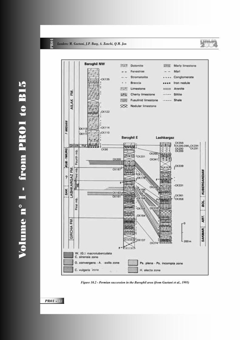
Vo
lum
e n
° 1
-
fro
m P
RO
1 t
o B
15
PR01 -
Leaders: M. Gaetani, J.P. Burg, A. Zanchi, Q.M. Jan
PR
01
Figure 10.2 - Permian succession in the Baroghil area (from Gaetani et al., 1995)
PR01_R_OK 42 24-05-2004, 15:55:49
A GEOLOGICAL TRANSECT FROM THE INDIAN PLATE TO THE EAST HINDU KUSH, PAKISTAN P
R0
1
43 - PR01
Vo
lum
e n
° 1
-
fro
m P
RO
1 t
o B
15
Comprehensive view of the structure of the thrust sheets. From South to North: Axial Batholith, Axial Zone, Reshun Fault, Baroghil-Lashkargaz Unit, Karamabar Unit. The Reshun Fault is enhanced by white marble boudins separating the very similar Yarkun group shales of two different tectonic units. Looking eastward the basal Ordovician shales of the Lashkargaz-Baroghil Unit are stacked above the Reshun red marls and conglomerates along a very steep N-dipping fault planes. Oblique to strike-slip striations suggesting a reactivation of the fault in a transpressional regime occur between the Reshun and the Permian white Fusulinid limestones of the Axial Unit. Complex slices of the Paleozoic formations have been distinguished along this fault system.Around the area there are sparse outcrops of the quartzarenites of the Gircha Fm. (Lower Permian), section Baroghil East, (Fig.10.2). Looking northward the very characteristic Tash Kupruk lithologies can be distinguished above the Paleo-Mesozoic succession of the Lashkargaz tectonic Unit. The Wakhan Slates, overthrusted by the fusulinid limestones and dolostones of the Kan Khun tectonic Unit form the watershed with the Afghan Ab-i-Panja river (later named Amu Darya), fl owing towards Aral Lake. To be noted are the sparse boulders of the Darkot Pass porphyritic granite, up to the altitude of 4400 m, indicating an earlier fl owing of the ice-streams into the Amu Darya catchment basin. Looking eastward the Lashkargaz area and the Chiantar glacier can be distinguished in the distance. (Fig. 10.3)
Back to the camp. Overnight in Ishkarwaz camp.
DAY 11The Devonian of the Northern Karakoram
Theme - The Devonian succession.Itinerary - Easy walking along the left bank of the Yarkhun River and back.
To the east of Chilmarabad, two slate sheets of the Baroghil Group are in contact by the Reshun Fault.
Stop 11.1:Chilmarabad Formation From Baarbun onwards, the trail crosses the Devonian succession, named in Talent et al., (1999) Yarkhun River section (Fig. 11.1).
The Chilmarabad Formation consists of two members. The lower is made by yellow dolostones with arenitic and slaty intercalations. Typical in the basal part are polymictic microconglomerates with clasts of black cherts, unknown in the underlying units and the basement. The thickness of this member is 130 m.The upper member is made of well-bedded yellow dolostones, locally stromatolitic. In this particular section, fossils are almost absent, but elsewhere in the Karambar Thrust Sheet stromatoporoids are fairly abundant and the age is Middle Devonian. The thickness of this member is about 100 m. (Fig. 11.2).
Stop 11.2:Shogram FormationThe trail follows the development of the Shogram Fomation (Fig. 11.3)
It rests unconformably on the Chilmarabad. The basal lithozone consists of coarse arenites and microconglomerates, deposited in a fl uvial setting. Then alternating hybrid sandstones and limestones, locally rich in brachiopods and corals, follow.Major fossil levels are in the lower part, with corals and brachiopods and in the upper part with corals (Schroeder 2004) (Disphyllum cf. caespitosum, Cyathophyllum afghanense, Pseudopexiphyllum sp., Hexagonaria sp., Argutastrea sp.) and brachiopods (Cyrtospirifer sp. and Atrypa sp.) suggesting a Frasnian age. The upper coral level forms a baffl estone, 20-30 m thick: a useful regional marker. A conodont sample (Talent et al., 1999) produced an early Famennian fauna, dominated by the genus Icriodus. Its position is, however, problematic. Total thickness of the formation here is 175 m.Along the river a small outcrop pertaining to the Margach Formation (latest Devonian – earliest Carboniferous) can be observed.
Stop 11.3:View on the Carboniferous sectionOn the opposite bank of the river, here unfordable, the dark grey crinoidal limestones of the Ribat Formation crop out. They delivered a Gnathodus conodont fauna of late Tournaisian age (Gaetani et al., 2004). A few tens of m above, the sandstones (well sorted arkoses and quartzarenites) of the Gircha Formation (Permian) directly follow. The Gircha Fm. seals the Carboniferous succession with a feeble angular unconformity.From here back to the camp.
PR01_R_OK 43 24-05-2004, 15:55:58
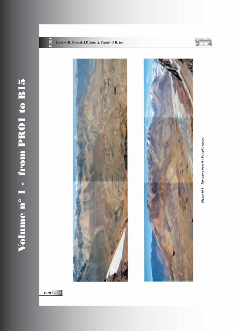
Vo
lum
e n
° 1
-
fro
m P
RO
1 t
o B
15
PR01 -
Leaders: M. Gaetani, J.P. Burg, A. Zanchi, Q.M. Jan
PR
01
Fig
ure
10.3
- P
anor
ama
from
the
Bar
oghi
l slo
pes.
PR01_R_OK 44 24-05-2004, 15:58:39
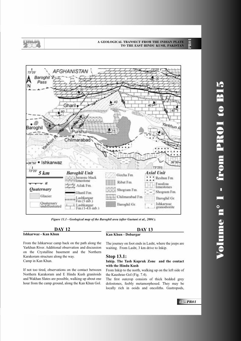
A GEOLOGICAL TRANSECT FROM THE INDIAN PLATE TO THE EAST HINDU KUSH, PAKISTAN P
R0
1
45 - PR01
Vo
lum
e n
° 1
-
fro
m P
RO
1 t
o B
15
DAY 12
Ishkarwaz - Kan Khun
From the Ishkarwaz camp back on the path along the Yarkhun River. Additional observation and discussion on the Crystalline basement and the Northern Karakoram structure along the way. Camp in Kan Khun.
If not too tired, observations on the contact between Northern Karakoram and E Hindu Kush granitoids and Wakhan Slates are possible, walking up about one hour from the camp ground, along the Kan Khun Gol.
DAY 13Kan Khun - Dobargar
The journey on foot ends in Lasht, where the jeeps are waiting. From Lasht, 3 km drive to Inkip.
Stop 13.1:Inkip. The Tash Kupruk Zone and the contact with the Hindu KushFrom Inkip to the north, walking up on the left side of the Kaushrao Gol (Fig. 7.4).The fi rst outcrop consists of thick bedded grey dolostones, feebly metamorphosed. They may be locally rich in ooids and oncoliths. Gastropods,
Figure 11.1 - Geological map of the Baroghil area (after Gaetani et al., 2004 ).
PR01_R_OK 45 28-05-2004, 18:47:34

Vo
lum
e n
° 1
-
fro
m P
RO
1 t
o B
15
PR01 -
Leaders: M. Gaetani, J.P. Burg, A. Zanchi, Q.M. Jan
PR
01
Figure 11.2 - Devonian section measured in Chitral and Upper Yarkhun Valley (after Talent et al.).
PR01_R_OK 46 24-05-2004, 15:56:26
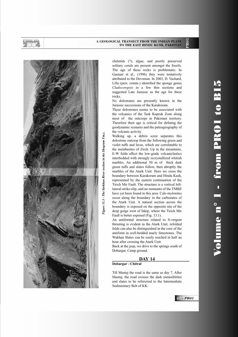
A GEOLOGICAL TRANSECT FROM THE INDIAN PLATE TO THE EAST HINDU KUSH, PAKISTAN P
R0
1
47 - PR01
Vo
lum
e n
° 1
-
fro
m P
RO
1 t
o B
15
chetetids (?), algae, and poorly preserved solitary corals are present amongst the fossils. The age of these rocks is problematic. In Gaetani et al., (1996) they were tentatively attributed to the Devonian. In 2003, D. Vachard, Lille (pers. comm.) identifi ed the sponge genus Cladocoropsis in a few thin sections and suggested Late Jurassic as the age for these rocks.No dolostones are presently known in the Jurassic successions of the Karakoram.These dolostones seems to be associated with the volcanics of the Task Kupruk Zone along most of the outcrops in Pakistani territory. Therefore their age is critical for defi ning the geodynamic scenario and the paleogeography of the volcanic activity.Walking up, a debris scree separates this dolostone outcrop from the following green and violet tuffs and lavas, which are correlatable to the metabasites of Zirch. Up in the mountains, E-W folds affect the low-grade volcaniclastics interbedded with strongly recrystallized whitish marbles. An additional 50 m of thick dark green tuffs and slates follow, then abruptly the marbles of the Atark Unit. Here we cross the boundary between Karakoram and Hindu Kush, represented by the eastern continuation of the Tirich Mir Fault. The structure is a vertical left-lateral strike-slip, and no remnants of the TMBZ have yet been found in this area. Calc-mylonites occur along the boundary in the carbonates of the Atark Unit. A natural section across the boundary is exposed on the opposite site of the deep gorge west of Inkip, where the Tirich Mir Fault is better exposed (Fig. 13.1). An antiformal structure related to S-vergent thrusting is evident in the Atark Unit; refolded folds can also be distinguished in the core of the antiform in well-bedded marly limestones. The Wakhan Slates can be easily reached in half an hour after crossing the Atark Unit.Back at the jeep, we drive to the springs south of Dobargar. Camp ground.
DAY 14Dobargar - Chitral
Till Mastuj the road is the same as day 7. After Mastuj, the road crosses the dark metasiltitites and slates to be refererred to the Intermediate Sedimentary Belt of KK.
Fig
ure
11.3
- T
he Y
arkh
un R
iver
sec
tion
in th
e Sh
ogra
m F
m.)
.
PR01_R_OK 47 24-05-2004, 15:56:34

Vo
lum
e n
° 1
-
fro
m P
RO
1 t
o B
15
PR01 -
Leaders: M. Gaetani, J.P. Burg, A. Zanchi, Q.M. Jan
PR
01
Figure 13.1 - The antiformal structure into the Atark Unit.
PR01_R_OK 48 24-05-2004, 15:57:47
A GEOLOGICAL TRANSECT FROM THE INDIAN PLATE TO THE EAST HINDU KUSH, PAKISTAN P
R0
1
49 - PR01
Vo
lum
e n
° 1
-
fro
m P
RO
1 t
o B
15
Stop 14.1:Reshun Conglomerate.At the tea stall of Parwak, polymictic coarse conglomerate relative to the Reshun Conglomerate. Here it is very rich in volcanic pebbles, up to 15-20 cm in size, poorly sorted and with abundant matrix. We continue along the Mastuj River.From Buni to the south, good view of the granitoids of the Ghamubar Unit.
Stop 14.2:Kuragh Spur.This locality has been known since Hayden (1915) and Desio (1966). It was designated as a type section of the Shogram Formation by Talent et al., (1999). (Fig. 14.1)
The fauna content is rich in brachiopods (Reed 1922, Sartenaer 1965, Vandercammen 1965, Gaetani 1967), corals (Schouppé 1965) and conodonts (Talent et al., 1982, 1999). Ages from Middle Givetian to Early Famennian are documented.Down in the valley we cross the village of Reshun. To the south in the distance good outcrops of the reddish Reshun Conglomerate. From this locality Hayden fi rst (1915) identifi ed pebbles with Orbitolina in the conglomerate, fi xing the minimum age for the unit.Stay in Chitral town.
DAY 15Chitral - Islamabad
How to reach Islamabad will be decided according to the situation in the Dir district.
AcknowledgmentsIn the last two decades, the plutonic rocks of Karakoram were extensively studied by P. Le Fort and F. Debon, with whom we also shared part of the fi eld work. They are now retired from geology and MG tried to summarize some of their outstanding results and to show in the fi eld some of the outcrops P. Le Fort studied.We also benefi ted from the fi eld guide along the KKH prepared by R.D. Lawrence and A. Khan for the Himalyan-Karakorum-Tibet Workshop, held in Peshawar, April 1998.
ReferencesAnczkiewicz, R. (1998). Structural and
geochronological study of the India-Kohistan Arc collision, Lower Swat region of Pakistan, NW Himalaya. Unpublished PhD, # 12771 thesis, ETH.
Anczkiewicz, R., Burg, J.-P., Hussain, S. S., Dawood, H., Ghazanfar, M. and Chaudhry, M. N. (1998). Stratigraphy and structure of the Indus Suture in the Lower Swat, Pakistan, NW Himalaya. Journal of Asian Earth Sciences 16(2-3), 225-238.
Anczkiewicz, R., Burg, J.-P., Villa, I. M. and Meier, M. (2000). Late Cretaceous blueschist metamorphism in the Indus Suture Zone, Shangla region, Pakisatan Himalaya. Tectonophysics 324, 111-134. Anczkiewicz, R. and Vance, D. (1997). Chronology of ,collision and regional metamorphism in Kohistan, NW Himalaya, Pakistan. Terra Nova, Abstract Supplement 331, 345.
Anczkiewicz, R. and Vance, D. (2000). Isotopic constraints on the evolution of metamorphic conditions in the Jijal-Patan complex and the Kamila Belt of the Kohistan arc, Pakistan Himalaya. In: Tectonics of the Nagna Parbat Syntaxis and the Western Himalaya (edited by Khan, M. A., Treloar, P. J., Searle, M. P. & Jan, M. Q.). Geological Society Special Publication, London, 170, 321-331.
Arbaret, L., Burg, J.-P., Zeilinger, G., Chaudhry, N., Hussain, S. and Dawood, H. (2000). Pre-collisional anastomosing shear zones in the Kohistan arc, NW Pakistan. In: Tectonics of the Nanga Parbat Syntaxis and the Western Himalaya (edited by Khan, M. A., Treloar, P. J., Searle, M. P. & Jan, M. Q.). Geological Society Special Publications, London 170, 295-311. Bard, J.-P. (1983). Metamorphism of an obducted island arc: Example of the Kohistan sequence (Pakistan) in the Himalayan collided range. Earth and Planetary Science Letters 65, 133-144.
Bard, J.-P., Maluski, H., Matte, P. and Proust, F. (1980). The Kohistan sequence: crust and mantle of an obducted island arc. Geol. Bull. Univ. Peshawar 11, 87-94.
Brookfi eld, M. E. & Reynolds, P. H. 1981. Late Cretaceous emplacement of the Indus suture zone ophiolitic mélange and an Eocene-Oligocene magmatic arc on the northern edge of the Indian plate. Earth and Planetary Science Letters(55), 157-162.Bedini, R. M., Bodinier, J.-L., Dautria, J.-M. &
PR01_R_OK 49 24-05-2004, 15:57:00
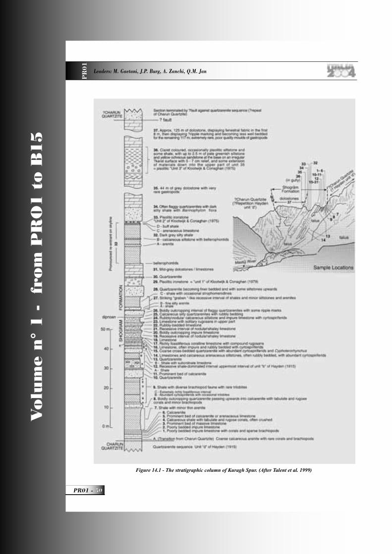
Vo
lum
e n
° 1
-
fro
m P
RO
1 t
o B
15
PR01 -
Leaders: M. Gaetani, J.P. Burg, A. Zanchi, Q.M. Jan
PR
01
Figure 14.1 - The stratigraphic column of Kuragh Spur. (After Talent et al. 1999)
PR01_R_OK 50 24-05-2004, 15:57:03
A GEOLOGICAL TRANSECT FROM THE INDIAN PLATE TO THE EAST HINDU KUSH, PAKISTAN P
R0
1
51 - PR01
Vo
lum
e n
° 1
-
fro
m P
RO
1 t
o B
15
Morten, L. (1997). Evolution of LILE-enriched small melt fractions in the lithospheric mantle: A case study from the East African Rift. Earth and Planetary Science Letters 153(1-2), 67-83.
Buchroithner, M (1980). An outline of the geology of the Afghan Pamirs. Tectonophysics 62, 13-35.. Buchroithner, M. and Gamerith, H. (1986) On the geology of the Tirich Mir area, Central Hindu Kush (Pakistan). Jharbuch des Geologisches. Bundesanstalt 128, 367-381.
Burbank, D. W. & Johnson, G. D. (1982). Intermontane-basin development in the past 4 Myr in the north-west Himalaya. Nature 298(5873), 432-436.
Burg, J.-P., Bodinier, J.-L., Chaudhry, M. N., Hussain, S. and Dawood, H. (1998). Infra-arc mantle-crust transition and intra-arc mantle diapirs in the Kohistan Complex (Pakistani Himalaya): petro-structural evidence. Terra Nova 10(2), 74-80.
Chamberlain, C. P., Zeitler, P. K. and Erickson, E. (1991). Constraints on the tectonic evolution of the Northwestern Himalaya from geochronologic and petrologic studies of Babusar Pass, Pakistan. Journal of Geology 99, 829-849.
Chaudhry, M. N., Spencer, D. A., Ghazanfar, M., Hussain, S. S. and Dawood, H. 1997. The location of the Main Central Thrust in the Northwest Himalaya of Pakistan: Tectonic implications. Geological Bulletin of the Punjab University 31&32, 1-19.
Coward, M. P., Butler, R. W. H., Khan, M. A. and Knipe, R. J. (1987). The tectonic history of Kohistan and its implications for Himalayan structure. Journal of the Geological Society of London 144, 377-391.
Coward, M. P., Windley, B. F., Broughton, R. D., Luff, I. W., Petterson, M. G., Pudsey, C. J., Rex, D. C. and Khan, M. A. (1986). Collision tectonics in the NW Himalayas. In: Collision tectonics (edited by Coward, M. P. & Ries, A. C.). Geological Society Special Publication, London, 19, 203-219.
Crawford, M.B. and Searle, M.P. (1992). Field relationships and geochemistry of pre-collisional (India-Asia) granitoid magmatism in the Central Karakoram. Tectonophysics 206, 171-192.
Debon, F. (1995). Incipient India-Eurasia collision and plutonism: the Lower Cenozoic Batura granites (Hunza Karakorum, North Pakistan). Journal of Geological Society of London 152, 785-795.
Debon, F. and Khan N.A. (1996). Alkaline orogenic plutonism in the Karakorum batholith: the Upper Cretaceous Koz Sar complex (Karambar Valley, N. Pakistan). Geodinamica Acta 9, 145-160.
Debon, F. and Le Fort, P. (1988). A cationic classifi cation os common plutonic rocks and their magmatic associations: principles, method, applications. Bulletin de minéralogie 111, 493-510.
Debon, F., Le Fort, P., Dautel, D., Sonet, J. & Zimmermann, J. L. (1987). Plutonism in western Karakoram and northern Kohistan (Pakistan): a composite Mid-Cretaceous to upper Cenozoic magmatism. Lithos 20, 19-40.Debon, F., Zimmermann, J. L. and Bertrand, J.-M. (1986). Le granite du Baltoro (batholite axial du Karakoram, nord Pakistan): une intrusion sub-alcaline d‘âge Miocène supérieur. Comptes Rendus de l’Académie des Sciences de Paris 303 série II(6), 463-468.
Debon, F., Zimmermann, J.L. and Le Fort, P. (1996). Upper Hunza granites (North Karakorum, Pakistan): a syn-collisional bimodal plutonism of mid-Cretaceous age. Comptes Rendu de l’Academie des Science Paris, IIa, 381-388.
Desio, A. (1964). Geological tentative map of the western Karakoram. Scale 1/500 000. Inst. Geol. Univ. Milano.
Desio, A. (1966). The Devonian system in Mastuj valley (Chitral, N.W. Pakistan. Rivista Italiana di Paleontologia e Stratigrafi a,72, 293-320.
Desio, A. and Martina, E. (1972). Geology of the Upper Hunza Valley, Karakoram, West Pakistan. Bolletino della Societa Geologica Italiana 91, 283-314.
DiPietro, J. A. & Isachsen, C. E. 2001. U-Pb zircon ages from the Indian plate in northwest Pakistan and their signifi cance to Himalayan and pre-Himalayan geologic history. Tectonics 20(4), 510-525.
PR01_R_OK 51 24-05-2004, 15:57:10
Vo
lum
e n
° 1
-
fro
m P
RO
1 t
o B
15
PR01 -
Leaders: M. Gaetani, J.P. Burg, A. Zanchi, Q.M. Jan
PR
01
Gaetani, M. (1967). Some Devonian brachiopods from Chitral. (N.W. Pakistan). Rivista Italiana di Paleontologia e Stratigrafi a 73, 3-22.
Gaetani, M. (1997). The Karakoram Block in Central Asia, from Ordovician to Cretaceous. Sedimentary Geology 109, 339-359.
Gaetani, M., Angiolini, L., Garzanti, E., Jadoul, F., Leven, E. Y., Nicora, A. and Sciunnach, D. (1995). Permian stratigraphy in the Northern Karakoram, Pakistan. Rivista Italiana di Paleontologia e Stratigrafi a 101, 112-158.
Gaetani, M. and Leven, E. Ja. (1993). Permian stratigraphy and fusulinids from Rosh Gol (Chitral, E Hindu Kush). Rivista Italiana di Paleontologia e Stratigrafi a 99, 307-326.
Gaetani, M., Garzanti, E., Jadoul, F., Nicora, A. , Pasini, M., Tintori, A. and Kanwar S.A.K. (1990) - The north Karakorum side of the Central Asia geopuzzle. Geological Society of America Bulletin 102, 54-62.
Gaetani, M., Jadoul, F., Erba, E. and Garzanti E. (1993) - Jurassic and Cretaceous orogenic events in the North Karakorum: age constraints from sedimentary rocks. In: Treloar P. & Searle M. (Eds.) - Himalayan Tectonics. Geological Society. London Special Publication 74, 39-52.
Gaetani, M., Le Fort, P., Tanoli, S., Angiolini, L., Nicora, A., Sciunnach, D. and Asif, K. (1996). Reconnaissance geology in Chitral, Baroghil and Karambar districts (N Pakistan). Geologische Rundschau 85, 683-704.
Gaetani, M., Zanchi, A.,Angiolini, A., Olivini, G., Sciunnach, D., Brunton, H., Nicora, A. and Mawson, R. (2004). The Carboniferous of the Western Karakoram (Pakistan). Journal of Asian Earth Sciences (in press).Hanson, C.R. (1989). The northern suture in the Shigar valley, Baltistan, northern Pakistan. Geological Society of America, Spec.Pap. 232, 203-215.
Hayden, H.H. (1915). Notes on the geology of Chitral, Gilgit and the Pamirs. Records of the Geological Survey of India 45, 271- 320.
Jan, M. Q. and Windley, B. F. (1990). Chromian spinel-silicate chemistry in ultramafi c rocks of the Jijal Complex, Northwest Pakistan. Journal of Petrology 31(3), 667-715.
Johnson, N. M., Opdyke, N. D., Johnson, G. D., Lindsay, E. H. and Tahirkheli, R. A. K. (1982). Magnetic polarity, stratigraphy and ages of the Siwalik group rocks of the Potwar Plateau, Pakistan. Palaeogeography, Palaeoclimatology, Palaeoecology 37, 17-42.
Kafarskyi, A. Kh. and Abdullah, J. (1976). Tectonics of the North-east Afghanistan (Badakhshan, Wakhan, Nurestan) and relationship with the adjacent territories. Atti Convegni Lincei Roma 21, 87-113.
Kaneko, Y., Katayama, I., Yamamoto, H., Misawa, K., Ishikawa, M., Rehman, H. U., Kausar, A. B. & Shiraishi, K. (2003). Timing of Himalayan ultrahigh-pressure metamorphism: sinking rate and subduction angle of the Indian continental crust beneath Asia. Journal of Metamorphic Geology 21(6), 589-599.
Kazmi, A. H. & Jan, Q. M. (1997). Geology and tectonics of Pakistan. Graphic Publishers, Karachi.Kelemen, P. B., Whitehead, J. A., Aharonov, E. and Jordahl, K. A. (1995). Experiments on fl ow focusing in soluble porous media, with applications to melt extraction from the mantle. Journal of Geophysical Research 100, 475-496.
Khan, M. A., Jan, M. Q., Windley, B. F., Tarney, J. and Thirlwall, M. F. (1989). The Chilas mafi c-ultramafi c igneous complex: the root of the Kohistan Island Arc in the Himalaya of northern Pakistan. Geological Society of America, Special Paper 232, 75-93.
Khan, T., Khan, M. A. and Jan, M. Q. (1994). Geology of a part of the Kohistan terrane between Gilgit and Chilas, northern areas, Pakistan. Geological Bulletin, University of Peshawar 27, 99-112.
Khan, M. A., Jan, M. Q. and Weaver, B. L. (1993) - Evolution of the lower arc crust in Kohistan, N. Pakistan: temporal arc magmatism through early, mature and intra-arc rift stages. In: Himalayan tectonics (edited by Treloar, P. J. & Searle, M. P.). Geological Society Special Publication, London, 74, 123-138.
PR01_R_OK 52 24-05-2004, 15:57:12
A GEOLOGICAL TRANSECT FROM THE INDIAN PLATE TO THE EAST HINDU KUSH, PAKISTAN P
R0
1
53 - PR01
Vo
lum
e n
° 1
-
fro
m P
RO
1 t
o B
15
Khan, T., Khan, M. A., Jan, M. Q. and Naseem, M. (1996). Back-arc basin assemblages in Kohistan, Northern Pakistan. Geodinamica Acta 9(1), 30-40.Le Fort, P., Debon, F. and Sonet, J. (1980). The ‘Lesser Himalayan’ Cordierite Granite Belt. Typology and age of the Pluton of Mansehra (Pakistan). Geological Bulletin, University of Peshawar 3, 51-61.
Le Fort, P. and Gaetani, M. (1998). Introduction to the geological map of the western Central Karakoram, North Pakistan. Hindu Raj, Ghamubar and Darkot regions. 1:250.000. Geologica 3, 3- 57. Geological Survey Pakistan, Islamabad.Le Fort, P., Tongiorgi, M. and Gaetani, M. (1994). Discovery of crystalline basement and Early Ordovician marine trnsgression in the Karakoram mountain Range. Geology 28, 941-944.
Mason, K. (1938). Karakoram nomenclature. Himalayan Journal 10, 86-125.Miller, D. J., Loucks, R. R. and Ashraf, M. (1991). Platinum-group element mineralization in the Jijal layered ultramafi c-mafi c complex, Pakistani Himalayas. Economic Geology 86(5), 1093-1102.
Mullen, E.D. (1983). MnO/TiO2/P2O5: a minor element disciminant for basaltic rocks of oceanic environments and its implications for petrogenesis. Earth and Planetary Science Letters 62, 53-62.
Niida, K., Kausar, A. B. and Khan, S. R. (1996). Ultramafi c crystal mush intrusion into crystallizing magma chamber: Field evidence from the Chilas Complex, Northern Pakistan. In: Proceedings of Geoscience Colloquium 15. Geological Survey of Pakistan, Geoscience Laboratory, 157-171.
O’Brien, P. J., Zotov, N., Law, R., Khan, M. A. & Jan, M. Q. 2001. Coesite in Himalayan eclogite and implications for models of India-Asia collision. Geology 29(5), 435-438.
Orberger, B., Lorand, J.-P., Girardeau, J., Mercier, J.-C. and Pitragool, S. (1995). Petrogenesis of ultramafi c rocks and associated chromitites in the Nan Uttaradit ophiolite, Northern Thailand. Lithos 35, 153-182.
Parrish, R. R. and Tirrul, R. (1989). U-Pb age of the Baltoro granite, northwest Himalaya, and implications for zircon inheritance and monazite U-Pb systematics. Geology 17, 1076-1079.
Pennington W.D. (1979). Summary of fi eld and seismic informations of the Pattan earthquake - 28 December 1974 In Farah A. & Dejong K.A. eds, Geodynamics of Pakistan, Quetta, Geol. Surv. Pak.Perri, M.C., Molloy, P.D. and Talent, J.A. (2004). Earliest Triassic conodonts from Chitral, Northernmost Pakistan. Rivista Italiana di Paleontologia e Stratigrafi a 110, (in press).Petterson, M. G. and Windley, B. F. (1985). Rb-Sr dating of the Kohistan arc-batholith in the Trans-Himalaya of north Pakistan, and tectonic implications. Earth and Planetary Science Letters 74(1), 45-57.
Petterson, M. G. and Windley, B. F. (1991). Changing source regions of magmas and crustal growth in the Trans-Himalayas: evidence from the Chalt volcanics and Kohistan batholith, Kohistan, northern Pakistan. Earth and Planetary Science Letters 102(3/4), 326-341.Petterson, M. G. and Treloar, P. J. (2004).
Volcanostratigraphy of arc volcanic sequences in the Kohistan arc, North Pakistan: volcanism within island arc, back-arc-basin, and intra-continental tectonic settings. Journal of Volcanology and Geothermal Research 130(1-2), 147-178.
Pogue, K. R., Hylland, M. D., Yeats, R. S., Khattak, W. U. & Hussain, A. (1999). Stratigraphic and structural framework of Himalayan foothills, northern Pakistan. Geological Society of America, Special Paper 328, 257-274.
Pogue, K. R., Wardlaw, B. R., Harris, A. G. & Hussain, A. (1992). Paleozoic and Mesozoic stratigraphy of the Peshawar basin, Pakistan: Correlations and implications. Geological Society of America Bulletin 104, 915-927.
Pudsey, C. J. (1986). The Northern Suture, Pakistan: margin of a Cretaceous island arc. Geological Magazine 123(4), 405-423.Pudsey, C. J., Coward, M. P., Luff, I. W., Shackleton, R. M., Windley, B. F. & Jan, M. Q. (1985a). Collision zone between the Kohistan arc and the Asian plate in NW Pakistan. Transactions of the Royal Society of Edinburgh: Earth Sciences 76, 463-479.
Pudsey, C. J., Schroeder, R. and Skelton, P. W. (1985b). Cretaceous (Aptian/Albian) age for island-arc volcanics, Kohistan, N Pakistan. Himalayan
PR01_R_OK 53 24-05-2004, 15:57:13
Vo
lum
e n
° 1
-
fro
m P
RO
1 t
o B
15
PR01 -
Leaders: M. Gaetani, J.P. Burg, A. Zanchi, Q.M. Jan
PR
01
Geology 3, 150-168.
Quintavalle, M., Tongiorgi, M. and Gaetani, M. (2000). Lower to Middle Ordovician acritarchs and chitinozoans from Northern Karakoram mountains, Pakistan. Rivista Italiana di Paleontologia e Stratigrafi a 106, 3-18.
Reed, F.R.C. (1922). Devonian fossils from Chitral and the Pamirs. Paleontologia Indica, N.S., 6/2, 134 pp.
Reynolds, P. H., Brookfi eld, M. E. & McNutt, R. H. (1983). The age and nature of Mesozoic-Tertiary magmatism across the Indus Suture Zone in Kashmir and Ladakh (N.W. India and Pakistan). Geologische Rundschau 72(3), 981-1004.
Ringuette, L., Martignole, J. & Windley, B. F. (1998). Pressure-Temperature evolution of garnet-bearing rocks from the Jijal complex (western Himalayas, northern Pakistan): from high-pressure cooling to decompression and hydration of a magmatic arc. Geological Bulletin, University of Peshawar 31, 167-168.
Sartenaer, P. (1965). Rhynchonelloidea de Shogram et Kuragh (Chitral). Italian Expeditions to Karakoram (K2) and Hindu Kush, Scientifi c Reports, IV/1, 55-66, E.J.Brill, Leiden.
Schaltegger, U., Zeiinger, G., Frank, M. & Burg, J.-P. (2002). Multiple mantle sources during island arc magmatism: U-Pb and Hf isotopic evidence from the Kohistan arc complex, Pakistan. Terra Nova 14(6), 461-468.Schroeder, S. (2004). Devonian rugose corals from the Karakorum Mountains (Northern Pakistan). Rivista Italiana di Paleontologia e Stratigrafi a 110 (in press).Schouppé, A. von (1965). Die mittel- bis oberdevonische Korallenfauna von Kuragh (Chitral). Italian Expeditions to Karakoram (K2) and Hindu Kush, Scientifi c Reports, IV/1, 13-53, E.J.Brill, Leiden.
Searle, M.P. (1991). Geology and Tectonics of the Karakoram Mountains. 358 pp., Wiley and Son.Searle, M. P., Rex, A. J., Tirrul, R., Rex, D. C. & Barnicoat, A. 1989. Metamorphic, magmatic and tectonic evolution of the central Karakoram in
the Biafo-Baltoro-Hushe regions of N. Pakistan. In: Tectonics of the Western Himalaya (edited by Malinconico, L. & Lillie, R. J.) 232. Geological Society of America, Special Paper, 47-74.
Searle, M. P., Asif Khan, M., Fraser, J. E. and Gough, S. J. (1999). The tectonic evolution of the Kohistan-Karakoram collision belt along the Karakoram Highway transect, north Pakistan. Tectonics 18(6), 929-949.
Seeber, L. and Armbruster, J. (1979). Seismicity of the Hazara Arc in Northern Pakistan: decollement vs. basement faulting. In: Geodynamics of Pakistan (edited by Farah, A. & K.A., D. J.). Geological Survey of Pakistan, Quetta, 131-142.
Seeber, L., Armbruster, J. G. and Quittmeyer, R. C. (1981). Seismicity and continental subduction in the Himalayan arc. In: Zagros - Hindu Kush - Himalaya, Geodynamic evolution (edited by Gupta, H. & Delany, F.). American Geophysical Union Geodynamics series, 3, 215-242.
Spencer, D. A., Pognante, U. and Tonarini, S. S. (1995). Geochemical and Sr-Nd isotopic characterisation of Higher Himalayan eclogites (and associated metabasites). European Journal of Mineralogy 7, 89-102.
Sullivan, M. A., Windley, B. F., Saunders, A. D., Haynes, J. R. and Rex, D. C. (1993). A palaeogeographic reconstruction of the Dir Group: evidence for magmatic arc migration within Kohistan, N. Pakistan. In: Himalayan tectonics (edited by Treloar, P. J. & Searle, M. P.). Geological Society Special Publication, London, 74, 139-160.
Tahirkheli, R. A. K., Mattauer, M., Proust, F. & Tapponnier, P. (1979). The India Eurasia Suture Zone in Northern Pakistan: Synthesis and interpretation of recent data at plate scale. In: Geodynamics of Pakistan (edited by Farah, A. & De Jong, K. A.). Geological Survey of Pakistan, Quetta, 125-130.
Talent, J. A., Conaghan, P.J., Mawson, R., Molloy, P.D. and Pickett, J. W. (1982). Intricay of tectonics in Chitral (Hindu Kush). Faunal evidence and some regional implications. Himalayan Seminar (1976), section IIA, Geological Survey of India, Miscellaneous Publications 41, 77-101.
PR01_R_OK 54 24-05-2004, 15:57:15
A GEOLOGICAL TRANSECT FROM THE INDIAN PLATE TO THE EAST HINDU KUSH, PAKISTAN P
R0
1
55 - PR01
Vo
lum
e n
° 1
-
fro
m P
RO
1 t
o B
15
Talent, J.A., Gaetani, M., Mawson, R., Molloy, P.D. and Conaghan P.J. (1999). Early Ordovician and Devonian conodonts from the Western Karakoram and Hindu Kush, northernmost Pakistan. Rivista Italiana di Paleontologia e Stratigrafi a 105, 201-230.
Tonarini, S., Villa, I. M., Oberli, F., Meier, M., Spencer, D. A., Pognante, U. & Ramsay, J. G. 1993. Eocene age of eclogite metamorphism in Pakistan Himalaya: implications for India-Eurasia collision. Terra Nova 5, 13-20.
Tongiorgi, M., Di Milia, A., Le Fort, P. and Gaetani M. (1994). Palynological dating (Arenig) of the sedimentary sequence overlying the Ishkarwaz granite (Upper Yarkhun Valley, Chitral, Pakistan. Terra Nova 6, 595-607.Treloar, P. J., Petterson, M. G., Qasim Jan, M. and Sullivan, M. A. (1996). A re-evaluation of the stratigraphy and evolution of the Kohistan arc sequence, Pakistan Himalaya: implications for magmatic and tectonic arc-building processes. Journal of the Geological Society of London 153, 681-693.
Treloar, P. J., Rex, D. C., Guise, P. G., Coward, M. P., M.P., S., Windley, B. F., Petterson, M. G., Jan, M. Q. and Luff, I. W. (1989a). K/Ar and Ar/Ar geochronology of the Himalayan collision in NW Pakistan: constraints on the timing of suturing, deformation, metamorphism and uplift. Tectonics 8(4), 881-909.
Treloar, P. J., Williams, M. P. and Coward, M. P. (1989b). Metamorphism and crustal stacking in the North Indian Plate, North Pakistan. Tectonophysics 165, 167-184.
Varfaly, V., Herbert, R. and Bédard, J. H. (1996). Interactions between melt and upper-mantle peridotites in the North Arm Mountain massif, Bay of Islands Ophiolite, Newfoundland, Canada: implications for the genesis of boninites and related magmas. Chemical Geology 129(1-2), 71-90.
Yamamoto, H. (1993). Contrasting metamorphic P-T-time paths of the Kohistan granulites and tectonics of the western Himalayas. Journal of the Geological Society of London 150, 843-856.
Yamamoto, H. and Nakamura, E. (1996). Sm-Nd
dating of garnet granulites from the Kohistan complex, northern Pakistan. Journal of the Geological Society of London 153, 965-969.
Yamamoto, H. and Nakamura, E. (2000). Timing of magmatic and metamorphic events in the Jijal complex of the Kohistan arc deduced from Sm-Nd dating of mafi c granulites. In: Tectonics of the Nagna Parbat Syntaxis and the Western Himalaya (edited by Khan, M. A., Treloar, P. J., Searle, M. P. & Jan, M. Q.). Geological Society Special Publication, London, 170, 321-331.
Yeats, R. S. and Lawrence, R. D. (1984). Tectonics of the Himalayan Thrust Belt in Northern Pakistan. In: Marine geology and oceanography of Arabian Sea and Coastal Pakistan (edited by Bilal, U. H. & Milliman, J. D.). Van Nostrand Reinhold Company, New York, 177-198.
Yoshida, M., Zaman, H. and Ahmad, M. N. (1996). Paleopositions of Kohistan Arc and surrounding terranes since Cretaceous time: the paleomagnetic constraints. Proceedings of Geoscience Colloquium, Geoscience Laboratory Project, Islamabad, Pakistan 15, 83-101.
Zanchi, A. (1993). Structural evolution of the North Karakorum cover, North Pakistan. In. Himalayan Tectonics (Ed. by Treloar, P.J. & Searle, M.P.) Geological Society of London, Special Publication 74: 21-38.
Zanchi, A. and Gaetani, M. (1994) - Introduction to the Geological map of the Northern Karakorum Terrain, from Chapursan valley to Shimshal Pass. Rivista Italiana di Paleontologia e Stratigrafi a 100, 125-136, 1 geol. map.Zanchi, A., Gaetani, M., Angiolini, L. and De Amicis, M. (2001). The 1:100.000 geological map of western-central Northern Karakoram terrain (northern areas, Pakistan). Journal of Asian Earth Sciences 19/3A, 79.
Zanchi, A., Gaetani, M. and Poli, S. (1997). The Rich Gol Metamorphic Complex: evidence of separaton between Hindu Kush and Karakoram. Comptes Rendues de l’Academie des Sciences Paris IIa, 325, 877-882.
Zanchi, A., Poli, S., Fumagalli, P., Gaetani, M., (2000). Mantle exhumation along the Tirich Mir Fault
PR01_R_OK 55 24-05-2004, 15:57:16
Vo
lum
e n
° 1
-
fro
m P
RO
1 t
o B
15
PR01 -
Leaders: M. Gaetani, J.P. Burg, A. Zanchi, Q.M. Jan
PR
01
Zone, NW Pakistan: pre mid-Cretaceous accretion of the Karakoram terrane to the Asian margin. In : Khan M.A., Treloar P.J., Searle M.P. and Jan M.Q- (eds.) - Tectonics of the Nanga Parbat Syntaxis and the Western Himalayas. Geological Society of London, Special. Publication, 170, 237-252.
Zeitler, P. K. (1985). Cooling history of the NW Himalaya, Pakistan. Tectonics 4(1), 127-151.
Zeitler, P.K., Tahirkheli, R. A. K., Naeser, C., Johnson, N. and Lyons, J. (1980). Preliminary fi ssion track ages from the Swat valley, Northern Pakistan. Geological Bulletin, University of Peshawar 13, 63-65.
PR01_R_OK 56 24-05-2004, 15:57:18

Back Cover: fi eld trip itinerary
PR01_copertina_R_OK E 24-05-2004, 15:46:49
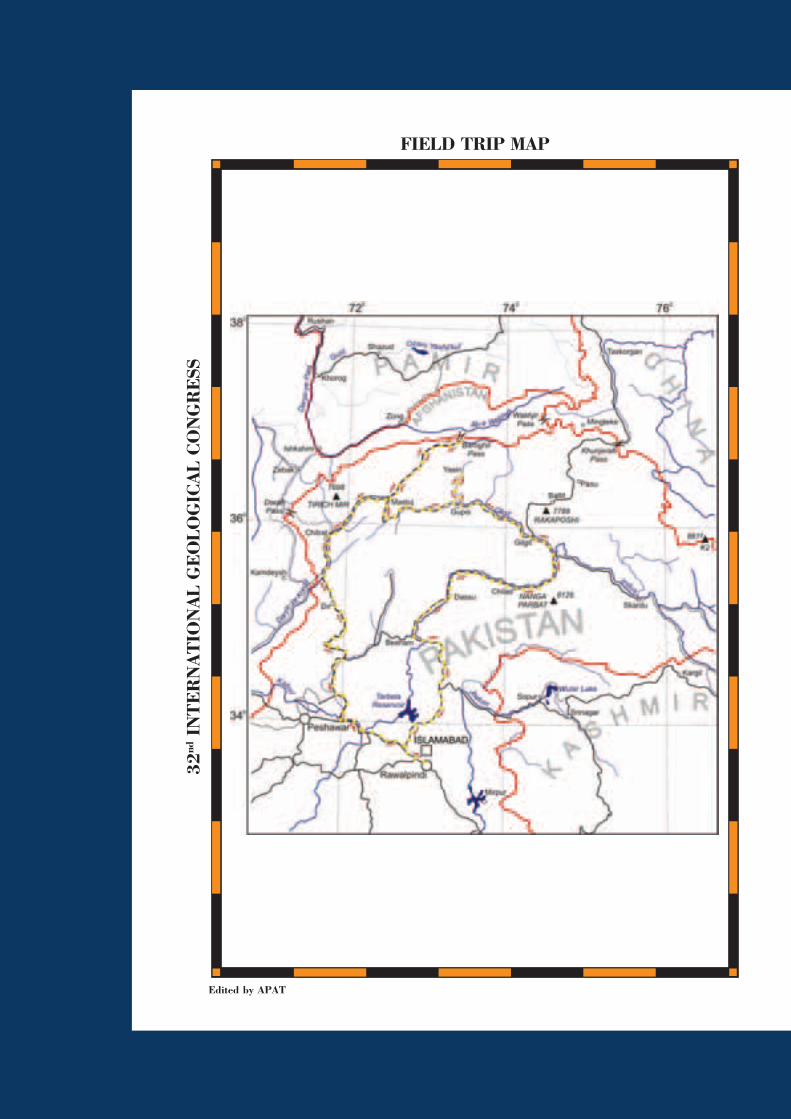
Edited by APAT
FIELD TRIP MAP
32nd
IN
TE
RN
AT
ION
AL
GE
OLO
GIC
AL
CO
NG
RE
SS
PR01_copertina_R_OK B 24-05-2004, 15:47:15