fargo planning commission · 117959 sf 420266 sf 272091 sf 162225 sf 1/4 line section line curve...
TRANSCRIPT
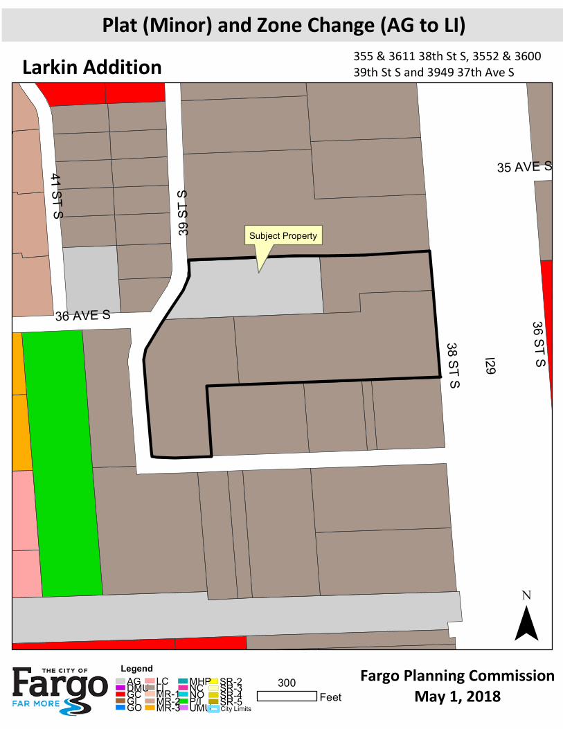
Subject Property
35 AVE S
I29
36 AVE S 36 ST S
38 ST S
41 ST S
39 ST
S
¯Fargo Planning Commission
May 1, 2018
Plat (Minor) and Zone Change (AG to LI)Larkin Addition
300Feet
355 & 3611 38th St S, 3552 & 3600 39th St S and 3949 37th Ave S
LegendSR-2SR-3SR-4SR-5
NCNOP/IMHP
UMUGIAGDMUGCGO
LCMR-2MR-3LIMR-1
City Limits
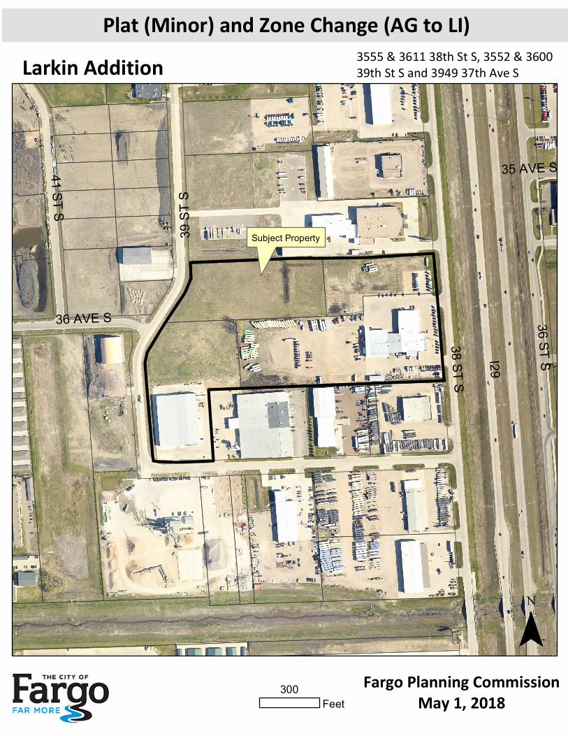
Subject Property
35 AVE S
I29
36 AVE S 36 ST S
38 ST S
41 ST S
39 ST
S
¯Fargo Planning Commission
May 1, 2018
Plat (Minor) and Zone Change (AG to LI)Larkin Addition
300Feet
3555 & 3611 38th St S, 3552 & 3600 39th St S and 3949 37th Ave S
39th S
TR
EE
T S
37th AVENUE S
36th AVENUE S
BLOCK 1
(V
AC
AT
ED
B
Y D
OC
. N
O. 1421508)
39th S
TR
EE
T S
36th AVENUE S
10' U
TIL
ITY
EA
SE
ME
NT
100 YEAR FLOODPLAIN LINE
BASE FLOOD ELEVATION 905.7
EX
IST
ING
10' U
TIL
ITY
EA
SE
ME
NT
(DO
C. N
O. 1422149)
E
X
I
S
T
I
N
G
1
0
'
U
T
I
L
I
T
Y
E
A
S
E
M
E
N
T
D
O
C
.
N
O
.
1
4
2
2
0
9
2
)
(VACATED B
Y DOC. N
O. 870213)
BLOCK 1
S04°28'25"E
93.29'
BLOCK 1
BLOCK 1
38th S
TR
EE
T S
4
3
1
2
N87°38'18"E
779.83'
S04°28'25"E
637.95'
S87°57'27"W
1173.15'
S04°27'45"E
349.90'
S87°57'42"W
280.00'
N
4
9
°
3
0
'
4
0
"
W
3
5
.
3
6
'
N04°29'17"W
444.23'
C
1
N
3
2
°
3
4
'
0
0
"
E
2
8
1
.
8
0
'
C
2
N02°12'42"W
24.50'
N87°50'29"E
438.80'
S04°30'39"E
0.80'
117959 SF
420266 SF
272091 SF
162225 SF
1/4 LINE
SECTION LINE
Curve Table
Curve #
C1
C2
Length
116.41
157.82
Radius
180.00
260.00
Delta
37°03'16"
34°46'42"
Chord Direction
N14°02'22"E
N15°10'39"E
Chord Length
114.39
155.41
PROJECT BENCHMARK
TOP NUT OF HYDRANT
907.59 (NAVD 1988)
10' U
TILIT
Y E
AS
EM
EN
T
N88°01'38"E
369.05
N01°46'54"W
94.50
N87°37'48"E
181.70
N87°53'27"E
128.23
N04°28'56"W
287.76
N04°28'56"W
346.39
N85°3
1'2
7"E
304.9
3
44.52'
357.52'
86.71'
489.75'
683.40'
441.71'
196.24'
683.35'
96.48'
10' U
TILIT
Y E
AS
EM
EN
T
5'
5'
10' U
TILIT
Y E
AS
EM
EN
T
10' U
TIL
ITY
EA
SE
ME
NT
5'
5'
5'
5'
10' U
TILIT
Y E
AS
EM
EN
T
5'
10' U
TILIT
Y E
AS
EM
EN
T
5'
10' U
TILIT
Y E
AS
EM
EN
T
10' U
TIL
ITY
EA
SE
ME
NT
10' U
TILIT
Y E
AS
EM
EN
T
10' U
TILIT
Y E
AS
EM
EN
T
H:\F
arg
o\JB
N\6
00
0\6
00
9\1
7_
60
09
_1
76
\C
AD
\P
la
t\F
IN
AL
P
LA
T L
arkin
R
ev1
.d
wg
-L
ayo
ut1-3
/2
3/2
01
8 3
:4
9 P
M-(kstro
ud)
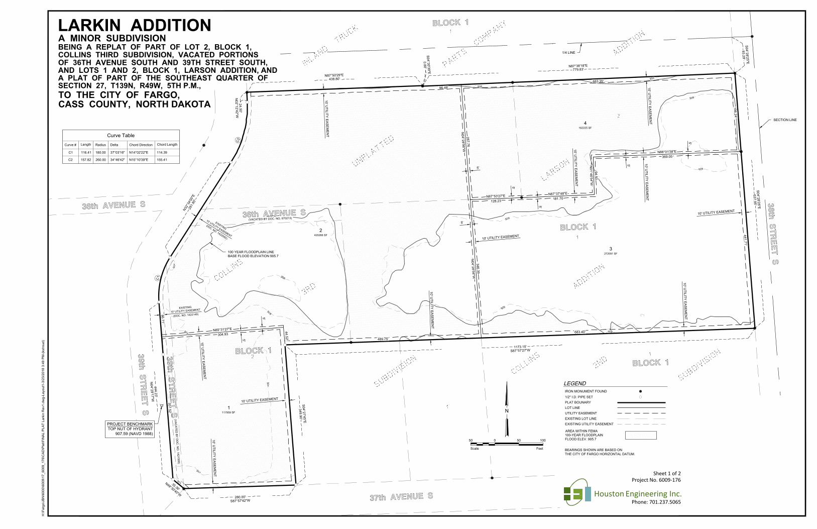
BEING A REPLAT OF PART OF LOT 2, BLOCK 1,
CASS COUNTY, NORTH DAKOTA
COLLINS THIRD SUBDIVISION, VACATED PORTIONS
TO THE CITY OF FARGO,
LARKIN ADDITION
Project No. 6009-176
Houston Engineering Inc.Phone: 701.237.5065
A MINOR SUBDIVISION
BEARINGS SHOWN ARE BASED ON
LEGEND
THE CITY OF FARGO HORIZONTAL DATUM.
FeetScale
0
N
1005050
EXISTING UTILITY EASEMENT
UTILITY EASEMENT
EXISTING LOT LINE
LOT LINE
AREA WITHIN FEMA
100-YEAR FLOODPLAIN
FLOOD ELEV. 905.7
PLAT BOUNARY
1/2" I.D. PIPE SET
IRON MONUMENT FOUND
OF 36TH AVENUE SOUTH AND 39TH STREET SOUTH,
Sheet 1 of 2
AND LOTS 1 AND 2, BLOCK 1, LARSON ADDITION, AND
A PLAT OF PART OF THE SOUTHEAST QUARTER OF
SECTION 27, T139N, R49W, 5TH P.M.,
H:\F
arg
o\JB
N\6
00
0\6
00
9\1
7_
60
09
_1
76
\C
AD
\P
la
t\F
IN
AL
P
LA
T L
arkin
R
ev1
.d
wg
-L
ayo
ut1
(2
)-3
/2
3/2
01
8 3
:4
9 P
M-(kstro
ud
)
Project No. 6009-176
Houston Engineering Inc.Phone: 701.237.5065
OWNER:
Larson Properties, LLC, a North Dakota limited liability company
________________________________________________________
Don Larson, XXXXXX
OWNER:
Larkin Properties, LLP, a North Dakota limited liability partnership
________________________________________________________
Jason Larkin, President
MORTGAGEE:
Bell State Bank & Trust, a North Dakota corporation
d/b/a Bell Bank, a North Dakota corporation
________________________________________________________
Shelly Kegley
Senior Vice President/Commercial Lender
SURVEYOR'S CERTIFICATE AND ACKNOWLEDGEMENT:
I, James A. Schlieman, Professional Land Surveyor under the laws of the State of
North Dakota, do hereby certify that this plat is a true and correct representation of
the survey of said subdivision; that the monuments for the guidance of future
surveys have been located or placed in the ground as shown.
Dated this _______day of ________________, 20_____.
__________________________________________
James A. Schlieman, Professional Land Surveyor No. 6086
CITY ENGINEER'S APPROVAL:
Approved by the Fargo City Engineer this _______ day of ________________,
20_____.
___________________________________________
Mark H. Bittner, City Engineer
FARGO PLANNING COMMISSION APPROVAL:
Approved by the City of Fargo Planning Commission this _______ day of
________________, 20_____.
___________________________________________
Shara Fischer, Chair
Fargo Planning Commission
FARGO CITY COMMISSION APPROVAL:
Approved by the Board of City Commissioners and ordered filed this
__________day of___________________________, 20_____.
________________________________________
Timothy J. Mahoney, Mayor
Attest: ________________________________________
Steven Sprague, City Auditor
State of North Dakota )
) ss
County of Cass )
On this __________ day of _______________, 20_____, before me personally
appeared Timothy J. Mahoney, Mayor, City of Fargo; and Steven Sprague, City
Auditor, City of Fargo, known to me to be the persons who are described in and
who executed the within instrument and acknowledged to me that they executed
the same on behalf of the City of Fargo.
Notary Public:_____________________________________
State of __________________ )
) ss
County of ________________ )
On this _______ day of ______________, 20____ before me personally appeared Don Larson,
XXXXXX of Larson Properties, LLC, a North Dakota limited liability company, known to me to be the
person who is described in and who executed the within instrument and acknowledged to me that he
executed the same on behalf of said limited liability company.
Notary Public: _____________________________________
State of __________________ )
) ss
County of ________________ )
On this _______ day of ______________, 20____ before me personally appeared Jason Larkin,
President of Larkin Properties, LLP, a North Dakota limited liability partnership, known to me to be the
person who is described in and who executed the within instrument and acknowledged to me that he
executed the same on behalf of said limited liability partnership.
Notary Public: _____________________________________
State of __________________ )
) ss
County of ________________ )
On this _______ day of ______________, 20____ before me personally appeared Shelly Kegley, Senior
Vice President/Commercial Lender for Bell Bank, a North Dakota corporation, known to me to be the
person who is described in and who executed the within instrument and acknowledged to me that he
executed the same on behalf of said corporation.
Notary Public: _____________________________________
State of North Dakota )
) ss
County of Cass )
On this ______ day of _______________, 20_____ before me personally appeared James A.
Schlieman, Professional Land Surveyor, known to me to be the person who is described in and who
executed the within instrument and acknowledged to me that he executed the same as his free act and
deed.
Notary Public: ____________________________________
State of North Dakota )
) ss
County of Cass )
On this ______ day of _______________, 20_____ before me personally appeared Mark H. Bittner,
Fargo City Engineer, known to me to be the person who is described in and who executed the within
instrument and acknowledged to me that he executed the same as his free act and deed.
Notary Public: __________________________________
State of North Dakota )
) ss
County of Cass )
On this _______day of ________________, 20_____, before me personally appeared Shara Fischer,
Chair, Fargo Planning Commission, known to me to be the person who is described in and who executed
the within instrument and acknowledged to me that she executed the same on behalf of the Fargo
Planning Commission.
Notary Public: __________________________________
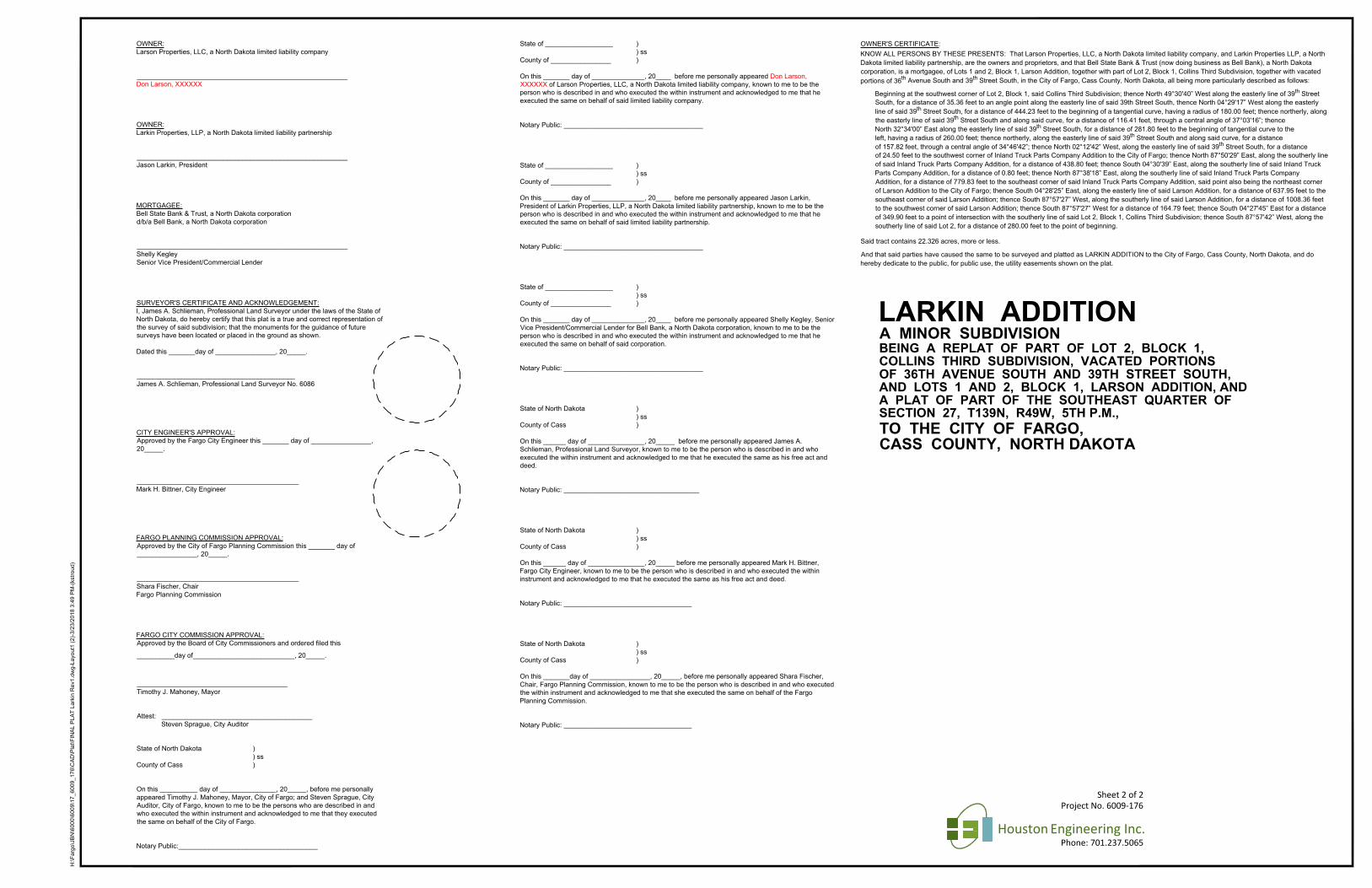
OWNER'S CERTIFICATE:
KNOW ALL PERSONS BY THESE PRESENTS: That Larson Properties, LLC, a North Dakota limited liability company, and Larkin Properties LLP, a North
Dakota limited liability partnership, are the owners and proprietors, and that Bell State Bank & Trust (now doing business as Bell Bank), a North Dakota
corporation, is a mortgagee, of Lots 1 and 2, Block 1, Larson Addition, together with part of Lot 2, Block 1, Collins Third Subdivision, together with vacated
portions of 36
th
Avenue South and 39
th
Street South, in the City of Fargo, Cass County, North Dakota, all being more particularly described as follows:
Beginning at the southwest corner of Lot 2, Block 1, said Collins Third Subdivision; thence North 49°30'40” West along the easterly line of 39
th
Street
South, for a distance of 35.36 feet to an angle point along the easterly line of said 39th Street South, thence North 04°29'17” West along the easterly
line of said 39
th
Street South, for a distance of 444.23 feet to the beginning of a tangential curve, having a radius of 180.00 feet; thence northerly, along
the easterly line of said 39
th
Street South and along said curve, for a distance of 116.41 feet, through a central angle of 37°03'16”; thence
North 32°34'00” East along the easterly line of said 39
th
Street South, for a distance of 281.80 feet to the beginning of tangential curve to the
left, having a radius of 260.00 feet; thence northerly, along the easterly line of said 39
th
Street South and along said curve, for a distance
of 157.82 feet, through a central angle of 34°46'42”; thence North 02°12'42” West, along the easterly line of said 39
th
Street South, for a distance
of 24.50 feet to the southwest corner of Inland Truck Parts Company Addition to the City of Fargo; thence North 87°50'29” East, along the southerly line
of said Inland Truck Parts Company Addition, for a distance of 438.80 feet; thence South 04°30'39” East, along the southerly line of said Inland Truck
Parts Company Addition, for a distance of 0.80 feet; thence North 87°38'18” East, along the southerly line of said Inland Truck Parts Company
Addition, for a distance of 779.83 feet to the southeast corner of said Inland Truck Parts Company Addition, said point also being the northeast corner
of Larson Addition to the City of Fargo; thence South 04°28'25” East, along the easterly line of said Larson Addition, for a distance of 637.95 feet to the
southeast corner of said Larson Addition; thence South 87°57'27” West, along the southerly line of said Larson Addition, for a distance of 1008.36 feet
to the southwest corner of said Larson Addition; thence South 87°57'27” West for a distance of 164.79 feet; thence South 04°27'45” East for a distance
of 349.90 feet to a point of intersection with the southerly line of said Lot 2, Block 1, Collins Third Subdivision; thence South 87°57'42” West, along the
southerly line of said Lot 2, for a distance of 280.00 feet to the point of beginning.
Said tract contains 22.326 acres, more or less.
And that said parties have caused the same to be surveyed and platted as LARKIN ADDITION to the City of Fargo, Cass County, North Dakota, and do
hereby dedicate to the public, for public use, the utility easements shown on the plat.
Sheet 2 of 2
BEING A REPLAT OF PART OF LOT 2, BLOCK 1,
CASS COUNTY, NORTH DAKOTA
COLLINS THIRD SUBDIVISION, VACATED PORTIONS
TO THE CITY OF FARGO,
LARKIN ADDITION
A MINOR SUBDIVISION
OF 36TH AVENUE SOUTH AND 39TH STREET SOUTH,
AND LOTS 1 AND 2, BLOCK 1, LARSON ADDITION, AND
A PLAT OF PART OF THE SOUTHEAST QUARTER OF
SECTION 27, T139N, R49W, 5TH P.M.,