executive summary: the mt. vernon mine property · executive summary: the mt. vernon mine property....
TRANSCRIPT
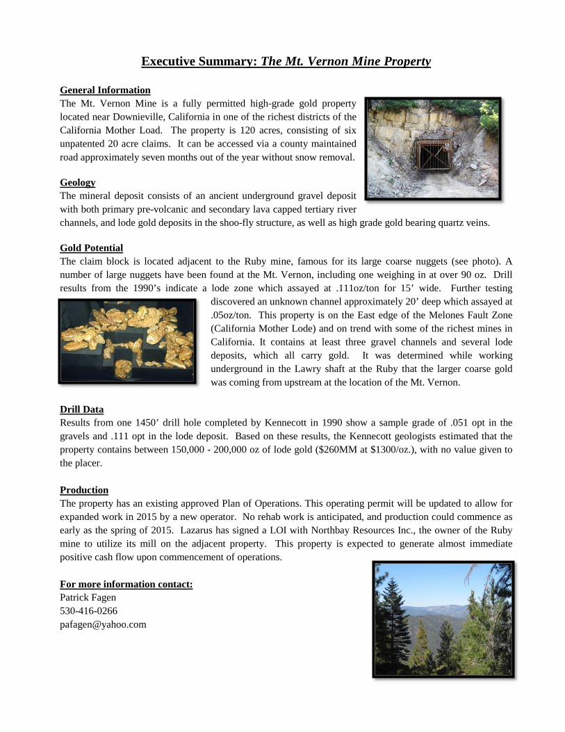
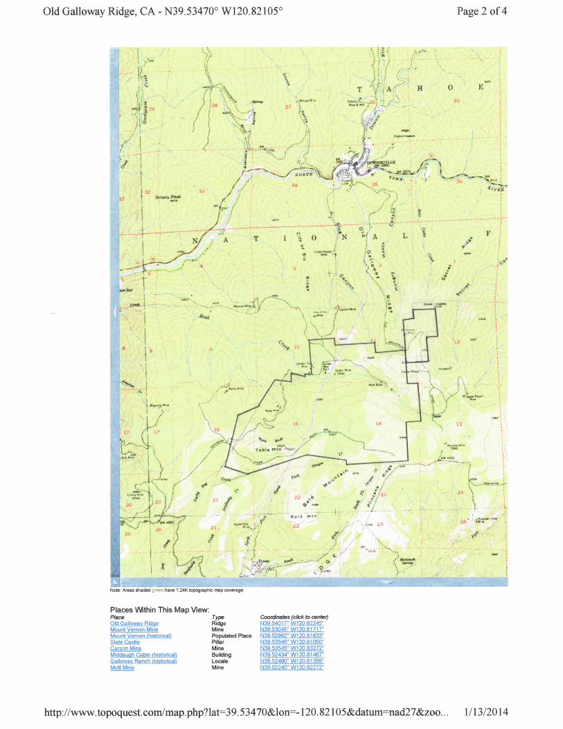
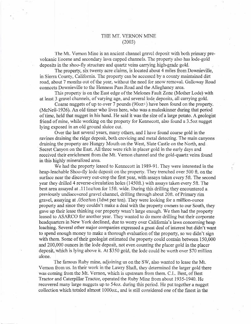
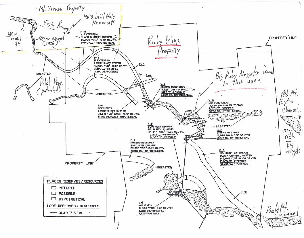
Executive Summary: The Mt. Vernon Mine Property General Information The Mt. Vernon Mine is a fully permitted high-grade gold property located near Downieville, California in one of the richest districts of the California Mother Load. The property is 120 acres, consisting of six unpatented 20 acre claims. It can be accessed via a county maintained road approximately seven months out of the year without snow removal. Geology The mineral deposit consists of an ancient underground gravel deposit with both primary pre-volcanic and secondary lava capped tertiary river channels, and lode gold deposits in the shoo-fly structure, as well as high grade gold bearing quartz veins. Gold Potential The claim block is located adjacent to the Ruby mine, famous for its large coarse nuggets (see photo). A number of large nuggets have been found at the Mt. Vernon, including one weighing in at over 90 oz. Drill results from the 1990’s indicate a lode zone which assayed at .111oz/ton for 15’ wide. Further testing
discovered an unknown channel approximately 20’ deep which assayed at .05oz/ton. This property is on the East edge of the Melones Fault Zone (California Mother Lode) and on trend with some of the richest mines in California. It contains at least three gravel channels and several lode deposits, which all carry gold. It was determined while working underground in the Lawry shaft at the Ruby that the larger coarse gold was coming from upstream at the location of the Mt. Vernon.
Drill Data Results from one 1450’ drill hole completed by Kennecott in 1990 show a sample grade of .051 opt in the gravels and .111 opt in the lode deposit. Based on these results, the Kennecott geologists estimated that the property contains between 150,000 - 200,000 oz of lode gold ($260MM at $1300/oz.), with no value given to the placer. Production The property has an existing approved Plan of Operations. This operating permit will be updated to allow for expanded work in 2015 by a new operator. No rehab work is anticipated, and production could commence as early as the spring of 2015. Lazarus has signed a LOI with Northbay Resources Inc., the owner of the Ruby mine to utilize its mill on the adjacent property. This property is expected to generate almost immediate positive cash flow upon commencement of operations. For more information contact: Patrick Fagen 530-416-0266 [email protected]
THE MT. VERNON MINE(2003)
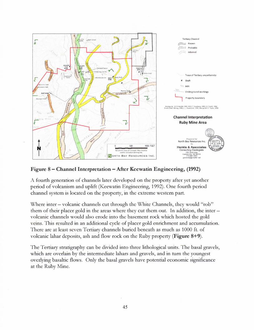
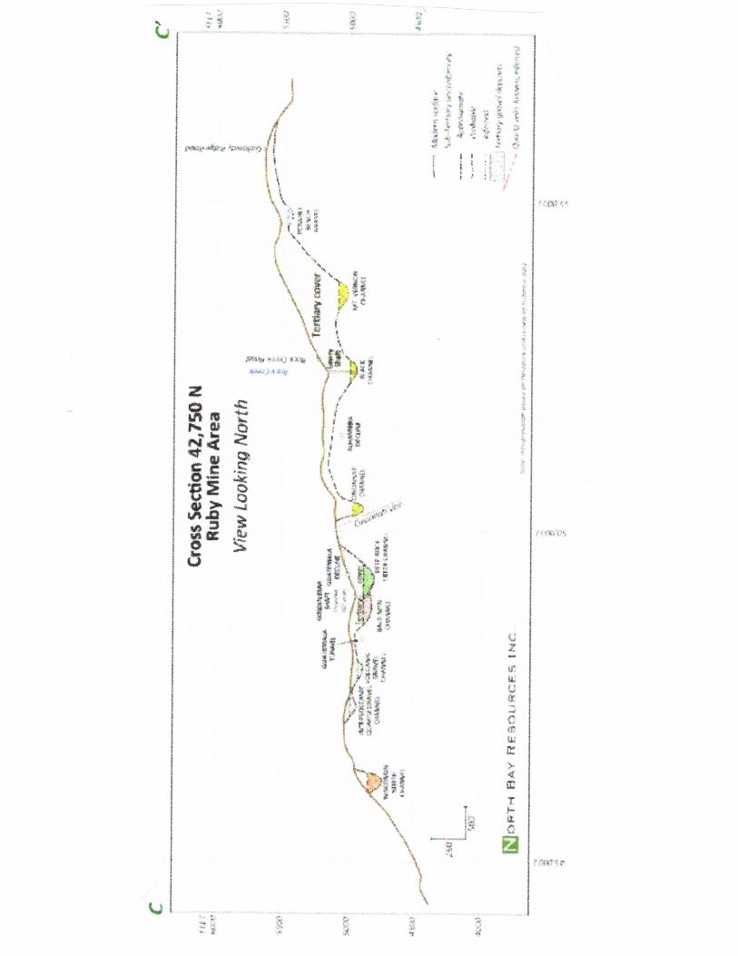
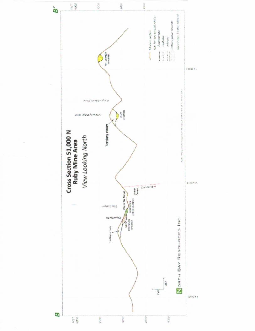
The Mt. Vernon Mine is an ancient channel gravel deposit with both primary pre-volcanic Eocene and secondary lava capped channels. The property also has lode-golddeposits in the shoo-fly structure and quartz veins carrying high-grade gold.
The property, six twenty acre claims, is located about 4 miles from Downieville,in Sierra County, California. The property can be accessed by a county maintained dirtroad, about 7 months out of the year, without the need for snow removaL Galloway Roadconnects Downieville to the Henness Pass Road and .the Alleghaney area.
This property is on the East edge of the Melones Fault Zone (Mother Lode) withat least 3 gravel channels, of varying age, and several lode, deposits, all carrying gold.
Coarse nuggets of up to over 7 pounds (900z+) have been found on the property.(McNeil-1926).. An old timer who lives here, who was a muleskinner .during that periodof time, held that nugget in his hand. He said it was the size ofa large potato. A geologistfriend of mine, while working on the property for Kennecott, also found a 3.50z nuggetlying exposed in an old ground sluice cut.
Over the last several years, many others, and I have found coarse gold in theravines draining the ridge deposit, both crevicing and metal detecting. The main canyonsdraining the property are Hungry Mouth on the West, Slate Castle on the North, and _
. Secret Canyon on the East. All three were rich in placer gold in the early days andreceived their enrichment fromthe Mt. Vernon channel and the gold-quartz veins foundin this highly mineralized area.
We had the property leased to Kennecott in 1989-91. They were interested in theheap-leachable Shoo-fly lode deposit on the property. They trenched over 500 ft. on thesurface near the discovery out-crop the first year, with assays taken every Sft. The secondyear they drilled 4 reverse-circulation holes (l4S0ft.) with assays taken every Sft. Thebest area assayed at .l l loz/ton for l.Sft. wide. During this drilling they encountered apreviously undiscovered gravel channel, drilling through about 20ft. of Primary rimgravel, assaying at .05ozlton (Ldwt per ton). They were looking for a million-ounceproperty and since they couldn't make a deal with the property owners to our South, theygave up their lease thinking our property wasn't large enough. We then had the propertyleased to ASARCO for another year. They wanted to do more drilling but their corporateheadquarters in New York declined, due to worry over California's Iaws.concerningheapleaching. Several other major companies expressed a great deal of interest but didn't wantto spend enough money to make a thorough evaluation of the property, so we didn't signwith them. Some of their geologist estimated the property could contain between lS0,000and 200,000 ounces in the lode deposit, not even counting the placer gold in the placerdeposit, which is lying above it. At $350 gold, the lode could be worth over $70 millionalone.
The famous Ruby mine, adjoining us on the SW, also wanted to lease the Mt.Vernon from us. In their work in the Lawry Shaft, they determined the larger gold therewas coming from the Mt. Vemon, which is upstream from them. CL, Best, of BestTractor and Caterpillar Tractor, operated the Ruby Mine from about 1935-1940. Herecovered many large nuggets up to 540z. during this period. He put together a nuggetcollection which totaled almost 1OOOoz.,and is still considered one ofthe Ernest in the
world. After his death, his wife sold the collection to Sierra Co. who still owns it and-hasit on loan to a southern Calif. Bank, which has it on display. In the early days, the Rubyproduced many thousands of ounces with one nugget weighing a whopping 17 pounds!The mine rewarded the lucky miner with a suit of clothes!
We turned down their lease offer when I discovered they were on the verge ofbankruptcy. Not long after that, their operating company, Brush Creek Mines, did gobroke, leaving many taxes and bills unpaid. So, we are glad we didn't do business withthem!
In 1999, we took in a new partner and filed a new Plan of Operationwith the USForest Service. It was approved after a six-month wait. We then bonded the mine andequipped it with more modem underground and surface support equipment.
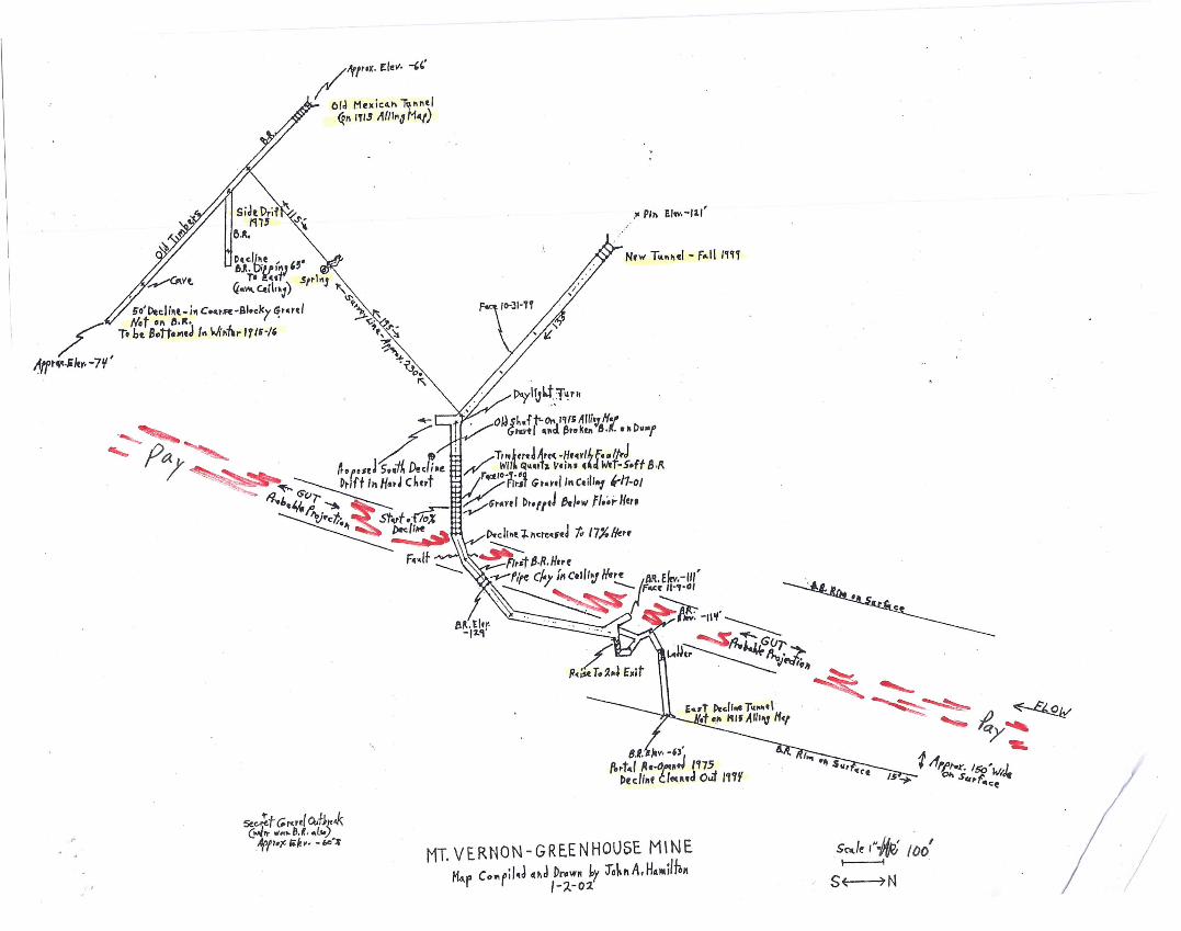
We put in about 300ft. of new spur road to a lower tunnel site where we put in anew portal in solid bedrock. All of the old tunnels on the North end of the channel-depositwere put in too high and became steep declines, which were abandoned before bottomingthe old river gut. Most of the first summer was spent waiting on the Forest Serviceapproval, which finally came on the first of August. By then we had installed our watertanks, water lines and booster pump, to put our spring water into a higher tank. Thiswater, about 4000 gals., is piped downhill to the new tunnel where we have about 65psifor underground drilling and fire protection. We built a 20x30ft. pole-bam to house the100KW gen-set, a 1000gal diesel storage tank with catch basin, and a stall to work on theLHD out of the weather. We also put an 8x8x20ft ship container adjoining.the building tolock-up tools, drills, etc. Beside that sits our 375c:frn compressor, which is connected tothe tunnel with 4 inch steel airline. We put in a 30hp axial vane mine blower at the portalwhich has a 7x8ft locking gate. That fall, after all the dead work, we still managed to putin about 140ft of tunnel through slate and hard chert bedrock, before we got.snowed outand had to winterize the mine.
That winter, my partner decided to go re-start his old business in the Bay Area.Since that time, I have extended the tunnel over 450ft further, working by myself (2002-:-2003) and tied into an old decline that I cleaned out in 1994, for a second exit and betterventilation. I found gold in this old decline with my metal detector while re-habilitatingit. I also found that the old timers quit before reaching the deepest gut, and they had onlydrifted about 20ft near the bottom.
I hit the gravel in the newtunnel a bit high also and had to decline a short distanceto cross the gut, where I also found gold with the detector sampling. Then I had to riseback up (about 15ft) to tie into the bottom of the old decline. Fortunately, the channel isdry and what little dripping I get from the large angular blocky gravel seeps out thefractured hard chert bedrock. The gravel is virgin in this area and is over 1500ft upstreamfrom where Kennecott drilled into the edge of it.
I have stockpiled several hundred yards of this gravel to run through a wash plantat a later date. I have found small nuggets (up to 3dwt) in it with my detector so I know itis carrying. This gravel is typical of a coarse gold channel where as it doesn't show muchfme gold when pan sampling but you can detect nuggets from it.
This season I worked mostly outside on the equipment maintenance, the roads,cleaning out the pond, and building the pads and access roads for a small wash plant. Ialso cleaned out another short steep decline that was caved and abandoned on the Northend near where the channel enters the ridge. Then I also found the entry point of the
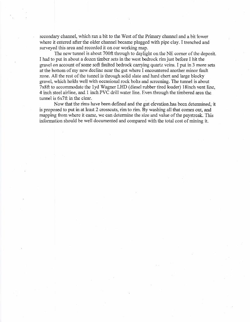
secondary channel, which ran a bit to the.West .of the Primary channel and a bitlowerwhere it entered after the older channel became plugged with pipe clay. I trenched andsurveyed this area and recorded it on our working map.
The new tunnel is about 700ft through to daylight on the NE corner of the deposit.I had to put in about a dozen timber sets in the west bedrock rim just before I hit thegravel on account of some soft faulted bedrock carrying quartz veins. I put in 3 more setsat the bottom of my newdecline near the gut where I encountered.anothe.r.minor faultzone. All the rest ofthe tunnel is through solid slate and hard chert and large blockygravel, which holds well with occasional rock bolts and screening. The tunnel is about7x8ft to accommodate the l yd Wagner LHD (diesel rubber tired loader) l Sinch vent line,4 inch steel airline, and. 1 inch PVC drill water line. Even-through the. timbere.d area thetunnel is 6x7ft in the clear. .
Now that the rims .have been defined and the gut elevation has been.determined; itis proposed to put in at least 2 crosscuts, rim to rim. By washing all that comes out, andmapping from where it came, we can determine the size and value of the paystreak. Thisinformation should be well documented and compared with the total cost of mining it.
~BIG BEND SHOOT13,929 TONS - 0.315 <lZ.1TOM1.6215QZ.-POSS!8LE
~~~~\:.L.--BREASTED
MAMAN CHUTE13,929 TONS - 0.3<5OZfTON4,8715 OZ.-HYPOTtIETICAL
- --
~SECOND BEND SHOOT
113,929TONS - 0.315 OZ.lTONk62!5 OZ.' POSSIBLE
,250 Oz. - HYPOTHETICAL
~OPEN ENDSLAWRY SHAFT SYST!:M33,333 YDS.!I (CUM.) - 0.164 OZ.fYD.15,467 OZ. (CUM.) - HYPOTETlCAL
f..:J.NORTHERN SEGMENTBALD MTN. CHANNEL153,333 vos.lI-0.20 QZ.IYD.1 7 0 - HYPOTHETICAL
PROPERTYLINE/
PLACER RESERVES IRESOURCES
o INFERREDo POSSIBLE
o HYPOTHETICAL
LODE RESERVES I RESOURCES
.•.•.. QUARTZ VEIN
Y:lWULFVEIN9,264 TONS-O.3!5 OZ.lTON1,62!S oz. - IMFERRED
, 1,6215- POSSIBLE
8'j R",'bv Al"f7€17 -f;"; '" 'th I~ 41( e ~
,-------
tlSOUTHERN !XTmSlON9LAC~ CHANNEL SYSTEM144,4~ YDS)l-O.I64 OZJYO10 933 OI. - "FEARED1f;7!56 oz. - POSSIBLE
PROPERTY LINE
so../~1~.JfJt100'I-----i
S~N I
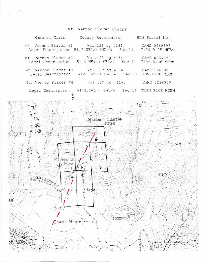
Mt. Vernon Placer ClaimsName of Claim County Recordation BLM Serial No.
Mt. Vernon Placer #1Legal Description
Vol.129 pg.4161E 1/2 .SE 1/4 .I'TE1/4 Sec. 11
CAMC 0269897T19N R10E MDBM
Mt. Vernon Placer #2Legal Description
Vol.129 pg.4164El/2 ,N"El/4,SE1/4 Sec. 11
CAMC 0269898T19N RIOE MDBM
Mt. Ver~on Placer #3Legal Description
Vol.129 pg.4166Wl/2,SW1/4,NW1/4 Sec.12
CAMC 0269899T19N R10E MDBM
Mt. Vernon Placer #4 Vol.129 pg. 4168 CAf-1C0269900
Legal Description Wl/2 ,Nwl/4, SW1/467
Sec.12 T19N RIOE MDBM
....... "'.~.·-'''''''''~''v .. :. . ,
. I ~~.-"-'_'">:::~~.~?".,--.....,.
.,.,- .....
. ~
•.«..,;t
I. 0 'F{<
_"1.<. ~ .;, .•• .-~ ••. ~ ..• ~. ". "-- ~.--.... " •
•~"9 \. '.,...; ~J '-'-~ .. -~ ~{
..•. ",'
". , - .:~ .•.. '..\\\ ..... >,. '-0"
.\ \,.
.3" ~::.:-~)/3,.',.;~~ ~ :.-"--"'~\., .:..;,.
..~.:~;.:.i\
,_.ii.if\,it \~j
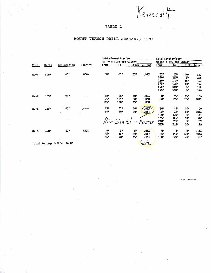
TABLE 1
MOUNT VERNON DRILL SUMMARY, 1990
Gold Mineralization Gold GeochemistryUsing a 0.02 opt Cutoff Using a 100 ppb Cutoff
!!2l!L Qsmh rnclinaticn Bearing Fn:III To Thiel::.Au opt Frail To Thiel:.Au g:O
MV·1 600' 60- II64W 30' 65' 35' .043 25' 165' 140' 527260' 265' 5' 2Z62&)' 345' 65' 163375' 405' 30' 152545' 550' .5' 104555' 560' 5' 144
KV·2 185' 90- 50' 60' 10' .094 0' 15' 15' 10675' 105' 30' .063 50' 185' 135' 1075
115' no' 15' .03aKV-3 365' 90- 45' 55' 10' CID 30' 40' 10' 109
60' 70' 10' 45' 75' 30' 1033/ 120' 125' 5' 111
R~ G0Ir-/(/135' 145' la' 342
- EOcrVlf. 210' 215' 5' 135315' 365' 50' 128
MV-4 300' 60- S73\l 0' 5' 5' .033 0' 5' 5' 113345' 85' 40' .067 45' 145' 100' 103a45' 60' 15' .111 lBO' 200' 20' 137
Total Footage Drilled 1450' We
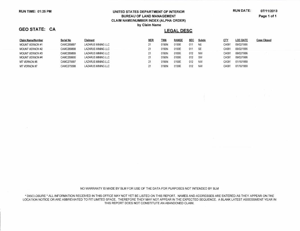
RUN TIME: 01:25 PM UNITED STATES DEPARTMENT OF INTERIOR RUN DATE: 07/11/2013BUREAU OF LAND MANAGEMENT Page 1 of 1
CLAIM NAME/NUMBER INDEX (ALPHA ORDER)
by Claim Name
GEO STATE: CA LEGAL DESC
Claim Name/Number Serial No Claimant MER TWN RANGE SEC Subdv CTY LOC DATE Case Closed
MOUNT VERNON #1 CAMC269897 LAZARUS MINING LLC 21 0190N 0100E 011 NE CA091 09102/1996
MOUNT VERNON #2 CAMC269898 LAZARUS MINING LLC 21 0190N 0100E 011 SE CA091 09/02/1996
MOUNT VERNON #3 CAMC269899 LAZARUS MINING LLC 21 0190N 0100E 012 NW CA091 09102/1996MOUNT VERNON #4 CAMC269900 LAZARUS MINING LLC 21 0190N 0100E 012 SW CA091 09102/1996
MT VERNON #6 CAMC275597 LAZARUS MINING LLC 21 0190N 0100E 012 NW CA091 01/10/1999
MTVERNON#7 CAMC275598 LAZARUS MINING LLC 21 0190N 0100E 012 NW CA091 01/10/1999
NO WARRANTY IS MADE BY BLM FOR USE OF THE DATA FOR PURPOSES NOT INTENDED BY BLM
* DISCLOSURE * ALL INFORMATION RECEIVED IN THIS OFFICE MAY NOT YET BE LISTED ON THIS REPORT. NAMES AND ADDRESSES ARE ENTERED AS THEY APPEAR ON THELOCATION NOTICE OR ARE ABBREVIATED TO FIT LIMITED SPACE. THEREFORE THEY MAY NOT APPEAR IN THE EXPECTED SEQUENCE. A BLANK LATEST ASSESSMENT YEAR IN
THIS REPORT DOES NOT CONSTITUTE AN ABANDONED CLAIM.