evidences of multiple phases of basin inversion in narmada ...spgindia.org/2008/368.pdf · p - 368...
TRANSCRIPT
P - 368
Evidences of Multiple Phases of Basin Inversion in Narmada Block, South Cambay Basin, Gujarat, India
Rajeev Mohan* 1, S. N. Tiwari 2, Sanjive Mayor 21. A & AA Basin, Oil & Natural Gas Corporation Ltd , Jorhat, [email protected]
2. KDMIPE, Oil & Natural Gas Corporation Ltd., Dehardun
Summary
The present study discusses the evidences on seismic of more than one phase of Inversion in Cambay basin. Reactivation of border fault systems resulted into reactivated structures in different time during rift evolution, which culminated with the evolution of inversion structures in recent age. Unlike the prevailing view of single phase of basin inversion, compelling evidences on seismic suggest at least a two phase structural inversion i.e. 1st phase of inversion at the end of Paleocene i.e. deposition of Olpad Formation and the 2nd phase during Mio-Pliocene age. Though workers in the past also have modeled this theory but Miocene inversion was given more importance. Now, when easy to find hydrocarbon is getting difficult day by day, a need is felt to restart the thought process of exploring the older phase of inversion in the basin again by using the latest exploration tools. The study discusses the interplay of rift architecture and sedimentation and subsequent rift inversion in the South Cambay Basin. Three tectono-sedimentary stages have been recognized viz. Rift, Post-rift Sag and Inversion. The first sequence of syn-rift sedimentation which occurred concomitant with the extrusion of the Deccan volcanics was dominated by the deposition of Olpad Formation into the evolving half-grabens. Subsequently rift sag developed during a period of relative tectonic quiescence and filled with the widespread shallow marine sediments of Cambay Shale Formation deposited uniformly over a broad trough in late Early Eocene to Mid-Eocene times which reflects the transition from syn-rift to post-rift sedimentation. The base of Eocene unconformity represents the breakup unconformity in the Cambay Basin.
Evidence of strong folding, uplift and erosion has been noticed below the breakup unconformity marks an older phase of rift inversion, which has resulted favorable traps like folds, low angle faults, unconformities and pinch outs in this area. Further, these traps are overlain by and at places juxtaposed with the Cambay shale (known source rock), which forms a regional cap. These are good exploration target for deeper Olpad plays in Olpad and Ankleswar-Kosamba area.
Introduction
Cambay basin - a pericratonic aborted rift formed during the late Cretaceous time by reactivation of basement fracture systems in the southwestern part of the Aravalli Range (Biswas et al.,1993) is situated in the western part of the Indian subcontinent in the state of Gujarat (Fig. 1). Thebasin covers an area of about 56,000 Sq km between
71°30’ to 73°30’E longitudes and 21°00’ to 25°00’N latitudes. The present study deals with Narmada Block in South Cambay basin, which is defined in the North by Mahisagar River, in the west by Gulf of Cambay and in the south by Tapti River. The study is limited to the Narmada–Tapti Block bordered by Narmada River in north and Tapti River in south.

Three major aspects has been examined, (1) the structural architecture of South Cambay basin, (2) subdivide the sedimentary fill into tectono-stratigraphic packages and (3) the interplay of tectonics and sedimentation, in controlling the large-scale stratigraphy of the basin; that record continental rifting, formation of Sag basin, and basin inversion.
Regional Geology : An Overview
Generalized Stratigraphy column of Narmada Block is shown in Fig. 2. Deccan basalts of Upper Cretaceous to Lower Paleocene age forms the technical basement and is overlain unconformably by Trap-wash, Trap conglomerate, claystones and siltstones of Olpad Formation deposited in continental to lacustrine setting.
The overlying Cambay Shale Formation marks the first major marine transgression in the basin during Early-Middle Eocene. The Formation is subdivided into two members i.e. Older Cambay Shale and Younger Cambay Shale separated by an unconformity. The unconformably overlying Ankleshwar Formation was deposited in shallow marine deltaic environment and is overlain by sediments of Dadhar Formation. The Early Oligocene is followed by a hiatus due to complete withdrawal of the sea from the basin. The Neogene section is represented by marine to fluvio-deltaic interbedded shale and sandstone and it includes the Miocene Tarkeshwar, Babaguru, Kand and Jhagadia formations. Broach and Jambusar formations consisting of claystone and sandstone represent the Pliocene-Pleistocene sedimentary rocks. Recent alluvium covers the entire basinal area except the outcrops along the eastern margin.
Geodynamics of Cambay Aborted-rift Basin
Cambay basin owes its origin to the rifting and drifting of the Indian plate from the Madagascar marked by outpouring of huge Deccan basalt during Late Cretaceous time. The rifting subsequently failed and evolved as a post-rift interior basin (Aborted Rift) synchronous with the
Figure 1: Index Map of Cambay Basin and adjoining area. Figure 2: Generalised Stratigraphy of Cambay Basin.

evolution of the Arabian Sea. During Cretaceous phase of widespread crustal tension, the crust around Cambay and Narmada rifted. Located over rising columns of hot mantle, these rifts ('failed arms') never became oceans. However, reactivation of border fault systems resulted into reactivated structures in different time during rift evolution. Compressions originating in the Indo-Eurasian plate collision that produced the Himalayan orogeny provided the far field stresses responsible for inversion and erosion of rift basin contents in different time.
Structural Style
Cambay basin, like many other continental rifts, displays large-scale structural domains strongly controlled by pre-existing basement fabrics of Aravalli and Delhi trends. Preexisting basement structures i.e. Precambrian, NNW-SSE Dharwarian and NE-SW Satpura trends played a critical role in rift architecture and the subsequent evolution in space and time. The structures are mostly controlled by major faults defining the rift boundary or large horst blocks within the rift. Cross-faults, transfer/accommodation zones subdivide the basin into five tectonic blocks (Fig. 1), i) Sanchor – Patan ii) Mehsana – Ahmedabad iii) Tarapur – Cambay iv) Broach – Jambusar and v) Narmada–Tapti Blocks
Reactivation of border fault systems resulted into reactivated structures in different time during rift evolution, which culminated with the evolution of inversion structures in recent age. Unlike the prevailing view of single phase of basin inversion, compelling evidences on seismic suggest atleast a two phase structural inversion i.e. 1st phase of inversion at the end of Paleocene (deposition of Olpad Formation) and the 2nd phase during Mio-Pliocene age. This aspect and its relevance to hydrocarbon accumulation in the study area is discussed at the later part of this paper.
Methodology
The present study is based on the integration of various surface and subsurface data of South Cambay basin. An attempt on the analysis and synthesis of regional reflection seismic lines and drilled well data has been made to develop a regionally consistent sequence stratigraphic framework for the South Cambay basin. Following a review of the sedimentology and stratigraphy of rift basins in general, the magmatism and structural evolution of the Cambay rift is reviewed. Well-log sequence analysis following Van Wagoner (1990), and seismic stratigraphic analysis coupled with the biostratigraphic studies has been attempted and finally integrated to define various orders of depositional sequences. In doing so, attempt has been made to recognize, correlate and map key stratal surfaces defined by important and abrupt facies shifts and by characteristic
onlap, downlap and truncated termination of beds. Various subsurface maps have been generated and used in deciphering the regional depositional pattern and reconstructing the paleogeography of the region. (Mohan et.al., 2004)
Data Used
DMO stack sections of approximately 2000 line km of 2D seismic data of different vintages have been considered. Well log correlation using around 40 deep wells has been attempted on a grid pattern. Mainly SP and Resistivity logs of these wells are used. Seismic sections have been calibrated using VSP/TD data of 15 wells. Since inversion on seismic is discussed here, the log correlation is not discussed. Interpretation and Discussions
Three tectono-sedimentary stages i.e. Syn-rift, Post-rift Sag and Inversion with their associated system tracts have been recognized. Synrift fill mostly corresponds to Olpad Formation that fill the half grabens. The other two mega-sequences represent the post-rift sag basin fill. (Naik et. al 2004).
Rift phase is tectonically active, with normal faulting, crustal thinning, volcanism, high heat flow and locally high rates of subsidence and sediment accumulation. Drift phase (post-rift) - dominated by lithospheric cooling, thermal subsidence, and development of broad flexural basins dominated by sediment loading (e.g. continental embankments. Post-rift basins (as opposed to syn-rift) are formed mainly from subsidence resulting from thermal relaxation.
In the present study, Deccan Trap volcanic activity has been perceived as the result of the rifting rather than the cause of it. Like many other rift basins, this huge volcanic activity took place little before the culminating phase of rift episode. Sedimentation that follows this episode till the first marine incursion during Early-Mid Eocene time logically marks the syn-rift phase. The angular unconformity on the top of Synrift sequence (Olpad Formation) separates two distinct tectonic units above and below. Tectonically, it corresponds to the transition unconformity in a rift basin which is coeval to the break-up unconformity in the adjacent West-coast passive margin of India. The cessation of rifting was marked by the generation of a late Paleocene angular unconformity andthe onset of seafloor spreading along Carlsberg Ridge in Arabian Sea. The lower Cambay Shale unit overlying and onlapping onto this transition unconformity, shows close resemblance to the overlying sedimentary units than to the Olpad Formation.
Major normal faults have been identified throughout the Narmada Block. All these major faults are half-graben bounding first generation normal faults probably existed as listric growth faults. These faults accommodate significant thickness variations and displacement along these faults produced lateral thickness variations of syn-rift stratigraphy and resulted in wedge shaped stratal geometries in the fault hanging walls. The earliest period of normal fault movement occurred during the deposition of the lower Olpad Formation conglomerates. Fault movement continued during the deposition of the other units of the Olpad Formation.
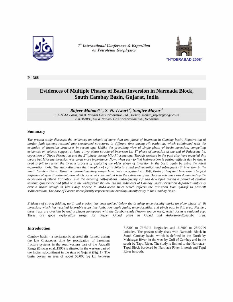
Accordingly, three major half-grabens viz. Olpad in the west, Sayan in the east and Kosamba-Ankleswar half-graben in the north have been identified and mapped in Narmada block in South Cambay basin (Fig.3).
The Olpad and Sayan half-grabens are relatively narrow, elongated and bounded by the main rift border fault to the east and west with corresponding gently sloping flexural margin in the west and east respectively. These half-grabens are separated by elevated areas related to a high relief accommodation zone. During this time the half grabens formed distinct sub-basins and were somewhat isolated from each other by basement highs, as evidenced by sediments lapping onto and thinning over these highs. These were isolated sub-regional-scale half-grabens that
were not connected during the initial stage of rifting, but rather shared similar patterns of sedimentation. The syn-rift sequence therefore, displays variable facies and is highly asymmetrical, tapering along the strike towards the far end of the border fault. Thickness of these sediments is highly variable. The thermal subsidence following Deccan Trap volcanism might have produced the required accommodation space. Based on the tectonic history, the sedimentation in Cambay basin can be subdivided into four (i) Syn-rift stage (extensional), ii) Rift inversion (compressional) (iii) Post rift – sag basin stage (thermal subsidence) and (iv) Post rift structural inversion stage.
Seismic profiles show that a thick sequence of sediments of Olpad Formation filled the Kosamba-Ankleswar, Olpad and Sayan half grabens during Paleocene and Early Eocene. The major drainage in the Kosamba-Ankleswar and Sayan half grabens were flowing southwestward toward the active and subsiding rifts from the flexural margin in the northeast/east. On the other hand, the Olpad half-graben is bounded by the main rift border fault to the east with corresponding gently sloping flexural margin in the west. Therefore, sediment input to this half graben is expected either from west or northeast or both.
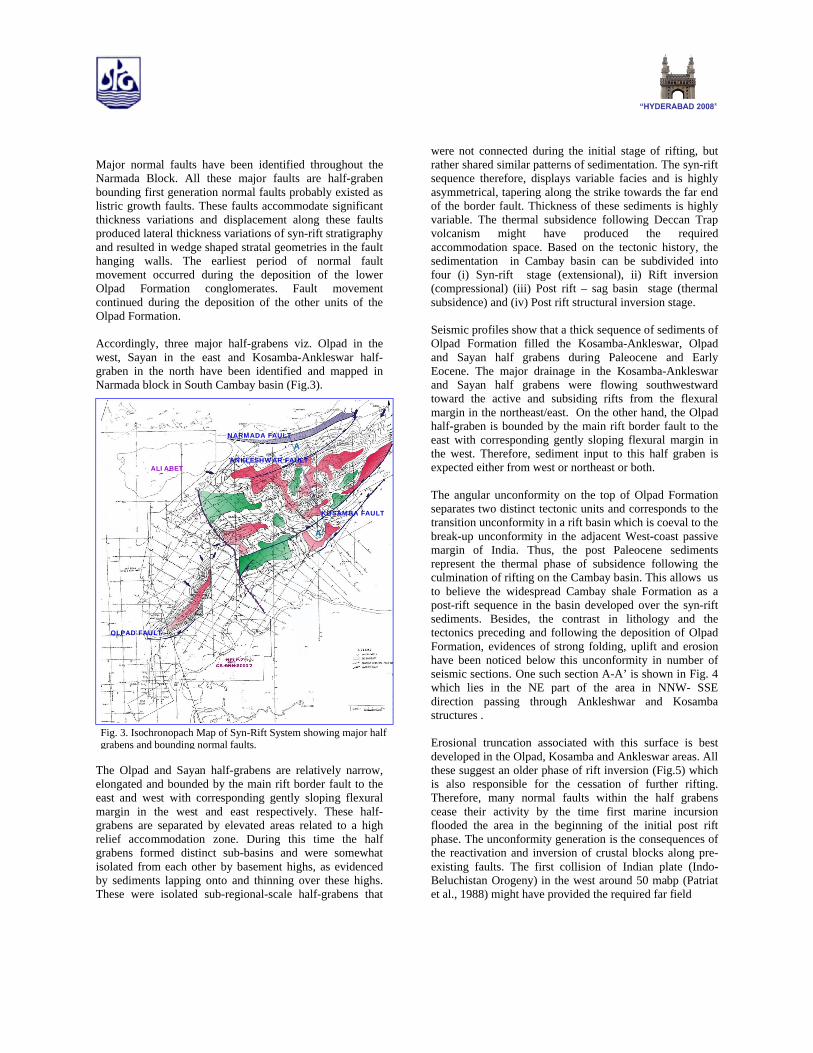
The angular unconformity on the top of Olpad Formation separates two distinct tectonic units and corresponds to the transition unconformity in a rift basin which is coeval to the break-up unconformity in the adjacent West-coast passive margin of India. Thus, the post Paleocene sediments represent the thermal phase of subsidence following the culmination of rifting on the Cambay basin. This allows us to believe the widespread Cambay shale Formation as a post-rift sequence in the basin developed over the syn-rift sediments. Besides, the contrast in lithology and the tectonics preceding and following the deposition of Olpad Formation, evidences of strong folding, uplift and erosion have been noticed below this unconformity in number of seismic sections. One such section A-A’ is shown in Fig. 4 which lies in the NE part of the area in NNW- SSE direction passing through Ankleshwar and Kosamba structures .
Erosional truncation associated with this surface is best developed in the Olpad, Kosamba and Ankleswar areas. All these suggest an older phase of rift inversion (Fig.5) which is also responsible for the cessation of further rifting. Therefore, many normal faults within the half grabens cease their activity by the time first marine incursion flooded the area in the beginning of the initial post rift phase. The unconformity generation is the consequences of the reactivation and inversion of crustal blocks along pre-existing faults. The first collision of Indian plate (Indo-Beluchistan Orogeny) in the west around 50 mabp (Patriat et al., 1988) might have provided the required far field
Fig. 3. Isochronopach Map of Syn-Rift System showing major half grabens and bounding normal faults.
ANKLESHWAR FAULT
NARMADA FAULT
KOSAMBA FAULT
OLPAD FAULT
ALIABET
A
A’
stress for this rift inversion. The upper part of the succession appears to be regional in extent and was likely laid down during a period of relative tectonic quiescence consistent with cooling subsidence (Sag basin phase -the result of 'postrift' subsidence).
The geometry of the rift event influenced the pattern of post-rift sedimentation, and determined the location and deformation style of structures formed during subsequent basin inversion.
In short, the rift phase is widespread but aerially restricted to half grabens where as the post-rift sag basin is essentially an unfaulted syncline that forms as the final effect of the rift tectonics. Sedimentary unit of the post-rift phase is thick and has greater lateral extent perhaps because of the existence of a broad marine basin during postrift thermal subsidence. Many normal faults within the half grabens terminate upward into the postrift phase.
Basin Inversion and Deformation
The simple structural architecture of rift basin may get complicated by basin inversion, in which a contractional
NNW SSE
ANKLESHWAR STRUCTURE(Post Rift Inversion)
KOSAMBA STRUCTURE (Post-Rift Inversion)
SYN-RIFT SEQUENCE
POST-RIFT SEQUENCE
Breakup UnconformityRIFT INVERSION
UNINTERPRETED
INTERPRETED
A
A’
Fig. 4. Uninterpreted and Interpreted seismic section A-A’ depicting two phases of Inversion (Rift and Post Rift). Besides the known Post Rift inversion, evidence of Rift inversion is seen as folds and top truncation below Breakup unconformity.
NNW LINE A-A’
ERODED PART
BREAKUP UNCONFORMITYANTICLINE
STEEP DIP
ANKLESHWAR STRUCTURE
KOSAMBA STRUCTURE
SSE
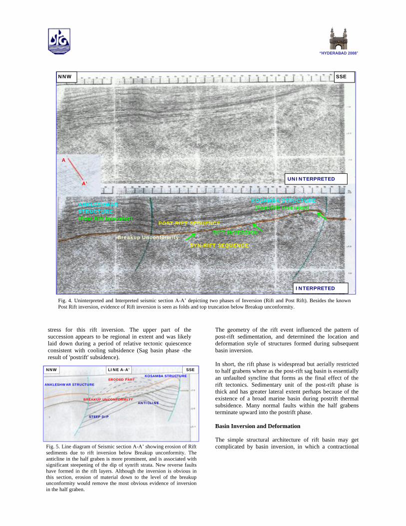
Fig. 5. Line diagram of Seismic section A-A’ showing erosion of Rift sediments due to rift inversion below Breakup unconformity. The anticline in the half graben is more prominent, and is associated with significant steepening of the dip of synrift strata. New reverse faults have formed in the rift layers. Although the inversion is obvious in this section, erosion of material down to the level of the breakup unconformity would remove the most obvious evidence of inversion in the half graben.
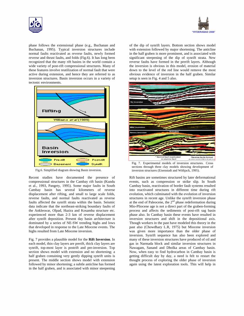
phase follows the extensional phase (e.g., Buchanan and Buchanan, 1995). Typical inversion structures include normal faults reactivated as reverse faults, newly formed reverse and thrust faults, and folds (Fig.6). It has long been recognized that the many rift basins in the world contain a wide variety of post-rift compressional structures. Many of these features involve reutilization of normal fault that were active during extension, and hence they are referred to as inversion structures. Basin inversion occurs in a variety of tectonic environments.
Recent studies have documented the presence of compressional structures in the Cambay rift basin (Kundu et al., 1993, Pangety, 1995). Some major faults in South Cambay basin has several kilometers of reverse displacement after rifting, and small to large scale folds, reverse faults, and normal faults reactivated as reverse faults affected the synrift strata within the basin. Seismic data indicate that the northeast-striking boundary faults of the Ankleswar, Olpad, Hazira and Kosamba structure etc. experienced more than 2-3 km of reverse displacement after synrift deposition. Present day basin architecture is dominated by a series of NE-SW trending highs and lows that developed in response to the Late Miocene events. The highs resulted from Late Miocene inversion.
Fig. 7 provides a plausible model for the Rift Inversion. In each model, thin clay layers are prerift, thick clay layers are synrift, top-most layer is postrift and pre-inversion. Top section shows model with extension and no shortening; a half graben containing very gently dipping synrift units is present. The middle section shows model with extension followed by minor shortening; a subtle anticline has formed in the half graben, and is associated with minor steepening
of the dip of synrift layers. Bottom section shows model with extension followed by major shortening. The anticline in the half graben is more prominent, and is associated with significant steepening of the dip of synrift strata. New reverse faults have formed in the prerift layers. Although the inversion is obvious in this model, erosion of material down to the level of the red line would remove the most obvious evidence of inversion in the half graben. Similar setup is seen in Fig. 4 and 5 also.
Rift basins are sometimes structured by later deformational events, such as compression or strike slip. In South Cambay basin, reactivation of border fault systems resulted into reactivated structures in different time during rift evolution, which culminated with the evolution of inversion structures in recent age. Unlike the synrift inversion phase at the end of Paleocene, the 2nd phase redeformation during Mio-Pliocene age is not a direct part of the graben-forming process and affects the sediments of post-rift sag basin phase also. In Cambay basin these events have resulted in inversion structures and shift in the depositional axis. Though workers in the past have modeled this theory in the past also (Chowdhary L.R, 1975) but Miocene inversion was given more importance than the older phase of inversion. Synrift sequence has also been explored and many of these inversion structures have produced of oil and gas in Narmada block and similar inversion structures in Nawagam, Sanand and Dholka areas of Cambay basin. Now, when easy to find hydrocarbon in Cambay basin is getting difficult day by day, a need is felt to restart the thought process of exploring the older phase of inversion again using the latest exploration tools. This will help in
Fig.6. Simplified diagram showing Basin inversion.
Fig. 7. Experimental models of inversion structures. Cross sections through three clay models showing development of inversion structures (Eisenstadt and Withjack, 1995).
deciphering the structure in a much better way and help in rejuvenated exploration for such inversion structures.
Conclusions
Stratigraphic successions spanning all stages from pre-rift, syn-rift to post-rift sag through the rift to drift transition are well preserved in South Cambay Basin.
Reactivation of border fault systems resulted into reactivated structures in different time during rift evolution. Compression (or transpression) had an important role in developing the basin's present form.
The Late Cretaceous to Early Paleocene Olpad Formation represents the syn-rift sequence deposited in fluvial to lacustrine setting.
The angular unconformity on the top of Olpad Formation separating the post-rift units above represents the transition/break-up unconformity.
Evidence of strong folding, uplift and erosion noticed below breakup unconformity indicating an older phase of rift inversion that resulted into favorable traps like folds, low angle faults, unconformities and pinch outsin this area. These are good exploration target for deeper Olpad plays in Olpad and Ankleswar-Kosamba area and elsewhere in similar structures in Cambay Basin.
References
Biswas, S.K., Bhasin, A.L. and Jokhan Ram, 1993, Classification of Indian sedimentary basins in the framework of plate tectonics, in Biswas et al., eds., Proceedings Second Seminar on Petroliferous basins of India., V-1, p. 1-46.
Buchan,J.G., and Buchanan, P.G., eds., 1995. Basin Inversion: Geological Society of London Special Publication 88, 596p.
Chowdhary. L.R., 1975, Reversal of Basement- Block Motions, India and its importance in Petroleum Exploration. AAPG Bulletin V.59 No. 1 (January 1975). p.85-96.
Eisenstadt, G., and Withjack, M.O., 1995, Estimating inversion results from clay models, in Buchan,J.G., and Buchanan, P.G., eds., 1995. Basin Inversion: Geological Society of London Special Publication 88,p.119-136.
Kundu, J. and Wani, M.R. (1992), Structural style and tectono-stratigraphic framework of Cambay rift basin, Western India: Indian Journal of Petroleum Geology, Vol. I, No.2, pp 181-202.
Mohan Rajeev, Naik G.C., and Tiwari S.N.(2004)Sequence Stratigraphic Analysis of Paleocene to Early Miocene Sediments in Narmada Block, South Cambay Basin and adjoining Off-shore area. 2nd APG Conference Khajurao, India.
Naik G.C, Mohan Rajeev and Tiwari S.N. (2003), Tectono-Sedimentation model of Narmada Block including offshore- An Integrated Study. Unpublished KDMIPE, ONGC report.
Naik G.C, Mohan Rajeev and Tiwari S.N. (2004) Rift Architecture and its control on Syn-rift Sedimentation in Narmada Block, South Cambay Basin. 2nd APG Conference, Khajurao, India.
Pandey, J., Singh, N.P., Krishna, B.R., Sharma, D.D., Parakh, A.K. and Nath, S.S. (1993), Lithostratigraphy of Cambay basin: Document III, KDMIPE publication, ONGC, Dehradun.
Acknowledgements
The authors express their sincere thanks to the ONGC authority for providing infrastructure support, facilities and data for carrying out the above study and according permission to present the paper. The authors are also thankful to Sh. R.T Arasu, DGM (GP), A & AA Basin, ONGC, Jorhat for his guidance and invaluable suggestions during the preparation of this paper.
The views expressed in the paper are solely the authors and not necessarily of the organization in which they are working.