european marine aggregates resources: origins, usage, prospecting … · european marine aggregates...
TRANSCRIPT
Journal of Coastal Research SI 51 1-14 West Palm Beach, Florida Summer 2010
European marine aggregates resources: Origins, usage, prospecting and dredging techniques Adonis F.Velegrakis1*, Arnaud Ballay2, Serafim Poulos2, Rolandas Radzevicius1,**, Valerie Bellec1,3*** and Faustino Manso4****
INTRODUCTION
In recent years, the importance of marine aggregates (sand and gravel) as a mineral resource has increased in the EU, due both to increasing demand and stricter regulations concerning land-won aggregates in the Member States (e.g. Jewell, 1996; Phua et al., 2004). In the last 20 years, more than 50 million m3 of sand and gravel have been extracted annually (on aver-age) from the northern European continental shelf alone and the production may increase further to supply the material needed for the construction of the planned projects of coastal
1 University of the Aegean, School of Environment,Department of Marine Sciences, University Hill, Mytilene 81100, [email protected]
2 Department of Geography and Climatology Faculty of Geology and Geoenvironment National and Kapodistrian University of Athens Panepistimioupolis, Zografou 15784 Athens, Greece
3 Ghent University Renard Centre of Marine Geology, Krijgslaan 281, s. 8, 9000 Gent, Belgium
4 Christian-Albrechts-University Kiel, Institute of Geosciences,Olshausenstrasse 40, 24118 Kiel, Germany
* corresponding author [email protected]
** Present address: Department of Marine Research, Institute of Geology and Geography, Ševcenkos str. 13,03223 Vilnius, Lithuania
*** Present address: Geological Survey of NorwayLeiv Eirikssons vei 39 7040 Trondheim, Norway
**** Present address: Fugro-Geoteam AS Address Hoffsveien 1C Zip N-0213 (Norway)00126 Rome (Italy)
infrastructure (Phua et al., 2004; Seaman, 2006; http://www.dredging-in-germany.de) and the replenishment of the erod-ing European beaches (euroSion, 2003; humPhreyS et al., 1996; iceS, 2006; Selby and oomS, 1996). Marine aggregates are of particular importance in the coastal states of northwestern Europe, with the UK, the Netherlands and Denmark collec-tively producing more than 80% of the European marine ag-gregate production (e.g. iceS, 2005; iceS, 2006).
Marine aggregates (MA) are non-metallic sediment depos-its, consisting of sands, gravels and shells/shell debris, which have been formed as a result of either contemporary (modern) or past sedimentary/hydrodynamic processes (relict deposits). Two different classification schemes are in place concerning the size of marine sand and gravels. Geologists use the Folk (1980)
ABSTRACT
Marine aggregates (sand and gravel) are important mineral resources and traded commodities. Their significance is bound to increase further, due to increasing coastal zone development, stricter environmental regulation concerning land-won aggregates and increasing demand for beach replenishment material. Marine aggregate (MA) deposits can be differentiated into relict and modern deposits. The former consist of sedimentary material deposited in the past and under different environmental and sedimentary regimes than those existing presently (e.g. the gravel/sand deposits of the Pleistocene buried river valleys of the northwestern European shelves). The latter are deposits, which have been formed and controlled by the modern hydro-and sediment dynamic conditions (e.g. the linear sand banks of the southern North Sea). The present contribution reviews the current state of affairs in 9 representative European Member States concerning the prospecting and extraction (dredging) techniques as well as the levels of production and usage. The review has shown a mixed record as, in some of the studied States, marine aggregate production is an important and streamlined activity, whereas other States have not yet developed efficient marine aggregate policies and industries. It has also shown that although attempts have been lately made to coordinate the field, the industry still faces problems, which hinder its sustainable development. These include (amongst others): lack of standardisation of the relevant information, difficulties in the access to information, non-coherent regulatory regimes and limited collaboration/coordination between the marine scientific research establishments and the marine aggregate industry. These issues should be addressed as quickly as possible in order to exploit effectively this important mineral resource.
ADDITIONAL INDEX WORDS: Marine aggregates, dredging, offshore mineral resources, relict sediments, buried palaeovalleys, mineral resource prospecting.
DOI: 10.2112 / SI51-002.1 received 23 February 2007; accepted in revision 5 October 2007.
2 Velegrakis, et al.
Journal of Coastal Research, Special Issue No. 51, 2010
grain-size classification, according to which sediments consist-ing of particles with sizes ranging between 0.063 and 2 mm are classified as sands and with sizes greater than 2 mm as gravels. In comparison, the MA industry classifies sediments consisting of particles with diameters ranging between 0.063 and 4 (or 5) mm as sands, and sediments with particle-sizes greater than 4 (or 5) mm as gravels. In the present contribution, the second classification is used, as most of the available data on supply and demand follow the MA industry’s classification.
The nature/texture of marine aggregates is generally simi-lar to land-won aggregates (Gubbay, 2005; harriSon, 2003). However, there are also differences, as marine aggregates are generally less ‘contaminated’ by fine-grained material (silts and clays) and have higher concentrations of undesir-able salts (NaCl) and biogenic material (shells/shell debris). In addition, siliciclastic marine aggregates consist generally of “harder” material than land-won aggregates, as they have been subjected to rigorous abrasion in the energetic coastal and inner shelf marine environments (e.g. PettiJohn, Potter, and Siever, 1972).
The composition of the MA deposits varies, depending on the original sediment source. For example, flint forms the greater part of the gravel deposits of the eastern English Channel and those offshore of the Riugen Island (Germany), being the product of erosion of the flint bands of the extensive Cretaceous Chalk outcrops found in these areas (kennedy and GarriSon, 1975). In comparison, marine aggregates found off-shore of the Humber Estuary (UK sector of the North Sea) have more variable composition, reflecting their glacial origin (Gubbay, 2005).
The aim of this contribution is to review the MA uses, ori-gin, demand/supply and exploitation (prospecting/dredging) techniques in (9) coastal EU Member States (Belgium, France, Germany, the UK, the Netherlands, Poland, Spain, Denmark and Greece), representing the different European coastal ar-eas (i.e. the Atlantic, Baltic and Mediterranean coasts).
USE OF THE MARINE AGGREGATES
Marine aggregates are used (bmaPa, 2004, 2005; ceda, 1993): in concrete and mortar manufacture; as ingredients of asphalt and coated products; for block making; as drainage and capping material and in other fill-related uses; and as beach replenishment material. In sandy beach replenishment schemes (dean, 2002), material specifications (apart from project-specific grain-size requirements) are relatively simple, as the mineralogy of the material is not, generally, a signifi-cant concern. Nevertheless, replenishment material must be clean and not containing fresh biogenic material and/or con-taminants such as chemical pollutants; for example, sediments from some areas of the Bristol Channel (UK) cannot be used as beach replenishment material, as they are characterised by large concentrations (exceeding in some cases 40% of the sediment weight) of waste coal (hamilton et al., 1979; veleG-rakiS et al., 1996). Sand used in construction must comply with certain standards (de vree, 2003) regarding, for instance, its chloride content (Table 1.).
Table 1. Chloride content limits (according to BS 882, App. C, Table 7.) in marine aggregates.
Concrete TypeChloride Content
(% weight)Pre-stressed concrete, heat-cured concrete with embedded metal 0.01
Concrete with embedded metal made with cement BS4027 0.03
Concrete with embedded metal made with cement BS12, BS146,DS1370, BS4246, BS 6588, BS6610, or combinations with ground granulated blastfurnace slag or pulverised-fuel ash
0.05
Other concrete no requirement
Marine gravels are also used for beach replenishment and in the construction industry. With regard to their use in the construction industry, although gravel-sized aggregates form an essential ingredient of certain concretes (see Table 2. for shell content requirements) and asphalt products, they can be replaced by good quality crushed-rock aggregates. In contrast, marine gravels are vital resources for certain beach replenish-ment schemes, due to their grain-size and (generally) rounded shape (e.g. arthurton, 1997; bateS et al., 1997).
Table 2. Shell content limits (according to BS 882 1992, Table 1.)
in marine aggregates.
Grain Size/Type Shell content(% weight)
Material with size less than 5 mm (sand) no requirement
Shingle size up to 10 mm, graded or all-in aggregate (> 5 mm and < 10 mm) 20
Shingle sizes, graded and all-in aggregate (> 10 mm) 8
ORIGINS OF THE MA DEPOSITS
Exploitable MA deposits have been mostly formed in the Quaternary. On the basis of their formation period, they may be differentiated into relict and modern sedimentary bodies (e.g. mcmanuS, 1975). Relict deposits are those formed in the past and under different environmental conditions i.e. in en-vironments controlled by sedimentrary regimes different than those existing presently. Typical examples are the gravel/sand deposits found within the Pleistocene buried river valleys of the northwestern European shelf (antoine et al., 2003; Gibbard, 1988; veleGrakiS, dix, and collinS, 1999), the moribund banks found at the outer shelf (at 60-140 m water depths) of the Celt-ic Sea (e.g. kenyon et al., 1981; reynaud et al., 1999) and the glacial (e.g. herrmann et al., 1999) and transgressive (bellec, dieSinG, and Schwarzer, this volume) deposits of the southern Baltic Sea. Such deposits are not normally involved in the mod-ern sedimentary processes, although some movement of their superficial layers may take place under particular conditions,
European Marine Sand and Gravel Resources 3
Journal of Coastal Research, Special Issue No. 51, 2010
such as storm waves (e.g. dalrymPle et al., 1992). Modern de-posits are those, which have been formed and controlled by the modern hydro-and sediment dynamic conditions. In areas as-sociated with high tidal and/or wave energy, as it is the case in most shallow Atlantic continental shelves, modern deposits can be characterized by significant mobility (e.g. veleGrakiS et al., 2007; vincent, Stolk, and Porter, 1998), which may result in considerable material exchanges between them and the ad-jacent areas.
Relict MA deposits These deposits have been mostly formed during the Pleis-
tocene climatic changes and sea level oscillations. During the Pleistocene sea level falls (lowstands), continental shelves around northern Europe were repeatedly exposed to sub-aerial erosion and drained by large periglacial river systems
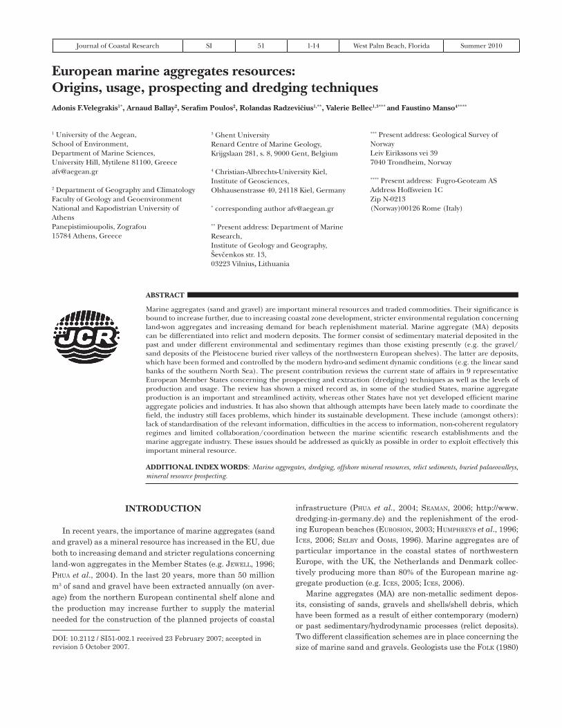
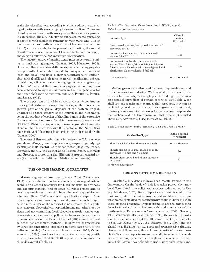
(e.g. antoine et al., 2003; Gibbard, 1988); deposition of uncon-solidated (and relatively well-sorted) coarse-grained material was taking place at the riverine thalwegs, terraces, point bars and fans (leeder, 1999). These deposits are of particular inter-est for the MA industry, since they contain large quantities of gravel and sandy gravel (Figure 1.). Although, such coarse-grained deposits are usually buried under transgressive/high-stand finer-grained deposits (see below), in some cases they can also be found exposed on the present seafloor (Figure 2.).
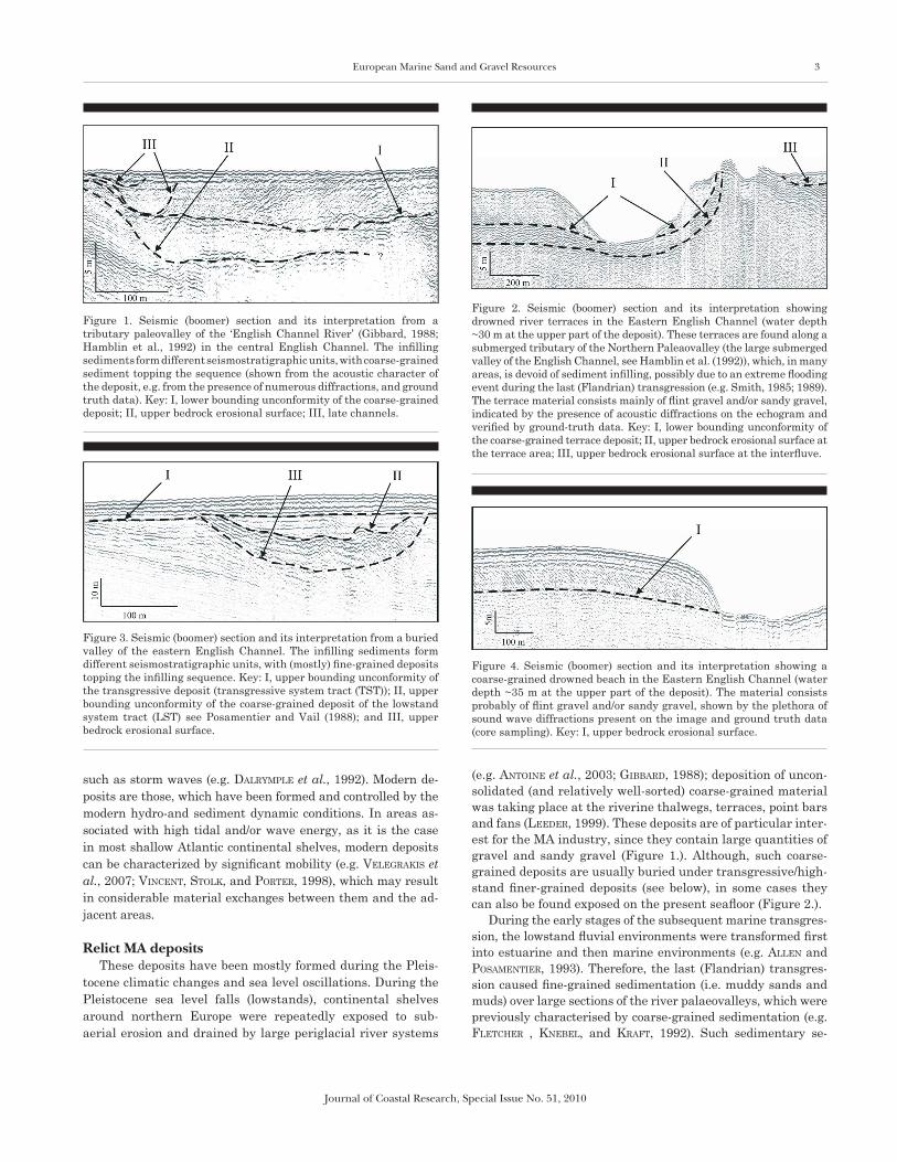
During the early stages of the subsequent marine transgres-sion, the lowstand fluvial environments were transformed first into estuarine and then marine environments (e.g. allen and PoSamentier, 1993). Therefore, the last (Flandrian) transgres-sion caused fine-grained sedimentation (i.e. muddy sands and muds) over large sections of the river palaeovalleys, which were previously characterised by coarse-grained sedimentation (e.g. Fletcher , knebel, and kraFt, 1992). Such sedimentary se-
Figure 2. Seismic (boomer) section and its interpretation showing drowned river terraces in the Eastern English Channel (water depth ~30 m at the upper part of the deposit). These terraces are found along a submerged tributary of the Northern Paleaovalley (the large submerged valley of the English Channel, see Hamblin et al. (1992)), which, in many areas, is devoid of sediment infilling, possibly due to an extreme flooding event during the last (Flandrian) transgression (e.g. Smith, 1985; 1989). The terrace material consists mainly of flint gravel and/or sandy gravel, indicated by the presence of acoustic diffractions on the echogram and verified by ground-truth data. Key: I, lower bounding unconformity of the coarse-grained terrace deposit; II, upper bedrock erosional surface at the terrace area; III, upper bedrock erosional surface at the interfluve.
Figure 3. Seismic (boomer) section and its interpretation from a buried valley of the eastern English Channel. The infilling sediments form different seismostratigraphic units, with (mostly) fine-grained deposits topping the infilling sequence. Key: I, upper bounding unconformity of the transgressive deposit (transgressive system tract (TST)); II, upper bounding unconformity of the coarse-grained deposit of the lowstand system tract (LST) see Posamentier and Vail (1988); and III, upper bedrock erosional surface.
Figure 4. Seismic (boomer) section and its interpretation showing a coarse-grained drowned beach in the Eastern English Channel (water depth ~35 m at the upper part of the deposit). The material consists probably of flint gravel and/or sandy gravel, shown by the plethora of sound wave diffractions present on the image and ground truth data (core sampling). Key: I, upper bedrock erosional surface.
Figure 1. Seismic (boomer) section and its interpretation from a tributary paleovalley of the ‘English Channel River’ (Gibbard, 1988; Hamblin et al., 1992) in the central English Channel. The infilling sediments form different seismostratigraphic units, with coarse-grained sediment topping the sequence (shown from the acoustic character of the deposit, e.g. from the presence of numerous diffractions, and ground truth data). Key: I, lower bounding unconformity of the coarse-grained deposit; II, upper bedrock erosional surface; III, late channels.
4 Velegrakis, et al.
Journal of Coastal Research, Special Issue No. 51, 2010
quences (Figure 3.) are difficult to exploit, as fine-grained sedi-ment deposits must be excavated before reaching the coarse-grained resource (but see loman (2006) for new technological developments which may address this problem).
Other relict sedimentary bodies with a good resource poten-tial are associated with drowned beaches and barrier islands (leeder, 1999). These are coastal sedimentary bodies left be-hind during the last marine transgression, as a result of their protected position (e.g. perched in front of coastal cliffs) and/or the fast rate of the transgression (Figure 4.). These deposits are of particular interest, as they are characterised by rela-tively good sorting and consist of material resistant to abra-sion, which makes them ideal for beach replenishment. Their texture depends on the particulars of the drowned sedimen-tary environment and their exploitability is controlled by the depth of their present position (bateS et al., 1997).
In some areas during the Pleistocene glacial episodes, ice-sheets originating from the land masses spread and extended to the shelves, depositing extensive mantles of sub-glacial till consisting of clays, sands, gravels and boulders. Although these deposits can attain substantial thicknesses (e.g. JackSon et al., 1995; JameS, harriSon, and ciavola, 1992), they may only rarely be of economic interest due to (a) their consolida-tion and ‘contamination’ by both fine and oversize material and (b) regulatory restrictions put in place for some areas (e.g. in the Baltic Sea, see helcom (1998)). In some areas, however, pro-glacial till deposits, deposited by melt ice rivers from the ice front and consisting of sandy gravels and coarse gravelly sands can be of interest to the MA industry (e.g. the Cleaver Bank in the Dutch sector and the areas east of Norfolk and the Humber in the UK sector of the North Sea).
Finally, some areas of the northern European shelves are characterised by veneers of lag gravel. These deposits have been substantially reworked by the present hydrodynamic re-gime; they usually form thin sedimentary bodies, as it is the case in the Baltic Sea (e.g. blazhchiShin, 1976) and the Eng-lish Channel (hamblin et al., 1992) and, thus, they have only limited economic potential.
Modern MA depositsIn terms of their dynamics, modern deposits may be broadly
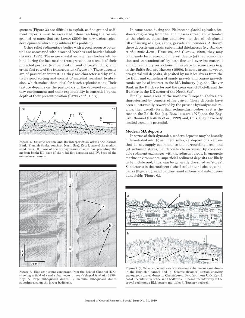
differentiated into: (i) sediment sinks, i.e. depositional centres that do not supply sediments to the surrounding areas and (ii) sediment stores, i.e. deposits characterised by consider-able sediment exchanges with the adjacent areas. In energetic marine environments, superficial sediment deposits are likely to be mobile and, thus, can be generally classified as ‘stores’. Sand stores in the continental shelf include sand sheets, sand-banks (Figure 5.), sand patches, sand ribbons and subaqueous dune fields (Figure 6.).
Figure 5. Seismic section and its interpretation across the Kwinte Bank (Flemish Banks, southern North Sea). Key: I, base of the modern sand bank; II, base of the transgressive coastal bar preceding the modern bank; III, base of the tidal flat deposits; and IV, base of the estuarine channels.
Figure 6. Side-scan sonar sonograph from the Bristol Channel (UK), showing a field of sand subaqueous dunes (Velegrakis et al., 1996). Key: A, large subaqueous dunes; B, medium subaqueous dunes superimposed on the larger bedforms.
Figure 7. (a) Seismic (boomer) section showing subaqueous sand dunes in the English Channel and (b) Seismic (boomer) section showing subaqueous gravel dunes in Christchurch Bay, (southern UK). Key: I, basal unconformity of the sand bedforms; II, basal unconformity of the gravel sediments; BM, bottom multiple; B, Tertiary bedrock.
European Marine Sand and Gravel Resources 5
Journal of Coastal Research, Special Issue No. 51, 2010
Sand sheets are extensive, continuous veneers of sand of variable thickness. Such deposits are commonly found over the western European shelf, mostly at relatively large (> 40-60 m) water depths (kenyon and Stride, 1970). Therefore, even though they may form substantial marine aggregate resources, they are probably beyond the operational capability of the ma-jority of the vessels of the dredging industry fleet (e.g. bateS et al., 1997; viSSer, 2007). Sandbanks are elongated sedimentary bodies, which may reach lengths well in excess of 30 km (col-linS et al., 1995; dyer and huntley, 1999; Pattiaratchi and col-linS, 1987). These sedimentary structures form huge resources of good quality, relatively well-sorted sand-sized sediments and are one of the primary targets of the MA industry (e.g. iceS, 2005; veleGrakiS et al., 2001). Sand ribbons are flow parallel bedforms (e.g. kenyon, 1970; mclean, 1981) consisting of elon-
gated patches of sand resting on coarser-grained sediments and/or bedrock substrates; they form good quality MA deposits which, however, are characterised by a limited thickness and rigorous hydrodynamic regime that makes their mining dif-ficult. Subaqueous dunes (aShley et al., 1990) are flow-trans-verse repetitive sediment structures developing on a sedimen-tary bed under the influence of current- and/or wave-induced flows (belderSon, JohnSon, and kenyon, 1982; dalrymPle et al., 1992). They have dune-like shapes with their crests aligned (almost) perpendicular to the prevailing flow direction and are characterised by variable sediment texture and dimensions (Figures 6. and 7.), reflecting the sediment and flow diversity of the shallow marine environments. Subaqueous dune fields can be of large economic interest, although they present certain practical problems in their exploitation (bateS et al., 1997).
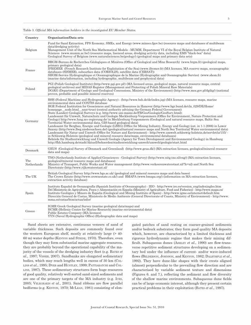
Table 3. Official MA information holders in the investigated EU Member States.
Country Organisation/Data sets
Belgium
Fund for Sand Extraction, FPS Economy, SMEs, and Energy (www.mineco.fgov.be) (resource maps and databases of multibeam data/dredging activity)Management Unit of the North Sea Mathematical Models - MUMM, Department VI of the Royal Belgian Institute of Natural Sciences (www.mumm.ac.be/) (resource maps, lisenced areas, dredging activity data, including EMS “black-box” data) Geological Survey of Belgium (www.naturalsciences.be/geology/) (geological maps and primary data sets)
France
BRGM-Bureau de Recherches Géologiques et Minières (Office of Geological and Mine Research) (www.brgm.fr) (geological maps, primary geological data) IFREMER (French Research Institute for Exploitation of the Sea) (www.ifremer.fr) (MA licenses, MA reserve maps, oceanographic databases (SISMER), subsurface data (CORIOLIS), satellite data (CERSAT))SHOM-Service Hydrographique et Oceanographique de la Marine (Hydrographic and Oceanographic Service) (www.shom.fr) (marine data/information, including hydrographic, multibeam and geophysical data)
PolandPGI (Polish Geological Institute) (http://www.pgi.gov.pl/) (MA licensed areas, geological maps, natural resource maps, central geological archives) and MIDAS Register (Management and Protecting of Polish Mineral Raw Materials)DGiKG (Department of Geology and Geological Concessions, Ministry of the Environment) (http://www.mos.gov.pl/dgikg/) (national proven, probable and possible mineral reserves)
Germany
BSH (Federal Maritime and Hydrographic Agency) - (http://www.bsh.de/de/index.jsp) (MA licenses, resource maps, marine environmental data and CONTIS database BGR Federal Institution for Geosciences and Natural Resources in Hanover (http://www.bgr.bund.de/cln_029/DE/Home/homepage__node.html__nnn=true) (central authority advising the German Federal Government)State (Lander) Geological Surveys (e.g. http://www.uni-mainz.de/FB/Geo/Geologie/GeoSurv.html):Landesamt für Umwelt, Naturschutz und Geologie Mecklenburg-Vorpommern (Office for Environment, Nature Protection and Geology) http://www.lung.mv-regierung.de/ in Mecklenburg-Vorpommern (Geological and natural resource maps, Baltic Sea Territorial Water environmental data, GIS-based geological data) Landesamt für Bergbau, Energie und Geologie (LBEG) (Office for Mining Industry, Energy and Geology (est. in 1-1-2006) in Lower Saxony (http://www.lbeg.niedersachsen.de/) (geological/natural resource maps and North Sea Territorial Water environmental data)Landesamt für Natur und Umwelt (Office for Nature and Environment) - http://www.umwelt.schleswig-holstein.de/servlet/is/155/ - in Schleswig-Holstein (geological and mineral resource data/maps, environmental databases)Behörde für Stadtentwicklung und Umwelt Geologie (Agency for Town Development and Environmental Geology) in Hamburg http://fhh.hamburg.de/stadt/Aktuell/behoerden/stadtentwicklung-umwelt/umwelt/geologie/start.html
Denmark GEUS (Geological Survey of Denmark and Greenland) (http://www.geus.dk/) (MA extraction licenses, geological/mineral resource data and maps)
The Netherlands
TNO (Netherlands Institute of Applied Geosciences - Geological Survey) (http://www.nitg.tno.nl/eng/) (MA extraction licenses, geological/mineral resource maps and databases)Ministry of Transport, Public Works and Water management (http://www.verkeerenwaterstaat.nl/?lc=nl) and North Sea Directorate (http://www.rijkswaterstaat.nl/
The UKBritish Geological Survey http://www.bgs.ac.uk/ (geological and mineral resource maps and data bases) The Crown Estate (http://www.crownestate.co.uk/) and BMAPA (www.bmapa.org/) (information on MA extraction licenses, extraction activity database)
Spain
Instituto Español de Oceanografía (Spanish Institute of Oceanography) - IEO - http://www.ieo.es/version_eng/indexingles.htm Del Ministerio de Agricultura, Pesca y Alimentación en España (Ministry of Agriculture, Food and Fisheries) - http://www.mapa.es/ Instituto Geológico y Minero de España (Geological and Mining Institute of Spain) - http://www.igme.es/internet/default.htm Dirección General de Costas, Ministerio de Medio Ambiente (General Directorate of Coasts, Ministry of Environment) - http://www.mma.es/costas/htm/actua/infor/
GreeceIGMR Greek Geological Survey (marine geological data/maps) and HCMR (Hellenic Centre for Marine Research) (marine environmental data)Public Estates Company (MA licenses)YYN (Naval Hydrographic Office) (Hydrographic data and maps)
6 Velegrakis, et al.
Journal of Coastal Research, Special Issue No. 51, 2010
EUROPEAN MARINE AGGREGATE RESOURCE INFORMATION
In all investigated European Member States, MA resource information has been found to be dispersed among various or-ganisations (Table 3.). The available information consists of both analogue and digital data sets and includes marine ag-gregate reserve maps and maps of areas licensed for extrac-tion, shallow seismic and side-scan sonar records, borehole logs and vibro-core, gravity core and grab sample records. The data quantity and quality vary widely, with the most modern and uniform data bases found in the UK, the Netherlands and Den-mark, where most of the information is held electronically (iceS, 2005; meakinS et al., 1999; nielSen and JenSen, 2003). Although the recent years substantial research has been undertaken to access the MA resource potential of the European shelves, there are still information gaps in all investigated EU Member States; this is true even for those states where modern surveys have been carried out. Thus, accurate estimations of the overall reserves are not available (iceS, 2006), particularly over areas exceeding 40 m water depths (e.g. bateS et al., 1997).
Resource information is also not always standardised (iceS, 2005; meakinS et al., 1999). Not only is there a wide disparity in the type/quality of data sets held by individual states, but there are discrepancies in the resource classification schemes and de-scriptions, in spite of the obvious benefits of data standardisa-tion. Marine aggregate classifications appear to depend on the area, type of material and end-user. For example, the lowest
grain-size limit for in the UK varies from 2 mm to 4 mm to 5 mm, whereas in France variations occur even between regions. Classification discrepancies are of significant concern when quantitative data, such as demand or reserve estimates, are compared between different areas and/or EU Member States. Some efforts towards a consistent format/standards have been made (e.g. de vree, 2003), particularly by organisations in the UK, the Netherlands and Denmark; however, satisfactory standardisation has not been yet achieved. In the Mediterra-nean region, MA reserve information is not available in a com-prehensive way, although it appears that substantial relict and modern deposits are available (e.g. veleGrakiS et al., 2001).
Table 4. National marine aggregate extraction for the period 1989-2005. (Data from Ices, 1995; 2000-2006; Meakins et al. (1999) and the Belgian Fund for Sand Extraction). Note that the UK data have been estimated on the basis of a volume/weight coefficient 1/1.66 (Ices, 2005, 2006). The first value for Germany and Denmark refers to the total production volume, whereas the values in parentheses refer to production volumes from the North Sea. Key: nd, no data available.
YearExtraction volumes (in million m3)
Germany Poland UK France Netherlands Spain Denmark Greece Belgium
1989 1.97 (1.97) 0.96 16.27 nd 8.43 7.68 nd 0.96
1990 2.27 (2.27) 1.35 15.24 nd 13.36 0.08 5.74 nd 0.95
1991 2.02 (2.02) 0.99 12.23 2.00 12.77 0.66 6.40 nd 1.75
1992 2.49 (2.08) 1.58 12.41 1.90 14.80 1.32 4.38 nd 1.22
1993 3.26 (2.21) 1.35 10.78 1.90 13.02 2.19 4.32 nd 1.45
1994 10.12 (8.81) 0.74 13.13 2.50 13.55 2.75 5.17 nd 1.60
1995 2.91 (1.54) 0.81 15.72 2.50 16.83 0.42 5.31 nd 1.66
1996 4.26 (1.38) 0.85 13.61 2.30 23.15 1.48 6.32 nd 1.44
1997 2.22 (0.00) 0.96 15.00 2.60 22.75 1.67 6.40 nd 3.86
1998 0.70 (0.70) 0.69 13.80 2.60 22.51 1.41 6.66 nd 1.40
1999 0.71 (0.71) 0.74 12.60 2.60 22.40 0.49 12.04 nd 1.69
2000 2.97 (1.67) 0.82 13.89 2.60 25.42 0.41 7.12 nd 1.90
2001 nd nd 13.71 2.43 36.45 0.30 7.86 nd 1.92
2002 nd 0.53 13.22 2.43 33.84 0.08 5.57 (3.50) nd 1.62
2003 1.14 (0.70) nd 13.39 nd 23.97 1.19 8.13 (6.18) nd 1.65
2004 nd 0.85 12.98 0.34 23.59 0.79 6.46 (4.18) nd 1.50
2005 14.00 (13.61) nd 12.78 nd 28.76 0.05 11.05 (9.28) nd 1.36
Average 3.64 (2.00) 0.94 13.57 2.21 20.92 0.96 6.86 nd 1.64
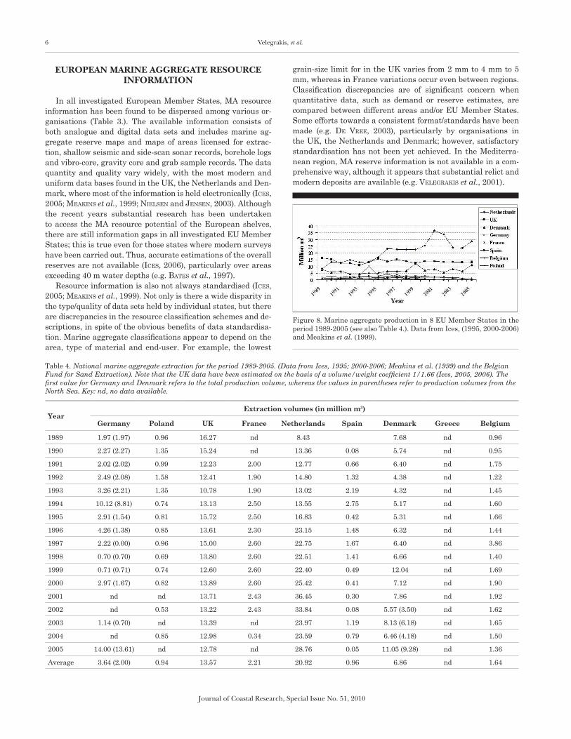
Figure 8. Marine aggregate production in 8 EU Member States in the period 1989-2005 (see also Table 4.). Data from Ices, (1995, 2000-2006) and Meakins et al. (1999).
European Marine Sand and Gravel Resources 7
Journal of Coastal Research, Special Issue No. 51, 2010
In view of the information gaps and classification discrep-ancies, the proven recoverable European MA reserves are difficult to be established with accuracy. However, such esti-mates exist for some of the investigated states, on the basis of detailed reconnaissance mapping (iceS, 2006). For example, Danish marine sand reserves have been estimated to be very substantial (in the order of several billions m3), but coarse sand/gravel resources are rather limited in the North Sea (birklund and wiJSman, 2005). The German recoverable MA reserves of the Baltic Sea are confined (of the order of 40-50 million m3), whereas the Polish reserves have been estimated to be close to a 100 million m3 (herrmann et al., 1999). Estima-tions for the UK have shown that the proven and potential workable marine sand reserves found within the present oper-ational capability of dredging vessels amount to several billion m3 (humPhreyS et al., 1996). In contrast, coarse-grained depos-its are finite, as they mostly form a thin (less than 1m thick) veneer over the seabed; only over certain areas the thickness of the gravel deposits becomes significant (Figures 1., 2. and 4.) and, thus, economically viable (e.g. arthurton, 1997; bateS et al., 1997).
MA PRODUCTION AND USAGE
Reliable statistics on marine aggregate production in the EU Member States are difficult to collate (e.g. iceS, 2006), due to non-standardised archiving, varying material classifica-tion, commercial confidentiality issues (meakinS et al., 1999) and regulation discrepancies (Radzevicius et al., this volume). In general, information is more complete in those countries that have increased dependence on marine aggregates and a mature MA industry; hence, limited/sparse information can be found for the Mediterranean EU States, which rely pre-dominantly on land aggregates. Continuous production (ex-traction) figures (for the last 30 years) are available for the UK, the Netherlands and Belgium (ceda, 1993; iceS reports 2000-2006), whereas France and Germany show significant information gaps (iceS, 2006; iFremer, 2007).
MA Production In the late 1980s, MA production increased significantly in
several states. The level of production has since been, more or less, stabilised (with the exception of the Netherlands), although significant interannual variations may occur in re-sponse to project-led demand (Figure 8. and Table 4.). The three main MA production countries in the EU are the Nether-lands, the UK and Denmark, which collectively yield over 80% of the marine aggregates produced by the 9 studied countries (harriSon, 2003; iceS, 2006; uScinowicz et al., 2003).
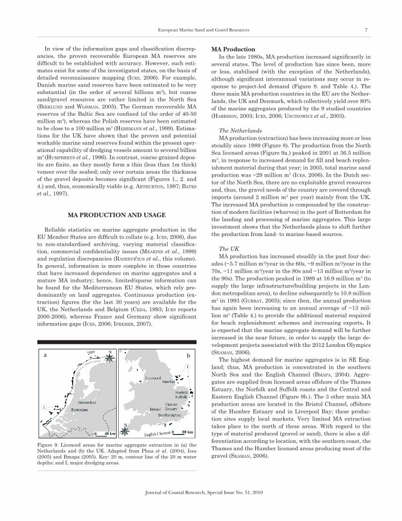
The NetherlandsMA production (extraction) has been increasing more or less
steadily since 1989 (Figure 8). The production from the North Sea licensed areas (Figure 9a.) peaked in 2001 at 36.5 million m3, in response to increased demand for fill and beach replen-ishment material during that year; in 2005, total marine sand production was ~29 million m3 (iceS, 2006). In the Dutch sec-tor of the North Sea, there are no exploitable gravel resources and, thus, the gravel needs of the country are covered through imports (around 2 million m3 per year) mainly from the UK. The increased MA production is compounded by the construc-tion of modern facilities (wharves) in the port of Rotterdam for the landing and processing of marine aggregates. This large investment shows that the Netherlands plans to shift further the production from land- to marine-based sources.
The UKMA production has increased steadily in the past four dec-
ades (~5.7 million m3/year in the 60s, ~9 million m3/year in the 70s, ~11 million m3/year in the 80s and ~13 million m3/year in the 90s). The production peaked in 1989 at 16.9 million m3 (to supply the large infrastructure/building projects in the Lon-don metropolitan area), to decline subsequently to 10.8 million m3 in 1993 (Gubbay, 2005); since then, the annual production has again been increasing to an annual average of ~13 mil-lion m3 (Table 4.) to provide the additional material required for beach replenishment schemes and increasing exports. It is expected that the marine aggregate demand will be further increased in the near future, in order to supply the large de-velopment projects associated with the 2012 London Olympics (Seaman, 2006).
The highest demand for marine aggregates is in SE Eng-land; thus, MA production is concentrated in the southern North Sea and the English Channel (bmaPa, 2004). Aggre-gates are supplied from licensed areas offshore of the Thames Estuary, the Norfolk and Suffolk coasts and the Central and Eastern English Channel (Figure 9b.). The 3 other main MA production areas are located in the Bristol Channel, offshore of the Humber Estuary and in Liverpool Bay; these produc-tion sites supply local markets. Very limited MA extraction takes place to the north of these areas. With regard to the type of material produced (gravel or sand), there is also a dif-ferentiation according to location, with the southern coast, the Thames and the Humber licensed areas producing most of the gravel (Seaman, 2006).
Figure 9. Licenced areas for marine aggregate extraction in (a) the Netherlands and (b) the UK. Adapted from Phua et al. (2004), Ices (2005) and Bmapa (2005). Key: 20 m, contour line of the 20 m water depths; and I, major dredging areas.

8 Velegrakis, et al.
Journal of Coastal Research, Special Issue No. 51, 2010
DenmarkThere has been a considerable production of marine sand
(mostly for fill purposes) over the last decade (Table 4. and Fig-ure 8.), to meet demands from the large infrastructure projects undertaken along the Danish coastal zone (e.g. herrmann et al., 1999). With the exception of the peaks of 1999 and 2005, pro-duction volumes have remained stable at around 6-7 million m3 during the last 10 years (ceda, 1993; iceS, 2005; 2006).
France Marine aggregate production has remained stable (at
around 2- 2.6 million m3 per year, see Table 4.) in France for several years (iFremer, 2007). There is a significant aggregate demand in the northern Seine and Loire regions but, little MA extraction takes place despite the occurrence of substantial MA resources. At the same time, some 47 million tonnes of aggregates have been abstracted from the channel and fluvial terraces of the Rhone River alone since 1949 (arnaud-FaSSet-ta, 2003). Therefore, even though the annual aggregate de-mand is ~300 million tonnes, less than 1% of that is supplied from marine sources. Approximately 1 million tonnes of ma-rine aggregates are imported annually from the UK and to much lesser extent from Belgium (iFremer, 2007).
GermanyMarine sands and gravels are produced in several areas of the
German sectors of the Baltic and (particularly) the North Seas (see Schwarzer, dieSinG, and manSo, this volume). The produced volumes have not been great (Figure 8. and Table 4.), but they make an important contribution to regional aggregate supply. Significant quantities of the extracted material are utilised in beach replenishment schemes, whereas the remainder (approxi-mately half of the annual production) is used in the construction industry (iceS, 2002). In 1994 and 2005, the production increased sharply due to project-led demand (iceS, 2006).
Belgium Although the seabed of the Belgian sector of the southern
North Sea contains large quantities of sand, production is con-centrated mainly on the Kwinte Bank (deGrendele et al., this volume; harriSon, 2003); however, sand extraction from this site has stopped in 2003 in order to study its potentially det-rimental effects on the stability and biodiversity of the bank (see van lancker et al., this volume). MA production has in-creased since the 1980s. In the recent years, with the excep-tion of a peak during 1997 (Figure 8. and Table 4.), the annual production has remained relatively stable at 1.5-2 million m3. Most of the produced sand is used in the construction indus-try, whereas some small quantities are exported to France (iceS, 2006; Schotte, 2003). Belgium imports yearly about 1.5 million m3 of marine sand/gravel from the UK.
PolandProduction in Poland is limited, having an average of less
than 1 million m3 per year (Table 4. and Figure 8.). In 2004, the fine- and medium-grained sand extracted from the Polish sector of the Baltic Sea (~0.8 million m3) was used mostly in beach re-plenishment and coastal defence schemes (iceS, 2005); limited
quantities were used in the construction industry. Some mate-rial (e.g. ~0.3 million m3 in 2000), extracted from the Slupsk Bank, has been exported to Germany (uScinowicz et al., 2003).
SpainMA production in Spain is allowed only for beach replen-
ishment (see Radzevicius et al., this volume). The average an-nual production is about 1 million m3, but there are significant interannual fluctuations in response to beach replenishment needs (Table 4. and Figure 8.). Extraction takes place both in the Atlantic and in the Mediterranean inner continental shelves, but presently is concentrated offshore of the southern Spanish coastline (iceS, 2006).
Mediterranean European coastThere is not an accurate registry of MA production for
Italy, the southern French coast and the other EU Mediter-ranean countries (e.g. Greece). In these areas, most aggregate material is still produced from land open-quarries, river chan-nels and terraces. Published information suggests that about 690 million m3 of aggregates have been extracted in the period 1958-1981 from the Po River valley (dal cin, 1983; marchetti, 2002), ~93 million m3 (1950-1992) from the Emilia-Romagna rivers (idroSer, 1994), 12.7 million m3 (1966-1975) from the rivers of the Marche Region and more than 26 million m3 (1966-1981) from the Abruzzo rivers (aquater, 1982). Lately, MA production has attracted more attention, due to the dis-covery of significant reserves offshore of the coasts of Lazio (S. Capucci, pers. comm.) and Emilia Romagna (A. Lamberti, pers. comm.). With regard to Greece, MA extraction has been taking place since the 1960s, mainly from the inner continen-tal shelf of the Greek islands (e.g. Andros, Mykonos); most of the material produced was used in the construction industry. Since the 1990s, stricter environmental regulations have re-sulted in the termination of most inshore MA extraction and production has since been concentrated offshore of the coasts of Trikeri (N. Evoikos Gulf) and Southern Evia. Although, there is no readily available information on annual extraction volumes, it is thought that these are of the order of hundreds of thousands of m3 rather than millions.
MA UsageWith the exception of the UK and to a lesser extent Po-
land and the Netherlands, marine aggregates are used in the country of production (Table 5.). Annual exports of aggregates extracted from the UK waters vary but, in some years, can be more than 20% of the UK production with the main foreign markets being the Netherlands, Belgium and France (bmaPa, 2004; iceS, 2005). Relatively small quantities of Danish marine aggregates are exported in some years to Sweden and Germa-ny, whereas there are also intermittent Dutch and Polish MA exports to Belgium and Germany, respectively (iceS, 2005).
In the Netherlands, most of the MA production is used for fill and beach replenishment, whereas in Spain the whole pro-duction is reserved for beach replenishment (Table 5.). This is not the case in the UK, where more than 60% of the MA production can be used in the construction industry (Gubbay, 2003, 2005; meakinS et al., 1999). In Denmark, almost 40% of
European Marine Sand and Gravel Resources 9
Journal of Coastal Research, Special Issue No. 51, 2010
marine sand is used in beach replenishment schemes, mainly along the west Jutland coast, whereas almost 80% of the Polish production is used for beach replenishment (iceS, 2005).
With regard to beach replenishment, most of the southern UK coast beaches consist of flint/chert gravel (shingle), where-as the remainder of the UK coastline is characterised by sandy beaches. Therefore, there will be an increasing demand for (flint) marine gravels in the southern UK to supply the beach replenishment schemes. As gravel deposits are limited (found mainly in the buried valleys/drowned beaches of the English Channel and the southern North Sea), extreme care should be taken to use them in a sustainable manner i.e. to reserve them for beach replenishment and not to use them in the construc-tion industry, for which material of lesser quality is sufficient (e.g. arthurton, 1997; bateS et al., 1997).
Table 5. Different usage of marine aggregates during the last years (as a percentage of the overall production). Data extracted from Ices, 2002-2006. Note: Data for Spain have been extracted from Ices (2006) and data for Belgium are based on an estimation and can be used only as an approximation.
CountryMA
extracted (million
m3)
Construction Industry
(%)
Beach replenish
ment(%)
Exports(%)
Belgium 1.63 93.8 6.2 0
Denmark 7.01 59.9 38.8 1.4
France 2.77 nd nd 0
Germany 7.57 nd nd 0
Netherlands 29.07 49.2 43.4 7.4
Poland 0.64 2.9 79.6 17.5
Spain 0.48 0 100 0
UK 13.13 66.6 4.8 28.8
Future MA demandPrediction of the future MA demand is not an easy exer-
cise, as it depends on forecasts of economic growth, the cy-clical nature of the construction industry, national and Euro-pean policies and regulation, the ability of the MA industry to penetrate markets long held by land-won aggregates and related investment (e.g. construction of dredging vessels and wharves). In addition, future demand/supply is dependent on the availability of suitable marine aggregate resources. In the Bristol Channel (UK) for example, certain MA deposits which have been dredged for over 60 years are coming to the end of their exploitation life (harriSon, 2003); likewise, extraction from old Outer Thames Estuary licenses is in decline. How-ever, the UK industry has found significant new reserves in the Eastern English Channel, the Irish Sea and the Bristol Channel (e.g. Seaman, 2006), which could last for some dec-ades at the present rates of extraction, even though special care should be given on the availability of gravelly material which appears to be limited (arthurton, 1997; bateS et al., 1997; harriSon, 2003).
Future demand figures can be distorted by large “one-off” capital development projects. For example, the UK Lincshore beach replenishment project used 8 million tonnes of marine aggregates (meakinS et al., 1999). In the Netherlands, plans exist to use marine aggregates in major future developments, which will require large quantities of material (Phua et al., 2004).
Within northwestern Europe, only the UK and the Nether-lands have produced official estimates of the future demand for marine sand and gravel. For the English part of the UK, the Department of Environment (DOE) (now DEFRA) has es-timated that the total aggregate demand in the period 1995-2015 will be up to 7000 million tonnes (humPhreyS et al., 1996; meakinS et al., 1999). This demand is not spread evenly; in southeastern England, where outcrops of hard rock suitable for use (after mining and crushing) in the construction indus-try are not available, land-won and marine sand and gravel are vital for the construction industry (bateS et al., 1997; Gubbay, 2005). Future annual total aggregate demand for the Netherlands (until 2020) has been estimated as 20 million tonnes of gravel, 23 million tonnes of sand for concrete and 53 million m3 of fill sand (meakinS et al., 1999); 7 out of the 20 million tonnes of gravel will be derived from Dutch land-based sources, whereas it is thought that the remainder will be supplied from recycling and imports. In 1997, the Ministry of Transport, Public Works and Water Management updated their future demand figures for MA extraction from Dutch wa-ters. These updates suggest that for the period 1996-2030 the average annual extraction should be in the order of 30-33 mil-
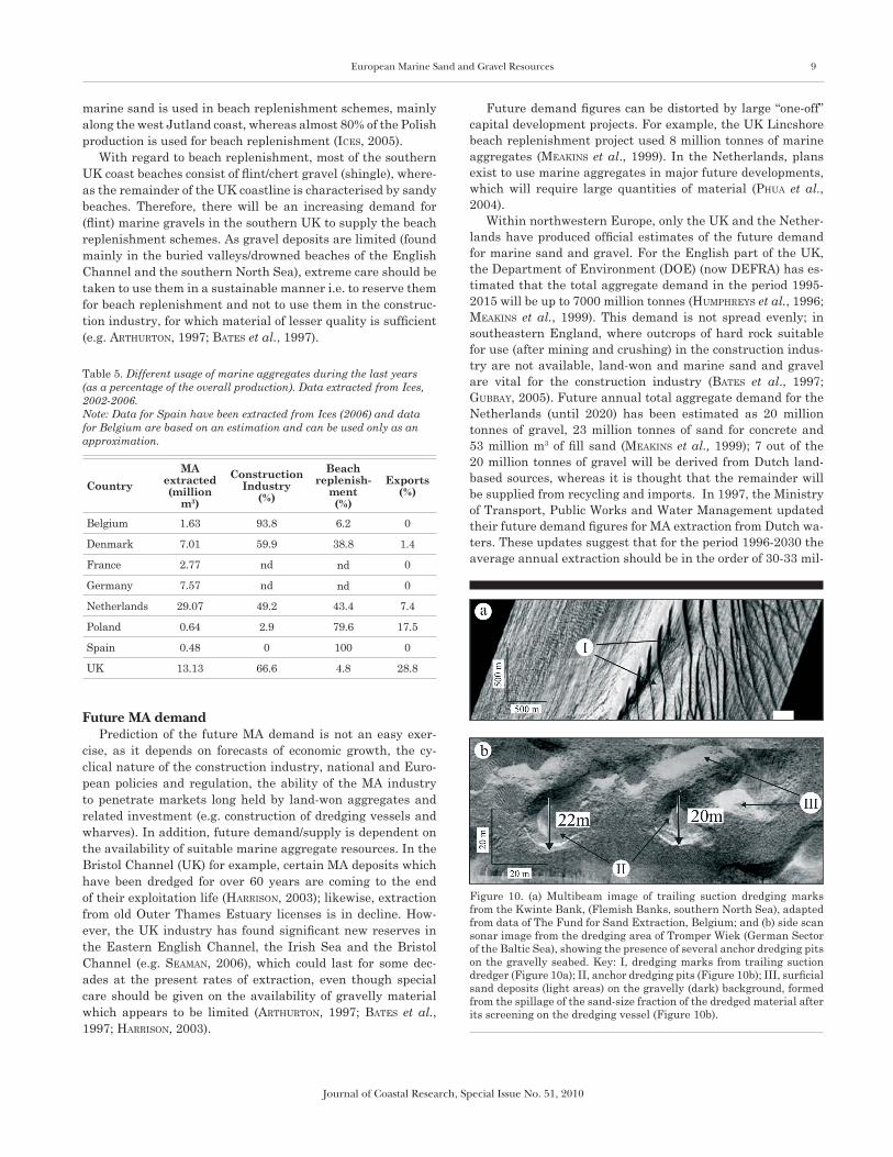
Figure 10. (a) Multibeam image of trailing suction dredging marks from the Kwinte Bank, (Flemish Banks, southern North Sea), adapted from data of The Fund for Sand Extraction, Belgium; and (b) side scan sonar image from the dredging area of Tromper Wiek (German Sector of the Baltic Sea), showing the presence of several anchor dredging pits on the gravelly seabed. Key: I, dredging marks from trailing suction dredger (Figure 10a); II, anchor dredging pits (Figure 10b); III, surficial sand deposits (light areas) on the gravelly (dark) background, formed from the spillage of the sand-size fraction of the dredged material after its screening on the dredging vessel (Figure 10b).
10 Velegrakis, et al.
Journal of Coastal Research, Special Issue No. 51, 2010
lion m3 of sand (meakinS et al., 1999). These figures do not take into account additional demand for one-off projects.
It has been estimated that large quantities of marine aggre-gates (between 6 and 14 million m3 of sand) will be required for beach replenishment to compensate for sand loss in erod-ing areas of the Dutch coastline, particularly if the effects of sea level rise are considered (ron2, 2004; harte et al., 2003; van dalFSen and eSSink, 1997). Future annual marine aggre-gate demand for construction (excluding large infrastructure projects) has been estimated as between 9.3 and 29 million m3 (Phua et al., 2004). As, however, large land reclamation projects have been planned for the near future, Dutch MA ex-traction may increase very substantially. The most important of these projects are: the enlargement of the Rotterdam Har-bour, which will require up to 300 million m3 of sand and the Westerschelde (Western Scheldt) Container Terminal (WCT), which will require up to 20 million m3 (dhv milieu & inFra-Structuur, 2003).
MA PRODUCTION TECHNIQUES
MA production incorporates 3 main phases: (i) identifica-tion of the potential deposit; (ii) evaluation (prospecting) of the deposit and (iii) aggregate mining (extraction). The first phase (identification of a potential deposit, Phase 1) is often linked to other marine research projects such as general geological mapping of the seabed (e.g. hamblin et al., 1992; JackSon et
al., 1995) and/or habitat mapping. If an area appears prom-ising, a prospecting license will be obtained according to the procedures in place in each state (see also Radzevicius et al., this volume) to prospect/evaluate the potential of the deposit in detail (Phase 2). Finally, if the deposit is found to be eco-nomically viable, an extraction license is obtained and mining (dredging) commences (Phase 3).
Prospecting techniques The evaluation of sand and gravel deposits (Phase 2) re-
quires the use of specialized equipment, such as: (a) acoustic (seismic) sources, powerful enough to penetrate the medium-and coarse grained sediments and, at the same time, having sufficient resolution to map accurately the internal architec-ture of the sedimentary deposit and (b) coring equipment able to penetrate at least 2 to 3 m into a medium- and/or coarse-grained sedimentary sequence. Reviews of seabed mapping techniques already exist (e.g. kenny et al., 2003). Neverthe-less, it is useful to summarise particular techniques used in the marine aggregate prospecting and which are based on the: • collection of indirect (remotely-sensed) information on the
geomorphology/geology of the seabed, using acoustic sourc-es (e.g. single and/or multibeam echosounders, side-scan sonar, continuous seismic profiling equipment) and
• collection of (direct) ground-truth data, using superficial (grab) and sub-bottom (gravity and vibro-core) sediment samplers.
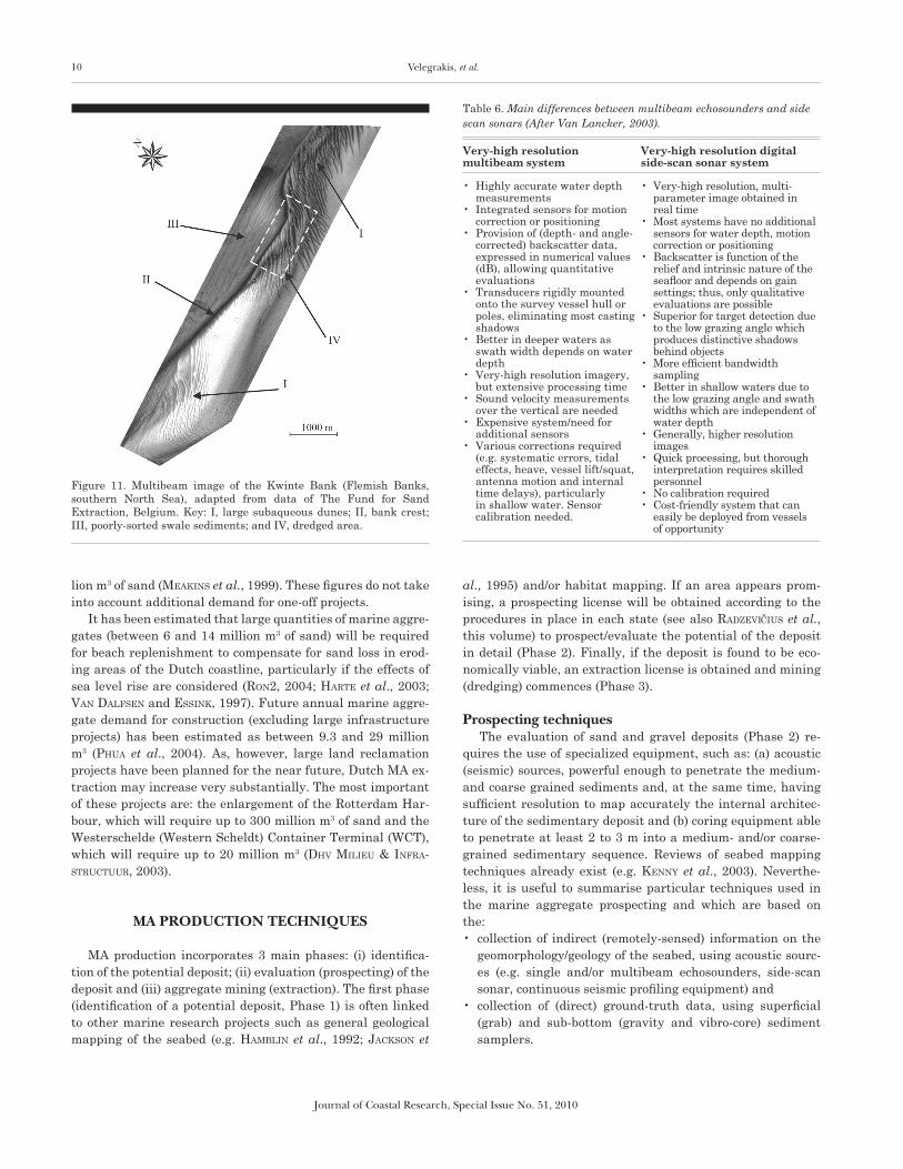
Figure 11. Multibeam image of the Kwinte Bank (Flemish Banks, southern North Sea), adapted from data of The Fund for Sand Extraction, Belgium. Key: I, large subaqueous dunes; II, bank crest; III, poorly-sorted swale sediments; and IV, dredged area.
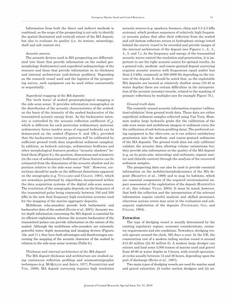
Table 6. Main differences between multibeam echosounders and side scan sonars (After Van Lancker, 2003).
Veryhigh resolution multibeam system
Veryhigh resolution digital sidescan sonar system
• Highly accurate water depth measurements
• Integrated sensors for motion correction or positioning
• Provision of (depth- and angle-corrected) backscatter data, expressed in numerical values (dB), allowing quantitative evaluations
• Transducers rigidly mounted onto the survey vessel hull or poles, eliminating most casting shadows
• Better in deeper waters as swath width depends on water depth
• Very-high resolution imagery, but extensive processing time
• Sound velocity measurements over the vertical are needed
• Expensive system/need for additional sensors
• Various corrections required (e.g. systematic errors, tidal effects, heave, vessel lift/squat, antenna motion and internal time delays), particularly in shallow water. Sensor calibration needed.
• Very-high resolution, multi-parameter image obtained in real time
• Most systems have no additional sensors for water depth, motion correction or positioning
• Backscatter is function of the relief and intrinsic nature of the seafloor and depends on gain settings; thus, only qualitative evaluations are possible
• Superior for target detection due to the low grazing angle which produces distinctive shadows behind objects
• More efficient bandwidth sampling
• Better in shallow waters due to the low grazing angle and swath widths which are independent of water depth
• Generally, higher resolution images
• Quick processing, but thorough interpretation requires skilled personnel
• No calibration required• Cost-friendly system that can
easily be deployed from vessels of opportunity
European Marine Sand and Gravel Resources 11
Journal of Coastal Research, Special Issue No. 51, 2010
Information from both the direct and indirect methods is combined, as the scope of the prospecting is not only to identify the spatial (horizontal and vertical) extent of the MA deposit, but also to evaluate its quality (i.e. its texture, mineralogy, shell and salt content etc).
Acoustic sources The acoustic devices used in MA prospecting are differenti-
ated into those that provide information on the seabed geo-morphology (bathymetry) and superficial sedimentology of the resource and those that provide information on its thickness and internal architecture (sub-bottom profilers). Depending on the research vessel used and the logistics of the prospect-ing survey, such equipment can be used either concurrently or sequentially.
Superficial mapping of the MA deposits The ‘work horse’ of seabed geomorphological mapping is
the side-scan sonar. It provides information (sonographs) on the distribution of the acoustic characteristics of the seabed, on the basis of the intensity of the seabed backscatter of the transmitted acoustic energy front. As the backscatter inten-sity is controlled by the acoustic reflection coefficient (CR), which is different for each particular sedimentary material, sedimentary facies (and/or areas of exposed bedrock) can be demarcated on the seabed (Figures 6. and 10b.), provided that the backscatter intensity patterns will be calibrated by sufficient ground truth data (superficial sediment samples). In addition, as bedrock outcrops, sedimentary bedforms and other morphological features produce “acoustic shadows” be-hind them (Figure 6.), the position, dimensions and symmetry (in the case of sedimentary bedforms) of these features can be estimated from the dimensions of the acoustic shadow and its position relative to the side-scan sonar “fish”. However, cor-rections should be made on the different distortions apparent on the sonographs (e.g. voulGariS and collinS, 1991), which are nowadays performed by algorithms incorporated within the data acquisition systems of the digital side-scan sonars. The resolution of the sonographs depends on the frequency of the transmitted pulse being commonly between 100 and 500 kHz in the new dual frequency high resolution systems used for the mapping of the marine aggregate deposits.
Multibeam echo-sounders provide both bathymetric and backscatter data of the seabed (davieS et al., 2001). Accurate wa-ter depth information concerning the MA deposit is essential for its efficient exploitation, whereas the acoustic backscatter of the transmitted pulses can provide information on the nature of the seabed. Although the multibeam echo-sounders are extremely powerful water depth measuring and imaging devices (Figures 10a. and 11.), they have both advantages and disadvantages con-cerning the mapping of the acoustic character of the seabed in relation to the side-scan sonar systems (Table 6.).
Thickness and internal architecture of the MA deposit The MA deposit thickness and architecture are studied us-
ing continuous reflection profiling and seismostratigraphic techniques (e.g. mcquillin and arduS, 1977; PoSamentier and vail, 1988). MA deposit surveying requires high resolution
acoustic sources (e.g. sparkers, boomers, chirp and 3.5-2.5 kHz systems), which produce sequences of relatively high frequen-cy acoustic pulses that after their reflection from the seabed and sub-bottom reflectors return to hydrophone strings towed behind the survey vessel to be recorded and provide images of the internal architecture of the deposit (see Figures 1., 2., 3., 4., 5. and 7.). As the frequency and energy of the transmitted acoustic waves control the resolution and penetration, it is im-portant to use the right acoustic source for optimal results. As a general rule, medium- and coarse-grained deposit surveying requires acoustic sources with frequencies equal and/or less than 2.5 kHz, commonly at 500-2000 Hz depending on the tex-ture of the deposit. It should be noted that, as the exploitable MA deposits are located at relatively shallow areas (10-40 m water depths) there are certain difficulties in the interpreta-tion of the acoustic (seismic) records, related to the masking of primary reflections by multiples (see for example Figure 7b.).
Ground-truth data The remotely-sensed acoustic information requires ‘calibra-
tion/validation’ from ground truth data. These data are either superficial sediment samples collected using Van Veen, Ham-mon and/or large hydraulic grabs (for the calibration of the side-scan sonar and multibeam images) or sediment cores (for the calibration of sub-bottom profiling data). The preferred cor-ing equipment is the vibro-core, as it can achieve satisfactory penetration into the medium- and coarse-grained sediments of the MA deposits. The ground truth data not only calibrate/validate the acoustic data allowing volume estimations but, they provide also information on the quality of the MA deposit (e.g. on its grain-size, mineralogy and carbonate, organic mat-ter and chloride content) through the analysis of the recovered sediment samples.
The prospecting data can also be used to provide essential information on the mobility/morphodynamics of the MA de-posit (bramPton et al., 1998) and to map its habitats, which are essential components of the required environmental im-pact assessment of the exploitation of the deposit (Radzevicius et al., this volume; vivian, 2003). It must be noted, however, that both the collection and the interpretation of the relevant information require careful analysis and skilled personnel, otherwise serious errors may arise in the evaluation and sub-sequent exploitation of the deposits (veleGrakiS, Gao, and collinS, 1994).
Extraction The type of dredging vessel is usually determined by the
existing regulatory regime, economic considerations, contac-tor requirements and site conditions. Nowadays, dredging ves-sels operate around the clock, 365 days a year. In the UK, the construction cost of a modern tailing suction vessel is around £15-20 million (22-30 million €). A modern large dredger can extract and load some 5,000 tonnes of marine sand and gravel from 40-60 m water depths in 3 hours, with overall operation-al cycles usually between 12 and 36 hours, depending upon the port of discharge (bateS et al., 1997).
Two main types of dredging vessels are used for marine sand and gravel extraction: (i) trailer suction dredgers and (ii) an-
12 Velegrakis, et al.
Journal of Coastal Research, Special Issue No. 51, 2010
chor suction dredgers (see for example ihc, 2007). The former can operate under relatively rough sea conditions, extracting sediments through their suction ‘pipes’ while steaming over the deposit; they operate very much like moving ‘vacuum cleaners’, resulting in the development of suction furrows (up to 1 m deep) on the sedimentary bed (see Figure 10a.). The aggregates are emptied by opening bottom hatches or by pumps. Because of their high production rates, these dredgers carry out most land reclamation projects and are also suitable for harbour main-tenance dredging and pipe trenching. The latter extract sedi-ments while anchored and the suction method employed results in the development of suction pits (Figure 10b.). These vessels can operate in relatively deep waters, but they are sensitive to strong currents and rough weather conditions; moreover, they are not suitable for channel/harbour construction projects, as they produce confined excavations. This method is now prohib-ited in some EU Member States (e.g. Belgium), as it is consid-ered to have large environmental impacts.
Dredging activities are subject to environmental impact as-sessments and should be controlled by the competent regula-tory authorities (see Radzevicius et al., this volume). In several (but not all as it should) EU Member States, dredging ves-sels are required to be equipped with Electronic Monitoring Systems (“black boxes”), which allow the monitoring of their activities and their compliance with the licensing terms.
SUMMARY AND CONCLUSIONS
Marine aggregates are a mineral resource of increasing importance for the EU Member States. Additional resources are needed to meet future demand, which is bound to increase substantially due to both increasing coastal zone development and the need to battle accelerating coastal erosion effectively. However, in order to develop an effective and sustainable Eu-ropean strategy, several problems facing the industry should be addressed. These include (amongst others): lack of stand-ardisation of the relevant information, difficulties related to the access to information and the presence of barriers between the scientific research establishments and the marine aggre-gate industry.
This review has shown that there are serious standardiza-tion issues as well as important information gaps that hinder the sustainable development of the industry. With the excep-tion of few Member States, the situation is rather discour-aging, particularly in the Mediterranean countries. In some cases, it has shown to be very difficult to access the relevant information (e.g. production volumes, resource estimates), as this is scattered between several organizations. It is important that these issues should be addressed as quickly as possible, possibly through European-wide initiatives.
Although the technology and ‘know-how’ are available, it appears that these are seldom employed in the discovering and evaluation of new marine aggregate resources. Hence, multibeam echosounding techniques are used rarely and the same is true for the modern techniques in the acquisition and interpretation of the remainder of the acoustic data. These problems appear to be related to an apparent lack of coordina-
tion between the scientific research establishments and the MA industry, which is endemic in most EU Member States. A closer collaboration between them would not only have sub-stantial benefits for both, but it would also prove to be cost-effective.
Finally, it should be kept in mind that marine aggregates are finite, being a non-renewable resource. Therefore, they should be used in a sustainable manner and effective policies/administrative frameworks should be developed to address future shortages, particularly with regard to certain types of material (e.g. gravel).
ACKNOWLEDGEMENTS
The authors acknowledge the support of European Com-mission through the EU-RTN FP5 Project EUMARSAND (Contract HPRN-CT-2002-00222). Dr A. Brampton and two other anonymous reviewers are thanked for their constructive comments which improved the manuscript.
LITERATURE CITED
allen, G.P. and PoSamentier, H.W., 1993. Sequence stratigraphy and facies model of an incised valley fill: the Gironde Estuary, France. Journal of Sedimentary Petrology, 63, 378-391.
antoine, P.; coutard, J.-P.; Gibbard, P.l.; halleGouet, b.; lautridou, J.-P., and ozouF, J.-c., 2003. The Pleistocene rivers of the English Channel region. Journal of Quaternary Science, 18(3-4), 227-243.
aquater, 1982. Studio generale per la difesa della costa. Prima Fase, Vol. 2, 90-196.
arnaud-FaSSetta, G., 2003. River channel changes in the Rhone Delta (France) since the end of the Little Ice Age: Geomorphological ad-justement to hydroclimatic change and natural resource manage-ment. Catena, 51, 141-172.
arthurton, R., 1997. Offshore sand and gravel resources and the need for careful management. In: earll, r. (ed.), Marine Environmental Management: A Review of past and Future Trends No. 4, pp.19-22.
aShley, G.m.; boothroyd, J.c.; bridGe, J.S.; cliFton, h.e.; dalrymPle, r.w.; elliot, t.; FlemminG b.w.; harmS, J.c.; harriS, P.t.; hunter, r.e.; krieSa, r.d.; lancaSter, n.; middleton, G.v.; Paola, c.; rubin, d.m.; Smith, J.d.; Southard, J.b.; terwindt, J.h.J., and twitchell, d.c. Jr., 1990. Classification of large scale subaqueous bedforms: a new look at an old problem. Journal of Sedimentary Petrology, 60, 160-172.
bateS, r.; veleGrakiS, a.F.; brand, c.; collinS, m.b., and nunn, a., 1997. Deep Water and Inshore Aggregates Exploitation. Research Report for the Countryside Council of Wales. 91 p.
belderSon, r.h.; JohnSon, m.a., and kenyon, n.h., 1982. Bedforms. In: Stride, a.h. (ed.), Offshore Tidal Sands: Processes and Deposits. London: Chapman and Hall, pp. 27-57.
bellec, v.; dieSinG, m., and Schwarzer, k., this volume. Last Qua-ternary evolution of a gravel area located on the Tromper Wiek. Journal of Coastal Research.
birklund, J. and wiJSman, J.w.m., 2005. Aggregate Extraction: A Re-view of the Effect on Ecological Functions. DHI Water and Envi-ronment and WL/Delft Hydraulics (SANDPIT Project), Technical Report Z3297.10
European Marine Sand and Gravel Resources 13
Journal of Coastal Research, Special Issue No. 51, 2010
blazhchiShin, A.I., 1976. Types of bottom sediments. In: GudeliS, v. and emelyanov, e. (eds.), Geology of the Baltic Sea. Vilnius, Mokslas, pp. 187-212. (In Russian).
bmaPa, 2004. Marine Aggregate Dredging 2004: The Area Involved. The Crown Estate/British Marine Aggregate Producer Association, 7th annual Report, 4 p.
bmaPa, 2005. Aggregates from the Sea: Drawing Strength from the Depths. British Marine Aggregate Producer Association. 6 p. www.bmapa.org.
bramPton, a.; evanS, c.d.r., and veleGrakiS, a.F., 1998. South Coast Mobility Study. London, UK: CIRIA PR65, 201 p.
collinS, m.b.; Shimwell, S.; Gao, S.; Powell, h.; hewitSon, c., and taylor, J. a., 1995. Water and sediment movement in the vicinity of linear sandbanks: The Norfolk Banks, southern North Sea. Ma-rine Geology, 123, 125-142.
ceda, 1993. Marine sand and gravel in the EC seas, CEDA Report 93/01, 46 p.
dal cin, r., 1983. I litorali del delta del Po e alle foci dell’Adige e del Brenta: Caratteri tessiturali e dispersione dei sedimenti, cause dell’arretramento e previsioni sull’evoluzione futura. Boll. Soc. Geol. It., 102, 9-56.
dalrymPle, r.w.; leGreSley, e.m.; Fader, G.b.J., and Petrie, b.d., 1992. The western Grand Banks of Newfoundland: Transgressive Holocene sedimentation under the combined influence of waves and currents. Marine Geology, 105, 95-118.
davieS, J.; baxter, J.; bradley, m.; connor, d.; khan, J.; murray, e.; SanderSon, w.; turnbull, c., and vincent, m., 2001. Marine Moni-toring Handbook, Joint Nature Conservation Committee, UK, ISBN 1-86107-524-3, 405 p.
dean, r.G., 2002. Beach Nourishment: Theory and Practice. Advanced series on Ocean Engineering, Vol. 18, New Jersey: World Scientific Publishing, 399 p.
deGrendele, k.; roche, m.; Schotte, P.; van lancker, v.; bellec, v., and bonne, w., this volume. Morphological evolution of the Kwinte Bank central depression before and after cessation of aggregate ex-traction. Journal of Coastal Research.
de vree, 2003. Quality demands on aggregates-European standards. EMSAGG Bulletin, Special Edition April 2003, 2 p.
dhv milieu & inFraStructuur, 2003. Zeeland Seaports- MER(EIA) Zandwinning WCT, Amersfoort.
dyer, k.r. and huntley, D.A., 1999. The origin, classification and modelling of sand banks and ridges. Continental Shelf Research, 19, 1285-1330.
euroSion, 2003. Trends in Coastal Erosion in Europe. Final Report of the Project Coastal Erosion – Evaluation of the Need for Action. Directorate General Environment, European Commission, 72 p.
Fletcher iii, c.h.; knebel, h.J., and kraFt, J.c., 1992. Holocene de-pocenter migration and sediment accumulation in Delaware Bay: a submerging marginal marine sedimentary basin. Marine Geology, 103, 165-183.
Folk, r.L., 1980. Petrology of the Sedimentary Rocks (2nd Edition). Austin, Texas: Hemphill Publishing Company, 182 p.
Gibbard, P.L., 1988. The history of the great northwest European riv-ers during the past three million years. Philosophical Transactions of Royal Society of London, B 318, 559-602.
Gubbay, S., 2003. Marine Aggregate Extraction and Biodiversity. Joint Marine Program of the Wildlife Trusts and WWF-UK, 24 p.
Gubbay S., 2005 A Review of Marine Aggregate Extraction in England and Wales, 1970-2005. 36 p. www.crownestate.co.uk (accessed 10.2006)
hamblin, r.J.o.; croSby, a.; balSon, P.S.; JoneS, S.m.; chadwick, r.a.; Penn, i.e., and arthur, m.J., 1992. The Geology of the English Channel. London: British Geological Survey Report, HMSO.
hamilton, e.i.; watSon, P.G.; cleary, J.J., and cliFton, r.J., 1979. The geochemistry of recent sediments of the Bristol Channel-Sev-ern Estuary system. Marine Geology, 31, 139-182.
harriSon, D.J., 2003. European overview of marine sand and gravel. European Marine Sand and Gravel – Shaping the Future. EM-SAGG Conference (Delft University, Netherlands), 3 p.
harte, m.; huntJenS, P.m.J.m.; mulder, S., and raadSchelderS, e.w., 2003. Zandsuppleties en Europese Richtlijnen. Ecologische effecten boven water gehaald. Maart. Ministerie van Verkeer en Waterstaat. Rijksinstituut voor Kust en Zee.
helcom, 1998. HELCOM Recommendations 19/1 on Marine Sediment Extraction in the Baltic Sea Area. http://www.helcom.fi/Recom-mendations/en_GB/rec19_1/.
herrmann, c.; krauSe, J.c.; tSouPikova, n., and hanSen, K., 1999. Ma-rine Sediment Extraction in the Baltic Sea: Status Report. Baltic Sea Environment Proceedings No.76 (Helsinki Commission (HEL-COM), Baltic Marine Environment Protection Commission), 50 p.
humPhreyS, b.; coateS, t.; watkiSS, m., and harriSon, d., 1996. Beach Recharge Materials: Demand and Resources. CIRIA Technical Re-port No. 154, Construction Industry Research and Information As-sociation, London. 176 p
iceS, 1995. Report of the Working Group on the Effects of Extraction of Marine Sediments on the Marine Ecosystem (WGEXT). Dublin, Ireland 25-28 April 1995. ICES C.M. 1995/E:5, 44 p.
iceS, 2000. Report of the Working Group on the Effects of Extraction of Marine Sediments on the Marine Ecosystem (WGEXT), 11–14 April 2000, Gdansk, Poland. ICES CM 2000/E:07, 172 p.
iceS, 2001. Report of the Working Group on the Effects of Extrac-tion of Marine Sediments on the Marine Ecosystem (WGEXT). Stromness, Orkney, Scotland 3–6 April 2001. ICES CM 2001/E:06, 84 p.
iceS, 2002. Report of the Working Group on the Effects of Extraction of Marine Sediments on the Marine Ecosystem (WGEXT). Boulogne-sur-Mer, France 9–13 April 2002. ICES CM 2002/E:06, 124 p.
iceS, 2003. Report of the Working Group on the Effects of Extraction of Marine Sediments on the Marine Ecosystem (WGEXT), 1–5 April 2003, Ostend, Belgium. ICES CM 2003/E:07, 104 p.
iceS, 2004. Report of the Working Group on the Effects of Extrac-tion of Marine Sediments on the Marine Ecosystem (WGEXT), 30 March–2 April 2004, Isle of Vilm, Germany, ICES CM 2004/E:07, 102 p.
iceS, 2005. Report of the Working Group on the Effects of Extraction of Marine Sediments on the Marine Ecosystem (WGEXT). San Se-bastián, Spain 5–8 April, ICES CM 2005/E:06, 102 p.
iceS, 2006. Report of the Working Group on the Effects of Extraction of Marine Sediments on the Marine Ecosystem (WGEXT). 4-7 April 2006, Cork, Ireland, ICES CM 2006/E:06, 91p.
idroSer, U., 1994. Aggiornamento ed Integrazione del Piano Pro-gettuale per la Difesa della Costa Adriatica Emiliano-Roma-gnola, Relazione Generale. Regione Emilia-Romagna, Bologna: ED, 276 p.
iFremer, 2007. http://www.ifremer.fr/drogm_uk/Realisation/Miner/Sa-ble/presentation.htm.
ihc, 2007. http://www.ihcholland.com/topleft-menu/news-and-events/newspages/products-and-services/dredging-equipment/
JackSon, d.i.; JackSon, a.a.; evanS, d.; winGField, r.t.r.; barneS, r.P., and arthur, J., 1995. The Geology of the Irish Sea. UK, Unit-ed Kingdom Offshore Regional Report, British Geological Survey, HMSO.
JameS, J.w.S.; harriSon, d.J., and ciavola, P., 1992. Marine Aggregate Survey, Phase 4: Irish Sea. Nottingham, UK, British Geological Survey Marine Report WB/92/10.
Jewell, T., 1996. Mineral Extraction. In: huGheS, d. (ed.), Environ-mental Law (3rd Ed.). Butterworths, London Bell, pp.333-362.

14 Velegrakis, et al.
Journal of Coastal Research, Special Issue No. 51, 2010
kennedy, w.J. and GarriSon, R.E., 1975. Morphology and genesis of nodular chalks and hardgrounds in the Upper Cretaceous of South-ern England. Sedimentology, 22, 311-386.
kenny, a.J.; cato, i.; deSPrez, m.; Fader, G.; Schuttenhelm, r.t.e., and Side, J., 2003. An overview of seabed-mapping technologies in the context of marine-habitat classification. ICES Journal of Ma-rine Science, 60, 411-418.
kenyon, N.H., 1970. Sand ribbons of European tidal seas. Marine Geol-ogy, 9, 25-39.
kenyon, n.h. and Stride, A.H., 1970. The tide-swept continental shelf sediments between the Shetland Isles and France. Sedimentology, 14, 159-173.
kenyon, n.h.; belderSon, r.h.; Stride, a.h., and JohnSon, m.a., 1981. Offshore tidal sandbanks as indicators of net sand transport and as potential deposits. International Association of Sedimentologists Special Publication No. 5, pp. 257-268.
leeder, M.R., 1999. Sedimentology and Sedimentary Basins: from Turbulence to Tectonics. Oxford: Blackwell Science, 591 p.
loman, G., 2006. BeauDredge, a new environmental friendly dredging technique developed by Boskalis for lowering various ground sur-faces. EMSAGG Bulletin No. 12, pp. 3-4.
marchetti, M., 2002. Environmental changes in the central Po plain (northern Italy) due to fluvial modifications and anthropogenic ac-tivities. Geomorphology, 44, 361-373.
mclean, S.R., 1981. The role of non-uniform roughness in the forma-tion of sand ribbons. Marine Geology, 42, 49-74.
mcmanuS, D.A., 1975. Modern versus relict sediments on continental shelf. Geological Society America Bulletin, 86, 1154-1160.
mcquillin, m. and arduS, c., 1977. Exploring the Geology of the Shelf Seas. Graham and Trotman Ltd. 234 p.
meakinS, S.c.; leGGett, d.J.; arthurton, r.a.; harriSon, d., and hum-PhreyS, b., 1999. The Development of Marine Sand and Gravel in Northwestern Europe - Identifying the Issues over the next 25 years, CIRIA Report PR 68.
nielSen, P. and JenSen, J.B., 2003. Marine resources in Danish wa-ters – Exploitation potential and sustainable management. Eu-ropean marine sand and gravel – shaping the future. EMSAGG Conference,(Delft University, Netherlands), 4 p.
Pattiaratchi, c. and collinS, M.B., 1987. Mechanisms for linear sand-bank formation and maintenance in relation to dynamical oceano-graphic observations. Progress in Oceanography, 19, 117-176.
PettiJohn, F.G.; Potter, P.d., and Siever, R., 1972. Sand and Sand-stone. New York: Springer-Verlag, 618 p.
Phua, c.; van den akker, S.; baretta, J., and van dalFSen, m., 2004. Ecological Effects of Sand Extraction in the North Sea. Report, 22 p.
PoSamentier, h.w. and vail, P.R., 1988. Eustatic controls on clastic deposition II- sequence and systems tract models. In: wilGuS, c.k.; haStinGS, b.S.; kendall, c.G.; PoSamentier, h.w.; roSS, c.a., and van waGoner, J.c. (eds.), Sea Level Change- An Integrated Ap-proach. Society of Economic Palaeontologists and Mineralogists, Special Publications, 42, pp. 125-154.
Radzevicius, R.; velegRakis, a.F.; Bonne, W.; koRtekaas, s.; gaRel, e.; Blažauskas, n., and aSariotiS, r., this volume. Marine aggregate extraction: regulation and management in EU Member States. Journal of Coastal Research.
reynaud, J.Y.; teSSier, B.; berne, S.; chamley, H., and debatiSt, M., 1999. Tide and wave dynamics on a sand bank from the deep shelf of the Western Channel approaches. Marine Geology, 161(2-4), 339-359.
ron2, 2004. Regionale Ontgrondingenplan Noordzee 2. Ministerie van Veerker en Waterstaat, Rijkswaterstaat 83 p. http://nzl-www.sen-tia.nl/Images/RON2_tcm14-2777.pdf.
Seaman, K., 2006. Turning gravel into gold- the growing role of the Bristish marine aggregate industry. Paper submitted to 2nd EM-SAGG Conference, London, 21st February 2006.
Selby, a. and oomS, D.F., 1996. Assessment of offshore sand and grav-el for dredging. Terra et Aqua, 64, 18-28.
Schotte, P.A.J., 2003. Belgian governmental control on the extrac-tion of marine sand and gravel. European marine sand and gravel – shaping the future. EMSAGG Conference(Delft University, The Netherlands), 4 p.
Schwarzer, K.; dieSinG, M., and manSo, T., this volume. Review of ma-rine aggregate deposits and exploitation in the non tidal Baltic Sea. Journal of Coastal Research.
Smith, A.J., 1985. A catastrophic origin for the palaeovalley system of the eastern English Channel. Marine Geology, 64, 65-75.
Smith, A.J., 1989. The English Channel-by geological design or cata-strophic accident? Proceedings of the Geologists’ Association, 100, 325-337.
uScinowicz, S.; kramarSka, r.; maSlowSka, m., and zachowicz J., 2003. Exploration and extraction of sand and gravel resources in the Polish Exclusive Economic Zone of the Baltic Sea. European marine sand and gravel – shaping the future. EMSAGG Confer-ence (Delft University, the Netherlands), 4 p.
van dalFSen, J.a. and eSSink, K., 1997. Risk analysis of coastal nour-ishment techniques in the Netherlands (RIACON). National Insti-tute for Coastal and Marine Management/RIKZ.
van lancker, V. 2003. Tools in Oceanography. Marine and Lacustrine Sciences Course Lecture Notes. Ghent University.
van lancker, V.; bonne, W.; veleGrakiS, A.F., and collinS, M.B., this volume. Aggregate extraction from tidal sandbanks: is dredging with nature an option? An introductory perspective. Journal of Coastal Research.
veleGrakiS, a.F., Gao, S., and collinS, M.B., 1994. Independent Assessment of the Marine Aggregate Extraction from Hastings Shingles Bank. Southampton, UK: University of Southamp-ton, Department of Oceanography, Technical Report SUDO/TEC/94/15/C, 70 p.
veleGrakiS, a.F.; lee, m.w.e.; dix, J.k., and collinS, m.b., 1996. Evaluation of waste coal deposits offshore Lavernock Point, Bristol Channel. Southampton, UK: University of Southampton, Depart-ment of Oceanography, Technical Report SUDO/TEC/96/1/C, 85 p.
veleGrakiS, a. F.; dix, J.k., and collinS, m.b., 1999. Late Quater-nary evolution of the upper reaches of the Solent River, southern England, based upon marine geophysical evidence. Journal of Geological Society of London, 156, 73-87.
veleGrakiS, a.F.; collinS, m.b.; owrid, G., and houGhton, A., 2001. Sandbanks of the European shelf. Southampton, UK: University of Southampton, School of Ocean and Earth Science to WWF, Technical Report SOES/TEC/00/3/C, 401 p.
veleGrakiS, a.F.; collinS, m.b.; baStoS, a.c.; PaPhitiS, d., and bramP-ton, a., 2007. Seabed sediment transport pathway investigations: review of scientific approach and methodologies. In: balSon, P.S. and collinS, m.b. (eds.), Coastal and Shelf Sediment Transport. Geologi-cal Society of London Special Publication No. 274, pp. 127-146.
vincent, c.e.; Stolk, a., and Porter, c.F.c., 1998. Sand suspension and transport on the Middelkerke Bank (southern North Sea) by storms and tidal currents. Marine Geology, 150, 113-129.
viSSer, 2007. Bert Visser’s Directory of Dredgers. http://www.dredg-ers.nl
vivian, C., 2003. UK Approach to Environmental Assessment of Sand and Gravel Dredging Proposals. European marine sand and gravel – shaping the future, EMSAGG Conference,(Delft University, The Netherlands), 6 p.
voulGariS, G. and collinS, M.B., 1991. Linear features on side-scan sonar images: an algorithm for the correction of angular distortion. Marine Geology, 96, 187-190.