eurobodalla historic cemeteries
TRANSCRIPT
Eurobodalla Historic Cemeteries Conservation Management Study
Volume 3
INVENTORY of BURIAL SITES
Part B Destroyed cemeteries, Private cemeteries, Lone burials, Memorials, Miscellaneous
Prepared by Pip Giovanelli
For Eurobodalla Shire Council
August 2019
Eurobodalla Shire Historic Cemeteries Conservation Management Study Volume 3 - Inventory of Burial Sites
2
Eurobodalla Historic Cemeteries Conservation Management Study Volume 3 Inventory of burial sites - Part B
This Volume is Part B of the Inventory and includes records on Destroyed cemeteries, Private
cemeteries, Lone burials, Memorials and some miscellaneous entries. Cemetery numbering follows
on from that in Part A. The sites in italics have been noted in other reports or publications but have
not been included in this volume as there is insufficient information available at present. The inventory
records are set out in the following sequence.
Destroyed cemeteries - where the headstone have been removed,
the land surface modified and possibly repurposed page
22. Batemans Bay C of E 3
23. Narooma St Phillip's former C of E 10
24. Nelligen former C of E 15
Nelligen - former Presbyterian
Nerrigundah Chinese – unknown
Nerrigundah Roman Catholic
Private cemeteries - on privately owned land and managed by
a family or group,
25. Currowan Private Cemetery – Backhouse 20
26. Moruya, Lucks Cemetery - Culthiart Place 23
27. Tilba Tilba Southam Graves 25
28. Wallaga Lake, Aboriginal Cemetery 29
Lone burials - with grave markers
29. Albert Read - lone grave, Haxstead Rd Tilba 34
30. Bottin Family Graves, Dignams Creek 36
31. Coman Family Graves, Wamban Rd, Moruya 41
32. Grave of James Richard George, Deua 44
33. Graves On Narooma Golf Course, Narooma 48
34. Henry Jefferson Bate Mountain View Farm 51
35. John Young Family Vault-Tilba south 55
36. Frederick Lester Blanchard lone grave plot, Alpine 58
37. Maria Thompson's Grave, Congo 61
38. Montague Island burials 65
39. Port Philip Neddie's Grave 69
40. Rankin Babies Grave, Canoolie 71
41. Sutherland's Babies' Grave, Belowra 75
42. Unidentified Grave, Bakers Flat, Deua River 78
43. W E Secombe Grave Haxstead Road, Central Tilba 81
44. William Fletcher’s ‘Dummy’ Grave, Nerrigundah 85
Benjamin Nixon Lone grave
Thomas Lovell
Lone burials - for which there is no evidence at ground level
45. Aboriginal Isolated Burials 89
46. Belowra Tramps burial plot 92
47. Tuross Head mystery graves 94
Memorials - commemorating a deceased person or persons
48. Horace Nathaniel Ramsay Memorial 99
49. Tomakin Melville Point Memorial 101
50. Miscellaneous - cemeteries and lone burials 105
Eurobodalla Shire Historic Cemeteries Conservation Management Study Volume 3 - Inventory of Burial Sites
3
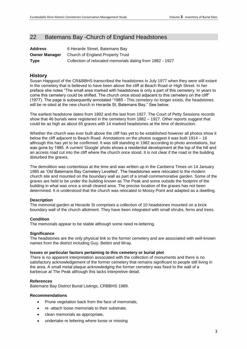
22 Batemans Bay -Church of England Headstones
Address 6 Herarde Street, Batemans Bay
Owner Manager Church of England Property Trust
Type Collection of relocated memorials dating from 1882 - 1927
History Susan Hapgood of the CR&BBHS transcribed the headstones in July 1977 when they were still extant in the cemetery that is believed to have been above the cliff at Beach Road or High Street. In her preface she notes “The small area marked with headstones is only a part of this cemetery. In years to come this cemetery could be shifted. The church once stood adjacent to this cemetery on the cliff” (1977). The page is subsequently annotated “1985 - This cemetery no longer exists, the headstones will be re-sited at the new church in Herarde St, Batemans Bay.” See below. The earliest headstone dates from 1892 and the last from 1927. The Court of Petty Sessions records show that 46 burials were registered in the cemetery from 1882 – 1927. Other reports suggest that could be as high as about 65 graves with 14 marked headstones at the time of destruction. Whether the church was ever built above the cliff has yet to be established however all photos show it below the cliff adjacent to Beach Road. Annotations on the photos suggest it was built 1914 – 16 although this has yet to be confirmed. It was still standing in 1982 according to photo annotations, but was gone by 1985. A current ‘Google’ photo shows a residential development at the top of the hill and an access road cut into the cliff where the church once stood. It is not clear if the road or the building disturbed the graves. The demolition was contentious at the time and was written up in the Canberra Times on 14 January 1985 as ‘Old Batemans Bay Cemetery Levelled’. The headstones were relocated to the modern church site and mounted on the boundary wall as part of a small commemorative garden. Some of the graves are held to be under the building known as The Peak and some outside the footprint of the building in what was once a small cleared area. The precise location of the graves has not been determined. It is understood that the church was relocated to Mossy Point and adapted as a dwelling. Description The memorial garden at Herarde St comprises a collection of 10 headstones mounted on a brick boundary wall of the church allotment. They have been integrated with small shrubs, ferns and trees. Condition The memorials appear to be stable although some need re-lettering. Significance The headstones are the only physical link to the former cemetery and are associated with well-known names from the district including Guy, Bettini and Wray. Issues or particular factors pertaining to this cemetery or burial plot There is no apparent interpretation associated with the collection of monuments and there is no satisfactory acknowledgement of the former cemetery that remains significant to people still living in the area. A small metal plaque acknowledging the former cemetery was fixed to the wall of a barbecue at The Peak although this lacks interpretive detail. References Batemans Bay District Burial Listings, CRBBHS 1989. Recommendations
Prune vegetation back from the face of memorials,
re -attach loose memorials to their substrate,
clean memorials as appropriate,
undertake re lettering where loose or missing
Eurobodalla Shire Historic Cemeteries Conservation Management Study Volume 3 - Inventory of Burial Sites
4
Prepare and install an interpretation panels in proximity to the memorial, and
Prepare and install an interpretation panel at the site of the former cemetery.
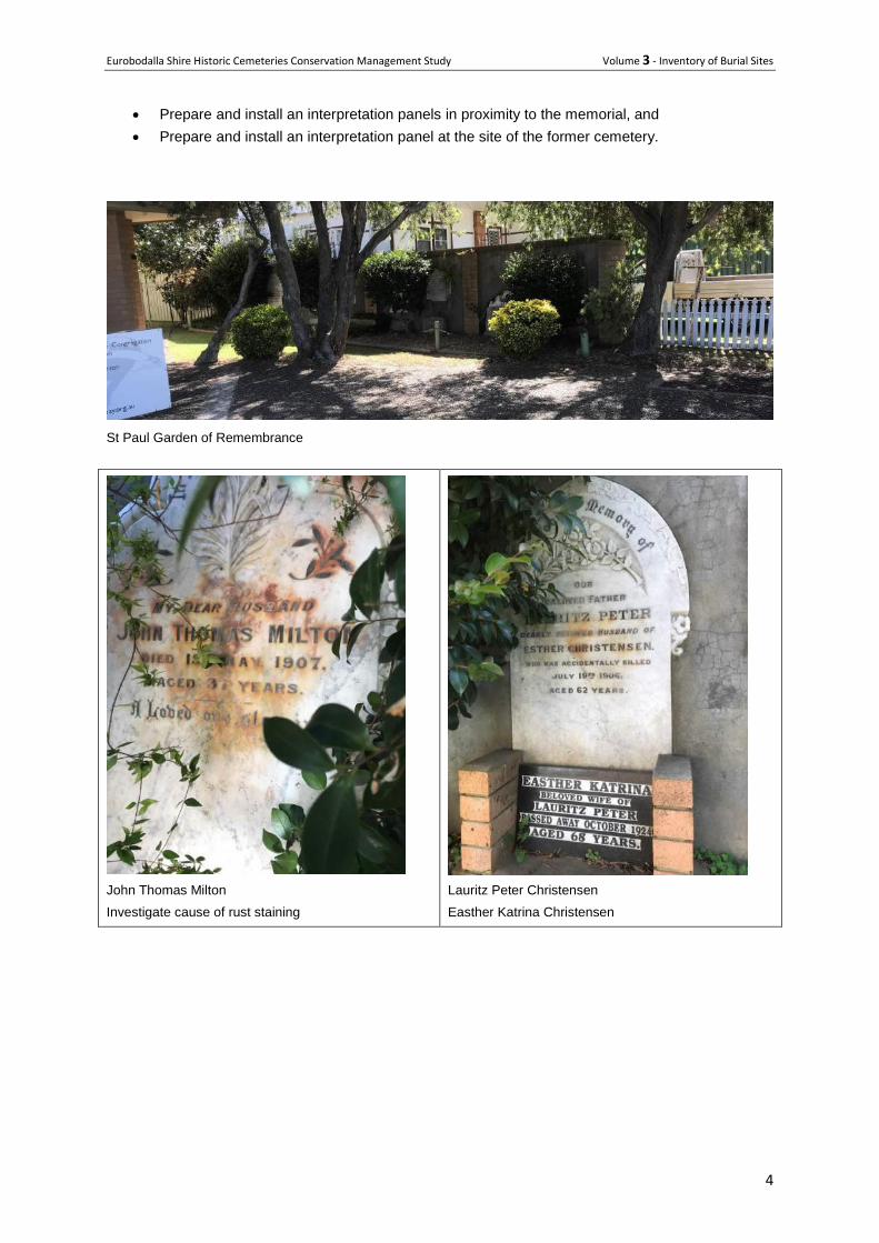
St Paul Garden of Remembrance
John Thomas Milton
Investigate cause of rust staining
Lauritz Peter Christensen
Easther Katrina Christensen
Eurobodalla Shire Historic Cemeteries Conservation Management Study Volume 3 - Inventory of Burial Sites
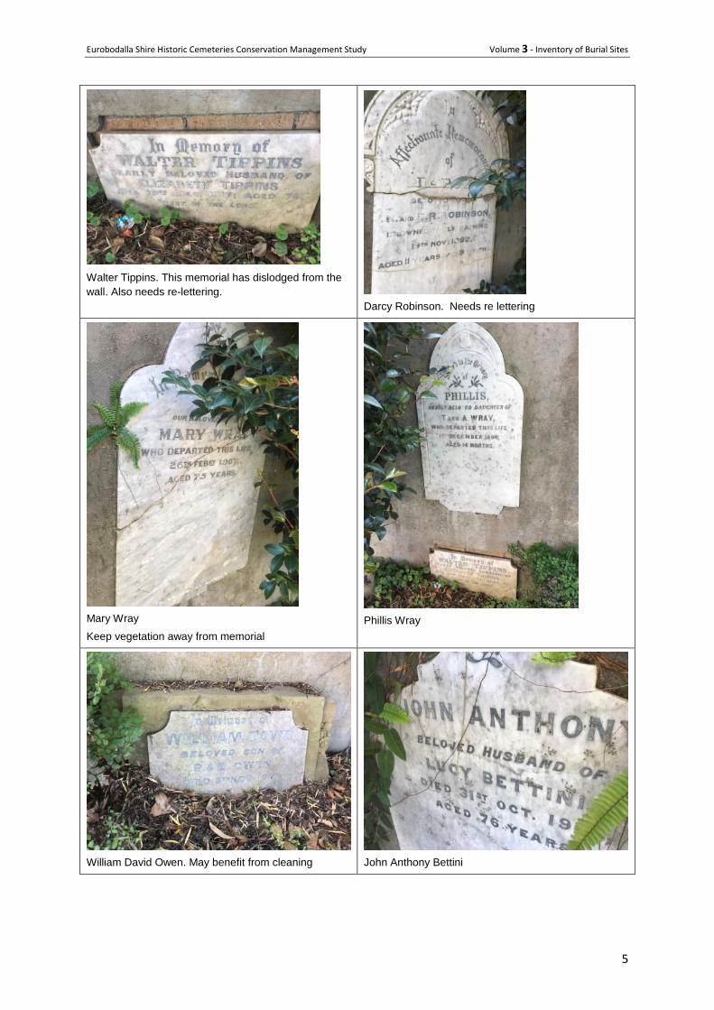
5
Walter Tippins. This memorial has dislodged from the
wall. Also needs re-lettering.
Darcy Robinson. Needs re lettering
Mary Wray
Keep vegetation away from memorial
Phillis Wray
William David Owen. May benefit from cleaning
John Anthony Bettini
Eurobodalla Shire Historic Cemeteries Conservation Management Study Volume 3 - Inventory of Burial Sites
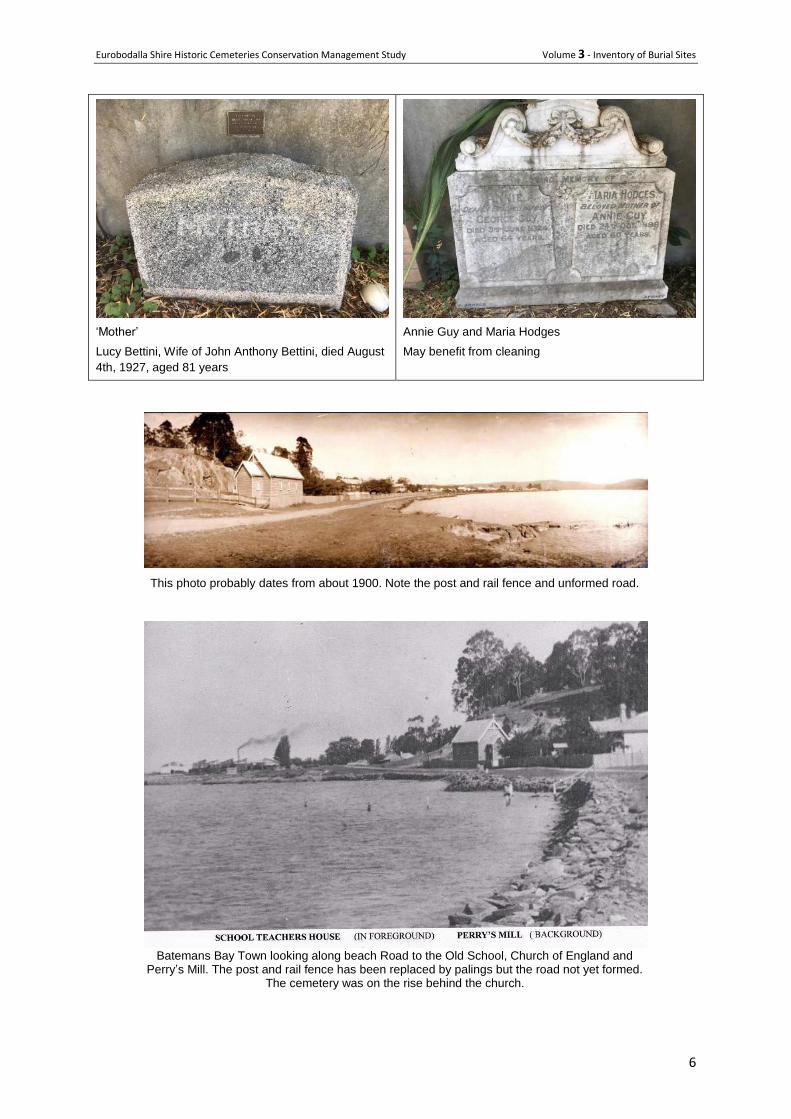
6
‘Mother’
Lucy Bettini, Wife of John Anthony Bettini, died August
4th, 1927, aged 81 years
Annie Guy and Maria Hodges
May benefit from cleaning
This photo probably dates from about 1900. Note the post and rail fence and unformed road.
Batemans Bay Town looking along beach Road to the Old School, Church of England and
Perry’s Mill. The post and rail fence has been replaced by palings but the road not yet formed. The cemetery was on the rise behind the church.
Eurobodalla Shire Historic Cemeteries Conservation Management Study Volume 3 - Inventory of Burial Sites
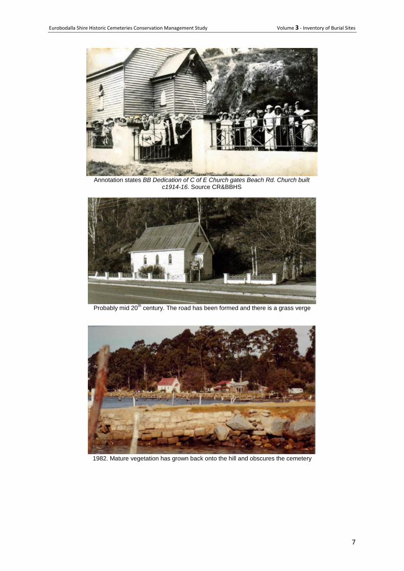
7
Annotation states BB Dedication of C of E Church gates Beach Rd. Church built
c1914-16. Source CR&BBHS
Probably mid 20
th century. The road has been formed and there is a grass verge
1982. Mature vegetation has grown back onto the hill and obscures the cemetery
Eurobodalla Shire Historic Cemeteries Conservation Management Study Volume 3 - Inventory of Burial Sites
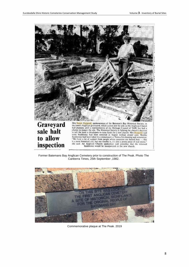
8
Former Batemans Bay Anglican Cemetery prior to construction of The Peak. Photo The Canberra Times, 25th September ,1982.
Commemorative plaque at The Peak. 2019
Eurobodalla Shire Historic Cemeteries Conservation Management Study Volume 3 - Inventory of Burial Sites
9
23 St Phillips Church of England Cemetery, Corunna- ‘Noorooma’
Also called Willcocks’ or Nettlewood Cemetery
Location Wagonga Scenic Drive, Narooma Lot 398 (2r) and 399 (1 Acre), DP 752155
Co-ords 36°14'30.8"S 150°06'16.9"E
Owner manager- Private
Type - Remnant of small local cemetery
Status - Closed
History
St Philip’s Church was located at the junction of Narooma, Tilba and Punkalla Roads on Lot numbers 398 (2r) and 399 (1ac) in Deposited Plan 752155.
1 The land was originally a Crown Grant - title was
established 18 July 1884 initially in the name of the Moruya clergyman. It was purchased by the Diocese for a church on 18 November 1885.
A church at this location was possibly initiated by William Willcocks of Nettlewood (the first selector
around Wagonga Inlet). Willcocks was born in England in 1830 and arrived at Wagonga Inlet in 1855.
He was initially employed by Thomas Forster at 'Noorooma' but then selected some of Forster's
holdings after 1862.
St Philip’s Church was built in 1886.2 Churchwardens for St Philip’s appointed in April 1893 were
John Willcocks, Edward Harper and George Barker. As Narooma developed as a town, having been gazetted in 1886, the church’s location so far from town was became increasingly inconvenient for the growing number of Church of England parishioners living in town. A new Church of England church – St Paul’s - was built in the town itself in 1900.
Corunna continued to hold church services ‘almost every Sunday’, despite the proximity of St Paul’s in Narooma and a declining number of St Philip’s parishioners in its later years. Some parishioners attended both churches. Services appear to have continued right up until the church was destroyed in a bushfire on 7 November 1928.
The building was insured but the Rector and churchwardens decided not to rebuild; the burial ground continued to be used.
3 Some of the insurance was spent re-erecting a fence around the site, and the
balance vested in the Church of England Property Trust, Diocese of Goulburn.
St Philip’s cemetery was also often referred to as the Willcocks’ or Nettlewood cemetery. At least 17 people are known to be buried there, most of them members of the extended Willcocks family.
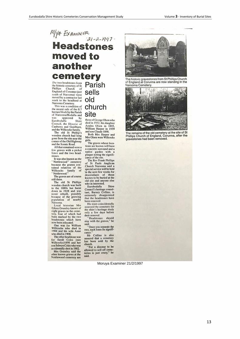
Only four burials were marked by headstones – one for William and Ann Willcocks and the other for George Olson and his daughter Azalea. Any wooden crosses on the other graves were destroyed along with the church and fencing in the 1928 bushfire. The last known burial at St Philip’s was William James Harper who died 18 November 1939, aged 79 years.
4
The Parish initiated moves to sell the Corunna land in 1992. Rev Phillips claimed in 1997 that St Philip’s was never a properly dedicated cemetery, and that it was ‘a matter of hospitality’ that members of the church could be buried in the churchyard instead of being taken to a community cemetery.
5
The Diocese was consulted about the sale and moving the headstones to Narooma main cemetery, as were the Willcocks family including family patriarch Arnim, Eurobodalla Shire Council, and Narooma Historical Society; none of them raised objections. . Removal of the headstones was
1 Laurelle Pacey, The History pf the Parish of Bodalla and Narooma, unpublished
2 R T Wyatt, The History of the Diocese of Goulburn, 1937, p.226; The Corunna Church Ordinance of 1930, Riley file, Bodalla
Parish Archives. 3 The Corunna Church Ordinance of 1930, Bill Riley file, Bodalla Parish Archives.
4 Boyce, op. cit., p. 274. William Harper’s parents are also buried in St Philip’s cemetery; Rev Frank Philip’s, letter to
Eurobodalla Shire Council General Manager, 18 November 1996, Corunna Lands file, Bodalla Parish records. 5 Rev Frank Philip’s, Narooma News, no date, Corunna land file, Bodalla Parish records.
Eurobodalla Shire Historic Cemeteries Conservation Management Study Volume 3 - Inventory of Burial Sites
10
apparently a condition of the sale of the 0.7 hectare block by the Parish. Council’s Heritage Consultant Barney Collins spoke out strongly against relocating the headstones. The cemetery site had been assessed for the shire’s heritage study just days before the headstones’ removal. ‘Headstones should stay with the graves,’ he said. ‘Once you separate the two, each loses its significance.’
Nor did Collins approve of the Diocese selling off cemeteries, describing it as ‘just crazy’. Similar concerns, as well as concerns about the process, were expressed in local newspapers in letters to the editor.
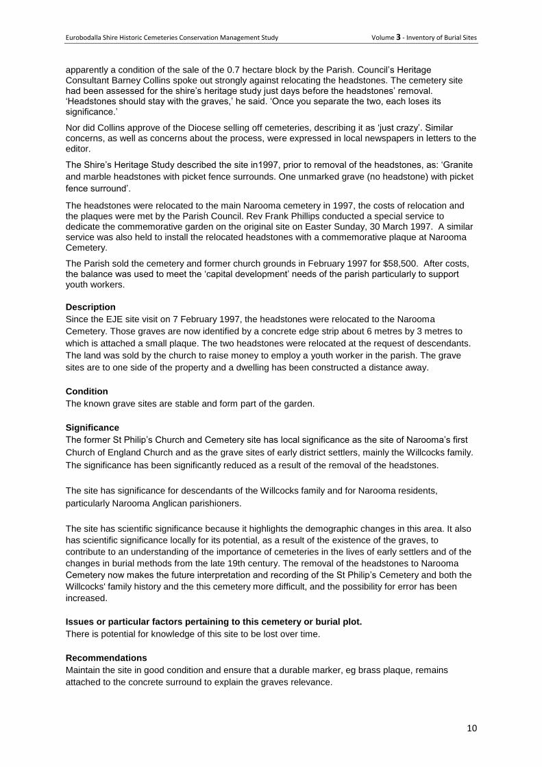
The Shire’s Heritage Study described the site in1997, prior to removal of the headstones, as: ‘Granite
and marble headstones with picket fence surrounds. One unmarked grave (no headstone) with picket
fence surround’.
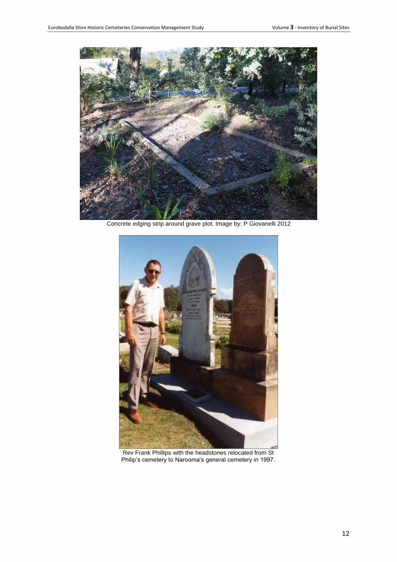
The headstones were relocated to the main Narooma cemetery in 1997, the costs of relocation and the plaques were met by the Parish Council. Rev Frank Phillips conducted a special service to dedicate the commemorative garden on the original site on Easter Sunday, 30 March 1997. A similar service was also held to install the relocated headstones with a commemorative plaque at Narooma Cemetery.
The Parish sold the cemetery and former church grounds in February 1997 for $58,500. After costs, the balance was used to meet the ‘capital development’ needs of the parish particularly to support youth workers.
Description
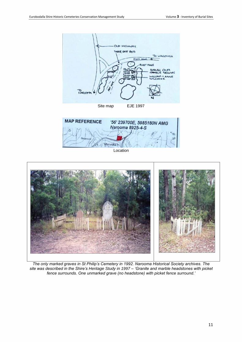
Since the EJE site visit on 7 February 1997, the headstones were relocated to the Narooma
Cemetery. Those graves are now identified by a concrete edge strip about 6 metres by 3 metres to
which is attached a small plaque. The two headstones were relocated at the request of descendants.
The land was sold by the church to raise money to employ a youth worker in the parish. The grave
sites are to one side of the property and a dwelling has been constructed a distance away.
Condition
The known grave sites are stable and form part of the garden.
Significance
The former St Philip’s Church and Cemetery site has local significance as the site of Narooma’s first
Church of England Church and as the grave sites of early district settlers, mainly the Willcocks family.
The significance has been significantly reduced as a result of the removal of the headstones.
The site has significance for descendants of the Willcocks family and for Narooma residents,
particularly Narooma Anglican parishioners.
The site has scientific significance because it highlights the demographic changes in this area. It also
has scientific significance locally for its potential, as a result of the existence of the graves, to
contribute to an understanding of the importance of cemeteries in the lives of early settlers and of the
changes in burial methods from the late 19th century. The removal of the headstones to Narooma
Cemetery now makes the future interpretation and recording of the St Philip’s Cemetery and both the
Willcocks' family history and the this cemetery more difficult, and the possibility for error has been
increased.
Issues or particular factors pertaining to this cemetery or burial plot.
There is potential for knowledge of this site to be lost over time.
Recommendations
Maintain the site in good condition and ensure that a durable marker, eg brass plaque, remains
attached to the concrete surround to explain the graves relevance.
Eurobodalla Shire Historic Cemeteries Conservation Management Study Volume 3 - Inventory of Burial Sites
11
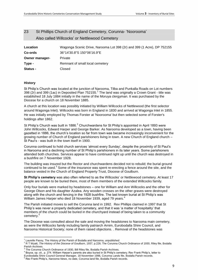
Site map EJE 1997
Location
The only marked graves in St Philip’s Cemetery in 1992. Narooma Historical Society archives. The site was described in the Shire’s Heritage Study in 1997 – ‘Granite and marble headstones with picket
fence surrounds. One unmarked grave (no headstone) with picket fence surround.’
Eurobodalla Shire Historic Cemeteries Conservation Management Study Volume 3 - Inventory of Burial Sites
12
Concrete edging strip around grave plot. Image by: P Giovanelli 2012
Rev Frank Phillips with the headstones relocated from St Philip’s cemetery to Narooma’s general cemetery in 1997.
Eurobodalla Shire Historic Cemeteries Conservation Management Study Volume 3 - Inventory of Burial Sites
13
Moruya Examiner 21/2/1997
Eurobodalla Shire Historic Cemeteries Conservation Management Study Volume 3 - Inventory of Burial Sites
14
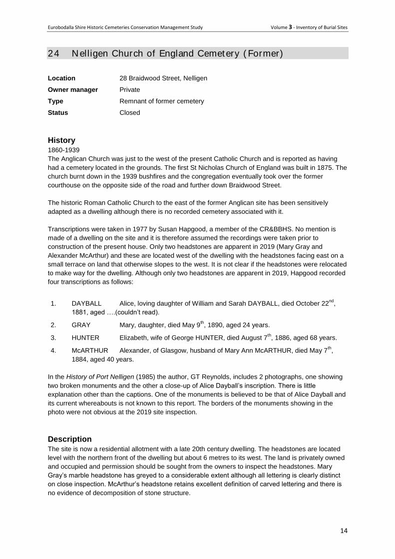
24 Nelligen Church of England Cemetery ( Former) Location 28 Braidwood Street, Nelligen
Owner manager Private
Type Remnant of former cemetery
Status Closed
History 1860-1939
The Anglican Church was just to the west of the present Catholic Church and is reported as having
had a cemetery located in the grounds. The first St Nicholas Church of England was built in 1875. The
church burnt down in the 1939 bushfires and the congregation eventually took over the former
courthouse on the opposite side of the road and further down Braidwood Street.
The historic Roman Catholic Church to the east of the former Anglican site has been sensitively
adapted as a dwelling although there is no recorded cemetery associated with it.
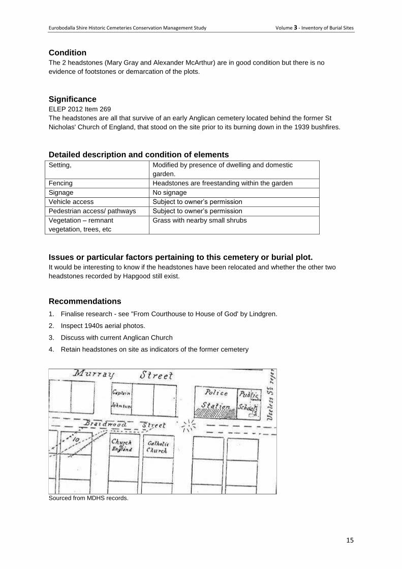
Transcriptions were taken in 1977 by Susan Hapgood, a member of the CR&BBHS. No mention is
made of a dwelling on the site and it is therefore assumed the recordings were taken prior to
construction of the present house. Only two headstones are apparent in 2019 (Mary Gray and
Alexander McArthur) and these are located west of the dwelling with the headstones facing east on a
small terrace on land that otherwise slopes to the west. It is not clear if the headstones were relocated
to make way for the dwelling. Although only two headstones are apparent in 2019, Hapgood recorded
four transcriptions as follows:
1. DAYBALL Alice, loving daughter of William and Sarah DAYBALL, died October 22nd
,
1881, aged ….(couldn’t read).
2. GRAY Mary, daughter, died May 9th, 1890, aged 24 years.
3. HUNTER Elizabeth, wife of George HUNTER, died August 7th, 1886, aged 68 years.
4. McARTHUR Alexander, of Glasgow, husband of Mary Ann McARTHUR, died May 7th,
1884, aged 40 years.
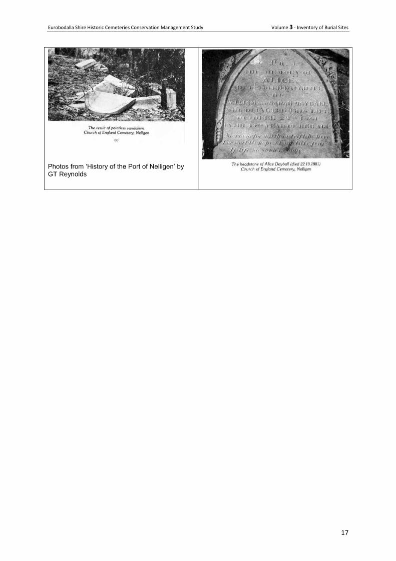
In the History of Port Nelligen (1985) the author, GT Reynolds, includes 2 photographs, one showing
two broken monuments and the other a close-up of Alice Dayball’s inscription. There is little
explanation other than the captions. One of the monuments is believed to be that of Alice Dayball and
its current whereabouts is not known to this report. The borders of the monuments showing in the
photo were not obvious at the 2019 site inspection.
Description
The site is now a residential allotment with a late 20th century dwelling. The headstones are located
level with the northern front of the dwelling but about 6 metres to its west. The land is privately owned
and occupied and permission should be sought from the owners to inspect the headstones. Mary
Gray’s marble headstone has greyed to a considerable extent although all lettering is clearly distinct
on close inspection. McArthur’s headstone retains excellent definition of carved lettering and there is
no evidence of decomposition of stone structure.
Eurobodalla Shire Historic Cemeteries Conservation Management Study Volume 3 - Inventory of Burial Sites
15
Condition The 2 headstones (Mary Gray and Alexander McArthur) are in good condition but there is no
evidence of footstones or demarcation of the plots.
Significance ELEP 2012 Item 269
The headstones are all that survive of an early Anglican cemetery located behind the former St
Nicholas' Church of England, that stood on the site prior to its burning down in the 1939 bushfires.
Detailed description and condition of elements
Setting, Modified by presence of dwelling and domestic
garden.
Fencing Headstones are freestanding within the garden
Signage No signage
Vehicle access Subject to owner’s permission
Pedestrian access/ pathways Subject to owner’s permission
Vegetation – remnant
vegetation, trees, etc
Grass with nearby small shrubs
Issues or particular factors pertaining to this cemetery or burial plot. It would be interesting to know if the headstones have been relocated and whether the other two
headstones recorded by Hapgood still exist.
Recommendations
1. Finalise research - see "From Courthouse to House of God' by Lindgren.
2. Inspect 1940s aerial photos.
3. Discuss with current Anglican Church
4. Retain headstones on site as indicators of the former cemetery
Sourced from MDHS records.
Eurobodalla Shire Historic Cemeteries Conservation Management Study Volume 3 - Inventory of Burial Sites
16
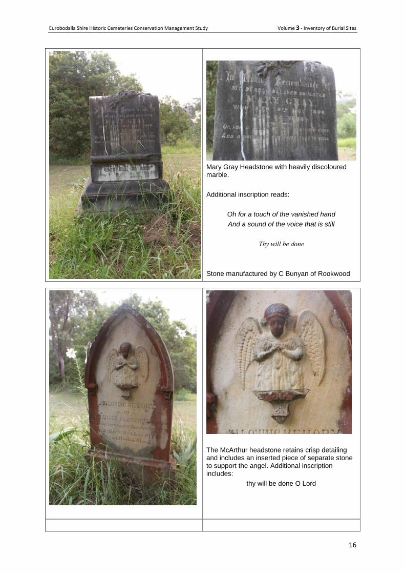
Mary Gray Headstone with heavily discoloured marble.
Additional inscription reads:
Oh for a touch of the vanished hand
And a sound of the voice that is still
Thy will be done
Stone manufactured by C Bunyan of Rookwood
The McArthur headstone retains crisp detailing and includes an inserted piece of separate stone to support the angel. Additional inscription includes:
thy will be done O Lord
Eurobodalla Shire Historic Cemeteries Conservation Management Study Volume 3 - Inventory of Burial Sites
17
Photos from ‘History of the Port of Nelligen’ by GT Reynolds
Eurobodalla Shire Historic Cemeteries Conservation Management Study Volume 3 - Inventory of Burial Sites
18
Private cemeteries - on privately owned land and managed by a family
or group,

Eurobodalla Shire Historic Cemeteries Conservation Management Study Volume 3 - Inventory of Burial Sites
19
25 Currowan Private Cemetery
Backhouse Cemetery
Location Western Distributor off The Kings Highway.
From Nelligen, head west on Kings Highway for 12.9km, turn right at The
Western Distributor for 2.2km to the cemetery. The cemetery is on private
property behind the old Backhouse homestead and permission to access it must
be sought.
GPS refs Latitude -35.576534 longitude 150.058014
Owner manager Private
Type Historic family cemetery.
History Currowan Private Cemetery, otherwise known as the Backhouse Cemetery, was established by the pioneering Backhouse family in the 1890s. It includes the graves of William and Ellen Backhouse and members of their family.
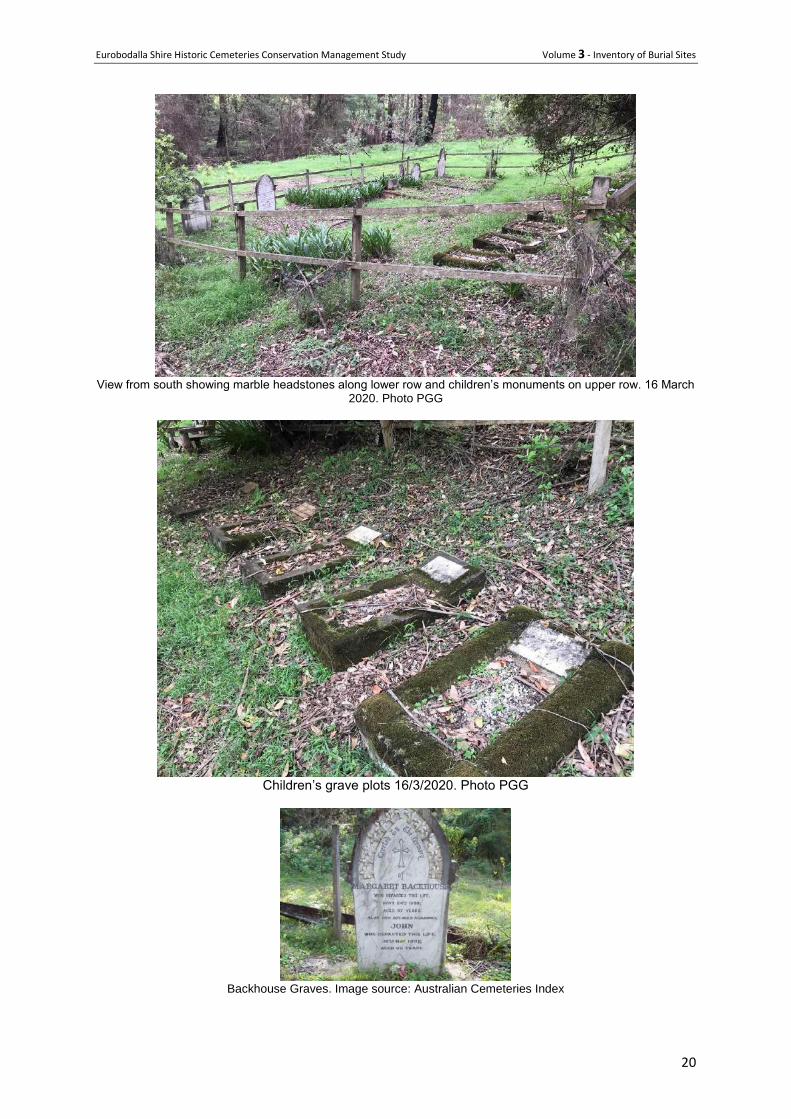
Description Up to 13 inscriptions or plaques on headstones are located within a fenced enclosure. Headstones on the lower side are of carved marble while the five on the upper side memorialise children and appear to have been constructed at the same time.
Condition The cemetery was not affected by the wildfires of the summer of 2019-20 and remains in good condition.
Significance The Backhouse family is well established in the district. The earliest grave in the cemetery dates from 1891 and the last from 1985. The site is an enduring record of the lives of the Backhouse family and contains some fine monuments. The cemetery is not listed in the ELEP heritage schedule.
Issues or particular factors pertaining to this cemetery or burial plot. Permission is required from the owners to enter the property
References Australian Cemeteries Index- includes photos: http://austcemindex.com/?cemetery=Currowan+Private
Recommendations Continue to manage the cemetery in a manner that preserves its significance.
Eurobodalla Shire Historic Cemeteries Conservation Management Study Volume 3 - Inventory of Burial Sites
20
View from south showing marble headstones along lower row and children’s monuments on upper row. 16 March
2020. Photo PGG
Children’s grave plots 16/3/2020. Photo PGG
Backhouse Graves. Image source: Australian Cemeteries Index
Eurobodalla Shire Historic Cemeteries Conservation Management Study Volume 3 - Inventory of Burial Sites
21
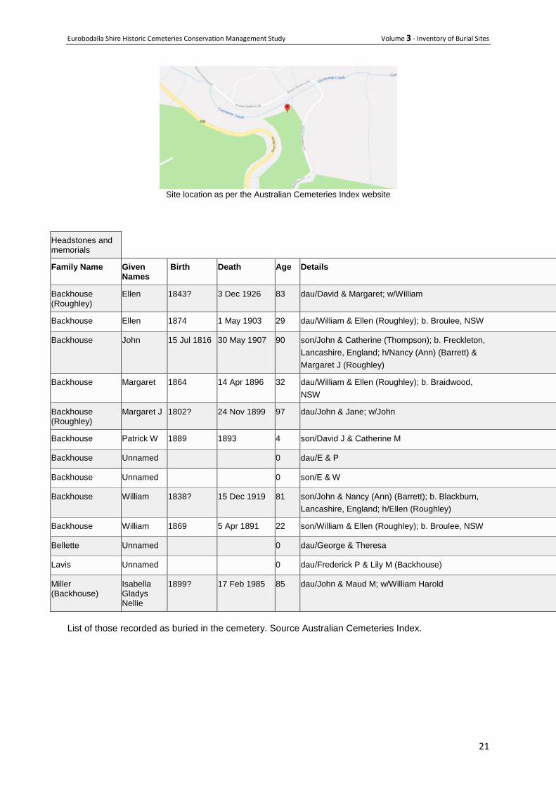
Site location as per the Australian Cemeteries Index website
Headstones and memorials
Family Name Given Names
Birth Death Age Details Cemetery Row, Plot
Backhouse (Roughley)
Ellen 1843? 3 Dec 1926 83 dau/David & Margaret; w/William Currowan Private NSW
Backhouse Ellen 1874 1 May 1903 29 dau/William & Ellen (Roughley); b. Broulee, NSW Currowan Private NSW
Backhouse John 15 Jul 1816 30 May 1907 90 son/John & Catherine (Thompson); b. Freckleton,
Lancashire, England; h/Nancy (Ann) (Barrett) &
Margaret J (Roughley)
Currowan Private NSW
Backhouse Margaret 1864 14 Apr 1896 32 dau/William & Ellen (Roughley); b. Braidwood,
NSW
Currowan Private NSW
Backhouse (Roughley)
Margaret J 1802? 24 Nov 1899 97 dau/John & Jane; w/John Currowan Private NSW
Backhouse Patrick W 1889 1893 4 son/David J & Catherine M Currowan Private NSW
Backhouse Unnamed 0 dau/E & P Currowan Private NSW
Backhouse Unnamed 0 son/E & W Currowan Private NSW
Backhouse William 1838? 15 Dec 1919 81 son/John & Nancy (Ann) (Barrett); b. Blackburn,
Lancashire, England; h/Ellen (Roughley)
Currowan Private NSW
Backhouse William 1869 5 Apr 1891 22 son/William & Ellen (Roughley); b. Broulee, NSW Currowan Private NSW
Bellette Unnamed 0 dau/George & Theresa Currowan Private NSW
Lavis Unnamed 0 dau/Frederick P & Lily M (Backhouse) Currowan Private NSW
Miller (Backhouse)
Isabella Gladys Nellie
1899? 17 Feb 1985 85 dau/John & Maud M; w/William Harold Currowan Private NSW
List of those recorded as buried in the cemetery. Source Australian Cemeteries Index.
Eurobodalla Shire Historic Cemeteries Conservation Management Study Volume 3 - Inventory of Burial Sites
22
26 Lucks Cemetery
Location 1 Cutharich Place, Moruya
Owner manager Private
Type Historic family grave
History 1877-1915 Mr Jacob Luck (b 1801) of Yarragee, who was one of the oldest residents in the district at the time of his death, was a native of Goudhurst near Tunbridge Wells, Kent, England and arrived in Australia with his wife Mary Ann (b 1812) in 1841. He farmed at Bergalia on land then owned by Abercrombie & McKay. He subsequently cultivated a large number of acres on the Moruya Flat in conjunction with his nephew John Luck (who had accompanied him from England) and William Collett of Mungerarie. At that time the land was a portion of the Gundary squatting station leased by the late William Campbell Esq. Following the success of the venture he purchased a farm at Yarragee, on which he subsequently lived. [One source says he had land at Kiora in 1850 - 60]. He was a consistent member of the Wesleyan Church and laid the foundation stone of the church in Page Street, Moruya to which at the time he donated 100 pounds. His wife died a few years before him and at her own particular request was buried near their residence on the bank of the Moruya River. Jacob was buried in the same private cemetery. Details of some of the family buried there are as below:
Jacob Luck was born 3 Nov 1801 at Goudhurst, Kent, England son of William Luck and Mary Frost. He arrived in NSW 4 February 1841 on the ‘Marquis Of Hastings’. Died 26 Dec 1887 at Yarragee, Moruya. Buried at Yarragee Private Cemetery.
Mary Ann Luck (nee Walter) (wife) was born on 31 July 1812 Goudhurst, Kent, England the daughter of William Walter and Elizabeth Wheeler. She also arrived in NSW 4 February 1841 on the ‘Marquis Of Hastings’ and died 24 Nov 1877 Moruya. Buried: Yarragee Private Cemetery.
John Luck (son) b. 16 Jun 1845 Gundary, Moruya. Died 12 Sep 1889 through being tossed out of a horse drawn cart. Bur: Yarragee Private Cemetery, and his wife
Johanna Blake (daughter in law married to John Luck) b. 25 Oct 1843 Parramatta, NSW daughter of Richard Blake and Sarah Cleve. Died 30 Apr 1915 Gundary, Moruya. Bur: Yarragee.
The cemetery was rediscovered in 1985 by Mr and Mrs Fairbanks who had just purchased the property at that time. Description (general) This is a private cemetery located on a property at Yarragee. Buried there are Jacob and Mary Luck, original pioneers of Yarragee. With them are their son John and his wife Joanna, grandson Walter, Jacob’s sister Elizabeth Sisley and two Jeffries babies, nieces of Joanna, who died in infancy. The site is associated with an old Cypress tree.
Condition (general) Not assessed on 2019
Significance Generally ELEP Item 258
Eurobodalla Shire Historic Cemeteries Conservation Management Study Volume 3 - Inventory of Burial Sites
23
The cemetery is significant as the private burial place of Joanna Luck, her husband Jacob and several of their descendants, numbering eight known burials in total.
References
ELEP 2012 Heritage schedule
Moruya Pioneers Directory, Kay Fensom Boyce.
‘Pioneer Graveyard Saved’ Moruya Examiner 1985
Recommendations Continue current management
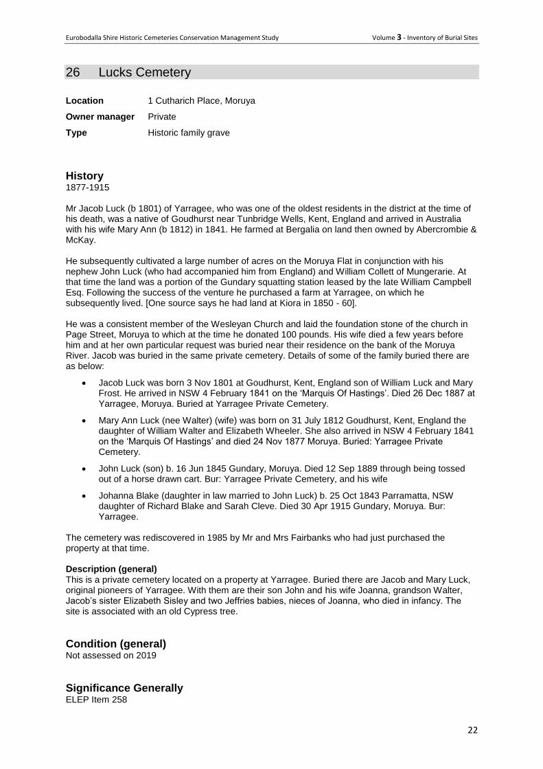
Hedley William Luck, grandson of Jacob showing the hill on which burial site is
located. Photo from 19th century.
Eurobodalla Shire Historic Cemeteries Conservation Management Study Volume 3 - Inventory of Burial Sites
24
27 Southam Graves
Location 9069 Princes Highway, Tilba Tilba
"Fairview" Fairview Road
Owner Private
Type Isolated family burial site
History
James Southam and wife Mary (nee Betts) and two sons Dan and John, selected in 1875 and then
bought W H K Hickson's selections. James and Mary's son-in-law, Davild Gilpin (former Couria Creek
school teacher, who became Lord Mayor of Sydney 1923-24) selected the last block to form the three
properties. Dan's sons ended up owning the properties "Killarney" (William), "Fairview" (Perce and
later Alan) and "Couria Creek (Walter "Top"). James and Mary reared at least 11 children.
The Southam family, through their marriages, probably had a greater influence on Tilba district
families than any other. The buildings on "Fairview" were shifted from a site further east about the turn
of the century. Cheese was made on "Fairview" for all Southam properties until about June 1926.
Perce Southam sold "Fairview" to Keith Teague in 1953.
The graves at "Fairview" are listed on the Moruya CPS and include: Daniel Southam, died 4 March
1921, aged 73 at "Fairview', Tilba. Son of James Southam and Mary Betts. Buried 5 March 1921 at
Private Church of England Cemetery, Tilba by T M Manning, John Bate and W H Corkhill. Born
England, 66 years in NSW. Married Brogo aged 26 to Catherine Curtis. Issue: Emily 46, William 45,
Alfred 31, Walter 28, Minnie 26, Percy 24, Allan 23, Maud 22, Freda 21, 4 males deceased. Also:
James Southam died 20 June 1908 at "Fairview' aged 89. Buried Tilba Tilba. No mention of Private
Cemetery. No other Southams listed to 1945.
The following burials were recorded by the MDHS burials database as buried in Tilba Tilba follow
establishment of the general cemetery. While not conclusive it could indicate some of the other burials
within the cemetery.
Surname Age Death date Burial location
BAILEY, Loveday 59 6/09/1910 Tilba Tilba
BARRETT, Francis 03 14/12/1908 Tilba Tilba by Jacon John Shottin
BUNGEL, William 24 21/02/1910 Tilba Tilba
MAXWELL, Catherine 85 9/09/1907 Tilba Tilba by Jacob John Shottin
MAYO, Edeline Jean 04m2w 8/06/1909 Tilba Tilba cem by Jacob John Shottin
SOUTHAM, Daniel 73 4/03/1921 Private Cem Couria Creek, Tilba
SOUTHAM, James 89 20/06/1908 Tilba Tilba by Jacob J Shottin
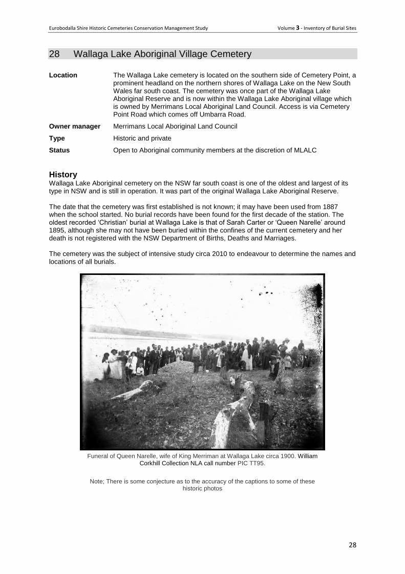
A more recent timber cross commemorates Betty Bate (Southam) who lived from 25-9-1925 to 30-6-
2011.
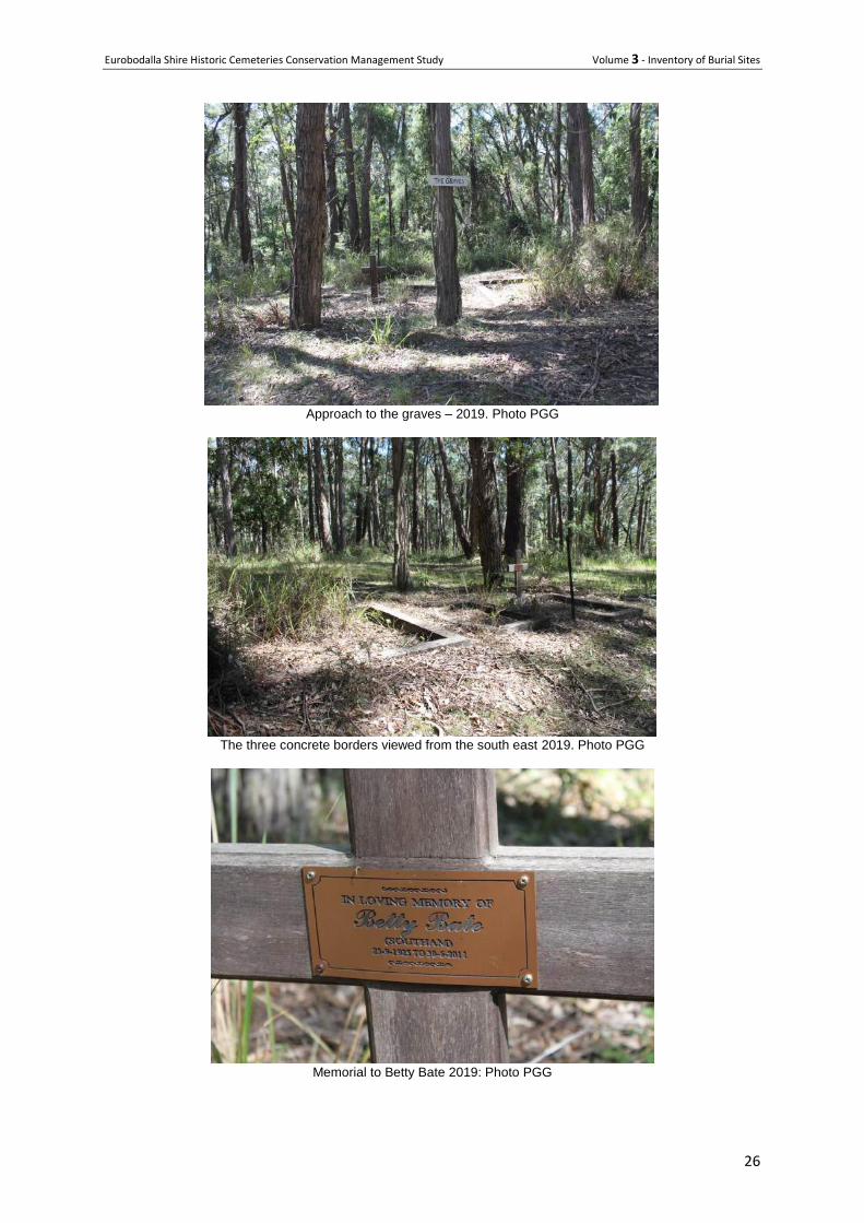
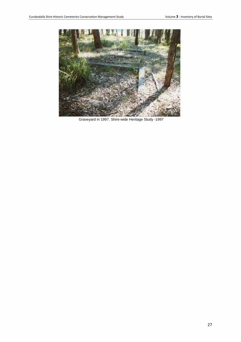
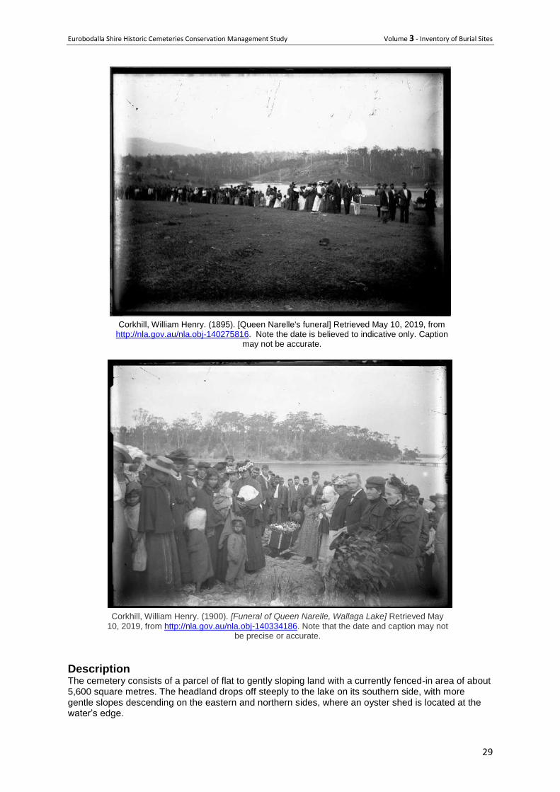
Description This small family cemetery contains three concrete grave borders. The one on the left (east) is a
double plot and the other two are single. None are marked and there are no headstones or plaques.
The timber cross commemorating Betty Bate is dated to 2011. The graves are in a partly cleared area
within a natural bush setting. Mature eucalyptus trees dominate and the plots are partly covered by
Eurobodalla Shire Historic Cemeteries Conservation Management Study Volume 3 - Inventory of Burial Sites
25
leaf litter. A private walking track passes nearby and the collection of burials is simply signed by the
word ‘Graves’ painted on a board and fixed to a tree.
Condition The concrete borders are very stable and have not been impacted by tree roots
Significance ELEP 2012 Item 243
Historically the Southam graves have high-level local significance for providing evidence of that
eminent family's continued occupation of the "Fairview" property well into the early 20th century,
helping to demonstrate the scope of that family's activities in and associations with the local area.
Socially, although unidentified, the grave sites continue to have high-level local significance for all
pioneering Southam family descendants. Scientifically the grave sites have local significance as
benchmark sites with potential to reveal information about the siting and form of private grave sites in
the South Coast area in the early 20th century. (ELP Citation)
Issues or particular factors pertaining to this cemetery or burial plot. The cemetery is on private land and not accessible without permission from the owner. Without
inscriptions they convey little information and while they are in a delightful location the graves
themselves are very basic.
Recommendations Continue current management
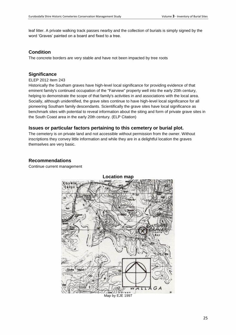
Location map
Map by EJE 1997
Eurobodalla Shire Historic Cemeteries Conservation Management Study Volume 3 - Inventory of Burial Sites
26
Approach to the graves – 2019. Photo PGG
The three concrete borders viewed from the south east 2019. Photo PGG
Memorial to Betty Bate 2019: Photo PGG
Eurobodalla Shire Historic Cemeteries Conservation Management Study Volume 3 - Inventory of Burial Sites
27
Graveyard in 1997. Shire-wide Heritage Study -1997
Eurobodalla Shire Historic Cemeteries Conservation Management Study Volume 3 - Inventory of Burial Sites
28
28 Wallaga Lake Aboriginal Village Cemetery
Location The Wallaga Lake cemetery is located on the southern side of Cemetery Point, a prominent headland on the northern shores of Wallaga Lake on the New South Wales far south coast. The cemetery was once part of the Wallaga Lake Aboriginal Reserve and is now within the Wallaga Lake Aboriginal village which is owned by Merrimans Local Aboriginal Land Council. Access is via Cemetery Point Road which comes off Umbarra Road.
Owner manager Merrimans Local Aboriginal Land Council
Type Historic and private
Status Open to Aboriginal community members at the discretion of MLALC
History Wallaga Lake Aboriginal cemetery on the NSW far south coast is one of the oldest and largest of its type in NSW and is still in operation. It was part of the original Wallaga Lake Aboriginal Reserve. The date that the cemetery was first established is not known; it may have been used from 1887 when the school started. No burial records have been found for the first decade of the station. The oldest recorded ‘Christian’ burial at Wallaga Lake is that of Sarah Carter or ‘Queen Narelle’ around 1895, although she may not have been buried within the confines of the current cemetery and her death is not registered with the NSW Department of Births, Deaths and Marriages. The cemetery was the subject of intensive study circa 2010 to endeavour to determine the names and locations of all burials.
Funeral of Queen Narelle, wife of King Merriman at Wallaga Lake circa 1900. William
Corkhill Collection NLA call number PIC TT95.
Note; There is some conjecture as to the accuracy of the captions to some of these historic photos
Eurobodalla Shire Historic Cemeteries Conservation Management Study Volume 3 - Inventory of Burial Sites
29
Corkhill, William Henry. (1895). [Queen Narelle's funeral] Retrieved May 10, 2019, from
http://nla.gov.au/nla.obj-140275816. Note the date is believed to indicative only. Caption may not be accurate.
Corkhill, William Henry. (1900). [Funeral of Queen Narelle, Wallaga Lake] Retrieved May
10, 2019, from http://nla.gov.au/nla.obj-140334186. Note that the date and caption may not be precise or accurate.
Description The cemetery consists of a parcel of flat to gently sloping land with a currently fenced-in area of about 5,600 square metres. The headland drops off steeply to the lake on its southern side, with more gentle slopes descending on the eastern and northern sides, where an oyster shed is located at the water’s edge.
Eurobodalla Shire Historic Cemeteries Conservation Management Study Volume 3 - Inventory of Burial Sites
30
Several of the graves are marked and in some cases are named. Many graves are noticeable by ground disturbance such as a mound depression or a planted tree, while others have become invisible over time, covered by grass. Extensive historical, archival and oral-history research since 2011 has identified the names of 182 people buried in the Wallaga Lake Cemetery between 1895 and 2015. Ground Penetrating Radar (GPR) and field surveys identified a total of 240 graves and possible graves inside and outside the current fenced cemetery. The cemetery ground cover consists of grass with a few native trees. There is thicker vegetation on the east and south sides so that the cemetery is not readily visible as such from the coastal road and nearby bridge.
Condition The cemetery is generally in good condition although there is the opportunity to improve the large perimeter fence.
Significance The cemetery is not currently listed on the local heritage schedule but is clearly of very high significance and would meet the threshold for local if not State significance. It is not only the resting place of significant Aboriginal elders, but encapsulates much of the history of Aboriginal people in this part of NSW since colonisation.
Significant burial plots For the community to propose
Issues or particular factors pertaining to this cemetery or burial plot. Many burials were not registered and so it is not entirely clear who has been interred in this cemetery. Significant steps have been taken using ground penetrating radar, detailed research and extensive oral histories and consultation to develop a more accurate understanding of the location of particular people and family groups. A management plan for the cemetery has been developed for the period 2015 - 2020
Recommendations
Consult with the community about listing the Wallaga Lake Aboriginal Cemetery on the Eurobodalla Shire Council local heritage schedule.
The community to review the management plan and any progress undertaken to date, and continue to implement its recommendations.
Eurobodalla Shire Historic Cemeteries Conservation Management Study Volume 3 - Inventory of Burial Sites
31
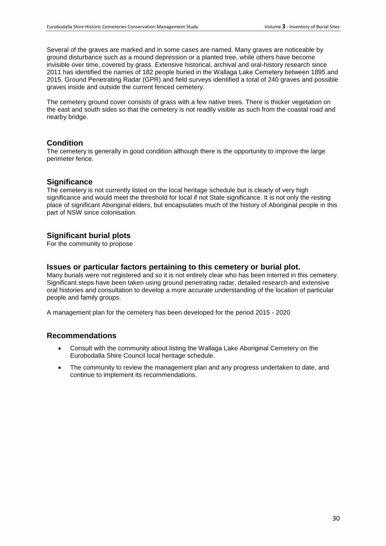
Overlay of cemetery on aerial photo. Black dots are visible graves; yellow dotted areas
are GPR graves.
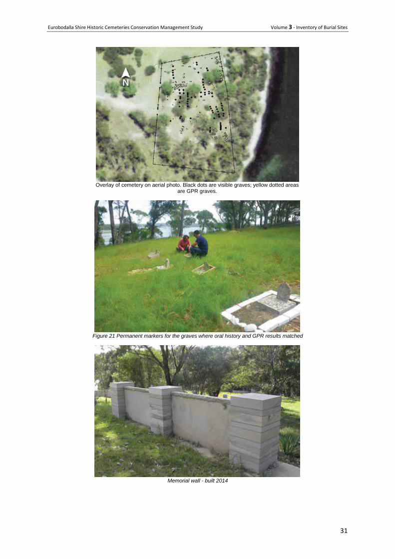
Figure 21 Permanent markers for the graves where oral history and GPR results matched
Memorial wall - built 2014
Eurobodalla Shire Historic Cemeteries Conservation Management Study Volume 3 - Inventory of Burial Sites
32
Lone burials with grave markers
Eurobodalla Shire Historic Cemeteries Conservation Management Study Volume 3 - Inventory of Burial Sites
33
29 Albert Read's Grave - Tiverton
Location 85 Haxstead Road, Central Tilba, NSW 2546
Owner /manager Private
Type Isolated Grave
History
The Read brothers - Horrex (Honk), Albert and Charles - selected land on the open coastal headlands
between Tilba and Little Lakes from 1870 to 1875 and bought 120 acres from John Forster. They
established three adjoining properties - "Haxstead", "Avondale" and "Kent Farm" with the help of two
aunts and walked their milking herd up from Numbugga (near Bega) to their new selection in 1873
without missing a milking. They made cheese the day they arrived.
Charles Read selected "Kent Farm", their Aunt Eliza left "Avondale" to Albert, and "Haxstead" to
Horrex Read. They later bought "Bellingah" on the southern shore of Tilba Lake from G Du Ross and
incorporated it into "Kent Farm". They all lived in the original homestead on "Haxstead". Albert Read
died in 1886. His wife, Margaret Elizabeth (daughter of James Southam) married Joseph Thomas
Fookes from Corunna in 1888 who then farmed "Avondale". They started supplying ABC in 1904.
Margaret reared 12 children - 6 children to Albert Read and 6 to Joseph Fookes. She died in 1913.
The property's name was changed to "Tiverton" in c1950.
Description
Broken concrete slab pieces
Condition (general) Tomb broken in pieces. No headstone. The grave was not inspected as part of this study.
Significance LEP 2012 Item 73
The grave site of Albert Read has high level local historic significance for being associated with and
representing the presence in the local Central Tilba area, of one of its early pioneers and also the
location of his property. The grave has local social significance to the descendants of the Read family
in the Central Tilba area. (EJE report)
Issues or particular factors pertaining to this cemetery or burial plot.
Referenced in Tilba Times by Pacey and Hoyer
Recommendations
Continue current management.
Restoration should be discussed with Council’s heritage adviser prior to commencing work.
Eurobodalla Shire Historic Cemeteries Conservation Management Study Volume 3 - Inventory of Burial Sites
34
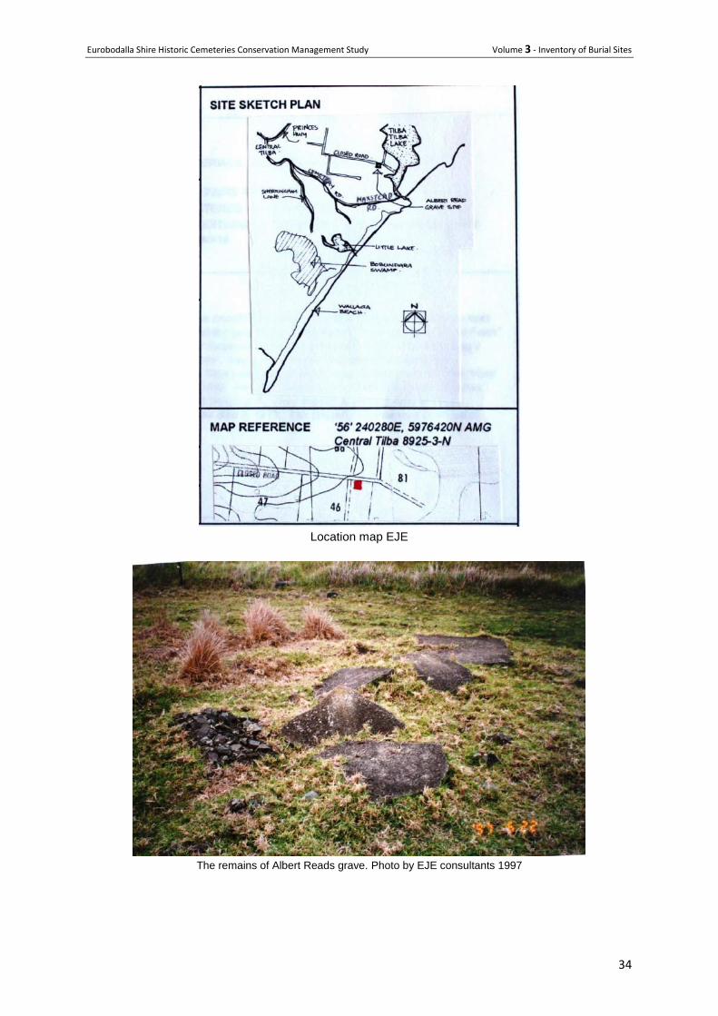
Location map EJE
The remains of Albert Reads grave. Photo by EJE consultants 1997
Eurobodalla Shire Historic Cemeteries Conservation Management Study Volume 3 - Inventory of Burial Sites
35
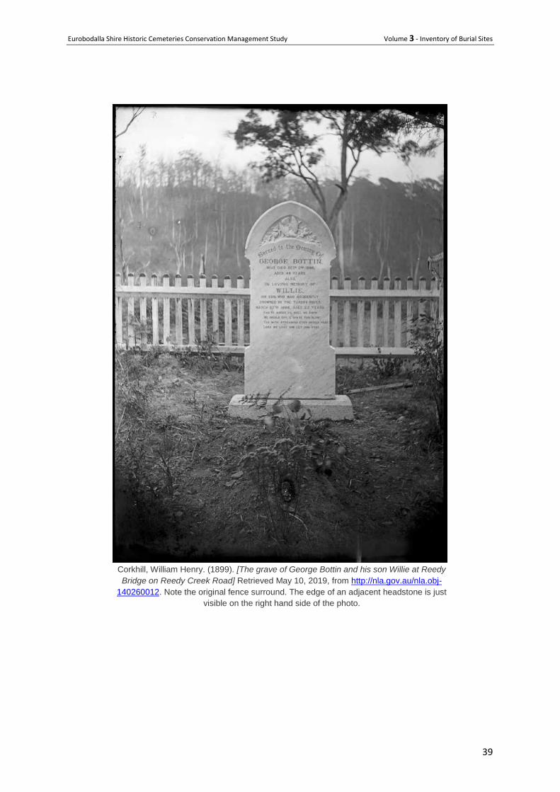
30 Bottin Family Graves
Address 1071 Reedy Creek Road, Dignams Creek, NSW 2537
Owner manager Private
Type Historic family cemetery - Closed
History George Bottin, local farmer, died aged 49 on 3 December 1880 following a five week long alcoholic
coma. The son of Thomas and Jane Bottin, he was buried on 5 December 1880 by J Humphrey and
Mr Vinlin. His headstone also remembers the death of his son, William Bottin.
William was buried in the same location following an accidental drowning in the Tuross River. William
was 25 when he was buried on 29 March 1898 by W H Spear. Until the mid-1970s there were two
graves side by side, the second with a wooden "headstone". This second grave "headstone" was
nearly destroyed by fire and was removed to the Eurobodalla Shire depot, Narooma, for safe keeping.
It is thought that the grave was that of a male member of the Southam family of Couria Creek.
Description Marble Headstone inscribed:
Sacred to the Memory Of
GEORGE BOTTIN, WHO DIED DEC 2
ND 1880
AGED 49 YEARS.
ALSO
IN LOVING MEMORY OF
WILLIE, HIS SON, WHO WAS ACCIDENTLY
DROWNED IN THE TUROSS RIVER
MARCH 27TH
1898. AGED 25 YEARS.
HAD HE ASKED US WELL WE KNOW
WE SHOULD CRY, AND SPARE THIS BLOW
YET WITH STREAMING EYES SHOULD PRAY
LORD WE LOVE HIM, LET HIM STAY.
Condition The headstone is in good condition with lettering clearly legible
The timber fence post remains at the site but has fallen over.
Significance Local Heritage item 219 gazetted 20/7/2012
The gravesite of George and William Bottin has local historic significance for evidencing the pattern of
settlement and also the type of settlers in remote Eurobodalla Shire areas in the late 1880s. It has
local social significance for descendants of the Bottin family. It has local scientific significance for its
potential to contribute to an understanding of the burial techniques in remote areas of the Shire in the
late 19th century. (SHI citation)
Eurobodalla Shire Historic Cemeteries Conservation Management Study Volume 3 - Inventory of Burial Sites
36
This is one of a number of isolated burial sites to be found across the Shire. Collectively they shed
light on settlement patterns of the 19th century and the challenges that many European settlers faced
at that time – in the case of the Bottins – alcoholism of the father and accidental drowning of the son.
The inscriptions across the Shire reveal that death by drowning was not uncommon.
Site elements
Grave All that remains is the headstone which is a finely carved marble
stele with a gentle gothic top and a carving of a bird and wreath.
Lettering remains crisp and legible. There is relatively little staining
on the headstone, which is in very good condition and still vertical.
Setting The headstone is between the road and creek in a former clearing
of native bush. Understorey plants are growing back with an
amount of leaf litter on the ground.
Fencing The 1997 photo shows remains of a timber fence that presumably
was around the grave.
Signage There is no signage
Vehicle access The grave site is about 10 metres from a public road. There is no
vehicle access to the grave.
Pedestrian access The grave is on private land. There is no formed pathway.
Issues or particular factors pertaining to this cemetery or burial plot. As the cemetery is on private land permission should be sought before entering the site.
It is unlikely this road will become an alternative tourism trail in the near future.
Recommendations The grave is on private land and management of the site is at the discretion of the owner.
Opportunities include:
Remove undergrowth from the immediate area,
Remove overhanging branches if any that could damage the headstone
Reinstate a fence, preferably in character with the original
Interpret the history of the site with a small interpretation sign
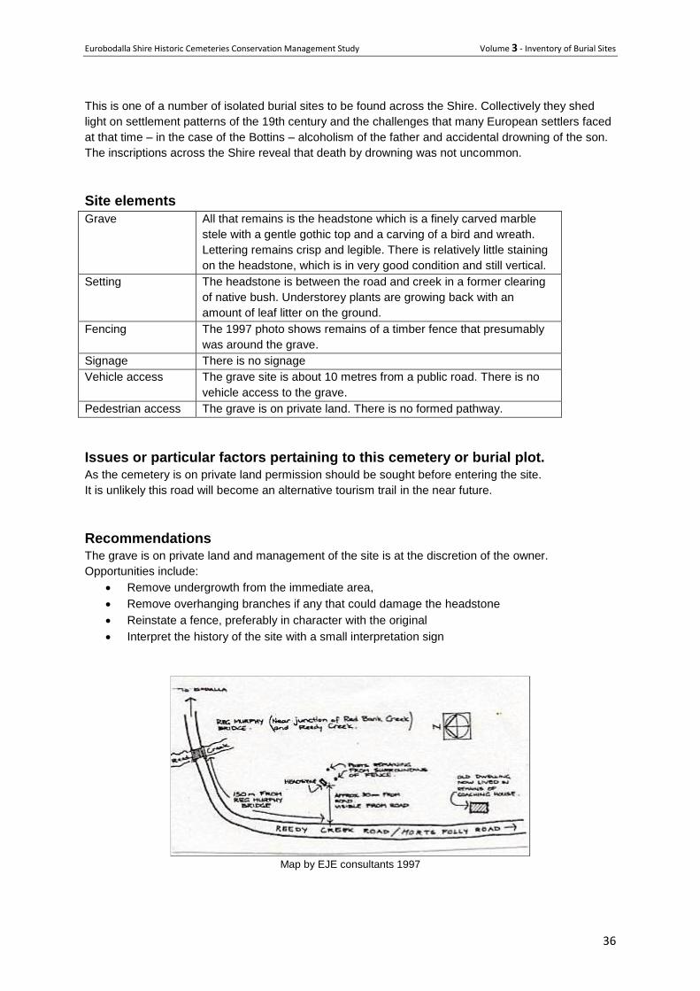
Map by EJE consultants 1997
Eurobodalla Shire Historic Cemeteries Conservation Management Study Volume 3 - Inventory of Burial Sites
37
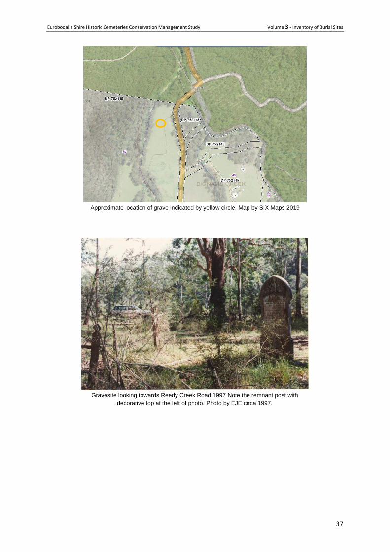
Approximate location of grave indicated by yellow circle. Map by SIX Maps 2019
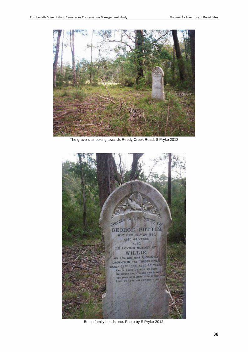
Gravesite looking towards Reedy Creek Road 1997 Note the remnant post with
decorative top at the left of photo. Photo by EJE circa 1997.
Eurobodalla Shire Historic Cemeteries Conservation Management Study Volume 3 - Inventory of Burial Sites
38
The grave site looking towards Reedy Creek Road. S Pryke 2012
Bottin family headstone. Photo by S Pryke 2012.
Eurobodalla Shire Historic Cemeteries Conservation Management Study Volume 3 - Inventory of Burial Sites
39
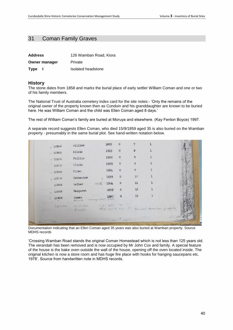
Corkhill, William Henry. (1899). [The grave of George Bottin and his son Willie at Reedy
Bridge on Reedy Creek Road] Retrieved May 10, 2019, from http://nla.gov.au/nla.obj-
140260012. Note the original fence surround. The edge of an adjacent headstone is just
visible on the right hand side of the photo.
Eurobodalla Shire Historic Cemeteries Conservation Management Study Volume 3 - Inventory of Burial Sites
40
31 Coman Family Graves
Address 126 Wamban Road, Kiora
Owner manager Private
Type I Isolated headstone
History The stone dates from 1858 and marks the burial place of early settler William Coman and one or two of his family members. The National Trust of Australia cemetery index card for the site notes:- ‘Only the remains of the original owner of the property known then as Condoin and his granddaughter are known to be buried here. He was William Coman and the child was Ellen Coman aged 8 days.’ The rest of William Coman’s family are buried at Moruya and elsewhere. (Kay Fenton Boyce) 1997. A separate record suggests Ellen Coman, who died 15/9/1859 aged 35 is also buried on the Wamban property - presumably in the same burial plot. See hand-written notation below.
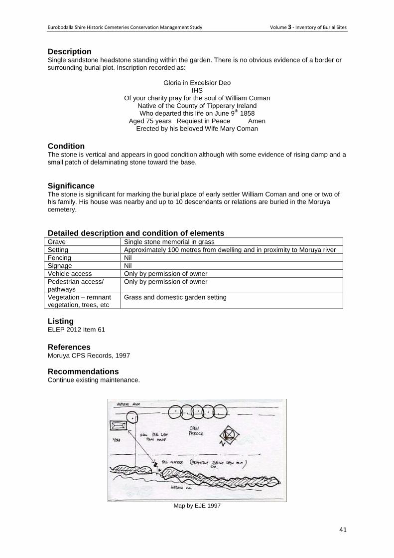
Documentation indicating that an Ellen Coman aged 35 years was also buried at Wamban property. Source MDHS records
‘Crossing Wamban Road stands the original Coman Homestead which is not less than 125 years old. The verandah has been removed and is now occupied by Mr John Cox and family. A special feature of the house is the bake oven outside the wall of the house, opening off the oven located inside. The original kitchen is now a store room and has huge fire place with hooks for hanging saucepans etc. 1978’. Source from handwritten note in MDHS records.
Eurobodalla Shire Historic Cemeteries Conservation Management Study Volume 3 - Inventory of Burial Sites
41
Description Single sandstone headstone standing within the garden. There is no obvious evidence of a border or surrounding burial plot. Inscription recorded as:
Gloria in Excelsior Deo IHS
Of your charity pray for the soul of William Coman Native of the County of Tipperary Ireland Who departed this life on June 9
th 1858
Aged 75 years Requiest in Peace Amen Erected by his beloved Wife Mary Coman
Condition The stone is vertical and appears in good condition although with some evidence of rising damp and a small patch of delaminating stone toward the base.
Significance The stone is significant for marking the burial place of early settler William Coman and one or two of his family. His house was nearby and up to 10 descendants or relations are buried in the Moruya cemetery.
Detailed description and condition of elements Grave Single stone memorial in grass
Setting Approximately 100 metres from dwelling and in proximity to Moruya river
Fencing Nil
Signage Nil
Vehicle access Only by permission of owner
Pedestrian access/ pathways
Only by permission of owner
Vegetation – remnant vegetation, trees, etc
Grass and domestic garden setting
Listing ELEP 2012 Item 61
References Moruya CPS Records, 1997
Recommendations Continue existing maintenance.
Map by EJE 1997
Eurobodalla Shire Historic Cemeteries Conservation Management Study Volume 3 - Inventory of Burial Sites
42
Photo by EJE 1997
Headstone 2019
Eurobodalla Shire Historic Cemeteries Conservation Management Study Volume 3 - Inventory of Burial Sites
43
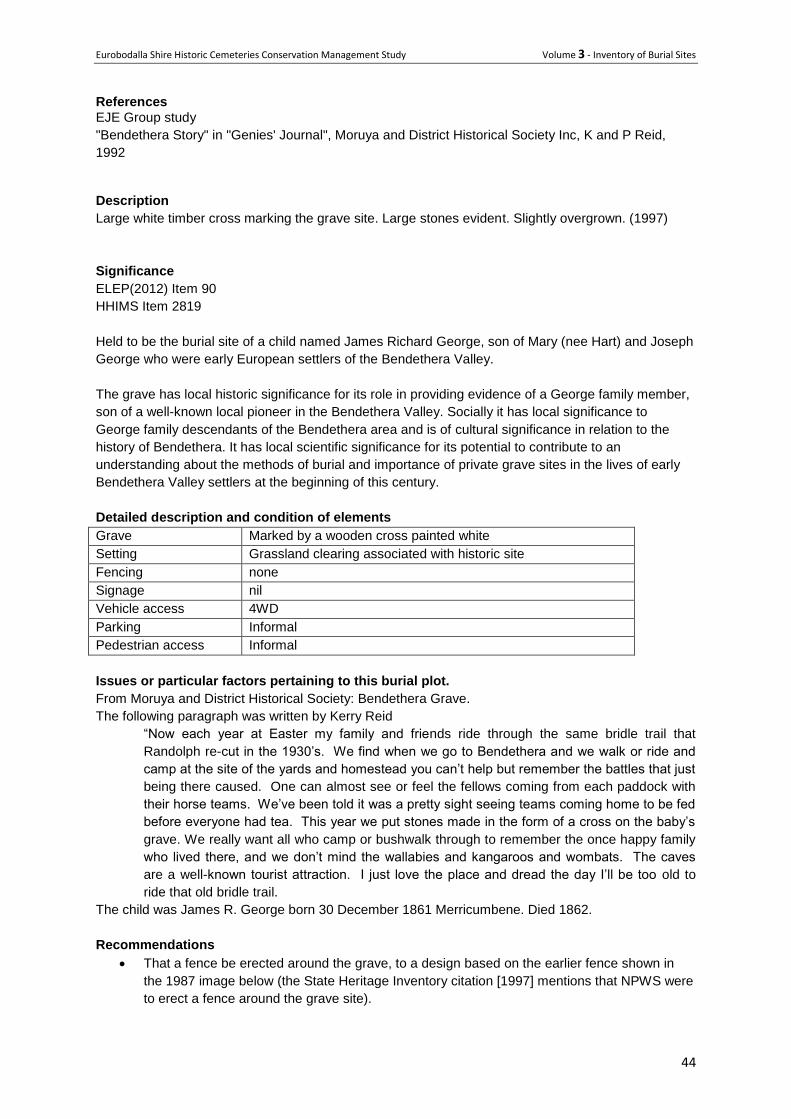
32 Grave of James Richard George
Address Wamban Rd, Deua
Owner /manager NPWS
Type Isolated grave History
Joseph George was born at Liverpool near Sydney in 1843. He moved with his family to Majors Creek
in the 1850s during the gold rush. At an age of 15 he met his wife-to-be, Mary Hart. They were
married at Majors Creek in 1860. Their first legitimate son was born in 1860 and was named Joseph
F, after his father. Joseph was a butcher by trade, and he and Mary opened a butcher shop at
Merricumbene, between Moruya and Araluen.
As the story of George's discovery of the Bendethera Valley explains, an Aboriginal man stole his
horse resulting in a pursuit across the mountains until he reached Bendethera. Joseph George took
up land there in early 1863, buying and also leasing a total of 840 acres. It was the discovery of gold
in the Deua River at Araluen in 1851 which led to the opening up of the rest of the Deua area for
farming. Farmers were able to make a living by supplying goods to the Araluen miners and later to the
miners at Nerrigundah, when gold was discovered there in 1861.
Joseph and Mary had another son, James R in 1862 and a daughter, Mary A, in 1863. Joseph
employed several workers to help construct his first home on the flat ground near Con Creek. It was
situated near the bread oven. This home was later burnt down and they slept in the barn until the next
house was built. More children were born including Doranda (1866), Charlotte (1867), Benjamin J
(1869), Randolph George (1871), Charles W (1874), Annie H (1876), Maria (1878), James Sydney
(1882) and Ernest (1884). The children were able to work on the property and each had a paddock to
cultivate and look after. The Connell and Clarke brothers, bushrangers in the area, helped at
Bendethera working for Joseph. At Bendethera they bred horses, sold produce to Araluen,
Nerrigundah and Moruya, including bacon, corn, wattle bark, chaff, wheat, kept pigs, bullocks, cows
and calves. They had the benefit of irrigation from Con Creek and Deua River. A water race was
constructed by miners out of work who were looking for tin and gold at Bendethera. The race carried
water from the creek and irrigated the paddocks, particularly during drought conditions and in 1978? it
was worked again. The Georges used the old bridle trail networks to transport produce to the
markets. In the 1880s many people from the surrounding districts visited Bendethera for the picnic
races at Racecourse Flat.
Joseph George Senior died on 27 April 1909 at Gundary aged 66 years. Mary died in 1908, aged 70
years. Both are buried at Moruya. Joseph George constructed a highly prosperous and productive
farm at Bendethera. Randolph George bought Bendethera from Auction in 1932. He left it to his
brother Charles' two sons, who sold it to Allen Rankin in 1939 for 500 pounds. In later years, Rankin
sold Bendethera to Ross McKinnon of Wollongong. He sold out to the Robinson family, also from
Wollongong. The National Parks and Wildlife Service took over in 1979. Today only the bakery oven,
water race, stand of trees and a George family member's grave remains as evidence of the former
Bendethera farm site. There is no evidence of the former George family homestead, having been
demolished some years ago. According to George family records, a child named James Richard
George is buried at this site. The death certificates of both parents list 13 children living and 1 male
deceased in 1908 and 1909.
Eurobodalla Shire Historic Cemeteries Conservation Management Study Volume 3 - Inventory of Burial Sites
44
References
EJE Group study
"Bendethera Story" in "Genies' Journal", Moruya and District Historical Society Inc, K and P Reid,
1992
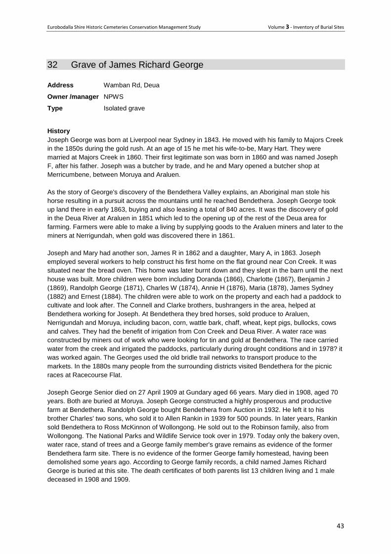
Description
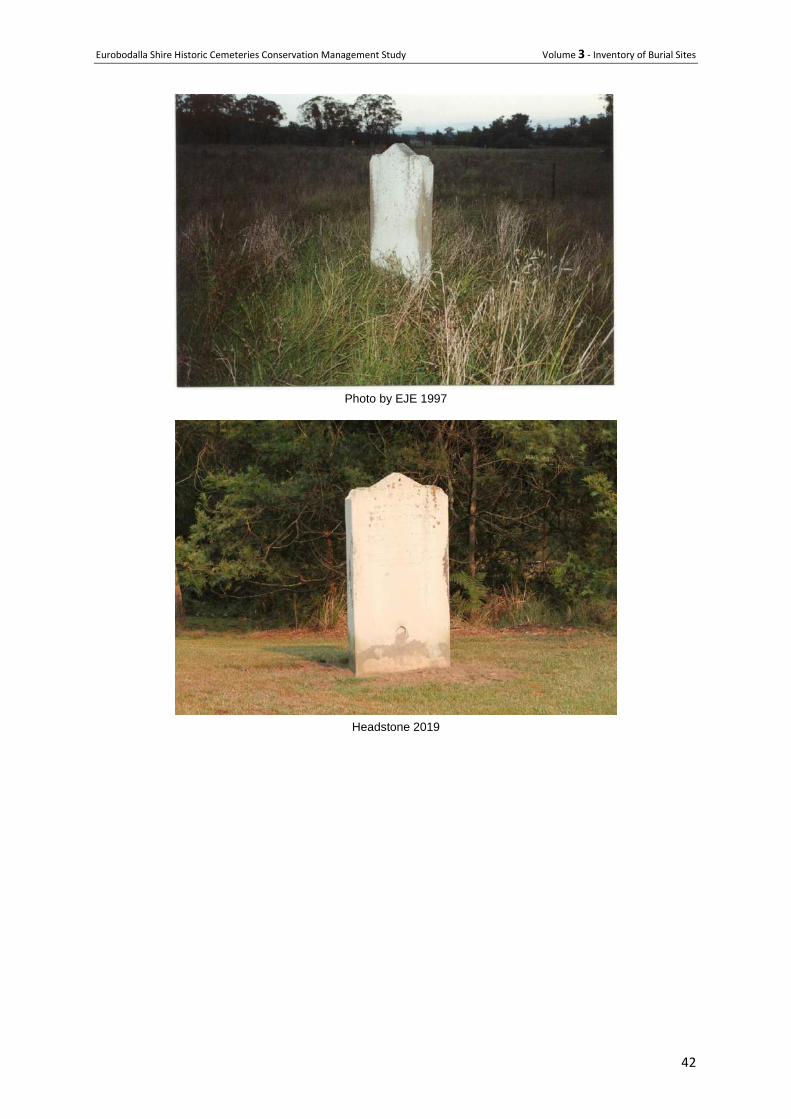
Large white timber cross marking the grave site. Large stones evident. Slightly overgrown. (1997)
Significance
ELEP(2012) Item 90
HHIMS Item 2819
Held to be the burial site of a child named James Richard George, son of Mary (nee Hart) and Joseph
George who were early European settlers of the Bendethera Valley.
The grave has local historic significance for its role in providing evidence of a George family member,
son of a well-known local pioneer in the Bendethera Valley. Socially it has local significance to
George family descendants of the Bendethera area and is of cultural significance in relation to the
history of Bendethera. It has local scientific significance for its potential to contribute to an
understanding about the methods of burial and importance of private grave sites in the lives of early
Bendethera Valley settlers at the beginning of this century.
Detailed description and condition of elements
Grave Marked by a wooden cross painted white
Setting Grassland clearing associated with historic site
Fencing none
Signage nil
Vehicle access 4WD
Parking Informal
Pedestrian access Informal
Issues or particular factors pertaining to this burial plot.
From Moruya and District Historical Society: Bendethera Grave.
The following paragraph was written by Kerry Reid
“Now each year at Easter my family and friends ride through the same bridle trail that
Randolph re-cut in the 1930’s. We find when we go to Bendethera and we walk or ride and
camp at the site of the yards and homestead you can’t help but remember the battles that just
being there caused. One can almost see or feel the fellows coming from each paddock with
their horse teams. We’ve been told it was a pretty sight seeing teams coming home to be fed
before everyone had tea. This year we put stones made in the form of a cross on the baby’s
grave. We really want all who camp or bushwalk through to remember the once happy family
who lived there, and we don’t mind the wallabies and kangaroos and wombats. The caves
are a well-known tourist attraction. I just love the place and dread the day I’ll be too old to
ride that old bridle trail.
The child was James R. George born 30 December 1861 Merricumbene. Died 1862.
Recommendations
That a fence be erected around the grave, to a design based on the earlier fence shown in
the 1987 image below (the State Heritage Inventory citation [1997] mentions that NPWS were
to erect a fence around the grave site).
Eurobodalla Shire Historic Cemeteries Conservation Management Study Volume 3 - Inventory of Burial Sites
45
The perimeter of the fence be outlined in local stone so the location of the grave is not lost in
the event of fire.
A small interpretation panel be provided to inform the public of the significance of the grave.
Images
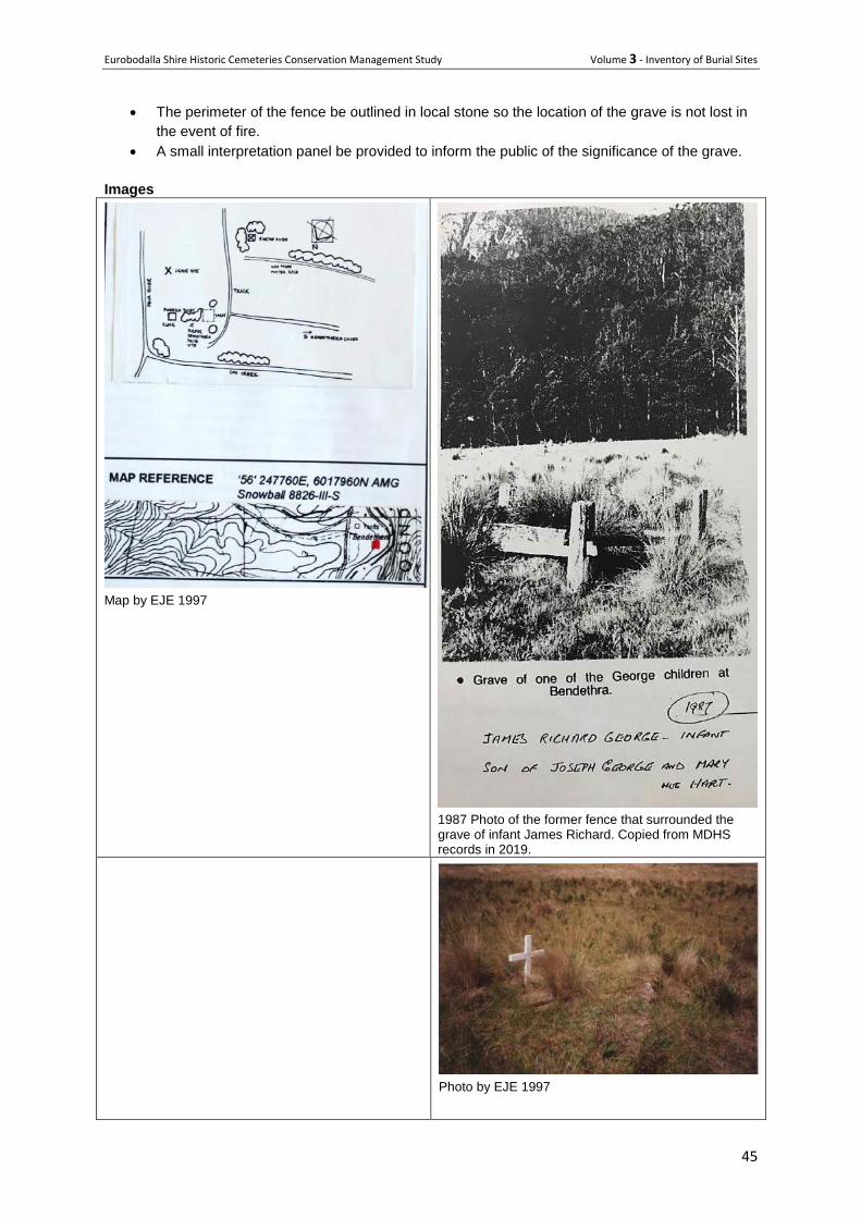
Map by EJE 1997
1987 Photo of the former fence that surrounded the grave of infant James Richard. Copied from MDHS records in 2019.
Photo by EJE 1997
Eurobodalla Shire Historic Cemeteries Conservation Management Study Volume 3 - Inventory of Burial Sites
46
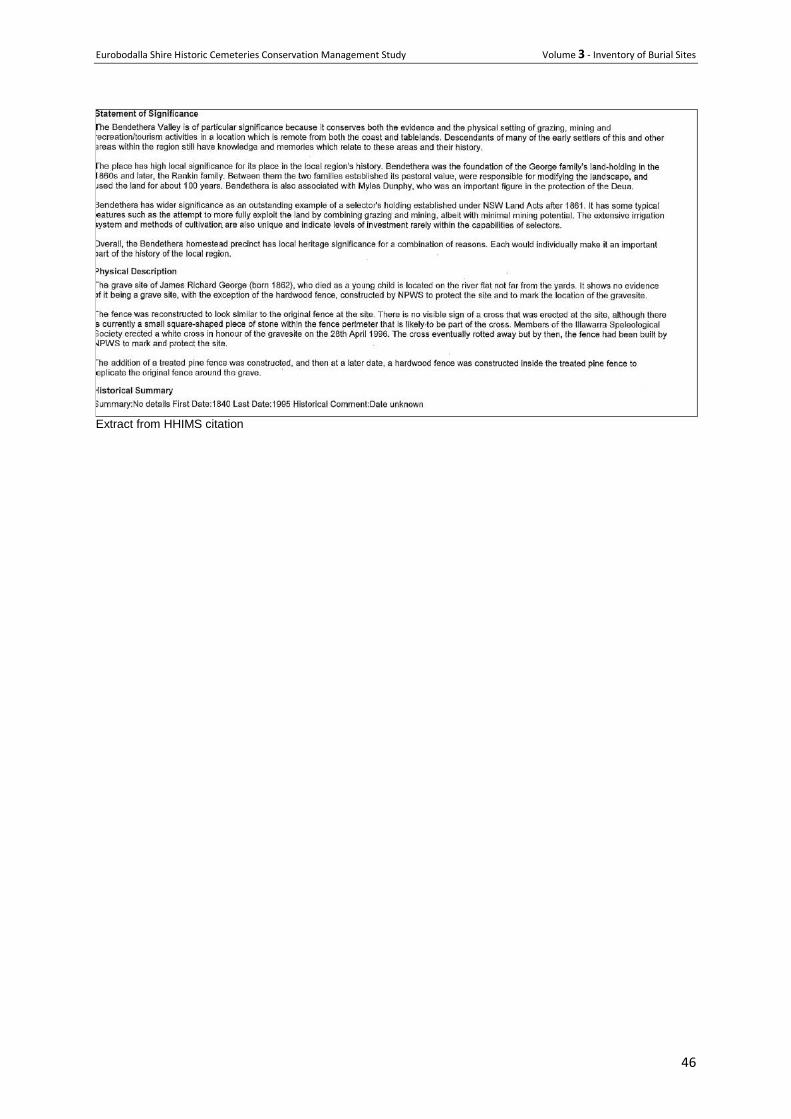
Extract from HHIMS citation
Eurobodalla Shire Historic Cemeteries Conservation Management Study Volume 3 - Inventory of Burial Sites
47
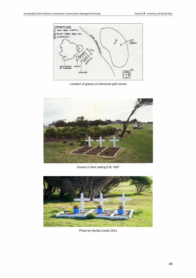
33 Graves on Narooma Golf Course
Location 3 Ballingalla Street, Narooma
Co-ords 36°13'06.0"S 150°08'29.5"E
Owner manager Crown land leased by Narooma Golf Club
Type Isolated burial
Status Closed
History
Older local residents say there were only ever two isolated graves overlooking the sea near what is
now the 5th green of Narooma Golf Course, not three.
Until the 1930s, the area now occupied by the golf course was common land and frequented by
Narooma residents for both formal and informal recreation. The Narooma Cemetery was only
established on a nearby headland overlooking Glasshouse Rocks in 1895, and until that time bush
burials were not uncommon.
Long-time Narooma residents, including Cletus Grumley and Ron Constable who played and hunted in that area as children before it became a golf course, stated there were only ever two graves on the site and they were in amongst some bush surrounded by a rough fence.
A 1957 newspaper article quoted Mrs Edie Hunt (nee Downer whose father Ted Downer was first mate on the SS Coomonderry and lived near the Pilot Station as a child) as saying the two graves belonged to Elsie Ross and John Flintoff. Narooma historical researcher Mrs Eileen Grumley said it was local knowledge in the 1940s that Elsie and John were buried in the two graves, although it was not known who was in which grave.
Elsie May Ross died of whooping cough on 17 February 1890 aged 10 months and was buried two days later. Elsie was the daughter of Jane (nee Thompson) and John Ross, then a fisherman, but later Narooma’s first Pilot, whose father Capt John Ross had been the pilot at Moruya. Elsie was one of 12 Ross children.
John Flintoff was recorded in the 1891 census as a resident of Narooma. At one time he worked as yardman for James Flanagan who owned Narooma Hotel at that time (later became Hyland’s Hotel). Flintoff died in 1892. Flintoff’s death does not appear to have been registered locally.
Longstanding Narooma residents were upset when a third grave appeared on this site in the late 1960s purporting to be that of a ‘Mrs Nell Murphy’. The third grave ppeared following work on the graves by Alan Murphy of Narooma Golf Club, yet no evidence exists for any Nell Murphy ever being in the Narooma area, nor of there ever being a third grave. There is no record or local knowledge of any Murphys in the area in the late nineteenth or early twentieth centuries.
Description
The three white pointed timber crosses with pine log edgings are not original; they were created by Alan Murphy in the late 1960s to mark the graves.
Condition
The grave plots are well marked and maintained

Eurobodalla Shire Historic Cemeteries Conservation Management Study Volume 3 - Inventory of Burial Sites
48
Significance Generally
LEP Item 182
The graves have local historic significance as an early burial site and for providing evidence of the
period of occupation of the Pilot station by John Ross and the site he and Jane Ross selected as a
private burial plot for their daughter Elsie Ross. The plot is also representative of bush burials that
were not uncommon in Narooma prior to the establishment of the cemetery at Glasshouse Rocks in
1895.
Significant burial plots
Elsie May Roos
John Flintoff
Site elements
Grave Natural earth outlined in timber logs
Setting Set in grassland adjacent to the golf course, with shrub growth nearby
Fencing Unfenced
Signage Not signed
Vehicle access No. The site is well away from the road.
Parking NA
Pedestrian access Accessible across grass. Seek permission from Club prior to visit
Shade, rest and
contemplation areas
Shrubs nearby provide shade.
Vegetation – remnant
vegetation, trees, etc
Photos show that the c1995 stand of shrubs are growing well
Issues or particular factors pertaining to this cemetery or burial plot.
The place record has been corrected following extensive research by local historian Eileen Grumley
and Narooma Historical Society. That research shows there were historically only two grave sites. It is
not known if Alan Murphy created the third grave perhaps for the ashes of a relative Nell Murphy.
References
Alan Murphy, The First 50 Years of the Narooma Golf Club 1930-1980, 1980.
Letter from Narooma Historical Society secretary Laurelle Pacey re Graves on Narooma Golf Course, 2005.
Nerida Cook, 2011
Recommendations
Continue to maintain in good condition.
Add information panel adjacent to the site explaining the historical record and the later discrepancy.
Eurobodalla Shire Historic Cemeteries Conservation Management Study Volume 3 - Inventory of Burial Sites
49
Location of graves on Narooma golf course
Graves in their setting EJE 1997
Photo by Nerida Cooke 2011
Eurobodalla Shire Historic Cemeteries Conservation Management Study Volume 3 - Inventory of Burial Sites
50
34 Henry Jefferson Bate Isolated Grave
Location Mountain View Farm
Owner manager Private
Type Isolated burial with monument
History This is the grave of Henry Jefferson Bate and his daughter Matilda Eleanor Bate.
HJ Bate died 1/11/1892, aged 76. Buried in the same plot is Matilda Eleanor Bate who died 7 August
1873 aged 35 years.
Biography
Henry Jefferson Bate was born March 22, 1816 to Samuel Bate (1776-1849) and Matilda Eleanor
King (c1787-1869) and died 1 November 1892 it "Mountain View", Tilba Tilba, New South Wales,
Australia of unspecified causes. He married Elizabeth Kendall Mossop (1819-1910) 25 January 1836
in St. James' Church of England, Sydney, New South Wales, Australia. Ancestors are from the United
Kingdom.
Offspring
Offspring of Henry Jefferson Bate and Elizabeth Kendall Mossop (1819-1910)
Name Birth Death Joined with
Matilda Eleanor Bate (1838-1873)
Samuel William Bate (1842-1935)
Richard Mossop Bate (1848-1925)
24 February 1848 Dapto,New South Wales, Australia
6 April 1925 Tilba Tilba,New South Wales, Australia
Henrietta Teresa Higman (1857-1909)
Elizabeth Honor Bainbrigge Bate (1850-1910)
Ellen Gay Bate (1853-1934)
Mary Harriet Bate (1855-1952)
Frances Hawtry Bate (1860-1953)
John Bate (1863-1938)
Obituary
Some of the very old hands will probably remember a Mr. Henry Jefferson Bate who resided in this
district in the ' fifties.' This gentleman died quite recently at Tilba Tilba, in the Cobargo district, and the
local Watch thus refers to the deceased:— "Henry Jefferson Bate was the son of Samuel Bate, who
came out in the year 1806, one of the civil officers in connection with the first batch of convicts sent to
Tasmania. He returned to England in 1816 in the ship Jefferson, and on that voyage his son, the late
Henry Jefferson Bate was born. The family did not, however, remain long in England, as soon
afterwards Samuel Bate was appointed Inspector of Distilleries for New South Wales, and on arrival
took up his residence at Middle Harbor, his son remaining with him until his marriage, when he settled
in the Illawarra district, then in its infancy. Mr. Bate used to tell many interesting tales of his
adventures in the early days of the colony, not the least exciting being the capture of a gang of
bushrangers, in which he was mainly instrumental.
Eurobodalla Shire Historic Cemeteries Conservation Management Study Volume 3 - Inventory of Burial Sites
51
From Illawarra he returned to Sydney, and started business as a miller in the old Victoria mills in
Lower George Street, in conjunction with the late Mr. Berkelman, and afterwards as a commission
agent in Sussex-street. In 1860 [or thereabouts] he came to Merimbula and erected a sawmill, and
nine years later took up his residence at Tilba Tilba, being one of the first selectors in this district, and
he has always been known, and justly so, as the pioneer of Tilba." (Illawarra Mercury, 15 November
1892, page 2, with some corrections to dates and spelling by Harry Bate 2019)
Death
BATE.—November 1, 1892, at his residence, Mountain View, Tilba Tilba, Henry Jefferson Bate, aged
76. (The Sydney Morning Herald, 4 November 1892, page 1)
Sources include:
Headstones
http://familypedia.wikia.com/wiki/Henry_Jefferson_Bate_(1816-1892)
www.geni.com/people/Henry-Jefferson-Bate
Description
The monument consists of two short polished granite headstones mounted on the concrete border of
the double grave. The centre of the grave is capped with a cement based screed set approximately
150 mm below the border.
The monument is located in a small adjacent to a tall kurrajong tree about 20 metres north east of the road to Gulaga Mountain.
Condition The monument is of robust construction and in good condition, although there is some algal growth on
the cement. There has been no uplift from the tree roots.
Significance
HJ Bate was the son of Samuel Bate who migrated to Australia and is associated with the large family
of Bate who have lived in the Tilba district for several generations.
Issues or particular factors pertaining to this cemetery or burial plot. The immediate setting of this grave, in an actively ploughed paddock puts it at risk of damage from
farm implements and does not do justice to its memorial function.
It also has interpretative potential due to its proximity to the Mountain View access road, a popular
path for tourists visiting the mountain.
Recommendations
Enhance the grave’s immediate setting eg using mown grass or similar.
Provide some form of fenced protection accessible from the road. This could be elaborate, or a
simple farm style fence set about 2 meters from the edge of the grave.
Provide an interpretation panel that tells the story of Henry and his daughter Matilda and their link
to the Tilba area. This could be at the road or closer to the graves.
Eurobodalla Shire Historic Cemeteries Conservation Management Study Volume 3 - Inventory of Burial Sites
52
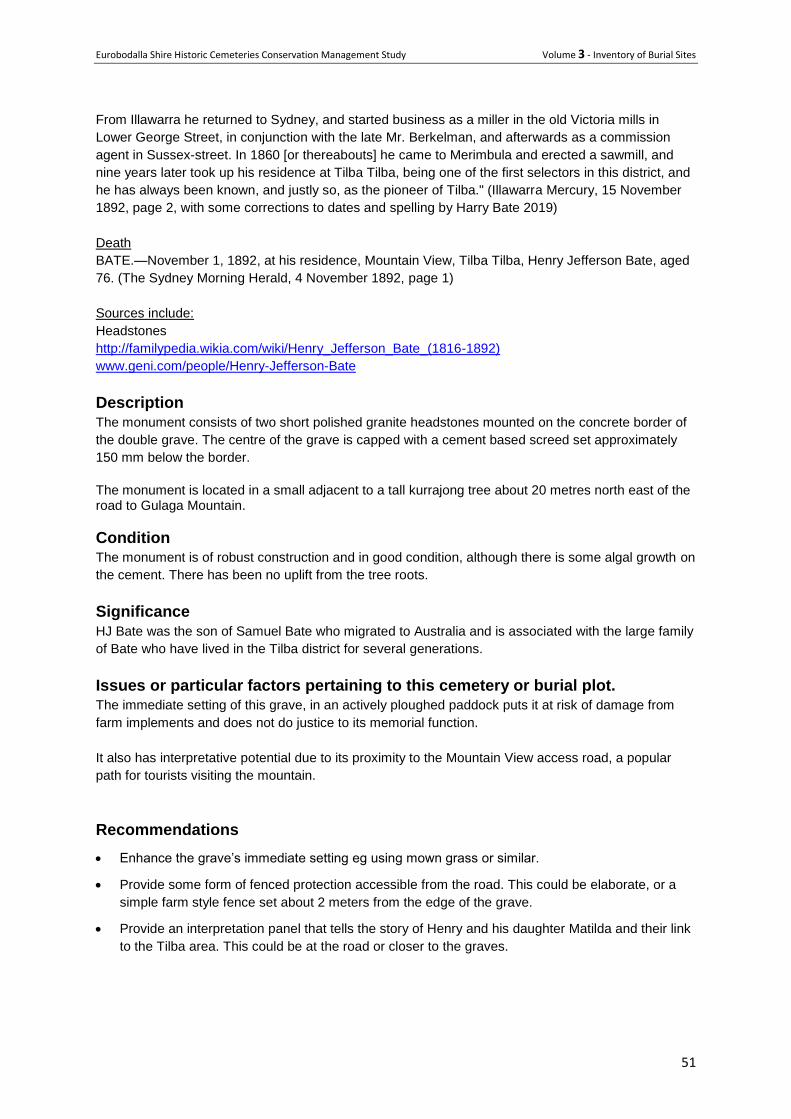
View to Gulaga Mt with the grave plot visible at the base of the tree. The tree poses no threat to the graves and
should be retained. Photo PG
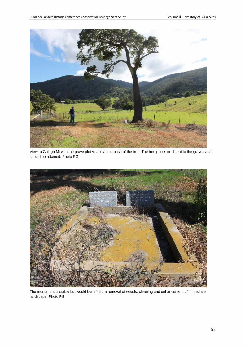
The monument is stable but would benefit from removal of weeds, cleaning and enhancement of immediate
landscape. Photo PG
Eurobodalla Shire Historic Cemeteries Conservation Management Study Volume 3 - Inventory of Burial Sites
53
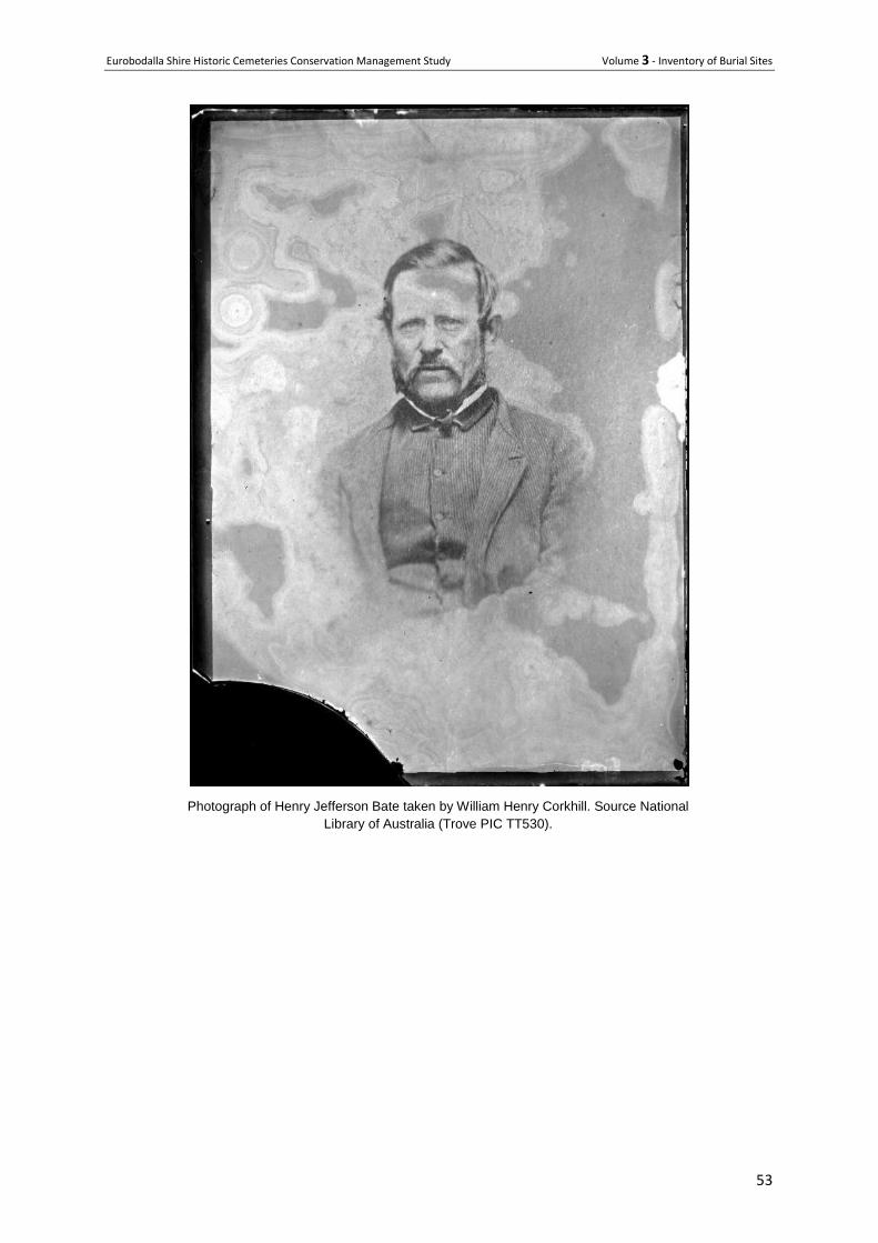
Photograph of Henry Jefferson Bate taken by William Henry Corkhill. Source National
Library of Australia (Trove PIC TT530).
Eurobodalla Shire Historic Cemeteries Conservation Management Study Volume 3 - Inventory of Burial Sites
54
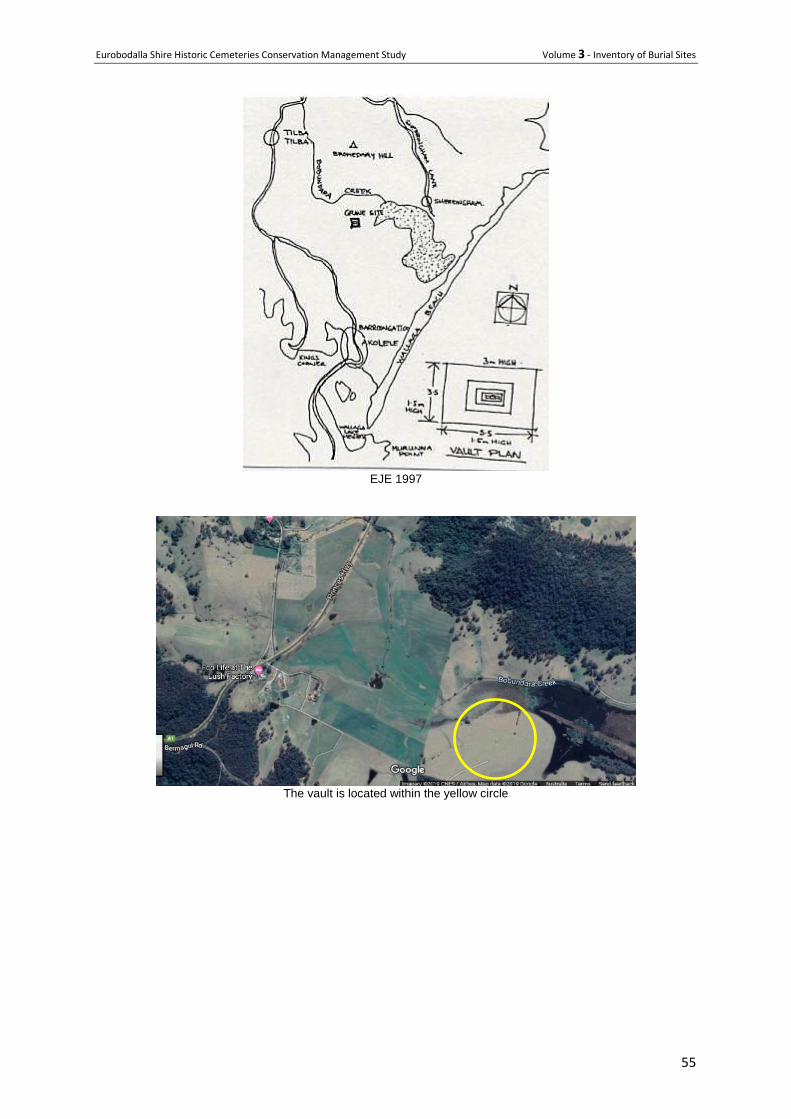
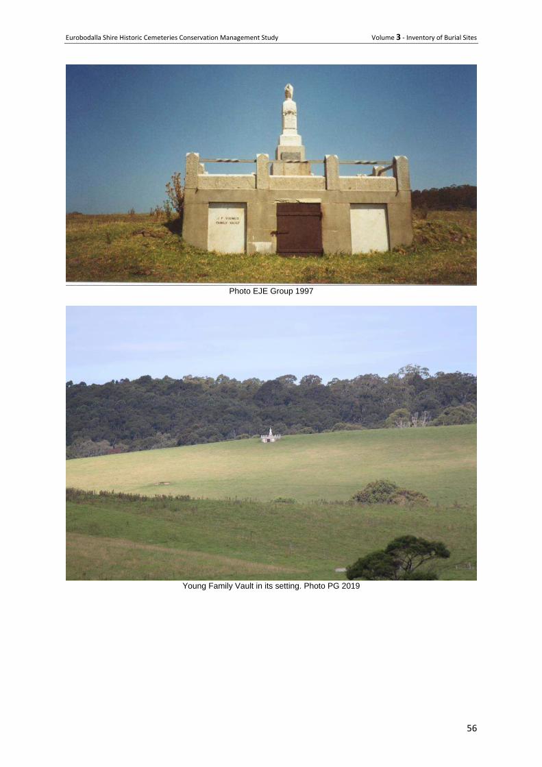
35 John Young Family Vault
Location Bermagui Road, Akolele
Owner manager Private
Type Mausoleum/Tomb/Funeral Vault/Ossario
History
Constructed in 1903, the main inscription on the vault reads "To the Memory of my dear husband and
our father, John Fenwick Young, born at Perth, Scotland, who died at Tilba Tilba, 10th January 1903,
aged 62 years. We mourn the loss of one we loved, we did our best to save, beloved in life, regretted
still, remembered in the grave".
The vault is also the resting place of Elizabeth Young (born 10 July 1847, died 11 September 1930).
John Young (died 27 December 1964, aged 82 years) and Richard Neville have memorial plaques
attached to the vault and John Young is buried in Narooma Cemetery. John Fenwick Young, one of
the early pioneers of the Tilba area, purchased the "Mountain Valley' 320 acre property on 9
September 1876 for £1,320 from Thomas Forster. He selected the rest in 1895 to total 470 acres.
Description Twisted iron railings. Granite and stone base. Marble and granite headstone with decorative element.
Three vents in south wall base.
Condition Some repairs required to north (front) wall, especially above door to vault. (1997)
Significance ELEP 2012 Item 2
The private vault has regional historic significance for being the only one of its kind in the South Coast
region and also for its association with a major early pioneer in the Tilba area. This is a significant
edifice regionally because of its unique scale and design and its dramatic siting at the head of the
valley. It has local social significance for descendants of the Young family. It has local scientific
significance for its potential to contribute to an understanding of the success of early pioneering
families in Tilba and the significance of private memorials in the lives of those families in the early
20th century.
Issues or particular factors pertaining to this cemetery or burial plot.
The vault is on private land and not accessible to the public
Eurobodalla Shire Historic Cemeteries Conservation Management Study Volume 3 - Inventory of Burial Sites
55
EJE 1997
The vault is located within the yellow circle
Eurobodalla Shire Historic Cemeteries Conservation Management Study Volume 3 - Inventory of Burial Sites
56
Photo EJE Group 1997
Young Family Vault in its setting. Photo PG 2019
Eurobodalla Shire Historic Cemeteries Conservation Management Study Volume 3 - Inventory of Burial Sites
57
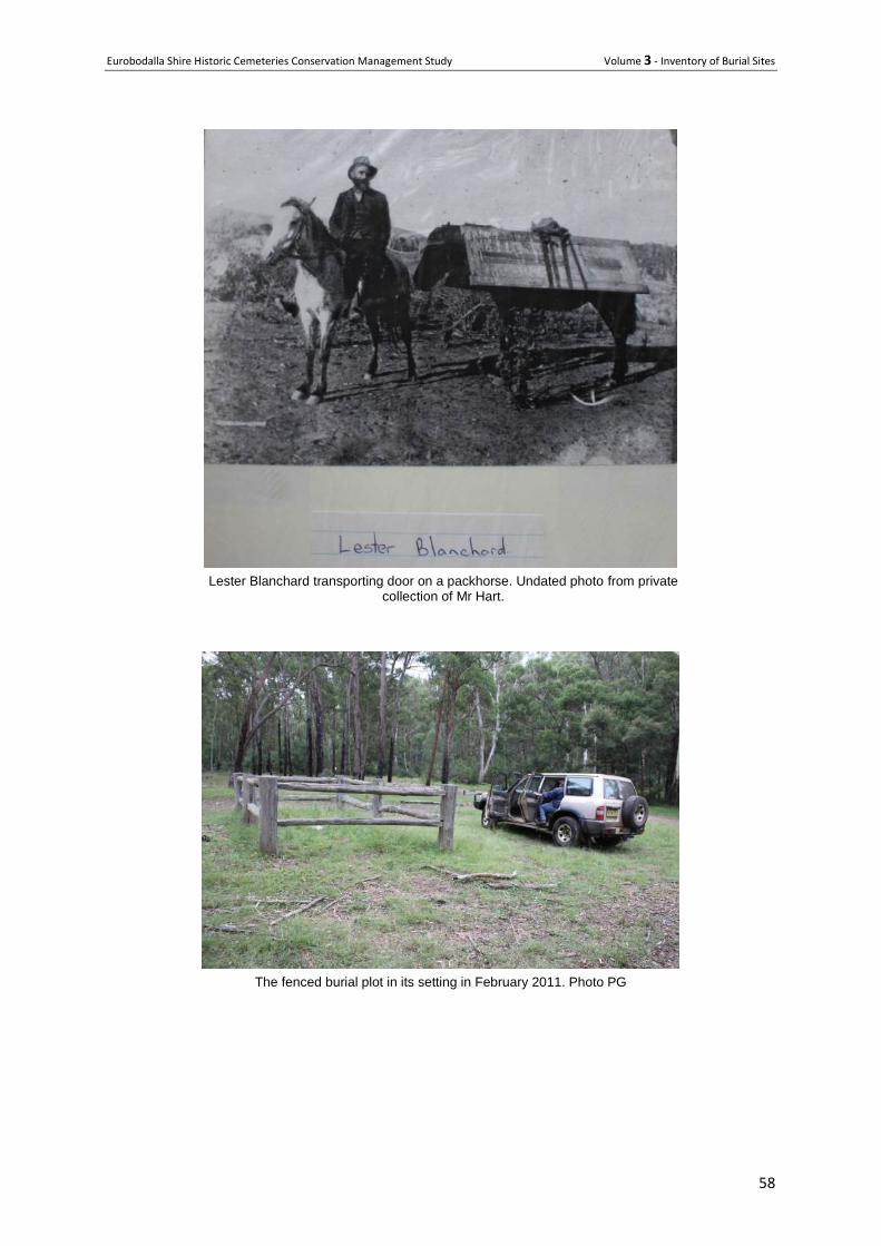
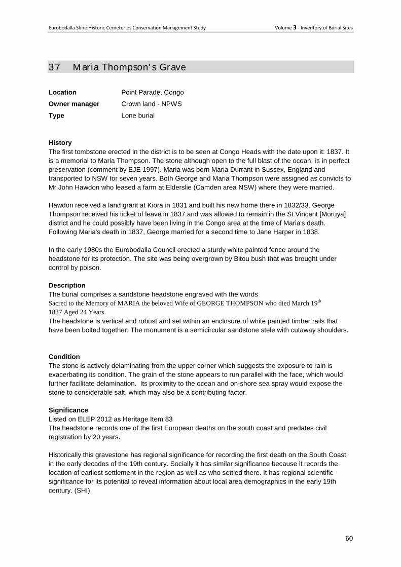
36 Fredric Lester-Blanchard’ s Lone Grave
Location Upper Deua River near Alpine, on the west side of the river bank at the Alpine homestead crossing.
Owner/manager NPWS
Type Lone grave plot
History Frederick Lester-Blanchard was born 1866 at Parkers Gap near Jerrabatgulla. He settled on the Deua
about 1895 and married Theresa Magdalen Murphy (born 1874) in 1905. Lester and his step brother
Jack Berry built Alpine homestead largely from local materials and the property was simply known as
‘Blanchard’s’. Mrs Blanchard was a keen gardener, growing flowers vegetables and fruit trees. The
homestead remains occupied and is a palpable link to the pioneering days in the upper Deua when
the only access was by horse track. Lester died in 1937 aged 71, leaving a widow and daughter Mary.
His obituary by Rev Fr Moore appeared in the Braidwood Review on Tuesday 19 October 1937. In
reference to Lester and Terry he said Between them they made a veritable little paradise on the
banks of a glorious stream, surrounded in every direction by towering majestic mountains, grim
guardians of a brave courageous family. It was an open house for everyone who ventured down and
their hospitality was such that it almost forced one to come again.
Description A small marble headstone at the head of a broken concrete or cement apron. A more recent post and
rail fence has been erected around the plot which is surrounded by natural grass. The inscription
reads: Fredrick Lester-Blanchard Died 11th. Oct. 1937 Aged 71 Years RIP.
Condition The headstone is cracked but stable and some lead lettering is missing, but otherwise clearly legible.
Significance
The burial plot is associated with European settlement on the upper Deua River at the end of the 19th
and in the first half of the 20th centuries and demonstrates a tangible link to that period. It is cared for
by community members who demonstrate a continuing social attachment to the place and its former
settlers.
Significant burial plots Lester Blanchard is significant for his place in European occupancy of the upper Deua River Valley
and for his role in constructing Alpine Homestead, the most significant structure surviving from that
phase of European pioneering.
References The Deua River Track by Peter Smith
Recommendations
Repair cracked headstone
Add an interpretation panel to the perimeter fence
Continue current management
Eurobodalla Shire Historic Cemeteries Conservation Management Study Volume 3 - Inventory of Burial Sites
58
Lester Blanchard transporting door on a packhorse. Undated photo from private
collection of Mr Hart.
The fenced burial plot in its setting in February 2011. Photo PG
Eurobodalla Shire Historic Cemeteries Conservation Management Study Volume 3 - Inventory of Burial Sites
59
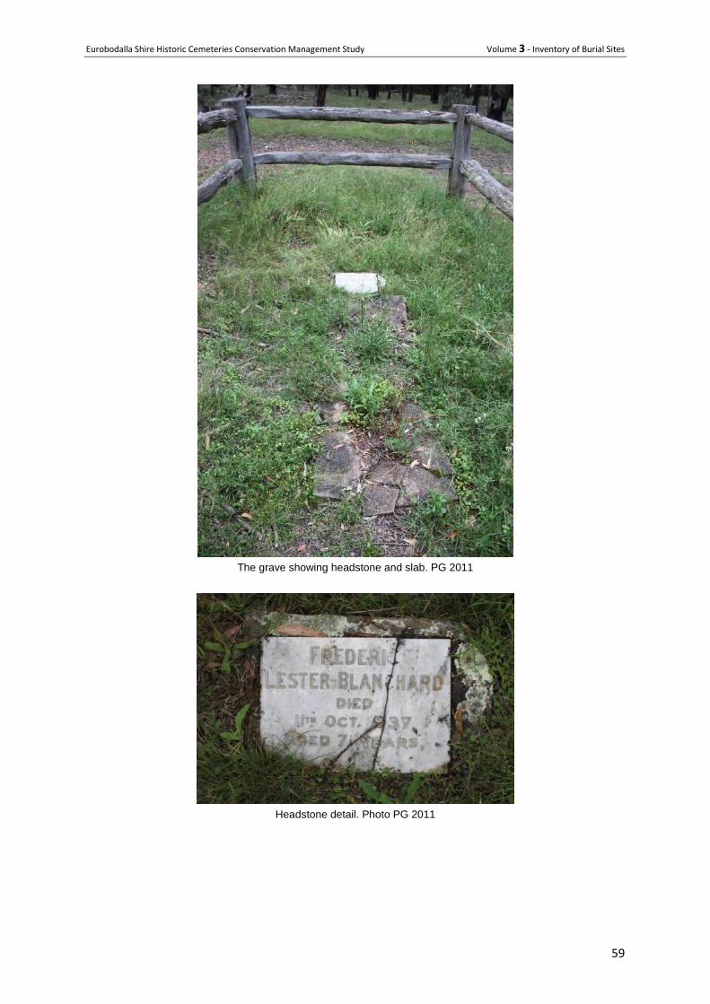
The grave showing headstone and slab. PG 2011
Headstone detail. Photo PG 2011
Eurobodalla Shire Historic Cemeteries Conservation Management Study Volume 3 - Inventory of Burial Sites
60
37 M aria Thompson' s Grave Location Point Parade, Congo
Owner manager Crown land - NPWS
Type Lone burial
History
The first tombstone erected in the district is to be seen at Congo Heads with the date upon it: 1837. It
is a memorial to Maria Thompson. The stone although open to the full blast of the ocean, is in perfect
preservation (comment by EJE 1997). Maria was born Maria Durrant in Sussex, England and
transported to NSW for seven years. Both George and Maria Thompson were assigned as convicts to
Mr John Hawdon who leased a farm at Elderslie (Camden area NSW) where they were married.
Hawdon received a land grant at Kiora in 1831 and built his new home there in 1832/33. George
Thompson received his ticket of leave in 1837 and was allowed to remain in the St Vincent [Moruya]
district and he could possibly have been living in the Congo area at the time of Maria's death.
Following Maria's death in 1837, George married for a second time to Jane Harper in 1838.
In the early 1980s the Eurobodalla Council erected a sturdy white painted fence around the
headstone for its protection. The site was being overgrown by Bitou bush that was brought under
control by poison.
Description
The burial comprises a sandstone headstone engraved with the words
Sacred to the Memory of MARIA the beloved Wife of GEORGE THOMPSON who died March 19th
1837 Aged 24 Years.
The headstone is vertical and robust and set within an enclosure of white painted timber rails that
have been bolted together. The monument is a semicircular sandstone stele with cutaway shoulders.
Condition
The stone is actively delaminating from the upper corner which suggests the exposure to rain is
exacerbating its condition. The grain of the stone appears to run parallel with the face, which would
further facilitate delamination. Its proximity to the ocean and on-shore sea spray would expose the
stone to considerable salt, which may also be a contributing factor.
Significance
Listed on ELEP 2012 as Heritage Item 83
The headstone records one of the first European deaths on the south coast and predates civil
registration by 20 years.
Historically this gravestone has regional significance for recording the first death on the South Coast
in the early decades of the 19th century. Socially it has similar significance because it records the
location of earliest settlement in the region as well as who settled there. It has regional scientific
significance for its potential to reveal information about local area demographics in the early 19th
century. (SHI)
Eurobodalla Shire Historic Cemeteries Conservation Management Study Volume 3 - Inventory of Burial Sites
61
Detailed description and condition of elements
Grave Sandstone headstone with grain parallel to face. Lettering still
distinct but beginning to fade. Delamination a problem
Setting Set in native coastal bushland about 50 metres from the beach
Fencing Painted timber post and rails bolted together
Signage No interpretative signage
Vehicle access About 10 meters from end of tarred road to suburban cul de sac
Parking On nearby road
Pedestrian access/
pathways
Bush track
Vegetation – remnant
vegetation, trees, etc
Natural coastal shrubs and small timber.
Issues or particular factors pertaining to this cemetery or burial plot.
Located on a local walking track behind the dune the burial plot would have some limited public
exposure and hence some basic interpretation may be worthwhile. Unless the delamination can be
arrested it is likely that the lettering will be lost progressively over the next 50 years or so.
Recommendations
Provide on-site interpretation of Maria Thompson’s story,
Undertake periodic repair and repainting of the timber surround,
Obtain specialist advice on methods to retard delamination and implement same.
Location maps from Shire-wide Heritage Study 1997
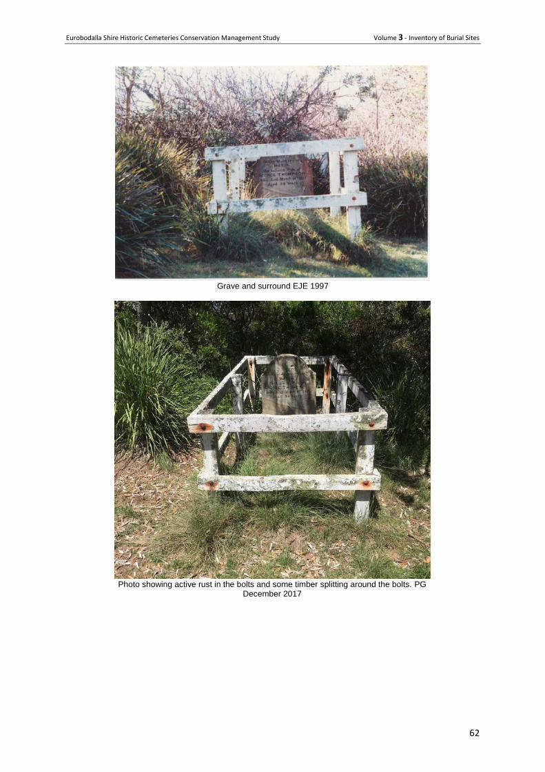
Eurobodalla Shire Historic Cemeteries Conservation Management Study Volume 3 - Inventory of Burial Sites
62
Grave and surround EJE 1997
Photo showing active rust in the bolts and some timber splitting around the bolts. PG
December 2017
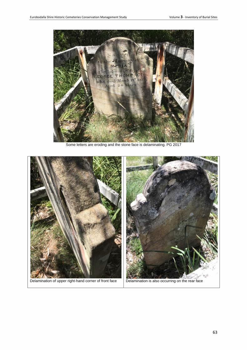
Eurobodalla Shire Historic Cemeteries Conservation Management Study Volume 3 - Inventory of Burial Sites
63
Some letters are eroding and the stone face is delaminating. PG 2017
Delamination of upper right-hand corner of front face
Delamination is also occurring on the rear face
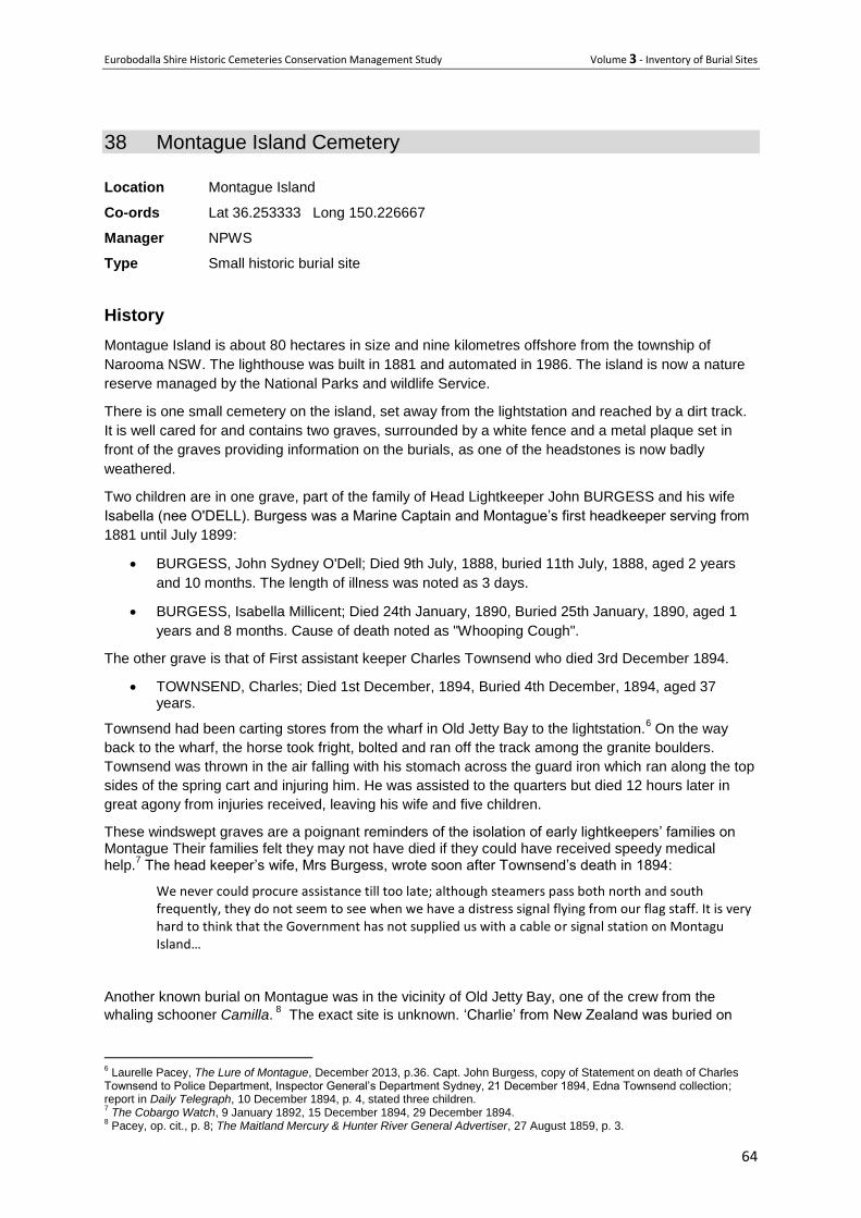
Eurobodalla Shire Historic Cemeteries Conservation Management Study Volume 3 - Inventory of Burial Sites
64
38 Montague Island Cemetery
Location Montague Island
Co-ords Lat 36.253333 Long 150.226667
Manager NPWS
Type Small historic burial site
History
Montague Island is about 80 hectares in size and nine kilometres offshore from the township of
Narooma NSW. The lighthouse was built in 1881 and automated in 1986. The island is now a nature
reserve managed by the National Parks and wildlife Service.
There is one small cemetery on the island, set away from the lightstation and reached by a dirt track.
It is well cared for and contains two graves, surrounded by a white fence and a metal plaque set in
front of the graves providing information on the burials, as one of the headstones is now badly
weathered.
Two children are in one grave, part of the family of Head Lightkeeper John BURGESS and his wife
Isabella (nee O'DELL). Burgess was a Marine Captain and Montague’s first headkeeper serving from
1881 until July 1899:
BURGESS, John Sydney O'Dell; Died 9th July, 1888, buried 11th July, 1888, aged 2 years
and 10 months. The length of illness was noted as 3 days.
BURGESS, Isabella Millicent; Died 24th January, 1890, Buried 25th January, 1890, aged 1
years and 8 months. Cause of death noted as "Whooping Cough".
The other grave is that of First assistant keeper Charles Townsend who died 3rd December 1894.
TOWNSEND, Charles; Died 1st December, 1894, Buried 4th December, 1894, aged 37 years.
Townsend had been carting stores from the wharf in Old Jetty Bay to the lightstation.6 On the way
back to the wharf, the horse took fright, bolted and ran off the track among the granite boulders.
Townsend was thrown in the air falling with his stomach across the guard iron which ran along the top
sides of the spring cart and injuring him. He was assisted to the quarters but died 12 hours later in
great agony from injuries received, leaving his wife and five children.
These windswept graves are a poignant reminders of the isolation of early lightkeepers’ families on Montague Their families felt they may not have died if they could have received speedy medical help.
7 The head keeper’s wife, Mrs Burgess, wrote soon after Townsend’s death in 1894:
We never could procure assistance till too late; although steamers pass both north and south frequently, they do not seem to see when we have a distress signal flying from our flag staff. It is very hard to think that the Government has not supplied us with a cable or signal station on Montagu Island…
Another known burial on Montague was in the vicinity of Old Jetty Bay, one of the crew from the
whaling schooner Camilla. 8 The exact site is unknown. ‘Charlie’ from New Zealand was buried on
6 Laurelle Pacey, The Lure of Montague, December 2013, p.36. Capt. John Burgess, copy of Statement on death of Charles
Townsend to Police Department, Inspector General’s Department Sydney, 21 December 1894, Edna Townsend collection; report in Daily Telegraph, 10 December 1894, p. 4, stated three children. 7 The Cobargo Watch, 9 January 1892, 15 December 1894, 29 December 1894.
8 Pacey, op. cit., p. 8; The Maitland Mercury & Hunter River General Advertiser, 27 August 1859, p. 3.
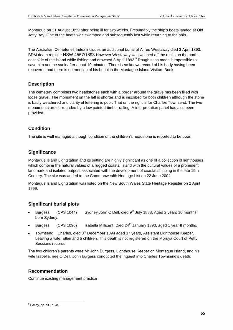
Eurobodalla Shire Historic Cemeteries Conservation Management Study Volume 3 - Inventory of Burial Sites
65
Montague on 21 August 1859 after being ill for two weeks. Presumably the ship’s boats landed at Old
Jetty Bay. One of the boats was swamped and subsequently lost while returning to the ship.
The Australian Cemeteries Index includes an additional burial of Alfred Westaway died 3 April 1893,
BDM death register NSW 4567/1893.However Westaway was washed off the rocks on the north-
east side of the island while fishing and drowned 3 April 1893.9 Rough seas made it impossible to
save him and he sank after about 10 minutes. There is no known record of his body having been
recovered and there is no mention of his burial in the Montague Island Visitors Book.
Description
The cemetery comprises two headstones each with a border around the grave has been filled with
loose gravel. The monument on the left is shorter and is inscribed for both children although the stone
is badly weathered and clarity of lettering is poor. That on the right is for Charles Townsend. The two
monuments are surrounded by a low painted-timber railing. A interpretation panel has also been
provided.
Condition
The site is well managed although condition of the children’s headstone is reported to be poor.
Significance
Montague Island Lightstation and its setting are highly significant as one of a collection of lighthouses
which combine the natural values of a rugged coastal island with the cultural values of a prominent
landmark and isolated outpost associated with the development of coastal shipping in the late 19th
Century. The site was added to the Commonwealth Heritage List on 22 June 2004.
Montague Island Lightstation was listed on the New South Wales State Heritage Register on 2 April
1999.
Significant burial plots
Burgess (CPS 1044) Sydney John O’Dell, died 9th July 1888, Aged 2 years 10 months,
born Sydney.
Burgess (CPS 1096) Isabella Millicent, Died 24th January 1890, aged 1 year 8 months.
Townsend Charles, died 3rd
December 1894 aged 37 years, Assistant Lighthouse Keeper.
Leaving a wife, Ellen and 5 children. This death is not registered on the Moruya Court of Petty
Sessions records
The two children’s parents were Mr John Burgess, Lighthouse Keeper on Montague Island, and his
wife Isabella, nee O’Dell. John burgess conducted the inquest into Charles Townsend’s death.
Recommendation
Continue existing management practice
9 Pacey, op. cit., p. 44.
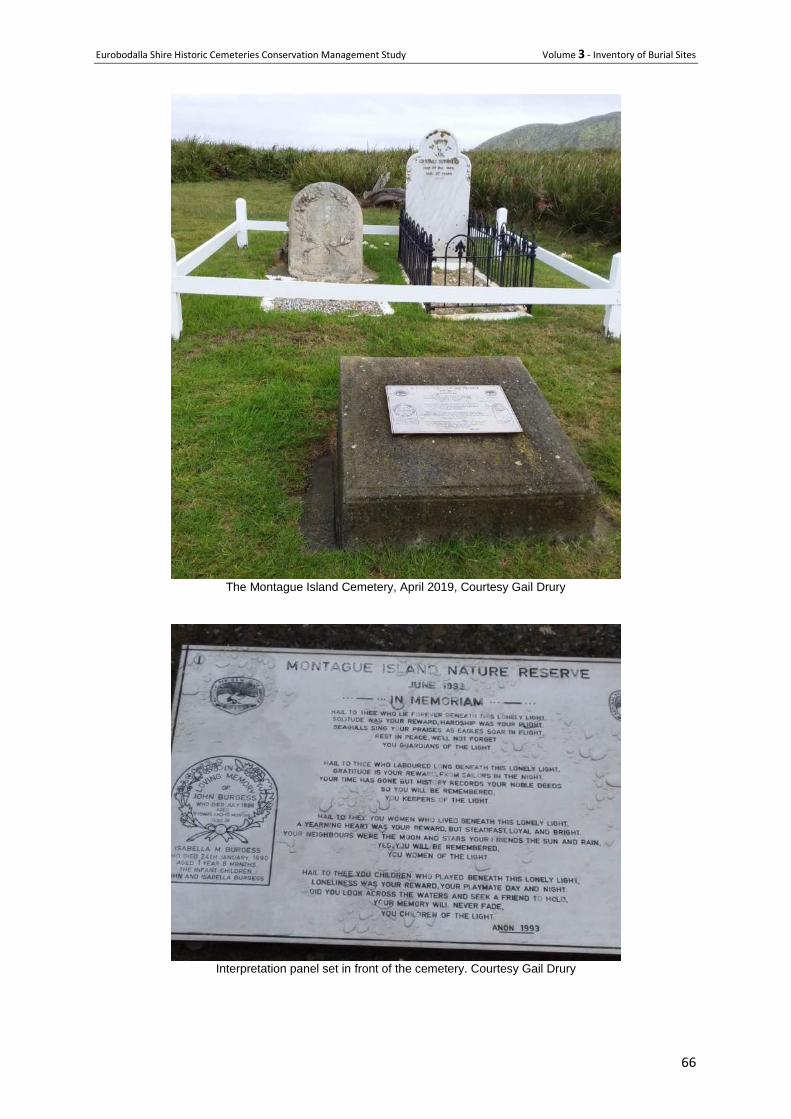
Eurobodalla Shire Historic Cemeteries Conservation Management Study Volume 3 - Inventory of Burial Sites
66
The Montague Island Cemetery, April 2019, Courtesy Gail Drury
Interpretation panel set in front of the cemetery. Courtesy Gail Drury
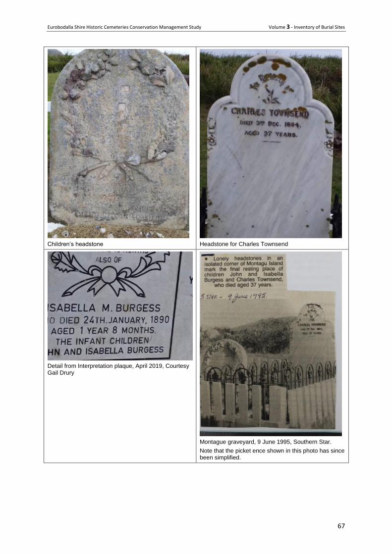
Eurobodalla Shire Historic Cemeteries Conservation Management Study Volume 3 - Inventory of Burial Sites
67
Children’s headstone
Headstone for Charles Townsend
Detail from Interpretation plaque, April 2019, Courtesy Gail Drury
Montague graveyard, 9 June 1995, Southern Star.
Note that the picket ence shown in this photo has since been simplified.
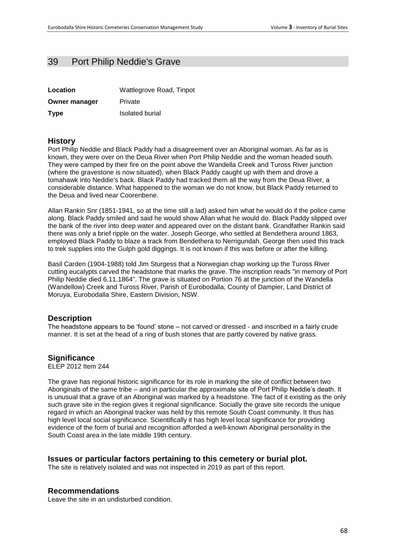
Eurobodalla Shire Historic Cemeteries Conservation Management Study Volume 3 - Inventory of Burial Sites
68
39 Port Philip Neddie's Grave
Location Wattlegrove Road, Tinpot
Owner manager Private
Type Isolated burial
History Port Philip Neddie and Black Paddy had a disagreement over an Aboriginal woman. As far as is known, they were over on the Deua River when Port Philip Neddie and the woman headed south. They were camped by their fire on the point above the Wandella Creek and Tuross River junction (where the gravestone is now situated), when Black Paddy caught up with them and drove a tomahawk into Neddie's back. Black Paddy had tracked them all the way from the Deua River, a considerable distance. What happened to the woman we do not know, but Black Paddy returned to the Deua and lived near Coorenbene. Allan Rankin Snr (1851-1941, so at the time still a lad) asked him what he would do if the police came along. Black Paddy smiled and said he would show Allan what he would do. Black Paddy slipped over the bank of the river into deep water and appeared over on the distant bank. Grandfather Rankin said there was only a brief ripple on the water. Joseph George, who settled at Bendethera around 1863, employed Black Paddy to blaze a track from Bendethera to Nerrigundah. George then used this track to trek supplies into the Gulph gold diggings. It is not known if this was before or after the killing. Basil Carden (1904-1988) told Jim Sturgess that a Norwegian chap working up the Tuross River cutting eucalypts carved the headstone that marks the grave. The inscription reads "in memory of Port Philip Neddie died 6.11.1864". The grave is situated on Portion 76 at the junction of the Wandella (Wandellow) Creek and Tuross River, Parish of Eurobodalla, County of Dampier, Land District of Moruya, Eurobodalla Shire, Eastern Division, NSW.
Description The headstone appears to be ‘found’ stone – not carved or dressed - and inscribed in a fairly crude manner. It is set at the head of a ring of bush stones that are partly covered by native grass.
Significance ELEP 2012 Item 244 The grave has regional historic significance for its role in marking the site of conflict between two Aboriginals of the same tribe – and in particular the approximate site of Port Philip Neddie’s death. It is unusual that a grave of an Aboriginal was marked by a headstone. The fact of it existing as the only such grave site in the region gives it regional significance. Socially the grave site records the unique regard in which an Aboriginal tracker was held by this remote South Coast community. It thus has high level local social significance. Scientifically it has high level local significance for providing evidence of the form of burial and recognition afforded a well-known Aboriginal personality in the South Coast area in the late middle 19th century.
Issues or particular factors pertaining to this cemetery or burial plot. The site is relatively isolated and was not inspected in 2019 as part of this report.
Recommendations Leave the site in an undisturbed condition.
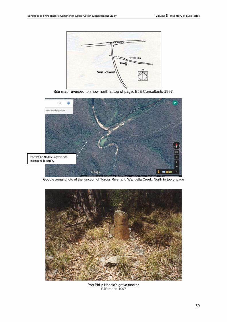
Eurobodalla Shire Historic Cemeteries Conservation Management Study Volume 3 - Inventory of Burial Sites
69
Site map reversed to show north at top of page. EJE Consultants 1997.
Google aerial photo of the junction of Tuross River and Wandella Creek. North to top of page
Port Philip Neddie’s grave marker.
EJE report 1997
Port Philip Neddie’s grave site Indicative location.
Eurobodalla Shire Historic Cemeteries Conservation Management Study Volume 3 - Inventory of Burial Sites
70
40 Rankin Babies Grave
Location ‘Canoolie’, Deua River via Bendethra
Owner manager Private property within Deua River National Park
Type Isolated burial site
History
Allen and Catherine Rankin had family connections to Jerrabatgulla, Berlang, and Favourite Flat at
Araluen before they moved to the site on the upper Deua River after their marriage in 1883. There
they raised a large family starting with Allen b 1884, 2 boys that died at birth and are buried near the
homesite [the subject of this citation], Henry (known as Bill) b 1888, Lily b 1891, Mary Vera b 1894,
Kathleen b 1898, Sylvia b 1900 and Iree b 1902. They were all born at Catherine’s parent’s place at
Favourite Flat other than Allen and the two babies that died. After the loss of the babies Catherine
decided to be closer to medical help as it was a 38 kilometre horse-ride with over 20 river crossings
from Allen and Catherine’s farm to Araluen.
All other births were successful and the Rankin family was large, hard-working and well-respected.
The property was only accessible by horse trail, and with everything needing to be brought in by pack
horse, the Rankin’s were not only self-sufficient, but also self-reliant. Their own house and
outbuildings were built from split timber, shingles and stringy-bark sheets, and the fences from timber
post and rail. It is not surprising that the new babies were buried on the site, not far from the house
rather than being taken by pack horse up the difficult path to the Gundillion cemetery, or even further
to Araluen.
Over time the girls married and left the property to start their own families. In 1939 Allen and
Catherine, then 88 and 79 respectively, decided to move to Moruya after residing up the Deua for 56
years. They left the way they had arrived, on horseback leading their packhorses. Allen died two
years later aged 90 and Catherine two years after that aged 83.
Oldest son Allen Rankin continued to run the property. Sadly the house burnt down in the early 1940s
and Allen converted the old split-slab dairy to a simple house in which he stayed when up from his
home in Moruya. When running cattle it was not necessary to be on the property all the time.
Rankin’s property was eventually acquired by the Donahues who built a modern cottage on the south
side of the river flat well away from Rankin’s homestead, probably in the 1970s or early 80s. In the
meantime much of the Rankin’s former homestead had burnt, decayed, been eaten by termites or
generally collapsed. By 2011 all that remained were a few timber fence posts, some stacked slabs
from the former dairy, some metal farm implements and old metal bed-frame, stone footings from the
original kitchen and a few introduced trees and shrubs. The latter however are interesting as they help
to locate the former home site in relation to historic photographs. Of specific relevance is a tough old
japonica bush that appears to have been located on the south western corner of the house paddock,
under which it is believed the Rankin babies are buried.
Description The pair of graves is believed to be located under a japonica bush near the former south west corner
of the Rankin homestead home paddock. There is no readily visible evidence of the graves, although
the japonica bush is robust and distinctive and is the only one in the vicinity.
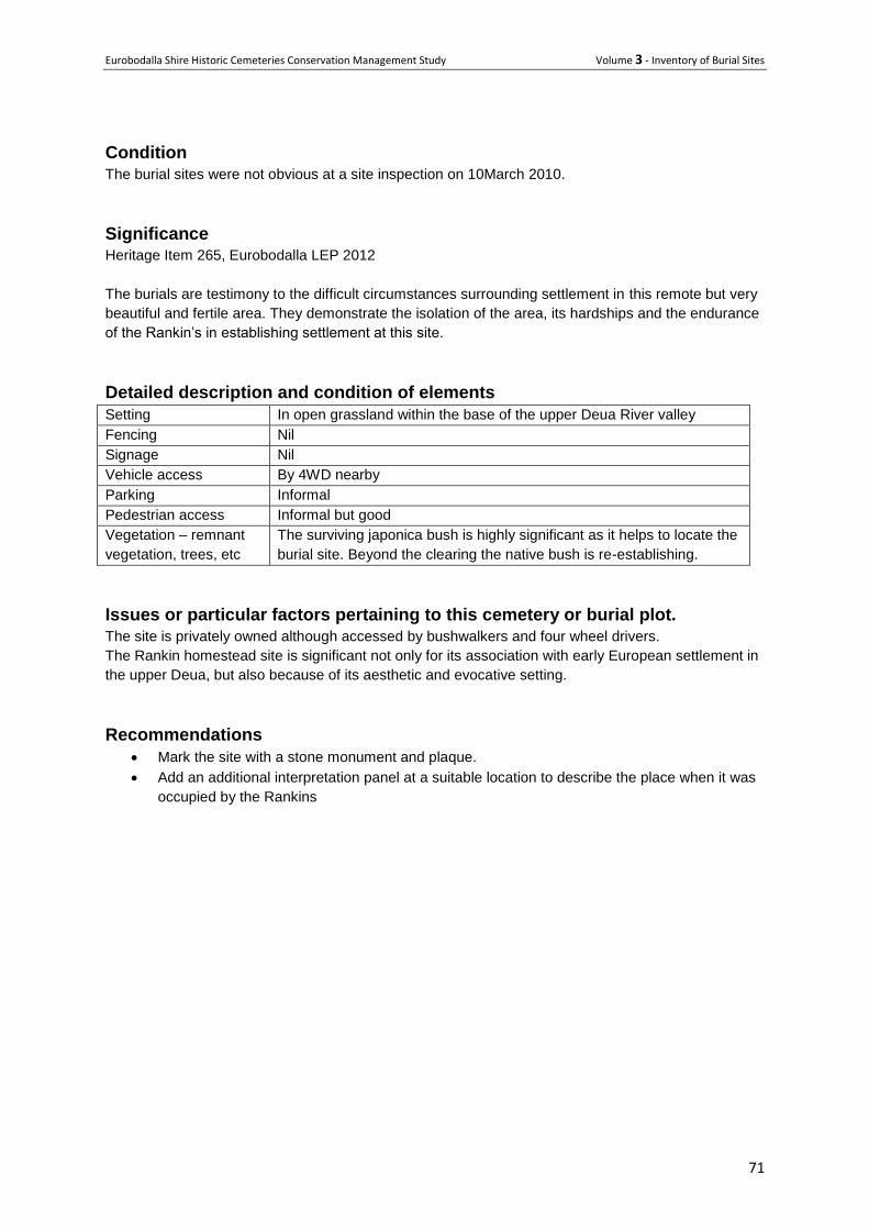
Eurobodalla Shire Historic Cemeteries Conservation Management Study Volume 3 - Inventory of Burial Sites
71
Condition
The burial sites were not obvious at a site inspection on 10March 2010.
Significance Heritage Item 265, Eurobodalla LEP 2012
The burials are testimony to the difficult circumstances surrounding settlement in this remote but very
beautiful and fertile area. They demonstrate the isolation of the area, its hardships and the endurance
of the Rankin’s in establishing settlement at this site.
Detailed description and condition of elements
Setting In open grassland within the base of the upper Deua River valley
Fencing Nil
Signage Nil
Vehicle access By 4WD nearby
Parking Informal
Pedestrian access Informal but good
Vegetation – remnant
vegetation, trees, etc
The surviving japonica bush is highly significant as it helps to locate the
burial site. Beyond the clearing the native bush is re-establishing.
Issues or particular factors pertaining to this cemetery or burial plot.
The site is privately owned although accessed by bushwalkers and four wheel drivers.
The Rankin homestead site is significant not only for its association with early European settlement in
the upper Deua, but also because of its aesthetic and evocative setting.
Recommendations
Mark the site with a stone monument and plaque.
Add an additional interpretation panel at a suitable location to describe the place when it was
occupied by the Rankins
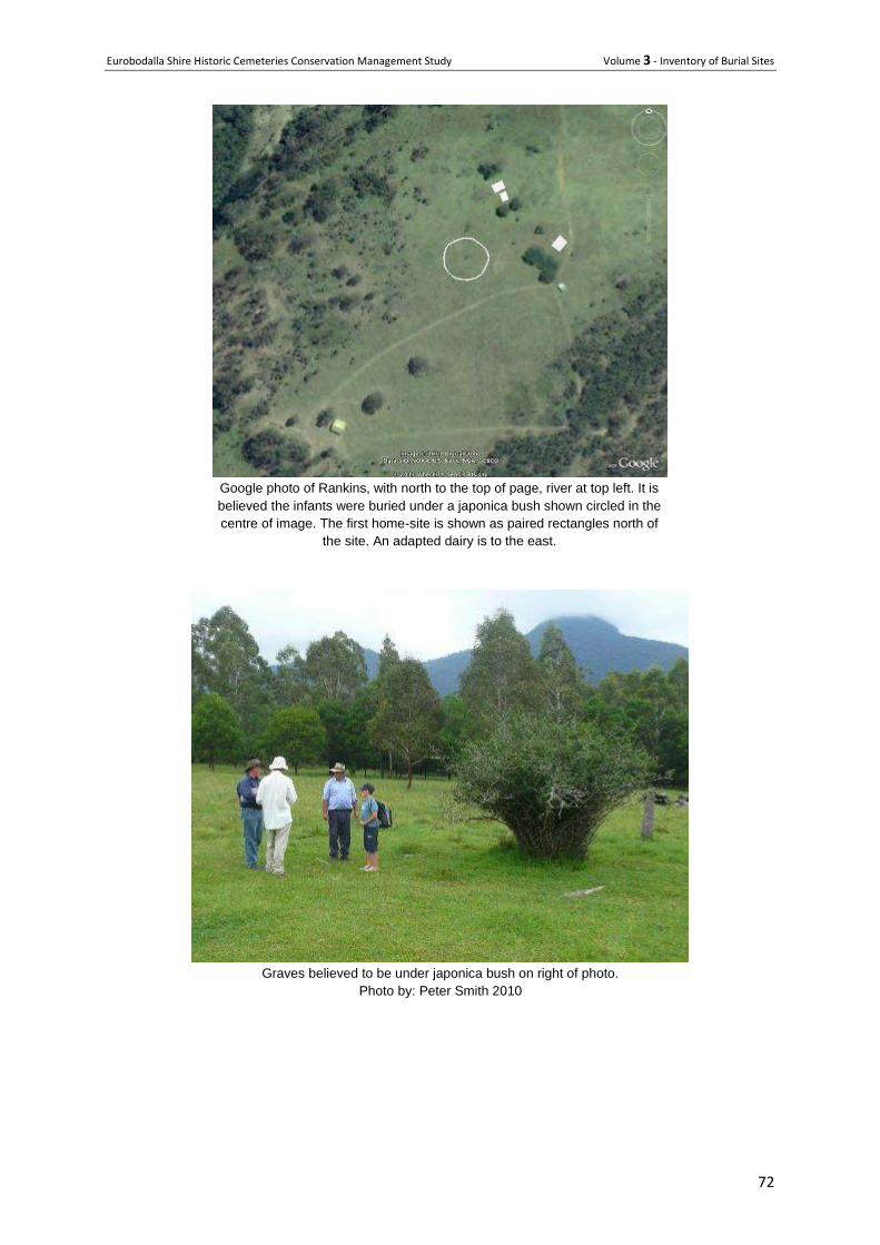
Eurobodalla Shire Historic Cemeteries Conservation Management Study Volume 3 - Inventory of Burial Sites
72
Google photo of Rankins, with north to the top of page, river at top left. It is
believed the infants were buried under a japonica bush shown circled in the
centre of image. The first home-site is shown as paired rectangles north of
the site. An adapted dairy is to the east.
Graves believed to be under japonica bush on right of photo.
Photo by: Peter Smith 2010
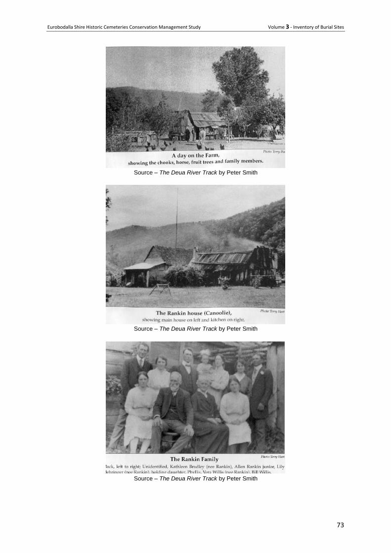
Eurobodalla Shire Historic Cemeteries Conservation Management Study Volume 3 - Inventory of Burial Sites
73
Source – The Deua River Track by Peter Smith
Source – The Deua River Track by Peter Smith
Source – The Deua River Track by Peter Smith
Eurobodalla Shire Historic Cemeteries Conservation Management Study Volume 3 - Inventory of Burial Sites
74
41 Sutherland's Babies' Grave
Address 3070 Belowra Road, Belowra
Owner Private
Type Historic lone burial-closed
History Catherine and Alex Sutherland had two sets of twins, one set in 1901 and another in 1905. One of the babies from the first set of twins (the twin of Jessie) died in infancy. Sadly, one of the newborns from the second set of twins (twin of Harry) also died in infancy. Both of the newborn babies were buried in a fenced enclosure at "Belowra" near the stockyards on Portion 96. The timber fence decayed over the last 100years or so and has been replaced with a stone marker and brass plaque. Tragically, Harry the surviving twin from 1905, also died at Belowra when he was 3 1/2 years old. A death certificate was needed for him to be buried so he had to be transported from Belowra to Cobargo in a tiny coffin on horseback. The rivers and creeks were turbulent and at the Junction of the Wadbilliga and Yowrie Rivers the coffin was swept off the horse. It was retrieved and little Harry was eventually buried in the Cobargo cemetery. The father of both sets of twins, Alex Sutherland, worked as a stockman for Charles Byrne the owner of Belowra, and drove bullocks to Nerrigundah to supply the miners with beef. Alexander Sutherland was the son of Sarah and Daniel Sutherland. Sarah was the first born child of Mary and WD Tarlington, the first Europeans to bring cattle overland to the district. Sarah and Daniel had nine children including Alex and hence the Sutherland family is very well established throughout the district and beyond. Catherine and Alex had very strong links to the early European settlers in the district, particularly to Belowra, Yourie and Cobargo and many of their descendants remain in the area.
Description The memorial comprises a large natural granite rock located on a south facing slope of a gentle rise near the stockyards. A commemorative bronze plaque is fixed to the face of the stone. The dwelling, which is no longer present, was on the ridge and there are two old pear trees about 40metres to the east of the memorial. A slab hut was built further east of the Sutherland’s home circa 1900 and was reconstructed in 2000. The burials were initially marked by a timber fence that collapsed over time. However some surviving pieces of timber indicated the burial site and the stone has been placed accurately over the graves. Several surviving portions of the timber fence were placed next to the stone.
Condition The stone and plaque are in excellent condition.
Significance Local heritage Item 12 ELEP 2012 The site is significant for marking the tragic death of one of each set of Catherine Sutherland’s twins and highlights the challenge of raising children in remote areas at the turn of the 19
th century. It also
contributes to an understanding of the European occupancy of the Belowra area. The commitment of the descendants and local community members to the remarking of the grave site indicates the very high level of social value that the site holds for members of the local community.
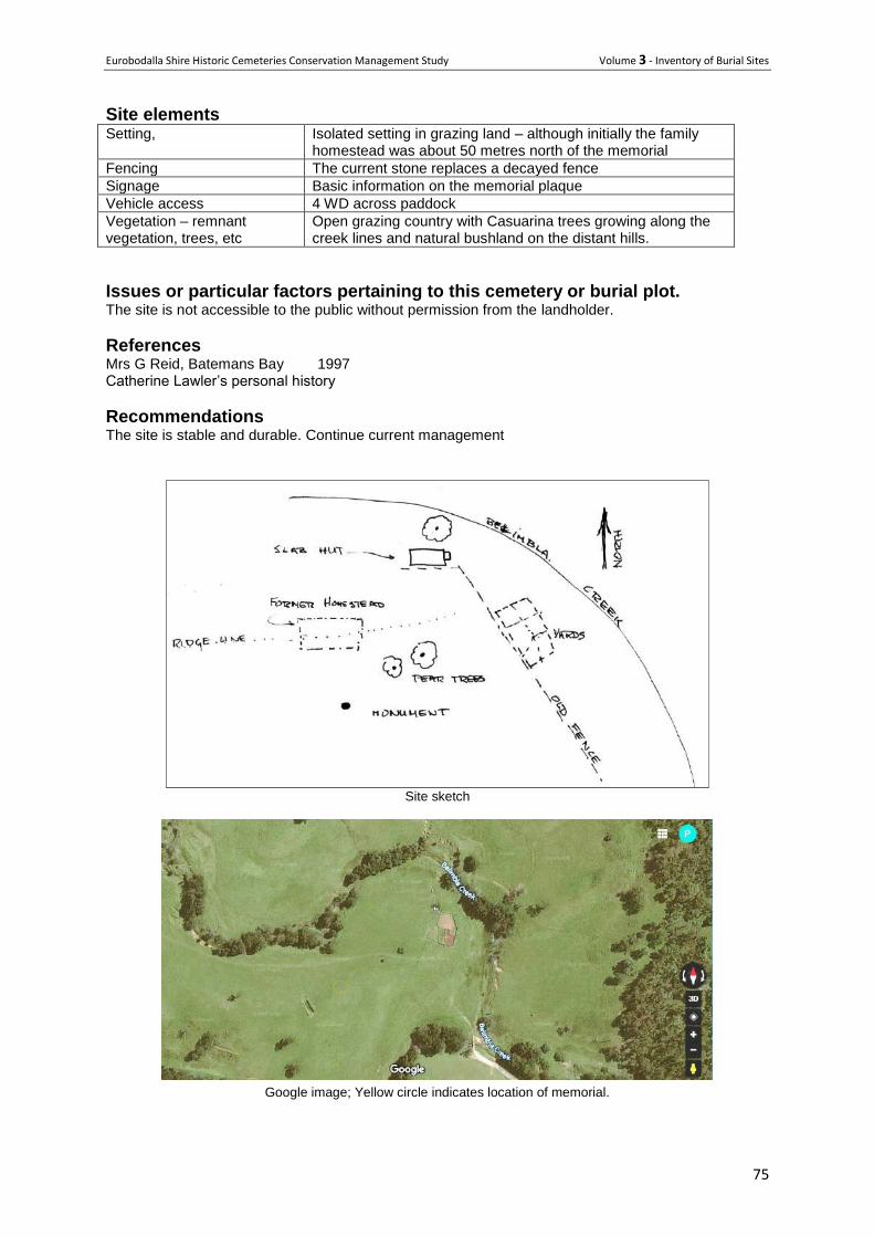
Eurobodalla Shire Historic Cemeteries Conservation Management Study Volume 3 - Inventory of Burial Sites
75
Site elements Setting, Isolated setting in grazing land – although initially the family
homestead was about 50 metres north of the memorial
Fencing The current stone replaces a decayed fence
Signage Basic information on the memorial plaque
Vehicle access 4 WD across paddock
Vegetation – remnant vegetation, trees, etc
Open grazing country with Casuarina trees growing along the creek lines and natural bushland on the distant hills.
Issues or particular factors pertaining to this cemetery or burial plot. The site is not accessible to the public without permission from the landholder.
References Mrs G Reid, Batemans Bay 1997 Catherine Lawler’s personal history
Recommendations The site is stable and durable. Continue current management
Site sketch
Google image; Yellow circle indicates location of memorial.
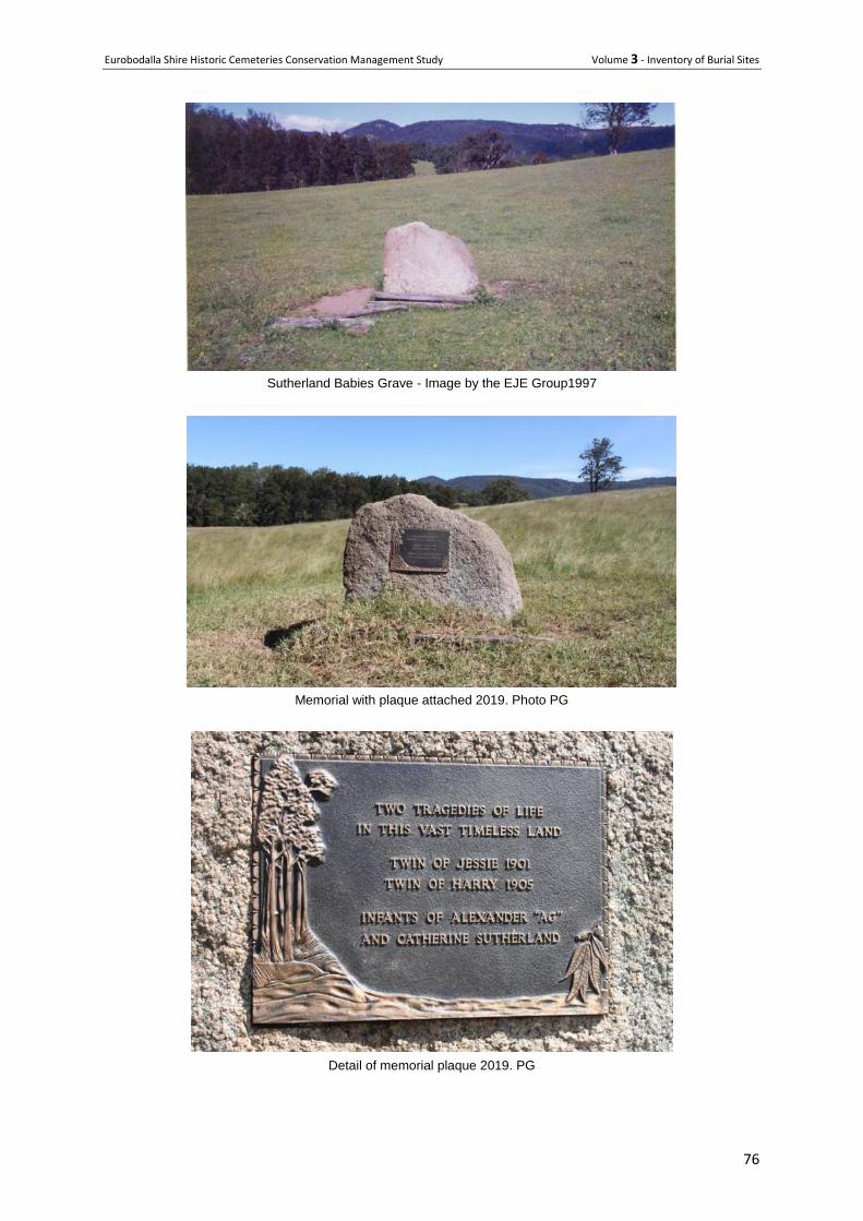
Eurobodalla Shire Historic Cemeteries Conservation Management Study Volume 3 - Inventory of Burial Sites
76
Sutherland Babies Grave - Image by the EJE Group1997
Memorial with plaque attached 2019. Photo PG
Detail of memorial plaque 2019. PG
Eurobodalla Shire Historic Cemeteries Conservation Management Study Volume 3 - Inventory of Burial Sites
77
42 Unidentified Grave - Deua River
Address Deua River Road near Bakers Flat, approximately 35kms west of Moruya
Owner manager NPWS
Type - Lone historic grave
History Believed to be 50 -100 years old.
It appears to have come to public attention in a newspaper article in November 1995.
Description A rectangular stone-lined depression approximately 1.8 x 0.9 metres with soil level about 450mm below the surface.
Condition Aged but sound.
Significance Possibly a burial site but not yet substantiated. There is no record of the site on the NPWS Historic Heritage Information Management System (HHIMS)
Issues or particular factors pertaining to this cemetery or burial plot. There is no documented history of the site and even though it appears to be a grave, there has been no excavation to confirm this. Investigation of the sub-surface would require approval from the NSW Office and Environment and Heritage under the NSW Heritage ACT.
Recommendations It is recommended that the site be left in an undisturbed state.

Eurobodalla Shire Historic Cemeteries Conservation Management Study Volume 3 - Inventory of Burial Sites
78
Newspaper articles collected by MDHS.

Eurobodalla Shire Historic Cemeteries Conservation Management Study Volume 3 - Inventory of Burial Sites
79
The stone-lined grave site in its setting, 2019. Photo F Hood
Detail of stone lined gravesite 2019. Photo F Hood
Eurobodalla Shire Historic Cemeteries Conservation Management Study Volume 3 - Inventory of Burial Sites
80
43 W E Seccombe’s Grave
Location Haxstead Road, Central Tilba
Owner manager Private
Type Isolated lone burial
History The headstone of William Seccombe's grave reads: "In loving remembrance, William Eastcott
Seccombe, born 31 December 1850. Died 30 December 1898, at rest". His death certificate notes
that he was buried on ‘Mr J P Secombe's Estate, "Henkley" Central Tilba by WH Nicholls’.
John Palmer Seccombe (William Seccombe’s brother) had selected "Henkley" in 1870 and was an
original ABC Cheese Factory shareholder and chairman from 1893 to 1899. William owned the
adjoining property "Morangi" (now "Lustleigh Park"), which he had selected in 1877.He died in 1898
from tuberculosis at the age of 48 and was buried on a portion of "Morangi", later incorporated into
"Henkley".
Both Seccombe brothers had mined gold in New Zealand and Will married a New Zealand girl, hence
the Maori name "Morangi". William Seccombe was always to the fore in any public movement for the
advancement of the district. He was also an enthusiastic sportsman. Following his death his wife and
five children returned to New Zealand and the property sold to Otho May (Tilba Tilba storekeeper)
who changed the name to "Lustleigh Park".
Description Granite or marble headstone with a cement base. The monument has a metal fence that is now within
timber post and rail fence, presumably for added protection from cattle. It is located in isolation in the
grass paddock
Condition Not closely inspected in 2019 but from a distance appears sound, with the headstone still vertical.
Significance
ELEP 2012 Item 69
The grave of William Eastcott Seccombe has high level local historic significance for representing the
presence and importance of one of the early Central Tilba area pioneers and for its role in identifying
the extent and location of William's original "Morangi" property, now incorporated into his brother's
early selection, "Henkley". Socially the grave has significance to the local Central Tilba area
descendants of the Seccombe family. It has local scientific significance for its potential to contribute to
an understanding of the methods and importance of private burials in the lives of early Central Tilba
pioneers in the latter years of the 19th century. (EJE report)
The grave contributes to the rich cultural landscape to be found within the Tilba area.
Issues or particular factors pertaining to this cemetery or burial plot. The burial is on private property
Recommendations Continue current management.
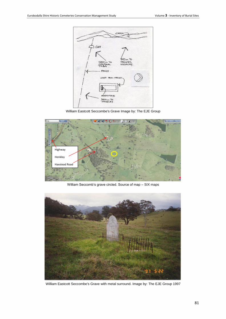
Eurobodalla Shire Historic Cemeteries Conservation Management Study Volume 3 - Inventory of Burial Sites
81
William Eastcott Seccombe's Grave Image by: The EJE Group
William Seccomb’s grave circled. Source of map – SIX maps
William Eastcott Seccombe's Grave with metal surround. Image by: The EJE Group 1997
Highway Henkley Haxstead Road
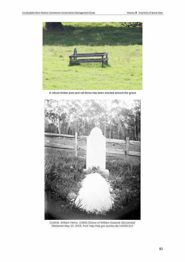
Eurobodalla Shire Historic Cemeteries Conservation Management Study Volume 3 - Inventory of Burial Sites
82
A robust timber post and rail fence has been erected around the grave
Corkhill, William Henry. (1900) [Grave of William Eastcott Seccombe] Retrieved May 10, 2019, from http://nla.gov.au/nla.obj-140301315
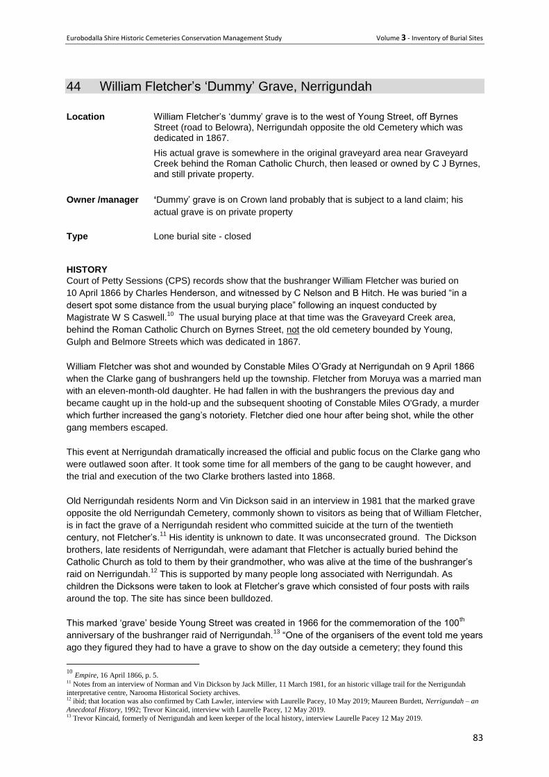
Eurobodalla Shire Historic Cemeteries Conservation Management Study Volume 3 - Inventory of Burial Sites
83
44 William Fletcher’s ‘Dummy’ Grave, Nerrigundah
Location William Fletcher’s ‘dummy’ grave is to the west of Young Street, off Byrnes Street (road to Belowra), Nerrigundah opposite the old Cemetery which was dedicated in 1867.
His actual grave is somewhere in the original graveyard area near Graveyard Creek behind the Roman Catholic Church, then leased or owned by C J Byrnes, and still private property.
Owner /manager ‘Dummy’ grave is on Crown land probably that is subject to a land claim; his
actual grave is on private property
Type Lone burial site - closed
HISTORY
Court of Petty Sessions (CPS) records show that the bushranger William Fletcher was buried on
10 April 1866 by Charles Henderson, and witnessed by C Nelson and B Hitch. He was buried “in a
desert spot some distance from the usual burying place” following an inquest conducted by
Magistrate W S Caswell.10
The usual burying place at that time was the Graveyard Creek area,
behind the Roman Catholic Church on Byrnes Street, not the old cemetery bounded by Young,
Gulph and Belmore Streets which was dedicated in 1867.
William Fletcher was shot and wounded by Constable Miles O’Grady at Nerrigundah on 9 April 1866
when the Clarke gang of bushrangers held up the township. Fletcher from Moruya was a married man
with an eleven-month-old daughter. He had fallen in with the bushrangers the previous day and
became caught up in the hold-up and the subsequent shooting of Constable Miles O'Grady, a murder
which further increased the gang’s notoriety. Fletcher died one hour after being shot, while the other
gang members escaped.
This event at Nerrigundah dramatically increased the official and public focus on the Clarke gang who
were outlawed soon after. It took some time for all members of the gang to be caught however, and
the trial and execution of the two Clarke brothers lasted into 1868.
Old Nerrigundah residents Norm and Vin Dickson said in an interview in 1981 that the marked grave
opposite the old Nerrigundah Cemetery, commonly shown to visitors as being that of William Fletcher,
is in fact the grave of a Nerrigundah resident who committed suicide at the turn of the twentieth
century, not Fletcher’s.11
His identity is unknown to date. It was unconsecrated ground. The Dickson
brothers, late residents of Nerrigundah, were adamant that Fletcher is actually buried behind the
Catholic Church as told to them by their grandmother, who was alive at the time of the bushranger’s
raid on Nerrigundah.12
This is supported by many people long associated with Nerrigundah. As
children the Dicksons were taken to look at Fletcher’s grave which consisted of four posts with rails
around the top. The site has since been bulldozed.
This marked ‘grave’ beside Young Street was created in 1966 for the commemoration of the 100th
anniversary of the bushranger raid of Nerrigundah.13
“One of the organisers of the event told me years
ago they figured they had to have a grave to show on the day outside a cemetery; they found this
10
Empire, 16 April 1866, p. 5. 11 Notes from an interview of Norman and Vin Dickson by Jack Miller, 11 March 1981, for an historic village trail for the Nerrigundah
interpretative centre, Narooma Historical Society archives. 12 ibid; that location was also confirmed by Cath Lawler, interview with Laurelle Pacey, 10 May 2019; Maureen Burdett, Nerrigundah – an
Anecdotal History, 1992; Trevor Kincaid, interview with Laurelle Pacey, 12 May 2019. 13 Trevor Kincaid, formerly of Nerrigundah and keen keeper of the local history, interview Laurelle Pacey 12 May 2019.
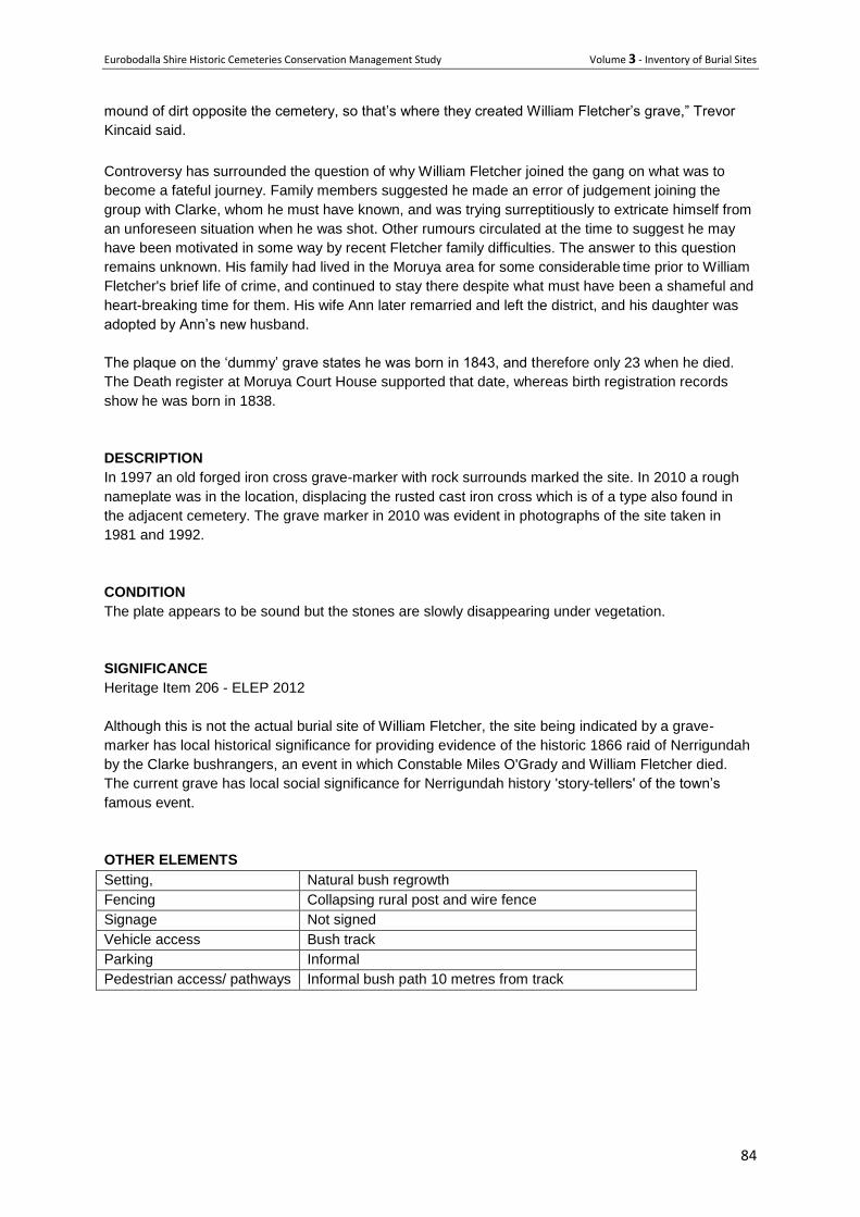
Eurobodalla Shire Historic Cemeteries Conservation Management Study Volume 3 - Inventory of Burial Sites
84
mound of dirt opposite the cemetery, so that’s where they created William Fletcher’s grave,” Trevor
Kincaid said.
Controversy has surrounded the question of why William Fletcher joined the gang on what was to
become a fateful journey. Family members suggested he made an error of judgement joining the
group with Clarke, whom he must have known, and was trying surreptitiously to extricate himself from
an unforeseen situation when he was shot. Other rumours circulated at the time to suggest he may
have been motivated in some way by recent Fletcher family difficulties. The answer to this question
remains unknown. His family had lived in the Moruya area for some considerable time prior to William
Fletcher's brief life of crime, and continued to stay there despite what must have been a shameful and
heart-breaking time for them. His wife Ann later remarried and left the district, and his daughter was
adopted by Ann’s new husband.
The plaque on the ‘dummy’ grave states he was born in 1843, and therefore only 23 when he died.
The Death register at Moruya Court House supported that date, whereas birth registration records
show he was born in 1838.
DESCRIPTION
In 1997 an old forged iron cross grave-marker with rock surrounds marked the site. In 2010 a rough
nameplate was in the location, displacing the rusted cast iron cross which is of a type also found in
the adjacent cemetery. The grave marker in 2010 was evident in photographs of the site taken in
1981 and 1992.
CONDITION
The plate appears to be sound but the stones are slowly disappearing under vegetation.
SIGNIFICANCE
Heritage Item 206 - ELEP 2012
Although this is not the actual burial site of William Fletcher, the site being indicated by a grave-
marker has local historical significance for providing evidence of the historic 1866 raid of Nerrigundah
by the Clarke bushrangers, an event in which Constable Miles O'Grady and William Fletcher died.
The current grave has local social significance for Nerrigundah history 'story-tellers' of the town’s
famous event.
OTHER ELEMENTS
Setting, Natural bush regrowth
Fencing Collapsing rural post and wire fence
Signage Not signed
Vehicle access Bush track
Parking Informal
Pedestrian access/ pathways Informal bush path 10 metres from track
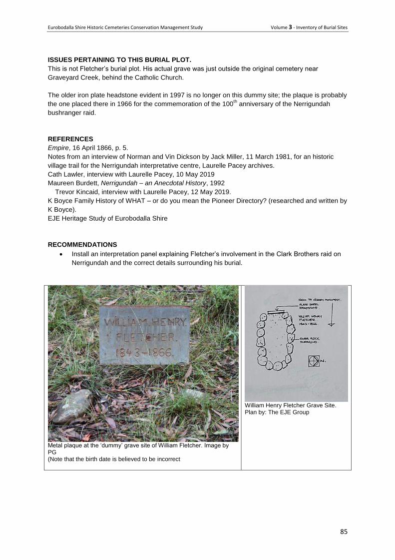
Eurobodalla Shire Historic Cemeteries Conservation Management Study Volume 3 - Inventory of Burial Sites
85
ISSUES PERTAINING TO THIS BURIAL PLOT.
This is not Fletcher’s burial plot. His actual grave was just outside the original cemetery near
Graveyard Creek, behind the Catholic Church.
The older iron plate headstone evident in 1997 is no longer on this dummy site; the plaque is probably
the one placed there in 1966 for the commemoration of the 100th anniversary of the Nerrigundah
bushranger raid.
REFERENCES
Empire, 16 April 1866, p. 5.
Notes from an interview of Norman and Vin Dickson by Jack Miller, 11 March 1981, for an historic
village trail for the Nerrigundah interpretative centre, Laurelle Pacey archives.
Cath Lawler, interview with Laurelle Pacey, 10 May 2019
Maureen Burdett, Nerrigundah – an Anecdotal History, 1992
Trevor Kincaid, interview with Laurelle Pacey, 12 May 2019.
K Boyce Family History of WHAT – or do you mean the Pioneer Directory? (researched and written by
K Boyce).
EJE Heritage Study of Eurobodalla Shire
RECOMMENDATIONS
Install an interpretation panel explaining Fletcher’s involvement in the Clark Brothers raid on
Nerrigundah and the correct details surrounding his burial.
Metal plaque at the ‘dummy’ grave site of William Fletcher. Image by PG (Note that the birth date is believed to be incorrect
William Henry Fletcher Grave Site. Plan by: The EJE Group
Eurobodalla Shire Historic Cemeteries Conservation Management Study Volume 3 - Inventory of Burial Sites
86
Lone burials - for which there is no evidence at ground level
Eurobodalla Shire Historic Cemeteries Conservation Management Study Volume 3 - Inventory of Burial Sites
87
45 Aboriginal Isolated Burials
Location Throughout the shire
Owner /manager Various
Type Pre and post 1788 isolated graves
Status – Archaeologically significant relics
History There is little evidence of the burials of the many Aboriginal people who lived and died on the south coast over the previous several thousand years and it is only in exceptional circumstances that the skeletal remains of traditional burials survive and are rediscovered. Notwithstanding this, Aboriginal heritage studies by Kamminga in 2003 and Feary in 2008 indicate former burials within coastal areas of Eurobodalla National Park south of the Tuross River and around Potato Point. The report Invisible Places (Donaldson and Feary 2012) indicated isolated burials associated with poignant accounts of Aboriginal life following the arrival of Europeans. Some of these are noted below. Murunna Point On the southern side of the Wallaga Lake entrance, several sites were recorded in 2003 (Webster and Kuskie 2003) and in July 2008, a section of the headland eroded away to expose the skeletal remains of a traditional Aboriginal burial (Feary 2009). The burial has been left in situ and Bega Valley Shire and the Office of Environment and Heritage (OEH) have put erosion control measures in place to ensure its long-term protection. (Caring for Ancestors – P13) William Campbell Since European settlement the deaths of well-known Aboriginal people were sometimes recorded in the local media such as that of William Campbell whose death on Friday 22 March 1901 was reported by the Moruya Examiner:
Death of an Aboriginal – Campbell, the well-known Aboriginal died suddenly on Monday at Coila. He has been in indifferent health for some time past…’ (Source - Invisible Places p8 burial site yet to be established).
Neddy An Aborigine by name of ‘Neddy’ was granted 40 acres on 20 /5/1878 as a gazetted reserve on the south bank of the Tuross River – adjacent to Borang Lake. ‘Neddy’s Point’ as it came to be known, had the lease revoked in 1918 and the land was subsequently held by the Berriman family. They had a good relationship with the Aboriginal people and allowed continued camping and fishing on the Point. When Neddy passed away he was buried on the point sometime before 1910. (Invisible places p17) William Benson William Benson’s reserve at Turlinjah, on the shore of Tuross Lake, was granted on 22/11/1880. Benson worked for the Hawdon family at Kyla Park. An extended family of about eight adults and eight children are recorded as living on the 32 acre reserve from 1883 and 1888. The lease was revoked in 1917, possibly as a result of William Benson’s death. Written sources indicate the presence of two burial grounds or cemeteries in the Turlinjah area, one located outside Benson’s reserve within the southern grazing lot of Kyla Park, and one within it on the peninsular.
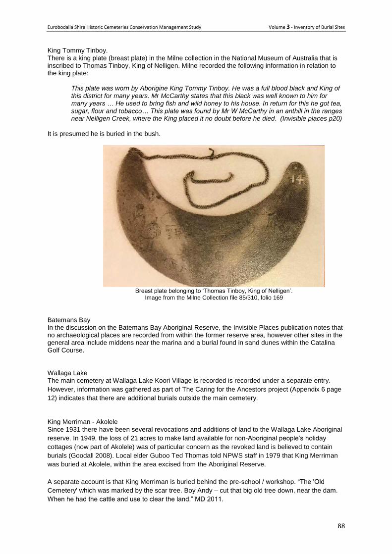
Eurobodalla Shire Historic Cemeteries Conservation Management Study Volume 3 - Inventory of Burial Sites
88
King Tommy Tinboy. There is a king plate (breast plate) in the Milne collection in the National Museum of Australia that is inscribed to Thomas Tinboy, King of Nelligen. Milne recorded the following information in relation to the king plate:
This plate was worn by Aborigine King Tommy Tinboy. He was a full blood black and King of this district for many years. Mr McCarthy states that this black was well known to him for many years … He used to bring fish and wild honey to his house. In return for this he got tea, sugar, flour and tobacco… This plate was found by Mr W McCarthy in an anthill in the ranges near Nelligen Creek, where the King placed it no doubt before he died. (Invisible places p20)
It is presumed he is buried in the bush.
Breast plate belonging to ‘Thomas Tinboy, King of Nelligen’.
Image from the Milne Collection file 85/310, folio 169
Batemans Bay In the discussion on the Batemans Bay Aboriginal Reserve, the Invisible Places publication notes that no archaeological places are recorded from within the former reserve area, however other sites in the general area include middens near the marina and a burial found in sand dunes within the Catalina Golf Course. Wallaga Lake The main cemetery at Wallaga Lake Koori Village is recorded is recorded under a separate entry.
However, information was gathered as part of The Caring for the Ancestors project (Appendix 6 page
12) indicates that there are additional burials outside the main cemetery.
King Merriman - Akolele Since 1931 there have been several revocations and additions of land to the Wallaga Lake Aboriginal
reserve. In 1949, the loss of 21 acres to make land available for non-Aboriginal people’s holiday
cottages (now part of Akolele) was of particular concern as the revoked land is believed to contain
burials (Goodall 2008). Local elder Guboo Ted Thomas told NPWS staff in 1979 that King Merriman
was buried at Akolele, within the area excised from the Aboriginal Reserve.
A separate account is that King Merriman is buried behind the pre-school / workshop. “The 'Old
Cemetery' which was marked by the scar tree. Boy Andy – cut that big old tree down, near the dam.
When he had the cattle and use to clear the land.” MD 2011.

Eurobodalla Shire Historic Cemeteries Conservation Management Study Volume 3 - Inventory of Burial Sites
89
In 1979 Bill Campbell informed Brian Egloff that King Merriman was buried ‘down there at Wallaga
Lake down at the old cricketing ground just at the back of the beach. That’s where he’s buried…’
Merriman died on 26/11/1904.
Biamanga
Possibly buried in the ‘Old Cemetery’.
Granny Tungiay “On the headland out from Umbarra at ‘Granny’s Point’. The grave site is near the big log by the lake.”
Chineese graves are near the tank on the way in to Wallaga.
Bunjuk
CF: Harold Freeman [CB's son] informed CF that Bunjuk was buried near a scar tree at Wallaga Lake.
Significance The burials illustrate the long history of Aboriginal occupation across the Eurobodalla Shire area. While some of the burials are comparatively recent it is likely that others predate European arrival.
Issues or particular factors pertaining to these burial plots. There is a risk that ground that is being disturbed for whatever reason in the areas noted above could inadvertently disturb significant skeletal remains. In the event that skeletal remains are uncovered work will need to cease while approval is sought from the Office of Environment and Heritage.
Recommendations Confirm the location of the ‘Old Cemetery’ at Wallaga Lake and if possible confirm the
location of King Merriman and others.
Develop a predictive model of the locations or type of country likely to have been used for Aboriginal burials before the arrival of Europeans.

Eurobodalla Shire Historic Cemeteries Conservation Management Study Volume 3 - Inventory of Burial Sites
90
46 Belowra Tramp’s Burial
Location Belowra Road
Owner Private
Type Isolated unmarked burial
History Catherine Lawler’s personal history records the following story:
‘There was a chap who wandered into one of the huts at Belowra and ate some pollard that
contained poison intended for rabbits. He died before he could get medical attention. The
local doctor who would have been in Moruya, and the police were notified. His body was
rolled up in a sheet of stringy bark and he was buried at Belowra. This was during AG
Sutherland’s time as manager.’
It is understood the chap was a tramp – probably walking through the valley looking for itinerant work.
This was common during the depression years from say 1929 – 33, but at other times as well. The
tramp initially denied he had eaten anything but as his condition deteriorated admitted to eating some
of the pollard – not knowing it to be poisoned. Sadly by this stage a cure, if there was one, was too
late and his death followed.
Description His precise burial spot is not known, however the land portion advertised camping availability in 2019
with a sign on a tree. The land is lightly timbered over native grassland.
Significance This is a poignant story that tells much about lifeways in the valley at the time – homelessness of the
tramp, the lack of vehicle access to doctors and hospitals, lack of phone communication and rural
farming and labour practice.
Recommendations Undertake further research as the ‘tramp’s’ death may have been recorded on police records and
possibly in the local newspapers of the day, so there is the possibility of uncovering additional
information such as dates and people involved.
Add an information plaque onto the land portion on which the burial occurred.

Eurobodalla Shire Historic Cemeteries Conservation Management Study Volume 3 - Inventory of Burial Sites
91
Land parcel on which the burial is believed to have taken place. 2019 – west side of Belowra Rd

Eurobodalla Shire Historic Cemeteries Conservation Management Study Volume 3 - Inventory of Burial Sites
92
47 Tuross Head Mystery Graves
Location Tuross Head, possibly in the little park that is bordered by the grassy dunes of
Coila beach, Bridges Road and Chauvel Crescent, near the paved path leading
from Coila Beach to Coila Lake, although no one knows for sure exactly where,
in this area, the graves might be situated.
Owner manager Presumed to be Eurobodalla Shire Council although possibly on adjacent private
land.
Type Isolated burials without markers
History
The following article was written by Carlene Winch-Dummett and published in the Journal of the
Moruya and District Historical Society March 2018.
“Discovering the identities, or even a general inkling, of the occupants of the graves begins with
known facts and these often lead to clues to other relevant information. So it is that the events of
March 1867 will lead the investigator to two definite burials and, possibly, in fact probably, two other
burials. A fifth burial may be identified as a later interment, perhaps almost 20 years later.
In a lonely, melancholy patch of shrubbery on Friday 29 March, 1867 two young men were laid to rest
in coffins among the she-oaks following a coronial inquest presided over by Mr Caswell, the local
magistrate, and a jury of twelve. George Magill, one of the deceased, had been found on the evening
of Thursday 28 March, and Thomas Mahon on the morning of 29 March. It was already dark following
the coronial inquest when their bodies were laid to rest in hastily built coffins in the oak scrub ‘by the
flickering wood fire’, the ‘moaning sea’ and the ‘sighing wind’, and where the Presbyterian Minister
Rev. P. Fitzgerald prayed over their graves. According to the Empire Sydney, NSW. (Mon. 8 April,
1867), the young men were buried near where two graves already existed.
This mournful scene began in what could be described as a simple misunderstanding of the force of
the swollen Tuross River meeting the powerful waves of the rushing sea. On 26 March, 1867
Frederick Massey, George Magill and Thomas Mahon, all young strong and healthy men, were
drowned at the mouth of the Tuross River. How could this tragedy happen? In the second week of
March, the farmers of Eurobodalla had been cheerfully anticipating good returns from their efforts,
particularly potatoes and corn which were expected to be bumper crops. Then, on Saturday, 23
March, the rains set in and by Sunday the Moruya River had risen by twelve feet. By Monday, 25
March, the swollen river met the incoming flood tide. The Moruya area lost crops, animals, fencing,
punts, bridges and structures. The damage was not confined to Moruya but spread throughout the
Eurobodalla including the Tuross River and surrounding lowland properties.
On that fateful Tuesday, 26 March 1867, a number of spectators had gathered at Tuross Lake to
observe the flooded Tuross River and its effect on the bar at the opening to the sea. Four boats were
on the river where it spreads out to form a lake about a mile in width before entering the sea. Mr
Brice, a local farmer from Horse Island, and his daughter were in one boat. Mr Dansey, who operated
the punt over the Tuross River, was in another boat with Mr Goodin, Mr Southern and three others
from the sawmill on the Tuross River. They arrived safely near Sandy Point. Francis Hawdon, son of
John Hawdon, accompanied by a visitor to his father’ property, George Magill, and Thomas Mahon,
his father’s coachman, took a flat bottomed boat on to the lake. A fourth boat, a flat-bottomed dinghy
with Frederick Massey, a French sailor employed by Dansey, and William Parsons on board, also
moored at Sandy Point. Massey proposed going further in the boat but Parsons refused so Massey
Eurobodalla Shire Historic Cemeteries Conservation Management Study Volume 3 - Inventory of Burial Sites
93
set off alone. Encouraged by the enthusiasm of Frederick Massey, Francis Hawdon joined George
Magill and Thomas Mahon and followed Massey.
Although the waters on the lake were still, at the heads the river current pulled strongly towards the
opening to the sea. The opening at the bar was only about three hundred metres wide and the ocean
was rushing towards the opening with massive waves turning the turbulent river waters into a
powerful cauldron. Both boats fell mercy to the current. The first casualty was Frederick Massey who
jumped out of his boat and vanished in the waves. Francis Hawdon, who had been struggling
unsuccessfully with a broken oar in the hope of getting the boat onto the bank, seeing Massy
disappear, jumped out of the boat and was swept into the waves. Being a Journal of the Moruya &
District Historical Society Inc. March 2018 22 strong swimmer, he struggled to reach the shore. Magill
and Mahon remained in the boat until it reached the breakers, then they too jumped overboard and
drowned.
Mr Goodin, one of the spectators, continued to monitor Francis Hawdon, who was buffeted around the
bar for about fifteen minutes or more before getting into a small eddy. This offered an opportunity for
those on shore, Mr Goodin, James Southam, Daniel Southam, William Parsons and Isaac Cole, to
make a human chain to rescue him. Despite the sea at the bar being black with mud they held hope
that the bodies would be recovered. Sergeant Brennan rode up the beach from Moruya to join in the
search. However, it was not until two or more days had passed that the bodies of the two unfortunate
men were washed up a mile north of the river mouth where they lost their lives. The body of Frederick
Massey was not found.
The bodies of Thomas Mahon and George Magill were interred on the 29 March 1867 at a site near
two existing graves. There are no official or anecdotal records of the deceased in the two existing
graves. They may have been the graves of sailors or passengers on ships that floundered in the
region, but that is just speculation.
Although it is has been suggested that the two existing graves were those of Andrew Lovell and
Christy Caffey, (The Sydney Morning Herald Wed. 9 January, 1867) death records show they were
buried at Broulee. In January 1867, just two months before the burials of Thomas Mahon and George
Magill, their bodies were washed up on Broulee Island, a few miles north of Tuross Head. According
to Jack Kenneth Loney, Wrecks on the New South Wales Coast, (1992: p.48) the deceased were
from the schooner Hope which was wrecked in December 1866 between Broulee Island and Tuross
Head. The Hope was built on the Tuross River for oyster growers by Moses Fletcher, a seaman and
shipwright. Fletcher had property at Trunketabella and built small wooden ships in association with
the Tuross steam sawmill of Goodin, Hicks brothers and Brown at Turlinjah just a few miles down the
Tuross River. (Mr Goodin was one of the men mentioned as being on the Tuross River the day that
Thomas Mahon and George Magill drowned.)
Similarly, an accident closer to Tuross Head in 1842 at the Moruya bar, reported in The Sydney
Morning Herald, 28 November 1842, describes the loss of three men and two boys who were
conveying a cargo of wheat from Moruya to Broulee in a whale boat belonging to Captain Oldrey of
Broulee. One of the bodies was found much mutilated, but the other bodies were not found.
While there is no evidence to support the identities of the bodies in the graves that pre-dated those of
Mahon and Magill, there is a very strong possibility that there is a fifth grave at, or near, the site of the
four graves. On Monday, 16 February 1891, a seaman, Louie Strone (Strom), drowned off Tuross
Head. Strone was a member of a three man crew of the steamer Meeinderry, a steel ship chartered
by Tuross property owner Patrick Mylott, a wine merchant of Balmain Sydney, to make weekly
voyages from Sydney to the South Coast of NSW. The crew were attempting to drop off supplies at
Tuross from the Meeinderry by one of the lifeboats when it capsized. The mate and the other seaman
Eurobodalla Shire Historic Cemeteries Conservation Management Study Volume 3 - Inventory of Burial Sites
94
were saved, but Louie Strone was drowned. Strone’s body washed ashore and was buried at Tuross
Head. (Extract from Moruya and District Historical Society Journal, 20 December, 2013.)
Therefore, the identities of the deceased of two of the graves have been verified, those of Thomas
Mahon and George Magill (1867). There are two older graves whose occupants have not been
identified (pre-1867). There is a fifth grave, that of Louis Strom. (1891). But exactly where these
graves are has also not been verified.”
Sources include:
All newspaper references above and including further newspaper reports are available on Trove,
National Library of Australia. Trove.nla.gov.au
Diary of Pilot Station Moruya 1866
Gibbney, H.J. 1980. Eurobodalla. Library of Australian History. Sydney.
www.bdm.nsw.gov.au
Description In her article Carlene Winch-Dummett describes the setting:
“The area is cool and shady, with a dry creek bed, and sheltered by a canopy of she-oaks that
sigh mournfully when the south easterlies drift through their spindly branches.”
Condition Unknown
Significance Although the specific site is not known, the burials illustrate some of the challenges faced by early
European settlers, many of whom were poor swimmers and did not fully appreciate local water
conditions. It is interesting to note how many of the deaths in the historic records of Eurobodalla Shire
were from drowning.
Issues or particular factors pertaining to this cemetery or burial plot. It is possible that the graves have been disturbed by infrastructure works, vegetation or changes to
landform over the intervening years, however it seems appropriate to acknowledge the burials in
some physical manner.
Recommendations
Provide an interpretation panel in the vicinity of the park to tell the story based on the research and
article published in the MDHS article.
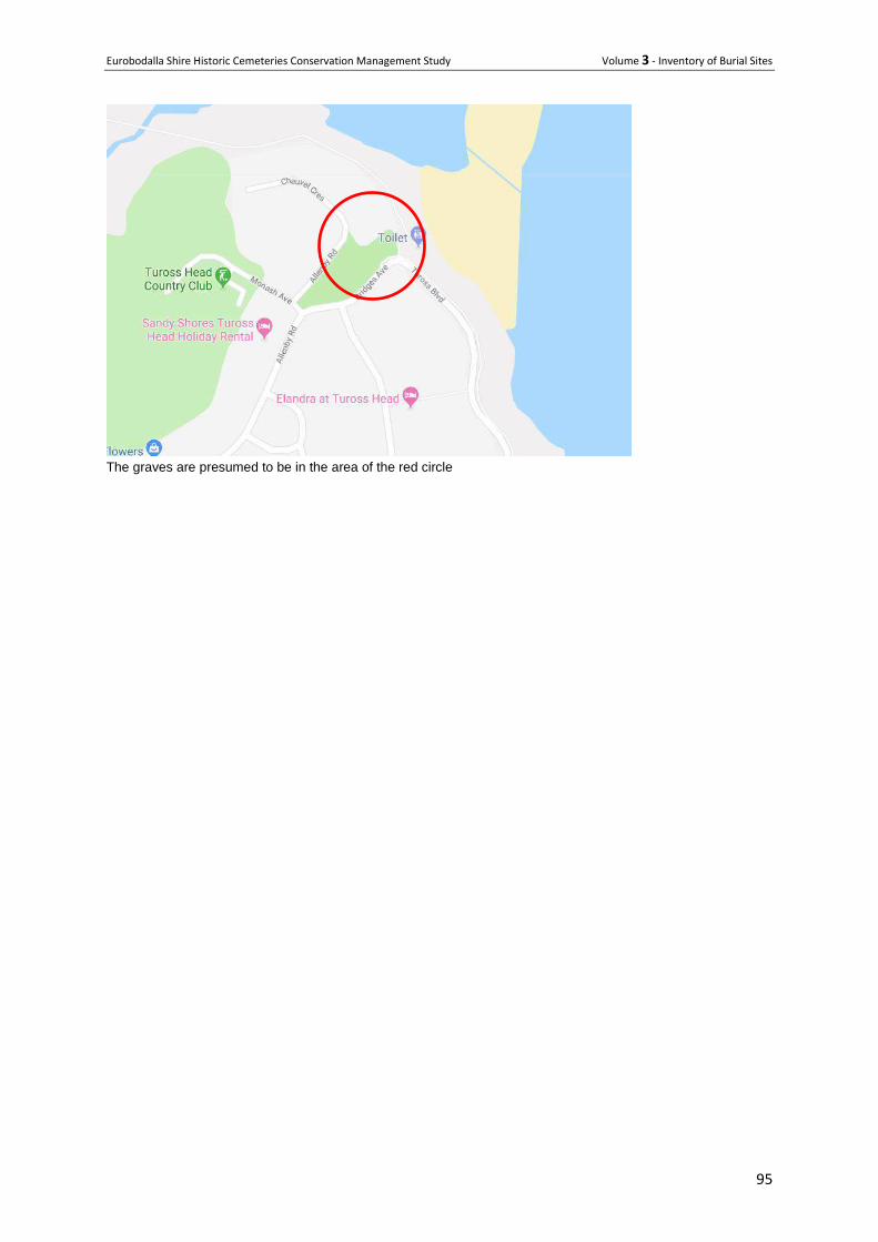
Eurobodalla Shire Historic Cemeteries Conservation Management Study Volume 3 - Inventory of Burial Sites
95
The graves are presumed to be in the area of the red circle
Eurobodalla Shire Historic Cemeteries Conservation Management Study Volume 3 - Inventory of Burial Sites
96
Memorials - commemorating a deceased person or persons
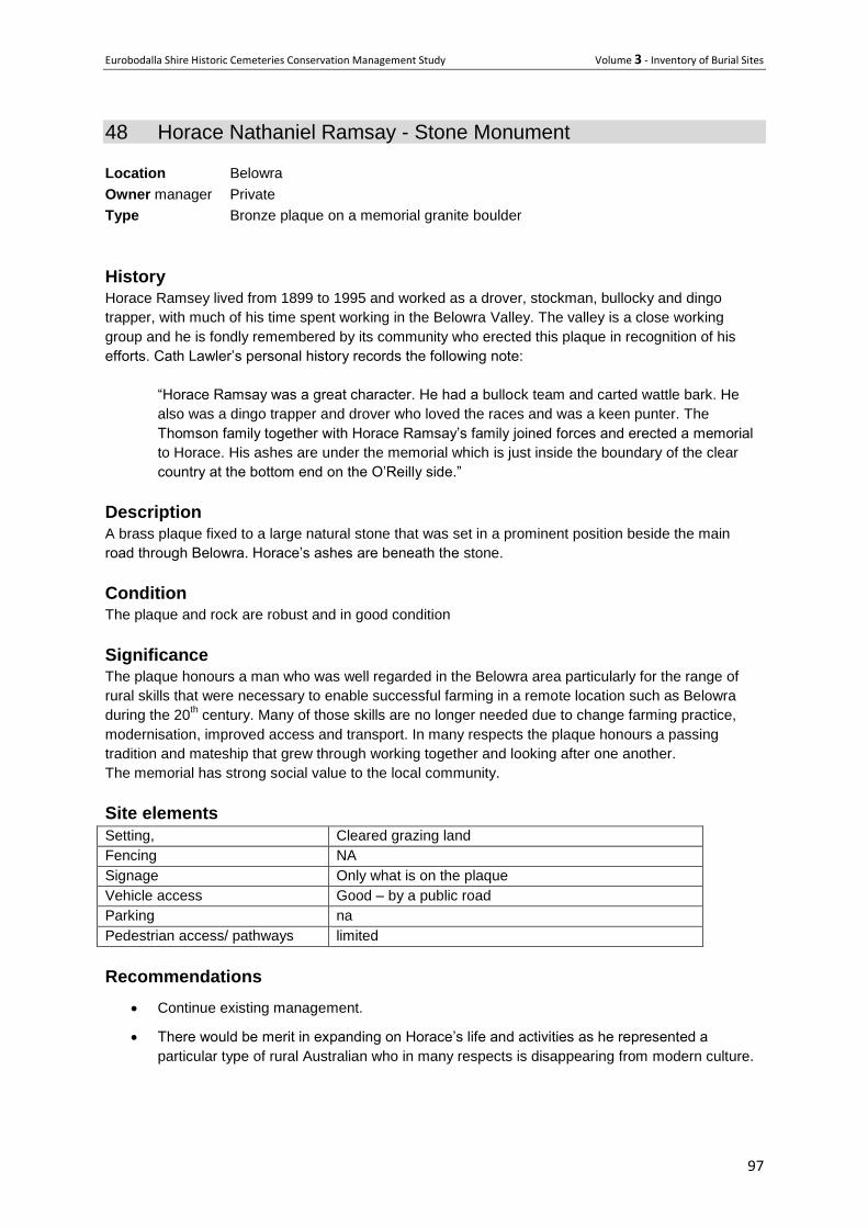
Eurobodalla Shire Historic Cemeteries Conservation Management Study Volume 3 - Inventory of Burial Sites
97
48 Horace Nathaniel Ramsay - Stone Monument
Location Belowra
Owner manager Private
Type Bronze plaque on a memorial granite boulder
History Horace Ramsey lived from 1899 to 1995 and worked as a drover, stockman, bullocky and dingo
trapper, with much of his time spent working in the Belowra Valley. The valley is a close working
group and he is fondly remembered by its community who erected this plaque in recognition of his
efforts. Cath Lawler’s personal history records the following note:
“Horace Ramsay was a great character. He had a bullock team and carted wattle bark. He
also was a dingo trapper and drover who loved the races and was a keen punter. The
Thomson family together with Horace Ramsay’s family joined forces and erected a memorial
to Horace. His ashes are under the memorial which is just inside the boundary of the clear
country at the bottom end on the O’Reilly side.”
Description
A brass plaque fixed to a large natural stone that was set in a prominent position beside the main
road through Belowra. Horace’s ashes are beneath the stone.
Condition The plaque and rock are robust and in good condition
Significance The plaque honours a man who was well regarded in the Belowra area particularly for the range of
rural skills that were necessary to enable successful farming in a remote location such as Belowra
during the 20th century. Many of those skills are no longer needed due to change farming practice,
modernisation, improved access and transport. In many respects the plaque honours a passing
tradition and mateship that grew through working together and looking after one another.
The memorial has strong social value to the local community.
Site elements
Setting, Cleared grazing land
Fencing NA
Signage Only what is on the plaque
Vehicle access Good – by a public road
Parking na
Pedestrian access/ pathways limited
Recommendations
Continue existing management.
There would be merit in expanding on Horace’s life and activities as he represented a
particular type of rural Australian who in many respects is disappearing from modern culture.
Eurobodalla Shire Historic Cemeteries Conservation Management Study Volume 3 - Inventory of Burial Sites
98
The memorial stone in its grassland setting. 2019
Bronze plaque mounted on memorial stone2019
Eurobodalla Shire Historic Cemeteries Conservation Management Study Volume 3 - Inventory of Burial Sites
99
49 M elvil le Point M emorial
Location Melville Point Tomakin
Owner manager Eurobodalla Shire Council
Type Memorial listing the names of burials in the nearby former cemetery.
History The former Tomakin Cemetery was bulldozed by developers in the 1960s as part of the Sunpatch Estate development at Tomakin. It seems there were two cemeteries at Tomakin, neither of which now exists. The first resulted from the wreck of a ship at Broulee following which some bodies were washed ashore at Tomakin (refer Broulee record) and were buried some distance from the beach on a mound afterwards known as the ‘Old Cemetery”. Some time later the first Mr Barling, his wife and the first Mr Sebbens were buried there. A metal fence was around the Barlings grave. In a later gale the graves were covered with sand and debris. The site is belied to have been at the south end of Sunpatch and in addition to the iron fence, had ‘wooden headstones’. While the Sunpatch Estate development was in progress the remains were brought to light by bulldozers. The later Cemetery was where the Sunpatch authority built Memorial Park. This later cemetery was on land that had been given to the churches by Mr George (Dusty) Barling towards the end of the 1800’s. (From a letter by Holroyd Innes to the Moruya Examiner 22/2/1963, reproduced in Tomakin – The Undiscovered History by Mark Young). The later cemetery was known as Burying Point (now Melville Point) and contained the burials of 29 people between 1878 and 1914, the last of which was Richard Sebben in 1914. His headstone was broken but still visible in 1972 although its current location has not been ascertained. The fate of the other headstones is not known. In recognition of the former cemetery, the local community in conjunction with Eurobodalla Shire Council mounted a bronze plaque on a Moruya Granite stone slab that was sited at nearby Melville Point. The memorial was unveiled on 29 July 1989.
Description The memorial comprises a natural slab of Moruya granite on which is fixed a bronze plaque listing the names of the 29 souls who were buried in the cemetery. The memorial is within a mown grassed area near the Melville point lookout.
Condition The memorial is robust and in good condition
Significance The memorial is significant as a tangible record of the 29 people who had been buried in the cemetery and it has high levels of social value for community members who saw the project through to completion. It is also significant as a reminder of the inappropriate planning and development practices that can occur when authorities are insensitive to people whose forebears had lived locally for many years.
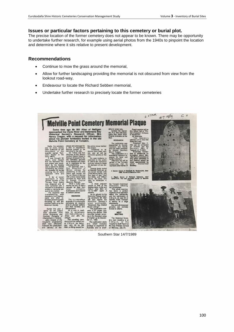
Eurobodalla Shire Historic Cemeteries Conservation Management Study Volume 3 - Inventory of Burial Sites
100
Issues or particular factors pertaining to this cemetery or burial plot. The precise location of the former cemetery does not appear to be known. There may be opportunity to undertake further research, for example using aerial photos from the 1940s to pinpoint the location and determine where it sits relative to present development.
Recommendations
Continue to mow the grass around the memorial,
Allow for further landscaping providing the memorial is not obscured from view from the lookout road-way,
Endeavour to locate the Richard Sebben memorial,
Undertake further research to precisely locate the former cemeteries
Southern Star 14/7/1989
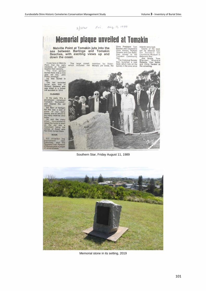
Eurobodalla Shire Historic Cemeteries Conservation Management Study Volume 3 - Inventory of Burial Sites
101
Southern Star, Friday August 11, 1989
Memorial stone in its setting, 2019
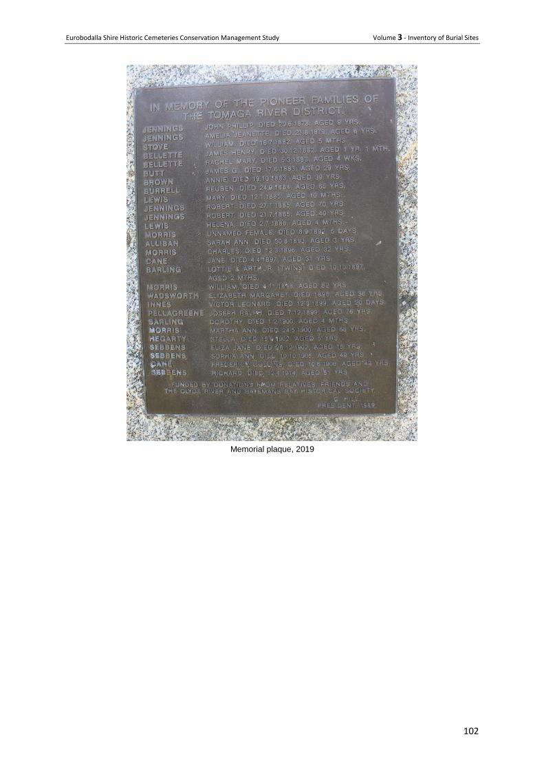
Eurobodalla Shire Historic Cemeteries Conservation Management Study Volume 3 - Inventory of Burial Sites
102
Memorial plaque, 2019
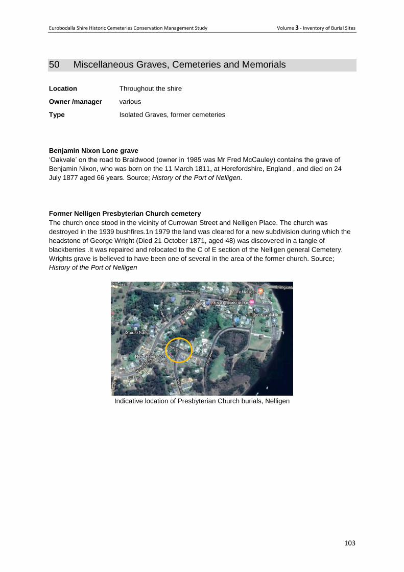
Eurobodalla Shire Historic Cemeteries Conservation Management Study Volume 3 - Inventory of Burial Sites
103
50 Miscellaneous Graves, Cemeteries and Memorials
Location Throughout the shire
Owner /manager various
Type Isolated Graves, former cemeteries
Benjamin Nixon Lone grave
‘Oakvale’ on the road to Braidwood (owner in 1985 was Mr Fred McCauley) contains the grave of
Benjamin Nixon, who was born on the 11 March 1811, at Herefordshire, England , and died on 24
July 1877 aged 66 years. Source; History of the Port of Nelligen.
Former Nelligen Presbyterian Church cemetery
The church once stood in the vicinity of Currowan Street and Nelligen Place. The church was
destroyed in the 1939 bushfires.1n 1979 the land was cleared for a new subdivision during which the
headstone of George Wright (Died 21 October 1871, aged 48) was discovered in a tangle of
blackberries .It was repaired and relocated to the C of E section of the Nelligen general Cemetery.
Wrights grave is believed to have been one of several in the area of the former church. Source;
History of the Port of Nelligen
Indicative location of Presbyterian Church burials, Nelligen
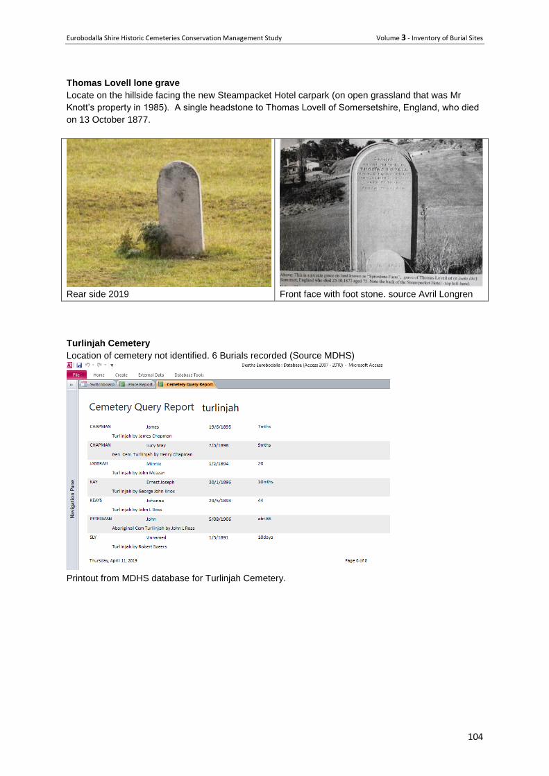
Eurobodalla Shire Historic Cemeteries Conservation Management Study Volume 3 - Inventory of Burial Sites
104
Thomas Lovell lone grave
Locate on the hillside facing the new Steampacket Hotel carpark (on open grassland that was Mr
Knott’s property in 1985). A single headstone to Thomas Lovell of Somersetshire, England, who died
on 13 October 1877.
Rear side 2019
Front face with foot stone. source Avril Longren
Turlinjah Cemetery
Location of cemetery not identified. 6 Burials recorded (Source MDHS)
Printout from MDHS database for Turlinjah Cemetery.
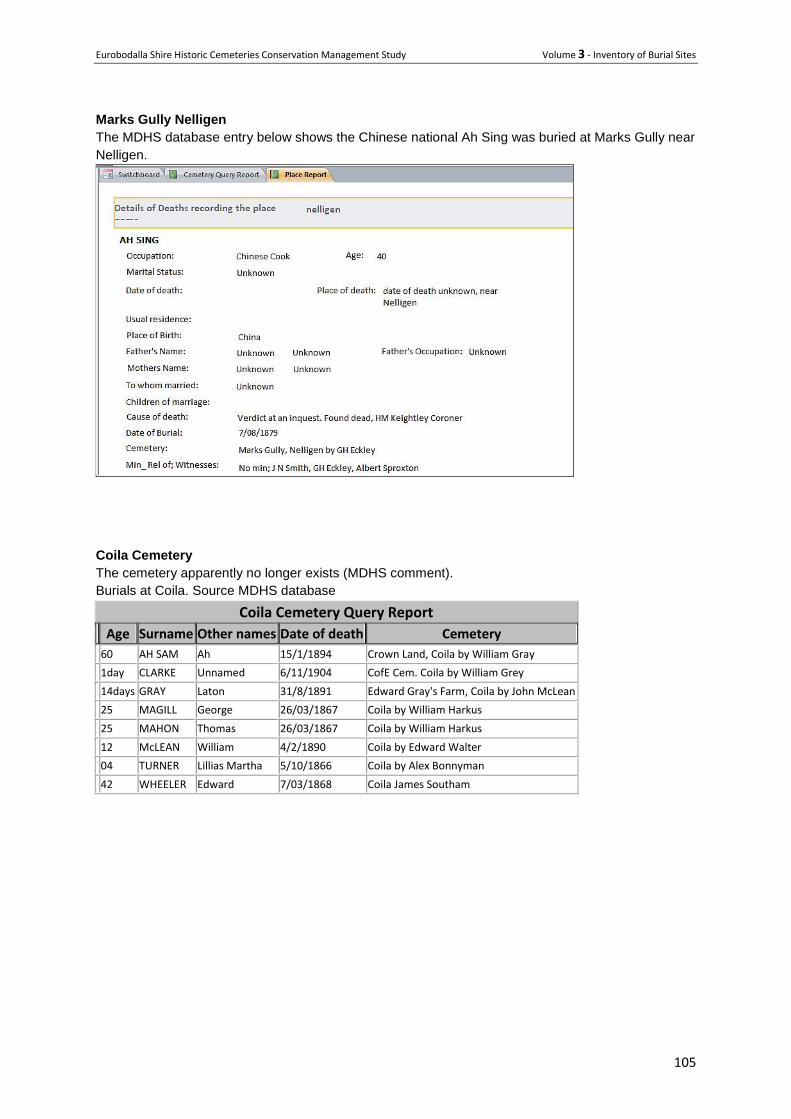
Eurobodalla Shire Historic Cemeteries Conservation Management Study Volume 3 - Inventory of Burial Sites
105
Marks Gully Nelligen
The MDHS database entry below shows the Chinese national Ah Sing was buried at Marks Gully near
Nelligen.
Coila Cemetery
The cemetery apparently no longer exists (MDHS comment).
Burials at Coila. Source MDHS database
Coila Cemetery Query Report
Age Surname Other names Date of death Cemetery
60 AH SAM Ah 15/1/1894 Crown Land, Coila by William Gray
1day CLARKE Unnamed 6/11/1904 CofE Cem. Coila by William Grey
14days GRAY Laton 31/8/1891 Edward Gray's Farm, Coila by John McLean
25 MAGILL George 26/03/1867 Coila by William Harkus
25 MAHON Thomas 26/03/1867 Coila by William Harkus
12 McLEAN William 4/2/1890 Coila by Edward Walter
04 TURNER Lillias Martha 5/10/1866 Coila by Alex Bonnyman
42 WHEELER Edward 7/03/1868 Coila James Southam
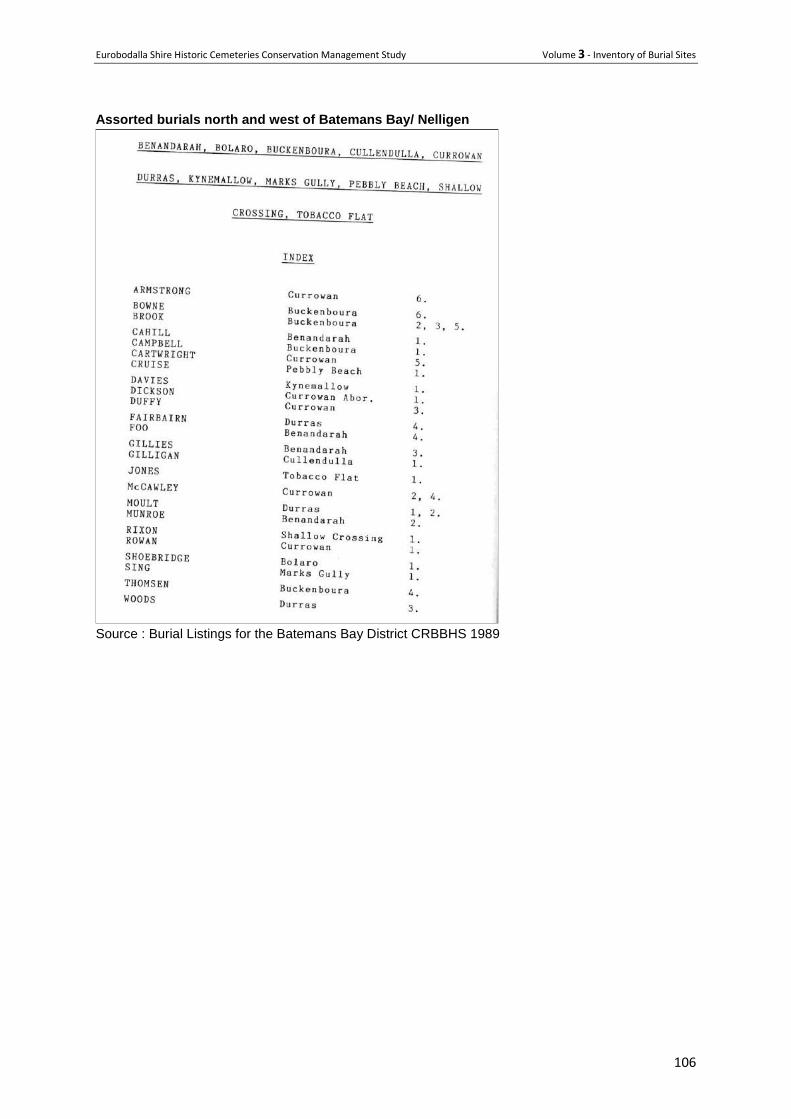
Eurobodalla Shire Historic Cemeteries Conservation Management Study Volume 3 - Inventory of Burial Sites
106
Assorted burials north and west of Batemans Bay/ Nelligen
Source : Burial Listings for the Batemans Bay District CRBBHS 1989