epibiota remote monitoring from digital imagery ... · epibiota remote monitoring from digital...
TRANSCRIPT
Epibiota Remote Monitoring from Digital Imagery: Operational Guidelines
Epibiota Remote Monitoring from Digital Imagery: Operational Guidelines
Authors: Hitchin, R., Turner, J.A., and Verling, E.
June 2015
Epibiota Remote Monitoring from Digital Imagery: Operational Guidelines
i
This report should be cited as:
Hitchin, R., Turner, J.A., Verling, E. 2015. Epibiota remote monitoring from digital imagery: Operational guidelines.
Acknowledgements:
Sections of this report were drafted by Suzanne Ware (Cefas), Magnus Axelsson (Seastar Survey Ltd.), and Daniel Jones (National Oceanography Centre). Their contributions are very gratefully acknowledged.
The authors would also like to thank: Fionnuala McBreen, Neil Golding, Mike Nelson, Megan Parry and Joey O’Connor (All JNCC), Ben James and Lisa Kamphausen (both SNH), Charlie Lindenbaum and Rohan Holt (both NRW), Alison Benson and Ian Sotheran (both Envision Mapping Ltd.), Ross Griffin (Ocean Ecology) and Annika Clements (AFBINI) for their valuable comments and suggestions throughout the preparation of this report.
Epibiota Remote Monitoring from Digital Imagery: Operational Guidelines
ii
Summary
There is increasing recognition that the effective acquisition and interpretation of underwater video and still image data for biodiversity is growing in importance. Numerous organisations (e.g. Statutory Nature Conservation Bodies (SNCBs), Inshore Fisheries Conservation Authorities (IFCAs), environmental consultancy agencies, industry and academic institutes) are now engaged in this work for a variety of different purposes, including:
Marine habitat mapping of physical seabed habitats and features in support of a variety of national and international initiatives, e.g. the Marine Environmental Mapping Programme (MAREMAP), Integrated Mapping For the Sustainable Development of Ireland's Marine Resource (INFOMAR) and Mapping European Seabed Habitats (MESH).
Characterisation of epifaunal attributes of seabed habitats and features e.g. in support of the Marine Strategy Framework Directive, Water Framework Directive, designation of Marine Protected Areas (European and National), marine development applications and licensing.
Monitoring trends in seabed habitat features and their associated epibiotic communities, e.g. in support of monitoring the effectiveness of management measures implemented to achieve given conservation objectives within MPAs and also to assess and monitor predicted impacts for given marine developments and the effectiveness of mitigation measures implemented.
The guidelines in this document provide a summary of current best practice for the acquisition of video and stills imaging of benthic substrata and epibenthic species to ensure that data collected are fit for purpose in relation to the needs and requirements of a survey.
These guidelines form part of the epibiota component of the NMBAQC scheme, reporting to HBDSEG (Healthy and Biologically Diverse Seas Evidence Group) under the UK’s Marine Monitoring and Assessment Strategy (UKMMAS).
Epibiota Remote Monitoring from Digital Imagery: Operational Guidelines
iii
Contents
1 Introduction ..................................................................................................... 1
1.1 Previous guidance ....................................................................................... 1
1.2 Platforms ..................................................................................................... 2
1.3 Sea conditions ............................................................................................. 3
1.4 Terminology ................................................................................................ 3
2 Towed and drop-down camera systems ......................................................... 4
2.1 Towed camera sledges ............................................................................... 4
2.2 Drop-down cameras .................................................................................... 5
2.3 Towed camera platforms ............................................................................. 6
2.4 Camera positioning ..................................................................................... 7
2.5 Camera configurations ................................................................................ 8
2.6 Operational procedures ............................................................................... 9
3 Remotely Operated Vehicles (ROVs) ............................................................ 11
4 Autonomous Underwater Vehicles (AUVs) .................................................... 13
5 Freshwater lens systems .............................................................................. 15
6 Video and still imagery quality metadata ....................................................... 17
7 Additional metadata ...................................................................................... 19
8 Appendix 1: Example case study links .......................................................... 20
9 References ................................................................................................... 22
Epibiota Remote Monitoring from Digital Imagery: Operational Guidelines
iv
Abbreviations
AFBINI Agri-Food Biosciences Institute Northern Ireland
AUV Autonomous Underwater Vehicle
AVC-HD Advanced Video Coding High Definition
BS British Standard
BSH Broad Scale Habitat
Cefas Centre for Environment, Fisheries and Aquaculture Science
CMA Competent Monitoring Agencies
DV Tape Digital Video Tape
DVL Doppler Velocity Log
EUNIS European Nature Information System
EXIF Exchangeable Image File Format
FPS Frames per Second
GPS Global Positioning System
HBDSEG Healthy and Biologically Diverse Seas Evidence Group
HD High Definition
HID High Intensity Discharge
HMI Hydrargyrum Medium Arc Iode
IFCA Inshore Fisheries Conservation Authorities
INFOMAR Integrated Mapping For the Sustainable Development of Ireland’s Marine Resource
ISO International Organization for Standardization
JNCC Joint Nature Conservation Committee
LED Light Emitting Diode
MAREMAP Marine Environmental Mapping Programme
MESH Mapping European Seabed Habitats
MMH Marine Monitoring Handbook
MPA Marine Protected Area
NMBAQC National Marine Biological Analytical Quality Control Scheme
NOC National Oceanography Centre
NRW Natural Resources Wales
O.D Overall Diameter
PG Procedural Guideline
RIB Rigid Inflatable Boat
ROG Recommended Operating Guidelines
ROV Remotely Operated Vehicle
SAC Special Area of Conservation
SD Secure Digital
SNCB Statutory Nature Conservation Body
SNH Scottish Natural Heritage
SOP Standard Operating Procedures
UKMMAS UK Marine Monitoring and Assessment Strategy
USBL Ultra Short Base Line
WCC Water Curtain Camera
Epibiota Remote Monitoring from Digital Imagery: Operational Guidelines
1
1 Introduction
This report provides best practice guidance for collection and analysis of epibiotic data using ship-based or autonomous videographic and photographic techniques.
Video and stills cameras are extremely valuable and wide-ranging tools for providing evidence for benthic monitoring and mapping, particularly in water depths that divers cannot reach to sample in situ or where capacity, cost or safety aspects do not allow for diver surveying. Video footage can be used for exploring and investigating previously unsurveyed areas of seabed, characterising and identifying habitat types by providing information on both the sediment and the distribution and abundance of epibiota, detecting and locating boundaries between various habitats and 'ground-truthing' acoustic information. As the methods are typically non-destructive, they are considered appropriate for sampling protected, fragile or sensitive areas. Stills footage provides an accompanying high quality visual record that enables finer resolution of species identification and increased ability to undertake quantitative analyses.
Depending on their specific purpose, surveys can be designed to be purely descriptive, semi-quantitative or fully quantitative. In order for each of these approaches to be effective, video quality must be adequate, particularly important for quantitative surveys where results will be statistically analysed. Turbidity, towing speed, lighting conditions and tidal flow may all affect video or image quality, and thus the size of organisms that can be accurately identified and counted with confidence and the level of taxonomic resolution achieved. Image quality is therefore directly linked to the confidence in the results obtained.
This new guidance note aims both to introduce a way of assessing video and stills quality at sea and to update previous guidance. The updated guidance concerns the main platforms from which video and stills cameras are operated, providing up-to-date information for the operation of video and still cameras in towed sledges, towed camera platforms, drop-down cameras, remotely operated vehicles (ROVs), autonomous underwater vehicles (AUV) and freshwater lens systems.
1.1 Previous guidance
This guidance aims to build on current standards and protocols, mainly the Mapping European Seabed Habitats (MESH) Recommended Operating Guidelines (ROGs) and JNCC’s Marine Monitoring Handbook (MMH). Where appropriate, the guidance will refer to previous ROGs or MMH Procedural Guidelines (PGs) while providing updated information where technology improvements or general changes in approach have occurred since the previous publication.
MESH Recommended Operating Guidelines
Under the Mapping European Seabed Habitats (MESH) project (2004 – 2008), a series of Recommended Operating Guidelines (ROGs) were identified to describe how best to use survey techniques in a marine habitat mapping context. For videographic and photographic uses, the “Recommended operating guidelines (ROG) for underwater video and photographic imaging techniques” (Coggan et al. 2007) was created along with the MESH Video Working Group report “Seafloor Video Mapping: Collection, analysis and interpretation of seafloor video footage for the purpose of habitat classification and mapping” (White et al. 2007). Video techniques were also detailed in the Review of Standards and Protocols for Seabed Habitat Mapping (Coggan, et al. (eds.) 2005).

Epibiota Remote Monitoring from Digital Imagery: Operational Guidelines
2
The ROGs were created to reflect operational experience of using particular techniques for marine habitat mapping and therefore may not be considered suitable for all monitoring applications. The video ROG continues to be appropriate in terms of configuration and deployment of towed video systems, but technology advances mean that some of it is now somewhat outdated.
Marine Monitoring Handbook
The Marine Monitoring Handbook (MMH) was produced by the Marine SACs Project through a series of literature reviews, workshops and practical trials (Davies et al., 2001). The most widely used part of the MMH is Section 6, the Procedural Guidelines (PGs). These lay out protocols or procedures for a wide range of different types of data collection for marine monitoring.
Two of the PGs refer to videographic and photographic techniques using camera systems. These are PG 3.5 - 'Identifying biotopes using video recordings' and PG 3.14 - 'In situ survey of sublittoral epibiota using towed sledge video and still photography'. While these guidelines still contain useful information on operational techniques, the technology advocated in them is, in many ways, now considered outdated or even unavailable.
EU guidelines
Development of, and adherence, to national, European or international standardised methods (where they exist) is a statutory requirement in the Water Framework and the Marine Strategy Framework Directives. The two standards most applicable to seabed videographic and photographic methods are:
BS EN 16260:2012. Water quality - Visual seabed surveys using remotely operated and towed observation gear for collection of environmental data. Provides guidance for seabed mapping and monitoring, recording or monitoring seabed conditions and epibiotic organisms.
EN ISO 19493:2007. Water quality - Guidance on marine biological surveys of hard-substrate communities. Provides guidance on the minimum requirements for marine biological surveys of supralittoral, eulittoral and sublittoral hard substrate for environmental impact assessment and monitoring in coastal areas.
The national and European standards are considered to provide a basic framework for the use of remote video and stills during surveys. This guidance focuses on more specific and practical approaches to the operation of remote video and stills equipment.
1.2 Platforms The guidance in this report is not platform specific, and only mentions any particular platform when, for example, ways of calculating camera position may be different in a small RIB to a large research vessel, or when a type of remote video use is only possible from a particular size of vessel.
Epibiota Remote Monitoring from Digital Imagery: Operational Guidelines
3
1.3 Sea conditions This report also does not include advice on how best to orientate, manoeuvre or otherwise work with a vessel and equipment in a range of sea conditions, such as how to operate video equipment in strong tidal flows or severe weather, as, at least with larger research vessels, the operation of video equipment and any necessary changes in course and speed will be under the control of the ship technicians and crew. With smaller vessels, there is likely to be more control over equipment and vessel movement by scientists, but as these smaller vessels may differ considerably in size, capability and equipment, it is still considered beyond the scope of these guidelines to consider how sea conditions may affect the video capability of these smaller vessels.
1.4 Terminology
The guidance in this report is split into two levels:
1. If a recommendation includes the term “must” then this is mandatory for organisations completing epibiota video imaging to contribute to statutory UK monitoring programmes.
2. If a recommendation includes the term “should” then this is mandatory where practicable for these organisations.
Epibiota Remote Monitoring from Digital Imagery: Operational Guidelines
4
2 Towed and drop-down camera systems
The most widely used methods of collecting good quality images of the seabed are the towed sledge, towed video platform and the drop-down camera. These methods are treated together for these guidelines as, from the video and stills point of view, they are operationally similar.
All of these methods have the ability to acquire video and still images. Stills footage can take several forms:
Purely automated, taken at pre-defined, regularly spaced intervals. This is often the preferred method as it avoids sampling bias.
Manually operated, taken as close to a defined time interval as possible. This also allows for operator discretion if the seabed is not in focus at the exact pre defined time.
Manually operated, taken opportunistically (“opportunistic stills”). This allows capture of specific high quality images of target species or habitats. This does generate problems with bias and these images are often omitted from statistical analysis, but provide a useful tool to assist with organism identification and for assisting to delineate habitat boundaries.
Most of the information presented below refers to towed systems, and drop-down systems are referred to where guidance differs between systems.
2.1 Towed camera sledges
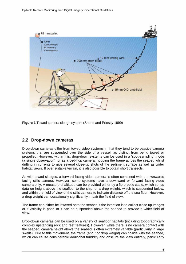
The towed camera sledge consists of a frame with sledge-like runners that is towed in full contact with the seafloor and is typically deployed at sites overlain by sediment. The sledge is deployed off the stern of the vessel, and as the ship moves, the sledge is towed along a predetermined transect taking video and still images (see Figure 1).
Towed sledges are limited to use on relatively topographically uniform seafloor habitats, and that, as the runners of the sledge are in contact with the seabed, any sledge has the potential to damage fragile seabed features and epifauna.
The common configuration for towed sledges has a forward facing (oblique view) video camera with a separate downward facing stills camera, with the latter behind the video, and thus allowing the video to be used as a remote ‘viewfinder’ for the stills. The oblique angle of view on the video camera improves the ability to identify species and give a better indication of seabed habitat type, while the perpendicular angle of view best enables quantitative analysis of still images. Separate video and stills cameras are considered best practice, as, if a single camera is used, video footage is lost when a still is taken.
Epibiota Remote Monitoring from Digital Imagery: Operational Guidelines
5
Figure 1 Towed camera sledge system (Shand and Priestly 1999)
2.2 Drop-down cameras Drop-down cameras differ from towed video systems in that they tend to be passive camera systems that are suspended over the side of a vessel, as distinct from being towed or propelled. However, within this, drop-down systems can be used in a ‘spot-sampling’ mode (a single observation), or as a bed-hop camera, hopping the frame across the seabed whilst drifting in currents to give several close-up shots of the sediment surface as well as wider habitat views. If over suitable terrain, it is also possible to obtain short transects.
As with towed sledges, a forward facing video camera is often combined with a downwards facing stills camera. However, some systems have a downward or forward facing video camera only. A measure of altitude can be provided either by a fibre-optic cable, which sends data on height above the seafloor to the ship, or a drop weight, which is suspended below, and within the field of view of the stills camera to indicate distance off the sea floor. However, a drop weight can occasionally significantly impair the field of view.
The frame can either be lowered onto the seabed if the intention is to collect close up images or if visibility is poor, or it can be suspended above the seabed to provide a wider field of view.
Drop-down cameras can be used on a variety of seafloor habitats (including topographically complex upstanding rock and reef features). However, while there is no camera contact with the seabed, camera height above the seabed is often extremely variable (particularly in large swells). Due to this movement, the frame (and / or drop weight) can collide with the seabed, which can cause considerable additional turbidity and obscure the view entirely, particularly
ø
ø
ø ø
ø
Epibiota Remote Monitoring from Digital Imagery: Operational Guidelines
6
in areas of muddy or sandy sediment. Understanding this variability in camera height is particularly important in areas where habitats are fragile.
2.3 Towed camera platforms
Towed camera platforms are similar to towed camera sledges. However, they are designed to be towed above the seabed, avoiding any contact. This approach offers two key advantages to towed sled systems: reduced disturbance to the seabed and the potential for operations in more complex seabed environments.
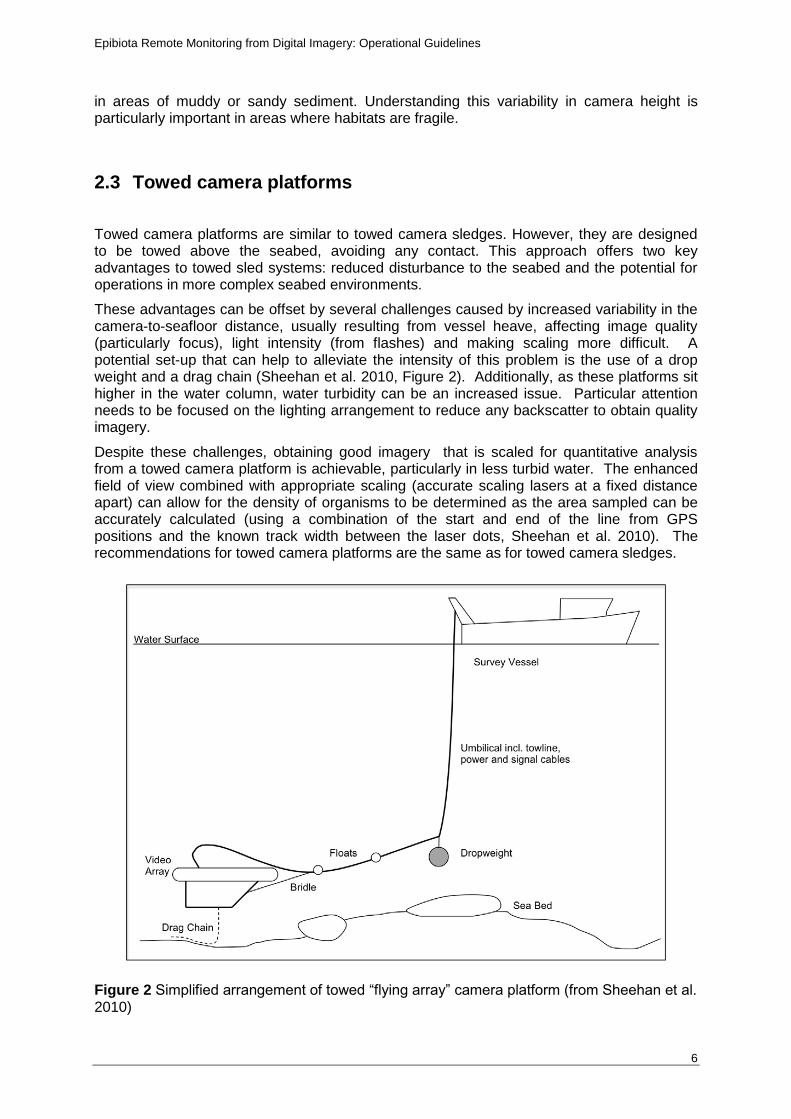
These advantages can be offset by several challenges caused by increased variability in the camera-to-seafloor distance, usually resulting from vessel heave, affecting image quality (particularly focus), light intensity (from flashes) and making scaling more difficult. A potential set-up that can help to alleviate the intensity of this problem is the use of a drop weight and a drag chain (Sheehan et al. 2010, Figure 2). Additionally, as these platforms sit higher in the water column, water turbidity can be an increased issue. Particular attention needs to be focused on the lighting arrangement to reduce any backscatter to obtain quality imagery.
Despite these challenges, obtaining good imagery that is scaled for quantitative analysis from a towed camera platform is achievable, particularly in less turbid water. The enhanced field of view combined with appropriate scaling (accurate scaling lasers at a fixed distance apart) can allow for the density of organisms to be determined as the area sampled can be accurately calculated (using a combination of the start and end of the line from GPS positions and the known track width between the laser dots, Sheehan et al. 2010). The recommendations for towed camera platforms are the same as for towed camera sledges.
Figure 2 Simplified arrangement of towed “flying array” camera platform (from Sheehan et al. 2010)
Epibiota Remote Monitoring from Digital Imagery: Operational Guidelines
7
2.4 Camera positioning Positional information for towed camera equipment on the seafloor tends to be derived through one of two approaches: through use of an ultra-short baseline (USBL) positioning beacon or through calculation of layback from the ship’s position (In waters shallower than ~200m, providing that currents are weak). USBL consists of a transceiver mounted on a pole under the ship and a transponder on the camera array. Use of USBL is considered best practice, particularly for large vessels, for towed sledges, for use in strong currents and in deep water where the location of the camera system on the seabed is likely to be a relatively long distance away from the position of deployment on the vessel. However, USBL systems are also expensive, time consuming and often require technician input. In very shallow water, the use of USBL can be problematic as it can be affected by propeller wash. If USBL is not available or is not considered the best practice method of position fixing (e.g. in shallow waters, where vessels using dynamic positioning thus generating a large amount of micro bubbles in the water column), the position of any towed camera may be calculated using a layback calculation (in waters shallower than ~200m providing that currents are weak). Accurate recording of the length of cable used (‘cable out’) and the ship’s heading can be used to perform the calculation. This will give an estimate of the position of the camera system on the seabed relative to the point of deployment on the vessel (e.g. stern or side gantry), assuming that the sledge is directly behind the boat. However, if operating from very small vessels (e.g. RIBs), it may be appropriate to use the position of the vessel as a proxy for the position of a drop-down camera. It should however be noted that this method is only suitable if the depth in which you are operating is sufficiently shallow (<25m) and there is little to no current. Cable layback should still be used when possible. It can also be beneficial to be able to record the elevation of the camera equipment above the seafloor, so that the area viewed can be calculated accurately. This can be straightforward for towed frames but is more challenging for drop frame cameras, particularly in very uneven terrain. Sonar altimetry is recommended as the most accurate method, but there are also a number of trigonometric methods. Laser used for scaling can also provide a reasonably accurate level of altitude estimation based on the distance between the points. If it is required, to accurately quantify the area covered by images the camera angles should be known (from manufacturer’s tests) or assessed using calibrated images (taken in water). An alternative is using multi point laser systems. At least two parallel laser points are required to be used if the images are taken vertically and at least four laser points are required if the images obtained are oblique.
Recommendations
1. A system must be in place to allow the position of the camera equipment to be known as accurately as possible, at the start and the end of a tow, as well as during the tow.
2. Towed gear only: The difference in position between the camera and the navigational feed positions must be recorded during survey, and the method used to derive the positions of the towed gear must be noted.
3. Towed gear only: The camera should be at a height of no more than 50cm off the seafloor, while noting that height will depend on substratum type and terrain.
Epibiota Remote Monitoring from Digital Imagery: Operational Guidelines
8
4. Should the survey require the elevation of the camera off the seafloor to be calculated and recorded these data should be recorded in a log file.
2.5 Camera configurations Camera configurations are noted in PG 3-14 ‘In situ survey of sublittoral epibiota using towed sledge video and still photography’ in the Marine Monitoring Handbook (Davies et al., 2001), but these technologies and equipment are now considered obsolete. The section below supersedes the relevant passage in that Procedural Guideline (‘Video and camera equipment’).
While the best settings for video cameras will vary depending on the type of survey being undertaken, it is possible to recommend some overall standards of image quality for surveys.
Video camera recommendations
1. Video cameras should be full colour.
2. HD cameras should be used (1080 lines interlaced as a minimum requirement) with an AVC-HD file format / HD-FH (17Mbps) image quality. A frame rate of 48 frames per second (FPS) should be used when possible. It is understood, however, that for some surveys, HD video capture is not necessary. If SD cameras are to be used, an explanation as to why SD video is appropriate should be included within the survey requirements / proformas.
3. Either a fixed or a zoomable lens is acceptable, but if a zoom lens is to be used, then this must be adjusted before the first video transect is started and this setting used for all the subsequent tows, allowing the field of view to be kept consistent.
4. Video and camera filenames must include the recording start date and time. Position may be included, although it must be within the overlay (See section 2.4).
Stills camera recommendations
5. A stills camera should be used in addition to the collection of video to aid species identification as well as for informing any quantitative analyses.
6. Stills camera focus must be manual.
7. Stills cameras should record their images in whichever RAW image format is utilised by the camera. This provides maximum information for interpretation.
8. For archiving images, due to the non-standardisation of the RAW format, RAW should not be used. For procedures for archiving stills, see Epibiota Video Analysis Guidelines (in prep).
9. Stills camera filenames must include the date and time of image capture.
Epibiota Remote Monitoring from Digital Imagery: Operational Guidelines
9
2.6 Operational procedures
We recommend following the operational procedures detailed in the MESH Video ROG for both towed camera and drop-down camera, with certain additions. Where noted, the requirements and recommendations below supersede the relevant passages in the ROG. [Also please see PG13 and PG14 from the Marine Monitoring Handbook] Recommendations
1. A towed sledge must have uninterrupted views for both video and stills cameras.
2. Cameras on a towed sledge must be mounted at a fixed height above the seabed, allowing the field of view to be fixed. This allows the size of the photographed area to be calculated and sizes of the object within the field of view estimated.
3. Towing speed should be no faster than 0.5kn (speed over ground), with 0.3kn considered optimal. It is noted that speed will depend on whether the boat is drifting or under power.
4. A period of at least 30 seconds should be allowed for stabilization, unless in the deep sea when a longer stabilisation phase may be needed, up to 5 minutes, in order to adjust the length of cable out and vessel speed so the camera is being towed smoothly.
5. Overlay (section 3.3 in MESH ROG): A video overlay must be used, with the following information included as a minimum:
Date / time
Position (most often the position of vessel rather than camera frame)
Survey name
Station code / transect number
The overlay data should not overly clutter the screen and a measure of depth should also be included, if there is a depth sensor on the camera that feeds up the umbilical and is displayed live on the screen and recorded onto the video.
6. Measures of scale: A measure of scale must be used. The following is recommended:
It is highly recommended that scaling lasers should be used to provide a reference scale on all camera platforms. Lasers should be mounted a fixed distance apart on the frame. Common configurations include 64mm (the size boundary between a pebble and a cobble) and 50cm (when looking to extract quantitative information using transects). Scale bars or other method of calibration should only be used in a situation where the primary laser system fails while at sea.
The distance between lasers must be clearly recorded in metadata.
At least two laser points must be used.
Use of four laser points is considered [a possible future recommendation] to take account of pitch and roll compared to the use of two points. It is also recommended when the camera is mounted obliquely, thus having a field of view that varies across the image.
If lasers are not used then an explanation as to why should be documented. Some form of scale bar must be used as an alternative. This must be visible
Epibiota Remote Monitoring from Digital Imagery: Operational Guidelines
10
throughout recording/image capture. It is recommended that any scale is fixed at the periphery of the field of view as it must not significantly obscure it.
7. Linear sequence of recording (section 3.1 in MESH ROG): If two or more video-recording methods are to be used, it is important to ensure that they are connected in the optimal sequence. The first recording method in the sequence must be that which writes data the fastest, ensuring that the signal is not degraded before it is fed into the subsequent recording systems. Hard disk or DV tapes are recommended so that image quality is not degraded.
8. Optimal lighting verification (section 3.4 [sic 3.5] in MESH ROG) Light-emitting diode (LED) light sources should be used for video lights, though high intensity discharge (HID) or halogen sources are considered acceptable. Video lighting must provide sufficiently bright and even illumination with no ‘hot spots’ and should approximate to daylight colour temperature (3200K or greater). A light diffuser may be used to ensure even lighting of the subject area. A single camera strobe should be used to avoid getting a double shadow and a flat image, both typical of double strobes.
Epibiota Remote Monitoring from Digital Imagery: Operational Guidelines
11
3 Remotely Operated Vehicles (ROVs)
ROVs can be a very powerful tool for imaging if used correctly. ROVs range in size from small suitcase-sized vehicles to large work-class vehicles, as is used in the subsea construction industry. The size of the ROV will determine the payload, manoeuvrability and uses of the vehicle. Even the smaller systems can typically be equipped with a positioning transponder and HD video and lighting, although small vehicles may struggle to operate effectively in current speeds greater than 1.5 knots (Rees, et al., 2009). A large system will have space for several camera systems, no practical limits on power for cameras and lights, fast fibre-optic data communication and precision navigation. The imaging systems can be mounted on hydraulic pan-and-tilt units, allowing continuous adjustment of camera position in response to the subject being imaged. However, a pan-and-tilt unit is not necessarily important and may be best avoided for some surveys.
Positioning on ROVs can be the same as for towed systems, using USBL. However, relative positional information may also be obtained from a Doppler-velocity log bottom-tracking navigation system. In deep water these systems are important for precise navigation.
ROVs are typically used in two modes for epifaunal imaging: qualitative inspections and quantitative assessments. The requirements for each approach are often different and different protocols should be used.
For qualitative inspections, such as confirming the presence of a key species or habitat at a site, the ROV should be set up to ensure optimal imaging of the target habitat or species. For smaller organisms it may be preferable to mount the stills camera system closer to the base of the ROV for close-up imaging. ROVs can be used to greatly improve taxonomic accuracy in areas with poorly known species by collection and detailed imaging of important organisms, which facilitates identification. Qualitative imaging can have many goals and guidelines may need to be tailored depending on the detailed objectives of the survey.
Recommendations
1. A system that is optimised for imaging should have at least one high-definition (HD) video camera with appropriate lighting (high intensity discharge (HID) or Hydrargyrum medium-arc iodide (HMI)), laser scalers, a digital stills camera and strobe light.
2. ROVs have the capacity to carry out highly sophisticated and replicated quantitative sampling of benthic environments along fixed transects. Although ROVs are at the cutting edge of underwater imaging and can be very efficient, paradoxically many surveys using this method may be sub-standard for quantitative seabed assessment. It is extremely important for successful imaging surveys that there must be:
A good sampling design (unplanned look-and-see style operations are extremely difficult to analyse quantitatively.
A clear survey plan should be made and adhered to (poor track following makes samples difficult to analyse quantitatively. This can easily occur as a result of pilot error in long transects, or scientists deviating from sample design to look more closely at or collect a particular organism).
A fixed camera setup (including optical geometry) should be used to allow for accurate quantification of image area (camera pan/tilt/zoom/altitude should remain constant during the transect).
3. Before starting a survey, the camera imaging, lighting and recording modes should be adjusted to ensure that the highest quality image be maintained throughout.
Epibiota Remote Monitoring from Digital Imagery: Operational Guidelines
12
Testing of the cameras and lighting must ensure that well-lit, high-resolution pictures can be obtained while the ROV is in flight.
4. ROV cameras must be positioned at the same orientation throughout the survey in order to ensure a constant view. When mounted on a pan-and-tilt unit the camera pan should be set to straight ahead, while the camera tilt should be set to a known angle. It is usually appropriate to set the camera angle to as near as vertical as possible.
5. It is important that a clear picture of the seabed is obtained, with no obstruction from the ROV frame. The zoom on cameras should be set and left unchanged; in flight it is usually convenient to use the maximum wide-angle setting (minimum zoom), which makes it easy to ensure that it is constant for all transects. The lighting should be adjusted to give the best possible picture. These settings should then remain unaltered for the duration of the survey.
6. Time and position must be constantly recorded during survey.
7. A video overlay must be used, with the following information included as a minimum:
Date / time
Position
Survey name
Station code / transect number
The overlay data should not overly clutter the screen and a measure of depth should also be included, if there is a depth sensor on the camera that feeds up the umbilical and is displayed live on the screen and recorded onto the video. Notes should also be made in relation to the position of animals in real time.
8. When flying each of the transects, the ROV must be maintained at a constant speed (e.g. 0.1 m.s-1 is optimal for the NOC deepwater ROV ISIS when conducting a video survey at 2m altitude).
9. The ROV should maintain a constant height above the seabed. This height should be the minimum practically possible, while still maintaining a good field of view and avoiding sediment clouds that might obscure the image, and must be recorded.
10. Laser scaling devices must be fitted to assist with determining height and to provide a scale.
11. The ROV should hold a straight course along the entire length of each transect, ignoring any features of interest.
12. The camera must have an uninterrupted view of the seabed, i.e. the ROV frame should not be visible.
Epibiota Remote Monitoring from Digital Imagery: Operational Guidelines
13
4 Autonomous Underwater Vehicles (AUVs)
AUVs are an ideal platform for imaging. They are able to carry still camera systems, maintain altitude precisely and carry out complex survey designs without intervention and while the surface vessel is otherwise engaged. They are able to operate independently to the surface vessel for periods from hours to weeks, following a programmed course (Wynn et al., 2014, 2012). AUVs are limited to a certain degree in terms of power, and hence the high power demands of continuous lighting means that video systems are not commonly used. AUVs do not have any connection to the surface and hence images cannot be viewed real time.
Low flying altitudes (typically 2- 3m) are required in order to acquire optical images of the benthos with an AUV. Due to this relatively high flying height (when compared to other video methods) there can occasionally be issues with backscatter in turbid waters (Wynn et al., 2014). Most AUVs, including nearly all commercial systems, fly at 1.5-3 knots and generate lift by forward motion. As a result, the low flying altitudes used for optical imaging mean that there is limited capacity to respond to obstacles on the seafloor and the risk of operations increases. Hover-capable AUVs exist and are well suited to imaging surveys, particularly those requiring precise control over a much shorter range (typically an order of magnitude shorter) than the lift-generating vehicles. As a result, AUVs may not be suitable for topographically complex areas. It must also be noted that there are inherent risks associated with leaving AUVs unattended in the marine environment. In remote, offshore and deep environments where other sea users are scarce the risk of damage and entanglement of the equipment is relatively low. In inshore areas, where for example, fishing gear may be prevalent, and boat traffic may be high, the risks of damage and or loss of the equipment is significantly higher. This should always be considered during the survey planning stage and maritime authorities may need to be consulted.
AUVs typically have well integrated systems for acquiring and storing data from a wide suite of sensors, enabling them to successfully carry out their missions. Precise navigational control is necessary for effective deployments and AUVs are often equipped with good absolute (e.g. USBL) and relative (e.g. DVL) positioning systems. These positional systems, coupled with information on vehicle heading, pitch, roll and altitude, mean that images can be accurately scaled using photogrammetric approaches. As a result of this and the relatively high power demand, laser scalers are less common for AUV imaging surveys.
The AUV should be set up with a high-quality camera system with manual focus (set to the target altitude of the vehicle) and settings appropriate for the lighting available (usually a flash system). All available data from the vehicle should be captured and linked to the AUV image by an internally consistent time-stamp. Owing to the relatively high speed of AUV surveys a high image frequency is recommended, with at least one image taken every 10 seconds. However, more than one image a second is feasible over long duration deployments (e.g. Morris et al, 2014).
Recommendations
1. Camera and flash systems should be with manual focus for the target height and must be tested prior to deployment.
2. Positional data should be recorded at the same rate as the images take or as close to this as possible to rule out any interpolation errors.
3. Survey design must take into consideration the battery capacity of the vehicle.

Epibiota Remote Monitoring from Digital Imagery: Operational Guidelines
14
4. Where possible overlapping images should be taken, to provide continual image of the seafloor without video.
5. Number of images captured should be considered when providing hard drive space on the vehicle.
6. Minimum time for the flash to re-load, as well as target altitude must be taken into consideration when setting the image speed.
7. Currents should be taken into consideration when planning missions to help avoid crabbing, where the AUV’s velocity relative to the terrain is not in the same direction as its heading, where possible.
Epibiota Remote Monitoring from Digital Imagery: Operational Guidelines
15
5 Freshwater housing systems
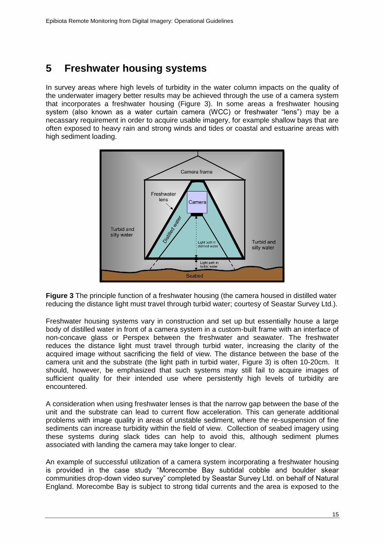
In survey areas where high levels of turbidity in the water column impacts on the quality of the underwater imagery better results may be achieved through the use of a camera system that incorporates a freshwater housing (Figure 3). In some areas a freshwater housing system (also known as a water curtain camera (WCC) or freshwater “lens”) may be a necassary requirement in order to acquire usable imagery, for example shallow bays that are often exposed to heavy rain and strong winds and tides or coastal and estuarine areas with high sediment loading.
Figure 3 The principle function of a freshwater housing (the camera housed in distilled water reducing the distance light must travel through turbid water; courtesy of Seastar Survey Ltd.).
Freshwater housing systems vary in construction and set up but essentially house a large body of distilled water in front of a camera system in a custom-built frame with an interface of non-concave glass or Perspex between the freshwater and seawater. The freshwater reduces the distance light must travel through turbid water, increasing the clarity of the acquired image without sacrificing the field of view. The distance between the base of the camera unit and the substrate (the light path in turbid water, Figure 3) is often 10-20cm. It should, however, be emphasized that such systems may still fail to acquire images of sufficient quality for their intended use where persistently high levels of turbidity are encountered.
A consideration when using freshwater lenses is that the narrow gap between the base of the unit and the substrate can lead to current flow acceleration. This can generate additional problems with image quality in areas of unstable sediment, where the re-suspension of fine sediments can increase turbidity within the field of view. Collection of seabed imagery using these systems during slack tides can help to avoid this, although sediment plumes associated with landing the camera may take longer to clear.
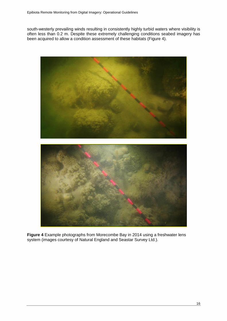
An example of successful utilization of a camera system incorporating a freshwater housing is provided in the case study “Morecombe Bay subtidal cobble and boulder skear communities drop-down video survey” completed by Seastar Survey Ltd. on behalf of Natural England. Morecombe Bay is subject to strong tidal currents and the area is exposed to the
Epibiota Remote Monitoring from Digital Imagery: Operational Guidelines
16
south-westerly prevailing winds resulting in consistently highly turbid waters where visibility is often less than 0.2 m. Despite these extremely challenging conditions seabed imagery has been acquired to allow a condition assessment of these habitats (Figure 4).
Figure 4 Example photographs from Morecombe Bay in 2014 using a freshwater lens system (images courtesy of Natural England and Seastar Survey Ltd.).
Epibiota Remote Monitoring from Digital Imagery: Operational Guidelines
17
6 Video and still imagery quality metadata
When videographic or photographic data are collected at sea, a number of observations on quality can be made which can greatly assist with the subsequent analysis and interpretation of the data. It is recognised that there is a wide variation in existing survey proformas, and so recommendations of how metadata should be included in proformas are not included here. It is the responsibility of the survey scientist-in-charge to decide how to accommodate these data, whether that is done by including the data in an existing recording sheet or by creating a new one.
It is also the responsibility of the scientist-in-charge to decide over what area of survey any quality assessment is representative of video conditions. If the seabed is uniform and sea conditions are stable, then one assessment of quality per day may prove adequate. If the seabed is highly heterogeneous and previous video tows have shown that areas of seabed turbidity or equipment has been erratic, then an assessment of quality per tow or per smaller area may be more representative.
The metadata that is recorded will likely be highly dependent on the aims and requirements of the survey. In terms of identifying footage quality, a list of suitable metadata must be decided upon prior to the survey and recorded throughout. Examples of appropriate metadata are identified, but not limited to, below. It is also recommended that detailed accompanying notes are made.
Can the seabed be seen, or is it obscured and how?
In what percentage of the tow could the seabed be clearly seen with organisms identifiable at the level need for the survey?
What size organisms can be distinguished and identified?
Is the footage acceptable for identifying BSH?
Is the footage acceptable for identifying habitats at EUNIS level 3 / 4 / 5?
Is the footage acceptable for identifying species to the taxonomic level required for the survey?
If video quality does not appear to meet acceptable standards, then the video quality must be assessed by a second scientist who should assess against the criteria relevant to that particular survey and the two sets of results compared. If it appears that the video footage isn’t of sufficient quality to extract the information required to meet the aims of the survey then the tow should be abandoned. If this problem persists on the survey then it is recommended that the team either alter the camera equipment configuration to better deal with the conditions (if practicable), or demobilise (e.g. wait for weather conditions to improve). Should surveying continue, notes should be made to explain why sampling is being continued with an inadequate quality of data being obtained. If the analysis indicates that the data are inadequate for collecting data at any resolution, the video must not be analysed.
Video and stills footage should always be provided to analysts with the associated notes from survey scientists and their survey-based assessment of video quality. Video analysts must then undertake a similar analysis to ensure agreement on quality. If analyst and survey scientist disagree on quality measure then a second analyst should reanalyze the video. It is also expected that stills quality is compared to associated video quality.
This metadata from the survey notes should lead to the analyst being able to assign a measure of video quality, which must include the following information:
Epibiota Remote Monitoring from Digital Imagery: Operational Guidelines
18
taxonomic resolution expected in survey
taxonomic resolution available from video
video issues such as camera footage loss, times where seabed was not visible
whether the video is acceptable for analysis at any taxonomic level
This measure must suggest whether the video is of acceptable quality, of lower than acceptable quality, or not usable. If a particular tow seems to be of particularly high quality, it is recommended that this is also flagged.
The analyst’s assessment of video and / or stills quality must be made before any analysis is undertaken to ensure that the video and / or stills are of high enough quality to be analysed to the needed accuracy and precision. It is expected that most analysts will be able to complete this assessment within the initial viewing of a video. This quality assessment must be completed in all cases.
It is recognised that, due to constraints on survey time, poorer quality data than expected on a survey may have to be analysed. Lowered confidence in these data sets must be noted in the metadata. It is expected that use of low quality video would result in higher resolution taxonomic analysis (orders / phyla, for example, rather than families, genera or species) and higher level EUNIS categories being assigned.
Epibiota Remote Monitoring from Digital Imagery: Operational Guidelines
19
7 Additional metadata
As well as metadata relating to the overall quality of the imagery there are various other elements that can vary between surveys. For the data collected in imagery surveys to be useful the following metadata must be collected for the survey (if applicable to the survey method):
Camera make and model used
Fundamental optics (focal length, sensor size, sensor resolution, acceptance angles – calibrated in water using operational port)
Target camera altitude
Camera orientation (degrees from vertical)
Camera zoom level
Camera settings (f-stop, exposure, ISO)
Lighting setup
RAW conversion approach (if used)
Image frequency
Video format used
Distance between parallel laser scalers
Distance from trigger weight to camera
Size of trigger weight (for scaling)
Positioning system used
Datum / projection used for positioning
Platform used
Survey speed
Ship
Camera operator
Survey strategy
Survey time and date
Weather
Epibiota Remote Monitoring from Digital Imagery: Operational Guidelines
20
8 Appendix 1: Example case study links
Towed sledges
Hiscock, K. & Oakley, J., 2005. English Channel towed sledge seabed images. Phase 2: Analysis of selected tow images. Report to the Joint Nature Conservation Committee from the Marine Biological Association. Plymouth: Marine Biological Association. JNCC contract F90-01-784 http://www.marlin.ac.uk/pdf/English_Channel_towed_sledge_surveys_Phase2.pdf
Limpenny, D.S., Foster-Smith, R.L., Edwards, T.M., Hendrick, V.J., Diesing, M., Eggleton, J.D., Meadows, W.J., Crutchfield, Z., Pfeifer, S. Reach, I.S., 2010. Best methods for identifying and evaluating Sabellaria spinulosa and cobble reef. ALSF Ref No. MAL0008. April 2010. http://www.cefas.defra.gov.uk/media/463842/mal0008_best%20methods%20for%20identifying%20and%20evaluating%20sabellaria%20spinulosa%20and%20cobble%20reef_final%20with%20cover.pdf
Last, K., Hendrick, V., Sotheran, I., Foster-Smith, R., Foster-Smith, D., Hutchinson, Z. (2012). Assessing the impacts of shrimp fishing on Sabellaria spinulosa reef and associated biodiversity in the Wash and north Norfolk SAC, Inner Dowsing Race Bank north ridge SAC and surrounding areas. – Pilot Study. A Natural England Report. 48 pp. http://www.dassh.ac.uk/dataDelivery/filestore/8/9/0/4_07c7622fb8c86d6/8904_427993f05ebf6ef.pdf
Drop Cameras
Tappin,D.R.; Pearce,B.; Fitch,S.; Dove,D.; Geary,B.; Hill,J.M.; Chambers,C.; Bates,R.; Pinnion,J.; Green,M.; Gallyot,J.; Georgiou,L.; Brutto,D.; Marzialetti,S.; Hopla,E.; Ramsay,E.; Fielding,H. 2011. The Humber Regional Environmental Characterisation Marine Aggregate Levy Sustainability Fund (MALSF), British Geological Survey Open Report OR/10/54. 317pp. http://www.cefas.defra.gov.uk/media/477115/humber_rec_final_report_lowres.pdf
Ware, S. 2013. Holderness Offshore rMCZ Survey Report, version 3. Report no. C5650.
Towed Camera Platforms / Flying Arrays
Sheehan, E.V., Stevens, T.F., Gall, S.C., Cousens, S.L., Attrill, M.J., 2013. Recovery of a temperate reef assemblage in a Marine Protected Area following the exclusion of towed demersal fishing. PLoS One 8 (12). http://www.ncbi.nlm.nih.gov/pmc/articles/PMC3877100/pdf/pone.0083883.pdf
Jones, D.O.B., Bett, B.J., Wynn, R.B., Masson, D.G., 2009. The use of towed camera platforms in deep sea science. Underwater Technology 28 (2), 41-50. http://eprints.soton.ac.uk/65879/1/Jones_UT_2009.pdf
Epibiota Remote Monitoring from Digital Imagery: Operational Guidelines
21
ROVs
Howell, K.L., Huvenne, V., Piechaud, N., Robert, K., Ross, R.E., 2014. Analysis of biological data from the JC060 survey of areas of conservation interest in deep waters off north and west Scotland. JNCC Report No. 528. http://jncc.defra.gov.uk/PDF/Report528_web.pdf
Cross, T., Howell, K.L., Hughes, E., Seeley, R., 2014. Analysis of seabed imagery from the Hebrides Terrace Seamount (2013). JNCC Report No. 510. http://jncc.defra.gov.uk/pdf/Report_510_web.pdf
AUVs
Morris, K.J., Bett, B.J., Durden, J.M., Huvenne, V.A.I., Milligan, R., Jones, D.O.B., McPhail, S., Robert, K., Bailey, D.M., Ruhl, H.A., 2014. A new method for ecological surveying of the abyss using autonomous underwater vehicle photography. Limnology and Oceanography Methods 12, 795-809.
Ruhl, H.A., 2013. Autonomous ecological surveying of the abyss: understanding mesoscale spatial heterogeneity at the Porcupine Abyssal Plain. National Oceanography Centre, Cruise report No. 23, RRS Discovery Cruise 377 & 378. http://www.bodc.ac.uk/data/information_and_inventories/cruise_inventory/report/d377.pdf
Wynn, R.B., 2012. Investigating the feasibility of utilizing AUV and Glider technology for mapping and monitoring of the UK MPA network. Final report for Defra project MB0118. http://eprints.soton.ac.uk/372785/1/DEFRA_MB0118%28Wynn%29_FINAL.pdf
Freshwater housing systems
Limpenny, S.E., Barrio Frojan, C., Cotterill, C., Foster-Smith, R.L., Pearce, B., Tizzard, L., Limpenny, D.S., Long, D., Walmsley, S., Baker, K., Meadows, W.J., Rees, J., Hill, J.M., Wilson, C., Leivers, M., Churchley, S., Russell, J., Birchenough, A.C., Green, S.L., & Law, R.J. 2011. The East Coast Regional Environmental Characterisation. Report No: Cefas Open report 08/04. Marine Aggregate Levy Sustainability Fund (MALSF). 1-287 pp.). http://cefas.defra.gov.uk/media/469471/ec%20rec%20final%20report_low%20res.pdf
Epibiota Remote Monitoring from Digital Imagery: Operational Guidelines
22
9 References
BS EN 16260:2012. Water quality - Visual seabed surveys using remotely operated and towed observation gear for collection of environmental data.
Coggan, R., Mitchell, A., White, J., Golding, N., 2007. Recommended operating guidelines (ROG) for underwater video and photographic imaging techniques. MESH.
www.emodnet-seabedhabitats.eu/pdf/GMHM3_Video_ROG.pdf
Coggan, R., Curtis, M., Vize, S., James, C., Passchier, S., Mitchell, A., Smit, C.J., Foster-Smith, B., White, J., Piel, S., Populus, J., 2005. Review of standards and protocols for seabed habitat mapping. MESH. http://www.emodnet-seabedhabitats.eu/PDF/050401%20MESH_REVIEWS_2_1_V2.2.pdf
Davies, J., Baxter, J., Bradley, M., Connor, D., Khan, J., Murray, E., Sanderson, W., Turnbull., C., Vincent, M., 2001. Marine Monitoring Handbook. JNCC. http://jncc.defra.gov.uk/MarineMonitoringHandbook
EN ISO 19493:2007. Water quality - Guidance on marine biological surveys of hard-substrate communities.
Epibiota Video Analysis Guidelines, in preparation.
Morris, K.J., Bett, B.J., Durden, J.M., Huvenne, V.A.I., Milligan, R., Jones, D.O.B., McPhail, S., Robert, K., Bailey, D.M., Ruhl, H.A., 2014. A new method for ecological surveying of the abyss using autonomous underwater vehicle photography. Limnology and Oceanography Methods 12, 795-809.
PG 3.5 - 'Identifying biotopes using video recordings' Davies, J., Baxter, J., Bradley, M., Connor, D., Khan, J., Murray, E., Sanderson, W., Turnbull., C., Vincent, M., 2001. Marine Monitoring Handbook. JNCC. http://jncc.defra.gov.uk/MarineMonitoringHandbook
PG 3.14 - 'In situ survey of sublittoral epibiota using towed sledge video and still
photography' Davies, J., Baxter, J., Bradley, M., Connor, D., Khan, J., Murray, E., Sanderson, W., Turnbull., C., Vincent, M., 2001. Marine Monitoring Handbook. JNCC. http://jncc.defra.gov.uk/MarineMonitoringHandbook
Rees, H.L. (ed), 2009. Guidelines for the study of the epibenthos of subtidal environments. ICES Techniques in Marine Environmental Sciences No. 42, 88 pp.
Shand, C.W. & Priestly, R., 1999. A towed sledge for benthic surveys. Scottish Fisheries Information Pamphlets No 22. http://www.scotland.gov.uk/Uploads/Documents/No22.pdf
Sheehan, E.V., Stevens, T.F., Attrill, M.J., 2010. A quantitative, non-destructive methodology for habitat characterisation and benthic monitoring at offshore renewable energy developments. PLoS One 5(12), e14461. doi:10.1371/journal.pone.0014461 https://www.plymouth.ac.uk/uploads/production/document/path/3/3031/HD_Flying_Array.pdf
White, J., Mitchell, A., Coggan, R., Southern, I., Golding, N., 2007. Seafloor video mapping: Collection, analysis and interpretation of seafloor video footage for the purpose of habitat classification and mapping. MESH. http://www.emodnet-seabedhabitats.eu/PDF/Video%20Working%20Group%20Report.pdf
Epibiota Remote Monitoring from Digital Imagery: Operational Guidelines
23
Wynn, R.B., 2012. Investigating the feasibility of utilizing AUV and Glider technology for mapping and monitoring of the UK MPA network. Final report for Defra project MB0118. http://eprints.soton.ac.uk/372785/1/DEFRA_MB0118%28Wynn%29_FINAL.pdf Wynn, R.B., Huvenna, V.A.I., Le Bas, T.P., Murton, BJ., Connelly, D.P., Bett, B.J., Ruhl, H.A., Morris, K.J., Peakall, J., Parsons, D.R., Sumner, E.J., Darby, S.E., Dorrell, R.M., Hunt, J.E., 2014 Autonomous Underwater Vehicles (AUVs): Their past, present and future contributions to the advancement of marine geosciences. Marine Geology, 352, 451-468. http://ac.els-cdn.com/S0025322714000747/1-s2.0-S0025322714000747-main.pdf?_tid=b1c24532-c324-11e4-a30d-00000aacb360&acdnat=1425552489_fbf1830a2a681510748d816bdf96a2a2
Epibiota Remote Monitoring from Digital Imagery: Operational Guidelines
24
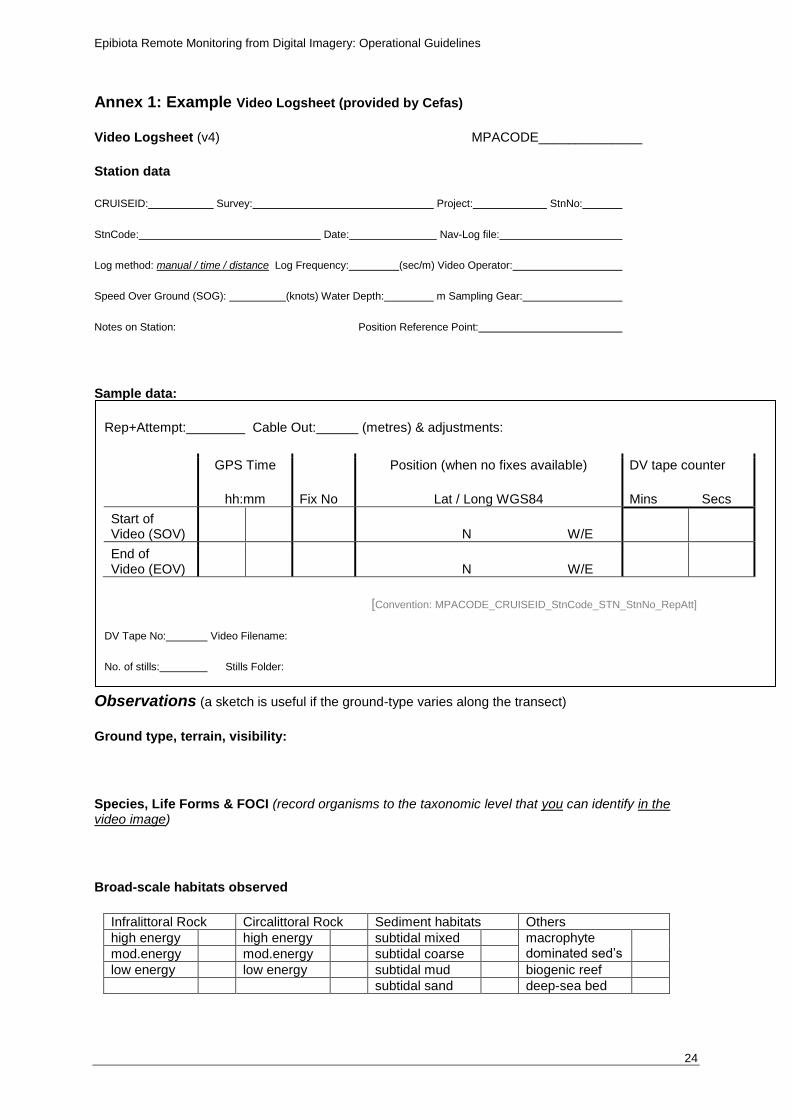
Annex 1: Example Video Logsheet (provided by Cefas)
Video Logsheet (v4) MPACODE______________
Station data
CRUISEID: Survey: Project: StnNo:
StnCode: Date: Nav-Log file:
Log method: manual / time / distance Log Frequency: (sec/m) Video Operator:
Speed Over Ground (SOG): (knots) Water Depth: m Sampling Gear:
Notes on Station: Position Reference Point:
Sample data:
Rep+Attempt: Cable Out: (metres) & adjustments:
GPS Time
hh:mm Fix No
Position (when no fixes available)
Lat / Long WGS84
DV tape counter
Mins Secs
Start of Video (SOV) N W/E
End of Video (EOV) N W/E
[Convention: MPACODE_CRUISEID_StnCode_STN_StnNo_RepAtt]
DV Tape No: Video Filename:
No. of stills: Stills Folder:
Observations (a sketch is useful if the ground-type varies along the transect)
Ground type, terrain, visibility:
Species, Life Forms & FOCI (record organisms to the taxonomic level that you can identify in the video image)
Broad-scale habitats observed
Infralittoral Rock Circalittoral Rock Sediment habitats Others
high energy high energy subtidal mixed macrophyte dominated sed’s
mod.energy mod.energy subtidal coarse
low energy low energy subtidal mud biogenic reef
subtidal sand deep-sea bed