environmental requirements for afforestation - … · fs-dafm environmental requirements for...
TRANSCRIPT
FS-DAFM Environmental Requirements for Afforestation (DRAFT, 11April16)
1
Environmental Requirements for Afforestation
Water, biodiversity, archaeology and landscape
CONSULTATION DRAFT
11th April 2016
FS-DAFM Environmental Requirements for Afforestation (DRAFT, 11April16)
2
Contents
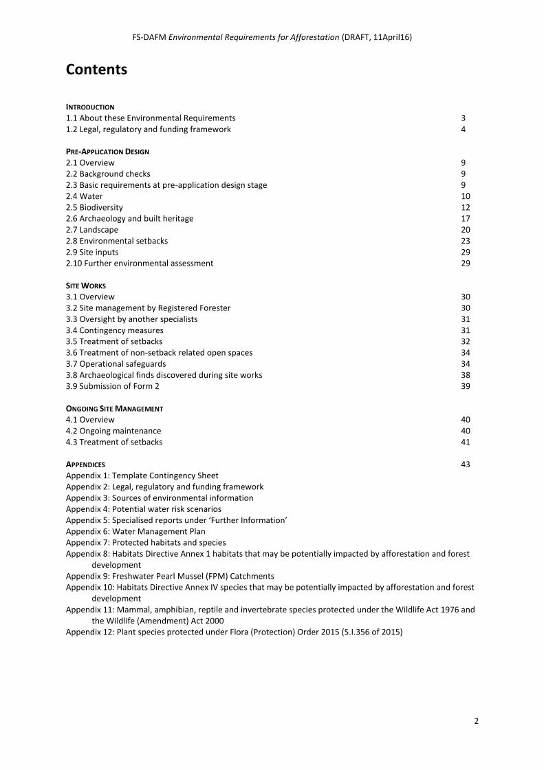
INTRODUCTION 1.1 About these Environmental Requirements 3 1.2 Legal, regulatory and funding framework 4 PRE-APPLICATION DESIGN 2.1 Overview 9 2.2 Background checks 9 2.3 Basic requirements at pre-application design stage 9 2.4 Water 10 2.5 Biodiversity 12 2.6 Archaeology and built heritage 17 2.7 Landscape 20 2.8 Environmental setbacks 23 2.9 Site inputs 29 2.10 Further environmental assessment 29 SITE WORKS 3.1 Overview 30 3.2 Site management by Registered Forester 30 3.3 Oversight by another specialists 31 3.4 Contingency measures 31 3.5 Treatment of setbacks 32 3.6 Treatment of non-setback related open spaces 34 3.7 Operational safeguards 34 3.8 Archaeological finds discovered during site works 38 3.9 Submission of Form 2 39 ONGOING SITE MANAGEMENT 4.1 Overview 40 4.2 Ongoing maintenance 40 4.3 Treatment of setbacks 41 APPENDICES 43 Appendix 1: Template Contingency Sheet Appendix 2: Legal, regulatory and funding framework Appendix 3: Sources of environmental information Appendix 4: Potential water risk scenarios Appendix 5: Specialised reports under ‘Further Information’ Appendix 6: Water Management Plan Appendix 7: Protected habitats and species Appendix 8: Habitats Directive Annex 1 habitats that may be potentially impacted by afforestation and forest
development Appendix 9: Freshwater Pearl Mussel (FPM) Catchments Appendix 10: Habitats Directive Annex IV species that may be potentially impacted by afforestation and forest
development Appendix 11: Mammal, amphibian, reptile and invertebrate species protected under the Wildlife Act 1976 and
the Wildlife (Amendment) Act 2000 Appendix 12: Plant species protected under Flora (Protection) Order 2015 (S.I.356 of 2015)
FS-DAFM Environmental Requirements for Afforestation (DRAFT, 11April16)
3
Introduction
1.1 About these Environmental Requirements Forestry is a significant landuse in Ireland. Through appropriate site selection, design and management, forests and woodlands contribute to farming incomes, rural development and downstream employment. Forests and woodlands also deliver a wide range of essential eco-system services and public goods, including climate change mitigation, the provision of renewable energy, the protection of water quality and biodiversity, the enhancement of landscape, and the creation of opportunities for outdoor recreation.
The Forest Service of the Department of Agriculture, Food & the Marine is responsible for ensuring the development of forestry within Ireland in a manner and to a scale that maximises its contribution to national socio-economic well-being on a sustainable basis that is compatible with the protection and enhancement of the environment.
The overall aim of the Forest Service Environmental Requirements for Afforestation is to ensure that the establishment of forests and woodland – which requires approval under the European Communities (Forest Consent and Assessment) Regulations 2010 (S.I. No. 558 of 2010, as amended) – is carried out in a way that is compatible with the protection and enhancement of our environment, including water quality, biodiversity, archaeology and landscape.
Any statutory approval (with or without grant aid) for afforestation issued under S.I.558 of 2010 (as amended) is conditional on adherence to the measures set out in these Environmental Requirements for Afforestation, in addition to any additional site specific conditions attached to the Letter of Approval and to the standards and procedures set out in the Forestry Standards Manual. Where a parallel approval for grant aid has been issued, the Afforestation Scheme Terms & Conditions also apply.
These Environmental Requirements for Afforestation replace those measures relating to afforestation contained within the following Forest Service Environmental Guidelines: Forestry & Water Quality Guidelines, Forestry & Archaeology Guidelines, Forestry & the Landscape Guidelines, and Forest Biodiversity Guidelines.
These Environmental Requirements for Afforestation are set out in three stages. While some overlap exists, these three stages to reflect the typical sequence of activities undertaken by an Applicant and her / his Registered Forester and the corresponding sequence of mandatory environmental measures that apply, throughout afforestation and up until the end of the premium period (or 15 years, for non-grant aided forests).
The three stages are as follows:
1. Pre-Application Design
2. Site Works
3. Ongoing Site Management
Photo of young, good quality mixed plantation
FS-DAFM Environmental Requirements for Afforestation (DRAFT, 11April16)
4
1.2 Legal, regulatory and funding framework In assessing an application for afforestation, the Forest Service, as the consenting authority under S.I. No. 558 of 2010 (as amended), is required to consider potential impacts (including in-combination impacts) across a range of issues and sensitivities, including the characteristics of the project, the location of the project, and the characteristics of the impacts. The following provides an overview of the legal, regulatory and funding framework that applies.
For a more complete listing, see Appendix 2.
1.2.1 European Communities (Forest Consent & Assessment) Regulations 2010
Afforestation consent is governed by the European Communities (Forest Consent & Assessment) Regulations (S.I. 558 of 2010), as amended by S.I. 442 of 2012. The purpose of these Regulations is to facilitate compliance with the Environmental Impact Assessment (EIA) Directive (Directive 2011/92/EU, as amended by Directive 2014/52/EU) as it applies to forestry development, by providing for a statutory approval system for afforestation and forest road construction projects and providing for Environmental Impact Assessment (EIA) for such development, if it is likely to have a significant effect on the environment.
Under Regulation 12 of S.I. 558 of 2010 (as amended), applications for afforestation 50 ha or greater require the submission of an Environmental Impact Statement (EIS). In addition, sites less that 50 ha may also require the submission of an EIS, where it is determined by the Minister that the proposed development is likely to have a significant environmental effect.
1.2.2 European Union rules governing the Forestry Programme
Although the Forestry Programme 2014-2020 is entirely State aid funded and approved under the
European Union Guidelines for State aid in the agricultural and forestry sectors and in rural areas,
the rules governing the programme ensure coherence with those set out in the Rural Development
Regulation (Regulation (EU) 1305/2013) and its implementing and delegated acts. This includes
compliancy with State aid rules regarding minimum environmental requirements in relation to the
afforestation and creation of woodland measure; paragraph (509)b of the Guidelines (Article 6(a) of
Regulation 1305/2013) states that:
“the selection of species to be planted, of areas and of methods to be used shall avoid the inappropriate afforestation of sensitive habitats such as peat lands and wetlands and negative effects on areas of high ecological value including areas under high natural value farming. On sites designated as Natura 2000 pursuant to Council Directive 92/43/EEC and Directive 2009/147/EC of the European Parliament and of the Council only afforestation consistent with the management objectives of the sites concerned and agreed with the Member State’s authority in charge of implementing Natura 2000 shall be allowed;”
1.2.3 Forestry Programme 2014-2020
Various specific measures committed to under the Forestry Programme 2014-2020 represent requirements to be adhered to at afforestation stage. For example:
Sites proposed for afforestation where significant areas have peat depths greater than 0.5 metres will require additional information and assessment to determine the potential
FS-DAFM Environmental Requirements for Afforestation (DRAFT, 11April16)
5
impacts on the environment, including the carbon balance, and their silvicultural suitability.
An appropriate ecological assessment is required in sites where Annex I habitats or the habitat of Annex I birds or Annex II species occur or are likely to occur.
All conifer afforestation applications with stream/river/lake frontage (as per OS maps) within certain water-sensitive catchments must include a Native Woodland Establishment (GPC 9 &10) plot at least 20 m wide (tree-to-tree) adjoining the water setback (where site suitability for broadleaves allows), for the protection and enhancement of water quality.
1.2.4 Biodiversity legislation
Various measures apply under the EU Habitats Directive, the Wildlife Acts and the European Communities (Birds & Natural Habitats) Regulations 2011 (S.I. 477 of 2011). Key measures are set out below.
Appropriate Assessment
As required under the European Communities (Birds and Natural Habitats) Regulations 2011 (S.I. 477 of 2011, as amended (by S.I. 299 of 2013, the Radiological Protection (Miscellaneous Provisions) Act 2014, and S.I. 355 of 2015), the Forest Service ‘screens’ afforestation applications to assess if there is a possibility of the project - alone or in combination with other projects - having a significant effect on a NATURA site – i.e. a Special Area of Conservation (SAC) or a Special Protection Area (SPA). This applies to projects both inside and outside SACs and SPAs. If a significant effect is likely, or where uncertainty exists, the Forest Service must seek a NATURA Impact Statement (NIS) from the Applicant, and subsequently undertakes an ‘Appropriate Assessment’, primarily to gauge the nature of the impact and the effectiveness of any avoidance, amelioration, or mitigation measures proposed. The Forest Service can only issue approval for afforestation if it has determined – either after screening or Appropriate Assessment – that the operation will not significantly affect the NATURA site. Full details of this process are set out in the Forestry Standards Manual.
It is in the interest of the Applicant to review the conservation objectives of any relevant NATURA site, and to provide supplementary information (including details of any additional protective measures proposed) with the initial application. (Details on individual NATURA sites are available on the National Parks & Wildlife Service website www.npws.ie/protectedsites/) Within the context of the Forest Service Appropriate Assessment Procedure, this supplementary information on additional protective measures may allow the Forest Service to arrive at a decision at screening stage.
Natural Heritage Areas
A dual consent system operates in relation to afforestation in most Natural Heritage Areas (NHAs), whereby it requires the consent of the Ministers for Arts, Heritage & the Gaeltacht and the Minister for Agriculture, Food & the Marine. Afforestation is a ‘notifiable action’ in most NHAs. Where the proposed project lies within or partially within a NHA, the Applicant and Registered Forester should refer to the NPWS website www.npws.ie for details, and if required, notify NPWS using the Notifiable Action Form. A completed Notifiable Action Form, signed and dated by NPWS, must be submitted to the Forest Service with the initial afforestation application.
(Note, the dual consent process does not exist for proposed Natural Heritage Areas (pNHAs), and a completed Notifiable Action Form is not required.)
FS-DAFM Environmental Requirements for Afforestation (DRAFT, 11April16)
6
Other legal measures protecting habitats and species
Other legal measures protecting habitats and species are relevant to afforestation, including:
Habitats Directive Annex I habitats in non-designated areas (*) (*The Forest Service require the
assessment (quality, size, connectivity, etc.) of any Annex I or potential Annex I habitat(s) on sites outside of non-designated areas, to inform its assessment of any corresponding application for afforestation.)
Annex IV species (Note, the Forest Service Forestry & Kerry Slug Guidelines and the Forestry & Otter Guidelines apply to these two Annex IV species.)
Mammal, amphibian, reptile or invertebrate species protected under the Wildlife Act
Species protected under the Flora (Protection) Order 2015
Wetland habitats
Features described in Article 10 of the Habitats Directive as being essential for the migration, dispersal and genetic exchange of wild species, due to their linear and continuous structure or function as ‘stepping stones’.
Further information is provided in Appendices 7–12.
1.2.5 Legislation regarding archaeology and built heritage
Archaeology
In Ireland archaeological sites and monuments and archaeological objects or artefacts are legally protected from unauthorised interference or damage by the National Monuments Acts 1930 to 2004 and which inter alia provide for penalties of a fine and/or terms of imprisonment for breaches of the provisions. A monument may be protected in one or more of four ways by being:
entered on the Record of Monuments and Places (RMP);
entered onto the Register of Historic Monuments (RHM);
National Monument in the ownership or in the guardianship of the Minister for Arts, Heritage & the Gaeltacht or a Local Authority; or
National Monument subject to a Preservation Order (PO) or Temporary Preservation Order (TPO).
Different levels of protection apply to monuments depending on which of the four categories they fall under. Where the owner or occupier of a property, or any other person proposes to carry out, or to cause, or to permit the carrying out of any work at or in relation to a Recorded Monument, notice in writing is required to be given to the Minister for Arts, Heritage & the Gaeltacht two months before commencing that work. This time is to allow the National Monuments Service (NMS), Department of Arts, Heritage & the Gaeltacht (DAHG) to advise the landowner, Local Authority, or other Consent Authorities, on how the work may proceed or be authorised to proceed in tandem with the protection of the monument(s) in question. For National Monuments in the ownership or guardianship of the Minister for Arts, Heritage & the Gaeltacht or a Local Authority or which are subject to a Preservation Order the prior written consent of the Minister is required for any interference with the monument. Separate controls apply in respect of archaeological works connected with approved road schemes.
In respect of archaeological objects, the law also provides that any archaeological object found in the State and which has no known owner is the property of the State. This means that any archaeological object found during afforestation development works or during any associated
FS-DAFM Environmental Requirements for Afforestation (DRAFT, 11April16)
7
archaeological monitoring or excavations is the property of the State and must be reported to the Director of the National Museum of Ireland within the prescribed statutory timeframes or in accordance with the conditions of any licence issued by NMS, and surrendered to the Director as or if required. The discovery of human remains must also be reported in the first instance to the Garda Síochána and the Coroner, as well as the Director of the National Museum of Ireland.
Built heritage
In Ireland important elements of the built heritage are legally protected from unauthorised interference or damage by the Planning and Development Acts 2000 to 2015. Part IV of the Act deals specifically with architectural heritage. Every Local Authority is obliged to have a Record of Protected Structures (RPS) and to enter thereon every structure in the authority's area which it considers to be of special interest from an architectural, historical, archaeological, artistic, cultural, scientific, social, or technical point of view. The RPS forms part of the County Development Plan.
If a structure is included in the RPS, the protection extends to the interior of the structure; to the land in its curtilage; and to any other structures on that land and their interiors. Curtilage means the land and outbuildings immediately surrounding a structure which is (or was) used for the purposes of the structure. This obligation also applies to all fixtures and features forming part of the interior and exterior of the protected structure or any structure on the grounds attached to it.
Under the Act, it is an offence for the owner of a Protected Structure to allow it to be endangered, or to carry out any works that could affect its character without planning permission, with severe penalties in the form of fines and / or a term of imprisonment for breaches of the provisions. A landowner can obtain a list of the works for their property that do or do not require planning permission by asking for a Declaration under Section 57 from the authority. This service is free.
The National Inventory of Architectural Heritage is a state initiative established under the provisions of the Architectural Heritage (National Inventory) and Historic Monuments (Miscellaneous Provisions) Act 1999 to identify, record, and evaluate the post-1700 built heritage of Ireland, uniformly and consistently as an aid to its protection and conservation. NIAH building surveys provide the basis for the recommendations of the Minister for Arts, Heritage & the Gaeltacht to the planning authorities for the inclusion of particular structures in their RPS. The published surveys are a source of information on the selected structures for relevant planning authorities. They are also a useful research and educational resource. The NIAH has also undertaken the initial phase of a Survey of Historic Gardens and Designed Landscapes. Surveys are published on the NIAH website. With each county or city survey, the NIAH is publishing an illustrated introduction to the architecture of the area. A full list of these can be found on the NIAH website.
1.2.6 Water Framework Directive
The Minister for Agriculture, Food & the Marine is listed as a public authority under the European Communities (Water Policy) Regulations 2003 (S.I.722 of 2003), the principal transposing legislation in relation to the European Water Framework Directive (WFD). The Minister must “exercise functions [including the issuing of afforestation approval] in a manner which is consistent with the provisions of the [Water Framework] Directive and which achieves or promotes compliance with the requirements of the Directive”.
The WFD sets out four core objectives regarding waterbodies (which are defined as area of land (or subcatchment) draining into a section of a stream or river, or a lake (*)):
prevent deterioration in status (particularly ‘High Status’ waterbodies);
restore ‘Good Status’ within specific timeframes;
reduce chemical pollution; and
FS-DAFM Environmental Requirements for Afforestation (DRAFT, 11April16)
8
achieve protected areas objectives in relation to, for example, aquatic based SACs.
(* Waterbodies represent the basic hydrological unit under the Water Framework Directive, with each assigned a status (‘High’, ‘Good’, ‘Moderate’, ‘Poor’, ‘Bad’) and objectives for improvement and protection.)
As part of its assessment of an application for afforestation, the Forest Service will consider the status of the relevant waterbody (or waterbodies) underlying and downstream of the site. Of particular concern are waterbodies of high status and waterbodies associated with water-related protected areas (e.g. aquatic SACs). When assessing an application, the Forest Service must also consider it in combination with other forestry and non-forestry plans and projects (including the level of existing forest cover) within the waterbody, in relation to whether or not the potential for a significant cumulative impact on the waterbody status exists.
The WFD is currently entering its second cycle in Ireland.
In general, 1st and 2nd order streams are highly sensitive to forest development. The corresponding sub-catchments of 1st and 2nd order streams often overlap significantly with lower site productivity, high status waterbodies, designated sites (SACs, SPA and NHAs) and other biodiversity sensitivities, landscape sensitive areas, and areas subject to the Acid Sensitivity Protocol.
1.2.7 Other Forest Service requirements, procedures and protocols
These include (inter alia):
the terms and conditions of the Afforestation Scheme (if grant aid is being sought);
the standards and procedures set out in the Forestry Standards Manual (including standards relating to diverse species and minimal broadleaf content, and procedures relating to environmental referrals, acid sensitive areas and Hen Harrier disturbance operations);
the Forestry & Freshwater Pearl Mussel Requirements;
the Forestry & Kerry Slug Guidelines;
the Forestry & Otter Guidelines; and
the Forest Protection Guidelines.
Photos of examples of important habitats / species
FS-DAFM Environmental Requirements for Afforestation (DRAFT, 11April16)
9
Pre-Application Design
2.1 Overview The pre-application design stage is where the Registered Forester undertakes environmental background checks and an onsite assessment. Both elements are inter-related. The intended end result of this stage is for the Applicant and/or his/her Registered Forester to develop to the best of their ability and based on the information available to them, an environmentally sensitive project design, for subsequent submission to the Forest Service in the form of the application for Afforestation Approval (with or without grant aid) (i.e. the Form 1), the Certified Species Map, the Biodiversity Map, and other required components (including supplementary reports) (as set out in the Forestry Standards Manual).
Photo of good quality biodiversity map
2.2 Background checks In addition to onsite assessment, consultation with the Applicant her-/himself, and the mandatory environmental checks on iNET regarding biodiversity, water, archaeology and landscape and other sensitivities, various sources of information can be checked by the Registered Forester early in the pre-application design stage, to identify environmental sensitivities. Relevant safeguards can then be incorporated into the proposed project design (e.g. species selection, design of ABEs) to avoid, ameliorate or mitigate any negative impacts identified, and to reinforce positive impacts.
Appendix 3 lists useful sources of information in relation to various environment features / sensitivities, in addition to iNET.
2.3 Basic requirements at pre-application design stage The basic requirements to be incorporated at the pre-application design stage in relation to the protection and enhancement of key environmental features / sensitivities (water, biodiversity, archaeology and the landscape) are set out below.
If faced with a particularly sensitive and complex site in relation to a particular environmental issue (such as water, biodiversity, archaeology or landscape), a Registered Forester may propose safeguards above and beyond the minimum requirements set out in this document. Furthermore, a relevant expert (e.g. hydrologist, ecologist, archaeologist, landscape architect) may be retained early in the pre-application design process, to assess the issue and to identify appropriate protective measures.
Doing so, with supporting notes / expert report submitted with the Form 1 application, may negate the need for a subsequent request for Further Information from the Forest Service.
(Note that an individual site may be deemed suitable from a productive perspective (as per the Forest Service Land Types for Afforestation document) but unsuitable from an environmental perspective. In such cases, before an application can be progressed any further, the Forest Service may require further assessment (up to and including a requirement to submit an EIS). Where the Forest Service is of the opinion that the proposed development does not accord with legislative requirements, other relevant standards, or Government policies or guidelines, or is likely to have an
FS-DAFM Environmental Requirements for Afforestation (DRAFT, 11April16)
10
adverse impact on human health, animal or plant health, water quality, an archaeological, historical or cultural site or feature, an area of special amenity, or nature conservation, it may also refuse approval. These sites may become apparent to Registered Foresters at the early pre-application design stage, following background checks on iNET supplemented by reference to the above sources of information, and in general, should not be advanced to the application stage.)
2.4 Water Objective: To protect and enhance water quality, both at afforestation stage and throughout the forest rotation.
As part of the pr-application design stage, assess and reflect the degree of risk to receiving waters (streams, rivers, lakes), both during afforestation and throughout the rotation, taking account of factors such as soil type, slope, available pathways for water, the erodibility of soil and subsoil, downstream SACs and the waterbody status. For guidance on identifying high risk scenarios, see Appendix 4.
During onsite assessment, identify and map aquatic zones and relevant watercourses adjoining or crossing the site, and also ‘hotspots’. These features are defined as follows:
Aquatic zone: A permanent or seasonal river, stream or lake shown on an Ordnance Survey 6 inch map. (Note, the EPA water layer on iFORIS may not capture all aquatic zones onsite.)
Relevant watercourse: A watercourse that is not shown on an OS 6 inch map but which is connected to an aquatic zone onsite, adjoining the site or elsewhere, and which has the potential to carry significant amounts of sediments / nutrients, or show evidence / signs of erosion/deposition. Relevant watercourses are often artificial, and include drains and channels and other potential pathways that may only contain flowing water during and immediately after rainfall. Note, not every watercourse may be deemed as a 'relevant watercourse'. For example, an existing well-vegetated agricultural drain on moderately sloping ground may not be regarded as a relevant watercourse.
Hotspot: An area (often localised) that is a potential source for sediment / nutrient loss during afforestation and / or future forestry operations. Examples include soft wet ground, flushes and springs, areas where machine access is difficult due to slope or ground-bearing capacity, flood prone areas.
Photos of aquatic zone, relevant watercourse, hotspot
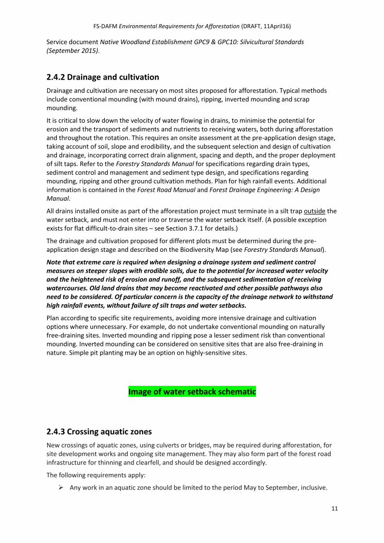
2.4.1 Water setback
A key component in the protection of water is the water setback (formerly known as the 'aquatic buffer zone'). A water setback is a defined area adjoining an aquatic zone, relevant watercourse or hotspot, that is left largely undisturbed during afforestation and throughout the rotation, specifically for the protection of water quality and aquatic ecosystems. All drains installed as part of the afforestation project must terminate in silt traps outside the water setback. The relevant water setbacks and treatment is set out in Section 2.8.
Note, site permitting, the required 10% broadleaf component within any afforestation project located within, or partially within, specified water sensitive areas must include Native Woodland Establishment GPC 9 and / or GPC 10 plot (or plots) along sensitive sections of any watercourse adjoining or crossing the site, to enhance water protection. Specific details are set out in the Forest
FS-DAFM Environmental Requirements for Afforestation (DRAFT, 11April16)
11
Service document Native Woodland Establishment GPC9 & GPC10: Silvicultural Standards (September 2015).
2.4.2 Drainage and cultivation
Drainage and cultivation are necessary on most sites proposed for afforestation. Typical methods include conventional mounding (with mound drains), ripping, inverted mounding and scrap mounding.
It is critical to slow down the velocity of water flowing in drains, to minimise the potential for erosion and the transport of sediments and nutrients to receiving waters, both during afforestation and throughout the rotation. This requires an onsite assessment at the pre-application design stage, taking account of soil, slope and erodibility, and the subsequent selection and design of cultivation and drainage, incorporating correct drain alignment, spacing and depth, and the proper deployment of silt taps. Refer to the Forestry Standards Manual for specifications regarding drain types, sediment control and management and sediment type design, and specifications regarding mounding, ripping and other ground cultivation methods. Plan for high rainfall events. Additional information is contained in the Forest Road Manual and Forest Drainage Engineering: A Design Manual.
All drains installed onsite as part of the afforestation project must terminate in a silt trap outside the water setback, and must not enter into or traverse the water setback itself. (A possible exception exists for flat difficult-to-drain sites – see Section 3.7.1 for details.)
The drainage and cultivation proposed for different plots must be determined during the pre-application design stage and described on the Biodiversity Map (see Forestry Standards Manual).
Note that extreme care is required when designing a drainage system and sediment control measures on steeper slopes with erodible soils, due to the potential for increased water velocity and the heightened risk of erosion and runoff, and the subsequent sedimentation of receiving watercourses. Old land drains that may become reactivated and other possible pathways also need to be considered. Of particular concern is the capacity of the drainage network to withstand high rainfall events, without failure of silt traps and water setbacks.
Plan according to specific site requirements, avoiding more intensive drainage and cultivation options where unnecessary. For example, do not undertake conventional mounding on naturally free-draining sites. Inverted mounding and ripping pose a lesser sediment risk than conventional mounding. Inverted mounding can be considered on sensitive sites that are also free-draining in nature. Simple pit planting may be an option on highly-sensitive sites.
Image of water setback schematic
2.4.3 Crossing aquatic zones
New crossings of aquatic zones, using culverts or bridges, may be required during afforestation, for site development works and ongoing site management. They may also form part of the forest road infrastructure for thinning and clearfell, and should be designed accordingly.
The following requirements apply:
Any work in an aquatic zone should be limited to the period May to September, inclusive.
FS-DAFM Environmental Requirements for Afforestation (DRAFT, 11April16)
12
Crossings should be designed so that:
o the number of crossings over a given aquatic zone is minimised;
o disruption to the bank, bed and adjacent water setback is minimised;
o the water flow is crossed at a right angle;
o cement or uncured concrete is kept out of the aquatic zone, with cast-in-place concrete isolated from any water which might enter the aquatic zone, until the concrete is cured;
o local stone is used for bridge kerbs and end treatments for culverts;
o all timber treatment is carried out off-site.
Consult with the Inland Fisheries Ireland at least 6 weeks prior to constructing any crossing of an aquatic zone within a Fisheries Sensitive Area (as identified in the Forestry Standards Manual).
Bridge construction is necessary where culverts may restrict fish migration.
o All supports and buttresses should be completely out of the stream.
o Do not create shallow or shooting flow at the bridge aprons, to ensure that water velocities do not impede fish movement.
Fords are not desirable and should only be used when the design is approved by Inland Fisheries Ireland.
All culverts should be well-bedded and of sufficient size to carry normal flow and to accommodate 25-year storm events, and to avoid blockages and washouts. Ends should be tapered to match the embankment slope. If greater than 1.0 m in diameter, they should be buried to a depth of 30 cm or 20% of their height (whichever is greater) below the streambed, and the original bed material as well as boulder-sized rocks placed in the culvert.
Various options are available to create temporary crossings to facilitate access at the site development stage – detail fully in the Afforestation Application and ensure removal and site restoration after use.
2.5 Biodiversity
Objectives:
To seek to ensure proposed afforestation development projects do not adversely impact directly or indirectly on designated sites and / or protected species and / or their habitats.
To enhance the biodiversity value within and outside the afforestation site throughout the rotation, primarily through the introduction of Areas for Biodiversity Enhancement (ABEs).
Biodiversity is the variety of living organisms, including: (i) the diversity of species; (ii) the genetic diversity or variation within the species; and (iii) the ecosystems in which the species lives. Forests (conifer, mixed and broadleaved) can contribute greatly to biodiversity, both within their boundaries and as wildlife corridors or refuges in the wider landscape.
Afforestation can impact on a range of habitats and species protected under various legislation. Appendix 7 sets out various scenarios that may apply, and the likely outcome regarding the proposed afforestation application.
FS-DAFM Environmental Requirements for Afforestation (DRAFT, 11April16)
13
2.5.1 Areas for Biodiversity Enhancement
During onsite assessment, identify Areas for Biodiversity Enhancement, or ABEs.
ABEs comprise open spaces and retained habitat, both described below. Their function is to conserve and encourage the development of diverse habitats, native flora and fauna, and overall biodiversity on the site throughout the rotation.
Open spaces include setbacks introduced for water, archaeology, landscape (including public roads and dwellings) and areas left unplanted for future management purposes (e.g. ridelines, future forest roads, deer lawns). In addition to their primary setback or management function, these open spaces will have an intrinsic biodiversity value within the emerging forest, both as open habitat and through the development of the 'edge effect' between the forest canopy and the open space. This edge effect can be significantly enhanced with a small level of additional design – see below.
Retained habitats include existing habitats onsite, either area-based (e.g. a localised flush), linear (e.g. a hedgerow) or point (e.g. a veteran tree), to be retained within the future forest. Design should aim to protect and enhance these habitats throughout the forest’s lifetime, and to facilitate the development of associated native flora and fauna. This may involve the addition of a habitat setback, to ensure that the retained habitat is not impacted by the developing canopy – see Section 2.8 for details.
(Note, it may be necessary to exclude from the afforestation application, certain habitats that require periodic grazing to persist. This is due to the requirement that the entire plantation area is stock-proof.)
Ensure that open spaces for future forest roads do not overlap with setbacks included for water, archaeology and retained habitats.
Up to 15% of the afforestation site must be treated with particular regard to biodiversity, comprising open spaces and / or retained habitats. (In sites less than 10 hectares, ABEs should be designed in conjunction on with neighbouring land use and may be reduced to 10%.) (Where ABEs add up to more than 15% of the total area, grant and premium payments are reduced accordingly, as set out in the Forestry Standards Manual) )
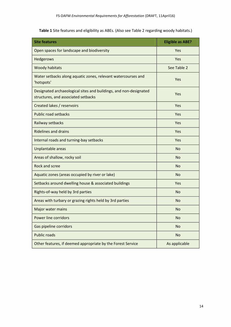
Tables 1 and 2 list the various features that are eligible as ABEs for the purpose of grant and premium calculation.
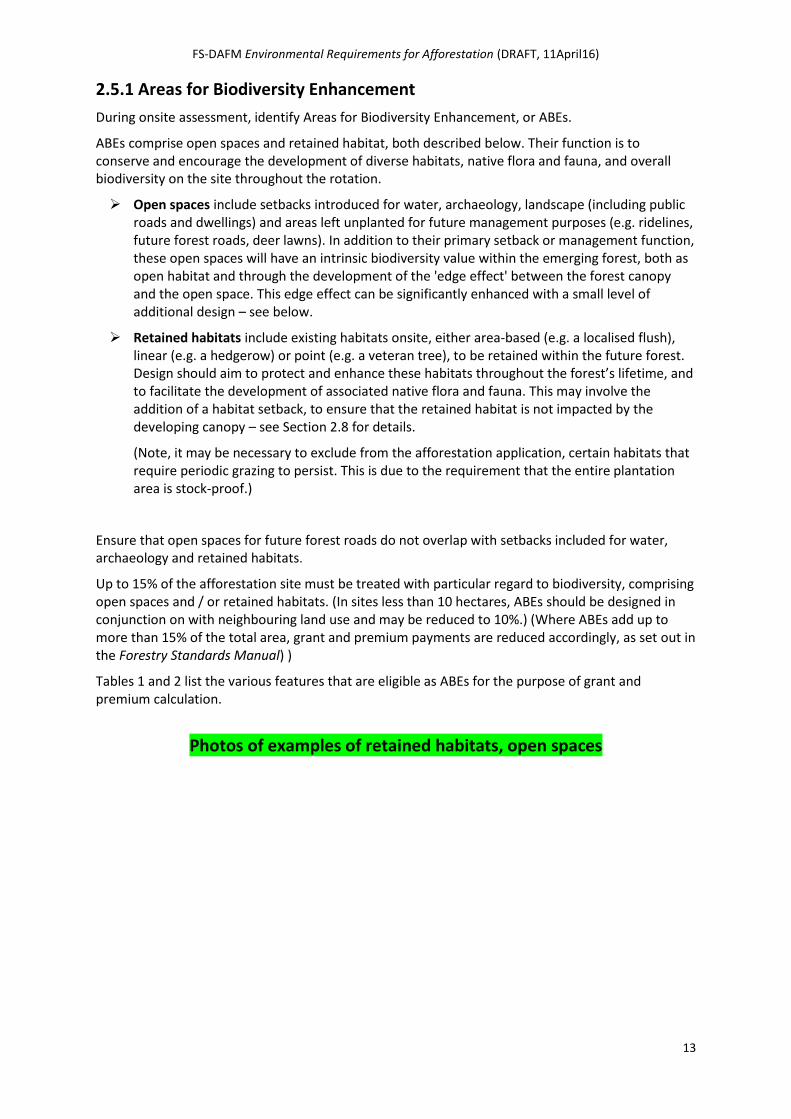
Photos of examples of retained habitats, open spaces
FS-DAFM Environmental Requirements for Afforestation (DRAFT, 11April16)
14
Table 1 Site features and eligibility as ABEs. (Also see Table 2 regarding woody habitats.)
Site features Eligible as ABE?
Open spaces for landscape and biodiversity Yes
Hedgerows Yes
Woody habitats See Table 2
Water setbacks along aquatic zones, relevant watercourses and
'hotspots' Yes
Designated archaeological sites and buildings, and non-designated
structures, and associated setbacks Yes
Created lakes / reservoirs Yes
Public road setbacks Yes
Railway setbacks Yes
Ridelines and drains Yes
Internal roads and turning-bay setbacks Yes
Unplantable areas No
Areas of shallow, rocky soil No
Rock and scree No
Aquatic zones (areas occupied by river or lake) No
Setbacks around dwelling house & associated buildings Yes
Rights-of-way held by 3rd parties No
Areas with turbary or grazing rights held by 3rd parties No
Major water mains No
Power line corridors No
Gas pipeline corridors No
Public roads No
Other features, if deemed appropriate by the Forest Service As applicable
FS-DAFM Environmental Requirements for Afforestation (DRAFT, 11April16)
15
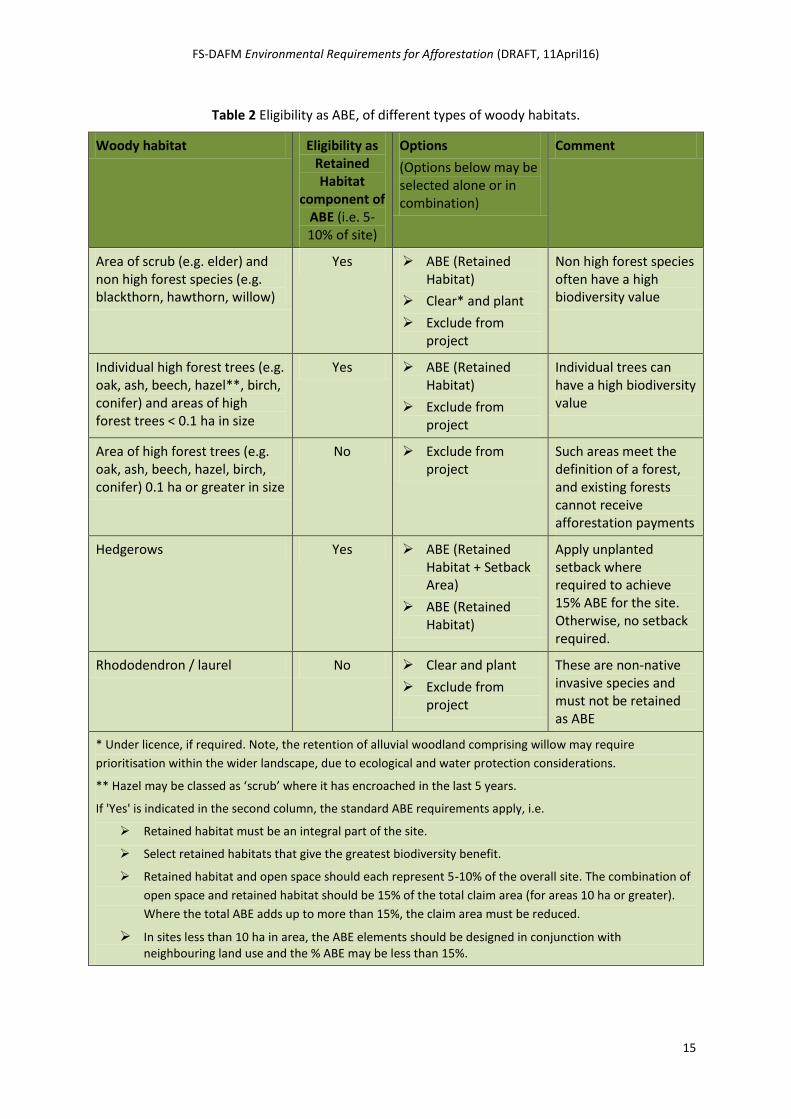
Table 2 Eligibility as ABE, of different types of woody habitats.
Woody habitat Eligibility as Retained Habitat
component of ABE (i.e. 5-10% of site)
Options
(Options below may be selected alone or in combination)
Comment
Area of scrub (e.g. elder) and non high forest species (e.g. blackthorn, hawthorn, willow)
Yes ABE (Retained Habitat)
Clear* and plant
Exclude from project
Non high forest species often have a high biodiversity value
Individual high forest trees (e.g. oak, ash, beech, hazel**, birch, conifer) and areas of high forest trees < 0.1 ha in size
Yes ABE (Retained Habitat)
Exclude from project
Individual trees can have a high biodiversity value
Area of high forest trees (e.g. oak, ash, beech, hazel, birch, conifer) 0.1 ha or greater in size
No Exclude from project
Such areas meet the definition of a forest, and existing forests cannot receive afforestation payments
Hedgerows Yes ABE (Retained Habitat + Setback Area)
ABE (Retained Habitat)
Apply unplanted setback where required to achieve 15% ABE for the site. Otherwise, no setback required.
Rhododendron / laurel No Clear and plant
Exclude from project
These are non-native invasive species and must not be retained as ABE
* Under licence, if required. Note, the retention of alluvial woodland comprising willow may require
prioritisation within the wider landscape, due to ecological and water protection considerations.
** Hazel may be classed as ‘scrub’ where it has encroached in the last 5 years.
If 'Yes' is indicated in the second column, the standard ABE requirements apply, i.e.
Retained habitat must be an integral part of the site.
Select retained habitats that give the greatest biodiversity benefit.
Retained habitat and open space should each represent 5-10% of the overall site. The combination of
open space and retained habitat should be 15% of the total claim area (for areas 10 ha or greater).
Where the total ABE adds up to more than 15%, the claim area must be reduced.
In sites less than 10 ha in area, the ABE elements should be designed in conjunction with neighbouring land use and the % ABE may be less than 15%.
FS-DAFM Environmental Requirements for Afforestation (DRAFT, 11April16)
16
2.5.2 ABE criteria
The following criteria apply in relation to ABE eligibility, to maximise biodiversity benefit:
ABEs must be areas that are suitable for planting, where the potential for a commercial forest crop is foregone for the purpose of retaining habitats and open spaces for biodiversity. Areas that are unsuitable for planting are not eligible as ABEs.
ABEs must be an integral part of the proposed forest area. For example, an ABE plot cannot be in an adjoining field / land parcel or in a separate plot away from the main area of the plantation.
Generally, identify ABEs using the following sequence:
Step 1: Identify required environmental setbacks (for water, archaeology, landscape) and unplanted areas required for future management purposes – these form the basis for the open space component of the ABEs.
Step 2: Select the ‘best quality’ habitats(*) onsite for retention. These, together with any associated habitat setbacks (where needed), represent the retained habitat component of the ABEs. In general, the retained habitats are to remain undisturbed, unless otherwise agreed or prescribed.
Note, onsite assessment may identify particular biodiversity sensitivities on or adjacent to the site, or elsewhere (e.g. downstream) which will dictate the positioning of ABEs (and also the use of the required 10% broadleaf requirement). Examples include the need for a wider water setback due to a downstream SAC, the inclusion of a wider-than-normal landscape setback in response to local concerns, or the exclusion of a section of a field due to the presence of a Flora Protection Order species.
Applicants must not remove ABEs prior to entry into the Afforestation Scheme or during afforestation works. If such areas are removed, the application may be refused or a penalty applied.
A Biodiversity Map showing (amongst other things) the ABEs onsite (including Bio Plots, and linear or point biodiversity features) and the equivalent area must be submitted with the afforestation application. The Forestry Standards Manual sets out the mapping requirements.
Setback distances and design in relation to water, retained habitats, archaeology and landscape are detailed in Section 2.8.
Regarding non-setback related open spaces (e.g. for future forest roads), the following applies:
o Edge design should take account of good landscaping practices and the local topography. Avoid creating an unnaturally straight forest edge. Instead, taking account of the immediate landform, create an undulating natural forest edge.
o Where possible, orientate in a east – west direction, to maximise sunlight throughout the day and the seasons.
The treatment of open spaces and retained habitats during site works in set out in Stage 2: Site Works.
(* A basic level of ecological assessment by Registered Foresters will identify the best quality habitats onsite. When identifying and mapping retained habitats, detailed guidance on habitats and habitat classification is set out in Fossitt's A Guide to Habitats in Ireland (2000) (PDF available at www.heritagecouncil.ie).)
FS-DAFM Environmental Requirements for Afforestation (DRAFT, 11April16)
17
2.5.3 Note on hedgerows
In addition to their biodiversity value, hedgerows form part of the cultural and historic heritage of the country, and are important landscape features. As such, they must be regarded carefully during afforestation design and subsequent site works. Hedgerows, ditches and open drains are identified as Landscape Features under the Good Agricultural & Environmental Condition (GAEC) of Cross Compliance.
All hedgerows must be retained. However, the application of a habitat setback is at the Registered Forester’s discretion, and should be informed by the quality of the hedgerow (in terms of its species composition and structure), its visibility and its status (for example, whether or not it represents a townland boundary).
2.6 Archaeology and built heritage Objectives:
To seek to ensure that proposed afforestation development projects do not adversely impact directly or indirectly on known or suspected archaeological sites and monuments or other important built heritage structures or features. This includes protecting their amenities and where relevant, their wider landscape setting, in particular, their relationship with other roughly contemporary or determinably linked sites, monuments, structures or features.
Where afforestation is approved near known or suspected archaeological sites and monuments or other important built heritage structures or features, to seek to ensure that: (i) appropriate exclusion zones, fencing, access paths and other relevant measures are incorporated into the project design; (ii) there is an appropriate response should any previously unrecorded archaeological site, monument, object, structure or feature be discovered during site work; and (iii) any approved design is sympathetic to and provides an appropriate visual setting for such sites, monuments, structures or features.
2.6.1 Potential impacts
The Irish countryside is rich in the physical remains of human activity stretching back over the millennia. These vary from the more obvious and iconic monument types such as megalithic tombs, standing stones, ringforts, crannógs, churches and graveyards, burial grounds, and medieval castles, to the less well known and lower visibility or entirely below the ground surface monument types such as ancient timber and gravel roadways (toghers), cooking places (fulachta fiadh) and settlement sites. All archaeological sites and monuments can have or may survive solely as associated artefacts and features. Examples include stone or metal tools, pottery sherds, post holes or refuse pits. These are often only uncovered during ploughing, drainage works, construction, or turf cutting.
Archaeological sites and monuments and other important built heritage structures and features are part of our national heritage. There is a wealth of information to be gathered from such sites, monuments, structures, and features, both from those which are visible above the ground and from those which have little or no surface expression. In addition to their educational value in terms of informing current and future generations and visitors about the history and development of our culture and society they are also important recreational and tourism resources at local, regional, and national levels.
FS-DAFM Environmental Requirements for Afforestation (DRAFT, 11April16)
18
2.6.2 Procedures
Land proposed for afforestation may contain or be located adjacent to any of these archaeological sites and monuments and built heritage structures and features which for the purpose of these Requirements, are grouped into three categories:
‘Designated’ archaeological sites and monuments, which include those entered onto the RMP, the RHM, National Monuments in the ownership or the guardianship of the Minister for Arts, Heritage & the Gaeltacht or a Local Authority, or those subject to a PO or TPO. These also include those sites and monuments newly discovered at the pre-application design stage or during the site works stage, post-approval. Examples include megalithic tombs, cairns, barrows, mounds, ringforts, enclosures, churches and graveyards, castles, tower houses, and children’s burial grounds.
‘Designated’ buildings and structures or parts of structures which form part of the architectural heritage and which are of special interest, i.e. those entered onto the RPS in the relevant County Development Plan or those entered into the National Inventory of Architectural Heritage (NIAH). Examples include vernacular cottages and houses, country houses and lodges, designed gardens and parklands, parish churches, historic creameries, military fortifications, mine engine houses, water mills, canals, locks and lock houses.
‘Non-designated’ built heritage structures, e.g. lime kilns, sheep folds, creamery stands, stiles, townland boundaries, pumps and pump houses, mill ponds, and derelict dwellings / farm buildings.
Given the nature of afforestation (site selection, ground preparation operations, canopy development, and making provisions for future management operations), the potential for damage to our archaeological and built heritage clearly exists. For example, soil cultivation and drainage works can directly or indirectly disturb or impact both upstanding and sub-surface archaeological sites and monuments and associated features and artefacts. Even the digging of drains and sediment traps near such sites or monuments may cause organic deposits and artefacts (e.g. structural timbers, wooden artefacts, or leather) preserved by anaerobic conditions to decay quicker as the soil deposit dries out, whilst changes caused to soil chemistry (for example from needle fall) may cause metal artefacts or ceramics to decay quicker.
The early identification of the nature, extent, setting, visual envelope, and linkages of archaeological sites and monuments or other important built heritage structures or features, and the incorporation of these considerations both at the pre-application design stage and during site works (where afforestation is approved near known or suspected archaeological sites and monuments) will help to avoid or minimise the risk of damage.
Examples of measures to avoid, reduce or mitigate adverse impacts include:
avoidance of areas of known or suspected elevated archaeological potential;
incorporation of appropriate archaeological setbacks;
access routes;
unplanted lines of sight;
arranging for in-works supervisory safeguards such as archaeological monitoring; and
the forest edge design for archaeological setbacks, to provide an appropriate setting.
Photo of arch. & built heritage features, pre-affor.
FS-DAFM Environmental Requirements for Afforestation (DRAFT, 11April16)
19
The Registered Forester must identify known archaeological sites and monuments or other important built heritage structures or features, on and adjoining a site proposed for afforestation, through review of the relevant layers on iNET, and through a thorough onsite assessment.
The Forester should also utilise readily accessible sources of information. For example, the online digital service provided by the Department of Arts, Heritage & the Gaeltacht (DAHG) - the Historic Environment Viewer - facilitates access to the databases of the National Monuments Service (NMS) Sites and Monuments Record (SMR) and the NIAH. The RPS for each county is normally accessible on-line as well, and can usually be found as an Appendix to the published County Development Plan. See the Forestry Standards Manual for further details.
Where possible, include all reference numbers (e.g. RMP number) on the Biodiversity Map submitted with the application. Doing so may expedite the Forest Service assessment of the application.
Once the various archaeological sites and monuments and other important built heritage structures or features, including those both ‘designated’ and ‘non-designated’, have been identified the relevant minimum archaeological setback, as detailed in Section 2.8, should be applied, as well as any other measures proposed to address considerations such as the nature, extent, setting, visual envelope, and linkages of the sites or monuments.
2.6.3 Conditions attached to or further information required in approvals
The archaeological conditions which may be attached to any approval for afforestation as a general rule will be taken from, but are not limited to, one or more of a tiered hierarchy of archaeological mitigation responses. These include:
archaeological setbacks (including fenced-off exclusion zones);
access routes;
unplanted lines of sight;
increasing the size of the archaeological setbacks;
the exclusion of a larger area or areas of archaeological potential;
archaeological monitoring of specified areas by an independent archaeological consultant retained by the Applicant or Registered Forester;
refusal of either part or all of the development pending the consideration by the Forest Service and NMS of an archaeological assessment and an archaeological impact statement prepared by an independent archaeological consultant retained by the Applicant or Registered Forester; or
refusal after submission, where warranted due to significant adverse impacts that are evident at the very outset of the Forest Service assessment, or which become so as the assessment continues.
Note, as explained above, where it is evident to the Forest Service at the outset or where it becomes evident as the assessment progresses, that a proposed development is likely to have significant adverse impacts on archaeological, historical or cultural sites or features, and which in its opinion cannot be adequately addressed by conditions based on the tiered hierarchy of archaeological mitigation responses listed above, the application may be refused entirely.
2.6.4 Archaeological finds at pre-application design stage
Note that, at pre-application design stage during the onsite assessment or with local knowledge, the Forester may also encounter a previously unrecorded archaeological site or monument. If
FS-DAFM Environmental Requirements for Afforestation (DRAFT, 11April16)
20
discovered, the location of any new or suspected new archaeological site or monument must be included on the Biodiversity Map, a reference made in the Biodiversity Map table legend, and a clear description provided in the Other Environmental Considerations section of the Afforestation Application Form 1.
The Forest Service will consider such reports as part of its assessment of the application and following referral to the NMS may impose one or more relevant archaeological conditions, with a default position being to favour preservation in situ of any new archaeological site or monument so identified (in accordance with the principles and approach as set out in Part III of DAHG’s Framework and Principles for the Protection of the Archaeological Heritage).
Where an archaeological object is discovered at this stage it must by law be reported within a reasonable time period (and not longer than 96 hours) to the Garda Síochána or the National Museum of Ireland. Also, unless there is reasonable cause to believe that removal or interference is necessary to preserve it or keep it safe it, it must not be disturbed. The unsupervised recovery of archaeological objects by untrained persons can greatly diminish, or entirely eliminate any knowledge or research value that might be gained from a particular discovery. It is important that wherever possible archaeological objects are recovered in a structured scientific manner, with careful recording of their association with other objects, structures, features and soil layers.
(Note, see Section 3.8 for details regarding archaeological finds discovered during site works.)
2.7 Landscape Objective: To ensure that the proposed forest is designed so that it is visually acceptable and in keeping with landscape and amenity sensitivities.
The character of any landscape comes from natural elements such as landform and vegetation, and human influences such as land use, field patterns and settlements. Distinctive features such as rock formations, watercourses, wildlife areas, archaeological sites, recreational areas, historical or traditional associations, and viewpoints are also important.
The predominantly open landscape of Ireland today is a result of the progressive clearance of the native forest cover over the centuries, primarily for agriculture. In such an open landscape, afforestation is a major change. Good design and attention to shape, scale, species diversity, margins, open spaces and views will ensure that new forests complement the character of the landscape. In this way, any possible intrusive and monotonous character associated with large scale, uniform plantations and geometric shapes can be avoided.
Landscape requirements set out below emphasise diversity in planting and the achievement of a forest outline and pattern which are visually acceptable.
Landscape sensitivities are identified in the relevant County Development Plan (both Draft and Final Plans). These Development Plans, which the Registered Forester should consult, identify important views, and areas which are of particular landscape and amenity importance. The Registered Forester should also view the site from various vantage points and approaches, to identify how best to design the forest.
Careful design of forests at the initial planning stage is important, as only limited improvements can be made later on. Achieving an acceptable landscape design can be a subjective exercise, and the following principles should be used to guide decisions.
Photo of good landscape practice. Include HAND SKETCHED USED BEFORE??
FS-DAFM Environmental Requirements for Afforestation (DRAFT, 11April16)
21
2.7.1 Shape
Shape is the dominant landscape feature. It refers not only to the outline of the forest but also to the pattern of different species within it.
Property boundaries strongly influence the external shape of the plantation. The inclusion of landscape setbacks (see Section 2.8) along visible boundaries of the proposed forest will mitigate against artificial shapes. Add visual interest and further enhance the biodiversity value of the forest edge by including along the margin, small groups or an irregular belt of native species (e.g. birch, rowan, oak, Scots pine).
On hillsides, planting should conform to the overall pattern in the landscape, whether natural landforms or field patterns, and follow the same rounded or irregular shapes. Overall straight or horizontal lines and geometric or regular shapes should be avoided, where possible.
2.7.2 Margins
Margins between the forest and open ground or between different species or between plots of different Grant & Premium Categories (GPCs) should avoid an abrupt, artificial appearance through attention to shape and detail. This applies in particular to larger plantation in upland areas and to highly visible plantations, including those close to and readily visible from roadways.
The upper margin or skyline is particularly important. It should be in line with the predominant landscape characteristics, be they irregular or smooth. The skyline should be completely forested or completely open, and a narrow parallel band of open ground near the skyline should be avoided. The open ground should reflect the scale of the hill or ridge. At lower points, planting can be carried right over the skyline.
In upland areas, long straight vertical boundaries should be avoided. Instead, a diagonal trend should be maintained. In lowland areas, straight boundaries can be acceptable where they reflect the agricultural field pattern.
On lower margins, plantations can be linked very successfully to agricultural valleys if broadleaf species are extended up into the conifer canopy, especially in hollows and gullies.
2.7.3 Diversity
Diversity can be incorporated through open spaces and landscape features, and by using a variety of species.
As set out in the Forestry Standards Manual:
"To be considered eligible under the Afforestation Scheme, the following plantation rules apply:
Rule 1: The plantation must contain a minimum of 10% broadleaves. This can comprise broadleaves planted in plots of minimum width and / or as additional broadleaves planted for landscape and environmental reasons.
Rule 2: Each plot within the plantation must comply with one of the Grant & Premium Categories (GPCs) listed in Table 4.1, and its corresponding requirements. [which include species diversity]"
Too much variety, however, should be avoided, and it is usually desirable that one species should dominate by about two-thirds.
FS-DAFM Environmental Requirements for Afforestation (DRAFT, 11April16)
22
The margins between species and plots should be designed in the same way as other forest shapes. The overall pattern should be interlocking. Two species can be successfully fused by extending groups and single trees of one species into the other. (Note that individual GPC requirements must be adhered to, as set out in the Forestry Standards Manual.)
Avoid long rows of single species or planting alternate species in vertical rows or blocks. Species boundaries crossing the skyline should also be avoided. Group planting should, where possible, form an irregular pattern and maintain a natural appearance by following ground vegetation patterns. The groups should preferably be diamond or polygon shaped rather than rectangular, varied in size and spacing, and run in diagonal rather than in vertical or horizontal lines.
Woody habitat eligible as ABE can be retained, with further broadleaf species planted in tongues or groups to relieve outlines. As set out elsewhere, individual, small groups or an irregular belt of native species (e.g. birch, rowan, oak, Scots pine) can be planted along the edge of various setbacks, including those relating to water, public roads and dwellings, to add visual interest along the forest edge. The landscape effect of these trees is considerable in proportion to the small area they occupy.
2.7.4 Scale
The scale of planting in relation to the landscape is also important. Large open uplands are more suited to relatively large forested areas, while smaller more regular shapes may fit in better with a lowland pattern of fields and hedgerows. With small woodlands, an interlocking pattern is more effective than an unconnected series of plots. These smaller woodlands can be visually linked by developing connecting hedgerows and by planting groups of trees wherever this is possible.
Where landowners are considering afforestation, cooperative ventures which would result in an appropriate scale of planting should be considered.
2.7.5 Open spaces
Within the overall plantation boundary, the pattern created by open spaces must also be taken into account.
Open spaces will arise from setbacks introduced for water, biodiversity, archaeology and landscape, (including public roads and dwellings), and from areas left unplanted for future management purposes (e.g. ridelines, future forest roads, deer lawns) (see Section 2.5.1). The design and edge treatment of these open spaces is set out elsewhere.
Overall, intersecting open spaces can be designed to merge and to interlock more naturally by introducing appropriately-scaled bellmouths and by eliminating artificially-shape corners.
2.7.6 Other considerations
Fences: Although fences are themselves generally unobtrusive, they can be obvious and end up re-enforcing geometric shapes. Their impact can be reduced by siting them in hollows and avoiding skylines, and by running them diagonally to contours, where possible.
Ridelines and firebreaks: Where possible, ridelines and firebreaks through forests should follow landform and make use of natural features. They should follow an irregular route that avoids dividing a plantation into equal parts, and they should not be sited at right angles or parallel to contours.
FS-DAFM Environmental Requirements for Afforestation (DRAFT, 11April16)
23
Public roads and dwellings: Landscape setbacks and appropriate edge design for public roads, dwelling and other utilised buildings are important – see Section 2.8 for details of requirements.
2.7.7 Public notification procedure
It is proposed in 2016 to introduce a requirement for a site notice to be placed on the public road adjacent to all proposed afforestation sites. This notice will detail the area and site reference number of the proposed afforestation. Further details, including a map of the proposed application, will be available on request from the Forest Service, Johnstown Castle Estate, Co. Wexford.
2.8 Environmental setbacks Different setbacks are required to protect various environmental features / sensitivities. These setbacks are to remain uncultivated and generally unplanted during afforestation, and allowed to develop naturally throughout the rotation. (Some exceptions apply regarding ongoing management, e.g. periodic control of woody growth on setbacks included to retain views. Such requirements will be specified in the conditions of approval for afforestation.)
The following table describes the various setbacks required in relation to a range of environmental features / sensitivities, together with the required setback distance and setback treatment. Note, these setbacks are the minimum required, and wider setbacks may be proposed by the Registered Forester to address particular concerns identified by him/herself. Wider setbacks may also be stipulated by the Forest Service as a condition of any afforestation approval that may issue. Other setbacks may also be required on a case-by-cases basis, e.g. geological feature, swallow hole.
Where different setbacks overlap onsite, the greater setback distance applies.
All setbacks mentioned are eligible as ABEs and may be included as such. Note, if the total ABE onsite exceeds 15%, the payable area will be reduced accordingly. All setbacks are to be mapped in the Biodiversity Map, and widths noted in the Biodiversity Map legend.
See relevant sections above for further requirements in relation to each of the environmental sensitivities described.
NOTE, the treatment of setbacks during Site Works and Ongoing Site Management are detailed in those chapters.

FS-DAFM Environmental Requirements for Afforestation (DRAFT, 11April16)
24
Table 3 Water setbacks
Purpose: To create at the outset, a buffer of natural vegetation positioned between water feature(*) and the forest crop and associated operations throughout the rotation. (* Aquatic zone, relevant watercourse, hotspot)
The water setback to be largely undisturbed during afforestation and throughout the rotation, specifically for the protection of water quality and aquatic ecosystems. The water setback comprises a sward of natural ground vegetation that will filter out sediment and nutrients from overland flow off the site. Furthermore, well-vegetated banks are more resistant to undercutting and collapse. Water setbacks should evolve naturally over time to form a semi-natural habitat of natural ground vegetation and (potentially) pockets of native scrub.
(Note: Additional measures to apply in Freshwater Pearl Mussel areas, as set out in the Forestry & FPM Requirements, as amended.)
Feature Minimum setback from the nearest bank / edge of the water feature, as observed onsite
Additional design
Aquatic zone, as defined on OS 6 inch map
Width depends on slope and soil erodibility, as follows:
Slope leading to aquatic zone (vary, as appropriate, where slope various over site)
Minimum water setback width (metres) on each side of the aquatic zone
Minimum water setback width (metres) for highly erodible soils, including peat.
Moderate (even to 1-in-7 / 0-15%)
10 metres 20 metres
Steep (1-in-7 to 1-in-3 / 15-30%)
20 metres 25 metres
Very steep (1-in-3 / >30%) 25 metres 25 metres
Widen the water setback at various points along its length, to include adjoining wet hollows and other low-lying areas where water gravitates towards as it approaches the receiving water.
Based on the immediate landform / topography, vary the setback to avoid artificial lines and to create a naturally undulating forest edge.
Relevant watercourse 5 metres
Hotspot 5 metres
FS-DAFM Environmental Requirements for Afforestation (DRAFT, 11April16)
25
Table 4 Habitat setbacks
Purpose: To create adequate space around a retained habitat, where appropriate, to avoid or reduce impact arising from canopy development.
Various habitats identified as retained habitats (either as biodiversity plots or as linear or point biodiversity features) may also require an unplanted setback to prevent undue impact (such as shading) from growing trees. The setback is dependent on the habitat and the potential impact. The setback must form part of the calculated area for the retained habitat. Design carefully, e.g. if retaining an open habitat, position the bulk of any necessary habitat setback on the southern side, to maximise sunlight as the forest canopy grows. Note that the retained habitat itself must remain undisturbed (unless otherwise agreed or prescribed).
FS-DAFM Environmental Requirements for Afforestation (DRAFT, 11April16)
26
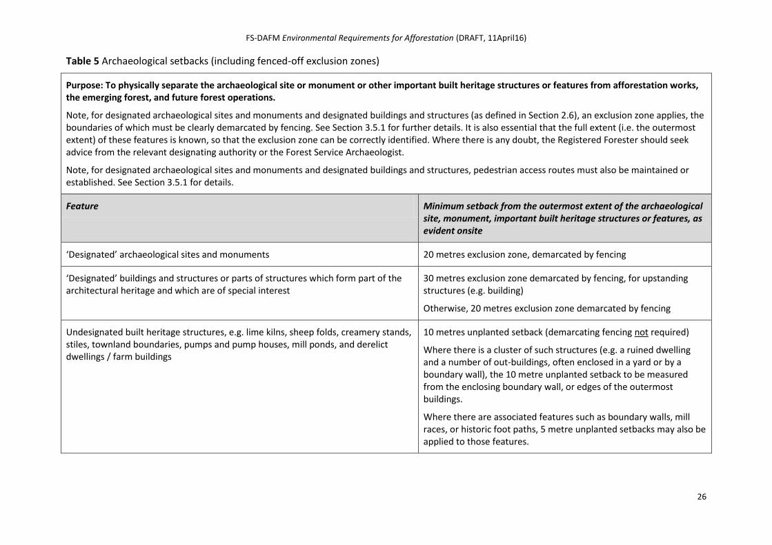
Table 5 Archaeological setbacks (including fenced-off exclusion zones)
Purpose: To physically separate the archaeological site or monument or other important built heritage structures or features from afforestation works, the emerging forest, and future forest operations.
Note, for designated archaeological sites and monuments and designated buildings and structures (as defined in Section 2.6), an exclusion zone applies, the boundaries of which must be clearly demarcated by fencing. See Section 3.5.1 for further details. It is also essential that the full extent (i.e. the outermost extent) of these features is known, so that the exclusion zone can be correctly identified. Where there is any doubt, the Registered Forester should seek advice from the relevant designating authority or the Forest Service Archaeologist.
Note, for designated archaeological sites and monuments and designated buildings and structures, pedestrian access routes must also be maintained or established. See Section 3.5.1 for details.
Feature Minimum setback from the outermost extent of the archaeological site, monument, important built heritage structures or features, as evident onsite
‘Designated’ archaeological sites and monuments 20 metres exclusion zone, demarcated by fencing
‘Designated’ buildings and structures or parts of structures which form part of the architectural heritage and which are of special interest
30 metres exclusion zone demarcated by fencing, for upstanding structures (e.g. building)
Otherwise, 20 metres exclusion zone demarcated by fencing
Undesignated built heritage structures, e.g. lime kilns, sheep folds, creamery stands, stiles, townland boundaries, pumps and pump houses, mill ponds, and derelict dwellings / farm buildings
10 metres unplanted setback (demarcating fencing not required)
Where there is a cluster of such structures (e.g. a ruined dwelling and a number of out-buildings, often enclosed in a yard or by a boundary wall), the 10 metre unplanted setback to be measured from the enclosing boundary wall, or edges of the outermost buildings.
Where there are associated features such as boundary walls, mill races, or historic foot paths, 5 metre unplanted setbacks may also be applied to those features.
FS-DAFM Environmental Requirements for Afforestation (DRAFT, 11April16)
27
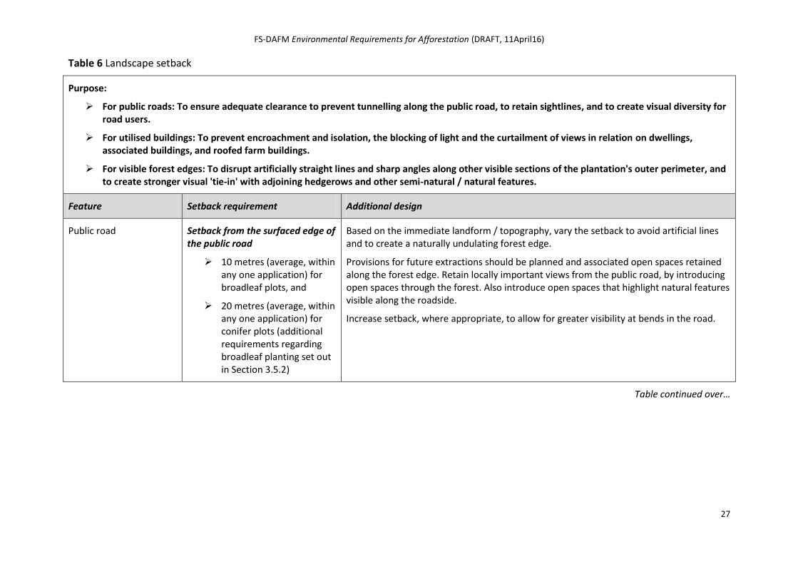
Table 6 Landscape setback
Purpose:
For public roads: To ensure adequate clearance to prevent tunnelling along the public road, to retain sightlines, and to create visual diversity for road users.
For utilised buildings: To prevent encroachment and isolation, the blocking of light and the curtailment of views in relation on dwellings, associated buildings, and roofed farm buildings.
For visible forest edges: To disrupt artificially straight lines and sharp angles along other visible sections of the plantation's outer perimeter, and to create stronger visual 'tie-in' with adjoining hedgerows and other semi-natural / natural features.
Feature Setback requirement Additional design
Public road Setback from the surfaced edge of the public road
10 metres (average, within any one application) for broadleaf plots, and
20 metres (average, within any one application) for conifer plots (additional requirements regarding broadleaf planting set out in Section 3.5.2)
Based on the immediate landform / topography, vary the setback to avoid artificial lines and to create a naturally undulating forest edge.
Provisions for future extractions should be planned and associated open spaces retained along the forest edge. Retain locally important views from the public road, by introducing open spaces through the forest. Also introduce open spaces that highlight natural features visible along the roadside.
Increase setback, where appropriate, to allow for greater visibility at bends in the road.
Table continued over…
FS-DAFM Environmental Requirements for Afforestation (DRAFT, 11April16)
28
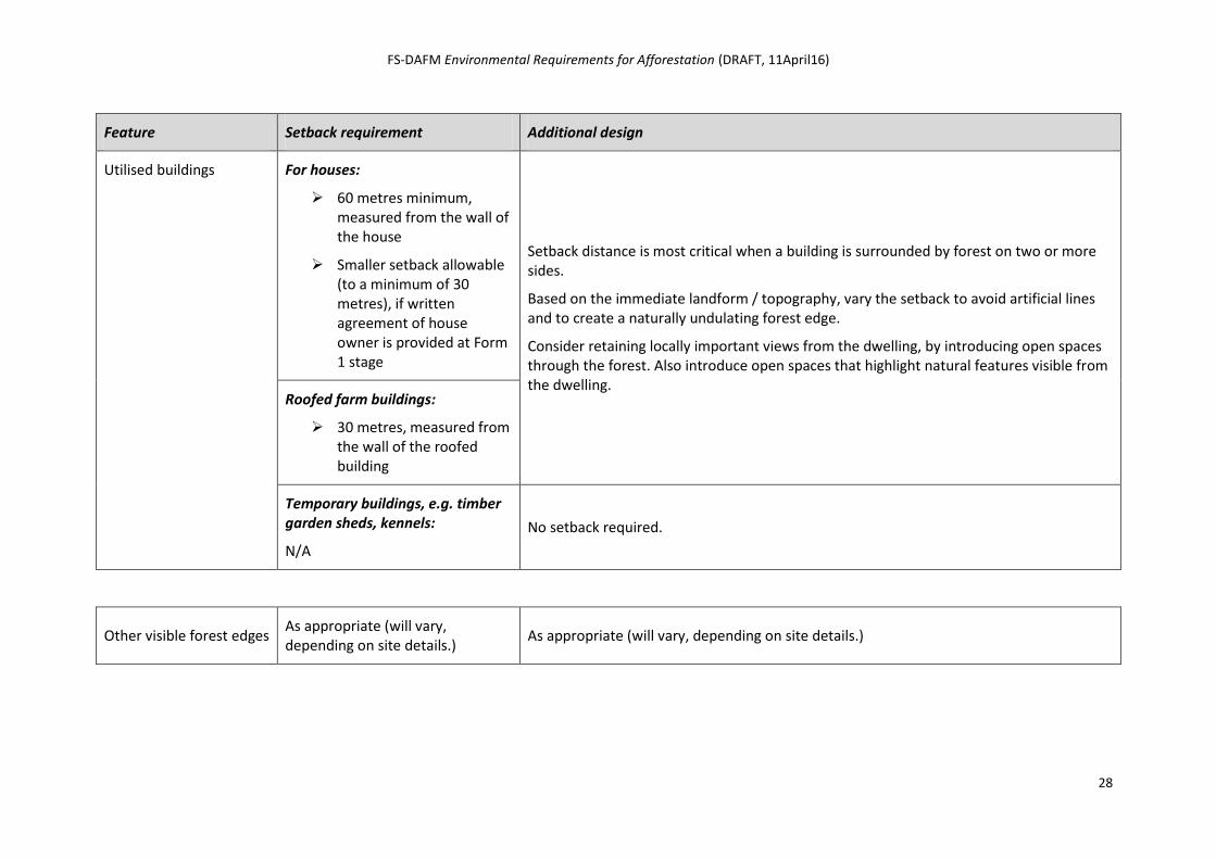
Feature Setback requirement Additional design
Utilised buildings For houses:
60 metres minimum, measured from the wall of the house
Smaller setback allowable (to a minimum of 30 metres), if written agreement of house owner is provided at Form 1 stage
Setback distance is most critical when a building is surrounded by forest on two or more sides.
Based on the immediate landform / topography, vary the setback to avoid artificial lines and to create a naturally undulating forest edge.
Consider retaining locally important views from the dwelling, by introducing open spaces through the forest. Also introduce open spaces that highlight natural features visible from the dwelling.
Roofed farm buildings:
30 metres, measured from the wall of the roofed building
Temporary buildings, e.g. timber garden sheds, kennels:
N/A
No setback required.
Other visible forest edges As appropriate (will vary, depending on site details.)
As appropriate (will vary, depending on site details.)
FS-DAFM Environmental Requirements for Afforestation (DRAFT, 06April16)
29
2.9 Site inputs At pre-application design stage, planned site inputs such as fertilisers and herbicide use should be tailored to the specific requirements of each plot within the project. The aim must be to achieve successful establishment with the minimal level of artificial inputs possible.
Regarding fertilisers, phosphorus (P) is the main nutrient fertiliser applied in afforestation, with nitrogen (N) and potassium (K) occasionally applied as remedial fertilisation. Note that peaty soils have a very low capacity to bind phosphorus. Slow-release formulations may be appropriate on more sensitive parts of the site. Detail the proposed fertiliser types and application rates in the afforestation application.
Regarding herbicides, refer to the Guidelines for the Use of Herbicides in Forestry and the Forest Protection Guidelines. Vegetation management in highly-sensitive parts of the site may need to rely on non-herbicide methods such as manual control, mats and mulches. Detail the proposed methods of vegetation control (including herbicide type and application rate, if applicable) in the afforestation application.
Note that further operational safeguards regarding fertiliser application and the use of herbicides is set out in Section 3.7.
2.10 Further environmental assessment Stage 1: Design culminates in the submission of a Form 1 for approval (with or without grant aid) to afforest under S.I. No. 558 of 2010 (as amended). This triggers the Forest Service assessment of the proposal, which includes an environmental assessment.
Certain situations may arise whereby the Forest Service, following assessment of the project, responses from referrals and consultation (*) and (as relevant) Appropriate Assessment screening and EIA screening, requires specific environmental information regarding the proposal, up to and including various specialised reports. In such cases, a request for Further Information will be sent to the Applicant and his / her Registered Forester. (* As
set out in the Forestry Standards Manual.)
For example, in a minority of cases, due to the environmental sensitivity of a site, the Forest Service may seek further information in the form of the following, before it can continue with its assessment of the application:
Ecological Report
Archaeological Assessment / Archaeological Impact Statement
Water Management Plan
Visual Impact Assessment
NATURA Impact Statement (NIS)
Environmental impact Statement (EIS)
See for Appendix 5 for further details.
FS-DAFM Environmental Requirements for Afforestation (DRAFT, 06April16)
30
Site Works
3.1 Overview This stage spans the period from the receipt by the Applicant of the Letter of Afforestation Approval (with or without grant aid) to the completion of initial site works and (where grant-aided) the submission of the Application for the 1st Instalment (i.e. Form 2).
The relevant environmental requirements for Stage 2: Site Works are set out below, and are in addition to the following:
the Forestry Standards Manual(*);
the terms and conditions of the Afforestation Scheme, as set out in the scheme document (and any revisions thereof);
any circulars amending the scheme requirements;
the Approval Letter (and where appropriate, remedial works notifications);
the Forest Protection Guidelines; and
(where relevant) species guidelines relating to the Kerry slug and otter, and the Forestry & Freshwater Pearl Mussel Requirements.
(* Including the Forest Service document Native Woodland Establishment GPC9 & GPC10: Silvicultural Standards.)
The Approval Letter may contain specific environmental or silvicultural conditions attached to the approval, and these conditions must be adhered to. If any uncertainty exists regarding the conditions, the Registered Forester must contact the Forest Service for clarity.
Note the following:
Site works can only commence after receipt of the Financial Approval for Afforestation (or the Technical Approval for Afforestation, for non-grant aided projects).
Registered Forester must secure the prior approval of the Forest Service (Approval Section) before pursing any material changes to the approved project, including operational changes.
Significant material changes which have not been approved in advance of works being carried out may invalidate any approval issued under S.I.558 of 2010 (as amended) and any eligibility for grant aid. See the Forestry Standards Manual for details.
3.2 Site management by Registered Forester It is primarily the responsibility of the Registered Forester, as the Applicant’s agent, to ensure that all operators onsite are made fully aware of, and properly implement, all relevant environmental safeguards, including relevant measures set out in these Environmental Requirements for Afforestation, and relevant conditions in the Approval Letter. This should be done via onsite management and supervision.
The Registered Forester must also supervise the work and monitor progress, through recorded site visits. In particular, onsite activities should be reviewed during or as soon as possible after heavy rainfall, to ensure that related safeguards are in place. and contingency planning is functioning.
FS-DAFM Environmental Requirements for Afforestation (DRAFT, 06April16)
31
3.3 Oversight by another specialist It may also be the case that the specific environmental conditions attached to the afforestation approval require that another specialist be present on site to ensure the proper implementation of certain aspects of those conditions.
For example, there may be a condition requiring archaeological monitoring of specified areas. Archaeological monitoring involves having a suitably qualified archaeologist present during the course of the carrying out of certain parts of approved development works so as to identify and protect archaeological deposits, features or objects which may be uncovered or otherwise affected by the works. In such cases:
an independent archaeological consultant must be retained by the Applicant or Registered Forester to carry out the monitoring;
as set out below in Section 3.8, the archaeologist will be empowered by the conditions to stop any works in the immediate area of any new discoveries inter alia so as to ensure the timely notification of the relevant authorities, the proper recording of any exposed archaeological material, and the preservation by record or preservation in-situ of the elements of the archaeological heritage, as appropriate;
there will a condition requiring the archaeological consultant to submit a full report on the results of the archaeological monitoring, including any discoveries made, and any subsequent archaeological work undertaken, to the Forest Service, the NMS, and the National Museum of Ireland; and
failure to ensure the archaeological monitoring is undertaken during the course of the carrying out of the specified parts of approved development or to submit the required report on this monitoring before or at latest at Form 2 stage may be deemed to be:
o a breach of the statutory approval for afforestation issued under S.I. No. 558 of 2010 (as amended), the potential consequences of which are detailed in Part 3 of the Regulations; and / or
o a breach of the specific environmental conditions attached to the approval for grant aid and may: (i) delay the progress of the Form 2 (Application for 1st Grant Instalment); and (ii) be subject to a penalty.
3.4 Contingency measures Various events can arise during the course of afforestation work, and proper contingency planning should be in place to minimise or eliminate any associated risk to the environment that might result. Such events include periods of intense rainfall, the accidental spillage of chemicals, the discovery of an unidentified archaeological site, monument, or object. These and other possible events must be planned for and operators clearly instructed as to how to react and who to contact.
Appendix 1 contains a template contingency sheet to be completed where relevant and made available onsite. It lists various possible events, the course of action operators are required to take should any arise. It should also list a local contact name and telephone number for relevant parties, to facilitate immediate notification.
All operators onsite should be made familiar with the document.
Photo of Reg. Forester marking out site pre-operations
FS-DAFM Environmental Requirements for Afforestation (DRAFT, 06April16)
32
3.5 Treatment of setbacks As set out in Stage 1: Pre-Application Design, various setbacks are required to protect different aspects of the environment. These include:
water setbacks, i.e. setbacks from aquatic zones, relevant watercourses and 'hotspots';
retained habitat setbacks, i.e. setbacks designed around retained habitats (including biodiversity plots, and linear or point biodiversity features);
archaeological setbacks, i.e. fenced-off exclusion zones for designated archaeological sites and monuments and designated buildings and structures or parts of structures which form part of the architectural heritage and which are of special interest, and setbacks from non-designated built heritage structures; and
Landscape setbacks, i.e. setbacks from public roads, utilised buildings and along other visible forest edges.
The actual setbacks required for each are set out in Table SETBACK. The treatment of these setbacks during Stage 2: Site Works is as follows.
3.5.1 Implementing setbacks
This section describes the marking out of environmental setbacks, prior to the commencement of other operations on site. In all cases, the Registered Forester must ensure that all operators onsite are aware of the importance of environmental setbacks and their extent on the site, and are clear regarding what is and what is not permitted to take place within these setbacks, as per Section 2.8. Under the Forestry Schemes Penalty Schedules, failure to adhere to the required environmental setbacks can incur significant penalties.
For designated’ archaeological sites and monuments and ‘designated’ buildings and structures or parts of structures which form part of the architectural heritage and which are of special interest, the following applies:
Unless the conditions attached to approval specify otherwise, erect a permanent fence comprising two strands of straight wire on the outer edge of the archaeological / built heritage exclusion zone. Adhere to the standard Forest Service fencing specifications, including the use of IS 436 stakes (see the Forestry Standards Manual). Note, where the outer edge of an archaeological monument / built heritage structure or feature is not evident on-the-ground, the advice of the Forest Service Archaeologist / consultant archaeologist retained by the Applicant or her / his Registered Forester should be sought.`
Existing access routes to an archaeological site must be left unplanted and undisturbed, and must be left open for pedestrian access throughout the rotation. If there is no existing access route, leave an unplanted 4 metre wide route suitable for pedestrian access from the direction of the nearest public road, forest road or track.
For all other setbacks (including setbacks for undesignated built heritage structures), the following applies:
It is good forest practice to mark out other environmental setbacks prior to operations commencing, to avoid incursions. As stated above, failure to adhere to the required setbacks can incur significant penalties. Where marking out, the following provides guidance:
o Mark off the required setback using temporary markers. These may comprise posts or bamboos with hi-vis tape attached, driven into the ground every 10 to 30 metres (depending on the scale and degree of undulation of the setback involved), with approximately 1.5 metres remaining visible above ground.
o When marking out setbacks, ensure that any required variations in width are represented.
FS-DAFM Environmental Requirements for Afforestation (DRAFT, 06April16)
33
o With additional markers, indicate, where required, the location for the planting of small groups of broadleaves and / or diverse conifers planned within the setback and along the forest edge.
o The centre line of any linear open spaces (e.g. a planned rideline or route of a future forest road, or an archaeological sight line) should be marked off using temporary markers.
o Once planting has been carried out, remove offsite all temporary markers.
3.5.2 Subsequent treatment
A key requirement is that the intended environmental function of these setbacks is maintained throughout the Stage 2: Site Works.
Forest edge treatment
The inclusion of single, small groups and irregular belts of broadleaves (preferable native species such as birch, rowan and oak) within the forest edge adjoining setbacks will enhance the visual appeal and biodiversity value of the forest edge. In relation to archaeological setbacks, this measure may also enhance the visual setting and context of the feature involved.
This measure is mandatory for dwelling setbacks and for setbacks for public roadside conifer crops (where the strip 10 metres to 20 metres from the road must be planted with broadleaves or groups of broadleaves). It may also be required for other landscape setbacks. The application of this measure is also encouraged within all other setbacks, to enhance the visual and biodiversity value of the forest edge.
Where applied, such planting must be included within the forest edge, and should not encroach into the setback itself, in order to maintain the necessary setback distance.
Exclusion of forest operations
A setback must not be used for any forest operation or any other purpose which could compromise its protective function or which could damage the environmental feature or attribute being protected. As a general rule, exclude all afforestation operations (including cultivation, drainage, fencing, planting, fertiliser and herbicide application, and the on-site storage of fertilisers, fuel and chemicals).
Exclude machine traffic from water setbacks and habitat setbacks. Limited machine passage may be permissible only if unavoidable, using appropriate safeguards and with the prior agreement of the Forest Service.
Machine traffic is not permitted within fenced-off archaeological exclusion zones.
Tree planting within setbacks
Over time, species (native and otherwise) of trees and scrubs will colonise the setbacks, as part of natural habitat development. However, in relation to 20 metre wide setback for conifer plots adjoining public roads, the planting of broadleaves within the strip 10 metres to 20 metres from the public road, is
FS-DAFM Environmental Requirements for Afforestation (DRAFT, 06April16)
34
mandatory, either as a solid belt or as groups to give a minimum two-thirds coverage within the 10 metre wide strip.
The planting of single, small groups and irregular belts of broadleaves (preferable native species) may also be stipulated within other landscape setbacks, including those for dwellings and those positioned along highly visible edges of plantations, to add further interest at the very outset to the forest edge, and greater integration between the forest and the open spaces within the setback.
Planting within water setbacks may also be appropriate, within the following context:
On most sites, the native scrub is likely to emerge within the water setback, through natural regeneration. However, on some sites, and with the agreement of Inland Fisheries Ireland and NPWS (if relevant), it may be appropriate to plant single or small groups (5-10 trees) of native riparian species (birch, willow, and occasional alder, oak) at strategic points within the water setback, to enhance the protective role of the setback (e.g. stabilise bank, food drop, shading / cooling). Such trees should be pit-planted and protected from grazing, as necessary. Fertiliser use is limited to the manual application of an appropriate slow-release formulation into the planting pit, to aid establishment, and the use of herbicides is prohibited. Willow cuttings can also be used - see the Forest Service document Native Woodland Establishment GPC9 & GPC10: Silvicultural Standards for details.)
3.6 Treatment of non-setback related open spaces As outlined in Section 2.5.1, open spaces include setbacks introduced for water, archaeology and landscape and areas left unplanted for future management purposes (e.g. ridelines, future forest roads, deer lawns). The treatment of environmental setbacks during Stage 2: Site Works is set out above. Regarding the treatment on non-setback related open spaces, the following applies in order to enhance their biodiversity value, both as open habitat and through the development of the 'edge effect' between the forest canopy and the open space.
Apply temporary marking out, as per Section 3.5.1. Based on the immediate landform / topography, vary the width to avoid artificial lines and to create a naturally undulating forest edge.
Consider adding visual interest and biodiversity value to the forest edge by including individual, small groups or an irregular belt of native species (e.g. birch, rowan, oak, Scots pine).
3.7 Operational safeguards Various mandatory measures designed to protect the environment during key afforestation operations are set out below. Approval conditions may also contain additional measures to be adhered to. Also note Section 3.1 regarding material changes during site works and Section 3.4 regarding contingency planning.
Photos of good operational practice ref. cultivation / drainage, fertiliser application, herbicide application, storage, etc.
FS-DAFM Environmental Requirements for Afforestation (DRAFT, 06April16)
35
3.7.1 Drainage and cultivation
A key consideration regarding drainage and cultivation is to protect any receiving waters from silt, sediment and nutrients contained in water draining off the site.
Adhere to Forest Service requirements regarding drainage, drain types and sediment control, as set out in the Forestry Standards Manual. Addition good practice is set out in the Forest Road Manual and Forest Drainage Engineering: A Design Manual.
Carefully plan according to specific site conditions, limiting drainage and cultivation to what is needed to successfully establish and grow the forest. Avoid more intensive options where unnecessary. In sensitive areas, inverted mounding combined with manual planting should be considered. Select less intensive options where site conditions allow, e.g. apply inverted mounding, ripping or pit planting instead of standard mounding and mound drains, if site conditions allow.
Adhere to the overall drainage and cultivation plan approved for the project.
Select machinery suitable for the site (in relation to, for example, soil, drainage and slope), so as not to create danger of excessive trafficking and rutting.
In relation to water setbacks established for any aquatic zone, relevant watercourse or hotspot (see Section 2.8):
o Ensure that all drains installed onsite as part of the afforestation project terminate in a silt trap outside the water setback, and do not enter into or traverse the water setback itself. This will allow discharged water to seeps out over the water setback, with any nutrients and sediment filtered out from the flow by ground vegetation within the setback before entry into the receiving water.
o Do not carry out any drainage or cultivation within the water setback. Drains must not discharge directly into the aquatic zone or relevant watercourse, or enter into the water setback (*).
(* An exception is flat difficult-to-drain sites where it may be necessary to connect drains directly into the aquatic zone, provided it can be assured that sediment and soluble pollutants will not enter the aquatic zone at establishment and throughout the rotation to clearfell stage. There should be no erosion risk on these at sites or, if there is, sediment control measures must negate the risk. Note, no connection is permitted where the Forestry & FPM Requirements or within the Priority 8 FPM Catchments, and this may render some sites non-viable, unplantable and not eligible for grant aid.)
Do not carry out any drainage or cultivation within any other environmental setback.
Where there is any risk to water quality, cease for an appropriate period, all drainage or cultivation works onsite if heavy rainfall is predicted, during heavy rainfall or following a period of prolonged heavy rainfall.
Collector drains that collect water from mound drains, plough furrows, mole drains, etc, should not be greater than 80 metres apart and should run at acute angles to the contour, to minimise flow velocity. These acute angles should be no greater than 2 degrees (1-in-30) on slopes greater than 3 degrees (1-in-20). They should be excavated to a depth not greater than 10-15 cm below the depth of mound drains. Where collector drains have to be extended into erodible material, ‘mini’ silt traps should be placed appropriately by deepening the drains in places. Collector drains should discharge via sediment traps and / or an interceptor drain (*) into the aquatic buffer zone.
(* Interceptor drains are constructed along the outer edges of aquatic buffer zones. They collect the discharge from the drained area and allow it to overflow into the aquatic buffer zone.)
Main drains to take the discharge from collector drains must be provided with waterdrops and rock armour where there are steep gradients, and must not run at right angles to the contour.
Silt traps must be used as part of the drainage network, with the number increasing based on erosion risk. Silt traps must be located in adequate numbers throughout the drainage network, so as to collect silt / sediment as close to the source as possible. Silt traps are also required at the end of the drainage channels to the outside of the water setback. Silt traps must have no direct outflow into the aquatic zone. A combination of multiple silt traps is often more effective at trapping a range of sediment particle sizes
FS-DAFM Environmental Requirements for Afforestation (DRAFT, 06April16)
36
than single isolated traps. Silt traps should be of such number, design and size that they are sufficient for the full rotation. If they prove inadequate and full with sediment, additional traps should be created or the existing ones maintained so that there is no risk of sediment reaching the aquatic zone. They should be located on level ground (where possible) and should be maintained – silt traps can fill within days on highly erodible sites. Silt traps should be rectangular, with the longer side parallel to the feeder drain. Silt traps can be a site hazard and both safety and access for maintenance must be considered. Fence off silt traps as deemed necessary.
Small dams (e.g. timber or stone, geotexiles, terram) have been used with success to slow water flow and to encourage the dropping of sediment. Physical barrier dams should have a ‘V’-notch in the centre of the dam, to control the overflow of water and to prevent the erosion and scouring out of the sides of the channel during flood events.
Regarding existing land drains onsite, the following applies:
o Evaluate the appropriateness of linking in with the drainage system developed for afforestation. It is not appropriate to link in with existing land drains that carry significant water (or have the potential to, in high rainfall), or drains that traverse the water setback.
o Where being linked in with, drain cleaning may be required. Existing drains may be 'greened over' to varying degrees, and this vegetation plays an important role in filtering out sediments and nutrients. Consider not cleaning out the entire length of an existing drain in one operation. The cleaning-out of existing drains can instead be staggered over several years, in sections.
Additional safeguards include the following:
It may be necessary to install large settling ponds into which site drains flow. These settling ponds must be appropriately sized (i.e. sufficient to contain flow from high rainfall events) and strategically located within the main body of the plantation, away from adjoining watercourses, and properly maintained.
Increase species diversity in areas adjoining water setbacks, such as the planting of native broadleaves, where site conditions allow. Note the requirement for GPC9 and / or GPC10 plots along water setbacks in within water sensitive areas – see Section 2.4.1.
Consider future management from the outset, and ways in which future risks to water can be avoided or minimised, e.g.
o consider future operations (e.g. extraction routes) – the drainage system must be designed so as to avoid future impacts on water at roading, thinning and clearfell / reforestation;
o install ridelines to facilitate the development of windfirm edges within the forest – this will enable the future harvesting of smaller coupe sizes over staggered periods of time; and
o plan for forest roading and timber extraction routes that minimise site impact and the potential for rutting and sedimentation.
3.7.2 Fertiliser application
A key consideration regarding fertiliser application during site works is to eliminate the risk of run-off of nutrients into receiving waters. The following apply:
Match fertiliser use, type and rate to specific plots, based on site conditions – the aim must be to achieve successful establishment with the minimal level of fertiliser input possible.
Granular fertiliser formulations should be used to reduce the likelihood of drift and wash-off to receiving waters. (With the exception of muriate of potash, which is not available in granular form.)
FS-DAFM Environmental Requirements for Afforestation (DRAFT, 06April16)
37
Regarding aquatic zones (stream, river, lake), do not apply fertiliser within 20 metres of the aquatic zone or within the associated water setback, whichever is greatest. Manual fertiliser application only is permitted from this point to 50 metres from the aquatic zone.
In general (and in keeping with the above), ensure that no fertiliser is applied within the water setback or any other environmental setback, as per Section 2.8. However, where individual and small groups of trees are being planted within water setbacks (as per Section 3.5.2), fertiliser use (if required) is limited to the manual application of an appropriate slow-release formulation into the planting pit, to aid establishment.
Do not apply fertiliser onsite if heavy rainfall is predicted, during heavy rainfall and / or high winds, or following a period of prolonged heavy rainfall.
Apply fertiliser manually, where possible.
Consider using alternative slow-release fertilisers in more sensitive parts of the site.
3.7.3 Vegetation management
Herbicide application will typically form the main component of vegetation management onsite. A key consideration during site works is to eliminate the risk of run-off of herbicide into receiving waters. The following apply:
The aim must be to achieve successful establishment with the minimal level of herbicide input possible.
Any chemical to be used in forestry must be on the up-to-date approved Pesticide Control Service list (www.pcs.agriculture.gov.ie or Pesticide Control Service, Department of Agriculture, Food & the Marine.
Do not apply herbicide onsite if heavy rainfall is predicted, during heavy rainfall and / or high winds, or following a period of prolonged heavy rainfall.
Fully adhere to the manufacturer’s instructions and use in accordance with the Forest Service Forest Protection Guidelines and the Guidelines for the Use of Herbicides in Forestry.
Regarding aquatic zones (stream, river, lake), do not apply herbicide within 20 metres of the aquatic zone or within the associated water setback, whichever is greatest (*). Rely instead on non-herbicide methods such as trampling, mulches and mats. (* Limited exceptions may exist, where agreed with the relevant statutory bodies,
e.g. the stem injection of herbicide to kill streamside rhododendron, to tackle infestation and to reinstate natural ground vegetation.)
Where individual and small groups of trees are being planted within water setbacks and dwelling setbacks (as per Section 3.5.2), associated vegetation management must be carried out using non-herbicide methods such as trampling, mulches and mats.
3.7.4 Note on pesticide use
Pesticides are generally not used during afforestation. However, situations may arise prompting their use. The above requirements regarding herbicides apply at a minimum, and more stringent measures may also be required. Regarding the risk of Pine Weevil outbreak (e.g. an afforestation site adjoining recent conifer clearfell), any necessary dipping of planting stock must be carried out offsite in the forest nursery, with onsite application permitted only in response to an ongoing outbreak. Alternative control measures are encouraged, e.g. the use of larger planting stock.
FS-DAFM Environmental Requirements for Afforestation (DRAFT, 06April16)
38
3.7.5 Preparation, storage and use of potentially hazardous material
Accidental spillage or leakage of fertilisers, chemicals (including herbicides and pesticides), fuel and machine oils (hydraulic, engine, gearbox oils, lubricants) can be highly toxic to the natural environment, in particular, water quality and aquatic habitats and species.
The following requirements apply:
Minimise the onsite storage and preparation of these materials.
If unavoidable, store and prepare (if relevant) all fertilisers, chemicals, fuel and machine oils at a dry, elevated location onsite at least 50 metres from the nearest aquatic zone and at least 20 m from the nearest relevant watercourse.
Similarly, undertake all machine refuelling, maintenance and repair at a dry, elevated location onsite at least 50 metres from the nearest aquatic zone and at least 20 m from the nearest relevant watercourse.
Never discharge fertilisers, chemicals, fuel or machine oils into an aquatic zone, relevant watercourse, hotspot, or into any drain or sediment trap created during the site works.
Never rinse out fertiliser, chemical, fuel or oil containers onsite.
Do not clean equipment within 50 metres of an aquatic zone, or within 20 metres of a relevant watercourse or hotspot. All wash waters must be disposed of carefully.
Where possible, biodegradable oil should be used as a substitute for mineral oil.
Collect and retain spent machine oil for appropriate disposal off-site.
Remove all empty fertiliser bags, chemical and oil containers, and all general refuse, from the site during and after site works, and dispose of appropriately off-site.
Adhere to relevant sections of Guidelines for the Use of Herbicides in Forestry and the Forest Protection Guidelines.
3.8 Archaeological finds discovered during site works Previously unidentified archaeological sites or artefacts may also be exposed during the course of site work, particularly during site cultivation and drainage. These include artefact scatters, objects such as pottery, flint and other stone artefacts, bronze or iron tools, quern stones, as well as burials, and structural features such as the foundations of buried structures or trackways. For example, the presence of a spread of black soil or charcoal and burnt and heat-shattered stone is likely to indicate the presence of a levelled cooking place (i.e. a fulacht fiadh) or other human activity in the past.
If an archaeological find is discovered, the following applies:
The Garda Síochána, the National Museum of Ireland or the National Monuments Service must be notified immediately.
The archaeological object(s) or feature(s) must be left undisturbed and a minimum exclusion zone 20 metres in radius centred on its location, and preferably larger, must be immediately created until the site of the find has been investigated.
Where an archaeological object is discovered, other than by a qualified archaeologist operating under an excavation licence issued by the NMS, it must be reported in the same way as described in the Section 2.6.
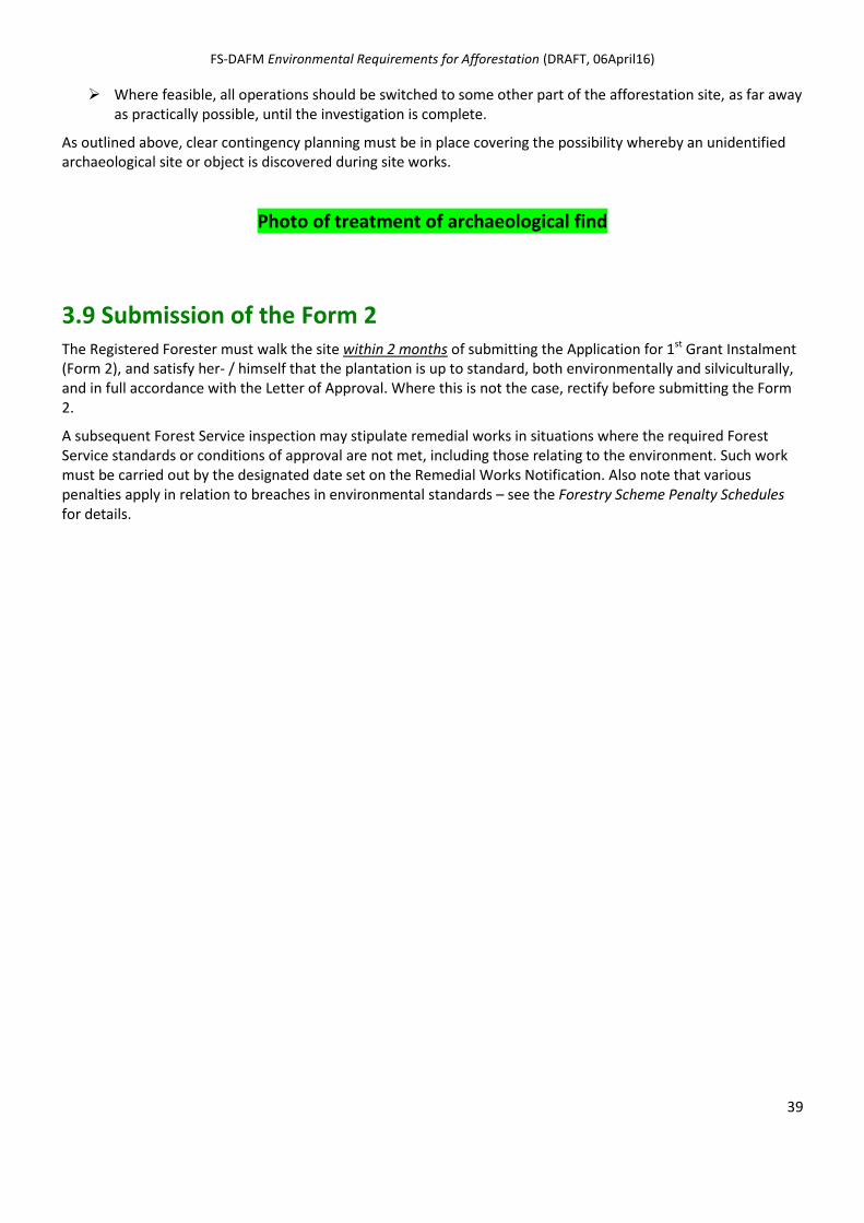
FS-DAFM Environmental Requirements for Afforestation (DRAFT, 06April16)
39
Where feasible, all operations should be switched to some other part of the afforestation site, as far away as practically possible, until the investigation is complete.
As outlined above, clear contingency planning must be in place covering the possibility whereby an unidentified archaeological site or object is discovered during site works.
Photo of treatment of archaeological find
3.9 Submission of the Form 2 The Registered Forester must walk the site within 2 months of submitting the Application for 1st Grant Instalment (Form 2), and satisfy her- / himself that the plantation is up to standard, both environmentally and silviculturally, and in full accordance with the Letter of Approval. Where this is not the case, rectify before submitting the Form 2.
A subsequent Forest Service inspection may stipulate remedial works in situations where the required Forest Service standards or conditions of approval are not met, including those relating to the environment. Such work must be carried out by the designated date set on the Remedial Works Notification. Also note that various penalties apply in relation to breaches in environmental standards – see the Forestry Scheme Penalty Schedules for details.
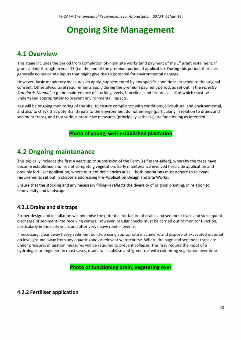
FS-DAFM Environmental Requirements for Afforestation (DRAFT, 06April16)
40
Ongoing Site Management
4.1 Overview This stage includes the period from completion of initial site works (and payment of the 1st grant instalment, if grant-aided) through to year 15 (i.e. the end of the premium period, if applicable). During this period, there are generally no major site inputs that might give rise to potential for environmental damage.
However, basic mandatory measures do apply, supplemented by any specific conditions attached to the original consent. Other silvicultural requirements apply during the premium payment period, as set out in the Forestry Standards Manual, e.g. the maintenance of stocking levels, fencelines and firebreaks, all of which must be undertaken appropriately to prevent environmental impacts.
Key will be ongoing monitoring of the site, to ensure compliance with conditions, silvicultural and environmental, and also to check that potential threats to the environment do not emerge (particularly in relation to drains and sediment traps), and that various protective measures (principally setbacks) are functioning as intended.
Photo of young, well-established plantation
4.2 Ongoing maintenance This typically includes the first 4 years up to submission of the Form 3 (if grant-aided), whereby the trees have become established and free of competing vegetation. Early maintenance involved herbicide application and possibly fertiliser application, where nutrient deficiencies arise – both operations must adhere to relevant requirements set out in chapters addressing Pre-Application Design and Site Works.
Ensure that the stocking and any necessary filling-in reflects the diversity of original planting, in relation to biodiversity and landscape.
4.2.1 Drains and silt traps
Proper design and installation will minimise the potential for failure of drains and sediment traps and subsequent discharge of sediment into receiving waters. However, regular checks must be carried out to monitor function, particularly in the early years and after very heavy rainfall events.
If necessary, clear away heavy sediment build-up using appropriate machinery, and dispose of excavated material on level ground away from any aquatic zone or relevant watercourse. Where drainage and sediment traps are under pressure, mitigation measures will be required to prevent collapse. This may require the input of a hydrologist or engineer. In most cases, drains will stabilise and ‘green-up’ with colonising vegetation over time.
Photo of functioning drain, vegetating over
4.2.2 Fertiliser application
FS-DAFM Environmental Requirements for Afforestation (DRAFT, 06April16)
41
In the case of poorly performing areas, it may be necessary to counter nutrient deficiencies during this stage of the forest’s development. Assess exact requirements via foliage analysis, following the procedures set out in Forestry Standards Manual. Apply fertiliser manually, adhering to all mandatory requirements set out in those chapters addressing Pre-Application Design and Site Works, particularly in relation to the protection of water.
Over larger areas, aerial fertilisation may be required. Under the European Communities (Aerial Fertilisation) (Forestry) Regulations 2012 (S.I. No.125 of 2012), no aerial fertilisation can be undertaken unless an Aerial Fertilisation Licence as been obtained from the Forest Service. Refer to the separate Aerial Fertilisation Requirements (June 2015) for details.
4.3 Treatment of setbacks As set out in Stage 1: Planning and Stage 2: Site Works, various setbacks are created to protect different aspects of the environment. These include:
water setbacks, i.e. setbacks from aquatic zones, relevant watercourses and 'hotspots';
retained habitat setbacks, i.e. setbacks designed around retained habitats (including biodiversity plots, and linear or point biodiversity features);
archaeological setbacks, i.e. fenced-off exclusion zones for designated archaeological sites and monuments and designated buildings and structures or parts of structures which form part of the architectural heritage and which are of special interest, and setbacks from non-designated built heritage structures; and
Landscape setbacks, i.e. setbacks from public roads, utilised buildings and along other visible forest edges.
The treatment of these setbacks during Stage 3 is as follows:
A key requirement is that the intended environmental function of these setbacks is maintained throughout this stage of the forest's development.
Continue to exclude all forestry operations and allow the natural ground vegetation to develop undisturbed.
Monitor the growth and development of native trees planted along the forest edge and within the setbacks themselves (where undertaken) and maintain as appropriate (e.g. apply appropriate vegetation management (*), replace mortalities, adjust and eventually remove tree shelters).
(* Non-herbicide methods only to be used for trees planted within setbacks, e.g. trampling, mulch, mats.)
The type of natural vegetation emerging within the various setback will vary according to soil, elevation, aspect and grazing pressure. However, on most sites, a mosaic of natural ground vegetation and pockets of woody scrub will typically emerge throughout this stage.
Monitor and apply appropriate control to prevent the colonisation of setbacks by rhododendron and laurel, based on the agreement of relevant bodies. (This also applies to paths required in relation to fenced-off exclusion zones for ‘designated’ archaeological sites and monuments and ‘designated’ buildings and structures, to maintain pedestrian access.)
Note, the above also applies to the treatment during ongoing site management, of non-setback related open spaces, as described in Section 3.6.

FS-DAFM Environmental Requirements for Afforestation (DRAFT, 06April16)
42
Photo of good examples of setback, at this stage of plantation development

FS-DAFM Environmental Requirements for Afforestation (DRAFT, 06April16)
43
Appendices
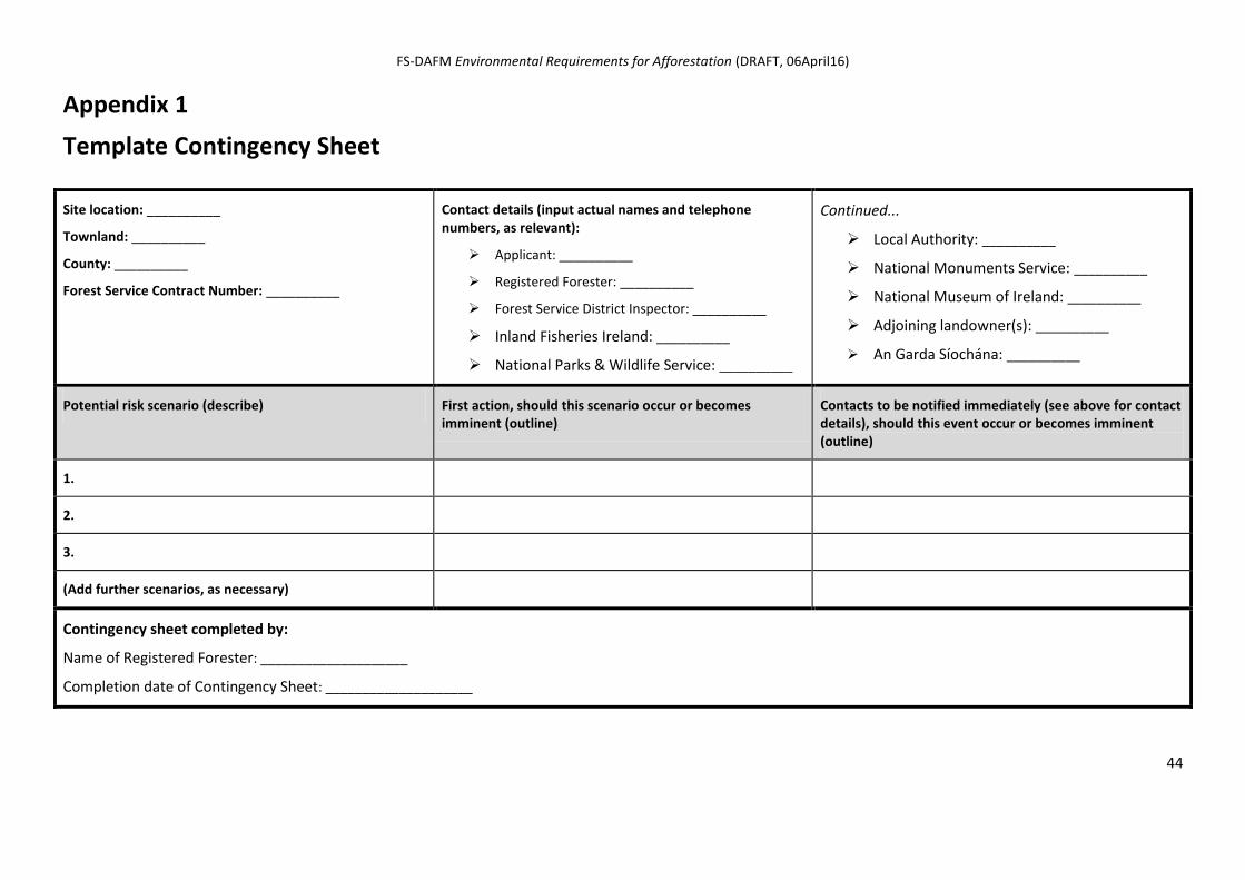
FS-DAFM Environmental Requirements for Afforestation (DRAFT, 06April16)
44
Appendix 1
Template Contingency Sheet
Site location: __________
Townland: __________
County: __________
Forest Service Contract Number: __________
Contact details (input actual names and telephone numbers, as relevant):
Applicant: __________
Registered Forester: __________
Forest Service District Inspector: __________
Inland Fisheries Ireland: __________
National Parks & Wildlife Service: __________
Continued...
Local Authority: __________
National Monuments Service: __________
National Museum of Ireland: __________
Adjoining landowner(s): __________
An Garda Síochána: __________
Potential risk scenario (describe) First action, should this scenario occur or becomes imminent (outline)
Contacts to be notified immediately (see above for contact details), should this event occur or becomes imminent (outline)
1.
2.
3.
(Add further scenarios, as necessary)
Contingency sheet completed by:
Name of Registered Forester: ____________________
Completion date of Contingency Sheet: ____________________
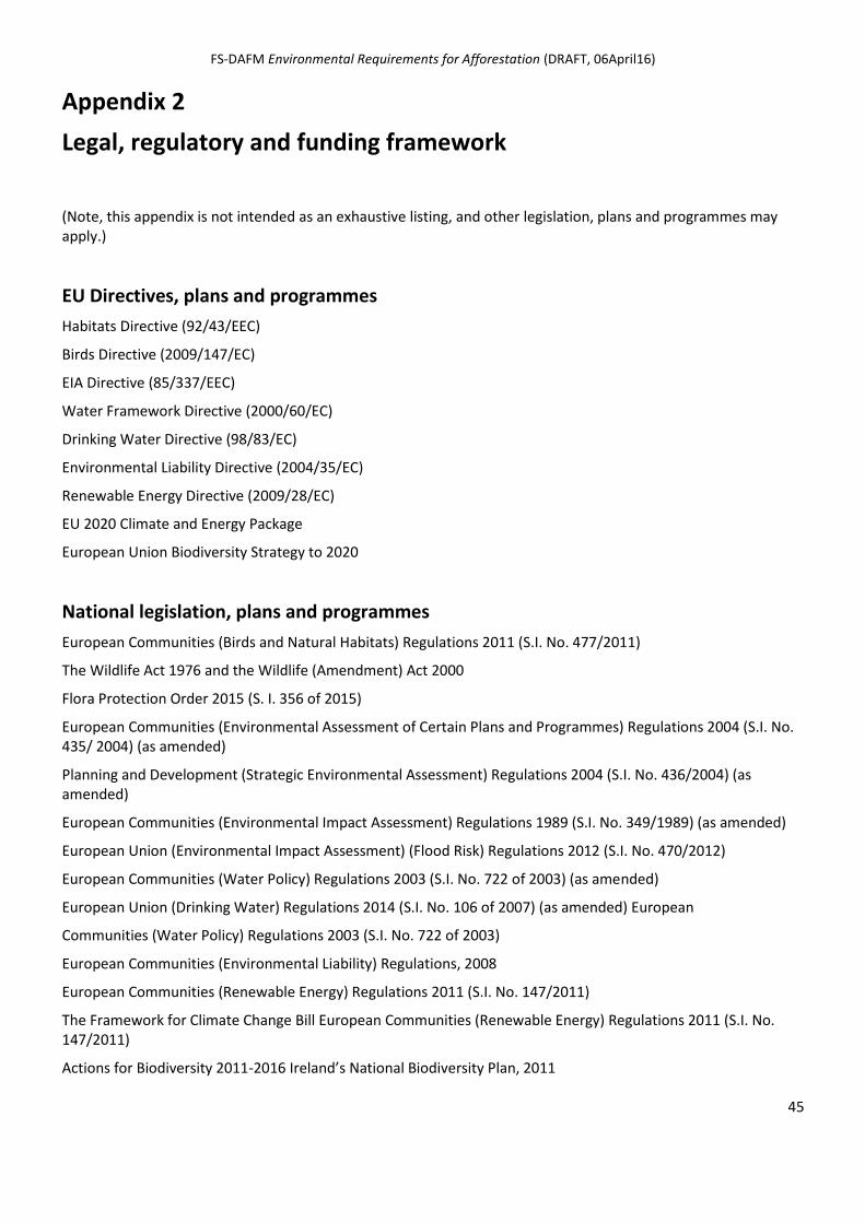
FS-DAFM Environmental Requirements for Afforestation (DRAFT, 06April16)
45
Appendix 2
Legal, regulatory and funding framework
(Note, this appendix is not intended as an exhaustive listing, and other legislation, plans and programmes may apply.)
EU Directives, plans and programmes
Habitats Directive (92/43/EEC)
Birds Directive (2009/147/EC)
EIA Directive (85/337/EEC)
Water Framework Directive (2000/60/EC)
Drinking Water Directive (98/83/EC)
Environmental Liability Directive (2004/35/EC)
Renewable Energy Directive (2009/28/EC)
EU 2020 Climate and Energy Package
European Union Biodiversity Strategy to 2020
National legislation, plans and programmes
European Communities (Birds and Natural Habitats) Regulations 2011 (S.I. No. 477/2011)
The Wildlife Act 1976 and the Wildlife (Amendment) Act 2000
Flora Protection Order 2015 (S. I. 356 of 2015)
European Communities (Environmental Assessment of Certain Plans and Programmes) Regulations 2004 (S.I. No. 435/ 2004) (as amended)
Planning and Development (Strategic Environmental Assessment) Regulations 2004 (S.I. No. 436/2004) (as amended)
European Communities (Environmental Impact Assessment) Regulations 1989 (S.I. No. 349/1989) (as amended)
European Union (Environmental Impact Assessment) (Flood Risk) Regulations 2012 (S.I. No. 470/2012)
European Communities (Water Policy) Regulations 2003 (S.I. No. 722 of 2003) (as amended)
European Union (Drinking Water) Regulations 2014 (S.I. No. 106 of 2007) (as amended) European
Communities (Water Policy) Regulations 2003 (S.I. No. 722 of 2003)
European Communities (Environmental Liability) Regulations, 2008
European Communities (Renewable Energy) Regulations 2011 (S.I. No. 147/2011)
The Framework for Climate Change Bill European Communities (Renewable Energy) Regulations 2011 (S.I. No. 147/2011)
Actions for Biodiversity 2011-2016 Ireland’s National Biodiversity Plan, 2011
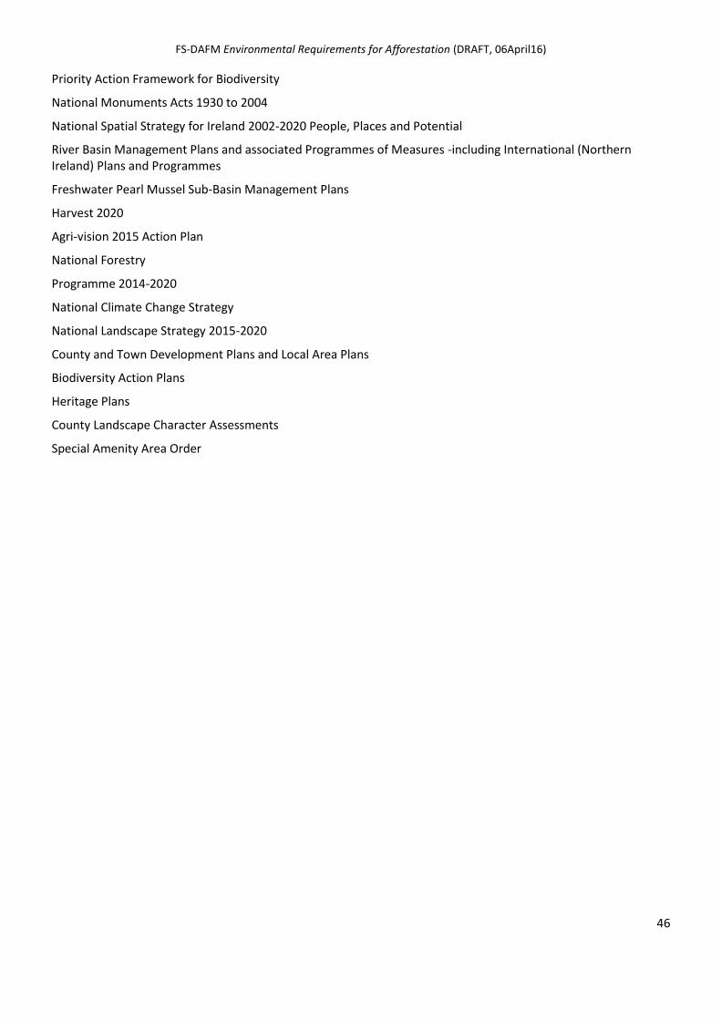
FS-DAFM Environmental Requirements for Afforestation (DRAFT, 06April16)
46
Priority Action Framework for Biodiversity
National Monuments Acts 1930 to 2004
National Spatial Strategy for Ireland 2002-2020 People, Places and Potential
River Basin Management Plans and associated Programmes of Measures -including International (Northern Ireland) Plans and Programmes
Freshwater Pearl Mussel Sub-Basin Management Plans
Harvest 2020
Agri-vision 2015 Action Plan
National Forestry
Programme 2014-2020
National Climate Change Strategy
National Landscape Strategy 2015-2020
County and Town Development Plans and Local Area Plans
Biodiversity Action Plans
Heritage Plans
County Landscape Character Assessments
Special Amenity Area Order
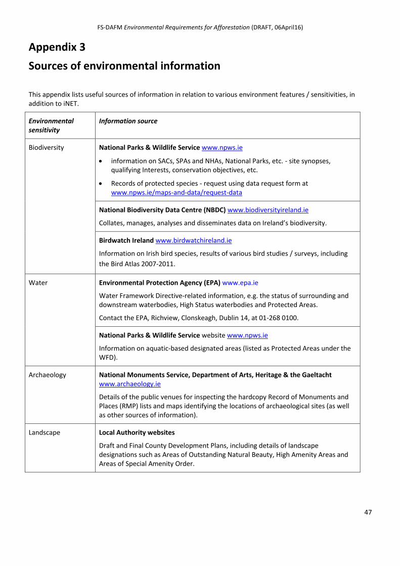
FS-DAFM Environmental Requirements for Afforestation (DRAFT, 06April16)
47
Appendix 3
Sources of environmental information
This appendix lists useful sources of information in relation to various environment features / sensitivities, in addition to iNET.
Environmental sensitivity
Information source
Biodiversity National Parks & Wildlife Service www.npws.ie
information on SACs, SPAs and NHAs, National Parks, etc. - site synopses, qualifying Interests, conservation objectives, etc.
Records of protected species - request using data request form at www.npws.ie/maps-and-data/request-data
National Biodiversity Data Centre (NBDC) www.biodiversityireland.ie
Collates, manages, analyses and disseminates data on Ireland’s biodiversity.
Birdwatch Ireland www.birdwatchireland.ie
Information on Irish bird species, results of various bird studies / surveys, including
the Bird Atlas 2007-2011.
Water Environmental Protection Agency (EPA) www.epa.ie
Water Framework Directive-related information, e.g. the status of surrounding and downstream waterbodies, High Status waterbodies and Protected Areas.
Contact the EPA, Richview, Clonskeagh, Dublin 14, at 01-268 0100.
National Parks & Wildlife Service website www.npws.ie
Information on aquatic-based designated areas (listed as Protected Areas under the WFD).
Archaeology National Monuments Service, Department of Arts, Heritage & the Gaeltacht www.archaeology.ie
Details of the public venues for inspecting the hardcopy Record of Monuments and Places (RMP) lists and maps identifying the locations of archaeological sites (as well as other sources of information).
Landscape Local Authority websites
Draft and Final County Development Plans, including details of landscape designations such as Areas of Outstanding Natural Beauty, High Amenity Areas and Areas of Special Amenity Order.
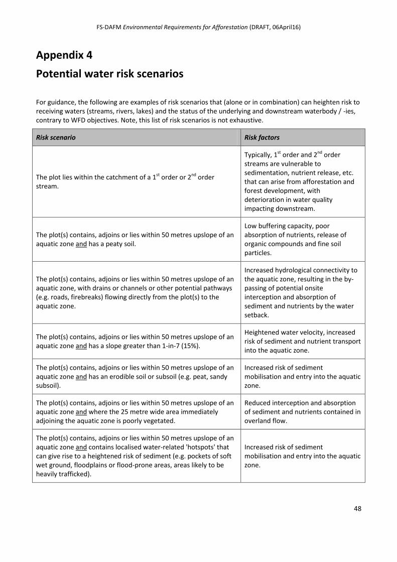
FS-DAFM Environmental Requirements for Afforestation (DRAFT, 06April16)
48
Appendix 4
Potential water risk scenarios
For guidance, the following are examples of risk scenarios that (alone or in combination) can heighten risk to receiving waters (streams, rivers, lakes) and the status of the underlying and downstream waterbody / -ies, contrary to WFD objectives. Note, this list of risk scenarios is not exhaustive.
Risk scenario Risk factors
The plot lies within the catchment of a 1st order or 2nd order stream.
Typically, 1st order and 2nd order streams are vulnerable to sedimentation, nutrient release, etc. that can arise from afforestation and forest development, with deterioration in water quality impacting downstream.
The plot(s) contains, adjoins or lies within 50 metres upslope of an aquatic zone and has a peaty soil.
Low buffering capacity, poor absorption of nutrients, release of organic compounds and fine soil particles.
The plot(s) contains, adjoins or lies within 50 metres upslope of an aquatic zone, with drains or channels or other potential pathways (e.g. roads, firebreaks) flowing directly from the plot(s) to the aquatic zone.
Increased hydrological connectivity to the aquatic zone, resulting in the by-passing of potential onsite interception and absorption of sediment and nutrients by the water setback.
The plot(s) contains, adjoins or lies within 50 metres upslope of an aquatic zone and has a slope greater than 1-in-7 (15%).
Heightened water velocity, increased risk of sediment and nutrient transport into the aquatic zone.
The plot(s) contains, adjoins or lies within 50 metres upslope of an aquatic zone and has an erodible soil or subsoil (e.g. peat, sandy subsoil).
Increased risk of sediment mobilisation and entry into the aquatic zone.
The plot(s) contains, adjoins or lies within 50 metres upslope of an aquatic zone and where the 25 metre wide area immediately adjoining the aquatic zone is poorly vegetated.
Reduced interception and absorption of sediment and nutrients contained in overland flow.
The plot(s) contains, adjoins or lies within 50 metres upslope of an aquatic zone and contains localised water-related 'hotspots' that can give rise to a heightened risk of sediment (e.g. pockets of soft wet ground, floodplains or flood-prone areas, areas likely to be heavily trafficked).
Increased risk of sediment mobilisation and entry into the aquatic zone.
FS-DAFM Environmental Requirements for Afforestation (DRAFT, 06April16)
49
Appendix 5
Specialised reports under ‘Further Information’
As set out in Section 2.10, at pre-approval stage, the Forest Service may require specific environmental information regarding the proposal before it can continue with its assessment, and this will be communicated to the Applicant and her / his Registered Forester via a Further Information request.
This may include specialised reports, such as the following. (In each case, specific details will be included in the Further Information request.)
An ecological report compiled by a suitably qualified and experienced ecologist, e.g. where the potential exists for impacting a Flora Protection Order species, or where a Habitats Directive Annex I habitat is present on the site, within a non-designated locality.
An Archaeological Assessment / Archaeological Impact Statement, prepared by a suitably qualified archaeologist retained by the Applicant or the Registered Forester, for the consideration of both the Forest Service and the NMS. In preparing the archaeological assessment and archaeological impact statement, due regard should be had inter alia to the definition, application and scope of an archaeological assessment as described in the document Framework and Principles for the Protection of the Archaeological Heritage (Department of Arts, Heritage, Gaeltacht & the Islands, 1999), as well as to any specifics regarding the scope of the assessment and the investigative methodologies required, given in the request for Further Information received from the Forest Service.
Note, if test excavation for archaeological purposes or the use of a detection device is required as part of the assessment, the archaeologist concerned must obtain separate statutory licences and consents directly from the NMS.
A Water Management Plan (prepared with or without the input of an engineer or hydrologist), demonstrating that the project can, and will be, implemented in a way that is compatible with the objectives of Water Framework Directive, as they relate to the status of the surrounding and downstream waterbody / -ies throughout all stages of the forest cycle. Details regarding the format of a Water Management Plan are set out in Appendix 6.
A Visual Impact Assessment report prepared by a suitably qualified landscape architect or other equivalently qualified environmental consultant retained by the Applicant or the Registered Forester. Such a report should seek to demonstrate how the proposed development will sit into the physical landscape and should include photomontages and maps showing the extent over which the proposed development will be visible. In preparing the VIA, regard should be given to the landscape and visual assessment methods described in the Guidelines for Landscape and Visual Impact Assessment (The Landscape Institute and Institute of Environmental Management & Assessment, 2002) and to any relevant Department of the Environment, Community, & Local Government Guidelines. A VIA should also seek to address any issues raised by the Local Authority during the referral process.
A NATURA Impact Statement (NIS), in situations where, following screening, the Forest Service concludes that the project has the potential to significantly affect a SAC and / or SPA and that an Appropriate Assessment is required. See the Forestry Standards Manual for details, including guidelines on compiling a NIS.

FS-DAFM Environmental Requirements for Afforestation (DRAFT, 06April16)
50
An Environmental Impact Statement (EIS) will be required in situations where, following its assessment to determine the requirement for EIA, the Forest Service considers that the proposal is likely to have significant environmental effect due to its nature, location or particular characteristics of its potential impact.
FS-DAFM Environmental Requirements for Afforestation (DRAFT, 06April16)
51
Appendix 6
Water Management Plan
Forest Service may seek an appropriate Water Management Plan, demonstrating that the project can, and will be, implemented in a way that is compatible with WFD objectives, as they relate to the status of the surrounding and downstream waterbody / -ies. Of particular note are High Status waterbodies and WFD Protected Areas Details regarding the format of the Water Management Plan are set out below.
An appropriate site evaluation is also required, to identify specific risks to water, and potential solutions to these risks.
(Depending on site type, a greater level of detail may be required for particular stages of the forest cycle, to reflect the level of risk associated with each.)
Central to this is identifying the nature, magnitude and temporal characteristics of the pressure, the pathway from land to water and its capacity to attenuate pollutants (i.e. ‘pathway susceptibility’), the sensitivity of the receiving water, and the interaction between all three.
Format of the Water Management Plan
The level of detail contained within the Water Management Plan for an afforestation application will vary, depending on the site and the scale of the application, and the risk levels associated with each stage in the forest cycle. In general, qualified foresters experienced in managing afforestation projects will have the necessary knowledge to prepare and implement Water Management Plans. However, plans for sites greater than 20 ha in area or sites with a complex hydrology will be more substantive in nature, and may require additional input by a suitably qualified and experienced specialist.
All stages of the forest cycle (afforestation, forest roading, thinning, clearfelling / replanting) must be considered, demonstrating how each stage is tailored to eliminate risk to water. Depending on site type, a greater level of detail may be required for particular stages of the forest cycle, to reflect the level of risk associated with each.
The Water Management Plan is required to contain the following information:
An appropriately scaled and labelled map illustrating all aquatic zones (streams, rivers and lakes on OS 6 inch maps) on and adjoining the proposed site, relevant watercourses and potential water-related ‘hotspots’, and the overall natural drainage pattern(s) on site. General mapping conventions as set out in the Forestry Standards Manual.
Details of the surrounding and downstream waterbody / -ies, including identification code(s), ecological status and restoration objective (e.g. SH_26_3912, Moderate, Restore 2021).
Details regarding the following site parameters at a plot level if the site is variable, which may heighten risk to water:
o Within the catchment of a 1st order or 2nd order stream?
o Underlying geology: igneous / metamorphic, sedimentary, or calcium-rich?
o Soil type: peat, well-drained minerals / gleys, poorly-drained gleys, podzolic / lithosolics, peaty gleys, or other?
o Soil erodibility: very erodible (e.g. podzols, most peats), erodible (e.g. brown earths), or less erodible (e.g. gleys)?
FS-DAFM Environmental Requirements for Afforestation (DRAFT, 06April16)
52
o Slope: very steep (1-in-3 or greater, >30%), steep (1-in-7 to 1-in-3, 15–30%), or moderate (even to 1-in-7, <15%)?
o Elevation: high, i.e. >200 m?
o Aspect: north, east, south or west facing?
o Rainfall: Is the site within a high rainfall area?
o Access: Will new access be required during the forest rotation, or is sufficient access already in place?
o Cultivation, drainage and fertiliser
o Planned future management: Will the forest be subjected to a standard thinning regime, a low thinning regime, a no-thinning regime, or Continuous Cover Forestry?
Description of any additional scenario or combinations of scenarios represented on the site and / or related to the proposed forest development, that heighten the risk to water.
Description of measures proposed to offset risk to water during the afforestation stage.
Description of measures proposed to offset risk to water during the following stages of the forest cycle: early crop formation (up to canopy closure); forest roading; thinning; and clearfell / replanting.
An appropriately scaled and labelled map illustrating the various water protection measures proposed for the afforestation stage. The map should also include the layout of proposed forest roading and the primary extraction routes to be used during thinning and clearfelling. Mapping conventions as set out in the Forestry Standards Manual (2015)
Site photographs and / ortho-photographs in support of the above, as appropriate.
FS-DAFM Environmental Requirements for Afforestation (DRAFT, 06April16)
53
Appendix 7
Protected habitats and species
Afforestation can impact of a range of habitats and species protected under various legislation. The follow sets out various scenarios that may apply, and the likely outcome regarding the proposed afforestation application, which may include an ecological assessment, changes to the layout and design of the proposed project, or refusal of afforestation approval. Applicants are encouraged to seek ecological input early in the development of any afforestation proposal, in situations where the follow scenarios may apply, and to tailor proposals accordingly, before submission of the Afforestation Application to the Forest Service.
Is the plot(s) within or partially within a Special Area of Conservation (SAC), Special Protection Area (SPA), a Natural Heritage Area (NHA) or proposed NHA, a Nature Reserve, a National Park, or a Refuge for Flora and Fauna?
These sites are designated for the conservation of habitats and species. For example, SACs are designated under the Habitats Directive to create a coherent European ecological network in order to ensure the restoration or maintenance of habitats (Annex I) and animal and plant species (Annex II) of Community interest at a favourable conservation status.
Relevant legislation: Habitats Directive; Birds Directive; Wildlife Act 1976; Wildlife (Amendments) Act 2000.
If ‘Yes’, the Forest Service may required the submission of an ecological report that demonstrates how the project can be implemented in a way which is compatible with the ecological objectives of the designated site, throughout all stages of the forest cycle.
In relation to NATURA sites (SACs and SPAs), the Forest Service will apply screening and where necessary, appropriate assessment (as required under the Habitats Directive and S.I.477 of 2011), and can only approve a project if it is satisfied that the project will not have a significant effect on the NATURA site, either alone or in combination with other plans or projects. See the Forest Service Forestry Standards Manual for further details.
Note, as per Forest Service Circular 13 of 2013, the Forest Service is not in a position to approve afforestation applications within Hen Harrier SPAs, pending the completion of the Threat Response Plan.
Natural Heritage Areas require dual consent. The Forest Service require the submission of a completed notifiable action form (documents consent from Minister for Arts, Heritage & the Gaeltacht) with the initial Afforestation Application (Form 1).
Is there a habitat listed in Annex I of the Habitats Directive known to be present or observed within the plot(s)?
See Appendix 8 for a list of Annex I habitats (and the corresponding Fossitt (2000) habitat classification) that may occur on afforestation sites.
Relevant legislation: Habitats Directive.
If ‘Yes’, the Forest Service may require the submission of an ecological survey of the habitat which includes an assessment of the habitat and where appropriate, mitigation measures to ensure that the project is compatible with the maintenance or restoration to a favourable conservation status of that habitat.
FS-DAFM Environmental Requirements for Afforestation (DRAFT, 06April16)
54
Is the plot(s) within or partially within one of the Priority 8 Freshwater Pearl Mussel (FPM) Catchments (as listed in Appendix 9)?
FPM is a freshwater shellfish. Its long life, low reproduction rate, complex lifecycle and exacting requirements regarding water quality make it highly vulnerable to siltation and nutrient runoff and other water impacts brought about by various landuses, including forestry. FPM is a highly threatened species of European importance, and populations in Irish streams and rivers, themselves in decline, represent a significant proportion of the total European population.
The Strategy for Conservation of the Freshwater Pearl Mussel (September 2011) prioritises the conservation of FPM populations within 8 sub-basin catchments, and aims to achieve maximum conservation outputs for the restoration effort in terms of numbers of mussels and populations conserved and protected over the long term.
Relevant legislation: Habitats Directive; European Communities Environmental Objectives (Freshwater Pearl Mussel) Regulations 2009.
If ‘Yes’, the Applicant must submit a NATURA Impact Statement with the initial application, which will be assessed by the Forest Service.
Note: A Plan for Forestry & Freshwater Pearl Mussel in Ireland is currently being developed, and will include measures for the Priority 8 Catchments.
Is the plot(s) within or partially within the 6 km zone of any other Freshwater Pearl Mussel Catchment listed in Appendix 9?
FPM is a freshwater shellfish. Its long life, low reproduction rate, complex lifecycle and exacting requirements regarding water quality make it highly vulnerable to siltation and nutrient runoff and other water impacts brought about by various landuses, including forestry. FPM is a highly threatened species of European importance, and populations in Irish streams and rivers, themselves in decline, represent a significant proportion of the total European population.
Relevant legislation: Habitats Directive; European Communities Environmental Objectives (Freshwater Pearl Mussel) Regulations 2009.
If ‘Yes’, afforestation approval is dependent inter alia upon the submission and the subsequent evaluation by the Forest Service, of Forms A and B from the Forestry & Freshwater Pearl Mussel Requirements.
The Forest Service may also request a NATURA Impact Statement.
Note: A Plan for Forestry & Freshwater Pearl Mussel in Ireland is currently being developed, and will include the revision of the Forestry & FPM Requirements.
FS-DAFM Environmental Requirements for Afforestation (DRAFT, 06April16)
55
Is there an Annex IV species or its habitat (if in the species range) known to be present or observed within the plot(s)?
Species listed in Annex IV of the Habitats Directive are strictly protected. It is an offence to deliberately disturb the species or damage or destroy its breeding or resting places wherever it occurs, whether inside or outside designated areas. Annex IV species include otter, Kerry slug and bats.
Relevant legislation: Habitats Directive.
If ‘Yes’ for otter, follow the requirements set out in the Forest Service Forestry and Otter Guidelines.
If ‘Yes’ for Kerry slug, follow the requirements set out in the Forest Service Forestry and Kerry Slug Guidelines
If ‘Yes’ for any other Annex IV species, the Forest Service may require the submission of an ecological report demonstrating how the project can and will be designed and implemented in a way which is compatible with the protection of the Annex IV species and associated habitat, throughout all stages of the forest cycle.
Is there an Annex II species and / or its habitat known to be present or observed on the plot(s)?
Species listed in Annex II of the Habitats Directive are animal and plant species of Community interest whose conservation requires the designation of SACs. Outside of SACs, these species are protected against damage which impacts their favourable conservation status (or ability to achieve that status) (for example, damage that reduces the natural range of the species). There are a number of Annex II species, included the Killarney Fern, Yellow Marsh Saxifrage and River Lamprey.
Relevant legislation: Habitats Directive; Environmental Liability Directive; European Communities (Environmental Liability) Regulations 2008 (S.I.547 of 2008).
If ‘Yes’ for any Annex II species, the Forest Service may request the submission of an ecological report confirming the presence of the species or its known habitat, a determination regarding whether or not the project would impact the species’ favourable conservation status (or its ability to achieve that status), and if so, required mitigation.
Is the application located on sandstone geology in west Cork or Kerry, as illustrated in Figure 1 of the Forest Service Forestry & Kerry Slug Guidelines?
The Kerry slug (Geomalacus maculosus), being an Annex IV species under the Habitats Directive, is strictly protected wherever it occurs, making it an offence to deliberately disturb the species or damage or destroy its breeding or resting place. It is also an offence under national legislation (Wildlife Act 1976, Wildlife (Amendment) Act 2000) to deliberately destroy or damage the slug or its habitat.
Relevant legislation: Habitats Directive; Wildlife Act 1976; Wildlife (Amendment) Act 2000.
If 'Yes', follow the decision path set out in the Forest Service Forestry & Kerry Slug Guidelines and detail both the outcome of this process and any resulting amendments to forestry operations required (as set out in these Guidelines) in the proposed application for afforestation.
FS-DAFM Environmental Requirements for Afforestation (DRAFT, 06April16)
56
Is there a population of a species protected under the Flora (Protection) Order 2015 known to be present or observed within the plot(s)?
The Flora (Protection) Order 1999 (S.I.94 of 1999) protects various plants (see Appendix 12). It is an offence (save under a licence granted under Section 21 of the Wildlife Act 1976) to (inter alia) wilfully alter, damage, destroy or interfere with the habitat or environment of these plants. This applies to wherever the plants are found, whether inside or outside designated areas.
See NOTE 2 for relevant sources of information.
Relevant legislation: Wildlife Act 1976; Wildlife (Amendment) Act 2000; Flora (Protection) Order 1999 (S.I.94 of 1999).
If ‘Yes’, the Forest Service may request the submission of an ecological report confirming the presence (or otherwise) of the species, and required mitigation.
Note regarding species of animal protected under the Wildlife Act 1976 and the Wildlife (Amendment) Act 2000
Mammal, amphibian, reptile and invertebrate species protected under the Wildlife Act 1976 and the Wildlife (Amendment) Act 2000 are protected from injury, or from disturbance / damage to their breeding or resting place wherever these occur.
The majority of species in Appendix 12 are considered by other scenarios listed above. Further cover is provided by specific Forest Service requirements for Kerry slug and otter and guidance for bat species, Therefore, to avoid duplication, the above does not contain a specific question dealing directly with the Wildlife Act 1976 and the Wildlife (Amendment) Act 2000.
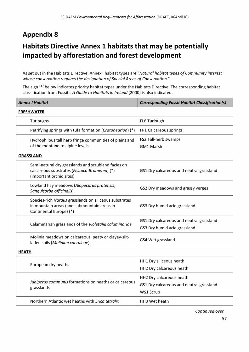
FS-DAFM Environmental Requirements for Afforestation (DRAFT, 06April16)
57
Appendix 8
Habitats Directive Annex 1 habitats that may be potentially impacted by afforestation and forest development
As set out in the Habitats Directive, Annex I habitat types are "Natural habitat types of Community interest whose conservation requires the designation of Special Areas of Conservation."
The sign ‘*’ below indicates priority habitat types under the Habitats Directive. The corresponding habitat classification from Fossit's A Guide to Habitats in Ireland (2000) is also indicated.
Annex I Habitat Corresponding Fossit Habitat Classification(s)
FRESHWATER
Turloughs FL6 Turlough
Petrifying springs with tufa formation (Cratoneurion) (*) FP1 Calcareous springs
Hydrophilous tall herb fringe communities of plains and of the montane to alpine levels
FS2 Tall-herb swamps
GM1 Marsh
GRASSLAND
Semi-natural dry grasslands and scrubland facies on calcareous substrates (Festuco-Brometea) (*) (important orchid sites)
GS1 Dry calcareous and neutral grassland
Lowland hay meadows (Alopecurus pratensis, Sanguisorba officinalis)
GS2 Dry meadows and grassy verges
Species-rich Nardus grasslands on siliceous substrates in mountain areas (and submountain areas in Continental Europe) (*)
GS3 Dry humid acid grassland
Calaminarian grasslands of the Violetalia calaminariae GS1 Dry calcareous and neutral grassland
GS3 Dry humid acid grassland
Molinia meadows on calcareous, peaty or clayey-silt-laden soils (Molinion caeruleae)
GS4 Wet grassland
HEATH
European dry heaths HH1 Dry siliceous heath
HH2 Dry calcareous heath
Juniperus communis formations on heaths or calcareous grasslands
HH2 Dry calcareous heath
GS1 Dry calcareous and neutral grassland
WS1 Scrub
Northern Atlantic wet heaths with Erica tetralix HH3 Wet heath
Continued over…
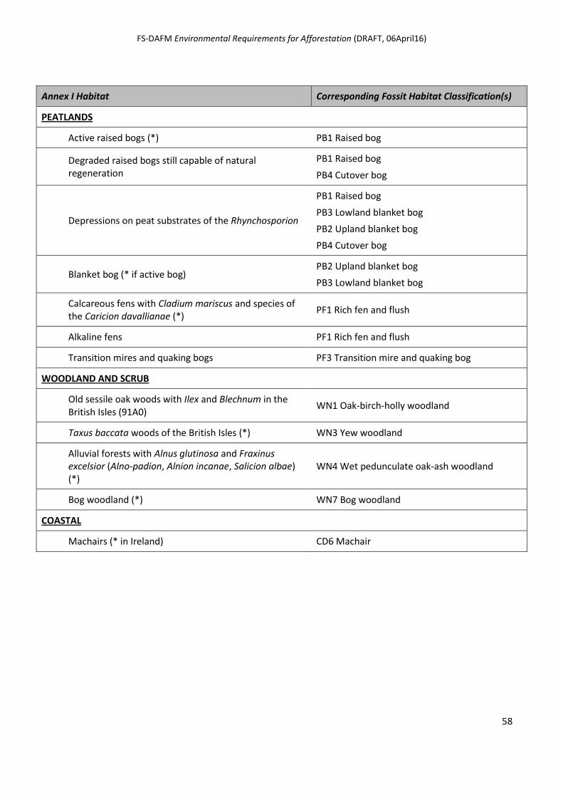
FS-DAFM Environmental Requirements for Afforestation (DRAFT, 06April16)
58
Annex I Habitat Corresponding Fossit Habitat Classification(s)
PEATLANDS
Active raised bogs (*) PB1 Raised bog
Degraded raised bogs still capable of natural regeneration
PB1 Raised bog
PB4 Cutover bog
Depressions on peat substrates of the Rhynchosporion
PB1 Raised bog
PB3 Lowland blanket bog
PB2 Upland blanket bog
PB4 Cutover bog
Blanket bog (* if active bog) PB2 Upland blanket bog
PB3 Lowland blanket bog
Calcareous fens with Cladium mariscus and species of the Caricion davallianae (*)
PF1 Rich fen and flush
Alkaline fens PF1 Rich fen and flush
Transition mires and quaking bogs PF3 Transition mire and quaking bog
WOODLAND AND SCRUB
Old sessile oak woods with Ilex and Blechnum in the British Isles (91A0)
WN1 Oak-birch-holly woodland
Taxus baccata woods of the British Isles (*) WN3 Yew woodland
Alluvial forests with Alnus glutinosa and Fraxinus excelsior (Alno-padion, Alnion incanae, Salicion albae) (*)
WN4 Wet pedunculate oak-ash woodland
Bog woodland (*) WN7 Bog woodland
COASTAL
Machairs (* in Ireland) CD6 Machair
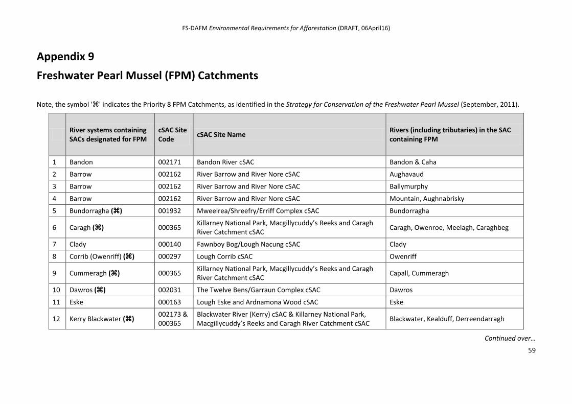
FS-DAFM Environmental Requirements for Afforestation (DRAFT, 06April16)
59
Appendix 9
Freshwater Pearl Mussel (FPM) Catchments
Note, the symbol '' indicates the Priority 8 FPM Catchments, as identified in the Strategy for Conservation of the Freshwater Pearl Mussel (September, 2011).
River systems containing SACs designated for FPM
cSAC Site Code
cSAC Site Name Rivers (including tributaries) in the SAC containing FPM
1 Bandon 002171 Bandon River cSAC Bandon & Caha
2 Barrow 002162 River Barrow and River Nore cSAC Aughavaud
3 Barrow 002162 River Barrow and River Nore cSAC Ballymurphy
4 Barrow 002162 River Barrow and River Nore cSAC Mountain, Aughnabrisky
5 Bundorragha () 001932 Mweelrea/Shreefry/Erriff Complex cSAC Bundorragha
6 Caragh () 000365 Killarney National Park, Macgillycuddy’s Reeks and Caragh River Catchment cSAC
Caragh, Owenroe, Meelagh, Caraghbeg
7 Clady 000140 Fawnboy Bog/Lough Nacung cSAC Clady
8 Corrib (Owenriff) () 000297 Lough Corrib cSAC Owenriff
9 Cummeragh () 000365 Killarney National Park, Macgillycuddy’s Reeks and Caragh River Catchment cSAC
Capall, Cummeragh
10 Dawros () 002031 The Twelve Bens/Garraun Complex cSAC Dawros
11 Eske 000163 Lough Eske and Ardnamona Wood cSAC Eske
12 Kerry Blackwater () 002173 & 000365
Blackwater River (Kerry) cSAC & Killarney National Park, Macgillycuddy’s Reeks and Caragh River Catchment cSAC
Blackwater, Kealduff, Derreendarragh
Continued over…
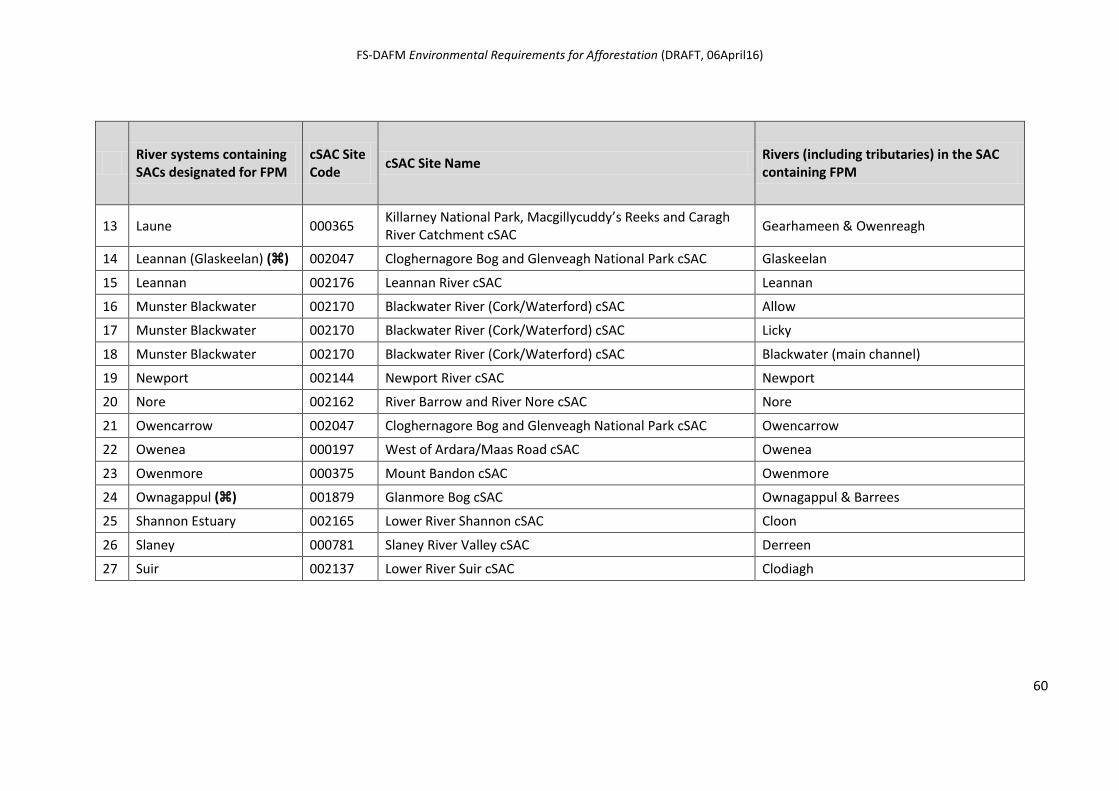
FS-DAFM Environmental Requirements for Afforestation (DRAFT, 06April16)
60
River systems containing SACs designated for FPM
cSAC Site Code
cSAC Site Name Rivers (including tributaries) in the SAC containing FPM
13 Laune 000365 Killarney National Park, Macgillycuddy’s Reeks and Caragh River Catchment cSAC
Gearhameen & Owenreagh
14 Leannan (Glaskeelan) () 002047 Cloghernagore Bog and Glenveagh National Park cSAC Glaskeelan
15 Leannan 002176 Leannan River cSAC Leannan
16 Munster Blackwater 002170 Blackwater River (Cork/Waterford) cSAC Allow
17 Munster Blackwater 002170 Blackwater River (Cork/Waterford) cSAC Licky
18 Munster Blackwater 002170 Blackwater River (Cork/Waterford) cSAC Blackwater (main channel)
19 Newport 002144 Newport River cSAC Newport
20 Nore 002162 River Barrow and River Nore cSAC Nore
21 Owencarrow 002047 Cloghernagore Bog and Glenveagh National Park cSAC Owencarrow
22 Owenea 000197 West of Ardara/Maas Road cSAC Owenea
23 Owenmore 000375 Mount Bandon cSAC Owenmore
24 Ownagappul () 001879 Glanmore Bog cSAC Ownagappul & Barrees
25 Shannon Estuary 002165 Lower River Shannon cSAC Cloon
26 Slaney 000781 Slaney River Valley cSAC Derreen
27 Suir 002137 Lower River Suir cSAC Clodiagh
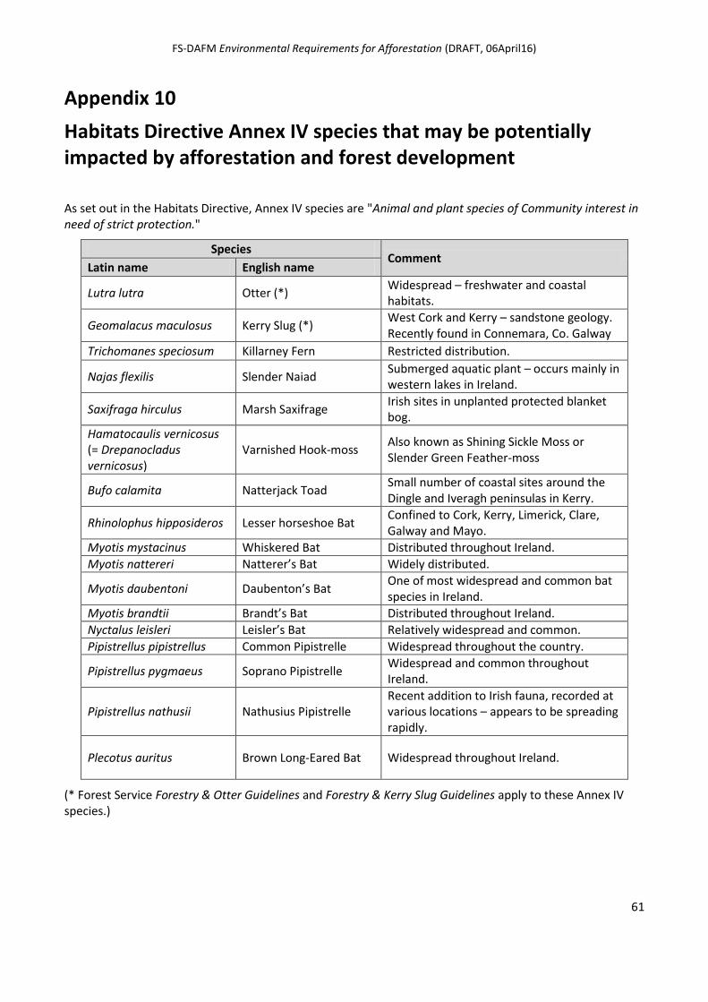
FS-DAFM Environmental Requirements for Afforestation (DRAFT, 06April16)
61
Appendix 10
Habitats Directive Annex IV species that may be potentially impacted by afforestation and forest development
As set out in the Habitats Directive, Annex IV species are "Animal and plant species of Community interest in need of strict protection."
Species Comment
Latin name English name
Lutra lutra Otter (*) Widespread – freshwater and coastal habitats.
Geomalacus maculosus Kerry Slug (*) West Cork and Kerry – sandstone geology. Recently found in Connemara, Co. Galway
Trichomanes speciosum Killarney Fern Restricted distribution.
Najas flexilis Slender Naiad Submerged aquatic plant – occurs mainly in western lakes in Ireland.
Saxifraga hirculus Marsh Saxifrage Irish sites in unplanted protected blanket bog.
Hamatocaulis vernicosus (= Drepanocladus vernicosus)
Varnished Hook-moss Also known as Shining Sickle Moss or Slender Green Feather-moss
Bufo calamita Natterjack Toad Small number of coastal sites around the Dingle and Iveragh peninsulas in Kerry.
Rhinolophus hipposideros Lesser horseshoe Bat Confined to Cork, Kerry, Limerick, Clare, Galway and Mayo.
Myotis mystacinus Whiskered Bat Distributed throughout Ireland.
Myotis nattereri Natterer’s Bat Widely distributed.
Myotis daubentoni Daubenton’s Bat One of most widespread and common bat species in Ireland.
Myotis brandtii Brandt’s Bat Distributed throughout Ireland.
Nyctalus leisleri Leisler’s Bat Relatively widespread and common.
Pipistrellus pipistrellus Common Pipistrelle Widespread throughout the country.
Pipistrellus pygmaeus Soprano Pipistrelle Widespread and common throughout Ireland.
Pipistrellus nathusii Nathusius Pipistrelle Recent addition to Irish fauna, recorded at various locations – appears to be spreading rapidly.
Plecotus auritus Brown Long-Eared Bat Widespread throughout Ireland.
(* Forest Service Forestry & Otter Guidelines and Forestry & Kerry Slug Guidelines apply to these Annex IV species.)
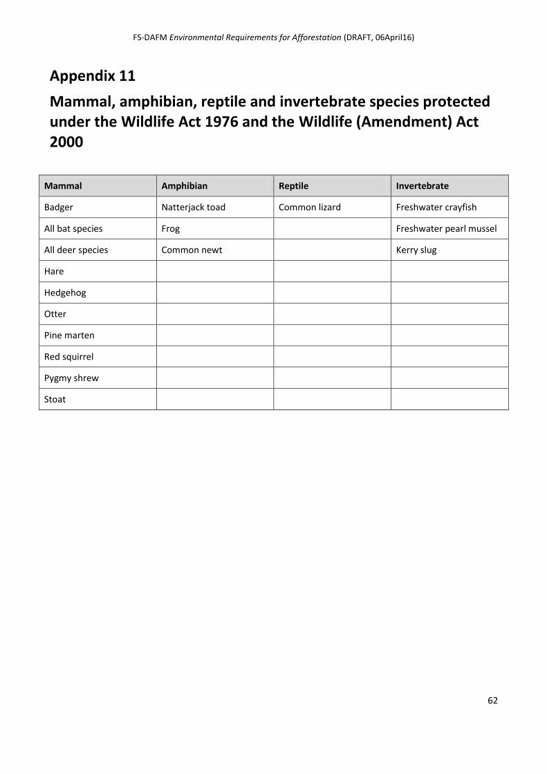
FS-DAFM Environmental Requirements for Afforestation (DRAFT, 06April16)
62
Appendix 11
Mammal, amphibian, reptile and invertebrate species protected under the Wildlife Act 1976 and the Wildlife (Amendment) Act 2000
Mammal Amphibian Reptile Invertebrate
Badger Natterjack toad Common lizard Freshwater crayfish
All bat species Frog Freshwater pearl mussel
All deer species Common newt Kerry slug
Hare
Hedgehog
Otter
Pine marten
Red squirrel
Pygmy shrew
Stoat
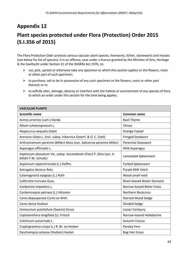
FS-DAFM Environmental Requirements for Afforestation (DRAFT, 06April16)
63
Appendix 12
Plant species protected under Flora (Protection) Order 2015 (S.I.356 of 2015)
The Flora Protection Oder protects various vascular plant species, liverworts, lichen, stoneworts and mosses (see below for list of species). It is an offence, save under a licence granted by the Minister of Arts, Heritage & the Gaeltacht under Section 21 of the Wildlife Act 1976, to:
cut, pick, uproot or otherwise take any specimen to which this section applies or the flowers, roots or other part of such specimen;
to purchase, sell or be in possession of any such specimen or the flowers, roots or other part thereof; or to
to wilfully alter, damage, destroy or interfere with the habitat or environment of any species of flora to which an order under this section for the time being applies.
VASCULAR PLANTS
Scientific name Common name
Acinos arvensis (Lam.) Dandy Basil Thyme
Allium schoenoprasum L. Chives
Alopecurus aequalis Sobol. Orange Foxtail
Arenaria ciliata L. (incl. subsp. hibernica Ostenf. & O. C. Dahl) Fringed Sandwort
Arthrocnemum perenne (Miller) Moss (syn. Salicornia perennis Miller) Perennial Glasswort
Asparagus officinalis L. Wild Asparagus
Asplenium obovatum Viv. subsp. lanceolatum (Fiori) P. Silva (syn. A. billotii F.W. Schultz)
Lanceolate Spleenwort
Asplenium septentrionale (L.) Hoffm. Forked Spleenwort
Astragalus danicus Retz. Purple Milk Vetch
Calamagrostis epigejos (L.) Roth Wood small-reed
Callitriche truncata Guss. Short-leaved Water-Starwort
Cardamine impatiens L. Narrow leaved Bitter-Cress
Cardaminopsis petraea (L.) Hiitonen Northern Rockcress
Carex depauperata Curtis ex With. Starved Wood Sedge
Carex divisa Hudson Divided Sedge
Centaurium pulchellum (Swartz) Druce Lesser Centaury
Cephalanthera longifolia (L). Fritsch Narrow-leaved Helleborine
Colchicum autumnale L. Autumn Crocus
Cryptogramma crispa (L.) R. Br. ex Hooker Parsley Fern
Deschampsia setacea (Hudson) Hackel Bog Hair Grass
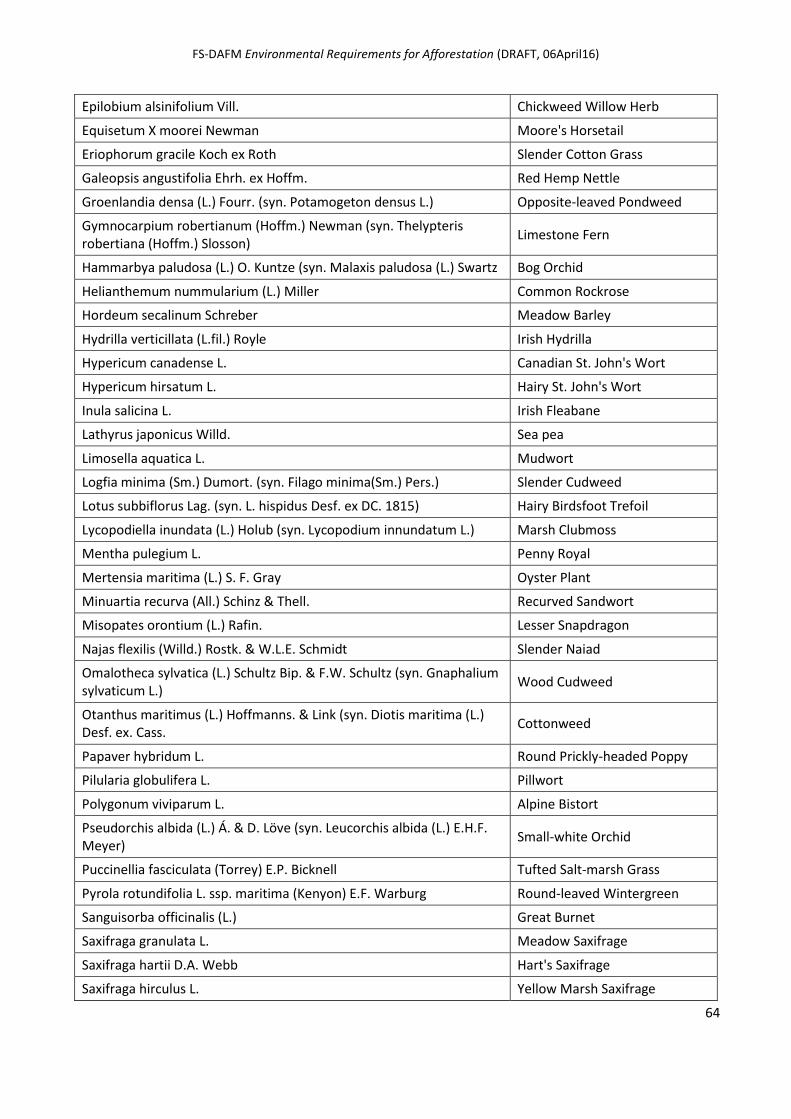
FS-DAFM Environmental Requirements for Afforestation (DRAFT, 06April16)
64
Epilobium alsinifolium Vill. Chickweed Willow Herb
Equisetum X moorei Newman Moore's Horsetail
Eriophorum gracile Koch ex Roth Slender Cotton Grass
Galeopsis angustifolia Ehrh. ex Hoffm. Red Hemp Nettle
Groenlandia densa (L.) Fourr. (syn. Potamogeton densus L.) Opposite-leaved Pondweed
Gymnocarpium robertianum (Hoffm.) Newman (syn. Thelypteris robertiana (Hoffm.) Slosson)
Limestone Fern
Hammarbya paludosa (L.) O. Kuntze (syn. Malaxis paludosa (L.) Swartz Bog Orchid
Helianthemum nummularium (L.) Miller Common Rockrose
Hordeum secalinum Schreber Meadow Barley
Hydrilla verticillata (L.fil.) Royle Irish Hydrilla
Hypericum canadense L. Canadian St. John's Wort
Hypericum hirsatum L. Hairy St. John's Wort
Inula salicina L. Irish Fleabane
Lathyrus japonicus Willd. Sea pea
Limosella aquatica L. Mudwort
Logfia minima (Sm.) Dumort. (syn. Filago minima(Sm.) Pers.) Slender Cudweed
Lotus subbiflorus Lag. (syn. L. hispidus Desf. ex DC. 1815) Hairy Birdsfoot Trefoil
Lycopodiella inundata (L.) Holub (syn. Lycopodium innundatum L.) Marsh Clubmoss
Mentha pulegium L. Penny Royal
Mertensia maritima (L.) S. F. Gray Oyster Plant
Minuartia recurva (All.) Schinz & Thell. Recurved Sandwort
Misopates orontium (L.) Rafin. Lesser Snapdragon
Najas flexilis (Willd.) Rostk. & W.L.E. Schmidt Slender Naiad
Omalotheca sylvatica (L.) Schultz Bip. & F.W. Schultz (syn. Gnaphalium sylvaticum L.)
Wood Cudweed
Otanthus maritimus (L.) Hoffmanns. & Link (syn. Diotis maritima (L.) Desf. ex. Cass.
Cottonweed
Papaver hybridum L. Round Prickly-headed Poppy
Pilularia globulifera L. Pillwort
Polygonum viviparum L. Alpine Bistort
Pseudorchis albida (L.) Á. & D. Löve (syn. Leucorchis albida (L.) E.H.F. Meyer)
Small-white Orchid
Puccinellia fasciculata (Torrey) E.P. Bicknell Tufted Salt-marsh Grass
Pyrola rotundifolia L. ssp. maritima (Kenyon) E.F. Warburg Round-leaved Wintergreen
Sanguisorba officinalis (L.) Great Burnet
Saxifraga granulata L. Meadow Saxifrage
Saxifraga hartii D.A. Webb Hart's Saxifrage
Saxifraga hirculus L. Yellow Marsh Saxifrage
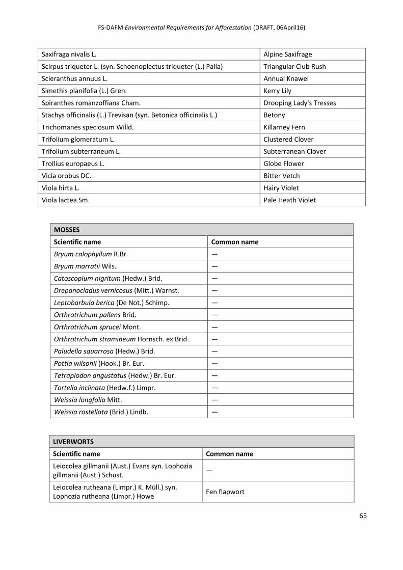
FS-DAFM Environmental Requirements for Afforestation (DRAFT, 06April16)
65
Saxifraga nivalis L. Alpine Saxifrage
Scirpus triqueter L. (syn. Schoenoplectus triqueter (L.) Palla) Triangular Club Rush
Scleranthus annuus L. Annual Knawel
Simethis planifolia (L.) Gren. Kerry Lily
Spiranthes romanzoffiana Cham. Drooping Lady's Tresses
Stachys officinalis (L.) Trevisan (syn. Betonica officinalis L.) Betony
Trichomanes speciosum Willd. Killarney Fern
Trifolium glomeratum L. Clustered Clover
Trifolium subterraneum L. Subterranean Clover
Trollius europaeus L. Globe Flower
Vicia orobus DC. Bitter Vetch
Viola hirta L. Hairy Violet
Viola lactea Sm. Pale Heath Violet
MOSSES
Scientific name Common name
Bryum calophyllum R.Br. —
Bryum marratii Wils. —
Catoscopium nigritum (Hedw.) Brid. —
Drepanocladus vernicosus (Mitt.) Warnst. —
Leptobarbula berica (De Not.) Schimp. —
Orthrotrichum pallens Brid. —
Orthrotrichum sprucei Mont. —
Orthrotrichum stramineum Hornsch. ex Brid. —
Paludella squarrosa (Hedw.) Brid. —
Pottia wilsonii (Hook.) Br. Eur. —
Tetraplodon angustatus (Hedw.) Br. Eur. —
Tortella inclinata (Hedw.f.) Limpr. —
Weissia longfolia Mitt. —
Weissia rostellata (Brid.) Lindb. —
LIVERWORTS
Scientific name Common name
Leiocolea gillmanii (Aust.) Evans syn. Lophozia gillmanii (Aust.) Schust.
—
Leiocolea rutheana (Limpr.) K. Müll.) syn. Lophozia rutheana (Limpr.) Howe
Fen flapwort
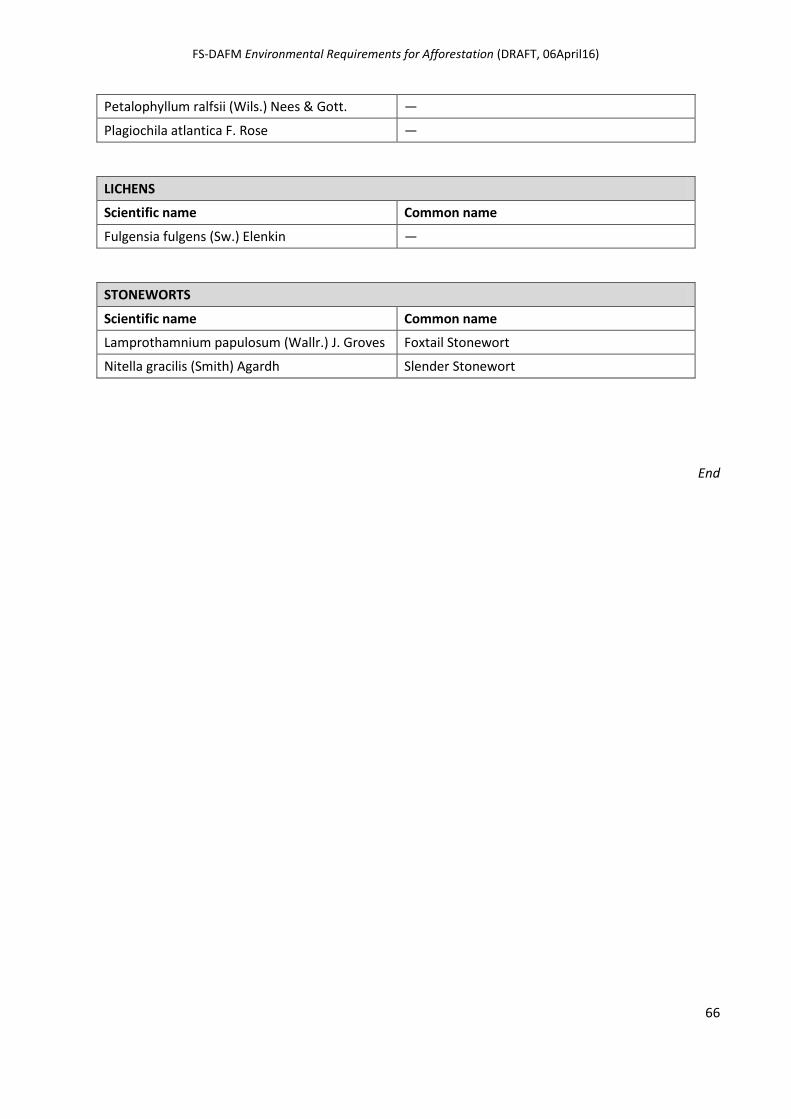
FS-DAFM Environmental Requirements for Afforestation (DRAFT, 06April16)
66
Petalophyllum ralfsii (Wils.) Nees & Gott. —
Plagiochila atlantica F. Rose —
LICHENS
Scientific name Common name
Fulgensia fulgens (Sw.) Elenkin —
STONEWORTS
Scientific name Common name
Lamprothamnium papulosum (Wallr.) J. Groves Foxtail Stonewort
Nitella gracilis (Smith) Agardh Slender Stonewort
End