egypt planning
TRANSCRIPT
http://reshafim.org.il/ad/egypt/building/fortifications_1.htm
Town planning
Location
The reasons for the foundation of a new settlement could be varied: security, often combined with economics, as in the case of the southern fortress towns (Buhen); cultic and administrative needs (Kahun); political motives seem to have led Akhenaten to found Akhetaten. The main consideration where to build was generally proximity to a waterway and height above the floodplains. Adobe buildings are very vulnerable when brought in prolonged contact with water, be it seeping groundwater or the rising Nile. But even stone edifices are in danger of collapsing, above all when their foundations are as flimsy as those the Egyptians built. Elevations, as long as they were inhabited, kept above the slowly rising plains, where the river deposited its silt. When old houses crumbled, new ones were built on top of the debris. This has been going on until recent times, when the yearly inundations were stopped by the Aswan dam. The continuity of settlement during the millennia is one of the reasons for the scarcity of data about ancient villages and cities, as excavation is virtually impossible. Herodotus noticed the elevated position of Egyptian cities and explained it as follows Whenever any man of the Egyptians committed any transgression, he (the Kushite king Shabaka) would never put him to death, but he gave sentence upon each man according to the greatness of the wrong-doing, appointing
them to work at throwing up an embankment before that city from whence each man came of those who committed wrong. Thus the cities were made higher still than before; for they were embanked first by those who dug the channels in the reign of Sesostris, and then secondly in the reign of the Ethiopian, and thus they were made very high: and while other cities in Egypt also stood high, I think in the town at Bubastis especially the earth was piled up.
By their very nature military settlements are more organized than civilian towns which have grown organically from villages. Buhen, a walled frontier town in Lower Nubia was built during the joint reign of Amenemhet I and his son Senusret I. It was probably erected at the site of an existing trading post and its purpose was to house the troops who controlled the traffic from Nubia into Egypt. The ramparts surrounding it may have been built before the fortress at the centre was constructed. The planned town covered an area of 6.3 ha, including the fort and was surrounded on three sides by a 712 metre long, 4 metre thick brick wall with thirty-two round bastions. Only a single gate opening towards the western desert has been found. The eastern side by the Nile was not fortified. It may have held 1500 to 2000 inhabitants. The town was expanded under Senusret III and further fortified.
City quarters
Generally there was little town planning, and what little there was looked a bit like the hieroglyph for "city" with houses arranged rather haphazardly around the crossing of two major roads. But in a number of cases attempts at rational planning seem to have been made.
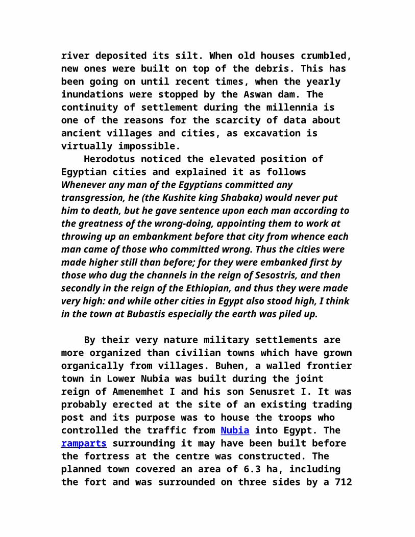
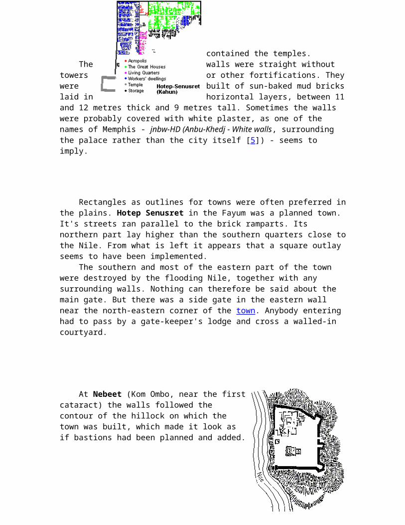
The town serving the pyramid temple complex Hotepsenusret (Kahun; Ha-Usertesen-hotep as Petrie called it) in the Fayum was founded by Senusret II and remained inhabited for about a century.
The outlay of the city itself was rectangular, covering an area of 350 by 400 metres. It was surrounded by a brick wall and divided into two parts by another wall. Generally different social classes did not live in separate city quarters. But here there was a rich residential area, where a handful of palatial 60 room residences were fifty times as big as the dwellings in the poorer half of the city. This part had also a wide street leading to the palace. The streets all over the city were laid out in approximately straight lines. The alleys leading to the workers' dwellings ended in culs-de-sac. The main street was nine metres wide, as opposed to the alleys and streets in the residential districts which were sometimes as narrow as 1½ metres. The streets had
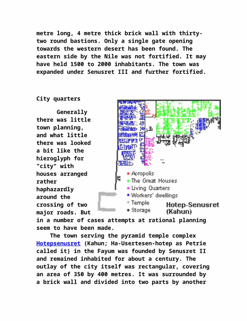
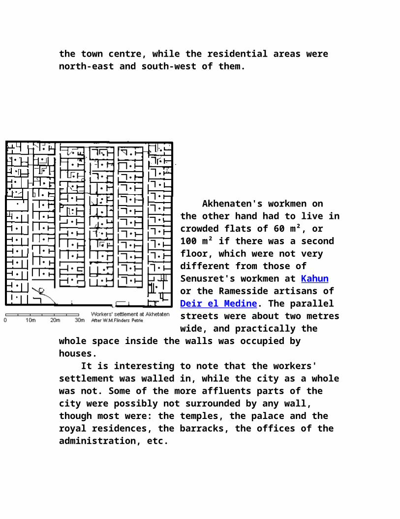
shallow stone channels running down the middle for drainage. Despite the love Egyptians had for gardens, there was no space left for them inside the walls at Hotepsenusret. The whole area was covered with streets and one-storeyed mud-brick buildings. In this Hotepsenusret was very different from Akhenaten's specially created capital Akhetaten - or at least some parts of it. There the planners included public open spaces where trees were planted and inhabitants often had their own private garden plots. Actually, within the boundaries of Akhetaten there was mostly empty space. The planners had given the new capital very generous dimensions; but it was abandoned after only a few of the main government edifices had been erected. These formed the town centre, while the residential areas were north-east and south-west of them.
Akhenaten's workmen on the other hand had to live in crowded flats of 60 m², or 100 m² if there was a second floor, which were not very different from those of Senusret's workmen at Kahun or the Ramesside artisans of Deir el Medine. The parallel streets were about two metres wide, and practically the whole space inside the walls was occupied by houses. It is interesting to note that the workers' settlement was walled in, while the city as a whole was not. Some of the more affluents parts of the city were
possibly not surrounded by any wall, though most were: the temples, the palace and the royal residences, the barracks, the offices of the administration, etc.
Residential areas
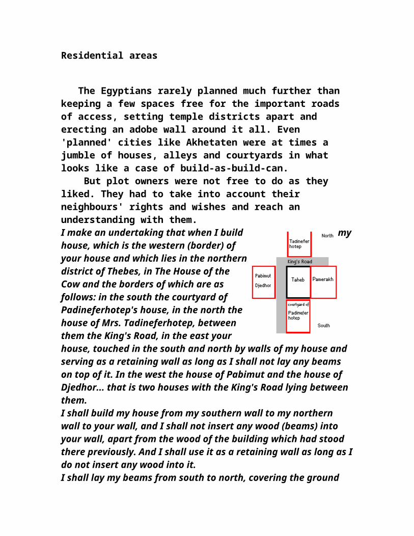
The Egyptians rarely planned much further than keeping a few spaces free for the important roads of access, setting temple districts apart and erecting an adobe wall around it all. Even 'planned' cities like Akhetaten were at times a jumble of houses, alleys and courtyards in what looks like a case of build-as-build-can. But plot owners were not free to do as they liked. They had to take into account their neighbours' rights and wishes and reach an understanding with them. I make an undertaking that when I build my house, which is the western (border) of your house and which lies in the northern district of Thebes, in The House of the Cow and the borders of which are as follows: in the south the courtyard of Padineferhotep's house, in the north the house of Mrs. Tadineferhotep, between them the King's Road, in the east your house, touched in the south and north by walls of
my house and serving as a retaining wall as long as I shall not lay any beams on top of it. In the west the house of Pabimut and the house of Djedhor... that is two houses with the King's Road lying between them. I shall build my house from my southern wall to my northern wall to your wall, and I shall not insert any wood (beams) into your wall, apart from the wood of the building which had stood there previously. And I shall use it as a retaining wall as long as I do not insert any wood into it. I shall lay my beams from south to north, covering the ground floor. If I want to build on top of it I shall build my walls mentioned above up to the wall of your house which will serve as a retaining wall. I shall leave the light-shaft opposite your two windows at a distance of one mud brick of the mud bricks which have been laid in the front of your house opposite your windows. I shall build north and south of them (the windows) up to your wall and cover them with a roof from south to north.... If I do not act according to what has been said above, then I shall pay you 5 pieces of silver, that is 25 stater .... If you hinder my building, then I will act according to what has been said above without leaving a light-shaft - without punishment.Even if they liked living on ground level, Egyptian city dwellers had little choice about adding further storeys. Land suitable for building had to be above the floodlevel of the Nile and still reasonably close to the river, and this was relatively rare. Many Egyptians either preferred or were forced to live in these crowded conditions. At Akhetaten where there was no lack of suitable land, some private homes were still built in the same warren-like fashion.
Temple districts
Temple districts on the other hand were better planned. The outlay of individual temples was basically symmetrical. Walls surrounded them. At Hotep-senusret the brick wall on three sides of the temple was 12 metres thick and lined with limestone. Avenues leading through the city to the temple district were wide, suitable for processions. During recent excavations near the great pyramids a paved street five metres wide was discovered. Pavement of streets was rare, generally restricted to the temple complexes themselves. Originally most temples were surrounded by an empty space, but
over time houses were built right up to the outer temple walls. These houses decayed and were rebuilt many times over the millennia, with the result that the ground level of the residential area rose and the temples which, being built of stone, were not periodically rebuilt, seemingly sank into the ground. The temenos [2] wall, the temple enclosure, could also have strategic value. At el-Kab the temple was built at the centre of the town, and its ramparts could furnish a last shelter for the garrison in case the town itself were taken by an enemy. At other places (Ombos, Edfu etc) the whole population lived inside the temple enclosure. Bigger towns like Memphis or Thebes had a number of temples which at first were separate, but were interconnected by sphinx avenues from the 18th dynasty onwards.
Palaces
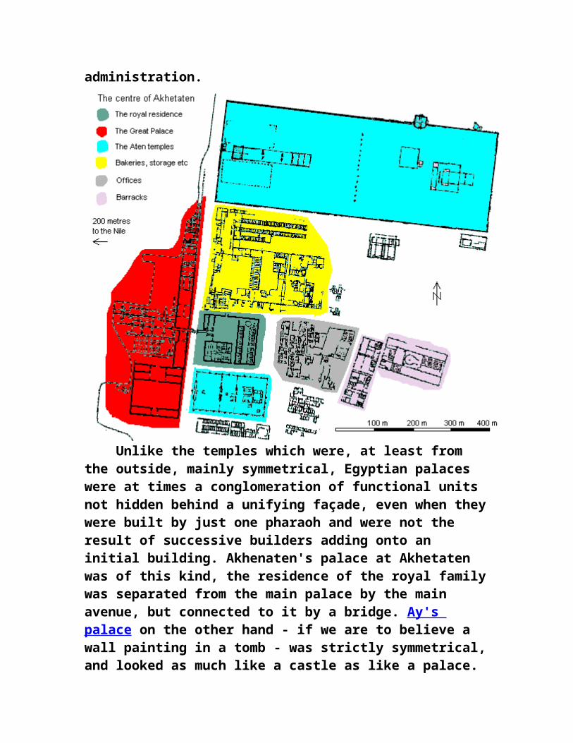
Royal palaces housed apart from the pharaoh's main family, his secondary wives, concubines, and their offspring, also a small army of servants. The whole compound was enclosed and separate from the rest of the capital, albeit close to suppliers of services, temples and the seat of the administration.
Unlike the temples which were, at least from the outside, mainly symmetrical, Egyptian palaces were at times a conglomeration of functional units not hidden behind a unifying façade, even when they were built by just one pharaoh and were not the result of successive builders adding onto an initial building. Akhenaten's palace at Akhetaten was of this kind, the residence of the royal family was separated from the main palace by the main avenue, but connected to it by a bridge. Ay's palace on the other hand - if we are to believe a wall painting in a tomb - was strictly symmetrical, and looked as much like a castle as like a palace.
Building in ancient Egypt Most of the ancient Egyptian buildings have disappeared leaving no trace. Built of sun baked bricks made of Nile mud and straw, houses, palaces and city walls crumbled when they stopped being looked after. Stone structures like temples and tombs fared better, but
even they fell victim to the ravages of time, the greed of men, to earthquakes and subsidence. One shouldn't be surprised by what has disappeared but by how much is left.
Planning
The planning of Egyptian architects and stone-masons was meticulous. It included ground-plans, sections and contours drawn on surfaces covered with grid lines. Petrie who investigated the Great Pyramids wrote 168. From several indications it seems that the masons planned the casing, and some at least of the core masonry also, course by course on the ground. For on all the casing, and on the core on which the casing fitted, there are lines drawn on the horizontal surfaces, showing where each stone was to be placed on those below it. If the stones were merely trimmed to fit each other as the
building went on, there would be no need to have so carefully marked the place of each block in this particular way; and it shows that they were probably planned and fitted together on the ground below. Another indication of very careful and elaborate planning on the ground is in the topmost space over the King's Chamber; there the roofing-beams were numbered, and marked for the north or south sides; and though it might be thought that it could be of no consequence in what order they were placed, yet all their details were evidently schemed before they were delivered to the builders' hands. This care in arranging all the work agrees strikingly with the great employment of unskilled labourers during two or three months at a time, as they would then raise all the
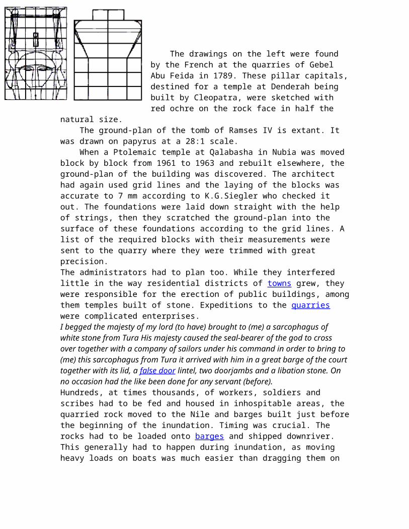
stones which the masons had worked and stored ready for use since the preceding season. The planning of Egyptian architects and stone-masons was meticulous. It included ground-plans, sections and contours drawn on surfaces covered with grid lines. Petrie who investigated the Great Pyramids wrote The drawings on the left were found by the French at the quarries of Gebel Abu Feida in 1789. These pillar capitals, destined for a temple at Denderah being built by Cleopatra, were sketched with red ochre on the rock face in half the natural size. The ground-plan of the tomb of Ramses IV is extant. It was drawn on papyrus at a 28:1 scale. When a Ptolemaic temple at Qalabasha in Nubia was moved block by block from 1961 to 1963 and rebuilt elsewhere, the ground-plan of the building was discovered. The architect had again used grid lines and the laying of the blocks was accurate to 7 mm according to K.G.Siegler who checked it out. The foundations were laid down straight with the help of strings, then they scratched the ground-plan into the surface of these foundations according to the grid lines. A list of the required blocks with their measurements were sent to the quarry where they were trimmed with great precision. The administrators had to plan too. While they interfered little in the way residential districts of towns grew, they were responsible for the erection of public buildings, among them temples built of stone. Expeditions to the quarries were complicated enterprises.
I begged the majesty of my lord (to have) brought to (me) a sarcophagus of white stone from Tura His majesty caused the seal-bearer of the god to cross over together with a company of sailors under his command in order to bring to (me) this sarcophagus from Tura it arrived with him in a great barge of the court together with its lid, a false door lintel, two doorjambs and a libation stone. On no occasion had the like been done for any servant
(before). Hundreds, at times thousands, of workers, soldiers and scribes had to be fed and housed in inhospitable areas, the quarried rock moved to the Nile and barges built just before the beginning of the inundation. Timing was crucial. The rocks had to be loaded onto barges and shipped downriver. This generally had to happen during inundation, as moving heavy loads on boats was much easier than dragging them on sledges and one could go farther by boat when the Nile was covering large tracts of land. I travelled north with them to the pyramid "Mernere-appears-splendor" in 6 barges,3 tow-boats of 8 ribs in a single expedition on no occasion had Ibhat and Yebu been done in a single expedition under the time of any king. Everything that his majesty commanded, happened, entirely as his majesty commanded. His majesty sent me to Hatnub in order to bring a great altar of Hatnub alabaster. I brought down this altar for him in 17 days after it was hewn at Hatnub. I caused it to travel downstream in this barge. (I) had built for it a barge of acacia wood of 60 cubits in its length, 30 cubits in its width assembled in 17 days in the 3rd month of summer, when there was no water upon the sandbanks. (it was) moored at the pyramid Mernere-appears-in-splendor, in safety.
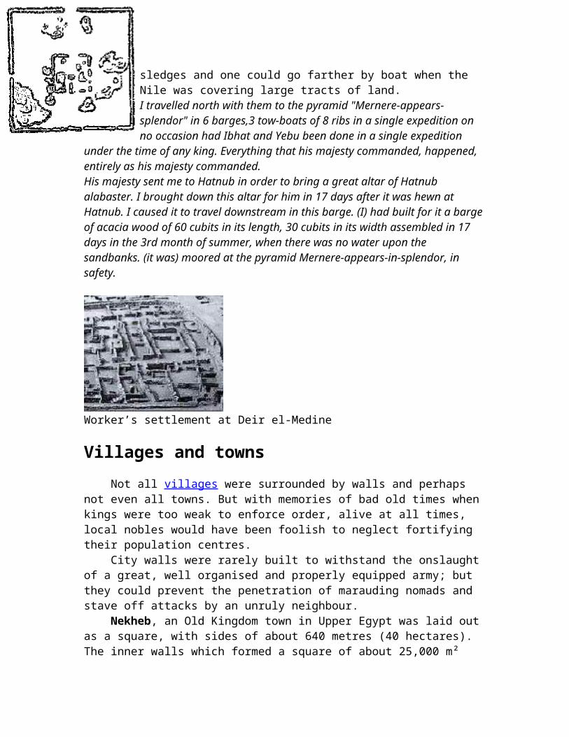
Worker’s settlement at Deir el-Medine
Villages and towns
Not all villages were surrounded by walls and perhaps not even all towns. But with memories of bad old times when kings were too weak to enforce order, alive at all times, local nobles would have been foolish to neglect fortifying their population centres. City walls were rarely built to withstand the onslaught of a great, well organised and properly equipped army; but they could prevent the penetration of marauding nomads and stave off attacks by an unruly neighbour. Nekheb, an Old Kingdom town in Upper Egypt was laid out as a square, with sides of about 640 metres (40 hectares). The inner walls which formed a square of about 25,000 m² contained the temples.
The walls were straight without towers or other fortifications. They were built of sun-baked
mud bricks laid in horizontal layers, between 11 and 12 metres thick and 9 metres tall. Sometimes the walls were probably covered with white plaster, as one of the names of Memphis - jnbw-HD (Anbu-Khedj - White walls, surrounding the palace rather than the city itself [5]) - seems to imply.
Rectangles as outlines for towns were often preferred in the plains. Hotep Senusret in the Fayum was a planned town. It's streets ran parallel to the brick ramparts. Its northern part lay higher than the southern quarters close to the Nile. From what is left it appears that a square outlay seems to have been implemented. The southern and most of the eastern part of the town were destroyed by the flooding Nile, together with any surrounding walls. Nothing can therefore be said about the main gate. But there was a side gate in the eastern wall near the north-eastern corner of the town. Anybody entering had to pass by a gate-keeper's lodge and cross a walled-in courtyard.
At Nebeet (Kom Ombo, near the first cataract) the walls followed the contour of the hillock on which the town was built, which made it look as if bastions had been planned and added.
Moats were at times dug to enhance the effectiveness of the ramparts and the towns' inhabitants were encouraged by economic benefits:
Dig a moat against [...] and flood the half of it at the Bitter Lakes, for see, it is the navel-string of the desert dwellers; its walls and its soldiers are many and the partisans in it know how to take up arms, apart from the freemen of the camp; the region of Djed-esut totals ten thousand men consisting of free untaxed commoners, and magnates have been in it since the time of the Residence. (its) boundary is established, its garrison is brave, and many northerners irrigate it to the limits of the Delta, they being taxed in corn like freemen; it is... the face of him who made it, and see, it is the door of the Delta. They made a moat for Ninsu, for a populous city is...
The instructions of Merikare
Following their experiences with Canaanite fortifications during the New Kingdom the Egyptians began to cover many of their city walls with stone. They seem to have improved primarily the ramparts of exposed towns on the eastern frontier, but sometimes even of cities deep inside the country such as Heliopolis and Memphis.
Housing in a workers' village: Deir el Medine
The village
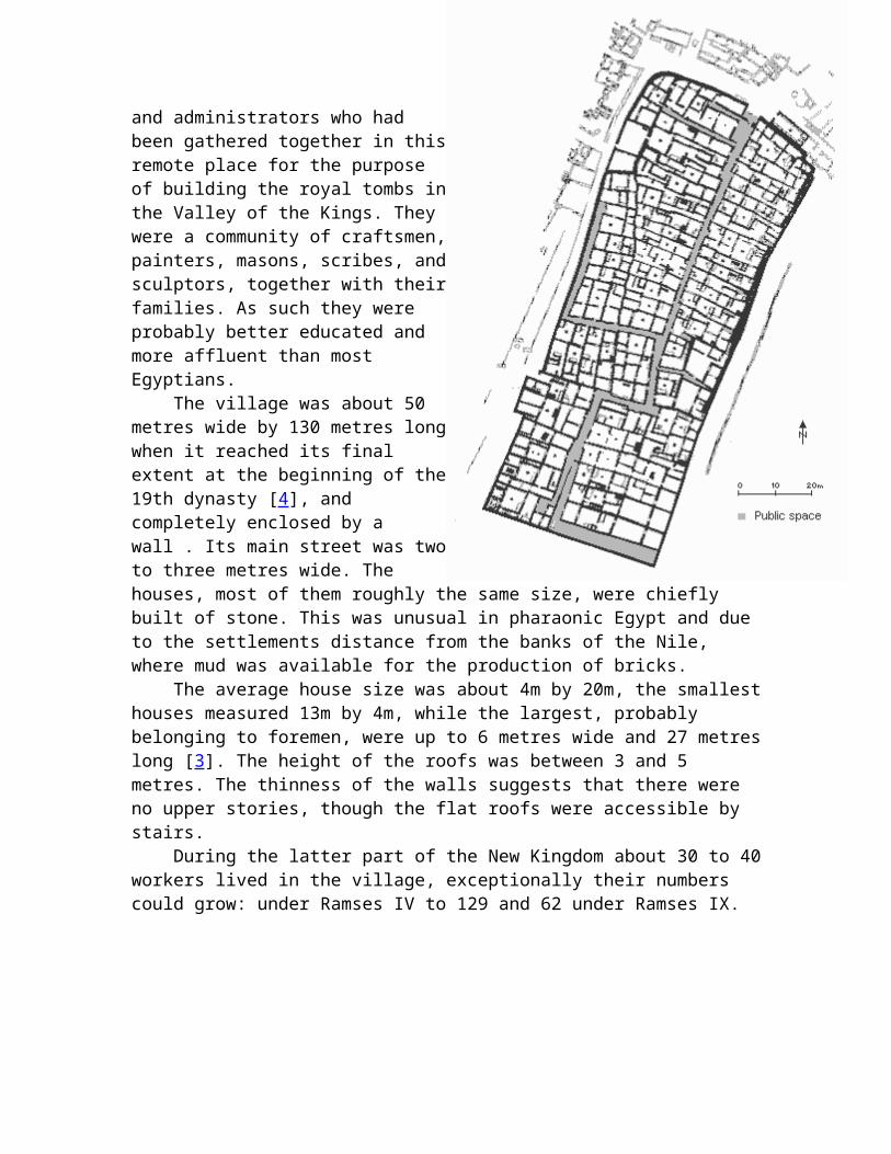
Deir el Medine was not an ordinary New Kingdom village populated by farmers and their dependents, but by workers and administrators who had been gathered together in this remote place for the purpose of building the royal tombs in the Valley of the Kings. They were a community of craftsmen, painters, masons, scribes, and sculptors, together with their families. As such they were probably better educated and more affluent than most Egyptians. The village was about 50 metres wide by 130 metres long when it reached its final extent at the beginning of the 19th dynasty [4], and completely enclosed by a wall . Its main street was two to three metres wide. The houses, most of them roughly the same size, were chiefly built of stone. This was unusual in pharaonic Egypt and due to the settlements distance from the banks of the Nile, where mud was available for the production of bricks. The average house size was about 4m by 20m, the smallest houses measured 13m by 4m, while the largest, probably belonging to foremen, were up to 6 metres wide and 27 metres long [3]. The height of the roofs was between 3 and 5 metres. The thinness of the walls suggests that there were no upper stories, though the flat roofs were accessible by stairs. During the latter part of the New Kingdom about 30 to 40 workers lived in the village,
exceptionally their numbers could grow: under Ramses IV to 129 and 62 under Ramses IX.
Cities in ancient Egypt grew out of the development of agriculture and the emergence of the state as the unifying and predominant form of political organization. However, even as early as 3500 BC, towns and cities (if they can be called such), consisted of regional capitals linked to the population centers of smaller administrative districts. The term we most frequently apply to these districts is nome, which was actually not used to describe a province until the Greek Period. During the New Kingdom, the Egyptian word for "city" was niwt, a term which in the earliest texts of the 1st Dynasty refers to "settlement". As early as the 5th Dynasty, the term for a "town" or large village was dmi. The term for "village", which was apparently linked to the word for "household", was whyt Unfortunately, our knowledge about Egyptian cities, and settlements in general is limited. Every aspect of of ancient Egyptian cities conspires to limit our understanding. Settlements and cities were located on the floodplain, with a preference for proximity to the Nile, in order to receive goods by boat and for its source of water. Unlike temples and tombs, most housing and public buildings in these cities and settlements were made of mudbrick throughout pharaonic times and shifts in the course of the Nile, the build-up of the floodplain by the annual deposition of silt and the impact of high Nile floods have all led to their destruction, which has sometimes been complete. Many cities, such as Thebes, have been built over by modern settlements, and even when some remains have survived, the mudbrick has been harvested by farmers to use as fertilizer. Finally, archaeological investigations since the nineteenth century have focused on temples and tombs, with their rich and spectacular art, sculpture and architecture, rather than the few less thrilling ancient Egyptian towns.
Early prehistoric settlement sites in the Nile Valley vary in size from as little as about 16 meters. The largest sites probably represent repeated occupations, with lateral displacement through time. By contrast, the Predynastic villages were the result of permanent occupation with a vertical build-up of deposits.
Prior to about 5000 BC, the inhabitants of the Nile Valley were mostly foragers who practiced fishing, fowling, hunting and collecting wild plants. The first known farming community then occupied a site at the edge of the floodplain of the Nile Delta at
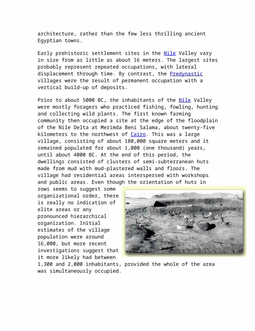
Merimda Beni Salama, about twenty-five kilometers to the northwest of Cairo. This was a large village, consisting of about 180,000 square meters and it remained populated for about 1,000 (one thousand) years, until about 4000 BC. At the end of this period, the dwellings consisted of clusters of semi-subterranean huts made from mud with mud-plastered walls and floors. The village had residential areas interspersed with workshops and public areas. Even though the orientation of huts in rows seems to suggest some organizational order, there is really no indication of elite areas or any pronounced hierarchical organization. Initial estimates of the village population were around 16,000, but more recent investigations suggest that it more likely had between 1,300 and 2,000 inhabitants, provided the whole of the area was simultaneously occupied.
Around 3500 BC, the village of Maadi was established about fifteen kilometers south of present day Cairo, probably as a trade center. The site shows evidence of huts, storage magazines, silos and cellars. We believe that Maadi was at the end of an overland trade route to Palestine, and was probably inhabited by middlemen from the Levant at that time, as evidenced by house and grave patterns. In fact, trade items including copper and bitumen from southwest Asia have been unearthed in this location. There were also artifacts discovered that associate the site with Upper Egypt, suggesting that Maadi was a trade link between the south and the Levant. Maadi seems to have been about the same size as Merimda Beni Salama.
At about the same time in the Nile Valley, the two towns of Hierakonpolis and Naqada became much more important, growing in relationship to neighboring villages. Hierakonpolis was contained in an area of about 50,000 to 100,000 square meters, which is comparable in area to the area known as South Town in the Naqada region. Excavations at Hierakonpolis reveal that over time, the village shifted to the northeast, suggesting that older areas were abandoned and used for disposal. At any one time, there were probably between 1,500 and 2,000 inhabitants.
Prior to the emergence of South town in the Naqada region, the area was dotted with small villages and hamlets between the edge of the floodplain and the desert margin. Dating to around 3800 BC, these villages, often spaced about two kilometers apart, consisted mostly of flimsy huts. However, by about 3600 BC, one of those villages began to build up into a true town. No other villages at the edge of the desert are known from that time. Of course, as the town grew, some of the rural population was incorporated into the emerging urban center, and a low Nile flood level caused some shifting of village communities closer to the river. South Town possibly developed into an urban settlement because of its association with a religious cult and shrine, which became a center for
solidarity among the villages, which were probably organized by kin-related lineages and clans. It probably developed into an early administrative center, where food exchanges and trade transactions among the villages and even nearby nomads of the Eastern Desert were overseen. The villages of Naqada seem to also have established trade with Hierakonpolis, where the development of an urban center was possibly most related to its trade with Nubia and the Near East by way of Maadi.
A decline in the Nile flood discharge and an increase in demands for trade goods by expanding urban dwellers, beginning from around 3500 to 3300 BC, led to the integration of neighboring communities into larger political units, with territorial chiefdoms and petty kingdoms. This also led to some sporadic warfare and therefore, fortified walled cities. Each of these became associated with a territorial standard representing the tribal or ethnic groups. In Mesopotamia, this evolution led to the emergence of city states, but perhaps because of the linear arrangement and limitations of the Nile Valley, this did not happen in Egypt. Instead, the course of the Nile Valley urbanization followed a political transformation that we believe, around 3200 BC, led to the emergence of some sub-national unity.
Abydos, north of Naqada and Hierakonpolis, existed as a locus of proto-national power that even controlled parts of the Delta some two centuries before the emergence of the 1st Dynasty. The royal necropolis of Abydos continued as a significant religious establishment well after the emergence of Memphis.
By 3000 BC, the unification of all the administrative districts under a single theocratic dynasty was accomplished, we are told, by Menes. Memphis was a result of this unification. The fist kings of Egypt's 1st Dynasty, by consolidating their power at Memphis, diminished the possibility of the rise of rival urban centers. These early kings display considerable brilliance in their consolidation of power at Memphis, developing a royal ideology that bonded all the districts to the person of the ruler, rather than to any given territory. Furthermore, some of the most powerful local deities were included in a cosmogony at Memphis that removed them from their local political districts. Unfortunately, we know very little about ancient Memphis itself. Though it remained an important population center throughout pharaonic history, Memphis remains mostly a mystery, though recent investigations using new technologies are beginning to provide some enlightenment. For example we now know that the city, over its vast history of some three millenniums, shifted eastward in response to the invasion of sand dunes and a shift in the course of the Nile.
Later, other royal cities emerged to become royal capitals, though Memphis always seems to have been an administrative center. Tell el-Dab'a, located in the northeastern Nile Delta, was the residential site of
Egyptianized Canaanites and elite Delta administrators. This town was possibly established on the site of an earlier estate, established at the beginning of the 12th Dynasty, as a royal palace of Amenemhet I. The town became the capital city of Egypt during the Hyksos dynasty from about 1585 to 1532, probably because of its favorable location for trade with the coastal Levant and the administration of mining activities in the Sinai. Then, this city's name was probably Avaris. Later, during the Ramessid era, the new capital of Piramesses was located nearby.
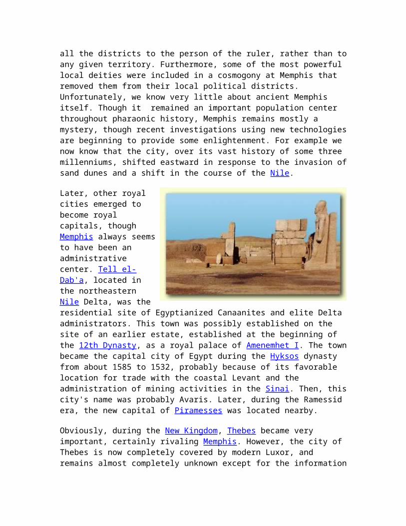
Obviously, during the New Kingdom, Thebes became very important, certainly rivaling Memphis. However, the city of Thebes is now completely covered by modern Luxor, and remains almost completely unknown except for the information derived from its temples and monuments, and from some rare excavations. We do know that the Middle Kingdom town consisted of an area of about 3,200 by 1,600 feet, made up on a grid plan and surrounded by a wall measuring some twenty feet thick. That city appears to have been almost completely leveled at the beginning of the New Kingdom, to accommodate the creation of the Great Temple complex of Karnak with a new residential area and suburbs that perhaps spread as far as eight kilometers from the city center.
During the Third Intermediate Period, Tanis, which is located about twenty kilometers north of Piramesses became an important royal city, and during the Late Period, Sais, which is situated on one of the western branches of the Nile and which is one of the earliest prominent settlements of the Delta, became a powerful capital. Of course, during the Ptolemaic (Greek) Period, Alexandria, located northwest of Sais, became Egypt's capital until the Arab invasion.
The town of Illahun (Kahun) is also representative of various settlements that existed where priests and others were responsible for the rituals and observances related to the mortuary cult of the king, as well as the foundation estate created to finance such cults. Some of these also became administrative centers, in addition to their responsibilities for maintaining the cult.
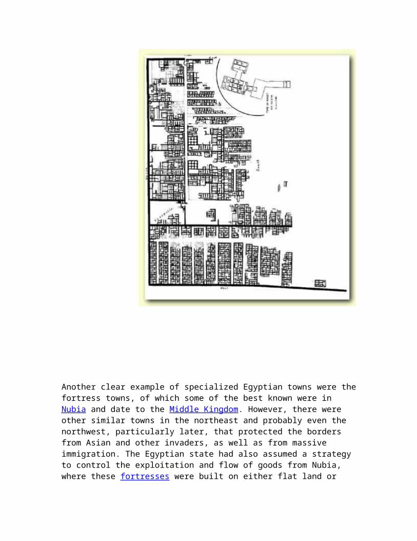
Another clear example of specialized Egyptian towns were the fortress towns, of which some of the best known were in Nubia and date to the Middle Kingdom. However, there were other similar towns in the northeast and probably even the northwest, particularly later, that protected the borders from Asian and other invaders, as well as from massive immigration. The Egyptian state had also assumed a strategy to control the exploitation and flow of goods from Nubia, where these fortresses were built on either flat land or hills. One of the largest was the fortress excavated at Buhen, abut 250 kilometers south of Aswan. It consisted of a fortress built on an Old Kingdom site that consisted of an inner citadel, surrounded by a mud-brick enclosure wall some five meters thick and eight to nine meters high, all overlooking the Nile. These fortresses in Nubia were developed into towns, with temples and residential areas. Residential areas surrounded the citadel and were adjacent to a temple.
As Egyptian civilization progressed, there appears to have been some seventeen cities and twenty-four towns in an administrative network that linked them to the national capital. Though of course the population varied over time, it has been estimated at
between 100,000 and 200,000 people. The populations of provincial capitals and towns were perhaps fairly small, ranging from 1,400 to 3,000 inhabitants. We believe that Illahun, Edfu, Hierakonpolis and Abydos would have been populated by 2,200, 1,800, 1,400 and 900 people, respectively. Tell el-Amarna, on the other hand, as a royal capital would have had a population of between 20,000 and 30,000. Older capitals, such as Memphis and Thebes, may have reached a level of between 30,000 and 40,000 inhabitants at the peaks of their occupation.
The population of these cities and towns were not urban in a modern sense, but perhaps more similar to today's provincial Egyptian towns, which have unmistakable rural aspects to them. The residents consisted not only of urban dwellers, but also of rural people, such as farmers and herdsmen who went out to the countryside each day. Urban inhabitants included artisans, scribes, priests, tax-collectors, servants, guards and soldiers, entertainers and shopkeepers. The kings, nobles and the temples possessed estates that employed a variety of personnel, many of whom were rural workers on the agricultural land. These cities and towns certainly had a hierarchical organization, which included not only palaces, mansions and temples, but also the humble dwellings for the functionaries and peasants, along with workshops, granaries, storage magazines, shops and local markets, all the institutions of residential urban life.
Irregardless of their size, towns and cities became centers of power. In these urban centers, both priests and nobles provided the fabric of the state ideology, as well as the administration of major economic and legal affairs. It was the cities of ancient Egypt that allowed the country to grow into an empire and assume the sophistications of a world power.
Egypt Home | Antiquities | Shop | Get Price for Tour | Kids | Recipes | Photos | Messageby Jimmy Dunn
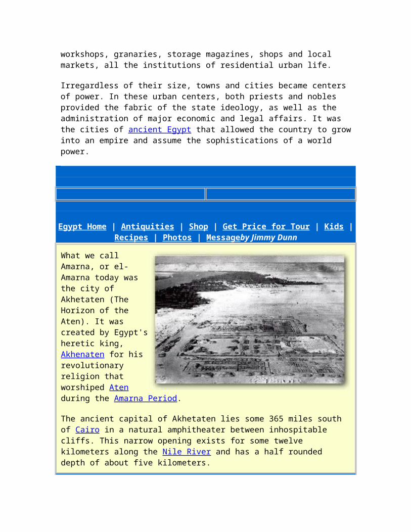
What we call Amarna, or el-Amarna today was the city of Akhetaten (The Horizon of the Aten). It was created by Egypt's heretic king, Akhenaten for his revolutionary religion that worshiped Aten during the Amarna Period.
The ancient capital of Akhetaten lies some 365 miles south of Cairo in a natural amphitheater between inhospitable cliffs. This narrow opening exists for some twelve kilometers along the Nile River and has a half rounded depth of about five kilometers.
This is the place where, in about the fifth year of the king's reign, we are told that by divine inspiration, Akhenaten build his capital.
The History of Discovery
The site was unknown to the European travelers other than its name, which was a village called Et Til el-Amarna. Early visitors misunderstood its name, so it became to be known as Tell el-Amarna, though there are not a single tell, or great mound marking the ancient site.
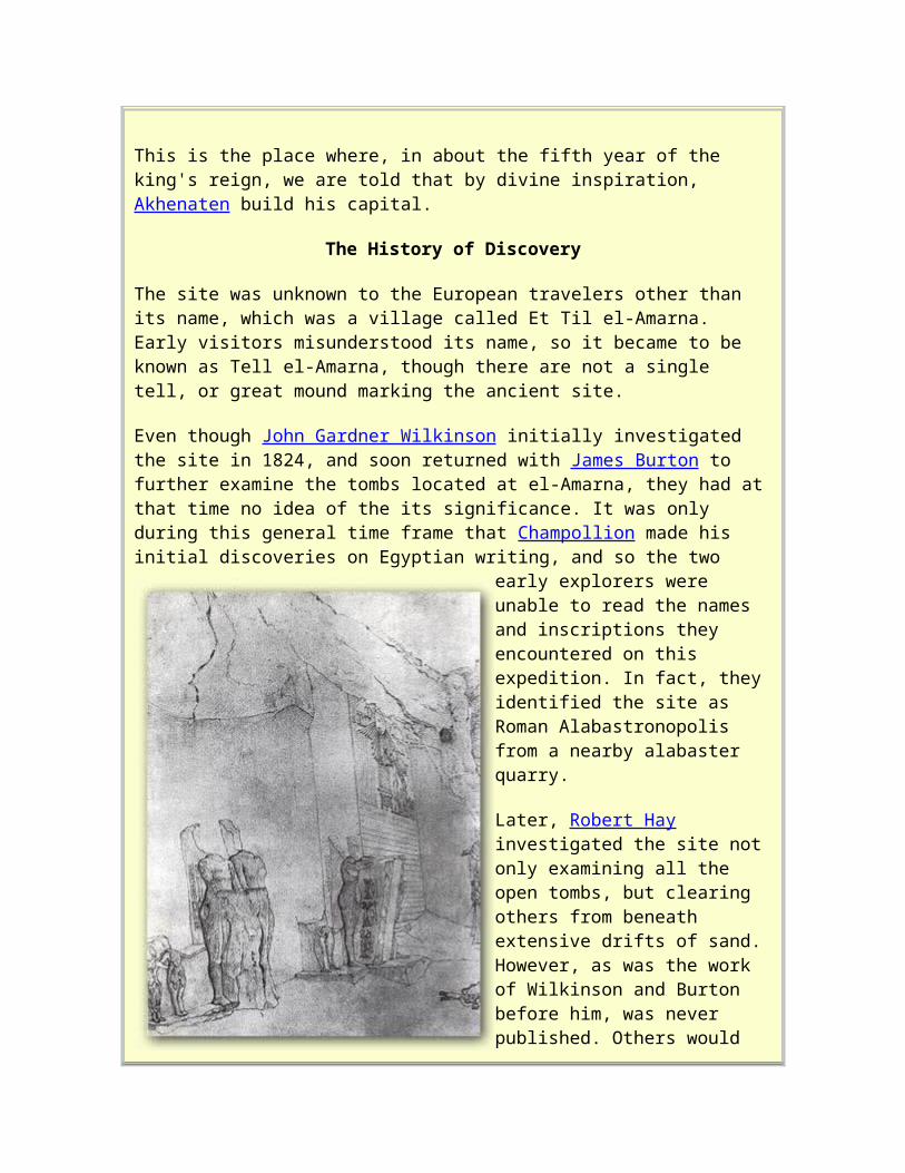
Even though John Gardner Wilkinson initially investigated the site in 1824, and soon returned with James Burton to further examine the tombs located at el-Amarna, they had at that time no idea of the its significance. It was only during this general time frame that Champollion made his initial discoveries on Egyptian writing, and so the two early explorers were unable to read the names and inscriptions they encountered on this expedition. In fact, they identified the site as Roman Alabastronopolis from a nearby alabaster quarry.
Later, Robert Hay investigated the site not only examining all the open tombs, but clearing others from beneath extensive drifts of sand. However, as was the work of Wilkinson and Burton before him, was never published. Others would also come to el-Amarna, and would also fell to publish their work, though most of their efforts are available in various museums today.
Nevertheless, due to the unique decorations in the tombs at el-Amarna, many showing the activities of the royal family not in the formal attitudes of worship repeated so often in other tombs, but in intimate and vivid detail as human beings engaged in everyday domestic affairs, scholars continued to visit the site. There was also a prevailing mystery. In fact, because of the depictions that we know understand represent Akhenaten and
Nefertiti, these early explorers wondered whether this was not the home of two queens, because of the almost feminine physique of the king.
Even as the ability to read hieroglyphics spread amongst the early Egyptologists, discovering the nature of this site remained elusive. So thoroughly had the ancient Egyptians, aided afterwards by the early Christians, destroyed this place that it was not easy to find an intact cartouche bearing the name of the king or queen for whom it was built. Even when they did find cartouches, they were larger then those of other pharaohs, and surrounded by a double border. Furthermore, the signs within these were complex and difficult to interpret, but were evidently the same as those which accompanied a representation of the Sun god, Re-Horakhty found on a few monuments elsewhere.
It was finally Richard Lepsius, a disciple of Champollion and doubtless the foremost Egyptologists of his day, who came to el-Amarna to record inscriptions and take paper squeezes of the reliefs and afterwards, publish his work. This work allowed scholars to finally make advances in their understanding of the city and its king, who they initially read as Khuenaten. Now, more than a century of study has given us this king's correct name, Akhenaten, as well as revealing many of the mysteries that once surrounded the site.
The General Area
The plan of the area of el-Amarna
Located on the eastern side of the Nile River, El-Amarna, like all other ancient Egyptian capitals, was made up of temples, government establishments, utilitarian facilities such as grain silos and bakeries, palaces and common mudbrick homes, several necropolises, as
well as a number of zoos, gardens and other public buildings. In fact, the scope of this city is somewhat amazing if one considers that it was founded in about 1350 BC and abandoned only some twenty years later. The population of the city has been estimated to have been between twenty and fifty thousand inhabitants.
The area of the city and its surrounding property was fixed by copies of decrees carved on fourteen tablets embedded in the cliffs on either side of the river. Hence, these stone slabs are known by Egyptologists as boundary stelae. They not only encompass the city
itself, but also fields and villages on the west bank. The most impressive of these today is Stela U, which measures about 7.6 meters from top to bottom and occupies almost the entire height of the cliff in a little bay to the north of the entrance to the Royal Wadi. At the base of this Stela on both sides are the remains of a group of carved statues of the Royal Family.
These stelae give a vivid account of the king's selection and dedication of the site for his capital, following instructions from his father Aten when he illuminated a certain spot on the desert at sunrise.
Much of the western side of the area, including houses, harbors and the main palace of the king, was obscured under the modern cultivation. However, there are a large number of structures that have been preserved in the desert to the east, and in general, most of the layout is discernable from foundations.
The area is divided into suburbs, with the so-called "central city" housing the Royal Palace and The Great Temple (The Per-Aten), as well as various buildings archaeologists have labeled official (police, taxes...). It is here in one such building, the 'records office', that the Amarna Letters were found by a peasant woman. This area of Amarna was completely excavated in the 1930s. The other residential areas consist of the North City or Suburb, the Main or South City, and the worker's village.
The central City was apparently carefully planned, while the other residential zones where not. In these other areas, the spaces between the earliest large houses was gradually filled up with smaller clusters of homes.
The Central City
There was an ancient road that led in from the north to the Central City, which took an identical path to the modern road of today. It is the central city that the scenes in the North Tombs depict, though the layout of this part of the area requires time and patience to follow now due to decay. Within a generation of Akhenaten's reign, most of the building material was removed, leaving mud brickwork that is now mostly gone.
The chronology of the buildings here can be fairly well determined. The Chapel in the Great Temple and the royal estate were built first, followed closely between year six and nine by the temenos wall of the Great Temple and its sanctuary, replacing the earlier chapel. The palace was begun but never completed.
The main street here is the Royal Road which is a modern name. It comes from the south and passes through the old South City moving into the Central City between the official palace and the royal estate, where it is spanned by a bridge and broadens into a square in front of the entrance facade of the Great Temple. To the east runs the West Road, continuing the High Priest Street of the South City and passing by the Records Office and stopping at the temple magazines.
Layout of the Central City
The city was dissected by two east-west streets that met the West road. The southern one stretches between the king's house and the small temple and then the records office and the clerks' houses to the south and reaches the army headquarters. The second street passes to the north of the royal estate along the southern side of the magazines.
This entire district was deserted in the third year of Tutankhamun's reign.
The Temples
Here, we find the Great Aten Temple as well the Small Aten Temple. Temples at Amarna are considerably different then most cult temples of ancient Egypt. They were, of course, solar temples, with the essential elements consisting of a small obelisk on a high base and an altar. Though solar temples had been built during the Old Kingdom, the worship of the Aten did not require the equipment and architectural elements found in these older establishments, with the exception of the altar. There was no need for a naos because
there is no deity to be sheltered.
However, some temple elements are essential. These attributes include a general rectangular plan enclosed within a tremenos wall which is symmetrically about a longitudinal axis and orientation with the facade facing the west. There are also the pylons as entrance fronts to courts together with a circuitous entrance to conceal the interior from the eyes of the uninitiated. There must also be a slaughter court, the altar and trees flanking the entrance approach. Most of these features, which had been characteristic of Egyptian Temples since Archaic Period, could not easily be absent even at Amarna.
The most basic element of an Aten temple is the altar, to which a ramp or stairway ascends from the west in the middle of the court, surrounded by a temenos wall. The altar platform could occasionally be surrounded by a wall and fronted with a porch. Some also could be abutted by four ramps oriented toward the cardinal points. The altar was usually surrounded by rows of offering tables. The court housing the altar could also be preceded by another court or more.
The Great Temple of the Aten
The Great Aten Temple is on the northern edge of the Central City. It is partly covered over by the modern cemetery of el-Till. The enclosure wall for this temple extended back from the modern road for some 750 meters, and is now represented by a low, straight ridge. Within, the sanctuary was very similar to that in the Small Aten Temple and is marked by a group of isolated rubble heaps near the back.
Bakeries
There is a long, low mound to the south of the temple running east-west with visible broken pottery. This pottery is actually broken bread moulds, and the line marks the site of the central bakeries.
The Bridge
At the end of this ridge is the massive foundations for a bridge that crossed the so called Royal Road in front of the King's House by means of brick piers. There remains some ancient timbers that once bound the brickwork together. On the far side of the road was the Great Palace, consisting of a complex of courts and halls of which only foundations remain.
The Small Temple of the Aten
In recent years, some consolidation and restoration has been carried out at the Small Aten Temple. This included the erection of a replica column. A prominent brick enclosure wall also remains, which was once strengthened by towers on the outside. There are brick pylons at the entrance, and others which subdivided the interior of this building. In the back of the temple stood the sanctuary originally built of limestone and sandstone.
This temple had a foundation layer of gypsum that is now covered over by sand. However, modern stone blocks have been laid atop the sand in order to provide the basic outlines of this temple.
A circular walk beginning at the middle of the north side of this small temple's enclosure wall reveals other parts of the Central City. There is a tall ridge of sand and some rubble that runs northward from across the street through the middle of a small palace built of mud brick. Known as the King's House, it probably accommodated the Royal Family on their visits from their North Palace.
Behind the King's House and the Small Aten Temple (further from the Nile River) were a group of government buildings built of mud brick. This is actually where the famous Amarna Letters were discovered by a peasant lady in 1888.
The Main City Sometimes Known as the South Suburb
Southwards from the Small Aten Temple is The Main City, which was the principal residential area of the ancient city that ran south to the vicinity of the modern village of el-Hagg Qandil. It was the part of the city occupied by the most important people (other than the king), including the vizier Nakht, the high priest
Panehsy, the priest Pawah, General Ramose, the architect Manekhtawitf and the sculptor Tuthmosis (Thutmose). Probably connected to this quarter was a river temple, still in use under Ramesses III and even later through perhaps the 26th Dynasty.
It was probably laid out just after the Central City. There is a platform here built in order to allow visitors to view the interior of one of the private houses which has been cleared and repaired in recent years. Though probably a senior official, the owner of the house is unknown. Here, there are also the ruins of grain silos.
Further south, roughly half way between el-Hagg Qandil and the desert edge of the site on the edge of the Main City, the famous bust of Nefertiti was discovered in Thutmose's workshop.
Elsewhere the city has grown up, as cities will, in an irregular haphazard way, as citizens erected buildings where they felt it was convenient. Some suggest Akhenaten lacked the resources to control the rapid growth of his new city and regulate its plan (other Egyptian cities are much more carefully laid out).
North Suburb
The North Suburb is separated from the Central City by a depression. It was apparently dominantly inhabited by essentially a middle-class including a strong mercantile component. It was not begun until the middle of Akhenaten's reign and was abruptly abandoned, apparently at the end of his reign. Afterwards, apparently the houses were re-inhabited by those who could not afford to travel back to Thebes after the end of the Amarna Period.
There were large estates built here initially between the West and East roads, and subsequently middle class houses and slums which apparently even blocked the streets were added.
The North Palace (Palace of Nefertiti)
Still further north is the North Palace that the locals call "The Palace of Nefertiti" (Kasr Nefertiti). This was a self contained residence built along three sides of a long open space, which itself was divided by a wall and pylon. The residential part had gardens and reception rooms with columns along its rear. In the northeast corner is the most famous part of this residence, consisting of a garden court. A central chamber on the north side, known as the "Green Room", was painted with a continuous frieze representing the natural life of the marshes. Each room has a window from which the sunk central garden could be viewed. In recent years, the walls have been somewhat restored and some of the missing column bases have been replaced with modern replicas. There were animal pens further to the west on the north side and also a court containing three solar altars, of which nothing now exits but their foundations. This palace was probably originally built

for one of Akhenaten's major queens, but was later converted for use by Princess Meritaten.
The North City
Farther to the north where the cultivation ends at the cliffs there is also a North City, which was a separate residential area that served a major palace known as the North Riverside Palace. The palace itself is located just north of the residential area. This was probably the main residence for Akhenaten's family. Most of this is now gone, but there is a length of a
massive brick enclosure wall pierced by a huge gateway at the palace.
The Desert Altars
On the road to the North Tombs, one passes a watchmen's house, and a short distance to the west and north of this lie the remains of three large mud-brick solar altars in the form of square platforms with ramps that are known as the Desert Altars. The northernmost of these had four ramps of well-rammed sand and probably an altar in the center.
The Necropolises
The necropolis consists of more than twenty-five tombs facing the base of the cliff front that is located on the east side of the desert plain, which reaches a height of about eighty-five meters and south of the Royal Wadi Six tombs are located at the north side near Darb El-Malik and known as the North Tombs. These were probably tombs owned by fairly high officials, while nineteen more tombs are located in the south and known as the South Tombs. These southern tombs were owned by a mix of officials.
These tombs are built to be highly complicated to ensure that they are protected from thieves. Most of them start with an open court that leads to three chambers. Within these chambers there are papyrus columns that meet in the rear end. There a statue of the dead would have been placed looking toward the entrance.

The North Tombs were once encroached upon by an ancient Coptic Christian settlement, and groups of little stone huts on the hillside below the tombs belong to these people, who converted tomb number six into a Church. From these tombs, there is an excellent view of the valley below.
The South Tombs are the larger of the two groups of tombs. They are cut into the flanks of a low plateau in front of a major break in the cliffs, where the rock is of poor quality. However, here one finds tomb number 25 which was built for the "God's Father", Ay, who would later become pharaoh. Though often not as imposing as the tombs in the north, they do have their charm, as well as more variety. On the other hand, many of the South Tombs contain little or no decoration and some had barely been started before the city was abandoned. Some of these tombs were also used for later burials, and amongst them are pot shards mostly dating from between the 25th and 30th Dynasty.
The Workers (or Eastern) Village
To the east in a little valley on the south side of a low plateau that runs out from the base of the cliffs between the Royal Wadi and the southern tombs there is an interesting settlement dubbed "the workmen's village". It is a walled enclosure of very regular houses along several parallel streets. Archaeologists believed it housed workers working on the rock tombs nearby (which, incidentally, though built for the royalty and courtiers, were mostly never occupied). However, this walled town had a guard house at the only exit, and it seems more likely to have been to keep the workers in than anything out (the main city was protected by no such wall, for the whole site, including the workmen's village, is enclosed by high cliffs).
The Royal Tomb
The Royal Tomb built for Akhenaten lies in a narrow side valley leading off of the Royal Wadi some six kilometers form its mouth. Its basic design and proportions are not unlike those of the royal tombs in the Valley of the Kings on the West Bank at Thebes (modern Luxor). However, it was intended for several people, including the king, a princes and probably Queen Tiy so there are additional burial chambers. There is also an unfinished annex that may have been intended for Nefertiti.
Here, the quality of the rock is poor, and so the decorations of the tomb were cut into a thin layer of gypsum plaster. Hence, most of the decorations have not survived and most of what is left is in the chambers of princess Meketaten.
Other Ruins
At Kom el-Nana, south of the main city and east of the modern village of el-Hagg Qandil is an enclosure thought to have surrounded another of Akhenaten's sun temples. Recent excavations have revealed brick ceremonial buildings and the foundations of two stone

shrines. The northern side was occupied by a Christian monastery during the 5th and 6th centuries, AD.
There is also far south of the city an unusual cult center known as the Maru-Aten. While it has completely disappeared under the cultivated land, this appears to have been a special function cult structure.
Amarna is unique in Egypt. Even cities built up by foreign rulers did not suffer its fate. It was established most probably from scratch, and appears to have been completely abandoned a short time after Akhenaten's death. Today, considerable research continues at this location that should eventually uncover more of the secrets of the most interesting pharaoh's reign.
References:
Title Author Date Publisher Reference Number
Akhenaten: King of Egypt Aldred, Cyril 1988 Thames and Hudson Ltd
ISBN 0-500-27621-8
Amarna Letters Forbes, Dennis C.
1991 KMT Communications ISBN 1-879388-03-0
Art and History of Egypt Carpiceci, Alberto Carlo
2001 Bonechi ISBN 88-8029-086-x
Chronicle of the Pharaohs (The Reign-By-Reign Record of the Rulers and Dynasties of Ancient Egypt)
Clayton, Peter A.
1994 Thames and Hudson Ltd
ISBN 0-500-05074-0
Conceptions of God in Ancient Egypt: The One and the Many
Hornung, Erik 1971 Cornell University Press
ISBN 0-8014-8384-0
Dictionary of Ancient Egypt, The
Shaw, Ian; Nicholson, Paul
1995 Harry N. Abrams, Inc., Publishers
ISBN 0-8109-3225-3
Dictionary of Egyptian Gods and Goddesses, A
Hart, George 1986 Routledge ISBN 0-415-05909-7
Egyptian Religion Morenz, Siegfried
1973 Cornell University Press
ISBN 0-8014-8029-9
Egyptian Treasures from the Egyptian Museum in Cairo
Tiradritti, Francesco, Editor
1999 Harry N. Abrams, Inc. ISBN 0-8109-3276-8

History of Ancient Egypt, A Grimal, Nicolas
1988 Blackwell None Stated
Oxford History of Ancient Egypt, The
Shaw, Ian 2000 Oxford University Press
ISBN 0-19-815034-2
Private Lives of the Pharaohs, The
Tyldesley, Joyce
2000 TV Books, L.L.C. ISBN 1-57500-154-3
Thebes in Egypt: A Guide to the Tombs and Temples of Ancient Luxor
Strudwick, Nigel & Helen
1999 Cornell University Press
ISBN 0 8014 8616 5
Tutankhamun (His Tomb and Its Treasures)
Edwards, I. E. S.
1977 Metropolitan Museum of Art; Alfred A. Knopf, Inc.
ISBN 0-394-41170-6
Archives
.

However, the cities of ancient Egypt, including their locations, functions and organization, were related to various dynamics that shaped the course of Egyptian civilization based on both internal and external forces. There were many specialized cities such as those based on trade. Others, for example, were made up of artisans,
craftsmen and workers related to various royal projects. Some of the best preserved of these are four different workers villages have survived to some extent, all of which were situated somewhat off of the Nile. The village at Deir el-Medina is perhaps one of the best known, located on the western bank of the Nile opposite Thebes. It does provide an idea of the organization of a specialized village, as well as a somewhat distorted view of village life. Another workers' village is located at Illahun, on the eastern end of the 12th Dynasty pyramid complex of Senusret II. That town was later occupied by officials of the king's mortuary cult. A third workers' village was discovered at Tell el-Amarna, the capital city built by the heretic king Akhenaten. It was build on the edge of the desert to the east of the Nile, and because the city was abandoned early on, provides one of the clearest indications of village design and construction, though it may not be completely reprehensive of other settlements. A final workers' and surprisingly, one of the last to be excavated, is found at Giza just outside Cairo

The town of Illahun (Kahun) is also representative of various settlements that existed where priests and others were responsible for the rituals and observances related to the mortuary cult of the king, as well as the foundation estate created to finance such cults. Some of these also became administrative centers, in addition to their responsibilities for maintaining the cult.
Another clear example of specialized Egyptian towns were the fortress towns, of which some of the best known were in Nubia and date to the Middle Kingdom. However, there were other similar towns in the northeast and probably even the northwest, particularly later, that protected the borders from Asian and other invaders, as well as from massive immigration. The Egyptian state had also assumed a strategy to control the exploitation and flow of goods from Nubia, where these fortresses were built on either flat land or hills. One of the largest was the fortress excavated at Buhen, abut 250 kilometers south of Aswan. It consisted of a fortress built on an Old Kingdom site that consisted of an inner citadel, surrounded by a mud-brick enclosure wall some five meters thick and eight to nine meters high, all overlooking the Nile. These fortresses in Nubia were developed into towns, with temples and residential areas. Residential areas surrounded the citadel and

were adjacent to a temple.
As Egyptian civilization progressed, there appears to have been some seventeen cities and twenty-four towns in an administrative network that linked them to the national capital. Though of course the population varied over time, it has been estimated at between 100,000 and 200,000 people. The populations of provincial capitals and towns were perhaps fairly small, ranging from 1,400 to 3,000 inhabitants. We believe that Illahun, Edfu, Hierakonpolis and Abydos would have been populated by 2,200, 1,800, 1,400 and 900 people, respectively. Tell el-Amarna, on the other hand, as a royal capital would have had a population of between 20,000 and 30,000. Older capitals, such as Memphis and Thebes, may have reached a level of between 30,000 and 40,000 inhabitants at the peaks of their occupation.
The population of these cities and towns were not urban in a modern sense, but perhaps more similar to today's provincial Egyptian towns, which have unmistakable rural aspects to them. The residents consisted not only of urban dwellers, but also of rural people, such as farmers and herdsmen who went out to the countryside each day. Urban inhabitants included artisans, scribes, priests, tax-collectors, servants, guards and soldiers, entertainers and shopkeepers. The kings, nobles and the temples possessed estates that employed a variety of personnel, many of whom were rural workers on the agricultural land. These cities and towns certainly had a hierarchical organization, which included not only palaces, mansions and temples, but also the humble dwellings for the functionaries and peasants, along with workshops, granaries, storage magazines, shops and local markets, all the institutions of residential urban life.
Irregardless of their size, towns and cities became centers of power. In these urban centers, both priests and nobles provided the fabric of the state ideology, as well as the administration of major economic and legal affairs. It was the cities of ancient Egypt that allowed the country to grow into an empire and assume the sophistications of a world power.
Author Date Publisher Reference Number
Akhenaten: King of Egypt Aldred, Cyril 1988 Thames and Hudson Ltd
ISBN 0-500-27621-8
Atlas of Ancient Egypt Baines, John; Malek, Jaromir
1980 Les Livres De France
None Stated
Complete Temples of Ancient Egypt, The
Wilkinson, Richard H.
2000 Thames and Hudson, Ltd
ISBN 0-500-05100-3
Dictionary of Ancient Egypt, The
Shaw, Ian; Nicholson,
1995 Harry N. Abrams, Inc., Publishers
ISBN 0-8109-3225-3

Paul
Early Dynastic Egypt Wilkinson, Toby A. H.
1999 Routledge ISBN 0-415-26011-6
Encyclopedia of Ancient Egyptian Architecture, The
Arnold, Dieter
2003 Princeton University Press
ISBN 0-691-11488-9
History of Ancient Egypt, A Grimal, Nicolas
1988 Blackwell None Stated
History of Egyptian Architecture, A (The Empire (the New Kingdom) From the Eighteenth Dynasty to the End of the Twentieth Dynasty 1580-1085 B.C.
Badawy, Alexander
1968 University of California Press
LCCC A5-4746
Oxford Encyclopedia of Ancient Egypt, The
Redford, Donald B. (Editor)
2001 American University in Cairo Press, The
ISBN 977 424 581 4
Oxford History of Ancient Egypt, The
Shaw, Ian 2000 Oxford University Press
ISBN 0-19-815034-2
Ramesses II James, T. G. H
2002 Friedman/Fairfax ISBN 1-58663-719-
Archives
