effective and affordable fleet management geotab gps technology and reporting geotab hardware gps...
TRANSCRIPT
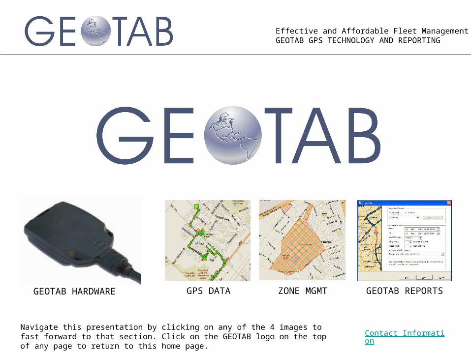
Effective and Affordable Fleet ManagementGEOTAB GPS TECHNOLOGY AND REPORTING
GEOTAB HARDWARE GPS DATA ZONE MGMT GEOTAB REPORTS
Contact InformationNavigate this presentation by clicking on any of the 4 images to fast forward to that section. Click on the GEOTAB logo on the top of any page to return to this home page.
Effective and Affordable Fleet ManagementGEOTAB GPS TECHNOLOGY AND REPORTING
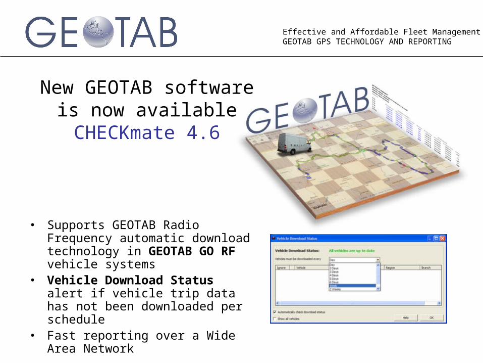
New GEOTAB software is now available CHECKmate 4.6
• Supports GEOTAB Radio Frequency automatic download technology in GEOTAB GO RF vehicle systems
• Vehicle Download Status alert if vehicle trip data has not been downloaded per schedule
• Fast reporting over a Wide Area Network
Effective and Affordable Fleet ManagementGEOTAB GPS TECHNOLOGY AND REPORTING
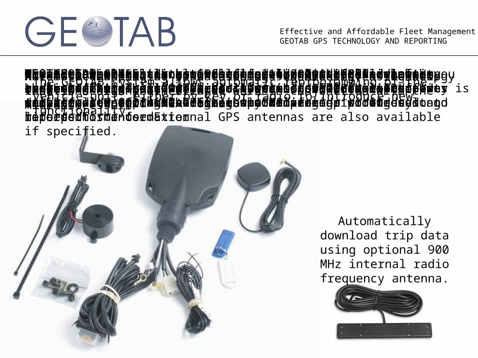
GEOTAB powered internal GPS antenna detects GPS signals through fiberglass, vinyl and glass. Installed on Step Vans with great results. The internal GPS antenna provides long life performance. External GPS antennas are also available if specified.
The GEOTAB GPS black box will log 16,000 records in memory on-board the vehicle. The equivalent of 5,000 miles of city driving or 8,000 miles of highway driving.
Wireless downloading of data using 900 MHz proven technology that is design engineered to work in conjunction with the microprocessor.GEOTAB has the ability to do special projects allowing custom versions of GO vehicle systems to address specific requirements eg. attaching a barcode scanner to our unit to record this information
Monitor switches, doors or motors along with GPS data so you can report where and when doors were opened or motors activated. Up to 4 devices can be monitored.
Wired to the ignition switch to provide enhanced idle time reporting. Also allows for a sleep mode where battery power is not affected if the vehicle is parked for up to 60 days.
Provides a connection point to deliver GPS data to a wide range of third party devices. Data is provided in the industry standard NMEA format.
Driver ID memory sticks are optional and useful in applications requiring driver log records. Driver ID sticks allow optional vehicle immobilization wiring harness to be used.
Automatic mapping of your customers (geocoding) using stop locations or any other inputA vehicle buzzer can be programmed to alert drivers of over-speeding or use of vehicle outside of authorized zone. GEOTAB calculates exceptions for over-speeding and harsh braking. The result is a reduction in accident claims.Passed SAE J1455 test standard for shock, vibration, heat and humidity. The unit is sealed with a rubber gasket and tamper evident plugs. GPS antenna tampering is detected and reported.
Automatically download trip data using optional 900 MHz internal radio
frequency antenna.
The GEOTAB system allows automatic reprogramming of the vehicle unit, either by key or radio to introduce new functionality.
Effective and Affordable Fleet ManagementGEOTAB GPS TECHNOLOGY AND REPORTING
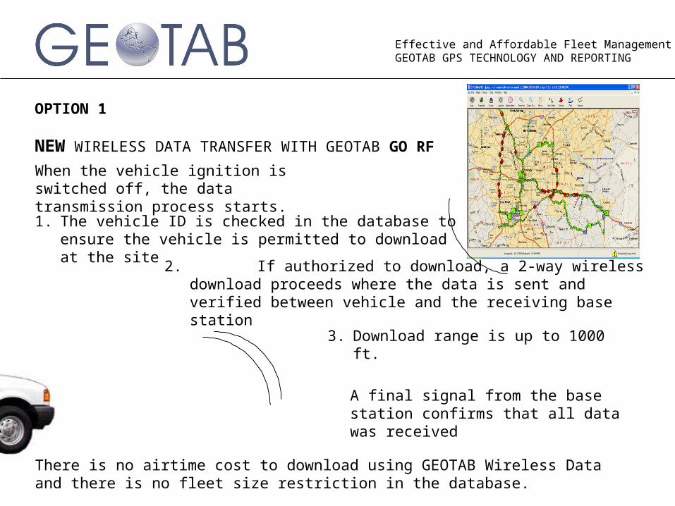
OPTION 1
NEW WIRELESS DATA TRANSFER WITH GEOTAB GO RF
When the vehicle ignition is switched off, the data transmission process starts.1. The vehicle ID is checked in the database to ensure
the vehicle is permitted to download at the site
2. If authorized to download, a 2-way wireless download proceeds where the data is sent and verified between vehicle and the receiving base station
3. Download range is up to 1000 ft.
There is no airtime cost to download using GEOTAB Wireless Data and there is no fleet size restriction in the database.
A final signal from the base station confirms that all data was received
Effective and Affordable Fleet ManagementGEOTAB GPS TECHNOLOGY AND REPORTING
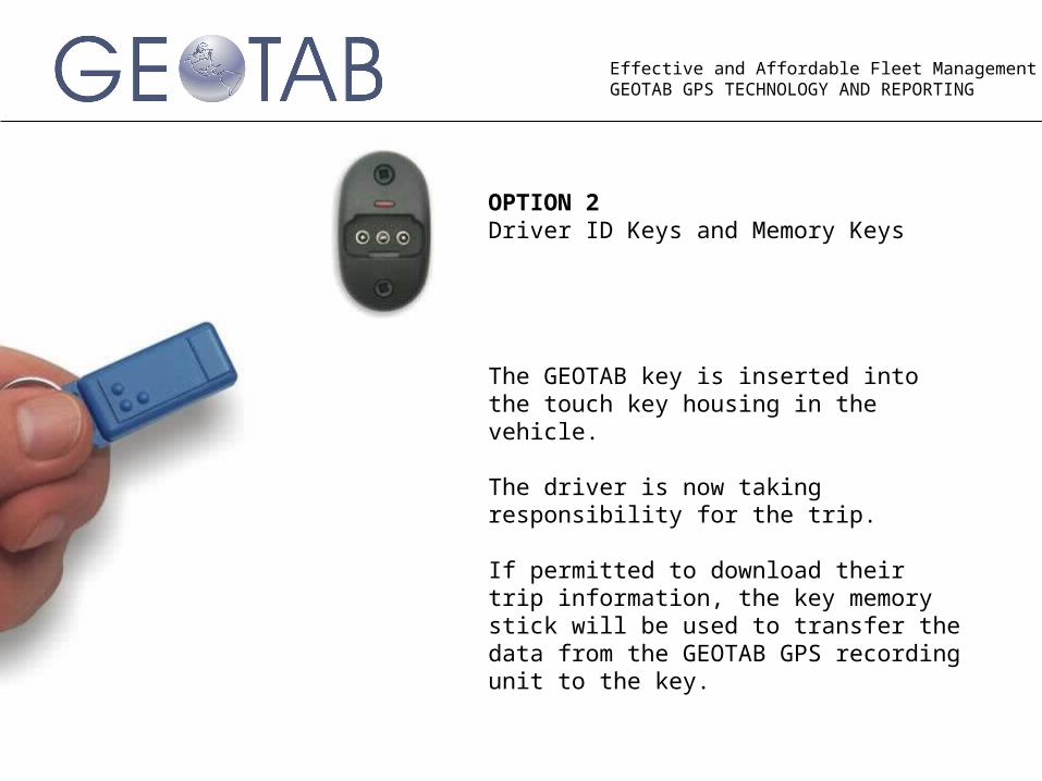
The GEOTAB key is inserted into the touch key housing in the vehicle.
The driver is now taking responsibility for the trip.
If permitted to download their trip information, the key memory stick will be used to transfer the data from the GEOTAB GPS recording unit to the key.
OPTION 2 Driver ID Keys and Memory Keys
Effective and Affordable Fleet ManagementGEOTAB GPS TECHNOLOGY AND REPORTING
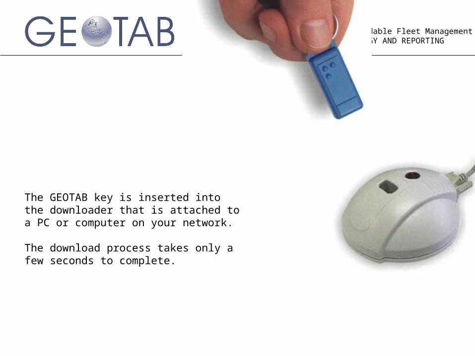
The GEOTAB key is inserted into the downloader that is attached to a PC or computer on your network.
The download process takes only a few seconds to complete.
Effective and Affordable Fleet ManagementGEOTAB GPS TECHNOLOGY AND REPORTING
GEOTAB GPS DATA
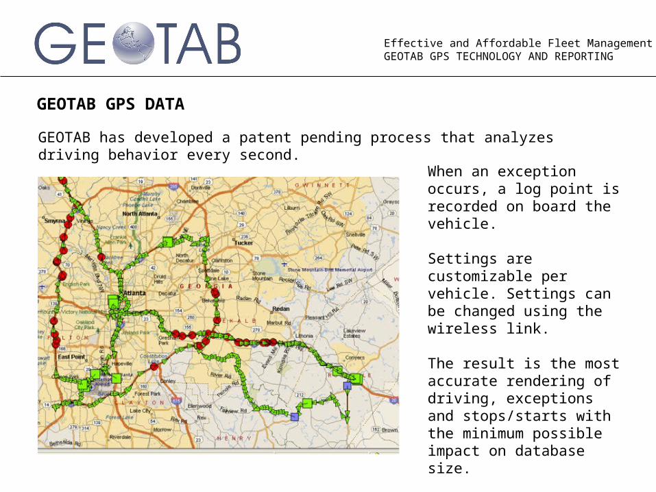
When an exception occurs, a log point is recorded on board the vehicle.
Settings are customizable per vehicle. Settings can be changed using the wireless link.
The result is the most accurate rendering of driving, exceptions and stops/starts with the minimum possible impact on database size.
Hot Start features fast GPS lock time for morning starts.
GEOTAB has developed a patent pending process that analyzes driving behavior every second.
Effective and Affordable Fleet ManagementGEOTAB GPS TECHNOLOGY AND REPORTING
GEOTAB GPS DATA
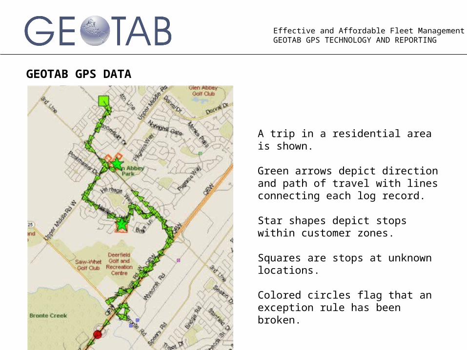
A trip in a residential area is shown.
Green arrows depict direction and path of travel with lines connecting each log record.
Star shapes depict stops within customer zones.
Squares are stops at unknown locations.
Colored circles flag that an exception rule has been broken.

Effective and Affordable Fleet ManagementGEOTAB GPS TECHNOLOGY AND REPORTING
GEOTAB GPS DATA
By moving a mouse over any log point, the details are displayed.
Effective and Affordable Fleet ManagementGEOTAB GPS TECHNOLOGY AND REPORTING
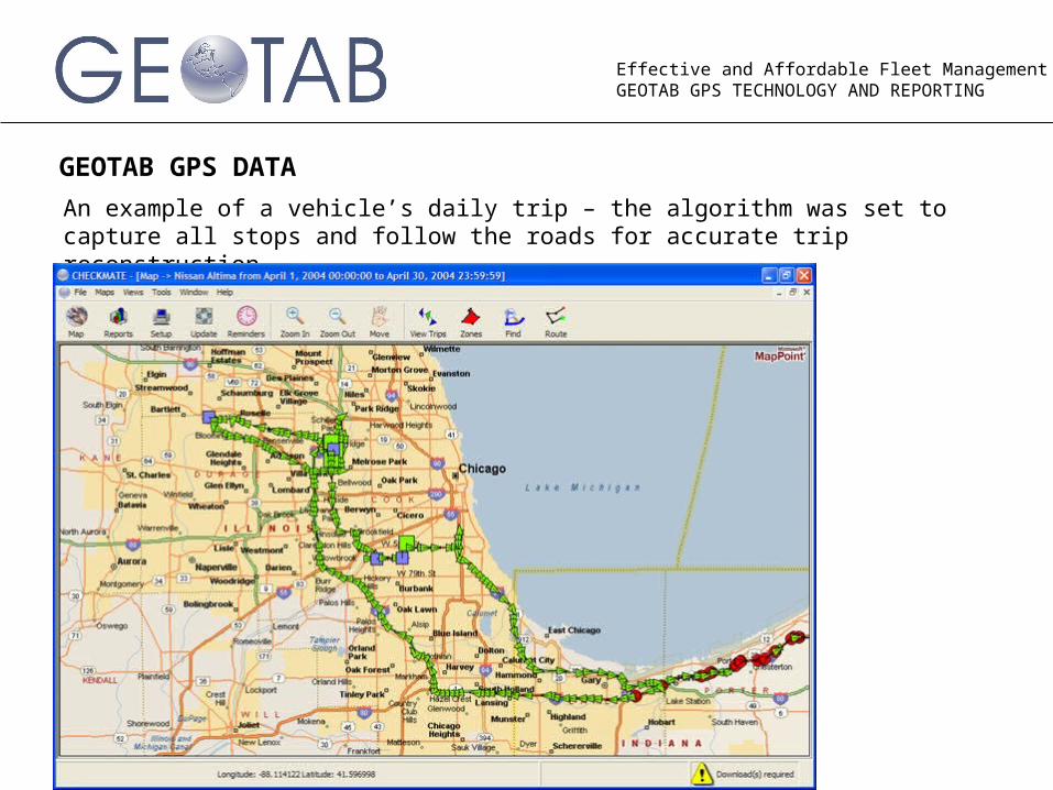
GEOTAB GPS DATA
An example of a vehicle’s daily trip – the algorithm was set to capture all stops and follow the roads for accurate trip reconstruction.
Effective and Affordable Fleet ManagementGEOTAB GPS TECHNOLOGY AND REPORTING
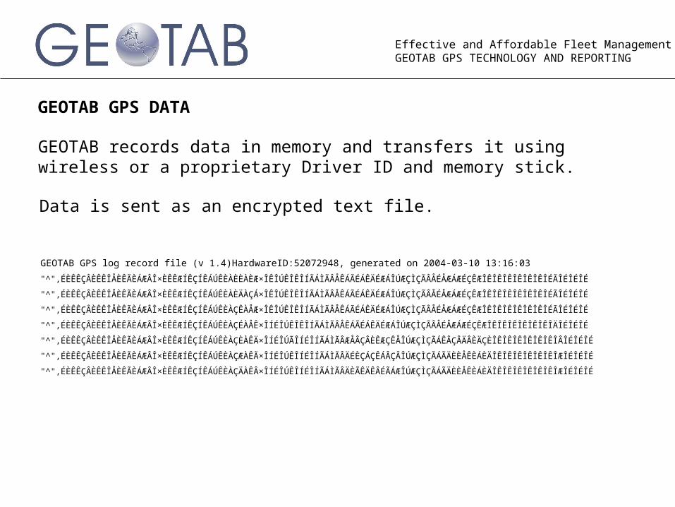
GEOTAB GPS DATA
GEOTAB GPS log record file (v 1.4)HardwareID:52072948, generated on 2004-03-10 13:16:03
"^",ÉÈÊÊÇÂÈÊÊÎÅÈÊÃÈÁÆÂÎ×ÈÊÊÆÍÊÇÍÊÁÚÊÈÀÈÈÀÈÆ×ÎÊÎÚÊÎÊÎÍÃÁÌÃÂÅÊÁÃÉÁÊÄÉÆÁÎÚÆÇÌÇÃÂÅÉÅÆÁÆÉÇÊÆÎÊÎÊÎÊÎÊÎÊÎÊÎÉÃÎÉÎÉÎÉ
"^",ÉÈÊÊÇÂÈÊÊÎÅÈÊÃÈÁÆÂÎ×ÈÊÊÆÍÊÇÍÊÁÚÊÈÀÈÄÀÇÁ×ÎÊÎÚÊÎÊÎÍÃÁÌÃÂÅÊÁÃÉÁÊÄÉÆÁÎÚÆÇÌÇÃÂÅÉÅÆÁÆÉÇÊÆÎÊÎÊÎÊÎÊÎÊÎÊÎÉÃÎÉÎÉÎÉ
"^",ÉÈÊÊÇÂÈÊÊÎÅÈÊÃÈÁÆÂÎ×ÈÊÊÆÍÊÇÍÊÁÚÊÈÀÇÊÀÅÆ×ÎÊÎÚÊÎÊÎÍÃÁÌÃÂÅÊÁÃÉÁÊÄÉÆÁÎÚÆÇÌÇÃÂÅÉÅÆÁÆÉÇÊÆÎÊÎÊÎÊÎÊÎÊÎÊÎÉÃÎÉÎÉÎÉ
"^",ÉÈÊÊÇÂÈÊÊÎÅÈÊÃÈÁÆÂÎ×ÈÊÊÆÍÊÇÍÊÁÚÊÈÀÇÉÀÅÊ×ÎÍÉÎÚÊÎÊÎÍÃÁÌÃÂÅÊÁÃÉÁÊÄÉÆÁÎÚÆÇÌÇÃÂÅÉÅÆÁÆÉÇÊÆÎÊÎÊÎÊÎÊÎÊÎÊÎÄÎÉÎÉÎÉ
"^",ÉÈÊÊÇÂÈÊÊÎÅÈÊÃÈÁÆÂÎ×ÈÊÊÆÍÊÇÍÊÁÚÊÈÀÇÈÀÊÄ×ÎÍÉÎÚÃÎÍÉÎÍÃÁÌÃÂÆÅÂÇÂÈÊÆÇÊÅÎÚÆÇÌÇÃÁÊÂÇÂÄÂÈÄÇÈÎÊÎÊÎÊÎÊÎÊÎÊÎÂÎÉÎÉÎÉ
"^",ÉÈÊÊÇÂÈÊÊÎÅÈÊÃÈÁÆÂÎ×ÈÊÊÆÍÊÇÍÊÁÚÊÈÀÇÆÀÊÃ×ÎÍÉÎÚÊÎÍÉÎÍÃÁÌÃÂÄÉÈÇÁÇÊÁÂÇÂÎÚÆÇÌÇÃÁÃÄÈÈÅÊÈÁÈÄÎÊÎÊÎÊÎÊÎÊÎÊÎÆÎÉÎÉÎÉ
"^",ÉÈÊÊÇÂÈÊÊÎÅÈÊÃÈÁÆÂÎ×ÈÊÊÆÍÊÇÍÊÁÚÊÈÀÇÄÀÊÂ×ÎÍÉÎÚÊÎÍÉÎÍÃÁÌÃÂÄÈÃÊÄÊÂÉÃÁÆÎÚÆÇÌÇÃÁÃÄÈÈÅÊÈÁÈÄÎÊÎÊÎÊÎÊÎÊÎÊÎÆÎÉÎÉÎÉ
GEOTAB records data in memory and transfers it using wireless or a proprietary Driver ID and memory stick.
Data is sent as an encrypted text file.
Effective and Affordable Fleet ManagementGEOTAB GPS TECHNOLOGY AND REPORTING
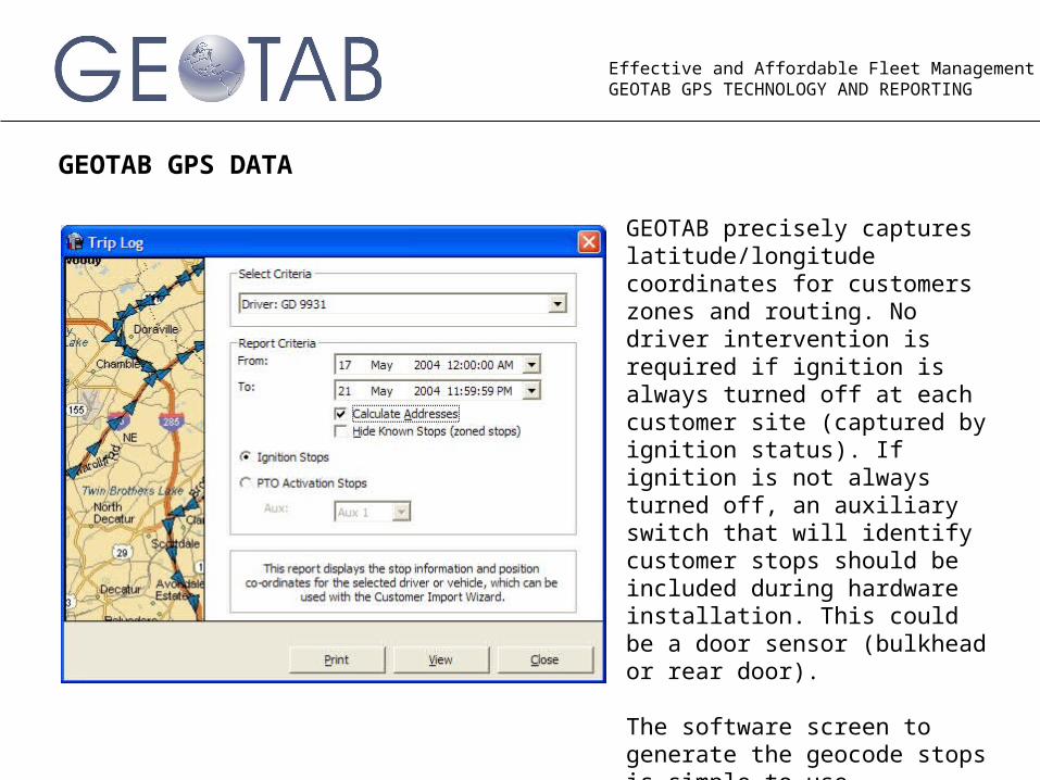
GEOTAB GPS DATA
GEOTAB precisely captures latitude/longitude coordinates for customers zones and routing. No driver intervention is required if ignition is always turned off at each customer site (captured by ignition status). If ignition is not always turned off, an auxiliary switch that will identify customer stops should be included during hardware installation. This could be a door sensor (bulkhead or rear door).
The software screen to generate the geocode stops is simple to use.
Effective and Affordable Fleet ManagementGEOTAB GPS TECHNOLOGY AND REPORTING
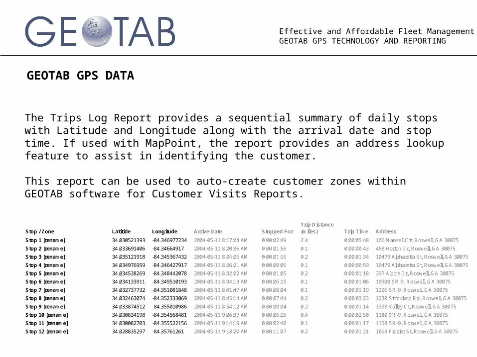
GEOTAB GPS DATA
The Trips Log Report provides a sequential summary of daily stops with Latitude and Longitude along with the arrival date and stop time. If used with MapPoint, the report provides an address lookup feature to assist in identifying the customer.
This report can be used to auto-create customer zones within GEOTAB software for Customer Visits Reports.
Stop / Zone Latitide Longitude Arrive Date Stopped ForTrip Distance (miles) Trip Time Address
Stop 1 [rename] 34.030521393 -84.346977234 2004-05-11 8:17:04 AM 0:00:02:49 2.4 0:00:05:48 106 Mansell Cir, Roswell, GA 30075
Stop 2 [rename] 34.033691406 -84.34664917 2004-05-11 8:20:36 AM 0:00:01:56 0.1 0:00:00:43 488 Horton Dr, Roswell, GA 30075
Stop 3 [rename] 34.035121918 -84.345367432 2004-05-11 8:24:06 AM 0:00:01:16 0.2 0:00:01:34 10479 Alpharetta St, Roswell, GA 30075
Stop 4 [rename] 34.034976959 -84.346427917 2004-05-11 8:26:21 AM 0:00:00:06 0.1 0:00:00:59 10479 Alpharetta St, Roswell, GA 30075
Stop 5 [rename] 34.034538269 -84.348442078 2004-05-11 8:32:02 AM 0:00:01:05 0.2 0:00:01:18 397 Alpine Dr, Roswell, GA 30075
Stop 6 [rename] 34.034133911 -84.349510193 2004-05-11 8:34:13 AM 0:00:06:15 0.1 0:00:01:06 10300 SR-9, Roswell, GA 30075
Stop 7 [rename] 34.032737732 -84.351081848 2004-05-11 8:41:47 AM 0:00:00:04 0.1 0:00:01:19 1306 SR-9, Roswell, GA 30075
Stop 8 [rename] 34.032463074 -84.352333069 2004-05-11 8:45:14 AM 0:00:07:44 0.2 0:00:03:23 1230 Strickland Rd, Roswell, GA 30075
Stop 9 [rename] 34.033874512 -84.355010986 2004-05-11 8:54:12 AM 0:00:00:04 0.2 0:00:01:14 1398 Valley Ct, Roswell, GA 30075
Stop 10 [rename] 34.030834198 -84.354568481 2004-05-11 9:06:37 AM 0:00:06:25 0.4 0:00:02:50 1180 SR-9, Roswell, GA 30075
Stop 11 [rename] 34.030082703 -84.355522156 2004-05-11 9:14:19 AM 0:00:02:40 0.1 0:00:01:17 1158 SR-9, Roswell, GA 30075
Stop 12 [rename] 34.028835297 -84.35761261 2004-05-11 9:18:20 AM 0:00:11:07 0.2 0:00:01:21 1098 Frazier St, Roswell, GA 30075
Effective and Affordable Fleet ManagementGEOTAB GPS TECHNOLOGY AND REPORTING
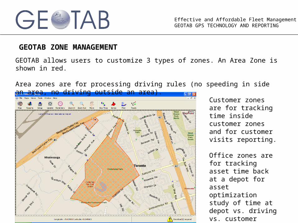
GEOTAB ZONE MANAGEMENT
GEOTAB allows users to customize 3 types of zones. An Area Zone is shown in red.
Area zones are for processing driving rules (no speeding in side an area, no driving outside an area).
Customer zones are for tracking time inside customer zones and for customer visits reporting.
Office zones are for tracking asset time back at a depot for asset optimization study of time at depot vs. driving vs. customer time.
Effective and Affordable Fleet ManagementGEOTAB GPS TECHNOLOGY AND REPORTING
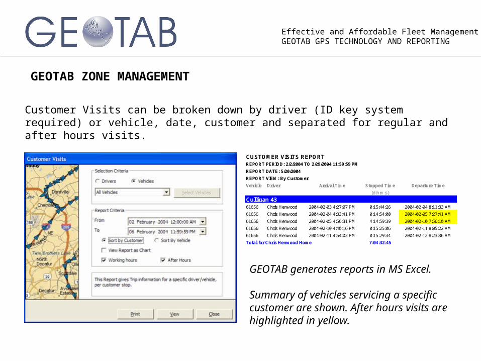
GEOTAB ZONE MANAGEMENT
Customer Visits can be broken down by driver (ID key system required) or vehicle, date, customer and separated for regular and after hours visits.
Vehicle Driver Arrival Time Stopped Time Departure Time
(d:h:m:s)
61656 Chris Henwood 2004-02-03 4:27:07 PM 0:15:44:26 2004-02-04 8:11:33 AM
61656 Chris Henwood 2004-02-04 4:33:41 PM 0:14:54:00 2004-02-05 7:27:41 AM
61656 Chris Henwood 2004-02-05 4:56:31 PM 4:14:59:39 2004-02-10 7:56:10 AM
61656 Chris Henwood 2004-02-10 4:40:16 PM 0:15:25:06 2004-02-11 8:05:22 AM
61656 Chris Henwood 2004-02-11 4:54:02 PM 0:15:29:34 2004-02-12 8:23:36 AM
Total for Chris Henwood Home 7:04:32:45
Culligan 43
CUSTOMER VISITS REPORTREPORT PERIOD: 2/2/2004 TO 2/29/2004 11:59:59 PM
REPORT DATE: 5/20/2004
REPORT VIEW: By Customer
GEOTAB generates reports in MS Excel.
Summary of vehicles servicing a specific customer are shown. After hours visits are highlighted in yellow.
Effective and Affordable Fleet ManagementGEOTAB GPS TECHNOLOGY AND REPORTING
GEOTAB REPORTS
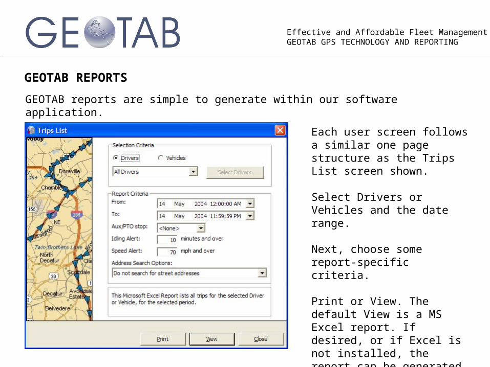
GEOTAB reports are simple to generate within our software application.
Each user screen follows a similar one page structure as the Trips List screen shown.
Select Drivers or Vehicles and the date range.
Next, choose some report-specific criteria.
Print or View. The default View is a MS Excel report. If desired, or if Excel is not installed, the report can be generated in html.
Effective and Affordable Fleet ManagementGEOTAB GPS TECHNOLOGY AND REPORTING
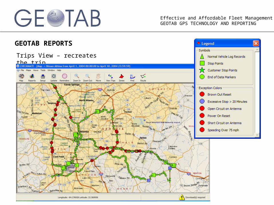
GEOTAB REPORTS
Trips View – recreates the trip
Effective and Affordable Fleet ManagementGEOTAB GPS TECHNOLOGY AND REPORTING
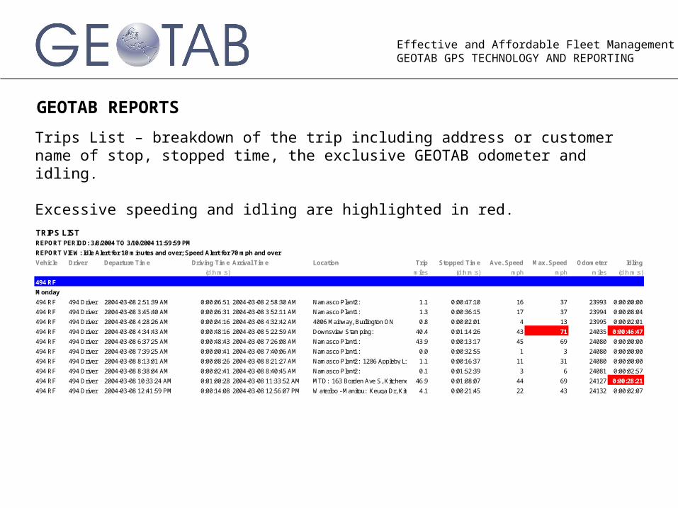
GEOTAB REPORTS
Trips List – breakdown of the trip including address or customer name of stop, stopped time, the exclusive GEOTAB odometer and idling.
Excessive speeding and idling are highlighted in red.
Vehicle Driver Departure Time Driving Time Arrival Time Location Trip Stopped Time Ave. Speed Max. Speed Odometer Idling
(d:h:m:s) miles (d:h:m:s) mph mph miles (d:h:m:s)
Monday
494 RF 494 Driver 2004-03-08 2:51:39 AM 0:00:06:51 2004-03-08 2:58:30 AM Namasco Plant2: 1.1 0:00:47:10 16 37 23993 0:00:00:00
494 RF 494 Driver 2004-03-08 3:45:40 AM 0:00:06:31 2004-03-08 3:52:11 AM Namasco Plant1: 1.3 0:00:36:15 17 37 23994 0:00:08:04
494 RF 494 Driver 2004-03-08 4:28:26 AM 0:00:04:16 2004-03-08 4:32:42 AM 4006 Mainway, Burlington ON 0.8 0:00:02:01 4 13 23995 0:00:02:01
494 RF 494 Driver 2004-03-08 4:34:43 AM 0:00:48:16 2004-03-08 5:22:59 AM Downsview Stamping: 40.4 0:01:14:26 43 71 24035 0:00:46:47
494 RF 494 Driver 2004-03-08 6:37:25 AM 0:00:48:43 2004-03-08 7:26:08 AM Namasco Plant1: 43.9 0:00:13:17 45 69 24080 0:00:00:00
494 RF 494 Driver 2004-03-08 7:39:25 AM 0:00:00:41 2004-03-08 7:40:06 AM Namasco Plant1: 0.0 0:00:32:55 1 3 24080 0:00:00:00
494 RF 494 Driver 2004-03-08 8:13:01 AM 0:00:08:26 2004-03-08 8:21:27 AM Namasco Plant2: 1286 Appleby Line, Burlington ON1.1 0:00:16:37 11 31 24080 0:00:00:00
494 RF 494 Driver 2004-03-08 8:38:04 AM 0:00:02:41 2004-03-08 8:40:45 AM Namasco Plant2: 0.1 0:01:52:39 3 6 24081 0:00:02:57
494 RF 494 Driver 2004-03-08 10:33:24 AM 0:01:00:28 2004-03-08 11:33:52 AM MTD: 163 Borden Ave S, Kitchener ON46.9 0:01:08:07 44 69 24127 0:00:28:21
494 RF 494 Driver 2004-03-08 12:41:59 PM 0:00:14:08 2004-03-08 12:56:07 PM Waterloo - Manitou: Keuga Dr, Kitchener ON4.1 0:00:21:45 22 43 24132 0:00:02:07
494 RF
TRIPS LISTREPORT PERIOD: 3/8/2004 TO 3/10/2004 11:59:59 PM
REPORT VIEW: Idle Alert for 10 minutes and over; Speed Alert for 70 mph and over
Effective and Affordable Fleet ManagementGEOTAB GPS TECHNOLOGY AND REPORTING
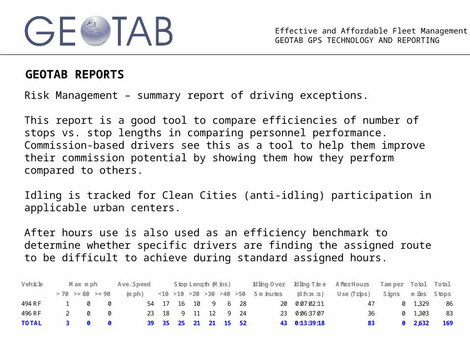
GEOTAB REPORTS
Risk Management – summary report of driving exceptions.
This report is a good tool to compare efficiencies of number of stops vs. stop lengths in comparing personnel performance. Commission-based drivers see this as a tool to help them improve their commission potential by showing them how they perform compared to others.
Idling is tracked for Clean Cities (anti-idling) participation in applicable urban centers.
After hours use is also used as an efficiency benchmark to determine whether specific drivers are finding the assigned route to be difficult to achieve during standard assigned hours.
Vehicle Ave. Speed Idling Over Idling Time After Hours Tamper Total Total
> 70 >= 80 >= 90 (mph) <10 >10 >20 >30 >40 >50 5 minutes (d:h:m:s) Use (Trips) Signs miles Stops
494 RF 1 0 0 54 17 16 10 9 6 28 20 0:07:02:11 47 0 1,329 86
496 RF 2 0 0 23 18 9 11 12 9 24 23 0:06:37:07 36 0 1,303 83
TOTAL 3 0 0 39 35 25 21 21 15 52 43 0:13:39:18 83 0 2,632 169
Max mph Stop Length (Mins)
Effective and Affordable Fleet ManagementGEOTAB GPS TECHNOLOGY AND REPORTING
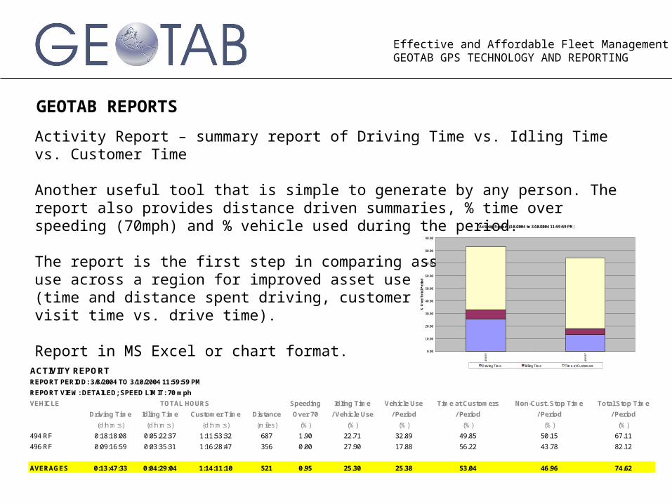
GEOTAB REPORTS
Activity Report – summary report of Driving Time vs. Idling Time vs. Customer Time
Another useful tool that is simple to generate by any person. The report also provides distance driven summaries, % time over speeding (70mph) and % vehicle used during the period.
The report is the first step in comparing asset use across a region for improved asset use (time and distance spent driving, customer visit time vs. drive time).
Report in MS Excel or chart format.
VEHICLE Speeding Idling Time Vehicle Use Time at Customers Non-Cust. Stop Time Total Stop Time
Driving Time Idling Time Customer Time Distance Over 70 / Vehicle Use / Period / Period / Period / Period
(d:h:m:s) (d:h:m:s) (d:h:m:s) (miles) (%) (%) (%) (%) (%) (%)
494 RF 0:18:18:08 0:05:22:37 1:11:53:32 687 1.90 22.71 32.89 49.85 50.15 67.11
496 RF 0:09:16:59 0:03:35:31 1:16:28:47 356 0.00 27.90 17.88 56.22 43.78 82.12
AVERAGES 0:13:47:33 0:04:29:04 1:14:11:10 521 0.95 25.30 25.38 53.04 46.96 74.62
TOTAL HOURS
ACTIVITY REPORTREPORT PERIOD: 3/8/2004 TO 3/10/2004 11:59:59 PM
REPORT VIEW: DETAILED; SPEED LIMIT: 70 mph
Activity Report (3/8/2004 to 3/10/2004 11:59:59 PM)
0.00
10.00
20.00
30.00
40.00
50.00
60.00
70.00
80.00
90.00
494
RF
496
RF
% O
ver
To
tal
Per
iod
Driving Time Idling Time Time at Customers
Effective and Affordable Fleet ManagementGEOTAB GPS TECHNOLOGY AND REPORTING
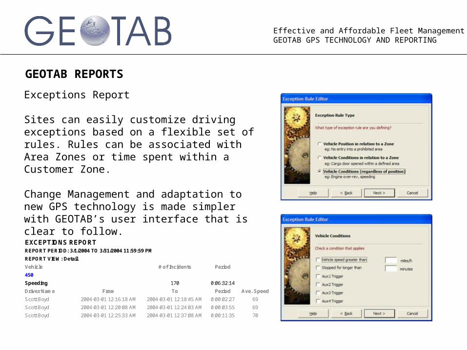
GEOTAB REPORTS
Exceptions Report
Sites can easily customize driving exceptions based on a flexible set of rules. Rules can be associated with Area Zones or time spent within a Customer Zone.
Change Management and adaptation to new GPS technology is made simpler with GEOTAB’s user interface that is clear to follow.
Vehicle # of Incidents Period
450
Speeding 170 0:06:32:14
Driver Name From To Period Ave. Speed
Scott Boyd 2004-03-01 12:16:18 AM 2004-03-01 12:18:45 AM 0:00:02:27 69
Scott Boyd 2004-03-01 12:20:08 AM 2004-03-01 12:24:03 AM 0:00:03:55 69
Scott Boyd 2004-03-01 12:25:33 AM 2004-03-01 12:37:08 AM 0:00:11:35 70
EXCEPTIONS REPORTREPORT PERIOD: 3/1/2004 TO 3/31/2004 11:59:59 PM
REPORT VIEW: Detail
Effective and Affordable Fleet ManagementGEOTAB GPS TECHNOLOGY AND REPORTING
GEOTAB REPORTS
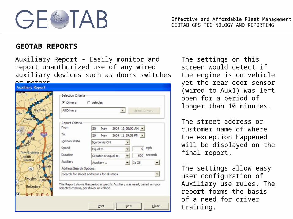
Auxiliary Report - Easily monitor and report unauthorized use of any wired auxiliary devices such as doors switches or motors.
The settings on this screen would detect if the engine is on vehicle yet the rear door sensor (wired to Aux1) was left open for a period of longer than 10 minutes.
The street address or customer name of where the exception happened will be displayed on the final report.
The settings allow easy user configuration of Auxiliary use rules. The report forms the basis of a need for driver training.
Effective and Affordable Fleet ManagementGEOTAB GPS TECHNOLOGY AND REPORTING
GEOTAB REPORTS
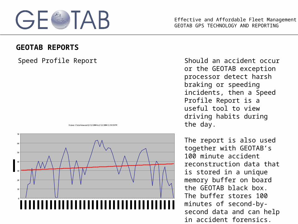
Speed Profile Report Should an accident occur or the GEOTAB exception processor detect harsh braking or speeding incidents, then a Speed Profile Report is a useful tool to view driving habits during the day.
The report is also used together with GEOTAB’s 100 minute accident reconstruction data that is stored in a unique memory buffer on board the GEOTAB black box. The buffer stores 100 minutes of second-by-second data and can help in accident forensics.
Driver: Chris Henwood (2/12/2004 to 2/12/2004 11:59:59 PM)
0
10
20
30
40
50
60
70
Effective and Affordable Fleet ManagementGEOTAB GPS TECHNOLOGY AND REPORTING
GEOTAB REPORTS
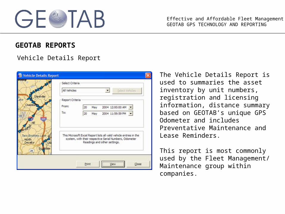
Vehicle Details Report
The Vehicle Details Report is used to summaries the asset inventory by unit numbers, registration and licensing information, distance summary based on GEOTAB’s unique GPS Odometer and includes Preventative Maintenance and Lease Reminders.
This report is most commonly used by the Fleet Management/ Maintenance group within companies.
Effective and Affordable Fleet ManagementGEOTAB GPS TECHNOLOGY AND REPORTING
GEOTAB REPORTS
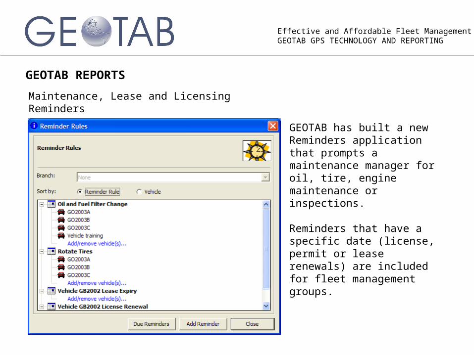
Maintenance, Lease and Licensing Reminders
GEOTAB has built a new Reminders application that prompts a maintenance manager for oil, tire, engine maintenance or inspections.
Reminders that have a specific date (license, permit or lease renewals) are included for fleet management groups.
Effective and Affordable Fleet ManagementGEOTAB GPS TECHNOLOGY AND REPORTING
NEW TECHNOLOGY ADVANCES FROM GEOTAB
An investment in technology comes with the question – when will the product I am buying now become outdated?
GEOTAB addressed this question in our product development lab. GEOTAB vehicle hardware is expandable to cater for the new technology releases that we are currently field testing and that we expect to release to the market in 2004 and 2005.
GEOTAB software is automatically upgraded via the internet to the next version releases of our software. Users of Checkmate version 4.5 discovered that they were automatically upgraded to version 4.6 when they connected to the internet and uploaded the free upgrade.
By selecting GEOTAB as your fleet technology source, you have invested in a long term solution partner.
GEOTAB partnerJonathan Okina, Project Manager Toll Free: 1-800-USA-0060Email: [email protected]: www.usa-gps.com