effect of trampling on the soils of the st james walkway, new zealand
TRANSCRIPT
30 SOIL USE AND MANAGEMENT Volume 8. Number 1. March 1992
HL~(;GI.:NHE:KGEK, F.J., LEL'EY, J. & FAKMER, W.J. 1972. Observed and calculated distribution of lindane in soil columns as influenced by water movement. Soil Science Socie$ ofAmerica Proceedings 36,544-548.
Kt.mvEY, P.C. & KAUFMAN, D.D. 1969. Degradation ofherbiciks. Marcel Dekker, New York.
KI.INGMAN, G.C. & ASII.T.ON, F.M. 1982. Weed science; principles and pructices. Wiley Interscience, New York, 2nd ed.
I.I..TEY, J. & FARMER, W.J. 1974. Movement ofpesticides in soil. In: Pesti- cides in soil and water (ed. W.D. Guenzi), Soil Science Society of America, Madison, pp. 67-106.
I , I Y I ) S . L ' K ~ M , F.T. 1967. 'Theory on the movement of some pesticides in soils: linear diffusion and convection ofchemicals in soils. Environmental Sriencrand Technology 1, 561-565.
MCCASI.IN, B.D. 1974. Predicting water and salt mmement in soils. PhD. Thesis, University of Minnesota, St. Paul.
MI)REI.ANU, D.E. 1977. Mode of action ofherbicides. In: Pesticidechemistry in /he 20th centuly (ed. J.R. Plimmer), American Chemical Society, Washington, pp. 56-75.
Ni(:iiOi.SoN, H.P. 1968. Pesticides, a current water quality problem. Transuctions of the Kansas Academy ofscience 70,3944.
OI)L)SON, J.K., LETEY, J. & WEEKS, L.V. 1970. Predicted distribution of
organic chemicals in solution and adsorbed as a function ofposition and time for various chemicals and soil properties. .%il .%wr .%cie!y I , /
America Proceedings 34,412417. PLIMMER, J.R. (ed.) 1977. Pesticide chemisiln, in the 20th cmtury. American
Chemical Society, Washington. ROHEKT, P.C. & ANr)EKsos, J. 1981. Use of computerized soil survey
reports in county extention offices. In: Proceedings of the hernut iond Confkence on Coniputers in Agriculture Extension Programs, Lake Huena Vista, Florida.
ROBERT, P.C. & RUST, R.H. 1982. In: Remote sensingfur rrsourcr manu,q- ment (eds C.J. Johannsen & J.L. Sanders), Soil Conservation Service of' America, New York.
VINK, J.P.M. & GROEN, K.P. 1992. Mathematical descriptions of accelcr- ated transformation of 1,3-dichloropropene in soil; a microbiological as- sessment. The Science of the Total Emironment (in press:i.
WEBER, J.T. 1972. Interaction of organic pesticides with particulate matter in aquatic and soil systems. In: Fate (forganicpesticides i iz theaquuticeni~r- ronment (ed. R.F. Gould), American Chemical Society, Washington, pp.
WEED SCIENCE SOCIEL'Y OF AMERICA, 1974. Herbicide handbook. Weed Sci- 55-120.
ence Society of America, Illinois, 3rd ed.
Effect of trampling on the soils of the St James Walkway, New Zealand
D. P. C. Stewart 8i K. C. Cameron
Abstract. The influence of trampling on the soils of the St James Walkway was studied during 1985 by com- paring 'on'- and 'off-track sites. Trampling increased the average soil bulk density by 0.3 g/cm3 at 0-5 cnn depth and by 0.1 g/cm3 at 10- 15 cm depth. Trampling increased the average soil shear strength by 1 1 kPa a.t 0-5 cm depth and by 6 kPa at 5-10 cm depth. All mineral soils were compacted to some extent by trampling. The podzolized high country yellow-brown earths (Dystrochrepts) were the most affected because their organic topsoil was truncated. Their exposed subsoil was however more resistant to further damage than their topsoil. Organic soils (Medihemists) were not compacted but their very low shear strength and high moisture content make them unsuitable for tracks. Untrampled soil bulk density and soil stone content were negatively correlated with the change in bulk density by trampling, and could be used to predict the risk of soil compac- tion by trampling.
INTRODUCTION
HE EFFECT of compaction on soil properties has been T investigated primarily from an agronomic perspective. More recently the importance of the effect of compaction on the wider environment has been realized and research has been directed to investigate compaction in recreational areas. Very little research on recreational compaction or trampling has been conducted in New Zealand.
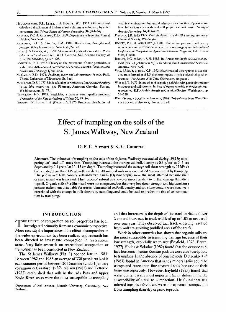
The St James Walkway (Fig. 1) opened late in 1981. Between 1982 and 1985 an average of 330 people walked it each summer period between 26 December and 3 1 January (Simmons & Cessford, 1989). Nelson (1982) and Tetteroo (1983) established that soils in the Ada Pass and upper Boyle River areas were the most susceptible to trampling
Department of Soil Science, Lincoln University, Canterbury, New Zealand.
and that increases in the depth of the track surface of over 2 cm and increases in track width of up to 1.05 m occurred over one year. They observed that track widening resulted from walkers avoiding puddled areas of the track.
Work in other countries has shown that organic soils are the most susceptible to trampling damage because of their low strength, especially when wet (Bayfield, II 973; Bryan, 1977). Shoba & Sokolov (1982) found that the organic sur- face horizons of some Russian podzols were also susceptible to trampling. In the absence of organic soils, Dotzenko et ul. (1967) found in America that sandy mineral soils could be compacted more than fine textured soils because of their large macroporosity. However, Bayfield (1 973) found that water content is the most important factor detlermining the susceptibility of a soil to compaction. He found that wet mineral topsoils in Scotland were more prone to compaction from trampling than dry organic topsoils.
SOIL USE A N D M A N A G E M E N T Volume 8, Number 1, March 1992 31
Fig. 1. Map of the St James Walkway, New Zealand.
Increases in bulk density of 0.3-0.8 gper cm' by trampling have been recorded by Crawford & Liddle (1977), Slatter (1978), Dotzenkoetal. (1967) and Shoba&Sokolov(1982). Beamish (1 977) found that trampling increases the penetro- meter resistance of mineral soils, but decreases the resist- ance of organic soils. Increases in soil shear strength from trampling by factors of 1.7-9.7 have been recorded by Crawford & Liddle (1977), Zubkova et al. (1982) and Shoba & Sokolov (1982). Reicosky et al. (1981) found that the
Table 1. Soil region characteristics
more plastic the soil the more prone it is to compaction. Trampling can also truncate upper soil horizons (Bryan, 1977; Manning, 1979), or mix upper organic horizons into lower mineral horizons (Shoba & Sokolov, 1982).
The aim of our research was to determine the effect of trampling on soil compaction in the different regions of the St James Walkway, New Zealand, and to examine the influ- ence of soil profile morphology and physical properties on susceptibility to compaction.
METHODS
The study was made at Lewis Pass (Fig. 1) during 1985. The area consists of steep mountains (up to 2000 m in height) with glacially formed valleys between. In the western part of the area the valleys are deep and narrow (0.2 km) but in the east they are wider (1.5 km). The mean annual tem- perature is 9.5"C, with monthly maxima and minima of 16.4 and 3.loC, respectively. The track gradient is gentle, following river valleys and traversing some lower slopes, and its altitude ranges from 600 to 1150 m.
For the purpose of this study, the area was divided into six regions, each with a single soil type and characteristic topo- graphy (Tables 1 and 2). Four sites in each region were selected subjectively for study (i.e. 24 sites in total). Each site exhibited typical trampling damage and a typical profile morphology. At each site, measurements were compared between adjacent 'on'- and 'off -track positions.
Field meusurements Soil bulk density and soil moisture content were measured using a core method (Blake, 1965). Four replicate cores were taken in 5 cm increments to a total depth of 15 cm at each position, using a 5.3 cm internal diameter corer. The
Profile classification
Soil Section of Soil mapping New Zealand U S . soil Precipitation Dominant region track unit* (soil set) genetic classification* taxonomy? (mm per annum)l,§ vegetation
1 Cannibal Lewis soils Gorge
2 Ada Pass -
3 Ada River Tasman soils
4 Henry River Katrine soils
5 Upper Boyle Lewis soils
6 Lower Boyle Tasrnan soils River
River
High country Dystrochrepts podzolized yellow-hrown earths Organic soils Medi hemists
Kecent soils Udifluvents
High country Dystrochrepts yellow-brown earths High country podzolized Ilystrochrepts yellow-brown earths Kccent soils Udifluvents
3000-4000 Beech forest
4000 Beech forest
2500-3500 Grasses and
2000-2500 Grasses and
2500-3500 Beech forest
and bogspecies
sedges
hriar
2000-2500 Grasses and sedgcs
*Soil Bureau Staff (1 969). ?Soil Survey Staff(1990). f Department of Conservation Staff (pers. comm. 1985). §Boyle River I.odgc Staff (pers. cnmm. 1985).
32 SOIL USE A N D M A N A G E M E N T Volume 8, Number 1, March 1992
‘Table 2. Typical profile descriptions from each soil region
Sod Depth region Horimn (cm) Description
4
5
fl
1 F
I.:
B S
0,
0 2
c Ah
<:
2c Ah
l3W
F
F:
13 s
.4h
2c:
0-10
10-17
17-70
0-1 1
1 1-20
20+ 0-8
8-48
48 + 0- 10
10-25
0-8
8-18
18-40
0-6
6-70
Veryduskyred (lOR2.5/2) moistpeaty loam; loose; abundant fine roots. Lightgrey(lOYR7/2)moistsiItloam; crumb/single grain; moderately weak; many tine roots. Strong brown (7.5 YR 5/8) moist silt loam; moderately developed line angular blocky; moderately weak; few medium roots. Dark reddish brown (5 YR 3 / 3 ) wet loamy peat; very weak; abundant fine roots. Dark reddish brown (5 YR 3/2) wet loamy peat; very weak; many fine roots. Coarse schist. Dark yellowish hrown (10YR 3/4) slightly moist sandy loam; poorly developed fine nutty; very weak; abundant fine roots. Very dark grey (5 Y 3/1) slightly moist sand; single grain; loose; many tine roots. Stony sand; mainly large rounded stones. Dark brown (10 YR 3 / 3 ) slightly moist silt loam; moderately developed coarse granular; moderately weak; abundant tine roots. Dark yellowish brown (10 YK 4/6) slightly moist stony silt loam; moderately developed coarse angular blocky; moderately weak; many fine roots. Dark reddishbrown (2.5 YK 2.5/3) moist; loose; abundant fine roots. Greyish brown (10 YR 5/2) moist silt loam; moderately developed medium angular blocky; moderately firm; many tine roots. Brownish yellow (10 YK 6/73) moist silt loam; strongly developed medium angular blocky; very firm; common fine roots. Dark olive hrown (2.5 Y 3 / 3 ) moist silt loam; moderately developed fine granular; very weak; abundant fine roots. Extrcmely stony sand; mainly medium- large rounded stones.
weight of stones in each sample was recorded. A ‘Pilcon’ direct reading pocket shear vane was used to determine the soil shear strength, as described by Hillel (1980). Measure- ments were made at depths of 0-5 and 5-10 cm in both ‘on’- and ‘off -track positions. Nine readings were taken at each position at each site. Bulk soil samples were collected from both the topsoil (either A, F or 0 horizon) and subsoil (€3 or C horizon) at each ‘off -track position for laboratory analyses.
Laboratory measurements Soil samples were air-dried in a forced-draft oven at 22°C. Subsamples (20 g) were oven-dried at 105°C to measure the water content. The samples were sieved through 4- and 2-mm sieves. Aggregates retained on the 2-mm sieve were used for aggregate stability analysis. Aggregates smaller
than 2 mm were used for determining organi I ’ L matter con- tent, soil consistence and clay content.
T h e upper plastic limit was determined using a ‘Wykeham Farrance’ Casagrande apparatus, as described by Sowers (1965). Measurements were made on four 30 g replicates of each soil sample. A flat grooving tool was used to make an 8-mm deep groove in a pat of soil placed in thc Casagrande apparatus. ’I’he upper plastic limit was defined as the gravimetric moisture content at which the groove closed following 25 impacts of the apparatus (Sowers, 1965). The lowerplastic limit was defined as the gravinietric moisture content at which a 3 mm diameter ‘1:hreacl’ ofsoil started to crumble when rolled on a glass plate (Sowers, 1965). T h e plasticity index was the difference in moisturc content between the upper and lower plastic limits. .4 largc plasticity index indicates that a soil is likely to he compacted if trampled when the moisture content exceeds the lower plastic limit.
Soil aggregate stability was measured using a modificci version of the wet-sieving technique of Yoder (1936). Pour 50 g replicates of aggregates (2-4 mm diameterj wcre sieved in a water tank using a mechanical sieving machine similar to that described by Kemper (1 965). “l‘he oven d ~ , mass of aggregates retained on the 2-mni sieve after 10 niin of wet sieving was recorded and the results expressed a s a percentage of the original mass.
’The organic matter content was determined by loss-on- ignition (Ball, 1964). Five grams of each sample werc ignited at 850°C for 2 h and the change in mass was re- corded. T h e clay content of the subsoil samples was deter- mined using a ‘Micromeritics’ sedigraph. Soil samples were sieved through a 63 p,m sieve before being analysed using 5% soil in a 0.4% ‘Calgon’ solution at 3 0 T , after 3 h of shaking. A particle density of 2.65 g/cm.’ was assumed.
RESULTS
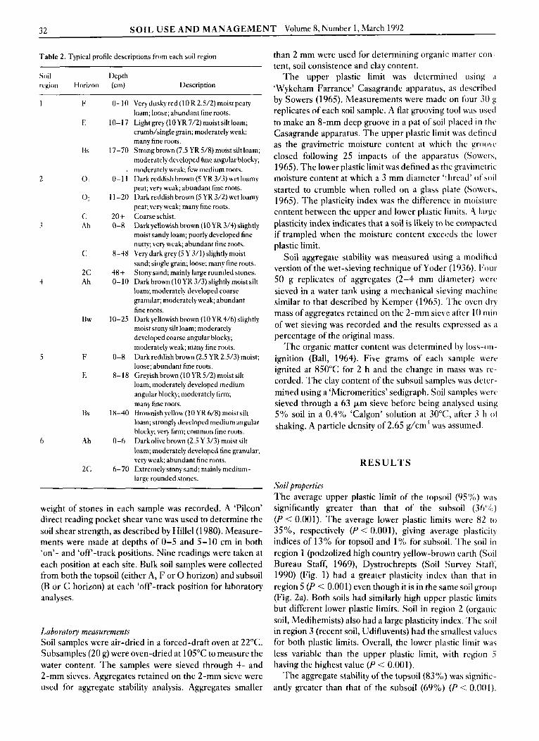
Soil properties T h e average upper plastic limit of the topsoil (95%) was significantly greater than that of the subsoil (.?h‘%) (P < 0.001). The average lower plastic limits were 82 to 35”/0, respectively (P < 0.001), giving average plasticity indices of 13% for topsoil and 1 ‘YO for subsoil. ’I’he soil in region 1 (podzolized high country yellow-brown earth (Soil Bureau Staff, 1969), Dystrochrepts (Soil !Survey Staft; 1990) (Fig. 1) had a greater plasticity index than that i n region 5 (P < 0.001) even though it is in the same soil group (Fig. Za). Both soils had similarly high upper plastic limits but different lower plastic limits. Soil in region 2 (organic soil, Medihemists) also had a large plasticity index. ‘I’hc soil in region 3 (recent soil, Udifluvents) had the smallest values for both plastic limits. Overall, the lower pla:stic limit was less variable than the upper plastic limit, with region 5 having the highest value (P < 0.001).
’l’he aggregate stability of the topsoil (83%) was signific- antly greater than that of the subsoil (69%) (P < 0.001).
SOIL U S E A N D M A N A G E M E N T Volume 8, Number 1 , March 1992 33
Soil in region 1 , and to a lesser extent in region 6 (recent soil, Udifluvents), had more stable aggregates than soil in other regions (P < 0.001) (Fig. 2b). The average organic matter content declined from 35% in the topsoil to 17% iI1
the subsoil. Soil in region 2, as expected, had the most organic matter (Fig. 2c). Soil in region 3 contained less organic matter than that in region 6 even though both are in the same soil group (Table 1). The clay content of the soil was less than 5% in region 3 and zero in region 2 (P < 0.01) (Fig. 2d). Soil in region 6, though classified as similar to region 3, contained 16% more clay. Regions 1,4 and 5 (high country yellow-brown earths, Dystrochrepts) contained sig- nificantly more stones than the other regions (P < 0.01) (Fig. 2e).
T LSD
r LSD
n
1 2 3 4 5 6 Soil region
" 1 2 3 4 5 6
Soil region
Fig. 2. Soil properties of regions 1-6 (means of topsoil and subsoil): (a) Soil consistence (lower part ofcolurnn is lower plastic limit; upper part is plasticity index; total length of column is upper plastic limit; LSD is for upper plastic limit); (b) Soil aggregate stability; (c) Organic matter content; (d) Clay content ofthe subsoil (weight YO); (e) Stone content (volume O h ) .
Table 3. Relationships between soil properties
Shear resistance (kPa) = 64 [Bulk density (g/cm3)]+ 13.4
Upper plastic limit (weight YO) = 2.42 [Organic matter (YO)]+ 1 1
Lower plastic limit (weight %) = 2.14 [Organic matter (%)]+7.3
r2 = 0.55
T' = 0.92
r2 = 0.96
P < 0.001
P < 0.001
P < 0.001
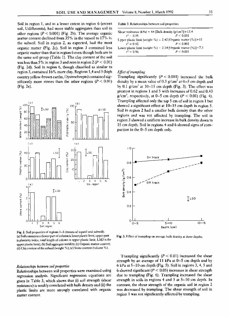
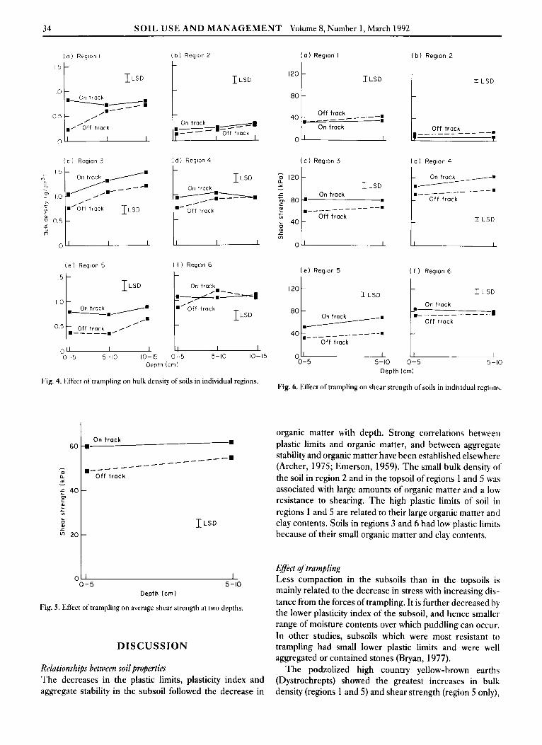
Efect of trampling Trampling significantly (P < 0.001) increased the bulk density by a mean value of 0.3 g/cm3 at 0-5 cm depth and by 0.1 g/cm3 at 10-15 cm depth (Fig. 3). The effect was greatest in regions 1 and 5 with increases of 0.62 and 0.43 g/cm3, respectively, at 0-5 cm depth (P < 0.01) (Fig. 4). Trampling affected only the top 5 cm of soil in region 1 but showed a significant effect at 10-15 cm depth in region 5. Soil in region 2 had a smaller bulk density than the other regions and was not affected by trampling. The soil in region 3 showed a uniform increase in bulk density down to 15 cm depth. Soil in regions 4 and 6 showed signs of com- paction in the 0-5 cm depth only.
1.0
0.0
- c)
E
2 0.6 - ,, + VI C 0) D
3
.-
5 0.4 m
0.2
0
On t rack 8-'
//--
1- I
I-- , ..' / , . ,
R' O f f t rack .' ILSD
0-5 5-10 10-15 Depth (cm)
Fig. 3. Effect oftrampling on average bulk density at three depths.
Relationships between soil properties Relationships between soil properties were examined using regression analysis. Significant regression equations are given in Table 3, which shows that (i) soil strength (shear resistance) is weakly correlated with bulk density and (ii) the plastic limits are more strongly correlated with organic
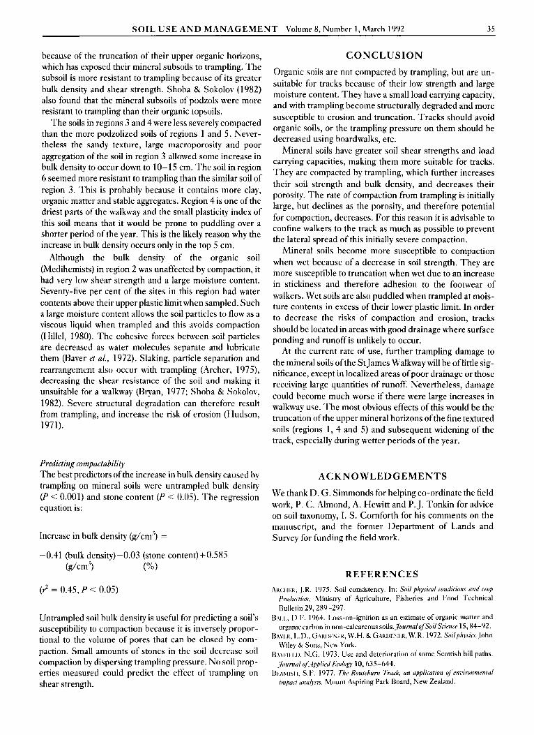
Trampling significantly (P < 0.01) increased the shear strength by an average of 1 1 kPa at 0-5 cm depth and by 6 kPa at 5-10 crn depth (Fig. 5). Soil in regions 3 ,4 ,5 and 6 showed significant (P < 0.05) increases in shear strength due to trampling (Fig. 6). Trampling increased the shear strength in soils in regions 4 and 5 at 5-10 cm depth. In contrast, the shear strength of the organic soil in region 2 was decreased by trampling. The shear strength of soil in - -
matter content. region 1 was not significantly affected by trampling.
34 SOIL USE A N D MANAGEMENT Volume 8, Number 1, March 1992
( a I Region I
1 LSD
O 5 /
0 - j b ) Region 2
On track
( a ) Region I
I LSD I2O 1 8o t
( b ) Region 2
I L S D t ( c ) Region 3 ( d ) Region L. ( c I Region 3 ( d ) Region 4
( e ) Region 5 ( f I Region 6 ( e ) Region 5 '1 '-----. ontrack+: IT::;,
0.5 Of f track .-----./ 0-5 5-10 10-15 0-5 5-10 10-15 I 0
Depth (cm) 0-5 5-10 0-5 5-10 Depth (cm)
Fig. 4. Effect of trampling on bulk density of soils in individual regions. Fig. 6. Effect oftrampling on shear strength of soils in individual regons.
I
6(
L 0
6 2(
On t r a c k -8
organic matter with depth. Strong correlations between plastic limits and organic matter, and between aggregate stability and organic matter have been established elsewhere (Archer, 1975; Emerson, 1959). T h e small bulk density of the soil in region 2 and in the topsoil of regions 1 and 5 was associated with large amounts of organic matter and a low resistance to shearing. The high plastic limits of soil in regions 1 and 5 are related to their large organic matter and clay contents. Soils in regions 3 and 6 had low plastic limits because of their small organic matter and clay contents.
8
_ _ _ _ _ _ -----. -
1 LSD -
DISCUSSION
Relutionships between soil properties The decreases in the plastic limits, plasticity index and aggregate stability in the subsoil followed the decrease in
Effect of trampling Less compaction in the subsoils than in the topsoils is mainly related to the decrease in stress with increasing dis- tance from the forces of trampling. It is further decreased by the lower plasticity index of the subsoil, and hence smaller range of moisture contents over which puddling can occur. In other studies, subsoils which were most resistant to trampling had small lower plastic limits and were well aggregated or contained stones (Bryan, 1977).
The podzolized high country yellow-brown earths (Dystrochrepts) showed the greatest increases in bulk density (regions 1 and 5) and shear strength (region 5 only),
SOIL U S E A N D M A N A G E M E N T Volume 8, Number 1, March 1992 35
because of the truncation of their upper organic horizons, which has exposed their mineral subsoils to trampling. The subsoil is more resistant to trampling because of its greater bulk density and shear strength. Shoba & Sokolov (1982) also found that the mineral subsoils of podzols were more resistant to trampling than their organic topsoils.
The soils in regions 3 and 4 were less severely compacted than the more podzolized soils of regions 1 and 5. Never- theless the sandy texture, large macroporosity and poor aggregation of the soil in region 3 allowed some increase in bulk density to occur down to 10- 15 cm. The soil in region 6 seemed more resistant to trampling than the similar soil of region 3 . This is probably because it contains more clay, organic matter and stable aggregates. Region 4 is one of the driest parts of the walkway and the small plasticity index of this soil means that it would be prone to puddling over a shorter period of the year. This is the likely reason why the increase in bulk density occurs only in the top 5 cm.
Although the bulk density of the organic soil (Medihemists) in region 2 was unaffected by compaction, it had very low shear strength and a large moisture content. Seventy-five per cent of the sites in this region had water contents above their upper plastic limit when sampled. Such a large moisture content allows the soil particles to flow as a viscous liquid when trampled and this avoids compaction (Hillel, 1980). T h e cohesive forces between soil particles are decreased as water molecules separate and lubricate them (Raver rt ul., 1972). Slaking, particle separation and rearrangement also occur with trampling (Archer, 1979 , decreasing the shear resistance of the soil and making it unsuitable for a walkway (Bryan, 1977; Shoba & Sokolov, 1982). Severe structural degradation can therefore result from trampling, and increase the risk of erosion (Hudson, 1971).
Predicting compuctubility The best predictors of the increase in bulk density caused by trampling on mineral soils were untrampled bulk density (P < 0.001) and stone content (P < 0.05). The regression equation is:
Increase in bulk density (g/cm3) =
-0.41 (bulk density-0.03 (stone content)+0.585 (dcm') (Yo)
(2 = 0.45, P < 0.05)
Untrampled soil bulk density is useful for predicting a soil's susceptibility to compaction because it is inversely propor- tional to the volume of pores that can be closed by com- paction. Small amounts of stones in the soil decrease soil compaction by dispersing trampling pressure. No soil prop- erties measured could predict the effect of trampling on shear strength.
C O N C L U S I O N
Organic soils are not compacted by trampling, but are un- suitable for tracks because of their low strength and large moisture content. They have a small load carrying capacity, and with trampling become structurally degraded and more susceptible to erosion and truncation. Tracks should avoid organic soils, or the trampling pressure on them should be decreased using boardwalks, etc.
Mineral soils have greater soil shear strengths and load carrying capacities, making them more suitable for tracks. They are compacted by trampling, which further increases their soil strength and bulk density, and decreases their porosity. The rate of compaction from trampling is initially large, but declines as the porosity, and therefore potential for compaction, decreases. For this reason it is advisable to confine walkers to the track as much as possible to prevent the lateral spread of this initially severe compaction.
Mineral soils become more susceptible to compaction when wet because of a decrease in soil strength. They are more susceptible to truncation when wet due to an increase in stickiness and therefore adhesion to the footwear of walkers. Wet soils are also puddled when trampled at mois- ture contents in excess of their lower plastic limit. In order to decrease the risks of compaction and erosion, tracks should be located in areas with good drainage where surface ponding and runoff is unlikely to occur.
At the current rate of use, further trampling damage to the mineral soils of the S t James Walkway will be of little sig- nificance, except in localized areas of poor drainage or those receiving large quantities of runoff. Nevertheless, damage could become much worse if there were large increases in walkway use. T h e most obvious effects of this would be the truncation of the upper mineral horizons of the fine textured soils (regions 1, 4 and 5) and subsequent widening of the track, especially during wetter periods of the year.
ACKNOWLEDGEMENTS
We thank 11. G. Simmonds for helping co-ordinate the field work, P. C. Almond, A. Hewitt and P. J. Tonkin for advice on soil taxonomy, I. S. Cornforth for his comments on the manuscript, and the former Department of Lands and Survey for funding the field work.
REFERENCES AKC:III.:K. J.R. 1975. Soil consistency. In: Soil physical conditions und crop
Prodn&n, Rlinistry of Agriculture, Fisheries and Food Technical Bulletin 29, 280-297.
u41.1., D.F. 1964. Loss-on-ignition as an estimate of organic matter and organic carbon in non-calcareous soils.~ournulofSoilSn'(7tcr 15,84-92.
BAVI.K, l,.D., G ~ K I X N I R , W.H. & GARIIF:;I..K, W.R. 1972.Soilph.ysia. John Wiley & Sons, New E'ork.
B.\)im 1.11, N.G. 1073. Use and deterioration of some Scottish hill paths. Jiinnrcil qJ4pplird Ecology 10, 635-644.
B ~ h ~ i s i I? S.F. 1977. Thr Roukburn Truck, un upplicution c$enz~ironmentul rmpucf und)ais. Mount Aspiring Park Board, New Zealand.
36 SOIL USE A N D MANAGEMENT Volume 8, Number 1, March 1992
BI.AFI., G.R. 1965. Bulk Density. In: Methods ( f s o i l analysis Part 1 (ed. <:.A. Black), Agronomy Society of America, Madison, Wisconsin, pp. 374-390.
BKY,AN, R.B. 1977. The influence of soil properties on degradation of mountain hiking trails at Grovelsjon. Geograjiska Annaler 59,49-65.
(:K,4wt:oRi), A.K. 84 LIl)DLE, M.J. 1977. The effect oftrampling on neutral grassland. Biological Conservation 12, 135-142.
I~O.I.XI~.NKO, A.D., PAPAMICHOS, N.T. & RAMINE, D.S. 1967. Effect of recreational use on soil and moisture conditions in Rocky Mountain National Park.3ournal ofsoiland Water Consenlation 22, 196-197.
EMI..KSON, W.W. 1959. The smcture of soil crumbs.~ournalofSoilScit.nce
HII.I.I:L, D. 1980. Fundamenrals ofsoilphysics. Academic Press, New York. I ICII )SON, N. 1971. Soil conseruation. Batsford, England. KlAll~lx, W.D. 1965. Aggregate stability. In: Methods ofsoil analysis Par? I
(cd. C.A. Black), Agronomy Society of America, Madison, Wisconsin,
MANNING, R.E. 1979. Impacts of recreation on riparian soils and vegeta- tion. American Water Resources Association, Water Resources Bulletin 15,
NF.I.SON, I). 1982. Environmental impact analysis on the StJames Walkway. Unpublished diploma dissertation, Lincoln University, New Zealand.
RI.ic:os~v, D.C., V O ~ K I I E S , W.B. & RADKF., J.D. 1981. Unsaturated water flow through a simulated wheel track. Soil Science Sociefy ofAmericu JiurnaI45,3-8.
10,235-244.
pp.511-519.
30-43.
S11o1i4, S.A. & Solco~.o~, L.A. 1982. Changes in the microlibric of so& podzolic soils in recreational load zones. S m i e r Soil Scioztr 14, 85-91
SIMMONS, D.G. & Ct:ssk'oKIJ, G.R. 1989. The S/ $mes Whlkma~ .s/u~li'. Occasional Paper No. 1. Ikpartmcnt ofParks, Recreation and 'I'ourisrn, Lincoln University, New Zealand.
SI.R.IWX, R.J. 1978. Ecological effects of trampling in sa id dunc teget.1-
tion.3ournal of Biological Education 12,8Y-Y6. Son. BUREAU ST~II; 1969. Soils of the South Island, Ncw Zealarid. .l;w
Zealand Soil Bureau Bulletin 27, Government Printer, Wellington. SOII. SuKvt:v STAW 1990. Keys to Soil Taxonomq, fnurth edition. .Cbf.S.S
Technical Monograph 19, Blacksburg, Virginia. SOWERS, G.F. 1965. Consistency. In: Methods of soil analysis Purt I (cd.
C.A. Black), Agronomy Society of America, Madison, Wisctinsin, pp.
TE'lrl<Koo, R. 1983. St.7anies Walktoay reseurch prqect I%YZ-X3. Unpuh- lished diploma dissertation, Lincoln University, New Z8:aland.
YOI)I:K, R.E. 1936. A direct method of aggregate analysis of soils and ii
study of the physical nature of erosion losses. , ~ O U ~ I U / o / / h . - l m e r i ~ / So&& ofAgronomy 28,337-351.
ZUHKOV,4, T.A., AHKIJL~\A, V.V., el ul. 1982. Influence of'recrcation on a brown forest soil in the Carpathian Reserve. .I/losm-,,n, Univervirp Sod Science Bulletin 37. 56-58.
391-399.
Influence of fertilized short-rotation forest plantations on nitrogen concentrations in groundwater
L. Bergstrom' & R. Joliansson2
Abstract. T h e influence of intensively fertilized short-rotation forest plantations o n nitrogen concentrations in groundwater was studied by piezometer readings and water sampling over a two-year period in a sandy field growing willow (Sulzx spp.) and other species. T h e mineral-N content of the unsaturated zonc was nieasuretl in soil samples collected to 0.9 m depth. Although piezometer readings suggested that deep groundwater could be affected, the concentrations of nitrate-N and ammonium-N were usually less than 1 m g per litre. T h e r e was also little mineral-N in the unsaturated zone, except for occasional peaks in the topsoil (0-30 cni) after application of fertilizer. W e conclude that there is little risk of nitrogen contamination of groundwater in intensively cultured t ree stands receiving up to 150 kg N/ha/yr as fertilizer. T h i s is probably because willow can take up water and nitrogen from deep parts of the soil profile.
INTRODUCTION N RECENT YEARS there has been considerable over- I production of most agricultural crops for human con-
sumption. In Sweden, for example, c. 500000 out of the 3 million hectares under agricultural management should, from an economic point of view, be taken out ofproduction. An alternative use of the surplus land is growing biomass suitable for producing energy and fibre for pulp.
The biomass production of willow (Salzx spp.) could be twice as much as the highest yielding agricultural crops in
'Department of Soil Sciences, Swedish University of Agricultural Sciences, PO Box 7072, S-750 07 Uppsala, Sweden. 'Department of Ecology and Environmental Research, Swedish University of Agricultural Sciences, PO Box 7072, S-750 07 Uppsala, Sweden.
Sweden (e.g. sugar-beet and sunflower), i.e. 20-30 t/ha/yr (Siren, 1983; Christersson, 1986). However, realization of this growth potential requires significant inpuls of fertilizer and irrigation (Christersson, 1986, 1987). Damage hq'
insects, diseases and other pests must also h c minimized. Considerable efforts are now being made to judge the en- vironmental consequences of this type of tree production. Little is yet known about its influence on groundwater quality.
This study investigated the impact of fertilized planta- tions of fast-growing forest trees on nitrogen concentrations in groundwater. Piezometer readings were made and groundwater samples were collected for chemical analysis in a sandy field planted predominantly with willow. Soil samples were collected down to 0.9 m depth for determina-