edwalton appraisal and management plan - · pdf filepart 1 character appraisal ... appendix 1...
TRANSCRIPT
2
Contents PART 1 CHARACTER APPRAISAL ................................................................................................. 3
1 Introduction and Summary ......................................................................................................... 3
1.1 The Edwalton Conservation Area .............................................................................................. 3
1.2 Key Characteristics .................................................................................................................... 3
1.3 Key issues ................................................................................................................................. 3
2 Introduction ................................................................................................................................ 4
2.1 The purpose of a Conservation Area character appraisal .......................................................... 4
2.2 The planning policy context ....................................................................................................... 4
3 Location and landscape setting ................................................................................................. 5
4 Historic development and archaeology ...................................................................................... 6
5 Spatial analysis........................................................................................................................ 11
5.1 Plan form and layout ................................................................................................................ 11
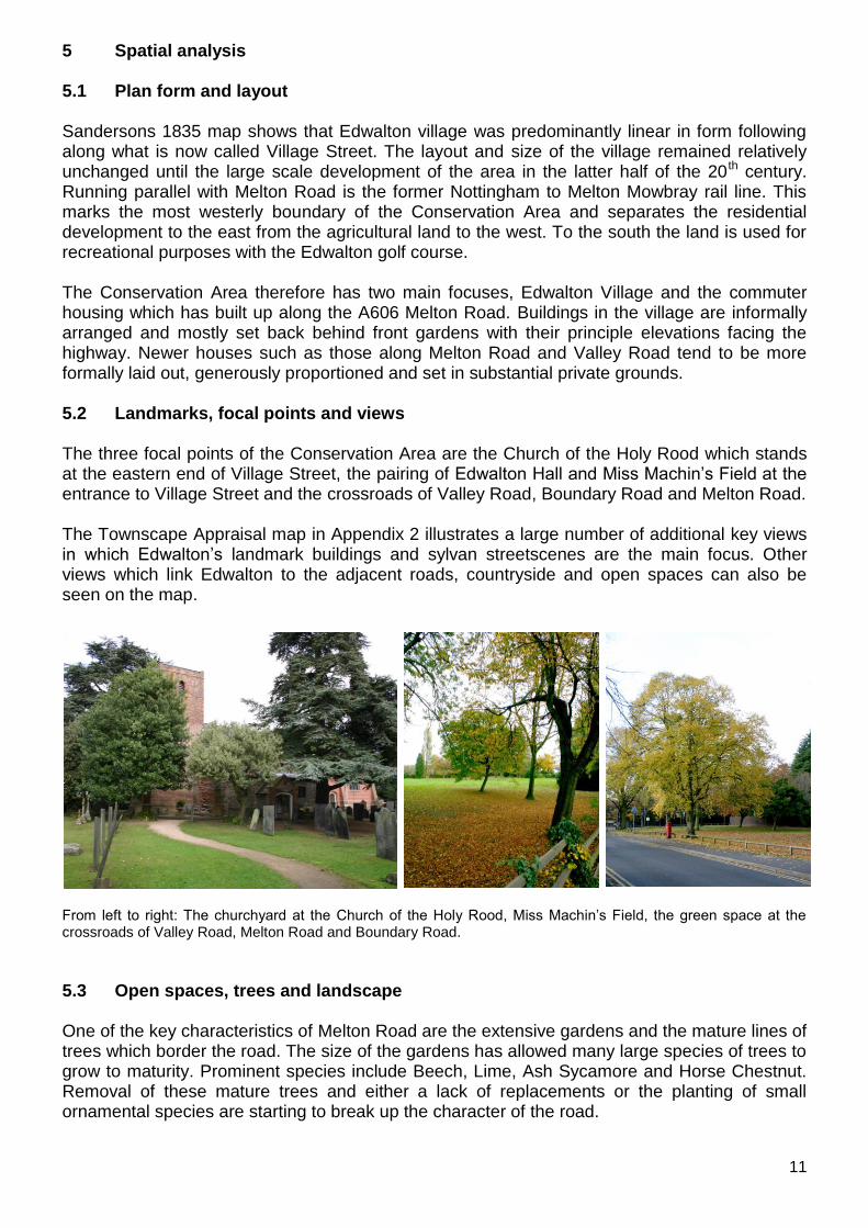
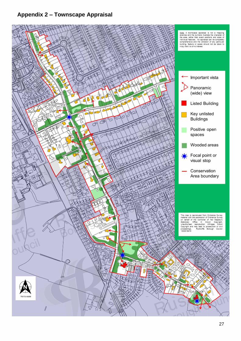
5.2 Landmarks, focal points and views .......................................................................................... 11
5.3 Open spaces, trees and landscape ......................................................................................... 11
5.4 Public realm ............................................................................................................................. 12
6.1 Building types .......................................................................................................................... 14
6.2 Listed Buildings ....................................................................................................................... 16
6.3 The contribution of unlisted buildings ....................................................................................... 17
6.4 Building materials and local details .......................................................................................... 17
7 The character areas of the Conservation Area ........................................................................ 19
PART 2 GENERIC MANAGEMENT PLAN FOR CONSERVATION AREAS IN RUSHCLIFFE ....... 20
1.0 Introduction .............................................................................................................................. 20
2.0 Aims and Objectives of this Management Plan ........................................................................ 20
3.0 National and Local Policies and guidance ............................................................................... 20
4.0 Development in Conservation Areas ....................................................................................... 22
5.0 Buildings at risk and sites which detract from the character of the area................................... 24
6.0 Management of Public Realm .................................................................................................. 25
7.0 Monitoring ................................................................................................................................ 25
APPENDICES ................................................................................................................................... 26
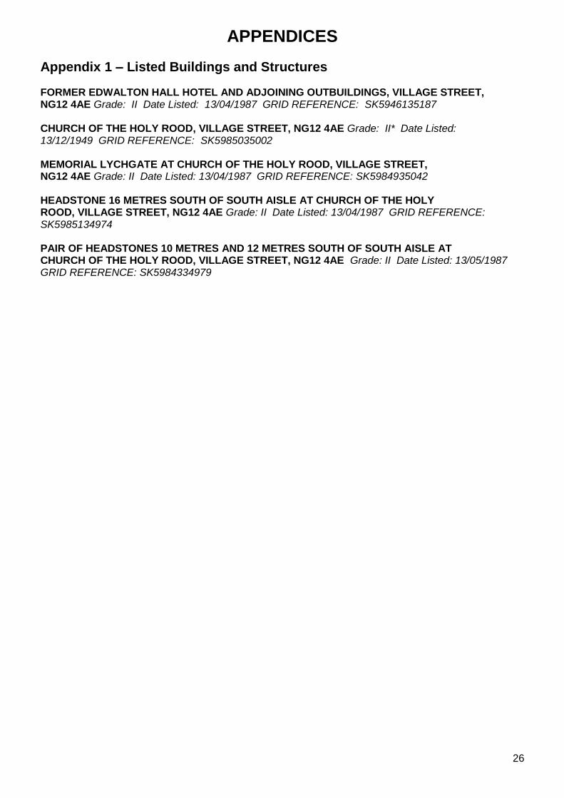
Appendix 1 – Listed Buildings and Structures .................................................................................... 26
Appendix 2 – Townscape Appraisal ................................................................................................... 27
Appendix 3 – Works within Conservation Areas that require permission ........................................... 28
3
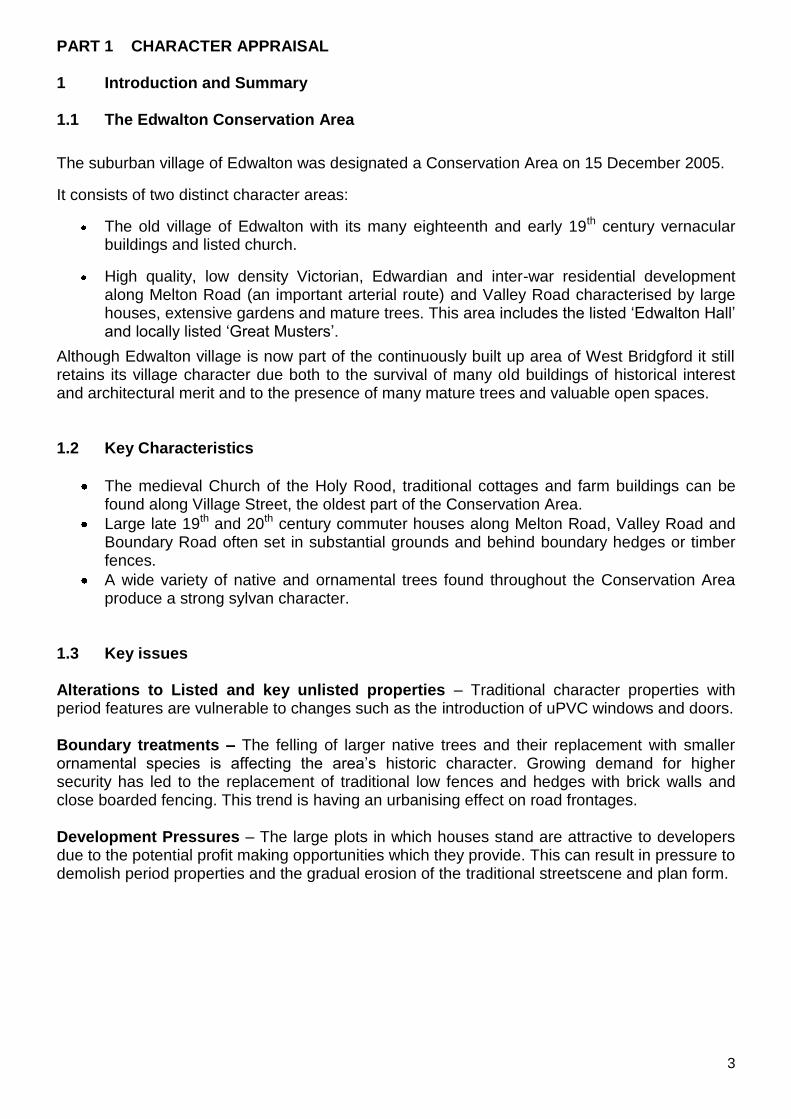
PART 1 CHARACTER APPRAISAL 1 Introduction and Summary 1.1 The Edwalton Conservation Area
The suburban village of Edwalton was designated a Conservation Area on 15 December 2005.
It consists of two distinct character areas:
The old village of Edwalton with its many eighteenth and early 19th century vernacular buildings and listed church.
High quality, low density Victorian, Edwardian and inter-war residential development along Melton Road (an important arterial route) and Valley Road characterised by large houses, extensive gardens and mature trees. This area includes the listed „Edwalton Hall‟ and locally listed „Great Musters‟.
Although Edwalton village is now part of the continuously built up area of West Bridgford it still retains its village character due both to the survival of many old buildings of historical interest and architectural merit and to the presence of many mature trees and valuable open spaces. 1.2 Key Characteristics
The medieval Church of the Holy Rood, traditional cottages and farm buildings can be found along Village Street, the oldest part of the Conservation Area.
Large late 19th and 20th century commuter houses along Melton Road, Valley Road and Boundary Road often set in substantial grounds and behind boundary hedges or timber fences.
A wide variety of native and ornamental trees found throughout the Conservation Area produce a strong sylvan character.
1.3 Key issues Alterations to Listed and key unlisted properties – Traditional character properties with period features are vulnerable to changes such as the introduction of uPVC windows and doors. Boundary treatments – The felling of larger native trees and their replacement with smaller ornamental species is affecting the area‟s historic character. Growing demand for higher security has led to the replacement of traditional low fences and hedges with brick walls and close boarded fencing. This trend is having an urbanising effect on road frontages. Development Pressures – The large plots in which houses stand are attractive to developers due to the potential profit making opportunities which they provide. This can result in pressure to demolish period properties and the gradual erosion of the traditional streetscene and plan form.

4
2 Introduction 2.1 The purpose of a Conservation Area character appraisal Local Planning Authorities have a duty to designate as Conservation Areas any „areas of special historic or architectural interest the character or appearance of which it is desirable to preserve or enhance‟. (PPS 5). This Appraisal aims to describe Edwalton as it is today and identify the special character and distinctiveness of its setting, buildings and open spaces. In 2005, Rushcliffe Borough Council followed government advice by pursuing a program for the production of Conservation Area Appraisals. These aim to document the significant architectural and historic features within each Conservation Area that are worthy of preservation and enhancement. Work on previous Conservation Areas has identified characteristics which are common throughout Rushcliffe. These have been fed into a generic Management Plan for the Borough which states why these features and characteristics should be preserved or enhanced and how this could be achieved. This document should be used by residents and professionals both as a source of information and as a guide. 2.2 The planning policy context This appraisal provides a firm basis on which applications for development within the Edwalton Conservation Area can be assessed. It should be read alongside the wider development plan policy framework produced by Rushcliffe Borough Council and other National Planning Policy Guidance documents. The relevant documents include:
Rushcliffe Borough Non-Statutory Replacement Local Plan 2006 - Policies EN2, EN3 (Conservation Areas)
EN4, EN5 (Listed Buildings) EN6 (Ancient Monuments) EN7 (Archaeological importance)
Planning Policy Statement 5 (PPS 5): Planning for the Historic Environment (2010)
Planning Policy Statement 1 (PPS 1): Delivering Sustainable Development (2006)
By Design: Urban Design in the Planning System – Towards Better Practice (2000)
Rushcliffe Residential Design Guide Supplementary Planning Document (2009)
5
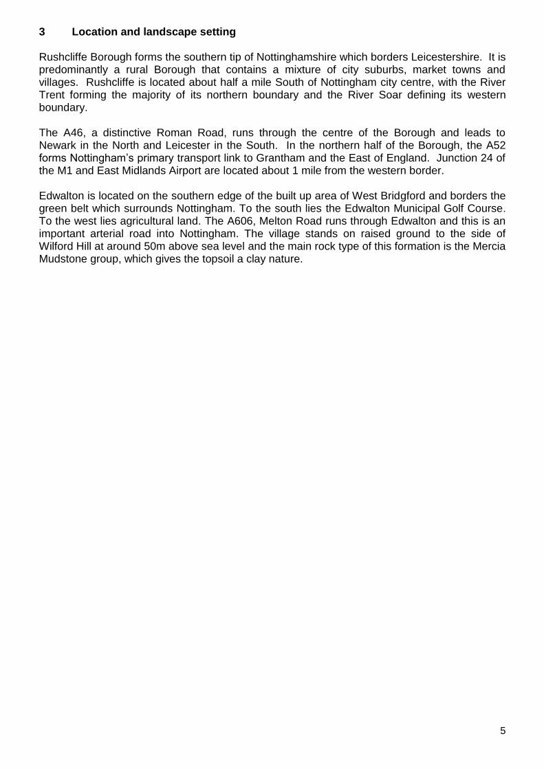
3 Location and landscape setting Rushcliffe Borough forms the southern tip of Nottinghamshire which borders Leicestershire. It is predominantly a rural Borough that contains a mixture of city suburbs, market towns and villages. Rushcliffe is located about half a mile South of Nottingham city centre, with the River Trent forming the majority of its northern boundary and the River Soar defining its western boundary. The A46, a distinctive Roman Road, runs through the centre of the Borough and leads to Newark in the North and Leicester in the South. In the northern half of the Borough, the A52 forms Nottingham‟s primary transport link to Grantham and the East of England. Junction 24 of the M1 and East Midlands Airport are located about 1 mile from the western border. Edwalton is located on the southern edge of the built up area of West Bridgford and borders the green belt which surrounds Nottingham. To the south lies the Edwalton Municipal Golf Course. To the west lies agricultural land. The A606, Melton Road runs through Edwalton and this is an important arterial road into Nottingham. The village stands on raised ground to the side of Wilford Hill at around 50m above sea level and the main rock type of this formation is the Mercia Mudstone group, which gives the topsoil a clay nature.
6
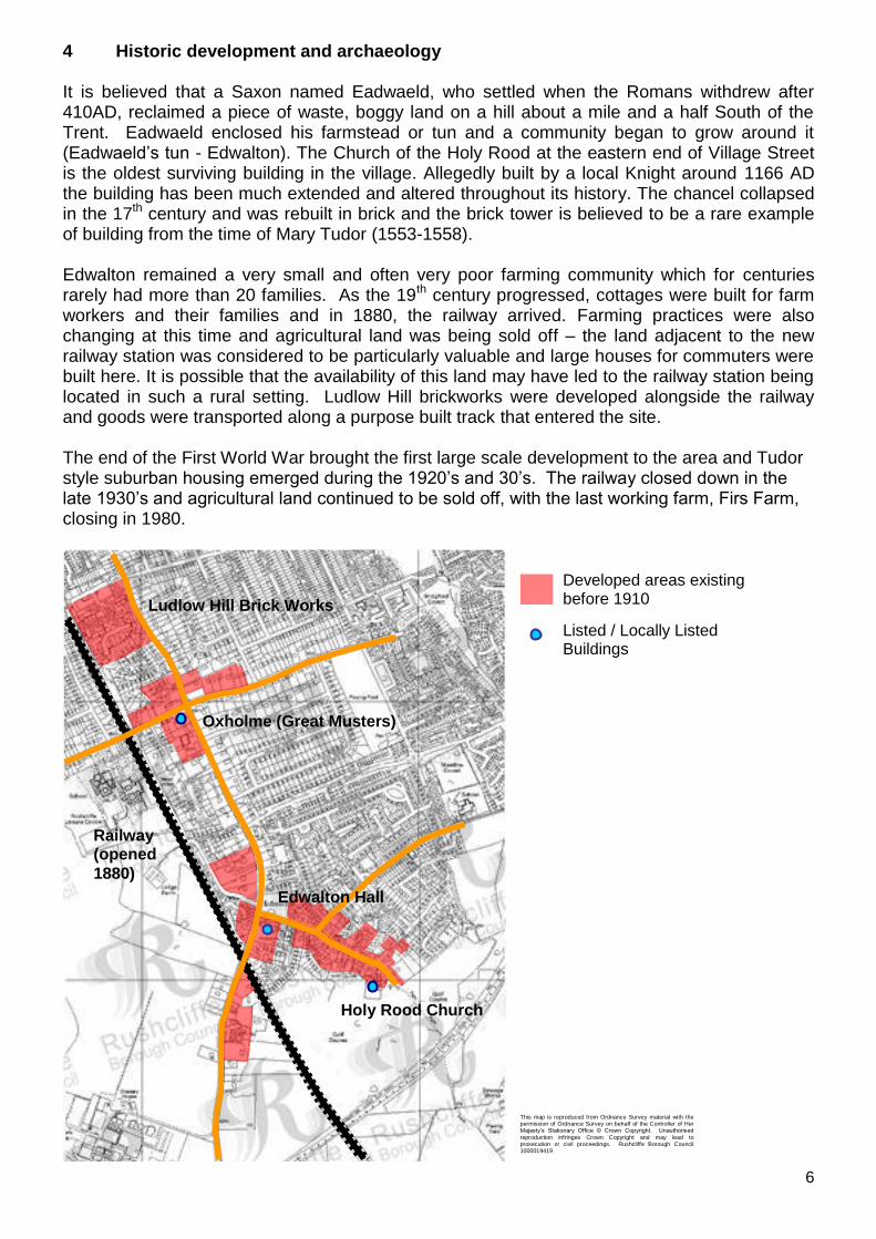
4 Historic development and archaeology It is believed that a Saxon named Eadwaeld, who settled when the Romans withdrew after 410AD, reclaimed a piece of waste, boggy land on a hill about a mile and a half South of the Trent. Eadwaeld enclosed his farmstead or tun and a community began to grow around it (Eadwaeld‟s tun - Edwalton). The Church of the Holy Rood at the eastern end of Village Street is the oldest surviving building in the village. Allegedly built by a local Knight around 1166 AD the building has been much extended and altered throughout its history. The chancel collapsed in the 17th century and was rebuilt in brick and the brick tower is believed to be a rare example of building from the time of Mary Tudor (1553-1558). Edwalton remained a very small and often very poor farming community which for centuries rarely had more than 20 families. As the 19th century progressed, cottages were built for farm workers and their families and in 1880, the railway arrived. Farming practices were also changing at this time and agricultural land was being sold off – the land adjacent to the new railway station was considered to be particularly valuable and large houses for commuters were built here. It is possible that the availability of this land may have led to the railway station being located in such a rural setting. Ludlow Hill brickworks were developed alongside the railway and goods were transported along a purpose built track that entered the site. The end of the First World War brought the first large scale development to the area and Tudor style suburban housing emerged during the 1920‟s and 30‟s. The railway closed down in the late 1930‟s and agricultural land continued to be sold off, with the last working farm, Firs Farm, closing in 1980.
Developed areas existing before 1910
Listed / Locally Listed Buildings
Oxholme (Great Musters)
Holy Rood Church
Railway (opened
1880)
Ludlow Hill Brick Works
Edwalton Hall
This map is reproduced from Ordnance Survey material with the permission of Ordnance Survey on behalf of the Controller of Her Majesty‟s Stationary Office © Crown Copyright. Unauthorised
reproduction infringes Crown Copyright and may lead to prosecution or civil proceedings. Rushcliffe Borough Council 1000019419
7
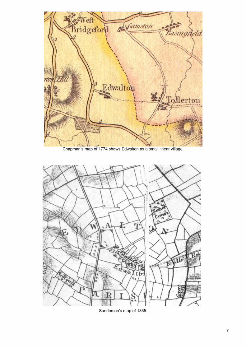
Chapman‟s map of 1774 shows Edwalton as a small linear village.
Sanderson‟s map of 1835.

8
Ordnance Survey map of 1880. Note the appearance of the railway and train station to the north west.
Ordnance Survey map of 1900. New commuter housing can be seen near the railway station.

9
This County Series map of c.1940 shows the decreasing gap between the southern edge of a rapidly expanding West Bridgford and Edwalton Village.

10
Edwalton today. The growth of West Bridgford‟s suburban housing has resulted in the merging of the two settlements.
This map is reproduced from Ordnance Survey material with the permission of Ordnance Survey on behalf of the Controller of Her Majesty‟s Stationary Office © Crown Copyright. Unauthorised
reproduction infringes Crown Copyright and may lead to prosecution or civil proceedings. Rushcliffe Borough Council 1000019419
11
5 Spatial analysis 5.1 Plan form and layout Sandersons 1835 map shows that Edwalton village was predominantly linear in form following along what is now called Village Street. The layout and size of the village remained relatively unchanged until the large scale development of the area in the latter half of the 20th century. Running parallel with Melton Road is the former Nottingham to Melton Mowbray rail line. This marks the most westerly boundary of the Conservation Area and separates the residential development to the east from the agricultural land to the west. To the south the land is used for recreational purposes with the Edwalton golf course. The Conservation Area therefore has two main focuses, Edwalton Village and the commuter housing which has built up along the A606 Melton Road. Buildings in the village are informally arranged and mostly set back behind front gardens with their principle elevations facing the highway. Newer houses such as those along Melton Road and Valley Road tend to be more formally laid out, generously proportioned and set in substantial private grounds. 5.2 Landmarks, focal points and views The three focal points of the Conservation Area are the Church of the Holy Rood which stands at the eastern end of Village Street, the pairing of Edwalton Hall and Miss Machin‟s Field at the entrance to Village Street and the crossroads of Valley Road, Boundary Road and Melton Road. The Townscape Appraisal map in Appendix 2 illustrates a large number of additional key views in which Edwalton‟s landmark buildings and sylvan streetscenes are the main focus. Other views which link Edwalton to the adjacent roads, countryside and open spaces can also be seen on the map. From left to right: The churchyard at the Church of the Holy Rood, Miss Machin‟s Field, the green space at the crossroads of Valley Road, Melton Road and Boundary Road. 5.3 Open spaces, trees and landscape One of the key characteristics of Melton Road are the extensive gardens and the mature lines of trees which border the road. The size of the gardens has allowed many large species of trees to grow to maturity. Prominent species include Beech, Lime, Ash Sycamore and Horse Chestnut. Removal of these mature trees and either a lack of replacements or the planting of small ornamental species are starting to break up the character of the road.
12
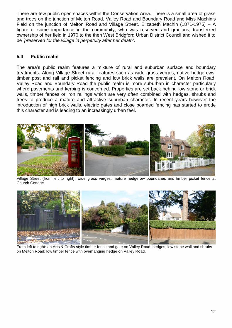
There are few public open spaces within the Conservation Area. There is a small area of grass and trees on the junction of Melton Road, Valley Road and Boundary Road and Miss Machin‟s Field on the junction of Melton Road and Village Street. Elizabeth Machin (1871-1975) – A figure of some importance in the community, who was reserved and gracious, transferred ownership of her field in 1970 to the then West Bridgford Urban District Council and wished it to be „preserved for the village in perpetuity after her death‟. 5.4 Public realm The area‟s public realm features a mixture of rural and suburban surface and boundary treatments. Along Village Street rural features such as wide grass verges, native hedgerows, timber post and rail and picket fencing and low brick walls are prevalent. On Melton Road, Valley Road and Boundary Road the public realm is more suburban in character particularly where pavements and kerbing is concerned. Properties are set back behind low stone or brick walls, timber fences or iron railings which are very often combined with hedges, shrubs and trees to produce a mature and attractive suburban character. In recent years however the introduction of high brick walls, electric gates and close boarded fencing has started to erode this character and is leading to an increasingly urban feel.
Village Street (from left to right): wide grass verges, mature hedgerow boundaries and timber picket fence at Church Cottage.
From left to right: an Arts & Crafts style timber fence and gate on Valley Road; hedges, low stone wall and shrubs on Melton Road; low timber fence with overhanging hedge on Valley Road.
13
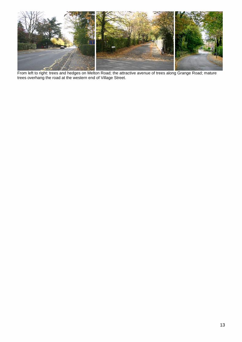
From left to right: trees and hedges on Melton Road; the attractive avenue of trees along Grange Road; mature trees overhang the road at the western end of Village Street.

14
6 The buildings of the Conservation Area 6.1 Building types The prominent building types within the Conservation Area can be categorized into 4 main groups.
Vernacular architecture found in Edwalton Village
Victorian 1837-1901
Edwardian 1901-1914
Mixed Inter-war and mid 20th century styles. Vernacular Architecture Many of the properties in Edwalton village were built to serve its farming community. Decorative materials and contemporary architectural trends would not have been a priority and local materials would have been used instead. This defines the term „vernacular architecture‟. From left to right: Firs Farm (c. 1739), The Old Post Office and the tower of the Church of the Holy Rood which is believed to be a rare example of building from the time of Mary Tudor.
Victorian Architecture With the arrival of the railway in the 1880s, Edwalton became an attractive proposition for wealthy commuters giving rise to the construction of a number of striking Victorian dwellings along Melton Road.
From left to right: Great Musters (formerly „Oxholme‟) seen from Boundary Road, Old Edwalton House and 258 Melton Road, formerly known as „Inglewood‟.
15
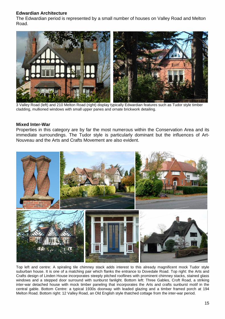
Edwardian Architecture The Edwardian period is represented by a small number of houses on Valley Road and Melton Road.
3 Valley Road (left) and 210 Melton Road (right) display typically Edwardian features such as Tudor style timber cladding, mullioned windows with small upper panes and ornate brickwork detailing.
Mixed Inter-War Properties in this category are by far the most numerous within the Conservation Area and its immediate surroundings. The Tudor style is particularly dominant but the influences of Art-Nouveau and the Arts and Crafts Movement are also evident.
Top left and centre: A spiraling tile chimney stack adds interest to this already magnificent mock Tudor style suburban house. It is one of a matching pair which flanks the entrance to Dovedale Road. Top right: the Arts and Crafts design of Linden House incorporates steeply pitched rooflines with prominent chimney stacks, stained glass windows and a stepped door surround with sunburst fanlight. Bottom left: Three Gables, Croft Road, a striking inter-war detached house with mock timber paneling that incorporates the Arts and crafts sunburst motif in the central gable. Bottom Centre: a typical 1930s doorway with leaded glazing and a timber framed porch at 194 Melton Road. Bottom right: 12 Valley Road, an Old English style thatched cottage from the inter-war period.
16
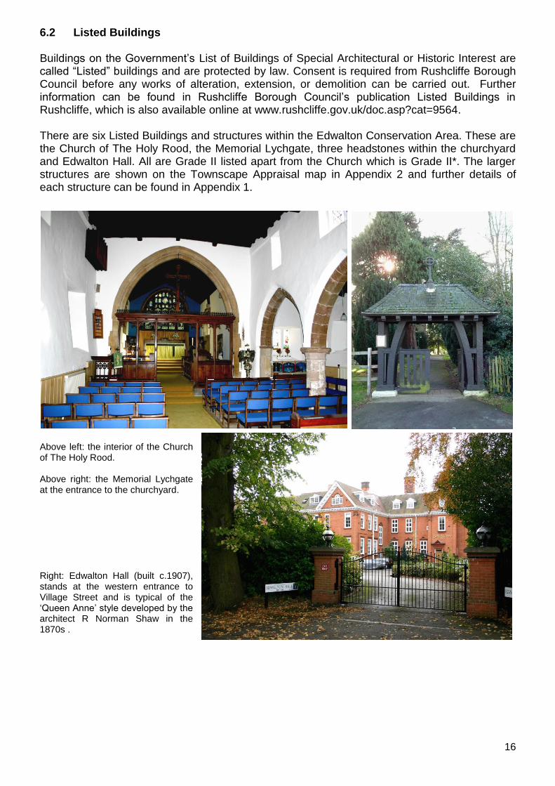
6.2 Listed Buildings Buildings on the Government‟s List of Buildings of Special Architectural or Historic Interest are called “Listed” buildings and are protected by law. Consent is required from Rushcliffe Borough Council before any works of alteration, extension, or demolition can be carried out. Further information can be found in Rushcliffe Borough Council‟s publication Listed Buildings in Rushcliffe, which is also available online at www.rushcliffe.gov.uk/doc.asp?cat=9564. There are six Listed Buildings and structures within the Edwalton Conservation Area. These are the Church of The Holy Rood, the Memorial Lychgate, three headstones within the churchyard and Edwalton Hall. All are Grade II listed apart from the Church which is Grade II*. The larger structures are shown on the Townscape Appraisal map in Appendix 2 and further details of each structure can be found in Appendix 1.
Above left: the interior of the Church of The Holy Rood. Above right: the Memorial Lychgate at the entrance to the churchyard. Right: Edwalton Hall (built c.1907), stands at the western entrance to Village Street and is typical of the „Queen Anne‟ style developed by the architect R Norman Shaw in the 1870s .

17
6.3 The contribution of unlisted buildings The Edwalton Conservation Area includes a number of unlisted buildings that make a positive contribution to the character and appearance of the Conservation Area. This may be because of their age, architectural style, former function, or general contribution to the variety of the townscape. Key unlisted buildings are highlighted in the Townscape Appraisal in Appendix 2. These represent the best examples of Edwalton‟s varied and sometimes eclectic architecture. However it is important to stress that nearly all the buildings within a Conservation Area can make a positive contribution to the townscape in some way.
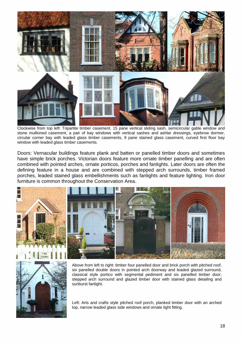
6.4 Building materials and local details Before the arrival of the railway building materials were largely locally sourced. Bricks for example, were not transported far from where they were made, with each village having its own brick pit and yard. This lead to interesting village-specific sizes, colours and styles of brickwork. Roofs would have been made from local materials such as thatch until clay tiles became popular. Slate would not have been common until railway freight allowed large quantities to be easily transported from slate mines in Wales. The building materials and architectural details within the Conservation Area are as follows: Walls: Pre-Victorian vernacular buildings are generally of orange/red brick with some blue brick detailing and are sometimes rendered or painted white. In Victorian and Edwardian buildings Orange/red bricks are still common but these are combined with mock timber panelling and ashlar detailing. Walls on 20th century buildings made use of readily available mass produced bricks which were combined with mock timber panelling, render and pebble dash. Roofs: Orange clay pantiles and red/brown plain tiles are dominant on vernacular buildings which generally have uncomplicated roof forms with either parapet gables or plain close verges. Victorian and later 20th century roofs are dominated by red plain tiles and have much more complex roof forms with a variety of pitches, hips, dormers, timber barge boards and prominent chimney stacks. Windows: Vernacular buildings have mainly timber tripartite York sliding sashes or casements. Victorian properties have a variety of glazing bar vertical sliding sashes and stone mullioned casements which are often incorporated into architectural details such as bay windows. Dormer windows are generally small and few in number. 20th century window types often have a strong vertical emphasis and include a variety of different sized timber casements with leaded glass (sometimes with stained glass embellishments) and smaller top panes. Curved or angular bay windows are common and some more unusual features such as curved corner bays, semicircular windows, oriel windows and eyebrow dormers can also be found.
18
Clockwise from top left: Tripartite timber casement, 15 pane vertical sliding sash, semicircular gable window and stone mullioned casement, a pair of bay windows with vertical sashes and ashlar dressings, eyebrow dormer, circular corner bay with leaded glass timber casements, 9 pane stained glass casement, curved first floor bay window with leaded glass timber casements.
Doors: Vernacular buildings feature plank and batten or panelled timber doors and sometimes have simple brick porches. Victorian doors feature more ornate timber panelling and are often combined with pointed arches, ornate porticos, porches and fanlights. Later doors are often the defining feature in a house and are combined with stepped arch surrounds, timber framed porches, leaded stained glass embellishments such as fanlights and feature lighting. Iron door furniture is common throughout the Conservation Area.
Above from left to right: timber four panelled door and brick porch with pitched roof, six panelled double doors in pointed arch doorway and leaded glazed surround, classical style portico with segmental pediment and six panelled timber door, stepped arch surround and glazed timber door with stained glass detailing and sunburst fanlight. Left: Arts and crafts style pitched roof porch, planked timber door with an arched top, narrow leaded glass side windows and ornate light fitting.

19
7 The character areas of the Conservation Area
Suburban Housing: Most of this character area runs along the major radial road and the
orbital roads lined with mature trees through which there are glimpses of large detached Victorian, Edwardian and inter-war houses. In most cases, these fine examples of their respective architectural styles sit grandly in their original plots.
Historic Village: As you enter this area from Melton Road, the abundance of mature trees and the listed Edwalton Hall with Miss Machin‟s Field opposite, create a distinctive rural village character. The main Village Street winds past 18th and 19th century vernacular houses and cottages with their associated walls and hedges. The road ends at the listed Church of the Holy Rood which is surrounded by mature trees with views of the open countryside beyond.
This map is reproduced from Ordnance Survey material with the permission of Ordnance Survey on behalf of the Controller of Her Majesty‟s Stationary Office © Crown Copyright. Unauthorised
reproduction infringes Crown Copyright and may lead to prosecution or civil proceedings. Rushcliffe Borough Council 1000019419

20
PART 2 GENERIC MANAGEMENT PLAN FOR CONSERVATION AREAS IN RUSHCLIFFE
1.0 Introduction 1.1 The quality and interest of the whole area, rather than individual buildings, gives a
Conservation Area its special character. This includes factors such as historic street layout, use of local building materials, scale and detailing of buildings, boundary treatments, shop fronts, street furniture, vistas along streets or between buildings as well as trees and shrub planting.
1.2 In carrying out its planning functions, the Borough Council is required to give special
attention to the desirability of preserving or enhancing the character or appearance of Conservation Areas. Conservation Area Appraisals identify the special character of each Conservation Area and the Borough Council has a programme for preparing or reviewing these.
1.3 There is also a duty to formulate and publish management plans setting out policies and proposals for the preservation and enhancement of Conservation Areas. Many of these policies and proposals are common to all Conservation Areas and these are set out in this document. Supplementary documents will be issued for individual Conservation Areas where specific policies or proposals are needed.
2.0 Aims and Objectives of this Management Plan
To set out clear management proposals for the preservation and enhancement of Conservation Areas.
To guide residents and professionals on:
- features of value, worthy of preservation; - characteristics worthy of preservation; - opportunities for enhancement. - development proposals which preserve and enhance the special character of
the area
To foster community commitment to conservation principles The Borough Council will follow these objectives in its own activities and will encourage other public bodies, including the Highway Authority to do the same. 3.0 National and Local Policies and guidance 3.1 Central Government guidance applies to all Conservation Areas. This can be found in
the following Planning Policy Statement 5 “Planning for the Historic Environment” English Heritage “Management of Conservation Areas”
3.2 The County Structure Plan contains the following policy:
21
POLICY 2/12 HISTORIC CHARACTER Local planning authorities will protect and enhance the historic and architectural character and appearance of the landscape of the Plan Area. Permission will not be granted for development within Historic Parks and Gardens, Historic Battlefields and other areas designated for special protection except where it demonstrably conserves and enhances the characteristics of these areas. The protection and enhancement of the historic character will be achieved through: a) the protection and maintenance of buildings listed as of special architectural, historic or
landscape importance, including their settings; b) the identification, protection and maintenance of other individual and groups of buildings
which are important for their local architectural distinctiveness, or significance; c) the identification, maintenance and enhancement of other locally distinctive and culturally
important aspects of the historic environment; d) the designation, enhancement and preservation of Conservation Areas and their settings; e) sensitively designed environmental improvement and traffic management schemes in
Conservation Areas and other appropriate areas; f) finding appropriate alternative uses for, and the restoration of, listed or other buildings
worthy of retention; and g) informed design of new development. 3.3 The adopted Rushcliffe Local Plan was replaced in 2006 by the Non Statutory
Replacement Local Plan for Development Control purposes and the following policies from that plan will be used for guidance in Conservation Areas.
EN2 – CONSERVATION AREAS Planning permission for development including changes of use and alterations or extensions to existing buildings within a designated Conservation Area, or outside of but affecting its setting, or views into or out of the Conservation Area will only be granted where:
a) the proposal would preserve or enhance the character or appearance of the Conservation Area by virtue of its use, design, scale, siting and materials;
b) there will be no adverse impact upon the form of the Conservation Area, including its
open spaces (including gardens), the position of existing buildings and notable features such as groups of trees, walls and other structures; and
there will be no loss of part or all of an open space which contributes to the character or appearance of the Conservation Area. EN3 – DEMOLITION IN CONSERVATION AREAS Where planning permission is required for development which includes the demolition of buildings in Conservation Areas it will only be granted where the proposal does not detrimentally affect the character or appearance of the area, and any permission may be conditional on redevelopment proposals for the site being approved, and contracts for them accepted, before demolition is begun. 3.4 Village Design Statements
Village Design Statements exist or are being prepared for several villages in the Borough, some of which are also Conservation Areas. Although these offer no statutory protection they identify the qualities that are valued by the local community and the character that should be preserved.
22
4.0 Development in Conservation Areas 4.1 Article 4 Directions.
Article 4 of the Town & Country Planning (General Permitted Development) Order 1995 allows planning authorities to restrict specified permitted development rights in particular areas. Many councils use these to assist with the preservation of the special character of Conservation Areas although there are currently none in Rushcliffe. Many buildings still possess original or traditional architectural details which contribute to the special character. These include windows, doors, porches, door hoods, pilasters and fanlights, chimneys, brick detailing and roofing materials as well as walls, gates and railings. However, the increased use of upvc windows, plastic barge boards, inappropriate roofing materials, high spiked metal railing and electric gates is eroding the character of many of our Conservation Areas. The use of Article 4 Directions will be proposed where considered appropriate following the completion of each Area Appraisal
4.2 Building Design Extensions to buildings in Conservation Areas should respect
The key characteristics of the original building including scale, mass, materials and proportions
The contextual setting and character of the Conservation Area
This does not mean slavishly copying the original, which can devalue it and destroy the ability to “read” historic change and dilutes our historic heritage. In some cases this is impossible. For example Flemish Bond brickwork cannot be replicated in cavity walls and narrow lime mortar joints cannot be replicated in modern cement mortar.
4.2.1 Good contemporary design will be encouraged where it respects the scale and character of its context. This must be demonstrated in the Design and Access Statement submitted with any planning application.
4.2.2 In particularly sensitive locations, such as uniform terraces, exact replication may be
necessary to maintain compositional unity. In that case, attention to details, choice of materials and high quality workmanship are the keynotes.
4.2.3 Where new building is appropriate, on infill sites or where an existing building detracts
from the character of the area, the opportunity should be taken to re-establish the streetscape, reinforce enclosure, open up distant vistas or views of landmarks or hide unsightly views.
4.2.4 As with extensions, good contemporary design which respects local character and the
context of the site will be encouraged. “New and old buildings can coexist happily without disguising one as the other, if the design of the new is a response to urban design objectives”. (DETR - „By Design‟, p19)
4.2.5 Pastiche designs, incorporating poor imitations of other styles will be resisted, particularly
where they incorporate details which are not locally appropriate. Careful high quality replication may be required in a few very sensitive locations.
23
4.2.6 All new buildings should respond appropriately to the existing frontage and normally follow the established building line. Development or redevelopment will normally be resisted if:
it blocks important views identified in the individual appraisals
uses important open spaces identified in the appraisals
adversely affects the setting of any Listed or key buildings
fails to maintain or re-establish the streetscape where appropriate
dominates its Conservation Area background
fails to recognize the context of the site
destroys important features identified in the individual appraisals such as boundary walls, fences, hedgerows or trees
4.2.7 New development that stands out from the background of buildings may be appropriate
in exceptional circumstances if it contributes positively as a landmark to enhance the street scene, to highlight a corner or to signal a visual change of direction such as along a curving vista.
4.2.8 Any external lighting should be carefully designed and sited to minimise light pollution. 4.2.9 Energy producing or saving devices are generally welcomed by the Council, but careful
consideration is required when these are to be located in a Conservation Area and some may require planning permission. In particular they should be sited to minimise their impact on the building and on the local amenity.
4.3 Materials
Rushcliffe‟s older buildings are predominantly brick, some incorporating earlier timber framed structures. (There were many small local brickyards, some of which only worked for a few years and produced bricks in various shades of orangey red.) There is a little local stone, mainly a soft grey lias, and higher status buildings in stone imported from Lincolnshire and elsewhere. Roofs are mainly plain tiles or pantiles, with some Swithland slate and Welsh slate from the mid 19c onwards. A few original thatched roofs remain. Most of these materials are no longer available second hand, except in very limited quantities. National guidance is to use high quality new materials for extensions to existing buildings. However, it is preferable to use reclaimed materials where:
Small quantities are needed to exactly match the materials of the existing building
The materials are of high quality, the correct dimensions and colour
The materials are sourced locally e.g. the approved demolition of an existing structure on site or in the immediate vicinity
It can be demonstrated that the sourced materials have not resulted in the loss of a heritage asset elsewhere
4.4 Boundary Treatment
Boundaries, such as walls, fences or hedges, separate private spaces from the public realm of roads and pavements, physically and visually. They are as important in determining the character of a Conservation Area as the buildings behind them.
24
4.4.1 Types of boundary 4.4.2 High brick walls and buildings on the back of pavements create a hard, urban feel to the
Conservation Area whilst hedges, verges and trees produce a more rural character. In some Conservation Areas one or the other predominates whilst some have a mix of these features.
4.4.3 Where the character definition is strong, it is important to retain and promote a
continuation of the theme. A high brick wall in a predominantly "green" lane will impact adversely on its character and the introduction of a hedge in an urban scene may be equally inappropriate. Where there is a variety in the type of boundary there will be more flexibility.
4.4.4 Local materials and design play a vital role in successful boundary treatments which
maintain or enhance the character of the Conservation Area. Brick walls which match or complement the local architecture or locally native hedgerows and trees invariably have the greatest conservation benefits.
4.4.5 Any boundary detail should be in keeping with the street scene and be complementary to
the building to which it is the boundary. It should reflect the status of the property and not attempt to create a sense of grandeur where unwarranted.
4.5 Landscaping 4.5.1 Trees can be a key factor in the special character of Conservation Areas. Each
Conservation Area appraisal identifies trees that are particularly important to the Conservation Area.
4.5.2 In Conservation Areas there is a duty to give the local planning authority six weeks notice
of any proposed work to a tree. This period allows the local authority to assess the trees and decide whether a tree preservation order is desirable.
4.5.3 In many instances, the planting of new trees or groups of trees, would enhance the character of the Conservation Area. The Council is keen to promote this, where new planting contributes to the public realm, and works with Parish Councils to carry out small scale planting and other landscape schemes in their areas.
5.0 Buildings at risk and sites which detract from the character of the area 5.1 A number of important buildings in our various Conservation Areas are currently vacant
or not in regular use, with some being „at risk‟ of neglect or decay. There is a presumption against demolition of buildings which contribute to the character of the area unless there are exceptional circumstances. It would therefore benefit both the physical form and the function of the Conservation Area if these buildings were repaired, maintained and brought back into use.
5.2 The Council will encourage owners of key properties in Conservation Areas which are in
need of renovation or repair to carry out the basic maintenance work necessary to make sure the building is structurally sound and weather tight. The Council will encourage and advise on renovation and repair work that is sensitive to the original or traditional historic character of the building and retains original features.
25
5.3 The Council may take formal action if the condition if any building (listed or unlisted) which makes a positive contribution to the character of the Conservation Area is considered to be at risk.
6.0 Management of Public Realm 6.1 Management of highways and footpaths is the responsibility of the Highway Authority,
Nottinghamshire County Council. The Council will use its influence to ensure that the principles of good street and public realm design, such as those set out in
“Streets for All: East Midlands” (English Heritage, 2005),
“By Design: Urban Design in the Planning System: Towards Better Practice” (DETR/CABE, 2000)
“Manual for Streets” (DfT, 2007),
are applied within Conservation Areas. 6.2 Grass verges can also be lost during road or pavement improvement schemes and
kerbstones may be added. They can also come under threat from property owners seeking to create hard-standings for off-street parking. The loss of grass verges, and the cumulative effect that this has over time, can result in the gradual deterioration of the special character of a Conservation Area. Such works will be resisted.
6.3 The quality and design of street surfaces and street furniture can also have a major impact on the character of the Conservation Area. Where historic or traditional street surfaces and street furniture have survived, these should be preserved and maintained. Any streets or public spaces in poor condition can have a negative impact on the Conservation Area and may need to be improved. Materials should be carefully selected to ensure that they complement and enhance the character of the Conservation Area.
6.4 Any surfaces, whether public or privately owned, that are in a severe state of disrepair
and/or have a negative impact on the Conservation Area should be a priority for improvement works.
6.5 The public footpaths and other rights of way within and adjacent to the Conservation
Area play a vital role in allowing people to enjoy and experience the area. It is important that these paths are well maintained, clearly marked and made accessible.
7.0 Monitoring 7.1 This Management Plan will be reviewed in accordance with a programme to be agreed in
the light of the emerging Local Development Framework and government policy and best practice guidance at the time.
7.2 This review could involve residents and/or members of a residents‟ conservation group or
conservation advisory committee under the guidance of the Borough Council. By this means, the local community would become more involved in the process, thus raising public awareness of and commitment to conservation issues.
26
APPENDICES
Appendix 1 – Listed Buildings and Structures FORMER EDWALTON HALL HOTEL AND ADJOINING OUTBUILDINGS, VILLAGE STREET, NG12 4AE Grade: II Date Listed: 13/04/1987 GRID REFERENCE: SK5946135187 CHURCH OF THE HOLY ROOD, VILLAGE STREET, NG12 4AE Grade: II* Date Listed: 13/12/1949 GRID REFERENCE: SK5985035002 MEMORIAL LYCHGATE AT CHURCH OF THE HOLY ROOD, VILLAGE STREET, NG12 4AE Grade: II Date Listed: 13/04/1987 GRID REFERENCE: SK5984935042 HEADSTONE 16 METRES SOUTH OF SOUTH AISLE AT CHURCH OF THE HOLY ROOD, VILLAGE STREET, NG12 4AE Grade: II Date Listed: 13/04/1987 GRID REFERENCE: SK5985134974 PAIR OF HEADSTONES 10 METRES AND 12 METRES SOUTH OF SOUTH AISLE AT CHURCH OF THE HOLY ROOD, VILLAGE STREET, NG12 4AE Grade: II Date Listed: 13/05/1987 GRID REFERENCE: SK5984334979
27
Appendix 2 – Townscape Appraisal
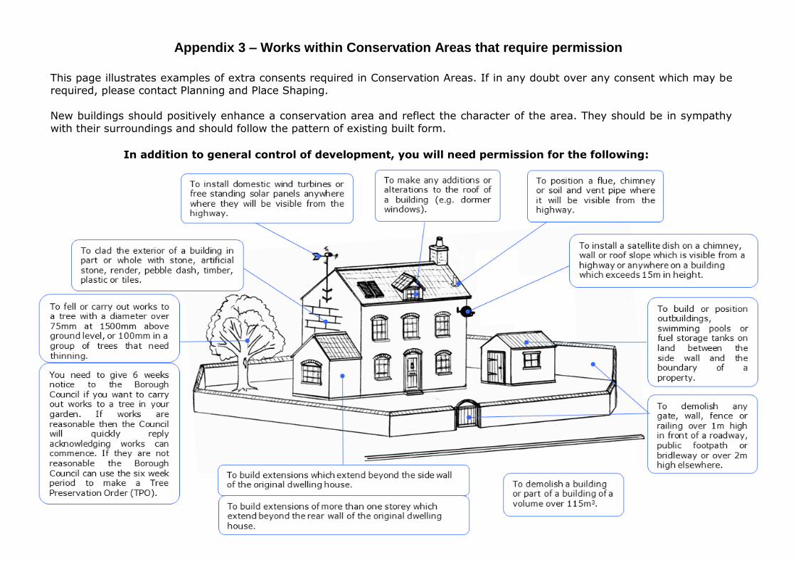
Appendix 3 – Works within Conservation Areas that require permission
In addition to general control of development, you will need permission for the following:
This page illustrates examples of extra consents required in Conservation Areas. If in any doubt over any consent which may be required, please contact Planning and Place Shaping.
New buildings should positively enhance a conservation area and reflect the character of the area. They should be in sympathy
with their surroundings and should follow the pattern of existing built form.