ecological characterization of the body ponds … · ecological characterization of the body ponds...
TRANSCRIPT
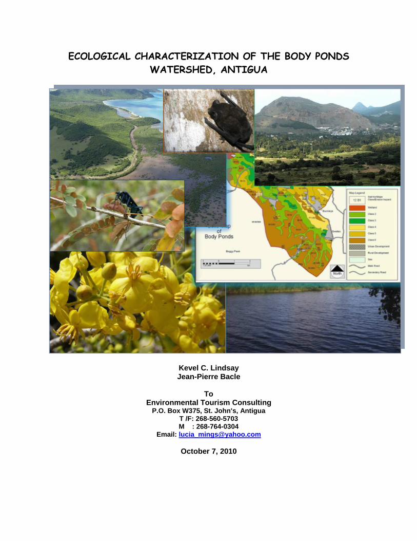
ECOLOGICAL CHARACTERIZATION OF THE BODY PONDS WATERSHED, ANTIGUA
Kevel C. Lindsay Jean-Pierre Bacle
To
Environmental Tourism Consulting P.O. Box W375, St. John's, Antigua
T /F: 268-560-5703 M : 268-764-0304
Email: [email protected]
October 7, 2010


View of Body Ponds with Bendals Village, Greencastle Hill and the Antigua Masonry Products quarry in the mid-distance. The Sleeping Indian is located in the mid-background (photo courtesy Bruce Potter).
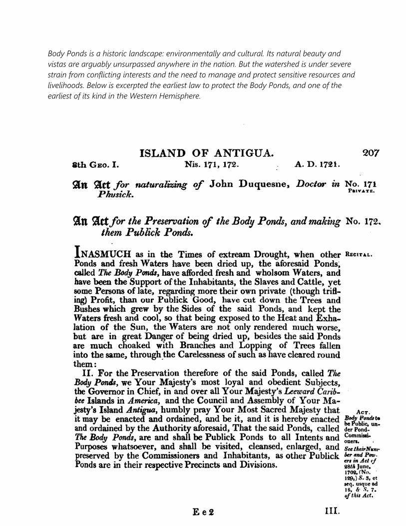
Body Ponds is a historic landscape: environmentally and cultural. Its natural beauty and vistas are arguably unsurpassed anywhere in the nation. But the watershed is under severe strain from conflicting interests and the need to manage and protect sensitive resources and livelihoods. Below is excerpted the earliest law to protect the Body Ponds, and one of the earliest of its kind in the Western Hemisphere.


TABLE OF CONTENTS
Introduction Page 10 Summary of Findings Page 13 Introduction Page10 Physical Characteristics of the Body Ponds Watershed Page 15 • Location Page 15 • Existing Conditions Page 15 • Climate and Weather Page 17 • Geology & Soils Page 19 • Drainage and Watersheds Page 22 • Cultural Context Page 25 Methodologies Page 29 − The Ecosystem Assessment of the Body Ponds Watershed Page 30 − Survey of the Vegetation and Plants Page 31 − Survey of Terrestrial Vertebrates Page 32 − Survey of Terrestrial and Freshwater Aquatic Invertebrates Page 33 − Survey of Marine Ecosystems and Issues Page 33 − Survey of Threatened, Rare and Endangered Species and Habitats Page 33 − Survey of the Cultural and Heritage Resources Page 33
The Body Ponds Ecosystem: An Overview Page 34 Observations: Vegetation and Flora of the Body Ponds Watershed Page 38 • Vegetation Communities Page 38 • Body Ponds Flora Page 49 Observations: Fauna of the Body Ponds Watershed Page 51 • Birds Page 53 • Mammals Page 59 • Reptiles and Amphibians Page 60 • Terrestrial and Aquatic Fish Page 62 • Terrestrial and Aquatic Invertebrates Page 66 • The BPW Marine Environment Page 69

• Invasive Species Page 75 • Species of Special Conservation Concern Page 79 • Vegetation Communities of Special Conservation Concern Page 82 • Areas of Special Conservation Concern Page 85 Recommendations for Management of Biological and Cultural Resources of the Body Ponds
Watershed Page 91 Definition of Terms Page 94 Acknowledgements Page 96 Selected References Page 97 Appendices - Appendix I: Five Islands Harbour Coastal Marine Trip Report Page 109 - Appendix II: Birds of the Body Ponds Watershed Page 113 - Appendix III: Plant species of the Body Ponds Watershed Page 117 - Appendix IV: IUCN Regional Red List of Plants of the Body Ponds Watershed Page 133 - Appendix V: Historic estates within and adjacent to the BPW Page 139 - Appendix VI: Sugar mills of the historic estates of the BPW Page 142

INTRODUCTION This ecological characterization has been prepared by team members, Kevel Lindsay, consultant to Environment Tourism Consulting (ETC), and Jean-Pierre Bacle of Island Resources Foundation. It forms part of part of a larger effort, jointly funded by the Global Environment Facility (GEF) full size project, Demonstrating the Development and Implementation of a Sustainable Island Resource Management Mechanism in a Small Island Developing State SIRMM project, and the ZARAGOZA Project: Developing an integrated management system for Antigua and Barbuda (ZARAGOZA-IWMS).
The Participatory Land‐Use Zoning Plan consists of:
• An updated ecosystem assessment for the Body Ponds watershed; and
• A participatory Land‐use Zoning Plan for the Body Ponds Watershed (BPW)
Demonstration Site.
The BPW, which has an approximate annual yield of 390,000m³/yr of water by volume, is the largest in Antigua and Barbuda. The Watershed, however, suffers from the indiscriminate burning of Lemon grass (Cymbopogon citratus), a practice which leaves vast areas of land exposed and susceptible to soil erosion, desiccation, severe loss of biodiversity, the compromise of ecological services and processes, and local aesthetics. Added to these is the fact that the soil has been made almost impermeable by the constant burning, and as a result, has created an environment favorable for the grass, but detrimental to forest tree species. This along with the many other unsustainable land practices within the area (uncontrolled grazing, illegal logging, use of agro-chemicals etc.) has left an ever increasing ecological footprint.
The landscapes of the Watershed encompass a complex system of forests, sub-watersheds, hills, rivers, ghauts, reservoirs, urban environments and

commercial activities, including large-scale quarrying. This creates a very dynamic range of biodiversity and landscapes.
Much of the native and naturalized flora and fauna of the Body Ponds area are typical for the south western volcanic region of Antigua, and are widely distributed throughout this part of the island. Many species, such as birds are transient, some staying as long as food and shelter are available, others only passing through area on their way to more productive grounds. Some of these transients are seasonal migrants while others are year-long residents.
To provide the most representative and comprehensive assessment of the biodiversity within the Watershed, the surveys required going beyond the confines of the human-imposed boundaries. The challenge was to assess the communities of plants and animals and not exclude or miss those features and assets that lay just beyond the immediate boundaries, or those that only occupied the area during periods convenient to them, but not during our presence there.
The assessment and survey of the vegetation, flora and fauna of the Body Ponds Watershed was done in three components. The first was a review of historical literature, reports and notes, as well as discussions with key local individuals and experts. The second was a field survey of the area and the third was the mapping of the communities and other features.
The Body Ponds Watershed is quite extensive, and it would have proved impossible to conduct a comprehensive and detailed survey in the short space of time for the effort, and given the financial resources of the project, the team conducted targeted surveys of specific areas with the assistance of volunteers. Field surveys were conducted in January, March and April 2009.
For terrestrial habitats and species, the team conducted assessments and searches on foot by using trails, natural access points, aerial imagery, random surveys, natural species congregation and aggregation points, flyways and along roads.
For plants and vegetation communities, the survey team worked closely with the Environmental Awareness Group’s (EAG) Plant Project. The Group has undertaken a survey of the native and naturalized plants of Antigua and Barbuda, under the guidance of Chris Pratt, and will publish a book on the work. Working with the Plant team allowed a more comprehensive survey exercise, and for the Body Ponds team to provide data on rare, endangered and new species. The species of plants are noted and tabulated in Microsoft Excel, and a list of plants was produced, along with statistical analysis of the species.
The vegetation communities have been assessed and mapped using the classification of Lindsay and Horwith, 1997, Loveless, 1963 and Beard, 1949. The results included an assessment of the invasive Lemon Grass.
Also included are cultural and heritage resources, which have been mapped. Roads and other urban features, including settlements have been mapped. These have been included under the Local Area Management and Zoning Plans. It was the team’s feeling that these maps are better suited to these reports.
For fauna, similar techniques were used, species were catalogued, and some statistical analysis provided.
SUMMARY OF FINDINGS
Conducted Field Research on the Biological Resources within the Body Ponds Watershed From January to April 2009, Kevel Lindsay, Jean Pierre Bacle,
Clive Petrovic and Dr. Carlos Ramos, along with three volunteers from the Environmental Awareness Group's (EAG) Plant Project, carried out surveys at throughout the BPW to assess the flora, vegetation communities, the fauna, the status of the marine communities in Hansons Bay, the water resources and erosion and sediment issues, invasive species and their impacts, issues and concerns, and of outstanding features of the area;
About 450 species of plants have been identified for the
Watershed; At least 88 species of birds, 8 species of reptiles and
amphibians were identified; 9 species of birds, two mammals, four reptiles and one special
taxon of terrestrial native aquatic invertebrate of “special conservation concern” were identified;
The Team identified all plant communities of “special
conservation concern” for the Watershed; For BPW, 20 vegetation community alliances and 2 associations
were identified; At least 17 key natural and cultural features have been
identified for the Wallings Forest area;
At least 70 species of IUCN Red Listed West Indian endemic plants identified;
Prepared and submitted a Final Project Report to the Environment Tourism Consulting • The report has been prepared and submitted to Environment
Tourism Consult ing, outlining the ecological characterist ics
and qualit ies of the Body Ponds Watershed and surrounding areas, and also includes an overview of the cultural and heritage resources of the watershed.

PHYSICAL CHARACTERISTICS OF THE BODY PONDS WATERSHED
Location Body Ponds Watershed is the largest watershed by aerial extent in Antigua. It is situated in the south of the island, oriented in a southeast to northwest direction, starting at Signal Hill and out-flowing at Hansons Bay, occupying an area of 4,200 km2 (10,400 acres). The figure insert below shows the overall location of the Watershed in relation to the rest of
the island Existing Conditions The Body Ponds Watershed encompasses a wide range of land uses and vegetative zones within its boundaries. This is because of the varied topography and resultant micro-climatic zones. The highest point in the watershed is 368 m (1207 ft) on top of Signal Hill. However there are several places
nearly as high within the watershed. These are the hills in the eastern part of the Shekerley Mountains, which are the eroded remnants of Antigua's long dormant volcanoes. The mountains and hills are composed volcanic rocks in various stages of weathering and in the bottoms of the surrounding valleys are the eroded sediments from these rocks. Further to the north east, are remnants of the ash falls and pyroclastic flows that were ejected from the many volcanoes that were active some 30 to 40 million years ago. These materials have provided the source of the heavier clay soils found in the watershed. The main Body Ponds valley lies between these types of rocks, and so a range of sediments are found in the lower parts of the watershed where these materials have been deposited. At the upper, south eastern end of the watershed, the valleys tend to be narrow and steep, where active erosion is still occurring. Further towards the sea, primarily west of and southwest of Bendals village, the surrounding hills are lower, slopes are less steep, and the valley bottom is much broader and flatter. The vegetation of the watershed is mostly a mix of forests (secondary) with some

agriculture on the crop and some livestock farming in low land areas. Extensive areas of lemon or fever grass are found scattered on the upland slopes of the hills. Main human settlements are found most on the northern, northeastern and east central parts of the watershed. The outer edges of the watershed are, in many places, quite steep and erosion prone. Fortunately, most of these slopes, although once cultivated for sugar production, are now covered in moist forest or woodland. Lower down, closer to where agriculture is still practised, the vegetative cover is more variable and may be quite sparse with only grass and scattered trees or shrubs. On the flatter lands, closer to the sources of stored water, the agricultural areas can be found. These are primarily in the Body Ponds valley itself, between the villages of Bendals and Swetes or in the Brecknock/Hamiltons areas. There are additional agricultural areas west and north of Bendals, including Bath Lodge, Big Creek and Smiths Estate. Some of these lands are in vegetable and fruit tree production while other areas are used as grassland for feeding livestock. An important grassland area lies mainly within the BPW but is also of growing importance outside it as well. This is the expanding area of Lemon (or Fever) grass, which is a very troublesome fire hazard due to the ease with which it is set on fire and the fierceness with which it burns. At the seaward end of the watershed, there is a large mangrove wetland and flash, which the drainage system passes through on its final approach to the ocean. The Flashes wetland is one of the largest intact wetlands still surviving in Antigua. A considerable portion of the watershed is now being used for residential and other forms of development, especially in the regions closest to St. John's. Major areas of growth have been in the Olivers/Buckleys, Belmont, Golden Grove, Creekside and Cooks Hill areas. Swetes, John Hughes, Bendals, and Ebenezer/Jennings have also expanded significantly. Industrial activity is limited but there are a few significant operations in the watershed. These include the largest stone quarry in Antigua, located just west of Bendals village. A smaller quarry, now closed, was located near the St. Luke’s church on the eastern edge of the community. This site now houses an asphalt mixing plant. For a spatial representation of land-use in the BPW, refer to the Local Area Zoning and Management Plan (ETC, 2010).
Climate & Weather As with most islands in Lesser Antilles, Antigua is strongly affected by the Northeast Trade winds, which means winds approach with great constancy from directions between east-northeast and southeast. The average wind direction varies throughout the year according to the following pattern:
o December to February: winds blow from east-northeast (known locally as “Christmas Winds”),
o March to May: winds blow from easterly directions, o June to August: winds blow from east to east-southeast directions, o September to November: winds blow mainly from the east to southeast.
Normally, except for the occasional hurricane, highest wind speeds are experienced from December to February and again in June and July. Average wind speeds for the months of June – July are around 9m/sec (20 mph), while for October average wind speeds drop to 6m/sec (13.5 mph). During the winter months, October to April, the island is occasionally influenced by frontal systems moving in an eastward direction across the southern part of the United States. The trailing edge of these fronts sometimes affects the Antigua and results in winds blowing from between northwest and northeast for short periods – usually no more than to two days. The area also lies within the hurricane belt. These intense storms occur between June and November, with September being the month when most tropical storms or hurricanes occur. Temperature varies little throughout the year, with daytime temperatures that fall within the range 25°-29° C and usually drop 6° C at night. Temperatures average an annual 81° F (21.6° C), with the winter lows averaging 76° F (24° C), and the summer high reaching the mid to upper 80s. The temperature and climate are moderated by near constant on-shore breezes. Due to year-round high temperatures and nearly constant winds, the evapo-transpiration rate is generally high. Heavy rainfall sometimes occurs during the passage of the easterly tropical waves, which are spurned off the West African coast from June to November of each year. Occasionally,

these waves intensify into tropical depressions, tropical storms, or hurricanes. Map1.0 below shows the rainfall patterns and zones within the BPW.

Map 1.0. Rainfall patterns and zones within the BPW.

Geology &Soils The initial geological landscape of Antigua was created when volcanoes burst through the ocean floor some 40 million years ago. Eruptions continued sporadically for the next 10 million years, to built at least 5 clusters of volcanic cones, craters, domes and lava flows in a triangle between what is now Deep Bay, Shirley Heights and Johnson’s Point. The following million years of weathering, landslides, mudflows, erosion and sedimentation has contributed to the landscape we see to date. The dominant bedrock types in the area andesite that form most of the domes and volcanic lava flows, and pyroclastic rocks associated with volcanic flows and ash fall. Basalt lava flow and dykes are also found but to a lesser extent. Soil formation and properties are influenced by a number of processes and effects: the parent rock is naturally very important in determining the eventual properties of the soils formed on it, but acting on this geochemical substrate are the effects of climate, in particular rainfall, slope, vegetation and of course the time such processes have been at work. In the Body Ponds watershed, the great majorities of parent rocks are of volcanic origin and are composed mostly of andesite. However, the pyroclastic flows and ash falls resulting from these volcanoes also provide different parent material for soil formation. Because of this there are many different soils identified even in the small area of the watershed. All together there are 12 different soils mapped in the watershed. These are listed in Table 1.0 together with the area under each soil. The most important soils in terms of area are the Monteros series (23%) and, the Blubber Valley series (14%). All the other soils occupy less than 10% each. Built-up land (housing and other forms of built development) occupy a surprising 21 percent of the whole watershed. This figure includes land already subdivided for housing lots, but which may not yet be built on except for road ways. Map 1.0 provides the locations of the soil types of the BPW.

Table 1.0. List of Soils found in the BPW with details of area and slope classes.
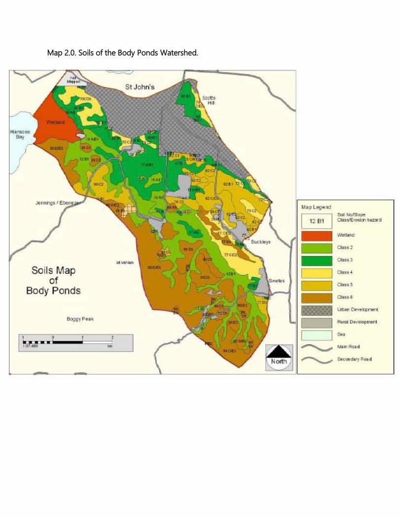
Map 2.0. Soils of the Body Ponds Watershed.
Drainage & Watersheds The natural outflow of the watershed all drains out through the Flashes at the north western end of the watershed. Map 3.0 shows the ghauts and water courses that make up the drainage system of the BPW. It can be seen that the major drainage branch starts in the south eastern end of the watershed, collecting water mainly from the hilly and mountainous regions south of Swetes, Sawcolts and Bendals. These sources provide the several dams and ponds in the main Body Ponds valley with their water. There is a second tributary that drains the area between Olivers and Renfrew and other points to the west. This is in a somewhat lower rainfall area, so does not collect as much rainfall. This drainage system joins the main Body Ponds system at the beginning of Big Creek in Bath Lodge, where a third branch of the drainage system that collects runoff from south facing slopes of Scotts Hill and Briggins also joins the other two tributaries. There a few other minor tributaries that join the main system further west, as well as Little Creek, an independent system that drains the area from west of Bendals through Smiths Estate and a branch from Greencastle Hill that runs through Ebenezer and drains into the southern edge of the Flashes. There are several natural springs scattered throughout the watershed. These include at least two on Byam’s Hill, situated just above the Body Ponds. Several within the reservoirs that have been dammed, one at Brecknock Dam No. 1, and another situated just a stone’s throw to the southwest of the village of Sawcolts (photo 1.0).
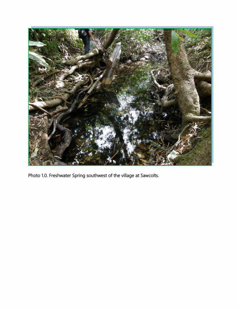
Photo 1.0. Freshwater Spring southwest of the village at Sawcolts.
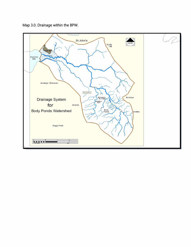
Map 3.0. Drainage within the BPW.

The Cultural Context The Body Ponds we see today is largely a product of human actions and determination. We see this in the many villages, roads, facilities, quarries, dams, agricultural fields and deforested slopes. Human influence on the landscape goes back thousands of years. We know this because there are at least two Amerindian (First Peoples) archaeological sites within the area: one at Greencastle Hill and another on at least one of the Five Islands. European and African influences began sometime in the 1600s and continue to the present day, though much of this is manifested in a more modern context. But the human influences is not limited to and confined by mere sites and individual events. The history and landscape of Body Ponds are woven together into a dynamic fabric of culture and the environment, events and change. We see history and signature moments, but the events that brought us to this point are often forgotten or manifested in heritage and cultural icons such as the Body Ponds themselves. Take for example: At Greencastle Estate at New Division, in1701 on Christmas Day, a Speaker of the House and owner of the estate, Samuel Martin, was murdered by his slaves after he refused to give them a holiday and compelled them to work. They hacked him to death during the dead of the night. This event transformed Antigua and the landscape. But it is not represented by a mark on the ground. This is how heritage and history works. There are a number of cultural, archaeological and heritage sites and resources scattered throughout the watershed and nearby areas. The survey team identified at least 22 of these heritage/cultural resources. These are summarised in table 2.0 below. Table 2.0. Cultural & heritage sites located in the Body Ponds Watershed NO. SITE LOCATION DESCRIPTION CONSERVATION & MANAGEMENT STATUS 1 Hamilton
Village Historical No conservation designation or management. There is
little known and available information on the exact historical context of the village. Unfortunately, the site was recently bulldozed and many of the few remaining structures were badly damaged and other characteristic features were razed.
2 Brecknock’s Mill
Historical Not protected or managed. Its conservation needs are currently unknown.
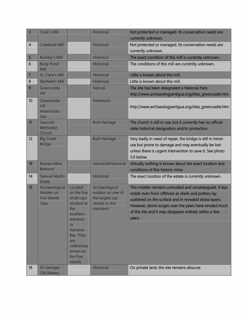
3 Cook’s Mill Historical Not protected or managed. Its conservation needs are currently unknown.
4 Creekside Mill Historical Not protected or managed. Its conservation needs are currently unknown.
5 Buckley’s Mill Historical The exact condition of this mill is currently unknown. 6 Body Pond
Mill Historical The conditions of this mill are currently unknown.
7 St. Clare’s Mill Historical Little is known about this mill. 8 Denfield’s Mill Historical Little is known about this mill. 9 Greencastle
Hill Natural The site has been designated a National Park.
http://www.archaeologyantigua.org/sites_greencastle.htm 10 Greencastle
Hill Amerindian Site
Prehistoric http://www.archaeologyantigua.org/sites_greencastle.htm
11 Sawcolts Methodist Church
Built Heritage The church is still in use, but it currently has no official state historical designation and/or protection.
12 Big Creek Bridge
Built Heritage Very badly in need of repair, the bridge is still in minor use but prone to damage and may eventually be lost unless there is urgent intervention to save it. See photo 3.0 below.
13 Barytes Mine Belmont
Industrial/Historical Virtually nothing is known about the exact location and conditions of this historic mine.
14 Samuel Martin Estate
Historical The exact location of the estate is currently unknown.
15 Archaeological Midden on Five Islands Cays
Located on the five small cays situated at the southern entrance to Hansons Bay. They are collectively known as the Five Islands.
Archaeological midden on one of the largest cay closest to the mainland.
This midden remains unstudied and uncatalogued. It lays visible even from offshore as shells and pottery lay scattered on the surface and in revealed strata layers. However, storm surges over the years have eroded much of the site and it may disappear entirely within a few years.
16 Sir Georges Old Battery
Historical On private land, the site remains obscure.

17 Brecknock Dam No. 1
Built Heritage Badly in need of repair and maintenance, the ironworks are rusting and much of it has fallen away. The reservoir is still in use.
18 Fiennes Dam Built Heritage In need of repair and maintenance. Land-use around the reservoir poses considerable threat to the long-term sustainability of the dam and to the reservoir.
19 Fisher Dam Built Heritage The situation of this dam and its related reservoir are similar to that of Fiennes.
20 New Division Sugar Mill
Historical At a glance, the structure of the mill appears stable. However, virtually nothing is known about its current conservation needs and conditions. Unprotected.
21 Petrified Forest
Geological/Natural Much of the natural petrified materials of this site, especially the larger pieces, have been stolen, vandalised and removed. Though recommended for protection since early 20th Century, the site remains unmanaged and unprotected and in fact, development around the area has encroached to just within meters and other upland activities are posing considerable challenges to its continued value.
22 Amerindian Steps
Archaeological The exact nature of this site is unknown to historical authorities. It was identified by the Hall family as Amerindian in origin. The steps are obvious from just offshore, but they remain an enigma. Immediate steps are needed to determine the identity of the site.
Many of the heritage and cultural sites and resources of the BPW are little known and/or understood. Attempts to locate information on these and other potential sites proved futile and details quite elusive. This is due to the fact that not many of these sites and resources are officially recognized and catalogued by any authority. Even more disconcerting is the state of some of these structures. For example, the Petrified Forest, which has been identified as a major natural monument since early in the 20th Century, has mostly disappeared due to removal of the large petrified stones that once littered the ravine and embankments. Today, much of the area is under severe threat from unplanned and unrestricted housing and commercial development. Another is the Big Creek Bridge, a marvellous example of Victorian bridge architecture (Photo 3.0). Its graceful stone arches, dark stone blocks, accents and curves hearken back to the 19th Century. Despite its historical and cultural values, the bridge now lies largely disused alongside the more modern Chinese-financed and designed bridge. It is crumbling

into the river, and its value as an attraction and a monument goes unnoticed by most.
Photo 3.0. Big Creek Bridge (photo Lucia Mings).

METHODOLOGIES Most of the flora and fauna of the BPW are widely distributed throughout parts of the island, especially the southern hills. Some species, such as birds are transient, some staying as long as food and shelter are available and others may only pass through on their way to more productive grounds. Some are seasonal migrants while others are year-long residents. To provide the most representative and comprehensive picture of the natural life at Body Ponds, surveys required going beyond the boundaries of the watershed. The challenge was to assess the communities of plants and animals and not exclude or miss those features and assets that may lie just beyond the immediate boundaries, or those that may only occupy the area during periods convenient to them, but not during our presence there. Prior to and during the period of surveys of the sites, extensive reviews of existing literature, aerial imagery and baseline information relevant to the island and surrounding area were conducted. Just days before field work was to begin at Body Ponds Watershed, Hurricane Omar passed northwest of the northern Leeward Islands and dumped up to 36 cm (14 inches) of rain on the island. This weather phenomenon presented special opportunities and challenges for the team and for the assessment of Body Ponds Watershed. The severe flooding caused considerable damage to infrastructure in the area, and washed away plants, features and swamped areas, making them inaccessible and dangerous. However, it allowed the team members to witness the immediate aftermath of a relatively rare event, allowed them to assess and gage the natural disaster vulnerability of Body Ponds Watershed and the surrounding areas, and learn how human and natural activities and services are interacting and impacting on Body Ponds Watershed. Where possible, videos and still images were taken of many of the outcomes of this weather event and will be made available as part of this report. In carrying out the characterizations of the biodiversity of THE BPW, the team was unable to undertake population estimates, including detailed distribution data, provide population dynamics or any other systematic estimates, because the time, circumstances and resources of this exercise only allowed for a cursory study of the areas. For this information

to be provided there would have to be more long-term population and habitat studies of specific taxa over many years. Where possible, the team made every effort to provide some information on the species’ conservation status, but much of this review is based on local knowledge, historical accounts, and reports, and also on the species’ biology. The status estimates are given as “common,” “rare,” “uncommon,” “widespread,” etc. For the team to give more concrete and accurate population estimates there would have had to be years of systematic surveys and monitoring carried out by trained personnel. Systematic surveys are based on protocols, methodologies and statistical analyses that provide spatial, ecological, biological and structural data that can then provide managers with critical information on the status and habits of species and ecosystems. This sort of information is usually impossible to be obtained within the short space of time that it took to complete this characterization. The specific methods used to survey and assess the flora, fauna and environment of Body Ponds Watershed are discussed below. The Ecosystem Assessment of the Body Ponds Watershed The assessment and survey of the vegetation, flora, fauna, landscapes, processes and natural events of the Body Ponds Watershed was undertaken in three components. The first was a review of historical literature, reports and notes, as well as discussions with key local individuals and experts. The second was a field survey of the area and the third is mapping of the communities. Much of the flora and fauna of the Body Ponds Watershed are very localized and not very widely distributed on. Some species, such as most birds are transient, some staying as long as food and shelter are available and others may only pass through on their way to more productive grounds. Some are seasonal migrants while others are year-long residents. To provide the most representative and comprehensive picture of the natural life in the Watershed’s area and scope of influence, surveys required going beyond the proposed boundaries of the Park. The challenge was to assess the communities of plants and animals and not exclude or miss those features and assets that may lie just beyond the immediate boundaries, or those that may only occupy the property during periods convenient to them, but not during our presence there.
Prior to and during the period of surveys of the site, extensive reviews of existing literature, aerial imagery and baseline information relevant to the island and surrounding area were conducted. For terrestrial habitats and species, the team conducted assessments and searches on foot. Detailed survey and assessment of the coastal/marine ecosystems of Hansons Bay and surrounding areas, was accomplished through site visits, including a boat tour. For the marine systems, snorkel dives were also employed. In October of 2008, Hurricane Omar passed northwest of the northern Leeward Islands and dumped up to considerable amounts of rain on Antigua. Reports on the actual amounts vary, but some suggests as much as 33 cm (13 inches). The flood event allowed the project team to experience a relatively rare event, and also allowed the members to assess and gage the natural disaster vulnerabilities of the affected areas, and to learn how human and natural activities may interact and combine with extreme weather events and the impact this may have on the Body Ponds Watershed. Survey of the Vegetation and Plants The BPW consists of steep narrow valleys, rolling hills, rocky outcrops and cliffs, streams, ghauts, reservoir, forests, woodlands, villages and town, farms and grasslands. The area is quite extensive, and it would have proved impossible to conduct a comprehensive and detailed survey in the relatively short space of time for the effort, and given the financial resources of the project. With this in mind, the team undertook targeted surveys of specific areas, with the assistance of volunteers from the EAG Plant Project and Adriel Thibou of the Forestry Division. The flora was were assessed by traversing some of the Forest’s main and secondary trails, as well as by hiking along ghauts and drains, by targeting outstanding areas and features such as grasslands, rocky outcrops, and areas thought to hold significant potential to yield interesting species. The survey team also targeted specific plant communities and focused on the unique features and characteristics and species makeup. Specimens were identified on site, and where and when necessary, photos and specimens were taken for further study and identification.
The team also used aerial imagery to determine past and current land-use, vegetation types and distribution, outstanding and special features, and the location of possible historical/archaeological sites. Where possible, the team GPSed species of plants of special conservation concern, those that presented identification challenges, and those collected and pressed as specimens. Survey of Terrestrial Vertebrates The terrestrial macro vertebrate fauna of BPW is limited to native bats, the introduced Black and Norway Rats (Rattus rattus and R. norvegicus), the House Mouse (Mus musculus), the introduced Indian Mongoose (Herpestes javanicus), birds and reptiles. Reptiles were surveyed and assessed using a combination of incidental observations and encounters, targeted searches of habitats and specific sites/features and from previous reports and records, and from expert knowledge and familiarity with the area. Amphibians were similarly assessed. Bats were surveyed by undertaking two nights of observations and mist-netting, and through incidental signs of bat activities. Those two nights of netting produced 40 individual captures representing four species. For birds, the survey team undertook roost surveys, the targeting of specific sites such as feeding areas, nesting activities, roosts, by incidental observations and from previous reports and records. No specific surveys of aquatic vertebrates were carried out during this effort. However, from previous efforts, through discussions with locals and from literature reviews, the was able to develop a preliminary list of about 41 species, many of which are deliberate introductions, including the small Gambusia sp., locally called “savage” because of it voracious appetite, and the other is a Tilapia sp., locally “calli.” The Gambusia at Body Ponds may in fact be Gambusia holbrooki or G. affinis, commonly referred to as “mosquito fish” because of their habit of consuming the larvae of insects. Both species are native to watersheds that drain into the Gulf of Mexico. It is also possible that both species are present.
The term “calli” is a generic term applied to one or several species of the Cichlidae, a family found primarily in Africa. Further work is needed to understand the species types that are present in the watershed, as well as the impacts that they may be having on local aquatic fish and invertebrates, as well as the long term ecology of the area. Most of the fish species are found throughout the ponds, streams and reservoirs of the watershed. Survey of Terrestrial &Freshwater Invertebrates No formal surveys of terrestrial and aquatic invertebrates were carried out. This was because the time-frame for the project, the very severe research demands that invertebrate surveys and species identifications require, and the limited financial resources available for the project. However, discussion on the lack of information and a national effort to document the country’s invertebrate fauna is further discussed in the fauna section below. Survey of Marine Ecosystems &Issues The survey of marine ecosystems was carried by marine biologist Clive Petrovic. Mr. Petrovic conducted several dives in Hansons Bay and Five Islands Harbour, and conducted extensive interviews with several key people and institutions. He also assessed issues surrounding the potential impacts of the Cooks Dump and Landfill on the marine environment. A summary of Mr. Petrovic’s report is provided in Appendix I. Survey of Threatened, Rare and Endangered Species and Habitats Special and particular care was taken to locate and identify any critical species of plants, animals and habitats and determine the particular threats and issues relating to their conservation status. Survey of Cultural and Heritage Resources The survey team identified cultural and heritage resources such as historical, archaeological and natural sites through field investigations, literature reviews, maps and discussions with local experts and residents.
THE BODY PONDS ECOSYSTEM: AN OVERVIEW
The Body Ponds Watershed is a varied landscape. Stretching over 5 km (3 miles) from its headwaters, to and over 1.5 km wide (1 mile) in some places, it encompasses a wide range of land uses, vegetative zones, vistas, ecosystems, geological features and processes within its boundaries. At its highest point, the watershed is 368 m (1,207 ft) on top of Signal Hill. However there are several places nearly as high, including McNish Mountain at 341 m (1,120 ft). These are the hills in the central and eastern part of the Shekerley Mountains, which are the eroded remnants of Antigua's long dormant volcanoes. On these higher slopes, secondary evergreen and evergreen-deciduous forests and woodlands clothe the hills in patches and fragments of various sizes. Steep ghauts, some seasonal, some with natural springs, such as the one along the “Sawcolts Ghaut,” slice through the flanks of the hills, taking the rains down into the central plains, down Big Creek and then flood The Flashes. Along the main stream, reportedly the only permanent river on Antigua (though this not quite true), a series of dams have been built, establishing what is more popularly known as the “Body Ponds” or body of ponds: a series of two large and one small reservoir. These provide portable water to many communities on the island, and are also a sanctuary for birds, aquatic habitat for many species of plants and animals, and a dramatic natural vista, which attracts many foreign and local visitors. The reservoirs, ponds, ghauts and streams are the arteries of the watershed. Water, the life-giving liquid, provides sustenance for all living things within its boundaries. Within the streams, pools and ponds, invertebrates such as snails, leaches, Macrobrachium shrimp, beetles, dragonfly larvae, worms and a myriad of other species, provide food for fish such as Tilapia (Tilapia spp.), the eel (Anguilla sp.), the introduced Cascadu or Cascadura (Hoplosternum littorale), a South American catfish species of the family Callichthyidae with boney plates covering its body, Gambusia sp., the wild Guppy (Poecilia reticulata), and other species, and for many birds, including the Great Blue Heron (Ardea herodias), the Common Moorhen (Gallinula chloropus), the White-cheeked Pintail (Anas bahamensis), rails and many other species. Recent GIS mapping has shown that there is 112.04 km of watercourses, streams and drainage areas in the Watershed.

The mapping also provided some 221 ponds, reservoirs and catchments throughout the area. This is the most extensive and detailed mapping of surface water resources in the Watershed to date. At night, bats, including the common Jamaican Fruit Bat (Artibeus jamaicensis) and the fishing bat (Noctilio leporinus), fly along the tree-covered steams, which provide water and a safe pathway from the upland forests and roots to their feeding grounds. The water also provides life to many farms. Plots of crops, in their geometric symmetry, have been carved out of many of the lowland areas between the villages of Swetes in the east and Bendals in the central western area, and west of Bendals along the floodplains of Big Creek. Crops of corn, sweet potato, yam, cassava, onions, cabbage, broccoli and tomatoes are interspersed with a wild tangle of weeds that provide habitat, cover and food for many terrestrial invertebrates and birds. One hundred years ago, sugar cane cultivation would have dominated the landscape, from the highest slopes to the shores in the west, and evidence for this is present, not only in the ruins of the sugar mills, but also by the relict grasslands and pastures that form a mosaic of patches throughout the watershed. In many areas, livestock farming maintains open pastures and woodlands, which are connected to the watershed's other ecosystems by corridors along trails and streams. At The Flashes, saltflats, marshes, mangrove woodland and forests harbors some of the island's rarest birds such as the West Indian Whistling Duck (Dendrocygna arborea). The Flashes drain the waters of the watershed into Hansons Bay, one of the deepest bays on Antigua, and one of the shallowest. The Bay is a mosaic of sandy bottoms, sea grass and calcareous algae. Among them, thousands of fish, invertebrates, sea turtles and seabirds swim the waters of the Bay in search of food, shelter and security. Body Ponds as a watershed is defined by the principles of a watershed, which is largely characterized by a single river or stream carrying the runoff from the upland areas to the sea. The boundaries thus provide a broader ecological unit, from which we can begin to define the discrete ecological aggregates and processes that make up the system. The component units of the watershed can be further divided into ecologically similar regions, which can then be further be sub-divided into ecosystems, and then further sub-divided into communities of plants, and so on and so forth (see fig 1.0 below).
However, this delineation should not be viewed as a strict separation of systems, services, species and processes. In fact, each component intimately and continuously interact with each other. Species are dependent on ecosystem level and biological process to survive, and ecosystems are made up of individuals and populations of animals and plants. The Body Ponds Watershed of today is a complex mix of human and natural ecosystems, many of which are artificially maintained in some way. For example, open areas of grasslands or agricultural fields are continuously and systematically manipulated on a regular basis in order to keep the current physical integrity of the community intact. But the Body Ponds of 500 years ago had far fewer communities, though these were by no means less complex in structure. The ecosystems and their components functioned in a more integrated way, with forests connected by stream corridors, chemical processes and species. The watershed in its current form is a disjointed fabric of conflicts, degraded habitats and shrinking fragments that continue to be put under extreme pressures. The forest, being fragmented makes them even more vulnerable to the mercy of the elements, to fires, deforestation and diseases. The recent severe and unusual dry spell from February to early May 2009 demonstrated just how vulnerable the ecosystems. As forests desiccated, many species of plants succumbed due to a lack of moisture, ponds and streams dried out, and biodiversity declined as a result. As humans continue to impact the ecosystems and natural resources of the watershed, the natural process and balance of nature is knocked off kilter, and this makes it even more susceptible to adverse impacts and events such as natural disasters. But though this narrative provide us with an insight into some aspects of the Watershed’s ecology. However, it also highlights just how little is actually known about the natural environment of this and other areas of the islands. Our understanding and appreciation for the area’s ecology is only cursory at beast. Major gaps in our information base on species, species’ ecology and biology, landscape architecture, ecosystems and ecosystems services, human impacts and human ecosystems connections and mechanisms present major challenges for conservation, sustainable and effective development, science and innovation advancement, education and awareness, and economic independence.

Fig. 1.0. A generalised example of ecosystems flow and relationships.


OBSERVATIONS: VEGETATION AND FLORA OF THE BODY PONDS WATERSHED
Vegetation Communities About 24 vegetation communities exist today in the Body Ponds Watershed. Much of this is secondary and highly disturbed and/or degraded as annual fires, harvesting, land clearing and development fragment and reduce the quality of the communities and disrupt ecosystem functions and services. The vegetation of the Watershed is quite varied. On the wetter slopes above Hamiltons, Brecknock and at Signal Hill, there is a mixture of evergreen and mixed evergreen forests surrounding. Along the series of reservoirs, commonly referred to as the Body Ponds, a “riparian” community is sustained by year-round water. Ponds harbor freshwater aquatic communities, while coastal wetlands along Hansons Bay and New Division maintain relatively extensive, though highly degraded mangrove and saltflats communities. Along steep, rocky and more exposed slopes, evergreen-deciduous wood and shrublands, succulent communities and forests persist. On slopes and summits north of and near Signal Hill, and in extensive swaths in the Body Ponds, Brecknock, Hamiltons, McNish, Buckleys and Greencastle areas, the invasive exotic introduce grass C. citratus or Lemon/Fever Grass dominates the landscapes, largely due to annual fires, and to recent attempts to develop the area. On more gentle slopes and flat plains lands are kept in varying levels of cultivation or periodic fallowing. Farming of fruit trees and vegetable crops is carried out, especially around the Body Ponds, Hamiltons and Big Creek areas. In some areas, livestock grazing continues to maintain open and semi-open fields of grasses and low forbs, though the most extensive livestock farming is on the property of the Hall family and at New Division. The Fever Grass has slowly encroached on many of the areas once used by livestock farmers.

On offshore cays, low succulent shrubland persists, though these islands are quite small. Coastal dry forests are quite rare and persist on steep slopes and thin soils at New Division, the Sleeping Indians, Hermitage, Pearns and Sutherlands, many of these areas are sub-watersheds of the larger Body Ponds. However, these areas drain into Hansons Bay and are critically endangered, many having already been bulldozed, despite having some of the rarest and most unique ecosystems and rare species of plants as well as landscape vistas on Antigua. Map 4.0 below shows the terrestrial vegetation communities of the Watershed. The legend is on the following page.
1. Evergreen Closed Tree Canopy Communities 1.a. Ficus citrifolia-Ceiba pentandra-Roystonea oleracea Alliance This community at Body Ponds Watershed is represented by scattered canopy emergents of F. citrifolia, C. pentandra and occasionally R. oleracea. The canopy emergents may reach up to 20-25 meters, the mid-level understory from 2-5 meters. There are abundant lianas, especially of P. kohautiana and Ipomoea spp., often climbing to the canopy. There are also abundant epiphytes, including bromeliads, orchids and ferns. It is represented by one association: The Cordia spp.-Inga laurina Association. This alliance is to be found in the upper sheltered valleys of the Hamiltons area.
1.B. Mangifera indica-Cocos nucifera-Bucida buceras Alliance At Body Ponds Watershed, this community is found along steep wet ghuts, especially where there are springs providing water for most of the year, though this is not always the case. There are scattered canopy emergents of C. pentandra, R. oleracea, C. nucifera, H. crepitans and B. buceras. These emergents may reach 20-30 meters or sometimes more. Lianas are less common in the canopy of this alliance. In the mid to upper story, it is common to find relicts and escapes from past cultivation, including Citrus varieties and S. jambos. The understory is also usually sparse because of floods, and may consist mainly of seedlings of canopy species, ferns and other pioneers. This community often occurs as
patches within seasonal forests like the Coccoloba pubescens-Eugenia spp. Mixed Evergreen-Deciduous Alliance, described below. This alliance is to be found at Fig Tree Drive, the upper parts of the ghut draining into Rendevouz, and steep ghuts on the north side of Signal Hill. 1.c. Calliandra purpurea-Hylocereus trigonus Sclerophyllous Alliance This community is a two-storied forest with emergents of Pisonia subcordata and P. fragrans, Tabebuia heterophylla, Coccoloba swartzii, C. pubescens, C. uvifera, Hymanaea courbaril, Acacia muricata, Amyris elemifera, Gymnanthes lucida, Clusia major and Tetrazygia angustifolia above 12 m canopy. There is a dense understory and concentrations of epiphytic species, and a thick humus over rocks and thin soil layer. The understory species include Chamaecrista glandulosa var. swartzii, Guettarda scabra, Ardisia obovata, Gymnanthes lucida, a number of Eugenia spp., Calliandra purpurea, Coccoloba pubescens, C. uvifera, Ouratea guildingii, Clusia major, Brunfelsia americana, Capparis hastata, Comocladia dodonaea, Phyllanthus epiphyllanthus, Canella winterana and, Hylocereus trigonus. The bromeliad Aechmea lingulata forms dense ground cover as well as growing on trees, Tillandsia utriculata, species of ferns, which include Microgramma and Pleopeltis and three species of orchids — Epidendrum ciliare, Tolumnia urophyllum and Tetramicra caniculata. 1.d. Tillandsia usneoides-Morisonia americana Sclerophyllous Alliance A two-storied forest with emergents of Bursera simaruba and Pisonia subcordata above a 15 m canopy. In places, the canopy is festooned with curtains of the abundant Tillandsia usneoides. Dense ground cover of Hylocereus trigonus, Agave karatto, Aechmea lingulata and Celtis iguanea occur over frequent rocky outcrops. Other canopy species include Morisonia americana, Pisonia fragrans, Ficus citrifolia and Eugenia spp. Understory species include Capparis baducca, C. indica, C. cynophallophora, Pilosocereus royeni and Eugenia spp.
Ground cover species include Pisonia aculeata, Rhipsalis baccifera [rare], Hylocereus trigonus [rare], Tragia volubilis, Aechmea lingulata, Tillandsia utriculata, Celtis iguanaea and Agave karatto.
1. Mixed Evergreen–Deciduous Closed Tree Canopy Communities
2.a. Coccoloba pubescens-Eugenia spp. Alliance This community appears as drier “islands” within wetter forests, because of greater exposure to drying winds or location within rain shadows. For example, it can be found within Ficus citrifolia-Ceiba pentandra-Roystonea oleracea Alliance at Body Ponds Watershed Hill, showing more pronounced seasonality of leaf loss than the surrounding forest. May have emergents of Ceiba pentandra, Hura crepitans or Spondias mombin; canopy may reach 20 meters, but generally less than in wetter forests. In the past, much of the understory often was as a result of coppicing, as wattle and charcoal cutters harvested the poles. 2.b. Coccoloba pubescens-Eugenia spp lowland tropical or subtropical mixed evergreen-deciduous closed tree canopy Alliance This vegetation community appears as drier “islands” within wetter forests, because of greater exposure to drying winds, peculiar soil conditions, due to the relatively early successional stage of the forests, or location within rain shadows. In the BPW, it can be found within Cordia spp.-Inga laurina Association. It shows more pronounced seasonality of leaf loss than the surrounding forest. May have emergents of Ceiba pentandra, Hura crepitans or Spondias mombin. The canopy may reach 20 m, but generally less than in wetter forests; understory often from coppicing. The canopy emergents may include Pisonia fragrans, P. subcordata, Coccoloba swartzii, C. pubescens, Swietenia mahagoni, Zanthoxylon martinicensis, Bursera simarouba and Tabebuia heterophylla. The understory species include Eugenia spp., Guettarda scabra and Erythroxylum havanense.
This community is widely distributed on the slopes above Brecknock, Hamiltons and McNish Mountain. 2.c. Pisonia subcordata-Bourreria succulenta Mixed Evergreen-deciduous Alliance This community is a two-storied forest with occasional emergents of Bursera simaruba and Tabebuia heterophylla above a 6-12 m canopy of slender-stemmed trees (less than 15-20 cm). Other canopy species include: Plumeria alba, Amyris elemifera, Pisonia subcordata, Capparis indica and C. cynophallophora, Malphigia emarginata, M. linearis, Canella winterana, Piscidia carthagenensis, Pisonia fragrans, Sideroxylon obovatum, Krugiodendron ferreum; the bromeliad Tillandsia utriculata occurs on trees. The understory may often consist of dense, fairly impenetrable thickets, in part because of the extensive vines characteristic of this alliance. It occurs in dry areas and/or areas with shallow soils. Species include: Pilosocereus royeni, Chamaecrista glandulosa var. swartzii, Pithecellobium unguis-cati, Agave karatto, Leucaena leucocephala, Acacia spp. Gymnanthes lucida, Haematoxylum campechianum, Jacquinia armillaris, Guettarda parviflora, Erithalis fruticosa, Comocladia dodonaea, Zanthoxylum spinifex, Randia aculeata and Colubrina arborescens (in open patches or forest edge). The vegetation may be tangled with vines of several species, including Pisonia aculeata, Stigmaphyllon spp., Gouania lupuloides, Passiflora suberosa, Galactia dubia, Heteropterys purpurea, Macfadyena unguis-cati, Ipomea tiliacea, Jasminum fluminense, and Trichostigma octandrum. 2.d. Cordia obliqua Seasonally/Temporally Flooded Evergreen-deciduous Open Tree Canopy Alliance The community generally exists as narrow belt of vegetation associated with streams, ghauts and pond edges. Under natural conditions, the vegetation differs from that on adjoining lands because of greater water availability, however, the vegetation is frequently confined by cultivation and other land-use practices. Distinguishable from the “Mangifera indica-Cocos nucifera-Bucida buceras Alliance” below by having a lower, less dense and distinct canopy (reaching around 15 m), with trees often covered by vines of Ipomoea and Stigmaphyllon species. Most trees are confined to banks above standing water, exceptions being Annona glabra, Sterculia caribaea, Roystonea oleracea, Cocos nucifera and Elaeis guineensis (especially in the Body Ponds area), which are adapted to standing water.
Other canopy species include Cordia obliqua, Prosopis juliflora, Pisonia subcordata, Terminalia catappa, Tabebuia heterophylla, Coccoloba diversifolia, Ficus citrifolia, Bucida buceras, Hippomane mancinella, Delonix regia and Bambusa vulgaris. Understory species may include Psidium guajava, Annona glabra and Thespesia populnea.
2. Mixed Evergreen Drought Deciduous Shrubland Communities 3.a. Acacia spp.-Caesalpinia coriaria-Haematoxylon campechianum-Leucaena leucocephala Alliance This is a rather widespread community in Antigua. It contains a mixture of trees and shrubs, the ratio of which depends in part on the type and timing of human disturbance. The community usually reaches 5-10 meters. There is no defined community, though there may be an occasional emergent, usually of T. heterophylla and P. subcordata. The density of trees and shrubs is typically high, but varies considerably. The community is secondary in nature, which reflects succession on unmanaged pasture land (previously sugar cultivation, livestock or crop farming). There are two associations of this community type found within the Body Ponds Watershed area, although they commonly intergrade with one another quite easily. These include the Acacia spp. Association and the Haematoxylon campechianum Association. At Body Ponds Watershed, this community is found at Doiggs, in patches on slopes above Fig Tree, especially on the western side, above John Hughes on Western slopes, north of Signal Hill on exposed dry slopes and in patches above Claremont Valley. 3.b. Melocactus intortus-Jacquinia arborea Succulent-Facultatively Dwarf-Shrubland Alliance This community consist of scattered cacti, short shrubs and trees. There is usually considerable bare ground and weathered “pavement” (often limestone), with a thin covering of soil that often is inadequate for normal root development. This community is restricted to cliffs, especially on sea coast and offshore cays, exposed to high winds and/or sea blasts thus limiting the growth of trees and shrubs. The species may include Mammillaria nivosa, Melocactus intortus, Opuntia spp., Croton astroites, Phyllanthus epiphyllanthus, Jacquinia arborea, Lantana involucrata, Chamaecrista
glandulosa var. swartzii, Castela erecta, Pithecellobium unguis-cati, Dodonaea viscosa, Erithalis fruticosa, Pilosocereus royeni, Agave karatto and Talinum paniculatum. 3.c. Acacia-Caesalpinia coriaria Shrubland Association This community is a drought-deciduous shrub association, largely secondary, that is found in the in Five Islands area of Antigua, where it has been recorded at least for 35 years (Loveless). The species composition is largely kept in check by over-browsing by feral goats. The species include Acacias, Caesalpinia coriaria, Prosopis juliflora, Haematoxylon campechianum, Pilosocereus royeni, Pisonia aculeata, and Capparis.
3. Grassland Communities 4.a. Dichanthium aristatum Grassland with Broad-leaved Evergreen Trees Alliance This grassland community has some forbs, with scattered shrubs and trees, providing a cover of generally 10-25%. None of these areas is natural, and are often in transition from grassland back to more woody communities. Many of these areas are maintained through grazing and fires. In addition to whatever shrub and tree species are present, the dominant grass species is Dichanthium aristatum; other monocots include Trimezia martinicensis, and the following forbs: Waltheria indica, Abutilon spp., Stylosanthes hamata, Chamaesyce hirta, Crotalaria retusa, Mimosa pudica, Neptunia spp., Desmodium incanum, Stachytarpetha jamaicensis, and others. At Body Ponds Watershed, this community is found in patches throughout the area, ranging from a few meters to one or two acres in size.
4.b. Cymbopogon citratus Grassland with Broad-leaved Evergreen Tree Alliance This community is virtually monospecific stands of the introduced grass, C. citratus, locally called Fever Grass, Citronella or Lemon Grass. At Body Ponds Watershed, the community occurs in patches, ranging from a few meters in size to acres. It is maintained by fires that are deliberately set by wood cutters, livestock and crop farmers to gain access to the
forest, get rid of weeds and problem plants, and to promote the growth of young palatable shoots. The dominant species is Cymbopogon citratus with scattered trees and/or small patches of woodland, which may include the species Albizzia lebbek, Mangifera indica, Leucaena leucocephala, Acacia spp., Psidium guajava, Pisonia subcordata and Tabebuia heterophylla. 4.c. Pasture: Acacia spp. Mixed Evergreen-Drought Deciduous Shrubland Association This community contains a mixture of trees and shrubs, with the ratio depending in part on the type and timing of human disturbance. Heights generally to 5m, but can reach to 10m; no defined canopy. The density of trees and shrubs is typically high, but varies considerably. Secondary in nature, it reflects the succession on unmanaged pasture land (much of the pasture land was preceded by sugarcane cultivation). Beard described this as Deciduous Seasonal Forest associated with human interference; Loveless also emphasized the “interference by man and his animals” and variously labeled the communities as “grasslands”, “waste bushlands” or “weeds of cultivated land”. The tree and shrub species may include Acacia spp., Pithecellobium unguis-cati, Prosopis juliflora, Haematoxylon campechianum, Pilosocereus royeni, Pisonia aculeata, Capparis flexuosa, Leucocephala, Albizzia lebbek, Lantana camara, Psidium guajava and Pluchea carolinensis. Grass and forb species may include Dichanthium aristatum, Trimezia martinicensis, Waltheria indica, Stylosanthes hamata, Chamaesyce hirta, Crotalaria spp., Mimosa pudica, Neptunia spp., Desmodium spp., Stachytarpetha jamaicensis, and others.
4. Mangrove and Associated Wetland Communities 5.a. Rhizophora mangle Tidally Flooded Sclerophyllous Alliance This Alliance is not land-locked and is influenced by sea tides, and is found along the banks of the banks and mouth of the creek. The species include Rhizophora mangle, Avicennia germinans, Laguncularia racemosa and Conocarpus erectus.
5.b. Rhizophora-Avicennia-Laguncularia Tidally Flooded Alliance Similar to “ Rhizophora mangle Tidally Flooded Sclerophyllous Alliance” above, but it has a more open tree canopy, and often, trees may be less than 3 m in height. Other species include Avicennia germinans, Laguncularia racemosa and Conocarpus erectus. 5.c. Rhizophora-Avicennia-Laguncularia-Conocarpus Tidally Flooded Shrubland Alliance In this community, the mangrove trees occur more as shrubs. This Alliance can contain any or all of the mangrove species listed. Rhizophora mangle, Avicennia germinans, Laguncularia racemosa and Conocarpus erectus. 5.d. Eleocharis cellulosa Seasonally Flooded/Saturated Grassland Alliance This community consist of one or more grass or sedge species occurring, usually in tussocks, in standing water and/or saturated soil for much of the year. The plants typically grow to less than two 0.8 m in height. 5.e. Salicornia-Batis-Sesuvium Salt Tolerant Herb Seasonally/Temporarily Flooded Mud Flats Alliance This land-locked Alliance is referred to as “salt marsh” (Bacon 1991) and is defined by “areas dominated by low, salt tolerant herbs... frequently interspersed with scrub mangrove”. It is often found along the perimeter of salt-flats, however, it over the years, grazing animals and the impact of vehicles have reduced the extent of the community, and in many areas, it has completely disappeared. The species may include Batis maritima, Salicornia perennis, Sesuvium portulacastrum, Rhizophora mangle, Avicennia germinans, Laguncularia racemosa and Conocarpus erectus. 5.f. Algae-dominated Seasonally/Temporarily Flooded Mud Flats Alliance This land-locked Alliance is referred to as “salina” (Bacon 1991) and is defined by “areas of hyper-saline soils, frequently dry with a crust of salt; un-vegetated, except for algae.”

5. Human-Associated Communities 6.a. Fruit-tree Farming This community is directly associated with daily human activities. The land is cleared and planted with a number of tree fruit crops, and may be mixed with vegetable and herb crop farming. Species include Citrus varieties and species, many Mango varieties, Pineapple, Banana varieties, Cacao, Annona spp., Spondias spp., and a variety of vegetable crops and root crops, as well as herbs for seasoning and medicinal purposes. 6.b. Gardens This community is associated with homes and is planted mainly for their aesthetic values. It may consist of showy herbs, shrubs, small or large trees, including fruit trees and some vegetable, root and herbal crops. These are often planted around the home. This community is found around most homes at John Hughes, Sawcolts and Old Road.
6. Freshwater Aquatic Communities 7.a. Hydromorphic rooted vegetation Alliance There are several reservoirs and ponds within the Body Ponds Watershed. In most cases, these aquatic environments have few or little aquatic vegetation association with them. However, the small reservoirs often have Dieffenbachia sanguine, Ludwigia erecta, the grass Job’s Tears (Coix lacryma-jobi), and larger reservoirs such as Fiennes and Fisher may have Pistia stratiotes, Eichhornia crassipes, Nymphaea ampla, Cyperus spp., Limnobium spp., Lemna spp., algae, among others.
7. Sparsely Vegetated & Consolidated Rock Communities 8.b. Sparsely vegetated cliffs Alliance This community is defined having plants covering 1-10% of the substrate. Although the vegetation cover is sparse, several species occur, including trees. Species of plants include Ficus citrifolia, Pilea microphylla, Boerhavia coccinea, Talinum paniculatum, Trianthema portulacastrum, Jatropha gossypifolia, Pilosocereus royeni,

Melocactus intortus, Opuntia spp. Plumbago scandens, Metastelma parviflorum Wedelia calycina and Chamaecrista glandulosa var. swartzii. This community is found along the coast of upper New Division, Hermitage and Pearns, as well as the offshore cays. 8.c. Beaches This community is defined by the substrate being of marine sand, sparsely vegetated by forbs and the occasional shrub. Species include Ipomoea pes-caprae, Canavalia rosea, Chamaesyce spp., Sporobolus virginicus, Scaevola plumieri, among others.
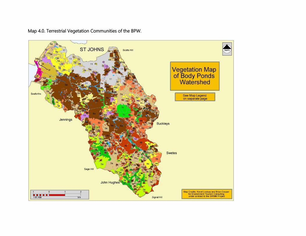
Map 4.0. Terrestrial Vegetation Communities of the BPW.

BODY PONDS FLORA
Much of the flora of the BPW is representative of the widely dispersed nature of the biodiversity of the Shekerley Mountains, and of the relict vestiges of the once diverse and rich fauna and flora of this Antigua.
Much of the vegetation is secondary and highly disturbed and/or degraded, as annual fires, harvesting, land clearing and development fragment and reduce the quality of the communities and disrupt ecosystem functions and services. Many of the species of plants are found throughout the valleys, plains and upland areas of these hills.
Body Ponds encompasses a wide range of land uses and vegetative zones. This is because of the varied topography, prevailing climatic conditions, micro-climates, the mix of species and populations, the historical agricultural practices, and present day land-use. Much if not all of the vegetation of the Watershed is secondary and post secondary in nature. Plant species compositions were assessed during the fieldwork periods. A total of about 450 species of plants belonging to about 95 different families were recorded. Appendix III provides a listing of the species recorded. However, by no means is this list complete. Additional work will undoubtedly provide many more species.
Out of the total number of species recorded, about 385 (86%) species are considered native. 65 species or 14% are introduced (or exotics).

OBSERVATIONS: FAUNA OF BODY PONDS
General Observations The fauna of the BPW, especially its birds, fluctuate depending on the season, the amount of rains, the availability of food, and on available nesting habitat. The Watershed shares many species with nearby watersheds and regions such as Wallings, Christian Valley and the Boggy Peak area, although the numbers and mixtures may vary and differ from those found in these other areas. North American migrant birds arrive in full force in late October and early November, some only stopping to gorge themselves on the fresh flush of insects, foliage, flowers, nectar, pollen and fruit, which are available in abundance as a result of the rains of this time of the year. Many of the birds continue southward along the Lesser Antillean chain to Trinidad and South America - Antigua being a stepping stone on the way. Some species of migrants may arrive as early as July and August. Species like the American Redstart (Setophaga ruticilla) and the Northern Parula (Dendroica americana) usually arrive earlier in the migration southward than other species, and may often stay longer in the spring. Many of the birds of the BPW are some of the country’s rarest, and many are West Indian regional endemic species. These include the Scaly-naped Pigeon (P. squamosa), the Brown Trembler (C. rauficauda), the Antillean Euphonia (E. musica), the Scaly-breasted Thrasher (A. fusca), the Purple-throated Carib (E. jugularis) and the West Indian Whistling Duck (D. arborea). One of the species of birds most often seen soaring above the forest canopy of the hills is Antigua’s only endemic bird, the Broad-winged Hawk (B. platypterus insulicola). The Hawk can usually be heard calling from the massive branches of the Silk Cotton trees as it sits perched looking for prey, calling to its life-long mate or young, or defend its territory. Its piercing scream and clicking whistles are distinctive. The species nests in the tall trees and rocky cliffs. Along the Body Ponds and at The Flashes, one may hear the ghostly call of the Black or Yellow-crowned Night Herons (N. nycticorax & N. violacea) as they fly back and forth in search of fish. Then the sudden alarm call of the Green Heron (B. viriscens), emitted as it is startled from its fishing endeavors, will send any person into flight; or the cackling call of the Clapper Rail (Rallus longirostris), one of our least known and rarely observed species due to its secretive nature and the swampy confines of its habitat.
For terrestrial reptiles, there are about five species found within the Watershed. Of these species, one is a snake T. monastus, or the Blind Worm or Coffin Borer as it is commonly known. This species is not often observed because it lives in leaf litter, in soil, below logs, and other decaying matter. Other species of snakes native to Antigua are now long gone as a result of predation from the introduced Indian Mongoose (Herpestes javanicus). The small terrestrial gecko S. elegantulus, an Antigua and Barbuda endemic species, is relatively rare at Wallings. These small geckos, which are among the smallest lizards in the world, can achieve super abundance in the leaf litter, and in many islands such as on Guana Island in the British Virgin Islands, related species achieve some of the highest population densities of any vertebrate species in the world. However, in Antigua and at Wallings, this is not so. Though there could be various reasons for this, it is also just as plausible that this is caused in part by predation by the Indian Mongoose, combined with other natural factors that limit the species’ natural populations. At least two species of frogs (E. johnstonei) and the introduced Cuban Tree Frog (O. septentrionalis), and one toad, the introduced Marine Toad (B. marinus) are present there. There are three species of sea turtles reported for Antigua. Of these, the Hawksbill (Eretmochelys imbricata), the Green (Chelonia mydas) and the Leatherback (Dermochelys coriacea) are known to nest on the beaches at Five Islands Harbour, and juveniles use the waters of Hansons Bay. A list of the beaches and the species of turtles that nest there is provided in below. Seaturtle nesting in Hansons Bay/Five Islands Harbour area:
- Pearns (5 beaches) - H, G, L - Sutherland - H - Hermitage (2 beaches) - G, L - Hansons - no data - Pinchin - H, G, L
H= Hawksbill G= Green L= Leatherback The beaches within and adjacent to the Five Islands Harbour are quite varies in types, slope, orientation, composition and use. However, many if not all are severely threatened by coastal development, sand mining, sea level rise and global warming, increasing damage from storm surges as a result of more frequent hurricanes and strong storms, from solid waste debris and pollution. Over the last 30 to 40 years, the conventional approach in Antigua and the rest of the region has always been to develop the coastline and hope that turtles continue to use the beaches, and if
such minor adjustments as artificial lighting and minimal setback are adhered to then this is adequate for turtle nesting. This approach is erroneous because it does not take into account the larger more complicated inter-relationships of ecosystem functions, climate, long-term impacts and declining species’ functions, increasing human pressures along the same coastline over time and so on. This then results in severe declines in turtle nesting success over time. The beaches of the Harbour are consist of fine marine and terrestrial sediments, especially on the beaches of Hansons Bay and New Division, while those of the outer areas of the Harbour at such places as Pearns, consist of larger grain marine aggregates and small pebbles. These are the beaches with the highest wave energies and currents, as well as the most attractive to development. These are also the beaches that are most preferred and used for nesting by sea turtles. It is important that at some point we recognize and decide that such beaches are too important for turtles and need to be set aside for species protection. These beaches and the species that depend on them require such bold and yet politically difficult steps. In terms of terrestrial mammals, there are four species of bats known to occur in the Watershed, though this number is likely higher given its proximity to Wallings, the size of the area and diversity of habitats. Other species of mammals are introduced and include the Indian Mongoose, the Brown and Black Rats (R. norvegicus and R. rattus), as well as the House Mouse (M. musculus). No observations and assessments were carried out on terrestrial invertebrates. For marine species, a survey of Hansons Bay was undertaken by Marine Biologist, Clive Petrovic, and a summary report is provided Appendix I. A more complete report, including photos and graphics, is provided under separate cover.
Birds Bird surveys were done along trails, ghauts, bird flyways and wherever the team ventured into the forest. The focal points for bird activity were along trails, pathways, forest edges, open patches in the forest, and wherever fruiting trees and large invertebrate populations occurred. At least 88 species representing 24 families of terrestrial, wetlands, coastal and seabirds have been observed during this and previous surveys and from previous surveys and reports (see Appendix II). It is important to note that the number of species seen during field operations reflects a short time frame in the day and within the season, and offers only a sample of the numbers of species that may occur there throughout the year. The list will undoubtedly expand considerably if

surveys were done more frequently covering all seasons, and as part of a systematic study, which would monitor the area’s bird population. Bird numbers and species fluctuate greatly, depending on the season, the amount of rain, the availability of food, and nesting habitat. North American migrants arrival on island during the fall usually coincide with the heaviest rains of the year when there is an explosion of insects, foliage, young plant shoots, fruits and flowers. On the northward migration in the spring, when species fly up the Lesser Antillean chain from South America, birds arrive at the end of the dry season and when the short but sustaining spring rains usually begin. Lindsay and Horwith, 2007, identified 40 species of birds of “special conservation concern” (SCC) for Antigua and Barbuda. About 21 or 53% of these are found in the Body Ponds Watershed and nearby areas. Despite the listing of these species below, virtually nothing is known about actual numbers and how much they have declined. There are no local programs and efforts to document biodiversity decline and to monitor habitat loss and the impacts of threats on the species of fauna on the islands. The list is compiled largely from the survey teams’ knowledge of the species on the island, from historical accounts and reports, and from feedback from local and foreign amateur birdwatchers. At least one of these species is extinct. The SCC species include: The White-crowned Pigeon (Patagioenas leucocephala), photo 4.0. Though widespread throughout Antigua, even occurring within St. Johns, this species is rare on most of the islands of the region and places like Body Ponds Watershed offer this species the sanctuary it needs. The species is a regional migrant, and disperses widely through the region, and birds born on Antigua may eventually colonize other islands from which it has disappeared due to over-hunting. It breeds at Body Ponds Watershed.
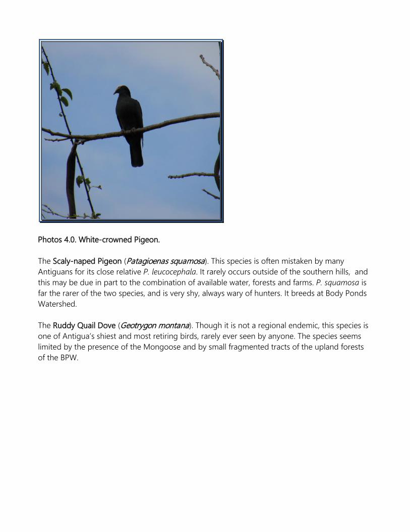
Photos 4.0. White-crowned Pigeon. The Scaly-naped Pigeon (Patagioenas squamosa). This species is often mistaken by many Antiguans for its close relative P. leucocephala. It rarely occurs outside of the southern hills, and this may be due in part to the combination of available water, forests and farms. P. squamosa is far the rarer of the two species, and is very shy, always wary of hunters. It breeds at Body Ponds Watershed. The Ruddy Quail Dove (Geotrygon montana). Though it is not a regional endemic, this species is one of Antigua’s shiest and most retiring birds, rarely ever seen by anyone. The species seems limited by the presence of the Mongoose and by small fragmented tracts of the upland forests of the BPW.
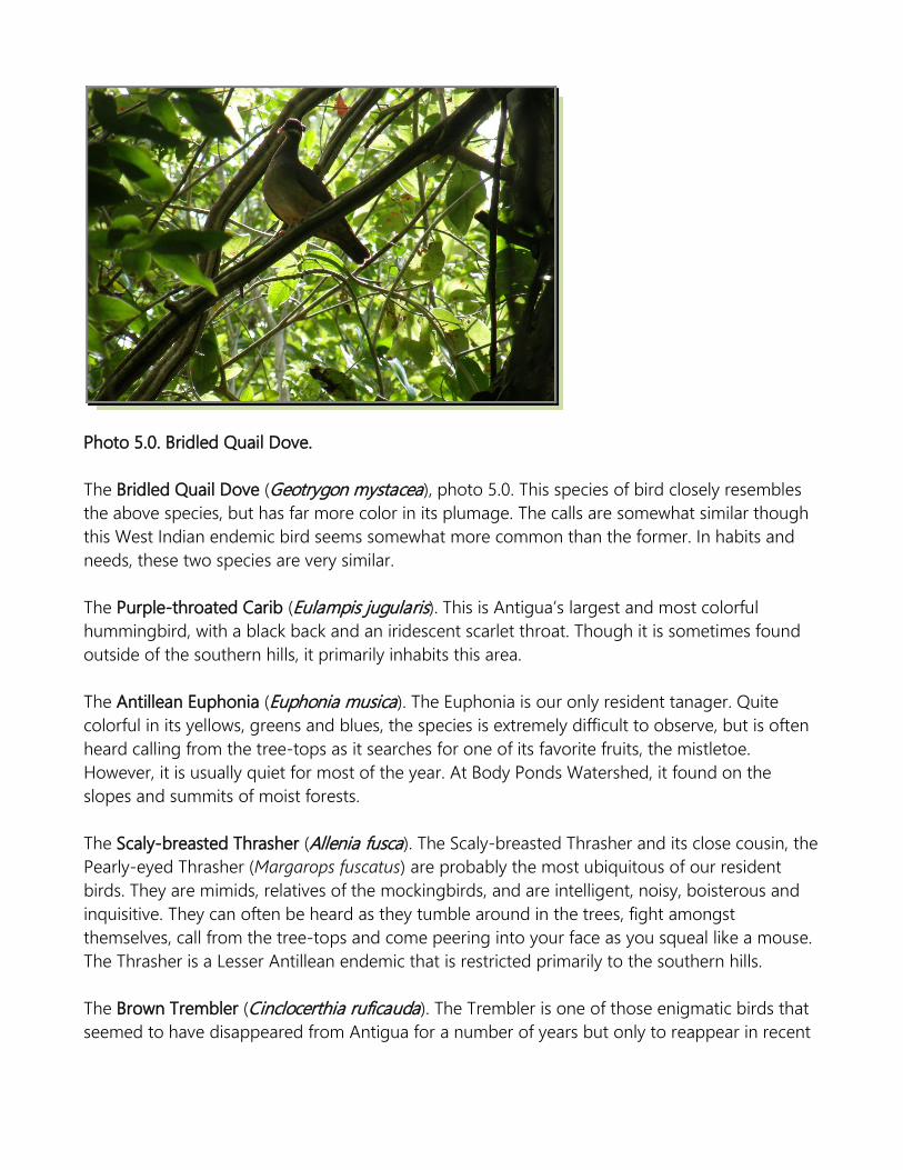
Photo 5.0. Bridled Quail Dove. The Bridled Quail Dove (Geotrygon mystacea), photo 5.0. This species of bird closely resembles the above species, but has far more color in its plumage. The calls are somewhat similar though this West Indian endemic bird seems somewhat more common than the former. In habits and needs, these two species are very similar. The Purple-throated Carib (Eulampis jugularis). This is Antigua’s largest and most colorful hummingbird, with a black back and an iridescent scarlet throat. Though it is sometimes found outside of the southern hills, it primarily inhabits this area. The Antillean Euphonia (Euphonia musica). The Euphonia is our only resident tanager. Quite colorful in its yellows, greens and blues, the species is extremely difficult to observe, but is often heard calling from the tree-tops as it searches for one of its favorite fruits, the mistletoe. However, it is usually quiet for most of the year. At Body Ponds Watershed, it found on the slopes and summits of moist forests. The Scaly-breasted Thrasher (Allenia fusca). The Scaly-breasted Thrasher and its close cousin, the Pearly-eyed Thrasher (Margarops fuscatus) are probably the most ubiquitous of our resident birds. They are mimids, relatives of the mockingbirds, and are intelligent, noisy, boisterous and inquisitive. They can often be heard as they tumble around in the trees, fight amongst themselves, call from the tree-tops and come peering into your face as you squeal like a mouse. The Thrasher is a Lesser Antillean endemic that is restricted primarily to the southern hills. The Brown Trembler (Cinclocerthia ruficauda). The Trembler is one of those enigmatic birds that seemed to have disappeared from Antigua for a number of years but only to reappear in recent
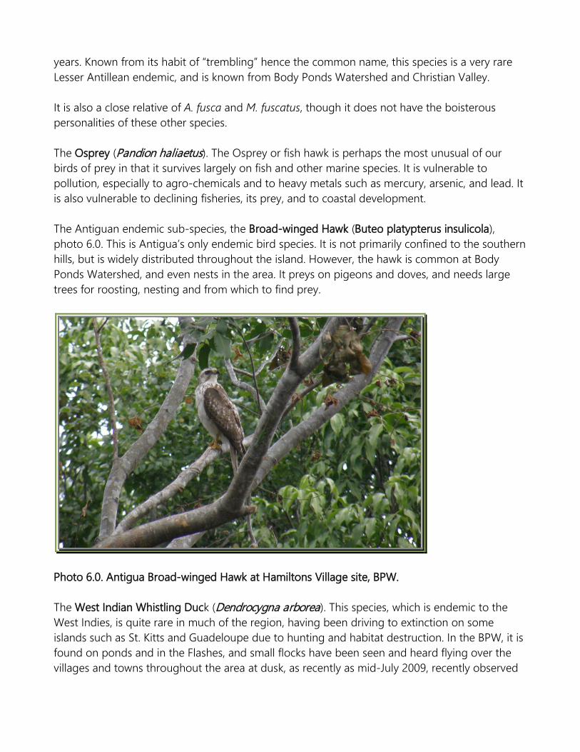
years. Known from its habit of “trembling” hence the common name, this species is a very rare Lesser Antillean endemic, and is known from Body Ponds Watershed and Christian Valley. It is also a close relative of A. fusca and M. fuscatus, though it does not have the boisterous personalities of these other species. The Osprey (Pandion haliaetus). The Osprey or fish hawk is perhaps the most unusual of our birds of prey in that it survives largely on fish and other marine species. It is vulnerable to pollution, especially to agro-chemicals and to heavy metals such as mercury, arsenic, and lead. It is also vulnerable to declining fisheries, its prey, and to coastal development. The Antiguan endemic sub-species, the Broad-winged Hawk (Buteo platypterus insulicola), photo 6.0. This is Antigua’s only endemic bird species. It is not primarily confined to the southern hills, but is widely distributed throughout the island. However, the hawk is common at Body Ponds Watershed, and even nests in the area. It preys on pigeons and doves, and needs large trees for roosting, nesting and from which to find prey.
Photo 6.0. Antigua Broad-winged Hawk at Hamiltons Village site, BPW. The West Indian Whistling Duck (Dendrocygna arborea). This species, which is endemic to the West Indies, is quite rare in much of the region, having been driving to extinction on some islands such as St. Kitts and Guadeloupe due to hunting and habitat destruction. In the BPW, it is found on ponds and in the Flashes, and small flocks have been seen and heard flying over the villages and towns throughout the area at dusk, as recently as mid-July 2009, recently observed
flying over All Saints Road on its way to the Ponds. The species continues to be indiscriminately hunted, and habitat decline and loss add to the mounting pressures that this species faces. The Clapper Rail (Rallus longirostris). This rail is the most secretive and one of the most rarely seen, but often heard of our wetland birds, usually confined to coastal mangrove wetlands. It is shy and secretive and few residents even know that this species exist. It is a resident breeding bird that directly depends on the availability, stability and quality of mangrove and marsh wetland habitats, which are under severe threats locally. The Caribbean Flamingo (Phoenicopterus ruber). This species has been extinct on Antigua for at least 100 years, and was wiped out due to overhunting and habitat decline. It once found refuge and bred in the Flashes, which at the time stretched from Hansons Bay north to the southern shores of St. John’s Harbour. Today, at least half of this wetland area has been obliterated. American Oystercatcher (Haemantopus palliatus). This shorebird with it brilliant red bill is rather rare on Antigua and confined to rocky coastlines. It is believed to breed in the area, though this has not yet been confirmed. It is threatened by coastal development, human activities and harassment, the Mongoose, coastal degradation and change. The Willet (Catoptrophorus semipalmatus). The Willet is perhaps the island’s most familiar wetland bird, but ironically also one of the least known. It is a very noisy species that will warn other species of impending dangers and threats, but because it is able to escape observations so readily many people often may dismiss it. It is a local but rare breeder and has been on the decline as wetlands and coastal habitats are consumed by development and as the quality and state of the remainder of their habitats also suffer. The Red-billed Tropicbird (Phaeton aethereus). The Tropicbird is by and large a pelagic species that spends most of its life at sea, only coming ashore to breed. Because of the Mongoose, this species is likely to have stopped breeding in the area, and throughout the mainland of Antigua. It may breed in very low numbers on the offshore cays of the Bay and nearby areas. Brown Pelican (Pelicanus occidentalis). The Pelican is the most symbolic of the islands’ avian denizens. It once ruled the skies of these islands, and testament of this can be gleaned by old reports, and by the place names such as “Pelican Island” or “Pelican Point” where the species once nested by the hundreds. Today, only a few handful nest anywhere on Antigua, including Maiden Island in Hansons Bay. Its decline may be directly attributed to hunting, egg-collecting, declining coastal fisheries, pollution, coastal development, habitat loss and harassment. The Mongoose is also implicated in that the species once nested on the mainland but this ceased after this mammal was introduced. The Magnificent Frigatebird (Fregata magnificens). This pirate of the skies once nested on the larger of the Five Islands, but this stopped in the 1970s or 80s. This was the only known nesting

colony on Antigua. The reason for the cessation is not known, but could be due to the vulnerability of the islands to storm-surges. In fact, in heavy surf, the islands may be easily over-washed. However, this is only speculation and the exact reason would need to be determined by careful field study and analysis. If possible, the species should be encouraged to reestablish nesting activities on the islands. Snowy Egret (Egretta thula). One of the few nesting colonies of this species on Antigua was located on Maiden Island during the 1990s. It is not known if it continues to do so. The species is threatened by wetlands decline and destruction. The Great Egret (Ardea abla). This is the second largest of our herons. It is a locally common resident, but rare nester. It is known to nest on Maiden Island and in a small colony at New Division. This mainland colony is extremely rare and unusual and should be strongly encouraged and enhanced. Black-crowned Night Heron (Nycticorax nycticorax). This striking and handsome heron is the rarer of the two nocturnal herons on Antigua. It is an uncommon to rare resident and breeder. It breeds on Maiden Island, limited to a handful of pairs. The species is threatened by habitat decline.
Mammals Bats are the only native mammals extant on Antigua today. Little is known about them. Previous to this survey, there were seven extant species of bats reported for the island. However, a new species record obtained during the one night of bat survey at Body Ponds Watershed, and this brings the total number of species to eight. There are six species reported for Body Ponds Watershed and these include: 1. The Velvety Free-tailed Bat (Molossus molossus), a widespread and relatively common
species throughout Antigua; 2. The Jamaican Fruit Bat (Artibeus jamaicensis), a very common and widespread species in
Antigua and throughout the Antilles; 3. The Cave Bat (Brachyphylla cavernarum), a rare, highly gregarious species that seems
limited by the availability of hot humid caves; 4. The Fishing or Bulldog Bat (Noctilio leporinus). This species is the largest bat of the
Americas with a wingspan that can go to over 61 cm (2 ft). At Body Ponds Watershed, the Fishing Bat flies along paths as it makes it way to catch fish on the reservoir or to take a drink.
5. The Tree or Forest Bat (Ardops nichollsi). In October 2008, an Island Resources Foundation (IRF) team discovered this species at Wallings, a new record for Antigua, during a survey

effort conducted on behalf of the Environment Division. The species is restricted to heavily forested areas and is likely found around Signal Hill and Hamiltons. However, it is unlikely to be found at Body Ponds, the open fields and the lower reaches of the watershed due to the fact these areas are very relatively degraded and possess no forests or dry woodlands. The species is very rare.
Bats are critical to the forest ecosystem health and wellbeing. These mammals are the primary pollinators, seed and beneficial insect dispersers of a number of species, and without them the forest ecosystem would almost certainly perish. Species of plants for which bats are critical include the Silk Cotton (C. pentandra), Locust or Tinking Toe (H. courbaril), Wild Figs (Ficus spp.), Piper spp., the Calabash (C. cujete) and a number of tree crops. The survey team carried out visual, roost, and mist netting surveys during the field work period. No roosts were located during the survey. At the end of the capture period, after nets were dismantled, the team took wing measurements, the gender of each individual, breeding status, and general health conditions of the specimens. Further work is needed at Body Ponds Watershed to assess the population of the species of bats: how they are using the forest, their diets and the effects on the plant communities, the populations, roosting, and the importance of a healthy forest to the sustainability of the bats. Other species of mammals known to occur within the Body Ponds Watershed area include the introduced and invasive Black Rat (Rattus rattus), the Norway or Brown Rat (R. norvegicus), the House Mouse (Mus musculus), and the Indian Mongoose (Herpestes javanicus). These introduced species move throughout the Body Ponds Watershed area and undoubtedly have a major effect on the ecology of the forest. The Mongoose is known to predate on birds, amphibians, reptiles and invertebrates and will scavenge human waste and surroundings if available. The rats and cats also have similar habits to the mongoose but mostly operate at nights, while the Mongoose is a diurnal forager.
Reptiles & Amphibians There are 21 terrestrial reptiles and amphibians recorded for Antigua. Of these, four are extinct, three of which are known only from fossils (Clelia clelia and Boa constrictor, both snakes, and Leocephalus cuneus, a lizard). The fourth species, the Lesser Antillean Iguana (Iguana delicatissima) was last seen in the mid 1980s, but is believed to be now extinct.

At least three species are human-assisted introductions, one a reptile and two amphibians (the Marine Toad Bufo marinus and the Cuban Tree Frog Osteopilus septentrionalis). One, the Green (Iguana iguana), can be classified as a natural introduction, arriving on the island as a result of the passage of Hurricane Luis in September 1995. The species, however, may have died out soon after its arrival. Another species, Eleutherodactylus johnstonei is possibly a human assisted introduction, though its presence on Antigua is likely natural. Of this total, the team recorded five species of reptiles and at least three amphibians at Body Ponds Watershed. These include: 1. Anolis (bimaculatus) leachi – Antigua or Tree Anole, endemic to Antigua and Barbuda.
This species is common throughout Antigua and at Body Ponds Watershed. 2. Anolis wattsi – The Brown or Watts Anole, an Antiguan endemic. This species is rather
common. 3. Sphaerodactylus elegantulus – The Dwarf Gecko, endemic to Antigua and Barbuda.
Uncommon to relatively rare at Body Ponds Watershed. 4. Hemidactylus mabouia – House Gecko/Woodslave. Introduced. Common. 5. Thecadactylus rapicauda – The Forest or Tree Gecko. Population status unknown, but
given its biology and ecological habits, it is believed to be locally common. 6. Typhlops monastus – The Blind Snake. This species is believed to be locally common,
though this conclusion is based on knowledge of the species’ habits throughout most of Antigua.
And three amphibians: the tree frog (Eleutherodactylus johnstonei), and the introduced South American Toad (Bufo marinus), and the Cuban Tree Frog (O. septentrionalis). The first two species are common and widespread throughout most of Antigua. The Cuban was introduced to Antigua in the 1990s, most likely on Long Island at Jumby Bay Resort, from where it spread to the Hodges Bay of Antigua. It has since spread very rapidly across the island and can be found on the northern and northeastern periphery of the Watershed. It is likely now at least in Bendals. The other species of tree frog recorded for Antigua remains problematic since some authors argue that it is not present here (Kaiser, 1992). The species, E. martinicensis or the Martinique Tree Frog, has been shown to be easily introduced to islands in the region, and it very closely resembles its relative E. johnstonei, so distinguishing them in the field is very difficult. The species could possibly be present at Body Ponds Watershed but this is only speculative at this time. All species of reptiles except S. elegantulus are relatively quite common and widely distributed throughout most of Antigua. Spherodactylus elegantulus, an Antigua and Barbuda endemic species, is relatively rare at Body

Ponds Watershed. These small geckos, which are among the smallest lizards in the world, can achieve super abundance in the leaf litter, and in many islands such as on Guana Island in the British Virgin Islands, related species achieve densities of about 67 600 ha-1, one of the highest population densities of any vertebrate species in the world. However, in Antigua and at Body Ponds Watershed, this is not so. A search for species in all appropriate habitats may prove futile. Very often, the animal remains elusive. There could be various reasons for this; it is also just as plausible that this is caused in part by predation by the Indian Mongoose, combined with other natural factors that limit the species’ natural populations. The House Gecko or Wood Slave is believed to be a West African immigrant, arriving in the region via slave ships within the last 400 years. One other species of lizard, the microteid Gymnophthalmus underwoodi is a widespread small skink-like species found throughout Antigua. It is known from nearby All Saints and Liberta, and is undoubtedly found in the BPW, though this has not yet been confirmed.
Terrestrial Aquatic Fish As stated previously, no specific surveys of aquatic vertebrates were carried out during this effort. This would have been extremely difficult to undertake, given the immense financial, equipment, personnel, expertise and time resources that this sort of survey demands. In addition, the aftermath of the flooding proved too dangerous and made conditions to precarious to carry out surveys during the field visits to Body Ponds Watershed. However, the team has identified several species of freshwater fish in the Body Ponds Watershed. The species are listed in table 4.0 below. Detailed discussions on the species and the state of their habitats following the table. Table 4.0. List of terrestrial aquatic fish species known to or suspected of inhabiting the BPW.
No. FAMILY SPECIES COMMON NAME
LOCAL NAME
STATUS
1.a. ANGUILLIDAE Anguilla rostrata American eel Eel Native 2.a. CALLICHTHYIDAE Hoplosternum littorale Hassar Cascadu Introduced 3.a. CARCHARHINIDAE Carcharhinus leucas Bull shark Native 3.b. Lepomis auritus Redbreast
sunfish Introduced
3.c. Lepomis gulosus Warmouth Introduced 3.d. Lepomis macrochirus Bluegill Introduced 3.e. Lepomis microlophus Redear
sunfish Introduced
4.a. CENTROPOMIDAE Centropomus ensiferus Swordspine
snook Native
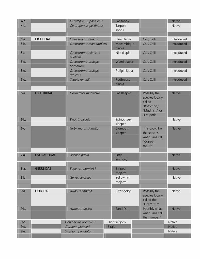
4.b. Centropomus parallelus Fat snook Native 4.c. Centropomus pectinatus Tarpon
snook Native
5.a. CICHLIDAE Oreochromis aureus Blue tilapia Cali, Calli Introduced 5.b. Oreochromis mossambicus Mozambique
tilapia Cali, Calli Introduced
5.c. Oreochromis niloticus niloticus
Nile tilapia Cali, Calli Introduced
5.d. Oreochromis urolepis hornorum
Wami tilapia Cali, Calli Introduced
5.e. Oreochromis urolepis urolepis
Rufigi tilapia Cali, Calli Introduced
5.d. Tilapia rendalli Redbreast tilapia
Cali, Calli Introduced
6.a. ELEOTRIDAE Dormitator maculatus Fat sleeper Possibly the
species locally called “Botombo,” “Mud fish,” or “Fat pork”
Native
6.b. Eleotris pisonis Spinycheek sleeper
Native
6.c. Gobiomorus dormitor Bigmouth sleeper
This could be the species Antiguans call “Copper mouth”
Native
7.a. ENGRAULIDAE Anchoa parva Little
anchovy Native
8.a. GERREIDAE Eugerres plumieri ? Striped
mojarra Native
8.b Gerres cinereus Yellow fin mojarra
Native
9.a. GOBIIDAE Awaous banana River goby Possibly the
species locally called the “Lizard fish”
Native
9.b. Awaous tajasica Sand fish Possibly what Antiguans call the “jumper”
Native
9.c. Gobionellus oceanicus Highfin goby Native 9.d. Sicydium plumieri Sirajo Native 9.e. Sicydium punctatum Native

10.a. HAEMULIDAE Pomadasys crocro Burro grunt Native 11.a. ICTALURIDAE Ameiurus catus ? White catfish Introduced 11.b. Ameiurus nebulosus ? Brown
bullhead Introduced
11.c. Ictalurus punctatus ? Channel catfish
This is likely the species referred to as “Catfish”
Introduced
12.a. LORICARIIDAE Lasiancistrus guacharote
? Native
12.b. Liposarcus multiradiatus ?
Sailfin catfish Introduced
12.c. MEGALOPIDAE Megalops atlanticus Tarpon Tarpon Native 13.a. MUGILIDAE Agonostomus monticola Mountain
mullet Mullet Native
13.b. Joturus pichardi Bobo mullet Native 13.c. Mugil cephalus ? Flathead
mullet Questionable
13.d. Mugil liza Liza Native 14.a. POECILIIDAE Gambusia affinis Mosquitofish Savage, Million Introduced 14.b. Poecilia reticulata Guppy Guppy Native ? 15.a. RIVULIDAE Rivulus marmoratus Mangrove
rivulus Native
BPW Fish List: The list of species of freshwater fishes of the BPW has been generated from literature reviews, species list compilations for nearby islands, including the Lesser Antilles, from past surveys and efforts and from discussions with local people. Many of the species on the list are hypothetical because no specimens have actually been procured or local reports are none-existent or sketchy. Nevertheless, they are included because the freshwater and riverine environments of the BPW are the types that these species prefer and there is a strong possibility that these species currently exist there or were there at some point during the past, and they could reestablish themselves at some point in the future. The BPW Fish Species: The species of fish of the Watershed include predators, omnivores and herbivores. Many of the herbivores are specialists and require clear streams and pools, and some, like the River goby require clear flowing streams, which are scarce in much of the Watershed, except for one or two minor short stretches of secondary tributaries. If the species is present in these areas only future sampling will determine.
Some species migrate up and down the river system depending on water levels, food availability, the breeding season and other factors. Many of the species of fish are found in the mid to lower parts of the river systems of the BPW, including the near-shore areas and mouth of the Flash where the outflow mixes with ocean water. Most are never seen, and are virtually unknown by most residents because of their cryptic colorations, habits and the environment within which they survive. The riparian system of the BPW today is far different from 400 years ago. Local often tell stories of the first English settlers and explorers moving up the Big Creek system in small row boats up to the Bendals area. Today, much of this system silted up and narrowed, and water levels have dropped considerably, especially given how dramatically the forest and other vegetation cover as well as soil ecology have changed and declined. It is interesting that the Bull shark (3.a. above) is listed. It is a species that often moves considerable distances up freshwater streams. It can actually spend weeks in these environments. The species is likely to have done this in the Big Creek system, and may still do so during high water levels, but given the extent of sedimentation at the lower end of the Creek, then this may prove a substantial barrier to larger specimens of the species and only young sharks may move part way up the Creek. In addition, other species of marine animals may also move up and down the system at some point, including turtles, rays and myriad species of crabs and shrimp. Freshwater Habitats of the BPW: There are several “freshwater” habitats types including coastal temporary brackish pools, estuarine systems, flashes, ponds, reservoirs, springs, a permanent river, and seasonal pools along ghuts and streams. Many of these systems offer varied habitats and refuges for fish species. Some, like the eel, can move over land to find more suitable habitats, or to escape a threat, while others like the Rivulid can ensconce itself in a cocoon-like state during severe dry periods until better times arrive. During flooding, which often occurs along the lower Big Creek area, some species may be dispersed, and may be marooned in isolated ponds and pools along the banks of the Creek for most of the year. There are several dams and artificial impoundments scattered throughout the Watershed, especially in the Body Ponds, Brecknock and Hamiltons. These impoundments offer peculiar habitats to specific species of fish, but are a barrier to others. These barriers prevent the movement of some species along the length and breadth of the streams and

ghuts, and in some instances, can have deleterious effects and impacts on the health of the overall the Watershed. The vegetation mapping exercise provided an inventory of the artificial ponds, reservoirs and catchments of the BPW, and the number totals some 221. Economic values of Freshwater Fish: Many of the species may have some economic and/or artisanal value for the local economy. Some species such as eels can be quite valuable as bait fish, while the fry of other species such as the Sirajo goby are fished by the thousands in islands such as St. Vincent. This species is known for its delicacy. Species highly prized by Antiguans are the “callis,” which are the members of the Cichlidae. No one has yet determined the species that are present in the island, and the list above is only speculative at this point. It is suggested that several species are currently grouped under one local term “calli” and in fact, many locals do distinguish types based on size, color, habits and other factors. These species are fished by the thousands each year, but their value to the local diet and economy goes undocumented and unrecognized. Another species of great value is the Hassar or Cascadu. This species is native to Trinidad and South America, and was introduced to Antigua at some point, most likely in the 1970s at the time when other freshwater fish introductions occurred. They were likely introduced to the Olivers and Body Ponds reservoirs. The fish has a hard bony outer shell, but its flesh is said to be highly delicate and much preferred by Guyanese and Trinidadians. Many from these immigrant communities fish for the species in these reservoirs on the weekends. The Health of Aquatic Communities: The state of these freshwater and estuarine communities may be the best indicator of water quality, habitat stability and overall environmental health in the BPW – the types of fish, where they occur, in what numbers and whether or not they continue to exist anywhere in the Watershed may speak volumes about how well the watershed is doing as a whole. The fish species can be adversely impacted by human activities, practices and habits such as chemical pollution as a result of farming, sewage and household runoff, sedimentation as a result of many factors, including road construction, unpaved roads and paths, home development and construction, mining and quarrying, bulldozing of hillsides and deforestation. Other activities may also have harmful and deleterious impacts, including among other things, habitat reduction, dam and reservoir construction, which may not only restrict water flow, but put barriers across streams and prevent the movement of species back and forth, especially since most of these species have very complex life-cycles.

Setting up a system of medium and long-term monitoring measures as well as developing the national capacity to react and reduce adverse impacts and improve water quality along the entire stretch of the watershed may improve overall environmental health, ecosystems’ functions and human life quality in the BPW.
Terrestrial & Aquatic Invertebrates No surveys of terrestrial invertebrate were carried out. This was due to a number of reasons, including the time-frame for completing project activities, the very severe demands that invertebrate surveys and species identifications require, and the limited financial resources available. There is a wealth of local anecdotal information about the islands’ native and introduced invertebrate biodiversity. Local people will often spend hours telling folktales about their encounters with the legendary “horsespider,” the “santapee,” or centipede, the “jackspaniard,” the “sinking,” or bont tick, which causes so much economic damage to livestock farmers, the flies, mosquitoes, dragonflies, and even the freshwater prawns or crayfish. All of these species are present in the BPW. Many of these species have made their way into the national psyche and folklore. They are cultural pieces to the puzzle that is a way of life in Antigua and Barbuda. Yet, so little of this local culture and keen insight have actually made their way into a concerted national effort to document the islands’ invertebrate biodiversity, including that of Body Ponds. The lack of information about the invertebrates of the BPW and for the rest of the country is highly symbolic of the generally poor state of knowledge about nation’s biodiversity and environmental resources in general. This disconnect between the actual state of the natural environment and the people’s involvement in defining and describing the extent of these critical resources is due to a myriad of reasons. These include, among other things:
A lack of local interest in what residents may deem slimy, crawly pestilence that infest home and the landscape;
A lack of human, financial and institutional investment in the framework that is needed to research, collect, record, document, database, report, analyse and monitor the invertebrate biodiversity and ecology of the islands;
For many local residents, including professionals in the natural resources research and management fields, invertebrates and the services that they provide lack any

worthwhile value. Many deliberately ignore and dismiss the economic, heritage/patrimonial, scientific, industrial and intellectual value that these creatures provide;
Many focus the blame for the lack of information and the disconnect of local residents to their faunal and floral heritage on foreign individuals and institutions who are often blamed for stealing local knowledge and keeping it amongst themselves;
Invertebrate studies demand a considerable amount of time, financial, expertise and commitment to allow deeper understanding a clarity of what exist and how things work;
In more industrialized societies such as the United States and England, the study of invertebrates is usually centered around academic, agricultural, industrial, intellectual and museum collections interests. Except for the intellectual, there is largely an economically driven incentive that allows the country to expend resources on these initiatives. However, this by no means that these interests are lacking in Antigua. Why these very same interests have not driven local residents to focus on the issues of biodiversity and ecological studies is up for debate.
Interestingly, the national interest in invertebrate biodiversity was not always lacking. The Plant Protection Division and the Experimentations of the Ministry of Agriculture, up until the late 1980s, maintained a unique interest in this area of study, especially focusing on economically important agricultural invertebrate pest, most notably on Sea Island Cotton. Unfortunately, much of this collection, which took years of effort and study to build, has been lost and discarded. For the country to develop its capacity to document, record, database, analyse and report on its invertebrate biodiversity it needs the support and cooperation of both local and foreign entities. However, without the national drive, investment and interest, it cannot accomplish this most needed and necessary effort. What we do know about the Watershed’s invertebrates offer only a minute snippet or view of the much larger and complicated picture of the extend and complexity of the overall fauna and ecological framework of the Watershed or for the island for that matter. The focus of past and recent studies of the invertebrates have concentrated on what is often perceived as the more colourful and fascinating taxon of animals, especially the butterflies. A list of the island’s butterfly species can be had from Butterflies of the West Indies by Norman Riley, published in 1975, or the more recent work by Smith et al 1994, but these are by and large incomplete and focus not on specific areas, but on an island

and regional level. For more specific information, studies will have to begin a focus on targeted surveys, mapping and data gathering. This is critically needed in Antigua and Barbuda.

The BPW Marine Environment Appendix I provides an overview of the findings of Clive Petrovic during his marine surveys earlier in 2009. Of major concern is the natural decline of The Flashes, of coastal integrity and the strong evidence of pollution, seemingly from the dredge spoil dumped onto the northern half of the wetland, and from the Cooks dump and sanitary landfill. Maps from the 1800s and previous to this period indicate that the Flashes also consisted of a shallow lagoon and creek system, much more like a "salt pond" than a mere flash as you see today (see Figure 2.0). This suggests that a very rapid rate of siltation has occurred over the past 200 years or so, and as with most mangrove systems, this silt and other deposits would have become trapped by the roots of the mangroves, and so much of this stuff is still in the wetland and not in the ocean. A very good record of events in the Body Ponds watershed is preserved in the sediments in and near the mangrove forests. That record should go back to pre-Columbian times. Analysis of core samples should provide critical detail as to the events, time-frame and sources of these sediments. As the wetland gets filled up and cannot hold back these events anymore, this is then transferred to the sea, much like a damn gets overburdened in time by similar events. A series of cores and silt profiles may tell us just how much this occurred, the rates of siltation, and the major events over the past 300 years that led to this. There is also the issue of the type of system that the Flashes should create in the nearby marine environment. Since the Flashes is more of a river system with permanent flow most years, there should be a creek ecosystem with related flora and fauna out to sea. That is, silt and nutrients should create a unique narrow turbid habitat along a narrow stretch of freshwater and brackish flow. This area would have little sea grass since the lack of sunlight would have provided little incentive to grow there, but there would be lots of clams and cockles and other flora and fauna. Rays would have loved this area as juvenile fish and other animals feed. But as this "creek" has diminished and the rate of flow is reduced, the sea grasses have moved in and the Creek is now a more shallow ghaut. There are stories of the British using row boats to access inland of the Creek system, way inland. Keithly's interview provided by Mr. Petrovic, hints at some of this. Kevel Lindsay often heard similar accounts from Desmond and ET Henry many years ago.
The creeks of The Flashes functions (or did) like similar mangrove habitats throughout the world. There is a broad zone between the fresh water "inland" areas and the sea. The water chemistry in such places fluctuates tremendously, depending on the flow, going from totally fresh to salt or even hyper-saline occasionally. Nutrients are naturally high, resulting in very increased biological productivity. That's why those habitats are loaded with fish, crabs, birds, and a whole host of species. Coastal mangrove estuaries have some of the highest biodiversity and biomass of any habitats. They are also easily disturbed, impacted and destroyed. The Hansons Bay/Five Islands area and The Flashes have suffered mightily at the hands of man. Further north and south of the creek there would be clearer saline water where sea grass thrived and as one went further out sea sand would appear. Areas closer to the Sutherland side (north and northwest of the Creek) should be a mix of fine sediments and sand not black muck. A comprehensive formal study would likely indicate that this is stuff came not from upland areas of the Watershed but from the dredge material and the dump/landfill. Map 09 shows the distribution of this muck in the Bay, and map 10.0 provides an estimate of the flow of runoff from the dredge spoil and Cooks Dump and Sanitary Landfill. The breach can be quite easily seen on aerial photos. Fine sediments and muds are characteristic of mangrove habitats, and Mr. Petrovic reports that “…in all my many years of field work in the tropics, I have never seen the nasty black goo we encountered just beneath the surface sediments. Even natural mangrove peat, which can be a bit nasty, is nothing like what we saw.”
Identifying the source of the material should be relatively simple and straightforward. During the field survey when Jean-Pierre Bacle and Mr. Petrovic snorkeled to the mangrove roots in one of the creeks, they reported how surprised they were that the prop roots were virtually devoid of encrusting growth. Normally, it is expected that the submerged roots would be covered in algae, worms, sponges, anemone, oysters, and a bunch of other flora and fauna. The fact that none of that was present is curious. Naturally, with just one short foray into the habitat, one cannot arrive at quantitative conclusion, but it is more than likely that the reason for the poor condition of the area is pollution from the dump, compounded by accelerated rates of siltation and pollutants from further up in the watershed. Contrary to what Kiethly reported, there certainly was no 2-3 meter (8-10 ft) depth in the creeks, at least not where Jean-Pierre and Mr. Petrovic snorkeled. The team
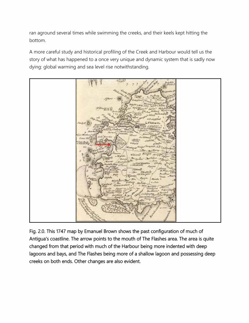
ran aground several times while swimming the creeks, and their keels kept hitting the bottom.
A more careful study and historical profiling of the Creek and Harbour would tell us the story of what has happened to a once very unique and dynamic system that is sadly now dying: global warming and sea level rise notwithstanding.
Fig. 2.0. This 1747 map by Emanuel Brown shows the past configuration of much of Antigua’s coastline. The arrow points to the mouth of The Flashes area. The area is quite changed from that period with much of the Harbour being more indented with deep lagoons and bays, and The Flashes being more of a shallow lagoon and possessing deep creeks on both ends. Other changes are also evident.

Below, map 5.0 provides a spatial representation of the marine communities, and map 6.0 shows the drainage pattern of sediments and materials from the northern and northeastern areas of the Flashes.
Map 5.0. Distribution of black muck sediments at Hansons Bay, Five Islands Harbour.
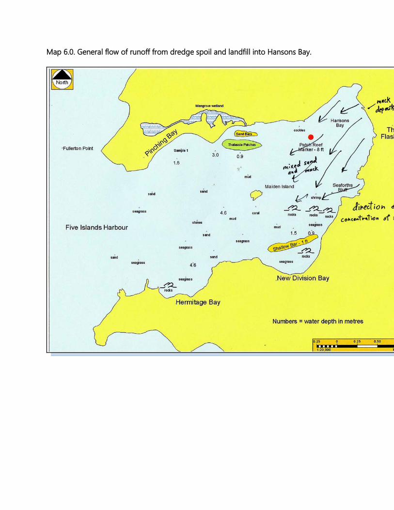
Map 6.0. General flow of runoff from dredge spoil and landfill into Hansons Bay.
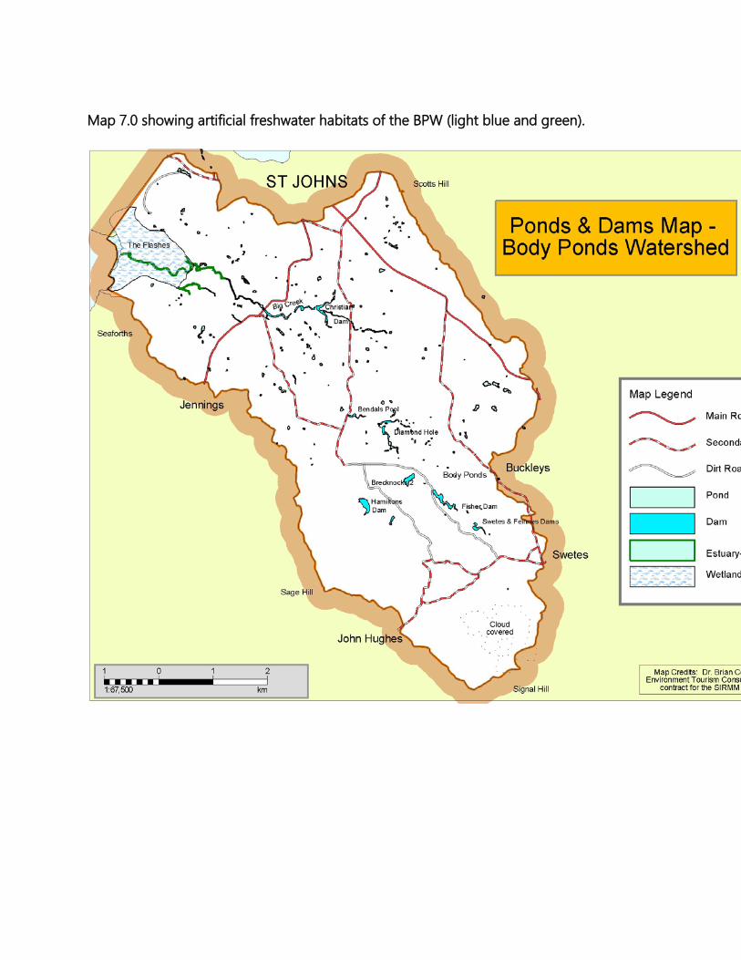
Map 7.0 showing artificial freshwater habitats of the BPW (light blue and green).
INVASIVE SPECIES There are three species of invasives that are of major concern in the Body Ponds Watershed area. The first species is the Lemon Grass (C. citratus), first introduced in 1902 to the banks of the Body Ponds as an erosion control measure. The species has since spread throughout the Shekerley Mountains and to a few small patches on the hills east of Liberta. For the first 50 years or so, it is believed that the species did not move very far from its initial area of introduction. Just why its spread has accelerated may be due largely be due to two main factors. Charcoal burners often line their pits with bunches of fertile stems, which are harvested from infested areas on the lower plains, and carried to locations up in the hills. According to J.C. Cater in his 1944 report on Forestry in the Leeward Islands, “[A]ntigua has the unenviable reputation of being, of all the West Indian Islands, the most prone to suffer so-called “bush fires”.” In the early parts of the 1900s, it seems that bush fires became a major environmental problem on Antigua. Landless and poor residents used fires to clear land, but also wanted to promote fresh growth of fresh succulent shoots, and for many years, a tradition was handed down that fires brought rains, a belief that still exists amongst some of the residents today. Fires greatly accelerate the spread of this species by killing off competing species and creating fresh ground for its seedlings. Today, the fires are set by farmers, livestock owners, wood cutters and other persons to help maintain access to the forests and the hills, to control the grass, and to provide fresh succulent and palatable shoots for livestock during severe dry periods. As fires are set to the Citronella grasslands, the fires also destroy and fragment forests and woodlands, and opens up these areas to the invasion of the grass. Citronella is not shade tolerant and dies out as forest and woodland crowd out the species. Photo 7.0 shows a fire set on March 13, 2009. The ground was still smoldering when the photo was taken.

Photo 7.0 showing March 13, 2009 fire set along Body Ponds Road. The spread of this species has also been assisted by periods of severe droughts when trees and shrubs die back and open up new areas to the invasion of the species. Citronella also spreads through direct human transport of cuttings from one area to the next, since the plant is prized for its herbal and medical uses. It is also spread by livestock as they carry the seeds from place to place. At Body Ponds Watershed, C. citratus is primarily found around Signal Hill and the slopes to the north. There are other smaller patches scattered throughout the main area of Body Ponds Watershed. Other small patches are found on the slopes and ridges west of Fig Tree Drive. Photo 8.0 provides a view of extent of C. citratus in the upper watershed.

Photo 8.0. Taken from Byam’s Hill looking southeast and south. The view is of Brecknock, John Hughes and Signal Hill areas. C. citratus covers much of the landscape of this area of the watershed. One of the most effective ways to control Lemon Grass is to stop fires, and prevent further road construction and fragmentation of the forest and landscape within and around the forest. The species is an aggressive invasive and roads provide access for the species to invade new areas and freshly turned earth. As the fires stop, pioneer shrubs and trees will colonize the grasslands and eventually shade out the grass. The vegetation map (map 4.0) provides a map of the Lemon Grass distribution at Body Ponds Watershed. The other two invasive species of concern are the goats and the introduced Indian Mongoose. Goats are a major problem in many parts of Antigua and Barbuda. They cause considerable damage to the landscape and biodiversity. They strip trees and other plants

of their foliage, prevent regeneration, and then as the vegetation dies back, the soil becomes exposed and then erodes away. This then has a cascading or domino effect on all aspects of the ecology and economy of the area’s landscape. At Body Ponds Watershed, the goats are semi-wild, but are owned by various, but unknown persons, who occasionally corral the animals and take animals as they need. These free-roaming animals are to be found around the Signal Hill, area and the damage they cause to the landscape can be seen in the defoliation of trees, the lack of regeneration in the undergrowth, and erosion of the slopes. The goats may also be aiding the spread of the Lemon Grass by reducing the vegetation cover and by exposing bare earth, which is then easily colonised by the grass. The Mongoose was introduced to Antigua in the 1800s at the behest of estate owners after they heard of the success that its introduction had had on controlling the rats that had been causing considerable damage in the cane fields of Jamaica. Its introduction soon had a disastrous effect on the native animals. Within a few years, the endemic Antigua Burrowing owl (Athene cunicularia amaura) became extinct, and so did the snake (A. antiguae) from the mainland. The snake is now found only on the offshore cays. The Mongoose undoubtedly caused the extinction of far more, but in those early years, relatively little was known and understood about the biodiversity of the island. The Mongoose is very common throughout Antigua, though there are no estimates of population numbers. At Body Ponds Watershed, the species is commonly seen darting about in search of prey, and can often be observed around homes, garbage bins, along the main road, and areas around the main reservoir. The species is known to be an aggressive and voracious predator and eats just about any vertebrate or invertebrate. Ground nesting birds and reptiles are especially vulnerable to this species. This is the reason that the endemic Antigua Ground Lizard (A. griswoldi) is rare on the island and entirely absent from Body Ponds Watershed and surrounding areas. In the past, the government used to pay a bounty on the Mongoose and encourage residents to kill any captured. This practice has been long discontinued, but it was effective in localized areas in controlling the species’ population numbers, thereby reducing its impact on the biodiversity.

SPECIES OF SPECIAL CONSERVATION CONCERN There are several species of special conservation concern in the Body Ponds Watershed area. For birds, the species are listed below. Much more details on each species are discussed in the fauna section above:
- The White-crowned Pigeon (Patagioenas leucocephala) – locally common. - The Scaly-naped Pigeon (Patagioenas squamosa) – uncommon to rare and
restricted. - The Ruddy Quail Dove (Geotrygon montana) – rare and restricted. - The Bridled Quail Dove (Geotrygon mystacea) – rare and restricted. - The Antigua Broad-winged Hawk (Buteo platypterus insulicola) – locally common
and widespread - The Purple-throated Carib (Eulampis jugularis) – rare and restricted. - The Antillean Euphonia (Euphonia musica) - very rare and restricted. - The Scaly-breasted Thrasher (Allenia fusca) – uncommon and relatively restricted. - The Brown Trembler (Cinclocerthia ruficauda) – very rare and restricted. - The Osprey (Pandion haliaetus) – rare migrant. - The Antiguan endemic sub-species, the Broad-winged Hawk (Buteo platypterus
insulicola). - The West Indian Whistling Duck (Dendrocygna arborea) – Uncommon to rare - The Clapper Rail (Rallus longirostris) – rare and restricted. - The Caribbean Flamingo (Phoenicopterus ruber) – extinct on Antigua and Barbuda. - American Oystercatcher (Haemantopus palliatus) – rare and restricted. - The Willet (Catoptrophorus semipalmatus) – uncommon to rare and restricted. - The Red-billed Tropicbird (Phaeton aethereus) – very rare and maybe extirpated in
area. - Brown Pelican (Pelicanus occidentalis) – widespread but declining. - The Magnificent Frigatebird (Fregata magnificens) – widespread and declining.
Extinct on Five Islands where once nested. - Snowy Egret (Egretta thula) – uncommon and restricted. - The Great Egret (Ardea alba) – widespread and increasing. Nesting is restricted and
rare. - Black-crowned Night Heron (Nycticorax nycticorax) – uncommon and restricted.
Nesting is quite rare. For the mammals, the species of concern are:

- The Cave Bat (Brachyphylla cavernarum) – rare and very restricted. Photo 9.0 shows
a specimen of the Cave Bat caught at Sawcolts area.
Photo 9.0. The Cave Bat at Sawcolts.
- The Tree or Forest Bat (Ardops nichollsi) – Very rare in Antigua and restricted to the southern part of the island. This species is likely to be found in the more forested areas of the BPW, especially around Signal Hill and Hamiltons areas. Further details on these two and other bat species are discussed above in the section on fauna. For amphibians, the species that are of some concern include the Antigua Dwarf Gecko (S. elegantulus), and the three nesting marine turtles, the Hawksbill (Eretmochelys imbricata), the Green (Chelonia mydas) and the Leatherback (Dermochelys coriacea). The introduced

mongoose may be having some impact on the population of the gecko, as well as the turtles. Measures should be taken to control the mongoose. Though no formal surveys of the invertebrates were undertaken, we are concerned about the native Macrobrachium shrimp and prawns in the Fig Tree stream. An assessment needs to be carried out to determine the species and ecological status of these animals. For freshwater fish, all native species are of concern, especially given the extent of changes in the watershed over the last 350 years. These species all require varied ecological characteristics and qualities, and for some, the current conditions in the freshwater environments of the Watershed are not very accommodating to their biology. For native plants of special conservation concern, an IUCN regional Red List of 70 West Indian endemics has been developed and can be found in Appendix IV. However, this not truly reflect the true nature of all the plant species of critical concern in the Watershed. Every native species is important and forms part of a dynamic framework. Many species of wide regional distribution are severely declining as the Watershed is developed and many areas fall to the backhoe. Plants and animals must be seen in the more holistic context along with their habitats and ecological needs in order to get the true picture of the health and wellbeing of the Watershed.

Vegetation Communities of Special Conservation Concern
The table 03 below provides a brief overview of the 12 vegetation communities of special conservation concern. For complete descriptions of all communities please refer to the section “Observations: Vegetation and Flora of the Body Ponds Watershed” above. Table 03. Vegetation Communities of Special Conservation Concern.
VEGETATION COMMUNITY LOCATION THREATS & STATUS 1.c. Calliandra purpurea-Hylocereus trigonus Sclerophyllous Alliance
Buckleys/Olivers area
Housing, commercial developments, roads and annual fires are the biggest threats. This community once stretched from Freeman’s Village, Sea View Farm, All Saints West to Buckleys. Most of this is now gone due to housing and commercial development, road construction and annual fires. A the best stand of this community is located at St. Clare Estate, on what is called “The Forest on Stones.” It is private property, but is slowing shrinking in size due to development pressures on its borders. Nearby to this site, on the eastern side of Olivers was/is the petrified forest. A smaller, more degraded patch remains at Sherwood, west of Stoney Hill.
1.d. Tillandsia usneoides-Morisonia americana Sclerophyllous Alliance
Sleeping Indian (New Div., and Hermitage areas Commercial development. Tourism and private upscale home development are a major and significant threat.

Much of the system remains, but without protection it surely will be lost.
2.c. Pisonia subcordata-Bourreria succulenta Mixed Evergreen-deciduous Alliance
Sleeping Indian, Hermitage and Pearns Commercial and housing developments. This community is relatively quite small and limited in range. Any destruction is a major loss and much of the community at Pears is now destroyed due to massive road construction, and commercial lot creation. At Hermitage, tourism development
3.b. Melocactus intortus-Jacquinia arborea Succulent-Facultatively Dwarf-Shrubland Alliance
New Div., Hermitage, Pears and Sutherlands
Commercial and upscale home development. Roads have already been cut on the western slopes of the Indian, and houses have been built. Much of this community is under severe threat and may disappear in 10 to 15 years.
5.a. Rhizophora mangle Tidally Flooded Sclerophyllous Alliance
The Flashes Threatened by sedimentation, pollution, livestock and the dump and landfill. A look at old historic maps show how dramatically this area has changed.

5.b. Rhizophora-Avicennia-Laguncularia Tidally Flooded Alliance
The Flashes As with the above.
5.c. Rhizophora-Avicennia-Laguncularia-Conocarpus Tidally Flooded Shrubland Alliance
New Div., The Flashes and Sutherlands areas As with the above.
5.d. Eleocharis cellulosa Seasonally Flooded/Saturated Grassland Alliance
New Div., The Flashes and Sutherlands areas As with the above.
5.f. Algae-dominated Seasonally/Temporarily Flooded Mud Flats Alliance
The Flashes and New Div. As with the above.
8.a. Sparsely vegetated cliffs Alliance New Div., Hermitage, Pearns and Sutherlands Commercial and upscale home development. Roads have already been cut on the western slopes of the Indian, and houses have been built. Much of this community is under severe threat and may disappear in 10 to 15 years.
8.b. Beaches All beaches in and adjacent to Hansons Bay/Five Islands Harbour.
All beaches in the area are threatened by commercial tourism developments, sand mining, sea level rise and pollution. Most of the more significant beaches have disappeared or been significantly altered and artificially enhanced, and now less aesthetically pleasing beaches are under development. Beaches are critical ecological environments in and of themselves and the loss of these systems carry significant risks and impacts. Beaches should be protected and their integrity preserved.
AREAS OF SPECIAL CONSERVATION CONCERN The areas of concern include natural plant communities, natural areas and historical, aesthetic and aquatic resources. Table 04 below provides a summary and overview for each site and area. These areas have been selected based on historical reports and accounts, from data obtained from the Museum of Antigua and Barbuda, through discussion with local experts and residents, and from the survey team members’ own knowledge and familiarity with the local landscape. The areas of special conservation concern are by no means complete and may in fact be further extended. This is only a preliminary list. The areas include: New Division Wilderness Area The Flashes Wetland Greencastle Hill Hamiltons Village Forest on Stones Petrified Forest Body Ponds/Fiennes Reservoirs
and Riparian System Sage Hill to McNish Corridor Wallings Forest Reserve) Five Islands/Sutherlands
Wilderness Area Sleeping Indian Hermitage/Pearns (this should be
included with the Sleeping Indian and New Division in the wilderness area. However, it will be a difficult sell, given the urge to develop the
area. Nevertheless, it is an area of unique ecosystems and outstanding beauty and should be recommended despite.)
Signal Hill and Wallings Forest Reserve (not shown on these maps)
Hansons Bay Maiden Island and small Five
Islands) Amerindian Archaeological
remains of the Five Island Cays Amerindian steps at Hermitage Sawcolts freshwater spring Byam's Hill at Body Ponds

Photo 10.0 showing a small section of the recent bulldozing and clearing of the former site of Hamiltons Village and the St. John Church. Table 04. Overview of heritage and cultural sites/resources of the BPW.
Area/Site Location Description Status New Division Wilderness Area
At New Division on the southwestern end of the Watershed
A stretch of undeveloped former cane lands turned livestock pasture, the southern and eastern end of the area is rimmed by low volcanic hill, and to the southwest by the Sleeping Indian
Unprotected and threatened by large-scale hotel development, this area is one of the last remaining truly wild and open area of Antigua. Much of the area is private.

and Hermitage and to the west by Five Islands Harbour and north by The Flashes. Some areas are now returning to woodland and scrub. It is wild and presents spectacular vistas and open space.
The Flashes Wetland Hansons Bay and Cooks area.
The largest wetland in Antigua, it is a composite of mangroves, creeks, marshes, saline and brackish flashes, river and coastal seagrass and aggregate marine systems.
Unprotected and slowly dying. Evidence for this comes from the dramatic changes of the system from 100 yrs ago, from the pollution and sedimentation evident in the system, and the ever shrinking size. It is now less than half of its original size.
Greencastle Hill Southwestern end of Bendals.
An old volcanic vent now largely eroded with large boulders and blocks scattered on the table-top (resembling megaliths), some believe was once use by Amerindians as a place of worship. It also is the location for the grave of Earl Baldwin, governor of the Leeward islands from 1948 to 1950. The Hill is also a quarry for the Antigua Masonry Products.
The Hill is now part of the National Park’s system, though not currently managed. Quarrying is reportedly to cease when mining reaches a designated point on the hill.
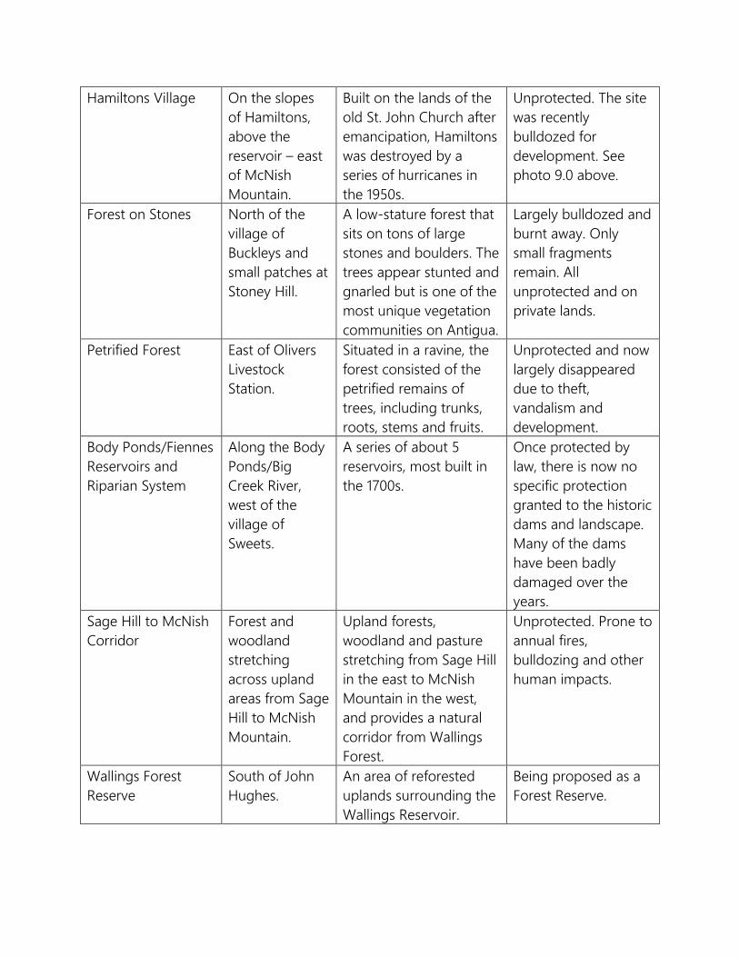
Hamiltons Village On the slopes of Hamiltons, above the reservoir – east of McNish Mountain.
Built on the lands of the old St. John Church after emancipation, Hamiltons was destroyed by a series of hurricanes in the 1950s.
Unprotected. The site was recently bulldozed for development. See photo 9.0 above.
Forest on Stones North of the village of Buckleys and small patches at Stoney Hill.
A low-stature forest that sits on tons of large stones and boulders. The trees appear stunted and gnarled but is one of the most unique vegetation communities on Antigua.
Largely bulldozed and burnt away. Only small fragments remain. All unprotected and on private lands.
Petrified Forest East of Olivers Livestock Station.
Situated in a ravine, the forest consisted of the petrified remains of trees, including trunks, roots, stems and fruits.
Unprotected and now largely disappeared due to theft, vandalism and development.
Body Ponds/Fiennes Reservoirs and Riparian System
Along the Body Ponds/Big Creek River, west of the village of Sweets.
A series of about 5 reservoirs, most built in the 1700s.
Once protected by law, there is now no specific protection granted to the historic dams and landscape. Many of the dams have been badly damaged over the years.
Sage Hill to McNish Corridor
Forest and woodland stretching across upland areas from Sage Hill to McNish Mountain.
Upland forests, woodland and pasture stretching from Sage Hill in the east to McNish Mountain in the west, and provides a natural corridor from Wallings Forest.
Unprotected. Prone to annual fires, bulldozing and other human impacts.
Wallings Forest Reserve
South of John Hughes.
An area of reforested uplands surrounding the Wallings Reservoir.
Being proposed as a Forest Reserve.
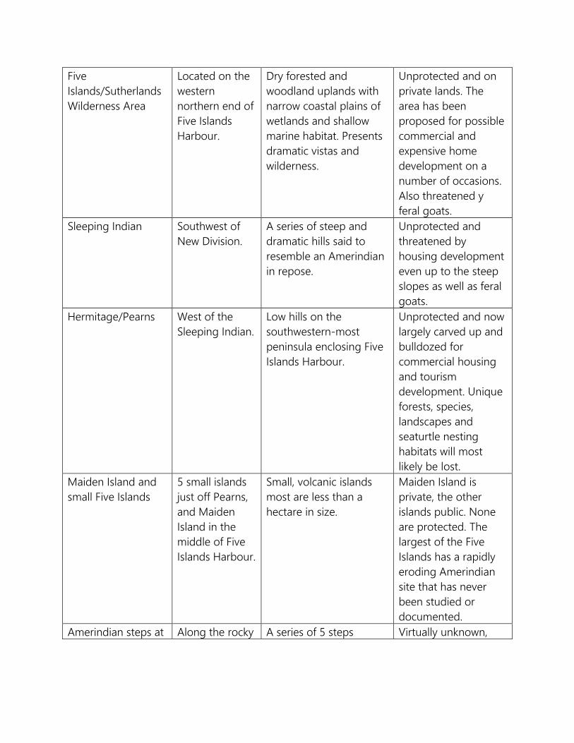
Five Islands/Sutherlands Wilderness Area
Located on the western northern end of Five Islands Harbour.
Dry forested and woodland uplands with narrow coastal plains of wetlands and shallow marine habitat. Presents dramatic vistas and wilderness.
Unprotected and on private lands. The area has been proposed for possible commercial and expensive home development on a number of occasions. Also threatened y feral goats.
Sleeping Indian Southwest of New Division.
A series of steep and dramatic hills said to resemble an Amerindian in repose.
Unprotected and threatened by housing development even up to the steep slopes as well as feral goats.
Hermitage/Pearns West of the Sleeping Indian.
Low hills on the southwestern-most peninsula enclosing Five Islands Harbour.
Unprotected and now largely carved up and bulldozed for commercial housing and tourism development. Unique forests, species, landscapes and seaturtle nesting habitats will most likely be lost.
Maiden Island and small Five Islands
5 small islands just off Pearns, and Maiden Island in the middle of Five Islands Harbour.
Small, volcanic islands most are less than a hectare in size.
Maiden Island is private, the other islands public. None are protected. The largest of the Five Islands has a rapidly eroding Amerindian site that has never been studied or documented.
Amerindian steps at Along the rocky A series of 5 steps Virtually unknown,
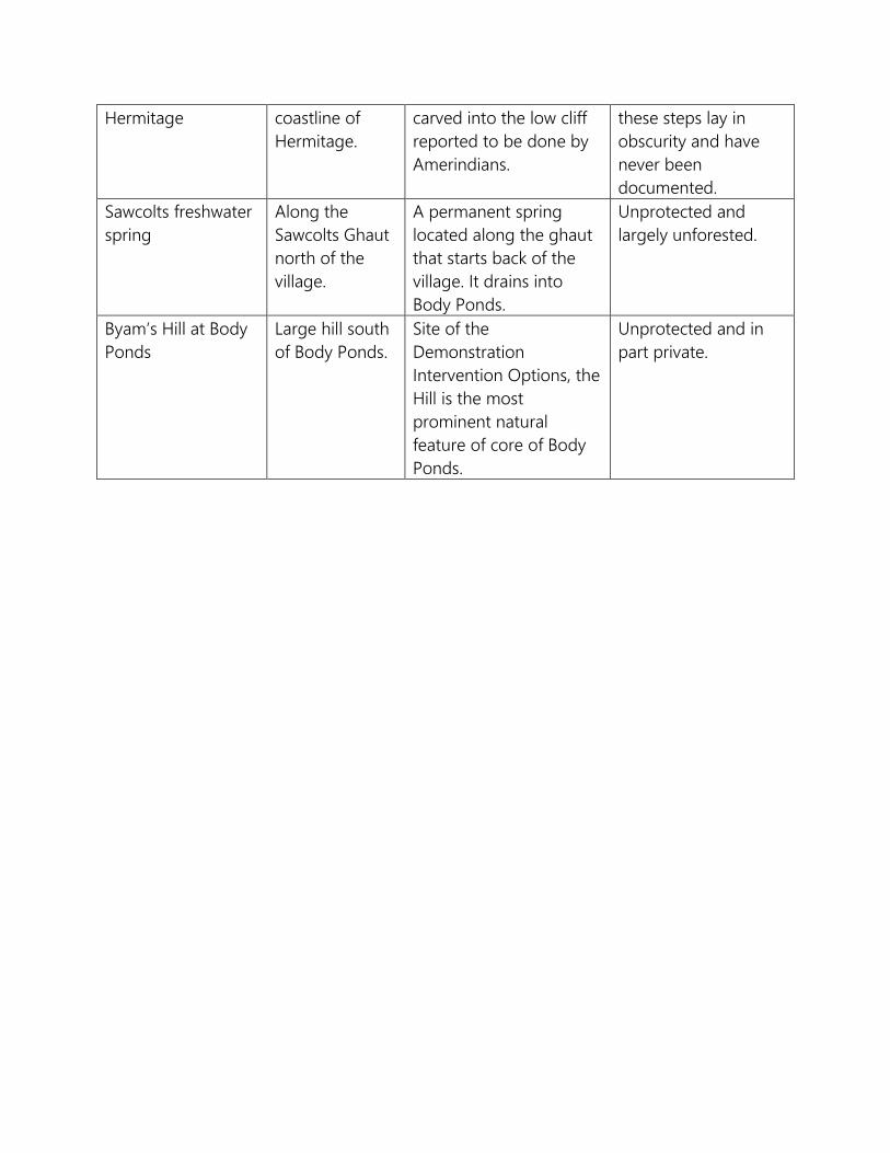
Hermitage coastline of Hermitage.
carved into the low cliff reported to be done by Amerindians.
these steps lay in obscurity and have never been documented.
Sawcolts freshwater spring
Along the Sawcolts Ghaut north of the village.
A permanent spring located along the ghaut that starts back of the village. It drains into Body Ponds.
Unprotected and largely unforested.
Byam’s Hill at Body Ponds
Large hill south of Body Ponds.
Site of the Demonstration Intervention Options, the Hill is the most prominent natural feature of core of Body Ponds.
Unprotected and in part private.
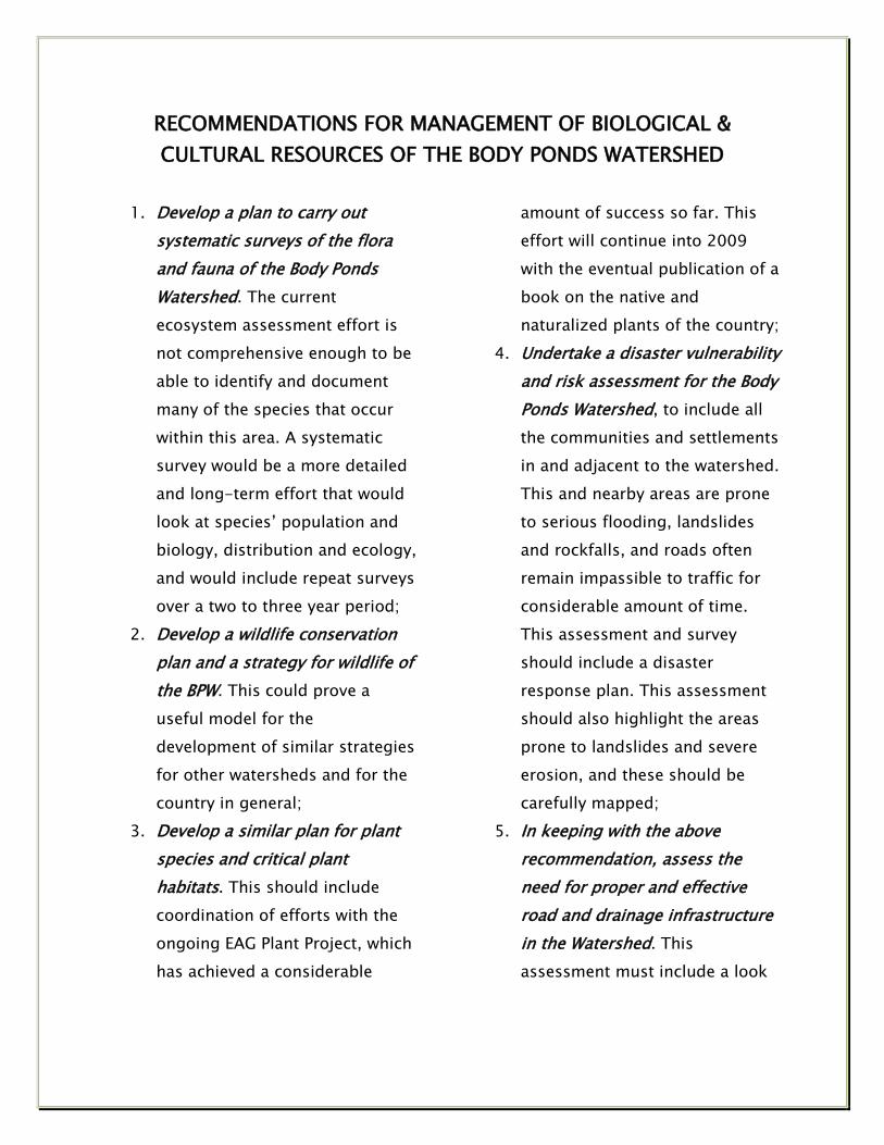
RECOMMENDATIONS FOR MANAGEMENT OF BIOLOGICAL & CULTURAL RESOURCES OF THE BODY PONDS WATERSHED
1. Develop a plan to carry out
systematic surveys of the flora and fauna of the Body Ponds Watershed. The current ecosystem assessment effort is not comprehensive enough to be able to identify and document many of the species that occur within this area. A systematic survey would be a more detailed and long-term effort that would look at species’ population and biology, distribution and ecology, and would include repeat surveys over a two to three year period;
2. Develop a wildlife conservation plan and a strategy for wildlife of the BPW. This could prove a useful model for the development of similar strategies for other watersheds and for the country in general;
3. Develop a similar plan for plant species and critical plant habitats. This should include coordination of efforts with the ongoing EAG Plant Project, which has achieved a considerable
amount of success so far. This effort will continue into 2009 with the eventual publication of a book on the native and naturalized plants of the country;
4. Undertake a disaster vulnerability and risk assessment for the Body Ponds Watershed, to include all the communities and settlements in and adjacent to the watershed. This and nearby areas are prone to serious flooding, landslides and rockfalls, and roads often remain impassible to traffic for considerable amount of time. This assessment and survey should include a disaster response plan. This assessment should also highlight the areas prone to landslides and severe erosion, and these should be carefully mapped;
5. In keeping with the above recommendation, assess the need for proper and effective road and drainage infrastructure in the Watershed. This assessment must include a look
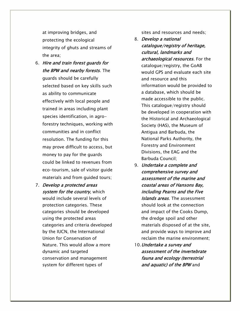
at improving bridges, and protecting the ecological integrity of ghuts and streams of the area;
6. Hire and train forest guards for the BPW and nearby forests. The guards should be carefully selected based on key skills such as ability to communicate effectively with local people and trained in areas including plant species identification, in agro-forestry techniques, working with communities and in conflict resolution. The funding for this may prove difficult to access, but money to pay for the guards could be linked to revenues from eco-tourism, sale of visitor guide materials and from guided tours;
7. Develop a protected areas system for the country, which would include several levels of protection categories. These categories should be developed using the protected areas categories and criteria developed by the IUCN, the International Union for Conservation of Nature. This would allow a more dynamic and targeted conservation and management system for different types of
sites and resources and needs; 8. Develop a national
catalogue/registry of heritage, cultural, landmarks and archaeological resources. For the catalogue/registry, the GoAB would GPS and evaluate each site and resource and this information would be provided to a database, which should be made accessible to the public. This catalogue/registry should be developed in cooperation with the Historical and Archaeological Society (HAS), the Museum of Antigua and Barbuda, the National Parks Authority, the Forestry and Environment Divisions, the EAG and the Barbuda Council;
9. Undertake a complete and comprehensive survey and assessment of the marine and coastal areas of Hansons Bay, including Pearns and the Five Islands areas. The assessment should look at the connection and impact of the Cooks Dump, the dredge spoil and other materials disposed of at the site, and provide ways to improve and reclaim the marine environment;
10. Undertake a survey and assessment of the invertebrate fauna and ecology (terrestrial and aquatic) of the BPW and
develop and national catalogue and database of invertebrates. This need not begin as an expensive undertaking, but could be initiated as a cooperative effort with the EAG, the Museum of Antigua and Barbuda, the Ministry of Agriculture, including the Plant Protection Division, as well as trained volunteers and external academic and museum institutions. As resources become available, the survey can then develop into a more intensive and comprehensive program;
11. Along with a national biodiversity database, authorities should develop and make available a national biodiversity bibliography in various formats, including paper (book), electronic and web-based formats. The document would be updated regularly, and if established as a database, it can be continually updated. Copies of the document could be sold to help generate revenue. The cost of creating such a bibliography could be borne through various means such as using government staff to create the document, undertaking this as part of a more comprehensive biodiversity and science management
capacity building and by seeking the assistance out external institutions sympathetic to such a cause.
12. Develop a Mongoose control program for the BPW. The program should be localized and targeted, especially for areas where there are species of special conservation concern and/or where the Mongoose has a considerable adverse impact. The local community should be enlisted to assist with this program.
13. Develop a national biodiversity specimens collection. This entails considerable effort, commitment, knowhow and patient, and should be developed to international standards and norms. This effort could be developed in concert with regional and international institutions and expertise, and the collection could be housed at a regional institution such as the University of the West Indies (UWI), at least for an initial time period.
14. Develop a water monitoring program for the marine environment and freshwater resources. This should be part of a medium and long-term monitoring program. The data

collected should be done under strict professional guidelines and criteria, and fed to a national database to which the public has access. This program should include the necessary training and institutional capacity development.
15. Develop a national program of wilderness and natural landscape areas protection, including areas of outstanding natural beauty, vistas, and cultural values, including the Sleeping Indian, Hansons Bay, the Flashes, New Division, the Five Islands and Body Ponds.
16. As part of any biodiversity, ecosystems and ecological surveys, there should be an assessment of the tradeoffs of ecological goods and services, as well as stakeholder views on biodiversity and conservation. This would help in the design of, and to inform management options and regimes, help improve and innovate technologies and systems, and increase public and private sector support for science, conservation and resources management.
Specific activities and suggestions for how to implementation the
recommendations are provided in the Local Area Plan and Area Management (ETC 2010).

DEFINITION OF TERMS
Alliance (as in vegetation community) – This refers to a plant or vegetation community and is the first floristic level in the classification of the community. The Alliance typically includes one or more characteristic species in its title, and provides an operational definition that allows it to serve as the basic unit for conservation management concerns. Biodiversity – This refers to the natural diversity of animals, plants, ecosystems, ecosystem functions, genetic diversity and landscapes in a given area. Common – Refers to a species of animal, plant or plant community that is widespread in distribution or size. Community (as in plants, vegetation and ecosystems) – An association of plant species that form the vegetation (sometimes loosely called habitat type as well) of a given area. A “community association” is in some cases, though not all “…an Alliance that may contain several Community Associations, which differ in species composition. The separation of Alliances into Associations is subject to the same prejudices that affect the “splitter versus lumper” debate in taxonomy; in general, we probably erred in the direction of splitting Alliances because the resulting Community Associations provide more information at the species level, and thus improves biodiversity conservation efforts.” (Lindsay and Horwith, 1997. A Vegetation
classification of Antigua, Barbuda and Redonda). Declining – A species, ecosystem, habitat and landscape that is reduced in numbers, capacity and ability over a time, from a position of previous stability or optimum capacity. Endangered – A species, ecosystem or landscape component is in danger of becoming extinct in the wild. Exotic invasive – A species that has been introduced to Antigua or Barbuda within historic times that has adverse effects on other species and/or human ecosystems and economies. Introduced – As opposed to native and indigenous, this term refers to species that have been aided by human intervention and has been brought to Antigua and Barbuda during recent historical times. Introduced species are often referred to as exotic, alien or non-indigenous, and may become an invasive at some point. Invasive species – Usually referred to an introduced species that has adverse effects on other species and/or on human ecosystems and economies. However, an invasive species can also refer to a native species that has adverse or negative effects on other species, ecosystems, on human systems and economies. Invasive species usually result from direct human activity and interference that causes a

disruption in the habits and functions of a species and/or its habitat. Landscape – The visible elements of plants, animals, vegetation communities, ecosystem functions, weather and climate, and human activities and functions that define the features of an area of land. Least concern – A species that is of low conservation and/or management needs. Marine – Of or relating to the sea, and usually means species of animals, plants and natural systems that are primarily based in the sea. Native – A species of plant, animal, ecosystem or landscape component that has naturally developed, evolved, or has occurred naturally in Antigua and Barbuda. Natural Disaster – A natural hazard that affects human activities and has adverse effects on human ecosystems. Rare – Severely restricted in distribution or size. Special conservation concern – Species of animals and plants, ecosystems,
landscapes and habitat that are of greatest conservation priority and concern and in need of management intervention. Systematic surveys/sampling – This refers to the undertaking and use of individual observations intended to provide information on the population and habits of a species and/or ecosystem and ecosystem functions. Several properties or components are measured, including location, species, species composition, weight, habit, time, weather and climate, date, genetics, sex, vocalization, etc. Terrestrial – Terrestrial refers to primarily land-based species of animals and plants and to ecosystems that are primarily based there (as opposed to aquatic/marine). Threatened – A species, ecosystem or landscape component is threatened when the best evidence suggest that the species or habitat is facing threats that may push it toward extinction at some point. Uncommon – Moderately distributed in numbers or size.
Acknowledgement The authors would like to express its gratitude and thanks to all those who assisted them in the field and otherwise, including the staff of the Forestry Division, the Environment Division, the Extension Division, the Museum of Antigua and Barbuda, Agnes Meeker and Dr. Reg Murphy for their assistance with the historical and archaeological resources, staff at the Pesticide Board, the Central Marketing Cooperation, and the EAG’s Plant Conservation team, including Chris Pratt, Melanie Pearson and Carolyn Thomas, to Dr. Brian Cooper for his diligent and hard work on the maps and assistance with locating difficult to find data on the area, and to anyone else whose name may slip us at the moment, but whose invaluable contribution made this report possible.

SELECT REFERENCES Adams, Rick A., Jon D. Appino, Hugh Genoways, Peter A. Larsen, Kevel C. Lindsay, Matthew N. Morton, Scott C. Pedersen & Vicki J. Swier. 2006. Bats of Antigua, northern Lesser Antilles. Museum of Texas Tech University: Number 249. Ahmad, N. 1984. Land capability of Antigua and Barbuda. Depart. Reg. Dev., Organization of American States. Ahmad, N. 1985. Land use in Antigua and Barbuda. Organization of American States. Alston, A.H.G. 1935. Pteridophyta of Antigua. Journal of Botany Vol. 73(366). American Ornithologists’ Union. 1983. Check-list of North American Birds. 6th edition. Archer, A. 1984. Report on the land-based sources of pollution in coastal, marine and land areas of CARICOM states. Prepared for UNEP/CARICOM/PAHO project for the protection of the coastal and marine environment of Caribbean islands. Bacon, P. R. 1991. The status of mangrove conservation in the CARICOM islands of the Eastern Caribbean. Report to the Commission of the European Communities as part of the Tropical Forestry Action Plan for the Caribbean Region.
Bacon, PR. 1993. Mangroves in the Lesser Antilles, Jamaica, and Trinidad and Tobago. LD Lacerda (ed.), Conservation and Sustainable Utilization of Mangrove Forests in Latin America and Africa Regions. Part I-Latin America. International Society for Mangrove Ecosystems. Baker, Robert J., Jane A. Groen & Robert D. Owen. 1984. Field key to Antillean bats. Occasional Papers: The Museum, Texas Tech University, No. 94. Barnes, M.J.C. 1996. A Provisional Guide to Some Common Moths of the Eastern Caribbean. Unpublished in files of Island Resources Foundation. Bauchot, M. 1959. La faune ichtyologique des eaux douces antillaises. Compte Rendu Summaire des Seances de la Societe du Biogeographie, Vol. 36(311). Beaman, Mark (Ed.). 2006. The Lesser Antilles: Tour report. Birdquest. Beaman, Mark (Ed.). 2004. The Lesser Antilles and the Bahamas: Tour report. Birdquest. Beard, J. S. 1949. Forestry and timber in the Windward and Leeward Islands. Guardina Commercial Printery. Beard, J. S. 1949. The natural vegetation of the Windward and Leeward Islands.

Oxford For. Mem. 21. Oxford, UK: Oxford University. Beard, J. S. 1955. The classification of tropical American vegetation-types. Ecology 36. Berleant-Schiller, R. 1977. Production and division of labor in a West Indian peasant community. American Ecologist 4. Betz, K. 1989. A report on land-based sources of marine pollution in the Caribbean. Unpublished report for the Office of International Activities, U.S. Environmental Protection Agency. Boerge, B. 1980. The mini-dams and ponds of Antigua: A water resources survey. U.S. Peace Corps in cooperation with the Ministry of Agriculture, Antigua. Bond, J. 1980. Birds of the West Indies. Fourth edition. Houghton Mifflin Company. Breuil, M. & D. Masson. 1991. Quelques remarques sur la biogeographie des chauves-souris des Petites Antilles. C.R. Biogeogr, V67. Breure, A.S.H. 1974. Caribbean land molluscs: Bulimidae, I. Bulimulus: Studies on the fauna of Curacao and other Caribbean Islands. Vol. 45(145). Buisseret, D & B. Clark. 1971. A report on the chief monuments of Antigua, British Virgin Islands, Dominica, Grenada, Montserrat, St. Lucia, St. Vincent, and
Turks and Caicos Islands. Commissioned on behalf of the governments by the British Development Division in the Caribbean. Burchi, S. 1981. Water resources legislation and administration in Antigua and Barbuda. Report to the Government of Antigua, prepared by United Nations Department of Technical Cooperation for Development. Burgess, G.H., & R. Franz. 1989. Zoogeography of the Antillean Freshwater Fish Fauna. In Woods, CA (ed). 1989. Biogeography of the West Indies. Sandhill Crane Press. Cambers, G. 1985. Erosion of coasts and beaches in the Caribbean islands: an overview of coastal zone management in six East Caribbean Islands. UNESCO Regional Office of Science and Technology. Caribbean Development Bank. 1984. Regional forestry sector study. Final report. Barbados. Carstens, B.C., L.M. Davalos, P.A. Larsen & S.C. Pedersen. 2004. Exploring population genetic structure in three species of Lesser Antillean bats. Molecular Ecology, 13. Cater, J. 1944. Forestry in the Leeward Islands: Development and welfare in the West Indies, bulletins, no. 7. Advocate Co., Ltd., Bridgetown, Barbados.

Censky, Ellen & Kevel Lindsay. 1997. Note on Gymnothalmus underwoodi (Antillean Lizard). Submitted to Herpetological Review. Center for International Development and Environment. 1988. Biological diversity and tropical forest assessment for the Eastern Caribbean. USAID/RDO/C. Chalmers, W. 1990. FAO tropical forestry action plan for nine CARICOM countries. FAO. Charter, C. 1969. Soil survey of Antigua and Barbuda. Government Printery, Antigua. Collins, M. 1994. Unpublished in files of Island Resources Foundation [The Caribbean Termite Survey collected in Antigua as part of a 58 island Caribbean effort that raised Snyder's 1956 list of 66 species to the new total of 94 species; Collins; Smithsonian Institution]. Conservation Data Center. 2004. United States Virgin Islands vegetation classification system. http://cdc.uvi.edu/reaweb/vegbody.html. Coomans, H.E. 1958. A survey of the littoral gastropoda of the Netherlands Antilles and other Caribbean islands. Studies on the Fauna of Curacao and other Caribbean Islands Vol. 8(31). Cooper, Brian & Vincent Bowen. 2001. Integrating management of watersheds and coastal areas in small island developing states of the Caribbean.
Environment Division, Ministry of Tourism and Environment, Antigua. Cory, C.B. 1891. A collection of birds taken by Cyrus S. Winch in the islands of Anguilla, Antigua, and St. Eustatius. The Auk, Vol. 8(1). Cory, C.B. 1891. Notes on West Indian birds. The Auk, Vol. 8(1). Courts, Sian E., Hugh H. Genoways, James W. Johnson, Matthew N. Morton & Scott C. Pedersen. 2003. Bats of St. Nevis, northern Lesser Antilles. Museum and Institute of Zoology PAS, Acta Chiropterologica, 5(2). Courts, Sian E., Hugh H. Genoways, Gary G. Kwiecinski & Scott C. Pedersen. 2005. Bats of St. Kitts (St. Christopher), northern Lesser Antilles, with comments regarding capture rates of Neotropical bats. Caribbean Journal of Science, Vol. 41, No. 4, 744-70. Cryan, P., T. OsShea, L. Ellison, M. Bogan, and J. Wilson. 2004. Flying by night: USGS scientists put technology to work on bats. United States Geological Survey. http://www.fort.usgs.gov/resources/research_briefs/FlyNight.asp. Daltry, Jennifer C. 2007. An introduction to the herpetofauna of Antigua, Barbuda and Redonda, with some conservation recommendations. Applied Herpethology 4.

Danforth, S.T. 1934. The birds of Antigua. The Auk, Vol. 51(3). Darlington, P. J. 1938. The Origin of the Fauna of the Greater Antilles, with discussion of dispersal of animals over water and through the air. The Quarterly Review of Biology, Vol. 13, No. 3. Davis, Dave D. 1982. Archaic settlement and resource exploitation in the Lesser Antilles: preliminary information from Antigua. Caribbean Journal of Science 17(1-4). Deichmann, E. 1963. Shallow water holothurians known from Caribbean waters. Studies on the Fauna of Curacao and other Caribbean Islands, Vol. 14(63). De kort-Gommers, M. & N. Nieser. 1969. Records of Antillean water-striders (Heteroptera). Studies on the Fauna of Curacao and other Caribbean Islands. Vol. 30(112). Devine, B., Gibney, E., O’Reilly, R. & T. Thomas. 2000. U.S. Virgin Islands vegetation community classification -- Basic community descriptions. The Conservation Data Center, University of the Virgin Islands. Devine, B. & Tony Thomas. 2005. Island peak to coral reef: A field guide to the plant and marine communities of the Virgin Islands. University of the Virgin Islands.
Diamond, A. 1973. Notes on the breeding biology and behavior of the Caribbean frigatebird. Condor 75. Dunne, ER. 1934. Physiography and herpetology in the Lesser Antilles. Copeia V1934?:105-111. Eastern Caribbean Natural Areas Management Program, 1980. Antigua: Preliminary data atlas. Survey of Conservation Priorities in the Lesser Antilles. ECNAMP. Earle, K. 1921. Report on the geology of Antigua. Report of the government geologist to the Windward and Leeward Islands. Edwards, Bryan. 1806. The history, civil and commercial of the British colonies in the West Indies. James Humphreys? Vol. 1. Elliot, Daniel Giraud. 1904. The land and sea mammals of middle America and the West Indies. Field Columbian Museum: Zoological Series, Vol. IV, Part 1. Evans, P. 1990. Birds of the Eastern Caribbean. MacMillan Caribbean. Faaborg, J. & W. Arendt. 1985. Wildlife assessments in the Caribbean. U.S. Department of Agriculture Forest Service, International Institute of Tropical Forestry. Fleming, T. H. 1971. Artibeus jamaicensis: Delayed embryonic development in a neotropical bat. Science 171.

Francis, J., C. Rivera and J. Figueroa. 1994. Toward a woody plant list for Antigua and Barbuda: past and present. Gen. Tech. Rep. SO-102. New Orleans, LA: US Dept of Agriculture, Forest Service, Southern Forest Experiment Station Freeman, Patricia Waring. 1981. A multivariate study of the family Molossidae: (mammalia, chiroptera): Morphology, ecology, evolution. Fieldiana Zoology-Field Museum of Natural History: New Series, No. 7. Freeman, Patricia Waring, Hugh H. Genoways & Scott C. Pedersen. Notes on the Bats of Montserrat (Lesser Antilles) with comments concerning the effects of Hurricane Hugo. Caribbean Journal of Science, Vol. 32, No. 2. Fuller, Richard A. & Rebecca M. Webb. 1997. Antigua Trip Report. Report on a bird watching trip undertaken by the authors. Garel, D. 1986. Livestock development in Antigua and Barbuda. Dept. Reg. Dev., Organization of American States. Godo, P. 1983. Diagnosis, proposal, strategies, and recommendations for the production of ruminants in Antigua and Barbuda. Organization of American States. Goreau, M and TJ Goreau. 1996. Ecological Assessment of Antigua and Barbuda Reefs. Report to the Environmental Awareness Group.
Unpublished, available in files of Island Resources Foundation. Gricks, N. 1994. Whale-watching in the West Indies: A Guide to Cetaceans and Sites of the Region. Island Resources Foundation. Gricks, N., B. Horwith & K Lindsay. 1997. Birds of Antigua-Barbuda-Redonda. Unpublished in files of Island Resources Foundation. Gudger, E.W. 1945. Fishermen bats of the Caribbean region. Journal of Mammology, Vol. 26, No. 1. Gannon, M.R., Allen Kurta, A. Rodriguez-Duran & Michael R. Willig. 2005. Bats of Puerto Rico: An island focus and a Caribbean perspective. Texas Tech University Press. Genoways, Hugh H, Jeffrey J. Huebschman, Gary G. Kwiecinski, Peter A. Larsen & Scott C. Pedersen. 2007. Bats of Saint Martin, French West Indies/Sint Maarten, Netherlands Antilles. Mastozoologia Neotropical, 14(2). Genoways, Hugh H., Jeffrey J. Huebschman, Peter A. Larsen & Scott C. Pedersen. 2007. Bats of Saba, Netherlands Antilles: a zoogeographic perspective. Museum and Institute of Zoology PAS, Acta Chiropterologica, 9(1). Genoways, Hugh H, Peter A. Larsen & Scott C. Pedersen. 2006. New records of

bats from Saint Barthelemy, French West Indies. Mammalia, DOI 10.1515, 056. Genoways, Hugh H., Linda K. Gordon, Scott C. Pedersen & Carleton J. Phillips. 2007. Bats of Anguilla, Northern Lesser Antilles. Museum of Texas Tech University, Number 270. Genoways, Hugh H., Steven J. Presley & Michael R. Willig. 2008. Macreology of Caribbean bats: Effects of area, elevation, latitude and hurricane-induced disturbance. Island bats: evolution, ecology, and conservation (T. Fleming, and P. Racey, Eds.). University of Chicago Press (in press). Grisebach, A.H.R. 1864. Flora of the British West Indian islands. Lovell Reeve and Company. Haas, F. 1962. Caribbean land molluscs: Subulinidae and Oleacinidae. Studies on the Fauna of Curacao and other Caribbean Islands. Vol. 13(58). Halcrow, Sir William & Partners. 1977. Report on water supplies in Antigua from medium reservoirs. Ministry of Overseas Development, London. Halcrow, Sir William & Partners. 1970. An engineering study on the water resources of Antigua. 4 Volumes. Ministry of Overseas Development, London. Halewyn, R. van & Norton, R. 1984. The status and conservation of seabirds in the
Caribbean. ICPB Technical Publication No. 2. Handley, C.O., Jr., D.E. Wilson & A.L. Gardner. 1991. Demography and natural history of the common fruit bat Artibeus jamaicensis on Barro Colorado Island, Panama. Smithsonian Contributions to Zoology 511. Harris, D. R. 1965. Plants, animals, and man in the Outer Leeward Islands, West Indies: An ecological study of Antigua, Barbuda and Anguilla. University of California Press. Berkeley and Los Angeles. Hayes, John P., Allen Kurta & Michael J. Lacki (Ed). 2007. Bats in forests: Conservation and management. The Johns Hopkins University Press. Hayssen, V., A. Van Tienhoven, & A. Van Tienhoven. 1993. Asdell’s Patterns of Mammalian Reproduction. Cornell University Press, Ithaca, NY. Henderson, Robert W. 1992. Consequences of predator introductions and habitat destruction on amphibians and reptiles in the post-Columbus West Indies. Caribbean Journal of Science, Vol. 28, No 1-2. Henry, McRonnie. 1984. Inventory of forest resources of Antigua. Institute of Tropical Forestry.
Hill, I. 1966. Soil and land use surveys no. 19: Antigua and Barbuda. Regional Resource Center, UWI. Hill, Robert T. 1898. Cuba and Porto Rico, with the other islands of the West Indies: Their topography, climate, flora, products, industries, cities, people, political conditions, etc. The Century Company. Hoedemann, J.J. 1958. Rivulid fishes of the Antilles. Studies on the Fauna of Curacao and other Caribbean Islands, Vol. 8(32). Holland, C.S. & J.M. Williams. 1978. Observations on the birds of Antigua. American Birds, Vol. 32(6). Howard, R. 1973. The vegetation of the Antilles. In: A. Graham (ed.), Vegetation and vegetational history of Northern Latin America. Elsevier Scientific Publishing Company. New York. Howard, R. 1974. Flora of the Lesser Antilles: Leeward and Windward Islands. Volume 1. Orchidaceae by L. Garay and H. Sweet. Arnold Arboretum, Harvard University. Howard, R. 1977. Flora of the Lesser Antilles: Leeward and Windward Islands. Volume 2. Pteridophyta by G. Proctor. Arnold Arboretum, Harvard University. Howard, R. 1979. Flora of the Lesser Antilles: Leeward and Windward Islands. Volume 3. Monocotyledoneae. Arnold Arboretum, Harvard University.
Howard, R. 1988. Flora of the Lesser Antilles: Leeward and Windward Islands. Volume 4. Dicotyledoneae—Part 1. Arnold Arboretum, Harvard University. Howard, R. 1989. Flora of the Lesser Antilles: Leeward and Windward Islands. Volume 5. Dicotyledoneae—Part 2. Arnold Arboretum, Harvard University. Howard, R. 1989. Flora of the Lesser Antilles: Leeward and Windward Islands. Volume 6. Dicotyledoneae—Part 3. Arnold Arboretum, Harvard University. Humann, P. & N. Deloach. 2002. Reef creature identification: Florida, Caribbean, Bahamas. New World Publications, Inc. Jacksonville, FL, USA. Humann, P. & N. Deloach. 2002. Reef coral identification: Florida, Caribbean, Bahamas. New World Publications, Inc. Jacksonville, FL, USA. Humann, P. & N. Deloach. 2002. Reef fish identification: Florida, Caribbean, Bahamas. New World Publications, Inc. Jacksonville, FL, USA. Humfrey, M. 1975. Sea Shells of the West Indies. Collins, St James's Place, London. Island Resources Foundation. 1991. Antigua and Barbuda environmental profile. Caribbean Conservation Association. Jefferson, Thomas A & Spencer K. Lynn. 1994. Marine Mammal Sightings in the
Caribbean Sea and Gulf of Mexico, Summer 1991. Caribbean Journal of Science, Vol. 30, No. 1-2. Kaiser H. 1992. The trade-mediated introduction of Eleutherodactylus martinicensis (Anura: Leptodactylidae) on St. Barthélémy, French Antilles, and its implications for Lesser Antillean biogeography. Journal of Herpetology, 26:264. Kenefick, Martyn. 2003. South eastern Caribbean bird alert. Trinidad and Tobago Field Naturalist Club. Knoles, William. 1992. Evaluation of use of bar detectors for location of roosts and feeding sites of fruit bats (Artibeus jamaicensis and Brachyphylla cavernarum) on St. Croix, U.S. Virgin Islands. Division of Fish and Wildlife, D.P.N.R, U.S.V.I, Study 18. Knoles, William. 1992. To evaluate the feasibility of using radio-tracking to study the ecology of the fruit bats (Brachyphylla cavernarum and Artibeus jamaicensis) in the United States Virgin Islands. Division of Fish and Wildlife, D.P.N.R, U.S.V.I, Study 19. Koopman, K. F. 1975. Bats of the Virgin Islands in relation to those of the Greater and Lesser Antilles. American Museum Novitates, 2581. Krutzsch, P. H., & D. W. Nellis. 2006. Reproductive anatomy and cyclicity of the male bat Brachyphylla cavernarum
(Chiroptera: Phyllostomidae). Acta Chiropterologica 8. Kunz, Thomas H, Gary F. McCracken & Akbar Zubaid (Ed). 2006. Functional and evolutionary ecology of bats. Oxford University Press. Lanagan, F.T. 1844. Antigua and the Antiguans. Vol. II. Saunders and Otley. London. Larsen, Roxanne J., Karen A. Boegler, Hugh H. Genoways, Will P. Masefield, Ronan A. Kirsch & Scott C. Pedersen. 2007. Mist netting bias, species accumulation curves, and the rediscovery of two bats on Montserrat (Lesser Antilles). Acta Chiropterologica, 9(2). Lazell, James. 2005. Island: Fact and theory in nature. University of California Press. Lazell, J.D. & E.E. Williams. 1962. The Anoles of the Eastern Caribbean (Sauria, Iguanidae). Parts IV-VI. Bulletin of the Museum of Comparative Zoology, 127. Harvard University. Lindsay, Kevel & Bruce Horwith. 1997. A biodiversity profile of Antigua, Barbuda and Redonda. Island Resources Foundation. Lindsay, Kevel & Bruce Horwith. 1997. A Vegetation classification of Antigua, Barbuda and Redonda. Island Resources Foundation.
Lindsay, K & B. Horwith. 1997. Plants Species of Antigua-Barbuda-Redonda. Unpublished in file of Island Resources Foundation. Lindsay, K. & L. Blackman. 1997. Freshwater Fish of Antigua-Barbuda. Unpublished in files of Island Resources Foundation. Little, E. L. and F. H. Wadsworth. 1974. Common trees of Puerto Rico and the Virgin Islands. Second Volume. Washington, DC. Little, E. L. and F. H. Wadsworth. 1989. Common trees of Puerto Rico and the Virgin Islands. Revision of First Volume. Washington, DC. Lovette, Irby J. & Robert E. Ricklefs. 1999. The role of island area per se and habitat diversity in the species-area relationships of four Lesser Antillean faunal groups. Journal of Ecology, 68. Loveless, A. 1960. The vegetation of Antigua, West Indies. Journal of Ecology 48. Lynne, W.G. 1957. Notes on a collection of reptiles and amphibians from Antigua. BWI Herpetologica, Vol. 13. Mackler, R. & Hannah, P. 1988. The forest at Wallings reservoir, Antigua, West Indies - forty four years after J.S. Beard's study: Conjecture on the patterns of change. Commonwealth Forestry Review 87(212).
Marcuzzi, G. 1962. Tenebrionid beetles of the West Indies. Studies on the Fauna of Curacao and other Caribbean Islands Vol. 13(57). Martin-Kaye, P. 1959. Reports on the geology of the Leeward and British Virgin Islands. Voice Publishing Company, St. Lucia. Miller, L.D. & J.Y. Miller. 1989. The Biogeography of West Indian Butterflies (Lepidopter: Papilionoidea, Hesperoidea). Unknown. Martin-Kaye, P. 1969. A summary of the geology of the Lesser Antilles. Overseas Geology and Mineral Resources, Vol. 10. Morello, J. 1983. Ecological diagnosis of Antigua and Barbuda. Organization of American States, Dept. Reg. Dev., Washington, DC. Mark, Cynthia S. & George E. Marks. 2006. Bats of Florida. University Press of Florida. MacLean, W.P., R. Kellner & H. Dennis. 1977. Island Lists of West Indian Amphibians and Reptiles. Smithsonian Herpetological Information Service, No. 40 (1977). Morello, J. 1983. Ecological diagnosis of Antigua and Barbuda. Organization of American States, Dept. Reg. Dev., Washington, DC.
Morton, M. 1994. A Short Survey of the Bats of Antigua and Barbuda. Unpublished in files of Island Resources Foundation. Mussington, John. 1983. A survey of the Codrington Lagoon system. ECNAMP/Government of Antigua. Nellis, D. W. 1994. Seashore Plants of South Florida and the Caribbean. Pineapple Press Inc. Sarasota, Florida, USA. Scullion Littler, D., M. Littler, K. Bucher & J.N. Norris. 1989. Marine plants of the Caribbean: A field guide from Florida to Brazil. Smithsonian Institution Press. Washington DC, USA. Stehle, H. 1945. Forest types of the Caribbean Islands. Caribbean Foresters 7 (supplement). Nicoll, M.J. 1908. Three voyages of a naturalist: Being an account of many little-known islands in three voyages visited by the “Valhalla” R.Y.S. Witherby and Company. Nicholson, Desmond. 1977. Some of the important wildlife areas of Antigua and Barbuda. Unpublished report. Ober, Fred. 1920. A guide to the West Indies, Bermuda and Panama. Dodd Mead. Organization of American States. 1988. Inventory of Caribbean marine and
coastal protected areas. Department for Regional Development, OAS. Parker, H.W. 1933. Some amphibians and reptiles from the Lesser Antilles. Annals and Magazine of Natural History, Vol. 11(10). Pashley, David N. & Robert Hamilton. 1990. Warblers of the West Indies III. Caribbean Journal of Science, Vol. 26, No. 3-4. Pedersen, Scott C. 2004. Earth, wind and fire: the fruit bats of Montserrat have had to contend with most of nature's torments - Naturalist At Large. American Museum of Natural History. Petterson, Jim. 1997. Feasibility of using ultrasonic surveys for bat monitoring on St. John, U.S. Virgin Islands. Organic Pipe Cactus National monument. Pregill, G.K.D., D.W. Steadman & D.R. Watters. 1994. Late Quaternary Vertebrate Fauna of the Lesser Antilles: Historical Components of Caribbean Biogeography. Bulletin of Carnegie Museum of Natural History, No. 30. Presley, Steven J. & Michael R. Willig. 2008. Composition and structure of Caribbean bat (chiroptera) assemblages: effects of inter-island distance, area, elevation and hurricane-induced disturbance. Global Ecology and Biogeography 17: DOI: 10.1111/j.1466-8238.2008.00412.x.
Powers, Miguel N., C. Patrick Ervin & Malcolm P. Weiss 1987. Reconnaissance magnetic survey of Antigua, West Indies. Caribbean Journal of Science 23(2). Riley, J.H. 1905. Catalogue of a collection of birds from Barbuda and Antigua, British West Indies. Smithsonian Miscellaneous Collections, Vol. 47. Riley, N.D. 1975. A Field Guide to the Butterflies of the West Indies. Collins, London. Robinson, A. 1979. Identification. And development of a national park system in Antigua and Barbuda. Project of the Government of Antigua-Barbuda. Rodda, Gordon H., Gad Perry, Renee J. Rondeau & James Lazell. 2001. The densest terrestrial vertebrate. Journal of Tropical Ecology, 17. Schmitt, W.L. 1959. Narrative of the 1958 Smithsonian-Bredin Caribbean expedition. In An Annual Report of the Smithsonian Institution for 1958. U.S. Government Printing Office. Schwartz, A. 1967. Frogs of the genus Eleutherodactylus in the Lesser Antilles. Studies Fauna Curacao and Caribbean Island Vol. 23(91). Schwartz, A. & R.W. Henderson. 1991. Amphibians and Reptiles of the West Indies: Descriptions, distributions and natural history. University of Florida Press.
Schwartz, A. & R.F. Klinikoski. 1963. Observations on West Indian birds. Proceedings of the Academy of Natural Sciences of Philadelphia, Vol. 155(3). Shoemaker, C.R. 1959. Three new cave amphipods from the West Indies. Journal of the Washington Academy of Sciences, Vol. 49(8). Smith, K.B & F.C. Smith. 2001. To shoot hard labour. Karia Press. Spencer, W. 1981. A Guide to the Birds of Antigua. Unpublished in files of Island Resources Foundation. Steadman, D.W., D.R. Watters, G.K. Pregill & S.L. Olson. 1984. Fossil vertebrates from Antigua, Lesser Antilles: Evidence for late Holocene human-caused extinctions in the West Indies. Proceedings of the National Academy of Sciences USA, Vol. 81. Stehle, H. 1945. Forest types of the Caribbean Islands. Caribbean Forester 7 (supplement). Stiling, P.D. 1986. Butterflies and other insects of the Eastern Caribbean. Macmillan Caribbean. Stock, J.H. 1977. The taxonomy and zoogeography of the hadziid amphipoda. Studies on the Fauna of Curacao and other Caribbean Islands Vol. 55(177). Stokes, F.J. 1984. Divers and Snorkelers Guide to the Fishes and Sea Life of the Caribbean, Florida, Bahamas and

Bermuda. The Academy of Natural Sciences. Terborgh, J.W., J. Faaborg & H.J. Brockmann. 1978. Island colonization by Lesser Antillean birds. The Auk, Vol. 95. Terborgh, J.W. & J. Faaborg. 1980. Saturation of bird communities in the West Indies. American Naturalist, Vol. 116(2). Underwood, G. 1962. Reptiles of the Eastern Caribbean. Caribbean Affairs (new series) No. 1. Dept of Extramural Studies, University of the West Indies. United States Man and the Biosphere Program. 1990. Land-based sources of marine pollution in the wider Caribbean region. Department of State Publication 9753. VanderGaast, Jay & Jesse Fagan. 2005. Lesser Antilles. Field Guides, Birding Tours Worldwide Triplist. VanderGaast, Jay & Jesse Fagan. 2006. Lesser Antilles. Field Guides, Birding Tours Worldwide Triplist. VanderGaast, Jay & Jesse Fagan. 2007. Lesser Antilles. Field Guides, Birding Tours Worldwide Triplist. Van Doesburg, P.H.V, Sr. 1970. Records of Syrphidae (Diptera) from the Lesser Antilles. Studies on the Fauna of Curacao and other Caribbean Islands. Vol. 34(126).
Velez, I. 1957. Herbaceous angiosperms of the Lesser Antilles. San Juan, Puerto Rico: Biology Department. Inter-American University of Puerto Rico. Voss, G. L. Seashore Life of Florida and the Caribbean. International Oceanographic Foundation Selection. Weakley, A. S. 1996. Vegetation of the West Indies (Cuba, the Greater Antilles, the Lesser Antilles, and the Bahamas. Draft. Westermann, J. H. 1953. Nature preservation in the Caribbean: A review of literature on the destruction and preservation of flora and fauna in the Caribbean area. Foundation for Scientific Research in Surinam and the Netherlands Antilles, Utrecht: No. 9. Wheeler, L. 1916. The botany of Antigua. Journal of Botany, Vol. 54. Widecast. 1992. Sea Turtle Recovery Action Plan for Antigua and Barbuda. Authored by J. Fuller, K. Eckert and J.I. Richardson for CEP Technical Report No. 16. Wilson, D. E. 1979. Reproductive patterns in Biology of Bats of the New World Phyllostomidae, Part III. (R. J. Baker, J. K. Jones, Jr., & D. c. Carter, eds.) Special publications of the Museum, Texas Tech University 16. Wing, Elizabeth S., Charles A. Hoffman, Jr. & Clayton E. Ra y. 1968. Vertebrate remains from Indian sites on Antigua,
West Indies. Caribbean Journal of Science. 8 (3-4). World Wildlife Fund. 1996. A Conservation Assessment of Mangrove Ecosystems of Latin America and the Caribbean. Eds. DM Olson, E. Dinerstein, G. Cintron and P. Lolster.
Woods, Charles A. & Florence E. Sergile (Eds.). 2001. Biogeography of the West Indies: Patterns and perspectives, second edition. CRC Press.
115
APPENDIX I
Zoning Plan for the Body Ponds Watershed – Hansons Bay and Coastal Marine Trip Report: 6 – 12 January 2009
Prepared by: Clive Petrovic
Prepared for: Island Resources Foundation
This is a briefly summary of the activities and findings of a field survey of the Hansons Bay marine environments from 6 – 12 January 2009. The marine surveys were part of a larger study of the Body Ponds watershed. A more detailed report will follow.
The primary purpose of the marine survey was to briefly assess the current conditions of the marine environments in the bay and examine the impacts of activities in the watershed upon the flora and fauna within the bay. Field work was restricted by time available and constrained by unfavorable weather conditions. All underwater observations were conducted near shore in shallow water using snorkel gear.
Another purpose of the marine characterization was to develop recommendations for future environmental monitoring, especially as related to impacts from the Cooks landfill and the Body Ponds watershed.
In addition to field surveys, information was obtained from oral interviews with individuals familiar with the bay and its marine life. Much anecdotal information was obtained from a local fisherman, Kiethly Bright, with years of experience in the bay.
Based on the interviews and the field surveys, it is clear that Hansons Bay has been heavily impacted by human activities for a long time. That is not surprising and follows the general pattern seen on many other small islands. The primary human impacts clearly visible include:
• Over fishing – most species of economic value are scarce. There is a notable lack of large specimens of fish, lobster and conch. It appears most juveniles are harvested before reaching sexual maturity.
• Sediment run off from land – layers of fine sediments that appear to be terrestrial in origin
116
are common, especially in the eastern portions of the bay.
• Pollution – black sediments devoid of visible plant and animal life occur in several areas in the NE corner of the bay and probably originate from Cooks landfill.
• Coastal erosion – while some shoreline erosion may result from natural processes, the removal of coastal vegetation along with changes to the watershed topography and drainage patterns probably increase erosion rates. Additional impacts may result from coastal sand mining for the construction industry.
• Mechanical damage to benthic communities – physical damage to marine life can be caused by anchors from visiting yachts, fishermen’s traps and nets, and other human activities.
• Discarded trash and debris – Human produced trash and debris were a common sight throughout the bay, especially along sandy shorelines.
Field surveys were conducted by boat, by walking along shorelines and by underwater swimming surveys. Roving fish surveys and other qualitative assessments were conducted throughout the bay, with special emphasis in the NE
portion near the outlet from the Cooks landfill.
To more accurately assess the current environmental conditions in the bay, special emphasis was made to survey areas expected to experience different degrees of impacts. Thus in the eastern portion of the bay, surveys were conducted near the northeast dock and along the SE shore up to the mangrove habitats. Shallow water areas off the north beach and at the entrance to the mangrove lagoon were evaluated. The near shore habitats along the southwest coast from the Hermitage Hotel west to Stony Horn and the sea caves were assumed to be least impacted by pollution and sediment runoff.
Species lists of marine plants, invertebrates, and fish were compiled for the entire bay. Recommendations included in the final report are based on field observations, oral interviews and reports from experienced residents, and information contained in previous studies. A summary of basic recommendations include the following.
• A thorough and detailed map of benthic habitats in the bay with assessments of condition.

117
• More detailed species lists of flora and fauna focusing on rare and endangered species.
• Assessment of population health, stability, and composition of species of economic importance.
• Analysis of sediments throughout the bay, but focusing on the NE corner. Sampling emphasis on areas near and downstream from Cooks landfill.
• Establishment of a water quality monitoring protocol evaluating standard parameters such as: nitrates, phosphates, turbidity, DO, BOD, fecal coliform, total coliform, and others as needed.
• Specialized analysis and long term monitoring of: 1. Sediments 2. Hydrocarbons – oil, fuel 3. Sewage – nutrients, domestic
contaminants (antibiotics, household chemicals)
4. Agricultural residues – pesticides, fertilizers
5. Targeted chemicals – PCBs, lead, arsenic, heavy metals, suspect carcinogens.
• Development of an environmental management plan to include action plans to improve water quality, sustainable fisheries proposals, carrying capacity
assessment for tourism and other human activities affecting the bay, and additional needs as identified.
Detailed descriptions and supportive documentation related to the recommendations will be included in the final report.
Daily Activities
6 January 2009 – Arrival in Antigua and transport to hotel. Meetings with project team to discuss schedule and logistics.
7 January 2009 – Tour of Body Ponds watershed with Brian Cooper, especially areas near Hansons Bay. Went to government offices to meet and chat with Steve, a fisheries officer, and to organize afternoon boat trip. Early afternoon to Antigua Coast Guard base at Camp Lizard to meet fisheries officers. Launched fisheries boat and went to Jolly Harbour to pick up local fisherman, Kiethly Bright. To Hansons Bay with Kiethly as leader for an introductory tour of habitats and issues. Kiethly guided the tour and presented a broad overview of his assessment of the current environmental conditions. Focused on areas heavily impacted by human activities. A good historical introduction to the various identified issues of concern. At 3:00, Kiethly was dropped off at Jolly Harbour and we began the return to the Coast
118
Guard Base. En route, one engine broke down so the arrival at the base was much delayed. An evening meeting at the hotel with the project team summarized the day’s events and planned the next day’s schedule.
8 January 2009 – Early morning discussions with the team to coordinate activities. Mid morning to Jolly Harbour to meet with Kiethly and board his fishing boat for a much more detailed evaluation of Hansons Bay. Explored the north shore beach area to view evidence of significant beach erosion. Snorkeled in shallows to examine condition and composition of seagrass habitats. Collected samples of sediments and flora. Entered mangrove lagoon from the west on foot and from the channel to the east. Conducted qualitative assessment of lagoon condition. Continued exploration of entire bay with Kiethly providing commentary on marine habitats and human impacts. Mid afternoon returned to dock at Jolly Harbour and then to hotel. Afternoon meeting with stakeholders and government officials to review the Body Ponds watershed project. Evening organizational meeting with project team to review daily activities and plan next day schedule.
9 January 2009 – Morning in the field with project team to view parts of the
watershed. Special visit to Cooks landfill. Photographed several liquid waste collection trucks dumping untreated sewage into the landfill at the edge of mangroves. Clear evidence of substantial quantities of raw sewage on the edge of the landfill and in the wetlands and mangroves habitats. In the afternoon a snorkel survey was conducted along the SW portion of the bay from the Hermitage Hotel toward the Stony Horn and sea caves area. Evening debriefing with project team and planning next day’s schedule.
10 January 2009 – Morning spent summarizing and reviewing field notes with the intent of identifying additional data required for the assessment. Noon to Jolly Harbour to meet with Kiethly and conduct a detailed oral interview on the Hansons Bay environments. Focus of discussion was on commercial fishing and the experiences of Kiethly and others in the area. His recollections and historical knowledge are essential to help establish a baseline of environmental conditions in the bay. Mid-afternoon to Seaforths Bluff to snorkel survey the SE portion of the bay. Explored the shallow seagrass habitats and swam to the mangroves and the mouth of the mangrove channel. Evening meeting with project team to review and plan.

119
11 January 2009 – Final field day. Review of field notes and documents provided by project team. Discussed parameters and issues to be covered in final report. Afternoon in field for photos, final looks
at habitats, and other activities. Summary discussions and review with project team in evening.
12 January 2009 – Final conversations and early morning departure.
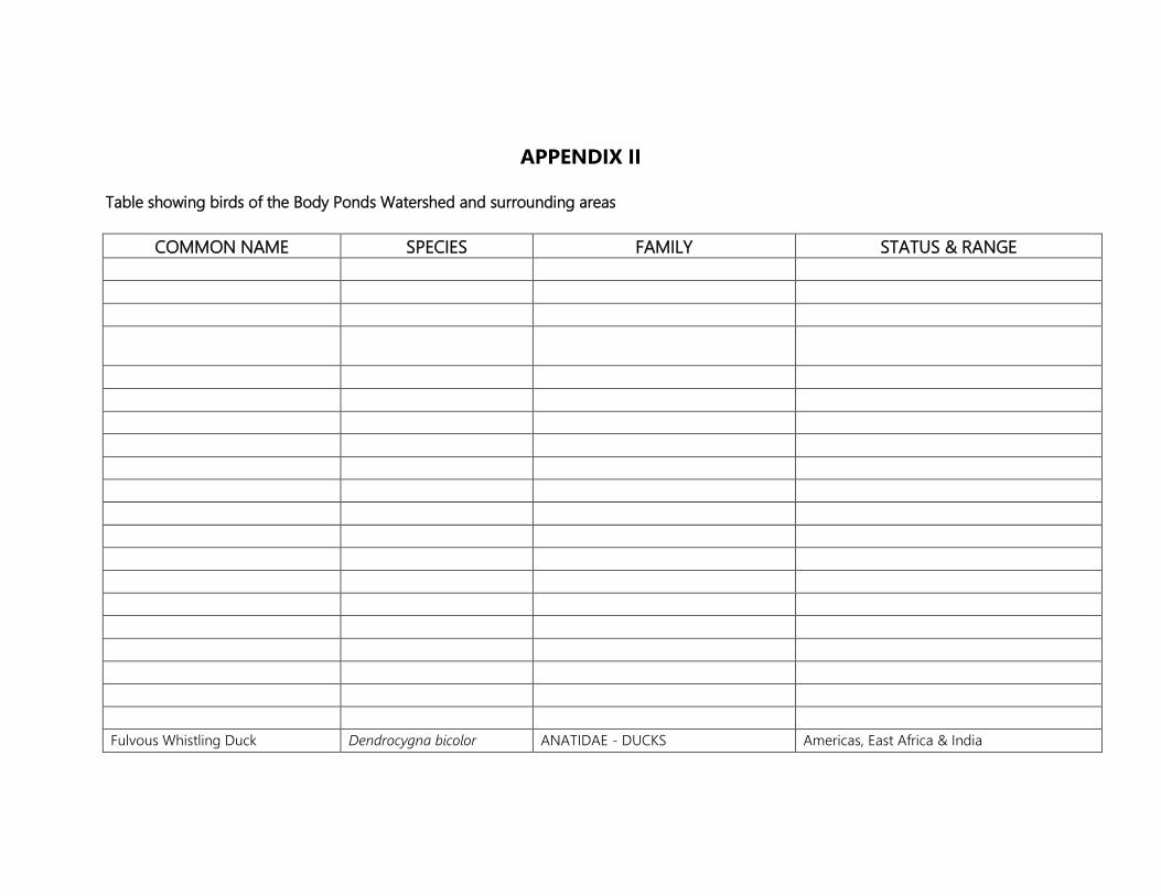
APPENDIX II Table showing birds of the Body Ponds Watershed and surrounding areas
COMMON NAME SPECIES FAMILY STATUS & RANGE
Fulvous Whistling Duck Dendrocygna bicolor ANATIDAE - DUCKS Americas, East Africa & India

West Indian Whistling Duck Dendrocygna arborea West Indian endemic Green-winged Teal ? Anas crecca Northern Hemisphere Blue-winged Teal ? Anas discors NA, CA and WI White-cheeked Pintail Anas bahamensis Americas, Lc Osprey Pandion haliaetus PANDIONIDAE - OSPREYS Worldwide, Rare Broad-winged Hawk Buteo platypterus insulicola ACCIPITRIDAE – HAWKS Endemic subspecies American Kestrel Falco sparverius FALCONIDAE - FALCONS Americas, Lc Merlin Falco columbarius America, Eurasia, Rare Peregrine Falcon Falco peregrinus Worldwide, Rare Sora Porzana carolina RALLIDAE - COOTS & GALLINULES Americas, very Rare Clapper Rail Rallus longirostris Americas, UnC to Rare Common Gallinule Gallinula chloropus Americas, Lc Greater Flamingo Phoenicopterus ruber Western Hemisphere, extinct on Antigua and
Barbuda Semipalmated Plover Charadrius semipalmatus CHARADRIIDAE - PLOVERS Western Hemisphere, Lc Wilson's Plover Charadrius wilsonia Western Hemisphere, breeds, UnC Snowy Plover Charadrius alexandrinus Worldwide, UnC Killdeer Charadrius vociferus Worldwide, UnC to Rare Black-bellied Plover Pluvialis dominicus North & South America, Rare American Oystercatcher Haemantopus palliatus HAEMATOPODIDAE-
OYSTERCATCHERS Americas, resident, breeds? Rare
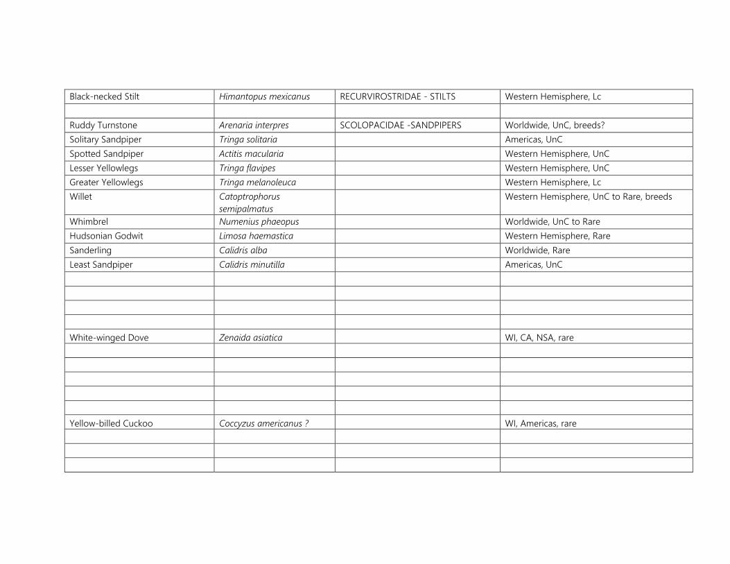
Black-necked Stilt Himantopus mexicanus RECURVIROSTRIDAE - STILTS Western Hemisphere, Lc Ruddy Turnstone Arenaria interpres SCOLOPACIDAE -SANDPIPERS Worldwide, UnC, breeds? Solitary Sandpiper Tringa solitaria Americas, UnC Spotted Sandpiper Actitis macularia Western Hemisphere, UnC Lesser Yellowlegs Tringa flavipes Western Hemisphere, UnC Greater Yellowlegs Tringa melanoleuca Western Hemisphere, Lc Willet Catoptrophorus
semipalmatus Western Hemisphere, UnC to Rare, breeds
Whimbrel Numenius phaeopus Worldwide, UnC to Rare Hudsonian Godwit Limosa haemastica Western Hemisphere, Rare Sanderling Calidris alba Worldwide, Rare Least Sandpiper Calidris minutilla Americas, UnC
White-winged Dove Zenaida asiatica WI, CA, NSA, rare
Yellow-billed Cuckoo Coccyzus americanus ? WI, Americas, rare
Antillean Crested Hummingbird Orthorhyncus cristatus LA, Comm
Caribbean Martin Progne dominicensis HIRUNDINIDAE - SWALLOWS WI, UnC
Worm-eating Warbler Helmitheros vermivorus Americas, Rare
Acronyns: Comm=Common; Decl=Declining; LA=Lesser Antilles; Lc=Least Common; NSA=Northern South America; UnC=Uncommon, WI=West Indian

APPENDIX III Plant species of the proposed the Body Ponds Watershed and adjacent areas.
GENUS
SPECIES EPITHET FAMILY COMMON NAME GROWTH HABIT
ORIGIN
Justicia eustachiana ACANTHACEAE S N
Thunbergia alata ACANTHACEAE Black-eyed Susan V I
Avicennia germinans ACANTHACEAE Black mangrove T N Avicennia schaueriana ACANTHACEAE Black mangrove T N
Annona glabra ANNONACEAE T N
Thevetia peruviana APOCYNACEAE Lucky nut T N Plumeria alba APOCYNACEAE Frangipani T N
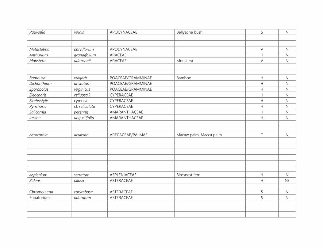
Rauvolfia viridis APOCYNACEAE Bellyache bush S N
Metastelma parviflorum APOCYNACEAE V N Anthurium grandifolium ARACEAE H N Monstera adansonii ARACEAE Monstera V N
Bambusa vulgaris POACEAE/GRAMMINAE Bamboo H N Dichanthium aristatum POACEAE/GRAMMINAE H N Sporobolus virginicus POACEAE/GRAMMINAE H N Eleocharis celluosa ? CYPERACEAE H N Fimbristylis cymosa CYPERACEAE H N Rynchosia cf. reticulata CYPERACEAE H N Salicornia perennis AMARANTHACEAE H N Iresine angustifolia AMARANTHACEAE H N
Acrocomia aculeata ARECACEAE/PALMAE Macaw palm, Macca palm T N
Asplenium serratum ASPLENIACEAE Birdsnest fern H N Bidens pilosa ASTERACEAE H N?
Chromolaena corymbosa ASTERACEAE S N Eupatorium odoratum ASTERACEAE S N

Pluchea odorata ASTERACEAE S/H N
Wedelia fruticosa ASTERACEAE Shrub wedelia S N
Sphagneticola trilobata ASTERACEAE Creeping oxeye H N Sesuvium portulacastrum AIZOACEAE H N Trianthema portulacastrium AIZOACEAE H N Batis maritima BATACEAE H N
Tecoma stans BIGNONIACEAE Golden seal S N
Acrostichum sp. PTERIDOIDEAE H N
Rochefortia sp. BORAGINACEAE S N Tournefortia cf. microphylla BORAGINACEAE V N Tournefortia volubilis BORAGINACEAE V N
Tillandsia recurvata BROMELIACEAE Old man’s beard H N Tillandsia usneiodes BROMELIACEAE Spanish moss, Old man’s beard H N
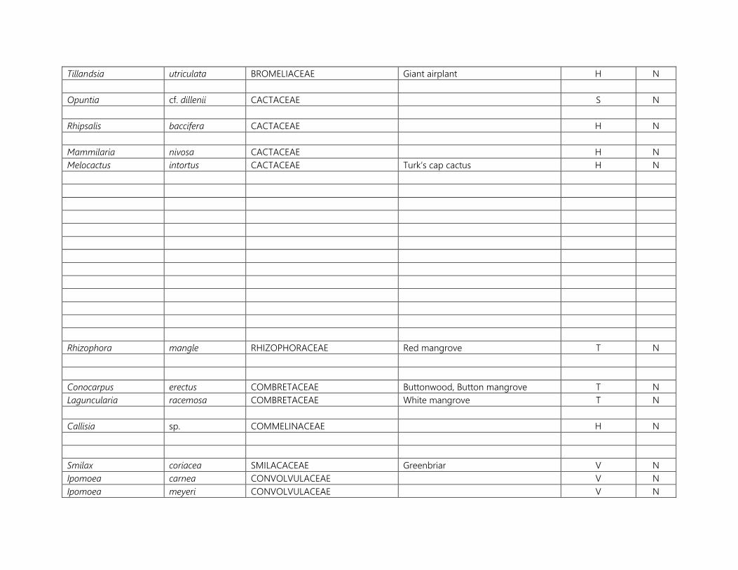
Tillandsia utriculata BROMELIACEAE Giant airplant H N
Opuntia cf. dillenii CACTACEAE S N
Rhipsalis baccifera CACTACEAE H N
Mammilaria nivosa CACTACEAE H N Melocactus intortus CACTACEAE Turk’s cap cactus H N
Rhizophora mangle RHIZOPHORACEAE Red mangrove T N
Conocarpus erectus COMBRETACEAE Buttonwood, Button mangrove T N Laguncularia racemosa COMBRETACEAE White mangrove T N
Callisia sp. COMMELINACEAE H N
Smilax coriacea SMILACACEAE Greenbriar V N Ipomoea carnea CONVOLVULACEAE V N Ipomoea meyeri CONVOLVULACEAE V N

Ipomoea obscura CONVOLVULACEAE V N Ipomoea tiliacea CONVOLVULACEAE V N Ipomoea tricolor CONVOLVULACEAE V N Ipomoea triloba CONVOLVULACEAE V N
Ipomoea sp. CONVOLVULACEAE V N
Jacquemontia solanifolia CONVOLVULACEAE V N Merremia aegyptia CONVOLVULACEAE V N Merremia dissecta CONVOLVULACEAE V N
Dioscorea alata DIOSCOREACEAE Water yam V I
Acalyphya cf. chamaedrifolia EUPHORBIACEAE H N
Margaritaria nobilis EUPHORBIACEAE S N Phyllanthus amarus EUPHORBIACEAE Seed under leaf H N? Phyllanthus epiphyllanthus EUPHORBIACEAE S N
Chamaesyce hirta EUPHORBIACEAE H N
Croton lobatus EUPHORBIACEAE H N Euphorbia cyantophora EUPHORBIACEAE H N

Pedilanthus tithymaloides EUPHORBIACEAE Slipper plant, bleeding heart S N Hura crepitans EUPHORBIACEAE Sandbox T N Jatropha gossypifolia EUPHORBIACEAE S N
Enicostema verticillatum GENTIANACEAE H N
Leonorus sibiricus LAMIACEAE Motherwort H I Leucas martinicensis LAMIACEAE H I
Cassytha filiformis LAURACEAE Love vine V N
Ocotea leucoxylon LAURACEAE Loblolly sweetwood T N Ocotea patens LAURACEAE Capberry T N Argemone mexicana PAPAVERACEAE Mexican poppy H I
Caesalpinia coriaria LEGUMINOSAE-CAESALPINIOIDEAE
Divi divi T N
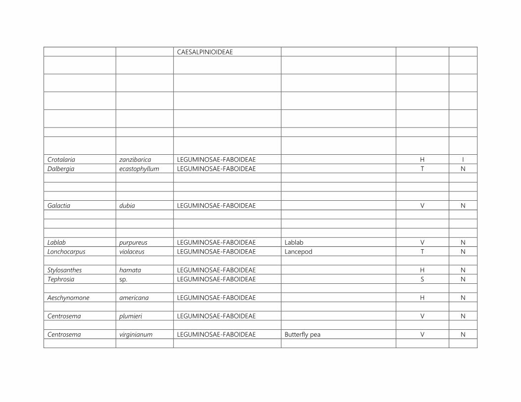
CAESALPINIOIDEAE
Crotalaria zanzibarica LEGUMINOSAE-FABOIDEAE H I Dalbergia ecastophyllum LEGUMINOSAE-FABOIDEAE T N
Galactia dubia LEGUMINOSAE-FABOIDEAE V N
Lablab purpureus LEGUMINOSAE-FABOIDEAE Lablab V N Lonchocarpus violaceus LEGUMINOSAE-FABOIDEAE Lancepod T N
Stylosanthes hamata LEGUMINOSAE-FABOIDEAE H N Tephrosia sp. LEGUMINOSAE-FABOIDEAE S N
Aeschynomone americana LEGUMINOSAE-FABOIDEAE H N
Centrosema plumieri LEGUMINOSAE-FABOIDEAE V N
Centrosema virginianum LEGUMINOSAE-FABOIDEAE Butterfly pea V N
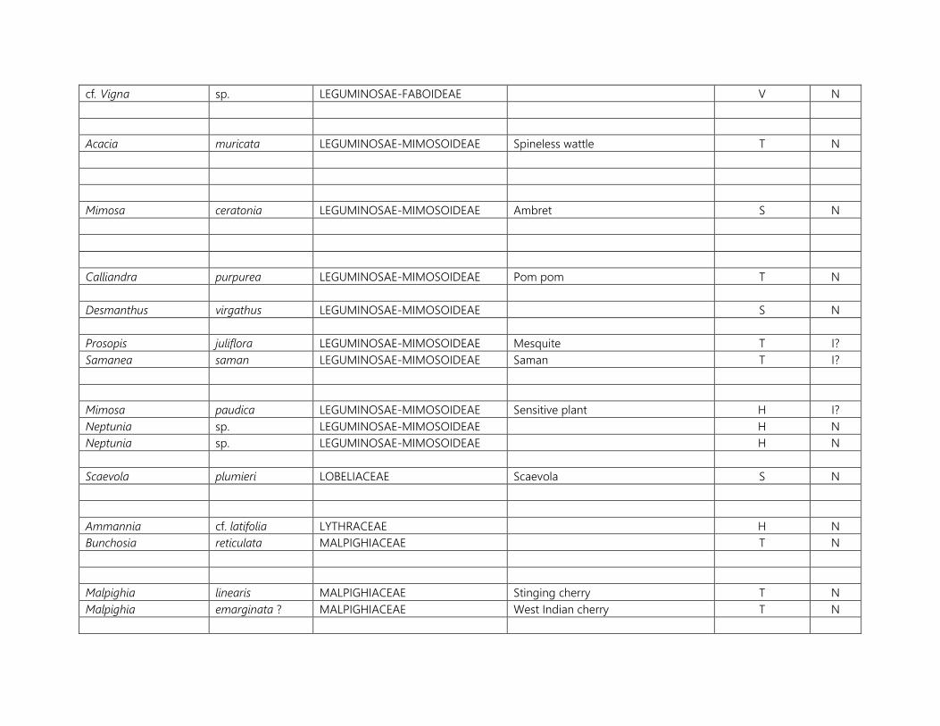
cf. Vigna sp. LEGUMINOSAE-FABOIDEAE V N
Acacia muricata LEGUMINOSAE-MIMOSOIDEAE Spineless wattle T N
Mimosa ceratonia LEGUMINOSAE-MIMOSOIDEAE Ambret S N
Calliandra purpurea LEGUMINOSAE-MIMOSOIDEAE Pom pom T N
Desmanthus virgathus LEGUMINOSAE-MIMOSOIDEAE S N
Prosopis juliflora LEGUMINOSAE-MIMOSOIDEAE Mesquite T I? Samanea saman LEGUMINOSAE-MIMOSOIDEAE Saman T I?
Mimosa paudica LEGUMINOSAE-MIMOSOIDEAE Sensitive plant H I? Neptunia sp. LEGUMINOSAE-MIMOSOIDEAE H N Neptunia sp. LEGUMINOSAE-MIMOSOIDEAE H N
Scaevola plumieri LOBELIACEAE Scaevola S N
Ammannia cf. latifolia LYTHRACEAE H N Bunchosia reticulata MALPIGHIACEAE T N
Malpighia linearis MALPIGHIACEAE Stinging cherry T N Malpighia emarginata ? MALPIGHIACEAE West Indian cherry T N

Stigmaphyllon emarginatum MALPIGHIACEAE V N Abutilon guineense MALVACEAE S I Abutilon indicum MALVACEAE S I Corchorus hirsutus MALVACEAE H N
Malvastrum americanum MALVACEAE S N
Sida glabra MALVACEAE S N Sida urens MALVACEAE S N Sidastrum multiflorum MALVACEAE S N Urena lobata MALVACEAE S N
Melochia nodiflora MALVACEAE S N
Sterculia caribaea MALVACEAE Hazel sterculia T I? broma cacao MALVACEAE Cocoa T N
Miconia impetiolaris MELASTOMATACEAE S N
Miconia sp. MELASTOMATACEAE S N Tetrazygia angustifolia MELASTOMATACEAE T N
Malpighia emarginatum MALPIGHIACEAE West Indian Cherry T N
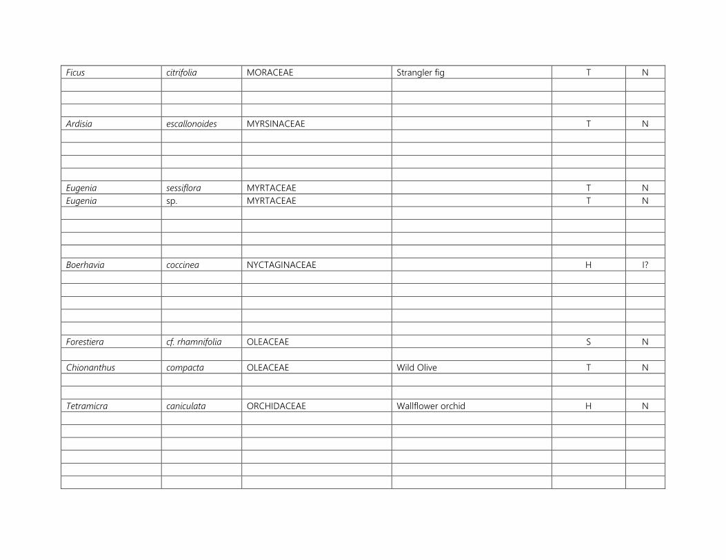
Ficus citrifolia MORACEAE Strangler fig T N
Ardisia escallonoides MYRSINACEAE T N
Eugenia sessiflora MYRTACEAE T N Eugenia sp. MYRTACEAE T N
Boerhavia coccinea NYCTAGINACEAE H I?
Forestiera cf. rhamnifolia OLEACEAE S N
Chionanthus compacta OLEACEAE Wild Olive T N
Tetramicra caniculata ORCHIDACEAE Wallflower orchid H N

Passiflora suberosa PASSIFLORACEAE Passion flower V N
Lasiacis sp. POACEAE/GRAMINIAE Bamboo grass H N
Coccoloba uvifera POLYGONACEAE Sea grape T N
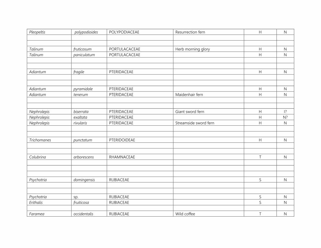
Pleopeltis polypodioides POLYPODIACEAE Resurrection fern H N
Talinum fruticosum PORTULACACEAE Herb morning glory H N Talinum paniculatum PORTULACACEAE H N
Adiantum fragile PTERIDACEAE H N
Adiantum pyramidale PTERIDACEAE H N Adiantum tenerum PTERIDACEAE Maidenhair fern H N
Nephrolepis biserrata PTERIDACEAE Giant sword fern H I? Nephrolepis exaltata PTERIDACEAE H N? Nephrolepis rivularis PTERIDACEAE Streamside sword fern H N
Trichomanes punctatum PTERIDOIDEAE H N
Colubrina arborescens RHAMNACEAE T N
Psychotria domingensis RUBIACEAE S N
Psychotria sp. RUBIACEAE S N Erithalis fruiticosa RUBIACEAE S N
Faramea occidentalis RUBIACEAE Wild coffee T N

Guettarda odorata RUBIACEAE Gunrod T N
Randia formosa RUBIACEAE S I
Citrus limon RUTACEAE Lemon T I Citrus reticulata RUTACEAE Tangerine T I Triphasia trifolia RUTACEAE Myrtle lime S I
Zanthoxylum punctatum RUTACEAE S N
Cardiospermum halicacabum ? SAPINDACEAE V N Cardiospermum microcarpum SAPINDACEAE V N
Dodonaea viscosa SAPINDACEAE Torchwood, Hop bush S N
Sideroxylon sp. SAPOTACEAE T N

Castela erecta SIMAROUBACEAE Goat bush S N
Brunfelsia americana SOLANACEAE Lady of the night S N
Capsicum chinense SOLANACEAE Bird pepper S N
Physalis angulata SOLANACEAE H N Physalis pubescens SOLANACEAE H N
Tectaria heracleifolia TECTARIACEAE Broad halberd fern H N
Thelypteris dentata THELYPTERIDACEAE Downy maiden fern H I
Thelypteris tetragona THELYPTERIDACEAE Freetip maiden fern H N Ludwigia octovalis ONAGRACEAE H N
Jacquinia berterii PHRASTACEAE T N
Laportea aestuans URTICACEAE Man stinging nettle H N
Pilea sp. URTICACEAE H N Artocarpus altilis MORACEAE Breadfruit T I Petrea kahoutiana VERBENACEAE Petrea V N
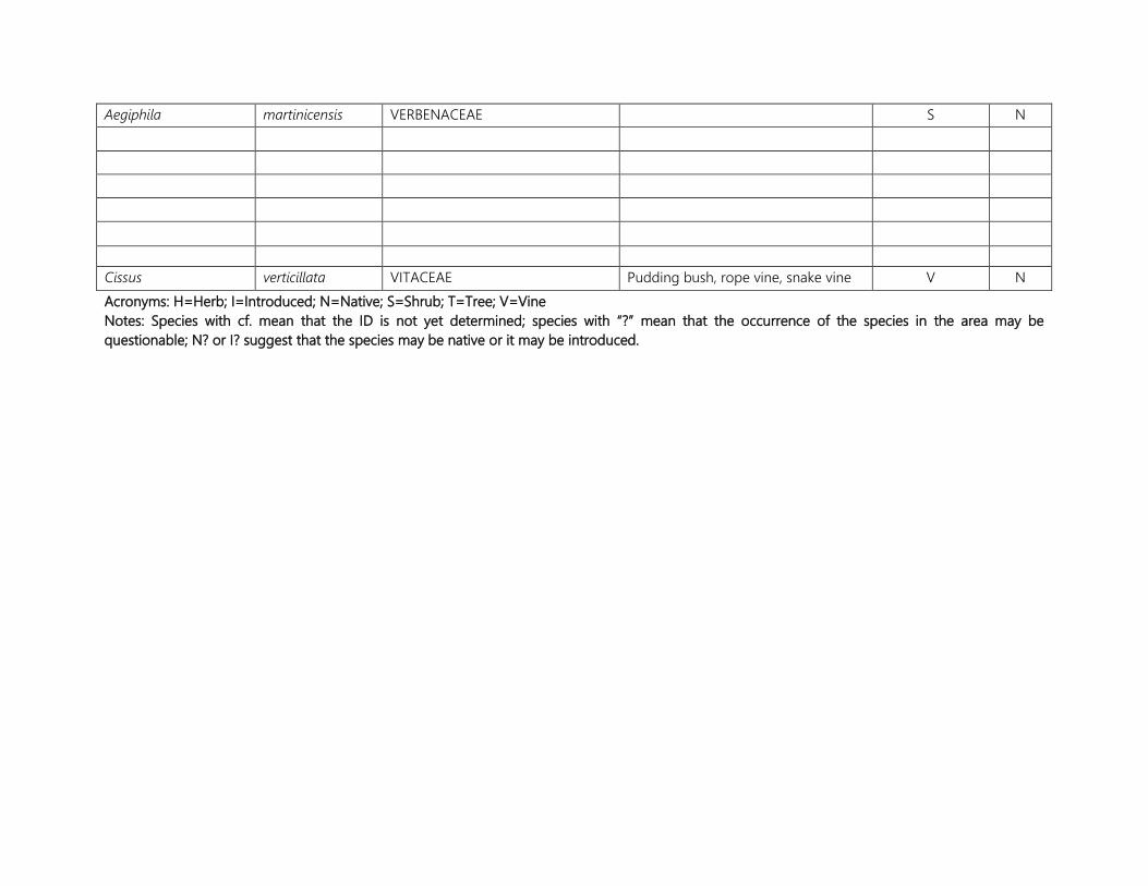
Aegiphila martinicensis VERBENACEAE S N
Cissus verticillata VITACEAE Pudding bush, rope vine, snake vine V N Acronyms: H=Herb; I=Introduced; N=Native; S=Shrub; T=Tree; V=Vine Notes: Species with cf. mean that the ID is not yet determined; species with “?” mean that the occurrence of the species in the area may be questionable; N? or I? suggest that the species may be native or it may be introduced.
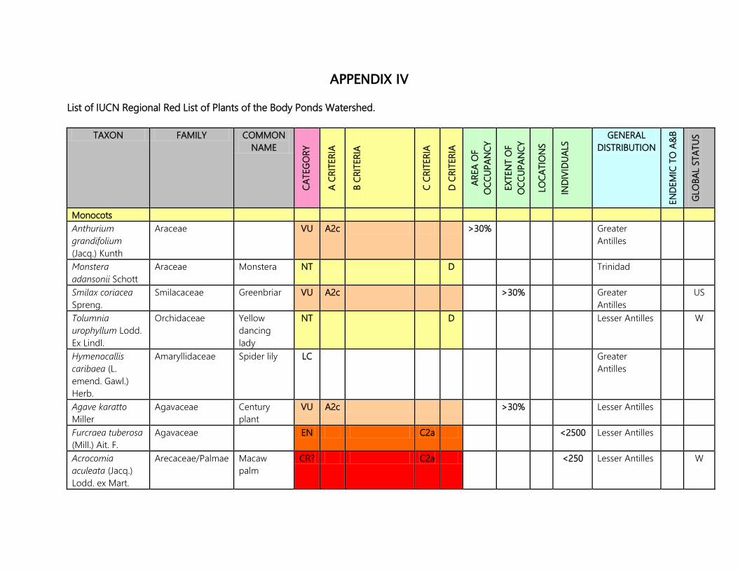
APPENDIX IV List of IUCN Regional Red List of Plants of the Body Ponds Watershed.
TAXON FAMILY COMMON NAME
CATE
GORY
A CR
ITER
IA
B CR
ITER
IA
C CR
ITER
IA
D CR
ITER
IA
AREA
OF
OCC
UPAN
CY
EXTE
NT
OF
OCC
UPAN
CY
LOCA
TIO
NS
INDI
VIDU
ALS
GENERAL DISTRIBUTION
ENDE
MIC
TO
A&
B
GLO
BAL
STAT
US
Monocots Anthurium grandifolium (Jacq.) Kunth
Araceae VU A2c >30% Greater Antilles
Monstera adansonii Schott
Araceae Monstera NT D Trinidad
Smilax coriacea Spreng.
Smilacaceae Greenbriar VU A2c >30% Greater Antilles
US
Tolumnia urophyllum Lodd. Ex Lindl.
Orchidaceae Yellow dancing lady
NT D Lesser Antilles W
Hymenocallis caribaea (L. emend. Gawl.) Herb.
Amaryllidaceae Spider lily LC Greater Antilles
Agave karatto Miller
Agavaceae Century plant
VU A2c >30% Lesser Antilles
Furcraea tuberosa (Mill.) Ait. F.
Agavaceae EN C2a <2500 Lesser Antilles
Acrocomia aculeata (Jacq.) Lodd. ex Mart.
Arecaceae/Palmae Macaw palm
CR? C2a <250 Lesser Antilles W
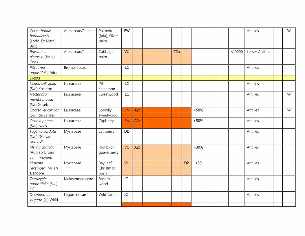
Coccothrinax barbadensis (Lodd. Ex Mart.) Becc.
Arecaceae/Palmae Palmetto (Bda), Silver palm
EW Antilles W
Roystonea oleracea (Jacq.) Cook
Arecaceae/Palmae Cabbage palm
VU C2a <10000 Lesser Antilles
Pitcairnia angustifolia Aiton
Bromeliaceae LC Antilles
Dicots Licaria salicifolia (Sw.) Kosterm.
Lauraceae PR cinnamon
LC Antilles
Nectandra membranacea (Sw) Griseb.
Lauraceae Sweetwood LC Antilles W
Ocotea leucoxylon (Sw.) de Laness
Lauraceae Loblolly sweetwood
EN A2c >50% Antilles W
Ocotea patens (Sw.) Nees
Lauraceae Capberry EN A2c >50% Antilles
Eugenia cordata (Sw.) DC. var. sintensii
Myrtaceae Lathberry DD Antilles
Myrcia citrifolia (Aublet) Urban var. imrayana
Myrtaceae Red birch, guava berry
VU A2c >30% Antilles
Pimenta racemosa (Miller) J. Moore
Myrtaceae Bay leaf, Christmas bush
VU D2 <20 Antilles
Tetrazygia angustifolia (Sw.) DC.
Melastomataceae Broom wood
LC Antilles
Desmanthus virgatus (L.) Willd.
Leguminosae Wild Tantan LC Antilles
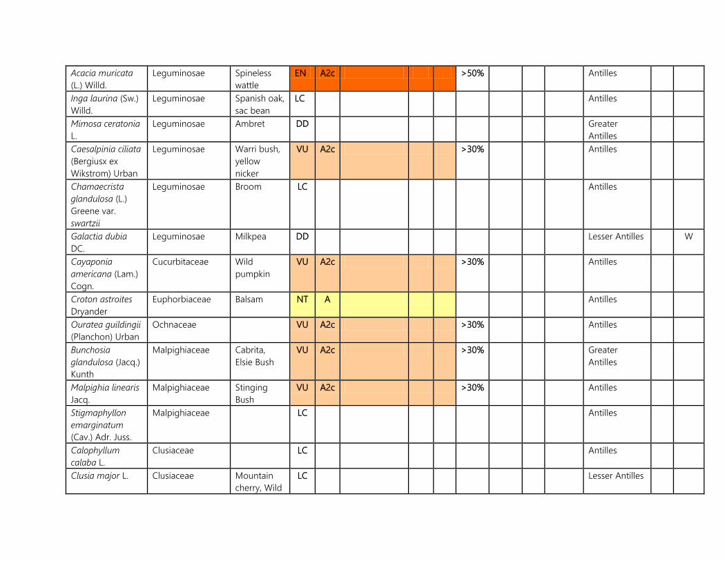
Acacia muricata (L.) Willd.
Leguminosae Spineless wattle
EN A2c >50% Antilles
Inga laurina (Sw.) Willd.
Leguminosae Spanish oak, sac bean
LC Antilles
Mimosa ceratonia L.
Leguminosae Ambret DD Greater Antilles
Caesalpinia ciliata (Bergiusx ex Wikstrom) Urban
Leguminosae Warri bush, yellow nicker
VU A2c >30% Antilles
Chamaecrista glandulosa (L.) Greene var. swartzii
Leguminosae Broom LC Antilles
Galactia dubia DC.
Leguminosae Milkpea DD Lesser Antilles W
Cayaponia americana (Lam.) Cogn.
Cucurbitaceae Wild pumpkin
VU A2c >30% Antilles
Croton astroites Dryander
Euphorbiaceae Balsam NT A Antilles
Ouratea guildingii (Planchon) Urban
Ochnaceae VU A2c >30% Antilles
Bunchosia glandulosa (Jacq.) Kunth
Malpighiaceae Cabrita, Elsie Bush
VU A2c >30% Greater Antilles
Malpighia linearis Jacq.
Malpighiaceae Stinging Bush
VU A2c >30% Antilles
Stigmaphyllon emarginatum (Cav.) Adr. Juss.
Malpighiaceae LC Antilles
Calophyllum calaba L.
Clusiaceae LC Antilles
Clusia major L. Clusiaceae Mountain cherry, Wild
LC Lesser Antilles
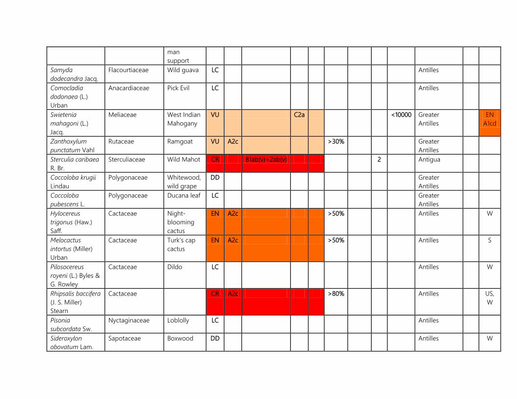
man support
Samyda dodecandra Jacq.
Flacourtiaceae Wild guava LC Antilles
Comocladia dodonaea (L.) Urban
Anacardiaceae Pick Evil LC Antilles
Swietenia mahagoni (L.) Jacq.
Meliaceae West Indian Mahogany
VU C2a <10000 Greater Antilles
EN A1cd
Zanthoxylum punctatum Vahl
Rutaceae Ramgoat VU A2c >30% Greater Antilles
Sterculia caribaea R. Br.
Sterculiaceae Wild Mahot CR B1ab(v)+2ab(v) 2 Antigua
Coccoloba krugii Lindau
Polygonaceae Whitewood, wild grape
DD Greater Antilles
Coccoloba pubescens L.
Polygonaceae Ducana leaf LC Greater Antilles
Hylocereus trigonus (Haw.) Saff.
Cactaceae Night-blooming cactus
EN A2c >50% Antilles W
Melocactus intortus (Miller) Urban
Cactaceae Turk's cap cactus
EN A2c >50% Antilles S
Pilosocereus royeni (L.) Byles & G. Rowley
Cactaceae Dildo LC Antilles W
Rhipsalis baccifera (J. S. Miller) Stearn
Cactaceae CR A2c >80% Antilles US, W
Pisonia subcordata Sw.
Nyctaginaceae Loblolly LC Antilles
Sideroxylon obovatum Lam.
Sapotaceae Boxwood DD Antilles W

Jacquinia berterii Sprengel
Theophrastaceae RE? Antilles W
Ardisia obovata Ham.
Myrsinaceae VU A2c >30% Antilles
Psychotria domingensis Jacq.
Rubiaceae LC Greater Antilles
Metastelma parviflorum (Sw.) R. Br. Ex J. A. Schultes
Apocynaceae LC Antilles
Tabernaemontana citrifolia L.
Apocynaceae Milky Bush CR A2c >80% Antilles VU D1+2
Thevetia peruviana (Persoon) Schumann
Apocynaceae Lucky nut DD Greater Antilles
Cordia nesophila I. M. Johnston
Boraginaceae Black sage DD Lesser Antilles W
Cordia reticulata M. Vahl
Boraginaceae DD Lesser Antilles
Cordia sulcata DC.
Boraginaceae Manjack LC Greater Antilles
Tournefortia microphylla Berteroex Sprengel
Boraginaceae LC Antilles
Ipomoea repanda Jacq.
Convolvulaceae DD Antilles
Jacquemontia solanifolia (L.) H. Hallier
Convolvulaceae DD Antilles
Brunfelsia americana L.
Solanaceae Lady of the night
EN? A2c >50% Greater Antilles
Cestrum Solanaceae Candlewood DD Greater
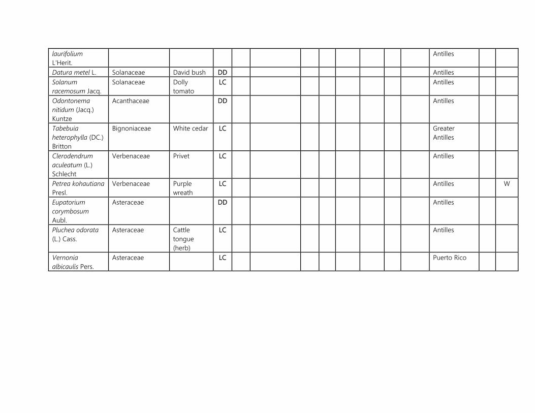
laurifolium L'Herit.
Antilles
Datura metel L. Solanaceae David bush DD Antilles Solanum racemosum Jacq.
Solanaceae Dolly tomato
LC Antilles
Odontonema nitidum (Jacq.) Kuntze
Acanthaceae DD Antilles
Tabebuia heterophylla (DC.) Britton
Bignoniaceae White cedar LC Greater Antilles
Clerodendrum aculeatum (L.) Schlecht
Verbenaceae Privet LC Antilles
Petrea kohautiana Presl.
Verbenaceae Purple wreath
LC Antilles W
Eupatorium corymbosum Aubl.
Asteraceae DD Antilles
Pluchea odorata (L.) Cass.
Asteraceae Cattle tongue (herb)
LC Antilles
Vernonia albicaulis Pers.
Asteraceae LC Puerto Rico

APPENDIX V
Historic estates within the BPW and adjacent areas The map referred to in the table can be found in the book, Plantations of Antigua by Agnes Meeker, 2007. Many of these names may not seem familiar since over the years, the estates and/or parcels changed ownership (purchased outright, rented or bequeathed to others) and some property and area names may have also changed as a result.
HISTORIC MAP CODE NO.
ESTATE NAME LOCATION
16 Otto’s Southeast of St. John’s on the north western boundary of the BPW.
17 Tomlinson’s About a 1.6 km (1 mile) southeast of what is today St. Johnston’s Village.
18 Drew’s Hill Southwest of Potters Village.
19 Belmont/Murrays Immediately south of Drew’s Hill Estate.
20 Herberts Near Belmont, southwest of Potters Bluff.
21 Renfrew’s Just north of Bellevue Heights.
22 Briggins Just east of Golden Grove.
23 Golden Grove At Golden Grove.
24 Grays/Thurnbull Southwest of what is currently Grays Hill.
25 Denfield’s About a kilometer (0.7 miles) northwest of Denfield’s, near The Flashes.

26 Cook’s Near the current location of the Cooks Dump.
27 The Union Just west of Side Hill near Ballast Bay.
28 Creekside Just southeast of Golden Grove.
31 Five Islands On what is today Sutherlands, located west of The Flashes and north of Hansons Bay.
33 The Folly (Bath Lodge)
Just west of Bellevue Heights.
35 St. Clare/Williams Just southwest of the junction of All Saints and Buckleys junction.
36 Belle Vue/Stoney Hill At Stoney Hill near the Baobab tree, nearly a km (0.7 miles) west of Freeman’s Village.
37 Bendalls Just east of the village of Bendals.
38 Belvidere Less than 0.8 km 90.5 miles) south of Bendals.
39 George Byam’s At Byam’s Hill, near the Body Ponds.
40 Brecknock’s South of Byam’s Hill near Brecknock’s No. 1 Dam.
41 Body Ponds Southeast of the Body Ponds.
45 Buckley’s Near Martin Hill just north of Buckleys.
46 Oliver’s Northeast of Buckleys Village near Martin Hill.
47 Potter’s West of Potters Village
48 Allen’s (McNish) Southwest of McNish Mountain.

132 Just west of the area of Matthews.
145 Just east of Follys (south of Swetes).
147 Richmond’s Near the Richmond area near Mount William.
151 Swetes Immediately northwest of Swetes Village.
160 Seaforth’s At The Flashes area.
161 Smith’s At the Robert Hall’s Estate near big Creek Bridge.
162 Rigby’s East of the Robert Hall’s Estate.
163 Greencastle North of the community of Emanuel.
165 New Division At New Division, Hansons Bay.
166 Hermitage At Hermitage.
176 Mill Hill Near John Hughes.
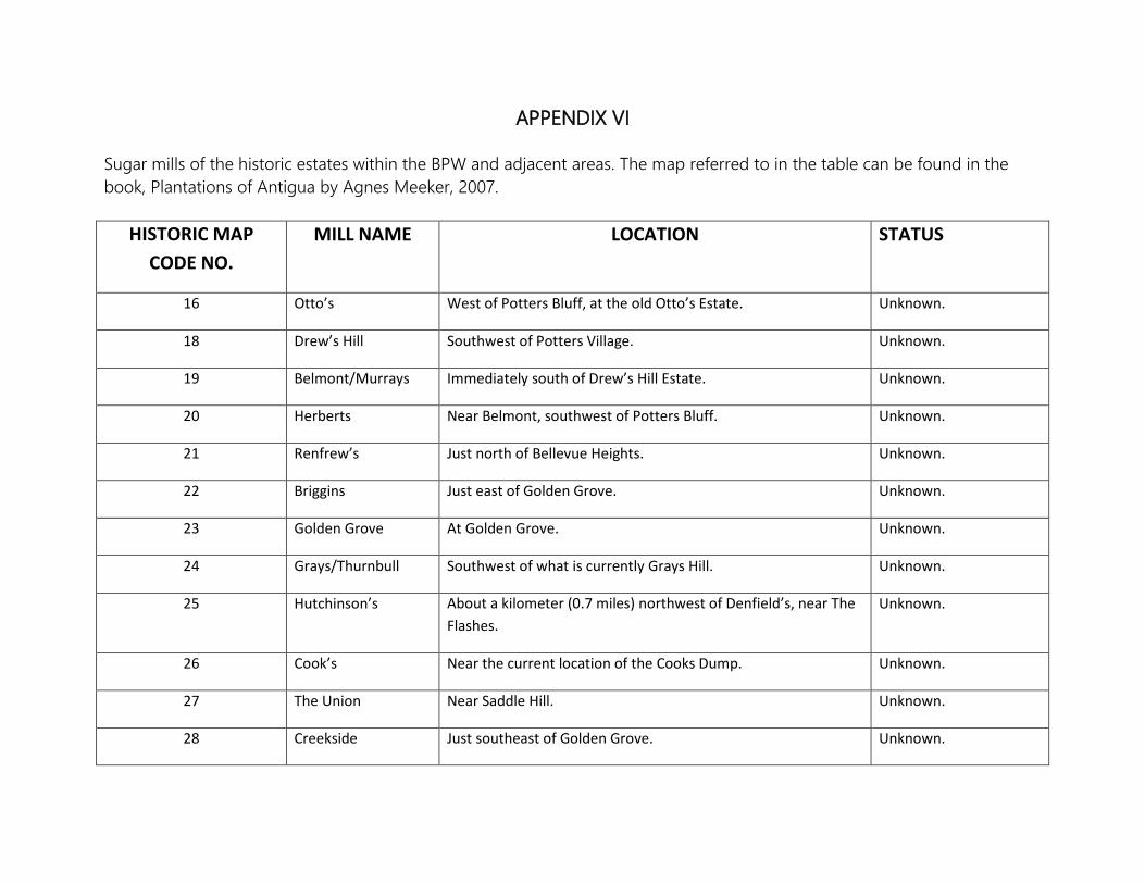
APPENDIX VI Sugar mills of the historic estates within the BPW and adjacent areas. The map referred to in the table can be found in the book, Plantations of Antigua by Agnes Meeker, 2007.
HISTORIC MAP CODE NO.
MILL NAME LOCATION STATUS
16 Otto’s West of Potters Bluff, at the old Otto’s Estate. Unknown.
18 Drew’s Hill Southwest of Potters Village. Unknown.
19 Belmont/Murrays Immediately south of Drew’s Hill Estate. Unknown.
20 Herberts Near Belmont, southwest of Potters Bluff. Unknown.
21 Renfrew’s Just north of Bellevue Heights. Unknown.
22 Briggins Just east of Golden Grove. Unknown.
23 Golden Grove At Golden Grove. Unknown.
24 Grays/Thurnbull Southwest of what is currently Grays Hill. Unknown.
25 Hutchinson’s About a kilometer (0.7 miles) northwest of Denfield’s, near The Flashes.
Unknown.
26 Cook’s Near the current location of the Cooks Dump. Unknown.
27 The Union Near Saddle Hill. Unknown.
28 Creekside Just southeast of Golden Grove. Unknown.
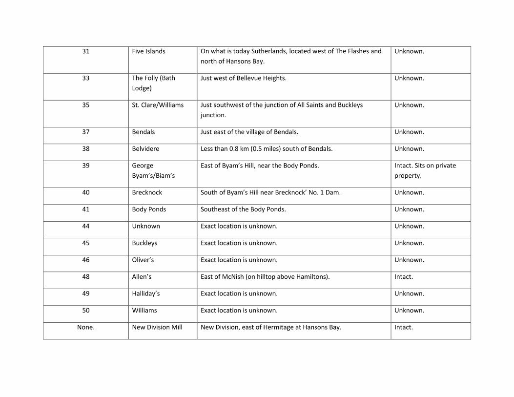
31 Five Islands On what is today Sutherlands, located west of The Flashes and north of Hansons Bay.
Unknown.
33 The Folly (Bath Lodge)
Just west of Bellevue Heights. Unknown.
35 St. Clare/Williams Just southwest of the junction of All Saints and Buckleys junction.
Unknown.
37 Bendals Just east of the village of Bendals. Unknown.
38 Belvidere Less than 0.8 km (0.5 miles) south of Bendals. Unknown.
39 George Byam’s/Biam’s
East of Byam’s Hill, near the Body Ponds. Intact. Sits on private property.
40 Brecknock South of Byam’s Hill near Brecknock’ No. 1 Dam. Unknown.
41 Body Ponds Southeast of the Body Ponds. Unknown.
44 Unknown Exact location is unknown. Unknown.
45 Buckleys Exact location is unknown. Unknown.
46 Oliver’s Exact location is unknown. Unknown.
48 Allen’s East of McNish (on hilltop above Hamiltons). Intact.
49 Halliday’s Exact location is unknown. Unknown.
50 Williams Exact location is unknown. Unknown.
None. New Division Mill New Division, east of Hermitage at Hansons Bay. Intact.