ecological assessment and terrestrial vertebrate surveys for black
TRANSCRIPT
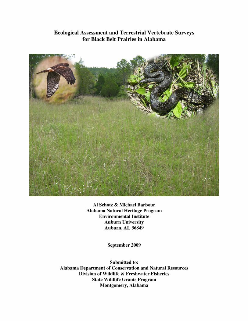
Ecological Assessment and Terrestrial Vertebrate Surveys for Black Belt Prairies in Alabama
Al Schotz & Michael Barbour Alabama Natural Heritage Program
Environmental Institute Auburn University Auburn, AL 36849
September 2009
Submitted to: Alabama Department of Conservation and Natural Resources
Division of Wildlife & Freshwater Fisheries State Wildlife Grants Program
Montgomery, Alabama
Ecological Assessment of Black Belt Prairies Page i
EXECUTIVE SUMMARY The Black Belt Prairie Region, or Black Belt, is a geologically and biologically distinct area among the physiographic regions of the Coastal Plain. The Black Belt is a crescent shaped area extending from southwestern Tennessee south through east-central Mississippi and east-southeastward through central Alabama to near the Georgia border. This region is characterized by weathered rolling plains of relatively low relief developed on chalk and marl of the Cretaceous Selma chalk. Historically, the natural communities of the Black Belt consisted of a mosaic of various hardwood and mixed hardwood/pine forests, chalk outcrops and prairies. Approximately 144,00 ha of prairie were reported in land surveys from the 1830s, with approximately 73,060 ha in Alabama. The prairies ranged in size from small to extensive and were found scattered among the forest communities throughout the landscape in the Black Belt, forming a distinct and important ecosystem in the Southeast. However, Black Belt prairies have been devastated by land use alterations. By the end of the twentieth century, only scattered remnants of the native Black Belt prairie remained as the grasslands were converted to agriculture or pasture or were lost to development. Until recently, the Black Belt prairies had received little conservation attention, despite the high degree of imperilment for prairie habitats. This study was undertaken to assess the current extent and ecological integrity of extant prairies. Prairie sites were identified using expert and local knowledge, aerial photographs, soil surveys, topographic maps, and other GIS data. Prairies were identified and digitized from a manual interpretation of 2006 color DOQQs, supplemented with 1990s DOQQs, SSURGO soil data, and aerial imagery available through Virtual Alabama. Prairies in close proximity to one another were grouped as a prairie site in reporting prairie locations. Field inspections were conducted to confirm the identification of prairie areas and evaluate and characterize the ecological integrity of the prairies. Surveys for terrestrial vertebrate species identified as species of Greatest Conservation Need in the State Wildlife Action Plan which utilized prairie habitat. Target species for the surveys were speckled kingsnake (Lampropeltis getula holbrooki), long-tailed weasel (Mustela frenata), Northern Harrier (Circus cyaneus), American Kestrel (Falco sparverius), and Short-eared Owl (Asio flammeus). Speckled kingsnake surveys were conducted using trap stations consisting of traps in conjunction with drift fence arrays. Traps were placed at Jones Bluff, Autauga County, and Old Bluffport, Sumter County, in 2007 and Cochrane Recreation Area in 2008. Surveys for long-tailed weasels were conducted at Elm Bluff Prairies and Old Cahawba Prairies in Dallas County, Old Bluffport Prairie Complex in Sumter County, and Cochrane Recreation Area in Pickens County. Avian surveys were conducted at the Cochrane Recreation, Pickens County; Elm Bluff, Old Cahawba Prairie Complex, and Tilden Prairies in Dallas County; Jones Bluff, Autauga County; and Old Bluffport Prairie Complex and University of West Alabama Prairie Restoration Site in Sumter County using line transects and area-search. We identified 14,595 individual prairies in 265 sites covering 6,276 ha (15,509 ac). The overwhelming majority of the extant prairies were small fragments; median prairie size was 0.14 ha (0.35 ac). Prairies were distributed throughout the Black Belt, with the largest concentrations located in Dallas, Lowndes, and Sumter counties. Sizable acreage also was present in Greene, Hale,
Ecological Assessment of Black Belt Prairies Page ii
Perry, and Wilcox counties. Prairies were much less abundant in the eastern third of the Black Belt in Montgomery, Macon, Bullock, and Russell counties than in the rest of the Black Belt. The condition of individual prairies ranged from high quality prairies to severely degraded, but the majority of the prairie habitat remaining in the Black Belt was of moderate or low quality. These areas exhibited degradation to varying degrees from erosion, infestation of native and exotic invasive species, woody encroachment, and past land use changes. County Number of Prairie Sites Number of Prairies Total Acreage Autauga 3 84 124.0 Bullock 4 38 11.5 Butler 2 664 132.5 Crenshaw 2 88 17.5 Dallas 31 1,506 807.0 Greene 16 773 388.9 Hale 24 616 375.0 Lowndes 60 4,543 1,060.1 Macon 5 75 32.1 Marengo 28 613 212.9 Montgomery 35 284 287.2 Perry 17 861 566.7 Pickens 5 77 89.0 Russell 1 107 2.5 Sumter 36 3,080 1,330.1 Wilcox 21 1,187 521.5
Ten Black Belt prairie sites were identified as special significance and are considered to be the highest conservation priority. This recognition was based on two criteria: ecological integrity and availability to restoration and long-term management. Examples characterized as having good to exceptional integrity were represented by several environmental attributes, including landscape context (mosaic of prairies and forests), diversity of native prairie taxa, and minimal incursion of exotic and native weedy (e.g., eastern red cedar) species. The selection criteria were also influenced by the availability of parcels for restoration efforts. The significant sites were the Jones Bluff-House Bluff Prairie Complex in Autauga County;. Elm Bluff Prairies, Old Cahawba Prairie Complex, and Tilden-Carlowville Prairie Complex in Dallas County; Pleasant Ridge in Greene County; Brags-Ridgeville Prairie Complex in Lowndes County; Cahaba River Prairies in Perry County; Cochrane Recreation Area in Pickens County; Old Bluffport in Sumter County; and Prairie Bluff in Wilcox County. The sites identified as high priority sites were the Braggville-Five Points Prairie Complex, Culpepper Creek Prairies, and West Greene-Mt. Hebron Prairie Complex in Greene County; Limestone Lakes Prairie Complex in Hale County; Calhoun-Logan Prairie Complex and Collirene-Beechwood Prairie Complex in Lowndes County; Big Swamp-Torbert Lake Prairie Complex in Macon and Russell counties; Uniontown-Faunsdale Prairie Complex in Perry County; Uniontown-Faunsdale Prairie Complex in Perry County; Belmont Prairie Complex, Epes Prairies, and the University of West Alabama Prairies in Sumter County; and Furman Prairie Complex in Wilcox County.
Ecological Assessment of Black Belt Prairies Page iii
The sites identified as moderate priority sites were the Belknap Prairie Complex and Harrell Prairie Complex in Dallas County; Macedonia Church Prairies in Greene County; the Mt Olive Baptist Church Prairies, Rosemary Prairies, State Cattle Ranch-Casemore Prairie Complex, and Wolf Bluff Prairie Complex in Hale County; the Letohatchee Prairie Complex, and Old Town SE-Collirene N Prairie Complex in Lowndes County; Dayton North Prairie Complex in Marengo County; the Doral Estates Prairies, McGehees Prairie Complex, and Pintlala Creek Prairies in Montgomery County; Emelle Prairie Complex and the Hamner Sumterville Prairie Complex in Sumter County; and Boykin Prairies and Union Church Prairies in Wilcox County. The remaining sites were a low conservation priority because they primarily contain small prairies, the total prairie acreage is low, most of the prairies in the site suffer from heavy woody encroachment, or the majority are heavily degraded by erosion or exotic infestation. Much of the prairies located in the Black Belt have been lost, with land use changes being the primary factor driving this loss. The remaining fragments continue to be lost and face threats from land use change, agricultural use, residential and commercial development, exotic and invasive species, woody encroachment, erosion, and climate change. Despite the challenges, management and restoration of Black Belt communities and species in a landscape context in Alabama appears feasible. This likely will require partnerships involving federal and state agencies, private conservation organizations, and private landowners. Success in conserving the Black Belt prairies will depend on our collective creativity and conviction.

Ecological Assessment of Black Belt Prairies Page iv
Ecological Assessment of Black Belt Prairies Page v
TABLE OF CONTENTS EXECUTIVE SUMMARY.............................................................................................................. i�LIST OF TABLES ........................................................................................................................ vii�LIST OF FIGURES ........................................................................................................................ ix�LIST OF APPENDICES ................................................................................................................ xi�INTRODUCTION........................................................................................................................... 1�
Historical Perspective and Biological Importance of Black Belt Prairies .................................. 1�OBJECTIVES ................................................................................................................................. 5�METHODS ..................................................................................................................................... 6�
Prairie Soils ................................................................................................................................. 6�Prairie Delineation ...................................................................................................................... 6�Speckled Kingsnake (Lampropeltis getula holbrooki) Survey ................................................... 7�Long-tailed Weasel (Mustela frenata) Survey ............................................................................ 8�Avian Surveys ............................................................................................................................. 8�
RESULTS AND DISCUSSION ................................................................................................... 13�Prairie Delineation .................................................................................................................... 13�
Significant Black Belt Prairies .............................................................................................. 18�Autauga County .................................................................................................................... 48�Bullock County ..................................................................................................................... 50�Butler County ........................................................................................................................ 50�Crenshaw County .................................................................................................................. 53�Dallas County ........................................................................................................................ 56�Greene County ...................................................................................................................... 59�Hale County .......................................................................................................................... 63�Lowndes County ................................................................................................................... 67�Macon and Russell County ................................................................................................... 73�Marengo County ................................................................................................................... 75�Montgomery County ............................................................................................................. 78�Perry County ......................................................................................................................... 81�Pickens County ..................................................................................................................... 84�Sumter County ...................................................................................................................... 87�Wilcox County ...................................................................................................................... 91�
Speckled Kingsnake (Lampropeltis getula holbrooki) Survey ................................................. 95�Long-tailed Weasel (Mustela frenata) Survey .......................................................................... 99�Avian Surveys ........................................................................................................................... 99�Potential Wildlife Viewing Areas ........................................................................................... 105�Threats ..................................................................................................................................... 105�
Land Use ............................................................................................................................. 105�Ecological Driving Forces .................................................................................................. 107�Exotic and Invasive Species ................................................................................................ 108�Erosion ................................................................................................................................ 111�Climate Change ................................................................................................................... 111�
CONSERVATION OF BLACK BELT PRAIRIES ................................................................... 112�Habitat Protection is Key ........................................................................................................ 113�

Ecological Assessment of Black Belt Prairies Page vi
Stewardship ............................................................................................................................. 113�Public Support is Essential ..................................................................................................... 114�
ACKNOWLEDGEMENTS ........................................................................................................ 114�LITERATURE CITED ............................................................................................................... 115�
Ecological Assessment of Black Belt Prairies Page vii
LIST OF TABLES Table 1. Species of conservation concern which utilize prairie habitat and would benefit from
prairie conservation actions. ........................................................................................... 5�Table 2. Acreage and proportionate extent by county for SSURGO soil map units containing
prairie soils as a major component in Alabama’s Black Belt. Prairie soils were considered to be those in the Binnsville, Demopolis, Sumter , or Trinity Series where the native vegetation was prairie grasses and eastern red cedar. Data not available for Lowndes County. ......................................................................................................... 14�
Table 3. Number of prairies and prairie sites; total prairie acreage; and maximum, mean, and median prairie size by county in Alabama’s Black Belt region. .................................. 15�
Table 4. Number of prairies, total prairie acreage; and maximum (max), mean, and median prairie size (ha) for Black Belt prairie sites in Autauga County, Alabama. ................. 48�
Table 5. Number of prairies, total prairie acreage; and maximum (max), mean, and median prairie size (ha) for Black Belt prairie sites in Bullock County, Alabama. .................. 50�
Table 6. Number of prairies, total prairie acreage; and maximum (max), median, and mean prairie size (ha) for Black Belt prairie sites in Crenshaw County, Alabama. .............. 54�
Table 7. Number of prairies, total prairie acreage; and maximum (max), mean, and median prairie size (ha) for prairie sites in Dallas County, Alabama. ...................................... 57�
Table 8. Number of prairies, total prairie acreage; and maximum (max), mean, and median prairie size (ha) for prairie sites in Greene County, Alabama. ..................................... 60�
Table 9. Number of prairies, total prairie acreage; and maximum (max), mean, and median prairie size (ha) for prairie sites in Hale County, Alabama. ......................................... 65�
Table 10. Number of prairies, total prairie acreage; and maximum (max), mean, and median prairie size (ha) for prairie sites in Lowndes County, Alabama. .................................. 68�
Table 11. Number of prairies, total prairie acreage; and maximum (max), mean, and median prairie size (ha) for prairie sites in Macon County, Alabama. ..................................... 73�
Table 12. Number of prairies, total prairie acreage; and maximum (max), mean, and median prairie size (ha) for prairie sites in Marengo County, Alabama. .................................. 76�
Table 13. Number of prairies, total prairie acreage; and maximum (max), mean, and median prairie size (ha) for prairie sites in Montgomery County, Alabama. ............................ 79�
Table 14. Number of prairies, total prairie acreage; and maximum (max), mean, and median prairie size (ha) for prairie sites in Perry County, Alabama. ........................................ 82�
Table 15. Number of prairies, total prairie acreage; and maximum (max), mean, and median prairie size (ha) for prairie sites in Pickens County, Alabama. .................................... 85�
Table 16. Number of prairies, total prairie acreage; and maximum (max), mean, and median prairie size (ha) for prairie sites in Sumter County, Alabama. ..................................... 88�
Table 17. Number of prairies, total prairie acreage; and maximum (max), mean, and median prairie size (ha) for prairie sites in Wilcox County, Alabama. .................................... 93�
Table 18. Species captured during trapping conducted in prairies at Old Bluffport (OB), Sumter County, and Jones Bluff (JB), Autauga County, in 2007 and Cochrane Recreation Area (CRA), Pickens County, in 2008. ................................................................................. 98�
Table 19. Species detected with track plates at Cochrane Recreation Area (CRA), Elm Bluff Prairies (EB), Old Bluffport Prairie Complex (OB), Old Cahawba Prairies (OC) February – June 2008. ................................................................................................ 100�
Ecological Assessment of Black Belt Prairies Page viii
Table 20. Avian species detected in Black Belt prairies at the Cochrane Recreation Area sub-site (CRA) of the Cochrane Prairie Complex in Pickens County; Elm Bluff sub-site (EB) of the Elm Bluff Prairie Complex, Old Cahawba Prairie Complex (OC), and Tilden sub-site (TC) of the Tilden-Carlowville Prairie Complex in Dallas County; Jones Bluff sub-site (JB) of the Jones Bluff-House Bluff Prairie Complex in Autauga County; and Old Bluffport Prairie Complex (OB) and University of West Alabama Prairie Restoration Site (UWA) in Sumter County. The names and order in which the species are presented follow AOU (1998) and Chesser et al. (2009). ........................ 103�
Table 21. Exotic species documented in the Black Belt prairies of Alabama. .......................... 110�Table 22. Native invasive species documented in the Black Belt prairies of Alabama. ............ 110�
Ecological Assessment of Black Belt Prairies Page ix
LIST OF FIGURES Figure 1. Historical locations of Black Belt prairies (Barone 2005) and location of the Black Belt
Level IV Ecoregion (Bailey 1980, United States Forest Service 2007) in Alabama, Mississippi, and Tennessee. ......................................................................................... 2�
Figure 2. Example of large box trap in the center of a drift fence array (A) and funnel traps at the distal end of drift fences (B) used in snake trapping. .................................................. 9�
Figure 3. Distribution of prairie sites in Alabama’s Black Belt trapped for speckled kingsnake (Lampropeltis getula holbrooki). ............................................................................... 10�
Figure 4. Track plate station used for sampling long-tailed weasels. .......................................... 11�Figure 5. Distribution of track plate survey sites in Alabama Black Belt prairies. ...................... 11�Figure 6. Distribution of avian sampling sites in Alabama’s Black Belt prairies. ....................... 12�Figure 7. Distribution of SSURGO soil map units with a prairie soil (Binnsville, Demopolis,
Sumter, Trinity Series) as a major component of the map unit. Spatial data was not available for Lowndes County. .................................................................................. 16�
Figure 8. Distribution of historical prairie locations (Barone 2005) and extant Black Belt prairies in Alabama. ................................................................................................................ 17�
Figure 9. Distribution of Black Belt prairies in the Briggs-Ridgeville Prairie Complex, Lowndes County, Alabama. ...................................................................................................... 21�
Figure 10. Distribution of Black Belt prairies in the Cahaba River Prairies site, Perry County, Alabama. .................................................................................................................... 24�
Figure 11. Distribution of Black Belt prairies in the Cochrane Recreation Area sub-site of the Cochrane Prairie Complex, Pickens County, Alabama. ............................................ 27�
Figure 12. Distribution of Black Belt prairies in the Elm Bluff Prairies sub-site of the Elm Bluff Prairie Complex, Dallas County, Alabama. ............................................................... 30�
Figure 13. Distribution of Black Belt prairies in the Jones Bluff-House Bluff Prairie Complex, Autauga County, Alabama. ........................................................................................ 33�
Figure 14. Distribution of Black Belt prairies in the Old Bluffport Prairie Complex, Sumter County, Alabama. ...................................................................................................... 36�
Figure 15. Distribution of Black Belt prairies in the Old Cahawba Prairie Complex, Dallas County, Alabama. ...................................................................................................... 39�
Figure 16. Distribution of Black Belt prairies in the Pleasant Ridge Prairie Complex, Greene County, Alabama. ...................................................................................................... 42�
Figure 17. Distribution of Black Belt prairies in the Prairie Bluff Prairie Complex, Wilcox County, Alabama. ...................................................................................................... 44�
Figure 18. Distribution of Black Belt prairies in the Tilden-Carlowville Prairie Complex, Dallas County, Alabama. ...................................................................................................... 47�
Figure 19. Distribution of Black Belt prairies in Autauga County, Alabama. ............................. 49�Figure 20. Distribution of Black Belt prairies in Bullock County, Alabama. .............................. 51�Figure 21. Distribution of Black Belt prairies in Butler County, Alabama. ................................ 52�Figure 22. Distribution of Black Belt prairies in Crenshaw County, Alabama. .......................... 55�Figure 23. Distribution of historic (Barone 2005) and extant Black Belt prairies in Dallas
County, Alabama. ...................................................................................................... 58�Figure 24. Distribution of Black Belt prairies in Greene County, Alabama. ............................... 61�
Ecological Assessment of Black Belt Prairies Page x
Figure 25. Distribution of historic (Barone 2005) and extant Black Belt prairies in Hale County, Alabama. .................................................................................................................... 66�
Figure 26. Distribution of historic (Barone 2005) and extant Black Belt prairies in Lowndes County, Alabama. ...................................................................................................... 70�
Figure 27. Distribution of Black Belt prairies in Macon and Russell County, Alabama. ............ 74�Figure 28. Distribution of historic (Barone 2005) and extant Black Belt prairies in Marengo
County, Alabama. ...................................................................................................... 77�Figure 29. Distribution of historic (Barone 2005) and extant Black Belt prairies in Montgomery
County, Alabama. ...................................................................................................... 80�Figure 30. Distribution of historic (Barone 2005) and extant Black Belt prairies in Perry County,
Alabama. .................................................................................................................... 83�Figure 31. Distribution of historic (Barone 2005) and extant Black Belt prairies in Pickens
County, Alabama. ...................................................................................................... 86�Figure 32. Distribution of historic (Barone 2005) and extant Black Belt prairies in Sumter
County, Alabama. ...................................................................................................... 89�Figure 33. Distribution of historic (Barone 2005) and extant Black Belt prairies in Wilcox
County, Alabama. ...................................................................................................... 94�Figure 34. Speckled kingsnake (Lampropeltis getula holbrooki) captured on the Cochrane
Recreation Area, Pickens County, 2 June 2008. (Photo by Rachel Foster) .............. 96�Figure 35. Location of speckled kingsnake (Lampropeltis getula holbrooki) observations and
trap captures on Cochrane Recreation Area, Pickens County, 15 April – 14 June 2008. .......................................................................................................................... 96�
Figure 36. Location of (A) speckled kingsnakes (Lampropeltis getula holbrooki) found dead on road and (B) road-killed speckled kingsnake in relation to the Pleasant Ridge Prairies in Greene County, Alabama. ...................................................................................... 97�
Figure 37. Location of long-tailed weasel (Mustela frenata) found dead on Alabama Highway 14 in Greene County. .................................................................................................... 101�
Figure 38. Locations of Short-eared Owl (Asio flammeus) observations in the Old Cahawba Prairie Complex, Dallas County. ............................................................................. 101�
Figure 39. Locations of Northern Harrier (Circus cyaneus) observations in or near prairies in Alabama’s Black Belt. ............................................................................................. 102�
Figure 40. Locations of incidental observations of American Kestrels (Falco sparverius) in Alabama’s Black Belt. ............................................................................................. 102�
Ecological Assessment of Black Belt Prairies Page xi
LIST OF APPENDICES APPENDIX A: Soil descriptions for mapping units considered to be prairie soils, partially
prairie soils, and non-prairie soils with a prairie soil as a minor component. Soil descriptions are from the SSURGO database Map Unit Description. ................................ 124�
APPENDIX B. Definition of Natural Heritage Ranks. ............................................................. 138�

Ecological Assessment of Black Belt Prairies Page xii
Ecological Assessment of Black Belt Prairies Page 1
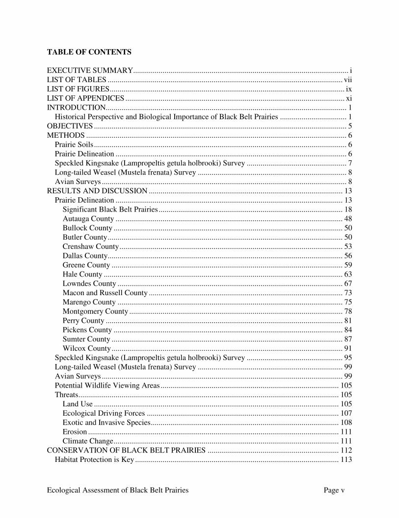
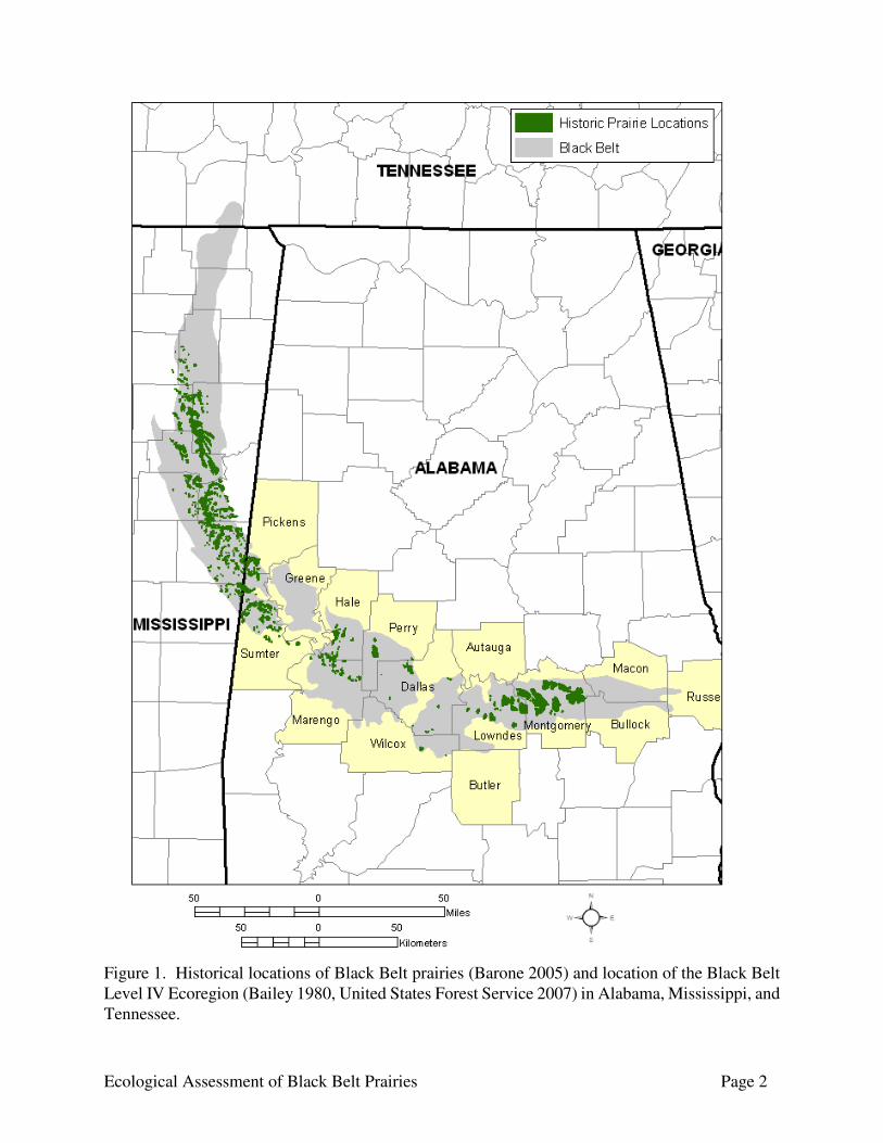
INTRODUCTION The Black Belt Prairie Region, or Black Belt, is a geologically and biologically distinct area among the physiographic regions of the Coastal Plain. The Black Belt is a crescent shaped area approximately 20,720 km2 (8,000 mi2) extending from southwestern Tennessee south through east-central Mississippi and east-southeastward through central Alabama to near the Georgia border (Figure 1). In Alabama, the Black belt covers approximately 10,360 km2 (4,000 mi2) in portions of Autauga, Bullock, Butler, Dallas, Greene, Hale, Lowndes, Macon, Marengo, Montgomery, Perry, Pickens, Russell, Sumter, and Wilcox counties. This region is characterized by weathered rolling plains of relatively low relief developed on chalk and marl of the Cretaceous Selma chalk formation (Copeland 1968, Schiefer 1998). The Selma Chalk is composed of concentrations of fossiliferous, soft, white-gray limestone (Chalk) that weathers into a fertile dark soil for which the region is named (Stephenson and Monroe 1940, as cited in Schiefer 1998). The Black Belt represents a unique and clearly defined hydrologic region in the Coastal Plain because of its thin soils and the impermeable nature of the chalk bedrock. This is the driest region of the state (Harper 1943), and the streams in the Black Belt are noted for high turbidity, high rates of runoff, and great variability in flow (Harper 1943, Harris et al. 1991). Small streams are dry and large streams have significantly reduced flow during the dry seasons. These harsh hydrological characteristics have a negative impact on many aquatic species distributions and many aquatic species common throughout the Coastal Plain are rare or absent within the Black Belt (Mettee et al. 1989, Harris et al. 1991, Hicks and Haynes 2000). However, at least one caddisfly species is endemic to this region (Harris et al. 1991). Historically, the natural communities of the Black Belt consisted of a mosaic of various hardwood and mixed hardwood/pine forests, chalk outcrops and prairies. The prairies ranged in size from small to extensive and were found scattered among the forest communities throughout the landscape in the Black Belt. These Black Belt prairies are less well known to both the scientific community and the public than the extensive prairies of the Great Plains. The Black Belt prairies are found on limestone formations laid down in the shallow sea that covered the southeastern United States approximately 30 million years ago (DeSelm and Murdock 1993). These types of calcareous grasslands are isolated on the Gulf Coastal Plain in Alabama, Mississippi, Arkansas, and Texas (Peacock and Schauwecker 2003). In the Black Belt region, prairies are primarily present on upland, alkaline soils with more forested habitats typically present in the lowland, acidic soils (Jones and Patton 1966, Rankin and Davis 1971). Historical Perspective and Biological Importance of Black Belt Prairies The Black Belt prairies are a unique habitat complex in the state. However, Black Belt prairies have been devastated by land use alterations. The Black Belt has undergone intensive settlement and cultivation that has greatly affected the soil and vegetative conditions for the past 200 years. Using historical accounts of prairies in the region and surveyors’ plat maps from the 1830’s, Barone (2005) estimated that approximately 144,000 hectares of prairies were present in the Black Belt in the 1830s, with approximately 73,060 ha in Alabama. The prairies formed an arc of islands in a mostly forested Black Belt, reaching their greatest densities at the east end of the Black Belt in Montgomery
Ecological Assessment of Black Belt Prairies Page 2
Figure 1. Historical locations of Black Belt prairies (Barone 2005) and location of the Black Belt Level IV Ecoregion (Bailey 1980, United States Forest Service 2007) in Alabama, Mississippi, and Tennessee.
Ecological Assessment of Black Belt Prairies Page 3
and Lowndes County, Alabama and in eastern Mississippi near the Alabama border (Fig. 1). This concentration of prairies in the Black Belt formed a coherent and important ecosystem in the Southeast (Barone 2005). By the end of the twentieth century, only scattered remnants of the native Black Belt prairie remained as the grasslands were converted to agriculture or pasture or were lost to development (Wilson 1981, White et al. 1998). Historically the Black Belt was the site of extensive cotton plantations. When planters left Virginia and the Carolinas following the depletion of soils from tobacco farming, the Black Belt became a focus of slave-based cotton farming because of the extraordinary fertility of the alkaline soils, and cotton-based agriculture dominated the region from the 1850s until the early 1900s (Cleland 1920, Peacock and Schauwecker 2003). Many areas were converted to pasture for grazing following the abandonment of cotton or other row crop farms. Urban and rural development also has contributed to the loss of Black Belt prairies, particularly in the areas around Montgomery, Selma, and Demopolis. Because the chalk substrate is impermeable and precludes the need for liming, numerous catfish ponds have been excavated in the Black Belt in Alabama and Mississippi, causing further losses of prairies. The remaining prairies tend to be relatively small and highly fragmented, and prairie habitat continues to be lost through human activities and the encroachment of woody vegetation, especially eastern red cedar (Juniperus virginiana Linnaeus). Prairies are grasslands that contain herbaceous vegetation with few if any trees. The flora of the Black Belt prairies is typically dominated by little bluestem (Schizachyrium scoparium Michaux), with many other species of grasses and herbaceous plants characteristic of the Great Plains present, along with some endemic and southern plant species (DeSelm and Murdock 1993, Peacock and Schauwecker 2003). The Black Belt prairies have been recognized as an ecological system within NatureServe’s ecological community classification scheme (Comer et al. 2003) with the following description (Copyright © 2009 NatureServe, 1101 Wilson Boulevard, 15th Floor, Arlington Virginia 22209, U.S.A. All Rights Reserved.) along with a Global Rank of G1:
Schizachyrium scoparium - Sorghastrum nutans - Dalea candida - Liatris squarrosa - (Silphium terebinthinaceum) Black Belt Herbaceous Vegetation Translated Name: Little Bluestem - Yellow Indiangrass - White Prairie-clover - Scaly Blazing Star - (Prairie-dock) Black Belt Herbaceous Vegetation Common Name: Black Belt Prairie Unique Identifier: CEGL004664 Classification Approach: International Vegetation Classification (IVC) Summary: This herbaceous association includes tallgrass prairies of the Black Belt of Alabama, Mississippi, and southern Tennessee (McNairy County), with outlying occurrences southwards in the Chunnenuggee Hills, Red Hills, and Lime Hills of southern Alabama (in Washington, Wilcox, Monroe, and Clark counties). This
Ecological Assessment of Black Belt Prairies Page 4
community occurs on calcareous soils of the Sumter and Binnsville series, described as beds of marly clay over Selma Chalk. In Alabama, the formations on which this system primarily occurs are the Demopolis Chalk and the Mooreville Chalk. In Tennessee, only the Demopolis is mapped. The area has an average annual precipitation of 130-140 cm and a frost-free period of 200-250 days. This prairie is dominated by Andropogon glomeratus, Andropogon virginicus, Bouteloua curtipendula, Panicum virgatum, Schizachyrium scoparium, and Sorghastrum nutans, with lesser amounts of Paspalum floridanum, Setaria parviflora, and Sporobolus indicus (exotic). Juniperus virginiana var. virginiana may invade examples. Moist, seepy inclusions within this herbaceous matrix are often dominated by Rhynchospora colorata and Scleria verticillata; Rhynchospora divergens, Lythrum alatum var. lanceolatum, Mitreola petiolata, and Gratiola floridana also occur but much less frequently.
Many of the typical prairie vertebrate animals are absent from the Black Belt prairies because of the typically small size of the prairies and their distance from the extensive grasslands to the west. They also lack locally endemic vertebrates (DeSelm and Murdock 1993). However, many vertebrate species use these prairie areas (Mount 1975, Imhof 1976), including several species recognized as species of greatest conservation need in the state’s Wildlife Action Plan (Wildlife and Freshwater Fisheries Division 2005) (Table 1). Mount (1975) recognized the Black Belt as a distinct herpetofaunal region. Prairies provide habitat for numerous grassland bird species, including several Mirarchi et al. (2004a) included on their Alabama Birds Watch List (species of moderate conservation concern) such as dickcissel (Spiza americana) and grasshopper sparrow (Ammodramus savannarum). The natural prairie of the Black Belt attracts more open-country birds during all seasons than anywhere else in Alabama (Imhof 1976). Mirarchi et al. (2004b) ranked the glades/prairies/prairie edges/old field succession ecosystem habitat complex second of six among terrestrial habitats in terms of importance to currently imperiled taxa. The Black Belt prairies have a rich invertebrate fauna, as exemplified by the moth fauna of the Black Belt in Mississippi. Slightly more than half the known moth species of Mississippi were collected during sampling of moths in the prairies and forests of the Black Belt, with 1,021 species collected including 2 known only from the Black Belt: an undescribed species of Neodactria (Crambidae) from Osborn Prairie and Elachista ciligera Kaila (Elachistidae) from a single specimen collected from an oak-hickory forest adjacent to a prairie remnant (Brown 2003). Although species richness of moths was greater in the forests than the prairies, 76% of the species occurred in the prairies, and 50 of the 59 uncommon and geographically localized species were most frequently collected in prairie sites (Brown 2003). Several invertebrates are primarily or totally restricted to either the Black Belt Prairie or the Jackson Prairie in Mississippi and Alabama, and much of the insect fauna present in the prairies has a disjunct distribution from populations in the midwestern prairie states with these occurrences representing the only eastern location for many species (DeSelm and Murdock 1993, Schiefer 1998, Brown 2003). Cyclotrechelus hypherpiformis (Freitage 1969, as cited in Brown 2003) (Carabidae) is a large flightless ground beetle described from prairies in Dallas County, Alabama, and known only from Black Belt prairies in Alabama and Mississippi (Brown 2003). One bee species,

Ecological Assessment of Black Belt Prairies Page 5
Table 1. Species of conservation concern which utilize prairie habitat and would benefit from prairie conservation actions. Species
Common Name
State Priority
Global Rank State Rank
Lampropeltis getula holbrooki speckled kingsnake P2 G5T5 S3 Circus cyaneus Northern Harrier P2 G5 S3N Asio flammeus Short-eared Owl P2 G5 SNR Falco sparverius American Kestrel P2 G5 S2B, S5N Mustela frenata long-tailed weasel P2 G5 S3
Xenoglossodes albadata (Cresson) (Anthophoridaee); four longhorned beetle species - Ataxia brunnea Champ & Knull, Mecas rotundicollis (Thom.), Tetraopes femoratus Lec., and Tetraopes texanus Horn; and ten moth species associated with prairie habitat are disjunct between the Black Belt and the Great Plains (MacGowan and Schiefer 1992, Brown 2003). The ten moth species include four species of Gelechiidae - Dichomeris gleba Hodges, Helcystogramma ectopon Hodges, Naera fuscocristatella Cham. and Neodactylota liguritrix Hodges; three species of Tortricidae - Epiblema iowana McD., Eucosma fulminana (Wlsm.), and Eucosma ridingsana (Rob.); one species of Crambidae - Hileithia rehamalis (Dyar); and one species of Noctuidae - Schinia grandimedia Hardwick. DeSelm and Murdock’s (1993) list of rare invertebrates inhabiting the Black Belt Prairie included 5 crayfish, 2 of which were endemic to Mississippi, and the prairie mole cricket (Gryllotalpa major). The only crayfish species listed known to occur in Alabama was the southeastern prairie crayfish (Procambarus hagenianus hagenianus). Until recently, the Black Belt prairies had received little conservation attention, despite the high degree of imperilment for prairie habitats. The remaining prairies tend to be relatively small and highly fragmented, and prairie habitat continues to be lost through human activities and the encroachment of woody vegetation, especially eastern red cedar (Juniperus virginiana Linnaeus). There is a clear need to assess current conditions of prairies and begin prairie restoration work in Alabama. OBJECTIVES The objective of the study was to conduct an ecological assessment of the status and extent of native Black Belt prairies, including surveys for terrestrial vertebrate species using prairie habitat. Specifically, the objectives were to: 1) Accurately delineate Black Belt prairie habitat in Alabama 2) Assess current condition of prairies, and prioritize areas for protection and restoration. 3) Conduct surveys to document terrestrial vertebrate use of prairie habitat 4) Assess areas for potential restoration, and 5) Identify potential wildlife viewing sites in the Black Belt region

Ecological Assessment of Black Belt Prairies Page 6
METHODS Prairie Soils Locations of natural prairies within the Black Belt are primarily determined by soil type as the Black Belt prairie community is an example of edaphic control of vegetation (Schuster and McDaniel 1973). The Soil Survey Geographic (SSURGO) Database (Soil Survey Staff 2006a, 2006b, 2006c, 2006d, 2006e, 2006f, 2006g, 2006h, 2006i, 2006j, 2006k, 2006l, 2006m, 2006n, 2007a, 2007b, 2008a, 2008b) was used to identify prairie soils and calculate the acreage and proportionate extent in each county. Prairie soils were considered to be those the native vegetation was described as consisting of prairie (or short) grasses, sedges, legumes, and some cedar or the only species listed for woodland use was red cedar. Prairie Delineation Prairie sites were identified using expert and local knowledge, aerial photographs, soil surveys, topographic maps, and other GIS data. We first evaluated the feasibility of using Landsat Thematic Mapper (TM) data to identify prairie sites. The Alabama Gap Analysis Project land cover map of ecological systems for the state of Alabama (Provisional) (Kleiner et al. 2007) contains two prairie classes in its classification: East Gulf Coastal Plain Black Belt calcareous prairie and woodland – woodland modifier and East Gulf Coastal Plain Black Belt calcareous prairie and woodland – herbaceous modifier. An accuracy assessment had not been completed on this data, but it is likely to be similar to the National Land Cover Data which had an accuracy for individual classes ranging from 38% to 99%. This data was reclassified to retain only the two prairie classes, and the larger areas were compared to Digital Orthophographic Quarter Quadrangles (DOQQ) and field checked to validate the classification. An accuracy assessment was not performed, but the accuracy for the areas checked was <45%. A problem with the data was noted before the verification in that only a few very small areas in Dallas County were classified as prairie (herbaceous). However, many more prairies and some relatively large prairies are known to occur in the county. To test the feasibility of using Landsat data to identify prairies, a feature extraction method was performed on a single Landsat TM scene (United States Geological Survey 2004), but the classification accuracy for prairies was no better than that obtained with the GAP Analysis ecological systems classification. Therefore, prairies were identified from a manual interpretation of 2006 color DOQQs, supplemented with 1990s DOQQs, SSURGO soil data, and aerial imagery available through Virtual Alabama (http://www.dhs.alabama.gov/virtual_alabama/home.aspx?sm=g_a). Known examples of prairies were used as reference to develop the search image when examining DOQQs for the presence of prairies. This search image was refined from ground truthing of suspected prairies as the project proceeded. Prairies in close proximity to one another were grouped as a prairie site. In general a separation distance of 1.5 – 2 km was used when grouping prairies into sites, although in a few instances separation distance as low as 1 km was used. Prairie sites were named for nearby features from the USGS topographic quadrangle or Geographic Names Information System (GNIS) (United States Geological Survey 2008). For the sites for which there were no nearby features on the topographic quadrangle or in GNIS, the site was named using the quad name and section in which the prairies
Ecological Assessment of Black Belt Prairies Page 7
were located. For the largest sites, the site was subdivided into sub-site groupings if natural breaks were apparent in the distribution of the prairies. Field inspections were conducted to confirm the identification of prairie areas and evaluate and characterize the ecological integrity of the prairies. During field inspections, a Global Positioning System (GPS) waypoint was collected in the prairie using a recreational grade Garmin GPS unit if a prairie summary form was completed. If the GPS unit used had the capacity to collect and save tracks, a track was saved for the day to indicate the area covered. For some prairies, the perimeter of the prairie was delineated by walking the perimeter of the prairie and recording the track with the GPS unit. All areas identified as prairies from the DOQQ could not be confirmed with a field visit for a number of reasons, including landowners denying access to their property, being unable to make contact with some landowners to obtain permission for access to the property, and time and budget limitations precluded visiting all prairies. Therefore, an effort was made to confirm the largest prairies identified and prairies from each prairie site. Sites were assigned a conservation priority status for the management, conservation, and restoration of prairies at the site based on the size of the site and the individual prairies, ecological integrity of the prairies, disturbance level, and potential for restoration and management. Generally all prairies in a site were assigned the same conservation priority status, with the exception of some of the largest sites where sub-sites were assigned different priorities. These status designations were defined as:
• Significant Prairies (Highest Conservation Priority) – Site contains prairies with good to exceptional ecological integrity and good availability for restoration and long-term management.
• High Priority – Sites with large prairies, large numbers of prairies, moderate to good ecological integrity, and good restoration potential for prairies with low ecological integrity.
• Moderate Priority – Sites generally with small prairies, low to moderate ecological integrity, and/or questionable availability for restoration and management.
• Low Priority – Sites with few and/or small prairie remnants, poor to moderate ecological integrity, and/or highly disturbed prairies.
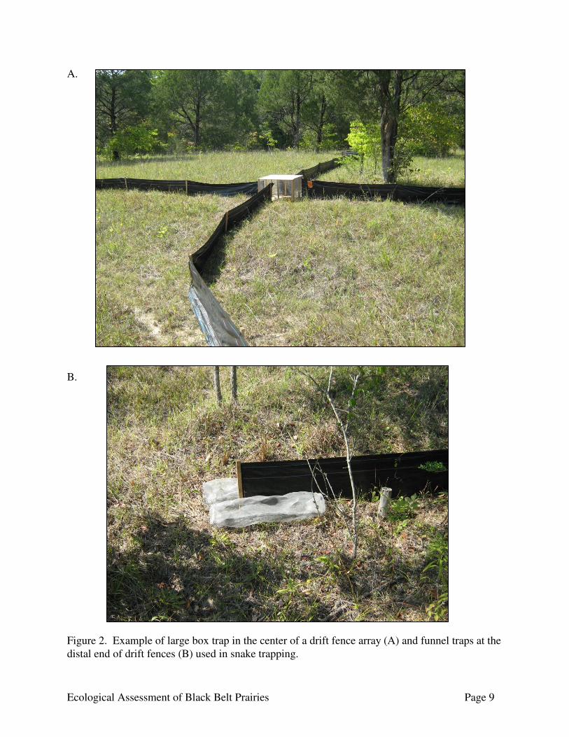
Accuracy of the aerial imagery interpretation was assessed using an error matrix (Story and Congalton 1986). Five hundred of the field inspections were randomly selected for use in the error analysis. To include potential errors of omission, 200 points for areas that appeared spectrally similar to prairies but were decided not to be prairies were included for analysis. These areas were checked when conducting field verification of nearby areas identified as prairies to confirm they were not prairie. Any prairies detected while conducting field work which were not detected in the image interpretation were added to this analysis. Speckled Kingsnake (Lampropeltis getula holbrooki) Survey Speckled kingsnake surveys were conducted using trap stations consisting of traps in conjunction with drift fence arrays. Traps followed the design of Burgdorf et al. (2005), and consisted of a large central box trap with funnel-shaped entrances on each side. Drift fences radiated from each entrance

Ecological Assessment of Black Belt Prairies Page 8
perpendicular to the central box trap in four directions (Fig. 2). To minimize soil disturbance and the subsequent risk of erosion, the drift fences were constructed using 100 ft (30.5 m) silt fences, with 2 funnels traps (1 on each side of the fence) placed at the distal end of the fence. The number of trap stations per site ranged from 3 to 6, with 1 to 3 trap stations in each individual prairie. In 2007, traps were placed in the Jones Bluff Prairies, Autauga County, and the Old Bluffport Prairies, Sumter County (Fig. 3), with three traps at each site. Traps were placed in two prairies at Jones Bluff and a single high-quality prairie at Old Bluffport, and were active from 21 May – 31 October. In 2008, traps were placed in the Cochrane Prairies, with 1-3 traps placed in 3 prairies on the Cochrane Recreation Area, Pickens County (Fig. 3). Traps were active 15 April – 14 June. Traps were checked daily. At each visit, trapped individuals were removed and measured for body length (mm) and mass (g). After identifying and measuring each captured individual, it was released near its capture location. Incidental observations of snakes while in the prairie for other purposes also were recorded. The species of the snake was noted and a GPS waypoint was collected at the location the snake was observed. For some of the prairies visited, the landowner or land manager was asked if speckled kingsnakes had been observed in the prairies when conducting the condition assessment or contacting the landowner for permission to visit the site. Long-tailed Weasel (Mustela frenata) Survey Long-tailed weasel surveys were conducted using track plate surveys (Ray and Zielinski 2008, Mowat et al. 2000). Track plates were constructed of aluminum flashing, with a precipitation cover constructed from 8” galvanized pipe (Fig. 4). Track plates were prepared in the field by applying a mixture of alcohol and red carpenter’s chalk with a garden-style mist sprayer (Orloff et al. 1993). Clear contact paper was used as the medium to record positive tracks. Track plate stations were baited with chicken wings or sardines placed at the back of the track plate, while a scent lure (Caven’s Gusto, Blue Ridge Outdoor Supplies) was applied just inside the entrance or slightly outside the track plate station. Track plate stations were placed at four prairie sites: Elm Bluff Prairies and Old Cahaba Prairies in Dallas County, Old Bluffport Prairie Complex in Sumter County, and Cochrane Recreation Area in Pickens County (Fig. 5). Five to ten track plate stations were placed at each site, with 1-4 stations active in individual prairies. Track plates were active from February to June 2009, and were checked once or twice per week. Avian Surveys Avian surveys were conducted at the Cochrane Recreation Area sub-site of the Cochrane Prairies Complex in Pickens County; Elm Bluff sub-site of the Elm Bluff Prairie Complex, Old Cahawba Prairie Complex, and Tilden sub-site of the Tilden-Carlowville Prairie Complex in Dallas County; Jones Bluff sub-site of the Jones Bluff-House Bluff Prairie Complex in Autauga County; and Old Bluffport Prairie Complex and University of West Alabama Prairie Restoration Site in Sumter County. Because no single method for bird census may adequately detect all species (Conant et al. 1981, Fletcher et al. 2000), avian species utilizing the prairies were assessed using point counts (Ralph et al. 1995, Hamel et al. 1996), and line transects (Emlen 1977). Surveys were conducted at various times throughout the year so that sampling occurred during each season. Surveys were conducted between sunrise and 3 hours after, as detection rates may decline after this period (Shields 1977). Surveys were not conducted during periods of precipitation or high wind velocities as these
Ecological Assessment of Black Belt Prairies Page 9
A. B. Figure 2. Example of large box trap in the center of a drift fence array (A) and funnel traps at the distal end of drift fences (B) used in snake trapping.

Figure 3. Distribution of prairie sites in Alabama’s Black Belt trapped for speckled kingsnake (Lampropeltis getula holbrooki).

Ecological Assessment of Black Belt Prairies Page 11
Figure 4. Track plate station used for sampling long-tailed weasels.
Figure 5. Distribution of track plate survey sites in Alabama Black Belt prairies.
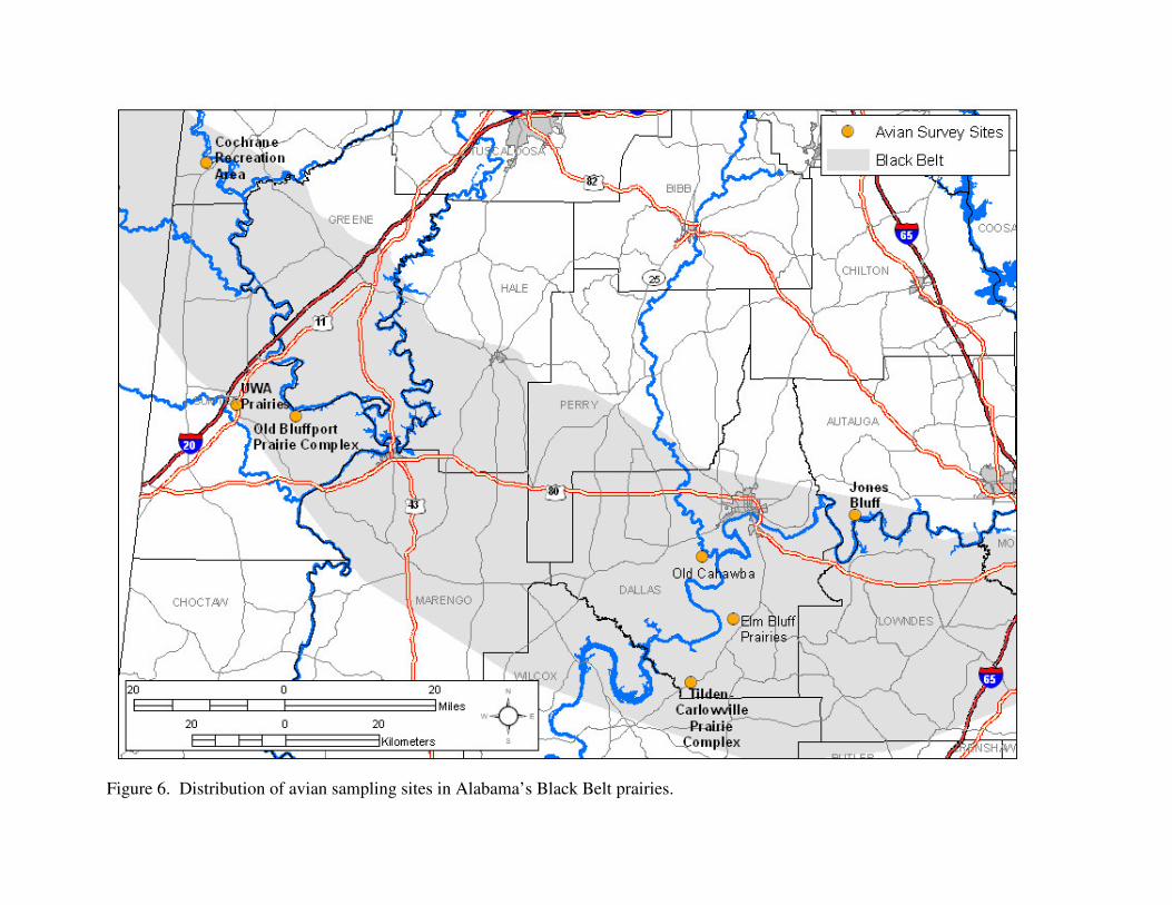
Figure 6. Distribution of avian sampling sites in Alabama’s Black Belt prairies.
Ecological Assessment of Black Belt Prairies Page 13
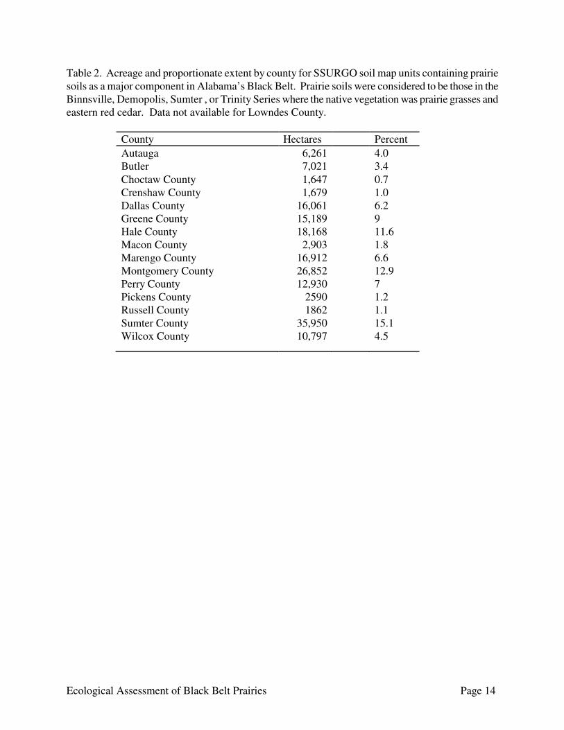
conditions decrease detectability (Robbins 1981). Birds flying over the site were not included unless they appeared to be foraging over or otherwise using the prairie habitat. Species incidentally observed while in prairies for other purposes also were recorded. Surveys specifically for the 3 raptors of conservation concern (Table 1) were conducted using line transects and area-search (Roberts and Scnell 2006). Although Short-eared Owls generally are silent outside of the breeding season (Holt and Leasure 1993), call playbacks (Johnson et al. 1981, Marion et al. 1981) were used to attempt to attract or solicit a response. Surveys for Northern Harrier (Circus cyaneus) and American Kestrel (Falco sparverius) generally were conducted between 10:00 and 14:00. Short-eared Owl surveys generally were conducted from before sunrise to 1 hr after sunrise or 1 hour before sunset to after sunset. Searches for Northern Harrier and Short-eared Owl (Asio flammeus) were restricted to the non-breeding season as these species do not breed in Alabama. All incidental sightings for these 3 species while conducting other field work also were recorded. RESULTS AND DISCUSSION Prairie Soils Prairie soils consisted primarily of the soils formed from the Demopolis and Sumter Series, so soils identified as prairie soils were those with Demopolis or Sumter soils as a major component for all counties, with Binnsville and Trinity Series also included for Greene County (Soil Conservation Service 1960, 1971, 1977, 1979, 1989; Soil Survey Staff 2009). Although gullied land usually supports little to no vegetation, gullied land in calcareous, weathered Selma chalk was included in the calculation of prairie soil acreage because it included small areas of vegetated land primarily on Demopolis, Sumter, or Oktibbeha soils. Prairie soil was distributed throughout the Black Belt (Fig. 7), with the acreage of prairie soil per county ranging from 1,647 ha (4,070 ac) for Choctaw County to 35,950 ha (88,834 ac) for Sumter County (Table 2). However, not all of this acreage would be prairie soil because each map unit included some proportion of non-prairie soil, with the proportion of a map unit consisting of prairie soil ranging from 35 to 91 percent. See Appendix A for more information about each map unit and the component soils comprising the map unit. Prairie Delineation We identified 14,595 individual prairies in 265 sites covering 6,276 ha (15,509 ac). The error matrix for the aerial image interpretation reported an overall accuracy of 96%. The overwhelming majority of the extant prairies were small fragments; median prairie size was 0.14 ha (0.35 ac). Prairies were distributed throughout the Black Belt, with the largest concentrations located in Dallas, Lowndes, and Sumter counties (Table 3, Fig. 8). Sizable acreage also was present in Greene, Hale, Perry, and Wilcox counties (Table 3). Prairies were much less abundant in the eastern third of the Black Belt in Montgomery, Macon, Bullock, and Russell counties than in the rest of the Black Belt. The condition of individual prairies ranged from high quality prairies to severely degraded, but the majority of the prairie habitat remaining in the Black Belt was of moderate or low quality. These areas exhibited degradation to varying degrees from erosion, infestation of native and exotic invasive species, woody encroachment, and past land use changes. A number of prairies were severely eroded and were little more than areas with deep gullies and large areas of exposed white chalk nearly devoid of vegetation. These highly eroded areas appeared to be more prevalent in Sumter, Marengo,
Ecological Assessment of Black Belt Prairies Page 14
Table 2. Acreage and proportionate extent by county for SSURGO soil map units containing prairie soils as a major component in Alabama’s Black Belt. Prairie soils were considered to be those in the Binnsville, Demopolis, Sumter , or Trinity Series where the native vegetation was prairie grasses and eastern red cedar. Data not available for Lowndes County.
County Hectares Percent Autauga 6,261 4.0 Butler 7,021 3.4 Choctaw County 1,647 0.7 Crenshaw County 1,679 1.0 Dallas County 16,061 6.2 Greene County 15,189 9 Hale County 18,168 11.6 Macon County 2,903 1.8 Marengo County 16,912 6.6 Montgomery County 26,852 12.9 Perry County 12,930 7 Pickens County 2590 1.2 Russell County 1862 1.1 Sumter County 35,950 15.1 Wilcox County 10,797 4.5

Ecological Assessment of Black Belt Prairies Page 15
Table 3. Number of prairies and prairie sites; total prairie acreage; and maximum, mean, and median prairie size by county in Alabama’s Black Belt region. Prairie Size (ha) County
Number of Prairie Sites
Number of Prairies
Total Acreage
Max
Median
Mean
Autauga 3 84 124.0 49.7 0.4 1.5 Bullock 4 38 11.5 2.4 0.1 0.3 Butler 2 664 132.5 4.0 0.1 0.2 Crenshaw 2 88 17.5 1.3 0.1 0.2 Dallas 31 1,506 807.0 29.7 0.3 0.5 Greene 16 773 388.9 13.0 0.3 0.9 Hale 24 616 375.0 78.3 0.2 0.6 Lowndes 60 4,543 1,060.1 18.4 0.1 0.2 Macon 5 75 32.1 1.9 0.3 0.4 Marengo 28 613 212.9 9.2 0.2 0.3 Montgomery 35 284 287.2 18.5 0.3 1.0 Perry 17 861 566.7 19.8 0.2 0.7 Pickens 5 77 89.0 12.3 0.4 1.2 Russell 1 107 2.5 2.9 0.1 0.2 Sumter 36 3,080 1,330.1 14.1 0.2 0.4 Wilcox 21 1,187 521.5 12.9 0.2 0.4 All Counties 264 14,595 6,281.2 78.3 0.1 0.4

Figure 7. Distribution of SSURGO soil map units with a prairie soil (Binnsville, Demopolis, Sumter, Trinity Series) as a major component of the map unit. Spatial data was not available for Lowndes County.

Figure 8. Distribution of historical prairie locations (Barone 2005) and extant Black Belt prairies in Alabama.
Ecological Assessment of Black Belt Prairies Page 18
and Perry counties. As an artifact of fire exclusion, eastern red cedar and various hardwoods have encroached upon many prairies, reducing overall acreage and greatly jeopardizing long-term ecological integrity and species viability. Significant Black Belt Prairies Ten publicly- and privately-owned examples of Black Belt prairies were identified as special significance and are considered to be the highest conservation priority. This recognition was based on two criteria: ecological integrity and availability to restoration and long-term management. Examples characterized as having good to exceptional integrity were represented by several environmental attributes, including landscape context (mosaic of prairies and forests), diversity of native prairie taxa, and minimal incursion of exotic and native weedy (e.g., eastern red cedar) species. The selection criteria were also influenced by the availability of parcels for restoration efforts. Sites where landowners have demonstrated an interest in maintaining natural processes and support compatible conservation strategies such as land protection are also critical toward safeguarding Alabama’s prairie landscape. The narratives presented below summarize the general character of those prairie sites recognized during the course of this study as integral components toward preserving the fabric of natural environments across Alabama. In addition to describing sites and highlighting State Wildlife Action Plan Species of Greatest Conservation Need (GCN) and other rare species, an abbreviated account of conservation issues are also included, briefly discussing management needs, potential threats, and past and present landuse practices. The other sites are then summarized by county, highlighting the high priority sites. Sites containing prairies in multiple counties are listed in the summary table and discussed in the summary section for the primary county for the site.

Ecological Assessment of Black Belt Prairies Page 19
Braggs – Ridgeville Prairie Complex County: Lowndes, Wilcox Ownership: Private Location: The Braggs-Ridgeville Prairie Complex occupies the southeastern corner of Lowndes
County, extending south into Butler County north of Ridgeville and west into Wilcox County (Fig. 9). The most significant component of the site are the sub-sites between Braggs and Macedonia extending west.
Significance: The complex of grasslands that constitute the region between the crossroad communities of Braggs and Macedonia are recognized as some of the finest prairies remaining in Alabama’s Black Belt. This site contains one of the greatest concentrations of Black Belt prairies remaining in Alabama, and was the second largest prairie complex identified in the state. Prairies within the complex range in size from <0.1 to 7.8 ha, with a total acreage of 578.5 ha for the site. An exceptional floral diversity, a minimal incursion of exotic and native invasive species, and relatively low levels of erosion and other human-induced disturbances are attributes worthy of promoting long-term conservation efforts for the site. An impressive array of prairie flora, including several members of the grass (Poaceae), bean (Fabaceae), and aster (Asteraceae) families are represented. An enumeration of the more common and noteworthy taxa are Indian grass (Sorghastrum nutans (L.) Nash), little bluestem, side-oats grama (Bouteloua curtipendula (Michx.) Torr.), butterfly-weed (Asclepias tuberosa L.), white and purple prairie clovers (Dalea candida Michx. ex Willd. and Dalea purpurea Vent.), round-leaf rattlebox (Crotalaria rotundifolia (Walt.) Poir.), wild bean (Strophostyles umbellata (Muhl. ex Willd.) Britt.), rose-pink (Sabatia angularis (L.) Pursh), downy wood-mint (Blephilia ciliata (L.) Benth.), American blue-hearts (Buchnera americana L.), false-foxgloves (Agalinis spp.) prairie coneflower (Ratibida pinnata (Vent.) Barnh.), gray goldenrod (Solidago nemoralis Ait.), and pale-leaved sunflower (Helianthus strumosus L.). The surrounding forests are equally as significant being primarily comprised of pine and various hardwoods, most notably oaks (namely white, chinquapin, and Shumard’s [Quercus alba L., Q. muehlenbergii Engelm., and Q. shumardii Buckl. respectively]), hickories (mostly pignut and southern shagbark [Carya glabra (Mill.) Sweet and C. ovata var. australis (Ashe) Little , respectively]), white ash (Fraxinus americana L.), and loblolly pine (Pinus taeda L.).
Conservation: The prairies of the Braggs – Ridgeville Complex, for the most part, represent good to high quality natural grasslands that warrant long-term protection. The challenges that confront conservation efforts of prairies throughout the Black Belt apply here as well. Vegetation succession is recognized as the most pervasive threat, where eastern red cedar and hardwoods, along with the incursion of exotic species, have encroached upon most examples. The presence of exotic species is relatively minimal, generally asserting the greatest influence in disturbed areas containing exposed soil, such as roadsides. Chinese bush-clover (Lespedeza cuneata (Dumont) G. Don), Johnson grass (Sorghum halepense (L.) Pers.), and MaCartney rose (Rosa bracteata Wendl.) are the most frequently encountered exotics, with the last named being equally at home in the adjacent woodlands. Livestock fencing and forage

Ecological Assessment of Black Belt Prairies Page 20
grasses are infrequent, perhaps suggesting livestock management was not as pronounced in the region as elsewhere in the Black Belt. While the entirety of the site is under private ownership, conservation efforts may be easily attainable. The general attitude of landowners appears favorable to prairie preservation.
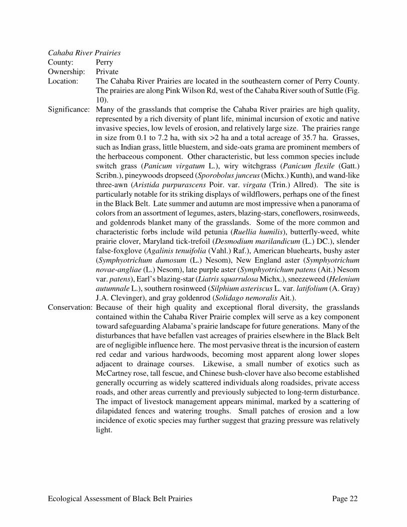
Examples:
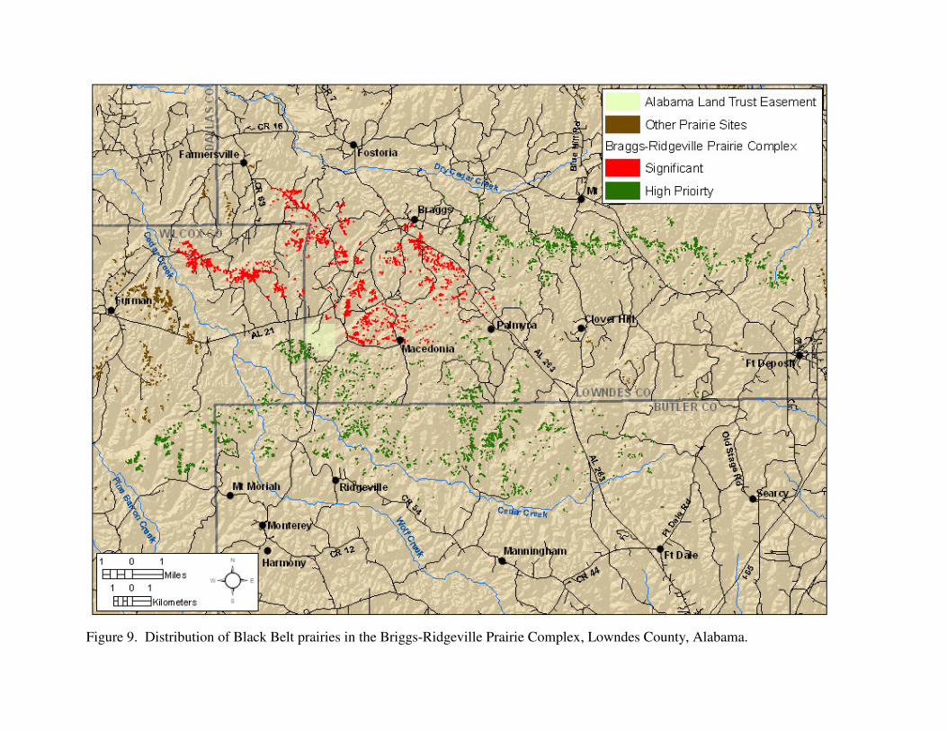
Figure 9. Distribution of Black Belt prairies in the Briggs-Ridgeville Prairie Complex, Lowndes County, Alabama.
Ecological Assessment of Black Belt Prairies Page 22
Cahaba River Prairies County: Perry Ownership: Private Location: The Cahaba River Prairies are located in the southeastern corner of Perry County.
The prairies are along Pink Wilson Rd, west of the Cahaba River south of Suttle (Fig. 10).
Significance: Many of the grasslands that comprise the Cahaba River prairies are high quality, represented by a rich diversity of plant life, minimal incursion of exotic and native invasive species, low levels of erosion, and relatively large size. The prairies range in size from 0.1 to 7.2 ha, with six >2 ha and a total acreage of 35.7 ha. Grasses, such as Indian grass, little bluestem, and side-oats grama are prominent members of the herbaceous component. Other characteristic, but less common species include switch grass (Panicum virgatum L.), wiry witchgrass (Panicum flexile (Gatt.) Scribn.), pineywoods dropseed (Sporobolus junceus (Michx.) Kunth), and wand-like three-awn (Aristida purpurascens Poir. var. virgata (Trin.) Allred). The site is particularly notable for its striking displays of wildflowers, perhaps one of the finest in the Black Belt. Late summer and autumn are most impressive when a panorama of colors from an assortment of legumes, asters, blazing-stars, coneflowers, rosinweeds, and goldenrods blanket many of the grasslands. Some of the more common and characteristic forbs include wild petunia (Ruellia humilis), butterfly-weed, white prairie clover, Maryland tick-trefoil (Desmodium marilandicum (L.) DC.), slender false-foxglove (Agalinis tenuifolia (Vahl.) Raf.), American bluehearts, bushy aster (Symphyotrichum dumosum (L.) Nesom), New England aster (Symphyotrichum novae-angliae (L.) Nesom), late purple aster (Symphyotrichum patens (Ait.) Nesom var. patens), Earl’s blazing-star (Liatris squarrulosa Michx.), sneezeweed (Helenium autumnale L.), southern rosinweed (Silphium asteriscus L. var. latifolium (A. Gray) J.A. Clevinger), and gray goldenrod (Solidago nemoralis Ait.).
Conservation: Because of their high quality and exceptional floral diversity, the grasslands contained within the Cahaba River Prairie complex will serve as a key component toward safeguarding Alabama’s prairie landscape for future generations. Many of the disturbances that have befallen vast acreages of prairies elsewhere in the Black Belt are of negligible influence here. The most pervasive threat is the incursion of eastern red cedar and various hardwoods, becoming most apparent along lower slopes adjacent to drainage courses. Likewise, a small number of exotics such as McCartney rose, tall fescue, and Chinese bush-clover have also become established generally occurring as widely scattered individuals along roadsides, private access roads, and other areas currently and previously subjected to long-term disturbance. The impact of livestock management appears minimal, marked by a scattering of dilapidated fences and watering troughs. Small patches of erosion and a low incidence of exotic species may further suggest that grazing pressure was relatively light.
Ecological Assessment of Black Belt Prairies Page 23
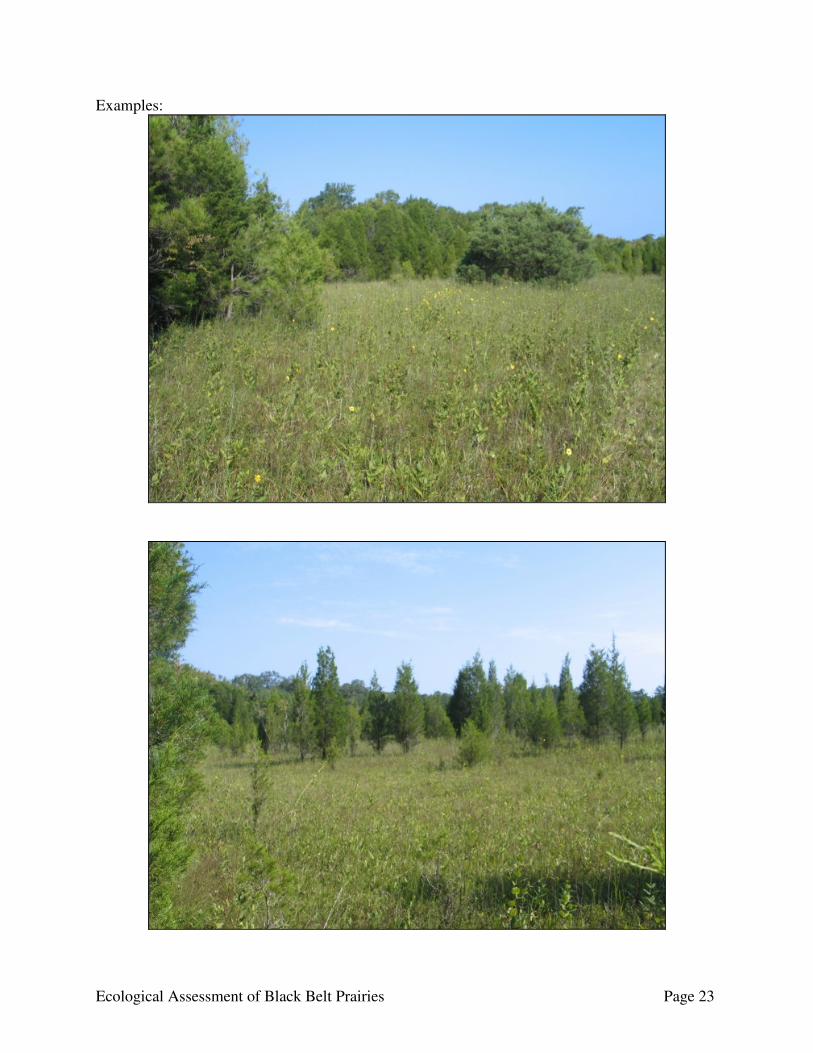
Examples:
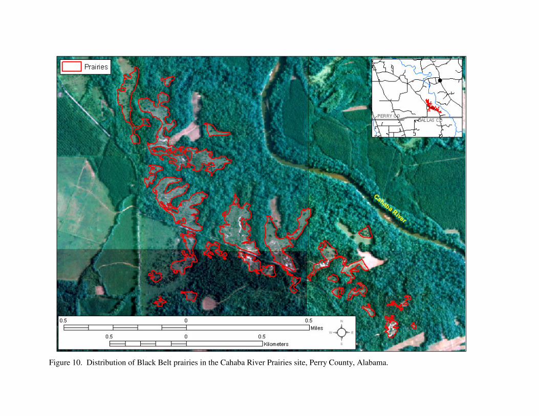
Figure 10. Distribution of Black Belt prairies in the Cahaba River Prairies site, Perry County, Alabama.
Ecological Assessment of Black Belt Prairies Page 25
Cochrane Recreation Area County: Pickens Ownership: U.S. Army Corps of Engineers 3606 West Plymouth Road Columbus, MS 39701 Location: The Cochrane Recreation Area (CRA) is a sub-site within the Cochrane Prairie
Complex site. The CRA is located along the Tombigbee River west of State Route 17 southwest of Aliceville. Prairies are distributed throughout the recreation area (Fig. 11).
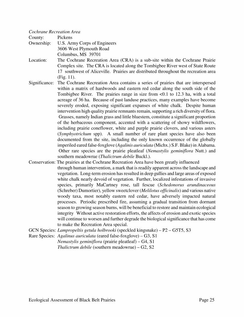
Significance: The Cochrane Recreation Area contains a series of prairies that are interspersed within a matrix of hardwoods and eastern red cedar along the south side of the Tombigbee River. The prairies range in size from <0.1 to 12.3 ha, with a total acreage of 36 ha. Because of past landuse practices, many examples have become severely eroded, exposing significant expanses of white chalk. Despite human intervention high quality prairie remnants remain, supporting a rich diversity of flora. Grasses, namely Indian grass and little bluestem, constitute a significant proportion of the herbaceous component, accented with a scattering of showy wildflowers, including prairie coneflower, white and purple prairie clovers, and various asters (Symphyotrichum spp). A small number of rare plant species have also been documented from the site, including the only known occurrence of the globally imperiled eared false-foxglove (Agalinis auriculata (Michx.) S.F. Blake) in Alabama. Other rare species are the prairie pleatleaf (Nemastylis geminiflora Nutt.) and southern meadowrue (Thalictrum debile Buckl.).
Conservation: The prairies at the Cochrane Recreation Area have been greatly influenced through human intervention, a mark that is readily apparent across the landscape and vegetation. Long-term erosion has resulted in deep gullies and large areas of exposed white chalk nearly devoid of vegetation. Further, localized infestations of invasive species, primarily MaCartney rose, tall fescue (Schedonorus arundinaceous (Schreber) Dumortier), yellow sweetclover (Melilotus officinalis) and various native woody taxa, most notably eastern red cedar, have adversely impacted natural processes. Periodic prescribed fire, assuming a gradual transition from dormant season to growing season burns, will be beneficial to restore and maintain ecological integrity Without active restoration efforts, the affects of erosion and exotic species will continue to worsen and further degrade the biological significance that has come to make the Recreation Area special.
GCN Species: Lampropeltis getula holbrooki (speckled kingsnake) – P2 – G5T5, S3 Rare Species: Agalinus auriculata (eared false-foxglove) – G3, S1 Nemastylis geminiflora (prairie pleatleaf) – G4, S1 Thalictrum debile (southern meadowrue) – G2, S2
Ecological Assessment of Black Belt Prairies Page 26
Examples:
Ecological Assessment of Black Belt Prairies Page 27
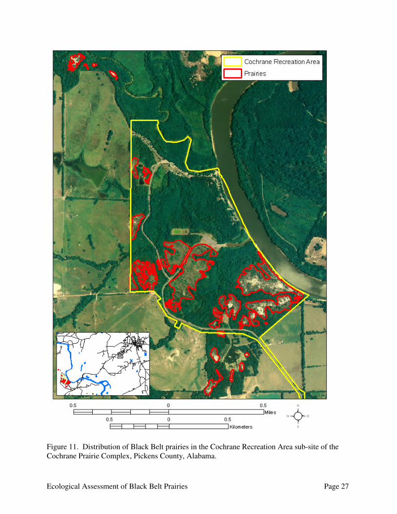
Figure 11. Distribution of Black Belt prairies in the Cochrane Recreation Area sub-site of the Cochrane Prairie Complex, Pickens County, Alabama.

Ecological Assessment of Black Belt Prairies Page 28
Elm Bluff Prairies County: Dallas Ownership: Private Location: The Elm Bluff Prairies are a sub-site within the Elm Bluff Prairie Complex located in
Dallas County south of Selma. The prairies occur within an area bordered by the Alabama River to the west, CR 407 to the south, State Route 41 to the east, and Cedar Creek to the north (Fig. 12). The remaining prairies in the Elm Bluff Prairie Complex extend to the southeast from State Route 41.
Significance: Occupying an extensive area east of the Alabama River, northeast of the Army Corps of Engineers Elm Bluff boat launch, is a complex of native grasslands and forested ravines. Prairies of various sizes are commonplace, ranging in size from <0.1 to 11.5 ha and covering an area totaling 114.7 ha. The prairies generally occur along ridgetops and upper slopes in association with Demopolis chalk. The quality of prairies is highly variable, where some examples represent exceptional integrity while others are severely degraded from the encroachment of woody vegetation and erosion. Eastern red cedar is predominant frequently occurring as scattered individuals within the interior of most prairies, typically becoming more numerous along the perimeter. Other woody species commonly encountered in the Elm Bluff Prairies are sugarberry (Celtis laevigata Willd.), chinquapin oak, green ash (Fraxinus pennsylvanica Marsh.), redbud (Cercis canadensis L.), Carolina buckthorn (Frangula caroliniana Walt.), winged elm (Ulmus alata Michx.), and two rare taxa currently monitored by the Alabama Natural Heritage Program, the three-flowered hawthorn (Crataegus triflora Chapm.) and the lance-leaved buckthorn (Rhamnus lanceolata Pursh var. glabrata Gleason). The herbaceous component is similar to prairies elsewhere in the Black Belt, characterized by a diverse assemblage of grasses and forbs. Indian grass and little bluestem are the principal grass species, with side-oats grama and switch grass (Panicum virgatum L.) occurring with lesser frequency, and thus serving as secondary importance. While all prairies associated with Elm Bluff contain a rich variety of wildflowers, examples with a low incidence of eastern red cedar display the greatest diversity and most impressive array of plant life. Some of the major forbs include prairie coneflower, white and purple prairie clovers, rose-pink, southern rosinweed (Silphium asteriscus L. var. latifolium (A. Gray) J.A. Clevinger), Carolina larkspur (Delphinium carolinianum Walt., butterfly-weed, blue sage (Salvia azurea Lam.), gray goldenrod, clasping aster (Symphyotrichum patens (Ait.) Nesom), and frost aster (Symphyotrichum pilosum (Willd.) Nesom).
Conservation: The prairies at Elm Bluff are represented by various levels of quality, from those of exceptional condition to examples beset with invasive species and erosion. Eastern red cedar is the most abundant woody species to have encroached upon the prairies, covering nearly 70 % in some examples. Exotic flora, most notably MaCartney rose and tall fescue, is evident in the majority of prairies, appearing most invasive in areas exposed to long-term livestock management. Erosion has severely degraded some examples, likely having originated from excessive grazing and/or prolonged trampling by farming equipment. The current landowner has verbally expressed interest in safeguarding portions of the site by limiting the access of heavy equipment on prairies and as resources allow, promote prescribed burning on select examples.
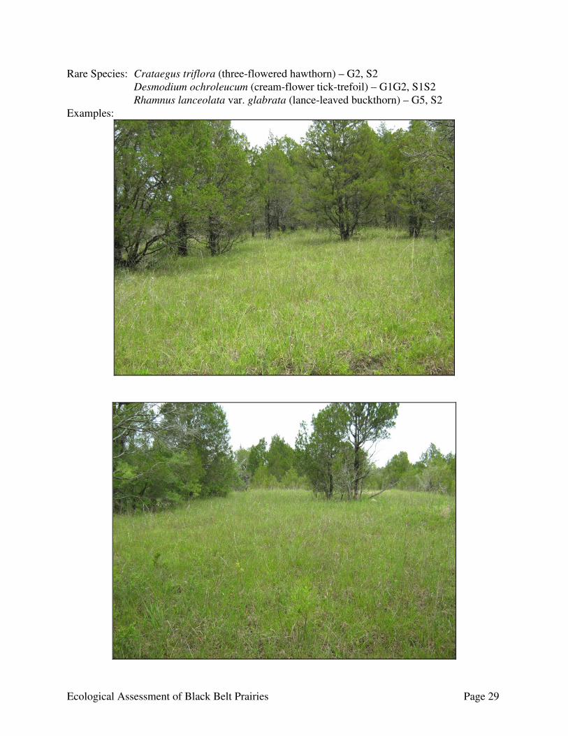
Ecological Assessment of Black Belt Prairies Page 29
Rare Species: Crataegus triflora (three-flowered hawthorn) – G2, S2 Desmodium ochroleucum (cream-flower tick-trefoil) – G1G2, S1S2 Rhamnus lanceolata var. glabrata (lance-leaved buckthorn) – G5, S2 Examples:
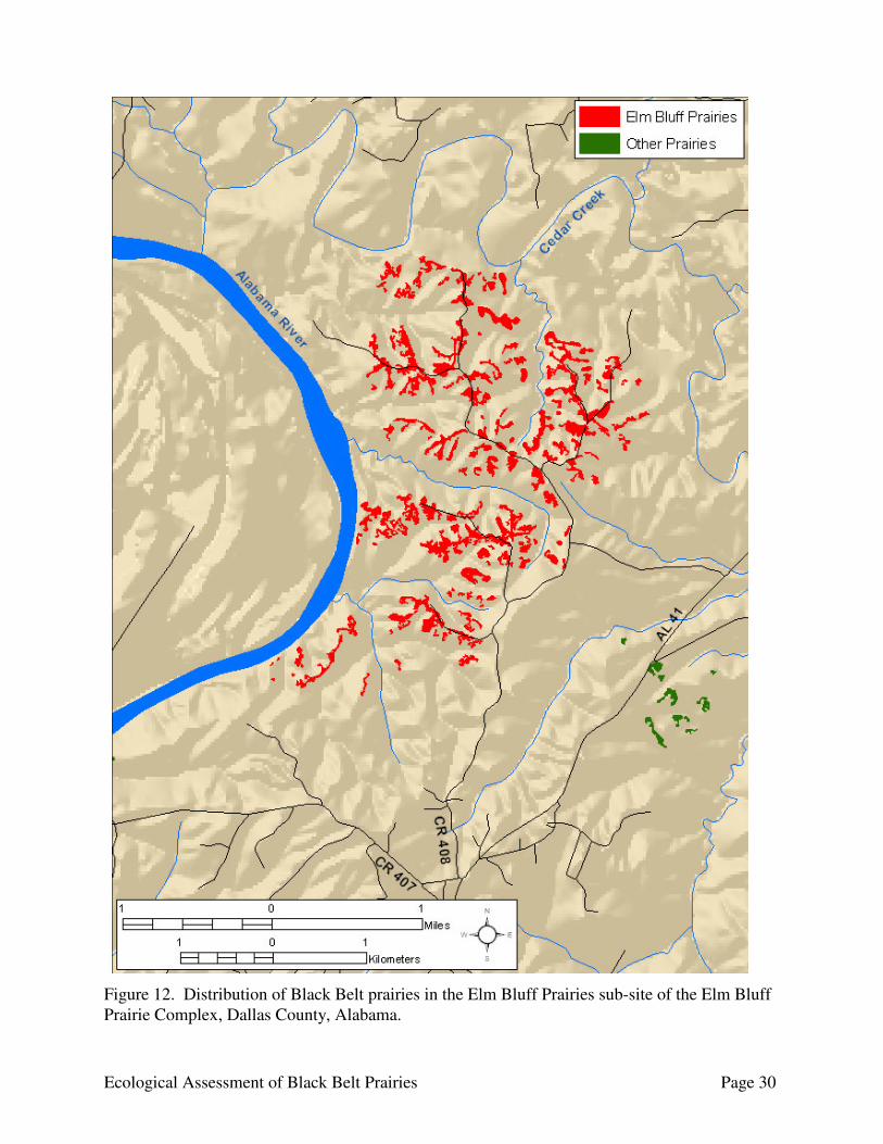
Ecological Assessment of Black Belt Prairies Page 30
Figure 12. Distribution of Black Belt prairies in the Elm Bluff Prairies sub-site of the Elm Bluff Prairie Complex, Dallas County, Alabama.
Ecological Assessment of Black Belt Prairies Page 31
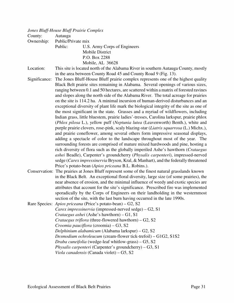
Jones Bluff-House Bluff Prairie Complex County: Autauga Ownership: Public/Private mix
Public: U.S. Army Corps of Engineers Mobile District P.O. Box 2288 Mobile, AL 36628 Location: This site is located north of the Alabama River in southern Autauga County, mostly
in the area between County Road 45 and County Road 9 (Fig. 13). Significance: The Jones Bluff-House Bluff prairie complex represents one of the highest quality
Black Belt prairie sites remaining in Alabama. Several openings of various sizes, ranging between 0.1 and 50 hectares, are scattered within a matrix of forested ravines and slopes along the north side of the Alabama River. The total acreage for prairies on the site is 114.2 ha. A minimal incursion of human-derived disturbances and an exceptional diversity of plant life mark the biological integrity of the site as one of the most significant in the state. Grasses and a myriad of wildflowers, including Indian grass, little bluestem, prairie ladies’-tresses, Carolina larkspur, prairie phlox (Phlox pilosa L.), yellow puff (Neptunia lutea (Leavenworth) Benth.), white and purple prairie clovers, rose-pink, scaly blazing-star (Liatris squarrosa (L.) Michx.), and prairie coneflower, among several others form impressive seasonal displays, adding a spectacle of color to the landscape throughout most of the year. The surrounding forests are comprised of mature mixed hardwoods and pine, hosting a rich diversity of flora such as the globally imperiled Ashe’s hawthorn (Crataegus ashei Beadle), Carpenter’s groundcherry (Physalis carpenteri), impressed-nerved sedge (Carex impressinervia Bryson, Kral, & Manhart), and the federally threatened Price’s potato-bean (Apios priceana B.L. Robins.).
Conservation: The prairies at Jones Bluff represent some of the finest natural grasslands known in the Black Belt. An exceptional floral diversity, large size (of some prairies), the near absence of erosion, and the minimal influence of weedy and exotic species are attributes that account for the site’s significance. Prescribed fire was implemented sporadically by the Corps of Engineers on their landholding in the westernmost section of the site, with the last burn having occurred in the late 1990s.
Rare Species: Apios priceana (Price’s potato-bean) – G2, S2 Carex impressinervia (impressed-nerved sedge) – G2, S1
Crataegus ashei (Ashe’s hawthorn) – G1, S1 Crataegus triflora (three-flowered hawthorn) – G2, S2 Croomia pauciflora (croomia) – G3, S2 Delphinium alabamicum (Alabama larkspur) – G2, S2 Desmodium ochroleucum (cream-flower tick-trefoil) – G1G2, S1S2 Draba cuneifolia (wedge-leaf whitlow-grass) – G5, S2 Physalis carpenteri (Carpenter’s groundcherry) – G3, S1 Viola canadensis (Canada violet) – G5, S2

Ecological Assessment of Black Belt Prairies Page 32
Examples:
Figure 13. Distribution of Black Belt prairies in the Jones Bluff-House Bluff Prairie Complex, Autauga County, Alabama.
Ecological Assessment of Black Belt Prairies Page 34
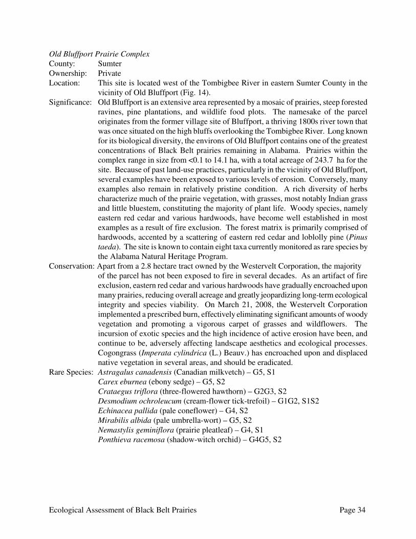
Old Bluffport Prairie Complex County: Sumter Ownership: Private Location: This site is located west of the Tombigbee River in eastern Sumter County in the
vicinity of Old Bluffport (Fig. 14). Significance: Old Bluffport is an extensive area represented by a mosaic of prairies, steep forested
ravines, pine plantations, and wildlife food plots. The namesake of the parcel originates from the former village site of Bluffport, a thriving 1800s river town that was once situated on the high bluffs overlooking the Tombigbee River. Long known for its biological diversity, the environs of Old Bluffport contains one of the greatest concentrations of Black Belt prairies remaining in Alabama. Prairies within the complex range in size from <0.1 to 14.1 ha, with a total acreage of 243.7 ha for the site. Because of past land-use practices, particularly in the vicinity of Old Bluffport, several examples have been exposed to various levels of erosion. Conversely, many examples also remain in relatively pristine condition. A rich diversity of herbs characterize much of the prairie vegetation, with grasses, most notably Indian grass and little bluestem, constituting the majority of plant life. Woody species, namely eastern red cedar and various hardwoods, have become well established in most examples as a result of fire exclusion. The forest matrix is primarily comprised of hardwoods, accented by a scattering of eastern red cedar and loblolly pine (Pinus taeda). The site is known to contain eight taxa currently monitored as rare species by the Alabama Natural Heritage Program.
Conservation: Apart from a 2.8 hectare tract owned by the Westervelt Corporation, the majority of the parcel has not been exposed to fire in several decades. As an artifact of fire exclusion, eastern red cedar and various hardwoods have gradually encroached upon many prairies, reducing overall acreage and greatly jeopardizing long-term ecological integrity and species viability. On March 21, 2008, the Westervelt Corporation implemented a prescribed burn, effectively eliminating significant amounts of woody vegetation and promoting a vigorous carpet of grasses and wildflowers. The incursion of exotic species and the high incidence of active erosion have been, and continue to be, adversely affecting landscape aesthetics and ecological processes. Cogongrass (Imperata cylindrica (L.) Beauv.) has encroached upon and displaced native vegetation in several areas, and should be eradicated.
Rare Species: Astragalus canadensis (Canadian milkvetch) – G5, S1 Carex eburnea (ebony sedge) – G5, S2 Crataegus triflora (three-flowered hawthorn) – G2G3, S2 Desmodium ochroleucum (cream-flower tick-trefoil) – G1G2, S1S2 Echinacea pallida (pale coneflower) – G4, S2 Mirabilis albida (pale umbrella-wort) – G5, S2 Nemastylis geminiflora (prairie pleatleaf) – G4, S1 Ponthieva racemosa (shadow-witch orchid) – G4G5, S2

Ecological Assessment of Black Belt Prairies Page 35
Examples:

Figure 14. Distribution of Black Belt prairies in the Old Bluffport Prairie Complex, Sumter County, Alabama.
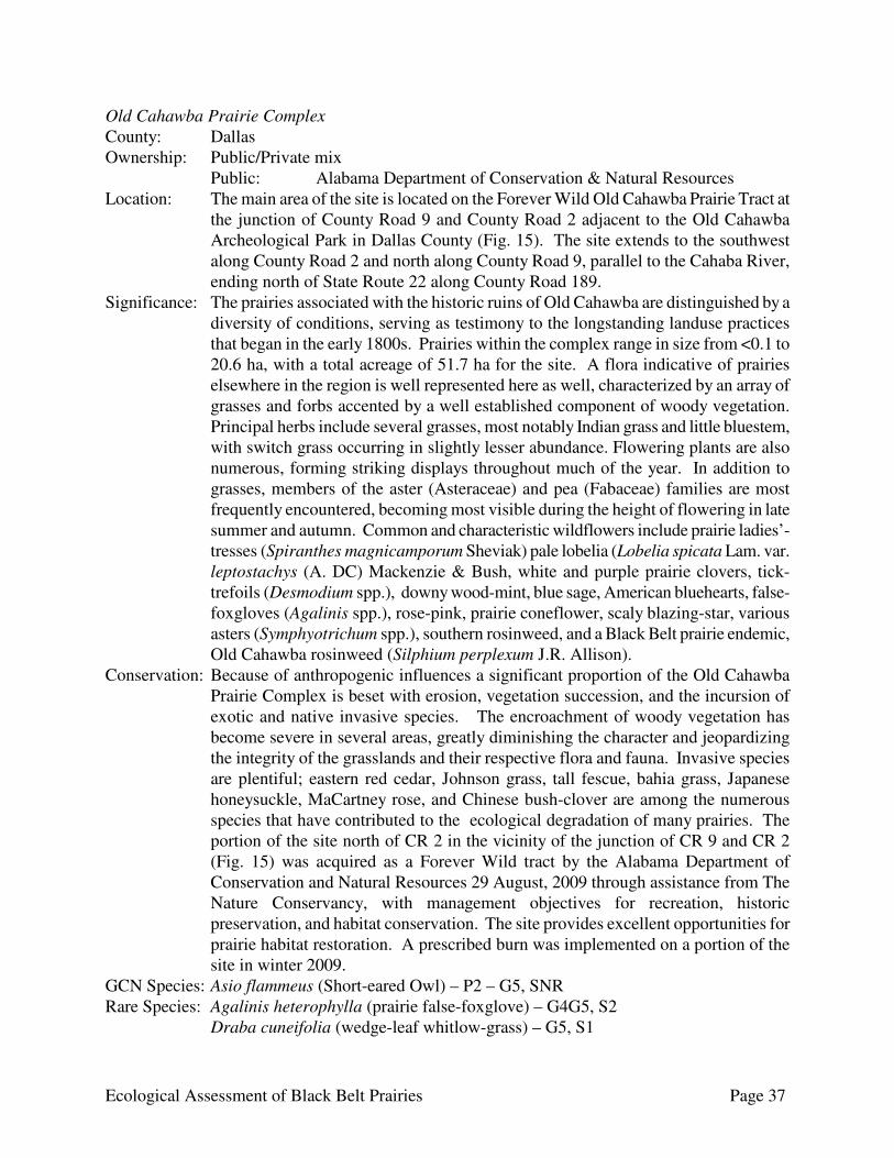
Ecological Assessment of Black Belt Prairies Page 37
Old Cahawba Prairie Complex County: Dallas Ownership: Public/Private mix Public: Alabama Department of Conservation & Natural Resources Location: The main area of the site is located on the Forever Wild Old Cahawba Prairie Tract at
the junction of County Road 9 and County Road 2 adjacent to the Old Cahawba Archeological Park in Dallas County (Fig. 15). The site extends to the southwest along County Road 2 and north along County Road 9, parallel to the Cahaba River, ending north of State Route 22 along County Road 189.
Significance: The prairies associated with the historic ruins of Old Cahawba are distinguished by a diversity of conditions, serving as testimony to the longstanding landuse practices that began in the early 1800s. Prairies within the complex range in size from <0.1 to 20.6 ha, with a total acreage of 51.7 ha for the site. A flora indicative of prairies elsewhere in the region is well represented here as well, characterized by an array of grasses and forbs accented by a well established component of woody vegetation. Principal herbs include several grasses, most notably Indian grass and little bluestem, with switch grass occurring in slightly lesser abundance. Flowering plants are also numerous, forming striking displays throughout much of the year. In addition to grasses, members of the aster (Asteraceae) and pea (Fabaceae) families are most frequently encountered, becoming most visible during the height of flowering in late summer and autumn. Common and characteristic wildflowers include prairie ladies’-tresses (Spiranthes magnicamporum Sheviak) pale lobelia (Lobelia spicata Lam. var. leptostachys (A. DC) Mackenzie & Bush, white and purple prairie clovers, tick-trefoils (Desmodium spp.), downy wood-mint, blue sage, American bluehearts, false-foxgloves (Agalinis spp.), rose-pink, prairie coneflower, scaly blazing-star, various asters (Symphyotrichum spp.), southern rosinweed, and a Black Belt prairie endemic, Old Cahawba rosinweed (Silphium perplexum J.R. Allison).
Conservation: Because of anthropogenic influences a significant proportion of the Old Cahawba Prairie Complex is beset with erosion, vegetation succession, and the incursion of exotic and native invasive species. The encroachment of woody vegetation has become severe in several areas, greatly diminishing the character and jeopardizing the integrity of the grasslands and their respective flora and fauna. Invasive species are plentiful; eastern red cedar, Johnson grass, tall fescue, bahia grass, Japanese honeysuckle, MaCartney rose, and Chinese bush-clover are among the numerous species that have contributed to the ecological degradation of many prairies. The portion of the site north of CR 2 in the vicinity of the junction of CR 9 and CR 2 (Fig. 15) was acquired as a Forever Wild tract by the Alabama Department of Conservation and Natural Resources 29 August, 2009 through assistance from The Nature Conservancy, with management objectives for recreation, historic preservation, and habitat conservation. The site provides excellent opportunities for prairie habitat restoration. A prescribed burn was implemented on a portion of the site in winter 2009.
GCN Species: Asio flammeus (Short-eared Owl) – P2 – G5, SNR Rare Species: Agalinis heterophylla (prairie false-foxglove) – G4G5, S2 Draba cuneifolia (wedge-leaf whitlow-grass) – G5, S1
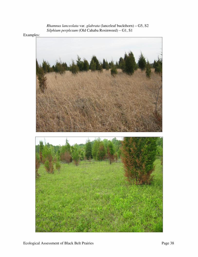
Ecological Assessment of Black Belt Prairies Page 38
Rhamnus lanceolata var. glabrata (lanceleaf buckthorn) – G5, S2 Silphium perplexum (Old Cahaba Rosinweed) – G1, S1 Examples:

Ecological Assessment of Black Belt Prairies Page 39
Figure 15. Distribution of Black Belt prairies in the Old Cahawba Prairie Complex, Dallas County, Alabama.

Ecological Assessment of Black Belt Prairies Page 40
Pleasant Ridge Prairie Complex County: Greene Ownership: Private Location: This site is located south of the Sipsey River in the northeastern corner of Greene
County around Pleasant Ridge along State Route 14 and County Road 120 (Fig. 16). Significance: The Pleasant Ridge Prairie Complex is a series of grasslands containing nearly 80%
of the plant life known to inhabit the Black Belt prairies. Prairies within the complex range in size from <0.1 to 5.6 ha, with a total acreage of 85.3 ha for the site. The floral diversity represents some of the most diverse to be found in the Black Belt. A representation of the more noteworthy and unusual prairie species include Indian grass, big bluestem (Andropogon gerardi Vitman), little bluestem, side-oats grama, lanceleaf buckthorn, white and purple prairie clovers, prairie coneflower (Echinacea pallida Nutt.), purple coneflower (Echinacea purpurea (L.) Moench), slender blazing-star, cream-flower tick-trefoil (Desmodium ochroleucum M.A. Curtis), prairie pleatleaf (Nemastylis geminiflora Nutt.), waxweed (Cuphea viscosissima Jacq.), and various asters (Symphyotrichum spp.), some of which have established impressive seasonal displays. Most examples are currently embedded within a matrix of eastern red cedar and a mix of regional hardwoods, most notably chinquapin oak, Shumard oak, nutmeg hickory (Carya myristiciformis (Michx. f.) Nutt.), pignut hickory, white ash, sugarberry, slippery elm (Ulmus rubra Muhl.), and redbud.
Conservation: While the Pleasant Ridge prairies have been adversely impacted to serve the interests of agriculture and forestry, most remain in good to excellent condition. The encroachment of eastern red cedar and various hardwoods have severely degraded portions of some prairies, but with the implementation of prescribed fire, most examples can be restored to rival historic conditions.
GCN Species: Lampropeltis getula holbrooki (speckled kingsnake) – P2 – G5T5, S3 Rare Species: Desmodium ochroleucum (cream-flower tick-trefoil) – G1G2, S1S2 Echinacea pallida (pale coneflower) – G4, S2 Nemastylis geminiflora (prairie pleatleaf) – G4, S1 Rhamnus lanceolata var. glabrata (lanceleaf buckthorn) – G5, S2
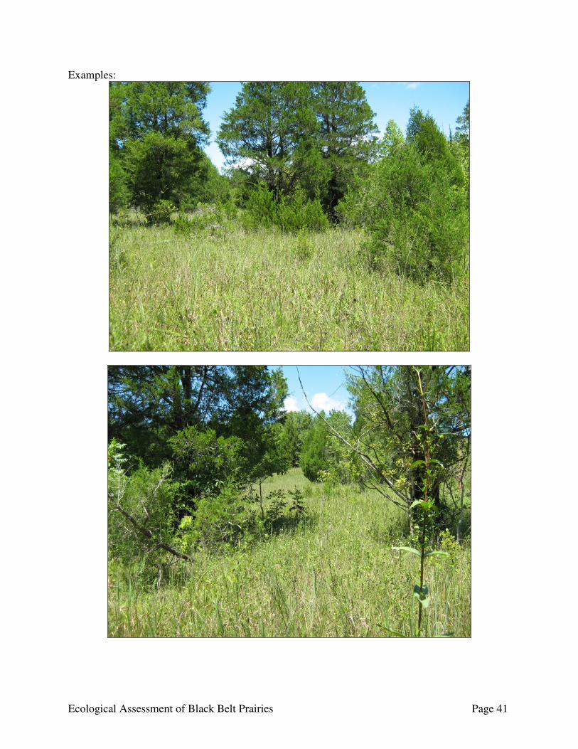
Ecological Assessment of Black Belt Prairies Page 41
Examples:
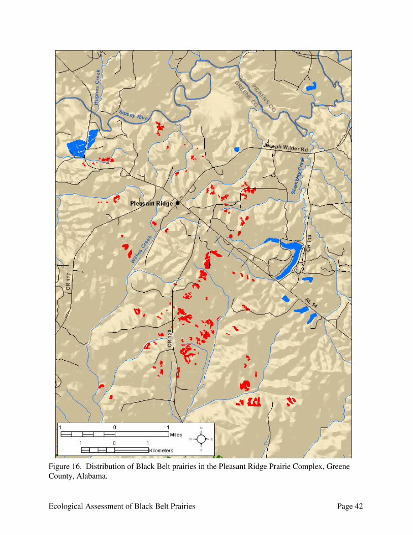
Ecological Assessment of Black Belt Prairies Page 42
Figure 16. Distribution of Black Belt prairies in the Pleasant Ridge Prairie Complex, Greene County, Alabama.
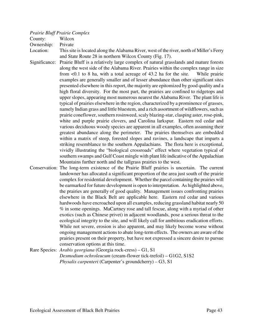
Ecological Assessment of Black Belt Prairies Page 43
Prairie Bluff Prairie Complex County: Wilcox Ownership: Private Location: This site is located along the Alabama River, west of the river, north of Miller’s Ferry
and State Route 28 in northern Wilcox County (Fig. 17). Significance: Prairie Bluff is a relatively large complex of natural grasslands and mature forests
along the west side of the Alabama River. Prairies within the complex range in size from <0.1 to 8 ha, with a total acreage of 43.2 ha for the site. While prairie examples are generally smaller and of lesser abundance than other significant sites presented elsewhere in this report, the majority are epitomized by good quality and a high floral diversity. For the most part, the prairies are confined to ridgetops and upper slopes, appearing most numerous nearest the Alabama River. The plant life is typical of prairies elsewhere in the region, characterized by a prominence of grasses, namely Indian grass and little bluestem, and a rich assortment of wildflowers, such as prairie coneflower, southern rosinweed, scaly blazing-star, clasping aster, rose-pink, white and purple prairie clovers, and Carolina larkspur. Eastern red cedar and various deciduous woody species are apparent in all examples, often assuming their greatest abundance along the perimeter. The prairies themselves are embedded within a matrix of steep, forested slopes and ravines, a landscape that imparts a striking resemblance to the southern Appalachians. The flora here is exceptional, vividly illustrating the “biological crossroads” effect where vegetation typical of southern swamps and Gulf Coast mingle with plant life indicative of the Appalachian Mountains further north and the tallgrass prairies to the west.
Conservation: The long-term existence of the Prairie Bluff prairies is uncertain. The current landowner has allocated a significant proportion of the area just south of the prairie complex for residential development. Whether the parcel containing the prairies will be earmarked for future development is open to interpretation. As highlighted above, the prairies are generally of good quality. Management issues confronting prairies elsewhere in the Black Belt are applicable here. Eastern red cedar and various hardwoods have encroached upon all examples, reducing grassland habitat nearly 50 % in some openings. MaCartney rose and tall fescue, along with a myriad of other exotics (such as Chinese privet) in adjacent woodlands, pose a serious threat to the ecological integrity to the site, and will likely call for ambitious eradication efforts. While not severe, erosion is also apparent, and may likely become worse without ongoing management actions to abate long-term effects. The owners are aware of the prairies present on their property, but have not expressed a sincere desire to pursue conservation options at this time.
Rare Species: Arabis georgiana (Georgia rock-cress) – G1, S1 Desmodium ochroleucum (cream-flower tick-trefoil) – G1G2, S1S2 Physalis carpenteri (Carpenter’s groundcherry) – G3, S1

Ecological Assessment of Black Belt Prairies Page 44
Figure 17. Distribution of Black Belt prairies in the Prairie Bluff Prairie Complex, Wilcox County, Alabama.
Ecological Assessment of Black Belt Prairies Page 45
Tilden-Carlowville Prairie Complex County: Dallas Ownership: Private Location: This site is located in southern Dallas County around the towns of Tilden and
Carlowville, extending south into Wilcox County (Fig. 18). Significance: The Tilden-Carlowville Prairie Complex contains one of the greatest concentrations
of Black Belt prairies remaining in Alabama, and was the fourth largest prairie complex identified in the state. A series of high quality prairies are centered in the vicinity of Tilden and Carlowville, several of which are visible along county roads and major highways. Prairies within the complex range in size from <0.1 to 29.7 ha, with a total acreage of 281.2 ha for the site. The vegetation is indicative of prairies throughout the Black Belt, represented by a diverse array of grasses and various wildflowers. Indian grass, little bluestem, white and purple prairie clovers, southern rosinweed, prairie coneflower, slender blazing-star (Liatris spicata (L.) Willd.), and rose-pink are some of the more commonly observed species, often forming colorful displays during the height of the growing season. The Tilden-Carlowville Prairies also support several rare plant taxa, including the only known site in Alabama for the creeping morning-glory (Evolvulus sericeus Swartz var. sericeus). The surrounding forests are equally as diverse, containing a rich assemblage of hardwoods accented by eastern red cedar and various pines, most notably loblolly, shortleaf, and spruce (Pinus taeda, P. echinata Mill., and P. glabra Walt., respectively).
Conservation: A general assessment of the Tilden-Carlowville Prairie Complex will indicate the condition of its grasslands to be of high quality. Apart from localized pockets of erosion, conversion to improved pastures, and the minor presence of exotic species, the Tilden-Carlowville prairies are recognized as some of the finest in the state. Despite not having been exposed to fire in several decades, the encroachment of woody vegetation appears relatively minimal, offering the observer a narrow window into the past, illustrating how the Black Belt region may have appeared during presettlement times.
Rare Species: Evolvulus sericeus var. sericeus (creeping morning-glory) – G5T3T5, S1 Veronicastrum virginicum (Culver’s-root) – G4, S1
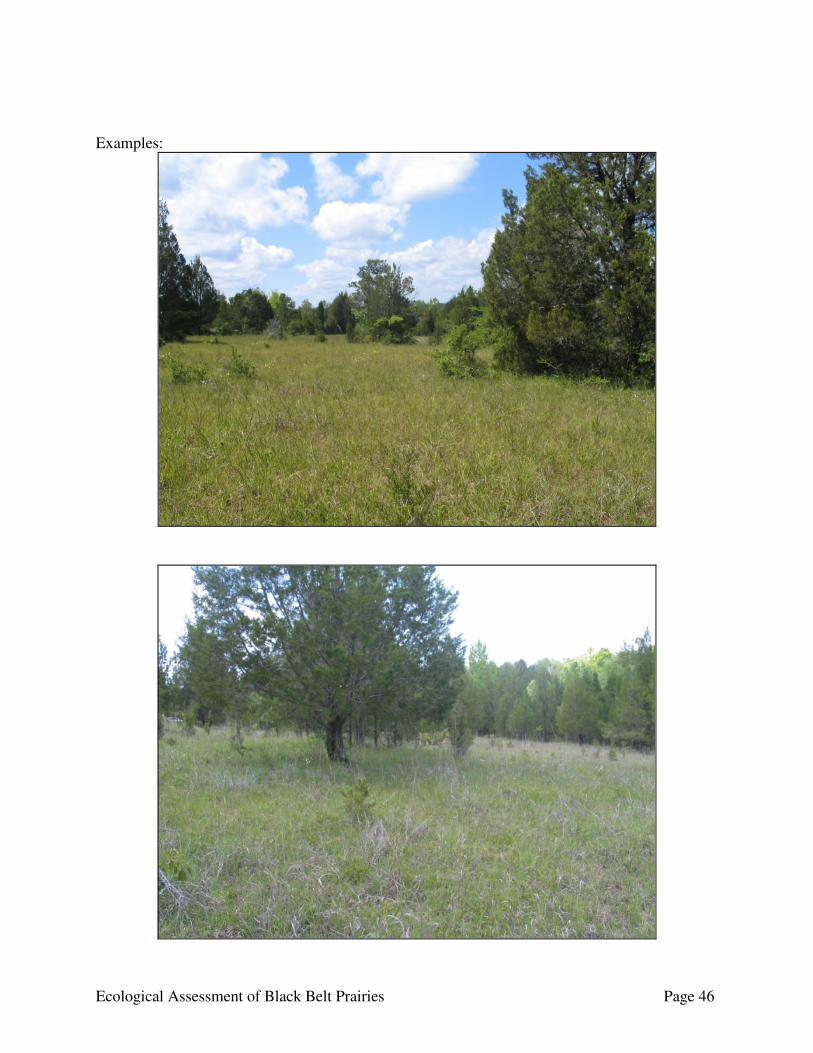
Ecological Assessment of Black Belt Prairies Page 46
Examples:
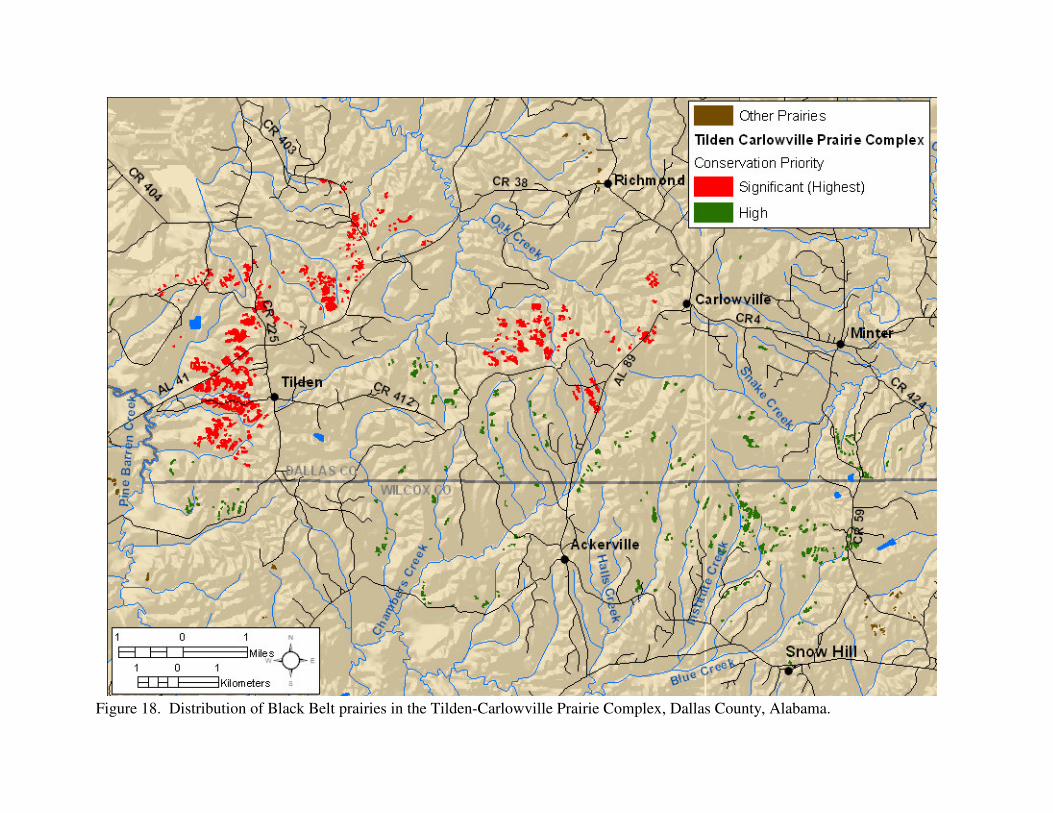
Figure 18. Distribution of Black Belt prairies in the Tilden-Carlowville Prairie Complex, Dallas County, Alabama.

Ecological Assessment of Black Belt Prairies Page 48
Autauga County Autauga County had few prairies within the county. We identified 84 prairies totaling 124 ha (306.4 ac) distributed in 3 sites in Autauga County. Prairies were restricted to the southwestern part of the county along the Alabama River (Fig. 19). The prairies are distributed in a band along approximately 10 miles of the Alabama River from River Mile 251 (Dutch Bend) to River Mile 241 (Jones Bluff), and were grouped in three sites: Jones Bluff-House Bluff Prairie Complex, Dutch Bend Prairies, and Kalmia Prairies (Table 4). The Dutch Bend Prairies and Kalmia Prairie sites are low conservation priority sites. The vast majority (82%) of the prairies in Autauga County were located in the Jones Bluff-House Bluff Prairie Complex, with 92% of the prairie acreage in the county at this site. Land ownership is a mosaic of public property (Army Corps of Engineers’ Jones Bluff Park) and many private land owners. Although the county contained a small amount of prairies relative to other counties in the Black Belt, the Jones Bluff-House Bluff Prairie Complex is a significant prairie site and should be a priority site for prairie conservation and restoration. This site was subdivided into three sub-sites: Jones Bluff, House Bluff, and Howard Creek. Jones Bluff and House Bluff are higher priority for conservation action than Howard Creek. The Jones Bluff sub-site encompassed the prairies on the Army Corps of Engineers’ Jones Bluff Park as well as the few small prairie fragments north of the western half of the park. House Bluff encompassed the prairies north of the Alabama River at House Bluff around Brown Branch and Beaver Creek, and contained the largest contiguous prairie area of any site in the Black Belt. Howard Creek encompassed those prairies along the Alabama River north of Howard Creek and along an unnamed tributary. Prairie conservation efforts at the site should focus on the Jones Bluff and House Bluff sub-sites. The site is described further in the significant prairie section above. Table 4. Number of prairies, total prairie acreage; and maximum (max), mean, and median prairie size (ha) for Black Belt prairie sites in Autauga County, Alabama.
Number of Prairies
Prairie Size (ha) Prairie Site
Total Acreage
Max
Median
Mean
Dutch Bend Prairies 7 4.3 3.1 0.1 0.6 Jones Bluff-House Bluff Prairie Complex a 69 114.2 49.7 0.4 1.7 Kalmia Prairies 8 5.5 2.1 0.1 0.7
a Significant (highest conservation priority) site.
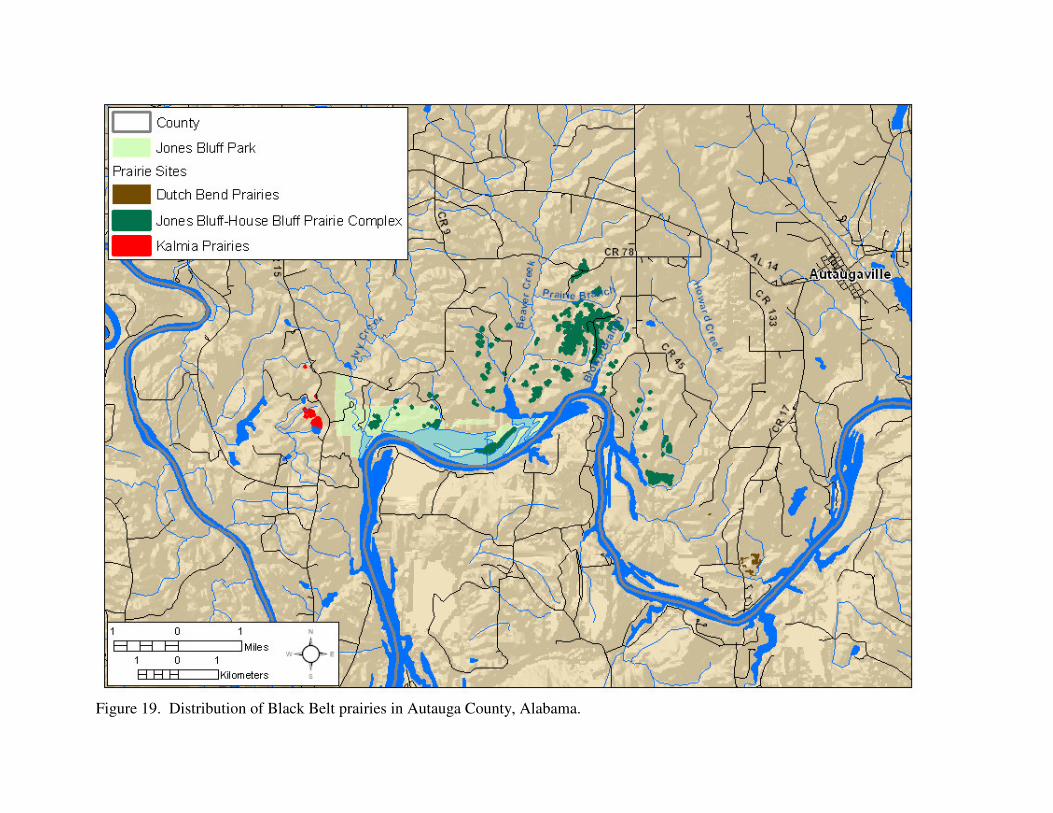
Figure 19. Distribution of Black Belt prairies in Autauga County, Alabama.
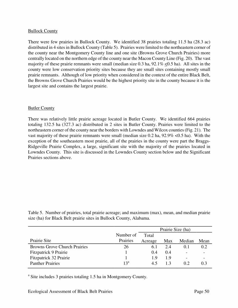
Ecological Assessment of Black Belt Prairies Page 50
Bullock County There were few prairies in Bullock County. We identified 38 prairies totaling 11.5 ha (28.3 ac) distributed in 4 sites in Bullock County (Table 5). Prairies were limited to the northeastern corner of the county near the Montgomery County line and one site (Browns Grove Church Prairies) more centrally located on the northern edge of the county near the Macon County Line (Fig. 20). The vast majority of these prairie remnants were small (median size 0.3 ha, 92.1% <0.5 ha). All sites in the county were low conservation priority sites because they are small sites containing mostly small prairie remnants. Although of low priority when considered in the context of the entire Black Belt, the Browns Grove Church Prairies would be the highest priority site in the county because it is the largest site and contains the largest prairie. Butler County There was relatively little prairie acreage located in Butler County. We identified 664 prairies totaling 132.5 ha (327.3 ac) distributed in 2 sites in Butler County. Prairies were limited to the northeastern corner of the county near the borders with Lowndes and Wilcox counties (Fig. 21). The vast majority of these prairie remnants were small (median size 0.2 ha, 92.9% <0.5 ha). With the exception of the southeastern most prairie, all of the prairies in the county were part the Braggs-Ridgeville Prairie Complex, a large, significant site with the majority of the prairies located in Lowndes County. This site is discussed in the Lowndes County section below and the Significant Prairies sections above. Table 5. Number of prairies, total prairie acreage; and maximum (max), mean, and median prairie size (ha) for Black Belt prairie sites in Bullock County, Alabama. Prairie Site
Number of
Prairies
Prairie Size (ha) Total
Acreage
Max
Median
Mean Browns Grove Church Prairies 26 6.1 2.4 0.1 0.2 Fitzpatrick 9 Prairie 1 0.4 0.4 - - Fitzpatrick 32 Prairie 1 1.9 1.9 - - Panther Prairies 13a 4.5 1.3 0.2 0.3
a Site includes 3 prairies totaling 1.5 ha in Montgomery County.

Ecological Assessment of Black Belt Prairies Page 51
Figure 20. Distribution of Black Belt prairies in Bullock County, Alabama.
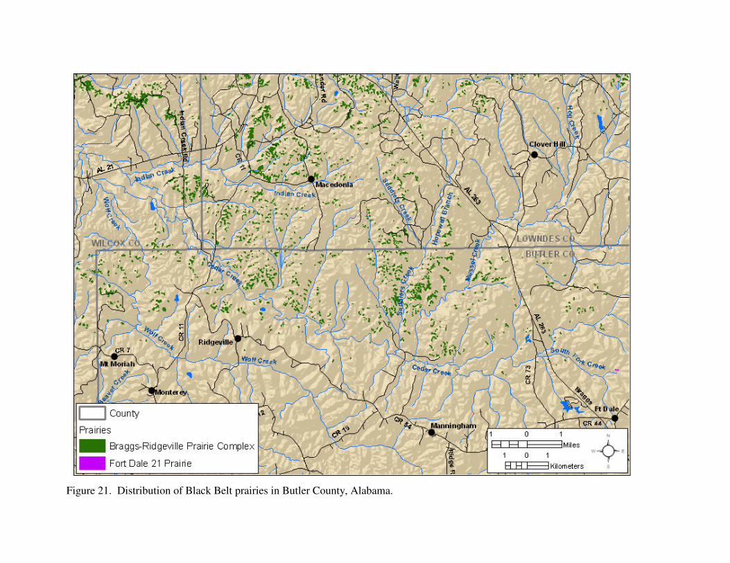
Figure 21. Distribution of Black Belt prairies in Butler County, Alabama.

Ecological Assessment of Black Belt Prairies Page 53
Crenshaw County There were relatively few Black Belt prairies in Crenshaw County. We identified 88 prairies totaling 17.5 ha (43.2 ac) distributed in 2 sites in Crenshaw County (Table 6). Prairies were limited to the northernmost section of the county, and are distributed in an east-west band from the border with Montgomery County near Naftel to the border with Lowndes County near Flatwoods (Fig. 22). The prairies in Crenshaw County generally are small remnants (median size of 0.3 ac, 92% <0.5 ha). Many show signs of past disturbance or agricultural use, being either eroded, infested with exotics to varying degrees, or fragmented. The prairies occur in two sites in the county, both of which are low priority sites. Both sites are moderate priority sites, and continue into adjacent counties. However, the majority of the prairies for both sites are in Crenshaw County. Periodic prescribed fire, assuming a gradual transition from dormant season to growing season burns, would be beneficial to restore and maintain ecological integrity within the sites. The Browns Lake-Mt Carmel Prairie Complex extends from State Route 97 west of Mt Carmel southwest along Beaver Dam Creek and Burgany Creek and extending west into Lowndes County to west of Browns Lake. This site contained 82 individual prairies totaling 18.3 ha (45.3 ac). The prairies in this site generally are small (median size 0.1 ha, 96% <0.5 ha). Although the site contains some good quality prairies, others show signs of past disturbance or agricultural use with varying degrees of erosion and exotic infestations present. Most of the larger prairies tended to be in the vicinity of Browns Lake and show signs of past disturbance such as erosion. The Pintlala Creek Prairies begin northeast of Rocky Mt Road at its intersection with State Route 97 and extend southeast following the ridge to Pintlala Creek and continuing southeast on either side of Pintlala Creek to Russells Lake in Montgomery County. This site contained 58 individual prairies totaling 11.3 ha (27.9 ac). The prairies in this site generally are small (median size 0.1 ha, 96% <0.5 ha). Although the site contains some good quality prairies, others show signs of past disturbance or agricultural use with varying degrees of erosion and exotic infestations present.
Small prairie in the Browns Lake-Mt Carmel Prairie Complex.
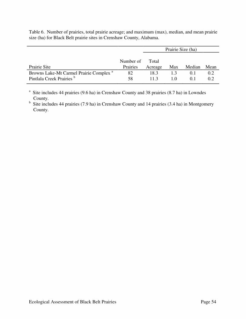
Ecological Assessment of Black Belt Prairies Page 54
Table 6. Number of prairies, total prairie acreage; and maximum (max), median, and mean prairie size (ha) for Black Belt prairie sites in Crenshaw County, Alabama. Prairie Size (ha) Prairie Site
Number of
Prairies
Total
Acreage
Max
Median
Mean Browns Lake-Mt Carmel Prairie Complex a 82 18.3 1.3 0.1 0.2 Pintlala Creek Prairies b 58 11.3 1.0 0.1 0.2
a Site includes 44 prairies (9.6 ha) in Crenshaw County and 38 prairies (8.7 ha) in Lowndes
County. b Site includes 44 prairies (7.9 ha) in Crenshaw County and 14 prairies (3.4 ha) in Montgomery
County.
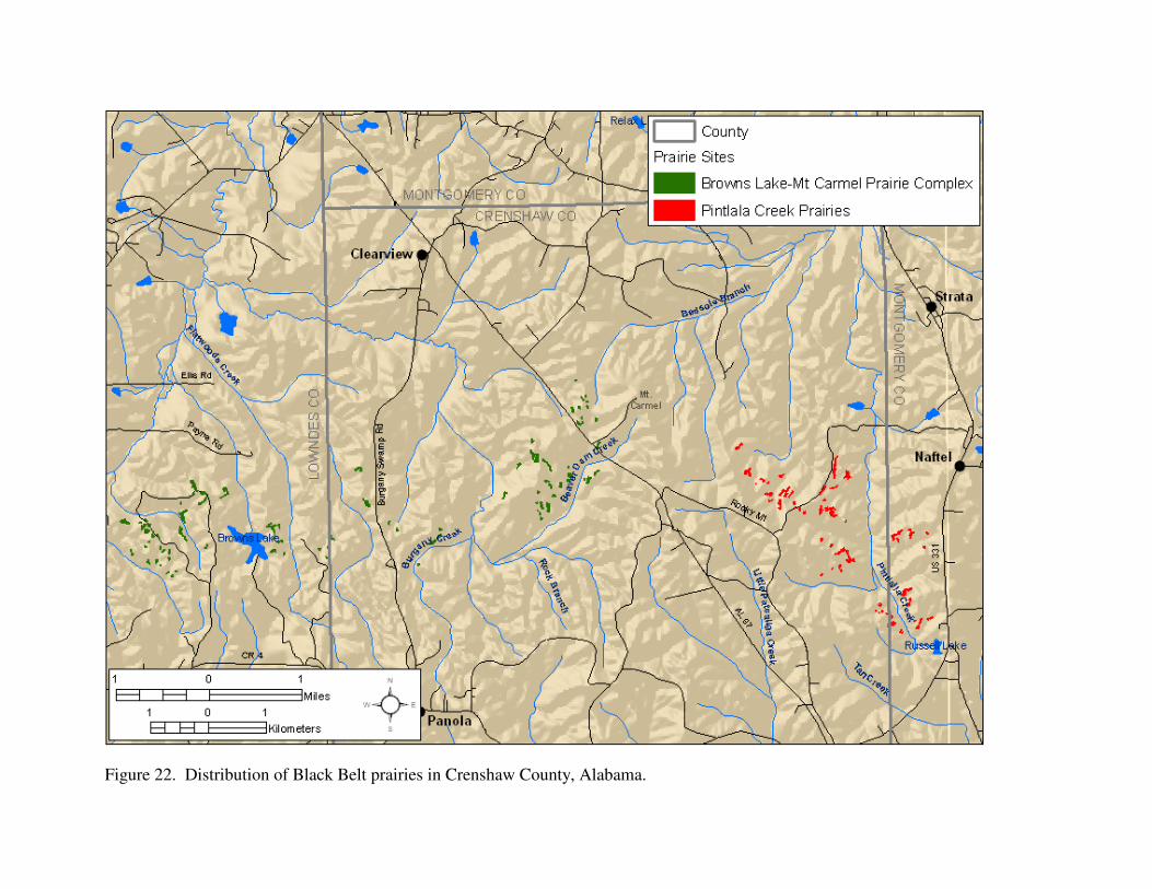
Figure 22. Distribution of Black Belt prairies in Crenshaw County, Alabama.

Ecological Assessment of Black Belt Prairies Page 56
Dallas County Dallas County had the third highest total prairie acreage for the counties in the Black Belt. Barone (2005) reported 2,300 ha of prairie in Dallas County from General Land Office surveys in the 1830s. We identified 1,506 individual prairies totaling 807 ha located in 31 sites in Dallas County (Table 7 – Three sites with prairies primarily in other counties are omitted from the table.). Prairies were distributed throughout most of the county, but generally occurred in bands running northwest to southeast through the county (Fig. 23). The largest concentrations and highest quality prairies tended to occur in the southern third of the county. The majority of the prairies in the county were small (median size 0.2 ha, 77.8% <0.5 ha). Many of the prairies show signs of past disturbance or agricultural use, being either eroded, infested with invasive species to varying degrees, or fragmented. Long-term erosion has resulted in deep gullies and large areas of exposed white chalk nearly devoid of vegetation in numerous prairies. As an artifact of fire exclusion, eastern red cedar and various hardwoods have gradually encroached upon many prairies, reducing overall acreage and greatly jeopardizing long-term ecological integrity and species viability. Periodic prescribed fire, assuming a gradual transition from dormant season to growing season burns, would be beneficial to restore and maintain ecological integrity within the sites. Three of the sites were significant (highest priority) sites or contained significant sub-sites: Elm Bluff Prairies in the Elm Bluff Prairie Complex, Old Cahawba Prairie Complex, and Tilden-Carlowville Prairie Complex. Four of the ten largest prairies in the county were located in the Tilden sub-site of the Tilden-Carlowville Prairie Complex, including the largest individual prairie in the county. There were two high priority sites containing prairies in Dallas County: the Old Town SE-Collirene N Prairie Complex, and the Uniontown-Faunsdale Prairie Complex. The Old Town SE-Collirene N Prairie Complex primarily occurs in Lowndes County, and the Unionotown-Faunsdale Prairie Complex occurs primarily in Perry County. These sites are discussed in their respective counties of primary occurrence. There were two moderate priority sites with prairies in Dallas County: the Belknap Prairie Complex and Harrell Prairie Complex. The remaining 23 sites located in Dallas County were a low conservation priority because they primarily contain small prairies, the total prairie acreage is low, most of the prairies in the site suffer from heavy woody encroachment, or the majority are heavily degraded by erosion or exotic infestation. The Belknap Prairie Complex is complex of several sub-sites located in eastern Dallas County south of Mush Creek between Belknap and Pleasant Hill. For the most part, the prairies are confined to ridgetops and upper slopes along the ridges paralleling Cedar Creek and Mush Creek. Many of the prairies show signs of past disturbance or agricultural use, being either eroded, infested with exotics to varying degrees, or fragmented. Several of the largest prairies have been greatly impacted by past land-use practices with long-term
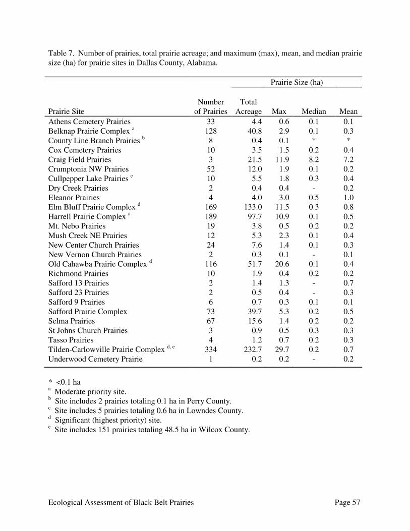
Ecological Assessment of Black Belt Prairies Page 57
Table 7. Number of prairies, total prairie acreage; and maximum (max), mean, and median prairie size (ha) for prairie sites in Dallas County, Alabama. Prairie Size (ha) Prairie Site
Number
of Prairies
Total
Acreage
Max
Median
Mean Athens Cemetery Prairies 33 4.4 0.6 0.1 0.1 Belknap Prairie Complex a 128 40.8 2.9 0.1 0.3 County Line Branch Prairies b 8 0.4 0.1 * * Cox Cemetery Prairies 10 3.5 1.5 0.2 0.4 Craig Field Prairies 3 21.5 11.9 8.2 7.2 Crumptonia NW Prairies 52 12.0 1.9 0.1 0.2 Cullpepper Lake Prairies c 10 5.5 1.8 0.3 0.4 Dry Creek Prairies 2 0.4 0.4 - 0.2 Eleanor Prairies 4 4.0 3.0 0.5 1.0 Elm Bluff Prairie Complex d 169 133.0 11.5 0.3 0.8 Harrell Prairie Complex a 189 97.7 10.9 0.1 0.5 Mt. Nebo Prairies 19 3.8 0.5 0.2 0.2 Mush Creek NE Prairies 12 5.3 2.3 0.1 0.4 New Center Church Prairies 24 7.6 1.4 0.1 0.3 New Vernon Church Prairies 2 0.3 0.1 - 0.1 Old Cahawba Prairie Complex d 116 51.7 20.6 0.1 0.4 Richmond Prairies 10 1.9 0.4 0.2 0.2 Safford 13 Prairies 2 1.4 1.3 - 0.7 Safford 23 Prairies 2 0.5 0.4 - 0.3 Safford 9 Prairies 6 0.7 0.3 0.1 0.1 Safford Prairie Complex 73 39.7 5.3 0.2 0.5 Selma Prairies 67 15.6 1.4 0.2 0.2 St Johns Church Prairies 3 0.9 0.5 0.3 0.3 Tasso Prairies 4 1.2 0.7 0.2 0.3 Tilden-Carlowville Prairie Complex d, e 334 232.7 29.7 0.2 0.7 Underwood Cemetery Prairie 1 0.2 0.2 - 0.2
* <0.1 ha a Moderate priority site. b Site includes 2 prairies totaling 0.1 ha in Perry County. c Site includes 5 prairies totaling 0.6 ha in Lowndes County. d Significant (highest priority) site. e Site includes 151 prairies totaling 48.5 ha in Wilcox County.
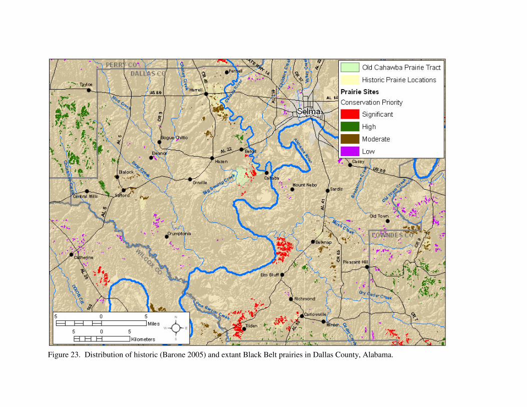
Figure 23. Distribution of historic (Barone 2005) and extant Black Belt prairies in Dallas County, Alabama.

Ecological Assessment of Black Belt Prairies Page 59
erosion resulting in deep gullies or large areas of exposed white chalk nearly devoid of vegetation. The prairies with the best ecological integrity tended to be in the CR 434 sub-site, making it the highest priority sub-site for prairie conservation. This sub-site is a concentration of prairies of relatively good ecological integrity south of County Road 434, southeast of Belknap. The Harrell Prairie Complex is located in northern Dallas County in the vicinity of Harrell south of the Wilcox County line. The majority of the prairies in the site are located southeast of Harrell in an area bordered by US 80 to the north, County Road 45 to the west, County Road 189 to the south, and the Cahaba River to the east. The site also includes prairies southwest of this main area on either side of Hurricane Creek and north of the site along the Cahaba River and Dry Creek. This site is to the north of the Old Cahawba Prairie Complex along the Cahaba River and could be considered an extension of that site. Although this is one of the largest sites in terms of total prairie acreage, most of the larger prairies have been greatly impacted by past land-use practices. Long-term erosion has resulted in deep gullies and large areas of exposed white chalk nearly devoid of vegetation. The other prairies in the site appear to range in quality from relatively good to severely degraded by erosion, infestation of exotics, or woody encroachment. Greene County Greene County had one of the higher total prairie acreage for counties in the Black Belt. We identified 773 individual prairies totaling 688.9 ha (1,702.2 ac) located in 16 sites in Greene County (Table 8). The prairies occurred in a broad band running from northwest to southeast through the county (Fig. 24). The majority of the prairies in the county are small (median size 0.3 ha, 60.4% <0.5 ha). Many of the prairies show signs of past disturbance or agricultural use, being either eroded, infested with invasive species to varying degrees, or fragmented. Long-term erosion has resulted in deep gullies and large areas of exposed white chalk nearly devoid of vegetation in numerous prairies. As an artifact of fire exclusion, eastern red cedar and various hardwoods have gradually encroached upon many prairies, reducing overall acreage and greatly jeopardizing long-term ecological integrity and species viability. Periodic prescribed fire, assuming a gradual transition from dormant season to growing season burns, would be beneficial to restore and maintain ecological integrity within the sites. There was one significant site in Greene County: the Pleasant Ridge Prairie Complex. This site is discussed in the Significant Prairies section above. There were 3 high priority sites in Greene County: Braggville-Five Points Prairie Complex, Culpepper Creek Prairies, and West Greene-Mt. Hebron Prairie Complex. The remaining 10 sites located in Greene County were a low conservation priority because they primarily contain small prairies, the total prairie acreage is low, most of the prairies in the site suffer from heavy woody encroachment, or the majority are heavily degraded by erosion or exotic infestation. The Braggville-Five Points Prairie Complex is a complex of prairies on either side of County Road 20 between the towns of Thornhill and Boligee in southern Greene County. This site is the fifth largest in Alabama’s Black Belt and the largest site in Greene County by total prairie acreage, with a total prairie acreage of 273.6 ha. Numerous prairie openings ranging in size from 0.01 to 9.7 ha are

Ecological Assessment of Black Belt Prairies Page 60
Table 8. Number of prairies, total prairie acreage; and maximum (max), mean, and median prairie size (ha) for prairie sites in Greene County, Alabama. Prairie Size (ha) Prairie Site
Number of
Prairies
Total
Acreage
Max
Median
Mean Allison Prairie 1 0.5 0.5 - - Boligee Prairies 9 3.6 1.4 0.3 0.4 Braggville-Five Points Prairie Complex a 314 273.6 9.7 0.3 0.9 Culpepper Creek Prairies a 92 52.4 4.3 0.3 0.6 Eutaw Prairie Complex 40 13.6 1.3 0.2 0.3 Fannim Hill Prairie 1 0.5 - - - Forkland Prairies 12 10.0 3.3 0.2 0.8 Hill Cemetery Prairies 2 2.1 1.8 - 1.1 Hutton Cemetery Prairie Complex 20 14.3 2.5 0.7 0.7 Little Vine Church Prairies 2 2.1 1.9 - 1.0 Macedonia Church Prairies b 52 67.3 9.0 0.4 1.3 Miller Branch Prairies 6 2.7 0.8 0.5 0.5 Pleasant Ridge Prairie Complex c 113 85.3 5.6 0.4 0.8 Rosemont Prairies 19 5.4 3.4 0.1 0.3 Trussells Creek 16 Prairies 14 25.9 12.5 0.4 1.8 West Greene-Mt. Hebron Prairie Complex a 76 129.5 13.0 0.5 1.7
a High priority site. b Moderate priority site. c Significant (highest priority) site.
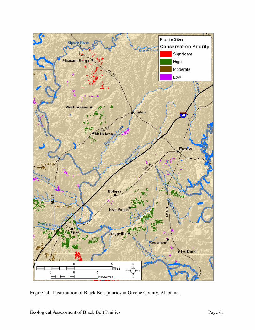
Ecological Assessment of Black Belt Prairies Page 61
Figure 24. Distribution of Black Belt prairies in Greene County, Alabama.

Ecological Assessment of Black Belt Prairies Page 62
distributed throughout the site, with the prairies primarily located in two clusters oriented from northeast to southwest paralleling Taylor Creek. One is southeast of Taylor Creek starting from southwest of Braggville running through Hagan Hill and crossing County Road 20 to Burton Hill and County Road 142 and occurring on either side of CR 142 southeast to Thornhill. The other cluster is located in the vicinity of the crossroads community of Five Points north of County Road 148 to County Road 138 and US 11. There also is a small cluster near the town of Hycutt. For the most part, the prairies are confined to ridgetops and upper slopes along the ridges to either side of Taylor Creek in a landscape mosaic primarily of forested and agricultural land. Although this is the largest site by total prairie acreage in Greene County, the quality of prairies is highly variable. Some examples represent good integrity, but the majority are moderately to severely degraded from erosion, infestations of exotics, and/or the encroachment of woody vegetation, primarily eastern red cedar. Many of the prairies show signs of past disturbance or agricultural use. Restoration efforts likely would be complicated by the highly fragmented nature of land ownership at the site.
The Culpepper Creek Prairies are a cluster of prairies in southeastern Greene County located northwest of Walden Quarters along the Black Warrior River. The prairies are primarily located south of Culpepper Creek and east of US 43. The prairies range in size from 0.02 to 4.3 ha, with a total acreage of 52.4 ha. For the most part, the prairies are confined to ridgetops and upper slopes along the ridges within the remaining forests in an agricultural landscape. The quality of the prairies is highly variable, ranging from relatively high ecological integrity to severely degraded. Many of the largest prairies have been greatly impacted by past land-use practices with long-term erosion resulting in gullies or large areas of exposed white chalk nearly devoid of vegetation. Although no vertebrate surveys were conducted at this site, an American Kestrel was observed along US 43 < 2 km northeast of the site.
Prairie in the Braggville-Five Points Prairie Complex with relatively good ecological integrity.
Eroded prairie in the Braggville-Five Points Prairie Complex.
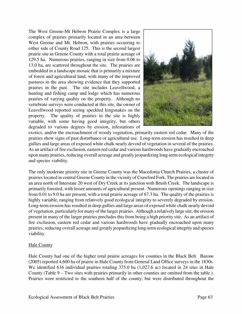
Ecological Assessment of Black Belt Prairies Page 63
The West Greene-Mt Hebron Prairie Complex is a large complex of prairies primarily located in an area between West Greene and Mt. Hebron, with prairies occurring to either side of County Road 125. This is the second largest prairie site in Greene County with a total prairie acreage of 129.5 ha. Numerous prairies, ranging in size from 0.06 to 13.0 ha, are scattered throughout the site. The prairies are embedded in a landscape mosaic that is primarily a mixture of forest and agricultural land, with many of the improved pastures in the area showing evidence that they supported prairies in the past. The site includes Leavellwood, a hunting and fishing camp and lodge which has numerous prairies of varying quality on the property. Although no vertebrate surveys were conducted at this site, the owner of Leavellwood reported seeing speckled kingsnakes on the property. The quality of prairies in the site is highly variable, with some having good integrity, but others degraded to various degrees by erosion, infestations of exotics, and/or the encroachment of woody vegetation, primarily eastern red cedar. Many of the prairies show signs of past disturbance or agricultural use. Long-term erosion has resulted in deep gullies and large areas of exposed white chalk nearly devoid of vegetation in several of the prairies. As an artifact of fire exclusion, eastern red cedar and various hardwoods have gradually encroached upon many prairies, reducing overall acreage and greatly jeopardizing long-term ecological integrity and species viability. The only moderate priority site in Greene County was the Macedonia Church Prairies, a cluster of prairies located in central Greene County in the vicinity of Crawford Fork. The prairies are located in an area north of Interstate 20 west of Dry Creek at its junction with Brush Creek. The landscape is primarily forested, with lesser amounts of agricultural present. Numerous openings ranging in size from 0.01 to 9.0 ha are present, with a total prairie acreage of 67.3 ha. The quality of the prairies is highly variable, ranging from relatively good ecological integrity to severely degraded by erosion. Long-term erosion has resulted in deep gullies and large areas of exposed white chalk nearly devoid of vegetation, particularly for many of the larger prairies. Although a relatively large site, the erosion present in many of the larger prairies precludes this from being a high priority site. As an artifact of fire exclusion, eastern red cedar and various hardwoods have gradually encroached upon many prairies, reducing overall acreage and greatly jeopardizing long-term ecological integrity and species viability. Hale County Hale County had one of the higher total prairie acreages for counties in the Black Belt. Barone (2005) reported 4,600 ha of prairie in Hale County from General Land Office surveys in the 1830s. We identified 616 individual prairies totaling 375.0 ha (1,027.6 ac) located in 24 sites in Hale County (Table 9 – Two sites with prairies primarily in other counties are omitted from the table.). Prairies were restricted to the southern half of the county, but were distributed throughout the

Ecological Assessment of Black Belt Prairies Page 64
southern half (Fig. 25). The majority of the prairies in the county are small (median size 0.2 ha, 76.3% <0.5 ha). Many of the prairies show signs of past disturbance or agricultural use, being either eroded, infested with invasive species to varying degrees, or fragmented. Long-term erosion has resulted in deep gullies and large areas of exposed white chalk nearly devoid of vegetation in numerous prairies. As an artifact of fire exclusion, eastern red cedar and various hardwoods have gradually encroached upon many prairies, reducing overall acreage and greatly jeopardizing long-term ecological integrity and species viability. Periodic prescribed fire, assuming a gradual transition from dormant season to growing season burns, would be beneficial to restore and maintain ecological integrity within the sites. The only high priority site in Hale County was the Limestone Lakes Prairie Complex. The Limestone Lakes Prairie Complex is a complex of prairies in western Hale County along the Black Warrior River west of Greensboro south of Hines Creek. The complex consists of three sub-sites: the CR 17 sub-site located west of County Road 17 between Millwood Rd and New Hope Rd, Long Cemetery sub-site located in the vicinity of the junction of County Road 35 and County Road 28, and Sully Ponds located south of County Road 24 along Limestone Creek. Most of the prairies have been heavily impacted by conversion to agricultural use, and retain a preponderance of weedy species from their use as pasture. The site was selected as a high priority because of the excellent restoration potential provided by the CR 17 sub-site. This sub-site contains the largest contiguous area digitized for this project. This property was used for both row crops and pasture in the past. Although some portions of this area are of relatively good ecological integrity, a large portion exhibits impacts from its agricultural use, and retains a preponderance of weedy and invasive species such as tall fescue, Johnson grass, and MaCartney rose from its agricultural use. The owner is interested in managing the area to promote the growth of native prairie species, to enhance prairie integrity, and to exterminate the invasive species present making it an excellent site for restoration. There were four moderate priority sites in Hale County: the Mt Olive Baptist Church Prairies, Rosemary Prairies, State Cattle Ranch-Casemore Prairie Complex, and Wolf Bluff Prairie Complex. The remaining 18 sites located in Hale County were a low conservation priority because they primarily contain small prairies, the total prairie acreage is low, most of the prairies in the site suffer from heavy woody encroachment, or the majority are heavily degraded by erosion or exotic infestation. The Mt. Olive Baptist Church Prairies are a group of prairies located in southwestern Hale County on the border with Marengo County. The prairies occur north of US 80 along Mt Olive Rd and County Road 77. The quality of the prairies is highly variable, ranging from relatively good integrity to severely degraded by woody encroachment. As an artifact of fire exclusion, eastern red cedar and various hardwoods have gradually encroached upon most of the prairies, reducing overall acreage and greatly jeopardizing long-term ecological integrity and species viability. Several of the prairies contain large areas of exposed white chalk nearly devoid of vegetation. Although the restoration potential for these prairies is good, restoration and management efforts likely would be hampered by the fragmented land ownership pattern and the close proximity of small residential complexes which could make the use of prescribed fire difficult.
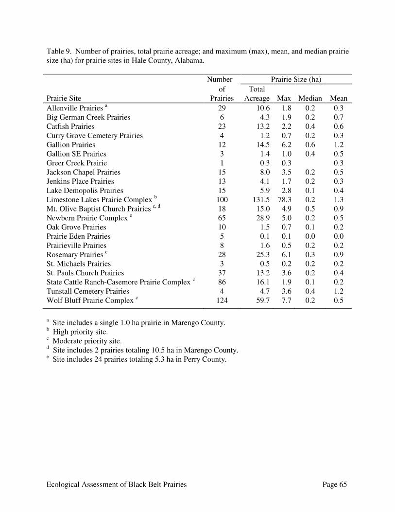
Ecological Assessment of Black Belt Prairies Page 65
Table 9. Number of prairies, total prairie acreage; and maximum (max), mean, and median prairie size (ha) for prairie sites in Hale County, Alabama. Number Prairie Size (ha) Prairie Site
of Prairies
Total Acreage
Max
Median
Mean
Allenville Prairies a 29 10.6 1.8 0.2 0.3 Big German Creek Prairies 6 4.3 1.9 0.2 0.7 Catfish Prairies 23 13.2 2.2 0.4 0.6 Curry Grove Cemetery Prairies 4 1.2 0.7 0.2 0.3 Gallion Prairies 12 14.5 6.2 0.6 1.2 Gallion SE Prairies 3 1.4 1.0 0.4 0.5 Greer Creek Prairie 1 0.3 0.3 0.3 Jackson Chapel Prairies 15 8.0 3.5 0.2 0.5 Jenkins Place Prairies 13 4.1 1.7 0.2 0.3 Lake Demopolis Prairies 15 5.9 2.8 0.1 0.4 Limestone Lakes Prairie Complex b 100 131.5 78.3 0.2 1.3 Mt. Olive Baptist Church Prairies c, d 18 15.0 4.9 0.5 0.9 Newbern Prairie Complex e 65 28.9 5.0 0.2 0.5 Oak Grove Prairies 10 1.5 0.7 0.1 0.2 Prairie Eden Prairies 5 0.1 0.1 0.0 0.0 Prairieville Prairies 8 1.6 0.5 0.2 0.2 Rosemary Prairies c 28 25.3 6.1 0.3 0.9 St. Michaels Prairies 3 0.5 0.2 0.2 0.2 St. Pauls Church Prairies 37 13.2 3.6 0.2 0.4 State Cattle Ranch-Casemore Prairie Complex c 86 16.1 1.9 0.1 0.2 Tunstall Cemetery Prairies 4 4.7 3.6 0.4 1.2 Wolf Bluff Prairie Complex c 124 59.7 7.7 0.2 0.5
a Site includes a single 1.0 ha prairie in Marengo County. b High priority site. c Moderate priority site. d Site includes 2 prairies totaling 10.5 ha in Marengo County. e Site includes 24 prairies totaling 5.3 ha in Perry County.
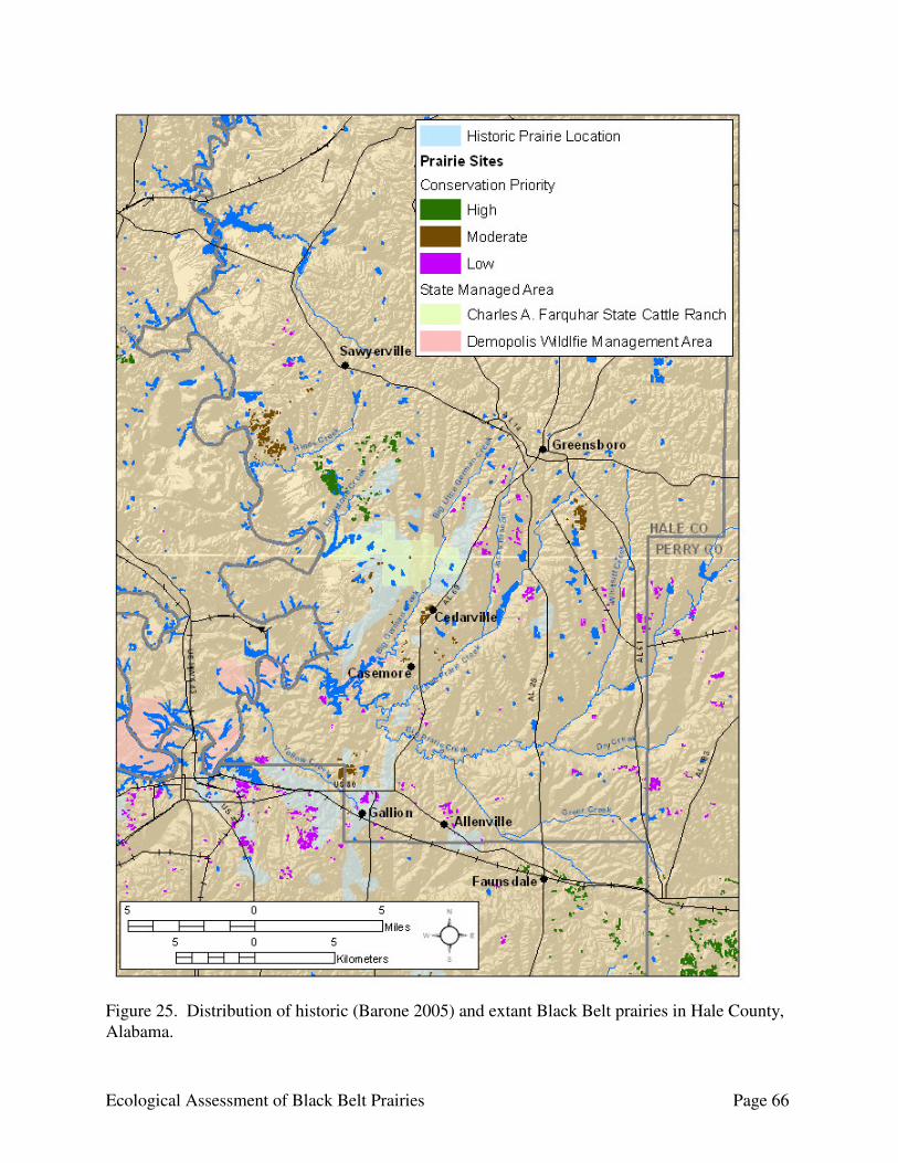
Ecological Assessment of Black Belt Prairies Page 66
Figure 25. Distribution of historic (Barone 2005) and extant Black Belt prairies in Hale County, Alabama.

Ecological Assessment of Black Belt Prairies Page 67
The Rosemary Prairies are a group of prairies north of Rosemary along the west side of Rosemary Rd in eastern Hale County. The quality of the prairies is variable, ranging from relatively good integrity to impacted to various degrees by erosion and woody encroachment. As an artifact of fire exclusion, eastern red cedar and various hardwoods have gradually encroached upon many prairies, reducing overall acreage and greatly jeopardizing long-term ecological integrity and species viability. Long-term erosion has resulted in several prairies containing large areas of exposed white chalk nearly devoid of vegetation. If the landowner is amenable, this site would provide good potential for prairie restoration. The State Cattle Ranch-Casemore Prairie Complex is a complex of prairies located around the Charles A. Farquhar State Cattle Ranch Wildlife Management Area extending south to Casemore and Little Prairie Creek. The majority of the prairies exhibit moderate to severe degradation, mainly from woody encroachment, but also from erosion and infestation of exotics. The largest concentration of prairies in this complex is located in Cedarville at the junction of State Route 69 and County Road 16. As an artifact of fire exclusion, eastern red cedar and various hardwoods have encroached upon these prairies, reducing overall acreage and greatly jeopardizing long-term ecological integrity and species viability. This site was ranked as a moderate priority based solely on its restoration potential. The State Cattle Ranch tract currently has very little prairie species present on the property, with the grasslands present consisting mainly of pasture species. The tract has good potential for restoration, but restoring native prairies species likely will require extensive efforts. The Wolf Bluff Prairie Complex is a complex of prairies located along the east side of the Black Warrior River at Eerie Bend. The site is in close proximity to the Limestone Lakes Prairie Complex on the opposite side of Hine Creek. It consists mainly of one large cluster of prairies on either side of County Road 15 with scattered small prairies to the northeast along County Road 15 and Erie Rd. Many of the prairies are degraded by erosion or woody encroachment. Long-term erosion has resulted in gullies and large areas of exposed white chalk nearly devoid of vegetation. As an artifact of fire exclusion, eastern red cedar and various hardwoods have gradually encroached upon many prairies, reducing overall acreage and greatly jeopardizing long-term ecological. If the landowners are amenable, this site would provide good potential for prairie restoration. Lowndes County Lowndes County had the second highest total prairie acreage for the counties in the Black Belt. Barone (2005) reported 11,730 ha of prairie in Lowndes County from General Land Office surveys in the 1830s. We identified 4,543 individual prairies totaling 1,060.1 ha (2,619.5 ac) located in 60 sites in Lowndes County (Table 10 - Two sites with prairies primarily in other counties are omitted from the table.). The prairies were primarily distributed in two east-west bands traversing the county (Fig. 26), one through the southern third of the county along its border with Butler County and the
Cedar encroached prairie in Cedarville.
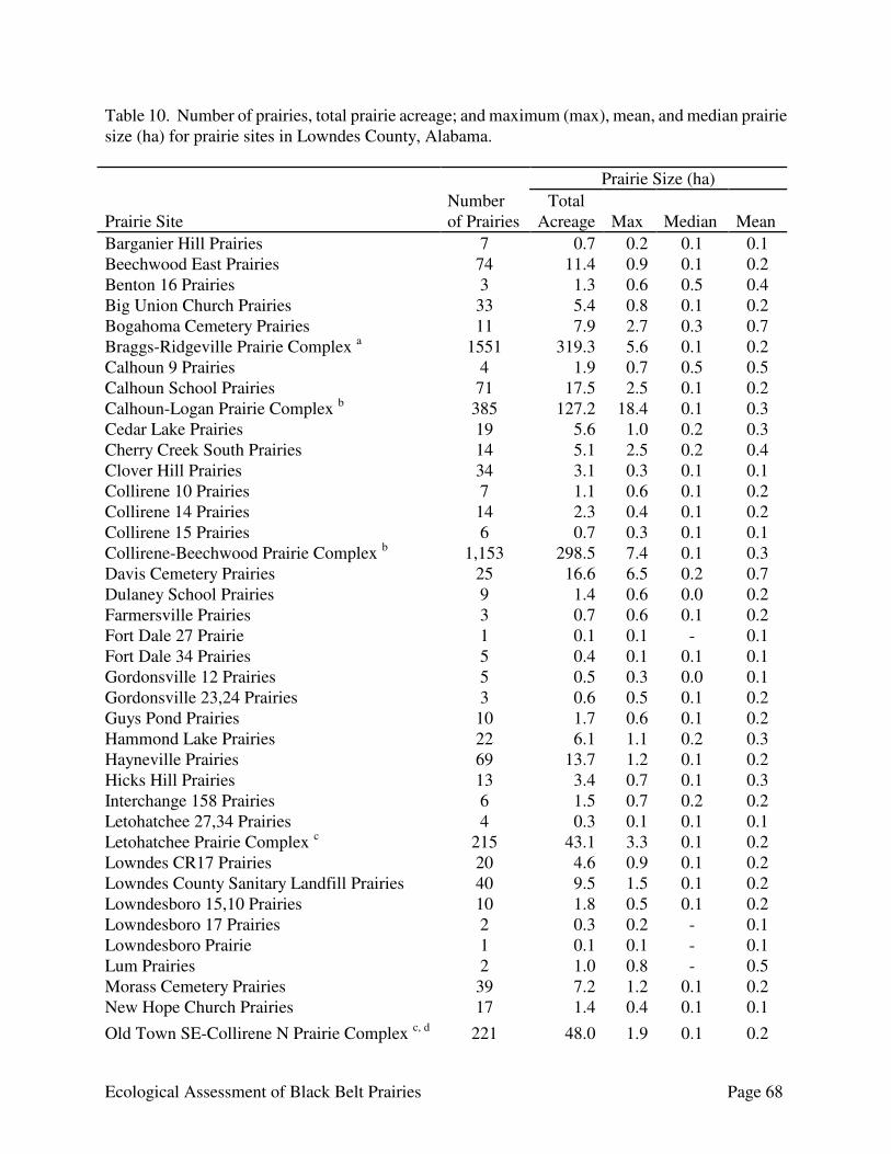
Ecological Assessment of Black Belt Prairies Page 68
Table 10. Number of prairies, total prairie acreage; and maximum (max), mean, and median prairie size (ha) for prairie sites in Lowndes County, Alabama. Prairie Size (ha) Prairie Site
Number of Prairies
Total Acreage
Max
Median
Mean
Barganier Hill Prairies 7 0.7 0.2 0.1 0.1 Beechwood East Prairies 74 11.4 0.9 0.1 0.2 Benton 16 Prairies 3 1.3 0.6 0.5 0.4 Big Union Church Prairies 33 5.4 0.8 0.1 0.2 Bogahoma Cemetery Prairies 11 7.9 2.7 0.3 0.7 Braggs-Ridgeville Prairie Complex a 1551 319.3 5.6 0.1 0.2 Calhoun 9 Prairies 4 1.9 0.7 0.5 0.5 Calhoun School Prairies 71 17.5 2.5 0.1 0.2 Calhoun-Logan Prairie Complex b 385 127.2 18.4 0.1 0.3 Cedar Lake Prairies 19 5.6 1.0 0.2 0.3 Cherry Creek South Prairies 14 5.1 2.5 0.2 0.4 Clover Hill Prairies 34 3.1 0.3 0.1 0.1 Collirene 10 Prairies 7 1.1 0.6 0.1 0.2 Collirene 14 Prairies 14 2.3 0.4 0.1 0.2 Collirene 15 Prairies 6 0.7 0.3 0.1 0.1 Collirene-Beechwood Prairie Complex b 1,153 298.5 7.4 0.1 0.3 Davis Cemetery Prairies 25 16.6 6.5 0.2 0.7 Dulaney School Prairies 9 1.4 0.6 0.0 0.2 Farmersville Prairies 3 0.7 0.6 0.1 0.2 Fort Dale 27 Prairie 1 0.1 0.1 - 0.1 Fort Dale 34 Prairies 5 0.4 0.1 0.1 0.1 Gordonsville 12 Prairies 5 0.5 0.3 0.0 0.1 Gordonsville 23,24 Prairies 3 0.6 0.5 0.1 0.2 Guys Pond Prairies 10 1.7 0.6 0.1 0.2 Hammond Lake Prairies 22 6.1 1.1 0.2 0.3 Hayneville Prairies 69 13.7 1.2 0.1 0.2 Hicks Hill Prairies 13 3.4 0.7 0.1 0.3 Interchange 158 Prairies 6 1.5 0.7 0.2 0.2 Letohatchee 27,34 Prairies 4 0.3 0.1 0.1 0.1 Letohatchee Prairie Complex c 215 43.1 3.3 0.1 0.2 Lowndes CR17 Prairies 20 4.6 0.9 0.1 0.2 Lowndes County Sanitary Landfill Prairies 40 9.5 1.5 0.1 0.2 Lowndesboro 15,10 Prairies 10 1.8 0.5 0.1 0.2 Lowndesboro 17 Prairies 2 0.3 0.2 - 0.1 Lowndesboro Prairie 1 0.1 0.1 - 0.1 Lum Prairies 2 1.0 0.8 - 0.5 Morass Cemetery Prairies 39 7.2 1.2 0.1 0.2 New Hope Church Prairies 17 1.4 0.4 0.1 0.1 Old Town SE-Collirene N Prairie Complex c, d 221 48.0 1.9 0.1 0.2
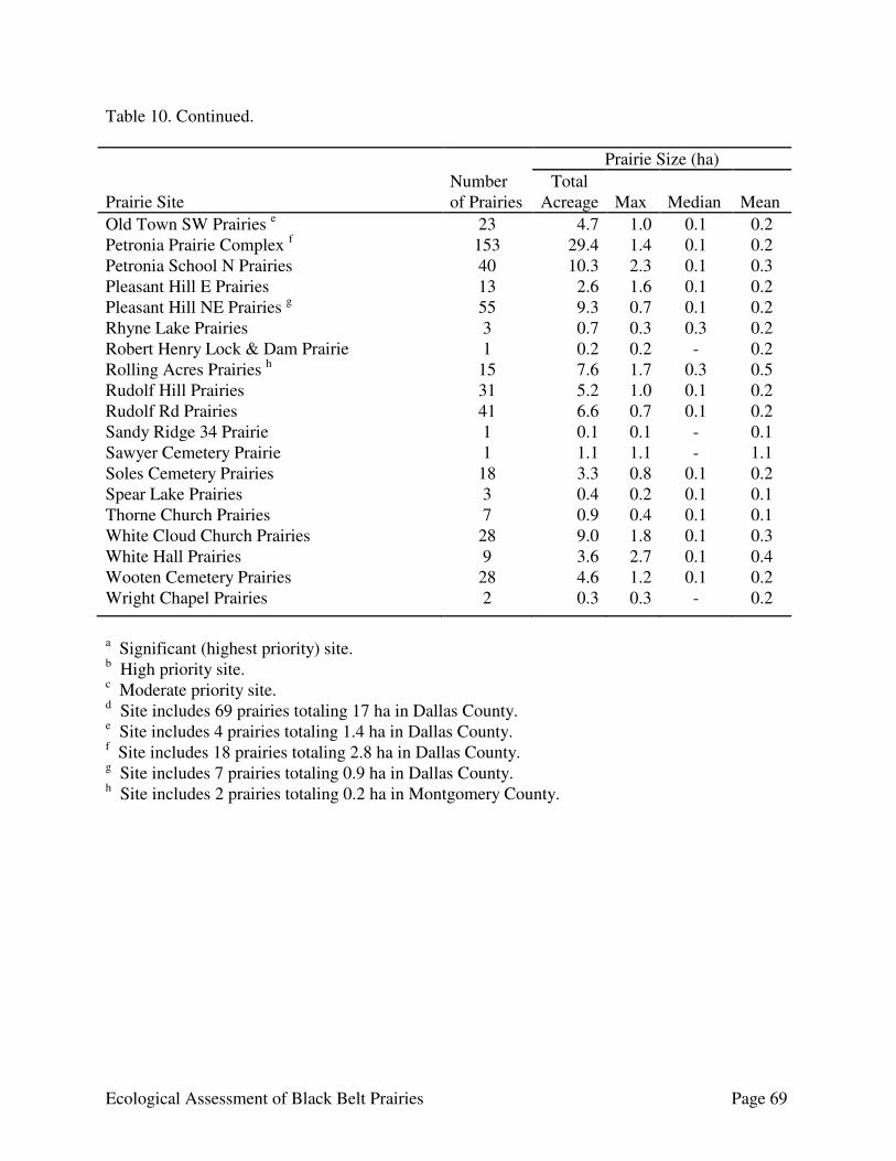
Ecological Assessment of Black Belt Prairies Page 69
Table 10. Continued. Prairie Size (ha) Prairie Site
Number of Prairies
Total Acreage
Max
Median
Mean
Old Town SW Prairies e 23 4.7 1.0 0.1 0.2 Petronia Prairie Complex f 153 29.4 1.4 0.1 0.2 Petronia School N Prairies 40 10.3 2.3 0.1 0.3 Pleasant Hill E Prairies 13 2.6 1.6 0.1 0.2 Pleasant Hill NE Prairies g 55 9.3 0.7 0.1 0.2 Rhyne Lake Prairies 3 0.7 0.3 0.3 0.2 Robert Henry Lock & Dam Prairie 1 0.2 0.2 - 0.2 Rolling Acres Prairies h 15 7.6 1.7 0.3 0.5 Rudolf Hill Prairies 31 5.2 1.0 0.1 0.2 Rudolf Rd Prairies 41 6.6 0.7 0.1 0.2 Sandy Ridge 34 Prairie 1 0.1 0.1 - 0.1 Sawyer Cemetery Prairie 1 1.1 1.1 - 1.1 Soles Cemetery Prairies 18 3.3 0.8 0.1 0.2 Spear Lake Prairies 3 0.4 0.2 0.1 0.1 Thorne Church Prairies 7 0.9 0.4 0.1 0.1 White Cloud Church Prairies 28 9.0 1.8 0.1 0.3 White Hall Prairies 9 3.6 2.7 0.1 0.4 Wooten Cemetery Prairies 28 4.6 1.2 0.1 0.2 Wright Chapel Prairies 2 0.3 0.3 - 0.2
a Significant (highest priority) site. b High priority site. c Moderate priority site. d Site includes 69 prairies totaling 17 ha in Dallas County. e Site includes 4 prairies totaling 1.4 ha in Dallas County. f Site includes 18 prairies totaling 2.8 ha in Dallas County. g Site includes 7 prairies totaling 0.9 ha in Dallas County. h Site includes 2 prairies totaling 0.2 ha in Montgomery County.
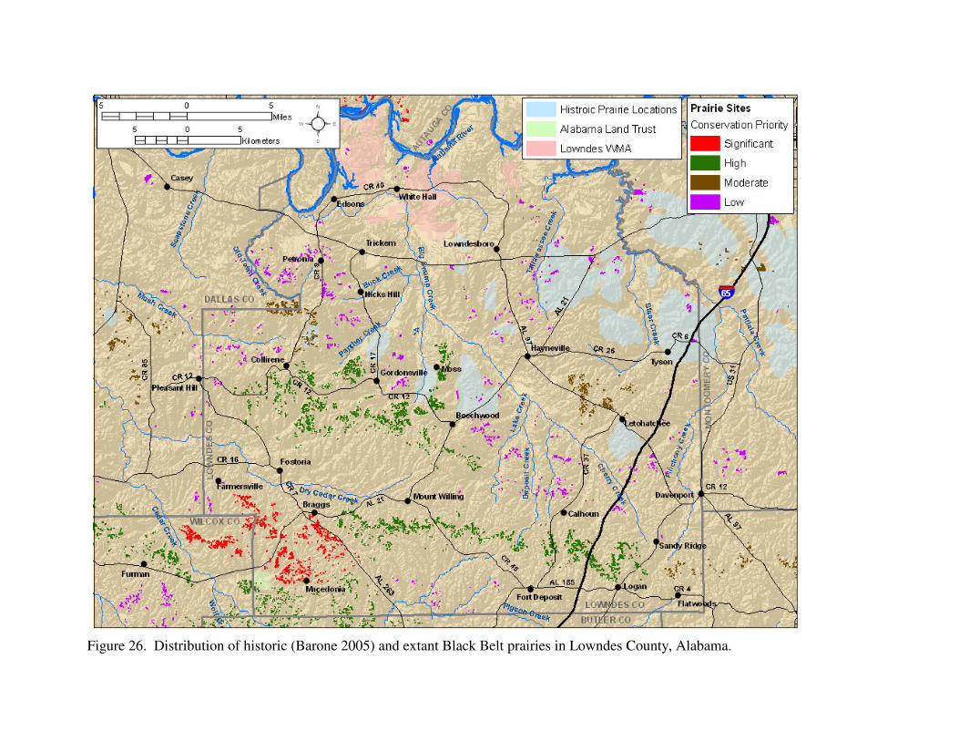
Figure 26. Distribution of historic (Barone 2005) and extant Black Belt prairies in Lowndes County, Alabama.

Ecological Assessment of Black Belt Prairies Page 71
other in the central part of the county. The large historical concentration of prairies in northeastern Lowndes County has been devastated and nearly eradicated by land use changes. The majority of the prairies in the county are small (median size 0.1 ha, 89.7% <0.5 ha). Many of the prairies show signs of past disturbance or agricultural use, being either eroded, infested with invasive species to varying degrees, or fragmented. Localized infestations of invasive species, primarily MaCartney rose, tall fescue, and various native woody taxa, most notably eastern red cedar, have adversely impacted natural processes. Long-term erosion has resulted in deep gullies and large areas of exposed white chalk nearly devoid of vegetation in numerous prairies. As an artifact of fire exclusion, eastern red cedar and various hardwoods have gradually encroached upon many prairies, reducing overall acreage and greatly jeopardizing long-term ecological integrity and species viability. Periodic prescribed fire, assuming a gradual transition from dormant season to growing season burns, would be beneficial to restore and maintain ecological integrity within the sites. There was one significant site in Lowndes County, the concentration of prairies in the sub-sites centered around the towns of Braggs and Macedonia in the Braggs-Ridgeville Prairie Complex. The Braggs-Ridgeville Prairie Complex is a large complex of prairies that stretches across much of the southern third of the county and extends into Butler and Wilcox counties (see Fig. 9). The significant sub-sites are described in the significant Prairies section above. The remainder of the site is a high priority site. For the most part, the prairies are confined to ridgetops and upper slopes along the ridges. The quality of the prairies is highly variable, ranging from relatively high ecological integrity to degraded to various degrees by erosion, infestation of invasive species, or woody encroachment. There were two high priority sites in Lowndes County: the Calhoun-Logan Prairie Complex and Collirene-Beechwood Prairie Complex. The Calhoun-Logan Prairie Complex is located in the southeastern corner of the county, and could be considered a continuation of the Braggs-Ridgeville Prairie Complex. The prairies occur north of State Route 185 on both sides of Interstate 65 and stretch from west of Ballards Creek to Ryals Lake. For the most part, the prairies are confined to ridgetops and upper slopes along the ridges. The quality of the prairies is highly variable, ranging from relatively high ecological integrity to degraded to various degrees by erosion, infestation of invasive species, or woody encroachment. If the landowners are amenable, this site has excellent potential for prairie management and restoration. The Collirene-Beechwood Prairie Complex is a large and extensive complex of prairies in the western half of central Lowndes County. The easternmost reach of the site is in the vicinity of Beechwood, stretching from north of Moss south along Main Street and County Road 12 to north of Lum. The site extends west to just west of Tucker Branch along County Road 12 southwest of Collirene. For the most part, the prairies are confined to ridgetops and upper slopes along the ridges. The quality of the prairies is highly variable, ranging from high

Ecological Assessment of Black Belt Prairies Page 72
ecological integrity to severely degraded by erosion, infestation of invasive species, or woody encroachment. Localized infestations of invasive species, primarily MaCartney rose, tall fescue, Johnson grass and various native woody taxa, most notably eastern red cedar, have adversely impacted natural processes. For the most part, erosion is minimal, although long-term erosion has resulted in large areas of exposed white chalk nearly devoid of vegetation in some prairies. As an artifact of fire exclusion, eastern red cedar and various hardwoods have gradually encroached upon many prairies, reducing overall acreage and greatly jeopardizing long-term ecological integrity and species viability. There were two moderate priority sites in Lowndes County: the Letohatchee Prairie Complex, and Old Town SE-Collirene N Prairie Complex. The remaining 55 sites located in Lowndes County were a low conservation priority because they primarily contain small prairies, the total prairie acreage is low, most of the prairies in the site suffer from heavy woody encroachment, or the majority are heavily degraded by erosion or exotic infestation. The Letohatchee Prairie Complex is a smaller complex of prairies located north and northwest of Letohatchee in eastern central Lowndes County. The site consists mostly of small prairies, with only five >1 ha. The majority of the prairies are located northwest of Letohatchee along State Route 97 on both sides of the road, with the remainder of the prairies occurring east of County Road 37. For the most part, the prairies are confined to ridgetops and upper slopes along the ridges. The prairies occur as openings within forest in a landscape mosaic consisting of forest and agricultural land. The quality of the prairies is highly variable, ranging from relatively high ecological integrity to degraded to various degrees by erosion, infestation of invasive species, or woody encroachment. For the most part, erosion is minimal. The Old Town SE-Collirene N Prairie Complex is a complex of prairies north of the Collirene-Beechwood Prairie Complex and could be considered an extension of that prairie complex. It is located in western Lowndes County, extending northeast of Collirene along County Road 9 to just before its junction with Collirene Cutoff Road and then extending west into eastern Dallas County south of Town Creek. For the most part, the prairies are confined to ridgetops and upper slopes along the ridges. The quality of the prairies is highly variable, ranging from high ecological integrity to degraded to various degrees by erosion, infestation of invasive species, or woody encroachment. Long-term erosion has resulted in gullies and large areas of exposed white chalk nearly devoid of vegetation in numerous prairies. The surrounding landscape is primarily forested, with silviculture being the primary land use. Vegetation succession, where eastern red cedar and hardwoods encroach upon the prairies, and potential negative impacts from silvicultural activities are recognized as the most pervasive threat.
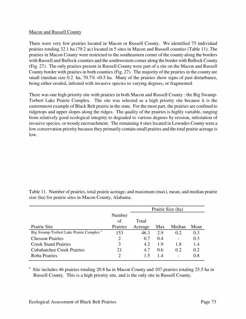
Ecological Assessment of Black Belt Prairies Page 73
Macon and Russell County There were very few prairies located in Macon or Russell County. We identified 75 individual prairies totaling 32.1 ha (79.2 ac) located in 5 sites in Macon and Russell counties (Table 11). The prairies in Macon County were restricted to the southeastern corner of the county along the borders with Russell and Bullock counties and the southwestern corner along the border with Bullock County (Fig. 27). The only prairies present in Russell County were part of a site on the Macon and Russell County border with prairies in both counties (Fig. 27). The majority of the prairies in the county are small (median size 0.2 ha, 70.7% <0.5 ha. Many of the prairies show signs of past disturbance, being either eroded, infested with invasive species to varying degrees, or fragmented. There was one high priority site with prairies in both Macon and Russell County : the Big Swamp-Torbert Lake Prairie Complex. The site was selected as a high priority site because it is the easternmost example of Black Belt prairie in the state. For the most part, the prairies are confined to ridgetops and upper slopes along the ridges. The quality of the prairies is highly variable, ranging from relatively good ecological integrity to degraded to various degrees by erosion, infestation of invasive species, or woody encroachment. The remaining 4 sites located in Lowndes County were a low conservation priority because they primarily contain small prairies and the total prairie acreage is low. Table 11. Number of prairies, total prairie acreage; and maximum (max), mean, and median prairie size (ha) for prairie sites in Macon County, Alabama. Prairie Size (ha) Prairie Site
Number of
Prairies
Total
Acreage
Max
Median
Mean Big Swamp-Torbert Lake Prairie Complex a 153 46.3 2.9 0.2 0.3 Chesson Prairies 2 0.7 0.4 - 0.3 Creek Stand Prairies 3 4.2 1.9 1.8 1.4 Cubahatchee Creek Prairies 21 4.7 0.6 0.2 0.2 Roba Prairies 2 1.5 1.4 - 0.8
a Site includes 46 prairies totaling 20.8 ha in Macon County and 107 prairies totaling 25.5 ha in
Russell County. This is a high priority site, and is the only site in Russell County.
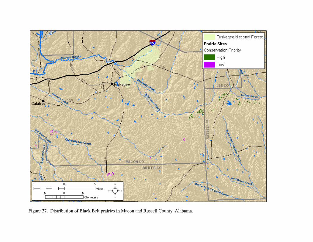
Figure 27. Distribution of Black Belt prairies in Macon and Russell County, Alabama.
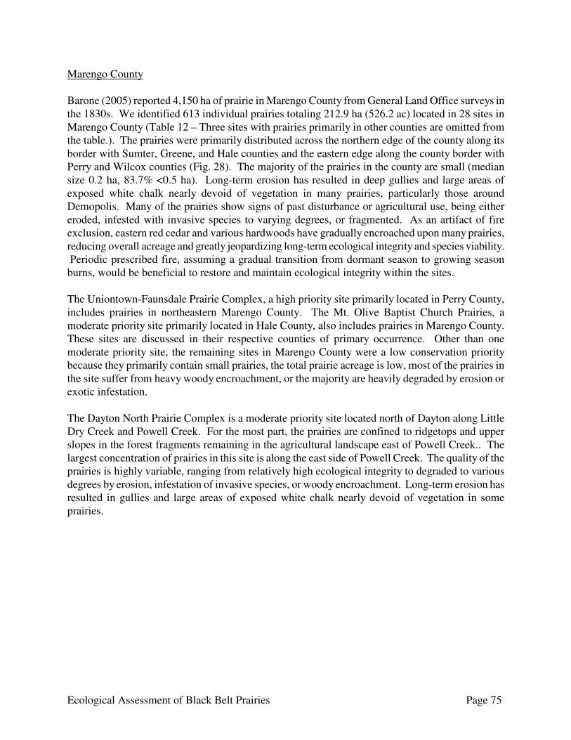
Ecological Assessment of Black Belt Prairies Page 75
Marengo County Barone (2005) reported 4,150 ha of prairie in Marengo County from General Land Office surveys in the 1830s. We identified 613 individual prairies totaling 212.9 ha (526.2 ac) located in 28 sites in Marengo County (Table 12 – Three sites with prairies primarily in other counties are omitted from the table.). The prairies were primarily distributed across the northern edge of the county along its border with Sumter, Greene, and Hale counties and the eastern edge along the county border with Perry and Wilcox counties (Fig. 28). The majority of the prairies in the county are small (median size 0.2 ha, 83.7% <0.5 ha). Long-term erosion has resulted in deep gullies and large areas of exposed white chalk nearly devoid of vegetation in many prairies, particularly those around Demopolis. Many of the prairies show signs of past disturbance or agricultural use, being either eroded, infested with invasive species to varying degrees, or fragmented. As an artifact of fire exclusion, eastern red cedar and various hardwoods have gradually encroached upon many prairies, reducing overall acreage and greatly jeopardizing long-term ecological integrity and species viability. Periodic prescribed fire, assuming a gradual transition from dormant season to growing season burns, would be beneficial to restore and maintain ecological integrity within the sites. The Uniontown-Faunsdale Prairie Complex, a high priority site primarily located in Perry County, includes prairies in northeastern Marengo County. The Mt. Olive Baptist Church Prairies, a moderate priority site primarily located in Hale County, also includes prairies in Marengo County. These sites are discussed in their respective counties of primary occurrence. Other than one moderate priority site, the remaining sites in Marengo County were a low conservation priority because they primarily contain small prairies, the total prairie acreage is low, most of the prairies in the site suffer from heavy woody encroachment, or the majority are heavily degraded by erosion or exotic infestation. The Dayton North Prairie Complex is a moderate priority site located north of Dayton along Little Dry Creek and Powell Creek. For the most part, the prairies are confined to ridgetops and upper slopes in the forest fragments remaining in the agricultural landscape east of Powell Creek.. The largest concentration of prairies in this site is along the east side of Powell Creek. The quality of the prairies is highly variable, ranging from relatively high ecological integrity to degraded to various degrees by erosion, infestation of invasive species, or woody encroachment. Long-term erosion has resulted in gullies and large areas of exposed white chalk nearly devoid of vegetation in some prairies.
Ecological Assessment of Black Belt Prairies Page 76
Table 12. Number of prairies, total prairie acreage; and maximum (max), mean, and median prairie size (ha) for prairie sites in Marengo County, Alabama. Prairie Size (ha) Prairie Site
Number of Prairies
Total Acreage
Max
Median
Mean
Dayton North Prairie Complex a 64 17.5 1.9 0.2 0.3 Demopolis East-Alfalfa Prairie Complex b 238 94.7 4.9 0.1 0.4 Demopolis West Prairies 72 15.8 2.0 0.1 0.2 Gallion 26 Prairie 1 0.1 0.1 - 0.1 Jefferson 20 Prairies 2 0.5 0.4 - 0.2 Jefferson 21 Prairie 1 0.2 0.2 - 0.2 Lake Henry Prairies 5 1.0 0.4 0.2 0.2 Lake Miriam Prairies 2 0.5 0.3 - 0.2 McCord Lake Prairies 9 1.0 0.3 0.1 0.1 McKinley Prairies 4 1.0 0.3 0.3 0.3 Moss Lake Prairies 5 1.4 0.6 0.3 0.3 Myrtlewood North 7 Prairie 1 0.4 0.4 - 0.4 Old Spring Hill 10 Prairies 13 4.8 0.8 0.3 0.4 Old Spring Hill 10-15 Prairies 4 0.4 0.2 0.1 0.1 Old Spring Hill 12, 1 Prairies 6 0.7 0.4 0.1 0.1 Old Spring Hill 13,14 Prairie 1 0.3 0.3 - 0.3 Old Spring Hill 8 Prairies 3 0.1 0.0 0.0 0.0 Owensby Lakes Prairies 2 0.3 0.2 - 0.1 Pin Hook Prairies 3 0.3 0.1 0.1 0.1 Prairie Lakes Prairies 19 6.2 1.8 0.2 0.3 Siddonsville Prairies 3 2.5 2.0 0.4 0.8 Stallworths Shadow Lake Prairies 21 6.2 1.2 0.2 0.3 Thomaston SE Prairies 9 3.2 0.7 0.3 0.4 Thomaston West 22 Prairies 5 0.7 0.3 0.3 0.1
a Moderate priority site. b Site includes 10 prairies totaling 10.7 ha in Hale County.

Figure 28. Distribution of historic (Barone 2005) and extant Black Belt prairies in Marengo County, Alabama.
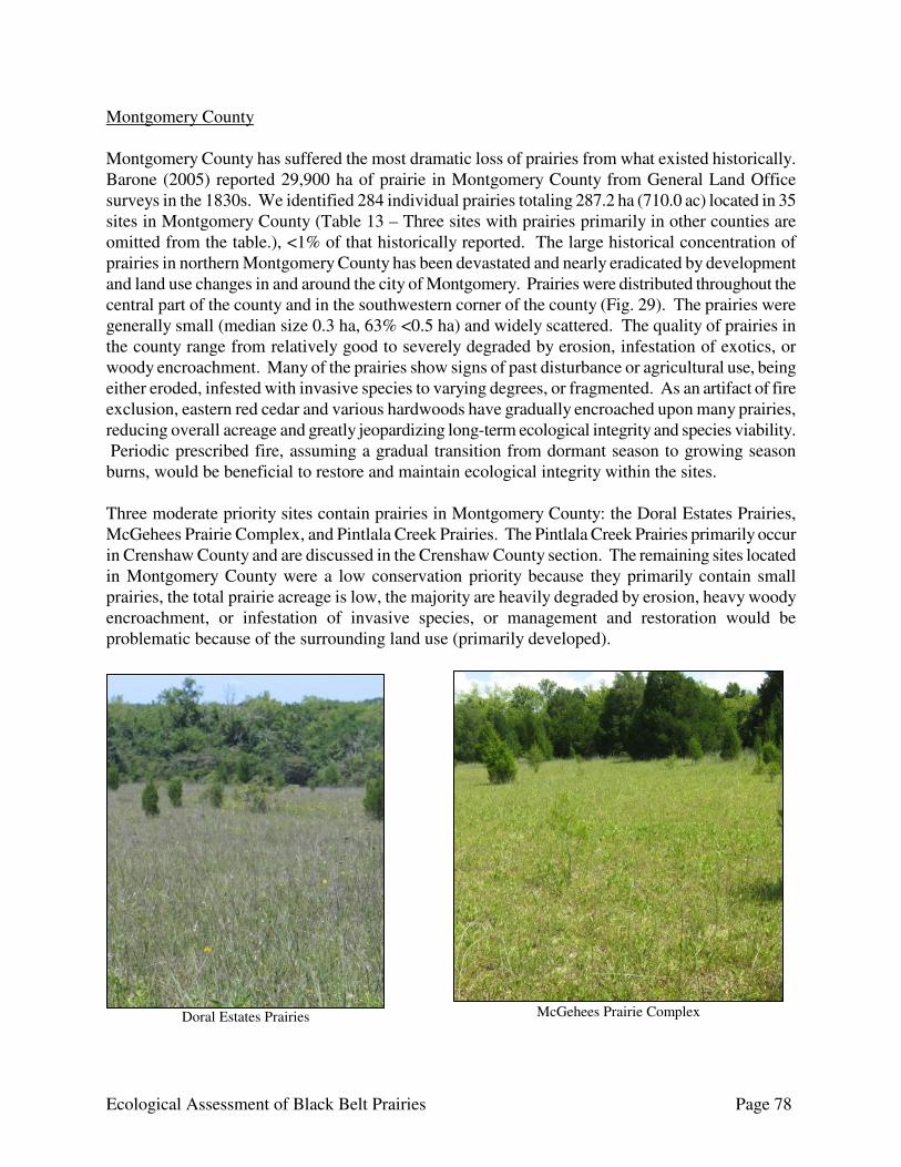
Ecological Assessment of Black Belt Prairies Page 78
McGehees Prairie Complex Doral Estates Prairies
Montgomery County Montgomery County has suffered the most dramatic loss of prairies from what existed historically. Barone (2005) reported 29,900 ha of prairie in Montgomery County from General Land Office surveys in the 1830s. We identified 284 individual prairies totaling 287.2 ha (710.0 ac) located in 35 sites in Montgomery County (Table 13 – Three sites with prairies primarily in other counties are omitted from the table.), <1% of that historically reported. The large historical concentration of prairies in northern Montgomery County has been devastated and nearly eradicated by development and land use changes in and around the city of Montgomery. Prairies were distributed throughout the central part of the county and in the southwestern corner of the county (Fig. 29). The prairies were generally small (median size 0.3 ha, 63% <0.5 ha) and widely scattered. The quality of prairies in the county range from relatively good to severely degraded by erosion, infestation of exotics, or woody encroachment. Many of the prairies show signs of past disturbance or agricultural use, being either eroded, infested with invasive species to varying degrees, or fragmented. As an artifact of fire exclusion, eastern red cedar and various hardwoods have gradually encroached upon many prairies, reducing overall acreage and greatly jeopardizing long-term ecological integrity and species viability. Periodic prescribed fire, assuming a gradual transition from dormant season to growing season burns, would be beneficial to restore and maintain ecological integrity within the sites. Three moderate priority sites contain prairies in Montgomery County: the Doral Estates Prairies, McGehees Prairie Complex, and Pintlala Creek Prairies. The Pintlala Creek Prairies primarily occur in Crenshaw County and are discussed in the Crenshaw County section. The remaining sites located in Montgomery County were a low conservation priority because they primarily contain small prairies, the total prairie acreage is low, the majority are heavily degraded by erosion, heavy woody encroachment, or infestation of invasive species, or management and restoration would be problematic because of the surrounding land use (primarily developed).
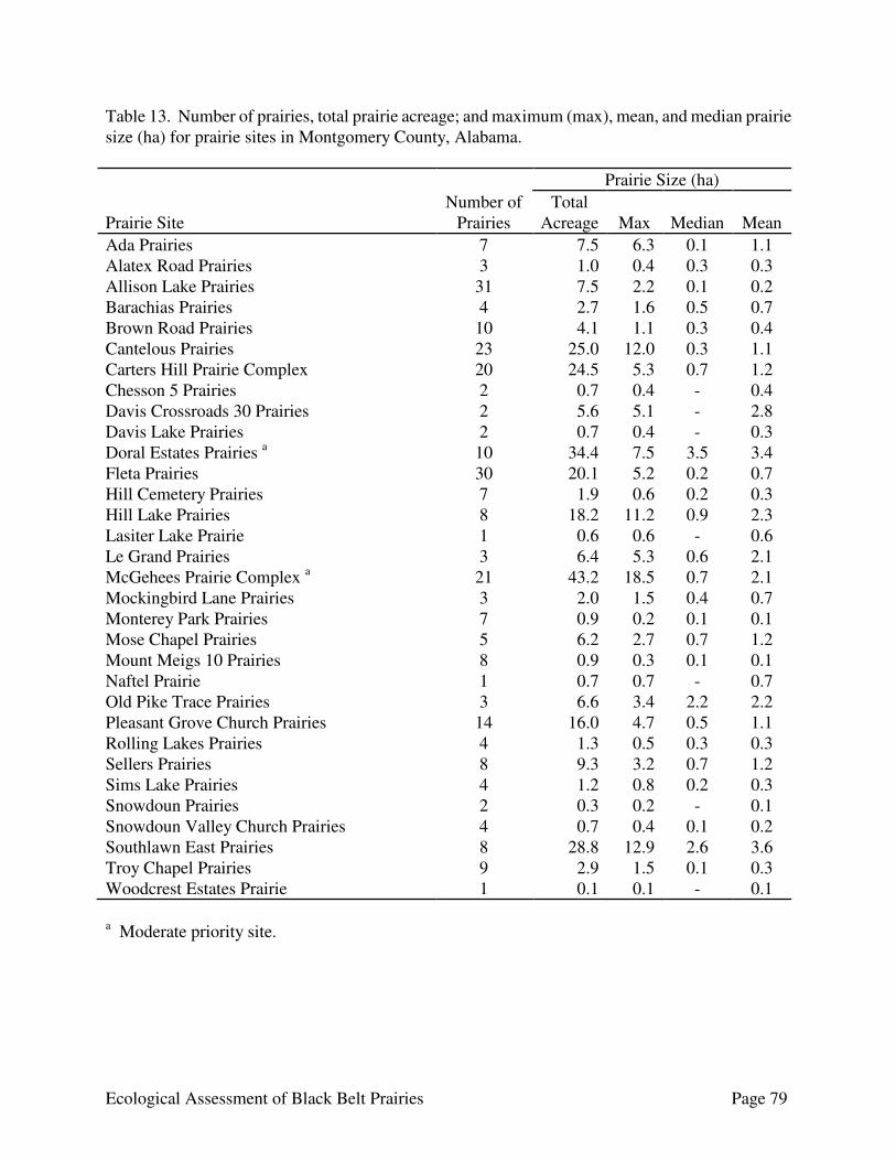
Ecological Assessment of Black Belt Prairies Page 79
Table 13. Number of prairies, total prairie acreage; and maximum (max), mean, and median prairie size (ha) for prairie sites in Montgomery County, Alabama. Prairie Size (ha) Prairie Site
Number of Prairies
Total Acreage
Max
Median
Mean
Ada Prairies 7 7.5 6.3 0.1 1.1 Alatex Road Prairies 3 1.0 0.4 0.3 0.3 Allison Lake Prairies 31 7.5 2.2 0.1 0.2 Barachias Prairies 4 2.7 1.6 0.5 0.7 Brown Road Prairies 10 4.1 1.1 0.3 0.4 Cantelous Prairies 23 25.0 12.0 0.3 1.1 Carters Hill Prairie Complex 20 24.5 5.3 0.7 1.2 Chesson 5 Prairies 2 0.7 0.4 - 0.4 Davis Crossroads 30 Prairies 2 5.6 5.1 - 2.8 Davis Lake Prairies 2 0.7 0.4 - 0.3 Doral Estates Prairies a 10 34.4 7.5 3.5 3.4 Fleta Prairies 30 20.1 5.2 0.2 0.7 Hill Cemetery Prairies 7 1.9 0.6 0.2 0.3 Hill Lake Prairies 8 18.2 11.2 0.9 2.3 Lasiter Lake Prairie 1 0.6 0.6 - 0.6 Le Grand Prairies 3 6.4 5.3 0.6 2.1 McGehees Prairie Complex a 21 43.2 18.5 0.7 2.1 Mockingbird Lane Prairies 3 2.0 1.5 0.4 0.7 Monterey Park Prairies 7 0.9 0.2 0.1 0.1 Mose Chapel Prairies 5 6.2 2.7 0.7 1.2 Mount Meigs 10 Prairies 8 0.9 0.3 0.1 0.1 Naftel Prairie 1 0.7 0.7 - 0.7 Old Pike Trace Prairies 3 6.6 3.4 2.2 2.2 Pleasant Grove Church Prairies 14 16.0 4.7 0.5 1.1 Rolling Lakes Prairies 4 1.3 0.5 0.3 0.3 Sellers Prairies 8 9.3 3.2 0.7 1.2 Sims Lake Prairies 4 1.2 0.8 0.2 0.3 Snowdoun Prairies 2 0.3 0.2 - 0.1 Snowdoun Valley Church Prairies 4 0.7 0.4 0.1 0.2 Southlawn East Prairies 8 28.8 12.9 2.6 3.6 Troy Chapel Prairies 9 2.9 1.5 0.1 0.3 Woodcrest Estates Prairie 1 0.1 0.1 - 0.1 a Moderate priority site.
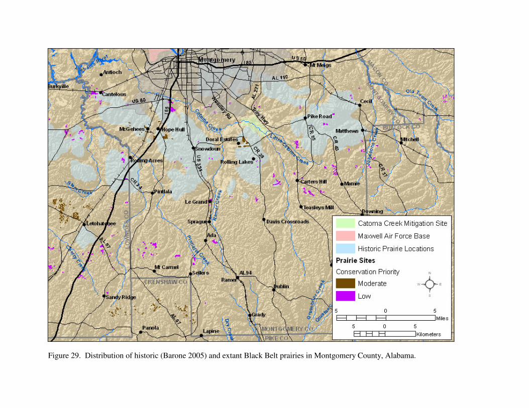
Figure 29. Distribution of historic (Barone 2005) and extant Black Belt prairies in Montgomery County, Alabama.

Ecological Assessment of Black Belt Prairies Page 81
The Doral Estates Prairies are a small grouping of relatively large prairies (only one is <1 ha) at the intersection of Woodly Road (County Road 39) and Snowdoun Chambers Road (County Road 18) south of Montgomery. The surrounding landscape is primarily a mixture of agriculture and residential. The prairies exhibit evidence of past agricultural use. If the landowner is amenable, this would be an excellent site for restoration efforts. The McGehees Prairie Complex is a complex of prairies scattered around the McGehees and Hope Hull southwest of Hyundai Plant. The landscape is a mixture of industrial, residential, and agricultural. The quality of the prairies is highly variable, ranging from relatively good ecological integrity to severely degraded by woody encroachment or infestation of invasive species. As an artifact of fire exclusion, eastern red cedar and various hardwoods have gradually encroached upon many prairies with several prairies severely encroached by cedars, reducing overall acreage and greatly jeopardizing long-term ecological integrity and species viability. Localized infestations of invasive species, primarily MaCartney rose, tall fescue, Johnson grass, and various native woody taxa, most notably eastern red cedar, have adversely impacted natural processes. Perry County Perry County had one of the higher total prairie acreage for counties in the Black Belt. We identified 861 individual prairies totaling 566.7 ha (1,400.4 ac) located in 17 sites in Perry County (Table 14 – Two sites with prairies primarily in other counties are omitted from the table.). Barone (2005) reported 2,910 ha of prairie in Dallas County from General Land Office surveys in the 1830s. Black Belt prairies were restricted to the southern and southwestern edges of the county, with the majority concentrated in the extreme southern end of the county that extends southward between Marengo and Dallas counties (Fig. 30). The majority of the prairies in the county are small (median size 0.2 ha, 83.7% <0.5 ha). Long-term erosion has resulted in deep gullies and large areas of exposed white chalk nearly devoid of vegetation in many prairies, particularly those around Demopolis. Many of the prairies show signs of past disturbance or agricultural use, being either eroded, infested with invasive species to varying degrees, or fragmented. As an artifact of fire exclusion, eastern red cedar and various hardwoods have gradually encroached upon many prairies, reducing overall acreage and greatly jeopardizing long-term ecological integrity and species viability. Periodic prescribed fire, assuming a gradual transition from dormant season to growing season burns, would be beneficial to restore and maintain ecological integrity within the sites. There was one significant site in Perry County: the Cahaba River Prairies. This site is discussed in the Significant Prairies section above. The Uniontown-Faunsdale Prairie Complex was the only high priority site in the county. The remaining sites located in Perry County were a low conservation priority because they primarily contain small prairies, the total prairie acreage is low, or the majority are heavily degraded by erosion, heavy woody encroachment, or infestation of invasive species. The Bogue Chitto Creek Prairies, Cottrell Lake Prairie Complex, and the Hamburg Prairie Complex have good restoration potential. The Uniontown-Faunsdale Prairie Complex is a large complex of prairies located mostly south of Uniontown and US 80 in Dallas, Perry, and Marengo counties. This site was the largest prairie complex in the state. The prairies primarily occupy a broad band oriented northwest to southeast
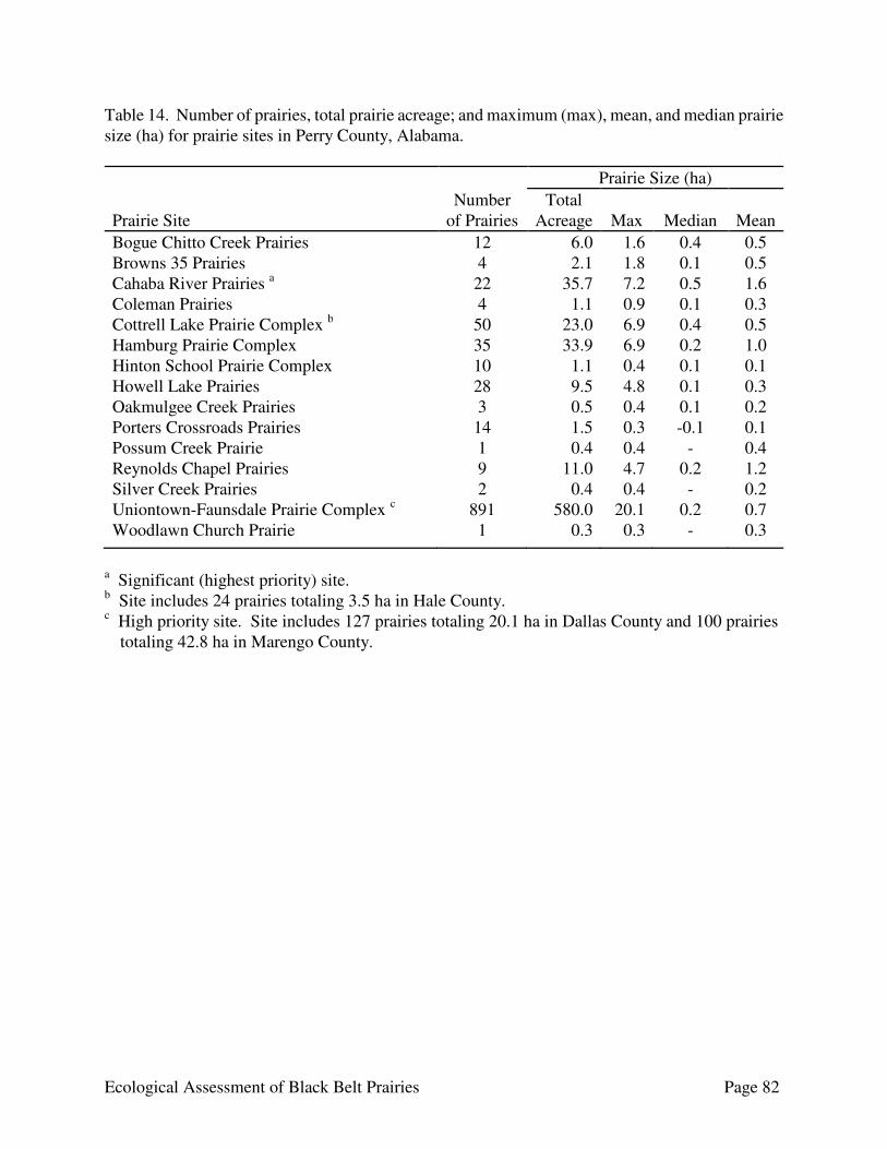
Ecological Assessment of Black Belt Prairies Page 82
Table 14. Number of prairies, total prairie acreage; and maximum (max), mean, and median prairie size (ha) for prairie sites in Perry County, Alabama. Prairie Size (ha) Prairie Site
Number of Prairies
Total Acreage
Max
Median
Mean
Bogue Chitto Creek Prairies 12 6.0 1.6 0.4 0.5 Browns 35 Prairies 4 2.1 1.8 0.1 0.5 Cahaba River Prairies a 22 35.7 7.2 0.5 1.6 Coleman Prairies 4 1.1 0.9 0.1 0.3 Cottrell Lake Prairie Complex b 50 23.0 6.9 0.4 0.5 Hamburg Prairie Complex 35 33.9 6.9 0.2 1.0 Hinton School Prairie Complex 10 1.1 0.4 0.1 0.1 Howell Lake Prairies 28 9.5 4.8 0.1 0.3 Oakmulgee Creek Prairies 3 0.5 0.4 0.1 0.2 Porters Crossroads Prairies 14 1.5 0.3 -0.1 0.1 Possum Creek Prairie 1 0.4 0.4 - 0.4 Reynolds Chapel Prairies 9 11.0 4.7 0.2 1.2 Silver Creek Prairies 2 0.4 0.4 - 0.2 Uniontown-Faunsdale Prairie Complex c 891 580.0 20.1 0.2 0.7 Woodlawn Church Prairie 1 0.3 0.3 - 0.3
a Significant (highest priority) site. b Site includes 24 prairies totaling 3.5 ha in Hale County. c High priority site. Site includes 127 prairies totaling 20.1 ha in Dallas County and 100 prairies
totaling 42.8 ha in Marengo County.

Figure 30. Distribution of historic (Barone 2005) and extant Black Belt prairies in Perry County, Alabama.
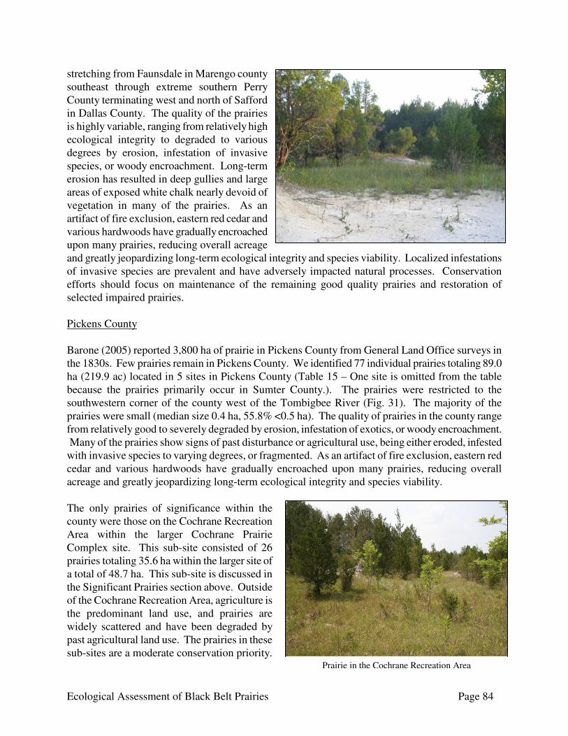
Ecological Assessment of Black Belt Prairies Page 84
stretching from Faunsdale in Marengo county southeast through extreme southern Perry County terminating west and north of Safford in Dallas County. The quality of the prairies is highly variable, ranging from relatively high ecological integrity to degraded to various degrees by erosion, infestation of invasive species, or woody encroachment. Long-term erosion has resulted in deep gullies and large areas of exposed white chalk nearly devoid of vegetation in many of the prairies. As an artifact of fire exclusion, eastern red cedar and various hardwoods have gradually encroached upon many prairies, reducing overall acreage and greatly jeopardizing long-term ecological integrity and species viability. Localized infestations of invasive species are prevalent and have adversely impacted natural processes. Conservation efforts should focus on maintenance of the remaining good quality prairies and restoration of selected impaired prairies. Pickens County Barone (2005) reported 3,800 ha of prairie in Pickens County from General Land Office surveys in the 1830s. Few prairies remain in Pickens County. We identified 77 individual prairies totaling 89.0 ha (219.9 ac) located in 5 sites in Pickens County (Table 15 – One site is omitted from the table because the prairies primarily occur in Sumter County.). The prairies were restricted to the southwestern corner of the county west of the Tombigbee River (Fig. 31). The majority of the prairies were small (median size 0.4 ha, 55.8% <0.5 ha). The quality of prairies in the county range from relatively good to severely degraded by erosion, infestation of exotics, or woody encroachment. Many of the prairies show signs of past disturbance or agricultural use, being either eroded, infested with invasive species to varying degrees, or fragmented. As an artifact of fire exclusion, eastern red cedar and various hardwoods have gradually encroached upon many prairies, reducing overall acreage and greatly jeopardizing long-term ecological integrity and species viability. The only prairies of significance within the county were those on the Cochrane Recreation Area within the larger Cochrane Prairie Complex site. This sub-site consisted of 26 prairies totaling 35.6 ha within the larger site of a total of 48.7 ha. This sub-site is discussed in the Significant Prairies section above. Outside of the Cochrane Recreation Area, agriculture is the predominant land use, and prairies are widely scattered and have been degraded by past agricultural land use. The prairies in these sub-sites are a moderate conservation priority.
Prairie in the Cochrane Recreation Area
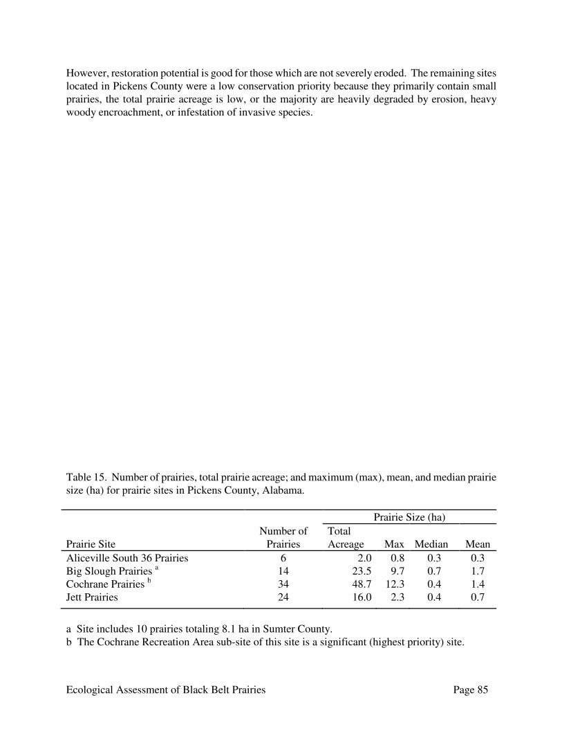
Ecological Assessment of Black Belt Prairies Page 85
However, restoration potential is good for those which are not severely eroded. The remaining sites located in Pickens County were a low conservation priority because they primarily contain small prairies, the total prairie acreage is low, or the majority are heavily degraded by erosion, heavy woody encroachment, or infestation of invasive species. Table 15. Number of prairies, total prairie acreage; and maximum (max), mean, and median prairie size (ha) for prairie sites in Pickens County, Alabama. Prairie Size (ha) Prairie Site
Number of Prairies
Total Acreage
Max
Median
Mean
Aliceville South 36 Prairies 6 2.0 0.8 0.3 0.3 Big Slough Prairies a 14 23.5 9.7 0.7 1.7 Cochrane Prairies b 34 48.7 12.3 0.4 1.4 Jett Prairies 24 16.0 2.3 0.4 0.7
a Site includes 10 prairies totaling 8.1 ha in Sumter County. b The Cochrane Recreation Area sub-site of this site is a significant (highest priority) site.
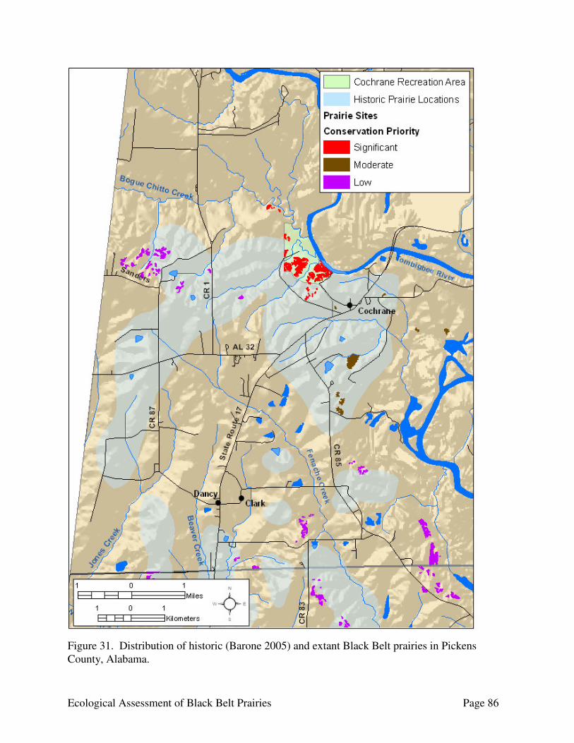
Ecological Assessment of Black Belt Prairies Page 86
Figure 31. Distribution of historic (Barone 2005) and extant Black Belt prairies in Pickens County, Alabama.

Ecological Assessment of Black Belt Prairies Page 87
Sumter County Sumter County had the highest total prairie acreage for the counties in the Black Belt. We identified 3,080 individual prairie fragments totaling 1,330.1 ha (3,286.7 ac) located in 36 sites in Sumter County (Table 16 – One site is omitted from the table because the prairies primarily occur in Pickens County.). Barone (2005) reported 13,230 ha of prairie in Dallas County from General Land Office surveys in the 1830s. Prairies in Sumter County were distributed throughout the northeastern half of the county, with the majority in a northwest to southeast oriented band parallel to the Tombigbee River running from the area around Geiger to Demopolis (Fig. 32). The majority of the prairies were small (median size 0.2 ha, 79.6% <0.5 ha). The quality of prairies in the county range from relatively good to severely degraded by erosion, infestation of exotics, or woody encroachment. Long-term erosion has resulted in deep gullies and large areas of exposed white chalk nearly devoid of vegetation in many prairies. Many of the prairies show signs of past disturbance or agricultural use, being either eroded, infested with invasive species to varying degrees, or fragmented. Localized infestations of invasive species are prevalent, and have adversely impacted natural processes. As an artifact of fire exclusion, eastern red cedar and various hardwoods have gradually encroached upon many prairies, reducing overall acreage and greatly jeopardizing long-term ecological integrity and species viability. Periodic prescribed fire, assuming a gradual transition from dormant season to growing season burns, would be beneficial to restore and maintain ecological integrity within the sites. There was one significant site in Sumter County: the Old Bluffport Prairie Complex. The Old Bluffport Prairie Complex is a large complex of prairies located around the former village site of Bluffport along the Tombigbee River. This site is discussed in the Significant Prairies section above. The high priority sites in Sumter County were the Belmont Prairie Complex, Epes Prairies, and the University of West Alabama Prairies. The moderate priority sites in Sumter County were the Emelle Prairie Complex and the Hamner Sumterville Prairie Complex. The remaining sites located in Sumter County were a low conservation priority because they primarily contain small prairies, the total prairie acreage is low, or the majority are heavily degraded by erosion, heavy woody encroachment, or infestation of invasive species. The Belmont Prairie Complex is a large complex of prairies located primarily along County Road 22 and County Road 23 around the town of Belmont. The site is located southeast of the Old Bluffport Prairie Complex. It is contiguous with and could be considered an extension of the Old Bluffport complex. For the most part, the prairies are confined to ridgetops and upper slopes along the ridges to either side of Hall Creek. The quality of the prairies is highly variable, ranging from relatively high ecological integrity to degraded to various degrees by erosion, infestation of invasive species, or woody encroachment. Long-term erosion has resulted in deep gullies and large areas
Eroded prairie in the Belmont Prairie Complex.
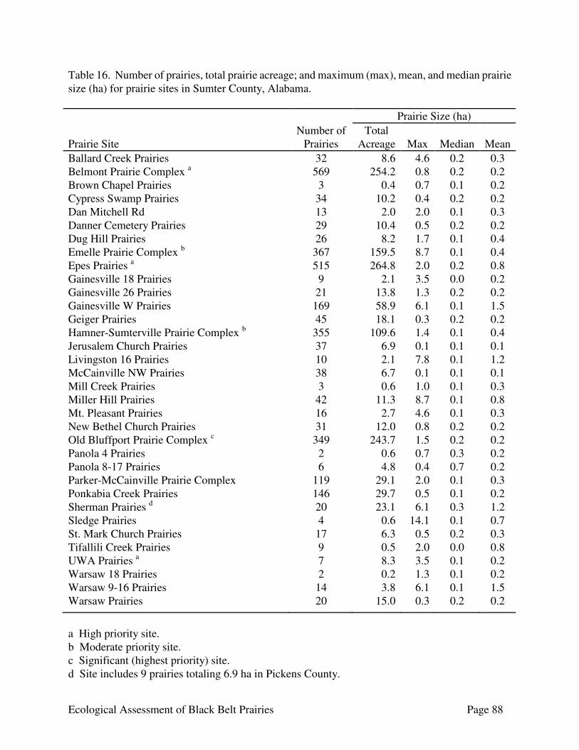
Ecological Assessment of Black Belt Prairies Page 88
Table 16. Number of prairies, total prairie acreage; and maximum (max), mean, and median prairie size (ha) for prairie sites in Sumter County, Alabama. Prairie Size (ha) Prairie Site
Number of Prairies
Total Acreage
Max
Median
Mean
Ballard Creek Prairies 32 8.6 4.6 0.2 0.3 Belmont Prairie Complex a 569 254.2 0.8 0.2 0.2 Brown Chapel Prairies 3 0.4 0.7 0.1 0.2 Cypress Swamp Prairies 34 10.2 0.4 0.2 0.2 Dan Mitchell Rd 13 2.0 2.0 0.1 0.3 Danner Cemetery Prairies 29 10.4 0.5 0.2 0.2 Dug Hill Prairies 26 8.2 1.7 0.1 0.4 Emelle Prairie Complex b 367 159.5 8.7 0.1 0.4 Epes Prairies a 515 264.8 2.0 0.2 0.8 Gainesville 18 Prairies 9 2.1 3.5 0.0 0.2 Gainesville 26 Prairies 21 13.8 1.3 0.2 0.2 Gainesville W Prairies 169 58.9 6.1 0.1 1.5 Geiger Prairies 45 18.1 0.3 0.2 0.2 Hamner-Sumterville Prairie Complex b 355 109.6 1.4 0.1 0.4 Jerusalem Church Prairies 37 6.9 0.1 0.1 0.1 Livingston 16 Prairies 10 2.1 7.8 0.1 1.2 McCainville NW Prairies 38 6.7 0.1 0.1 0.1 Mill Creek Prairies 3 0.6 1.0 0.1 0.3 Miller Hill Prairies 42 11.3 8.7 0.1 0.8 Mt. Pleasant Prairies 16 2.7 4.6 0.1 0.3 New Bethel Church Prairies 31 12.0 0.8 0.2 0.2 Old Bluffport Prairie Complex c 349 243.7 1.5 0.2 0.2 Panola 4 Prairies 2 0.6 0.7 0.3 0.2 Panola 8-17 Prairies 6 4.8 0.4 0.7 0.2 Parker-McCainville Prairie Complex 119 29.1 2.0 0.1 0.3 Ponkabia Creek Prairies 146 29.7 0.5 0.1 0.2 Sherman Prairies d 20 23.1 6.1 0.3 1.2 Sledge Prairies 4 0.6 14.1 0.1 0.7 St. Mark Church Prairies 17 6.3 0.5 0.2 0.3 Tifallili Creek Prairies 9 0.5 2.0 0.0 0.8 UWA Prairies a 7 8.3 3.5 0.1 0.2 Warsaw 18 Prairies 2 0.2 1.3 0.1 0.2 Warsaw 9-16 Prairies 14 3.8 6.1 0.1 1.5 Warsaw Prairies 20 15.0 0.3 0.2 0.2
a High priority site. b Moderate priority site. c Significant (highest priority) site. d Site includes 9 prairies totaling 6.9 ha in Pickens County.
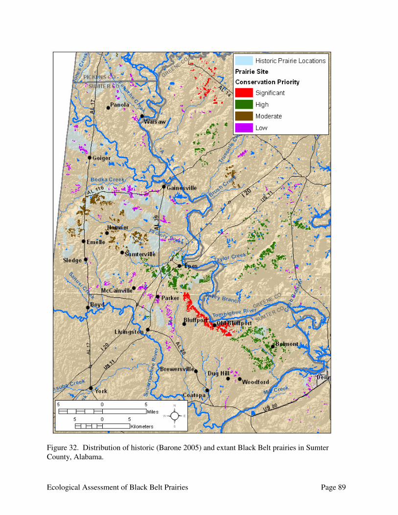
Ecological Assessment of Black Belt Prairies Page 89
Figure 32. Distribution of historic (Barone 2005) and extant Black Belt prairies in Sumter County, Alabama.

Ecological Assessment of Black Belt Prairies Page 90
of exposed white chalk nearly devoid of vegetation in many of the prairies. As an artifact of fire exclusion, eastern red cedar and various hardwoods have gradually encroached upon many prairies, reducing overall acreage and greatly jeopardizing long-term ecological integrity and species viability. Localized infestations of invasive species have adversely impacted natural processes in some prairies. The surrounding landscape is forested, primarily pine plantations, with silviculture being the primary land use. Timber harvest operations have adversely impacted some prairies, mainly through the prairie serving as a staging area or heavy equipment traversing the prairie and disturbing the soil. Conservation efforts at the site should focus on management of the extant good quality prairies with initial restoration efforts focusing on the prairies with little to moderate degradation.
The Epes Prairies are a large complex of prairies located around the town of Epes along the Tombigbee River and Jones Creek. The prairies occupy an east-west band stretching from Lukes Landing on the Tombigbee River west through Epes and along Jones Creek to the power line and pumping station on County Road 20, with the prairies primarily occurring along Port of Epes Highway, County Road 21, U.S. 11, Interstate 20 and County Road 20. This site is north of the Old Bluffport Prairie Complex and could be considered an extension of that site. For the most part, the prairies are confined to ridgetops and upper slopes along the ridges. The quality of the prairies is highly variable, ranging from relatively high ecological integrity to degraded to various degrees by erosion, infestation of invasive species, or woody encroachment. Many of the prairies are severely degraded by these factors. Long-term erosion has resulted in deep gullies and large areas of exposed white
chalk nearly devoid of vegetation in many of the prairies. As an artifact of fire exclusion, eastern red cedar and various hardwoods have gradually encroached upon many prairies, reducing overall acreage and greatly jeopardizing long-term ecological integrity and species viability. Localized infestations of invasive species are prevalent and have adversely impacted natural processes in many of the prairies. The surrounding landscape is primarily a mixture of agricultural, industrial, and residential, with forest primarily occurring as riparian buffers along streams. Conservation efforts at the site should focus on management of the extant prairies of good quality with initial restoration efforts focusing on the prairies with little to moderate degradation. The University of West Alabama (UWA) Prairies consist of the large (7.8 ha) prairie on the campus of UWA that is the UWA’s prairie restoration site and several very small prairie fragments in the vicinity in Livingston. The large prairie is located between U.S. 11 and Lake LU. The UWA Prairies site was selected as a high priority site because of the ongoing prairie restoration work conducted by Dr. Doug Wymer and Robbie Limerick. The prairie area formerly was utilized as an improved pasture. The restoration efforts
Eroded prairie in the Epes Prairies.
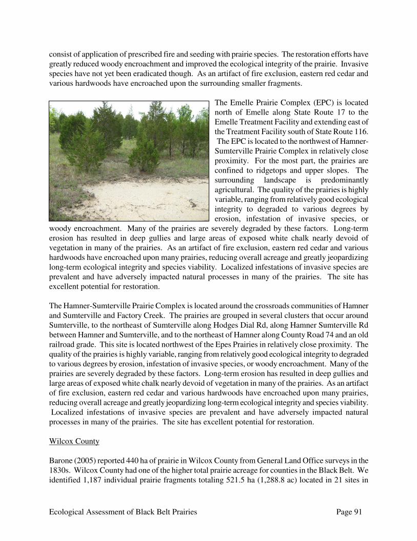
Ecological Assessment of Black Belt Prairies Page 91
consist of application of prescribed fire and seeding with prairie species. The restoration efforts have greatly reduced woody encroachment and improved the ecological integrity of the prairie. Invasive species have not yet been eradicated though. As an artifact of fire exclusion, eastern red cedar and various hardwoods have encroached upon the surrounding smaller fragments.
The Emelle Prairie Complex (EPC) is located north of Emelle along State Route 17 to the Emelle Treatment Facility and extending east of the Treatment Facility south of State Route 116. The EPC is located to the northwest of Hamner-Sumterville Prairie Complex in relatively close proximity. For the most part, the prairies are confined to ridgetops and upper slopes. The surrounding landscape is predominantly agricultural. The quality of the prairies is highly variable, ranging from relatively good ecological integrity to degraded to various degrees by erosion, infestation of invasive species, or
woody encroachment. Many of the prairies are severely degraded by these factors. Long-term erosion has resulted in deep gullies and large areas of exposed white chalk nearly devoid of vegetation in many of the prairies. As an artifact of fire exclusion, eastern red cedar and various hardwoods have encroached upon many prairies, reducing overall acreage and greatly jeopardizing long-term ecological integrity and species viability. Localized infestations of invasive species are prevalent and have adversely impacted natural processes in many of the prairies. The site has excellent potential for restoration. The Hamner-Sumterville Prairie Complex is located around the crossroads communities of Hamner and Sumterville and Factory Creek. The prairies are grouped in several clusters that occur around Sumterville, to the northeast of Sumterville along Hodges Dial Rd, along Hamner Sumterville Rd between Hamner and Sumterville, and to the northeast of Hamner along County Road 74 and an old railroad grade. This site is located northwest of the Epes Prairies in relatively close proximity. The quality of the prairies is highly variable, ranging from relatively good ecological integrity to degraded to various degrees by erosion, infestation of invasive species, or woody encroachment. Many of the prairies are severely degraded by these factors. Long-term erosion has resulted in deep gullies and large areas of exposed white chalk nearly devoid of vegetation in many of the prairies. As an artifact of fire exclusion, eastern red cedar and various hardwoods have encroached upon many prairies, reducing overall acreage and greatly jeopardizing long-term ecological integrity and species viability. Localized infestations of invasive species are prevalent and have adversely impacted natural processes in many of the prairies. The site has excellent potential for restoration. Wilcox County Barone (2005) reported 440 ha of prairie in Wilcox County from General Land Office surveys in the 1830s. Wilcox County had one of the higher total prairie acreage for counties in the Black Belt. We identified 1,187 individual prairie fragments totaling 521.5 ha (1,288.8 ac) located in 21 sites in

Ecological Assessment of Black Belt Prairies Page 92
Wilcox County (Table 17 – Two sites are omitted from the table because the prairies primarily occur in other counties.). Black Belt prairies were restricted to the northeastern half of the county along its borders with Marengo, Dallas, Lowndes, and Butler counties (Fig. 33). The majority of the prairies were small (median size 0.2 ha, % <0.5 ha). The quality of prairies in the county range from relatively good to severely degraded by erosion, infestation of exotics, or woody encroachment. Long-term erosion has resulted in deep gullies and large areas of exposed white chalk nearly devoid of vegetation in many prairies. Many of the prairies show signs of past disturbance or agricultural use, being either eroded, infested with invasive species to varying degrees, or fragmented. Localized infestations of invasive species are prevalent, and have adversely impacted natural processes. As an artifact of fire exclusion, eastern red cedar and various hardwoods have gradually encroached upon many prairies, reducing overall acreage and greatly jeopardizing long-term ecological integrity and species viability. Periodic prescribed fire, assuming a gradual transition from dormant season to growing season burns, would be beneficial to restore and maintain ecological integrity within the sites. The significant site in Wilcox County was the Prairie Bluff Prairie Complex, a complex of prairies located along the Alabama River north of Miller’s Ferry. Two other significant sites with prairies primarily in other counties extend into Wilcox County. The Tilden-Carlowville Prairie Complex has its most significant prairies in Dallas County, but extends into Wilcox County along Pine Barren Creek and Chambers Creek. The highest integrity prairies in the Braggs-Ridgeville Prairie Complex tend to occur in Lowndes County, but the site extends into Wilcox County from Lowndes and Butler counties. The high priority site located solely in Wilcox County was the Furman Prairie Complex. The moderate priority sites in the county were the Boykin Prairies and Union Church Prairies. The remaining sites located in Wilcox County were a low conservation priority because they primarily contain small prairies, the total prairie acreage is low, or the majority are heavily degraded by erosion, heavy woody encroachment, or infestation of invasive species.
The Furman Prairie Complex was a complex of prairies located along Wagontongue Creek north and east of Furman and west of Snake Creek in eastern Wilcox County. This site is located southeast of the Tilden-Carlowville Prairie Complex and could be considered an extension of that site. The surrounding landscape is forested, primarily pine plantations, with silviculture being the primary land use. For the most part, the prairies are confined to ridgetops and upper slopes. The quality of the prairies is highly variable, ranging from good ecological integrity to degraded to various degrees by erosion, infestation of invasive
species, or woody encroachment. Long-term erosion has resulted in gullies and large areas of exposed white chalk nearly devoid of vegetation in some prairies. As an artifact of fire exclusion, eastern red cedar and various hardwoods are gradually encroaching upon many prairies, reducing overall acreage and greatly jeopardizing long-term ecological integrity and species viability. Localized infestations of invasive species have adversely impacted natural processes in many of the prairies.

Ecological Assessment of Black Belt Prairies Page 93
Table 17. Number of prairies, total prairie acreage; and maximum (max), mean, and median prairie size (ha) for prairie sites in Wilcox County, Alabama. Prairie Size (ha) Prairie Site
Number of Prairies
Total Acreage
Max
Median
Mean
Allenton Prairies 20 7.0 1.1 0.3 0.3 Boykin Prairies a 66 63.4 10.7 0.3 1.0 Bridges Cemetery Prairies 10 1.4 0.4 0.1 0.1 Camden North 7 Prairie 1 0.4 0.4 - 0.4 Catherine Prairie Complex 84 15.0 1.3 0.1 0.2 Darlington Prairies 7 7.7 2.3 1.2 1.1 Donald Lake Prairies 36 22.3 5.1 0.3 0.6 Furman Prairie Complex b 129 53.9 3.9 0.2 0.4 Oak Grove Church Prairies 2 0.4 0.3 0.2 0.2 Pine Apple North 17 Prairies 4 0.8 0.4 0.2 0.2 Poplar Springs Cemetery Prairies 4 0.3 0.1 0.1 0.1 Prairie Bluff Prairie Complex 58 43.2 8.0 0.3 0.7 Prairie Creek Prairies 73 17.3 1.4 0.1 0.2 Rock Springs Prairie Complex 97 27.1 2.4 0.1 0.3 Rosebud Prairies 23 18.5 5.1 0.3 0.8 Shell Creek Park Prairies 14 2.1 0.5 0.1 0.1 Strother Landing Strip Prairie Complex c 78 29.5 3.7 0.2 0.4 Union Church Prairies a 56 39.9 12.9 0.2 0.7 Vincent Spring NE Prairies 14 5.5 1.7 0.3 0.4 Allenton Prairies 20 7.0 1.1 0.3 0.3
a Moderate priority site. b High Priority site. c Site includes 27 prairies totaling 9.7 ha in Marengo County.

Figure 33. Distribution of historic (Barone 2005) and extant Black Belt prairies in Wilcox County, Alabama.

Ecological Assessment of Black Belt Prairies Page 95
The Boykin Prairies are a group of prairies northwest of Boykin along County Road 29 that occupies an area along the east side of the William “Bill” Dannelly Reservoir on the Alabama River between the river and Foster Creek on the peninsula formed by the curve of the river at Gees Bend. This site is isolated from the other sites, and occurs at about the midpoint between the two generalized groupings of the other sites in the county. The surrounding landscape is primarily forested, primarily pine plantations, with some agricultural areas along the river. Silviculture is the primary land use. For the most part, the prairies are confined to ridgetops and upper slopes. The quality of the prairies is highly variable, ranging from good ecological integrity to degraded to various degrees by erosion and infestation of invasive species. Long-term erosion has resulted in gullies and areas of exposed white chalk nearly devoid of vegetation in some prairies. The Union Church Prairies are a small complex of prairies east of the Alabama River and Roland Cooper State Park along State Route 41 near the border with Dallas County. The prairies generally occur on the ridgetop and upper slopes above the floodplain of Pine Barren Creek. This site occurs on the opposite side of Pine Barren Creek from the Tilden sub-site of the Tilden-Carlowville Prairie Complex and could be considered an extension of that site. The quality of the prairies is variable, ranging from good ecological integrity to degraded to various degrees by erosion, infestation of invasive species, or woody encroachment. Although erosion is minimal for the most part, areas of exposed white chalk nearly devoid of vegetation exist in some prairies. As an artifact of fire exclusion, eastern red cedar and various hardwoods are gradually encroaching upon some of the prairies, reducing overall acreage and greatly jeopardizing long-term ecological integrity and species viability. Localized infestations of invasive species such as MaCartney rose have adversely impacted natural processes in some of the prairies. Speckled Kingsnake (Lampropeltis getula holbrooki) Survey The only speckled kingsnakes captured during trapping efforts were two specimens captured at Cochrane Recreation Area (CRA) in 2008 (Fig. 34). Speckled kingsnakes also were observed at two locations on CRA: one on the road between two prairies and one in the vicinity of the camping area (Fig. 35). Overall trap success in 2007 was very poor, likely due to climatic conditions. Alabama experienced a severe drought in 2007, and generally the weather was extremely hot during much of the time the traps were active. Snake captures with the methods used tend to decline during the summer, and this trend was likely exaggerated by the heat and drought conditions. The snake species most frequently captured during trapping was black racer (Coluber constrictor) (Table 18). This was the only snake species captured at all trapping sites, and was the only snake species observed in the prairies outside of trapping other than the kingsnake seen at CRA. The landowner or land manager reported having seen speckled kingsnakes in the prairies on properties in the Limestone Lakes Prairie Complex in Hale County, Tilden-Carlowville Prairie Complex in Dallas County, and West Greene-Mt. Hebron Prairie Complex in Greene County. In addition, a road-killed speckled kingsnake was observed on Alabama Highway 14 in the general area of the Pleasant Ridge Prairie Complex in Greene County (Fig. 36). The habitat in the
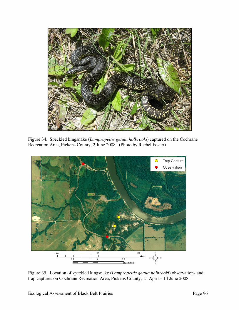
Ecological Assessment of Black Belt Prairies Page 96
Figure 34. Speckled kingsnake (Lampropeltis getula holbrooki) captured on the Cochrane Recreation Area, Pickens County, 2 June 2008. (Photo by Rachel Foster)
Figure 35. Location of speckled kingsnake (Lampropeltis getula holbrooki) observations and trap captures on Cochrane Recreation Area, Pickens County, 15 April – 14 June 2008.
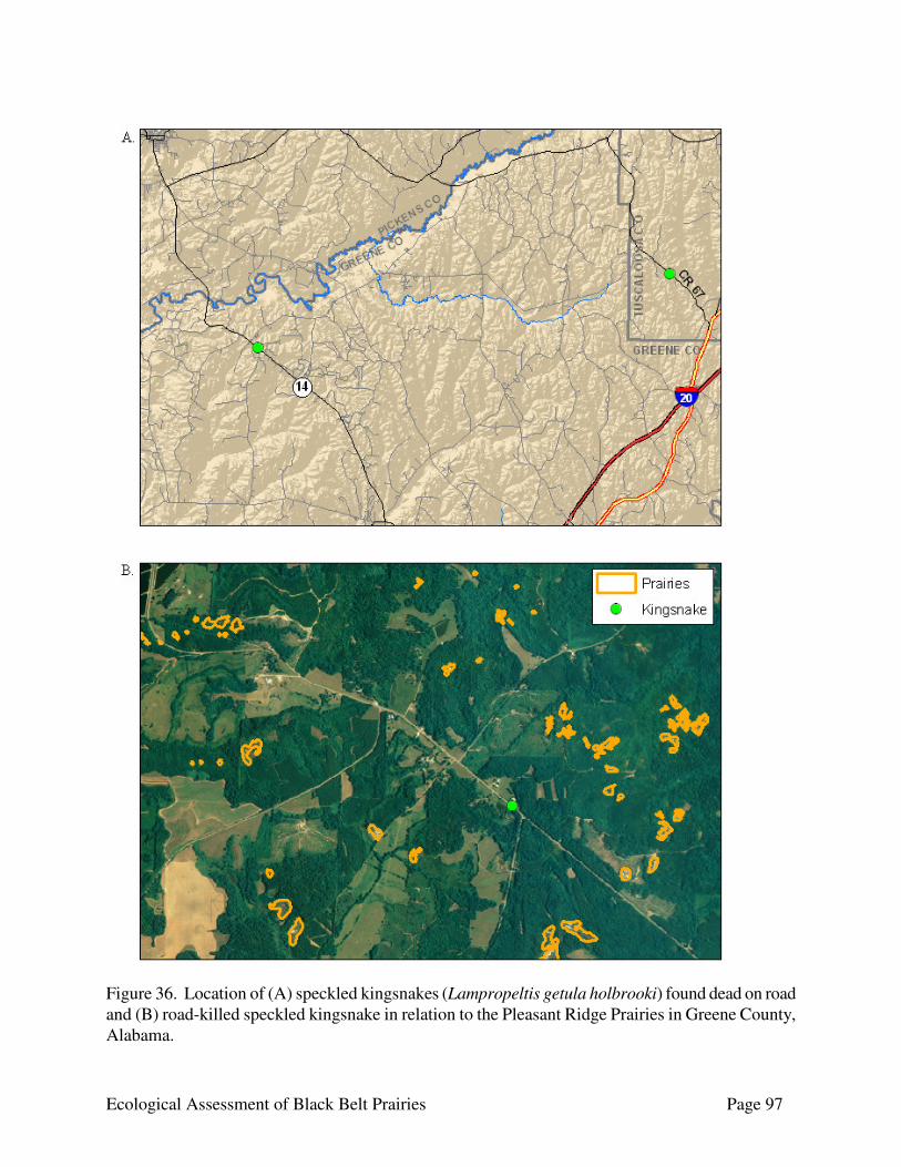
Ecological Assessment of Black Belt Prairies Page 97
Figure 36. Location of (A) speckled kingsnakes (Lampropeltis getula holbrooki) found dead on road and (B) road-killed speckled kingsnake in relation to the Pleasant Ridge Prairies in Greene County, Alabama.
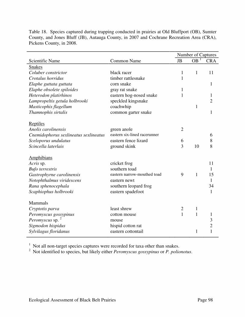
Ecological Assessment of Black Belt Prairies Page 98
Table 18. Species captured during trapping conducted in prairies at Old Bluffport (OB), Sumter County, and Jones Bluff (JB), Autauga County, in 2007 and Cochrane Recreation Area (CRA), Pickens County, in 2008.
Number of Captures Scientific Name Common Name JB OB 1 CRA Snakes Coluber constrictor black racer 1 1 11 Crotalus horridus timber rattlesnake 1 Elaphe guttata guttata corn snake 1 Elaphe obsolete spiloides gray rat snake 1 Heterodon platirhinos eastern hog-nosed snake 1 1 Lampropeltis getula holbrooki speckled kingsnake 2 Masticophis flagellum coachwhip 1 Thamnophis sirtalis common garter snake 1 Reptiles Anolis carolinensis green anole 2 Cnemidophorus sexlineatus sexlineatus eastern six-lined racerunner 6 Sceloporus undulatus eastern fence lizard 6 8 Scincella laterlais ground skink 3 10 8 Amphibians Acris sp. cricket frog 11 Bufo terrestris southern toad 1 Gastrophyrne carolinensis eastern narrow-mouthed toad 9 1 15 Notophthalmus viridescens eastern newt 1 Rana sphenocephala southern leopard frog 34 Scaphiophus holbrooki eastern spadefoot 1 Mammals Cryptotis parva least shrew 2 1 Peromyscus gossypinus cotton mouse 1 1 1 Peromyscus sp. 2 mouse 3 Sigmodon hispidus hispid cotton rat 2 Sylvilagus floridanus eastern cottontail 1 1
1 Not all non-target species captures were recorded for taxa other than snakes. 2 Not identified to species, but likely either Peromyscus gossypinus or P. polionotus.

Ecological Assessment of Black Belt Prairies Page 99
immediate vicinity was a mosaic of forest, agriculture, and residential lawn, and was somewhat centrally located in the area covered by the prairies in this prairie complex. The closest prairie was approximately 0.84 km (0.52 mi). Another road-killed speckled kingsnake was found outside the Black Belt in Tuscaloosa County during this study (Fig. 36). Long-tailed Weasel (Mustela frenata) Survey The majority of tracks left on track plates were raccoon (Procyon lotor) tracks, which was the only species detected at all four sampling sites (Table 19). A possible weasel track was left on one track plate at Cochrane Recreation Area, but the track was not clear so it could not be positively identified. The only positive identification of a long-tailed weasel during the project was a road-killed long-tailed weasel found on Alabama Highway 14 in Greene County southeast of the Pleasant Ridge Prairies (Fig. 37). Avian Surveys The only Short-eared Owls detected during this project were two observations in the largest prairie in the Old Cahawba Prairie Complex (Fig. 38). This prairie is located along CR 9 near its junction with County Road 2. A single owl was observed in this prairie 15 November 2008 and 12 March 2009. Northern Harriers were observed in three prairies and in the vicinity of another prairie complex (Fig. 39). Two birds were seen in foraging flight 8 March 2007 over the largest prairie in the Limestone Lakes Prairie Complex in Hale County. This prairie is located west of County Road 17. One bird was observed 20 February hunting over a prairie along County Road 59 in the Snow Hill Institute North sub-site of the Tilden-Carlowville Prairie Complex in Wilcox County. One bird was observed perched in a low snag 15 August 2009 in a prairie near Interstate 65 in the Cherry Creek South Prairies in Lowndes County. In addition, a Northern Harrier was observed 18 February 2009 in flight over a pasture along US 43 in Greene County. Although not seen over prairie, this location is between the Eutaw Prairie Complex and the Culpepper Creek Prairies with prairies from both sites nearby. No American Kestrels were observed in prairies during the course of this project. However, the landowner of the prairie in the Limestone Lakes Prairie Complex at which the Northern Harriers were observed reported that Kestrels are usually observed on the property every year. In addition, two kestrels were observed perched on power lines in the general vicinity of prairie sites along US 43 in Greene County and State Route 69 in Hale County (Fig. 40). Sixty-six species of birds were documented during avian surveys in prairies (Table 20). The majority of the species detected are considered to be of low conservation concern in Alabama (Mirachi 2004). The Short-eared Owl, one of the target species, was the only High ranked species. An additional nine species were ranked as a species of Moderate concern. However, only three of those nine species would be primarily found in the prairies instead of the surrounding forest: Prairie Warbler (Dendroica discolor), Palm Warbler (Dendroica palmarum), and Grasshopper Sparrow (Ammodramus savannarum). The most frequently encountered
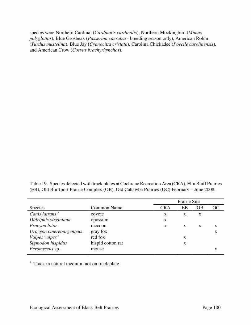
Ecological Assessment of Black Belt Prairies Page 100
species were Northern Cardinal (Cardinalis cardinalis), Northern Mockingbird (Mimus polyglottos), Blue Grosbeak (Passerina caerulea - breeding season only), American Robin (Turdus mustelina), Blue Jay (Cyanocitta cristata), Carolina Chickadee (Poecile carolinensis), and American Crow (Corvus brachyrhynchos). Table 19. Species detected with track plates at Cochrane Recreation Area (CRA), Elm Bluff Prairies (EB), Old Bluffport Prairie Complex (OB), Old Cahawba Prairies (OC) February – June 2008. Prairie Site Species Common Name CRA EB OB OC Canis latrans a coyote x x x Didelphis virginiana opossum x Procyon lotor raccoon x x x x Urocyon cinereoargenteus gray fox x Vulpes vulpes a red fox x Sigmodon hispidus hispid cotton rat x Peromyscus sp. mouse x
a Track in natural medium, not on track plate

Ecological Assessment of Black Belt Prairies Page 101
Figure 37. Location of long-tailed weasel (Mustela frenata) found dead on Alabama Highway 14 in Greene County. Figure 38. Locations of Short-eared Owl (Asio flammeus) observations in the Old Cahawba Prairie Complex, Dallas County.

Ecological Assessment of Black Belt Prairies Page 102
Figure 39. Locations of Northern Harrier (Circus cyaneus) observations in or near prairies in Alabama’s Black Belt.
Figure 40. Locations of incidental observations of American Kestrels (Falco sparverius) in Alabama’s Black Belt.
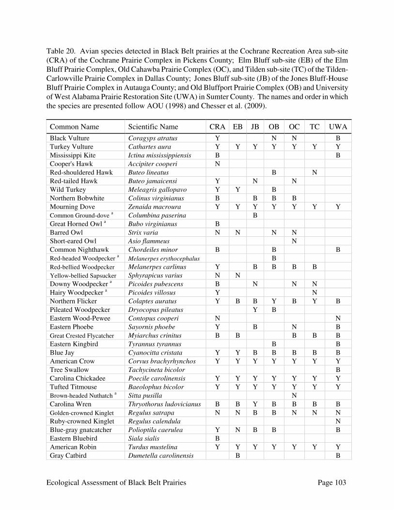
Ecological Assessment of Black Belt Prairies Page 103
Table 20. Avian species detected in Black Belt prairies at the Cochrane Recreation Area sub-site (CRA) of the Cochrane Prairie Complex in Pickens County; Elm Bluff sub-site (EB) of the Elm Bluff Prairie Complex, Old Cahawba Prairie Complex (OC), and Tilden sub-site (TC) of the Tilden-Carlowville Prairie Complex in Dallas County; Jones Bluff sub-site (JB) of the Jones Bluff-House Bluff Prairie Complex in Autauga County; and Old Bluffport Prairie Complex (OB) and University of West Alabama Prairie Restoration Site (UWA) in Sumter County. The names and order in which the species are presented follow AOU (1998) and Chesser et al. (2009).
Common Name Scientific Name CRA EB JB OB OC TC UWA Black Vulture Coragyps atratus Y N N B Turkey Vulture Cathartes aura Y Y Y Y Y Y Y Mississippi Kite Ictina mississippiensis B B Cooper's Hawk Accipiter cooperi N Red-shouldered Hawk Buteo lineatus B N Red-tailed Hawk Buteo jamaicensi Y N N Wild Turkey Meleagris gallopavo Y Y B Northern Bobwhite Colinus virginianus B B B B Mourning Dove Zenaida macroura Y Y Y Y Y Y Y Common Ground-dove a Columbina paserina B Great Horned Owl a Bubo virginianus B Barred Owl Strix varia N N N N Short-eared Owl Asio flammeus N Common Nighthawk Chordeiles minor B B B Red-headed Woodpecker a Melanerpes erythocephalus B Red-bellied Woodpecker Melanerpes carlinus Y B B B B Yellow-bellied Sapsucker Sphyrapicus varius N N Downy Woodpecker a Picoides pubescens B N N N Hairy Woodpecker a Picoides villosus Y N Northern Flicker Colaptes auratus Y B B Y B Y B Pileated Woodpecker Dryocopus pileatus Y B Eastern Wood-Pewee Contopus cooperi N N Eastern Phoebe Sayornis phoebe Y B N B Great Crested Flycatcher Myiarchus crinitus B B B B B Eastern Kingbird Tyrannus tyrannus B B Blue Jay Cyanocitta cristata Y Y B B B B B American Crow Corvus brachyrhynchos Y Y Y Y Y Y Y Tree Swallow Tachycineta bicolor B Carolina Chickadee Poecile carolinensis Y Y Y Y Y Y Y Tufted Titmouse Baeolophus bicolor Y Y Y Y Y Y Y Brown-headed Nuthatch a Sitta pusilla N Carolina Wren Thryothorus ludovicianus B B Y B B B B Golden-crowned Kinglet Regulus satrapa N N B B N N N Ruby-crowned Kinglet Regulus calendula N Blue-gray gnatcatcher Polioptila caerulea Y N B B B Eastern Bluebird Siala sialis B American Robin Turdus mustelina Y Y Y Y Y Y Y Gray Catbird Dumetella carolinensis B B

Ecological Assessment of Black Belt Prairies Page 104
Table 20. Continued.
Common Name Scientific Name CRA EB JB OB OC TC UWA Northern Mockingbird Mimus polyglottos Y Y Y Y Y Y Y Brown Thrasher Toxostoma rufum N B B N Y Cedar Waxwing Bombycilla cedrorum N N N Yellow-rumped Warbler Dendroica coronata N N N N Pine Warbler Dendroica pinus B B Y Prairie Warbler a Dendroica discolor B B B B B Palm Warbler a Dendroica palmarum N N Common Yellowthroat Geothlypis trichas B Yellow-breasted Chat Icteria virens N B B B Sumer Tanager Piranga rubra B B B B Eastern Towhee Pipilo erythrophthalmus Y Y B B Y Y B Chipping Sparrow Spizella passerina N Y N Y N N Field Sparrow Spizella pusilla N N Y N B Savannah Sparrow Passerculus sandwichensis N N N Grasshopper Sparrow a Ammodramus savannarum Y Song Sparrow Melospiza melodia N N N N N N N White-throated Sparrow Zonotrichia albicollis N N N Dark-eyed Junco Junco hemalis N N N N Northern Cardinal Cardinalis cardinalis Y Y Y Y Y Y Y Blue Grosbeak Passerina caerulea B B B B B B B Indigo Bunting Passerina cyanea B B B B B B Red-winged Blackbird Agelaius phoeniceus N B Eastern Meadowlark Sturnella magna B Brown-headed Cowbird Molothrus ater Y Orchard Oriole Icterus spurius B Baltimore Oriole Icterus galbula N Pine Siskin Carduelis pinus N American Goldfinch Carduelis tristis N
B = breeding season only N = non-breeding season only Y = year round a Ranked as a species of Moderate conservation concern in Mirarchi (2004).
Ecological Assessment of Black Belt Prairies Page 105
Potential Wildlife Viewing Areas We identified five areas with the potential to serve as wildlife viewing areas: Cochrane Recreation Area (CRA) in Pickens County, Old Cahawba Prairie Tract in Dallas County, Jones Bluff Park in Autauga County, University of West Alabama Prairie Restoration Site in Sumter County, and the State Cattle Ranch in Hale County. All of these sites are generally easily accessible and support a diverse community of wildlife. The CRA and UWA Prairie Restoration Site probably provide the best opportunities to serve as a wildlife viewing areas under current conditions. The UWA is adjacent to Lake LU, the lake on the UWA campus, and CRA is along the Tombigbee River so both present the opportunity to see some additional species that might not be present on the other sites. There also are mowed trails through the UWA prairie that continue into the adjacent forests. The Jones Bluff Park supports a mixture of habitats with the prairies, wetlands along the river, and the diversity and maturity of the surrounding forest. The park would make an excellent wildlife viewing area. However, the U.S. Army Corps of Engineers closed the park facilities in 2005. The park is still available for hunting and can be accessed from the entrance on County Road 9, but the access road off County Road 15 to the boat ramp which is surrounded by mature hardwood and hardwood/pine forest in the eastern half of the park is closed. The Forever Wild State Cattle Ranch is currently closed to the public. However, a notice of a roseate spoonbill (Ajaia ajaja) roosting with the Wood Storks (Mycterina americana) on the east side of the property in August 2009 was posted on the Alabama Birds list. Threats Since the arrival of the first Europeans to what is now the Black Belt physiographic province of Alabama, the region has undergone such a rapid transformation as to render the area virtually unrecognizable by the early settlers if they were alive today. Most of the Black Belt was converted to agriculture by the late 1800s, leaving only small remnants of prairies, forests, and chalk outcrops, with many of the latter being highly eroded (Peacock and Schauwecker 2003). Habitat loss and degradation have driven several species of plants and animals to the verge of extirpation in the Black Belt since settlements appeared nearly 250 years ago. Although extinction is a natural process, the current rate of species decline, rather than the process itself, is a cause for preeminent concern on regional and global levels. Land Use The Black Belt landscape has changed dramatically over the vast expanse of human occupation, and the vegetation has reflected these changes. Perhaps more than any other area of the state, this region has experienced an astonishing variety of landuse patterns that has forever transformed the land. The Native Americans were the first major residents to assert some level of influence, shaping the land to accommodate sustainable lifestyles. Several authorities suggest that native peoples often employed fire to maintain favorable hunting grounds by encouraging forage for game species (Wilson 1981). It is conjectured, however, that the Native Americans probably avoided the heavy clay soils of the prairies for growing crops, but used the area for hunting grounds.
Ecological Assessment of Black Belt Prairies Page 106
The nineteenth century saw the total occupation of the Black Belt by European colonists. After the Indian removals of 1814 to 1831 (Doster and Weaver 1981), the Black Belt was settled rapidly. Overland passages to the region were made by wagonloads of settlers striving to lay claim to what was purportedly the most fertile soils in the state. The dark, chalky soil was rumored to yield cotton in such abundance as to make fortunes and establish dynasties (Hamilton 1977). The first settlers appreciated the rich, black soils, but generally avoided settling there due to the lack of water. Most bought land along the rivers, preferring the red-brown soils of the alluvial terraces to the obviously richer, but drier, soils of the chalk belt (Rindsberg 1989). It was an era of forest clearing, and any virgin stand which survived that century was logged or farmed or both in the next. Prior to the last century, if a Black Belt farm became depleted, the depleters moved elsewhere. Farming practices were abusive to the soil, promoting vast areas of erosion and mass devastation of the landscape and the region’s remarkable biodiversity. It was the expectation of a homesteader arriving on new land that he could eventually exhaust the soil and have to move elsewhere. The idea of living with the consequences of one’s agricultural practices was widely accepted only when there were no more western lands to be had, largely a phenomenon of the last century. Prior to the forests being cut and the cleared areas merged, many prairies were distinct enough to be individually named on older maps, such as Wild Horse and Grindstone prairies that appear on the geologic map of Sumter County prepared by R.D. Webb in 1881. Beginning in the mid-nineteenth century and extending to the present day domestic grazing has exerted a profound influence on the Black Belt prairies. Well-worn, dilapidated fences encircling many of the region’s prairies are a testimony to the extensive use employed by ranchers to most effectively utilize their lands. The act of domestic grazing, including foraging and trampling, decreases native species diversity by increasing soil compaction, by decreasing soil moisture, by opening areas for secondary succession (such as the incursion of Juniperus virginiana), by reducing the seed source of native species, and by eliminating the cover of protective microhabitats necessary for the survival of some prairie forbs. The reduction of some species is undoubtedly caused by selective browsing because of plant height and palatability (Drew 1947). It has also been demonstrated that cool season species, such as tall fescue (Schedonorus arundinaceous) complete their growing season before grazing is generally started and allow better competition with native species that do not mature until later in the growing season. As apparent throughout the Black Belt, domestic foragers tend to use the same browsing trail repeatedly, and consequently, bare soil becomes exposed signifying the initial phases of erosion. These areas are prime sites for invasive species. If domestic grazing is necessitated, rotational grazing is probably the best way of managing grasslands for a diverse flora and fauna. However, economic obstacles to this form of management often make it impractical (DeSelm and Murdock 1993). Residential and commercial development has been and continues to be encroaching on prairies, particularly in the metropolitan areas of Montgomery, Selma, and Demopolis. Land development has fueled the surge of Alabama’s population and its economy; perhaps more than any other human activity, it has depleted local floras across the state. The southward expansion of Montgomery has been responsible for severely degrading and eliminating several examples of grasslands within the past 20 years. Remnants of prairie vegetation are still visible along several streets in Selma, offering a narrow glimpse of past vegetation types that have now been largely replaced by suburbanization.
Ecological Assessment of Black Belt Prairies Page 107
The establishment of aquaculture, primarily for the production of catfish and shrimp, has and will likely continue to displace native prairies. The impermeability of the clay-based soils is ideal for the construction of containment ponds, having the ability to retain water for extended periods. Ecological Driving Forces While it is generally agreed upon by ecologists that the Black Belt prairies are principally edaphically maintained, many also concur that naturally occurring fire and stochastic events such as periodic droughts were likely essential driving forces toward maintaining habitat integrity and species viability. The frequency of fire within the prairie system is open to interpretation, but was likely influential toward maintaining uniformity of species composition (Harper 1943) during pre-European times. Historically, fires were caused by lightning and by Native Americans. The Native Americans understood the role of natural fire, and they practiced sophisticated vegetation management of grasslands, as well as woodlands and forests. This disappeared when Native Americans lost their land, along with their knowledge of fire-vegetation relationships. As settlements began to increase in the mid 1800s, a gradual change in the vegetation of the prairies likely took place, an artifact of alterations in fire return intervals, in seasonal occurrence of fires, and in fire intensity. These factors have been found to influence the floristic composition of prairies in the mid-West (Dix 1960, Wright and Bailey 1982, Riser 1986, Steinauer and Bragg 1987). In general, prairie vegetation is dependent on periodic fire for seed production because it replenishes nutrients, satisfies seed dormancy requirements, and allows light to reach plants by preventing the establishment of eastern red cedar and other woody species that have become commonplace in the prairies of Alabama’s Black Belt. Leidolf and McDaniel (1998) suggested that prairie cedar woodlands in the Black Belt are a recent feature resulting from the absence of fire and grazing. Encroachment of the prairies by eastern red cedar has a profound impact on the prairies by directly altering the soil environment and changing soil nutrient levels (Bekele et al. 2006). In the 1970s prescribed burning began to become a widely accepted management tool to reduce the buildup of fuels (e.g., leaves and branches) and to control unwanted vegetation. The benefits of prescribed burning are well documented in literature. Research conducted by ecologists indicated that prairie lands could be restored and maintained by burning. Seasonal timing of burning has been an issue with fire ecologists striving to achieve the greatest level of restoration without jeopardizing the growth and reproduction of indigenous plants and animals. For example, fire management research in Missouri (McCarty et al. 1999) has demonstrated that fall-season burns are advantageous to forbs and promote seed production and plant vigor, whereas summer-season burns tend to improve herbaceous vitality. Late-winter or early-spring burns benefit grass productivity. Spring burns stimulate grasses because their reserves are stored in the roots. Burning also turns litter into reusable nutrients. State and federal agencies are now working together to maintain prairies and other natural ecosystems across Alabama while protecting lives and property. It has also been conjectured that the Black Belt prairies may have partially evolved and subsequently been maintained through grazing, although no supporting evidence is known. Regardless of influence, the grazing system under which the mid-western grasslands and possibly Alabama’s prairies partially evolved is radically different from the intensive grazing pressure characteristic of

Ecological Assessment of Black Belt Prairies Page 108
livestock management. According to Weaver (1968), when prairies are grazed and trampled, various changes occur, and the nature and extent of these changes vary somewhat with the degree of disturbance. Once degeneration is well under way, however, it proceeds so gradually and effectively that it is usually not observed until a great loss in productivity is sustained; and several years are required for recovery. Weaver (1968) further exclaims that climax grassland, when it is grazed lightly or moderately, may essentially retain its natural composition over extremely long periods. It is only when grazing animals are circumscribed in their range by fences, and when too large a population is thus confined, that grazing and trampling become so excessive that the normal cover cannot be maintained. As the hold of native species is weakened by continued pasturing or intense overgrazing, the incursion of exotic and native weedy species begin. As witnessed in the Black Belt, small places of exposed soil appear. Gradually opportunistic, and generally undesirable, species invade, which, once established, produce seed for new populations. In time, the native grasses and forbs are partially or entirely replaced by invasive species that are better adapted to close grazing and trampling. When the Indian grass, bluestems, and other prairie herbs are eaten, many invasives increase their areas by means of rhizomes and developing large, bush-like clumps and/or deep roots. Nearly all of these are less productive, or less palatable – or both – than the original vegetation. Typically however, as long as a prairie is undisturbed except by occasional mowing, weeds find it difficult to become established. Weaver (1968) presents a long list of important prairie species, all perennials, which decrease under intensive or long-term domestic grazing pressure. The following occur in the Black Belt prairies: Andropogon gerardi – Big Bluestem Dalea candida – White Prairie-clover Dalea purpurea – Purple Prairie-clover Desmodium spp. – Tick Trefoils Helianthus spp. – Sunflowers Lespedeza capitata – Bush Clover Panicum virgatum – Switch Grass Ratibida pinnata – Prairie Coneflower Solidago nemoralis – Gray Goldenrod Schizachyrium scoparium – Little Bluestem Sorghastrum nutans – Indian Grass Exotic and Invasive Species With the arrival of European settlement, Alabama soon began to experience the curse of exotic species. Many of the introductions are artifacts of livestock management where existing prairies were seeded with forage species better suited to intensive grazing pressure. Tall fescue and dallis grass (Paspalum dilatatum) were widely planted throughout the Black Belt for this purpose and has now become well established. Yet others were planted to enhance wildlife habitat and gardens. In addition to tall fescue and dallis grass, cogon grass (Imperata cylindrica), Johnson grass (Sorghum halepense), and MaCartney rose (Rosa bracteata) are three exotic plant species that have become well established in several locations in the Black Belt prairies. Cogon grass has become a serious pest throughout warmer regions of the world, often encroaching upon and displacing native vegetation. The species can be readily identified by its production of fluffy, white, plume-like

Ecological Assessment of Black Belt Prairies Page 109
seedheads in early spring. It also has a distinctive habit of quickly forming colonies or infestations, somewhat circular in outline. The plants vary in height, extending from 1 to 4 feet. MaCartney rose
is native to China and was first introduced into the United States as an ornamental and used for livestock containment, erosion control, and cross-breeding rose cultivars. Since the arrival of the species in North America, R. bracteata has become highly invasive throughout vast areas of the Southeast, forming dense thickets and dominating habitats that have resulted in the reduction of foraging capacity of pastures and the displacement of native species. Its low mortality, efficient growth, ability to withstand harsh environmental conditions, and the beneficial adaptation to fire render the MaCartney rose as one of the most problematic invasives of the Black Belt prairies. The widespread dispersal of exotic and native invasive species in the prairies is primarily attributed to disturbance associated with human-derived activities (e.g., highway construction, grazing, land clearing, etc.). Although many species appear not to pose a significant threat to the ecological integrity of prairies in general, some however, are capable of adversely affecting natural processes. Tables 21 and 22, while inconclusive, provide accounts of exotic and invasive species documented during the course of this project. Monitoring and treatment of existing infestations, and preventing the encroachment of new populations, particularly those taxa designated with a severity ranking of one, should be an important component of land management within all prairies. Education of land managers and property owners about problems associated with exotic and invasive species, coupled with the use of appropriate native plants for improving livestock management, wildlife habitat, and landscaping pursuits may be beneficial in this effort. Many invasive species are sold in nurseries, despite their known destructive impacts on native vegetation. Several websites are available that offer guidance to land managers and homeowners regarding the control of specific exotic and invasive species. Many provide images, management plan templates, weed control methods, tool reviews, technical support, and other sources pertinent to invasive species control. Consultation of the four websites presented below is recommended for additional information.
Imperata cylindrica (cogon grass) Rosa bracteata (MaCartney rose) Sorghum halepense (Johnson grass)
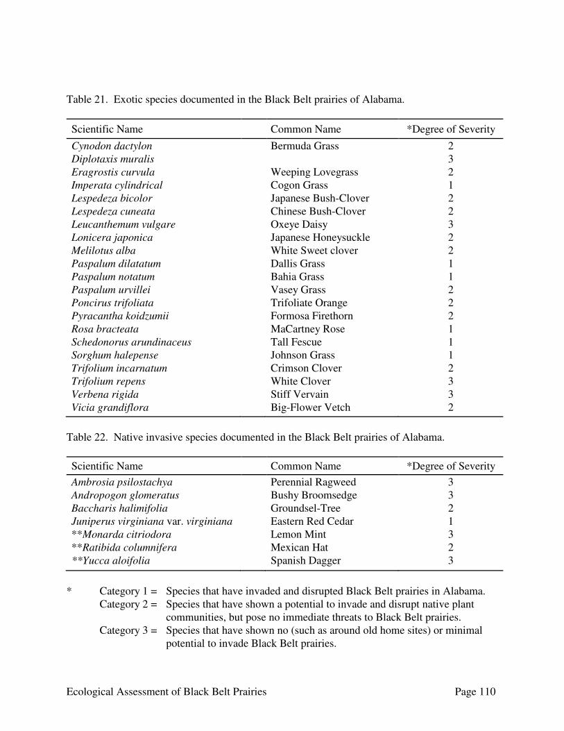
Ecological Assessment of Black Belt Prairies Page 110
Table 21. Exotic species documented in the Black Belt prairies of Alabama.
Scientific Name Common Name *Degree of Severity
Cynodon dactylon Bermuda Grass 2 Diplotaxis muralis 3 Eragrostis curvula Weeping Lovegrass 2 Imperata cylindrical Cogon Grass 1 Lespedeza bicolor Japanese Bush-Clover 2 Lespedeza cuneata Chinese Bush-Clover 2 Leucanthemum vulgare Oxeye Daisy 3 Lonicera japonica Japanese Honeysuckle 2 Melilotus alba White Sweet clover 2 Paspalum dilatatum Dallis Grass 1 Paspalum notatum Bahia Grass 1 Paspalum urvillei Vasey Grass 2 Poncirus trifoliata Trifoliate Orange 2 Pyracantha koidzumii Formosa Firethorn 2 Rosa bracteata MaCartney Rose 1 Schedonorus arundinaceus Tall Fescue 1 Sorghum halepense Johnson Grass 1 Trifolium incarnatum Crimson Clover 2 Trifolium repens White Clover 3 Verbena rigida Stiff Vervain 3 Vicia grandiflora Big-Flower Vetch 2
Table 22. Native invasive species documented in the Black Belt prairies of Alabama. Scientific Name Common Name *Degree of Severity Ambrosia psilostachya Perennial Ragweed 3 Andropogon glomeratus Bushy Broomsedge 3 Baccharis halimifolia Groundsel-Tree 2 Juniperus virginiana var. virginiana Eastern Red Cedar 1 **Monarda citriodora Lemon Mint 3 **Ratibida columnifera Mexican Hat 2 **Yucca aloifolia Spanish Dagger 3
* Category 1 = Species that have invaded and disrupted Black Belt prairies in Alabama.
Category 2 = Species that have shown a potential to invade and disrupt native plant communities, but pose no immediate threats to Black Belt prairies.
Category 3 = Species that have shown no (such as around old home sites) or minimal potential to invade Black Belt prairies.
Ecological Assessment of Black Belt Prairies Page 111
** Native to North America, but not to Alabama. Southeast Exotic Pest plant Council (http://www.se.eppc.org): A non-profit organization dedicated to promoting public awareness about the spread of exotic plants and to serve as an outlet for educational, advisory, and technical support on all aspects of exotic plants in the Southeast. The website also provides information on grant opportunities, publications, upcoming events, and links to other web pages devoted to invasive species. The Nature Conservancy (http://tncweeds.ucdavis.edu): A conservation organization that has recently launched a new initiative, the Global Invasive Species Team, whose mission is a abate the damage caused by human-facilitated introductions of non-native invasive species. The website provides resources designed to help all conservationists and land managers to deal most effectively with invasive species. Invasive and Exotic Species of North America (http://www.invasive.org/seweeds.cfm): A compilation of invasive species prepared by various federal agencies that offers a listing of invasive plants documented from each of the 13 southeastern states.
National Invasive Species Council (http://www.invasivespecies.gov): A website that focuses on federal efforts concerning invasive species. The site offers information outlining the impacts of invasive species and the Federal government’s response, as well as furnishes profiles of exotic species and links to agencies and organizations dealing with invasive species issues.
Erosion The impacts of erosion are readily apparent throughout the Black Belt region, where the greatest damage has befallen the prairies. Marked by exposed expanses of white chalk, several prairies have been severely degraded, a result of long-standing incompatible landuse practices. Intensive grazing and, to a lesser extent, highway construction are the primary erosive forces associated with degradation of the region’s grasslands. As the dark, fertile surface layer is washed away, the subsoil consisting of a bright gray montmorillonite clay becomes exposed. Characterized by extreme changes in texture, which shrink and swell according to levels of soil moisture, these exposed clay soils bake hard upon drying and then become highly adhesive and sticky when wet. Given such adverse environmental conditions the establishment of vegetation becomes slow and difficult. Climate Change There is general agreement among scientists that the rising concentrations of CO2 and other greenhouse gases will lead to dramatically higher temperatures over most of the earth’s surface in the next few decades. There is significant evidence that the earth is now experiencing a warming trend; several of the warmest years on record have occurred within the past 15 years. General circulation models of the earth’s atmosphere have been used to project climatic parameters after a doubling of CO2. According to Bolin et al (1986), such projections suggest an increase in the global mean

Ecological Assessment of Black Belt Prairies Page 112
surface temperature of 1.5-4.5C. The predictions of global warming over the next 50 years have spectacular implications for vegetation and the distribution of plants and animals (Bolin et al 1986). The implications of climate change on the Black Belt prairies are open to interpretation. Considering the affects of elevated CO2 varies among plant species (Kimball 1983, Cure 1985), some models suggest that grasslands in general may change in character, but not undergo much change in regional distribution (Emanuel et al. 1985). Other interpretations suggest that prairies may expand at the expense of forests similar to the Hypsothermic period that profoundly affected the mid-portion of North America 8,000 BP (Transeau 1935, Sears 1942). Ecologists assert that under current climate and disturbance regimes, grasses typically dominate at an early stage of succession, but this is usually temporary, and forests are re-established in a few years. However, under a new climate and disturbance regime, the regeneration niche of the forest species may be lost, becoming replaced with a greater prominence of grasses. A general pattern of climate change, as discussed by Sauchyn and Lapp (2008), in relation to potential effects on prairies of the upper mid-West, may be applicable to natural grasslands elsewhere in North America, including the Black Belt prairies. The findings of their work are summarized as follows: ♦ shorter winters and longer drier summers ♦ decreasing trends in annual stream flow, with reductions in precipitation and higher
temperatures in winter ♦ increasing soil and surface water deficits as more water is lost by evaporation and
transpired from plants in summer, than is gained by the extra precipitation in winter ♦ model projections of increased climate variability, and therefore droughts of longer
duration and greater frequency, as well as unusual wet periods and flooding A long-term study of ecotone dynamics should prove to be useful in resolving the fate of grasslands and forests in the Black Belt and elsewhere. Such studies could provide evidence correlating the change of vegetation to climate change. At the regional scale, observation by remote sensing could be employed to document vegetation change through time. Naturally occurring fire has always played an important role across the Alabama landscape, and decades of fire suppression has led to a fuel buildup throughout many portions of the state, such as those surrounding the Black Belt prairies. Under the warmer, drier climatic conditions proposed for the coming decades, wildfire may be expected to increase in both frequency and intensity. Fire suppression systems are technically sophisticated and increasingly effective in suppressing most fires, especially those under low hazard conditions. However, the ecologically significant fires (large scale and intense) will continue to occur and resist control because agencies responsible for fire suppression have limited resources. The current trend of forest invasion of grasslands may be reversed in the coming decades. CONSERVATION OF BLACK BELT PRAIRIES Alabamians face the daunting challenge of protecting one of the country’s most diverse ecosystems – the Black Belt prairies – amid the pressures imposed by a rapidly expanding population. Over the last century, the state has experienced unprecedented losses of natural lands; yet it is the beauty of
Ecological Assessment of Black Belt Prairies Page 113
these natural landscapes that inspires many people to spend their lives here. When Roland Harper, botanist with the Geologic Survey of Alabama, began studying the plant life of Alabama in the early 1920s, the population of the Birmingham metropolitan area was about 179,000; by 2006 it was almost one million. Who could have imagined the changes a little less than a century would bring. By the year 2020 the state’s population is projected to increase to nearly five million people from today’s four million. What can we do to ensure that biological wealth and breathtaking landscapes of the Black Belt prairies and elsewhere across the state remain for the benefit of future generations? Citizen involvement has played a key role in the development and passing into law the Forever Wild Program to protect Alabama’s plants and animals and their habitats. Individual citizens and conservation organizations have had a strong influence in shaping Alabama’s conservation history. Scientists, teachers, landowners, legislators, agency personnel, conservation groups, and community members all have the ability to contribute to the conservation of the state’s remarkable biodiversity. Habitat Protection is Key Conserving prairie species in their natural setting, their own habitat, is essential to ensure their long-term survival. An animal at a zoo or a plant in a botanical garden does not meet the conservation goal of preserving Alabama’s Black Belt prairies and overall biologic diversity. Management and restoration of Black Belt communities and species in a landscape context in Alabama appears feasible. This likely will require partnerships involving federal and state agencies, private conservation organizations, and private landowners. Prairie habitats on private lands can be protected through a variety of formal and informal means. The simplest way is when a landowner makes a personal commitment to care for prairie habitat; many knowledgeable and concerned landowners in Alabama are doing this. In some cases, private landowners may want to transfer management responsibilities for a specific site to someone else by either transferring an easement or the land itself, or by establishing a cooperative management agreement with a public agency, private conservation group, or an organization with experience in managing natural lands, such as a local land trust. Throughout Alabama, partnerships between state, federal, and local agencies, conservation organizations, land trusts, and private citizens have successfully protected, maintained, and enhanced natural areas. The state’s public voting record is a testimony to the commitment of Alabamians toward safeguarding natural areas. In 1992, by a constitutional amendment to provide for the purchase of public recreational lands, the Forever Wild Program was established, which to date, has funded the acquisition of over 205,400 acres. Some of this funding has been used to protect Black Belt prairies. Private and public owners and managers of these lands are protecting an important legacy for Alabama’s future. Stewardship Once a prairie site is legally protected, long-term stewardship of the land is essential. This entails monitoring rare plant and animal populations over time to assess their health and detect potential threats. At the newly state acquired prairies near the historic town of Old Cahawba, for example, the Alabama Department of Conservation and Natural Resources in collaboration with The Nature Conservancy is restoring the grasslands to their original character. Additional activities there are
Ecological Assessment of Black Belt Prairies Page 114
planned, including the removal of exotic and native invasive species and ecological restoration to repair previous damage. Volunteers will likely become a driving force in these efforts. The traditional goal of conservation efforts is for endangered species to recover to a population size where they can flourish without human intervention. A more realistic goal may be to protect a declining species’ habitat so it will continue to thrive with minimal intervention. Recovery programs must be tailored to the needs of the species, using the most effective and efficient tools available. Efforts that promote collaboration and integrate land conservation actions with scientifically based stewardship and public outreach programs are often the most successful. Public Support is Essential Every resident and visitor to Alabama can help conserve our dwindling native habitats. Involvement by concerned citizens, and groups such as The Nature Conservancy and regional land trusts, is the essential ingredient for effective plant conservation. Public involvement affects the strength of our laws, the actions of public and private landowners to conserve our biological heritage, and the ability of government agencies, charged with protecting nature, to follow through. Moreover, citizen involvement often swings the pendulum of decision-making toward a conservation solution. Improved government effort on behalf of conservation is dependent on the active role of private citizens. One of the most important steps individuals can take is to learn about Black Belt’s grasslands in their local area and to share their knowledge with others. Many who care deeply about the natural world have not yet learned about the prairies in their own “backyard” or how they, as citizens, can influence conservation efforts. By visiting the wildlife viewing areas discussed in this report and joining organized field trips, people can begin to become involved. Organizations such as The Nature Conservancy and the Alabama Wildlife Federation, government agencies such as the Alabama Department of Conservation and Natural Resources, and smaller jurisdictions such as counties and cities need assistance and expertise from local citizens. Their success depends on people who volunteer to remove exotic plants from prairies and other native habitats, lead field trips, participate in restoration projects, monitor rare species, and conduct research and education programs. Volunteers are the primary reason many conservation actions are successful. Success in conserving the Black Belt prairies will depend on our collective creativity and conviction. Each of us can help in some way to preserve Alabama’s rich biological heritage. ACKNOWLEDGEMENTS This study could not have been completed without the assistance of many individuals. We would first like to thank the many landowners who granted us access to their property. Without their kind permission, this project truly would not have been possible. A special thanks is due the United States Army Corps of Engineers and The Westervelt Corporation for granting permission to trap on their property.
Ecological Assessment of Black Belt Prairies Page 115
Staff members of The Westervelt Corporation (TWC) and Resources Management Services (RMS) were extremely helpful and supportive throughout the process. Individuals to be recognized include Sam Hopkins with TWC and Bud Sypert with RMS. Doug Wymer of the University of West Alabama also was helpful in sharing his knowledge of prairies in Sumter County. Rachel Foster, Anne-Marie Hodge, Courtney Holt, Bart Orovet, and Katherine Glynn, of Auburn University and Robert Rey of the University of West Alabama provided field support. Finally, we would like to extend our gratitude to Wayne Webb of Camden, Alabama, for sharing locations of prairies in Dallas and Wilcox counties, for his participation in field surveys, and for contacting landowners on behalf of this project. LITERATURE CITED American Ornithologists’ Union. 1998. Check-list of North American birds, 7th edition. American
Ornithologists’ Union, Washington, D.C. Barone, J. A. 2005. Historical presence and distribution of prairies in the Black Belt of Mississippi
and Alabama. Castanea 70(3):170-183. Bekele, A., W. H. Hudnall, and R. G. Downer. 2006. Woody encroachment effects on the
calcareous prairie soils of Louisiana. Journal of Geophysical Research., 111, G04010, doi:10.1029/2006JG000214.
Bolin, B., B.R. Doos, S. Jager, and R.W. Warrick (eds.). 1986. The greenhouse effect, climate
change, and ecosystems. Scientific Committee on Problems of the Environment (SCOPE) 29. John Wiley and Sons, New York.
Brown, R. L. 2003. Paleoenvironment and biogeography of the Mississippi Black Belt: evidence
from insects. Pages 11-26 in Peacock, E. and T. Schauwecker, editors. Blackland prairies of the Gulf Coastal Plain: nature, culture, and sustainability. University of Alabama Press, Tuscaloosa, Alabama. 348 pages.
Burgdorf, S. J., D. C. Rudolph. R. N. Conner, D. Saenz, and R. R. Schaefer. 2005. A successful
trap design for capturing large terrestrial snakes. Herpetological Review 36:421-424. Chesser, R. T., R. C. Banks, F. K. Barker, C. Cicero, J. L. Dunn, A. W. Kratter, I. J. Lovette, P. C.
Rasmussen, J. V. Remsen, Jr., J. D. Rising, D. F. Stotz, and K. Winker. 2009. Fiftieth supplement to the American Ornithologists’ Union check-list of North American birds. Auk 126:705-714.
Cleland, H. F. 1920. Black Belt of Alabama. Geographical Review. 10:375-387.

Ecological Assessment of Black Belt Prairies Page 116
Comer, P., D. Faber-Langendoen, R. Evans, S. Gawler, C. Josse, G. Kittel, S. Menard, M. Pyne, M. Reid, K. Schulz, K. Snow, and J. Teague. 2003. Ecological systems of the United States: A Working Classification of U.S. Terrestrial Systems. NatureServe, Arlington, Virginia. 75 pages.
Conanat, S., M. S. Collins, and C. J. Ralph. 1981. Effects of observers using different methods
upon the total population estimates of two resident island birds. Studies in Avian Biology 6:377-381.
Copeland, C. W. 1968. Geology of the Alabama coastal plain: a guide book. Geological Survey
of Alabama Circular 47. 97 pages. Cure, J.D. 1985. Carbon dioxide doubling responses: a crop survey. Pages 99-116. In B.R. Strain
and J.D. Cure (eds.). Direct effects of increasing carbon dioxide on vegetation. United States Department of Energy. DOE/ER-0238.
DeSelm, H. R. and N. Murdock. 1993. Grass-dominated communities. Pages 87-141 in W. H.
Martin, S. G. Boyce, and A. C. Echternacht, editors. Biodiversity of the southeastern United States: upland terrestrial communities. John Wiley and Sons, New York, New York. 373 pages.
Dix, R.L. 1960. The effects of burning on the mulch structure and species composition in
western North Dakota. Ecology 41: 49-56. Doster, J.F., and D.C. Weaver. 1981. Historic settlement in the upper Tombigbee Valley.
University of Alabama, Center for the Study of Southern History and Culture, 247 pages. Drew, W.B. 1947. Floristic composition of grazed and ungrazed prairie vegetation in north-
central Missouri. Ecology 28: 26-41. Emanuel, W.R., H.H. Shugart, and M.P. Stevenson. 1985. Climatic change and the broad-scale
distribution of terrestrial ecosystem complexes. Climatic Change 7: 29-43. Emlen, J. T. 1977. Estimating breeding season bird densities from transect counts. Auk 94:455-
468. Fletcher, R. J., Jr., J. A. Dhundale, and T. F. Dean. 2000. Estimating non-breeding bird abundance
in prairies: a comparison of two survey techniques. Journal of Field Ornithology 71:321-329.
Freitage, R. 1969. A revision of the species of the genus Evarthrus LeConte (Coleoptera:
Carabidae). Quaestiones entomologicae 5:89-212.
Ecological Assessment of Black Belt Prairies Page 117
Hamel, P. B., W. P. Smith, D. J. Twedt, J. R. Woehr, E. Morris, R. B. Hamilton, and R. J. Cooper. 1996. A land manager’s guide to point counts of birds in the southeast. United States Forest Service General Technical Report SO-120. Southeast Research Station, Asheville, North Carolina. 39 pages.
Hamilton, V. 1977. Alabama, A Bicentennial History. W.W. Norton & Co., New York, New
York. 189 pages. Harper, R. M. 1943. Forests of Alabama. Monograph 10. Wetumpka Printing Company,
Wetumpka, Alabama. Harris, S. C., P. E. O’Neil, and P. K. Lago. 1991. Caddisflies of Alabama. Geological Survey of
Alabama Bulletin 142. Geological Survey of Alabama, Biological Resources Division, Tuscaloosa, Alabama. 442 pages.
Hicks, M. B. and C. G. Haynes. 2000. An annotated list of Trichoptera in the Black Belt Prairie
Region of west central Alabama. Entomological News 111:215-222. Holt, D. W. and S. M. Leasure. 1993. Short-eared Owl, Asio flammeus. The Birds of North
America 62:1-24. Imhof, T. A. 1976. Alabama birds, second edition. The University of Alabama Press.
Tuscaloosa, Alabama. 445 pages. Johnson, R. R., B. T. Brown, L. T. Haight, and J. M. Simpson. 1981. Playback recordings as a
special avian censusing technique. Studies in Avian Biology 6:68-75. Jones, A. S. and E. G. Patton. 1966. Forest, “prairies”, and soils in the Black Belt of Sumter
County, Alabama in 1832. Ecology 47:75-80. Kimball, B.A. 1983. Carbon dioxide and agricultural yield: assemblage and analysis of 430
prior observations. Agronomy Journal 75: 779-788. Kleiner, K. J., M. D. Mackenzie, A. L. Silvano, J. A. Grand, J. B. Grand, J. Hogland, E. R. Irwin, M.
S. Mitchell, B. D. Taylor, T. Earnhardt, E. Kramer, J. Lee, A. J. McKerrow, M. J. Rubino, K. Samples, A. Terando, and S. G. Williams. 2007. GAP land cover map of ecological systems for the state of Alabama (Provisional). Alabama Gap Analysis Project. Last accessed 18 May 2009 from www.auburn.edu\gap
Leidolf, A. and S. McDaniel. 1998. A floristic study of black prairie plant communities at
Sixteen Section Prairie, Oktibbeha County, Mississippi. Castanea 63:51-62. MacGown, M. W. and T. L. Schiefer. 1992. Disjunct distribution and a new record for an
Anthophorid bee, Xenoglosodes albata (Hymenopter: Anthophoridae), in southeastern United States. Entomological News 103:81-82.

Ecological Assessment of Black Belt Prairies Page 118
Marion, W. R., T. E. O’Meara, and D. S. Maehr. 1981. Use of playback recordings in sampling elusive or secretive birds. Studies in Avian Biology 6:81-85.
McCarty, K., M. Magai, C.A. Evans, S. Smith, and L. Larson. 1999. Fall, winter, and spring
burning: comparing the differences in a study ay Prairie State Park. Jefferson City: Missouri Department of Natural Resources, Division of State Parks.
Mettee, M. F., P. E. O’Neil, J. M. Pierson, and R. D. Suttkus. 1989. Fishes of the western Mobile
River basin in Alabama and Mississippi. Geological Survey of Alabama Atlas 24. 170 pages.
Mirarchi, R. E., M. A. Bailey, T. M. Haggerty, and T. L. Best, editors. 2004a. Alabama wildlife.
Volume 3. Imperiled amphibians, reptiles, birds, and mammals. The University of Alabama Press, Tuscaloosa, Alabama. 225 pages.
Mirarchi, R. E., M. A. Bailey, J. T. Garner, T. M. Haggerty, T. L. Best, M. F. Mettee, and P. E.
O’Neil, editors. 2004b. Alabama wildlife. Volume 4. Conservation and management recommendations for imperiled wildlife. The University of Alabama Press, Tuscaloosa, Alabama. 221 pages.
Mount, R. H. 1975. The reptiles and amphibians of Alabama. University of Alabama Press,
Tuscaloosa, Alabama. 347 pages. Mowat, G., C. Shurgot, and K. Poole. 2000. Using track plates and remote cameras to detect
marten and short-tailed weasels in coastal cedar hemlock forests. Northwestern Naturalist 81: 113-121.
Orloff, S. G., A. W. Flannery, and K. C. Belt. 1993. Identification of San Joaquin kit fox (Vulpes
macrotis mutica) tracks on aluminum tracking plates. California Fish and Game 79(2): 45-53.
Peacock, E. and T. Schauwecker. 2003. Blackland prairies of the Gulf Coastal Plain: nature,
culture, and sustainability. University of Alabama Press, Tuscaloosa, Alabama. 348 pages. Ralph, C. J., J. R. Sauer, and S. Doege, technical editors. 1995. Monitoring bird populations by
point counts. United States Forest Service General Technical Report PSW-GTR-149. Pacific Southwest Research Station, Albany, California. 187 pages.
Rankin, H. T. and D. E. Davis. 1971. Woody vegetation in the Black Belt Prairie of
Montgomery County, Alabama, in 1845-46. Ecology 52:716-719. Ray, J. C. and W. J. Zielinski. 2008. Track stations. Pages 75-109 in R. A. Long, P. MacKay, W. J.
Zielinski, and J. C. Ray, editors. Noninvasive survey methods for carnivores. Island Press, Washington, DC. 385 pages.
Ecological Assessment of Black Belt Prairies Page 119
Rindsberg, A.K. 1989. Natural history of chalk in Alabama. Guidebook for the annual field trip of the Alabama Geologic Society 26: 93-99. Geological Survey of Alabama, Tuscaloosa, Alabama.
Riser, P.G. 1986. Preservation status of true prairie grasslands and ecological concepts relevant
to management of prairie preserves. In Wilderness and Natural Areas in the Eastern United States: A Management Challenge, edited by D.L. Kulhavy and R.N. Conner, pp. 339-344. Stephen J. Austin State University, School of Forestry, Center for Applied Studies, Nacogdoches, Texas.
Roberts, J. P. and G. D. Schnell. 2006. Comparison of survey methods for wintering grassland
birds. Journal of Field Ornithology 77:46-60. Robbins, C. 1981. Bird activity levels related to weather. Studies in Avian Biology 6:275-286. Sauchyn, D., and S. Lapp. 2008. Climate change scenarios for the prairies. Advances in Pork
Production 19: 129-136. Schiefer, T. L. 1998. Disjunct distribution of Cerambycidae (Coleoptera) in the Black Belt
Prairie and Jackson Prairie in Mississippi and Alabama. The Coleopterists Bulletin 52:278-284.
Schuster, M. F. and S. McDaniel. 1973. A vegetative analysis of a black prairie relict site near
Aliceville, Alabama. Journal of the Mississippi Academy of Science 19:153-159. Sears, P.B. 1942. Xerothermic theory. Bot. Rev. 8: 708-736. Shields, W. M. 1977. The effect of time of day on avian census results. Auk 94:380-383. Soil Conservation Service. 1960. Soil survey, Montgomery County, Alabama. Series 1957, No. 7.
United States Department of Agriculture, Soil Conservation Service, in Cooperation with Alabama Agricultural Experiment Station and Alabama Department of Agriculture and Industries. 99 pages + maps.
Soil Conservation Service. 1971. Soil survey, Greene County, Alabama. United States Department
of Agriculture, Soil Conservation Service, in Cooperation with Alabama Agricultural Experiment Station and Alabama Department of Agriculture and Industries. 94 pages + maps.
Soil Conservation Service. 1977. Soil survey, Autauga County, Alabama. United States
Department of Agriculture, Soil Conservation Service, in Cooperation with Alabama Agricultural Experiment Station and Alabama Department of Agriculture and Industries. 64 pages + maps.
Ecological Assessment of Black Belt Prairies Page 120
Soil Conservation Service. 1979. Soil survey, Dallas County, Alabama. United States Department of Agriculture, Soil Conservation Service, in Cooperation with Alabama Agricultural Experiment Station and Alabama Department of Agriculture and Industries. 133 pages + maps.
Soil Conservation Service. 1989. Soil survey, Sumter County, Alabama. United States Department
of Agriculture, Soil Conservation Service, in Cooperation with Alabama Agricultural Experiment Station and Alabama Department of Agriculture and Industries. 135 pages + maps.
Soil Survey Staff. 2006a. Soil Survey Geographic (SSURGO) database for Autauga County,
Alabama. Soil Survey Staff, Natural Resources Conservation Service, United States Department of Agriculture. Available online at http://soildatamart.nrcs.usda.gov. Accessed January 15, 2007.
Soil Survey Staff. 2006b. Soil Survey Geographic (SSURGO) database for Bullock County,
Alabama. Soil Survey Staff, Natural Resources Conservation Service, United States Department of Agriculture. Available online at http://soildatamart.nrcs.usda.gov. Accessed January 15, 2007.
Soil Survey Staff. 2006c. Soil Survey Geographic (SSURGO) database for Butler County,
Alabama. Soil Survey Staff, Natural Resources Conservation Service, United States Department of Agriculture. Available online at http://soildatamart.nrcs.usda.gov. Accessed January 15, 2007.
Soil Survey Staff. 2006d. Soil Survey Geographic (SSURGO) database for Choctaw County,
Alabama. Soil Survey Staff, Natural Resources Conservation Service, United States Department of Agriculture. Available online at http://soildatamart.nrcs.usda.gov. Accessed January 15, 2007.
Soil Survey Staff. 2006e. Soil Survey Geographic (SSURGO) database for Greene County,
Alabama. Soil Survey Staff, Natural Resources Conservation Service, United States Department of Agriculture. Available online at http://soildatamart.nrcs.usda.gov. Accessed January 15, 2007.
Soil Survey Staff. 2006f. Soil Survey Geographic (SSURGO) database for Hale County, Alabama.
Soil Survey Staff, Natural Resources Conservation Service, United States Department of Agriculture. Available online at http://soildatamart.nrcs.usda.gov. Accessed January 15, 2007.
Soil Survey Staff. 2006g. Soil Survey Geographic (SSURGO) database for Lowndes County,
Alabama. Soil Survey Staff, Natural Resources Conservation Service, United States Department of Agriculture. Available online at http://soildatamart.nrcs.usda.gov. Accessed January 15, 2007.
Ecological Assessment of Black Belt Prairies Page 121
Soil Survey Staff. 2006h. Soil Survey Geographic (SSURGO) database for Marengo County, Alabama. Soil Survey Staff, Natural Resources Conservation Service, United States Department of Agriculture. Available online at http://soildatamart.nrcs.usda.gov. Accessed January 15, 2007.
Soil Survey Staff. 2006i. Soil Survey Geographic (SSURGO) database for Marengo County,
Alabama. Soil Survey Staff, Natural Resources Conservation Service, United States Department of Agriculture. Available online at http://soildatamart.nrcs.usda.gov. Accessed January 15, 2007.
Soil Survey Staff. 2006j. Soil Survey Geographic (SSURGO) database for Montgomery County,
Alabama. Soil Survey Staff, Natural Resources Conservation Service, United States Department of Agriculture. Available online at http://soildatamart.nrcs.usda.gov. Accessed January 15, 2007.
Soil Survey Staff. 2006k. Soil Survey Geographic (SSURGO) database for Perry County, Alabama.
Soil Survey Staff, Natural Resources Conservation Service, United States Department of Agriculture. Available online at http://soildatamart.nrcs.usda.gov. Accessed January 15, 2007.
Soil Survey Staff. 2006l. Soil Survey Geographic (SSURGO) database for Pickens County,
Alabama. Soil Survey Staff, Natural Resources Conservation Service, United States Department of Agriculture. Available online at http://soildatamart.nrcs.usda.gov. Accessed January 15, 2007.
Soil Survey Staff. 2006m. Soil Survey Geographic (SSURGO) database for Russell County,
Alabama. Soil Survey Staff, Natural Resources Conservation Service, United States Department of Agriculture. Available online at http://soildatamart.nrcs.usda.gov. Accessed January 15, 2007.
Soil Survey Staff. 2006m. Soil Survey Geographic (SSURGO) database for Wilcox County,
Alabama. Soil Survey Staff, Natural Resources Conservation Service, United States Department of Agriculture. Available online at http://soildatamart.nrcs.usda.gov. Accessed January 15, 2007.
Soil Survey Staff. 2007a. Soil Survey Geographic (SSURGO) database for Crenshaw County,
Alabama. Soil Survey Staff, Natural Resources Conservation Service, United States Department of Agriculture. Available online at http://soildatamart.nrcs.usda.gov. Accessed June 10, 2007.
Soil Survey Staff. 2007b. Soil Survey Geographic (SSURGO) database for Sumter County,
Alabama. Soil Survey Staff, Natural Resources Conservation Service, United States Department of Agriculture. Available online at http://soildatamart.nrcs.usda.gov. Accessed November 13, 2007.
Ecological Assessment of Black Belt Prairies Page 122
Soil Survey Staff. 2008a. Soil Survey Geographic (SSURGO) database for Dallas County, Alabama. Soil Survey Staff, Natural Resources Conservation Service, United States Department of Agriculture. Available online at http://soildatamart.nrcs.usda.gov. Accessed March 9, 2009.
Soil Survey Staff. 2008b. Soil Survey Geographic (SSURGO) database for Macon County,
Alabama. Soil Survey Staff, Natural Resources Conservation Service, United States Department of Agriculture. Available online at http://soildatamart.nrcs.usda.gov. Accessed January 15, 2007.
Soil Survey Staff. 2009. Web Soil Survey. Soil Survey Staff, Natural Resources Conservation
Service, United States Department of Agriculture. Available online at http://websoilsurvey.nrcs.usda.gov/ last accessed July 1, 2009.
Steinauer, E.M., and T.B. Bragg. 1987. Ponderosa pine (Pinus ponderosa) invasion of Nebraska
Sandhills Prairie. American Midland Naturalist 118: 358-365. Stephenson L. W. and W. H. Monroe. 1940. The Upper Cretaceous deposits. Bulletin 40.
Mississippi State Geological Survey, University, Mississippi. 296 pages. Story, M. and R. G. Congalton. 1986. Accuracy assessment: a user’s perspective.
Photogrammetric Engineering and Remote Sensing 52:397-399. Transeau, E.N. 1935. The Prairie Peninsula. Ecology 16:423-437. United States Forest Service. 2007. Ecological subregions: sections and subsections for the
conterminous United States. Available online at http://svinetfc4.fs.fed.us/research/section/index.html Accessed 10 January 2008.
United States Geological Survey. 2004. Landsat 5TM 27 December 2004. Last accessed at
alabamaview.org on 5 June 2007. United States Geological Survey. 2008. United States Geographic Names Information System
(GNIS). United States Geological Survey, Reston, Virginia. Available online at http://geonames.usgs.gov/
Weaver, J.E. 1968. Prairie plants and their environment. University of Nebraska Press, Lincoln. White, P. S., S. P. Wilds, J. M. Alderman, M. Barnett-Lawrence, J. W. Gibbons, T. C. Gibson, D. S.
Lee, M. R. Pelton, D. Penrose, and J. D. Williams. 1998. Part 2: Regional Trends in Biological Resources – Southeast. Pages 255-314 in Mac, M. J., P. A. Opler, C. E. Puckett Haecker, and P. D. Doran, editors. Status and trends of the nation’s biological resources. Volume 1. U.S. Department of the Interior, U.S. Geological Survey, Reston, Virginia. 436 pages.
Ecological Assessment of Black Belt Prairies Page 123
Wildlife and Freshwater Fisheries Division, Alabama Department of Conservation and Natural Resources. 2005. Conserving Alabama’s wildlife: a comprehensive strategy. Alabama Department of Conservation and Natural Resources, Montgomery, Alabama. 322 pages.
Wilson, T. H. 1981. Natural history of the Black Belt Prairie. Journal of the Alabama Academy
of Science 52:10-19. Wright, H.A., and A.W. Bailey. 1982. Fire ecology: United States and southern Canada. John
Wiley and Sons, New York.
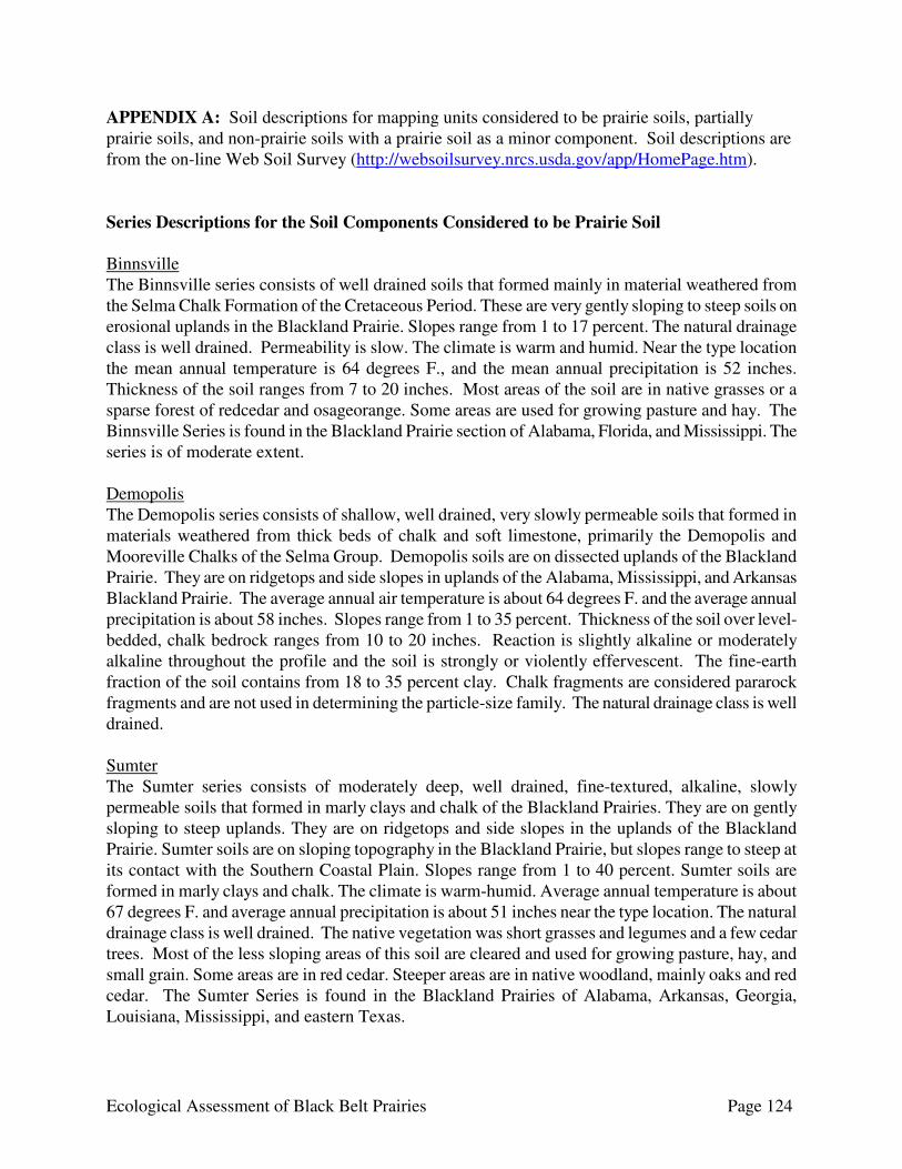
Ecological Assessment of Black Belt Prairies Page 124
APPENDIX A: Soil descriptions for mapping units considered to be prairie soils, partially prairie soils, and non-prairie soils with a prairie soil as a minor component. Soil descriptions are from the on-line Web Soil Survey (http://websoilsurvey.nrcs.usda.gov/app/HomePage.htm). Series Descriptions for the Soil Components Considered to be Prairie Soil
Binnsville The Binnsville series consists of well drained soils that formed mainly in material weathered from the Selma Chalk Formation of the Cretaceous Period. These are very gently sloping to steep soils on erosional uplands in the Blackland Prairie. Slopes range from 1 to 17 percent. The natural drainage class is well drained. Permeability is slow. The climate is warm and humid. Near the type location the mean annual temperature is 64 degrees F., and the mean annual precipitation is 52 inches. Thickness of the soil ranges from 7 to 20 inches. Most areas of the soil are in native grasses or a sparse forest of redcedar and osageorange. Some areas are used for growing pasture and hay. The Binnsville Series is found in the Blackland Prairie section of Alabama, Florida, and Mississippi. The series is of moderate extent. Demopolis The Demopolis series consists of shallow, well drained, very slowly permeable soils that formed in materials weathered from thick beds of chalk and soft limestone, primarily the Demopolis and Mooreville Chalks of the Selma Group. Demopolis soils are on dissected uplands of the Blackland Prairie. They are on ridgetops and side slopes in uplands of the Alabama, Mississippi, and Arkansas Blackland Prairie. The average annual air temperature is about 64 degrees F. and the average annual precipitation is about 58 inches. Slopes range from 1 to 35 percent. Thickness of the soil over level-bedded, chalk bedrock ranges from 10 to 20 inches. Reaction is slightly alkaline or moderately alkaline throughout the profile and the soil is strongly or violently effervescent. The fine-earth fraction of the soil contains from 18 to 35 percent clay. Chalk fragments are considered pararock fragments and are not used in determining the particle-size family. The natural drainage class is well drained. Sumter The Sumter series consists of moderately deep, well drained, fine-textured, alkaline, slowly permeable soils that formed in marly clays and chalk of the Blackland Prairies. They are on gently sloping to steep uplands. They are on ridgetops and side slopes in the uplands of the Blackland Prairie. Sumter soils are on sloping topography in the Blackland Prairie, but slopes range to steep at its contact with the Southern Coastal Plain. Slopes range from 1 to 40 percent. Sumter soils are formed in marly clays and chalk. The climate is warm-humid. Average annual temperature is about 67 degrees F. and average annual precipitation is about 51 inches near the type location. The natural drainage class is well drained. The native vegetation was short grasses and legumes and a few cedar trees. Most of the less sloping areas of this soil are cleared and used for growing pasture, hay, and small grain. Some areas are in red cedar. Steeper areas are in native woodland, mainly oaks and red cedar. The Sumter Series is found in the Blackland Prairies of Alabama, Arkansas, Georgia, Louisiana, Mississippi, and eastern Texas.
Ecological Assessment of Black Belt Prairies Page 125
Trinity The Trinity series consists of moderately well drained, fine-textured, alkaline soils in the prairie part of Greene county. These soils are very sticky and very plastic. They formed in fine-textured alluvium. Slopes range from 0 to 2 percent. The native vegetation is prairie grasses and a few trees such as cottonwood, ash, hackberry, elm, and hickory. Map Units By County The map units delineated on the detailed soil maps in a soil survey represent the soils or miscellaneous areas in the selected area. The map unit descriptions, along with the maps, can be used to determine the composition and properties of a unit. A map unit delineation on a soil map represents an area dominated by one or more major kinds of soil or miscellaneous areas. A map unit is identified and named according to the taxonomic classification of the dominant soils. Within a taxonomic class there are precisely defined limits for the properties of the soils. On the landscape, however, the soils are natural phenomena, and they have the characteristic variability of all natural phenomena. Thus, the range of some observed properties may extend beyond the limits defined for a taxonomic class. Areas of soils of a single taxonomic class rarely, if ever, can be mapped without including areas of other taxonomic classes. Consequently, every map unit is made up of the soils or miscellaneous areas for which it is named and some minor components that belong to taxonomic classes other than those of the major soils. Autauga County Prairie soil as major component Sumter-Faceville-Vaiden association, hilly (SVE) Acres: 15,471 Proportionate Extent of County: 4.0 Major Components: Sumter (35%), Faceville (30%), Vaiden (25%) Minor Components: Roanoke (1%) Butler County Prairie soil as major component Demopolis-Brantley complex, 15 to 35 percent slopes (DbF) Acres: 6,450 Proportionate Extent of County: 1.3 Major Components: Demopolis (50%), Brantley (30%) Minor Components: Tuscumbia (1%) Demopolis-Watsonia complex, 2 to 8 percent slopes (DwD) Acres: 10,470 Proportionate Extent of County: 2.1 Major Components: Demopolis (65%), Watsonia (20%) Sumter silty clay, 5 to 15 percent slopes, eroded (SuD2) Acres: 430 Proportionate Extent of County: <0.1 Major Component: Sumter (85%)
Ecological Assessment of Black Belt Prairies Page 126
Choctaw County Prairie soil as major component Sumter-Maytag complex, 3 to 8 percent slopes, eroded (StD2) Acres: 1,740 Proportionate Extent of County: 0.3 Major Components: Sumter (50), Maytag (40%) Minor Components: Hannon (5%), Oktibbeha (5%) Sumter-Maytag complex, 8 to 15 percent slopes, eroded (StE2) Acres: 2,330 Proportionate Extent of County: 0.4 Major Components: Sumter (45%), Maytag (40%) Minor Components: Hannon (5%), Leeper (5%), Oktibbeha (5%) Prairie soil as minor component Boswell fine sandy loam, 5 to 12 percent slopes, eroded (BgD2) Acres: 1,600 Proportionate Extent of County: 0.3 Major Component: Boswell (85%) Minor Components: Hannon (2%), Maytag (2%), Okeelala (2%), Oktibbeha (2%), Sumter (2%) Brantley-Okeelala complex, 15 to 35 percent slopes, eroded (BrE2) Acres: 26,400 Proportionate Extent of County: 4.5 Major Components: Brantley (55%), Okeelala (30%) Minor Components: Bibb (2%), Boswell (2%), Hannon (2%), Sumter (2%), Toxey(2%),
Wadley (2%) Brantley-Okeelala complex, 35 to 60 percent slopes (BrF) Acres: 10,120 Proportionate Extent of County: 1.7 Major Components: Brantley (55%), Okeelala (30%) Minor Components: Bibb (3%), Boswell (2%), Hannon (2%), Sumter (2%), Toxey (2%),
Wadley (2%) Oktibbeha clay, 1 to 5 percent slopes (OtB) Acres: 180 Proportionate Extent of County: <0.1 Major Component: Oktibbeha (90%) Minor Components: Louin (4%), Maytag (3%), Sumter (3%) Toxey-Brantley-Hannon complex, 3 to 8 percent slopes, eroded (ToC2) Acres: 4,590 Proportionate Extent of County: 0.8 Major Components: Toxey (45%), Brantley (30%), Hannon (20%) Minor Components: Sumter (3%), Okeelala (2%)

Ecological Assessment of Black Belt Prairies Page 127
Crenshaw County Prairie soil as major component Hannon-Sumter complex, 2 to 8 percent slopes, eroded (HsC2) Acres: 1,240 Proportionate Extent of County: 0.3 Major Components: Hannon (50%), Sumter (40%) Minor Components: Brantley (5%), rock outcrop, limestone (5%) Sumter-Hannon complex, 12 to 35 percent slopes, eroded (StE2) Acres: 2,910 Proportionate Extent of County: 0.7 Major Components: Sumter (50%), Hannon (35%) Minor Components: Brantley (5%), Leeper (4%), rock outcrop, limestone (4%), Marietta (3%) Prairie soil as minor component Brantley sandy loam, 30 to 50 percent slopes (BrF) Acres: 2,195 Proportionate Extent of County: 0.6 Major Component: Brantley (85%) Minor Components: Lucy (3%), Smithdale (3%), Halso (2%), Troup (2%), Bibb (1%), Hannon
(1%), Marietta (1%), rock outcrop, limestone (1%), Sumter (1%) Dallas County Prairie soil as major component Demopolis silty clay loam, 3 to 12 percent slopes Acres: 11,202 Proportionate Extent of County: 1.8 Major Component: Demopolis (75%) Demopolis cobbly silty clay loam, 5 to 15 percent slopes Acres: 1,019 Proportionate Extent of County: 0.2 Major Component: Demopolis (80%) Gullied land Acres: 3,331 Proportionate Extent of County: 0.5 Major Component: Gullied land (90%) Sumter silty clay, 1 to 5 percent slopes Acres: 16,858 Proportionate Extent of County: 2.6 Major Component: Sumter (85%) Sumter silty clay, 5 to 12 percent slopes Acres: 6,463 Proportionate Extent of County: 1.0 Major Component: Sumter (85%) Minor Components: Leeper (flooded long) (1%), Minter (1%)
Ecological Assessment of Black Belt Prairies Page 128
Sumter-Urban land complex, 1 to 8 percent slopes Acres: 815 Proportionate Extent of County: 0.1 Major Components: Sumter (55%), Urban land (35%) Minor Components: Leeper (flooded long) (1%), Minter (1%) Prairie soil as minor component Houston clay (29) Acres: 13,776 Proportionate Extent of County: 2.2 Major Component: Houston (85%) Minor Components: Eutaw (1%) Oktibbeha clay, 1 to 5 percent slopes (45) Acres: 14,233 Proportionate Extent of County: 2.2 Major Component: Oktibbeha (80%) Oktibbeha clay, 5 to 12 percent slopes (46) Acres: 21,911 Proportionate Extent of County: 3.4 Major Component: Oktibbeha (80%) Minor Components: Leeper (flooded long) (1%), Minter (1%) Greene County Prairie soil as major component Binnsville clay, 3 to 8 percent slopes (BcC) Acres: 443 Proportionate Extent of County: 0.1 Major Component: Binnsville (85%) Gullied land (Gu) Acres: 1,548 Proportionate Extent of County: 0.4 Major Component: Gullied land (85%) Sumter silty clay, 1 to 3 percent slopes, eroded (SuB2) Acres: 4,314 Proportionate Extent of County: 1.0 Major Component: Sumter (85%) Sumter silty clay, 3 to 5 percent slopes, eroded (SuC2) Acres: 8,246 Proportionate Extent of County: 2.0 Major Component: Sumter (85%) Sumter silty clay, 5 to 12 percent slopes, eroded (SuD2) Acres: 4,095 Proportionate Extent of County: 1.0 Major Component: Sumter (85%) Minor Components: Tuscumbia (1%)
Ecological Assessment of Black Belt Prairies Page 129
Sumter-Watsonia complex, 1 to 5 percent slopes, eroded (SwB2) Acres: 5,036 Proportionate Extent of County: 1.2 Major Components: Sumter (40%), Watsonia (30%) Sumter-Watsonia complex, 5 to 17 percent slopes, eroded (SwE2) Acres: 5,752 Proportionate Extent of County: 1.4 Major Components: Sumter (30%), Watsonia (30%) Minor Components: Tuscumbia (1%) Trinity clay (Tr) Acres: 8,098 Proportionate Extent of County: 1.9 Major Component: Trinity (90%) Minor Components: Tuscumbia (1%) Hale County Prairie soil as major component Demopolis silty clay loam, 3 to 8 percent slopes, eroded (DeD2) Acres: 882 Proportionate Extent of County: 0.2 Major Component: Demopolis (90%) Demopolis-Sumter complex, 3 to 8 percent slopes, eroded (DsD2) Acres: 7,166 Proportionate Extent of County: 1.7 Major Components: Demopolis (65%), Sumter (25%) Demopolis-Sumter complex, 8 to 12 percent slopes, eroded (DsE2) Acres: 4,232 Proportionate Extent of County: 1.0 Major Components: Demopolis (50%), Sumter (40%) Sumter silty clay loam, 1 to 3 percent slopes (SmB) Acres: 18,040 Proportionate Extent of County: 4.3 Major Component: Sumter (90%) Sumter silty clay loam, 3 to 8 percent slopes, eroded (SmD2) Acres: 12,095 Proportionate Extent of County: 2.9 Major Component: Sumter (90%) Sumter-Oktibbeha complex, 3 to 8 percent slopes, eroded (SoD2) Acres: 404 Proportionate Extent of County: <0.1 Major Components: Sumter (50%), Oktibbeha (30%) Sumter-Watsonia complex, 1 to 3 percent slopes (SwB) Acres: 2,025 Proportionate Extent of County: 0.5 Major Components: Sumter (50%), Watsonia (30%)

Ecological Assessment of Black Belt Prairies Page 130
Sumter-Watsonia complex, 3 to 8 percent slopes, eroded (SwD2) Acres: 4,122 Proportionate Extent of County: 1.0 Major Components: Sumter (50%), Watsonia (35%) Sumter-Watsonia complex, 8 to 12 percent slopes, eroded (SwE2) Acres: 155 Proportionate Extent of County: <0.1 Major Components: Sumter (55%), Watsonia (30%) Lowndes County Acreage not available Prairie soil as major component Sumter-Demopolis complex, 8 to 25 percent slopes, eroded (48E) Major Components: Sumter (60%), Demopolis (30%) Demopolis-Watsonia complex, 2 to 8 percent slopes (51C) Major Components: Demopolis (65%), Watsonia (20%) Demopolis-Brantley complex, 15 to 35 percent slopes (51F) Major Components: Demopolis (50%), Brantley (30%) Sumter silty clay, 1 to 5 percent slopes, eroded (53C) Major Component: Sumter (85%) Sumter silty clay, 5 to 17 percent slopes, eroded (53F) Major Component: Sumter (85%) Minor Components: Tuscumbia (1%) Sumter-Oktibbeha complex, 1 to 5 percent slopes (57C) Major Components: Sumter (45%), Oktibbeha (35%) Sumter-Oktibbeha complex, 5 to 17 percent slopes, eroded (57F) Major Components: Sumter (45%), Oktibbeha (35%) Minor Components: Tuscumbia (1%) Sumter-Hannon complex, 12 to 35 percent slopes, eroded (61F) Major Components: Sumter (45%), Hannon (35%) Macon County Prairie soil as major component Hannon-Sumter complex, 5 to 12 percent slopes (HsE) Acres: 1,562 Proportionate Extent of County: 0.4 Major Components: Hannon (45%), Sumter (35%) Minor Components: Conecuh (4%), Kinston (4%), Maytag (4%), Oktibbeha (4%), Una (4%)
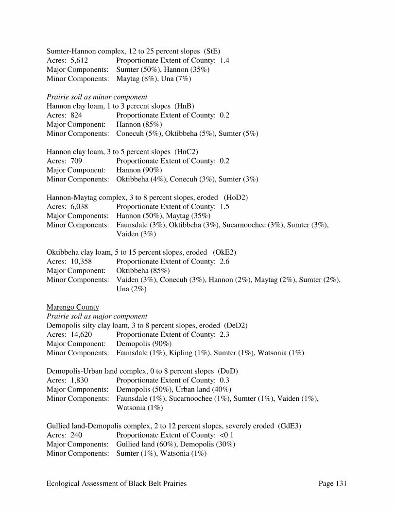
Ecological Assessment of Black Belt Prairies Page 131
Sumter-Hannon complex, 12 to 25 percent slopes (StE) Acres: 5,612 Proportionate Extent of County: 1.4 Major Components: Sumter (50%), Hannon (35%) Minor Components: Maytag (8%), Una (7%) Prairie soil as minor component Hannon clay loam, 1 to 3 percent slopes (HnB) Acres: 824 Proportionate Extent of County: 0.2 Major Component: Hannon (85%) Minor Components: Conecuh (5%), Oktibbeha (5%), Sumter (5%) Hannon clay loam, 3 to 5 percent slopes (HnC2) Acres: 709 Proportionate Extent of County: 0.2 Major Component: Hannon (90%) Minor Components: Oktibbeha (4%), Conecuh (3%), Sumter (3%) Hannon-Maytag complex, 3 to 8 percent slopes, eroded (HoD2) Acres: 6,038 Proportionate Extent of County: 1.5 Major Components: Hannon (50%), Maytag (35%) Minor Components: Faunsdale (3%), Oktibbeha (3%), Sucarnoochee (3%), Sumter (3%),
Vaiden (3%) Oktibbeha clay loam, 5 to 15 percent slopes, eroded (OkE2) Acres: 10,358 Proportionate Extent of County: 2.6 Major Component: Oktibbeha (85%) Minor Components: Vaiden (3%), Conecuh (3%), Hannon (2%), Maytag (2%), Sumter (2%),
Una (2%) Marengo County Prairie soil as major component Demopolis silty clay loam, 3 to 8 percent slopes, eroded (DeD2) Acres: 14,620 Proportionate Extent of County: 2.3 Major Component: Demopolis (90%) Minor Components: Faunsdale (1%), Kipling (1%), Sumter (1%), Watsonia (1%) Demopolis-Urban land complex, 0 to 8 percent slopes (DuD) Acres: 1,830 Proportionate Extent of County: 0.3 Major Components: Demopolis (50%), Urban land (40%) Minor Components: Faunsdale (1%), Sucarnoochee (1%), Sumter (1%), Vaiden (1%),
Watsonia (1%) Gullied land-Demopolis complex, 2 to 12 percent slopes, severely eroded (GdE3) Acres: 240 Proportionate Extent of County: <0.1 Major Components: Gullied land (60%), Demopolis (30%) Minor Components: Sumter (1%), Watsonia (1%)
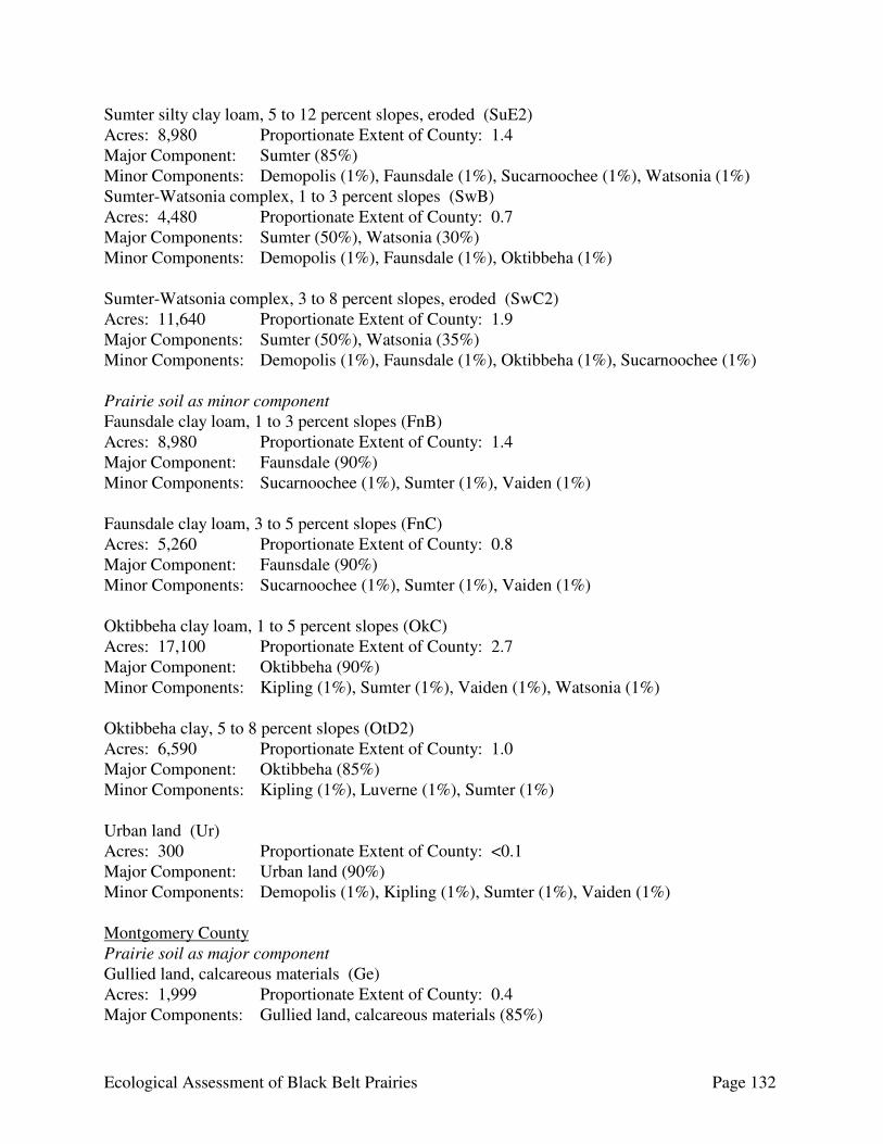
Ecological Assessment of Black Belt Prairies Page 132
Sumter silty clay loam, 5 to 12 percent slopes, eroded (SuE2) Acres: 8,980 Proportionate Extent of County: 1.4 Major Component: Sumter (85%) Minor Components: Demopolis (1%), Faunsdale (1%), Sucarnoochee (1%), Watsonia (1%) Sumter-Watsonia complex, 1 to 3 percent slopes (SwB) Acres: 4,480 Proportionate Extent of County: 0.7 Major Components: Sumter (50%), Watsonia (30%) Minor Components: Demopolis (1%), Faunsdale (1%), Oktibbeha (1%) Sumter-Watsonia complex, 3 to 8 percent slopes, eroded (SwC2) Acres: 11,640 Proportionate Extent of County: 1.9 Major Components: Sumter (50%), Watsonia (35%) Minor Components: Demopolis (1%), Faunsdale (1%), Oktibbeha (1%), Sucarnoochee (1%) Prairie soil as minor component Faunsdale clay loam, 1 to 3 percent slopes (FnB) Acres: 8,980 Proportionate Extent of County: 1.4 Major Component: Faunsdale (90%) Minor Components: Sucarnoochee (1%), Sumter (1%), Vaiden (1%) Faunsdale clay loam, 3 to 5 percent slopes (FnC) Acres: 5,260 Proportionate Extent of County: 0.8 Major Component: Faunsdale (90%) Minor Components: Sucarnoochee (1%), Sumter (1%), Vaiden (1%) Oktibbeha clay loam, 1 to 5 percent slopes (OkC) Acres: 17,100 Proportionate Extent of County: 2.7 Major Component: Oktibbeha (90%) Minor Components: Kipling (1%), Sumter (1%), Vaiden (1%), Watsonia (1%) Oktibbeha clay, 5 to 8 percent slopes (OtD2) Acres: 6,590 Proportionate Extent of County: 1.0 Major Component: Oktibbeha (85%) Minor Components: Kipling (1%), Luverne (1%), Sumter (1%) Urban land (Ur) Acres: 300 Proportionate Extent of County: <0.1 Major Component: Urban land (90%) Minor Components: Demopolis (1%), Kipling (1%), Sumter (1%), Vaiden (1%) Montgomery County Prairie soil as major component Gullied land, calcareous materials (Ge) Acres: 1,999 Proportionate Extent of County: 0.4 Major Components: Gullied land, calcareous materials (85%)

Ecological Assessment of Black Belt Prairies Page 133
Sumter clay, eroded, nearly level phase (SmB2) Acres: 20,153 Proportionate Extent of County: 3.9 Major Component: Sumter (85%) Sumter clay, severely eroded, nearly level phase (SmB3) Acres: 2,889 Proportionate Extent of County: 0.6 Major Component: Sumter (85%) Sumter clay, eroded, very gently sloping phase (SmC2) Acres: 3,403 Proportionate Extent of County: 0.7 Major Component: Sumter (85%) Sumter clay, severely eroded, very gently sloping phase (SmC3) Acres: 12,718 Proportionate Extent of County: 2.5 Major Component: Sumter (85%) Sumter clay, eroded, gently sloping phase (SmD2) Acres: 911 Proportionate Extent of County: 0.2 Major Component: Sumter (85%) Minor Components: Tuscumbia (1%) Sumter clay, severely eroded, gently sloping phase (SmD3) Acres: 5,318 Proportionate Extent of County: 1.0 Major Component: Sumter (85%) Minor Components: Tuscumbia (1%) Sumter-Oktibbeha-Vaiden clays, eroded, nearly level (SnB2) Acres: 5,513 Proportionate Extent of County: 1.1 Major Components: Sumter (35%), Oktibbeha (25%), Vaiden (20%) Sumter-Oktibbeha-Vaiden clays, eroded, very gently sloping phases (SnC2) Acres: 463 Proportionate Extent of County: <0.1 Major Components: Sumter (35%), Oktibbeha (25%), Vaiden (20%) Sumter-Oktibbeha-Vaiden clays, severely eroded, very gently sloping phases (SnC3) Acres: 3,108 Proportionate Extent of County: 0.6 Major Components: Sumter (40%), Oktibbeha (20%), Vaiden (20%) Sumter-Oktibbeha-Vaiden clays, eroded, gently sloping phases (SnD2) Acres: 644 Proportionate Extent of County: 0.1 Major Components: Sumter (40%), Oktibbeha (20%), Vaiden (15%) Minor Components: Tuscumbia (1%)
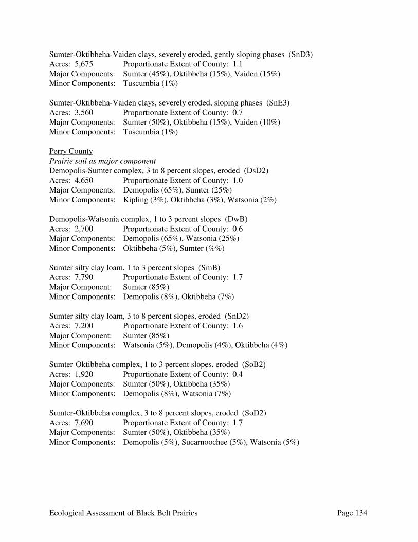
Ecological Assessment of Black Belt Prairies Page 134
Sumter-Oktibbeha-Vaiden clays, severely eroded, gently sloping phases (SnD3) Acres: 5,675 Proportionate Extent of County: 1.1 Major Components: Sumter (45%), Oktibbeha (15%), Vaiden (15%) Minor Components: Tuscumbia (1%) Sumter-Oktibbeha-Vaiden clays, severely eroded, sloping phases (SnE3) Acres: 3,560 Proportionate Extent of County: 0.7 Major Components: Sumter (50%), Oktibbeha (15%), Vaiden (10%) Minor Components: Tuscumbia (1%) Perry County Prairie soil as major component Demopolis-Sumter complex, 3 to 8 percent slopes, eroded (DsD2) Acres: 4,650 Proportionate Extent of County: 1.0 Major Components: Demopolis (65%), Sumter (25%) Minor Components: Kipling (3%), Oktibbeha (3%), Watsonia (2%) Demopolis-Watsonia complex, 1 to 3 percent slopes (DwB) Acres: 2,700 Proportionate Extent of County: 0.6 Major Components: Demopolis (65%), Watsonia (25%) Minor Components: Oktibbeha (5%), Sumter (%%) Sumter silty clay loam, 1 to 3 percent slopes (SmB) Acres: 7,790 Proportionate Extent of County: 1.7 Major Component: Sumter (85%) Minor Components: Demopolis (8%), Oktibbeha (7%) Sumter silty clay loam, 3 to 8 percent slopes, eroded (SnD2) Acres: 7,200 Proportionate Extent of County: 1.6 Major Component: Sumter (85%) Minor Components: Watsonia (5%), Demopolis (4%), Oktibbeha (4%) Sumter-Oktibbeha complex, 1 to 3 percent slopes, eroded (SoB2) Acres: 1,920 Proportionate Extent of County: 0.4 Major Components: Sumter (50%), Oktibbeha (35%) Minor Components: Demopolis (8%), Watsonia (7%) Sumter-Oktibbeha complex, 3 to 8 percent slopes, eroded (SoD2) Acres: 7,690 Proportionate Extent of County: 1.7 Major Components: Sumter (50%), Oktibbeha (35%) Minor Components: Demopolis (5%), Sucarnoochee (5%), Watsonia (5%)
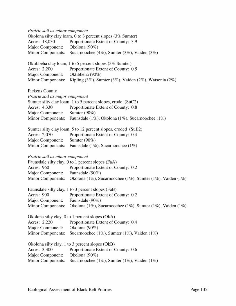
Ecological Assessment of Black Belt Prairies Page 135
Prairie soil as minor component Okolona silty clay loam, 0 to 3 percent slopes (3% Sumter) Acres: 18,030 Proportionate Extent of County: 3.9 Major Component: Okolona (90%) Minor Components: Sucarnoochee (4%), Sumter (3%), Vaiden (3%) Oktibbeha clay loam, 1 to 5 percent slopes (3% Sumter) Acres: 2,200 Proportionate Extent of County: 0.5 Major Component: Oktibbeha (90%) Minor Components: Kipling (3%), Sumter (3%), Vaiden (2%), Watsonia (2%) Pickens County Prairie soil as major component Sumter silty clay loam, 1 to 5 percent slopes, erode (SuC2) Acres: 4,330 Proportionate Extent of County: 0.8 Major Component: Sumter (90%) Minor Components: Faunsdale (1%), Okolona (1%), Sucarnoochee (1%) Sumter silty clay loam, 5 to 12 percent slopes, eroded (SuE2) Acres: 2,070 Proportionate Extent of County: 0.4 Major Component: Sumter (90%) Minor Components: Faunsdale (1%), Sucarnoochee (1%) Prairie soil as minor component Faunsdale silty clay, 0 to 1 percent slopes (FaA) Acres: 960 Proportionate Extent of County: 0.2 Major Component: Faunsdale (90%) Minor Components: Okolona (1%), Sucarnoochee (1%), Sumter (1%), Vaiden (1%) Faunsdale silty clay, 1 to 3 percent slopes (FaB) Acres: 900 Proportionate Extent of County: 0.2 Major Component: Faunsdale (90%) Minor Components: Okolona (1%), Sucarnoochee (1%), Sumter (1%), Vaiden (1%) Okolona silty clay, 0 to 1 percent slopes (OkA) Acres: 2,220 Proportionate Extent of County: 0.4 Major Component: Okolona (90%) Minor Components: Sucarnoochee (1%), Sumter (1%), Vaiden (1%) Okolona silty clay, 1 to 3 percent slopes (OkB) Acres: 3,300 Proportionate Extent of County: 0.6 Major Component: Okolona (90%) Minor Components: Sucarnoochee (1%), Sumter (1%), Vaiden (1%)

Ecological Assessment of Black Belt Prairies Page 136
Sucarnoochee silty clay, 0 to 1 percent slopes, frequently flooded (SrA) Acres: 7,000 Proportionate Extent of County: 1.2 Major Component: Sucarnoochee (90%) Minor Components: Faunsdale (1%), Sumter (1%), Vaiden (1%) Russell County Prairie soil as major component Hannon-Sumter complex, 5 to 12 percent slopes, eroded (HsE2) Acres: 870 Proportionate Extent of County: 0.2 Major Components: Hannon (45%), Sumter (35%) Minor Components: Una (2%) Sumter-Hannon complex, 12 to 25 percent slopes, severely eroded (ShE3) Acres: 3,730 Proportionate Extent of County: 0.9 Major Components: Sumter (50%), Hannon (35%) Minor Components: Kinston (1%) Sumter County Prairie soil as major component Demopolis-Kipling complex, 3 to 20 percent slopes, eroded (DkE2) Acres: 73,164 Proportionate Extent of County: 12.5 Major Components: Demopolis (60%), Kipling (20%) Minor Components: Sucarnoochee (1%), Sumter (1%), Vaiden (1%) Demopolis-Sumter complex, 1 to 3 percent slopes (DsB) Acres: 13,320 Proportionate Extent of County: 2.3 Major Components: Demopolis (57%), Sumter (23%) Minor Components: Kipling (1%), Vaiden (1%) Gullied land-Demopolis complex, 3 to 20 percent slopes, severely eroded (GdE3) Acres: 685 Proportionate Extent of County: 0.1 Major Components: Gullied land (75%), Demopolis (20%) Minor Components: Kipling (1%), Sumter (1%) Sumter silty clay loam, 1 to 5 percent slopes, eroded (SuB2) Acres: 1.335 Proportionate Extent of County: 0.2 Major Component: Sumter (85%) Minor Components: Demopolis (1%), Kipling (1%), Vaiden (1%) Sumter silty clay loam, 5 to 8 percent slopes, eroded (SuC2) Acres: 205 Proportionate Extent of County: <0.1 Major Component: Sumter (85%) Minor Components: Demopolis (1%), Kipling (1%), Vaiden (1%)
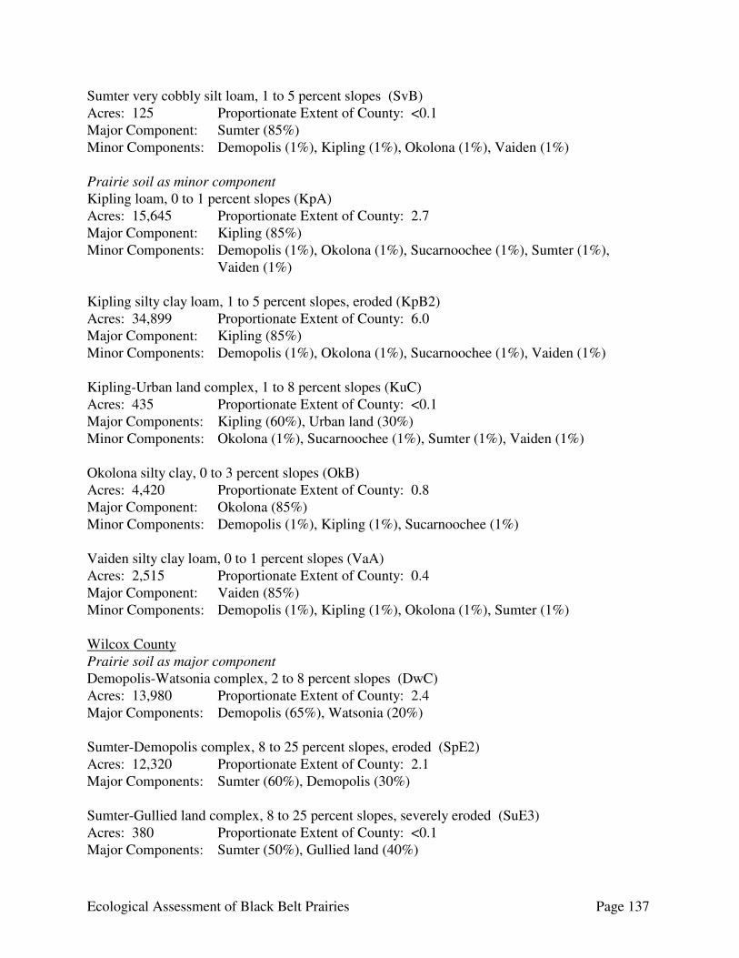
Ecological Assessment of Black Belt Prairies Page 137
Sumter very cobbly silt loam, 1 to 5 percent slopes (SvB) Acres: 125 Proportionate Extent of County: <0.1 Major Component: Sumter (85%) Minor Components: Demopolis (1%), Kipling (1%), Okolona (1%), Vaiden (1%) Prairie soil as minor component Kipling loam, 0 to 1 percent slopes (KpA) Acres: 15,645 Proportionate Extent of County: 2.7 Major Component: Kipling (85%) Minor Components: Demopolis (1%), Okolona (1%), Sucarnoochee (1%), Sumter (1%),
Vaiden (1%) Kipling silty clay loam, 1 to 5 percent slopes, eroded (KpB2) Acres: 34,899 Proportionate Extent of County: 6.0 Major Component: Kipling (85%) Minor Components: Demopolis (1%), Okolona (1%), Sucarnoochee (1%), Vaiden (1%) Kipling-Urban land complex, 1 to 8 percent slopes (KuC) Acres: 435 Proportionate Extent of County: <0.1 Major Components: Kipling (60%), Urban land (30%) Minor Components: Okolona (1%), Sucarnoochee (1%), Sumter (1%), Vaiden (1%) Okolona silty clay, 0 to 3 percent slopes (OkB) Acres: 4,420 Proportionate Extent of County: 0.8 Major Component: Okolona (85%) Minor Components: Demopolis (1%), Kipling (1%), Sucarnoochee (1%) Vaiden silty clay loam, 0 to 1 percent slopes (VaA) Acres: 2,515 Proportionate Extent of County: 0.4 Major Component: Vaiden (85%) Minor Components: Demopolis (1%), Kipling (1%), Okolona (1%), Sumter (1%) Wilcox County Prairie soil as major component Demopolis-Watsonia complex, 2 to 8 percent slopes (DwC) Acres: 13,980 Proportionate Extent of County: 2.4 Major Components: Demopolis (65%), Watsonia (20%) Sumter-Demopolis complex, 8 to 25 percent slopes, eroded (SpE2) Acres: 12,320 Proportionate Extent of County: 2.1 Major Components: Sumter (60%), Demopolis (30%) Sumter-Gullied land complex, 8 to 25 percent slopes, severely eroded (SuE3) Acres: 380 Proportionate Extent of County: <0.1 Major Components: Sumter (50%), Gullied land (40%)
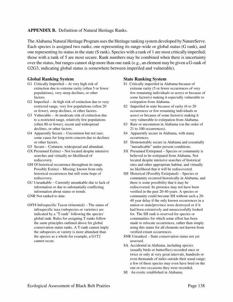
Ecological Assessment of Black Belt Prairies Page 138
APPENDIX B. Definition of Natural Heritage Ranks. The Alabama Natural Heritage Program uses the Heritage ranking system developed by NatureServe. Each species is assigned two ranks; one representing its range-wide or global status (G rank), and one representing its status in the state (S rank). Species with a rank of 1 are most critically imperiled; those with a rank of 5 are most secure. Rank numbers may be combined when there is uncertainty over the status, but ranges cannot skip more than one rank (e.g., an element may be given a G-rank of G2G3, indicating global status is somewhere between imperiled and vulnerable). Global Ranking System G1 Critically Imperiled – At very high risk of
extinction due to extreme rarity (often 5 or fewer populations), very steep declines, or other factors.
G2 Imperiled – At high risk of extinction due to very restricted range, very few populations (often 20 or fewer), steep declines, or other factors.
G3 Vulnerable – At moderate risk of extinction due to a restricted range, relatively few populations (often 80 or fewer), recent and widespread declines, or other factors.
G4 Apparently Secure – Uncommon but not rare; some cause for long-term concern due to declines or other factors.
G5 Secure – Common; widespread and abundant. GX Presumed Extinct – Not located despite intensive
searches and virtually no likelihood of rediscovery.
GH Of historical occurrence throughout its range. Possibly Extinct – Missing; known from only historical occurrences but still some hope of rediscovery.
GU Unrankable – Currently unrankable due to lack of information or due to substantially conflicting information about status or trends.
GNR Not ranked to date. G#T# Infraspecific Taxon (trinomial) – The status of
infraspecific taxa (subspecies or varieties) are indicated by a "T-rank" following the species' global rank. Rules for assigning T-ranks follow the same principles outlined above for global conservation status ranks. A T-rank cannot imply the subspecies or variety is more abundant than the species as a whole-for example, a G1T2 cannot occur.
State Ranking System S1 Critically imperiled in Alabama because of
extreme rarity (5 or fewer occurrences of very few remaining individuals or acres) or because of some factor(s) making it especially vulnerable to extirpation from Alabama.
S2 Imperiled in state because of rarity (6 to 20 occurrences or few remaining individuals or acres) or because of some factor(s) making it very vulnerable to extirpation from Alabama.
S3 Rare or uncommon in Alabama (on the order of 21 to 100 occurrences).
S4 Apparently secure in Alabama, with many occurrences.
S5 Demonstrably secure in Alabama and essentially "ineradicable" under present conditions.
SX Presumed Extirpated – Species or community is believed to be extirpated from Alabama. Not located despite intensive searches of historical sites and other appropriate habitat, and virtually no likelihood that it will be rediscovered.
SH Historical (Possibly Extirpated) – Species or community occurred historically in Alabama, and there is some possibility that it may be rediscovered. Its presence may not have been verified in the past 20-40 years. A species or community could become SH without such a 20-40 year delay if the only known occurrences in a nation or state/province were destroyed or if it had been extensively and unsuccessfully looked for. The SH rank is reserved for species or communities for which some effort has been made to relocate occurrences, rather than simply using this status for all elements not known from verified extant occurrences.
SNR Unranked – State conservation status not yet assessed.
SA Accidental in Alabama, including species (usually birds or butterflies) recorded once or twice or only at very great intervals, hundreds or even thousands of miles outside their usual range; a few of these species may even have bred on the one or two occasions they were recorded.
SE An exotic established in Alabama.

Ecological Assessment of Black Belt Prairies Page 139
Variant Ranks and Rank Modifiers G#G# Range Rank – A numeric range rank
(e.g., G2G3) is used to indicate the range of uncertainty in the status of a species or community (e.g., an element may be given a G-rank of G2G3, indicating global status is somewhere between imperiled and vulnerable). Ranges cannot skip more than one rank (e.g., GU should be used rather than G1G4). Also applies to state ranks (e.g., S2S3)
HYB Hybrid Q Questionable taxonomy – Taxonomic
distinctiveness of this entity at the current level is questionable; resolution of this uncertainty may result in change from a species to a subspecies or hybrid, or the inclusion of this taxon in another taxon, with the resulting taxon having a lower-priority conservation priority.
? Inexact Numeric Rank – Denotes inexact numeric rank (e.g., G2?)
Special State Ranking for Migrants SB Regularly occurring, migratory and
present only during the breeding season. A rank of S3B indicates a species uncommon during the breeding season (spring/summer) in Alabama.
SN Regularly occurring, usually migratory and typically non-breeding species in Alabama; this category includes migratory birds, bats, sea turtles, and cetaceans which do not breed in Alabama but pass through twice a year or may remain in winter. A rank of S2B,S5N indicated a rare breeder but a common winter resident.
SZ Not of conservation concern in Alabama because species in this category are so widely and unreliably distributed during migration or in winter that no small set of sites could be set aside with the hope of significantly furthering their conservation. A rank of SZN indicates the species does not breed in Alabama. Species that have resident breeding populations that are augmented in winter by non-breeding migrants may have dual ranks, one each for the breeding (B) and non-breeding (N) components.
For more information regarding Conservation Status Ranks, see http://www.natureserve.org/explorer/ranking.htm#globalstatus