east pilgrim street - our services · east pilgrim street preferred option report regeneration...
TRANSCRIPT


EAST PILGRIM STREET
Preferred Option Report REGENERATION OPPORTUNITY AREA
If you would like a summary of this document in Arabic, Bengali, Chinese, Hindi, Punjabi or Urdu language, please phone the contact named at the bottom of this page.
Arabic
Urdu
Punjabi
Hindi
Chinese
Bengali
If you would like the text of this booklet in large print or on audio tape, please phone;
Anne Tavernor: Telephone 0191 277 7169 or 0191 2116003 Email [email protected] Address: Strategic Housing, Planning &
Transportation, City Centre Developments Newcastle City Council, Civic Centre, Newcastle upon Tyne NE1 8PD
Fax: 0191 2114991
East Pilgrim Street Preferred Options Report Page 1

Preferred Options Report - September 2008 East Pilgrim Street Regeneration Opportunity Area
Contents page
1 Introduction ......................................................................................................... 3
2 The Study Area ................................................................................................... 4
3 Scope and Status ............................................................................................... 9
4 Planning Policy Context ................................................................................... 10
5 Work to date ..................................................................................................... 13
6 Regeneration Options ...................................................................................... 14
7 Public Consultation to date ............................................................................... 16
8 The Vision and Strategic Objectives ................................................................. 18
9 Assessing the options ...................................................................................... 20
9.5 Historic environment ................................................................................ 20
9.6 Historic buildings ...................................................................................... 21
9.7 Public Spaces and improved public realm ............................................... 23
9.8 Connectivity ............................................................................................. 24
9.9 Accessibility by a range of transport modes ............................................ 25
9.10 Growing the leisure economy .................................................................. 27
9.11 Area Wide regeneration ........................................................................... 28
9.12 Deliverability ............................................................................................ 30
10 The Preferred Option ........................................................................................ 33
12 The Next Steps ................................................................................................. 40
Appendix 1: List of background documents ................................................................. 41
Appendix 2: Glossary ................................................................................................... 42
page 2 East Pilgrim Street Preferred Options Report

1 Introduction
1.1 Newcastle City Council is preparing a vision and development framework for the East Pilgrim Street (EPS) area. The EPS area lies at the heart of the City and represents one of the most strategically important City Centre Regeneration Opportunity Areas in the north of England.
1.2 It is intended that the Council’s Preferred Option for the EPS area set out in this report, will guide the comprehensive regeneration of the area. The EPS area has a rich and diverse heritage base, including many fine listed and other historic buildings. However, for such a large, central and highly accessible area, significant parts of the EPS area are under used and failing to fulfil their true potential.
1.3 The EPS area is well placed to help meet many of the City Centre’s needs over the next 20 years. These include a major expansion of the City Centre shopping offer, provision of residential, student accommodation, leisure, cultural and office uses, and creation of improved open spaces and enhanced public transport facilities.
1.4 New development must take into account and build on the heritage of the area, work with the topography of the site and take advantage of good public transport accessibility. The City Council’s vision is for this to be provided in a mix of uses in sustainable forms, creating an exemplar City Centre regeneration project.
1.5 This document presents for consultation the City Council’s Preferred Option for the EPS area. This has evolved from detailed analysis of the area, and previous consultation with the public and stakeholders over the last 12 months on three high level options.
East Pilgrim Street Preferred Options Report Page 3

2 The Study Area
2.1 The boundary of the East Pilgrim Street Regeneration Opportunity Area is shown at Figure 1.
Figure 1: East Pilgrim Street Regeneration Opportunity Area
2.2 The EPS area is a large and strategically located area of 17 hectares at the heart of the City Centre. Whilst parts are disused, neglected, and almost “hidden away”, the area is an integral part of the City Centre and sections of New Bridge Street and Pilgrim Street lie within the defined core shopping area.
page 4 East Pilgrim Street Preferred Options Report
2.3 The area benefits from good public transport accessibility. It is also adjacent to the primary road network, offering the prospect of high profile “gateways” to the City Centre from the south and east. There is also potential to link with the quayside to the south and the eastern side of the Central Motorway east, as well as back to the main shopping frontages.
2.4 Site topography is a key consideration in planning the future of the area, as the site slopes steeply from north to south. For example, Swan House roundabout is some 7 metres and Carliol Square 9 metres lower than the crossing point of Northumberland and New Bridge Streets.
2.5 The EPS area has a rich historic and cultural asset base, including a number of important listed buildings and unlisted buildings which help give the area definition and character. Three character areas have been identified:-
a) In the northern part of the EPS area there is an important and growing cultural hub with the listed Laing Art Gallery and the new City Library, and the adjacent Northumbria University Campus. Other listed buildings include John Dobson House, Portland House, 6-8 Higham Place.
b) In the central area there is an impressive collection of civic/institutional listed buildings either side of Market Street. These include Carliol House, the Police Station, Magistrates Courts, the vacated Fire station, St Andrews Church. East of Carliol Street lies Plummer House and Plumber Tower, the latter being a scheduled ancient monument.
c) The southern part of the EPS area contains a grouping of finer grain listed buildings on 93 -101 Pilgrim Street and Worswick Chambers .The vacant Bank of England marks the lower end of Pilgrim Street together with the refurbished 55 Degrees North building.
2.6 Figure 2 illustrates listed and historic buildings and other key features of the EPS area.
2.7 There are several important historic streets, with Pilgrim Street being the most significant since medieval times. Other historic features include the line of the old town wall and the Burgage plots south of Worswick Chambers.
2.8 The area has a number of latter 20th Century interventions such as the central Motorway East, John Dobson Street, Swan House roundabout and the associated network of high level walkways and subways. These have served to fracture the area, in places removing historic sightlines and routes and impacting on the settings of some of the historic buildings.
2.9 The northern part of the area is very accessible by public transport containing many bus routes and is within walking distance of Monument and Manors Metro stations (Figure 3). The Central Motorway East provides good vehicular access to the area and the City’s Inner Distributor Road runs through the northern part.
East Pilgrim Street Preferred Options Report Page 5
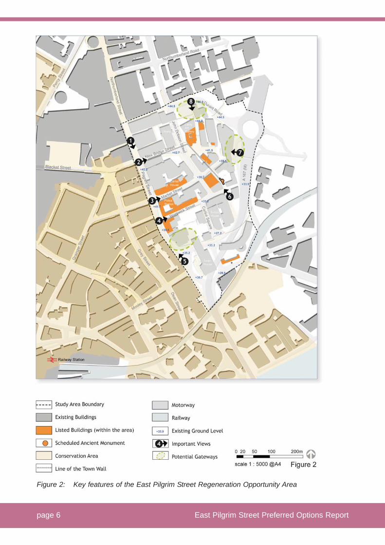
Figure 2: Key features of the East Pilgrim Street Regeneration Opportunity Area
page 6 East Pilgrim Street Preferred Options Report

2.10 There are three multi-storey car parks within the area as well as surface and on-street parking providing around 1400 spaces. In addition Manors multi storey car park (590 spaces) is linked to the south of the area by a high level walkway across the inner motorway. None of these car parks meet the expectations of customers in terms high quality parking provision. For example, Carliol Square surface car park is on a steeply sloping site. There are also many private non residential car parks which draw traffic into the area especially at peak times.
2.11 There is a small area of pedestrian priority around the Blue Carpet east of John Dobson Street.
East Pilgrim Street Preferred Options Report Page 7

Figure 3: East Pilgrim Street Regeneration Opportunity Area Movement and Connections
page 8 East Pilgrim Street Preferred Options Report

3 Scope and Status
3.1 The regeneration potential of the EPS area has been recognised for some time. The City Council’s 1998 City Centre Retail Study identified the opportunity. The Council’s Regeneration Strategy “Newcastle in 2021 (November 2006) identifies the area for major expansion of retail facilities. The area has also been the focus of significant developer interest.
3.2 The City Council’s emerging Local Development Framework (LDF) and the submitted draft Core Strategy DPD at policies CS 1 and CS 11, state that the core shopping area will be expanded at land east of Pilgrim Street. The Council has also published the City Centre Area Action Plan (CCAAP) - Key Issues and Development of Options paper (March 2006), which identifies East Pilgrim Street as a crucial regeneration priority for the City Centre.
3.3 Work on identifying the vision for the East Pilgrim Street area has been carried out in the context of the emerging Core Strategy and CCAAP. The East Pilgrim Street Regeneration Opportunity Area Options Consultation Report was published in November 2007 and made available for public consultation. The Options Consultation Report put forward a vision for the area, strategic objectives, emerging development principles and three high level concepts showing how the area might be developed.
3.4 This report builds on and responds to the consultation undertaken to date and sets out the Council’s Preferred Option for the EPS area.
3.5 It is the Council’s intention that the Preferred Option will be taken forward and adopted as Interim Planning Guidance (IPG) subject to a further period of consultation. The purpose of the IPG will be to provide more detailed guidance on the Council’s vision and preferred development framework for the East Pilgrim Street area.
3.6 The key features of the EPS regeneration opportunity area Interim Planning Guidance will be incorporated into the Preferred Options Report of the City Centre Area Action Plan. In due course the City Council may seek to adopt the IPG as a Supplementary Planning Document (SPD) for the EPS area based on the Preferred Option. Throughout this process sustainability will be a key consideration.
3.7 This Preferred Option Report reflects national planning policy statements, the current development plan (Regional Spatial Strategy and saved UDP policies) and the submission draft Core Strategy DPD. It is consistent with and has been prepared as a vital part of the emerging City Centre Area Action Plan (CCAAP). Other material considerations such as the Council’s Regeneration Strategy and Sustainable Community Strategy have informed the EPS Preferred Option Report.
East Pilgrim Street Preferred Options Report Page 9

4 Planning Policy Context
4.1 Planning policy guiding the development of the East Pilgrim Street area is set out at national, regional and local levels.
4.2 National level
At the national level Planning Policy Statement 1: Delivering Sustainable Development (PPS 1) makes clear that the principles of sustainable development underpin plan making and the consideration of applications. PPS 1 also promotes the efficient use of land through higher density, mixed use development and the use of suitably previously developed land and buildings.
4.3 Planning Policy Statement 6: Planning for Town Centres (PPS 6), emphasises that local authorities should adopt a positive and proactive approach and plan for the growth and development of existing centres, encouraging a wide range of services in a good environment which are accessible to all. Planning Policy Guidance 13: Transport (PPG 13) promotes accessibility to jobs, shopping, leisure facilities and services by public transport, walking and cycling and reducing the need to travel, especially by car. Planning Policy Guidance 15: Planning and the Historic Environment (PPG 15) notes that historic buildings should be put to good economic use.
4.4 Regional level
Regional Spatial Strategy (RSS) for the North East was published in July 2008 and identifies Newcastle as a key urban centre and the regional capital. Policy 25 states that within Tyne and Wear City region, the majority of new retail and leisure floorspace should be located in Newcastle as regional capital and Sunderland as a sub regional centre. Policy 26 states that no provision should be made for additional retail or leisure development at the Metro Centre or the surrounding retail complex.
4.5 Local level
At the local level saved policies from the Unitary Development Plan (UDP) for Newcastle (January 1998), with the related Proposals Map, are still relevant until superseded by LDF policies. Saved UDP Policy R1 encourages the development of sites within or adjacent to existing centres for new retail development which are readily accessible by shoppers on foot and enjoy the benefits of good public transport.
4.6 Saved Policy R2 defines the Core Shopping Area of the City Centre and highlights the need for its continued support and development in order to maintain its position as the principle shopping location in the northern region. A very small proportion of the EPS study area is identified within the Core Shopping Area on the UDP Proposals Map.
page 10 East Pilgrim Street Preferred Options Report

4.7 In terms of urban design, saved Policy EN1 requires all development to meet high quality standards of design. The UDP also confirms the role of the historic environment with saved Policy C1 emphasising the importance of preserving, protecting and restoring the City’s built heritage.
4.8 There are a number of saved transport policies which are relevant to the East Pilgrim Street area. Policies T1.1 (developers to provide for operational needs of public transport), T2 (traffic management) and T5.3 (cycling) all emphasise the need to manage and provide for pedestrians and cyclists balanced with the needs of public transport. T4.5 and T4.6 (parking management) sets out how public parking will be managed to protect environmental quality and viability of commercial development.
4.9 Within the Submission draft Core Strategy DPD (May 2008), policy CS 1 sets the spatial strategy for the City, with the City Centre developing as the vibrant regional capital for shopping. It states that the core shopping area will be expanded to the east of Pilgrim Street. Policy CS 11 states that the role of the City Centre as the primary regional location for comparison goods shopping will be expanded and enhanced and identifies a need for additional comparison goods floorspace in the City Centre of up to 75, 000 sq m (net sales area) by 2016. This is intended to complement existing shopping and increase quality and choice. To accommodate the majority of this additional floorspace, draft Policy CS 11 states that the core shopping area will be expanded at land east of Pilgrim Street, and that the City Centre Area Action Plan DPD will identify a revised boundary and the extent, phasing and implementation of new floorspace.
4.10 The City Centre Area Action Plan (CCAAP) - Key Issues and Development of Options paper (March 2006), identifies East Pilgrim Street as a crucial regeneration priority for the City Centre. As with the draft Core Strategy DPD, the CCAAP does not currently form part of the statutory development plan, but both documents are material considerations. It is the Council’s intention to publish the Preferred Options Report CCAAP early in 2009. Preferred Options for the East Pilgrim Street area have been prepared in the context of the evolving CCAAP.
4.11 Newcastle City Council’s Regeneration Strategy ‘Newcastle in 2021’ (November 2006), stresses that successful economic and social regeneration can only be achieved through an integrated approach to physical, economic and social regeneration efforts.
4.12 The Council’s Regeneration Strategy promotes the growing leisure economy stating that combined with tourism, retail is one of the strongest private sector drivers of employment in the City. The Regeneration Strategy identifies East Pilgrim Street as the next retail led, mixed use development opportunity for the City. It places importance on developing and diversifying the City’s retail offer.
4.13 The Regeneration Strategy also promotes the role of quality public realm, the built environment, open spaces, streetscape and public buildings in creating sustainable places. Emphasising accessibility as essential to delivering
East Pilgrim Street Preferred Options Report Page 11

sustainable communities, the Regeneration Strategy aims to increase public transport patronage and reduce the use of cars across the city which will contribute to the Council’s sustainability action plan, air quality and climate change objectives. It will address traffic and parking issues in the City through traffic calming, parking and the promotion of sustainable alternatives.
4.14 The Sustainable Community Strategy (SCS) and Local Area Agreement (LAA) for Newcastle identifies East Pilgrim Street as a mixed - use development opportunity on the East of the City Centre. The SCS drives forward the Regeneration Strategy and sets out clear aims, objectives and priority objectives across six integrated themes.
page 12 East Pilgrim Street Preferred Options Report

5 Work to date
5.1 The City Council is preparing a suite of documents under the new Local Development Framework (LDF) regime. These documents are informed by a strong evidence base of the City Centre’s future needs over the next 20 years. Analyses have been carried out to identify the size and nature of future retail, student accommodation, and office needs within the City Centre.
5.2 The studies demonstrate substantial unmet needs if the City Centre is to remain competitive and service the requirements of current and future residents, visitors and workers, as well as the City Centre’s growing sectors including the leisure/ retail and knowledge economies.
5.3 The estimates of retail need identified at Policy CS 11 of the submission draft Core Strategy DPD have taken account of the expansion of the Eldon Square shopping centre and the Regional Spatial Strategy policy for the Metro Centre.
5.4 A “sequential site” analysis has also been carried out. This demonstrates that there are no sites other than East Pilgrim Street which are available, suitable and viable to accommodate the critical mass of development that will be required. The City Council has also reviewed the potential impact of major development at East Pilgrim Street on existing retail frontages and concluded that there should be no prolonged significant adverse impact.
5.5 The City Council has therefore concluded that to maintain and enhance the regional role set out for the City Centre in the RSS, saved UDP policies and the draft Core Strategy DPD, there is a need to significantly expand and diversify the City Centre’s retail and leisure offer. This will involve expanding City Centre retailing at East Pilgrim Street and seeking new development which is complementary to the existing offer and contributes to the attractiveness and distinctiveness of the City Centre. This will mean a new retail led mixed use environment, and attracting new quality anchor stores and retailers including those that are not currently represented in the City Centre.
5.6 In addition an in-depth analysis of the East Pilgrim Street area in its wider City Centre context has also been carried out. Studies have considered land use, urban design, the historic environment, character and landscape, movement and connections and public space.
5.7 All background reports relating to East Pilgrim Street are listed in appendix 1, and are available on Newcastle City Council’s website (www.newcastle.gov.uk ).
East Pilgrim Street Preferred Options Report Page 13

6 Regeneration Options
6.1 The City Council has considered a range of generic regeneration options for accommodating identified needs in the City Centre as part of its work in preparing the Core Strategy and the City Centre Area Action Plan (CCAAP). It has also considered how these needs maybe accommodated in the EPS area.
6.2 The range of generic regeneration options include:
����� assessing sequentially preferable sites in the City Centre;
����� a “do nothing” approach;
����� a “limited intervention” scenario for EPS; and
����� “comprehensive regeneration” of the EPS area.
6.3 The City Council’s sequential sites analysis identifies a small number of sites within the core shopping area defined by the UDP. These sites and indeed the existing City Centre retail floorspace are likely to absorb some of the additional retail expenditure and capacity identified. However, the Council considers that there are no sequentially preferable sites which are available, suitable or viable that could deliver the majority of future retail needs identified for the City Centre.
6.4 The City Council has identified alternative scenarios within the East Pilgrim Street area. These approaches are detailed in the BDP Development of Options Report also available at www.newcastle.gov.uk.
6.5 A “do nothing” approach would not meet the needs that have been identified or bring back into use neglected buildings. An option of “limited intervention”, for example, individual blocks being developed, would likely result in piecemeal development.
6.6 The City Council has concluded that a comprehensive, integrated and area wide approach to regeneration in East Pilgrim Street is essential in order to meet future needs, to make optimal use of land, to enhance the use and settings of the historic assets, to improve the connectivity and accessibility, and to create a new high quality destination for the City Centre.
page 14 East Pilgrim Street Preferred Options Report

The following illustrates the three “high level” options from the EPS Options Consultation Report (November 2007)
Figure 4: “high level” options
6.7 Three high level options were developed around the comprehensive approach (Figure 4).
6.8 The three high level options were published in November 2007, setting out emerging development principles and asking key questions. The options are broad concepts and not intended to be indicative masterplans. For example, the options could accommodate a variety of design approaches, land use mixes, varying degrees of change to bus movements, and greater or lesser amounts of pedestrian priority.
6.9 The three high level options produced were:
����� Option 1 – “the Blue Carpet” (Figure 4) – focusing retail led mixed use development on an east/west axis around the Blue Carpet area, with mixed use regeneration south of Market Street;
����� Option 2 – “Carliol Square” (Figure 4) - focusing retail led mixed used development on a diagonal axis around Carliol Square and the Blue Carpet areas with mixed use regeneration south of Market Street; and
����� Option 3 – “Pilgrim Street” (Figure 4) – focusing retail led mixed use development on a north/south axis in the blocks down the length of Pilgrim Street with mixed use regeneration east of John Dobson Street.
East Pilgrim Street Preferred Options Report Page 15

7 Public Consultation to date
7.1 A number of drop in events, on-street interviews, questionnaire mailings to stakeholders in the area and presentations to interested groups were carried out between November 2007 and January 2008.
7.2 Some 21 formal responses were received from stakeholders, 81 completed questionnaires and 400 on-street interviews. The Consultation findings are reported in the Options Consultation Feedback Report available at: www.newcastle.gov.uk.
7.3 The Options Consultation Report produced a variety of helpful responses. There were a number of areas of general agreement as well as areas of concern expressed.
7.4 There was a strong emphasis on the need to treat sensitively the archaeological and historic assets. There was support for more pedestrian priority, although there were different views as to how this should be implemented. The importance of public transport and parking were also highlighted. The majority of responses supported the location of new retail led mixed use development in the East Pilgrim Street area.
7.5 Although not expressly asked for an opinion on which option was preferred, written responses often included a preference. Option 1 was considered to have potential to consolidate the existing retail offer. Option 2 was seen to produce more public space and retailing. Option 3 was seen to be advantageous for pulling people down Pilgrim Street.
7.6 The options also attracted some negative feedback. Some felt the mix of cultural and retail uses in Option 1 inappropriate and questioned whether it was too far away from the main retail area. In Option 2 the diagonal grid and high level walkways were not favoured. Option 3 was seen as pulling development too far south of Northumberland Street and further away from public transport.
7.7 Some key City Centre stakeholders, have made more detailed representations. Capital Shopping Centres (CSC) (joint owners of Eldon Square), the John Lewis Partnership and Fenwick’s are all generally supportive of EPS as the location of a new mixed use quarter in the City Centre. All three stakeholders consider that option 1 is to be preferred, as this would maintain the most compact shopping centre and retail circuits.
7.8 However, concerns were also raised by CSC, John Lewis and Fenwick’s. These relate to the potential scale of retail development in the EPS area, the potential impact on the existing retail core, and the need to ensure new retail development is complementary to and fully integrated with the retail core. In addition representation has been made that the options for the EPS area should be promoted through consultation on the City Centre Area Action Area, as the implications for the overall City Centre can then be properly understood, and that
page 16 East Pilgrim Street Preferred Options Report

proposals for new retail development in the EPS area should be subject to need, impact and sequential tests.
7.9 Brookfield Properties (Multiplex) /Aldersgate is a major landowner in the EPS area. Brookfield has made a number of representations. Brookfield supports major retail led regeneration in the EPS area, but has sought clarification as to how the options were arrived at and has expressed concern that the options do not follow best practice in urban design. Brookfield does not support any one of the three consulted high level options.
7.10 Brookfield has submitted its own evolving proposals for the EPS area and has asked that its latest proposals, dated 23rd June 2008, be considered as part of their formal response to the Options Consultation Report. This contains an analysis of the “key structural components” of the three consulted options and puts forward an “emerging concept masterplan”. This seeks to merge the consulted options together and sets out a drawing called “Option 4”. This option incorporates features of the consulted options, particularly Option 1 and Option 3, indicating anchor stores in both the east and south of the EPS area.
East Pilgrim Street Preferred Options Report Page 17

8 The Vision and Strategic Objectives
8.1 The proposed vision for East Pilgrim Street set out in the Options Consultation Report is:
‘To regenerate land and historic assets and promote comprehensive retail-led mixed use sustainable redevelopment in the East Pilgrim Street Regeneration Opportunity Area, which creates an attractive high quality quarter of the City Centre to live, work and visit and which positively contributes towards the wider renaissance of Newcastle City as the regional capital’
8.2 In order to achieve this vision the regeneration of East Pilgrim Street will need to be comprehensive, area wide mixed use regeneration with high quality urban design creating a lively European regional capital which sustains 24 hour activity. Integrating the EPS area with the existing retail core as well as other parts of the City Centre will be a key requirement.
8.3 The EPS vision will enhance Newcastle status as the regional shopping centre of the north east through provision of major new retail led mixed use development and the creation of a true “destination” and new city centre “experience”.
8.4 The vision also seeks to preserve and find sustainable economic uses for listed buildings and other buildings of merit, enhance wherever possible their settings whilst maximising the efficient use of land. It will create major new connected public spaces. It will also integrate the area’s good public transport accessibility and enhance bus facilities, and by achieving these goals will help “stitch” together the urban fabric which in places is fractured.
8.5 Whilst a vital part of the vision is the development of a major retail led mixed use scheme, the vision is much wider and requires a new urban quarter and area wide approach to regeneration throughout the overall EPS area. Given the scale and nature of the EPS area, the Council considers that in additional to development of a major retail led mixed use scheme, the EPS area will also include other new infill development, as well as smaller scale, finer grain refurbishment (particularly of listed and historic properties) for a range of uses to include residential, student accommodation, speciality/local retail, leisure, hotels, and offices.
8.6 The strategic objectives set out in the Options Consultation Report remain valid and set out a number of principles for the redevelopment which can be used to assess the options.
page 18 East Pilgrim Street Preferred Options Report

Images of European and UK exemplar projects
Museum courtyard, Stockholm Duke of York Square, London
Nimegen Centre, The Netherlands Victoria Square, Belfast
Karl Johans Gate, Oslo Apple Store, New York
East Pilgrim Street Preferred Options Report Page 19

9 Assessing the Options
9.1 The City Council considers there could be a number of innovative interpretations and solutions which meet with the principles and objectives laid out in the vision.
9.2 All options have similar issues to address – reusing historic buildings and enhancing their settings, dealing with level changes across the area; maintaining and enhancing pedestrian and public transport accessibility, improving connectivity; creating meaningful public space and improved public realm, and accommodating large scale mixed use commercial development.
9.3 It is the Council’s intention for the Preferred Option and subsequent IPG to provide a clear framework so that development proposals can be brought forward. The City Council will require such proposals to be accompanied by a detailed masterplan setting the context for planning application(s).
9.4 There are a number of key issues that have emerged during collection of the evidence base, the consultation process, and the application of best practice, which have helped guide the Council’s choice of the preferred Option. These are set out below together with the Council’s reasoning.
9.5 Historic Environment
9.5.1 The historic streets starting with Pilgrim Street give a framework and character to the area which reflects its development over time with the predominant medieval north / south emphasis being challenged by the introduction of new east / west routes. More recently this grid has been fractured in the north east by 20th Century development.
9.5.2 Urban design response should recognise the roots of local character and wherever practicable, include the full use of the historic assets. The existing street pattern and blocks should wherever possible be maintained and reinstated.
9.5.3 At the same time English Heritage recognise that where there is a need to accommodate large floorplates for commercial buildings, it may not always be possible to replicate very fine grain patterns. In these cases it is recommended that the most significant routes be preserved making good connections with the surrounding areas with active frontages onto them. It is also important to consider how new routes could improve connectivity within the City Centre working within the constraints of the area to avoid high level walkways or steeply sloping routes.
9.5.4 Option 1 provides an east/west orientation north of Market Street, introducing a new pedestrian street which mirrors the existing east – west grid in this location and reinstates Croft Street. This reflects and would help reinstate the historic grid, rather than the current street pattern which is more based on a north/south grid. South of Market Street, proposals are to work with existing street and block patterns.
page 20 East Pilgrim Street Preferred Options Report

9.5.5 Option 2 could contain a number of the features of option 1. However, this has a defining characteristic of a diagonal new south east route, which cuts across both current and historic grain. This option also makes use of a high level walkway over Market Street to accommodate step level changes.
9.5.6 Option 3 respects the existing and historic urban grain along Pilgrim Street. It introduces a new west /east pedestrian street similar to Option 1 to ensure regeneration benefits cross John Dobson Street and a new north south at grade route crossing Market Street passing around Carliol Square. In summary options 1 and 3 most faithfully mirror historic routes and do not involve new high level walkways.
From a historic environment / urban design perspective the preferred options are 1 and 3
9.6 Historic buildings
9.6.1 There is a need to preserve and enhance the settings of listed buildings and others of historic interest. As PPG15 makes clear, exceptions can only be considered where there are clear wider benefits in the public interest. In addition English Heritage states that:
“new developments should respond to the character of the whole area…should provide public spaces and new linkages”. (Retail Development in Historic Areas)
9.6.2 A defining characteristic of the EPS area is the number, quality and location of listed and other buildings of merit as well as a Scheduled Ancient Monument. There is a need within the EPS area to introduce economically sustainable new uses for some of the areas historic buildings, including Carliol House, the Fire Station and Worswick Chambers. For all listed and historic buildings including the Police Station, the Scheduled Ancient Monument (Plumber Tower), Portland House and John Dobson House there is a need to place them in more appropriate settings.
9.6.3 Detailed development proposals will be needed in order to carry out specific assessments on the potential impacts on listed and historic buildings and their settings. English Heritage states that for those developments involving historic buildings, a site analysis should be undertaken to determine the area’s capacity to accommodate change, to identify those attributes which warrant attention and measures that have been taken to minimise adverse impacts.
9.6.4 The City Council has assessed the character of groups of listed/historic buildings, the roles they currently perform, or could perform in future, and their capacity to absorb change.
9.6.5 The northern sub-area at Higham Place contains elements of a successful street with the Richard Grainger Townhouses, the Laing Art Gallery and the view southwards towards Portland House having the combined potential to create a
East Pilgrim Street Preferred Options Report Page 21

distinctive quarter. However, the settings have suffered from modern intrusions in the form of unsympathetic surrounding buildings, the creation of John Dobson Street and the loss of the historic grain.
9.6.6 The Central sub-area contains large civic/institutional buildings such as Carliol House, the Fire Station, Police Station and Magistrates Courts and east of Carliol Street Plumber House and the scheduled ancient monument Plumber Tower. The southern sub-area has a more fragmented character with Carliol Square reflecting the outline of the historic Gaol and the finer grain buildings including Worswick Chambers at the southern end of Pilgrim Street evidencing the medieval Burgage plots, complementing and knitting back into the historic buildings on the western side of Pilgrim Street. The southern area also contains larger scale 20th Century additions such as 55 Degrees North and the Bank of England.
9.6.7 Option 1 has the potential to repair the urban fabric by reintroducing the historic Higham Place and Croft Street. Introducing a large new retail anchor to the east around John Dobson House raises issues concerning the setting of listed buildings which would require careful assessment. However, it is considered the overall urban fabric in this area has the capacity for significant change, it could create opportunities for the sustainable reuse of listed buildings, and deliver a major new eastern “gateway” for the City Centre. This option proposes refurbishment of the central and largely listed block between Market and Worswick streets for a mix of uses, smaller scale mixed use refurbishment for the finer grain area around Worswick Chambers and lower Pilgrim Street, and the potential for a further gateway scheme in the Bank of England/Bank House area.
9.6.8 Option 2 could achieve the same impacts as option 1 north of Market Street, but by creating new high level walkway this option has the potential for greater adverse impact on Plumber Tower, which is a scheduled ancient monument.
9.6.9 Option 3 incorporates retail led commercial development in the three blocks fronting Pilgrim Street with a large retail anchor store in the Bank of England area at the southern end of Pilgrim Street. This option has potential to regenerate Pilgrim Street, bring underused sites and buildings into use along the length of Pilgrim Street and to reuse listed buildings. Introducing a large scale new commercial anchor at the southern end of Pilgrim Street would also create an important southern “gateway” to the City Centre. However, accommodating major commercial development alongside what is a fine grain and particularly historic part of the EPS area would create significant issues for the setting of the listed and historic buildings and Burgage plots around Worswick Chambers.
9.6.10 Carliol House and the Fire/Police/Magistrates station complex are fine examples of civic/institutional architecture. The Police Station, Magistrates Courts and St Andrews Church are in current use. All the options have the potential to work with existing uses and bring vacated buildings back into economically sustainable use. The City Council has in mind active ground floor frontages such as retail, leisure and restaurants, with upper floor uses as residential or hotel.
page 22 East Pilgrim Street Preferred Options Report

9.6.11 Pedestrian access through the listed Carliol House, across Market Street (which in all consulted options would remain a heavily used bus route) and though the Police/Fire/ St Andrews Church listed buildings complex, whilst addressing level changes, are significant design challenges. This is a particularly important issue for Option 3 which needs to create a major new north/south pedestrian movement and retail circuit to access the retail development and anchor store south of Market and Worswick streets.
9.6.12 It is considered that the area north of Market Street and east of John Dobson Street, where more modern intrusions have fractured the urban grain, has the greater potential to absorb significant change including major new commercial development. There remain significant design challenges in Option 1, including addressing the setting of listed buildings.
9.6.13 However, there are also opportunities for greater pedestrianisation from closing John Dobson Street, potentially re-rerouting of buses out of New Bridge Street via Market Street and improving bus interchange facilities. Option 1 would then allow lower Pilgrim Street to regenerate as a finer grain mixed use area more sympathetic to the historic scale of the area, potentially with new development in the Bank House/Carliol Square area. This would also allow north/south pedestrian flows to be more easily accommodated, for example by signalised crossings on Market Street.
From a historic building perspective option 1 is the preferred option
9.7 Public spaces and improved public realm
9.7.1. PPG 17 states that high quality and well managed and maintained open spaces can support urban renaissance. The Council’s Regeneration Strategy considers that more could be made of Newcastle’s major public realm assets to improve quality of life and sees significant opportunities to promote further pedestrian only areas within the City Centre, bringing back to life historic buildings and public spaces.
9.7.2 A Transportation / Urban Design Framework forms part of the emerging CCAAP. This framework recognises the importance of managing movement to create opportunities for improved public realm, particularly the need to create clear pedestrian and cycle routes through the City Centre. These routes will form a series of linked spaces, with opportunities for public art, culture and greening.
9.7.3 Public realm must have a clear function, focused around high activity areas with active frontages and a convergence of routes requiring movement through them. Existing open space such as the Blue Carpet will need careful treatment to achieve these attributes and make them into successful places.
9.7.4 An integrated approach would focus new open space where it builds on existing assets such as the line of the town wall, the Blue Carpet, Plumber Tower and the Burgage plots. Locating open space on the main pedestrian routes into and
East Pilgrim Street Preferred Options Report Page 23

through the East Pilgrim Street area so people can stop, rest, and relax is also a major positive consideration.
9.7.5 Options 1 and 2 with anchor stores and a new car park east of John Dobson Street would act to draw people through the Blue Carpet area, create active frontages and provide it with the setting and role it currently lacks.
9.7.6 These options will provide needed new public space close to the highest footfall areas of Monument/ Northumberland Street/New Bridge Street and between the Manors and Monument Metro stations. Enhancing the Blue Carpet area (on what would be a high footfall route to the anchor development) outside the Laing Gallery also offers the prospect of a highly activated area and focal point for the whole of the City Centre.
9.7.7 Option 3 would act to draw people southwards through the new pedestrian north/ south route. This would suggest that the focus of new public space would be further down Pilgrim Street, potentially in the area around St Andrews Church. The lower Pilgrim Street area currently lacks meaningful open space and would be a welcome addition. However, in this location it would be more remote from the existing core retail area. Without a major anchor to the east of John Dobson Street, this option would likely generate fewer footfalls in the Blue Carpet area and outside the Laing Art Gallery.
From a public space perspective the preferred options are 1 and 2
9.8 Connectivity
9.8.1 Newcastle has a relatively compact City Centre and retail core. However, it needs to be better connected in places. East Pilgrim Street can perform a major role forging better links with Grainger Town, the Quayside, and Northumbria University campus (north and east), Northumberland Street, and the Manors area to the east.
9.8.2 Analysis shows that there are significant barriers to movement for pedestrians and cyclists particularly to the east and the south. Some areas of the City Centre experience high levels of footfall, particularly the core retail areas but there are significant barriers to access including inadequate crossings and conflict in places between pedestrians and vehicles.
9.8.3 Option 1 provides an east - west connection on the line of the Monument and Manors metro stations, helping to link with new development east of the inner motorway. This reflects the Council’s aspiration for a pedestrian and cycling east – west cardinal route, and ties in with the Council’s aspiration for a new high quality pedestrian bridge over the inner motorway. Strong links could also be made with Northumberland Street via New Bridge Street and further north at Saville Row, as well as through Market Street back to Grainger Market and the southern end of Eldon Square. This would create a strong and still reasonably compact retail circuit. Pedestrian links across Market Street, which would remain a busy bus route, would need careful consideration in order to ensure regeneration north and south of Market Street is properly connected.
page 24 East Pilgrim Street Preferred Options Report

9.8.4 Option 2 could achieve many of the benefits of Option 1. It would also offer a grade separated and direct connection with the area south of Market Street, by providing a high level walkway. This would provide easily at grade access across Market Street, but would recreate the high level walkways imposed on the City Centre in the 1960/1970’s.
9.8.5 Option 3 provides stronger north south connections along Pilgrim Street and a new parallel route south of John Dobson Street. This reflects the Council’s aspiration for a south /north cardinal route towards the Quayside and for the regeneration of Pilgrim Street. However, in order to create a true retail circuit this requires two pedestrian crossings of Market Street, one at the junction with Pilgrim Street and another further along Market Street near the entrance to Carliol House. The later would require careful consideration as to how to accommodate large scale pedestrian flows and high bus movements along Market Street. Option 3 would provide a strong pedestrian link with the southern end of Northumberland Street and through Market Street back to the southern end of Eldon Square and Grainger Market.
9.8.6 All options have the potential to significantly improve connectivity within the City Centre for pedestrians and cyclists. A challenge for all options is achieving a safe attractive pedestrian crossing of Market Street (which in all consulted options remains a key bus route). This is particularly significant challenge for options 2 and 3 as they are dependent on creating strong pedestrian routes capable of taking high footfall over Market Street to access the anchor store(s) and associated retail development.
9.8.7 Option 2 provides the most radical option by bridging over Market Street. However, this is not a preferred option as it does not respect site topography and would introduce a high level walkway.
9.8.8 Option 3 relies on calming Market Street at grade or by having to introduce grade separation which could mean a high level walkway or subway. The City Council is eager to identify safe and attractive solutions for the crossing of Market Street, as it considers this is a particularly important factor in connecting up the EPS regeneration opportunity area and proving better access to the Quayside from the City Centre. However, there are concerns whether Option 3, given its particular need to accommodate high footfall and retail circuits, could provide high quality and safe connections in the right location, given the presence of listed buildings, level changes and the number of bus movements on Market Street.
From a connectivity perspective Option 1 is the preferred option
9.9 Accessibility by a range of transport modes
9.9.1 PPG 13 promotes an integrated approach to land use and transport, to provide, more sustainable transport choices, to promote accessibility to services by public transport and, to reduce the need to travel by car. The UDP states that traffic within the City Centre will be restrained to give priority to pedestrians, cyclists,
East Pilgrim Street Preferred Options Report Page 25

public transport and servicing. Where new car parks are provided they should be outside the central shopping core or linked to park and ride sites.
9.9.2 The Council’s Regeneration Strategy sets out a number of priorities to improve public transport, increase patronage, address traffic and parking issues as well as promoting pedestrian only areas in the City Centre. Newcastle enjoys high levels of public transport usage due to its key bus and Metro network and the City Council wishes to further enhance public transport accessibility and quality within the East Pilgrim Street Area in order to maintain this sustainable travel.
9.9.3 At present the northern part of the EPS area is very accessible by bus and Monument and Manors Metro stations are within easy walking distance. At the same time it is recognised that there is a need to create a safe, attractive and high quality pedestrian environment to complement the vision for East Pilgrim Street and to improve accessibility.
9.9.4 All the consulted options contain proposals for further pedestrian priority with implications for bus routeing and road closures. The emerging City Centre Area Action Plan is addressing these options in detail in the context of the City Centre as a whole. For the purposes of this Preferred Option Report, it should be noted that all the options could work in variety of ways in terms of bus routeing and new bus interchange facilities.
9.9.5 Whilst public transport accessibility is a key consideration, the City Council acknowledges that major new commercial development will need to be supported by high quality and easily accessible car parking. This parking should be located outside the shopping core and as near as possible to the Central Motorway East to minimise traffic penetration within the City Centre and to avoid conflict with pedestrians and buses.
9.9.6 Option 1 benefits from locating the proposed retail led mixed use scheme and anchor with associated high levels of footfall, in the area with highest levels of public transport accessibility which increases sustainability. It would also benefit from locating a major new car park in the area serviced directly off the inner motorway, with queuing capacity on Durant Road.
9.9.7 Option 2, in the area south of Market Street does not currently benefit from such good public transport accessibility, though this could be improved depending upon the location of any new bus facility. Direct access to the car parking associated with the retail led mixed use scheme and anchor is more difficult off the inner motorway at this point and may involve vehicles routing through the development area. There may be some potential to use the existing Manors car park providing high quality pedestrian links can be achieved.
9.9.8 Option 3 with the retail led mixed use scheme and anchor at the southern end of Pilgrim Street does not have such good public transport accessibility levels as the northern area. Access to the car parking would either have to be taken from the Swan House roundabout, which would be more challenging at this point or involve vehicles routing through the development area. Option 3 could use the existing
page 26 East Pilgrim Street Preferred Options Report

Manors car park to the south, but this would likely need to be supplemented with additional space and would be dependent on achieving a high quality pedestrian link across the inner motorway.
From an accessibility perspective the preferred option is Option 1
9.10 Growing the leisure economy
9.10.1 An important factor in the renaissance of UK cities has been the growth of what can be termed the “leisure economy”. This includes commercial leisure/ entertainment/hotels, cultural/arts/sports and retail led regeneration. It is the combination of these activities in high quality, attractive and safe environments which are attracting back lost trade and opening up wholly new visitor markets for city centres.
9.10.2 Newcastle/Gateshead has positioned itself strongly in the cultural regeneration field, with the Sage and Baltic the most well known, but with important other cultural facilities including the Laing Art Gallery and Theatre Royal. The Council’s commitment to expanding the cultural/civic offer is demonstrated by the new City Library/learning centre which is currently being constructed on New Bridge Street at the north of the East Pilgrim Street area and has the potential for good pedestrian links to Northumbria University campus.
9.10.3 Retail is a crucial part of the leisure economy. The City Centre has slipped down the national retail hierarchy, but East Pilgrim Street provides the opportunity to meet identified retail needs both in terms of quality and quantity. This will mean attracting retailers including those who are not already in the City Centre. This should include at least one quality department store, additional anchor stores and other quality retail units. The City Council is also eager to encourage specialist shops, local retailers, and cafes and restaurants in appropriate locations to ensure there is a rich diversity of retail/leisure which is complementary to the existing retail offer.
9.10.4 This will be provided in a modern “open” retail environment to enhance the City Centre’s regional centre role. Careful planning and design will be needed to ensure that new retail development in the EPS area contains a genuine mix of uses, is well integrated with the existing retail core and not competing with existing prime retail areas in the City Centre. The Council is particularly keen to ensure that the EPS area becomes an exemplar in “place shaping”.
9.10.5 Option 1 has the potential to accommodate a significant expansion of the retail offer and build on existing and emerging cultural assets in the shape of the Laing Gallery and new City library, with connections to the University campus both north and to the east. This would create a strong retail/cultural/leisure/educational destination hub in the City Centre. Together with residential and other uses at upper floors, and enhanced open space around the Blue Carpet, this would create a true mixed use destination and “experience” for residents and visitors alike.
East Pilgrim Street Preferred Options Report Page 27

9.10.6 Option 2 could achieve a number of the benefits associated with option 1. Option 2 could potentially accommodate the largest amount of retail as it provides two clear locations for major department and anchor stores and a triangular retail circuit within the East Pilgrim Street area. However, the introduction of the new south east retail street could also detract from the focal point outside the Laing and take the retail focus further away from the existing retail core.
9.10.7 Option 3 would also provide a major boost to the City Centre leisure economy by incorporating many of the uses described above. It would also give early emphasis to the reuse of the Fire Station, potentially for specialist retail/leisure/ cultural/arts use. Option 3 would not however provide to the same degree the major stimulus to the cultural/retail/leisure destination hub concept that option 1 offers, as the main pedestrian desire lines do not pass in front of the Laing gallery/ Blue Carpet area.
From the point of view of a growing leisure economy the preferred option is option 1
9.11 Area wide regeneration
9.11.1 The City Council wishes to see comprehensive regeneration of the East Pilgrim Street area which is fully integrated with the remainder of the City Centre. The Council recognises this may take place in a phased manner. Given the size and diversity of the area, the Council considers different parts of the EPS will take on different roles with different character areas, appealing to different markets at different times of the day and night. In this way the Council see the EPS area as an exceptional opportunity for City Centre place making.
9.11.2 An essential part of the vision for the EPS area is to promote a major new retail led mixed use regeneration scheme of the type that have opened this year in Liverpool (Liverpool One), Belfast (Victoria Square) and Bristol (Cabot Circus). As already noted this in itself will require a high quality mixed use development comprising of at least one new department store, other anchor stores, a range of unit shopping – particularly attracting higher range fashion and lifestyle stores, and areas for more specialist retailers to ensure there is diversity and consumer choice. The Council considers this should be conceived and designed in an open street format and not a covered mall.
9.11.3 The Council’s retail studies have identified need for up to 75,000 sq m (net sales) of additional comparison floorspace in the City Centre up to 2016. This is not a target figure for a scheme. The existing retail core area will grow either in floor area or through increased turnover efficiencies and this will properly take up some of the identified need. However, in order to maintain and enhance the regional role, the Council expects the majority of the identified need to be accommodated in the EPS area, which it sees as developing as a complementary and properly integrated extension to the existing core shopping area. It will be for developers to put forward and demonstrate that their proposals are of the appropriate scale, quality and impact on the city centre and are properly integrated with existing retail areas..
page 28 East Pilgrim Street Preferred Options Report

9.11.4 In any option the Council will insist on a genuinely mixed use approach to the retail led components of the EPS area. This means upper floors of the retail led mixed use scheme will need to comprise of a range of uses such as residential, office or leisure.
9.11.5 However, the retail led mixed use component is only a part of the comprehensive regeneration of the EPS area. The Council’s vision is for the EPS area as a whole to become a new and highly sustainable living, working and visitor urban quarter of the City Centre. It will have its own new resident population including student accommodation, local shops, restaurants and bars, hotel accommodation, offices, smaller scale leisure and arts and cultural uses.
9.12.6 The Council considers that the finer grain parts of the EPS area, including many of the civic, historic and listed buildings should form a key part of this new mixed use urban quarter. The success of this approach of refurbishing and working with historic grains can be seen in other cities which have created speciality or alternative areas , e.g. the Lace Market in Nottingham, the Cools in Leeds or the Ropewalks in Liverpool.
9.11.7 Option 1 focuses the retail led mixed use component, which requires larger commercial floorplates, in the area north of Market Street and the mixed use urban quarter in the finer grain areas south of Market Street. In addition there are also opportunities south of Market Street for new development to optimise the use of underused sites. Together this will facilitate the sustainable reuse of the finer grain properties of the EPS area and the regeneration of the area east of John Dobson street, which might otherwise be “by passed” by the market. However, this approach creates its own challenges. Commercial development north of Market Street would have to sympathetically embrace and reuse the listed and historic buildings. In addition much care will be needed to ensure areas north and south of Market Street are properly integrated.
9.11.8 Option 2 extends the approach set out in option 1 by seeking to spread regeneration to the south east corner of the EPS. This provides the most extensive vision and would require the greatest level of intervention. It could dilute attention away from the regeneration of the eastern area and Pilgrim Street.
9.11.9 Option 3 focuses retail led mixed use development on the three main Pilgrim Street blocks with an anchor store in the block south of Worswick Street. This has the advantage of bringing early regeneration to the Pilgrim Street blocks, particularly the listed and other historic buildings which need to be refurbished and reused. The challenges for this option include whether the larger floorplates required by the retail uses could fit comfortably alongside the finer grain historic grid pattern and listed/historic buildings particularly the Worswick/Pilgrim Street grouping and the historic Burgage plots at the southern end of Pilgrim Street. The converted 55 Degrees North building, the vacant Bank of England and Bank House are large scale buildings, however there is concern that the finer grain elements of the historic area could be lost or swamped if major new commercial development was located alongside. A further challenge would be to develop a coherent regeneration strategy for the eastern side of the EPS area, which lacks
East Pilgrim Street Preferred Options Report Page 29

the inherent fine grain qualities that in many town and city centres underpin vibrant urban quarters.
9.11.10 The historic lower Pilgrim Street properties need regeneration but the Council is concerned that larger scale commercial development in their near vicinity would not be in keeping, and would not optimise the use of the finer grain nature of this area. The Council notes that the properties on the western side of Lower Pilgrim Street are already being refurbished and reused as bars, restaurants and offices in an manner more in keeping with the grain and scale. The area east of John Dobson Street has a number of fine listed buildings, but it is considered that it has the greater capacity to accommodate large scale change. This has to be sympathetically planned and designed with the listed buildings being incorporated as the “centre pieces” of new commercial development.
From an area wide regeneration perspective Option 1 is the preferred option
9.12 Deliverability
9.12.1 Options need to be viable and deliverable if regeneration benefits are to be secured. A key component of deliverability is the degree to which options are commercially attractive to potential retailers, operators, and investors. A specific requirement is to enhance the City Centre’s regional retail role. The attraction of retailers including those not currently represented in the City Centre, particularly quality department and anchors stores and more aspirational retailers is a key goal. This requires options to offer attractive commercial retail environments with good parking and public transport facilities.
9.12.2 As noted at section paragraph 7.7, the response to consultation from the major retailers and investors who have been present in the City Centre for many years, is that they consider Option 1 is to be preferred as it retains a more compact City Centre and retail circuit.
9.12.3 This commercial view is in line with planning policy. PPS6 requires that when local authorities are planning to expand the primary shopping area, they seek to carefully integrate this with the existing core in terms of design and easy walking distance. Given that the majority of the EPS area is outside the defined primary shopping area, the topography and location of major roads and bus routes in the EPS area is a significant consideration in assessment of the options.
9.12.4 By accommodating the retail led mixed use scheme north of Market Street with a major anchor store east of John Dobson Street, Option 1 delivers a new shopping, leisure and cultural environment largely on the same level as the Monument and Northumberland Street. This would also give the proposed anchor store direct visibility from the bottom of Northumberland Street and from the inner motorway creating a new “gateway”. Option 1 would allow for a retail circuit within the EPS area and back to the existing retail core via Monument/Northumberland Street and Eldon Square via Market Street. There is also potential to create a further pedestrian link via Saville Row to Northumberland Street.
page 30 East Pilgrim Street Preferred Options Report

9.12.5 If buses were re-rerouted around the scheme via Market Street, the retail scheme in Option 1 would be very well integrated with the existing core shopping via pedestrianised areas and within easy walking distance of it. If buses remained within the scheme, careful design would be needed to minimise vehicular / pedestrian conflicts and to create the “place shaping” quality of environment required.
9.13.6 Option 2 requires a new pedestrian high level walkway across Market Street. This creates an at-grade triangular retail circuit within the East Pilgrim Street area. Both proposed anchors (east and south east locations) would have direct visibility from the bottom of Northumberland Street and would be within easy walking distance. There is however, concern that the high level walkway is an artificial construct that does not respect the site topography. Representations have also raised the issue as to whether an anchor store in the south east part of the EPS area would draw the retail focus too far away from the core retail area.
9.13.7 Option 3 focuses the retail led mixed use scheme down the full length of Pilgrim Street, with a major anchor store in the block south of Worswick Street in the Bank of England area. This Option could link back to the southern end of Eldon Square and Grainger Town through Market Street and connect with Northumberland Street at the northern crossing point. An anchor store in this location would have excellent profile from the south/Tyne Bridge creating an impressive southern “gateway” to the City Centre.
9.13.8 However, in this location the anchor store and associated retail would be at a level some 7.5 metres lower than the prime retail area of Northumberland Street, resulting in a significant climb through the scheme and crossing of Market Street, in order to connect with the core shopping frontages at Monument and Northumberland Street. In addition there would be little or no direct sight lines to the anchor store from Northumberland Street.
9.13.9 Thus without the introduction of grade separated walkways, Option 3 would, by virtue of gradients, lack of clear sight lines, and the need to cross a busy bus route (Market Street), appear to be the least attractive in commercial and planning terms. This would mean a scheme which either failed to fulfil its potential or one that was effectively a satellite from the existing retail core. In retail planning terms there would also be concern that Option 3 would not meet the “easy walking distance” test given gradients and the severance factor of having to cross a major road.
9.13.10 In respect of viability, the Council recognises that this will be different for different options and that this will change according to prevailing economic and property market conditions. In this context the Council is mindful that its primary task is to plan for the future of the City Centre over the medium to long term and to identify the correct vision for the EPS area. The planning and development of a comprehensive scheme of the size and complexity of EPS will take a number of years and will be subject to different economic cycles. The Council has undertaken indicative assessment of the viability of the Options and has concluded that Option 1 has a realistic and reasonable prospect of being
East Pilgrim Street Preferred Options Report Page 31

delivered over the medium to longer term.
From a deliverability perspective the preferred option is option 1
page 32 East Pilgrim Street Preferred Options Report

10 The Preferred Option
10.1 The City Council has assessed the three consulted options against adopted planning policies, other material considerations, best practice guidance, and the key issues identified at section 9. The Council has also taken into account the feedback from the options consultation report and Brookfield’s evolving proposals for the area as major landowner.
10.2 All three publicly consulted options can satisfy to greater or lesser degrees some of the issues needing to be addressed for a successful regeneration of the East Pilgrim Street area. However, as the table below shows the City Council considers that Option 1 achieves significantly more preferences across the range of issues and requirements.
Option 1 Option 2 Option 3
Historic Environment × ×
Historic Buildings ×
Public space and public realm × ×
Connectivity ×
Accessibility ×
Growing Leisure Economy ×
Area Wide Regeneration ×
Deliverability ×
10.3 In particular the Council consider Option 1 offers the following advantages. It:
1. Locates larger scale retail led mixed use development in the area considered to have most capacity in urban design terms to absorb change;
2. Provides an opportunity to reuse and incorporate listed and historic buildingsas “centre pieces” of new commercial development;
3. Integrates with and builds on existing cultural, art and educational assets to create a powerful new retail, leisure, cultural hub at the heart of the City Centre;
4. Provides an east/west cardinal route to improve pedestrian and cyclemovements;
5. Regenerates an area (i.e. east of John Dobson street) that might otherwise notbe regenerated in the foreseeable future;
East Pilgrim Street Preferred Options Report Page 33

6. Allows Pilgrim Street’s listed and historic properties to be reused in a way which better reflects their finer grain and historic settings;
7. Takes advantage of particularly high public transport accessibility in the northern part of the EPS area, creating a sustainable development form;
8. Allows new car parking facilities to be accessed off the inner motorway via Durant Road minimising vehicular intrusion into the EPS area;
9. Keeps the main commercial development on the same level as the current prime shopping frontages at Northumberland Street and Monument;
10. Maintains and enhances a compact City Centre with tight retail circuits;
11. Provides major new open space where it is required at the heart of the City Centre outside the Laing gallery;
12. Subject to the City Centre Area Action Plan offers the potential to re-route buses delivering improved interchange facilities and greater pedestrian priority;
13. Subject to the City Centre Area Action Plan reclaims for public use areas such as John Dobson Street optimising use of brownfield land;
10.4 Figure 5 illustrates the Preferred Option in diagrammatic form which is put forward for consultation. Three areas are shown (largely based on the character areas), which the Council consider collectively would deliver the comprehensive vision for the EPS area.
10.5 The Council considers that flexibility will be a key feature in the delivery of the EPS area. In this regard the Council recognises that the EPS vision may be delivered in a phased manner. It also notes that different parts of the EPS area will require different types of intervention, including comprehensive development to deliver the retail led mixed use scheme, refurbishment led regeneration in the finer grain parts and other new development where it is in keeping with character and forms part of the comprehensive vision. As with the Options Consultation Report, the Preferred Option remains a high level concept. It seeks to indicate the general land use principles and accessibility patterns within and between the three constituent areas recognising the rich heritage within each of the three sub areas. The Preferred Option indicates the strategic objectives for each sub area and the relationships between the areas. It does not seek to “fix” specific locations for department or anchor stores, bus station facilities, car parks or bus movements but invites comments on these issues.
page 34 East Pilgrim Street Preferred Options Report

Figure 5:
Figure 5
East Pilgrim Street Preferred Option
East Pilgrim Street Preferred Options Report Page 35

10.6 The three sub areas as indicated at Figure 4 (Preferred Option diagram) and key objectives are:
10.7 Northern area (coloured orange)
The Council considers this area should:
����� facilitate the expansion of the City Centre’s retail offer and accommodate the majority of the identified capacity for retail growth in the City Centre. This should contain one or more anchor stores incorporating at least one quality department store, as well as wide range of other retailers, cafes and restaurants to create active frontages;
����� deliver a mixed use approach, embracing other uses particularly the “cultural hub” incorporating the Laing and the new City Library and complementary uses such as education and student accommodation with uses such as residential, offices and leisure /hotels above the retail uses;
����� enhance existing and create new pedestrian and cycleways through the site reinforcing retail circuits and permeability of the City Centre – desire lines are indicated on the Preferred Option diagram, to include “showcasing” the line of the town wall route and a new a pedestrian / cycle bridge over the motorway.;
����� respect and enhance the setting of listed and historic buildings, identifying sustainable new uses where appropriate;
����� incorporate new high quality public realm at key locations, as indicated on the Preferred Option diagram;
����� provide additional and new high quality parking facilities accessed off the inner motorway and Durant Road;
����� consider and investigate in the context of the emerging City Centre Area Action Plan the potential to re-route existing through bus movements onto Market Street and Durant Road;
����� provide enhanced bus interchange facilities with options to the north or the south as indicated on the Preferred Option diagram; and
����� consider and investigate in the context of the emerging City Centre Area Action Plan the potential closure of John Dobson and New Bridge Streets within the sub area to create greater public space and pedestrian priority.
page 36 East Pilgrim Street Preferred Options Report

The Following illustrates how a new high quality public space adjacent to the Laing art gallery might look:-
10.8 Central area (coloured purple)
The Council consider this area should:
����� become a new urban quarter taking its lead from the civic architecture and uses in the area;
����� have a focus on specialist retail, cultural, leisure, cafes and restaurants making full use of the grouping of listed buildings between Market and Worswick Streets;
����� reuse the Fire Station for active ground floor uses with potential for residential, offices or hotel above ground;
����� maintain important existing “civic” roles such as the Police and Magistrates Courts until such time as they may wish to relocate;
����� increase public accessibility to and through the area, potentially opening up a courtyard to the rear of the Fire Station with cafes and restaurants as a new City Centre destination;
����� provide all listed and historic building with appropriate settings;
East Pilgrim Street Preferred Options Report Page 37

����� provide Plumber Tower with a setting which reflects its status and historic role in the City Centre incorporating a new public space;
����� create new pedestrian and cycle links with both northern and southern areas to connect help connect up with the remainder of the City Centre; and
����� Encourage a diverse range of employment uses including offices and cultural industries in appropriate buildings and locations including the Carliol Square area;
The following illustration shows how the courtyard to the rear of the vacant fire station on Pilgrim Street could look:-
page 38 East Pilgrim Street Preferred Options Report

10.9 Southern area (green colour)
The Council consider this area should:
����� Become a new urban quarter taking its lead from the fine grain and historic nature of the listed Worswick Chambers and Pilgrim Street properties, Burgage plots and other historic buildings in lower Pilgrim Street;
����� Re-use listed and historic buildings for active ground floor uses such as specialist retail, cafes and restaurants, with residential or small scale offices above reflecting the scale and character of those on the west side of lower Pilgrim Street;
����� Interpret the burgage plots, create new courtyard(s) and public open spaces to rear of Worswick Chambers and listed Pilgrim Street properties;
����� Create new pedestrian and cycle links across Worswick Street and to the Quayside;
����� Capitalise on the “gateway” potential of the southern area and views across the Tyne; and
����� Introduce newhigher density office/residential/studentaccommodation/hotel
development onunderused sites.
The illustration showswhat a view throughone of the historicburgage plots on theeastern side of PilgrimStreet could look like:-
East Pilgrim Street Preferred Options Report Page 39

11 The Next Steps
11.1 This Preferred Option document has been prepared for public consultation. The Council invites comments on the Preferred Option and the key objectives for the three sub areas as set out in Section 10 and in illustrative form at Figure 4. The Council also invites comment on the reasons as set out at Section 9 for the selecting the Preferred Option. Representations on this document must be submitted in writing or by e-mail by 7th November 2008 to the following address;
Harvey Emms, Director of Strategic Housing, Planning & Transportation Newcastle City Council Civic Centre Barras Bridge Newcastle upon Tyne NE1 8PD
11.2 A review of the responses made will be published by the Council in late 2008. It is then the Councils intention that this document (the Preferred Option Report) will be taken forward and adopted as Interim Planning Guidance (IPG) and subject to a further period of consultation in early 2009.
11.3 Work in identifying the vision for the EPS Regeneration Opportunity Area has been and will continue to be carried out in the context of the Core Strategy and the CCAAP. The key components and proposals of the EPS Interim Planning Guidance will be incorporated into the Preferred Options Report of the City Centre Area Action Plan.
11.4 It is envisaged that the IPG will provide further details on land uses and mix, development principles, urban design requirements, historic buildings guidance and access arrangements for EPS and its sub areas. The IPG will also set out what will be required in the form of planning applications. The Council will require applications to be accompanied by masterplanning documents.
11.5 The Council intends to continue to work with stakeholders to deliver the comprehensive vision for the EPS area. In addition to the use of its planning powers, the City Council recognises that it may be necessary to use its land ownerships in the EPS area and where required and in the public interest, its compulsory purchase powers, to facilitate delivery of the comprehensive approach.
11.6 All background documents including the Options Consultation Report (November 2007) are available on the City Council’s website www.newcastle.gov.uk.
11.7 The City Council welcome your views on the Preferred Option Report and the Preferred Option. If you would like more information or help understanding this document please phone the City Centre Developments Team on 0191 211 5004 or 0191 277 7169, or e-mail [email protected]
page 40 East Pilgrim Street Preferred Options Report

Appendix 1: East Pilgrim Street background documents
1. East Pilgrim Street opportunity Area, Development of options Background Paper – BDP (September 2008)
2. East Pilgrim Street Regeneration Opportunity Area Options Consultation Feedback Report – City Council (Spring 2008)
3. East Pilgrim Street Regeneration Opportunity Area Options Consultation Report – City Council ( November 2007)
4. East Pilgrim Street Transportation Analysis – City Council (2007)
5. East Pilgrim Street Historic Environment Analysis – City Council (2007)
6. East Pilgrim Street Urban Design Analysis – City Council (2007)
7. East Pilgrim Street Development Options Report – BDP (2007)
8. East Pilgrim Street Historic Environment Reports – Gifford Phase I and Phase II (2007)
9. East Pilgrim Street Movement and Connections – Crowd Dynamics (2007)
10. Draft East Pilgrim Street Communication and Consultation Strategy – City Council (2007)
11. Draft East Pilgrim Street Sustainability Scoping Report – City Council (2007)
12. Newcastle Retail Study Future Capacity Forecast – DTZ (October 2007)
13. Newcastle Retail Study Future Retail Capacity Forecast – DTZ (October 2007)
14. City Centre Area Action Plan, Key Issues and Development of Options – City Council (March 2006)
15. Local Development Framework, Core Strategy Development Plan Document, Submission Draft – City Council (March 2008)
East Pilgrim Street Preferred Options Report Page 41

Appendix 2: Glossary
Area Action Plan (AAP) A type of Development Plan Document focused upon a specific location or an area subject to conservation or significant change (for example major regeneration).
Burgage plots A plot of land longer than it is wide which can include structures on it. They are typical of medieval towns
Connectivity The extent to which places, spaces and routes are joined together or united.
Core Strategy The Core Strategy sets out key elements of the planning framework for an area. It contains a spatial vision, strategic objectives for the area, core policies and a clear monitoring and implementation framework.
Development Includes new buildings, alterations and extensions, change in use of land or buildings and displaying advertising signs. Also includes operations such as tipping, mining and earth moving.
Development Plan Document (DPD) DPDs are Local Development Documents that have development plan status. Once adopted, development control decisions must be made in accordance with them unless material considerations indicate otherwise. The DPDs which local planning authorities must prepare, include the core strategy, site-specific allocations of land and, where needed, area action plans. There will also be a proposals map, which illustrates the spatial extent of policies that must be prepared and maintained to accompany all DPDs. All DPDs must be subject to rigorous procedures of community involvement, consultation and independent examination, and adopted after receipt of the inspector’s binding report.
Gateway Sites marking the arrival at the AAP area and/or city. Gateways need not necessary be formed by landmark buildings or physical gateway structures. Rather innovation and creativity in design should be used to create a quality statement of place.
Legibility The degree to which a place can be easily understood and travelled through.
Local Development Document (LDD) These include Development Plan Documents, which will form part of the statutory development plan, and Supplementary Planning Documents, which do not form part of the statutory development plan. LDDs collectively deliver the spatial planning strategy for the local planning authority’s area, and they may be prepared jointly between local planning authorities.
page 42 East Pilgrim Street Preferred Options Report

Local Development Framework (LDF) The local development framework is a non statutory term used to describe a folder of documents, which includes all the local planning authority’s local development documents (comprised of development plan documents, which will form part of the statutory development plan, and supplementary planning documents). The local development framework will also comprise the statement of community involvement, the local development scheme and the annual monitoring report.
Mixed Use A development which includes two or more different uses in the overall scheme.
Permeability The degree to which an area has a variety of pleasant, convenient and safe routes through it.
Regional Spatial Strategy (RSS) A strategy for how the region should look in the next 15-20 years. It sets out guidance on housing, economic development, environment, transport, infrastructure, agriculture, minerals and waste and other regional issues.
Statement of Community Involvement (SCI) The SCI sets out standards to be achieved by the local authority in involving the community in the preparation, alteration and continuing review of all local development documents and development control decisions.
Supplementary Planning Document (SPD) A SPD is a Local Development Document that may cover a range of issues, thematic or site specific, and provides further detail of policies and proposals in a ‘parent’ DPD.
Supplementary Planning Guidance (SPG) SPG may cover a range of issues, both thematic and site specific and provide further detail of policies and proposals in a Development Plan. SPGs can be saved when linked to policy under transitional arrangements.
Sustainable Development Development which meets today’s needs without compromising the ability of future generations to meet their own needs
East Pilgrim Street Preferred Options Report Page 43

The maps in this publication are provided by Newcastle City Council under licence from the Ordnance Survey in order to fulfil its function as Local Planning Authority. All maps are based upon Ordnance Survey material with the permission of Ordnance Survey on behalf of the Controller of Her Majesty’s Stationery Office © Crown Copyright. Unauthorised reproduction infringes Crown copyright and may lead to prosecution or civil proceedings. Newcastle City Council, 100019569, 2008.
Aerial photography is copyright of The GeoInformation Group, 2005
page 44 East Pilgrim Street Preferred Options Report

If you would like more information or help understanding this document please phone Anne Tavernor on 0191 2777169 or 0191 2116003,
or e-mail [email protected] Further information on the East Pilgrim Street Regeneration Opportunity Area
is available at www.newcastle.gov.uk