east india estate conservation area appraisal · pdf fileeast india estate conservation area....
TRANSCRIPT
EAST INDIA ESTATE CONSERVATION AREA
APPRAISAL AND MANAGEMENT PLAN
SUPPLEMENTARY PLANNING DOCUMENT
CROYDON COUNCIL
ISSUE Supplementary Planning Document (SPD) adopted at full Council 24 April 2014
This document is available to view and download online at: www.croydon.gov.uk/environment/conservation/ conservation-areas
PUBLISHED BY Spatial Planning Service, Croydon Council Zone B, 6 Floor Bernard Weatherill House, 8 Mint Walk Croydon CR0 1EA www.croydon.gov.uk
Email: [email protected] Tel: 0208 4071385
IMAGE CREDITS Historic photographs supplied by the Croydon Local Studies and Archives Centre unless otherwise specified
All other photographs supplied by London Borough of Croydon
Maps reproduced by permission of Ordnance Survey on behalf of HMSO. © Crown copyright and database right 2014. Ordnance Survey Licence Number 100019257, courtesy of Croydon Council
Aerial photography: ‘Cities Revealed’ aerial photography © ’The GeoInformation Group’ 2006
CONSERVATION AREA DESIGNATION The East India Estate Conservation Area was designated in March 2008
CONSERVATION AREA GENERAL GUIDANCE Please read this document alongside the Croydon Conservation Area General Guidance SPD (adopted April 2013). This document is available online at: www.croydon.gov.uk/ environment/conservation/conservation-areas
CROYDON LOCAL PLAN The Croydon Local Plan and other Supplementary Planning Documents are available online at: http://www.croydon.gov.uk/ planningandregeneration/framework/localplan/
© Croydon Council 2014
CONTENTS 1.0 INTRODUCTION 01 PART 2: MANAGEMENT PLAN 39 1.1 What is a Conservation Area? 03 1.2 What is a Conservation Area 03 8.0 ADDITIONAL CONSIDERATIONS 40
Appraisal and Management Plan? 8.1 Statutorily Listed Buildings 40 1.3 What is the Status of this Document? 03 8.2 Locally Listed Buildings 40 1.4 Community Involvement 03 8.3 Article 4 Directions 40 1.5 Designation Background 03 8.4 Building Regulations 40 1.6 Statement of Special Character 04 8.5 Archaeological Investigations 40 1.7 Streets within the Conservation Area 04 8.6 Planning Enforcement 40
8.7 Trees in Private Gardens 40 PART 1: APPRAISAL 05
9.0 DEVELOPMENT GUIDELINES 41 2.0 CONTEXT 06 9.1 Demolition 41 2.1 Location and Setting 06 9.2 New Development 41 2.2 Historic Development 07 9.3 Back Garden Development 41 2.3 Archaeological Significance 12 9.4 Property Conversion 41
9.5 Extensions 42 3.0 TOWNSCAPE CHARACTER 13 9.6 Window Replacement 43 3.1 Layout and Plan Form 13 9.7 Porches 43 3.2 Density and Land Uses 13 9.8 Cladding, Rendering or Painting 43 3.3 Building Height and Massing 13 of Walls 3.4 Topography and Views 13 9.9 Front Gardens and Boundary 44
Treatments 4.0 STREETSCAPE CHARACTER 17 9.10 Extraneous Fixtures 44 4.1 Public Realm and Open Space 17 9.11 Development Affecting the 44 4.2 Street Furniture 17 Conservation Area’s Setting 4.3 Boundary Treatments 18 4.4 Greenery and Trees 18 10.0 ENHANCEMENT 45
10.1 Maintenance 45 5.0 ARCHITECTURAL CHARACTER 19 10.2 Repairing 45 5.1 General Architectural Character 19 10.3 Front Garden Management and 46 5.2 Historic and Architectural 20 Refuse Storage
Significance of Buildings 10.4 Plaques for Historic Buildings 46 5.3 Key Architectural Features and 22 10.5 Conservation Area Signage 46 Building Materials 10.6 Public Realm Improvements 46 5.4 Building Types 24 10.7 Street Trees 46
10.8 Energy Effi ciency Improvements 46 6.0 STREET ASSESSMENT 26 6.1 Canning Road 26 11.0 APPENDIX 47 6.2 Clyde Road 27 11.1 Websites and Other Relevant 47 6.3 Elgin Road 29 Information 6. 4 Havelock Road (including 30 11.2 Contacts 48 Mulberry Lane) 6.5 Outram Road 32 6.6 Ashburton Road 33 6.7 Lower Addiscombe Road 34 6.8 Addiscombe Road 36
7.0 CONDITION AND THREATS 37 7.1 General Condition 37 7.2 Key Threats and Problems 37
CoulsdonCoulsdonCC
BroadBroad
N
B dB dB dB dBroadBroadBroadBroadBroadBroadBroadBroadBroadBroadBroadBroadGGGreenGreenGreenGreenGreenGreenGreenGreenGreenGreenGreenGreenGreenGreenGreenGreenGreenGreen
CCC lC lC lC l ddddddddC lC lC lC lC lC l ddC lC l ddCoulsdonCoulsdonCoulsdonCoulsdonCoulsdonCoulsdonCoulsdonCoulsdonCoulsdonCoulsdonCoulsdonCoulsdonCoulsdonCoulsdonCoulsdonCoulsdonCoulsdonCoulsdonCoulsdonCoulsdonCoulsdonCoulsdonCoulsdonCoulsdon
Addi bAddi bAddiscombeAddiscombeAddiscombeAddiscombeAddiscombeAddiscombeAddiscombe
M kM kM kMonks OrchardMonks OrchardMonks OrchardMonks OrchardMonks OrchardMonks OrchardMonks Orchard M k OOOO hh dddMonks OrchardMonks OrchardMonks Orchardhh dMonks OrcharMonks OrchardMonks OrcharMonks Orchard
AddiAddi gggtAddi gAddiAddiAddingtonAddingtonAddingtonAddingtonAddingtonAddingtonAddingtonAddingtonAddingtonAddingtonAddingtonAddingtonAddingtonAddingtonAddingtonAddingtonAddingtonAddingtonAddingtonAddingtonAddingtonAddington
Key:
KEY East India Estate Conservation Area
The East India Estate Conservation AreaOther Conservation Areas
Other conservation areas in Croydon
© Crown Copyright and database right 2012 Ordnance Survey Licence No:100019257
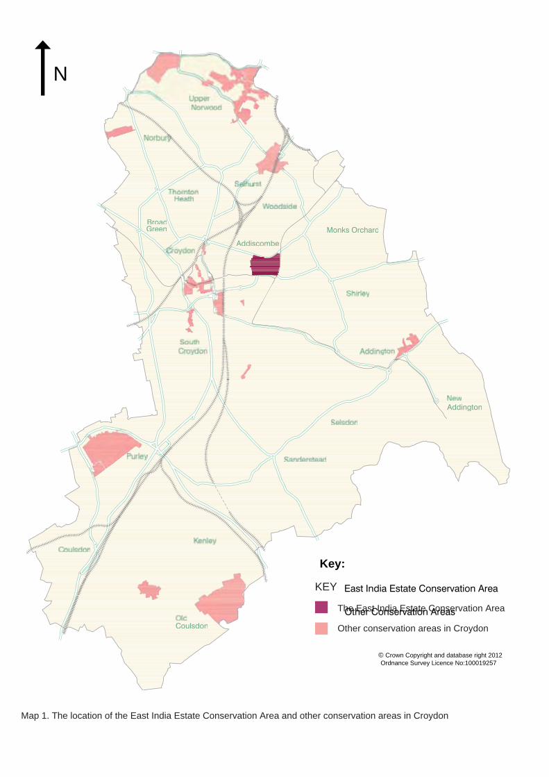
Map 1. The location of the East India Estate Conservation Area and other conservation areas in Croydon
INTRODUCTION

N
Above: Map 2. The boundary of the East India Estate Conservation Area Previous Page: Pair of houses on Ashburton Road
2

1.0 INTRODUCTION
1.1 WHAT IS A CONSERVATION AREA? 1.1.1 A conservation area is an area of special architectural or historic interest, the character and appearance of which it is desirable to preserve or enhance. Please see section 1.3 of Croydon’s Conservation Area General Guidance SPD for further information.
1.2 WHAT IS A CONSERVATION AREA APPRAISAL AND MANAGEMENT PLAN? 1.2.1 A Conservation Area Appraisal and Management Plan is a document produced to supplement Croydon’s Local Plan, the London Plan, and Croydon’s Conservation Area General Guidance SPD.
1.2.2 An Appraisal defi nes the principal qualities that constitute the conservation area’s special character, also identifying threats to this character. It is important to note that assessments made in this document are non-exhaustive, and further elements of architectural or historic interest may be present.
1.2.3 A Management Plan addresses the issues raised in the Appraisal and provides area-specifi c development guidelines to supplement those provided in Croydon’s Conser-vation Area General Guidance SPD; potential enhancement schemes are also explored. For further information please see section 1.5 of the Conservation Area General Guidance SPD.
1.3 WHAT IS THE STATUS OF THIS DOCUMENT? 1.3.1 This document is a Supplementary Planning Document (SPD) to the Croydon Local Plan: Strategic Policies (adopted April 2013) and is a material consideration when planning applications affecting the conservation area are assessed.
1.3.2 All planning applications for sites within the East India Estate Conservation Area should be informed by both this SPD and the Croydon Conser-vation Area General Guidance SPD.
1.4 COMMUNITY INVOLVEMENT 1.4.1 The Mid Croydon Conservation Area Advisory Panel (see section 1.4 of the Conservation Area General Guidance SPD), as well as the Canning & Clyde Road and HOME Resident’s Associations supplied information to inform the production of this document prior to public consultation, which ran from 2 September - 14 October 2013. The draft document was available to view and download on the Council’s website and hard copies were available from local libraries. Site notices were placed in the conservation area, letters were sent to all properties located within its boundary, an article was published in the Croydon Guardian and two events were held at the Central Croydon Library and the Living Water Satisfies Cafe in Crystal Palace on 23 and 26 September respectively.
1.4.2 Following the consultation all responses were considered and where appropriate, the document was amended prior to a recommendation to full Council for adoption.
Houses on Clyde Road, typical of the architectural character of the East India Estate Conservation Area
Terraced houses on Elgin Road with bay windows and architectural mouldings around windows and doorways
Historic entrance piers and doorway to 89 Outram Road
3
1.5 DESIGNATION BACKGROUND 1.5.1 The East India Estate Conservation Area was designated in March 2008 as part of a borough-wide review of conservation areas and local areas of special character in recognition of its architectural and historic significance.
1.6 STATEMENT OF SPECIAL CHARACTER 1.6.1 The special character of the East India Estate Conservation Area is largely defi ned by the concentration of historic buildings of a high architectural quality, of which three are statutorily listed at Grade II and fifty-seven are locally listed. The area has strong historical associations with the East India Military Academy, of which the Grade II listed Havelock Hall, a former gymnasium, survives. Some of the historic buildings present form attractive groupings and almost all are residential in use.
1.6.2 The conservation area’s special character is also defined by its spatial quality and formal layout of the estate, in particular the strong urban ‘ladder’ structure made up of six parallel roads. The strong structure provides a framework for architectural variation, but maintains a distinctive local character within the wider Addiscombe area.
1.7 STREETS WITHIN THE CONSERVATION AREA 1.7.1 All or part (as specifi ed) of the following streets are located within the East India Estate Conservation Area: • Canning Road (all) • Clyde Road (all) • Elgin Road (all) • Havelock Road (all) • Mulberry Lane (all) • Outram Road (all) • Ashburton Road (all) • Lower Addiscombe Road
(part) • Addiscombe Road (part)
1.7.2 Please see section 6 of this document for detailed assessment and analysis of the character of each street.
4

APPRAISAL
The following Appraisal defines the characteristics that make the East India Estate Conservation Area special, including its wider context, historic development, townscape, streetscape and architectural character. It also describes its current condition.
Previous page: Detail of Outram Court, Outram Road, with a prominent feature dormer window part of the house’s original design
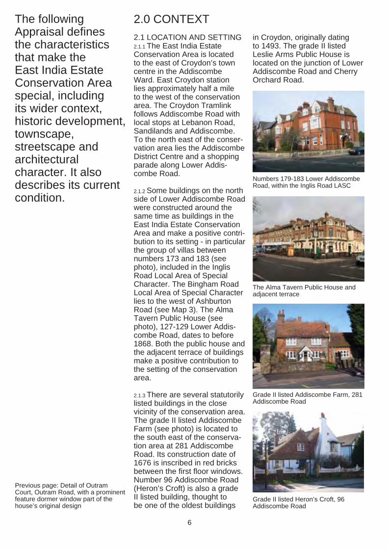
2.0 CONTEXT 2.1 LOCATION AND SETTING 2.1.1 The East India Estate Conservation Area is located to the east of Croydon’s town centre in the Addiscombe Ward. East Croydon station lies approximately half a mile to the west of the conservation area. The Croydon Tramlink follows Addiscombe Road with local stops at Lebanon Road, Sandilands and Addiscombe. To the north east of the conservation area lies the Addiscombe District Centre and a shopping parade along Lower Addiscombe Road.
2.1.2 Some buildings on the north side of Lower Addiscombe Road were constructed around the same time as buildings in the East India Estate Conservation Area and make a positive contribution to its setting - in particular the group of villas between numbers 173 and 183 (see photo), included in the Inglis Road Local Area of Special Character. The Bingham Road Local Area of Special Character lies to the west of Ashburton Road (see Map 3). The Alma Tavern Public House (see photo), 127-129 Lower Addiscombe Road, dates to before 1868. Both the public house and the adjacent terrace of buildings make a positive contribution to the setting of the conservation area.
2.1.3 There are several statutorily listed buildings in the close vicinity of the conservation area. The grade II listed Addiscombe Farm (see photo) is located to the south east of the conservation area at 281 Addiscombe Road. Its construction date of 1676 is inscribed in red bricks between the first fl oor windows. Number 96 Addiscombe Road (Heron’s Croft) is also a grade II listed building, thought to be one of the oldest buildings
in Croydon, originally dating to 1493. The grade II listed Leslie Arms Public House is located on the junction of Lower Addiscombe Road and Cherry Orchard Road.
Numbers 179-183 Lower Addiscombe Road, within the Inglis Road LASC
The Alma Tavern Public House and adjacent terrace
Grade II listed Addiscombe Farm, 281 Addiscombe Road
Grade II listed Heron’s Croft, 96 Addiscombe Road
6
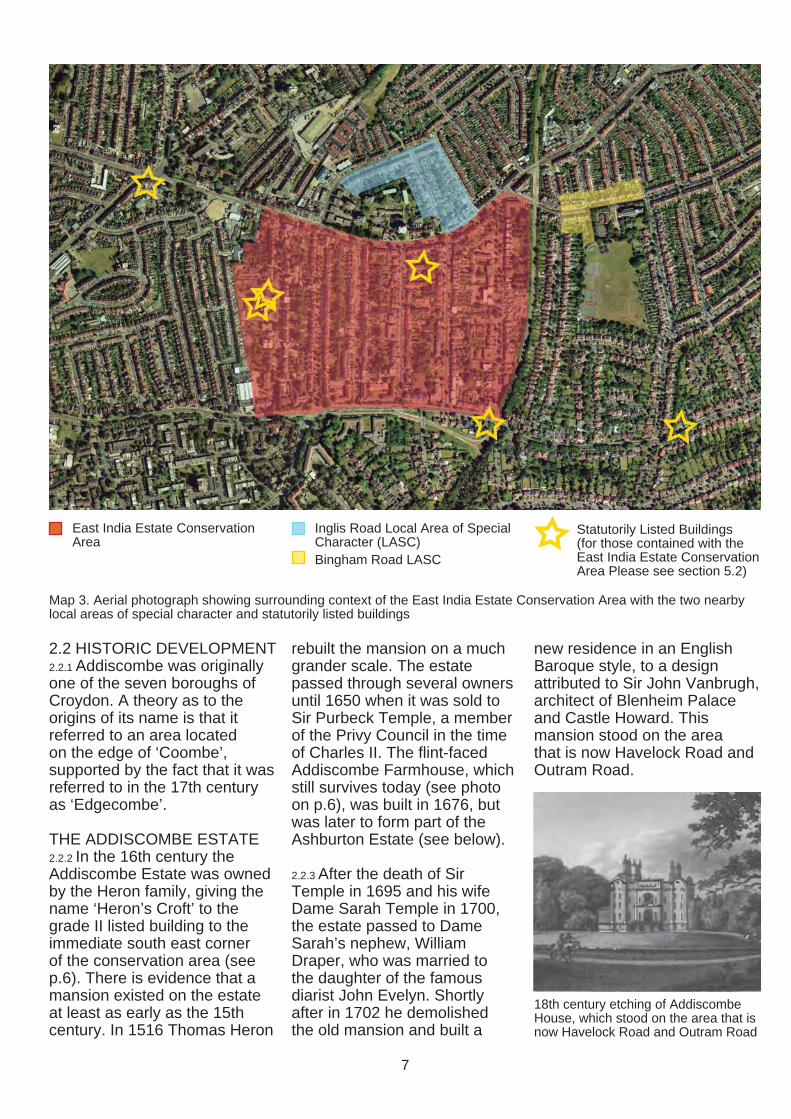
East India Estate Conservation Area
Inglis Road Local Area of Special Character (LASC) Bingham Road LASC
Statutorily Listed Buildings (for those contained with the East India Estate Conservation Area Please see section 5.2)
Map 3. Aerial photograph showing surrounding context of the East India Estate Conservation Area with the two nearby local areas of special character and statutorily listed buildings
2.2 HISTORIC DEVELOPMENT 2.2.1 Addiscombe was originally one of the seven boroughs of Croydon. A theory as to the origins of its name is that it referred to an area located on the edge of ‘Coombe’, supported by the fact that it was referred to in the 17th century as ‘Edgecombe’.
THE ADDISCOMBE ESTATE 2.2.2 In the 16th century the Addiscombe Estate was owned by the Heron family, giving the name ‘Heron’s Croft’ to the grade II listed building to the immediate south east corner of the conservation area (see p.6). There is evidence that a mansion existed on the estate at least as early as the 15th century. In 1516 Thomas Heron
rebuilt the mansion on a much grander scale. The estate passed through several owners until 1650 when it was sold to Sir Purbeck Temple, a member of the Privy Council in the time of Charles II. The flint-faced Addiscombe Farmhouse, which still survives today (see photo on p.6), was built in 1676, but was later to form part of the Ashburton Estate (see below).
2.2.3 After the death of Sir Temple in 1695 and his wife Dame Sarah Temple in 1700, the estate passed to Dame Sarah’s nephew, William Draper, who was married to the daughter of the famous diarist John Evelyn. Shortly after in 1702 he demolished the old mansion and built a
new residence in an English Baroque style, to a design attributed to Sir John Vanbrugh, architect of Blenheim Palace and Castle Howard. This mansion stood on the area that is now Havelock Road and Outram Road.
18th century etching of Addiscombe House, which stood on the area that is now Havelock Road and Outram Road
7

2.2.4 When William Draper died in 1718, he left his estate to his son of the same name. It was then passed to his nephew, Charles Clark who lived there until 1778. In 1808, its then owner, Henry Delme Radcliff, sold the estate to the East India Company for £15,500.
ASHBURTON ESTATE 2.2.5 The land now bounded by Ashburton Road, Lower Addiscombe Road, Addsicombe Road and Shirley Road once comprised the Ashburton Estate. The Estate is labelled as ‘Addiscombe Farm’ on 19th century maps (see Maps 5 and 7). Ashburton House (see photo), located where Northampton Road now meets Addiscombe Road, was a grand Georgian house built in the late 18th century by the Whig politician John Dunning. The Ashburton Estate acquired its name when Alexander Baring, who inherited the estate from Elizabeth Baring, the wife of John Dunning, took over the barony of Ashburton in Devon. Lord Ashburton married Anne Louise Bingham, hence the naming of the nearby Bingham Road.
THE EAST INDIA COMPANY MILITARY ACADEMY 2.2.6 The East India Company was established as a trading company by Royal Charter in 1600. It has been described as the largest multinational business in history. At its peak, the Company controlled half the world’s trade and a quarter of its population. It ran its own army and navy, minted its own currency and traded across the world. The East India Company ran a military academy at Addiscombe House between 1809 and 1858.
2.2.7 The first entrants of the East India Cadets were in residence
Map 4: 1745 Rocque’s Map of Croydon, with ‘Adscomb’ and ‘Adscomb House’ highlighted in red
Map 5: 1847 Robert’s Map of Croydon, showing Addiscombe and Addiscombe Farm
Ashburton House in the late 19th century
19th century photograph of Addiscombe House, when it was in use by the East India Company
8

at Addiscombe by 1809. Initially everyone was crowded into the mansion, but work soon started on the erection of barrack blocks, classrooms, hospital, laundry, bakehouse, brewhouse and other necessary buildings. All of these were completed by 1828 at an accumulated cost of £21,397.
2.2.8 About two thirds of the grounds were used as a farm, with a large area to the south of the college buildings laid out as woodland known as ‘The Wilderness’, including elm, lime, oak, walnut, ash, beech chestnut, fir, hornbeam and sycamore trees. The remaining 30 acres of land formed the grounds of the college, including a parade ground surrounded
by the flagstaff bastion and ditches. Another area of land to the north, now contained by Grant Road and Inglis Road, was also formerly part of the estate, and was initially two meadows leased from a neighbouring farmer for the site of the ‘coldstream’, which the college cadets used for swimming.
2.2.9 The last building at the College was erected in 1851 -the large gymnasium which still stands today in Havelock Road (see photos on p.20 and 30), now converted into fl ats. The other remaining buildings that still exist from the days of the East India Company are the semidetached houses, labelled on a Plan of the College (see Map 6) as the ‘Professors Houses’.
2.2.10 Cadets at Addiscombe College, aged between 14 and 18, were given a wide education, with a focus on science and engineering including practical work. Over the fifty-two years of existence, the college took about 3600 cadets who were later commissioned for service in India.
2.2.11 Following the Indian Mutiny of 1857, the British Government took control of India from The Company and appointed Lord Stanley as the Secretary of State for India. In 1861 the Royal and Indian services were amalgamated and the military academy at Addiscombe was closed, being of no further use. The remaining cadets transferred to the Royal Military Academy at Sandhurst.
Map 6: Extract from a plan of c.1850 of the East India Company Military College, showing the layout of the college including Gymnasium and the Professor’s Houses on the Addiscombe Road that still survive today. From Vibart
9
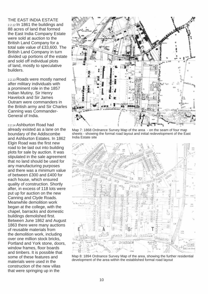
THE EAST INDIA ESTATE 2.2.12 In 1861 the buildings and 88 acres of land that formed the East India Company Estate were sold at auction to the British Land Company for a total sale value of £33,600. The British Land Company in turn divided up portions of the estate and sold off individual plots of land, mostly to speculative builders.
2.2.13 Roads were mostly named after military individuals with a prominent role in the 1857 Indian Mutiny. Sir Henry Havelock and Sir James Outram were commanders in the British army and Sir Charles Canning was Commander-General of India.
2.2.14 Ashburton Road had already existed as a lane on the boundary of the Addiscombe and Ashburton Estates. In 1862 Elgin Road was the fi rst new road to be laid out into building plots for sale by auction. It was stipulated in the sale agreement that no land should be used for any manufacturing purposes and there was a minimum value of between £300 and £400 for each house, which ensured quality of construction. Shortly after, in excess of 118 lots were put up for auction on the new Canning and Clyde Roads. Meanwhile demolition work began at the college, with the chapel, barracks and domestic buildings demolished first. Between June 1862 and August 1863 there were many auctions of reusable materials from the demolition work, including over one million stock bricks, Portland and York stone, doors, window frames, fl oor boards and timbers. It is possible that some of these features and materials were used in the construction of the new villas that were springing up in the
Map 7: 1868 Ordnance Survey Map of the area - on the seam of four map sheets - showing the formal road layout and initial redevelopment of the East India Estate site
Map 8: 1894 Ordnance Survey Map of the area, showing the further residential development of the area within the established formal road layout
10
area. Addiscombe House, the new Havelock and Outram Roads and the western side of Ashburton Road were put up for auction on 25 May 1863.
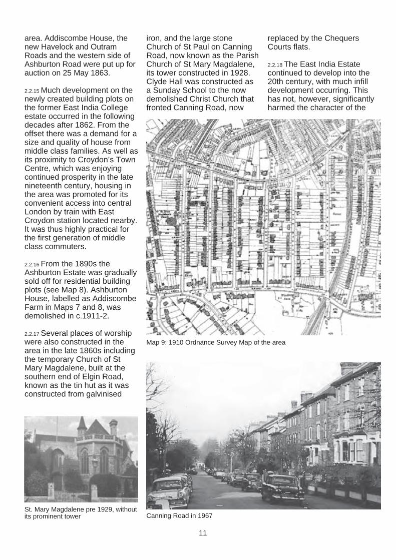
2.2.15 Much development on the newly created building plots on the former East India College estate occurred in the following decades after 1862. From the offset there was a demand for a size and quality of house from middle class families. As well as its proximity to Croydon’s Town Centre, which was enjoying continued prosperity in the late nineteenth century, housing in the area was promoted for its convenient access into central London by train with East Croydon station located nearby. It was thus highly practical for the first generation of middle class commuters.
2.2.16 From the 1890s the Ashburton Estate was gradually sold off for residential building plots (see Map 8). Ashburton House, labelled as Addiscombe Farm in Maps 7 and 8, was demolished in c.1911-2.
2.2.17 Several places of worship were also constructed in the area in the late 1860s including the temporary Church of St Mary Magdalene, built at the southern end of Elgin Road, known as the tin hut as it was constructed from galvinised
St. Mary Magdalene pre 1929, without its prominent tower
iron, and the large stone Church of St Paul on Canning Road, now known as the Parish Church of St Mary Magdalene, its tower constructed in 1928. Clyde Hall was constructed as a Sunday School to the now demolished Christ Church that fronted Canning Road, now
Canning Road in 1967
replaced by the Chequers Courts flats.
2.2.18 The East India Estate continued to develop into the 20th century, with much infill development occurring. This has not, however, significantly harmed the character of the
Map 9: 1910 Ordnance Survey Map of the area
11
formal estate layout of the 1860s with its villa-lined roads.
2.2.19 Important residents of the East India Estate include Frederick George Creed (18711957), electrical engineer and inventor of the Teleprinter who lived at 20 Outram Road and is commemorated by an English Heritage Blue Plaque. For a thorough and detailed record of the area’s social history please refer to The Book of Addiscombe, a copy of which is stored in the Central Croydon Library.
SELECTED REFERENCES: • Canning & Clyde Road
Residents Association and Friends, The Book of Addiscombe, 2000
• C. Paget, Croydon Homes of the Past, 1971
• Vibart, 1894
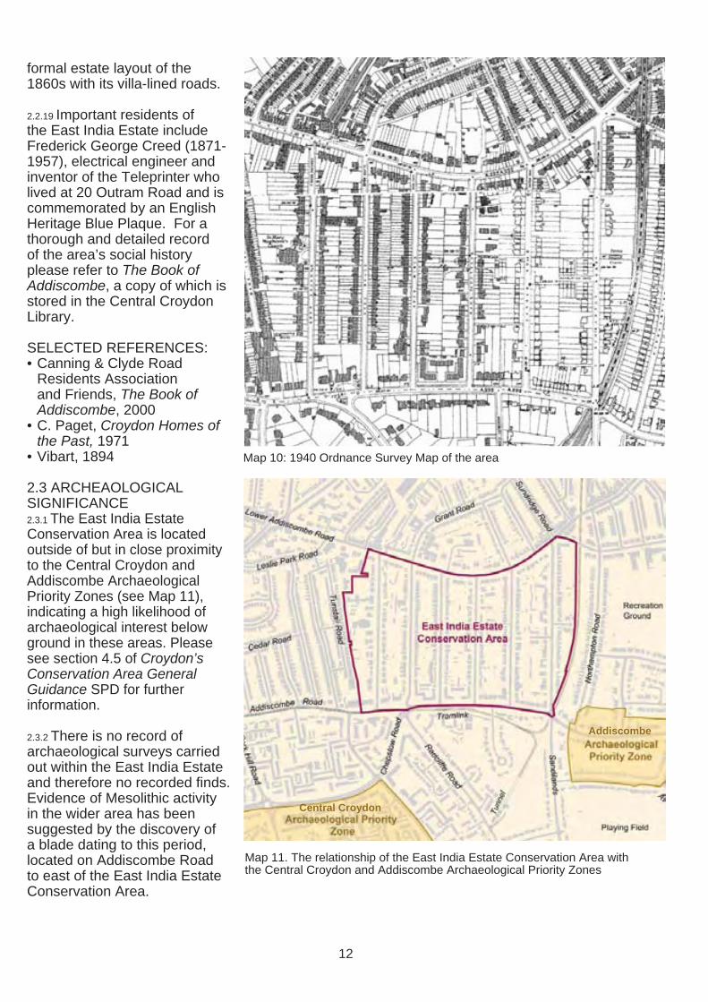
2.3 ARCHEAOLOGICAL SIGNIFICANCE 2.3.1 The East India Estate Conservation Area is located outside of but in close proximity to the Central Croydon and Addiscombe Archaeological Priority Zones (see Map 11), indicating a high likelihood of archaeological interest below ground in these areas. Please see section 4.5 of Croydon’s Conservation Area General Guidance SPD for further information.
2.3.2 There is no record of archaeological surveys carried out within the East India Estate and therefore no recorded finds. Evidence of Mesolithic activity in the wider area has been suggested by the discovery of a blade dating to this period, located on Addiscombe Road to east of the East India Estate Conservation Area.
Map 10: 1940 Ordnance Survey Map of the area
Addiscombe
Central Croydon
Map 11. The relationship of the East India Estate Conservation Area with the Central Croydon and Addiscombe Archaeological Priority Zones
12
3.0 TOWNSCAPE CHARACTER
3.0.1 Townscape is the arrangement and appearance of buildings, spaces and other physical features in the built and natural environments.
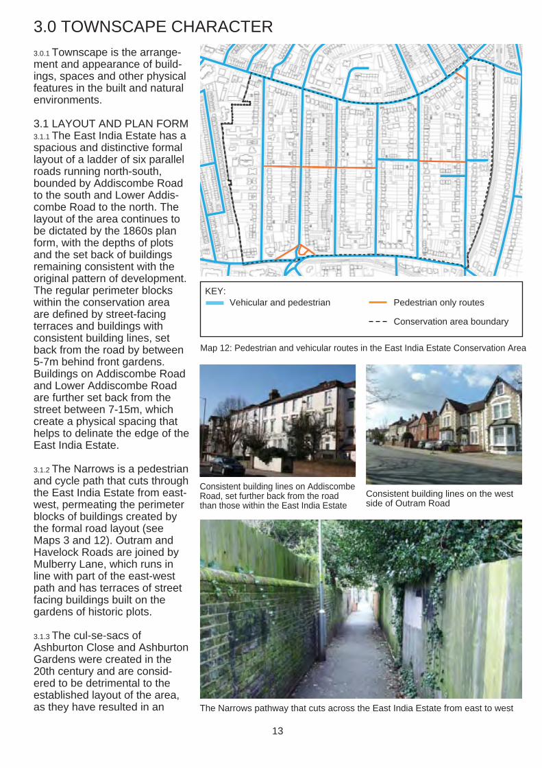
3.1 LAYOUT AND PLAN FORM 3.1.1 The East India Estate has a spacious and distinctive formal layout of a ladder of six parallel roads running north-south, bounded by Addiscombe Road to the south and Lower Addiscombe Road to the north. The layout of the area continues to be dictated by the 1860s plan form, with the depths of plots and the set back of buildings remaining consistent with the original pattern of development. The regular perimeter blocks within the conservation area are defined by street-facing terraces and buildings with consistent building lines, set back from the road by between 5-7m behind front gardens. Buildings on Addiscombe Road and Lower Addiscombe Road are further set back from the street between 7-15m, which create a physical spacing that helps to delinate the edge of the East India Estate.
3.1.2 The Narrows is a pedestrian and cycle path that cuts through the East India Estate from east-west, permeating the perimeter blocks of buildings created by the formal road layout (see Maps 3 and 12). Outram and Havelock Roads are joined by Mulberry Lane, which runs in line with part of the east-west path and has terraces of street facing buildings built on the gardens of historic plots.
3.1.3 The cul-se-sacs of Ashburton Close and Ashburton Gardens were created in the 20th century and are considered to be detrimental to the established layout of the area, as they have resulted in an
KEY: Vehicular and pedestrian Pedestrian only routes
Conservation area boundary
Map 12: Pedestrian and vehicular routes in the East India Estate Conservation Area
Consistent building lines on Addiscombe Road, set further back from the road than those within the East India Estate
Consistent building lines on the west side of Outram Road
The Narrows pathway that cuts across the East India Estate from east to west
13

increase in density, loss of gardens and erosion of the original layout of the area.
3.1.4 Generally building plots are rectangular with a width to depth ratio of approximately 1:5 or 1:6. Plots have a depth ranging from 40-50m. Plot width varies depending on the type and age of development. Of the original estate layout, detached town houses have a plot width of approximately 15m, semidetached building have a plot width of approximately 10m wide and fine grain terraces have an approximate plot width of 5m. Larger developments built in the 20th century are usually built on several consolidated plots and are therefore out of keeping with the layout of the estate.
3.2 DENSITY AND LAND USES 3.2.1 The streets and houses of the East India Estate are of a generous size and are of a lower density than the residential areas which surround it, due to the wide road, deep gardens and layout of buildings in the area. Street widths are fairly consistent at approximately 12.5m, including footways which are between 2.2-2.7m wide.
3.2.2 Spacing between buildings when viewed from the street is tight and varies from 1.5m to 3.5m depending on the type and age of development. In many instances buildings have extensions or garages present, which further reduces gaps between buildings.
3.2.3 Back gardens provide spacing between the terraces of tightly packed street facing buildings, which is particularly visible from The Narrows. There has been no significant backland development in the East India Area, which has helped to preserve the quality
Elgin Nursery, 2 Elgin Road
of the area in terms of private amenity space.
3.2.4 Land uses are predominantly residential. There are a number of buildings with a public or community use present in the conservation area, including the Church of St Mary Magdalene on Canning Road and Clyde Hall on Clyde Road, which currently operates as a private community hall with associated facilities. The Ashwood Mental Health Centre (Outram Lodge) is located at 6-10 Outram Road. The Elgin Nursery, 2 Elgin Road, is located in a converted building that was originally residential in use.
3.3 BUILDING HEIGHT AND MASSING 3.3.1 Building heights in the East India Conservation Area vary
from one to four storeys (see Map 13). The tall tower of the Church of St Mary Magdalene on Canning Road rises above the surrounding buildings and is a local landmark. Three-four storey buildings are located predominantly along Addiscombe Road and on the western part of the Estate on Canning, Clyde and Elgin Roads. Lower Addiscombe Road contains buildings that are predominantly two stories in height with roof accommodation. Single storey bungalows are located on Ashburton Close.
3.3.2 The depth of buildings is consistent along each street in the case of original East India Estate buildings whilst later, 20th century insertions tend to be different. As a result the regular grid has been distorted in a number of instances, along Ashburton Road, Addiscombe Road and Havelock Road in particular.
3.3.3 There is a variety in the massing of buildings, depending on their height (see Map 13), and the size of their footprint. The 20th century blocks of flats have a much larger footprint that the original Estate houses, and therefore a much larger overall massing, which is out of scale in the context of the area’s character.
Typical sequence of three storey pairs of semis on Outram Road
14
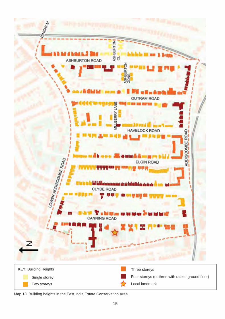
Three storeys
Four storeys (or three with raised ground floor)
Local landmark
N
KEY: Building Heights
Single storey
Two storeys
Map 13: Building heights in the East India Estate Conservation Area
15

3.4 TOPOGRAPHY AND VIEWS 3.4.1 The East India Conservation Area is located on a slope descending to the north, from 65.7m above sea level at Addiscombe Road, down to 55.7m on Lower Addiscombe Road (see Map 14). Vistas closing south-north roads are prominent components of its setting.
3.4.2 Views along north-south running roads are uninterrupted within the conservation area, and there are east-west views along The Narrows. The NLA Tower in Central Croydon is a prominent landmark when looking west along Addiscombe Road. There are views from the southern end of Outram Road
towards South Norwood and the slopes of Upper Norwood. Views south are terminated by the large buildings immediately north of Lower Addiscombe Road.
View of the NLA Tower from View north down Outram Road towards Upper Norwood Addiscombe Road
N
KEY
Long or Linear View
Map 14: Topography and views within and without the East India Estate Conservation Area
16
4.0 STREETSCAPE CHARACTER
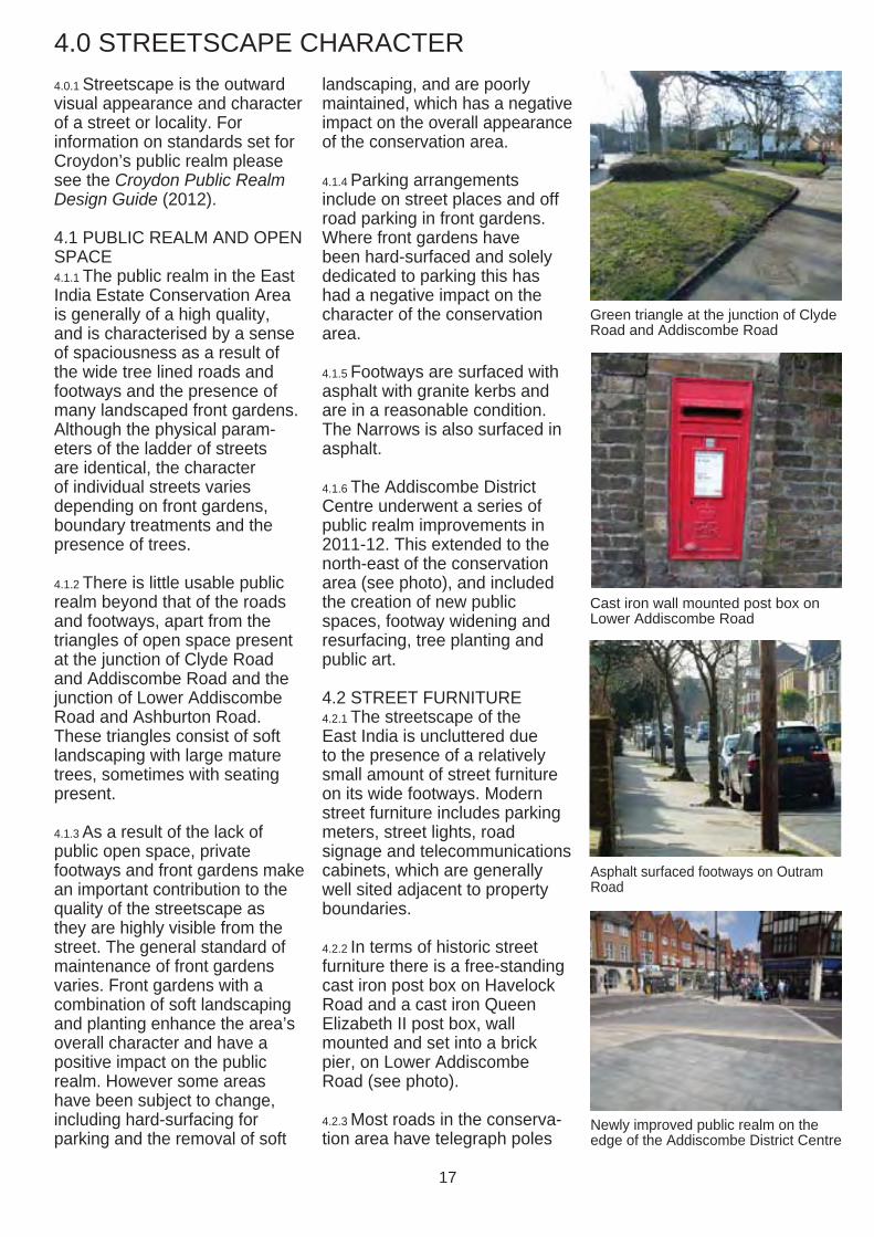
4.0.1 Streetscape is the outward visual appearance and character of a street or locality. For information on standards set for Croydon’s public realm please see the Croydon Public Realm Design Guide (2012).
4.1 PUBLIC REALM AND OPEN SPACE 4.1.1 The public realm in the East India Estate Conservation Area is generally of a high quality, and is characterised by a sense of spaciousness as a result of the wide tree lined roads and footways and the presence of many landscaped front gardens. Although the physical parameters of the ladder of streets are identical, the character of individual streets varies depending on front gardens, boundary treatments and the presence of trees.
4.1.2 There is little usable public realm beyond that of the roads and footways, apart from the triangles of open space present at the junction of Clyde Road and Addiscombe Road and the junction of Lower Addiscombe Road and Ashburton Road. These triangles consist of soft landscaping with large mature trees, sometimes with seating present.
4.1.3 As a result of the lack of public open space, private footways and front gardens make an important contribution to the quality of the streetscape as they are highly visible from the street. The general standard of maintenance of front gardens varies. Front gardens with a combination of soft landscaping and planting enhance the area’s overall character and have a positive impact on the public realm. However some areas have been subject to change, including hard-surfacing for parking and the removal of soft
landscaping, and are poorly maintained, which has a negative impact on the overall appearance of the conservation area.
4.1.4 Parking arrangements include on street places and off road parking in front gardens. Where front gardens have been hard-surfaced and solely dedicated to parking this has had a negative impact on the character of the conservation area.
4.1.5 Footways are surfaced with asphalt with granite kerbs and are in a reasonable condition. The Narrows is also surfaced in asphalt.
4.1.6 The Addiscombe District Centre underwent a series of public realm improvements in 2011-12. This extended to the north-east of the conservation area (see photo), and included the creation of new public spaces, footway widening and resurfacing, tree planting and public art.
4.2 STREET FURNITURE 4.2.1 The streetscape of the East India is uncluttered due to the presence of a relatively small amount of street furniture on its wide footways. Modern street furniture includes parking meters, street lights, road signage and telecommunications cabinets, which are generally well sited adjacent to property boundaries.
4.2.2 In terms of historic street furniture there is a free-standing cast iron post box on Havelock Road and a cast iron Queen Elizabeth II post box, wall mounted and set into a brick pier, on Lower Addiscombe Road (see photo).
4.2.3 Most roads in the conservation area have telegraph poles
Green triangle at the junction of Clyde Road and Addiscombe Road
Cast iron wall mounted post box on Lower Addiscombe Road
Asphalt surfaced footways on Outram Road
Newly improved public realm on the edge of the Addiscombe District Centre
17

with cables running from them to properties in the area. These cause clutter to the streetscene and have a negative impact on the appearance of the area.
4.3 BOUNDARY TREATMENTS 4.3.1 All street-facing properties in the conservation area have front gardens, many of which retain their original boundary treatments, often consisting of attractive low brick walls, sometimes with iron railings or timber fencing and / or hedges. Front gardens that have no boundary treatments demarcating the public and private realms have a negative impact on the appearance of the area as they are not consistent with the original street layout.
4.3.2 A characteristic feature of the boundary treatment walls in the area is that they are often accompanied by brick or stone
piers to mark gates and property boundaries (see photo of properties on Canning Road on p.19). Where a row of piers is present this creates a sense of rhythm and has a positive impact on the quality of the streetscape.
4.3.3 Boundary treatments between back gardens and The Narrows are typically made up of brick walls or timber fences approximately 1.8m in height.
4.4 GREENERY AND TREES 4.4.1 There are a variety of tree species present in the conservation area, including oak, cedar, birch, holly, yew, beech and fir trees. Street trees generally form avenues along either side of the streets. These, along with trees and planting in private front gardens makes a positive contribution to the area’s attractive streetscape character. There are several mature trees in rear
gardens present, either visible from The Narrows or from gaps in street-facing buildings, which contributes to the suburban character of the area. Where trees and soft landscaping have been removed from front gardens this has had a negative impact on the character and appearance of the conservation area.
4.4.2 Where street trees are established and well maintained, for example on Clyde Road (see section 6.2), the quality of the streetscape is higher. Distinctive tree species, for example the cherry trees on Havelock Road, also contribute to the quality of the area.
4.4.3 Conservation area status gives protection to trees within its boundary. For further information please see sections 5.14 and 7.3 of the Conservation Area General Guidance SPD.
Low walling boundary treatment with brick piers topped with stone coping Low walling boundary treatments
Trees and greenery along The Narrows
Street tree lines on Clyde Road Evergreen tree on Outram Road
18

5.0 ARCHITECTURAL CHARACTER
5.1 GENERAL ARCHITECTURAL CHARACTER 5.1.1 The area’s architectural character is primarily defined by the concentration of well detailed Victorian and Edwardian houses built on the formal layout of the East India Estate. Buildings vary from modest detached villas to imposing semi-detached three storey town houses.
5.1.2 Most town houses built in the East India Estate in the 1860s and 1870s were relatively restrained in their design and were infl uenced by the Italian Classical style. Italianate proportions and detailing, such as stucco cornices or pediments over windows or stucco quoins, are present on many of the earlier buildings in the East India Estate. House design in the second half of the nineteenth century was eclectic, and many architects and builders mixed and matched decorative elements. From the 1880s Gothic Revival style became popular. There are some examples of buildings with Gothic and Arts and Crafts inspired detailing, including pointed windows and doors and steeply pitched roofs.
5.1.3 Despite the variety of architectural character, there are many attractive groupings of buildings with a consistent character, which helps to provide a cohesive character throughout the area. Please see section 5.4 for an assessment of some of these significant groupings. There are also many examples of 20th century infill development, which has resulted in a mix in the architectural character.
5.1.4 There are many high quality architectural features present on Victorian and Edwardian
buildings in the area (see section 5.3). These details and embellishments are invaluable to the area’s special character and reveal the exceptionally high quality of craftsmanship displayed in this collection of Victorian and Edwardian houses.
5.1.5 In addition to the collection of formally laid out houses there are several local landmark
Three storey semi-detached buildings on Clyde Road with additional lower ground floors
Group of three storey semi-detached buildings with basements and raised ground floors on Canning Road
Detached villas on Havelock Road in contrasting styles
19
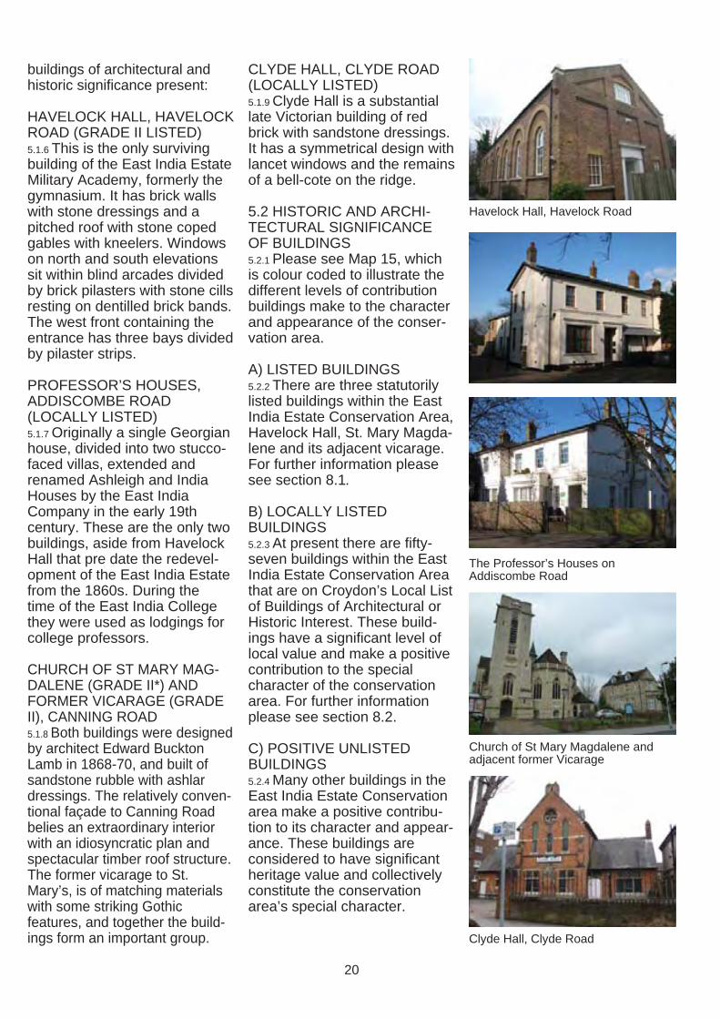
buildings of architectural and historic signifi cance present:
HAVELOCK HALL, HAVELOCK ROAD (GRADE II LISTED) 5.1.6 This is the only surviving building of the East India Estate Military Academy, formerly the gymnasium. It has brick walls with stone dressings and a pitched roof with stone coped gables with kneelers. Windows on north and south elevations sit within blind arcades divided by brick pilasters with stone cills resting on dentilled brick bands. The west front containing the entrance has three bays divided by pilaster strips.
PROFESSOR’S HOUSES, ADDISCOMBE ROAD (LOCALLY LISTED) 5.1.7 Originally a single Georgian house, divided into two stucco-faced villas, extended and renamed Ashleigh and India Houses by the East India Company in the early 19th century. These are the only two buildings, aside from Havelock Hall that pre date the redevelopment of the East India Estate from the 1860s. During the time of the East India College they were used as lodgings for college professors.
CHURCH OF ST MARY MAGDALENE (GRADE II*) AND FORMER VICARAGE (GRADE II), CANNING ROAD 5.1.8 Both buildings were designed by architect Edward Buckton Lamb in 1868-70, and built of sandstone rubble with ashlar dressings. The relatively conventional façade to Canning Road belies an extraordinary interior with an idiosyncratic plan and spectacular timber roof structure. The former vicarage to St. Mary’s, is of matching materials with some striking Gothic features, and together the buildings form an important group.
CLYDE HALL, CLYDE ROAD (LOCALLY LISTED) 5.1.9 Clyde Hall is a substantial late Victorian building of red brick with sandstone dressings. It has a symmetrical design with lancet windows and the remains of a bell-cote on the ridge.
5.2 HISTORIC AND ARCHITECTURAL SIGNIFICANCE OF BUILDINGS 5.2.1 Please see Map 15, which is colour coded to illustrate the different levels of contribution buildings make to the character and appearance of the conservation area.
A) LISTED BUILDINGS 5.2.2 There are three statutorily listed buildings within the East India Estate Conservation Area, Havelock Hall, St. Mary Magdalene and its adjacent vicarage. For further information please see section 8.1.
B) LOCALLY LISTED BUILDINGS 5.2.3 At present there are fiftyseven buildings within the East India Estate Conservation Area that are on Croydon’s Local List of Buildings of Architectural or Historic Interest. These buildings have a significant level of local value and make a positive contribution to the special character of the conservation area. For further information please see section 8.2.
C) POSITIVE UNLISTED BUILDINGS 5.2.4 Many other buildings in the East India Estate Conservation area make a positive contribution to its character and appearance. These buildings are considered to have significant heritage value and collectively constitute the conservation area’s special character.
Havelock Hall, Havelock Road
The Professor’s Houses on Addiscombe Road
Church of St Mary Magdalene and adjacent former Vicarage
Clyde Hall, Clyde Road
20
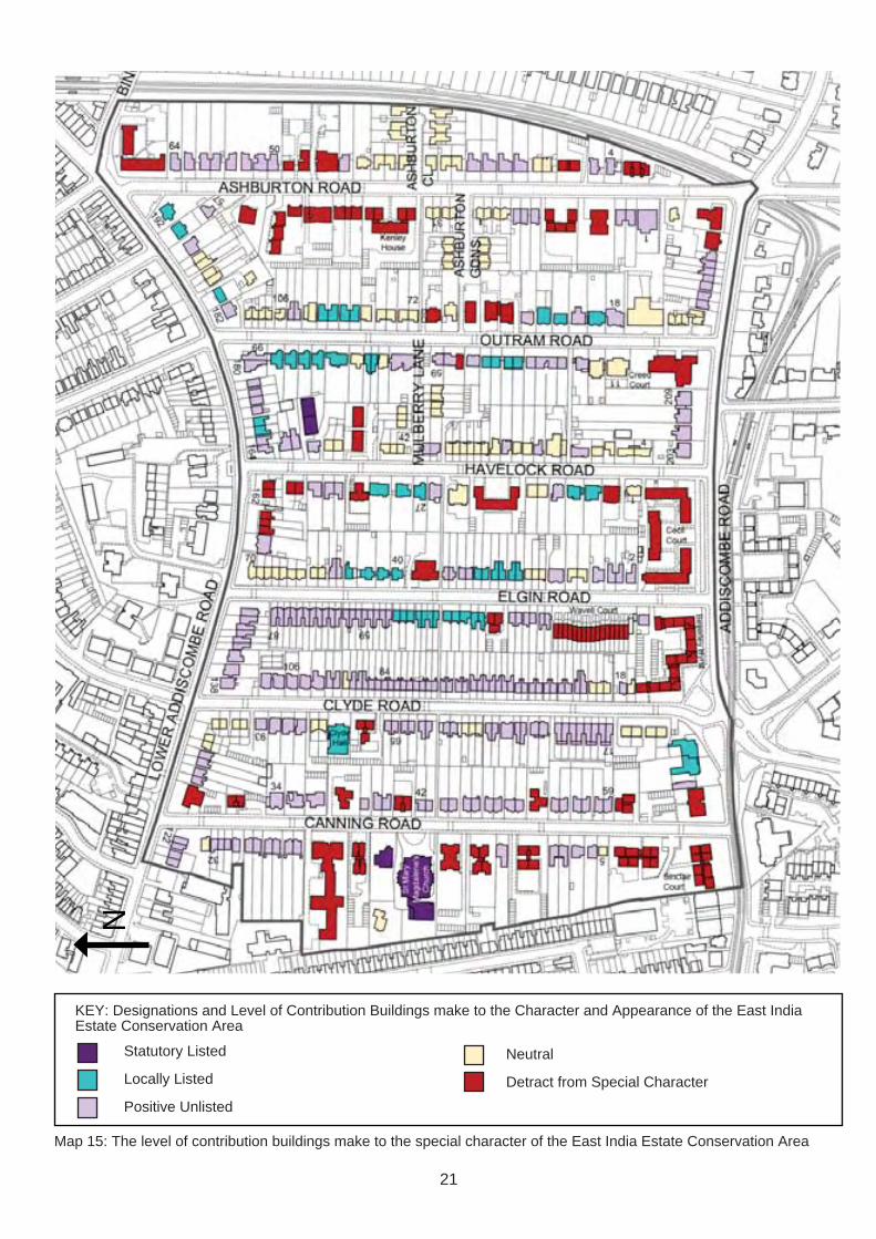
KEY: Designations and Level of Contribution Buildings make to the Character and Appearance of the East India Estate Conservation Area
Neutral
Detract from Special Character
Statutory Listed
Locally Listed
Positive Unlisted
N
Map 15: The level of contribution buildings make to the special character of the East India Estate Conservation Area
21

D) NEUTRAL BUILDINGS 5.2.5 There are several buildings in the conservation that area do not positively contribute nor actively detract from the conservation area’s special character, which may include modern buildings that are respectful in their scale and appearance.
E) BUILDINGS THAT DETRACT FROM THE AREA’S SPECIAL CHARACTER 5.2.6 There are some buildings in the conservation area that are considered to have a negative impact on its character and appearance. Buildings in this category may include those that out of keeping with the established formal layout of the conservation area and the scale and character of historic buildings present.
5.3 KEY ARCHITECTURAL FEATURES AND BUILDING MATERIALS 5.3.1 Many historic architectural features and common materials are found throughout the conservation area and make an important contribution to the character and appearance of the conservation area. Brick walls, either red or yellow London Stock, are a characteristic feature of this area. However, some exposed brick walls have been rendered or painted, which has had a negative impact on their appearance and that of the wider streetscape. In a few cases pebbledash render has been applied, which has considerably detracted from the appearance of the building.
5.3.2 Please see the adjacent box for a list of architectural features and common building materials found in the East India Estate Conservation Area. Buildings generally contain a selection of the characteristic key features and materials features listed.
KEY ARCHITECTURAL FEATURES1
1. Arched entrances, often recessed and raised with steps leading up to the doorway
2. Brick piers to boundary walls
3. Timber porches
4. Brick chimney stacks
5. Bay windows
6. Round arched windows
7. Timber sliding sash windows
8. Brackets supporting projecting window boxes or eaves
9. Pediments above windows or doors
10. Architraves around windows or doors
11. Soldier brick courses above windows or doors
12. Stucco or stone lintels, often with decorative key stones
13. String courses or banding
14. Cornices above windows or doors
15. Quoins
16. Pilasters
17. Patterned brickwork
18. Decorative glazed tiles
COMMON BUILDING MATERIALS:
19. Yellow London stock bricks
20. Red bricks
21. Render as part of original house design
22. Stucco or stone dressings
23. Natural slate tiles
24. Hand-made clay tiles
25. Ironwork columns or window boxes
1 Please see glossary of relevant terms in the Conservation Area General Guidance SPD
22

1, 10
11, 17
1, 10
4, 6, 8
5, 11, 25
1, 11
10
18
10, 12, 22 6, 15
17, 193
23
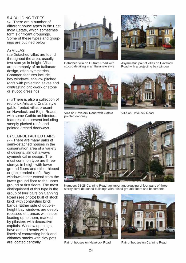
5.4 BUILDING TYPES 5.4.1 There are a number of different house types in the East India Estate, which sometimes form signifi cant groupings. Some of these types and groupings are outlined below.
A) VILLAS 5.4.2 Detached villas are found throughout the area, usually two storeys in height. Villas are commonly of an Italianate design, often symmetrical. Common features include bay windows, shallow pitched roofs with projecting eaves and contrasting brickwork or stone or stucco dressings.
5.4.3 There is also a collection of red brick Arts and Crafts style gable-fronted villas present on Havelock and Elgin Roads, with some Gothic architectural
Detached villa on Outram Road with stucco detailing in an Italianate style
Villa on Havelock Road with Gothic pointed doorway
Asymmetric pair of villas on Havelock Road with a projecting bay window
Villa on Havelock Road
features also present including steeply pitched roofs and pointed arched doorways.
B) SEMI-DETACHED PAIRS 5.4.4 There are many pairs of semi-detached houses in the conservation area of a variety of designs, almost always symmetrical in design. The most common type are three-storeys in height with lower ground floors and either hipped or gable ended roofs. Bay windows either extend from the lower ground floor to the upper ground or first floors. The most Numbers 23-28 Canning Road, an important grouping of four pairs of three distinguished of this type is the group of four pairs on Canning Road (see photo) built of stock brick with contrasting brick bands. Either side of double-height bay windows are deeply recessed entrances with steps leading up to them, marked by pilasters with decorative capitals. Window openings have arched heads with lintels of contrasting brick and chimney stacks with clay pots are located centrally.
storey semi-detached buildings with raised ground floors and basements
Pair of houses on Havelock Road Pair of houses on Canning Road
24

5.4.6 There are also examples of two storey semi-detached houses present, for example the pair of houses on Clyde Road with bay windows, round headed windows at first floor level and a feature dormer window. Another example is the pair on Havelock Road, which are of a more simple design with feature bay windows and contrasting lintels above windows at first fl oor level.
C) TERRACES 5.4.7 There are several different types of terraces present in the area, ranging from short terraces of three or four houses to longer sequences. Examples of short terraces include those of a simple repeating design, for example at 31-35 Elgin Road where the raised doorway and upper ground fl oor window are picked out with decorative treatments. Another example of a short terrace is the group of four on Elgin Road, of a symmetrical design with pairs of recessed entrances and gable fronted end buildings and central chimney stack with clay pots. All windows are picked out with stucco architraves.
5.4.8 Continuous terraces of sequences of houses are also present on Elgin and Clyde Roads. An example of these are the group on Clyde Road that have a relatively simple design with an elaborate timber porch running along the elevation at upper ground fl oor level.
5.4.9 There are also Edwardian terraces present in the conservation area.
Two storey pair of houses on Clyde Two storey pair on Havelock Road Road with central dormer windows
Terrace of houses at 76-82 Clyde Road with an elaborate timber porch
Short symmetrical terrace of four houses at 37-43 Elgin Road
Three storey terrace on Clyde Road with attractive contrasting brickwork
Short terrace of three houses at 31-35 Elgin Road
25

54-59
6.0 STREET ASSESSMENT
6.1 CANNING ROAD Statutorily listed buildings: Church of St Mary Magdalene (Grade II*) and number 17, former vicarage (Grade II) Unlisted positive buildings: 6-9, 12, 23-32, 34-36, 38-40, 42-51,
6.1.1 Canning Road forms the western boundary of the East India Estate Conservation Area and its spacious character is in marked contrast with the tight-knit terraced houses further to the west outside of the conservation area. Although there are only four street trees present, located outside numbers 34-36, there are many trees and much greenery located on private land, which contributes to the quality of the streetscape. The historic architecture is of a high quality, with unifying features and materials. However there are also several examples of 20th century blocks of flats, which reduces the uniformity of character in the street.
6.1.2 Canning Road is dominated by the local landmark building of the Church of St Mary Magdalene (Grade II* listed) and the adjacent former vicarage (Grade II listed), both constructed of sandstone rubble with ashlar dressings (please see photos and description on p.20). The church is set in a large plot, back from established building lines. A new vicarage and hall have been constructed to the rear of the site.
6.1.3 There are several pairs of three storey semi-detached buildings with basements, built of stock brick and lintel detailing. Numbers 23-28 are striking and well preserved examples of this type (see photo on p.24). Number 29 is of the same design but was constructed as a detached property rather than a
semi-detached. Numbers 44-51 and 54-59 are also interesting examples of this type. Numbers 6, 29 and 38 were originally semi-detached properties, of which the other half has been demolished. Prominent features on these buildings include deep bracketed eaves, bay windows at the upper ground fl oor and sometimes first fl oors, recessed main entrances with steps leading up to them, flanked by pilasters with decorative capitals. Front gardens generally have low level boundary walls, although several of these have been lost. Some groups have lost their unity due to a range of alterations, including the application of render and the hard surfacing of front gardens.
38 Canning Road - the surviving half of a semi-detached pair
56-59 Canning Road
Street tree outside numbers 26-29 Canning Road
26

6.1.4 There are also several examples of two storey semidetached buildings on Canning Road, including numbers 39-40, 42-43 and 8-9, with a similar composition of facades to the three-storey variety: stock brick walls, bay windows, set back and well articulated main door with stair access. Numbers 39-40 are particularly well preserved examples of this type. There is also one short terrace at numbers 30-32, originally design to be symmetrical.
6.1.5 Several two storey Victorian villas are present, numbers 7, 12, 34 and 36, which are generally of a high architectural quality, detailing and materials and well proportioned scale and massing. Number 32B is a new build detached house that respects the layout and scale of the area.
6.1.6 The 20th century blocks vary in terms of their architectural quality and sensitivity to their surrounding context. Edward Jobson Court, Princess Court, Hereford Court and Tierney Court Key are all over-sized in their massing and Chequers Court and Alpha House are out of keeping with the established layout and building lines. On Canning Road the most sensitively designed blocks of fl ats are Park Court and Neville Court, in terms of their siting, massing and simplicity of symmetrical design of facades and Fourways and Cheyene Court, with their interesting brick facades and reduced massing. However the design, materials and detailing of these blocks does not match the quality of existing historic buildings in the East India Estate.
Architectural detailing of London brick elevations
36 Canning Road
6.2 CLYDE ROAD Locally listed buildings: Clyde Hall Unlisted positive buildings: 17-45 (odd), 18, 26-98 (even), 53-67 (odd), 87-93 (odd), 102110 (even)
6.2.1 Clyde Road has the highest density of historic development in the conservation area with many terraced houses and small gaps between buildings on both sides of the road. Continuous tree lines of pollarded lime trees, low walled boundary treatments and greenery and planting in front gardens contribute to the quality of the streetscape.
6.2.2 Clyde Hall is a local landmark building of red brick with sandstone dressings that contributes to the character and interest of the street (please see photos and description on
8-9 Canning Road
34 Canning Road
View north down Clyde Road showing avenues of lime trees
Consistent building lines on Clyde Road
27

p.20). The siting of Clyde Hall marks the only break in building lines, which are otherwise consistent along the east and west sides of Clyde Road.
6.2.3 Numbers 87-93 (odd) and 102-110 (even) form a group of two storey detached houses, with square floor plans and pyramid hip roofs, distinctly smaller in scale than other detached properties in the area The group is of a plain yet attractive design with yellow London stock brick facades, white detailing around windows and a projection at ground floor level.
6.3.4 There are lots of large Victorian semi-detached buildings on Clyde Road (many of which share characteristics with those on Canning Road). These are grouped mostly on the eastern side of the road (numbers 18, 30-32, 34-36, 38-40, 42-44, 60-62, 64-66 and 98-100), though there are some on the western side also (numbers 57-59 and 65-67). Each pair of semis has experienced some alterations and simplifications, such as rendered and painted podiums and bay windows, simplified window frames and roof structures. There are also examples of two or three storey semi-detached houses with bay windows (numbers 33-35, 43-45 and 37-39).
6.2.5 Numbers 68-96 (even) form a terrace of buildings that correspond in their proportions to the large semi-detached properties. They are also of three storeys with basements, bay windows to ground and basement level, and the remains of a continuous wooden veranda at the ground floor of 82-86.
6.2.6 Numbers 46-58 form another group of terraces with a rhythm
of gabled frontages and dormer windows. A symmetrical terrace with rendered elevations has distinctive window surrounds, barge boards and dormer windows. A similar, yet incomplete, composition exists in Canning Road 30-32.
6.2.7 An Edwardian terrace is located to the south of the road at numbers 17-31, of two storeys with a continuous projecting bay/ veranda along the front. Small pane casement windows, front boundary fences and other arts and crafts details contribute to their particular character.
6.2.8 World War II bomb damage and development pressures of the 20th century resulted in the re-development of a number of sites on Clyde Road, including the small terrace (numbers 47-51). Sets of pairs of maisonettes were erected along the western side of the street (numbers 1-15, 79-85 and 95-109). Carlton House is the only post-War block of flats present on Clyde Road. These later interventions stand out from the original character of the conservation area, however mostly respect the layout, scale and massing of the street.
Numbers 46-58 Clyde Road
Numbers 106-110 Clyde Road
Numbers 86-90 Clyde Road
Numbers 17-31 Clyde Road
28
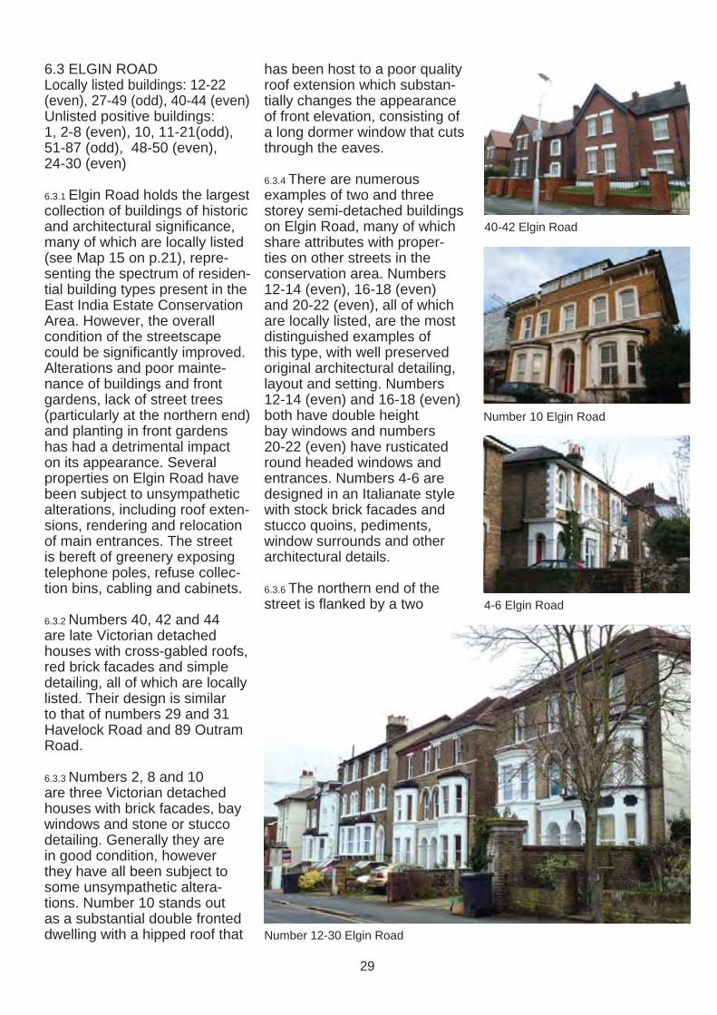
6.3 ELGIN ROAD Locally listed buildings: 12-22 (even), 27-49 (odd), 40-44 (even) Unlisted positive buildings: 1, 2-8 (even), 10, 11-21(odd), 51-87 (odd), 48-50 (even), 24-30 (even)
6.3.1 Elgin Road holds the largest collection of buildings of historic and architectural significance, many of which are locally listed (see Map 15 on p.21), representing the spectrum of residential building types present in the East India Estate Conservation Area. However, the overall condition of the streetscape could be signifi cantly improved. Alterations and poor maintenance of buildings and front gardens, lack of street trees (particularly at the northern end) and planting in front gardens has had a detrimental impact on its appearance. Several properties on Elgin Road have been subject to unsympathetic alterations, including roof extensions, rendering and relocation of main entrances. The street is bereft of greenery exposing telephone poles, refuse collection bins, cabling and cabinets.
6.3.2 Numbers 40, 42 and 44 are late Victorian detached houses with cross-gabled roofs, red brick facades and simple detailing, all of which are locally listed. Their design is similar to that of numbers 29 and 31 Havelock Road and 89 Outram Road.
6.3.3 Numbers 2, 8 and 10 are three Victorian detached houses with brick facades, bay windows and stone or stucco detailing. Generally they are in good condition, however they have all been subject to some unsympathetic alterations. Number 10 stands out as a substantial double fronted dwelling with a hipped roof that
has been host to a poor quality roof extension which substantially changes the appearance of front elevation, consisting of a long dormer window that cuts through the eaves.
6.3.4 There are numerous examples of two and three storey semi-detached buildings on Elgin Road, many of which share attributes with properties on other streets in the conservation area. Numbers 12-14 (even), 16-18 (even) and 20-22 (even), all of which are locally listed, are the most distinguished examples of this type, with well preserved original architectural detailing, layout and setting. Numbers 12-14 (even) and 16-18 (even) both have double height bay windows and numbers 20-22 (even) have rusticated round headed windows and entrances. Numbers 4-6 are designed in an Italianate style with stock brick facades and stucco quoins, pediments, window surrounds and other architectural details.
6.3.6 The northern end of the street is flanked by a two
40-42 Elgin Road
Number 10 Elgin Road
4-6 Elgin Road
Number 12-30 Elgin Road
29
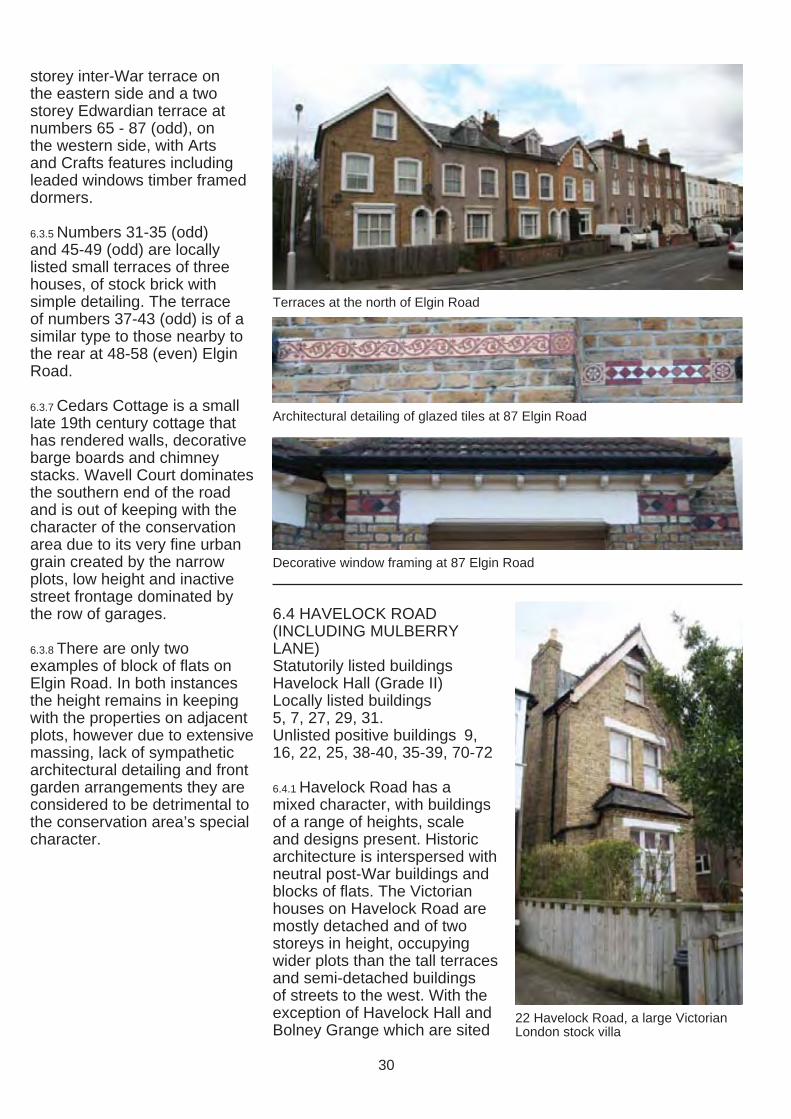
storey inter-War terrace on the eastern side and a two storey Edwardian terrace at numbers 65 - 87 (odd), on the western side, with Arts and Crafts features including leaded windows timber framed dormers.
6.3.5 Numbers 31-35 (odd) and 45-49 (odd) are locally listed small terraces of three houses, of stock brick with simple detailing. The terrace of numbers 37-43 (odd) is of a similar type to those nearby to the rear at 48-58 (even) Elgin Road.
6.3.7 Cedars Cottage is a small late 19th century cottage that has rendered walls, decorative barge boards and chimney stacks. Wavell Court dominates the southern end of the road and is out of keeping with the character of the conservation area due to its very fi ne urban grain created by the narrow plots, low height and inactive street frontage dominated by the row of garages.
6.3.8 There are only two examples of block of fl ats on Elgin Road. In both instances the height remains in keeping with the properties on adjacent plots, however due to extensive massing, lack of sympathetic architectural detailing and front garden arrangements they are considered to be detrimental to the conservation area’s special character.
Terraces at the north of Elgin Road
Architectural detailing of glazed tiles at 87 Elgin Road
Decorative window framing at 87 Elgin Road
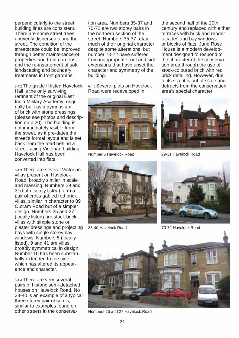
6.4 HAVELOCK ROAD (INCLUDING MULBERRY LANE) Statutorily listed buildings Havelock Hall (Grade II) Locally listed buildings 5, 7, 27, 29, 31. Unlisted positive buildings 9, 16, 22, 25, 38-40, 35-39, 70-72
6.4.1 Havelock Road has a mixed character, with buildings of a range of heights, scale and designs present. Historic architecture is interspersed with neutral post-War buildings and blocks of flats. The Victorian houses on Havelock Road are mostly detached and of two storeys in height, occupying wider plots than the tall terraces and semi-detached buildings of streets to the west. With the exception of Havelock Hall and 22 Havelock Road, a large VictorianBolney Grange which are sited London stock villa
30
perpendicularly to the street, building lines are consistent. There are some street trees, unevenly dispersed along the street. The condition of the streetscape could be improved through better maintenance of properties and front gardens, and the re-instatement of soft landscaping and boundary treatments in front gardens.
6.4.2 The grade II listed Havelock Hall is the only surviving remnant of the original East India Military Academy, originally built as a gymnasium of brick with stone dressings (please see photos and description on p.20). The building is not immediately visible from the street, as it pre-dates the street’s formal layout and is set back from the road behind a street-facing Victorian building. Havelock Hall has been converted into flats.
6.4.3 There are several Victorian villas present on Havelock Road, broadly similar in scale and massing. Numbers 29 and 31(both locally listed) form a pair of cross gabled red brick villas, similar in character to 89 Outram Road but of a simpler design. Numbers 25 and 27 (locally listed) are stock brick villas with simple stone or plaster dressings and projecting bays with single storey bay windows. Numbers 5 (locally listed), 9 and 41 are villas broadly symmetrical in design. Number 10 has been substantially extended to the side, which has altered its appearance and character.
6.4.4 There are very several pairs of historic semi-detached houses on Havelock Road. No 38-40 is an example of a typical three storey pair of semis, similar to examples found on other streets in the conserva
tion area. Numbers 35-37 and 70-72 are two storey pairs in the northern section of the street. Numbers 35-37 retain much of their original character despite some alterations, but number 70-72 have suffered from inappropriate roof and side extensions that have upset the character and symmetry of the building.
6.4.5 Several plots on Havelock Road were redeveloped in
Number 5 Havelock Road
38-40 Havelock Road
the second half of the 20th century and replaced with either terraces with brick and render facades and bay windows or blocks of flats. June Rose House is a modern development designed to respond to the character of the conservation area through the use of stock-coloured brick with red brick detailing. However, due to its size it is out of scale and detracts from the conservation area’s special character.
29-31 Havelock Road
70-72 Havelock Road
Numbers 25 and 27 Havelock Road
31

69-71
6.5 OUTRAM ROAD Locally listed buildings 20, 30, 32, 41-47 (odd), 75, 77, 84-90 (even), 89-97 (odd) Unlisted positive buildings 18, 22, 28, 102-104 (even), 19, 21-37 (odd), 34, 53-59 (odd),
6.5.1 Outram Road has a range of building types of a high architectural quality, consistent building lines and low wall front boundary treatments. There are numerous important historic buildings, many of which are locally listed. However the street has experienced a certain amount of 20th century redevelopment of an inappropriate scale, design and massing, concentrated around the middle of the street on the east side of the road, and to the south of the road near the junction with Addiscombe Road. Street tree lines are present, but not continuous; however there are large trees in front gardens, which adds to the quality of the public realm.
6.5.2 Numbers 33-47 is a significant grouping of buildings, originally four pairs of semidetached buildings. Numbers 41-43 and 45-47 are locally listed buildings that preserve much of their original character. Numbers 33-39 (odd) have been sympathetically joined together in the late 1930s to form a large mansion block (Outram Court). As a whole, the group represents consistent architecture with deep bracketed eaves, stucco detailing and substantial brick dormers. The front garden of Outram Court preserves the characteristic low level boundary treatments with inserts of iron artistic fencing, a mature tree and two large shrubs.
6.5.3 Numbers 91-97 (odd) are a group of matching build
ings, constructed of coursed rubble with stucco dressings and features. Number 99 is one of a pair with 180 Lower Addiscombe Road, originally named ‘Helston Lodge’ and ‘Huelva’. They share some characteristics with numbers 91-97 in terms of features and red coloured rubble faced walls, described in the 1877 sales particulars as ‘red tiles attached to the brickwork’.
6.5.4 Numbers 84-90 are two pairs of Edwardian houses in a distinctive style identical to a collection on Ashburton Road. They have casement windows with stained glass lights, and large original dormers.
6.5.5 There are several semi-detached buildings of a high quality present, including
75-77 Outram Road
The joining of numbers 33-39 Outram Road to form Outram Court
Numbers 33-47 (odd) Outram RoadNumbers 33-47 (odd) Outram RoadNumbers 33-47 (odd) Outram Road
Numbers 91-97 (odd) Outram Road
32

numbers 57-59, 69-71, and 75-77 (locally listed). Number 77 has a well preserved low level brick wall to the front garden with planting.
6.5.6 Numbers 18-34 are a grouping of villas, thee of which are locally listed (20, 30 and 32). Although the details of the architectural language of this grouping vary, there is a consistent scale, massing, height, and approach to articulation of eves, fenestration and doorways, front garden and boundary arrangements. Some villas have been converted into flats.
6.5.7 Number 89 is identical to 31 Havelock Road, sharing the same distinctive red brick detailing, as well as retaining its original Gothic arched front door, and brick boundary wall and gate piers.
6.5.8 Mulberry Lane is the only street within the Conservation Area which connects streets in an east-west direction. It was delineated on the original plans of the East India Estate. Together with the Narrows it was designed to enable connectivity across the estate and was not intended to become a street with a frontage. The development pressure in the middle of 20th century resulted in the construction of two small terraces that make a neutral contribution to the character and appearance of the conservation area with pitched roofs and small windows.
24-26 Outram Road
57-59 Outram Road
6.6 ASHBURTON ROAD Unlisted positive buildings: 1-7, 4, 6, 18-22, 50-64
6.6.1 Ashburton Road is the widest of the East India Estate streets and marks the eastern boundary of the conservation area. Due to its slightly later and less consistent development it has a more varied character than other streets within the conservation area with building heights that range from bungalows to four-storey blocks of flats. The street trees and wealth of greenery, as well as consistent low level boundary treatments, many of which are iron railings, contribute to the quality of the streetscape.
6.6.2 Numbers 16-22 Ashburton Road are a particularly well
Signature tree at the front of Victorian villa: Ashburton Road
33

preserved group of houses, dating from approximately 1900. Their consistent design creates a regular rhythm, complete with original timber sash windows and doors, as well as tall chimney stacks with a full set of matching pots.
6.6.3 There are several groupings of detached or semi-detached Edwardian houses of a similar design and character along Ashburton Road, numbers 1-7, 40 and 50-64. They share common features and were presumably built in a single phase. The houses have a red brick ground fl oor, rendered upper storey, red tiled roof with pairs of dormers, rectangular bay windows, some of which retain stained glass inserts, and recessed doorways within open arched porches. Numbers 19-23 are also Edwardian buildings of a simpler design
6.6.4 Numbers 4 and 6 are a pair of identical Edwardian detached houses with cross-gabled roofs with white painted timber bargeboards and rectangular bay windows at ground fl oor level, as well as well maintained front gardens. Appletree Cottage is a small 20th century cottage, that dates to at least the 1950s. It has rendered walls, timber cladding at first floor level and feature chimney stacks and dormers.
6.6.5 The original, linear layout of the street has been distorted by an introduction of two perpendicular cul-de-sacs in the middle section of east and west sides of the street. Ashburton Close and Ashburton Gardens, constructed in the late 1930s and the early 1960s respectively, contain clusters of single and two storey detached and semi-detached houses.
Numbers 16-22 Ashburton Road
Numbers 1-7 Ashburton Road Number 6 Ashburton Road
6.7 LOWER ADDISCOMBE ROAD Locally listed buildings: 168, 170, 173, 184, 190, 192 Unlisted positive buildings: 116122, 128-134, 138-154, 158, 164-166, 172-180, 188, 192
6.7.1 The Lower Addiscombe Road marks the northern boundary of the East India Estate and curves on its route from east to west. The character of the southern side of the road is generally consistent in terms of building lines and regular spacing of detached and semi-detached houses. Some of the grandest historic buildings in the conservation area are located on the south side of Lower Addiscombe Road. There are also some
infill and redevelopments of the 20th century present (numbers 124-126, Bellmore Court, 136A-136C, 160, 160A-B, 162, 168-168A and 168C-168E), that respect the surrounding character due to their scale and landscaping. Boundary treatments vary and some houses are well hidden behind brick walls and mature planting, while others are very exposed due to the hard-surfacing of front gardens for parking.
6.7.2 Number 192 Lower Addiscombe Road, Bernard House, is a prominent locally listed building that marks the corner with Ashburton Road and dates to pre-1868. It has a unique design with distinctive features, including cast iron barge boards,
34

fretted window hoods, and a decorative entrance.
6.7.3 Numbers 182, 184, 188 and 190 are a grouping of large symmetrical two and three storey villas with a range of features including imposing central doorways and entrance steps. 182 and 190 are of a virtually identical design with imposing stone entrance arches and other detailing.
6.7.4 Number 180 is one of a pair of Victorian houses with the adjcacent 99 Outram Road, originally named ‘Helston Lodge’ and ‘Huelva’, faced with red coloured rubble, described in the 1877 sales particulars as ‘red tiles attached to the brickwork’. The houses have suffered from a number of additions and alterations.
Number 192 Lower Addiscombe Road
Number 180 Lower Addiscombe Road and number 99 Outram Road
6.7.5 Numbers 164-178 are an Edwardian grouping of buildings of a similar design, with distinctive features including barge boards, hanging tiles and prominent chimney stacks. Numbers 164-176 are three pairs of semi-detached buildings. Number 178 is of the same design but is detached, missing its semi-detached pair that was never constructed. Of particular note is the plasterwork detailing within the gables of numbers 168-170.
6.7.6 Number 158 is a prominent large symmetrical villa with bay windows and stucco quoins, currently in a poor condition.
6.7.7 Numbers 138-154 (even) are a group of late Victorian / Edwardian buildings arranged in
Number 184 Lower Addiscombe Road
128-134 Lower Addiscombe Road (better photo)
Plasterwork detailing at number 170
a staggered formation. 138-142 are two storey villas of yellow London stock bricks walls with bay windows, projecting bracketed eaves and detailing picked out in white. 142-154 are a terrace with interesting features, the character of which is degraded by the hard-surfacing to most of the front gardens.
6.7.8 Numbers 128-134 and 116-118 are pairs of three storey Victorian semi-detached properties with attractive detailing, of a similar character to those found on Canning and Clyde Roads.
6.7.9 120-122 is a large red brick building, with particular features such as the stone finials to the roof, and was formerly used as a bank.
Number 182 Lower Addiscombe Road
Numbers 116-118 Lower Addiscombe Road (rendered) and 120-122 (red brick)
35

6.8 ADDISCOMBE ROAD Locally listed buildings: 137, 139 Unlisted positive buildings: 231233, 235-243, 203, 205, 209
6.8.1 Addiscombe Road marks the conservation area’s southern boundary and is distinctive due to the large scale of buildings, mostly three or four storeys in height and of substantial massing. Buildings are insulated from the busy traffic route by wide footways, signifi cant set backs behind mature greenery and trees in front gardens. The road culminates in a major junction with Chepstow and Radcliffe Roads, abutted by small triangles of green space and trees.
6.8.2 Addiscombe Road is dominated by a number of large blocks of flats with continuous frontages, including Sinclair Court, Beverley Hyrst and Cecil Court on the north side, and Lynden Hyrst on the south side, outside of the conservation area boundary.
8.8.3 Numbers 235-243 are a terrace of three storey buildings, numbers 237-243 have a consistent character and features including bay windows and architraves. Number 235 has undergone alterations to windows and stripping of detailing that has had an adverse impact on the character and appearance of the East India Estate Conservation Area.
8.8.4 Numbers 203, 205 and 209 are an identical group of high quality early Victorian detached villas. Number 207 was demolished in the late 1990s and a new building constructed that connects numbers 205 and 209 to form the Ismaili Prayer Centre.
8.8.5 Numbers 231-233 are a semi-detached pair of Victorian
houses. Number 231 has undergone alterations including changes to windows, gables and dormers, which have changed its appearance and the pair has lost its symmetry.
8.8.6 Numbers 137-139, also known as Ashleigh and India Houses, are semi-detached buildings of architectural and historic signifi cance (please see p.20 for more photos and descriptions of these buildings).
231-233 Addiscombe Road
Long vistas towards Norbury
139 Addiscombe Road
235-243 Addiscombe Road
203-209 Addiscombe Road - numbers 205-209 form the Ismaili Prayer Centre
36
7.0 CONDITION AND THREATS
7.1 GENERAL CONDITION 7.1.1 The overall condition of the conservation area is variable. The majority of buildings are occupied and maintained to a high standard. However some properties in the area suffer from a lack of maintenance, which, if it continues, could lead to further deterioration, removal and inappropriate replacement of historic features.
7.1.2 The East India Estate Conservation Area was included in the 2009 English Heritage at Risk Register, but has since been removed.
7.1.3 The streetscape is of a varied condition, with some cracking of tarmac on pavements. There are some examples where trees have been removed and not replaced, and tree pits have subsequently been infi lled and a hard surface applied over it. In some places the road surface is in a poor state of repair.
7.2 KEY THREATS AND PROBLEMS 7.2.1 While insensitive redevelopment can instantly harm an area’s special character, negative change to the East India Estate has often occurred incrementally through piecemeal alterations that do not require planning permission, or that occurred prior to the area’s designation. The quality of the public realm also has an impact on the conservation area’s character.
7.2.2 When buildings are converted from single dwelling houses to multiple occupancies changes can occur to the area’s visual appearance through alterations to buildings and front gardens. There are several examples of conversions of properties that have involved
THREATS TO BUILDINGS
1. Partial or total demolition of historic buildings
2. New development of a poor quality design / materials or inappropriate siting, scale and massing
3. Alterations to individual buildings disruptingconsistency of architectural groupings
4. Poor maintenance of buildings
5. Loss of historic architectural features
6. Poorly designed and / or oversized extensions
7. Multiple extensions to buildings
8. Replacement of timber windows with uPVC or aluminium alternatives
9. Rendering, painting or cladding of brick facades
10. Re-pointing of brick walls with cement mortarinstead of a lime based mortar
11. The use of non-traditional roofi ng materials
12. Installation of satellite dishes visible from the street
13. Loss of chimneys
14. Installation of poorly sited renewable energy technologies and other building services
15. Back Garden Development
THREATS TO STREETSCAPE
16. Poor maintenance of front-gardens
17. Hard-surfacing of front gardens
18. Estate agents signage cluttering building elevations and front gardens
19. Lack of screened storage for refuse or recycling bins
20. Graffiti
21. Litter
22. Fly tipping
23. Loss of trees
24. Loss of boundary treatments
25. Poor condition of road and footway surfaces
37

harm to their original design and character, for example through the removal of landscaping in front gardens, the addition of extra doorways or the alteration of existing windows (see photos on the following page). More minor additions such as additional holes in walls, and satellite dishes, wires and cables cluttering building elevations can also negatively affect the appearance of a building.
7.2.3 Due to the layout of the area, with groupings of buildings, there is a danger of disruption of the character of a whole group when a single building undergoes alteration. This has happened in several instances, for example where one house from a semi-detached pair has been rendered or painted and the other retains the originally exposed brickwork, or where a single house from a terrace has been rendered resulting in an incongruous appearance.
Loss of front gardens to properties on Clyde Road, leaving a stark and harsh appearance and negative impact on the streetscene
The original character of this building has been eroded by the introduction of render, the installation of uPVC windows at ground floor level and the installation of a dormer window to the front roofscape
Poor quality extensions to a building on Havelock Road - the side extension is not set back from the front wall of the house and does not respect the building’s character and design and the roof extension is oversized and of an insensitive design.
A poorly maintained front garden and bins with no storage or screening
Oversized rendered extension (left) of a poor quality design and materials
Photograph illustrating a range of alterations that have harmed the appearance of two pairs of semi-detached buildings, including an oversized dormer, render and pebbledash application, uPVC windows, the loss of a chimney stack and car parking where there would have once been a front garden
38
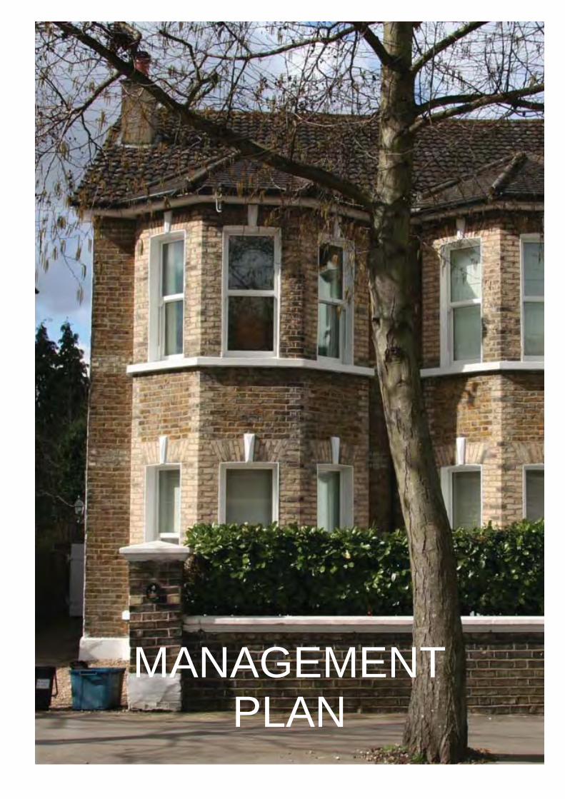
MANAGEMENT PLAN

This Management 8.0 ADDITIONAL CONSIDERATIONS Plan provides area-specific guidance on development and maintenance in and enhancement of the East India Estate Conservation Area. It supplements, and should be read in conjunction with, Croydon’s Conservation Area General Guidance SPD, which provides general development and maintenance guidance for all conservation areas in Croydon.
Previous page: number 9 Havelock Road with its originally exposed brickwork and decorative keystones
8.0.1 It is the responsibility of the property owner to be aware of the designations that apply to their building and the area within which it is situated.
8.1 STATUTORY LISTED BUILDINGS 8.1.1 Three buildings in the East India Estate Conservation Area are statutorily listed (please see section 5.2). Listed building consent is required for all building works, both external and internal, that affect the building’s character. For more information on the implications of statutory listing please see section 4.5 of the Conservation Area General Guidance SPD.
8.2 LOCALLY LISTED BUILDINGS 8.2.1 Fifty-seven buildings in the East India Estate Conservation Area are currently locally listed (please see section 5.2). Demolition of these buildings are considered to cause substantial harm to the conservation area. Careful consideration must be given towards protecting important features present. For further information please see Croydon’s Locally Listed Buildings SPD.
8.3 ARTICLE 4 DIRECTIONS 8.3.1 The Council maintains the right to serve an Article 4 Direction, if deemed appropriate, to protect the special character of the conservation area. For further information please see section 2.5 of the Conservation Area General Guidance SPD.
8.4 BUILDING REGULATIONS 8.4.1 All building work must comply with Building Regulations. For further information and guidance please see section 8 of the Conservation Area General Guidance SPD.
8.5 ARCHAEOLOGICAL INVESTIGATIONS 8.5.1 Archaeological investigations may be required for development affecting the setting of the conservation area located within an Archaeological Priority Zone that involves groundworks. Please see section 4.5 of the Conservation Area General Guidance SPD for further information.
8.6 PLANNING ENFORCEMENT 8.6.1 If you feel that unauthorised development has occurred in the area, including the replacement of windows or installation of satellite dishes, please report this to the Council’s planning enforcement team. For further information please see section 7 of the Conservation Area General Guidance SPD.
8.6.2 As part of this assessment a full photographic survey of the conservation area as visible from the street has been made, which will be used as evidence when reviewing any reports of unauthorised development.
8.7 TREES IN PRIVATE GARDENS 8.7.1 Please see sections 5.14 and 7.3 of the Conservation Area General Guidance SPD.
40

9.0 DEVELOPMENT GUIDELINES
9.0.1 General guidance for development in conservation areas is provided in the Conservation Area General Guidance SPD.
8.0.2 The development guidelines provided below supplement these general guidelines, providing area-specifi c principles that respond to the particular challenges for proposed development in the East India Estate Conservation Area.
9.1 DEMOLITION 9.1.1 The demolition of statutorily listed buildings, locally listed buildings and buildings that make a positive contribution to the special character of the East India Estate Conservation Area, as outlined in section 5.2 of this document, will not be considered acceptable.
9.1.2 Demolition of buildings will only be permitted where the building in question has been identified in section 5.2 of this document as making a neutral contribution to or detracting from the conservation area’s special character and the proposed replacement scheme will be of a suitably high quality that will result in an enhancement to the character and appearance of the conservation area. For further advice please see section 5.1 of the Conservation Area General Guidance SPD.
9.2 NEW DEVELOPMENT 9.2.1 There are no vacant development sites of a significant size in the East India Estate Conservation Area. Opportunities for new development could only result from the redevelopment of sites containing buildings that either make a neutral contribution or detract from the area’s special character.
9.2.2 All proposed development should respect the established
plot layout and building lines present, as well as the height, scale and massing of nearby buildings. For general guidance on new development in conservation areas please see section 5.2 of the Conservation Area General Guidance SPD.
9.2.3 The construction of new dwellings in small gaps between buildings will generally not be permitted due to the likelihood of resultant over-cramped development and incongruous plot size in the context of the area’s formal layout, as well as the impact on reducing views between buildings that contributes to the spacious character of the area.
9.3 BACK GARDEN DEVELOPMENT 9.3.1 Where planning permission is required, development in back gardens will generally not be permitted due to the potential disruption to the area’s spacious character and loss of green spaces. All small-scale outbuildings in back gardens should preserve views across gardens and not cause the removal of existing trees.
9.4 PROPERTY CONVERSION 9.4.1 Due to the generous proportions of many buildings in the area the conversion of single dwellings into flats is often desirable. There is no objection to this in principle, provided it complies with the Croydon Local Plan and the appearance of the front elevation is not harmed by the proposed conversion. Additional parking and bin storage requirements should not result in harm to the appearance of the front garden.
9.4.2 Careful attention should be paid to entrance arrangements, and new doors should not be installed to front elevations.
Gap between buildings on Clyde Road with an attractive view of Church of St Mary on Canning Road
One of the historic Professor’s Houses on Addiscombe Road was recently converted into flats, and the former Coach House was converted into two small houses. The work was carried out to a high quality and has resulted in an enhancement to the character and appearance of the conservation area.
41
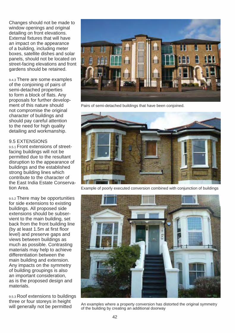
Changes should not be made to window openings and original detailing on front elevations. External fixtures that will have an impact on the appearance of a building, including meter boxes, satellite dishes and solar panels, should not be located on street-facing elevations and front gardens should be retained.
9.4.3 There are some examples of the conjoining of pairs of semi-detached properties to form a block of fl ats. Any proposals for further development of this nature should not compromise the original character of buildings and should pay careful attention to the need for high quality detailing and workmanship.
9.5 EXTENSIONS 9.5.1 Front extensions of street-facing buildings will not be permitted due to the resultant disruption to the appearance of buildings and the established strong building lines which contribute to the character of the East India Estate Conservation Area.
9.5.2 There may be opportunities for side extensions to existing buildings. All proposed side extensions should be subservient to the main building, set back from the front building line (by at least 1.5m at first floor level) and preserve gaps and views between buildings as much as possible. Contrasting materials may help to achieve differentiation between the main building and extension. Any impacts on the symmetry of building groupings is also an important consideration, as is the proposed design and materials.
9.5.3 Roof extensions to buildings three or four storeys in height will generally not be permitted
Pairs of semi-detached buildings that have been conjoined.
Example of poorly executed conversion combined with conjunction of buildings
An examples where a property conversion has distorted the original symmetry of the building by creating an additional doorway
42

due to the resultant additional massing. Those to buildings one or two storeys in height will be considered on their own merits. All roof extensions to historic buildings visible from the street are likely to have a negative impact on the original design and are unlikely to be permitted.
9.6 WINDOW REPLACEMENT 9.6.1 Many historic buildings in the East India Estate Conservation Area have timber sliding sash or casement windows. Original or traditional style windows should be retained and repaired. If it is desired to improve the thermal performance of single glazed windows then draught proofing and internal secondary glazing can be installed without the need for planning permission.
9.6.2 If windows are beyond repair following advice from a professional joiner, then replacements should match the original window design and be of timber construction and should be double glazed. The use of uPVC as a replacement material for original or traditional style timber windows will not be considered acceptable as their proportions, opening methods, shiny plastic appearance, and light reflection are all at odds with the character of historic buildings. Aluminium is also not considered to be an acceptable alternative to timber.
9.7 PORCHES 9.7.1 Where houses have open porticoes or recessed porches these are part of their original design and add interest to the character and appearance of the conservation area. Recessed entrances should not be enclosed by modern doors.
9.8 CLADDING, RENDERING OR PAINTING OF WALLS 9.8.1 As outlined in the Appraisal, exposed yellow stock or red brick walls are a characteristic feature of the original design of historic buildings in the East India Estate Conservation Area and their rich texture and colour contributes to its special character. Proposals to render or clad brick walls will not be permitted. It is also strongly recommended that brick walls
are not painted due to the impact on the appearance of buildings and problems of damp that non-breathable paint can cause. The removal of existing paint, render and cladding is encouraged, although care must be taken to ensure that the underlying brickwork is not damaged. It is recommended that trial panels should be undertaken prior to the removal of surface treatments.
An example of a replaced window (above left) that has signifi cantly departed from the original design (above right) resulting in the loss of a signifi cant feature of the building and harm to the character of the conservation area
Examples of inappropriate cladding and render that has harmed the unity of this Victorian terrace
43

9.9 FRONT GARDENS AND BOUNDARY TREATMENTS 9.9.1 Landscaped gardens make an important contribution to the quality of the streetscape. All development proposals to properties where soft landscaping in front gardens has been removed in the past should involve its reinstatement. Trees in front gardens should be protected and retained if possible.
9.9.2 The planting of trees and greenery in front gardens is encouraged and the hard-surfacing of front gardens for car-parking is discouraged.
9.9.3 Existing boundary treatments should be retained. Where brick gate piers are present these should be retained due to the positive contribution they make to the streetscene. All development proposals to properties where boundary treatments have been removed in the past should involve their reinstatement.
9.9.4 All development proposals should include storage and screening for refuse and recycling bins.
9.10 EXTRANEOUS FIXTURES 9.10.1 As most buildings in the conservation area are street facing with their front elevations prominently visible, the impact of extraneous fixtures on front elevations or roofscapes facing the street is signifi cant. Extraneous fixtures, including satellite dishes, meter boxes, cabling and piping, should not be visible from the street. The removal of existing fi xtures cluttering front elevations is encouraged; however care should be taken to ensure that surfaces affected are repaired.
9.10.2 There are several examples of satellite dishes located on front elevations that are either unauthorised or installed prior to conservation area designation, planning permission is now required for the installation of satellite dishes to front elevations or roofscapes visible from the street. It is recommended that satellite dishes are installed to the rear elevation of buildings not visible from the street.
9.10.3 For further guidance on the installation of extraneous fixtures please see section 3 of the Conservation Area General Guidance SPD.
9.11 DEVELOPMENT AFFECTING SETTING OF THE CONSERVATION AREA 9.11.1 As the conservation area boundary runs along the Addiscombe and the Lower Addiscombe Road there is a high potential for development or changes to existing buildings to affect the direct setting of the conservation area.
9.1.2 All proposed development in close proximity to the East India Estate Conservation Area should seek to preserve and enhance its setting.
44
10.0 ENHANCEMENT
10.0.1 In principle the Council supports and welcomes schemes for enhancement of the area proposed by property owners and / or the local community. It is recognised that there is a strong sense of community in the East India Estate, which the Canning & Clyde Road and HOME Residents Associations play an important role in maintaining and promoting.
10.0.2 Property owners are strongly encouraged to maintain their properties and undertake minor works that would improve the condition and appearance of their properties, which will have a wider positive impact on the conservation area as a whole.
10.0.3 Much enhancement of buildings and the wider area does not require planning permission; for advice on what works require planning permission please either see the Planning Portal or contact the Council’s Development Management service (see Appendix for details).
10.1 MAINTENANCE 10.1.1 It is important that buildings receive regular maintenance to ensure the long-term survival of important features and to prevent problems including damp and decay. Some minor works do not require planning permission but, if left unattended, may result in unnecessary decay and damage, which could lead to the need to conduct more complex and expensive repair works that may require planning permission at a later date.
10.1.2 Recommendations for basic maintenance of buildings and front gardens include: • The regular clearing of debris in gutters and rainwater pipes • The regular upkeep of boundary treatments and / or refuse stores • The pruning of vegetation and regular maintenance of trees in front gardens • The re-fixing of loose roof tiles or slates • The regular re-painting of timber features
10.1.3 Additional advice for homeowners is provided in a publication produced by the Institute of Historic Buildings Conservation and the Society for the Protection of Ancient Buildings called A Stitch in Time.
10.2 REPAIRING, RESTORING AND RE- INSTATING ARCHITECTURAL FEATURES 10.2.1 The East India Estate Conservation Area could be much enhanced through the repair, restoration or reinstatement of damaged or lost architectural features, including: • Timber sash windows • Brackets supporting projecting
eaves or window boxes • Decorative brick string
courses • Decorative window and door
surrounds • Plasterwork mouldings • Ironwork railings
10.2.2 In addition, the following works would also result in an enhancement to the area: • The stripping of inappropriate
paint or render using a non-damaging method to reveal originally exposed brickwork.
• The removal of in-filled porches
• The re-siting of satellite dishes and TV aerials where their location has a negative impact on the conservation area
• The replacement of nontraditional roofi ng materials with either hand-made clay or natural slate tiles
• The removal of architectural features that are out of keeping with the area’s special character
• The removal of uPVC or aluminium windows and doors and replacement with timber alternatives that are in keeping with the conservation area’s special character
45

10.3 FRONT GARDEN MAN 10.5 CONSERVATION AREA be provided wherever possible. AGEMENT AND REFUSE SIGNAGE New trees should be planted STORAGE 10.5.1 Existing and new in a continuous line to form 10.3.1 Property owners and way-finding schemes in avenues. tenants should take respon Croydon’s town centre, such sibility for the management of as Legible London, may be 10.7.3 For further information front gardens and be aware that extended in the future to cover please see sections 5.14 and their treatment has a big impact the East India Estate Conser 7.3 of the Conservation Area on the quality of the wider area. vation Area. The Council will General Guidance SPD. Low boundary walls should be consider any community-led retained and additional tree and projects to introduce signage to 10.8 ENERGY EFFICIENCY shrub planting is welcomed. identify the conservation area, IMPROVEMENTS
provided that it is of a design 10.8.1 The Council supports the 10.3.2 Property owners should that would enhance the area’s principle of works to buildings to consider the installation of special character and that improve their energy efficiency, screening for refuse bins that the cost of maintenance and provided that the original would otherwise be visible management are fully consid character of the building is not from the street. This can be ered. harmed. a relatively simple measure that can enhance not only 10.6 PUBLIC REALM 10.8.2 There are some retrofitting the appearance of individual IMPROVEMENTS measures that can be explored properties but also that of the 10.7.1 Routine maintenance of for buildings in this conservation wider conservation area. Any the public realm occurs as part area to improve their energy structure should be situated of the ongoing cycle of mainte efficiency and thermal perforbehind the main building line if nance within the borough. mance. Please see section 9 of possible. Planning permission is There may be potential for the Conservation Area General required for the erection of any further enhancements in the Guidance SPD. permanent structure in front of future. All proposals to enhance the main building line. See also the conservation area’s public 10.8.3 Some retrofi tting measures section 9.9. realm must be in accordance may require planning permis
with the Croydon Public Realm sion and if proposed to a statu10.4 PLAQUES FOR HIS- Design Guide. torily listed building may also TORIC BUILDINGS require listed building consent. 10.4.1 Some members of the 10.7.2 All new street lighting will community have recommended be implemented in the area that plaques could be erected according to the adopted Street on listed or locally listed build- Lighting PFI. ings within the conservation area to celebrate and inform 10.7 STREET TREES passers-by of their locally 10.7.1 Where predominant listed designation. In principle species are present and considthe Council would consider ered to be making a positive proposals for the erection of contribution to the conservation plaques, subject to appropriate area, for example the cherry design and sensitive place- trees in Havelock Road, the ment, but there is no capacity Council will endeavour to for the foreseeable future for ensure that the character is the Council to supply plaques. maintained in any new street The Council recommends that planting. such a scheme could be led by a local heritage organisation, 10.7.2 Where streets are lacking such as the Croydon Natural in street trees, for example History and Scientifi c Society. Elgin Road, new trees should
46
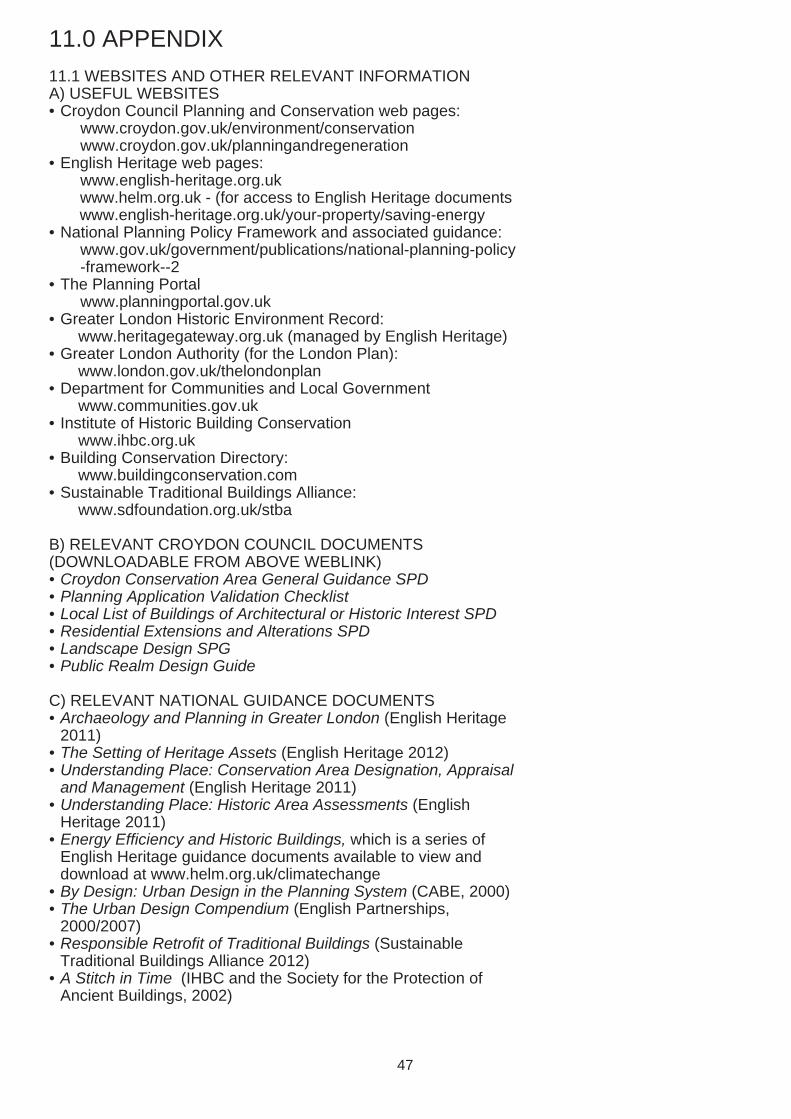
11.0 APPENDIX
11.1 WEBSITES AND OTHER RELEVANT INFORMATION A) USEFUL WEBSITES • Croydon Council Planning and Conservation web pages:
www.croydon.gov.uk/environment/conservation www.croydon.gov.uk/planningandregeneration
• English Heritage web pages: www.english-heritage.org.uk www.helm.org.uk - (for access to English Heritage documents www.english-heritage.org.uk/your-property/saving-energy
• National Planning Policy Framework and associated guidance: www.gov.uk/government/publications/national-planning-policy -framework--2
• The Planning Portal www.planningportal.gov.uk
• Greater London Historic Environment Record: www.heritagegateway.org.uk (managed by English Heritage)
• Greater London Authority (for the London Plan): www.london.gov.uk/thelondonplan
• Department for Communities and Local Government www.communities.gov.uk
• Institute of Historic Building Conservation www.ihbc.org.uk
• Building Conservation Directory: www.buildingconservation.com
• Sustainable Traditional Buildings Alliance: www.sdfoundation.org.uk/stba
B) RELEVANT CROYDON COUNCIL DOCUMENTS (DOWNLOADABLE FROM ABOVE WEBLINK) • Croydon Conservation Area General Guidance SPD • Planning Application Validation Checklist • Local List of Buildings of Architectural or Historic Interest SPD • Residential Extensions and Alterations SPD • Landscape Design SPG • Public Realm Design Guide
C) RELEVANT NATIONAL GUIDANCE DOCUMENTS • Archaeology and Planning in Greater London (English Heritage
2011) • The Setting of Heritage Assets (English Heritage 2012) • Understanding Place: Conservation Area Designation, Appraisal
and Management (English Heritage 2011) • Understanding Place: Historic Area Assessments (English
Heritage 2011) • Energy Efficiency and Historic Buildings, which is a series of
English Heritage guidance documents available to view and download at www.helm.org.uk/climatechange
• By Design: Urban Design in the Planning System (CABE, 2000) • The Urban Design Compendium (English Partnerships,
2000/2007) • Responsible Retrofit of Traditional Buildings (Sustainable
Traditional Buildings Alliance 2012) • A Stitch in Time (IHBC and the Society for the Protection of
Ancient Buildings, 2002)
47
11.2 CONTACTS Croydon Council, Bernard Weatherill House, 8 Mint Walk, Croydon CR0 1EA; www.croydon.gov.uk Tel/Email: 0208 7266000; [email protected]
• Spatial Planning (including Urban Design and Conservation officers): Tel: 0208 4071385; Email: [email protected]
• Development Management (including Enforcement & Tree Officers): Email: [email protected]
• Building Control Team, Croydon Council: Email: [email protected]
• Waste Management Team, Community Services, Croydon Council: Tel: 0208 7266200
• Croydon Local Studies Library and Archives Centre: www.croydon.gov.uk/libraries Tel:0208 7266900; Email: [email protected]
English Heritage, London Region 1 Waterhouse Square, 138-142 Holborn, London EC1N 2ST Tel/Email: 0207 9733000; [email protected]
The Victorian Society Tel/Email: 0208 9941019; [email protected] www.victoriansociety.org.uk
The Georgian Group Tel/Email: 0871 7502936; [email protected] www.georgiangroup.org
The Society for the Protection of Ancient Buildings (SPAB) Tel/Email: 0207 3771644; [email protected]; www.spab.org.uk Technical helpline: 0207 456 0916
The Building Conservation Directory Tel/Web: 01747 871717; www.buildingconservation.com
The Energy Saving Trust Tel/Web: 0800 512012; www.energysavingtrust.org.uk
Register of Building Conservation Accredited Architects Tel/Web: 01625 523784; www.aabc-register.co.uk
Royal Institute of British Architects (RIBA) Tel/Web: 0207 3073700; www.architecture.com
Mid Croydon Conservation Area Advisory Panel (please contact the Spatial Planning Team for details)
Croydon Natural History and Scientifi c Society Contact: Brian Lancaster (Secretary): Email: [email protected]
48
COMMUNITY LANGUAGES
If English is not your first language and you need help to understand the information contained in this brochure, please contact Croydon Council on Tel: 020 8726 6400. We will then arrange for an interpreter to help you.
0208 726 6400.
0208 726 6400
Albanian
Bengali
French
Czech
0208 726 6400
0208 726 6400.
Gujerati
0208 726 6400
Panjabi0208 726 6400
Somali 0208 726 6400.
0208 726 6400
Tamil
0208 726 6400
Turkish
0208 726 6400.
Urdu
49