east and west encounter at sea - ulisboachcul.fc.ul.pt/textos/malhao_pereira_2002.pdf · academia...
TRANSCRIPT
ACADEMIA DE MARINHA
EAST AND WEST ENCOUNTER AT SEA
JOSÉ MANUEL MALHÃO PEREIRA
LISBOA – 2002

Execução gráfica: INSTITUTO HIDROGRÁFICO – Lisboa
ISBN – 972-781-066-7
3
East and west encounter at sea
Comunicação apresentada pelo Cap. m.g. JoséManuel Malhão Pereira no Seminário «On Maritime Mal-abar and the Europeans (1500-1962)» em Tellichery(União Indiana) em 16 de Janeiro de 2002.
First of all, I must say, that I am really very honoured to be heretoday, facing such an illustrious audience. Thank you dear Dr. Mathew forgiving me this opportunity to contact again Indian scholars, and also ofEuropean nations, with which my country has so much in common.
It is the fourth time that I am in India on account of history (thistime with Fundação Oriente sponsorship, which I highly appreciated),and in fact, although I am involved now in historical research relatedto the Portuguese navigations, what I am really is an humble sailor whotries to interpret history with some of the experience I have got aboardsailing and motor ships of my country’s Navy, and of my family’s navy,if I can say that, because we are happy owners of a sailing boat.
I am not speaking in my personal name only, but also, being mem-ber of Academia de Marinha in Lisbon, I brought from its President,Admiral Rogério de Oliveira, who couldn’t come to India this time, themission to address His Grace Most Reverend Dr. George Valiamattan, hisregards and best wishes for a great success of this Seminar. AdmiralOliveira told also to me that he is entirely available for any cooperationconsidered useful, with your Institutions.
The purpose of my paper is to comment the encounter of westerntechniques of navigation with their counterparts in the Indian Ocean. Inits early stage, the pilots of Vasco da Gama and the mouslim pilotembarked in Malindi in April 1498 have performed this encounter.
I am going to compare, in a very abridged way, the techniques usedby Indian and Atlantic Ocean’s navigators, and mainly to discuss and sug-gest some areas of research.
It is also my purpose to give a wider view of the problem ofocean navigation, speaking of the many times forgotten role ofPacific Ocean navigators, who so early in history have colonized thePacific islands.
HIGH SEAS NAVIGATION IN THE DIFFERENT OCEANS
Before the first Europeans sailed outside of sight of land in the AtlanticOcean, the Indian Ocean was already sailed by Arab, Indian, Persian, Chi-nese and other nations sailors. They began with coastal navigation, but bythe beginning of the Christian Era, they were continuously sailing more andmore in the high seas, till by the first century AD, according to some histo-rians, their ships sailed directly from the Gulf of Aden to India.
But their navigations were mainly made with a very important help,which was the regularity of the monsoon winds that affected all the north-ern Indian Ocean from Sofala in the African coast, to the South East Asiaand China Seas. According to their specific needs, the appropriate tech-niques, which included astronomical means, were introduced, and wereadequate for the purpose of their navigations. And they were used till andafter the arrival of the Portuguese in their areas of operations.
Before that, a great part of the Pacific Ocean was colonized by peo-ple departing from southeast Asia, as it is now generally recognized,being the thesis of Thor Heyerdal, of an east to west migration from southAmerica, not completely accepted by the majority of the scholars.
The navigations of these colonizers, although not corresponding tolong distances, were among islands, sometimes very small and low. In spiteof that, new voyages were made to the previously discovered places, and itstechniques involved orientation by the stars, swells, wind and birds.
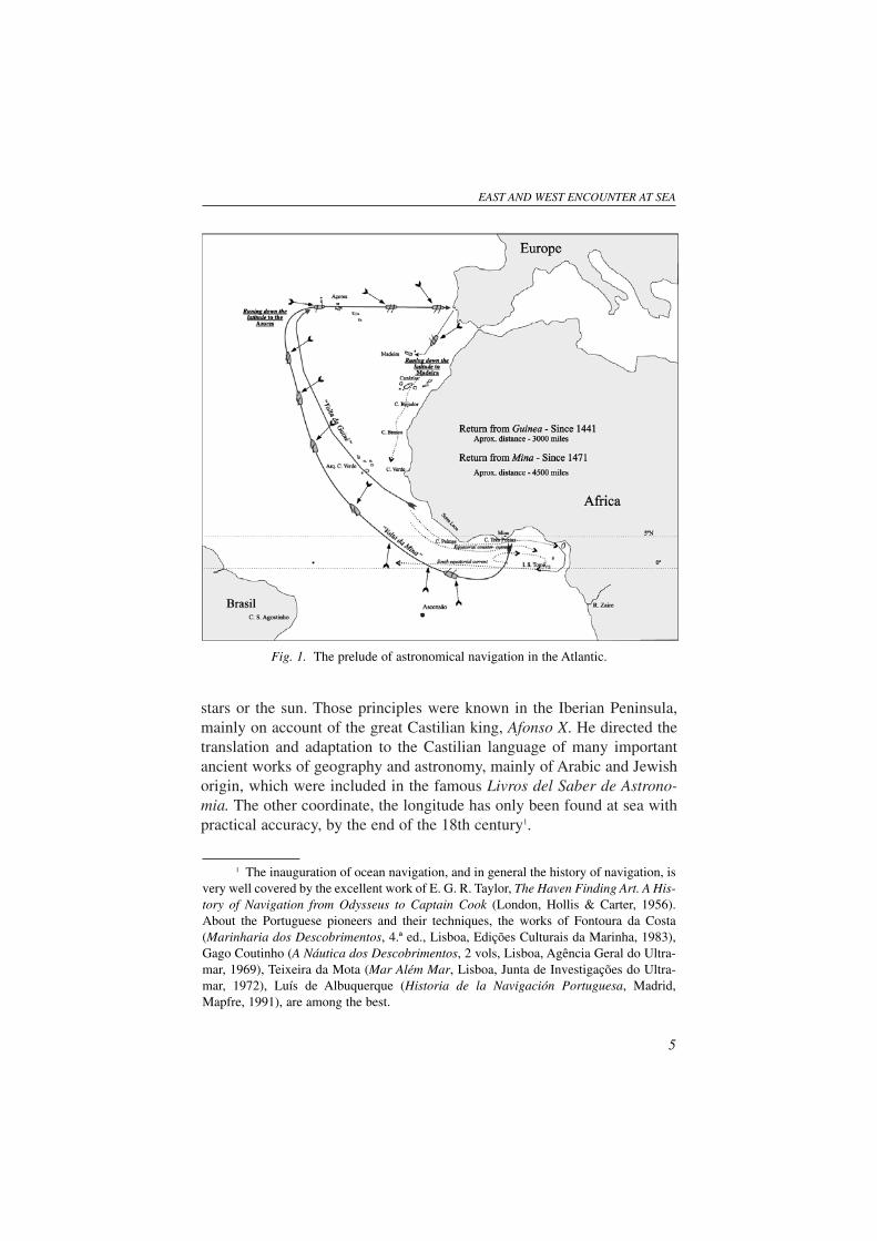
On the other hand, in the Atlantic during the exploration of the WestAfrican coast in the first half of the fifteenth century, and its progresstowards the south, the Portuguese sailors had to return to Portugal througha route that brought them very faraway from the coast, because the pre-vailing north-easterly wind didn’t allowed them to make a direct route.
This return trip was a tiresome voyage of almost 3000 miles or muchmore, depending of how far south they departed. Besides that, the Azoreswas populated since 1431/2, and the voyage was an ocean trip of more than800 miles. So, they performed not only coastal voyages, in which case thedead reckoning navigation would be sufficient. It was necessary to knowwith a certain amount of accuracy the position of the ship on the high seas.
In figure 1 we can have a visual view of the problem. The returnfrom Mina, performed later, is even a longer voyage of around 4500 milesout of sight of land.
For that purpose, the Portuguese introduced the application of somealready known principles of astronomy to the navigation in the open sea,namely the calculation of the latitude by observation of the appropriate
4
stars or the sun. Those principles were known in the Iberian Peninsula,mainly on account of the great Castilian king, Afonso X. He directed thetranslation and adaptation to the Castilian language of many importantancient works of geography and astronomy, mainly of Arabic and Jewishorigin, which were included in the famous Livros del Saber de Astrono-mia. The other coordinate, the longitude has only been found at sea withpractical accuracy, by the end of the 18th century1.
EAST AND WEST ENCOUNTER AT SEA
5
1 The inauguration of ocean navigation, and in general the history of navigation, isvery well covered by the excellent work of E. G. R. Taylor, The Haven Finding Art. A His-tory of Navigation from Odysseus to Captain Cook (London, Hollis & Carter, 1956).About the Portuguese pioneers and their techniques, the works of Fontoura da Costa(Marinharia dos Descobrimentos, 4.ª ed., Lisboa, Edições Culturais da Marinha, 1983),Gago Coutinho (A Náutica dos Descobrimentos, 2 vols, Lisboa, Agência Geral do Ultra-mar, 1969), Teixeira da Mota (Mar Além Mar, Lisboa, Junta de Investigações do Ultra-mar, 1972), Luís de Albuquerque (Historia de la Navigación Portuguesa, Madrid,Mapfre, 1991), are among the best.
Fig. 1. The prelude of astronomical navigation in the Atlantic.
The astronomical navigation introduced an important developmentin cartography, which was the inclusion of a latitude scale on the chartsused for navigation.
WESTERN AND EASTERN TECHNIQUES COMPARED
Let us make now a very rapid review of the techniques of eachother’s areas of sailing, which later will be justified more deeply, speciallythe ones used in the Indian and Pacific Oceans.
The Portuguese used in coastal navigation the lead line and in theEast this very rudimentary instrument was also utilized.
The compass was at the beginning, besides the lead line, the onlyinstrument of navigation. It was formed of a compass rose with two mag-netic needles sealed underneath.
The compass was graduated in 32 winds, system already used in theMediterranean. Nevertheless the Portuguese were responsible for theadaptation to the compass of a suspension, which maintained the instru-ment permanently horizontal. This suspension was surely used by the Por-tuguese since 1537.
The main direction-finding instrument in the Indian Ocean was thestellar or sidereal compass based on the fact that the areas sailed outsidethe sight of land were very near the Equator. By day the sun was used toorientate the compass. The direction of the relatively constant wind andwaves were also utilized for the same purpose. As previously said, I willdevelop this subject after.
During the beginning of their ocean navigation, the Portuguese usedfor finding the latitude, the altitude of the Pole Star above the horizon, asit was known already that the altitude of the north celestial Pole above thehorizon corresponds to the latitude of the place.
As the Pole Star was not in the north celestial pole but separatedfrom it by 3°.5, corrections were made to its altitude, using simple meth-ods that could be understood by the not greatly educated pilots. So, a seto rules, the Regiment of the North, were introduced and the other stars ofthe Little Bear, revolving around the North Celestial Pole, gave, in eightdifferent positions the corrections to reduce the altitude above the horizonof the Pole Star. Let us try to explain those rules, with the help of the fig-ures that follows.
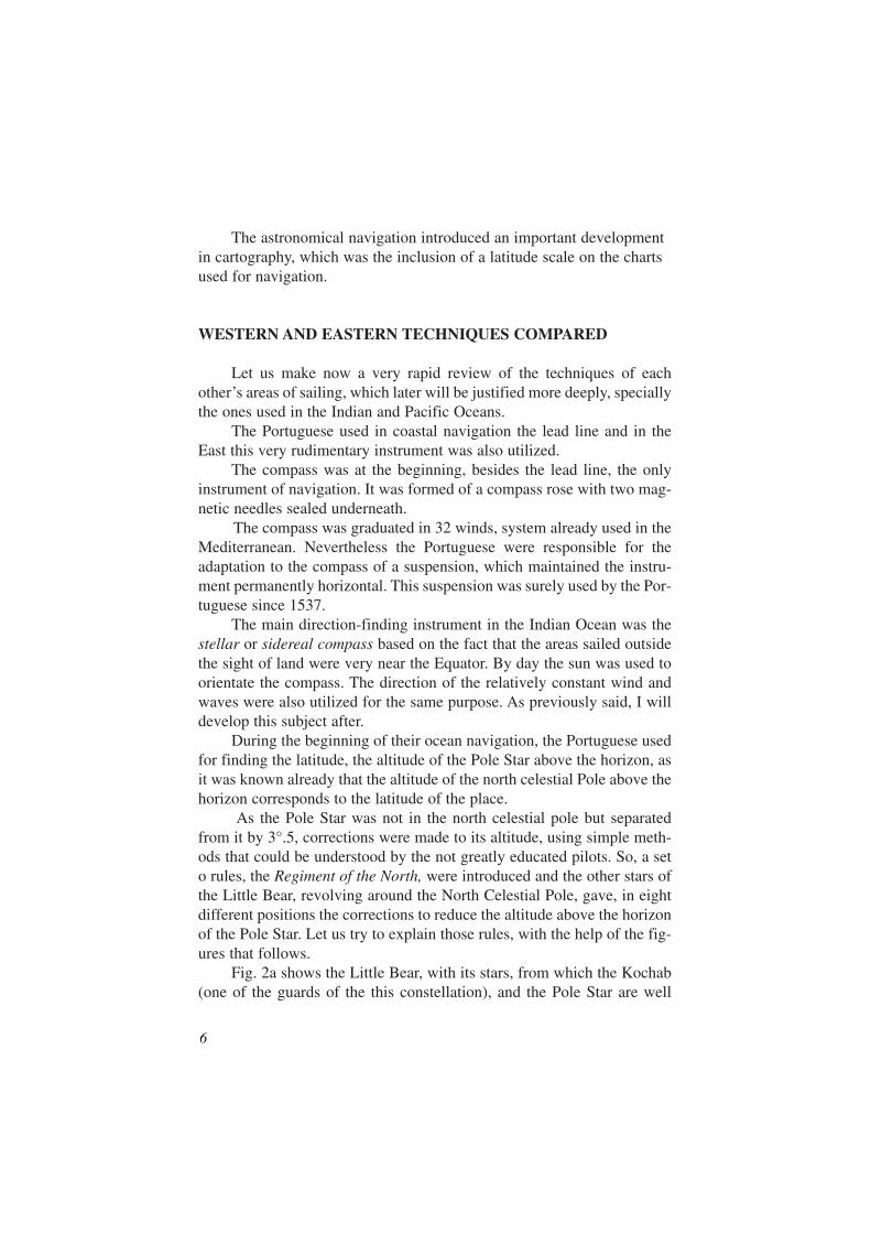
Fig. 2a shows the Little Bear, with its stars, from which the Kochab(one of the guards of the this constellation), and the Pole Star are well
6
marked. In the centre is represented the North Celestial Pole, and themovement of the celestial sphere, which is counter clockwise, for anobserver facing north is also shown. We can recognize that Kochab goesahead of the other stars in the diurnal movement, and on account of thatand also of its relative brightness, was used, in connection with the PoleStar, as a dial of a watch.
Fig. 2b, shows the dial 12 hours later.
We see that the Pole Star, which was passing the meridian of theobserver over the North Celestial Pole in fig. 2a (we say that it passed theupper branch of the local meridian), 12 hours later2 passes bellow it (wesay that it passed in the lower branch of the local meridian). The angularseparation from the Pole is 3°.5 as previously stated.
EAST AND WEST ENCOUNTER AT SEA
7
2 In fact, it will be more precisely eleven hours and fifty-eight minutes, becausesidereal time is faster than meantime. The stars rise everyday four minutes earlier than thesun, on account of the translation of the earth around the sun.
Fig. 2a. The alignmentPole Star-Kochab,
used as a dial.
Fig. 2b. The samealignmen twelve
hours later.
For finding the latitude in these two positions of the star, the onlyoperation necessary was to subtract 3°.5 to the altitude of it above thehorizon in the first case, and to add that amount in the second situation.
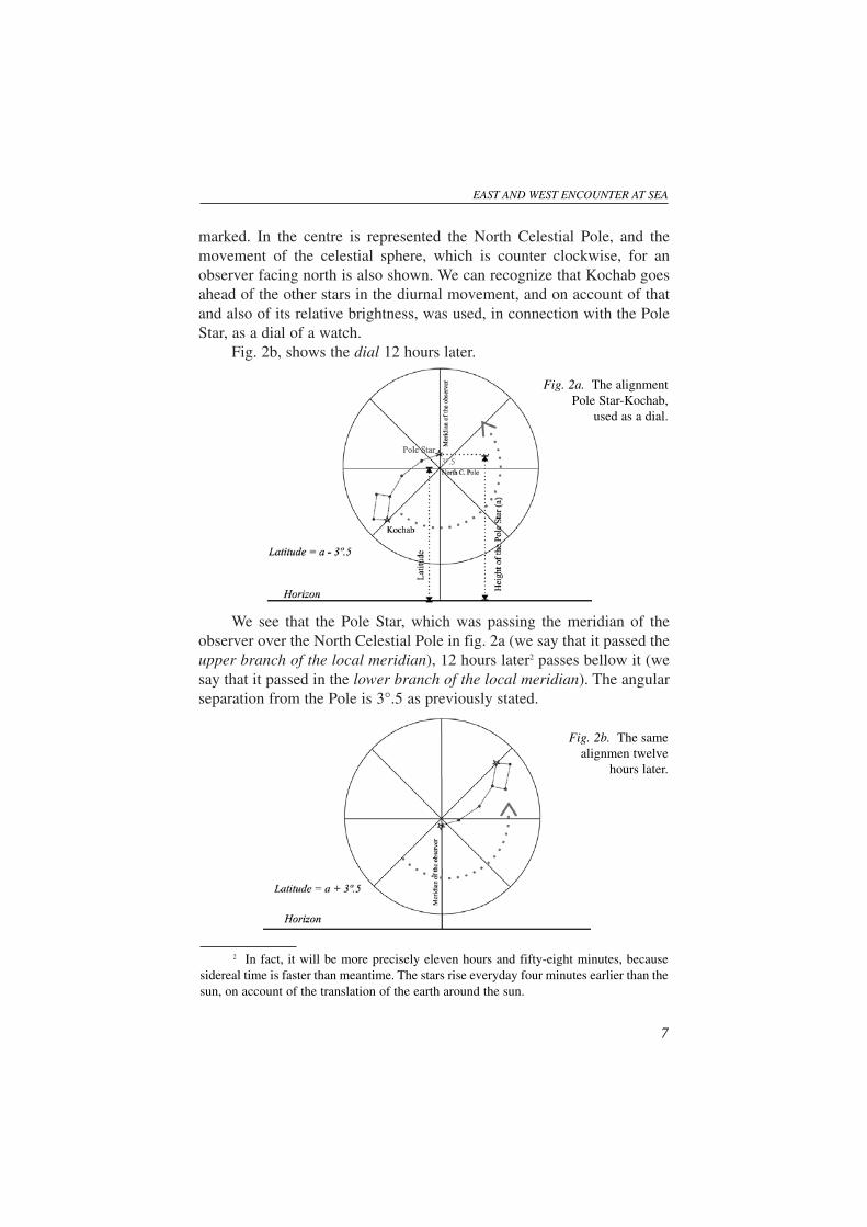
We can now imagine other positions equally separated from thoseones, to which the correction was calculated. For memorizing the rulesand the correction to apply, a human figure was imagined to stand in theNorth Celestial Pole, facing the observer with his arms stretched.
Using the alignment Kochab-Pole Star as a dial, the later star can bein the head, west arm, feet, etc. in relation to the human figure. The cor-respondent corrections, which were indicated,were then easily applied.
In fig. 3 is represented an adapta-tion of the illustration of the Regi-mento do Norte. We can see thefigure facing the observer, thelines and also, in its periphery,the corrections in degrees anddecimal degrees, affected by theminus and plus signal. In thesame figure I included theschematic view of the Little Bear,with the front guard, Kochab, inthe line under the west arm. We cansee that this position corresponds tothe situation in figure 2.a, where,for finding the latitude, it is neces-sary to subtract the polar distanceof Polaris (3°.5), to the altitude of the star.
If the position of Kochab was for example in the arm of the west, itwill be also subtractive and of 1°1/2. But if it was in the head, it will beadditive and in the amount of 3°.
It is generally accepted that the first Regimento do Norte is the onethat is published in the Manual de Munique, studied by Fontoura da Costaand Luís de Albuquerque, among other historians3.
8
Fig. 3. The human figure that helped theinterpretation of the Regimento do Norte.
3 See Marinharia dos Descobrimentos, (Op. cit., pp. 54, 55), and from Luís deAlbuquerque, his critical study of the referred manuals (Luís Mendonça de Albuquerque,Os Guias Náuticos de Munique e Évora, Lisboa, Junta de Investigações do Ultramar,Agrupamento de Estudos de Cartografia Antiga, 1965, pp. 21-51. This study is evendeeper then the one of Fontoura da Costa. See also E. G. R. Taylor in The Haven FindingArt, (op. cit.), pp. 162-165, among other historians.
The following translation is made from the text of the Manual deMunique, as per the transcription of Luis de Albuquerque4:
This is the Regiment of the NorthAnd when the guards are in the arm of the west, is the North Star above
the pole one degree and a half.Item. When the guards are on the line below the arm of the west, the
North Star is above the pole three degrees and a half.Item. When the guards are at the foot, the star is three degrees over the pole.Item. When the guards are in a line below the arm of the east, the star
is over the pole half a degree.And when you take the altitude of the star, and the guards are in some
of theses four places in which the star is above the pole, from the altitudeyou take of the star, it is convenient to know, you will take those degreesthat the star is above; and the remaining degrees, are those that you are sep-arated of the equinoctial line.
In these four places the North Star is below the pole.Item. When the guards are in the arm of the east, the star is below the
pole one degree and a half.Item. When the guards are in the line above the arm of the east, the star
is three and a half degrees below the pole.Item. When the guards are at the head, the star is below the pole three
degrees.Item. When the guards are in the line above the arm of the west, the star
is below the pole half a degree.When you take the altitude of the star, and the guards are in any of these
four places in which the star is below the pole, it is convenient to know, youwill add those degrees that the star is below the pole, with the altitude youtake from the star; and the degrees you find, those are the ones you are sep-arated from the equinoctial line.
Probably two decades before Vasco da Gama´s voyage, as the southAtlantic was navigated, loosing the sailors the Pole Star, it was used forfinding the latitude the altitude of the Sun in its meridian passage. The prin-ciples also came in the Libros del Saber de Astronomia, of Afonso X, butwe can imagine how difficult it was for the astronomers in land, to find easyrules to the rude pilots. Declination tables were calculated and a practicalRegimento do Sol was introduced with easy rules for the pilots5.
EAST AND WEST ENCOUNTER AT SEA
9
4 Os Guias Náuticos de Munique e Évora, pp. 135, 136. Fontoura da Costa dates theRegimento as early as 1483, 1484 (See Marinharia dos Descobrimentos, p. 54).
5 Fontoura da Costa considers that the first Regimento was made in 1483 or 1484.See Marinharia dos Descobrimentos, p. 69.
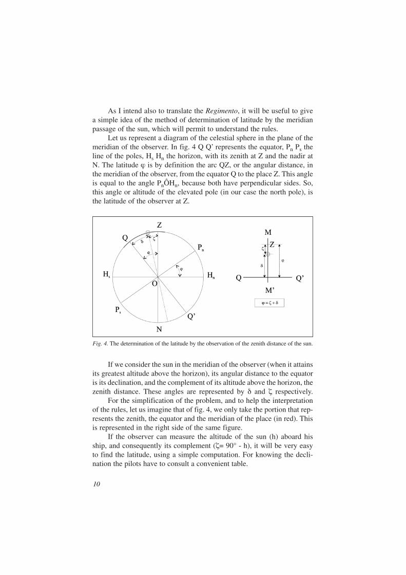
As I intend also to translate the Regimento, it will be useful to givea simple idea of the method of determination of latitude by the meridianpassage of the sun, which will permit to understand the rules.
Let us represent a diagram of the celestial sphere in the plane of themeridian of the observer. In fig. 4 Q Q’ represents the equator, Pn Ps theline of the poles, Hs Hn the horizon, with its zenith at Z and the nadir atN. The latitude ϕ is by definition the arc QZ, or the angular distance, inthe meridian of the observer, from the equator Q to the place Z. This angleis equal to the angle PnÔHn, because both have perpendicular sides. So,this angle or altitude of the elevated pole (in our case the north pole), isthe latitude of the observer at Z.
Fig. 4. The determination of the latitude by the observation of the zenith distance of the sun.
If we consider the sun in the meridian of the observer (when it attainsits greatest altitude above the horizon), its angular distance to the equatoris its declination, and the complement of its altitude above the horizon, thezenith distance. These angles are represented by δ and ζ respectively.
For the simplification of the problem, and to help the interpretationof the rules, let us imagine that of fig. 4, we only take the portion that rep-resents the zenith, the equator and the meridian of the place (in red). Thisis represented in the right side of the same figure.
If the observer can measure the altitude of the sun (h) aboard hisship, and consequently its complement (ζ= 90° - h), it will be very easyto find the latitude, using a simple computation. For knowing the decli-nation the pilots have to consult a convenient table.
10
The rules of the different regimentos were modified to be more use-ful to the rude pilots, and the ones that I am going to indicate are thoseexplained by Fontoura da Costa in modern language, and extracted fromthe works of Pedro Nunes, the famous Portuguese mathematician of the16th century6.
Regiment of the altitude of the sun at midday1) The sun at the equinoctial [declination zero]: the latitude will be
equal to the zenith distance.2) The sun at the zenith: the latitude is equal and of the same name as
the declination.3) The sun and the shade of the same name: the sum of the declination
with the zenith distance will be the latitude of the same name of theshade.
4) The sun and the shade of different names: if the declination and thezenith distance are equal, you will be at the equator; if they will bedifferent, subtract the smallest from the biggest and the remain willbe the latitude of the same name of the biggest.
It is necessary to understand that the shade gives the bearing of thesun at meridian passage, which for example, for an observer in Cochim isnorth if the sun has north declination and bigger than 10 degrees, whichis the latitude of this town.
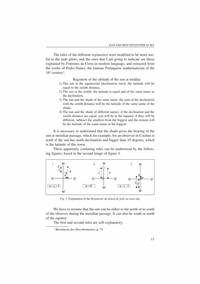
These apparently confusing rules can be understood by the follow-ing figures, based in the second image of figure 4.
Fig. 5. Explanation of the Regimento da altura do polo ao meio dia.
We have to assume that the sun can be either to the north or to southof the observer during the meridian passage. It can also be south or northof the equator.
The first and second rules are self-explanatory.
EAST AND WEST ENCOUNTER AT SEA
11
6 Marinharia dos Descobrimentos, p. 72.
The third one corresponds to the situation when the sun is betweenthe observer and the equator, being either to the south or to the north of it.Fig 5, position 1, shows the situation when the sun and observer are northof the equator, being the shade of the sun north, or of the same name asthe latitude of the observer. It is clear that the latitude is the sum of thezenith distance and the declination.
If both were in the same conditions but to the south of the equator, theshade will be to the south, or of the same name as the latitude of the place.The latitude will be again the sum of the declination and the zenith distance.
The fourth rule corresponds to the situation of the sun and place indifferent hemispheres. Its first part is clearly explained by position 2 offig. 5. One of the conditions of the second part is explained by position 3of the same figure.
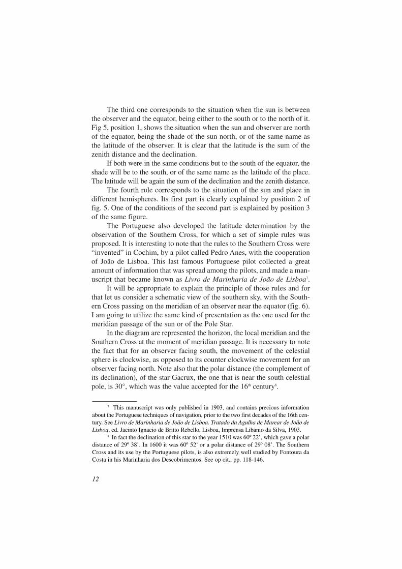
The Portuguese also developed the latitude determination by theobservation of the Southern Cross, for which a set of simple rules wasproposed. It is interesting to note that the rules to the Southern Cross were“invented” in Cochim, by a pilot called Pedro Anes, with the cooperationof João de Lisboa. This last famous Portuguese pilot collected a greatamount of information that was spread among the pilots, and made a man-uscript that became known as Livro de Marinharia de João de Lisboa7.
It will be appropriate to explain the principle of those rules and forthat let us consider a schematic view of the southern sky, with the South-ern Cross passing on the meridian of an observer near the equator (fig. 6).I am going to utilize the same kind of presentation as the one used for themeridian passage of the sun or of the Pole Star.
In the diagram are represented the horizon, the local meridian and theSouthern Cross at the moment of meridian passage. It is necessary to notethe fact that for an observer facing south, the movement of the celestialsphere is clockwise, as opposed to its counter clockwise movement for anobserver facing north. Note also that the polar distance (the complement ofits declination), of the star Gacrux, the one that is near the south celestialpole, is 30°, which was the value accepted for the 16th century8.
12
7 This manuscript was only published in 1903, and contains precious informationabout the Portuguese techniques of navigation, prior to the two first decades of the 16th cen-tury. See Livro de Marinharia de João de Lisboa. Tratado da Agulha de Marear de João deLisboa, ed. Jacinto Ignacio de Britto Rebello, Lisboa, Imprensa Libanio da Silva, 1903.
8 In fact the declination of this star to the year 1510 was 60º 22’, which gave a polardistance of 29º 38’. In 1600 it was 60º 52’ or a polar distance of 29º 08’. The SouthernCross and its use by the Portuguese pilots, is also extremely well studied by Fontoura daCosta in his Marinharia dos Descobrimentos. See op cit., pp. 118-146.
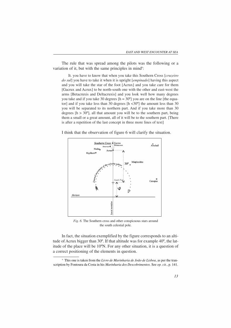
The rule that was spread among the pilots was the following or avariation of it, but with the same principles in mind9:
It. you have to know that when you take this Southern Cross [cruzeirodo sul] you have to take it when it is upright [empinado] having this aspectand you will take the star of the foot [Acrux] and you take care for them[Gacrux and Acrux] to be north-south one with the other and east-west thearms [Betacruxis and Deltacruxis] and you look well how many degreesyou take and if you take 30 degrees [h = 30º] you are on the line [the equa-tor] and if you take less than 30 degrees [h <30º] the amount less than 30you will be separated to its northern part. And if you take more than 30degrees [h > 30º], all that amount you will be to the southern part, beingthem a small or a great amount, all of it will be to the southern part. [Thereis after a repetition of the last concept in three more lines of text]
I think that the observation of figure 6 will clarify the situation.
Fig. 6. The Southern cross and other conspicuous stars aroundthe south celestial pole.
In fact, the situation exemplified by the figure corresponds to an alti-tude of Acrux bigger than 30º. If that altitude was for example 40º, the lat-itude of the place will be 10ºN. For any other situation, it is a question ofa correct positioning of the elements in question.
EAST AND WEST ENCOUNTER AT SEA
13
9 This one is taken from the Livro de Marinharia de João de Lisboa, as per the tran-scription by Fontoura da Costa in his Marinharia dos Descobrimentos. See op. cit., p. 141.
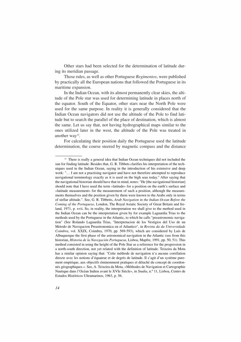
Other stars had been selected for the determination of latitude dur-ing its meridian passage.
Those rules, as well as other Portuguese Regimentos, were publishedby practically all the European nations that followed the Portuguese in itsmaritime expansion.
In the Indian Ocean, with its almost permanently clear skies, the alti-tude of the Pole star was used for determining latitude in places north ofthe equator. South of the Equator, other stars near the North Pole wereused for the same purpose. In reality it is generally considered that theIndian Ocean navigators did not use the altitude of the Pole to find lati-tude but to search the parallel of the place of destination, which is almostthe same. Let us say that, not having hydrographical maps similar to theones utilized later in the west, the altitude of the Pole was treated inanother way10.
For calculating their position daily the Portuguese used the latitudedetermination, the course steered by magnetic compass and the distance
14
10 There is really a general idea that Indian Ocean techniques did not included thesun for finding latitude. Besides that, G. R. Tibbets clarifies his interpretation of the tech-niques used in the Indian Ocean, saying in the introduction of his extensive and deepwork: "… I am not a practising navigator and have not therefore attempted to reproducenavigational terminology exactly as it is used on the high seas today." After saying thatthe navigational historian should have that in mind, notes: "He [the navigational historian]should note that I have used the term «latitude» for a position on the earth’s surface and«latitude measurement» for the measurement of such a position, although the measure-ments themselves and the position given by them were known to the Arabs only in termsof stellar altitude.". See, G. R. Tibbetts, Arab Navigation in the Indian Ocean Before theComing of the Portuguese, London, The Royal Asiatic Society of Great Britain and Ire-land, 1971, p. xvii. So, in reality, the interpretation we shall give to the method used inthe Indian Ocean can be the interpretation given by for example Laguardia Trias to themethods used by the Portuguese in the Atlantic, to which he calls "preastronomic naviga-tion" (See Rolando Laguardia Trias, "Interpretacion de los Vestigios del Uso de unMetodo de Navegacion Preastronomica en el Atlantico", in Revista da da UniversidadeCoimbra, vol. XXIX, Coimbra, 1970, pp. 569-593), which are considered by Luís deAlbuquerque the first phase of the astronomical navigation in the Atlantic (see from thishistorian, Historia de la Navegación Portuguesa, Lisboa, Mapfre, 1991, pp. 50, 51). Thismethod consisted in using the height of the Pole Star as a reference for the progression ina north-south direction, not yet related with the definition of latitude. Teixeira da Motahas a similar opinion saying that: "Cette méthode de navigation n’a aucune corrélationdirecte avec les notions d’équateur et de degrés de latitude. Il s’agit d’un système pure-ment empirique, aux objectifs éminemment pratiques et détaché du concept de coordon-nés géographiques.». See, A. Teixeira da Mota, «Méthodes de Navigation et CartographieNautique dans l’Océan Indien avant le XVIe Siècle», in Studia, n.º 11, Lisboa, Centro deEstudos Históricos Ultramarinos, 1963, p. 56.
of a day’s run appreciated by eye. A table of the distance in leagues trav-elled in a fixed course in order to raise the latitude by one degree was cal-culated, and the Regiment of the leagues introduced. Its comparison withthe distance evaluated by eye, made possible a fix, which was the productof the correction (in Portuguese, emendas) of all these elements.
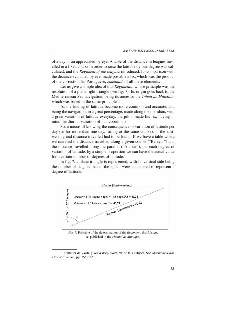
Let us give a simple idea of that Regimento, whose principle was theresolution of a plane right triangle (see fig. 7). Its origin goes back to theMediterranean Sea navigation, being its ancestor the Toleta de Mateloio,which was based in the same principle11.
As the finding of latitude become more common and accurate, andbeing the navigation, in a great percentage, made along the meridian, witha great variation of latitude everyday, the pilots made his fix, having inmind the diurnal variation of that coordinate.
So, a means of knowing the consequence of variation of latitude perday (or for more than one day, sailing at the same course), in the east-westing and distance travelled had to be found. If we have a table wherewe can find the distance travelled along a given course (“Relevar”) andthe distance travelled along the parallel (“Afastar”), per each degree ofvariation of latitude, by a simple proportion we can have the actual valuefor a certain number of degrees of latitude.
In fig. 7, a plane triangle is represented, with its vertical side beingthe number of leagues that in the epoch were considered to represent adegree of latitude.
Fig. 7. Principle of the determination of the Regimento das Léguas,as published in the Manual de Munique.
EAST AND WEST ENCOUNTER AT SEA
15
11 Fontoura da Costa gives a deep overview of this subject. See Marinharia dosDescobrimentos, pp. 355-372.
Sailing in a given course C, the ship will travel the distance repre-sented by the hypotenuse of the triangle, which was designated by thePortuguese word Relevar. The distance travelled along the parallel is theAfastar of the figure. By simple trigonometry the afastar and relevar havethe result as shown, for the course of 67º.5 or 6 points (quartas in Por-tuguese).
The following text is the translation of part of the Regimento of theManual de Munique:
Item you will know that the north south degree is of seventeen leaguesand a half, and so you have to know that sixty minutes make one degree.
Item by one point releva by each degree seventeen leagues and five sixthsof a league. And you afastas from the straight-line three leagues and a half.
Item by two points releva by degree nineteen leagues and one sixth ofa league.
And you afastas from the straight-line seven leagues and a half.…………………………………………………………………………Item by seven points releva by each degree eighty-seven leagues and
one sixth of the league.And you afastas from the straight-line eighty five leagues12.
Resolving the triangle for the course angles of one point (11º.5), twopoints (22º.5) and seven points (78º.75) we have respectively and for therelevar and afastar: 3.48 and 17.84 leagues; 7.25 and 18.94 leagues;87.98 and 89.70 leagues. We see that these values differ little from theones of the Regimento, although it is generally admitted that they wereobtained graphically or geometrically13.
We have to recognize however, that the main technique for findingan island or any other harbour in a continent was to run down the latitude.The ship was directed to the parallel of destination, to a position clearlysafe to the east or west of it, according with the present conditions, andafter that sailed along the parallel. And this was the procedure of theIndian Ocean pilots prior to the Portuguese development of high seas nav-igation in the Atlantic.
16
12 The text is the one that Fontoura da Costa transcribed from the Manual deMunique. I maintain the expressions relevar and afastar, which have no translation inEnglish. See Marinharia dos Descobrimentos, p. 364. The text contains all the courses ofthe quadrant, which were traditionally measured in points from one to seven.
13 This subject, among many others, is also deeply studied by Luís de Albuquerquein his critical study, Os Guias Náuticos de Munique e Évora. See op. cit., pp. 96, 97,116-119, 138, 193-194.
In the Indian Ocean a similar system was used, a table also being cal-culated with the distance travelled by the ship on a fixed bearing in orderto raise the latitude by one isba, which was the angular unit of the areaand corresponds, according to Gabriel Ferrand, to 1º 37’14. This is theinterpretation given by G. R. Tibbetts and Gabriel Ferrand to the conceptof tirfa, in the Arab texts15.
For taking the altitude of the sun and stars the Portuguese used mainlythe astrolabe and the quadrant, which had as reference the vertical of the place.
The astrolabe corresponds to the adaptation by the Portuguese navi-gators of the planispheric astrolabe for its use at sea. This astrolabe wasknown in Europe even before Christ, and was used to solve many astro-nomical problems, required mainly by the popular astrologers.
The instrument is well known and was used till the middle of theseventeenth century to take altitudes of sun and stars, when it was super-seded by the cross staff for shooting the sun backwards. To observe a star,which couldn’t produce a convenient beam of light, the astrolobe was sus-pended at the level of the eyes of the observer, where the alidade shouldbe aligned with the heavenly body.
The quadrant was used before the astrolabe for taking the altitude ofthe Pole Star. It was made of wood, being simply a circular sector of 90º(or quadrant), conveniently graduated from zero to 90º and having sus-pended from its centre a small string with a lead or brass weight of 100 to200 grams in its extremity. Mounted on its side where ends the 90ºdegrees graduation, are two sights with two holes, similar to the ones pro-duced on the alidade of the astrolabe. It was also used for the sun, withthe help of the two holes, in a similar way.
It was easier to observe a star with the quadrant, because the instrumentwas lighter than the astrolabe. To observe the sun the astrolabe was moreaccurate, because its weight materialised better the vertical of the place.
EAST AND WEST ENCOUNTER AT SEA
17
14 See Gabriel Ferrand, Instructions Nautiques et Routiers Arabes et Portugais desXVe et XVIe Siècles, ed. Gabriel Ferrand, tome III, «Introduction a L’Astronomie NautiqueArabe», Paris, Librairie Orientaliste Paul Geuthner, 1928, p. 171. It follows an extract ofpart of the text, where Ferrand also explains his interpretation of tirfa: «Un tirfa seraisdonc le changement en latitude d’un isba, mais comme le texte spécifie que chaque cap ason tirfa, il est préférable de considérer le tirfa comme un coefficient indiquant lalongueur de route à parcourir à un cap donné pour provoquer un changement d’un isbadans la hauteur du pôle.».
15 See supra the interpretation of Gabriel Ferrand. Tibbets says (See op. cit., p. 299):"The tirfa was the distance travelled by a ship on a fixed bearing, in order to raise its lat-itude by one isba.". Tibbetts says also that "... tirfa measurement were used in the IndianOcean considerably earlier that the Portuguese «raised the Pole».".
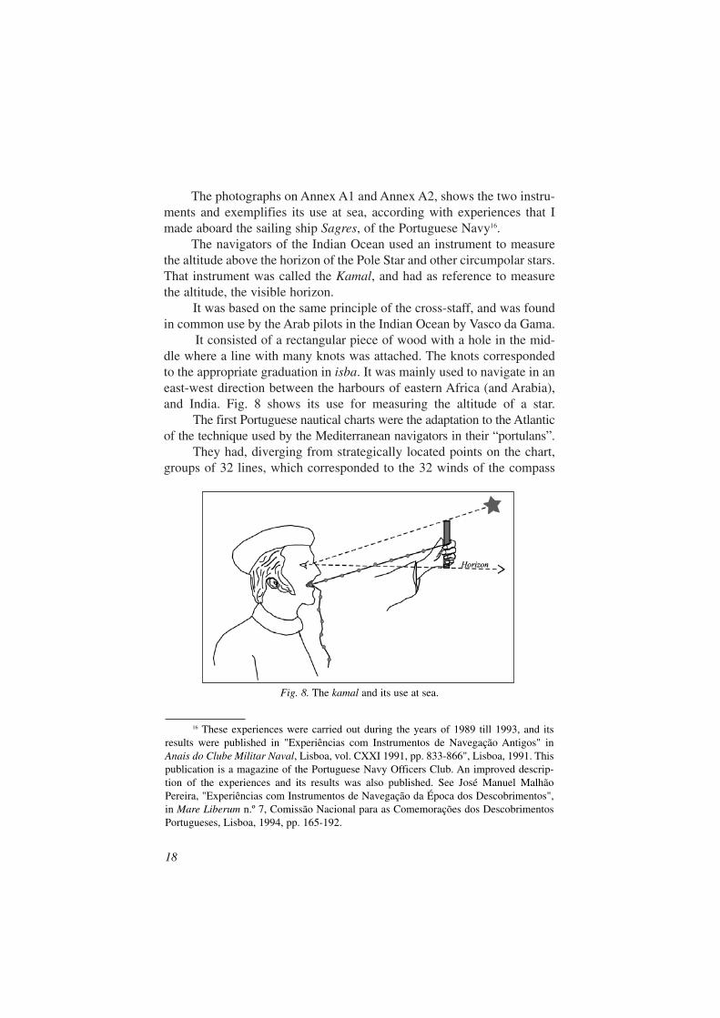
The photographs on Annex A1 and Annex A2, shows the two instru-ments and exemplifies its use at sea, according with experiences that Imade aboard the sailing ship Sagres, of the Portuguese Navy16.
The navigators of the Indian Ocean used an instrument to measurethe altitude above the horizon of the Pole Star and other circumpolar stars.That instrument was called the Kamal, and had as reference to measurethe altitude, the visible horizon.
It was based on the same principle of the cross-staff, and was foundin common use by the Arab pilots in the Indian Ocean by Vasco da Gama.
It consisted of a rectangular piece of wood with a hole in the mid-dle where a line with many knots was attached. The knots correspondedto the appropriate graduation in isba. It was mainly used to navigate in aneast-west direction between the harbours of eastern Africa (and Arabia),and India. Fig. 8 shows its use for measuring the altitude of a star.
The first Portuguese nautical charts were the adaptation to the Atlanticof the technique used by the Mediterranean navigators in their “portulans”.
They had, diverging from strategically located points on the chart,groups of 32 lines, which corresponded to the 32 winds of the compass
18
16 These experiences were carried out during the years of 1989 till 1993, and itsresults were published in "Experiências com Instrumentos de Navegação Antigos" inAnais do Clube Militar Naval, Lisboa, vol. CXXI 1991, pp. 833-866", Lisboa, 1991. Thispublication is a magazine of the Portuguese Navy Officers Club. An improved descrip-tion of the experiences and its results was also published. See José Manuel MalhãoPereira, "Experiências com Instrumentos de Navegação da Época dos Descobrimentos",in Mare Liberum n.º 7, Comissão Nacional para as Comemorações dos DescobrimentosPortugueses, Lisboa, 1994, pp. 165-192.
Fig. 8. The kamal and its use at sea.
rose. These lines were used to mark the courses from the departure to thedestination harbour, using a parallel ruler or dividers. And they were inmany areas of the chart to allow that there was always one line near thearea of the chart that was in use.
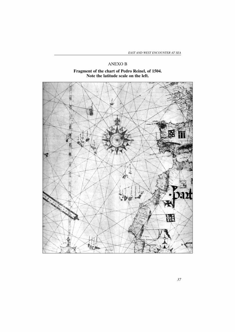
The astronomical navigation introduced an important evolution incartography, which was the inclusion of a latitude scale on the charts usedfor navigation. On the chart of Pedro Reinel of 1504, it is clearly visiblea latitude scale, which was the result of decades of experience with thenew methods. Annex B shows a copy of part of this chart.
Indian Ocean navigators would have had nautical charts or some-thing with a similar objective, and that information is included on the Por-tuguese chronicles. Marco Polo also spoke about them. But unfortunatelythey were not found.
Portuguese pilots have also written navigation instructions, or Roteiros,for the Atlantic, Indian and western Pacific Oceans, which on the firstdecades of the sixteenth century covered an enormous area of this waters.
Indian Ocean navigators had also their pilot books, of which theKutchi Rehmanis, which will be referred later, are an example.
Environmental conditions of the Indo-Pacific regions of navigationand its consequence to navigation techniques
As a result of what has been said above, it seems that the techniquesused by the Portuguese when they arrived in the Indian Ocean were sim-ilar in certain aspects to the ones used by Indian Ocean navigators.
Nevertheless, some techniques differed from each other and I amgoing to try to demonstrate the influence of the environmental conditionsof the navigational areas that originated the differences in the procedures.
Besides that, a study of the techniques of Pacific navigators showedto many historians that exists a great interchange between this ocean andthe Indian Ocean17.
EAST AND WEST ENCOUNTER AT SEA
19
17 It is for example the opinion of Tibbetts, expressed in a paper in 1979 (See G. R.Tibbets, A Comparison of Medieval Arab Methods of Navigation With Those of thePacific Islands, Lisboa, sep. CXXI, Centro de Estudos de Cartografia Antiga, Junta deInvestigações do Ultramar, 1979), performed some years after the publication of his veryimportant work, Arab Navigation in the Indian Ocean … already cited above. He saysthat: "My own opinion is that in both areas [Indian and Pacific oceans], there must havebeen a general mutual awareness of the way that navigational problems were solved. Inthe days when the Malaysian peoples travelled to Madagascar, the Pacific peoples mayhave been in contact with southeast Asia and similar navigational systems may have oper-ated on both Malayan archipelago.". See op. cit., p. 13.

20
Fig
. 9.I
nter
trop
ical
are
as a
t sea
. Eur
opea
n an
d A
sian
rou
tes
of n
avig
atio
n (o
nly
for
show
ing
area
s of
ope
ratio
n an
d co
nseq
uent
ly n
ot w
ith h
isto
rica
l or
saili
ng a
ccur
ancy
).
The first important fact is that the Arab, Persian, Indian, and Poly-nesian navigation is performed mainly in inter-tropical areas.
Let us take a look of fig. 9, where the inter-tropical areas of the seasof the world are shaded and the routes of navigation schematically repre-sented. It is immediately apparent that Asian routes are mainly inter-trop-ical, with the only exception of routes of northern parts of China. ThePortuguese, Spanish, Dutch, French and English routes have big propor-tions out of the tropics.
It is also evident from the map, that:
– European routes are long distance ones with many months at seaand out of sight of land.
– Arabian, Persian and Indian routes have some medium distanceocean routes, but more coastal navigation.
– Malayan and Chinese routes are mainly coastal or short distancehigh seas navigation, with the exception of the probable but notvery frequent direct routes to Africa.
– Western Pacific routes are mainly short inter-island routes, whichnever exceed the 350 miles distance, with the exception of the voy-ages to Hawaii and New Zealand.
It is my deep conviction that all sailors find the necessary techniquesand instrumentation for their areas of operation. And sailors are very prac-tical and only use or develop what is needed for the purpose of the navi-gation.
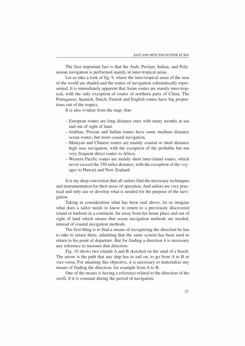
Taking in consideration what has been said above, let us imaginewhat does a sailor needs to know to return to a previously discoveredisland or harbour in a continent, far away from his home place and out ofsight of land which means that ocean navigation methods are needed,instead of coastal navigation methods.
The first thing is to find a means of recognizing the direction he hasto take to return there, admitting that the same system has been used toreturn to his point of departure. But for finding a direction it is necessaryany reference to measure that direction.
Fig. 10 shows two islands A and B sketched on the sand of a beach.The arrow is the path that any ship has to sail on, to go from A to B orvice-versa. For attaining this objective, it is necessary to materialize anymeans of finding the direction, for example from A to B.
One of the means is having a reference related to the direction of theswell, if it is constant during the period of navigation.
EAST AND WEST ENCOUNTER AT SEA
21
Another can be the direction of the wind, again if it is constant indirection.
Another can be the flight of birds, if they go always to the sameplace B.
We see that those means have too many ifs, and people soon recog-nized that the heavens, with its stars and planets during the night, and sunand moon during the day, could be a good reference. From those, the bestare the stars, because they maintain their relative positions for very long
periods. Besides that they rise and set in well-defined positions in the horizon.
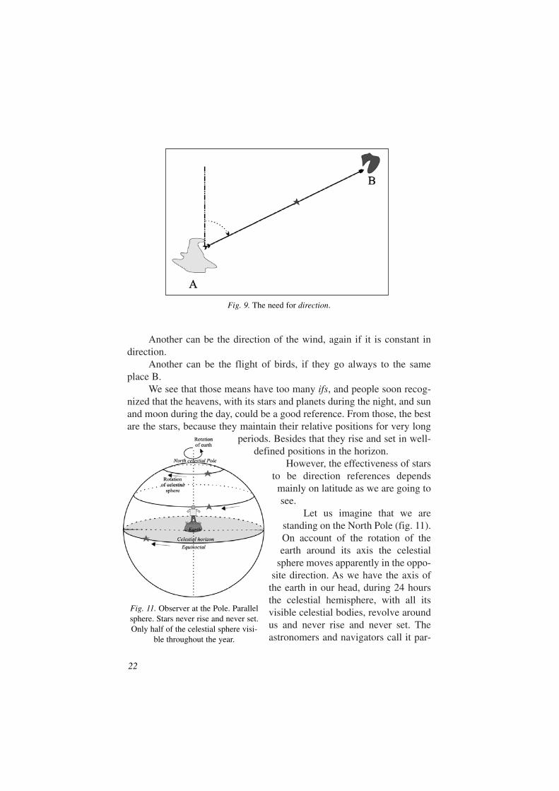
However, the effectiveness of starsto be direction references dependsmainly on latitude as we are going tosee.
Let us imagine that we arestanding on the North Pole (fig. 11).On account of the rotation of theearth around its axis the celestial
sphere moves apparently in the oppo-site direction. As we have the axis of
the earth in our head, during 24 hoursthe celestial hemisphere, with all itsvisible celestial bodies, revolve aroundus and never rise and never set. Theastronomers and navigators call it par-
22
Fig. 9. The need for direction.
Fig. 11. Observer at the Pole. Parallelsphere. Stars never rise and never set.Only half of the celestial sphere visi-
ble throughout the year.
allel sphere, because the heavenly bodieshave their movements along celestialparallels.
As there is no rising and set-ting, and they are always movinghorizontally, celestial bodies arenot good references for direction.
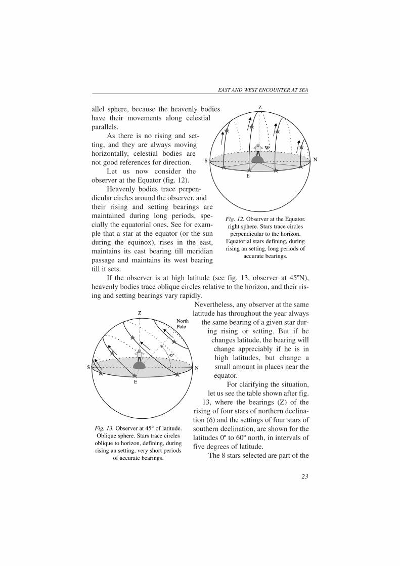
Let us now consider theobserver at the Equator (fig. 12).
Heavenly bodies trace perpen-dicular circles around the observer, andtheir rising and setting bearings aremaintained during long periods, spe-cially the equatorial ones. See for exam-ple that a star at the equator (or the sunduring the equinox), rises in the east,maintains its east bearing till meridianpassage and maintains its west bearingtill it sets.
If the observer is at high latitude (see fig. 13, observer at 45ºN),heavenly bodies trace oblique circles relative to the horizon, and their ris-ing and setting bearings vary rapidly.
Nevertheless, any observer at the samelatitude has throughout the year always
the same bearing of a given star dur-ing rising or setting. But if he
changes latitude, the bearing willchange appreciably if he is inhigh latitudes, but change asmall amount in places near theequator.
For clarifying the situation,let us see the table shown after fig.
13, where the bearings (Z) of therising of four stars of northern declina-tion (δ) and the settings of four stars ofsouthern declination, are shown for thelatitudes 0º to 60º north, in intervals offive degrees of latitude.
The 8 stars selected are part of the
EAST AND WEST ENCOUNTER AT SEA
23
Fig. 12. Observer at the Equator.right sphere. Stars trace circlesperpendicular to the horizon.
Equatorial stars defining, duringrising an setting, long periods of
accurate bearings.
Fig. 13. Observer at 45° of latitude.Oblique sphere. Stars trace circles
oblique to horizon, defining, duringrising an setting, very short periods
of accurate bearings.
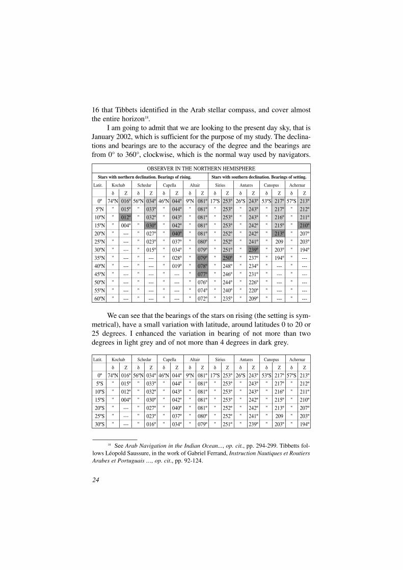
OBSERVER IN THE NORTHERN HEMISPHERE
Stars with northern declination. Bearings of rising. Stars with southern declination. Bearings of setting.
Latit. Kochab Schedar Capella Altair Sirius Antares Canopus Achernar
δ Z δ Z δ Z δ Z δ Z δ Z δ Z δ Z
0º 74ºN 016º 56ºN 034º 46ºN 044º 9ºN 081º 17ºS 253º 26ºS 243º 53ºS 217º 57ºS 213º
5ºN " 015º " 033º " 044º " 081º " 253º " 243º " 217º " 212º
10ºN " 012º " 032º " 043º " 081º " 253º " 243º " 216º " 211º
15ºN " 004º " 030º " 042º " 081º " 253º " 242º " 215º " 210º
20ºN " --- " 027º " 040º " 081º " 252º " 242º " 213º " 207º
25ºN " --- " 023º " 037º " 080º " 252º " 241º " 209 " 203º
30ºN " --- " 015º " 034º " 079º " 251º " 239º " 203º " 194º
35ºN " --- " --- " 028º " 079º " 250º " 237º " 194º " ---
40ºN " --- " --- " 019º " 078º " 248º " 234º " --- " ---
45ºN " --- " --- " --- " 077º " 246º " 231º " --- " ---
50ºN " --- " --- " --- " 076º " 244º " 226º " --- " ---
55ºN " --- " --- " --- " 074º " 240º " 220º " --- " ---
60ºN " --- " --- " --- " 072º " 235º " 209º " --- " ---
24
18 See Arab Navigation in the Indian Ocean..., op. cit., pp. 294-299. Tibbetts fol-lows Léopold Saussure, in the work of Gabriel Ferrand, Instruction Nautiques et RoutiersArabes et Portuguais …, op. cit., pp. 92-124.
Latit. Kochab Schedar Capella Altair Sirius Antares Canopus Achernar
δ Z δ Z δ Z δ Z δ Z δ Z δ Z δ Z
0º 74ºN 016º 56ºN 034º 46ºN 044º 9ºN 081º 17ºS 253º 26ºS 243º 53ºS 217º 57ºS 213º
5ºS " 015º " 033º " 044º " 081º " 253º " 243º " 217º " 212º
10ºS " 012º " 032º " 043º " 081º " 253º " 243º " 216º " 211º
15ºS " 004º " 030º " 042º " 081º " 253º " 242º " 215º " 210º
20ºS " --- " 027º " 040º " 081º " 252º " 242º " 213º " 207º
25ºS " --- " 023º " 037º " 080º " 252º " 241º " 209 " 203º
30ºS " --- " 016º " 034º " 079º " 251º " 239º " 203º " 194º
16 that Tibbets identified in the Arab stellar compass, and cover almostthe entire horizon18.
I am going to admit that we are looking to the present day sky, that isJanuary 2002, which is sufficient for the purpose of my study. The declina-tions and bearings are to the accuracy of the degree and the bearings arefrom 0° to 360°, clockwise, which is the normal way used by navigators.
We can see that the bearings of the stars on rising (the setting is sym-metrical), have a small variation with latitude, around latitudes 0 to 20 or25 degrees. I enhanced the variation in bearing of not more than twodegrees in light grey and of not more than 4 degrees in dark grey.
Now we can also see that for the same stars but to south latitudes ofthe same amount, which I only extended to 30ºS, the bearings are thesame. See table above.
This is a very interesting fact that sometimes is not recognized, evenby experienced navigators19. It gives an added advantage of using risingand setting stars for direction between the tropics because their bearingsare equal if we are at the same latitude, even if we are in different hemi-spheres. This means that the entire area of the tropics is suitable for thispurpose and not only half of it.
It also shows clearly, that for observers between the tropics, the ris-ing and setting of stars are an accurate way for direction, and that out ofthe tropics, they are not suitable for that purpose.
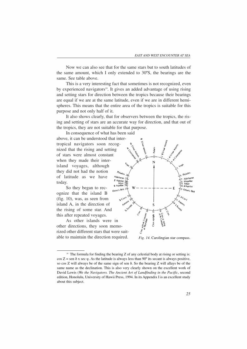
In consequence of what has been saidabove, it can be understood that inter-tropical navigators soon recog-nized that the rising and settingof stars were almost constantwhen they made their inter-island voyages, althoughthey did not had the notionof latitude as we havetoday.
So they began to rec-ognize that the island B(fig. 10), was, as seen fromisland A, in the direction ofthe rising of some star. Andthis after repeated voyages.
As other islands were inother directions, they soon memo-rized other different stars that were suit-able to maintain the direction required.
EAST AND WEST ENCOUNTER AT SEA
25
19 The formula for finding the bearing Z of any celestial body at rising or setting is:cos Z = sen δ x sec ϕ. As the latitude is always less than 90º its secant is always positive,so cos Z will always be of the same sign of sen δ. So the bearing Z will allays be of thesame name as the declination. This is also very clearly shown on the excellent work ofDavid Lewis (We the Navigators. The Ancient Art of Landfinding in the Pacific, secondedition, Honolulu, University of Hawii Press, 1994. In its Appendix I is an excellent studyabout this subject.
Fig. 14. Carolingian star compass.
As stars are only near the horizon for a short period, other stars wereused on the same direction or bearing (this is nowadays the appropriatetechnical word).
As in the same bearing the amount of stars was not sufficient tocover all the horizon, soon practical navigators recognized that other starswould be associated with the others, if they made an image of them, alto-gether, on a piece of circular or square wood, where they marked all thestars useful for the purpose of finding different islands.
And we can also understand that this system is useful mainly in areasnear the equator, and where navigation is made in all possible directions,among islands (which is the present case of the Western Pacific), and sail-ing in the open ocean for relatively short distances.
It is also necessary to understand that their voyages were in direc-tions that covered the entire horizon, on account of the physical charac-teristics of the areas navigated, with a great amount of islands.
As other islands were in other directions, they develop the use of lowstars for references. From this stage, it is easy to understand the develop-ment of a compass rose that showed to the navigator the different direc-tions which in the future could be the reference for future voyages. Inconsequence of this the Carolingian compasswas introduced. See fig. 1420.
This kind of navigationtechnique, since historiansknow, was only practisedduring the colonization ofthe Pacific Islands andafter the continuedestablishment of peopleon those areas. Neitherthe Atlantic, nor theSouthern Indian Oceanwas navigated beforethe Western Pacific.Many centuries before theVikings and the ocean navi-gation in the Northern IndianOcean, the most part of westernPacific Islands were colonized.
26
20 Adapted from David Lewis, We the Navigators…., p. 104.
Fig. 15. Arab star compass.
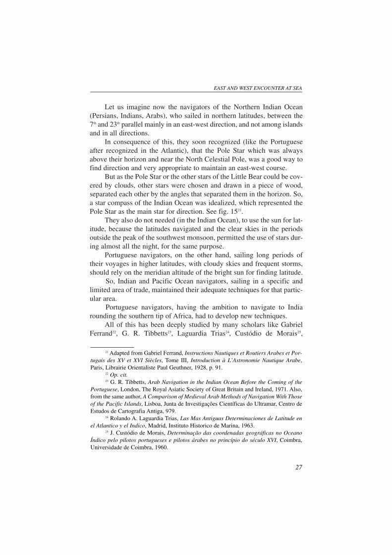
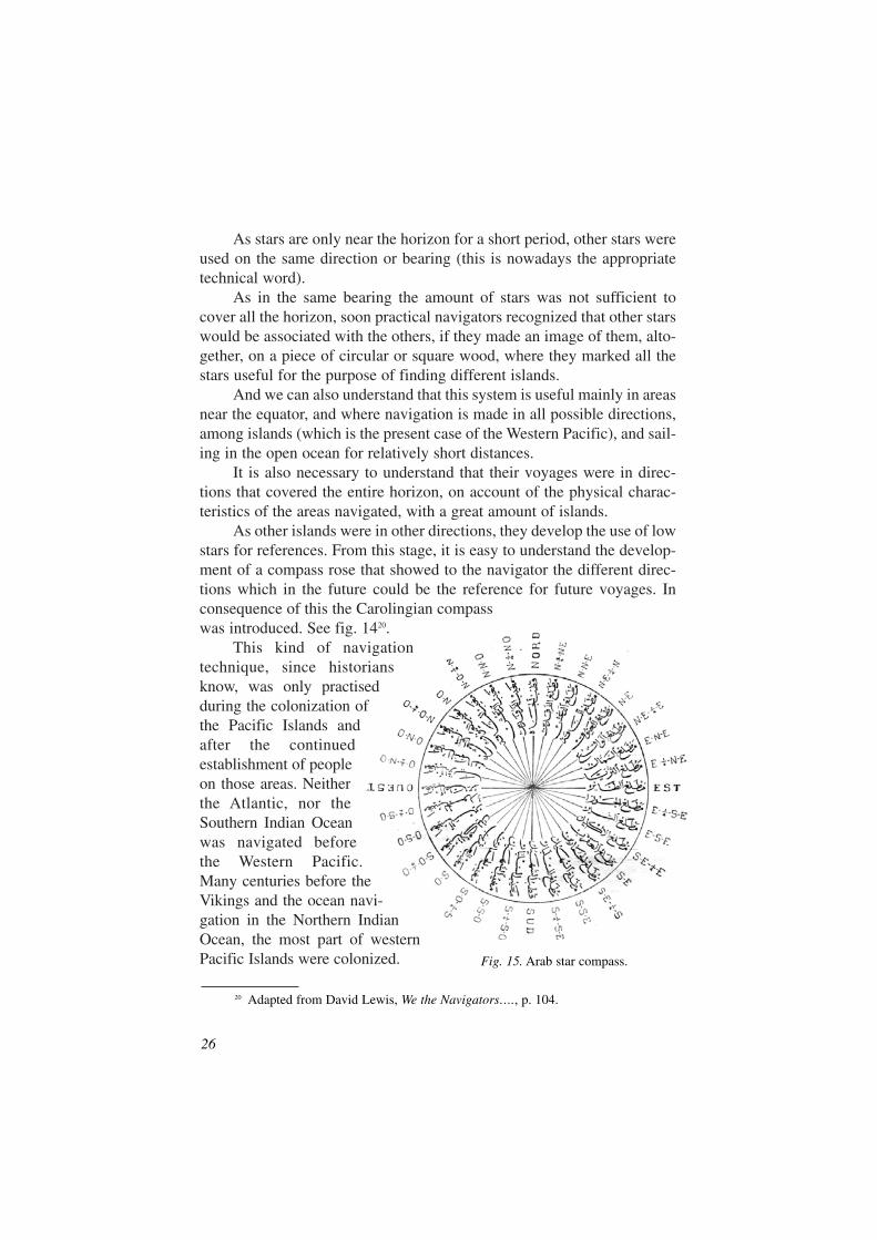
Let us imagine now the navigators of the Northern Indian Ocean(Persians, Indians, Arabs), who sailed in northern latitudes, between the7th and 23th parallel mainly in an east-west direction, and not among islandsand in all directions.
In consequence of this, they soon recognized (like the Portugueseafter recognized in the Atlantic), that the Pole Star which was alwaysabove their horizon and near the North Celestial Pole, was a good way tofind direction and very appropriate to maintain an east-west course.
But as the Pole Star or the other stars of the Little Bear could be cov-ered by clouds, other stars were chosen and drawn in a piece of wood,separated each other by the angles that separated them in the horizon. So,a star compass of the Indian Ocean was idealized, which represented thePole Star as the main star for direction. See fig. 1521.
They also do not needed (in the Indian Ocean), to use the sun for lat-itude, because the latitudes navigated and the clear skies in the periodsoutside the peak of the southwest monsoon, permitted the use of stars dur-ing almost all the night, for the same purpose.
Portuguese navigators, on the other hand, sailing long periods oftheir voyages in higher latitudes, with cloudy skies and frequent storms,should rely on the meridian altitude of the bright sun for finding latitude.
So, Indian and Pacific Ocean navigators, sailing in a specific andlimited area of trade, maintained their adequate techniques for that partic-ular area.
Portuguese navigators, having the ambition to navigate to Indiarounding the southern tip of Africa, had to develop new techniques.
All of this has been deeply studied by many scholars like GabrielFerrand22, G. R. Tibbetts23, Laguardia Trias24, Custódio de Morais25,
EAST AND WEST ENCOUNTER AT SEA
27
21 Adapted from Gabriel Ferrand, Instructions Nautiques et Routiers Arabes et Por-tugais des XV et XVI Siècles, Tome III, Introduction à L’Astronomie Nautique Arabe,Paris, Librairie Orientaliste Paul Geuthner, 1928, p. 91.
22 Op. cit.23 G. R. Tibbetts, Arab Navigation in the Indian Ocean Before the Coming of the
Portuguese, London, The Royal Asiatic Society of Great Britain and Ireland, 1971. Also,from the same author, A Comparison of Medieval Arab Methods of Navigation With Thoseof the Pacific Islands, Lisboa, Junta de Investigações Científicas do Ultramar, Centro deEstudos de Cartografia Antiga, 979.
24 Rolando A. Laguardia Trias, Las Mas Antiguas Determinaciones de Latitude enel Atlantico y el Indico, Madrid, Instituto Historico de Marina, 1963.
25 J. Custódio de Morais, Determinação das coordenadas geográficas no OceanoÍndico pelo pilotos portugueses e pilotos árabes no princípio do século XVI, Coimbra,Universidade de Coimbra, 1960.
Vitorino Magalhães Godinho26, Moura Braz27, David Lewis28, WilliamKelsalka29, Teixeira da Mota30, among many others. Lewis and Kelsalkamade interesting sailing experiences, with extremely important results.
Let us comment and compare some more techniques of the differentareas. We have seen that in Indian and Pacific Oceans was used the stel-lar compass instead of the magnetic compass. In fact, the stars are bettermeans of knowing direction in the area navigated31.
28
26 Vitorino Magalhães Godinho, "Navegação oceânica e origens da náuticaastronómica", in Ensaios (I, Sobre História Universal), Lisboa, Sá da Costa, pp. 177-227.
27 C. A. Moura Braz, O Encontro das Marinhas Oriental e Ocidental na Era dosDescobrimentos, Lisboa, Sociedade de Geografia, 1962.
28 Op. cit.29 Will Kelsalka, An Ocean in Mind, Honolulu, University of Hawaii Press, 1987. 30 A. Teixeira da Mota, " Méthodes de Navigation ...", op. cit.31 Lewis considers that "... steering by horizon stars is every bit as accurate as by
magnetic compass and probably easier than trying follow the gyrating compass card of anisland schooner or a yacht.". I agree 100% with this assessment, and it can be added thatthe problem of magnetic variation, that can go to more than 20º to the east or the west oftrue north, is completely eliminated by the observation of rising or setting of stars, whichis a true bearing. See op. cit., p. 121.
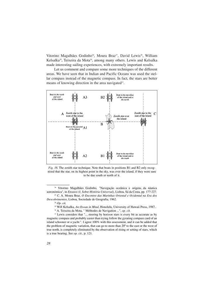
Fig. 16. The zenith star technique. Note that boats in positions B1 and B2 only recog-nized that the star, on its highest point in the sky, was over the island, if they were sure
to be due south or north of it.
On the Western Pacific, another use of stars was performed. Besidesthe use of the sun, swells and birds for orientation during the day, an inter-esting technique of zenith star was used at night. Its principle is that anisland can have a star that passes every night over it. That star shouldhave, of course, a declination that equals the latitude of the place. If a nav-igator knows in advance the time when that star is overhead the island, thedirection to that star is the direction to the island.
But for this it was necessary to know the times of overhead passage,which was not possible in the past. So, the overhead star or zenith star wasused as an indicator of, let us say, the parallel of the island when it passedoverhead the observer, situated to the east or the west of the referredisland. It was only necessary to navigate due east or west to the objective.See fig. 16, position A1, where it was necessary to navigate to the east andposition C where it was necessary to sail west. The other situations caneasily be understood.
The zenith star passing on the meridian of the observer, gave also anindication that the island was directly due north or due south, but only ifthe observer previously new that he was in its meridian, which was not acommon situation. Lewis has detected evidence of these techniques in hisexperiences32.
Windward landfall, also extensively commented by Lewis, isanother technique perfectly adapted to the Pacific and also the IndianOcean. It consists of approaching the island or coast, to its windward(and up current). This is understandable, because the voyage was madein sailing boats. But what is more interesting is that this technique wascomplemented with the zenith star technique, which insured to the nav-igator that he was on the parallel of the destination as it has beenexplained above33.
EAST AND WEST ENCOUNTER AT SEA
29
32 See op. cit., pp. 280-286. It is very interesting Dr. Lewis description of local andhis own technique of ascertaining that the star was overhead the boat.
33 See op. cit., p. 286. Lewis says here that “latitude sailing” or running down thelatitude as I said previously, “… was the method used by ancient Indian Ocean seafar-ers and by Western seamen prior to the late eighteenth century, that is, before a practi-cal method of ascertaining the longitude had been developed.”. Comments after that,that “Akerblom correctly points that although, theoretically speaking, it was possiblefor the Polynesians to have navigated by latitude sailing, there is not an atom of proofthat they ever did so.”. I do not understand this statement, if we consider that the zenithstar technique is, in a certain way, a method that approaches the latitude sailingmethod.
CONCLUSIONS
From what I have said above, it can be again emphasised that thenavigation techniques are mainly a result of environmental conditions anddifferent sailors find different procedures in different areas of operation.
But in the Portuguese case what was really incredible was how fastthey developed their cartography of the new waters navigated, and the cor-respondent pilot books or Roteiros, after the first voyage of Vasco da Gama.
The charts of Francisco Rodrigues, made around 1515, have also agreat amount of information, which was only possible to acquire not onlythrough direct knowledge, but also local knowledge34.
The same happened with the pilot books of João de Lisboa ofapproximately the same epoch, which had already important informationof areas east of India, already navigated by the Portuguese but apparentlyimpossible to obtain without local knowledge.
What I really think is that charts, pilot books and navigation tech-niques of Arab, Indian, Persian, even Chinese origin are not sufficientlystudied, although some scholars like G. R. Tibbetts, Gabriel Ferrand,Ybrahim Koury, Joseph Needham, David Lewis have dedicated to it greatpart of their lives.
But some of them were not sailors, and also some recent findingshave not been studied.
Nevertheless, there has been in India, in 1988, a very interesting andproductive initiative of the Tamil University that organized an importantWorkshop on The History of Traditional Navigation in South India. Fromits Proceedings35, I found very interesting new material as for example theKuchi Rehamanis, in a certain way, equivalent to the Portuguese Roteiros36.
30
34 Teixeira da Mota studied deeply this subject in his work Méthodes de Naviagtionet Cartographie Nautique dans l’Océan Indien, (see note 10), making comments aboutthe references of João de Barros, the javanese chart of Afonso de Albuquerque, the chartof Piri Reis, the references in Livro de Marinharia de André Pires and in the Mohit of SidiAli, and the eastern influences on the first Portuguese charts of the Indian Ocean. Heaccepted the idea of Youssouf Kamal, in his Monumenta Cartographica Africae etAegypti, who “… conteste l’idée que les Orientaux auraient possédé de véritables cartesnautiques, et estime que ce sont les Occidentaux qui ont contribué au progrès de lareprésentation des littoraux.». As explained in the text of my work, I do not agree withthis definitive conclusion and I consider that a deeper investigation should be made.
35 History of Traditional Navigation, ed. by G. Victor Rajamanickam and Y. Sub-barayalu, Thanjapur, 1988.
36 Idem, pp. 87-99. (Kalpana S. Desai, Traditional Techniques of Navigation. Astudy of Log-books of 17th-18th centuries).
They included also sketches of the coasts, which can be considered,in a certain way, information similar to the one obtained in the Europeancharts.
Also the deep and very well organized program of the National Insti-tute of Science Technology And Development Studies (NISTADS), NewDehli, on Boat Building and Fishing Communities. Bengal and theAndamans, in which worked deeply Lotika Varadarajan, can be immenselyfruitful37. In fact, at the same time as local knowledge of craft and fishing isobtained, information about techniques of navigation can be acquired.
The Indo-Portuguese Seminars of Maritime History have been alsovery important, although they cover a very wide area of study38 and themore specialized Maritime Seminars organized by Professor Mathew, haddecisive and important results.
Taking in consideration that in my opinion the areas navigated by thedifferent sailors, with their specific physical characteristics, are the mostimportant factor for the different techniques utilized, having in mind thedifferent studies made by the scholars mentioned, and taking into accountmy own experience, I can arrive to the following conclusions:
– Practical astro navigation has probably begun during the coloniza-tion of the Pacific Islands, and was performed without instruments.
– Practical astro navigation using the Pole Star and an instrument toperform the system later called running down the Latitude hasprobably began in the Arabian Sea.
– The origin of the Stellar Compass, is probably from the WesternPacific area, and the product of contacts of the Indian Ocean nav-igators through the Malay-Chinese connection originated theIndian Ocean stellar compass.
– Interchange of Atlantic and Indian Oceans techniques, producedlater Mediterranean techniques, with the development of magneticcompass, dead reckoning and the cartography.
– Portuguese sailors, contacting Mediterranean sailors, introducedmodern astro navigation and developed cartography in a way that
EAST AND WEST ENCOUNTER AT SEA
31
37 See for example, Hans Kumar and Lotika Varadarajan, “Ap, The Canoe ofChowra Island”, in Techniques and Culture, 35-36, 2000, pp. 85-120.
38 On the IXth Seminar on Indo-Portuguese History (NISTADS, New Delhi, 7-11December, 1998) three excellent papers on the subject of navigation have been presented.They are: Lotika Varadarajan, Indian Routers-The Indigenous Tradition; C. K. Raju,Kamâl or Râpalagai; François Bellec, Early Pilots on the Indian Waters. This three worksdeal mainly with the subject that I am studying in the text of my work. Unhappily, theProceedings of this excellent event have not been yet published.
permitted, after the end of the 15th century, to repeat voyages to anypart of the world, previously recognized and chartered.
– Portuguese sailors adapted in an incredible fast way to the naviga-tion of Indian Ocean and Southeast Asia seas, chartering thesewaters with the already known elements available locally and itsown future experience.
This is the idea I have after crossing information of many great histori-ans, and some of these last conclusions do not agree with of some of them.
I am Portuguese and very proud the of my country’s maritimeachievements. But I am also a sailor and I recognize that the achievementsof Portuguese navigators, like the achievements of any other nation, arethe product of information of a variety of origins.
As per the Portuguese techniques, I can say that:
– We adapted for the use at sea the astrolabe, of Greek and Arab ori-gin.
– We transformed and adapted to the Atlantic, the techniques of theMediterranean sailors, which, by themselves, acquired northernEurope and Arab techniques.
– With the caravel we recognized and chartered the coasts of Africaand of some parts of other oceans coasts, using the efficiency ofthe latten sail that was brought by the Arabs to the Mediterranean.
– We adapted to the sea the already known principles of astronomy,left by the Arabs and Jews in the Iberian Peninsula, that were bythemselves acquired in their areas of birth.
– We utilized the system of running down the latitude that also wasused in the Indian Ocean for the same purpose of navigation.
– Arab, Indian and Persian sailors probably acquired from theWestern Pacific sailors the stellar compass through the Malayconnection.
All of this was a permanent interchange of ideas, which becameeffective because there were things to be done by all the intervenients inthe process, and because there was an incentive, namely the commerce(like nowadays).
And I think that it is impossible to forget this and the future willbring to us the same kind of procedure among all the peoples in the world.The only difference now is that all these exchange of information will beincredibly fast.
32
But for preparing the future, it is more urgent than in the past thatpeople speak together, and I think that in the maritime history somethingmore has to be done, because a lot of things need to be studied.
And for example, in which concerns the maritime history of the greatIndian nation, a lot has to be researched. I quote for example the follow-ing passage of the paper of commander K. N. Bahl in the already referredSeminar in Indian Traditional Navigation: “Indian archaeologists haveunearthed the world’s most ancient dockyard in Lothal, a port city inGujarate. It was in use four thousand years ago. That evidence is suffi-cient to challenge the myth that sailing and navigation developed in thesheltered waters of the Mediterranean …”.
I quote also, from a recent Lotika Varadarajan’s work alreadyreferred39: “Despite literary references to navigators of the past and torecorded voyages (Varadarajan, 1980, 1983a, 1991), the image was that ofcaste bound Hindu society in which the elite was prohibited from sailingacross the black waters. This was enunciated through the concept of Kali-varjya (Varadrajan, 1983b). This image is now being eroded. The first evi-dence came to light as a result of a lead provided by the late Dr. U. P.Shah, Gaekwad Oriental Institue, Baroda. This led to the location of a setof sailing manuals in the possession of Sri Dushyanta Pandaya at Jamna-gar, Gujarat, in 1978.”.40
I quote also the suggestion of the late Poruguese Admiral Teixeira daMota in the already referred paper “Méthodes de Navigation et Cartogra-phie dans l’Océan Indien avant le XVI siècle…” : “Nous estimons oppor-tun de consigner ici un voeu pour qu’il soit procédé à la prochainetraduction, dans une langue européenne, des textes nautiques arabes con-nus, afin que les historiens de la science nautique, non arabisants, puissentfacilement les utilizer; …”.41
So, dear ladies and gentlemen and dear father Mathew. I agree withthe idea that the discipline of Maritime History has to be individualized.So I would like to propose that a Seminar of World Navigation Historyshould be held somewhere, because all of us contribute to that. And prob-ably the best place will be your country, India. And why not the Kerala,to where all the navigators converged from all other parts of the world?
Here I leave this humble suggestion.
39 Indian Rutters-The Indigenous Tradition (footnote 30).40 I have already referred these documents, which are the Kutchi Rehmanis.41 Op. cit. p. 58.
EAST AND WEST ENCOUNTER AT SEA
33

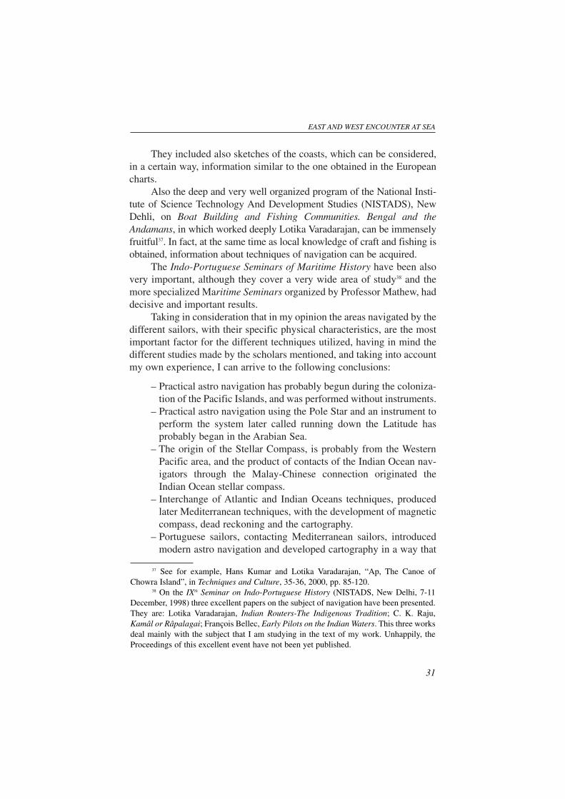
ANEXO A1
Observations with astrolobe, aboard the Portuguese sail trainingship Sagres.
The plane of the instrument should be in the vertical plane of the sun. Note in the firstphotograph that the shade of the instrument in the deck indicates that it is in the same
vertical plane of the sun.
The projection of the sunbeam on the second pinule, after crossing the first one.
EAST AND WEST ENCOUNTER AT SEA
35
36
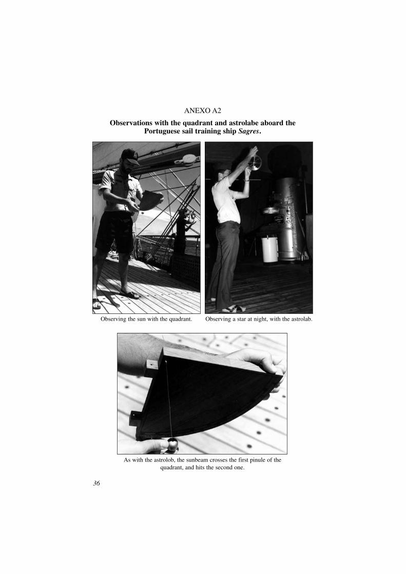
ANEXO A2
Observations with the quadrant and astrolabe aboard the Portuguese sail training ship Sagres.
Observing the sun with the quadrant. Observing a star at night, with the astrolab.
As with the astrolob, the sunbeam crosses the first pinule of thequadrant, and hits the second one.
EAST AND WEST ENCOUNTER AT SEA
37
ANEXO B
Fragment of the chart of Pedro Reinel, of 1504. Note the latitude scale on the left.
