earthquake clustering and possible fault interactions across cook strait, new zealand, during the...
TRANSCRIPT

This article was downloaded by: [UQ Library]On: 06 November 2014, At: 19:46Publisher: Taylor & FrancisInforma Ltd Registered in England and Wales Registered Number: 1072954 Registered office: MortimerHouse, 37-41 Mortimer Street, London W1T 3JH, UK
New Zealand Journal of Geology and GeophysicsPublication details, including instructions for authors and subscription information:http://www.tandfonline.com/loi/tnzg20
Earthquake clustering and possible fault interactionsacross Cook Strait, New Zealand, during the 1848and 1855 earthquakesRH Grapesa & GR Holdgateb
a Department of Earth Sciences, Sun Yat-sen University, Canton, Chinab Department of Earth Sciences, University of Melbourne, Parkville, AustraliaPublished online: 30 Apr 2014.
To cite this article: RH Grapes & GR Holdgate (2014) Earthquake clustering and possible fault interactions across CookStrait, New Zealand, during the 1848 and 1855 earthquakes, New Zealand Journal of Geology and Geophysics, 57:3,312-330, DOI: 10.1080/00288306.2014.907579
To link to this article: http://dx.doi.org/10.1080/00288306.2014.907579
PLEASE SCROLL DOWN FOR ARTICLE
Taylor & Francis makes every effort to ensure the accuracy of all the information (the “Content”) containedin the publications on our platform. However, Taylor & Francis, our agents, and our licensors make norepresentations or warranties whatsoever as to the accuracy, completeness, or suitability for any purpose ofthe Content. Any opinions and views expressed in this publication are the opinions and views of the authors,and are not the views of or endorsed by Taylor & Francis. The accuracy of the Content should not be reliedupon and should be independently verified with primary sources of information. Taylor and Francis shallnot be liable for any losses, actions, claims, proceedings, demands, costs, expenses, damages, and otherliabilities whatsoever or howsoever caused arising directly or indirectly in connection with, in relation to orarising out of the use of the Content.
This article may be used for research, teaching, and private study purposes. Any substantial or systematicreproduction, redistribution, reselling, loan, sub-licensing, systematic supply, or distribution in anyform to anyone is expressly forbidden. Terms & Conditions of access and use can be found at http://www.tandfonline.com/page/terms-and-conditions

RESEARCH ARTICLE
Earthquake clustering and possible fault interactions across Cook Strait, New Zealand, during the 1848and 1855 earthquakes
RH Grapesa* and GR Holdgateb
aDepartment of Earth Sciences, Sun Yat-sen University, Canton, China; bDepartment of Earth Sciences, University of Melbourne, Parkville, Australia
(Received 26 August 2013; accepted 3 March 2014)
The 1848 and 1855 earthquakes provide examples of clustered earthquake sequences involving several faults. Historical evidenceindicates that fault rupturing and ground deformation on both sides of Cook Strait occurred over periods of several days during theOctober 1848 earthquakes on the Awatere, Ohariu and possibly the Wellington faults, with shallowing in Lambton Harbour, Wellington.The January–February 1855 earthquakes occurred on the Wairarapa, Wharekauhau, Nicholson Bank, Vernon, Awatere and Needlesfaults. The pattern of faulting suggests the existence of distinct seismogenic zones across Cook Strait, within which mainshocktriggering of aftershock displacement on major faults can occur.
Keywords: clustered earthquakes; 1848; 1855; across Cook Strait; fault interactions; triggered rupturing
Introduction
The Cook Strait region encompasses the transition from obliquewestwards c. 42 mm a−1 subduction of the Pacific Plate alongthe Hikurangi Trough margin of the North Island to continentaltransform tectonics in the South Island of New Zealand(Fig. 1A). Seismic reflection and bathymetric data imply thatmajor transcurrent faults in the North and South islandsterminate offshore in Cook Strait and are characterised bydiscontinuities, lateral sidesteps and a change in regional strike(Carter et al. 1988; Pondard & Barnes 2010). This has led to theassumption that through-going fault rupturing (in particular,strike-slip displacement) across Cook Strait is improbable.Nevertheless, mainshock triggering of additional rupturing onnearby discontinuous fault segments across Cook Strait is apossibility, at least during large earthquakes where loading onthese faults may have accumulated a significant amount ofelastic strain (e.g. Robinson et al. 2011). Historical evidencethat this may have occurred is provided by the October 1848(Marlborough) and January 1855 (Wairarapa) earthquakes,related respectively to mainshock displacement on the AwatereFault in the South Island (Grapes et al. 1998; Mason & Little2006) and the Wairarapa Fault in the southern North Island(Grapes & Downes 1997; Rogers & Little 2006). This evidenceis discussed and assessed with respect to possible across-Cook-Strait fault movement and ground deformation, namely:during the 1848 earthquakes on the Ohariu and Wellingtonfaults, with shallowing affecting Lambton Harbour at Welling-ton, southern North Island; and during the 1855 earthquakes,activation of the Awatere, Vernon and possibly the Needles andother faults, northeast Marlborough, South Island.
The historical evidence that forms the basis of this paperis sourced from private journals, diaries, family papers andletters, reminiscences, sourced and unsourced newspaper arti-cles, published books, Government reports and hydrographiccharts, much of which is transcribed in Grapes & Downes(1997), Downes & Grapes (1999) and Grapes et al. (2003)together with newly located published and unpublished mater-ial. Where possible, the information is compared with morerecent data to help determine reliability. Due to the difficulty inaccessing most of the source material used in this paper, therelevant historical data (unpublished and published) are pre-sented in full rather than summarised in tables in order to allowother interpretations to be made.
Fault connections across Cook Strait
Prior to seismic mapping of faults in Cook Strait (describedbelow) there were numerous proposals to link the major faultsof the Marlborough Fault System (Wairau, Awatere, Clarence,Kekerengu and Hope faults in northeast South Island) andNorth Island Dextral Fault Belt (Ohariu, Wellington andWairarapa faults in southern North Island) (Fig. 1A, B) acrossCook Strait based on simple extensions along the line of faultstrike, geomorphology, geology, horizontal slip rate and earth-quake magnitude. The earliest fault connection was proposed byLyell (1856c, 1868) who considered that the ‘rent [AwatereFault] traversing the chain [of mountains along the northwesternside of the Awatere Valley] in a longitudinal direction is in thesame line as the great Rimutaka fault [Wairarapa Fault alongthe eastern side of the Rimutaka Range; Fig. 1B] of 1855 but onthe opposite side of Cooks Straits’. A map of New Zealand
*Corresponding author. Current address: 45 Collier Ave, Karori, Wellington, New Zealand. Email: [email protected]
New Zealand Journal of Geology and Geophysics, 2014Vol. 57, No. 3, 312–330, http://dx.doi.org/10.1080/00288306.2014.907579
© 2014 The Royal Society of New Zealand
Dow
nloa
ded
by [
UQ
Lib
rary
] at
19:
46 0
6 N
ovem
ber
2014
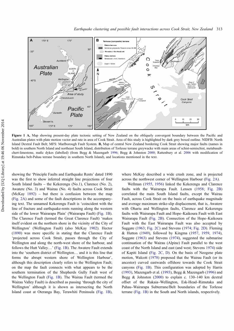
showing the ‘Principle Faults and Earthquake Rents’ dated 1890was the first to show inferred straight line projections of fourSouth Island faults – the Kekerengu (No.1), Clarence (No. 2),Awatere (No. 3) and Wairau (No. 4) faults across Cook Strait(McKay 1892) – but there is confusion between the map(Fig. 2A) and some of the fault descriptions in the accompany-ing text. The unnamed Kekerengu Fault is ‘coincident with theline of fracture and earthquake-rents running along the westernside of the lower Wairarapa Plain’ (Wairarapa Fault) (Fig. 1B).The Clarence Fault (termed the Great Clarence Fault) ‘makesitself evident on the northern shore in the vicinity of the City ofWellington’ (Wellington Fault) (also McKay 1902). Hector(1890) was more specific in stating that the Clarence Fault‘projected across Cook Strait, passes through the City ofWellington and along the north-west shore of the harbour, andfollows the Hutt Valley…’ (Fig. 1B). The Awatere Fault extendsinto the ‘southern district of Wellington… and it is this line thatforms the abrupt western shore of Wellington Harbour’,although this description clearly refers to the Wellington Fault;on the map the fault connects with what appears to be thesouthern termination of the Shepherds Gully Fault west ofthe Wellington Fault (Fig. 1B). The Wairau Fault (termed theWairau Valley Fault) is described as passing ‘through the city ofWellington’ although it is shown as intersecting the NorthIsland coast at Oteranga Bay, Terawhiti Peninsula (Fig. 1B),
where McKay described a wide crush zone, and is projectedacross the northwest corner of Wellington Harbour (Fig. 2A).
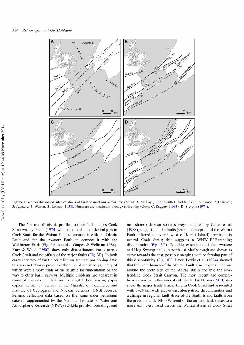
Wellman (1955, 1956) linked the Kekerengu and Clarencefaults with the Wairarapa Fault. Lensen (1958; Fig. 2B)correlated the main South Island faults, except the WairauFault, across Cook Strait on the basis of earthquake magnitudeand average maximum strike-slip displacement, that is, Awaterewith Ohariu and Wellington faults, Clarence and Kekerengufaults with Wairarapa Fault and Hope–Kaikoura Fault with EastWairarapa Fault (Fig. 2B). Connection of the Hope–KaikouraFault with the East Wairarapa Fault was also accepted bySuggate (1963; Fig. 2C) and Stevens (1974; Fig. 2D). Fleming& Hutton (1949), followed by Kingma (1957, 1959, 1974),Suggate (1963) and Stevens (1974), suggested the submarinecontinuation of the Wairau (Alpine) Fault parallel to the westcoast of the North Island and east (and west; Stevens 1974) sideof Kapiti Island (Fig. 2C, D). On the basis of Neogene platemotion, Walcott (1978) proposed that the Wairau Fault (or itsancestor) curved eastwards offshore towards the Cook Straitcanyons (Fig. 1B). This configuration was adopted by Harris(1993), Mazengarb et al. (1993), Begg & Mazengarb (1996) andBegg & Johnston (2000) to explain c. 130–140 km dextraloffset of the Rakaia–Wellington, Esk-Head–Rimutaka andPahau–Wairarapa Subterrane/Belt boundaries of the Torlesseterrane (Fig. 1B) in the South and North islands, respectively.
Figure 1 A, Map showing present-day plate tectonic setting of New Zealand on the obliquely convergent boundary between the Pacific andAustralian plates with plate motion vector and rate in area of Cook Strait. Area of this study is highlighted by dark grey boxed outline. NIDFB: NorthIsland Dextral Fault Belt; MFS: Marlborough Fault System. B, Map of central New Zealand bordering Cook Strait showing major faults (names inbold) in southern North Island and northeast South Island, distribution of Torlesse terrane greywacke with main areas of schist-semischist, metabasalt-chert-limestone, mafic dykes (labelled) (from Begg & Mazengarb 1996; Begg & Johnston 2000; Rattenbury et al. 2006 with modification ofRimutaka belt-Pahau terrane boundary in southern North Island), and locations mentioned in the text.
Earthquake clustering and possible fault interactions across Cook Strait, New Zealand 313
Dow
nloa
ded
by [
UQ
Lib
rary
] at
19:
46 0
6 N
ovem
ber
2014
The first use of seismic profiles to trace faults across CookStrait was by Ghani (1974) who postulated major dextral jogs inCook Strait for the Wairau Fault to connect it with the OhariuFault and for the Awatere Fault to connect it with theWellington Fault (Fig. 3A; see also Grapes & Wellman 1986).Katz & Wood (1980) show only discontinuous traces acrossCook Strait and no offsets of the major faults (Fig. 3B). In bothcases accuracy of fault plots relied on accurate positioning data;this was not always present at the time of the surveys, many ofwhich were simply trials of the seismic instrumentation on theway to other basin surveys. Multiple problems are apparent insome of the seismic data and no digital data remain; papercopies are all that remain in the Ministry of Commerce andInstitute of Geological and Nuclear Sciences (GNS) records.Seismic reflection data based on the same older petroleumdataset, supplemented by the National Institute of Water andAtmospheric Research (NIWA) 3.5 kHz profiles, soundings and
near-shore side-scan sonar surveys obtained by Carter et al.(1988), suggest that the faults (with the exception of the WairauFault inferred to extend west of Kapiti Island) terminate incentral Cook Strait; this suggests a WNW–ESE-trendingdiscontinuity (Fig. 3C). Possible extensions of the Awatereand Hog Swamp faults in northeast Marlborough are shown tocurve towards the east, possibly merging with or forming part ofthis discontinuity (Fig. 3C). Later, Lewis et al. (1994) showedthat the main branch of the Wairau Fault also projects in an arcaround the north side of the Wairau Basin and into the NW-trending Cook Strait Canyon. The most recent and compre-hensive seismic reflection data of Pondard & Barnes (2010) alsoshow the major faults terminating in Cook Strait and associatedwith 5–20 km wide step-overs, along-strike discontinuities anda change in regional fault strike of the South Island faults fromthe predominantly NE–SW trend of the on-land fault traces to amore east–west trend across the Wairau Basin in Cook Strait
Figure 2 Geomorphic-based interpretations of fault connections across Cook Strait. A, McKay (1892). South Island faults 1: not named; 2: Clarence;3: Awatere; 4: Wairau. B, Lensen (1958). Numbers are maximum average strike-slip values. C, Suggate (1963). D, Stevens (1974).
314 RH Grapes and GR Holdgate
Dow
nloa
ded
by [
UQ
Lib
rary
] at
19:
46 0
6 N
ovem
ber
2014

(Fig. 3D). The North and South island faults can be traced intoCook Strait for distances of 1–40 km (Pondard & Barnes 2010)(Fig. 3D).
Movement on the major Cook Strait faults is documentedby the onlapping latest Miocene–Holocene sequence. Faultsbreak the seabed and a widespread unconformity that is possiblymid-Castlecliffian or younger. The opening of Cook Straitappears to be intimately linked with possible rotation and dextralslip in Marlborough and southern North Island (Lamb 1988;Lamb & Bibby 1989; Roberts 1995). Pliocene palaeomagneticdata suggest that the northeast Marlborough coast has rotatedclockwise 20–40° about a northwest-striking kink plane since c.5 Ma (Roberts 1995; Little & Roberts 1997; Hall et al. 2004),resulting in the general discontinuity between the overall ENE–WSW-striking faults in northeast South Island (Marlborough
Fault System) and the NE–SW-trending faults of the North Island(North Island Dextral Fault Belt) (Fig. 1A).
Historical evidence and deductions for surface rupturingand ground deformation1848 earthquakes
The main shock of the 1848 earthquake sequence beginning at01:40 on 16 October 1848 is inferred to have been causedby rupturing of the Awatere Fault over an on-land distance of100–110 km (Lyell 1856b, c, 1868; Grapes et al. 1998; Mason &Little 2006), to produce an earthquake of magnitude MW7.4–7.7(Grapes et al. 1998; Mason & Little 2006). The main shockwas followed by three very large shocks on 17, 19 and 24October with probable magnitudes of between MW 6 and 7.5
Figure 3 Seismic-based interpretations of fault connections across Cook Strait. A, Ghani (1974); B, Katz & Wood (1980); C, Carter et al. (1988);D, Pondard & Barnes (2010).
Earthquake clustering and possible fault interactions across Cook Strait, New Zealand 315
Dow
nloa
ded
by [
UQ
Lib
rary
] at
19:
46 0
6 N
ovem
ber
2014

(Eiby 1973, 1980; Grapes et al. 2003). The sequence ofearthquakes between 16 October 1848 and 16 December 1849is given in table 1 of Grapes et al. (2003).
Ohariu Fault
In late November 1848, Reverend Taylor who was travellingfrom Wanganui to Wellington stopped at Waikanae and‘lunched with Major Durie, who walked with us to see somecracks formed by the earthquakes, they run N. and S. and areabout six inches wide; there are also circular holes in thisplace from which large quantities of gas escaped. About 2 miles[3.2 km] from Waikanae a large fissure of near 8 inches [20 cm]width opened on the side of a hill’ (Taylor 1848). It is notcertain whether Taylor was able to examine this ‘large fissure’or was told about it by Major Durie, but the width of the hill-slope fissure was obviously measured or estimated by closeobservation.
Two miles from Waikanae (the site of Major Durie’s houseand police barracks situated three-quarters of a mile [1.2 km]from the beach on the south side of the Waikanae River) is a hillacross the west-facing front of which runs the active trace of theOhariu Fault and along which the fissure (earthquake rupture) isinferred to have to have formed (Fig. 4). There is additionalevidence for a very young earthquake rupture on the OhariuFault in the Ohariu Valley c. 18 km south of Waikanae, 14Cdated at post-310–150 cal yr BP (Litchfield et al. 2010). Theseauthors suggest the possibility that the few centimetres–decimetres vertical displacement observed (no horizontal dis-placement could be determined) represents an event triggeredby the 1848 or 1855 earthquakes. The Ohariu Fault continuesnorth from the youngest event sites in the Ohariu Valley for atleast another 50 km to just north of Waikanae, and possibly fora further c. 60 km as the North Ohariu Fault (Palmer & VanDissen 2002). The evidence from Taylor (1848) at Waikanaethus implies rupturing on the Ohariu Fault in 1848 over aminimum distance of at least 47 km (Fig. 4).
There is also 14C dating evidence for earlier co-seismicityon the Awatere and Ohariu faults during the penultimateearthquake. On the Ohariu Fault this is closely constrainedfrom several sites between c. 19 and 47 km northeast from theCook Strait coast (Fig. 4) to 1050–1000 cal yr BP (Heron et al.1998; Litchfield et al. 2004, 2006; Cochran et al. 2007). On theAwatere Fault, the penultimate earthquake has been dated at980–1080 cal yr BP at two localities: 18 km (Lake Jasper) and69 km (Upcot trenches) southwest from the Cook Strait coast(Mason & Little 2006).
Wellington Fault
James McDowell wrote a letter entitled ‘Wellington Earth-quakes’, published in the 11 August 1909 Evening Post, inresponse to a lecture on Wellington Harbour and earthquakerisks to Wellington’s brick buildings by James McIntosh Bell,the then Director of the Geological Survey. McDowell refers to
information he obtained from John Valentime, who experiencedthe 1848 earthquakes in Wellington, regarding a fissure in theThorndon area that ‘was beyond Pipitea Point, and went upTinakori Road and into the harbour’ indicating that it had aNW–SE trend (Fig. 5A, B). Another account evidently describ-ing the same fissure originated from Edward Withers (1901),Quartermaster of the 65th Regiment stationed in Wellington atthe time of the 1848 and 1855 earthquakes. In combining (andconfusing) a description of both events, Withers mentionssomewhat exaggeratedly, ‘Immense chasms opening up, somepartially closing afterwards, one remains in a gully crossed by asuspension bridge now with a stream at the bottom and sidescovered with ferns, etc.’ The so-called ‘earthquake fissure’ wasa well-known feature following the 1848 earthquakes and wasalso referred to in the editorial of the Wanganui Chronicle andRangitikei Observer (23 November 1901) on the 1901 Cheviotearthquake, Canterbury as ‘… it was this earthquake [1848] webelieve, which caused the great crack which appears in
Figure 4 Map showing surface trace of the Ohariu Fault, southwestNorth Island with inferred location of 1848 hill slope fissure reportedby the Reverend Richard Taylor in November 1848, locations ofrupture sites along the Ohariu Fault dated at <310 cal yr BP andinferred to be one of the 1848 earthquakes and sites of penultimaterupturing at c. 1000 cal yr BP (see text).
316 RH Grapes and GR Holdgate
Dow
nloa
ded
by [
UQ
Lib
rary
] at
19:
46 0
6 N
ovem
ber
2014

Thorndon, Wellington, and which is believed to pass underCook’s Straits re-appearing again in that familiar feature knownas ‘The Earthquake track’ running up the Awatere valley. Seenfrom a distance lying on the ranges at the back of BlairichStation, it appears like a road cutting on the side of themountain, and may be traced for over 60 miles.’
The position of the fissure (or fissures) at Thorndondescribed by these sources indicates that it was located alongHobson Street Gully, which was a precipitous, V-shaped streamgully (Wakahikuai Stream) c. 35 m wide at the top and 330 m inlength extending across Thorndon Flat and appearing as a deepcleft in the sea cliff at Thorndon Quay (Adkin 1923; Hydro-graphic map ‘Lambton Harbour’ 1849; Fig. 5B), now coveredby the Wellington Motorway. The gully was therefore not afissure per se but a narrow stream-carved valley as shown in a1860s photograph (Fig. 6), along which fissuring is assumed tohave occurred and would suggest that the valley was (is)probably a fault-controlled feature. Whether there was anysurface displacement across the supposed 1848 fissure atThorndon, or that it formed only as a result of earthquake
shaking as other fissures reported elsewhere in Wellington(Fitzherbert 1848; Ironside 1891), is unknown. The officialreport on damage caused by the 1848 earthquakes (Collinsonet al. 1848) mentions that fissures formed ‘in the ground atWellington’ were ‘long narrow cracks, not larger than thosecaused by a long drought’. Ironside (1891) states ‘that severalextensive cracks and fissures were found in the land when the[earthquake] storm subsided’, but no specific localities arementioned in either report.
Borehole data from the Wellington Harbour Board along thesite of the Thorndon (Aotea Quay) breastwork (Adkin 1950;Fig. 5C) indicates that the trend of Hobson Street Gully lies onthe projected line of a fault which Adkin (1950) considered tobe a subsidiary fault lying c. 660 ft (200 m) east of what heassumed to be the main trace of the Wellington Fault.According to a section constructed from c. 30 ft deep boreholedata (Adkin 1950), the fault is inferred to dip east and disruptsharbour floor layers of broken greywacke sediment (interpretedas stream wash) (Fig. 5C) which Adkin states ‘… reveals, as theResident Engineer pointed out, a break in the sub-harbour
Figure 5 A, Map of Wellington Peninsula and Port Nicholson showing map areas of 5B and Fig. 7, and position of the Hutt bridge damaged by the19 October 1848 aftershock (see text). B, Map showing location of the 1848 fissure at Thorndon, Hobson Street Gully and Tinakori Road, Wellingtonand the mapped (solid line) and inferred (dashed line) surface trace of the Wellington Fault (after Perrin & Wood 2004; submarine trace after Lewis1989). C, Section along the Thorndon (Aotea Quay) breastworks (position of section line shown on B) depicting disturbed harbour sediment layers,inferred location and dip of a ‘subsidiary’ fault (after Adkin 1950).
Earthquake clustering and possible fault interactions across Cook Strait, New Zealand 317
Dow
nloa
ded
by [
UQ
Lib
rary
] at
19:
46 0
6 N
ovem
ber
2014

stratification, which may be ascribed to a rather recent move-ment on the Wellington Fault’. The disrupted layers of ‘Pre-European’ greywacke stream wash and the harbour bottomfloored by ‘Post-European … mucky pug and slimy silts’ thatoverlie the greywacke stream wash layers appear to beupthrown on the SE side of the fault (Fig. 5C). Adkinconjectured that if this fault was the seaward continuation ofthe Wellington Fault it would imply a ‘sharp bend or offset’ inthe on-land trace of the fault, which has been shown by Perrin &Wood (2003) to be probable (Fig. 5B). Whether or not there is asplay of the Wellington Fault that extends along Hobson StreetGully from this right-lateral bend or offset of the fault isunknown, but it is a tectonically feasible geometry. A distinctchange in the level of the Last Glacial terrace that formsThorndon Flat across Hobson Street Gully, shown in Fig. 6,suggests long-term uplift on the SE side of the proposed fault.This is consistent with the most recent displacement upthrownon the SE (harbour) side of the submarine trace of WellingtonFault (Lewis 1989).
There is one further unsubstantiated reference to a fissurepurportedly formed during the 1848 earthquakes that may havebeen close, and possibly parallel, to the line of the WellingtonFault: ‘to this day a fissure several feet in width and ofunknown depth near the Hutt Road, a mile or two out ofWellington, is pointed out as one of the effects of the earthquakeof 1848’ (article entitled ‘The Great Wellington Earthquake [of1848]’ published in Auckland Star on 12 June 1897). The dis-tance of 1–2 miles (1.6–3.2 km) along the Wellington–Hutt-Valley road, from Thorndon for example, would placethe fissure near Kaiwharawara and several hundred metres westof the submarine trace of the Wellington Fault (Lewis 1989;Fig. 5B). The fissure width of several feet suggests that it mayhave formed as a result of slumping of unconsolidated deltaicsediments that form the Kaiwharawara Stream salient intoWellington Harbour (Fig. 5B), possibly due to movement on
the Wellington Fault, that is, upthrown on its SE side(Lewis 1989).
The effects of the early morning aftershock on 19 October1848, considered to be the most violent of all the largeearthquakes in the 1848 sequence including the mainshock(e.g. New Zealand Spectator and Cook’s Strait Guardian 25October 1848; Eyre 1848 in British Parliamentary Papers 1849;Chapman 1849), and its northward propagation were experi-enced in the lower Hutt valley from the bridge over the HuttRiver (location shown in Fig. 5A). According to Hansard(1848), ‘The policeman standing on the Hutt bridge beforesunrise of the 19th, saw the river greatly agitated, and two orthree seconds afterwards, the ground shook beneath his feet.Just then, the bridge received the injury it is now seen to havesustained – the road for a considerable distance rose andsubsided like the waves of the sea; the motion graduallyapproached, and the policeman and his companion plainly feltit pass in an opposite direction towards the North’. The ‘injury’done to the bridge, constructed in 1847, was damage to one ofthe abutments and straining of the superstructure.
The formation of a fissure at Thorndon along Hobson StreetGully extending across the beach, into the harbour and upTinakori Road, the fissure inferred to have formed atKaiwharawhara, the Policeman’s account from the Hutt valleybridge and the severity of the 19 October earthquake inWellington (felt intensity of MMVII–MMVIII; Grapes et al.2003) all suggest the possibility of northwards propagation ofrupturing along a segment of the Wellington Fault at this time.
Lambton Harbour
A draft (Lyell 1856a) of Sir Charles Lyell’s well-known articlesreporting the details of the 1855 earthquake (Lyell 1856b, c,1868) mentions that ‘During a former earthquake in Oct. 1848the land at Wellington was much fissured and raised and the
Figure 6 A photographic panorama taken in 1860 looking south showing Thorndon Quay (beach), cliff and Thorndon Flat, with Lambton Harbour inthe distance. The prominent valley cutting through the cliff is Hobson Street Gully. In the background is Murphy Street with the first woodenfootbridge over the gully. The northern end of Tinakori Road can be seen in the lower centre of the photo (photographer unknown; reference no.F-122101-1/2, Alexander Turnbull Library, National Library of New Zealand).
318 RH Grapes and GR Holdgate
Dow
nloa
ded
by [
UQ
Lib
rary
] at
19:
46 0
6 N
ovem
ber
2014
soundings in the harbour of Port Nicholson altered so thatvessels were not able to anchor so near to the shore aspreviously’, implying some uplift. A remark by the WellingtonHarbour Master Charles Sharp, that ‘between Oct 1848 & 1855the whole [uplift] movement of 5 ft’ at Wellington recorded inLyell’s notes of an interview with Edward Roberts, Clerk ofWorks for the Wellington Provincial Government and a RoyalEngineer, would seem to offer indirect evidence for this uplift(Lyell 1856a). Additional information is provided by ReverendRichard Taylor: ‘several fissures were formed, and the land wasraised so much that the small craft which were accustomed toanchor close in shore, were obliged to change their ground’(Taylor 1855). While Taylor’s extract could be, and has been,dismissed as confusion with the well-known uplift that occurredin Wellington during the 1855 earthquake (Grapes & Downes1997), it needs to be considered in its respective context. Taylorwas in Wanganui in 1848 and recorded the effects of theearthquakes there. Following the extract quoted, he describesthe effects of the 1855 earthquake in Wellington by writing ‘AtWellington, the harbour is stated to have been raised full fourfeet and a half, and similar changes have taken place in everypart of the district’, so there is no confusion with his statementthat some uplift also occurred in 1848. Taylor was a carefulobserver and recorder of natural history, as seen from his bookTe Ika a Maui published in London in November 1855, but inthis case he does not name his source. Lyell was aware ofTaylor’s book and it is possible that his quote was taken from itor related to him by one of the eyewitnesses of the 1855earthquake that he interviewed in 1856. The identification ofTaylor’s as-yet unknown source would provide critical evidencefor uplift in Lambton Harbour in 1848. This may have beenEdward Roberts, who was in Wellington in 1848; he wasengaged in several harbour reclamation projects (in 1852, 1853,1854) and provided Taylor with a ‘Memorandum on theearthquake in the islands of New Zealand, January 23, 1855’that was published as an appendix in his book (Taylor 1855).Roberts also supplied Lyell with information about the effectsof the 1855 earthquake (Lyell 1856a).
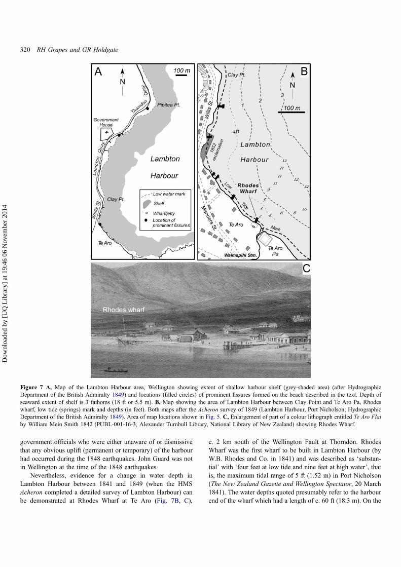
Although shallowing of Lambton Harbour or parts of it in1848 would be consistent with uplift on the SE side of theWellington Fault (Adkin 1950; Lewis 1989), a decrease in near-shore water depth as a result of liquefaction and lateralspreading of bottom sediments during the earthquakes is alsoa possibility considering the shallow bathymetry, nature of thebottom sediment and substrate. According to various sources,there is a ‘flat extending around Lambton Harbour for aconsiderable distance beyond low tide mark, and from whichit suddenly shelves into deep water’ (report by Byron Drury inthe New Zealand Spectator and Cook’s Strait Guardian, 24February 1855; Fig. 7A); ‘the shore shelves off gradually fromlow water mark … with a soft muddy bottom’ (Carkeek &Sharp 1852); and, concerning the feasibility of constructing awharf near Clay Point in Lambton Harbour, Edward Roberts(1853) pointed out that the ‘obstacle to a piled jetty is theimpossibility of driving piles farther than about three feet into
the ground, in consequence of the rocky nature of the bottomimmediately under the superstratum of mud.’ During and afterthe earthquakes, prominent fissures were described by manysources on the beach fronting Lambton Harbour (Fig. 7A). Forexample, ‘a crack was discovered on the beach [after the shockof Tuesday 17th] from the west of Colonel Gold’s house [Te Aroflat] to McBeths [Willis Street] store nearby’ (Oliver 1848).Samuel Chapman, a conscientious recorder of the 1848 earth-quakes, mentions ‘… a slight change of surface on the beach atWellington – where one side of a slight fissure was left a fewinches below the other, some pi-pi (cockle) shells having beenpushed to the surface’ (Chapman 1849). According to reports inNew Zealand Spectator and Cook’s Strait Guardian on 25October 1848, ‘several cracks or fissures were observed in theearth [after the shock of Thursday 19th], the most remarkablebeing on the beach on Thorndon Quay a short distance beyondthe Cottage of Content’ [hotel on Thorndon Quay near PipiteaPoint]. Ironside (1891) wrote: ‘I remember putting my walkingstick, a big stout one, into a fissure a little west of Barrett’sHotel [Lambton Quay]. I held the stick by its knob, and let itfall to its entire length, but could feel no bottom; I moved it toand fro, but it was empty space, so far as my limited means ofexamination could determine’. It seems possible that thesebeach fissures may have been manifestations of seawardmovement of shallow bottom sediments and their re-depositionacross the shelf area surrounding Lambton Harbour (Fig. 7A),causing the shallowing described.
A search for corroborative evidence of any uplift or change inwater depth in Lambton Harbour during the 1848 earthquakes(e.g. in newspapers, Wellington Harbour Master’s reports for1848 and 1849 and inwards correspondence to the ColonialSecretary) failed to find anything. There are however reports tothe contrary by Commander Byron Drury of HMS Pandora whowas in Wellington during the 1855 earthquake and whoresounded the harbour after the earthquake uplift that occurredat that time, and from Charles Mills and Charles Carter who werecommissioned to produce a report on the same earthquake by theWellington Provincial Government. Drury wrote ‘I am inclined tobelieve that the upheaving which certainly did take place on the23rd ult. [1855] was the work of an instant, and within thefollowing 12 hours, when the sea was seen approaching andreceding in such an extraordinary manner. This was not observedin 1848, because there was no change in the level.’ (New ZealandSpectator and Cook’s Strait Guardian, 24 February 1855). Mills &Carter (1855) stated that on ‘the recent [1855] sudden upheavalof part of the Province of Wellington, there is good reason tobelieve is a rare occurrence. No white man that we can learn ofhas ever witnessed it before. One of the oldest inhabitants ofCook’s straits, Mr. John Guard [a whaler based in ToryChannel, Marlborough Sounds], says “the last earthquake wasthe most violent one he ever knew in this country”, and he haslived in it for a period of twenty-two years, and he never beforewitnessed a perceptible rise of the land after the shock of anearthquake.’ Drury’s information came from an unknown inform-ant or informants, almost certainly in Wellington, and probably
Earthquake clustering and possible fault interactions across Cook Strait, New Zealand 319
Dow
nloa
ded
by [
UQ
Lib
rary
] at
19:
46 0
6 N
ovem
ber
2014
government officials who were either unaware of or dismissivethat any obvious uplift (permanent or temporary) of the harbourhad occurred during the 1848 earthquakes. John Guard was notin Wellington at the time of the 1848 earthquakes.
Nevertheless, evidence for a change in water depth inLambton Harbour between 1841 and 1849 (when the HMSAcheron completed a detailed survey of Lambton Harbour) canbe demonstrated at Rhodes Wharf at Te Aro (Fig. 7B, C),
c. 2 km south of the Wellington Fault at Thorndon. RhodesWharf was the first wharf to be built in Lambton Harbour (byW.B. Rhodes and Co. in 1841) and was described as ‘substan-tial’ with ‘four feet at low tide and nine feet at high water’, thatis, the maximum tidal range of 5 ft (1.52 m) in Port Nicholson(The New Zealand Gazette and Wellington Spectator, 20 March1841). The water depths quoted presumably refer to the harbourend of the wharf which had a length of c. 60 ft (18.3 m). On the
Figure 7 A, Map of the Lambton Harbour area, Wellington showing extent of shallow harbour shelf (grey-shaded area) (after HydrographicDepartment of the British Admiralty 1849) and locations (filled circles) of prominent fissures formed on the beach described in the text. Depth ofseaward extent of shelf is 3 fathoms (18 ft or 5.5 m). B, Map showing the area of Lambton Harbour between Clay Point and Te Aro Pa, Rhodeswharf, low tide (springs) mark and depths (in feet). Both maps after the Acheron survey of 1849 (Lambton Harbour, Port Nicholson; HydrographicDepartment of the British Admiralty 1849). Area of map locations shown in Fig. 5. C, Enlargement of part of a colour lithograph entitled Te Aro Flatby William Mein Smith 1842 (PUBL-001-16-3, Alexander Turnbull Library, National Library of New Zealand) showing Rhodes Wharf.
320 RH Grapes and GR Holdgate
Dow
nloa
ded
by [
UQ
Lib
rary
] at
19:
46 0
6 N
ovem
ber
2014
Acheron map of 1849 (Hydrographic Department of the BritishAdmiralty 1849) two sounding tracks converge at Rhodes wharfand indicate a low water springs depth of 2 ft (0.6 m) (Fig. 7B),implying a shallowing of about this amount between 1841 and1849; some of this may have been due to tectonic uplift orpossibly lateral spreading related to the fissure on Te Aro beachrecorded by Oliver (1848) during the 1848 earthquakes.Construction of a 300 ft shore-shallow water profile from theAcheron survey and the steep beach profile evident in the 1842lithograph by William Mein Smith (Fig. 7C) indicates thattectonic uplift of 2 ft (0.6 m) would result in a seaward shift ofthe low water springs mark by c. 4–5 ft (1.2–1.5 m). Anotherpossible cause of shallowing is accelerated deposition ofsediment into the harbour following the 1848 earthquakes,particularly as Rhodes Wharf is situated near where WaimapihiStream debouches into Lambton Harbour (Fig. 7B). In the1850s, deforestation in the area of the headwaters of this stream(Poolhill Gully) caused extensive deposition of sediment thatbuilt a prominent, tongue-like extension of the shorelineimmediately east of the wharf as shown in a photograph of TeAro in c. 1857 (F.J. Denton; reproduced as fig. 18 in Grapes &Downes 1997) and documented in legal proceedings relating toclaims of this part of the Te Aro foreshore reported in theEvening Post (6 September 1907). Such an extension of theforeshore at low tide is not shown on the 1849 AcheronLambton Harbour map, indicating that there was no obviousaccelerated deposition by the stream following the earthquakesin 1848 or when bush clearing of the hills surroundingWellington had not been carried out to any great extent.Nevertheless, over the 7 year period between the constructionof the wharf and the earthquakes in 1848, some deposition ofsediment from this stream into the shallow part of the harbour atTe Aro must have taken place and the 2 ft difference in waterdepth can only provide a maximum possible tectonic uplift and/or shallowing by lateral spreading in 1848 at this locality.Unfortunately, no reports have been found mentioning thatRhodes Wharf was extended following the earthquakes in orderto maintain the pre-earthquake water depth of 4 ft (1.2 m) atlow tide.
Although this example provides support for the statementsof Lyell, Taylor and possibly the Harbour Master Charles Sharpthat there was uplift or shallowing of Lambton Harbour duringthe 1848 earthquakes, the cause is problematical; the fact thatnothing was reported during or after the earthquakes, especiallyin the Wellington newspapers, is discouraging. A possibleexplanation could be the occurrence of unusually high tidesduring the earthquakes variously documented: (1) as the resultof prolonged SE gales which blow directly into the harbour andheavy rain rising 1 ft above high water springs eight hours afterthe first shock on October 16 (Chapman 1849); (2) on themorning of 18 October (about 11 hours after the 15:40 shock onthe 17th) when the tide, although at neap, rose 18 inches abovehigh water springs level and flooded the beach road aroundLambton Harbour and the lower parts of houses (New ZealandSpectator and Cook’s Straits Guardian, 18 October 1848;
Fitzherbert 1848; Thomas 1848; Chapman 1849); and (3) an‘unusually high tide’ on 19 October, about six and a half hoursafter the shock at 05:03 (Thomas 1848). It was concluded at thetime that these abnormally high tides attracted more attentionthan usual because they occurred during the earthquakes,but they were not associated with the times of the main shocks(Fitzherbert 1848; Chapman 1849). Ironside (1891) alsoremarks that the ‘vagaries of the inflow and receding of thewaters caused no doubt by submarine action, were remarkable’.While there are reports of unusually high tides flooding anddamaging the beach road and parts of its retaining wall frontingLambton Harbour prior to the 1848 earthquakes (e.g. NewZealand Spectator and Cook’s Strait Guardian, 10 May 1848),no reports of tidal flooding have been found between October1848 and the 23 January 1855 earthquake when prolongedseiching occurred in Port Nicholson (Grapes & Downes 1997).This suggests that, if there was tectonic shallowing of theharbour in 1848, it was sufficient to prevent the low landfronting Lambton Harbour (Te Aro and Lambton Quay inparticular) from being inundated during storm-induced higher-than-normal high tide levels.
1855 earthquakes
The 23 January 1855 MS ≅ 8.2 earthquake was caused byrupturing of the Wairarapa Fault over an on-land distance ofc. 120 km and possibly for a further c. 40 km into Cook Straiton the offshore extension of the Wharekauhau Fault. It involvedvertical and horizontal fault displacement and northwest tiltingaffecting the southwest North Island and northeast South Island(Lyell 1856b, c, 1868; Grapes & Wellman 1988; Grapes &Downes 1997; Grapes 1999; Schermer et al. 2004; Barnes2005; Rogers & Little 2006; Grapes & Downes 2010). Thesequence of aftershocks from 23 January to 2 May 1855 islisted in Grapes & Downes (1997). The mainshock at 21:11 on23 January was followed by a tsunami and large aftershockswithin a few hours and over the next few days; these werestrongly felt along the northeast Marlborough coast with at leastone aftershock generating a tsunami on 3 February (Grapes &Downes 1997). A comprehensive record of earthquakes fromthe main shock on 23 January until 11 February, kept byAlexander Mowat (1855) of Altimarlock Station, AwatereValley c. 30 km from the coast, suggests intensities of MMVIIIand possibly MMIX. Frederick Trolove (1855) on the Marlbor-ough coast suggested intensities of MMVII to possibly MMIX(both accounts transcribed in Downes & Grapes 1999).
Awatere Fault
According to the Nelson Examiner (21 February 1855) in theAwatere Valley, ‘nearly all the cob buildings, within twentymiles [32 km, to Altimarlock] of the sea, were more or lessdamaged, but beyond this the force of the shocks sensiblydiminished’. There are several reports of fissures being formedor being re-opened along the Awatere Fault during the 1855
Earthquake clustering and possible fault interactions across Cook Strait, New Zealand 321
Dow
nloa
ded
by [
UQ
Lib
rary
] at
19:
46 0
6 N
ovem
ber
2014

earthquakes. Although these were written or communicatedmany years after the earthquake, it is clear that all the sourceswere aware of the formation of a fissure along the AwatereValley prior to the 1855 earthquake and that it was a prominentfeature or ‘a great rent’ that formed in 1848, as documented byLyell (1856c, 1868) and Hochstetter (1863, 1864). Frominformation on the effects of the 1855 earthquake supplied byJulius von Haast who visited the lower Awatere and Wairauvalleys during 12–24 September 1859, Hochstetter (1863)records, ‘In the Awatere Valley the surface split and fissuresand scarplets formed. One of these fissures could be continu-ously followed for 40 English miles, of which traces could stillbe observed by my friend Haast in 1859, some of them 3 feetwide and several feet deep.’ As Haast only travelled c. 20 kmup the valley (from Maxwell Pass to Puddingstone Hill viaBlairich and Altimarlock stations; Hochstetter 1859; Fig. 8A),he must have obtained the information about one particularfissure (or fissures) extending for 40 miles from locals,presumably the Mowats of Altimarlock Station and the McRaesof Blairich Station. In his Geology of New Zealand, Hochstetter(1864, p. 38) confirmed the information that, in 1855, in ‘theAwatere Valley (Marlborough) the ground suffered powerfulrents and fissures which could be followed for a distance of40 miles and still gaped locally several feet wide in the year1859’. He was well aware of a fissure which had formed alongthe Awatere Valley in 1848, and refers to this as ‘a great rent’and a ‘remarkable phenomenon. It is visible on the north side ofthe river [Awatere River] from White Bluff, over hill and valefor a distance of many miles, right to Berfeld’s [Barefell] Pass(Fig. 8A). In many places, the fissure is said to be 5 to 6 ft. deepand 30 ft. broad and it resembles a canal without water for miles
on end’ (Hochstetter 1864, p. 231). Twenty years later, whencommenting on Alexander McKay’s observations of the Awa-tere Fault, Sir James Hector (1890) wrote, ‘It has till now beenconsidered that this Awatere earthquake-rent had its origin inand was caused by the earthquakes of 1855. Mrs Mouat[Mowat] of Altimarlock informed Mr. McKay that the openrents and fissures yet to be seen on the surface along the line offracture were not produced by the disturbances of 1855 butwere caused by the earthquakes of 1848. It may have been asstated, but it is equally probable that fresh fractures may havetaken place on both dates. Mr. McKay came to the conclusion,and both here [Altimarloch Station] and further up the valleyobtained distinct proof, that the earthquakes of 1848 and 1855did but open afresh an old line of dislocation, and producedmeagre results compared with the total movement which hastaken place along this line.’ How McKay was able to obtain this‘distinct proof’ and the evidence he used is not stated, butduring 1888–1889 he examined the geology of the AwatereValley as far as Middlehurst (92 km from the Cook Strait coast;Grapes 2009) and may have obtained eye-witness informationof the 1855 fissuring from the upper Awatere Valley stations(Glenlee, Camden, Mt Gladstone, Upcot, Middlehurst, Langridgeand Muller; Kennington 1978) that had been settled since theearly 1850s.
Other reports describing rupturing along the fault during the1855 earthquake state that ‘On Fairfield Downs [upper AwatereValley], a fissure was opened as far as the eye could see, andperfectly straight’ (letter in Hawkes Bay Herald, 20 January1894, from ‘a pioneer of the early fifties’ who was living inWellington in 1855, but went to Marlborough soon after theearthquake to investigate an erroneous report of an erupting
Figure 8 A, Map showing Awatere and Vernon faults, northeast Marlborough (after Begg & Johnston 2000) and localities described in the text;B, map; and C, map and sections of ‘recent’ fissures developed along the surface trace of the Awatere Fault near Upcot Saddle that may have formedin 1855, 1848 or both (unpublished survey by R. Grapes, 1997).
322 RH Grapes and GR Holdgate
Dow
nloa
ded
by [
UQ
Lib
rary
] at
19:
46 0
6 N
ovem
ber
2014

volcano); according to James McKay, who was near CapeFarwell during the 1855 earthquake and experienced the effectof tsunami waves on the spit, in the Awatere Valley ‘anenormous rift was made, which was of considerable depth andwidth, and extended for several miles in a straight line, andI believe it can still be traced. I have not seen it for thirty-twoyears [since 1862], but it was very plainly visible then’ (articleentitled ‘Quaky Wellington, some historical earthquakes’ in theAuckland Star, 25 May 1894); and ‘the earthquake crack inMarlborough was much enlarged…’ (article by H.C. Field, anengineer based at Wanganui who arrived in New Zealand in1851 and wrote a number of articles on the earthquakes heexperienced in 1855, 1891 and 1897, including ‘Wanganuiearthquakes’ in the Wanganui Herald, 19 June 1902). In anarticle entitled ‘Nature Notes’ in the New Zealand Herald,1 April 1922, James Drummond (a well-known science writer/journalist) records that ‘Marlborough residents date the fracture[Awatere Fault] from two historical earthquake years, 1848 and1855. Although deep rents were made in the fracture in thoseyears, it was a line of weakness long before the Europeans cameto New Zealand’.
The amount of displacement, if any, on the Awatere Faultduring the 1855 earthquake cannot be determined. It would bevirtually impossible to see any definitive geomorphic evidenceof vertical or horizontal movement on the fault at this timegiven the 7 year interval between the two earthquakes, butthe smallest mean horizontal displacement assumed to representthe latest movement (or possibly the sum of two co-seismicmovements) on the fault is 5.3 ± 1.6 m over an on-land distanceof c. 110 km (Grapes et al. 1998; Little et al. 1998; Mason &Little 2006). Fissuring along the line of the Awatere Fault ispreserved at Upcot Saddle in the upper Awatere Valley and wasrevealed by augering across a shallow marshy area pondedagainst the fault scarp (Fig. 8B, C). Profiles indicate two distincten echelon fissures up to 1.35 m deep and 3 m wide at thesurface and a suggestion of uplift on the northwest side, but theearthquake which caused the fissuring (although obviously‘recent’) could have been 1848, 1855 or both.
Vernon Fault and lower Wairau Valley
Observations of fissuring along what could be the Vernon Fault(Fig. 8) were made in 1856 by W.H.S. Roberts in a series ofarticles entitled ‘Overland from Nelson to Southland in 1856’(North Otago Times, 22 June 1894). Roberts refers to the trackgenerally used between the Wairau and the Awatere valleys viaMaxwell Pass, and recollected ‘… a crack or chasm across thehills at this pass, in places more than a foot wide, which hadbeen made by the earthquake in 1854 (sic). It was verydangerous. I dropped stones into it to try and ascertain thedepth, but could only hear them tumbling from side to side,until the sound was lost in the unknown abyss. The track onreaching the Awatere plain turned westward’. The section of theVernon Fault that crosses the Maxwell Pass track consists of
two NNE-striking strands c. 300 m apart and 2.1–2.3 kmsoutheast of Maxwell Pass (Fig. 8A).
Historical evidence also indicates subsidence of the Wairaulagoons area on the northern side of the Vernon Fault in 1855(Fig. 8A) of 0.5–0.6 m to as much as 1.5 m (Mason 1855;Roberts 1855; unknown source quoted in Buick 1900; Budge,1855, letter to Superintendent of Nelson, quoted in McIntosh1940; see also Grapes & Downes 1997, 2010 for discussion).Displacement on the Vernon Fault is dominantly strike-slip(vertical component of long-term movement up to 0.14 ±0.05 mm a−1) as determined by Clark et al. (2011) who alsosuggest that a portion of the vertical displacement that doesoccur on parts of the shallow south-dipping Vernon Fault mayresult in absolute uplift of the Vernon Hills to the south of thefault, rather than absolute subsidence of the Wairau lagoon areato the north. Hayward et al. (2010) show from lithological andmicrofossil evidence that there has been 3–4 m of subsidencealong the south side of the Wairau lagoons in the last 3–4 ka,and suggest either gradual subsidence or a series of smalldownthrows on the north side of the Vernon Fault. In anotherarea c. 2.6 km northwest of the fault they document earthquake-induced subsidence of c. 0.5 m that is attributed to the 1855earthquake, confirming the historical evidence quoted above.Subsidence of the lagoons area that occurred in 1855 was theresult of local compaction and regional tectonic tilting causedby uplift on the Wairarapa–Wharekauhau faults in southernNorth Island (Grapes & Downes 1997, 2010; Hayward et al.2010; Clark et al. 2011), with tectonic subsidence of the lowerWairau Valley terminating at the Vernon Fault. This is supportedby the fact that the coastal route around White Bluffs(immediately south and on the upthrown side of the fault;Fig. 8A) does not appear to have been adversely affected,although ‘…the tides after Jany 1855 were irregular at theWhite Bluffs for weeks’ (Lyell 1856a).
Coastal area, northeast Marlborough
Severe aftershocks of the 23 January 1855 earthquake werereported from the northern coastal area of Marlborough and arediscussed by Grapes & Downes (1997, pp. 357–358). Follow-ing the main shock at 21:11, another of even greater severityoccurred in ‘the middle of the night’ (Trolove 1855); this wasprobably the same shock as that described by Frederick Weldwhich he ‘supposed to be local’ and ‘had the same strength asthe first one’ (Lyell 1856a). Three ‘heavier shocks than anybefore’ and another about an hour later were recorded byFrederick Trolove (1855) during the night of 24/25 January. Thedamage described by Trolove suggests a local source for thesestrong aftershocks (probably up to MMVIII) (Grapes & Downes1997). These ‘local’ shocks evidently caused widespread land-sliding along the Kaikoura coast. Between Kekerengu and ‘TheFlags’ (Fig. 9A), a few days after 23 January Trolove (1855)found ‘the hills very much shaken and split’ and betweenKekerengu and the Clarence River ‘the overhanging hills alongthe beach are now bare of vegetation as can be well imagined
Earthquake clustering and possible fault interactions across Cook Strait, New Zealand 323
Dow
nloa
ded
by [
UQ
Lib
rary
] at
19:
46 0
6 N
ovem
ber
2014

owing the slips’. David Monro (1855) noted that, opposite LakeElterwater (Fig. 9A) on Weld’s Flaxbourne station, ‘in manyplaces the ground is very much cracked and the sides of the hills[London Hill east of Lake Elterwater] have slipped’. Lyell(1856a) notes ‘Sev[e]ral landslips into the sea & into valleystook place. This was chiefly S of Cape Campbell to WaipapaPoint’ (Clarence River mouth salient 57 km southwest of CapeCampbell). At Cape Campbell itself, ‘parts of the mountain fellexposing white rocks’ (Hochstetter 1864).
Information for uplift of the coastal area of northeastMarlborough during the 1855 earthquakes is recorded by Lyell(1856a) from information supplied by Frederick Weld. Thisincluded uplift at Lake Grassmere (at that time called Kaipar-atehau) and further south at Flaxbourne (Fig. 9A): ‘A lakecalled Kaiparatehau wh[ich] was large & near 1 ½ miles indiameter now 4 ft. [1.2 m] higher than it was – no filling up,rocks & stones now stirred up in it. It was below the level of thesea, now it drains thru’ the shingle banks and is smaller &smaller as the land rose – chiefly perhaps in 1848 but seeminglygradual [presumably a reference to gradual shallowing of the
lake as a result of sedimentation]. Wall made near the lake ofsod or an embankment which is now many yards (30) [27 m]from the water in ordinary state of the water – this may beowing to about 2 ft. [0.2 m] rise of the land [in 1855]’. Thereare also the statements: ‘At the station lake [Lake Elterwater] atFlaxbourne there was an out-house of people living up thevalley of F [Flaxbourne]. People c[ould] not see the sea but afterthe earthquake of 1855 they could’, and ‘Whether the upper partof the valley rose as did the W. [Wairarapa? Wairau? surface] orthe lower sank unknown’ (Fig. 9A). The mention of upliftcausing the lake to become smaller in 1855 but ‘chiefly perhapsin 1848’ is curious as there is no immediate evidence of coastaluplift south of the Awatere Valley in 1848 and in 1855,according to Weld, ‘the tides were very irregular after theearthquake so that it was impossible to tell whether there hadbeen any uplift or subsidence except at favoured spots’. Asthere is beach ridge evidence of Quaternary uplift in the LakeGrassmere area (Ota et al. 1995), perhaps some uplift (the 2 ftmentioned by Lyell 1856a) in 1855 is not unexpected. The otherstatement of Lyell about being able to see the sea after the
Figure 9 A, Map showing the northeast Marlborough coastal area with main onshore faults (Awatere, Hogg Swamp, Haldon Hills, Flaxbourne,London and Kekerengu) and offshore faults (Needles and Chancet), synclinal axes and locations mentioned in text. Arrowed solid line orientatedsoutheast along the Flaxbourne River indicates line of sight from western side of Lake Elterwater to the coast mentioned in the text. B, Does SirCharles Lyell’s (1856a) sketch of the coast from Needles Point (White Rock) to The Flags illustrate the direction of the wave generated during theaftershock of 3 February 1855 (see text for details)? Arrowed dotted line within area of Lyell’s sketch map in A indicates approximate direction of thestanding wave shown in B.
324 RH Grapes and GR Holdgate
Dow
nloa
ded
by [
UQ
Lib
rary
] at
19:
46 0
6 N
ovem
ber
2014

earthquakes from the western side of Lake Elterwater in theFlaxbourne River valley provides better evidence for tectonicuplift. The site provided a clear line of sight down theFlaxbourne River by way of an opening through the coastalhills to the sea (arrowed line in Fig. 9A). Additional informationconcerning possible uplift at Flaxbourne comes from a letterwritten by an employee of Flaxbourne Station, Mr EdwardRoberts, to the previous station manager, E. Weld (son ofFrederick) about the effects of past earthquakes and asking ifthe river had been shallowed by the 1855 (‘big’) earthquake.The reply (dated 7 January 1949) states ‘Flaxbourne River wasdeep enough for small craft to come up as far as the old boiling-down plant, and that was the reason that the original homesteadwas established a short distance further up the river. The bigearthquake of which you speak in your letter was responsiblefor the alteration’ (Weld 1949). A personal communication inCotton (1914) states that the same E. Weld informed him thatthe bed of the Flaxbourne River had been ‘perceptibly raised’(cause not stated); Cotton concluded that the shallowing wasdue to aggradation resulting of man-made destruction of theoriginal vegetation. When the area was first settled in 1847 byFrederick Weld it was largely grassland and certainly notforested (Weld 1846–51), but the possibility of aggradation inthe Flaxbourne River caused by earthquake-induced landslidedebris (as described above) is a more likely explanation.
The characteristics, extent and effects of tsunami generatedby the main shock of the 1855 earthquakes on 23 January aredocumented by Grapes & Downes (1997). The same authorsalso discuss evidence for tidal disturbances affecting theKaikoura coast, Marlborough; these were caused by severeaftershocks that appear to have been localised to that area asthey were not specifically recorded as particularly strong in theAwatere Valley or in Wellington (Grapes & Downes 1997). Theeffects of tsunami were observed by Frederick Trolove (1855)on 26 January (‘The sea has been inland many feet above highwatermark. Indeed in some places the sea occupies what used tobe green bushes and grass’) and 30 January (‘My boat at theFlags was taken away 20 yards [18 m] inland by the roll whichcame in from seaward and left high and dry on the greensward’). It is unclear from the above extracts if they refer to theresult of tsunami that followed the main shock on 23 January, orof one or more tsunami generated by the strong shocks thatoccurred during the nights of 23/24 and 24/25 January as felt onthe Kaikoura coast (Grapes & Downes 1997). Lyell’s statement(quoted above) of ‘several landslips into the sea’ between CapeCampbell to the Clarence River suggests that local tsunami mayhave been generated, although the timing of the landslips is notrecorded. A local tsunami was produced by an aftershock on 3February. Trolove (1855) was loading wool onto a ship from thebeach at ‘The Flags’ (Wharanui; Fig. 9B) and observed ‘a heavyshock out at sea. It made the sea appear on the horizon like ahilly and undulating country; it also caused a swell on the beachfor about an hour after.’ An account of what appears to havebeen the same earthquake is also given by Lyell (1856a) andprovided by Frederick Weld: ‘Some people who were loading a
vessel with wood [sic. wool?] at a place called the Flags southof Cape Campbell, saw the sea [“movements of the” crossedout] earthquake at a distance of three miles north of them at aplace called the White Rocks [Needles Point]. It was mademanifest by clouds of dust and by the rolling of stones from thetops of the cliffs and an undulatory motion in the sands of thebeach. As it approached them it was accompanied by a wave ofthe sea which broke upon the coast. Mr. Weld says that therewere waves in opposite directions which occasioned differencesof opinion as to whether the earthquake travelled from NE toSW or in a contrary direction.’ Lyell (1856a) also records thatthe wave was ‘outside or seaward of the vessel leaving her insmooth water between the wave & the land’, and provides adiagram (Fig. 9B) showing the course of the sea disturbancetravelling in a southeast direction and that the same wave ‘brokeupon the N. East coast of the Middle Island for a distance ofabout 50 miles’. This earthquake and the apparent narrow zoneof disturbed water and ground disturbance travelling in asoutheast direction suggests NW–SE fault rupturing andassociated coastal rock falls and submarine slumping.
Discussion
The distribution and density of faults and their apparentterminations in Cook Strait (Fig. 3C, D) suggest that stressloading associated with large-magnitude earthquakes couldtrigger movement on nearby faults (e.g. King et al. 1994;Pondard & Barnes 2010), potentially resulting in a cascading offault rupturing across Cook Strait. Coulomb static stressmodelling of hypothetical and historical earthquake rupturingacross Cook Strait by Pondard & Barnes (2010) suggests lateralstress loading of c. 100 bar with an area of c. 10 km from theends of ruptured faults, decreasing to c. 1–10 bar away from thefaults. Although the stress increase is much less than thatreleased in the initial earthquake, its effects can be significant. Ifthe stress change is transient it could result in a burst ofaftershocks in the days and weeks following the mainshock(Parsons 2005), some of which may be large enough to indicateadditional fault displacement. This appears to have occurredduring the 1848 and 1855 earthquakes.
The 1848 earthquake sequence began at 01:40 on 16October with mainshock rupturing for c. 110 km along theAwatere Fault in northeast Marlborough and probably extendinginto Cook Strait for a further c. 10 km, that is, as far as thecontinuous trace of the fault is mapped and/or on anothersubparallel fault to the east (Pondard & Barnes 2010; Fig. 10A).As there is no evidence of tectonic subsidence of the LowerWairau Valley, northeast Marlborough in 1848, althoughlocalised subsidence due to compaction and liquefaction wereobserved, it would appear that there was no transference ofmovement from the Awatere Fault to the Vernon Fault atthis time.
Within a period of one week following the mainshock (tothe strong aftershock of 24 October), large shocks triggered bystress transfer and loading (e.g. Reasenberg & Simpson 1992;
Earthquake clustering and possible fault interactions across Cook Strait, New Zealand 325
Dow
nloa
ded
by [
UQ
Lib
rary
] at
19:
46 0
6 N
ovem
ber
2014

King et al. 1994; Harris & Simpson 1998; Stein 1999; Robinson2004) are inferred to have been associated with movement onthe Ohariu Fault and possibly the Wellington Fault which mayhave extended from Cook Strait, that is, on their submarinetraces of c. 20 and 25 km, respectively (Pondard & Barnes2010; Fig. 10A). Information that could support a Cook Straitextension of rupture is reported in the New Zealand Evangelist(1848): ‘From the Heads [entrance to Port Nicholson] round toCape Terawite [Terawhiti; i.e. Cook Strait coast of the WellingtonPeninsula; Fig. 10A] large rocks were rent, and fragments rolleddown and were precipitated into the sea’. There is no evidence
for very recent displacement of the Vernon and Cloudy faultsthat intervene between the Cook Strait terminations of theAwatere and Ohariu–Wellington faults (Pondard & Barnes2010; Fig. 3D). From the localities of probable 1848 verticaldisplacement on the Ohariu Fault (Litchfield et al. 2010; thispaper), the submarine–on-land rupture length could have beenc. 80 km (Fig. 10A). Apparent shallowing in Lambton Harbourwould be consistent with tectonic uplift (probably < 0.6 m) onthe southeast side of the Wellington Fault, but the extent of anyuplift along and east of the fault is unknown and there is noevidence indicating horizontal movement. The available data is
Figure 10 A, Map showing inferred fault ruptures related to the 1848 earthquakes as described in text. Thick grey line shows inferred 1848seismogenic zone across Cook Strait. B, Map showing inferred fault ruptures related to the 1855 earthquakes as described in text. Thick grey linesindicate inferred 1855 seismogenic zones across Cook Strait; barbed lines indicate thrust fault (i.e. Wharekauhau Fault). On both maps the sense ofhorizontal (opposing arrowed lines) and vertical (u: up; d: down) fault displacement are shown. Cook Strait faults after Pondard & Barnes (2010).
326 RH Grapes and GR Holdgate
Dow
nloa
ded
by [
UQ
Lib
rary
] at
19:
46 0
6 N
ovem
ber
2014

inconclusive as to whether 1848 shallowing in LambtonHarbour was the result of uplift on the Wellington Fault orlateral spreading of shallow harbour sediment. From theevidence at hand, we conjecture that any fissuring (implyingseismogenic displacement) along the Wellington Fault in 1848probably took place during the large shock of 19 October andthat it was perhaps only a few centimetres (vertical) at most, asrecorded for the most recent (1848) rupture along the OhariuFault.
Radiocarbon dating constrains the timing of the most recentearthquake displacements on the Ohariu and Wellington faultsto <310 cal yr BP (Litchfield et al. 2010; Langridge et al. 2011),and is therefore not incompatible with an inferred small amountof movement on both faults in 1848. Coincidence of the timingof the penultimate earthquake or earthquakes on the Ohariu andAwatere faults at c. 1000 cal yr BP reinforces the notion of atriggered earthquake link between these faults (Van Dissenet al. 2007).
The 23 January 1855 MS ≅ 8.2 earthquake was caused byrupturing of the Wairarapa Fault over an on-land distance of c.120 km and for a further c. 35 km into Cook Strait on theoffshore extension of the Wharekauhau Fault zone and possiblythe Nicholson Bank East Fault (Fig. 10B). Northwest tiltingaffecting the southwest North Island and northeast South Islandindicates that rupturing during the mainshock also extendedacross Cook Strait, probably via the Nicholson Bank WestFault, to the offshore extension of the Vernon Fault, for 15 kmalong the on-land trace of this fault (resulting in tectonicsubsidence of the lower Wairau Valley, terminating to the southalong the Vernon Fault) and along the Awatere Fault for afurther c. 60 km (Fig. 10B). Linkage between the Vernon andAwatere faults is suggested by a dextral slip rate of ≤3.9 mm a−1
on the Vernon Fault, consistent with the transfer of a significantportion of the slip on the Awatere Fault to the Vernon Fault(Little et al. 1998; Clark et al. 2011; Fig. 9). This may haveoccurred during the 1855 earthquake as the smallest dextraldisplacements (two sites) on the Awatere Fault northeast ofwhere the Vernon Fault splays from the fault are c. 4 m, whereassouthwest of this junction the smallest displacements (14 sites)are c. 6–7 m (Grapes et al. 1998; Little et al. 1998; Benson et al.2001; Fig. 9).
Faulting and deformation in Cook Strait in 1855 almostcertainly caused extensive landsliding into the Cook Strait andNicholson canyons from the Nicholson Bank area (Barnes2005), resulting in a tsunami and the deaths of thousands ofbottom-dwelling fish that were found floating in the middle ofthe strait following the earthquake (Grapes & Downes 1997).The historical evidence relating to the 1855 earthquake analysedby Grapes & Downes (1997) indicates that the mainshock had aduration of at least 50 s and probably consisted of two eventswith an epicentre in Cook Strait close to Wellington at a depthof 25 km. We suggest that the two events which made up themainshock may have been: (1) bilateral rupturing of a probablelistric fault plane (Darby & Beanland 1992) northeast along theWharekauhau and Wairarapa faults; and (2) a cascading
progression west and southwest across Cook Strait possiblyvia the Nicholson Bank West Fault to the Vernon and Awaterefaults in northeast Marlborough. These two events led to theformation of a c. 280 km long seismically active zone for the23 January 1855 mainshock(s) (Fig. 10B).
About 6 hours (03:00; 24 January) after the first shock(s),the large (‘local’) earthquake strongly felt along the northeastcoastal area of Marlborough suggests triggered rupturing of theoffshore Needles Fault, closely co-aligned with the NicholsonBank East Fault (Fig. 10B), which may have generatedadditional tsunami. With respect to the other large aftershocks(four in number) that were felt on the Marlborough coast duringthe night of 24/25 January, felt intensities documented inGrapes & Downes (1997; p. 357–358) suggest that theseearthquakes could also have been initiated off the coast closeto Kekerengu (Fig. 9A); this would indicate possible south-wards propagation of rupturing along the Needles Fault to theKekerengu Fault (Fig. 9A). On the afternoon of 3 February1855, a local earthquake that generated a southeast-movingstanding wave along the northeast Marlborough coast (Fig. 9B)suggests rupturing either on the NNE–SSW-striking LondonFault or a parallel, blind fault between the London Fault andNeedles Fault (Fig. 9A). Whether or not one or several of theseshocks was accompanied by some uplift, for example asrecorded at Lake Grassmere and possibly extending south alongthe Flaxbourne River, is uncertain, but the evidence of beingable to see the sea from Lake Elterwater in the FlaxbourneValley (Fig. 9A) after the earthquakes implies uplift and/orsouthwards tilting along the valley. Lake Elterwater occursbetween tectonically raised bulges to the north and south thatdeveloped along the eastern blind thrust extensions of theHaldon Hills and Flaxbourne faults, respectively (Fig. 9).Activation (uplift) of one or both of these bulges that confinethe lake could result in southwards-tilting, as evidenced fromsecond-order tilt directions inferred from river piracy over alonger time period (Townsend & Little 1998). The effects ofdisplacement on west-dipping flexural slip faults on the down-thrown (western) side of the reverse east-dipping London Faultand active growth of the Ward syncline (Townsend & Little1998) (Fig. 9A) must also be considered, particularly withrespect to any uplift that may have affected Lake Grassmere in1855 and possibly even in 1848 (if credence be given to Lyell’sinformation).
Conclusions
Historical evidence together with more recent data indicate thatfault rupturing south (1848) and north (1855) of Cook Straitwas accompanied by surface rupturing and ground displacementon the opposite sides of the strait. The pattern of possiblefaulting and associated ground deformation related to the 1848and 1855 earthquakes implies the presence of seismogeniczones rather than continuous fault connections across CookStrait, within which rupturing of apparently unconnected faultstrands may by triggered by large (>MW7) earthquakes. The
Earthquake clustering and possible fault interactions across Cook Strait, New Zealand 327
Dow
nloa
ded
by [
UQ
Lib
rary
] at
19:
46 0
6 N
ovem
ber
2014
1848 and 1855 events are examples of clustered earthquakesinvolving faults additional to those that ruptured during theirmainshocks, that is, the Awatere and Wairarapa–Wharekauhaufaults, respectively. Earthquake clustering was evidently con-trolled by fault interactions crossing Cook Strait that resulted inspecific loading conditions and were primed to trigger earth-quakes on other major faults (Ohariu and Wellington faults in1848; Nicholson Bank, Vernon, Awatere and Needles faults in1855) over very short periods of 8 (1848) and 11 (1855) days.
AcknowledgementsWe would like to thank Brendon Duffy (Canterbury University) and ananonymous reviewer for their insightful comments and suggestions thatclarified our ideas and presentation. We also extend our gratitude toAssociate Editor Simon Cox for his suggestions on improving both themanuscript and diagrams.
ReferencesAdkin GL 1923. Unpublished field notebook 5. Lower Hutt, New
Zealand, Institute of Geological and Nuclear Sciences Library.Adkin GL 1950. Unpublished field notebook 24. Lower Hutt, New
Zealand, Institute of Geological and Nuclear Sciences Library.Barnes PM 2005. The southern end of the Wairarapa Fault, and
surrounding structures in Cook Strait. In: Langridge R, TownsendJ, Jones A (Compilers). The 1855 earthquake symposium: 150 yearsof thinking about magnitude 8+ earthquakes and seismic hazard inNew Zealand, 8–10 September 2005. Museum of New Zealand TePapa Tongawera. Wellington Regional Council Publication No. GW/RINV-T-05/205. Greater Wellington Regional Council, Wellington.Pp. 66–71.
Begg JG, Johnston MR (Compilers) 2000. Geology of the Wellingtonarea. Institute of Geological and Nuclear Sciences 1:250 000geological map 10, 1 sheet + 64p. Lower Hutt, New Zealand,Institute of Geological and Nuclear Sciences Limited.
Begg JG, Mazengarb C 1996. Geology of the Wellington area. Instituteof Geological and Nuclear Sciences 1:50 000 sheet map 22, 1sheet + 128p. Lower Hutt, New Zealand, Institute of Geologicaland Nuclear Sciences Limited.
Benson AM, Little TA, Van Dissen RJ, Hill N, Townsend DB 2001.Late Quaternary paleoseismic history and surface rupture char-acteristics of the eastern Awatere strike-slip fault. GeologicalSociety of America Bulletin 113: 1079–1091.
British Parliamentary Papers 1849. Papers relative to the RecentEarthquake at Wellington, Documents presented to both Housesof Parliament of Her Majesty, 10th May, 1849. London, printed byW. Clowes and Sons, Stamford Street, for Her Majesty’sStationary Office.
Buick TL 1900. Old Marlborough. Palmerton North, New Zealand,Hart & Heeling.
Carkeek S, Sharp C 1852. Report of a survey of Lambton Harbour, 29Dec. 1852. Appendix 2 in: communications to the ColonialSecretary concerning proposed harbour jetty expenditure esti-mates. C5 1/3 53/186 plans. Wellington, National Archives ofNew Zealand.
Carter L, Lewis KB, Davey F 1988. Faults in Cook Strait and theirbearing on the structure of central New Zealand. New ZealandJournal of Geology and Geophysics 31: 431–446.
Chapman HS 1849. Events attending the late earthquake in NewZealand. Westminster Review 51: 211–218.
Clark KJ, Litchfield NJ, Bartholomew T, Van Dissen RJ, Little TA2011. The Vernon Fault: onshore paleoseismicity, constraints on
slip rate, and a contribution to Holocene tectonic subsidence ofBig Lagoon. South Island, New Zealand, GNS Science Report2011/42. 32 p.
Cochran U, Hannah M, Harper M, Van Dissen R, Berryman K, Begg J2007. Detection of large Holocene earthquakes using diatomanalysis of coastal sedimentary sequences, Wellington, NewZealand. Quaternary Science Reviews 26: 1129–1147.
Collinson JB, Park R, St. Hill H 1848. Report on earthquake damage inWellington (dated November 21, 1848), New Zealand Govern-ment Gazette, December 6, 1848.
Cotton CA 1914. Preliminary note on the uplifted east coast ofMarlborough. Transactions of the New Zealand Institute 56:286–294.
Darby DJ, Beanland S 1992. Possible source models for the 1855Wairarapa earthquake, New Zealand. Journal of GeophysicalResearch 97: 12,375–12,389.
Downes G, Grapes R 1999. The 1855 Wairarapa, New Zealand,earthquake – historical data. Lower Hutt, Institute of Geologicaland Nuclear Sciences science report 99/16. 267 p.
Eiby GA 1973. A descriptive catalogue of New Zealand earthquakes.Part 2 – shocks felt from 1846 to 1854. New Zealand Journal ofGeology and Geophysics 16: 857–907.
Eiby GA 1980. The Marlborough earthquakes of 1848. New ZealandDepartment of Scientific and Industrial Research Bulletin 225: 82.
Fitzherbert W 1848. An account of the earthquakes in New Zealand.New South Wales Sporting and Literary Magazine and RacingCalendar. Sydney, Australia. D. Wall, 76 York Street.
Fleming CA, Hutton CO 1949. Notes on the geology of Kapiti Island.Cook Strait, New Zealand. Transactions of the Royal Society ofNew Zealand 77: 456–468.
Ghani MA 1974. Late Cainozoic vertical crustal movements in thecentral part of New Zealand. Unpublished PhD thesis. Wellington,Victoria University Library.
Grapes R 1999. Geomorphology of faulting: the Wairarapa Fault. In:Crozier M, Mausbacher R eds. Magnitude and frequency ingeomorphology. Zeitschrift fur Geomorphologie 115: 191–217.
Grapes R 2009. Alexander McKay and the Awatere Fault, NewZealand: ground rupturing and large-scale horizontal displace-ment. New Zealand Journal of Geology and Geophysics 52:349–365.
Grapes R, Downes G 1997. The 1855 Wairarapa earthquake – analysisof historical data. Bulletin of the New Zealand National Societyfor Earthquake Engineering 30: 271–368.
Grapes R, Downes G 2010. Charles Lyell and the great 1855earthquake in New Zealand: first recognition of active faulttectonics. Journal of the Geological Society, London 167: 35–47.
Grapes R, Downes G, Goh A 2003. Historical documents relating tothe 1848 Marlborough earthquakes, New Zealand. Lower Hutt,Institute of Geological and Nuclear Sciences science report 2003/4. 221 p.
Grapes R, Little T, Downes G 1998. Rupturing of the Awatere Faultduring the 1848 October 16 Marlborough earthquake, NewZealand: historical and present day evidence. New ZealandJournal of Geology and Geophysics 41: 387–399.
Grapes R, Wellman H 1986. The north-east end of the Wairau Fault,Marlborough, New Zealand. The Journal of the Royal Society ofNew Zealand 16: 245–250.
Grapes R, Wellman H 1988. The Wairarapa Fault. Publication No.4.Research School of Earth Sciences, Geology Board of Studies.New Zealand, Victoria University of Wellington. 55p.
Hall LS, Lamb SH, Mac Niocaill C 2004. Cenozoic distributeddeformation, South Island, New Zealand. Tectonics 23: p.TC2002.
Hansard GA 1848. The Voyage of the Acheron. Greenwich, England,Mss in National Maritime Museum. Acheron Part 3rd (The NewZealand Section 1849–50).
328 RH Grapes and GR Holdgate
Dow
nloa
ded
by [
UQ
Lib
rary
] at
19:
46 0
6 N
ovem
ber
2014
Harris D 1993. A cross-section through the Torlesse terrane around theWellington coast. Geological Society of New Zealand Miscellan-eous Publication 79A: 83.
Harris RA, Simpson DW 1998. Changes in static stress on southernCalifornia faults after the 1992 Landers earthquake. Nature 360:251–254.
Hayward BW, Wilson K, Morely MS, Cochran U, Grenfell HR, SabaaAT et al. 2010. Microfossil record of the Holocene evolution ofcoastal wetlands in a tectonically active region of New Zealand.The Holocene 20: 405–421.
Hector J 1890. Progress Report. New Zealand Geological SurveyReport of Geological Explorations 1888–89. 20: ix–lviii.
Heron D, Van Dissen R, Treinman JA 1998. Late Quaternarymovement on the Ohariu Fault, Tongue Point to McKays Cross-ing, North Island, New Zealand. New Zealand Journal of Geologyand Geophysics 41: 419–439.
Hochstetter F von 1859. Neu-Seeland 1859, 5. Hochstetter’s FifthDiary, 6 September – 2 October 1859. Dr. Albert SchedlCollection, Vienna. Transcribed in Johnson M, Nolden S, HokeL 2012. Hochstetter’s Nelson Diary. Geoscience Society of NewZealand Miscellaneous Publication 132.
Hochstetter F von 1863, Neu-Seeland. Stuttgart, J.G.Cotta.Hochstetter F von 1864. Geology of New Zealand. Contributions to the
geology of the provinces of Auckland and Nelson. Translatedfrom the German and edited by CA Fleming, 1959. Wellington,New Zealand, Government Printer.
Hydrographic Department of the British Admiralty 1849. LambtonHarbour (Surveyed 1849) Survey L9267. 8 inches = 1 mile,London, Author.
Ironside S 1891. Missionary reminiscences, no. XXIL: the story of theearthquake storms of 1848: city in Ruins. The New ZealandMethodist, 26 September.
Kennington AL 1978. The Awatere. A district and its people.Marlborough County Council, Blenheim, New Zealand.
Katz HR, Wood RA 1980. Submerged margin east of the North Island,New Zealand, and its petroleum potential. UN ESCAP, CCOP/SOPAC Technical Bulletin 3: 221–235.
King GCP, Stein RS, Lin J 1994. Static stress changes and thetriggering of earthquakes. Bulletin of the Seismological Society ofAmerica 84: 935–953.
Kingma JT 1957. The tectonic setting of the Ruahine-Tararua Range.New Zealand Journal of Science and Technology B38: 858–861.
Kingma JT 1959. The tectonic history of New Zealand. New ZealandJournal of Geology and Geophysics 2: 1–55.
Kingma JT 1974. The geological structure of New Zealand. New York,Wiley-Interscience. 407 p.
Lamb SH 1988. Tectonic rotations about vertical axes during the last4 Ma in part of the New Zealand plate boundary zone. Journal ofStructural Geology 10: 875–893.
Lamb SH, Bibby H 1989. The last 25 Ma of rotational deformation inpart of the New Zealand plate boundary zone. Journal ofStructural Geology 11: 473–492.
Langridge R, Van Dissen R, Rhoades D, Villamor P, Little T, Litchfield Net al. 2011. Five thousand years of surface ruptures on the WellingtonFault, New Zealand: Implications for recurrence and fault segmenta-tion. Bulletin of the Seismological Society of America 101:2088–2107.
Lensen GJ. 1958. Note on fault correlations across cook strait. NewZealand Journal of Geology and Geophysics 1: 263–268.
Lewis KB 1989. A reversal of throw and change of trend on theWellington Fault in Wellington Harbour. New Zealand Journal ofGeology and Geophysics 32: 293–298.
Lewis K, Carter L, Davey F 1994. The opening of Cook Strait:interglacial tidal scour and aligning basins at a subduction totransform plate edge. Marine Geology 126: 293–312.
Litchfield N, Van Dissen R, Heron D, Rhoades D 2006. Constraints onthe timing of the three most recent surface rupture events andrecurrence interval for the Ohariu Fault: trenching results fromMacKays Crossing, Wellington, New Zealand. New ZealandJournal of Geology and Geophysics 49: 57–61.
Litchfield N, Van Dissen R, Hemphill-Haley M, Townsend D, Heron D2010. Post c.300 year rupture of the Ohariu Fault in OhariuValley, New Zealand. New Zealand Journal of Geology andGeophysics 53: 43–56.
Litchfield N, Van Dissen R, Lamgridge R, Heron D, Prentice C 2004.Timing of the most recent surface rupture event on the OhariuFault near Paraparaumu, New Zealand. New Zealand Journal ofGeology and Geophysics 47: 123–127.
Little TA, Grapes RH, Berger GW 1998. Late Quaternary strike-slip onthe eastern part of the Awatere Fault, South Island. New Zealand.Geological Society of America Bulletin 110: 127–148.
Little TA, Roberts AP 1997. Distribution and mechanism of Neogeneto present-day vertical-axis rotations, Pacific-Australian Plateboundary, South Island, New Zealand. Journal of GeophysicalResearch 102: 20,447–20, 468.
Lyell, Sir Charles 1856a. Folder entitled ‘1855 earthquake’. Gen 119,Special Collections, University of Edinburgh. [Unpublished.Collection of miscellaneous papers that includes notes of inter-views with Edward Roberts on 18 March and 4 April 1856 andwith Frederick Weld on 16 April 1856, and several unsorted andincomplete drafts of his 1856 papers, at least one set beingrecognisable as a draft or near final version of the first part ofLyell (1856b) written on 30 May 1856.] Transcribed by GayeDownes (GNS).
Lyell, Sir Charles 1856b. On the successive changes of the Temple ofSerapis. Proceedings of the Royal Institution of Great Britain 2:207–214.
Lyell, Sir Charles 1856c. Sur les éffects du tremblement de Terre du 23Janvier, 1855, à la Nouvelle Zélande. Bulletin of the GeologicalSociety of France, Series 2 13: 661–667.
Lyell, Sir Charles 1868. Principles of Geology, 10 ed. London, JohnMurray & Sons.
Mason T 1855. Letter from Thomas Mason to his uncle. MS Papers0054–0002. Wellington, Alexander Turnbull Library, NationalLibrary of New Zealand.
Mason DPM, Little TA 2006. Refined slip distribution and momentmagnitude of the 1848 earthquake, Awatere Fault, New Zealand.New Zealand Journal of Geology and Geophysics 49: 375–382.
Mazengarb C, Begg J, Simes J 1993. Does the Esk Head Subterranecross Cook Strait. Geological Society of New Zealand Miscellan-eous Publication 79A: 113.
McIntosh AD 1940. Marlborough – a provincial history. Blenheim,New Zealand, Provincial History Committee.
McKay A 1892. On the geology of Marlborough and southeast Nelson,New Zealand. Geological Survey Reports on Geological Explora-tions 1890–91, 21: 1–28.
McKay A 1902. Report of the recent seismic disturbances withinCheviot County in Northern Canterbury and in the Amuri Districtof Nelson, New Zealand (November and December, 1901).Wellington, Government Printer. 80 p.
Mills C, Carter CR 1855. Report of the Commission Appointed by HisHonour the Superintendent to Inquire into the amount of DamageSustained by the City of Wellington and Suburbs, from theEarthquake of the 23rd January 1855 and also to Report onthe Material and Mode of Building Best Calculated to Resist theEffects of Earthquakes Peculiar to New Zealand. New ZealandGovernment Gazette Province of Wellington 2: 116–126.
Monro, Sir David 1855. Diary 1854–1855. MS papers-1734.Wellington,Alexander Turnbull Library, National Library of New Zealand.
Earthquake clustering and possible fault interactions across Cook Strait, New Zealand 329
Dow
nloa
ded
by [
UQ
Lib
rary
] at
19:
46 0
6 N
ovem
ber
2014

Mowat A 1855. Mowat Family Papers 1855–56, MS-papers-126.Wellington, Alexander Turnbull Library, National Library ofNew Zealand.
New Zealand Evangelist 1848. Vol. 1, No.V, November 1848: p. 116.Oliver RA 1848. Private journal 1848–9. Micro-MS-199. Wellington,
Alexander Turnbull Library, National Library of New Zealand.Ota Y, Brown LJ, Berryman KR, Fujimori T, Miyauchi T 1995.
Vertical tectonic movement in northeastern Marlborough: strati-graphic, radiocarbon, and paleoecological data from Holoceneestuaries. New Zealand Journal of Geology and Geophysics 38:269–282.
Palmer A, Van Dissen R 2002. Northern Ohariu Fault: earthquakehazard assessment of a newly discovered active strike-slip fault atHorowhenua. Unpublished report for Earthquake CommissionResearch Foundation project 07/263. EQC Research Paper 3619.Wellington, Earthquake Research Commission Foundation.
Parsons T 2005. Significance of stress transfer in time-dependentearthquake probability calculations. Journal of GeophysicalResearch 110: B05502.1-B05502.20
Perrin ND, Wood PR 2003. Defining the Wellington Fault within theurban area of Wellington City. Lower Hutt, Institute of Geologicaland Nuclear Sciences client report 2002/151.
Pondard N, Barnes PM. 2010. Structure and paleoearthquake records ofactive submarine faults, Cook Strait, New Zealand: implicationsfor fault interactions, stress loading, and seismic hazard. Journal ofGeophysical Research 115, B12320: 1–31.
Rattenbury MS, Townsend DB, Johnston MR (Compilers) 2006.Geology of the Kaikoura area. Institute of Geological and NuclearSciences 1: 250 000 geological map 13, 1 sheet + 70p, LowerHutt, New Zealand. GNS Science.
Reasenberg PA, Simpson RW 1992. Response of regional seismicity tothe static stress change produced by the Loma Prieta earthquake.Science 255: 1687–1690.
Roberts AP 1995. Tectonic rotation about the termination of a majorstrike-slip fault, Marlborough Fault System, New Zealand. Geo-physical Research Letters 22: 187–190.
Roberts E 1853. Report on construction of wharves in LambtonHarbour with plans to Civil Secretary, Wellington, dated 6thJanuary 1853. CS1/6.53/186. National Archives of New Zealand,Wellington.
Roberts E 1855. Appendix F, Mem. on the earthquake in the islands ofNew Zealand. In: Taylor R ed. Te Ika a Maui or New Zealandand its inhabitants. Wertheim & McIntosh, London, England.Pp. 471–472.
Robinson R 2004. Potential earthquake triggering in a complex faultnetwork: the northern South island, New Zealand. InternationalJournal of Geophysics 159: 734–748.
Robinson R, Van Dissen R, Litchfield N 2011. Using syntheticseismicity to evaluate seismic hazard in the Wellington region,New Zealand. Geophysical Journal International 187: 510–528.
Rogers DW, Little TA 2006. World’s largest coseismic strike-slipoffset: the 1855 rupture of the Wairarapa Fault, New Zealand, andimplications for displacement/length scaling of continental earth-quakes. Journal of Geophysical Research 111: B12408.
Schermer ER, Van Dissen R, Berryman KR, Kelsey HM, Cashman SM2004. Active faults, paleoseismology, and historical fault rupturein northern Wairarapa, North Island. New Zealand Journal ofGeology and Geophysics 47: 107–122.
Stein RS 1999. The role of stress transfer in earthquake occurrence.Nature 402: 248–251.
Stevens GR 1974. Rugged Landscape: the geology of central NewZealand. Wellington, A.H. & A.W. Reed. 286 p.
Suggate RP 1963. The Alpine Fault. Transactions of the Royal Societyof New Zealand 2: 105–129.
Taylor R 1848. Journal Vol 5, December 1848. MS-1989. Wellington,Alexander Turnbull Library, National Library of New Zealand.29 p.
Taylor R 1855. Te Ika a Maui or New Zealand and its inhabitants.London, England, Wertheim and MacIntosh.
Thomas GJ (Sir) 1848. Journal –Australia and New Zealand Nov. 1848 -Oct. 1848. MS-Papers-2428-04. Wellington, Alexander TurnbullLibrary, National Library of New Zealand.
Townsend DB, Little TA 1998. Pliocene-Quaternary deformation andmechanisms of near-surface strain to the eastern tip of theClarence Fault, northeast Marlborough. New Zealand Journal ofGeology and Geophysics 41: 401–417.
Trolove FW 1855. Diary of F.W. Trolove 1855–1857. MS-2161.Wellington, Alexander Turnbull Library, National Library ofNew Zealand.
Van Dissen R, Little T, Litchfield N, Robinson R, Mason D 2007.Rupture of the Awatere and Ohariu faults, central New Zealand, atca. 1000 years ago: one big earthquake or several smallertemporally clusted ones. Quaternary International 167–168: 430.
Walcott RI 1978. Present tectonics and Late Cenozoic evolution of NewZealand. Journal of the Royal Astronomical Society (Geophysics)52: 137–164.
Wellman HW 1955. New Zealand Quaternary tectonics. Geologische.Rundschau 43: 248–257.
Wellman HW 1956. Structural outline of New Zealand. New ZealandDepartment of Industrial and Scientific Research Bulletin 121.36 p.
Weld EA 1949. Extract from a letter to Mr. E. Roberts, January 7 1949.MS-Papers-3521. Wellington, Alexander Turnbull Library,National Library of New Zealand.
Weld FA 1846–51. Memoranda and Memorabilia (Sir Frederick Weld,Accession W213) WELD W213, 4/1, 4/3. National Archives ofNew Zealand, Wellington.
Withers E 1901. From a copy of ‘Old New Zealand’, written in 1901by the daughter of Captain Withers. Privately held and transcribedin Grapes et al. (2003).
330 RH Grapes and GR Holdgate
Dow
nloa
ded
by [
UQ
Lib
rary
] at
19:
46 0
6 N
ovem
ber
2014