drainage basin part ii geomorphological process. contents weathering subsystem slope subsystem...
TRANSCRIPT
Drainage Basin
Part IIGeomorphological Process
Contents
Weathering SubsystemSlope SubsystemChannel Subsystem
Weathering Subsystem
What is weatheringPhysical weatheringChemical weatheringBiological / Organic weatheringCase study – weathering in desert
What is weathering
Weathering refers to the process of disintegration (physical break down) or decomposition (chemical decay) of solid rocks in situ at or near the earth’s surface.It is a very slow process.
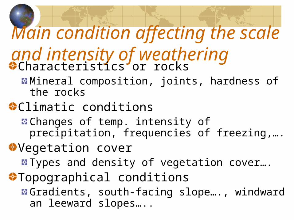
Main condition affecting the scale and intensity of weatheringCharacteristics or rocks
Mineral composition, joints, hardness of the rocks
Climatic conditionsChanges of temp. intensity of precipitation, frequencies of freezing,….
Vegetation coverTypes and density of vegetation cover….
Topographical conditionsGradients, south-facing slope…., windward an leeward slopes…..
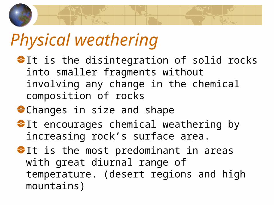
Physical weatheringIt is the disintegration of solid rocks into smaller fragments without involving any change in the chemical composition of rocksChanges in size and shapeIt encourages chemical weathering by increasing rock’s surface area.It is the most predominant in areas with great diurnal range of temperature. (desert regions and high mountains)
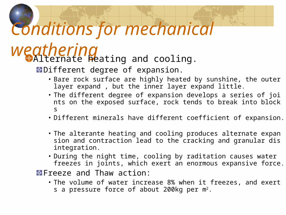
Conditions for mechanical weatheringAlternate heating and cooling.
Different degree of expansion.• Bare rock surface are highly heated by sunshine, the outer lay
er expand , but the inner layer expand little.• The different degree of expansion develops a series of joints o
n the exposed surface, rock tends to break into blocks• Different minerals have different coefficient of expansion. • The alterante heating and cooling produces alternate expansi
on and contraction lead to the cracking and granular disintegration.
• During the night time, cooling by raditation causes water freezes in joints, which exert an enormous expansive force.
Freeze and Thaw action:• The volume of water increase 8% when it freezes, and exerts a
pressure force of about 200kg per m2.
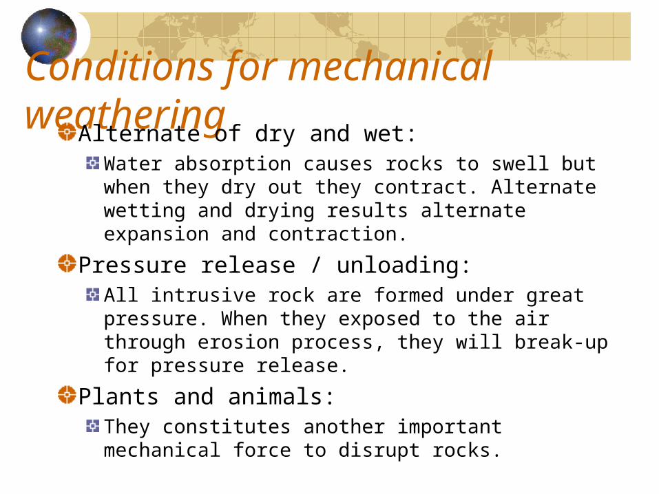
Conditions for mechanical weatheringAlternate of dry and wet:
Water absorption causes rocks to swell but when they dry out they contract. Alternate wetting and drying results alternate expansion and contraction.
Pressure release / unloading:All intrusive rock are formed under great pressure. When they exposed to the air through erosion process, they will break-up for pressure release.
Plants and animals:They constitutes another important mechanical force to disrupt rocks.
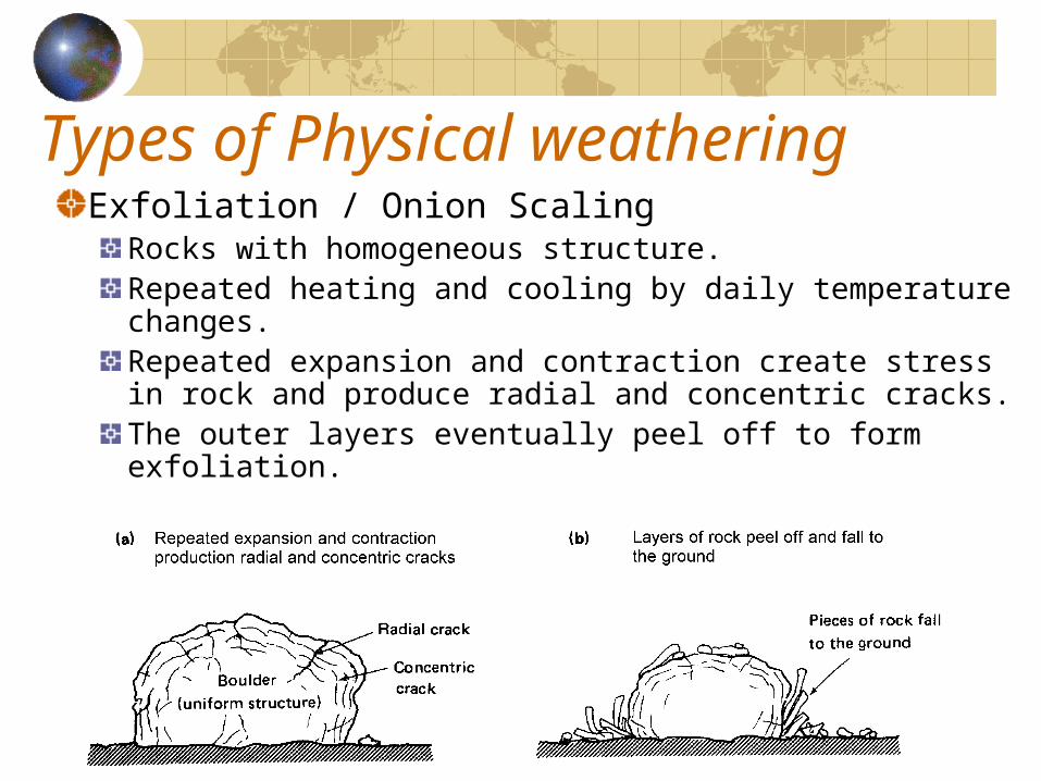
Types of Physical weatheringExfoliation / Onion Scaling
Rocks with homogeneous structure.Repeated heating and cooling by daily temperature changes.Repeated expansion and contraction create stress in rock and produce radial and concentric cracks.The outer layers eventually peel off to form exfoliation.
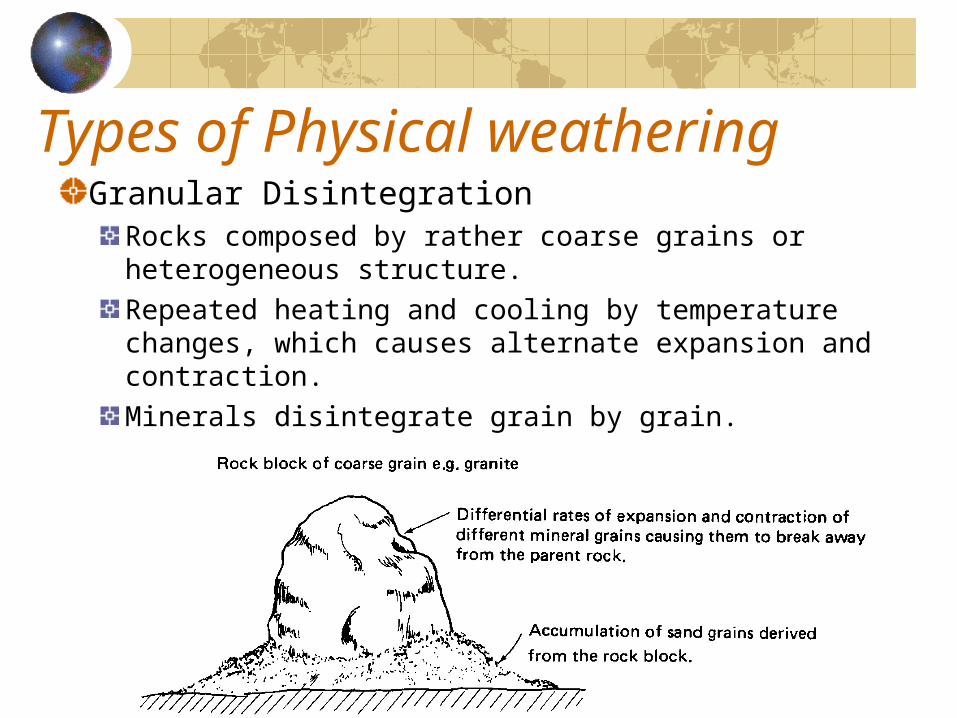
Types of Physical weatheringGranular Disintegration
Rocks composed by rather coarse grains or heterogeneous structure.Repeated heating and cooling by temperature changes, which causes alternate expansion and contraction.Minerals disintegrate grain by grain.
Types of Physical weatheringBlock disintegration
Well-jointed rock (eg. Granite)Great diurnal range of temperature with more than 10oC between freezing point (0oC)Repeated heating and cooling by temperature changes, which causes alternate expansion and contraction.Cracks and joints are widened or breaks down into small blocks or fragments.It may be accompanied by frost action and chemical weathering.
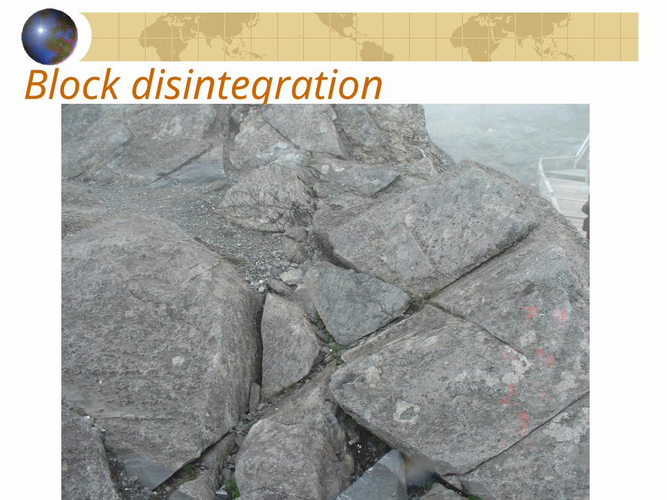
Block disintegration
Types of Physical weathering
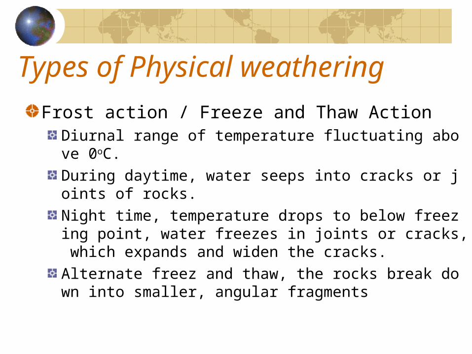
Frost action / Freeze and Thaw ActionDiurnal range of temperature fluctuating above 0oC.During daytime, water seeps into cracks or joints of rocks.Night time, temperature drops to below freezing point, water freezes in joints or cracks, which expands and widen the cracks.Alternate freez and thaw, the rocks break down into smaller, angular fragments
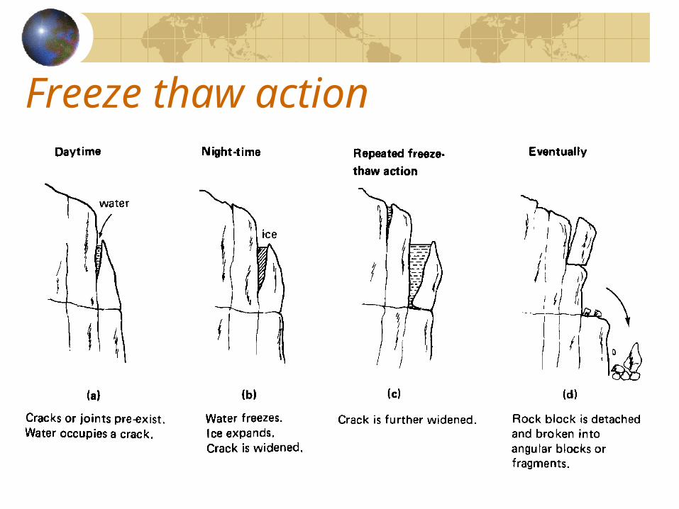
Freeze thaw action
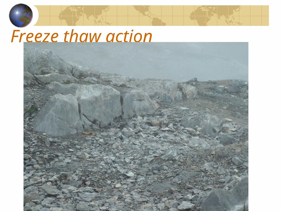
Freeze thaw action
Chemical Weathering
IntroductionProcesses of Chemical WeatheringTypes of Chemical Weathering
Chemical weatheringIntroduction
Chemical weathering is the decomposition or decay of solid rocks as a result of chemical reactions between the rock minerals and moisture, rain water, sea water and organic acids produced by plants and animals,Chemical weathering can be accelerated by high temperature.It also can accelerated by physical weathering which breaks rocks up and increase the surface exposed to possible chemical weathering.
Processes of Chemical weatheringOxidation
It is the process of the combination of oxygen.Hydrolysis
Free hydrogen ions in water enter into the mineral structure and create a new compound.Eg. Feldspar in Granite to Kaolinite.
HydrationThe whole water molecule combines with the mineral.
CarbonationCarbon dioxide (rain water pH=5.7) is capable of reaction with certain mineralsIt is particularly effective in limestone with humid climate.
SolutionSoluble minerals (rock salt,…)are dissolved directly in water.
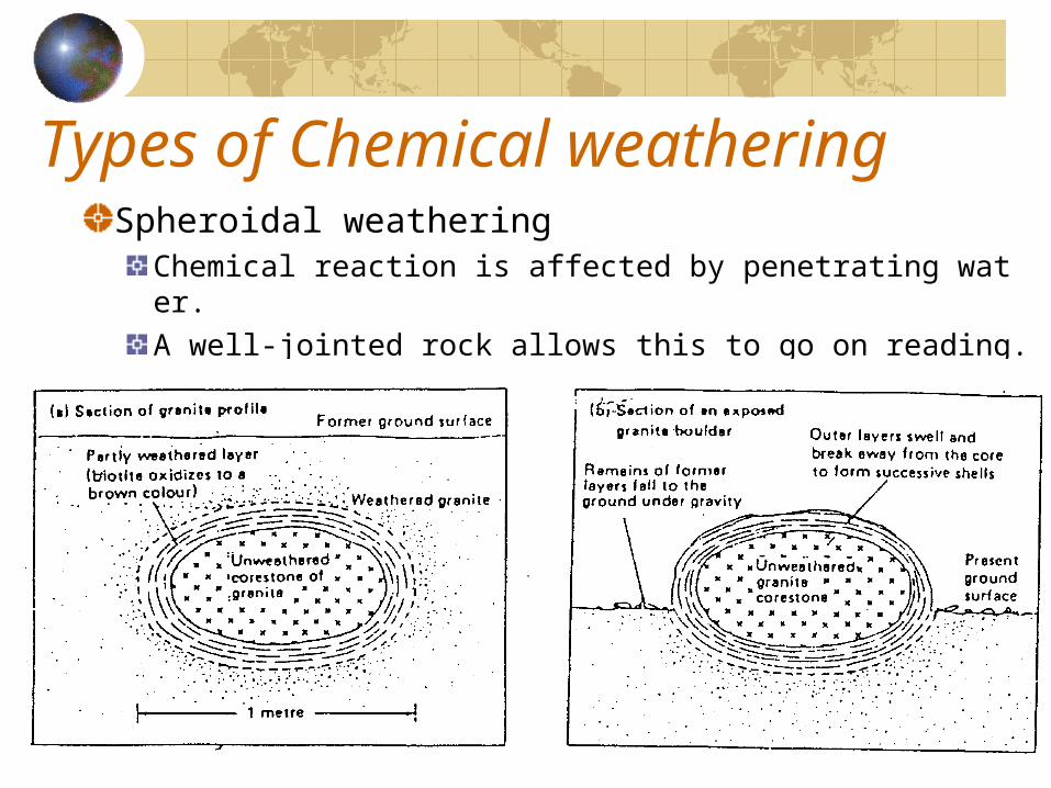
Types of Chemical weatheringSpheroidal weathering
Chemical reaction is affected by penetrating water.A well-jointed rock allows this to go on reading.
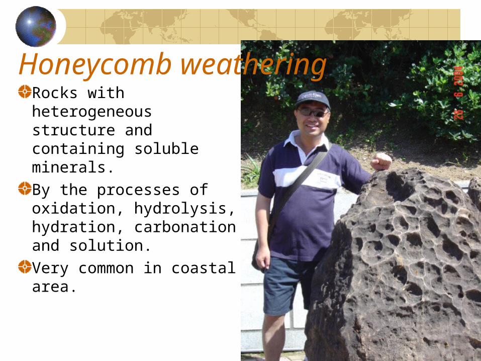
Honeycomb weatheringRocks with heterogeneous structure and containing soluble minerals.By the processes of oxidation, hydrolysis, hydration, carbonation and solution.Very common in coastal area.
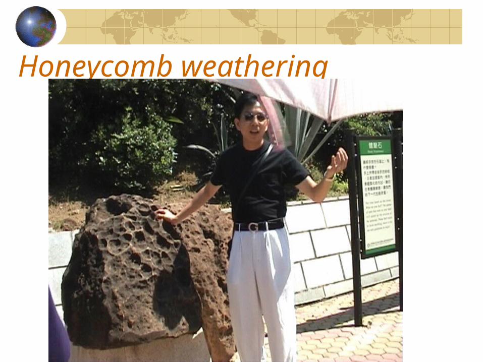
Honeycomb weathering
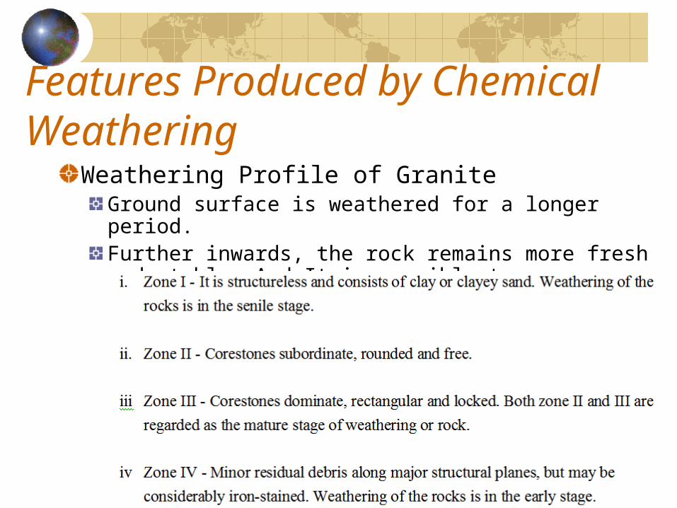
Features Produced by Chemical Weathering
Weathering Profile of GraniteGround surface is weathered for a longer period.Further inwards, the rock remains more fresh and stable. And It is possible to see a graduation of four weathered zones.
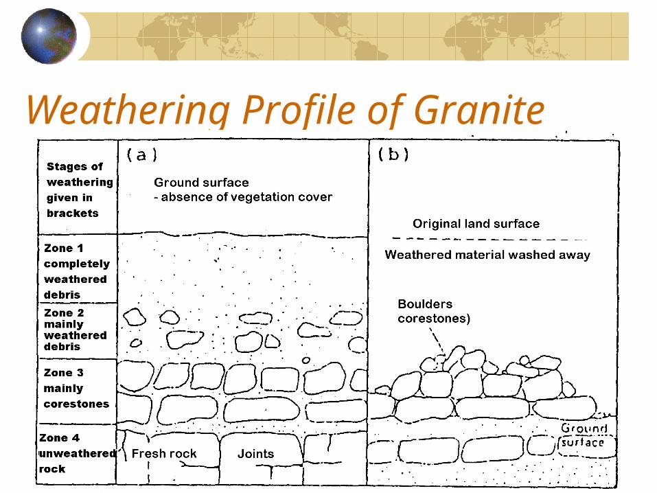
Weathering Profile of Granite
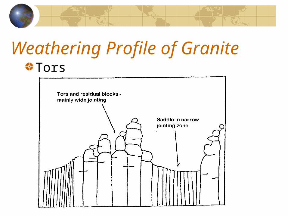
Weathering Profile of GraniteTors
TorsTors may be the result of the surface rotting of granite through the action of acidulation rainwater penetrating along joints into the body of the granitic mass.The pattern of tors is controlled by the joints.When the overlying weathered materials were moved away (eroded) and the corestones exposed to the air, tors are formed.
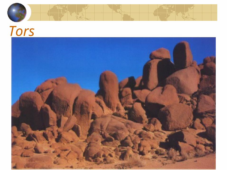
Tors
Biological / Organic weathering
Biological weathering is the physical disintegration or chemical decomposition of rocks in situ by organic agents – plants and animals.It is effective in regions with a continuous vegetation cover and burrowing animals.In desert regions and polar regions, it is insignificant for limited plants and animals.
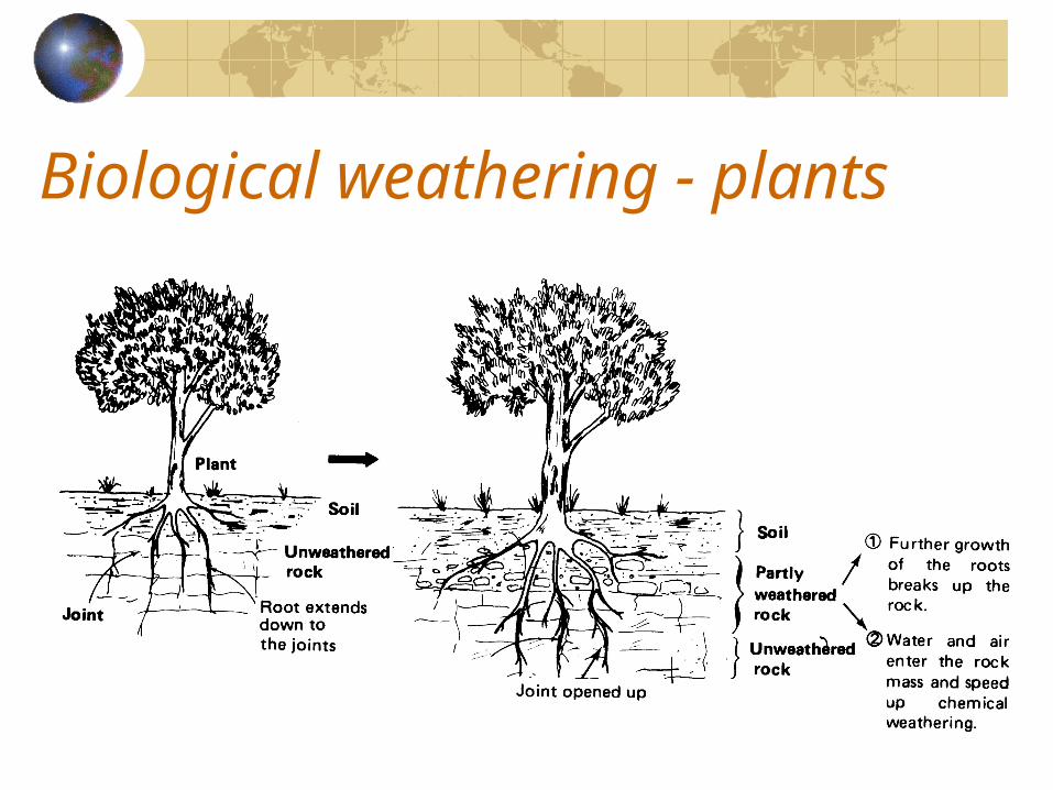
Biological weathering - plants
Biological weathering - Plants
The growth of plants roots and their penetration into rocks are sufficiently effective to widen cracks and joints.Rocks may be weathered by orgranic acids secreted by roots of plants and from decayed plants.
Biological weathering - animalsAnimals
Burrowing animals may dig or turn up and loosen the joints of rocks.Earthworms and termites also loosen and expose the surface materials for weathering.Wastes secreted by animals or derived from dead animals (organic acids) help chemical weathering
HumanHuman activities often cause large scale disintegration of rocks (mining, quarrying, excavation for building….)Careless removal of vegetation by man exposes large surface area to weathering processes. (deforestation for farming, for lumbering, for firewood; abandon farmland, overgrazing, hill fires,…..)
Case study – weathering in desert
Traditional concept:Little rainfall, strong winds and large daily range of temperature.Mechanical weathering (block disintegration and granular disintegration ) is dominant.Exfoliation is very common in deserts.Chemical weathering only takes place by the drawing of strong solutions to the surface by capillary and forms duricrust (a hard compact layer) on the land surface.
Case study – weathering in desertNew founding
Barton:• He found that weathering of the stonework was in general
more pronounced in the Delta than higher up the Nile Valley where has the maximum heating and cooling effects.
Griggs’s experiment:• He gave the granite to 90000 fifteen-minutes cycles of
alternate heating and cooling over a temperature range of nearly 90oC.
• He found the rock totally undamaged at the end.• When he gave some water in the experiment, the whole
block very quickly disintegrated.
Chemical weathering involving water was the real destroyer of rocks in the desert regions.
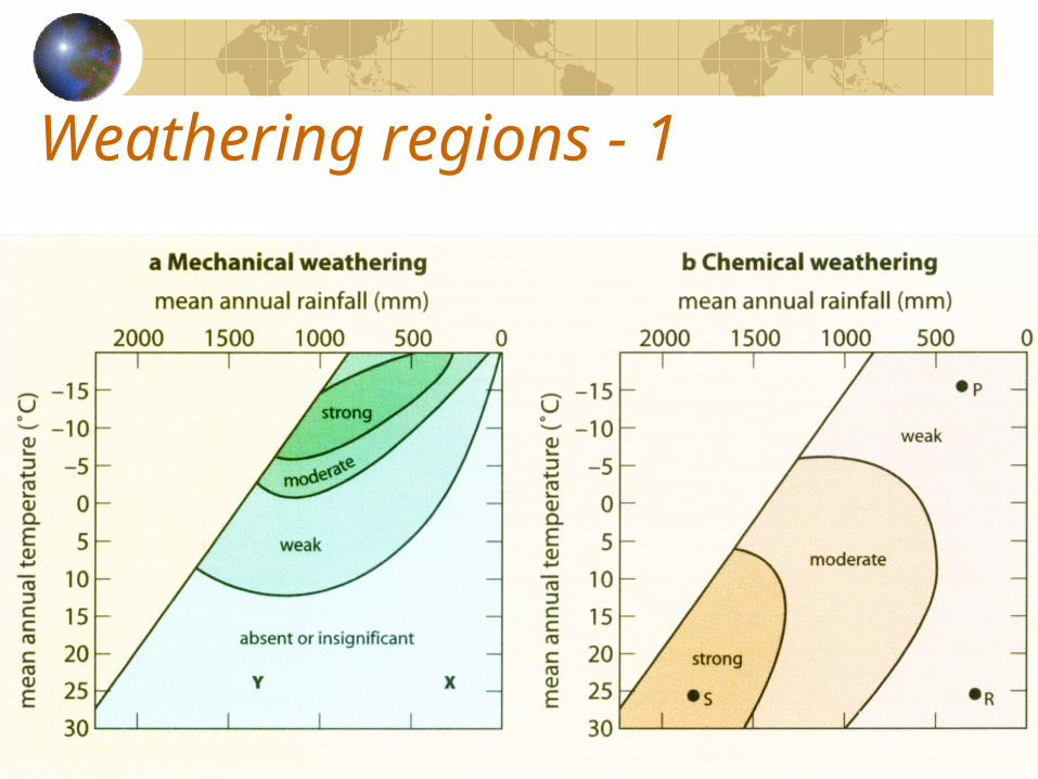
Weathering regions - 1
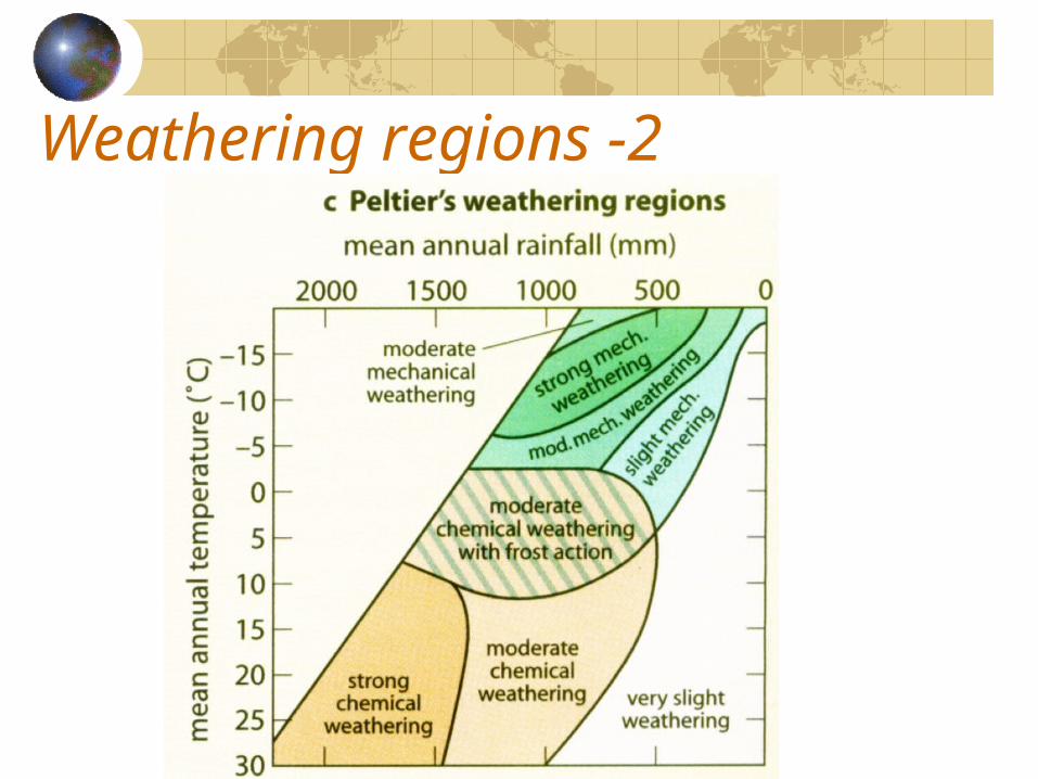
Weathering regions -2
Slope Sub-system
ContentsSlope as a systemSlope ProfilesSlope development / Slope evolutionGeomorphic processes on a slope
Slope as a system
All landforms are made up of slopes.They originate by a combination of tectonic (endogenetic) and erosional activities (exogenetic).
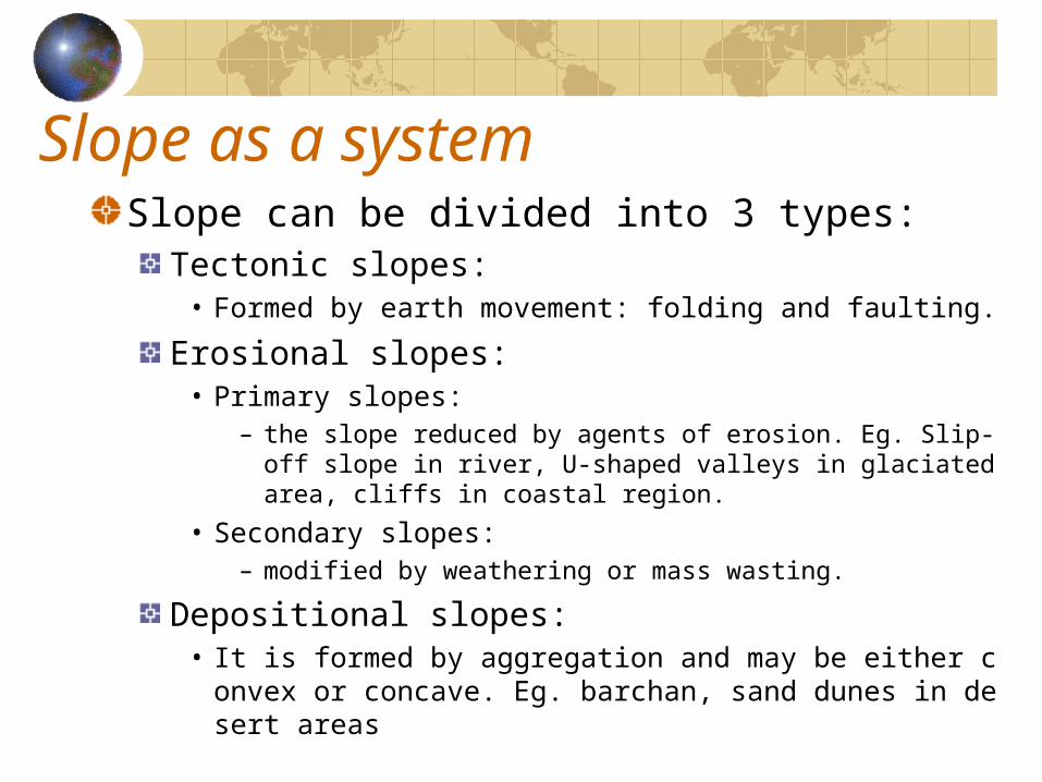
Slope as a systemSlope can be divided into 3 types:
Tectonic slopes:• Formed by earth movement: folding and faulting.
Erosional slopes:• Primary slopes:
– the slope reduced by agents of erosion. Eg. Slip-off slope in river, U-shaped valleys in glaciated area, cliffs in coastal region.
• Secondary slopes: – modified by weathering or mass wasting.
Depositional slopes:• It is formed by aggregation and may be either convex or c
oncave. Eg. barchan, sand dunes in desert areas
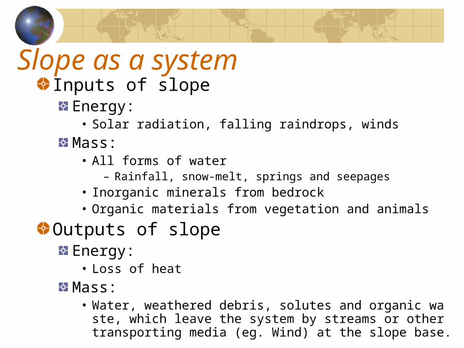
Slope as a systemInputs of slope
Energy:• Solar radiation, falling raindrops, winds
Mass:• All forms of water
– Rainfall, snow-melt, springs and seepages• Inorganic minerals from bedrock• Organic materials from vegetation and animals
Outputs of slopeEnergy:
• Loss of heatMass:
• Water, weathered debris, solutes and organic waste, which leave the system by streams or other transporting media (eg. Wind) at the slope base.

Slope as a system
Slope systems are sustained by inputs of energy and mass, which may be balanced by outputs, giving a steady state or equilibrium condition.Slopes are controlled by increased or decreased inputs and outputs, so as to maintain its equilibrium.
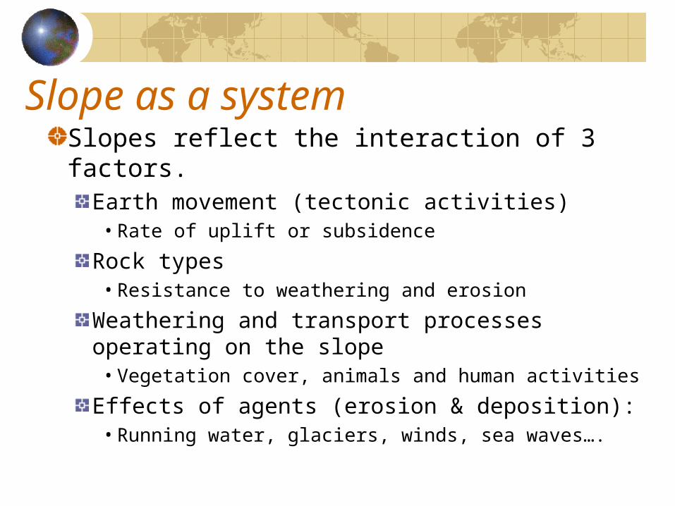
Slope as a systemSlopes reflect the interaction of 3 factors.
Earth movement (tectonic activities)• Rate of uplift or subsidence
Rock types• Resistance to weathering and erosion
Weathering and transport processes operating on the slope• Vegetation cover, animals and human activities
Effects of agents (erosion & deposition):• Running water, glaciers, winds, sea waves….
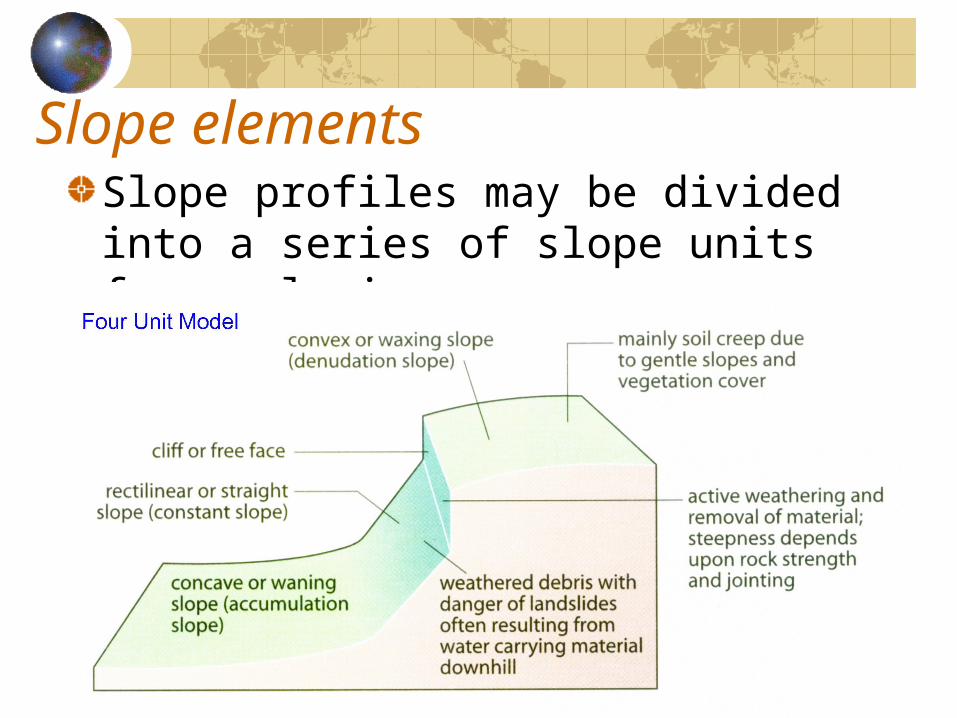
Slope elementsSlope profiles may be divided into a series of slope units for analysis
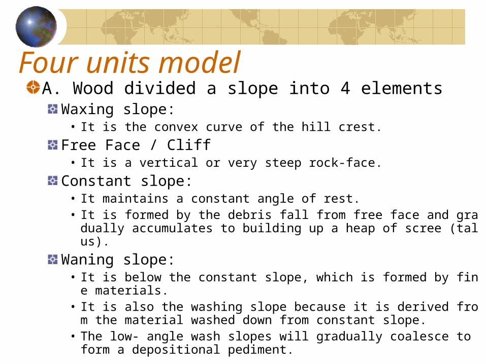
Four units modelA. Wood divided a slope into 4 elements
Waxing slope:• It is the convex curve of the hill crest.
Free Face / Cliff• It is a vertical or very steep rock-face.
Constant slope:• It maintains a constant angle of rest.• It is formed by the debris fall from free face and gradually accu
mulates to building up a heap of scree (talus).Waning slope:
• It is below the constant slope, which is formed by fine materials.
• It is also the washing slope because it is derived from the material washed down from constant slope.
• The low- angle wash slopes will gradually coalesce to form a depositional pediment.
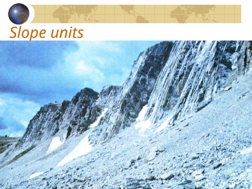
Slope units
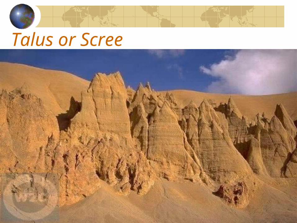
Talus or Scree
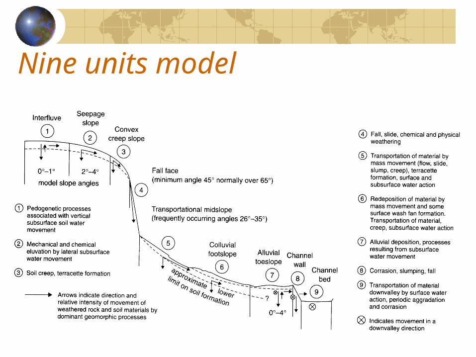
Nine units model
Slope development / evolution
The forms of slopes develop through time and the factors (rock structure, lithology, soil, climate, vegetation and human activities).There are few models of slope development or slope evolution.
Slope DeclineSlope replacementSlope parallel retreat
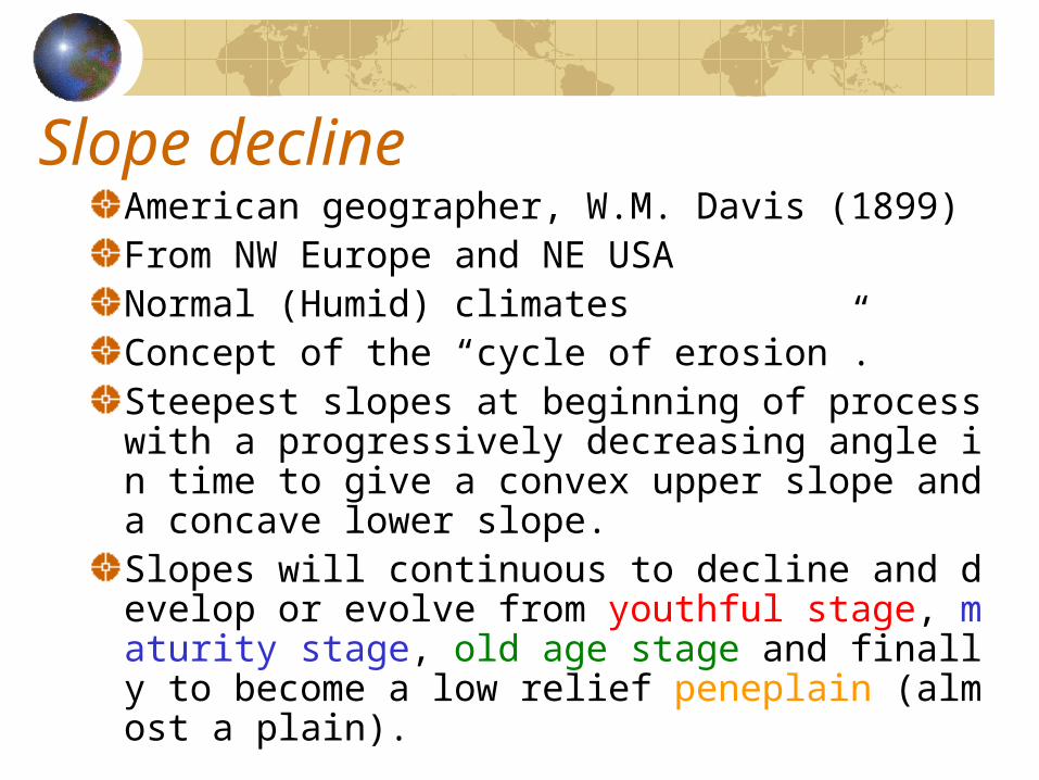
Slope declineAmerican geographer, W.M. Davis (1899)From NW Europe and NE USANormal (Humid) climatesConcept of the “cycle of erosion”.Steepest slopes at beginning of process with a progressively decreasing angle in time to give a convex upper slope and a concave lower slope.Slopes will continuous to decline and develop or evolve from youthful stage, maturity stage, old age stage and finally to become a low relief peneplain (almost a plain).
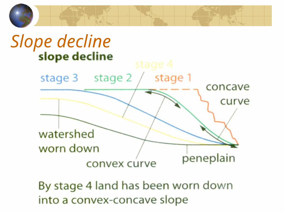
Slope decline
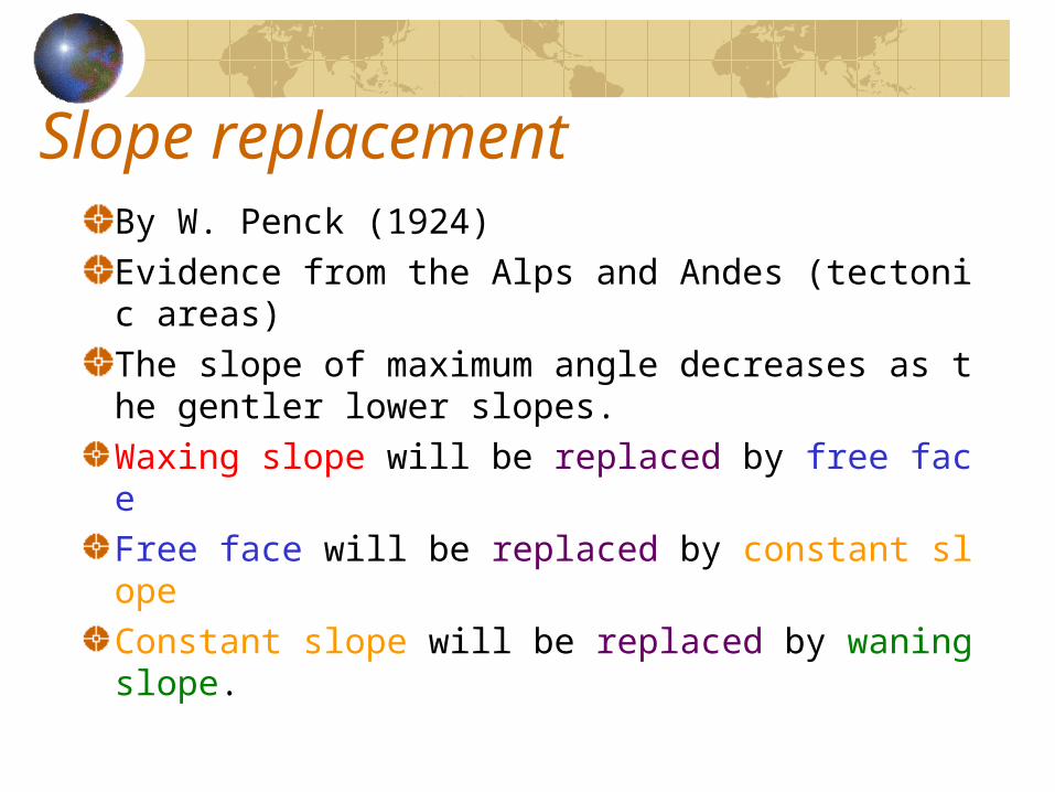
Slope replacementBy W. Penck (1924)Evidence from the Alps and Andes (tectonic areas)The slope of maximum angle decreases as the gentler lower slopes.Waxing slope will be replaced by free faceFree face will be replaced by constant slopeConstant slope will be replaced by waning slope.
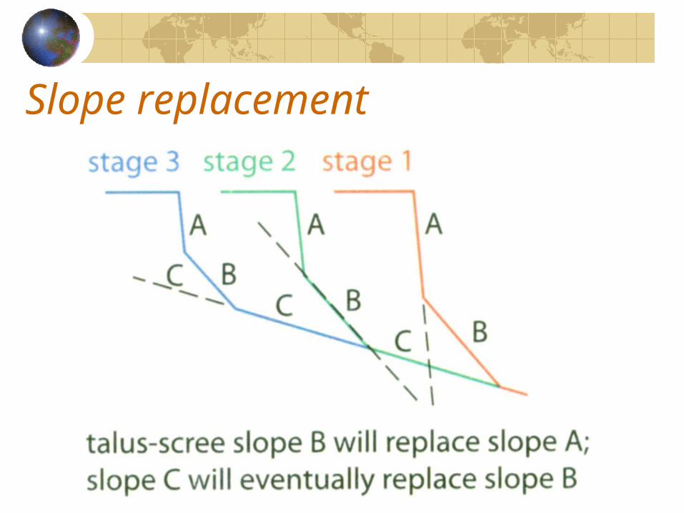
Slope replacement
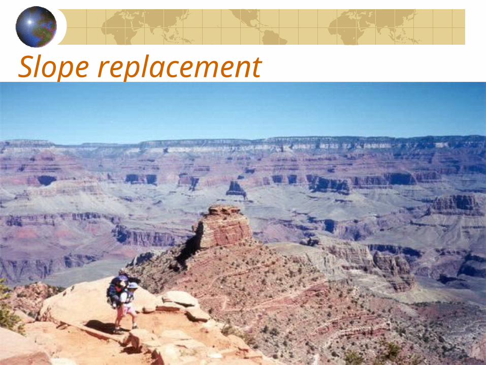
Slope replacement
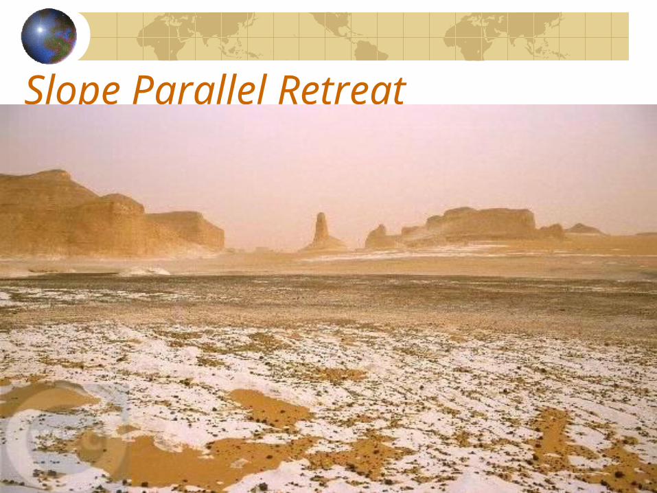
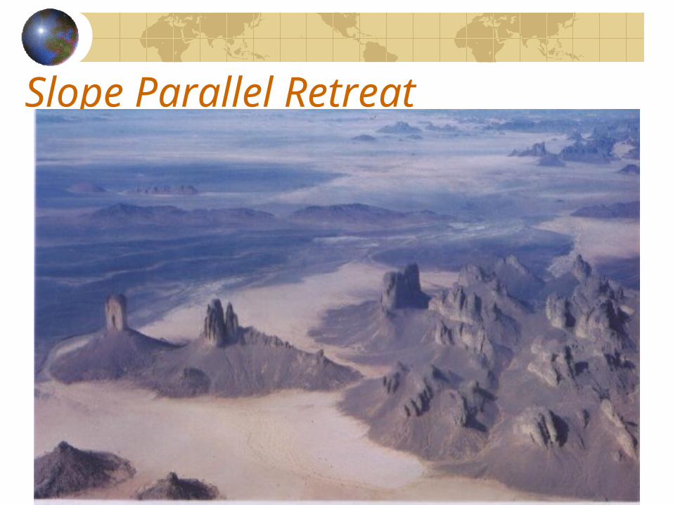
Slope Parallel RetreatBy L.C. King (1948, 1957)From South AfricaSemi-arid regions and sea cliffs with wave-cut platformsSedimentary rocks structureThe slope units retreat by the same amount (proportion) so that the whole profile retains but leaves an extending concave unit (pediment) at its foot.This sequence is controlled by the rate of retreat of free face which is controlled by geology and climate (weathering and transport processes)
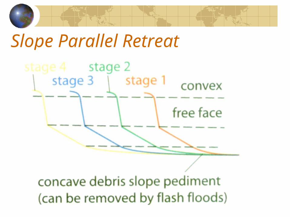
Slope Parallel Retreat
Slope Parallel Retreat
Slope Parallel Retreat
Geomorphic Processes on Slope
Weathering, mass movement and erosion are the major processes in shaping slopes.On hard rocks which weather very slowly – weathering limited slopeHigh potential weathering but outputs from slope are restricted – transport limited.
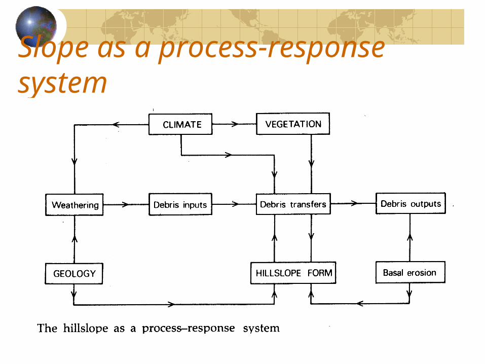
Slope as a process-response system
Mass movement - landslideMass movement involve the transport of debris under the influence of gravity.It depends on the instability (stresses and strength) of slope.Loss strength (frictional resistance and cohesion)
Heavy rainfallSevere weatheringOversteepening of hillslope (excavation)
Increase stress Heavy rainfall (increase weight of slope)Earthquakes or volcanic activitiesBuilding on slope increase loadingVibration from passing heavy vehicle
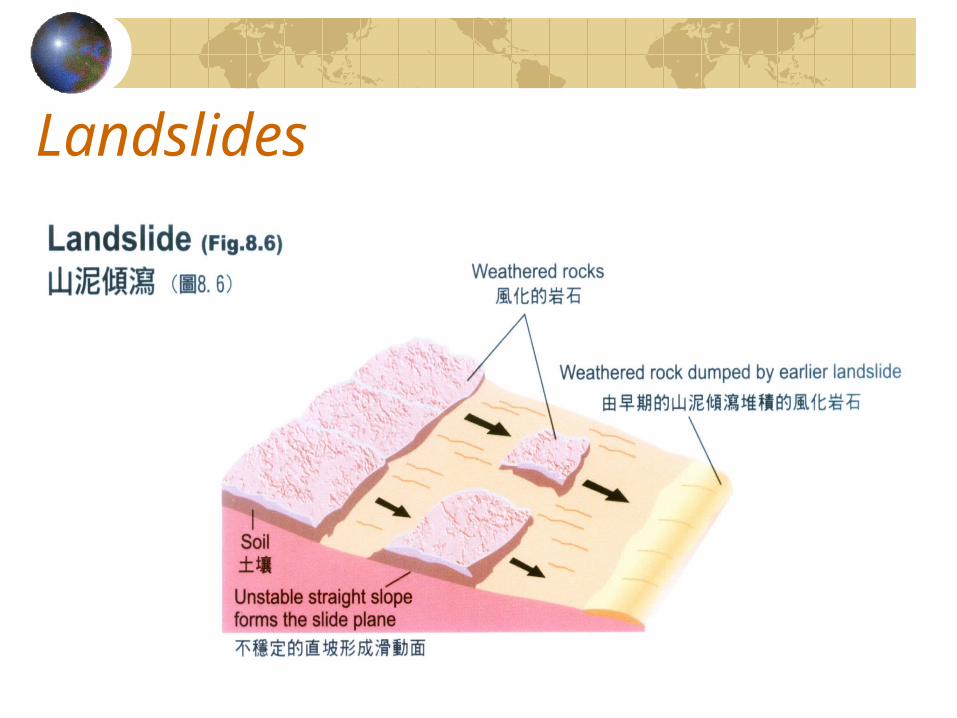
Landslides
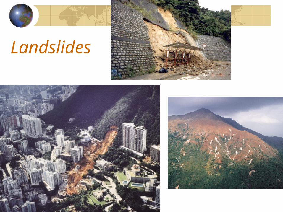
Landslides
Slope processes(non-cohesive materials)Gravels and sandsLandforms: alluvial fans, screes (talus), sand dunes and glacial outwash features.The movement occurs largely through the sliding or rolling of individual particles.It may be triggered by minor events such as rainfall or vibration.
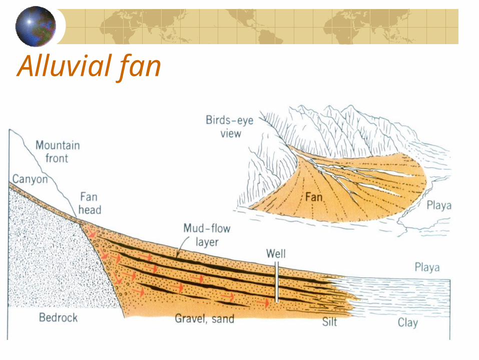
Alluvial fan
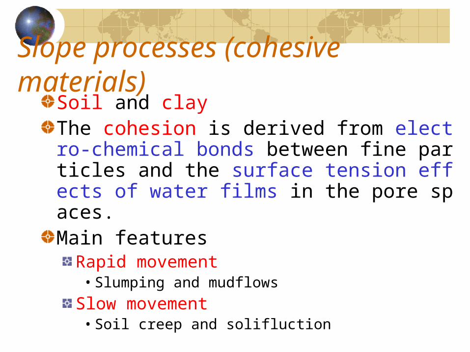
Slope processes (cohesive materials)Soil and clayThe cohesion is derived from electro-chemical bonds between fine particles and the surface tension effects of water films in the pore spaces.Main features
Rapid movement• Slumping and mudflows
Slow movement• Soil creep and solifluction
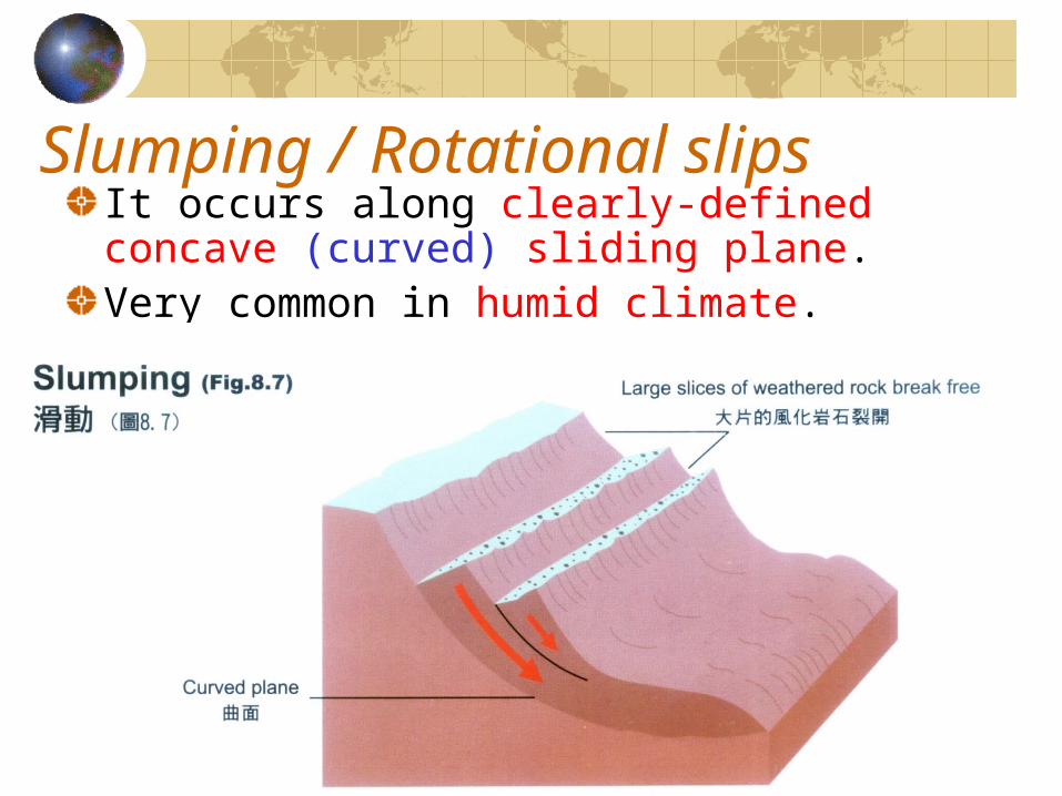
Slumping / Rotational slipsIt occurs along clearly-defined concave (curved) sliding plane.Very common in humid climate.
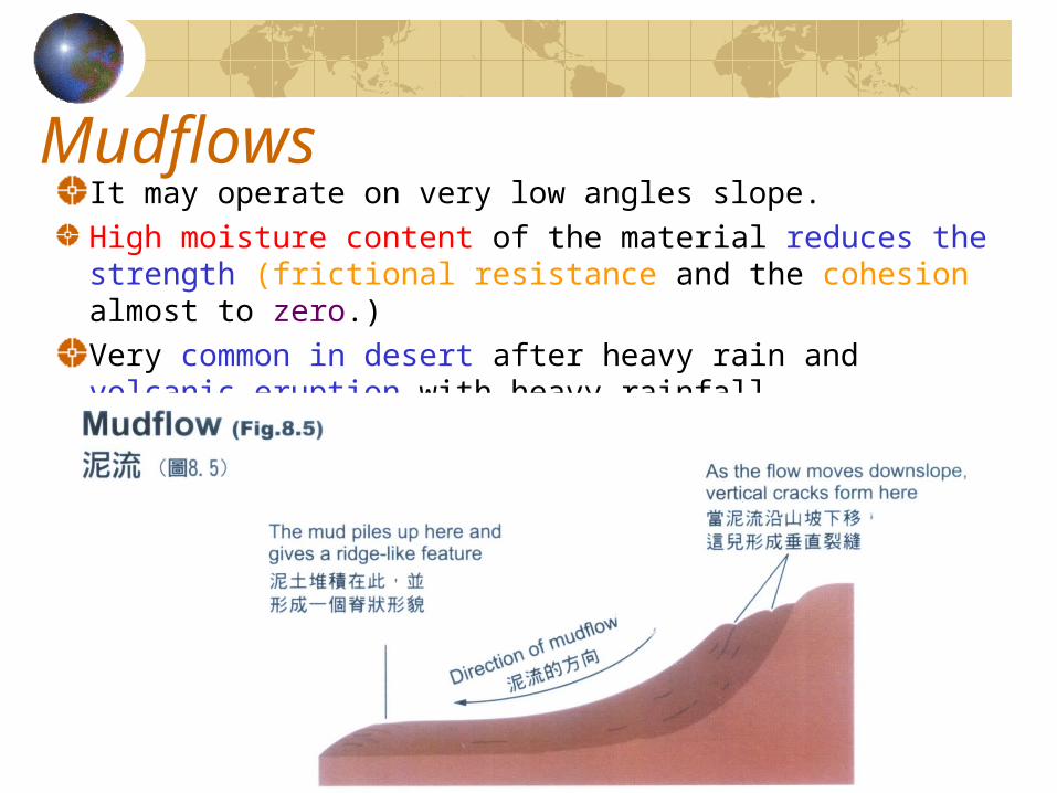
MudflowsIt may operate on very low angles slope.High moisture content of the material reduces the strength (frictional resistance and the cohesion almost to zero.)Very common in desert after heavy rain and volcanic eruption with heavy rainfall.
Soil creep
It can be found on all slopesIt was formed by the effects of gravity, temperature fluctuations (Freeze-thaw) and variations in moisture (wet-dry periods) content within the soil may all act to cause displacement of particles.
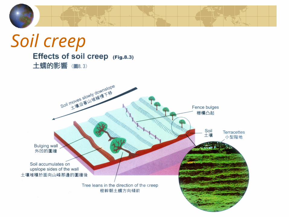
Soil creep
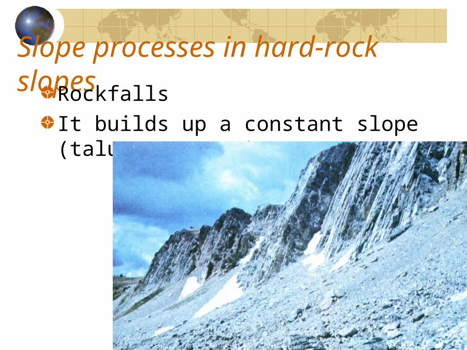
Slope processes in hard-rock slopesRockfallsIt builds up a constant slope (talus or scree)
Soil erosionWater plays a significant role to soil erosion in humid regionsRain splash can redistribution the materials without any transport on horizontal surface.It can move the materials downslide on a slopeRain splash rills gullies badland
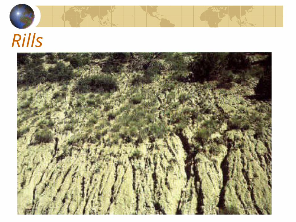
Rills
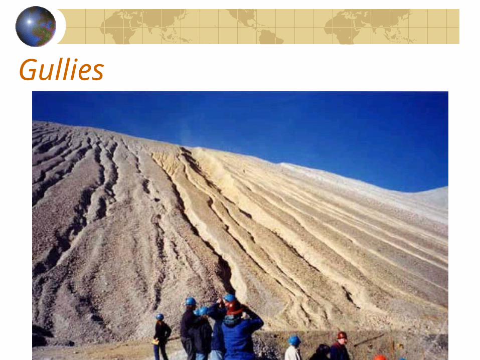
Gullies
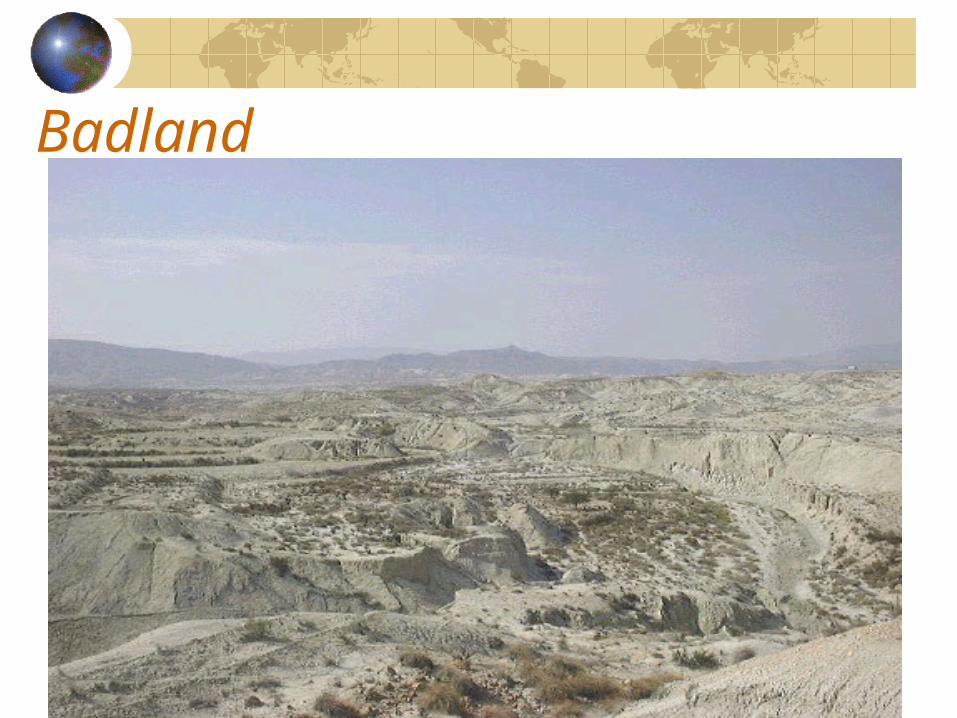
Badland
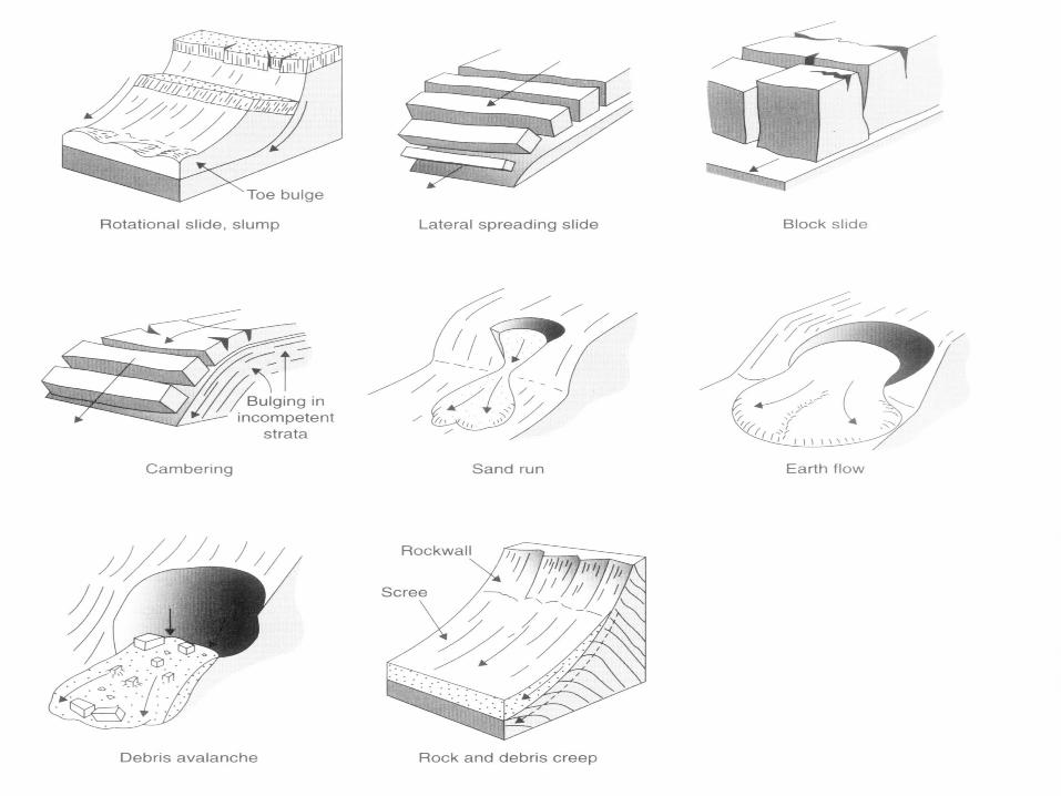
Other forms of slide
Channel Sub-system
Channel as a sub-systemStream VelocityChannel Processes (Geomorphological work of stream)Channel FormRivers work in the two landscapes
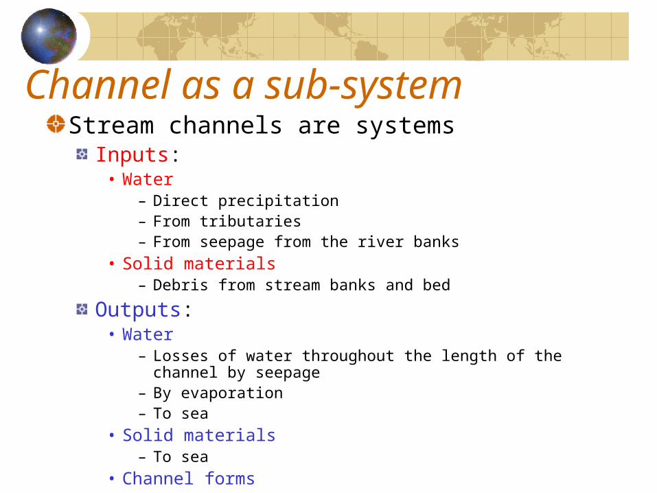
Channel as a sub-systemStream channels are systems
Inputs:• Water
– Direct precipitation– From tributaries– From seepage from the river banks
• Solid materials– Debris from stream banks and bed
Outputs:• Water
– Losses of water throughout the length of the channel by seepage
– By evaporation– To sea
• Solid materials– To sea
• Channel forms
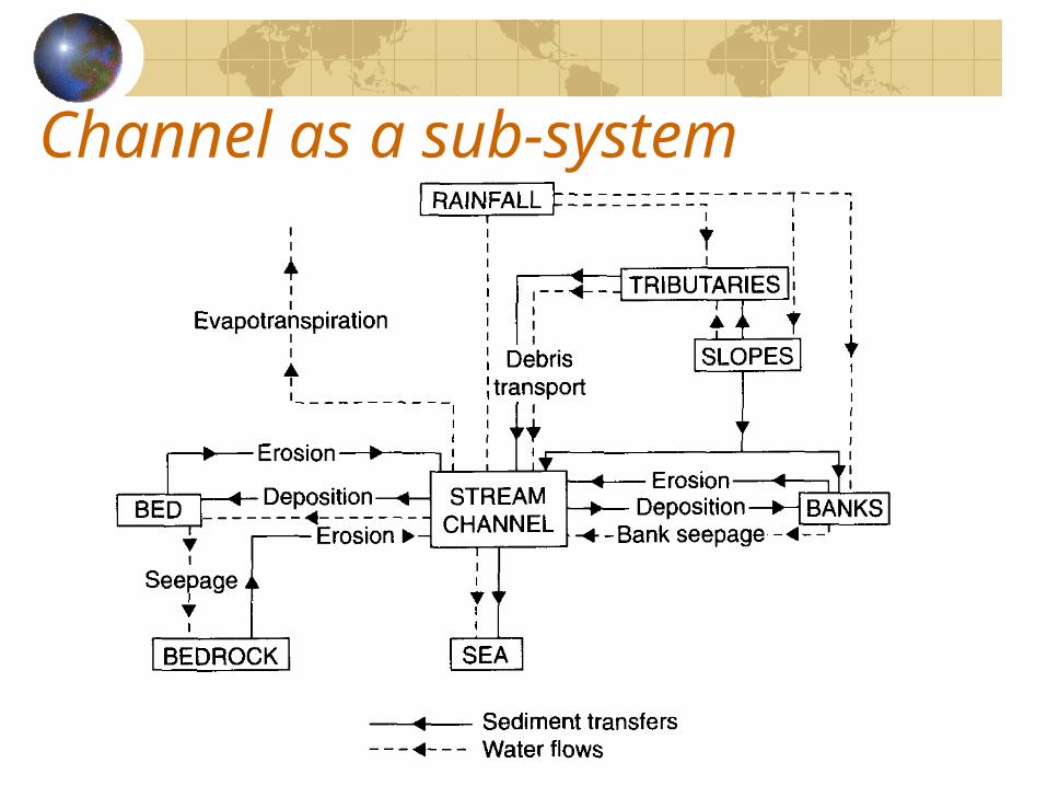
Channel as a sub-system
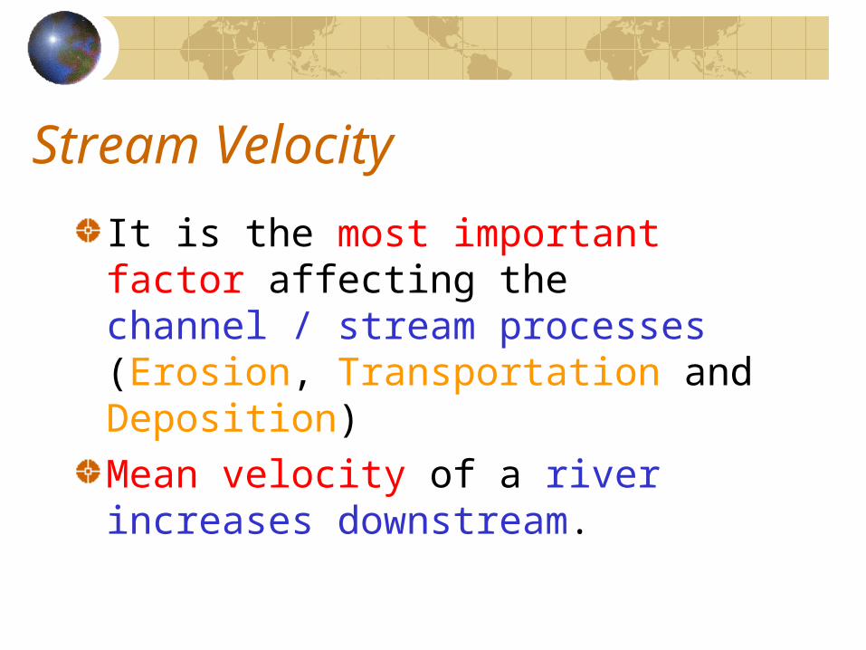
Stream Velocity
It is the most important factor affecting the channel / stream processes (Erosion, Transportation and Deposition)Mean velocity of a river increases downstream.
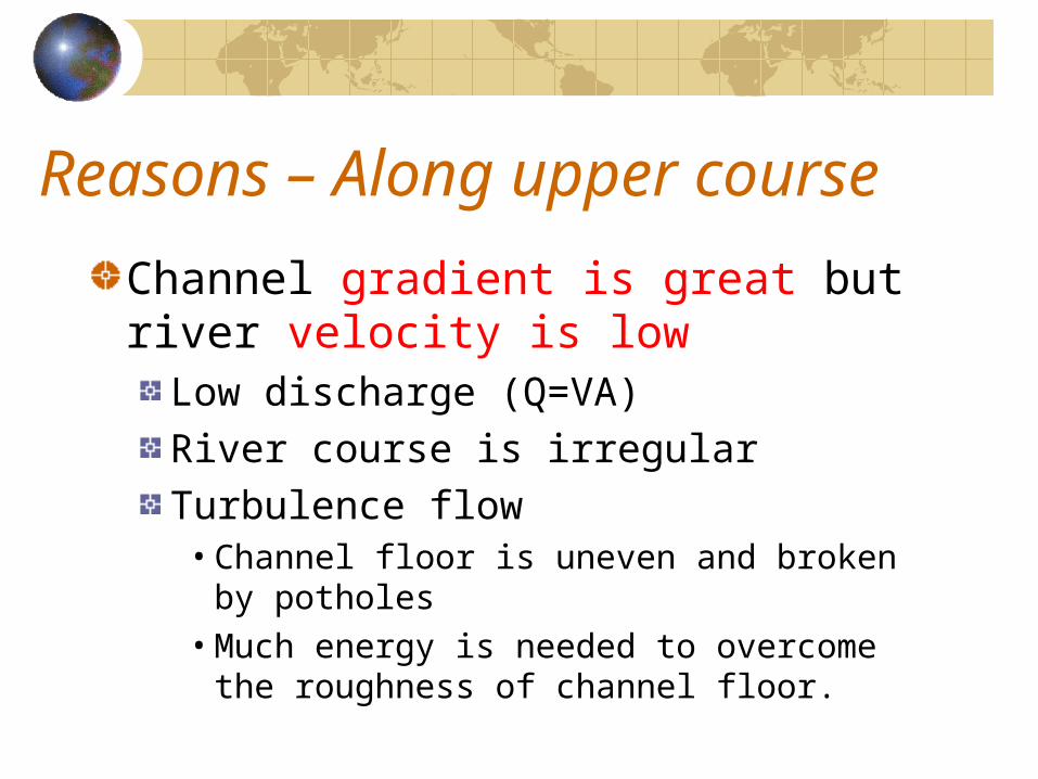
Reasons – Along upper course
Channel gradient is great but river velocity is low
Low discharge (Q=VA)River course is irregularTurbulence flow• Channel floor is uneven and broken by
potholes• Much energy is needed to overcome the
roughness of channel floor.
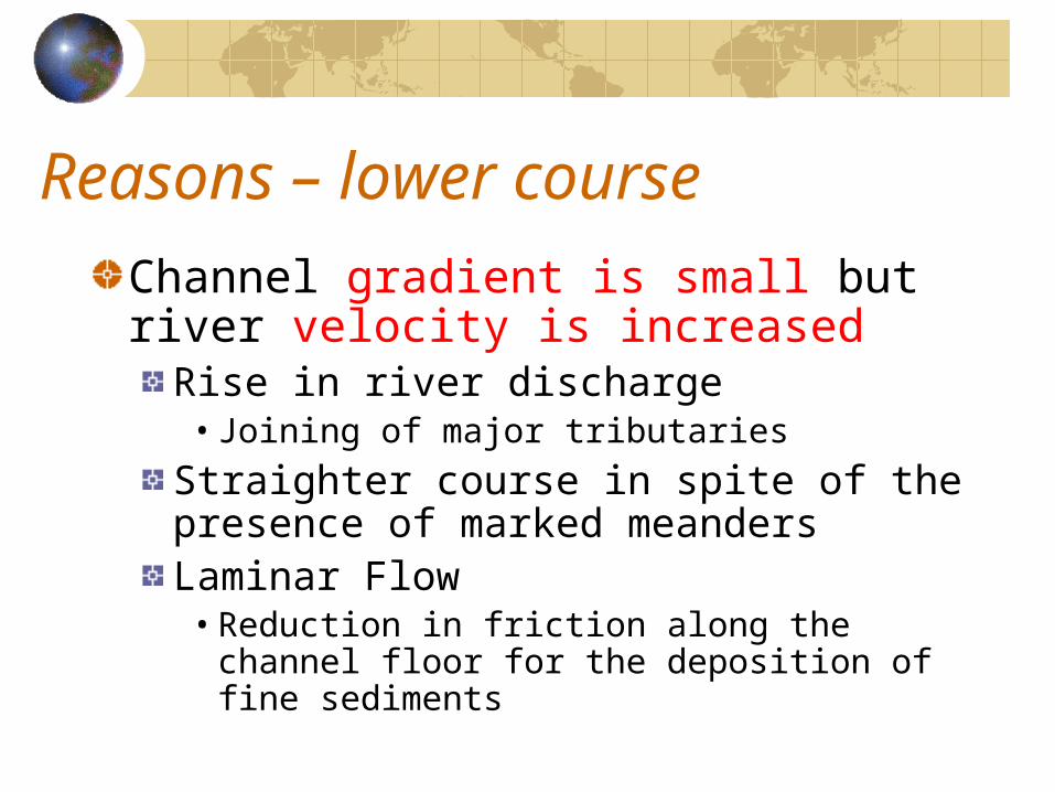
Reasons – lower course
Channel gradient is small but river velocity is increased
Rise in river discharge• Joining of major tributaries
Straighter course in spite of the presence of marked meandersLaminar Flow• Reduction in friction along the channel
floor for the deposition of fine sediments
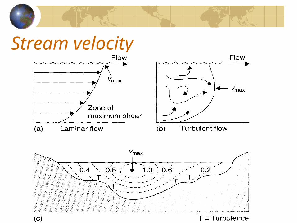
Stream velocity
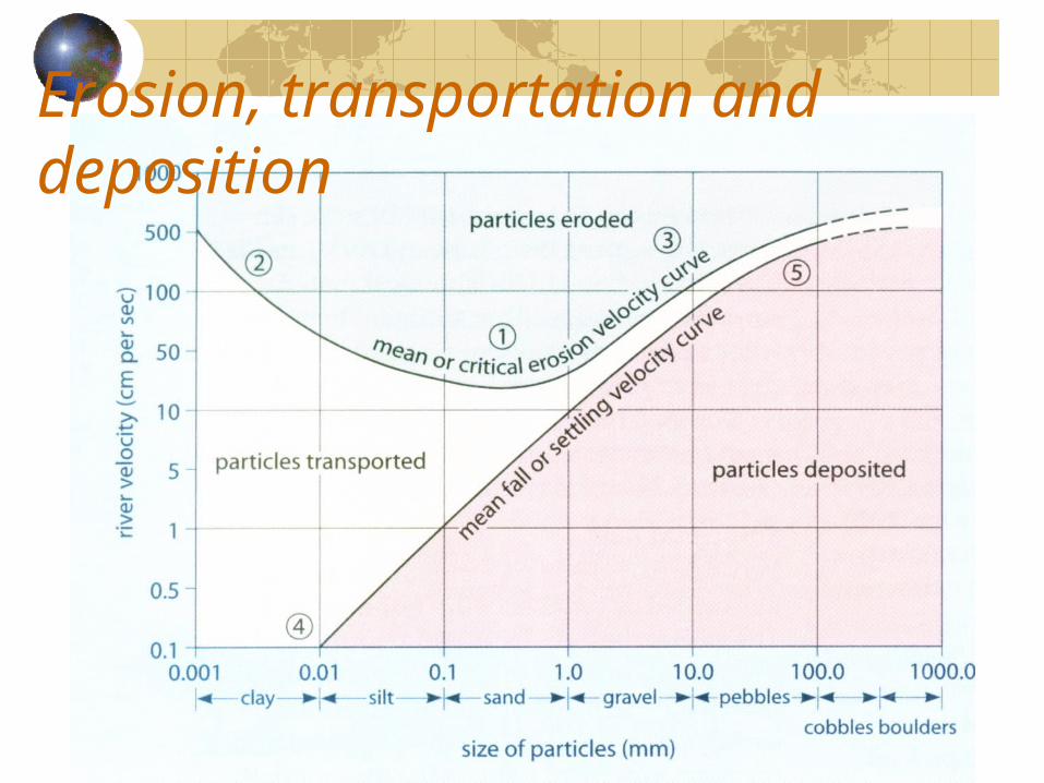
Erosion, transportation and deposition
Erosion, transportation and depositionCritical tractive force
Minimum force to entrainment of grains from bedrock on the sides or floor of channel.
Critical (erosion) velocityLowest velocity to obtain the critical tractive force (to move grains from channel bed)
ErosionThe easiest eroded material is of diameter of about 0.5mm.Coarse materials (medium sand to boulders) require greater velocity.Very fine materials are also difficult to erode for strong binding by chemical bonds.Smooth channel bed formed by fine materials is more resistant to erosion.
Erosion, transportation and depositionTransportation velocity
Between the critical erosion velocity and the curve of deposition of particles
Fall /Settling velocityVelocity at which materials in transport are dropped and deposited on the channel bed.It is high for the larger and heavier particles but extremely low for clay (transported in suspension)
Channel Processes (Geomorphological work of river)
The morphology of natural river channel is determined by the interaction of flowing water and solid materials.Channel Processes
ErosionTransportationDeposition
Erosion – along the river coursesStream erosion is the progressive removal of mineral material from the floor and sides of the channel, whether bedrock or regolith.Upper Course
Erosion is the dominant process for the steep channel gradient.
Middle CourseErosion is a bit reduced as some depositions occur where channel beds are flat.
Lower CourseErosion becomes far less important than deposition.
Erosion – erosion processesHydraulic action:
Removal of loose materials by direct force of impact of running / flowing water.
Abrasion (Corrasion):Mechanical wearing and tearing of rock particles at or being dragged along the channel bed.
Corrosion (Solution):Rocks minerals are dissolved by water.
Attrition:Reduction in size of loads in transport as they strike at each other or the channel bed.
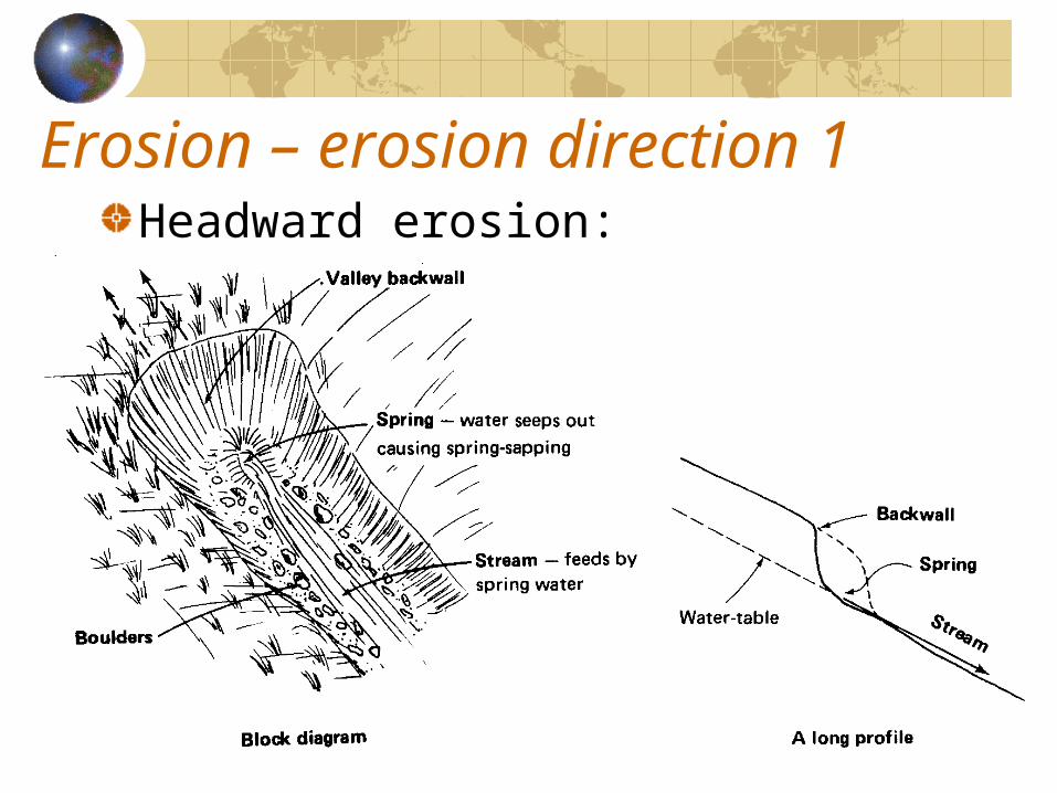
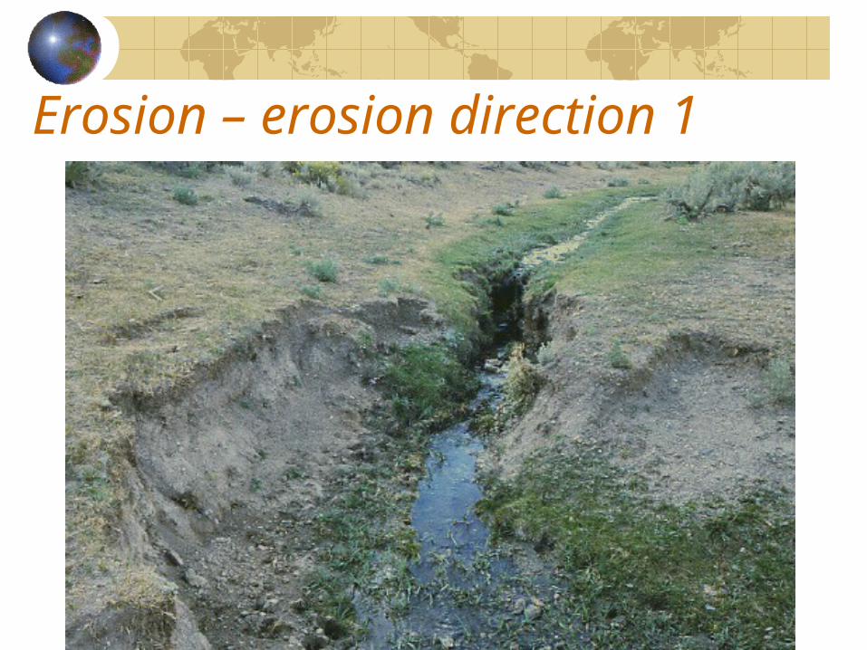
Erosion – erosion direction 1Headward erosion:
Erosion – erosion direction 1
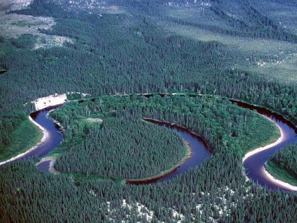
Erosion – erosion direction 2Lateral erosion
Erosion of the sides of a river channelMore lateral erosion is found along the concave banks than along the convex slip-off banks.More active along lower course for the gentle slope.The kinetic energy transfers to lateral erosion.
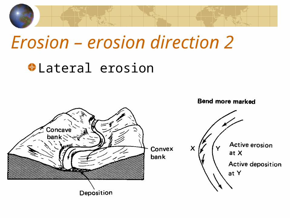
Erosion – erosion direction 2Lateral erosion
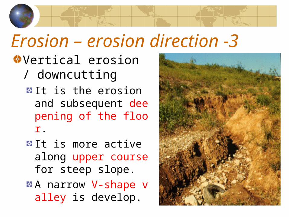
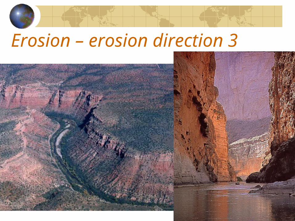
Erosion – erosion direction -3Vertical erosion / downcutting
It is the erosion and subsequent deepening of the floor.It is more active along upper course for steep slope.A narrow V-shape valley is develop.
Erosion – erosion direction 3
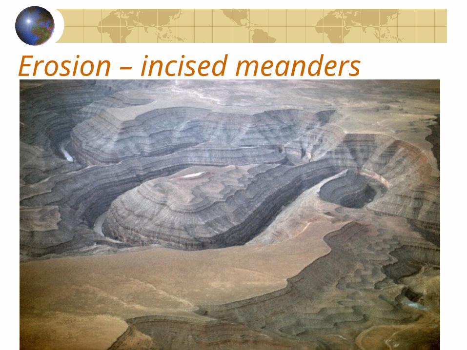
Erosion – incised meanders
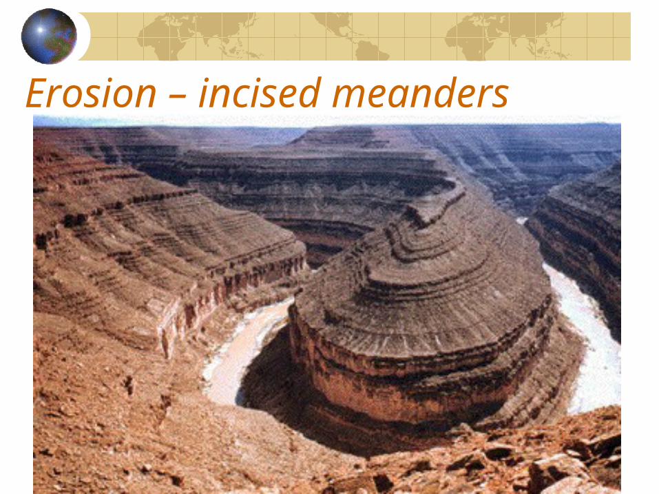
Erosion – incised meanders
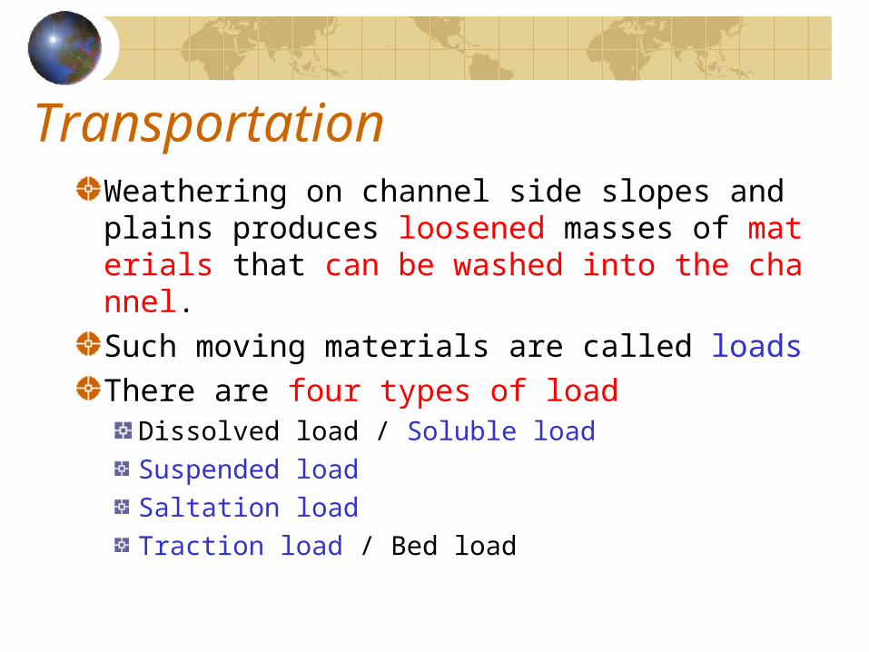
TransportationWeathering on channel side slopes and plains produces loosened masses of materials that can be washed into the channel.Such moving materials are called loadsThere are four types of load
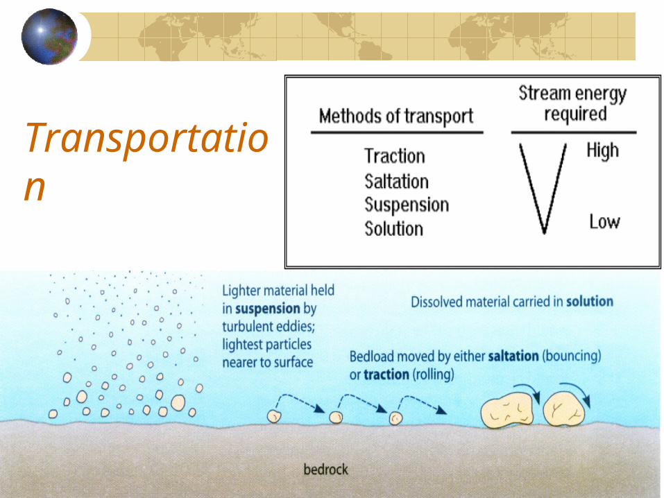
Dissolved load / Soluble loadSuspended loadSaltation loadTraction load / Bed load
Transportation Dissolved load:
They are enters the water current by corrosion, and is transported in solution by the river water.Chemical composition of river water depends on
• Topography– Steep bank-side slopes is likely to be richer in dissolved
minerals.
• Climate– High temperature can increase the rate of chemical
reaction.
• Geology– Rocks minerals are dissolvable or not.
• Vegetation– Supplier of organic matter.
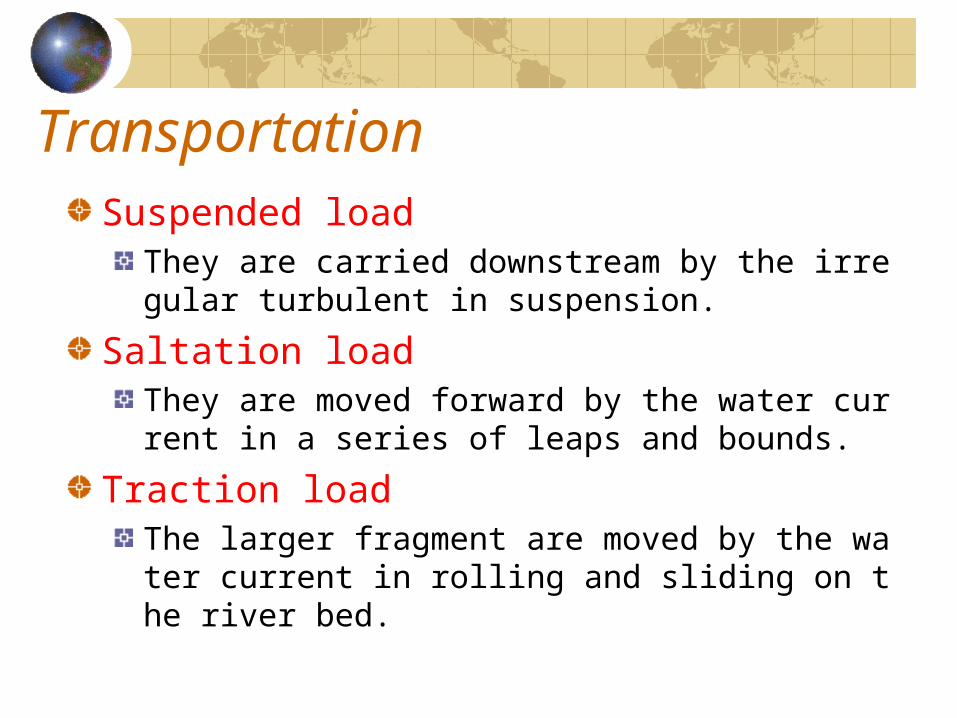
TransportationSuspended load
They are carried downstream by the irregular turbulent in suspension.
Saltation loadThey are moved forward by the water current in a series of leaps and bounds.
Traction loadThe larger fragment are moved by the water current in rolling and sliding on the river bed.
Transportation
Stream CompetenceThe largest transported particles that a stream is able to move in traction as bed load.Normally, stream channel is less competent in removeing coarse bedload materials because coarser materials are heavier and more irregular in shape such that much energy is needed to overcome their friction.Stream channels are more competent in removing bedload at high water flow level for increasing in river discharge.
Stream Capacity
It is maximum amount of load materials that a stream can transport.It varies according to velocity which depends on channel gradient, stream discharge and weight of load.
LoadsSuspended sediment:
It tends to increase with discharge levels at any point on a stream.
Solute:It is the greatest concentrated at low flows, or channel water is derived entirely from groundwater seepage.During periods of higher discharge, solute will be diluted by throughflow and overland flow.
Bedload:It increases at higher levels of discharge.
LoadsThree types of load varies according to the nature of load available, the discharge and courses of the river.
Solute load being more important at low flows.Suspended sediment is transported in greater at flood time.Bedload moves only once a threshold level of discharge has been attained.
Deposition
The deposition of sediments occurs when a stream is no longer to carry loads, loss of competence or transporting ability.It may be the result of
Decrease in channel gradientDecrease in discharge volumeIncrease loads supply in the channel
Deposition Decrease in channel gradient
Stream water enter to its lower course at flat plainStream water enter into a pre-existing depression (lake, lagoon, or any type of still water…)
Decrease in discharge volumeDischarge will decrease in dry seasonIt will decrease by river capture.It will decrease by seepage which is very common along exotic rivers (River Nile), along a permeable channel floor (desert) or flowing into limestone areas.
Increase loads supply in the channelExcessive increase in the supply of load materials (serious mass movement)

Channel Form
The channel form can be regarded as the response by the channel inputs.It can be considered in terms of
Cross profileLong profilePlan

Plan – Channel patterns
There are three major patterns:Straight channel patternMeandering channel patternBraided channel pattern
Straight channel patternIt refers to the channel characterized with straight banks.In fact, it is impossible of natural rivers with straight banks for irregularities of river channels.The stream line of flow is usually in a winding path or sinuous pattern.
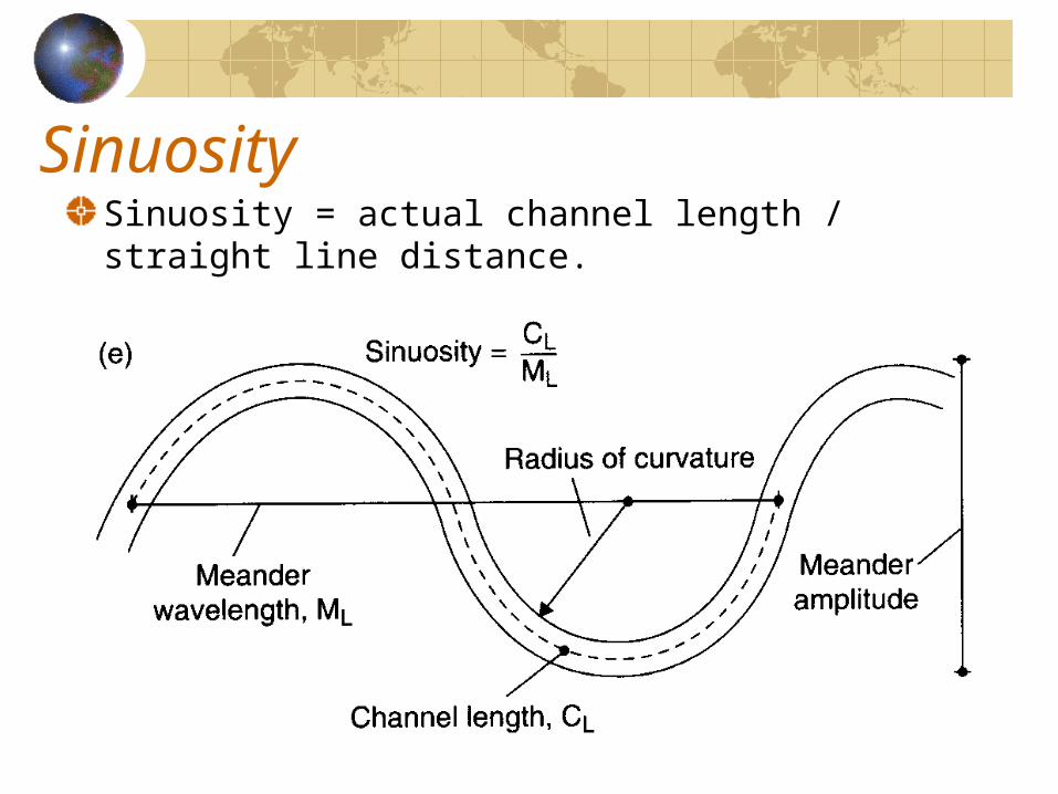
SinuositySinuosity = actual channel length / straight line distance.
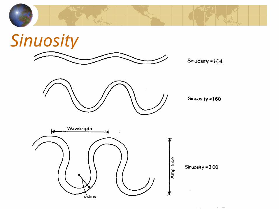
Sinuosity
Meandering channel patternIf forms when pronounced bends or loops develop in the course of river.It may be the result of
Helical flow• When stream water moves in a winding pattern, it
produces a strong centrifugal force which causes a helical flow in concave outside bank.
• It results in effective erosion in concave bank.
Slope gradient is reduced in lower course.Large proportion of loads is carried in suspension formThere is significant local bank erosion and deposition.
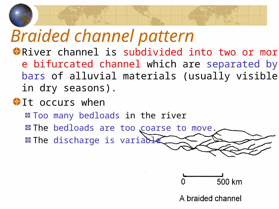
Braided channel patternRiver channel is subdivided into two or more bifurcated channel which are separated by bars of alluvial materials (usually visible in dry seasons).It occurs when
Too many bedloads in the riverThe bedloads are too coarse to move.The discharge is variable
Long Profile
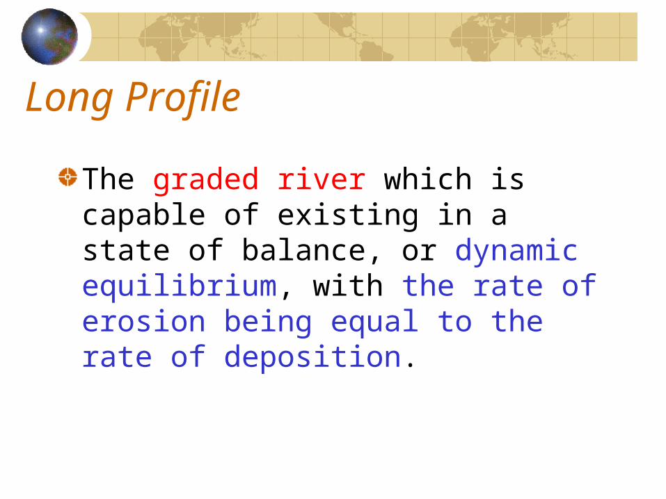
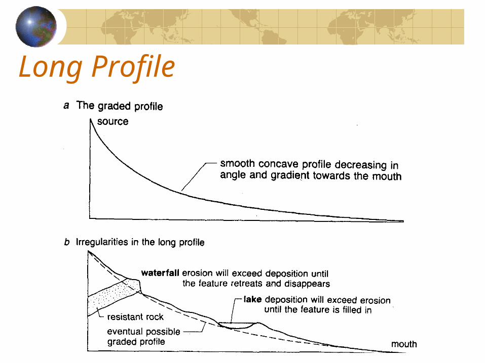
The graded river which is capable of existing in a state of balance, or dynamic equilibrium, with the rate of erosion being equal to the rate of deposition.
Long Profile
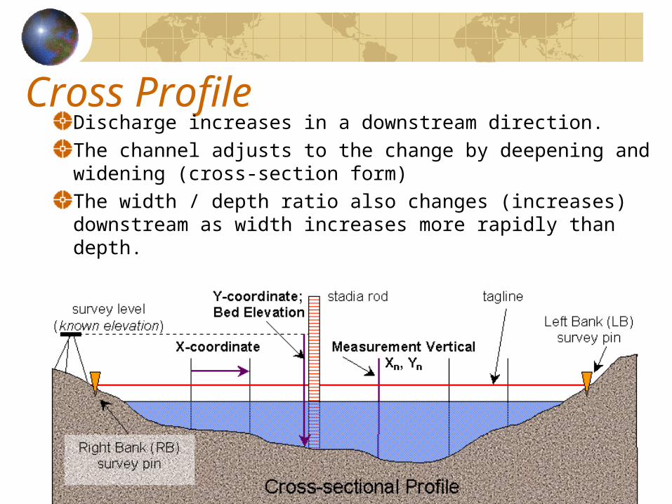
Cross ProfileDischarge increases in a downstream direction.The channel adjusts to the change by deepening and widening (cross-section form)The width / depth ratio also changes (increases) downstream as width increases more rapidly than depth.
Work done by rivers in the two landscape
Tropical RainforestTropical Desert
Tropical RainforestIntense chemical weathering under the hot humid condition.Erosion:
Small streams of steep gradient have bouldery channels but the boulders experience little downstream movement.Lateral erosion is very serious in middle and lower course for gentle slope and large discharge.
Loads and transportationGreater portion is in the form of dissolved solids.Little coarse sediments move as bed load, because the cover of vegetation holds back allFinest soil particles from transport by overland flow.
Tropical Rainforest
Deposition:Deposition is very common in the lower course, meandering channels, flood plains and deltas can be found in lower lower course.
Tropical Desert
IntroductionStreamflow characteristics in the arid landsStreamflood
Introduction
River work is very effectiveness because of the meagreness of vegetation in dry desert.Without a thick vegetation , large quantities of coarse rock debris are swept into streams to transform a dry channel into a flood stream.Sediment concentration can be extremely high up to 50%.Stream flow in deserts usually accounts for most of the water from precipitation.
IntroductionMuch of the precipitation is held as surface runoff rather than infiltrating deeply into the ground:Reasons
Lack of vegetationLack of water-absorbent organic layer in desert soilPresence of hardpans (salt cover) in the topsoil.Clayey surface of some deserts.Rainfall is too intense for a large amount of water to percolate.
Streamflow characteristics
Precipitation tends to run off into wadis which are normally dry out occasionally subjected to large flows of water and sediment.Rock-cut gorges may developed on pediments and fans at the foot of mountains.Floods are rather occasional and even fewer floods in the almost totally arid parts.
StreamfloodRainfall in deserts in usually of high intensity, most of the rainfall is available as runoff and enters the dry stream courses.Where streams flow across plains of gravel and sand, water is lost from the channels by seepages to water table as underground water.The role of water in erosion, transportation, deposition should not be ignored or made in secondary to the action of wind, once though to be the most important geomorphological agent in desert .
Geomorphological work of stream-floods
Large amounts of debris due to weathering, slow mass movements and wind action.Debris of all sizes from clay particles to boulders are moved until eventually they reach the upland edges.Stream floods can also cause erosion of stream channels themselves.Streamfloods in deserts are more important than the floods of humid regions in erosion. It is because weathered materials are not cohesive in dry environment and few plants to hold the soil together.
Geomorphological work of stream-floods
Lateral erosion of wadis channels is also due to streamfloods.Drainage density is very high (eg. 350 km/km2 in parts of arid North America), but in sandy deserts with high infiltration rate and hence little runoff, drainage intensity will be low.Deposition occurs and braided channels are conspicuous because of the heavy load of sediments carried by the streams.