Download - Vegetational Zonation in the Rocky Mountains || Vegetational Zonation in the Rocky Mountains

Vegetational Zonation in the Rocky MountainsAuthor(s): R. F. DaubenmireSource: Botanical Review, Vol. 9, No. 6, Vegetational Zonation in the Rocky Mountains (Jun.,1943), pp. 325-393Published by: Springer on behalf of New York Botanical Garden PressStable URL: http://www.jstor.org/stable/4353289 .
Accessed: 28/06/2014 10:42
Your use of the JSTOR archive indicates your acceptance of the Terms & Conditions of Use, available at .http://www.jstor.org/page/info/about/policies/terms.jsp
.JSTOR is a not-for-profit service that helps scholars, researchers, and students discover, use, and build upon a wide range ofcontent in a trusted digital archive. We use information technology and tools to increase productivity and facilitate new formsof scholarship. For more information about JSTOR, please contact [email protected].
.
New York Botanical Garden Press and Springer are collaborating with JSTOR to digitize, preserve and extendaccess to Botanical Review.
http://www.jstor.org
This content downloaded from 91.220.202.80 on Sat, 28 Jun 2014 10:42:07 AMAll use subject to JSTOR Terms and Conditions

THE BOTANICAL REVIEW VOL. IX JUNE, 1943 No. 6
VEGETATIONAL ZONATION IN THE ROCKY MIOUNTAINS
R. F. DAUBENMIRE
University of Idaho
CONTENTS
I. INTRODUCTION . ....................................... 326 II. THE ZONES ................ ....................... 330
The alpine zone ....................................... 330 The spruce-fir zone ....................................... 334 The Douglas fir zone ...................................... 337 The ponderosa pine zone ................................... 339 The juniper-pifion zone .................................... 340 The oak-mountain mahogany zone ........... ............... 341 Vegetation of the basal plains .............. ................ 343
III. MOUNTAIN ENVIRONMENT ................................... 343 Atmospheric pressure ...................................... 344 Insolation ................ ....................... 345 Temperature . ....................................... 345 Precipitation . ....................................... 349 Relative humidity ....................................... 352 Wind velocity . ....................................... 353 Evaporation ..................... .................. 353 Soils ........... ............................ 355 Topography . ....................................... 355
IV. ETIOLOGY .............. ......................... 357 Upper altitudinal limits .................................... 358
Low temperature ....................................... 358 Competition and other biologic influences ....... ........... 360 Wind .............. ......................... 361 Snow depth . ....................................... 363 Soil ................................................. 364
Lower altitudinal limits ..................................... 365 Drought . ......................................... 365 High temperature ....................................... 368 Soil texture ......................................... 370 Parasites . .......................................... 371
V. ALTITUDE VERSUS LATITUDE . .................................. 372 VI. IRREGULARITIES IN THE ZONAL PATTERN ......... .............. 375
Discontinuity of zones ..................................... 375 Pacific Coast elements in the Rocky Mt. flora ...... .......... 376 Inversion and lack of zonation ............. ................. 380 Mountain parks ......................................... 383
VII. SUMMARY . .......................................... 386 VIII. LITERATURE CITED ......................................... 387
325
This content downloaded from 91.220.202.80 on Sat, 28 Jun 2014 10:42:07 AMAll use subject to JSTOR Terms and Conditions

326 THE BOTANICAL REVIEW
I. INTRODUCTION
On approaching the Rocky Mountains, even the most casual observer cannot fail to be impressed by the sudden change in vege- tation where the forest-covered mountain slopes rise abruptly from the unforested basal plain. On ascending the mountain slopes, the forest types observed in the foothills may be seen to give way in rapid succession to other types, each of which in turn predominates only within a particular elevational zone. Near the summits of the higher prominences another edge of the forest is encountered, be- yond which there is only low-growing vegetation of still a different type. To the discriminating eye, these changes in the morphology of the vegetation are accompanied by practically complete changes in the species of herbs, shrubs and trees from one altitude to another.
Scientific interest in plant zonation on mountain slopes is very old, dating back at least to the writings of Tournefort in 1717 (28). Since that early date, the steadily increasing volume of botanical literature on zonation, especially that which has appeared in the last half century, attests the great interest which this phenomenon has held for students of field botany.
The mountains of southern Europe were the first to be studied intensively by botanists, and even though studies there have been somewhat handicapped by the disturbed nature of all the plant communities, European ecologists (Christ, Schr6ter, Brockmann- Jerosch, et al.) have made outstanding contributions to mountain ecology. With the development of western North America, the Cordilleras have more recently proven a vast and fertile field for ecologic study, especially because of the relatively undisturbed nature of plant communities there. Ecologic investigations have also been pursued to some extent in many other mountainous re- gions of the world, but nowhere in as much detail as in Europe and in the western United States of America.
When viewed as a whole, the literature on plant zonation has one very regrettable feature, and that is the great variation which has. ch'racterized the interests, viewpoints and methods of the writers. !i l,ny descriptions of isolated regions are as yet of limited value because they cannot be related to each other. Certainly the prin- ciples underlying zonation should bear much more similarity from one mountain region to another than do the published descriptions of those zonal systems. Perhaps such irregularities have been due
This content downloaded from 91.220.202.80 on Sat, 28 Jun 2014 10:42:07 AMAll use subject to JSTOR Terms and Conditions

VEGETATION ZONATION IN THE ROCKY MOUNTAINS 327
in part to the fact that there has been little attempt to digest and integrate the literature for various regions.
Sufficient data have been published on the altitudinal variations in environment and vegetation in the Rocky Mountains so that previously isolated researches may be fitted together into a unified system of facts which shows the existence of fundamental geo- botanical principles. It is the purpose of this paper to attempt an integration of most of the important literature pertaining to plant zonation in this mountain system, supplemented by the writer's personal field studies.
* * * * * *
Looking at Rocky Mountain vegetation from the broadest view- point, it is apparent that four major plant formations are involved. First, there is the treeless vegetation of the high peaks and ridges which is classified as "tundra." Extending from the lower edge of the tundra downward over most of the mountainous slopes is a broad belt of forest dominated by coniferous trees, a portion of the 'needle-leaved forest." The upper edge of this forest belt, i.e., the ecotone between forest and tundra, will subsequently be referred to as "upper timberline." The "lower timberline," i.e., the lower limit of the forest belt, coincides roughly with the bases of the steeper mountain slopes where they meet the less precipitous topog- raphy of the surrounding basal plains. At this lower ecotone, the Rocky Mountain forests are in contact with either the "grassland" or the "desert" formation.
In areal extent the Rocky Mountain zonal system is essentially homogeneous from the Black Hills (Fig. 1) of South Dakota west- ward to approximately the divide of the Cascades and the eastern foothills of the Sierras, and from the latitude of northern Alberta to the southern end of the Sierra Madres of northern Mexico (131, 124).
Physiographically the Rocky Mountain region ma'y be separated at the continental divide into a west slope and an east slope (Fig. 1). Also each of the ranges which make up the Rockies may be divided into a west and an east slope, even though in actuality all directions of exposure may be found on both slopes. The term "slope" is obviously used in two senses, the one much broader than the other. Such divisions are of some value in plant geography, since they coincide with a certain amount of climatic and floristic differentia-
This content downloaded from 91.220.202.80 on Sat, 28 Jun 2014 10:42:07 AMAll use subject to JSTOR Terms and Conditions

328 THE BOTANICAL REVIEW
tion. It must be realized, however, that physiography means nothing to plant life except for the types of habitats which it pro- vides. In consequence, a species which depends for its existence upon the climatic type prevailing on one slope is generally found only on that slope, but may be encountered occasionally on the oppo- site slope where soil or microclimate compensates for the inadequacy of the macroclimate.
Based upon some conspicuous floristic differences, the Rockies may also be divided in a north-south direction. In this paper there
0Z0, 2>
-AXO
LA\ o0,,A
FIG. 1. Map showing the Rocky Mountain region (enclosed by heavy lines), the continental divide (dotted line), principal storm tracks (arrows), and peaks and ranges mentioned in this paper. Meaning of symbols: A- Abajo Mts.; B-Big Horn Mts.; BR-Bitterroot Range; BH Black Hills; L-La Sal Mts., M- Medicine Bow Mts., P-Pike's Peak; R-Rincon Mts.; SC-Santa Catalina Mts.; SF-San Francisco Peak; SR-Salmon River Mts.; U-Uinta Mts.; W-Wasatch Range.
are recognized four north-south divisions: the southern, central, northern and far-northern. The line of separation between the southern and central Rockies occurs just a little south of and paral- lel to the northern borders of the states of New Mexico and Arizona. The floristic break between the central and northern Rockies coin- cides roughly with a line running east and west through the center of Wyoming. In about the latitude of central Alberta and British Columbia there is another significant break in the flora which sepa- rates the northern from the far-northern Rockies. Considering
This content downloaded from 91.220.202.80 on Sat, 28 Jun 2014 10:42:07 AMAll use subject to JSTOR Terms and Conditions

VEGETATION ZONATION IN THE ROCKY MOUNTAINS 329
only the larger ligneous plants, addition of the following species to, or their notable absence from, the typical Rocky Mountain flora in each case characterizes a particular one of the four divisions:
SOUTHERN RocKIES
Abies lasiocarpa var. arizonica Alnus oblongifolia Arbutus arizonica Arbutus texana Arctostaphylos pungens Bumelia languinosa Cupressus arizonica Cupressus glabra Fraxinus lowellii Fremontodendron californicum Juglans rupestris Juniperus pachyphloea Juniperus pinchoti Pinus arizonica Pinus cembroides Pinus latifolia
Pinus leiophylla Pinus strobiformis Platanus wrightii Quercus arizonica Q uercus chrysolepis Quercus diversicolor Quercus dumosa Quercus emoryi Quercus hypoleuca Quercus oblongifolia Rhamnus crocea var. ilicifolia Rhus ovata Sorbus dumosa No Alnus tenuifolia No Pinus murrayana
CENTRAL ROCKIES
No large ligneous plants are peculiar to this region.
NORTHERN ROCKIES
Abies grandis Alnus rhombifolia Alnus sinuata Ceanothus sanguineus Cornus nuttallii Holodiscus discolor Larix lyallii Larix occidentalis
Oplopanax horridumn Pinus albicaulis Pinus monticola Populus trichocarpa Taxus brevifolia Thuja plicata Tsuga heterophylla Tsuga mertensiana
FAR-NORTHERN ROCKIES
Picea mariana No Populus angustifolia
These four divisions of the Rocky Mountains are strictly botani- cal and bear no relation to geologic or physiographic provinces into which the same region may be divided, except insofar as these influence climate.
This content downloaded from 91.220.202.80 on Sat, 28 Jun 2014 10:42:07 AMAll use subject to JSTOR Terms and Conditions
330 THE BOTANICAL REVIEW
II. THE ZONES
Various criteria have been employed by different botanists in their delimitation of vegetational zones. Among these the one which has gained the greatest favor is ecologic rather than floristic, and makes its basic distinctions upon the nature of the climatic climax associations which obtain at different elevations or in dif- ferent regions. On this basis there may be distinguished six major vegetation zones which are primarily characteristic of the Rocky Mountains:
TUNDRA FORMATION
1. Alpine tundra zone
NEEDLE-LEAVED FOREST FORMATION
2. Engelmann spruce-subalpine fir zone 3. Douglas fir zone 4. Ponderosa pine zone 5. Juniper-pifion zone 6. Oak-mountain mahogany zone
GRASSLAND and DESERT FORMATIONS
The alpine zone
Nowhere is the youthfulness of Rocky Mountain topography more important vegetationally than in the alpine zone. Here the surface is essentially an alternation of rocky outcrops with depres- sions of varying degrees of imperfect drainage, and the soil, when present, varies from peat to gravels which are practically devoid of organic matter. The plants in this zone are so sensitive to this out- standing edaphic heterogeneity that communities are seldom as extensive or as homogeneous as, for example, in prairie vegetation.
The climate of these higher mountain summits is so cool that the chemical processes of rock weathering function with extreme slow- ness. Mechanical processes, operating nearly unaided, have made relatively little progress in soil formation, and in consequence over much of the area at high elevations the surface of the bed rock has become covered with only a jumble of large angular boulders which represent the first stage in the change from rock to soil. Such areas, if not unstable, are generally referred to as "boulder fields." Their vegetation consists chiefly of crustose lichens growing on the surfaces of the frost blocks, and a scanty flora of crevice plants such
This content downloaded from 91.220.202.80 on Sat, 28 Jun 2014 10:42:07 AMAll use subject to JSTOR Terms and Conditions

VEGETATION ZONATION IN THE ROCKY MOUNTAINS 331
as Oxyria digyna, Aquilegia spp., Polemonium spp., Pentstemon fruticosus and Sibbaldia procumnbens.
In less severe habitats a coarse gravelly soil has accumulated between the boulders to the extent that only the summits of the latter are exposed. On these habitats, the "fell fields," is a sparse vegetative cover in which mat or cushion plants are especially con- spicuous. Some of the characteristic species of the fell fields are Silene acautlis, Dryas octopetala, Areniaria sajanenisis, Erigeron co0n- positu-s, E. multiflorus, Luzula spicata, Paroniychia spp., Phlox caespitosa and Selaginiella densa.
In still more favorable habitats, in especially the lower part of the alpine zone, the xerosere has progressed until the last vestiges of the boulders have disappeared under the accumulating soil, which by this time has become completely covered by a dense, low, meadow-like type of plant cover (38, 88). In the Rocky Moun- tains this vegetation is usually referred to as "alpine meadow." Some of the more common dominants of these climax meadows are Carex spp., Kobresia bellardi, Poa spp., Phleurn alpinum, Des- charnpsia caespitosa, Triseturn subspicaturn, Agrostis spp., Festuca spp., Polygonumn viviparurm, Potentilla spp., Sieversia turbinata, Trifoliurn spp. and Pedicularis parryi. That these dense associa- tions of grasses, sedges and forbs have long been considered valu- able summer forage is reflected in the common custom in southern Europe of referring to the lower portion of the alpine zone as "pasture" (111). In North America this vegetation has also been called "alpine grassland" (33, 146).
Hydroseres in the alpine tundra are quite varied in nature. Communities dominated by Carex, Eleocharis, shrubby Salix, or forbs such as Trollius, Caltha, Raniunculus and Menyanthes, charac- terize hydric sites until development of drainage and accumulation of peat permit an approach toward the climatic climax.
Relatively few peaks and ridges of the Rockies are high enough to support tundra, so that areas of this vegetation exist as islands in a sea of forest. Although such a circumstance favors a spotty dis- tribution of species with relatively inefficient disseminules, others have become widely distributed, possibly in Pleistocene time when the timberline may have been lower and consequently the gaps between tundra islands less extensive.
This content downloaded from 91.220.202.80 on Sat, 28 Jun 2014 10:42:07 AMAll use subject to JSTOR Terms and Conditions

332 THE BOTANICAL REVIEW
The members of the alpine flora seem to have been drawn from two major sources. First, there are alpine species endemic to the Rockies which have been derived from low-altitude species of the immediate vicinity. Examples taken from lists compiled by Ryd- berg (132) are:
ALPINE DERIVATIVE POSSIBLE SUB-ALPINE PARENT
Achillea subalpina A. lanulosa Aquilegia saximontana A. brevistyla Besseya alpina B. plantaginifolia Phacelia alpina P. heterophylla Solidago decumbens S. oreophila
A second major source for Rocky Mountain alpine plants has been the arctic tundra. Many of the Rocky Mountain species are at present widely distributed' in the arctic as well as in other alpine regions in the northern hemisphere. Because many of these have retained their specific identity in both alpine and arctic regions it is commonly believed that the southward extension of ranges took place in recent geologic time,-most likely during the Pleistocene epoch when timberlines may have been lower than at present. A partial list of these plants is as follows:
Androsace chamaejasme Astragalus alpinus Carex incurva Dryas octopetala Empetrum nigrum Erigeron uniflorus Kobresia bellardi
Luzula spicata Oxyria digyna Papaver nudicaule Polygonum viviParum Potentilla nivea Salix reticulata Saxifraga cernua
Saxifraga hirculus S. nivalis S. oppositifolia Sedum rhodiola Thalictrum alpinum Trisetum spicatum
Other alpine species of boreal origin have undergone slight though distinct speciation at lower latitudes so that the arctic and alpine regions now contain several closely related species-pairs. Thus, according to Rydberg (132), the alpine Phyllodoce empetriformis, Sieversia turbinatac, and Saxifraga rhomboidea are probably deriva- tives of the arctic P. coeruleac, S. rossii and S. nivalis, respectively.
At any latitude north of the equator the alpine flora of the Cor- dilleras contains genera which are more widespread farther north,
1 Among the species common to the Rocky Mountain and the arctic tundras are some which enjoy relatively limited distribution at high latitudes, and of this group at least some may not have originated in the arctic region. Holm, following an earlier hypothesis, believed that some of these arctic-alpine species with limited arctic distribution originated in the Rockies, then mi- grated northward, possibly at the close of the last glacial period, to become incorporated with the arctic flora (68).
This content downloaded from 91.220.202.80 on Sat, 28 Jun 2014 10:42:07 AMAll use subject to JSTOR Terms and Conditions

VEGETATION ZONATION IN THE ROCKY MOUNTAINS 333
but progressing southward along the Rockies this proportion of species of boreal extraction decreases as the number of endemics of local extraction increases (137). Thirty-seven per cent of the alpine species of Colorado are found also in the arctic regions. In central Mexico the alpine vegetation is still dominated by northern genera, although at this latitude three Andean genera occur in the tundra (52). Even the tundra at the equator in the Ecuadorean Andes has a small percentage of northern genera (112).
Rydberg (132) estimated the strictly alpine flora of the Rockies to consist of approximately 250 species, more than a third of which are endemic. In addition, there are about 100 species which occur below as well as above upper timberline. In the far-northern Rockies Raup (125) found a much smaller percentage (about 15%o) of the alpine flora growing below upper timberline. At their lower limits these species were found chiefly on river banks or on talus slopes.
Alpine vegetation consists almost entirely of perennials.2 During two summers of intensive collecting in the alpine zone of Colorado, Holm (67) found a total of 170 species of vascular plants, only two of which are annuals: Androsace subumbellata and Gentiana plebeja. The principal families represented in his collection were, in order, Compositae, Cyperaceae, Gramineae, Caryophyllaceae and Scrophulariaceae.
Most of the perennials are caespitose (40) and either herbaceous or suffrutescent. True shrub communities consist of associations of willows growing on wet, boggy soil, and heath-like communities of Phyllodoce, Cassiope, etc., in the northern Rockies (133). Raup (125) described shrub thickets in the lower part of the alpine zone in the far-northern Rockies, which are dominated by Rhododendron albiflorum, Betula glandulosa and Salix spp.
Perhaps no single morphologic characteristic of the plants in the alpine zone is more conspicuous than the dwarfness of the shoots in proportion to the size of the flowers and fruits which they bear. The flowers of alpine potentillas, for example, are not much smaller than those borne by other species at lower elevations, although the shoots of the latter are several times larger. The fruits of Rubus chanaemnorus and the catkins of dwarf willows are also conspicu-
2 Of the 49 species which comprise the alpine flora of San Francisco Peak, Arizona, 83%o are hemicryptophytes, 10%o chamaephytes, 4% therophytes, and 2%o cryptophytes (88).
This content downloaded from 91.220.202.80 on Sat, 28 Jun 2014 10:42:07 AMAll use subject to JSTOR Terms and Conditions

334 THE BOTANICAL REVIEW
ously out of proportion to the remainder of the diminutive shoots. It is a common misconception that alpine plants are but dwarfed forms of lowland species; transplant experiments have disproven this (31). Dwarfness is a fixed genetic character of most true alpine species, although when low-altitude species extend up into this zone the individuals are greatly reduced in size.
A very evident physiologic characteristic of alpine plants is their immunity to injury from heavy frost during periods of active growth and flowering. Furthermore, the phenomenon of prolifery, which is best developed in this formation,3 may be considered an adaptation that at least in part offsets the disadvantages of a grow- ing season which is rather short for the complicated process of setting seed.
Although the Rocky Mountain alpine vegetation bears many eco- logic and floristic relationships to the more extensive circumpolar tundra which borders the Arctic Sea, there are certain features peculiar to this formation and its environment as represented on mountain summits at lower altitudes. Floristically, the vegetation contains a high proportion of endemics, as mentioned previously. In matters of daylength and intensity of insolation, the environment of the tundra in temperate latitudes is very different from that of the boreal region where the photoperiod is nearly 24 hours long during the growing season, and the light is of weak intensity. The subsoil of the arctic region, unlike that of the alpine region in the Rockies, is perennially frozen. Holm (67) called attention to the fact that although the arctic growing season is shorter than the alpine, it is much less subject to violent changes in weather than is the alpine growing season. From the above it is evident that pecu- liarities in both environment and vegetation make the term "alpine tundra" very desirable to distinguish this vegetation from "arctic tundra," although the two merge imperceptibly near the arctic timberline.
The spruce-fir zone
The broad belt of coniferous forest which extends down from the upper timberline to the basal plain may be divided into several
3 Species reputedly proliferous which occur in the Rocky Mountain tundra are: Deschampsia caespitosa, Hierochloe alpina, Poa alpina, P. arctica, Polygonum viviparum, Saxifraga cernua, and S. nivalis. This phenomenon should also be looked for in Juncus, for certain species of this genus in other tundra regions are proliferous.
This content downloaded from 91.220.202.80 on Sat, 28 Jun 2014 10:42:07 AMAll use subject to JSTOR Terms and Conditions

VEGETATION ZONATION IN THE ROCKY MOUNTAINS 335
zones. The uppermost of these, because of its position, is often referred to as the "subalpine zone." It usually occupies about 2,000 feet of elevation4 and is characterized by a climatic climax, the dominants of which are subalpine fir (Abies lasiocarpa) and Engel- mann spruce (Picea engelmannii). In the southern Rockies Abies lasiocarpa is in part replaced by A. lasiocarpa var. arizonica. In northern Idaho and Montana island-like stands of mountain hem- lock (Tsuga mertensiana) occur in this zone, and in the far-northern Rockies the forest is enriched by the addition of Picea glauca and P. mariaria.
These spruces and firs have a very slender form, and under favor- able conditions they grow close together to form a dense forest. Engelmann spruce grows to larger size than subalpine fir and, ex- cept on the west slope of the Bitterroots (139), is usually the more abundant species.
On the relatively dry eastern slope of the central Rockies the undergrowth in this forest is characteristically scant and is domi- nated by dwarf vacciniums, especially V. scoparium, Arnica cordi- folia, Carex geyeri, and other plants. Under the more mesic climate of the west slope the undergrowth consists of a rank growth of large dicotyledonous herbs. Mosses and lichens are abundant on the forest floor, and here again the cryptogamic flora is generally richer on the west slope. In the northern Rockies Menziesia ferruginea, Vacciniium s membranaceum, Shepherdia canadensis and Xerophyl- lumn tenax are characteristic vascular plants in the undergrowth, while in the far-northern Rockies Alnus crispa, Viburnum pauci- floru'n, Amielanchier florida and Shepherdia canadensis predomi- nate. In both the northern and far-northern Rockies the mosses often form a thick and nearly continuous layer over the ground. Thus it may be seen that the dominant tree synusia has far more floristic homogeneity throughout the north-south extent of this zone than do the inferior synusiae.5
Fire, which is all but unknown in the cool moist tundra, fre- quently destroys the climax spruce-fir association, and in its place there develop temporary forests of lodgepole pine6 (Pinus Mur-
4 Other climax zones of woody vegetation in the Rockies occupy 2,000 feet of elevation only in a rather restricted region.
5 The same is true of the other zones of ligneous vegetation. However, despite the floristic heterogeneity, the life-forms and density of the ground cover are fairly uniform throughout the geographic extent of each zone.
6 Conspicuously absent from the southern Rockies.
This content downloaded from 91.220.202.80 on Sat, 28 Jun 2014 10:42:07 AMAll use subject to JSTOR Terms and Conditions

336 THE BOTANICAL REVIEW
rayana), aspen (Populus tremuloides) and Douglas fir (Pseudo- tsuga taxifolia). The factors determining which of these temporary associations prevails on a given area are not always evident, but frequently they seem related to soil moisture, with aspen invading the most mesic sites. Bates (9) expressed a view that lodgepole pine usually dominates after heavy burning, while aspen usually follows light burning. Certain it is that where the original forest contained relics of aspen, this species is likely to take possession of the ground after fire of moderate intensity because of its vigor in producing root suckers. In fact, propagation of aspen is mostly vegetative throughout the Rockies. Aspen stands are especially noted for their tall, luxuriant undergrowth of grasses and forbs. The richer herbaceous flora here as compared with areas dominated by conifers may be associated with the moistness of aspen sites, or what is more likely, with the increased fertility of the soil which accompanies deciduous woody vegetation.
Spruce and fir seedlings appear under the canopies of the tem- porary forest types while they are yet young, and ultimately crowd out the latter (74). Establishment of seedlings of climax species in temporary forest types is a much less difficult process than in the forest which follows, for as succession progresses there accumulates a duff layer so thick that very few seedlings survive (130, 51). Fir seems most adversely affected by this duff mat, especially south- ward in the Rockies. In the central Rockies it reproduces almost entirely by layering, but in the northern Rockies both seedlings and layered branches are commonly found. Spruce seedlings survive much better on rotten logs than on duff, and most of them that get established under climax forest conditions have germinated on this type of substratum (89).
The climate near the upper timberline is usually too severe to permit pine, aspen or Douglas fir to colonize burned areas, and in such situations spruce and fir regenerate directly, although at a very slow rate (158).
The ecotone between the spruce-fir and alpine zones is well known for its stunted trees. Some writers have recognized a sepa- rate timberline or krummholz (literally "crooked wood") zone, in which woody vegetation gradually thins out from the "forest line," i.e., the edge of the continuous forest, upward to the last stunted tree, i.e., "tree line." In this paper the expression "upper timber-
This content downloaded from 91.220.202.80 on Sat, 28 Jun 2014 10:42:07 AMAll use subject to JSTOR Terms and Conditions

VEGETATION ZONATION IN THE ROCKY MOUNTAINS 337
line" refers to a hypothetical line drawn midway between the "forest" and "tree" lines, i.e., down the center of the timberline zone which is truly an ecotone.
In the timberline zone there may occur species of trees, in addi- tion to spruce and fir, which can tolerate neither the severe climates of the alpine zone nor the intense competition offered by the dense forests at lower elevations. South of the latitude of Denver, bristle- cone pine (Pinus aristata) is especially abundant at upper timber- line, although it may also be found at lower elevations in the forest belt on wind-swept ridges (4, 25). Throughout the central Rockies limber pine plays a similar role (26). In the northern Rockies (98) white bark pine (Pinus albicaulis) and Lyall's larch (Larix lyallii) are found chiefly at upper timberline. In the far-northern Rockies lodgepole pine is abundant at upper timberline (125).
The Douglas fir zone
Immediately below the spruce-fir zone there is characteristically a belt dominated by Douglas fir. Although a climax dominant at this elevation in the Rockies, this tree never attains the magnificent size or commercial importance that it does on the west slope of the Cas- cades. It has a pointed but moderately broad crown which even at a distance readily distinguishes it from the spruce and fir which have a more spire-like form. In the southern and central Rockies, white fir (Abies concolor) and blue spruce (Picea pungens) are often associated with Douglas fir, although they are seldom present in great numbers. These two species are characteristic of the most mesic habitats, the latter being found usually along stream courses. Canada spruce (Picea glauca), an important climax domi- nant over much of Canada, extends southward along the Rockies in the Douglas fir zone, especially on the east slope. In climatic requirements and ecologic characteristics it is so similar to Douglas fir that it shares a climax status with the latter where their ranges overlap. The absolute southern limits of this boreal species are attained in the Black Hills of South Dakota and Wyoming, where it occurs, curiously enough, without Douglas fir, in a belt imme- diately above the ponderosa pine zone (92).
In the northern Rockies grand fir (Abies grandis) may be found with Douglas fir, especially on the west slopes of the ranges and west of the continental divide.
This content downloaded from 91.220.202.80 on Sat, 28 Jun 2014 10:42:07 AMAll use subject to JSTOR Terms and Conditions
338 THE BOTANICAL REVIEW
A typical old Douglas fir stand is so dense that very few herbs (Calamagrostis rubescens, Arnica cordifolia, etc.) and shrubs are found beneath the trees. As in the spruce-fir zone, a duff layer accumulates on the forest floor, but in this case the duff is not as thick as in the higher forest belt.
In the central and southern Rockies, ravines in this zone which are wide enough to have low stream terraces may contain Populus angustifolia on these alluvial habitats. Wind-swept ridges fre- quently bear only a savanna of deformed pines, the species of which vary with latitude. From central Arizona southward the chief species is Pinus strobiformis. In northern Arizona and the south- ern parts of Utah and Colorado P. aristata is conspicuous on these habitats. Over the remainder of the central Rockies the species is P. flexilis, and in the northern Rockies it is P. albicaulis. These trees are all very similar in appearance, and except for P. aristata all are very closely related taxonomically. All are likewise found on corresponding habitats in the zones adjacent to the Douglas fir zone.
Following the devastation of forest fires, stands of lodgepole pine7 or aspen (53, 105, 140) invade the burned areas and bear the same successional relationship to Douglas fir as they do to the climax forest at higher elevations. Ponderosa pine (Pinus ponI- derosa and closely related segregates) frequently play the same role, particularly in the lower part of the zone. In the northern Rockies western larch, Larix occidentalis, is an additional species found on burned areas in this zone.
In the Great Basin and vicinity, the Douglas fir zone may be represented almost exclusively by aspen, and in such cases aspen has all appearances of maintaining a climax status.8 In the Hayden Division of the Medicine Bow National Forest, Wyoming, for example, extensive stands of this type may be found. The presence of all age classes of aspen up to old specimens four decimeters in diameter, together with the absence of all other trees except
7Robbins (128) enumerated the vegetational zones in northern Colorado as follows: alpine, spruce-fir, lodgepole pine, ponderosa pine-Douglas fir, chaparral and plains. Apparently, he accorded lodgepole pine the status of a zone only because of the prevalence of extensive burned areas in the upper part of the Douglas fir and the lower part of the spruce-fir zones, for Clements (30) had shown earlier that at higher altitudes in this same region, the lodgepole pine stands are all replaced in natural succession by spruce-fir forests, and at lower altitudes by Douglas fir.
8 This region appears to be the center of optimum development of trembling aspen in North America. Specimens a meter in diameter are on record (2).
This content downloaded from 91.220.202.80 on Sat, 28 Jun 2014 10:42:07 AMAll use subject to JSTOR Terms and Conditions

VEGETATION ZONATION IN THE ROCKY MOUNTAINS 339
a few white firs, indicates a relatively stable condition. It is quite possible that this circumstance has been brought about by holocausts which eliminated all Douglas fir from so large an area that the centripetal migration necessary to restock the entire area with the climax tree will require many centuries for completion (50). The extensive stands of lodgepole pine in the northern Rockies may have the same explanation.
The ponderosa pine zone
At its lower edge the Douglas fir belt is usually in contact with forest of ponderosa pine. The rounded crowns and open spacing of the older pine trees are conspicuous features which distinguish this forest from the next one above. In the southern Rockies, Pearson (109) states that the canopies of the trees usually cover no more than 25% of the ground. Usually toward the lower limit of the zone the vegetation is distinctly savanna-like. This relative thinness of shade coupled with the meagerness of brush and litter favor a well developed ground cover in which perennial grasses such as Festuca, Agropyron, Poa and Muhlenbergia dominate. Because of this, ponderosa pine forests provide excellent grazing as well as valuable timber (110).
Ponderosa pine, or one or more of its varieties, is the character- istic tree in this zone. Only west of the continental divide and in the northern Rockies is this zone dominated by Pinus ponderosa. East of the divide in this same latitude, and southward throughout the remainder of the Rockies, Pinus poniderosa var. scopulorum is generally the most important tree in the forest. In the southern Rockies this variety is joined or replaced by P. ponderosa var. ari- zonica, P. leiophylla and P. latifolia. In the eastern foothills of the Sierras still another closely related form, P. ponderosa var. jeffreyi, is characteristic of the zone. Although there is a tendency among taxonomists to elevate each of the above varieties to the rank of species, the variety status is most desirable here, since it empha- sizes the homogeneity of this group of trees, all of which are so similar in appearance and ecology. In most of these pines the younger trees have a dark gray bark and in this stage are often referred to as "blackjack" or "bull pines." Old trees are locally called "yellow pines" in allusion to the bright yellow color of the thick bark plates.
This content downloaded from 91.220.202.80 on Sat, 28 Jun 2014 10:42:07 AMAll use subject to JSTOR Terms and Conditions

340 THE BOTANICAL REVIEW
For several months during the summer the forest floor9 in this zone is dry enough to burn readily, and slow-spreading surface fires, which do little more than consume grass and tree litter and destroy small seedlings, are common (32). Old trees are quite fire-resistant, as is indicated by traces of charcoal usually to be found between the bark plates on their lower trunks. Each of the distinct age groups of saplings encountered in a typical stand generally consti- tutes a record of a series of consecutive summers which passed without fire, during which a generation of seedlings had time to grow into fire-resistant saplings.
When the climax ponderosa pine stand is more severely dis- turbed, as with logging or overgrazing, there usually develops a fairly dense stand of brush (Quercus, Ceanothus, Cercocarpus, etc.). Toward the upper limits of the zone, lodgepole pine may be found on burned sites (102). Aspen thickets may occur along streams and in other mesic habitats in the ponderosa pine zone as well as at still lower elevations. On flood-plains and low terraces several species of cottonwood and box elder (Acer negundo) are abundant.
Juniper-pinon zone
The lowest subdivision of coniferous vegetation is the juniper- pifion zone which in the aggregate covers approximately 76 million acres in the United States of America (27). In the central and southern Rockies various species of arborescent juniper (Juniperus scopulorum, J. monosperma, J. utahensis, J. occidentalis, J. pachy- phloea, J. mexicana, etc.) are mingled with piinons (Pinus cemn- broides and its varieties edulis and monophylla). Locally in the southern Rockies the arborescent flora of this zone is enriched by the genus Cupressus.
From northern Mexico this type extends northward along the west slope of the Rockies as far as the Snake River in Idaho. Along the east flank it extends only as far north as Colorado Springs, Colo- rado, but for a small outpost near Ft. Collins, Colorado. North of these boundaries, from central Idaho and northwestern Wyoming
9 A thick layer of duff, as is found in the climax forests at higher altitudes, is generally lacking here, although a heavy layer of needle litter is character- istic. The abundance of grasses in this zone promotes development of a defi- nite zone of humus soil several inches thick. In the higher forest zones, on the other hand, most organice matter is superficial as in typical podsol profiles. In at least certain sections of the Rockies much of the chernozem-like charac- ter of the soil profiles at low altitudes may have developed largely during the post-glacial xerothermic period if timberlines were higher then than at present.
This content downloaded from 91.220.202.80 on Sat, 28 Jun 2014 10:42:07 AMAll use subject to JSTOR Terms and Conditions

VEGETATION ZONATION IN THE ROCKY MOUNTAINS 341
to southern Alberta, there occurs a similar though poorly identified zone dominated by limber pine'0 and junipers.
Because of the low stature of the trees, commonly between 10 and 30 feet tall, this zone is frequently referred to as woodland. In most regions the wide spacing of the individuals gives the vege- tation the character of a savanna." In the interstices between the trees there is a dense cover of grasses (Bouteloua, Stipa, Agropyron, Poa, etc.) and forbs, together with a few shrubs such as Ceanothus, Cercocarpus, Purshia, Cowania, Artemisia and Opuntia.
Two of the dominants in this zone, Juniperus pachyphloea (114) and J. pinchoti (117), sprout freely from the stump after the trees are burned or cut, but others show little or no tendency to regener- ate in this manner.'2 If any temporary woody vegetation intervenes between burning and reestablishment of this climax, it is dominated by shrubs drawn from the next lower zone (86, 174). When the stands are overgrazed, either the junipers and pines increase in den- sity, or a heavy stand of brush develops. Aspen may occur at this elevation, but only as an edaphic or topographic climax on the most mesic sites.
Oak-mountain mahogany zone
The ecotone between the needle-leaved forest and the non-forested formations of the adjacent plains and plateaus is often marked by a fringe of scrub which may be considered a distinct zone. Eco- logically this vegetation is more closely related to the needle-leaved formation, since it is distinctly too mesophytic to be classed with the desert and grassland formations of the basal plants.
This zone attains its maximum development in the southern Rockies where it has a vertical range of as much as 1,800 feet and is floristically most complex. In the central Rockies it forms a relatively narrow and frequently interrupted belt (123), and farther northward it is scarcely represented. An interesting feature which merits study is that in regions where this zone is well developed, the juniper-pinon zone is poorly represented, and vice versa (15).
10 Undoubtedly the entire population of limber pine, extending as it does from the upper to the lower timberline and from Canada to Mexico, consists of a number of distinct ecologic races.
11 A Mexican term for this vegetation is "sabaneta" (156). 12 Such a method of reproduction has also been reported for Quercus emoryi
of the oak-mountain mahogany zone, and Pinus leiophylla of the ponderosa pine zone (114, 117), and for aspen as described above.
This content downloaded from 91.220.202.80 on Sat, 28 Jun 2014 10:42:07 AMAll use subject to JSTOR Terms and Conditions
342 THE BOTANICAL REVIEW
Their true zonal relations seem to be well demonstrated in the mountains between San Francisco Peak, Arizona, and the desert to the south, where the oak-mountain mahogany zone forms a broad belt between the juniper-piiion and desert regions.
This is the most heterogeneous of all the zones from the stand- point of the specific composition of the dominants. The oaks (Quercus gambellii, Q. gunnisoni, Q. undulata, Q. fendleri, Q. emoryi, etc.) are limited entirely to the region south of a line drawn from Denver, Colorado, to Logan, Utah, although the mountain mahoganies (Cercocarpus parviflorus, C. ledifolius, etc.) extend farther north. Other shrubby members of this zone which locally may replace oak or mountain mahogany are Rhus trilobata, Purshia tridentata, Fallugia paradoxa, Amelanchier spp. and Symphori- carpos spp. In Arizona this zone is enriched by a considerable group of shrubs of Pacific Coast affinity, whose significance will be discussed later. In valleys at the lower edge of the ponderosa pine zone in the Black Hills occur thicket-like stands of bur oak (Quercus macrocarpa) which possibly should be considered a part of the oak-mountain mahogany zone. Because this association in the Black Hills region is dominated by species of distinctly eastern affinity (Q. macrocarpa, Ostrya virginiana, Celtis occidentalis, C. crassifolia, Ulmus americana and Fraxinus camnpestris), Rydberg (137) considered this zone the western representation of the ex- tensive angiosperm forest region of the eastern United States. Again along the eastern edge of the foothills of the Cascades, for a short distance both north and south of the Columbia River, there occur thickets or low open forests of Quercus garryana at the ecotone between the coniferous forests and the adjacent prairie. These stands are the easternmost extensions of the Quercus garr- yana forests which characterize the over-drained gravelly plains lying at low elevations west of the Cascades.
The dominant shrubs of the oak-mountain mahogany zone include both deciduous and evergreen species, although the latter are con- fined chiefly to the southern Rockies. Characteristically these plants form dense clumps which alternate with open areas of prairie or desert vegetation, but not infrequently they may be scattered indi- vidually as in a true savanna. According to Nichol (104), the cov- erage of the shrub synusia has increased as a result of overgrazing; Shantz (143) reported the opposite tendency in eastern Colorado.
This content downloaded from 91.220.202.80 on Sat, 28 Jun 2014 10:42:07 AMAll use subject to JSTOR Terms and Conditions

VEGETATION ZONATION IN THE ROCKY MOUNTAINS 343
Since the oaks are the largest (occasionally to 35 feet tall) and most dominant members of this zone in the central and southern Rockies, the vegetation may be properly referred to as "chaparral," a word of Spanish origin applied to any scrub community dominated by oaks. Shreve (151) has used the term "encinal" (from the Spanish "encina" meaning oak) for this zone in southern Arizona.
Vegetation of the basal plains The relatively level, non-forested plains and plateaus which sur-
round the bases of the mountains are covered with various types of desert and grassland vegetation. West of the Rockies, from British Columbia to northern Oregon, a prairie characterized by Festuca idahoensis and Agropyron spicatum usually borders the forest. Southward from central Oregon to northern Arizona the lowland vegetation is a semidesert dominated by sagebrush (Artemisia tridentata), tall perennial grasses of the bunch habit, and halophytes such as Atriplex spp., Sarcobatus vermiculatus, Eurotia laniata and Grayia spinosa. From southern Arizona to western Texas and southward into Mexico the basal plains are occupied either by grass- land characterized by Sporobolus, Aristida, Bouteloua and Hilaria, or by desert characterized by Fouquieria, Larraea, Prosopis, Parkin- sonia, Acacia, Agave and cacti. Northward along the east edge of the mountains the foothills abut upon a prairie region where the dominants include Agropyron smnithii, Koeleria cristata, Stipa comtata, Stipa spartea var. curtiseta, Bouteloua, Buchloe and Carex eleocharis.
III. MOUNTAIN ENVIRONMENT
Accompanying the altitudinal stratification of plant life, is a stratification of environmental factors. The fact that, to a certain point, rainfall increases up a mountain slope while temperature de- creases, is too evident to escape the attention of even the non-scien- tific tourist. Over a century ago Humboldt recognized this close correlation between the altitudinal zonation of vegetation and cli- matic factors, and surmised correctly that it is causal.
As a basis for making inquiry into the causal relationships of altitudinal zonation of plants in the Rocky Mountains it will be necessary first to consider briefly the chief factors of mountain en- vironment. Although certain general features of environment are common to all mountainous regions, the influence of latitude, con-
This content downloaded from 91.220.202.80 on Sat, 28 Jun 2014 10:42:07 AMAll use subject to JSTOR Terms and Conditions

344 THE BOTANICAL REVIEW
tinentality and prevailing winds bring about considerable indi- viduality in the environmental conditions of any particular mountain system. Therefore it is desirable to restrict the following discussion of mountain environment primarily to conditions as they are known to exist in the Rockies.
Atmospheric pressure
The magnitude of variation in atmospheric pressure with altitude is shown in Table 1. There are five noteworthy effects of atmos- pheric pressure upon plant growth, and these are strictly indirect: (a) Thinness of the atmospheric blanket at higher altitudes allows more intense insolation during the day. (b) Radiation of heat from soil surfaces at night is relatively rapid at high altitudes, due to
TABLE 1 RELATIONSHIP OF BAROMETRIC
PRESSURE TO ALTITUDE (99)
Mean Altitude Barometric Above
Pressure Sea Level in Inches in Feet
30 0 29 910 28 1,950 27 2,820 26 3,800 25 4,800 24 5,900 23 7,000 22 8,200 21 9,300 20 10,600 18 13,200 16 16,000 15 19,000
TABLE 2 DECREASE IN MEAN MONTHLY TEM-
PERATURE PER 1,000 FEET OF ELE- VATION IN COLORADO (128)
Month Decrease Month Decrease
Jan. 1.00 F July 2.8 Feb. 2.5 Aug. 2.9 Mar. 3.4 Sept. 2.8 Apr. 3.4 Oct. 2.3 May 3.5 Nov. 2.8 June 3.5 Dec. 1.8
rarefied atmosphere. (c) At reduced pressure the evaporative power of the air is increased. Raber (119) states that the rate of evaporation from an atmometer at an elevation of 6,000 meters is about 2.5 times greater than at sea level. (d) The lower the atmos- pheric pressure, the lower the partial pressure of oxygen, which condition aggravates the inherent tendency toward suboptimal oxygen concentrations in the soil at high altitudes. The significance of this factor has been demonstrated by Dutt and Guha-Thakurta (47) who obtained distinct reductions or cessation in growth, de-
This content downloaded from 91.220.202.80 on Sat, 28 Jun 2014 10:42:07 AMAll use subject to JSTOR Terms and Conditions

VEGETATION ZONATION IN THE ROCKY MOUNTAINS 345
pending upon the species, by growing plants at pressures approxi- mately equivalent to elevations of 13,000 to 20,000 feet. However, they found that when the partial pressure of oxygen is maintained equal to that of the normal atmosphere at low altitudes, variations in pressure have no effect upon the plant. (e) The lower the atmos- pheric pressure the lower the partial pressure of carbon dioxide, which even at low altitudes is generally a limiting factor in photo- synthesis.
Insolation
A considerable portion of the sun's radiation is absorbed by the water vapor, carbon dioxide and dust of the atmosphere through which it must penetrate before impinging upon the earth's surface. The summits of mountains extend far upward into this gaseous blanket and consequently receive more intense insolation than the basal plains because there remains much less of the energy-absorbing atmosphere above them. The average maximal light intensity which penetrates to sea level is about 10,000 foot candles. With increasing elevation this value regularly increases so that the most intense light which reaches the earth's surface is at the summits of high moun- tains where the maximal intensity is about 12,000 foot candles (148). The heating properties of insolation as well as the propor- tion of ultraviolet rays are also relatively greater at high altitudes.
A factor which compensates at least in part for the intense poten- tial insolation at high elevations is the clouds which tend to hover over mountain masses while the skies over adjacent basal plains remain unobstructed. However, the full intensity of insolation is attained rather frequently at high elevations in the Rocky Mountains because of the general aridity of the region, so that the plants grow- ing there must be attuned to withstand occasional days of maximal intensity interspersed among cold, cloudy periods.
Temperature
Because the temperature of the air normally lowers with increas- ing elevation above the earth's surface, mountain slopes rise di- agonally across progressively cooler strata of air. The resultant altitudinal temperature gradient on mountain slopes in the Rockies averages about 30 F per 1,000 feet. Robbins (128) showed that this temperature gradient is not as steep at high altitudes as at low, and that it is greatest in early summer when the upper slopes are
This content downloaded from 91.220.202.80 on Sat, 28 Jun 2014 10:42:07 AMAll use subject to JSTOR Terms and Conditions

346 THE BOTANICAL REVIEW
still covered with snow (Table 2). Data presented by Price and Evans ( 118) more recently corroborate Robbins' conclusions. This gradient is also affected by direction of exposure, being steepest on the south sides of mountains in the northern hemisphere, but it is not affected by latitude (59).
In consequence of the temperature gradient, the data of the last killing frost is progressively later with rise in elevation. For each increase of 1,000 feet in altitude the data of the last killing frost in spring is about two weeks later in Arizona (151) and in New Mexico (87). Very similar conditions obtain in the Wasatch Mountains in Utah, for the growing season there is reported to begin 10-14 days later for each increase of 1,000 feet in altitude (34).
Autumnal frosts, on the other hand, begin earlier at high eleva- tions, and, therefore, because it is shortened at both ends, the length
TABLE 3 FROST-FREE PERIOD IN VEGETATIONAL ZONES AT VARIOUS LATITUDES
Region Ariz. & N. Mex. Utah Northern Source of Data (109) (118) Rockies1"
Upper timberline ...... 101-113 days ... ...... Spruce-fir zone ....... 110-118 80 Douglas fir zone ...... 122-139 87 8915-0 Ponderosa pine zone .. 104-122 1203 71-181 Juniper-pifion zone .... 139-185 90 150
of the frost-free period of summer decreases up a slope. This rate of decrease is so irregular and there is so much variation within the same zone at different latitudes in the Rockies (Table 3) that little direct significance can be attached to this aspect of temperature.
Corresponding with the increasing length of winter at high alti- tudes, Bates (12) found that in the Pike's Peak region the soil at a depth of one foot remains continuously frozen for 37 days in the ponderosa pine forest, and as long as 195 days at upper timberline.
Unseasonal frosts are common in the Rocky Mountains. In the alpine zone frosts may occur any week in summer (38, 128, 146). Larsen (84) has stated that "none of the coniferous types in Mon-
13 Although referred to as "oak brush" zone in Utah, a photograph of the station shows a number of ponderosa pines, and its elevation is given as over 2,000 feet higher than the "pifion-juniper" station. Hence the station has been considered as the equivalent of the ponderosa pine zone in this Table.
14 Previously unpublished data.
This content downloaded from 91.220.202.80 on Sat, 28 Jun 2014 10:42:07 AMAll use subject to JSTOR Terms and Conditions

VEGETATION ZONATION IN THE ROCKY MOUNTAINS 347
tana or Idaho are free from killing frosts at any time during the growing season." Judging from the detrimental effects of unsea- sonal frosts on certain deciduous trees which have been introduced into the Rocky Mountain region, this factor alone is sufficient to exclude many species from the natural flora.
The tendency for dense masses of cold air to drain down the val- leys at night and slide under less dense layer of warm air results in temperature inversion, i.e., inversion of the normal vertical gradient of atmospheric temperature. This phenomenon is very pronounced in the Rocky Mountains, and its influence can be recognized in almost any series of temperature data.
During four seasons of study in the mountains of northern Idaho, Hayes (63) recorded inversions on 89-99%o of the nights between May 1 and September 30, inversions which attained an average magnitude of 180 F during the month of August.
In Table 3 it may be seen that in Arizona, at least, the ponderosa pine zone which lies below the Douglas fir zone has a shorter frost- free season, a fact which may be attributed solely to strong nocturnal drainage of cold air onto flats occupied by ponderosa pine, for dur- ing the day the temperature gradient between these two zones con- forms with the expected gradient (109). This phenomenon of one zone having a shorter frost-free period than the zone immediately above it appears also in data assembled by Price and Evans (Table 3) and by Graham (56). Thus, in general, the decrease in tempera- ture with increasing altitude is more pronounced in maximal figures than in mean or minimal figures, due to cold air drainage.
Shreve's studies have shown that minimal daily temperatures at any point in a ravine are equalled on the ridges only at 2,350 feet higher. Thus, isotherms zigzag across contour lines at every ravine and ridge, deviating a thousand feet or more in each case. The writer has observed the effects of this phenomenon on the phenology of herbaceous plants in forested ravines along the western edge of the Bitterroots. Each species of plant which enjoys wide distri- bution over the slopes of a ravine comes into flower earliest near the ridgetop and latest along the creekbed.
Under conditions of inversion, the vertical rise in temperature does not continue indefinitely, but when a certain level15 is attained the temperature gradient reverses and begins to decline in ac-
15 Sometimes as much as 300 meters above the valley floor (59).
This content downloaded from 91.220.202.80 on Sat, 28 Jun 2014 10:42:07 AMAll use subject to JSTOR Terms and Conditions

348 THE BOTANICAL REVIEW
cordance with the normal gradie-nt. The upper layers of air in the inverted zone therefore constitute a warm horizon (the "thermal belt"), suspended between bodies of cold air above and below. In the Priest River Valley in northern Idaho, Hayes (63) found the thermal belt to lie between 700 and 1,700 feet above the valley floor.
Close attention to the elevation of this thermal belt is amply justified in locating orchards and vineyards in mountainous topog- raphy, for the latest frosts in spring and the earliest frosts in autumn occur on the valley floors below. For example, Gordon (55) found the frost-free season to be fully a month longer in the thermal belt than on the valley floor in the Salt River Valley of Arizona. In addition, an understanding of the thermal belt appears useful in suppression of forest fires, for at night the rate of spread of fire is greatest in the thermal belt, and consequently efforts should be concentrated there (63).
As mentioned previously, heating of the earth's surface due to solar radiation is stronger at higher elevations. During the day so much heat energy is received and absorbed by the soil in alpine regions that despite the relatively low air temperatures, the maximal soil surface temperatures there approximate those on the basal plains, but after sundown the thinness of the air at high altitudes allows the soils to lose heat by radiation more rapidly and to a greater degree. In consequence, soil surface temperatures at high elevations are characterized by a relatively wide diurnal range.
On the other hand, the maximal daily air temperatures are notably less than those at low altitudes, although the nightly minima are only slightly so (118, 146, 154). The cooler diurnal temperatures may be due to the relative inability of the air at high altitudes to absorb heat from sunlight, or possibly due to the more thorough mixing of air masses under the influence of higher winds. As a result of these conditions there is a greater diurnal range in air temperature at the lower altitudes (37, 66).
The difference between the soil temperatures in the sun and shade are much greater at higher elevations. Almost all of the heat in shaded soils is derived from the atmosphere. Since the thin atmos- phere of high altitudes is always cool, the soil temperatures in the shade are very low, whereas at low elevations shaded soils obtain considerably more heat from the warm atmosphere.
The decrease in average soil temperature with elevation is not as rapid as the decrease in average air temperature. Since the mean
This content downloaded from 91.220.202.80 on Sat, 28 Jun 2014 10:42:07 AMAll use subject to JSTOR Terms and Conditions

VEGETATION ZONATION IN THE ROCKY MOUNTAINS 349
soil temperatures are higher than mean air temperatures, the dif- ferences between soil and air temperatures is distinctly greater at higher altitudes (95).
General temperature conditions are somewhat different on the east and west slopes of most ranges in the Rockies. Along the Pacific coast of central North America the climate is characterized by dry summers and wet winters, with mitigated temperature ex- tremes. The prevailing westward winds in this latitude tend to drag these coastal climatic characteristics inland, especially along two major storm tracks (Fig. 1), but with the crossing of each mountain range a considerable portion of this coastal influence is lost. This is particularly true at the crest of the Coast Ranges, and again at the divide of the Cascades and Sierras. East of the divide of the Rockies the influence of the ocean is entirely unrecognizable, but on the west slope winter temperatures are generally less severe as a result of the oceanic influence.
Precipitation
Uplift and cooling of winds as they cross a mountain mass results in relatively heavy precipitation, the amount of which is roughly proportional to the height to which the air mass is forced. Even though the westerlies lose most of their moisture in crossing the Sierras and Cascades and in consequence are low in relative humid- ity, there is sufficient cooling as they cross the Rockies that precipi- tation is substantially increased even at the edge of the foothills.
Correlation between altitude and precipitation in the Rockies may be as irregular as is correlation of altitude with temperature. Some precipitation data (62) from two regions west of the continental divide in Colorado show how much variation can exist in the rate of increase with elevation in a restricted area (Table 4). Differ- ences in the amount of precipitation falling at the same altitude may be attributed to a number of causes, the chief among which are shape of the valleys, direction of exposure of the slope, angle of the slope, location with respect to adjacent mountain masses, orientation with respect to storm paths, distance from the ocean, and the total size of the mountain range (161).
Pearson has assembled precipitation data for the principal vege- tational zones in Arizona and New Mexico (Table 5), and these show closer relationships than do precipitation-altitude correlations.
This content downloaded from 91.220.202.80 on Sat, 28 Jun 2014 10:42:07 AMAll use subject to JSTOR Terms and Conditions

350 THE BOTANICAL REVIEW
Stations with similar moisture conditions might be expected to have similar vegetation regardless of altitude because of the strong de- pendence of vegetation upon moisture in this region of moderately low rainfall and dry air.
On the higher mountain ranges, increase in precipitation with elevation attains a maximum on the intermediate slopes, and above this point there is a gradual decline in the precipitation-altitude curve (Table 6). Shreve (151) found that stations located above
TABLE 4
MEAN ANNUAL PRECIPITATION AT DIFFERENT ELEVATIONS IN
COLORADO (62)
Region Elev. Ppt. and Period in Feet in Inches
4,729 9.58 5,025 7.73 5,310 11.04 5,694 17.69 5,823 17.17
Between Glenwood 6,000 16.45 Springs and Pali- 6,110 14.92 sade, 1922-1926 6,175 11.83
6,500 15.37 6,600 7.99 6,925 22.82 7,670 9.77
7,884 16.81 8,153 16.87 8,608 23.41
Headwaters of 8,671 19.10 Fraser River, 8,800 15.70 1909-1916 8,800 17.38
9,600 30.70 11,660 47.80
TABLE 5 MEAN ANNUAL PRECIPITA-
TION IN VARIOUS VEGETA- TIONAL ZONES IN ARI-
ZONA AND NEW MEXICO (109)
Inches Zone of
Precipi- tation
Spruce-fir ....... 34.24 Douglas fir ....... 26.36 Ponderosa pine ... 21.35 Juniper-pifion .... 16.53 Grassland ......... 10.60
7,600 feet in the Santa Catalina Mountains of Arizona receive less precipitation than at that elevation. Sampson (141), whose work has recently been corroborated by Price and Evans (118), found that the maximum precipitation in the Wasatch Mountains of Utah occurs in the Douglas fir zone, which receives about one and a half inches more rain per year than the spruce-fir zone. Whitfield's (170) precipitation records of May-September, 1929-1930, indicate that the elevation of 12,150 feet in the alpine zone of Pike's Peak receives nearly three more inches of rain during the summer than an elevation of 14,109 feet on the same mountain.
This content downloaded from 91.220.202.80 on Sat, 28 Jun 2014 10:42:07 AMAll use subject to JSTOR Terms and Conditions

VEGETATION ZONATION IN THE ROCKY MOUNTAINS 351
Shreve (151) suggested that this reduction in precipitation at high elevations may possibly be attributed to differences in the type of storms at different elevations. Also, it is evident that before a current of air rises very far up a slope it has lost most of its mois- ture by condensation and precipitation and therefore becomes abso- lutely incapable of giving up great quantities of water, even though
TABLE 6 A PRECIPITATION TRANSECT 350 MILEs LONG EXTENDING FROM WEST TO EAST ACROSS THE ROCKIES IN COLORADO IN THE LATITUDE OF APPROXIMATELY 390 15'. THIS TRANSECT ILLUSTRATES SEVERAL IMPORTANT CHARACTERISTICS OF PRECIPITATION IN TIlE ROCKY MOUNTAIN REGION. THE STEEPER PORTION OF THE EAST SLOPE (TOTALS FOR STATIONS 8-10) IS RELATIVELY DRIER THAN THE CORRESPONDING PART OF THE WEST SLOPE (TOTALS FOR STATIONS 4-6), AND ALSO DRIER THAN STATIONS ON THE BASAL PLAIN AT STILL LOWER ELEVATION BUT LOCATED BEYOND THE RANGE OF THE RAIN-SHADOW EFFECT (TOTALS FOR STATIONS 11-12). THE ZONE OF MAXIMUM PRECIPITATION ON THE WEST SLOPE AT THIS LATITUDE IS APPROXIMATELY 8,000 FEET (TOTAL FOR STATION 5), AT WHICH ALTITUDE PRECIPITATION IS NEARLY TWICE THAT WHICH FALLS 2,000 FEET HIGHER (TOTAL FOR STATION 7). SUMMER PRE- CIPITATION IS RELATIVELY MUCH GREATER THAN WINTER ON THE EAST SLOPE AT ALL STATIONS, WHEREAS WEST OF THE DIVIDE SUMMER AND
WINTER PRECIPITATION ARE NEARLY EQUAL
Alt. Mean Mean Mean Weather in Ppt. Ppt. Annual Station Feet Dec.- June- Ppt.
Feb. Aug. _____
1. Fruita ............... 4,590 2.47 2.28 10.49 2. Palisade .............. 4,729 1.70 2.75 10.90 3. Collbran ............. 6,000 3.51 3.61 16.08 4. Columbine Ranch 6,925 6.61 6.00 25.03 5. Marble ............... 7,951 7.82 6.46 28.32 6. Aspen ................ 9,483 4.70 3.90 18.19 7. Alma ................ 10,228 2.21 6.16 14.98 8. Como ................ 9,785 1.96 7.05 15.61 9. Cheeseman ........... 6,890 1.41 7.23 16.37
10. Thon ................ 6,500 0.84 6.28 15.85 11. Flagler ............... 5,243 1.26 8.28 17.60 12. Burlington ........... 4,160 1.25 8.32 17.59
the temperature is reduced still further and the frequency of precipi- tation is increased. Still another factor which must be considered is that the higher the elevation, the more opportunities exist for air currents to cross a mountain range by passing between the higher prominences without rising over them. Relatively low mountain ranges in the Rockies do not attain sufficient elevation for precipi- tation to drop off at their summits.
Differences in the amount and seasonal distribution of precipita- tion on the east and west slopes of the Rockies are of sufficient mag-
This content downloaded from 91.220.202.80 on Sat, 28 Jun 2014 10:42:07 AMAll use subject to JSTOR Terms and Conditions

352 THE BOTANICAL REVIEW
nitude to be very important. This is due to the fact that the Rockies lie directly across the path of the westerlies which lose much of their moisture as they rise up the west slope. As these winds descend the east slope they become warmer and consequently suffer a drop in relative humidity, with the result that the east slope lies in a "rain shadow" (Table 6). Although the precipitation is much reduced on the east slope, the normal gradient is preserved chiefly by virtue of the carry-over of condensation which is initiated on the windward slope.
East of the divide the summer and winter precipitation are nearly equal or the former is the heaviest, but west of the divide winter precipitation predominates (Table 6), especially at high altitudes (56, 118). Closely related to the dryness of the winters east of the divide is the fact that the ground there is covered with snow for shorter intervals than westward. Snow cover is rendered even less continuous east of the divide by the warm dry winds (chinook, or foehn winds) which descend down the east slope with frequent regularity during the winter, quickly evaporating the snow as they advance (20, 74, 127).
Robbins (128) showed that variations in precipitation from year to year are of greater magnitude on the east than on the west slope in Colorado.
A number of differences exist between the floras on sides of the continental divide, and these must at least in part be attributed to differences in climate, although the relative importance of the tem- perature and moisture differences are unknown. Pinus cembroides var. monophylla, for example, is limited to the west slope, although the closely related var. edulis is not. Juniperus utahensis is likewise found only on the west slope while I. scopulorum occurs on both. A great majority of the species listed as being limited to the north- ern or southern Rockies on page 329 occur only west of the Rocky Mountain divide. Another distributional fact of possible signifi- cance is that J. monosperma, Quercus gambellii and Q. utahensis extend farthest northward west of the continental divide. The greatest differences in vegetation on the east and west slopes are on the basal plains, as described previously.
Relative humidity
Very little study has been made of this environmental factor in the Rocky Mountains. Robbins (128) stated that there is no con-
This content downloaded from 91.220.202.80 on Sat, 28 Jun 2014 10:42:07 AMAll use subject to JSTOR Terms and Conditions

VEGETATION ZONATION IN THE ROCKY MOUNTAINS 353
stant and regular relationship between humidity and altitude. Whitfield (170) concluded that during the day in summer, the rela- tive humidity is highest in the alpine zone in Colorado and lowest in the prairie, and that at night this gradient is reversed. He re- marks further that the diurnal range is greater at higher elevations, a statement which is also borne out by observations in Arizona (109).
Hann (59) states that on high mountains winter is the driest season from the standpoint of relative humidity, while the reverse is true on the basal plains.
Wind velocity
Those investigators who have measured wind movement over wide altitudinal range in the Rockies (11, 66, 170) have concluded that velocities are lowest on the midslopes, and increase in both directions toward the plains and toward the high summits.
In southern Colorado Bates (11), who has presented the most complete set of data, found that altitudinal differences in wind are relatively small during the summer months, but during the winter the gradient at high altitudes increases sharply in the vicinity of upper timberline. For the coldest part of winter he found the total miles of wind on a deforested site within the spruce zone to average 5,000-6,000 miles per month, as compared to 10,000-15,000 miles at upper timberline. Records made half a century ago show that on the summit of Pike's Peak, several thousand feet above timber- line, January has a mean total of about 18,600 miles of wind.
Although as a rule wind is an important ecologic factor only at high altitudes, locally the increase in velocity toward the basal plains may render the factor of considerable importance at low elevations as well. For example, along the foothills on the east slope of the Rockies in northern Montana the trees are obviously wind-deformed and occur in groves which bear close relationship to such topo- graphic irregularities as afford some measure of protection against strong winds.
Evaporation
The evaporative power of the air is controlled by temperature, relative humidity, wind velocity and atmospheric pressure. If tem- perature alone governed the altitudinal gradient of evaporation, it would decrease with increasing altitude. The gradients of wind
This content downloaded from 91.220.202.80 on Sat, 28 Jun 2014 10:42:07 AMAll use subject to JSTOR Terms and Conditions

354 THE BOTANICAL REVIEW
TABLE 7 RELATIVE EVAPORATION IN DIFFERENT VEGETATION ZONES IN THE RoCKY
MOUNTAINS. ONLY DATA FROM ATMOMERES LOCATED IN THE OPEN AND OPERATED FOR SEVERAL WEEKS ARE USED. THE STATION ON EACH
SLOPE HAVING THE LOWEST RATE OF EVAPORATION IS TAKEN AS UNITY, TO WHICH ALL OTHERS
ON THAT SLOPE ARE COMPARED
State Utah Colorado Colorado Wyoming Source (141) (169) (66) Daubenmire"9
Alpine zone ..... .. 1.3316 1.0017 108 1.66 Spruce-fir zone . 1.53 ... 1.49 1.00 Douglas fir zone 1.00 1.00 1.04 Ponderosa pine
zone ...... ... ... ... 2.13 ... Oak-mountain
mahogany zone 1.42 ... ... Grassland zone . ... 2.47 1.52 ... 2.30
velocity and atmospheric pressure, on the other hand, exert differ- ent effects.
A study of the available figures on atmometric evaporation (Table 7) together with a consideration of Pearson's (109) data from the open pan type of instrument, reveals that evaporation is characteristically low in the forest belt, attaining a minimum in either the spruce-fir or Douglas fir zone. From this elevation the
TABLE 8 PRECIPITATION/EVAPORATION RATIO
FOR JUNE THROUGH SEPTEM- BER IN ARIZONA (109)
Zone P/E ratio
Upper timberline .... 0.81 Spruce-fir .......... 1.39 Ponderosa pine ..... 0.55 Grassland .......... 0.15
TABLE 9 PHYSIOLOGIC TEMPERATURE EFFI-
CIENCY FOR VEGETATIONAL ZONES IN NORTHERN ARIZONA, MAY
TO SEPTEMBER, INCLUSIVE, 1918 (109)
Zone Index
Upper timberline .... 630 Spruce-fir .......... 994 Douglas fir ......... 2,008 Ponderosa pine ..... 3,822 Juniper-pifion ....... 8,412
16 Summer of 1929. 17 Summer of 1930. 18 Wind velocity in 1935, when this comparative series of evaporation fig-
ures was obtained, was only 68%o of the velocity during the preceding summer. Also, precipitation was heaviest at this station in 1935. The relatively low figure for evaporation rate in the alpine zone therefore cannot be depended upon as representative of average conditions.
L9 Previously unpublished data.
This content downloaded from 91.220.202.80 on Sat, 28 Jun 2014 10:42:07 AMAll use subject to JSTOR Terms and Conditions

VEGETATION ZONATION IN THE ROCKY MOUNTAINS 355
evaporative power of the air increases both up and down the slope. Shaw (29) also found the evaporative rate to be lowest at inter- mediate elevations in the Selkirks.
The precipitation/evaporation ratio bears the opposite relation to altitude, as is shown by data obtained for the summer season in northern Arizona (Table 8).
Soils
Considering only the broader aspects of this factor, it appears that as a result of climatic or vegetational influences, there are sev- eral soil characteristics which vary consistently with altitude. The total organic content (76) and nitrogen content (65) of the soil increase with elevation, phenomena which are usually correlated with an approach toward cool, moist climates.
In the grassland zone in Arizona, the soil reaction at a depth of six inches is alkaline, pH 8.2. With increasing elevation the pH drops progressively until the same horizon at timberline has a-pH of 6.5 (109). A nearly identical gradient was found by Graham (56) in the Uintah Mountains of Utah.
Pearson (109) stated that soils tend to be deepest at intermediate elevations in Arizona, particularly in the ponderosa pine zone. At higher elevations, he explains, weathering is hampered by low tem- peratures with a result that the chief agent of weathering there is temperature change. Thin coarse soils are characteristically the product of the mechanical type of rock disintegration. Also at ele- vations below the ponderosa pine zone, soils tend to be coarse and thin because drouth restricts the chemical processes of weathering. At intermediate altitudes both chemical and mechanical processes of disintegration operate together and here soils are consequently deep- est. Applicability of these statements to other portions of the Rocky Mountains has not yet been shown.
Topography
Perhaps the most complex factor in mountain environment is topography, which influences plant distribution indirectly through its control of the primary factors mentioned above. As discussed previously, topography disrupts the normal temperature gradient on a slope through its influence upon cold air drainage. All other factors being equal, west-facing slopes are hotter in summer than
This content downloaded from 91.220.202.80 on Sat, 28 Jun 2014 10:42:07 AMAll use subject to JSTOR Terms and Conditions

356 THE BOTANICAL REVIEW
east-facing slopes, because the sun sets on an east slope shortly after the time of maximal air temperature, whereas the west slope is subjected to several hours of insolation during the hottest part of the day. Due to the low angle of the sun in winter a similar temperature difference is found between north-facing and south- facing slopes. Alter (1) stated that, ofher factors being equal, a surface sloping only 10 to the north has approximately the same temperature relations as a level surface 70 miles further north, and a 50 slope would find its equivalent solar climate 350 miles further north. North-facing slopes have a shorter season of growth and exposure to desiccation as well as a much greater supply of water when the dry summer season begins, although (63) the magni- tude of these environmental differences decreases with increasing elevation. The degree of topographic irregularity also has a marked influence upon the amount and uniformity of distribution of rainfall, and upon wind velocities.
Humboldt was first to call attention to the fact. that the tempera- ture on a plateau is generally higher than that which prevails at the same elevation on peaks which rise from the lowlands at the same latitude (90). Hann (59) states that the average temperature at the earth's surface decreases upward at the approximate rates of 10 C per 180 m on mountains, per 200 m on hills, and per 250 m on plateaus. Furthermore, the vertical decrease in temperature in the northern hemisphere is more rapid on southern than on northern sides of mountains.
Vegetational phenomena which may possibly be related to some of the above temperature and moisture phenomena have been ob- served in the southern Rockies. Shreve (153) has shown that the higher the basal plain from which a mountain rises, the higher the actual elevation of a particular vegetation zone. His data show that this may amount to a variation as great as 1,800 feet in the elevation of lower timberline on different mountain ranges in the same latitude. Zon (174) states that in southern New Mexico ponderosa pine descends to exceptionally low elevations, a phenome- non which is correlated with a very low basal plain.
Shreve (153) has observed that in the southern Rockies the greater the height to which a mountain extends, the lower its vege- tation zones. This phenomenon is particularly significant when related to the recent findings of Turnage and Mallery (161).
This content downloaded from 91.220.202.80 on Sat, 28 Jun 2014 10:42:07 AMAll use subject to JSTOR Terms and Conditions
VEGETATION ZONATION IN THE ROCKY MOUNTAINS 357
These workers state that "rain is increased by the location of a sta- tion on the slopes of a high mountain, in a deep and narrow canyon, or immediately to the leeward of higher land." On the other hand, precipitation is decreased by "the location of a station on the slopes of a low mountain, or by its location on an abrupt peak." Turnage and Mallery's results are not in very good agreement with those of Pearson (109), who found that in Arizona and New Mexico both temperature and precipitation are higher in a vegetational zone where it occurs on a small isolated mountain than on a large moun- tain mass. These conclusions are based on climatological data as well as on measurements which show that tree growth is more rapid on the smaller mountains. Possibly the disagreement rests on the fact that the small mountains with which Pearson was concerned rise from a much higher basal plain than those to the south which were studied by Turnage and Mallery.
From the above it is apparent that the topographic factor is at once complex and important, and that our understanding of this factor is very incomplete. At present we may be certain of but little more than the fact that topography accounts for most of the deviations from the ideal altitudinal gradient in climate, and from the ideal sequence of vegetational zones which in turn depend upon climate.
IV. ETIOLOGY
In view of the significant degree of altitudinal variation in many environmental factors, among which are included those generally conceded to be most critical for plant growth, it is not surprising that extremely few species are known to be capable of growing nat- urally throughout a very wide altitudinal range. A few species, such as Poa crocata (136), Paronychia diffusa, Potentilla quinque- folia, Cystopteris fragilis (138), Koeleria cristata and Populus tremuloides, run the gamit of zones from the alpine zone to the basal plains, but by far the majority of vascular plants are restricted to low, intermediate or high elevations, depending upon their physio- logical requirements and ranges of adaptability.
The task of correlating environmental data with known facts of altitudinal distribution is very difficult. As yet there is a lack of sufficient research in the nature of controlled experimentation to warrant much drawing of conclusions from measurements of envi- ronmental factors. Furthermore, it is well known that the various
This content downloaded from 91.220.202.80 on Sat, 28 Jun 2014 10:42:07 AMAll use subject to JSTOR Terms and Conditions

358 THE BOTANICAL REVIEW
factors of mountain environment, which were treated individually in the preceding section of this paper, do not operate separately upon plants. Variations in one factor alter the optimal and limiting intensities of the others. Yet in spite of this interdependence of factors it is quite evident-in certain instances that a single factor out of the environmental complex attains an intensity so critical for plant growth that it may be considered the limiting factor.
Fundamentally, the etiology of plant zonation involves a consid- eration of the factors which determine the upper altitudinal limits on the one hand, and the lower limits on the other. Since the climax dominants are the controlling species and are therefore of most ecologic importance, and since they have been investigated most thoroughly because of their economic importance, these will receive the major emphasis in the following discussion. It may be supposed without too great exercise of the imagination that there are relatively few types of causes for distributional limits on moun- tain slopes, and that these operate with nearly equal efficiency upon subordinates as upon dominants.
Upper altitudinal limits
Evidence from various sources seems to indicate that the upper altitudinal limits of vegetation types in the Rocky Mountains are controlled, or at least greatly influenced, by one or more of the fol- lowing factors: low temperature, competition and other biologic influences, wind, snow and soil.
Low temperature. In explaining the upper altitudinal limits of species distribution, considerable significance has been attached to the relative physiologic inefficiency of low temperatures during the growing season. Pearson has shown that the curve of physiologic efficiency of temperature decreases at a very rapid rate with increas- ing altitude (Table 9).
Long ago Merriam expressed a firm belief that the upper alti- tudinal limits of all plants and animals are set entirely by tempera- tures too low to meet the heat requirements of the various species, although he offered neither experimental nor circumstantial evi- dence in support of this hypothesis (39, 77, 147). Somewhat later, in connection with the altitudinal distribution of fungi, Weir (168) also championed the importance of low summer temperatures. He observed that the mycelia of certain species grow very well at high
This content downloaded from 91.220.202.80 on Sat, 28 Jun 2014 10:42:07 AMAll use subject to JSTOR Terms and Conditions

VEGETATION ZONATION IN THE ROCKY MOUNTAINS 359
altitudes where the individuals are quite rare, and this was taken to indicate that the upper altitudinal limits of these fungi may be deter- mined solely by temperatures too low to permit the germination of their spores. Bates (10, 11) concluded that insufficient quantities of heat determine the upper limits of Douglas fir and ponderosa pine, not only because at their uppermost limits these species20 are confined to the warmest parts of the topography, i.e., ridgetops and the upper portions of south-facing slopes, but because he found soil temperature to be the factor which differed most consistently among the various forest zones in Colorado. Another phenomenon which may be taken as support for this temperature theory is that the climax communities below the spruce-fir zone frequently invade the next higher zone in the role of a temporary association following the destruction of the vegetation by fire or logging ( 11, 83, 103). As a consequence of deforestation the average daily temperature of the habitat may be increased sufficiently to permit establishment of species characteristic of lower and warmer altitudinal zones. Later, failure of invading species to regenerate, resulting in their replace- ment by the original association, may be explained as results of re- development of shade sufficiently dense to restore temperatures to their former low levels.
Experimental evidence of the importance of low soil temperatures was provided by Cannon (22) who demonstrated that the optimal soil temperature for plant growth varies greatly among species. Also some very significant observations have been made by Pearson (109) who transplanted seedlings of Douglas fir, ponderosa pine, pifion and juniper beyond the upper limits of their natural ranges, and found that all such transplants eventually succumbed. The appearance of the seedlings and the time at which they died strongly suggested that their natural upward limits are determined by their varying heat requirements during the growing season.
It is undoubtedly true that plants of high altitudes have the great- est resistance to late frosts. Some observations by the writer illus- trate this point. On the night of June 17, in the spruce-fir zone of Wyoming, the temperature fell below freezing for six consecutive hours, dropping as low as 230 F. By that date most herbs and shrubs in the vicinity were either in flower or in vigorous stages of vegetative growth, but the only effect of this heavy frost was to
20 Also true of pifion, juniper, oak, etc.
This content downloaded from 91.220.202.80 on Sat, 28 Jun 2014 10:42:07 AMAll use subject to JSTOR Terms and Conditions

360 THE BOTANICAL REVIEW
cause a temporary wilting of leaves and flowers, a condition which in all cases disappeared completely in less than two days. These high-altitude plants are not only frost-resistant, but appear to have especially low cardinal temperatures for various functions. Pheno- logic observations (109) indicate that the cardinal temperatures for germination, root growth and shoot growth vary among conifers, and that these are relatively low for species of high elevations. The lowest threshold temperature for photosynthesis reported for vascu- lar plants, - 160 C, has been found in an alpine species (Henrici, as quoted by Miller, 1938, p. 594). All such adaptations lend further support to the belief that the decreasing physiologic efficiency of temperature up a mountain slope is a factor of the greatest impor- tance in setting the upper altitudinal limits of plant species.
All the researches summarized above emphasize the importance of temperature gradient on mountain slopes during the growing sea- son. In the case of species characteristic of low altitudes it is quite possible that the coldest part of the winter season may likewise be critical. Shreve (149) found that the upper limits of distribution in a desert cactus (Cereus giganteus) appear to be determined by its inability to withstand more than 18 consecutive hours of freezing temperature. This suggests that possibly other species have a lim- ited tolerance of protracted cold weather, although no study of this factor has been made with respect to truly montane species.
Competition and other biologic influences. The climax domi- nants at low elevations are very intolerant of shade. Progressing up the slope each zone in turn (except the alpine) is characterized by dominants of increasing ability to endure shade (19, 109).
In connection with heat requirements reference was made to the fact that at their upper limits, the major climax communities are fairly well restricted to warm, dry sites, but will readily invade adja- cent cool, mesic sites in the role of temporary associations whenever competition from the species of higher altitudinal range which nor- mally grow there is eliminated. This phenomenon may also be interpreted as an indication of the importance of competition rather than of temperature. If this second interpretation of the facts is correct, the upper limits of distribution are generally set by the rela- tive inefficiency on the part of plants in the lower zones to compete in territory where the high altitude species find- conditions suitable for growth (171). This biotic factor can apply to only the upper
This content downloaded from 91.220.202.80 on Sat, 28 Jun 2014 10:42:07 AMAll use subject to JSTOR Terms and Conditions

VEGETATION ZONATION IN THE ROCKY MOUNTAINS 361
edge of the association, however, for Pearson's transplant experi- ments showed that the upper limits of the scattered inditiduals of a species, which are higher than the limits of the association, are set by low temperature.
An entirely different biotic factor controlling the upper altitudinal limits of species was described by MacDougal (91) who found that transplanting species of Opuntia from the desert to the oak zone in Arizona was highly successful only when the cacti were protected by rodent-proof screens. He concluded that rodents which inhabit the oak zone "act as barriers to the upward extension of certain Opuntias by devouring the plants."
Wind. At the upper timberline Engelmann spruce, subalpine fir and the other tree species which occur at this elevation are all strik- ingly dwarfed. The nature of this deformity as well as the distribu- tion of the individual trees within the ecotone show very clearly that wind is the primary factor preventing forests from extending farther up the mountain slopes.
At timberline the pines develop only the deliquescent type of branching and are often very much misshapen. Limber pine is capable of the most extreme distortion; under the influence of strong winds from a constant direction it may grow completely prostrate upon the ground. Although lodgepole pine commonly does not attain upper timberline, when it occurs there it may respond to the severity of the environment by becoming essentially dioecious (78).
Unlike the pines, the main axis of spruce and fir at timberline usually retains its dominance and erectness. In these trees the lat- eral buds on the windward side of the upper part of the main stem are killed, due either to desiccation or to blasting by wind-driven particles of ice. Consequently, branches develop only on the lee- ward side of the bole and give the upper part of the tree a flag shape. The lower branches of such trees form a low, streamlined mat which is protected from wintry winds by the mass of snow which it accumulates early in autumn. Layering of the lower branches which make up these basal mats enables isolated spruces and firs in the timberline zone to expand during favorable climatic cycles and form sizeable island-like clumps which tend to retain the general form of the parent tree. Later, death of the oldest trees in such an island may leave a central opening surrounded by a dense, atoll-like ring of offspring (57).
This content downloaded from 91.220.202.80 on Sat, 28 Jun 2014 10:42:07 AMAll use subject to JSTOR Terms and Conditions

362 THE BOTANICAL REVIEW
Wind-molded clumps of all species of trees at timberline fre- quently show the effects of winter-killing in that the branch tips over the entire surface of the mass of shoots are dead and brown in spring. When this occurs the lateral buds produce vigorous growth so that each dead terminal is replaced by several shoots of lateral origin. The resultant complex system of branching gives these streamlined masses of vegetation a dense, superficial, shell-like can- opy. Winter-killing recurs frequently enough to perpetuate the even contours of these thickets; each time the twigs which have elongated the most vigorously are killed back the farthest. Consid- erable significance may be attached to the fact that Engelmann spruce, which extends up to timberline, is less susceptible to winter- killing than are Douglas fir or ponderosa pine, neither of which attains an equivalent elevation (13). That this form of winter- killing is truly a desiccation phenomenon is strongly indicated by the fact that in trees subjected to soil-drought under less rigorous atmospheric conditions the tips of the shoots die first (108).
Aside from the deformed nature of timberline trees, another sig- nificant feature of these plants is their relation to topography. Especially in the upper part of the timberline zone, the individuals or clumps of individuals are confined to small areas immediately to the lee of prominences or to valleys, either of which situation offers a measure of protection from strong winds. That this behavior is associated with wind is shown by the fact that the trees are all on the same side of the windbreaks, regardless of soil or other condi- tions, and their streamlined contours are closely fitted to the feature which affords protection.
In addition to such evidence as is provided by the form and distri- bution of trees at timberline, Rydberg (131) called attention to another phenomenon which shows the importance of wind. He noticed that in the central and northern Rockies 'he more isolated the range the lower the altitude of its upper timberline. This may be attributed to the fact that a peak isolated from other high promi- nences is subjected to the fullest force of the wind, and since wind velocity increases with elevation, the point at which winds become too strong for forest cover is attained at a comparatively low alti- tude on an isolated peak.
It has long been held that the poleward and upper altitudinal lim- its of forest growth coincide roughly with the warmest-month iso-
This content downloaded from 91.220.202.80 on Sat, 28 Jun 2014 10:42:07 AMAll use subject to JSTOR Terms and Conditions

VEGETATION ZONATION IN THE ROCKY MOUNTAINS 363
therm of about 100 C, and Pearson's data (109) for timberline in Arizona agree with this hypothesis. However, rather incontestable evidence that the exact limits of upper timberline throughout most of the Rockies are not determined by low temperature is the fact that trees reproduce well at upper timberline (109), survival depend- ing upon the degree of protection from wind or from excessive snow accumulation. Brandegee (18) remarked that the largest trees and most magnificent forests of Engelmann spruce are found close to upper timberline, and that there is no gradual decrease in size and vigor as characterizes the subarctic needle-leaved forest as it ap- proaches the arctic tundra. It must nevertheless be acknowledged that possibly the effect of wind would not be so important were it not for the fact that low temperature increases the viscosity of water to the extent that transpired moisture is not replaced rapidly enough to prevent desiccation. Of the two factors, wind and low tempera- ture, the more importance can be attached to wind, for where wind action is severe, timberline is depressed to relatively warmer alti- tudes, even down to sea level (93). Moreover, an occasional tree may be found nearly a thousand feet above the average timberline in an exceptionally well protected site. The theory that wind is the most critical factor bringing about the abrupt termination of the forest at upper timberline needs to be supported by data which show a correspondingly sharp increase in wind velocity at this ecotone. Such information has been provided for southern Colorado by Bates (11) who showed that the total wind for the month of January is about 13,000 miles at upper timberline, but less than 6,000 miles in the spruce-fir zone just below.
All the above evidence points to the conclusion that throughout most of the Rockies the upper altitudinal limits of tree species which reach timberline are determined primarily by high wind velocity, and that wind is effective by promoting transpiration at times when the soil is frozen and plants cannot absorb or conduct moisture with sufficient rapidity to replace that lost by transpiration.
Snow depth. The effect of wind is not always evident in the form and distribution of trees at upper timberline. Shaw (145) showed rather conclusively that the upper edge of the forest in cer- tain parts of the Selkirk Range is determined by excessive snowfall at high altitudes in that part of the Rockies. He pointed out that this cause of timberline may be recognized by an abundance of dead
This content downloaded from 91.220.202.80 on Sat, 28 Jun 2014 10:42:07 AMAll use subject to JSTOR Terms and Conditions

364 THE BOTANICAL REVIEW
lower branches on the trees which appear to have died as a result of being covered with snow21 for prolonged periods, while the upper parts of such trees remain symmetrical and vigorous. Also, under these circumstances the trees ascend highest on ridges where there is the least snow accumulation. By comparison, where wind deter- mines timberline the upper part of the tree is asymmetrical, due to the death of branches on one side, the lower branches are the largest and most vigorous, due to protection afforded by a moderately deep snow cover, and the last outposts are located in the lee of obstruc- tions or in valleys where the force of wind is least.
The fact that in valley heads timberline is often a thousand feet lower than on the sides of the valley has likewise been explained as an effect of excessive accumulations of snow in such basins (131).
Depth of snow is less important to low alpine plants than to trees. Wherever the soil is free of snow for even a few weeks in summer, certain alpine species can grow. These plants add materially to the length of their growing season by putting forth much of their new growth beneath the snow, utilizing only those rays of the early sum- mer sun which penetrate the slowly melting sheets of snow (61). Local areas upon which exceptionally deep drifts accumulate in win- ter may be recognized late in summer by their floras (38, 144). This "snow patch" flora is generally poor in species and has differ- ent dominants than other associations in the alpine tundra.
Soil. The nature of the substratum is usually not important in determining the general distribution of major vegetational regions or zones, but the exact location of the margins of these zones, as well as local distribution of the component communities, are fre- quently controlled by soil factors.
As a result of many observations in the southern Rockies, Shreve (152) concluded that "in general, desert species reach higher eleva- tions on volcanics than on gneiss and the highest elevations on lime- stone." Also the upper altitudinal limits of juniper are sometimes extended by the lime content of the soil. Watson (164) reported
21 The nature of the detrimental effect of deep snow cover is not clear. Death of the covered branches in many cases is the result of the action of parasitic fungi which grow vigorously during periods when the needles are imbedded in snow. There is no widespread shearing off of branches as described by Day (44) in the Lake States. Griggs (57) believed that the injurious effect of persistent snow cover results from the influence of stagnant snow water upon the tree roots. However, the writer has observed instances in the southern Selkirks where deep snow has greatly dwarfed trees on steep rocky slopes where drainage is exceptionally good.
This content downloaded from 91.220.202.80 on Sat, 28 Jun 2014 10:42:07 AMAll use subject to JSTOR Terms and Conditions

VEGETATION ZONATION IN THE ROCKY MOUNTAINS 365
that along lime-charged streams in northern New Mexico Juniperus scopulorum frequently replaces ponderosa pine. Soils containing much lime have been shown to be unfavorable to ponderosa pine and associated conifers (81).
Upper timberline is depressed far below its theoretical climatic position by avalanching, where long continuous slopes extend from high up down into the forest zone. It may also be depressed merely by increasing scarcity toward the mountain tops of areas covered with even meager amounts of soil. For the same reason, alpine tundra may be represented on a mountain only by crevice plants without much indication of the nature of the fell field communities or climax meadows which theoretically follow. Because of lack of soil or insufficient height of the mountains, the true upper altitu- dinal limit for alpine plants cannot be observed in the Rockies except far north in Canada where the summits are capped with perpetual snow and ice.
Lower altitudinal limits
The lower limits of plant distribution on mountain slopes seem to be conditioned by environmental forces entirely different from those that control the upper limits. Chief among the factors which merit discussion in this connection are drought, high temperature, soil texture and parasites.
Drought. Most investigators in the Rockies have concluded from their observations that increasing dryness of the climate down the mountain slopes is the chief factor which determines the lowest altitude to which a species can extend its range. The evidence most frequently presented in support of this hypothesis consists of the habitat relations at the lower distributional extremes. It is a well established ecologic principle that as a species approaches the edge of its climatic range, it betrays the factor which is becoming more and more limiting in effect by an increasing dependence upon that edaphic or topographic feature which offers the most compensation for the climatic adversity. At their lowermost altitudinal limits the ligneous dominants of each of the Rocky Mountain zones occurs on habitats which are relatively mesic. It will be necessary to discuss separately the shallow-rooted trees (spruces and firs), and the deep-rooted trees and shrubs which grow at lower elevations.
Under natural conditions the shallow-rooted trees, characteristic of the upper half of the forest belt, reach their lowermost altitudinal
This content downloaded from 91.220.202.80 on Sat, 28 Jun 2014 10:42:07 AMAll use subject to JSTOR Terms and Conditions

366 THE BOTANICAL REVIEW
limits in ravines, either along the margins of the streams (spruces and subalpine fir) or along the lower portions of the north-facing slopes (Douglas fir). As one advances along the bottom of a ravine leading up from the foothills, he meets in turn the Douglas fir and spruce-fir associations in the expected order, but at elevations a thousand feet or more lower than the average lower limits of the zones.
The soil on the lower portion of the north-facing slope is kept moist even in the driest part of summer by seepage from above. In the bottom of the ravine there is always an abundance of moisture just below the surface, even though the stream may disappear dur- ing the summer. Furthermore, transpiration-promoting factors are of low intensity in a ravine, for the air is relatively cool, at least at night, due to cold air drainage, and the habitat is sheltered from desiccating winds as well as from long daily periods of insolation. In these habitats loss of heat by radiation begins earlier in the after- noon and continues until relatively late the subsequent morning, due to protection from the sun's rays coming at low angles. It would appear that the shallow-rooted, and hence drouth-sensitive, species characteristic of higher elevations attain their lowest altitudinal lim- its in ravines because of the highly favorable water-balance condi- tions which prevail there.
Drouth may be equally as critical in winter as in summer. Bates (14) observed that in a nursery established in the ponderosa pine zone of Colorado, Douglas fir seedlings suffer very heavily during winter, apparently because of effects of warm dry winds.
Competition cannot be a factor in determining the lower limits of these relatively mesophytic climax trees of higher altitudes, for the higher the altitudinal distribution of the tree the greater its toler- ance of shade (19). At its lower limits each species forms an eco- tone with less tolerant types and thus has the advantage on any site where there is moisture sufficient for its growth. For this reason stable mixtures of the species of any two zones exist only along very narrow ecotones. The only apparent exception to this general rule is that not infrequently stands of ponderosa pine are found with an understory of Douglas fir. In some of these cases the pine is not reproducing as well as the fir, and succession is clearly leading toward a pure Douglas fir forest. In other instances the aggres- siveness of Douglas fir is due only to a series of exceptionally wet
This content downloaded from 91.220.202.80 on Sat, 28 Jun 2014 10:42:07 AMAll use subject to JSTOR Terms and Conditions

VEGETATION ZONATION IN THE ROCKY MOUNTAINS 367
years, and with a reverse swing of climatic cycles the young trees succumb to drought.
In contrast to the group of mesophytic trees discussed above, the root systems of ponderosa pine and of ligneous dominants of still lower zones are relatively deep.22 Although Douglas fir roots are actually intermediate in depth between the shallow-rooted spruces and firs on the one hand, and the deep-rooted pines, junipers and shrubs of lower elevations on the other, its habitat relations at its lower limits of distribution are similar to those of spruce and fir; hence it was discussed with the preceding group.
Considerable insight is likewise gained into the ecology of the deep-rooted species by noting their habitat preferences at the lower limits of their altitudinal distribution. Along these xeric ecotones all members of this group are characteristically confined to thin, stony soil or rock outcrops (36, 48, 54, 120, 163). Such habitats offer a number of advantages to plants possessing their peculiar environmental requirements and growth habits. When the seeds germinate the tap roots can descend much more rapidly (108) through crevices between the rocks than would be possible in the fine-textured, more compact soils of other habitats. Hence, the deep-rooted ligneous seedlings in these habitats are able to establish contact early in the season with horizons possessed of a permanent supply of moisture which lies well beyond the reach of less deeply rooted species. Furthermore, the ratio of water to water-holding mass (i.e., the pulverized rock fragments) is high because of the great mass of large non-absorptive rock fragments, and the wilting coefficients of the soils are always so low that with only a small amount of rainfall the moisture content exceeds the wilting per- centage (160). Still another important characteristic of the habi- tat is that there is almost no runoff. The moisture penetrates rapidly and to such a depth that it is not quickly lost by evaporation into the atmosphere, or absorbed and transpired by the shallow- rooted herbs. The sum of all these slight advantages muake the rock outcrop habitat relatively mesic and thus adequate for the transpirational demands of the ligneous species.
The conclusions reached above from a consideration of the cir- cumstantial evidence of distribution are corroborated by studies of
22 The roots of ponderosa pine in Arizona extend as deeply as 24 feet, and spread up to 150 feet from the base of the tree (173).
This content downloaded from 91.220.202.80 on Sat, 28 Jun 2014 10:42:07 AMAll use subject to JSTOR Terms and Conditions

368 THE BOTANICAL REVIEW
soil moisture. These have generally shown that the soils under high-altitude forests are distinctly more moist than are those of forests at lower altitudes (8, 165, 60, 109).
Observations of seedling mortality under natural and under con- trolled conditions have usually revealed drought to be the major factor in survival. This is true in the relatively mesophytic forests of high altitudes (58) as well as in the more xerophytic zones (80, 167). Pearson (109) transplanted small trees of Douglas fir and blue spruce into the ponderosa pine zone and found that all such individuals succumbed to drought. Experiments with seedlings under controlled conditions have shown that soil drought is more important than atmospheric drought in the establishment of seed- lings of the Rocky Mountain conifers (41). In general the lower the altitude of a species the greater the length of time which its seedlings can endure soil which has dried to the wilting coefficient. Another physiological difference among the seedlings of different species is that those which grow at low altitudes have the most rapid rates of root penetration (108). Not only are such seedlings more likely to escape drought by their rapid root growth, but they are better able to endure its influence should desiccation overtake the root tips. - To summarize all the above evidence, it appears that the approach toward an intolerabfe degree of aridity is probably the most impor- tant factor which determines the lower limits of ligneous dominants in the Rocky Mountain vegetational zones. Differences among species as to type of root system bring about distinctly different habitat relafionships at the lower limits of their ranges.
High temperature. Two investigators have held that the lower limits of plant distribution in the Rockies are determined by their varying abilities to endure mid-summer heat, the intensity of which increases with decreasing altitude. Merriam (97) believed that this critical degree of heat could be expressed as the mean tempera- ture of the six hottest consecutive weeks in summer. However, he presented no evidence in support of his contention, nor has it ever been accepted by students of experimental plant ecology (39).
Along a vertical section through a typical terrestrial habitat, the maximal temperatures are attained in the upper few millimeters of the soil, due to absorption of the longer waves of radiant energy. Therefore, temperatures at the soil surface are most likely to attain a degree which is lethal to the protoplasm of tender seedlings.
This content downloaded from 91.220.202.80 on Sat, 28 Jun 2014 10:42:07 AMAll use subject to JSTOR Terms and Conditions

VEGETATION ZONATION IN THE ROCKY MOUNTAINS 369
Bates (10) concluded from his experiments that the seedlings of ponderosa pine are better able to resist high temperatures than those of Douglas fir or Engelmann spruce. These results were taken to indicate that the lower limits of distribution of various tree species are determined chiefly by the varying abilities of their seedlings to withstand high temperatures. Furthermore, Bates would interpret the habitat preferences of species at lower edges of their ranges in the light of temperature rather than moisture, as others have done. The partial shade afforded by irregularities of the soil surface in a ravine he believes to be more important than the relatively favor- able moisture conditions of these habitats.
Plausible as it may seem, this high temperature hypothesis based upon the above observations meets with difficulty in the following manner. Most research is in essential agreement that if tempera- tures between 120-140 F. are maintained for only a few hours, serious injury is sustained by the seedlings of most temperate zone trees. While this temperature range, as well as higher levels, is not uncommonly attained on unprotected south-facing slopes, it is prob- ably never attained under forest conditions. Shreve (155) has shown that although soil surface temperatures in the sun exceed temperatures of the air, a very slight shading will allow evaporation to reduce the soil temperature below that of the air, even in the desert zone. Korstian and Fetherolf (82) found that high surface soil temperatures caused lesions at the ground line in seedlings of Engelmann spruce when planted below its natural elevation limits in Utah, but they also observed that even a slight shading of the soil at the base of the stem, caused by an inclination of the seedling to the south, greatly reduced mortality from this cause. If the soil temperature is the factor which prevents Engelmann spruce seed- lings from surviving on the shady forest floor of Douglas fir stands, the critical lethal point for spruce must be far below that of any other conifer for which figures have been presented. Furthermore, tests of temperature tolerance under controlled conditions have shown that the seedlings can tolerate temperature levels well in excess of those which prevail at the lower limits of each species' distribution (41). The importance of drought, on the other hand, is shown by the fact that there occur dry periods in summer which take a heavy toll of spruce seedlings, even in the dense forests in the spruce-fir zone. It is also significant to note that in the Forestry
This content downloaded from 91.220.202.80 on Sat, 28 Jun 2014 10:42:07 AMAll use subject to JSTOR Terms and Conditions
370 THE BOTANICAL REVIEW
School nursery at Moscow, Idaho, seedlings of most species of conifers can be grown successfully without shade, even though the nursery is located on the basal plain where the primeval vegetation was prairie.
Although the relative importance of temperature and moisture is not revealed, the fact that one or both of these two climatic fac- tors determines the altitudinal ranges of the zones is shown by the effect of topography upon elevation of the zones. A given zone usually occurs at higher elevations on cool, moist, northerly slopes than on hot, dry, southerly aspects. On San Francisco Peak, for example, Merriam (96) found that the vegetational belts are ap- proximately 900 feet higher on the southwest than on the northeast exposure. This may be interpreted to mean that for a given point on the northerly slope, ecologically equivalent conditions of moisture and (or) temperature are attained 900 feet higher on the opposite slope. In certain cases, at least, drought alone is responsible for raising the elevation of zones. In the Rincon Mts. of Arizona, Blumer (17) found that the vegetation zones are higher on the west slope which is not much hotter than the east but is relatively much drier, due to desiccating westerly winds.
In conclusion it must be admitted that there is no more difficult task in etiologic plant geography than to distinguish drying effects of high temperature levels from injury caused to protoplasm by temperature per se. With the present status of research, the rela- tive importance of these two environmental forces cannot be ad- judged. Certain ecologists are inclined to give more weight to drought (109, 151, 165), while Bates champions the effects of high temperature with equal vigor.
Soil texture. Most trees and shrubs which dominate the various altitudinal zones in the Rocky Mountains appear to have rather high requirements with respect to soil aeration. With ponderosa pine, for example, survival of seedlings is better on porous than on fine-textured soils, even though favorable amounts of growth water are present in both (6, 7, 107). Since the alluvial and loessal soils of the basal plains are commonly finer-textured than the residual covering of the mountain slopes which have lost much of their finer material through natural erosion, the lower limits of the ligneous associations often terminate abruptly at the lower edge of mountain slopes where the erosional and depositional surfaces are in contact.
This content downloaded from 91.220.202.80 on Sat, 28 Jun 2014 10:42:07 AMAll use subject to JSTOR Terms and Conditions

VEGETATION ZONATION IN THE ROCKY MOUNTAINS 371
Even though extension of montane associations to lower altitudes would be possible from the standpoint of climate, the occurrence of bodies of fine-textured soils at low altitudes often elevates lower timberline far above its climatic limits, sometimes setting this line so high as to fall in the Douglas fir zone (7). Perhaps the aeration problem at low altitudes is aggravated by the warmth of the climate, for the higher the temperature the higher the lower critical oxygen concentration for roots (24).
That this matter of aeration may provide an explanation of lower altitudinal limits only in the case of the lowest zone of ligneous vegetation is shown by the fact that the dominants of the juniper- pifion zone seem to require fully as much soil oxygen as does ponderosa pine, yet both associations may be found on the same slope with the juniper and pifion occupying the lower, more xeric levels. Where the lower limits of the ponderosa pine zone are deter- mined by poor aeration, other ligneous zones are likewise excluded from the fine-textured soils. In many places gradual ecotones indicative of a climatic gradient may be found between the grassland or desert vegetation and the oak-mountain mahogany zone, and between each of the ligneous zones. Nevertheless, so common are sharp textural distinctions between soils of the mountains and ad- jacent plains that lower timberline is very frequently elevated above its climatic limits by edaphic conditions.
Parasites. It is quite possible that in a few cases climate may determine the altitudinal limits of vascular plants indirectly through its influence upon the pathogenicity of their parasites. For example, Weir (168) remarked that in most cases trees are more vigorously attacked by their fungal parasites at low elevations. He suggested that this may be due to climate checking the growth of the fungus directly at high altitudes, or it may be due to changes in the struc- ture and composition of the plant tissues which render infection more difficult.
Until further observations have been made, this phenomenon must be looked upon only as a minor contributory factor in plant zonation. It can be assigned a position of more significance only if an instance is found where, at the lower altitudinal limit of a species' range, the individuals are so vigorously parasitized that its life cycle cannot be completed.
This content downloaded from 91.220.202.80 on Sat, 28 Jun 2014 10:42:07 AMAll use subject to JSTOR Terms and Conditions

372 THE BOTANICAL REVIEW
Fundamentally, the phenomenon of plant zonation depends on the one hand upon differences among species as to their limits of toler- anoe of cimatic variation, and on the otfier, upon a progressive change in climate from the top to the bottom of a mountain slope. Each species is best represented at the altitude where its environ- mental reuirements are most completely fulfilled, provided that all other species with similar habitat requirements do not exceed its competitive abilities.
The concept of zonation with respect to plant associations is none too ideal, for sa:rcely any two species have exactly the same physio- logic requirements of altitudinal ranges. For example, Engelmann spruce usually descends to much lower altitudes than subalpine fir, and in the juniper-pinon zone the ranges of the two dominant genera are different, although they overlap greatly (56, 70, 113, 164, 174). In consequence, it might appear that the altitudinal ranges of the climax dominants constitute the sole criterion of zones. However, because subordinate plants are not only affected by the same climatic factors but are more or less dependent upon the environmental influences of particular climax dominants, many shrubs and herbs tend to correspond with the dominant trees in their distribution. Because of this there exist more fundamental differences between zones than is expressed merely by differences in the dominant species.
V. ALTITUDE versus LATITUDE
Progressing in a poleward direction along a mountain range, each zone descends gradually so that its lower edge finally meets the basal plain. Beyond this latitude only the upper limits of the zone continue to descend, so that its altitudinal breadth steadily decreases until it is figuratively "run into" the basal plain. At this point the lower limit of the next higher zone first meets the basal plain, etc.
In the opposite direction each zone is found at increasingly higher elevations until a latitude is reached beyond which there are no peaks high enough to provide suitable climate. In consequence of this altitude-latitude relationship, any one zone extends farther in a poleward direction than the next lower zone, which on the other hand extends farthest in an equatorial direction.
As discussed earlier in this paper, the present status of research warrants the broad conclusion that the major factors determining
This content downloaded from 91.220.202.80 on Sat, 28 Jun 2014 10:42:07 AMAll use subject to JSTOR Terms and Conditions

VEGETATION ZONATION IN THE ROCKY MOUNTAINS 373
the upper and lower altitudinal limits of zones in the Rockies are low summer temperatures and drought, respectively. At this point it is well to reexamine these conclusions with respect to the altitude- latitude relationship of zonation.
Hopkins (69) stated that the isotherms of mean temperature decrease in altitude toward the poles at an average rate of 100 feet per 15 minutes of latitude. If this rate of decrease is as uniform as Hopkins implies, it bears little relationship to the cant of vege- tational zones in the Rocky Mountains. For example, Merriam (96, 98) determined the upper limit of the Douglas fir zone in northern Arizona as 9,200 feet and in the Salmon River Mountains of Idaho as 9,000 feet. With eight degrees difference in latitude one would expect a difference of 3,200 feet rather than a mere 200
nooI _____ 0ec5Rt3
IOWN LA==f
700' - ____ - - ____
J i 20 25 00 JoA2
FIG. 2. Average elevation of timberline in the Rocky Mountains and adja- cent portions of the Cordilleras to the north and to the south, as compiled from published accounts.
feet in the elevation of these homologous ecotones if they bear a close relationship to isotherms, as described by Hopkins. From this bit of evidence one might conclude that either the elevational limits of the zones are not primarily determined by temperature, or that Hopkins' statement is too broad to find practical application in a region so small as the Rocky Mountains. Both of these alter- natives may be partially correct. Previous mention has been made of the possibility that either high temperature or drought may cause zones to have unusually high altitudinal ranges in certain regions. Also, the effects of the relative elevation of the basal plain upon the temperature of adjacent mountain slopes, or differences in the con- tinentality of different segments of the Rockies, would render any altitude-latitude relationship of isotherms very irregular.
Another matter of interest in this connection is brought out by a graphic summary of the published records of the elevation of upper timberline (Fig. 2). The rate of change in altitude of upper timber-
This content downloaded from 91.220.202.80 on Sat, 28 Jun 2014 10:42:07 AMAll use subject to JSTOR Terms and Conditions
374 THE BOTANICAL REVIEW
line parallels the average rate of rise in elevation of isotherms (69) from the Arctic Circle to the southern end of the northern Rockies. Farther southward there is a strong flattening of the timberline curve. From the southern Rockies to central Mexico, and even farther into the Andes of South America, there is little further rise in the elevation of upper timberline. The explanation of this phe- nomenon, which seems not to have been commented on before, must await accumulation of a comparable series of climatological data for timberline stations located at intervals along the Cordilleran axis.
Some meteorologic phenomena which may possibly have a bearing on this timberline problem are as follows. Hann (59) stated that snowline does not increase at a uniform rate toward the equator, and that the temperature at snowline in the tropics is much warmer than at high latitudes. According to Humphreys (72), the lower the latitude the warmer the surface temperatures and the more persistent is vertical convection. This causes high humidity and cloudiness in the upper atmosphere, which in turn reflects the sur- face radiation downward so that the high mountain summits are relatively cold in summer.
In general, the drought-determined lower limits of a vegetational zone gain in altitude in a southerly direction at a rate which approxi- mates the gain of the upper edge of the zone. This phenomenon suggests that there is some fundamental connection between the causes of the upper and lower limits of a zone. This basic factor may well be the temperature gradient. Operating rather directly, temperature governs the upward extension of zones, while indi- rectly it plays a major role in determining lower limits through its influence upon precipitation and evaporation.
To a certain extent the transition in vegetation types from cool mountain summits to the warmer basal plain resembles the transi- tion encountered in progressing from arctic regions toward the equator. Popular attempts to express this altitude-latitude re- semblance generally consist of a statement to the effect that by selecting the correct elevation on a mountain slope, one can match a climate prevailing on the lowlands at higher latitudes. Mean annual temperature, which is practically worthless as a statistic in plant geography, constitutes about the only figure which can be mustered in support of such a statement. Very little ecologic
This content downloaded from 91.220.202.80 on Sat, 28 Jun 2014 10:42:07 AMAll use subject to JSTOR Terms and Conditions

VEGETATION ZONATION IN THE ROCKY MOUNTAINS 375
similarity exists between such stations when due consideration is given to such significant climatic characteristics as the degree and rate of temperature fluctuation, length of growing season, amount and distribution of precipitation, evaporative power of the air, in- tensity of insolation, daylength, etc. Proof of the invalidity of this generalization is provided by the fact that mountain species of the tropics usually cannot be grown as lowland species in temperate zones, and vice versa (49). Furthermore, at their northern limits where they have descended to the basal plain, none of the altitudinal vegetation zones extends out at right angles to the Rockies as a latitudinal zone. In fact, the boundary between the subarctic conifer region and the Rocky Mountain forests is at least as distinct as between different zones on the slopes of the Rockies (137). Although it is true that there is a tendency toward similarity be- tween the latitudinal and altitudinal vegetation zones in the northern hemisphere, as far as the writer is aware the two zonal systems have many important distinguishing characteristics in both climate and vegetation, and this is particularly true in the Rocky Mountains.
If the assumption is true that climate determines the elevation of a given zone, one might expect the climate throughout the north- south extent of that zone to be fairly uniform, at least insofar as requirements for growth of the dominant species are concerned. However, it is well known that a considerable amount of variation exists throughout the longitudinal extent of a zone. Furthermore, experimentation has shown that evolution has produced genetically distinct races in the dominant species in various segments of a zone (166, 175).
VI. IRREGULARITIES IN THE ZONAL PATTERN
Discontinuity of zones
Perhaps the most common type of exception to the zonal pattern as described earlier in this paper is the omission of certain zones on various ranges. As a matter of fact, slopes presenting the entire complement of zones are rare. On the slope which extends south from San Francisco Peak, Arizona, all zones are well represented, but in the La Sal Mountains of Utah (135), and on the slope just west of Encampment, Wyoming, all zones below the spruce-fir belt are lacking. A condition in which one or more of the low-altitude zones are lacking can generally be attributed to an extension of the
This content downloaded from 91.220.202.80 on Sat, 28 Jun 2014 10:42:07 AMAll use subject to JSTOR Terms and Conditions

376 THE BOTANICAL REVIEW
fine-textured soils of the basal plains upward into an elevation which has sufficient moisture to support chaparral of forest vegetation. In such cases all of the ligneous zones are omitted as far up the slope as the heavy soils extend. Although discontinuity is common in all zones below the spruce-fir belt, this and the tundra zones are in- variably represented on all ranges except those which are so low that even the highest peaks do not attain sufficient elevation to provide suitable climate.
The phenomena described above involve the absence of one or more zones over an extensive area. Omissions of a more local character are frequent on mountains of relatively low elevation. Here certain zones may occur only on the north slope for the reason that the south slope does not attain sufficient elevation to provide ecologically equivalent climates. Also, exposure may be so extreme on the one slope as to preclude development of the normal sequence at any elevation there (131). Mountains are completely encircled by vegetational zones only where elevation is sufficient and exposure is not extreme.
Disjunct islands of lowland vegetation frequently occur on steep south-facing slopes at high altitude, and high altitude vegetation often occurs as oases on moist sites at low elevation. The isolated character of these restricted areas may be attributed to chance dis- persal allowing species to cross great areas of inhospitable territory, or the islands may be explained as relics of former continuous exten- sions of the same type which may have existed during extreme phases of past climatic cycles.
Pacific Coast elements in the Rocky Mt. flora
Aside from its role in producing various climatic types, wind is also largely responsible for their distribution. This is especially true in the latitude of the westerlies where, along strongly developed storm tracks, the characteristics of one climatic region may be ex- tended far in a leeward direction.
Climates along the west coast of North America are characterized by a predominance of winter precpitation and by a narrow annual range of temperature. From Alaska to northern Mexico the coastal climates are sufficiently distinct from the continental climates of the interior to produce endemic or near-endemic vegetation types. Where steady winds, following well developed storm tracks (162),
This content downloaded from 91.220.202.80 on Sat, 28 Jun 2014 10:42:07 AMAll use subject to JSTOR Terms and Conditions
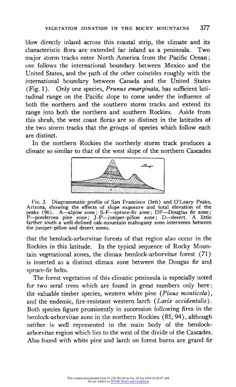
VEGETATION ZONATION IN THE ROCKY MOUNTAINS 377
blow directly inland across this coastal strip, the climate and its characteristic flora are extended far inland as a peninsula. Two major storm tracks enter North America from the Pacific Ocean; one follows the international boundary between Mexico and the United States, and the path of the other coincides roughly with the international boundary between Canada and the United States (Fig.. 1). Only one species, Prunus emarginata, has sufficient lati- tudinal range on the Pacific slope to come under the influence of both the northern and the southern storm tracks and extend its range into both the northern and southern Rockies. Aside from this shrub, the west coast floras are so distinct in the latitudes of the two storm tracks that the groups of species which follow each are distinct.
In the northern Rockies the northerly storm track produces a climate so similar to that of the west slope of the northern Cascades
. ~~~~~~~~~M
FIG. 3. Diagrammatic profile of San Francisco (left) and O'Leary Peaks, Arizona, showing the effects of slope exposure and total elevation of the peaks (96). A-alpine zone;- S-F-spruce-fir zone; DF-Douglas fir zone; P-ponderosa pine zone; J-P-juniper-pifion zone; D-desert. A little farther south a well-defined oak-mountain mahogany zone intervenes between the juniper-pifion and desert zones.
that the hemlock-arborvitae forests of that region also occur in the Rockies in this latitude. In the typical sequence of Rocky Moun- tain vegetational zones, the climax hemlock-arborvitae forest (71) is inserted as a distinct climax zone between the Dougas fir and spruce-fir belts.
The forest vegetation of this climatic peninsula is especially noted for two seral trees which are found in great numbers only here: the valuable timber species, western white pine (Pinus monticola), and the endemic, fire-resistant western larch (Larix occidentalis). Both species figure prominently in succession following fires in the hemlock-arborvitae zone in the northern Rockies (85, 94), although neither is well represented in the main body of the hemlock- arborvitae region which lies to the west of the divide of the Cascades. Also found with white pine and larch on forest burns are grand fir
This content downloaded from 91.220.202.80 on Sat, 28 Jun 2014 10:42:07 AMAll use subject to JSTOR Terms and Conditions
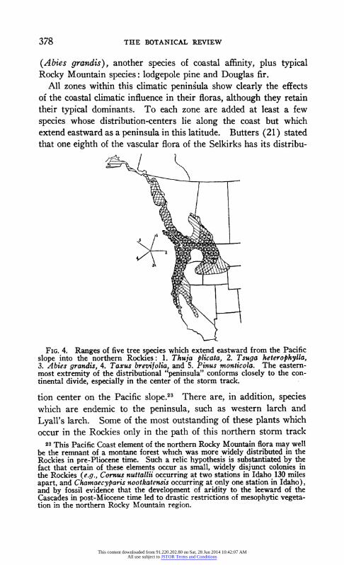
378 THE BOTANICAL REVIEW
(Abies grandis), another species of coastal affinity, plus typical Rocky Mountain species: lodgepole pine and Douglas fir.
All zones within this climatic peninsula show clearly the effects of the coastal climatic influence in their floras, although they retain their typical dominants. To each zone are added at least a few species whose distribution-centers lie along the coast but which extend eastward as a peninsula in this latitude. Butters (21) stated that one eighth of the vascular flora of the Selkirks has its distribu-
FIG. 4. Ranges of five tree species which extend eastward from the Pacific slope into the northern Rockies: 1. Thuja plicata, 2. Tsuga heterophylla, 3. Abies grandis, 4. Taxus brevifolia, and 5. Pinus monticola. The eastern- most extremity of the distributional "peninsula" conforms closely to the con- tinental divide, especially in the center of the storm track.
tion center on the Pacific slope.23 There are, in addition, species which are endemic to the peninsula, such as western larch and Lyvall's larch. Some of the most outstanding of these plants,which
occur in the Rockies only in the path of this northern storm track 2-3 This Pacific Coast element of the northern Rocky Mountain flora may well
be the remnant of a montane forest which was more widely distributed in the Rockies in pre-Pliocene time. Such a relic hypothesis is substantiated by the fact that certain of these elements occur as small, widely disjunct colonies in the Rockies (e.g., Cornus nuttaliji occurring at two stations in Idaho 130 miles apart, and Chamaecyparis nootkaten.sis occurring at only one station in Idaho), and by fossil evidence that the development of aridity to the leeward of the Cascades in post-Miocene time led to drastic restrictions of mesophytic vegeta- tion in the northern Rocky Mountain region.
This content downloaded from 91.220.202.80 on Sat, 28 Jun 2014 10:42:07 AMAll use subject to JSTOR Terms and Conditions

VEGETATION ZONATION IN THE ROCKY MOUNTAINS 379
are as follows. Alpine zone: Phyllodoce empetriformis, P. glandu- liflora, and Pulsatilla occidentalis; upper timberline: Pinus albicau- lis, Larix lyalli, and Valeriana sitchensis; spruce-fir zone: Menziesia ferruginea, Pentstemon ellipticus, Rhododendron albiflorus, Tsuga mertensiana, and Xerophyllum tenax; Douglas fir zone: Larix occi- dentalis and Abies grandis; ponderosa pine zone: Physocarpus mal- vaceus and Calamagrostis rubescens. Furthermore, epiphytic lichens, poorly represented in other parts of the Rockies, are abun- dant in the northern Rockies. A number of these are epiphyllous (42).
The west-coast elements in the flora of the northern Rockies are largely confined to west-facing slopes, and to the region west of
FIG. 5. Ranges of four species of shrubs which extend eastward from the Pacific slope into the southern Rockies: 1. Rhus ovata, 2. Fremontodendron californicum, 3. Quercus chrysolepis, 4. Rhamnus crocea var. ilicifolia.
the continential divide. The significance of this distributional limita- tion is heightened by the fact that there is another group of species which in this latitude is practically confined to the east slope, e.g., limber pine (lowland strain), Picea glauca and Populus sargentii. Also the short-needled variety of ponderosa pine (P. ponderosa var. scopulorum), characteristic of the main body of the Rockies, is in this latitude confined chiefly to the region east of the continental divide. Westward its place is taken by the long-needled P. ponderosa (134).
From the above distributional data it may be deduced that the coastal influence along this northerly storm track is greatest on the windward slopes, especially at intermediate altitudes where the
This content downloaded from 91.220.202.80 on Sat, 28 Jun 2014 10:42:07 AMAll use subject to JSTOR Terms and Conditions

380 THE BOTANICAL REVIEW
hemlock-arborvitae zone is. At higher and lower altitudes on these slopes there is also a distinct coastal influence, although the Rocky Mountain type of climate dominates. On leeward slopes in the same latitude the coastal influence is insignificant and the climate and vegetation exhibit characteristic Rocky Mountain features almost exclusively.
Along the southern storm track a more subtle blending of coastal species with interior species takes place, and the chief altitude af- fected is the oak-mountain mahogany zone (Fig. 5). Mingled with the species characteristic of the Rocky Mountain region are many shrubs which are abundant in the California broad sclerophyll for- mation: the evergreen Quercus dumosa, Q. chrysolepis, Arcto- staphylos pungens, Fremontodendron californicum, Rhamnus crocea var. ilicifolia and Rhus ovata, and the deciduous Brickellia californica, Amorpha californica, etc. Here again the coastal in- fluence is recognized in the vegetation only west of the continental divide.
This similarity between the oak-mountain mahogany zone of the southern Rockies and the chaparral of the Pacific coast has been explained by Axelrod (3) as the result of their having a common origin in the vegetation of northern Mexico. During the Cenozoic era these xerophytic shrubs and low trees moved northward as aridity spread northward from Mexico. Some species found their climatic requirements most closely matched in the coastal region and shifted their ranges largely or completely to the Pacific slope. Others encountered more suitable environment in the foothills of the Rockies and extended their ranges northward for varying dis- tances. It is quite possible that this northward migration is still in progress for at the northern boundary of the oak thickets which end so abruptly in central Colorado there is no evident indication that these oaks have attained a climatic limit to their ranges.
From the above it is evident that only the floras of the central and far-northern Rockies escape dilution with coastal species, and herein lies the most important distinction between the four north- south divisions of the Rocky Mountain vegetation.
Inversion and lack of zonation
In connection with the moisture requirements of the climax asso- ciations, previous mention has been made of the fact that the
This content downloaded from 91.220.202.80 on Sat, 28 Jun 2014 10:42:07 AMAll use subject to JSTOR Terms and Conditions

VEGETATION ZONATION IN THE ROCKY MOUNTAINS 381
Douglas fir and spruce-fir zones descend along ravines to relatively low elevations. These downward extensions are pennant-shaped, tapering to a point at their lower extremities, and oriented so that their axes correspond roughly with the stream course. Often the length of one of these wedge-shaped peninsulas exceeds the breadth of the lower zone into which it extends, and in consequence there is a telescoping of zones along ravines. The broad upper end of a Douglas fir peninsula may contain the narrow lower extremity of the spruce-fir peninsula of similar form but centered at higher elevation.
On the other hand, pennant-shaped extensions of the ponderosa pine forest, as well as other low-altitude zones, ascend the mountain
ALPIE
/ SPE-FIR
FIG. 6. Diagram of a slope in the Rocky Mountains showing the tele- scoping of forest zones due to their extensions downward in ravines and upward along sharp ridges.
slope along the summits of ridges, particularly along the south- facing brows of the ridges. Because communities of low elevation extend up the ridges, at the same time that those of high altitude descend along the ravines, interfingering is a very pronounced char- acteristic of the Rocky Mountain zonal system (Fig. 6). Indeed, on precipitous slopes the zone of interfingering of ponderosa pine and Douglas fir is often broader than the zone where either forms a distinct altitudinal belt and occupies a relatively wide range of habitats.34
As a consequence of the interdigitation of zones, their altitudinal relationships along the sides of a ravine are exactly reversed. At
24 For this reason several students of Rocky Mountain vegetation have lumped the two associations into a "montane zone," although it is easily demonstrable that these are distinct climax types which have different alti- tudinal ranges, and in the zone where their ranges overlap they inhabit dif- ferent types of sites, except when pine invades Douglas fir sites temporarily following disturbance (5, 9).
This content downloaded from 91.220.202.80 on Sat, 28 Jun 2014 10:42:07 AMAll use subject to JSTOR Terms and Conditions

382 THE BOTANICAL REVIEW
intermediate elevations, for example, a narrow fringe of Engelmann spruce often follows the stream margin while Douglas fir dominates the lower slopes of the ravine and ponderosa pine covers thie ridges. Likewise, in the foothills ponderosa pine may occupy the valley bottom, but give way to pifion or chaparral vegetation along the summits of the ridges which border the valley. As Shreve (151) pointed out, the species with the widest altitudinal ranges are usually those capable of inhabiting exactly reversed habitats along the upper and lower edges of their ranges,-if topography were not so varied, the altitudinal ranges of these species would be much more restricted.
An interesting but rather rare type of inversion may be observed along the Clark's Fork River in western Montana, which cuts through the Bitterroot Mountains from east to west. By approach- ing the mountains this stream flows toward a region where precipi- tation is greater and temperature lower, even though the stream bed drops in elevation. One may descend the river from the prairie zone, at the town of Ravelli, and cross in turn the ponderosa pine, the Douglas fir, and the arborvitae-hemlock zones, each of which is encountered at successively lower elevations.
The telescoping of zones is most pronounced at intermediate ele- vations within the forest belt. At such altitudes, particularly where the topography is rather rugged, the altitudinal control of environ- mental factors may be overshadowed by the influences of slope exposure, cold air drainage, etc., with a result that the distribution of climax types at these elevations often bears no apparent relation- ship to altitude. The slopes of the first high prominences encoun- tered upon entering the foothills of a mountain range generally exhibit the typical complement of zones in their proper altitudinal sequence, but beyond the outermost line of foothills the zonal rela- tionships of the climax forests are often obscure.
As pointed out long ago (98, 159), it is only in the narrow ravines and valleys that zones extend downward. In wide valleys, com- munities characteristic of low altitudes extend well up into the next zone. The apparent explanation of this difference is that the water-balance in a narrow ravine is more favorable than average for that altitude, while in broad valleys, where a body of hot air builds up each day during the growing season and cold air drain- age is less pronounced, the environment is more xeric than average for that altitude.
This content downloaded from 91.220.202.80 on Sat, 28 Jun 2014 10:42:07 AMAll use subject to JSTOR Terms and Conditions

VEGETATION ZONATION IN THE ROCKY MOUNTAINS 383
Zones in the sense of rigidly defined altitudinal belts clearly do not exist in the Rocky Mountains, but no careful student of plant sociology in this region would deny the existence of a regularly repeated series of distinct vegetational types, each of which bears a constant altitudinal or topographic relationship to contiguous types.
The attention of the taxonomist in particular should be called to this phenomenon of the interfingering of zones and the resultant inversions of altitudinal relationships. Instead of altimeter read- ings far more significant data as to the location of collections could be obtained by making a brief notation of the zonal relationships of the specimens. Apparently with a similar idea in mind, Hey- brock (64) stated that "the zonal conception is indispensable for the investigation of the conditions of climate and vegetation."
Mountain parks
In all forested zones there occur treeless or nearly treeless areas varying from a few meters to several miles in diameter. Some of these have been caused by fire or logging, or represent stages in primary hydro- or xeroseres. In consequence they are only tem- porarily lacking in forest cover, as is evidenced by the success of tree seedlings upon these areas. Still other areas, however, appear to be naturally inimical to tree growth; these are the true "moun- tain parks."
Except near the upper timberline, the plant cover of these park- lands is characteristically similar to that of the adjacent basal plains. Thus in the central Rockies sagebrush (Artemisia tridentata, A. cana, etc.) is dominant in most parks on the west slope, while east of the divide the parkland vegetation is prairie-like. Ramaley (122) showed that the flora of these parks embraces fewer species with increasing altitude, and that the specific composition varies greatly with elevation. In the spruce-fir zone parks are often covered with willows, alders and sedges. Other parks at this elevation support a luxuriant growth of forbs and alpine grasses such as Phleum alpinum and Deschanpsia caespitosa (109, 126, 129). More than half the flora of these parks is boreal in affinity (121).
Aspen, lodgepole pine or blue spruce (124) frequently form thin marginal zones about the peripheries of parks, but even these trees seem entirely incapable of invading the open park. The borders between the parks and adjacent forests are often exceptionally
This content downloaded from 91.220.202.80 on Sat, 28 Jun 2014 10:42:07 AMAll use subject to JSTOR Terms and Conditions

384 THE BOTANICAL REVIEW
abrupt, especially in small ones. At the periphery of parks in northern Arizona blue spruce makes very slow growth (124).
Relatively little research has been directed to the cause of the apparent inability of trees to invade parks. Pearson (106) made a climatological study of large parks in the ponderosa pine zone in Arizona. He concluded that "it is possible that the absence of natural forest in parks may be explained by the presence of adverse atmospheric conditions which make it impossible for seedlings to survive the first year; but it is probable that there are also other factors, such as unfavorable soil conditions." Later he showed that even at a depth of 12 inches the moisture content of the parkland soils is below the wilting coefficient for over three months in sum- mer (109). In these particular parks, soil moisture conditions alone are sufficiently adverse to exclude trees.
In 1918 Robbins suggested that competitive ability of grassland vegetation, once it is well established, may prevent establishment of tree seedlings. If this were the sole factor involved, trees could invade parks slowly in a centripetal manner, weakening the con- tiguous grass cover with shade as the marginal trees extended their branches outward over the edge of the park.
An edaphic cause for parks, other than dryness of the soil, has long been suspected (135, 171). Commonly observed natural phenomena which suggest this explanation are as follows. Within a park there often occur small islands of timber which are confined to hillocks or to the upper extremity of a steep streamside embank- ment, both of which situations are better drained and aerated than is the remainder of the area encompassed by the periphery of the park. Secondly, parks are generally situated in the bottoms of shallow basins or broad aggraded valleys (75) which are surfaced with a thick mantle of fine alluvium washed from the surrounding slopes. Dunnewald (45) found that the only inherent difference between forest and parkland soils in the Bighorn Mountains in Wyoming is that the soils of the former are coarser and shallower. Miller (101) found that juniper is unable to invade areas of compact soils in northern Arizona while adjacent areas of looser soil are invaded. Cottam and Stewart (35) reported an invasion by juniper of parklands which were originally moist meadows, but which have become dry due to drainage channels resulting from severe erosion.
All these observations point to the conclusion that the conifers of the Rocky Mountain region are adversely affected by some factor
This content downloaded from 91.220.202.80 on Sat, 28 Jun 2014 10:42:07 AMAll use subject to JSTOR Terms and Conditions

VEGETATION ZONATION IN THE ROCKY MOUNTAINS 385
associated with fine textured, compact or poorly drained soils. Pos- sibly this is but a matter of poor aeration. The significance of soil air in determining the distribution of plant communities was long ago championed by Cannon and Free (23) in connection with the zonation of vegetation about desert playas. Wilde and White (172) suggested that heavy soils may prove very detrimental to the seed- lings of certain conifers by favoring the activity of damping-off fungi. There is also strong likelihood that fine texture or com- pactness may play a critical role by retarding elongation of the roots of seedlings so that the progressive drying out of the soil from the surface downward overtakes the root tips before they reach the relatively permanent supply of moisture contained in the subsoil.
Not all parkland soils are relatively fine textured, however. In the dry parklands which Pearson studied in Arizona, the soils are coarser than under the adjacent forest, suggesting that over-drain- age might be an important factor. Also, chemical characteristics of the soil may have a bearing on this problem. Dunnewald (46) found that germination and survival of lodgepole and limber pine are 28%o and 50%o better, respectively, on forest than on parkland soils. Further experimentation indicated that water-soluble substances in the soil, which can be inactivated by boiling, account for at least a large part of the adverse effects upon germination.
On the west slope of the Bitterroots, especially in northern Idaho, many forest openings occur near the summits of the taller promi- nences, and always on their southerly exposures (43). These areas typically consist of a central spot of prairie dominated by Agropyron spicatum and/or Festuca idahoensis, surrounded by a belt of shrubs and scattered stunted trees. Unpublished studies by the writer have shown that the moisture content of these soils is below the wilting coefficient for a long period in summer, whereas soils in the adjoining forest remain moist during most or all of the year. The drought of the grassland areas seems to be a result of the effects of maximum exposure to the sun's rays and coarse soil. Grassland life forms aestivate when the soil dries out, but tree seed- lings cannot and thereby the forest is excluded. Rydberg (131) described a similar but more severe condition in the Abajo Moun- tains of southeastern Utah where there is a complete lack of timber at all elevations on south and west slopes, although north and east faces have the normal complement of zones from juniper-pifion to alpine.
This content downloaded from 91.220.202.80 on Sat, 28 Jun 2014 10:42:07 AMAll use subject to JSTOR Terms and Conditions

386 THE BOTANICAL REVIEW
Pickford and Reid (116) have described subalpine parks in the Wallowa and Blue Mountains of eastern Oregon and Washington, which are dominated by Festuca viridula. They stated that the soil of these parks is well-drained but made no etiologic study.
Considering all available information, it seems quite unlikely that any one type of factor, such as soil aeration or microclimate, can be invoked to explain all mountain parks. These openings occur over such wide altitudinal and latitudinal range, and are vegetated by such diverse plant communities, that there are undoubtedly several distinct types of causes for the inhibition of trees.
VII. SUMMARY
The basal plains from which the Rocky Mountains rise are arid, and support only desert and grassland vegetation. The height to which these mountain masses rise brings about sufficient precipita- tion on their intermediate slopes to support forests of needle-leaved coniferous trees. This forest vegetation may be subdivided into five distinct altitudinal zones, each characterized by a climax asso- ciation which, when well developed, occupies about 2,000 feet of vertical elevation. On the higher peaks and ridges above the forest zones, a tundra vegetation is found.
The phenomenon of zonation in the Rocky Mountain vegetation depends, on the one hand, upon differences among species as to their limits of tolerance of climatic variation, and on the other, upon gradients in climatic factors, chiefly temperature and moisture, from the bottom to the top of a mountain slope.
For the most part the upper altitudinal limits of the species seem to be determined by the relative physiologic efficiency of tempera- ture during the growing season. The upper limits of the major climax associations (which are not as high as the absolute elevations to which the individuals of the dominant species extend) are bio- logically determined, for with the exception of the alpine zone the higher the range of the climax zone the greater the competitive pow- ers of the species. Upper timberline is usually caused by physio- logic drouth resulting from the concomitance of high wind velocities and cold soil.
The lower altitudinal limits in general seem to be determined by drouth, although lower timberline is frequently elevated above its climatic limits by bodies of fine-textured soil at low altitudes.
This content downloaded from 91.220.202.80 on Sat, 28 Jun 2014 10:42:07 AMAll use subject to JSTOR Terms and Conditions
VEGETATION ZONATION IN THE ROCKY MOUNTAINS 387
Other factors associated with elevation do not appear to be of sufficient intensity to limit plant distribution directly, although a number of these may be contributory to the primary factors.
Within the altitudinal range where a major association is best developed it is the climatic climax and occupies a wide variety of habitats. Toward its upper limits the same association character- istically becomes a topographic climax restricted to warm south- facing slopes, and may serve in a seral capacity following disturb- ance on other habitats. At its lower limits each of these associations plays the role of a topographic or edaphic climax which is confined to the most mesic habitats at that elevation.
At intermediate elevations in the mountains, exposure and soils may be of more significance in determining the local distribution of species than is elevation.
Zones decrease in elevation above sea level with increasing lati- tude, although the altitude-latitude relationship is not linear.
The typical pattern of zonation may be interrupted in any of sev- eral ways. One or more of the lower zones may be lacking, due to soil factors elevating the lower timberline. One or more of the upper zones may not be represented on a mountain, because of insufficient height of the range. Unforested parks may break the continuity of the forest zones. In certain latitudes a heavy infusion of species and communities more characteristic of the Pacific slope may also interrupt the typical zonation pattern. The last named phenomenon provides a floristic basis for dividing Rocky Mountain vegetation into four north-south provinces: southern, central, north- ern and far-northern.
LITERATURE CITED 1. ALTER, J. C. Crop safety on mountain slopes. U. S. Dept. Agr., Year-
book 1912: 309-318. 1912. 2. ANONYMOUS. Big trees, the giant aspen of Utah. Am. For. 48: 148.
1942. 3. AXELROD, D. I. A Miocene flora from the western border of the Mojave
Desert. Carnegie Inst. Wash., Publ. 516: 1-129. 1939. 4. BAILEY, V. Life zones and crop zones of New Mexico. U. S. Dept.
Agr., No. Am. Fauna 35: 1-100. 1913. 5. BAKER, F. S. AND KORSTIAN, C. F. Is Douglas fir replacing western
yellow pine in central Idaho? Jour. For. 20: 755-764. 1922. 6. . Character of the soil in relation to the reproduction of
western yellow pine. Jour. For. 23: 630-634. 1925. 7. AND KORSTIAN, C. F. Suitability of brush lands in the inter-
mountain region for the growth of natural or planted western yellow pine forests. U. S. Dept. Agr., Tech. Bul. 256: 1-82. 1931.
8. BArES, C. G. et al. Climatic characteristics of forest types in the cen- tral Rocky Mountains. Soc. Am. For., Proc. 9: 78-97. 1914.
This content downloaded from 91.220.202.80 on Sat, 28 Jun 2014 10:42:07 AMAll use subject to JSTOR Terms and Conditions

388 THE BOTANICAL REVIEW
9. . Forest succession in the central Rocky Mountains. Jour. For. 15: 587-592. 1917.
10. . The transect of a mountain valley. Ecology 4: 54-62. 1923.
11. c Forest types in the central Rocky Mountains as affected by climate and soil. U. S. Dept. Agr., Bul. 1233: 1-152. 1924.
12. . Physiological requirements of Rocky Mountain trees. Jour. Agr. Res. 24: 97-164. 1924.
13. AND ROESER JR., J. Relative resistance of tree seedlings to excessive heat. U. S. Dept. Agr., Bul. 1263: 1-16. 1924.
14. . Some relations of plant ecology to sylvicultural practice. Ecology 7: 469-480. 1926.
15. BLUMER, J. C. On the plant geography of the Chiricahus Mountains. Science 30: 720-724. 1909.
16. Change of aspect with altitude. Plant World 14: 236-248. 1911.
17. . A comparison between two mountain sides. Plant World 13: 134-140. 1910.
18. BRANDEGEE, T. S. Timberline in the Wasatch Range. Bot. Gaz. 5: 125-126. 1880.
19. BURNS, G. P. Minimum light requirements referred to a definite stand- ard. Vt. Agr. Exp. Sta. Bul. 235: 1-32. 1923.
20. BURROWS, A. T. The Chinook winds. U. S. Dept. Agr., Yearbook 1901: 555-566. 1901.
21. BUTTERS, F. K. The vegetation of the Selkirk Mountains. pp. 352-362. In Mountaineering and exploration in the Selkirks, by H. Palmer. 1914.
22. CANNON, W. A. Distribution of the cacti with especial reference to the role played by the root response to soil temperature and soil moisture. Am. Nat. 50: 435-442. 1916.
23. AND FREE, E. E. The ecological significance of soil aeration. Jour. Ecol. 5: 127. 1917.
24. th . Physiological features of roots with especial reference to the relation of roots to aeration of the soil. Carnegie Inst. Wash., Publ. 368: 1-168. 1925.
25. CARY, M. A biological survey of Colorado. U. S. Dept. Agr., No. Am. Fauna 33: 1-256. 1911.
26. . Life zone investigations in Wyoming. U. S. Dept. Agr., No. Am. Fauna 42: 1-95. 1917.
27. CLAPP, E. H. et al. The western range. A great but neglected natural resource. Senate Document 199: 1-620. 1936.
28. CLEMENTS, F. E. Research methods in ecology. 1905. 29. - 0 . The causes of dwarfing in alpine plants. Science 25: 287.
30. . The life history of lodgepole burn forests. U. S. Dept. Agr., For. Bul. 79: 1-56. 1910.
31. et al. Factor and function in adaptation. Carnegie Inst. Wash., Year Book 37: 229-233. 1938.
32. CONNAUGHTON, C. A. Fire damage in the ponderosa pine type in Idaho. Jour. For. 34: 46-51. 1936.
33. COOPER, W. S. Alpine vegetation in the vicinity of Long's Peak, Colo- rado. Bot. Gaz. 45: 319-337. 1908.
34. COSTELLO, D. F. AND PRICE, R. Weather and plant-development data as determinants of grazing periods on mountain range. U. S. Dept. Agr., Tech. Bul. 686: 1-31. 1939.
35. COTTAM, W. P. AND STEWART, G. Plant succession as a result of graz- ing and of meadow desiccation by erosion since settlement in 1862. Jour. For. 38: 613-626. 1940.
36. COTTLE, H. J. Studies in the vegetation of southwestern Texas. Ecol- ogy 12: 105-155. 1931.
This content downloaded from 91.220.202.80 on Sat, 28 Jun 2014 10:42:07 AMAll use subject to JSTOR Terms and Conditions
VEGETATION ZONATION IN THE ROCKY MOUNTAINS 389
37. COVILLE, F. V. AND MAC DOUGAL, D. T. Desert botanical laboratory of the Carnegie Institution. Carnegie Inst. Wash., Publ. 6: 1-58. 1903.
38. Cox, C. F. Alpine plant succession on James Peak, Colorado. Ecol. Mono. 3: 299-372. 1933.
39. DAUBENMIRE, R. F. Merriam's life zones of North America. Quart. Rev. Biol. 13: 327-332. 1938.
40. . Some ecologic features of the subterranean organs of alpine plants. Ecology 22: 370-379. 1941.
41. . Soil temperature versus drought as factors determining the lower altitudinal limits of trees in the Rocky Mountains. [Unpubl. ms.]
42. . Observations on the epiphyllous lichens of northern Idaho. Am. Midl. Nat. [In press] 1943.
43. AND SLIPP, A. W. Plant succession on talus slopes in north- ern Idaho as influenced by slope exposure. Torrey Bot. Club, Bul. [In press] 1943.
44. DAY, M. W. Snow damage to conifer plantations. Quart. Bul. Mich. Agr. Exp. Sta. 23: 97-98. 1940.
45. DUNNEWALD, T. J. Grass and timber soils distribution in the Big Horn Mountains. Jour. Am. Soc. Agron. 22: 577-586. 1930.
46. . Soil factors in germination of pine seeds. Univ. Wy. Publ. Sci. 1: 267-274. 1934.
47. DuTT, B. K. AND GUHA-THAKURTA, A. Effect of reduced atmospheric pressure on the growth of plants. Trans. Bose Res. Inst. 12: 1-9. 1937.
48. EMERSON, F. W. The tension zone between the gramma grass and pifion-juniper associations in northeastern New Mexico. Ecology 13: 347-358. 1932.
49. FAIRCHILD, D. The world was my garden. 1938. 50. FETHEROLF, J. M. Aspen as a permanent forest type. Jour. For. 15:
757-760. 1917. 51. FISHER, G. M. Comparative germination of tree species on various
kinds of surface-soil material in the western white pine type. Ecol- ogy 16: 606-611. 1935.
52. GADOW, H. Altitude and distribution of plants in southern Mexico. Jour. Linn. Soc. 38: 429-440. 1909.
53. GARDNER, W. J. Results of a Rocky Mountain forest fire studied 50 years after its occurrence. Soc. Am. For., Proc. 1: 102-109. 1905.
54. GOODDING, L. N. An interesting area of limber pine extending into southwestern Nebraska. Jour. For. 21: 175-176. 1923.
55. GORDON, J. H. Temperature survey of the Salt River Valley, Arizona. Mo. Wea. Rev. 49: 271-275. 1921.
56. GRAHAM, E. H. Botanical studies in the Uinta Basin of Utah and Colo- rado. Ann. Carnegie Mus. 26: 1-432. 1937.
57. GRIGGS, R. F. Timberlines in the northern Rocky Mountains. Ecology 19: 548-564. 1938.
58. HAIG, I. et al. Natural regeneration in the western white pine type. U. S. Dept. Agr., Tech. Bul. 767: 1-99. 1941.
59. HANN, J. Handbook of climatology. 1903. 60. HANSON, H. C. A study of the vegetation of northeastern Arizona.
Univ. Neb. Studies 24: 85-175. 1924. 61. HARSHBERGER, J. W. Preliminary notes on American snow patches
and their plants. Ecology 10: 275-281. 1929. 62. HART, F. C. Precipitation and run-off in relation to altitude in the
Rocky Mountain region. Jour. For. 35: 1005-1010. 1937. 63. HAYES, G. L. Influence of altitude and aspect on daily variations in
factors of forest-fire danger. U. S. Dept. Agr., Cir. 591: 1-39. 1941. 64. HEYBROCK, W. The interval between tree and pasture lines and the
position of their extremes. Geogr. Rev. 24: 444-452. 1934.
This content downloaded from 91.220.202.80 on Sat, 28 Jun 2014 10:42:07 AMAll use subject to JSTOR Terms and Conditions

390 THE BOTANICAL REVIEW
65. HOCKENSMITH, R. D. AND TUCKER, E. The relation of elevation to the nitrogen content of grassland and forest soils in the Rocky Moun- tains of Colorado. Soil Sci. 36: 41-45. 1933.
66. HOLCH, A. E. et al. Root habits of certain plants of the foothill and alpine belts of Rocky Mountain National Park. Ecol. Mono. 11: 327-345. 1941.
67. HOLM, T. H. The vegetation of the alpine region of the Rocky Moun- tains in Colorado. Mem. Nat. Acad. Sci. 19: 1-45. 1927.
68. . Contributions to the morphology, synonymy, and geographi- cal distribution of arctic plants. Rept. Can. Arctic Exped. 1913-18. 5 (Botany, Part B): 1-139. 1922.
69. HOPKINS, A. D. Bioclimatics. U. S. Dept. Agr., Misc. Publ. 280: 1- 188. 1938.
70. HOWELL, J. Pifion and juniper woodlands of the southwest. Jour. For. 39: 542-545. 1941.
71. HUBERMAN, M. A. The role of western white pine in forest succession in northern Idaho. Ecology 16: 137-151. 1935.
72. HUMPHREYS, W. J. Physics of the air. 1929. 73. IvEs, R. L. Forest replacement rates in the Colorado headwaters area.
Torrey Bot. Club Bul. 68: 407-408. 1941. 74. . Colorado Front Range crest clouds and related phenomena.
Geogr. Rev. 31: 23-45. 1941. 75. . Atypical subalpine environments. Ecology 23: 89-97.
1942. 76. JENNY, H. Soil organic matter-temperature relationships in the eastern
United States. Soil Sci. 31: 247-252. 1931. 77. KENDEIGH, S. C. A study of Merriam's temperature laws. Wilson Bul.
44: 129-143. 1932. 78. KIENER, W. Unisexual limber pines. Science 82: 193. 1935. 79. KORSTIAN, C. F. Growth on cut-over and virgin western yellow pine
lands in central Idaho. Jour. Agr. Res. 28: 1139-1148. 1924. 80. AND BAKER, F. S. Precipitation as a factor limiting the
distribution of Pinus ponderosa scopulorum. Jour. Ecol. 6: 96. 1918.
81. et al. A chlorosis of conifers corrected by spraying with ferrous sulphate. Jour. Agr. Res. 21: 153-171. 1921.
82. AND FETHEROLF, N. J. Control of stem girdle of spruce transplants caused by excessive heat. Phytopath. 11: 485-490. 1921.
83. KRAUCH, H. Some factors influencing Douglas fir reproduction in the southwest. Jour. For. 34: 601-608. 1936.
84. LARSEN, J. A. Fires and forest succession in the Bitterroot Mountains of northern Idaho. Ecology 11: 631-672. 1930.
85. . Forest types of the northern Rocky Mountains and their climatic controls. Ecology 11: 631-672. 1930.
86. LEOPOLD, A. Grass, brush, timber, and fire in southern Arizona. Jour. For. 22: 1-10. 1924.
87. LINNEY, C. E. et al. Climate as it affects crops and ranges in New Mexico. New Mex. Agr. Exp. Sta. Bul. 182: 1-83. 1930.
88. LITTLE, E. L., JR. Alpine flora of San Francisco Mountain, Arizona. Madrono 6: 65-81. 1941.
89. LOWDERMILK, W. C. Factors affecting reproduction of Engelmann spruce. Jour. Agr. Res. 30: 995-1009. 1925.
';. LOWELL, P. The sun is dominant. The Century 75: 731-743. 1908. 91. MAcDOUGAL, D. T. The reactions of plants to new habitats. Ecology
2: 1-20. 1921. 92. McINTosH, A. C. A botanical survey of the Black Hills of South
Dakota. Black Hills Engr. 19: 159-276. 1931. 93. MACMILLAN, C. Notes on some British Columbian dwarf trees. Bot.
Gaz. 38: 379-381. 1904.
This content downloaded from 91.220.202.80 on Sat, 28 Jun 2014 10:42:07 AMAll use subject to JSTOR Terms and Conditions

VEGETATION ZONATION IN THE ROCKY MOUNTAINS 391
94. MARSHALL, R. The life history of some western white pine stands on the Kaniksu National Forest. Northw. Sci. 2: 48-53. 1928.
95. MAURER, J. Bodentemperatur und Sonnenstrahlung in den Schweizer Alpen. Meteor. Zeits. 33: 193-199. 1916.
96. MERRIAM, C. H. Results of a biological survey of the San Francisco Mountain region and the desert of the Little Colorado, Arizona. U. S. Dept. Agr., No. Am. Fauna 3: 1-136. 1890.
97. . Life zones and crop zones of the United States. U. S. Dept. Agr., Biol. Surv. Bul. 10: 9-79. 1889.
98. . Results -f a biological reconnaissance of south-central Idaho. U. S. Dept. Agr., No. Am. Fauna 5: 1-127. 1891.
99. MILHAM, W. I. Meteorology. 1918. 100. MILLER, E. C. Plant physiology. 1938. 101. MILLER, F. H. Reclamation of grasslands by Utah juniper on the
Tusayan National Forest, Arizona. Jour. For. 19: 647-651. 1921. 102. MUNGER, T. T. Replacement of yellow pine by lodgepole pine on the
pumice soils of central Oregon. Soc. Am. For., Proc. 9: 396-406. 1914.
103. 4 Western yellow pine in Oregon. U. S. Dept. Agr., Bul. 418: 1-48. 1917.
104. NICHOL, A. A. The natural vegetation of Arizona. Ariz. Agr. Exp. Sta., Tech. Bul. 68: 181-222. 1937.
105. PEARSON, G. A. The role of aspen in the reforestation of mountain burns in Arizona and New Mexico. Plant World 17: 249-260. 1914.
106. . A meteorological study of parks and timbered areas in the western yellow pine forests of Arizona and New Mexico. Mo. Wea. Rev. 41: 1615-1629. 1914.
107. . Natural reproduction of western yellow pine in the south- west. U. S. Dept. Agr., Bul. 1105: 1-144. 1923.
108. . Studies in transpiration of coniferous tree seedlings. Ecology 5: 340-347. 1924.
109. ad . Forest types in the southwest as determined by climate and soil. U. S. Dept. Agr., Tech. Bul. 247: 1-143. 1931.
110. . Herbaceous vegetation as a factor in the natural regenera- tion of ponderosa pine in the southwest. Ecol. Mono. 12: 315-338. 1942.
111. PEATTIE, R. Mountain geography; A critique and field study. 1936. 112. PENLAND, C. W. T. The alpine vegetation of the southern Rockies and
the Ecuadorean Andes. Colo. College Publ., Study Ser. 32: 1-30. 1941.
113. PHILLIPS, F. J. A study of pinon pine. Bot. Gaz. 48: 216-223. 1909. 114. . Two sprouting conifers of the southwest. Bot. Gaz. 51:
385-390. 1911. 115. PICKFORD, G. D. AND REID, E. H. Guides to determine range condition
and proper use of mountain meadows in eastern Oregon. Pacific Northw. For. & Range Exp. Sta., Range Res. Rept. 3: 1-21. 1942.
116. AND . Basis for judging subalpine grassland ranges of Oregon and Washington. U. S. Dept. Agr., Cir. 655: 1-37. 1942.
117. PRESTON, R. J. Rocky Mountain trees. pp. 285. 1940. 118. PRICE, R. AND EVANS, R. B. Climate of the west front of the Wasatch
Plateau in central Utah. Mo. Wea. Rev. 65: 291-301. 1937. 119. RABER, 0. Water utilization by trees, with special reference to the
economic forest species of the north temperate zone. U. S. Dept. Agr., Misc. Publ. 257: 1-97. 1937.
120. RAMALEY, F. Botany of northeastern Larimer County, Colorado. Univ. Colo. Studies 5: 119-131. 1908.
121. . . Dry grassland of a high mountain park in northern Colo- rado. Plant World 19: 249-270. 1916.
This content downloaded from 91.220.202.80 on Sat, 28 Jun 2014 10:42:07 AMAll use subject to JSTOR Terms and Conditions

392 THE BOTANICAL REVIEW
122. . Xerophytic grasslands at different altitudes in Colorado. Torrey Bot. Club Bul. 46: 37-52. 1919.
123. . Vegetation of chaparral-covered foothills southwest of Denver, Colorado. Univ. Colo. Studies 18: 231-237. 1931.
124. RASMUSSEN, D. I. Biotic communities of Kaibab Plateau, Arizona. Ecol. Mono. 11: 229-275. 1941.
125. RAUP, H. M. Phytogeographic studies in the Peace and upper Laird River regions, Canada, with a catalogue of the vascular plants. Contr. Arn. Arb. 6: 1-230. 1934.
126. REED, E. L. Meadow vegetation in the montane region of northern Colorado. Torrey Bot. Club Bul. 44: 97-109. 1917.
127. REITZ, L. P. Crop regions in Montana as related to environmental factors. Mont. Agr. Exp. Sta. Bul. 340: 1-84. 1937.
128. ROBBINS, W. W. Native vegetation and climate of Colorado in their relation to agriculture. Colo. Agr. Exp. Sta., Bul. 224: 1-56. 1917.
129. . Successions of vegetation in Boulder Park, Colorado. Bot. Gaz. 65: 493-525. 1918.
130. ROESER, J., JR. A study of Douglas fir reproduction under various cutting methods. Jour. Agr. Res. 28: 1233-1242. 1924.
131. RYDBERG, P. A. Phytogeographical notes on the Rocky Mountain region. I. Alpine region. Torrey Bot. Club, Bul. 40: 677-686. 1913.
132. . Phytogeographical notes on the Rocky Mountain region. II. Origin of the alpine flora. Torrey Bot. Club, Bul. 41: 89-103. 1914.
133. . Phytogeographical notes on the Rocky Mountain region. III. Formations in the alpine zone. Torrey Bot. Club, Bul. 41: 459-482. 1914.
134. . Phytogeographical notes on the Rocky Mountain region. IV. Forests of the subalpine and montane zones. Torrey Bot. Club, Bul. 42: 11-25. 1915.
135. . Phytogeographical notes on the Rocky Mountain region. V. Grasslands of the subalpine and montane zones. Torrey Bot. Club, Bul. 42: 629-64. 1915.
136. . Phytogeographical notes on the Rocky Mountain region. VI. Distribution of the subalpine plants. Torrey Bot. Club, Bul. 43: 343-364. 1916.
137. . Vegetative life zones of the Rocky Mountain region. N. Y. Bot. Gard., Mem. 6: 477-499. 1916.
138. . Flora of the Rocky Mountains and adjacent plains. 1917. 139. . Phytogeographical notes on the Rocky Mountain region.
VII. Formations in the subalpine zone. Torrey Bot. Club, Bul. 44: 431-454. 1917.
140. SAMPSON, A. W. The stability of aspen as a type. Soc. Amer. For., Proc. 11: 86-87. 1916.
141. to . Climate and plant growth in certain vegetative associa- tions. U. S. Dept. Agr., Bul. 700: 1-72. 1918.
142. SANDERS, E. M. The natural regions of Mexico. Geogr. Rev. 11: 212-226. 1921.
143. SHANTZ, H. L. A study of the vegetation of the mesa region east of Pike's Peak. Bot. Gaz. 42: 16-47; 179-207. 1906.
144. SHAW, C. H. Vegetation and altitude. Am. Nat. 43: 420-431. 1909. 145. P . The causes of timber line on mountains; the role of snow.
Plant World 12: 169-181. 1909. 146. . The vegetation of the Selkirks. Bot. Gaz. 61: 477-494.
1916. 147. SHELFORD, V. E. Life zones, modern ecology, and the failure of tem-
perature summing. Wilson Bul. 44: 144-157. 1932. 148. SHIRLEY, H. L. Ligbt as an ecological factor and its measurement.
Bot. Rev. 1: 355-381. 1935.
This content downloaded from 91.220.202.80 on Sat, 28 Jun 2014 10:42:07 AMAll use subject to JSTOR Terms and Conditions

VEGETATION ZONATION IN THE ROCKY MOUNTAINS 393
149. SHREvE, F. The influence of low temperatures on the distribution of the giant cactus. Plant World 14: 136-146. 1911.
150. . Cold air drainage. Plant World 15: 110-115. 1912. 151. . The vegetation of a desert mountain range as conditioned
by climatic factors. Carnegie Inst. Wash., Publ. 217: 1-112. 1915. 152. . A comparison of the vegetational features of two desert
mountain ranges. Plant World 22: 291-307. 1919. 153. . Indirect factors influencing the vertical distribution of
vegetation. Carnegie Inst. Wash., Yearbook 21: 64-65. 1922. 154. . Soil temperature as influenced by altitude and slope ex-
posure. Ecology 5: 128-136. 1924. 155. - . Physical conditions in sun and shade. Ecology 12: 96-
104. 1931. 156. . [Personal correspondence. 1942.] 157. SPERRY, 0. E. A study of the growth, transpiration and distribution
of the conifers of the Rocky Mountain National Park. Torrey Bot. Club, Bul. 63: 75-103. 1936.
158. STAHELIN, R. Factors influencing the natural restocking of high alti- tude burns by coniferous trees in the central Rocky Mountains. Ecology 24: 19-30. 1943.
159. STANDLEY, P. C. Vegetation of the Brazos Canyon, New Mexico. Plant World 18: 179-191. 1915.
160. STOECKLER, J. H. AND BATES, C. G. Shelterbelts: the advantages of porous soils for trees. Jour. For. 37: 205-221. 1939.
161. TURNAGE, W. V. AND MALLERY, T. D. An analysis of rainfall in the Sonoran desert and adjacent territory. Carnegie Inst. Wash., Publ. 529: 1-45. 1941.
162. VAN CLEEF, E. Is there a type of storm path? Mo. Wea. Rev. 36: 56-58. 1908.
163. VESTAL, A. G. Foothills vegetation in the Colorado Front Range. Bot. Gaz. 44: 353-385. 1917.
164. WATSON, J. R. Plant geography of north central New Mexico. Bot. Gaz. 54: 194-217. 1912.
165. WEAVER, J. E. A study of the vegetation of southeastern Washington and adjacent Idaho. Univ. Neb. Studies 17: 1-114. 1917.
166. WEIDMAN, R. H. Evidences of racial influence in a 25-year test of ponderosa pine. Jour. Agr. Res. 59: 855-888. 1939.
167. . Forest succession as a basis of the sylviculture of western yellow pine. Jour. For. 19: 877-885. 1921.
168. WEIR, J. R. Notes on the altitudinal range of forest fungi. Mycologia 10: 4-14. 1918.
169. WHITFIELD, C. J. Ecological aspects of transpiration. I. Pike's Peak region: climatic aspects. Bot. Gaz. 93: 436-452. 1932.
170. . The ecology of the vegetation of the Pike's Peak region. Ecol. Mono. 3: 75-105. 1933.
171. WHITFORD, H. N. The forests of Flathead Valley, Montana. Bot. Gaz. 39: 99-122, 194-218, 276-296. 1905.
172. WILDE, S. A. AND WHITE, D. P. Damping off as a factor in the nat- ural distribution of pine species. Phytopath. 29: 367-369. 1939.
173. WOOLSEY, T. S. Western yellow pine in Arizona and New Mexico. U. S. Dept. Agr., Bul. 101: 1-33. 1911.
174. ZON, R. Forests. In U. S. Dept. Agr. Atlas of Amer. Agr. I (E): 1-29. 1924.
175. . Effect of source of seed upon the growth of Douglas fir. Forestry Quart. 11: 499-502. 1913.
This content downloaded from 91.220.202.80 on Sat, 28 Jun 2014 10:42:07 AMAll use subject to JSTOR Terms and Conditions


