Draft Plan of Management
Trinkey State Conservation Area
Trinkey Community Conservation Area Zone 3 State Conservation Area
Acknowledgments
This plan of management was prepared by staff of the Northern Plains Region of the NSW National Parks and Wildlife Service (NPWS), part of the Office of Environment and Heritage, Department of Premier and Cabinet.
The NPWS acknowledges that Trinkey State Conservation Area is in the traditional country of the Gamilaraay Aboriginal people.
For additional information or any inquiries about this park or this plan of management, contact the NPWS Coonabarabran Area Office, 30 Timor St, Coonabarabran or by telephone on (02) 6842 1311.
Disclaimer: This publication is for discussion and comment only. Publication indicates the proposals are under consideration and are open for public discussion. Any statements made in this draft publication are made in good faith and do not render the Office of Environment and Heritage liable for any loss or damage. Provisions in the final management plan may not be the same as those in this draft plan.
Published by: Office of Environment and Heritage 59–61 Goulburn Street PO Box A290 Sydney South 1232 © Copyright State of NSW and the Office of Environment and Heritage: Use permitted with appropriate acknowledgment.
ISBN 978 1 74293 524 9
OEH 2012/0141
Printed on recycled paper
Trinkey State Conservation Area Draft Plan of Management
NSW National Parks and Wildlife Service
February, 2012

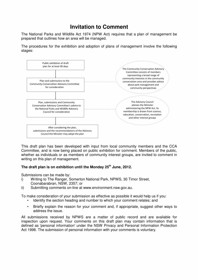
Invitation to Comment
The National Parks and Wildlife Act 1974 (NPW Act) requires that a plan of management be prepared that outlines how an area will be managed.
The procedures for the exhibition and adoption of plans of management involve the following stages:
Public exhibition of draft
plan for at least 90 days
Plan and submissions to the
Community Conservation Advisory Committee
for consideration
Plan, submissions and Community
Conservation Advisory Committee’s advice to
the National Parks and Wildlife Advisory
Council for consideration
After considering the plan,
submissions and the recommendations of the Advisory
Council the Minister may adopt the plan
The Community Conservation Advisory
Committee consists of members
representing a broad range of
community interests in the community
conservation area and provides advice
about park management and
community perspectives
The Advisory Council
advises the Minister
administering the NPW Act. Its
membership is drawn from science,
education, conservation, recreation
and other interest groups
This draft plan has been developed with input from local community members and the CCA Committee, and is now being placed on public exhibition for comment. Members of the public, whether as individuals or as members of community interest groups, are invited to comment in writing on this plan of management.
The draft plan is on exhibition until the Monday 25th
June, 2012.
Submissions can be made by: i) Writing to The Ranger, Somerton National Park, NPWS, 30 Timor Street,
Coonabarabran, NSW, 2357; or ii) Submitting comments on-line at www.environment.nsw.gov.au. To make consideration of your submission as effective as possible it would help us if you:
• Identify the section heading and number to which your comment relates; and
• Briefly explain the reason for your comment and, if appropriate, suggest other ways to address the issue.
All submissions received by NPWS are a matter of public record and are available for inspection upon request. Your comments on this draft plan may contain information that is defined as 'personal information' under the NSW Privacy and Personal Information Protection Act 1998. The submission of personal information with your comments is voluntary.

Contents
1. INTRODUCTION ................................................................................................................ 1
1.1 Location, gazettal and regional setting ............................................................................ 1
1.2 Statement of Significance ............................................................................................... 1
2. MANAGEMENT CONTEXT ................................................................................................ 2
2.1 Legislative and Policy Framework ................................................................................... 2
2.2 Management Purposes and Principles ............................................................................ 2
2.3 Specific Management Directions ..................................................................................... 3
3. VALUES ............................................................................................................................. 4
3.1 Geology, Landscape and Hydrology ............................................................................... 4
3.2 Native Plants ................................................................................................................... 4
3.3 Native Animals ................................................................................................................ 6
3.4 Aboriginal Heritage ......................................................................................................... 6
3.5 Historic Heritage ............................................................................................................. 7
3.6 Visitor Use, Education and Research .............................................................................. 7
3.7 Information and Education .............................................................................................. 7
4. ISSUES .............................................................................................................................. 8
4.1 Weeds and Pest Animals ................................................................................................ 8
4.2 Isolation and Fragmentation ............................................................................................ 9
4.3 Climate Change .............................................................................................................. 9
5. MANAGEMENT OPERATIONS AND OTHER USES ........................................................ 10
5.1 Management Facilities and Operations ......................................................................... 10
5.2 Non-NPWS Uses/Operations ........................................................................................ 10
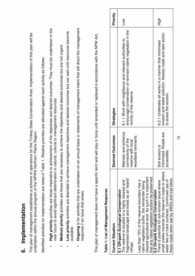
6. IMPLEMENTATION .......................................................................................................... 12
REFERENCES ......................................................................................................................... 17
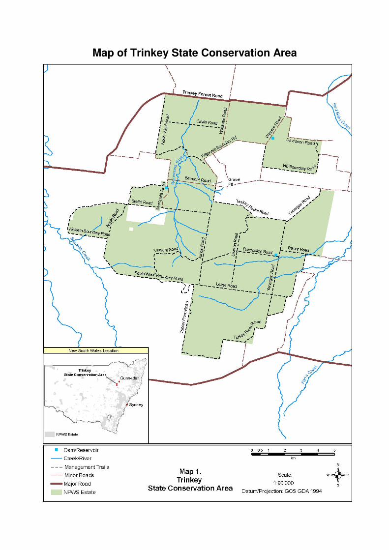
Map of Trinkey State Conservation Area
1
1. Introduction
1.1 Location, gazettal and regional setting
Trinkey State Conservation Area (also referred to in this plan as ‘the reserve’) is 10,229 hectares in size, with a boundary 81.2 kilometres in length. It is located approximately 12 kilometres east of Tambar Springs, 7 kilometres north-east of Premer and 41 kilometres south-west of Gunnedah. Trinkey State Conservation Area is one of the reserves established under the Brigalow and Nandewar Community Conservation Areas Act 2005 (NSW) (BNCCA Act) and as such forms part of a chain of reserves stretching the length of the Brigalow Belt South Bioregion. It provides some connectivity in a highly cleared and fragmented landscape between the larger reserved lands to the west such as Warrumbungle National Park and the Pilliga conservation reserves, and the Liverpool Ranges to the south and forms part of the catchment for Bundella and Coxs Creeks and the Lake Goran basin, part of the Namoi River Catchment. Trinkey State Conservation Area is part of both the Liverpool Plains and the Pilliga sub-regions of the Brigalow Belt South Bioregion. Prior to being gazetted as a State Conservation Area in December 2005 the reserve was managed by Forests NSW as a commercial cypress pine forest and included grazing leases. It is surrounded by private properties used for grazing and cropping and includes several roads that are vested in the Minister under Part 11 of the NPW Act to ensure continued access to neighbouring land. These roads do not form part of the gazetted area of the park but their management is subject to this plan, the NPW Regulation and the requirements of the EPA Act. Trinkey State Conservation Area lies within the Gunnedah Local Government Area and the Liverpool Plains Local Government Area. It lies within Zone 8(a) 'National Parks and Nature Reserves' of the Gunnedah Local Environmental Plan 1998 and Zone 1(f) 'Rural (Forestry) Zone' of the Quirindi Local Environmental Plan1991. The SCA falls within area of the Walhallow Local Aboriginal Land Council (LALC), and is part of the traditional lands of the Gamilaraay Aboriginal people.
1.2 Statement of Significance
Trinkey State Conservation Area is considered to be of significance for: Native Plants: Trinkey State Conservation Area conserves remnants of the original vegetation and habitats of the Pilliga sub-region of the Brigalow Belt South Bioregion. It contains a total of 358 vascular plant species. One species, Rulingia procumbens is listed as endangered under both the NSW TSC Act and the EPBC Act (Hunter 2008). Nine plant communities have been identified within the reserve – three of which contain threatened ecosystems. The White Pine – Bulloak – White Box Woodland is protected under the TSC Act as “White Box – Yellow Box – Blakely’s Red Gum Community” and under the EPBC Act as critically endangered “White Box – Yellow Box – Blakely’s Red Gum Grassy Woodland or derived native grassland”. Additionally components of the Pilliga Box – White Box – Myall Woodland and the Dirty Gum – Rough-barked Apple – Bulloak Woodland contain are likely to constitute the “Myall Woodland in the Darling Riverine Plains, Brigalow Belt South, Cobar Peneplain, Murray-Darling Depression, Riverina and NSW South Western Slopes bioregions” classified as an endangered ecological community under the TSC Act and the endangered ecological community “Weeping Myall Woodland” under the EPBC Act.
2
Native Animals: One hundred and sixty species of native fauna have been recorded within the reserve including seven species of amphibians, 25 reptile species, 103 bird species and 20 species of mammal. Of these, nine species of birds and three species of mammals (spotted-tailed quoll, koala and the little pied bat) are listed as vulnerable under the TSC Act. One species, the bush stone-curlew is listed as endangered under the TSC Act. Aboriginal Heritage: The reserve protects over 30 Aboriginal sites, with a likelihood that more sites will be found. It provides an important connection to Country for the local Aboriginal community. Historic Heritage: Two historic blazed trees have been recorded in the reserve.
2. Management Context
2.1 Legislative and Policy Framework
The management of the community conservation area is in the context of a legislative and policy framework, primarily the National Parks and Wildlife Act 1974 (NPW Act) and Regulation, the Community Conservation Area Agreement developed under the Brigalow and Nandewar Community Conservation Area Act 2005 (CCA Act), the Threatened Species Conservation Act 1995 (TSC Act) and the policies of the National Parks and Wildlife Service (NPWS).
Other legislation, strategies and international agreements may also apply to management of the area. In particular, the Environmental Planning and Assessment Act 1979 (EPA Act) may require assessment of environmental impact of works proposed in this plan. The Commonwealth Environment Protection and Biodiversity Conservation Act 1999 (EPBC Act) may apply in relation to actions that impact on matters of National Environmental Significance, such as migratory and threatened species listed under that Act.
A plan of management is a statutory document under the NPW Act. Once the Minister has adopted a plan, the plan must be carried out and no operations may be undertaken within the reserve except in accordance with the plan. This plan will also apply to any future additions to Trinkey State Conservation Area. Should management strategies or works be proposed in future that are not consistent with this plan, an amendment to the plan will be required.
2.2 Management Purposes and Principles
Community Conservation Areas
Community conservation areas are established under the Brigalow and Nandewar Community Conservation Area Act 2005. This Act provides for four dedicated management zones of which zones 1, 2 and 3 relate to land reserved under the NPW Act as a national park, Aboriginal area or a State conservation area, respectively. Land in zones 1, 2 and 3 are managed consistent with the management principles set out in the NPW Act.
Zone 3 State Conservation Areas
Zone 3 community conservation areas are reserved under the NPW Act to protect and conserve areas that:
• contain significant or representative ecosystems, landforms or natural phenomena or places of cultural significance;
• that are capable of providing opportunities for sustainable visitor use and enjoyment, the sustainable use of buildings and structures, or research; and
3
• are capable of providing opportunities for uses permitted under other provisions of the Act.
Under the Act (section 30G), Zone 3 community conservation areas are therefore managed to:
• conserve biodiversity, maintain ecosystem functions, protect natural phenomena and maintain natural landscapes;
• conserve places, objects and features of cultural value;
• provide for the undertaking of uses permitted under other provisions of the NPW Act (including uses permitted under section 47J such as mineral exploration and mining), having regard to the conservation of the natural and cultural values of the state conservation area;
• provide for sustainable visitor use and enjoyment that is compatible with conservation of the area's natural and cultural values and with uses permitted in the area;
• provide for sustainable use (including adaptive reuse) of any buildings or structures or modified natural areas having regard to conservation of the area's natural and cultural values and with other uses permitted in the area; and
• provide for appropriate research and monitoring.
Land is reserved as a state conservation area where mineral values do not allow for reservation under another category. The NPW Act requires a review of the classification of state conservation areas every five years in consultation with the Minister administering the Mining Act 1992. A review was undertaken in November 2008 in which the status of Trinkey Community Conservation Area, Zone 3 State Conservation Area remained unchanged.
In the long term it is intended for Trinkey Community Conservation Area, Zone 3 State Conservation Area to become a national park and therefore management of the state conservation area will also be guided by the management principles for national parks as far as possible.
2.3 Specific Management Directions
In addition to the general principles for the management of state conservation areas (refer section 2.2), the management of Trinkey State Conservation Area will focus on the protection of the significant vegetation communities and threatened native animal species and the protection of Aboriginal heritage sites.
Major strategies to achieve these objectives are:
• On-going fire management so that people and property are protected from wildfire, and park values are maintained;
• On-going control of pest species to minimise their impact on park values, in particular the weed mother of millions;
• Protection of cultural heritage places with community involvement, in particular from members of the local Aboriginal community; and
• Maintenance of information and regulatory signage.
3. Values
The location, landforms and plant and animal communities of an area have determined how it has been used and valued. Both Aboriginal and non-Aboriginal people place values on natural areas, including aesthetic, social, spiritual and recreational values. These values may be attached to the landscape as a whole or to individual components, for example to plant and animal species used by Aboriginal people. This plan of management aims to conserve both natural and cultural values. For reasons of clarity and document usefulness, various aspects of natural heritage, cultural heritage, threats and on-going use are dealt with individually, but their inter-relationships are recognised. Trinkey State Conservation Area is a significant reserve within the region as it provides key habitat and refuge to a representative sample of the flora and fauna including woodland birds and other native animals, in an area that is now mainly cleared of its original woodlands and forests.
3.1 Geology, Landscape and Hydrology
Trinkey State Conservation Area is located in the southern section of the Brigalow Belt South Bioregion. It is composed of country that rises gently from 330 metres above sea level in the north of the reserve, to a series of higher ridges 574 metres above sea level in the south-western section of the reserve. This ridgeline creates a watershed that drains westwards into Bundella and Coxs Creeks and east and northwards to the Goran Lakes basin. The reserve is predominantly underlain by Jurassic Pilliga Sandstones with associated conglomerates and siltstones. These overlie the earlier Purlawaugh Beds of lithic sandstone, shale, claystone and conglomerates and the Garrawilla Volcanics of dolerite, basalt, trachyte and tuff / breccia. These areas are surrounded to the north and west by water deposited Quaternary alluviums, gravel, silt, sands and clay deposits of the Liverpool plains. There is a minor Tertiary basalt and dolerite intrusion of the earlier Pilliga sandstone in the central western section of the reserve (Geological Survey of NSW, 1968). The soils are predominantly yellow and red texture contrast soils with smaller regions of deep black cracking clays in the north and west.
3.2 Native Plants
The vegetation of Trinkey State Conservation Area provides important links within the landscape, but also in terms of vegetation types, between the Warrumbungle and Pilliga areas to the north and the upper Hunter areas of the Wollemi and Goulburn River to the south and east. In terms of diversity the reserve is ranked very highly in comparison to many other reserves in western New South Wales across both richness overall, regional diversity and species turnover (Hunter 2008). A total of 358 vascular plant species have been recorded in the reserve. Only one species recorded in the reserve, Rulingia procumbens, is of conservation concern and it is listed as endangered under both the TSC Act and EPBC Act. Rulingia procumbens was found in the past at one site within the reserve but was not found during recent floristic surveys. Much of the reserve's vegetation is characterised by white cypress Pine (Callitris glaucophylla), buloke (Allocasuarina luehmanii), black cypress pine (Callitris endlicheri), red ironbark (Eucalytpus fibrosa), white bloodwood (Corymbia trachyphloia) and narrow-leaved ironbark (Eucalyptus crebra), with a scattered shrub layer of peach heath (Leucopogon muticus) and a diverse ground layer of grasses, herbs and forbs (Hunter 2008).
5
Nine plant communities have been identified within the reserve – three of which contain threatened ecosystems. Components of the White Pine – Bulloak – White Box Woodland is protected under the TSC Act as “White Box – Yellow Box – Blakely’s Red Gum Community” and is potentially classified as endangered under the EPBC Act as critically endangered “White Box – Yellow Box – Blakely’s Red Gum Grassy Woodland or derived native grassland”. Additionally components of the Pilliga Box – White Box – Myall Woodland and the Dirty Gum – Rough-barked Apple – Bulloak Woodland are likely to constitute the “Myall Woodland in the Darling Riverine Plains, Brigalow Belt South, Cobar Peneplain, Murray-Darling Depression, Riverina and NSW South Western Slopes bioregions” classified as an endangered ecological community under the TSC Act and the endangered ecological community known as “Weeping Myall Woodland” under the EPBC Act. 3.2.1 Vegetation Communities The nine vegetation types identified as part of a comprehensive vegetation survey conducted in 2008 are listed below:
Insert table:
• Buloke – White Cypress Pine – Narrow-leaved Ironbark Forest;
• White Cypress Pine – Buloke – White Box (Eucalyptus albens) Woodland;
• Pilliga Box (Eucalyptus pilligaensis) – White Box – Weeping Myall (Acacia pendula) Woodland;
• White Box – Western Rosewood (Alectryon oleifolius) Woodland;
• Dirty Gum (Eucalyptus chloroclada) – Rough-barked Apple (Angophora floribunda) – Buloke Woodland;
• Buloke – Red Ironbark Woodland;
• White Bloodwood – Red Ironbark – Black Cypress Pine Woodland;
• Blakely’s Red Gum (Eucalyptus blakelyi) – Black Cypress Pine Woodland; and
• White Cypress Pine – Black Cypress Pine – Red Ironbark – White Bloodwood Woodland.
The Buloke – White Cypress Pine – Narrow-leaved Ironbark Forest community is a layered woodland community restricted to the lower elevation parts of the reserve, particularly on the northern and eastern outwash flats on the deeper, moist but well drained soils. It is composed of a tall tree layer of the three main tree species as well as black cypress pine, dirty gum, Pilliga box, Blakely's red gum and grey box (Eucalyptus microcarpa). The shrub and ground cover layer is diverse and includes Acacia and Cassinia species as the dominant shrubs.
The White Cypress Pine – Buloke– White Box Woodland is the largest community and covers nearly 40 percent of the reserve. It is generally layered woodland however the presence of understorey shrub layers is highly variable. This community is found throughout the central parts of the reserve, commonly between mid-slopes and flats on well drained and deep soils. Tree species include the canopy dominants white cypress pine, buloke and white box, plus Pilliga box, yellow box (Eucalyptus melliodora), dirty gum, narrow-leaved ironbark, kurrajong (Brachychiton populneus), rough-barked apple, grey box (Eucalyptus moluccana), red ironbark, Blakely's red gum, black cypress pine, and motherumbah (Acacia cheelii). The shrub layer is dominated by several Acacia species, sticky daisy-bush (Olearia elliptica) and wilga (Geijera parviflora).
6
The remaining communities occur as small disjunct patches, linear strips or are scattered and dispersed throughout the reserve. Most are currently well-reserved across their range and generally not of conservation concern.
Another community, the Red Gum-Black Cypress Pine Woodland, occurs with a low shrubby understorey in disjunct linear patches in the southern parts of the reserve on mid slopes on deep and moist to well drained loamy sands. This community is typified by the two canopy dominants along with white cypress pine and kurrajong, with numerous shrub species including Leptospermum, Melaleuca, Callistemon, Acacia, Macrozamia and Grevillea species. This is an unusual community type and likely naturally rare in the landscape (Hunter 2008).
3.3 Native Animals
One hundred and sixty species of native fauna have been recorded within Trinkey State Conservation Area including seven species of amphibians, 25 reptile species, 103 bird species and 20 mammals (DECC 2010a). Of these, the spotted harrier (Circus assimilis), little eagle (Hieraaetus morphnoides), glossy black-cockatoo (Calyptorhynchus lathami), little lorikeet (Glossopsitta pusilla), turquoise parrot (Neophema pulchella), Brown Treecreeper (Climacteris picumnus), Speckled Warbler (Pyrrholaemus saggitatus), grey crowned babbler - eastern subspecies (Pomatostomus temporalis temporalis), varied sittella (Daphoenositta chrysoptera), spotted-tailed quoll (Dasyurus maculatus), koala (Phascolarctos cinereus) and the little pied bat (Chlinolobus picatus) are listed as vulnerable under the TSC Act. This means that they 'are likely to become endangered unless the circumstances and factors threatening their survival or evolutionary development cease to operate’ (DECC 2010b). One species, the bush stone-curlew (Burhinus grallarius), is known from a single record and is listed as endangered under the TSC Act. This means this species is 'likely to become extinct or is in immediate danger of extinction' (DECC 2010b).
3.4 Aboriginal Heritage
Somerton State Conservation Area lies within the traditional country of the Gamilaraay people and falls within the Walhallow Local Aboriginal Land Council area. The land and water within a landscape are central to Aboriginal spirituality and contribute to Aboriginal identity. Aboriginal communities associate natural resources with the use and enjoyment of foods and medicines, caring for the land, passing on cultural knowledge, kinship systems and strengthening social bonds. Aboriginal heritage and connection to nature are inseparable from each other and need to be managed in an integrated manner across the landscape. Aboriginal sites are places with evidence of Aboriginal occupation or that are related to other aspects of Aboriginal culture. They are important as evidence of Aboriginal history and as part of the culture of local Aboriginal people. A cultural heritage site survey was conducted in May 2009 by members of the local Aboriginal community and NPWS staff. This survey recorded several scarred trees, grinding grooves, and artefact scatters (DECC 2009c).
Many plant species growing within the reserve such as the grass tree (Xanthorrhoea johnsonii) and porcupine grass (Triodia scariosa), were also potentially used as food or medicinal plants, or for tool and utensil construction (Hunter 2008). While the NSW Government has legal responsibility for the protection of Aboriginal sites and places the NPWS acknowledges the right of Aboriginal people to make decisions about their
7
own heritage. It is therefore policy that Aboriginal communities be consulted and involved in the management of Aboriginal sites, places and related issues, and the promotion and presentation of Aboriginal culture and history.
3.5 Historic Heritage
Heritage places and landscapes are made up of living stories as well as connections to the past which can include natural resources, objects, customs and traditions that individuals and communities have inherited from the past and wish to conserve for current and future generations. Cultural heritage comprises places and items that may have historic, scientific, aesthetic and social significance. The NPWS conserves the significant heritage features of NSW parks and reserves.
Two historic sites have been recorded within Trinkey State Conservation Area. There are two marked trees, dating from the 1930s to the early 1940s, which were blazed by the then Forestry Commission of NSW to indicate forestry coupe boundaries. In 1878 part of the area now occupied by the reserve originally fell under the Trinkey Run lease and from early pastoral maps much of the land was heavily timbered (scrubby) and was known locally as the Colly Blue Scrub (LPMA 2010). The Trinkey Run once covered an area of 12,800 acres and was originally owned by George Loder and then by Robert Simson in 1888. In the early 1890s Trinkey Forest Reserve No. 1261 was established over the Colly Blue Scrub area and then later gazetted in 1912 as Forest Reserve No. 28406 and made 'exempt from operation of ordinary timber licences' (LPMA 2010). This Forest Reserve was converted to Trinkey State Forest (No. 177) on 18 November 1914 with further additions being added in 1924 and 1937 resulting in the present day area of the reserve. Evidence of former forestry practices can be found throughout the reserve in the form of snigging tracks, the remains of milled flitches and the many cypress and ironbark tree stumps. Evidence in the form of signage and cleared areas, now overgrown, indicates former use of the forest by apiarists.
3.6 Visitor Use, Education and Research
Trinkey State Conservation Area is able to be accessed via Belmont and Donohue Roads, from the three entrances off the Trinkey Forest Road (Curlewis - Tambar Springs Road) and off Brunskills road onto Yannergee Road. All other entrances to the reserve are through private property. Signage exists at all the main access points from these roads indicating the activities that are permissible within the reserve. Trinkey State Conservation Area is used for driving, bushwalking, mountain biking and horse riding. It also has a history of use for various purposes by the local communities, including fire wood collection, trail bike riding, hunting and off-road four-wheel driving. Some of these activities were previously permitted under Forests NSW management. There are currently no public facilities in the reserve and camping within Trinkey State Conservation Area is not permitted unless by consent.
3.7 Information and Education
The reserve has been used in the recent past for educational purposes, particularly for training the local Aboriginal community in undertaking cultural surveys (DECC 2009c).
8
Recent research activities within Trinkey State Conservation Area have included fauna, flora and cultural surveys conducted by NPWS and community groups to better understand the natural and cultural values of the reserve.
4. Issues
4.1 Weeds and Pest Animals
The Northern Plains Regional Pest Management Strategy (DECC 2007) lists several species of pest animals and weeds and identifies their respective populations in Trinkey State Conservation Area. Goats (Capra hircus), rabbits (Oryctolagus cuniculus), wild dogs (Canis lupus) and cats (Felis catus) occur in isolated populations restricted to small areas, whilst feral pigs (Sus scrofa) occur as scattered populations. The European fox (Vulpes vulpes) is widespread throughout the reserve. Pest species are plants and animals that have negative environmental, economic and social impacts and are most commonly introduced species. Pests can have impacts across the range of park values, including impacts on biodiversity, cultural heritage, catchment and scenic values.
4.1.1 Pest Animals Goat control is listed as a critical priority program within the Northern Plains Regional Pest Management Strategy (DECC 2007). This is attributable to the need to manage goats to protect colonies of large-eared pied bats which are susceptible to disturbance by goats – as identified in the Priority Action Statement (PAS). Only a small transient population of feral goats has been identified within the reserve, which moves off the reserve for extended periods of time. At the time of writing (2011) goats have not been seen in the reserve for 2 years. Trinkey State Conservation Area also contains localised high-density populations of feral pigs, which may cause damage to crops adjoining the reserve if left uncontrolled. Feral pigs are a declared pest under the Rural Lands Protection Act 1998 (NSW) and the NPWS is required to control (continuously suppress and destroy) declared pest animals to the extent necessary to minimise the risk of the pest causing damage to any land. A winter fox baiting program has been running since 2006. A low presence of wild dogs has been recorded within Trinkey State Conservation Area. Wild dogs, including dingoes, are a declared pest under the Rural Lands Protection Act 1998. This binds all land managers, including the NPWS to control the species. 4.1.2 Weeds The introduced plants mother of millions (Bryophyllum sp.) and tree pear (Opuntia tomentosa), occur within the reserve, whilst common prickly pear (Opuntia stricta) and tiger pear (Opuntia aurantiaca) have also been recorded as scattered through the reserve. These weed species are sprayed annually during the appropriate season. Biological control agents including cactoblastis and cochineal have been spread within prickly pear infestations in the reserve. Thistles and other 'disturbance' weed species are present along edges of the trail network and along the reserve boundaries where the level of disturbance by vehicles, machinery and feral animals is greatest.
9
4.2 FIRE The primary fire management objectives of the NPWS are to protect life and property and community assets from the adverse impacts of fire, whilst managing fire regimes to maintain and protect biodiversity and cultural heritage. Fire is a natural feature of many environments and is essential for the survival of some plant communities. However, inappropriate fire regimes can lead to loss of particular plant and animal species and communities, and high frequency fires have been listed as a key threatening process under the TSC Act. There have been no recorded wildfires within Trinkey State Conservation Area. There is little evidence of fire scars and past wildfire events. Litter accumulation and understorey growth also support this observation. A separate (map-based) fire management strategy has been prepared for the reserve (DECC 2009a). The fire management strategy outlines the key assets within and adjoining Trinkey State Conservation Area including sites of natural and cultural heritage value, fire management zones which include asset protection zones, and fire control advantages such as management roads and water supply points.
4.2 Isolation and Fragmentation
The area surrounding the reserve has been extensively cleared in the past, which has resulted in a high loss of biodiversity and fragmentation of habitat in the region. Long term conservation of biodiversity depends upon the protection, enhancement and connection of remaining habitat across the landscape, incorporating vegetation remnants on both public and private lands. Nearby vegetated areas contribute to the habitat values of the reserve and provide ecological corridors to other vegetated areas. Maintaining the integrity of the remaining habitat within the reserve and, where possible, linking this to adjacent areas of vegetation to facilitate wildlife corridors is important in ensuring long term viability of the reserve’s biological values.
4.3 Climate Change
Anthropogenic climate change has been listed as a key threatening process under the TSC Act. Projections of future changes in climate for NSW include higher temperatures, increasing sea levels and water temperatures, more intense but possibly reduced annual average rainfall, increased temperature extremes and higher evaporative demand. These changes are likely to lead to greater intensity and frequency of fires, more severe droughts, reduced river runoff and water availability, regional flooding, increased erosion and ocean acidification.
Climate change may significantly affect biodiversity by changing population size and distribution of species, modifying species composition, and altering the geographical extent of habitats and ecosystems. The potential impact of climate change is difficult to assess since it depends on the compounding effects of other pressures, particularly barriers to migration and pressure from feral animals. Species most at risk are those unable to migrate or adapt, particularly those with small population sizes or with slow growth rates.
Programs to reduce the pressures arising from other threats, such as habitat fragmentation, invasive species, bushfires and pollution, will help reduce the severity of the effects of climate change.
10
5. Management Operations And Other Uses
5.1 Management Facilities and Operations
There are many access roads within Trinkey State Conservation Area. These are used for fire fighting and pest operations purposes and are accessible to standard 4 wheel drive vehicles. The following roads have been gazetted as Part 11 Lands vested in the Minister on the basis that they are required access routes for the general public: Wilgavale Road; Waitara Road; Gean Boundary Road between its junctions with Waitara Road and Belmont/Jungle Road; Belmont Road; North-West Boundary Road between the junction with Donohue Road and Tambar Road, and where it meets Merrigula Track; and Merrigula Track. These roads do not form part of the gazetted area of the park but their management is subject to this plan, the NPW Regulation and the requirements of the EPA Act.
5.2 Non-NPWS Uses/Operations
5.2.1 Mining and Exploration
Exploration for minerals and petroleum, as well as mining and petroleum production, are permissible uses within state conservation areas. Trinkey State Conservation Area is currently cover by two petroleum titles – both held by Australian Coalbed Methane Pty Ltd. PEL 12 was granted 27 September 1995, renewed 31 January 2008 and expired 26 September 2011 (covered about 2/3 of SCA); and PEL 1 granted 11 February 1993, last renewed 6 April 2009 and expires 10 February 2015 (covers about 1/3 of SCA).
The Department of Trade and Investment, Regional Infrastructure and Services (DTIRIS) is the lead authority for mining and petroleum activities, including mineral exploration and mine site rehabilitation. OEH and DTIRIS work together to ensure that exploration and production proposals in SCAs comply with all statutory requirements, including any necessary environmental impact assessments and approvals.
5.2.2 Access by Third Parties
An in-holding south east of the Breffni and Argyle Roads and a gazetted easement for the Merrigula trigonometric station require access by other parties. An old gravel extraction pit, not currently in use, is located off Gean Boundary Road just north of the Belmont / Jungle Road junction. The gravel in the past has been used for maintenance and construction of the reserve roads and public roads outside the reserve. The site of the gravel pit is excluded from the reserve. 5.2.3 Apiary Sites There are currently seven licensed apiary sites located within the reserve. A further 43 sites exist in the reserve that have the potential to be reactivated in the future. These sites are recognised as existing interests under the NPW Act as they pre-date the reserve’s gazettal. NPWS policy on bee keeping allows existing sites to continue but does not allow any new or additional sites. The European honeybee (Apis mellifera) can have adverse impacts on some native plants and animals (Paton 1996) including poor flower pollination and competition with native nectar feeders. Competition from feral honeybees has been listed as a Key Threatening Process under the TSC Act.

11
Whilst managed honeybees were not the subject of this determination it may be necessary to relocate existing bee sites where apiary activities result in unacceptable environmental impacts, user conflicts or are inconsistent with the park’s management.
12
6.
Imp
lem
en
tati
on
This
pla
n o
f m
anag
em
ent
esta
blis
hes a
schem
e o
f opera
tions f
or
the T
rinkey S
tate
Conserv
ation A
rea.
Imple
menta
tion o
f th
is p
lan w
ill b
e
undert
aken w
ithin
the a
nnual pro
gra
m o
f th
e N
PW
S N
ort
hern
Pla
ins R
eg
ion.
Identified a
ctivitie
s f
or
imple
menta
tion a
re lis
ted in T
able
1.
Rela
tive p
riorities a
re a
llocate
d a
gain
st
each a
ctivity a
s f
ollo
ws:
• H
igh
pri
ori
ty a
ctivitie
s a
re t
hose im
pera
tive t
o a
chie
vem
ent
of
the o
bje
ctives a
nd d
esired o
utc
om
es.
They m
ust
be u
ndert
aken in t
he
near
futu
re t
o a
void
sig
nific
ant
dete
riora
tion in n
atu
ral, c
ultura
l or
manag
em
ent
resourc
es.
• M
ed
ium
pri
ori
ty a
ctivitie
s a
re t
hose t
hat
are
necessary
to a
chie
ve t
he o
bje
ctives a
nd d
esired o
utc
om
es b
ut
are
not
urg
ent.
• L
ow
pri
ori
ty a
ctivitie
s a
re d
esirable
to a
chie
ve m
anag
em
ent
obje
ctives a
nd d
esired o
utc
om
es b
ut
can w
ait u
ntil re
sourc
es b
ecom
e
availa
ble
.
• O
ng
oin
g is f
or
activitie
s t
hat
are
undert
aken o
n a
n a
nnual basis
or
sta
tem
ents
of
manag
em
ent
inte
nt
that
will
direct
the m
anag
em
ent
response if
an issue t
hat
arises.
This
pla
n o
f m
anag
em
ent
does n
ot
have a
specific
term
and w
ill s
tay in f
orc
e u
ntil am
ended o
r re
pla
ced in a
ccord
ance w
ith t
he N
PW
Act.
Ta
ble
1:
Lis
t o
f M
an
ag
em
en
t R
es
po
ns
e
Cu
rren
t S
itu
ati
on
D
esir
ed
Ou
tco
mes
Str
ate
gie
s
Pri
ori
ty
6.1
Off
-park
Eco
log
ical
Co
nserv
ati
on
T
he r
eserv
e is locate
d in a
hig
hly
cle
are
d a
nd
frag
mente
d landscape a
nd e
xis
ts a
s a
n 'i
sla
nd'
refu
ge.
Less t
han 1
5%
of
the r
eserv
e b
oundary
has a
native v
eg
eta
tion b
uff
er,
the r
em
ain
der
bein
g
cle
are
d a
gricultura
l la
nd.
As s
uch it
is im
port
ant
that
any n
ative v
eg
eta
tion b
uff
ers
be p
reserv
ed.
Main
tain
and e
nhance
connectivity o
f th
e
reserv
e w
ith local
woodla
nd r
em
nants
.
6.1
.1 W
ork
with n
eig
hbours
and r
ele
vant
auth
orities t
o
encoura
ge c
onserv
ation o
f re
mnant
native v
eg
eta
tion in t
he
vic
inity o
f th
e r
eserv
e.
Low
6.2
On
-park
Eco
log
ical
Co
nserv
ati
on
T
here
is p
ote
ntial fo
r soil
ero
sio
n issue w
here
sm
all
cre
eks t
ravers
e t
he r
eserv
e’s
roads o
r w
here
w
ate
r lie
s o
n t
rack s
urf
aces.
Continued u
se o
f th
ese r
oads w
hen w
et
by 4
WD
s a
nd t
rail
bik
es
Soil
ero
sio
n is
min
imis
ed.
Roads a
re
accessib
le.
6.2
.1 U
ndert
ake a
ll w
ork
s in a
manner
that
min
imis
es
ero
sio
n a
nd w
ate
r pollu
tion.
Assess r
oads a
nd t
ake a
ction
to a
rrest
the e
rosio
n.
Hig
h
13
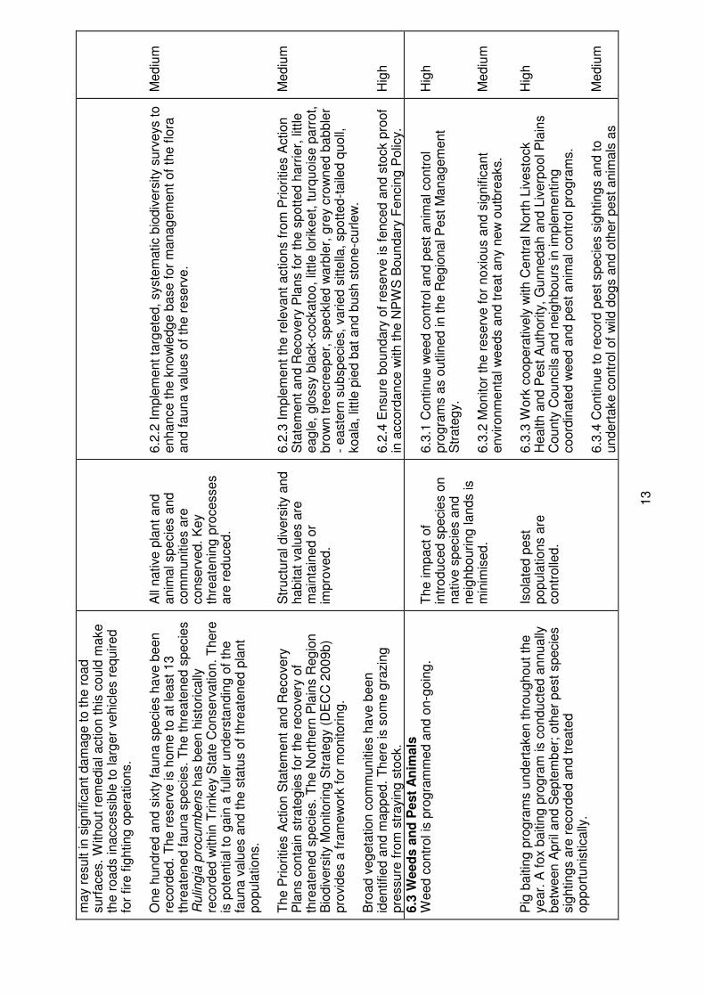
may r
esult in s
ignific
ant
dam
ag
e t
o t
he r
oad
surf
aces.
Without
rem
edia
l action t
his
could
make
the r
oads inaccessib
le t
o larg
er
vehic
les r
eq
uired
for
fire
fig
hting
opera
tions.
One h
undre
d a
nd s
ixty
fauna s
pecie
s h
ave b
een
record
ed.
The r
eserv
e is h
om
e t
o a
t le
ast
13
thre
ate
ned f
auna s
pecie
s.
The t
hre
ate
ned s
pecie
s
Rulin
gia
pro
cum
bens h
as b
een h
isto
rically
re
cord
ed w
ithin
Trinkey S
tate
Conserv
ation.
There
is
pote
ntial to
gain
a f
ulle
r unders
tandin
g o
f th
e
fauna v
alu
es a
nd t
he s
tatu
s o
f th
reate
ned p
lant
popula
tions.
T
he P
riorities A
ction S
tate
ment
and R
ecovery
P
lans c
onta
in s
trate
gie
s f
or
the r
ecovery
of
thre
ate
ned s
pecie
s.
The N
ort
hern
Pla
ins R
eg
ion
Bio
div
ers
ity M
onitoring
Str
ate
gy (
DE
CC
2009b)
pro
vid
es a
fra
mew
ork
for
monitoring
. B
road v
eg
eta
tion c
om
munitie
s h
ave b
een
identified a
nd m
apped.
There
is s
om
e g
razin
g
pre
ssure
fro
m s
trayin
g s
tock.
All
native p
lant
and
anim
al specie
s a
nd
com
munitie
s a
re
conserv
ed.
Key
thre
ate
nin
g p
rocesses
are
reduced.
Str
uctu
ral div
ers
ity a
nd
habitat
valu
es a
re
main
tain
ed o
r im
pro
ved.
6.2
.2 I
mple
ment
targ
ete
d,
syste
matic b
iodiv
ers
ity s
urv
eys t
o
enhance t
he k
now
ledg
e b
ase f
or
manag
em
ent
of
the f
lora
and f
auna v
alu
es o
f th
e r
eserv
e.
6.2
.3 I
mple
ment
the r
ele
vant
actions f
rom
Priorities A
ction
Sta
tem
ent
and R
ecovery
Pla
ns f
or
the s
pott
ed h
arr
ier,
little
eag
le,
glo
ssy b
lack-c
ockato
o,
little lorikeet,
turq
uois
e p
arr
ot,
bro
wn t
reecre
eper,
speckle
d w
arb
ler,
gre
y c
row
ned b
abble
r -
easte
rn s
ubspecie
s,
varied s
itte
lla,
spott
ed-t
aile
d q
uoll,
koala
, lit
tle p
ied b
at
and b
ush s
tone-c
urlew
.
6.2
.4 E
nsure
boundary
of
reserv
e is f
enced a
nd s
tock p
roof
in a
ccord
ance w
ith t
he N
PW
S B
oundary
Fencin
g P
olic
y.
Mediu
m
Mediu
m
Hig
h
6.3
Weed
s a
nd
Pest
An
imals
W
eed c
ontr
ol is
pro
gra
mm
ed a
nd o
n-g
oin
g.
Pig
baitin
g p
rog
ram
s u
ndert
aken t
hro
ug
hout
the
year.
A f
ox b
aitin
g p
rog
ram
is c
onducte
d a
nnually
betw
een A
pril and S
epte
mber;
oth
er
pest
specie
s
sig
hting
s a
re r
ecord
ed a
nd t
reate
d
opport
unis
tically
.
The im
pact
of
intr
oduced s
pecie
s o
n
native s
pecie
s a
nd
neig
hbouring
lands is
min
imis
ed.
Isola
ted p
est
popula
tions a
re
contr
olle
d.
6.3
.1 C
ontinue w
eed c
ontr
ol and p
est
anim
al contr
ol
pro
gra
ms a
s o
utlin
ed in t
he R
eg
ional P
est
Manag
em
ent
Str
ate
gy.
6.3
.2 M
onitor
the r
eserv
e f
or
noxio
us a
nd s
ignific
ant
environm
enta
l w
eeds a
nd t
reat
any n
ew
outb
reaks.
6.3
.3 W
ork
coopera
tively
with C
entr
al N
ort
h L
ivesto
ck
Health a
nd P
est
Auth
ority
, G
unnedah a
nd L
iverp
ool P
lain
s
County
Councils
and n
eig
hbours
in im
ple
menting
coord
inate
d w
eed a
nd p
est
anim
al contr
ol pro
gra
ms.
6.3
.4 C
ontinue t
o r
ecord
pest
specie
s s
ighting
s a
nd t
o
undert
ake c
ontr
ol of
wild
dog
s a
nd o
ther
pest
anim
als
as
Hig
h
Mediu
m
Hig
h
Mediu
m
14
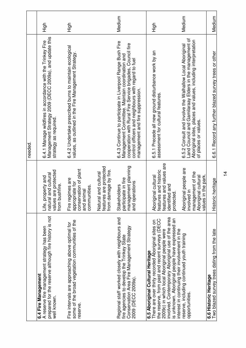
needed.
6.4
Fir
e M
an
ag
em
en
t A
reserv
e f
ire m
anag
em
ent
str
ate
gy h
as b
een
pre
pare
d f
or
the r
eserv
e a
lthoug
h f
ire h
isto
ry is n
ot
well
know
n.
Fire inte
rvals
are
appro
achin
g a
bove o
ptim
al fo
r som
e o
f th
e b
road v
eg
eta
tion c
om
munitie
s o
f th
e
reserv
e.
Reg
ional sta
ff w
ork
ed c
losely
with n
eig
hbours
and
fire
ag
encie
s t
o d
evelo
p t
he T
rinkey S
tate
C
onserv
ation A
rea F
ire M
anag
em
ent
Str
ate
gy
2009 (
DE
CC
2009a).
Life,
pro
pert
y a
nd
natu
ral and c
ultura
l valu
es a
re p
rote
cte
d
from
bushfire
. F
ire r
eg
imes a
re
appro
priate
for
conserv
ation o
f pla
nt
and a
nim
al
com
munitie
s.
Natu
ral and c
ultura
l fe
atu
res a
re p
rote
cte
d
from
dam
ag
e b
y f
ire.
Sta
kehold
ers
part
icip
ate
in f
ire
manag
em
ent
pla
nnin
g
and o
pera
tions
6.4
.1 M
anag
e w
ildfire
s in a
ccord
ance w
ith t
he T
rinkey F
ire
Manag
em
ent
Str
ate
gy 2
009 (
DE
CC
2009a),
and u
pdate
this
str
ate
gy a
s r
eq
uired.
6.4
.2 U
ndert
ake p
rescribed b
urn
s t
o m
ain
tain
ecolo
gic
al
valu
es,
as o
utlin
ed in t
he F
ire M
anag
em
ent
Str
ate
gy.
6.4
.3 C
ontinue t
o p
art
icip
ate
in L
iverp
ool R
ang
e B
ush F
ire
Manag
em
ent
Com
mitte
e.
Main
tain
coord
ination a
nd
coopera
tion w
ith R
ura
l F
ire S
erv
ice b
rig
ades,
Council
fire
contr
ol off
icers
and n
eig
hbours
with r
eg
ard
to f
uel
manag
em
ent
and f
ire s
uppre
ssio
n.
Hig
h
Hig
h
Mediu
m
6.5
Ab
ori
gin
al
Cu
ltu
ral
Heri
tag
e
There
are
over
thirty
record
ed A
borig
inal sites o
n
the r
eserv
e,
from
past
and r
ecent
surv
eys (
DE
CC
2009c)
in w
hic
h local A
borig
inal people
were
in
volv
ed.
Conte
mpora
ry A
borig
inal use o
f th
e a
rea
is u
nknow
n.
Aborig
inal people
have e
xpre
ssed a
n
inte
rest
in c
ontinuin
g t
heir involv
em
ent
in t
he
reserv
e,
inclu
din
g c
ontinued y
outh
tra
inin
g
opport
unitie
s.
Aborig
inal cultura
l fe
atu
res a
nd h
isto
ric
featu
res a
nd v
alu
es a
re
identified a
nd
pro
tecte
d.
Aborig
inal people
are
in
volv
ed in
manag
em
ent
of
the
Aborig
inal cultura
l valu
es in t
he p
ark
.
6.5
.1 P
recede a
ll new
gro
und d
istu
rbance w
ork
by a
n
assessm
ent
for
cultura
l fe
atu
res.
6.5
.2 C
onsult a
nd involv
e t
he W
alh
allo
w L
ocal A
borig
inal
Land C
ouncil
and G
am
ilara
ay E
lders
in t
he m
anag
em
ent
of
Aborig
inal sites,
pla
ces a
nd v
alu
es,
inclu
din
g inte
rpre
tation
of
pla
ces o
r valu
es.
Hig
h
Mediu
m
6.6
His
tori
c H
eri
tag
e
Tw
o b
lazed s
urv
ey t
rees d
ating
fro
m t
he late
H
isto
ric h
erita
ge
6.6
.1 R
ecord
any f
urt
her
bla
zed s
urv
ey t
rees o
r oth
er
Mediu
m
15
1930s t
o t
he e
arly 1
940s h
ave b
een r
ecord
ed.
No
oth
er
his
toric s
ites a
re r
ecord
ed f
or
Trinkey S
tate
C
onserv
ation A
rea.
featu
res a
nd v
alu
es a
re
identified a
nd
pro
tecte
d.
his
toric s
ites o
r art
efa
cts
found o
n t
he r
eserv
e a
nd p
rote
ct
from
dam
ag
e a
s f
ar
as p
ossib
le.
6.7
Vis
ito
r U
se a
nd
Serv
ices
Trinkey S
tate
Conserv
ation A
rea h
as a
long
his
tory
of
use b
y t
he local com
munity f
or
various p
urp
oses
that
are
no long
er
perm
itte
d s
uch a
s,
fire
wood
colle
ction,
trail
bik
e r
idin
g a
nd h
unting
.
Opport
unitie
s e
xis
t w
ithin
the r
eserv
e f
or
passiv
e
natu
re b
ased r
ecre
ation a
s w
ell
as c
yclin
g,
drivin
g
or
hors
e r
idin
g a
long
the e
xte
nsiv
e p
ark
road
netw
ork
. N
o a
dditio
nal fa
cili
ties a
re p
rovid
ed.
P
rom
otion o
f com
munity u
nders
tandin
g a
nd
appre
cia
tion o
f th
e c
onserv
ation v
alu
es o
f th
e
reserv
e w
ill b
e im
port
ant
for
min
imis
ing
ille
gal
activitie
s a
nd t
he im
pact
of
vis
itation.
Impacts
upon r
eserv
e
valu
es a
re s
table
or
dim
inis
hin
g.
U
se o
f ro
ad n
etw
ork
w
ill n
ot
impact
upon
reserv
e v
alu
es.
Vis
itor
use is
ecolo
gic
ally
susta
inable
and d
oes n
ot
reduce
reserv
e v
alu
es.
Vis
itors
will
have a
n
appre
cia
tion o
f re
serv
e
valu
es a
nd
conserv
ation issues.
6.7
.1 P
erm
it r
eg
iste
red v
ehic
le u
se,
cyclin
g a
nd h
ors
e r
idin
g
on p
ark
roads s
how
n o
n M
ap1.
The im
pacts
of
use w
ill b
e
monitore
d.
6.7
.2 C
am
pin
g in t
he r
eserv
e p
erm
issib
le b
y c
onsent.
6.7
.3 P
erm
it o
rganis
ed s
elf-r
elia
nt
recre
ational g
roups a
nd
educational vis
its,
subje
ct
to c
onditio
ns s
uch lim
itations t
o
gro
up s
ize.
6.7
.5 I
nvestig
ate
the n
eed f
or,
and b
est
location f
or
perm
anent
info
rmation s
ignag
e o
n t
he r
eserv
e.
6.7
.6 O
rganis
e m
edia
rele
ases,
educational m
ate
rial and
conta
ct
with n
eig
hbours
and c
om
munity o
rganis
ations
based o
n r
eserv
e m
anag
em
ent
issues.
Mediu
m
Mediu
m
Mediu
m
Low
Low
6.8
In
frastr
uctu
re U
se a
nd
main
ten
an
ce
Roads a
re a
t an a
deq
uate
sta
ndard
for
fire
and
pest
opera
tions,
and a
re g
enera
lly s
uitable
for
4-
wheel drive v
ehic
les.
Th
e r
ese
rve
in
clu
de
s s
eve
ral ro
ad
s t
ha
t a
re v
este
d in
th
e M
inis
ter
un
de
r P
art
11
of
the
NP
W A
ct
to e
nsu
re
co
ntin
ue
d a
cce
ss t
o n
eig
hb
ou
rin
g l
an
d.
Th
ese
ro
ad
s
do
no
t fo
rm p
art
of
the
ga
ze
tte
d a
rea
of
the
pa
rk b
ut
the
ir m
an
ag
em
en
t is
su
bje
ct
to t
his
pla
n,
the
NP
W
Re
gu
latio
n a
nd
th
e r
eq
uir
em
en
ts o
f th
e E
PA
Act.
Thre
e d
am
s a
re s
uitable
for
fire
fig
hting
.
Manag
em
ent
facili
ties
adeq
uate
ly s
erv
e
manag
em
ent
needs
and h
ave a
ccepta
ble
im
pact.
F
ire f
ighting
capacity is
maxim
ised w
ithin
the
6.8
.1 M
ain
tain
all
park
roads a
s s
how
n o
n M
ap 1
for
manag
em
ent
purp
oses.
6.8
.2 R
eta
in d
am
s a
s f
ire f
ighting
wate
r supplie
s a
nd
main
tain
as r
eq
uired.
Hig
h
Hig
h
16
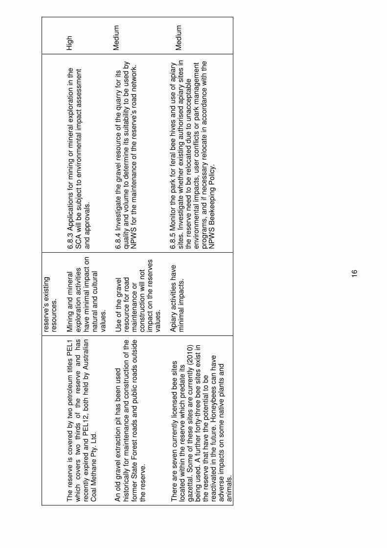
Th
e r
ese
rve
is c
ove
red
by t
wo
pe
tro
leu
m t
itle
s P
EL
1
wh
ich
co
ve
rs
two
th
ird
s
of
the
re
se
rve
a
nd
h
as
rece
ntly e
xp
ire
d a
nd
PE
L1
2,
bo
th h
eld
by A
ustr
alia
n
Co
al M
eth
an
e P
ty. L
td.
An o
ld g
ravel extr
action p
it h
as b
een u
sed
his
torically
for
main
tenance a
nd c
onstr
uction o
f th
e
form
er
Sta
te F
ore
st
roads a
nd p
ublic
roads o
uts
ide
the r
eserv
e.
T
here
are
seven c
urr
ently lic
ensed b
ee s
ites
locate
d w
ithin
the r
eserv
e w
hic
h p
redate
its
g
azett
al. S
om
e o
f th
ese s
ites a
re c
urr
ently (
2010)
bein
g u
sed.
A f
urt
her
fort
y-t
hre
e b
ee s
ites e
xis
t in
th
e r
eserv
e t
hat
have t
he p
ote
ntial to
be
reactivate
d in t
he f
utu
re.
Honeybees c
an h
ave
advers
e im
pacts
on s
om
e n
ative p
lants
and
anim
als
.
reserv
e’s
exis
ting
re
sourc
es.
Min
ing
and m
inera
l explo
ration a
ctivitie
s
have m
inim
al im
pact
on
natu
ral and c
ultura
l valu
es.
Use o
f th
e g
ravel
resourc
e f
or
road
main
tenance o
r constr
uction w
ill n
ot
impact
on t
he r
eserv
es
valu
es.
Apia
ry a
ctivitie
s h
ave
min
imal im
pacts
.
6.8
.3 A
pplic
ations f
or
min
ing
or
min
era
l explo
ration in t
he
SC
A w
ill b
e s
ubje
ct
to e
nvironm
enta
l im
pact
assessm
ent
and a
ppro
vals
. 6.8
.4 I
nvestig
ate
the g
ravel re
sourc
e o
f th
e q
uarr
y f
or
its
qualit
y a
nd v
olu
me t
o d
ete
rmin
e its
suitabili
ty t
o b
e u
sed b
y
NP
WS
for
the m
ain
tenance o
f th
e r
eserv
e’s
road n
etw
ork
. 6.8
.5 M
onitor
the p
ark
for
fera
l bee h
ives a
nd u
se o
f apia
ry
sites.
Investig
ate
wheth
er
exis
ting
auth
orised a
pia
ry s
ites in
the r
eserv
e n
eed t
o b
e r
elo
cate
d d
ue t
o u
naccepta
ble
environm
enta
l im
pacts
, user
conflic
ts o
r park
manag
em
ent
pro
gra
ms,
and if
necessary
relo
cate
in a
ccord
ance w
ith t
he
NP
WS
Beekeepin
g P
olic
y.
Hig
h
Mediu
m
Mediu
m
References
DEC, 2006. Recreational Horse Riding Policy 2006 -2009, Department of Environment and Conservation NSW, Sydney NSW. http://www.australianhorsealliance.asn.au/Horse_riding_policy_July_2006.pdf. DECC, 2007. Northern Plains Region Pest Management Strategy 2008-2011. Department of Environment and Climate Change NSW, Sydney, NSW. http://www.environment.nsw.gov.au/pestsweeds/NorthernPlainsPestManagementStrategy.htm. DECC, 2009a. Trinkey State Conservation Area (CCAZ3) - Reserve Fire Management Strategy 2009. Department of Environment and Climate Change NSW, Sydney NSW. http://www.environment.nsw.gov.au/resources/firemanagement/final/20080056TrinkeyFMS2009.pdf. DECC, 2009b. Northern Plains Region Biodiversity Monitoring Strategy 2009-2014, NPWS Northern Plains Region, Department of Environment and Climate Change NSW, Sydney NSW. DECC, 2009c. Trinkey State Conservation Area - Cultural Heritage Survey May 2009, Unpub. report to NPWS, Baradine NSW. DECC, 2010a. NSW Wildlife Atlas, Somerton CCA Zone 1 Animal Species report, Department of Environment and Climate Change NSW, Sydney NSW. http://wildlifeatlas.nationalparks.nsw.gov.au/wildlifeatlas/watlas.jsp. DECC, 2010b. - Threatened Species, Populations and Ecological Communities. Department of Environment and Conservation NSW, Sydney, NSW. http://www.threatenedspecies.environment.nsw.gov.au/tsprofile/index.aspx. DECCW, 2010. NSW National Parks and Wildlife Service Cycling Policy Review and Sustainable Mountain Biking Strategy Discussion Paper, August 2010, Department of Environment Climate Change and Water, Sydney NSW. Geological Survey of New South Wales, 1968. Geological Map of Gilgandra,1:250 000 MapSheet SH55-16, NSW Department of Mines, Sydney, NSW. Hunter, J.T., 2008. Vegetation and Floristics of Trinkey State Conservation Area - A report to the NSW National Parks and Wildlife Service. Unpub. report to NPWS, Northern Plains Region.
LPMA, 2010. NSW Land and Property Management Authority Parish and Historical Mapping Preservation Project database, Parish Map Trinkey and Tamarang, County Pottinger. http://www.lpma.nsw.gov.au/survey_and_maps/maps_and_imagery/parish_maps. NPWS, 2003. National Parks and Wildlife Service - Cycling Policy. National Parks and Wildlife Service, Sydney, NSW. http://www.environment.nsw.gov.au/resources/parks/policyCycling.pdf Paton, D.C., 1996. Overview of Feral and Managed Honeybees in Australia: Distribution, Abundance, Extent of Interactions with Native Biota, Evidence of Impacts and Future Research, Australia Nature Conservation Agency.

Thackway. R & Cresswell. I. 1995. An interim Biogeographic Regionalisation for Australia: A Framework for Establishing the National System of Reserves. Version 4.0. Australian Nature Conservation Agency, Canberra.


