
The Weather Wire
October 2017 Volume 24 Number 10
Contents:
• A Look Back: 1997 October Blizzard
• Drought Monitor
• September Summary/Statistics
• October Preview
• Rainfall Totals
A Look Back: 1997 October Blizzard
October is often one of the quieter months for weather in Eastern Colorado, but occasionally there are exceptions in which significant snowfall occurs in October. Such was the case 20 years ago this month, on October 24-26, 1997 when a powerful blizzard pummeled Eastern Colorado from Denver to Colorado Springs, producing heavy snowfall, high winds, and massive snowdrifts. The storm was one of the biggest snowstorms to ever occur in Colorado during the month of October, and was also one of the costliest of all-time.
The storm evolved as a powerful low pressure system developed over the Great Basin and moved into Colorado, stalling in eastern Colorado and tapping into Gulf moisture, while also drawing in a surge of unseasonably cold Canadian air from the north.
The following is a historical excerpt from the National Weather Service in Denver/Boulder regarding the October 1997 blizzard:
In 1997…one of the worst and deadliest blizzards of the decade developed over eastern Colorado as deep east to northeast flow associated with a vigorous upper level low pressure system over the four corners…combined with a strong arctic air mass over the central great plains. Snowfall totals across metro Denver ranged from 14 to 31 inches. The heaviest snowfall occurred in the foothills west and southwest of Denver where 2 to 4 feet of snow were measured.
Sustained winds to 40 mph with gusts as high as 60 mph produced zero visibilities and extremely cold wind chill temperatures from 25 below to 40 below zero. Winds whipped the snow into drifts 4 to 10 feet deep.
Several major and interstate highways were closed as travel became impossible. Red Cross shelters were set up for hundreds of travelers who became stranded when they had to abandon their vehicles. Four people died in northeastern Colorado as a result of the blizzard. None of the deaths were in metro Denver.

At Denver International Airport…4 thousand travelers were stranded when the airport was forced to shut down. At least 120 cars were abandoned along Pena Blvd….the only arterial leading into and out of DIA. The blizzard cost air carriers at least 20 million dollars. Thousands of cattle died in the storm over northeastern Colorado…resulting in losses totaling 1.5 million dollars.
Some of the more impressive snowfall totals included: 51 inches at Coal Creek Canyon; 48 inches at Silver Spruce Ranch…near Ward; 42 inches at Intercanyon…in the foothills southwest of Denver; 37 inches at Sedalia; 35 inches at Aspen Springs and Conifer in the foothills west of Denver; 31 inches at Eldorado Springs… Southeast Aurora…and Englewood; and 30 inches on Table Mesa in Boulder. Snowfall totaled 21.9 inches at the site of the former Stapleton International Airport…setting a new 24-hour snowfall record of 19.1 inches for the month. Snowfall totaled only 14 inches at Denver International Airport where north winds gusted to 39 mph on the 24th.
High temperature of only 21 degrees on the 25th equaled the record low maximum for the date first set in 1873. Low temperature of only 3 degrees on the 26th set a new record minimum for the date.
The following is an excerpt from NWS Pueblo on the impacts of the October 1997 blizzard in Colorado Springs and Southeast Colorado:
October blizzards are rare (in southeast Colorado), and the severity of that blizzard any time of year even rarer. Blizzard conditions lasted in Colorado Springs from 9 p.m. Friday evening through 6 p.m. Saturday. Shortly before 2 p.m. Saturday, at the Colorado Springs Airport, north winds gusted to 48 kts (55 mph) with an air temperature of 21 degrees. Nineteen inches of snow was measured at that time.
The scope and length of blizzard conditions proved fatal for several eastern Coloradans. Three people in El Paso county perished from carbon monoxide poisoning after waiting for help to come in their snowbound vehicles for over 24 hours. Another person froze to death in a vehicle on post at Fort Carson in the Colorado Springs area. An elderly woman in Otero County tried to walk home after her vehicle became stuck in open country. She froze to death. A man in Bent County froze to death in open country while hunting, or looking for other hunters. Another man died in a vehicle accident in Pueblo during the blizzard Friday night.
Many people were injured during the blizzard. Two people were injured in Colorado Springs when a canopy at a gas station collapsed under the weight of deep snow on top. Another canopy at a gas station in Lamar collapsed, but no one was injured. A vehicle was destroyed, though.
Thousands of people were stranded in eastern Colorado, and hundreds had to be rescued from their snowbound vehicles.
By Saturday, the Governor declared a State of Emergency. Emergency traffic only was allowed on eastern Colorado roadways. Rescues were made by the U.S. Army in Humvees and by helicopter, the National Guard, law enforcement, other public resources, and private citizens. The combination of high wind and heavy snow caused power lines to come down. Power outages occurred (and lasted up to two days) in many parts of the area, most notably
in parts of Colorado Springs, in and around Pueblo, and in southeast Colorado from McClave in Bent County to Holly in Prowers County. Hundreds of businesses and stores were closed throughout much of the weekend, and temporary sales and production loses were in the millions of dollars.
Many school districts were closed for a part, or all of the following week, as the digging out process continued.
Extra costs for snow removal in both the private and public sector from overtime wages certainly ran into the millions of dollars areawide. Not only did humans suffer, but there was a widespread die off of range cattle. Estimates of around 20,000 dead cattle and calves were given. Untold numbers were saved by hay drops carried out by the Army and National Guard. Removal of dead cattle and feeding of remaining cattle cost millions of dollars.
Snow amounts with the blizzard were impressive. One to two feet fell in the Eastern San Juan, La Garita, and Sangre de Cristo Mountains. However, the San Luis Valley received only a few inches of snow. The Upper Arkansas Valley had six to 12 inches of snow. Generally between one and two feet fell from the Rampart Range and southern Colorado Springs, south through Pueblo, down to Trinidad, and throughout the southeast Plains. However, parts of the Wet Mountains, Beulah, Walsenburg, and some areas around La Junta had around three feet of snow. From northern Colorado Springs to the Palmer Divide, amounts were excessive. In northern Colorado Springs as much as three feet of snow fell. In the Black Forest and Monument three to four foot amounts were the norm. At Palmer Lake, on the Palmer Divide, 52 inches of snow was reported. The deep snow was blown and piled into drifts anywhere between three and 15 feet deep.
Drought Update
Colorado remains mostly drought-free, but a small area of moderate drought has developed along the Western Slope near the Utah border. Areas of severe to exceptional drought remain over Montana, and areas of moderate drought have also developed over portions of Washington and Oregon.

The map below shows forecasted temperature deviances for October 2017. There is a slight bias toward below normal temperatures across the northern two-thirds of Colorado, and equal chances for above or below normal temperatures across the southern third of Colorado.
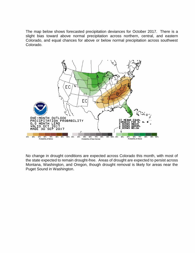
The map below shows forecasted precipitation deviances for October 2017. There is a slight bias toward above normal precipitation across northern, central, and eastern Colorado, and equal chances for above or below normal precipitation across southwest Colorado.
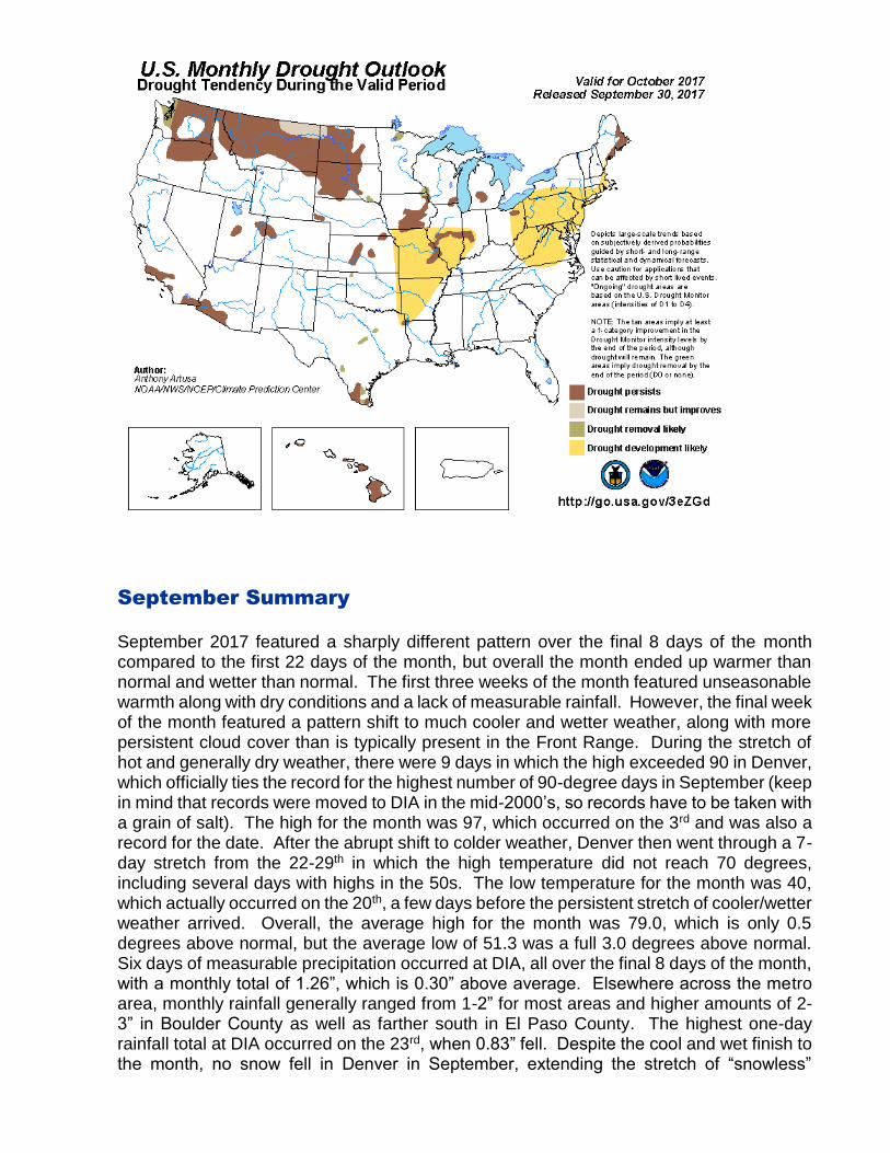
No change in drought conditions are expected across Colorado this month, with most of the state expected to remain drought-free. Areas of drought are expected to persist across Montana, Washington, and Oregon, though drought removal is likely for areas near the Puget Sound in Washington.
September Summary
September 2017 featured a sharply different pattern over the final 8 days of the month compared to the first 22 days of the month, but overall the month ended up warmer than normal and wetter than normal. The first three weeks of the month featured unseasonable warmth along with dry conditions and a lack of measurable rainfall. However, the final week of the month featured a pattern shift to much cooler and wetter weather, along with more persistent cloud cover than is typically present in the Front Range. During the stretch of hot and generally dry weather, there were 9 days in which the high exceeded 90 in Denver, which officially ties the record for the highest number of 90-degree days in September (keep in mind that records were moved to DIA in the mid-2000’s, so records have to be taken with a grain of salt). The high for the month was 97, which occurred on the 3rd and was also a record for the date. After the abrupt shift to colder weather, Denver then went through a 7-day stretch from the 22-29th in which the high temperature did not reach 70 degrees, including several days with highs in the 50s. The low temperature for the month was 40, which actually occurred on the 20th, a few days before the persistent stretch of cooler/wetter weather arrived. Overall, the average high for the month was 79.0, which is only 0.5 degrees above normal, but the average low of 51.3 was a full 3.0 degrees above normal. Six days of measurable precipitation occurred at DIA, all over the final 8 days of the month, with a monthly total of 1.26”, which is 0.30” above average. Elsewhere across the metro area, monthly rainfall generally ranged from 1-2” for most areas and higher amounts of 2-3” in Boulder County as well as farther south in El Paso County. The highest one-day rainfall total at DIA occurred on the 23rd, when 0.83” fell. Despite the cool and wet finish to the month, no snow fell in Denver in September, extending the stretch of “snowless”

Septembers to 17 years. Denver averages 1.3” of snow in September, but has not officially recorded any snow in September since 2000.
September Stats
TEMPERATURE (IN DEGREES F)
AVERAGE MAX 79.0 NORMAL 78.5 DEPARTURE 0.5
AVERAGE MIN 51.3 NORMAL 48.3 DEPARTURE 3.0
MONTHLY MEAN 65.1 NORMAL 63.4 DEPARTURE 1.7
HIGHEST 97 on 9/3
LOWEST 40 on 9/20
DAYS WITH MAX 90 OR ABOVE 9 NORMAL 3.4
DAYS WITH MAX 32 OR BELOW 0 NORMAL 0.0
DAYS WITH MIN 32 OR BELOW 0 NORMAL 0.8
DAYS WITH MIN ZERO OR BELOW 0 NORMAL 0.0
TEMPERATURE RECORDS
9/3 – Record high of 97 set
HEATING DEGREE DAYS
MONTHLY TOTAL 122 NORMAL 125 DEPARTURE -3
SEASONAL TOTAL 130 NORMAL 141 DEPARTURE -11
COOLING DEGREE DAYS
MONTHLY TOTAL 131 NORMAL 76 DEPARTURE 55
YEARLY TOTAL 880 NORMAL 764 DEPARTURE 61
PRECIPITATION (IN INCHES)
MONTHLY TOTAL 1.26 NORMAL 0.96 DEPARTURE 0.30
YEARLY TOTAL 10.23 NORMAL 12.32 DEPARTURE -2.09
GREATEST IN 24 HOURS 0.83 on 9/23
DAYS WITH MEASURABLE PRECIP. 6
SNOWFALL (IN INCHES)
MONTHLY TOTAL 0.0 NORMAL 1.3 DEPARTURE -1.3
SEASONAL TOTAL 0.0 NORMAL 1.3 DEPARTURE -1.3
GREATEST IN 24 HOURS NA
GREATEST DEPTH NA
WIND (IN MILES PER HOUR)
AVERAGE SPEED 9.6 mph
PEAK WIND GUST 48 mph from the NE on 9/19
MISCELLANEOUS WEATHER
NUMBER OF DAYS WITH THUNDERSTORM
2 NORMAL 4
NUMBER OF DAYS WITH HEAVY FOG 1 NORMAL 1
NUMBER OF DAYS WITH HAIL 0
NUMBER OF SUNNY DAYS 9
NUMBER OF PARTLY CLOUDY DAYS 15
NUMBER OF CLOUDY DAYS 6
AVERAGE RELATIVE HUMIDITY 48%
October Preview
October is one of Denver’s drier months on average, but it also is the month when typically the first taste of winter occurs. The average date of Denver’s first freeze of the season is on October 7th and the average date of the first measurable snow of the season is on October 18th. The average high for the month of October is 65.3 and the average low for the month is 36.6, with an average of 8.5 days of below freezing temperatures. October is also the month in which Denver’s latest 90 degree day and earliest subzero day have occurred, although it’s been about 100 years or more since either of these instances. The hottest temperature on record in October is 90, which happened in 1892, and the coldest temperature on record in October is -2, which happened in 1917. Typically, 1-3 cool, wet systems will occur during the month, most of which produce light to moderate precipitation with an average monthly precipitation of 1.02” and an average monthly snowfall of 4.0”. Most of the snowfall events that occur during October are “wet” in nature and have less impacts on pavement compared to other months due to typical warmer surface temperatures. However, heavy snowfall events can occasionally occur during October, which can significantly impact roadways, especially when snowfall rates exceed 1”/hour. The biggest snow event on record in October occurred in 1906 when 22.7” fell, but the second heaviest October snow event of 21.9” occurred more recently in 1997. The snowiest October on record occurred in 1969 with a monthly total of 31.2”. October 1969 was also the coldest and wettest October on record. The most notable “cold and snowy” October in recent years occurred in 2009, which was the second coldest and fifth snowiest October on record. Currently, we are actually on a three-year streak of not having any

snow in Denver in October – the longest such streak on record. However, for October 2017 we are anticipating a more active month than recent Octobers with below average temperatures and near to above average precipitation and snowfall expected. We will likely experience 1-2 light to moderate snow events in the Denver metro area this month.
DENVER'S OCTOBER CLIMATOLOGICALLY NORMAL (NORMAL PERIOD 1981-2010 DIA Data)
TEMPERATURE
AVERAGE HIGH 65.3 AVERAGE LOW 36.6 MONTHLY MEAN 50.9 DAYS WITH HIGH 90 OR ABOVE 0 DAYS WITH HIGH 32 OR BELOW 0.4 DAYS WITH LOW 32 OR BELOW 8.5 DAYS WITH LOWS ZERO OR BELOW 0
PRECIPITATION
MONTHLY MEAN 1.02”
DAYS WITH MEASURABLE PRECIPITATION 5.3” AVERAGE SNOWFALL IN INCHES 4.0” DAYS WITH 1.0 INCH OF SNOW OR MORE NA
MISCELLANEOUS AVERAGES
HEATING DEGREE DAYS 440 COOLING DEGREE DAYS 5 WIND SPEED (MPH) 8.8mph WIND DIRECTION South DAYS WITH THUNDERSTORMS 1 DAYS WITH DENSE FOG 1 PERCENT OF SUNSHINE POSSIBLE 72%
EXTREMES
RECORD HIGH 90 on 10/1/1982 RECORD LOW -2 on 10/29/1917 WARMEST 59.0 in 1950 COLDEST 38.9 in 1969 WETTEST 4.17” in 1969 DRIEST Trace in 1934 SNOWIEST 31.2” in 1969 LEAST SNOWIEST 0.0” in many years
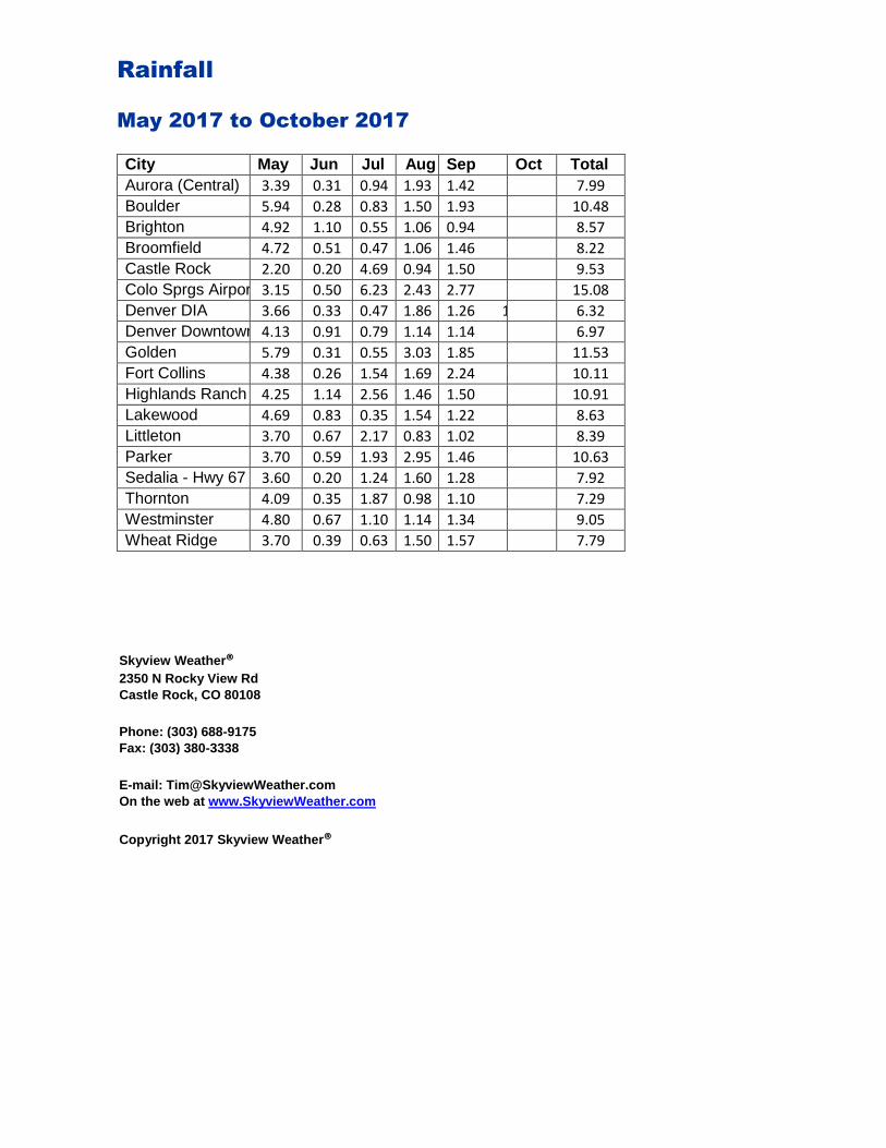
Rainfall
May 2017 to October 2017
City May Jun Jul Aug Sep Oct Total
Aurora (Central) 3.39 0.31 0.94 1.93 1.42 1 7.99
Boulder 5.94 0.28 0.83 1.50 1.93 10.48
Brighton 4.92 1.10 0.55 1.06 0.94 8.57
Broomfield 4.72 0.51 0.47 1.06 1.46 8.22
Castle Rock 2.20 0.20 4.69 0.94 1.50 9.53
Colo Sprgs Airport 3.15 0.50 6.23 2.43 2.77 15.08
Denver DIA 3.66 0.33 0.47 1.86 1.26 1 6.32
Denver Downtown 4.13 0.91 0.79 1.14 1.14 6.97
Golden 5.79 0.31 0.55 3.03 1.85 11.53
Fort Collins 4.38 0.26 1.54 1.69 2.24 10.11
Highlands Ranch 4.25 1.14 2.56 1.46 1.50 10.91
Lakewood 4.69 0.83 0.35 1.54 1.22 8.63
Littleton 3.70 0.67 2.17 0.83 1.02 8.39
Parker 3.70 0.59 1.93 2.95 1.46 10.63
Sedalia - Hwy 67 3.60 0.20 1.24 1.60 1.28 7.92
Thornton 4.09 0.35 1.87 0.98 1.10 7.29
Westminster 4.80 0.67 1.10 1.14 1.34 9.05
Wheat Ridge 3.70 0.39 0.63 1.50 1.57 7.79
Skyview Weather® 2350 N Rocky View Rd Castle Rock, CO 80108 Phone: (303) 688-9175 Fax: (303) 380-3338 E-mail: [email protected] On the web at www.SkyviewWeather.com
Copyright 2017 Skyview Weather®


