Saskatchewan Geological Survey 1 Summary of Investigations 2014, Volume 1
Sedimentary Facies and Depositional Environments of the Upper Devonian–Lower Mississippian Bakken Formation in Eastern
Saskatchewan
Liya Zhang 1 and Luis A. Buatois 1
Zhang, L. and Buatois, L.A. (2014): Sedimentary facies and depositional environments of the Upper Devonian–Lower Mississippian Bakken Formation in eastern Saskatchewan; in Summary of Investigations 2014, Volume 1, Saskatchewan Geological Survey, Sask. Ministry of the Economy, Misc. Rep. 2014-4.1, Paper A-3, 18p.
Abstract The Upper Devonian–Lower Mississippian Bakken Formation is present in the subsurface of the Williston Basin in northeastern Montana, northwestern North Dakota, southwestern Manitoba and southern Saskatchewan. In southeastern Saskatchewan, the Bakken Formation unconformably overlies either the Upper Devonian Big Valley Formation or the Torquay Formation, and is conformably overlain by the Lower Mississippian Lodgepole Formation (Souris Valley Beds). The Bakken Formation includes three members: lower and upper organic-rich black shales, and a middle calcareous/dolomitic sandstone and siltstone, which together form a ‘perfect’ petroleum system that includes source rock, reservoir and seal all within the same formation. Based on detailed analysis of cores from the study area in eastern Saskatchewan, the Bakken Formation is divided into eight facies, and Facies 2 is subdivided into two subfacies. Facies 1 is a planar cross-stratified, fine-grained sandstone; Facies 2A comprises wavy- to flaser-bedded, very fine-grained sandstone; Facies 2B is thinly parallel-laminated, very fine-grained sandstone and siltstone; Facies 3 constitutes parallel-laminated, very fine-grained sandstone and muddy siltstone; Facies 4 is a sandy siltstone; Facies 5 is highly bioturbated, interbedded very fine-grained sandstone and siltstone; Facies 6 is interbedded highly bioturbated sandy siltstone and micro-hummocky cross-stratified, very fine-grained sandstone; Facies 7 is a highly bioturbated siltstone; and Facies 8 is black shale. Our integrated sedimentologic and ichnologic study suggests that deposition of the Bakken occurred in two different paleoenvironmental settings: open marine (Facies 4 to 8), and brackish-water marginal marine (Facies 1 to 3). Isochore maps show that both open-marine and marginal-marine deposits are widely distributed in this study area.
Keywords: Bakken Formation, Upper Devonian, Lower Mississippian, sedimentary facies, depositional environments, facies distribution, ichnology, core analysis, Saskatchewan, Williston Basin.
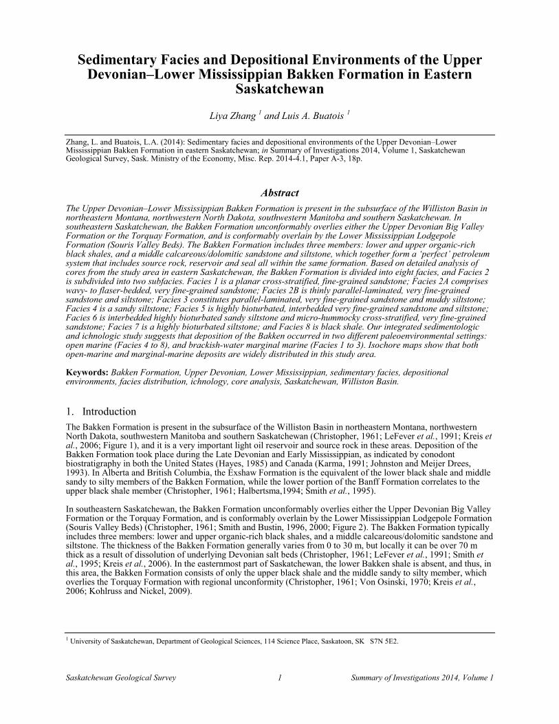
1. Introduction The Bakken Formation is present in the subsurface of the Williston Basin in northeastern Montana, northwestern North Dakota, southwestern Manitoba and southern Saskatchewan (Christopher, 1961; LeFever et al., 1991; Kreis et al., 2006; Figure 1), and it is a very important light oil reservoir and source rock in these areas. Deposition of the Bakken Formation took place during the Late Devonian and Early Mississippian, as indicated by conodont biostratigraphy in both the United States (Hayes, 1985) and Canada (Karma, 1991; Johnston and Meijer Drees, 1993). In Alberta and British Columbia, the Exshaw Formation is the equivalent of the lower black shale and middle sandy to silty members of the Bakken Formation, while the lower portion of the Banff Formation correlates to the upper black shale member (Christopher, 1961; Halbertsma,1994; Smith et al., 1995).
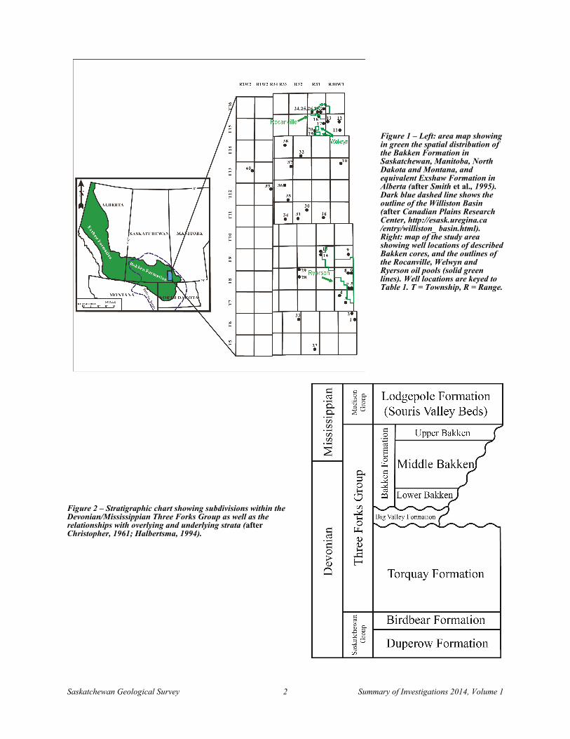
In southeastern Saskatchewan, the Bakken Formation unconformably overlies either the Upper Devonian Big Valley Formation or the Torquay Formation, and is conformably overlain by the Lower Mississippian Lodgepole Formation (Souris Valley Beds) (Christopher, 1961; Smith and Bustin, 1996, 2000; Figure 2). The Bakken Formation typically includes three members: lower and upper organic-rich black shales, and a middle calcareous/dolomitic sandstone and siltstone. The thickness of the Bakken Formation generally varies from 0 to 30 m, but locally it can be over 70 m thick as a result of dissolution of underlying Devonian salt beds (Christopher, 1961; LeFever et al., 1991; Smith et al., 1995; Kreis et al., 2006). In the easternmost part of Saskatchewan, the lower Bakken shale is absent, and thus, in this area, the Bakken Formation consists of only the upper black shale and the middle sandy to silty member, which overlies the Torquay Formation with regional unconformity (Christopher, 1961; Von Osinski, 1970; Kreis et al., 2006; Kohlruss and Nickel, 2009).
1 University of Saskatchewan, Department of Geological Sciences, 114 Science Place, Saskatoon, SK S7N 5E2.
Saskatchewan Geological Survey 2 Summary of Investigations 2014, Volume 1
Figure 1 – Left: area map showing in green the spatial distribution of the Bakken Formation in Saskatchewan, Manitoba, North Dakota and Montana, and equivalent Exshaw Formation in Alberta (after Smith et al., 1995). Dark blue dashed line shows the outline of the Williston Basin (after Canadian Plains Research Center, http://esask.uregina.ca /entry/williston_ basin.html). Right: map of the study area showing well locations of described Bakken cores, and the outlines of the Rocanville, Welwyn and Ryerson oil pools (solid green lines). Well locations are keyed to Table 1. T = Township, R = Range.
Figure 2 – Stratigraphic chart showing subdivisions within the Devonian/Mississippian Three Forks Group as well as the relationships with overlying and underlying strata (after Christopher, 1961; Halbertsma, 1994).
Saskatchewan Geological Survey 3 Summary of Investigations 2014, Volume 1
Many studies of the Bakken Formation have been conducted in southeastern Saskatchewan, and a variety of sedimentary environment and sequence-stratigraphic models have been proposed (Christopher, 1961; LeFever et al., 1991; Smith and Bustin, 1996; Kreis et al., 2006; Kohlruss and Nickel, 2009). The most recent integrated sedimentologic, ichnologic and sequence-stratigraphic studies in southeastern Saskatchewan (Townships 1 through 11, Ranges 3 to 25W2, including the Viewfield and Roncott oil fields) suggested a model of an offshore to shoreface environment during normal regression, followed by a transgressive brackish-water embayment environment (Angulo et al., 2008; Angulo and Buatois, 2009, 2010, 2012).
The research area discussed in this paper—from Townships 5 through 16, Ranges 30W1 to 2W2—is east-northeast of the area mentioned above. The Rocanville and Welwyn oil fields, which produce from the Bakken Formation, and the Ryerson oil field, which produces from Bakken and Torquay formations, are located in this study area (Figure 1).
The goals of this project are 1) to provide a detailed, integrated sedimentologic and ichnologic analysis of the Bakken Formation in the study area, and 2) to compare the sedimentary facies and stratal architecture of the Bakken Formation in this area with those documented in the area to the west-southwest by Angulo and Buatois (2009, 2010, 2012).
2. Study Method This project is mainly based on sedimentology and ichnology data obtained from detailed descriptions of 40 cores in our study area (Figure 1, Table 1). All the cores examined were slabbed in order to improve the recognition of sedimentologic and ichnologic features. Facies were defined based on sedimentary texture and structures, bioturbation index, and ichnologic content. The bioturbation index (BI) of Taylor and Goldring (1993) was applied, according to which, BI is defined from 0 to 6 to suggest the increase of bioturbation intensity: BI = 0 (0%) is represented by no bioturbation, while BI = 6 (100%) indicates completely bioturbated and reworked sediment. The open-marine environment subdivision of Buatois and Mángano (2011), adapted from MacEachern et al. (1999), and brackish-water marginal-marine environment subdivision of MacEachern and Gingras (2007) are adopted in this study.
Table 1 – The well locations, licence numbers, and cored intervals for each of the 40 wells studied in this project are provided in this table; also included are the numbers used to indicate the location of each well on the map in Figure 1.
Well Number
Well Identification Licence Number Core Interval (m)
1 131/12-24-006-30W1 05J209 1092.20 to 1098.70
2 131/15-35-006-30W1 07K132 1077.00 to 1095.00
3 121/15-15-007-30W1 06E187 1085.00 to 1096.00
4 111/09-29-007-30W1 06H495 1096.90 to 1114.00
5 141/14-01-008-30W1 06B107 1026.00 to 1036.70
6 101/09-25-008-30W1 06H319 993.00 to 1003.40
7 141/12-02-008-30W1 02G378 1038.40 to 1056.40
8 101/08-26-008-30W1 06I122 1015.00 to 1033.00
9 101/03-23-009-30W1 08A041 972.50 to 988.50
10 111/07-27-013-30W1 09L121 753.00 to 771.00
11 141/07-11-015-30W1 09J069 662.50 to 680.50
12 121/05-23-015-30W1 86B069 645.00 to 663.20
13 101/10-19-015-30W1 97C030 667.25 to 685.50
14 131/16-17-009-31W1 08J375 1067.50 to 1084.75
15 131/16-20-009-31W1 06H322 1069.00 to 1087.00
16 101/01-10-011-31W1 05I238 963.00 to 981.00
17 121/16-24-015-31W1 96F084 681.50 to 690.70
18 101/08-34-015-31W1 96E128 671.50 to 680.70
Saskatchewan Geological Survey 4 Summary of Investigations 2014, Volume 1
Well Number
Well Identification Licence Number Core Interval (m)
19 101/16-04-015-31W1 98B127 726.00 to 744.00
20 101/01-09-015-31W1 98I033 727.40 to 745.40
21 101/10-12-016-31W1 94L133 650.00 to 668.00
22 121/02-02-016-31W1 96F121 666.00 to 675.00
23 121/05-03-016-31W1 95A008 674.50 to 687.30
24 101/08-05-016-31W1 59C012 687.02 to 702.26
25 101/09-05-016-31W1 85J188 685.00 to 703.00
26 101/10-05-016-31W1 59L052 686.10 to 700.70
27 101/13-11-005-32W1 66E073 1325.27 to 1343.56
28 121/02-19-008-32W1 06H069 1218.00 to 1234.00
29 101/01-31-008-32W1 06H080 1201.50 to 1271.50
30 141/05-23-011-32W1 10F105 975.00 to 993.35
31 141/13-08-011-32W1 10D224 1019.00 to 1037.00
32 111/09-04-014-32W1 08I283 859.00 to 877.10
33 101/06-24-006-33W1 06I015 1326.00 to 1344.00
34 101/03-10-011-33W1 10H250 1091.50 to 1109.50
35 141/16-02-012-33W1 10F097 1007.00 to 1025.00
36 131/13-27-012-33W1 10F135 971.50 to 985.05
37 101/16-24-013-33W1 07L095 883.00 to 900.00
38 102/09-22-014-33W1 11A306 856.00 to 874.00
39 141/11-25-012-01W2 10F104 1048.00 to 1066.00
40 131/16-24-013-02W2 07H346 1034.00 to 1052.20
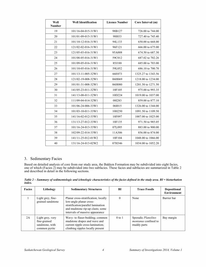
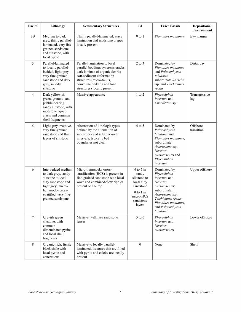
3. Sedimentary Facies Based on detailed analysis of core from our study area, the Bakken Formation may be subdivided into eight facies, one of which (Facies 2) may be subdivided into two subfacies. These facies and subfacies are summarized in Table 2 and described in detail in the following sections.
Table 2 – Summary of sedimentologic and ichnologic characteristics of the facies defined in the study area. BI = bioturbation index.
Facies Lithology Sedimentary Structures BI Trace Fossils Depositional Environment
1 Light grey, fine-grained sandstone
Planar cross-stratification; locally low-angle planar cross-stratification/parallel lamination and mudstone rip-up clasts; some intervals of massive appearance
0 None Barrier bar
2A Light grey, very fine-grained sandstone, with common pyrite
Wavy- to flaser-bedding; common mudstone drapes and wave and current ripple cross-lamination; climbing ripples locally present
0 to 1 Sporadic Planolites montanus confined to muddy parts
Bay margin
Saskatchewan Geological Survey 5 Summary of Investigations 2014, Volume 1
Facies Lithology Sedimentary Structures BI Trace Fossils Depositional Environment
2B Medium to dark grey, thinly parallel-laminated, very fine-grained sandstone and siltstone, with local pyrite
Thinly parallel-laminated; wavy lamination and mudstone drapes locally present
0 to 1 Planolites montanus Bay margin
3 Parallel-laminated to locally parallel-bedded, light grey, very fine-grained sandstone and dark grey, muddy siltstone
Parallel lamination to local parallel bedding; syneresis cracks; dark laminae of organic debris; soft-sediment deformation structures (micro-faults, convolute bedding and load structures) locally present
2 to 3 Dominated by Planolites montanus and Palaeophycus tubularis; subordinate Rosselia isp. and Teichichnus rectus
Distal bay
4 Dark yellowish green, granule- and pebble-bearing sandy siltstone, with mudstone rip-up clasts and common shell fragments
Massive appearance 1 to 2 Phycosiphon incertum and Chondrites isp.
Transgressive lag
5 Light grey, massive, very fine-grained sandstone and thin layers of siltstone
Alternation of lithologic types defined by the alternation of sandstone- and siltstone-rich intervals; typically bed boundaries not clear
4 to 5 Dominated by Palaeophycus tubularis and Planolites montanus; subordinate Asterosoma isp., Nereites missouriensis and Phycosiphon incertum
Offshore transition
6 Interbedded medium to dark grey, sandy siltstone to local silty sandstone and light grey, micro-hummocky cross-stratified, very fine-grained sandstone
Micro-hummocky cross-stratification (HCS) is present in fine-grained sandstone with local wave and combined-flow ripples present on the top
4 to 5 in sandy
siltstone to local silty sandstone
0 to 1 in micro-HCS sandstone
layers
Dominated by Phycosiphon incertum and Nereites missouriensis; subordinate Asterosoma isp., Teichichnus rectus, Planolites montanus, and Palaeophycus tubularis
Upper offshore
7 Greyish green siltstone, with common disseminated pyrite and local shell fragments
Massive, with rare sandstone lenses
5 to 6 Phycosiphon incertum and Nereites missouriensis
Lower offshore
8 Organic-rich, fissile black shale with local pyrite and concretions
Massive to locally parallel-laminated; fractures that are filled with pyrite and calcite are locally present
0 None Shelf
Saskatchewan Geological Survey 6 Summary of Investigations 2014, Volume 1
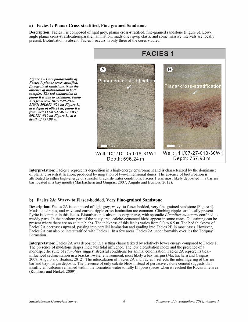
a) Facies 1: Planar Cross-stratified, Fine-grained Sandstone Description: Facies 1 is composed of light grey, planar cross-stratified, fine-grained sandstone (Figure 3). Low-angle planar cross-stratification/parallel lamination, mudstone rip-up clasts, and some massive intervals are locally present. Bioturbation is absent. Facies 1 occurs in only three of the cores studied.
Figure 3 – Core photographs of Facies 1, planar cross-stratified, fine-grained sandstone. Note the absence of bioturbation in both samples. The red colouration in photo B is due to oxidation. Photo A is from well 101/10-05-016-31W1; 59L052 (#26 on Figure 1), at a depth of 696.24 m; photo B is from well 111/07-27-013-30W1; 09L121 (#10 on Figure 1), at a depth of 757.90 m.
Interpretation: Facies 1 represents deposition in a high-energy environment and is characterized by the dominance of planar cross-stratification, produced by migration of two-dimensional dunes. The absence of bioturbation is attributed to either high-energy or stressful brackish-water conditions. Facies 1 was most likely deposited in a barrier bar located in a bay mouth (MacEachern and Gingras, 2007; Angulo and Buatois, 2012).
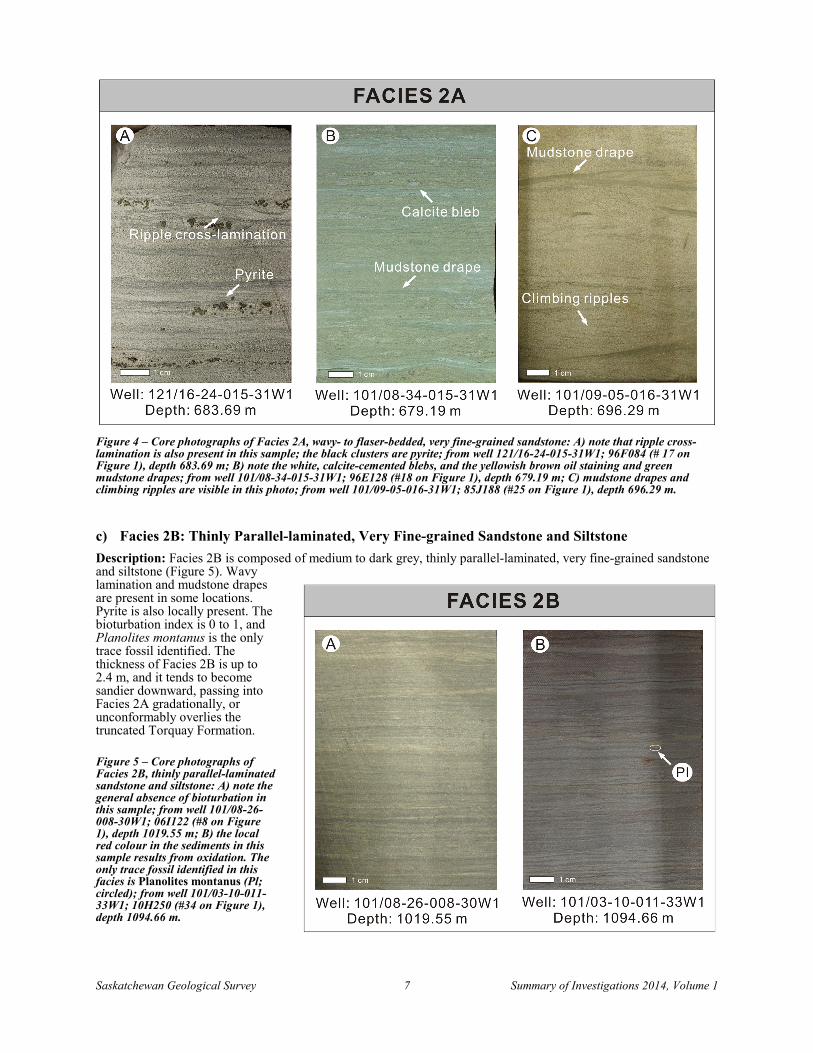
b) Facies 2A: Wavy- to Flaser-bedded, Very Fine-grained Sandstone Description: Facies 2A is composed of light grey, wavy- to flaser-bedded, very fine-grained sandstone (Figure 4). Mudstone drapes, and wave and current ripple cross-lamination are common. Climbing ripples are locally present. Pyrite is common in this facies. Bioturbation is absent to very sparse, with sporadic Planolites montanus confined to muddy parts. In the northern part of the study area, calcite-cemented blebs appear in some cores. Oil staining can be present where there are no calcite blebs. The thickness of this facies varies from 0.0 to 6.5 m. The bed thickness of Facies 2A decreases upward, passing into parallel lamination and grading into Facies 2B in most cases. However, Facies 2A can also be interstratified with Facies 1. In a few areas, Facies 2A unconformably overlies the Torquay Formation.
Interpretation: Facies 2A was deposited in a setting characterized by relatively lower energy compared to Facies 1. The presence of mudstone drapes indicates tidal influence. The low bioturbation index and the presence of a monospecific suite of Planolites suggest stressful conditions for animal colonization. Facies 2A represents tidal-influenced sedimentation in a brackish-water environment, most likely a bay margin (MacEachern and Gingras, 2007; Angulo and Buatois, 2012). The intercalation of Facies 2A and Facies 1 reflects the interfingering of barrier bar and bay-margin deposits. The presence of only calcite blebs instead of pervasive calcite cement suggests that insufficient calcium remained within the formation water to fully fill pore spaces when it reached the Rocanville area (Kohlruss and Nickel, 2009).
Saskatchewan Geological Survey 7 Summary of Investigations 2014, Volume 1
Figure 4 – Core photographs of Facies 2A, wavy- to flaser-bedded, very fine-grained sandstone: A) note that ripple cross-lamination is also present in this sample; the black clusters are pyrite; from well 121/16-24-015-31W1; 96F084 (# 17 on Figure 1), depth 683.69 m; B) note the white, calcite-cemented blebs, and the yellowish brown oil staining and green mudstone drapes; from well 101/08-34-015-31W1; 96E128 (#18 on Figure 1), depth 679.19 m; C) mudstone drapes and climbing ripples are visible in this photo; from well 101/09-05-016-31W1; 85J188 (#25 on Figure 1), depth 696.29 m.
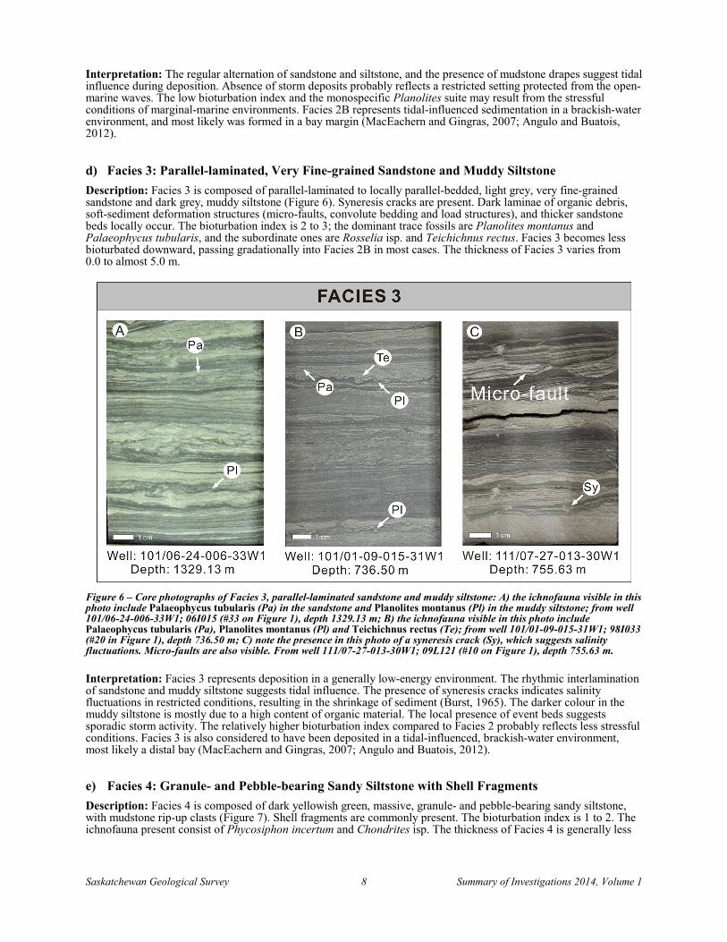
c) Facies 2B: Thinly Parallel-laminated, Very Fine-grained Sandstone and Siltstone Description: Facies 2B is composed of medium to dark grey, thinly parallel-laminated, very fine-grained sandstone and siltstone (Figure 5). Wavy lamination and mudstone drapes are present in some locations. Pyrite is also locally present. The bioturbation index is 0 to 1, and Planolites montanus is the only trace fossil identified. The thickness of Facies 2B is up to 2.4 m, and it tends to become sandier downward, passing into Facies 2A gradationally, or unconformably overlies the truncated Torquay Formation. Figure 5 – Core photographs of Facies 2B, thinly parallel-laminated sandstone and siltstone: A) note the general absence of bioturbation in this sample; from well 101/08-26-008-30W1; 06I122 (#8 on Figure 1), depth 1019.55 m; B) the local red colour in the sediments in this sample results from oxidation. The only trace fossil identified in this facies is Planolites montanus (Pl; circled); from well 101/03-10-011-33W1; 10H250 (#34 on Figure 1), depth 1094.66 m.
Saskatchewan Geological Survey 8 Summary of Investigations 2014, Volume 1
Interpretation: The regular alternation of sandstone and siltstone, and the presence of mudstone drapes suggest tidal influence during deposition. Absence of storm deposits probably reflects a restricted setting protected from the open-marine waves. The low bioturbation index and the monospecific Planolites suite may result from the stressful conditions of marginal-marine environments. Facies 2B represents tidal-influenced sedimentation in a brackish-water environment, and most likely was formed in a bay margin (MacEachern and Gingras, 2007; Angulo and Buatois, 2012).
d) Facies 3: Parallel-laminated, Very Fine-grained Sandstone and Muddy Siltstone Description: Facies 3 is composed of parallel-laminated to locally parallel-bedded, light grey, very fine-grained sandstone and dark grey, muddy siltstone (Figure 6). Syneresis cracks are present. Dark laminae of organic debris, soft-sediment deformation structures (micro-faults, convolute bedding and load structures), and thicker sandstone beds locally occur. The bioturbation index is 2 to 3; the dominant trace fossils are Planolites montanus and Palaeophycus tubularis, and the subordinate ones are Rosselia isp. and Teichichnus rectus. Facies 3 becomes less bioturbated downward, passing gradationally into Facies 2B in most cases. The thickness of Facies 3 varies from 0.0 to almost 5.0 m.
Figure 6 – Core photographs of Facies 3, parallel-laminated sandstone and muddy siltstone: A) the ichnofauna visible in this photo include Palaeophycus tubularis (Pa) in the sandstone and Planolites montanus (Pl) in the muddy siltstone; from well 101/06-24-006-33W1; 06I015 (#33 on Figure 1), depth 1329.13 m; B) the ichnofauna visible in this photo include Palaeophycus tubularis (Pa), Planolites montanus (Pl) and Teichichnus rectus (Te); from well 101/01-09-015-31W1; 98I033 (#20 in Figure 1), depth 736.50 m; C) note the presence in this photo of a syneresis crack (Sy), which suggests salinity fluctuations. Micro-faults are also visible. From well 111/07-27-013-30W1; 09L121 (#10 on Figure 1), depth 755.63 m.
Interpretation: Facies 3 represents deposition in a generally low-energy environment. The rhythmic interlamination of sandstone and muddy siltstone suggests tidal influence. The presence of syneresis cracks indicates salinity fluctuations in restricted conditions, resulting in the shrinkage of sediment (Burst, 1965). The darker colour in the muddy siltstone is mostly due to a high content of organic material. The local presence of event beds suggests sporadic storm activity. The relatively higher bioturbation index compared to Facies 2 probably reflects less stressful conditions. Facies 3 is also considered to have been deposited in a tidal-influenced, brackish-water environment, most likely a distal bay (MacEachern and Gingras, 2007; Angulo and Buatois, 2012).
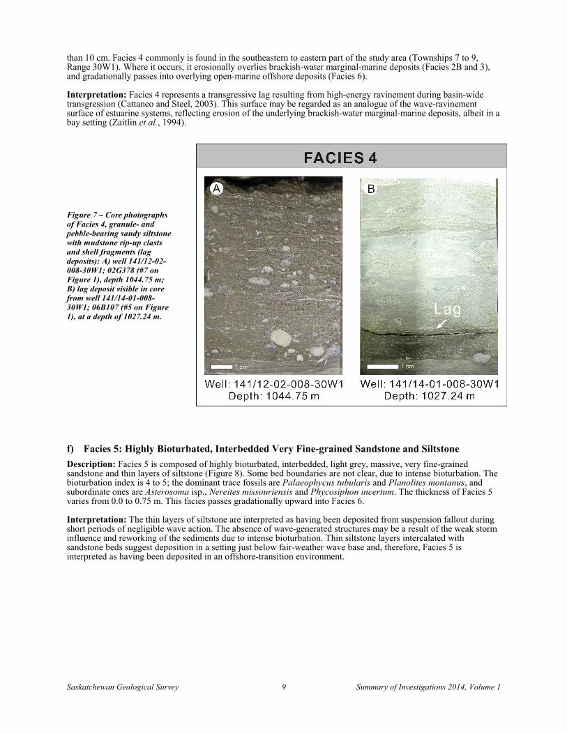
e) Facies 4: Granule- and Pebble-bearing Sandy Siltstone with Shell Fragments Description: Facies 4 is composed of dark yellowish green, massive, granule- and pebble-bearing sandy siltstone, with mudstone rip-up clasts (Figure 7). Shell fragments are commonly present. The bioturbation index is 1 to 2. The ichnofauna present consist of Phycosiphon incertum and Chondrites isp. The thickness of Facies 4 is generally less
Saskatchewan Geological Survey 9 Summary of Investigations 2014, Volume 1
than 10 cm. Facies 4 commonly is found in the southeastern to eastern part of the study area (Townships 7 to 9, Range 30W1). Where it occurs, it erosionally overlies brackish-water marginal-marine deposits (Facies 2B and 3), and gradationally passes into overlying open-marine offshore deposits (Facies 6).
Interpretation: Facies 4 represents a transgressive lag resulting from high-energy ravinement during basin-wide transgression (Cattaneo and Steel, 2003). This surface may be regarded as an analogue of the wave-ravinement surface of estuarine systems, reflecting erosion of the underlying brackish-water marginal-marine deposits, albeit in a bay setting (Zaitlin et al., 1994).
Figure 7 – Core photographs of Facies 4, granule- and pebble-bearing sandy siltstone with mudstone rip-up clasts and shell fragments (lag deposits): A) well 141/12-02-008-30W1; 02G378 (#7 on Figure 1), depth 1044.75 m; B) lag deposit visible in core from well 141/14-01-008-30W1; 06B107 (#5 on Figure 1), at a depth of 1027.24 m.
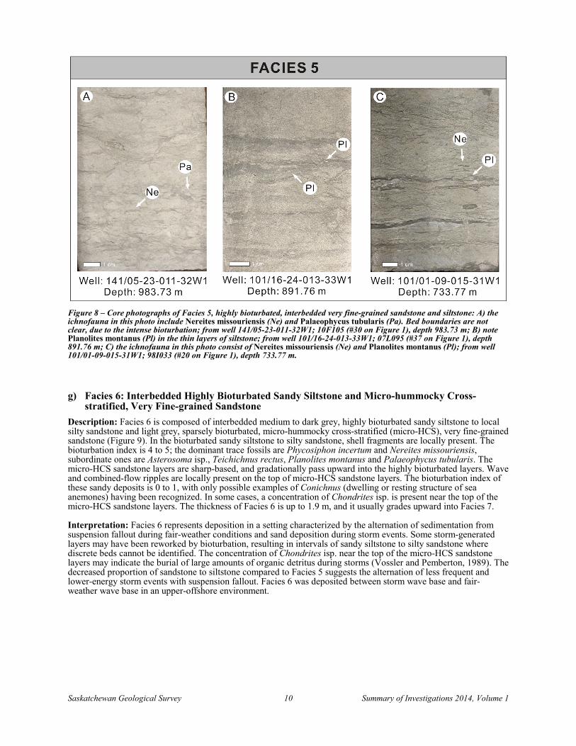
f) Facies 5: Highly Bioturbated, Interbedded Very Fine-grained Sandstone and Siltstone Description: Facies 5 is composed of highly bioturbated, interbedded, light grey, massive, very fine-grained sandstone and thin layers of siltstone (Figure 8). Some bed boundaries are not clear, due to intense bioturbation. The bioturbation index is 4 to 5; the dominant trace fossils are Palaeophycus tubularis and Planolites montanus, and subordinate ones are Asterosoma isp., Nereites missouriensis and Phycosiphon incertum. The thickness of Facies 5 varies from 0.0 to 0.75 m. This facies passes gradationally upward into Facies 6.
Interpretation: The thin layers of siltstone are interpreted as having been deposited from suspension fallout during short periods of negligible wave action. The absence of wave-generated structures may be a result of the weak storm influence and reworking of the sediments due to intense bioturbation. Thin siltstone layers intercalated with sandstone beds suggest deposition in a setting just below fair-weather wave base and, therefore, Facies 5 is interpreted as having been deposited in an offshore-transition environment.
Saskatchewan Geological Survey 10 Summary of Investigations 2014, Volume 1
Figure 8 – Core photographs of Facies 5, highly bioturbated, interbedded very fine-grained sandstone and siltstone: A) the ichnofauna in this photo include Nereites missouriensis (Ne) and Palaeophycus tubularis (Pa). Bed boundaries are not clear, due to the intense bioturbation; from well 141/05-23-011-32W1; 10F105 (#30 on Figure 1), depth 983.73 m; B) note Planolites montanus (Pl) in the thin layers of siltstone; from well 101/16-24-013-33W1; 07L095 (#37 on Figure 1), depth 891.76 m; C) the ichnofauna in this photo consist of Nereites missouriensis (Ne) and Planolites montanus (Pl); from well 101/01-09-015-31W1; 98I033 (#20 on Figure 1), depth 733.77 m.
g) Facies 6: Interbedded Highly Bioturbated Sandy Siltstone and Micro-hummocky Cross-stratified, Very Fine-grained Sandstone
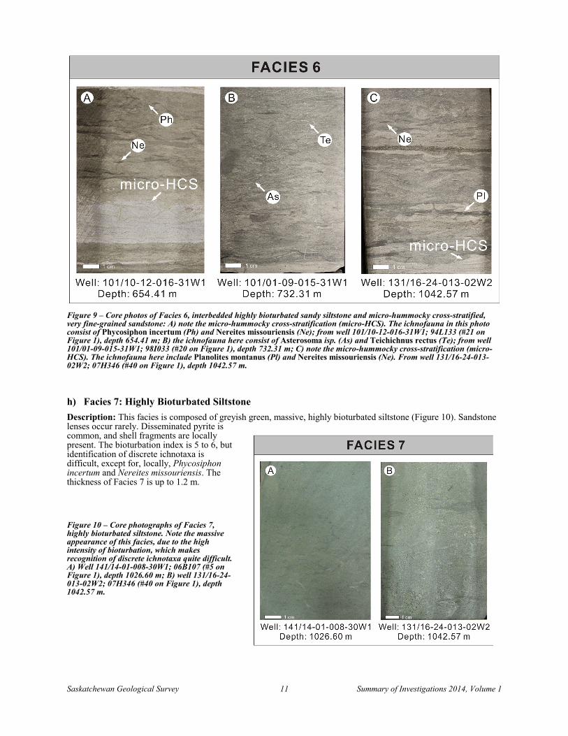
Description: Facies 6 is composed of interbedded medium to dark grey, highly bioturbated sandy siltstone to local silty sandstone and light grey, sparsely bioturbated, micro-hummocky cross-stratified (micro-HCS), very fine-grained sandstone (Figure 9). In the bioturbated sandy siltstone to silty sandstone, shell fragments are locally present. The bioturbation index is 4 to 5; the dominant trace fossils are Phycosiphon incertum and Nereites missouriensis, subordinate ones are Asterosoma isp., Teichichnus rectus, Planolites montanus and Palaeophycus tubularis. The micro-HCS sandstone layers are sharp-based, and gradationally pass upward into the highly bioturbated layers. Wave and combined-flow ripples are locally present on the top of micro-HCS sandstone layers. The bioturbation index of these sandy deposits is 0 to 1, with only possible examples of Conichnus (dwelling or resting structure of sea anemones) having been recognized. In some cases, a concentration of Chondrites isp. is present near the top of the micro-HCS sandstone layers. The thickness of Facies 6 is up to 1.9 m, and it usually grades upward into Facies 7.
Interpretation: Facies 6 represents deposition in a setting characterized by the alternation of sedimentation from suspension fallout during fair-weather conditions and sand deposition during storm events. Some storm-generated layers may have been reworked by bioturbation, resulting in intervals of sandy siltstone to silty sandstone where discrete beds cannot be identified. The concentration of Chondrites isp. near the top of the micro-HCS sandstone layers may indicate the burial of large amounts of organic detritus during storms (Vossler and Pemberton, 1989). The decreased proportion of sandstone to siltstone compared to Facies 5 suggests the alternation of less frequent and lower-energy storm events with suspension fallout. Facies 6 was deposited between storm wave base and fair-weather wave base in an upper-offshore environment.
Saskatchewan Geological Survey 11 Summary of Investigations 2014, Volume 1
Figure 9 – Core photos of Facies 6, interbedded highly bioturbated sandy siltstone and micro-hummocky cross-stratified, very fine-grained sandstone: A) note the micro-hummocky cross-stratification (micro-HCS). The ichnofauna in this photo consist of Phycosiphon incertum (Ph) and Nereites missouriensis (Ne); from well 101/10-12-016-31W1; 94L133 (#21 on Figure 1), depth 654.41 m; B) the ichnofauna here consist of Asterosoma isp. (As) and Teichichnus rectus (Te); from well 101/01-09-015-31W1; 98I033 (#20 on Figure 1), depth 732.31 m; C) note the micro-hummocky cross-stratification (micro-HCS). The ichnofauna here include Planolites montanus (Pl) and Nereites missouriensis (Ne). From well 131/16-24-013-02W2; 07H346 (#40 on Figure 1), depth 1042.57 m.
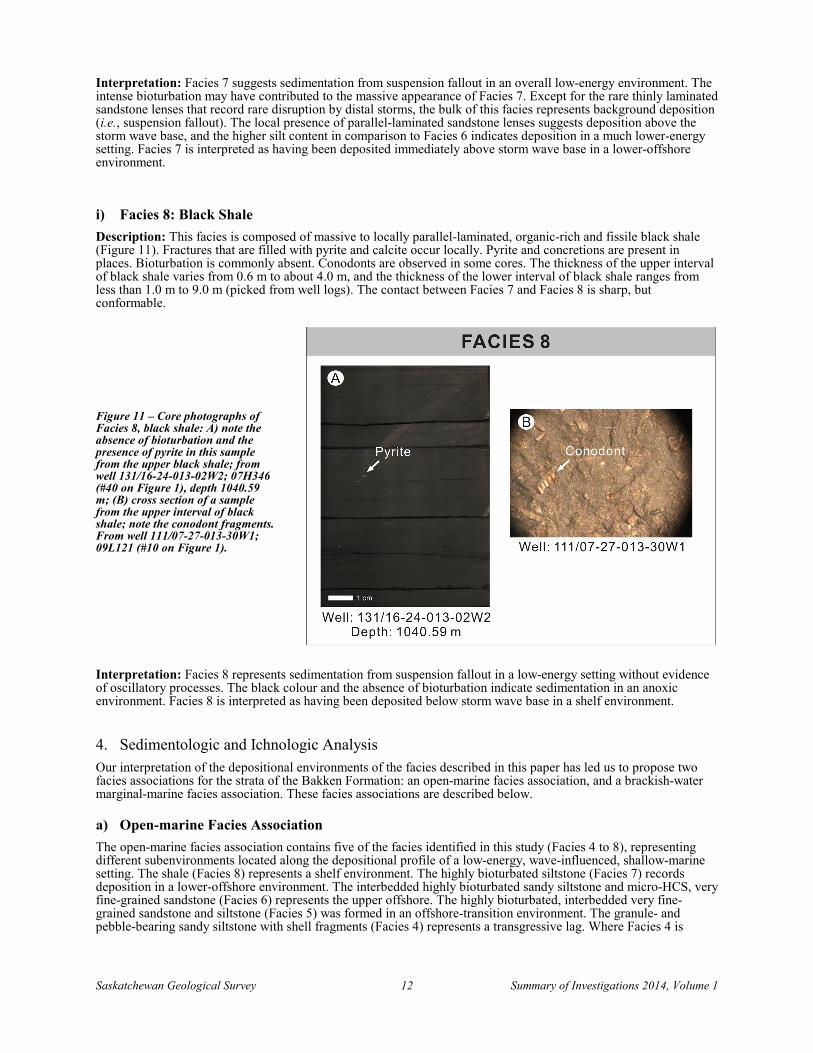
h) Facies 7: Highly Bioturbated Siltstone Description: This facies is composed of greyish green, massive, highly bioturbated siltstone (Figure 10). Sandstone lenses occur rarely. Disseminated pyrite is common, and shell fragments are locally present. The bioturbation index is 5 to 6, but identification of discrete ichnotaxa is difficult, except for, locally, Phycosiphon incertum and Nereites missouriensis. The thickness of Facies 7 is up to 1.2 m.
Figure 10 – Core photographs of Facies 7, highly bioturbated siltstone. Note the massive appearance of this facies, due to the high intensity of bioturbation, which makes recognition of discrete ichnotaxa quite difficult. A) Well 141/14-01-008-30W1; 06B107 (#5 on Figure 1), depth 1026.60 m; B) well 131/16-24-013-02W2; 07H346 (#40 on Figure 1), depth 1042.57 m.
Saskatchewan Geological Survey 12 Summary of Investigations 2014, Volume 1
Interpretation: Facies 7 suggests sedimentation from suspension fallout in an overall low-energy environment. The intense bioturbation may have contributed to the massive appearance of Facies 7. Except for the rare thinly laminated sandstone lenses that record rare disruption by distal storms, the bulk of this facies represents background deposition (i.e., suspension fallout). The local presence of parallel-laminated sandstone lenses suggests deposition above the storm wave base, and the higher silt content in comparison to Facies 6 indicates deposition in a much lower-energy setting. Facies 7 is interpreted as having been deposited immediately above storm wave base in a lower-offshore environment.
i) Facies 8: Black Shale Description: This facies is composed of massive to locally parallel-laminated, organic-rich and fissile black shale (Figure 11). Fractures that are filled with pyrite and calcite occur locally. Pyrite and concretions are present in places. Bioturbation is commonly absent. Conodonts are observed in some cores. The thickness of the upper interval of black shale varies from 0.6 m to about 4.0 m, and the thickness of the lower interval of black shale ranges from less than 1.0 m to 9.0 m (picked from well logs). The contact between Facies 7 and Facies 8 is sharp, but conformable.
Figure 11 – Core photographs of Facies 8, black shale: A) note the absence of bioturbation and the presence of pyrite in this sample from the upper black shale; from well 131/16-24-013-02W2; 07H346 (#40 on Figure 1), depth 1040.59 m; (B) cross section of a sample from the upper interval of black shale; note the conodont fragments. From well 111/07-27-013-30W1; 09L121 (#10 on Figure 1).
Interpretation: Facies 8 represents sedimentation from suspension fallout in a low-energy setting without evidence of oscillatory processes. The black colour and the absence of bioturbation indicate sedimentation in an anoxic environment. Facies 8 is interpreted as having been deposited below storm wave base in a shelf environment.
4. Sedimentologic and Ichnologic Analysis Our interpretation of the depositional environments of the facies described in this paper has led us to propose two facies associations for the strata of the Bakken Formation: an open-marine facies association, and a brackish-water marginal-marine facies association. These facies associations are described below.
a) Open-marine Facies Association The open-marine facies association contains five of the facies identified in this study (Facies 4 to 8), representing different subenvironments located along the depositional profile of a low-energy, wave-influenced, shallow-marine setting. The shale (Facies 8) represents a shelf environment. The highly bioturbated siltstone (Facies 7) records deposition in a lower-offshore environment. The interbedded highly bioturbated sandy siltstone and micro-HCS, very fine-grained sandstone (Facies 6) represents the upper offshore. The highly bioturbated, interbedded very fine-grained sandstone and siltstone (Facies 5) was formed in an offshore-transition environment. The granule- and pebble-bearing sandy siltstone with shell fragments (Facies 4) represents a transgressive lag. Where Facies 4 is
Saskatchewan Geological Survey 13 Summary of Investigations 2014, Volume 1
present, the contact with the sediments of the underlying brackish-water marginal-marine environment is erosive; otherwise, the contact between Facies 5 or Facies 6 with the underlying brackish-water interval can be sharp or gradational.
The open-marine facies are highly bioturbated, except for Facies 8 and Facies 4. Facies 7 is almost completely bioturbated, and the identification of individual fossil traces is difficult, but Phycosiphon incertum and Nereites missouriensis can be recognized locally. The dominance of feeding traces and grazing trails indicates the distal Cruziana ichnofacies. Facies 6 mainly has a bioturbation index of 4 to 5. The fair-weather trace fossil suite displays moderate ichnodiversity and high abundance, including feeding traces, such as Phycosiphon incertum, Asterosoma isp., Teichichnus rectus and Planolites montanus; dwelling structures, namely Palaeophycus tubularis; and also grazing trails, such as Nereites missouriensis. The assemblage resembles the Cruziana ichnofacies, but it is less diverse and is dominated by elements of the distal Cruziana ichnofacies (Buatois et al., 2013). Facies 5 also has a bioturbation index of 4 to 5, with trace fossils including feeding traces, such as Phycosiphon incertum, Asterosoma isp. and Planolites montanus; dwelling structures, such as Palaeophycus tubularis; and grazing trails, such as Nereites missouriensis. As in the case of Facies 6, the fossil assemblage is similar to the Cruziana ichnofacies, but displays less diversity and a dominance of ichnotaxa common in the distal expression of the Cruziana ichnofacies. The lack of shallow-tier ichnofossils may result from their lower potential for preservation in a highly bioturbated sediment, since the deep-tier structures commonly obliterate those emplaced in shallower tiers due to upward migration as a response to vertical accretion of the sea floor. Generally, the open-marine environment is characterized by the distal Cruziana ichnofacies.
b) Brackish-water Marginal-marine Facies Association The brackish-water marginal-marine facies association contains four of the facies identified in this study (Facies 1, 2A, 2B and 3), representing different subenvironments of a restricted embayment with limited or intermittent connection to the open-marine environment. The parallel-laminated, very fine-grained sandstone and muddy siltstone (Facies 3) represent a distal bay environment; the thinly parallel-laminated, very fine-grained sandstone and siltstone (subfacies 2B), and wavy- to flaser-bedded, very fine-grained sandstone (subfacies 2A), record a bay margin environment; and the planar cross-stratified, fine-grained sandstone (Facies 1) suggests a barrier bar. Heterolithic lamination/bedding, mudstone drapes, syneresis cracks, and low bioturbation in these facies all suggest tidal-influenced and stressful marginal-marine environments instead of open-marine environments.
Compared to the open-marine environment, strata deposited in the brackish-water marginal-marine environment generally display a lower bioturbation index, smaller size of trace fossils and also a lower ichnodiversity and abundance of trace fossils. The most common trace fossil is Planolites montanus. Other ichnotaxa such as Palaeophycus tubularis, Rosselia isp. and Teichichnus rectus only occur locally in Facies 3. The marginal-marine environment is characterized by the depauperate Cruziana ichnofacies.
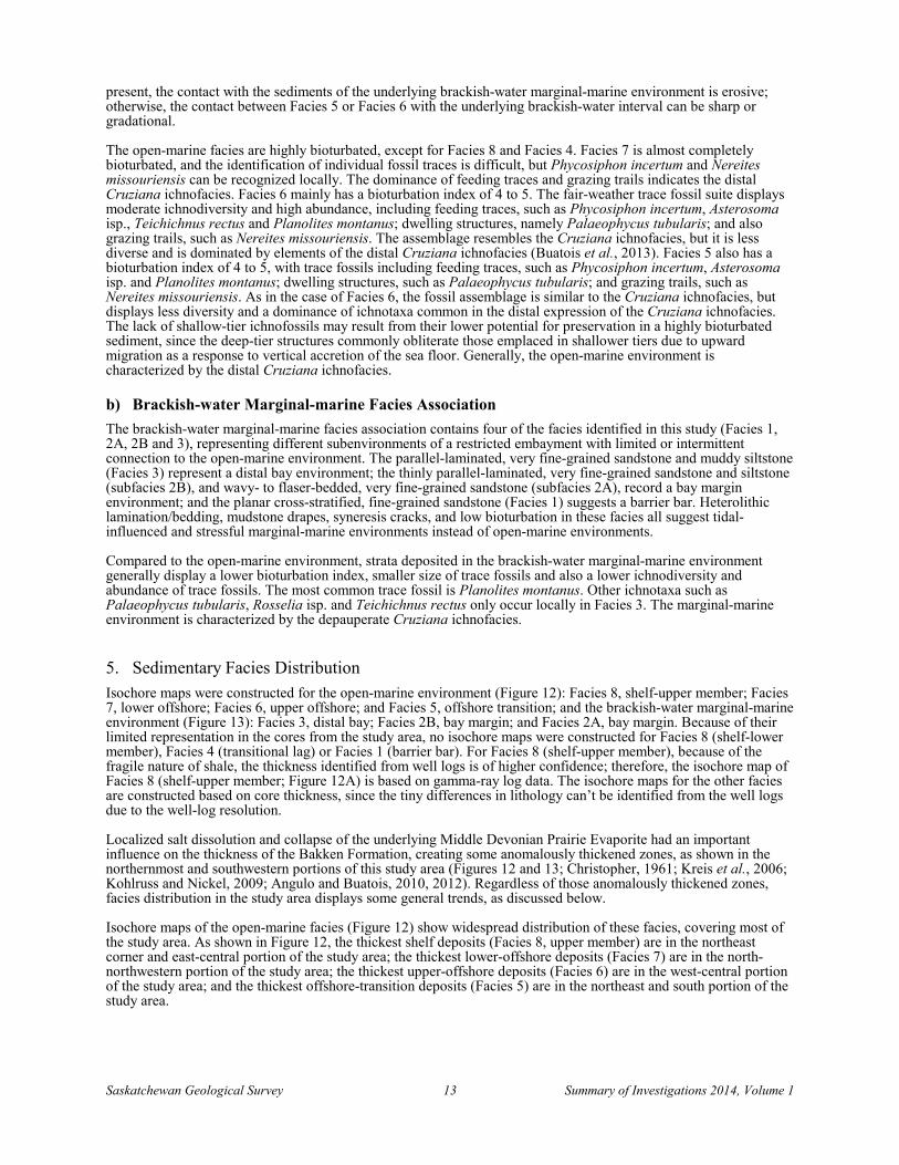
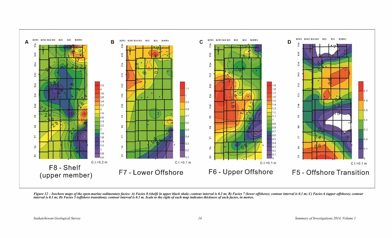
5. Sedimentary Facies Distribution Isochore maps were constructed for the open-marine environment (Figure 12): Facies 8, shelf-upper member; Facies 7, lower offshore; Facies 6, upper offshore; and Facies 5, offshore transition; and the brackish-water marginal-marine environment (Figure 13): Facies 3, distal bay; Facies 2B, bay margin; and Facies 2A, bay margin. Because of their limited representation in the cores from the study area, no isochore maps were constructed for Facies 8 (shelf-lower member), Facies 4 (transitional lag) or Facies 1 (barrier bar). For Facies 8 (shelf-upper member), because of the fragile nature of shale, the thickness identified from well logs is of higher confidence; therefore, the isochore map of Facies 8 (shelf-upper member; Figure 12A) is based on gamma-ray log data. The isochore maps for the other facies are constructed based on core thickness, since the tiny differences in lithology can’t be identified from the well logs due to the well-log resolution.
Localized salt dissolution and collapse of the underlying Middle Devonian Prairie Evaporite had an important influence on the thickness of the Bakken Formation, creating some anomalously thickened zones, as shown in the northernmost and southwestern portions of this study area (Figures 12 and 13; Christopher, 1961; Kreis et al., 2006; Kohlruss and Nickel, 2009; Angulo and Buatois, 2010, 2012). Regardless of those anomalously thickened zones, facies distribution in the study area displays some general trends, as discussed below.
Isochore maps of the open-marine facies (Figure 12) show widespread distribution of these facies, covering most of the study area. As shown in Figure 12, the thickest shelf deposits (Facies 8, upper member) are in the northeast corner and east-central portion of the study area; the thickest lower-offshore deposits (Facies 7) are in the north-northwestern portion of the study area; the thickest upper-offshore deposits (Facies 6) are in the west-central portion of the study area; and the thickest offshore-transition deposits (Facies 5) are in the northeast and south portion of the study area.
Saskatchewan Geological Survey 14 Summary of Investigations 2014, Volume 1
Figure 12 – Isochore maps of the open-marine sedimentary facies: A) Facies 8 (shelf) in upper black shale; contour interval is 0.2 m; B) Facies 7 (lower offshore); contour interval is 0.1 m; C) Facies 6 (upper offshore); contour interval is 0.1 m; D) Facies 5 (offshore transition); contour interval is 0.1 m. Scale to the right of each map indicates thickness of each facies, in metres.
Saskatchewan Geological Survey 15 Summary of Investigations 2014, Volume 1
Figure 13 – Isochore maps of the brackish-water marginal-marine sedimentary facies: A) Facies 3 (distal bay); contour interval is 0.2 m; B) Facies 2B (bay margin); contour interval is 0.1 m; C) Facies 2A (bay margin); contour interval is 0.5 m. Scale to the right of each map indicates thickness, in metres.
Saskatchewan Geological Survey 16 Summary of Investigations 2014, Volume 1
Isochore maps of the marginal-marine facies (Figure 13) also show widespread distribution of this facies, covering a significant part of the study area. The bay margin deposits (Facies 2A and Facies 2B) tend to be thicker toward the west, whereas the distal bay deposits (Facies 3) tend to be thicker toward the east, which is probably because of the irregular paleotopography resulting from a sea-level fall.
6. Conclusion and Future Work Through our sedimentologic and ichnologic analysis of 40 cores, eight facies, one of which (Facies 2) is subdivided into two subfacies, are identified in our study area: Facies 1 (planar cross-stratified, fine-grained sandstone); Facies 2A (wavy- to flaser-bedded, very fine-grained sandstone); Facies 2B (thinly parallel-laminated, very fine-grained sandstone and siltstone); Facies 3 (parallel-laminated, very fine-grained sandstone and muddy siltstone); Facies 4 (granule- and pebble-bearing sandy siltstone with shell fragments); Facies 5 (highly bioturbated, interbedded very fine-grained sandstone and siltstone); Facies 6 (interbedded highly bioturbated sandy siltstone and micro-hummocky cross-stratified, very fine-grained sandstone); Facies 7 (highly bioturbated siltstone); and Facies 8 (black shale). Facies 1 to 3 are grouped into a brackish-water marginal-marine facies association, which correlates to Unit B of the Middle Bakken Member (Table 3); Facies 4 to 8 (upper member) are grouped into an open-marine facies association, which correlates to Unit C of the Middle Bakken Member (Table 3).
Table 3 – Stratigraphic subdivision of the Bakken Formation (Angulo and Buatois, 2012), and comparison between facies and depositional environments identified in the study area of this project (Townships 5 through 16, Ranges 30W1 to 2W2) and those identified in the study area of Angulo and Buatois (Townships 1 through 11, Ranges 3 to 25W2). Detailed descriptions of the facies in this study are summarized in Table 2; Table 2 in Angulo and Buatois (2010) provides detailed descriptions of the facies defined in their study.
Bakken Fm Stratigraphic Subdivision
This Paper Angulo and Buatois (2012)
Facies Environment Facies Environment
Upper Member 8 Shelf 1 Shelf
Mid
dle
Mem
ber
Unit C
7 Lower Offshore 6 Upper Offshore 3B Upper Offshore 5 Offshore Transition 4 Transgressive Lag 11 Transgressive Lag
Unit B
3 Distal Bay 10 Distal Bay
2B
Bay Margin
9 Bay Margin 8C Tidal Flat
2A 8B Distal Bay 8A Bay Margin 7 Wave-dominated Tidal Flat
1 Barrier Bar 6 Barrier Bar
Unit A
5 Lower Shoreface 4 Offshore Transition 3 Upper Offshore 2 Lower Offshore
Lower Member 8 Shelf 1 Shelf
In Unit C, in addition to the upper-offshore deposits identified by Angulo and Buatois (2012) in their study area to the west, we identify lower-offshore and offshore-transition deposits. Unit B of the Middle Member is interpreted to be deposited in a brackish-water embayment in our study area, but fewer different facies have been identified in this unit compared to those described in Angulo and Buatois (2012). Unit A, which is present in the Middle Member to the west (Angulo and Buatois, 2012), is not preserved in any of the cores logged in our study area, but small areas with Unit A are identified in Kohlruss and Nickel (2009).
Future work will include a sequence-stratigraphic analysis of the Bakken Formation in this study area, in order to provide a framework for high-resolution correlation.
Saskatchewan Geological Survey 17 Summary of Investigations 2014, Volume 1
7. Acknowledgments Financial support for this project is provided by the Petroleum Technology Research Centre, and additional funding is provided by the AAPG (grant 2013). We would like to thank Solange Angulo, Erik Nickel, Fran Haidl, Dan Kohlruss and Heather Brown for reviewing this paper and providing insightful comments. We are very grateful to staff of the Subsurface Geological Laboratory in Regina, especially Chao Yang, Melinda Yurkowski, and the technical team. We also wish to give special thanks to John Lake for always being kind and helpful during core logging.
8. References Angulo, S. and Buatois, L. (2009): Sedimentological and ichnological aspects of a sandy low-energy coast: Upper
Devonian–Lower Mississippian Bakken Formation, Williston Basin, southeastern Saskatchewan; in Summary of Investigations 2009, Volume 1, Saskatchewan Geological Survey, Sask. Ministry of Energy and Resources, Misc. Rep. 2009-4.1, Paper A-5, 17p. http://economy.gov.sk.ca/SOI2009V1_A5
Angulo, S. and Buatois, L. (2010): Sedimentary facies distribution of the Upper Devonian–Lower Mississippian Bakken Formation, Williston Basin, southeastern Saskatchewan: implications for understanding reservoir geometry, paleogeography, and depositional history; in Summary of Investigations 2010, Volume 1, Saskatchewan Geological Survey, Sask. Ministry of Energy and Resources, Paper A-4, 18p. http://economy.gov.sk.ca/SOI2010V1_A4.
Angulo, S. and Buatois, L. (2012): Integrating depositional models, ichnology, and sequence stratigraphy in reservoir characterization: the middle member of the Devonian–Carboniferous Bakken Formation of subsurface southeastern Saskatchewan revisited; Amer. Assoc. Petrol. Geol. Bull., v96, p1017-1043.
Angulo, S., Buatois, L., and Halabura, S. (2008): Paleoenvironmental and sequence-stratigraphic reinterpretation of the Upper Devonian–Lower Mississippian Bakken Formation of subsurface Saskatchewan integrating sedimentological and ichnological data; in Summary of Investigations 2008, Volume 1, Saskatchewan Geological Survey, Sask. Ministry of Energy and Resources, Misc. Rep. 2008-4.1, Paper A-3, 24p. http://economy.gov.sk.ca/adx/aspx/adxGetMedia.aspx?DocID=11855,11458,11455,11228,3385,5460,2936,Documents&MediaID=36759&Filename=anguloopt.pdf
Buatois, L. and Mángano, G. (2011): Ichnology: Organism-Substrate Interactions in Space and Time; Cambridge University Press, Cambridge, U.K., 358p.
Buatois, L., Angulo, S., and Mángano, G. (2013): Onshore expansion of benthic communities after the Late Devonian mass extinction; Lethaia, v46, p251-261.
Burst, J.F. (1965): Subaqueously formed shrinkage cracks in clay; J. Sed. Resear., v35, p348-353.
Cattaneo, A. and Steel, R.J. (2003): Transgressive deposits: a review of their variability; Earth-Sci. Rev., v62, no3, p187-228.
Christopher, J.E. (1961): Transitional Devonian-Mississippian Formations of Southern Saskatchewan; Sask. Dept. Miner. Resour., Rep. 66, 103p.
Halbertsma, H.L. (1994): Devonian Wabamun Group of the Western Canada Sedimentary Basin; Chapter 13 in Geological Atlas of the Western Canada Sedimentary Basin, Mossop, G.D. and Shetsen, I. (comps.), Canadian Society of Petroleum Geologists and Alberta Research Council, URL http://ags.aer.ca/publications/chapter-13-devonian-wabamun-group.htm [accessed November 28, 2014].
Hayes, M.D. (1985): Conodonts of the Bakken Formation (Devonian and Mississippian), Williston Basin, North Dakota; Mountain Geologist, Rky. Mtn. Assoc. Geol., v22, p64-77.
Johnston, D.I. and Meijer Drees, N.C. (1993): Upper Devonian conodonts in west central Alberta and adjacent British Columbia; Bull. Can. Petrol. Geol., v41, p139-149.
Karma, R. (1991): Geology and geochemistry of the Bakken Formation (Devonian–Mississippian) in Saskatchewan; M.Sc. thesis, University of Regina, Regina, 308p.
Saskatchewan Geological Survey 18 Summary of Investigations 2014, Volume 1
Kohlruss, D. and Nickel, E. (2009): Facies analysis of the Upper Devonian–Lower Mississippian Bakken Formation, southeastern Saskatchewan; in Summary of Investigations 2009, Volume 1, Saskatchewan Geological Survey, Sask. Ministry of Energy and Resources, Misc. Rep. 2009-4.1, Paper A-6, 11p. http://economy.gov.sk.ca/SOI2009V1_A6
Kreis, L.K., Costa, A., and Osadetz, K.G. (2006): Hydrocarbon potential of Bakken and Torquay formations, southeastern Saskatchewan; in Gilboy, C.F. and Whittaker, S.G. (eds.), Saskatchewan and Northern Plains Oil & Gas Symposium 2006, Sask. Geol. Soc., Spec. Publ. No. 19, p118-137.
LeFever, J.A., Martiniuk, C.D., Dancsok, E.F.R., and Mahnic, P.A. (1991): Petroleum potential of the Middle Member, Bakken Formation, Williston Basin; in Christopher, J.E. and Haidl, F. (eds.), Sixth International Williston Basin Symposium, Sask. Geol. Soc., Spec. Publ. No. 11, p74-94.
MacEachern, J.A. and Gingras, M.K. (2007): Recognition of brackish-water trace-fossil suites in the Cretaceous Western Interior Seaway of Alberta, Canada; SEPM Spec. Publ., v88, p149.
MacEachern, J.A., Zaitlin, B.A., and Pemberton, S.G. (1999): A sharp-based sandstone of the Viking Formation, Joffre Field, Alberta, Canada: criteria for recognition of transgressively incised shoreface complexes; J. Sed. Resear., Section B69, p876-892.
Smith, M.G. and Bustin, R.M. (1996): Lithofacies and paleoenvironments of the Late Devonian and Early Mississippian Bakken Formation, Williston Basin; Can. Soc. Petrol. Geol. Bull., v44, p495-507.
Smith, M.G. and Bustin, R.M. (2000): Late Devonian and Early Mississippian Bakken and Exshaw black shale source rocks, Western Canada Sedimentary Basin: a sequence stratigraphic interpretation; Amer. Assoc. Petrol. Geol. Bull., v84, p940-960.
Smith, M.G., Bustin, R.M., and Caplan, M.L. (1995): Sequence stratigraphy of the Bakken and Exshaw formations: a continuum of black shale formations in the Western Canada Sedimentary Basin; in Hunter, L.D.V. and Schalla, R.A. (eds.), 7th International Williston Basin Symposium, 1995 Guidebook, Montana Geological Society, p399-409.
Taylor, A. and Goldring, R. (1993): Description and analysis of bioturbation and ichnofabric; Geol. Soc. Lon. J., v150, p141-148.
Von Osinski, W.P.C. (1970): Geology and production history of the Bakken Formation in the Rocanville area, southeastern Saskatchewan; Dept. Min. Resour., Geological Sciences Branch, Misc. Rep. 11, 28p.
Vossler, S.M. and Pemberton, G.S. (1989): Ichnology and paleoecology of offshore siliciclastic deposits in the Cardium Formation (Turonian, Alberta, Canada); Palaeogeography, Palaeoclimatology, Palaeoecology, v74, p217-239.
Zaitlin, B.A., Dalrymple, R.W., and Boyd, R. (1994): The stratigraphic organization of incised-valley systems associated with relative sea-level change; in Dalrymple, R.W., Boyd, R., and Zaitlin, B.A. (eds.), Incised Valley Systems, SEPM, Spec. Publ. No. 51, p45-60.


