
The International Journal of Nautical Archaeology
(2007)
36
.2: 365–381doi: 10.1111/j.1095-9270.2006.00133.x
© 2007 The Authors. Journal Compilation © 2007 The Nautical Archaeology Society. Published by Blackwell Publishing Ltd. 9600 Garsington Road, Oxford OX4 2DQ, UK and 350 Main Street, Malden, MA 02148, USA.
Blackwell Publishing LtdSEARCHING FOR ANCIENT SHIPWRECKS IN THE AEGEAN SEAD. SAKELLARIOU
ET AL.
Searching for Ancient Shipwrecks in the Aegean Sea: the Discovery of Chios and Kythnos Hellenistic Wrecks with the Use of Marine Geological-Geophysical Methods
Dimitris Sakellariou, Panos Georgiou, Aggellos Mallios, Vasilios Kapsimalis
Institute of Oceanography, Hellenic Centre for Marine Research, Anavyssos, Greece
Dimitris Kourkoumelis, Paraskevi Micha, Theotokis Theodoulou, and Katerina Dellaporta
Ephorate for Underwater Antiquities, Ministry of Culture, Athens, Greece
This paper presents the results of two deep-water archaeological surveys recently conducted in the Aegean Sea, and the advan-tages of using conventional marine geological techniques in deep-water archaeology. Two Hellenistic wrecks were discovered:one in the Chios-Oinousses strait at 70 m, was a concentration of over 400 amphoras in a 1.5-m-high, high-backscattering,morphological high; the second, west of Kythnos island, at 495 m, consisted of a few amphoras scattered in a 20
×
20-m-widearea. Side-scan sonar was integrated with high-resolution sub-bottom profiling, and the integration of the two data-sets provedto contribute significantly to realistic interpretation of the sonar targets.
© 2007 The Authors
Key words:
side-scan sonar, sub-bottom profiling, geological interpretation, ancient wrecks, amphora concentration,
sedimentation rate.
E
vidence of sailing activity and maritimetransportation in the Aegean Sea datesback to at least the Mesolithic or Neolithic
Period (10,000–7000 BC), as indicated by thediscovery of obsidian from Milos island, CycladesArchipelago, in Frachthi cave, Argolis, NEPeloponese, and by the first traces of islandcolonization (McGrail, 2001). Maritime transporta-tion subsequently grew tremendously and becamevery important for trade activity and productexchange between the main cultural centres inancient (Classical, Hellenistic, Roman, Byzantine)times (Agouridis, 1997). In the course of time avast number of vessels have plied the AegeanSea conveying goods, people and ideas, and itseems reasonable to assume that the frequency ofmaritime accidents increased in parallel with thegrowth of maritime activity. The large number ofwrecks of various periods discovered to date allover the Aegean Sea verifies this hypothesis.
Many shipwrecks were discovered by divers atrelatively shallow depths during the 19th and20th century. Growing trawling activity at depthsup to 600–700 m has very frequently resulted
in the recovery of ancient artefacts during thelast decades. It is often the case that amphorasand pottery are being caught in the fishing netsof trawls all over the Aegean. Some of them havebeen delivered to the Ephorate of UnderwaterAntiquities at Athens, while others not. Apartfrom amphoras, statues or other objects of higharchaeological value have been retrieved fromthe sea-bed and delivered to the Ephorate. Themajority of the known bronze statues havebeen discovered by fishermen while trawling orsponge-diving.
This fact led the Ephorate of UnderwaterAntiquities (EUA) of the Greek Ministry of Cultureand the Hellenic Centre for Marine Research(HCMR) to join their efforts towards mappingof the Aegean sea-floor, aiming at the discoveryof the remnants of our ancient nautical heritage.The collaboration started in 2000 and has resultedto date in the discovery of tens of Classical,Hellenistic, Roman, Byzantine and Post-Byzantineshipwrecks all over the Aegean Sea (Fig. 1). Herewithwe present the way that marine geophysical methodsand geological-oceanographic interpretation of the

NAUTICAL ARCHAEOLOGY,
36
.2
366 © 2007 The Authors. Journal Compilation © 2007 The Nautical Archaeology Society
geophysical recordings were used for deep-waterarchaeological research during joint HCMR-EUAcruises, and contributed to the discovery of twoHellenistic wrecks close to Chios and Kythnosislands, in the Aegean Sea (Fig. 1).
Research outline
In the first 3 to 4 years of the joint EUA-HCMRresearch cruises, the investigation of the sea-bedwas mainly based on side-scan sonar prospectingand the interpretation of the sonar images. Remotelyoperated vehicles (ROVs) and the two-personsubmersible
Thetis
, operating from the researchvessel
Aegaeo
, were used for visual inspection ofselected sonar targets. Priority was given to searching
at depths exceeding the depth range of scubadiving. Nevertheless, the majority of the 20 wrecksdiscovered were found accidentally or locatedfollowing information provided by fishermenand old sponge-divers, at depths shallower than100 m, close to rocky coasts. Only two out ofhundreds of visually-inspected sonar targets wereproved to correspond to ancient wrecks.
Remains of ancient shipwrecks on the sea-floorare usually restricted to the cargo of the wreckedvessels instead of the vessel itself. In cases ofmerchant ships, which are the majority of ancientwrecks found so far, the cargo was composedmainly of amphoras and pottery. In areas of lowsedimentation rate the amphoras lie scatteredon the sea-bed or form a longitudinal topographic
Figure 1. Morphological map of the Aegean region. White stars indicate areas surveyed during the last five years as part ofthe HCMR-EUA collaboration. White boxes mark the study areas, between Chios and Oinousses islands (Fig. 2a) and westof Kythnos island (Fig. 5a).

D. SAKELLARIOU
ET AL.
: SEARCHING FOR ANCIENT SHIPWRECKS IN THE AEGEAN SEA
© 2007 The Authors. Journal Compilation © 2007 The Nautical Archaeology Society 367
high, gently rising above the sea-floor. The lattercase reflects the shape and dimensions of thewrecked vessel (Hadjidaki, 1996; Ballard
et al
,2001). Structures like that are being recorded onthe side-scan sonographs as strongly-reflectingtargets, very similar to low-relief rocky outcrops.Thus, interpretation of the sonographs alone,without the assistance of data on the nature ofthe sea-floor’s substrate, led more often thannot to the misinterpretation of sonar targets. Asa result, numerous ROV and submersible divesended up with the ‘discovery’ of rocky outcropson the sea-bed.
In 2004, sub-bottom profiling emerged as abasic tool of the joint research effort of EUA andHCMR. Integration of the sub-bottom profilingdata resulted in a major qualitative and quantitativeimprovement of the effectiveness of the researchefforts. The combination of sub-bottom profilingand side-scan sonar data led to a dramatic decreasein the number of ‘targets of interest’, since strongly-reflecting sonar targets deriving from rocky outcropswere immediately excluded on the basis of the sub-sea-floor data. Consequently, the previously almostpurposelessly-consumed ship-time in unsuccessfulROV and submersible dives was drasticallyeliminated, allowing the systematic survey oflarger areas of the sea-floor. This integrated bothmarine geophysical methods and was followedby the interpretation of the acquired data on thebasis of marine geological and oceanographicprinciples.
It is widely accepted that remote-sensingtechniques are a powerful tool in deep-waterarchaeological research (Ballard
et al.
, 2000;Papatheodorou
et al.
, 2001; Quinn
et al.
, 2002a;Quinn
et al.
, 2002b; Chalari
et al.
, 2003; Blondeland Pouliquen, 2004; Papatheodorou
et al.
, 2005,Sakellariou
et al.
, 2006), especially at depthsbeyond the range of scuba-diving. Among otheradvantages remote-sensing techniques providethe ability to systematically survey large areasand to collect large amounts of data within arelatively short time. Quinn
et al.
(2000) describeadequately the principles of the operation of side-scan sonar, sub-bottom profiler and magnetometer,and the advantages of using geophysical equipmentto record submerged and buried archaeologicalresources. Nevertheless, the majority of the publishedworks refer to the detection of relatively-recent,wooden- or iron-made wrecked ships, the hull ofwhich is rather complete or relatively well-preservedand commonly rises well above the sea-floor(Hobbs
et al.
, 1994; Søreide and Jasinski, 1998;
Barto Arnold III
et al.
, 1999), or to the geophysicalinvestigation of already-known submerged arch-aeological sites (Quinn
et al.
, 1997; Quinn
et al.
,1998). The present work aims to present in detailthe equipment and the methodology used duringthe survey for ancient, wooden shipwrecks, of whichonly the cargo, exclusively composed of amphorasand fine ceramics, is preserved at various depths.Instrumentation and settings are thoroughlydescribed. Particular attention has been paidto the rationale behind the interpretation of theside-scan sonar targets and their correlationwith the results of the visual verification. Thecontribution of the sub-bottom profiling data tothe geologically-reasonable interpretation of theside-scan sonar recordings is considered to be ofgreat importance, especially in areas with complexsub-sea-floor geological structure. The sedimen-tation rate around the submerged archaeologicalsites will be shown to be also a very importantfactor for the preservation of the wreck’s cargo.
Survey rationale and planning
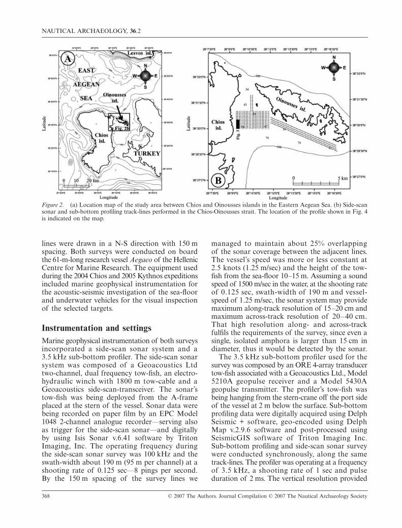
The Chios survey took place in April 2004(Sakellariou
et al.
, in press). The survey areacovered the 1–2 nautical miles (2–3.5 km) widestrait between Chios and Oinousses islands in theeastern Aegean Sea (Fig. 2). Prassonissia islands,two small islets located within the strait leave aless than 1 mile (1.85 km) wide passage availablefor sailing. This fact, along with the orientationof the strait in N-S direction creates a very dangerousmaritime passage for the ancient merchantships, especially under strong northern winds.The southern part of the strait, of 60–70 m meandepth, was the first to be surveyed. The 7 km
2
(2 km wide by 3.5 km long) area was investigatedalong north-south survey lines at 150 m spacing.
The Kythnos survey took place in March 2005as a follow-up of the delivery of a bronzestatue to the Ephorate of Underwater Antiquities(Sakellariou
et al.
, 2005). The statue had beenrecovered by a trawler while fishing at 500 mmean depth, west of Kythnos island. The aim ofthe survey was to locate the wrecked ship, whichwould have been carrying the statue. Accordingto the fisherman who delivered the statue, it wassupposed to have been caught in the cod net soonafter the start of a N-S, 14 mile (26 km) longtrawling line. The area chosen to be surveyed firstincluded a 6.5 km (3.5 nautical miles) long and1.0 km wide stripe (6.5 km
2
) covering the northernpart of the above-mentioned trawling line. Survey
NAUTICAL ARCHAEOLOGY,
36
.2
368 © 2007 The Authors. Journal Compilation © 2007 The Nautical Archaeology Society
lines were drawn in a N-S direction with 150 mspacing. Both surveys were conducted on boardthe 61-m-long research vessel
Aegaeo
of the HellenicCentre for Marine Research. The equipment usedduring the 2004 Chios and 2005 Kythnos expeditionsincluded marine geophysical instrumentation forthe acoustic-seismic investigation of the sea-floorand underwater vehicles for the visual inspectionof the selected targets.
Instrumentation and settings
Marine geophysical instrumentation of both surveysincorporated a side-scan sonar system and a3.5 kHz sub-bottom profiler. The side-scan sonarsystem was composed of a Geoacoustics Ltdtwo-channel, dual frequency tow-fish, an electro-hydraulic winch with 1800 m tow-cable and aGeoacoustics side-scan-transceiver. The sonar’stow-fish was being deployed from the A-frameplaced at the stern of the vessel. Sonar data werebeing recorded on paper film by an EPC Model1048 2-channel analogue recorder—serving alsoas trigger for the side-scan sonar—and digitallyby using Isis Sonar v.6.41 software by TritonImaging, Inc. The operating frequency duringthe side-scan sonar survey was 100 kHz and theswath-width about 190 m (95 m per channel) at ashooting rate of 0.125 sec—8 pings per second.By the 150 m spacing of the survey lines we
managed to maintain about 25% overlappingof the sonar coverage between the adjacent lines.The vessel’s speed was more or less constant at2.5 knots (1.25 m/sec) and the height of the tow-fish from the sea-floor 10–15 m. Assuming a soundspeed of 1500 m/sec in the water, at the shooting rateof 0.125 sec, swath-width of 190 m and vessel-speed of 1.25 m/sec, the sonar system may providemaximum along-track resolution of 15–20 cm andmaximum across-track resolution of 20–40 cm.That high resolution along- and across-trackfulfils the requirements of the survey, since even asingle, isolated amphora is larger than 15 cm indiameter, thus it would be detected by the sonar.
The 3.5 kHz sub-bottom profiler used for thesurvey was composed by an ORE 4-array transducertow-fish associated with a Geoacoustics Ltd., Model5210A geopulse receiver and a Model 5430Ageopulse transmitter. The profiler’s tow-fish wasbeing hanging from the stern-crane off the port sideof the vessel at 2 m below the surface. Sub-bottomprofiling data were digitally acquired using DelphSeismic + software, geo-encoded using DelphMap v.2.9.6 software and post-processed usingSeismicGIS software of Triton Imaging Inc.Sub-bottom profiling and side-scan sonar surveywere conducted synchronously, along the sametrack-lines. The profiler was operating at a frequencyof 3.5 kHz, a shooting rate of 1 sec and pulseduration of 2 ms. The vertical resolution provided
Figure 2. (a) Location map of the study area between Chios and Oinousses islands in the Eastern Aegean Sea. (b) Side-scansonar and sub-bottom profiling track-lines performed in the Chios-Oinousses strait. The location of the profile shown in Fig. 4is indicated on the map.

D. SAKELLARIOU
ET AL.
: SEARCHING FOR ANCIENT SHIPWRECKS IN THE AEGEAN SEA
© 2007 The Authors. Journal Compilation © 2007 The Nautical Archaeology Society 369
by the system under that settings was
c
.0.5 m andthe along track resolution
c
.1.25 m.The purpose of using the sub-bottom profiler
for this kind of survey is the need for collectingas much information about the natural geologicalcharacteristics of the sea-floor and its substrateas possible and not to ‘detect’ possible wreckson the recordings of the profiler. The in-depthknowledge of marine geological factors, which formthe structure of the sea-floor and its substrate, isof paramount importance and helps greatly wheninterpreting the side-scan sonar recordings, especiallythe nature of the sea-bed and the selected targets.For example, small outcrops of rocky basement risingto the sea-bed through the surrounding sedimentsproduce strong reflecting targets on the sonarrecordings similar to the ones derived from anancient shipwreck cargo, forming a short ridgeon the sea-bed. In such cases, in the absence ofany information on the structure of the substrate,it is always very difficult to interpret correctly thenature of the target. When ROV diving is used toinspect the nature of such kind of strong reflecting,‘highly promising’ targets, it often ends up withthe discovery of rocky outcrops on the sea-floor.Repeated unsuccessful ROV or submersible diveswaste a large amount of money (ship-time) and time,but what is more important is the disappointmentand the gradually-growing feeling of purposelessresearch among the cruise participants.
One ROV and one submersible were used forvisually inspecting the selected side-scan sonartargets on the sea-bed and eventually for collectingartefacts. The observation-class
Super Achilles
ROV(Comex, FR) can operate at depths up to 1000 mand is equipped with navigation sonar, two lights,one electric 3-function arm, and a video camera.
Super Achilles
was used mainly for visual ground-truthing of the selected targets. The 2-person,Model Remora-2000,
Thetis
submersible, alsomanufactured by Comex, can operate at a maximumdepth of 610 m. It was mainly used for systematicobservation on sites of particular interest aswell as for sampling archaeological artefacts likeamphoras. It is equipped with omni-directionalnavigation sonar, two lights, two hydraulic armsof 3- and 5-functions, one suction pump and onehigh definition video camera.
The Chios survey
Geological setting and sea-floor prospecting
The sea-floor survey area in the strait between Chiosand Oinousses islands was, as already mentioned,
performed along 22 parallel, 1 mile (1.85 km) longlines, aligned N-S at 150 m spacing (Fig. 2b).Another 4 lines were surveyed parallel to thesouthern coastline of Oinousses island, in WNW-ESE direction. The 60–70 m deep, flat sea-flooris covered by Holocene silt of variable thickness.The rocky base occurs on the sea-bed of the westernand eastern part of the area, close to the nearbyrocky coasts of Chios and Oinousses islands.Base outcrops form elongated or shapeless ridgesor patches on the sea-floor, either connected tothe adjacent rocky coasts or isolated, emergingon the sea-floor through the silty sediments.
The morphology of the rock represents the reliefof the area during the last glacial stage, when thesea-level was
−
120 m (Chappell and Shackleton,1986; Shackleton, 1987; Fairbanks, 1989). TheHolocene sea-level rise led to the flooding of thestrait and the deposition of silty sediments, whichtend to smooth the pre-Holocene relief. A verypronounced outcrop occurs in the northern partof the area. A low-relief, 50–60 m wide, WSW-ENE, linear base stripe can be followed on theside-scan sonographs from the western to theeastern edge of the surveyed area. Sub-bottomprofiling data show the presence of a small fault,running along the southern side of the stripe. Thelatter represents the uplifting (footwall) blocknorth of the fault trace. South of the fault-line,the thickness of the recent sediments increasesrapidly to more than 20–30 m.
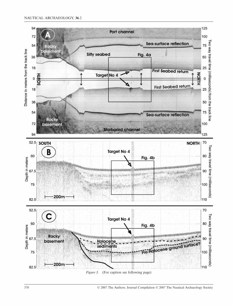
Trawling scars are observed on the side-scanrecordings only from the central section of thesouthern part of the area. Thus, possible wreckslocated on the sea-floor outside the trawling fieldmay have been preserved unaffected by recenttrawling activity. Several tens of targets wererecorded on the side-scan sonographs. The majorityof them were interpreted as base-rock outcrops,since this interpretation was supported by the sub-bottom profiling data. Other targets were consideredof low interest. The sonograph shown in Fig. 3ashows a characteristic image of the sea-floor fromthe south-western part of the survey area, closeto the Chios coast. A very pronounced outcropof the base rock is recorded on the southernpart of the image. This is seen as a strongly-backscattering area displayed in dark grey tones.Variations of the colour tones originate fromthe rough and irregular relief of the base-rockoutcrop, while lighter grey tones may comefrom small silt or sand pockets on the rock. Thesection of the 3.5 kHz profile, shown in Fig. 3b,was acquired simultaneously with the sonar record
NAUTICAL ARCHAEOLOGY,
36
.2
370 © 2007 The Authors. Journal Compilation © 2007 The Nautical Archaeology Society
Figure 3. (For caption see following page)
D. SAKELLARIOU
ET AL.
: SEARCHING FOR ANCIENT SHIPWRECKS IN THE AEGEAN SEA
© 2007 The Authors. Journal Compilation © 2007 The Nautical Archaeology Society 371
of Fig. 3a. In the interpretation of this profile (Fig. 3c)it is clearly shown that the highly-backscatteringarea recorded on the sonar image coincides withthe occurrence of the base-rock on the sea-floor.
Weakly-backscattering (light grey tones) sea-floor occurs in the sonographs of Fig. 3a, northof the rock outcrop. Despite the high-amplitudereflection derived from the first return from thesea-surface and the medium-amplitude returns,which occur at the outer part of both channels andoriginate from the waves of the sea-surface, thesea-floor displays a homogenous acoustic character.This part of the sea-floor is underlain by recentsediments of significant thickness, as shown onthe high-resolution profile of Fig. 3b and 3c. Twoacoustically-transparent seismic packages separatedby a medium-amplitude reflector overly a high-amplitude, morphologically-irregular reflector. Thelatter forms the roof over the acoustically-opaquebase, which represents the rocky substrate. Thetotal thickness of the transparent packages variesbetween 5–7 m. We interpret them as mainly siltdeposits accumulated during the present high sea-level stage. The high-amplitude, irregular reflectorbelow them may well represent the ground-surfaceof the alluvial plain, which would have connectedChios and Oinousses islands during the last glacialstage, when sea-level was at
−
120 m (Chappell andShackleton, 1986; Shackleton, 1987; Fairbanks,1989). According to the Holocene sea-level-risecurve, the sea should have drowned the presentday 70-m-deep survey area some 13–14 ka ago(Perissoratis and Conispoliatis, 2003). Thus, meanaccumulation rate of marine sediments during theHolocene in the area may be as high as 0.5 m/ka.
A strongly backscattering (dark grey) feature,located within the homogenously weakly-reflecting
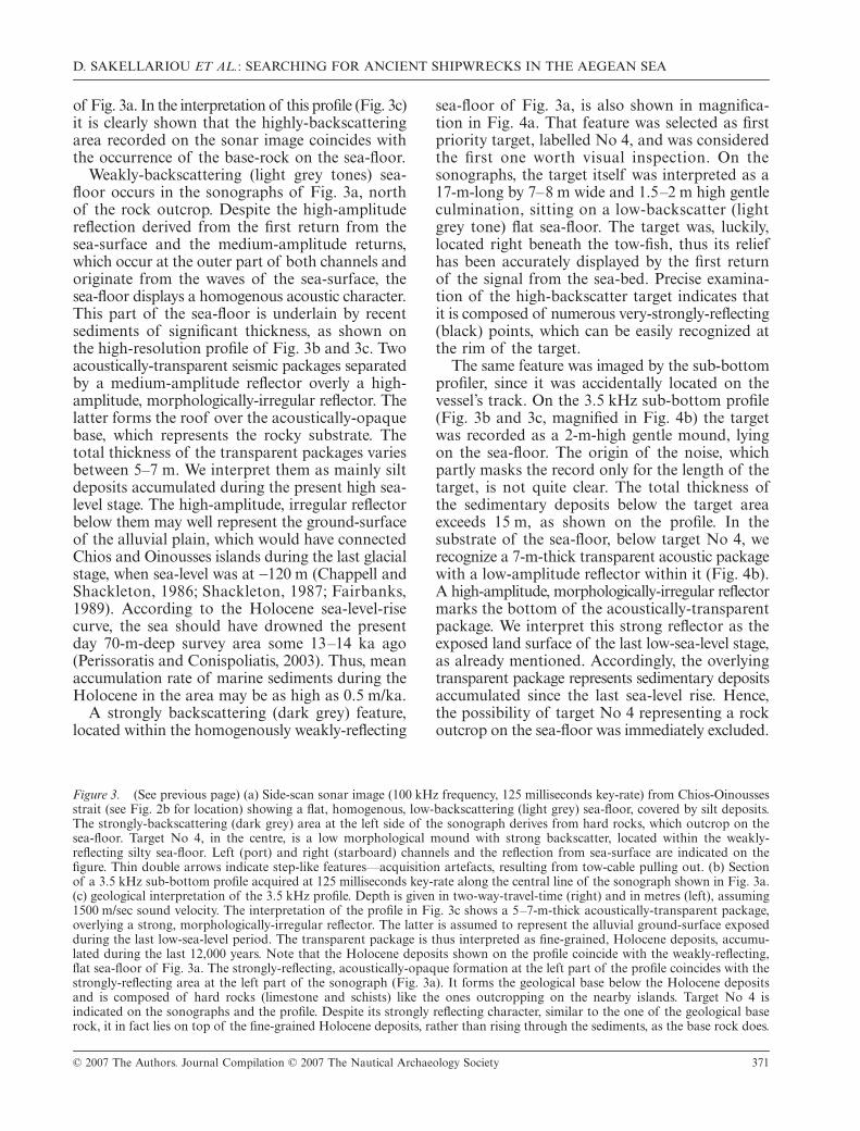
sea-floor of Fig. 3a, is also shown in magnifica-tion in Fig. 4a. That feature was selected as firstpriority target, labelled No 4, and was consideredthe first one worth visual inspection. On thesonographs, the target itself was interpreted as a17-m-long by 7–8 m wide and 1.5–2 m high gentleculmination, sitting on a low-backscatter (lightgrey tone) flat sea-floor. The target was, luckily,located right beneath the tow-fish, thus its reliefhas been accurately displayed by the first returnof the signal from the sea-bed. Precise examina-tion of the high-backscatter target indicates thatit is composed of numerous very-strongly-reflecting(black) points, which can be easily recognized atthe rim of the target.
The same feature was imaged by the sub-bottomprofiler, since it was accidentally located on thevessel’s track. On the 3.5 kHz sub-bottom profile(Fig. 3b and 3c, magnified in Fig. 4b) the targetwas recorded as a 2-m-high gentle mound, lyingon the sea-floor. The origin of the noise, whichpartly masks the record only for the length of thetarget, is not quite clear. The total thickness ofthe sedimentary deposits below the target areaexceeds 15 m, as shown on the profile. In thesubstrate of the sea-floor, below target No 4, werecognize a 7-m-thick transparent acoustic packagewith a low-amplitude reflector within it (Fig. 4b).A high-amplitude, morphologically-irregular reflectormarks the bottom of the acoustically-transparentpackage. We interpret this strong reflector as theexposed land surface of the last low-sea-level stage,as already mentioned. Accordingly, the overlyingtransparent package represents sedimentary depositsaccumulated since the last sea-level rise. Hence,the possibility of target No 4 representing a rockoutcrop on the sea-floor was immediately excluded.
Figure 3.
(See previous page) (a) Side-scan sonar image (100 kHz frequency, 125 milliseconds key-rate) from Chios-Oinoussesstrait (see Fig. 2b for location) showing a flat, homogenous, low-backscattering (light grey) sea-floor, covered by silt deposits.The strongly-backscattering (dark grey) area at the left side of the sonograph derives from hard rocks, which outcrop on thesea-floor. Target No 4, in the centre, is a low morphological mound with strong backscatter, located within the weakly-reflecting silty sea-floor. Left (port) and right (starboard) channels and the reflection from sea-surface are indicated on thefigure. Thin double arrows indicate step-like features—acquisition artefacts, resulting from tow-cable pulling out. (b) Sectionof a 3.5 kHz sub-bottom profile acquired at 125 milliseconds key-rate along the central line of the sonograph shown in Fig. 3a.(c) geological interpretation of the 3.5 kHz profile. Depth is given in two-way-travel-time (right) and in metres (left), assuming1500 m/sec sound velocity. The interpretation of the profile in Fig. 3c shows a 5–7-m-thick acoustically-transparent package,overlying a strong, morphologically-irregular reflector. The latter is assumed to represent the alluvial ground-surface exposedduring the last low-sea-level period. The transparent package is thus interpreted as fine-grained, Holocene deposits, accumu-lated during the last 12,000 years. Note that the Holocene deposits shown on the profile coincide with the weakly-reflecting,flat sea-floor of Fig. 3a. The strongly-reflecting, acoustically-opaque formation at the left part of the profile coincides with thestrongly-reflecting area at the left part of the sonograph (Fig. 3a). It forms the geological base below the Holocene depositsand is composed of hard rocks (limestone and schists) like the ones outcropping on the nearby islands. Target No 4 isindicated on the sonographs and the profile. Despite its strongly reflecting character, similar to the one of the geological baserock, it in fact lies on top of the fine-grained Holocene deposits, rather than rising through the sediments, as the base rock does.
NAUTICAL ARCHAEOLOGY,
36
.2
372 © 2007 The Authors. Journal Compilation © 2007 The Nautical Archaeology Society
Figure 4. (For caption see following page)
D. SAKELLARIOU
ET AL.
: SEARCHING FOR ANCIENT SHIPWRECKS IN THE AEGEAN SEA
© 2007 The Authors. Journal Compilation © 2007 The Nautical Archaeology Society 373
Target visual inspection
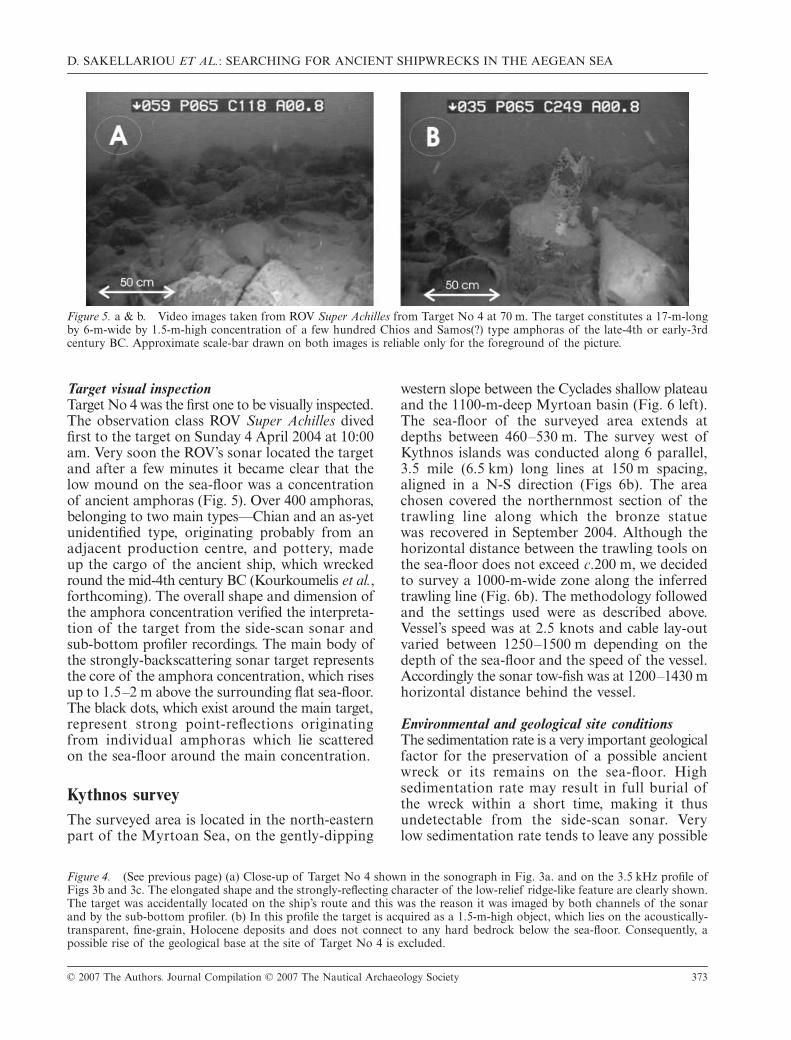
Target No 4 was the first one to be visually inspected.The observation class ROV
Super Achilles
divedfirst to the target on Sunday 4 April 2004 at 10:00am. Very soon the ROV’s sonar located the targetand after a few minutes it became clear that thelow mound on the sea-floor was a concentrationof ancient amphoras (Fig. 5). Over 400 amphoras,belonging to two main types—Chian and an as-yetunidentified type, originating probably from anadjacent production centre, and pottery, madeup the cargo of the ancient ship, which wreckedround the mid-4th century BC (Kourkoumelis
et al.
,forthcoming). The overall shape and dimension ofthe amphora concentration verified the interpreta-tion of the target from the side-scan sonar andsub-bottom profiler recordings. The main body ofthe strongly-backscattering sonar target representsthe core of the amphora concentration, which risesup to 1.5–2 m above the surrounding flat sea-floor.The black dots, which exist around the main target,represent strong point-reflections originatingfrom individual amphoras which lie scatteredon the sea-floor around the main concentration.
Kythnos survey
The surveyed area is located in the north-easternpart of the Myrtoan Sea, on the gently-dipping
western slope between the Cyclades shallow plateauand the 1100-m-deep Myrtoan basin (Fig. 6 left).The sea-floor of the surveyed area extends atdepths between 460–530 m. The survey west ofKythnos islands was conducted along 6 parallel,3.5 mile (6.5 km) long lines at 150 m spacing,aligned in a N-S direction (Figs 6b). The areachosen covered the northernmost section of thetrawling line along which the bronze statuewas recovered in September 2004. Although thehorizontal distance between the trawling tools onthe sea-floor does not exceed
c
.200 m, we decidedto survey a 1000-m-wide zone along the inferredtrawling line (Fig. 6b). The methodology followedand the settings used were as described above.Vessel’s speed was at 2.5 knots and cable lay-outvaried between 1250–1500 m depending on thedepth of the sea-floor and the speed of the vessel.Accordingly the sonar tow-fish was at 1200–1430 mhorizontal distance behind the vessel.
Environmental and geological site conditions
The sedimentation rate is a very important geologicalfactor for the preservation of a possible ancientwreck or its remains on the sea-floor. Highsedimentation rate may result in full burial ofthe wreck within a short time, making it thusundetectable from the side-scan sonar. Verylow sedimentation rate tends to leave any possible
Figure 5. a & b. Video images taken from ROV Super Achilles from Target No 4 at 70 m. The target constitutes a 17-m-longby 6-m-wide by 1.5-m-high concentration of a few hundred Chios and Samos(?) type amphoras of the late-4th or early-3rdcentury BC. Approximate scale-bar drawn on both images is reliable only for the foreground of the picture.
Figure 4.
(See previous page) (a) Close-up of Target No 4 shown in the sonograph in Fig. 3a. and on the 3.5 kHz profile ofFigs 3b and 3c. The elongated shape and the strongly-reflecting character of the low-relief ridge-like feature are clearly shown.The target was accidentally located on the ship’s route and this was the reason it was imaged by both channels of the sonarand by the sub-bottom profiler. (b) In this profile the target is acquired as a 1.5-m-high object, which lies on the acoustically-transparent, fine-grain, Holocene deposits and does not connect to any hard bedrock below the sea-floor. Consequently, apossible rise of the geological base at the site of Target No 4 is excluded.

NAUTICAL ARCHAEOLOGY,
36
.2
374 © 2007 The Authors. Journal Compilation © 2007 The Nautical Archaeology Society
wreck free on the sea-floor, but also exposed tocorrosion and activities such as fishing and trawling.
Sedimentation rate in the Aegean Sea variessignificantly, following the rough large-scale mor-phology of the sea-floor. High sedimentation rates(0.3–1.0 m/kyr) occur in deep basins, whichare characterized by enhanced tectonic subsidenceand are located close to large landmasses, like theNorth Aegean Trough basins (Roussakis
et al.
,2005) and the Gulf of Corinth (Moretti
et al.
,2004). Low sedimentation rates have been observedin deep basins like the Cretan basin in the SouthAegean or in shallow plateaus like the Cycladesplateau, which are not affected by the depositionof suspended material transported by rivers. Never-theless, in all the above cases, the sedimentation ratemay vary between a few centimetres to a few tens ofcentimetres per 1000 years. Gravity cores recoveredfrom the Cretan Sea indicate a sedimentation rateof about 10 cm/kyrs (Aksu
et al.
, 1995), while onecore from the Myrtoan basin, close to the Kythnossurvey area, revealed very similar values for thelast 18,000 yrs (Geraga
et al.
, 2000).Figure 7 shows a characteristic 3.5 kHz sub-bottom
profile acquired from the survey area. The substrateof the sea-floor is composed of transparent acousticpackages separated by medium- and low-amplitudereflectors, running parallel to the sea-floor. Thetransparent packages may represent fine-grain
deposits, predominantly silt or clay, while themedium- and low-amplitude reflectors mayderive from coarser-grain deposits. The seismicstratigraphy of the sea-floor’s substrate impliescontinuous sedimentation for at least the upper25–30 milliseconds (at least 15–20 m) below thesea-floor. No hard base was observed on any ofthe acquired seismic profiles in the survey area.The shallowest medium amplitude reflector liesat 6–8 milliseconds (4–6 m) below the sea-floor.This reflector may have derived by a distinct layerdeposited at the base of Holocene, when the sea-level started to rise after the last glacial maximumsome 18,000 yrs ago (Chappell and Shackleton,1986; Shackleton, 1987; Fairbanks, 1989). In thatcase, mean sedimentation rate in the survey areacould be as high as 20–30 cm/kyrs for the Holoceneinterval. In the absence of gravity cores and con-sequently of any ground-truthing of this seismicprofile, it is not possible to have an accurate valueof the sedimentation rate in the survey area. So, wefollow the results presented in Geraga
et al.
(2000),assuming that sedimentation rate may well be ashigh as 10 cm/1000yrs.
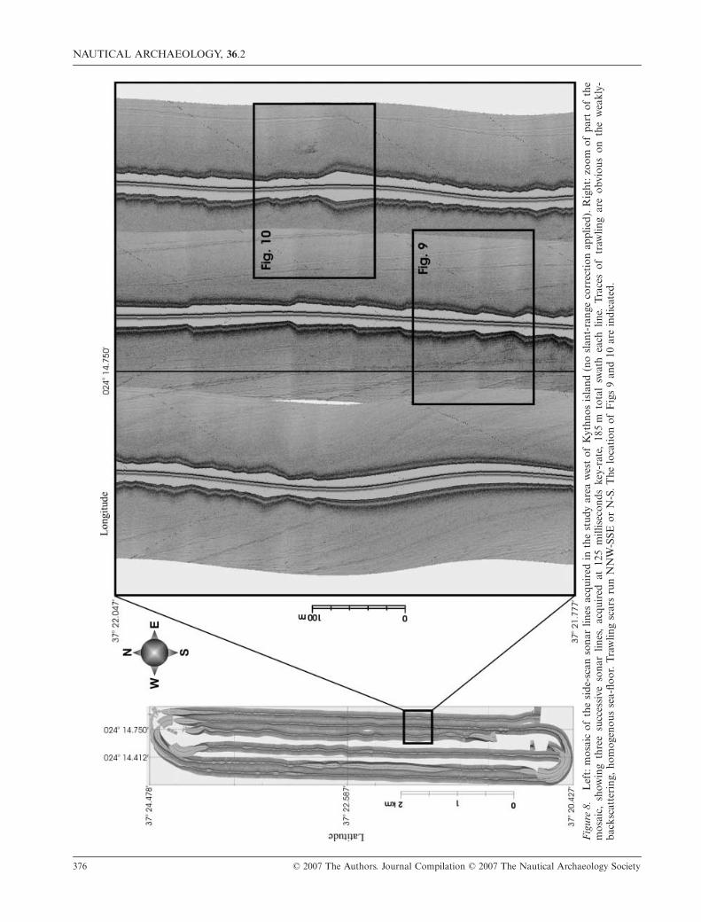
Figure 8a shows the mosaic of the six side-scansonar lines which were acquired in the study area.A 7-km-long by 1-km-wide area has been almostentirely covered, using total swath of 185 m for everyacquired line. Fig. 8b shows a 500
×
500-m-wide
Figure 6. (a) Location of the study area west of Kythnos island, in the northeastern Myrtoan Sea. (b) Track lines (150 mspacing, 3.5 miles/6.5 km long) along which the side-scan sonar and sub-bottom profiling survey was performed in the areawest of Kythnos island. The trace of the trawling line, along which the bronze statue was retrieved, is shown in both maps.

D. SAKELLARIOU
ET AL.
: SEARCHING FOR ANCIENT SHIPWRECKS IN THE AEGEAN SEA
© 2007 The Authors. Journal Compilation © 2007 The Nautical Archaeology Society 375
Figure 7. Section of a representative 3.5-kHz sub-bottom profile acquired at 1000 milliseconds in the study area west ofKythnos island (upper) and geological interpretation of the 3.5-kHz profile (lower). Depth is given in two-way-travel-time (left)and in metres (right), assuming 1500 m/sec sound velocity. The interpretation of the profile shows a seismic-sedimentarystratigraphic succession of acoustically-transparent packages and medium- or low-amplitude reflectors of minimum totalthickness of 15 m. Hard base rock was not observed in the study area.
NAUTICAL ARCHAEOLOGY,
36
.2
376 © 2007 The Authors. Journal Compilation © 2007 The Nautical Archaeology Society
Fig
ure
8.L
eft:
mos
aic
of t
he s
ide-
scan
son
ar l
ines
acq
uire
d in
the
stu
dy a
rea
wes
t of
Kyt
hnos
isl
and
(no
slan
t-ra
nge
corr
ecti
on a
pplie
d).
Rig
ht:
zoom
of
part
of
the
mos
aic,
sho
win
g th
ree
succ
essi
ve s
onar
lin
es,
acqu
ired
at
125
mill
isec
onds
key
-rat
e, 1
85 m
tot
al s
wat
h ea
ch l
ine.
Tra
ces
of t
raw
ling
are
obvi
ous
on t
he w
eakl
y-ba
cksc
atte
ring
, ho
mog
enou
s se
a-flo
or.
Tra
wlin
g sc
ars
run
NN
W-S
SE o
r N
-S.
The
loc
atio
n of
Fig
s 9
and
10 a
re i
ndic
ated
.
D. SAKELLARIOU
ET AL.
: SEARCHING FOR ANCIENT SHIPWRECKS IN THE AEGEAN SEA
© 2007 The Authors. Journal Compilation © 2007 The Nautical Archaeology Society 377
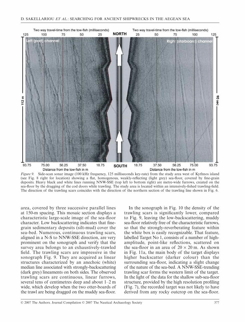
area, covered by three successive parallel linesat 150-m spacing. This mosaic section displays acharacteristic large-scale image of the sea-floorcharacter. Low backscattering indicates that fine-grain sedimentary deposits (silt-mud) cover thesea-bed. Numerous, continuous trawling scars,aligned in a N-S to NNW-SSE direction, are veryprominent on the sonograph and verify that thesurvey area belongs to an exhaustively-trawledfield. The trawling scars are impressive in thesonograph Fig. 9. They are acquired as linearstructures characterized by an anechoic (white)median line associated with strongly-backscattering(dark grey) lineaments on both sides. The observedtrawling scars are continuous, linear furrows,several tens of centimetres deep and about 1–2 mwide, which develop when the two otter-boards ofthe trawl are being dragged on the muddy sea-floor.
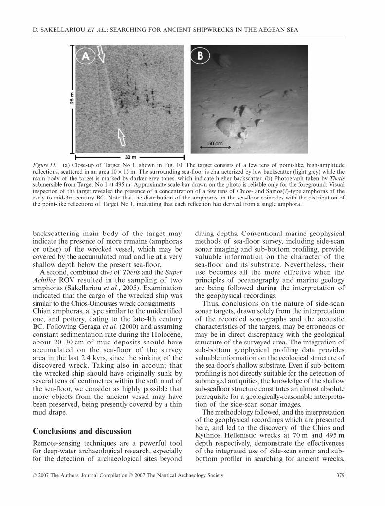
In the sonograph in Fig. 10 the density of thetrawling scars is significantly lower, comparedto Fig. 9, leaving the low-backscattering, muddysea-floor relatively free of the characteristic furrows,so that the strongly-reverberating feature withinthe white box is easily recognizable. That feature,labelled Target No 1, consists of a number of high-amplitude, point-like reflections, scattered onthe sea-floor in an area of 20
×
20 m. As shownin Fig. 11a, the main body of the target displayshigher backscatter (darker colour) than thesurrounding sea-floor, indicating a slight changeof the nature of the sea-bed. A NNW-SSE-trendingtrawling scar forms the western limit of the target.In the light of the data for the shallow sub-sea-floorstructure, provided by the high resolution profiling(Fig. 7), the recorded target was not likely to havederived from any rocky outcrop on the sea-floor.
Figure 9. Side-scan sonar image (100 kHz frequency, 125 milliseconds key-rate) from the study area west of Kythnos island(see Fig. 8 right for location) showing a flat, homogenous, weakly-reflecting (light grey) sea-floor, covered by fine-graindeposits. Heavy black and white lines running NNW-SSE (top left to bottom right) are metre-wide furrows, created on thesea-floor by the dragging of the cod doors while trawling. The study area is located within an intensively-fished trawling-field.The direction of the trawling scars coincides with the direction of the northern section of the trawling line shown in Fig. 6.

NAUTICAL ARCHAEOLOGY,
36
.2
378 © 2007 The Authors. Journal Compilation © 2007 The Nautical Archaeology Society
Thus, the strong, point-like reflections and themoderately-reflecting main body of the target shouldderive from any kind of small objects, lying onthe sea-floor or at a shallow depth below it.
Target visual inspection
Target No 1 was the first one to be visuallyinspected. The two-person submersible
Thetis
dived first to the target on Wednesday 16 March2005 at 14:30, with one of the authors (P. M.)as passenger-archaeologist. Fig. 11b presentsthe result of the visual inspection of the target.Several tens of ancient amphoras were lying onthe sea-floor, semi-buried within the mud. Someof the amphoras have been shifted by several
metres, leaving on the soft sea-floor a shallowfurrow behind them. Shifting of the amphorasmay be attributed to trawling activity in the area,and it may occur when the half-buried amphorasare caught by the cod-net of the trawl.
The visually observed distribution of the amphorason the sea-floor allows a re-interpretation of theshape and the acoustic character of target No 1,which is shown on the sonographs in Figs 10 and11a. Each single, point-like, strong reflection ofthe target is very likely to have derived from eachsingle amphora which rises above the sea-floor.The resolution provided by the side-scan sonarsystem under the settings described above supportsthis interpretation. Moreover, the moderately-
Figure 10. Side-scan sonar image (100 kHz frequency, 125 milliseconds key-rate, 125 milliseconds/94 m swath per channel)from the study area west of Kythnos island (see Fig. 8 right for location) showing a flat, homogenous, weakly-reflecting (lightgrey) sea-floor, covered by fine-grain deposits. Large white arrows pointing north show the ship’s direction. Left (port) and right(starboard) channels are marked. Distance from the tow-fish is given in metres and in time (seconds) at the lower and upperedge of the sonograph. Total length of sonograph in N-S direction is 90 seconds (c.112 m). Total width is 250 milliseconds(c.190 m). Trawling scars are indicated by small white arrows. The white box marks a concentration of high-amplitude, point-like reflections, scattered on the sea-floor in an area of 10 × 15 m. Magnification of this target is shown in Fig. 11a. Note thatthe target is limited to the west by a trawling scar.
D. SAKELLARIOU
ET AL.
: SEARCHING FOR ANCIENT SHIPWRECKS IN THE AEGEAN SEA
© 2007 The Authors. Journal Compilation © 2007 The Nautical Archaeology Society 379
backscattering main body of the target mayindicate the presence of more remains (amphorasor other) of the wrecked vessel, which may becovered by the accumulated mud and lie at a veryshallow depth below the present sea-floor.
A second, combined dive of
Thetis
and the
SuperAchilles
ROV resulted in the sampling of twoamphoras (Sakellariou
et al.
, 2005). Examinationindicated that the cargo of the wrecked ship wassimilar to the Chios-Oinousses wreck consignments—Chian amphoras, a type similar to the unidentifiedone, and pottery, dating to the late-4th centuryBC. Following Geraga
et al.
(2000) and assumingconstant sedimentation rate during the Holocene,about 20–30 cm of mud deposits should haveaccumulated on the sea-floor of the surveyarea in the last 2.4 kyrs, since the sinking of thediscovered wreck. Taking also in account thatthe wrecked ship should have originally sunk byseveral tens of centimetres within the soft mud ofthe sea-floor, we consider as highly possible thatmore objects from the ancient vessel may havebeen preserved, being presently covered by a thinmud drape.
Conclusions and discussion
Remote-sensing techniques are a powerful toolfor deep-water archaeological research, especiallyfor the detection of archaeological sites beyond
diving depths. Conventional marine geophysicalmethods of sea-floor survey, including side-scansonar imaging and sub-bottom profiling, providevaluable information on the character of thesea-floor and its substrate. Nevertheless, theiruse becomes all the more effective when theprinciples of oceanography and marine geologyare being followed during the interpretation ofthe geophysical recordings.
Thus, conclusions on the nature of side-scansonar targets, drawn solely from the interpretationof the recorded sonographs and the acousticcharacteristics of the targets, may be erroneous ormay be in direct discrepancy with the geologicalstructure of the surveyed area. The integration ofsub-bottom geophysical profiling data providesvaluable information on the geological structure ofthe sea-floor’s shallow substrate. Even if sub-bottomprofiling is not directly suitable for the detection ofsubmerged antiquities, the knowledge of the shallowsub-seafloor structure constitutes an almost absoluteprerequisite for a geologically-reasonable interpreta-tion of the side-scan sonar images.
The methodology followed, and the interpretationof the geophysical recordings which are presentedhere, and led to the discovery of the Chios andKythnos Hellenistic wrecks at 70 m and 495 mdepth respectively, demonstrate the effectivenessof the integrated use of side-scan sonar and sub-bottom profiler in searching for ancient wrecks.
Figure 11. (a) Close-up of Target No 1, shown in Fig. 10. The target consists of a few tens of point-like, high-amplitudereflections, scattered in an area 10 × 15 m. The surrounding sea-floor is characterized by low backscatter (light grey) while themain body of the target is marked by darker grey tones, which indicate higher backscatter. (b) Photograph taken by Thetissubmersible from Target No 1 at 495 m. Approximate scale-bar drawn on the photo is reliable only for the foreground. Visualinspection of the target revealed the presence of a concentration of a few tens of Chios- and Samos(?)-type amphoras of theearly to mid-3rd century BC. Note that the distribution of the amphoras on the sea-floor coincides with the distribution ofthe point-like reflections of Target No 1, indicating that each reflection has derived from a single amphora.

NAUTICAL ARCHAEOLOGY,
36
.2
380 © 2007 The Authors. Journal Compilation © 2007 The Nautical Archaeology Society
Amphoras and pottery constitute the remains ofboth wrecks on the sea-floor. In the case of the Chioswreck, over 400 concentrated artefacts form alongitudinal body of high reflectivity, which risesby 1.5–2 m above the surrounding flat, muddy sea-floor. Loose amphoras, scattered over a 20
× 20-m-wide area, represent the remains of Kythnos wreckand were recorded as strongly-reflecting points. Both
wrecks were found in areas where the sea-floor isunderlain by thick sedimentary sequences, as nicelyshown on the sub-bottom profiler recordings. Inthe absence of the sub-seafloor data, both targetscould be easily misinterpreted as possible outcropsof the rocky substrate or loose rocks on the sea-floorrespectively, especially because such structuresoccur in close proximity to both sites.
AcknowledgementsThe authors greatly acknowledge the officers and the crew of R/V Aegaeo for their valuable contribution to the success of theresearch cruises CHIOS-2004 and KYTHNOS-2005. Our thanks go also to our colleagues and friends P. Mantopoulosand I. Pampidis, engineers and operators of the geophysical equipment used during the survey. Last but not least wethank K. Katsaros, pilot, Th. Fotopoulos, engineer and V. Stasinos, diver, all friends and colleagues, for the operation of thesubmersible Thetis and their assistance in the operation of ROV Super Achilles.
ReferencesAgouridis, C., 1997, Sea routes and navigation in the third millennium Aegean, Oxford Journal of Archaeology 16,
1–24.Aksu, A. E., Yasar, D., and Mudie, P. J., 1995, Origin of late glacial-Holocene hemipelagic sediments in the Aegean Sea: clay
mineralogy and carbonate cementation, Marine Geology 123, 33–59.Ballard, R. D., McCann, A. M., Yoerger, D., Whitcomb, L., Mindell, D., Oleson, J., Singh, H., Foley, B., Adams, J., Piechota,
D., and Giagrande, C., 2000, The discovery of ancient history in the deep sea using advanced deep submergence technology,Deep-Sea Research I 47, 1591–620.
Ballard, R., Stager, L., Master, D., Yoerger, D., Mindell, D., Whitcomb, L., Singh, H., and Piechota, D., 2001, Iron ageshipwrecks in deep water off Ashkelon, Israel, American Journal of Archaeology, 106.2, 151–68.
Barto Arnold III, J., Oertling, T. J., and Hall A. W., 1999, The Denbigh project: initial observations on a Civil War blockade-runner and its wreck-site, IJNA 28, 126–44.
Blondel, P. and Pouliquen, E., 2004, Acoustic textures and detection of shipwreck cargo—example of a Roman ship near Elba,Italy, in T. Akal, R. D. Ballard, and G. F. Bass (eds), Proceedings of the Conference on: The application of recent advancesin underwater detection and survey techniques to underwater archaeology, 135–42. Bodrum, Turkey.
Chalari, A., Christodoulou, D., Papatheodorou, G., Geraga, M., and Ferentinos, G., 2003, Marine geophysical investigationaround the site of the famous Pharos of Alexandria (Egypt) for the detection of ancient shipwrecks, in 2nd World Congress.Ancient Greece “The Modern World”, International Olympic Academy, 62–73. Ancient Olympia, Greece.
Chappell, J., and Shackleton, N. J., 1986, Oxygen isotopes and sea-level, Nature 323. 137–40.Fairbanks, R. G., 1989, A 17000 year glacio-eustatic sea level record: influence of glacial melting rates on the Younger Dryas
event and deep-ocean circulation. Nature 342, 637–42.Geraga, M., Tsaila-Monopolis, St., Ioakim, Chr., Papatheodorou, G., and Ferentinos, G., 2000, Evaluation of palaeoenviron-
mental changes during the last 18,000 years in the Myrtoon basin, SW Aegean Sea, Palaeogeography, Palaeoclimatology,Palaeoecology 156, 1–17.
Hadjidaki, E., 1996, Underwater Excavations of a late fifth century merchant ship at Alonnesos, Greece: the 1991–1993Seasons, Bulletin de Correspondance Hellenique 120, 561–93.
Hobbs, C. H., Blanton, D. B., Gammisch, R. A., and Broadwater, J., 1994, A marine archaeological reconnaissance surveyusing side-scan sonar, Jamestown, Virginia, USA, Journal of Coastal Research 10, 351–9.
Kourkoumelis, D., Micha, P., Theodoulou, Th., and Sakellariou D., forthcoming, Recherches archéologiques sous-marines enMer Égée, in Procceedings 9th Int. Symp. on Ship Construction in Antiquity, August 25–30, 2005, Cyprus.
McGrail, S., 2001, Boats of the World, From the Stone Age to Medieval Times. Oxford.Moretti, I., Lykousis, V., Sakellariou, D., Reynaud, J-Y., Benziane, B., Prinzhoffer A., 2004, Subsidence rate in the Gulf of
Corinth: what we learn from the long piston coring. C.R.Geosciences 336, 291–9.Quinn, R., Bull, J. M., Dix, J. K., and Adams, J. R., 1997, The Mary Rose site—geophysical evidence for palaeo-scar marks,
IJNA 26, 3–16.Quinn, R., Adams, J. R., Dix, J. K., and Bull, J. M., 1998, The Invincible (1758) site—an integrated geophysical assessment,
IJNA 27, 126–38.Quinn, R., Cooper, A. J., and Williams, B., 2000, Marine geophysical investigation of the inshore coastal waters of Northern
Ireland, IJNA 29, 294–8.Quinn, R., Breen, C., Forsythe, W., Barton, K., Rooney, S., and O’Hara, D., 2002a, Integrated geophysical surveys of the
French Frigate La Surveillante (1797), Bantry Bay, Co. Cork, Ireland, Journal of Anthropological Science 29, 413–22.Quinn, R., Forsythe, W., Breen, C., Dean, M., Lawrence, M., and Liscoe, S., 2002b, Comparison of the Maritime Sites
and Monuments Record with side-scan sonar and diver surveys: a case study from Rathlin Island, Ireland, Geoarchaeology 17,441–51.
D. SAKELLARIOU ET AL.: SEARCHING FOR ANCIENT SHIPWRECKS IN THE AEGEAN SEA
© 2007 The Authors. Journal Compilation © 2007 The Nautical Archaeology Society 381
Papatheodorou, G., Stefatos, A., Christodoulou, D., and Ferentinos, G., 2001, Remote sensing in submarine archaeology andmarine cultural resources management: an ancient shipwreck outside Zakynthos Port, Greece, 7th Conference on Environ-mental Science and Technology, vol. C, 377–85.
Papatheodorou, G., Geraga, M., and Ferentinos, G., 2005, The Navarino Naval Battle Site, Greece—an integrated remote-sensing survey and a rational management approach, IJNA 34, 95–109.
Perissoratis, C., and Conispoliatis, N., 2003, The impacts of sea-level changes during latest Pleistocene and Holocene timeson the morphology of the Ionian and Aegean seas (SE Alpine Europe), Marine Geology 196, 145–56.
Roussakis, G., Karageorgis, A. P., Conispoliatis, N. and Lykousis, V., 2005, Last glacial-Holocene sediment sequences inN. Aegean basins: structure, accumulation rates and clay mineral distribution, GeoMarine Letters 24, 97–111.
Sakellariou, D., and the KYTHNOS-2005 cruise-party, 2005, The discovery of 4th century BC wreck at 495 m depth west ofKythnos island, E&T 7, 28–30 (in Greek, a monthly publication of the General Secretariat for Research & Technology, Athens).
Sakellariou, D., Kourkoumelis, D., Mallios, A., Micha, P., Georgiou, P., Kapsimalis, V., and Dellaporta, E., 2006, ROV andsubmersible dives to the deepest known Hellenistic age wreck in the Aegean Sea: KYTHNOS-I, Cyclades Archipelago,Central Aegean Sea, in International Conference on “Diving for Science and Archaeology”, organized by the Society forUnderwater Technology, March, 21–22, in conjunction with Oceanology International 2006, London. Abstracts, 16.
Sakellariou, D., and the SAMOS-CHIOS-2004 cruise-party, in press, The modern techniques of seafloor survey at the serviceof Deep Water Archaeology: The Samiopoula and Chios wrecks, in Proceedings of 1st Conference on Underwater Archaeo-logical Deep Water Exploration—Technology and Perspectives, Athens, September 14th 2004.
Shackleton, N. J., 1987, Oxygen isotopes, ice volume and sea level. Quaternary Science Reviews 6, 183–90.Søreide, F., and Jasinski, M. E., 1998, The Unicorn wreck, central Norway—underwater archaeological investigations of an
18th-century Russian pink, using remotely-controlled equipment, IJNA 27, 95–112.


