1 Saltash Neighbourhood Development Plan - Submission Draft June 2020
SALTASH NEIGHBOURHOOD DEVELOPMENT PLAN
CONSULTATION DRAFT
2020 - 2030 Saltash Town Council
Neighbourhood Plan Steering Group
2 Saltash Neighbourhood Development Plan - Submission Draft June 2020
The Saltash Neighbourhood Development Plan has been prepared in accordance with the Neighbourhood Planning Regulations 2012, the Localism Act 2011, the Planning &
Compulsory Purchase Act 2004, the European Directive 2001/42 on Strategic Environmental Assessment and the EU Directive 92/43 on Habitats Regulations Assessment.
3 Saltash Neighbourhood Development Plan - Submission Draft June 2020
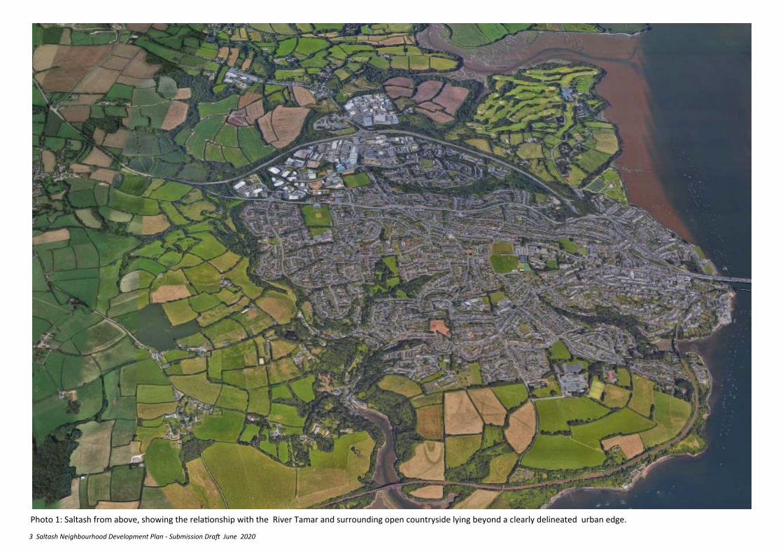
Photo 1: Saltash from above, showing the relationship with the River Tamar and surrounding open countryside lying beyond a clearly delineated urban edge.
4 Saltash Neighbourhood Development Plan - Submission Draft June 2020
PREFACE 1. INTRODUCTION ………………………………………………………………………………………...…...7
• FOREWORD
• HOW THIS PLAN IS ORGANISED
• STEERING GROUP & WORKING GROUP MEMBERSHIP
2. BACKGROUND……………………………………………………………………………………………….11
• THE LEGAL BASIS
• DESIGNATED NEIGHBOURHOOD PLAN AREA
• NATIONAL PLANNING POLICY FRAMEWORK
• CORNWALL LOCAL PLAN 2010 TO 2030 (ADOPTED NOVEMBER 2016)
• CORNWALL LOCAL PLAN SITE ALLOCATIONS DEVELOPMENT PLAN
DOCUMENT
• A COMMUNITY LED PLAN
• PLANNING AND STRATEGY INITIATIVES
3. EVIDENCE BASE……………………………………………………………………………………………..17
• FACTS AND FIGURES
• COMMUNITY ENGAGEMENT SUMMER 2015
• SUMMARY OF ISSUES
4. THE VISION FOR SALTASH………………………………..……………….…………………….……..20
• POLICY DP 1 – DEVELOPMENT BOUNDARY
5. SECURE A DIVERSE AND PROSPEROUS LOCAL ECONOMY……………………..………..24
• POLICY EM 1 – ACCESS TO EMPLOYMENT DEVELOPMENT
• POLICY EM 2 – REDEVELOPMENT AND ENHANCEMENT OF EXISTING
EMPLOYMENT SITES.
• POLICY EM 3 – PARKING, STORAGE AND MOVEMENT ON AND AROUND
EMPLOYMENT SITES
• POLICY EM 4 – HOME BASED ENTERPRISE
• POLICY EM 5 – TELECOMMUNICATIONS ON EMPLOYMENT SITES
• POLICY EM 6 – SUSTAINABLE TOURISM
6. REGENERATE THE TOWN CENTRE AND MANAGE THE GROWTH OF “OUT OF TOWN” SHOPPING…………………………………………………………………………..………………..28
• REGENERATION OBJECTIVES FOR THE TOWN CENTRE
• POLICY TC 1 – DEVELOPMENT AT CARKEEL
• POLICY TC 2 – MAINTAINING THE TOWN CENTRE AS A RETAIL & SOCIAL DESTINATION
• POLICY TC3 – NEW USES FOR UPPER FLOORS IN THE TOWN CENTRE
• POLICY TC4 – RETENTION OF SMALL SCALE EMPLOYMENT IN THE TOWN CENTRE
7. CREATE AND SUPPORT SUSTAINABLE NEIGHBOURHOODS……………………………..34
• POLICY SN 1 – SUPPORT FOR A SUSTAINABLE NEIGHBOURHOOD CENTRE AT BROADMOOR FARM
• POLICY SN 2 – STRENGTHENING NEIGHBOURHOODS
8. REVITALISE THE WATERFRONT………………………………….…………………………………...37
• POLICY WF 1 - MAKING THE MOST OF SALTASH WATERFRONT
9. ENSURE A BALANCED RANGE OF QUALITY NEW HOUSING………………………….....41
• POLICY H 1 – ENSURING A CHOICE OF HOUSING
• POLICY H 2 – CONVERSIONS OF LARGE HOUSES INTO MULTIPLE OCCUPATION
• POLICY H 3 – MAKING BETTER USE OF LAND – REDEVELOPMENT, RENEWAL AND INTENSIFICATION
• POLICY H 4 – MAKING BETTER USE OF LAND – SUBURBAN VILLAS CHARACTER AREA
• POLICY H 5 – EXTENSIONS TO EXISTING DWELLINGS
10. PROTECT AND ENHANCE THE BUILT ENVIRONMENT………………………………….…45
• POLICY ENV 1 – DESIGN AND LOCAL DISTINCTIVENESS WITHIN THE CHARACTER AREAS
• POLICY ENV 2 – DESIGN AND LOCAL DISTINCTIVENESS OUTSIDE THE HISTORIC CORE
• POLICY ENV 3 – GENERAL DESIGN PRINCIPLES
• POLICY ENV 4 – LOCAL LISTING OF NON-DESIGNATED HERITAGE ASSETS
• POLICY ENV 5 – REUSE OF SALTASH STATION BUILDING
• POLICY ENV 6 – DEVELOPMENT IN CONSERVATION AREAS
• POLICY ENV 7 – DEVELOPMENT WITHIN THE SETTING OF CONSERVATION AREAS
• POLICY ENV 8 – VIEWS AND VISTAS
11. PROTECT AND ENHANCE THE NATURAL ENVIRONMENT……………………...………58
• POLICY GRN 1 – BIODIVERSITY PROTECTION AND GAIN
• POLICY GRN 2 – THE GREENING OF SALTASH: WOODLANDS, TREES, CORNISH HEDGES AND HEDGEROWS
• POLICY GRN 3 – COUNTRYSIDE CHARACTER AREAS
• POLICY GRN 4 – DRAINAGE AND FLOODING
• SEWAGE TREATMENT .
12. MANAGE THE RURAL AREAS OF THE PARISH IN A SYMPATHETIC MANNER…..64
• POLICY RUR 1 – SMALL WORKSHOP DEVELOPMENT IN THE COUNTRYSIDE
• POLICY RUR 2 – VILLAGE DEVELOPMENT BOUNDARIES & RURAL HOUSING SITES
• POLICY RUR 3 – LAND AT OLD FARM, TREMATON
CONTENTS
5 Saltash Neighbourhood Development Plan - Submission Draft June 2020
• POLICY RUR 4 – LAND OPPOSITE PANDRAMA, TREHAN
• POLICY RUR 5 – LAND AT FORMER ALLOTMENT GARDENS, TREHAN
• POLICY RUR 6 – AGRICULTURAL DWELLINGS AND SPECIALIST NEED
13. MEET THE CHANGING DEMAND FOR HEALTH, EDUCATION, COMMUNITY & EMERGENCY SERVICES AND FACILITIES……………………………………………………………....70
• POLICY HWB 1 – EDUCATION PROVISION
• POLICY HWB 2 – PROTECTION AND ENHANCEMENT OF SALTASH COMMUNITY CAMPUS
• POLICY HWB 3 – THE FUTURE OF HEALTH AND CARE PROVISION IN SALTASH
• POLICY HWB 4 – PROTECTION OF IMPORTANT COMMUNITY FACILITIES
14. MEET THE GROWING DEMAND FOR ADDITIONAL SPORT, RECREATION AND LEISURE FACILITIES……………………………………………………………………………………………..74
• POLICY LEI 1 – KEY STRATEGIC SPORTS, LEISURE AND RECREATION OPEN SPACES
• POLICY LEI 2 – LOCAL GREEN SPACES
• POLICY LEI 3 – CONSERVATION, ENHANCEMENT AND CREATION OF LOCAL GREEN SPACES
• POLICY LEI 4 – DILAPIDATED PLAY SPACES
• POLICY LEI 5 – ALLOTMENTS
15. IMPROVED AND SUSTAINABLE CONNECTIVITY ……………………………………………..79
• POLICY CON 1 – THE GREEN BOULEVARD
• POLICY CON 2 – NORTH ROAD/NEW ROAD DISTRIBUTION ROUTE
• POLICY CON 3 – TOWN CENTRE TRANSITION ZONES
• POLICY CON 4 – BURRATON CROSS HUB
• POLICY CON 5 – SALTASH STATION
• POLICY CON 6 – CARKEEL TRAFFIC CALMING AND ENVIRONMENTAL ENHANCEMENT
• POLICY CON 7 – BROADBAND
• POLICY CON 8 – SUSTAINABLE TRANSPORT MEASURES IN NEW DEVELOPMENTS
• POLICY CON 9 – PROTECTION OF FOOTPATHS, BRIDLEWAYS AND CYCLE PATHS
• POLICY CON 10 – ENHANCING AND EXTENDING THE WALKING AND CYCLE
NETWORK
16. CLIMATE CHANGE ………………………………………………………………………………………..89
• POLICY CC 1 – RENEWABLE ENERGY
• POLICY CC 2 –LOCAL ENERGY STORAGE
• POLICY CC 3 – COMMUNITY SUSTAINABLE ENERGY
• POLICY CC 4 – SMALL CARBON FOOTPRINT DEVELOPMENT
DELIVERY PLAN…………………………………………………………………………………..……………..99
• POLICY DP 1 – MAKING IT HAPPEN – COMMUNITY PRIORITIES
17. MONITORING…………………………………………………………………………………….….…..110
18. JARGON BUSTER ………………………………….…………………………………………….………111
Abbreviations Used
LP:SP —Cornwall Local Plan
CC—Cornwall Council
DPD —Cornwall Local Plan Allocations Development Plan Document
NDP —Neighbourhood Development Plan
NPPF —National Planning Policy Framework
STC—Saltash Town Council
PHOTO CREDITS
Western Web
Steve Besford-Foster, PlanSupport
David Orr, David Orr Consulting
GRAPHICS
Steve Besford-Foster, PlanSupport
Jane Hamlyn, Atelier3
6 Saltash Neighbourhood Development Plan - Submission Draft June 2020
PREFACE
CLLR DAVID YATES, CHAIRMAN OF SALTASH NEIGBOURHOOD DEVELOPMENT PLAN STEERING GROUP
The Saltash Neighbourhood Development Plan has been created by the people of Saltash, through a Steering Group made up of residents, local organisations and Town and Cornwall Councillors, which reported to the Saltash Town Council.
Although the Town Council is the ‘qualifying body’ responsible for the progress of the Plan, many hundreds of residents have been directly involved, as have many other stakeholders, including those working and running businesses in the area, local landowners, those who care about our environment and wildlife (by no means all of whom are residents) and those providing services to our community. The Plan is based on the feedback received from these people throughout the process, including a major survey carried out in 2015.
A town the size of Saltash will rarely have an entirely unanimous view, especially when decisions between alternative planning policies are at issue, but the discussions, and on occasion disagreements, have been handled well to reach as close to a consensus view as can reasonably be expected.
We have benefitted throughout from the guidance and advice of professional planners from Cornwall Council. Their Neighbourhood Planning Officers, supported by the extensive material in their Neighbourhood Planning Toolkit, have been an invaluable support. While in the preparation of the draft of the Neighbourhood Plan we were advised by consultants Steve Besford-Foster, David Orr and Tim Kellett, in part funded through the Locality organisation. Jane Hamlyn of Atelier3 and Ian Taylor of S34 Architecture provided graphical interpretation
of key policy proposals.
We also need to ‘fit’ in with the National Planning Policy Framework and the Cornwall Local Plan. The Saltash section of the Cornwall Site Allocations Development Plan Document is of direct relevance, as it allocates land locally for housing and industry (for example Broadmoor Farm).
While we have received a lot of professional advice and guidance, and the Neighbourhood Plan must be in conformity with the senior documents referred to above, it began, and remains, a very much a bottom-up perspective of the way that we want to see Saltash develop and prosper. Taking into account community views, we began with a Vision, and 12 Key Objectives, which we believe will receive widespread support, and our set of planning policies flow from these.
Finally I would like to thank the Steering Group, particularly the core group responsible for writing the Plan in detail. The Group have invested huge amounts of their own time, entirely unpaid, to create this Plan.
David Yates,
Chairman, Saltash NDP Steering Group
6 Saltash Neighbourhood Development Plan—Consultation Draft August 2018
7 Saltash Neighbourhood Development Plan - Submission Draft June 2020
1. INTRODUCTION
1.1 Saltash is a thriving community, with lots of drive and ambition to improve. Right at the ‘Gateway to Cornwall’, it has a unique waterfront setting, excellent transport links, and with the great City of Plymouth just across the Tamar, it’s a desirable place to live, work, learn and visit. These give immense opportunities for prosperity through well balanced growth.
1.2 But there are challenges: the affordability of housing, low wages, competing land uses, traffic and pedestrian congestion, the changing age balance within our community, and global environmental change to name but a few.
1.3 We need to take the opportunities and tackle the challenges so that our present needs are met without harming the ability of future generations to meet their needs. That is the essence of sustainable development.
1.4 The Saltash Neighbourhood Plan is the opportunity for everyone in the town to have a real say as to how sustainable development is done. It’s a new type of plan that has come about from the Localism Act 2011 which gives everyone who lives in a local area the democratic right to be involved in drawing up the plan.
1.5 What’s more, when it’s written, the plan has to be agreed through a local referendum, in which everyone on the electoral roll gets a vote. If the vote is in favour, the Neighbourhood Plan is ‘made’ in law and cannot be ignored when planning applications are decided by Cornwall Council, Planning Inspectors, or the Government.
1.6 A Neighbourhood Plan can help us control the way that land is used for housing, business, shops and leisure; protect green spaces and influence the design of buildings and estates; build consensus on difficult
issues and support the things that we cherish and which make Saltash such a great place to live, work, learn and visit.
1.7 Why should we care? If we are all involved, our community’s creativity, energy and diversity can be released to make a plan that is fair, inclusive, and well-balanced. So please get involved and get your views across during the next stage of consultation!
1.8 The Saltash NDP was published as a consultation draft in June 2019. Nearly 200 local residents and many local and national organisations commented on the NDP. These comments have been carefully considered and the NDP has been altered in response wherever it was reasonable and necessary to do so. A detailed summary of the comments received and the response to them is included in the ‘Consultation Statement’ that accompanies this ‘Submission Draft’ of the NDP.
1.9 The Saltash NDP has now been formally submitted to Cornwall Council, the local planning authority.
1.10 If Cornwall Council assess the Plan as being in compliance with the laws and regulations governing Neighbourhood Plan making, further consultations will be held, and the Plan will be assessed by an Independent Examiner. The Independent Examiner will then recommend whether the Plan can go to a community referendum. Some modification to the NDP may result from the Examiners’ findings. At the referendum all registered electors in Saltash will be entitled to vote for or against the Plan.
1.11 If the Neighbourhood Development Plan is supported in the referendum, Cornwall Council will formally ‘make’ the Plan. This will give it legal recognition as part of the statutory local
development plan for the area. This means it must be considered when planning decisions are made by Cornwall Council, Planning Inspectors, and the Secretary of State.
1.12 All the supporting evidence and documentation backing this Neighbourhood Plan, including the Visioning Workshops, Working Group Reports and many of the background studies referred to are available via the evidence base pages of the Saltash Neighbourhood Plan website at plan4saltash.co.uk
1.13 Following this introduction, a summary profile of Saltash and its community is given, identifying the issues to be addressed in the Plan. The overarching vision, aims and objectives of the Plan are stated and it is then divided into sections that are framed around the key objectives. Each section then notes the NPPF and LP:SP policy relating to the objective, discusses the issues, and gives the actions (policies) considered necessary to deliver the aims of the Plan, with a reasoned justification and brief reference to evidence that supports it. In some cases notes on how the policy may be interpreted are included. Some sections also include Projects, which do not have the status of formal planning policies, but indicate other actions which will help the delivery of the Plan’s vision.
NPPF —National Planning Policy Framework LP:SP —Cornwall Local Plan DPD —Cornwall Local Plan Allocations Development Plan Document NDP —Neighbourhood Development Plan
8 Saltash Neighbourhood Development Plan - Submission Draft June 2020
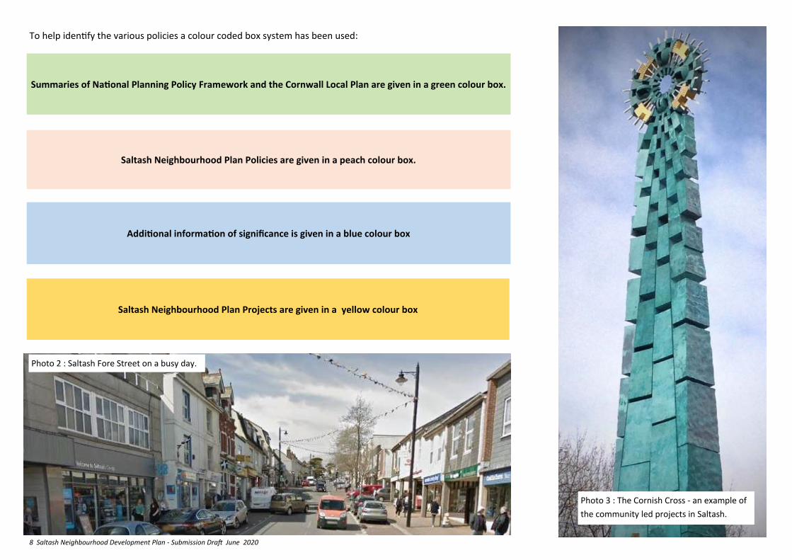
To help identify the various policies a colour coded box system has been used:
Summaries of National Planning Policy Framework and the Cornwall Local Plan are given in a green colour box.
Saltash Neighbourhood Plan Policies are given in a peach colour box.
Additional information of significance is given in a blue colour box
Saltash Neighbourhood Plan Projects are given in a yellow colour box
Photo 2 : Saltash Fore Street on a busy day.
Photo 3 : The Cornish Cross - an example of
the community led projects in Saltash.
9 Saltash Neighbourhood Development Plan - Submission Draft June 2020
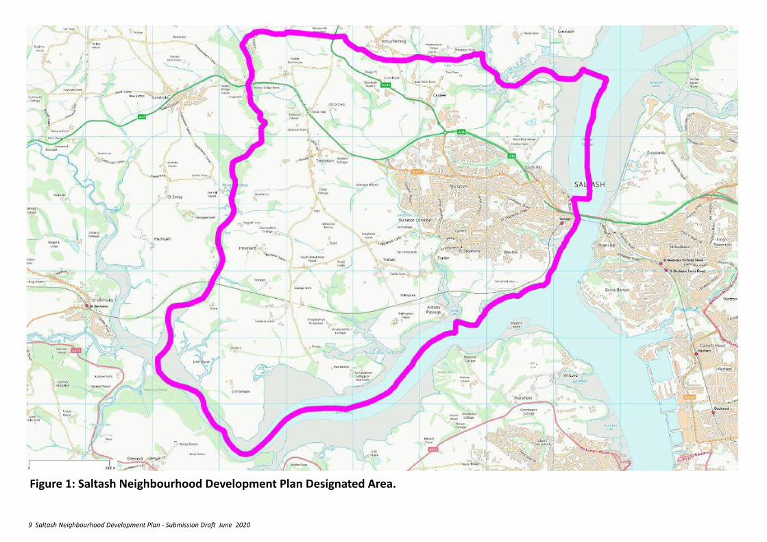
Figure 1: Saltash Neighbourhood Development Plan Designated Area.

10 Saltash Neighbourhood Development Plan - Submission Draft June 2020
STEERING GROUP MEMBERHIP
William Holman N&M Pill Landowners Consortium
Cllr. David Yates Saltash Town Council
Cllr. Jean Dent Saltash Town Council
Cllr Derek Holley Saltash Town Council
Cllr. Bob Austin Saltash Town Council
Cllr. Lee Russell Saltash Town Council
Cllr Richard Bickford Saltash Town Council
Mike Finch Saltash Environmental Action
Mike Hocking N&M Pill Neighbourhood Assoc’n
Catherine Noakes N&M Pill Neighbourhood Association
Leslie Rust Latchbrook Neighbourhood Assoc’n
John Percil Latchbrook Neighbourhood Assoc’n
Denise Watkins Waterfront Residents Association
Gail Swift Pillmere Community Association
David Bennett SWRA and Essa Cycling
Ian Taylor Port View Estate
Jane Hamlyn Architect and Pillmere Resident
Nick Theis Resident
Stephen Jensen Resident
DRAFTING TEAM
Cllr David Yates Saltash Town Council
Ian Taylor Architect and Port View Estate
Cllr Jean Dent Saltash Town Council
John Percil Latchbrook Neighbourhood Assoc’n
Mike Hocking N&M Pill Neighbourhood Association
David Bennett SWRA and Essa Cycling
William Holman N&M Pill Landowners Association
WORKSHOP & WORKING GROUP COMMUNITY VOLUNTEERS
Andrew Wiiliams Resident—North Pill
Peter Ryland Chamber of Commerece, CiC STIG
Andy Rance CC Youth Worker
Richard Hall Resident
Tunde Awe Resident
Geoff Mawson Resident
Michael Griffin MA Griffin Associates (Hole Farm)
Simon Walker Landrake and St. Erney N. Assocn.
Sue Newell Landrake and St. Erney N. Assocn.
Ken Martin Governor Saltash.net
Alex Sharpe China Fleet Country Club
Robert Taylor Persimmon Homes
Ian Broad North & Middle Pill Landowner Consortium
Maggie Gee Resident
Richard Fry Saltash Maritime Cadets
Lizzy Sharpe-Asprey Saltash Heritage
Jenny Wreford Engage Saltash Church Pastor
Roger Fursier Forder Community and Conservation Association
PROFESSIONAL SUPPORT
Steve Besford-Foster PlanSupport
David Orr David Orr Consulting
Tim Kellett Tim Kellett Urban Design
Mark Pearson Design Action
11 Saltash Neighbourhood Development Plan - Submission Draft June 2020
2. BACKGROUND
2.1 The Saltash Neighbourhood Development Plan is required by law to take into account the National Planning Policy Framework (NPPF) and the adopted Cornwall Local Plan 2016 (LP:SP) including the Site Allocations Development Plan Document (DPD). It must also take into account the advice given in the National Planning Policy Guidance (NPPG).
2.2 The Neighbourhood Plan area was designated under the 2012 Regulations on 11th January 2013. It covers the entire administrative area of Saltash Town Council (See Fig 1).
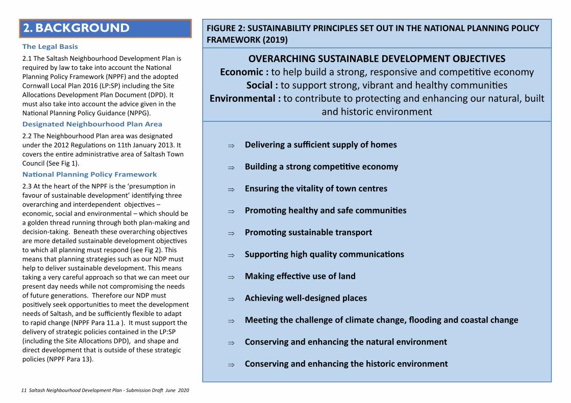
2.3 At the heart of the NPPF is the ‘presumption in favour of sustainable development’ identifying three overarching and interdependent objectives – economic, social and environmental – which should be a golden thread running through both plan-making and decision-taking. Beneath these overarching objectives are more detailed sustainable development objectives to which all planning must respond (see Fig 2). This means that planning strategies such as our NDP must help to deliver sustainable development. This means taking a very careful approach so that we can meet our present day needs while not compromising the needs of future generations. Therefore our NDP must positively seek opportunities to meet the development needs of Saltash, and be sufficiently flexible to adapt to rapid change (NPPF Para 11.a ). It must support the delivery of strategic policies contained in the LP:SP (including the Site Allocations DPD), and shape and direct development that is outside of these strategic policies (NPPF Para 13).
FIGURE 2: SUSTAINABILITY PRINCIPLES SET OUT IN THE NATIONAL PLANNING POLICY FRAMEWORK (2019)
OVERARCHING SUSTAINABLE DEVELOPMENT OBJECTIVES Economic : to help build a strong, responsive and competitive economy
Social : to support strong, vibrant and healthy communities Environmental : to contribute to protecting and enhancing our natural, built
and historic environment
Delivering a sufficient supply of homes
Building a strong competitive economy
Ensuring the vitality of town centres
Promoting healthy and safe communities
Promoting sustainable transport
Supporting high quality communications
Making effective use of land
Achieving well-designed places
Meeting the challenge of climate change, flooding and coastal change
Conserving and enhancing the natural environment
Conserving and enhancing the historic environment
12 Saltash Neighbourhood Development Plan - Submission Draft June 2020
2.4 Sustainable development is also the main purpose of Cornwall Council’s Local Plan suite of documents which aim to ‘Achieve a leading position in sustainable living’…. through ‘a balance of decisions around economic, social and environmental issues’.
2.5 The Local Plan documents include:
The LP:SP Strategic Policies document interprets the NPPF at a county-wide strategic level, and so is the most important part of the town and country planning context for the Saltash NDP. As well as a range of general strategic policies it includes specific objectives relating to Saltash:
Objective 1: Regeneration - Support the regeneration of Saltash town centre.
Objective 2: Jobs and Services - Improve the provision of and access to jobs and services (including public services), considering the influence of Plymouth.
Objective 3: Affordable Housing. - Enable the provision of affordable housing.
Objective 4: Transport - Support the improvement of public transport between the rural and urban areas.
Objective 5: Tourism - Improve Saltash as a tourism destination through the promotion of its heritage and regeneration of the waterfront.
In its Policy SP:LP 2a it sets specific targets for the provision of the following over the Plan period:
• around 1,200 dwellings for Saltash town in the period up to 2030; and
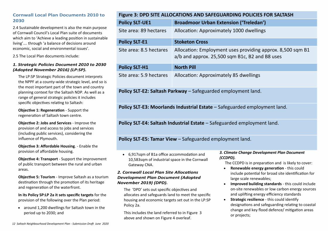
Figure 3: DPD SITE ALLOCATIONS AND SAFEGUARDING POLICIES FOR SALTASH
Policy SLT-UE1 Broadmoor Urban Extension (‘Treledan’)
Site area: 89 hectares Allocation: Approximately 1000 dwellings
Policy SLT-E1 Stoketon Cross
Site area: 8.5 hectares Allocation: Employment uses providing approx. 8,500 sqm B1 a/b and approx. 25,500 sqm B1c, B2 and B8 uses
Policy SLT-H1 North Pill
Site area: 5.9 hectares Allocation: Approximately 85 dwellings
Policy SLT-E2: Saltash Parkway – Safeguarded employment land.
Policy SLT-E3: Moorlands Industrial Estate – Safeguarded employment land.
Policy SLT-E4: Saltash Industrial Estate – Safeguarded employment land.
Policy SLT-E5: Tamar View – Safeguarded employment land.
• 6,917sqm of B1a office accommodation and 10,583sqm of industrial space in the Cornwall Gateway CNA.
The ‘DPD’ sets out specific objectives and allocates and safeguards land to meet the specific housing and economic targets set out in the LP:SP Policy 2a.
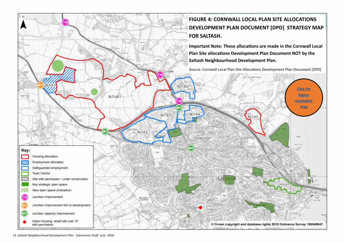
This includes the land referred to in Figure 3 above and shown on Figure 4 overleaf.
3. Climate Change Development Plan Document (CCDPD).
The CCDPD is in preparation and is likely to cover: • Renewable energy generation - this could
include potential for broad site identification for large scale renewables;
• Improved building standards - this could include on-site renewables or low carbon energy sources and uplifting energy efficiency standards
• Strategic resilience - this could identify designations and safeguarding relating to coastal change and key flood defence/ mitigation areas or projects;
13 Saltash Neighbourhood Development Plan - Submission Draft June 2020
FIGURE 4: CORNWALL LOCAL PLAN SITE ALLOCATIONS
DEVELOPMENT PLAN DOCUMENT [DPD] STRATEGY MAP
FOR SALTASH.
Important Note: These allocations are made in the Cornwall Local
Plan Site allocations Development Plan Document NOT by the
Saltash Neighbourhood Development Plan.
Source: Cornwall Local Plan Site Allocations Development Plan Document [DPD]
Click for
higher
resolution
map
14 Saltash Neighbourhood Development Plan - Submission Draft June 2020
community-based Working Groups were set up to investigate, analyse and report on the themes of:
Housing
Moving About
Making Communities
Invest, Work and Learn
2.12 This was followed by a further ‘visioning workshop’ for Working Groups, Councillors and community volunteers, to bring the work of the Groups together and agree a planning strategy around which a small drafting group then set about preparing this Plan.
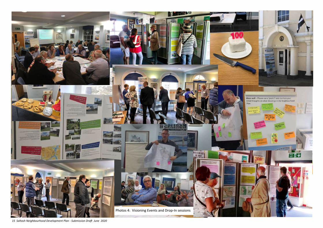
2.13 The pre-submission ‘Consultation Draft’ NDP was prepared by a core team of the Steering Group and was published on 19th June 2019, with 8 weeks allowed for comments, up to 14th August 2019. A launch event was followed by 5 drop-in sessions for people to see the Plan and discuss it with team members. An explanatory leaflet was also distributed to every household in the designated area and extensive use made of social media.
2.14 Saltash is a town with many community projects. Where this involves planning for new development, the NDP can enable such developments and set policies to ensure that they are sustainable in nature. These include:
• Saltash Waterside Coastal Community Strategy 2016
• Saltash Community Interest Company Strategic Plan 2006
• Saltash Station Project 2017
2.15 The impacts of global warming on our climate are widely recognised and many comments received during the consultation on the draft NDP called for more attention to be paid in its strategy and policies to this
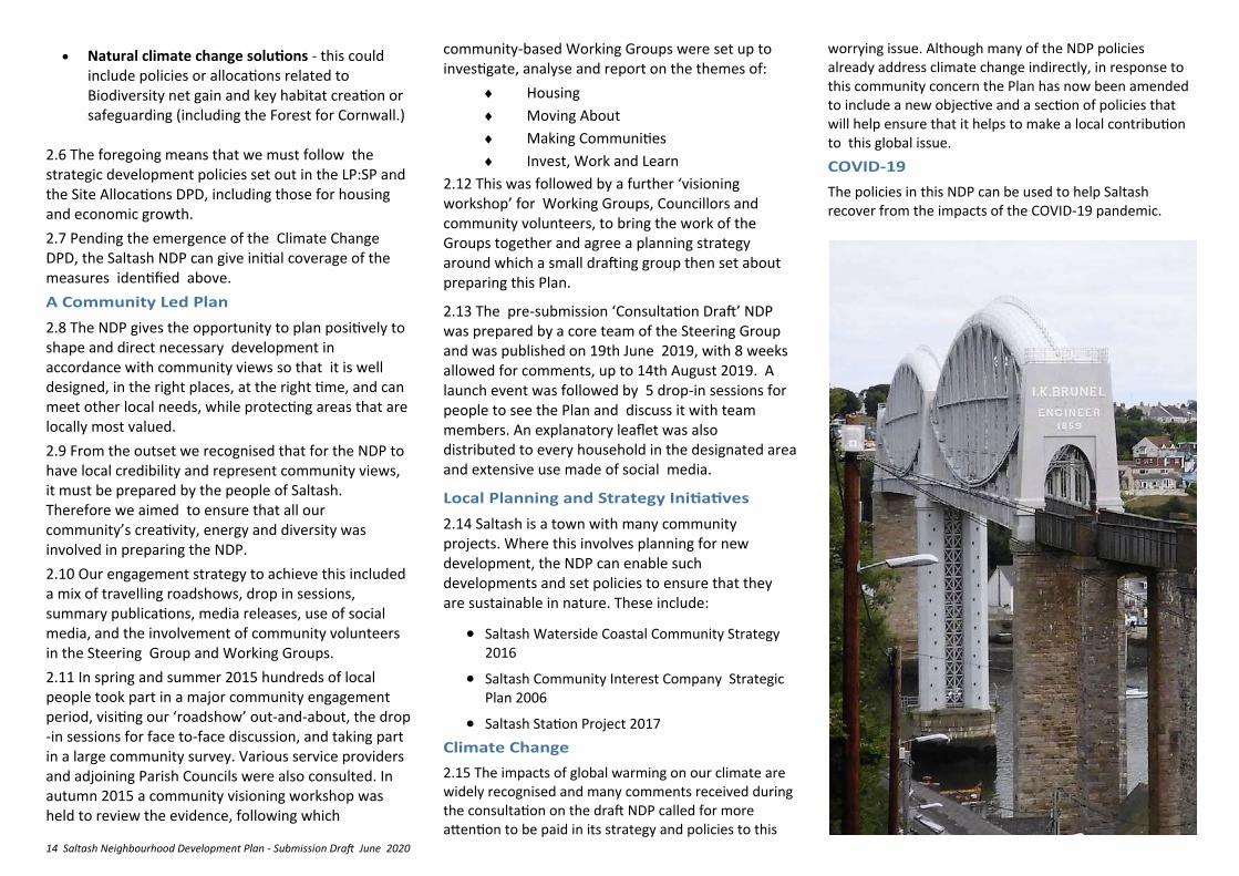
• Natural climate change solutions - this could include policies or allocations related to Biodiversity net gain and key habitat creation or safeguarding (including the Forest for Cornwall.)
2.6 The foregoing means that we must follow the strategic development policies set out in the LP:SP and the Site Allocations DPD, including those for housing and economic growth.
2.7 Pending the emergence of the Climate Change DPD, the Saltash NDP can give initial coverage of the measures identified above.
2.8 The NDP gives the opportunity to plan positively to shape and direct necessary development in accordance with community views so that it is well designed, in the right places, at the right time, and can meet other local needs, while protecting areas that are locally most valued.
2.9 From the outset we recognised that for the NDP to have local credibility and represent community views, it must be prepared by the people of Saltash. Therefore we aimed to ensure that all our community’s creativity, energy and diversity was involved in preparing the NDP.
2.10 Our engagement strategy to achieve this included a mix of travelling roadshows, drop in sessions, summary publications, media releases, use of social media, and the involvement of community volunteers in the Steering Group and Working Groups.
2.11 In spring and summer 2015 hundreds of local people took part in a major community engagement period, visiting our ‘roadshow’ out-and-about, the drop-in sessions for face to-face discussion, and taking part in a large community survey. Various service providers and adjoining Parish Councils were also consulted. In autumn 2015 a community visioning workshop was held to review the evidence, following which
worrying issue. Although many of the NDP policies already address climate change indirectly, in response to this community concern the Plan has now been amended to include a new objective and a section of policies that will help ensure that it helps to make a local contribution to this global issue.
The policies in this NDP can be used to help Saltash recover from the impacts of the COVID-19 pandemic.
15 Saltash Neighbourhood Development Plan - Submission Draft June 2020
Photos 4: Visioning Events and Drop-In sessions

16 Saltash Neighbourhood Development Plan - Submission Draft June 2020
SPACER
17 Saltash Neighbourhood Development Plan - Submission Draft June 2020
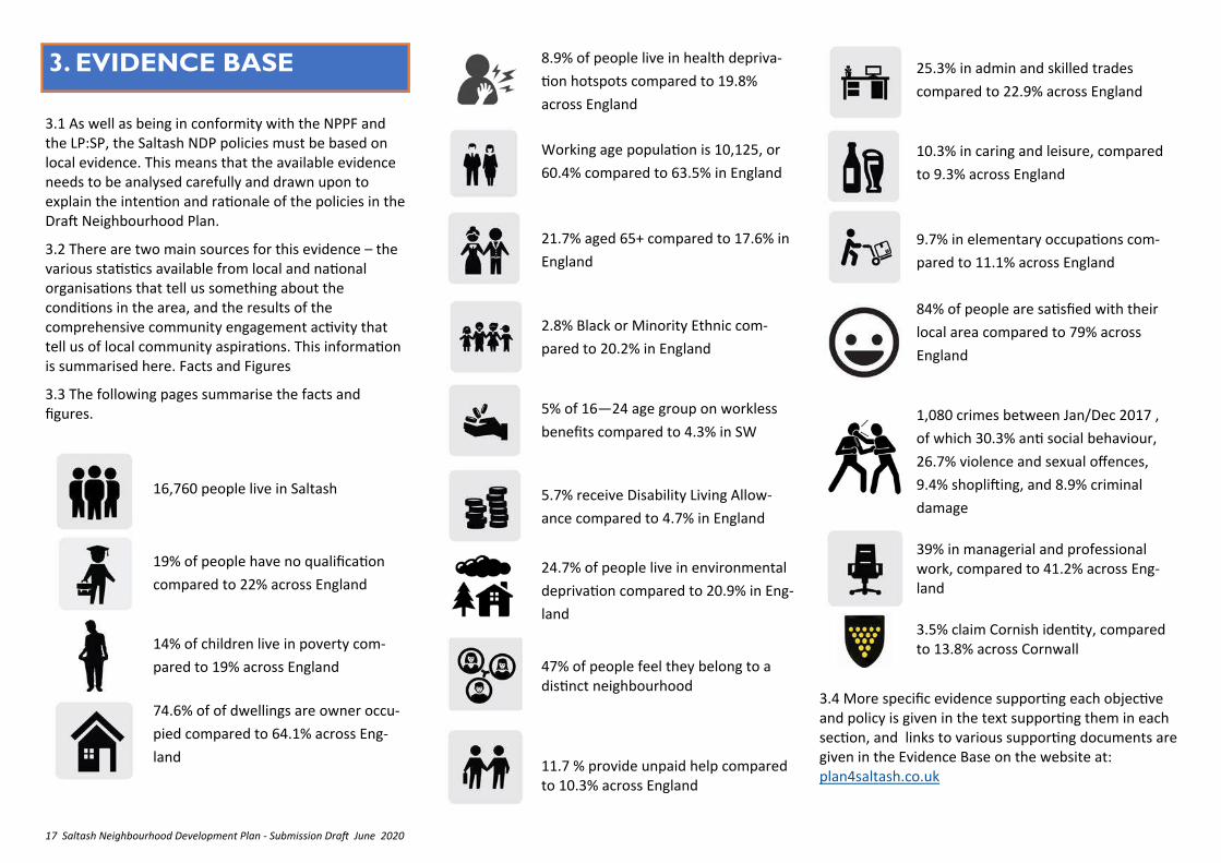
3.1 As well as being in conformity with the NPPF and the LP:SP, the Saltash NDP policies must be based on local evidence. This means that the available evidence needs to be analysed carefully and drawn upon to explain the intention and rationale of the policies in the Draft Neighbourhood Plan.
3.2 There are two main sources for this evidence – the various statistics available from local and national organisations that tell us something about the conditions in the area, and the results of the comprehensive community engagement activity that tell us of local community aspirations. This information is summarised here. Facts and Figures
3.3 The following pages summarise the facts and figures.
3. EVIDENCE BASE
16,760 people live in Saltash
19% of people have no qualification
compared to 22% across England
14% of children live in poverty com-
pared to 19% across England
74.6% of of dwellings are owner occu-
pied compared to 64.1% across Eng-
land
8.9% of people live in health depriva-
tion hotspots compared to 19.8%
across England
Working age population is 10,125, or
60.4% compared to 63.5% in England
21.7% aged 65+ compared to 17.6% in
England
2.8% Black or Minority Ethnic com-
pared to 20.2% in England
5% of 16—24 age group on workless
benefits compared to 4.3% in SW
5.7% receive Disability Living Allow-
ance compared to 4.7% in England
24.7% of people live in environmental
deprivation compared to 20.9% in Eng-
land
47% of people feel they belong to a distinct neighbourhood
11.7 % provide unpaid help compared to 10.3% across England
25.3% in admin and skilled trades
compared to 22.9% across England
10.3% in caring and leisure, compared
to 9.3% across England
9.7% in elementary occupations com-
pared to 11.1% across England
84% of people are satisfied with their
local area compared to 79% across
England
1,080 crimes between Jan/Dec 2017 ,
of which 30.3% anti social behaviour,
26.7% violence and sexual offences,
9.4% shoplifting, and 8.9% criminal
damage
39% in managerial and professional work, compared to 41.2% across Eng-land
3.5% claim Cornish identity, compared to 13.8% across Cornwall
3.4 More specific evidence supporting each objective and policy is given in the text supporting them in each section, and links to various supporting documents are given in the Evidence Base on the website at: plan4saltash.co.uk
18 Saltash Neighbourhood Development Plan - Submission Draft June 2020
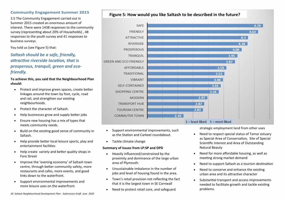
3.5 The Community Engagement carried out in Summer 2015 created an enormous amount of interest. There were 1438 responses to the community survey (representing about 20% of Households) , 48 responses to the youth survey and 41 responses to business surveys.
You told us (see Figure 5) that:
Saltash should be a safe, friendly, attractive riverside location, that is prosperous, tranquil, green and eco-friendly.
To achieve this, you said that the Neighbourhood Plan should:
• Protect and improve green spaces, create better linkages around the town by foot, cycle, road and rail, and strengthen our existing neighbourhoods.
• Protect the character of Saltash.
• Help businesses grow and supply better jobs
• Ensure new housing has a mix of types that meets community needs.
• Build on the existing good sense of community in Saltash.
• Help provide better local leisure sports, play and entertainment facilities
• Help create variety and better quality shops in Fore Street
• Improve the ‘evening economy’ of Saltash town centre, through better community safety, more restaurants and cafes, more events, and good links down to the waterfront.
• Support environmental improvements and more leisure uses on the waterfront.
• Support environmental improvements, such as the Station and Carkeel roundabout.
• Tackle climate change
Summary of Issues from LP:SP and DPD
• Heavily influenced/constrained by the proximity and dominance of the large urban area of Plymouth.
• Unsustainable imbalance in the number of jobs and level of housing found in the area.
• Town’s retail provision not reflecting the fact that it is the largest town in SE Cornwall
• Need to protect retail core, and safeguard
strategic employment land from other uses
• Need to respect special status of Tamar estuary as Special Area of Conservation, Site of Special Scientific Interest and Area of Outstanding Natural Beauty
• Need for more affordable housing, as well as meeting strong market demand
• Need to support Saltash as a tourism destination
• Need to conserve and enhance the existing urban area and its attractive character
• Substantial transport and access improvements needed to facilitate growth and tackle existing problems.
Figure 5: How would you like Saltash to be described in the future?
19 Saltash Neighbourhood Development Plan - Submission Draft June 2020
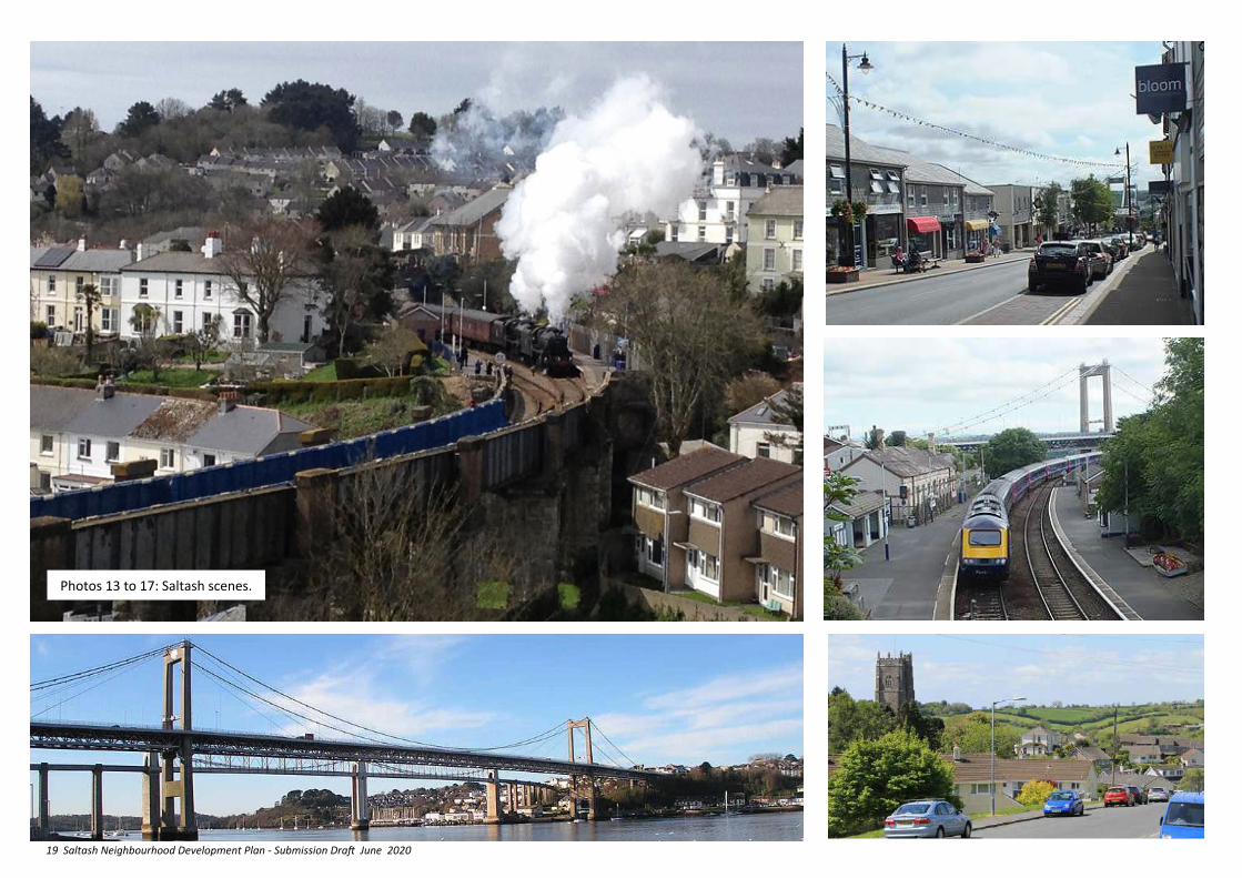
Photos 13 to 17: Saltash scenes.
20 Saltash Neighbourhood Development Plan - Submission Draft June 2020
4. THE VISION FOR SALTASH
Sustainable Saltash
4.1 Our intention is that….
The Vision will be achieved by delivering the following objectives to:
Secure a diverse and prosperous Local Economy
Regenerate the Town Centre, especially Fore Street, and Manage the Growth of “Out of Town” shopping
Create and Support Sustainable Neighbourhoods
Revitalise the Waterfront
Ensure a Balanced Range of Quality New Housing
Protect and Enhance the Built Environment
Enhance the Natural Environment of the Parish
Manage the Rural Areas of the Parish in a Sympathetic Manner
Meet the Changing demand for Health, Education, and Community Services and Facilities
Meet the growing demand for additional Sport, Recreation and Leisure facilities
Encourage Improved and Sustainable Connectivity
Tackle the causes and impacts of climate change.
4.2 This vision and objectives are underpinned and achieved through the adoption and application of the following two beliefs.
Putting the principles of sustainable development and community participation at the heart of the Neighbourhood Plan.
4.3 This means not only taking the opportunities and tackling the challenges so that our present needs are met without harming the ability of future generations to meet their needs, but achieving this by creating a parish structure which enables direct community participation in shaping, delivering and reviewing the Plan , and committing to greater involvement in managing public assets and facilities created.
Fostering community pride and releasing the latent potential.
4.4 This means encouraging every resident and business in the Parish, as well as the numerous associations, clubs and bodies within it, to take greater responsibility and work together in delivering the Plan and making Saltash an even more special place to live, work and enjoy.
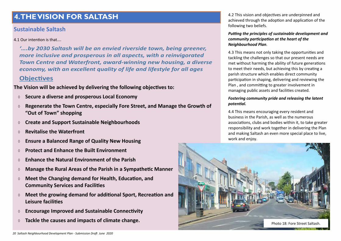
Photo 18: Fore Street Saltash.
21 Saltash Neighbourhood Development Plan - Submission Draft June 2020
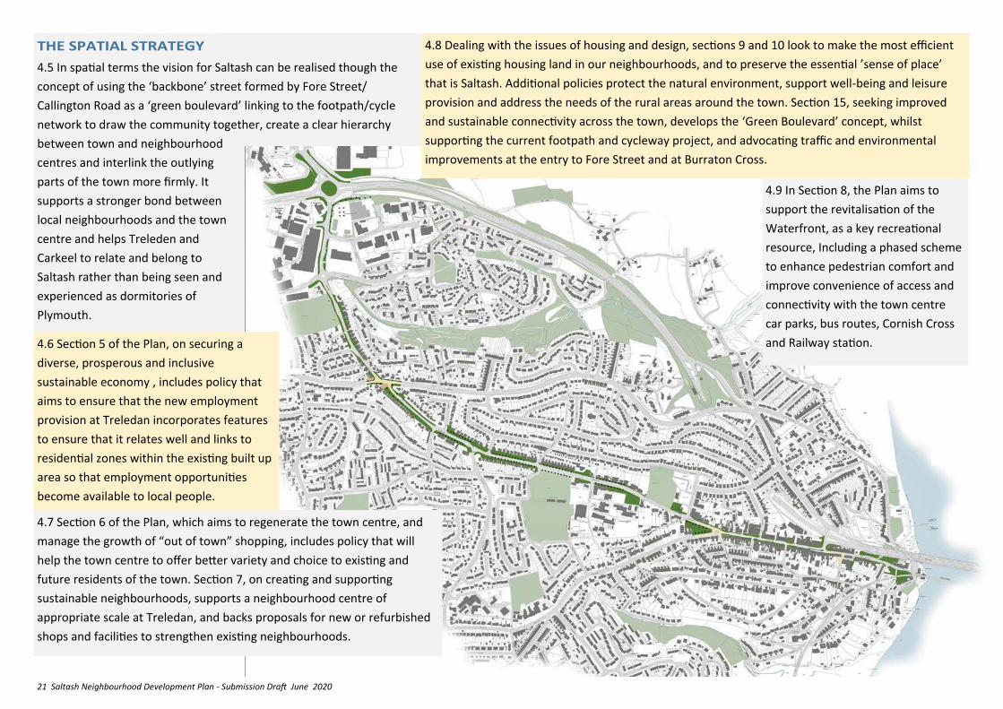
4.5 In spatial terms the vision for Saltash can be realised though the
concept of using the ‘backbone’ street formed by Fore Street/
Callington Road as a ‘green boulevard’ linking to the footpath/cycle
network to draw the community together, create a clear hierarchy
between town and neighbourhood
centres and interlink the outlying
parts of the town more firmly. It
supports a stronger bond between
local neighbourhoods and the town
centre and helps Treleden and
Carkeel to relate and belong to
Saltash rather than being seen and
experienced as dormitories of
Plymouth.
4.9 In Section 8, the Plan aims to
support the revitalisation of the
Waterfront, as a key recreational
resource, Including a phased scheme
to enhance pedestrian comfort and
improve convenience of access and
connectivity with the town centre
car parks, bus routes, Cornish Cross
and Railway station. 4.6 Section 5 of the Plan, on securing a
diverse, prosperous and inclusive
sustainable economy , includes policy that
aims to ensure that the new employment
provision at Treledan incorporates features
to ensure that it relates well and links to
residential zones within the existing built up
area so that employment opportunities
become available to local people.
4.7 Section 6 of the Plan, which aims to regenerate the town centre, and
manage the growth of “out of town” shopping, includes policy that will
help the town centre to offer better variety and choice to existing and
future residents of the town. Section 7, on creating and supporting
sustainable neighbourhoods, supports a neighbourhood centre of
appropriate scale at Treledan, and backs proposals for new or refurbished
shops and facilities to strengthen existing neighbourhoods.
4.8 Dealing with the issues of housing and design, sections 9 and 10 look to make the most efficient
use of existing housing land in our neighbourhoods, and to preserve the essential ’sense of place’
that is Saltash. Additional policies protect the natural environment, support well-being and leisure
provision and address the needs of the rural areas around the town. Section 15, seeking improved
and sustainable connectivity across the town, develops the ‘Green Boulevard’ concept, whilst
supporting the current footpath and cycleway project, and advocating traffic and environmental
improvements at the entry to Fore Street and at Burraton Cross.
22 Saltash Neighbourhood Development Plan - Submission Draft June 2020
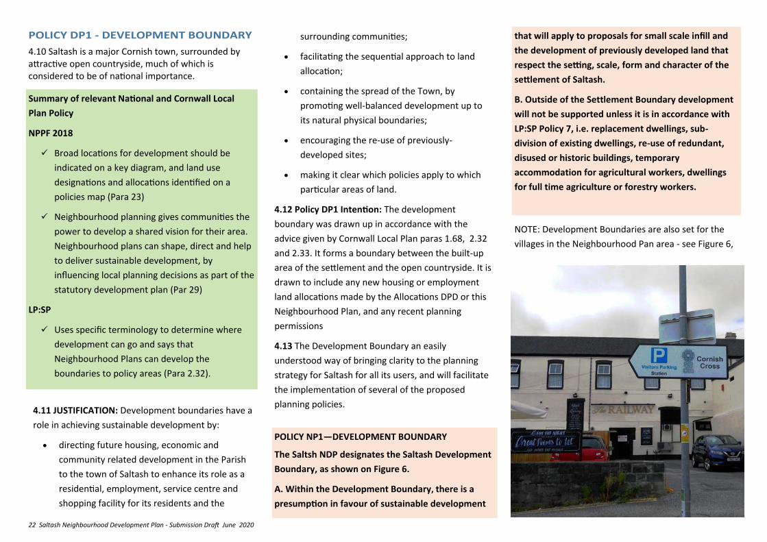
4.10 Saltash is a major Cornish town, surrounded by attractive open countryside, much of which is considered to be of national importance.
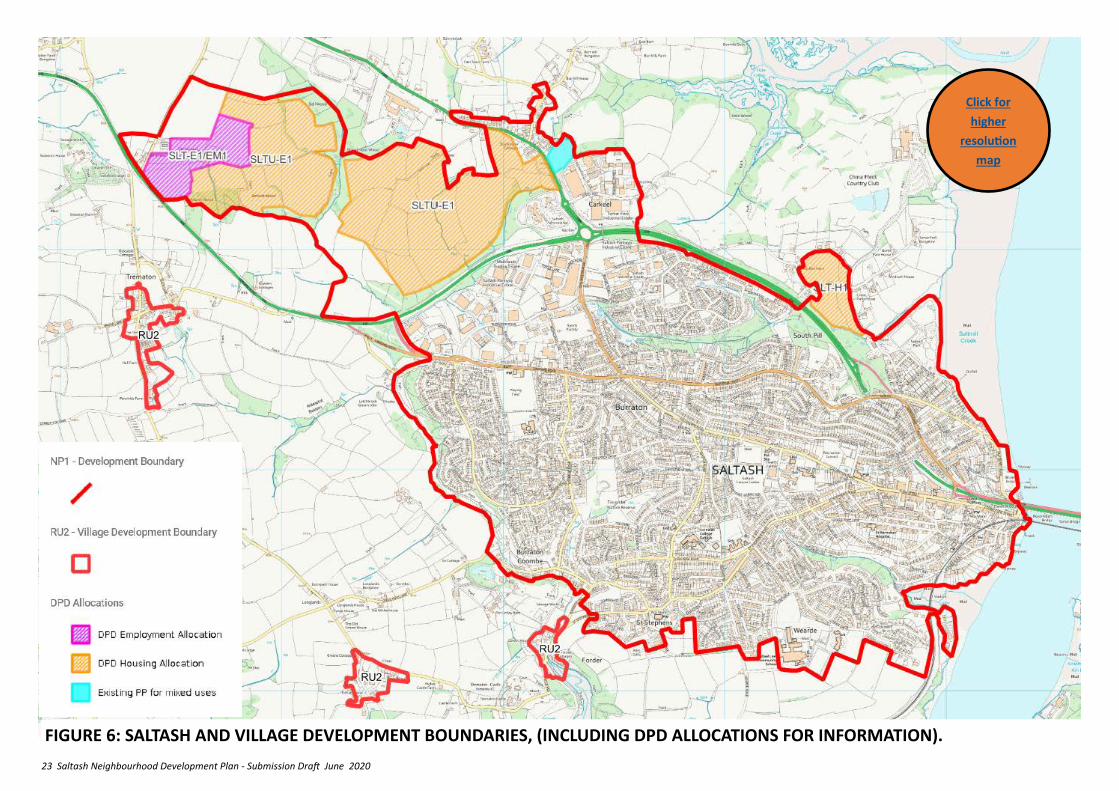
POLICY NP1—DEVELOPMENT BOUNDARY
The Saltsh NDP designates the Saltash Development
Boundary, as shown on Figure 6.
A. Within the Development Boundary, there is a
presumption in favour of sustainable development
4.11 JUSTIFICATION: Development boundaries have a
role in achieving sustainable development by:
• directing future housing, economic and
community related development in the Parish
to the town of Saltash to enhance its role as a
residential, employment, service centre and
shopping facility for its residents and the
Summary of relevant National and Cornwall Local
Plan Policy
NPPF 2018
✓ Broad locations for development should be
indicated on a key diagram, and land use
designations and allocations identified on a
policies map (Para 23)
✓ Neighbourhood planning gives communities the
power to develop a shared vision for their area.
Neighbourhood plans can shape, direct and help
to deliver sustainable development, by
influencing local planning decisions as part of the
statutory development plan (Par 29)
LP:SP
✓ Uses specific terminology to determine where
development can go and says that
Neighbourhood Plans can develop the
boundaries to policy areas (Para 2.32).
surrounding communities;
• facilitating the sequential approach to land
allocation;
• containing the spread of the Town, by
promoting well-balanced development up to
its natural physical boundaries;
• encouraging the re-use of previously-
developed sites;
• making it clear which policies apply to which
particular areas of land.
4.12 Policy DP1 Intention: The development
boundary was drawn up in accordance with the
advice given by Cornwall Local Plan paras 1.68, 2.32
and 2.33. It forms a boundary between the built-up
area of the settlement and the open countryside. It is
drawn to include any new housing or employment
land allocations made by the Allocations DPD or this
Neighbourhood Plan, and any recent planning
permissions
4.13 The Development Boundary an easily
understood way of bringing clarity to the planning
strategy for Saltash for all its users, and will facilitate
the implementation of several of the proposed
planning policies.
that will apply to proposals for small scale infill and
the development of previously developed land that
respect the setting, scale, form and character of the
settlement of Saltash.
B. Outside of the Settlement Boundary development
will not be supported unless it is in accordance with
LP:SP Policy 7, i.e. replacement dwellings, sub-
division of existing dwellings, re-use of redundant,
disused or historic buildings, temporary
accommodation for agricultural workers, dwellings
for full time agriculture or forestry workers.
NOTE: Development Boundaries are also set for the
villages in the Neighbourhood Pan area - see Figure 6,
23 Saltash Neighbourhood Development Plan - Submission Draft June 2020
FIGURE 6: SALTASH AND VILLAGE DEVELOPMENT BOUNDARIES, (INCLUDING DPD ALLOCATIONS FOR INFORMATION).
Click for
higher
resolution
map
24 Saltash Neighbourhood Development Plan - Submission Draft June 2020
5. SECURE A DIVERSE AND
PROSPEROUS LOCAL
ECONOMY
5.1 JUSTIFICATION: Saltash has a strong economic link to Plymouth immediately to the east, which creates significant demand to travel, counter to the principles of sustainability. Saltash needs to address the current imbalance between the number of jobs and level of housing found within the town. The DPD allocates a new area for employment growth, and safeguards existing employment spaces. However it is important to ensure that the new employment is properly accessible by residents.
5.2 Policy EM1 Intention – Whilst DPD Policy SLT-E1 is strongly supported, it is essential that the site is developed as sustainably as possible and provides job opportunities for the existing community in Saltash. The site is not well related and accessible to the town. Policy EM1 is intended to ensure that this is addressed by adding detail to Policy SLT-E1 2(a) The policy complements the Saltash Transport Strategy and paragraph 13.40 of the DPD.
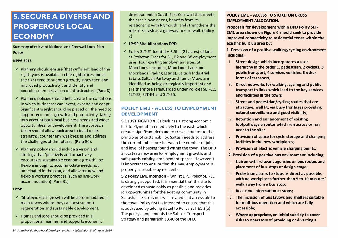
POLICY EM1 – ACCESS TO STOKETON CROSS EMPLOYMENT ALLOCATION.
Proposals for development within DPD Policy SLT-EM1 area shown on Figure 6 should seek to provide improved connectivity to residential zones within the existing built up area by:
1. Provision of a positive walking/cycling environment including:
i. Street design which incorporates a user hierarchy in the order 1. pedestrian, 2 cyclists, 3 public transport, 4 services vehicles, 5 other forms of transport;
ii. Direct networks for walking, cycling and public transport to links which lead to the key services and facilities in the town;
iii. Street and pedestrian/cycling routes that are attractive, well lit, via busy frontages providing natural surveillance and good visibility;
iv. Retention and enhancement of existing footpath/cycle routes which run across or run near to the site;
v. Provision of space for cycle storage and changing facilities in the new workplaces;
vi. Provision of electric vehicle charging points.
2. Provision of a positive bus environment including:
i. Liaison with relevant agencies on bus routes and placement of bus stops at design stage;
ii. Pedestrian access to stops as direct as possible, with no workplaces further than 5 to 10 minutes’ walk away from a bus stop;
iii. Real-time information at stops;
iv. The inclusion of bus laybys and shelters suitable for midi-bus operation and which are fully accessible;
v. Where appropriate, an Initial subsidy to cover risks to operators of providing or diverting a
Summary of relevant National and Cornwall Local Plan
Policy
NPPG 2018
✓ Planning should ensure ‘that sufficient land of the right types is available in the right places and at the right time to support growth, innovation and improved productivity’; and identify and coordinate the provision of infrastructure (Para 8).
✓ Planning policies should help create the conditions in which businesses can invest, expand and adapt. Significant weight should be placed on the need to support economic growth and productivity, taking into account both local business needs and wider opportunities for development. The approach taken should allow each area to build on its strengths, counter any weaknesses and address the challenges of the future… (Para 80).
✓ Planning policy should include a vision and strategy that ‘positively and proactively encourages sustainable economic growth’, be flexible enough to accommodate needs not anticipated in the plan, and allow for new and flexible working practices (such as live-work accommodation) (Para 81);
LP:SP
✓ ‘Strategic scale’ growth will be accommodated in main towns where they can best support regeneration and sustainable development.
✓ Homes and jobs should be provided in a proportional manner, and supports economic
development in South East Cornwall that meets the area’s own needs, benefits from its relationship with Plymouth, and strengthens the role of Saltash as a gateway to Cornwall. (Policy 2)
✓ LP:SP Site Allocations DPD
✓ Policy SLT-E1 identifies 8.5ha (21 acres) of land at Stoketon Cross for B1, B2 and B8 employment uses. Four existing employment sites, at Moorlands (including Moorlands Lane and Moorlands Trading Estate), Saltash Industrial Estate, Saltash Parkway and Tamar View, are identified as being strategically important and are therefore safeguarded under Policies SLT-E2, SLT-E3, SLT-E4 and SLT-E5.
25 Saltash Neighbourhood Development Plan - Submission Draft June 2020
5.3 JUSTIFICATION: Older industrial and commercial premises, built at a time when car-ownership was less common and commercial vehicles were smaller, often have inflexible layouts, life-expired buildings, and poor environments, which tend not to attract inward investment and higher technology development and can cause negative customer impressions that restrict competitiveness.
5.4 Policy EM2 Intention - This policy is intended to encourage and enable upgrading and improvement of employment sites to a standard more appropriate to modern needs, subject to criteria protecting the local environment and encouraging improved sustainable transport options.
POLICY EM2 - REDEVELOPMENT AND ENHANCEMENT OF EXISTING EMPLOYMENT SITES.
1. The redevelopment and/or enhancement of employment uses on existing sites to provide upgraded premises and improved environment will be supported subject to there being no significant detrimental impact on the amenities of adjoining residential areas in terms of:
i. its scale and visual appearance;
ii. noise, effluent or fumes it would emit;
iii. the traffic it would generate;
iv. and that it will not add to difficulties with water supply, sewerage and sewage treatment and waste disposal
5.5 JUSTIFICATION: Due to the growth in travel to work by car, transfer of goods movement to road and use of bigger commercial vehicles, established industrial and commercial sites may struggle to accommodate modern requirements on site, causing parking, vehicle manoeuvring, and even goods handling, to spill over on to adjoining public areas, and adjacent roads to the detriment of residential and public amenity.
5.6 Policy EM3 Intention - This policy is intended to ensure that new and redeveloped industrial and commercial premises incorporate sufficient facilities to obviate the need for customer/employee car parking and commercial vehicle movements on adjacent roads.
POLICY EM3 – PARKING, STORAGE AND MOVEMENT ON AND AROUND EMPLOYMENT SITES
New and redeveloped employment development will be supported where it incorporates, on-site, adequate provision to meet the needs of potential occupiers for :
i. Staff and visitor car parking,
ii. Commercial vehicle loading, unloading, parking manoeuvring facilities
iii. External storage/transfer space for materials and products.
service, or to cover ticketing incentive schemes;
vi. Roads of adequate width to fit buses.
3. Contributions to off-site measures needed to meet the access needs of the new population occupying the workspaces to be built.
2. Proposals should improve pedestrian/cycle links to adjoining residential areas and the Town Centre, pedestrian links to public transport routes, and enhance the usability and safety of existing routes.
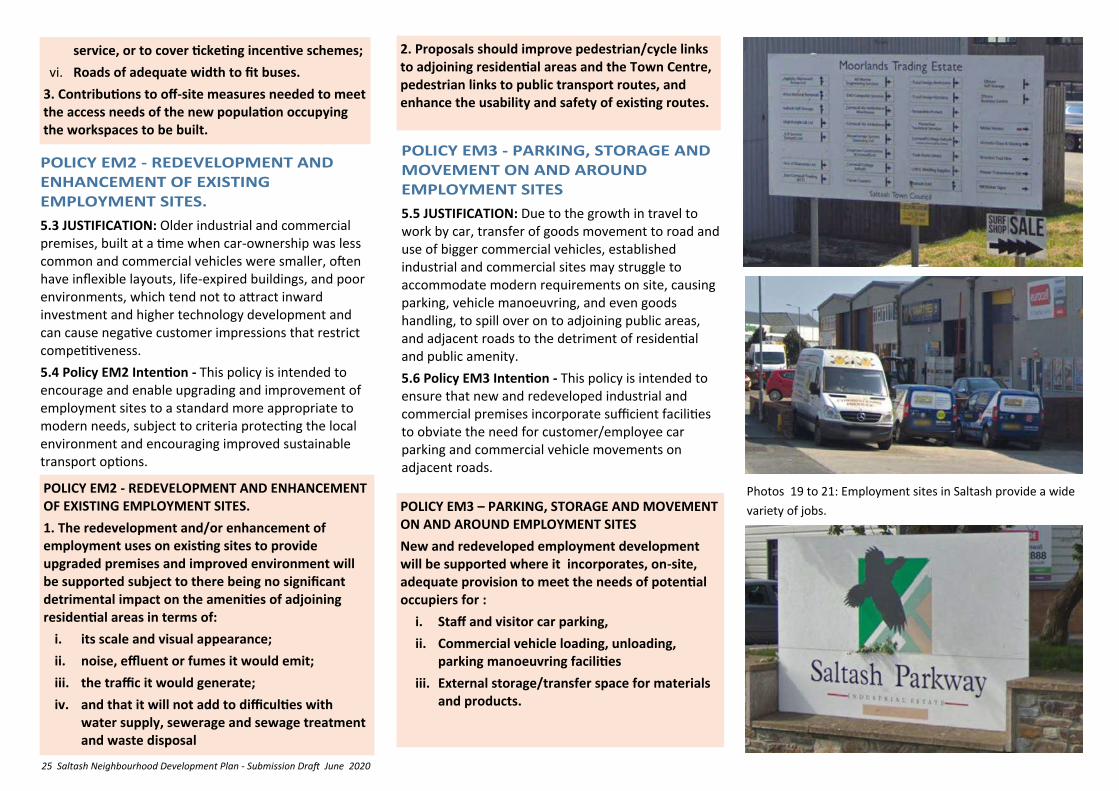
Photos 19 to 21: Employment sites in Saltash provide a wide
variety of jobs.

26 Saltash Neighbourhood Development Plan - Submission Draft June 2020
5.8 JUSTIFICATION: Running businesses at/from home is a major and increasingly valuable part of the local economy. The 2011 Census indicated 12.4% of Saltash’s working population were based at home and according to DBIS figures (2014) 1 in 10 domestic properties are home to at least 1 business. Applied to Saltash this implies around 700 home-based businesses. Planning permission will be required if there are alterations to buildings, or the scale of business materially changes the use of the premises.
5.9 Policy EM4 Intention - In such circumstances, it is desirable to encourage the business to continue in operation and to expand by ensuring that their impact on local residential amenity and the environment is acceptable.
POLICY EM4 – HOME BASED ENTERPRISE
Home based enterprise proposals requiring Planning Permission will be supported where it can be shown that there will be no unreasonable adverse impact affecting nearby residents and countryside, the character and appearance of the locality, or local road and footpath/cycle routes by reason of visual impact, vehicle movements and parking, noise vibration, special lighting, advertising and activity outside of normal business hours.
5.10 JUSTIFICATION: To retain and develop competitiveness it is important that local businesses can take advantage of superfast broadband and trouble-free telephone communications.
5.11 Policy EM5 Intention - This policy is intended to ensure that new and redeveloped employment development incorporates or allows for a standard of telecommunications that supports the latest forms of
POLICY EM5 – TELECOMMUNICATIONS ON EMPLOYMENT SITES
New or redeveloped employment sites should provide superfast fibre connections or ducting to facilitate such connections, and if appropriate include provision for mobile phone signal towers and satellite dishes.
commerce and manufacturing, so that the development of existing local firms and the formation or inward movement of new firms to the area may be encouraged.
Photos 22 & 23 left: Satellite dish and mobile phone
masts within employment sites
Photo 24 below: Modernisation of employment sites
often leads to the introduction of mixed trade/retail
counters
27 Saltash Neighbourhood Development Plan - Submission Draft June 2020
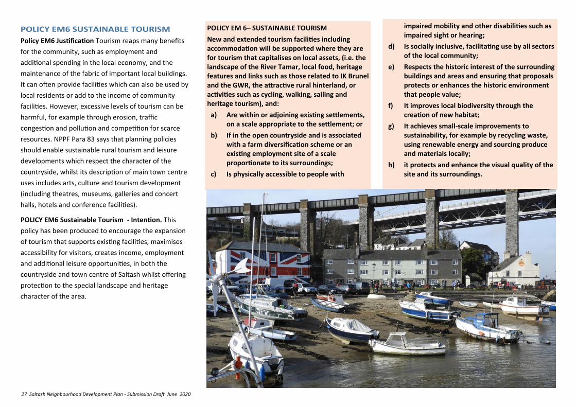
Policy EM6 Justification Tourism reaps many benefits
for the community, such as employment and
additional spending in the local economy, and the
maintenance of the fabric of important local buildings.
It can often provide facilities which can also be used by
local residents or add to the income of community
facilities. However, excessive levels of tourism can be
harmful, for example through erosion, traffic
congestion and pollution and competition for scarce
resources. NPPF Para 83 says that planning policies
should enable sustainable rural tourism and leisure
developments which respect the character of the
countryside, whilst its description of main town centre
uses includes arts, culture and tourism development
(including theatres, museums, galleries and concert
halls, hotels and conference facilities).
POLICY EM6 Sustainable Tourism - Intention. This
policy has been produced to encourage the expansion
of tourism that supports existing facilities, maximises
accessibility for visitors, creates income, employment
and additional leisure opportunities, in both the
countryside and town centre of Saltash whilst offering
protection to the special landscape and heritage
character of the area.
POLICY EM 6– SUSTAINABLE TOURISM
New and extended tourism facilities including accommodation will be supported where they are for tourism that capitalises on local assets, (i.e. the landscape of the River Tamar, local food, heritage features and links such as those related to IK Brunel and the GWR, the attractive rural hinterland, or activities such as cycling, walking, sailing and heritage tourism), and:
a) Are within or adjoining existing settlements, on a scale appropriate to the settlement; or
b) If in the open countryside and is associated with a farm diversification scheme or an existing employment site of a scale proportionate to its surroundings;
c) Is physically accessible to people with
impaired mobility and other disabilities such as impaired sight or hearing;
d) Is socially inclusive, facilitating use by all sectors of the local community;
e) Respects the historic interest of the surrounding buildings and areas and ensuring that proposals protects or enhances the historic environment that people value;
f) It improves local biodiversity through the creation of new habitat;
g) It achieves small-scale improvements to sustainability, for example by recycling waste, using renewable energy and sourcing produce and materials locally;
h) it protects and enhance the visual quality of the site and its surroundings.
28 Saltash Neighbourhood Development Plan - Submission Draft June 2020
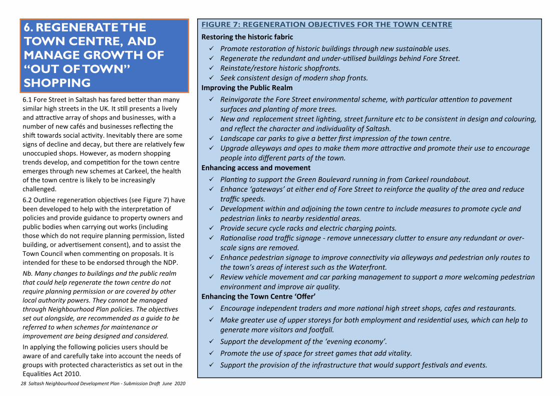
6. REGENERATE THE
TOWN CENTRE, AND
MANAGE GROWTH OF
“OUT OF TOWN”
SHOPPING
6.1 Fore Street in Saltash has fared better than many similar high streets in the UK. It still presents a lively and attractive array of shops and businesses, with a number of new cafés and businesses reflecting the shift towards social activity. Inevitably there are some signs of decline and decay, but there are relatively few unoccupied shops. However, as modern shopping trends develop, and competition for the town centre emerges through new schemes at Carkeel, the health of the town centre is likely to be increasingly challenged.
6.2 Outline regeneration objectives (see Figure 7) have been developed to help with the interpretation of policies and provide guidance to property owners and public bodies when carrying out works (including those which do not require planning permission, listed building, or advertisement consent), and to assist the Town Council when commenting on proposals. It is intended for these to be endorsed through the NDP.
Nb. Many changes to buildings and the public realm that could help regenerate the town centre do not require planning permission or are covered by other local authority powers. They cannot be managed through Neighbourhood Plan policies. The objectives set out alongside, are recommended as a guide to be referred to when schemes for maintenance or improvement are being designed and considered.
In applying the following policies users should be aware of and carefully take into account the needs of groups with protected characteristics as set out in the Equalities Act 2010.
Restoring the historic fabric
✓ Promote restoration of historic buildings through new sustainable uses. ✓ Regenerate the redundant and under-utilised buildings behind Fore Street. ✓ Reinstate/restore historic shopfronts. ✓ Seek consistent design of modern shop fronts.
Improving the Public Realm
✓ Reinvigorate the Fore Street environmental scheme, with particular attention to pavement surfaces and planting of more trees.
✓ New and replacement street lighting, street furniture etc to be consistent in design and colouring, and reflect the character and individuality of Saltash.
✓ Landscape car parks to give a better first impression of the town centre. ✓ Upgrade alleyways and opes to make them more attractive and promote their use to encourage
people into different parts of the town. Enhancing access and movement
✓ Planting to support the Green Boulevard running in from Carkeel roundabout. ✓ Enhance ‘gateways’ at either end of Fore Street to reinforce the quality of the area and reduce
traffic speeds. ✓ Development within and adjoining the town centre to include measures to promote cycle and
pedestrian links to nearby residential areas. ✓ Provide secure cycle racks and electric charging points. ✓ Rationalise road traffic signage - remove unnecessary clutter to ensure any redundant or over-
scale signs are removed. ✓ Enhance pedestrian signage to improve connectivity via alleyways and pedestrian only routes to
the town’s areas of interest such as the Waterfront. ✓ Review vehicle movement and car parking management to support a more welcoming pedestrian
environment and improve air quality. Enhancing the Town Centre ‘Offer’
✓ Encourage independent traders and more national high street shops, cafes and restaurants.
✓ Make greater use of upper storeys for both employment and residential uses, which can help to generate more visitors and footfall.
✓ Support the development of the ‘evening economy’.
✓ Promote the use of space for street games that add vitality.
✓ Support the provision of the infrastructure that would support festivals and events.
29 Saltash Neighbourhood Development Plan - Submission Draft June 2020
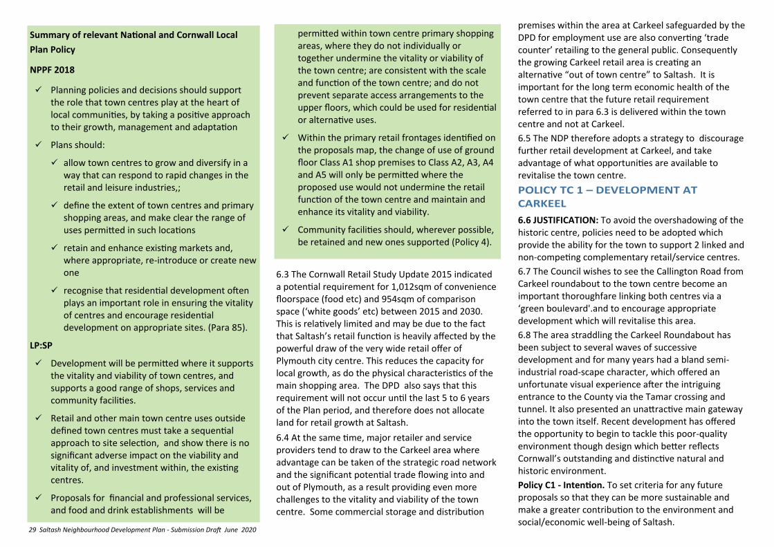
6.3 The Cornwall Retail Study Update 2015 indicated a potential requirement for 1,012sqm of convenience floorspace (food etc) and 954sqm of comparison space (‘white goods’ etc) between 2015 and 2030. This is relatively limited and may be due to the fact that Saltash’s retail function is heavily affected by the powerful draw of the very wide retail offer of Plymouth city centre. This reduces the capacity for local growth, as do the physical characteristics of the main shopping area. The DPD also says that this requirement will not occur until the last 5 to 6 years of the Plan period, and therefore does not allocate land for retail growth at Saltash.
6.4 At the same time, major retailer and service providers tend to draw to the Carkeel area where advantage can be taken of the strategic road network and the significant potential trade flowing into and out of Plymouth, as a result providing even more challenges to the vitality and viability of the town centre. Some commercial storage and distribution
premises within the area at Carkeel safeguarded by the DPD for employment use are also converting ‘trade counter’ retailing to the general public. Consequently the growing Carkeel retail area is creating an alternative “out of town centre” to Saltash. It is important for the long term economic health of the town centre that the future retail requirement referred to in para 6.3 is delivered within the town centre and not at Carkeel.
6.5 The NDP therefore adopts a strategy to discourage further retail development at Carkeel, and take advantage of what opportunities are available to revitalise the town centre.
6.6 JUSTIFICATION: To avoid the overshadowing of the historic centre, policies need to be adopted which provide the ability for the town to support 2 linked and non-competing complementary retail/service centres.
6.7 The Council wishes to see the Callington Road from Carkeel roundabout to the town centre become an important thoroughfare linking both centres via a ‘green boulevard'.and to encourage appropriate development which will revitalise this area.
6.8 The area straddling the Carkeel Roundabout has been subject to several waves of successive development and for many years had a bland semi-industrial road-scape character, which offered an unfortunate visual experience after the intriguing entrance to the County via the Tamar crossing and tunnel. It also presented an unattractive main gateway into the town itself. Recent development has offered the opportunity to begin to tackle this poor-quality environment though design which better reflects Cornwall’s outstanding and distinctive natural and historic environment.
Policy C1 - Intention. To set criteria for any future proposals so that they can be more sustainable and make a greater contribution to the environment and social/economic well-being of Saltash.
Summary of relevant National and Cornwall Local
Plan Policy
NPPF 2018
✓ Planning policies and decisions should support the role that town centres play at the heart of local communities, by taking a positive approach to their growth, management and adaptation
✓ Plans should:
✓ allow town centres to grow and diversify in a way that can respond to rapid changes in the retail and leisure industries,;
✓ define the extent of town centres and primary shopping areas, and make clear the range of uses permitted in such locations
✓ retain and enhance existing markets and, where appropriate, re-introduce or create new one
✓ recognise that residential development often plays an important role in ensuring the vitality of centres and encourage residential development on appropriate sites. (Para 85).
LP:SP
✓ Development will be permitted where it supports the vitality and viability of town centres, and supports a good range of shops, services and community facilities.
✓ Retail and other main town centre uses outside defined town centres must take a sequential approach to site selection, and show there is no significant adverse impact on the viability and vitality of, and investment within, the existing centres.
✓ Proposals for financial and professional services, and food and drink establishments will be
permitted within town centre primary shopping areas, where they do not individually or together undermine the vitality or viability of the town centre; are consistent with the scale and function of the town centre; and do not prevent separate access arrangements to the upper floors, which could be used for residential or alternative uses.
✓ Within the primary retail frontages identified on the proposals map, the change of use of ground floor Class A1 shop premises to Class A2, A3, A4 and A5 will only be permitted where the proposed use would not undermine the retail function of the town centre and maintain and enhance its vitality and viability.
✓ Community facilities should, wherever possible, be retained and new ones supported (Policy 4).
30 Saltash Neighbourhood Development Plan - Submission Draft June 2020
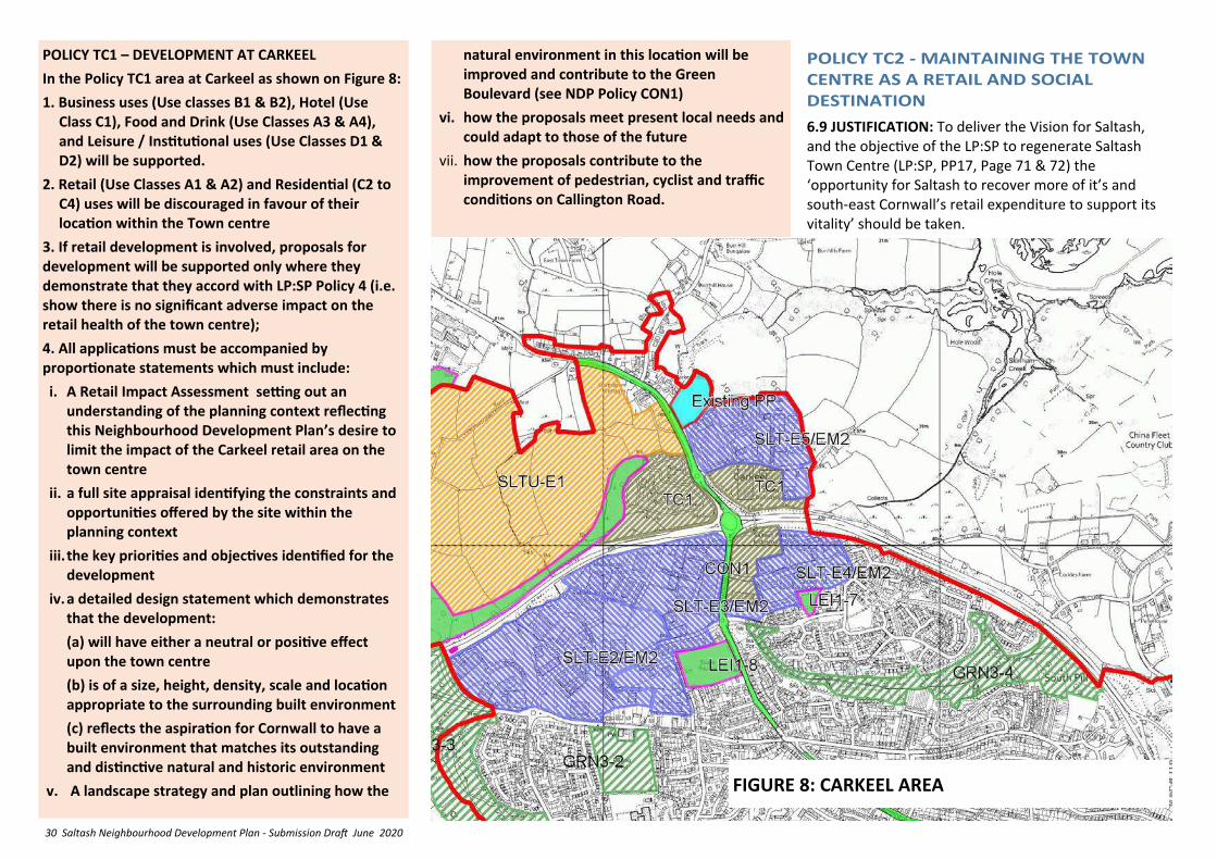
POLICY TC1 – DEVELOPMENT AT CARKEEL
In the Policy TC1 area at Carkeel as shown on Figure 8:
1. Business uses (Use classes B1 & B2), Hotel (Use Class C1), Food and Drink (Use Classes A3 & A4), and Leisure / Institutional uses (Use Classes D1 & D2) will be supported.
2. Retail (Use Classes A1 & A2) and Residential (C2 to C4) uses will be discouraged in favour of their location within the Town centre
3. If retail development is involved, proposals for development will be supported only where they demonstrate that they accord with LP:SP Policy 4 (i.e. show there is no significant adverse impact on the retail health of the town centre);
4. All applications must be accompanied by proportionate statements which must include:
i. A Retail Impact Assessment setting out an understanding of the planning context reflecting this Neighbourhood Development Plan’s desire to limit the impact of the Carkeel retail area on the town centre
ii. a full site appraisal identifying the constraints and opportunities offered by the site within the planning context
iii. the key priorities and objectives identified for the development
iv. a detailed design statement which demonstrates that the development:
(a) will have either a neutral or positive effect upon the town centre
(b) is of a size, height, density, scale and location appropriate to the surrounding built environment
(c) reflects the aspiration for Cornwall to have a built environment that matches its outstanding and distinctive natural and historic environment
v. A landscape strategy and plan outlining how the
natural environment in this location will be improved and contribute to the Green Boulevard (see NDP Policy CON1)
vi. how the proposals meet present local needs and could adapt to those of the future
vii. how the proposals contribute to the improvement of pedestrian, cyclist and traffic conditions on Callington Road.
6.9 JUSTIFICATION: To deliver the Vision for Saltash, and the objective of the LP:SP to regenerate Saltash Town Centre (LP:SP, PP17, Page 71 & 72) the ‘opportunity for Saltash to recover more of it’s and south-east Cornwall’s retail expenditure to support its vitality’ should be taken.
FIGURE 8: CARKEEL AREA
31 Saltash Neighbourhood Development Plan - Submission Draft June 2020
6.9 Opportunities include; enticing both independent traders and more national high street shops, extending the offer to a more niche shopping experience and enhancing the evening economy; public realm improvements; and making greater use of upper storeys for both employment and residential uses, which can help to generate more footfall,
6.10 In order to maintain the Town Centre as a retail and social destination the introduction of new ground floor non-retail uses such as banks and building societies, dentists, cafes, restaurants and the like could provide a significant increase in footfall and income generation and provide options as the spectrum of retail and other trading demand changes. National planning policy encourages diversity in town centres as a whole, but highlights the importance of ensuring that ground floor use class changes to non-retail uses are not permitted where they create a predominance of such uses, unacceptably dilute the shopping street frontage or undermine the vitality, attractiveness and viability of a centre. These principles are reflected in LP:SP Policy 4.
6.11 Policy TC2 Intention - Policy TC2 seeks to add local clarity to LP:SP policies 4.2 and 4.3 as it is a general policy that does not reflect the local circumstances. The desire is to promote footfall and the night-time economy, without harming the retail character of prominent locations and corner locations or forming continuous non-retail frontages, whilst recognising that leisure and night-time economy uses have the potential to generate disturbance to nearby residents. Hot food takeaways (Class A5) are specifically excluded from Policy TC2, and it should be noted that change of use of shops (Class A1) and financial/professional offices (class A2) to restaurants and cafes (Class A3) is permitted development subject to the ‘prior approval’ process.
POLICY TC2 – MAINTAINING THE TOWN CENTRE AS A RETAIL AND SOCIAL DESTINATION
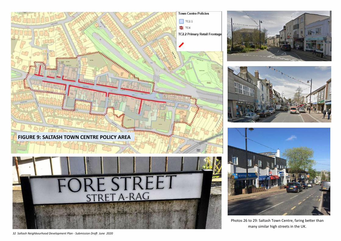
1.The introduction of new ground floor non-retail uses such as financial and professional services, cafes, restaurants (Classes A2, A3, and A4) and sui-generis uses appropriate to a town centre will be supported in the Primary Shopping Area, as defined on Figure 9, providing that:
i. they comply with the criteria set in LP:SP Policy 4.2;
II. they would not create (or further extend) a continuous frontage exceeding two or more non A1 units;
Iii They would not result in the loss of A1 retail units in prominent locations, corner units or those with long frontages.
2. Restaurants and Cafes (Class A3, and Drinking Establishments (Class A4) will be supported in the ground floor of the Primary Retail Frontage providing that:
i. they comply with the criteria set in LP:SP Policy 4.3;
ii. Any noise emanating from the premises is not likely to exceed nationally recognised guidance in relation to rating and assessing industrial and commercial sound (currently identified as BS4142, date 2014).
iii. The design ensures that disabled people can enjoy barrier free participation in the opportunities on offer
iv. Arrangements are made for the regular cleansing of the area fronting the premises involved, that adequate rubbish storage facilities are made available.
3. The change of use of land within the public highway [or adjoining private land used as part of the thoroughfare] to external seating areas for the
consumption of food and beverages, as part of a development, will be supported where:
i. Its operation and management is the responsibility of the operator of the principle premises;
ii. Tables, chairs, parasols, space heaters and barriers/enclosures to the external seating area are capable of being removed and are not permanently fixed to the ground, walls or adjacent structures;
iii. Barriers/enclosures do not exceed 1.2m above ground level;
iv. Tables and chairs are of timber or metal material and of unified style/design;
v. No live or recorded music or screened entertainment is to be played;
vi. In the hours of darkness, the external seating areas are lit and that the lighting only illuminates the intended surface(s) and is fitted with feature(s) designed to control the intensity and direction of light.
vii. The seating area, its equipment and operation, pose no risk to the safety within the public highway or adjoining private land used as part of the thoroughfare.
Photo 25: Saltash Fore Street during May Fare 2018.
32 Saltash Neighbourhood Development Plan - Submission Draft June 2020
FIGURE 9: SALTASH TOWN CENTRE POLICY AREA
Photos 26 to 29: Saltash Town Centre, faring better than
many similar high streets in the UK.
33 Saltash Neighbourhood Development Plan - Submission Draft June 2020
6.12 JUSTIFICATION: The introduction or reintroduction of residential, retail and business uses on the upper floors of town centre premises could also increase footfall, extending into the evening economy, and support income generation, as well as providing for cheaper forms of residential and business accommodation.
6.13 Policy TC3 Intention – Policy TC3 is intended to encourage new uses in upper floors of town centre premises, whilst protecting the important retail roles present at ground floor level, and respecting the residential amenity of existing town centre dwellers.
POLICY TC4 – RETENTION OF SMALL-SCALE EMPLOYMENT IN THE TOWN CENTRE
1. Proposals for the redevelopment or change of use of the ground floor of redundant buildings in the town centre (fig 9) in existing A2, B1(c) B2 or sui-generis*
use to non-employment uses will only be supported if the existing use is no longer economically viable, (as demonstrated by an assessment of he length of any vacancy of the premises and evidence of unsuccessful marketing for the current permitted use).
2. Proposals for the redevelopment or change of use of redundant land or buildings in employment or service trade use to retail uses will be supported in those areas located within the defined town centre area. * ‘In a class of its own’.
POLICY TC3 – NEW USES FOR UPPER FLOORS IN THE TOWN CENTRE
Within the town centre (Fig 9), the introduction or re-introduction of business, residential and retail uses will be supported in upper floor accommodation above existing retail and business premises provided that:
i. The viability of any ground floor commercial use would not be adversely affected;
ii. The site is well integrated with the primary and secondary retail frontages;
iii. There would be no adverse impact on the amenities of neighbouring residential users.
iv. There is no conflict with LP:SP Policy 5
6.14 JUSTIFICATION: The town centre, as shown on the Figure 8, is a most sustainable location for employment, central to much of the towns residential areas, and providing a range of services that employees can use before, during and after work.
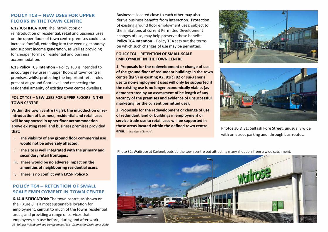
Businesses located close to each other may also derive business benefits from interaction. Protection of existing ground floor employment uses, subject to the limitations of current Permitted Development changes of use, may help preserve these benefits. Policy TC4 Intention – Policy TC4 sets out the terms on which such changes of use may be permitted.
Photo 32: Waitrose at Carkeel, outside the town centre but attracting many shoppers from a wide catchment.
Photos 30 & 31: Saltash Fore Street, unusually wide
with on-street parking and through bus-routes.
34 Saltash Neighbourhood Development Plan - Submission Draft June 2020
7. CREATE AND SUPPORT
SUSTAINABLE
NEIGHBOURHOODS
7.1 Saltash is made up of distinctive neighbourhood communities which are seen by local residents to lack facilities and meeting places within them. The major new Urban extension at Broadmoor Farm (Treledan) will form a new neighbourhood for Saltash and it is essential that it should incorporate provision to meet the new population’s everyday local needs.
Summary of relevant National and Cornwall Local Plan Policy
NPPF 2018
✓ Planning policies and decisions should aim to achieve healthy, inclusive and safe places (Para 91).
✓ To provide the social, recreational and cultural facilities and services the community needs, planning policies and decisions should:
✓ support the provision and use of shared spaces, community facilities (such as local shops, meeting places, sports venues, open space, cultural buildings, public houses and places of worship);
✓ support the delivery of local health, social and cultural well-being strategies;
✓ guard against the unnecessary loss of valued facilities and services, particularly where this would reduce the community’s ability to meet its day-to-day needs;
✓ ensure that established shops, facilities and services are able to develop and modernise.
✓ Integrate housing, economic uses and community facilities and services (Para 92).
✓ Planning policies and decisions should promote public safety (Para 95)
LP:SP
✓ Community facilities and village shops should, wherever possible, be retained and new ones supported...loss of provision will only be acceptable where there is no longer a need for it, or it is not viable, or re-provision in nearby accessible locations is possible (Policy 4).
Access to Facilities
✓ Essential every-day facilities and services (eg Shop, café, post-box) within 5 to 10 minutes walking distance
✓ Health, educational, financial (ATM) and well-being facilities accessible on foot/bike or short bus trip
✓ Formal gathering places such as community halls within 20 minutes walking distance
✓ Cycle routes and parking spaces
✓ Clear signage
✓ Disabled Parking spaces
✓ Adequate disabled access
✓ Electric vehicle charging points
Environment
✓ Informal gathering and play spaces within the public realm
✓ Small open performance spaces
✓ Public wifi
✓ Seating
✓ Trees, planting and rich biodiversity
✓ Urban allotment opportunities
✓ Simple recycling facilities
Maintenance and Cleansing
✓ Well maintained buildings and street scene furniture
✓ Clean and visible playspaces
✓ Excellent street cleansing
✓ Minimal dereliction, underutilised and under maintained spaces and places
✓ Good air quality
Community Safety
✓ ‘Design out crime’ - good visibility, no isolated spaces
✓ Balance activities which may be crime generators such as bars, restaurants and entertainment venues in terms of scale, size and local context
✓ CCTV as necessary
✓ Well defined and purposeful open spaces
Design
✓ Human Scale – walkable, eye-level, tactile, pleasant smelling, quiet
✓ Distinctive and unified design that gives a ‘sense of place’
✓ Use of colour and texture to give definition
✓ Respecting scale, height, volume, site coverage
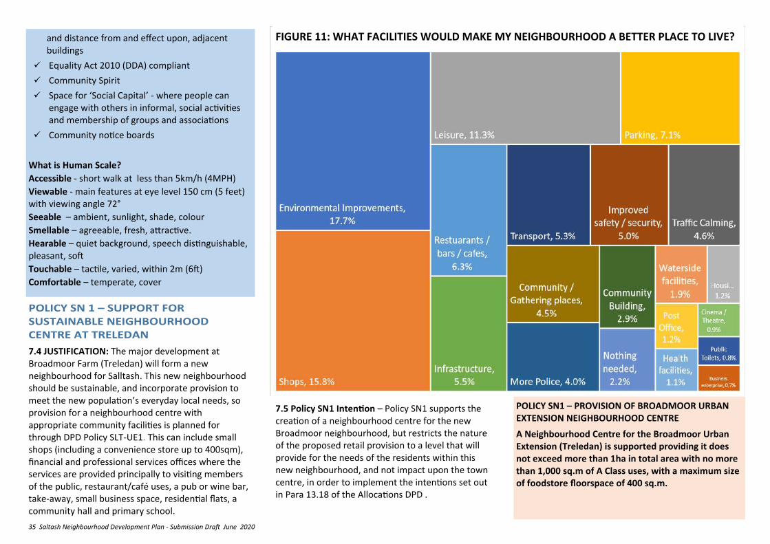
7.2 What are the key things that make for a liveable, enduring, human scale neighbourhood? Following research and discussion, the NDP Steering Group agreed that the following appear to be the most im-portant factors [Figure 10]. This was reflected closely in the 2015 survey which revealed what local people seek in a good neighbourhood [Figure 11 and 12]. Green space and healthy biodiversity are other as-pects of sustainable neighbourhoods. [Section 11].
7.3 In applying the following policies users should be aware of and carefully take into account the needs of groups with protected characteristics as set out in the Equalities Act 2010.
35 Saltash Neighbourhood Development Plan - Submission Draft June 2020
7.4 JUSTIFICATION: The major development at Broadmoor Farm (Treledan) will form a new neighbourhood for Salltash. This new neighbourhood should be sustainable, and incorporate provision to meet the new population’s everyday local needs, so provision for a neighbourhood centre with appropriate community facilities is planned for through DPD Policy SLT-UE1. This can include small shops (including a convenience store up to 400sqm), financial and professional services offices where the services are provided principally to visiting members of the public, restaurant/café uses, a pub or wine bar, take-away, small business space, residential flats, a community hall and primary school.
POLICY SN1 – PROVISION OF BROADMOOR URBAN EXTENSION NEIGHBOURHOOD CENTRE
A Neighbourhood Centre for the Broadmoor Urban Extension (Treledan) is supported providing it does not exceed more than 1ha in total area with no more than 1,000 sq.m of A Class uses, with a maximum size of foodstore floorspace of 400 sq.m.
7.5 Policy SN1 Intention – Policy SN1 supports the creation of a neighbourhood centre for the new Broadmoor neighbourhood, but restricts the nature of the proposed retail provision to a level that will provide for the needs of the residents within this new neighbourhood, and not impact upon the town centre, in order to implement the intentions set out in Para 13.18 of the Allocations DPD .
and distance from and effect upon, adjacent buildings
✓ Equality Act 2010 (DDA) compliant
✓ Community Spirit
✓ Space for ‘Social Capital’ - where people can engage with others in informal, social activities and membership of groups and associations
✓ Community notice boards
What is Human Scale?
Accessible - short walk at less than 5km/h (4MPH)
Viewable - main features at eye level 150 cm (5 feet) with viewing angle 72°
Seeable – ambient, sunlight, shade, colour
Smellable – agreeable, fresh, attractive.
Hearable – quiet background, speech distinguishable, pleasant, soft
Touchable – tactile, varied, within 2m (6ft)
Comfortable – temperate, cover
FIGURE 11: WHAT FACILITIES WOULD MAKE MY NEIGHBOURHOOD A BETTER PLACE TO LIVE?
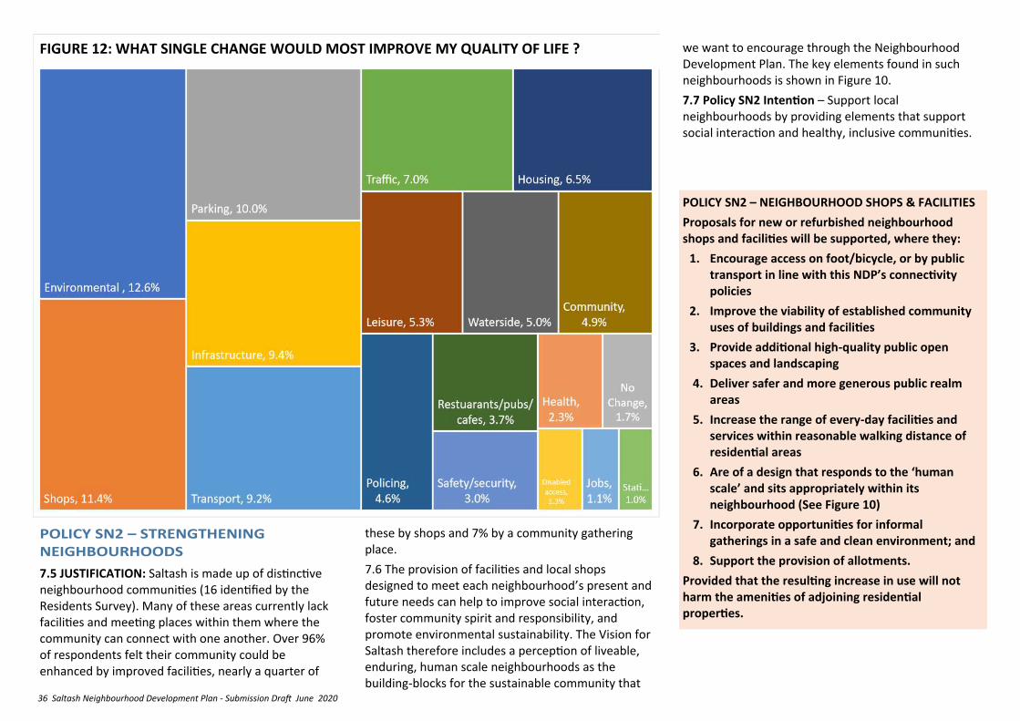
36 Saltash Neighbourhood Development Plan - Submission Draft June 2020
POLICY SN2 – NEIGHBOURHOOD SHOPS & FACILITIES
Proposals for new or refurbished neighbourhood shops and facilities will be supported, where they:
1. Encourage access on foot/bicycle, or by public transport in line with this NDP’s connectivity policies
2. Improve the viability of established community uses of buildings and facilities
3. Provide additional high-quality public open spaces and landscaping
4. Deliver safer and more generous public realm areas
5. Increase the range of every-day facilities and services within reasonable walking distance of residential areas
6. Are of a design that responds to the ‘human scale’ and sits appropriately within its neighbourhood (See Figure 10)
7. Incorporate opportunities for informal gatherings in a safe and clean environment; and
8. Support the provision of allotments.
Provided that the resulting increase in use will not harm the amenities of adjoining residential properties.
7.5 JUSTIFICATION: Saltash is made up of distinctive neighbourhood communities (16 identified by the Residents Survey). Many of these areas currently lack facilities and meeting places within them where the community can connect with one another. Over 96% of respondents felt their community could be enhanced by improved facilities, nearly a quarter of
these by shops and 7% by a community gathering place.
7.6 The provision of facilities and local shops designed to meet each neighbourhood’s present and future needs can help to improve social interaction, foster community spirit and responsibility, and promote environmental sustainability. The Vision for Saltash therefore includes a perception of liveable, enduring, human scale neighbourhoods as the building-blocks for the sustainable community that
FIGURE 12: WHAT SINGLE CHANGE WOULD MOST IMPROVE MY QUALITY OF LIFE ? we want to encourage through the Neighbourhood Development Plan. The key elements found in such neighbourhoods is shown in Figure 10.
7.7 Policy SN2 Intention – Support local neighbourhoods by providing elements that support social interaction and healthy, inclusive communities.
37 Saltash Neighbourhood Development Plan - Submission Draft June 2020
8. REVITALISE THE
WATERFRONT
8.1 The River Tamar is the reason for the existence of Saltash, at a crossing point and landing, and its riverside identity continues to be drawn from this relationship. At the core of the riverside is the area known as ‘Saltash Waterfront’, which in this NDP is defined as the area running north from the Sailing Club, under the Bridges, through to Brunel Green (See Figure 13). The Waterfront is an area that every resident of Saltash knows and has become the billboard for Saltash, a vibrant mix of historical bridges and buildings, romantic topography with modern monuments welcoming visitors to Cornwall, and a key recreational resource. However there has been widespread discontent with the 1950’s redevelopment of the area immediately between Silver Street , Culver Road, and the river, and calls for investment to improve it and the facilities located there.
Summary of relevant NPPF and Cornwall Local Plan Policy
NPPF 2018
✓ Plans should set out a positive strategy for the conservation and enjoyment of the historic environment, including heritage assets most at risk through neglect, decay or other threats (Para 185).
✓ These strategies should reflect the desirability of sustaining and enhancing heritage assets and putting them to viable uses consistent with conservation; the wider benefits that conservation can bring; the need for new development to make a positive contribution to local character and distinctiveness, and the opportunities to use
historic environment to contribute to a place's character. (Para 185).
✓ Great weight to be given to their conservation in all decisions (Para 193).
✓ Clear and convincing justification is required for any harm to, or loss of, the significance of a designated heritage asset.
✓ Substantial harm (direct or by change in the setting) to or total loss of Grade 2 listed buildings should be 'exceptional'.
✓ Substantial harm to or total loss of Grade 1 or Grade II* listed buildings should be ‘wholly exceptional’ (Para 194).
✓ Substantial harm will require substantial public benefits that outweigh that harm or loss: less than substantial harm should be weighed against the public benefits of the proposal (Para 195 and 196).
LP:SP
✓ Proposals should be judged against fundamental design principles of character, layout, movement, adaptability, inclusiveness, resilience, diversity, and ‘good neighbourliness’ (LP:SP Policy 12 ).
8.2 JUSTIFICATION: The Saltash Coastal Community Team (CCT) has created an Economic Plan which aims to promote economic activity in Saltash as a whole (and the Waterfront area in particular) by encouraging tourists and local people to visit the area. This is an aim that sits squarely and is well-integrated with the vision and aims of the NDP.
8.3 The CCT Economic Plan identifies several issues of
concern which could hamper this aim, including:
• Disused and poorly maintained buildings
• Abandoned boats and mooring management issues
• Chaotic trailer parking
• Poor facilities for beach and public pontoon users
• Disconnection from the town
8.4 The CCT Economic Plan puts forward many ideas to tackle these issues and achieve the overall aim. Whilst many involve non-land use matters such as local management of existing facilities and promotion and publicity activity, there are proposals which have land-use implications, such as the provision of improved facilities for water users, new workshop space, public realm and building improvements, for which the Planning context can be enabled through the NDP.
PROJECT P1: CCT WATERFRONT IMPROVEMENT PROJECT.
The CCT project is a joint initiative of: • Cornwall Council - Marine Management dept • Saltash Town Council - Devolution Options Group • Saltash Community Enterprise CIC • Saltash Sailing Club • Caradon Gig Club • Ashtorre Rock (SWCA) Saltash CCT aims to promote economic activity in Saltash through encouraging tourists and local people to visit the area by :Exploiting the world famous Brunel Bridge; promoting waterside events; promoting waterside businesses; improving accessibility and linkages; improving the attractiveness of the physical environment; and improving management of the waterside facilities. In March 2019 the Team were awarded £50,000 to support detailed studies that will help take the project forward.
38 Saltash Neighbourhood Development Plan - Submission Draft June 2020
8.5 The link between the town centre facilities and main car parking areas with Saltash Waterfront suffers from difficult access by foot, cycle and vehicles because of narrowness of streets, very steep approaches, and a poor mix of surfaces. Pending any more radical approaches to overcoming these issues, it is acknowledged that enhancements to the attractiveness of the Waterfront may encourage increased road traffic flows and result in higher parking demand and pedestrian/vehicle conflict within the area. To mitigate against this the NDP requires that the CCT plans for the Waterfront must incorporate a scheme to enhance pedestrian comfort and improve convenience of access and connectivity with the town centre car parks, railway station and other attractions.
8.6 Proposals for the railway station building may assist in this by providing an intermediate stopping point between the Waterfront and town centre as well as encouraging more visits by rail (See policies ENV5 and CON5)
8.7 The Waterfront immediately abuts the Tamar Estuaries Complex Special Protection Area and the Plymouth Sound & Estuaries Special Area of Conservation and any detailed proposals may require a Habitat Regulations Assessment and mitigation measures under LP:SP Policy 22.
8.8 Policy WF1 Intention is to provide guidance for the master-planning of skilful public and private investment to enhance the Waterfront and unlock its true potential for the benefit of the wider area of Saltash.
POLICY WF1 - MAKING THE MOST OF SALTASH WATERFRONT
1. Regeneration proposals for the Waterfront (See Figure 13) will be supported if they:
i. Draw out and preserve the economic, cultural and heritage values inherent in the area;
ii. Are of a scale and character appropriate to the setting and preserve or enhance its historic character [See Policy ENV1 and Tables 18 & 19) and avoid impinging unacceptably on public views and vistas [See Policy ENV8];
iii. Ensure that the setting and significance of any heritage assets present on and close to the area affected are protected and interpreted to a high standard;
iv. Retain and restore the existing medieval street pattern;
v. Retain and if possible improve access to all existing amenities, boat launching and recovery facilities;
vi. Safeguard a safe and suitable access to the Pier for possible ferry service, river cruises and water taxis;
vii. Include means of ensuring any environmental impact (waste, litter, vandalism, light, noise etc etc.) resulting from the use of any new facilities is managed effectively;
viii. Ensure that the residential amenity enjoyed by local residents is not unreasonably affected;
ix. Include residents and disabled car-parking;
x. Include a phased scheme to enhance pedestrian and cyclist comfort and improve convenience of access and connectivity with the town centre car parks, bus routes, Cornish Cross and Railway station, featuring:
A. Improved signage and route-marking; and
B. improved access for mobility impaired users (disabled, pushchairs etc) through improved surfaces, level change transitions, handrails, user-friendly surfaces etc; and
cycle parking;
C. Improved facilities for cyclists; and
D. public seating en-route to the Waterfront
xi. increase the planting of appropriate trees in all available spaces, ensuring no detriment to views or use of spaces during public events.
2. Applications will be expected to include:
i. a full historic environment impact assessment to inform the design process, (as detailed in NDP policies ENV 1, 6 and 7 , and Cornwall Local Plan policy 24);
ii. a Design and Access Statement derived from a master-planning process and illustrating satisfactorily how the above criteria have been met;
iii. a Construction Environment Management Plan (CEMP) to ensure that any effects from the construction phase upon the Tamar Estuaries Complex SPA and the Plymouth Sound and Estuaries SAC are avoided or appropriately mitigated.
3. Any development will be expected to provide an appropriate off-site contribution to mitigate against adverse in-combination recreational impacts on the Tamar Estuaries Complex SPA and the Plymouth Sound and Estuaries SAC.
4. No development will be supported prior to confirmation that the CCT proposals can be accommodated within the headroom of existing treatment works or prior to provision of appropriate upgrades / new facilities.
5. Surface water drainage is designed in accordance with the Sustainable Urban Drainage Systems (SUDS) principles and standards set out in the Drainage Guidance for Cornwall to ensure surface water run-off from development is managed appropriately, so that flood risk is not increased, and also to ensure no detrimental impact on Tamar Estuaries Complex Special Protection Area (SPA) and the Plymouth Sound and Estuaries SAC, including as a result of changes in water quality or flow.
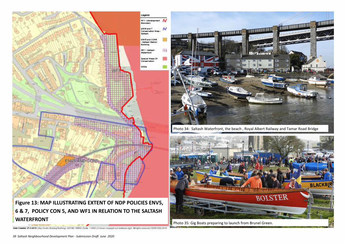
39 Saltash Neighbourhood Development Plan - Submission Draft June 2020
Figure 13: MAP ILLUSTRATING EXTENT OF NDP POLICIES ENV5,
6 & 7, POLICY CON 5, AND WF1 IN RELATION TO THE SALTASH
WATERFRONT
Photo 34: Saltash Waterfront, the beach , Royal Albert Railway and Tamar Road Bridge
Photo 35: Gig Boats preparing to launch from Brunel Green.
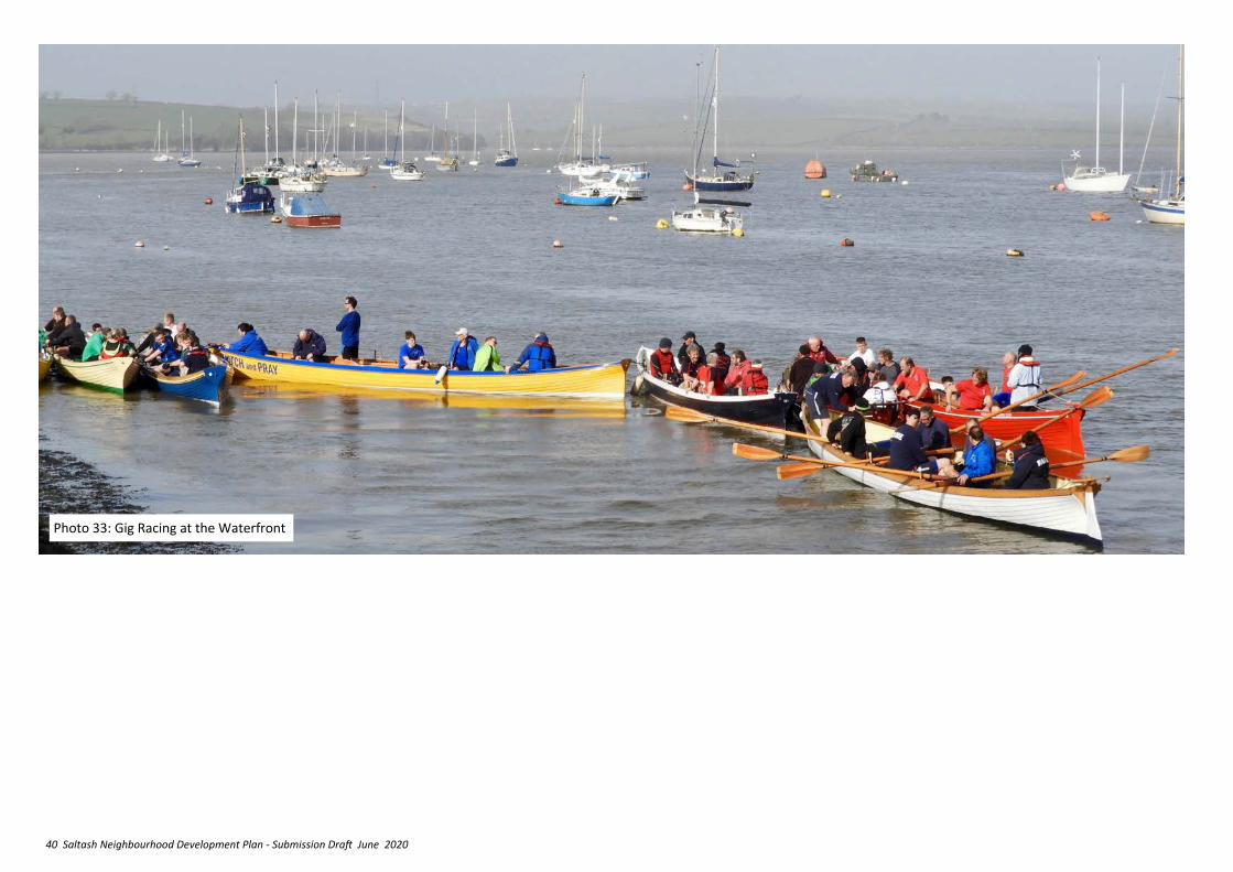
40 Saltash Neighbourhood Development Plan - Submission Draft June 2020
Photo 33: Gig Racing at the Waterfront
41 Saltash Neighbourhood Development Plan - Submission Draft June 2020
9. ENSURE A BALANCED
RANGE OF QUALITY
NEW HOUSING
Summary of relevant NPPF and Cornwall Local Plan Policy
NPPF 2018
✓ Neighbourhood Plans should not promote less development than set out in the strategic policies for an area (Para 29).
✓ A 5 year supply of deliverable sites must be maintained and a supply of developable sites of up to 20% if conditions require it (Para 73).
✓ Plans should provide for a mix of housing catering for different groups, identify the size, type, and tenure of housing required and where an affordable housing need has been identified, plans should provide for it (Para 61).
The Saltash NDP area includes open countryside and within these areas the NPPF says that:
• new isolated homes in the countryside should be avoided unless there are special circumstances which includes meeting the needs of rural workers, enabling development to secure the future of heritage assets, or reuse redundant buildings, or where a building is of exceptional quality or innovative nature (Para 79);
• Great importance is placed on ensuring quality sustainable design in development and ensuring that housing reflects local distinctiveness and improves the character of the area (Paras 124 to 132).
• Making effective use of land is also strongly encouraged (Paras 117 to 123)
LP:SP
✓ The aim is to meet housing need for everyone in the community with the opportunity of living in an appropriate home, supported by local community facilities (Obj 4).
✓ Most development should go to those areas capable of sustaining it, including a housing apportionment of 1,200 dwellings to Saltash to be managed through the Allocations DPD (Policies 2, 2a and 3).
✓ Neighbourhood Plans can provide detailed guidance on which settlements outside the town are appropriate for infill and rounding off to meet local needs and support community sustainability at a scale appropriate to its character and role (Para 1.64 to 1.68).
✓ Sites of 10 dwellings or more should include a mix of house size, type, price and tenure to address identified needs and market demand and to support mixed communities (Policy 6).
✓ On sites of 200 dwellings or more, additional specialised housing (including extra care housing) should be considered where demand exists, to meet specialist needs.
✓ On sites of 10 or more dwellings at least 30% should be affordable housing (of which 70% should be for rental and 30% for rental/sale at a price affordable to a typical local household (Policy 8).
✓ Outside the town the threshold at which affordable provision is required is set at 6 or more dwellings. LP:SP Policy 9 allows for ‘exceptions sites’ on the edge of smaller towns, villages and hamlets where at least 50% of the housing is affordable.
✓ Cornwall Local Plan Policy 12 provides guidance on design expectations generally across Cornwall.
9.1 The CLP Target for housing growth between 2010 and 2030 has been set at 1200 completed dwellings for Saltash. Treledan and North Pill have been identified as the most suitable locations for the required development in the Cornwall Local Plan Allocations DPD. The provisions of the DPD are shown on Figure 4, and they are included within the Development Boundary for Saltash, as illustrated in Figure 6. The Saltash NDP must accept these allocations. Concerns regarding access, drainage, impact on biodiversity and infrastructure provision will be dealt with through the planning application process.
9.2 Should there be a problem with delivery of Treledan that reduces its ability to contribute the required completions within the Plan period, or if Cornwall’s housing need increase and/or further dwellings are required in the Saltash area, then Treledan is the preferred site in view of its accepted sustainable location and associated services/employment etc.
9.3 Justification: Council Tax banding assesses properties according to their rental value and can be used as a surrogate measure of the quality and attractiveness of dwellings. Data on the number of dwellings by council tax band confirms that Saltash’s dwelling stock is skewed towards bands ‘b’ and ‘c’ properties (the second and third lowest value of seven bands) compared to the rest of the county [see Figure 14]. Recent data on the period from 2006 to 2015 indicates that little change in this balance has occurred. The 2011 Census showed that Saltash had a lower proportion of larger properties than in Cornwall and the SW, and of lower proportion of small properties than in Cornwall and the SW. On the other hand, the town has a higher proportion of medium sized
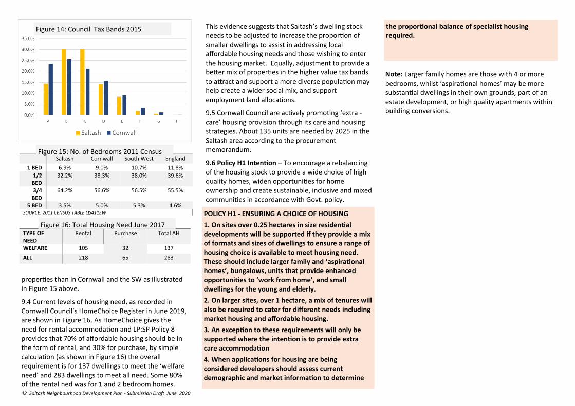
42 Saltash Neighbourhood Development Plan - Submission Draft June 2020
properties than in Cornwall and the SW as illustrated in Figure 15 above.
9.4 Current levels of housing need, as recorded in Cornwall Council’s HomeChoice Register in June 2019, are shown in Figure 16. As HomeChoice gives the need for rental accommodation and LP:SP Policy 8 provides that 70% of affordable housing should be in the form of rental, and 30% for purchase, by simple calculation (as shown in Figure 16) the overall requirement is for 137 dwellings to meet the ‘welfare need’ and 283 dwellings to meet all need. Some 80% of the rental ned was for 1 and 2 bedroom homes.
the proportional balance of specialist housing required.
TABLE X: NUMBER OF BEDROOMS 2011 CENSUS.
Saltash Cornwall South West England 1 BED 6.9% 9.0% 10.7% 11.8%
1/2 BED
32.2% 38.3% 38.0% 39.6%
3/4 BED
64.2% 56.6% 56.5% 55.5%
5 BED 3.5% 5.0% 5.3% 4.6% SOURCE: 2011 CENSUS TABLE QS411EW
TABLE Z: TOTAL HOUSING NEED JUNE 2017 TYPE OF NEED
Rental Purchase Total AH
WELFARE 105 32 137
ALL 218 65 283
This evidence suggests that Saltash’s dwelling stock needs to be adjusted to increase the proportion of smaller dwellings to assist in addressing local affordable housing needs and those wishing to enter the housing market. Equally, adjustment to provide a better mix of properties in the higher value tax bands to attract and support a more diverse population may help create a wider social mix, and support employment land allocations.
9.5 Cornwall Council are actively promoting ‘extra -care’ housing provision through its care and housing strategies. About 135 units are needed by 2025 in the Saltash area according to the procurement memorandum.
9.6 Policy H1 Intention – To encourage a rebalancing of the housing stock to provide a wide choice of high quality homes, widen opportunities for home ownership and create sustainable, inclusive and mixed communities in accordance with Govt. policy.
POLICY H1 - ENSURING A CHOICE OF HOUSING
1. On sites over 0.25 hectares in size residential developments will be supported if they provide a mix of formats and sizes of dwellings to ensure a range of housing choice is available to meet housing need. These should include larger family and ‘aspirational homes’, bungalows, units that provide enhanced opportunities to ‘work from home’, and small dwellings for the young and elderly.
2. On larger sites, over 1 hectare, a mix of tenures will also be required to cater for different needs including market housing and affordable housing.
3. An exception to these requirements will only be supported where the intention is to provide extra care accommodation
4. When applications for housing are being considered developers should assess current demographic and market information to determine
Figure 14: Council Tax Bands 2015
Figure 15: No. of Bedrooms 2011 Census
Figure 16: Total Housing Need June 2017
Note: Larger family homes are those with 4 or more bedrooms, whilst ‘aspirational homes’ may be more substantial dwellings in their own grounds, part of an estate development, or high quality apartments within building conversions.
43 Saltash Neighbourhood Development Plan - Submission Draft June 2020
daylight, sunlight, outlook or privacy;
v. Amenity space, refuse storage and car and bicycle parking are provided at an appropriate quantity and standard of design, and are controlled through practical management arrangements;
vi. The proposal conforms to the current accessibility standards at the time of the application;
vii. The proposal will not generate a demand for on-street car parking that would prejudice the safe operation of the highway or cause detriment to amenity;
viii. The proposal provides acceptable levels of amenity for its occupants in terms of noise, outlook, light, privacy, access and air quality.
9.7 Justification – see Policy H1 above.
9.8 Policy H2 Intention – to allow for sensitive conversions of larger residences in the ‘Suburban Villa’ Character Area (See section 10) to provide smaller homes in ways that help to support a sustainable, inclusive and mixed-use community without harming the character and appearance of the area or its residential amenity.
9.9 N.B. Change of Use from dwelling house (Class C3) to a House in Multiple Occupation use (Class C4) where no more than 6 people share is ‘Permitted development’ for which planning permission is not required.
POLICY H2 – CONVERSIONS OF LARGE HOUSES INTO MULTIPLE OCCUPATION IN THE SUBURBAN VILLA CHARACTER AREA OF SALTASH
The change of use of dwelling houses in Class 3 to self-contained flats or into a sui generis House in Multiple Occupation use (more than six people sharing) will be supported if:
i. The proposal would not harm the visual character and appearance of the neighbourhood and street scene;
ii. The proposal would not harm the character and appearance of the building;
iii. The scale and intensity of the use proposed would not have an unacceptable impact on neighbouring residential amenities through increased levels of activity, noise and disturbance;
iv. Any associated extensions or external alterations required as part of the change-of-use would not have an unacceptable impact on neighbouring residential amenities through reduced levels of
9.10 Justification – In order to meet the market housing requirements set out in the Cornwall Local Plan, and to ensure that provision is made to meet the continuing need for housing that is affordable by local people, it is important that the best use of land is made when opportunities for redevelopment arise. Increased densities can help to reduce development pressure on the countryside and can be a particularly effective form of sustainable development where it occurs close to established public transport routes and near to the town centre by contributing to the critical mass needed to support more shops, better and more diverse local services, and improved social and transport infrastructure.
9.11 Higher density should not be seen as bad design, although the quality of design is critical to the success of intensification. Therefore, it is important that design is given a high priority in redevelopment
schemes, and that they should not be viewed in isolation but well related to their surroundings. With excellent design high quality developments at densities of 50 dwellings per hectare (dph) and above can be successfully achieved. The Building for Life 12 standard (or any successor schemes) and the Cornwall Design Guide are particularly important references for this.
9.12 Policy H3 Intention – The policy sets out the key matters against which higher density schemes on redevelopment sites will be considered.
POLICY H3 – MAKING BETTER USE OF LAND
Proposals coming forward (1) as redevelopment within or on the edge of the town centre boundary See Figure 9), and (2) as the regeneration of outworn residential estates, will be supported where:
1. They are at the highest appropriate densities, taking into account:
i. The relationship with adjoining buildings and the relevant Character Area (See Policy ENV1) as a whole.
ii. The significance of any heritage assets affected, (including any contribution made by their setting), the potential impact of the proposal on those assets, and the effectiveness of the mitigation proposed.
iii. Policy ENV1 relating to the Character Areas
2. The scale, mass, height and positioning of the new buildings reflects the purpose for which they are proposed but does not overwhelm buildings nearby or impinge unacceptably into cherished local views.
3. They maintain a human scale and follow established ‘building lines’.
4. They demonstrate a positive relationship with the public realm by maintaining and improving permeability of pedestrian routes, and contributing to the ‘greening’ of Saltash.
44 Saltash Neighbourhood Development Plan - Submission Draft June 2020
5. They include design cues taken from locally distinctive features noted in the Character Area.
6. They include measures for energy efficiency and high environmental standards for drainage, sewage control, surface water management and flood control.
7. Where the current affordable housing threshold is met, they include a minimum of 30% affordable housing provision for small dwellings suitable for first-time buyers, and purchase or renting by the elderly, and other small households.
8. They include provision for mixed use development such as live/work units, with ’common room’ and ‘maker-space’ facilities.
9. They incorporate measures to meet the sustainable transport and connectivity needs of residents, in accordance with NDP policy CON8.
Applications should be accompanied by detailed Design and Access Statements which clearly demonstrate how the proposal meets the considerations given above.
9.13 Justification - The suburban villas area of carefully planned housing of good design and materials built in the Victorian age have well cultivated gardens with mature trees which form an important ‘green ring’ around the densely developed town centre. Although much of the area to the north of the town centre has been subject to piecemeal infilling, the Port View Estate remains a unique example of a planned development that survives from the 1850s. The pattern of development established through the 1855 deed of covenant that continues to apply to all properties within the Port View Estate (which includes St Baranbas Hospital) has survived largely intact since that time. The Suburban Villas area
makes an important contribution to the character of the town and to the diversity and quality of the housing stock in Saltash. Their loss would have a detrimental impact on the character of the area and the town . Incremental alterations and demolition could, in aggregate, seriously undermine the historic value of the area. Maintaining the quality in terms of its streetscape, green areas and historic buildings adds to the overall attractiveness of the town as a place to live and invest in. 9.14 Policy H5 intention - To ensure high quality development in the Surburban Villas area that reflects the quality and particular distinctiveness of this part of Saltash’s urban environment.
(Note the Port View Deed of Covenant of 1855 stipulates only a single building on each defined "allotment" plot and not breaching the building lines, and may continue to apply to all allotments under property law.)
POLICY H4 – MAKING BETTER USE OF LAND - SUBURBAN VILLAS CHARACTER AREA Proposals for new residential development within the Suburban Villas Character Area will be supported where:
i. The design, layout and appearance preserves and enhances the character and appearance of the Character Area;
ii. It follows established building lines; iii. It avoids development which subdivides villa
gardens in a way which would not reflect the existing character of the area, or impairs the function of the villa gardens as a green area giving views into the town and enhancing the streetscape and setting of Saltash ;
iv. It avoids the loss of historic garden walls, outbuildings and walls defining service lanes;
9.15 Justification - In addition to providing new build housing stock it is important that the Neighbourhood Plan ensures that the existing housing stock is used effectively to help meet housing needs. Many households can meet their need for a new or larger house by extending the home they occupy. Permitted Development rights allow householders to extend their homes within generous limits. Where planning permission is required beyond these limits it is essential that are in keeping with the scale and design of the original house, respect the street scene and respect the living conditions of neighbours.
9.16 Policy H6 Intention – To set the key principles on which extensions which require planning permission can be judged.
POLICY H5 – EXTENSIONS TO EXISTING DWELLINGS
Extensions to existing dwellings beyond permitted development limits will be supported where:
i. The scale and design of the extension complements and respects the scale and design of the original property;
ii. The extension respects the character of the street scene; and
iii. It would not have an unacceptable impact on neighbouring residential amenities through reduced levels of daylight, sunlight, or privacy.
v. Does not involve the loss of trees that contribute to the overall character of the area.
45 Saltash Neighbourhood Development Plan - Submission Draft June 2020
Summary of relevant NPPF and Cornwall Local Plan Policy
NPPF 2018
✓ Good design is a key aspect of sustainable development, creates better places in which to live and work and helps make development acceptable to communities (para 124).
✓ Design policies should be developed with local communities so they reflect local aspirations, and are grounded in an understanding and evaluation of each area’s defining characteristics. Neighbourhood plans can play an important role in identifying the special qualities of each area and explaining how this should be reflected in development (Para 125).
✓ Planning policies should ensure that developments: function well and add to the overall quality of the area, are visually attractive through good architecture, layout and appropriate landscaping; are sympathetic to local character and history, appropriately innovative, establish or maintain a strong sense of place that is attractive, welcoming and distinctive, optimise the potential of the site, are safe, inclusive and accessible and which promote health and well-being, and where crime and disorder, and the fear of crime, do not undermine the quality of life or community cohesion and resilience (Para 127).
✓ Great weight should be given to outstanding or innovative designs which help raise the standard of design more generally in the area (Para 131).
✓ Poor design that fails to improve local character and function should be refused (Para 130).
✓ Great weight to be given to their conservation in all decisions (Para 193).
✓ Clear and convincing justification is required for any harm to, or loss of, the significance of a designated heritage asset;
✓ Substantial harm (direct or by change in the setting) to or total loss of Grade 2 listed buildings should be 'exceptional'; and
✓ Substantial harm to or total loss of Grade 1 or Grade II* listed buildings should be ‘wholly exceptional’ (Para 194).
✓ Substantial harm will require substantial public benefits that outweigh that harm or loss: less than substantial harm should be weighed against the public benefits of the proposal (Para 195 and 196).
LP:SP
✓ Proposals should be judged against fundamental design principles of character, layout, movement, adaptability, inclusiveness, resilience, diversity, and ‘good neighbourliness’ (Policy 12).
✓ Proposals will be permitted where they protect, conserve and where appropriate enhance designated and non-designated heritage assets, and requires historic environment assessments to accompany all proposals. (Policy 24)
Supplementary Planning Document [SPD] requires the historic environment impact assessments to:
1) identify the site, the heritage assets and their settings;
2) Understand its significance, its sensitivities and capacity for change irrespective of any known proposals;
3) Understand the potential impact of specific proposals on that significance;
4) Use that understanding to inform the design process to:
10. PROTECT AND
ENHANCE THE BUILT
ENVIRONMENT
a. look for opportunities to avoid, minimise or mitigate impact,
b. look for opportunities to better reveal or enhance significance, create a more sustainable and interesting place,
c. justify any harmful impacts (in terms of sustainable development, the need for change, overriding benefits etc).
10.1 Justification – Saltash has heritage significance through its long and varied history as one of the oldest boroughs in Cornwall: an ancient river-crossing place, then a planned medieval settlement and market, a Civil War stronghold and scene of bombardment, an example of the first waves of railway led suburban expansion in Victorian times, and a strategic target in WW2. Although modern development has removed some key features the town still retains its medieval street pattern, has a number of key historic buildings and pleasantly elegant historic residential streets, with good period street surfaces. Its riverside location provides commercial and leisure opportunities and stunning views throughout the town, whilst the waterfront, railway and road bridges give the town a distinctive identity.
10.2 An assessment of the built form of different parts of the historic core of the NDP area has identified several different character areas which are characteristically different to each other. They are:
1. The Waterside 1b. Waterside North 2. The Old Town 3. Suburban Villas 4. Circa 1900 Urban Expansion
In applying the following policies users should be aware of and carefully take into account the needs of groups with protected characteristics as set out in the Equalities Act 2010.
46 Saltash Neighbourhood Development Plan - Submission Draft June 2020
These Character Areas identify the historic features and buildings which make Saltash a recognisably distinctive place. Unfortunately, much of the late 20th century development has been of lower design standard which is poorly related to these distinctive characteristics. Thus, it is very important that new development respects the characteristics of good design (See Fig 17) and reinforce the aspects that provide its character, where possible removing or remedying features that detract. This is particularly important within the historic core, but is also desirable elsewhere.
10.3 Policy ENV1 Intention – To ensure high quality design that reflects the quality and particular distinctiveness of Saltash’s urban environment and provide a means by which development within the historic Character Areas shown in Figure 18 can be guided. Fig 19 records the distinctive features and regeneration opportunities that development proposals in
FIGURE 17: SALTASH DESIGN STATEMENT—CHARACTERISTICS OF GOOD DESIGN
To achieve high quality, sustainable development the following characteristics are supported in all proposals, whether planning permission is required or not:
High Quality Townscape, Landscape and Amenity
Accessible layouts of buildings, routes and spaces that promote health and well-being of the community, and which complement the existing settlement. Good enclosure; support the ‘greening’ of the townscape and green infrastructure, public and private spaces, busy frontages, visual delight and residential amenity.
High Architectural Quality
Dwellings that are fit for purpose, providing space standards and facilities which can adapt to meet a range of needs over time, which minimise energy consumption and can respond to climate change.
Buildings and boundary treatments that are designed to be durable, well built and aesthetically pleasing and respond to their context.
Conservation Areas and other historically significant areas
Developments in conservation and other historically significant areas and changes to traditionally styled buildings are appropriate in character and appearance.
Town Centre Shopping Area
Positive enhancements include upgrading and enhancing fascias, shop fronts and signs.
Places Which have their own distinct identity (Character Areas)
Development works with sites natural assets whilst either enhancing and/or creating local distinctiveness and helps people find their way around by the layout and building design.
Schemes which are built using or reflecting the local palette of materials and architectural details and which have a clear design rationale related to the built form proposed.
Permeable Layouts
Development has good connections within the site and to places and facilities beyond it for all modes of movement and transport.
Pedestrian and Cycle Friendly Places and Routes
Layouts give priority to pedestrian and cycle movement with safe and convenient routes within development sites and to destinations beyond.
POLICY ENV1 – DESIGN AND LOCAL DISTINCTIVENESS WITHIN THE DEFINED CHARACTER AREAS (see Figures 15 and 16)
Development proposals within the Character Areas will be supported where they :
i. Reflect the Locally Distinctive Features identified in the Character Area in terms of height, scale, massing, orientation, roof-scape and location within the site, follow established/traditional building line practice; be integrated into the historic topography and settlement form, and reflect existing historic street patterns; and
ii. Avoid pastiche and ‘token’ local distinctiveness, by taking design detailing cues from Locally Distinctive Features and Landmark Buildings present in the Character Area, ensuring that doors, windows, fascia, boxboards, pilasters and other detailing features are of similar proportions to the existing, and reflect local building traditions by making careful use of appropriate materials to ensure sufficient richness of detail.
iii. Where appropriate and feasible, help to address any Negative Features and take up Enhancement Opportunities.
iv. Applications should be accompanied by detailed Design
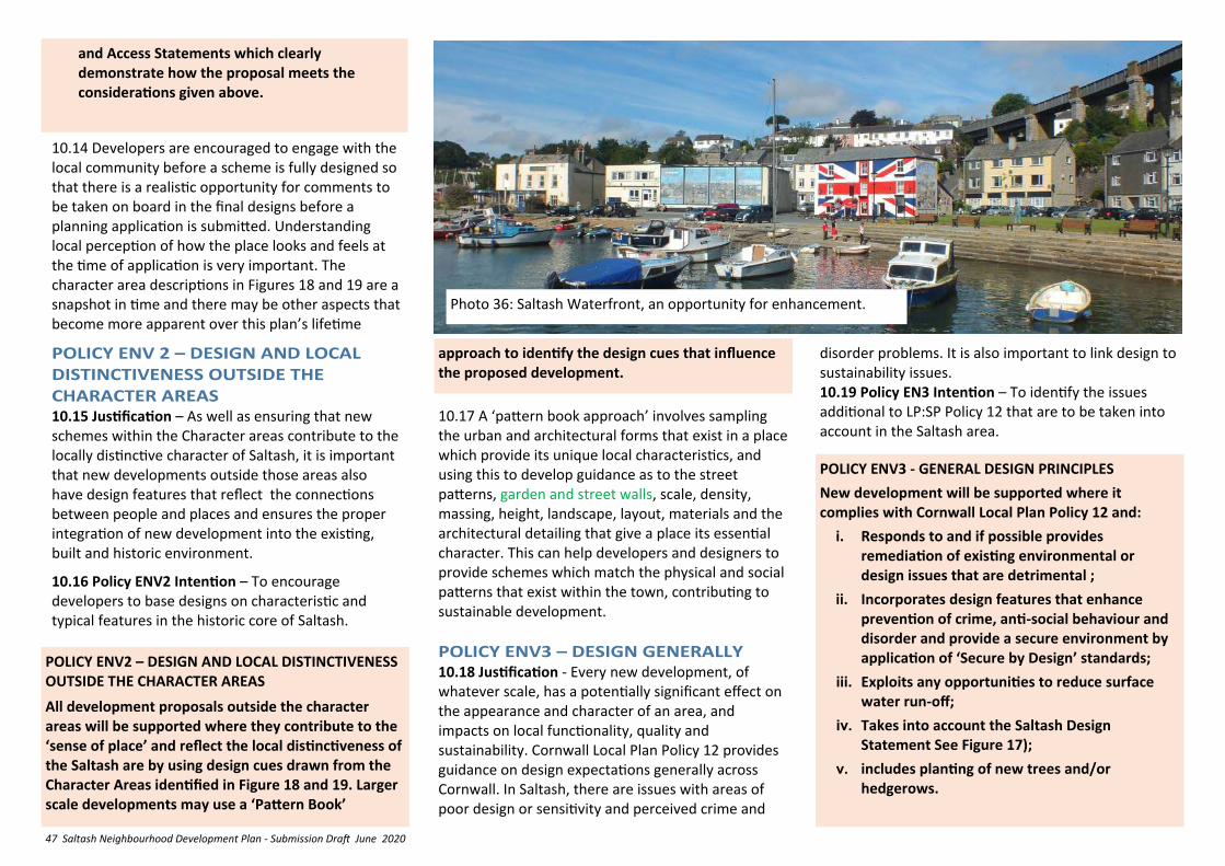
47 Saltash Neighbourhood Development Plan - Submission Draft June 2020
10.14 Developers are encouraged to engage with the local community before a scheme is fully designed so that there is a realistic opportunity for comments to be taken on board in the final designs before a planning application is submitted. Understanding local perception of how the place looks and feels at the time of application is very important. The character area descriptions in Figures 18 and 19 are a snapshot in time and there may be other aspects that become more apparent over this plan’s lifetime
10.15 Justification – As well as ensuring that new schemes within the Character areas contribute to the locally distinctive character of Saltash, it is important that new developments outside those areas also have design features that reflect the connections between people and places and ensures the proper integration of new development into the existing, built and historic environment.
10.16 Policy ENV2 Intention – To encourage developers to base designs on characteristic and typical features in the historic core of Saltash.
POLICY ENV2 – DESIGN AND LOCAL DISTINCTIVENESS OUTSIDE THE CHARACTER AREAS
All development proposals outside the character areas will be supported where they contribute to the ‘sense of place’ and reflect the local distinctiveness of the Saltash are by using design cues drawn from the Character Areas identified in Figure 18 and 19. Larger scale developments may use a ‘Pattern Book’
POLICY ENV3 - GENERAL DESIGN PRINCIPLES
New development will be supported where it complies with Cornwall Local Plan Policy 12 and:
i. Responds to and if possible provides remediation of existing environmental or design issues that are detrimental ;
ii. Incorporates design features that enhance prevention of crime, anti-social behaviour and disorder and provide a secure environment by application of ‘Secure by Design’ standards;
iii. Exploits any opportunities to reduce surface water run-off;
iv. Takes into account the Saltash Design Statement See Figure 17);
v. includes planting of new trees and/or hedgerows.
and Access Statements which clearly demonstrate how the proposal meets the considerations given above.
10.17 A ‘pattern book approach’ involves sampling the urban and architectural forms that exist in a place which provide its unique local characteristics, and using this to develop guidance as to the street patterns, garden and street walls, scale, density, massing, height, landscape, layout, materials and the architectural detailing that give a place its essential character. This can help developers and designers to provide schemes which match the physical and social patterns that exist within the town, contributing to sustainable development.
10.18 Justification - Every new development, of whatever scale, has a potentially significant effect on the appearance and character of an area, and impacts on local functionality, quality and sustainability. Cornwall Local Plan Policy 12 provides guidance on design expectations generally across Cornwall. In Saltash, there are issues with areas of poor design or sensitivity and perceived crime and
Photo 36: Saltash Waterfront, an opportunity for enhancement.
approach to identify the design cues that influence the proposed development.
disorder problems. It is also important to link design to sustainability issues. 10.19 Policy EN3 Intention – To identify the issues additional to LP:SP Policy 12 that are to be taken into account in the Saltash area.
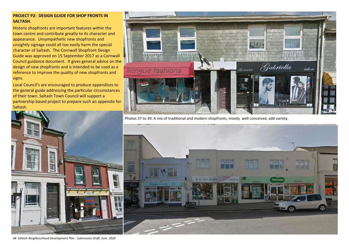
48 Saltash Neighbourhood Development Plan - Submission Draft June 2020
PROJECT P2: DESIGN GUIDE FOR SHOP FRONTS IN SALTASH.
Historic shopfronts are important features within the town centre and contribute greatly to its character and appearance. Unsympathetic new shopfronts and unsightly signage could all too easily harm the special character of Saltash. The Cornwall Shopfront Design Guide was approved on 15 September 2017 as a Cornwall Council guidance document. It gives general advice on the design of new shopfronts and is intended to be used as a reference to improve the quality of new shopfronts and signs.
Local Council's are encouraged to produce appendices to the general guide addressing the particular circumstances of their town. Saltash Town Council will support a partnership based project to prepare such an appendix for Saltash.
Photos 37 to 39: A mix of traditional and modern shopfronts, mostly well conceived, add variety.
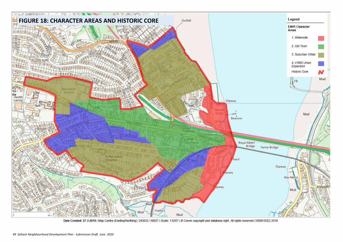
49 Saltash Neighbourhood Development Plan - Submission Draft June 2020
FIGURE 18: CHARACTER AREAS AND HISTORIC CORE
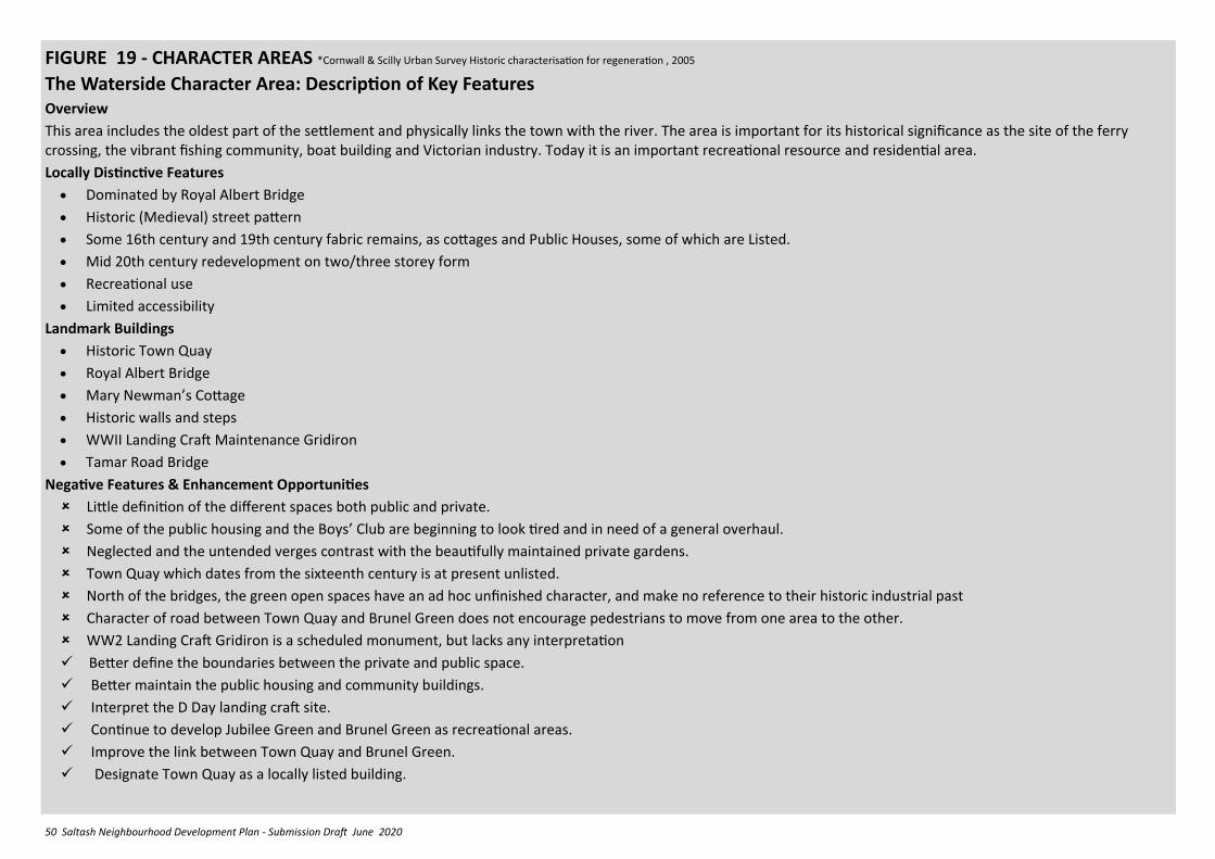
50 Saltash Neighbourhood Development Plan - Submission Draft June 2020
FIGURE 19 - CHARACTER AREAS *Cornwall & Scilly Urban Survey Historic characterisation for regeneration , 2005
The Waterside Character Area: Description of Key Features Overview
This area includes the oldest part of the settlement and physically links the town with the river. The area is important for its historical significance as the site of the ferry crossing, the vibrant fishing community, boat building and Victorian industry. Today it is an important recreational resource and residential area.
Locally Distinctive Features
• Dominated by Royal Albert Bridge
• Historic (Medieval) street pattern
• Some 16th century and 19th century fabric remains, as cottages and Public Houses, some of which are Listed.
• Mid 20th century redevelopment on two/three storey form
• Recreational use
• Limited accessibility
Landmark Buildings
• Historic Town Quay
• Royal Albert Bridge
• Mary Newman’s Cottage
• Historic walls and steps
• WWII Landing Craft Maintenance Gridiron
• Tamar Road Bridge
Negative Features & Enhancement Opportunities
Little definition of the different spaces both public and private.
Some of the public housing and the Boys’ Club are beginning to look tired and in need of a general overhaul.
Neglected and the untended verges contrast with the beautifully maintained private gardens.
Town Quay which dates from the sixteenth century is at present unlisted.
North of the bridges, the green open spaces have an ad hoc unfinished character, and make no reference to their historic industrial past
Character of road between Town Quay and Brunel Green does not encourage pedestrians to move from one area to the other.
WW2 Landing Craft Gridiron is a scheduled monument, but lacks any interpretation
✓ Better define the boundaries between the private and public space.
✓ Better maintain the public housing and community buildings.
✓ Interpret the D Day landing craft site.
✓ Continue to develop Jubilee Green and Brunel Green as recreational areas.
✓ Improve the link between Town Quay and Brunel Green.
✓ Designate Town Quay as a locally listed building.
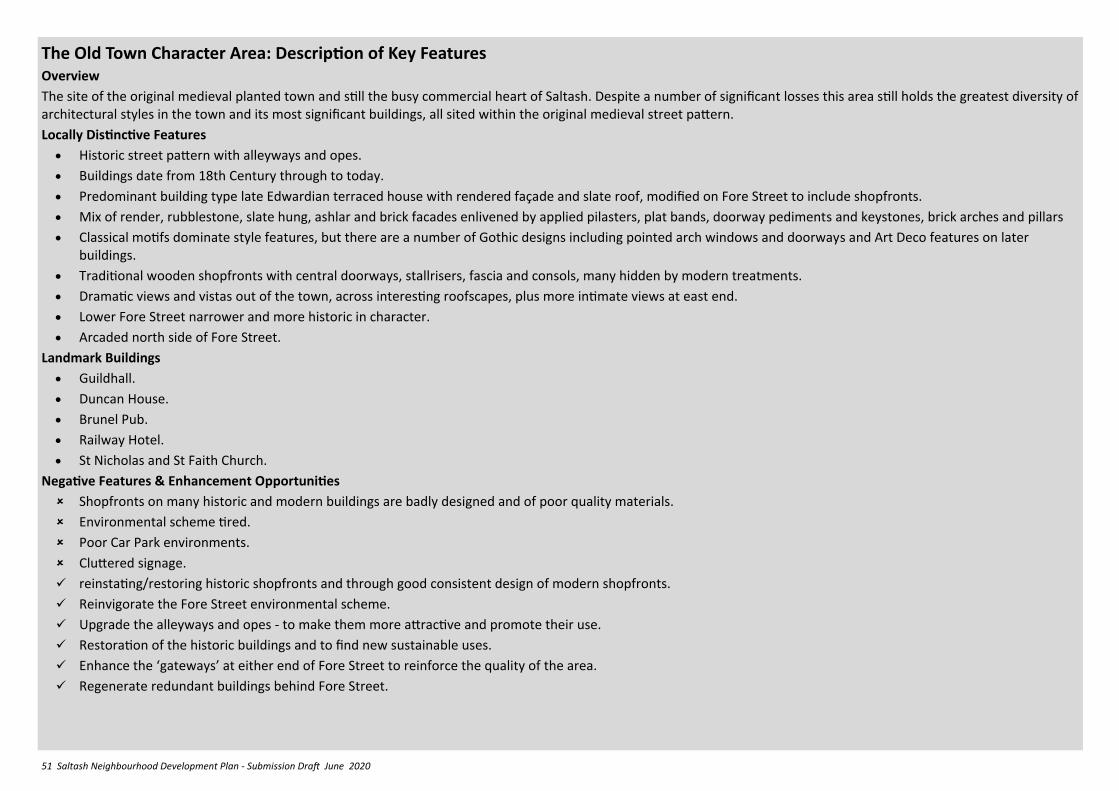
51 Saltash Neighbourhood Development Plan - Submission Draft June 2020
The Old Town Character Area: Description of Key Features Overview
The site of the original medieval planted town and still the busy commercial heart of Saltash. Despite a number of significant losses this area still holds the greatest diversity of architectural styles in the town and its most significant buildings, all sited within the original medieval street pattern.
Locally Distinctive Features
• Historic street pattern with alleyways and opes.
• Buildings date from 18th Century through to today.
• Predominant building type late Edwardian terraced house with rendered façade and slate roof, modified on Fore Street to include shopfronts.
• Mix of render, rubblestone, slate hung, ashlar and brick facades enlivened by applied pilasters, plat bands, doorway pediments and keystones, brick arches and pillars
• Classical motifs dominate style features, but there are a number of Gothic designs including pointed arch windows and doorways and Art Deco features on later buildings.
• Traditional wooden shopfronts with central doorways, stallrisers, fascia and consols, many hidden by modern treatments.
• Dramatic views and vistas out of the town, across interesting roofscapes, plus more intimate views at east end.
• Lower Fore Street narrower and more historic in character.
• Arcaded north side of Fore Street.
Landmark Buildings
• Guildhall.
• Duncan House.
• Brunel Pub.
• Railway Hotel.
• St Nicholas and St Faith Church.
Negative Features & Enhancement Opportunities
Shopfronts on many historic and modern buildings are badly designed and of poor quality materials.
Environmental scheme tired.
Poor Car Park environments.
Cluttered signage.
✓ reinstating/restoring historic shopfronts and through good consistent design of modern shopfronts.
✓ Reinvigorate the Fore Street environmental scheme.
✓ Upgrade the alleyways and opes - to make them more attractive and promote their use.
✓ Restoration of the historic buildings and to find new sustainable uses.
✓ Enhance the ‘gateways’ at either end of Fore Street to reinforce the quality of the area.
✓ Regenerate redundant buildings behind Fore Street.
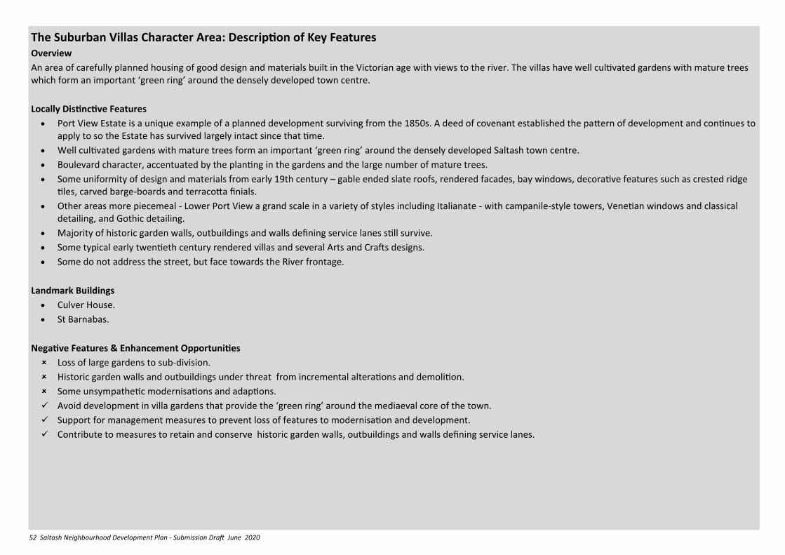
52 Saltash Neighbourhood Development Plan - Submission Draft June 2020
The Suburban Villas Character Area: Description of Key Features Overview
An area of carefully planned housing of good design and materials built in the Victorian age with views to the river. The villas have well cultivated gardens with mature trees which form an important ‘green ring’ around the densely developed town centre.
Locally Distinctive Features
• Port View Estate is a unique example of a planned development surviving from the 1850s. A deed of covenant established the pattern of development and continues to apply to so the Estate has survived largely intact since that time.
• Well cultivated gardens with mature trees form an important ‘green ring’ around the densely developed Saltash town centre.
• Boulevard character, accentuated by the planting in the gardens and the large number of mature trees.
• Some uniformity of design and materials from early 19th century – gable ended slate roofs, rendered facades, bay windows, decorative features such as crested ridge tiles, carved barge-boards and terracotta finials.
• Other areas more piecemeal - Lower Port View a grand scale in a variety of styles including Italianate - with campanile-style towers, Venetian windows and classical detailing, and Gothic detailing.
• Majority of historic garden walls, outbuildings and walls defining service lanes still survive.
• Some typical early twentieth century rendered villas and several Arts and Crafts designs.
• Some do not address the street, but face towards the River frontage.
Landmark Buildings
• Culver House.
• St Barnabas.
Negative Features & Enhancement Opportunities
Loss of large gardens to sub-division.
Historic garden walls and outbuildings under threat from incremental alterations and demolition.
Some unsympathetic modernisations and adaptions.
✓ Avoid development in villa gardens that provide the ‘green ring’ around the mediaeval core of the town.
✓ Support for management measures to prevent loss of features to modernisation and development.
✓ Contribute to measures to retain and conserve historic garden walls, outbuildings and walls defining service lanes.
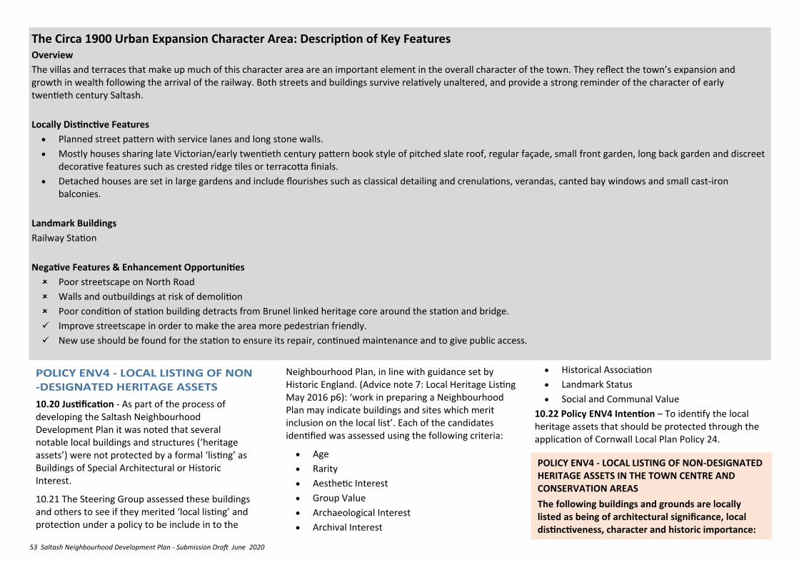
53 Saltash Neighbourhood Development Plan - Submission Draft June 2020
The Circa 1900 Urban Expansion Character Area: Description of Key Features Overview
The villas and terraces that make up much of this character area are an important element in the overall character of the town. They reflect the town’s expansion and growth in wealth following the arrival of the railway. Both streets and buildings survive relatively unaltered, and provide a strong reminder of the character of early twentieth century Saltash.
Locally Distinctive Features
• Planned street pattern with service lanes and long stone walls.
• Mostly houses sharing late Victorian/early twentieth century pattern book style of pitched slate roof, regular façade, small front garden, long back garden and discreet decorative features such as crested ridge tiles or terracotta finials.
• Detached houses are set in large gardens and include flourishes such as classical detailing and crenulations, verandas, canted bay windows and small cast-iron balconies.
Landmark Buildings
Railway Station
Negative Features & Enhancement Opportunities
Poor streetscape on North Road
Walls and outbuildings at risk of demolition
Poor condition of station building detracts from Brunel linked heritage core around the station and bridge.
✓ Improve streetscape in order to make the area more pedestrian friendly.
✓ New use should be found for the station to ensure its repair, continued maintenance and to give public access.
Neighbourhood Plan, in line with guidance set by Historic England. (Advice note 7: Local Heritage Listing May 2016 p6): ‘work in preparing a Neighbourhood Plan may indicate buildings and sites which merit inclusion on the local list’. Each of the candidates identified was assessed using the following criteria:
• Age
• Rarity
• Aesthetic Interest
• Group Value
• Archaeological Interest
• Archival Interest
10.20 Justification - As part of the process of developing the Saltash Neighbourhood Development Plan it was noted that several notable local buildings and structures (‘heritage assets’) were not protected by a formal ‘listing’ as Buildings of Special Architectural or Historic Interest.
10.21 The Steering Group assessed these buildings and others to see if they merited ‘local listing’ and protection under a policy to be include in to the
• Historical Association
• Landmark Status
• Social and Communal Value
10.22 Policy ENV4 Intention – To identify the local heritage assets that should be protected through the application of Cornwall Local Plan Policy 24.
POLICY ENV4 - LOCAL LISTING OF NON-DESIGNATED HERITAGE ASSETS IN THE TOWN CENTRE AND CONSERVATION AREAS
The following buildings and grounds are locally listed as being of architectural significance, local distinctiveness, character and historic importance:
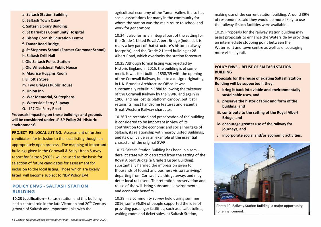
54 Saltash Neighbourhood Development Plan - Submission Draft June 2020
10.23 Justification—Saltash station and this building had a central role in the late Victorian and 20th Century growth of Saltash and important links with the
agricultural economy of the Tamar Valley. It also has social associations for many in the community for whom the station was the main route to school and work for generations.
10.24 It also forms an integral part of the setting for the Grade 1 Listed Royal Albert Bridge (indeed, it is really a key part of that structure’s historic railway footprint), and the Grade 2 Listed building at 28 Albert Road, which overlooks the station forecourt.
10.25 Although formal listing was rejected by Historic England in 2015, the building is of some merit. It was first built in 1858/59 with the opening of the Cornwall Railway, built to a design originating in I. K. Brunel’s Architecture Office. It was substantially rebuilt in 1880 following the takeover of the Cornwall Railway by the GWR, and again in 1906, and has lost its platform canopy, but it still retains its most handsome features and essential Great Western Railway character.
10.26 The retention and preservation of the building is considered to be important in view of its contribution to the economic and social heritage of Saltash, its relationship with nearby Listed Buildings, and its own value as an example of the essential character of the original GWR.
10.27 Saltash Station Building has been in a semi-derelict state which detracted from the setting of the Royal Albert Bridge (a Grade 1 Listed Building), substantially harmed the impression given to thousands of tourist and business visitors arriving/departing from Cornwall via this gateway, and may deter local rail users. The retention, preservation and reuse of the will bring substantial environmental and economic benefits.
10.28 In a community survey held during summer 2016, some 96.8% of people supported the idea of providing passenger facilities, such as a cafe, toilets, waiting room and ticket sales, at Saltash Station,
making use of the current station building. Around 89% of respondents said they would be more likely to use the railway if such facilities were available.
10.29 Proposals for the railway station building may assist proposals to enhance the Waterside by providing an intermediate stopping point between the Waterfront and town centre as well as encouraging more visits by rail.
POLICY ENV5 - REUSE OF SALTASH STATION BUILDING
Proposals for the reuse of existing Saltash Station Building will be supported if they:
i. bring it back into viable and environmentally sustainable uses, and
ii. preserve the historic fabric and form of the building, and
iii. contribute to the setting of the Royal Albert Bridge, and
iv. encourage greater use of the railway for journeys, and
v. incorporate social and/or economic activities.
a. Saltash Station Building
b. Saltash Town Quay
c. Saltash Library Building
d. St Barnabas Community Hospital
e. Bishop Cornish Education Centre
f. Tamar Road Bridge
g. St Stephens School (Former Grammar School)
h. Saltash Drill Hall
i. Old Saltash Police Station
j. Old Wheatsheaf Public House
k. Maurice Huggins Room
l. Elliott’s Store
m. Two Bridges Public House
n. Union Inn
o. War Memorial, St Stephens
p. Waterside Ferry Slipway
Q. 127 Old Ferry Road
Proposals impacting on these buildings and grounds will be considered under LP:SP Policy 24 ‘Historic environment’.
Photo 40: Railway Station Building: a major opportunity
for enhancement.
PROJECT P3: LOCAL LISTING. Assessment of further
candidates for inclusion to the local listing though an
appropriately open process,. The mapping of important
buildings given in the Cornwall & Scilly Urban Survey
report for Saltash (2005) will be used as the basis for
selection of future candidates for assessment for
inclusion to the local listing. Those which are locally
listed will become subject to NDP Policy EV4
55 Saltash Neighbourhood Development Plan - Submission Draft June 2020
10.33 Justification - Conservation Areas are designated where an area has a particular historical or architectural interest, the character and appearance of which is worthy of protection and enhancement. The Saltash Conservation area covers the extent of the original planted settlement, the medieval street pattern linking the modern town and the historic waterfront, and contains the greatest local concentration of nationally and locally listed buildings. Overall it provides a kernel of distinctive character to the town and sense of place for local people. Forder and Antony Passage Conservation Area connects the two settlements along Forder Creek, and was important for flour milling, fulling, water transport, market gardening, lime burning, roadstone quarrying and concrete-block making, and featured a mineral tramway. Set beneath Trematon Castle and Forder Viaduct, the area retains a distinctive character. Together these areas have promotional, educational and social value, which should be respected in new developments.
10.34 Policy ENV6 Intention – To encourage new development that responds sympathetically to the special character of these areas and contributes to their distinctive qualities.
POLICY ENV6 - DEVELOPMENT IN CONSERVATION AREAS
1. The design of new development proposals within the Saltash and Forder and Antony Passage Conservation Areas will be supported where they:
i. are informed by and consistent with the scale, design and character of the surroundings,
ii. are integrated into the historic topography and settlement form,
10.35 Justification - As with listed buildings the character of Conservation Areas is also affected by their setting. Development proposals outside the Conservation Area can therefore still adversely affect its character. The distance within which they may have an impact will vary depending upon the location and nature of the proposed development and the surrounding landscape/townscape. Proposals can also affect important views in or out of the Conservation Area
10.36 Policy ENV7 Intention –To ensure that developments occurring that are visually close to Conservation areas are designed in such a way as not to detract from the distinctive characteristics of the Conservation Area concerned.
10.31 The ‘Cornwall & Scilly Urban Survey Historic characterisation for regeneration’ Report of 2005 recommended that the formal Conservation Area should be extended to include the 1900 Urban Expansion, Old Town and Suburban Villas Character Areas in order to control future design and development, and to preserve the historic spaces and views. The importance of including areas of unsuccessful modern development within the conservation area is recognised by Historic England in their notes regarding conservation area appraisals, as these negative elements can ‘offer a welcome opportunity for change’. Saltash Town Council will request Cornwall Council to review the Conservation Area boundary and consider extension as soon as is practicable.
10.32 The Portview estate within the Suburban Villas Character Area is a carefully planned housing community of good design and materials with views to the river. The villas have well cultivated gardens with mature trees which form an important ‘green ring’ around the densely developed town centre. It is recommended that extension of Saltash Conservation Area to include the estate be a priority, as this status would recognise the special architectural and historic importance of this unusual planned development and promote policies and schemes for its preservation and enhancement.
PROJECT P4: SALTASH STATION REFURBISHMENT
PROJECT
Saltash Town Council has bought the building and is working to transform the site into a modern station, complete with a café, toilets and ticket office.
iii. reinforce the existing ‘sense of place’ and local distinctiveness
iv. reflect existing historic street patterns and the historic streetline.
v. avoid pastiche and ‘token’ local distinctiveness, making use of appropriate materials and detailing to reflect local building traditions
2. Proposals for development, which would have an impact on heritage assets (Statutorily Listed and locally listed) should seek to preserve the building or its setting or any features of special architectural or historic interest which it possesses. Such proposals must be accompanied by an assessment of the significance of the asset and the impact of the proposal upon its significance, identifying mitigating measures to be incorporated into the development, as necessary.
56 Saltash Neighbourhood Development Plan - Submission Draft June 2020
POLICY ENV7: DEVELOPMENT WITHIN THE SETTING OF CONSERVATION AREAS
1. Development proposals visually close to Conservation Areas should be sensitive to their potential impact upon the setting of the Conservation Area and inward or outward public views the Conservation area.
2. In appropriate cases, usually involving significant or major development, an assessment of the impact upon the character of Conservation Area should accompany the planning application.
10.37 Justification – A major element of Saltash’s distinctive character is its location on the banks of the River Tamar, with views down into and along the river into the adjoining AONB from much of the town. The two bridges are major landmarks with national significance, now added to by the Cornish Cross, These local views are complemented by more distant views into Devon revealing the city to the south and east, and distant Dartmoor to the north-east. It is important to note the effect of the local topography which may make certain proposals very prominent and have a significant impact on these views.
10.38 Policy ENV8 Intention— to ensure that these impacts can be assessed in appropriate cases.
POLICY ENV 8: IMPACT ON VIEWS AND VISTAS.
Development proposals which would be visible above the ridgelines and skylines of valley slopes and hilltops or above the average roof height of surrounding development, or are proposed on previously undeveloped areas on the settlement edges should take account of their potential impact on the roofscape of the town in general, and the views and vistas crossing and into the site from surrounding areas.
• St. Stephens Church western panorama.
• Churchtown Farm Reserve south and western panorama.
• Saltash Library western panorama.
• Longstone Park northern panorama.
• Victoria Gardens eastwards down Fore Street towards the bridges.
• Lower Fore Street eastwards towards the bridges.
• Railway Station eastwards towards the bridges.
• West end of Lower Port View Road towards the Dockyard.
• Saltash .net north eastwards to the bridges.
• General panoramic views to the southern area of AONB.
• Yellow Tor Road western/north western
panorama from Broadmoor to Trematon Castle.
• Salt Mill Park panorami from the bridges upstream towards the River Tavy.
• Saltmill views of Saltash roofscape
• Panorama westwards from the ridge road between Stokedon Cross and Roods Cross.
• Antony Passage views into Lynher River.
• Town Centre glimpses of bridges
• The Northern panorama
Proposals that rise significantly above the average roof height of surrounding development or develop previously undeveloped areas on the development boundary edges should be accompanied by a Landscape and Visual Impact Assessment and photomontages which
a. sets out a description of the views and vistas crossing and into the site, and describes the nature of the impact or harm to the view from the proposals, considering the cumulative impact on the view from any existing unimplemented development proposals
b. identify any mitigating measures to be incorporated into the development as necessary.
Proposals that would have an unacceptable detrimental impact on key viewpoints or vistas of the townscape or of the surrounding landscape will not be supported (see Figure 20),
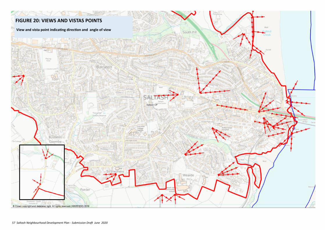
57 Saltash Neighbourhood Development Plan - Submission Draft June 2020
FIGURE 20: VIEWS AND VISTAS POINTS
View and vista point indicating direction and angle of view
58 Saltash Neighbourhood Development Plan - Submission Draft June 2020
11. PROTECT & ENHANCE
THE NATURAL
ENVIRONMENT
Summary of relevant NPPF and Cornwall Local Plan
Policy
NPPF 2018
✓ Planning should
✓ Protect and enhance valued landscapes, biodiversity, geological or soils;
✓ Recognise the intrinsic character and beauty of the countryside, and the wider benefits from natural capital and ecosystem services
✓ Maintain the character of the undeveloped coast,
✓ Minimise impacts on and provide net gains for biodiversity, and establish coherent ecological networks ;
✓ Avoid unacceptable levels of soil, air, water or noise pollution or land instability, and
✓ Encourage remediation and mitigation of despoiled, degraded, derelict, contaminated and unstable land (Para 170).
✓ Green areas of particular importance to local communities can be designated to rule out new development other than in very special circumstances (Para 99—101).
✓ Planning permission should be refused for major developments in AONBs, where great weight should be given to conserving landscape and scenic beauty (Para 172),
✓ Planning permission should be refused where it will have an adverse effect on a Site of Special Scientific Interest or result in the loss or deterioration of irreplaceable habitats, including
ancient woodland and the loss of aged or veteran trees found outside ancient woodland (Para 175),
✓ Special Protection Areas and Special Areas of Conservation and important wetlands sites are also protected from harm (Para 176)
✓ The effects (including cumulative effects) of pollution on health, the natural environment or general amenity, and the potential sensitivity of the area or proposed development to adverse effects from pollution, should be taken into account (Para 180).
✓ Ground conditions and land instability, including from natural hazards or former activities such as mining, and contamination should also be taken into account. (Para 178).
✓ Tranquil areas which have remained relatively undisturbed by noise and are prized for their recreational and amenity value for this reason may be protected (Para 180b).
✓ The impact of light pollution from artificial light on local amenity, intrinsically dark landscapes and nature conservation should be limited (Para 180c).
LP:SP
✓ Mitigation measures are required for the recreational impacts on European Sites where development is proposed within their zones of influence (Policy 23)
✓ Development proposals must sustain local distinctiveness and character and protect and enhance Cornwall’s natural environment.
✓ Development should be of an appropriate scale, mass and design that recognises and respects landscape character of both designated and un-designated landscapes.
✓ Only the most exceptional developments should be permitted in, and that the highest levels of
11.1 Justification – The protection and enhancements, where possible, of biodiversity opportunities is a key principle of the NPPF . The Saltash section of the DPD (Para 13.47) lists important links which should be protected where possible:
• Plymouth Sound and Estuaries SAC and Tamar Estuaries Complex
• SPA (this includes the Lynher Estuary and Tamar/Tavy SSSI) and areas such as Saltmill, Skinham and Hole Creek
• Latchbrook, Burraton Coombe to Antony Passage valley
• Tincombe valley
• Broadmoor/Marsh Wood and streams
• Smallacombe Valley
• South Pill to Burraton
• Habitats associated with the railway line.
• The A38 corridor from the west through to the Tamar Bridge tunnel
11.2 Net Biodiversity Gain [NBG] is a new approach to
protection should apply to SSSI, SPA and SAC.
✓ Locally designated sites are also protected, unless the need and benefits of the development clearly outweigh the loss, Biodiversity should be protected and where possible improved.
✓ Paragraphs 93 to 108 of the NPPF deal with the challenge of climate change, flooding and coastal change, whilst LP:SP Policy 26 covers flood risk management.
In applying the following policies users should be aware of and carefully take into account the needs of groups with protected characteristics as set out in the Equalities Act 2010.
59 Saltash Neighbourhood Development Plan - Submission Draft June 2020
POLICY GRN1 - BIODIVERSITY PROTECTION AND GAIN
1. Development within or close to the Biodiversity/Habitat Corridors shown on Figure 21 will be supported where it includes:
i. measures to protect the integrity of the affected corridor, and
ii. adequate mitigation of any harmful impact;
iii. linkages across sites to provide new connections between corridors
2. New development proposals will be supported where they demonstrate that they minimise impacts on and result in net gains to biodiversity by using a mitigation hierarchy which follows guidance in the Cornwall Biodiversity SPD, is consistent with the British Standard for Biodiversity, BS42020, and supports Cornwall’s Environmental Growth Strategy.
3 As per existing policy
4. Any residential developments of 10 or more dwellings, or employment development of 1000m2 per hectare or more should demonstrate:
11.4 Justification – The Saltash NDP area is not particularly well wooded and there has been substantial hedge and hedgerow loss in the 20th Century, although sufficient remains to give the landscape outside the town a distinctly Cornish rural character. Within the built-up area existing trees and Cornish hedges can add to the quality of development, provide useful boundaries, and help support urban biodiversity. Woodlands incorporated into development can provide good recreational opportunities, and help to ‘green up’ the town and it’s appearance from outside
11.5 Policy GRN2 - Intention. To support development and ensure existing woodlands, trees,
development which aims to leave the natural environment in a measurably better state than before it was involved in development. The Government has indicated that it will introduce mandatory requirements to achieve a 10% net gain for biodiversity into the planning system in England through the Environment Bill 2020. Cornwall Council are now promoting a 10% net gain in biodiversity in the context of CLP Policies 23 and 28.
11.2 The key habitat/biodiversity corridors identified on the accompanying proposals map (Figure 21) link and enhance green links through the town and the green space to the west of the settlement. Public open space and the Public Right of Way networks may also be utilised as biodiversity corridors, as may Integrated green and engineered flood attenuation and relief measures. In addition, steps can be taken to enhance biodiversity through the inclusion of enhancement measures in new developments, as advocated in the Cornwall Council Biodiversity Supplementary Planning Document and British Standard 42020.
11.3 Policy GRN1 – Intention. This policy develops the guidance, given in the DPD into specific requirements for new development. Net Biodiversity Gain follows the principle of the mitigation hierarchy which seeks to:
• Enhance habitat
• Avoid habitat loss
• Minimise habitat loss
• Restore habitat loss
• Compensate for habitat loss
• Offset Habitat loss
DEFRA have published a ‘Biodiversity Metric’ to provide a way of measuring and accounting for biodiversity losses and gains resulting from development or land management change.
Note: Saltash sits within the zone of influence of the Plymouth Sound & Estuaries Special Area of Conservation (SAC) and the Tamar Estuaries Complex Special Protection Area (SPA). As a result, development proposals within the town will be required to provide mitigation to address recreational impact upon the SAC and SPA. Further detail on the nature of the mitigation measures are set out in the European Sites Mitigation Strategy Supplementary Planning Document.
a) That the Mitigation Hierarchy has been followed (including proposals for any necessary compensation)
b) How the proposal will provide a minimum 10% net gain increase in biodiversity
c) How the proposal will integrate into any wider green infrastructure network.
3. Development which results in the loss of or significant harm to the ecological or landscape value of private residential gardens will not be supported.
Examples of appropriate methods to address BGN might include:
i. purpose designed boxes and bricks for bats, birds (including owls in remoter areas), bees and other invertebrates, within the structure of the building, or within the site boundaries on non-built features if this is not possible;
ii. hedgehog access points in fences,
iii. planting new native trees and hedges and flower-rich habitats
iv. the intentional use of SUDS, and drainage ponding, as habitat,
v. ‘re-wilding’ of areas to support drainage and create habitat

60 Saltash Neighbourhood Development Plan - Submission Draft June 2020
POLICY GRN2 – TREES, CORNISH HEDGES AND HEDGEROWS
1. Development proposals will be supported that seek to mitigate impacts on trees, Cornish hedges or hedgerows by:
i. Sympathetically incorporating and retain trees and Cornish Hedges or hedgerows of good arboricultural and amenity value into the overall design of the scheme;
ii. Including measures to ensure their protection during the course of development and their continued survival in the long term;
iii. iMaintaining a minimum buffer of at least 15 metres in width between ancient woodland, veteran trees and any footprint of the built development including trenches or drainage runs;
iv. Where proposed development abuts existing woodland, providing a 10m buffer (minimum) between residential or commercial development and edge of canopy (as present at time of survey)
v. Incorporate the planting of additional trees at a minimum of 3 trees for each dwelling or 1 tree for each 50 SqM of gross business floorspace.
2. Where development proposals result in the loss of trees replacement should be at a ratio of 3:1 to ensure rapid canopy replacement.
3. Any replacement planting should be of a proven Cornish provenance or other provenance which is appropriate to the site, its character and surrounding
11.6 Justification – Between Saltash urban area and the surrounding AONB there are areas of open countryside which form a green foreground or background that is important to the setting of Saltash or its villages. These areas, which have no special protection, contain trees, meadows, Cornish Hedges, hedgerows, ponds, springs, streams and rivers, public rights of way, parish paths and quiet byways, scattered amongst which are a few traditional buildings all of which contributes to the present character and natural environment of the area.
11.7 Intention of Policy GRN3 – Part of the area to the north of the A38 has been allocated for housing purposes (site SLT-H1 in the Cornwall Site Allocations DPD). Nevertheless, it is important to ensure that the natural features of this area are protected and incorporated as environmental and leisure assets within that development. Elsewhere north of the A38 and to the west of Saltash it is important that the key
POLICY GRN3 – COUNTRYSIDE CHARACTER AREAS
1. In the Countryside Character Areas identified in Figure 22, any development which is permitted should:
i. include measures to ensure that no harm occurs to the key features of their landscape character, including trees, meadows, Cornish Hedges, hedgerows, ponds, springs, streams and rivers, and
ii. incorporate public rights of way, parish paths and quiet byways in ways that minimise deviation
iii. reflect the traditional building styles, materials and design of the local area.
2. Proposals to create greater recreational linkages in the form of permissive paths connecting to the existing network of paths and bridleways, signage and interpretive material will be supported.
See also Policy ENV8
features of these areas are protected as part of the current setting of Saltash and taken into account of any rural development under CLP Policy 7 or Policy 9 which comes forward.
Cornish hedges and hedgerows are effectively accommodated. This policy links with the ‘Green Boulevard’ policy (CON1).
habitat. [See Cornwall Council Guidance].
4. Whenever a Cornish hedge is lost, and replacement is considered the necessary mitigation, a net gain of Cornish hedge and canopy cover is desirable
5.Proposals should be accompanied by:
a. a survey that establishes the health and longevity of any affected trees or hedgerows and a management plan in accordance with the latest version of British Standard BS 5837 ‘Trees in relation to demolition, design and development’ to demonstrate how they will be so maintained.
b. a scheme depicting the method by which retained trees and hedges will be protected for the duration of development.
61 Saltash Neighbourhood Development Plan - Submission Draft June 2020
11.8 Justification - The low-lying area adjacent to Saltash Pier, Town Quay and Forder are subject to tidal flooding, whilst the Anthony Passage and Forder areas have experienced both tidal and surface water flooding. Surface water management at Forder, through the storage pond and dam on the Latchbrook Leat may also need enhancing because of changed environmental circumstances. The entire western catchment for the Latchbrook Leat is a Critical Drainage area. LP:SP Policy 26 requires that developments of 10 or more dwellings should provide a Surface Water Management Plan.
11.9 Policy GRN4 – Intention. To ensure that all new developments incorporate both soft and hard engineering drainage solutions that are adequate enough to prevent escalation in flooding but are also be designed to anticipate future changes resulting from updated climate change forecasts for extreme rainfall predictions for the England South West and Wales South Climate Region, and the predicted increase in the severity of storm events and tidal surges.
POLICY GRN4 - DRAINAGE AND FLOODING
1. All new developments [within the Saltash Critical Drainage Area] must demonstrate that they have a site-specific flood risk assessment and management plan showing that the risk of flooding both on and off site is effectively minimised and managed.
2, Unless it can be demonstrated that any of the measures below are unreasonable, unnecessary or would impact unacceptably on the viability of the scheme, developers should demonstrate that the proposals:
i. Are supported by a sequential, risk-based approach to the location of the development, in
order to avoid possible flood risk to people and property; as well as setting out measures to manage any residual future risk.
ii. Help mitigate and adapt to climate change and alleviate increased vulnerability to the range of impacts arising from climate change.
iii.Incorporate proportionate and appropriate pollution control measures to prevent adverse impacts on the water environment.
iv. Are in line with Environment Agency Groundwater Protection Guides include SUDS as the first method of surface water disposal.
3. Connection to the surface water sewer should only be used as a last option; and where either SUDS is not feasible/appropriate or if the development is of a size and nature that will likely exacerbate existing drainage issues elsewhere within the Plan Area, an appropriate payment towards off-site drainage and water run-off management will be required.
4. Proposals for larger scale phased developments should include provision for the review of flood risk assessment and management plans as appropriate in the light of any changes in nationally adopted climate change related rainfall forecasts and any proposed increases in development densities that may lead to additional run-off.
11.11 The DPD reports that Sewage is piped across the River Tamar for treatment at Ernesettle, on the edge of Plymouth. The treatment capacity at Ernesettle is likely to be exceeded in the medium term; plus pipe capacity across the Tamar may also be exceeded. South West Water is investigating the delivery of a new treatment works on the edge of Saltash/upgrades to the current works at Ernesettle and enhancing the capacity of the network on the Saltash side of the Tamar, which will have a 3-4 year lead in time. If a new facility was required it is likely to be a ‘regulated investment’ and as a result no developer contributions would be expected. However, as a consequence, the proposals covered by this NDP will not be able to proceed prior to confirmation that they can be accommodated within the ‘headroom’ of existing treatment works or prior to provision of appropriate upgrades / new facilities.
11.10 Salltmill: The Durslton Head to Rame Head Shoreline Management Plan, by South Devon and Dorset Coastal Advisory Group covers the issue of erosion and flooding in this area. The southern half of Saltmill is in ‘Policy Unit 6c34 Tamar Estuary - Saltash’ described on pages 486 to 490 of the Plan. In this area the short, medium and long term policy is ‘continue to hold the line where there are existing defences with No Active Intervention along the
undefended frontages’. The northern half is in ‘PU 6c33 Upper Tamar Estuary West’. Here the policy is No Active Intervention along the undefended frontages, with if necessary Managed Realignment in strategic locations, whilst continuing to Hold the Line of existing defences where realignment is not feasible. On the Cornwall Council Strategic Flood Map the filled area of Saltmill is currently identified as being outside the functional flood zone, and only the car park/changing area (outside the main tip area) is within flood zones 2 and 3. The latter, plus part of the road fronting Tamara estate, is shown as being within the 1:30 to 1:1000 surface water flood risk areas. In the light of these factors it is considered that there is no reason to include specific polices concerning flood risk at Saltmill in the NDP.
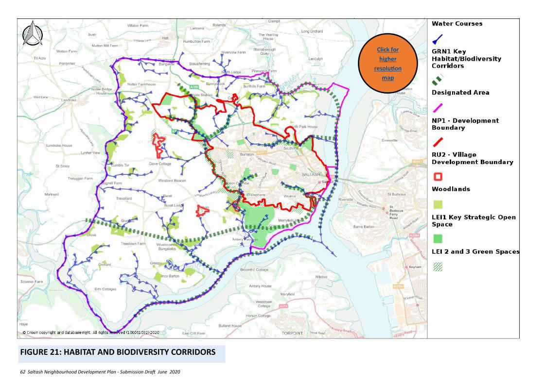
62 Saltash Neighbourhood Development Plan - Submission Draft June 2020
FIGURE 21: HABITAT AND BIODIVERSITY CORRIDORS
Click for
higher
resolution
map
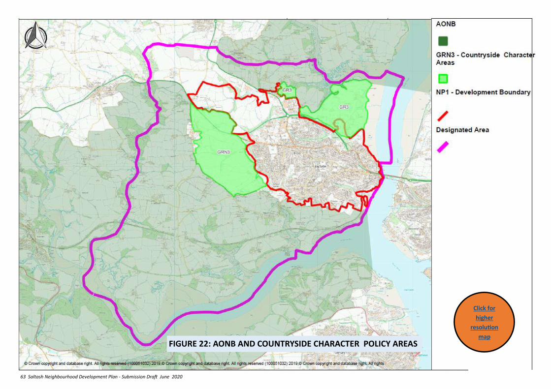
63 Saltash Neighbourhood Development Plan - Submission Draft June 2020
FIGURE 22: AONB AND COUNTRYSIDE CHARACTER POLICY AREAS
Click for
higher
resolution
map
64 Saltash Neighbourhood Development Plan - Submission Draft June 2020
12. MANAGE THE RURAL AREAS OF THE PARISH IN A
SYMPATHETIC MANNER
12.1 Saltash town is surrounded by very attractive countryside of great quality, with a scattering of small villages and hamlets, and individual isolated houses. This provides a fine setting for the town, a recreational resource, but also a place where many of our community live and work.
Summary of relevant NPPF and Cornwall Local Plan Policy
NPPF 2018
Planning policies should support economic growth in rural areas by:
✓ sustainable growth and expansion of all types of business and enterprise, through conversion of existing buildings and well-designed new buildings;
✓ development and diversification of agricultural and other land-based rural businesses;
✓ sustainable rural tourism and leisure developments which respect the character of the countryside;
✓ retention and development of accessible local services and community facilities, such as local shops, meeting places, sports venues, open space, cultural buildings, public houses and places of worship (Para 83);
✓ Recognition that sites to meet local business and community needs in rural areas may have to be found adjacent to or beyond existing settlements (para 84);
✓ Supporting new housing where it will enhance or maintain the vitality of rural communities, identifying opportunities for villages to grow and thrive (Para 78);
✓ new isolated homes in the countryside should be avoided unless there are special circumstances such as the needs of rural workers, enabling development to secure the future of heritage assets, or reuse redundant buildings, or where a building is of exceptional quality or innovative nature (Para 79).
LP:SP
✓ ‘Outside main towns, housing and employment growth will be delivered for Community Network Area housing requirements through:
✓ identification of sites through Neighbourhood Plans;
✓ rounding off settlements and development of previously developed land within or immediately adjoining of a scale appropriate to its size and role;
✓ infill schemes that fill a small gap in an otherwise continuous built frontage and do not physically extend the settlement into the open countryside;
✓ rural exception sites under Policy 9 (Policy 3.3 )
✓ Within the AONB or its setting, development should demonstrate that it conserves and enhances landscape character and natural beauty’ (Policy 3.4).
✓ In smaller villages and hamlets in which ‘infill’ sites of one-two housing units are allowed, the settlement should have a form and shape and clearly definable boundaries, not just a low-density straggle of dwellings…. Neighbourhood
12.2 Justification – Small rural workshops can aid diversification and encourage new small firms, provide employment opportunities close to rural communities, so reducing commuting, and enabling the start-up and development of businesses specializing in everything from traditional crafts to advanced ‘digital businesses’. They also provide opportunities for inward investment that supports rural vitality.
12.3 Policy RUR1 Intention – This Neighbourhood Plan policy aims to support the development of employment in the rural area outside the town boundary, taking into account the beautiful and varied character of our countryside, and the heritage buildings within it, which must be conserved. The conversion of redundant farm buildings for employment (including holiday rental) is encouraged. Any conversion will be required to be of a compatible size, design and material with the existing building and any existing nearby properties.
POLICY RUR 1 – SMALL WORKSHOP DEVELOPMENT IN THE COUNTRYSIDE
1. Where planning permission is required, the conversion of an existing buildings to small workshop use will be supported if:
a. It will not add to difficulties with water supply, sewerage and sewage treatment and waste disposal;
b. It will not have a materially adverse impact on the rural environment in terms of, noise, effluent or fumes it would emit, and the traffic it would
Plans can provide detailed definition on which settlements are appropriate for infill and boundaries to which the policy will operate (Para 1.68).
65 Saltash Neighbourhood Development Plan - Submission Draft June 2020
generate;
c. It will not conflict with the need to conserve the best and most versatile agricultural land and minimise interference with farming;
d. It will not have a materially adverse impact on nature conservation or landscape interests;
e. It includes measures to improve access on foot, cycling or public transport;
f. Reasonable measures have been taken to provide for any nature conservation interest.
g. The building is capable of change or conversion without the need for major extension or rebuilding;
h. If extension is required the scale, design and use of materials retain the existing character of the building and relate to its surroundings;
2. Where development involves conversion or change of use of a listed building, LP:SP strategic policy 24 will apply.
3. Where the need cannot be met by the conversion of an existing building, proposals for new sites will be supported where in addition to 1.a to 1.f above:
a. They are located within or adjacent to existing groups of buildings or use previously developed land.
b. The scale, form, bulk and general design is appropriate to its location.
c. They do not create road hazards that are considered unacceptable by the Highway Authority; and
d. Where appropriate and feasible, supports opportunities to make the location more sustainable by improving the scope for access on foot, by cycling or by public transport.
NOTE: Certain forms of conversion are ‘Permitted Development’: Development of buildings for agricultural purposes up to 465 Sq.m is ‘permitted development’ subject to various criteria in Part 6 Class A ‘Agricultural and forestry’ of the Town and Country Planning (General Permitted Development) (England) Order 2015. Change of use of existing agricultural buildings established for 10 years to a flexible A1, A2, A3, B1, B8, C1 use, C3 and D2 or State Funded School/nursery is also permitted subject to criteria in Part 3 of the same.
12.4 Justification – Whilst there is a need to protect and conserve the rich countryside and ecology of the surrounding countryside, it is an area that has its own housing needs for both low cost and more expensive housing, the latter which could also serve to support the economy of SE Cornwall and Plymouth by providing larger dwellings set in a pleasant setting, likely to be favoured by managerial staff and entrepreneurs. However, it is important to ensure that such development does not overwhelm the character of the villages or exceed the capacity of local services, nor harm the open, spacious and green character of the rural areas of Saltash.
12.5 To achieve this outcome, the Village development boundaries, first established in the now superseded Caradon Local Plan, have been reviewed to identify where acceptable small scale developments might occur and what criteria should be used to the forms of development required.
12.6 The village development boundary review has taken into account the following criteria:
• Reflect and respect the character and built form of the settlement.
• Follow clearly defined features such as field boundaries, roads, streams, walls, well-established fences, curtilage of properties (dwellings and other uses) physically linked to the built part of the settlement except for large gardens, separate curtilages to dwellings (eg allotments), or where it may significantly and inappropriately extend the built form of the settlement, or encroach on an important ‘green gap’ between settlements.
Include:
• development permitted outside the boundaries since 2007, and existing commitments for built development on the edge of a settlement.
• built sites and small-scale amenity space on the edge of a settlement which contribute to the economic & social life of the settlement
• traditional rural buildings which have been converted to residential use, together with their residential boundaries.
• redundant agricultural or industrial buildings providing they are of a scale appropriate to the size and role of the settlement, and have no impact on important ‘green gaps’ between settlements.
• redundant modern agricultural buildings but only if the buildings have had a lawful use and have been redundant for at least 10 years.
• land which is outside of a settlement where at least two-thirds of the existing edge substantially encloses it with development, and where its edge is clearly defined by a physical feature that can act as a barrier to further growth (such as a road, Cornish hedge, or substantial hedgerow) and would not visually extend development into the open countryside.
Exclude:
66 Saltash Neighbourhood Development Plan - Submission Draft June 2020
setting of Listed Buildings within the parish. (In accordance with CLP Policies 12 and 24, and policy ENV3 of this Plan).
ii. The development having a net density consistent with but not substantially exceeding the existing densities of the settlement;
iii. Being of a similar curtilage to adjacent existing properties, appropriate to the scale of the property (with 50sqm normally being min requirement); and
iv. Inclusion of starter/later life homes and family homes, and aspirational dwellings where appropriate; and
v. Incorporates a garage or provides adequate off-road parking for private vehicles (with the minimum provision for at least one vehicle).
vi. Submission of proportionate archaeological and heritage assessments and agreement to any necessary archaeological investigation and heritage impact mitigations.
3. Development of up to 5 dwellings will be supported, on land within the village development boundaries, at
i. Old Farm, Trematon;
ii. Opposite Pandrama, Trehan;
iii. Former allotment gardens, Trehan
iv. Subject to Policies RUR 3, 4 and 5 following.
4. Outside village settlement boundaries only affordable housing led local needs residential development under LP:SP Policy 9 and appropriate rural development under LP:SP Policy 7 will be supported subject to:
i. a maximum of 8 dwellings that reflect the nature of the local housing need; and
ii. the site immediately adjoins a suitable part of the village settlement boundary as defined in this policy.
POLICY RUR 2 – VILLAGE DEVELOPMENT BOUNDARIES AND RURAL HOUSING SITES
1. Village development boundaries are set for the following villages:
Trehan
Forder
Trematon.
2. New residential infill development will be supported within these boundaries, subject to:
i. Design being of a style which respects the character and appearance, where appropriate, of the AONB and Forder Conservation area and the
12.7. Policy RU2 – Intention. This policy seeks to focus most new development in the rural area on to the established villages, whilst ensuring that they are not harmed, through the use of settlement development boundaries and criteria which guide the forms of development required.
• isolated or sporadic development, free standing, individual or groups of dwellings, farm buildings or other structures detached from the main built area of settlements
• larger scale amenity land, such as parkland, kick-about areas, and club playing fields
• single depth development (ribbon development) along roads leading out of settlements unless physically well related to the settlement.
• working farms with modern agricultural buildings situated alongside a settlement boundary, should be outside.
Land which is within a settlement boundary but which performs a role as a green space that contributes to the character and/or provides recreational opportunities to the local community are identified as Green Spaces under Policy GRN3.
POLICY RUR 3 - LAND AT OLD FARM, TREMATON
Proposals for this site will be supported where:
i. They comply with the criteria set out in Policy RUR2.2;
ii. Retain the existing field boundaries (which should be protected during construction);
iii. Its layout, form, scale and use of materials reflect and complement the LB opposite and its original use as a farmhouse.
POLICY RUR 4 - LAND OPPOSITE PANDRAMA, TREHAN
Proposals for this site will be supported where they:
i. Comply with the criteria set out in Policy RUR2.2;
ii. Retain existing the field boundaries (which should be protected during construction);
iii. Restrict the height of any buildings located at the south boundary of the site, or use this area as garden space, to protect the setting of the nearby LB.
iv. Remove the electricity infrastructure that currently dominates the LB;
v. Provide a new western boundary in the form of a Cornish Hedge planted with trees of Cornish provenance.
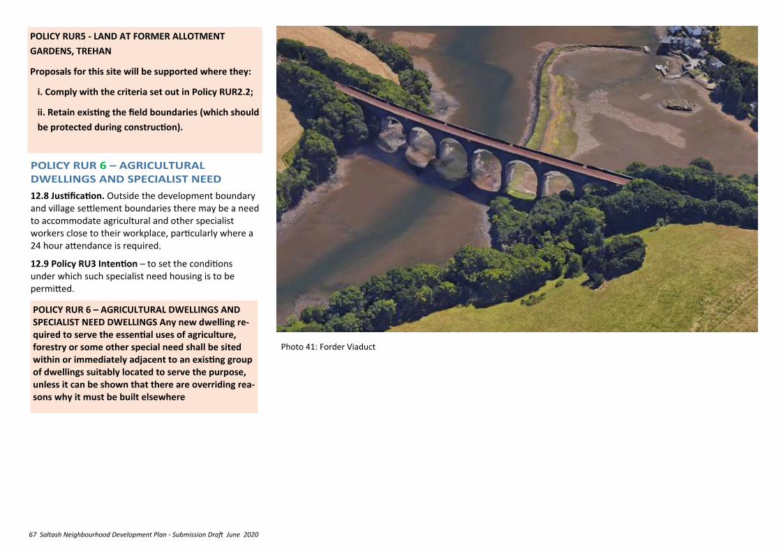
67 Saltash Neighbourhood Development Plan - Submission Draft June 2020
POLICY RUR 6 – AGRICULTURAL DWELLINGS AND SPECIALIST NEED DWELLINGS Any new dwelling re-quired to serve the essential uses of agriculture, forestry or some other special need shall be sited within or immediately adjacent to an existing group of dwellings suitably located to serve the purpose, unless it can be shown that there are overriding rea-sons why it must be built elsewhere
12.8 Justification. Outside the development boundary and village settlement boundaries there may be a need to accommodate agricultural and other specialist workers close to their workplace, particularly where a 24 hour attendance is required.
12.9 Policy RU3 Intention – to set the conditions under which such specialist need housing is to be permitted.
Photo 41: Forder Viaduct
POLICY RUR5 - LAND AT FORMER ALLOTMENT
GARDENS, TREHAN
Proposals for this site will be supported where they:
i. Comply with the criteria set out in Policy RUR2.2;
ii. Retain existing the field boundaries (which should
be protected during construction).
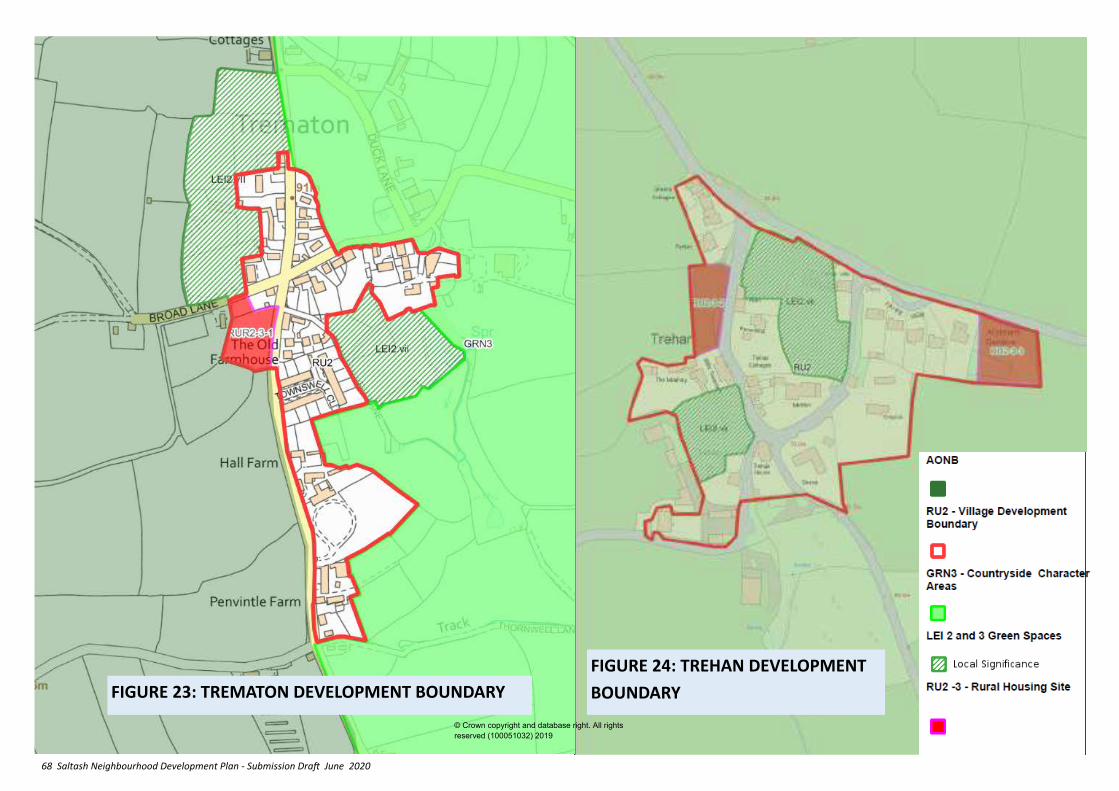
68 Saltash Neighbourhood Development Plan - Submission Draft June 2020
FIGURE 24: TREHAN DEVELOPMENT
BOUNDARY FIGURE 23: TREMATON DEVELOPMENT BOUNDARY
© Crown copyright and database right. All rights
reserved (100051032) 2019
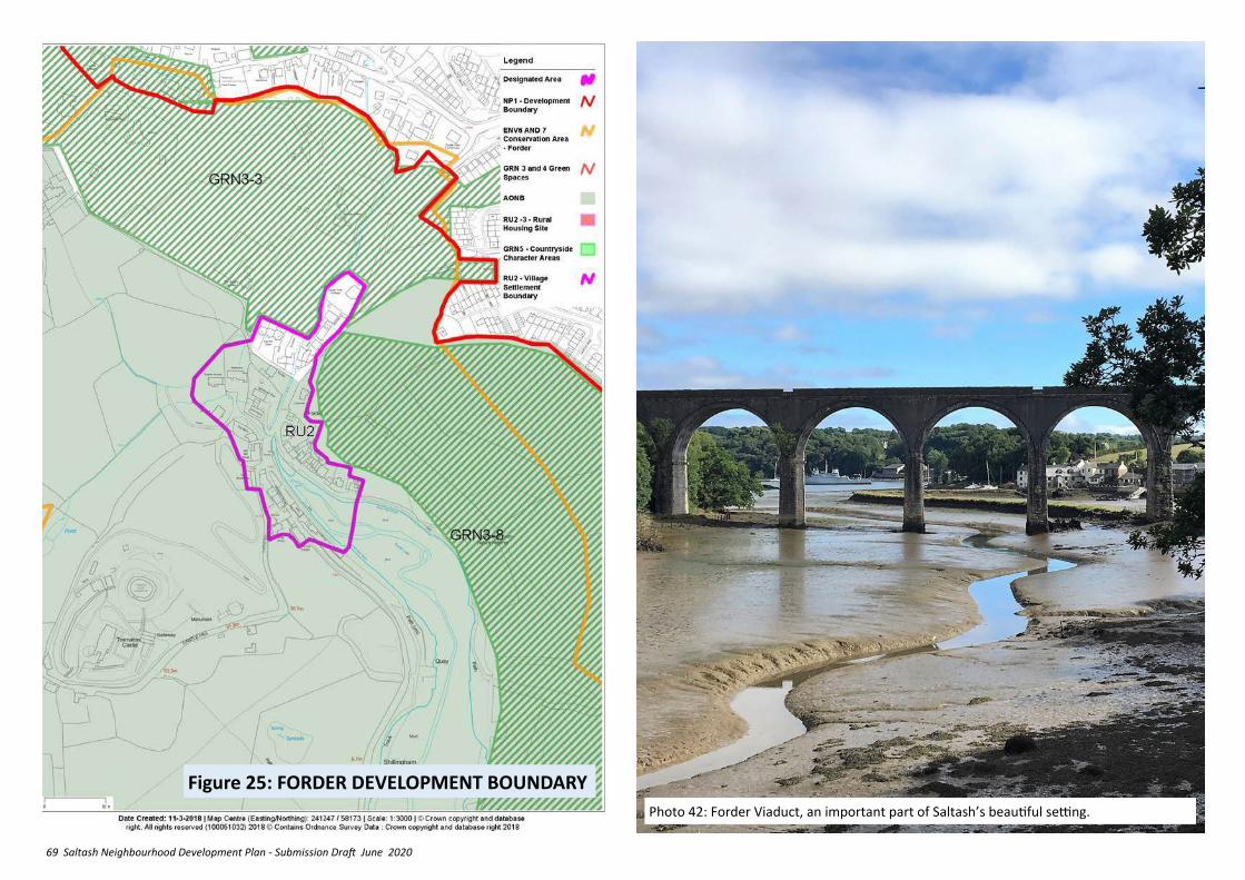
69 Saltash Neighbourhood Development Plan - Submission Draft June 2020
Figure 25: FORDER DEVELOPMENT BOUNDARY
Photo 42: Forder Viaduct, an important part of Saltash’s beautiful setting.
70 Saltash Neighbourhood Development Plan - Submission Draft June 2020
13. MEET THE CHANGING DEMAND FOR HEALTH, EDUCATION, COMMUNITY &
EMERGENCY SERVICES AND FACILITIES
13.1 The population of Saltash and the surrounding communities are supported by the St Barnabas Community Hospital, four junior schools, the Saltash.net senior school, and a range of community and ‘blue light’ services clustered around Warfelton, supplemented by higher level but more distant services located in Plymouth and elsewhere. Facilities in Saltash are also impacted upon by growth in the nearby parts of Plymouth. The improvement of this social infrastructure is recognised in the allocations DPD as being a fundamental element for the future growth of Saltash.
Summary of relevant NPPF and Cornwall Local Plan Policy
NPPF 2018
✓ The social role of the planning system should support ‘vibrant and healthy communities’ with ‘accessible local services that reflect the community’s needs and support its health, social and cultural well-being’ (Para 8).
✓ Planning policies and decisions should plan for the provision and use of shared space, community facilities and other local services to enhance the sustainability of communities and residential environments.
✓ Support the delivery of local strategies to improve health, social and cultural well being.
✓ Ensure that established shops, facilities and services are able to develop and modernise in a way that is sustainable and retained for the benefit of the community.
LP:SP
✓ Community facilities should wherever possible, be retained and new ones supported (Policy 4).
✓ Loss will only be acceptable where the proposal shows there is no need for the facility or service, or it is not viable; or adequate facilities or services exist or the service can be re-provided in accessible locations (Policy 4).
✓ Developer contributions will be sought to ensure that the necessary physical, social, economic and green infrastructure is in place to deliver development (policy 28).
13.2 Justification – although local primary schools cumulatively have some limited spare capacity, the housing growth forecast in the DPD will lead to a deficit of some 200 places. Similarly the secondary school, already near to or at capacity, will have a deficit of 250 by 2030. Provision is made in the DPD to support new primary provision and secondary school expansion to meet this need, which may also create interest in private investment in education facilities in the form of academies and ‘free schools’. Travel to school generates traffic flow through the town centre and along residential distributor roads at school start and finishing times, especially in the morning peak travel period.
13.3 Policy HWB 1 Intention – to ensure that
adequate educational provision is facilitated.
POLICY HWB1 – EDUCATION PROVISION
Proposals for the expansion of existing schools, pre-schools and nurseries or the development of new schools, pre-schools and nurseries will be supported where it can be demonstrated that:
a. Expansion would not exacerbate existing access related or traffic circulation problems, or that suitable mitigation measures are being brought forward as part of the proposal;
b. New development would be safely accessible by pedestrians and cyclists and is well related to bus routes and/or there is adequate provision for waiting school buses to park;
c. The development has appropriate vehicular access and does not adversely impact upon traffic circulation;
d. The development would not result in a significant loss of amenity to local residents or other adjacent uses.
13.4 Justification – The Saltash Community Campus is an area of mainly community uses established under the first post war Town Map for Saltash, and includes a number of socially valuable facilities that contribute substantially to the health and well-being of the community. The area was intentionally located at the heart of the town and is highly accessible. It is bounded by Callington Road, Tobruk Road, Alamein Road, Warfelton Crescent and served in part off Plougastel Drive, and includes the Brunel
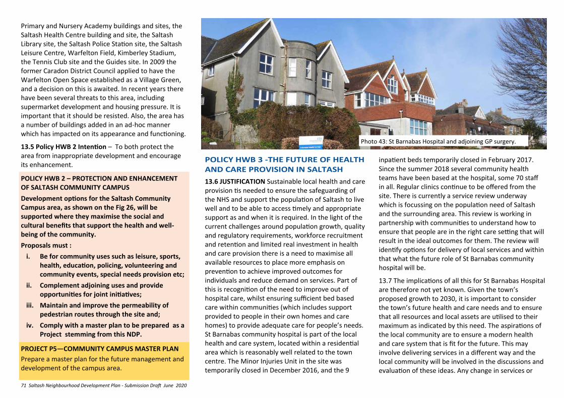
71 Saltash Neighbourhood Development Plan - Submission Draft June 2020
Primary and Nursery Academy buildings and sites, the Saltash Health Centre building and site, the Saltash Library site, the Saltash Police Station site, the Saltash Leisure Centre, Warfelton Field, Kimberley Stadium, the Tennis Club site and the Guides site. In 2009 the former Caradon District Council applied to have the Warfelton Open Space established as a Village Green, and a decision on this is awaited. In recent years there have been several threats to this area, including supermarket development and housing pressure. It is important that it should be resisted. Also, the area has a number of buildings added in an ad-hoc manner which has impacted on its appearance and functioning.
13.5 Policy HWB 2 Intention – To both protect the area from inappropriate development and encourage its enhancement.
POLICY HWB 2 – PROTECTION AND ENHANCEMENT OF SALTASH COMMUNITY CAMPUS
Development options for the Saltash Community Campus area, as shown on the Fig 26, will be supported where they maximise the social and cultural benefits that support the health and well-being of the community.
Proposals must :
i. Be for community uses such as leisure, sports, health, education, policing, volunteering and community events, special needs provision etc;
ii. Complement adjoining uses and provide opportunities for joint initiatives;
iii. Maintain and improve the permeability of pedestrian routes through the site and;
iv. Comply with a master plan to be prepared as a Project stemming from this NDP.
13.6 JUSTIFICATION Sustainable local health and care provision tis needed to ensure the safeguarding of the NHS and support the population of Saltash to live well and to be able to access timely and appropriate support as and when it is required. In the light of the current challenges around population growth, quality and regulatory requirements, workforce recruitment and retention and limited real investment in health and care provision there is a need to maximise all available resources to place more emphasis on prevention to achieve improved outcomes for individuals and reduce demand on services. Part of this is recognition of the need to improve out of hospital care, whilst ensuring sufficient bed based care within communities (which includes support provided to people in their own homes and care homes) to provide adequate care for people’s needs. St Barnabas community hospital is part of the local health and care system, located within a residential area which is reasonably well related to the town centre. The Minor Injuries Unit in the site was temporarily closed in December 2016, and the 9
PROJECT P5—COMMUNITY CAMPUS MASTER PLAN
Prepare a master plan for the future management and development of the campus area.
Photo 43: St Barnabas Hospital and adjoining GP surgery.
inpatient beds temporarily closed in February 2017. Since the summer 2018 several community health teams have been based at the hospital, some 70 staff in all. Regular clinics continue to be offered from the site. There is currently a service review underway which is focussing on the population need of Saltash and the surrounding area. This review is working in partnership with communities to understand how to ensure that people are in the right care setting that will result in the ideal outcomes for them. The review will identify options for delivery of local services and within that what the future role of St Barnabas community hospital will be.
13.7 The implications of all this for St Barnabas Hospital are therefore not yet known. Given the town’s proposed growth to 2030, it is important to consider the town’s future health and care needs and to ensure that all resources and local assets are utilised to their maximum as indicated by this need. The aspirations of the local community are to ensure a modern health and care system that is fit for the future. This may involve delivering services in a different way and the local community will be involved in the discussions and evaluation of these ideas. Any change in services or
72 Saltash Neighbourhood Development Plan - Submission Draft June 2020
13.9 JUSTIFICATION – Saltash has a good and wide range of community facilities, which meet the day to day needs of the community (see LP:SP Para 1.81 for
POLICY HWB 4 - PROTECTION OF IMPORTANT COMMUNITY FACILITIES
The following assets are identified, in accordance with LP:SP Policy 4, as key community facilities in Saltash
a. Post Office and Parcel Pick Up Facility b. Library; c. Town Council offices; d. Churches and Chapels e. Police Station f. Fire Station g. Ambulance Station h. The Railway Station
Development proposals which would enable the rationalisation of ‘blue light’ services to provide enhanced coverage and improved services will be supported .
POLICY HWB 3 – THE FUTURE OF HEALTH AND CARE PROVISION IN SALTASH
1. Proposals for the regeneration and enhancement of local GP surgeries, community health and social care services (which may include development of new ways of working including use of existing services, buildings and support infrastructure) will be supported, subject to:
i. Sufficient evidence of local public and staff engagement in the development and evaluation of options
ii. Sufficient evidence that proposals are based on population need and aim to enhance local services and improve the health and wellbeing of the local population
Iii. Any expansion would not exacerbate existing access related or traffic circulation problems, or that suitable mitigation measures are being brought forward as part of the proposal;
Iv Any new development would be safely accessible by pedestrians and cyclists and is well related to bus routes and/or there is adequate provision for waiting school buses to park and;
v. The development has appropriate vehicular access and does not adversely impact upon traffic circulation and;
iv. The development would not result in a significant loss of amenity to local residents or other adjacent uses.
2. The following enabling development will be supported at appropriate sites (including St Barnabas-see also para 13.7 re the implications for St Barnabas are under discussion) based on the above evidence (this is not an exhaustive list):
i. Workshop, business and retail space for health and care-related activities
ii. Residential development including key sector worker housing
iii. Flexible housing and accommodation options with care and support e.g. extra care housing
iv. Fitness and wellbeing facilities including improved access to green space
v. Community ‘hub’ provision for health, care and community services, support and information and/or the administration of the same
3. Appropriate alternative re-use of the St Barnabas Hospital building will be supported subject to other policies in this NDP (H5, ENV1, ENV4, ENV7) and the CLP (24). Demolition of the building will not be supported.
provision of alternative services will need to improve the health and wellbeing of the local population, address health inequalities and be based on the projected future population needs in relation to services and support required to meet those needs. The options for change (considering both how services are provided and where they are provided) will determine the future role of St Barnabas community hospital.
13.8 Policy HWB 3 Intention — The current service review recognises that any perceived or actual loss of local health and care services, building assets or permanent change to the services offered there will only be acceptable where the proposal shows there is no need for the facility or service, it is not viable; or adequate facilities or services exist or the service can be re- provided in alternative accessible locations or in different, more effective ways.
definition of community facilities). However there is concern about a gradual decline in and centralisation of community facilities, which has resulted in residents having to travel further to access facilities. There is also further concern about the impact that proposed growth will have on the capacity of facilities which are highly valued and prized by the local community.
13.10 The Cornwall Local Plan Policy 4 says that community facilities should, wherever possible, be retained and new ones supported, and that loss will only be acceptable where the proposal shows there is no need for the facility or service, or it is not viable; or adequate facilities or services exist or the service can be provided in accessible locations elsewhere.
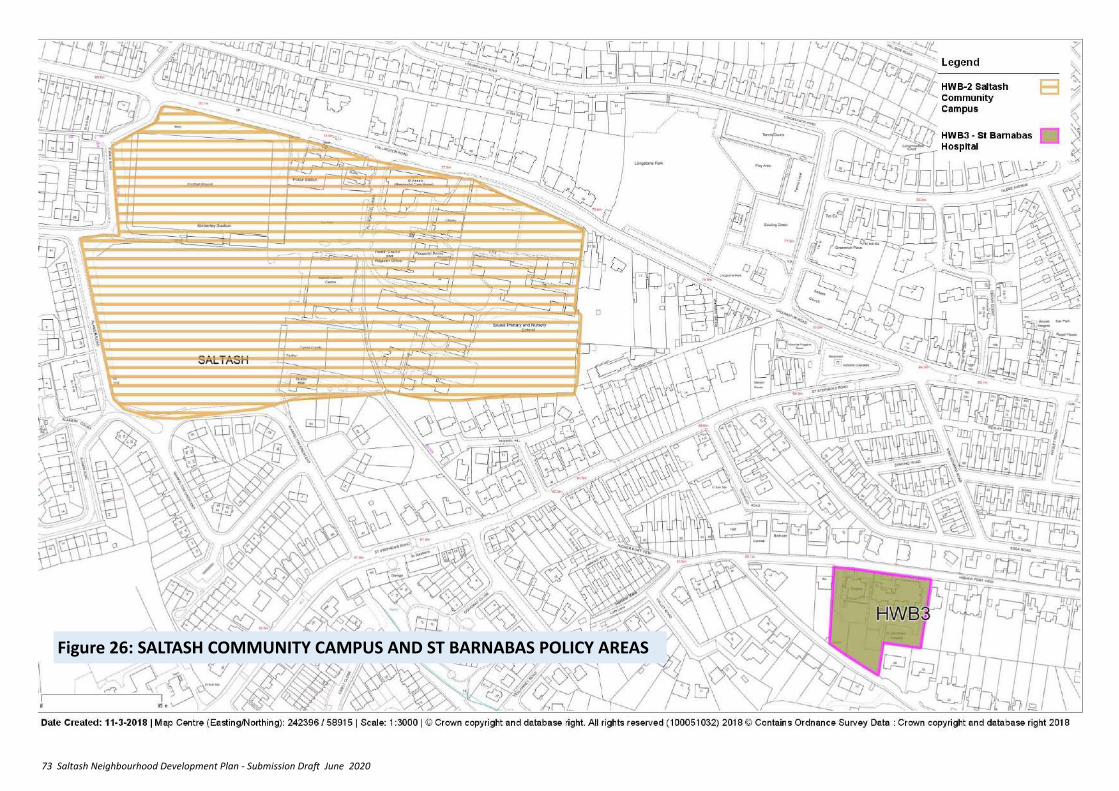
73 Saltash Neighbourhood Development Plan - Submission Draft June 2020
Figure 26: SALTASH COMMUNITY CAMPUS AND ST BARNABAS POLICY AREAS
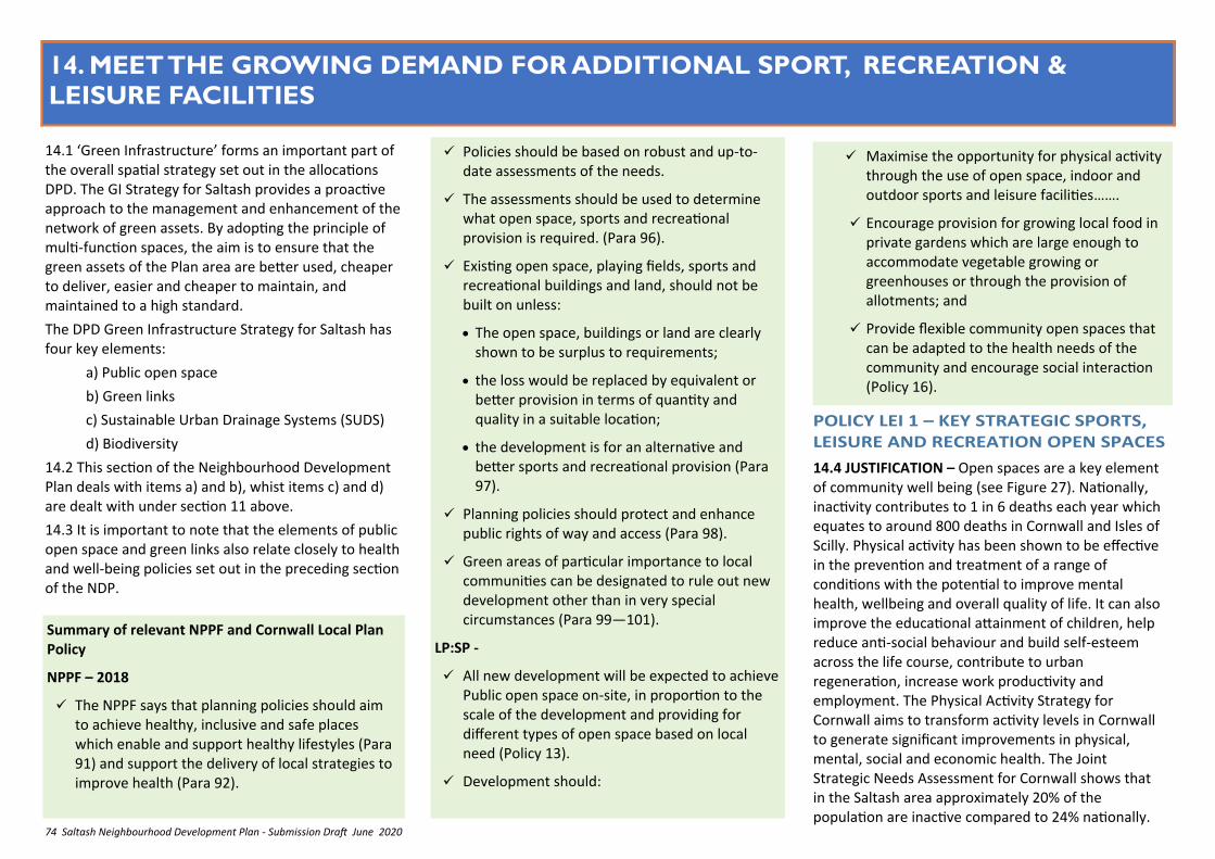
74 Saltash Neighbourhood Development Plan - Submission Draft June 2020
14. MEET THE GROWING DEMAND FOR ADDITIONAL SPORT, RECREATION &
LEISURE FACILITIES
14.1 ‘Green Infrastructure’ forms an important part of the overall spatial strategy set out in the allocations DPD. The GI Strategy for Saltash provides a proactive approach to the management and enhancement of the network of green assets. By adopting the principle of multi-function spaces, the aim is to ensure that the green assets of the Plan area are better used, cheaper to deliver, easier and cheaper to maintain, and maintained to a high standard.
The DPD Green Infrastructure Strategy for Saltash has four key elements:
a) Public open space
b) Green links
c) Sustainable Urban Drainage Systems (SUDS)
d) Biodiversity
14.2 This section of the Neighbourhood Development Plan deals with items a) and b), whist items c) and d) are dealt with under section 11 above.
14.3 It is important to note that the elements of public open space and green links also relate closely to health and well-being policies set out in the preceding section of the NDP.
✓ Policies should be based on robust and up-to-date assessments of the needs.
✓ The assessments should be used to determine what open space, sports and recreational provision is required. (Para 96).
✓ Existing open space, playing fields, sports and recreational buildings and land, should not be built on unless:
• The open space, buildings or land are clearly shown to be surplus to requirements;
• the loss would be replaced by equivalent or better provision in terms of quantity and quality in a suitable location;
• the development is for an alternative and better sports and recreational provision (Para 97).
✓ Planning policies should protect and enhance public rights of way and access (Para 98).
✓ Green areas of particular importance to local communities can be designated to rule out new development other than in very special circumstances (Para 99—101).
LP:SP -
✓ All new development will be expected to achieve Public open space on-site, in proportion to the scale of the development and providing for different types of open space based on local need (Policy 13).
✓ Development should:
Summary of relevant NPPF and Cornwall Local Plan Policy
NPPF – 2018
✓ The NPPF says that planning policies should aim to achieve healthy, inclusive and safe places which enable and support healthy lifestyles (Para 91) and support the delivery of local strategies to improve health (Para 92).
✓ Maximise the opportunity for physical activity through the use of open space, indoor and outdoor sports and leisure facilities…….
✓ Encourage provision for growing local food in private gardens which are large enough to accommodate vegetable growing or greenhouses or through the provision of allotments; and
✓ Provide flexible community open spaces that can be adapted to the health needs of the community and encourage social interaction (Policy 16).
14.4 JUSTIFICATION – Open spaces are a key element of community well being (see Figure 27). Nationally, inactivity contributes to 1 in 6 deaths each year which equates to around 800 deaths in Cornwall and Isles of Scilly. Physical activity has been shown to be effective in the prevention and treatment of a range of conditions with the potential to improve mental health, wellbeing and overall quality of life. It can also improve the educational attainment of children, help reduce anti-social behaviour and build self-esteem across the life course, contribute to urban regeneration, increase work productivity and employment. The Physical Activity Strategy for Cornwall aims to transform activity levels in Cornwall to generate significant improvements in physical, mental, social and economic health. The Joint Strategic Needs Assessment for Cornwall shows that in the Saltash area approximately 20% of the population are inactive compared to 24% nationally.
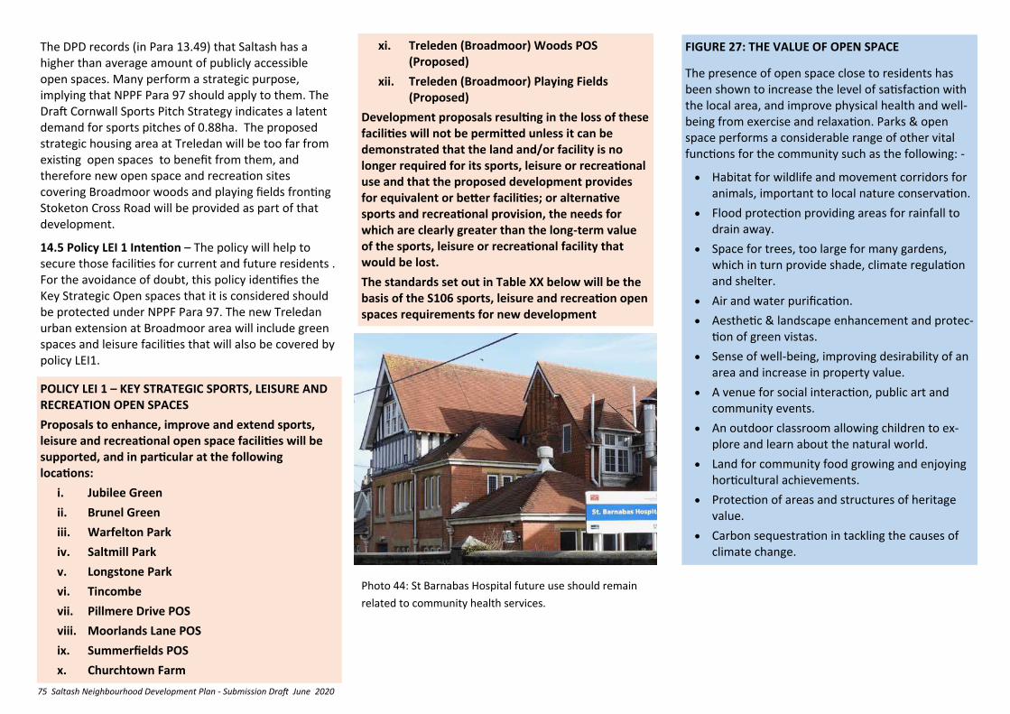
75 Saltash Neighbourhood Development Plan - Submission Draft June 2020
POLICY LEI 1 – KEY STRATEGIC SPORTS, LEISURE AND RECREATION OPEN SPACES
Proposals to enhance, improve and extend sports, leisure and recreational open space facilities will be supported, and in particular at the following locations:
i. Jubilee Green
ii. Brunel Green
iii. Warfelton Park
iv. Saltmill Park
v. Longstone Park
vi. Tincombe
vii. Pillmere Drive POS
viii. Moorlands Lane POS
ix. Summerfields POS
x. Churchtown Farm
FIGURE 27: THE VALUE OF OPEN SPACE
The presence of open space close to residents has been shown to increase the level of satisfaction with the local area, and improve physical health and well-being from exercise and relaxation. Parks & open space performs a considerable range of other vital functions for the community such as the following: -
• Habitat for wildlife and movement corridors for animals, important to local nature conservation.
• Flood protection providing areas for rainfall to drain away.
• Space for trees, too large for many gardens, which in turn provide shade, climate regulation and shelter.
• Air and water purification.
• Aesthetic & landscape enhancement and protec-tion of green vistas.
• Sense of well-being, improving desirability of an area and increase in property value.
• A venue for social interaction, public art and community events.
• An outdoor classroom allowing children to ex-plore and learn about the natural world.
• Land for community food growing and enjoying horticultural achievements.
• Protection of areas and structures of heritage value.
• Carbon sequestration in tackling the causes of climate change.
Photo 44: St Barnabas Hospital future use should remain
related to community health services.
The DPD records (in Para 13.49) that Saltash has a higher than average amount of publicly accessible open spaces. Many perform a strategic purpose, implying that NPPF Para 97 should apply to them. The Draft Cornwall Sports Pitch Strategy indicates a latent demand for sports pitches of 0.88ha. The proposed strategic housing area at Treledan will be too far from existing open spaces to benefit from them, and therefore new open space and recreation sites covering Broadmoor woods and playing fields fronting Stoketon Cross Road will be provided as part of that development.
14.5 Policy LEI 1 Intention – The policy will help to secure those facilities for current and future residents . For the avoidance of doubt, this policy identifies the Key Strategic Open spaces that it is considered should be protected under NPPF Para 97. The new Treledan urban extension at Broadmoor area will include green spaces and leisure facilities that will also be covered by policy LEI1.
xi. Treleden (Broadmoor) Woods POS (Proposed)
xii. Treleden (Broadmoor) Playing Fields (Proposed)
Development proposals resulting in the loss of these facilities will not be permitted unless it can be demonstrated that the land and/or facility is no longer required for its sports, leisure or recreational use and that the proposed development provides for equivalent or better facilities; or alternative sports and recreational provision, the needs for which are clearly greater than the long-term value of the sports, leisure or recreational facility that would be lost.
The standards set out in Table XX below will be the basis of the S106 sports, leisure and recreation open spaces requirements for new development
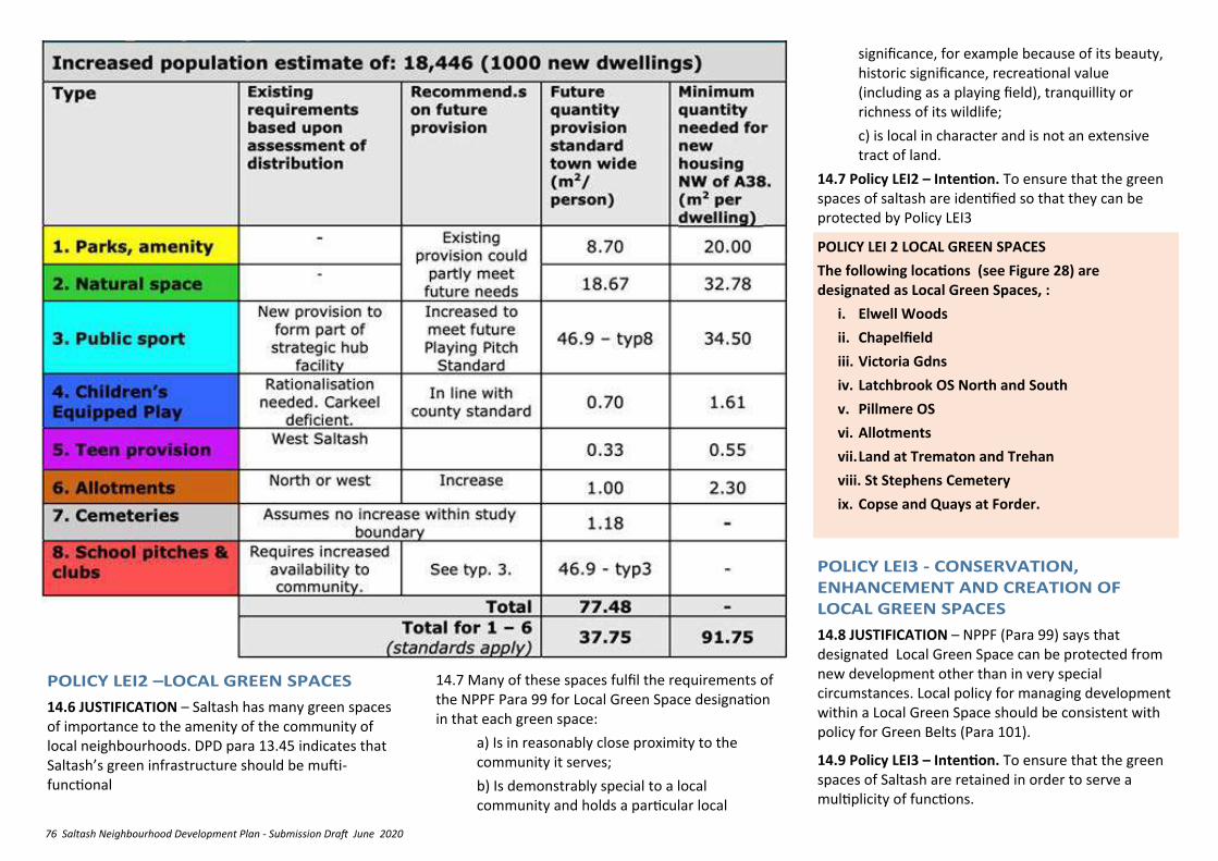
76 Saltash Neighbourhood Development Plan - Submission Draft June 2020
14.6 JUSTIFICATION – Saltash has many green spaces of importance to the amenity of the community of local neighbourhoods. DPD para 13.45 indicates that Saltash’s green infrastructure should be mufti-functional
14.7 Many of these spaces fulfil the requirements of the NPPF Para 99 for Local Green Space designation in that each green space:
a) Is in reasonably close proximity to the community it serves;
b) Is demonstrably special to a local community and holds a particular local
POLICY LEI 2 LOCAL GREEN SPACES
The following locations (see Figure 28) are designated as Local Green Spaces, :
i. Elwell Woods
ii. Chapelfield
iii. Victoria Gdns
iv. Latchbrook OS North and South
v. Pillmere OS
vi. Allotments
vii. Land at Trematon and Trehan
viii. St Stephens Cemetery
ix. Copse and Quays at Forder.
14.8 JUSTIFICATION – NPPF (Para 99) says that designated Local Green Space can be protected from new development other than in very special circumstances. Local policy for managing development within a Local Green Space should be consistent with policy for Green Belts (Para 101).
14.9 Policy LEI3 – Intention. To ensure that the green spaces of Saltash are retained in order to serve a multiplicity of functions.
significance, for example because of its beauty, historic significance, recreational value (including as a playing field), tranquillity or richness of its wildlife;
c) is local in character and is not an extensive tract of land.
14.7 Policy LEI2 – Intention. To ensure that the green spaces of saltash are identified so that they can be protected by Policy LEI3
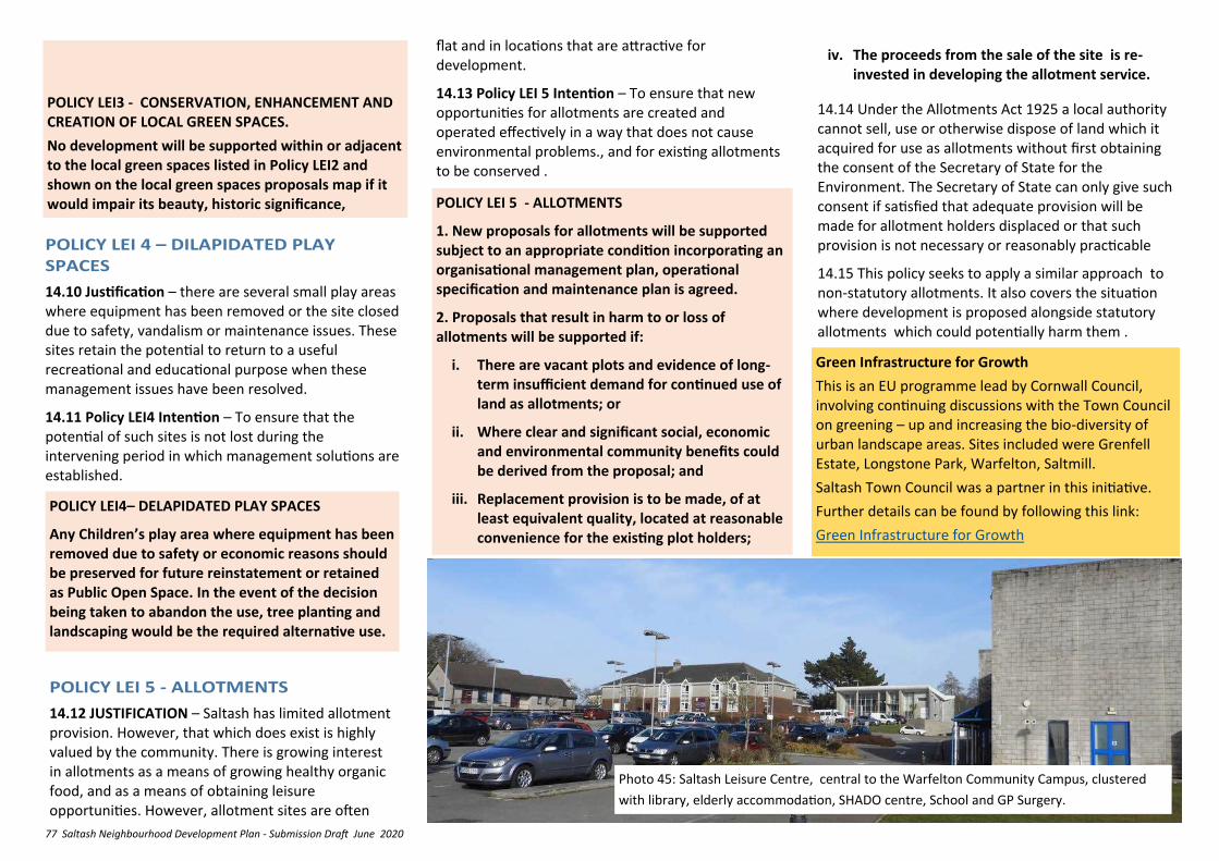
77 Saltash Neighbourhood Development Plan - Submission Draft June 2020
14.10 Justification – there are several small play areas where equipment has been removed or the site closed due to safety, vandalism or maintenance issues. These sites retain the potential to return to a useful recreational and educational purpose when these management issues have been resolved.
14.11 Policy LEI4 Intention – To ensure that the potential of such sites is not lost during the intervening period in which management solutions are established.
POLICY LEI4– DELAPIDATED PLAY SPACES
Any Children’s play area where equipment has been removed due to safety or economic reasons should be preserved for future reinstatement or retained as Public Open Space. In the event of the decision being taken to abandon the use, tree planting and landscaping would be the required alternative use.
14.12 JUSTIFICATION – Saltash has limited allotment provision. However, that which does exist is highly valued by the community. There is growing interest in allotments as a means of growing healthy organic food, and as a means of obtaining leisure opportunities. However, allotment sites are often
POLICY LEI 5 - ALLOTMENTS
1. New proposals for allotments will be supported subject to an appropriate condition incorporating an organisational management plan, operational specification and maintenance plan is agreed.
2. Proposals that result in harm to or loss of allotments will be supported if:
i. There are vacant plots and evidence of long-term insufficient demand for continued use of land as allotments; or
ii. Where clear and significant social, economic and environmental community benefits could be derived from the proposal; and
iii. Replacement provision is to be made, of at least equivalent quality, located at reasonable convenience for the existing plot holders;
Green Infrastructure for Growth
This is an EU programme lead by Cornwall Council, involving continuing discussions with the Town Council on greening – up and increasing the bio-diversity of urban landscape areas. Sites included were Grenfell Estate, Longstone Park, Warfelton, Saltmill.
Saltash Town Council was a partner in this initiative.
Further details can be found by following this link:
Green Infrastructure for Growth
iv. The proceeds from the sale of the site is re-invested in developing the allotment service.
POLICY LEI3 - CONSERVATION, ENHANCEMENT AND CREATION OF LOCAL GREEN SPACES.
No development will be supported within or adjacent to the local green spaces listed in Policy LEI2 and shown on the local green spaces proposals map if it would impair its beauty, historic significance,
14.14 Under the Allotments Act 1925 a local authority cannot sell, use or otherwise dispose of land which it acquired for use as allotments without first obtaining the consent of the Secretary of State for the Environment. The Secretary of State can only give such consent if satisfied that adequate provision will be made for allotment holders displaced or that such provision is not necessary or reasonably practicable
14.15 This policy seeks to apply a similar approach to non-statutory allotments. It also covers the situation where development is proposed alongside statutory allotments which could potentially harm them .
Photo 45: Saltash Leisure Centre, central to the Warfelton Community Campus, clustered
with library, elderly accommodation, SHADO centre, School and GP Surgery.
flat and in locations that are attractive for development.
14.13 Policy LEI 5 Intention – To ensure that new opportunities for allotments are created and operated effectively in a way that does not cause environmental problems., and for existing allotments to be conserved .
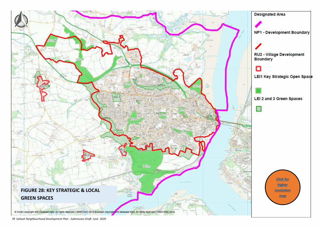
78 Saltash Neighbourhood Development Plan - Submission Draft June 2020
FIGURE 28: KEY STRATEGIC & LOCAL
GREEN SPACES
Click for
higher
resolution
map
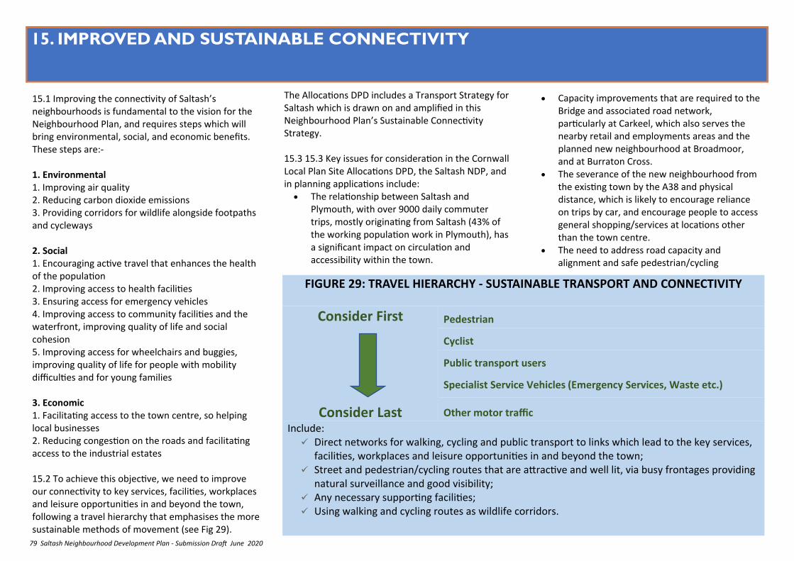
79 Saltash Neighbourhood Development Plan - Submission Draft June 2020
15. IMPROVED AND SUSTAINABLE CONNECTIVITY
15.1 Improving the connectivity of Saltash’s neighbourhoods is fundamental to the vision for the Neighbourhood Plan, and requires steps which will bring environmental, social, and economic benefits. These steps are:- 1. Environmental 1. Improving air quality 2. Reducing carbon dioxide emissions 3. Providing corridors for wildlife alongside footpaths and cycleways 2. Social 1. Encouraging active travel that enhances the health of the population 2. Improving access to health facilities 3. Ensuring access for emergency vehicles 4. Improving access to community facilities and the waterfront, improving quality of life and social cohesion 5. Improving access for wheelchairs and buggies, improving quality of life for people with mobility difficulties and for young families 3. Economic 1. Facilitating access to the town centre, so helping local businesses 2. Reducing congestion on the roads and facilitating access to the industrial estates 15.2 To achieve this objective, we need to improve our connectivity to key services, facilities, workplaces and leisure opportunities in and beyond the town, following a travel hierarchy that emphasises the more sustainable methods of movement (see Fig 29).
• Capacity improvements that are required to the Bridge and associated road network, particularly at Carkeel, which also serves the nearby retail and employments areas and the planned new neighbourhood at Broadmoor, and at Burraton Cross.
• The severance of the new neighbourhood from the existing town by the A38 and physical distance, which is likely to encourage reliance on trips by car, and encourage people to access general shopping/services at locations other than the town centre.
• The need to address road capacity and alignment and safe pedestrian/cycling
FIGURE 29: TRAVEL HIERARCHY - SUSTAINABLE TRANSPORT AND CONNECTIVITY
Consider First
Consider Last
Pedestrian
Cyclist
Public transport users
Specialist Service Vehicles (Emergency Services, Waste etc.)
Other motor traffic
Include: ✓ Direct networks for walking, cycling and public transport to links which lead to the key services,
facilities, workplaces and leisure opportunities in and beyond the town; ✓ Street and pedestrian/cycling routes that are attractive and well lit, via busy frontages providing
natural surveillance and good visibility; ✓ Any necessary supporting facilities; ✓ Using walking and cycling routes as wildlife corridors.
The Allocations DPD includes a Transport Strategy for Saltash which is drawn on and amplified in this Neighbourhood Plan’s Sustainable Connectivity Strategy. 15.3 15.3 Key issues for consideration in the Cornwall Local Plan Site Allocations DPD, the Saltash NDP, and in planning applications include:
• The relationship between Saltash and Plymouth, with over 9000 daily commuter trips, mostly originating from Saltash (43% of the working population work in Plymouth), has a significant impact on circulation and accessibility within the town.
80 Saltash Neighbourhood Development Plan - Submission Draft June 2020
movement from the North Pill DPD housing allocation.
• The expectation that the route from the Latchbrook A38 junction along North Road to connect with bottom of Fore Street/Tamar Bridge will become more frequented following the development at Broadmoor.
• The impact that road capacity improvements may have on the quality and distinctiveness of the public realm.
• Improving the connectedness of the town centre and the Waterside, with the Town Centre car parks, bus routes, Cornish Cross and Railway station.
• The need for transition spaces between the higher speed context of the highway and the lower speed more complex environment of the town.
• Encouraging ‘modal transfer’ from cars to buses and rail (67% of travel to work journeys are by car, only 1% by rail).
15.4 The Allocations DPD Transport Strategy deals with many of these issues, whilst the Neighbourhood Plan covers others or adds detail to the DPD strategy. Together these are summarised as the Saltash Sustainable Connectivity Strategy as illustrated in Figure 30.
15.5 Although not required for Cornwall’s growth up to 2030, Cornwall Council has indicated that it will work with Plymouth City Council to examine opportunities for a western corridor Park and Ride facility to serve both the communities of Cornwall and Plymouth.
Summary of relevant NPPF and Cornwall Local Plan Policy
NPPF 2018
Transport issues should be considered from the earliest
stages of plan-making and development proposals (Para 102)
Planning policies should
✓ support an appropriate mix of uses across an area, and within larger scale sites, to minimise the number and length of journeys needed for employment, shopping, leisure, education and other activities;
✓ provide for high quality walking and cycling networks and supporting facilities such as cycle parking (Para 103);
✓ ensure an adequate provision of spaces for charging plug-in and other ultra-low emission vehicles. (Para 105);
✓ give priority first to pedestrian and cycle movements and second to facilitating access to high quality public transport;
✓ address the needs of people with disabilities and reduced mobility in relation to all modes of transport;
✓ create places that are safe, secure and attractive – which minimise the scope for conflicts between pedestrians, cyclists and vehicles, avoid unnecessary street clutter, and respond to local character and design standards;
✓ allow for the efficient delivery of goods, and access by service and emergency vehicles; and
✓ be designed to enable charging of plug-in and other ultra-low emission vehicles in safe, accessible and convenient locations.
LP:SP
✓ All developments should provide safe and suitable access and not cause significantly adverse impacts on the road network (Policy 27)
Connecting Cornwall: 2030
✓ support economic prosperity
15.6 Justification - The A38 trunk road and physical distance effectively sever the new neighbourhood at Broadmoor from the main body of the town and the town centre. Many of the routes to the town centre are unattractive and difficult to use. It is considered that these factors are is likely to encourage reliance on journeys by car, and encourage people to access general shopping/services at locations other than the town centre. The Vision for Saltash relies, in spatial terms, on the efficient use of the routes that link the community together.
15.7 Policy CON1 Intention – The route from Carkeel via Callington Road to Fore Street is the main link which connects the ‘top’ of Saltash, all the way to the Waterfront area. It also connects with all the other parts of the town. Enhancing this route with quality urban design, substantial tree planting and landscaping, improved surface treatments and rationalised signage to create a ‘backbone street’, forming one clear and cohesive route will help draw the community together, create a clear hierarchy between town and neighbourhood centres and interlink the outlying parts of the town more firmly. It supports a clear inter-relationship of local neighbourhoods, and ensures that Broadmoor and Carkeel look to the town (and vice versa) rather than being suburbs of Plymouth. This can also serve multiple forms of transport, allow for connections between them making sustainable travel easier, and potentially ‘capture’ passing traffic to improve town centre vitality and viability.
✓ move towards more sustainable travel, with less reliance on the private car;
✓ encourage vibrant, accessible and safe town environments;
✓ provide strong links between communities.
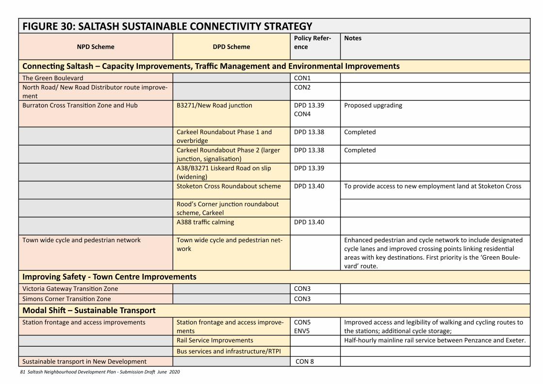
81 Saltash Neighbourhood Development Plan - Submission Draft June 2020
FIGURE 30: SALTASH SUSTAINABLE CONNECTIVITY STRATEGY
NPD Scheme DPD Scheme
Policy Refer-ence
Notes
Connecting Saltash – Capacity Improvements, Traffic Management and Environmental Improvements
The Green Boulevard CON1
North Road/ New Road Distributor route improve-ment
CON2
Burraton Cross Transition Zone and Hub
B3271/New Road junction DPD 13.39
CON4
Proposed upgrading
Carkeel Roundabout Phase 1 and overbridge
DPD 13.38 Completed
Carkeel Roundabout Phase 2 (larger junction, signalisation)
DPD 13.38 Completed
A38/B3271 Liskeard Road on slip (widening)
DPD 13.39
Stoketon Cross Roundabout scheme DPD 13.40
To provide access to new employment land at Stoketon Cross
Rood’s Corner junction roundabout scheme, Carkeel
A388 traffic calming DPD 13.40
Town wide cycle and pedestrian network Town wide cycle and pedestrian net-work
Enhanced pedestrian and cycle network to include designated cycle lanes and improved crossing points linking residential areas with key destinations. First priority is the ‘Green Boule-vard’ route.
Improving Safety - Town Centre Improvements
Victoria Gateway Transition Zone CON3
Simons Corner Transition Zone CON3
Modal Shift – Sustainable Transport
Station frontage and access improvements Station frontage and access improve-ments
CON5
ENV5
Improved access and legibility of walking and cycling routes to the stations; additional cycle storage;
Rail Service Improvements Half-hourly mainline rail service between Penzance and Exeter.
Bus services and infrastructure/RTPI
Sustainable transport in New Development CON 8
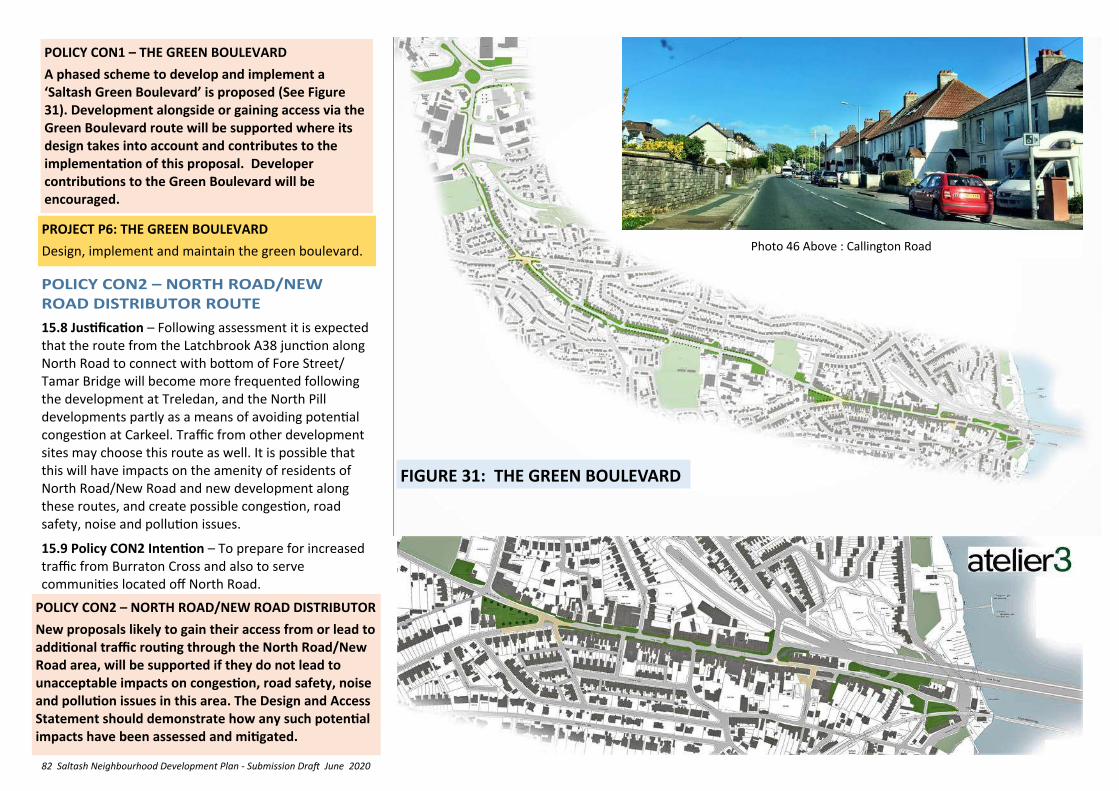
82 Saltash Neighbourhood Development Plan - Submission Draft June 2020
POLICY CON1 – THE GREEN BOULEVARD
A phased scheme to develop and implement a ‘Saltash Green Boulevard’ is proposed (See Figure 31). Development alongside or gaining access via the Green Boulevard route will be supported where its design takes into account and contributes to the implementation of this proposal. Developer contributions to the Green Boulevard will be encouraged.
15.8 Justification – Following assessment it is expected that the route from the Latchbrook A38 junction along North Road to connect with bottom of Fore Street/Tamar Bridge will become more frequented following the development at Treledan, and the North Pill developments partly as a means of avoiding potential congestion at Carkeel. Traffic from other development sites may choose this route as well. It is possible that this will have impacts on the amenity of residents of North Road/New Road and new development along these routes, and create possible congestion, road safety, noise and pollution issues.
15.9 Policy CON2 Intention – To prepare for increased traffic from Burraton Cross and also to serve communities located off North Road.
POLICY CON2 – NORTH ROAD/NEW ROAD DISTRIBUTOR
New proposals likely to gain their access from or lead to additional traffic routing through the North Road/New Road area, will be supported if they do not lead to unacceptable impacts on congestion, road safety, noise and pollution issues in this area. The Design and Access Statement should demonstrate how any such potential impacts have been assessed and mitigated.
FIGURE 31: THE GREEN BOULEVARD
Photo 46 Above : Callington Road
PROJECT P6: THE GREEN BOULEVARD
Design, implement and maintain the green boulevard.
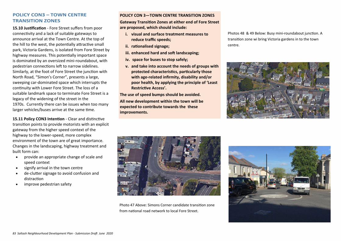
83 Saltash Neighbourhood Development Plan - Submission Draft June 2020
15.10 Justification - Fore Street suffers from poor connectivity and a lack of suitable gateways to announce arrival at the Town Centre. At the top of the hill to the west, the potentially attractive small park, Victoria Gardens, is isolated from Fore Street by highway measures. This potentially important space is dominated by an oversized mini-roundabout, with pedestrian connections left to narrow sidelines. Similarly, at the foot of Fore Street the junction with North Road, “Simon’s Corner”, presents a large, sweeping car-dominated space which interrupts the continuity with Lower Fore Street. The loss of a suitable landmark space to terminate Fore Street is a legacy of the widening of the street in the 1970s. Currently there can be issues when too many larger vehicles/buses arrive at the same time.
15.11 Policy CON3 Intention - Clear and distinctive transition points to provide motorists with an explicit gateway from the higher speed context of the highway to the lower-speed, more complex environment of the town are of great importance. Changes in the landscaping, highway treatment and built form can:
• provide an appropriate change of scale and speed context
• signify arrival in the town centre • de-clutter signage to avoid confusion and
distraction • improve pedestrian safety
POLICY CON 3—TOWN CENTRE TRANSITION ZONES
Gateway Transition Zones at either end of Fore Street are proposed, which should include:
i. visual and surface treatment measures to reduce traffic speeds;
ii. rationalised signage;
iii. enhanced hard and soft landscaping;
iv. space for buses to stop safely;
v. and take into account the needs of groups with protected characteristics, particularly those with age-related infirmity, disability and/or poor health, by applying the principle of ‘Least Restrictive Access’.
The use of speed bumps should be avoided.
All new development within the town will be expected to contribute towards the these improvements.
Photo 47 Above: Simons Corner candidate transition zone
from national road network to local Fore Street.
Photos 48 & 49 Below: Busy mini-roundabout junction. A
transition zone wi bring Victoria gardens in to the town
centre.
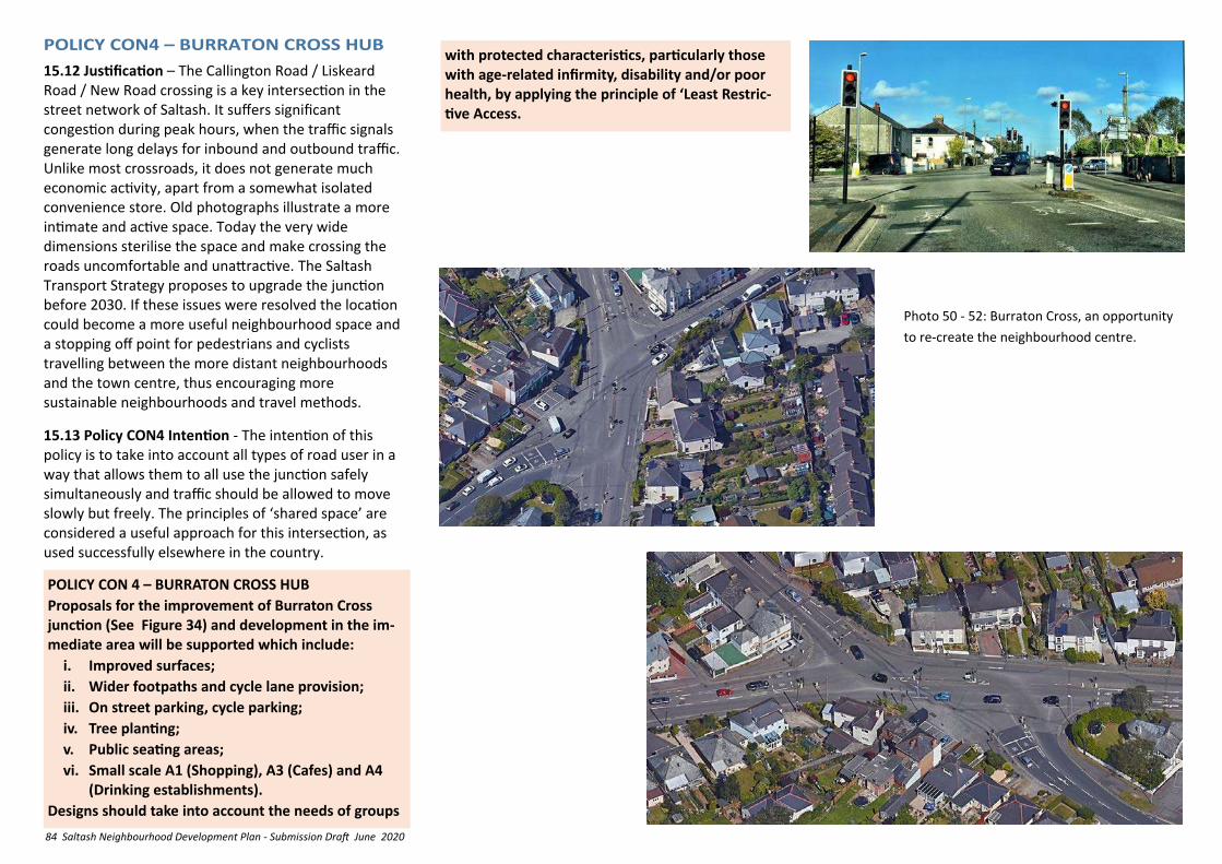
84 Saltash Neighbourhood Development Plan - Submission Draft June 2020
15.12 Justification – The Callington Road / Liskeard Road / New Road crossing is a key intersection in the street network of Saltash. It suffers significant congestion during peak hours, when the traffic signals generate long delays for inbound and outbound traffic. Unlike most crossroads, it does not generate much economic activity, apart from a somewhat isolated convenience store. Old photographs illustrate a more intimate and active space. Today the very wide dimensions sterilise the space and make crossing the roads uncomfortable and unattractive. The Saltash Transport Strategy proposes to upgrade the junction before 2030. If these issues were resolved the location could become a more useful neighbourhood space and a stopping off point for pedestrians and cyclists travelling between the more distant neighbourhoods and the town centre, thus encouraging more sustainable neighbourhoods and travel methods.
15.13 Policy CON4 Intention - The intention of this policy is to take into account all types of road user in a way that allows them to all use the junction safely simultaneously and traffic should be allowed to move slowly but freely. The principles of ‘shared space’ are considered a useful approach for this intersection, as used successfully elsewhere in the country.
POLICY CON 4 – BURRATON CROSS HUB
Proposals for the improvement of Burraton Cross junction (See Figure 34) and development in the im-mediate area will be supported which include:
i. Improved surfaces;
ii. Wider footpaths and cycle lane provision;
iii. On street parking, cycle parking;
iv. Tree planting;
v. Public seating areas;
vi. Small scale A1 (Shopping), A3 (Cafes) and A4 (Drinking establishments).
Designs should take into account the needs of groups
Photo 50 - 52: Burraton Cross, an opportunity
to re-create the neighbourhood centre.
with protected characteristics, particularly those with age-related infirmity, disability and/or poor health, by applying the principle of ‘Least Restric-tive Access.
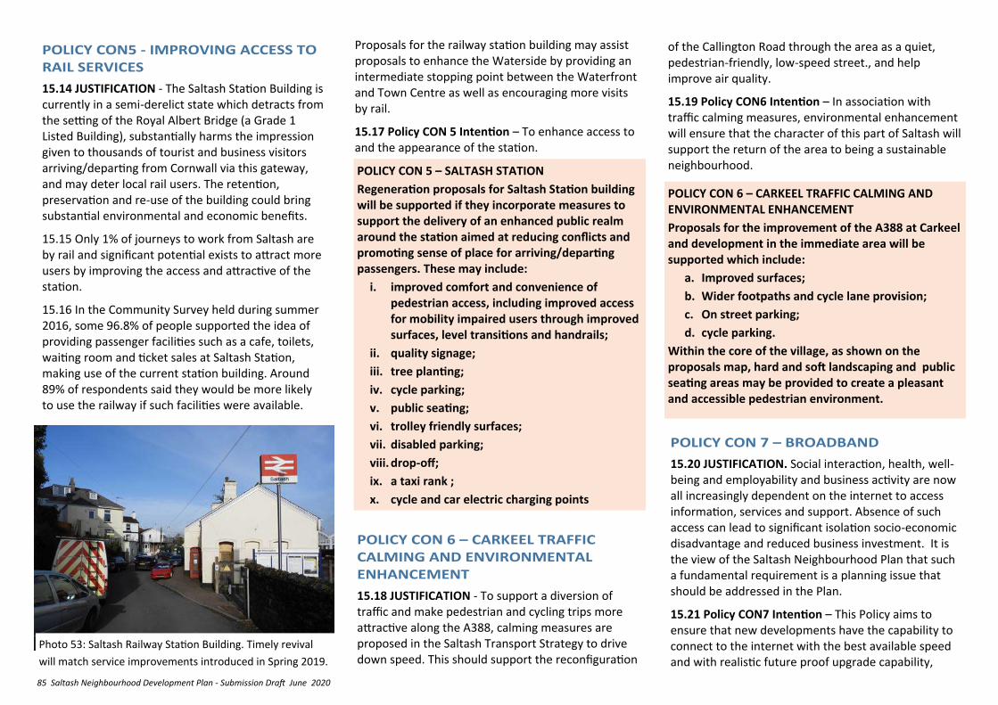
85 Saltash Neighbourhood Development Plan - Submission Draft June 2020
15.14 JUSTIFICATION - The Saltash Station Building is currently in a semi-derelict state which detracts from the setting of the Royal Albert Bridge (a Grade 1 Listed Building), substantially harms the impression given to thousands of tourist and business visitors arriving/departing from Cornwall via this gateway, and may deter local rail users. The retention, preservation and re-use of the building could bring substantial environmental and economic benefits.
15.15 Only 1% of journeys to work from Saltash are by rail and significant potential exists to attract more users by improving the access and attractive of the station.
15.16 In the Community Survey held during summer 2016, some 96.8% of people supported the idea of providing passenger facilities such as a cafe, toilets, waiting room and ticket sales at Saltash Station, making use of the current station building. Around 89% of respondents said they would be more likely to use the railway if such facilities were available.
POLICY CON 5 – SALTASH STATION
Regeneration proposals for Saltash Station building will be supported if they incorporate measures to support the delivery of an enhanced public realm around the station aimed at reducing conflicts and promoting sense of place for arriving/departing passengers. These may include:
i. improved comfort and convenience of pedestrian access, including improved access for mobility impaired users through improved surfaces, level transitions and handrails;
ii. quality signage;
iii. tree planting;
iv. cycle parking;
v. public seating;
vi. trolley friendly surfaces;
vii. disabled parking;
viii. drop-off;
ix. a taxi rank ;
x. cycle and car electric charging points
15.18 JUSTIFICATION - To support a diversion of traffic and make pedestrian and cycling trips more attractive along the A388, calming measures are proposed in the Saltash Transport Strategy to drive down speed. This should support the reconfiguration
POLICY CON 6 – CARKEEL TRAFFIC CALMING AND ENVIRONMENTAL ENHANCEMENT
Proposals for the improvement of the A388 at Carkeel and development in the immediate area will be supported which include:
a. Improved surfaces;
b. Wider footpaths and cycle lane provision;
c. On street parking;
d. cycle parking.
Within the core of the village, as shown on the proposals map, hard and soft landscaping and public seating areas may be provided to create a pleasant and accessible pedestrian environment.
15.20 JUSTIFICATION. Social interaction, health, well-being and employability and business activity are now all increasingly dependent on the internet to access information, services and support. Absence of such access can lead to significant isolation socio-economic disadvantage and reduced business investment. It is the view of the Saltash Neighbourhood Plan that such a fundamental requirement is a planning issue that should be addressed in the Plan.
15.21 Policy CON7 Intention – This Policy aims to ensure that new developments have the capability to connect to the internet with the best available speed and with realistic future proof upgrade capability,
Proposals for the railway station building may assist proposals to enhance the Waterside by providing an intermediate stopping point between the Waterfront and Town Centre as well as encouraging more visits by rail.
15.17 Policy CON 5 Intention – To enhance access to and the appearance of the station.
of the Callington Road through the area as a quiet, pedestrian-friendly, low-speed street., and help improve air quality.
15.19 Policy CON6 Intention – In association with traffic calming measures, environmental enhancement will ensure that the character of this part of Saltash will support the return of the area to being a sustainable neighbourhood.
Photo 53: Saltash Railway Station Building. Timely revival
will match service improvements introduced in Spring 2019.
86 Saltash Neighbourhood Development Plan - Submission Draft June 2020
POLICY CON 7—BROADBAND
1. New developments should demonstrate how they will contribute to, and be compatible with, existing local fibre or internet connectivity. This could be through a ‘Connectivity Statement’ provided with relevant planning applications. Such statements could consider such aspects as: -
i. The intended land use and the anticipated connectivity requirements of the development;
ii. Existing or proposed data networks and their anticipated speed (fixed copper, 3G, 4G, fibre etc.);
iii. Realistic assessments of connection potential or contribution to any such networks.
2. Suitable ducting that can accept fibre should be provided either to: -
i. the nearest access point to existing internet providers; or
ii. a local access network; or
iii. another location that can be justified through the connectivity statement.
3. Infrastructure supporting major development should provide ducting that is available for community owned local access network or fibre optic cable deployment.
3. Street and pedestrian/cycling routes that are attractive, well lit, via busy frontages providing natural surveillance and good visibility;
4. Retention and enhancement of existing footpath/cycle routes which cross a site;
5. Provision of space for cycle storage in new dwellings and workplaces;
6. Low emission vehicle charging points;
7. Provision of electric bikes with each property;
8. Street layout which should favour interconnected street and avoid the use of culs-de-sac;
9. Incorporation of the cycle routes proposed under Policy CON 10;
B. Provision of a positive public transport (bus rail and ferry) environment including:
i. Liaison on bus routes and placement of bus stops at design stage;
ii. Pedestrian access to stops as direct as possible, with no dwellings further than 5 minutes’ walk away from a bus stop;
iii. Real-time information at stops;
iv. On main streets, the inclusion of bus friendly traffic calming measures, bus laybys and shelters suitable for midi-bus operation and which are fully accessible;
v. Where appropriate, an initial subsidy to cover risks to operators of providing or diverting a service or to cover ticketing incentive schemes.
In addition to this and in line with current practice, developers of larger schemes will also be expected to produce comprehensive travel plans as part of their planning application. These will identify the specific, detailed, on site improvements that may also be required as a result of more detailed transport
POLICY CON8 - SUSTAINABLE TRANSPORT MEASURES IN NEW DEVELOPMENT
15.21 JUSTIFICATION: It is important to ensure that new developments make a consistent and reasonable contribution to meeting the transport and connectivity needs of neighbourhoods in the most sustainable manner. The aim is to increase overall mobility and interconnections between neighbourhoods and the Town Centre whilst reducing levels of car dependency and improving opportunities to improve health and well-being.
15.22 Policy CON8 Intention - This policy seeks to contribute to the means by which the DPD Transport Strategy will be implemented in a way that will help to integrate new and existing neighbourhoods into the town.
POLICY CON 8: SUSTAINABLE TRANSPORT MEASURES IN NEW DEVELOPMENT
New developments that incorporate measures to meet the sustainable transport and connectivity needs of the local community and businesses will be supported. These may include:
A. Provision of a positive walking/cycling environment including:
1. street design which incorporates a user hierarchy in the order:
i. pedestrian
ii. cyclists
iii. public transport
iv. services vehicles
v. other forms of transport;
2. Direct networks for walking, cycling and public transport to links which lead to the key services, workplaces, facilities and leisure opportunities in the town;
subject to NPPF Para 34 and NPPG on viability and deliverability. This will help to ensure that all current and future members of the community of Saltash are not digitally disadvantaged and that inward investment is is not restricted by any local inadequacy in digital communications.
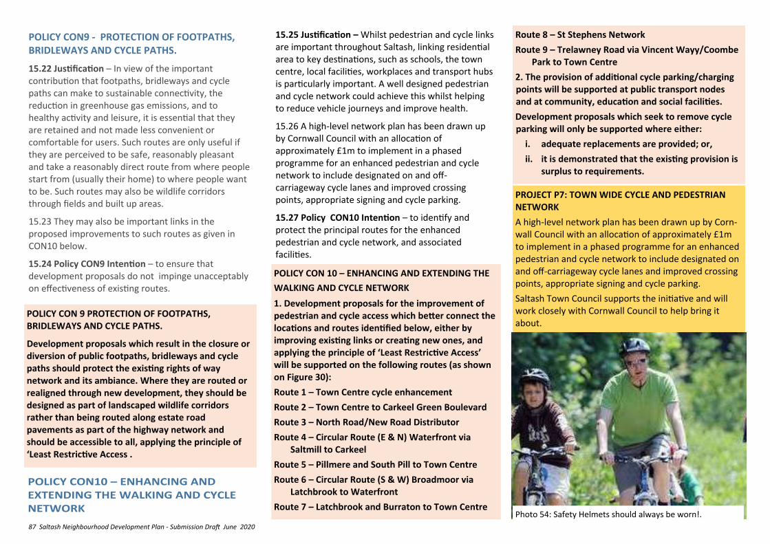
87 Saltash Neighbourhood Development Plan - Submission Draft June 2020
POLICY CON9 - PROTECTION OF FOOTPATHS, BRIDLEWAYS AND CYCLE PATHS.
15.22 Justification – In view of the important contribution that footpaths, bridleways and cycle paths can make to sustainable connectivity, the reduction in greenhouse gas emissions, and to healthy activity and leisure, it is essential that they are retained and not made less convenient or comfortable for users. Such routes are only useful if they are perceived to be safe, reasonably pleasant and take a reasonably direct route from where people start from (usually their home) to where people want to be. Such routes may also be wildlife corridors through fields and built up areas.
15.23 They may also be important links in the proposed improvements to such routes as given in CON10 below.
15.24 Policy CON9 Intention – to ensure that development proposals do not impinge unacceptably on effectiveness of existing routes.
POLICY CON 9 PROTECTION OF FOOTPATHS, BRIDLEWAYS AND CYCLE PATHS.
Development proposals which result in the closure or diversion of public footpaths, bridleways and cycle paths should protect the existing rights of way network and its ambiance. Where they are routed or realigned through new development, they should be designed as part of landscaped wildlife corridors rather than being routed along estate road pavements as part of the highway network and should be accessible to all, applying the principle of ‘Least Restrictive Access .
Route 8 – St Stephens Network
Route 9 – Trelawney Road via Vincent Wayy/Coombe Park to Town Centre
2. The provision of additional cycle parking/charging points will be supported at public transport nodes and at community, education and social facilities.
Development proposals which seek to remove cycle parking will only be supported where either:
i. adequate replacements are provided; or,
ii. it is demonstrated that the existing provision is surplus to requirements.
POLICY CON 10 – ENHANCING AND EXTENDING THE
WALKING AND CYCLE NETWORK
1. Development proposals for the improvement of pedestrian and cycle access which better connect the locations and routes identified below, either by improving existing links or creating new ones, and applying the principle of ‘Least Restrictive Access’ will be supported on the following routes (as shown on Figure 30):
Route 1 – Town Centre cycle enhancement
Route 2 – Town Centre to Carkeel Green Boulevard
Route 3 – North Road/New Road Distributor
Route 4 – Circular Route (E & N) Waterfront via Saltmill to Carkeel
Route 5 – Pillmere and South Pill to Town Centre
Route 6 – Circular Route (S & W) Broadmoor via Latchbrook to Waterfront
Route 7 – Latchbrook and Burraton to Town Centre
15.25 Justification – Whilst pedestrian and cycle links are important throughout Saltash, linking residential area to key destinations, such as schools, the town centre, local facilities, workplaces and transport hubs is particularly important. A well designed pedestrian and cycle network could achieve this whilst helping to reduce vehicle journeys and improve health.
15.26 A high-level network plan has been drawn up by Cornwall Council with an allocation of approximately £1m to implement in a phased programme for an enhanced pedestrian and cycle network to include designated on and off-carriageway cycle lanes and improved crossing points, appropriate signing and cycle parking.
15.27 Policy CON10 Intention – to identify and protect the principal routes for the enhanced pedestrian and cycle network, and associated facilities.
PROJECT P7: TOWN WIDE CYCLE AND PEDESTRIAN NETWORK
A high-level network plan has been drawn up by Corn-wall Council with an allocation of approximately £1m to implement in a phased programme for an enhanced pedestrian and cycle network to include designated on and off-carriageway cycle lanes and improved crossing points, appropriate signing and cycle parking.
Saltash Town Council supports the initiative and will work closely with Cornwall Council to help bring it about.
Photo 54: Safety Helmets should always be worn!.
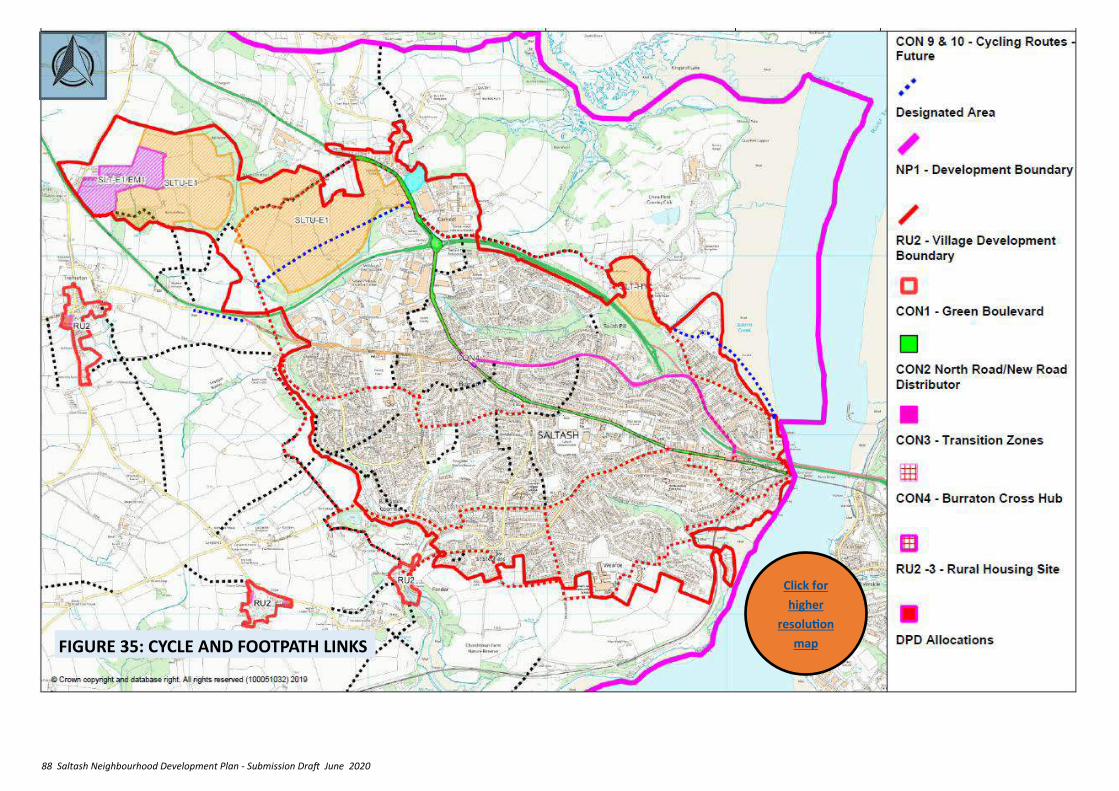
88 Saltash Neighbourhood Development Plan - Submission Draft June 2020
FIGURE 35: CYCLE AND FOOTPATH LINKS
Click for
higher
resolution
map
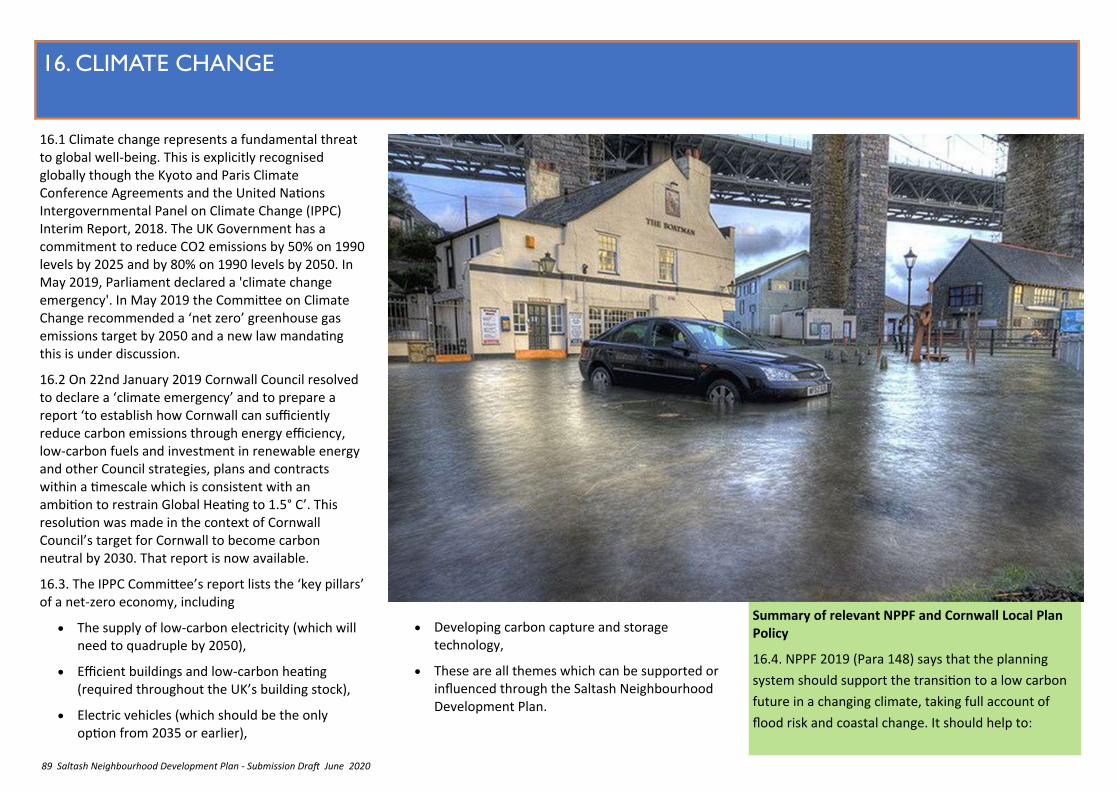
89 Saltash Neighbourhood Development Plan - Submission Draft June 2020
16. CLIMATE CHANGE
16.1 Climate change represents a fundamental threat to global well-being. This is explicitly recognised globally though the Kyoto and Paris Climate Conference Agreements and the United Nations Intergovernmental Panel on Climate Change (IPPC) Interim Report, 2018. The UK Government has a commitment to reduce CO2 emissions by 50% on 1990 levels by 2025 and by 80% on 1990 levels by 2050. In May 2019, Parliament declared a 'climate change emergency'. In May 2019 the Committee on Climate Change recommended a ‘net zero’ greenhouse gas emissions target by 2050 and a new law mandating this is under discussion.
16.2 On 22nd January 2019 Cornwall Council resolved to declare a ‘climate emergency’ and to prepare a report ‘to establish how Cornwall can sufficiently reduce carbon emissions through energy efficiency, low-carbon fuels and investment in renewable energy and other Council strategies, plans and contracts within a timescale which is consistent with an ambition to restrain Global Heating to 1.5° C’. This resolution was made in the context of Cornwall Council’s target for Cornwall to become carbon neutral by 2030. That report is now available.
16.3. The IPPC Committee’s report lists the ‘key pillars’ of a net-zero economy, including
• The supply of low-carbon electricity (which will need to quadruple by 2050),
• Efficient buildings and low-carbon heating (required throughout the UK’s building stock),
• Electric vehicles (which should be the only option from 2035 or earlier),
• Developing carbon capture and storage technology,
• These are all themes which can be supported or influenced through the Saltash Neighbourhood Development Plan.
Summary of relevant NPPF and Cornwall Local Plan Policy
16.4. NPPF 2019 (Para 148) says that the planning
system should support the transition to a low carbon
future in a changing climate, taking full account of
flood risk and coastal change. It should help to:
90 Saltash Neighbourhood Development Plan - Submission Draft June 2020
Saltash Carbon Budget
16.6 The amount of carbon added to the atmosphere
from Saltash taking into account heating, cooking,
transport and manufacturing, will be many
thousands of tonnes. The NDP operating under
current legislation cannot possibly reduce this to net-
zero by 2030. However, to be in accordance with
NPPF 2018, CLP and Climate Emergency
Declarations, the NDP should be laying a pathway to
secure net-zero carbon by 2050.
shape places in ways that contribute to radical
reductions in greenhouse gas emissions, minimise
vulnerability and improve resilience;
encourage the reuse of existing resources, including
the conversion of existing buildings; and
support renewable and low carbon energy and
associated infrastructure.
16.5 Para 152 of NPPF 2018 encourages planning
support for community-led initiatives for renewable
and low carbon energy, including developments
outside areas identified in local plans or other strategic
policies that are being taken forward through
neighbourhood planning. It is anticipated that, as the
focus on climate change in Government intensifies,
some revision to NPPF will be forthcoming that will
allow Local and Neighbourhood Plans to better tackle
climate change at their local level. Cornwall Council
has started work on preparing a Climate Change
Development Plan Document which will incorporate
stronger climate change policies than are currently
available in the CLP.
16.7 Pending the adoption of more effective central
and Cornwall level policies, the Saltash NDP can
take the first steps towards securing net-zero
carbon, working within the current policies set out
in the NPPF and Cornwall Local Plan. This can
include:
• encouraging and supporting local renewable
energy sources that will cause least harm to
the area and its setting and benefits local
people through reduced energy consumption,
reduced carbon footprint and results in lower
energy costs.
• encouraging designs which minimise the need
to use energy, and encourage and support
the use of renewable energy sources within
new and existing properties
• encouraging the location of necessary new
development close to existing facilities,
reducing the need to travel and supporting
the development of low carbon travel
methods (walking, cycling, public transport)
• incorporating natural solutions which help
draw green-house gasses from the air
(‘carbon sequestration’) in the layout of
development and subsequent land-
management practice.
16.7 These measures will bear down on global
heating and make a useful local contribution to the
national and international campaign to achieve net-
zero carbon by 2050. Stronger measures may be
possible in future reviews of the NDP when more
stringent national legislation is available. Indeed any
policies in this NDP indirectly contribute to the tackling
of the causes and effects of the climate crisis – see
Table 9 below. The policies in this section of the NDP
are intended to act more directly.
91 Saltash Neighbourhood Development Plan - Submission Draft June 2020
92 Saltash Neighbourhood Development Plan - Submission Draft June 2020
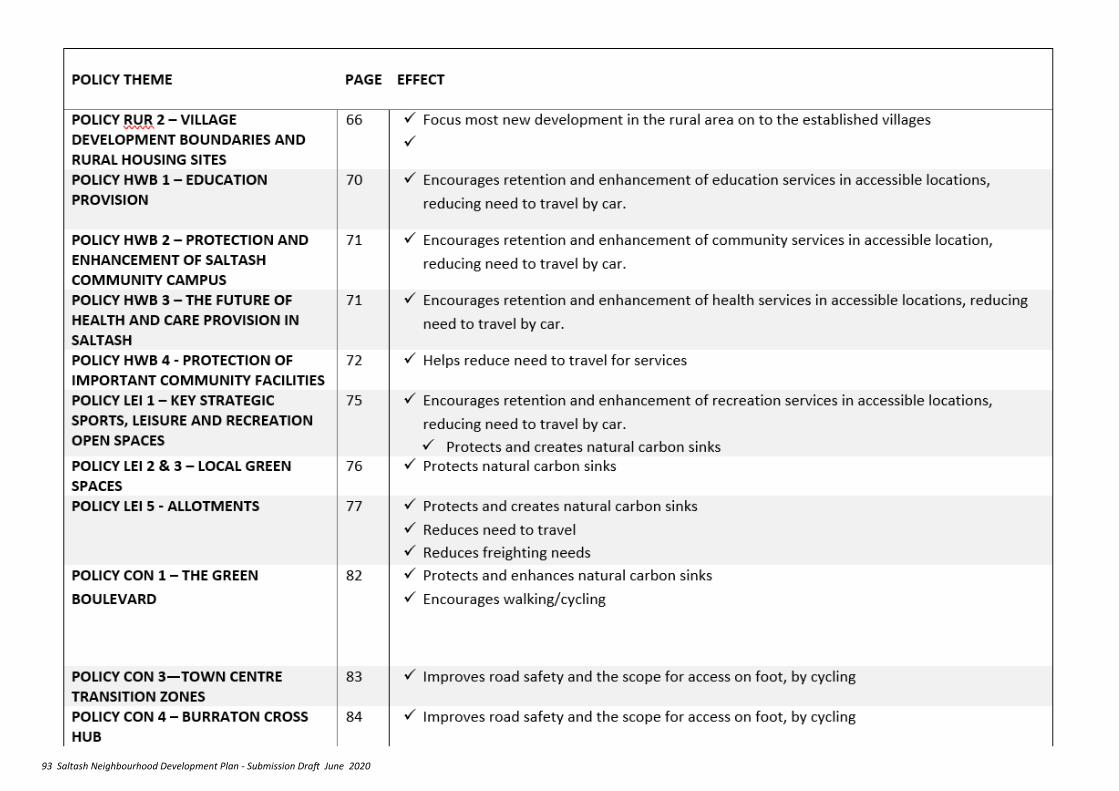
93 Saltash Neighbourhood Development Plan - Submission Draft June 2020
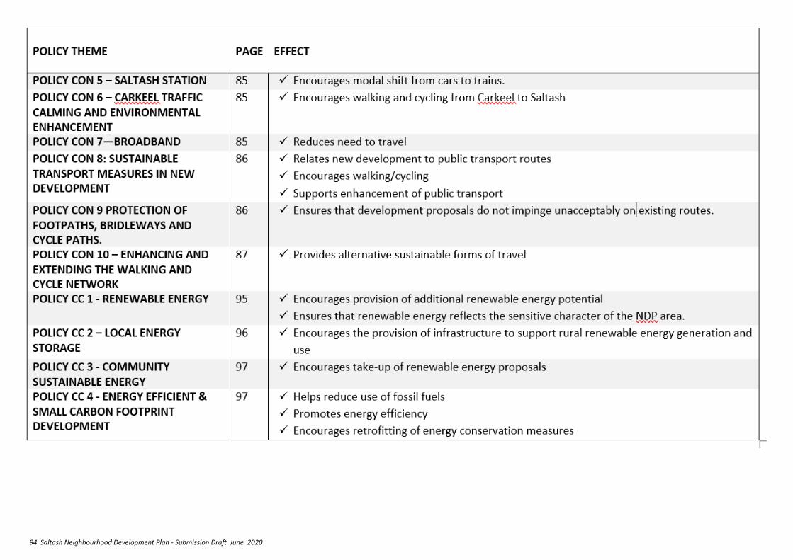
94 Saltash Neighbourhood Development Plan - Submission Draft June 2020
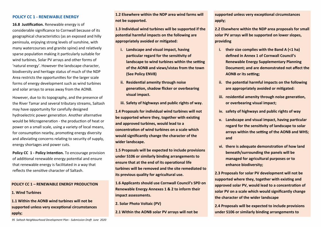
95 Saltash Neighbourhood Development Plan - Submission Draft June 2020
POLICY CC 1 - RENEWABLE ENERGY
16.8 Justification. Renewable energy is of
considerable significance to Cornwall because of its
geographical characteristics (as an exposed and hilly
peninsula, enjoying strong levels of sunshine, with
many watercourses and granite spine) and relatively
sparse population making it particularly suitable for
wind turbines, Solar PV arrays and other forms of
‘natural energy’. However the landscape character,
biodiversity and heritage status of much of the NDP
Area restricts the opportunities for the larger scale
forms of energy development such as wind turbines
and solar arrays to areas away from the AONB.
However, due to its topography, and the presence of
the River Tamar and several tributary streams, Saltash
may have opportunity for carefully designed
hydroelectric power generation. Another alternative
would be Microgeneration - the production of heat or
power on a small scale, using a variety of local means,
for consumption nearby, promoting energy diversity
and alleviating concerns relating to security of supply,
energy shortages and power cuts.
Policy CC 1 - Policy Intention. To encourage provision
of additional renewable energy potential and ensure
that renewable energy is facilitated in a way that
reflects the sensitive character of Saltash.
POLICY CC 1 – RENEWABLE ENERGY PRODUCTION
1. Wind Turbines
1.1 Within the AONB wind turbines will not be
supported unless very exceptional circumstances
apply;
1.2 Elsewhere within the NDP area wind farms will
not be supported.
1.3 Individual wind turbines will be supported if the
potential harmful impacts on the following are
appropriately avoided or mitigated:
i. Landscape and visual impact, having
particular regard for the sensitivity of
landscape to wind turbines within the setting
of the AONB and views/vistas from the town
(See Policy ENV8)
ii. Residential amenity through noise
generation, shadow flicker or overbearing
visual impact.
iii. Safety of highways and public rights of way.
1.4 Proposals for individual wind turbines will not
be supported where they, together with existing
and approved turbines, would lead to a
concentration of wind turbines on a scale which
would significantly change the character of the
wider landscape.
1.5 Proposals will be expected to include provisions
under S106 or similarly binding arrangements to
ensure that at the end of its operational life
turbines will be removed and the site remediated to
its previous quality for agricultural use.
1.6 Applicants should use Cornwall Council’s SPD on
Renewable Energy Annexes 1 & 2 to inform their
impact assessments.
2. Solar Photo Voltaic (PV)
2.1 Within the AONB solar PV arrays will not be
supported unless very exceptional circumstances
apply;
2.2 Elsewhere within the NDP area proposals for small
solar PV arrays will be supported on lower slopes,
providing
i. their size complies with the Band A (<1 ha)
defined in Annex 1 of Cornwall Council’s
Renewable Energy Supplementary Planning
Document; and are demonstrated not affect the
AONB or its setting;
ii. the potential harmful impacts on the following
are appropriately avoided or mitigated:
iii. residential amenity through noise generation,
or overbearing visual impact;
iv. safety of highways and public rights of way
v. Landscape and visual impact, having particular
regard for the sensitivity of landscape to solar
arrays within the setting of the AONB and WHS;
and
vi. there is adequate demonstration of how land
beneath/surrounding the panels will be
managed for agricultural purposes or to
enhance biodiversity;
2.3 Proposals for solar PV development will not be
supported where they, together with existing and
approved solar PV, would lead to a concentration of
solar PV on a scale which would significantly change
the character of the wider landscape
2.4 Proposals will be expected to include provisions
under S106 or similarly binding arrangements to
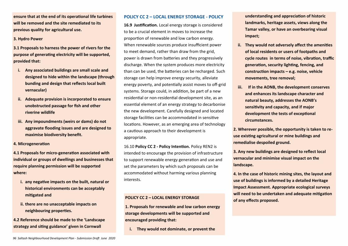
96 Saltash Neighbourhood Development Plan - Submission Draft June 2020
POLICY CC 2 – LOCAL ENERGY STORAGE - POLICY
16.9 Justification. Local energy storage is considered
to be a crucial element in moves to increase the
proportion of renewable and low carbon energy.
When renewable sources produce insufficient power
to meet demand, rather than draw from the grid,
power is drawn from batteries and they progressively
discharge. When the system produces more electricity
than can be used, the batteries can be recharged. Such
storage can help improve energy security, alleviate
energy poverty, and potentially assist moves to off-grid
systems. Storage could, in addition, be part of a new
residential or non-residential development site, as an
essential element of an energy strategy to decarbonise
the new development. Carefully designed and located
storage facilities can be accommodated in sensitive
locations. However, as an emerging area of technology
a cautious approach to their development is
appropriate.
16.10 Policy CC 2 - Policy Intention. Policy REN2 is
intended to encourage the provision of infrastructure
to support renewable energy generation and use and
set the parameters by which such proposals can be
accommodated without harming various planning
interests.
POLICY CC 2 – LOCAL ENERGY STORAGE
1. Proposals for renewable and low carbon energy
storage developments will be supported and
encouraged providing that:
i. They would not dominate, or prevent the
ensure that at the end of its operational life turbines
will be removed and the site remediated to its
previous quality for agricultural use.
3. Hydro Power
3.1 Proposals to harness the power of rivers for the
purpose of generating electricity will be supported,
provided that:
i. Any associated buildings are small scale and
designed to hide within the landscape (through
bunding and design that reflects local built
vernacular)
ii. Adequate provision is incorporated to ensure
unobstructed passage for fish and other
riverine wildlife
iii. Any impoundments (weirs or dams) do not
aggravate flooding issues and are designed to
maximise biodiversity benefit.
4. Microgeneration
4.1 Proposals for micro-generation associated with
individual or groups of dwellings and businesses that
require planning permission will be supported
where:
i. any negative impacts on the built, natural or
historical environments can be acceptably
mitigated and
ii. there are no unacceptable impacts on
neighbouring properties.
4.2 Reference should be made to the ‘Landscape
strategy and siting guidance’ given in Cornwall
understanding and appreciation of historic
landmarks, heritage assets, views along the
Tamar valley, or have an overbearing visual
impact;
ii. They would not adversely affect the amenities
of local residents or users of footpaths and
cycle routes in terms of noise, vibration, traffic
generation, security lighting, fencing, and
construction impacts – e.g. noise, vehicle
movements, tree removal;
iii. If in the AONB, the development conserves
and enhances its landscape character and
natural beauty, addresses the AONB’s
sensitivity and capacity, and if major
development the tests of exceptional
circumstances.
2. Wherever possible, the opportunity is taken to re-
use existing agricultural or mine buildings and
remedialise despoiled ground.
3. Any new buildings are designed to reflect local
vernacular and minimise visual impact on the
landscape.
4. In the case of historic mining sites, the layout and
use of buildings is informed by a detailed Heritage
Impact Assessment. Appropriate ecological surveys
will need to be undertaken and adequate mitigation
of any effects proposed.
97 Saltash Neighbourhood Development Plan - Submission Draft June 2020
POLICY CC 3 - COMMUNITY SUSTAINABLE ENERGY
16.11 Justification. Para 152 of NPPF 2019 encourages
plans to support community-led initiatives for
renewable and low carbon energy, including
developments outside areas identified in local plans or
other strategic policies that are being taken forward
through neighbourhood planning. This could contribute
locally by way of the community owning or holding
shares in renewable energy or by providing cheaper
energy bills. Potentially it could encourage the take up
of electric vehicles.
16.12 Policy CC 3 – Intention. To define how the
Cornwall Local Plan Policy and Renewable Energy SPD
support for the communities’ relationship with
renewable energy should be applied in Saltash NDP
area. In particular, future renewable energy schemes
will be supported where they can demonstrate they
have sought and secured whole or part ownership for
POLICY CC 3 - COMMUNITY SUSTAINABLE ENERGY
Proposals for community owned renewable energy schemes will be supported where they:
i. Conform with Renewable Energy Production Policy REN1 of the NDP
ii. Are integrated into the local grid or by other means so that the energy generated can be supplied directly to domestic, business and other buildings in the NDP area, demonstrated by direct reduction to buildings’ energy consumption.
iii. Are fully or partly owned by local residents and businesses in a profit sharing cooperative. This
can be demonstrated by evidence of the development being fully or partly owned through an appropriately constituted community energy enterprise (CEE, whose members include local residents and/or businesses). or
If the applicant has sought to deliver via this model
but this has not been possible, a local share offer
would be, providing there is evidence CEE delivery
was not possible; and that residents and business in
the NDP area are given priority
POLICY CC 4 - ENERGY EFFICIENT & SMALL CARBON FOOTPRINT DEVELOPMENT
16.13 Justification. Substantial contributions to
reducing greenhouse gasses can be obtained by
careful design of new development to reduce the
‘carbon footprint’. These may include:
• Heat Pumps (air to air and air to water) - a
very efficient means of producing renewable
energy.
• Biomass boilers - At best these are only
carbon neutral, and there can be negative
biodiversity impacts, other emissions and
noise which can be an issue for nearby
residential development.
• Ground source heat pumps (geothermal).
• Solar Panels - currently the most common
form of domestic renewable energy, a well
designed installation on a dwelling orientated
to maximise exposure to the Sun can
contribute a significant amount of domestic
energy needs. Typically a 4Kw solar panel system
on each property could cover that properties
electricity needs for a year.
16.14 Much non-renewable energy can be ‘embodied’
in the production processes of building materials and
fittings, and opportunities to reduce green house gas
emissions can be obtained by careful choice of
supplies.
16.15 Ideally all new developments within the NDP
area should seek to achieve high standards of
sustainable development and, in particular,
demonstrate in proposals how design, construction
and operation seek to reduce the use of fossil fuels,
promote the efficient use of natural resources, the re-
use and recycling of resources, and the production and
consumption of renewable energy and adopt/facilitate
the flexible development of low and zero carbon
energy through a range of technologies.
16.14. Policy CC 4 – Intention. To support the
transition to a low carbon future through good design.
POLICY CC 4 – ENERGY EFFICIENT & SMALL CARBON
FOOTPRINT DEVELOPMENT
1. New development which aims to meet a high level
of sustainable design and construction and be
optimized for energy efficiency so that it has a small
‘carbon footprint’ will be supported. This includes:
a. Sting and orientation to optimize passive solar
gain;
b. Provision of shelter belt planting in areas
exposed to wind;
98 Saltash Neighbourhood Development Plan - Submission Draft June 2020
c. Use of sustainable water sources ( rainwater
harvesting, greywater recycling and other
measures of water demand management) and
efficient use of all water for both internal and
external water consumption;
d. Layouts that encourage natural cooling to avoid
heat stress and avoid the need for air-
conditioning;
e. The use of high quality, thermally efficient
building materials, locally sourced wherever
practicable, and of low embodied energy use;
f. Installation of energy efficiency measures such
as loft and wall insulation and double glazing;
g. Modular or flexible designs which are adaptable
to meet changing needs;
h. incorporation of a passive electric vehicle
charging point* built into individual dwellings
and additional charging points within on-street
parking areas;
i. The sensitive retrofitting of energy efficiency
measures in heritage properties/assets and
buildings to reduce energy demand, providing
that it safeguards the historic characteristics of
these heritage assets and development is done
with the engagement and permissions of
relevant organizations. Such measures could
include:
i. measures to reduce heat loss, such as
double or secondary glazing with wooden
windows that meet the latest relevant
British standard; and/the replacement of
fossil fuel burning energy sources with
electric power from renewable sources with
zero air emissions locally.
2. All new residential buildings should achieve
I. a 19% reduction in Dwelling Emission Rate
compared to the Target Emission Rate (calculated
using Standard Assessment Procedure methodology
as per Part L1A of the Building Regulations 2013)**
or achieve any higher standard than this that is
required under new national planning policy or
Building Regulations; and
ii. a water consumption rate of 110 litres per person
per day (calculated as per Part G of the Building
Regulations).
3. All new non-residential buildings with a total
internal floor area of 100m2 or greater should achieve
BREEAM ‘Excellent’ (or equivalent)
4. New housing development which achieves at least 4
stars in the overall Building Research Establishment
Home Quality Mark (HQM)***and 5 stars in the HQM
‘My Footprint’ assessment is encouraged.
* Passive provision means either cabling in place to
enable straightforward connection of a charge point at
a later date, or sufficiently wide ducting provided to
enable cables to be inserted at a later date without
the need for excavation.
** Code Level 4 is approximately 19% above current
(2013) Part L.
***See http://www.homequalitymark.com/ratings-
and-stars
99 Saltash Neighbourhood Development Plan - Submission Draft June 2020
16. DELIVERY PLAN
16.1 Justification—In order for the vision, objectives and policies of this Plan to be delivered, a range of organisations and groups will need to work in close collaboration, bringing together funding from many sources, in particular from planning obligations (Including Section 106 agreements, Community Infrastructure Levy, and Highways agreements). The Delivery Plan sets out the mechanism for this to happen during the lifetime of this Neighbourhood Plan.
16.2 Delivery Plan Table 1 sets out the policies and proposals of this NDP, identifying the tasks necessary to ensure that the plans intentions are delivered, and identifying the key organisations involved in that delivery. It forms the basis for partnership working. Delivery Plan Table 2 sets out the same for the Projects included in this Plan.
16.3 The timescales set out in Table 1 and Table 2 are defined as follows:
• Immediate - upon approval of the Neighbourhood Plan
• Short - within one year of the approval of the Plan
• Medium - between one and five years of the Plan being approved
• Long - between five years of the Plan being approved and the end period of the Plan
• Ongoing - throughout the lifetime of the Plan an annual monitoring report will be produced to indicate progress with the plans intentions.
16.4 Policy DP1 Intention – To ensure that Saltash achieves its vision, that the needs of existing and new population are met, that any adverse impacts of growth and climate change are mitigated against, and that existing infrastructure is maintained at suitable levels to accommodate both the existing and additional populations. The Plan’s policies, proposals and projects should be the main recipients of planning gain monies (such as S106 agreements, CIL, and any other such schemes) in the area. The lists below set out the main priority areas for such spending. In areas with approved Neighbourhood Plans, the Government has decided that a minimum of 25% of CIL money should be spent in the local area. If CIL financing becomes available a plan to use the 25% retained locally is necessary to ensure that the funding is used effectively.
POLICY DP1 – MAKING IT HAPPEN - COMMUNITY PRIORITIES
1. Community Infrastructure Levy receipts by the Saltash Town Council (the ‘Neighbourhood Portion’) will be directed towards support for the Projects set out in Table 2.
2. The use of Community Infrastructure Levy receipts by Cornwall Council (the ‘Strategic Share’) that are directed to the to the Saltash Neighbourhood Development Plan area should provide funding for the strategic open
space requirements set out in policy LE1, and the projects set out in table 2 below, recognising the Town Council/community prioritisation of them.
16.5 Table 1 sets out timescales for each Policy and Proposal. A suggested process for the delivery of Projects is set out in Table 2, which will involve community groups in decisions about the scope, priority and timing of the projects. While the projects do not form part of the policies of the Plan, they play an important and significant part in its delivery. The recommendations should guide Cornwall Council, developers, and other relevant agencies in how the community wants development to be shaped in the Saltash area. The recommendations should also inform Cornwall Council policy - in particular on the spending of Section 106 and Community Infrastructure Levy funds to meet the local community’s priorities. Table 2 should also guide the Town Council in its allocation of resources.
16.6 In applying the NDP users should be aware of and carefully take into account the needs of groups with protected characteristics as set out in the Equalities Act 2010.
16.7 COVID-19. The impacts of the COVID-19 pandemic on Saltash could continue to be experienced well into the NDP period 2020 to 2030. The application of the policies and take up of initiatives in this NDP should be progressed vigorously in ways which assist the recovery of the town and community.
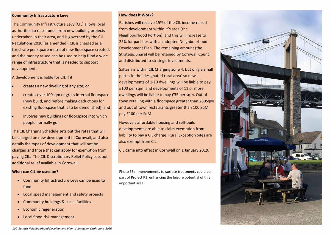
100 Saltash Neighbourhood Development Plan - Submission Draft June 2020
Community Infrastructure Levy
The Community Infrastructure Levy (CIL) allows local
authorities to raise funds from new building projects
undertaken in their area, and is governed by the CIL
Regulations 2010 (as amended). CIL is charged as a
fixed rate per square metre of new floor space created,
and the money raised can be used to help fund a wide
range of infrastructure that is needed to support
development.
A development is liable for CIL if it:
• creates a new dwelling of any size; or
• creates over 100sqm of gross internal floorspace
(new build, and before making deductions for
existing floorspace that is to be demolished); and
• involves new buildings or floorspace into which
people normally go.
The CIL Charging Schedule sets out the rates that will
be charged on new development in Cornwall, and also
details the types of development that will not be
charged and those that can apply for exemption from
paying CIL. The CIL Discretionary Relief Policy sets out
additional relief available in Cornwall.
What can CIL be used on?
• Community Infrastructure Levy can be used to
fund:
• Local speed management and safety projects
• Community buildings & social facilities
• Economic regeneration
• Local flood risk management
How does it Work?
Parishes will receive 15% of the CIL income raised
from development within it’s area (the
Neighbourhood Portion), and this will increase to
25% for parishes with an adopted Neighbourhood
Development Plan. The remaining amount (the
Strategic Share) will be retained by Cornwall Council
and distributed to strategic investments.
Saltash is within CIL Charging zone 4, but only a small
part is in the ’designated rural area’ so new
developments of 1-10 dwellings will be liable to pay
£100 per sqm, and developments of 11 or more
dwellings will be liable to pay £35 per sqm. Out of
town retailing with a floorspace greater than 280SqM
and out of town restaurants greater than 100 SqM
pay £100 per SqM.
However, affordable housing and self-build
developments are able to claim exemption from
liability to pay a CIL charge. Rural Exception Sites are
also exempt from CIL.
CIL came into effect in Cornwall on 1 January 2019.
Photo 55: Improvements to surface treatments could be
part of Project P1, enhancing the leisure potential of this
important area.
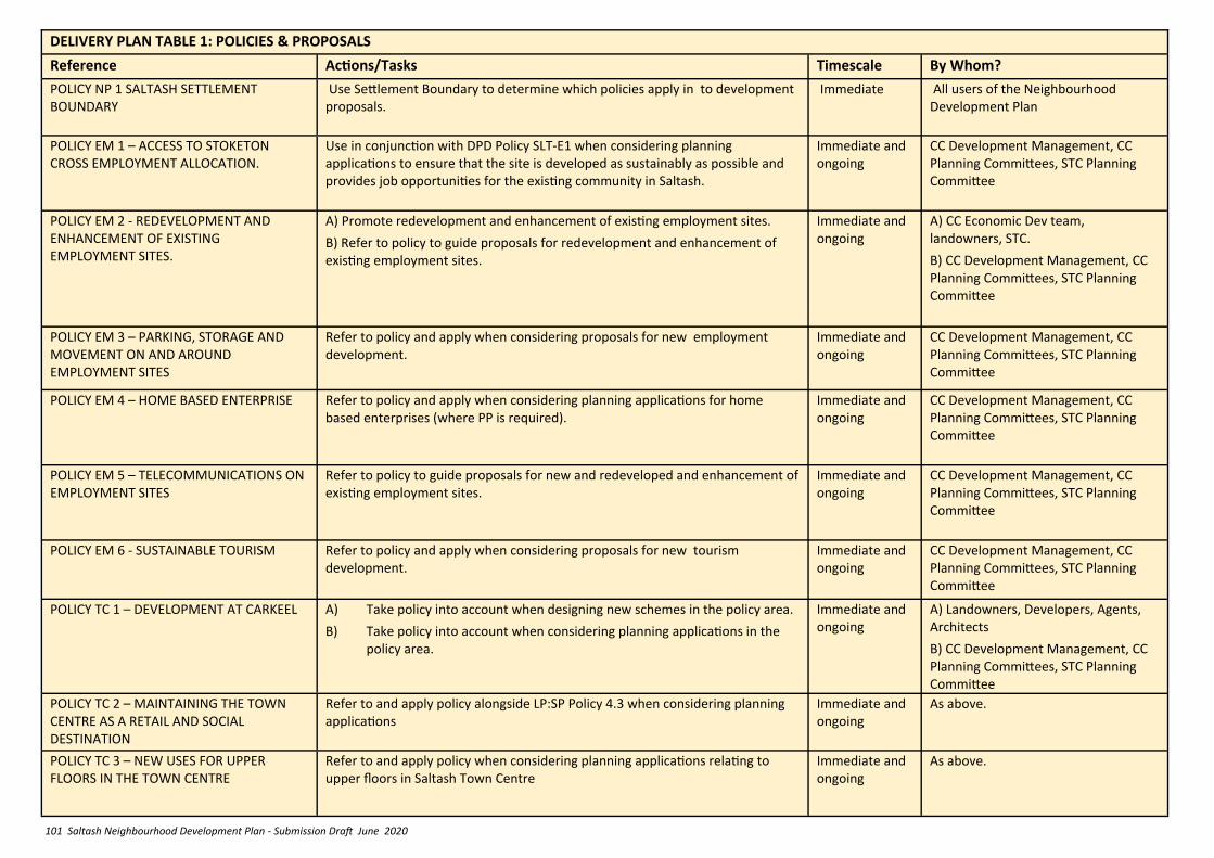
101 Saltash Neighbourhood Development Plan - Submission Draft June 2020
DELIVERY PLAN TABLE 1: POLICIES & PROPOSALS
Reference Actions/Tasks Timescale By Whom?
POLICY NP 1 SALTASH SETTLEMENT BOUNDARY
Use Settlement Boundary to determine which policies apply in to development proposals.
Immediate All users of the Neighbourhood Development Plan
POLICY EM 1 – ACCESS TO STOKETON CROSS EMPLOYMENT ALLOCATION.
Use in conjunction with DPD Policy SLT-E1 when considering planning applications to ensure that the site is developed as sustainably as possible and provides job opportunities for the existing community in Saltash.
Immediate and ongoing
CC Development Management, CC Planning Committees, STC Planning Committee
POLICY EM 2 - REDEVELOPMENT AND ENHANCEMENT OF EXISTING EMPLOYMENT SITES.
A) Promote redevelopment and enhancement of existing employment sites.
B) Refer to policy to guide proposals for redevelopment and enhancement of existing employment sites.
Immediate and ongoing
A) CC Economic Dev team, landowners, STC.
B) CC Development Management, CC Planning Committees, STC Planning Committee
POLICY EM 3 – PARKING, STORAGE AND MOVEMENT ON AND AROUND EMPLOYMENT SITES
Refer to policy and apply when considering proposals for new employment development.
Immediate and ongoing
CC Development Management, CC Planning Committees, STC Planning Committee
POLICY EM 4 – HOME BASED ENTERPRISE Refer to policy and apply when considering planning applications for home based enterprises (where PP is required).
Immediate and ongoing
CC Development Management, CC Planning Committees, STC Planning Committee
POLICY EM 5 – TELECOMMUNICATIONS ON EMPLOYMENT SITES
Refer to policy to guide proposals for new and redeveloped and enhancement of existing employment sites.
Immediate and ongoing
CC Development Management, CC Planning Committees, STC Planning Committee
POLICY EM 6 - SUSTAINABLE TOURISM Refer to policy and apply when considering proposals for new tourism development.
Immediate and ongoing
CC Development Management, CC Planning Committees, STC Planning Committee
POLICY TC 1 – DEVELOPMENT AT CARKEEL A) Take policy into account when designing new schemes in the policy area.
B) Take policy into account when considering planning applications in the policy area.
Immediate and ongoing
A) Landowners, Developers, Agents, Architects
B) CC Development Management, CC Planning Committees, STC Planning Committee
POLICY TC 2 – MAINTAINING THE TOWN CENTRE AS A RETAIL AND SOCIAL DESTINATION
Refer to and apply policy alongside LP:SP Policy 4.3 when considering planning applications
Immediate and ongoing
As above.
POLICY TC 3 – NEW USES FOR UPPER FLOORS IN THE TOWN CENTRE
Refer to and apply policy when considering planning applications relating to upper floors in Saltash Town Centre
Immediate and ongoing
As above.
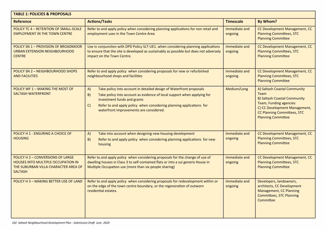
102 Saltash Neighbourhood Development Plan - Submission Draft June 2020
TABLE 1: POLICIES & PROPOSALS
Reference Actions/Tasks Timescale By Whom?
POLICY TC 4 – RETENTION OF SMALL-SCALE EMPLOYMENT IN THE TOWN CENTRE
Refer to and apply policy when considering planning applications for non retail and employment uses in the Town Centre Area
Immediate and ongoing
CC Development Management, CC Planning Committees, STC Planning Committee
POLICY SN 1 – PROVISION OF BROADMOOR URBAN EXTENSION NEIGHBOURHOOD CENTRE
Use in conjunction with DPD Policy SLT-UE1. when considering planning applications to ensure that the site is developed as sustainably as possible but does not adversely impact on the Town Centre.
Immediate and ongoing
CC Development Management, CC Planning Committees, STC Planning Committee
POLICY SN 2 – NEIGHBOURHOOD SHOPS AND FACILITIES
Refer to and apply policy when considering proposals for new or refurbished neighbourhood shops and facilities
Immediate and ongoing
CC Development Management, CC Planning Committees, STC Planning Committee
POLICY WF 1 – MAKING THE MOST OF SALTASH WATERFRONT
A) Take policy into account in detailed design of Waterfront proposals
B) Take policy into account as evidence of local support when applying for investment funds and grants
C) Refer to and apply policy when considering planning applications for waterfront improvements are considered.
Medium/Long A) Saltash Coastal Community Team B) Saltash Coastal Community Team, Funding agencies C) CC Development Management, CC Planning Committees, STC Planning Committee
POLICY H 1 - ENSURING A CHOICE OF HOUSING
A) Take into account when designing new housing development
B) Refer to and apply policy when considering planning applications for new housing
Immediate and ongoing
CC Development Management, CC Planning Committees, STC Planning Committee
POLICY H 2 – CONVERSIONS OF LARGE HOUSES INTO MULTIPLE OCCUPATION IN THE SUBURBAN VILLA CHARACTER AREA OF SALTASH
Refer to and apply policy when considering proposals for the change of use of dwelling houses in Class 3 to self-contained flats or into a sui generis House in Multiple Occupation use (more than six people sharing)
Immediate and ongoing
CC Development Management, CC Planning Committees, STC Planning Committee
POLICY H 3 – MAKING BETTER USE OF LAND Refer to and apply policy when considering proposals for redevelopment within or on the edge of the town centre boundary, or the regeneration of outworn residential estates.
Immediate and ongoing
Developers, landowners, architects, CC Development Management, CC Planning Committees, STC Planning Committee

103 Saltash Neighbourhood Development Plan - Submission Draft June 2020
POLICY H 4 – MAKING BETTER USE OF LAND - SUBURBAN VILLAS CHARACTER AREA: PORT VIEW ESTATE
Refer to and apply policy when considering proposals for new residential development within the Suburban Villas Character Area: Port View Estate
Immediate and ongoing
Developers, landowners, architects, CC Development Management, CC Planning Committees, STC Planning Committee
POLICY H 5 – EXTENSIONS TO EXISTING DWELLINGS
Refer to and apply policy when considering proposals for residential extensions, where planning permission is required.
Immediate and ongoing
Developers, landowners, architects, CC Development Management, CC Planning Committees, STC Planning Committee
POLICY ENV 1 – DESIGN AND LOCAL DISTINCTIVENESS WITHIN THE DEFINED CHARACTER AREAS
Refer to and apply policy when considering proposals for development within the defined character areas.
Immediate and ongoing
Developers, landowners, architects, CC Development Management, CC Planning Committees, STC Planning Committee
POLICY ENV 2 – DESIGN AND LOCAL DISTINCTIVENESS OUTSIDE THE HISTORIC CORE
A) Refer to and apply policy when considering proposals for development outside the historic core,
B) Develop ‘Pattern Books’ for larger scale developments
Immediate and ongoing
A) Developers, landowners, architects, CC Development Management, CC Planning Committees, STC Planning Committee
B) Developers, and designers of larger schemes.
POLICY ENV 3 - GENERAL DESIGN PRINCIPLES
Refer to and apply policy when considering proposals for development throughout Saltash
Immediate and ongoing
Developers, landowners, architects, CC Development Management, CC Planning Committees, STC Planning Committee
POLICY ENV 4 - LOCAL LISTING OF NON-DESIGNATED HERITAGE ASSETS IN THE TOWN CENTRE AND CONSERVATION AREAS
Refer to and apply policy ENV4 and LP:SP Policy 24 to proposals affecting the identified unlisted heritage assets.
Immediate and ongoing
CC Development Management, CC Planning Committees, STC Planning Committee
POLICY ENV 5 - REUSE OF SALTASH STATION BUILDING
A) Refer to and apply policy when developing proposals for reuse of Saltash Railway Station
B) Refer to and apply policy when considering planning applications for the Station
C) Refer to and apply policy when designing public realm in vicinity.
Immediate and ongoing
A) Saltash Town Council
B) CC Development Management, CC Planning Committees, STC Planning Committee
C) CC Transport team
TABLE 1: POLICIES & PROPOSALS
Reference Actions/Tasks Timescale By Whom?
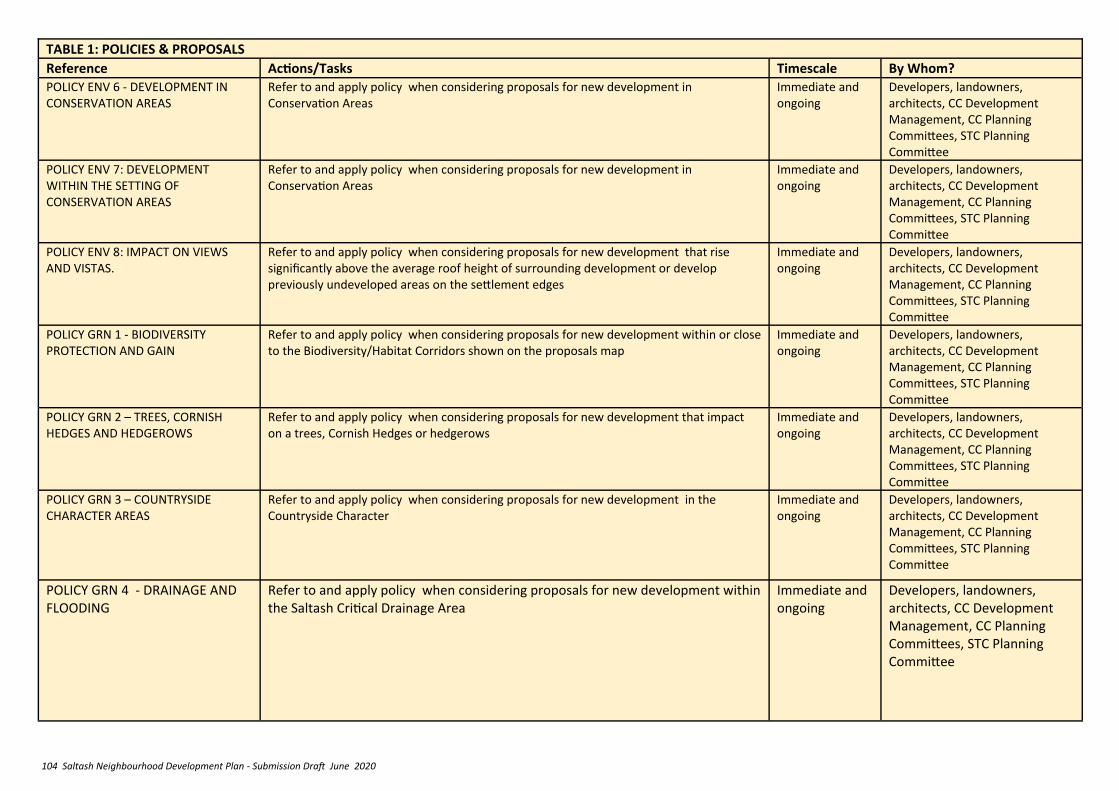
104 Saltash Neighbourhood Development Plan - Submission Draft June 2020
TABLE 1: POLICIES & PROPOSALS
Reference Actions/Tasks Timescale By Whom? POLICY ENV 6 - DEVELOPMENT IN CONSERVATION AREAS
Refer to and apply policy when considering proposals for new development in Conservation Areas
Immediate and ongoing
Developers, landowners, architects, CC Development Management, CC Planning Committees, STC Planning Committee
POLICY ENV 7: DEVELOPMENT WITHIN THE SETTING OF CONSERVATION AREAS
Refer to and apply policy when considering proposals for new development in Conservation Areas
Immediate and ongoing
Developers, landowners, architects, CC Development Management, CC Planning Committees, STC Planning Committee
POLICY ENV 8: IMPACT ON VIEWS AND VISTAS.
Refer to and apply policy when considering proposals for new development that rise significantly above the average roof height of surrounding development or develop previously undeveloped areas on the settlement edges
Immediate and ongoing
Developers, landowners, architects, CC Development Management, CC Planning Committees, STC Planning Committee
POLICY GRN 1 - BIODIVERSITY PROTECTION AND GAIN
Refer to and apply policy when considering proposals for new development within or close to the Biodiversity/Habitat Corridors shown on the proposals map
Immediate and ongoing
Developers, landowners, architects, CC Development Management, CC Planning Committees, STC Planning Committee
POLICY GRN 2 – TREES, CORNISH HEDGES AND HEDGEROWS
Refer to and apply policy when considering proposals for new development that impact on a trees, Cornish Hedges or hedgerows
Immediate and ongoing
Developers, landowners, architects, CC Development Management, CC Planning Committees, STC Planning Committee
POLICY GRN 3 – COUNTRYSIDE CHARACTER AREAS
Refer to and apply policy when considering proposals for new development in the Countryside Character
Immediate and ongoing
Developers, landowners, architects, CC Development Management, CC Planning Committees, STC Planning Committee
POLICY GRN 4 - DRAINAGE AND FLOODING
Refer to and apply policy when considering proposals for new development within the Saltash Critical Drainage Area
Immediate and ongoing
Developers, landowners, architects, CC Development Management, CC Planning Committees, STC Planning Committee
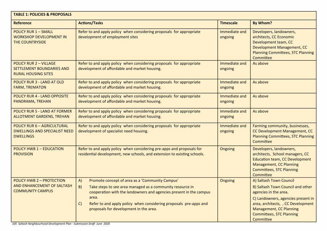
105 Saltash Neighbourhood Development Plan - Submission Draft June 2020
TABLE 1: POLICIES & PROPOSALS
Reference Actions/Tasks Timescale By Whom?
POLICY RUR 1 – SMALL WORKSHOP DEVELOPMENT IN THE COUNTRYSIDE
Refer to and apply policy when considering proposals for appropriate development of employment sites
Immediate and ongoing
Developers, landowners, architects, CC Economic Development team, CC Development Management, CC Planning Committees, STC Planning Committee
POLICY RUR 2 – VILLAGE SETTLEMENT BOUNDARIES AND RURAL HOUSING SITES
Refer to and apply policy when considering proposals for appropriate development of affordable and market housing.
Immediate and ongoing
As above
POLICY RUR 3 - LAND AT OLD FARM, TREMATON
Refer to and apply policy when considering proposals for appropriate development of affordable and market housing.
Immediate and ongoing
As above
POLICY RUR 4 - LAND OPPOSITE PANDRAMA, TREHAN
Refer to and apply policy when considering proposals for appropriate development of affordable and market housing.
Immediate and ongoing
As above
POLICY RUR 5 - LAND AT FORMER ALLOTMENT GARDENS, TREHAN
Refer to and apply policy when considering proposals for appropriate development of affordable and market housing.
Immediate and ongoing
As above
POLICY RUR 6 – AGRICULTURAL DWELLINGS AND SPECIALIST NEED DWELLINGS
Refer to and apply policy when considering proposals for appropriate development of specialist need housing.
Immediate and ongoing
Farming community, businesses, CC Development Management, CC Planning Committees, STC Planning Committee
POLICY HWB 1 – EDUCATION PROVISION
Refer to and apply policy when considering pre-apps and proposals for residential development, new schools, and extension to existing schools.
Ongoing Developers, landowners, architects, School managers, CC Education team, CC Development Management, CC Planning Committees, STC Planning Committee
POLICY HWB 2 – PROTECTION AND ENHANCEMENT OF SALTASH COMMUNITY CAMPUS
A) Promote concept of area as a ‘Community Campus’
B) Take steps to see area managed as a community resource in cooperation with the landowners and agencies present in the campus area.
C) Refer to and apply policy when considering proposals pre-apps and proposals for development in the area.
Ongoing A) Saltash Town Council
B) Saltash Town Council and other agencies in the area.
C) Landowners, agencies present in area, architects, , CC Development Management, CC Planning Committees, STC Planning Committee
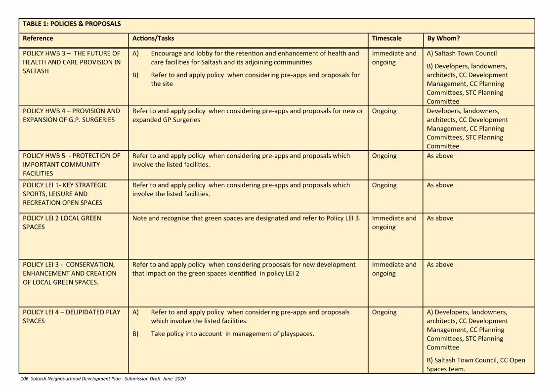
106 Saltash Neighbourhood Development Plan - Submission Draft June 2020
POLICY HWB 3 – THE FUTURE OF HEALTH AND CARE PROVISION IN SALTASH
A) Encourage and lobby for the retention and enhancement of health and care facilities for Saltash and its adjoining communities
B) Refer to and apply policy when considering pre-apps and proposals for the site
Immediate and ongoing
A) Saltash Town Council
B) Developers, landowners, architects, CC Development Management, CC Planning Committees, STC Planning Committee
POLICY HWB 4 – PROVISION AND EXPANSION OF G.P. SURGERIES
Refer to and apply policy when considering pre-apps and proposals for new or expanded GP Surgeries
Ongoing Developers, landowners, architects, CC Development Management, CC Planning Committees, STC Planning Committee
POLICY HWB 5 - PROTECTION OF IMPORTANT COMMUNITY FACILITIES
Refer to and apply policy when considering pre-apps and proposals which involve the listed facilities.
Ongoing As above
POLICY LEI 1- KEY STRATEGIC SPORTS, LEISURE AND RECREATION OPEN SPACES
Refer to and apply policy when considering pre-apps and proposals which involve the listed facilities.
Ongoing As above
POLICY LEI 2 LOCAL GREEN SPACES
Note and recognise that green spaces are designated and refer to Policy LEI 3. Immediate and ongoing
As above
POLICY LEI 3 - CONSERVATION, ENHANCEMENT AND CREATION OF LOCAL GREEN SPACES.
Refer to and apply policy when considering proposals for new development that impact on the green spaces identified in policy LEI 2
Immediate and ongoing
As above
POLICY LEI 4 – DELIPIDATED PLAY SPACES
A) Refer to and apply policy when considering pre-apps and proposals which involve the listed facilities.
B) Take policy into account in management of playspaces.
Ongoing A) Developers, landowners, architects, CC Development Management, CC Planning Committees, STC Planning Committee
B) Saltash Town Council, CC Open Spaces team.
TABLE 1: POLICIES & PROPOSALS
Reference Actions/Tasks Timescale By Whom?
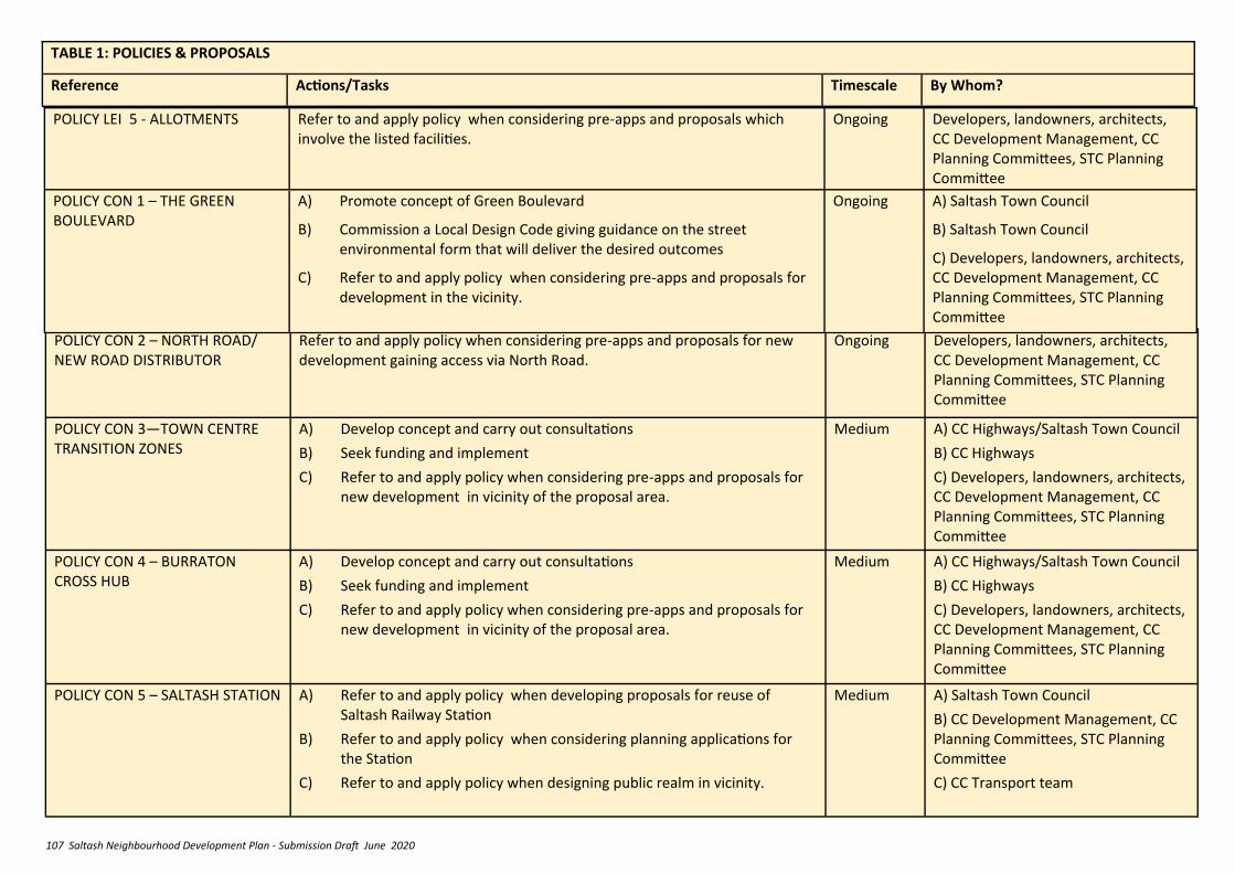
107 Saltash Neighbourhood Development Plan - Submission Draft June 2020
POLICY CON 2 – NORTH ROAD/ NEW ROAD DISTRIBUTOR
Refer to and apply policy when considering pre-apps and proposals for new development gaining access via North Road.
Ongoing Developers, landowners, architects, CC Development Management, CC Planning Committees, STC Planning Committee
POLICY CON 3—TOWN CENTRE TRANSITION ZONES
A) Develop concept and carry out consultations
B) Seek funding and implement
C) Refer to and apply policy when considering pre-apps and proposals for new development in vicinity of the proposal area.
Medium A) CC Highways/Saltash Town Council
B) CC Highways
C) Developers, landowners, architects, CC Development Management, CC Planning Committees, STC Planning Committee
POLICY CON 4 – BURRATON CROSS HUB
A) Develop concept and carry out consultations
B) Seek funding and implement
C) Refer to and apply policy when considering pre-apps and proposals for new development in vicinity of the proposal area.
Medium A) CC Highways/Saltash Town Council
B) CC Highways
C) Developers, landowners, architects, CC Development Management, CC Planning Committees, STC Planning Committee
POLICY CON 5 – SALTASH STATION A) Refer to and apply policy when developing proposals for reuse of Saltash Railway Station
B) Refer to and apply policy when considering planning applications for the Station
C) Refer to and apply policy when designing public realm in vicinity.
Medium A) Saltash Town Council
B) CC Development Management, CC Planning Committees, STC Planning Committee
C) CC Transport team
TABLE 1: POLICIES & PROPOSALS
Reference Actions/Tasks Timescale By Whom?
POLICY LEI 5 - ALLOTMENTS Refer to and apply policy when considering pre-apps and proposals which involve the listed facilities.
Ongoing Developers, landowners, architects, CC Development Management, CC Planning Committees, STC Planning Committee
POLICY CON 1 – THE GREEN BOULEVARD
A) Promote concept of Green Boulevard
B) Commission a Local Design Code giving guidance on the street environmental form that will deliver the desired outcomes
C) Refer to and apply policy when considering pre-apps and proposals for development in the vicinity.
Ongoing A) Saltash Town Council
B) Saltash Town Council
C) Developers, landowners, architects, CC Development Management, CC Planning Committees, STC Planning Committee
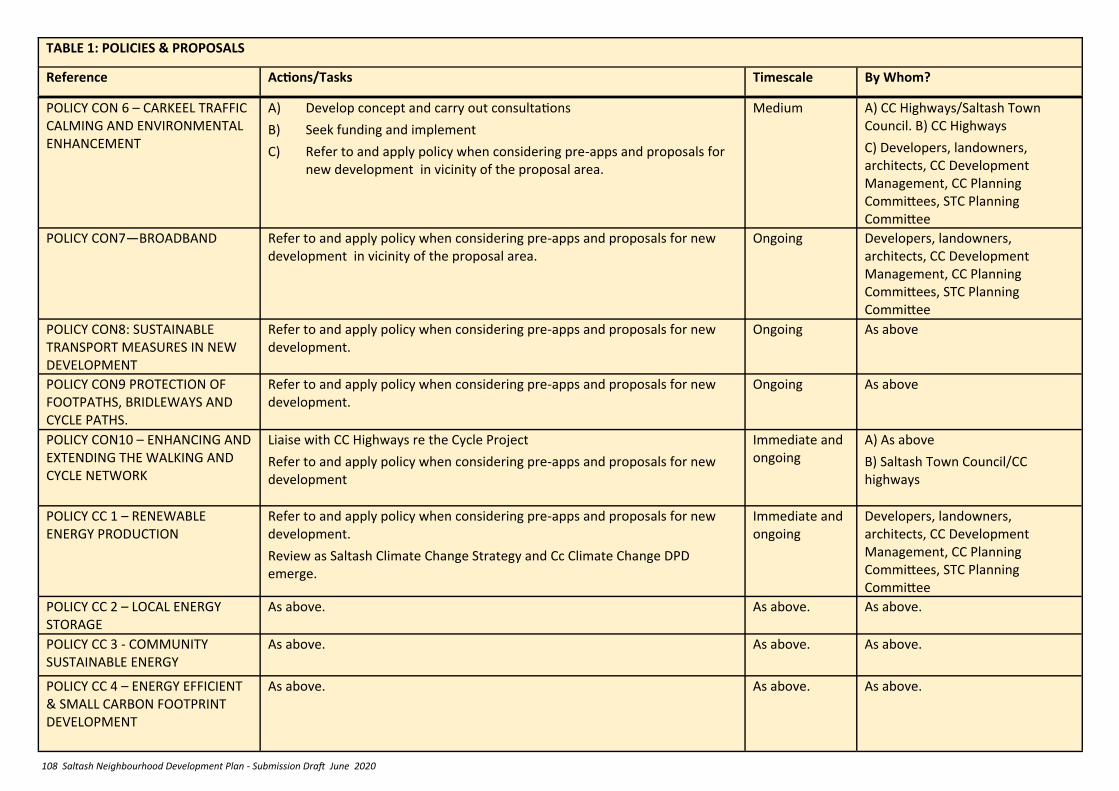
108 Saltash Neighbourhood Development Plan - Submission Draft June 2020
TABLE 1: POLICIES & PROPOSALS
Reference Actions/Tasks Timescale By Whom?
POLICY CON 6 – CARKEEL TRAFFIC CALMING AND ENVIRONMENTAL ENHANCEMENT
A) Develop concept and carry out consultations
B) Seek funding and implement
C) Refer to and apply policy when considering pre-apps and proposals for new development in vicinity of the proposal area.
Medium A) CC Highways/Saltash Town Council. B) CC Highways
C) Developers, landowners, architects, CC Development Management, CC Planning Committees, STC Planning Committee
POLICY CON7—BROADBAND Refer to and apply policy when considering pre-apps and proposals for new development in vicinity of the proposal area.
Ongoing Developers, landowners, architects, CC Development Management, CC Planning Committees, STC Planning Committee
POLICY CON8: SUSTAINABLE TRANSPORT MEASURES IN NEW DEVELOPMENT
Refer to and apply policy when considering pre-apps and proposals for new development.
Ongoing As above
POLICY CON9 PROTECTION OF FOOTPATHS, BRIDLEWAYS AND CYCLE PATHS.
Refer to and apply policy when considering pre-apps and proposals for new development.
Ongoing As above
POLICY CON10 – ENHANCING AND EXTENDING THE WALKING AND CYCLE NETWORK
Liaise with CC Highways re the Cycle Project
Refer to and apply policy when considering pre-apps and proposals for new development
Immediate and ongoing
A) As above
B) Saltash Town Council/CC highways
POLICY CC 1 – RENEWABLE ENERGY PRODUCTION
Refer to and apply policy when considering pre-apps and proposals for new development.
Review as Saltash Climate Change Strategy and Cc Climate Change DPD emerge.
Immediate and ongoing
Developers, landowners, architects, CC Development Management, CC Planning Committees, STC Planning Committee
POLICY CC 2 – LOCAL ENERGY STORAGE
As above. As above. As above.
POLICY CC 3 - COMMUNITY SUSTAINABLE ENERGY
As above. As above. As above.
POLICY CC 4 – ENERGY EFFICIENT & SMALL CARBON FOOTPRINT DEVELOPMENT
As above. As above. As above.
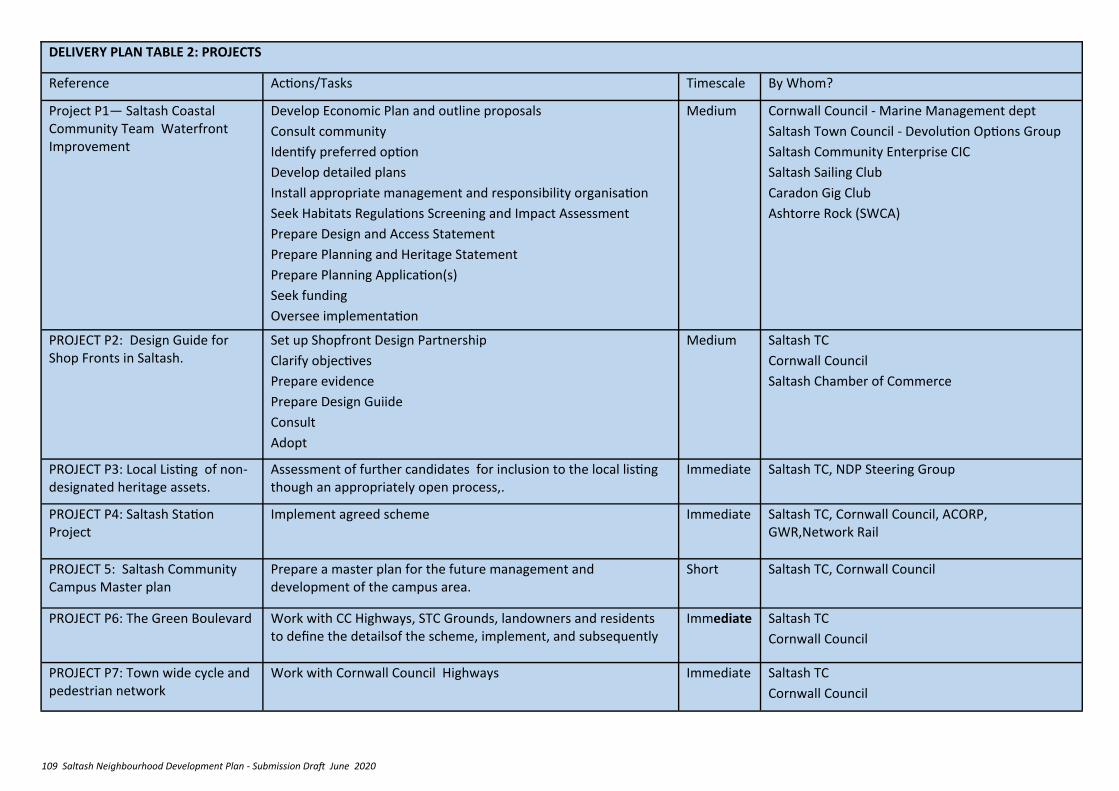
109 Saltash Neighbourhood Development Plan - Submission Draft June 2020
DELIVERY PLAN TABLE 2: PROJECTS
Reference Actions/Tasks Timescale By Whom?
Project P1— Saltash Coastal Community Team Waterfront Improvement
Develop Economic Plan and outline proposals
Consult community
Identify preferred option
Develop detailed plans
Install appropriate management and responsibility organisation
Seek Habitats Regulations Screening and Impact Assessment
Prepare Design and Access Statement
Prepare Planning and Heritage Statement
Prepare Planning Application(s)
Seek funding
Oversee implementation
Medium Cornwall Council - Marine Management dept
Saltash Town Council - Devolution Options Group
Saltash Community Enterprise CIC
Saltash Sailing Club
Caradon Gig Club
Ashtorre Rock (SWCA)
PROJECT P2: Design Guide for Shop Fronts in Saltash.
Set up Shopfront Design Partnership
Clarify objectives
Prepare evidence
Prepare Design Guiide
Consult
Adopt
Medium Saltash TC
Cornwall Council
Saltash Chamber of Commerce
PROJECT P3: Local Listing of non-designated heritage assets.
Assessment of further candidates for inclusion to the local listing though an appropriately open process,.
Immediate Saltash TC, NDP Steering Group
PROJECT P4: Saltash Station Project
Implement agreed scheme Immediate Saltash TC, Cornwall Council, ACORP, GWR,Network Rail
PROJECT 5: Saltash Community Campus Master plan
Prepare a master plan for the future management and development of the campus area.
Short Saltash TC, Cornwall Council
PROJECT P6: The Green Boulevard Work with CC Highways, STC Grounds, landowners and residents to define the detailsof the scheme, implement, and subsequently
Immediate Saltash TC
Cornwall Council
PROJECT P7: Town wide cycle and pedestrian network
Work with Cornwall Council Highways Immediate Saltash TC
Cornwall Council

110 Saltash Neighbourhood Development Plan - Submission Draft June 2020
17. MONITORING
7. Statistical analysis including the following
(mostly already collected by Cornwall Council):
i. Net additional dwellings in previous
years; Net additional dwellings for
the reporting year; forecast net
additional dwellings in future years
ii. Number of affordable homes
provided:
iii. Vacancy rates in main town centre
iv. Amount and type of employment
floorspace provided and lost:
v. Amount of employment land lost to
other uses from safeguarded
employment sites
vi. Amount of new housing provided
by house type, tenure and size
vii. Number of self build and custom
build housing provided
If it is apparent that policies are not successful, an
analysis of the reasons why will be prepared, covering
the following points:
• drafting errors or wording interpretation issues
• NPPF and NPPG policy changes affecting
relevancy of policy content
The Saltash Neighbourhood Development Plan will be
monitored on a regular basis to provide evidence to
support an annual review of its effectiveness
Items to be monitored include:
1. STC responses on planning applications, and an
assessment of how far the LPA (Cornwall
Council) has taken them into consideration, as
an indicator of success in getting policies
implemented and to identify policies that are
not working to influence development
proposals as intended.
2. Discussion with Development Management at
Cornwall Council to identify why a policy may
not be working as intended.
3. Whether permissions have been granted, or a
start made on allocated sites, including an
assessment as to whether the form of the
development, type of houses etc is as was
intended?.
4. Effectiveness of protection of community
facilities
5. An assessment of change in the identified
character areas
6. An assessment of progress in the delivery of new
cycleways, footpaths, transition zones, traffic
calming etc
• Local Plan policy changes affecting relevancy of
policy content
• Appeal and court decision trends (where known)
• wider development and investment trends and
their local impacts.
To assist this process, Cornwall Council are requested
to advise Saltash Town Council of any alterations in
national planning policy and practice that impact on
policies in the plan.
If the monitoring indicates implementation problems
are emerging, consideration will be given to reviewing
the Neighbourhood Development Plan.
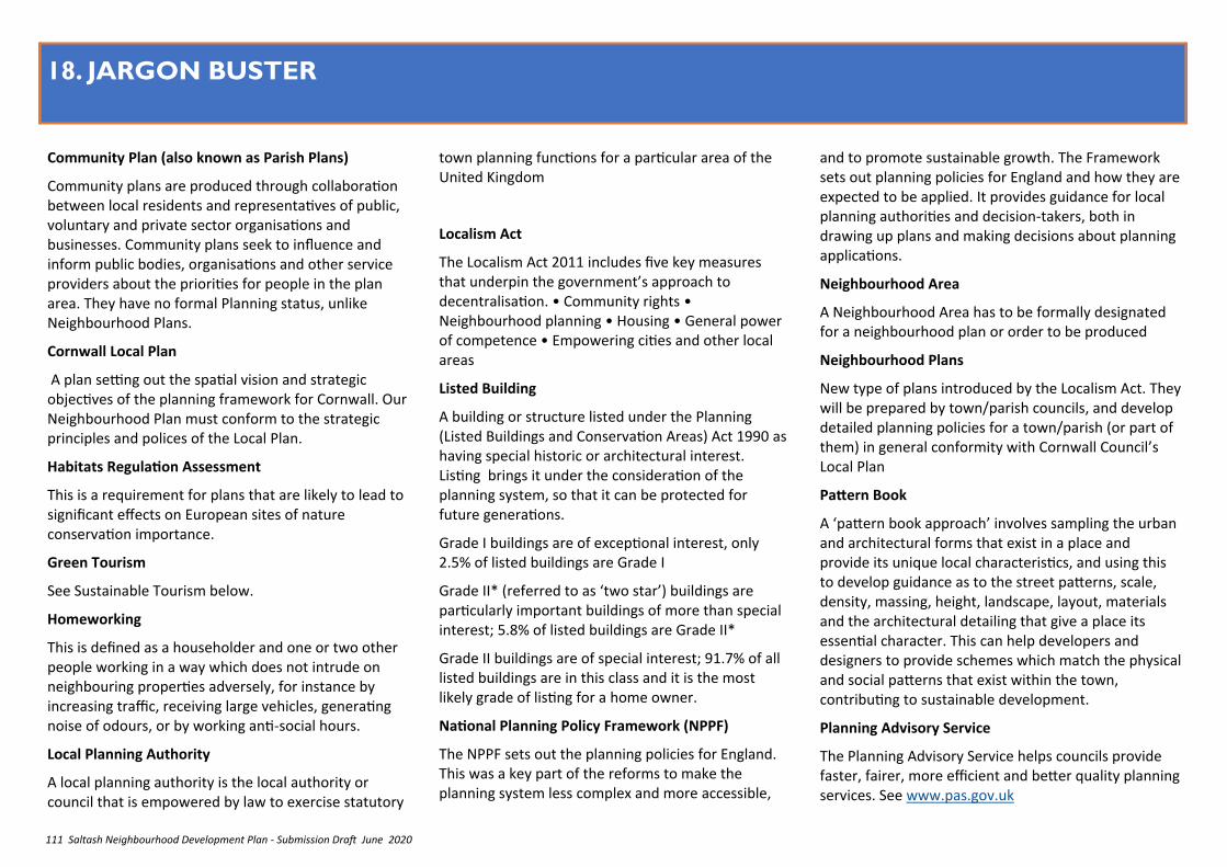
111 Saltash Neighbourhood Development Plan - Submission Draft June 2020
18. JARGON BUSTER
Community Plan (also known as Parish Plans)
Community plans are produced through collaboration between local residents and representatives of public, voluntary and private sector organisations and businesses. Community plans seek to influence and inform public bodies, organisations and other service providers about the priorities for people in the plan area. They have no formal Planning status, unlike Neighbourhood Plans.
Cornwall Local Plan
A plan setting out the spatial vision and strategic objectives of the planning framework for Cornwall. Our Neighbourhood Plan must conform to the strategic principles and polices of the Local Plan.
Habitats Regulation Assessment
This is a requirement for plans that are likely to lead to significant effects on European sites of nature conservation importance.
Green Tourism
See Sustainable Tourism below.
Homeworking
This is defined as a householder and one or two other people working in a way which does not intrude on neighbouring properties adversely, for instance by increasing traffic, receiving large vehicles, generating noise of odours, or by working anti-social hours.
Local Planning Authority
A local planning authority is the local authority or council that is empowered by law to exercise statutory
town planning functions for a particular area of the United Kingdom
Localism Act
The Localism Act 2011 includes five key measures that underpin the government’s approach to decentralisation. • Community rights • Neighbourhood planning • Housing • General power of competence • Empowering cities and other local areas
Listed Building
A building or structure listed under the Planning (Listed Buildings and Conservation Areas) Act 1990 as having special historic or architectural interest. Listing brings it under the consideration of the planning system, so that it can be protected for future generations.
Grade I buildings are of exceptional interest, only 2.5% of listed buildings are Grade I
Grade II* (referred to as ‘two star’) buildings are particularly important buildings of more than special interest; 5.8% of listed buildings are Grade II*
Grade II buildings are of special interest; 91.7% of all listed buildings are in this class and it is the most likely grade of listing for a home owner.
National Planning Policy Framework (NPPF)
The NPPF sets out the planning policies for England. This was a key part of the reforms to make the planning system less complex and more accessible,
and to promote sustainable growth. The Framework sets out planning policies for England and how they are expected to be applied. It provides guidance for local planning authorities and decision-takers, both in drawing up plans and making decisions about planning applications.
Neighbourhood Area
A Neighbourhood Area has to be formally designated for a neighbourhood plan or order to be produced
Neighbourhood Plans
New type of plans introduced by the Localism Act. They will be prepared by town/parish councils, and develop detailed planning policies for a town/parish (or part of them) in general conformity with Cornwall Council’s Local Plan
Pattern Book
A ‘pattern book approach’ involves sampling the urban and architectural forms that exist in a place and provide its unique local characteristics, and using this to develop guidance as to the street patterns, scale, density, massing, height, landscape, layout, materials and the architectural detailing that give a place its essential character. This can help developers and designers to provide schemes which match the physical and social patterns that exist within the town, contributing to sustainable development.
Planning Advisory Service
The Planning Advisory Service helps councils provide faster, fairer, more efficient and better quality planning services. See www.pas.gov.uk
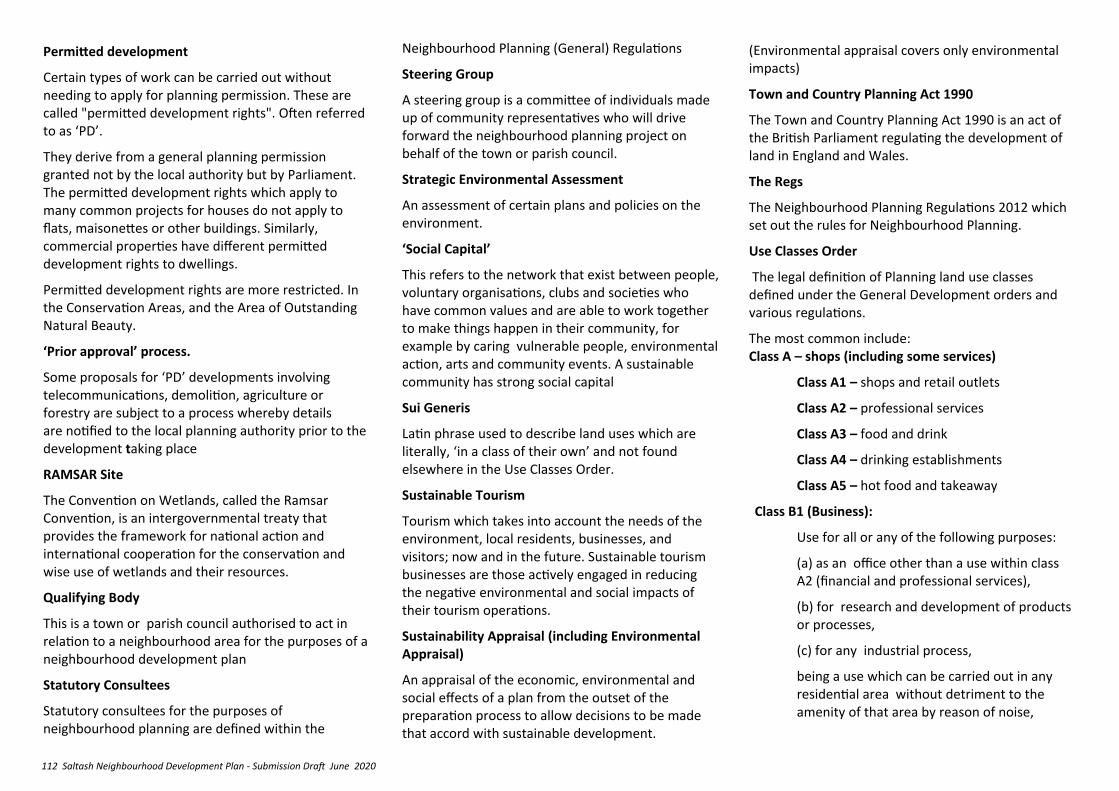
112 Saltash Neighbourhood Development Plan - Submission Draft June 2020
Permitted development
Certain types of work can be carried out without needing to apply for planning permission. These are called "permitted development rights". Often referred to as ‘PD’.
They derive from a general planning permission granted not by the local authority but by Parliament. The permitted development rights which apply to many common projects for houses do not apply to flats, maisonettes or other buildings. Similarly, commercial properties have different permitted development rights to dwellings.
Permitted development rights are more restricted. In the Conservation Areas, and the Area of Outstanding Natural Beauty.
‘Prior approval’ process.
Some proposals for ‘PD’ developments involving telecommunications, demolition, agriculture or forestry are subject to a process whereby details are notified to the local planning authority prior to the development taking place
RAMSAR Site
The Convention on Wetlands, called the Ramsar Convention, is an intergovernmental treaty that provides the framework for national action and international cooperation for the conservation and wise use of wetlands and their resources.
Qualifying Body
This is a town or parish council authorised to act in relation to a neighbourhood area for the purposes of a neighbourhood development plan
Statutory Consultees
Statutory consultees for the purposes of neighbourhood planning are defined within the
Neighbourhood Planning (General) Regulations
Steering Group
A steering group is a committee of individuals made up of community representatives who will drive forward the neighbourhood planning project on behalf of the town or parish council.
Strategic Environmental Assessment
An assessment of certain plans and policies on the environment.
‘Social Capital’
This refers to the network that exist between people, voluntary organisations, clubs and societies who have common values and are able to work together to make things happen in their community, for example by caring vulnerable people, environmental action, arts and community events. A sustainable community has strong social capital
Sui Generis
Latin phrase used to describe land uses which are literally, ‘in a class of their own’ and not found elsewhere in the Use Classes Order.
Sustainable Tourism
Tourism which takes into account the needs of the environment, local residents, businesses, and visitors; now and in the future. Sustainable tourism businesses are those actively engaged in reducing the negative environmental and social impacts of their tourism operations.
Sustainability Appraisal (including Environmental Appraisal)
An appraisal of the economic, environmental and social effects of a plan from the outset of the preparation process to allow decisions to be made that accord with sustainable development.
(Environmental appraisal covers only environmental impacts)
Town and Country Planning Act 1990
The Town and Country Planning Act 1990 is an act of the British Parliament regulating the development of land in England and Wales.
The Regs
The Neighbourhood Planning Regulations 2012 which set out the rules for Neighbourhood Planning.
Use Classes Order
The legal definition of Planning land use classes defined under the General Development orders and various regulations.
The most common include: Class A – shops (including some services)
Class A1 – shops and retail outlets
Class A2 – professional services
Class A3 – food and drink
Class A4 – drinking establishments
Class A5 – hot food and takeaway
Class B1 (Business):
Use for all or any of the following purposes:
(a) as an office other than a use within class A2 (financial and professional services),
(b) for research and development of products or processes,
(c) for any industrial process,
being a use which can be carried out in any residential area without detriment to the amenity of that area by reason of noise,

113 Saltash Neighbourhood Development Plan - Submission Draft June 2020
vibration, smell, fumes, smoke, soot, ash, dust or grit.
Class B2 (General industrial):
Use for the carrying on of an industrial process other than one falling within class B1 above.
Class B8 (Storage or distribution):
Use for storage or as a distribution centre.
Class C – hotels, hostels and dwelling houses
Class C1— hotels, boarding houses, guest houses
Class C2— Hospitals and nursing homes,
Schools, colleges or training centres
Class C3— dwelling houses
Class C4—Houses in multiple occupation
Class D – non-residential institutions
Class D1
• Medical or health services premises which don’t form a part of the practitioner’s home
• Crèches, day nurseries or day centres
• Premises for education,
• Premises which display works of art without commercial transactions (sale or hire)
• Museums
• Public libraries or reading rooms
• Public or exhibition halls
• Premises “for, or in connection with, public worship or religious instruction”
Class D2
• Cinemas
• Concert halls


