12th International Conference on Ground Penetrating Radar, June 16-19, 2008, Birmingham, UK
Combined time-lapse 3D GPR and resistivity investigations on simulated clandestine burials in complex urban environments
L. Nuzzo1, J. K. Pringle1, J. Jervis1, J.P Cassella2, and N.J. Cassidy1
1School of Physical and Geographical Sciences, Keele University, Keele, Staffordshire, ST5 5BG, [email protected]
2Faculty of Health & Sciences, Staffordshire University, College Road, Stoke-on-Trent, Staffs., ST4 2DE, U.K.
In submitting this paper for EuroGPR2008 I hereby assign the copyright in it to the University of Birmingham and confirm that I have had the permission of any third party for the inclusion of their copyright material in the paper. The University of Birmingham will license EuroGPR to use this paper for non-commercial purposes. This will be the sole use of this ma-terial.
Abstract - The use of non-invasive geophysical methods in criminal investigations is still relatively uncommon espe-cially when compared to more conventional methods (e.g., aerial and remote sensing, cadaver dogs, excavation, etc.). Near-surface geophysical techniques, and particularly ground-penetrating radar (GPR), have been used with vary-ing degrees of success to locate clandestine graves, but multi-disciplinary studies have shown that cadaver detection is generally problematic after a long period of burial. Since the success of geophysical techniques is predominantly depen-dent upon the contrast between the target and host materi-als, there is a need for scientific research to try and quantify both target and site variables and how they may change over time which may therefore affect forensic burial detection.
This paper reports on recent near-surface high-frequency (450 and 900 MHz) GPR surveys over two contrasting simu-lated clandestine burial case studies in a difficult urban envi-ronment: a simulated 12 year old adult burial and a recent juvenile burial using contrasting materials.
Accurate GPR data processing, integration and 3D visualiza-tion (time-slice) techniques were essential to recognize and isolate the often subtle GPR anomalies over ‘graves’ in this complex, urban environment. GPR results compared well with bulk ground resistive anomaly locations, although GPR was higher resolution, better resolved the older burial and provided a depth estimate to the buried target.
Keywords – Forensics, Clandestine Burials, Time-lapse geo-physics, GPR, Resistivity.
I. INTRODUCTIONForensic geophysics, defined as ‘the application of geo-physical methods related to legal investigations’ [9], is still uncommon in normal police practice compared to more conventional methods (aerial survey/photographs and remote sensing, site walking by anthropologists and archaeologists, cadaver dogs, excavation). Although more routinely used in engineering, environmental and archaeo-
logical applications, such as burial site investigations or the search for tombs [1], [3], [5], [12], [19], [21], [22], [33], near-surface geophysical techniques have been used with varying degrees of success in forensic applications [4], [6]. Ground Penetrating Radar (GPR) is probably the most commonly-used, forensic geophysical technique. GPR has been used to locate unmarked cemetery graves or mass graves [1] [7], and in murder investigations to locate shal-low clandestine burials [9], [20], [26] [31]. There have also been simulated burial studies using GPR [2], [4], [15] in an effort to improve clandestine burial detection rates. Some studies have demonstrated that locating individual archaeological graves or clandestine cadavers after a long period of burial is generally problematic, because of lim-ited skeletal remains and soil compaction. The success of a geophysical technique to locate a clan-destine grave can be very site and time dependent because of variations in ground material type and distribution and perhaps the amount of cadaver decomposition (ranging from incomplete to skeletonised). Numerical modeling [13] in a simple environment has shown the potential of GPR for detailed characterization of a suspect site, but also showed the need for high-frequency antennae (900 MHz or greater) and small sample point intervals (< 10 cm) to both recognize and correlate diagnostic features of a human target across successive radargrams. Because of strong signal attenuation due to the high conductivity of biological tissues, [13] also suggested that only the reflec-tions from the upper parts of the human body could be de-tectable by GPR. High clay fraction, salinity and soil wa-ter content, scattering from background heterogeneities and advanced state of decomposition can all have a detri-mental effect on the detectability of buried human re-mains.
1 Corresponding author: Luigia Nuzzo, [email protected] Tel: +44 (0)1782 583752, Fax: +44 (0)1782 583737. Jamie Pringle, [email protected]; John Jervis, [email protected]; John Cassella, [email protected]; Nigel Cassidy, [email protected]
12th International Conference on Ground Penetrating Radar, June 16-19, 2008, Birmingham, UK
Resistivity is the other near-surface geophysical technique that has been proven for detecting clandestine burials, in both real cases [2], [8], [29] and simulated [4] studies, when used on a small grid survey pattern (typically using 0.25 m to 0.5 m -spaced data point samples). This tech-nique measures the bulk ground resistivity of a volume of material below the sample position whose thickness roughly correspond to the electrode separation [25]. Twin-probe surveys are used to build up a high-resolution map of near-surface variations in earth resistivity. Low resistiv-ity anomalies with respect to background values are ex-pected over clandestine burials. Although more time con-suming to collect, Electrical Resistivity Tomography (ERT) can produce high-resolution, vertical 2D resistivity contoured images or profiles of the near-surface. Since re-sistivity methods are particularly sensitive to moisture content variations, ERT surveys are sometimes used in forensic investigations to detect spatial resistivity changes in near-surface materials and especially fluids that may be associated with graves [8], [23], [30].To be considered successful, forensic geophysical investi-gations should rapidly, and non-invasively survey a site, identify anomalous areas for intrusive excavations and even establish the potential burial characteristics (e.g. tar-get depth, orientation, size, distribution and condition). Although multi-disciplinary studies have shown to im-prove the detection of clandestine burials [2], [10], [11], using a number of techniques is time-consuming and therefore impractical for real cases. Published geophysical reports on simulated clandestine graves generally use a single technique, usually GPR or bulk ground resistivity, which are considered to be the most successful techniques under favorable ground conditions.Because of the legally sensitive nature of the subject, little background literature is available on the use of geophysi-cal methods for criminal investigations. This fact, together with the limited success of geophysical techniques re-ported in some published forensic case studies (due either to unfavorable site ground conditions or to survey time constraints) outlines the need for extensive quantitative scientific research over simulated clandestine burials in re-alistic situations. As such, new insights will be gained into the full optimization of geophysical techniques and their ability to assist forensic investigators at real crime scenes.
II. METHODOLOGYThe Applied and Environmental Geophysics Group (AEG) at Keele University is currently involved in collaborative research projects with Forensic Science Practitioners at Staffordshire University for the geoscientific simulated burials research. Project objectives are to both provide ‘real-world’ crime scenes for forensic science undergradu-ates’ taught studies and for research purposes to establish, compare and disseminate multi-disciplinary methodolo-gies in complex environments. This paper reports results related to detailed processing and visualization of GPR
data (and comparisons with bulk-ground resistivity) to two forensic case studies in a complex, urban environment. These are time-lapse (repeat) near-surface geophysical surveys over simulated clandestine graves with the follow-ing scenarios: Detection of relative long-term (12 year) adult murder
victim (‘SID’ project);
Detection of recently buried juvenile murder victim (‘Juvenile’ project).
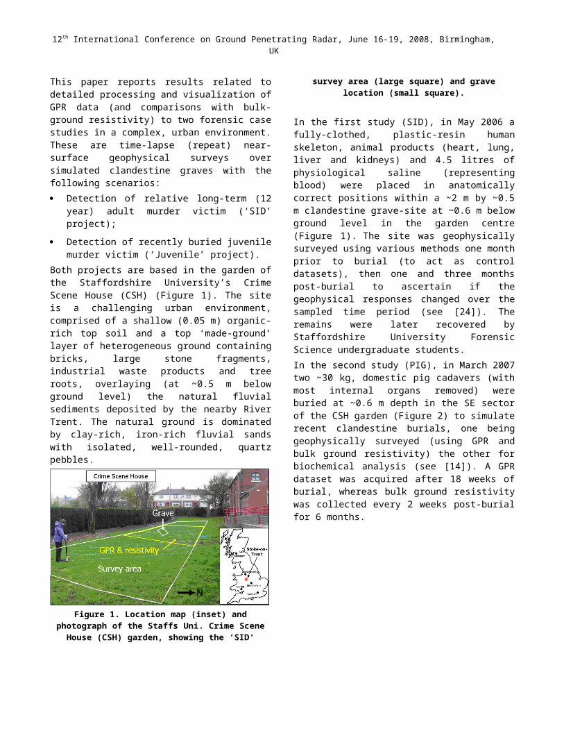
Both projects are based in the garden of the Staffordshire University’s Crime Scene House (CSH) (Figure 1). The site is a challenging urban environment, comprised of a shallow (0.05 m) organic-rich top soil and a top ‘made-ground’ layer of heterogeneous ground containing bricks, large stone fragments, industrial waste products and tree roots, overlaying (at ~0.5 m below ground level) the natu-ral fluvial sediments deposited by the nearby River Trent. The natural ground is dominated by clay-rich, iron-rich fluvial sands with isolated, well-rounded, quartz pebbles.
Figure 1. Location map (inset) and photo-graph of the Staffs Uni. Crime Scene House
(CSH) garden, showing the ‘SID‘ survey area (large square) and grave location (small
square).
In the first study (SID), in May 2006 a fully-clothed, plas-tic-resin human skeleton, animal products (heart, lung, liver and kidneys) and 4.5 litres of physiological saline (representing blood) were placed in anatomically correct positions within a ~2 m by ~0.5 m clandestine grave-site at ~0.6 m below ground level in the garden centre (Figure 1). The site was geophysically surveyed using various methods one month prior to burial (to act as control datasets), then one and three months post-burial to ascer-tain if the geophysical responses changed over the sam-pled time period (see [24]). The remains were later recov-ered by Staffordshire University Forensic Science under-graduate students.In the second study (PIG), in March 2007 two ~30 kg, do-mestic pig cadavers (with most internal organs removed) were buried at ~0.6 m depth in the SE sector of the CSH garden (Figure 2) to simulate recent clandestine burials,
12th International Conference on Ground Penetrating Radar, June 16-19, 2008, Birmingham, UK
one being geophysically surveyed (using GPR and bulk ground resistivity) the other for biochemical analysis (see [14]). A GPR dataset was acquired after 18 weeks of burial, whereas bulk ground resistivity was collected every 2 weeks post-burial for 6 months.
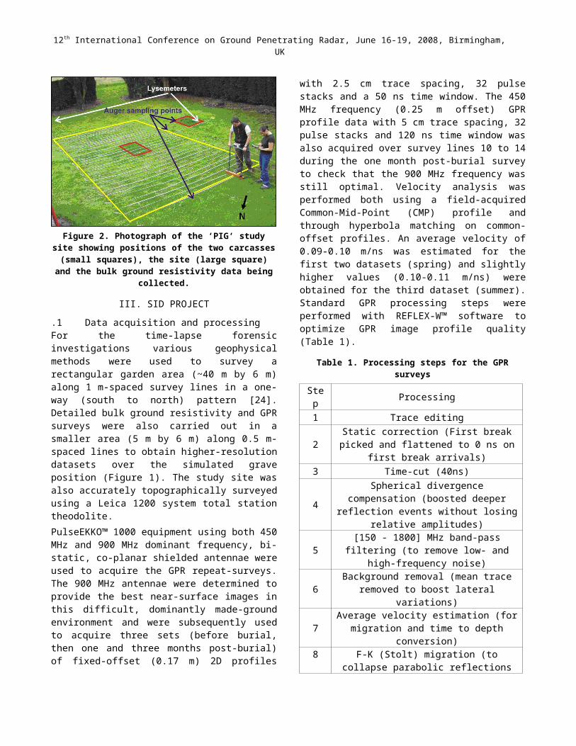
Figure 2. Photograph of the ‘PIG‘ study site showing posi-tions of the two carcasses (small squares), the site (large
square) and the bulk ground resistivity data being collected.
III. SID PROJECT
1.1 Data acquisition and processingFor the time-lapse forensic investigations various geo-physical methods were used to survey a rectangular gar-den area (~40 m by 6 m) along 1 m-spaced survey lines in a one-way (south to north) pattern [24]. Detailed bulk ground resistivity and GPR surveys were also carried out in a smaller area (5 m by 6 m) along 0.5 m-spaced lines to obtain higher-resolution datasets over the simulated grave position (Figure 1). The study site was also accurately to-pographically surveyed using a Leica 1200 system total station theodolite.PulseEKKO™ 1000 equipment using both 450 MHz and 900 MHz dominant frequency, bi-static, co-planar shielded antennae were used to acquire the GPR repeat-surveys. The 900 MHz antennae were determined to pro-vide the best near-surface images in this difficult, domi-nantly made-ground environment and were subsequently used to acquire three sets (before burial, then one and three months post-burial) of fixed-offset (0.17 m) 2D pro-files with 2.5 cm trace spacing, 32 pulse stacks and a 50 ns time window. The 450 MHz frequency (0.25 m offset) GPR profile data with 5 cm trace spacing, 32 pulse stacks and 120 ns time window was also acquired over survey lines 10 to 14 during the one month post-burial survey to check that the 900 MHz frequency was still optimal. Ve-locity analysis was performed both using a field-acquired Common-Mid-Point (CMP) profile and through hyperbola matching on common-offset profiles. An average velocity of 0.09-0.10 m/ns was estimated for the first two datasets (spring) and slightly higher values (0.10-0.11 m/ns) were obtained for the third dataset (summer). Standard GPR
processing steps were performed with REFLEX-W™ soft-ware to optimize GPR image profile quality (Table 1).
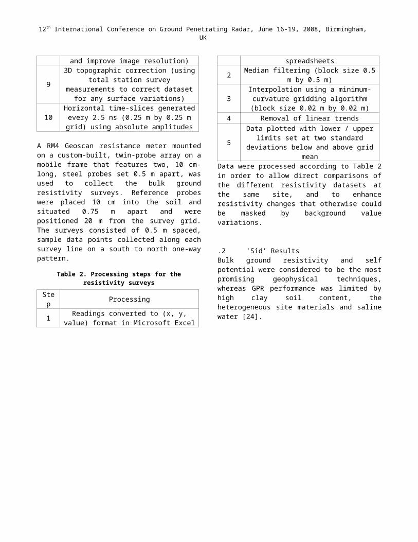
Table 1. Processing steps for the GPR surveys
Step Processing1 Trace editing
2 Static correction (First break picked and flat-tened to 0 ns on first break arrivals)
3 Time-cut (40ns)
4Spherical divergence compensation (boosted
deeper reflection events without losing relative amplitudes)
5 [150 - 1800] MHz band-pass filtering (to re-move low- and high-frequency noise)
6 Background removal (mean trace removed to boost lateral variations)
7 Average velocity estimation (for migration and time to depth conversion)
8 F-K (Stolt) migration (to collapse parabolic re-flections and improve image resolution)
93D topographic correction (using total station
survey measurements to correct dataset for any surface variations)
10Horizontal time-slices generated every 2.5 ns (0.25 m by 0.25 m grid) using absolute ampli-
tudes
A RM4 Geoscan resistance meter mounted on a custom-built, twin-probe array on a mobile frame that features two, 10 cm-long, steel probes set 0.5 m apart, was used to collect the bulk ground resistivity surveys. Reference probes were placed 10 cm into the soil and situated 0.75 m apart and were positioned 20 m from the survey grid. The surveys consisted of 0.5 m spaced, sample data points col-lected along each survey line on a south to north one-way pattern.
Table 2. Processing steps for the resistivity surveys
Step Processing
1 Readings converted to (x, y, value) format in Microsoft Excel spreadsheets
2 Median filtering (block size 0.5 m by 0.5 m)
3 Interpolation using a minimum-curvature grid-ding algorithm (block size 0.02 m by 0.02 m)
4 Removal of linear trends
5Data plotted with lower / upper limits set at
two standard deviations below and above grid mean
Data were processed according to Table 2 in order to al-low direct comparisons of the different resistivity datasets at the same site, and to enhance resistivity changes that otherwise could be masked by background value varia-tions.
12th International Conference on Ground Penetrating Radar, June 16-19, 2008, Birmingham, UK
1.2 ‘Sid’ ResultsBulk ground resistivity and self potential were considered to be the most promising geophysical techniques, whereas
GPR performance was limited by high clay soil content, the heterogeneous site materials and saline water [24].
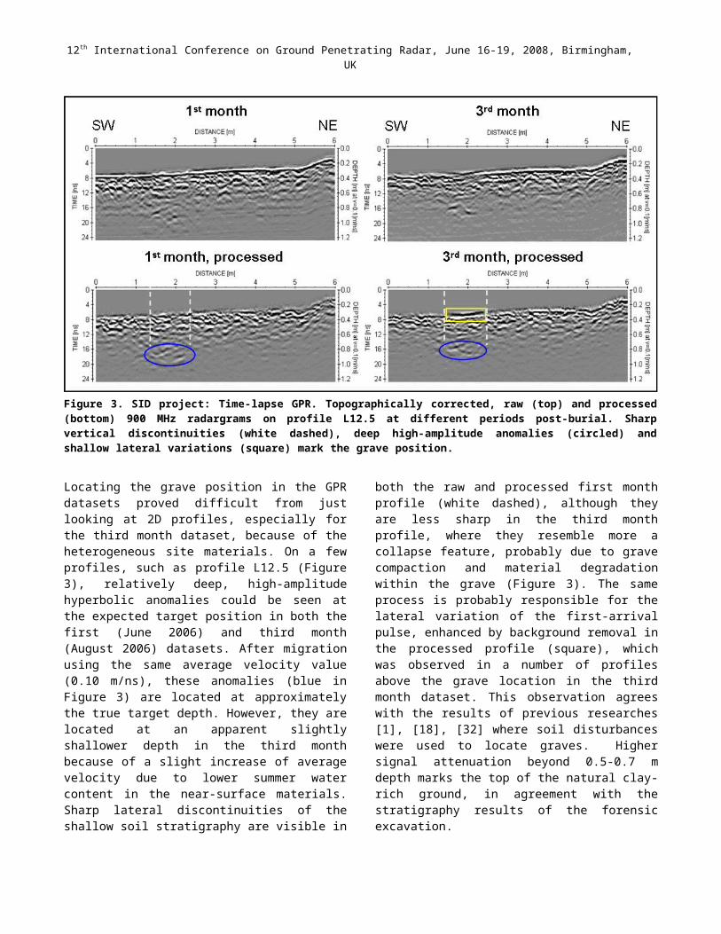
Figure 3. SID project: Time-lapse GPR. Topographically corrected, raw (top) and processed (bottom) 900 MHz radargrams on profile L12.5 at different periods post-burial. Sharp vertical discontinuities (white dashed), deep high-amplitude anomalies (cir -cled) and shallow lateral variations (square) mark the grave position.
Locating the grave position in the GPR datasets proved difficult from just looking at 2D profiles, especially for the third month dataset, because of the heterogeneous site materials. On a few profiles, such as profile L12.5 (Figure 3), relatively deep, high-amplitude hyperbolic anomalies could be seen at the expected target position in both the first (June 2006) and third month (August 2006) datasets. After migration using the same average velocity value (0.10 m/ns), these anomalies (blue in Figure 3) are located at approximately the true target depth. However, they are located at an apparent slightly shallower depth in the third month because of a slight increase of average velocity due to lower summer water content in the near-surface materi-als. Sharp lateral discontinuities of the shallow soil stratig-raphy are visible in both the raw and processed first month profile (white dashed), although they are less sharp in the third month profile, where they resemble more a collapse feature, probably due to grave compaction and material degradation within the grave (Figure 3). The same process is probably responsible for the lateral variation of the first-arrival pulse, enhanced by background removal in the pro-cessed profile (square), which was observed in a number of profiles above the grave location in the third month dataset. This observation agrees with the results of previ-ous researches [1], [18], [32] where soil disturbances were
used to locate graves. Higher signal attenuation beyond 0.5-0.7 m depth marks the top of the natural clay-rich ground, in agreement with the stratigraphy results of the forensic excavation.
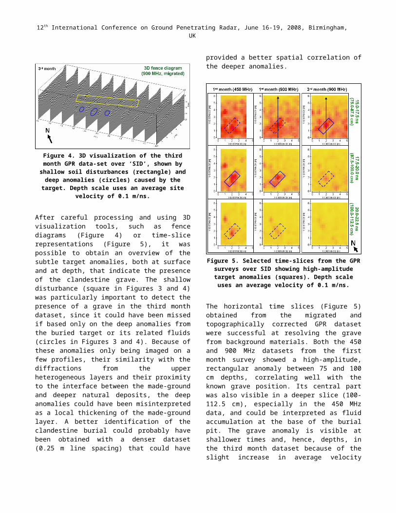
Figure 4. 3D visualization of the third month GPR data-set over ‘SID’, shown by shallow soil disturbances (rectangle) and deep anomalies (circles) caused by the target. Depth
scale uses an average site velocity of 0.1 m/ns.
After careful processing and using 3D visualization tools, such as fence diagrams (Figure 4) or time-slice representa-
12th International Conference on Ground Penetrating Radar, June 16-19, 2008, Birmingham, UK
tions (Figure 5), it was possible to obtain an overview of the subtle target anomalies, both at surface and at depth, that indicate the presence of the clandestine grave. The shallow disturbance (square in Figures 3 and 4) was par-ticularly important to detect the presence of a grave in the third month dataset, since it could have been missed if based only on the deep anomalies from the buried target or its related fluids (circles in Figures 3 and 4). Because of these anomalies only being imaged on a few profiles, their similarity with the diffractions from the upper heteroge-neous layers and their proximity to the interface between the made-ground and deeper natural deposits, the deep anomalies could have been misinterpreted as a local thick-ening of the made-ground layer. A better identification of the clandestine burial could probably have been obtained with a denser dataset (0.25 m line spacing) that could have provided a better spatial correlation of the deeper anom-alies.
Figure 5. Selected time-slices from the GPR surveys over SID showing high-amplitude target anomalies (squares).
Depth scale uses an average velocity of 0.1 m/ns.
The horizontal time slices (Figure 5) obtained from the migrated and topographically corrected GPR dataset were successful at resolving the grave from background materi-als. Both the 450 and 900 MHz datasets from the first month survey showed a high-amplitude, rectangular anomaly between 75 and 100 cm depths, correlating well with the known grave position. Its central part was also visible in a deeper slice (100-112.5 cm), especially in the 450 MHz data, and could be interpreted as fluid accumu-
lation at the base of the burial pit. The grave anomaly is visible at shallower times and, hence, depths, in the third month dataset because of the slight increase in average ve-locity during summer, as already illustrated in the analysis of the 2D profile (Figure 3 and arrows in Figure 5). The 450 MHz data showed only a minimal increase in penetra-tion depth, compared to the 900 MHz data, at the expense of resolution. These results suggested the use of high-fre-quency GPR antenna for forensic surveys.The bulk-ground resistivity maps for the same area sur-veyed with GPR are shown in Figure 6. Data have been processed according to Table 2. As expected, low-resistiv-ity anomalies can be correlated to the target position. De-spite the presence of a small negative peak even in the pre-burial dataset, both an amplitude increase and spatial spreading of the negative anomaly with respect to back-ground values with elapsed time from burial can be ob-served, that is also observed in ERT 2D vertical sections [24]. This change in resistance could be interpreted as ac-cumulation of conductive fluids from the target at the base of the burial pit and their progressive migration.The position of the low-resistive anomaly correlates with the deep GPR anomaly (Figure 5) and the known target lo-cation. Although slower to acquire, GPR data also pro-vided a better spatial resolution of the target and important additional information on its depth. Using both methods can provide insights for a better understanding of the near-surface fluid dynamics in the presence of a buried body.
Figure 6. SID project: Bulk-ground resistivity normalized mapview plots of the same area surveyed with GPR. Grave
position is marked by rectangle. Modified from [14].
IV. ‘JUVENILE’ PROJECT
1.3 Data acquisition and processingThe geophysical surveys performed for the simulated ju-venile study using domestic pig cadavers were carried out in an 8.0 m by 4.5 m area, located in the SE sector of the CSH garden (Figure 2). Both the bulk ground resistivity and GPR surveys were carried out along 0.25 m-spaced profiles using the same instrumentation and survey config-urations as described in the previous section. 450 MHz dominant frequency antennae were used for this GPR survey, with 5 cm trace spacing and 70 ns time win-dow. GPR data processing steps were similar to those de-
12th International Conference on Ground Penetrating Radar, June 16-19, 2008, Birmingham, UK
scribed in Table 1, except that only the DC frequency component was filtered out and a much lower velocity value (0.064 m/ns) was derived, probably due to the ex-ceptional rainfall just prior to the survey. Consequently, a different time window (4 ns) was used in the time slice generation to obtain a slice thickness (12.8 cm) similar to the previous study (12.5 cm). Moreover, the smaller cross-line spacing allowed a smaller interpolation grid (0.125 m by 0.125 m) that gave a better spatial resolution of the smaller target.The bulk ground resistivity surveys consisted of 0.25 m spaced sample data points collected along each survey line. Data were processed in a way similar to Table 2, ex-cept that a cubic site trend (instead of a linear one) was re -moved to enhance the potential spatial resistivity varia-tions.
1.4 ‘Juvenile’ Results[27] and [28] showed GPR hyperbolic reflections over simulated clandestine burials using large or small pig ca-davers (as human ‘proxys’) up to 20 months after burial in ideal site conditions: nearly homogeneous sand with a flat topographic surface and shallow burial depth (~0.5 m). Conversely, their studies showed the increasing difficulty in the detection of either small pigs buried in sands for ex-tended periods if a grave response was not produced from disturbed soil features, or in imaging the response from large pig cadavers buried next to clay horizons. This sug-gests that GPR could be a viable tool for forensic investig-ations, but imaging the presence of any cadavers buried in complex environments could be extremely difficult and a reliable interpretation of the GPR dataset would require highly experienced and competent researchers [16].In this study, the burial depth within the made-ground layer, the small target size and the lower resolution of the 450 MHz antennae prevented identification of GPR anom-alies directly correlated to the presence of the target in raw data. Because of strong attenuation in the wet, clayey soil, no clear hyperbolic reflection were noticed below an undulating, discontinuous, 0.5 m deep, surface created from the made-ground/natural clay deposits interface (dashed in Figure 7a). Hyperbolic reflections from the tar-get located above this discontinuity could be masked by the hyperbolic reflections from made-ground materials. However, after processing, it was possible to identify sharp vertical discontinuities of the gently dipping, shal-low stratigraphy, which marked the lateral extent of the burial pit (Figure 7a). The GPR response from the disturbed backfill inside the pit resulted in locally more intense, quasi-horizontal re-flections probably due to enhanced reflectivity caused by accumulation of conductive fluids from the decomposing cadaver at the grave base. This interpretation is supported by the increased conductivity at the grave location in the corresponding bulk-ground resistivity map (Figure 7c) and by analysis of groundwater samples collected from
lysemeters [14]. Indeed, the fluid from the grave was con-sistently more conductive than the site groundwater, with the discrepancy increasing over time during the 24-week study period [14], whereas only small differences in porosity and slight increase in saturation were measured between grave and control soil [14]. In addition, prelimi-nary results of ICP-MS analysis of the groundwater re-vealed enhancement in grave fluid samples of distinctive elements (calcium, potassium, sodium and magnesium) associated with a release of nutrients into the soil beneath cadavers during active decay.
Figure 7. ‘Juvenile’ project: GPR and bulk ground resistiv-ity. (a) Processed and interpreted radargrams (450 MHz) showing the shallow stratigraphy and the burial site location (b) Selected GPR time slice (450 MHz) showing the location of the analyzed profiles (arrows), high-amplitude anomalies from the grave (rectangles) and possible fluid accumulation (circle). (c) Processed bulk ground resistivity survey col-lected on the same day as the GPR survey, showing a low-re-sistive anomaly (black) that could be correlated to the target position
Probably driven by the heavy rainfall, the conductive fluid associated with the ‘grave’ seems to migrate outward from the SE side of the grave in the downslope southward di-rection (Figure 7c) and progressively reduces in strength from background value in the following weeks [14]. How-ever, the persistence of the negative peak at the NW side of the grave continues up to 24 weeks post-burial which is interpreted as a local accumulation of leachate fluid. The GPR processed time-slice maps (Figure 7b) clearly show a rectangular high-amplitude anomaly of the correct size and location of the known ‘grave’, especially in the intermediate slice where the masking effect of the reflec-tions from the made-ground layer above is reduced. This anomaly is probably caused by the relatively higher am-plitude of soil reflections overlaying the decomposing pig.
12th International Conference on Ground Penetrating Radar, June 16-19, 2008, Birmingham, UK
A weak anomaly is also visible in the deepest slice that correlates well with the NW low-resistivity peak. Accurate processing and time-slice visualization was cru-cial for the analysis of the GPR data and the successful de-tection of the grave anomaly in this difficult situation. The detection of the grave would also have been difficult using the resistivity maps alone, because of the presence of other, even stronger, negative anomalies. The repetition of the resistivity survey at regular time intervals and the inte-gration with GPR and site measurements were essential for a comprehensive understanding of the physical subsur-face modifications occurring during active decomposition of carcass cadavers in such complex environments.
V. CONCLUSIONSThis paper details recent near-surface GPR surveys over two simulated clandestine burial case studies in an urban environment and compares them to the findings from re-sistivity surveys. In both cases (a 12 year old adult and a recently buried juvenile) the raw GPR datasets were par-ticularly difficult to interpret due to the heterogeneous na-ture of the shallow subsurface masking the subtle geo-physical responses from a clandestine grave. Only after careful 2D profile processing and 3D visualisation as depth-slice maps, could the subtle anomalies be identified. Their location correlated well with resistivity anomalies and the known ‘grave’ positions. The adult case study pro-vided an invaluable tool for comparing the effectiveness of two different antennae (450 and 900 MHz), whilst the juvenile case study showed the need of very short profile spacing (<25 cm) in order to map small-area clandestine burials in complex, urban environments. Both accurate el-evation surveys and topographic correction of GPR data were essential to recognize sloping stratigraphical bound-aries and isolate the GPR anomalies that were a combina-tion of physical remains and leachate fluid accumulation at the base of the burial pit. The combination of different geophysical techniques proved optimal to gain an in-creased understanding of how geophysical surveying may be best utilized to locate graves in complex environments.
ACKNOWLEDGMENTSStaffordshire University is thanked for allowing the scien-tific investigations to be conducted on their campus. Dr. Roger Summers, Mr. David Rogers and Mr. Hilton Mid-dleton (part of the Forensic Science Degree teaching staff at Staffordshire University) are thanked for expert crime scene advice, field logistics and general project support. The authors would also like to thank all the Keele and Staffordshire University undergraduates and postgraduates who assisted with data collection and some processing.A UK SRIF2 equipment grant allowed the acquisition of the geophysical instruments used in this study. Luigia Nuzzo is funded by the EPSRC IMAGINE Project (Inver-sion, Modelling and Analysis of GPR in Near-Surface En-vironments - grant EP/004032/1). John Jervis is funded by
a joint EPSRC-CASE STATS Ltd. industrial geophysics PhD studentship.
REFERENCES[1] Bevan, B. W., The search for graves. Geophysics, 56,
1310-1319 (1991).[2] Buck, S. C., Searching for graves using geophysical
technology: field tests with ground penetrating radar, magnetometry and electrical resistivity. Journal of Forensic Sciences, 48, 5-11 (2003).
[3] Cassidy, N. J., Characterizing GPR Signal Attenua-tion and Scattering in a Mature LNAPL Spill: A FDTD Modeling and Dielectric Analysis Study. Vadoze Zone Journal, Vol. 7, No. 1, 140-159 (2008).
[4] Cheetham, P., Forensic geophysical survey. In: Hunter, J., Cox M., editors. Forensic archaeology: advances in theory and practice, Routledge Publish-ers, Abingdon, UK, 62-95 (2005).
[5] Conyers, L. B., Goodman, D., Ground-Penetrating Radar - An Introduction for Archaeologists, Alta Mira Press, Walnut Creek, CA (1997).
[6] Davenport, G. C., et al., Crime scene investigation techniques. The Leading Edge, 7 (8), 64–66 (1988).
[7] Davis, J. L., et al., Ground penetrating radar surveys to locate 1918 Spanish flu victims in permafrost. Jour-nal of Forensic Sciences, 45, 68-76 (2000).
[8] Ellwood, B. B., Electrical resistivity surveys in two historical cemeteries in northeast Texas: A method for delineating unidentified burial shafts. Historical Ar-chaeology, 24, 91-98 (1990).
[9] Fenning, P. J., Donnelly L. J., Geophysical techniques for forensic investigation. In: Pye K., Croft D. J., (Ed.), Forensic geoscience: principles, techniques and applications, Geological Society, London, Spe-cial Publications, 232, 11-20 (2004).
[10] France, D. L, et al., A multidisciplinary approach to the detection of clandestine graves. Journal of Foren-sic Sciences, 37, 1445-58 (1992).
[11] France, D. L., et al., NecroSearch revisited: further multi-disciplinary approaches to the detection of clan-destine graves. In: Haglund W. D., Sorg M. H., (Ed.), Forensic taphonomy: the postmortem fate of human remains, CRC Press, Boca Raton, FL, 497-509 (1997).
[12] Goodman D., et al., GPR surveying over burial mounds: correcting for topography and the tilt of the GPR antenna. Near Surface Geophysics, 5, 383-388 (2007).
[13] Hammon, W. S., et al., Forensic GPR: finite-differ-ence simulations of responses from buried human re-mains. Journal of Applied Geophysics, 45, 171-186 (2000).
12th International Conference on Ground Penetrating Radar, June 16-19, 2008, Birmingham, UK
[14] Jervis, J., et al., Using soil and groundwater data to understand resistivitiy surveys over a pig grave. In: 2nd
Soil Forensics International Conference, Edinburgh, UK (2007).
[15] Koppenjan, S. K, et al., The application of GPR in Florida for detecting forensic burials. Proceedings of the SAGEEP-2003 Conference, 635-649 (2003).
[16] Koppenjan, S. K., et al., Advanced signal analysis for forensic applications of Ground Penetrating Radar. In: Tenth International Conference on Ground Penetrat-ing Radar, Delft, NL (2004).
[17] Mellett, J.S., Location of human remains with ground-penetrating radar. In: Fourth International Conference on Ground Penetrating Radar, Rovaniemi, Finland. Geological Survey of Finland Special Paper, 359-365 (1992).
[18] Miller, P. S., Disturbances in the soil: finding buried bodies and other evidence using ground penetrating radar. Journal of Forensic Sciences, 41, 648-652 (1996).
[19] Nobes, D. C., Geophysical surveys of burial sites: a case study of the Oaro urupa. Geophysics, 64, 357-367 (1999).
[20] Nobes, D. C., The Search for “Yvonne”: A case ex-ample of the delineation of a grave using near-surface geophysical methods, Journal of Forensic Sciences, 45, 715-721 (2000).
[21] Nuzzo, L., et al., Application of 3D visualization techniques in the analysis of GPR data for archaeol-ogy. Annals of Geophysics, 45, 321-337 (2002).
[22] Piro, S., et al., Beyond image analysis in processing archaeomagnetic geophysical data: case studies of chamber tombs with dromos. Near Surface Geo-physics, 5, 405-414 (2007).
[23] Powell, K., Detecting human remains using near-sur-face geophysical instruments. Exploration Geo-physics, 35, 88-92 (2004).
[24] Pringle, J. K., et al., Time-lapse geophysical investi-gations over a simulated urban clandestine grave, Journal of Forensic Sciences, in press, (2008).
[25] Reynolds, J. M., Introduction to applied and environ-mental geophysics, John Wiley & Sons Ltd., Chich-ester, UK, 806pp (1997).
[26] Ruffell, A., McKinley, J., Forensic Geoscience: appli-cations of geology, geomorphology and geophysics to criminal investigations. Earth Science Reviews, 69, 235-247 (2005).
[27] Schultz, J. J., et al., Sequential Monitoring of Burials Containing Large Pig Cadavers Using Ground-Pene-trating Radar, Journal of Forensic Sciences, 51, 607-16 (2006).
[28] Schultz, J. J., Sequential Monitoring of Burials Con-taining Small Pig Cadavers Using Ground Penetrating Radar. Journal of Forensic Sciences, 53, 279-287 (2008).
[29] Scott, J., Hunter, J. R., Environmental influences on resistivity mapping for the location of clandestine graves. . In: Pye K., Croft D. J., (Ed.), Forensic geo-science: principles, techniques and applications, Geo-logical Society, London, Special Publications, 232, 33-39 (2004).
[30] Senos Matias, M. J., et al., An investigation into the use of geophysical methods in the study of aquifer contamination by graveyards. Near Surface Geo-physics, 2, 131-136 (2004).
[31] Strongman, K.B., Forensic applications of ground penetrating radar. In: Pilon, J. (Ed.), Ground Pene-trating Radar, Paper Geological Survey of Canada, 90, 203-211 (1992).
[32] Unterberger, R. R., Ground penetrating radar finds disturbed earth over burials. In: Fourth International Conference on Ground Penetrating Radar, Rovaniemi, Finland. Geological Survey of Finland Special Paper, 351-357 (1992).
[33] Vaughan, C. J., Ground-penetrating radar surveys used in archaeological investigations. Geophysics 51, 595-604 (1986).


