2
Contents PART 1 CHARACTER APPRAISAL ................................................................................................. 3
1 Summary ................................................................................................................................... 3
1.1 Key characteristics .................................................................................................................... 3
1.2 Key issues ................................................................................................................................. 3
2 Introduction ................................................................................................................................ 4
2.1 The Orston Conservation Area .................................................................................................. 4
2.2 The purpose of a Conservation Area character appraisal .......................................................... 4
2.3 The planning policy context ....................................................................................................... 4
3 Location and landscape setting ................................................................................................. 6
5.1 Plan form and layout ................................................................................................................ 10
5.2 Landmarks, focal points and views .......................................................................................... 10
5.3 Open spaces, trees and landscape ......................................................................................... 10
5.4 Public realm ............................................................................................................................. 11
6 The buildings of the Conservation Area ................................................................................... 13
6.1 Building types .......................................................................................................................... 13
6.2 Listed Buildings ....................................................................................................................... 13
6.3 Key unlisted buildings .............................................................................................................. 15
6.4 Building materials and local details .......................................................................................... 15
7 The character areas of the Conservation Area ........................................................................ 17
8 SWOT Analysis ....................................................................................................................... 19
PART 2 GENERIC MANAGEMENT PLAN FOR CONSERVATION AREAS IN RUSHCLIFFE ....... 22
1.0 Introduction .............................................................................................................................. 22
2.0 Aims and Objectives of this Management Plan ........................................................................ 22
3.0 National and Local Policies and guidance ............................................................................... 22
4.0 Development in Conservation Areas ....................................................................................... 24
5.0 Buildings at risk and sites which detract from the character of the area................................... 26
6.0 Management of Public Realm .................................................................................................. 27
7.0 Monitoring ................................................................................................................................ 27
APPENDICES ................................................................................................................................... 28
Appendix 1 – Listed Buildings and Structures .................................................................................... 28
Appendix 2 – Townscape Appraisal ................................................................................................... 29
Appendix 3 – Works within conservation areas that require permission ............................................ 30
3
PART 1 CHARACTER APPRAISAL 1 Summary 1.1 Key characteristics
The low lying western side of the village is connected by a central thoroughfare to the higher ground of the Belvoir Ridge in the east.
Strong sylvan character around Orston Hall and the Churchyard of St Mary‟s provides tree lined western approach to the village.
Hedgerows and grass verges dominate approaches to the village from the east.
Strong equestrian influence has resulted in the retention of a large number of paddocks on the outskirts of the village.
Large variety of residential property types includes a substantial proportion of traditional cottages and houses.
1.2 Key issues Amenities – Lack of conveniently located recreational areas such as sports fields. Growing trend in closure of rural pubs, local shops and places of worship could potentially threaten existing facilities in Orston. Development – Potential for distortion of the existing mix of housing types from new development. Delays to the implementation of existing planning permissions have slowed the provision of new housing in the village. Highways and Transportation – Increasing trend of on street parking. Poor condition of road surfaces. Speeding through traffic and HGV traffic along Station Road. Public Realm – Increasing amount of street signage and unsympathetic street lighting.
4
2 Introduction 2.1 The Orston Conservation Area
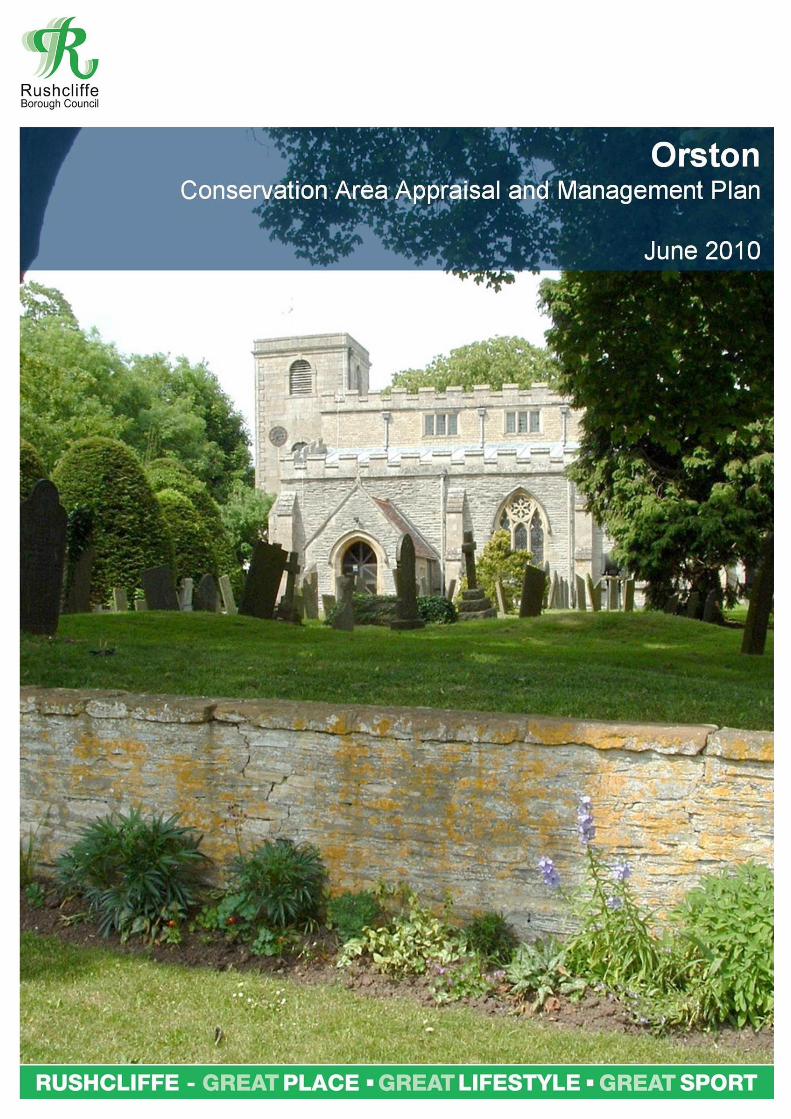
The Orston Conservation Area includes nearly all the buildings in this fairly large village (population 420). It was designated in 1990 as part of the Borough Council‟s proposals to create ten new Conservation Areas.
Orston has an intricate street pattern. High Street and Church Street suggest a medieval layout. Between these streets is St Mary‟s Church which is mostly 13th, 14th and 15th century. The tower dates from 1766 with restoration work taking place in 1889 and 1914. The delicately carved font dated 1662 and a drum from the Battle of Waterloo are both worthy of note.
The village as a whole is very well preserved with some fine cottages and farmhouses and contains 9 Listed Buildings. Trees are an intrinsic element of the village. An avenue of trees forms an attractive entrance to Orston from the west and Horse Chestnut trees enhance several street scenes. One of the finest houses is The Gables, a 17th century brick building with an unusual and large Dutch gable.
2.2 The purpose of a Conservation Area character appraisal Local Planning Authorities have a duty to designate as conservation areas any „areas of special architectural or historic interest the character or appearance of which it is desirable to preserve or enhance‟. (PPG 15). In 2005, Rushcliffe Borough Council followed government advice by looking more closely at the architectural and historic features within each conservation area and how their special character could be preserved or enhanced. An important part of this process has been to evaluate the appropriateness of a conservation area‟s boundary and make changes where necessary. In the case of Orston the original boundary was drawn tightly around the built up area, generally omitting adjacent open areas which contribute positively to the rural character of the village and have strong historic links to its older buildings. The boundary has therefore been expanded to include a number of fields, gardens, grass verges and hedgerows which enhance Orston‟s rural character and are sometimes archaeologically important. Other small realignments have also been made in order to follow up to date property boundaries. The survey and analysis work within the appraisal sections of this document highlight the particular features and characteristics of Orston that are worthy of preservation. Work on previous conservation areas has identified characteristics which are common throughout Rushcliffe. These have been fed into a generic Management Plan for the Borough which states why these features and characteristics should be preserved or enhanced and how this could be achieved. This document should be used by residents and professionals both as a source of information and as a guide. 2.3 The planning policy context This appraisal provides a firm basis on which applications for development within the Orston Conservation Area can be assessed. It should be read alongside the wider development plan policy framework produced by Rushcliffe Borough Council and other National Planning Policy Guidance documents. The relevant documents include:
Rushcliffe Borough Non-Statutory Replacement Local Plan 2006 - Policies EN2, EN3 (Conservation Areas)

5
EN4, EN5 (Listed Buildings) EN6 (Ancient Monuments) EN7 (Archaeological importance)
Planning Policy Statement 5 (PPS 5): Planning for the Historic Environment (2010)
Planning Policy Statement 1 (PPS 1): Delivering Sustainable Development (2006)
By Design: Urban Design in the Planning System – Towards Better Practice (2000)
Rushcliffe Residential Design Guide Supplementary Planning Document (2009)
6
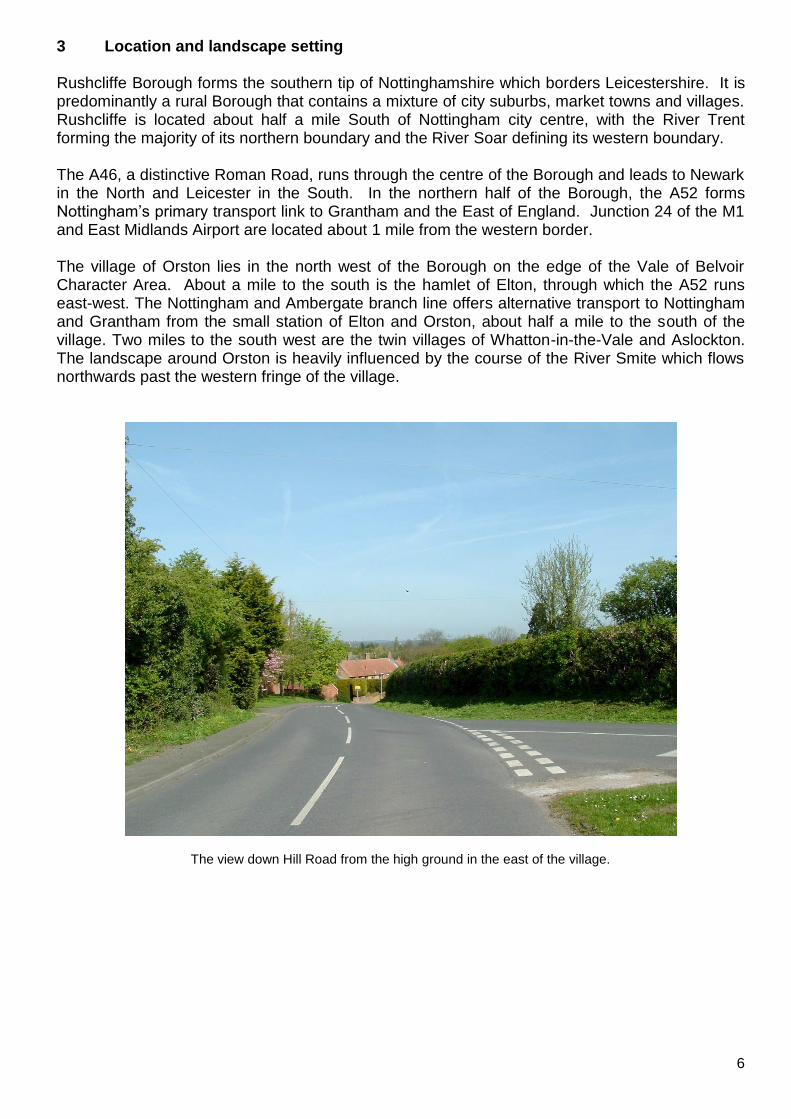
3 Location and landscape setting Rushcliffe Borough forms the southern tip of Nottinghamshire which borders Leicestershire. It is predominantly a rural Borough that contains a mixture of city suburbs, market towns and villages. Rushcliffe is located about half a mile South of Nottingham city centre, with the River Trent forming the majority of its northern boundary and the River Soar defining its western boundary. The A46, a distinctive Roman Road, runs through the centre of the Borough and leads to Newark in the North and Leicester in the South. In the northern half of the Borough, the A52 forms Nottingham‟s primary transport link to Grantham and the East of England. Junction 24 of the M1 and East Midlands Airport are located about 1 mile from the western border. The village of Orston lies in the north west of the Borough on the edge of the Vale of Belvoir Character Area. About a mile to the south is the hamlet of Elton, through which the A52 runs east-west. The Nottingham and Ambergate branch line offers alternative transport to Nottingham and Grantham from the small station of Elton and Orston, about half a mile to the south of the village. Two miles to the south west are the twin villages of Whatton-in-the-Vale and Aslockton. The landscape around Orston is heavily influenced by the course of the River Smite which flows northwards past the western fringe of the village.
The view down Hill Road from the high ground in the east of the village.
7
4 Historic development and archaeology There has probably been a settlement at Orston since at least 1000 BC but the village as we know it with its central church, village green and cluster of cottages would have grown up soon after the Roman withdrawal. The name Orston derives from the Old English Ordicestune or “farmstead of Ordric” after the name of the village‟s leader. Other incarnations of the village‟s name include Oschintone (1086 Domeseday Survey), Oskintone (1242), Horston (1428) and Horson (c.1500). During the early medieval period Orston was a place of some importance being at the head of one of the five great manors of Nottinghamshire and having jurisdiction over an area which included the villages of Scarrington, Staunton, Thoroton, Screveton and Aslockton. This administrative structure dated back to the Danelaw of 877 and continued under the Normans after the Domesday Survey of 1086. The Survey mentions 33 people living in the village by name and along with their families the total population probably amounted to around 150 to 175. Although there is no visible evidence for it today, the Manor at Orston was originally positioned at the north end of High Street and remained in Royal ownership until the time of Richard I (1189- 1199) when it was ceded to William de Albini. The presence of the Manor would have made High Street the focal point of the village but since the demolition of the Manor around 1840 the street has been somewhat sidelined as new development, including the new buildings of Manor Farm, moved eastwards onto the higher ground of the Belvoir Escarpment. Occupying a similarly influential role in the life of the village was the church. The earliest parts of the present church of St Mary date to the late eleventh century when the church was given by King William II to the Dean and Chapter at Lincoln. This entitled Lincoln Cathedral to 10 per cent of the village‟s income which was collected as produce in the tithe barn that still stands in the grounds of Orston Hall. Orston Hall itself was originally the Rectory although it is unlikely that the Rector ever resided there, preferring to lease the house to a tenant instead. The rector would appoint a vicar who in turn employed a curate. Before World War Two the village was primarily a farming community with the related trades of miller, wheelwright, blacksmith, saddler and joiner all present. A shop, school, post office, village hall and pub would have made further contributed to the village‟s self sufficiency. Orston‟s villagers farmed the land using an open field system until enclosure in 1793. Most of the villages in the Vale of Belvoir used a three field system but Ortson was the exception to the rule and used a four field system for its arable crops. The rich pasture land alongside the River Smite also provided good grazing and there is archaeological evidence to suggest that some of this land may have been used as water meadows, a practice which was rare in the East Midlands. Orston‟s prosperity was not solely based on agriculture however and since medieval times part of the village‟s workforce was employed in digging gypsum, evidence for which can be seen in the form of pits in the fields north of Loughbon and along Moor Lane. Indeed the quality of Orston‟s gypsum was so renowned (it was called „the finest in the Kingdom‟ by the Victoria History of the Counties of England) that in the 1860s a quarry and works known as The Royal Plaster Works were established in the in the area to the south of Loughbon. This was soon followed by a larger mine and factory next to the railway to the south which operated until their closure in 1914. The production of plaster resulted in the extraction of large quantities of clay which was used to produce bricks, tiles and pipes. A high gypsum content gave these bricks a light orange colour which still visibly contrasts with the darker red colour of older bricks dug from a pit opposite the Hall. Following the closure of the plaster works corn milling soon became profitable and the windmill on Mill Lane was eventually superseded in 1920 by a larger mechanised mill on Station Road. This mill came to be the single largest employer in the village for most of the twentieth century. The layout of properties in Orston today gives little indication of the village‟s nineteenth century appearance which was characterised by terraces for agricultural and gypsum workers known as
8
Rows. Most of these dwellings were one-up one-down affairs and today Little Gables on The Row (once split into 4 separate houses) is the only building which gives an impression of what they were like. Yeomen‟s houses by contrast were more substantially built and a few pre-1800 houses still survive.
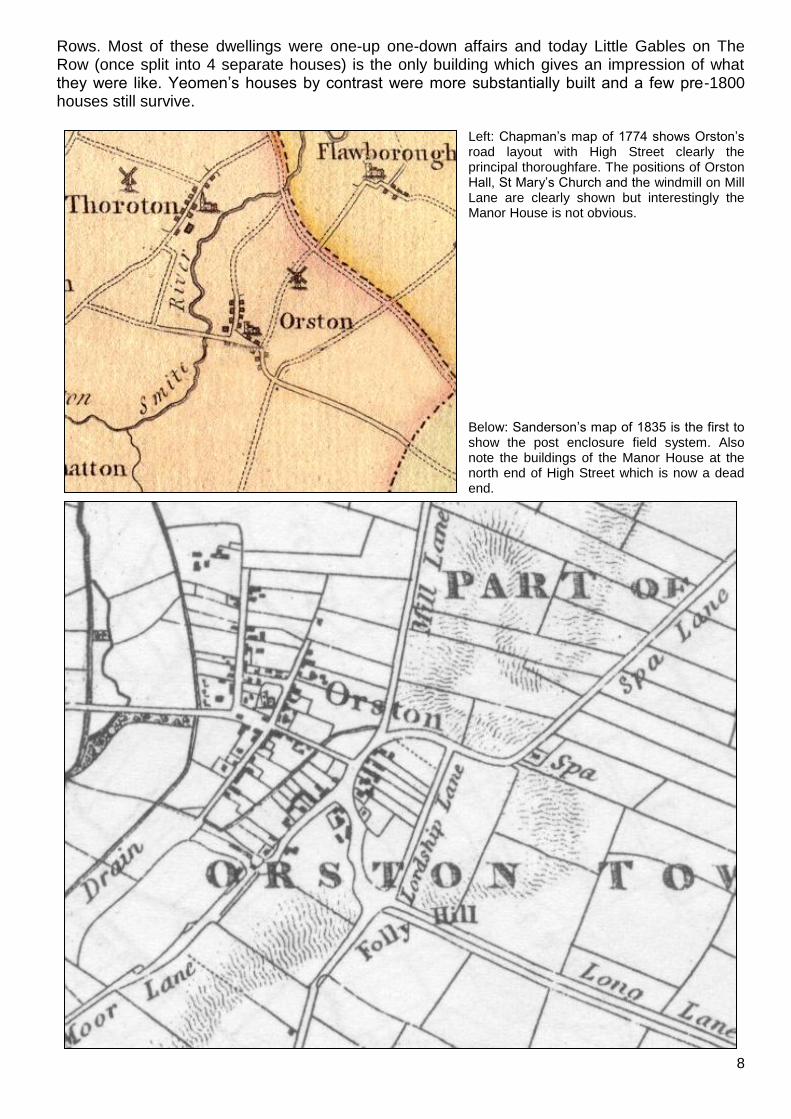
Left: Chapman‟s map of 1774 shows Orston‟s road layout with High Street clearly the principal thoroughfare. The positions of Orston Hall, St Mary‟s Church and the windmill on Mill Lane are clearly shown but interestingly the Manor House is not obvious. Below: Sanderson‟s map of 1835 is the first to show the post enclosure field system. Also note the buildings of the Manor House at the north end of High Street which is now a dead end.
9
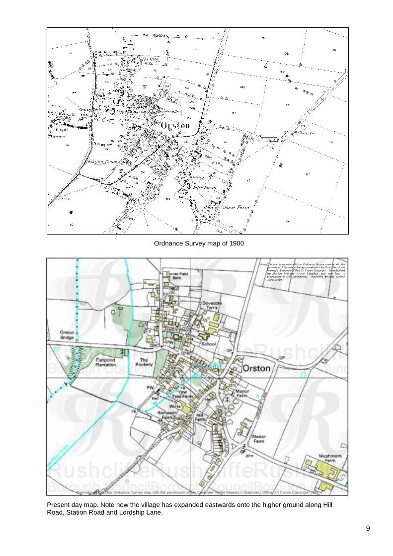
Ordnance Survey map of 1900
Present day map. Note how the village has expanded eastwards onto the higher ground along Hill Road, Station Road and Lordship Lane.
This map is reproduced from Ordnance Survey material with the permission of Ordnance Survey on behalf of the Controller of Her
Majesty‟s Stationary Office © Crown Copyright. Unauthorised reproduction infringes Crown Copyright and may lead to prosecution or civil proceedings. Rushcliffe Borough Council
1000019419

10
5 Spatial analysis 5.1 Plan form and layout Orston‟s layout consists of a principal thoroughfare (Smite Lane, The Green, Loughbon and Hill Road) which runs roughly from north west to south east and five other roads which radiate to the north and south: High Street, Church Street, Chapel Street, Lombard Street and Mill Lane, the last of which heads northwards towards Flawborough. High Street and Church Street are linked by Launder Street which runs past the northern edge of the churchyard. In the south east of the village Hill Road forms a cross roads with Lordship Lane (heading north), Bottesford Lane (heading east) and Station Road (heading south). Residential properties are mostly to be found with their principal elevations facing the highway, as on High Street and Chapel Street but in certain places they are also positioned gable-end to the road, as on Loughbon. Larger properties such as Orston Hall, The Woodlands and Manor Farm are generally set back from the highway in their own private grounds. 5.2 Landmarks, focal points and views Orston has a number of noteworthy landmarks which feature strongly in vistas within the village. The most prominent of these are St Mary‟s Church and Manor Farm. These are positioned at key focal points, with St Mary‟s churchyard being the cultural centre of the village and Manor Farm catching the eye at the south east crossroads. In addition the crossroads of Hill Road, Lombard Street, Mill Lane and Loughbon, with its charming green and wide grass verges acts as a third focal point. The higher ground along Hill Road and Station Road and the open aspect on the western fringes of the village offer good vantage points for outward looking views of the countryside around Orston. The Townscape Appraisal map illustrates these key views and vistas.
From left to right: the tower of St Mary‟s Church seen from the Smite Lane approach to the village; the view northwards from High Street towards St Helena‟s Church, Thoroton; Manor Farm from Station Road.
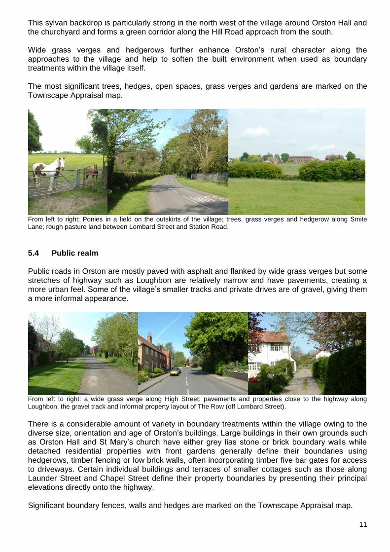
5.3 Open spaces, trees and landscape As Orston‟s network of roads is closely lined by its properties, the areas in between streets are often occupied by large gardens, small fields and paddocks while the village outskirts are flanked by attractive open countryside which is easily accessible thanks to a good network of public footpaths. The equestrian tradition is particularly strong in Orston something which has created a continuing demand for good grazing land and strengthens the village‟s rural character. Individual mature trees and wooded areas are also a defining characteristic of certain parts of the village.
11
This sylvan backdrop is particularly strong in the north west of the village around Orston Hall and the churchyard and forms a green corridor along the Hill Road approach from the south. Wide grass verges and hedgerows further enhance Orston‟s rural character along the approaches to the village and help to soften the built environment when used as boundary treatments within the village itself. The most significant trees, hedges, open spaces, grass verges and gardens are marked on the Townscape Appraisal map.
From left to right: Ponies in a field on the outskirts of the village; trees, grass verges and hedgerow along Smite Lane; rough pasture land between Lombard Street and Station Road.
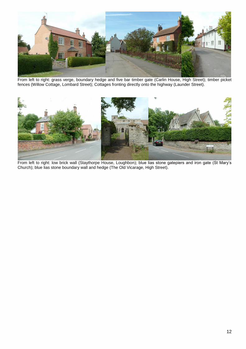
5.4 Public realm Public roads in Orston are mostly paved with asphalt and flanked by wide grass verges but some stretches of highway such as Loughbon are relatively narrow and have pavements, creating a more urban feel. Some of the village‟s smaller tracks and private drives are of gravel, giving them a more informal appearance.
From left to right: a wide grass verge along High Street; pavements and properties close to the highway along Loughbon; the gravel track and informal property layout of The Row (off Lombard Street).
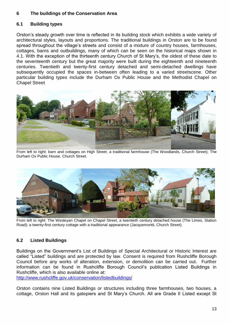
There is a considerable amount of variety in boundary treatments within the village owing to the diverse size, orientation and age of Orston‟s buildings. Large buildings in their own grounds such as Orston Hall and St Mary‟s church have either grey lias stone or brick boundary walls while detached residential properties with front gardens generally define their boundaries using hedgerows, timber fencing or low brick walls, often incorporating timber five bar gates for access to driveways. Certain individual buildings and terraces of smaller cottages such as those along Launder Street and Chapel Street define their property boundaries by presenting their principal elevations directly onto the highway. Significant boundary fences, walls and hedges are marked on the Townscape Appraisal map.
12
From left to right: grass verge, boundary hedge and five bar timber gate (Carlin House, High Street); timber picket fences (Willow Cottage, Lombard Street); Cottages fronting directly onto the highway (Launder Street).
From left to right: low brick wall (Staythorpe House, Loughbon); blue lias stone gatepiers and iron gate (St Mary‟s Church); blue lias stone boundary wall and hedge (The Old Vicarage, High Street).
13
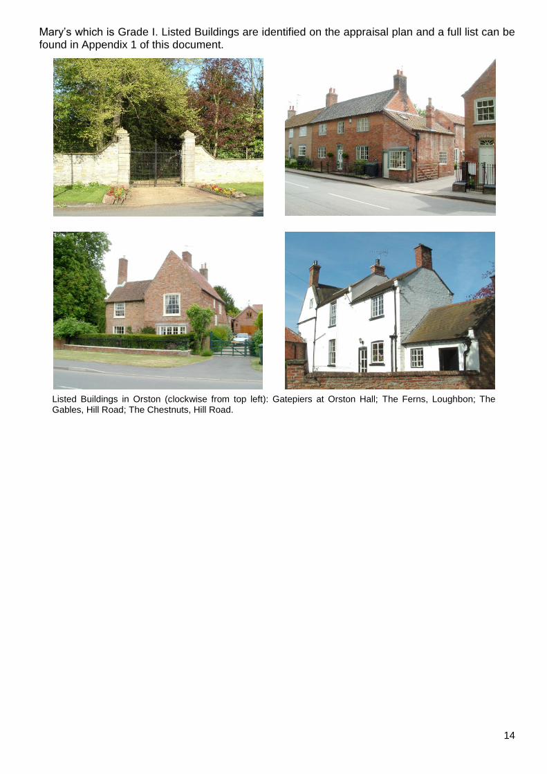
6 The buildings of the Conservation Area 6.1 Building types Orston‟s steady growth over time is reflected in its building stock which exhibits a wide variety of architectural styles, layouts and proportions. The traditional buildings in Orston are to be found spread throughout the village‟s streets and consist of a mixture of country houses, farmhouses, cottages, barns and outbuildings, many of which can be seen on the historical maps shown in 4.1. With the exception of the thirteenth century Church of St Mary‟s, the oldest of these date to the seventeenth century but the great majority were built during the eighteenth and nineteenth centuries. Twentieth and twenty-first century detached and semi-detached dwellings have subsequently occupied the spaces in-between often leading to a varied streetscene. Other particular building types include the Durham Ox Public House and the Methodist Chapel on Chapel Street
From left to right: barn and cottages on High Street; a traditional farmhouse (The Woodlands, Church Street); The Durham Ox Public House, Church Street.
From left to right: The Wesleyan Chapel on Chapel Street, a twentieth century detached house (The Limes, Station Road); a twenty-first century cottage with a traditional appearance (Jacquemontii, Church Street).
6.2 Listed Buildings Buildings on the Government‟s List of Buildings of Special Architectural or Historic Interest are called “Listed” buildings and are protected by law. Consent is required from Rushcliffe Borough Council before any works of alteration, extension, or demolition can be carried out. Further information can be found in Rushcliffe Borough Council‟s publication Listed Buildings in Rushcliffe, which is also available online at: http://www.rushcliffe.gov.uk/conservation/listedbuildings/ Orston contains nine Listed Buildings or structures including three farmhouses, two houses, a cottage, Orston Hall and its gatepiers and St Mary‟s Church. All are Grade II Listed except St
14
Mary‟s which is Grade I. Listed Buildings are identified on the appraisal plan and a full list can be found in Appendix 1 of this document.
Listed Buildings in Orston (clockwise from top left): Gatepiers at Orston Hall; The Ferns, Loughbon; The Gables, Hill Road; The Chestnuts, Hill Road.
15
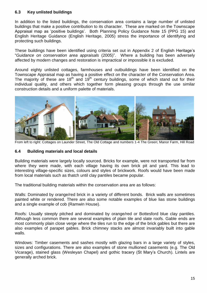
6.3 Key unlisted buildings In addition to the listed buildings, the conservation area contains a large number of unlisted buildings that make a positive contribution to its character. These are marked on the Townscape Appraisal map as „positive buildings‟. Both Planning Policy Guidance Note 15 (PPG 15) and English Heritage Guidance (English Heritage, 2005) stress the importance of identifying and protecting such buildings. These buildings have been identified using criteria set out in Appendix 2 of English Heritage‟s “Guidance on conservation area appraisals (2005)”. Where a building has been adversely affected by modern changes and restoration is impractical or impossible it is excluded. Around eighty unlisted cottages, farmhouses and outbuildings have been identified on the Townscape Appraisal map as having a positive effect on the character of the Conservation Area. The majority of these are 18th and 19th century buildings, some of which stand out for their individual quality, and others which together form pleasing groups through the use similar construction details and a uniform palette of materials.
From left to right: Cottages on Launder Street, The Old Cottage and numbers 1-4 The Green; Manor Farm, Hill Road
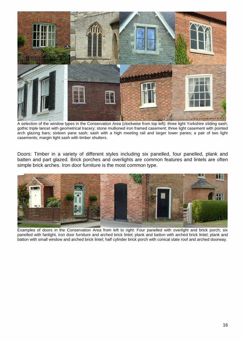
6.4 Building materials and local details Building materials were largely locally sourced. Bricks for example, were not transported far from where they were made, with each village having its own brick pit and yard. This lead to interesting village-specific sizes, colours and styles of brickwork. Roofs would have been made from local materials such as thatch until clay pantiles became popular. The traditional building materials within the conservation area are as follows: Walls: Dominated by orange/red brick in a variety of different bonds. Brick walls are sometimes painted white or rendered. There are also some notable examples of blue lias stone buildings and a single example of cob (Ramwin House). Roofs: Usually steeply pitched and dominated by orange/red or Bottesford blue clay pantiles. Although less common there are several examples of plain tile and slate roofs. Gable ends are most commonly plain close verge where the tiles run to the edge of the brick gables but there are also examples of parapet gables. Brick chimney stacks are almost invariably built into gable walls. Windows: Timber casements and sashes mostly with glazing bars in a large variety of styles, sizes and configurations. There are also examples of stone mullioned casements (e.g. The Old Vicarage), stained glass (Wesleyan Chapel) and gothic tracery (St Mary‟s Church). Lintels are generally arched brick.
16
A selection of the window types in the Conservation Area (clockwise from top left): three light Yorkshire sliding sash; gothic triple lancet with geometrical tracery; stone mullioned iron framed casement; three light casement with pointed arch glazing bars; sixteen pane sash; sash with a high meeting rail and larger lower panes; a pair of two light casements; margin light sash with timber shutters.
Doors: Timber in a variety of different styles including six panelled, four panelled, plank and batten and part glazed. Brick porches and overlights are common features and lintels are often simple brick arches. Iron door furniture is the most common type.
Examples of doors in the Conservation Area from left to right: Four panelled with overlight and brick porch; six panelled with fanlight, iron door furniture and arched brick lintel; plank and batton with arched brick lintel; plank and batton with small window and arched brick lintel; half cylinder brick porch with conical slate roof and arched doorway.
17
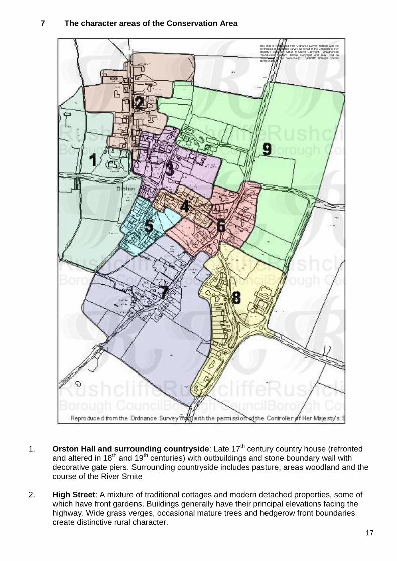
7 The character areas of the Conservation Area
1. Orston Hall and surrounding countryside: Late 17th century country house (refronted
and altered in 18th and 19th centuries) with outbuildings and stone boundary wall with decorative gate piers. Surrounding countryside includes pasture, areas woodland and the course of the River Smite
2. High Street: A mixture of traditional cottages and modern detached properties, some of
which have front gardens. Buildings generally have their principal elevations facing the highway. Wide grass verges, occasional mature trees and hedgerow front boundaries create distinctive rural character.
This map is reproduced from Ordnance Survey material with the permission of Ordnance Survey on behalf of the Controller of Her Majesty‟s Stationary Office © Crown Copyright. Unauthorised
reproduction infringes Crown Copyright and may lead to prosecution or civil proceedings. Rushcliffe Borough Council 1000019419
18
3. Church Street, Launder Street and The Green: The historic village centre with cottages and arranged to face the Churchyard of St Mary‟s. Notable buildings include the Rectory, The Durham Ox Public House and The Woodlands. Strong sylvan character around the Churchyard. Modern infill development has generally retained the rural character of the area.
4. Loughbon: Traditional cottages mostly orientated gable end to the highway along south
side. Properties on the north side are of twentieth century construction Enclosed feel created by cottages facing directly onto the pavement on the south side and trees, boundary hedges and walls on the north side.
5. Chapel Street: Nineteenth century terraced workers cottages, twentieth century council
housing with associated landscaping, Wesleyan chapel of 1848. 6. Mill Lane and Village Green crossroads: Wide grass verges, village green and low
building density gives this area a distinctive rural village character. Properties generally have substantial garden plots and are a mixture of twentieth century development and older houses and cottages. Small groups of mature trees and boundary hedges add to visual amenity.
7. Lombard Street and surrounding countryside: Informally arranged cottages and
farmhouses surrounded by paddocks and pasture land which enhance the immediate setting of the village. Other rural features include hedgerows and post and rail fencing delineating field boundaries, grass verges along the highway and occasional groups of trees. Some modern infill development and barn conversions. Track known as Moor Lane leads to site of former Gypsum works to the south.
8. Hill Road and Station Road: Higher ground in the east of the village characterised by
wide grass verges, hedgerows and belts of trees. Striking property of Manor Farm is set back behind stone boundary wall in its own grounds and is the focal point at the crossroads. Other traditional buildings include the Hill Farm complex and The Old Mill. The cul-de-sac of Hill Top serves a number of modest twentieth century detached houses.
9. Dovecote Farm Equestrian Centre and surrounds: Traditional farmhouse and fronting
onto Church Street with complex of modern metal framed stable buildings to rear. Surrounding land is almost entirely given over to paddocks. Highways lined with grass verges and high hedgerows.
19
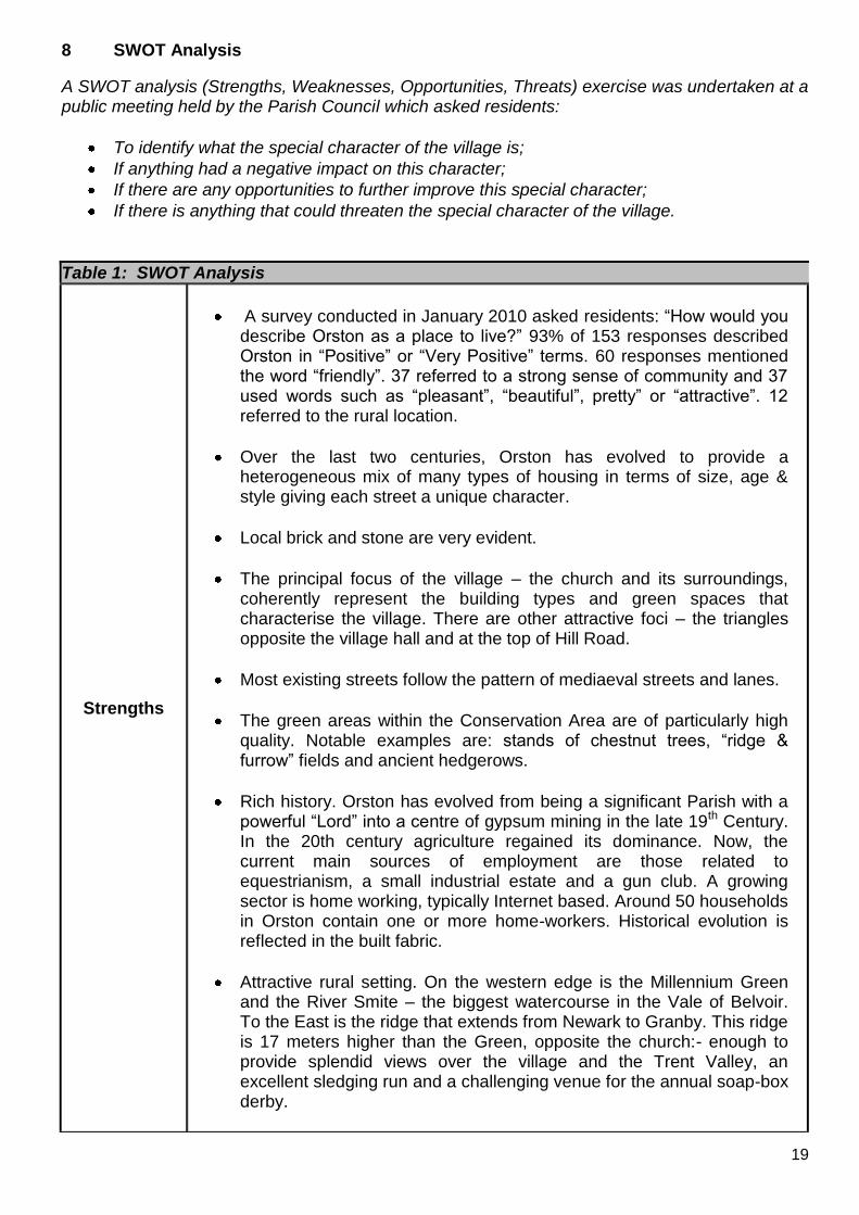
8 SWOT Analysis
A SWOT analysis (Strengths, Weaknesses, Opportunities, Threats) exercise was undertaken at a public meeting held by the Parish Council which asked residents:
To identify what the special character of the village is;
If anything had a negative impact on this character;
If there are any opportunities to further improve this special character;
If there is anything that could threaten the special character of the village.
Table 1: SWOT Analysis
Strengths
A survey conducted in January 2010 asked residents: “How would you describe Orston as a place to live?” 93% of 153 responses described Orston in “Positive” or “Very Positive” terms. 60 responses mentioned the word “friendly”. 37 referred to a strong sense of community and 37 used words such as “pleasant”, “beautiful”, pretty” or “attractive”. 12 referred to the rural location.
Over the last two centuries, Orston has evolved to provide a heterogeneous mix of many types of housing in terms of size, age & style giving each street a unique character.
Local brick and stone are very evident.
The principal focus of the village – the church and its surroundings, coherently represent the building types and green spaces that characterise the village. There are other attractive foci – the triangles opposite the village hall and at the top of Hill Road.
Most existing streets follow the pattern of mediaeval streets and lanes.
The green areas within the Conservation Area are of particularly high quality. Notable examples are: stands of chestnut trees, “ridge & furrow” fields and ancient hedgerows.
Rich history. Orston has evolved from being a significant Parish with a powerful “Lord” into a centre of gypsum mining in the late 19th Century. In the 20th century agriculture regained its dominance. Now, the current main sources of employment are those related to equestrianism, a small industrial estate and a gun club. A growing sector is home working, typically Internet based. Around 50 households in Orston contain one or more home-workers. Historical evolution is reflected in the built fabric.
Attractive rural setting. On the western edge is the Millennium Green and the River Smite – the biggest watercourse in the Vale of Belvoir. To the East is the ridge that extends from Newark to Granby. This ridge is 17 meters higher than the Green, opposite the church:- enough to provide splendid views over the village and the Trent Valley, an excellent sledging run and a challenging venue for the annual soap-box derby.
20
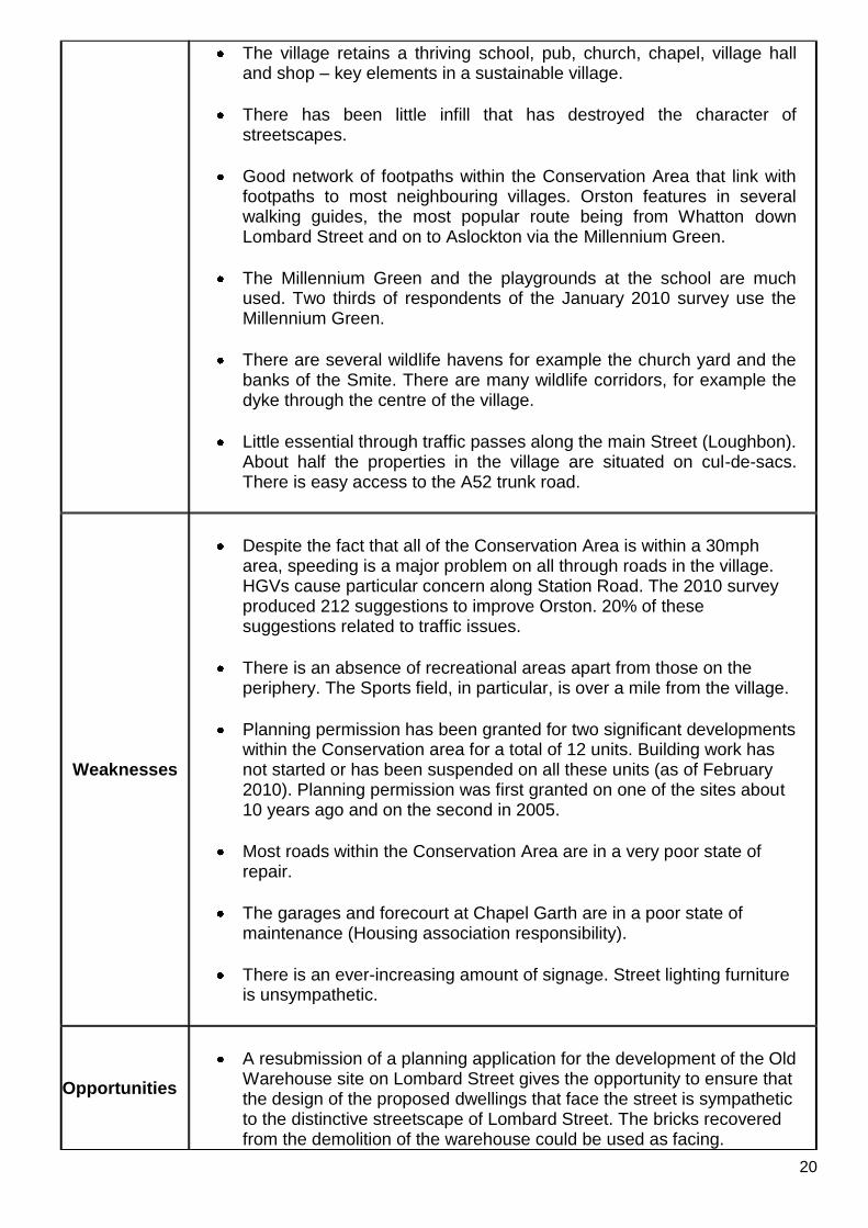
The village retains a thriving school, pub, church, chapel, village hall and shop – key elements in a sustainable village.
There has been little infill that has destroyed the character of streetscapes.
Good network of footpaths within the Conservation Area that link with footpaths to most neighbouring villages. Orston features in several walking guides, the most popular route being from Whatton down Lombard Street and on to Aslockton via the Millennium Green.
The Millennium Green and the playgrounds at the school are much used. Two thirds of respondents of the January 2010 survey use the Millennium Green.
There are several wildlife havens for example the church yard and the banks of the Smite. There are many wildlife corridors, for example the dyke through the centre of the village.
Little essential through traffic passes along the main Street (Loughbon). About half the properties in the village are situated on cul-de-sacs. There is easy access to the A52 trunk road.
Weaknesses
Despite the fact that all of the Conservation Area is within a 30mph area, speeding is a major problem on all through roads in the village. HGVs cause particular concern along Station Road. The 2010 survey produced 212 suggestions to improve Orston. 20% of these suggestions related to traffic issues.
There is an absence of recreational areas apart from those on the periphery. The Sports field, in particular, is over a mile from the village.
Planning permission has been granted for two significant developments within the Conservation area for a total of 12 units. Building work has not started or has been suspended on all these units (as of February 2010). Planning permission was first granted on one of the sites about 10 years ago and on the second in 2005.
Most roads within the Conservation Area are in a very poor state of repair.
The garages and forecourt at Chapel Garth are in a poor state of maintenance (Housing association responsibility).
There is an ever-increasing amount of signage. Street lighting furniture is unsympathetic.
Opportunities
A resubmission of a planning application for the development of the Old Warehouse site on Lombard Street gives the opportunity to ensure that the design of the proposed dwellings that face the street is sympathetic to the distinctive streetscape of Lombard Street. The bricks recovered from the demolition of the warehouse could be used as facing.
21
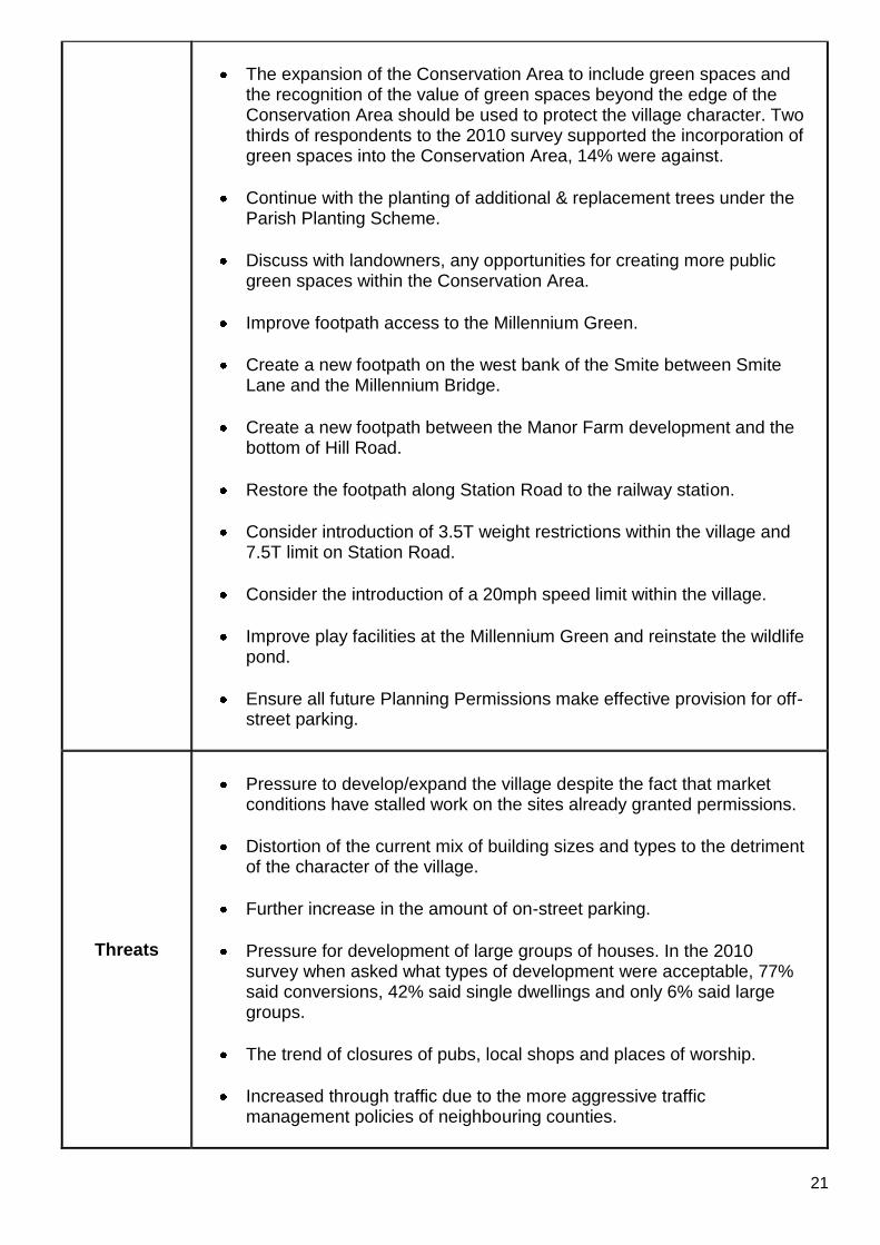
The expansion of the Conservation Area to include green spaces and the recognition of the value of green spaces beyond the edge of the Conservation Area should be used to protect the village character. Two thirds of respondents to the 2010 survey supported the incorporation of green spaces into the Conservation Area, 14% were against.
Continue with the planting of additional & replacement trees under the Parish Planting Scheme.
Discuss with landowners, any opportunities for creating more public green spaces within the Conservation Area.
Improve footpath access to the Millennium Green.
Create a new footpath on the west bank of the Smite between Smite Lane and the Millennium Bridge.
Create a new footpath between the Manor Farm development and the bottom of Hill Road.
Restore the footpath along Station Road to the railway station.
Consider introduction of 3.5T weight restrictions within the village and 7.5T limit on Station Road.
Consider the introduction of a 20mph speed limit within the village.
Improve play facilities at the Millennium Green and reinstate the wildlife pond.
Ensure all future Planning Permissions make effective provision for off-street parking.
Threats
Pressure to develop/expand the village despite the fact that market conditions have stalled work on the sites already granted permissions.
Distortion of the current mix of building sizes and types to the detriment of the character of the village.
Further increase in the amount of on-street parking.
Pressure for development of large groups of houses. In the 2010 survey when asked what types of development were acceptable, 77% said conversions, 42% said single dwellings and only 6% said large groups.
The trend of closures of pubs, local shops and places of worship.
Increased through traffic due to the more aggressive traffic management policies of neighbouring counties.
22
PART 2 GENERIC MANAGEMENT PLAN FOR CONSERVATION AREAS IN RUSHCLIFFE
1.0 Introduction 1.1 The quality and interest of the whole area, rather than individual buildings, gives a
Conservation Area its special character. This includes factors such as historic street layout, use of local building materials, scale and detailing of buildings, boundary treatments, shop fronts, street furniture, vistas along streets or between buildings as well as trees and shrub planting.
1.2 In carrying out its planning functions, the Borough Council is required to give special
attention to the desirability of preserving or enhancing the character or appearance of Conservation Areas. Conservation Area Appraisals identify the special character of each Conservation Area and the Borough Council has a programme for preparing or reviewing these.
1.3 There is also a duty to formulate and publish management plans setting out policies and proposals for the preservation and enhancement of conservation areas. Many of these policies and proposals are common to all Conservation Areas and these are set out in this document. Supplementary documents will be issued for individual conservation areas where specific policies or proposals are needed.
2.0 Aims and Objectives of this Management Plan
To set out clear management proposals for the preservation and enhancement of Conservation Areas.
To guide residents and professionals on:
- features of value, worthy of preservation; - characteristics worthy of preservation; - opportunities for enhancement. - development proposals which preserve and enhance the special character of the
area
To foster community commitment to conservation principles The Borough Council will follow these objectives in its own activities and will encourage other public bodies, including the Highway Authority to do the same. 3.0 National and Local Policies and guidance 3.1 Central Government guidance applies to all conservation areas. This can be found in the
following Planning Policy Statement 5 “Planning for the Historic Environment” English Heritage “Management of Conservation Areas”
3.2 The County Structure Plan contains the following policy:
23
POLICY 2/12 HISTORIC CHARACTER Local planning authorities will protect and enhance the historic and architectural character and appearance of the landscape of the Plan Area. Permission will not be granted for development within Historic Parks and Gardens, Historic Battlefields and other areas designated for special protection except where it demonstrably conserves and enhances the characteristics of these areas. The protection and enhancement of the historic character will be achieved through: a) the protection and maintenance of buildings listed as of special architectural, historic or
landscape importance, including their settings; b) the identification, protection and maintenance of other individual and groups of buildings
which are important for their local architectural distinctiveness, or significance; c) the identification, maintenance and enhancement of other locally distinctive and culturally
important aspects of the historic environment; d) the designation, enhancement and preservation of Conservation Areas and their settings; e) sensitively designed environmental improvement and traffic management schemes in
Conservation Areas and other appropriate areas; f) finding appropriate alternative uses for, and the restoration of, listed or other buildings
worthy of retention; and g) informed design of new development. 3.3 The adopted Rushcliffe Local Plan was replaced in 2006 by the Non Statutory
Replacement Local Plan for Development Control purposes and the following policies from that plan will be used for guidance in Conservation Areas.
EN2 – CONSERVATION AREAS Planning permission for development including changes of use and alterations or extensions to existing buildings within a designated conservation area, or outside of but affecting its setting, or views into or out of the conservation area will only be granted where:
a) the proposal would preserve or enhance the character or appearance of the conservation area by virtue of its use, design, scale, siting and materials;
b) there will be no adverse impact upon the form of the conservation area, including its
open spaces (including gardens), the position of existing buildings and notable features such as groups of trees, walls and other structures; and
there will be no loss of part or all of an open space which contributes to the character or appearance of the Conservation Area. EN3 – DEMOLITION IN CONSERVATION AREAS Where planning permission is required for development which includes the demolition of buildings in conservation areas it will only be granted where the proposal does not detrimentally affect the character or appearance of the area, and any permission may be conditional on redevelopment proposals for the site being approved, and contracts for them accepted, before demolition is begun. 3.4 Village Design Statements
Village Design Statements exist or are being prepared for several villages in the Borough, some of which are also Conservation Areas. Although these offer no statutory protection they identify the qualities that are valued by the local community and the character that should be preserved.

24
4.0 Development in Conservation Areas 4.1 Article 4 Directions.
Article 4 of the Town & Country Planning (General Permitted Development) Order 1995 allows planning authorities to restrict specified permitted development rights in particular areas. Many councils use these to assist with the preservation of the special character of conservation areas although there are currently none in Rushcliffe. Many buildings still possess original or traditional architectural details which contribute to the special character. These include windows, doors, porches, door hoods, pilasters and fanlights, chimneys, brick detailing and roofing materials as well as walls, gates and railings. However, the increased use of upvc windows, plastic barge boards, inappropriate roofing materials, high spiked metal railing and electric gates is eroding the character of many of our conservation areas. The use of Article 4 Directions will be proposed where considered appropriate following the completion of each Area Appraisal
4.2 Building Design Extensions to buildings in Conservation Areas should respect
The key characteristics of the original building including scale, mass, materials and proportions
The contextual setting and character of the conservation area
This does not mean slavishly copying the original, which can devalue it and destroy the ability to “read” historic change and dilutes our historic heritage. In some cases this is impossible. For example Flemish Bond brickwork cannot be replicated in cavity walls and narrow lime mortar joints cannot be replicated in modern cement mortar.
4.2.1 Good contemporary design will be encouraged where it respects the scale and character of its context. This must be demonstrated in the Design and Access Statement submitted with any planning application.
4.2.2 In particularly sensitive locations, such as uniform terraces, exact replication may be
necessary to maintain compositional unity. In that case, attention to details, choice of materials and high quality workmanship are the keynotes.
4.2.3 Where new building is appropriate, on infill sites or where an existing building detracts
from the character of the area, the opportunity should be taken to re-establish the streetscape, reinforce enclosure, open up distant vistas or views of landmarks or hide unsightly views.
4.2.4 As with extensions, good contemporary design which respects local character and the
context of the site will be encouraged. “New and old buildings can coexist happily without disguising one as the other, if the design of the new is a response to urban design objectives”. (DETR - „By Design‟, p19)
4.2.5 Pastiche designs, incorporating poor imitations of other styles will be resisted, particularly
where they incorporate details which are not locally appropriate. Careful high quality replication may be required in a few very sensitive locations.
25
4.2.6 All new buildings should respond appropriately to the existing frontage and normally follow the established building line. Development or redevelopment will normally be resisted if:
it blocks important views identified in the individual appraisals
uses important open spaces identified in the appraisals
adversely affects the setting of any Listed or key buildings
fails to maintain or re-establish the streetscape where appropriate
dominates its conservation area background
fails to recognize the context of the site
destroys important features identified in the individual appraisals such as boundary walls, fences, hedgerows or trees
4.2.7 New development that stands out from the background of buildings may be appropriate in
exceptional circumstances if it contributes positively as a landmark to enhance the street scene, to highlight a corner or to signal a visual change of direction such as along a curving vista.
4.2.8 Any external lighting should be carefully designed and sited to minimise light pollution. 4.2.9 Energy producing or saving devices are generally welcomed by the Council, but careful
consideration is required when these are to be located in a conservation area and some may require planning permission. In particular they should be sited to minimise their impact on the building and on the local amenity.
4.3 Materials
Rushcliffe‟s older buildings are predominantly brick, some incorporating earlier timber framed structures. (There were many small local brickyards, some of which only worked for a few years and produced bricks in various shades of orangey red.) There is a little local stone, mainly a soft grey lias, and higher status buildings in stone imported from Lincolnshire and elsewhere. Roofs are mainly plain tiles or pantiles, with some Swithland slate and Welsh slate from the mid 19c onwards. A few original thatched roofs remain. Most of these materials are no longer available second hand, except in very limited quantities. National guidance is to use high quality new materials for extensions to existing buildings. However, it is preferable to use reclaimed materials where:
Small quantities are needed to exactly match the materials of the existing building
The materials are of high quality, the correct dimensions and colour
The materials are sourced locally e.g. the approved demolition of an existing structure on site or in the immediate vicinity
It can be demonstrated that the sourced materials have not resulted in the loss of a heritage asset elsewhere
4.4 Boundary Treatment
Boundaries, such as walls, fences or hedges, separate private spaces from the public realm of roads and pavements, physically and visually. They are as important in determining the character of a conservation area as the buildings behind them.
26
4.4.1 Types of boundary 4.4.2 High brick walls and buildings on the back of pavements create a hard, urban feel to the
conservation area whilst hedges, verges and trees produce a more rural character. In some conservation areas one or the other predominates whilst some have a mix of these features.
4.4.3 Where the character definition is strong, it is important to retain and promote a
continuation of the theme. A high brick wall in a predominantly "green" lane will impact adversely on its character and the introduction of a hedge in an urban scene may be equally inappropriate. Where there is a variety in the type of boundary there will be more flexibility.
4.4.4 Local materials and design play a vital role in successful boundary treatments which
maintain or enhance the character of the conservation area. Brick walls which match or complement the local architecture or locally native hedgerows and trees invariably have the greatest conservation benefits.
4.4.5 Any boundary detail should be in keeping with the street scene and be complementary to
the building to which it is the boundary. It should reflect the status of the property and not attempt to create a sense of grandeur where unwarranted.
4.5 Landscaping 4.5.1 Trees can be a key factor in the special character of conservation areas. Each
conservation area appraisal identifies trees that are particularly important to the conservation area.
4.5.2 In conservation areas there is a duty to give the local planning authority six weeks notice
of any proposed work to a tree. This period allows the local authority to assess the trees and decide whether a tree preservation order is desirable.
4.5.3 In many instances, the planting of new trees or groups of trees, would enhance the character of the conservation area. The Council is keen to promote this, where new planting contributes to the public realm, and works with Parish Councils to carry out small scale planting and other landscape schemes in their areas.
5.0 Buildings at risk and sites which detract from the character of the area 5.1 A number of important buildings in our various conservation areas are currently vacant or
not in regular use, with some being „at risk‟ of neglect or decay. There is a presumption against demolition of buildings which contribute to the character of the area unless there are exceptional circumstances. It would therefore benefit both the physical form and the function of the conservation area if these buildings were repaired, maintained and brought back into use.
5.2 The Council will encourage owners of key properties in conservation areas which are in
need of renovation or repair to carry out the basic maintenance work necessary to make sure the building is structurally sound and weather tight. The Council will encourage and advise on renovation and repair work that is sensitive to the original or traditional historic character of the building and retains original features.
27
5.3 The Council may take formal action if the condition if any building (listed or unlisted) which makes a positive contribution to the character of the conservation area is considered to be at risk.
6.0 Management of Public Realm 6.1 Management of highways and footpaths is the responsibility of the Highway Authority,
Nottinghamshire County Council. The Council will use its influence to ensure that the principles of good street and public realm design, such as those set out in
“Streets for All: East Midlands” (English Heritage, 2005),
“By Design: Urban Design in the Planning System: Towards Better Practice” (DETR/CABE, 2000)
“Manual for Streets” (DfT, 2007),
are applied within conservation areas. 6.2 Grass verges can also be lost during road or pavement improvement schemes and
kerbstones may be added. They can also come under threat from property owners seeking to create hard-standings for off-street parking. The loss of grass verges, and the cumulative effect that this has over time, can result in the gradual deterioration of the special character of a conservation area. Such works will be resisted.
6.3 The quality and design of street surfaces and street furniture can also have a major impact on the character of the conservation area. Where historic or traditional street surfaces and street furniture have survived, these should be preserved and maintained. Any streets or public spaces in poor condition can have a negative impact on the conservation area and may need to be improved. Materials should be carefully selected to ensure that they complement and enhance the character of the conservation area.
6.4 Any surfaces, whether public or privately owned, that are in a severe state of disrepair
and/or have a negative impact on the conservation area should be a priority for improvement works.
6.5 The public footpaths and other rights of way within and adjacent to the conservation area
play a vital role in allowing people to enjoy and experience the area. It is important that these paths are well maintained, clearly marked and made accessible.
7.0 Monitoring 7.1 This Management Plan will be reviewed in accordance with a programme to be agreed in
the light of the emerging Local Development Framework and government policy and best practice guidance at the time.
7.2 This review could involve residents and/or members of a residents‟ conservation group or
conservation advisory committee under the guidance of the Borough Council. By this means, the local community would become more involved in the process, thus raising public awareness of and commitment to conservation issues.
28
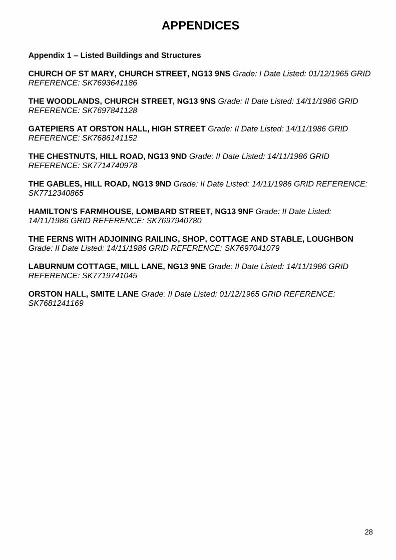
APPENDICES Appendix 1 – Listed Buildings and Structures CHURCH OF ST MARY, CHURCH STREET, NG13 9NS Grade: I Date Listed: 01/12/1965 GRID REFERENCE: SK7693641186 THE WOODLANDS, CHURCH STREET, NG13 9NS Grade: II Date Listed: 14/11/1986 GRID REFERENCE: SK7697841128 GATEPIERS AT ORSTON HALL, HIGH STREET Grade: II Date Listed: 14/11/1986 GRID REFERENCE: SK7686141152 THE CHESTNUTS, HILL ROAD, NG13 9ND Grade: II Date Listed: 14/11/1986 GRID REFERENCE: SK7714740978 THE GABLES, HILL ROAD, NG13 9ND Grade: II Date Listed: 14/11/1986 GRID REFERENCE: SK7712340865 HAMILTON'S FARMHOUSE, LOMBARD STREET, NG13 9NF Grade: II Date Listed: 14/11/1986 GRID REFERENCE: SK7697940780 THE FERNS WITH ADJOINING RAILING, SHOP, COTTAGE AND STABLE, LOUGHBON Grade: II Date Listed: 14/11/1986 GRID REFERENCE: SK7697041079 LABURNUM COTTAGE, MILL LANE, NG13 9NE Grade: II Date Listed: 14/11/1986 GRID REFERENCE: SK7719741045 ORSTON HALL, SMITE LANE Grade: II Date Listed: 01/12/1965 GRID REFERENCE: SK7681241169
29
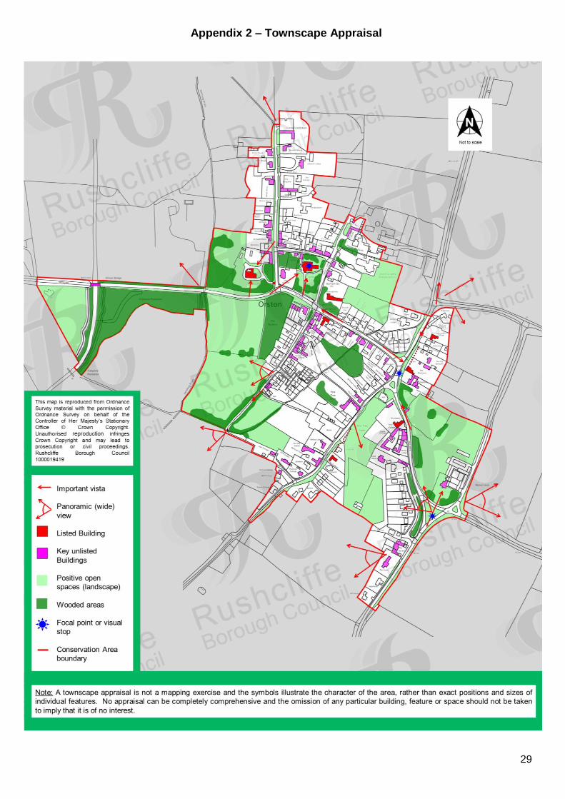
Appendix 2 – Townscape Appraisal
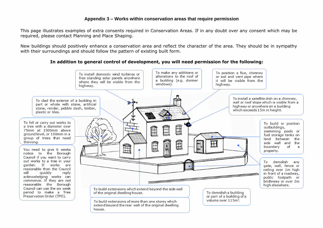
Appendix 3 – Works within conservation areas that require permission
In addition to general control of development, you will need permission for the following:
This page illustrates examples of extra consents required in Conservation Areas. If in any doubt over any consent which may be required, please contact Planning and Place Shaping.
New buildings should positively enhance a conservation area and reflect the character of the area. They should be in sympathy
with their surroundings and should follow the pattern of existing built form.


