NPOESS Preparatory Project(NPP)
The Direct Readout Conference December 2004
Pete WilczynskiNPP Program Manager
NPOESS Integrated Program Office (IPO)
2
Overview
• NPP Origins & Objectives• Requirements & Mission Segments• Data Products • NPP Direct Broadcast• Summary

3
NPP Origins & Mission Objectives
• NPP is a joint partnership between NASA’s Office of Earth Sciences (OES) and the NPOESS Integrated Program Office (IPO) initiated in 1998.– Feasibility study began in November 1998.– Formulation began in November 1999.
• The partnership provides both organizations with considerable cost savings while achieving their key program objectives: – Bridge Mission: To provide NASA with continuation of a group
of global change observations initiated by the Earth Observing System (EOS) TERRA, AQUA, and Aura missions.
– NPOESS Risk Reduction: To provide the NPOESS operational community with pre-operational risk reduction demonstration and validation for selected NPOESS instruments, and algorithms, as well as ground processing.
4
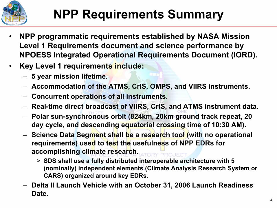
NPP Requirements Summary• NPP programmatic requirements established by NASA Mission
Level 1 Requirements document and science performance by NPOESS Integrated Operational Requirements Document (IORD).
• Key Level 1 requirements include:– 5 year mission lifetime.– Accommodation of the ATMS, CrIS, OMPS, and VIIRS instruments.– Concurrent operations of all instruments.– Real-time direct broadcast of VIIRS, CrIS, and ATMS instrument data.– Polar sun-synchronous orbit (824km, 20km ground track repeat, 20
day cycle, and descending equatorial crossing time of 10:30 AM).– Science Data Segment shall be a research tool (with no operational
requirements) used to test the usefulness of NPP EDRs for accomplishing climate research.
> SDS shall use a fully distributed interoperable architecture with 5 (nominally) independent elements (Climate Analysis Research System or CARS) organized around key EDRs.
– Delta II Launch Vehicle with an October 31, 2006 Launch Readiness Date.
5
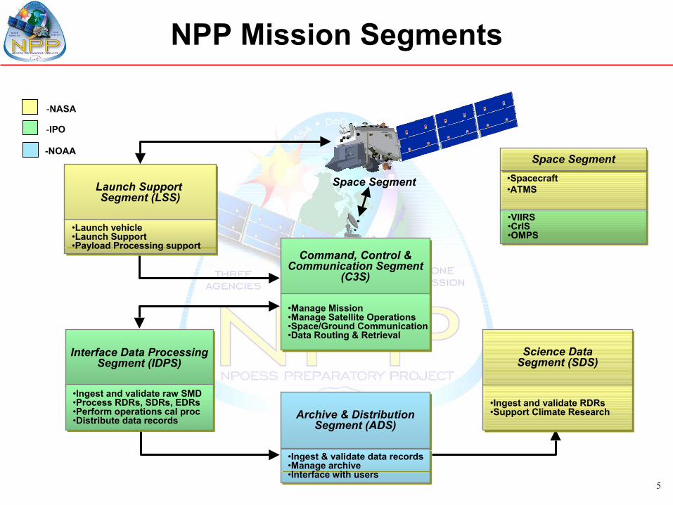
Space Segment
-NASA
-IPO
-NOAA
Command, Control &Communication Segment
(C3S)
Command, Control &Communication Segment
(C3S)
•Manage Mission •Manage Satellite Operations•Space/Ground Communication•Data Routing & Retrieval
•Manage Mission •Manage Satellite Operations•Space/Ground Communication•Data Routing & Retrieval
Launch Support Segment (LSS)
Launch Support Segment (LSS)
•Launch vehicle•Launch Support•Payload Processing support
•Launch vehicle•Launch Support•Payload Processing support
Interface Data ProcessingSegment (IDPS)
Interface Data ProcessingSegment (IDPS)
•Ingest and validate raw SMD•Process RDRs, SDRs, EDRs•Perform operations cal proc•Distribute data records
•Ingest and validate raw SMD•Process RDRs, SDRs, EDRs•Perform operations cal proc•Distribute data records Archive & Distribution
Segment (ADS)Archive & Distribution
Segment (ADS)
•Ingest & validate data records•Manage archive•Interface with users
•Ingest & validate data records•Manage archive•Interface with users
Science DataSegment (SDS)Science Data
Segment (SDS)
•Ingest and validate RDRs•Support Climate Research•Ingest and validate RDRs•Support Climate Research
NPP Mission Segments
Space SegmentSpace Segment•Spacecraft •ATMS
•VIIRS•CrIS•OMPS
•VIIRS•CrIS•OMPS

6
NPP Satellite
• LRD: October 31, 2006• Orbit: 824 km, sun-synchronous,
98° inclination, descending 10:30AM ± 10 minute local mean time• Launch Vehicle: Delta 7920-10 from VAFB• Bus Developer: Ball Aerospace and Technology Corporation• Bus: BCP-2000• Heritage Missions: ICESat, QuickScat, QuickBird• Dimensions: ~1.35 m x 1.35 m x 4.03 m• Mass: 2,228 kg (including 325 kg of propellant / pressurant)• Power: 2,400 w
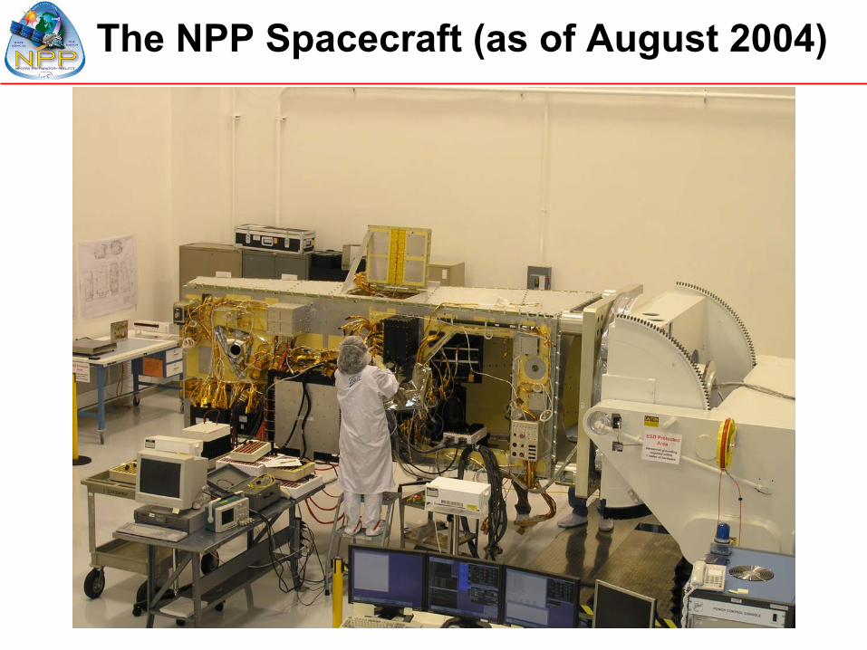
The NPP Spacecraft (as of August 2004)

8
ADVANCED TECHNOLOGY MICROWAVE SOUNDER
In conjunction with CrIS, global observations of temperature and moisture profiles at high temporal resolution (~daily)
ATMS
• Mass: 85 kg• Power: 110 w• Average Data Rate: 30 kbps
• Instrument Developer: Northrop Grumman Electronic Systems
• Predecessor Instruments: AMSU A1 / A2, MHS
• Approach: Scanning passive microwave radiometer (22 channels / 23 - 183 GHz)
• Swath width: 2,300 km (Co-registered with CrIS)
9
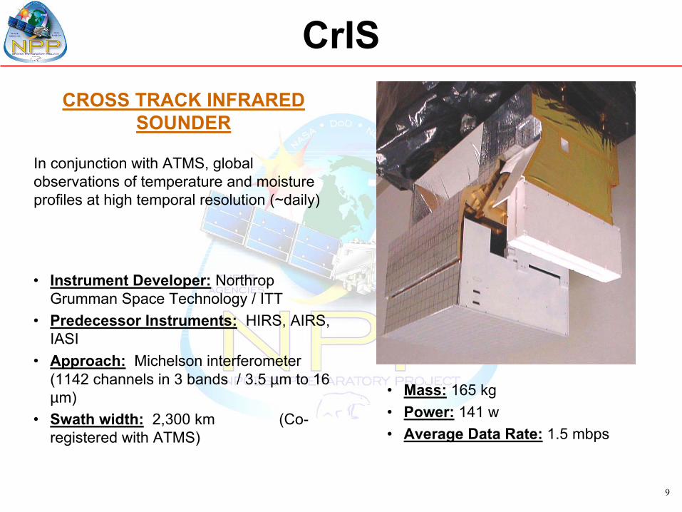
CROSS TRACK INFRARED SOUNDER
In conjunction with ATMS, global observations of temperature and moisture profiles at high temporal resolution (~daily)
CrIS
• Instrument Developer: Northrop Grumman Space Technology / ITT
• Predecessor Instruments: HIRS, AIRS, IASI
• Approach: Michelson interferometer (1142 channels in 3 bands / 3.5 µm to 16 µm)
• Swath width: 2,300 km (Co-registered with ATMS)
• Mass: 165 kg• Power: 141 w• Average Data Rate: 1.5 mbps
10
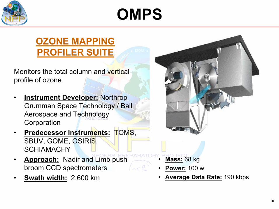
• Instrument Developer: Northrop Grumman Space Technology / Ball Aerospace and Technology Corporation
• Predecessor Instruments: TOMS, SBUV, GOME, OSIRIS, SCHIAMACHY
• Approach: Nadir and Limb push broom CCD spectrometers
• Swath width: 2,600 km
OMPSOZONE MAPPING PROFILER SUITE
Monitors the total column and vertical profile of ozone
• Mass: 68 kg• Power: 100 w• Average Data Rate: 190 kbps
11
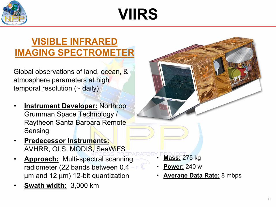
VISIBLE INFRARED IMAGING SPECTROMETER
Global observations of land, ocean, & atmosphere parameters at high temporal resolution (~ daily)
VIIRS
• Instrument Developer: Northrop Grumman Space Technology / Raytheon Santa Barbara Remote Sensing
• Predecessor Instruments:AVHRR, OLS, MODIS, SeaWiFS
• Approach: Multi-spectral scanning radiometer (22 bands between 0.4 µm and 12 µm) 12-bit quantization
• Swath width: 3,000 km
• Mass: 275 kg• Power: 240 w• Average Data Rate: 8 mbps
12
NPP Development Status
• ATMS, VIIRS, CrIS, and OMPS instruments have Engineering Development Units in process. Flight assembly has started for all the sensors and deliveries are expected through out 2005
• Key spacecraft components have been integrated, the spacecraft has been successfully powered-up, and the first command has been successfully sent on August 10, 2004. The spacecraft is on track for an early 2005 completion
• All ground system elements are well underway and development schedules support mission readiness testing
• In general all NPP mission elements are making good progress, although some technical issues with the sensors are putting pressure on mission schedule reserves
13
Mission Data Products
• NPP (and later the NPOESS Space Segment) will produce sensor data for processing by the NPOESS Interface Data Processing Segment (IDPS)
• The IDPS will produce Environmental Data Records (EDR’s) of geophysical products in an operational environment while minimizing data latency
• NASA, NOAA, and other agencies will leverage the operational EDR’s in performing climate research– ADS will archive the IDPS EDRs– SDS is intended to be a research tool in support of NASA’s
efforts

14
Precipitation Type/Rate
Sea SFC Height/TOPO
Solar IrradianceSupra-Therm-Aurora PropSurface Type
Suspended MatterTotal Water ContentVegetative Index
Surface Wind Stress
Snow Cover/Depth
Cloud Top PressureCloud Top TemperatureDown LW Radiance (Sfc)Down SW Radiance (Sfc)Electric Fields
Energetic IonsGeomagnetic Field
In-situ Plasma FluctuationIn-situ Plasma Temp
Med Energy Chgd Parts
Net Solar Radiation (TOA)Neutral Density ProfileOcean Color/ChlorophyllOcean Wave CharacterOutgoing LW Rad (TOA)O3 – Total Column Profile
Electron Density Profile
Ionospheric Scintillation
Ice Surface Temperature
Land Surface TempNet Heat Flux
Imagery
Sea Surface Winds
Aerosol Refractive IndexAlbedo (Surface)Auroral BoundaryAuroral Energy DepositionAuroral Imagery
Cloud Cover/LayersCloud Effective Part SizeCloud Ice Water PathCloud Liquid WaterCloud Optical ThicknessCloud Particle Size/DistribCloud Top Height
Atm Vert Moist ProfileAtm Vert Temp Profile
Sea Surface Temperature
Cloud Base Height
VIIRS (24)CMIS (19)
CrIS/ATMS (3)
SES (13)OMPS (1)
GPSOS (2)
TSIS (1)ERBS (5)
ALT (3)APS (4)
LEGEND
- NPOESS Key Performance Parameters (KPPs)
Precipitable Water
Soil MoistureAerosol Optical ThicknessAerosol Particle Size
Pressure (Surface/Profile)Sea Ice Characterization
NPP Sensors Contribute 27 of 56 NPOESSEnvironmental Data Records (EDRs)
Active Fires
NPP EDRs IN BLACK FONT
15
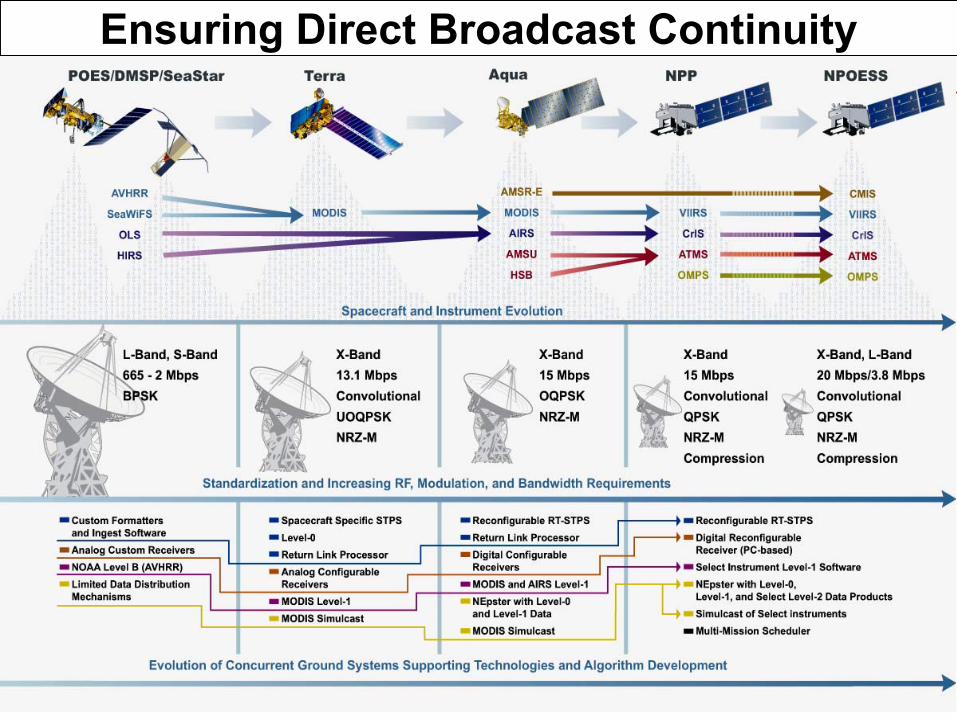
Ensuring Direct Broadcast Continuity

16
Risk Reduction & Mitigation
• For NPP, the NASA Direct Readout Laboratory (DRL) provides risk reduction and a roadmap for the NPOESS IDPS system in the Field Terminal Segment (FTS).
• The DRL has been, and will continue to do this by providing NPP packet processing and Level-0 algorithms, real-time NPP-specific visualization tools, lessons learned and an environment for testing and validating the FTS processing system.
17
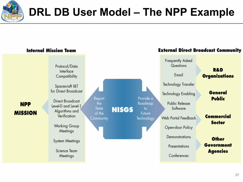
DRL DB User Model – The NPP Example

18
LAUNCH VEHICLE
TDRS
TDRSS WHITE SANDS
STATION
HARDLINE
8.2125 GHz300 Mbps
CMD 2067.270833 MHz 2 & 128 kbps
TLM 2247.5 MHz 1, 4, 16, 32 Kib/s
(Realtime) 512 Kib/s (Stored)
TDRSS Ground Link
CMD: 2067.270833 MHz.125 & 1 kbps
TLM: 2247.5 MHz1, 4 or 16 Kib/s
7.812 GHz15 Mbps
NPP SPACECRAFT
S-Band Omni Antenna
NorwaySVALBARD
STATION
HRDAntenna
S-Band OmniAntenna
HRD DirectDownlink
User Terminal
SMDAntenna
Launch Operations Only
NPP’s Communications
19
Summary
• NPP meeting requirements for EOS Bridge Mission and NPOESS Risk Reduction.
• NPP and NPOESS to benefit from close collaboration with NASA and the DRL.
• Developing plans to send out a “Future Polar User” survey to Latin American and Caribbean countries that are interested in acquiring NPP/NPOESS direct broadcast data.– Purpose: To better understand specific localized
data needs and uses.


