
June 2012
Iowa Highway 5 / US Highway 65 Freeway Corridor
Interstate System Designation Summary Report

Iowa Highway 5/US Highway 65 Freeway Corridor Interstate System Designation Summary Report
Page 1
Introduction As requested by the Des Moines Area Metropolitan Planning Organization (MPO), the Iowa Department of Transportation (Iowa DOT) has completed several planning‐level needs analyses related to the designation of the Iowa Highway 5 (IA 5) /US Highway 65 (US 65) freeway corridor in the Des Moines metropolitan area as part of the federal Interstate system. These analyses have been completed to satisfy Federal Highway Administration (FHWA) requirements for identifying and documenting the need for potential improvements to meet design standards for Interstate roadway facilities. This summary report documents the methodologies and findings of the planning‐level analyses performed on the subject corridor between the I‐35 and I‐80 system interchanges. Specific analyses and results documented in this report include:
Geometric analysis of existing roadway conditions;
Safety analysis of roadway deficiencies;
Right of way gate access points, alternative gate accesses, and slow moving vehicle provisions;
Future traffic analysis of freeway conditions and interchanges in the freeway corridor; and
Resulting concept‐level cost estimates to rectify geometric deficiencies, replace signage, and provide alternative access roads.
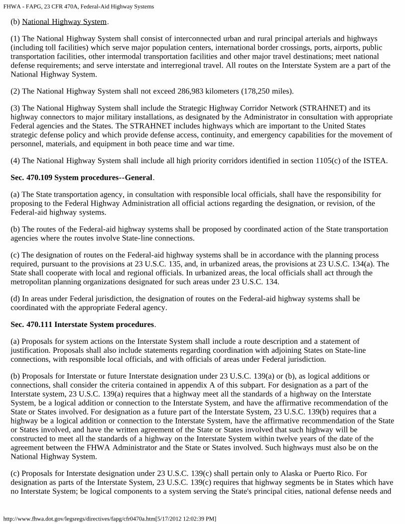
In addition, this report also generally outlines the federal Interstate facility designation process as described in 23 CFR 470A.111 and Appendix A of 23 U.S.C 139(a)(b). The next steps in the Interstate designation process of the IA 5/US 65 corridor are also discussed should Iowa DOT policy dictate moving forward with the designation request.
Roadway Geometric Analysis As‐built plans for the previously constructed IA 5/US 65 freeway corridor were examined to identify existing roadway geometry that did not meet minimum AASHTO geometric criteria for freeway facilities. These plans were reviewed against minimum AASHTO interstate/freeway standards and design speeds of 70 mph. The following geometric factor conditions were analyzed:
Superelevation;
Vertical curve K‐value / stopping sight distance;
Vertical bridge clearance;
Maximum/minimum vertical grades;
Lane / shoulder / median widths;
Clear zone / design speed;
Side slope / end conditions; and
Ramp terminal / interchange spacing. As plans were reviewed, notations and comments were made to identify and record locations of geometric design deficiencies. Design deficiencies were identified through comparison of the as‐built plan specifications to minimum AASHTO design standards (A Policy on Design Standards Interstate System, 2005) for freeway facilities to be eligible for an Interstate system designation. Additionally, A Policy on Geometric Design for Highways and Streets, AASHTO, 2004 and the Roadside Design Guide, AASHTO, 2006 were consulted per the Policy on Design Standards Interstate System for detailed design
Iowa Highway 5/US Highway 65 Freeway Corridor Interstate System Designation Summary Report
Page 2
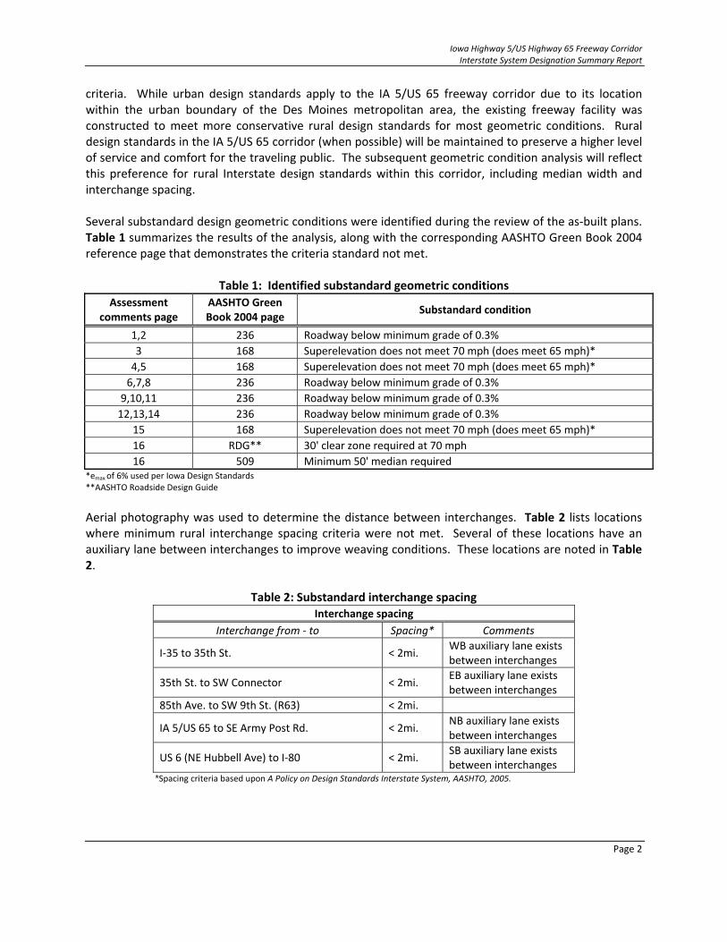
criteria. While urban design standards apply to the IA 5/US 65 freeway corridor due to its location within the urban boundary of the Des Moines metropolitan area, the existing freeway facility was constructed to meet more conservative rural design standards for most geometric conditions. Rural design standards in the IA 5/US 65 corridor (when possible) will be maintained to preserve a higher level of service and comfort for the traveling public. The subsequent geometric condition analysis will reflect this preference for rural Interstate design standards within this corridor, including median width and interchange spacing. Several substandard design geometric conditions were identified during the review of the as‐built plans. Table 1 summarizes the results of the analysis, along with the corresponding AASHTO Green Book 2004 reference page that demonstrates the criteria standard not met.
Table 1: Identified substandard geometric conditions
Assessment comments page
AASHTO Green Book 2004 page
Substandard condition
1,2 236 Roadway below minimum grade of 0.3%
3 168 Superelevation does not meet 70 mph (does meet 65 mph)*
4,5 168 Superelevation does not meet 70 mph (does meet 65 mph)*
6,7,8 236 Roadway below minimum grade of 0.3%
9,10,11 236 Roadway below minimum grade of 0.3%
12,13,14 236 Roadway below minimum grade of 0.3%
15 168 Superelevation does not meet 70 mph (does meet 65 mph)*
16 RDG** 30' clear zone required at 70 mph
16 509 Minimum 50' median required *emax of 6% used per Iowa Design Standards **AASHTO Roadside Design Guide
Aerial photography was used to determine the distance between interchanges. Table 2 lists locations where minimum rural interchange spacing criteria were not met. Several of these locations have an auxiliary lane between interchanges to improve weaving conditions. These locations are noted in Table 2.
Table 2: Substandard interchange spacing Interchange spacing
Interchange from ‐ to Spacing* Comments
I‐35 to 35th St. < 2mi. WB auxiliary lane exists between interchanges
35th St. to SW Connector < 2mi. EB auxiliary lane exists between interchanges
85th Ave. to SW 9th St. (R63) < 2mi.
IA 5/US 65 to SE Army Post Rd. < 2mi. NB auxiliary lane exists between interchanges
US 6 (NE Hubbell Ave) to I‐80 < 2mi. SB auxiliary lane exists between interchanges
*Spacing criteria based upon A Policy on Design Standards Interstate System, AASHTO, 2005.

Iowa Highway 5/US Highway 65 Freeway Corridor Interstate System Designation Summary Report
Page 3
In addition to substandard rural interchange spacing, one location with substandard ramp terminal spacing was identified. That location, NE Hubbell Avenue (US 6) interchange, has ramp terminal spacing of less than 2,000 feet and is therefore considered deficient per AASHTO Green Book preferred criteria. Geometric deficiencies in the IA 5/US 65 corridor identified during the as‐built geometric analysis were verified by field investigation through the use of a Stabila Smart Level, 100‐foot tape measure, and a digital camera with GPS capabilities. Additionally, typical cross sections were measured and documented at locations deemed representative of each geometric deficiency area. Site conditions were also noted, including drainage, pavement condition, clear zone obstructions, signage, and emergency turn‐around points. Additional measurements were taken at the approximate locations of full superelevation at each deficient location identified in the as‐built analysis. These notations and observations have been documented in Appendix A to this technical memorandum. All roadway geometric deficiencies identified through the as‐built plan review were verified during the field investigation. However, field observations of adequate drainage infrastructure and clear zones and a good overall condition of the facility indicate that the identified geometric deficiencies, especially those that generate concerns with roadway drainage, do not cause adverse driving or roadway maintenance conditions. However, roadway superelevations lacking a 70 mph design speed may necessitate a lower posted speed limit to enhance safety at those locations. Existing signage on roadside, overhead, and bridge‐mounted structures may need to be replaced with signage meeting federal Interstate signage standards, possibly including roadside mile‐marker numbering.
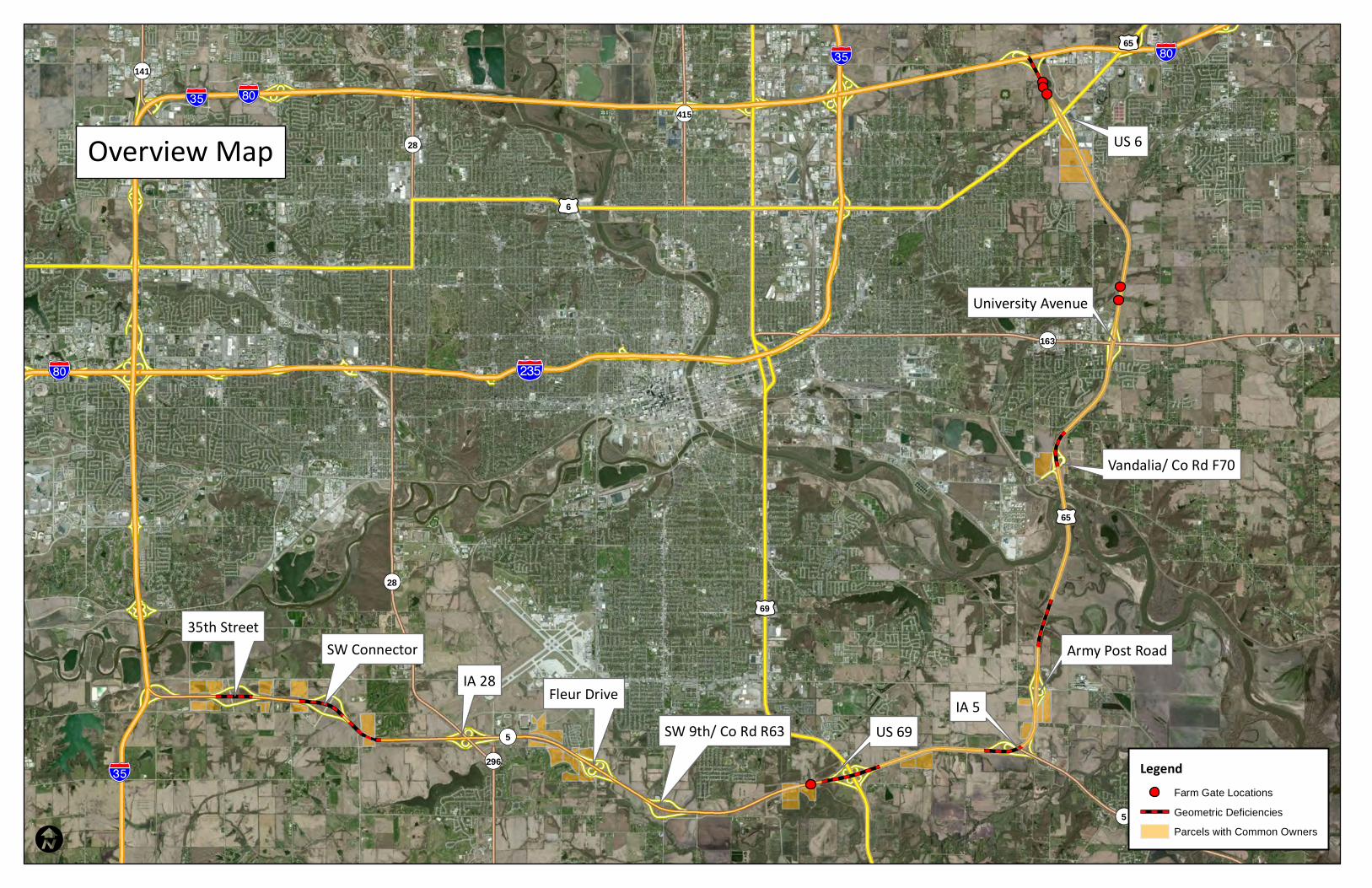
Safety Analysis of Roadway Deficiencies Previously identified geometrically deficient locations in the IA 5/US 65 freeway corridor were further examined to determine if those locations may create conditions for higher numbers of crashes when compared against statewide averages for similar facilities. Crash data were obtained from the Iowa DOT for the most recent five year period available (2006‐2010). Safety analysis results show that among the seven previously identified locations with geometric deficiencies along the corridor, three have crash rates higher than the statewide average for similar roadway facilities. Locations of the geometric deficiencies are displayed on the attached Overview Map. Table 3 displays the summarized results of the safety analysis at the seven locations with identified geometric deficiencies.

Iowa Highway 5/US Highway 65 Freeway Corridor Interstate System Designation Summary Report
Page 4
Table 3: Safety analysis summary of geometric deficiencies
Freeway segment Geometric deficiency
Segment length (miles)
Total crashes (2006‐2010)
Crash rate (per HMVMT)
Statewide crash rate (per
HMVMT)
35th Street Below minimum grade of 0.3%
0.55 14 56.5 48
SW Connector Super does not meet 70 mph
1.40 23 37.2 48
US 69 Below minimum grade of 0.3%
0.88 10 31.9 48
IA 5 Below minimum grade of 0.3%
0.61 23 192.5 48
North of Army Post Road
Below minimum grade of 0.3%
0.72 11 41.9 48
Vandalia Super does not meet 70 mph
0.55 21 124.5 48
I‐80 Minimum 50' median required
0.64 13 45.9 48
Nearly all of the crashes at the three locations with higher than statewide average crash rates are single vehicle crashes. This could indicate that there may be outside factors such as deficient geometry contributing to the number and type of crashes. Additionally, there were two fatal crashes in the deficient areas for the 5‐year study period. Due to the short length and comparatively low volumes of both of these analysis segments, one fatal crash in a 5 year period skews the calculations higher than the statewide fatal crash rate.
Right of Way Gate Access Points The existence of Iowa DOT right of way gate access points is an important issue in the IA 5/US 65 freeway corridor due to the requirements that an Interstate facility be fully access controlled. Should the IA 5/US 65 facility be designated as part of the Interstate system, all Iowa DOT right of way gate access points would be permanently closed to meet the full access control requirements. To determine likely locations of existing access gates in the IA 5/US 65 corridor, parcels with common or similar ownership that appeared to be split by Iowa DOT right of way were identified using GIS parcel ownership data files from Polk and Warren counties. A field visual inspection of the IA 5/US 65 corridor was then completed to visually confirm gate access points. Right of way gate access points were photographed and logged to document their location and condition. The field investigation initially identified five gate access points in the IA 5/US 65 freeway corridor. One additional gate access point was later identified, photographed, and logged during the geometric deficiency field verification exercise. Three gate access points are located between the US 65/I‐80 systems interchange and the US 65/US 6 interchange. Two gates were located less than one mile north of the US 65/University Avenue interchange, and one gate was found on the IA 5 corridor west of the IA 5/US 69 interchange. Approximate locations of the six farm gate locations are displayed on the Overview Map. Utility maintenance and farm property access have been identified as two potential uses for the gate access points. However, it is currently unclear as to which gate access points are used

Iowa Highway 5/US Highway 65 Freeway Corridor Interstate System Designation Summary Report
Page 5
for utility access and those potentially used for farm vehicle access, if any. Prior to permanent closure of any existing gates, property owners will be consulted and gate use details and use frequency will be further investigated. Through the preliminary landowner and right of way analysis, it was determined that closure of three access gates may require the provision of alternative access points from the local roadway system to the served properties. Construction of an estimated 2,750 linear feet of gravel access drives may be required to provide continued access to parcels served by existing access gates. Preliminary cost estimates for providing gravel access drives can be found in the Concept‐level Cost Estimates section of this report. Farm vehicles, implements, and other slow‐moving vehicles currently utilizing existing interchanges or gates to access Iowa DOT right of way and use the IA 5/US 65 roadway will be prohibited from doing so should the roadway be designated as part of the federal Interstate system. Such vehicles will be prohibited from accessing the right of way due to State of Iowa operating rules that determine which vehicles are allowed on the Interstate system under its jurisdiction. Specifically, Iowa State Code Title VIII, Subtitle 2, Chapter 321.285 5(e) states:
“Any kind of vehicle, implement, or conveyance incapable of attaining and maintaining a speed of forty miles per hour shall be prohibited from using the interstate road system.”
Should the IA 5/US 65 corridor be designated as an Interstate facility, speed restrictions will effectively preclude most slow moving vehicles from using the roadway. Slow moving vehicles currently using the corridor will be required to find alternative routes on the local roadway system. An analysis of the local roadway system demonstrated that adequate alternative access to property is generally available and the provision of alternative gravel access drives from the local road system in lieu of gate access will mitigate for the loss of direct access to Iowa DOT right of way. Slow moving vehicles currently utilizing the IA 5/US 65 corridor specifically to cross the Des Moines River between the US 69 and US 6 interchanges will no longer be permitted to do so. The nearest available crossings of the Des Moines River are located at Iowa Highway 316 (IA 316) south of Runnells and US 69 (SE 14th Street) in the City of Des Moines. The IA 316 bridge is located approximately ten miles southeast of the IA 5/US 65 corridor crossing while the US 69 bridge is located approximately four miles west.
Traffic Operational Analysis Traffic analysis for IA 5/US 65 freeway corridor segments was performed using the Highway Capacity Manual (HCM) 2010 and the corresponding Highway Capacity Software (HCS) 2010. Year 2040 forecast AM and PM peak hour volumes provided by the Iowa DOT were used in the analyses. Heavy vehicle percentages were also provided by the Iowa DOT for the Year 2040. Based upon this analysis there were some areas which did not perform to level of service (LOS) C, the Iowa DOT standard for urban Interstate roadways. On the IA 5/US 65 freeway corridor, Year 2040 LOSs are generally acceptable. However, traffic flow begins to experience a LOS D during the AM peak on IA 5 at many of the westbound off‐ramps and a few other locations between the I‐35 and US 69 interchanges. In the PM peak period, the southbound US 65 on‐ramp from I‐80 eastbound is forecast to have a volume that exceeds capacity, which results in a LOS

Iowa Highway 5/US Highway 65 Freeway Corridor Interstate System Designation Summary Report
Page 6
F. Results of the HCS analysis of the IA 5/US 65 freeway segments are displayed in Appendix B: Traffic Operational Analysis Results. The I‐35/IA 5 and I‐80/US 65 systems interchanges were operationally evaluated as part of this analysis. The I‐35/IA 5 interchange generally experiences acceptable levels of service during the AM and PM peak periods in 2040. However, the I‐80/I‐35 system interchange performs poorly during both the AM and PM peak periods, with most merge and diverge points achieving LOS D through F. However, a comparison of 2040 traffic volumes and operations on the IA 5/US 65 corridor and the I‐80 corridor generally indicates that operational issues with the I‐80/US 65 system interchange are a result of high volumes and poor operations on I‐80 that create weaving, merge, and diverge operational issues throughout the interchange. The cross street ramp terminal intersection evaluation using Year 2040 traffic volumes was performed using Synchro 8 software. Many ramp terminals will require improvements to operate at acceptable levels with forecasted Year 2040 traffic volumes. Table 4 shows the LOS results from the ramp terminal intersection analysis.
Table 4: Year 2040 traffic operational analysis for ramp terminal intersections
Location Type of control
2040 Level of service1
AM peak PM peak
35th St. & Eastbound IA 5 Ramps Stop A A
35th St. & Westbound IA 5 Ramps Stop A B
SW Connector & Eastbound IA 5 Ramps Stop E C
SW Connector & Westbound IA 5 Ramps Stop C C
IA 28 & Eastbound IA 5 Ramps Stop F F
IA 28 & Westbound IA 5 Ramps Signal D B
Fleur Dr. & Eastbound IA 5 Ramps Stop E F
Fleur Dr. & Westbound IA 5 Ramps Stop F B
9TH St. (Co. R63) & Eastbound IA 5 Ramps Stop F F
9TH St. (Co. R63) & Westbound IA 5 Ramps Stop F F
64TH St. & Northbound US 65 Ramps Stop C C
64TH St. & Southbound US 65 Ramps Stop C D
University Ave. & Northbound US 65 Ramps Signal D C
University Ave. & Southbound US 65 Ramps Signal C F
46th Ave. & Northbound US 65 Ramps Signal C E
46th Ave. & Southbound US 65 Ramps Signal B E
Hubbell Ave. & Northbound US 65 Ramps Signal C B
Hubbell Ave. & Southbound US 65 Ramps Signal B B1 For stop controlled intersections the lowest approach level of service is presented. As displayed in Table 4, many Year 2040 traffic operational issues at ramp terminal intersections are likely the result of delay issues with stop‐controlled intersections. Signalization of these intersections will likely improve LOS at these locations to acceptable levels. Similarly, existing signalized intersections where future LOS issues are forecasted can likely achieve acceptable LOSs through basic capacity improvements and signal optimization.
Iowa Highway 5/US Highway 65 Freeway Corridor Interstate System Designation Summary Report
Page 7
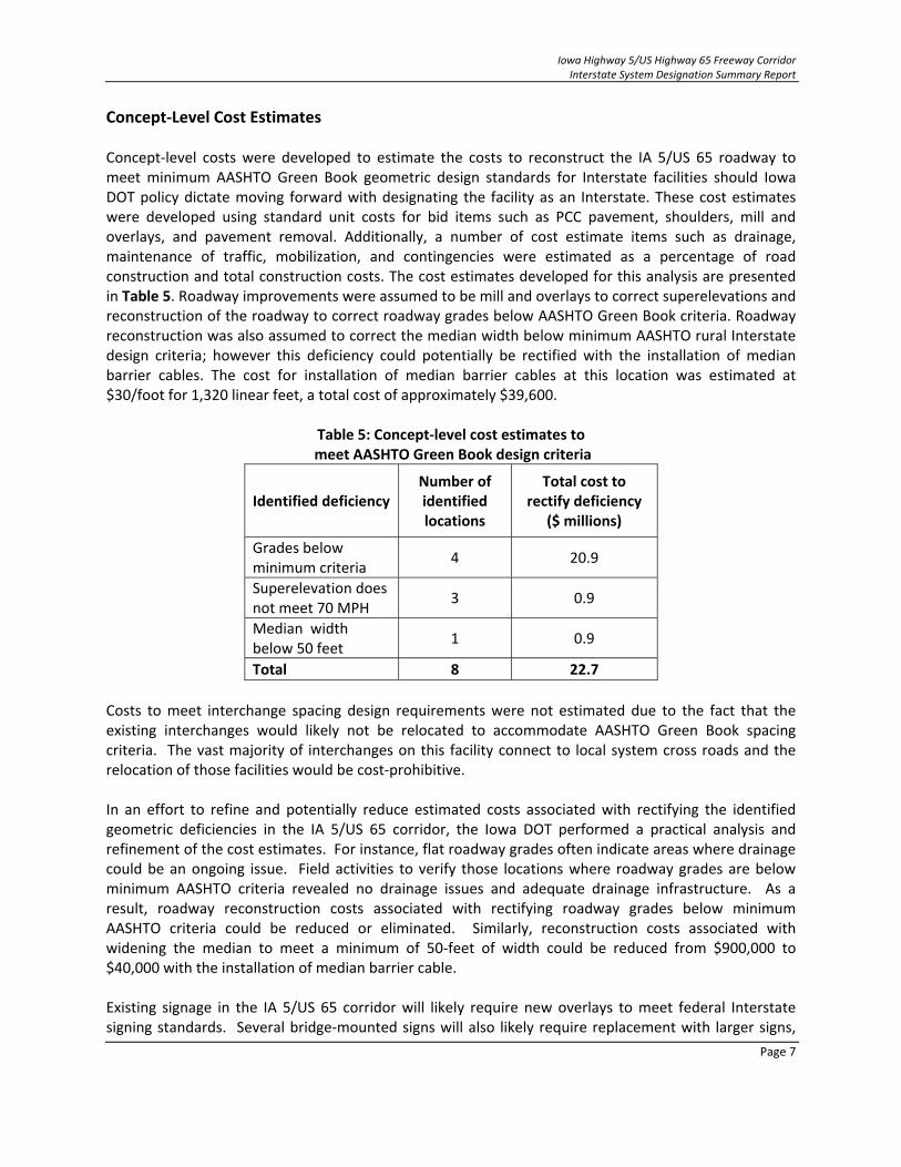
Concept‐Level Cost Estimates Concept‐level costs were developed to estimate the costs to reconstruct the IA 5/US 65 roadway to meet minimum AASHTO Green Book geometric design standards for Interstate facilities should Iowa DOT policy dictate moving forward with designating the facility as an Interstate. These cost estimates were developed using standard unit costs for bid items such as PCC pavement, shoulders, mill and overlays, and pavement removal. Additionally, a number of cost estimate items such as drainage, maintenance of traffic, mobilization, and contingencies were estimated as a percentage of road construction and total construction costs. The cost estimates developed for this analysis are presented in Table 5. Roadway improvements were assumed to be mill and overlays to correct superelevations and reconstruction of the roadway to correct roadway grades below AASHTO Green Book criteria. Roadway reconstruction was also assumed to correct the median width below minimum AASHTO rural Interstate design criteria; however this deficiency could potentially be rectified with the installation of median barrier cables. The cost for installation of median barrier cables at this location was estimated at $30/foot for 1,320 linear feet, a total cost of approximately $39,600.
Table 5: Concept‐level cost estimates to meet AASHTO Green Book design criteria
Identified deficiency Number of identified locations
Total cost to rectify deficiency
($ millions)
Grades below minimum criteria
4 20.9
Superelevation does not meet 70 MPH
3 0.9
Median width below 50 feet
1 0.9
Total 8 22.7
Costs to meet interchange spacing design requirements were not estimated due to the fact that the existing interchanges would likely not be relocated to accommodate AASHTO Green Book spacing criteria. The vast majority of interchanges on this facility connect to local system cross roads and the relocation of those facilities would be cost‐prohibitive. In an effort to refine and potentially reduce estimated costs associated with rectifying the identified geometric deficiencies in the IA 5/US 65 corridor, the Iowa DOT performed a practical analysis and refinement of the cost estimates. For instance, flat roadway grades often indicate areas where drainage could be an ongoing issue. Field activities to verify those locations where roadway grades are below minimum AASHTO criteria revealed no drainage issues and adequate drainage infrastructure. As a result, roadway reconstruction costs associated with rectifying roadway grades below minimum AASHTO criteria could be reduced or eliminated. Similarly, reconstruction costs associated with widening the median to meet a minimum of 50‐feet of width could be reduced from $900,000 to $40,000 with the installation of median barrier cable. Existing signage in the IA 5/US 65 corridor will likely require new overlays to meet federal Interstate signing standards. Several bridge‐mounted signs will also likely require replacement with larger signs,

Iowa Highway 5/US Highway 65 Freeway Corridor Interstate System Designation Summary Report
Page 8
and the need for five additional sign trusses is possible. The Iowa DOT estimates the cost for all signage upgrades, including sign trusses, at $800,000. Concept‐level cost estimates were also developed to provide alternative access roads to three properties in the event existing gate accesses to the IA 5/US 65 right of way are closed. The cost estimates assumed that all new access roads would be constructed as 16‐foot wide gravel roads with 4 inches of gravel surfacing. The cost to construct each gravel access road was assumed to be $15 per square yard of gravel. Table 6 displays the cost estimate to provide alternative access roads to the identified properties.
Table 6: Concept‐level cost estimates for alternative access roads
Property/Mile marker of farm access gate
Linear feet of access road
Cost per sq. yard of gravel ($)
Approximate total cost of new access ($)
Horn/Burkhalter properties – Mile marker 88
500 $15 $15,000
Ledlie property – Mile marker 70
2,250 $15 $60,000
Total 2,750 $15 $75,000
Total estimated concept‐level costs to meet AASHTO Green Book design criteria in the IA 5/US 65 freeway corridor and refined estimated costs are presented in Table 7. Unrefined total estimated costs include rectifying geometric deficiencies, upgrading signage, and providing gravel alternative access roads to property owners with existing gate accesses. Refined cost estimates include only those costs associated with upgrading signage, modifying superelevations, providing median cable barrier where necessary, and providing gravel alternative access roads.
Table 7: Total concept‐level costs for upgrading the IA 5/US 65 freeway corridor to Interstate standards
Cost item to upgrade Unrefined total costs to upgrade ($ thousands)
Refined total costs to upgrade ($ thousands)
Grades below minimum criteria 20,900 0
Superelevation does not meet 70 MPH 900 900
Median width below 50 feet 900 40
Upgrade signage 800 800
Provide alternative access roads 75 75
Total 23,575 1,815
Federal Interstate Designation Process and Next Steps
The process for designating the IA 5/US 65 corridor as a federal Interstate Highway facility must follow the policies and procedures as outlined in 23 CFR 470A.111. They must also meet the criteria found in appendices A and B as established in 23 U.S.C 139(a)(b). 23 CFR 470A and associated appendices A and B can be viewed in Appendix C of this report. Should Iowa DOT policy determine that pursuing federal

Iowa Highway 5/US Highway 65 Freeway Corridor Interstate System Designation Summary Report
Page 9
Interstate designation for the IA 5/US 65 facility is appropriate, requests for designating the corridor as an Interstate should follow these steps and guidelines:
The Iowa DOT must submit a formal request for Interstate designation through the Iowa Division of FHWA to the FHWA Associate Administrator for Program Development. Comments and recommendations by the Iowa Division will be offered.
The Director of the Iowa DOT must also request that the IA 5/US 65 corridor be added to the Interstate system. Exact locations and termini must be specified in this request.
The FHWA ensures that the request for Interstate designation of the corridor is supported by findings that the corridor is constructed to Interstate design standards and directly connects to the existing Interstate system.
The request for Interstate designation should identify and justify any design exceptions for which federal approval is requested.
The Iowa DOT’s proposed route numbering for the corridor must be submitted to FHWA and AASHTO’s Route Numbering Committee.
Any request for designation of the IA 5/US 65 corridor as part of the Interstate system should include justification that the corridor meets all standards of a highway on the Interstate system, have the affirmative recommendation of the state, and be a logical addition or connection to the Interstate system. FHWA would then evaluate the IA 5/US 65 corridor and make a determination of logical addition based on the following criteria:
The proposed route should be of sufficient length to serve long‐distance Interstate travel, such as connecting routes between industrial centers important to national defense and economic development.
The proposed route should not duplicate other Interstate routes. It should serve Interstate traffic movement not provided by another Interstate route.
The proposed route should directly serve major highway traffic generators. The term "major highway traffic generator" means either an urbanized area with a population over 100,000 or a similar major concentrated land use activity.
The proposed route should connect to the Interstate System at each end and connect to routes that of the National Highway System that can adequately handle the traffic.
The proposed route must meet all the current geometric and safety standards criteria as set forth in 23 CFR part 625 for highways on the Interstate System, or a formal agreement to construct the route to such standards within 25 years must be executed between the State and the FHWA. Any proposed exceptions to the standards shall be approved at the time of designation.
The proposed route for designation under 23 U.S.C. 139(b) must have an approved final environmental document (including, if required, a 49 U.S.C. 303(c) [Section 4(f)] approval) covering the route.
At this point in time, the IA 5/US 65 corridor would satisfy four of the six criteria for a determination of logical addition to the Interstate system. The analyses completed and documented in this technical report may serve, all or in part, as documentation that the IA 5/US 65 freeway corridor meets current geometric and safety standards. As a result, the following next steps to satisfy the criteria for addition

Iowa Highway 5/US Highway 65 Freeway Corridor Interstate System Designation Summary Report
Page 10
to the Interstate system should be completed prior to submitting a formal request for designation of the corridor as part of the Interstate system:
Consult with FHWA regarding the need for preparation of design exceptions for identified geometric deficiencies on the existing IA 5/US 65 corridor.
If necessary and requested by FHWA, prepare detailed design exceptions.
If requested by FHWA, prepare a detailed needs and capacity analysis for those ramp terminal intersections forecasted to poorly operate in 2040.
Request a NEPA classification from FHWA for the proposed action and prepare the required environmental documentation.
As part of the NEPA process, engage stakeholders, the general public, and affected landowners regarding farm gate access closures and proposed gravel alternative access to their properties.
Once completed, documentation of these additional steps should be packaged together and submitted as a supporting documentation for a formal request to the Iowa Division of FHWA for designation of the IA 5/US 65 corridor as part of the federal Interstate system. FHWA will review the request, and pending satisfactory fulfillment of the criteria, may:
Request additional information or data;
Conditionally approve the request contingent upon completing roadway improvements that address any identified geometric, safety, traffic, or access issues not addressed by approved design exceptions; or
Approve or deny the request. Continued detailed traffic and safety analyses and preparation of design exceptions may reveal additional and currently unknown issues that may need to be addressed as required by FHWA prior to approval of the request for Interstate designation.
!"c$
%&e(
!"a$
!"c$!"a$
!"c$
!"a$
¬«5
¬«28
¬«163
¬«415
¬«141
¬«296
¬«5
¬«28
£¤6
£¤65
£¤69
£¤65
I
LegendFarm Gate Locations
Geometric Deficiencies
Parcels with Common Owners
35th StreetSW Connector
IA 28 Fleur DriveSW 9th/ Co Rd R63 US 69
IA 5
Army Post Road
Vandalia/ Co Rd F70
University Avenue
US 6Overview Map

Appendix B
Traffic Operational Analysis Results

Eastbound IA 5/Northbound US 65 Freeway Components
Rte. Location Component
2040 Level of Service
AM Peak PM Peak
Eastbound IA
5
On‐Ramp From NB I‐35 Ramp Merge B C
I‐35 to 35th St. Basic Freeway B C
Off‐Ramp To 35 St. Ramp Diverge B D
35th St. Between Ramps Basic Freeway B C
35th St. to SW Connector Weave B B
SW Connector Between Ramps Basic Freeway A C
On‐Ramp From SW Connector Ramp Merge B C
SW Connector to IA 28 Basic Freeway B C
Off‐Ramp to IA 28 Ramp Diverge B C
IA 28 Between Ramps Basic Freeway A B
On‐Ramp From SB IA 28 Ramp Merge A B
On‐Ramp From NB IA 28 Ramp Merge B C
IA 28 To Fleur Dr. Basic Freeway B C
Off‐Ramp To Fleur Dr. Ramp Diverge B C
Fleur Dr. Between Ramps Basic Freeway A B
On‐Ramp From SB Fleur Dr. Ramp Merge A B
On‐Ramp From NB Fleur Dr. Ramp Merge A C
Fleur Dr. to 9th St. (Co Rte. 63) Basic Freeway A C
Off‐Ramp to 9th St. (Co Rte. 63) River Diverge B C
9th St. (Co Rte. 63) Between Ramps Basic Freeway A B
On‐Ramp From 9th St. (Co Rte. 63) Ramp Merge A B
9th St. (Co Rte. 63) To US 69 Basic Freeway A B
Off‐Ramp To SB US 69/65 Ramp Diverge B C
US 69/65 Off‐Ramp To Loop Ramp Basic Freeway A B
US 69/65 Loop On‐Ramp To Loop Off‐Ramp Weave A A
US 69 Loop Ramp To On‐Ramp Basic Freeway A A
EB IA
5
/US 65 On‐Ramp From NB US 69 Ramp Merge A B
US 69/65 To IA 5 Basic Freeway A B
Off‐Ramp To SB IA 5 Ramp Diverge B B
IA 5 Between Ramps Basic Freeway A A
Northbound US 65
IA 5 To 64th Ave. Weave B A
64th Ave. Off‐Ramp To Loop On‐Ramp Basic Freeway A A
On‐Ramp From EB 64th Ave. Ramp Merge B A
On‐Ramp From WB 64th Ave. Ramp Merge B B
64th Ave. To Vandalia Rd. Basic Freeway B A
Off‐Ramp To Vandalia Rd. Ramp Diverge B B
Vandalia Rd. Between Ramps Basic Freeway A A
On‐Ramp From Vandalia Rd. Ramp Merge B B
Vandalia Rd. to University Ave. (IA 163) Basic Freeway B A
Off‐Ramp To University Ave. (IA 163) Ramp Diverge B B
University Ave. (IA 163) Between Ramps Basic Freeway A A
On‐Ramp From University Ave. (IA 163) Ramp Merge C B
University Ave. (IA 163) To 46th Ave./Hubbell Ave. Basic Freeway C A
Off‐Ramp To 46th Ave./Hubbell Ave. Ramp Diverge C B
46th Ave./Hubbell Ave. Between Ramps Basic Freeway B A
On‐Ramp From 46th Ave./Hubbell Ave. Ramp Merge C B
46th Ave./Hubbell Ave. To I‐80 Basic Freeway C A
Off‐Ramp To EB I‐80 Ramp Diverge D B

Westbound IA 5/Southbound US 65 Freeway Components
Rte. Location Component
2040 Level of Service
AM Peak PM Peak
Westbound IA
5
35th St. To SB I‐35 Weave B A
35th St. Between Ramps Basic Freeway C B
Off‐Ramp To 35th St. Ramp Diverge D B
SW Connector To 35th St. Basic Freeway C B
On‐Ramp From SB SW Connector Ramp Merge C B
SW Connector Between Ramps Basic Freeway C A
Off‐Ramp To SW Connector Ramp Diverge D B
IA 28 To SW Connector Basic Freeway C A
On‐Ramp From SB IA 28 Ramp Merge C B
On‐Ramp From NB IA 28 Ramp Merge C A
IA 28 Between Ramps Basic Freeway C A
Off‐Ramp To IA 28 Ramp Diverge D B
Fleur Dr. To IA 28 Basic Freeway C A
On‐Ramp From SB Fleur Dr. Ramp Merge C B
On‐Ramp From NB Fleur Dr. Ramp Merge B A
Fleur Dr. Between Ramps Basic Freeway C A
Off‐Ramp To Fleur Dr. Ramp Diverge D B
9th St. (Co Rte. 63) To Fleur Dr. Basic Freeway D A
On‐Ramp From 9th St. (Co Rte. 63) Ramp Merge D A
9th St. (Co Rte. 63) Between Ramps Basic Freeway C A
Off‐Ramp to 9th St. (Co Rte. 63) River Diverge D B
US 69 To 9th St. (Co Rte. 63) Basic Freeway C A
On‐Ramp From SB US 69 Ramp Merge C A
Loop Ramp To SB US 69/65 On‐Ramp Basic Freeway C A
US 69/65 Loop On‐Ramp To Loop Off‐Ramp Weave B A
Off‐Ramp To NB US 69 To Loop Ramp Basic Freeway B A
EB IA
5
/US 65 Off‐Ramp To NB US 69 Ramp Diverge B B
IA 5 To US 69/65 Basic Freeway B A
On‐Ramp From NB IA 5 Ramp Merge B A
IA 5 Between Ramps Basic Freeway A A
Southbound US 65
Off‐Ramp to IA 5 Ramp Diverge A A
64th Ave. To IA 5 Basic Freeway A A
On‐Ramp From 64th Ave. Ramp Merge A B
64th Ave. Between Ramps Basic Freeway A A
Off‐Ramp To 64th Ave. Ramp Diverge B B
Vandalia Rd. To 64th Ave. Basic Freeway A B
On‐Ramp From Vandalia Rd. Ramp Merge B B
Vandalia Rd. Between Ramps Basic Freeway A A
Off‐Ramp To Vandalia Rd. Ramp Diverge B B
University Ave. (IA 163) To Vandalia Rd. Basic Freeway A B
On‐Ramp From University Ave. (IA 163) Ramp Merge B B
University Ave. (IA 163) Between Ramps Basic Freeway A A
Off‐Ramp To University Ave. (IA 163) Ramp Diverge B C
46th Ave. To University Ave. (IA 163) Basic Freeway A B
On‐Ramp From 46th Ave./Hubbell Ave. Ramp Merge B B
46th Ave./Hubbell Ave. Between Ramps Basic Freeway A A
Off‐Ramp To 46th Ave./Hubbell Ave. Ramp Diverge B C
I‐80 To 46th Ave./Hubbell Ave. Basic Freeway A B
On‐Ramp From EB I‐80 Add Lane C F
On‐Ramp From WB I‐80 Add Lane A A

Westbound I‐80
Rte. Location Component
2040 Level of Service
AM Peak PM Peak
Westbound I‐80 Off‐Ramp To US 65 Ramp Diverge D C
On‐Ramp From US 65 Ramp Merge F C
US 65 To I‐35/235 Basic Freeway F C
Off‐Ramp To NB I‐35 Ramp Diverge F D
Off‐Ramp To SB I‐235 Drop Lane D D
On‐Ramp From NB I‐235 Ramp Merge F F
On‐Ramp From SB I‐35 Add Lane E F
Eastbound I‐80
Rte. Location Component
2040 Level of Service
AM Peak PM Peak
Eastbound I‐80 Off‐Ramp To SB I‐235 Ramp Diverge C F
Off‐Ramp To NB I‐35 Drop Lane E F
On‐Ramp From SB I‐35 Ramp Merge C F
On‐Ramp From NB I‐235 Add Lane E E
I‐35/235 To US 65 Basic Freeway B F
Off‐Ramp To US 65 Ramp Diverge C F
On‐Ramp From US 65 Ramp Merge B D
Northbound I‐235 & I‐35 (East Mixmaster)
Rte. Location Component
2040 Level of Service
AM Peak PM Peak
Northbound
I‐235/I‐35 South of Off‐Ramp To I‐80 Basic Freeway D D
Off‐Ramp To I‐80 Basic Freeway C C
North of Off‐Ramp To I‐80 Basic Freeway C C
On‐Ramp From EB I‐80 Add Lane E F
On‐Ramp From WB I‐80 Add Lane C D
Southbound I‐35 & I‐235 (East Mixmaster)
Rte. Location Component
2040 Level of Service
AM Peak PM Peak
Southbound
I‐35/I‐235 North of Off‐Ramp To I‐80 Basic Freeway C C
Off‐Ramp To I‐80 Basic Freeway C C
South of Off‐Ramp To I‐80 Basic Freeway C C
On‐Ramp From WB I‐80 Add Lane D D
On‐Ramp From EB I‐80 Ramp Merge C C

Northbound I‐35 (West Side) – 6 Lane I‐35 Between IA 5 and I‐80
Rte. Location Component
2040 Level of Service
AM Peak PM Peak
Northbound I‐35
South Of IA 5 Basic Freeway C A
Off‐Ramp To IA 5 Ramp Diverge C B
IA 5 Between Ramps Basic Freeway B A
IA 5 On‐Ramp to Grand Ave. Off‐Ramp Weave F B
Grand Ave. to Mills Civic Parkway Basic Freeway D B
Mills Civic Parkway Between Ramps Basic Freeway C B
Mills Civic Parkway To I‐80/I‐235 Basic Freeway E C
Off‐Ramp To EB I‐235 Ramp Diverge E D
Off‐Ramp To EB I‐235 To Off‐Ramp To WB I‐80 Basic Freeway D B
Off‐Ramp To WB I‐80 Ramp Diverge D C
Off‐Ramp To University Ave. Ramp Diverge D C
University Off‐Ramp To On‐Ramp From EB I‐80/WB I‐235
Basic Freeway C A
On‐Ramp From EB I‐80/WB I‐235 Add Lanes D F
University Ave. Between Ramps Basic Freeway E D
University Ave. To US 6 Basic Freeway F F
Southbound I‐35 (West Side) – 6 Lane I‐35 Between IA 5 and I‐80
Rte. Location Component
2040 Level of Service
AM Peak PM Peak
Southbound I‐35
US 6 To University Ave. Basic Freeway F F
University Ave. Between Ramps Basic Freeway C E
University Ave. To Off‐Ramp to WB I‐80 Weave F F
Off‐Ramp To WB I‐80 To On‐Ramp Loop Basic Freeway C F
On‐Ramp Loop to Off‐Ramp Loop Weave F F
Off‐Ramp Loop To On‐Ramp From EB I‐80 Basic Freeway C D
On‐Ramp From EB I‐80 Ramp Merge C D
I‐80/I‐235 to Mills Civic Parkway Basic Freeway C E
Mills Civic Parkway Between Ramps Basic Freeway A C
Mills Civic Parkway To Grand Ave. Basic Freeway B D
Grand Ave. To IA 5 Basic Freeway B D
Off‐Ramp To EB IA 5 Basic Freeway B C
IA 5 Between Ramps Basic Freeway A C
On‐Ramp From WB IA 5 Ramp Merge A C
South of IA 5 Basic Freeway A C
Eastbound I‐80/235 (West Mixmaster)
Rte. Location Component
2040 Level of Service
AM Peak PM Peak
Eastbound
I‐80/I‐235 60th St. To Off‐Ramp to I‐35/NB I‐80 Basic Freeway D C
Off‐Ramp To I‐35/NB I‐80 Basic Freeway C C
Off‐Ramp To I‐35 To On‐Ramp From SB I‐35 Basic Freeway C A
On‐Ramp From SB I‐35 Add Lane F F
On‐Ramp From NB I‐35 Ramp Merge D D

Westbound I‐235/80 (West Mixmaster)
Rte. Location Component
2040 Level of Service
AM Peak PM Peak
Westbound I‐
235/I‐80
Off‐Ramp To NB I‐35/I‐80 Lane Drop F F
Off‐Ramp To NB I‐35/I‐80 To Loop On‐Ramp Basic Freeway B D
Loop On‐Ramp To Loop Off‐Ramp Weave B D
Loop Off‐Ramp To On‐Ramp From SB I‐35/I‐80 Basic Freeway B D
On‐Ramp From SB I‐35/I‐80 Basic Freeway B C
On‐Ramp From SB I‐35/I‐80 To 60th St. Basic Freeway C E
Cross Street Ramp Terminal Intersections
Location Type of Control
2040 Level of Service1
AM Peak PM Peak
35th St. & Eastbound IA 5 Ramps Stop A A
35th St. & Westbound IA 5 Ramps Stop A B
SW Connector & Eastbound IA 5 Ramps Stop E C
SW Connector & Westbound IA 5 Ramps Stop C C
IA 28 & Eastbound IA 5 Ramps Stop F F
IA 28 & Westbound IA 5 Ramps Signal D B
Fleur Dr. & Eastbound IA 5 Ramps Stop E F
Fleur Dr. & Westbound IA 5 Ramps Stop F B
9TH St. (Co. R63) & Eastbound IA 5 Ramps Stop F F
9TH St. (Co. R63) & Westbound IA 5 Ramps Stop F F
64TH St. & Northbound US 65 Ramps Stop C C
64TH St. & Southbound US 65 Ramps Stop C D
University Ave. & Northbound US 65 Ramps Signal D C
University Ave. & Southbound US 65 Ramps Signal C F
46th Ave. & Northbound US 65 Ramps Signal C E
46th Ave. & Southbound US 65 Ramps Signal B E
Hubbell Ave. & Northbound US 65 Ramps Signal C B
Hubbell Ave. & Southbound US 65 Ramps Signal B B1 For stop controlled intersections the lowest approach level of service is presented.

Appendix C
FHWA Federal‐Aid Policy Guide
Guidance for Interstate System Designations

FHWA - FAPG, 23 CFR 470A, Federal-Aid Highway Systems
http://www.fhwa.dot.gov/legsregs/directives/fapg/cfr0470a.htm[5/17/2012 12:02:39 PM]
FEDERAL-AID POLICY GUIDEDecember 19, 1997, Transmittal 20
23 CFR 470A
OPI: HEP-11
SUBCHAPTER E - PLANNING
PART 470 - HIGHWAY SYSTEMS
Subpart A - Federal-Aid Highway Systems
Sec.470.101 Purpose.470.103 Definitions.470.105 Urban area boundaries and highway functional classification.470.107 Federal-aid highway systems.470.109 System procedures--General.470.111 Interstate System procedures.470.113 National Highway System procedures.470.115 Approval authority.
Appendix A - Guidance Criteria for Evaluating Requests for Interstate System Designations under 23 U.S.C. 139 (a)and (b)
Appendix B - Designation of Segments of Section 332(a)(2) Corridors as Parts of the Interstate System
Appendix C - Policy for the Signing and Numbering of Future Interstate Corridors Designated by Section 332 of theNHS Designation Act of 1995 or Designated under 23 U.S.C. 139(b)
Appendix D - Guidance Criteria for Evaluating Requests for Modifications to the National Highway System.
Authority: 23 U.S.C. 103(b)(2), 103 (e)(1), (e)(2), and (e)(3), 103(f), 134, 135, and 315; and 49 CFR 1.48(b)(2).
Source: 63 FR 33351, June 11, 1997, unless otherwise noted.
Sec. 470.101 Purpose.
This part sets forth policies and procedures relating to the identification of Federal-aid highways, the functionalclassification of roads and streets, the designation of urban area boundaries, and the designation of routes on theFederal-aid highway systems.
Sec. 470.103 Definitions.
(a) Except as otherwise provided in this part, terms defined in 23 U.S.C. 101(a) are used in this part as so defined.
(b) As used herein:
(1) "Consultation" means that one party confers with another identified party and, prior to taking action(s), considersthat party's views.
(2) "Cooperation" means that the parties involved in carrying out the planning, programming and management systemsprocesses work together to achieve a common goal or objective.
(3) "Coordination" means the comparison of the transportation plans, programs, and schedules of one agency withrelated plans, programs, and schedules of other agencies or entities with legal standing, and adjustment of plans,

FHWA - FAPG, 23 CFR 470A, Federal-Aid Highway Systems
http://www.fhwa.dot.gov/legsregs/directives/fapg/cfr0470a.htm[5/17/2012 12:02:39 PM]
programs, and schedules to achieve general consistency.
(4) "Federal-aid highway systems" means the National Highway System and the Dwight D. Eisenhower NationalSystem of Interstate and Defense Highways (the "Interstate System").
(5) "Federal-aid highways" means highways on the Federal-aid highway systems and all other public roads notclassified as local roads or rural minor collectors.
(6) "Governor" means the chief executive of the State and includes the Mayor of the District of Columbia.
(7) "Metropolitan planning organization" (MPO) means the forum for cooperative transportation decisionmaking forthe metropolitan planning area in which the metropolitan transportation planning process required by 23 U.S.C. 134and 49 U.S.C. 5303-5305 must be carried out.
(8) "Responsible local officials" means (a) In urbanized areas, principal elected officials of general purpose localgovernments acting through the Metropolitan Planning Organization designated by the Governor, or (b) In rural areasand urban areas not within any urbanized area, principal elected officials of general purpose local governments.
(9) "State" means any one of the fifty States, the District of Columbia, Puerto Rico, or, for purposes of functionalclassification of highways, the Virgin Islands, American Samoa, Guam, or the Commonwealth of the NorthernMarianas.
Sec. 470.105 Urban area boundaries and highway functional classification.
(a) Urban area boundaries. Routes on the Federal-aid highway systems may be designated in both rural and urbanareas. Guidance for determining the boundaries of urbanized and nonurbanized urban areas is provided in the "Federal-Aid Policy Guide," [ The "Federal - Aid Policy Guide " is available for inspection and copying as prescribed in 49CFR part 7, Appendix D.] Chapter 4 [G 4063.0], dated December 9, 1991.
(b) Highway Functional Classification. (1) The State transportation agency shall have the primary responsibility fordeveloping and updating a statewide highway functional classification in rural and urban areas to determine functionalusage of the existing roads and streets. Guidance criteria and procedures are provided in the FHWA publication"Highway Functional Classification--Concepts, Criteria and Procedures." [ This publication, revised in March 1989, isavailable on request to the FHWA, Office of Environment and Planning, HEP - 10, 400 Seventh Street, SW.,Washington, DC 20590. 3] The State shall cooperate with responsible local officials, or appropriate Federal agency inthe case of areas under Federal jurisdiction, in developing and updating the functional classification. (2) The results ofthe functional classification shall be mapped and submitted to the Federal Highway Administration (FHWA) forapproval and when approved shall serve as the official record for Federal-aid highways and the basis for designation ofthe National Highway System.
Sec. 470.107 Federal-aid highway systems.
(a) Interstate System.
(1) The Dwight D. Eisenhower National System of Interstate and Defense Highways (Interstate System) shall consistof routes of highest importance to the Nation, built to the uniform geometric and construction standards of 23 U.S.C.109(h), which connect, as directly as practicable, the principal metropolitan areas, cities, and industrial centers,including important routes into, through, and around urban areas, serve the national defense and, to the greatest extentpossible, connect at suitable border points with routes of continental importance in Canada and Mexico.
(2) The portion of the Interstate System designated under 23 U.S.C. 103 (e)(1), (e)(2), and (e)(3) shall not exceed69,230 kilometers (43,000 miles). Additional Interstate System segments are permitted under the provisions of 23U.S.C. 139 (a) and (c) and section 1105(e)(5)(A) of the Intermodal Surface Transportation Efficiency Act of 1991(ISTEA), Pub. L. 102-240, 105 Stat. 1914, as amended.
FHWA - FAPG, 23 CFR 470A, Federal-Aid Highway Systems
http://www.fhwa.dot.gov/legsregs/directives/fapg/cfr0470a.htm[5/17/2012 12:02:39 PM]
(b) National Highway System.
(1) The National Highway System shall consist of interconnected urban and rural principal arterials and highways(including toll facilities) which serve major population centers, international border crossings, ports, airports, publictransportation facilities, other intermodal transportation facilities and other major travel destinations; meet nationaldefense requirements; and serve interstate and interregional travel. All routes on the Interstate System are a part of theNational Highway System.
(2) The National Highway System shall not exceed 286,983 kilometers (178,250 miles).
(3) The National Highway System shall include the Strategic Highway Corridor Network (STRAHNET) and itshighway connectors to major military installations, as designated by the Administrator in consultation with appropriateFederal agencies and the States. The STRAHNET includes highways which are important to the United Statesstrategic defense policy and which provide defense access, continuity, and emergency capabilities for the movement ofpersonnel, materials, and equipment in both peace time and war time.
(4) The National Highway System shall include all high priority corridors identified in section 1105(c) of the ISTEA.
Sec. 470.109 System procedures--General.
(a) The State transportation agency, in consultation with responsible local officials, shall have the responsibility forproposing to the Federal Highway Administration all official actions regarding the designation, or revision, of theFederal-aid highway systems.
(b) The routes of the Federal-aid highway systems shall be proposed by coordinated action of the State transportationagencies where the routes involve State-line connections.
(c) The designation of routes on the Federal-aid highway systems shall be in accordance with the planning processrequired, pursuant to the provisions at 23 U.S.C. 135, and, in urbanized areas, the provisions at 23 U.S.C. 134(a). TheState shall cooperate with local and regional officials. In urbanized areas, the local officials shall act through themetropolitan planning organizations designated for such areas under 23 U.S.C. 134.
(d) In areas under Federal jurisdiction, the designation of routes on the Federal-aid highway systems shall becoordinated with the appropriate Federal agency.
Sec. 470.111 Interstate System procedures.
(a) Proposals for system actions on the Interstate System shall include a route description and a statement ofjustification. Proposals shall also include statements regarding coordination with adjoining States on State-lineconnections, with responsible local officials, and with officials of areas under Federal jurisdiction.
(b) Proposals for Interstate or future Interstate designation under 23 U.S.C. 139(a) or (b), as logical additions orconnections, shall consider the criteria contained in appendix A of this subpart. For designation as a part of theInterstate system, 23 U.S.C. 139(a) requires that a highway meet all the standards of a highway on the InterstateSystem, be a logical addition or connection to the Interstate System, and have the affirmative recommendation of theState or States involved. For designation as a future part of the Interstate System, 23 U.S.C. 139(b) requires that ahighway be a logical addition or connection to the Interstate System, have the affirmative recommendation of the Stateor States involved, and have the written agreement of the State or States involved that such highway will beconstructed to meet all the standards of a highway on the Interstate System within twelve years of the date of theagreement between the FHWA Administrator and the State or States involved. Such highways must also be on theNational Highway System.
(c) Proposals for Interstate designation under 23 U.S.C. 139(c) shall pertain only to Alaska or Puerto Rico. Fordesignation as parts of the Interstate System, 23 U.S.C. 139(c) requires that highway segments be in States which haveno Interstate System; be logical components to a system serving the State's principal cities, national defense needs and

FHWA - FAPG, 23 CFR 470A, Federal-Aid Highway Systems
http://www.fhwa.dot.gov/legsregs/directives/fapg/cfr0470a.htm[5/17/2012 12:02:39 PM]
military installations, and traffic generated by rail, water, and air transportation modes; and have been constructed tothe geometric and construction standards adequate for current and probable future traffic demands and the needs of thelocality of the segment. Such highways must also be on the National Highway System.
(d) Routes proposed for Interstate designation under section 332(a)(2) of the NHS Designation Act of 1995 (NHS Act)shall be constructed to Interstate standards and connect to the Interstate System. Proposals shall consider the criteriacontained in appendix B of this subpart.
(e) Proposals for Interstate route numbering shall be submitted by the State transportation agency to the RouteNumbering Committee of the American Association of State Highway and Transportation Officials.
(f) Signing of corridors federally designated as future Interstate routes can follow the criteria contained in appendix Cof this subpart. No law, rule, regulation, map, document, or other record of the United States, or of any State orpolitical subdivision thereof, shall refer to any highway under 23 U.S.C. 139, nor shall any such highway be signed ormarked, as a highway on the Interstate System until such time as such highway is constructed to the geometric andconstruction standards for the Interstate System and has been designated as a part of the Interstate System.
Sec. 470.113 National Highway System procedures.
(a) Proposals for system actions on the National Highway System shall include a route description, a statement ofjustification, and statements of coordination with adjoining States on State-line connections, with responsible localofficials, and with officials of areas under Federal jurisdiction.
(b) Proposed modifications to the National Highway System shall enhance the national transportation characteristics ofthe National Highway System and shall follow the criteria listed in Sec. 470.107. Proposals shall also consider thecriteria contained in appendix D of this subpart.
Sec. 470.115 Approval authority.
(a) The Federal Highway Administrator will approve Federal-aid highway system actions involving the designation, orrevision, of routes on the Interstate System, including route numbers, future Interstate routes, and routes on theNational Highway System.
(b) The Federal Highway Administrator will approve functional classification actions.
Appendix A
Guidance Criteria for Evaluating Requests for Interstate System Designations
Under 23 U.S.C. 139 (a) and (b)
Section 139 (a) and (b), of title 23, U.S.C., permits States to request the designation of National Highway Systemroutes as parts or future parts of the Interstate System. The FHWA Administrator may approve such a request if theroute is a logical addition or connection to the Interstate System and has been, or will be, constructed to meetInterstate standards. The following are the general criteria to be used to evaluate 23 U.S.C. 139 requests for InterstateSystem designations.
1. The proposed route should be of sufficient length to serve long-distance Interstate travel, such as connectingroutes between principal metropolitan cities or industrial centers important to national defense and economicdevelopment.
2. The proposed route should not duplicate other Interstate routes. It should serve Interstate traffic movement notprovided by another Interstate route.
FHWA - FAPG, 23 CFR 470A, Federal-Aid Highway Systems
http://www.fhwa.dot.gov/legsregs/directives/fapg/cfr0470a.htm[5/17/2012 12:02:39 PM]
3. The proposed route should directly serve major highway traffic generators. The term "major highway trafficgenerator" means either an urbanized area with a population over 100,000 or a similar major concentrated landuse activity that produces and attracts long-distance Interstate and statewide travel of persons and goods. Typicalexamples of similar major concentrated land use activities would include a principal industrial complex,government center, military installation, or transportation terminal.
4. The proposed route should connect to the Interstate System at each end, with the exception of Interstate routesthat connect with continental routes at an international border, or terminate in a "major highway trafficgenerator" that is not served by another Interstate route. In the latter case, the terminus of the Interstate routeshould connect to routes of the National Highway System that will adequately handle the traffic. The proposedroute also must be functionally classified as a principal arterial and be a part of the National Highway Systemsystem.
5. The proposed route must meet all the current geometric and safety standards criteria as set forth in 23 CFR part625 for highways on the Interstate System, or a formal agreement to construct the route to such standards within12 years must be executed between the State(s) and the Federal Highway Administration. Any proposedexceptions to the standards shall be approved at the time of designation.
6. A route being proposed for designation under 23 U.S.C. 139(b) must have an approved final environmentaldocument (including, if required, a 49 U.S.C. 303(c) [Section 4(f)] approval) covering the route and projectaction must be ready to proceed with design at the time of designation. Routes constructed to Interstate standardsare not necessarily logical additions to the Interstate System unless they clearly meet all of the above criteria.
Appendix B
Designation of Segments of Section 332(a)(2) Corridors as Parts of the Interstate System
The following guidance is comparable to current procedures for Interstate System designation requests under 23 U.S.C.139(a). All Interstate System additions must be approved by the Federal Highway Administrator. The provisions ofsection 332(a)(2) of the NHS Act have also been incorporated into the ISTEA as section 1105(e)(5)(A).
1. The request must be submitted through the appropriate FHWA Division and Regional Offices to the AssociateAdministrator for Program Development (HEP-10). Comments and recommendations by the division andregional offices are requested.
2. The State DOT secretary (or equivalent) must request that the route segment be added to the Interstate System.The exact location and termini must be specified. If the route segment involves more than one State, eachaffected State must submit a separate request.
3. The request must provide information to support findings that the segment (a) is built to Interstate designstandards and (b) connects to the existing Interstate System. The segment should be of sufficient length toprovide substantial service to the travelling public.
4. The request must also identify and justify any design exceptions for which approval is requested.
5. Proposed Interstate route numbering for the segment must be submitted to FHWA and the American Associationof State Highway and Transportation Officials Route Numbering Committee.
Appendix C
Policy for the Signing and Numbering

FHWA - FAPG, 23 CFR 470A, Federal-Aid Highway Systems
http://www.fhwa.dot.gov/legsregs/directives/fapg/cfr0470a.htm[5/17/2012 12:02:39 PM]
of Future Interstate Corridors Designated by Section 332 of the NHS Designation Act
of 1995 or Designated Under 23 U.S.C. 139(b)
Policy
State transportation agencies are permitted to erect informational Interstate signs along a federally designated futureInterstate corridor only after the specific route location has been established for the route to be constructed to Interstatedesign standards.
Conditions
1. The corridor must have been designated a future part of the Interstate System under section 332(a)(2) of theNHS Designation Act of 1995 or 23 U.S.C. 139(b).
2. The specific route location to appropriate termini must have received Federal Highway (FHWA) environmentalclearance. Where FHWA environmental clearance is not required or Interstate standards have been met, theroute location must have been publicly announced by the State.
3. Numbering of future Interstate route segments must be coordinated with affected States and be approved by theAmerican Association of State Highway and Transportation Officials and the FHWA at Headquarters. Shortportions of a multistate corridor may require use of an interim 3-digit number.
4. The State shall coordinate the location and content of signing near the State line with the adjacent State.
5. Signing and other identification of a future Interstate route segment must not indicate, nor imply, that the route ison the Interstate System.
6. The FHWA Regional Office must confirm in advance that the above conditions have been met and approve thegeneral locations of signs.
Sign Details
1. Signs may not be used to give directions and should be away from directional signs, particularly at interchanges.
2. An Interstate shield may be located on a green informational sign of a few words. For example: Future InterstateCorridor or Future I-00 Corridor.
3. The Interstate shield may not include the word "Interstate."
4. The FHWA Division Office must approve the signs as to design, wording, and detailed location.
Appendix D
Guidance Criteria for Evaluating Requests for Modifications to the National Highway System
Section 103(b), of title 23, U.S.C., allows the States to propose modifications to the National Highway System (NHS)and authorizes the Secretary to approve such modifications provided that they meet the criteria established for the NHSand enhance the characteristics of the NHS. In proposing modifications under 23 U.S.C. 103(b), the States mustcooperate with local and regional officials. In urbanized areas, the local officials must act through the metropolitanplanning organization (MPO) designated for such areas under 23 U.S.C. 134. The following guidance criteria should beused by the States to develop proposed modifications to the NHS.

FHWA - FAPG, 23 CFR 470A, Federal-Aid Highway Systems
http://www.fhwa.dot.gov/legsregs/directives/fapg/cfr0470a.htm[5/17/2012 12:02:39 PM]
1. Proposed additions to the NHS should be included in either an adopted State or metropolitan transportation planor program.
2. Proposed additions should connect at each end with other routes on the NHS or serve a major traffic generator.
3. Proposals should be developed in consultation with local and regional officials.
4. Proposals to add routes to the NHS should include information on the type of traffic served (i.e., percent oftrucks, average trip length, local, commuter, interregional, interstate) by the route, the population centers ormajor traffic generators served by the route, and how this service compares with existing NHS routes.
5. Proposals should include information on existing and anticipated needs and any planned improvements to theroute.
6. Proposals should include information concerning the possible effects of adding or deleting a route to or from theNHS might have on other existing NHS routes that are in close proximity.
7. Proposals to add routes to the NHS should include an assessment of whether modifications (adjustments ordeletions) to existing NHS routes, which provide similar service, may be appropriate.
8. Proposed modifications that might affect adjoining States should be developed in cooperation with those States.
9. Proposed modifications consisting of connections to major intermodal facilities should be developed using thecriteria set forth below. These criteria were used for identifying initial NHS connections to major intermodalterminals. The primary criteria are based on annual passenger volumes, annual freight volumes, or dailyvehicular traffic on one or more principal routes that serve the intermodal facility. The secondary criteria includefactors which underscore the importance of an intermodal facility within a specific State.
Primary Criteria
Commercial Aviation Airports
1. Passengers--scheduled commercial service with more than 250,000 annual enplanements.
2. Cargo--100 trucks per day in each direction on the principal connecting route, or 100,000 tons per year arrivingor departing by highway mode.
Ports
1. Terminals that handle more than 50,000 TEUs (a volumetric measure of containerized cargo which stands fortwenty-foot equivalent units) per year, or other units measured that would convert to more than 100 trucks perday in each direction. (Trucks are defined as large single-unit trucks or combination vehicles handling freight.)
2. Bulk commodity terminals that handle more than 500,000 tons per year by highway or 100 trucks per day ineach direction on the principal connecting route. (If no individual terminal handles this amount of freight, but acluster of terminals in close proximity to each other does, then the cluster of terminals could be considered inmeeting the criteria. In such cases, the connecting route might terminate at a point where the traffic to severalterminals begins to separate.)
3. Passengers--terminals that handle more than 250,000 passengers per year or 1,000 passengers per day for at least90 days during the year.
Truck/Rail
1. 50,000 TEUs per year, or 100 trucks per day, in each direction on the principal connecting route, or other unitsmeasured that would convert to more than 100 trucks per day in each direction. (Trucks are defined as large

FHWA - FAPG, 23 CFR 470A, Federal-Aid Highway Systems
http://www.fhwa.dot.gov/legsregs/directives/fapg/cfr0470a.htm[5/17/2012 12:02:39 PM]
single-unit trucks or combination vehicles carrying freight.)
Pipelines
1. 100 trucks per day in each direction on the principal connecting route.
Amtrak
1. 100,000 passengers per year (entrainments and detrainments). Joint Amtrak, intercity bus and public transitterminals should be considered based on the combined passenger volumes. Likewise, two or more separatefacilities in close proximity should be considered based on combined passenger volumes.
Intercity Bus
1. 100,000 passengers per year (boardings and deboardings).
Public Transit
1. Stations with park and ride lots with more than 500 vehicle parking spaces, or 5,000 daily bus or rail passengers,with significant highway access (i.e., a high percentage of the passengers arrive by cars and buses using a routethat connects to another NHS route), or a major hub terminal that provides for the transfer of passengers amongseveral bus routes. (These hubs should have a significant number of buses using a principal route connectingwith the NHS.)
Ferries
1. Interstate/international--1,000 passengers per day for at least 90 days during the year. (A ferry which connectstwo terminals within the same metropolitan area should be considered as local, not interstate.)
2. Local--see public transit criteria above.
Secondary Criteria
Any of the following criteria could be used to justify an NHS connection to an intermodal terminal where there is asignificant highway interface:
1. Intermodal terminals that handle more than 20 percent of passenger or freight volumes by mode within a State;
2. Intermodal terminals identified either in the Intermodal Management System or the State and metropolitantransportation plans as a major facility;
3. Significant investment in, or expansion of, an intermodal terminal; or
4. Connecting routes targeted by the State, MPO, or others for investment to address an existing, or anticipated,deficiency as a result of increased traffic.
Proximate Connections
Intermodal terminals, identified under the secondary criteria noted above, may not have sufficient highway trafficvolumes to justify an NHS connection to the terminal. States and MPOs should fully consider whether a directconnection should be identified for such terminals, or whether being in the proximity (2 to 3 miles) of an NHS route issufficient.
Home | Directives | 23 CFR TOC | Feedback
United States Department of Transportation - Federal Highway Administration


