Hierarchy for Ecological Sites(LRR, MLRA, LRU, Soil-Landscape Properties)
Interagency Ecological Site Applications Workshop Winnemucca, NV
June 5-7, 2012
Herman B. GarciaEcological Site Inventory Specialist
USDA-NRCS Phoenix AZ
What are Land Resource Regions?
Land Resource Regions (LRRs ) are a group of geographically associated major land resource areas.
There are 28 LRRs described across the conterminous United States,Alaska, Pacific Basin Region, Hawaiian Region,and the Caribbean Region.
United States Department of Agriculture Handbook 296Land Resource Regions and Major Land Resource Areas of the United States, the Caribbean, and the Pacific Basin
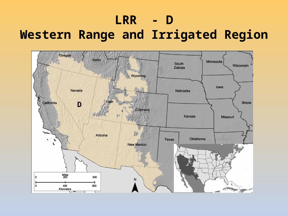
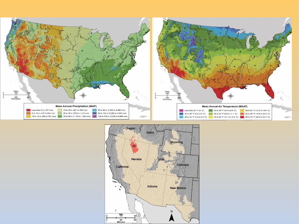
LRR - DWestern Range and Irrigated Region
D
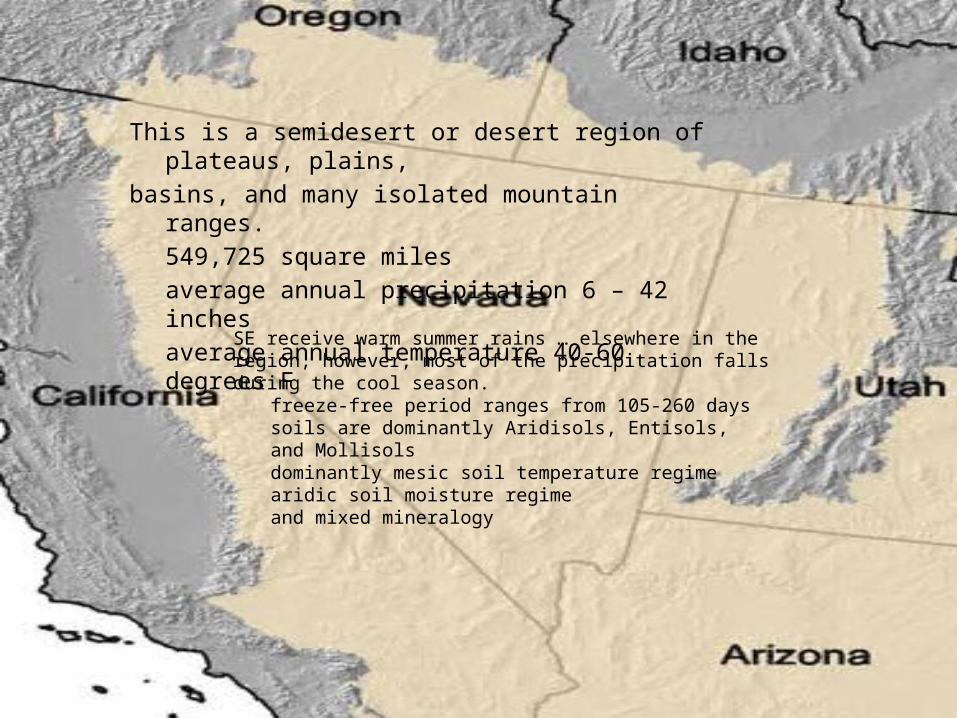
SE receive warm summer rains … elsewhere in the region, however, most of the precipitation falls during the cool season. freeze-free period ranges from 105-260 days
soils are dominantly Aridisols, Entisols,and Mollisols dominantly mesic soil temperature regimearidic soil moisture regimeand mixed mineralogy
This is a semidesert or desert region of plateaus, plains,basins, and many isolated mountain ranges.
549,725 square milesaverage annual precipitation 6 – 42 inches
average annual temperature 40-60 degrees F
What are Major Land Resource Areas (MLRAs)?
Major land resource areas are geographically associated landresource units.
23 MLRAs are identified within LRR D
Over 300 MLRAs are currently described
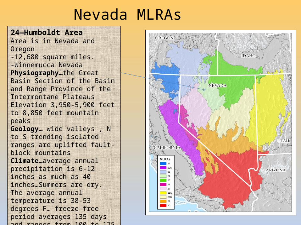
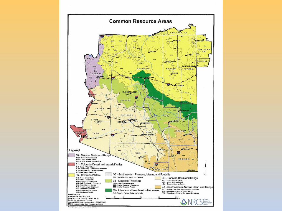
Nevada MLRAs 24—Humboldt AreaArea is in Nevada and Oregon -12,680 square miles.-Winnemucca Nevada Physiography…the Great Basin Section of the Basin and Range Province of the Intermontane Plateaus Elevation 3,950-5,900 feet to 8,850 feet mountain peaksGeology… wide valleys , N to S trending isolated ranges are uplifted fault-block mountainsClimate…average annual precipitation is 6-12 inches as much as 40 inches…Summers are dry. The average annual temperature is 38-53 degrees F… freeze-free period averages 135 days and ranges from 100 to 175 days…Soils… dominant soil order is AridisolsTorriorthents (Boton series) in loess and alluvium over lacustrine sediments…Biological Resources… Shrub-grass veg
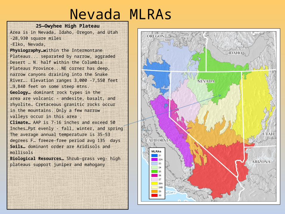
Nevada MLRAs 25—Owyhee High Plateau
Area is in Nevada, Idaho, Oregon, and Utah -28,930 square miles -Elko, Nevada,Physiography…within the Intermontane Plateaus... separated by narrow, aggraded Desert … N. half within the Columbia Plateaus Province...NE corner has deep, narrow canyons draining into the Snake River…. Elevation ranges 3,000 -7,550 feet …9,840 feet on some steep mtns. Geology… dominant rock types in the area are volcanic - andesite, basalt, and rhyolite… Cretaceous granitic rocks occur in the mountains. Only a few narrow valleys occur in this area . Climate… AAP is 7-16 inches and exceed 50 Inches…Ppt evenly - fall, winter, and springThe average annual temperature is 35-53 degrees F… freeze-free period avg 135 days Soils… dominant order are Aridisols and mollisolsBiological Resources… Shrub-grass veg- high plateaus support juniper and mahogany
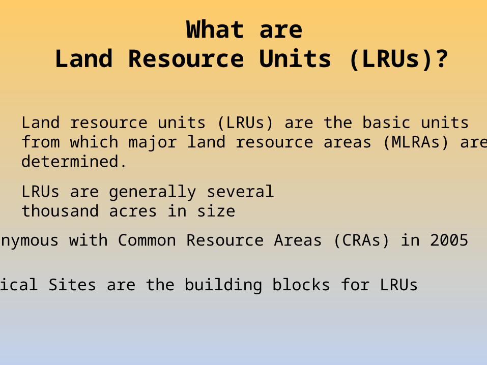
What are Land Resource Units (LRUs)?
Land resource units (LRUs) are the basic unitsfrom which major land resource areas (MLRAs) aredetermined.
LRUs are generally several thousand acres in size
Synonymous with Common Resource Areas (CRAs) in 2005
Ecological Sites are the building blocks for LRUs
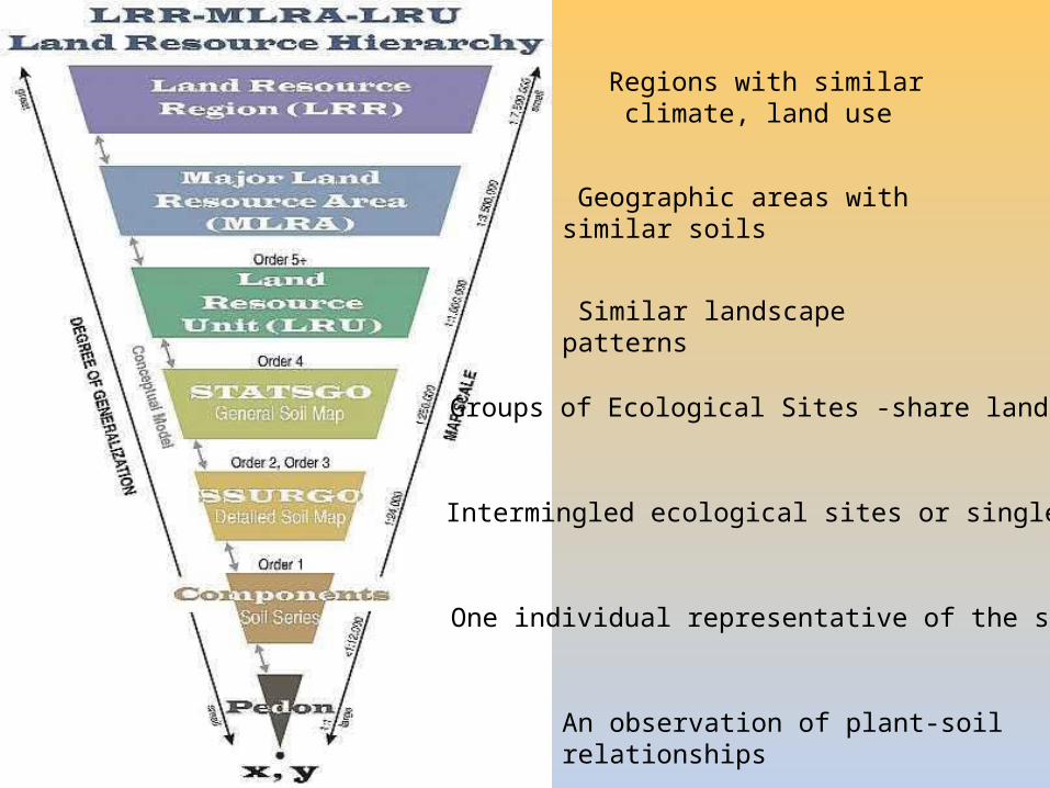
Regions with similar climate, land use
Geographic areas with similar soils
Similar landscape patterns
Groups of Ecological Sites -share landscapes
Intermingled ecological sites or single site
One individual representative of the site
An observation of plant-soil relationships
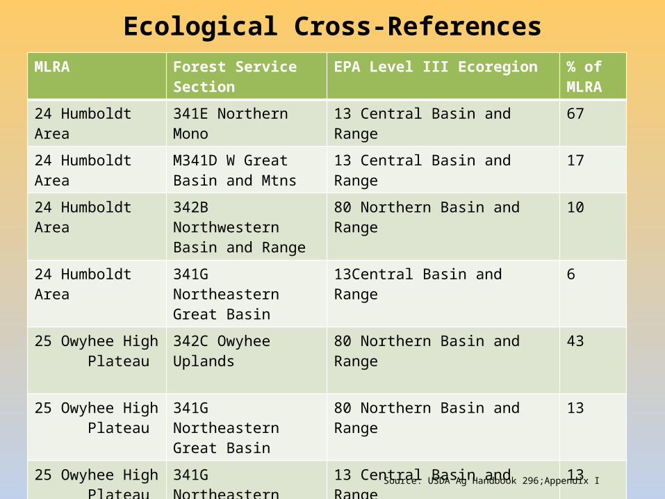
Ecological Cross-ReferencesMLRA Forest Service Section EPA Level III Ecoregion % of
MLRA24 Humboldt Area 341E Northern Mono 13 Central Basin and Range 67
24 Humboldt Area M341D W Great Basin and Mtns
13 Central Basin and Range 17
24 Humboldt Area 342B Northwestern Basin and Range
80 Northern Basin and Range 10
24 Humboldt Area 341G Northeastern Great Basin
13Central Basin and Range 6
25 Owyhee High Plateau
342C Owyhee Uplands 80 Northern Basin and Range 43
25 Owyhee High Plateau
341G Northeastern Great Basin
80 Northern Basin and Range 13
25 Owyhee High Plateau
341G Northeastern Great Basin
13 Central Basin and Range 13
25 Owyhee High Plateau
342J Eastern Basin and Range
80 Northern Basin and Range 11
25 Owyhee High Plateau
M341A East Great Basin and Mtns
13 Central Basin and Range 7
Source: USDA Ag Handbook 296;Appendix I


