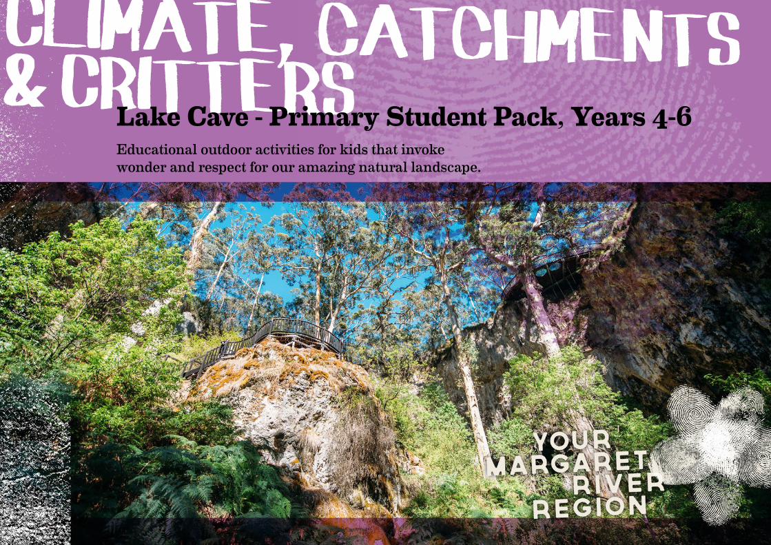
Climate, catchments & CrittersLake Cave - Primary Student Pack, Years 4-6
Educational outdoor activities for kids that invoke wonder and respect for our amazing natural landscape.
Contents3 Overview4 Curriculum Links5 Topic Web6 Teachers Notes on Lake Cave7 Lake Cave Primary Program11 Sentence Race12 Caves of the Leeuwin-Naturaliste Ridge13 KWL Chart14 Climate Change Cycle15 Shifting Sands16 How Caves Form17 Cave Chemistry18 Cave Simulation19 What’s in a Cave20 DIY Stalactites and Stalagmites21 Catchment if You Can22 Glorious Groundwater23 Karst Connections25 Cave Critters26 Meet the Family27 Food Chains28 Final Notes29 Answer Page31 Books ‘n’ Bytes
Booking Your Lake Cave Field TripTo book your tour of Lake Cave or request a copy of our Teacher Guide contact us on the details below:
P. +61 (8) 9755 2152E. [email protected]

OverviewAim: This package is designed to support an excursion to Lake Cave in the Margaret River Region for Years 4-6 students. It has been developed to accompany classroom investigation as per the ACARA Australian Curriculum.
Upon completion of this package students will:• have knowledge about the settlement of the Southwest, discovery of the caves, and the development of tourism in the region
• be able to identify the common cave decorations and understand the geological and chemical forces which influence the growth of caves and cave formations
• have identified and examined the fauna which exist in the unique cave environment
• have examined the biological adaptations of cave fauna to suit their environment
• be able to identify how weather conditions and human interaction can change the cave environment
• appreciate the importance of the environment to animals and people, and different views on how it can be protected
3
Curriculum LinksCurriculum Framework LinksThe following chart summarises key curriculum achievement standards covered by this unit of work. The resource materials and activities have been developed to achieve a range of outcomes and be relevant to the new ACARA Australian Curriculum.
Australian Curriculum Assessment and Reporting Authority - The Australian Curriculum
Science Humanities and Social Sciences Cross Curriculum PrioritiesScience Understanding Biological sciencesThe growth and survival of living things are affected by the physical conditions of their environment.
Living things have structural features and adaptations that help them to survive in their environment.
Chemical sciencesSolids, liquids and gases have different observable properties and behave in different ways.
Earth and space sciencesSudden geological changes or extreme weather conditions can affect Earth’s surface.
Science as Human Endeavour Nature and development of scienceScience involves testing predictions by gathering data and using evidence to develop explanations of events and phenomena.
Use and influence of scienceScientific knowledge is used to inform personal and community decisions.
GeographyConcepts for developing understanding
The importance of environments to animals and people, and different views on how it can be protected.
The use and management of natural resources and waste, and the different views on how to do this sustainably.
Sustainability The biosphere, including all life forms, relies on the interdependence of social, economic and ecological systems. We recognise that by valuing and actioning sustainable practices as individuals and communities, we are preserving our environment for the future.
Aboriginal and Torres Strait Islander Histories and Cultures The Wadandi people of the Southwest maintain a special relationship with the land, sea, sky and waterways. Their knowledge of the local area is extensive and they have lived in this area for tens of thousands of years. Their language and history are intrinsically linked to local flora, fauna and landscapes.
4

Topic WebYour visit to Lake Cave can be used as a springboard to explore a range of topics surrounding caves. You might like to consider the following:
Your Lake Cave
Experience
Cave Biologyfauna
adaptations stygofauna
subterranean fauna
Conservationeco tourism
cave managementregulations
Historyindigenous
links to caves Wadandi people
European settlementfossils
Human Interaction
tourismfarming
water managementforestry
Earth Scienceslimestone
lithificationkarst
Leeuwin-Naturaliste Ridgeclimate change glacial periods plate tectonicsearthquakes
Chemistrychemical processes in
formation of calcitecarbon dioxide
equilibriumcalcium carbonate
solution
5
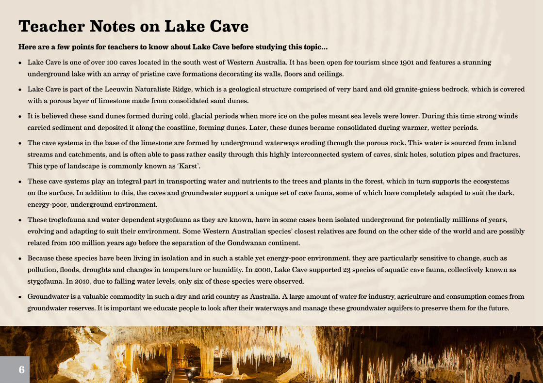
Teacher Notes on Lake CaveHere are a few points for teachers to know about Lake Cave before studying this topic...
• Lake Cave is one of over 100 caves located in the south west of Western Australia. It has been open for tourism since 1901 and features a stunning underground lake with an array of pristine cave formations decorating its walls, floors and ceilings.
• Lake Cave is part of the Leeuwin Naturaliste Ridge, which is a geological structure comprised of very hard and old granite-gniess bedrock, which is covered with a porous layer of limestone made from consolidated sand dunes.
• It is believed these sand dunes formed during cold, glacial periods when more ice on the poles meant sea levels were lower. During this time strong winds carried sediment and deposited it along the coastline, forming dunes. Later, these dunes became consolidated during warmer, wetter periods.
• The cave systems in the base of the limestone are formed by underground waterways eroding through the porous rock. This water is sourced from inland streams and catchments, and is often able to pass rather easily through this highly interconnected system of caves, sink holes, solution pipes and fractures. This type of landscape is commonly known as ‘Karst’.
• These cave systems play an integral part in transporting water and nutrients to the trees and plants in the forest, which in turn supports the ecosystems on the surface. In addition to this, the caves and groundwater support a unique set of cave fauna, some of which have completely adapted to suit the dark, energy-poor, underground environment.
• These troglofauna and water dependent stygofauna as they are known, have in some cases been isolated underground for potentially millions of years, evolving and adapting to suit their environment. Some Western Australian species’ closest relatives are found on the other side of the world and are possibly related from 100 million years ago before the separation of the Gondwanan continent.
• Because these species have been living in isolation and in such a stable yet energy-poor environment, they are particularly sensitive to change, such as pollution, floods, droughts and changes in temperature or humidity. In 2000, Lake Cave supported 23 species of aquatic cave fauna, collectively known as stygofauna. In 2010, due to falling water levels, only six of these species were observed.
• Groundwater is a valuable commodity in such a dry and arid country as Australia. A large amount of water for industry, agriculture and consumption comes from groundwater reserves. It is important we educate people to look after their waterways and manage these groundwater aquifers to preserve them for the future.
6
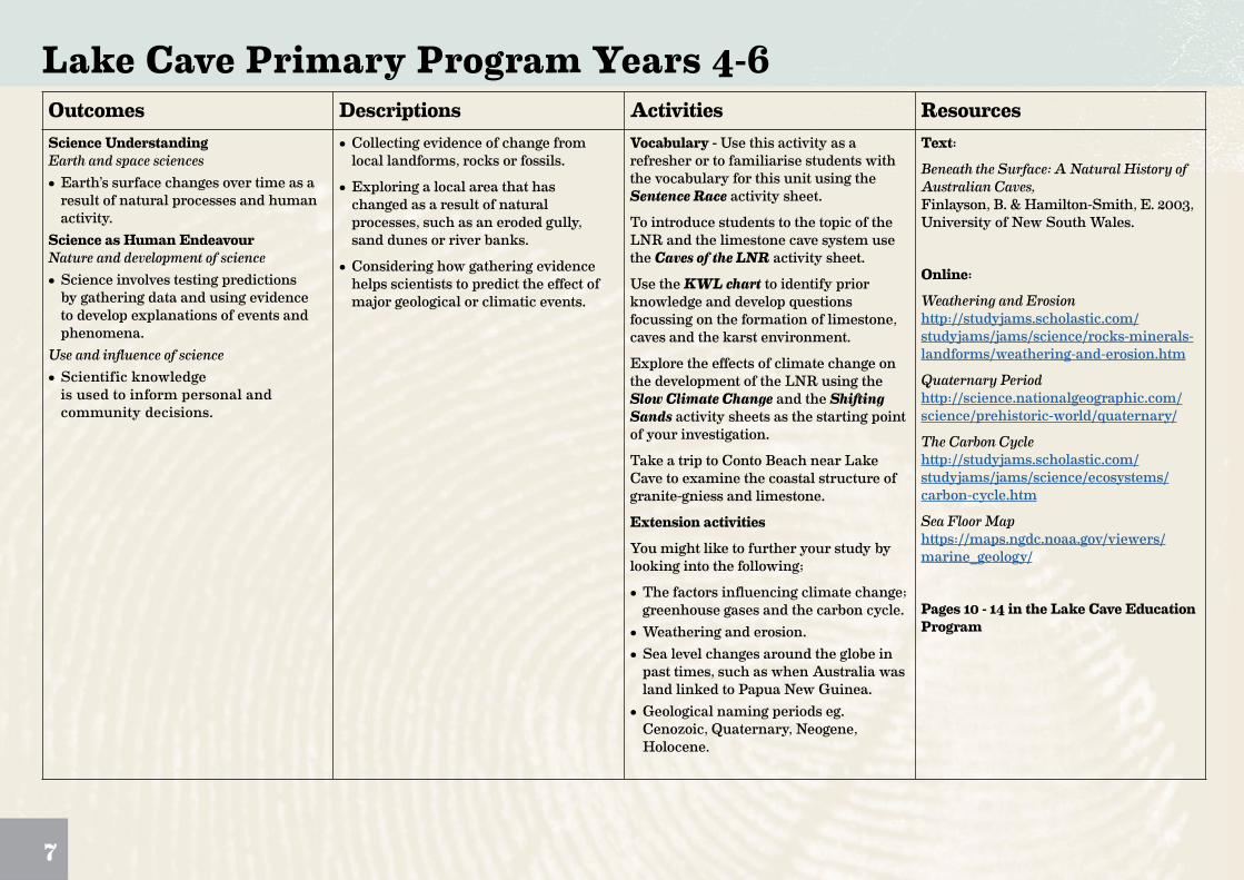
Lake Cave Primary Program Years 4-6Outcomes Descriptions Activities ResourcesScience UnderstandingEarth and space sciences• Earth’s surface changes over time as a
result of natural processes and human activity.
Science as Human EndeavourNature and development of science• Science involves testing predictions
by gathering data and using evidence to develop explanations of events and phenomena.
Use and influence of science• Scientific knowledge
is used to inform personal and community decisions.
• Collecting evidence of change from local landforms, rocks or fossils.
• Exploring a local area that has changed as a result of natural processes, such as an eroded gully, sand dunes or river banks.
• Considering how gathering evidence helps scientists to predict the effect of major geological or climatic events.
Vocabulary - Use this activity as a refresher or to familiarise students with the vocabulary for this unit using the Sentence Race activity sheet.
To introduce students to the topic of the LNR and the limestone cave system use the Caves of the LNR activity sheet.
Use the KWL chart to identify prior knowledge and develop questions focussing on the formation of limestone, caves and the karst environment.
Explore the effects of climate change on the development of the LNR using the Slow Climate Change and the Shifting Sands activity sheets as the starting point of your investigation.
Take a trip to Conto Beach near Lake Cave to examine the coastal structure of granite-gniess and limestone.
Extension activities
You might like to further your study by looking into the following;
• The factors influencing climate change; greenhouse gases and the carbon cycle.
• Weathering and erosion.• Sea level changes around the globe in
past times, such as when Australia was land linked to Papua New Guinea.
• Geological naming periods eg. Cenozoic, Quaternary, Neogene, Holocene.
Text:
Beneath the Surface: A Natural History of Australian Caves, Finlayson, B. & Hamilton-Smith, E. 2003, University of New South Wales.
Online:
Weathering and Erosion http://studyjams.scholastic.com/studyjams/jams/science/rocks-minerals-landforms/weathering-and-erosion.htm
Quaternary Period http://science.nationalgeographic.com/science/prehistoric-world/quaternary/
The Carbon Cycle http://studyjams.scholastic.com/studyjams/jams/science/ecosystems/carbon-cycle.htm
Sea Floor Map https://maps.ngdc.noaa.gov/viewers/marine_geology/
Pages 10 - 14 in the Lake Cave Education Program
7

Lake Cave Primary Program Years 4-6Outcomes Descriptions Activities ResourcesScience UnderstandingChemical sciences• Solids, liquids and gases have different
observable properties and behave in different ways.
• Changes to materials can be reversible or irreversible.
Earth and space sciences• Earth’s surface changes over time as a
result of natural processes and human activity.
• Sudden geological changes or extreme weather conditions can affect Earth’s surface.
Science as Human EndeavourNature and development of science• Science involves testing predictions
by gathering data and using evidence to develop explanations of events and phenomena.
• Exploring the way solids, liquids and gases change under different situations.
• Investigating the solubility of common materials in water by collecting evidence of change from local landforms, rocks or fossils.
• Exploring a local area that has changed as a result of natural processes, such as an eroded gully, sand dunes or river banks.
Explore the processes of weathering (physical, chemical, biological) and erosion in the formation of caves and karst systems using the How Caves Form activity sheet to illustrate the processes of lithification.
Examine chemical weathering in the cave using the Cave Chemistry activity sheet to illustrate the chemical processes which occur in the formation of calcite crystal.
Carry out your own cave formation experiment with our Cave Simulation activity sheet.
Use the What’s in a Cave activity sheet to familiarise students with the formations they are likely to see on their tour of Lake Cave.
Grow your own crystals with our DIY Stalactites and Stalagmites activity sheet.
Revisit the KWL chart to consolidate knowledge and present information to the class or teacher.
Extension activities
You might like to further your study by looking into the following;
• How common are karst landscapes around the world? There are some amazing and beautiful landscapes!
• Research the worlds largest, longest caves.
• Investigate weathering and erosion and how they shape a landscape.
Text:
Beneath the Surface: A Natural History of Australian Caves, Finlayson, B. & Hamilton-Smith, E. 2003, University of New South Wales.
Online:
Weathering and Erosion http://studyjams.scholastic.com/studyjams/jams/science/rocks-minerals-landforms/weathering-and-erosion.htm
Pages 12 & 15 - 19 in the Lake Cave Education Program
8

Lake Cave Primary Program Years 4-6Outcomes Descriptions Activities ResourcesScience UnderstandingBiological sciences• Living things have structural features
and adaptations that help them to survive in their environment.
• The growth and survival of living things are affected by the physical conditions of their environment.
Earth and space sciences• Earth’s surface changes over time as a
result of natural processes and human activity.
• Sudden geological changes or extreme weather conditions can affect Earth’s surface.
Science as Human EndeavourUse and influence of science• Scientific knowledge is used to inform
personal and community decisions.GeographyConcepts for developing understanding• The importance of environments to
animals and people, and different views on how they can be protected.
• The use and management of natural resources and waste and the different views on how to do this sustainably.
• The environmental and human influences on the location and characteristics of a place and the management of spaces within them.
• Collecting evidence of change from local landforms, rocks or fossils.
• Exploring a local area that has changed as a result of natural processes, such as an eroded gully, sand dunes or river banks.
• Considering the effects of drought on living and non-living aspects of the environment.
• Exploring how science has contributed to a discussion about an issue such as loss of habitat for living things or how human activity has changed the local environment.
• Exploring strategies to protect particular environments that provide habitats for animals.
• Identifying some of the resources produced by the environment and where they come from.
• Exploring the extent of change in the local environment over time and the impact of change on ecosystems.
• Investigating a current local planning issue (for example, redevelopment of a site, protection of a unique species), exploring why people have different views on the issue, and developing a class response to it.
Discuss the statement below and introduce the next part of your cave investigation, looking at the importance of groundwater systems and cave fauna.
“Caves provide critical habitat for a variety of plant and animal communities and are nature’s time capsules, preserving evidence of past life, climates and earth-forming processes. Caves are highly valued by the community as places for recreation, shelter and refuge and provide water for more than a quarter of the world’s population.”
Use the KWL chart to identify existing knowledge and direct student investigation.
Use the Catchment if You Can, Glorious Groundwater and Karst Connections activity sheets to investigate the following:
• The collection and movement of water into groundwater systems.
• The importance of protecting our groundwater.
• The interconnectedness and vulnerability of the karst system.
Extension activities
You might like to further your study by looking into the following;
• Water cycles.
• Pollution in groundwater, looking at Horse Cave in the U.S.A or the impact of farming and dairy on groundwater in New Zealand.
Text:
Beneath the Surface: A Natural History of Australian Caves, Finlayson, B. & Hamilton-Smith, E. 2003, University of New South Wales.
Online:
Karst for Kids http://www.nationalgeographic.org/encyclopedia/karst/
Rainfall and Dams in Perth https://www.watercorporation.com.au/water-supply/rainfall-and-dams
Catchment to Tap https://www.youtube.com/watch?v=dN-VmJrgk7o
The Water Cycle http://studyjams.scholastic.com/studyjams/jams/science/ecosystems/water-cycle.htm
Pages 12 & 20 - 22 in the Lake Cave Education Program
9
Lake Cave Primary Program Years 4-6Outcomes Descriptions Activities ResourcesScience UnderstandingBiological sciences• The growth and survival of living things
are affected by the physical conditions of their environment.
• Living things have structural features and adaptations that help them to survive in their environment.
Earth and space sciences• Earth’s surface changes over time as a
result of natural processes and human activity.
Science as Human EndeavourUse and influence of science• Scientific knowledge is used to inform
personal and community decisions.GeographyConcepts for developing understanding• The importance of environments to
animals and people, and different views on how they can be protected.
• The use and management of natural resources and waste and the different views on how to do this sustainably.
• The environmental and human influences on the location and characteristics of a place and the management of spaces within them.
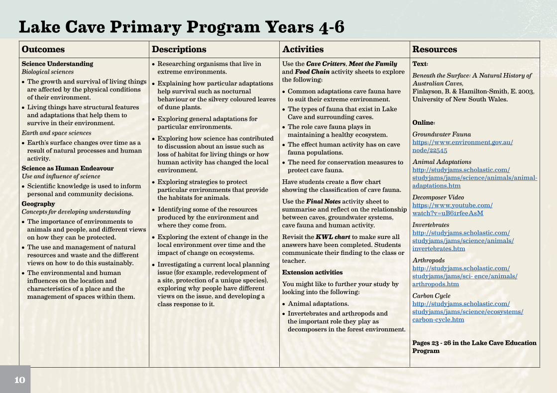
• Researching organisms that live in extreme environments.
• Explaining how particular adaptations help survival such as nocturnal behaviour or the silvery coloured leaves of dune plants.
• Exploring general adaptations for particular environments.
• Exploring how science has contributed to discussion about an issue such as loss of habitat for living things or how human activity has changed the local environment.
• Exploring strategies to protect particular environments that provide the habitats for animals.
• Identifying some of the resources produced by the environment and where they come from.
• Exploring the extent of change in the local environment over time and the impact of change on ecosystems.
• Investigating a current local planning issue (for example, redevelopment of a site, protection of a unique species), exploring why people have different views on the issue, and developing a class response to it.
Use the Cave Critters, Meet the Family and Food Chain activity sheets to explore the following;
• Common adaptations cave fauna have to suit their extreme environment.
• The types of fauna that exist in Lake Cave and surrounding caves.
• The role cave fauna plays in maintaining a healthy ecosystem.
• The effect human activity has on cave fauna populations.
• The need for conservation measures to protect cave fauna.
Have students create a flow chart showing the classification of cave fauna.
Use the Final Notes activity sheet to summarise and reflect on the relationship between caves, groundwater systems, cave fauna and human activity.
Revisit the KWL chart to make sure all answers have been completed. Students communicate their finding to the class or teacher.
Extension activities
You might like to further your study by looking into the following;
• Animal adaptations.• Invertebrates and arthropods and
the important role they play as decomposers in the forest environment.
Text:
Beneath the Surface: A Natural History of Australian Caves, Finlayson, B. & Hamilton-Smith, E. 2003, University of New South Wales.
Online:
Groundwater Fauna https://www.environment.gov.au/node/22545
Animal Adaptations http://studyjams.scholastic.com/studyjams/jams/science/animals/animal-adaptations.htm
Decomposer Video https://www.youtube.com/watch?v=uB61rfeeAsM
Invertebrates http://studyjams.scholastic.com/studyjams/jams/science/animals/invertebrates.htm
Arthropods http://studyjams.scholastic.com/studyjams/jams/sci- ence/animals/arthropods.htm
Carbon Cycle http://studyjams.scholastic.com/studyjams/jams/science/ecosystems/carbon-cycle.htm
Pages 23 - 26 in the Lake Cave Education Program
10
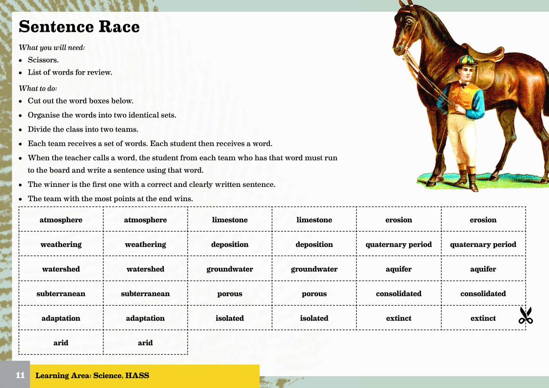
Sentence RaceWhat you will need:• Scissors.• List of words for review.
What to do:• Cut out the word boxes below.
• Organise the words into two identical sets.
• Divide the class into two teams.
• Each team receives a set of words. Each student then receives a word.
• When the teacher calls a word, the student from each team who has that word must run to the board and write a sentence using that word.
• The winner is the first one with a correct and clearly written sentence.
• The team with the most points at the end wins.
Learning Area: Science, HASS11
atmosphere atmosphere limestone limestone erosion erosion
weathering weathering deposition deposition quaternary period quaternary period
watershed watershed groundwater groundwater aquifer aquifer
subterranean subterranean porous porous consolidated consolidated
adaptation adaptation isolated isolated extinct extinct
arid arid

Caves of the Leeuwin-Naturaliste RidgeFrom Cape Naturaliste in the north to Cape Leeuwin in the south, runs the Leeuwin-Naturaliste Ridge (LNR). It is a huge stretch of porous limestone rock, about ten kilometres in width and filled with beautiful caves.
On the diagram to the right, colour and label the following:
• Draw a compass to the left of Cape Naturaliste. North should be pointing straight up.
• The straight distance from Cape Naturaliste to Cape Leeuwin is 100kms. Draw a scale to the right which shows 1cm = ? kms.
• Draw and label a dotted line for the Dunsborough Fault Line. It runs from Dunsborough straight down to Augusta heading just around the eastern side of Margaret River township.
• Colour in and label the land on the western side of the fault as the Leeuwin-Naturaliste Ridge.
• Using a different colour, colour and label the land on the eastern side of the fault as the Southern Perth Basin.
Learning Area: Science, HASS12

KWL ChartTopic of Investigation
Know Want to Know Learned
Learning Area: Science, HASS13

Climate Change CycleScientists break the Earth’s history up into different time periods. Currently we live in what is known as the Quaternary Period, which started 2.58 million years ago. This period is referred to as an ice age because there has always been at least one permanent large ice sheet covering Antarctica.
Within this ice age there have been a series of colder periods and warmer periods. The colder periods are known as glacial periods and the warmer times as interglacial periods. This cycle between cold and warm is known as a glacial-interglacial cycle. Over the past 740,000 years there have been eight of these cycles.
1. Use the information above to match the following phrases and definitions;
Learning Area: Science, HASS14
glacial period
interglacial period
glacial-interglacial cycle
Using samples from ice cores drilled at Lake Vostok in Antarctica, scientists have been able to show evidence of the changes in temperature from the last four glacial periods over 400,000 years. You can see the changes in average temperature on the graph below.
420-2-4-6-8
-10400 350 300 250 200 150 100 50 0
Temperature variation ( T)
THOUSANDS OF YEARS
TEM
P C
2. Mark in the the following items on the above graph. (Don’t forget to use the temperature on the Y axis):
a) glacial periods b) interglacial periods c) glacial-interglacial cycles
3. What is the highest temperature shown from the samples?
4. What is the lowest temperature?
5. How many complete glacial cycles are show from this data (from cold period to cold period)?
6. How long is the longest glacial-interglacial cycle?
7. What is the average time for a complete glacial-interglacial cycle?
movement from cold to warm and back to cold
cooler period
warmer period

Shifting SandsDuring the cooler glacial periods, the movement and distribution of water on Earth was completely different to our current patterns. The huge volume of water frozen in ice sheets on land meant that the sea level may have been about 120 metres lower than the current level.
1. Here is an image of the current coast line at Lake Cave near Margaret River. You can see a point marked showing where the ocean depth is 120 metres. Using the scale work out how much further out the land might have extended during the glacial period.
Due to the dense, cold air coming off the glacier fields during glacial periods, strong and persistent winds were common. These winds carried large amounts of sediment and consequently, sand dunes were much more widespread and active in many areas during the early Quaternary Period. The sand dunes and limestone of the Leeuwin-Naturaliste Ridge (LNR) are believed to have been formed by this process of wind erosion and deposition over the last two million years.
The limestone on the LNR is know as Tamala Limestone, and is believed to be some of the youngest limestone in the world. It sits in the base of the sand dunes, on top of a very hard and very old layer of granite-gniess bedrock, believed to be about 600 million years old. If you take a trip to Conto Beach near Lake Cave, you can see these layers very clearly.
2. Label the parts of the image below with the following; Sea, Sand Dunes, Tamala Limestone, Granite-Gneiss Bedrock
Learning Area: Science15
Take a trip to Conto Beach to study the layers of rock, which are clearly visible.

How Caves Form1. Caves are formed by a combination of weathering and erosion. Read through the descriptions to the right describing how limestone caves
are formed on the Leeuwin-Naturaliste Ridge and match them to the pictures below OR redraw the images on another piece of paper, colour them in and write the description underneath.
Learning Area: Science, HASS16
2 Use the internet link below to research the different types of weathering and erosion. Describe your understanding of how they affect the formation of limestone caves.
http://studyjams.scholastic.com/studyjams/jams/science/index.htm
A. Sand, which is mainly made from broken bits of seashell (calcium carbonate) is blown onto the shore by the wind. It then forms sand dunes along the coast.
B. Water from rain washes through the sand dunes, cementing them together and forming a thick layer of limestone in the base of the dunes.
C. Underground streams and waterways flow from inland regions through the limestone towards the ocean. They hollow out deep caves as they go.
D. Rainwater becomes acidic as it mixes with carbon dioxide in the soil and atmosphere. It washes through the dunes and dissolves the limestone. This solution runs into the caves and solidifies as crystals on the ceiling, walls and floor.
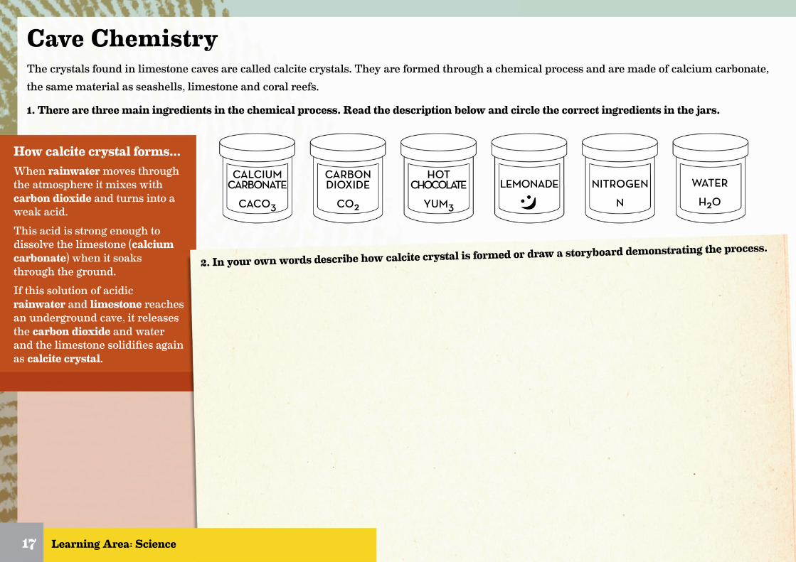
How calcite crystal forms...When rainwater moves through the atmosphere it mixes with carbon dioxide and turns into a weak acid.This acid is strong enough to dissolve the limestone (calcium carbonate) when it soaks through the ground.If this solution of acidic rainwater and limestone reaches an underground cave, it releases the carbon dioxide and water and the limestone solidifies again as calcite crystal.
Cave ChemistryThe crystals found in limestone caves are called calcite crystals. They are formed through a chemical process and are made of calcium carbonate, the same material as seashells, limestone and coral reefs.
1. There are three main ingredients in the chemical process. Read the description below and circle the correct ingredients in the jars.
Learning Area: Science
WATER
H2O
NITROGEN
N
CALCIUM CARBONATE
CACO3
CARBON DIOXIDE
CO2
HOT CHOCOLATE
YUM3
LEMONADE
17
2. In your own words describe how calcite crystal is formed or draw a storyboard demonstrating the process.

Cave Simulation1. Work in groups to simulate the processes that form a cave in the real world with this classroom experiment.
What you’ll need:• 150 grams of modelling clay• 4 x sugar cubes• Clear plastic or glass container/bowl• Skewer• Spray bottle with warm water• Pen or pencil
What to do:• Arrange the sugar cubes together on the side of the bowl.• Use the modelling clay to seal the sugar cubes on the side of the bowl. Make sure there are no gaps.• Use a skewer to poke holes through the clay all the way to the sugar. Make sure they are large enough for water to pass through.• Spray the top of the clay with warm water until the sugar has dissolved.• As the water dissolves the sugar cubes, record your observations.
2. Answer the following questions:
A. What did the water spray represent?
B. What did the clay represent?
C. What did the sugar represent?
D. How does this activity simulate the formation of real caves? Discuss with your class.
E. If you could do this experiment again, what would you do differently? Why, why not?
Learning Area: Science18
Why not grab a dictionary and write down the meaning of SIMULATE?
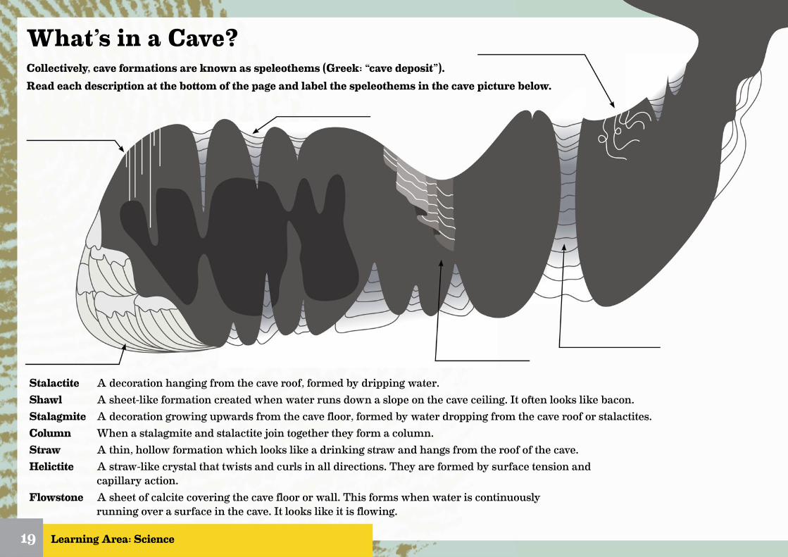
What’s in a Cave?Collectively, cave formations are known as speleothems (Greek: “cave deposit”). Read each description at the bottom of the page and label the speleothems in the cave picture below.
Learning Area: Science
Stalactite A decoration hanging from the cave roof, formed by dripping water.Shawl A sheet-like formation created when water runs down a slope on the cave ceiling. It often looks like bacon.Stalagmite A decoration growing upwards from the cave floor, formed by water dropping from the cave roof or stalactites.Column When a stalagmite and stalactite join together they form a column.Straw A thin, hollow formation which looks like a drinking straw and hangs from the roof of the cave.Helictite A straw-like crystal that twists and curls in all directions. They are formed by surface tension and capillary action.Flowstone A sheet of calcite covering the cave floor or wall. This forms when water is continuously running over a surface in the cave. It looks like it is flowing.
19

DIY Stalactites and StalagmitesWork in groups to simulate the processes that form cave decorations in the real world with this classroom experiment.
What to do:• Place the jars side by side on the piece of paper, making sure they are in a place free of drafts.• Fill each jar with Epsom salts.• Add water to the level of the Epsom salts and stir.• Cut a piece of string 60cm long.• Tie a washer to each end of the piece of string and place one washer in each jar.• Place a piece of paper between the jars.• Move the jars so that the string hangs between them, with the lowest part of the loop about 2.5cm above the paper.• Let the jars stand undisturbed for a week.
Answer the following questions:
1. What does the saltwater represent in this experiment?
2. What are the similarities between this experiment and the formation of stalactites and stalagmites?
3. If you could do this experiment again, what would you do differently? Why, why not?
Learning Area: Science20
What you will need:
Epsom salts2 small jarscotton stringscissors
2 washersspoonrulerpaper
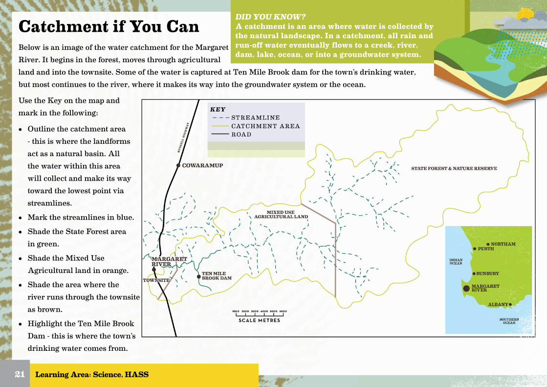
Catchment if You CanBelow is an image of the water catchment for the Margaret River. It begins in the forest, moves through agricultural land and into the townsite. Some of the water is captured at Ten Mile Brook dam for the town’s drinking water, but most continues to the river, where it makes its way into the groundwater system or the ocean.
Use the Key on the map and mark in the following;
• Outline the catchment area - this is where the landforms act as a natural basin. All the water within this area will collect and make its way toward the lowest point via streamlines.
• Mark the streamlines in blue.
• Shade the State Forest area in green.
• Shade the Mixed Use Agricultural land in orange.
• Shade the area where the river runs through the townsite as brown.
• Highlight the Ten Mile Brook Dam - this is where the town’s drinking water comes from.
Learning Area: Science, HASS21
DID YOU KNOW?A catchment is an area where water is collected by the natural landscape. In a catchment, all rain and run-off water eventually flows to a creek, river, dam, lake, ocean, or into a groundwater system.
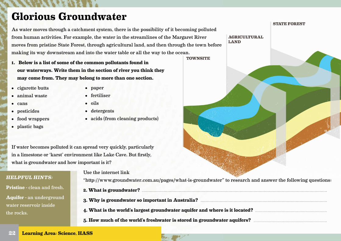
Glorious GroundwaterAs water moves through a catchment system, there is the possibility of it becoming polluted from human activities. For example, the water in the streamlines of the Margaret River moves from pristine State Forest, through agricultural land, and then through the town before making its way downstream and into the water table or all the way to the ocean.
1. Below is a list of some of the common pollutants found in our waterways. Write them in the section of river you think they may come from. They may belong to more than one section.
• cigarette butts• animal waste• cans• pesticides• food wrappers• plastic bags
Learning Area: Science, HASS22
• paper• fertiliser• oils• detergents• acids (from cleaning products)
If water becomes polluted it can spread very quickly, particularly in a limestone or ‘karst’ environment like Lake Cave. But firstly, what is groundwater and how important is it?
Use the internet link “http://www.groundwater.com.au/pages/what-is-groundwater” to research and answer the following questions:
2. What is groundwater?
3. Why is groundwater so important in Australia?
4. What is the world’s largest groundwater aquifer and where is it located?
5. How much of the world’s freshwater is stored in groundwater aquifers?
HELPFUL HINTS:
Pristine - clean and fresh.
Aquifer - an underground water reservoir inside the rocks.

Karst ConnectionsThe upper layer of the Leeuwin-Naturaliste Ridge, where Lake Cave is located, is mainly made of limestone. This type of landscape is know as ‘karst’, which means it is made of rock that can be easily dissolved and eroded by water. It is often filled with solution pipes and interconnected cave passages, and is particularly sensitive to pollution because water can pass very easily into the system without being filtered.
Often when water makes its way through a streamline and into the groundwater system, it might pass through layers of sand, soil and silt, which can filter out larger particles and pollutants. The karst landscape however, is full of caves, solution pipes and fractures which allow polluted waters to pass through easily. This can be disastrous for the flora and fauna in the surface ecosystems downstream, and potentially fatal for the subterranean fauna that actually exist inside the caves. In fact, any changes to the flow or quality of water can affect ecosystems very quickly. Floods or droughts, construction of dams and the diversion of waterways can very quickly change the ecosystem downstream.
1. What are three characteristics common to ‘karst’ landscapes?
A.
B.
C.
2. Why are karst landscapes particularly sensitive to pollution?
Learning Area: Science, HASS23
CAVE ENTRANCE
TAP ROOTWATERTABLE
GRANITE
SOLUTIONPIPES
DOLINE
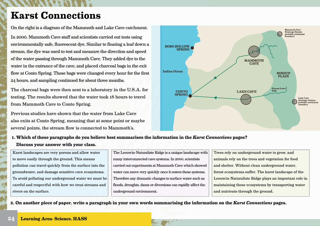
Karst ConnectionsOn the right is a diagram of the Mammoth and Lake Cave catchment.
In 2000, Mammoth Cave staff and scientists carried out tests using environmentally safe, fluorescent dye. Similar to floating a leaf down a stream, the dye was used to test and measure the direction and speed of the water passing through Mammoth Cave. They added dye to the water in the entrance of the cave, and placed charcoal bags in the exit flow at Conto Spring. These bags were changed every hour for the first 24 hours, and sampling continued for about three months.
The charcoal bags were then sent to a laboratory in the U.S.A. for testing. The results showed that the water took 18 hours to travel from Mammoth Cave to Conto Spring.
Previous studies have shown that the water from Lake Cave also exits at Conto Spring, meaning that at some point or maybe several points, the stream flow is connected to Mammoth’s.
1. Which of these paragraphs do you believe best summarises the information in the Karst Connections pages? Discuss your answer with your class.
Learning Area: Science, HASS24
Karst landscapes are very porous and allow water to move easily through the ground. This means pollution can travel quickly from the surface into the groundwater, and damage sensitive cave ecosystems. To avoid polluting our underground water we must be careful and respectful with how we treat streams and rivers on the surface.
The Leeuwin-Naturaliste Ridge is a unique landscape with many interconnected cave systems. In 2000, scientists carried out experiments at Mammoth Cave which showed water can move very quickly once it enters these systems. Therefore any dramatic changes to surface water such as floods, droughts, dams or diversions can rapidly affect the underground environment.
Trees rely on underground water to grow, and animals rely on the trees and vegetation for food and shelter. Without clean underground water, forest ecosystems suffer. The karst landscape of the Leeuwin-Naturaliste Ridge plays an important role in maintaining these ecosystems by transporting water and nutrients through the ground.
2. On another piece of paper, write a paragraph in your own words summarising the information on the Karst Connections pages.

Learning Area: Science
Cave CrittersRead the text below and complete the crossword.
Being protected from the surface, caves are usually very stable environments, which is why they preserve bones and fossils so well. In Mammoth Cave alone, over 10,000 bones have been found, many from species which no longer exist in Australia. In Lake, Jewel, Mammoth and Ngilgi Cave, we also have a number of living fauna which have unique adaptations to suit their subterranean cave environment.
Without any sunlight, caves are a unique habitat where species exist in complete darkness. No plants can grow without light, so there is also very little food. Cave fauna have adapted to suit the dark, food/energy-poor environment in some of the following ways:
• loss of / reduction in eyesight• loss of / reduction of body pigment (colour)• lengthened appendages, eg. longer legs or antennae• enhanced sensory structures such as sensory hairs and/or more sensitive antennae
Cave fauna are divided into two groups based on their habitats. They are either troglofauna, which live on land in the cave, or stygofauna, which live in the waters in the cave.
Just to confuse matters more, these are divided into three further categories;
Troglobite/Stygobite - these are highly specialised species, which have fully adapted over time to suit the cave environment. Because they have evolved in the cave, they are very sensitive to environmental changes, and often cannot withstand changes in temperature or humidity. As they are unable to survive on the surface, troglobites cannot migrate and are often confined to a single cave system or karst area.
Troglophile/Stygophile - these species are capable of living their entire lifecycle in a cave, but also on the surface, therefore they are not classed as having fully adapted. If surface conditions change and they become isolated underground, they may eventually evolve into troglobites.
Trogloxene/Stygoxene - these are species who use caves as a habitat but must return to the surface or entrance at some point, often for food or to breed.
25
ACROSS3. a ?????????? can complete their
lifecycle in the cave environment
or on the surface.
4. ?????????? is the name for fauna
that live in the waters of the
cave.6. a number of stygofauna species
live inside of ?????????? cave.
7. this word means ‘under the
ground’.10. cave fauna often lose or have
reduced body ??????????.
DOWN1. there is very little of this
in the cave environment.
2. ?????????? is the name for
fauna that live on land in
the cave.5. a hollow underground
place.8. some cave fauna lose this
when they adapt to the
dark environment.
9. ?????????? may become
longer or more sensitive in
the cave adapted species.
Learning Area: Science
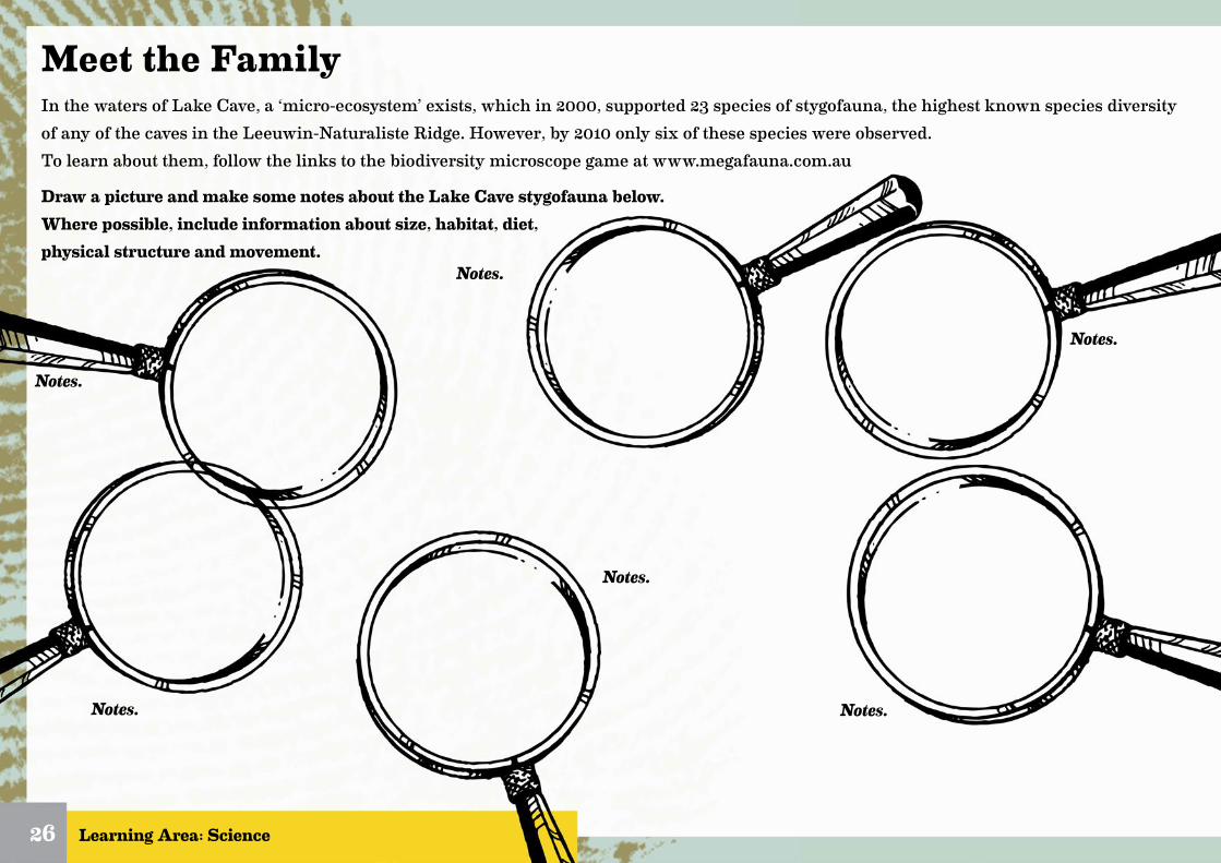
Meet the FamilyIn the waters of Lake Cave, a ‘micro-ecosystem’ exists, which in 2000, supported 23 species of stygofauna, the highest known species diversity of any of the caves in the Leeuwin-Naturaliste Ridge. However, by 2010 only six of these species were observed. To learn about them, follow the links to the biodiversity microscope game at www.megafauna.com.au
Draw a picture and make some notes about the Lake Cave stygofauna below. Where possible, include information about size, habitat, diet, physical structure and movement.
26
Notes.
Notes.
Notes.
Notes.
Notes.
Notes.

Food ChainsTroglofauna/stygofauna are an important part of the cave environment that needs to be protected. As science progresses we learn more and more about these hidden species. Currently we know they are valuable for the following reasons;
• they filter and clean groundwater• they break down and recycle organic material• they are indicators of water quality• they are important for the study of species evolution/adaptation• they may be related to ancient species
Scientists believe that many cave fauna evolved from surface dwelling species. Many of these you’ll be familiar with, like the creepy crawlies you find in the soil and leaf litter on the forest floor or in streams and swamps. It is thought that cave fauna may have come from some of these species that were already partially suited to the underground way of life. For example, they may have already had poor eyesight or longer antennae so it was a relatively ‘easy’ transition to the subterranean habitat. Caves being such stable environments, are the ideal place for a species like this to seek refuge. Then, when changes above ground cause surface species to go extinct, these cave fauna survive, become isolated and slowly adapt to suit their new habitat.
27
Like many of the surface species, cave fauna decompose and recycle dead organic material. Common sources of food for cave fauna include bat and bird droppings, tree roots, plant matter and other ‘accidentals’ that wash or fall into caves. By breaking down old organic material, cave fauna are cleaning water systems and putting nutrients back into the ground. This gives vegetation downstream access to nutrients and clean water which helps them grow and thrive. Thia in turn supports all the larger species who live in the forests above.
Australia is one of the most important research sites for stygofauna in the world. Having experienced a long term drying climate over millions of years, species which may have moved into cave systems a long time ago have been isolated and evolving. Some of the species in the Roe Plains area of Western Australia like Nurina poultera, have been stranded inland from changes in sea levels, and appear to be related to a species that was common over two million years ago.
Stygofauna found in Cape Range in the north of Western Australia, have ancient relatives found on the other side of the world in the North Atlantic. Possibly these species may have existed since Australia broke away from Gondwana around 100 million years ago!
1. The activities below refer to the information you have just read on cave fauna. Circle the statements below as true or false;Scientists believe many surface dwelling fauna evolved from cave species. Cave fauna are mainly decomposers who break down dead organic material.Some species of stygofauna have been isolated and evolving underground for possibly millions of years.2. Draw a line from these statements to the correct number, putting them into order to create a simple food chain of the forest.
cave fauna break down dead materials, cleaning groundwater
and releasing nutrients
animals and vegetation are ‘accidentally’ washed
or fall into the caveanimals use vegetation
for food and shelterforest vegetation uses
groundwater and nutrients to grow
1 2 3 4
T
T
T
F
F
F
Learning Area: Science
Learning Area: Science, HASS
Final NotesHere is a summary written by a student on the topic of the Leeuwin-Naturaliste Ridge and cave fauna. Fill in the blanks using the words in the box below.
The Leeuwin-Naturaliste Ridge is a geological structure with a hard bedrock covered by a young and porous layer of limestone.
This limestone is formed from sand dunes deposited along the coast during changes in climate and sea levels over thousands
of years. Weathering and from water has led to the development of complex cave systems under the limestone, often filled with
valuable groundwater. This type of landscape is commonly known as .
Because the karst landscape is so and interconnected, any changes to the water levels or quality in one area can
quickly affect other parts of the system. This can impact on water supplies further down stream and in turn affect flora and fauna;
particularly cave fauna.
Cave systems are home to a unique set of fauna, some of which have to suit the cave environment so well that they
can no longer survive on the surface. Scientists believe cave fauna may have adapted from surface dwelling species which became
underground during changes in climate. Some cave fauna may have been isolated for millions of years, and may be closely related to
surface species that went a very long time ago.
There are two types of cave fauna; , which live in the soils and rock areas of caves and , which
live in the water systems. Like all animals, cave fauna play an important role in the forest by breaking down and
recycling organic material and cleaning underground water. This in turn supports the vegetation on the surface and all of the larger
animals which rely on that, including us!
Much of the world’s is stored in karst landscapes and the importance of subterranean fauna in karst systems has
been formally recognised by global institutions such as the International Union for Conservation of Nature. In Australia, stygofauna are
currently under government policies and legislation. However, because our land is so dry and arid, groundwater is a very precious
and there is a large amount of pressure to access it for industry, agriculture and mining. We must work to educate people about the
importance of looking after their waterways for the .
28
subterraneanstygofaunagranitefutureconsolidatedresourcekarstecosystemadaptedextinctporoustroglofaunaerosionisolatedprotectedgroundwater

Answer Page
29
Page 11.Sentence Race• atmosphere - atmosphere is a layer of gases surrounding a
planet.• limestone - sedimentary rock, composed mainly of skeletal
fragments of marine organisms such as coral and molluscs.• erosion - surface processes that remove soil, rock, or dis-
solved material, and transport it to another location.• weathering - weathering is the breaking down or dissolving
of rocks and minerals on Earth’s surface.• deposition - process in which sediments, soil and rocks are
added to a landform or land mass; deposited.• quaternary period - is the current and most recent of the
three periods of the Cenozoic Era in the geologic time scale.• watershed - an area or ridge of land that separates waters
flowing to different rivers, basins, or seas.• groundwater - groundwater is water that is located below
the Earth’s surface.• aquifer - an underground layer of water-bearing permeable
rock, or materials from which groundwater can be extract-ed using a water well.
• subterranean - existing, occurring, or done under the Earth’s surface.
• porous - having small holes that allow air or liquid to pass through.
• consolidated - combining loose sediment into hard rock.• adapted - become adjusted to new conditions.• isolated - separated from others.• extinct - having no living members.• arid - having little or no rain.
Page 12.Caves of the LNR
Page 14.Slow Climate Change
Page 15.Shifting Sands
Page 19.What’s in a Cave
Page 17.Cave Chemistry
Page 16. How Caves Form
glacial period
interglacial period
glacial-interglacial cycle
movement from cold to warm and back to cold
cooler period
warmer period
420-2-4-6-8
-10400 350 300 250 200 150 100 50 0
Temperature variation ( T)
THOUSANDS OF YEARS
TEM
P C
interglacial
glacial
glacialcycles
glacial glacial glacial
interglacial interglacial interglacial interglacial
3. 3 degrees C.4. -9 degrees C.5. 3 complete glacial-interglacial cycle
1. 25kms
6. approximately 120,000 years7. approximately 100,000 years
B D C A
straw
flowstone
stalactite
helictite
columnshawl
seasand dunes
tamala limestonegranite-gneiss bedrock
30
Page 22.Karst Connections
Page 23. Karst Connections
Page 28.Final Notes
Page 27. Food Chain
Page 25.Cave Critters
Answer Page
• cigarette butts• cans• pesticides• food wrappers• plastic bags• paper• fertiliser• oils• detergents• acids
• animal waste• pesticides• fertiliser
2. Groundwater is water that is located below the Earth’s surface. Over time, water from rain and rivers migrates through the ground and is stored in porous soils and rocks.
3. In Australia, the importance of groundwater is pronounced given that Australia is the driest inhabited continent on Earth.
4. The Great Artesian Basin in central Australia is the largest aquifer of its kind in the world, covering 22% of Australia, and containing water that is more than a million years old.
5. Groundwater makes up 98% of the fresh water on the planet.
1. it is made of rock that can be easily dissolved and eroded by water.
2. often filled with solution pipes and interconnected cave passages.3. is particularly sensitive to pollution because water can pass very
easily into the system without being filtered.4. Water is able to pass easily into the system withour being filtered.
1.
cave fauna break down dead materials, cleaning
groundwater and releasing nutrients
animals and vegetation are ‘accidentally’ washed
or fall into the caveanimals use vegetation
for food and shelter
forest vegetation uses groundwater and nutrients to grow
T T T
The Leeuwin-Naturaliste Ridge is a geological structure with a hard granite bedrock covered by a young and porous layer of limestone. This limestone is formed from consolidated sand dunes deposited along the coast during changes in climate and sea levels over thousands of years. Weathering and erosion from water has lead to the development of complex cave systems under the limestone, often filled with valuable groundwater. This type of landscape is commonly known as karst.Because the karst landscape is so porous and interconnected, any changes to the water levels or quality in one area can quickly affect other parts of the system. This can impact on water supplies further down stream and in turn affect flora and fauna; particularly subterranean cave fauna.These cave systems are home to a unique set of fauna, some of which have adapted to suit the cave environment so well that they can no longer survive on the surface. Scientists believe cave fauna may have adapted from surface dwelling species who became isolated underground during changes in climate. Some cave fauna may have been isolated for millions of years and may be closely related to surface species that went extinct a very long time ago.There are two types of cave fauna; troglofauna, which live in the soils and rock areas of caves and stygofauna, which live in the water systems. Like all animals, cave fauna play an important role in the forest ecosystem by breaking down and recycling organic material and cleaning underground water. This in turn supports the vegetation on the surface and all of the larger animals which rely on that, including us!Much of the world’s groundwater is stored in karst landscapes and the importance of subterranean fauna in karst systems has been formally recognised by global institutions such as the International Union for Conservation of Nature. In Australia, stygofauna are currently protected under government policies and legislation. However, because our land is so dry and arid, groundwater is a very precious resource and there is a large amount of pressure to access it for industry, agriculture and mining. We must work to educate people about the importance of looking after their waterways for the future.
1 2 3 4
Books ‘n’ BytesHere are some great resources to assist you with your investigations:
Print Resources…
Beneath the Surface: A Natural History of Australian Caves - Finlayson, B. & Hamilton-Smith, E. 2003, University of New South Wales, N.S.W.
Jewel Cave Karst System - Western Australia: Environmental Hydrogeology and Groundwater Ecology, Eberhard, S. 2002, Augusta Margaret River Tourism Association Inc. W.A.
Are Stygofauna Really Protected in Western Australia? - Goater, S.E., 2009, University of Western Australia, W.A.
Lake Cave Eco-Hydrology Recovery Project: Progress Report No. 3 - Davies, S. & Eberhard, S., 2012, Subterranean Ecology PTY LTD, Augusta Margaret River Tourism Association.
Impacts of Drying Climate on Aquatic Cave Fauna in Jewel Cave and other Caves in Southwest Western Australia in Journal of the Australasian Cave and Karst Management Association - Eberhard, S. & Davies, S., 2011, ACKMA.
Eberhard, S.M. (2004) Ecology and hydrology of a threatened groundwater-dependent ecosystem: the Jewel Cave karst system in Western Australia - PhD thesis Murdoch University. 204 pp
Online resources…
Climate Warming Central, last visited 24/1/17 - http://www.climatewarmingcentral.com
Department of Environment and Energy - Groundwater Fauna. Last visited 24/1/17 - https://www.environment.gov.au/node/22545
Subterranean Ecology - Publications. Last visited 20/1/17 - http://www.subterraneanecology.com.au/knowledge-publications
Department of Environment - Water Resource Protection Series. Last visited 20/1/17 - https://www.water.wa.gov.au/ data/assets/pdf_file/0011/5114/12137.pdf
National Oceanic and Atmospheric Administration - Marine Geology Data. Last visited 21/1/17 - https://maps.ngdc.noaa.gov/viewers/marine_geology/
National Centre for Groundwater Research and Training - What is groundwater? Last visited 27/1/17 - http://www.groundwater.com.au/pages/what-is-groundwater
31


