1
Conservation Management Plan
Nepal
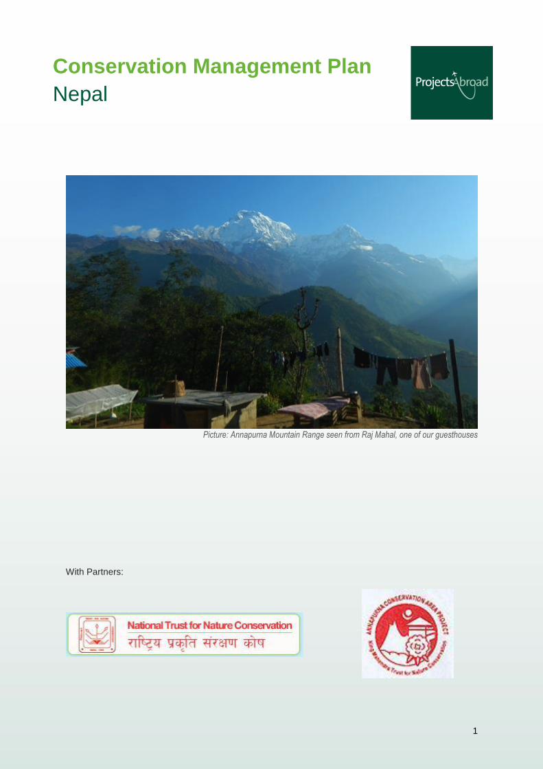
Picture: Annapurna Mountain Range seen from Raj Mahal, one of our guesthouses
With Partners:
2
Contents
1. Executive Summary……………………………………………………………………………….………. 4
2. Background Information …………………………………………………………………….…….…….. 4
2.1 Map showing the country of Nepal with the ACA area highlighted ………………………… 5
2.2 Geography ……………………………………………………………………………………….. 6
2.3 Weather …………………………………………………………………………………………... 6
2.4 Study Area within ACAP …………...................................................................................... 7
2.5 Land Use …………………………………………………………………………………………. 8
2.6 Social Context ………………………………………………………………………………..….. 8
3. Major threats to the area ………………………………………………………………..…………..…… 9
4. Overall Aim ……………………………………………………………………………………………..……9
4.1 Objectives ………………………………………………………………………….………………9
5. Remote sensor camera survey …………………………..……………………………………………. 10
5.1 Aims ………………………………………………………………………………………...…… 10
5.2 Summary to date …………………………………………………………………………..…… 10
5.3 Methods …………………………………………………………………………………..,.…… 12
6. Indicator Species Survey ……………….……………………………………………………………… 13
6.1 Aims ……………………………………………………………………………………………... 13
6.2 Summary to date ………………………………………………………………………….….… 13
6.3 Methodology ……………………………………………………………………………….…… 13
7. Bird Inventory ………………………………………………………………………..…………………… 15
7.1 Aims ………………………………………………………………………………………...…… 15
7.2 Summary to date ……………………………………………………………………………..… 16
7.3 Methodology ………………………………………………………………………………….… 17
8. Butterfly Survey ………….………………………………………………………………………………. 18
8.1 Aims ………………………………………………...…………………………………………… 18
8.2 Summary to date ………………………………………………………..……………………… 18
8.3 Methodology ………………………………………………….……………………………….…19
9. Herpetology Project ………………………………………………………………………………………19
9.1 Aims …………………………………………………………………………………………...… 20
9.2 Summary ……………………………………………………………………………………...… 20
3
9.3 Methodology ……………………………………………………………………………….…… 20
10. Other Projects…………………………………………………………………………………………….21
10.1 Raptor Survey…………………………………………………………………………………..21
10.2 Garbage Collection……………………………………………………………………………..21
10.3 Martins, Swallows, and swifts survey………………………………………………………...21
11. Future Projects …………………………………………………………………………………………..22
11.1 Small Mammals…………………………………………………………………………………22
11.2 Rhododendron Survey and Inventory………………………………………………………...22
11.2a Aims ………………………………………………………………………………….22
11.2b Summary……………………………………………………………………………..22
11.2c Methodology………………………………………………………………………....23
12. Seasonal Projects………………………………………………………………..…………………….. .24
12.1 Honeybee Project …………………………………………………………………………… ..24
12.1a Aims ……………………………………………………………………………… …24
12.1b Summary …………………………………………………………..……………… ..24
12.1c Methodology………………………………………………………………………….24
13. Implementation of the plan …………………………………………………………………………… 25
14. Reporting on research ………………………………………………………………………………… 25
4
1. Executive Summary
Projects Abroad are proud to further our partnership with the world famous Annapurna Conservation
Area Project (ACAP) to extend our project within the Ghandruk region. As one of the seven regions
within the Annapurna mountain range, Ghandruk was chosen as the ideal study area due to its
relative ease of conducting a year round study with volunteers and ACAP’s largest district office is
located there with a full team of staff.
As ACAP primarily focuses on sustainable social development within the area, Projects Abroad are
conducting wildlife studies to act as a method of testing ACAPs programs in reducing the reliance of
natural resources from local communities.
With no active research being carried out in the area other than that of Projects Abroad, our ongoing
mammal and bird inventories will provide a much-needed insight to the health of the eco-system and
its wildlife populations. These will also act as a solid platform for further studies and demonstrate what
areas to focus conservation efforts. Projects Abroad tree nurseries and education program are
complementing ACAPs work in social development and reducing the impact of the local people on
natural resources.
By conducting extended studies of species that are both indicator species and considered vulnerable
or endagered, Projects Abroad is able to provide key data that will aid the management of
endangered species through researching their ecology within the Ghandruk area. This will allow for
extra protection to be given through expeditions to locate where these animals live.
2. Background Information
For a relatively small country, Nepal has some of the greatest diversity in topography, climate and
biodiversity in the world. Ranging from tropical lowlands where one-horned rhino (Rhinoceros
unicornis), Asian elephants (Elephas maximus), tigers (Panthera tigris) and gharials (Gavialis
gangeticus) call home to the vast Himalaya and the roof of the world Mount Everest. Amongst the
Himalaya an equal amount of biodiversity can be found as in the tropical lowlands. This diversity is
protected under a network of 9 National Parks, 3 wildlife reserves, 1 hunting reserve and 3
conservation areas developed since 1973.
Amongst these, the Annapurna Conservation Area (ACA) is the largest protected area covering an
area of 7629 sq.km. The ACA region is located between 83 °34’ to 84°25’E longitude and 28°15’ to
28°50’N latitude. It runs through high mountain eco-zone areas of Nepal and is bordered by
Marsyangdi valley in the east, Kali Gandaki River in the west, the dry alpine forest of Mustang and
Tibet to the north and the valleys and foothills of Pokhara to the south.
5
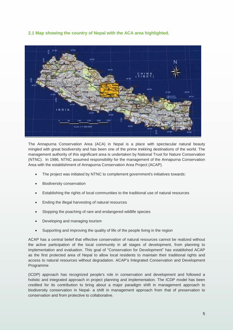
2.1 Map showing the country of Nepal with the ACA area highlighted.
The Annapurna Conservation Area (ACA) in Nepal is a place with spectacular natural beauty
mingled with great biodiversity and has been one of the prime trekking destinations of the world. The
management authority of this significant area is undertaken by National Trust for Nature Conservation
(NTNC). In 1986, NTNC assumed responsibility for the management of the Annapurna Conservation
Area with the establishment of Annapurna Conservation Area Project (ACAP).
The project was initiated by NTNC to complement government's initiatives towards:
Biodiversity conservation
Establishing the rights of local communities to the traditional use of natural resources
Ending the illegal harvesting of natural resources
Stopping the poaching of rare and endangered wildlife species
Developing and managing tourism
Supporting and improving the quality of life of the people living in the region
ACAP has a central belief that effective conservation of natural resources cannot be realized without
the active participation of the local community in all stages of development, from planning to
implementation and evaluation. This goal of “Conservation for Development” has established ACAP
as the first protected area of Nepal to allow local residents to maintain their traditional rights and
access to natural resources without degradation. ACAP’s Integrated Conservation and Development
Programme
(ICDP) approach has recognized people's role in conservation and development and followed a
holistic and integrated approach in project planning and implementation. The ICDP model has been
credited for its contribution to bring about a major paradigm shift in management approach to
biodiversity conservation in Nepal- a shift in management approach from that of preservation to
conservation and from protective to collaborative.
6
The biogeographically diversity in this region is globally unique as it represents four distinct climatic
regions: alpine, mountain desert, temperate and sub-tropical. These combined habitats are home to
22 forest types, 1,140 plant species, 21 amphibians’ species, 39 reptile species, 478 species of bird
and 101 species of mammals. It is also home to 100,000 people consisting of 10 ethnic groups. With
this vast dynamic of life and scenery, it is easy to see why the area attracts over 80,000 plus tourists
per year. The area claims to be home to the world’s deepest river gorge, t h e world’s largest
rhododendron forest and the world’s highest altitude fresh water lake.
ACAP has numerous collaborations consisting of not only the local people but also other NGOs,
INGOs, governmental organizations and CBOs and Projects Abroad. Projects Abroad and ACAP go
hand to hand in their efforts for the conservation of biodiversity and the enhancement of livelihoods.
At present ACAP has initiated collaboration with Projects Abroad to conduct scientific research,
sustainable development and livelihood improvement through sharing technical and other bilateral
supports.
2.2 Geography
The Annapurna area rises from an altitude of 1000m to over 8000m. There is a 6 °C drop in
temperature for every 1000m rise in elevation. The average temperatures decrease between the
months of December to February and reach a maximum between May to June. The seasonal
climate is dominated by the southern monsoon, which occurs from June to September.
As the monsoons are generated from the Himalayas, rain can increase three-fold during this season.
This provides problems with drainage as the sheer amount of water builds up in groundwater storage
and as surface run off. As the land becomes increasingly saturated the risk of land slides are
multiplied. The study area of Ghandruk, like the vast majority of Nepal is plagued by landslides due to
the topography of the land exacerbated by the climate. As the land struggles to deal with the
increased water loads during the monsoon, flashfloods are also a common occurrence.
In higher altitude areas above the snow line, avalanches are a common occurrence especially
during times of shifting temperatures. These Avalanches usually spill into rivers causing massive
floods or blockages in rivers, which lead to flash floods with tremendous force.
2.3 Weather
The heavy rainfall from June through to September brings with it a lot of landslides. These can be
very small but they also have the potential to be massive and life threatening. Areas up to 50 acres
have slid away within the study area taking with them trees and anything in their path.
Although there is a number of meteorological data recording stations across Nepal and indeed the
Annapurna range, there are none located within the Ghandruk area. The closet is located at
Machapuchare base camp which is at a higher altitude and approximately 10 km as the crow flies
from our study area. Therefore Projects Abroad recognizes the need to build a weather station and
record meteorological data within the Ghandruk area.
Over time this data will provide essential information when assessing bird presence and migratory
patterns. It will also allow conclusions to be drawn on the availability of different fruits and flowers of
many plants that resident and migratory wildlife populations depend on.
With a greater amount of weather stations across the Himalaya, it would allow for greater
comparisons to be made and certainly temporal comparisons in relation to global climate change.
7
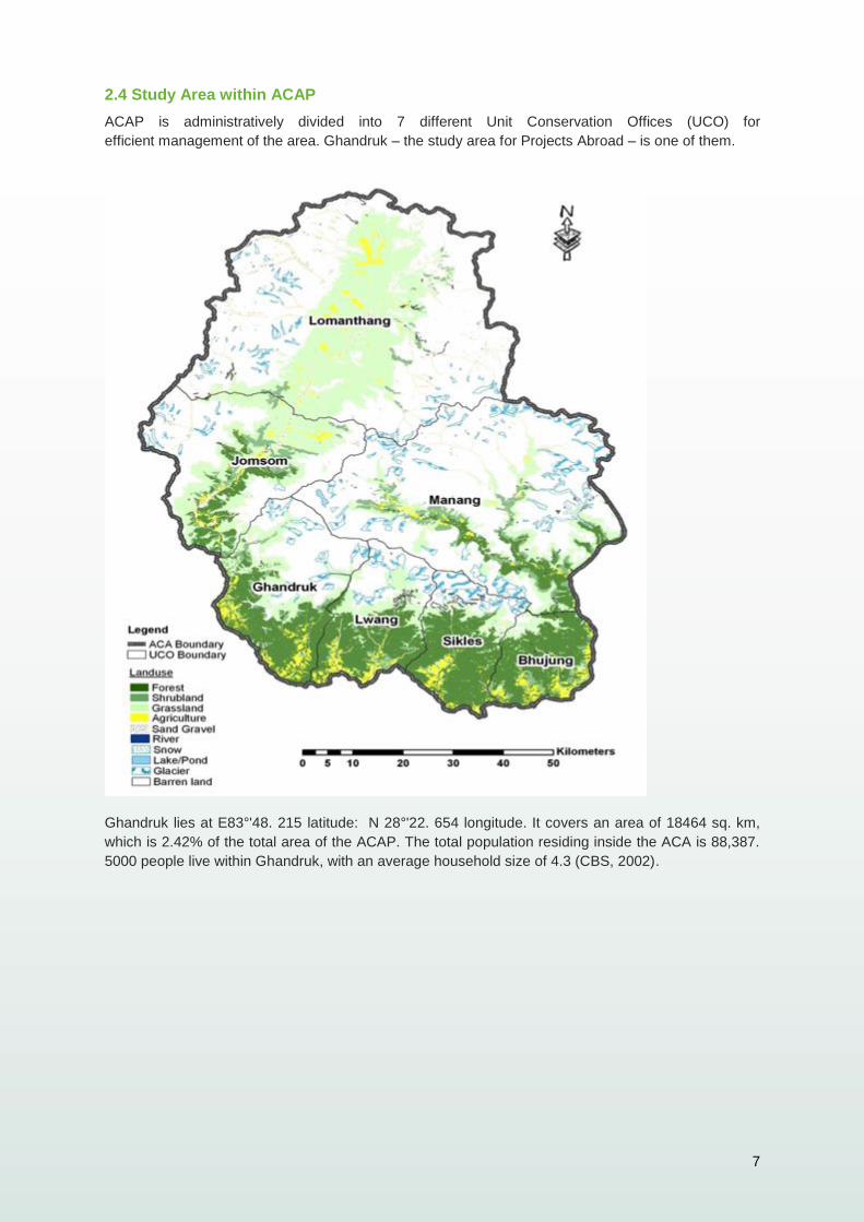
2.4 Study Area within ACAP
ACAP is administratively divided into 7 different Unit Conservation Offices (UCO) for
efficient management of the area. Ghandruk – the study area for Projects Abroad – is one of them.
Ghandruk lies at E83°'48. 215 latitude: N 28°'22. 654 longitude. It covers an area of 18464 sq. km,
which is 2.42% of the total area of the ACAP. The total population residing inside the ACA is 88,387.
5000 people live within Ghandruk, with an average household size of 4.3 (CBS, 2002).
8
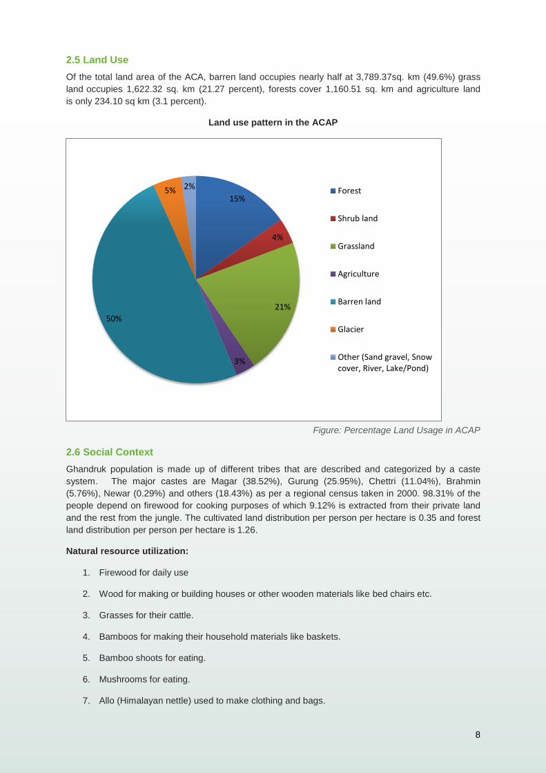
2.5 Land Use
Of the total land area of the ACA, barren land occupies nearly half at 3,789.37sq. km (49.6%) grass
land occupies 1,622.32 sq. km (21.27 percent), forests cover 1,160.51 sq. km and agriculture land
is only 234.10 sq km (3.1 percent).
Land use pattern in the ACAP
Figure: Percentage Land Usage in ACAP
2.6 Social Context
Ghandruk population is made up of different tribes that are described and categorized by a caste
system. The major castes are Magar (38.52%), Gurung (25.95%), Chettri (11.04%), Brahmin
(5.76%), Newar (0.29%) and others (18.43%) as per a regional census taken in 2000. 98.31% of the
people depend on firewood for cooking purposes of which 9.12% is extracted from their private land
and the rest from the jungle. The cultivated land distribution per person per hectare is 0.35 and forest
land distribution per person per hectare is 1.26.
Natural resource utilization:
1. Firewood for daily use
2. Wood for making or building houses or other wooden materials like bed chairs etc.
3. Grasses for their cattle.
4. Bamboos for making their household materials like baskets.
5. Bamboo shoots for eating.
6. Mushrooms for eating.
7. Allo (Himalayan nettle) used to make clothing and bags.
15%
4%
21%
3%
50%
5% 2% Forest
Shrub land
Grassland
Agriculture
Barren land
Glacier
Other (Sand gravel, Snowcover, River, Lake/Pond)
9
8. Lokta (Daphne bholua) for making papers.
9. Satuwa (Paris Polyphylla) for medicines.
10. Nirmashi (Delphinium himalayai) for medicines.
3. Major threats to the area
The major threats to the area have been identified in three levels:
Habitat degradation: Throughout the ACAP region, local villagers use almost all the accessible land
– including prime wildlife habitats – for livestock grazing, collection of fodder, firewood, food and other
natural resources. In some areas, forest fires are a significant habitat degradation problem. These are
either deliberate or incidental forest and alpine grassland fires. The fires are set by the villagers to
improve forage, poachers to drive targeted wildlife or reckless mountaineering and trekker groups
making campfires. Forest patches and alpine meadows have been completely destroyed by fire in
some areas. These activities inevitably impact on the plants and wildlife habitats, both directly and
indirectly, and also create food shortages and general habitat disturbances. These activities drive wild
animals away to areas of sub-optimal habitat.
Natural Resource Management: High altitude forest resources, wild animals, glaciers, lakes and
rivers are important natural resources of the area. Now these resources are facing tremendous
threats, including changing habitats for plants and animals, due to climate change and human
exploitation. Increased forest degradation as a result of local people using huge amounts of firewood
from the forest for cooking purposes has threatened the area with rapid deforestation. Newly built
roads have both positive and negative effects on plant resources. Local people can bring
kerosene or gas for cooking purpose if they have better access through the road, but the road may
increase illegal logging and exporting of timber from the forest. These new roads have the potential to
cause landslides as they are often built with no drainage and a r e cut into the sides of steep
slopes and therefore contribute to surface run off.
Livelihoods diversification: Agricultural fields are being increasingly left fallow since the local
residents are either involved in tourism business or fly overseas for the purpose of foreign
employment. Small and fragmented farm sizes with widespread absent land lords and tenants also
have hindered the agricultural practices.
4. Overall Aim
The overall aim of this project is to enhance and preserve biodiversity in the area through a
combination of scientific research and community engagement. The remoteness of mountain ranges
and their inaccessibility has made studying their unique flora and fauna very difficult for biologists. Our
study area in Nepal enables us to access a wide variety of micro-habitats on an altitude gradient from
1000m to over 2000m and provides us with a unique opportunity to research these little known
species.
4.1 Objectives
Due to a lack of scientific studies within the Ghandruk area, Projects Abroad places a strong
emphasis on research and act as the sole research centre within the area.
10
As the area is home to vulnerable and endemic Himalayan species, emphasis is placed on surveying
these species and improving our knowledge of them.
In line with our partners ACAP, Projects Abroad will continue to strive to engage the communities in
conservation and achieve better natural resource management through various programs of social
development and poverty reduction.
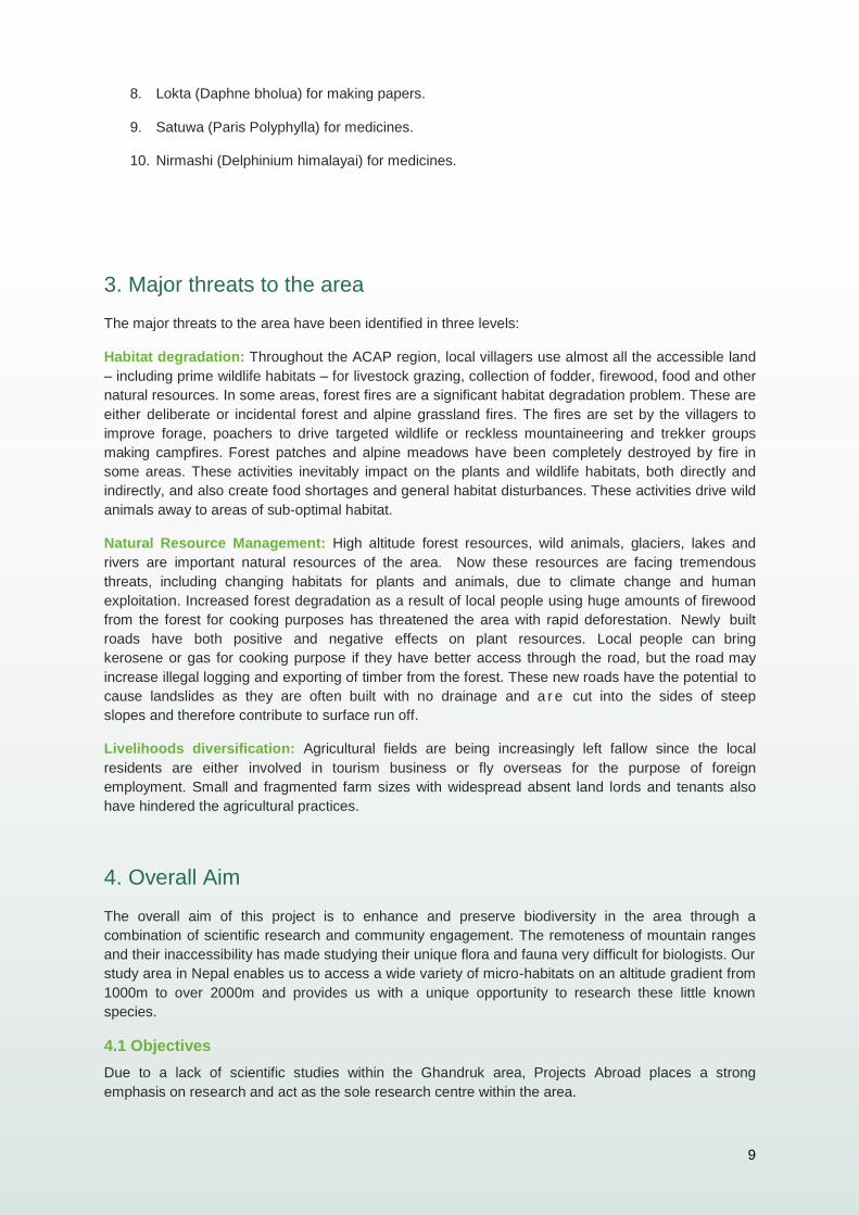
5. Remote sensor camera survey
Picture: Barking deer (Muntiacus vaginalis) caught on camera at night by one of our camera sensors
5.1 Aims
Compile a species inventory through the use of remote sensor cameras.
Provide a sound basis for determining what species are common within the area.
Act as a basis for further study.
Compare the data of animals found in close proximity to agricultural activities and areas
experiencing human encroachment with natural habitats where human activities are less
present.
5.2 Summary to date
In the first year of research we have been able to make an index of the mammals present in close
proximity to Ghandruk village. In this region activities in the forest are important. Disturbance by

11
domestic animals (buffaloes, cows, dogs etc.) and human activities (e.g. wood, grasses collection
etc.) can affect local wildlife populations.
The following species (with their IUCN status) have been found close to the village:
Common leopard (Panthera Pardus), status IUCN: Near Threatened
Leopard cat (Prionailurus bengalensis ancient Felis bengalensis), status IUCN: Least
Concern
Large Indian civet (Viverra zibetha), status IUCN: Near Threatened
Barking deer (Muntiacus vaginalis), status IUCN: Least Concern
Himalayan Goral (Naemorhedus goral), status IUCN: Near Threatened
Himalayan or Asiatic black bear (Ursus thibetanus), status IUCN: Vulnerable
Yellow Throated Marten (Martes Flavigula), status IUCN: Least Concern
Rhesus Monkey (Macaca mulatta), status IUCN: Least Concern
Assamese Monkey (Macaca assamensis), status IUCN: Least Concern
Nepal Gray Langur (Semnopithecus schistaceus), status IUCN: Least Concern
Orange-bellied Himalayan squirrel (Dremomys lokriah), status IUCN: Least Concern
In 2014, the objective of the research is to compare our data collected in 2013 with that taken from a
remote location where human activities are limited or inexistent. We will be able to see if the species
are similar and if there is any difference in the relative abundance of each one. In 2015 we shall
continue our research into mammal diversity but will also employ the cameras in an anti-poaching
campaign where we will place them in known hunting areas. The idea will be to capture illegal hunters
on camera or simply discourage them once they become aware of the monitoring program.
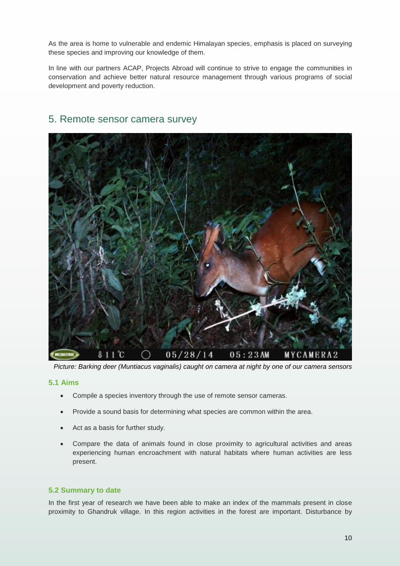
12
Picture: The Royles Pika (Ochotona roylei) a widespread rodent species to the Himalayans commonly
seen near the Annapurna Base Camp (ABC).
5.3 Methods
A line transect is a standard sampling technique used to study species distribution. To conduct a line
transect, an imaginary line is drawn to dissect the study area at predetermined places. The use of
transects allow for the study area to be monitored in a uniform and systematic way.
A total of five line transects will be surveyed within the study area. Each transect will be 1km long and
cameras will be placed 50m apart and approximately 50cm above the ground. Transects will vary in
order to compensate for the extreme topography and terrain. Cameras will be left in place for 2 weeks
and will be checked after this time. More frequent checks are unnecessary and less traffic through the
area will give a better reflection of the wildlife in their natural habitat.
Known geographical distributions, preferred habitats and seasonality are taken into consideration, and
special interest is taken in rare and poorly known species often with the help of local experts.
13
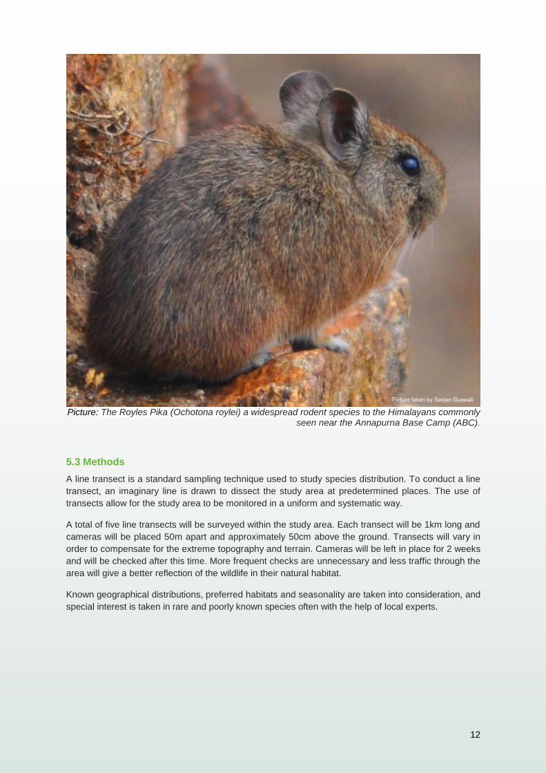
6. Indicator Species Survey
Picture: Common Leopard (Panthera Pardus) walking past one of our camera traps.
6.1 Aims
Indicator species are those animals found within an ecosystem that are the first to disappear when the
natural balance is disturbed. A strong presence of these species suggests a healthy ecosystem, their
absence the opposite. In the area immediately surrounding Ghandruk we have identified certain
species as being key indicator species. We wish to study the populations of the common leopard
(Panthera pardus) and the Himalayan black bear (Ursus thibetanus).
By gaining a better understanding of the population numbers and distribution of these indicator
species around Ghandruk we can then investigate how their numbers and behaviour differ from
populations in more remote areas.
6.2 Summary to date
At the time of writing we have captured on film three individual leopards and two individual bears.
These results are encouraging but we must continue to study these animals and discover if numbers
are increasing or decreasing over time.
6.3 Methodology
We decided to sue our remote sensor cameras in this study in conjunction with other sampling
methods which include searching the target areas for signs of each animal. Such signs include
faeces, tracks and evidence of feeding.
As the people living within the Annapurna Conservation Area have lived side by side with wildlife for
many generations, it is vital to draw upon their knowledge of each species through qualitative data
collection in the forms of interviews.
Therefore the three stages of the methods are:
14
1. Interview
By targeting local farmers and hotel owners we hope to gain invaluable knowledge of where common
leopards and Himalayan black bears have been sighted. The areas where sightings have occurred
can then be mapped and used for further study and deployment of research teams and remote sensor
cameras.
2. Checking for evidence in the field
After the interview process field research is conducted to corroborate the interview information and
determine the presence/absence of each target species.
3. Remote Sensor Cameras
Remote sensor cameras are a non-invasive method that allows the survey of shy, quiet and elusive
animals, like each of the target species. This method will not only determine presence/absence but
also provide some insight to the abundance of each animal within each target area.
The cameras traps will be placed in areas where there are recorded signs of the animal, qualitative
data from interview results, and in the area where there is a greater chance to film them. Such sites
could include trails, bamboo areas and known latrine sites.
15
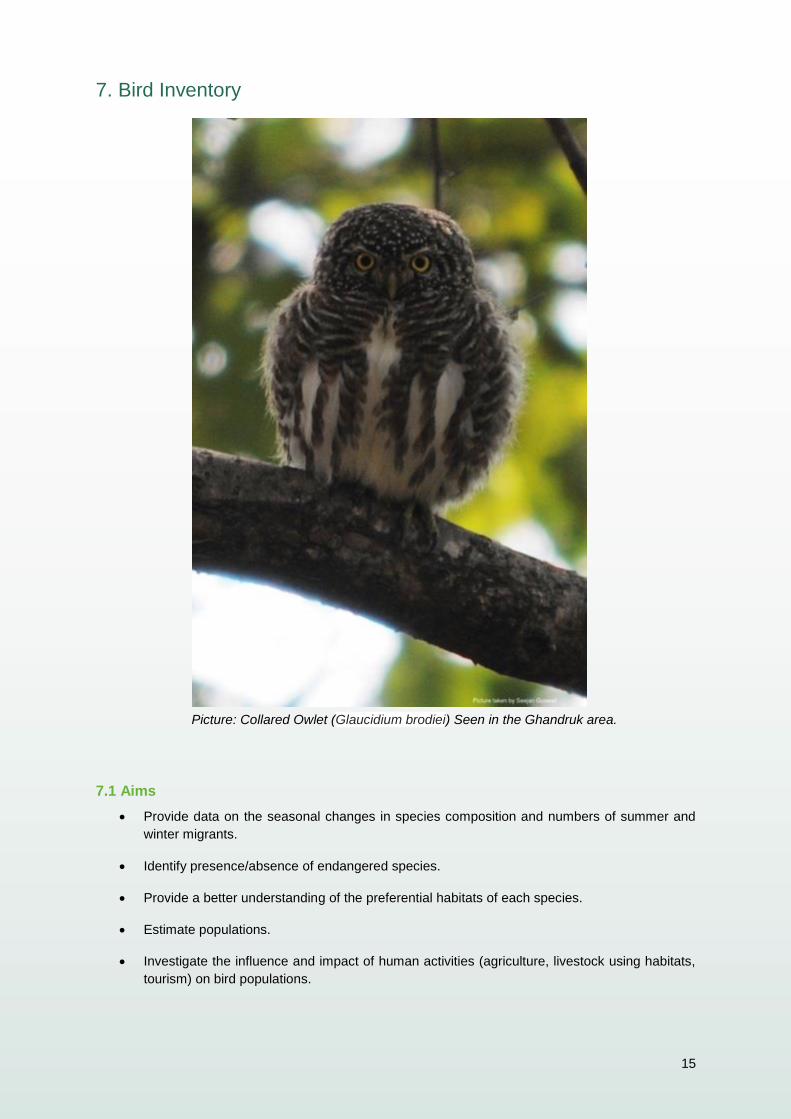
7. Bird Inventory
Picture: Collared Owlet (Glaucidium brodiei) Seen in the Ghandruk area.
7.1 Aims
Provide data on the seasonal changes in species composition and numbers of summer and
winter migrants.
Identify presence/absence of endangered species.
Provide a better understanding of the preferential habitats of each species.
Estimate populations.
Investigate the influence and impact of human activities (agriculture, livestock using habitats,
tourism) on bird populations.
16
7.2 Summary to date
Birds play an important role in the ecosystems as plant pollinators, insect eaters, seed dispersers and
important members of the food chain. They are easy to identify with the correct materials (binoculars,
books etc.) and they are present in most habitats. Birds are good indicators of the health of the
ecosystems and environment (INSKIPP & al., 2011 and SAGAR BARAL & al., 2005). Birds, like many
other species, are facing pressure and threats from human activity, some of the threats that birds are
facing include: habitat loss and modification, fragmentation of habitats, human activity and forest
degradation of forest.
Nepal is home to 871 species of birds that represent 9% of the world’s total bird species. Annapurna
Conservation Area (ACA), the largest protected area of Nepal, is one of the 27 Important Bird Areas
(IBAs) identified in Nepal.
During the first year of research (June 2012 to July 2013), the methodology used for our bird study
has involved one method: the fixed point method. This method has provided us with valuable data but
we have been unable to include some important species and information. After a meeting with Dr.
Hem Sagar Baral, a bird expert of Nepal, we came to the decision to add a new method of research
(MacKinnon’s list). The two methods combined will give us a better overview of the species present
around Ghandruk and some complimentary information about the habitat preferences for each
species along with an estimate of abundance. We also are able to compare the 2 main methods and
see which one provides the best data for analysis.
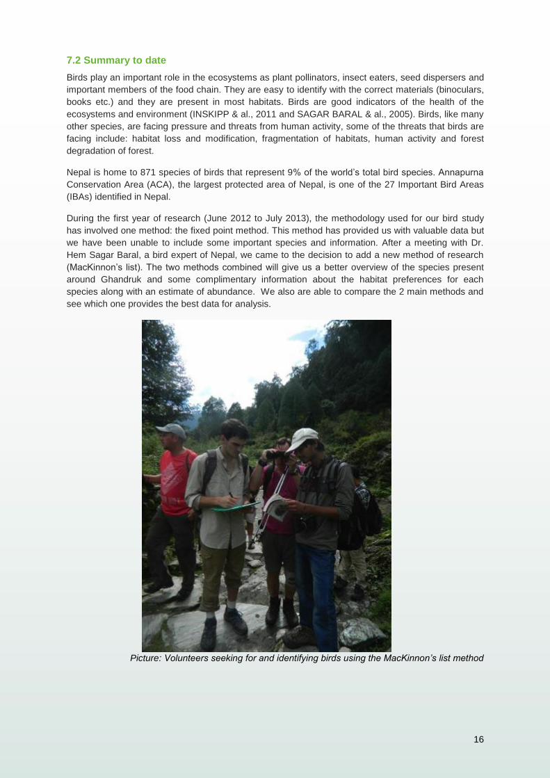
Picture: Volunteers seeking for and identifying birds using the MacKinnon’s list method
17
7.3 Methodology
The two methods we are using are:
a) Fix point method
b) MacKinnon’s list method
a) Fix point method
Point counts are a standard sampling procedure for many bird species (Farnsworth G.L. & al, 2005). It
is a popular and simple method for sampling bird populations and composition conducted over a large
area. Point counts are essentially fixed stations from which the observer performs the count in a 360º
arc. Survey stations are randomly located throughout the study area to obtain representative samples
of the species and numbers of each species present depending on the habitat.
Point count observers are sedentary, they may be more likely to detect shy species that would
otherwise hide and escape detection when mobile and conspicuous strip transect observers
approach.
b) MacKinnon’s list method
According to SUTHERLAND & al (2005), MacKinnon has proposed an alternative method of
standardizing effort by repeated accumulation of fixed length species lists (McKinnon and Phillips
1993). This method allows for the calculation of a species discovery curve and an index of relative
abundance (BIBBY C. & al., 1998).
The observer records each new species observed until a target number of species has been
recorded. At that point, a new list is started that allows for all species to be recorded again as new.
This is replicated several times. Comparisons can only be made between surveys where the same
length of list was chosen. The advantage of this is that it makes the method relatively less susceptible
to differences in ability and concentration of the observer. If an inexperienced observer takes a long
time to identify each species detected this does not greatly affect the results providing he/she does
eventually identify all species detected. Similarly recording during a period of low activity such as over
midday will not greatly affect the results – it will just take longer to detect a given number of species
(BIBBY C. & al., 1998).
Common species will clearly be recorded more frequently than rare ones, but there is no reason why
the relationship between frequency and absolute (unknown) abundance should be linear
(SUTHERLAND & al, 2005).
18
8. Butterfly Survey
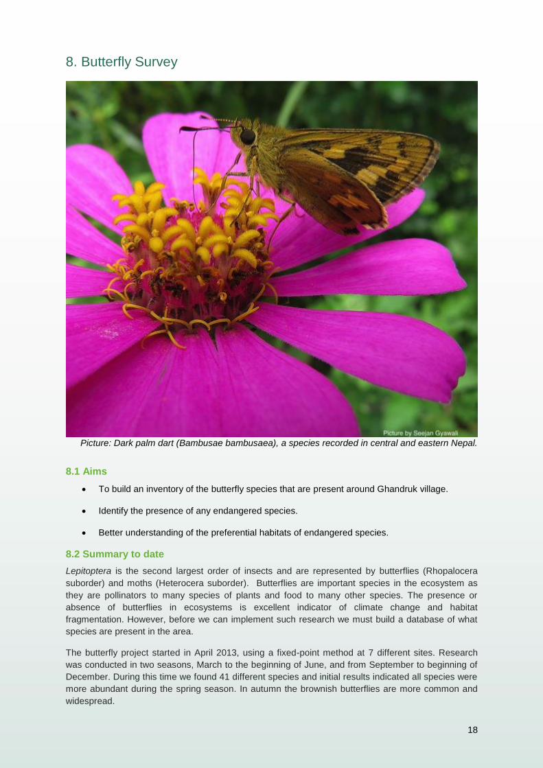
Picture: Dark palm dart (Bambusae bambusaea), a species recorded in central and eastern Nepal.
8.1 Aims
To build an inventory of the butterfly species that are present around Ghandruk village.
Identify the presence of any endangered species.
Better understanding of the preferential habitats of endangered species.
8.2 Summary to date
Lepitoptera is the second largest order of insects and are represented by butterflies (Rhopalocera
suborder) and moths (Heterocera suborder). Butterflies are important species in the ecosystem as
they are pollinators to many species of plants and food to many other species. The presence or
absence of butterflies in ecosystems is excellent indicator of climate change and habitat
fragmentation. However, before we can implement such research we must build a database of what
species are present in the area.
The butterfly project started in April 2013, using a fixed-point method at 7 different sites. Research
was conducted in two seasons, March to the beginning of June, and from September to beginning of
December. During this time we found 41 different species and initial results indicated all species were
more abundant during the spring season. In autumn the brownish butterflies are more common and
widespread.
19
In 2014 and 2015, the project will continue with the same methodology. The project will survey the
same sites in order to compare the data with 2013 and will expand to other sampling sites. We hope
to identify any changes in populations and distributions of the species most commonly found.
New projects for 2015 will also include the collection and study of caterpillars. We will collect the
caterpillars and bring them back with the leaves of the plants they were found feeding on.
Photographs will be taken of the caterpillar, pupa and emergent butterfly with the aim to produce a
guide to these insects.
8.3 Methodology
Surveys are conducted within a pre-determined area and conducted for a period of one hour. Each
site is surveyed two times in each season.
With each recorded species, notes are also taken on the surrounding habitat which includes flowering
plants and habitat density.
January 2015 we will start using fixed butterfly traps which can be placed in denser forest areas
where manual netting is impractical. The height of the traps in the canopy can also be varied to
investigate the diversity at different levels of the forest.
9. Herpetology Project
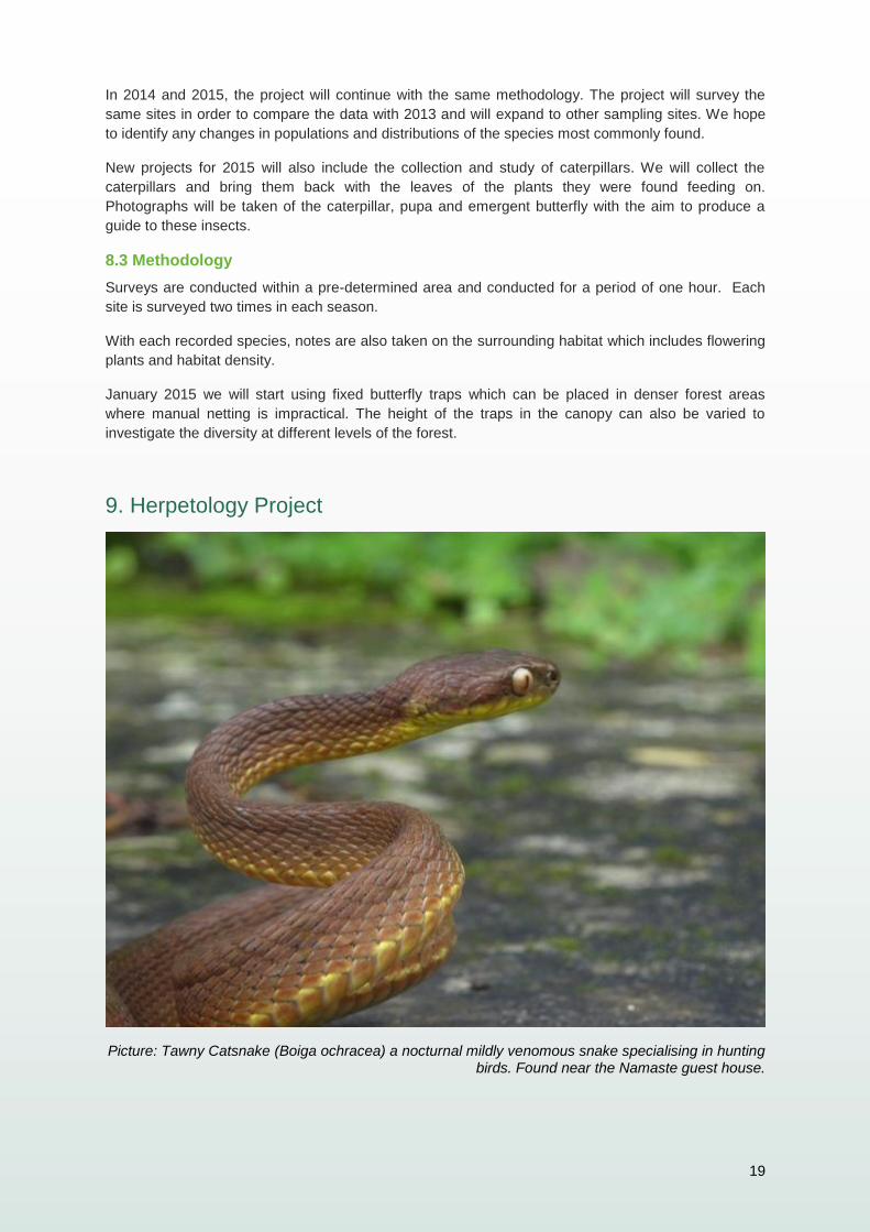
Picture: Tawny Catsnake (Boiga ochracea) a nocturnal mildly venomous snake specialising in hunting birds. Found near the Namaste guest house.
20
9.1 Aims
Determine the present status of Herpetofauna diversity in different habitat types in
Annapurna Conservation Area.
Mapping the different species of Herpetofauna.
Investigate spatial distribution of the Herpetofauna in Annapurna Conservation
Area.
Environmental education- teaching locals not to kill snakes on sight using
presentations and outreach programs
9.2 Summary
Herpetology is the study of reptiles and amphibians. Both these groups of animals are excellent bio-indicators and are often the first to disappear when an ecosystem is damaged yet on a global scale these animals are often the least studied due to their unique habitats and shy behaviour. The whole ACA Park is known to house 40 species of reptile and 13 species of amphibian and we need to discover how many are in and around the Ghandruk area. Once we have a definitive list of what is in the area we can study the dynamics of the populations to see if numbers are stable or increasing/decreasing. This data will be a great indicator of how healthy the ecosystems around us are and how effective our conservation work is.
9.3 Methodology
The survey will start during the peak monsoon time i.e. from June to September, and
continue through till June 2015 by which time the surveying methods will be standard. The
current system of surveying is as follows.
1. Pitfall trapping – 20m of plastic netting is stretched over the surface of the ground and two
25l buckets are buried at either end of the fence. Animals will encounter the obstruction and
follow it looking for an on-going route and then fall into the traps
2. Heat traps- metal sheets are used to capture natural heat from the sun, reptiles will bask on
the sheet in the morning to gain heat. When the sheet becomes too hot around midday the
reptiles retreat under the same sheeting to cool off and can be caught there.
3. Nocturnal surveying- night walks looking for reflective eye shines can make detecting these
elusive animals easier
4. Visual encounters- any reptiles or amphibians encountered on other activities will be
recorded and data collected.
Once we have a comprehensive list of the reptiles and amphibians of the area we can start
to investigate other aspects of their biology such as breeding cycles, habitat types and
vocalisations.
21
10. Other Projects
10.1 Raptor Survey
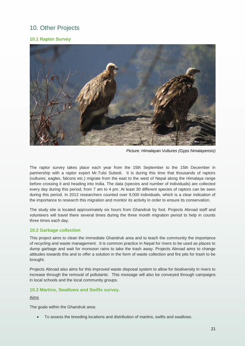
Picture: Himalayan Vultures (Gyps himalayensis)
The raptor survey takes place each year from the 15th September to the 15th December in
partnership with a raptor expert Mr.Tulsi Subedi. It is during this time that thousands of raptors
(vultures, eagles, falcons etc.) migrate from the east to the west of Nepal along the Himalaya range
before crossing it and heading into India. The data (species and number of individuals) are collected
every day during this period, from 7 am to 4 pm. At least 30 different species of raptors can be seen
during this period. In 2012 researchers counted over 9,000 individuals, which is a clear indication of
the importance to research this migration and monitor its activity in order to ensure its conservation.
The study site is located approximately six hours from Ghandruk by foot. Projects Abroad staff and
volunteers will travel there several times during the three month migration period to help in counts
three times each day.
10.2 Garbage collection
This project aims to clean the immediate Ghandruk area and to teach the community the importance
of recycling and waste management. It is common practice in Nepal for rivers to be used as places to
dump garbage and wait for monsoon rains to take the trash away. Projects Abroad aims to change
attitudes towards this and to offer a solution in the form of waste collection and fire pits for trash to be
brought.
Projects Abroad also aims for this improved waste disposal system to allow for biodiversity in rivers to
increase through the removal of pollutants. This message will also be conveyed through campaigns
in local schools and the local community groups.
10.3 Martins, Swallows and Swifts survey.
Aims
The goals within the Ghandruk area:
To assess the breeding locations and distribution of martins, swifts and swallows.
22
To establish the locations of nesting colonies and some indication of the sizes of those
colonies.
To establish a survey- this will act as a basis for future monitoring and surveying.
Summary
Martins, swifts and swallows (Hirundinidae genus) are important birds in any ecosystem as they are
important pest controls for flying insects and very little is known about their life history in Nepal. They
are migratory in that they can range over large distances or just move up and down mountains in
search of seasonally displaced food. Most flying insects move down from higher altitudes during the
cold winter months and these birds will follow their prey.
Hirundinidae numbers have been decreasing worldwide but there has been no data recorded in the
ACAP area.
Methodology
Two nesting colonies have been identified in the reserve and we need to set up fixed point
observation stations with a high powered telescope to study population numbers, breeding season,
behaviour and breeding success.
Once we have collected data on these elusive birds we can suggest conservation plans and methods
for protecting the colonies.
11. Future projects
11.1 Small Mammals
In conjunction with the pitfall traps we want to set up live rodent traps and arboreal traps to register
the rodents of the area. We suspect there might be as many as 20 small mammal species in the
region and we wish to capture and identify as many as possible. We expect to begin this project in
January/February 2015.
11.2 Rhododendron Survey and Inventory
11.2a Aims
The general aim of this project is to assess growing stock of Rhododendron Forest in the study area.
Specific aims of the project are as follows:
To find the total forest area that is Rhododendron forest.
To find growing stock of Rhododendron Forest in the study area.
To suggest what management needs to be adopted for conservation management.
To record the size of the forest and determine if it is the world’s largest as proclaimed.
11.2b Summary
The rhododendron forests of the Annapurna area have always been a tourist attraction and locals
claim it holds the world’s largest rhododendron forest, a hypothesis Projects Abroad wishes to test in
this study!
The generic term rhododendron is formed by the union of two Latin and Greek words: rhodo (red or
rose) and Dendron (tree or branches). Over 850 species of rhododendron are known globally
23
(Pokharel, 1999). Most of them are well known as conspicuous elements of the temperate vegetation
of the Northern Hemisphere. From South China to East Asia, to the Himalayas and Japan, these
countries exhibit the greatest abundance and highest concentration of this genus, followed by North
America and Malaysia in the second and the third ranks respectively (Shakya, 1985).
Rhododendron is normally understory vegetation of the oak and conifers forests of Nepal (Shrestha,
1997) and plays a vital role with Himalaya eco-systems by providing food and shelter to numerous
species of mammal, bird and reptile.
11.2c Methodology
Forest Boundary Survey
The area covered by Rhododendron Forest will be calculated using GPS. Volunteers and staff will
walk along the perimeter of the forest recording way-points at a distance of approximately 100m
depending on altitude and terrain. The data taken will be plotted in GIS software and area calculated
accordingly. After the area is calculated, the team will determine a suitable number of sample plots to
survey the forest strata at a 10% sampling intensity.
Stratified Random Sampling
As there are many sub species of rhododendron within the forest, for statistical analysis purposes it is
advantageous to survey each subpopulation separately, this is called stratification. We can then
sample each plot for the different subspecies and draw comparisons to topography, altitude and
immediate surroundings for each species.
Sample Plots
Sample plots will be chosen randomly in areas that can represent each subspecies. Plots will be a
least 100m apart. The age of trees within each plot will be estimated by measuring the diameter of the
trees at chest height.
Other measurements will be taken by dividing the sample plots into further smaller quadrants of:
1. 5m by 2m plot – for measuring regeneration (seedlings) that are less than 1m in height.
2. 5m by 5m plot – for measuring regeneration (saplings) that are less than 10cm.
3. 10m by 10m plot – for measuring poles that are between 10cm to 30 cm.
4. 20m by 25m plot – for measuring trees that are higher than 30cm.
This data will be recorded all year round and the study will be on-going for at least three years
although conclusions will be drawn and data analysed quarterly.
Growing Stock and Volume Calculation:
The number of trees per hectare will be calculated using mathematical formulae. SPSS software will
be used for this purpose.
24
12. Seasonal Projects
12.1 Honeybee Project
12.1a Aims
To gain an understanding of the impact of honey hunting on wild populations.
Mapping the different hive and the wild nests.
12.1b Summary
This is a new project that will be started in 2014. Bees play an important and valuable role as they are
vital plant pollinators in agricultural and natural ecosystems whilst also maintaining mountain
biodiversity (Bahadur Gurung & al., 2012). All over the globe there have been scientific studies
documenting the decline of bees. There has never been a more urgent need to further our
understanding of bees and how environmental variables – both natural and man-made – affect their
ecology.
12.1c Methodology
The methodologies to be used in this survey will combine several methods:
Questionnaires with honey hunters and hive owners.
GIS software to map hives and analyse spatial distribution.
Field surveys.
a) Questionnaires
Interviews with local honey hunters and beekeepers will be conducted to gather qualitative
data and gain a further understanding of how bees are used among local communities. All
qualitative data will be studied so that best practice recommendations can be made.
Questions will be aimed to build up data on the following:
Period of year that honey is collected.
Quantity that is collected from each hive.
Price fluctuations.
Any change of variables that affect the harvest or bee activity.
Opinions on best practice techniques.
b) Spatial Distribution and analysis
The location of all wild and domesticated hives will be recorded and mapped. For the wild
sites, spatial analysis can be made to determine if hives are located in a random or uniform
distribution. This data will help make sound conservation management decisions in the
future.
25
At each wild site the numbers of hives will be noted to draw comparisons in the data
recorded each year and determine if the honey hunters are causing a decline in wild stock.
By mapping the domestic hive locations and the number of hives at each site we will be able
to make sound recommendations on best practice techniques when the data is reviewed
over time.
c) Field Surveys
Field surveys will be conducted two times before harvest and two times after each year. The
number of hives, immediate surroundings of each hive, altitude, GPS coordinates, direction
the nest is facing and ease of access for hunters and bees will all be noted and recorded on
each visit.
13. Implementation of the plan
As Projects Abroad places volunteers, interns and professionals into hundreds of projects worldwide,
it is vital that these resources are deployed in a way that utilizes their strengths and coincides with the
aims and objectives of the project.
To ensure all resources available to the project are being used correctly Projects Abroad employs
three staff on site directing the daily activities and ensuring research is being carried in accordance
with this plan. Projects Abroad also has a conservation programme manager ensuring constant
consultation with experts and the project is correctly managed.
Staff at the project:
Mr. Raj Bahadur Gurung – Conservation Manager
Mr. Seejan Gyawali – Conservation Field Coordinator
Mr. Cormac Price – Conservation Field Coordinator
14. Reporting on research
Data collected at the project will be sent to Projects Abroad head office in the U.K. to be reviewed by
the Conservation Programme Manager. Internal reports will be written using these data sets and
made available to the public through a public domain.
When data sets are sufficient, reports will be peer reviewed by leading experts with the aim of
publication in scientific journals.
The project will also produce an annual report outlining progress and recommendations. The project
will also feature in Projects Abroad’s Conservation Annual Report, made available to the public
through a wide range of media.
26
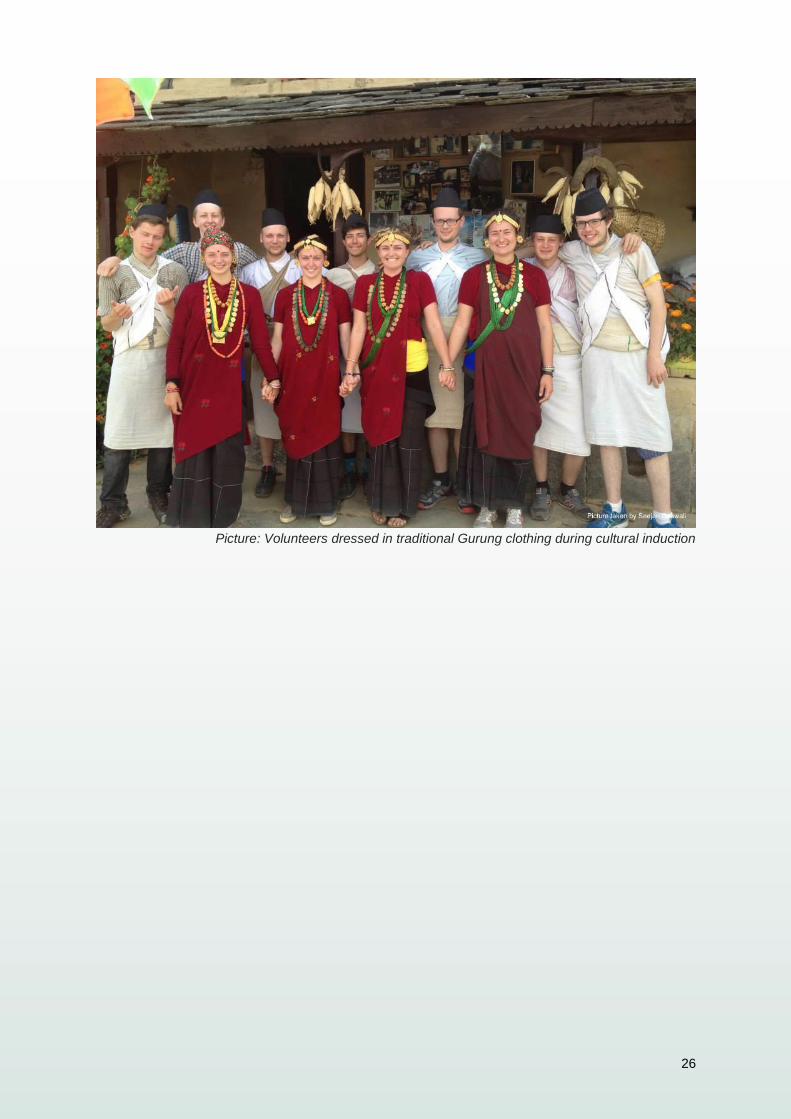
Picture: Volunteers dressed in traditional Gurung clothing during cultural induction


