dolomites pdf
DESCRIPTION
TrekinItaly1. Alta Via 2James Baxter July-August 2010Alta Via 2Edelwiess, Leontopodium alpinum, an iconic flower in the alps is not common in the DolomitesThe Alpine Marmot, Marmota marmota, lives in colonies in burrows in rocky meadows and alps. They eat vegetation in the summer to build a layer of fat for their long hibernationWhite Mountain Saxifrage Saxifraga paniculata, grows on high stable screes and moraine in the DolomitesThe Alta Via 2 is the longest of the Alta Via roTRANSCRIPT

Trek in
Italy
James Baxter
July-August 2010
1. Alta Via 2
Alta Via 2
The Alta Via 2 is the longest of the Alta Via routes in the Dolomites. It goes from the Tyrolean town of Brixen to the Venetian town of Feltre. It is possible to shorten it by eliminating the first day’s climbing from Brixen and most of the descent to Feltre, but this diminishes the fluency of the walk.
The best time to walk the route is July to September. Earlier and snow is likely to be a problem, especially on the descent from Marmolada to Contrin lodge. Later and the lodges are closed. Perhaps the optimum time to walk it are the middle two weeks in July when the flowers are at their best, most of the snow has melted and the busy holiday season of late July and August has not begun in earnest. If you include the day’s ascent to Plose and a day’s descent from Piaz, and do the alternative route up Marmolada as described, then allow 15 days walking and at least one weather day.
There are many lodges en route, often two a day. The lodges will accommodate and cater for you
- even if it is a mattress on the floor. Food can be obtained at all the lodges. Meals are not that cheap but the quality and quantity is good. The simple half pension of dinner, bed in a dorm and breakfast will cost around €40 a night, Water on the mountains is scarce and water at the lodges is often undrinkable, so it has to be bought, but is cheap.
A tent and sleeping bag are totally unnecessary and camping is not allowed in the national parks which the route mainly passes through. A sleeping sheet is essential however for use in the lodges. If one is planning to climb Marmolada by the west ridge a very light via ferrata harness is needed, otherwise as long as one has a head for heights, it is unnecessary. Crampons and ice axe are also unnecessary. So the weight of the rucksack should be restricted to around 5-6 kg. This is important as many of the ascents and descents are very steep.
In a nutshell the route climbs over the treeline of 2000m and well beyond on the first day and stays
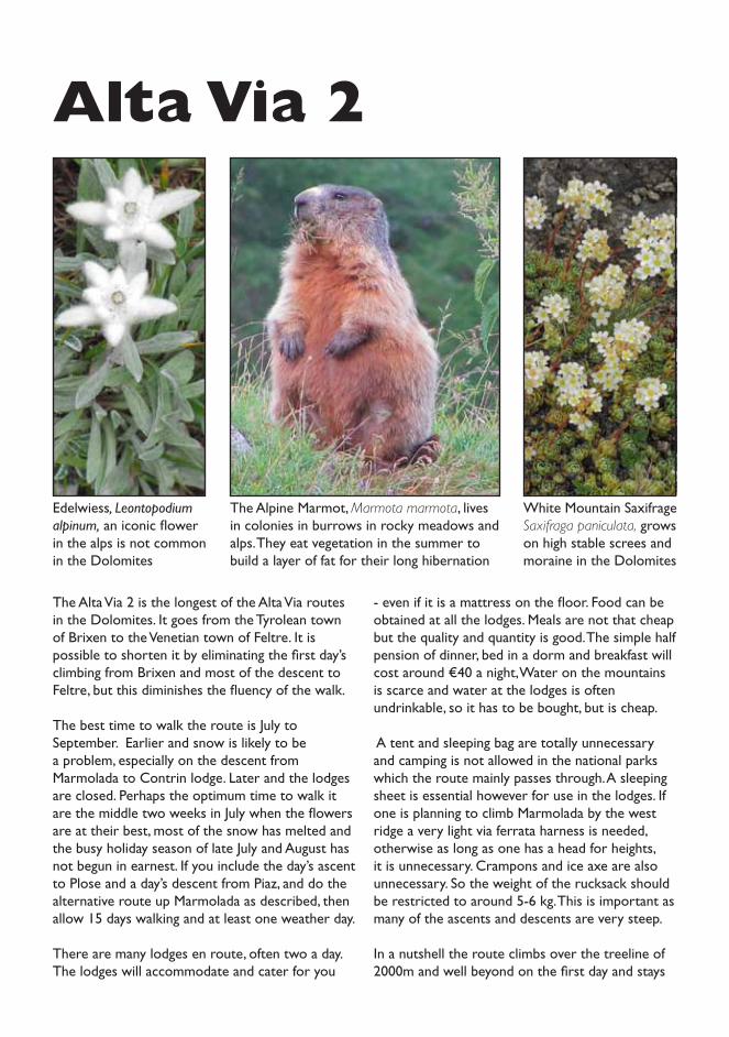
Edelwiess, Leontopodium alpinum, an iconic flower in the alps is not common in the Dolomites
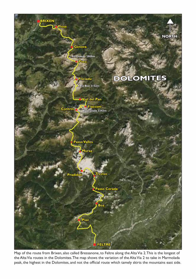
White Mountain Saxifrage Saxifraga paniculata, grows on high stable screes and moraine in the Dolomites
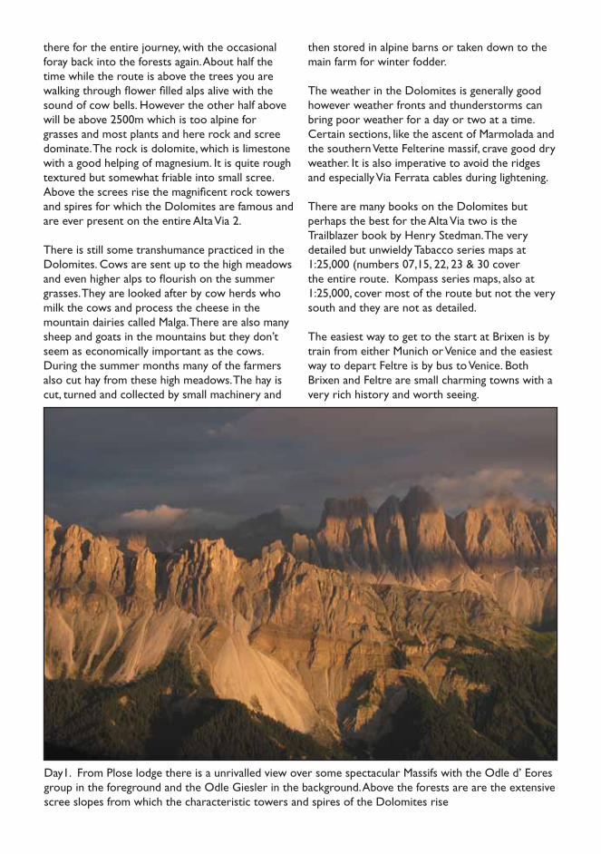
The Alpine Marmot, Marmota marmota, lives in colonies in burrows in rocky meadows and alps. They eat vegetation in the summer to build a layer of fat for their long hibernation
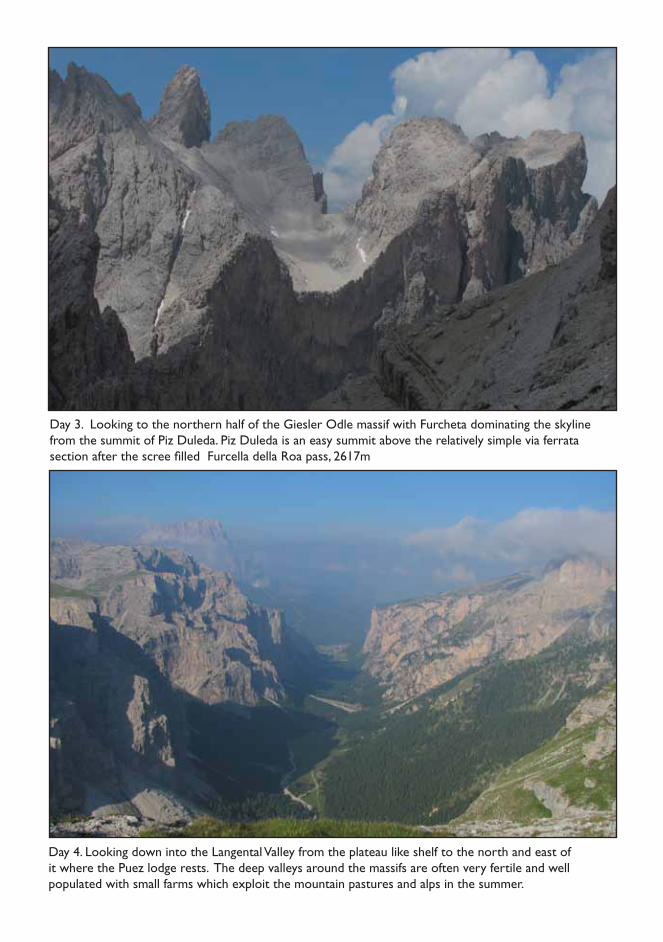
Day1. From Plose lodge there is a unrivalled view over some spectacular Massifs with the Odle d’ Eores group in the foreground and the Odle Giesler in the background. Above the forests are are the extensive scree slopes from which the characteristic towers and spires of the Dolomites rise
there for the entire journey, with the occasional foray back into the forests again. About half the time while the route is above the trees you are walking through flower filled alps alive with the sound of cow bells. However the other half above will be above 2500m which is too alpine for grasses and most plants and here rock and scree dominate. The rock is dolomite, which is limestone with a good helping of magnesium. It is quite rough textured but somewhat friable into small scree. Above the screes rise the magnificent rock towers and spires for which the Dolomites are famous and are ever present on the entire Alta Via 2.
There is still some transhumance practiced in the Dolomites. Cows are sent up to the high meadows and even higher alps to flourish on the summer grasses. They are looked after by cow herds who milk the cows and process the cheese in the mountain dairies called Malga. There are also many sheep and goats in the mountains but they don’t seem as economically important as the cows. During the summer months many of the farmers also cut hay from these high meadows. The hay is cut, turned and collected by small machinery and
then stored in alpine barns or taken down to the main farm for winter fodder.
The weather in the Dolomites is generally good however weather fronts and thunderstorms can bring poor weather for a day or two at a time. Certain sections, like the ascent of Marmolada and the southern Vette Felterine massif, crave good dry weather. It is also imperative to avoid the ridges and especially Via Ferrata cables during lightening.
There are many books on the Dolomites but perhaps the best for the Alta Via two is the Trailblazer book by Henry Stedman. The very detailed but unwieldy Tabacco series maps at 1:25,000 (numbers 07,15, 22, 23 & 30 cover the entire route. Kompass series maps, also at 1:25,000, cover most of the route but not the very south and they are not as detailed.
The easiest way to get to the start at Brixen is by train from either Munich or Venice and the easiest way to depart Feltre is by bus to Venice. Both Brixen and Feltre are small charming towns with a very rich history and worth seeing.
Puez
DOLOMITES
Map of the route from Brixen, also called Bressanone, to Feltre along the Alta Via 2. This is the longest of the Alta Via routes in the Dolomites. The map shows the variation of the Alta Via 2 to take in Marmolada peak, the highest in the Dolomites, and not the official route which tamely skirts the mountains east side.
Pisciadu
Fiacconi
Plose
Viel del Pan
Genova
BRIXEN
NORTH
Contrin
Passo Valles
Muraz
Pradidali Treviso
Passo Cerada
Boz
Piaz
FELTRE
Marmolada 3343m
Piz Boe 3152m
Piz Duleda 2909m
Day 3. Looking to the northern half of the Giesler Odle massif with Furcheta dominating the skyline from the summit of Piz Duleda. Piz Duleda is an easy summit above the relatively simple via ferrata section after the scree filled Furcella della Roa pass, 2617m
Day 4. Looking down into the Langental Valley from the plateau like shelf to the north and east of it where the Puez lodge rests. The deep valleys around the massifs are often very fertile and well populated with small farms which exploit the mountain pastures and alps in the summer.
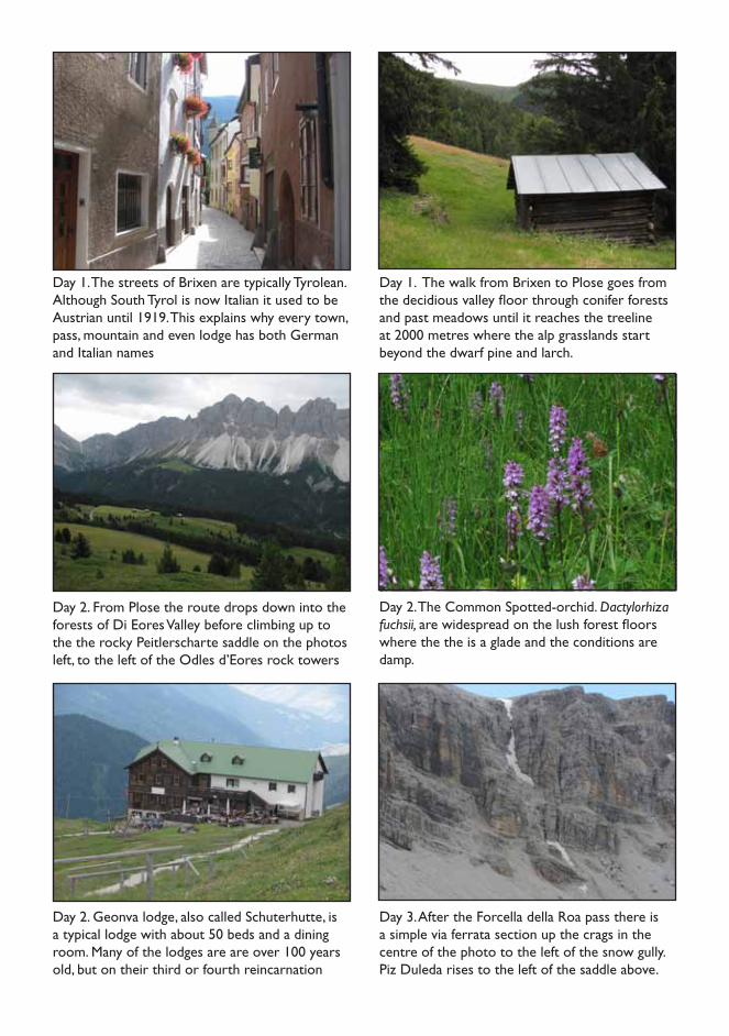
Day 1. The streets of Brixen are typically Tyrolean. Although South Tyrol is now Italian it used to be Austrian until 1919. This explains why every town, pass, mountain and even lodge has both German and Italian names
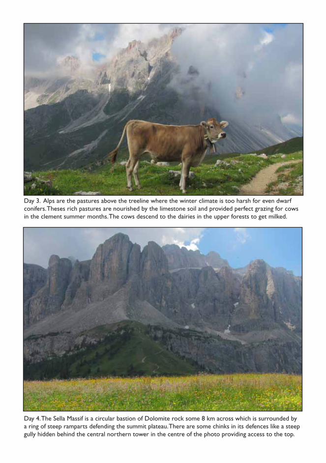
Day 1. The walk from Brixen to Plose goes from the decidious valley floor through conifer forests and past meadows until it reaches the treeline at 2000 metres where the alp grasslands start beyond the dwarf pine and larch.
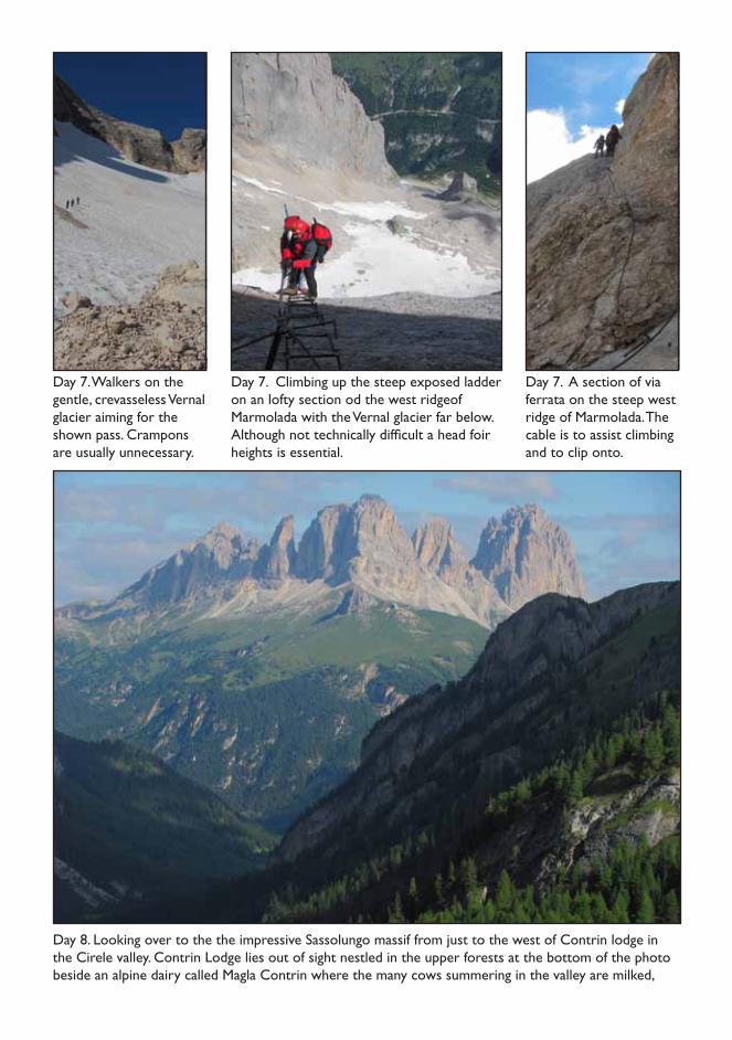
Day 2. Geonva lodge, also called Schuterhutte, is a typical lodge with about 50 beds and a dining room. Many of the lodges are are over 100 years old, but on their third or fourth reincarnation
Day 3. After the Forcella della Roa pass there is a simple via ferrata section up the crags in the centre of the photo to the left of the snow gully. Piz Duleda rises to the left of the saddle above.
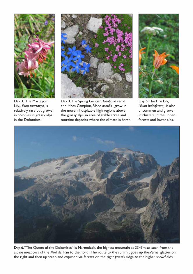
Day 2. From Plose the route drops down into the forests of Di Eores Valley before climbing up to the the rocky Peitlerscharte saddle on the photos left, to the left of the Odles d’Eores rock towers
Day 2. The Common Spotted-orchid. Dactylorhiza fuchsii, are widespread on the lush forest floors where the the is a glade and the conditions are damp.
Day 3. Alps are the pastures above the treeline where the winter climate is too harsh for even dwarf conifers. Theses rich pastures are nourished by the limestone soil and provided perfect grazing for cows in the clement summer months. The cows descend to the dairies in the upper forests to get milked.
Day 4. The Sella Massif is a circular bastion of Dolomite rock some 8 km across which is surrounded by a ring of steep ramparts defending the summit plateau. There are some chinks in its defences like a steep gully hidden behind the central northern tower in the centre of the photo providing access to the top.
Day 6. “The Queen of the Dolomites” is Marmolada, the highest mountain at 3343m, as seen from the alpine meadows of the Viel dal Pan to the north. The route to the summit goes up the Vernal glacier on the right and then up steep and exposed via ferrata on the right (west) ridge to the higher snowfields.
Day 3. The Martagon Lily, Lilium martagon, is relatively rare but grows in colonies in grassy alps in the Dolomites.
Day 5. The Fire Lily, Lilium bulbiferum, is also uncommen and grows in clusters in the upper forests and lower alps.
Day 3. The Spring Gentian, Gentiana verna and Moss Campion, Silene acaulis, grow in the more inhospitable high regions above the grassy alps, in area of stable scree and moraine deposits where the climate is harsh.
Day 8. Looking over to the the impressive Sassolungo massif from just to the west of Contrin lodge in the Cirele valley. Contrin Lodge lies out of sight nestled in the upper forests at the bottom of the photo beside an alpine dairy called Magla Contrin where the many cows summering in the valley are milked,
Day 7. Walkers on the gentle, crevasseless Vernal glacier aiming for the shown pass. Crampons are usually unnecessary.
Day 7. A section of via ferrata on the steep west ridge of Marmolada. The cable is to assist climbing and to clip onto.
Day 7. Climbing up the steep exposed ladder on an lofty section od the west ridgeof Marmolada with the Vernal glacier far below. Although not technically difficult a head foir heights is essential.

Day 8. After the rocky Cirele Pass the verdant meadows between Fuciade lodge and Passo di San Pelligrino are very refreshing. In the distance are the northen end of the Pale di San Martino massif, with Cima Focobon, 3054m, highest in the centre.
Day 8. In addittion to cow there are also sheep and goats grazing in the forests and alps of the Dolomites. Their predators have long been absent from the area due to excessive hunting but might be slowly returning from the east.
Day 10.. After the steep zig-zags from Pedrotti lodge the path heads over a grassy shelf and up to the Ball Pass squeezed between the towers of Cima di Ball (right) and Cima Pradidali (left)
Day 12. Looking west to the Passo del Lede (centre) from where there is a long descent down across scree, then alp and finally forest to Canali stream where Treviso lodge nestles in the trees.
Day 9. Mulaz lodge (center) lies at the northern end of one of the most spectacular massifs in the Dolomites, called the Pale di San Martino. It is just to the south of the diffiucult Fangarole Pass.
Day 10. The Fangerole Pass, 2814m lies in the heart of the Pale Di San Martino massif. It would be difficult to climb the wire cables in bad weather and dangerous in a thunder storm.
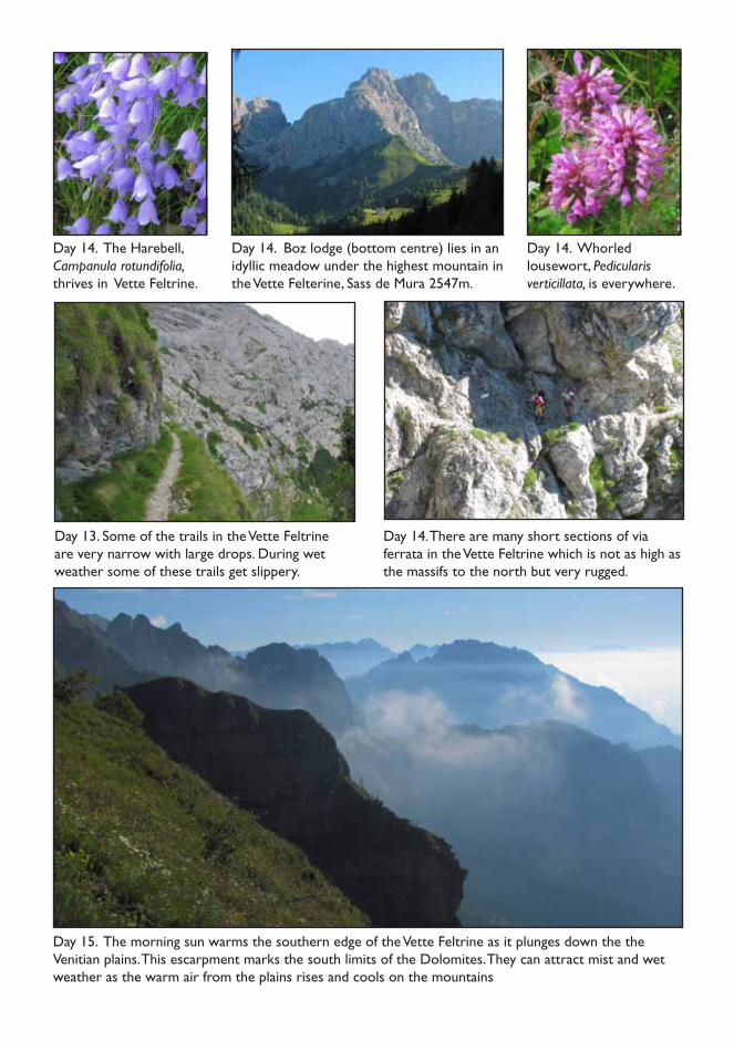
Day 15. The morning sun warms the southern edge of the Vette Feltrine as it plunges down the the Venitian plains. This escarpment marks the south limits of the Dolomites. They can attract mist and wet weather as the warm air from the plains rises and cools on the mountains
Day 14. The Harebell, Campanula rotundifolia, thrives in Vette Feltrine.
Day 14. Whorled lousewort, Pedicularis verticillata, is everywhere.
Day 14. Boz lodge (bottom centre) lies in an idyllic meadow under the highest mountain in the Vette Felterine, Sass de Mura 2547m.
Day 13. Some of the trails in the Vette Feltrine are very narrow with large drops. During wet weather some of these trails get slippery.
Day 14. There are many short sections of via ferrata in the Vette Feltrine which is not as high as the massifs to the north but very rugged.
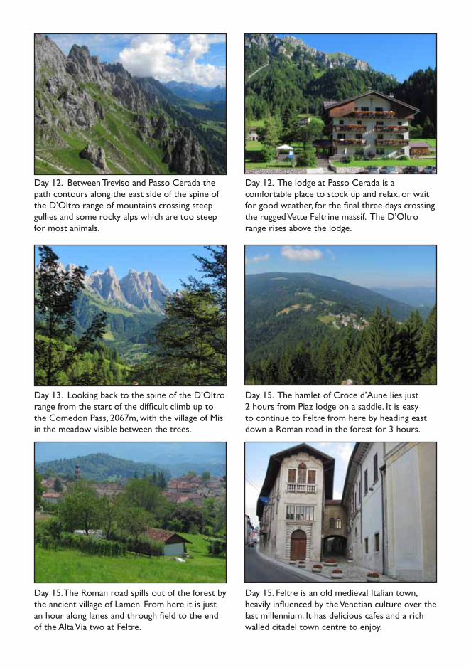
Day 12. Between Treviso and Passo Cerada the path contours along the east side of the spine of the D’Oltro range of mountains crossing steep gullies and some rocky alps which are too steep for most animals.
Day 12. The lodge at Passo Cerada is a comfortable place to stock up and relax, or wait for good weather, for the final three days crossing the rugged Vette Feltrine massif. The D’Oltro range rises above the lodge.
Day 15. The Roman road spills out of the forest by the ancient village of Lamen. From here it is just an hour along lanes and through field to the end of the Alta Via two at Feltre.
Day 15. Feltre is an old medieval Italian town, heavily influenced by the Venetian culture over the last millennium. It has delicious cafes and a rich walled citadel town centre to enjoy.
Day 13. Looking back to the spine of the D’Oltro range from the start of the difficult climb up to the Comedon Pass, 2067m, with the village of Mis in the meadow visible between the trees.
Day 15. The hamlet of Croce d’Aune lies just 2 hours from Piaz lodge on a saddle. It is easy to continue to Feltre from here by heading east down a Roman road in the forest for 3 hours.
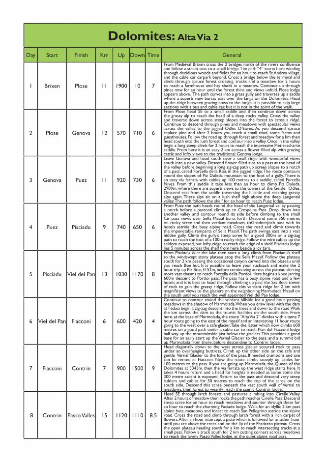
Dolomites: Alta Via 2
Day Start Finish Km Up Down Time General
1 Brixen Plose 11 1900 10 7
From Medieval Brixen cross the 2 bridges north of the rivers confluence and follow a street east to a small bridge. The path “4” starts here winding through decidious woods and fields for an hour to reach St Andrea village, and the cable car carpark beyond. Cross a bridge below the terminal and climb through spruce forest crossing, tracks and a meadow for 2 hours to reach a farmhouse and hay sheds in a meadow. Continue up through pines now for an hour until the forest thins and views unfold. Plose lodge appears above. The path curves into a grass gully and traverses up a sadde where a superb view bursts east over the fangs on the Dolomites. Head up the ridge between grazing cows to the lodge. It is possible to skip large sections with a bus and cable car, but it is not in the spirit of the walk.
2 Plose Genova 12 570 710 6
From Plose head SE to a small saddle and then continue down across the grassy alp to reach the head of a deep rocky valley. Cross the valley and traverse down across steep slopes into the forest to cross a ridge. Continue to descend through pines and meadows with spectacular views across the valley to the jagged Odles D’Eores. As you descend spruce replace pine and after 2 hours you reach a small road, some farms and guesthouses. Follow the road up through forest and meadow for a km then head south into the lush forest and contour into a valley. Once in the valley begin a long steep climb for 2 hours to reach the impressive Pietlerscharte saddle. From here it is an easy 2 km across a flower filled alp with grazing cattle and lofty views to the traditional Genova lodge.
3 Genova Puez 11 920 730 6
Leave Genova and head south over a small ridge with wonderful views south into a new valley. Descend flower filled alps to a pass at the head of the valley before beginning a long zig-zag path up screes slopes to a notch of a pass, called Forcella della Roa, in the jagged ridge. The route contours round the slopes of Piz Duleda mountain to the foot of a gully. There is an easy via ferrata with cables up 100 metres to a saddle, called Furcella Nives. From this saddle it take less than an hour to climb Piz Duleda, 2909m, where there are superb views to the towers of the Geisler Odles. Descend east from the saddle traversing the hillside and reaching grassy alps again. These alps sit on a lush shelf high above the deep Langental valley. The path follows the shelf for an hour to reach Puez lodge.
4 Puez Pisciadu 9 740 650 6
From Puez the path heads round the head of the Langental valley passing a notch before a pastoral climb up to Crespeina Pass. Drop down into another valley and contour round its side before climbing to the small Cir pass views over Sella Massif burst forth. Descend some 350 metres on rocky scree and then verdant meadows, toGrodnerjoch pass with its hotels astride the busy alpine road. Cross the road and climb towards the impenetable ramparts of Sella Massif. The path swings east into a vast hidden gully. Climb the gully’s steep scree for a good 300m on a zig-zag path to reach the foot of a 100m rocky ridge. Follow the wire cables up the seldom exposed, but lofty, ridge to reach the edge of a shelf. Pisciadu lodge lies 5 minutes across the shelf from here beside a icy tarn.
5 Pisciadu Viel del Pan 13 1030 1170 8
From Pisciadu skirt the lake then start a long climb from Pisciadu’s shelf to the windswept stony plateau atop the Sella Massif. Follow the plateau south for 2 km passing the occasional canyon carved into the plateau until you reach Boe hut. It is possible to leave your rucksack and make the 2 hour trip up Piz Boe, 3152m, before continueing across the plateau skirting more vast chasms to reach Forcella della Pordoi. Here begins a knee jarring 600m descent to Pordoi pass. The pass has a busy alpine road and a few hotels and it is best to head through climbing up past the Sas Bece tower of rock to gain the grassy ridge. Follow this verdant ridge for 2 km with magnificent views to the glaciers on the neighboring Marmolada Massif on the south until you reach the well appointed Viel del Pan lodge.
6 Viel del Pan Fiacconi 6 600 420 4
Continue to contour round the verdant hillside for a good hour passing meadows in the shadow of Marmolada. When you draw level with the dam at Fedaia begin a zig-zag descent into the trees and down to the road. Walk the km across the dam to the tourist facilities on the south side. From here, at the base of Marmolada, the route “Alta Via 2” divides with a tame 7 hour route going to the east of the massif and an interesting 11 hour route going to the west over a safe glacier. Take the latter which now climbs 600 metres on a good path under a cable car to reach Pian del Fiacconi lodge half way up the mountainside just below the glaciers. This provides a good base for an early start up the Vernal Glacier to the pass, and a summit bid up Marmolada from there, before descending to Contrin lodge.
7 Fiacconi Contrin 7 900 1500 9
Head diagonally down to the west across glacier scoured rock to pass under an overhanging buttress. Climb up the other side on the safe and gentle Vernal Glacier to the foot of the pass. If needed crampons and axe can be rented at Fiacconi. Now the route climbs steeply up cables for 100 metres to the pass. If you are going up Marmolada, the Queen of the Dolomites at 3343m, then the via ferrata up the west ridge starts here. It takes 4 hours return and a head for heights is needed as some some the 300 metre ascent is exposed. Return to the pass and descend very steep ladders and cables for 50 metres to reach the top of the scree on the south side. Descend this scree beneath the vast south wall of Vernal to meadows, then forest to wearily reach the scenic Contrin lodge.
8 Contrin Passo Valles 15 1120 1110 8.5
Head SE through larch forests and pastures climbing into Cirelle Valley. After 2 hours of meadow then rocks the path reaches Cirelle Pass. Descend steep scree for an hour to reach meadows and saunter through these for an hour to reach the charming Fuciade lodge. Walk for an idyllic 2 km past alpine huts, meadows and forest to reach San Pellegrino astride the alpine road. Cross the road and climb through larch forest with a rich carpet of flowers. After an hour intercept a piste which is followed for another hour until you are above the trees and on the lip of the Pradazzo plateau. Cross the open plateau heading south for a km to reach intersecting tracks at a small pass. Follow a track south for 2 km cutting corners across meadows to reach the lovely Passo Valles lodge, at the quiet alpine road pass.

Dolomites: Alta Via 2
Day Start Finish Km Up Down Time General
9 Passo Valles Muraz 6 760 260 3.5
Cross the road and start up the zig-zags on a steep but verdant path to gain a ridge. Cross the ridge and contour along its south side with the impressive spires of the Pale di San Martin massif ahead of you. Pass a small pastoral lake and continue SE along the ridge to the grassy but minor Venegiota Pass, probably ringing with cow bells. Now descend for a good 100 metres traversing scree down the east side of Mt Muraz passing the odd cable on the steep hilside. Negociate a short cabled outcrop and then start to climb. The route goes into a cabled gully then up a rough path on the knobbly rock for an hour. After a few false summits the path eventually climbs over a ridge and Muraz lodge lies before in a small bowl surrounded by gigantic towers of rock. After the hut is the high steep Farangole Pass so stop here if the weather is threatening.
10 Muraz Pradidali 12 910 1170 8
Climb to Margheritta Pass in 20 min where the formidable Farangole Pass, 2814m, appears. Cross a km of scree and snowfields to reach it’s base then climb up150m of cables and steep scree. The descent is similar until it opens into a scree filled bowl. The path now heads south for 2 hours along a sensational sloping grassy shelf high above the Comelle Gorge beneath vast cliffs and spires. The path is often precarious and secured with cables. This lofty walk ends at the open meadowy bowl of Pian del Cantoni. From here it is a climb up rocks to the busy Pedrotti lodge. From Pedrotti the path zig-zags south down to the main valley. Take it half way then branch SE into the valley lined with dolomitic towers which leads up to the Ball Pass. There are 500m of cables as the path contours the steep rock. From the Ball Pass it is a quick easy descent to the now visible Pradidali lodge.
11 Pradidali Treviso 6 600 1220 4.5
Head north past the small lake with the massive spire of Canali on the right. The path veers NE and climbs gently towards the assumed easy Fradusta pass. However our route cuts off west up a steep loose ramp. Turn left into a steep snow filled gully. Climb this for 15m, cross the snow and exit the north wall of the gully to reach an open face. Scramble up this exposed, unsecured face for 50m to gain a broad shelf. Continue west up crags and rocks to the Lede Pass, 2695m, a notch in a forest of spires. Now begin the hard 150 minute descent. This initially descends across scree passing karstic bowls and an open rustic cabin then weaves down steep rocky alps to the trees. The steep path now enters larch and fir forest, and finally birch woods where the Canali stream flows. From here it is a easy half hours climb up zig-zags through fir trees to reach Treviso lodge, 1631m.
12 TrevisoPasso
Cerada9 730 1000 5
Contour through the lush woods above the Canali stream for 2 km then climb for a good hour to the d’Oltro Pass, 2094m, with views west to the spires of Pale di San Martino and east over pastoral villages below. Descend towards them but then veer south and start a rising traverse of the southern end of the Cima d’Oltro range. This hard 3 km traverse takes nearly 2 hours. The narrow path hugs the steep grassy shelf below the spine of rock towers and is often exposed. Eventually the path begins a steep rocky descent down a gully before it reaches the sanctuary of forest. Here it eases down pleasant zig-zags passing firs and entering beech forest. After a good hours total descent, the path spills you onto a tiny road. This is followed SW for 30 minutes past barns and meadows to a quiet Alpine road as it crosses Passo Cereda where there is a mountain lodge.
13Passo
CeradaBoz 13 1250 920 8.5
Cross the road to a track and head east contouring through pleasant forest for 2 km. Now climb a forest path through mixed woods crossing streams. Soon the path reaches the low tree line. Start a difficult 3 hour climb up a loose ramp on the north face of Sasso delle Undici. It is taxing, often difficult and occasionally exposed before Comedon Pass, 2067m. Turn west for 30 min down some steep sections to the lovely grassy shelf where the rustic Bodo shelter sits. Continue south down through meadows and dwarf pines, under a cliff before climbing up steep grassy slopes to Col dei Bechi. The steep grassy path veers west round a huge precipitious verdant bowl for nearly 2 hours with some scrambling, cables and narrow ledges reachng the pastoral Mura Pass. Now descend SW for 20 min through meadows to reach the idyllic Boz lodge amid alps and grazing cattle.
14 Boz Piaz 14 920 690 7
Head south through meadows and woods until the path climbs to easy Finestra Pass. Go over, then west following exposed ledges to arrive at the NE ridge of Sasso Scarnia. Now start the hour’s climb up this fortress on a steep exposed path with some cables. At a high col on the SE ridge the path starts a difficult descent on steep loose rock, for 30 min until you reach a junction with the valley path. After a stiff climb from here the path eases as it traverses an amphitheater to gain the main ridge again to cross the “devils place” with a circle of boulders. The good level path now skirts meadows above a vast flower filled karstic bowl to reach Rietena Pass. From here you can see the next hour’s walk across another grassy cow-bell ringing bowl to the lower Vetti Grandi pass where the Piaz lodge with a pastoral view down to Feltre and the Venetian Plain beyond.
15 Piaz Feltre 24 50 1790 7
Head south down across a meadow for a km to pick up the track. Descend some spectacular bends then veer west of the track into pleasant conifer woods for 3 km until beech woods dominate and you meet the track again shortly before Croce d’Aune where the AV2 ends 6 km after Piaz. To continue to Feltre head east before the village on a track signposted “Norcem” on an old Roman road as it contours east for 2km. Still on the Roman road descend the “Pedemontane” track for a km in eroded slot to a track. The track continues as the Roman road NE for 3km through mixed woods into the Lamen Valley. Cross the bridged stream and then head south for 3 hours on small roads, marked paths, woods and small fields passing through the idyllic villages of Lamen, Pren and Murle to reach the georgeous medieval town of Feltre and a more fitting end to the AV2.
168 13000 13350 98