chennai port
TRANSCRIPT
Chennai PortFrom Wikipedia, the free encyclopediaJump to: navigation, search
Chennai Port
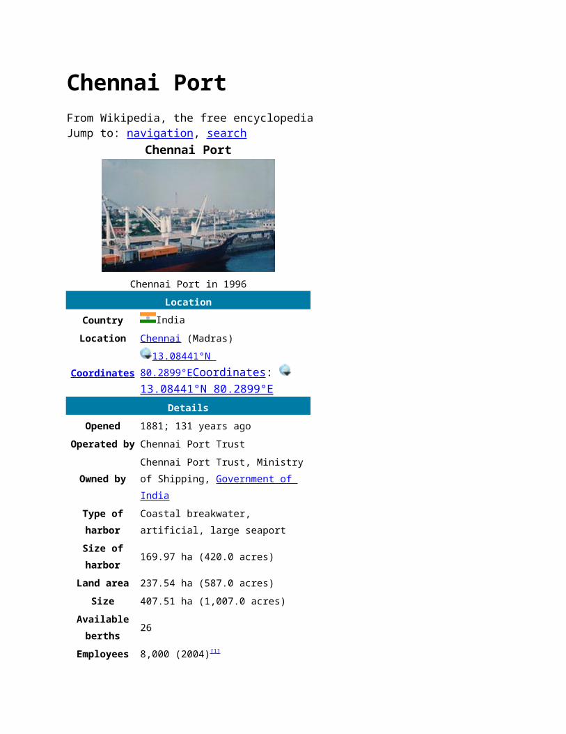
Chennai Port in 1996Location
Country IndiaLocation Chennai (Madras)
Coordinates13.08441°N
80.2899°E Coordinates : 13.08441°N 80.2899°E
DetailsOpened 1881; 131 years ago
Operated by Chennai Port Trust
Owned byChennai Port Trust, Ministry of Shipping, Government of India
Type ofharbor
Coastal breakwater, artificial, large seaport
Size ofharbor
169.97 ha (420.0 acres)
Land area 237.54 ha (587.0 acres)Size 407.51 ha (1,007.0 acres)
Availableberths
26
Employees 8,000 (2004)[1]
Chairman Atulya Mishra (since 2010)
Main trades
Automobiles, motorcycles and general industrial cargo including iron ore, granite, coal, fertilizers, petroleum products, and containersMajor exports: Iron ore, leather, cotton textilesMajor imports: Wheat, raw cotton, machinery, iron & steel
World PortIndex Number
49450[2]
UN/LOCODE INMAAStatistics
Annual cargotonnage
61.46 million (2010-2011)
Annualcontainervolume
1.523 million TEUs (2010-2011)
Annualrevenue
8,904.0 million (2007-08)[3]
Vesselshandled
2,181 (2010-2011)
CapacityCargoes: 55.75 million tonnes(2008-09)[4]
Containers: 2 million TEUs[5]
Websitewww.chennaiport.gov.in
Chennai Port, formerly known as Madras Port, is the second largest port of India, behind the Mumbai Port, and the largest port in the Bay of Bengal. Being the third oldest port among the 12 major ports of India, it is over 125 years old, although
maritime trade started away back in 1639 on the sea shore. It is an artificial and all-weather port with wet docks. It was a majortravel port before becoming a major container port. It is a substantial reason for the economic growth of Tamil Nadu, especially for the manufacturing boom in South India, and has contributed in no small measure to the development of the city.[6]
It is due of the existence of the port that the city of Chennai became known as the Gateway of South India. The port with 3 docks, 24berths and draft ranging from 12 to 16.5 m (39 to 54.1 ft) has become a hub port for containers, cars and project cargo in the east coast of India. From handling a meagre volume of cargo in the early years, consisting chiefly of imports of oil and motors and the export of groundnuts, granite and ores, the port has moved towards handling 60 million tonnes of cargo in recent years. An ISO 14001:2004 and ISPS-certified port, its container traffic crossed 1 million twenty-foot equivalent units (TEUs) forthe first time in 2008. It is currently ranked the 86th largest container port in the world and is expanding in the coming years with the capacity going up to 140 million tonnes per annum.[7][8] Chennai Port has been transformed into a main line port having direct connectivity to 50+ ports.
Contents 1 History 2 Location and geography 3 Traffic growth 4 Port layout and infrastructure 5 Terminals
o 5.1 Container terminals o 5.2 Ro-ro car terminal o 5.3 Cruise terminal
6 Operations 7 Auxiliary functions
o 7.1 Meteorological functions o 7.2 Disease control
8 Connectivity o 8.1 Extra-port connectivity o 8.2 Intra-port connectivity
o 8.3 Pipelines 9 Natural disasters 10 Lights and lighthouses 11 The future 12 Sister ports 13 See also 14 References 15 External links
HistoryBefore 1800s
Although the settlement of Madras did not form until after the mid-17th century, the region surrounding the present-day port remained an important centre for military, administrative, and economic activities since the 1st century AD under various South Indian dynasties, namely, the Pallava, the Pandya, the Chola and the Vijayanagara empires.[9] Chief among them was the Pallava dynasty, which reigned from the 6th to 9th centuries AD. The ancient town of Mylapore, known to Roman traders as "Meliapor", was an important port of the Pallavas and is now part of Chennai.
The region also attracted many distant civilisations, with the Christian apostle St. Thomas having preached in the area between 52 and 70 AD.[10][11][12][13] In 1522, the Portuguese built the São Tomé harbour, named after St. Thomas, on the site of today's portand the São Tomé church on the grave of Saint Thomas. The following years saw the arrival of other Europeans, namely, the Dutch arriving at Pulicat in 1613 and the British arriving in 1639. In 1639, the British East India Company bought a three-milelong strip of land lying along the coast between the Cooum delta and the Egmore River encompassing an area of about five square kilometres from the Vijayanagara King Peda Venkata Rayalu.[14] Soon obtaining permission from the regional ruler, Damarla Venkatadri Nayakudu, the British built a warehouse and factory onthe site, and in 1940, the British expanded the occupation by building the Fort St. George and establishing a colony on the site of the future port of Madras.[15]
In 1746, under the leadership of Admiral La Bourdonnais, French forces captured and plundered Madras, the fort and surrounding villages. However, they returned the town along with the port to the British under the Treaty of Aix-la-Chapelle in 1748.[16][17] TheBritish then strengthened the fort to defend the port not only from the French but also from the increasingly powerful Sultan ofMysore and other regional rulers.[18]
The British era
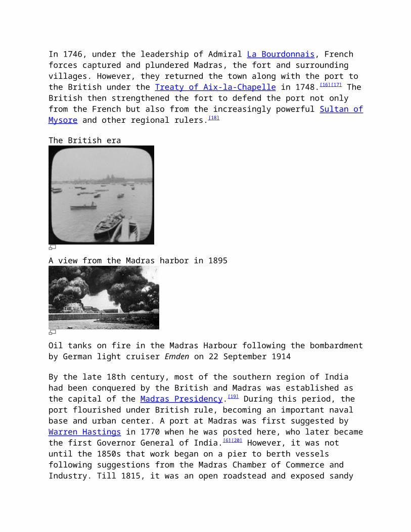
A view from the Madras harbor in 1895
Oil tanks on fire in the Madras Harbour following the bombardmentby German light cruiser Emden on 22 September 1914
By the late 18th century, most of the southern region of India had been conquered by the British and Madras was established as the capital of the Madras Presidency.[19] During this period, the port flourished under British rule, becoming an important naval base and urban center. A port at Madras was first suggested by Warren Hastings in 1770 when he was posted here, who later becamethe first Governor General of India.[6][20] However, it was not until the 1850s that work began on a pier to berth vessels following suggestions from the Madras Chamber of Commerce and Industry. Till 1815, it was an open roadstead and exposed sandy

coast, swept by occasional storms and monsoons. At the time, the natural harbor was so shallow that ships had to anchor over 1 km (0.62 mi) offshore, and cargo was delivered to and from the shorein masula boats [21] [22] and catamarans.[23] Cargo losses were high, close to 90 percent, in addition to pilfering with several goods from the ships often taken to the nearby evening bazaar.[6] A 335 m (1,099 ft) iron-screw pile pier capable of berthing larger vessels was built perpendicular to the shore in 1861.[24] However,the storms of 1868 and 1872 made the initial piers inoperative. In 1875, Edward VII laid the foundation stone for a new port,[6] and the masonry work for L-shaped breakwaters was started in 1876. The northern and southern groynes of the harbour were constructed, in order to create a still water enclosure that would be unaffected by storm and surf water. However, the groynescollapsed in 1877. The same year, construction of the south pier was commenced with concrete blocks weighing 33 tonnes each brought from Pallavaram,[6] and the port started handling ships inside the harbour from 1881. However, again the storm of 12 November 1881 completely washed the almost-completed harbour, breaching over half a mile of breakwater.[24] An artificial harbour was then built and the operations were started in 1881, and the pier was rebuilt in 1885, although there was a demand forrelocating the entrance. Work on the harbour was completed in 1911.[20] The Chennai Port Trust has taken the year 1881, the yearof rebuilding, as the starting year. The cargo operations were carried out on the northern pier, located on the northeastern side of Fort St. George in Chennai. In the first couple of years the port registered traffic of 300,000 tonnes of cargo handling 600 ships. The first railway line in South India was laid betweenMadras and Arcot which started operating in 1856. By the late 19th century, the port was well connected to the other two important cities in the British colony, viz. Bombay (Mumbai) and Calcutta (Kolkata).[25] In 1904, a new northeastern entrance was added to control siltation in the basin, after closing the original eastern entrance. The port's quays (berths) were constructed at different periods—the South Quay I in 1913, the five west quay berths between 1916 and 1920, the north quay in 1931 and the South Quay II in 1936, in the Inner Harbour, later christened Dr. Ambedkar Dock.[24] Chennai was the only Indian city
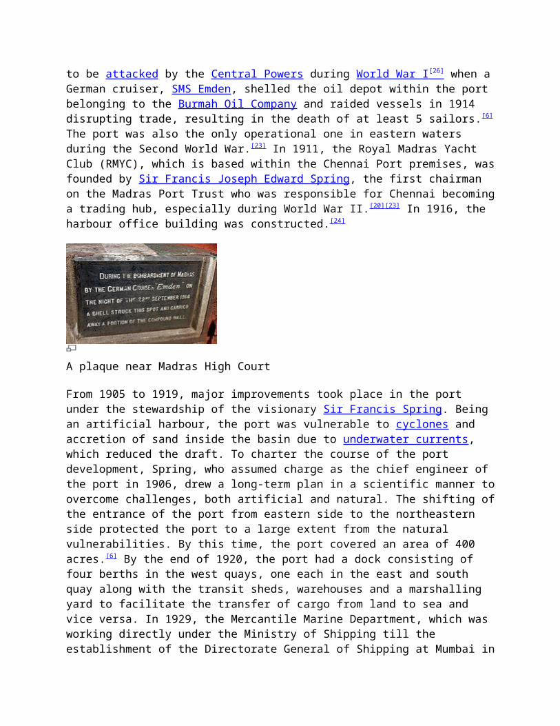
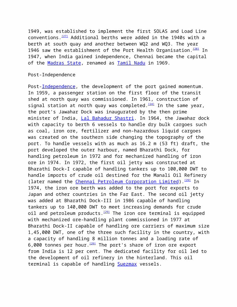
to be attacked by the Central Powers during World War I [26] when aGerman cruiser, SMS Emden, shelled the oil depot within the port belonging to the Burmah Oil Company and raided vessels in 1914 disrupting trade, resulting in the death of at least 5 sailors.[6]
The port was also the only operational one in eastern waters during the Second World War.[23] In 1911, the Royal Madras Yacht Club (RMYC), which is based within the Chennai Port premises, wasfounded by Sir Francis Joseph Edward Spring, the first chairman on the Madras Port Trust who was responsible for Chennai becominga trading hub, especially during World War II.[20][23] In 1916, the harbour office building was constructed.[24]
A plaque near Madras High Court
From 1905 to 1919, major improvements took place in the port under the stewardship of the visionary Sir Francis Spring. Being an artificial harbour, the port was vulnerable to cyclones and accretion of sand inside the basin due to underwater currents, which reduced the draft. To charter the course of the port development, Spring, who assumed charge as the chief engineer of the port in 1906, drew a long-term plan in a scientific manner toovercome challenges, both artificial and natural. The shifting ofthe entrance of the port from eastern side to the northeastern side protected the port to a large extent from the natural vulnerabilities. By this time, the port covered an area of 400 acres.[6] By the end of 1920, the port had a dock consisting of four berths in the west quays, one each in the east and south quay along with the transit sheds, warehouses and a marshalling yard to facilitate the transfer of cargo from land to sea and vice versa. In 1929, the Mercantile Marine Department, which was working directly under the Ministry of Shipping till the establishment of the Directorate General of Shipping at Mumbai in
1949, was established to implement the first SOLAS and Load Line conventions.[27] Additional berths were added in the 1940s with a berth at south quay and another between WQ2 and WQ3. The year 1946 saw the establishment of the Port Health Organisation.[28] In1947, when India gained independence, Chennai became the capital of the Madras State, renamed as Tamil Nadu in 1969.
Post-Independence
Post-Independence, the development of the port gained momentum. In 1959, a passenger station on the first floor of the transit shed at north quay was commissioned. In 1961, construction of signal station at north quay was completed.[24] In the same year, the port's Jawahar Dock was inaugurated by the then prime minister of India, Lal Bahadur Shastri. In 1964, the Jawahar dockwith capacity to berth 6 vessels to handle dry bulk cargoes such as coal, iron ore, fertilizer and non-hazardous liquid cargoes was created on the southern side changing the topography of the port. To handle vessels with as much as 16.2 m (53 ft) draft, theport developed the outer harbour, named Bharathi Dock, for handling petroleum in 1972 and for mechanized handling of iron ore in 1974. In 1972, the first oil jetty was constructed at Bharathi Dock-I capable of handling tankers up to 100,000 DWT to handle imports of crude oil destined for the Manali Oil Refinery (later named the Chennai Petroleum Corporation Limited).[29] In 1974, the iron ore berth was added to the port for exports to Japan and other countries in the Far East. The second oil jetty was added at Bharathi Dock-III in 1986 capable of handling tankers up to 140,000 DWT to meet increasing demands for crude oil and petroleum products.[29] The iron ore terminal is equipped with mechanized ore-handling plant commissioned in 1977 at Bharathi Dock-II capable of handling ore carriers of maximum size1,45,000 DWT, one of the three such facility in the country, witha capacity of handling 8 million tonnes and a loading rate of 6,000 tonnes per hour.[29] The port's share of iron ore export from India is 12 per cent. The dedicated facility for oil led to the development of oil refinery in the hinterland. This oil terminal is capable of handling Suezmax vessels.
In the 1970s, containerisation started in India in a limited way with the creation of interim container handling facilities at Mumbai and Cochin ports in 1973.[4] During the same period, Chennai Port began handling containerized cargoes. In 1983, a container terminal was built at the Bharathi Dock with a 380-metre (1,250 ft) quay, a 51,000-square-metre (550,000 sq ft) container yard, and a 6,000-square-metre (65,000 sq ft) containerfreight station, which was commissioned by the then prime minister Indira Gandhi on 18 December 1983 as the country's firstdedicated container terminal facility. The terminal was provided with tow-shore cranes and other shore facilities. In 1991, the port's container terminal quay was lengthened by 220 m (720 ft) with two additional tow shore cranes. In November 2001, the container terminal and back-up area was privatized through a 30-year concession with Chennai Container Terminal Private Limited. Continually increasing container traffic resulted in another 285-metre (935 ft) extension of the quay in 2002, bringing the total berth length to 885-metre (2,904 ft).[30] During 2008-09, the portrecorded a 17.2% share of container traffic in India. Having the capability of handling fourth-generation vessels, the terminal isranked among the top 100 container ports in the world.[31] To meetthe demand in container handling, the port is added with the second container terminal with a capacity to handle 1.5 million TEUs. The port is also planning a mega container terminal, capable of handling 4 million TEUs per annum expected to be operational from 2013, when the first phase of the project will be completed. The full project will be completed by 2017.[32]
When the city of Madras was renamed as Chennai in 1996, the Madras Port Trust followed suit and was renamed as Chennai Port Trust. In 2000, the port began to handle pure-car-carrier shipments of automobiles. In 2003, the 200 m naval berth was given for 30-year lease.[24] The 2004 tsunami devastated the shores of the port, taking many lives and permanently altering the coastline.
Location and geographyMain article: Geography of Chennai
Chennai Port lies on a flat coastal plain known as the Eastern Coastal Plains on the east coast of the Indian peninsula known asthe Coromandel Coast in the Bayof Bengal. The bed slope isfairly flat. The port issituated on the thermal equatorand is also coastal, whichprevents extreme variation inseasonal temperature. Theclimate is tropical,specifically tropical wet anddry, and for most of the year,the weather is hot and humid,with temperatures ranging from amaximum of 42°C in May to aminimum of 18°C in January. Themean minimum temperature is 18°Cin January and 26.8°C in May.The mean highest temperature is29.3°C in December and 39.6°C inMay. The port gets most of its seasonal rainfall from the northeast monsoon winds, from mid-September to mid-December. Occasionally, cyclones in the Bay of Bengal hit the coast. The average annual rainfall in the region is about 1298.11 mm, with 443.5 mm during southwest monsoon (June–September), 753.1 mm during northeast monsoon (October–December), 37.3 mm during winter season (January–February) and 64.2 mm during hot weather (March–May). The monthly average varies from 7 mm in April to 308 mm in November. Humidity ranges from 63 to 83 percent during January–March, from 57 to 72 percent during April–June and from 70 to 81 percent during October–December.
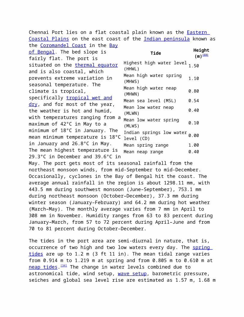
The tides in the port area are semi-diurnal in nature, that is, occurrence of two high and two low waters every day. The spring tides are up to 1.2 m (3 ft 11 in). The mean tidal range varies from 0.914 m to 1.219 m at spring and from 0.805 m to 0.610 m at neap tides.[34] The change in water levels combined due to astronomical tide, wind setup, wave setup, barometric pressure, seiches and global sea level rise are estimated as 1.57 m, 1.68 m
Tide Height(m)[33]
Highest high water level(HHWL) 1.50
Mean high water spring (MHWS) 1.10
Mean high water neap (MHWN) 0.80
Mean sea level (MSL) 0.54Mean low water neap (MLWN) 0.40
Mean low water spring (MLWS) 0.10
Indian springs low waterlevel (CD) 0.00
Mean spring range 1.00Mean neap range 0.40
and 1.8 m at 15 m, 10 m and 5 m depth contours, respectively.[33] Waves ranging from 0.4 m to 2.0 m in the deep water around Chennai harbour have been experienced with the predominant being 0.4 m to 1.2 m with wave periods predominantly in the order of 4 to 10 seconds. During cyclone season, waves of height exceeding 2.5 m are common. The predominant wave directions during southwest and northeast monsoons are 145° from north and 65° fromnorth, respectively.[35]
The most prevailing winds in the region are the southwesterly between April and October[36] and the northeasterly during the rest of the year. The predominant wind direction is mostly from Wand SW direction during the rainy season and SW and NW during post-monsoon month. However, during January to March, winds from NE and E direction are predominant. During the northeast monsoon,that is, between October and January, the direction of wind is generally NE and NNE. During depressions in northeast monsoon, the wind velocity goes up to 50 km/h and up to 105 km/h during cyclones of duration 2 to 3 days. Gusts of 160 km/h have been occasionally experienced. During southwest monsoon between March and September, the wind blows predominantly from the south. During June, July and August, strong wind is experienced from southwest direction in mornings, from south during afternoons, and from southeast during nights. Wind direction is between 153° and 263° relative to the north, and the wind speed varies from 2 to 12 m/s.[35]
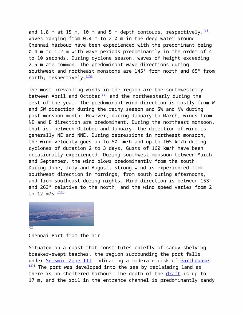
Chennai Port from the air
Situated on a coast that constitutes chiefly of sandy shelving breaker-swept beaches, the region surrounding the port falls under Seismic Zone III indicating a moderate risk of earthquake.[37] The port was developed into the sea by reclaiming land as there is no sheltered harbour. The depth of the draft is up to 17 m, and the soil in the entrance channel is predominantly sandy
and silt. The port is bordered by the Cooum delta in the south and Royapuram fishing harbour in the north. Visibility in the harbour region is good throughout the year and low visibility is commonly associated with heavy rains during the northeast monsoon.
Historically, the port was responsible for the shoreline changes in the region, where the area south of the port has accreted significantly, resulting in the formation of the Marina Beach, whereas the coast in the northern region has undergone severe erosion.[38][39] Ever since the harbour was constructed, the coast north of the harbour has been experiencing erosion at the rate ofabout 8 m annually. The shoreline has recessed by about 1,000 m with respect to the original shoreline in 1876. It is estimated that 500 m of beach has been lost between 1876 and 1975 and another 200 m between 1978 and 1995. About 350 ha land in the coast north of the port is lostinto sea.[33] On the other hand, thearea south of the port isincreasing 40 sq m every year dueto the progradation.[39]
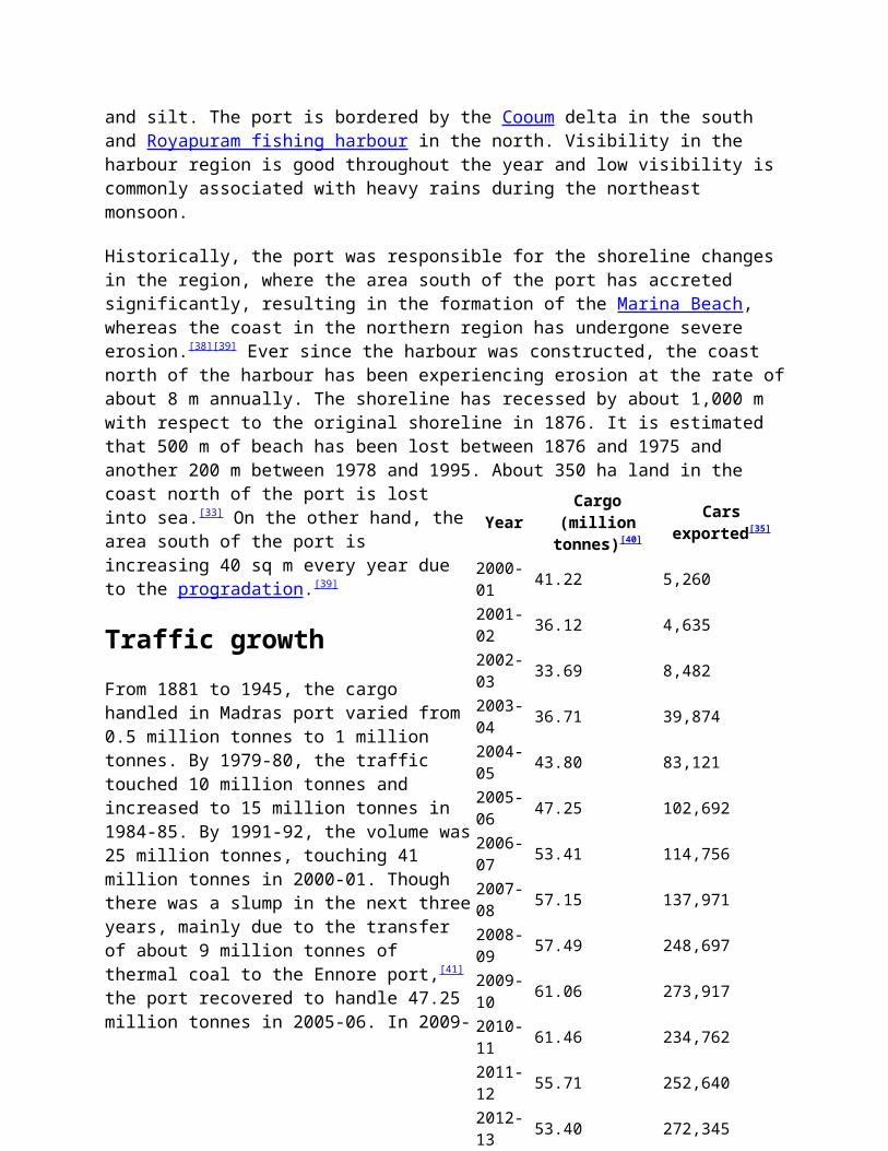
Traffic growthFrom 1881 to 1945, the cargohandled in Madras port varied from0.5 million tonnes to 1 milliontonnes. By 1979-80, the traffictouched 10 million tonnes andincreased to 15 million tonnes in1984-85. By 1991-92, the volume was25 million tonnes, touching 41million tonnes in 2000-01. Thoughthere was a slump in the next threeyears, mainly due to the transferof about 9 million tonnes ofthermal coal to the Ennore port,[41]
the port recovered to handle 47.25million tonnes in 2005-06. In 2009-
YearCargo
(milliontonnes)[40]
Carsexported[35]
2000-01 41.22 5,260
2001-02 36.12 4,635
2002-03 33.69 8,482
2003-04 36.71 39,874
2004-05 43.80 83,121
2005-06 47.25 102,692
2006-07 53.41 114,756
2007-08 57.15 137,971
2008-09 57.49 248,697
2009-10 61.06 273,917
2010-11 61.46 234,762
2011-12 55.71 252,640
2012-13 53.40 272,345
10, the port handled 61.06 million tonnes of cargo against 57.49 million tonnes in 2008-09 marking an increase of 6.20 per cent and has set a target to handle 75 million tonnes in 2011-12 and 100 million tonnes in 2015-16. In 2010-11, the port handled 61.46million tonnes, a 0.66 per cent increase over the previous fiscal.[42] The target set for the port for 2010-11 is 65.51 million tonnes against a target of 64.00 million tonnes during the previous fiscal.[43] The terminal's throughput has increased from around 829,000 TEUs in 2006 to around 1.19 million TEUs in 2008.[44] Crane productivity has been improved from 22 moves per hour per quay crane in 2006 to over 27 in 2009.[45] The port annually handles nearly 20 million tonnes of both coal (8 milliontonnes) and iron ore (12 million tonnes).[46]
During 2009-10, the container traffic from the first terminal reached 1.216 million TEUs against 1.14 million TEUs in the previous fiscal. In 2010-11, this increased to 1.523 million TEUs, a 25 per cent growth over the previous year. The second terminal handled over 300,000 TEUs during the calendar year 2010—up from 26,000 TEUs handled in the 3 months of operations since start up in 2009.[47] The car exports from this port touched 273,917 units in 2009-10, 10.14 per cent more than the previous year's 248,697 units, despite the recession.
The annual growth for container volumes handled by the Chennai port during the last 5 years till 2009-10 was 13 to 14 per cent, while the average annual container growth in Indian ports is in the order of 8%. The growth increased to 25 per cent during 2010-11, the largest growth rate among the top three container ports comprising JNPT, Chennai and Tuticorin.[48] This is primarily due to capacity addition with the second terminal commencing operations coupled with new services starting to call the Chennaiport.
The port currently has the capacity to handle 3,000,000 TEUs and with the commissioning of the third mega container terminal beingplanned, the capacity would go up to 8,000,000 TEUs.
Due to excessive pollution from coal dust, the port for a brief period of time suspended shipping food grain. However, following
the transfer of coal shipments to the neighbouring Ennore Port since 2002, handling of food grain was resumed after about 9 years in 2003. The port hopes to handle 4 million tonnes of food grain annually over the next few years.[49]
The following table lists the number of vessels handled in the past:[50]
Commodity
2008-09
2009-10
2010-11
Liquid bulk 441 494 502
Dry bulk 441 446 308Break bulk 486 489 559
Containers 710 703 812
Total 2,078 2,132 2,181
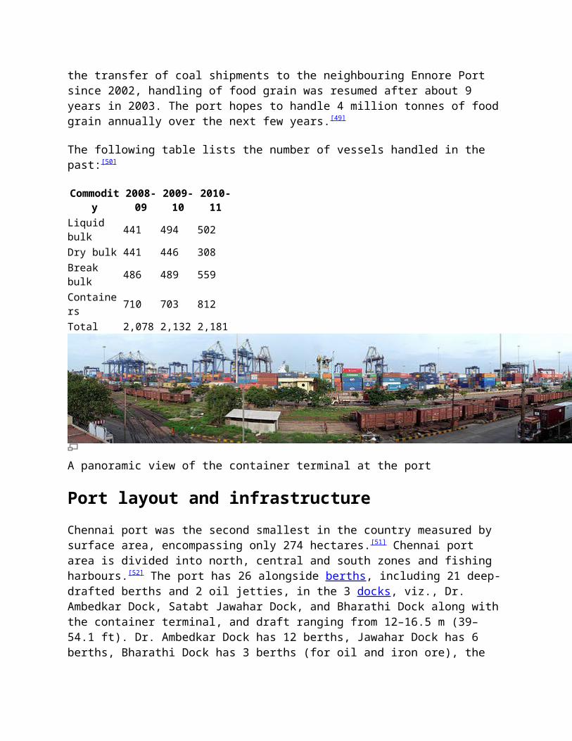
A panoramic view of the container terminal at the port
Port layout and infrastructureChennai port was the second smallest in the country measured by surface area, encompassing only 274 hectares.[51] Chennai port area is divided into north, central and south zones and fishing harbours.[52] The port has 26 alongside berths, including 21 deep-drafted berths and 2 oil jetties, in the 3 docks, viz., Dr. Ambedkar Dock, Satabt Jawahar Dock, and Bharathi Dock along with the container terminal, and draft ranging from 12–16.5 m (39–54.1 ft). Dr. Ambedkar Dock has 12 berths, Jawahar Dock has 6 berths, Bharathi Dock has 3 berths (for oil and iron ore), the
container terminal has 3 berths and the moorings has 1 berth. Theberths can handle containers as well as liquid and dry bulk and breakbulk cargoes. The approach channel to the port is 6,700 m (22,000 ft) long, and the turning basin is 560 m (1,840 ft) in length.[53] A total of 9 well-lit channels marks buoys for the approach channel.
Region Waterspread
Landarea
No. ofberths
Inner harbour 218 acres 413
acres 16
Outer harbour 200 acres 100
acres 7
Total 418 acres 513 acres 23
The Jawahar Dock has six berths with a total length of 1,310 m (4,300 ft) and maximum permissible draft of 10.4 m (34 ft) and 11 m (36 ft). All berths are 218.3 m (716 ft), and half of them have maximum draft of 10.4 m (34 ft). The dock mainly handles coal, fertilizer, iron ore lumps, pellets, edible oil, and phosperic acid. The Dr. Ambedkar Dock has 13 berths with a total length of 1,676 m (5,499 ft) and maximum permissible drafts from 8.5–12 m (28–39 ft). The longest berth is 246 m (807 ft) long with maximum draft of 9.5 m (31 ft). Berth No. 7 is 198 m (650 ft) long with maximum draft of 8.5 m (28 ft), whereas Berths8, through 12 are each 170.6 m (560 ft) and have maximum draft of11 m (36 ft). Berth 14 is 179 m (587 ft) long with maximum draft of 9.5 m (31 ft). Berths 18 and 19 are naval berths. The dock hascar and cruise terminals and chiefly handles general cargo, cars,granite steel, and food grains. The Bharathi Dock contains three berths with total quay length of 917.2 m (3,009 ft), with berths ranging from 274.3 m (900 ft) in length with maximum permissible draft of 16.5 to 338.9 m (54 to 1,112 ft) in length with maximum draft of 14.6 m (48 ft). The dock has three terminals, namely, container terminal, iron ore terminal, and oil terminal. It mainly handles containers, iron ore, and POL (petroleum, oil and lubricants).[24]

Dock/Terminal
No.
Name ofberth Type
Length
(m)
Permissible
draft(m)
Remarks
Jawahar Dock 1 JD-1 Food grains/general
218.33 11.50
12.0 m on HW subject tothe vessel reducing the draftto permissibledraft ofthe berth below low tide.Transit shed attached
2 JD-3 Food grains/general
218.33 11.50 Transit shed
attached
3 JD-5 Food grains/general
218.33 11.50 Transit shed
attached
4 JD-2 Coal/other liquid bulk
218.33 11.50
5 JD-4 Coal 218.33 11.00
6 JD-6 Other ores/coal 218.33 11.00
Dr. AmbedkarDock 7 NQ Passenger/
general198.00 8.50
8 WQ-1 General/other liquid bulk
170.60 11.00
9 WQ-2 General 170.60 12.00
10 CB General 170.60 12.00 Transit shed
attached
11 WQ-3 General 170.60 12.00
12 WQ-4 Fertilizer/general
170.60 11.00
11 m up to 795 m;9.5 m up to 810 m
13 SQ-1 Fertilizer/ 246.0 9.50
Dock/Terminal
No.
Name ofberth Type
Length
(m)
Permissible
draft(m)
Remarks
general 0
14 SQ-2 Fertilizer/general
179.00 9.50
15 2nd CT-1 -- 12.016 2nd CT-2 -- 12.017 2nd CT-3 -- 12.0
18Naval Berth North
60.00 09.00
19Naval Berth South
140.00 12.00
Bharathi Dock(oil & iron ore)
20 BD-1 Oil 338.94 14.0
21 BD-3 Oil 304.00 16.50
17.0 m during HW;Between extreme dolphins
22 BD-2 Iron ore 274.32 16.50
Container Terminal 23 CT-1 Containers 200.0
0 13.40Container freight station
24 CT-2 Containers 200.00 13.40
Container freight station
25 CT-3 Containers 200.00 13.40
26 CT-4 Containers 285.00 13.40
Approach Channel Zone I 750.0
0Zone II toZone VII
5950.00
Dock/Terminal
No.
Name ofberth Type
Length
(m)
Permissible
draft(m)
Remarks
Turning Circle
560.00
The oil terminals at the port's Bharathi Dock (BD1 and BD3) can accommodate tankers to 100,000 dead weight tonnage (DWT), and a third berth can handle tankers up to 280.4 m (920 ft) and 140,000DWT. Berth BD1 can accommodate ships to 108.1 m (355 ft) long. The oil terminals have capacity to handle 12 million tons of cargo per year and to pump 3,000 tons of crude oil and 1,000 tonsof petroleum products per hour. Each berth is equipped with five marine loading arms, and the berths have pipelines to convey crude oil, white oil, and furnace oil.
The port handles Suezmax tankers of up to a draft of 17 m at BD3 during day light, high tide as the per the present navigational practice and also during night hours subject to fulfilment of safety considertions on a ship-to-ship basis.
The iron ore terminal, which can handle 6 million tons per year and can load iron ore at a rate of 6,000 tons per hour, is also located at the Bharathi Dock. Berth BD2 can accommodate ore carriers up to 280.4 m (920 ft) in length. The terminal's separate receiving and shipping lines can function as an interconnected system. The terminal is served by rail lines and includes an ore stock yard with capacity for 544,000 metric tons.[54]
The container terminal has four berths with a total quay length of 885 m (2,904 ft) and maximum permissible draft of 13.4 m (44 ft). With capacity to handle fifth-generation container vessels, three of the four berths are 200 m (660 ft) long, and one is 285 m (935 ft) long. The berths are served by seven quay cranes, including five super-post-Panamax and two post-Panamax cranes, and 24 gantry cranes. Operated by Chennai Container Terminal Private Limited, the container terminal has capacity for950,000 TEUs. The container yard has 3,960 ground slots and 240
reefer plug points. The terminal contains 24 container freight stations with warehouse storage and offers 24-hr customs inspection and clearance facilities. The container terminal has direct services to Europe, China, the United States, Korea, Thailand, the Mediterranean region, and West Africa.[55]
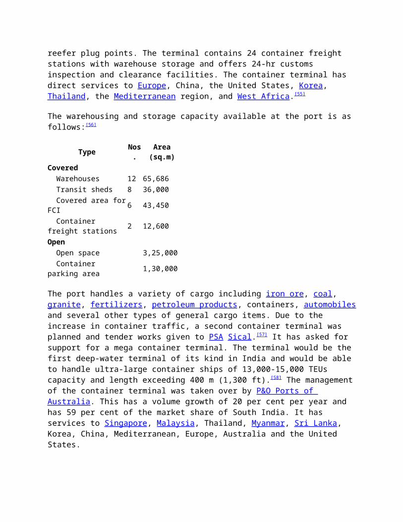
The warehousing and storage capacity available at the port is as follows:[56]
Type Nos.
Area(sq.m)
Covered Warehouses 12 65,686 Transit sheds 8 36,000 Covered area forFCI 6 43,450
Container freight stations 2 12,600
Open Open space 3,25,000 Container parking area 1,30,000
The port handles a variety of cargo including iron ore, coal, granite, fertilizers, petroleum products, containers, automobilesand several other types of general cargo items. Due to the increase in container traffic, a second container terminal was planned and tender works given to PSA Sical.[57] It has asked for support for a mega container terminal. The terminal would be the first deep-water terminal of its kind in India and would be able to handle ultra-large container ships of 13,000-15,000 TEUs capacity and length exceeding 400 m (1,300 ft).[58] The managementof the container terminal was taken over by P&O Ports of Australia. This has a volume growth of 20 per cent per year and has 59 per cent of the market share of South India. It has services to Singapore, Malaysia, Thailand, Myanmar, Sri Lanka, Korea, China, Mediterranean, Europe, Australia and the United States.
The port has a current depth of 17 m (56 ft) and is capable of handling fourth-generation vessels up to 150,000 DWT.[38] It is going through an expansion and will have a depth of 18–22 m (59–72 ft), a continuous quay length of 2 km (1.2 mi) and back-up area of around 100 ha (250 acres). Two new breakwaters for a total length of 4 km (2.5 mi) will be constructed — one as extension of the existing outer arm and the other extending from the fishing harbor breakwater. The consequent silting will reclaim about 300 ha (740 acres) of land. The mega terminal will be built on a 100-hectare (250-acre) portion of this land.[59] Theterminal will have a continuous quay length of 2 km (1.2 mi) with18–22 m (59–72 ft) side along draft, capable of handling ultra-large container ships carrying over 15,000 TEUs. This will help it handle the latest generation vessels. Though the port is largely a container port, it has strategic importance as 3 service berths are allotted to the Indian Navy.
The approach channel to the port has two sections—the entrance channel within the protection of outer arm and the outer channel beyond the protection of outer arm. The total length of the entrance channel is 7 km. The width of channel gradually increased from 244 m to 419 m at the bent portion, then maintainsa constant width of 305 m. The depth of the inner and the outer channels are 18.6 m and 19.2 m, respectively, below chart datum, with a swell allowances of 3 m.[60] The entrance is 350 m in Bharathi Dock and 125 m in Dr. Ambedkar Dock. The draught in the navigational channel is maintained by dredging approximately 1 million cubic metres annually.[38]
TerminalsContainer terminals
The port has two container terminals, run separately by DP World Pvt. Ltd and Singapore's PSA International Pte Ltd, with a combined capacity to handle 2.8 million standard containers a year. The two terminals loaded 1.11 million standard containers between April and December 2010, up from 886,000 containers a year earlier. Both the terminals have daily trains to Inland
Container Depots (ICDs). There are plans to build a mega container terminal, the third one at the port, with private fundsworth 36,860 million.[61][62][63] The port is served by various container liner services, namely, APL, K Line, Maersk Line, MOL, NYK, PIL and several regional container lines.[64]
Chennai Container Terminal
Chennai Container Terminal (CCT) is the first container terminal in Chennai port built in 1983. The container terminal was privatized in 2001 and is operated by DP World since 30 November 2001 with a capacity of 1.2 million TEUs. CCT is managed under a 30 year build-operate-transfer agreement set up with the Chennai Port Trust of the Government of India. The terminal is capable ofhandling fifth generation vessels up to 6,400 TEU and has direct services to China, West Africa, Europe and the United States. Theterminal crossed the "one million TEU" mark in 2007.[65] In 2011, it handled 1.12 million TEUs.[66] It enjoys a quay length of 885 m(2,904 ft) and has 4 berths with an alongside depth of 13.4 m (44 ft), height (ISLW to Top of Cope) of 34 m (112 ft), channel length of 6,700 m (22,000 ft) and channel depth of 19.2 m (63 ft). The total terminal area covers 21.1 hectares, and yard stacking area covers 17 hectares (42 acres). The terminal has an on-site rail track.[34] It has a berth productivity of 22 moves per hour and an average turnaround of 26 hours. The operator has invested around US$128 million to get new equipment at the terminal. At present, 7 quay cranes with Super Post Panamax handling capacity and 24 rubber-tyred gantry cranes (RTGs) form part of the inventory. The operator has also taken over from Chennai Port 4 quay cranes, 10 RTGs, 3 reach stackers, 240 reeferplugs, and 2 top lifters and one empty container handler.[67] CCT is ranked at the 79th position among the top 100 container terminals in the world.[68] It is one of the fastest growing terminals in India with a CAGR of 20 per cent.[68] It presently has four mainline services with direct connectivity to Mediterranean, Europe, Thailand, Vietnam, China and Korea. The mainline services are complemented by seven weekly feeder services and one coastal service to Colombo, Vizag, Penang, Port Klang, Singapore, Yangon and Port Blair, respectively. Presently,
CCT is connected to 50+ ports worldwide.[68] A container freight station, with a covered area of 6,500 m2 (70,000 sq ft), operateswithin the port offering such services as inspection, LCL de-stuffing and delivery of import cargo. CCT has plans to invest 1billion to install two quay cranes.[69]
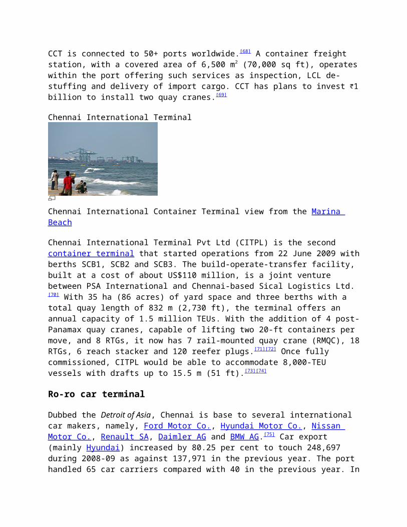
Chennai International Terminal
Chennai International Container Terminal view from the Marina Beach
Chennai International Terminal Pvt Ltd (CITPL) is the second container terminal that started operations from 22 June 2009 withberths SCB1, SCB2 and SCB3. The build-operate-transfer facility, built at a cost of about US$110 million, is a joint venture between PSA International and Chennai-based Sical Logistics Ltd.[70] With 35 ha (86 acres) of yard space and three berths with a total quay length of 832 m (2,730 ft), the terminal offers an annual capacity of 1.5 million TEUs. With the addition of 4 post-Panamax quay cranes, capable of lifting two 20-ft containers per move, and 8 RTGs, it now has 7 rail-mounted quay crane (RMQC), 18RTGs, 6 reach stacker and 120 reefer plugs.[71][72] Once fully commissioned, CITPL would be able to accommodate 8,000-TEU vessels with drafts up to 15.5 m (51 ft).[73][74]
Ro-ro car terminal
Dubbed the Detroit of Asia, Chennai is base to several international car makers, namely, Ford Motor Co., Hyundai Motor Co., Nissan Motor Co., Renault SA, Daimler AG and BMW AG.[75] Car export (mainly Hyundai) increased by 80.25 per cent to touch 248,697 during 2008-09 as against 137,971 in the previous year. The port handled 65 car carriers compared with 40 in the previous year. In
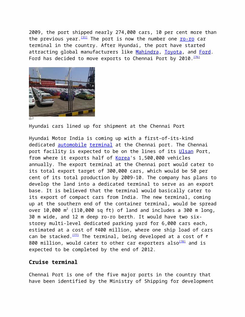
2009, the port shipped nearly 274,000 cars, 10 per cent more thanthe previous year.[31] The port is now the number one ro-ro car terminal in the country. After Hyundai, the port have started attracting global manufacturers like Mahindra, Toyota, and Ford. Ford has decided to move exports to Chennai Port by 2010.[76]
Hyundai cars lined up for shipment at the Chennai Port
Hyundai Motor India is coming up with a first-of-its-kind dedicated automobile terminal at the Chennai port. The Chennai port facility is expected to be on the lines of its Ulsan Port, from where it exports half of Korea's 1,500,000 vehicles annually. The export terminal at the Chennai port would cater to its total export target of 300,000 cars, which would be 50 per cent of its total production by 2009-10. The company has plans todevelop the land into a dedicated terminal to serve as an export base. It is believed that the terminal would basically cater to its export of compact cars from India. The new terminal, coming up at the southern end of the container terminal, would be spreadover 10,000 m2 (110,000 sq ft) of land and includes a 300 m long,30 m wide, and 12 m deep ro-ro berth. It would have two six-storey multi-level dedicated parking yard for 6,000 cars each, estimated at a cost of 400 million, where one ship load of cars can be stacked.[77] The terminal, being developed at a cost of 800 million, would cater to other car exporters also[78] and is expected to be completed by the end of 2012.
Cruise terminal
Chennai Port is one of the five major ports in the country that have been identified by the Ministry of Shipping for development
of cruise terminals, the other four being Goa, Cochin, Mumbai andMangalore.[79] The port has had passenger and tourist services to Burma, Malaya, Singapore, Manila, London, Suez, Aden and Colombo for over 100 years. There was regular passenger traffic during the British rule. Per official records, the port had an annual passenger traffic of 60,000 in 1956. In 1959, the port built a dedicated passenger terminal for coastal and cruise vessels. The passenger cruise terminal is located in the West Quay. The Shipping Corporation of India operated regular Chennai–Singapore services till 1984. On an average, 10 international cruise vessels dock in the port each year. The number of tourists visiting the port in 2008-09 was 2,616, which rose to 3,401 in 2009-10.[80][81] The country's first cruise ship, AMET Majesty, is registered in Chennai and is set to start from Chennai on 8 June 2011.[82][83]
Operations
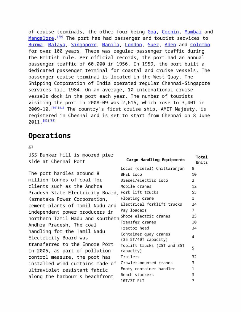
USS Bunker Hill is moored pierside at Chennai Port
The port handles around 8million tonnes of coal forclients such as the AndhraPradesh State Electricity Board,Karnataka Power Corporation,cement plants of Tamil Nadu andindependent power producers innorthern Tamil Nadu and southernAndhra Pradesh. The coalhandling for the Tamil NaduElectricity Board wastransferred to the Ennore Port.In 2005, as part of pollution-control measure, the port hasinstalled wind curtains made ofultraviolet resistant fabricalong the harbour's beachfront
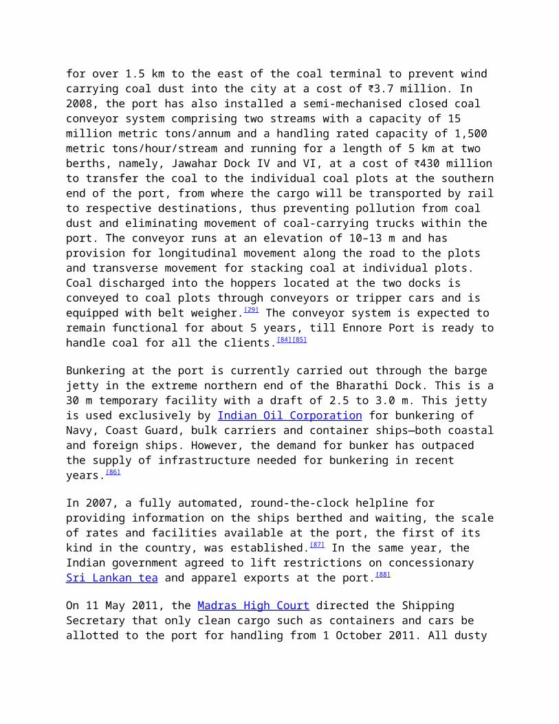
Cargo-Handling Equipments TotalUnits
Locos (diesel) Chittaranjan 8BHEL loco 10Diesel/electric loco 2Mobile cranes 12Fork lift trucks 55Floating crane 1Electrical forklift trucks 24Pay loaders 7Shore electric cranes 25Transfer cranes 10Tractor head 34Container quay cranes (35.5T/40T capacity) 4
Toplift trucks (25T and 35T capacity) 5
Trailers 32Crawler-mounted cranes 3Empty container handler 1Reach stackers 310T/3T FLT 7
for over 1.5 km to the east of the coal terminal to prevent wind carrying coal dust into the city at a cost of 3.7 million. In 2008, the port has also installed a semi-mechanised closed coal conveyor system comprising two streams with a capacity of 15 million metric tons/annum and a handling rated capacity of 1,500 metric tons/hour/stream and running for a length of 5 km at two berths, namely, Jawahar Dock IV and VI, at a cost of 430 millionto transfer the coal to the individual coal plots at the southernend of the port, from where the cargo will be transported by railto respective destinations, thus preventing pollution from coal dust and eliminating movement of coal-carrying trucks within the port. The conveyor runs at an elevation of 10–13 m and has provision for longitudinal movement along the road to the plots and transverse movement for stacking coal at individual plots. Coal discharged into the hoppers located at the two docks is conveyed to coal plots through conveyors or tripper cars and is equipped with belt weigher.[29] The conveyor system is expected toremain functional for about 5 years, till Ennore Port is ready tohandle coal for all the clients.[84][85]
Bunkering at the port is currently carried out through the barge jetty in the extreme northern end of the Bharathi Dock. This is a30 m temporary facility with a draft of 2.5 to 3.0 m. This jetty is used exclusively by Indian Oil Corporation for bunkering of Navy, Coast Guard, bulk carriers and container ships—both coastaland foreign ships. However, the demand for bunker has outpaced the supply of infrastructure needed for bunkering in recent years.[86]
In 2007, a fully automated, round-the-clock helpline for providing information on the ships berthed and waiting, the scaleof rates and facilities available at the port, the first of its kind in the country, was established.[87] In the same year, the Indian government agreed to lift restrictions on concessionary Sri Lankan tea and apparel exports at the port.[88]
On 11 May 2011, the Madras High Court directed the Shipping Secretary that only clean cargo such as containers and cars be allotted to the port for handling from 1 October 2011. All dusty
cargo such as coal and iron ore will be allotted to the Ennore Port.[89][90]
The port is one of the six ports in India through which drugs arepermitted to be imported, which is handled by the Central Drugs Standard Control Organisation (CDSCO), the other ports being Kolkata, Mumbai, Nhava Sheva, Kochi and Kandla ports.[91]
As of 2011, cargo movement to the port is increasing by 21 per cent.[51] Over 5,000 container trucks move through the port every day. However, the number of containers coming into the port has dropped by 30 per cent in the same year.[92]
In July 2012, a vessel traffic management system was installed atthe port to track vessel movements for nearly 2 km, which can be extended to 48 nautical miles.[93]
As of 2012, the port consumed 38 MW of power every year, spendingabout 290 million per annum on electricity charges.[94]
Auxiliary functionsMeteorological functions
The cyclone detection radar station of the Southern Regional Meteorological Centre is located at the Centenary Building, the administrative building of the port.[95] It is located atop the building at a height of about 53 m above sea level in a dome weighing 18 tonnes. The radar scans the atmosphere within a radius of 500 km.[96] The Port Meteorological Office also functions from the same building.[97]
The India Meteorological Department (IMD) maintains Voluntary Observing Fleet (VOF) through the Port Meteorological Office comprising ships of Merchant Navy, Indian Navy and foreign agencies through which meteorological observations from the oceanarea are collected on real-time basis for operational forecastingand climatological purpose.[98]
Disease control
The Port Health Organisation, Chennai, functioning under the Director General of Health Services, Ministry of Health and Family Welfare, Government of India, was established in 1946 withan objective of preventing entry of yellow fever and other quarantinable and communicable diseases from abroad.[28] Mosquito control in the port area is being undertaken by two agencies, namely, the Chennai Port Trust and the Port Health Organisation. Anti-mosquito measures are undertaken by the Port Trust while theissuance of yellow fever certificates, ship deratting and overallsupervision of mosquito control is undertaken by the Port Health Organisation.[52]
ConnectivityExtra-port connectivity
The foundation stone for the 6,000-million Chennai Port-Ennore road connectivity project was laid in January 2011. The Ennore Manali Road Improvement Project (EMRIP) is expected to be completed in 2 years.[99] Of the total cost of 6,000 million, 2,500 million would be contributed each by the National Highways Authority of India and the Chennai Port Trust while 582 million would come from the Tamil Nadu government and rest by Ennore PortLtd. EMRIP, which was conceived in 1998, has been under implementation for the past 10 years. The project envisages improvement of a 30.1-kilometre (18.7 mi) road network in north Chennai that connects all the container freight station handling containers for Chennai port. This includes 6 km (3.7 mi) of Ennore Expressway, 9 km (5.6 mi) of Thiruvotriyur Ponneri Pancheti Road, 5.4 km (3.4 mi) of Manali Oil Refinery Road, 8.1 km (5.0 mi) of the northern segment of Inner Ring Road, and 1.6 km (0.99 mi) of Chennai Port Trust Fishing Harbour Road, in addition to shore protection measures comprising 13 groins along the Ennore coast.[100] The original cost of the project was 1,500 million but was revised due to addition of service road to the four lanes of Thiruvottiyur-Pooneri-Panchetti road, provision of underpass on Ennore Expressway Road and drainage on Manali Oil Refinery Road besides escalation of cost during the intervening period.[101][102] The project completion is expected by June 2013.[103]
An 18.3-kilometre (11.4 mi) long, 20-metre (66 ft) wide elevated road project connecting the port with Maduravoyal is under construction at a cost of 16,550 million. Upon completion, this will be the country's longest four-way elevated expressway. The project was sanctioned in June 2007 when the Tamil Nadu Government gave its 'in principle' approval to the National Highway Authority of India (NHAI) for the elevated expressway. The project cost then was put at 14,680 million. In January 2009, the Prime Minister, Dr. Manmohan Singh, laid the foundationstone for the project but the project was put on hold for want ofenvironment clearance.[104] The project has got the environment clearance in February 2011, and during the same month, the port handed over a cheque for 500 million to the NHAI as part of its contribution to the project. The expressway starts from Gate No. 10 of the Chennai Port near the War Memorial and ends before Maduravoyal Interchange. It would run along the banks of the Cooum up to Koyambedu and would end along the Cooum near the Koyambedu grade separator. From there for a distance of three km up to Maduravoyal the elevated expressway would come up on Poonamallee High Road. There would be a total of four entry and exit ramps as part of the project. While the entry ramps would come up on Sivananda Salai and College Road, the exit points would be provided on Spurtank Road and Kamaraj Salai. The work atthe Maduravoyal end began in December 2010. The project is being implemented on a build, own and transfer mode. Of the total project cost of 16,550 million, 3,100 million has been set aside for land acquisition and rehabilitation and resettlement ofnearly 7,400 people living along the project area. About 1,300 people have been rehabilitated at Okkiam Thoraipakkam. Of 30 hectares to be acquired for the project, only 2 hectares belong to private owners. The project was initially expected to be completed by end of 2013.[105] However, the project has been put onhold.[106][107]
Intra-port connectivity
The total port roads run to a length of 27.5 km with a minimum width of 6 m and a maximum width of 26 m.[56]
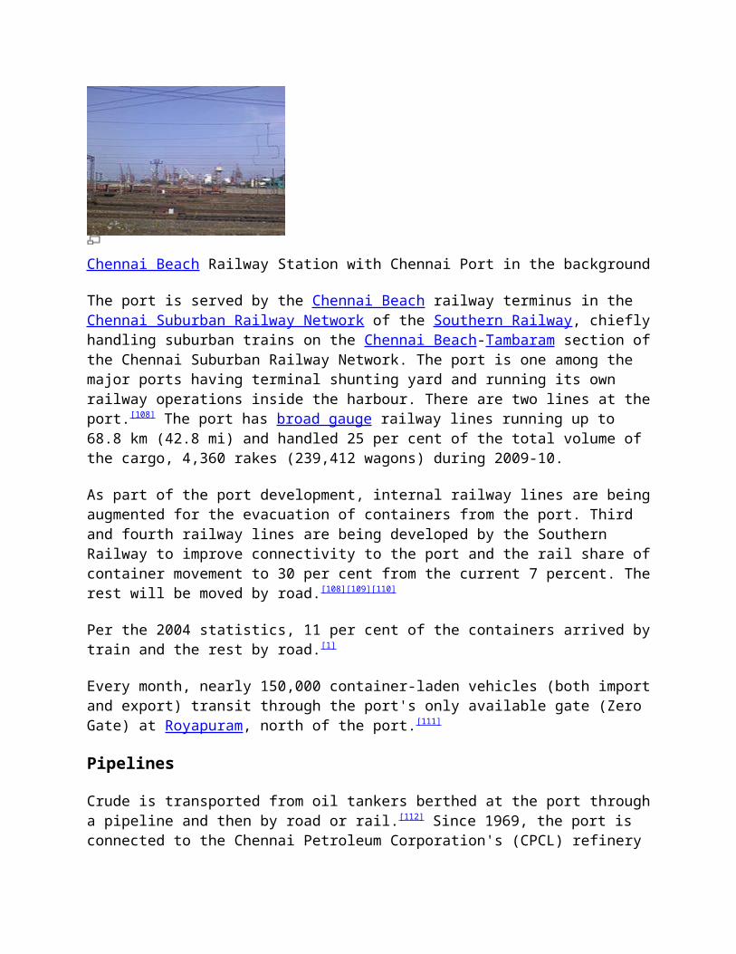
Chennai Beach Railway Station with Chennai Port in the background
The port is served by the Chennai Beach railway terminus in the Chennai Suburban Railway Network of the Southern Railway, chieflyhandling suburban trains on the Chennai Beach-Tambaram section ofthe Chennai Suburban Railway Network. The port is one among the major ports having terminal shunting yard and running its own railway operations inside the harbour. There are two lines at theport.[108] The port has broad gauge railway lines running up to 68.8 km (42.8 mi) and handled 25 per cent of the total volume of the cargo, 4,360 rakes (239,412 wagons) during 2009-10.
As part of the port development, internal railway lines are beingaugmented for the evacuation of containers from the port. Third and fourth railway lines are being developed by the Southern Railway to improve connectivity to the port and the rail share ofcontainer movement to 30 per cent from the current 7 percent. Therest will be moved by road.[108][109][110]
Per the 2004 statistics, 11 per cent of the containers arrived bytrain and the rest by road.[1]
Every month, nearly 150,000 container-laden vehicles (both importand export) transit through the port's only available gate (Zero Gate) at Royapuram, north of the port.[111]
Pipelines
Crude is transported from oil tankers berthed at the port througha pipeline and then by road or rail.[112] Since 1969, the port is connected to the Chennai Petroleum Corporation's (CPCL) refinery
in Manali via a 30-inch-diameter pipeline running for a length of17 km.[113] CPCL is planning to replace this with 42-inch-diameter pipeline at a cost of 1,260 million along the proposed Quadrilateral Road Network from Chennai Port to Ennore-Manali Highway.[114] However, citing threats to habitation, the governmenthas refused clearance to the project.[115]
Natural disastersThe Indian Ocean Tsunami of 26 December 2004, one of the deadliest in the recorded history, had a devastating effect all over the region and, of course, damaged the port's infrastructure, including cranes, wharfs, moorings and some part of the ship channel and hindered the operations of the port for abrief period. Some of the ships hit the wharves close to where they were berthed. Other damages at the port include collision ofthree ships while being towed to deep sea resulting in the loss of about 1,500 tonnes of sugar and damages to some of the cars that awaited export. The port suspended operations for two days.[116] The total damage to property, infrastructure and equipment atthe port due to the tsunami stood at 129.6 million. Rebuilding the entry channels and affected areas incurred another 100 million. The port suffered a loss of 30 million due to operational halt on 26 and 27 December 2004, during which around 250,000 tonnes of container could not be serviced, with trade of 15 vessels on sail and 10 vessels at berth affected. This was in addition to the loss due to waiving of marine charges owing to the disaster.[117]
As a consequence of the tsunami, the port trust is planning to create an artificial beach from left of the Cooum river (next to the Napier bridge) right up to fishing harbour in North Chennai covering about 10 km to protect the port from seaside from similar natural calamities. The beach is planned within the port's territory before the east breakwater on the seaside and would not be accessible to the public. In addition, the port is also planning to reclaim the land adjacent to the Cooum during the Tenth Plan.[118]
On the flip side, the disaster has made the port the deepest on the east coast. A bathymetry survey conducted by the National Institute of Ocean Technology (NIOT) to measure the depth of the sea has revealed the entry channel to the port has deepened enabling the berthing of vessels of deeper drafts. The high current generated by the tsunami waves dredged about 0.4 to 0.5 million cubic metres of sediments, which has deepened the 17.4 m-deep harbour by 1 to 2 m more, especially along the Dr. Ambedkar Dock and the Barathi Dock. Similarly, the depth of the entry channel, which was 18.6 m, has deepened by a metre.[117][119]
Lights and lighthouses
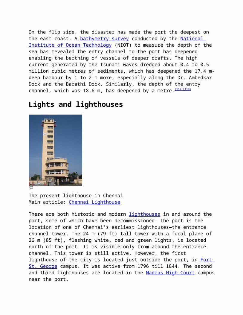
The present lighthouse in ChennaiMain article: Chennai Lighthouse
There are both historic and modern lighthouses in and around the port, some of which have been decommissioned. The port is the location of one of Chennai's earliest lighthouses—the entrance channel tower. The 24 m (79 ft) tall tower with a focal plane of 26 m (85 ft), flashing white, red and green lights, is located north of the port. It is visible only from around the entrance channel. This tower is still active. However, the first lighthouse of the city is located just outside the port, in Fort St. George campus. It was active from 1796 till 1844. The second and third lighthouses are located in the Madras High Court campusnear the port.
The present lighthouse is located about 6 km south of the port onthe Marina Beach. It is a 46 m (151 ft) tall, 11-storied triangular cylindrical concrete tower with lantern and double gallery, attached to a 3-story circular harbour-control building,emitting light from a height of 57 m (187 ft) from the mean sea level. This lighthouse, which is active since 1977, is powered bya 440V, 50 Hz main supply.
The futureA third box terminal has been approved by the Cabinet Committee on Infrastructure. This will require investment of US$800 millionand will be offered as a build-operate-transfer project, as part of a 30-year concession. Construction will take seven years to complete and the deep-water container terminal will have a capacity of 4 million TEU.[120][121][122] The mega container terminal project, expected to be the single largest terminal ever built inIndia,[123] is to be developed north of existing Bharathi Dock withtwo new breakwaters (total length of 4.23 km (2.63 mi)), continuous quay length of 2 km (1.2 mi) with 22 m (72 ft) alongside depth (ultimate) and a basin area of 300 hectares and back up area of 100 hectares.[124] The gigantic proportions will feature 2 km quay length in a straight line at the new outer harbour, with a 2.75 km extension of the existing outer arm breakwater and a new northern breakwater of 1.73 km emanating from the eastern breakwater of the fishing harbour.[125] The project also involves converting waterfront into 225 acres of land. The other side of breakwater would be used by the port as aberth to handle oil vessels.[66] The project will be the first deep-water terminal of its kind in India and can handle ultra-large container ships of capacity over 15,000 TEUs and length of 400 m (1,300 ft). Overall project completion is expected by 2018.In September 2011, Mundra Port and Special Economic Zone Ltd (MPSEZ) emerged as the sole and lowest bidder for constructing the mega terminal.[66][126] Based on earlier projections, Chennai isexpected to handle 5 million TEUs by 2017.
A portion of the port visible from the surrounding buildings
Chennai Port Trust has plans to build a marina along a 200-metre (660 ft) stretch in the west quay to berth a dozen yachts. The marina will provide lockers, separate berths and other facilitiesto these sailors, who come in small boats. The sailors can then proceed inland for sightseeing. However, the plan still remains on paper. Although the plan to build a large-scale marina is at the proposal stage, the port cannot have a marina till the coal yard is vacated. After coal handling is moved out, the port will reclaim land by constructing groynes—rigid hydraulic structures built from an ocean shore that interrupt water flow and limit themovement of sediment.[127]
The Rajiv Gandhi dry port (container freight station) and multi-modal logistics hub near Sriperumbudur special economic zone (SEZ) is under development at an estimated cost of 3,800 million, including land cost of 1,001.6 million. Proposed components include ICD/off-dock CFS, container yard, rail and road connectivity to national rail and road network, trade centre, warehouses for containerized cargos like leather garments, textiles, automotive components and electronic hardware. A total of 125 acres of land at Mappedu in the Sriperumbudur SEZ alloted by SIPCOT of the Government of Tamil Nadu is being acquired for the project on a 99-year lease basis. The first-of-its-kind project[51] is expected to be completed by 2014. The distance between Chennai Port and the dry port is about50 km (31 mi). About 19 km (12 mi) would be covered by the elevated corridor, 16 km (9.9 mi) by National Highway 4 and balance by a single-line state highway that would be converted
into two-lane soon. The dry port would consist of 75 acres (30 ha) of custom-bound area and 50 acres (20 ha) of non-custom bound area and would accommodate containers, hazardous and non-hazardous materials. A barge jetty-cum-liquid cargo terminal at an outlay of 250 million is also being proposed on PPP mode.[128] This is one of the three container freight stations planned by Chennai Port Trust.[3]
A barge handling facility at the Bharathi Dock is being developedat a cost of 250 million. The project is expected to be completed by 2013. The 200 m long barge jetty is being developed with a depth of 10 m and back area of 7,500 m. The jetty is proposed to be constructed between the iron ore berth and oil terminal so as to cater to barges and bunkers and similar vesselshandling liquid cargo.[78]
The port is planning to construct a parking facility on an 11-acre stretch in Thiruvottiyur for container trucks.[129] The port is also investing 500 million to have more berths exclusively for bunkering.[31]
The port has decided to have a 7.5 MW wind energy farm in Tirunelveli district at an outlay of 493.1 million.[130]
To reduce congestion at the harbour, which has two bays (two eachfor entry and two for exit of containers), the port plans to modernise zero gate and open one more bay and widen the roads that lead to zero gate and to lay six to eight lanes from the zero gate to avoid stranding of vehicles.[131]
In December 2011, as part of security measures, the Directorate of Logistics, Customs and Central Excise planned to get a fixed mega container scanner within the next few months at a location near the Zero Gate of the port at a cost of 600 million from a U.S.-based company.[132]
The Chennai Port Trust plans to develop a barge handling facilityinside the port at a cost of 260 million in Bharathi Dock through public-private partnership to meet the increase in demandfor bunkering - fuel oil used aboard ships. The need for barge
facility is also due to the increasing vessel movements and vessel size. The proposed length of the jetty will be three timesthe length of the present facility. The jetty could accommodate barges with carrying capacity of 1,000 tonne to 3,000 tonne. In addition to bunkering fuel and edible oil, other cargoes that areenvisaged to be handled at the proposed facility include vegetable oil (crude and refined), furnace oil and molasses.[86]
Sister portsThe port has sister port agreements with the following ports to cooperate in maritime transportation and port development. This also covers technical expertise, cruise knowledge, container terminal and tourism between the sister ports.
Country Port State / Region Since
Belgium Port of Zeebrugge [133] West Flanders November
2008
Canada Port of Halifax [134] Nova Scotia January
2009
See alsoChennai portalNautical portal
Ennore Port Kattupalli Shipyard Ports in India
References1. ^ a b Ramanathan, S Kalyana (17 April 2004). "New chief
likely for Chennai port". Business Standard (Chennai: Business Standard). Retrieved 22-Oct-2011.
2. ̂ "World Port Index Eighteenth Edition (2005), Pub.150" (pdf). National Geospatial-Intelligence Agency, Bethesda, Maryland. Retrieved 22-Oct-2011.
3. ^ a b "Chennai Port achieves record turnover of Rs 890 cr in07-08". One India News. 25 June 2008. Retrieved 22-Oct-2011.
4. ^ a b "Performance of Major Port" (pdf). Ministry of Shipping, Government of India. Retrieved 22-Oct-2011.
5. ̂ "Chennai Port terminal project gets Cabinet nod". Business Standard (Chennai: Business Standard). 13 October 2010. Retrieved 22-Oct-2011.
6. ^ a b c d e f g "Century-old stories wash up on heritage tour of Chennai port". The Times of India (Chennai: The Times Group).27 August 2012. Retrieved 6-Nov-2012.
7. ̂ "Chennai". CS Top 100 Container Ports 2010. Cargo Systems. August 2010. p. 69. Retrieved 23-Oct-2011.
8. ̂ "Chennai Port capacity to be expanded with Rs.100 billion". The Siasat Daily. 19 January 2011. Retrieved 23-Oct-2011.
9. ̂ Imperial Gazetteer of India, 1908, Vol 16, pp. 247-24810. ̂ "Saint Thomas the Apostle". D. C. Kandathil.
Retrieved 2010-04-26.11. ̂ Stephen Andrew Missick.Mar Thoma: The Apostolic
Foundation of the Assyrian Church and the Christians of St. Thomas in India. Journal of Assyrian Academic studies.
12. ̂ "Early references about the Apostolate of Saint Thomas in India, Records about the Indian tradition, Saint Thomas Christians & Statements by Indian Statesmen". NasraniSyrian Christians Network. 16 February 2007. Retrieved 2009-10-27.
13. ̂ "Saint Thomas (Christian Apostle) – Britannica OnlineEncyclopedia". Britannica.com. Retrieved 2010-04-25.
14. ̂ S. Muthiah (21 August 2006). "Founders' Day, Madras".Hindu Times. Retrieved 2009-01-28.
15. ̂ Madras in the Olden Time, Vol I, p. 2616. ̂ Encyclopaedia Britannica Treaty of Aix-la-Chapelle17. ̂ Sosin, Jack M., "Louisburg and the Peace of Aix-la-
Chapelle, 1748," The William and Mary Quarterly. Third Series, Vol. 14, No. 4 (Oct., 1957): 516-535
18. ̂ Fortescue, John William (1902). A history of the British army, Volume 3. Macmillan. pp. 431–432.
19. ̂ Madras in the Olden Time, Vol I, pp. 281-28220. ^ a b c "City from the sea". The Times of India (Chennai:
The Times Group). 5 September 2011. Retrieved 24-Nov-2011.21. ̂ Fiebig, Frederick (1851). "Masula boat, Madras".
Online Gallery. The British Library. Retrieved 27-Oct-2011.22. ̂ Anonymous (1787). "Masula boat". Online Gallery. The
British Library. Retrieved 27-Oct-2011.23. ^ a b c Sreevatsan, Ajai (5 September 2011). "Booming
Chennai has a lot to do with port". The Hindu (Chennai: The Hindu). Retrieved 27-Oct-2011.
24. ^ a b c d e f g "Profile of Chennai Port Trust". Scribd.com. Retrieved 28-Oct-2011.
25. ̂ Hurd, John (2005). "Railways". In Kerr, Ian J. Railways in Modern India. New Delhi: Oxford University Press. pp. 147–172–96. ISBN 0-19-567292-5.
26. ̂ Naval Battles of the First World War, Capt. Geoffrey Bennet, Penguin Books, reprint 2001
27. ̂ "Mercantile Marine Department, Chennai". Directorate General of Shipping. Retrieved 9-Oct-2011.
28. ^ a b "Port Health Organization, Chennai" (pdf). Ministry of Health & Family Welfare, Government of India. Retrieved 28-Oct-2011.
29. ^ a b c d "Facilities at port". Chennai Port Trust. n.d.Retrieved 2-Oct-2011.
30. ̂ Raman, T M A (23 December 1999). "Chennai Port Trust to invite BOT bids for container berth expansion". Express India (Express India). Retrieved 28-Oct-2011.
31. ^ a b c Venkatraman, Kavitha (10 July 2010). "Chennai Port plans upgrade to meet growing mkt demand". The Financial Express (The Indian Express). Retrieved 28-Oct-2011.
32. ̂ "Mega container terminal for Chennai port approved". Thaindian News (Thaindian News). 12 October 2010. Retrieved 29-Oct-2011.
33. ^ a b c "Shoreline Management Plan for Ennore Coast (Tamilnadu)" (pdf). Ministry of Earth Sciences, Government of India. November 2006. Retrieved 29-Oct-2011.
34. ^ a b "DP World Chennai, Terminal Infrastructure". DP World, Chennai. Retrieved 29-Oct-2011.
35. ^ a b c "Project Information Memorandum - Development ofRo-Ro cum Multipurpose Berth and Multilevel Car Park at Chennai Port on DBFOT basis" (pdf). Chennai Port Trust. January 2012. Retrieved 13-Apr-2012.
36. ̂ "NASA climate data visualized". Classzone.com. Retrieved 1-Sep-2010.
37. ̂ John, Ekatha Ann (29 September 2012). "Disaster body for panel to monitor highrises in Chennai". The Times of India (Chennai: The Times Group). Retrieved 1-Oct-2012.
38. ^ a b c Waste Load Allocation & Waster Assimilative Capacity Studies for Ennore Creek & North Chennai Coastal Waters, National Institute of Ocean Technology, retrieved 28 September 2011
39. ^ a b EARSeL (2002). Observing our environment from space: new solutions for a new millennium .... A. A. Balakema. ISBN 90-5809-254-2. Retrieved 23-Oct-2011.
40. ̂ "Traffic Handled at Major Ports (Last 7 Years) 2004-05 to 2010-11" (pdf). Ministry of Shipping, Government of India. Retrieved 29-Oct-2011.
41. ̂ "Chennai port handles 30 million tonnes of cargo in 10 days". The Hindu (Chennai: The Hindu). 14 February 2004. Retrieved 29-Oct-2011.
42. ̂ Sanyal, Santanu (5 April 2011). "Major ports traffic at 569.9 mt in 2010-11; post meagre 1.57% growth". The HinduBusiness Line (Chennai: The Hindu). Retrieved 29-Oct-2011.
43. ̂ "Traffic Targets" (pdf). Ministry of Shipping, Government of India. Retrieved 29-Oct-2011.
44. ̂ Manoj, P. (9 April 2008). "Container cargo traffic atmajor Indian ports rises 19% in 2008". livemint.com. Retrieved 29-Oct-2011.
45. ̂ Narasimhan, T.E. (12 May 2011). "Tariff authority orders 35 pc cut in terminal charges". Business Standard (Business Standard). Retrieved 29-Oct-2011.
46. ̂ Simhan, T. E. Raja (11 May 2011). "Chennai port ordered to stop handling polluting coal, iron ore". BusinessLine (Chennai: The Hindu). Retrieved 6-Nov-2011.
47. ̂ Simhan, T.E. Raja (22 April 2011). "2010-11, bumper year for Chennai port container traffic". Business Line (Chennai: The Hindu). Retrieved 6-Nov-2011.
48. ̂ "An Indian first". Port Strategy (Mercator Media). 8 June 2011. Retrieved 6-Nov-2011.
49. ̂ "Chennai Port resumes shipping grain after 9 years". Silicon India News (SiliconIndia.com). 9 April 2003. Retrieved 6-Nov-2011.
50. ̂ "Indian Ports Association, Performance Indicators: April to March 2011 vis-a-vis March 2010" (pdf). Ministry ofShipping, Government of India. Retrieved 6-Nov-2011.
51. ^ a b c "Chennai port to become major transshipment hub". TOS (Dredgingtoday.com). 28 February 2011. Retrieved 6-Nov-2011.
52. ^ a b Kuldip Singh Gill et al., (2000). Aedes aegypti survey of Chennai Port/Airport, India, Dengue Bulletin, Vol. 24
53. ̂ "Table 1.3: Topography of Major Ports" (pdf). Ministry of Shipping, Government of India. Retrieved 6-Nov-2011.
54. ̂ "Karnataka ban on iron ore exports hits Chennai". Maritime News (The Hindu Business Line). Retrieved 6-Nov-2011.
55. ̂ "Port Detail". World Port Source. Retrieved 6-Nov-2011.
56. ^ a b "Chennai Port". Steel Exchange India. Retrieved 6-Nov-2011.
57. ̂ Sanjai, P. R. (5 September 2006). "Chennai port project to go to Singapore". Business Standard (Business Standard). Retrieved 6-Nov-2011.
58. ̂ Rao, Lalitha (14–20 April 2008). "Chennai Port to build Rs 5,500 cr projects". Projects Monitor. Retrieved 6-Nov-2011.
59. ̂ Simhan, T.E. Raja. "Chennai port mega terminal Connectivity still an issue". Business Line (Chennai: The Hindu). Retrieved 6-Nov-2011.
60. ̂ "India—Chennai Port". AsiaTradeHub.com. Retrieved 6-Nov-2011.
61. ̂ "Chennai Port confirms construction of Rs 3,686 croremega terminal". Dredging Today (Business Standard). 12 January 2010. Retrieved 6-Nov-2011.
62. ̂ Manoj, P. (29 January 2011). "No takers for mega container terminal at Chennai port". Live Mint (LiveMint.com). Retrieved 6-Nov-2011.
63. ̂ "Development of India's First Mega Container Terminalat Chennai Port on BOT Basis" (pdf). Retrieved 6-Nov-2011.
64. ̂ "Port of Chennai, Container Liner Service". World Port Source. Retrieved 7-Nov-2011.
65. ̂ "DP World Chennai, Welcome". DP World Chennai. Retrieved 7-Nov-2011.
66. ^ a b c Anand, N. (5 October 2008). "MPSEZ, sole bidder for Mega Container Terminal Project at ChPT". The Hindu (Chennai: The Hindu). Retrieved 5-Oct-2011.
67. ̂ Chennai Port Expansion[dead link]
68. ^ a b c "DP World Chennai, CEO's Message". DP World, Chennai. Retrieved 7-Nov-2011.
69. ̂ "Chennai Container Terminal to invest Rs.1000 millionon cranes". port.industry-focus.net. Retrieved 9-Nov-2011.
70. ̂ "Sical Logistics sells stake in Chennai port". GlobalSupply Chain Council. 22 April 2010. Retrieved 9-Nov-2011.
71. ̂ "PSA Chennai—Equipments". PSA Chennai. Retrieved 9-Nov-2011.
72. ̂ "Chennai container terminals gets new cranes". Business Line (Chennai: The Hindu). Retrieved 8-Apr-2012.
73. ̂ "PSA Chennai—Infrastructure". PSA Chennai. Retrieved 9-Nov-2011.
74. ̂ "Chennai International Terminals" (pdf). PSA - The World's Port of Call. Retrieved 10-Nov-2011.
75. ̂ Bellman, Eric (8 July 2010). "A New Detroit Rises in India's South". The Wall Street Journal (Dow Jones & Company). Retrieved 10-Nov-2011.
76. ̂ "Ford to start full exports from Chennai Port next year". The Economic Times (Chennai: The Times Group). 18 August 2009. Retrieved 10-Nov-2011.
77. ̂ "Chennai Port to create capacity to facilitate car exports". Projects Monitor. 24 February 2010. Retrieved 10-Nov-2011.
78. ^ a b Bhattacharya, Pradip (19 October 2009). "Multi-level car park at Chennai Port to boost auto exports". Projects Monitor. Retrieved 10-Nov-2011.
79. ̂ "Developing Cruise Shipping". MG/AS–PQ1–usq 1185 (ReleaseID: 77989). Press Information Bureau, Government of India. 1 December 2011. Retrieved 2-Dec-2011.
80. ̂ Janardhanan, Arun (8 June 2012). "City Port to Harbour Cruise Dreams". The Times of India (Chennai: The Times Group).
81. ̂ "More Cruise Ships Favouring Chennai Port". Deccan Chronicle (ChennaiBest.com). Retrieved 10-Nov-2011.
82. ̂ "India's first cruise ship to visit Chennai on June 8". Business Line (Chennai: The Hindu). 20 May 2011. Retrieved 10-Nov-2011.
83. ̂ Fredeick, Prince (7 June 2011). "Cruising around". The Hindu (Chennai: The Hindu). Retrieved 10-Nov-2011.
84. ̂ Simhan, T.E. Raja (5 December 2007). "Chennai port tohave closed coal conveyor system". Business Line (Chennai: The Hindu). Retrieved 12-Nov-2011.
85. ̂ "Chennai Port in pollution promise". Port Technology International. 14 March 2011. Retrieved 12-Nov-2011.
86. ^ a b Rajasimhan, T.E. (13 January 2012). "Chennai portplans new barge facility for bunkering". Business Line (Chennai: The Hindu). Retrieved 13-Jan-2012.
87. ̂ "Baalu inaugurates Chennai port's helpline". The Hindu (Chennai: The Hindu). 25 January 2007. Retrieved 12-Nov-2011.
88. ̂ Sirimanna, Bandula (1 April 2007). "Chennai port opento Lankan tea, garments". The Sunday Times Online (The Sunday Times). Retrieved 12-Nov-2011.
89. ̂ Sangameswaran, K.T. (12 May 2011). "Chennai port willhandle only clean cargo: court". The Hindu (Chennai: The Hindu). Retrieved 14-Nov-2011.
90. ̂ Anand, N. (28 June 2011). "Chennai Port Trust seeks review of High Court order". The Hindu (Chennai: The Hindu).Retrieved 14-Nov-2011.
91. ̂ Sivan, Jayaraj (17 June 2009). "China to Chennai is the new route for spurious medicines". The Times of India (Chennai: The Times Group). Retrieved 14-Nov-2011.
92. ̂ Janardhanan, Arun (24 September 2011). "Sluggish cargo traffic: Shippers avoid city port". The Times of India(Chennai: The Times Group). Retrieved 14-Nov-2011.
93. ̂ Simhan, T. E. Raja (6 July 2012). "Chennai port gets vessel traffic management system". Business Line (Chennai: The Hindu). Retrieved 6-Jul-2012.
94. ̂ Sujatha, S. (14 April 2012). "Chennai Port Trust to produce power from wind, wave". Deccan Chronicle (Chennai: The Deccan Chronicle). Retrieved 16-Apr-2012.
95. ̂ "Regional Meteorological Centre open for public today". The Hindu (Chennai: The Hindu). 27 February 2009. Retrieved 14-Nov-2011.
96. ̂ "Doppler radar completes 10 years too". The Hindu (Chennai: The Hindu). 22 February 2012. Retrieved 23-Feb-2012.
97. ̂ "Address Port Meteorological Offices (PMOs)" (pdf). imdpune.gov.in. Retrieved 14-Nov-2011.
98. ̂ "Annual Report 2003 - 2004". Department of Science & Technology, Government of India. Retrieved 14-Nov-2011.
99. ̂ Chabra, Pawan (8 March 2011). "Chennai-Ennore Port road connectivity project to be completed in two years". India Transport Portal. Retrieved 14-Nov-2011.
100. ̂ "Chennai-Ennore Port Road Connectivity Project" (pdf). DP World Chennai. Retrieved 14-Nov-2011.
101. ̂ "29 new projects for Chennai port". Business Standard (Business Standard). 20 January 2011. Retrieved 14-Nov-2011.
102. ̂ "Ennore-Manali project: Chennai port to invest Rs 139.80 crore". Maritime Gateway (Maritime Gateway). 10 February 2009. Retrieved 7-Nov-2012.
103. ̂ Narasimhan, T. E. (10 October 2011). "Rs 600 crore road project may be ready by 2013". Business Standard (Chennai). Retrieved 23-Oct-2011.
104. ̂ "Vasan urges speedy execution of Chennai port-Maduravayol expressway". Business Line (Chennai: The Hindu). 27February 2011. Retrieved 14-Nov-2011.
105. ̂ Lakshmi, K. (5 May 2011). "Preliminary work on elevated expressway along the Cooum begins". The Hindu (Chennai: The Hindu). Retrieved 15-Nov-2011.
106. ̂ Ramakrishnan, Deepa H. (7 November 2012). "Under one govt it's go, under another it's stop". The Hindu (Chennai: The Hindu). Retrieved 7-Nov-2012.
107. ̂ Ramakrishnan, Deepa H.; N. Anand (7 November 2012). "PM's adviser to meet CM for talks on pending projects". TheHindu (Chennai: The Hindu). Retrieved 7-Nov-2012.
108. ^ a b Janardhanan, Arun (19 May 2012). "Two more railway lines to come up inside port soon". The Times of India (Chennai: The Times Group). Retrieved 19-May-2012.
109. ̂ "No slowdown impact on traffic at Chennai port". Business Line (Chennai: The Hindu). 23 January 2010. Retrieved 15-Nov-2011.
110. ̂ "Singapore firms keen on infrastructure projects in TN". Business Line (Chennai: The Hindu). 25 March 2011. Retrieved 3-Feb-2012.
111. ̂ "Chennai port will to spend additional INR 1 crore every day". Business Line (Steel Guru). 21 August 2011. Retrieved 15-Nov-2011.
112. ̂ Sharma, Pratul (10 April 2013). "CPCL project no morein pipeline". The New Indian Express (Chennai: Express Publications). Retrieved 13-Apr-2013.
113. ̂ Kumar, N. Ravi (9 February 2013). "CPCL mulls optionsto replace ageing pipeline". The Hindu (Chennai: The Hindu). Retrieved 11-Feb-2013.
114. ̂ "Chennai Port Signs MoU With CPCL For Crude Handling". The Financial Express (The Indian Express). 21 May 2003. Retrieved 28-Oct-2011.
115. ̂ "Environment Ministry refuses clearance to Chennai Petro pipeline". The Economic Times (The Times Group). 28 October 2011. Retrieved 28-Oct-2011.
116. ̂ Jagannath, Venkatachari (27 December 2004). "Chennai Port suffers Rs.10-crore damage". domain-b.com. Retrieved 15-Nov-2011.
117. ^ a b Tsunami-hit Chennai port bounces back[dead link]
118. ̂ Simhan, T.E. Raja (1 January 2005). "Tsunami effect: Chennai Port Trust plans artificial beach". Business Line (Chennai: The Hindu). Retrieved 15-Nov-2011.
119. ̂ Post-tsunami, Chennai is east coast’s deepest port[dead
link]
120. ̂ "Third Chennai box terminal approved". PortStrategy (PortStrategy). 8 December 2010. Retrieved 15-Nov-2011.
121. ̂ "Chennai Port to expand its container terminal". Port.industry-focus.net. n.d. Retrieved 15-Nov-2011.
122. ̂ "Mega Container Terminal Project at Chennai Port Approved". Dredging Today (DredgingToday.com). 18 October 2010. Retrieved 15-Nov-2011.
123. ̂ "Chennai Port Trust to build massive container terminal". Financial Express (Dredging News Online). 5 July 2010. Retrieved 15-Nov-2011.
124. ̂ Venkatraman, Kavitha (4 July 2010). "India: Decision on Chennai Port Development Will be Made Within Month". Financial Express (DredgingToday.com). Retrieved 15-Nov-2011.
125. ̂ "India: Chennai Port to Build Imposing Container Terminal". Worldnews (DredgingToday.com). 14 May 2010. Retrieved 15-Nov-2011.
126. ̂ Manoj, P. (25 November 2011). "Chennai port yet to decide on MPSEZ bid". LiveMint.com. Retrieved 27-Nov-2011.
127. ̂ Ayyappan, V. (8 March 2011). "Sailors skip Chennai asplans to build marina go at slow pace". The Times of India (Chennai: The Times Group). Retrieved 15-Nov-2011.
128. ̂ "Chennai Port acquires land for dry port". ConstructionUpdate.com. September 2010. Retrieved 15-Nov-2011.
129. ̂ "Chennai-Ennore Port project finally gets rolling". Deccan Chronicle (Chennai: Deccan Chronicle). 20 January 2011. Retrieved 15-Nov-2011.
130. ̂ "Shipping ministry calls meeting for Chennai port road project". Thaindian News (Theindian News). 12 January 2010. Retrieved 15-Nov-2011.
131. ̂ Anand, N. (5 October 2011). "Vasan orders action to reduce congestion at Chennai Port". The Hindu (Chennai: The Hindu). Retrieved 8-Oct-2011.
132. ̂ "Chennai Port to get scanner for containers". IBN Live (ibnlive.in.com). 4 December 2011. Retrieved 4-Dec-2011.
133. ̂ "Chennai port in pact with Canada port". Business Standard. 29 January 2009. Retrieved 5 September 2011.
134. ̂ "Chennai Port signs pact with Canada’s Port of Halifax". The Hindu. 29 January 2009. Retrieved 5 September 2011.
External links Official website DP World Chennai Chennai port makes it to top 100 ports New container service at Chennai port Chennai Air Exporters Data Chennai Container Terminal Chennai Air Importers Data
[show]
v t e
Chennai[show]
v t e
Transport in TamilNadu
Categories:
Economy of Chennai Transport in Chennai Ports in Tamil Nadu Ports and harbours of India Water transport in India Ports and harbours of the Indian Ocean
Navigation menu
Create account Log in
Article Talk
Read Edit source Editbeta View history
Main page Contents Featured content Current events Random article Donate to Wikipedia
Interaction
Help About Wikipedia Community portal Recent changes Contact page
Toolbox
Print/export
Languages
മമമമമമ Русский മമമമമ Edit links
This page was last modified on 11 July 2013 at 21:39.

Text is available under the Creative Commons Attribution-ShareAlike License; additional terms may apply. By using this site, you agree to the Terms of Use and Privacy Policy.
Wikipedia® is a registered trademark of the Wikimedia Foundation, Inc., a non-profit organization.
Privacy policy About Wikipedia Disclaimers Contact Wikipedia Mobile view