cauvery basin report - version 2.0
TRANSCRIPT
Cauvery Basin Report
ii
Version 2.0

Cauvery Basin Report
www.india-wris.nrsc.gov.in
i
Preface Optimal management of water resources is the necessity of time in the wake of development and
growing need of population of India. The National Water Policy of India (2002) recognizes that
development and management of water resources need to be governed by national perspectives in
order to develop and conserve the scarce water resources in an integrated and environmentally
sound basis. The policy emphasizes the need for effective management of water resources by
intensifying research efforts in use of remote sensing technology and developing an information
system. In this reference a Memorandum of Understanding (MoU) was signed on December 3, 2008
between the Central Water Commission (CWC) and National Remote Sensing Centre (NRSC), Indian
Space Research Organisation (ISRO) to execute the project “Generation of Database and
Implementation of Web enabled Water resources Information System in the Country” short named
as India-WRIS WebGIS.
India-WRIS WebGIS has been developed and is in public domain since December 2010 (www.india-
wris.nrsc.gov.in). It provides a ‘Single Window solution’ for all water resources data and information
in a standardized national GIS framework and allow users to search, access, visualize, understand
and analyze comprehensive and contextual water resources data and information for planning,
development and Integrated Water Resources Management (IWRM).
Basin is recognized as the ideal and practical unit of water resources management because it allows
the holistic understanding of upstream-downstream hydrological interactions and solutions for
management for all competing sectors of water demand. The practice of basin planning has
developed due to the changing demands on river systems and the changing conditions of rivers by
human interventions. The multiple uses of water and varying demands on a river basin require an
integrated approach to managing river basin.
Basin wise report generation is one the important deliverables of India-WRIS project. Report of
Cauvery Basin describes systematically the present status of water resources: major water resources
projects, hydro-meteorological observations, surface and ground water development scenario,
topographic characteristics, climatic variability, land use / land cover pattern & allied natural
resources along with socio-economic profile of the basin. The report contains valuable latest
information of the basin on all aspects of water resources and allied sectors and will be useful as
baseline information for the irrigation officials, hydrologists, agriculturalists, conservationists,
research organizations and all those involved in the development of Cauvery Basin.

Cauvery Basin Report
www.india-wris.nrsc.gov.in ii
Acknowledgement The Cauvery Basin report is an outcome of the project “Generation of Database and Implementation
of Web enabled Water resources Information System in the Country” short named as India-WRIS
WebGIS jointly executed by the Central Water Commission (CWC) and National Remote Sensing
Centre (NRSC), Indian Space Research Organization (ISRO). This comprehensive publication gives the
present status of water resources assets, topographic features, climatic variability, land use / land
cover pattern & allied natural resources along with socio-economic information of the basin.
We, on behalf of the authors and India-WRIS project team acknowledge; Shri Alok Rawat, Secretary,
Ministry of Water Resources; Mrs. Sudha Midha, Additional Secretary, Ministry of Water
Resources; Er. A. B. Pandya, Chairman, Central Water Commission; Dr. K. Radhakrishnan, Chairman,
Indian Space Research Organization and Secretary, Department of Space; Shri Sudarsanam
Srinivasan, Secretary to GOI and Member- Finance, Department of Space; Shri A. Vijay Anand,
Additional Secretary, Department of Space; Dr. V. Koteswara Rao, Scientific Secretary, ISRO; Dr. V.
Jayaraman, Ex-Director, NRSC for constant encouragement and guidance, technical discussions and
for evincing keen interest in India-WRIS project and this report.
Our foremost acknowledgement is towards India-WRIS project team who created and
organized large number of data sets and information in GIS format as seamless layers and attribute
data for the entire country which served as base for this report. Thanks are also due to all CWC and
NRSC / ISRO officials who carried out the quality assurance and shown their enthusiastic
involvement. Finally, our sincere thanks are to all divisions and officials of NRSC and CWC for their
valuable support during the preparation of this report.
The basin report includes the results generated through interpretation of latest satellite imageries as
well as compilation of huge information from voluminous records. This would not have been
possible without the countrywide support. We would like to thank all the organizations, institutes
and individuals who contributed either directly or indirectly in bringing out this publication.
Dr. J R Sharma Project Director, India-WRIS &
Chief General Manager, RCs/ NRSC/ ISRO, New Delhi
Er. Yogesh Paithankar Project In-charge, India-WRIS &
Director, CWC, New Delhi
Cauvery Basin Report
www.india-wris.nrsc.gov.in iii
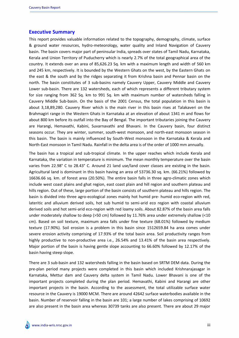
Executive Summary This report provides valuable information related to the topography, demography, climate, surface
& ground water resources, hydro-meteorology, water quality and Inland Navigation of Cauvery
basin. The basin covers major part of peninsular India, spreads over states of Tamil Nadu, Karnataka,
Kerala and Union Territory of Puducherry which is nearly 2.7% of the total geographical area of the
country. It extends over an area of 85,626.23 Sq. km with a maximum length and width of 560 km
and 245 km, respectively. It is bounded by the Western Ghats on the west, by the Eastern Ghats on
the east & the south and by the ridges separating it from Krishna basin and Pennar basin on the
north. The basin constitutes of 3 sub-basins namely Cauvery Upper, Cauvery Middle and Cauvery
Lower sub-basin. There are 132 watersheds, each of which represents a different tributary system
for size ranging from 362 Sq. km to 991 Sq. km with maximum number of watersheds falling in
Cauvery Middle Sub-basin. On the basis of the 2001 Census, the total population in this basin is
about 3,18,89,280. Cauvery River which is the main river in this basin rises at Talakaveri on the
Brahmagiri range in the Western Ghats in Karnataka at an elevation of about 1341 m and flows for
about 800 km before its outfall into the Bay of Bengal. The important tributaries joining the Cauvery
are Harangi, Hemavathi, Kabini, Suvarnavathi and Bhavani. In the Cauvery basin, four distinct
seasons occur. They are winter, summer, south-west monsoon, and north-east monsoon season in
this basin. The basin is mainly influenced by South-West monsoon in the Karnataka & Kerala and
North-East monsoon in Tamil Nadu. Rainfall in the delta area is of the order of 1000 mm annually.
The basin has a tropical and sub-tropical climate. In the upper reaches which include Kerala and
Karnataka, the variation in temperature is minimum. The mean monthly temperature over the basin
varies from 22.98° C to 28.43° C. Around 21 land use/land cover classes are existing in the basin.
Agricultural land is dominant in this basin having an area of 53736.30 sq. km. (66.21%) followed by
16636.66 sq. km. of forest area (20.50%). The entire basin falls in three agro-climatic zones which
include west coast plains and ghat region, east coast plain and hill region and southern plateau and
hills region. Out of these, large portion of the basin consists of southern plateau and hills region. The
basin is divided into three agro-ecological zones mainly hot humid pre- humid eco-region with red,
lateritic and alluvium derived soils, hot sub humid to semi-arid eco region with coastal alluvium
derived soils and hot semi-arid eco-region with red loamy soils. About 82.87% of the basin area falls
under moderately shallow to deep (>50 cm) followed by 11.76% area under extremely shallow (<10
cm). Based on soil texture, maximum area falls under fine texture (68.01%) followed by medium
texture (17.90%). Soil erosion is a problem in this basin since 1512659.84 ha area comes under
severe erosion activity comprising of 17.93% of the total basin area. Soil productivity ranges from
highly productive to non-productive area i.e., 26.54% and 13.41% of the basin area respectively.
Major portion of the basin is having gentle slope accounting to 66.60% followed by 12.17% of the
basin having steep slope.
There are 3 sub-basin and 132 watersheds falling in the basin based on SRTM DEM data. During the
pre-plan period many projects were completed in this basin which included Krishnarajasagar in
Karnataka, Mettur dam and Cauvery delta system in Tamil Nadu. Lower Bhavani is one of the
important projects completed during the plan period. Hemavathi, Kabini and Harangi are other
important projects in the basin. According to the assessment, the total utilizable surface water
resource in the Cauvery is 19000 MCM. There are around 42642 surface waterbodies available in the
basin. Number of reservoir falling in the basin are 101; a large number of lakes comprising of 10692
are also present in the basin area whereas 30739 tanks are also present. There are about 29 major

Cauvery Basin Report
www.india-wris.nrsc.gov.in iv
and medium irrigation projects in Karnataka and 25 major and medium irrigation projects in Tamil
Nadu. There are 15 major hydroelectric projects with 24 power houses available in the basin.
Number of dams falling in this basin are 96 whereas 10 barrage and 16 anicuts or weirs have been
constructed in the basin.
In the Cauvery Lower sub-basin, there are 146 ground water observation wells whereas in Cauvery
Middle sub-basin there are 612 observation wells located and Cauvery upper sub-basin comprises of
115 observation wells. In general, ground water levels in major part of the basin falls between 10 to
20 m bgl, however, in Cauvery delta the water level is less than 10 m bgl during pre-monsoon in year
of 2009. There are a total of 36 hydrological observation sites in the basin maintained by Central
Water Commission. Out of this, 21 sites are GDQ and 15 are GDSQ sites located in the basin. The
basin has good quality of ground water, except salinity near sea shore. Ground water quality
observations are taken at 71 sites of CWC in the basin.
NWDA has proposed 16 peninsular components in the inter-linking of rivers, out of these two are
falling in the Cauvery basin viz. Somasila- Grand Anicut Link and Cauvery (kattalai) – Vaigni-Gundar
Link. There are 60 main tourist places, including many pilgrimages, wildlife sanctuaries, waterfalls,
hill station, forts and lakes etc.
Team India-WRIS hopes that the Cauvery River Basin Report will be a useful asset for the country
and stakeholders and may engrain better understanding of the water resources scenario in the
basin. This report will be a utilitarian for management of water sector in the basin.
Cauvery Basin Report
www.india-wris.nrsc.gov.in v
Table of Contents Preface --------------------------------------------------------------------------------------------------------------------------------- i Acknowledgement ------------------------------------------------------------------------------------------------------------------- ii Executive Summary ----------------------------------------------------------------------------------------------------------------- iii
1. Introduction -------------------------------------------------------------------------------------------------------------------------- 1 1.1 Overview of basin -------------------------------------------------------------------------------------------------------------- 1 1.2 Topography---------------------------------------------------------------------------------------------------------------------- 6 1.3 Climate --------------------------------------------------------------------------------------------------------------------------- 9
1.3.1 Rainfall --------------------------------------------------------------------------------------------------------------------- 9 1.3.2 Temperature ------------------------------------------------------------------------------------------------------------- 11 1.3.3 Trends and variability -------------------------------------------------------------------------------------------------- 11
1.4 Major rivers -------------------------------------------------------------------------------------------------------------------- 13 1.5 Land use/land cover ---------------------------------------------------------------------------------------------------------- 13 1.6 Soils ------------------------------------------------------------------------------------------------------------------------------ 16 1.7 Agro-climatic zones ----------------------------------------------------------------------------------------------------------- 21 1.8 Agro-ecological zones -------------------------------------------------------------------------------------------------------- 21 1.9 Demography ------------------------------------------------------------------------------------------------------------------- 24
2. Hydrological units ----------------------------------------------------------------------------------------------------------------- 26 2.1 Sub-basins ---------------------------------------------------------------------------------------------------------------------- 26 2.2 Watersheds --------------------------------------------------------------------------------------------------------------------- 27
3. Surface water resources --------------------------------------------------------------------------------------------------------- 31 3.1 Surface waterbodies ---------------------------------------------------------------------------------------------------------- 31 3.2 Water resource projects ----------------------------------------------------------------------------------------------------- 32
3.2.1 Major and medium irrigation projects ----------------------------------------------------------------------------- 32 Lift irrigation and ERM -------------------------------------------------------------------------------------------------------- 33 3.2.2. Hydro Electric Projects ------------------------------------------------------------------------------------------------ 33 Power house -------------------------------------------------------------------------------------------------------------------- 33 3.2.3. Dams, Barrages/Weirs/Anicuts ------------------------------------------------------------------------------------- 34 3.3.4. Command area and canals network ------------------------------------------------------------------------------- 40 3.3.5. Multipurpose projects ------------------------------------------------------------------------------------------------ 42 3.3.6. Interstate projects ----------------------------------------------------------------------------------------------------- 42
4. Ground water resources --------------------------------------------------------------------------------------------------------- 43 4.1 Ground water observation wells ------------------------------------------------------------------------------------------- 43 4.2 Ground water level fluctuation -------------------------------------------------------------------------------------------- 45 4.3 Litholog well locations ------------------------------------------------------------------------------------------------------- 48
5. Hydro-met observations --------------------------------------------------------------------------------------------------------- 50 5.1 Hydrological observation sites --------------------------------------------------------------------------------------------- 51 5.2 Meteorological stations ----------------------------------------------------------------------------------------------------- 51
6. Water quality ----------------------------------------------------------------------------------------------------------------------- 52 6.1 Surface water quality observations --------------------------------------------------------------------------------------- 52 6.2 Ground water quality observations --------------------------------------------------------------------------------------- 52
7. Inter-basin transfer links --------------------------------------------------------------------------------------------------------- 53 8. Water tourism sites --------------------------------------------------------------------------------------------------------------- 55 9.Conclusion --------------------------------------------------------------------------------------------------------------------------- 57 Annexure I: State, district and parliamentary constituency in the basin ----------------------------------------------- 58 Annexure II: Climate – Rainfall (1971-2004) and Temperature (1969-2004) profile in the basin ----------------- 61 Annexure III : Sub-basin wise population and drinking water facilities ------------------------------------------------- 63 Annexure IV: Inventory of surface water resources-------------------------------------------------------------------------- 65 Annexure V : Inventory of litholog well locations ---------------------------------------------------------------------------- 83 Annexure VI : Salient features of hydro-meteorological stations ------------------------------------------------------ 117 Annexure VII : Inventory of water tourism sites ---------------------------------------------------------------------------- 124 Acronyms ----------------------------------------------------------------------------------------------------------------------------- 127 References ---------------------------------------------------------------------------------------------------------------------------- 131 Authors -------------------------------------------------------------------------------------------------------------------------------- 132 India-WRIS Project Team -----------------------------------------------------------------------------------------------------------133
Cauvery Basin Report
www.india-wris.nrsc.gov.in vi
List of Tables Table 1. Salient features of the basin-----------------------------------------------------------------------------------------------5 Table 2. Elevation zones----------------------------------------------------------------------------------------------------------------7 Table 3. Length of major rivers------------------------------------------------------------------------------------------------------13 Table 4. Land use/ land cover statistics (2005-06)-----------------------------------------------------------------------------14 Table 5. Sub-basin wise watersheds-----------------------------------------------------------------------------------------------27 Table 6. Number and size of waterbodies----------------------------------------------------------------------------------------31 Table 7. Number of water resources projects ----------------------------------------------------------------------------------33 Table 8. Sub-basin wise number and type of water resources structures------------------------------------------------34 Table 9. Sub-basin wise number of ground water observation wells------------------------------------------------------43 Table 10. Hydrological observation sites of CWC-------------------------------------------------------------------------------51 Table 11. Meteorological stations--------------------------------------------------------------------------------------------------51 Table 12. Water tourism sites-------------------------------------------------------------------------------------------------------55
List of Maps Map 1. Index map-------------------------------------------------------------------------------------------------------------------- 2 Map 2(a). Satellite Imagery of cauvery basin---------------------------------------------------------------------------------- 3 Map 2(b). Cauvery Basin- Drainage & Sub-basin----------------------------------------------------------------------------- 4 Map 3. Elevation zones------------------------------------------------------------------------------------------------------------- 8 Map 4. Annual average rainfall -------------------------------------------------------------------------------------------------- 10 Map 5. Land use/land cover(2005-06)------------------------------------------------------------------------------------------ 15 Map 6. Soil texture------------------------------------------------------------------------------------------------------------------- 17 Map 7. Soil erosion------------------------------------------------------------------------------------------------------------------- 18 Map 8. Soil slope --------------------------------------------------------------------------------------------------------------------- 19 Map 9. Soil productivity------------------------------------------------------------------------------------------------------------- 20 Map 10. Agro-climatic zones------------------------------------------------------------------------------------------------------ 22 Map 11. Agro-ecological zones---------------------------------------------------------------------------------------------------- 23 Map 12. Population density-------------------------------------------------------------------------------------------------------- 25 Map 13 (a). Cauvery Lower Sub-basin and watersheds--------------------------------------------------------------------- 28 Map 13 (b). Cauvery Middle Sub-basin and watersheds------------------------------------------------------------------- 29 Map 13 (c). Cauvery Upper Sub-basin and watersheds--------------------------------------------------------------------- 30 Map 14. Major water resources structures and projects------------------------------------------------------------------- 35 Map 15 (a). Cauvery Upper Sub basin water resources assets------------------------------------------------------------ 37 Map 15 (b). Cauvery Middle Sub basin water resources assets---------------------------------------------------------- 38 Map 15 (c). Cauvery Lower Sub basin water resources assets ----------------------------------------------------------- 39 Map 16. Command area and canal network ---------------------------------------------------------------------------------- 41 Map 17. Location of ground water observation wells----------------------------------------------------------------------- 44 Map 18. Ground water level fluctuation (Recharge)------------------------------------------------------------------------- 46 Map 19. Ground water level fluctuation (Draft)------------------------------------------------------------------------------ 47 Map 20. Litholog well locations--------------------------------------------------------------------------------------------------- 49 Map 21. Hydro observation stations-------------------------------------------------------------------------------------------- 50 Map 22. Inter basin transfer links ----------------------------------------------------------------------------------------------- 54 Map 23. Water tourism sites------------------------------------------------------------------------------------------------------ 56
List of Figures Figure 1. State wise basin area--------------------------------------------------------------------------------------------------- 6 Figure 2. Monthly average temperature (1969-2004)--------------------------------------------------------------------- 11 Figure 3. Trend of average rainfall (1971-2004)----------------------------------------------------------------------------- 12 Figure 4. Sub-basins and per cent drainage area---------------------------------------------------------------------------- 26 Figure 5. Type and number of water bodies---------------------------------------------------------------------------------- 32 Figure 6. Dam classification based on storage------------------------------------------------------------------------------- 36 Figure 7. Dam classification based on purpose------------------------------------------------------------------------------ 36

Cauvery Basin Report
www.india-wris.nrsc.gov.in 1
1. Introduction
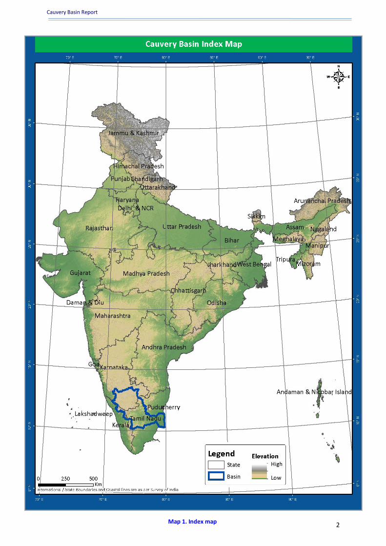
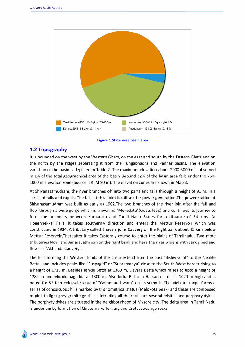
1.1 Overview of basin The Cauvery basin extends over states of Tamil Nadu, Karnataka, Kerala and Union Territory of
Puducherry, draining an area of 85,626.23 Sq.km (GIS Calculated as per India-WRIS Database) which
is nearly 2.7% of the total geographical area of the country with a maximum length and width of
about 560 km and 245 km, respectively. Out of this, 42% area lies in Karnataka, 54% area in Tamil
Nadu & Karaikkal region of Puducherry and 4% in Kerala (Figure 1). It falls in peninsular India and lies
between 75°27’E to 79°54’E and 10°9’N to 13°30’N as shown in Map 1. The salient features for the
basin are described in Table 1. It is bounded by the Western Ghats on the west, by the Eastern Ghats
on the east and south and by the ridges separating it from Krishna basin and Pennar basin on the
north. The three main physiographic division of the basin are the Western Ghats, the plateau of
Mysore and the Delta. The Western Ghat region is mountainous and covered with thick vegetation.
56 m resolution False Colour Composite AWiFS satellite imagery of the Cauvery basin is shown in
Map 2(a). The plateau of Mysore with an average elevation of 750 m slopes gently towards the
east/south-east (Source: Report of the Irrigation Commission, 1972, Vol.III). The delta is the most
fertile tract in the basin and covers some portion of Tamil Nadu and is eminently suited for intensive
cultivation.
The Cauvery River is one of the major rivers of the peninsular India. It rises at an elevation of 1,341
m at Talakaveri on the Brahmagiri range near Cherangala village of Kodagu district of Karnataka and
drains into the Bay of Bengal. The total length of the river from origin to outfall is around 800 km. In
size, it is smaller than the Godavari, the Mahanadi and the Krishna. Its important tributaries joining
from left are the Harangi, the Hemavati, the Shimsha and the Arkavati whereas the Lakshmantirtha,
the Kabbani, the Suvarnavati, the Bhavani, the Noyil and the Amaravati join from right. The utilizable
surface water resource for the basin is 19 BCM. The Average Annual Runoff and Average Annual
Water Potential in the basin are same as 21.36 BCM. The major part of basin is covered with
agricultural land accounting to 66.21% of the total area and 20.50 % of the basin is covered by forest
area. The basin spreads over three sub-basins and thirty six parliamentary constituencies (2009)
comprising eighteen of Tamil Nadu, eleven of Karnataka, three of Kerala and one of Puducherry
(Map 2(b)). These comprises of a total population of 3,18,89,280 spread across the basin area.
Cauvery Basin Report
www.india-wris.nrsc.gov.in 2
Map 1. Index map

Cauvery Basin Report
www.india-wris.nrsc.gov.in 3
Map 2(a).Satellite Imagery of Cauvery Basin

Cauvery Basin Report
www.india-wris.nrsc.gov.in 4
Map 2(b). Cauvery Basin- Drainage & Sub-basin
Cauvery Basin Report
www.india-wris.nrsc.gov.in 5
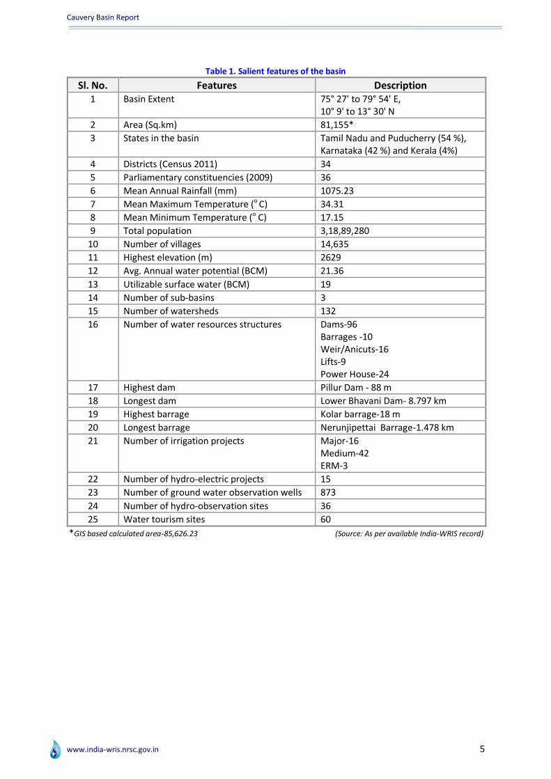
Table 1. Salient features of the basin
Sl. No. Features Description
1 Basin Extent 75° 27' to 79° 54' E, 10° 9' to 13° 30' N
2 Area (Sq.km) 81,155*
3 States in the basin Tamil Nadu and Puducherry (54 %), Karnataka (42 %) and Kerala (4%)
4 Districts (Census 2011) 34
5 Parliamentary constituencies (2009) 36
6 Mean Annual Rainfall (mm) 1075.23
7 Mean Maximum Temperature (o C) 34.31
8 Mean Minimum Temperature (o C) 17.15
9 Total population 3,18,89,280
10 Number of villages 14,635
11 Highest elevation (m) 2629
12 Avg. Annual water potential (BCM) 21.36
13 Utilizable surface water (BCM) 19
14 Number of sub-basins 3
15 Number of watersheds 132
16 Number of water resources structures Dams-96 Barrages -10 Weir/Anicuts-16 Lifts-9 Power House-24
17 Highest dam Pillur Dam - 88 m
18 Longest dam Lower Bhavani Dam- 8.797 km
19 Highest barrage Kolar barrage-18 m
20 Longest barrage Nerunjipettai Barrage-1.478 km
21 Number of irrigation projects Major-16 Medium-42 ERM-3
22 Number of hydro-electric projects 15
23 Number of ground water observation wells 873
24 Number of hydro-observation sites 36
25 Water tourism sites 60
*GIS based calculated area-85,626.23 (Source: As per available India-WRIS record)
Cauvery Basin Report
www.india-wris.nrsc.gov.in 6
Figure 1.State wise basin area
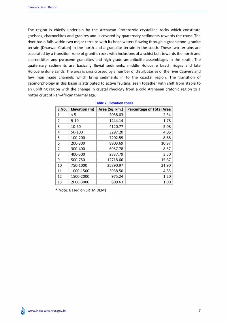
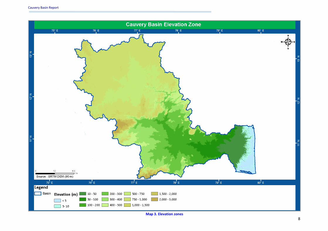
1.2 Topography It is bounded on the west by the Western Ghats, on the east and south by the Eastern Ghats and on
the north by the ridges separating it from the Tungabhadra and Pennar basins. The elevation
variation of the basin is depicted in Table 2. The maximum elevation about 2000-3000m is observed
in 1% of the total geographical area of the basin. Around 32% of the basin area falls under the 750-
1000 m elevation zone (Source: SRTM 90 m). The elevation zones are shown in Map 3.
At Shivanasamudram, the river branches off into two parts and falls through a height of 91 m. in a
series of falls and rapids. The falls at this point is utilised for power generation.The power station at
Shivanasamudram was built as early as 1902.The two branches of the river join after the fall and
flow through a wide gorge which is known as "Mekedatu"(Goats leap) and continues its journey to
form the boundary between Karnataka and Tamil Nadu States for a distance of 64 kms. At
Hogennekkal Falls, it takes southernly direction and enters the Mettur Reservoir which was
constructed in 1934. A tributary called Bhavani joins Cauvery on the Right bank about 45 kms below
Mettur Reservoir.Thereafter it takes Easternly course to enter the plains of Tamilnadu. Two more
tributaries Noyil and Amaravathi join on the right bank and here the river widens with sandy bed and
flows as "Akhanda Cauvery".
The hills forming the Western limits of the basin extend from the past “Bisley Ghat" to the "Jenkle
Betta" and includes peaks like "Puspagiri" or "Subramanya" close to the South-West border rising to
a height of 1715 m. Besides Jenkle Betta at 1389 m, Devara Betta which raises to upto a height of
1282 m and Murukanagudda at 1300 m. Also Indra Betta in Hassan district is 1020 m high and is
noted for 52 feet colossal statue of "Gommateshwara" on its summit. The Melkote range forms a
series of conspicuous hills marked by trignometrical status (Melokota peak) and these are composed
of pink to light grey granite gneisses. Intruding all the rocks are several felsites and porphyry dykes.
The porphyry dykes are situated in the neighbourhood of Mysore city. The delta area in Tamil Nadu
is underlain by formation of Quaternary, Tertiary and Cretaceous age rocks.
Cauvery Basin Report
www.india-wris.nrsc.gov.in 7
The region is chiefly underlain by the Archaean Proterozoic crystalline rocks which constitute
gneisses, charnockites and granites and is covered by quaternary sediments towards the coast. The
river basin falls within two major terrains with its head waters flowing through a greenstone- granite
terrain (Dharwar Craton) in the north and a granulite terrain in the south. These two terrains are
separated by a transition zone of granitic rocks with inclusions of a schist belt towards the north and
charnockites and pyroxene granulites and high grade amphibolite assemblages in the south. The
quaternary sediments are basically fluvial sediments, middle Holocene beach ridges and late
Holocene dune sands. The area is criss crossed by a number of distributaries of the river Cauvery and
few man made channels which bring sediments in to the coastal region. The transition of
geomorphology in this basin is attributed to active faulting, seen together with shift from stable to
an uplifting region with the change in crustal rheology from a cold Archaean cratonic region to a
hotter crust of Pan-African thermal age.
Table 2. Elevation zones
S.No. Elevation (m) Area (Sq. km.) Percentage of Total Area
1 < 5 2058.03 2.54
2 5-10 1444.14 1.78
3 10-50 4120.77 5.08
4 50-100 3297.20 4.06
5 100-200 7202.59 8.88
6 200-300 8903.69 10.97
7 300-400 6957.78 8.57
8 400-500 2837.79 3.50
9 500-750 12718.66 15.67
10 750-1000 25890.97 31.90
11 1000-1500 3938.50 4.85
12 1500-2000 975.24 1.20
13 2000-3000 809.63 1.00
*(Note: Based on SRTM DEM)
Cauvery Basin Report
www.india-wris.nrsc.gov.in
8
Map 3. Elevation zones

Cauvery Basin Report
www.india-wris.nrsc.gov.in 9
1.3 Climate Climate is a measure of the average pattern of variation in temperature, humidity, atmospheric
pressure, wind, precipitation, atmospheric particle count and other meteorological variables in a
given region over long periods of time. Climate is different than weather, in that weather only
describes the short-term conditions of these variables in a given region.
In the Cauvery basin, four distinct seasons occur. They are Winter, Summer, South-West Monsoon,
and North-East Monsoon. The climate at the basin level generally remains dry except from monsoon
months. There is a considerable variation in the mean daily maximum and minimum temperatures
across the basin. in the cold season, the Western Ghat is cooler than the rest of the basin and the
climate is generally pleasant. In the hot weather season, the Central, Northern and Eastern regions
are hotter than the Western most parts.
The South-West monsoon sets by middle of June and ends by middle of September. During this
season the basin receives major part of its total annual rainfall. The North-East monsoon is from
October to December and is important particularly for the Eastern part of the basin.
However, around 44 blocks of 10 districts falling in the basin are drought prone (Source: Drought
Prone Areas Program, DPAP, MoRD, 2002).
1.3.1 Rainfall
There are many rain gauge stations inside the basin. The rainfall in the basin varies from region to
region. The normal annual rainfall in Kerala region is about 2400 mm. In the Western Ghats it ranges
from 1700 mm to 3800 mm. In Karnataka for the Cauvery basin, the average rainfall is between 600
mm to 800 mm resulting into semi-arid condition. In Tamil Nadu, under the cauvery basin the
average rainfall is low ranging from 500 mm to 1000 mm and is semi-arid. In general, the highest
rainfall in the Cauvery basin usually occur in July or early August and the mean annual rainfall is
around 1075.23 mm.
The basin is mainly influenced by South-West monsoon in the Karnataka & Kerala and North-East
monsoon in Tamil Nadu. Most of the parts in Tamil Nadu receive rainfall from the North-East
Monsoon. Rainfall in the delta area is of the order of 1000 mm annually. In the coastal areas the
highest rainfall months are October, November and December, while further inland the peak
monthly rainfall is early October. This pattern of rainfall is conductive to a fairly high flow during the
irrigation season from June to January, except for a short period of about six weeks when there is a
break in the monsoon. While the South-West monsoon supply is copious and dependable, the
North-East monsoon supply is irregular and subject to frequent failure. Map 4 represents 10 x 10
average annual rainfall of past 35 year (1971-2004).

Cauvery Basin Report
www.india-wris.nrsc.gov.in
10
Map 4. Annual average rainfall
Cauvery Basin Report
www.india-wris.nrsc.gov.in 11
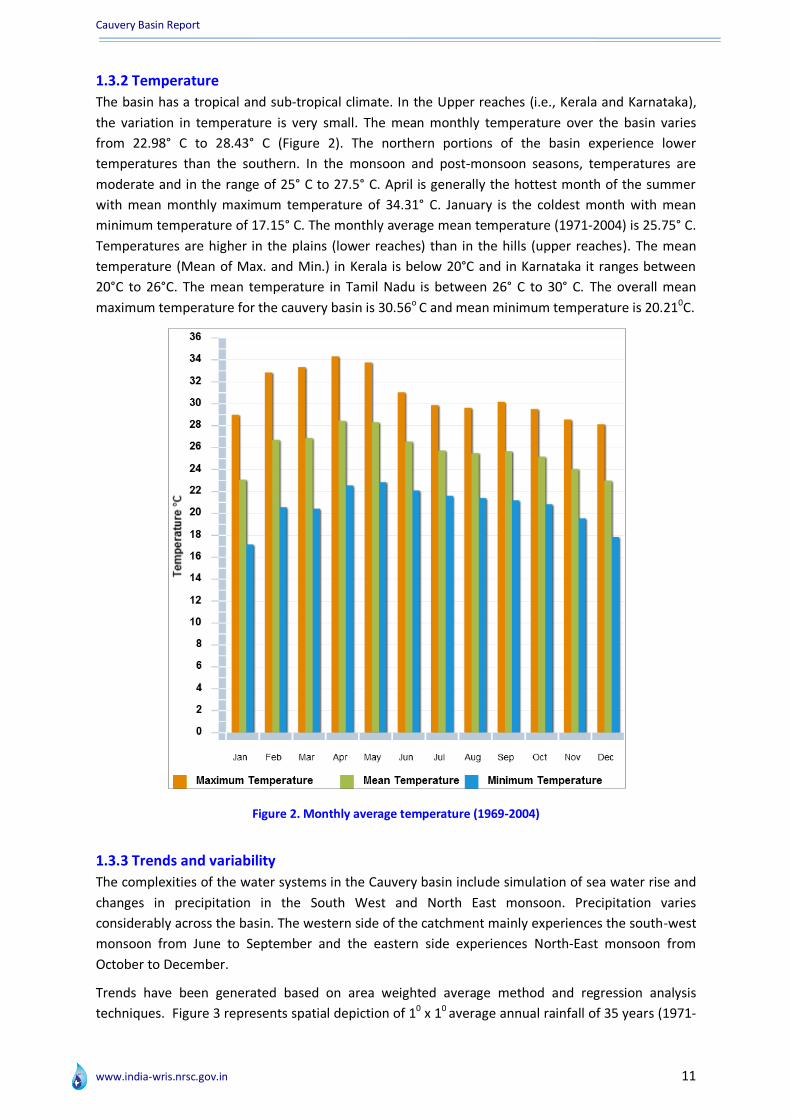
1.3.2 Temperature
The basin has a tropical and sub-tropical climate. In the Upper reaches (i.e., Kerala and Karnataka),
the variation in temperature is very small. The mean monthly temperature over the basin varies
from 22.98° C to 28.43° C (Figure 2). The northern portions of the basin experience lower
temperatures than the southern. In the monsoon and post-monsoon seasons, temperatures are
moderate and in the range of 25° C to 27.5° C. April is generally the hottest month of the summer
with mean monthly maximum temperature of 34.31° C. January is the coldest month with mean
minimum temperature of 17.15° C. The monthly average mean temperature (1971-2004) is 25.75° C.
Temperatures are higher in the plains (lower reaches) than in the hills (upper reaches). The mean
temperature (Mean of Max. and Min.) in Kerala is below 20°C and in Karnataka it ranges between
20°C to 26°C. The mean temperature in Tamil Nadu is between 26° C to 30° C. The overall mean
maximum temperature for the cauvery basin is 30.56o C and mean minimum temperature is 20.210C.
Figure 2. Monthly average temperature (1969-2004)
1.3.3 Trends and variability
The complexities of the water systems in the Cauvery basin include simulation of sea water rise and
changes in precipitation in the South West and North East monsoon. Precipitation varies
considerably across the basin. The western side of the catchment mainly experiences the south-west
monsoon from June to September and the eastern side experiences North-East monsoon from
October to December.
Trends have been generated based on area weighted average method and regression analysis
techniques. Figure 3 represents spatial depiction of 10 x 10 average annual rainfall of 35 years (1971-

Cauvery Basin Report
www.india-wris.nrsc.gov.in 12
2004). The trend shows that there is significant change in rainfall across the basin. Looking at the
histogram for average annual rainfall general trend, the trend line shows there is a decrease in
rainfall amount since 1971 to 2014. Year 1975 appear highest annual rainfall of 1750 mm. The basin
experience lowest rainfall amount to 700 mm in the year 2003.
Figure 3. Trend of annual rainfall (1971-2004)
Cauvery Basin Report
www.india-wris.nrsc.gov.in 13
1.4 Major rivers The Cauvery River is biggest river in south India. It rises at Talakaveri on the Brahmagiri range in the
Western Ghats in Karnataka at an elevation of about 1341 m above mean sea level and flows for
about 800 km, before its outfall into the Bay of Bengal. The Cauvery river system consists of 21
principal tributaries each with catchment area around 250 sq. km.
The river Bhavani is one of the largest and the second longest river in the basin rises in Kerala and
Karnataka but lies mostly in Tamil Nadu. The longest tributary, the Hemavathi (233 km) is the fifth
largest river in catchment area and lies wholly in Karnataka. It rises in the Western ghats and runs
South-East. After a stream from the West joins it, it turns East, receiving the Yagachi from the North.
It then winds round Holenarasipur and runs South to the Cauvery near Yedatore. The Kabini river is
an important tributary of the Cauvery. It is a perennial river, 150 to 200 m. wide and has a course of
about 240 kms. It rises in the Western ghats in North Wynad in Kerala State as two streams i.e. the
Mannantoddypuzha and Panamarampuzha. About 16 kms. below their confluence, the Kabini forms
border between Kerala and Karnataka for about 12 kms. before entering Karnataka state. It joins the
Cauvery at Tirumakudalu Narasipur (T.N.Pur) and this confluence point is being considered as a spot
of great sanctity. The confluence point is also called as “Triveni Sangama”. The Bhavani is a
picturesque perennial river of South India, rising in Attappadi valley in Kerala. It enters Tamilnadu
near Mannar and traverses from West to East for 234 kms. and joins the Cauvery near Bhavani
Town. It principally receives runoff from the South-West monsoon and occasional floods during
North-East Monsoon. From the point of view of flow contribution to the system, apart from the head
reach of the Cauvery main, the most important tributaries are Amravati, Hemavathi, Kabini, Noyil
and Bhavani. All the distributaries in the region are non-perennial and flow is mainly due to Cauvery
water release during June to January. No considerable flow occurs due to South-West monsoon and
for most of the months in the year, the flow available are the regulated flows from upper regulators
maintained by Tamil Nadu. The total length of the river Cauvery from the head to its outfall into the
sea comprises a length of 320 km in Karnataka 416 km in Tamil Nadu and remaining length of 64 km
forms the common boundary between states of Karnataka and Tamil Nadu (Table 3).
Table 3. Length of major rivers
S.No. River Name Length (km)
1 Cauvery River 825.10
2 Amaravati River 215.15
3 Arkavati River 169.82
4 Bhavani River 234.98
5 Hemavati River 233.63
6 Kabini or Kapila River 237.61
7 Lakshmantirtha River 148.82
8 Noyil River 181.49
9 Perum Pallam 197.32
10 Shimsha River 204.23 *(As per available India-WRIS record)
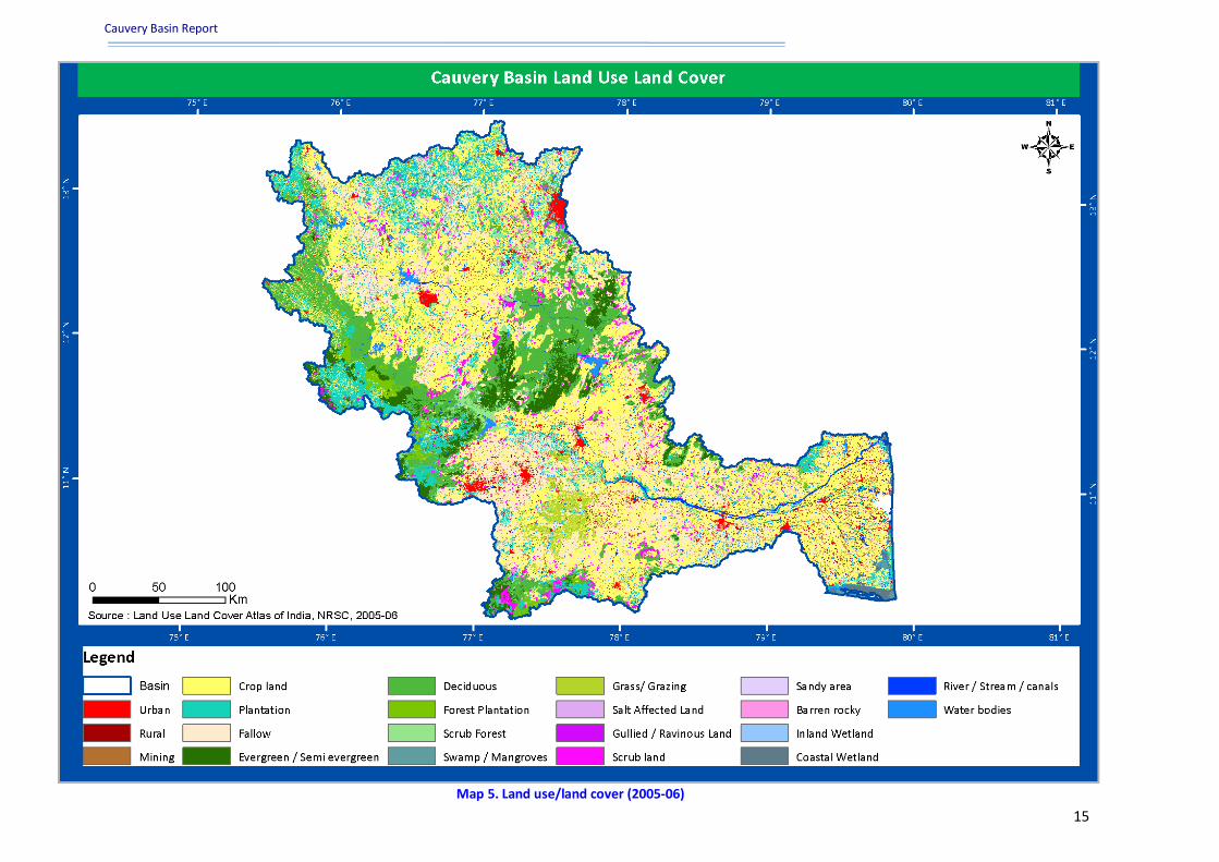
1.5 Land use/land cover The spatial distribution of land use/land cover (2005-2006) was carried by LISS-III data of Cauvery
basin and is shown in Map 5. It is found that nearly 21 land use/land cover classes exist in the basin.
Agricultural land is dominant in this basin having an area of 53736.30 sq. km. (66.21%) followed by
Cauvery Basin Report
www.india-wris.nrsc.gov.in 14
16636.66 sq. km. of forest area (20.50%). The built up area is 4.01% which comprises of 3256.37
sq.km of the total area of the basin. 3133.94 sq. km. wastelands are there in this basin comprising
3.86% of the total basin area (Table 4). The second level categories of land use/land cover in the
basin are fallow land, scrub land, scrub forest, river/stream/canal, rural, urban mining,
swamp/mangrove, etc.
Its vast fertile alluvial tracts and low hills with suitable climatic condition offer excellent condition for
utilization of land for different uses. The land use pattern of the basin witnessed a change in last few
decades. The fast growing population aided with the modern technology lead to rapid change in the
land use pattern of the basin. The effects such an unwise change is well reflected in the forms of
ecological imbalance and land degradation through soil erosion. The forest area has been decreasing
due to the encroachment for agricultural. The horizontal growth of settlement in the last few
decades due the rapid growth of population and the resultant growth of other developmental
activities also leading to a slow but continual change to the land use pattern at different scale.
There are mainly three crop seasons in the basin viz. kharif, rabi and summer. The kharif crops are
paddy, bajra, jowar, maize, ragi, cotton, millets etc. Paddy is the most important crop in this basin,
whereas Ragi, Jawar and other millets constitute the important crops under rainfed conditions.
Coconut, betel leaves, pepper, oranges and lemon are grown as horticulture crops throughout the
year. The main forest products are sandalwood, bamboo, teak, eucalyptus, blue gum and wattle etc.
Table 4. Land use/ land cover statistics (2005-06)
S.no. Category Area (Sq.km) Percentage of Total Area
1 Built Up Land 3256.37 4.01
2 Agricultural 53736.30 66.21
3 Forest 16636.66 20.50
4 Grassland 1075.80 1.33
5 Wasteland 3133.94 3.86
6 Waterbodies 3315.92 4.09
*(As per available India-WRIS record)
Cauvery Basin Report
www.india-wris.nrsc.gov.in 15
Map 5. Land use/land cover (2005-06)

Cauvery Basin Report
www.india-wris.nrsc.gov.in 16
1.6 Soils Soil is composed of minerals, mixed with some organic matter, which differ from its parent
materials in terms of its texture, structure, consistency, colour, chemical, biological and other
characteristics. Information on the soil profile is also required for simulating the hydrological
character of the basin. The principal soil types found in the basin are clay, loamy clay, sandy clay,
silty clay, loamy sand, sand, loam, sill loam, silt, sandy loam and rocky. The soil productivity of the
basin is categorized into highly productive, low productive, non-productive and moderately
productive. The soil in the basin is classified into moderate, slight and severe and the major soil
slope classes are gently, steep, moderately and nearly leveled.
The highly productive and fertile soils of the basin are now facing the serious problem of soil erosion
like other parts of the country. Under heavy precipitation and humid climate loss of top soil through
surface run-off is the most common type of soil erosion in the entire basin. The delta area is the
most fertile tract in the basin. The principal soil types found in the basin are black soils, red soils,
laterites, alluvial soils, forest soils and mixed soils. Red soils occupy large areas in the basin. Alluvial
soils are found in the delta areas of Cauvery which is the most important agricultural tract in the
basin. In addition to the distinct soil types described above, combinations of these types such as
mixed red and black soils, etc. also occur.
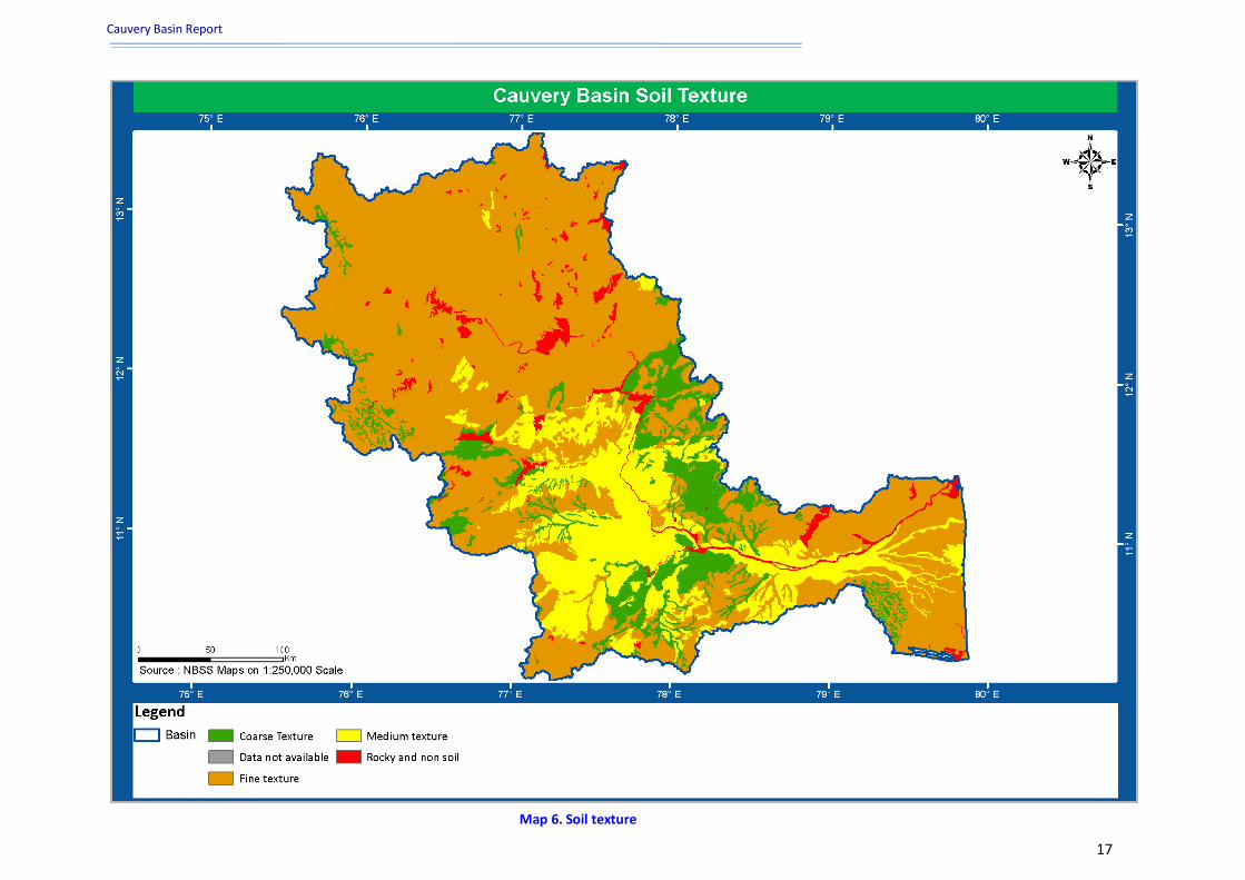
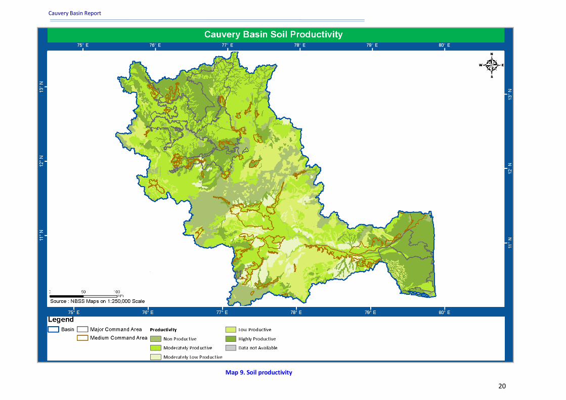
The main soil types based on texture, erosion, productivity and slope are spatially depicted. About
82.87% falls under moderately shallow to deep (>50 cm) followed by 11.76% extremely shallow (<10
cm) based on the depth of the soil. Based on soil texture, maximum area falls under fine texture
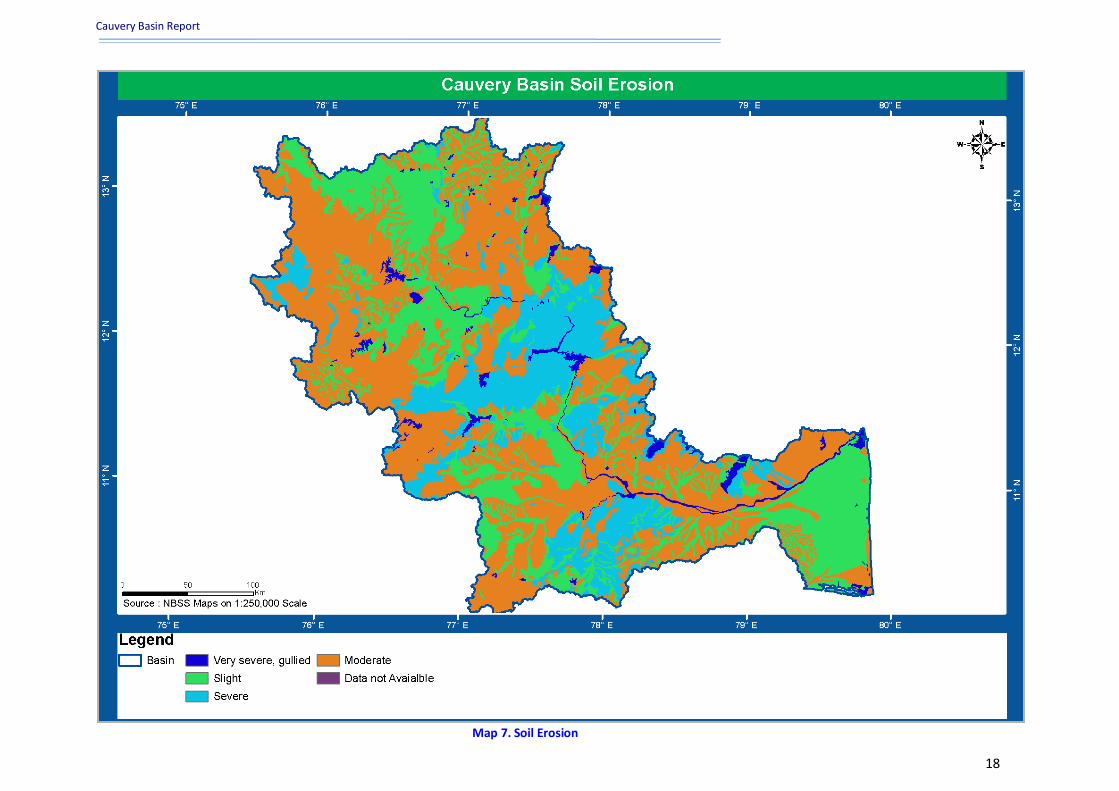
(68.01%) followed by medium texture (17.90%) as shown in Map.6. Soil erosion is a problem in this
basin since 211357.95 ha area comes under very severe erosion activity comprising of 2.50% of the
total basin area. 1512659.84 ha (17.93%) area comes under severe condition and about 50.33% area
of the basin which constitutes 4246760.29 ha have moderate erosion as shown in Map 7. Major
portion of the basin is having gentle slope accounting to 66.60% followed by 12.17% having steeply
sloped as shown in Map 8. Soil productivity ranges from highly productive to non-productive area
i.e., 26.54% and 13.41% of the basin respectively as shown in Map 9.
Cauvery Basin Report
www.india-wris.nrsc.gov.in 17
Map 6. Soil texture
Cauvery Basin Report
www.india-wris.nrsc.gov.in 18
Map 7. Soil Erosion

Cauvery Basin Report
www.india-wris.nrsc.gov.in 19
Map 8. Soil slope
Cauvery Basin Report
www.india-wris.nrsc.gov.in 20
Map 9. Soil productivity

Cauvery Basin Report
www.india-wris.nrsc.gov.in 21
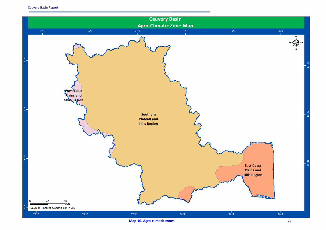
1.7 Agro-climatic zones The agro-climatic classification is an extension of the climate classification keeping in view the
suitability for agriculture. For resource development, the country has been broadly divided into 15
agricultural regions based on agro climatic features, particularly soil type, climate including
temperature and rainfall and its variation and water resources availability.
There are basically three zones falling in Cauvery basin which includes west coast plains and ghat
region, east coast plain and hill region and southern plateau and hills region (Map 10).
Out of these, large portion of the basin falls in southern plateau and hills region which is suitable for
cultivation of variety of crops. The climatic pattern of this basin is characterized by the moderate
rainfall, forest cover and soil erosion. This agro-climatic zone is also important for improvement of
cropping systems, development of land and water resources, animal husbandry and fisheries
activities, each one having special characteristics of its own. The main characteristics of the agro-
climatic zones of the basin are describes below:
Southern Plateau and Hills Region: The maximum part of the basin is covered by this region and
comprises of southern part of Karnataka, the central parts of Tamil Nadu falling, parts of Kerala in
the basin, which are typically semi-arid zones.
East Coast Plains & Hills Region: This region covers small area of Tamil Nadu falling in the basin. In
this region soils are mainly alluvial and coastal sands and Irrigation is done through canals and tanks.
West Coast Plains and Ghat Region: The minimum part of the basin is covered by this region
comprising of hilly area of Karnataka, Kerala and Tamil Nadu. Variety of crop patterns, rainfall and
soil types exist in the zone.
1.8 Agro-ecological zones India has a variety of landscapes and climate conditions and this is reflected in the development of
different soils and types of vegetation. Based on 50 years of climate data and an up-to-date soil
database, the country has been divided into 20 agro-ecological zones (AEZs). Each AEZ is as uniform
as possible in terms of physiography, climate, length of growing period and soil type for macrolevel
land-use planning and effective transfer of technology.
The basin is divided into three agro ecological zones mainly hot humid pre-humid eco-region with
red, lateritic and alluvium derived soils suitable for cultivation of paddy, tapioca, coconut, spices; hot
sub humid to semi-arid eco-region with coastal alluvium derived soils having crop intensity of paddy,
coconut, black gram, lentil, sunflower and groundnut and hot semi-arid eco-region with red loamy
soil giving fertility to some of the major crops like millets, pulses, oilseeds(groundnut), sugarcane
and paddy as shown in Map 11. Large portion of the basin area comprises of red loamy soil which
comes under semi-arid eco-region.
Cauvery Basin Report
www.india-wris.nrsc.gov.in 22 Map 10. Agro-climatic zones

Cauvery Basin Report
www.india-wris.nrsc.gov.in 23 Map 11. Agro-ecological zones

Cauvery Basin Report
www.india-wris.nrsc.gov.in 24
1.9 Demography Demographics are the quantifiable statistics of a given population. Demographics are also used to
identify the study of quantifiable subsets within a given population which characterize that
population at a specific point in time. Demographic data is used widely in public opinion polling and
marketing. Commonly examined demographics include gender, age, ethnicity, knowledge of
languages, disabilities, mobility, home ownership, employment status, and even location. The
administrative & demographic details of cauvery basin are listed in the Annexure-I.
A major factor affecting forest cover is the growth of human populations throughout the cauveri
region and the growing pressure that additional people place on the region’s forests. While
urbanization has been growing rapidly over the past few decades at a rate, in many states of the
basin, the rural population has also been expanding by a fast rate. The increasing population and
population density trends are reflected in the per capita availability of forestland. This reflects the
combined impact of population growth and forestland loss. The decadal growth rate has shown a
sharp decline in this zone to 11.19% from 17.25% compared to all India decadal growth of 21.34%
during 1991–2001. The literacy rate has improved to 73.47%, 65.38% and 67.07% in Tamil Nadu,
Andhra Pradesh and Karnataka respectively as against the national average of 65.38%.
The city of Bangalore is partly situated in the basin having a population density of 1500-5000.
Maximum numbers of districts are falling in the density range of 200-500. Important industries in the
basin include cotton textile industry in Coimbatore and Mysore, cement factories in Coimbatore and
Trichinapally and industries based on mineral and metals. The Salem steel plant and many
engineering industries in Coimbatore and Trichinapally are also situated in this basin. As per Census
data 2001, the total no. of villages falling in the Cauvery Middle Sub-basin is 8306, for Cauvery Upper
Sub-basin number of villages are 3339 and for Cauvery Lower Sub-basin it is 2990. The total
population in this basin is 3,18,89,280 and the district-wise population density in the basin is shown
in Map 12.
Cauvery Basin Report
www.india-wris.nrsc.gov.in 25
Map 12. Population density

Cauvery Basin Report
www.india-wris.nrsc.gov.in 26
2. Hydrological units
2.1 Sub-basins Semi-automated approach for delineation of hydrological units (basin, sub-basin and watershed)
uses SRTM DEM, topo maps on 1:50000 scale, IRS P6 LISS IV & CARTOSAT-1 merged data, drainage
network, surface waterbodies, rail/road network and other ancillary data. Drainage divides from
contour/ridge lines are used to demarcate the boundary of hydrological units. The divide has been
marked where flow is in opposite directions. Knowledge of terrain as well as DEM is essential for
accurate demarcation of boundary. Hydrological boundary has been validated with reference to
contours and drainage network. Hydrological unit boundary cuts perpendicular to the contour lines
but it does not cross the drainage line at any location except its outlet. This approach is potentially
more objective, repeatable and cost-effective.
The Cauvery basin constitute of three sub-basins- Cauvery upper, Cauvery middle and Cauvery lower
sub-basin, as shown in Figure 4. Cauvery upper sub-basin covers an area of 10958.8 sq. km. and
consisting of 18 watersheds, Middle sub-basin having an area of 57280.98 sq. km and consisting of
86 watersheds and Lower sub-basin covering an area of 17386.45 sq. km. and consisting of 28
watersheds. The dependable yield for the basin is utilized under number of major, medium and
minor irrigation projects of the basin. Irrigation is being carried out in the area under these projects
viz., dams, barrages, diversion structures and other lift irrigation systems.
Figure 4. Sub-basins and Percent drainage area

Cauvery Basin Report
www.india-wris.nrsc.gov.in 27
2.2 Watersheds Hydrological unit wise assessment of water resources is a prerequisite for its proper management as
it is fast becoming scarce in India. Sub-basins could be sub divided into smaller hydrological units
namely, watershed for water resources management at larger scale. Watershed is a natural
hydrological entity that covers a specific areal expanse of land surface from which rainfall flows to a
defined drain, channel, stream or river at any particular point. Watershed should be delineated
purely on the basis of hydrologic principles. Size of the watershed is governed by the size of stream
and its boundaries.
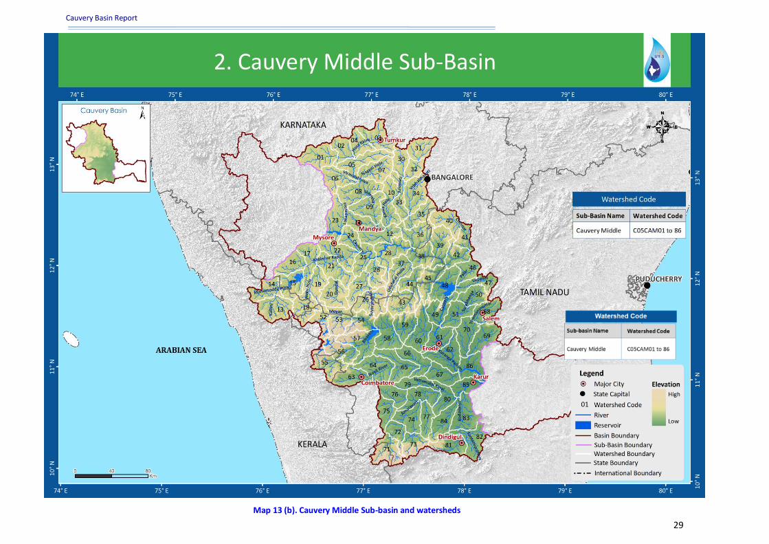
Three sub-basins have been further divided into 132 watersheds each of which represents a
different tributary system for size ranging from 362 km2 to 991 km2 with maximum number of
watersheds falling in Cauvery middle sub-basin. Maps depicting sub-basin wise watershed
distribution are shown in Map 13(a, b & c). Number of watersheds and the range of size for the sub-
basins are given in Table 5.
Table 5. Sub-basin wise watersheds
S.No. Sub-basin Area (Sq. km.)
Size range of watersheds (Sq. km.)
No. of Watersheds
1 Cauvery Lower Sub-basin 17386.45 320.70-979.20 28
2 Cauvery Middle Sub-basin 57280.98 377.45-934.52 86
3 Cauvery Upper Sub-basin 10958.80 362.94-991.25 18 *(As per available India-WRIS record)

Cauvery Basin Report
www.india-wris.nrsc.gov.in 28
Map 13 (a). Cauvery Lower Sub-basin and watersheds
Cauvery Basin Report
www.india-wris.nrsc.gov.in 29
Map 13 (b). Cauvery Middle Sub-basin and watersheds

Cauvery Basin Report
www.india-wris.nrsc.gov.in 30
Map 13 (c). Cauvery Upper Sub-basin and watersheds

Cauvery Basin Report
www.india-wris.nrsc.gov.in 31
3. Surface water resources
3.1 Surface waterbodies Surface waterbodies have traditionally played an important role in the basin,which is used for
irrigation, drinking water supply, ecology, tourism and other domestic uses. But waterbodies (total
number, capacity and quality) are decreasing day by day due to mainly siltation and disposal of
untreated waste in that waterbodies. The details of the surface water resources of the Cauvery basin
are listed in the Annexure-IV.
Surface waterbodies are impounded in the form of reservoirs, lakes, ponds, tanks, abandoned
quarry, aquaculture, cooling pond, lagoon and salt pan. A large scale inventory of surface
waterbodies is required in order to keep it healthy (both quantitatively and qualitatively) and
rejuvenate wherever necessary. The basin is blessed with optimal amount of rainfall. Storage of
water in pond both in the settlement and agricultural fields is the one water saving/storing strategy
of the local population of this basin. It is observed that there are sufficient number of ponds in this
region followed by lakes which is generally used for fish cultivation and agricultural activity. Several
large reservoirs of considerable size have also been constructed in the basin associated with the
dams and barrages. The major reservoirs in Cauvery basin are Krishnaraja Sagar, Mettur (Stanley),
Hemavathy, Kabini, Lower Bhavani and Grand Anicut. The details of different surface waterbodies
are shown in Figure 5.
Around 42642 waterbodies are present in the basin of varying size. No. of waterbodies covering an
area of 25 ha are about 41296 whereas 7 big waterbodies are there covering an area of more than
2500 ha. A detail of number of waterbodies according to their water spread area is given in Table 6.
Table 6. Number and size of waterbodies
S.No. Size Range (Ha) No. of Waterbodies
1 0 - 25 41296
2 25 - 50 761
3 50 - 100 370
4 100 - 250 155
5 250 - 500 35
6 500 - 1000 11
7 1000 - 2500 7
8 More than 2500 7
Total 42642 *(As per available India-WRIS record)

Cauvery Basin Report
www.india-wris.nrsc.gov.in 32
Figure 5. Type and number of waterbodies
3.2 Water resource projects Water resources schemes and projects are multi-disciplinary in nature and are implemented by
several departments and agencies of State Governments and various ministries/departments of
Central Government. Water resources projects are broadly categorized into irrigation projects and
hydroelectric projects. The water resources of the Cauvery basin are well developed. The issues of
water resources in the Cauvery are complex and include flood and drainage problems, lack of
freshwater, salinity intrusion of surface and ground water and over abstraction of ground water. The
sustainable management of water resources in the Cauvery Delta requires a wide range of different
approaches involving different sectors. Major water resources project in this basin are Hemavathy,
Kabini, Harangi, Votehole, Uduthorehalla and Karapuzha Irrigation Project. Annexure IV shows CCA
and UIP of some of the projects in the basin of major commands in the basin. During the plan period
many projects were taken up and completed.
3.2.1 Major and medium irrigation projects
There are about 29 Major and Medium Irrigation Projects in Karnataka and 25 Major and Medium
Irrigation Projects in Tamil Nadu. Besides the above, there are series of 10 masonry Anicuts
constructed across the main Cauvery River and some of its tributaries in Tamil Nadu. The areas
getting benefited from these channels in Karnataka lie mainly in Mysore, Mandya and Hassan
districts and to a small extent in Kodagu and Bangalore districts. Large areas in Tanjore and
Tiruchirapalli districts of Tamil Nadu are benefitted through the canal system taking off from Grand
Anicut and Upper Anicut.
Cauvery Basin Report
www.india-wris.nrsc.gov.in 33
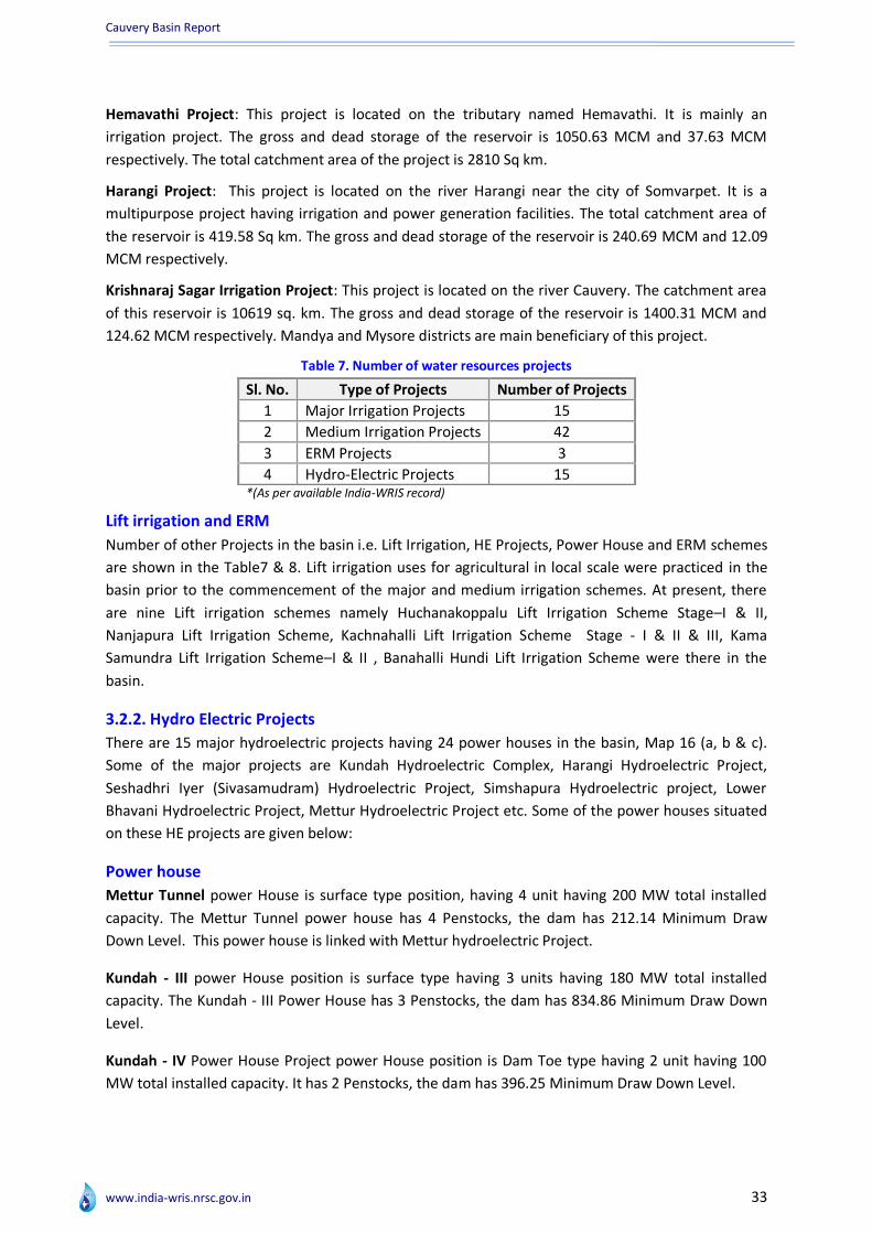
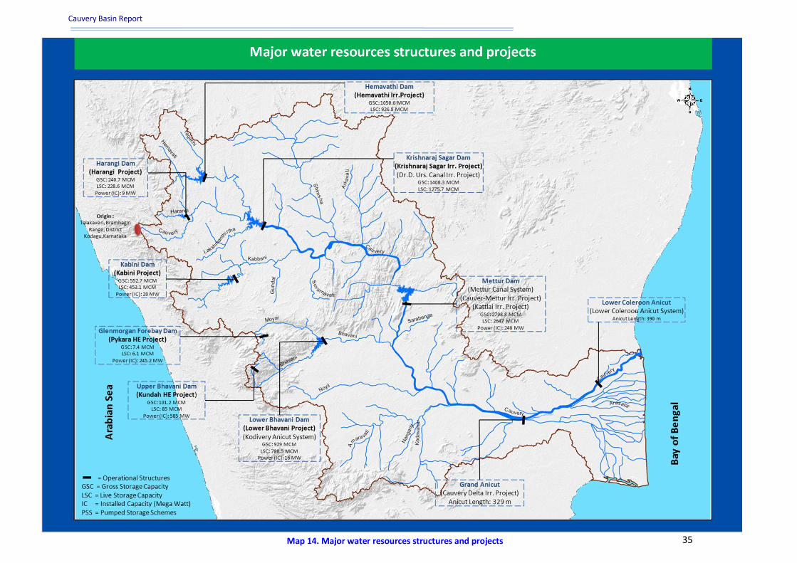
Hemavathi Project: This project is located on the tributary named Hemavathi. It is mainly an
irrigation project. The gross and dead storage of the reservoir is 1050.63 MCM and 37.63 MCM
respectively. The total catchment area of the project is 2810 Sq km.
Harangi Project: This project is located on the river Harangi near the city of Somvarpet. It is a
multipurpose project having irrigation and power generation facilities. The total catchment area of
the reservoir is 419.58 Sq km. The gross and dead storage of the reservoir is 240.69 MCM and 12.09
MCM respectively.
Krishnaraj Sagar Irrigation Project: This project is located on the river Cauvery. The catchment area
of this reservoir is 10619 sq. km. The gross and dead storage of the reservoir is 1400.31 MCM and
124.62 MCM respectively. Mandya and Mysore districts are main beneficiary of this project.
Table 7. Number of water resources projects
Sl. No. Type of Projects Number of Projects
1 Major Irrigation Projects 15
2 Medium Irrigation Projects 42
3 ERM Projects 3
4 Hydro-Electric Projects 15 *(As per available India-WRIS record)
Lift irrigation and ERM
Number of other Projects in the basin i.e. Lift Irrigation, HE Projects, Power House and ERM schemes
are shown in the Table7 & 8. Lift irrigation uses for agricultural in local scale were practiced in the
basin prior to the commencement of the major and medium irrigation schemes. At present, there
are nine Lift irrigation schemes namely Huchanakoppalu Lift Irrigation Scheme Stage–I & II,
Nanjapura Lift Irrigation Scheme, Kachnahalli Lift Irrigation Scheme Stage - I & II & III, Kama
Samundra Lift Irrigation Scheme–I & II , Banahalli Hundi Lift Irrigation Scheme were there in the
basin.
3.2.2. Hydro Electric Projects
There are 15 major hydroelectric projects having 24 power houses in the basin, Map 16 (a, b & c).
Some of the major projects are Kundah Hydroelectric Complex, Harangi Hydroelectric Project,
Seshadhri Iyer (Sivasamudram) Hydroelectric Project, Simshapura Hydroelectric project, Lower
Bhavani Hydroelectric Project, Mettur Hydroelectric Project etc. Some of the power houses situated
on these HE projects are given below:
Power house
Mettur Tunnel power House is surface type position, having 4 unit having 200 MW total installed
capacity. The Mettur Tunnel power house has 4 Penstocks, the dam has 212.14 Minimum Draw
Down Level. This power house is linked with Mettur hydroelectric Project.
Kundah - III power House position is surface type having 3 units having 180 MW total installed
capacity. The Kundah - III Power House has 3 Penstocks, the dam has 834.86 Minimum Draw Down
Level.
Kundah - IV Power House Project power House position is Dam Toe type having 2 unit having 100
MW total installed capacity. It has 2 Penstocks, the dam has 396.25 Minimum Draw Down Level.

Cauvery Basin Report
www.india-wris.nrsc.gov.in 34
Pykara Ultimate (Pushe) Project power House position is Under Ground type having 3 unit having
150 MW total installed capacity. It has 1964 Minimum Draw Down Level.
Extension, Renovation and Modernisation (ERM) of 3 irrigation projects in the Cauvery Basin is on
going, this include The Modernisation of Krishnaraja-sagar Canal and Dr.D. Urs. Canal both are
ongoing project in the districts of Mandya and Mysore. This project proposed for the purpose of
irrigation and water resource management. New Kattalai High Level Canal is a useful ERM project
benefitting the districts of thanjavur, thiruchirapalli for the purpose of irrigation.
3.2.3. Dams, Barrages/Weirs/Anicuts
Water resources structures are manmade structures to store/divert the water for hydropower,
irrigation, drinking water supply etc. At present, there are many structures used for irrigation and
hydro-electric purposes. Some of them include Pillur Dam, Kolar barrage, Lower Bhavani Dam and
Nerunjipettai Barrage, Upper Bhavani Weir, Lower Colleron Anicut, etc. The number of dams based
on storage is shown in Figure 6 and dams based on purpose are shown in Figure 7. The salient
features of these structures are given below:
Pillur Dam: This dam is the highest in the basin with a maximum height of 88m and is located on the
river Bhavani. The catchment area of this reservoir is 1191 sq. km. The gross and live storage of the
reservoir is 44.4 MCM and 34.97 MCM respectively.
Lower Bhavani Dam: This dam is the longest in the basin with a maximum length of 8.79 km and is
located on the river Bhavani. The catchment area of this reservoir is 4200 sq. km. The gross and live
storage of the reservoir is 929 MCM and 908 MCM respectively.
Kabini Dam: This dam is located on the river Kabini. It is a multipurpose project having irrigation and power generation facilities. This project has 20 MW power capacity. The catchment area of this reservoir is 2142 sq. km. The gross and dead storage of the reservoir is 552.74 MCM and 99.675 MCM respectively.
Mettur Dam: This dam is located on the river Cauvery in Tamil Nadu State. It is a multipurpose dam having irrigation and Hydro-electric facilities. This project has 240 MW power capacities. The catchment area of this reservoir is 42217 sq. km. The gross storage of the reservoir is 2708.79 MCM.
Grand Anicut: This Anicut is used for Cauvery Delta Irrigation Project. The catchment area of this
project is 7.40 Th Ha. The length of anicut is around 329 m. Numbers of water resources structures
are given in Table No.7 and the spatial distribution of these structures are given in Map 14.
Table 8. Sub-basin wise number and type of water resources structures
Sl. No. Sub-basin Dams Barrages Weirs Anicuts Lifts Power Houses
1 Cauvery Lower Sub-basin 2 0 1 3 0 0
2 Cauvery Middle Sub-basin 85 10 3 9 2 23
3 Cauvery Upper Sub-basin 9 0 0 0 7 1 *(As per available India-WRIS record)
Cauvery Basin Report
www.india-wris.nrsc.gov.in 35 Map 14. Major water resources structures and projects

Cauvery Basin Report
www.india-wris.nrsc.gov.in 36
Figure 6. Dam classification based on storage
Figure 7. Dam classification based on purpose
Cauvery Basin Report
www.india-wris.nrsc.gov.in 37
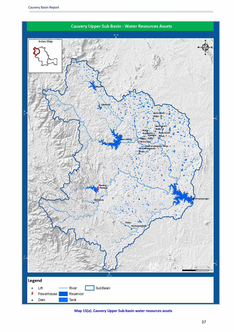
Map 15(a). Cauvery Upper Sub-basin water resources assets
Cauvery Basin Report
www.india-wris.nrsc.gov.in 38
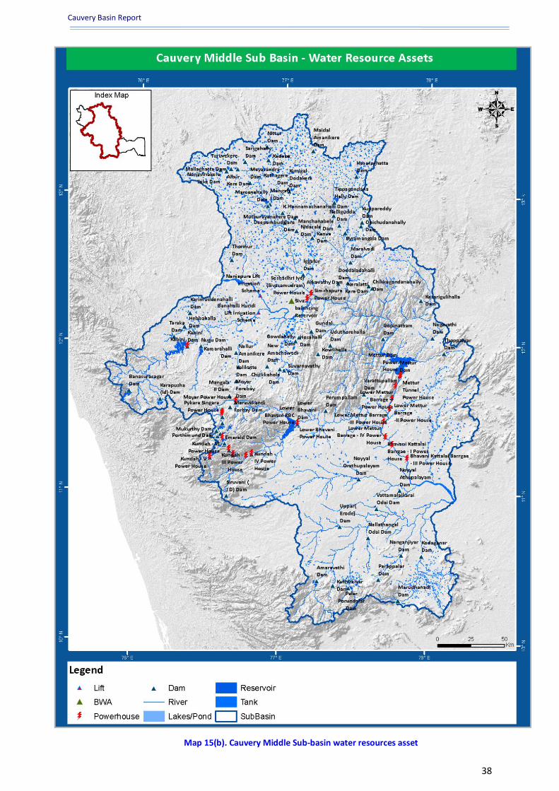
Map 15(b). Cauvery Middle Sub-basin water resources asset

Cauvery Basin Report
www.india-wris.nrsc.gov.in 39
Map 15(c). Cauvery Lower Sub-basin water resources
Cauvery Basin Report
www.india-wris.nrsc.gov.in 40
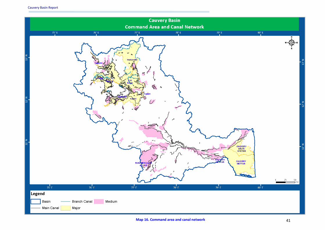
3.3.4. Command area and canals network
Canals are man-made channels for conveyance of water. When the water is to be transported across
landscape to deliver the water to the respective command areas by canal network, construction of
various irrigation structures are necessary to negotiate terrain including drains, road, rail lines.
Important irrigation structures are Regulators, Bridge, Aqueduct / Syphon Aqueduct, Super passage /
Syphon, Level crossing / Inlets and Outlets, and Other Cross drainage Structures. Distributary head
regulators control the supply to an off taking channel from the parent channel.
In Cauvery basin there are few completed and ongoing major irrigation projects. Cauvery delta major
irrigation project, Hemavathi major irrigation project, Cauvery Mettur major irrigation project,
Parambikulam Aliyar major irrigation project, Krishnaraj Sagar major irrigation project and Harangi
major irrigation project which is an ongoing project are those major projects having considerable
command area falling within the cauvery Basin. Map 15 is showing the major and medium command
area map of cauvery Basin. All the major command areas of the Cauvery basin are irrigated by
constructing diversion structures like weir and barrage.
The cauvery basin has the largest irrigation canal system in the Tamil Nadu plain. The Grand Anicut
canal irrigation covered land in Mannargudi and Arantangi taluks (Thanjavur). Further down the
Kattalai High level scheme, taking off from the head sluice above Kattalai bed regulator, benefits in
Thanjavur and Tiruchchirappalli district. The Pullambadi canal also irrigates part of the Cauvery
basin. The Baipar and Chittar along with the Tambraparani irrigate a considerable area in
Ramanathapuram and Tirunelveli districts.
Yagachi is an ongoing major Irrigation Project of Karnataka having considerable command area
benefitting the district of Hassan. Yagachi major irrigation project have a culturable command area
of around 21.25 th ha and an ultimate irrigation potential of 21.45 th ha providing support to a large
portion of the area for irrigation.
The Cauvery delta major irrigation project falling in the basins of Cauvery and east flowing region
from Pennar to Kanyakumari has an ultimate irrigation potential of 504.64 th ha and a largest
culturable command area of 368 th ha in this basin assisting large area of irrigation in the districts of
Thanjavur and Karaikal.
Hemavathy major irrigation project with culturable command area of 283.58 th ha and ultimate
irrigation potential of 283.60 th ha is also an important project of the basin providing valuable profit
to the districts of Hassan, Mandya, Tumkur.
Cauvery Mettur Major Irrigation Project is an important project of Tamil Nadu with some related
structure like grand anicut and mettur da associated to it. It provides an ultimate irrigation potential
of 111.70 th ha and covering a culturable command area of 103.60 th ha benefitting the districts of
Thanjavur, Pudukkottai.
A study was carried out jointly by CWC & ISRO to assess the existing status of the irrigation
commands. IRS P4 LISS III data of two different seasons namely, pre monsoon (2005) and post
monsoon (2004) were used for delineation of waterlogged and salt affected areas of major and
medium irrigation commands of the basin. Total waterlogged area within these occupies 21969.33
ha whereas salt affected area has been extended to 14038.85 ha.
Cauvery Basin Report
www.india-wris.nrsc.gov.in 41 Map 16. Command area and canal network

Cauvery Basin Report
www.india-wris.nrsc.gov.in 42
3.3.5. Multipurpose projects
Cauvery Basin is gifted with number of rivers and other water resources so the utilization of them
has been taken cautiously and precisely. There are four multipurpose projects going on in this basin.
The Harangi Multi Purpose Project is one of the major project of cauvery basin having gross storage
capacity of 240.7 MCM and Live storage capacity of 228.6 MCM. The project is used for power
generation as well as irrigation purposes. The other important multi-purpose projects in the basin
are Kabini, Bhavani sagar, Mettur multipurpose projects serving the basin with its purposes.
3.3.6. Interstate projects
There is one major Interstate project in the basin - Cauvery Delta interstate project falling in Tamil
Nadu and Puducherry states. This project is is benefitting a large population for irrigation purposes
in both the states.
Cauvery Basin Report
www.india-wris.nrsc.gov.in 43
4. Ground water resources
4.1 Ground water observation wells Water is essential to sustain agricultural growth and productivity. Ground water is the water below
the surface of the earth that occurs in soil pores and in cracks and fissures in rocks. Typically, ground
water is liquid flowing water but the definition also includes soil moisture, perma-frost (frozen soil)
and water trapped in very low permeability bed rocks. A unit of rock containing a usable amount of
water is termed as an aquifer. Ground water is refurbished from the surface and eventually flows
back to the surface in the form of springs or oases. The occurrence of ground water generally
depends upon the rainfall, drainage, topography and the geological conditions of the area.
Ground water plays a key role in meeting the water needs of various user-sectors ranging from
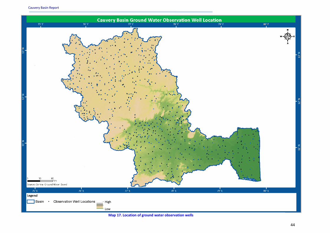
agriculture to domestic as well as commercial use. In the Cauvery Lower Sub-basin there are 146
ground water observation wells whereas in Cauvery Middle Sub-basin there are 612 observation
wells located and Cauvery upper basin comprises of 115 observation wells which are depicted in the
Table 9 and spatially shown in the Map 17. These observation wells are equally distribute in the
entire basin.
The ground water occurs in the weathered gneisses, granites and in joints, fractures and shear zones
of fresh rocks. The yield of wells in these rocks varies from place to place depending on various
factors like the nature of the rocks, the amount and depth of weathering, joint patterns etc. Water
can be tapped in Archaean rocks generally ranged in depth from 6 to 21 m and sometimes to 27 m.
depths to water level in these rocks range between 4.5 and 4.0 m below the ground water. Up the
slope towards north westerly direction, there is lesser and lesser ground water being used for
domestic, industrial and other uses.
Ground water is also often withdrawn for agricultural, municipal and industrial use by constructing
and operating extraction wells. The dependability of ground water is further increased by the vagary
of monsoon as well as poor intensity of rainfall in the delta. This situation had put people to lots of
hardships affecting even the drinking water supply in addition to agricultural instability.Ground
water is used for mainly two purposes at large scale in the basin which includes Drinking and
Irrigation.
Table 9. Sub-basin wise number of ground water observation wells
Sl. No. Sub-basin No. of Observation Wells
1 Cauvery Lower Sub-basin 146
2 Cauvery Middle Sub-basin 612
3 Cauvery Upper Sub-basin 115
*(As per available India-WRIS record)
Cauvery Basin Report
www.india-wris.nrsc.gov.in 44
Map 17. Location of ground water observation wells

Cauvery Basin Report
www.india-wris.nrsc.gov.in 45
4.2 Ground water level fluctuation The occurrence of ground water generally depends upon the rainfall, drainage, topography and the
geological conditions of the area. Ground water fluctuation in the Cauvery basin is assessed for
recharge and draft conditions based on the available ground water level in four different seasons.
Ground water recharge is estimated by the difference in ground water level between pre and post
monsoon seasons. Similarly, groundwater draft is estimated by the difference between post-
monsoon and post-monsoon (rabi) seasons data. Interpolated maps for ground water recharge and
irrigation draft (rabi) are prepared based on the available ground water fluctuation data in the basin.
Any phenomenon, which produces pressure change within an aquifer, results into the change of
ground water level (source: http://drsksingh.tripod.com/gwlevel.htm). These changes in ground
water level can be a result of changes in storage, amount of discharge and recharge, variation of
stream stages and evaporation. External loads such as tides, trains, atmospheric pressure and
earthquake are born in part by the ground water of confined aquifers. Hence they affect peizometric
levels. The general consideration is that due to any reason if the aquifer pressure raises above the
atmospheric pressure an upleveling in ground water level results and vice- versa.
Water table undergoes a seasonal fluctuation following a natural cycle (source:
http://www.indiawaterportal.org). Water table rises during rainy season due to recharge received
from rainfall and falls back during summer season due to lack of recharge and continuing extraction
of ground water. In geohydrology, the highest water level is referred to as the post-monsoon water
level and the lowest level in summer as pre-monsoon water level. The difference between highest
water level value and lowest water level value is termed as fluctuation in ground water level; this
value can be positive as well as negative depending upon various factors.
In general ground water level in major part of the basin falls between 10 to 20 m bgl, however, in
Cauvery delta the water level is less than 10 m bgl during pre-monsoon in year 2009. The ground
water level fluctuation maps (2011) shows that there is a fall of <2m ,fall 2-4 m, fall>4m at different
places in the Cauvery basin while at some places there is positive change in water level fluctuation
(recharge) ranging from 2 to 4 m. The rise in water level is maximum in Cauvery lower sub-basin. The
water fluctuation due to draft is positive in major part of Cauvery middle sub-basin as well in
Cauvery lower sub-basin while in Cauvery upper sub-basin fall is noticed in the range from 2 to 4 m
depending on terrain. The fluctuation due to recharge and draft in the Cauvery basin is shown in the
given below Map 18 & 19 respectively.

Cauvery Basin Report
www.india-wris.nrsc.gov.in 46
Map 18. Ground water level fluctuation (Recharge)
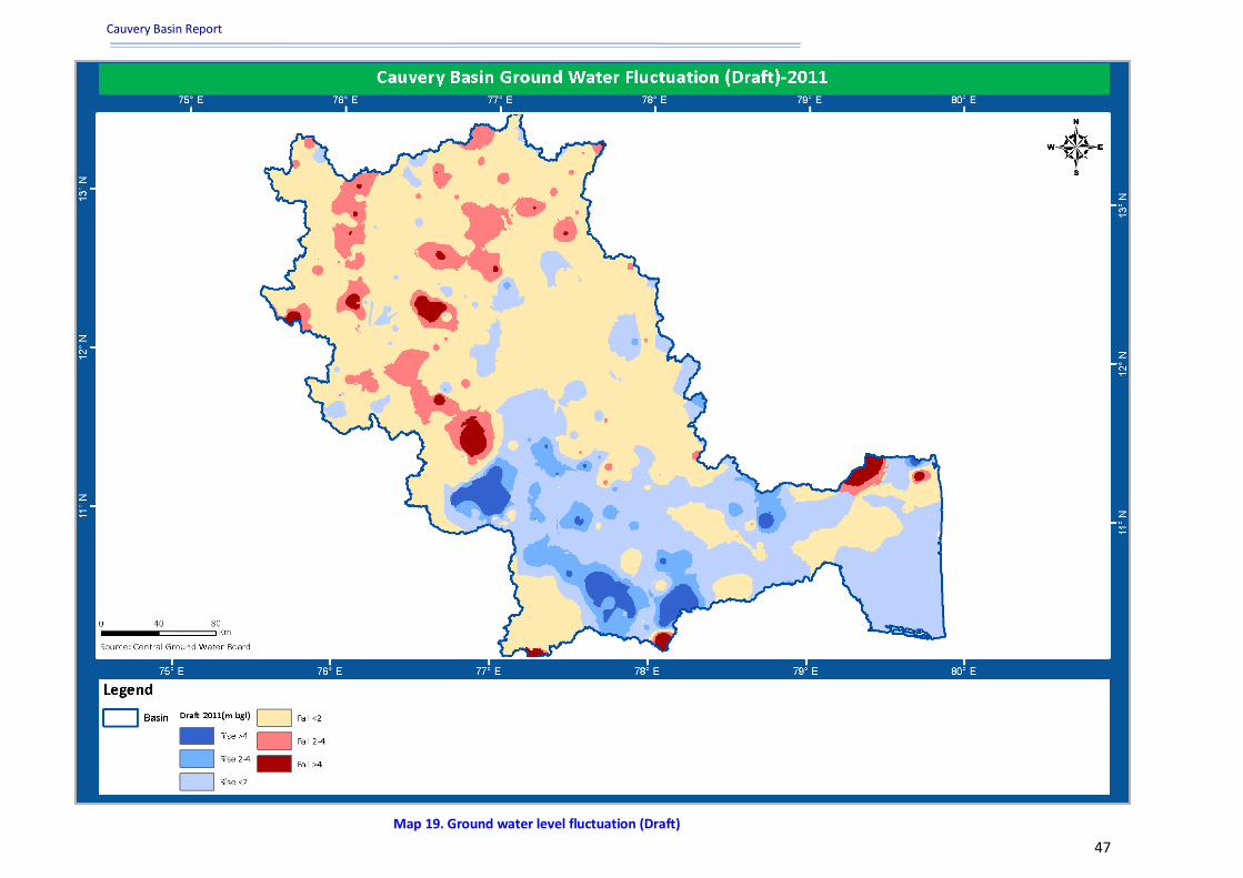
Cauvery Basin Report
www.india-wris.nrsc.gov.in 47
Map 19. Ground water level fluctuation (Draft)

Cauvery Basin Report
www.india-wris.nrsc.gov.in 48
4.3 Litholog well locations
An aquifer is an underground layer of water-bearing permeable rock or unconsolidated materials
(gravel, sand, or silt) from which ground water can be extracted using a dug well or borewell.
Related terms include aquitard, which is a bed of low permeability along an aquifer and
aquiclude (or aquifuge), which is a solid, impermeable area underlying or overlying an aquifer. If the
impermeable layer overlies the aquifer layer, pressure could cause it to become a confined aquifer.
Aquifers may occur at various depths(source: http://www.ijsciences.com/pub/pdf/V220130908.pdf).
Those closer to the surface are not only more likely to be used for water supply and irrigation, but
are also more likely to be tapped up by the local rainfall. Alluvium, sandstone, loose sand/gravel etc
are the better aquifer material. In hard rock area; fracture/lineament plays an important role in
identifying ground water potential areas. The information on the aquifer material, depth and
thickness of the aquifer layers in a basin can be analysed based on the available lithlog information.
There are 354 litholog well locations exists in whole basin (as per available records) out of which 145
well locations fall in Cauvery Lower sub-basin while 210 well locations fall in Cauvery middle sub-
basin. The litholog well locations is listed under, Annexure V under the heading “Inventory of litholog
well locations”.
The major lithology groups found in the basin are granite gneiss, biotite gneiss, sand with clay and
sandstone, sand clay gravel and sandstone etc. Major rock group encountered in basin is Crystalline
Rocks (Archaean-Pre-Cambrian) and Semi-Consolidated Sediments (Carboniferous-Pliocene and
other ages). The well type which is used for lithological studies with their locations in the basin is
shown in the Map 20.
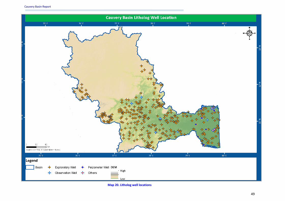
Cauvery Basin Report
www.india-wris.nrsc.gov.in 49
Map 20. Litholog well locations

Cauvery Basin Report
www.india-wris.nrsc.gov.in 50
5. Hydro-met observations
Map 21. Hydro observation stations

Cauvery Basin Report
www.india-wris.nrsc.gov.in 51
5.1 Hydrological observation sites Hydrological observation in the basin is carried out by the Central and State Governments. The
information about various hydrological observation parameters such as gauge (river water level),
discharge (amount of water released from a cross section in the river in a given time period) and
sediment (concentration of solid particles in water) are released time to time by observing stations
of CWC. It has contributed substantially in the collection of hydrological data all over the Cauvery
basin. Being the apex national body for the development of surface water resources of the country,
CWC has established a network of hydrological observation stations across the entire river in this
basin. These stations are categorized as ‘GDSQ’, where the abbreviation stands as: G-Gauge, D-
Discharge, S-Sediment and Q-Water Quality. RF stands for rainfall measuring station.
The CWC maintains 36 gauge-discharge sites in the basin. These sites fall under Cauvery basin sub
zone and east coast sub zone. From some of these sites, sediment observations are also taken. The
Central Water Commission has 21 observation sites for Gauge Discharge Water Quality (GDQ), while
for Gauge Discharge Sediment and Water Quality (GDSQ) the numbers of observation sites are 15 as
shown in the Table 10. The data and observations recorded at these sites are used to understand the
river dynamics of the basin. There spatial distribution for the stations is shown in Map 21. The details
of the attributes related to these sites like Station Name, Station type, Independent river, status etc.
are listed in Annexure VI under heading Salient features of hydro-observation stations.
Table 10. Hydrological observation sites of CWC
Sl. No. Station Type Number of Stations
1 GDQ 21
2 GDSQ 15 *(As per available India-WRIS record)
5.2 Meteorological stations The Hydro-meteorological data pertaining to the river basin is required for modelling the catchment.
These include daily rainfall, maximum and minimum temperature, solar radiation, relative humidity,
wind speed and others. There are three main organizations in our country which records
meteorological parameters viz., India Meteorological Department (IMD), Central Water Commission
(CWC) and ISRO (Automatic Weather Stations).CWC has established 35 Meteorological stations in
the basin. These stations are established to understand the relationship between meteorological
parameter and river dynamics. The basin has 183 Indian Meteorological stations (IMD). The
integrated approach of measuring meteorological parameter using Automated Weather Stations
(AWS) is helpful in the remote region. AWS stations require a minimum maintenance and the data is
generated on the temporal basis. These stations are maintained and data stored by the MOSDAC,
SAC Ahmedabad. Under the supervision of ISRO there are 63 AWS station established in the basin
(Table 11).
Table 11. Meteorological stations
Sl. No. Organisation Number of Stations
1 CWC Observation Stations 35
2 IMD Stations 183
3 ISRO AWS Stations 63 *(As per available India-WRIS record)
Cauvery Basin Report
www.india-wris.nrsc.gov.in 52
6. Water quality
6.1 Surface water quality observations Surface water has played an important role in the development of human civilization. Good quality
water resources depends on a large number of physico-chemical parameters and the magnitude and
source of any pollution load; and to assess that, monitoring of these parameters is essential. Cauvery
and its tributaries are one of the main and important sources of water for a large population in basin
for drinking and irrigation and its quality directly affects their lives. Central Water Commission
operates 36 stations which carry out observations for testing the surface water quality with 68
water quality parameters, which are considered to be the ‘Standard Hydrology Project Water Quality
Parameters’.
All physical, chemical and biological water quality parameters are categorized further under sub
categories like field determinations, nutrients, organic matter, alkalinity, hardness, other inorganics,
major ions, coliforms and others. The ranges of water quality observed in Cauvery basin with respect
to pH, electrical conductivity, DO, BOD, COD, Total Coliform (TC) and Faecal Coliform (FC) are
presented as minimum, maximum and mean value to assess the extent of water quality variation
throughout the year. The untreated sewage waste and effluents of major towns situated along the
river also flow into the main stream of river and degrade its quality for use in irrigation and drinking
purposes.
6.2 Ground water quality observations
The ground water quality at observation wells located in the basin, which measures 15 parameters
viz., pH, Electrical Conductivity (EC), Total Dissolved Solids (TDS), Magnesium, Nitrate, Potassium,
Sulphate, Calcium, Sodium, Carbonate, Bicarbonate, Chloride, Fluoride, Sodium Absorption Ratio
(SAR) and Residual Sodium Carbonate (RSC) and heavy metals like Arsenic & Iron. They are further
classified in two categories viz. irrigation and drinking water quality standards as described by
Bureau of Indian Standards (BIS) for Ground water quality. They are further classified in two
categories viz. Irrigation and Drinking Water quality standards as described by Bureau of Indian
Standards (BIS) for Ground Water Quality. Based upon all these parameters, the chemical quality of
ground water, both from near-surface and deeper aquifer zones, is generally good and suitable for
the irrigation and drinking purposes in the basin.
There are 71 ground water quality locations present in the basin and monitored by Central Ground
Water Board (CGWB). The physical and chemical properties of ground water were measured by
CGWB in this basin.
Cauvery Basin Report
www.india-wris.nrsc.gov.in 53
7. Inter-basin transfer links India has substantial water resources potential but its availability in various parts of the country is
highly uneven. Inter-basin transfer link proposes river water transfer from the region of surplus to
deficit areas. This may provide an effective way to enhance irrigation potential, to mitigate floods
and droughts and reduce regional imbalance by way of additional irrigation, domestic and
industrial water supply, hydropower generation, navigational facilities, etc. There are two inter-
basin transfer links falling in this basin.
NWDA has proposed 30 possible links in India which include 14 Himalayan components and 16
Peninsular components. Two of those are proposed in the Cauvery Basin (Map 22).
Somasila- Grand Anicut Link
This link envisages diversion of 8,565 MCM of water from Somasila reservoir at Pennar Basin to
South of Pennar to irrigate 4.91 lakh Ha (0.49 lakh Ha in Andhra Pradesh, 4.36 lakh Ha in Tamil
Nadu and 0.06 lakh Ha in Pondicherry). Total length of link canal is about 529 km.
Cauvery (Kattalai) – Vaigni-Gundar Link
The Kattalai Vaigai Gundar Link envisages tapping of 2,252 MCM of water from Cauvey basin at the
existing Kattalai bed to irrigate 3.38 lakh hectares area of Tamil Nadu up to Gundar River. Total
length of link canal is about 255.60 km.

Cauvery Basin Report
www.india-wris.nrsc.gov.in 54
Map 22. Inter basin transfer links
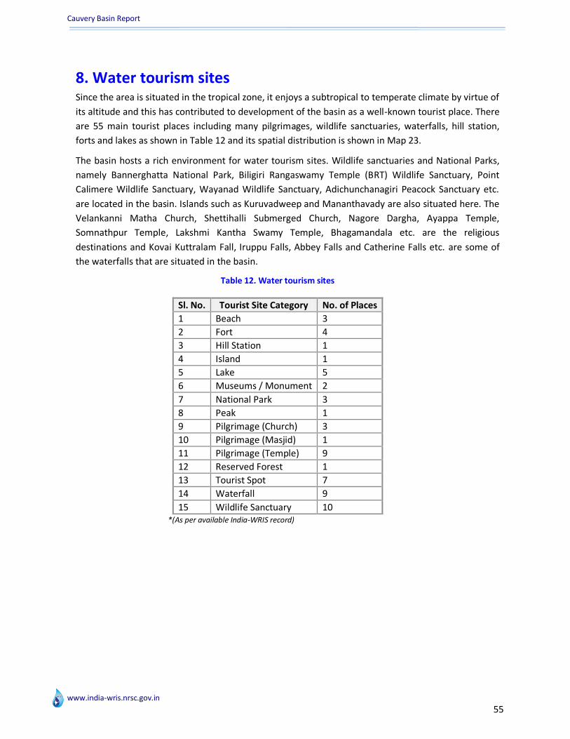
Cauvery Basin Report
www.india-wris.nrsc.gov.in
55
8. Water tourism sites Since the area is situated in the tropical zone, it enjoys a subtropical to temperate climate by virtue of
its altitude and this has contributed to development of the basin as a well-known tourist place. There
are 55 main tourist places including many pilgrimages, wildlife sanctuaries, waterfalls, hill station,
forts and lakes as shown in Table 12 and its spatial distribution is shown in Map 23.
The basin hosts a rich environment for water tourism sites. Wildlife sanctuaries and National Parks,
namely Bannerghatta National Park, Biligiri Rangaswamy Temple (BRT) Wildlife Sanctuary, Point
Calimere Wildlife Sanctuary, Wayanad Wildlife Sanctuary, Adichunchanagiri Peacock Sanctuary etc.
are located in the basin. Islands such as Kuruvadweep and Mananthavady are also situated here. The
Velankanni Matha Church, Shettihalli Submerged Church, Nagore Dargha, Ayappa Temple,
Somnathpur Temple, Lakshmi Kantha Swamy Temple, Bhagamandala etc. are the religious
destinations and Kovai Kuttralam Fall, Iruppu Falls, Abbey Falls and Catherine Falls etc. are some of
the waterfalls that are situated in the basin.
Table 12. Water tourism sites
Sl. No. Tourist Site Category No. of Places
1 Beach 3
2 Fort 4
3 Hill Station 1
4 Island 1
5 Lake 5
6 Museums / Monument 2
7 National Park 3
8 Peak 1
9 Pilgrimage (Church) 3
10 Pilgrimage (Masjid) 1
11 Pilgrimage (Temple) 9
12 Reserved Forest 1
13 Tourist Spot 7
14 Waterfall 9
15 Wildlife Sanctuary 10
*(As per available India-WRIS record)
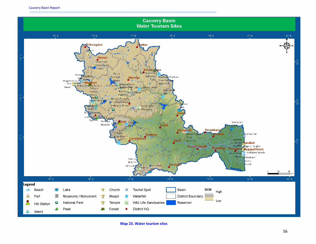
Cauvery Basin Report
www.india-wris.nrsc.gov.in
56
Map 23. Water tourism sites
Cauvery Basin Report
www.india-wris.nrsc.gov.in
57
9.Conclusion The Cauvery and its tributaries are inter-state river system, flowing through the states of Kerala,
Karnataka, Tamil Nadu and parts of Puducherry. A number of small and large projects have already
been constructed in the basin and few are under construction. The surface water potential in the
basin is nearly utilized, but there is a need to make arrangements for use of full potential of ground
water. Systematic and scientific exploratory work is needed for a quantitative and qualitative
assessment of the ground water resources in the basin, so that these resources may be exploited in a
rational way, either independently or in conjunction with surface waters. There is need for interstate
cooperation and agreement in respect of carrying out soil conservation measures to conserve the
storage capacities of the existing and proposed reservoirs in the basin. It is necessary for systematic
data to be collected with regard to the sediment carried by the rivers, which would illustrate the
effect of any soil conservation works carried out in the basin.
With an overview of the various environmental issues, it's time to seriously think about the efforts
needed to bring back the original balance in our environment. Ecology, environment and human
beings have to form a synchronous and healthy relationship for them to have any meaning at all.
Realization that, one without the other may not be able to survive has to dawn on one and all. Any
dilly-dallying on the matter could harm us and put us beyond redemption. Old approaches may have
to be reformed, new technologies like for instance remote sensing, have to be harnessed, our
people's attitudes have to be changed. It's only then can we hope to see any difference in the
harmed atmosphere. As of now, the stresses on our environment are many. Some of them we list
here to highlight the need for prioritisation for action.
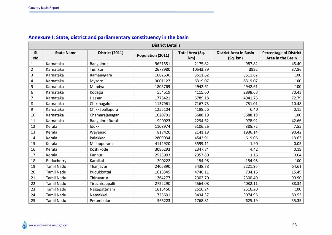
Cauvery Basin Report
www.india-wris.nrsc.gov.in 58
Annexure I: State, district and parliamentary constituency in the basin
District Details
Sl. No.
State Name District (2011) Population (2011)
Total Area (Sq. km)
District Area in Basin (Sq. km)
Percentage of District Area in the Basin
1 Karnataka Bangalore 9621551 2175.82 987.82 45.40
2 Karnataka Tumkur 2678980 10543.89 3992 37.86
3 Karnataka Ramanagara 1082636 3511.62 3511.62 100
4 Karnataka Mysore 3001127 6319.07 6319.07 100
5 Karnataka Mandya 1805769 4942.61 4942.61 100
6 Karnataka Kodagu 554519 4115.60 2898.68 70.43
7 Karnataka Hassan 1776421 6789.18 4941.78 72.79
8 Karnataka Chikmagalur 1137961 7167.73 751.01 10.48
9 Karnataka Chikkaballapura 1255104 4188.56 6.40 0.15
10 Karnataka Chamarajanagar 1020791 5688.19 5688.19 100
11 Karnataka Bangalore Rural 990923 2294.62 978.92 42.66
12 Kerala Idukki 1108974 5106.26 385.72 7.55
13 Kerala Wayanad 817420 2141.18 1936.14 90.42
14 Kerala Palakkad 2809934 4542.91 619.06 13.63
15 Kerala Malappuram 4112920 3599.11 1.90 0.05
16 Kerala Kozhikode 3086293 2347.84 4.42 0.19
17 Kerala Kannur 2523003 2957.80 1.16 0.04
18 Puducherry Karaikal 200222 154.98 154.98 100
19 Tamil Nadu Thanjavur 2405890 3438.78 2221.95 64.61
20 Tamil Nadu Pudukkottai 1618345 4740.11 734.16 15.49
21 Tamil Nadu Thiruvarur 1264277 2302.70 2300.40 99.90
22 Tamil Nadu Tiruchirappalli 2722290 4564.08 4032.11 88.34
23 Tamil Nadu Nagapattinam 1616450 2516.24 2516.20 100
24 Tamil Nadu Namakkal 1726601 3434.37 3074.96 89.53
25 Tamil Nadu Perambalur 565223 1768.81 625.19 35.35

Cauvery Basin Report
www.india-wris.nrsc.gov.in 59
Sl. No.
State Name District (2011) Population (2011) Total Area (Sq. km)
District Area in Basin (Sq. km)
Percentage of District Area in the Basin
26 Tamil Nadu Erode 2251744 5802.54 5802.54 100
27 Tamil Nadu Dindigul 2159775 6164.99 4429.05 71.84
28 Tamil Nadu Dharmapuri 1506843 4529.54 1906.74 42.10
29 Tamil Nadu Cuddalore 2605914 3725.96 604.91 16.24
30 Tamil Nadu Coimbatore 3458045 4708.71 2569.37 54.57
31 Tamil Nadu The Nilgiris 735394 2572.79 2213.40 86.03
32 Tamil Nadu Karur 1064493 2928.71 2928.71 100
33 Tamil Nadu Salem 3482056 5247.41 3027.08 57.69
34 Tamil Nadu Ariyalur 754894 1970.10 1623.55 82.41
35 Tamil Nadu Tiruppur 2479052 5266.55 4983.33 94.62
36 Tamil Nadu Krishnagiri 1879809 5142.53 1909.10 37.12
(Disclaimer: District wise population data has been taken from census 2011)(Note: Population is mentioned for the complete district)
Parliamentary Constituency Details Sl. No. State Name Parliamentary Constituencies
(2009) Total Area (Sq. Km) Area Falling in Basin
(Sq. Km) Percentage Area in the Basin
1 Karnataka Bangalore South 113.69 40.61 35.72
2 Karnataka Bangalore North 714.75 442.95 61.97
3 Karnataka Udupi Chikmagalur 8397.83 751.01 8.94
4 Karnataka Chikkaballapura 5466.08 1432.92 26.21
5 Karnataka Tumkur 7043.62 3000.24 42.60
6 Karnataka Bangalore Rural 5002.08 4539.67 90.76
7 Karnataka Bangalore Central 337.93 19.51 5.77
8 Karnataka Mysore 6367.11 5206.36 81.77
9 Karnataka Chamrajnagar 9100.19 9100.19 100
10 Karnataka Mandya 5542.90 5542.90 100
11 Karnataka Hassan 7947.83 4941.78 62.18
12 Kerala Idukki 5640.05 385.72 6.84
13 Kerala Kannur 2064.27 1.16 0.06
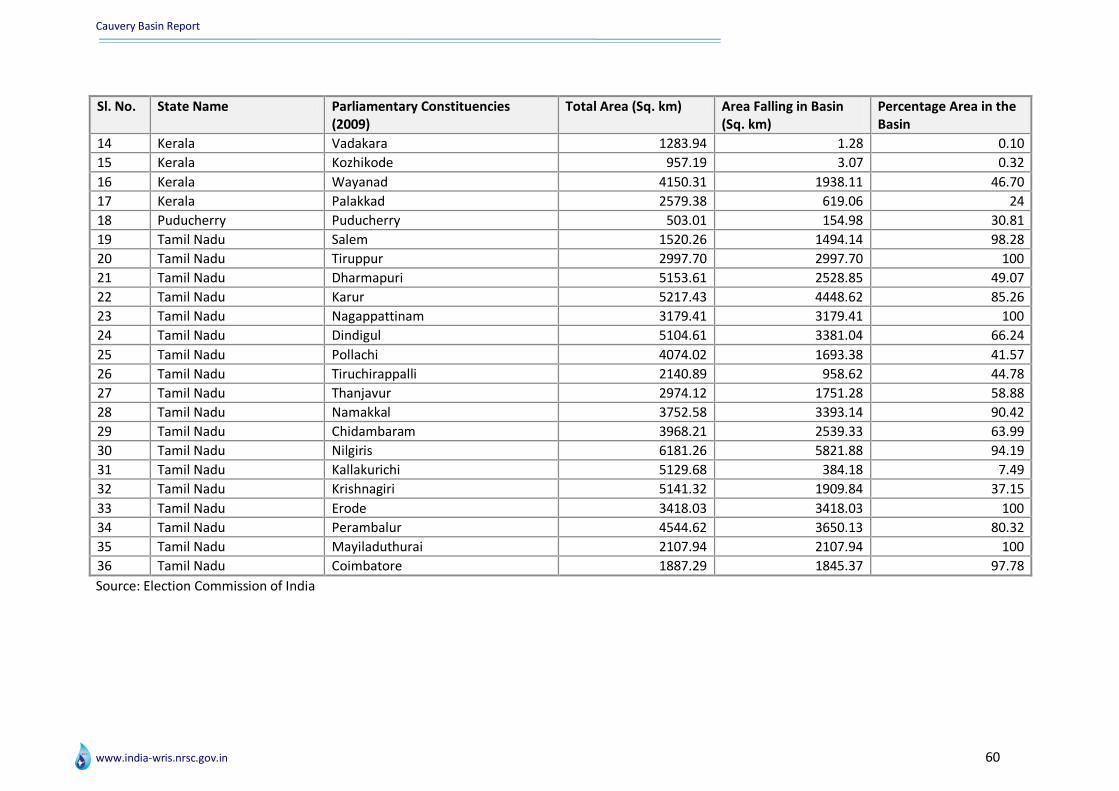
Cauvery Basin Report
www.india-wris.nrsc.gov.in 60
Sl. No. State Name Parliamentary Constituencies (2009)
Total Area (Sq. km) Area Falling in Basin (Sq. km)
Percentage Area in the Basin
14 Kerala Vadakara 1283.94 1.28 0.10
15 Kerala Kozhikode 957.19 3.07 0.32
16 Kerala Wayanad 4150.31 1938.11 46.70
17 Kerala Palakkad 2579.38 619.06 24
18 Puducherry Puducherry 503.01 154.98 30.81
19 Tamil Nadu Salem 1520.26 1494.14 98.28
20 Tamil Nadu Tiruppur 2997.70 2997.70 100
21 Tamil Nadu Dharmapuri 5153.61 2528.85 49.07
22 Tamil Nadu Karur 5217.43 4448.62 85.26
23 Tamil Nadu Nagappattinam 3179.41 3179.41 100
24 Tamil Nadu Dindigul 5104.61 3381.04 66.24
25 Tamil Nadu Pollachi 4074.02 1693.38 41.57
26 Tamil Nadu Tiruchirappalli 2140.89 958.62 44.78
27 Tamil Nadu Thanjavur 2974.12 1751.28 58.88
28 Tamil Nadu Namakkal 3752.58 3393.14 90.42
29 Tamil Nadu Chidambaram 3968.21 2539.33 63.99
30 Tamil Nadu Nilgiris 6181.26 5821.88 94.19
31 Tamil Nadu Kallakurichi 5129.68 384.18 7.49
32 Tamil Nadu Krishnagiri 5141.32 1909.84 37.15
33 Tamil Nadu Erode 3418.03 3418.03 100
34 Tamil Nadu Perambalur 4544.62 3650.13 80.32
35 Tamil Nadu Mayiladuthurai 2107.94 2107.94 100
36 Tamil Nadu Coimbatore 1887.29 1845.37 97.78
Source: Election Commission of India

Cauvery Basin Report
www.india-wris.nrsc.gov.in 61
Annexure II: Climate – Rainfall (1971-2004) and Temperature (1969-2004) profile in the basin
Sub-Basin Wise Annual Rainfall (mm) (1971-2004)
Sl. No. Year Cauvery Lower Sub-basin Cauvery Middle Sub-basin Cauvery Upper Sub-basin
1 1971 1237.67 1333.71 2003.79
2 1972 1167.79 1263.54 1830.68
3 1973 774.06 1018.43 1669.03
4 1974 634.66 1170.05 1938.18
5 1975 1058.91 1614.52 2660.84
6 1976 937.49 1015.71 1665.84
7 1977 1323.13 1603.05 2503.17
8 1978 1010.44 1515.11 2592.04
9 1979 1168.01 1284.8 1889.57
10 1980 581.21 1096.03 2128.3
11 1981 1029.17 1354.67 2135.27
12 1982 650.49 888.85 1732.83
13 1983 1130.26 1190.46 1904.5
14 1984 1056.39 1123.42 1989.58
15 1985 1063.67 921.18 1549.26
16 1986 986.51 1047.93 1729.4
17 1987 968.54 1029.62 1377.38
18 1988 789.45 1089.7 1631.45
19 1989 890.8 909.62 1589.16
20 1990 830.7 998.97 1861.56
21 1991 1000.65 1338.9 2091.98
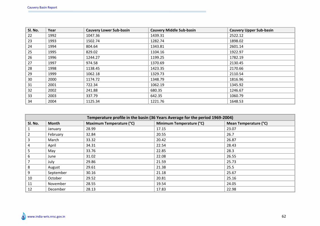
Cauvery Basin Report
www.india-wris.nrsc.gov.in 62
Sl. No. Year Cauvery Lower Sub-basin Cauvery Middle Sub-basin Cauvery Upper Sub-basin
22 1992 1047.36 1439.31 2522.12
23 1993 1502.74 1282.74 1898.02
24 1994 804.64 1343.81 2601.14
25 1995 829.02 1104.16 1922.97
26 1996 1244.27 1199.25 1782.19
27 1997 974.58 1370.69 2130.45
28 1998 1138.45 1423.35 2170.66
29 1999 1062.18 1329.73 2110.54
30 2000 1174.72 1348.79 1816.96
31 2001 722.34 1062.19 1345.92
32 2002 241.88 680.35 1246.67
33 2003 337.79 642.35 1060.79
34 2004 1125.34 1221.76 1648.53
Temperature profile in the basin (36 Years Average for the period 1969-2004) Sl. No. Month Maximum Temperature (°C) Minimum Temperature (°C) Mean Temperature (°C)
1 January 28.99 17.15 23.07
2 February 32.84 20.55 26.7
3 March 33.32 20.42 26.87
4 April 34.31 22.54 28.43
5 May 33.76 22.85 28.3
6 June 31.02 22.08 26.55
7 July 29.86 21.59 25.73
8 August 29.61 21.38 25.5
9 September 30.16 21.18 25.67
10 October 29.52 20.81 25.16
11 November 28.55 19.54 24.05
12 December 28.13 17.83 22.98

Cauvery Basin Report
www.india-wris.nrsc.gov.in 63
Annexure III : Sub-basin wise population and drinking water facilities
Demographic Details Sl. No. Sub-basin No. of
Districts No. Villages Total Population Male Population Female
Population No. of Households
1 Cauvery Lower Sub-basin 13 2990 7379853 3675739 3704114 1720133
2 Cauvery Middle Sub-basin 25 8306 19987819 10187395 9800423 4730301
3 Cauvery Upper Sub-basin 6 3339 2604228 1305494 1298734 557444
*(Disclaimer: Population data has been taken from Census 2001)
Drinking Water Facilities Sl. No. Sub-basin District Wells Tubewells Handpumps
1 Cauvery Lower Sub-basin Ariyalur 0 0 0
2 Cauvery Lower Sub-basin Karur 0 0 0
3 Cauvery Lower Sub-basin Karaikal 0 0 0
4 Cauvery Lower Sub-basin Namakkal 0 0 0
5 Cauvery Lower Sub-basin Pudukkottai 0 0 0
6 Cauvery Lower Sub-basin Thiruvarur 0 0 0
7 Cauvery Lower Sub-basin Nagapattinam 0 0 0
8 Cauvery Lower Sub-basin Perambalur 0 0 0
9 Cauvery Lower Sub-basin Cuddalore 0 0 0
10 Cauvery Lower Sub-basin Tiruchirappalli 0 0 0
11 Cauvery Lower Sub-basin Salem 0 0 0
12 Cauvery Lower Sub-basin Thanjavur 0 0 0
13 Cauvery Lower Sub-basin Dindigul 0 0 0
14 Cauvery Middle Sub-basin Erode 0 0 0
15 Cauvery Middle Sub-basin Hassan 0 0 0
16 Cauvery Middle Sub-basin Karur 0 0 0
17 Cauvery Middle Sub-basin Chamarajanagar 0 0 0
18 Cauvery Middle Sub-basin Coimbatore 0 0 0
19 Cauvery Middle Sub-basin Namakkal 0 0 0

Cauvery Basin Report
www.india-wris.nrsc.gov.in 64
Sl. No. Sub-basin District Wells Tubewells Handpumps
20 Cauvery Middle Sub-basin The Nilgiris 0 0 0
21 Cauvery Middle Sub-basin Kozhikode 87 76 63
22 Cauvery Middle Sub-basin Mandya 0 0 0
23 Cauvery Middle Sub-basin Palakkad 143 127 134
24 Cauvery Middle Sub-basin Bangalore Rural 0 0 0
25 Cauvery Middle Sub-basin Kodagu 0 0 0
26 Cauvery Middle Sub-basin Madurai 0 0 0
27 Cauvery Middle Sub-basin Tiruchirappalli 0 0 0
28 Cauvery Middle Sub-basin Wayanad 48 45 36
29 Cauvery Middle Sub-basin Dharmapuri 0 0 0
30 Cauvery Middle Sub-basin Malappuram 119 107 97
31 Cauvery Middle Sub-basin Salem 0 0 0
32 Cauvery Middle Sub-basin Idukki 54 43 36
33 Cauvery Middle Sub-basin Kolar 0 0 0
34 Cauvery Middle Sub-basin Mysore 0 0 0
35 Cauvery Middle Sub-basin Bangalore 0 0 0
36 Cauvery Middle Sub-basin Dindigul 0 0 0
37 Cauvery Middle Sub-basin Kannur 78 64 49
38 Cauvery Middle Sub-basin Tumkur 0 0 0
39 Cauvery Upper Sub-basin Hassan 0 0 0
40 Cauvery Upper Sub-basin Chikmagalur 0 0 0
41 Cauvery Upper Sub-basin Mandya 0 0 0
42 Cauvery Upper Sub-basin Kodagu 0 0 0
43 Cauvery Upper Sub-basin Wayanad 48 45 36
44 Cauvery Upper Sub-basin Mysore 0 0 0
Source : Census Data 2001

Cauvery Basin Report
www.india-wris.nrsc.gov.in 65
Annexure IV: Inventory of surface water resources
List of Dams with surrogate information
Sl. No.
Name of Dam River
Typ
e o
f D
am
Ye
ar o
f
com
ple
tio
n
Cat
chm
en
t A
rea
(Sq
. km
.)
Len
gth
of
dam
(m
)
Max
he
igh
t
abo
ve
fou
nd
atio
n (
m)
Gro
ss s
tora
ge
cap
acit
y (M
CM
)
Live
sto
rage
ca
pac
ity
(MC
M)
Typ
e o
f
spill
way
Sub
me
rge
nce
A
rea
(Th
Ha)
Pu
rpo
se
1 Alalur Dam Lakshmanathirtha Gravity / Masonry
1983 NA 939.6 17.41 2.18 2.07 NA 0.05 Irrigation
2 Albur Kere Dam NA NA NA NA NA NA NA NA NA NA NA
3 Amaravathi Dam Amaravati Earthen / Gravity / Masonry
1958 840 1095 50 114.62 109.36 Ogee 0.85 HE,IR
4 Arkavathy Dam Arkavathy Earthen / Gravity / Masonry
2004 NA 720 29.685 44.94 40.49 NA 0.7 Irrigation
5 Avalanche Dam Avalanche Gravity / Masonry
1961 58.5 366 57 156 152.8 NA 0.81 Hydroelectric
6 Banasurasagar Dam Panamarampuzha Gravity / Masonry
NA NA NA NA NA NA NA NA HE,IR
7 Byramangala Dam Vrishabhavathy Earthen 1943 380 2286 22.85 24.1 22.01 NA 0.41 Irrigation
8 Chakena Hally Dam Hemavathy River Earthen 1970 14.11 886.75 17.3 4.28 3.92 NA 0.03 Irrigation
9 Chickkahole Dam Chickkahole Earthen / Gravity / Masonry
1958 676 756 27.53 10.65 10.53 Side Channel
0.11 Irrigation
10 Chikkagondanahally Dam
Arkavathy Earthen 1979 19.5 516 22.3 5.9 2.46 NA 0.04 Irrigation
11 Chiklihole Dam Chiklihole Earthen 1985 NA 464.8 25.3 5.1 4.73 NA 0.11 Irrigation
12 Deepambudikere Nagini Earthen 1906 NA 600 15 12.11 9.69 NA 0.21 Irrigation
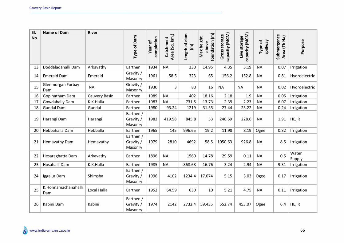
Cauvery Basin Report
www.india-wris.nrsc.gov.in 66
Sl. No.
Name of Dam River
Typ
e o
f D
am
Ye
ar o
f
com
ple
tio
n
Cat
chm
en
t A
rea
(Sq
. km
.)
Len
gth
of
dam
(m
)
Max
he
igh
t
abo
ve
fou
nd
atio
n (
m)
Gro
ss s
tora
ge
cap
acit
y (M
CM
)
Live
sto
rage
ca
pac
ity
(MC
M)
Typ
e o
f
spill
way
Sub
me
rge
nce
A
rea
(Th
Ha)
Pu
rpo
se
13 Doddaladahalli Dam Arkavathy Earthen 1934 NA 330 14.95 4.35 3.19 NA 0.07 Irrigation
14 Emerald Dam Emerald Gravity / Masonry
1961 58.5 323 65 156.2 152.8 NA 0.81 Hydroelectric
15 Glenmorgan Forbay Dam
NA Gravity / Masonry
1930 3 80 16 NA NA NA 0.02 Hydroelectric
16 Gopinatham Dam Cauvery Basin Earthen 1989 NA 402 18.16 2.18 1.9 NA 0.05 Irrigation
17 Gowdahally Dam K.K.Halla Earthen 1983 NA 731.5 13.73 2.39 2.23 NA 6.07 Irrigation
18 Gundal Dam Gundal Earthen 1980 93.24 1219 31.55 27.44 23.22 NA 0.24 Irrigation
19 Harangi Dam Harangi Earthen / Gravity / Masonry
1982 419.58 845.8 53 240.69 228.6 NA 1.91 HE,IR
20 Hebbahalla Dam Hebballa Earthen 1965 145 996.65 19.2 11.98 8.19 Ogee 0.32 Irrigation
21 Hemavathy Dam Hemavathy Earthen / Gravity / Masonry
1979 2810 4692 58.5 1050.63 926.8 NA 8.5 Irrigation
22 Hesaraghatta Dam Arkavathy Earthen 1896 NA 1560 14.78 29.59 0.11 NA 0.5 Water Supply
23 Hosahalli Dam K.K.Halla Earthen 1985 NA 868.68 16.76 3.24 2.94 NA 9.31 Irrigation
24 Iggalur Dam Shimsha Earthen / Gravity / Masonry
1996 4102 1234.4 17.074 5.15 3.03 Ogee 0.17 Irrigation
25 K.Honnamachanahalli Dam
Local Halla Earthen 1952 64.59 630 10 5.21 4.75 NA 0.11 Irrigation
26 Kabini Dam Kabini Earthen / Gravity / Masonry
1974 2142 2732.4 59.435 552.74 453.07 Ogee 6.4 HE,IR
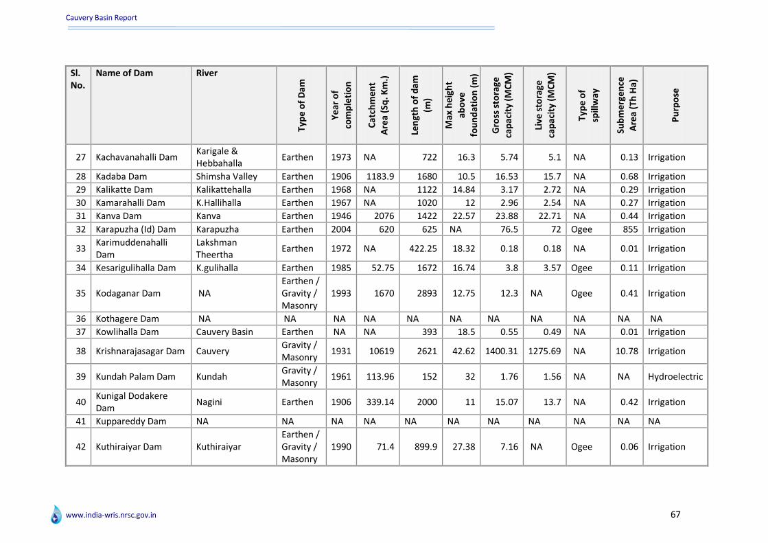
Cauvery Basin Report
www.india-wris.nrsc.gov.in 67
Sl. No.
Name of Dam River
Typ
e o
f D
am
Ye
ar o
f
com
ple
tio
n
Cat
chm
en
t A
rea
(Sq
. Km
.)
Len
gth
of
dam
(m
)
Max
he
igh
t
abo
ve
fou
nd
atio
n (
m)
Gro
ss s
tora
ge
cap
acit
y (M
CM
)
Live
sto
rage
ca
pac
ity
(MC
M)
Typ
e o
f
spill
way
Sub
me
rge
nce
A
rea
(Th
Ha)
Pu
rpo
se
27 Kachavanahalli Dam Karigale & Hebbahalla
Earthen 1973 NA 722 16.3 5.74 5.1 NA 0.13 Irrigation
28 Kadaba Dam Shimsha Valley Earthen 1906 1183.9 1680 10.5 16.53 15.7 NA 0.68 Irrigation
29 Kalikatte Dam Kalikattehalla Earthen 1968 NA 1122 14.84 3.17 2.72 NA 0.29 Irrigation
30 Kamarahalli Dam K.Hallihalla Earthen 1967 NA 1020 12 2.96 2.54 NA 0.27 Irrigation
31 Kanva Dam Kanva Earthen 1946 2076 1422 22.57 23.88 22.71 NA 0.44 Irrigation
32 Karapuzha (Id) Dam Karapuzha Earthen 2004 620 625 NA 76.5 72 Ogee 855 Irrigation
33 Karimuddenahalli Dam
Lakshman Theertha
Earthen 1972 NA 422.25 18.32 0.18 0.18 NA 0.01 Irrigation
34 Kesarigulihalla Dam K.gulihalla Earthen 1985 52.75 1672 16.74 3.8 3.57 Ogee 0.11 Irrigation
35 Kodaganar Dam NA Earthen / Gravity / Masonry
1993 1670 2893 12.75 12.3 NA Ogee 0.41 Irrigation
36 Kothagere Dam NA NA NA NA NA NA NA NA NA NA NA
37 Kowlihalla Dam Cauvery Basin Earthen NA NA 393 18.5 0.55 0.49 NA 0.01 Irrigation
38 Krishnarajasagar Dam Cauvery Gravity / Masonry
1931 10619 2621 42.62 1400.31 1275.69 NA 10.78 Irrigation
39 Kundah Palam Dam Kundah Gravity / Masonry
1961 113.96 152 32 1.76 1.56 NA NA Hydroelectric
40 Kunigal Dodakere Dam
Nagini Earthen 1906 339.14 2000 11 15.07 13.7 NA 0.42 Irrigation
41 Kuppareddy Dam NA NA NA NA NA NA NA NA NA NA NA
42 Kuthiraiyar Dam Kuthiraiyar Earthen / Gravity / Masonry
1990 71.4 899.9 27.38 7.16 NA Ogee 0.06 Irrigation

Cauvery Basin Report
www.india-wris.nrsc.gov.in 68
Sl. No.
Name of Dam River
Typ
e o
f D
am
Ye
ar o
f
com
ple
tio
n
Cat
chm
en
t A
rea
(Sq
. km
.)
Len
gth
of
dam
(m
)
Max
he
igh
t
abo
ve
fou
nd
atio
n (
m)
Gro
ss s
tora
ge
cap
acit
y (M
CM
)
Live
sto
rage
ca
pac
ity
(MC
M)
Typ
e o
f
spill
way
Sub
me
rge
nce
A
rea
(Th
Ha)
Pu
rpo
se
43 Lower Bhavani Dam Bhavani Earthen / Gravity / Masonry
1955 4200 8797 62 929 908 Ogee 7.88 HE,IR
44 Maidal Amanikere Dam
Agasarahalli nala Earthen 1895 52.96 810 13.8 7.4 6.97 NA 2.11 Irrigation
45 Mallaghatta Dam Shimsha Valley Earthen NA 57.36 750 15.6 16.62 14.86 NA 0.63 Irrigation
46 Manchanabele Dam Arkavathy Earthen / Gravity / Masonry
1993 1590 362.2 38.71 34.6 30.04 Ogee 0.37 Irrigation
47 Mangala I Dam Nagini River Earthen 1969 749 610 13.1 15 13.5 NA 0.25 Irrigation
48 Mangala II Dam Cauvery Earthen 1977 NA 661.4 25 5.85 4.89 NA 0.53 Irrigation
49 Maralvadi Dam Arkavathy Earthen 1938 NA 480 16.5 74.04 67.35 NA 0.07 Irrigation
50 Maravakandi Forbay Dam
Aravarihalla Earthen / Gravity / Masonry
1947 21 415 22 0.82 NA NA
NA Hydroelectric
51 Marconahally Dam Shimsha Valley Earthen / Gravity / Masonry
1940 4103 1609 22.4 68 64 NA
1.46 Irrigation
52 Marudhanadi Dam Maurdhanadhi Earthen 1979 53.35 808 27.43 4.93 NA Ogee 0.07 Irrigation
53 Mayasandra Dam Shimsha Valley Earthen 1906 74.85 1410 10.7 4.86 3.89 NA 0.21 Irrigation
54 Mettur Dam Cauvery Gravity / Masonry
1934 42217 1615.44 70.41 2708.79 2647 NA
15.35 HE,IR
55 Moyar Forebay Dam NA Earthen / Gravity / Masonry
1951 154.23 731 22 0.17 NA NA NA
Hydroelectric
56 Mukurthy Dam NA NA NA NA NA NA NA NA NA NA NA

Cauvery Basin Report
www.india-wris.nrsc.gov.in 69
Sl. No.
Name of Dam River
Typ
e o
f D
am
Ye
ar o
f
com
ple
tio
n
Cat
chm
en
t A
rea
(Sq
. km
.)
Len
gth
of
dam
(m
)
Max
he
igh
t
abo
ve
fou
nd
atio
n (
m)
Gro
ss s
tora
ge
cap
acit
y (M
CM
)
Live
sto
rage
ca
pac
ity
(MC
M)
Typ
e o
f
spill
way
Sub
me
rge
nce
A
rea
(Th
Ha)
Pu
rpo
se
57 Muthurayanakere Dam
Local Nala Earthen 1970 NA 1140 12.06 6.8 5.87 NA NA
Irrigation
58 Nagavathi Dam Nagavathy Earthen 1986 105.36 306 15.81 4.65 4.65 Ogee 0.12 Irrigation
59 Nallathangal Odai Dam
NA NA NA NA NA NA NA NA NA NA NA
60 Nallur Amanikere Dam
Gundlu Earthen 1987 416.7 1802 15.04 6.54 5.89 NA
0.2 Irrigation
61 Nanganjiyar Dam Nanganjiyar Gravity / Masonry
2007 389 2680 21.5 7.2 6.59 NA
0.16 Irrigation
62 Nelligudda Dam Bidadi Halla Earthen 1940 NA 740 17.07 6.13 5.68 NA 0.16 Irrigation
63 Neralatti Kere Dam NA NA NA NA NA NA NA NA NA NA NA
64 New Amachawadi Dam
Yennehole Stream Earthen 1984 NA
540 15.29 1.69 1.56 NA
0.06 Irrigation
65 Nidasale Dam Nagini Earthen 1906 NA 870 11 6.63 5.31 NA 0.12 Irrigation
66 Nittur Dam Shimsha Valley Earthen 1906 278.62 1350 10.5 5.41 5.41 NA 0.25 Irrigation
67 Nonavinakere Lake Dam
NA NA NA NA NA NA NA NA NA NA NA
68 Noyyal Athupalayam Dam
Noyyal Earthen 1992 13 2850 14.06 6.66 6.46 NA
0.17 Irrigation
69 Noyyal Orathupalayam Dam
Noyyal Earthen 1992 2245.53 2290 21.7 17.48 NA Ogee 0.42 Irrigation
70 Nugu Dam Nugu Earthen / Gravity / Masonry
1959 308 637.65 43.58 154.04 129.85 NA
3.24 HE,IR
71 Obichudanahally Dam Arkavathy Earthen 1989 NA 637 28.7 4.67 3.3 NA 0.04 Irrigation
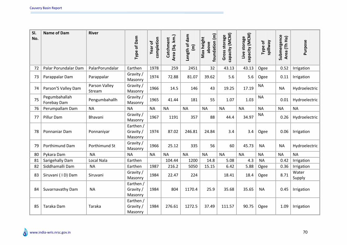
Cauvery Basin Report
www.india-wris.nrsc.gov.in 70
Sl. No.
Name of Dam River
Typ
e o
f D
am
Ye
ar o
f
com
ple
tio
n
Cat
chm
en
t A
rea
(Sq
. km
.)
Len
gth
of
dam
(m
)
Max
he
igh
t
abo
ve
fou
nd
atio
n (
m)
Gro
ss s
tora
ge
cap
acit
y (M
CM
)
Live
sto
rage
ca
pac
ity
(MC
M)
Typ
e o
f
spill
way
Sub
me
rge
nce
A
rea
(Th
Ha)
Pu
rpo
se
72 Palar Porundalar Dam PalarPorundalar Earthen 1978 259 2451 32 43.13 43.13 Ogee 0.52 Irrigation
73 Parappalar Dam Parappalar Gravity / Masonry
1974 72.88 81.07 39.62 5.6 5.6 Ogee 0.11 Irrigation
74 Parson’S Valley Dam Parson Valley Stream
Gravity / Masonry
1966 14.5 146 43 19.25 17.19 NA
NA Hydroelectric
75 Pegumbahallah Forebay Dam
Pengumbahallh Gravity / Masonry
1965 41.44 181 55 1.07 1.03 NA
0.01 Hydroelectric
76 Perumpallam Dam NA NA NA NA NA NA NA NA NA NA NA
77 Pillur Dam Bhavani Gravity / Masonry
1967 1191 357 88 44.4 34.97 NA
0.26 Hydroelectric
78 Ponnaniar Dam Ponnaniyar Earthen / Gravity / Masonry
1974 87.02 246.81 24.84 3.4 3.4 Ogee 0.06 Irrigation
79 Porthimund Dam Porthimund St Gravity / Masonry
1966 25.12 335 56 60 45.73 NA NA Hydroelectric
80 Pykara Dam NA NA NA NA NA NA NA NA NA NA NA
81 Sarigehally Dam Local Nala Earthen 104.44 1200 14.8 5.08 4.3 NA 0.42 Irrigation
82 Siddhamalli Dam NA Earthen 1987 216.2 5050 15.15 6.42 5.88 Ogee 0.36 Irrigation
83 Siruvani ( I D) Dam Siruvani Gravity / Masonry
1984 22.47 224 18.41 18.4 Ogee 8.71 Water Supply
84 Suvarnavathy Dam NA Earthen / Gravity / Masonry
1984 804 1170.4 25.9 35.68 35.65 NA 0.45 Irrigation
85 Taraka Dam Taraka Earthen / Gravity / Masonry
1984 276.61 1272.5 37.49 111.57 90.75 Ogee 1.09 Irrigation
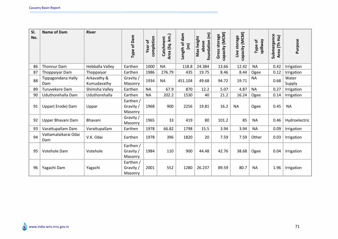
Cauvery Basin Report
www.india-wris.nrsc.gov.in 71
Sl. No.
Name of Dam River
Typ
e o
f D
am
Ye
ar o
f
com
ple
tio
n
Cat
chm
en
t A
rea
(Sq
. km
.)
Len
gth
of
dam
(m
)
Max
he
igh
t
abo
ve
fou
nd
atio
n (
m)
Gro
ss s
tora
ge
cap
acit
y (M
CM
)
Live
sto
rage
ca
pac
ity
(MC
M)
Typ
e o
f
spill
way
Sub
me
rge
nce
A
rea
(Th
Ha)
Pu
rpo
se
86 Thonnur Dam Hebballa Valley Earthen 1000 NA 118.8 24.384 13.66 12.42 NA 0.42 Irrigation
87 Thoppaiyar Dam Thoppaiyar Earthen 1986 276.79 435 19.75 8.46 8.44 Ogee 0.12 Irrigation
88 Tippagondana Hally Dam
Arkavathy & Kumudavathy
Gravity / Masonry
1934 NA 451.104 49.68 94.72 19.71 NA
0.68 Water Supply
89 Turuvekere Dam Shimsha Valley Earthen NA 67.9 870 12.2 5.07 4.87 NA 0.27 Irrigation
90 Uduthorehalla Dam Uduthorehalla Earthen NA 202.2 1530 40 21.2 16.24 Ogee 0.14 Irrigation
91 Uppar( Erode) Dam Uppar Earthen / Gravity / Masonry
1968 900 2256 19.81 16.2 NA Ogee 0.45 NA
92 Upper Bhavani Dam Bhavani Gravity / Masonry
1965 33 419 80 101.2 85 NA 0.46 Hydroelectric
93 Varattupallam Dam Varattupallam Earthen 1978 66.82 1798 15.5 3.94 3.94 NA 0.09 Irrigation
94 Vattamalaikarai Odai Dam
V.K. Odai Earthen 1978 396 1820 20 7.59 7.59 Other 0.03 Irrigation
95 Votehole Dam Votehole Earthen / Gravity / Masonry
1984 110 900 44.48 42.76 38.68 Ogee 0.04 Irrigation
96 Yagachi Dam Yagachi Earthen / Gravity / Masonry
2001 552 1280 26.237 89.59 80.7 NA 1.96 Irrigation

Cauvery Basin Report
www.india-wris.nrsc.gov.in 72
List of BWA with surrogate information
Sl. No.
Name of B/W/A River Length (m)
Height upto crest (m)
Catchment area (Th. ha.)
Design flood discharge (Cumecs)
Purpose
1 Bangaradoddy Anicut Cauvery 164 NA NA 9910.9 Irrigation
2 Bhavani Kattalai Barrage - I
Bhavani NA NA NA NA
Hydroelectric
3 Bhavani Kattalai Barrage - II
Bhavani NA NA NA NA
Hydroelectric
4 Bhavani Kattalai Barrage - III
NA NA NA NA NA
Hydroelectric
5 Chekkanur Barrage Cauvery 948
NA NA NA Hydroelectric
6 Chikka Devaraya Sagar Anicut
Cauvery 520 3.5 NA
28.03 Irrigation
7 Danagere Anicut Cauvery
NA NA NA NA Hydroelectric
8 Devaraya Anicut Cauvery 470 NA
NA 9910.9 Irrigation
9 East Varahapallam Weir
East VARAHAPALLAM stream
173 18 NA
NA Hydroelectric
10 Grand Anicut NA 329 NA
NA 5094 Irrigation
11 Kalingarayan Anicut Bhavani 902.5 1
NA 3590 Irrigation
12 Kattalai Bed Regulator Cauvery NA
NA NA NA Irrigation
13 Koneripatti Barrage Cauvery 710
NA NA NA Hydroelectric
14 Lower Colleron Anicut Colleron 710
NA NA NA Irrigation
15 Madhavamatri Anicut Cauvery NA
NA NA NA Irrigation

Cauvery Basin Report
www.india-wris.nrsc.gov.in 73
Sl. No.
Name of B/W/A River Length (m)
Height upto crest (m)
Catchment area (Th. ha.)
Design flood discharge (Cumecs)
Purpose
16 Nerunjipettai Barrage Cauvery 1478
NA NA NA Hydroelectric
17 Netkal Balancing Reservoir
Cauvery NA NA NA NA
Hydroelectric
18 Niralapallam Weir NA 60 18 54 519 Hydroelectric
19 Orathupalayam Barrage Noyal
NA NA NA NA Irrigation
20 Rajaparameshwari Anicut
Cauvery NA NA NA NA
Irrigation
21 Ramaswamy Anicut Cauvery 978
NA NA 9910.9 Irrigation
22 Siva balancing Reservoir Cauvery
NA NA NA NA Hydroelectric
23 Upper Anicut Cauvery
NA NA NA NA Irrigation
24 Upper Bhavani Weir NA
NA NA NA NA Hydroelectric
25 Urachikottar Barrage Cauvery 1085
NA NA NA Hydroelectric
26 Virija Anicut Cauvery NA
NA NA 9910.9 Irrigation

Cauvery Basin Report
www.india-wris.nrsc.gov.in 74
Major/Medium irrigation projects with surrogate information
Sl. No.
Name of Project Type River Tributary Status
Ye
ar o
f
com
ple
tio
n
GC
A (
Th h
a)
CC
A (
Th h
a)
Ult
imat
e
Irri
gati
on
P
ote
nti
al
Dis
tric
ts
Be
ne
fitt
ed
1 Amaravathy Medium Irrigation Project
Medium Amaravati Amaravathy Completed 1958 NA 8.70 8.70 Coimbatore, erode
2 Arkavathi Medium Irrigation Project
Medium Arkavathy Arkavathy Completed NA NA 8.50 6.23 Bangalore
3 Badanavalu Medium Irrigation Project
Medium NA NA Ongoing NA NA NA 3.27 Mysore
4 Banahalli Hundi Lift Irrigation Project
Medium NA Kabini River Completed NA NA NA 1.77 Mysore
5
Banasurasagar Medium Irrigation Project
Medium Kabini Panamaram Ongoing NA NA 2.80 4.80 Wynad
6
Byramangala Medium Irrigation Project
Medium Vrishabavathy
Vrishabhavathy Completed 1945 2.45 2.19 2.23 Bangalore
7
Cauvery Anicut Channels Major Irrigation Project
Major NA Cauvery Completed 1900 NA 76.88 77.17 Bangalore, Hassan, Kodagu, Mandya, Mysore
8
Cauvery Delta Major Irrigation Project_Puducherry
Major NA Cauvery Completed NA 11 18 Karaikal
9
Cauvery Delta Major Irrigation Project_Tamilnadu
Major Cauvery Cauvery Completed 1889 NA 368 504.64 Thanjavur (TN), Karaikal (PY)
10
Cauvery Mettur Major Irrigation project
Major Cauvery Cauvery Completed 1934 491.36 103.60 111.70 Thanjavur,pudukkottai
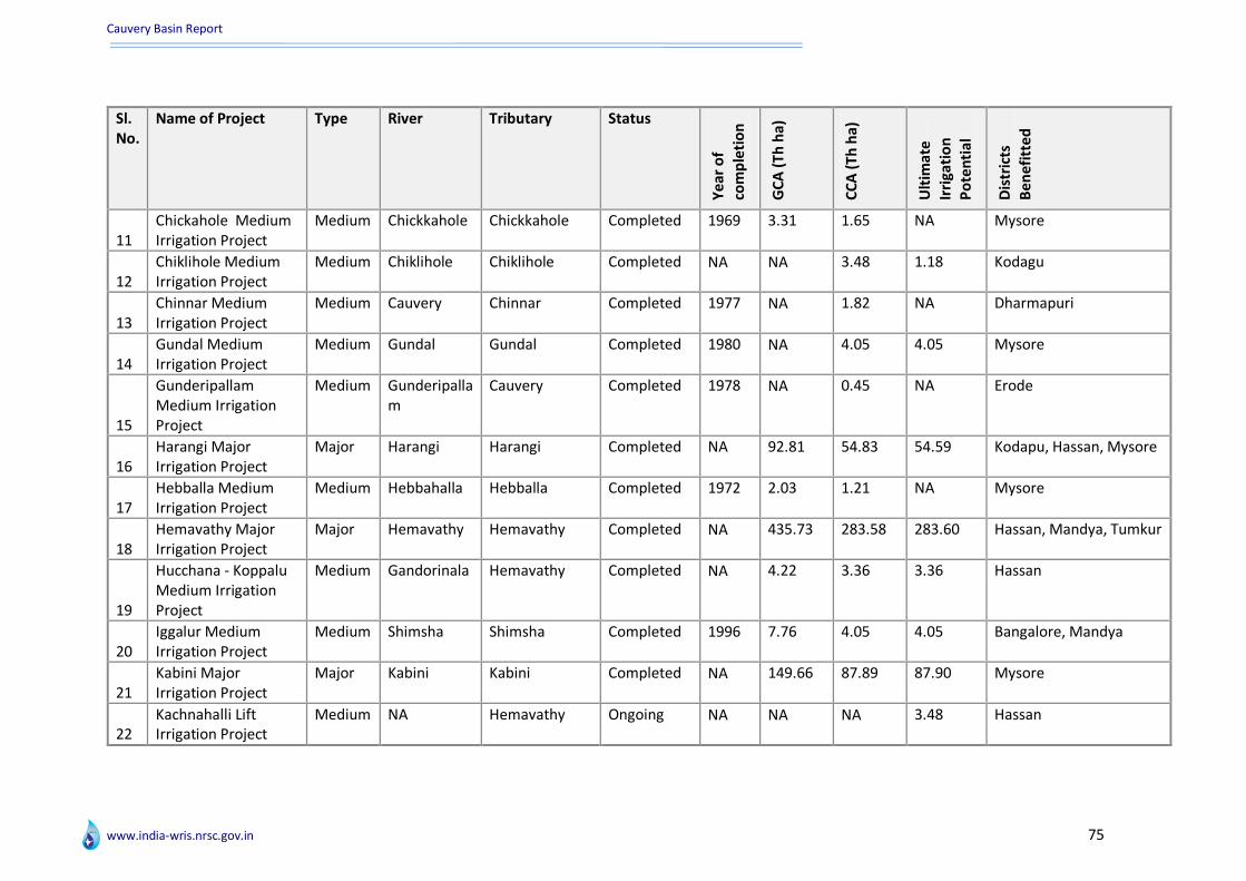
Cauvery Basin Report
www.india-wris.nrsc.gov.in 75
Sl. No.
Name of Project Type River Tributary Status
Ye
ar o
f
com
ple
tio
n
GC
A (
Th h
a)
CC
A (
Th h
a)
Ult
imat
e
Irri
gati
on
P
ote
nti
al
Dis
tric
ts
Be
ne
fitt
ed
11 Chickahole Medium Irrigation Project
Medium Chickkahole Chickkahole Completed 1969 3.31 1.65 NA Mysore
12 Chiklihole Medium Irrigation Project
Medium Chiklihole Chiklihole Completed NA NA 3.48 1.18 Kodagu
13 Chinnar Medium Irrigation Project
Medium Cauvery Chinnar Completed 1977 NA 1.82 NA Dharmapuri
14 Gundal Medium Irrigation Project
Medium Gundal Gundal Completed 1980 NA 4.05 4.05 Mysore
15
Gunderipallam Medium Irrigation Project
Medium Gunderipallam
Cauvery Completed 1978 NA 0.45 NA Erode
16 Harangi Major Irrigation Project
Major Harangi Harangi Completed NA 92.81 54.83 54.59 Kodapu, Hassan, Mysore
17 Hebballa Medium Irrigation Project
Medium Hebbahalla Hebballa Completed 1972 2.03 1.21 NA Mysore
18 Hemavathy Major Irrigation Project
Major Hemavathy Hemavathy Completed NA 435.73 283.58 283.60 Hassan, Mandya, Tumkur
19
Hucchana - Koppalu Medium Irrigation Project
Medium Gandorinala Hemavathy Completed NA 4.22 3.36 3.36 Hassan
20 Iggalur Medium Irrigation Project
Medium Shimsha Shimsha Completed 1996 7.76 4.05 4.05 Bangalore, Mandya
21 Kabini Major Irrigation Project
Major Kabini Kabini Completed NA 149.66 87.89 87.90 Mysore
22 Kachnahalli Lift Irrigation Project
Medium NA Hemavathy Ongoing NA NA NA 3.48 Hassan

Cauvery Basin Report
www.india-wris.nrsc.gov.in 76
Sl. No.
Name of Project Type River Tributary Status
Ye
ar o
f
com
ple
tio
n
GC
A (
Th h
a)
CC
A (
Th h
a)
Ult
imat
e
Irri
gati
on
P
ote
nti
al
Dis
tric
ts
Be
ne
fitt
ed
23 Kalingarayan Major Irrigation Project
Major Cauvery / Bhavani
Bhavani Completed 1893 NA NA NA Erode
24 Kama Samundra Lift Irrigation Project
Medium Hamavathy Hemavathi Completed NA 13.43 3.58 5.13 Hassan
25 Kanva Medium Irrigation Project
Medium Kanva Kanva Completed 1946 3.44 2.08 2.58 Bangalore
26 Karapuzha Medium Irrigation Project
Medium Panamaram Karampuzha Ongoing NA 6.80 5.58 9.87 Wynad
27 Kattalai Major Irrigation Project
Major Cauvery Cauvery Completed 1926 34.26 NA NA Trichirapalli, Thanjavur
28 Kodaganar Medium Irrigation Project
Medium Kodaganar KODAGANAR Completed NA 1.56 NA NA dindiguil
29
Kodivery Anicut System Major Irrigation Project
Major Bhavani Bhavani Completed 1894 NA 9.92 19.83 Erode
30
Krishnarajasagar Major Irrigation Project
Major Cauvery Cauvery Completed 1931 201.16 79.31 79.31 Mandya, Mysore
31 Kuthiraiyar Medium Irrigation Project
Medium Kuthiraiyar Cauvery Completed 1990 1.68 NA NA Dindigul
32 Lower Bhavani Major Irrigation Project
Major Cauvery Bhavani Completed 1955 113.46 83.77 83.77 Erode,Thiruchirapalli
33
Lower Coleroon Anicut Major Irrigation Project
Major Cauvery COLeroon Completed 1903 NA NA NA Cuddalore, Thanjavur
34 Manchanabele Medium Irri. Project
Medium Arkavathy Arkavathy Completed NA 3.83 2.43 2.43 Bangalore
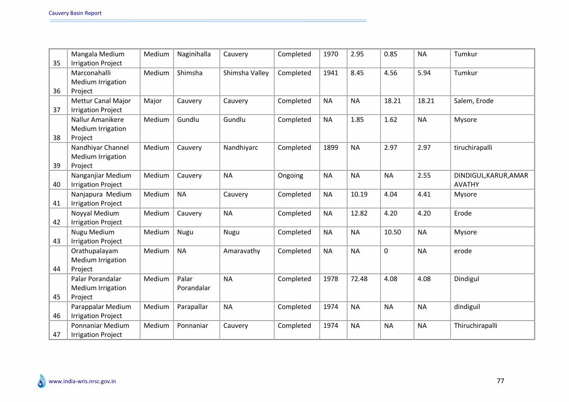
Cauvery Basin Report
www.india-wris.nrsc.gov.in 77
35 Mangala Medium Irrigation Project
Medium Naginihalla Cauvery Completed 1970 2.95 0.85 NA Tumkur
36
Marconahalli Medium Irrigation Project
Medium Shimsha Shimsha Valley Completed 1941 8.45 4.56 5.94 Tumkur
37 Mettur Canal Major Irrigation Project
Major Cauvery Cauvery Completed NA NA 18.21 18.21 Salem, Erode
38
Nallur Amanikere Medium Irrigation Project
Medium Gundlu Gundlu Completed NA 1.85 1.62 NA Mysore
39
Nandhiyar Channel Medium Irrigation Project
Medium Cauvery Nandhiyarc Completed 1899 NA 2.97 2.97 tiruchirapalli
40 Nanganjiar Medium Irrigation Project
Medium Cauvery NA Ongoing NA NA NA 2.55 DINDIGUL,KARUR,AMARAVATHY
41 Nanjapura Medium Irrigation Project
Medium NA Cauvery Completed NA 10.19 4.04 4.41 Mysore
42 Noyyal Medium Irrigation Project
Medium Cauvery NA Completed NA 12.82 4.20 4.20 Erode
43 Nugu Medium Irrigation Project
Medium Nugu Nugu Completed NA NA 10.50 NA Mysore
44
Orathupalayam Medium Irrigation Project
Medium NA Amaravathy Completed NA NA 0 NA erode
45
Palar Porandalar Medium Irrigation Project
Medium Palar Porandalar
NA Completed 1978 72.48 4.08 4.08 Dindigul
46 Parappalar Medium Irrigation Project
Medium Parapallar NA Completed 1974 NA NA NA dindiguil
47 Ponnaniar Medium Irrigation Project
Medium Ponnaniar Cauvery Completed 1974 NA NA NA Thiruchirapalli

Cauvery Basin Report
www.india-wris.nrsc.gov.in 78
Sl. No.
Name of Project Type River Tributary Status
Ye
ar o
f
com
ple
tio
n
GC
A (
Th h
a)
CC
A (
Th h
a)
Ult
imat
e
Irri
gati
on
P
ote
nti
al
Dis
tric
ts
Be
ne
fitt
ed
48
Pullambadi Canal Medium Irrigation Project
Medium Cauvery Penniyar Completed NA NA 8.94 8.94 Thiruchirapalli
49 Siddhamalli Medium Irrigation Project
Medium Siddhamalli Cauvery Completed 1987 NA 2.05 1.70 Thiruchirapalli
50
Suvarnavathy Medium Irrigation Project
Medium Suvarnavathy
NA Completed 1984 4.80 2.83 NA Mysore
51 Taraka Medium Irrigation Project
Medium Taraka Taraka Completed 13.81 7.04 7.04 Mysore
52 Thoppaiyar Medium Irrigation Project
Medium Thoppaiyar NA Completed 1986 3.94 2.16 4.31 Dharmapuri
53
Uduthorehalla Medium Irrigation Project
Medium Uduthorehalla
Uduthorehalla Completed 9.40 6.48 6.60 Mysore
54
Varattupallam Medium Irrigation Project
Medium Varattupallam
Cauvery Completed 1978 NA NA NA Erode
55
Vattamalai Karai Odai Medium Irrigation Project
Medium Vattamalaikari Odaii
Cauvery Completed 1978 NA 2.30 1.20 Erode
56 Votehole Medium Irrigation Project
Medium Votehole Votehole Completed NA 9.81 7.49 7.49 Hassan
57 Yagachi Major Irrigation Project
Major Yagachi Yagachi Ongoing NA NA 21.25 21.45 Hassan
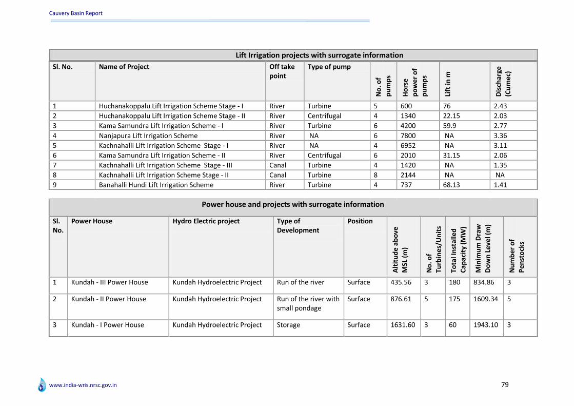
Cauvery Basin Report
www.india-wris.nrsc.gov.in 79
Lift Irrigation projects with surrogate information
Sl. No. Name of Project Off take point
Type of pump
No
. of
pu
mp
s
Ho
rse
p
ow
er
of
pu
mp
s
Lift
in m
Dis
char
ge
(Cu
me
c)
1 Huchanakoppalu Lift Irrigation Scheme Stage - I River Turbine 5 600 76 2.43
2 Huchanakoppalu Lift Irrigation Scheme Stage - II River Centrifugal 4 1340 22.15 2.03
3 Kama Samundra Lift Irrigation Scheme - I River Turbine 6 4200 59.9 2.77
4 Nanjapura Lift Irrigation Scheme River NA 6 7800 NA 3.36
5 Kachnahalli Lift Irrigation Scheme Stage - I River NA 4 6952 NA 3.11
6 Kama Samundra Lift Irrigation Scheme - II River Centrifugal 6 2010 31.15 2.06
7 Kachnahalli Lift Irrigation Scheme Stage - III Canal Turbine 4 1420 NA 1.35
8 Kachnahalli Lift Irrigation Scheme Stage - II Canal Turbine 8 2144 NA NA
9 Banahalli Hundi Lift Irrigation Scheme River Turbine 4 737 68.13 1.41
Power house and projects with surrogate information
Sl. No.
Power House Hydro Electric project Type of Development
Position
Alt
itu
de
abo
ve
MSL
(m
)
No
. of
Turb
ine
s/U
nit
s
Tota
l In
stal
led
Cap
acit
y (M
W)
Min
imu
m D
raw
Do
wn
Lev
el (
m)
Nu
mb
er o
f
Pen
sto
cks
1 Kundah - III Power House Kundah Hydroelectric Project Run of the river Surface 435.56 3 180 834.86 3
2 Kundah - II Power House Kundah Hydroelectric Project Run of the river with small pondage
Surface 876.61 5 175 1609.34 5
3 Kundah - I Power House Kundah Hydroelectric Project Storage Surface 1631.60 3 60 1943.10 3
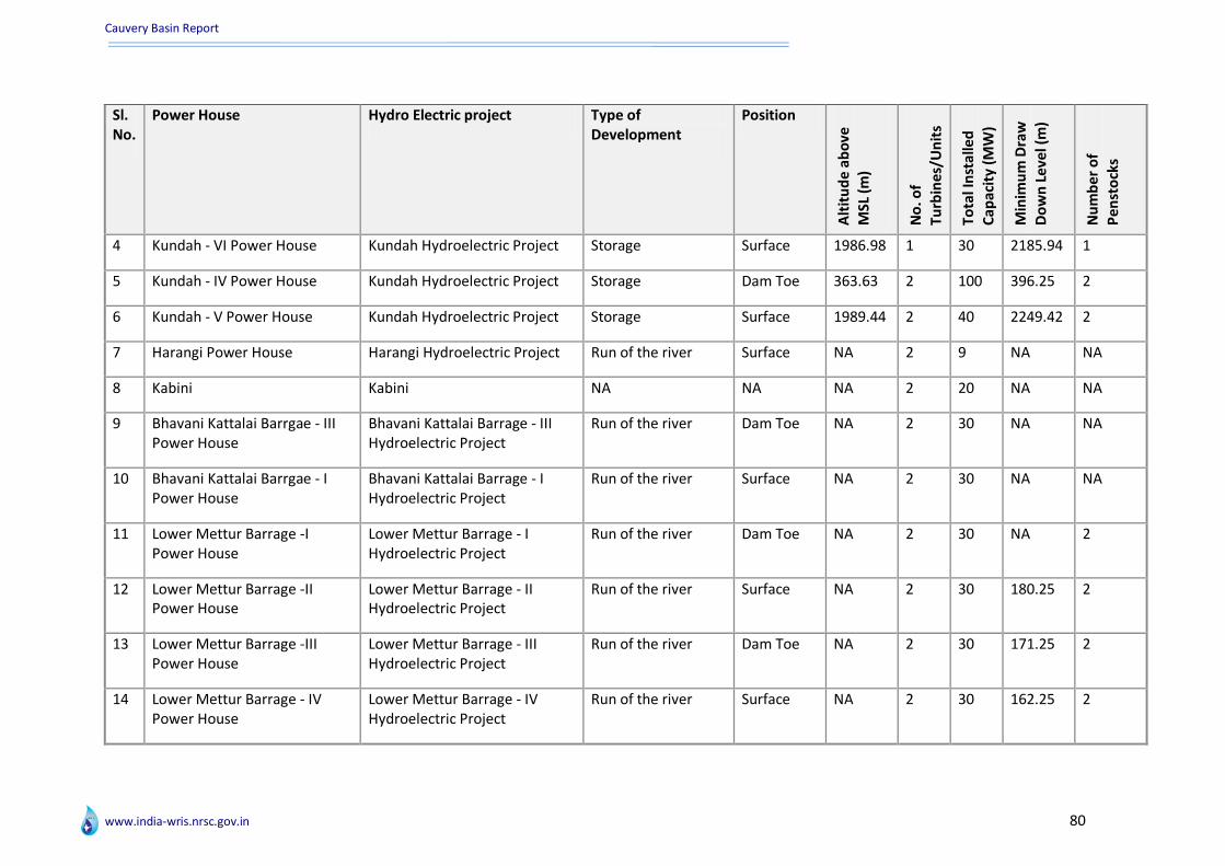
Cauvery Basin Report
www.india-wris.nrsc.gov.in 80
Sl. No.
Power House Hydro Electric project Type of Development
Position
Alt
itu
de
ab
ove
M
SL (
m)
No
. of
Turb
ine
s/U
nit
s
Tota
l In
sta
lled
Cap
acit
y (M
W)
Min
imu
m D
raw
Do
wn
Le
vel (
m)
Nu
mb
er
of
Pe
nst
ock
s
4 Kundah - VI Power House Kundah Hydroelectric Project Storage Surface 1986.98 1 30 2185.94 1
5 Kundah - IV Power House Kundah Hydroelectric Project Storage Dam Toe 363.63 2 100 396.25 2
6 Kundah - V Power House Kundah Hydroelectric Project Storage Surface 1989.44 2 40 2249.42 2
7 Harangi Power House Harangi Hydroelectric Project Run of the river Surface NA 2 9 NA NA
8 Kabini Kabini NA NA NA 2 20 NA NA
9 Bhavani Kattalai Barrgae - III Power House
Bhavani Kattalai Barrage - III Hydroelectric Project
Run of the river Dam Toe NA 2 30 NA NA
10 Bhavani Kattalai Barrgae - I Power House
Bhavani Kattalai Barrage - I Hydroelectric Project
Run of the river Surface NA 2 30 NA NA
11 Lower Mettur Barrage -I Power House
Lower Mettur Barrage - I Hydroelectric Project
Run of the river Dam Toe NA 2 30 NA 2
12 Lower Mettur Barrage -II Power House
Lower Mettur Barrage - II Hydroelectric Project
Run of the river Surface NA 2 30 180.25 2
13 Lower Mettur Barrage -III Power House
Lower Mettur Barrage - III Hydroelectric Project
Run of the river Dam Toe NA 2 30 171.25 2
14 Lower Mettur Barrage - IV Power House
Lower Mettur Barrage - IV Hydroelectric Project
Run of the river Surface NA 2 30 162.25 2
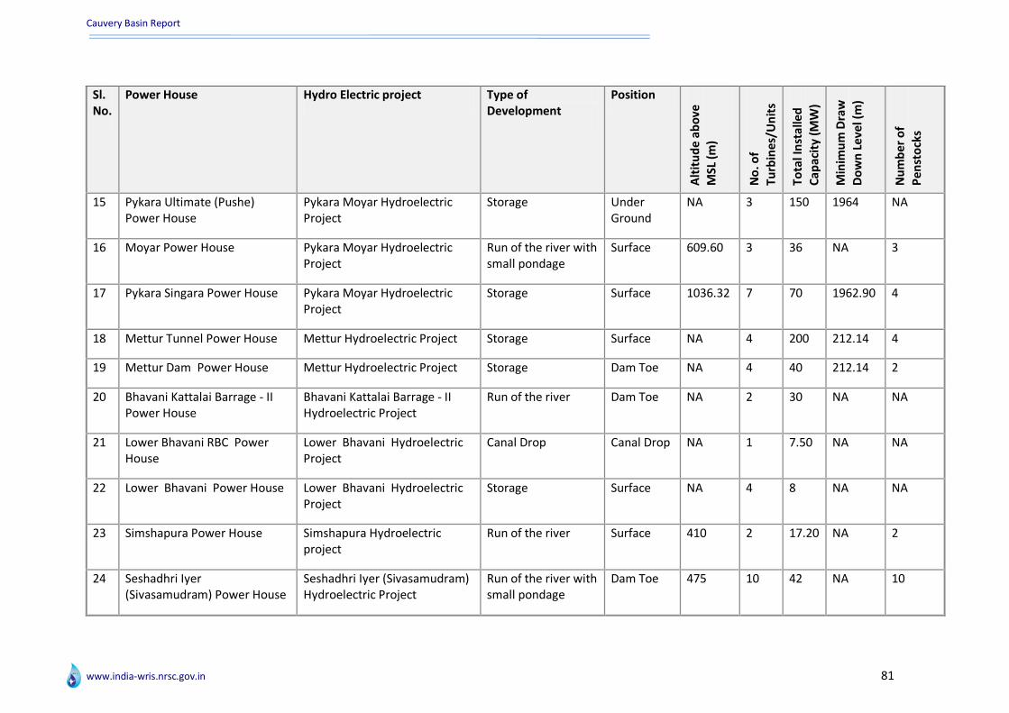
Cauvery Basin Report
www.india-wris.nrsc.gov.in 81
Sl. No.
Power House Hydro Electric project Type of Development
Position
Alt
itu
de
ab
ove
M
SL (
m)
No
. of
Turb
ine
s/U
nit
s
Tota
l In
sta
lled
Cap
acit
y (M
W)
Min
imu
m D
raw
Do
wn
Le
vel (
m)
Nu
mb
er
of
Pe
nst
ock
s
15 Pykara Ultimate (Pushe) Power House
Pykara Moyar Hydroelectric Project
Storage Under Ground
NA 3 150 1964 NA
16 Moyar Power House Pykara Moyar Hydroelectric Project
Run of the river with small pondage
Surface 609.60 3 36 NA 3
17 Pykara Singara Power House Pykara Moyar Hydroelectric Project
Storage Surface 1036.32 7 70 1962.90 4
18 Mettur Tunnel Power House Mettur Hydroelectric Project Storage Surface NA 4 200 212.14 4
19 Mettur Dam Power House Mettur Hydroelectric Project Storage Dam Toe NA 4 40 212.14 2
20 Bhavani Kattalai Barrage - II Power House
Bhavani Kattalai Barrage - II Hydroelectric Project
Run of the river Dam Toe NA 2 30 NA NA
21 Lower Bhavani RBC Power House
Lower Bhavani Hydroelectric Project
Canal Drop Canal Drop NA 1 7.50 NA NA
22 Lower Bhavani Power House Lower Bhavani Hydroelectric Project
Storage Surface NA 4 8 NA NA
23 Simshapura Power House Simshapura Hydroelectric project
Run of the river Surface 410 2 17.20 NA 2
24 Seshadhri Iyer (Sivasamudram) Power House
Seshadhri Iyer (Sivasamudram) Hydroelectric Project
Run of the river with small pondage
Dam Toe 475 10 42 NA 10

Cauvery Basin Report
www.india-wris.nrsc.gov.in 82
ERM projects with surrogate information
Sl. No. Name of Project River Status Year of completion Districts Benefitted Purpose
1 Dr.D. Urs. Canal Cauvery Ongoing NA Mandya, Mysore Irrigation
2 New Kattalai High Level Canal Cauvery Completed NA Thanjavur, thiruchirapali Irrigation
3 Modernisation of Krishnaraja-sagar Canal Cauvery Ongoing NA Mandya, Mysore Irrigation
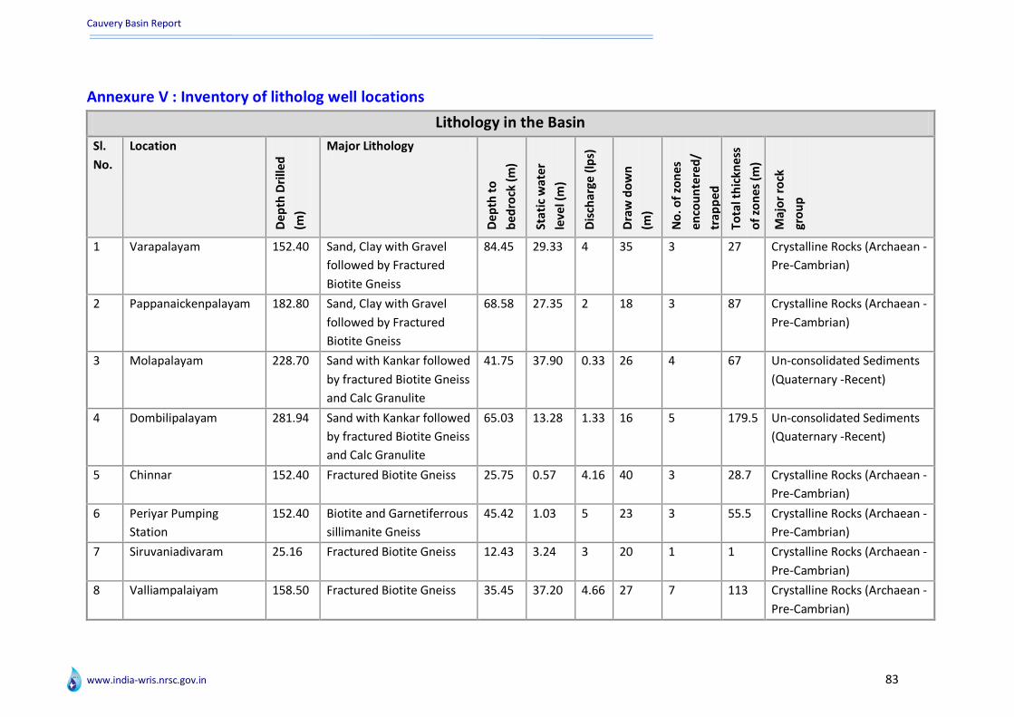
Cauvery Basin Report
www.india-wris.nrsc.gov.in 83
Annexure V : Inventory of litholog well locations
Lithology in the Basin
Sl.
No.
Location
De
pth
Dri
lled
(m)
Major Lithology
De
pth
to
be
dro
ck (
m)
Sta
tic
wat
er
leve
l (m
)
Dis
char
ge (
lps)
Dra
w d
ow
n
(m)
No
. of
zon
es
en
cou
nte
red
/
trap
pe
d
Tota
l th
ickn
ess
of
zon
es
(m)
Maj
or
rock
gro
up
1 Varapalayam 152.40 Sand, Clay with Gravel
followed by Fractured
Biotite Gneiss
84.45 29.33 4 35 3 27 Crystalline Rocks (Archaean -
Pre-Cambrian)
2 Pappanaickenpalayam 182.80 Sand, Clay with Gravel
followed by Fractured
Biotite Gneiss
68.58 27.35 2 18 3 87 Crystalline Rocks (Archaean -
Pre-Cambrian)
3 Molapalayam 228.70 Sand with Kankar followed
by fractured Biotite Gneiss
and Calc Granulite
41.75 37.90 0.33 26 4 67 Un-consolidated Sediments
(Quaternary -Recent)
4 Dombilipalayam 281.94 Sand with Kankar followed
by fractured Biotite Gneiss
and Calc Granulite
65.03 13.28 1.33 16 5 179.5 Un-consolidated Sediments
(Quaternary -Recent)
5 Chinnar 152.40 Fractured Biotite Gneiss 25.75 0.57 4.16 40 3 28.7 Crystalline Rocks (Archaean -
Pre-Cambrian)
6 Periyar Pumping
Station
152.40 Biotite and Garnetiferrous
sillimanite Gneiss
45.42 1.03 5 23 3 55.5 Crystalline Rocks (Archaean -
Pre-Cambrian)
7 Siruvaniadivaram 25.16 Fractured Biotite Gneiss 12.43 3.24 3 20 1 1 Crystalline Rocks (Archaean -
Pre-Cambrian)
8 Valliampalaiyam 158.50 Fractured Biotite Gneiss 35.45 37.20 4.66 27 7 113 Crystalline Rocks (Archaean -
Pre-Cambrian)

Cauvery Basin Report
www.india-wris.nrsc.gov.in 84
Sl.
No.
Location
De
pth
Dri
lled
(m)
Major Lithology
De
pth
to
be
dro
ck (
m)
Sta
tic
wat
er
leve
l (m
)
Dis
char
ge (
lps)
Dra
w d
ow
n
(m)
No
. of
zon
es
en
cou
nte
red
/
trap
pe
d
Tota
l
thic
kne
ss o
f
zon
es
(m)
Maj
or
rock
gro
up
9 Veerakeralam 140.20 Fractured Biotite Gneiss 61.57 24.78 6.66 25 NA NA NA
10 Vedapatti 147.16 Fractured Biotite Gneiss 47.39 12.56 10 19 NA NA NA
11 Vadakkalur 184.10 Fractured Biotite Gneiss 14.94 11.54 2.16 45 8 112 Crystalline Rocks (Archaean -
Pre-Cambrian)
12 Kanur Pudur 100.74 Fractured Biotite Gneiss 4.50 16.83 6.66 14 4 73.3 Crystalline Rocks (Archaean -
Pre-Cambrian)
13 Kumarapalayam 184.57 Fractured Biotite Gneiss
withPegmatite and Quartz
Veins
22.70 13.08 1.66 13 4 105.5 Crystalline Rocks (Archaean -
Pre-Cambrian)
14 Rudrampalayam 182.86 Fractured Biotite Gneiss 27.14 17.08 6.66 5 2 22 Crystalline Rocks (Archaean -
Pre-Cambrian)
15 Nariyampalli 70.10 Fractured Biotite Gneiss 25.42 7.23 6.66 25 3 36.57 Crystalline Rocks (Archaean -
Pre-Cambrian)
16 Arasampalayam 123.14 Fractured Biotite Gneiss
with Pegmatites
2.55 19.38 0.33 13 5 78 Crystalline Rocks (Archaean -
Pre-Cambrian)
17 Ellachipalaym 201.11 Fractured Biotite Gneiss
with Pegmatites
4 18.53 0.66 13 9 163.7 Crystalline Rocks (Archaean -
Pre-Cambrian)
18 Ariyagoundanpalayam 201.17 Fractured Biotite Gneiss
with Pegmatites
5 25.47 8.33 10 4 74 Crystalline Rocks (Archaean -
Pre-Cambrian)
19 Vetturvampalayam 220.60 Fractured Biotite Gneiss 3.10 18.14 0.33 34 4 148 Crystalline Rocks (Archaean -
Pre-Cambrian)
20 Suripalayam 121.92 Fractured Biotite Gneiss 61 29.32 8.33 11 3 89.72 Crystalline Rocks (Archaean -
Pre-Cambrian)
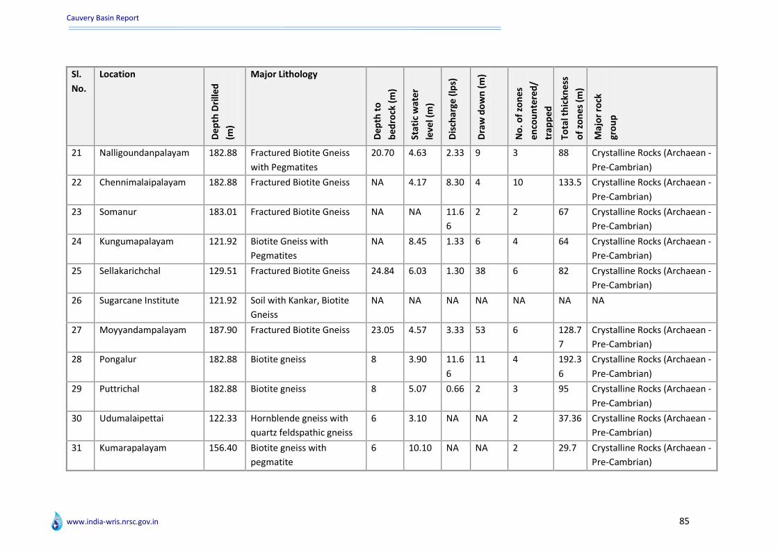
Cauvery Basin Report
www.india-wris.nrsc.gov.in 85
Sl.
No.
Location
De
pth
Dri
lled
(m)
Major Lithology
De
pth
to
be
dro
ck (
m)
Sta
tic
wat
er
leve
l (m
)
Dis
char
ge (
lps)
Dra
w d
ow
n (
m)
No
. of
zon
es
en
cou
nte
red
/
trap
pe
d
Tota
l th
ickn
ess
of
zon
es
(m)
Maj
or
rock
gro
up
21 Nalligoundanpalayam 182.88 Fractured Biotite Gneiss
with Pegmatites
20.70 4.63 2.33 9 3 88 Crystalline Rocks (Archaean -
Pre-Cambrian)
22 Chennimalaipalayam 182.88 Fractured Biotite Gneiss NA 4.17 8.30 4 10 133.5 Crystalline Rocks (Archaean -
Pre-Cambrian)
23 Somanur 183.01 Fractured Biotite Gneiss NA NA 11.6
6
2 2 67 Crystalline Rocks (Archaean -
Pre-Cambrian)
24 Kungumapalayam 121.92 Biotite Gneiss with
Pegmatites
NA 8.45 1.33 6 4 64 Crystalline Rocks (Archaean -
Pre-Cambrian)
25 Sellakarichchal 129.51 Fractured Biotite Gneiss 24.84 6.03 1.30 38 6 82 Crystalline Rocks (Archaean -
Pre-Cambrian)
26 Sugarcane Institute 121.92 Soil with Kankar, Biotite
Gneiss
NA NA NA NA NA NA NA
27 Moyyandampalayam 187.90 Fractured Biotite Gneiss 23.05 4.57 3.33 53 6 128.7
7
Crystalline Rocks (Archaean -
Pre-Cambrian)
28 Pongalur 182.88 Biotite gneiss 8 3.90 11.6
6
11 4 192.3
6
Crystalline Rocks (Archaean -
Pre-Cambrian)
29 Puttrichal 182.88 Biotite gneiss 8 5.07 0.66 2 3 95 Crystalline Rocks (Archaean -
Pre-Cambrian)
30 Udumalaipettai 122.33 Hornblende gneiss with
quartz feldspathic gneiss
6 3.10 NA NA 2 37.36 Crystalline Rocks (Archaean -
Pre-Cambrian)
31 Kumarapalayam 156.40 Biotite gneiss with
pegmatite
6 10.10 NA NA 2 29.7 Crystalline Rocks (Archaean -
Pre-Cambrian)
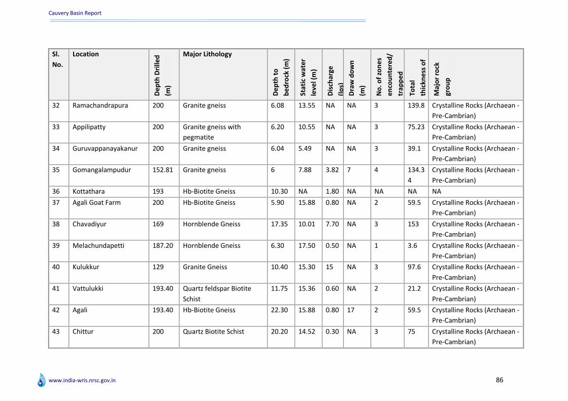
Cauvery Basin Report
www.india-wris.nrsc.gov.in 86
Sl.
No.
Location
De
pth
Dri
lled
(m)
Major Lithology
De
pth
to
be
dro
ck (
m)
Sta
tic
wat
er
leve
l (m
)
Dis
char
ge
(lp
s)
Dra
w d
ow
n
(m)
No
. of
zon
es
en
cou
nte
red
/
trap
pe
d
Tota
l
thic
kne
ss o
f
zon
es
(m)
Maj
or
rock
gro
up
32 Ramachandrapura 200 Granite gneiss 6.08 13.55 NA NA 3 139.8 Crystalline Rocks (Archaean -
Pre-Cambrian)
33 Appilipatty 200 Granite gneiss with
pegmatite
6.20 10.55 NA NA 3 75.23 Crystalline Rocks (Archaean -
Pre-Cambrian)
34 Guruvappanayakanur 200 Granite gneiss 6.04 5.49 NA NA 3 39.1 Crystalline Rocks (Archaean -
Pre-Cambrian)
35 Gomangalampudur 152.81 Granite gneiss 6 7.88 3.82 7 4 134.3
4
Crystalline Rocks (Archaean -
Pre-Cambrian)
36 Kottathara 193 Hb-Biotite Gneiss 10.30 NA 1.80 NA NA NA NA
37 Agali Goat Farm 200 Hb-Biotite Gneiss 5.90 15.88 0.80 NA 2 59.5 Crystalline Rocks (Archaean -
Pre-Cambrian)
38 Chavadiyur 169 Hornblende Gneiss 17.35 10.01 7.70 NA 3 153 Crystalline Rocks (Archaean -
Pre-Cambrian)
39 Melachundapetti 187.20 Hornblende Gneiss 6.30 17.50 0.50 NA 1 3.6 Crystalline Rocks (Archaean -
Pre-Cambrian)
40 Kulukkur 129 Granite Gneiss 10.40 15.30 15 NA 3 97.6 Crystalline Rocks (Archaean -
Pre-Cambrian)
41 Vattulukki 193.40 Quartz feldspar Biotite
Schist
11.75 15.36 0.60 NA 2 21.2 Crystalline Rocks (Archaean -
Pre-Cambrian)
42 Agali 193.40 Hb-Biotite Gneiss 22.30 15.88 0.80 17 2 59.5 Crystalline Rocks (Archaean -
Pre-Cambrian)
43 Chittur 200 Quartz Biotite Schist 20.20 14.52 0.30 NA 3 75 Crystalline Rocks (Archaean -
Pre-Cambrian)

Cauvery Basin Report
www.india-wris.nrsc.gov.in 87
Sl.
No.
Location
De
pth
Dri
lled
(m)
Major Lithology
De
pth
to
be
dro
ck (
m)
Sta
tic
wat
er
leve
l (m
)
Dis
char
ge
(lp
s)
Dra
w d
ow
n
(m)
No
. of
zon
es
en
cou
nte
red
/
trap
pe
d
Tota
l
thic
kne
ss o
f
zon
es
(m)
Maj
or
rock
gro
up
44 Chemmannur 200 Hornblende Gneiss 13 2.64 0.80 34 1 2 Crystalline Rocks (Archaean -
Pre-Cambrian)
45 Moolakombupirivu 200 Hornblende Gneiss 22.60 17.70 7 NA 3 149 Crystalline Rocks (Archaean -
Pre-Cambrian)
46 Ummathampadi 200 Hornblende Gneiss 14.30 9.44 4 NA 4 132 Crystalline Rocks (Archaean -
Pre-Cambrian)
47 Kunnanchala 187.30 Hornblende Gneiss 10.40 30.35 0.10 NA 1 2 Crystalline Rocks (Archaean -
Pre-Cambrian)
48 Mangarai 134.72 Sand and Clay followed by
fractured Biotite Gneiss
62.48 25.52 6.66 37 3 63.1 Un-consolidated Sediments
(Quaternary -Recent)
49 Veerapandipudur 188.97 Sand, Clay with gravel
followed by fractured
Biotite gneiss and
pegmatite
82.14 39.16 2 20 4 93 Crystalline Rocks (Archaean -
Pre-Cambrian)
50 Chinnathadagam 152.04 Sand, Clay with gravel
followed by fractured
Biotite Gneiss
100.6
0
20.89 3.15 12 4 53.7 Crystalline Rocks (Archaean -
Pre-Cambrian)
51 Periyathadagam 182.36 Sand and Clay with gravel
followed by fractured
Biotite Gneiss
64.25 50.90 0.33 16 3 40.5 Crystalline Rocks (Archaean -
Pre-Cambrian)
52 Kalayanur 228.65 Sand and Clay followed by
fractured Biotite Gneiss
59.43 28.55 1 7 4 77 Crystalline Rocks (Archaean -
Pre-Cambrian)

Cauvery Basin Report
www.india-wris.nrsc.gov.in 88
Sl.
No.
Location
De
pth
Dri
lled
(m)
Major Lithology
De
pth
to
be
dro
ck (
m)
Sta
tic
wat
er
leve
l (m
)
Dis
char
ge (
lps)
Dra
w d
ow
n
(m)
No
. of
zon
es
en
cou
nte
red
/
trap
pe
d
Tota
l
thic
kne
ss o
f
zon
es
(m)
Maj
or
rock
gro
up
53 Madithur 138.07 Sand and Clay followed by
fractured Biotite Gneiss
71.82 28.53 6.66 33 3 36 Crystalline Rocks (Archaean -
Pre-Cambrian)
54 Nanjundapuram 182.88 Sand, Clay with Gravel
followed by Fractured
Biotite Gneiss
69.79 30.80 3.30 34 4 58 Crystalline Rocks (Archaean -
Pre-Cambrian)
55 Puliyampatti 183.30 Charnockite and gneiss 6.20 1.85 NA NA 3 193 Crystalline Rocks (Archaean -
Pre-Cambrian)
56 Thaneerpandal 300 Hb - Bio. Gneiss 26.35 35.50 0.50 NA 4 269 Crystalline Rocks (Archaean -
Pre-Cambrian)
57 Mathipalayam 300 Bio. Granite Gneiss 75.50 300 NA NA NA NA NA
58 Palayamkottai 229.72 Sand, Gravel and Clay,
Cuddalore Sandstone
NA 6.49 25.6
0
5 2 118.2 Un-consolidated Sediments
(Quaternary -Recent)
59 Ayyampettai 457.20 Sand, Gravel and Clay,
Cuddalore Sandstone
NA 24.38 22.3
0
5 9 320.6
5
Un-consolidated Sediments
(Quaternary -Recent)
60 Srimushnam 377 Cuddalore Sandstone with
clay intercalations
NA 23.32 NA NA 13 230 Semi-Consolidated
Sediments (Carboniferous -
Pliocene and other ages)
61 Velakudi 120 Sand and Clay, Sandstones
with shales
NA NA NA NA 3 96 Un-consolidated Sediments
(Quaternary -Recent)
62 S.R. Nagar 180.70 Sand and Clay, Sandstones
with shales
NA NA NA NA 4 37 Un-consolidated Sediments
(Quaternary -Recent)
63 Matappuram 141.50 Sand and Clay, Sandstones
with shales
NA NA NA NA 3 42 Un-consolidated Sediments
(Quaternary -Recent)

Cauvery Basin Report
www.india-wris.nrsc.gov.in 89
Sl.
No.
Location
De
pth
Dri
lled
(m)
Major Lithology
De
pth
to
be
dro
ck (
m)
Sta
tic
wat
er
leve
l (m
)
Dis
char
ge (
lps)
Dra
w d
ow
n
(m)
No
. of
zon
es
en
cou
nte
red
/
trap
pe
d
Tota
l
thic
kne
ss o
f
zon
es
(m)
Maj
or
rock
gro
up
64 Sivapuri 200.50 Sand and Clay, Sandstones
with shales
NA NA NA NA 1 9 Un-consolidated Sediments
(Quaternary -Recent)
65 Poolamedu 201 Sand and Clay, Sandstones
with shales
NA NA NA NA 5 84 Un-consolidated Sediments
(Quaternary -Recent)
66 Sivayam 200 Sand and Clay, Cuddalore
Sandstones, shales and
claystones
NA NA NA NA 3 39 Semi-Consolidated
Sediments (Carboniferous -
Pliocene and other ages)
67 Kadvachcheri 200.30 Sand and Clay, Cuddalore
Sandstones, shales and
claystones
NA NA NA NA 4 37 Semi-Consolidated
Sediments (Carboniferous -
Pliocene and other ages)
68 Lakkidi 200 Granite gneiss 21.70 NA 1 NA 1 2 Crystalline Rocks (Archaean -
Pre-Cambrian)
69 Kunnampetta 124 Horneblende gneiss 12.60 1.95 6 NA 4 108.8 Crystalline Rocks (Archaean -
Pre-Cambrian)
70 Kalpetta 200 Granite gneiss 21 2.60 0.33 NA 2 120 Crystalline Rocks (Archaean -
Pre-Cambrian)
71 Koliyadi 200 Granite gneiss 11.50 0.30 0.40 NA NA NA NA
72 Minangadi 200 Horneblende gneiss 15 8.10 1 NA 2 85.4 Crystalline Rocks (Archaean -
Pre-Cambrian)
73 Sultan Battery 200 Granite gneiss 26.50 8.39 2.17 NA 2 120 Crystalline Rocks (Archaean -
Pre-Cambrian)
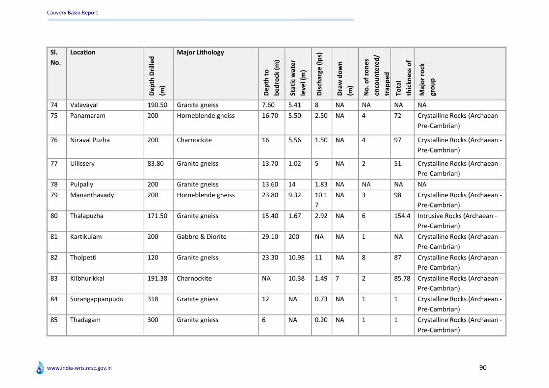
Cauvery Basin Report
www.india-wris.nrsc.gov.in 90
Sl.
No.
Location
De
pth
Dri
lled
(m)
Major Lithology
De
pth
to
be
dro
ck (
m)
Sta
tic
wat
er
leve
l (m
)
Dis
char
ge (
lps)
Dra
w d
ow
n
(m)
No
. of
zon
es
en
cou
nte
red
/
trap
pe
d
Tota
l
thic
kne
ss o
f
zon
es
(m)
Maj
or
rock
gro
up
74 Valavayal 190.50 Granite gneiss 7.60 5.41 8 NA NA NA NA
75 Panamaram 200 Horneblende gneiss 16.70 5.50 2.50 NA 4 72 Crystalline Rocks (Archaean -
Pre-Cambrian)
76 Niraval Puzha 200 Charnockite 16 5.56 1.50 NA 4 97 Crystalline Rocks (Archaean -
Pre-Cambrian)
77 Ullissery 83.80 Granite gneiss 13.70 1.02 5 NA 2 51 Crystalline Rocks (Archaean -
Pre-Cambrian)
78 Pulpally 200 Granite gneiss 13.60 14 1.83 NA NA NA NA
79 Mananthavady 200 Horneblende gneiss 23.80 9.32 10.1
7
NA 3 98 Crystalline Rocks (Archaean -
Pre-Cambrian)
80 Thalapuzha 171.50 Granite gneiss 15.40 1.67 2.92 NA 6 154.4 Intrusive Rocks (Archaean -
Pre-Cambrian)
81 Kartikulam 200 Gabbro & Diorite 29.10 200 NA NA 1 NA Crystalline Rocks (Archaean -
Pre-Cambrian)
82 Tholpetti 120 Granite gneiss 23.30 10.98 11 NA 8 87 Crystalline Rocks (Archaean -
Pre-Cambrian)
83 Kilbhurikkal 191.38 Charnockite NA 10.38 1.49 7 2 85.78 Crystalline Rocks (Archaean -
Pre-Cambrian)
84 Sorangappanpudu 318 Granite gniess 12 NA 0.73 NA 1 1 Crystalline Rocks (Archaean -
Pre-Cambrian)
85 Thadagam 300 Granite gniess 6 NA 0.20 NA 1 1 Crystalline Rocks (Archaean -
Pre-Cambrian)

Cauvery Basin Report
www.india-wris.nrsc.gov.in 91
Sl.
No.
Location
De
pth
Dri
lled
(m)
Major Lithology
De
pth
to
be
dro
ck (
m)
Sta
tic
wat
er
leve
l (m
)
Dis
char
ge (
lps)
Dra
w d
ow
n
(m)
No
. of
zon
es
en
cou
nte
red
/
trap
pe
d
Tota
l
thic
kne
ss o
f
zon
es
(m)
Maj
or
rock
gro
up
86 Byranatham 300 Granite 8.70 7.50 0.08 NA 2 32.5 Crystalline Rocks (Archaean -
Pre-Cambrian)
87 Bevuhalli 300 Granite 11.50 14.60 3.34 37 2 20 Crystalline Rocks (Archaean -
Pre-Cambrian)
88 Murthinayakanpatti 201 Charnockite 5.90 17.36 NA NA 1 1 Crystalline Rocks (Archaean -
Pre-Cambrian)
89 Pithalaipatti 110 Biotite Gneiss 6.10 12.55 2.83 12 4 58.53 Crystalline Rocks (Archaean -
Pre-Cambrian)
90 Sellamantadi 184 Granite Gneiss 6 5.80 1.20 18 3 72.38 Crystalline Rocks (Archaean -
Pre-Cambrian)
91 Padiyur 108 Charnockite 6.10 12.82 12.4
0
31 2 75.58 Crystalline Rocks (Archaean -
Pre-Cambrian)
92 Kamashipuram 200 Granite Gneiss 6 1.21 0.77 34 4 181.8
8
Crystalline Rocks (Archaean -
Pre-Cambrian)
93 Kuttam 184 Granite Gneiss 6 3.34 0.80 31 3 40.16 Crystalline Rocks (Archaean -
Pre-Cambrian)
94 Emakkalapuram 200 Granite Gneiss 12 9.50 1.70 32 2 61 Crystalline Rocks (Archaean -
Pre-Cambrian)
95 Narasingapuram 200 Biotite Gneiss 6.10 11.70 0.50 NA 2 109.6
8
Crystalline Rocks (Archaean -
Pre-Cambrian)
96 Gujiliyamparai 165.43 Biotite Granite Gneiss 12 13.55 3 6 4 145.7
8
Crystalline Rocks (Archaean -
Pre-Cambrian)

Cauvery Basin Report
www.india-wris.nrsc.gov.in 92
Sl.
No.
Location
De
pth
Dri
lled
(m)
Major Lithology
De
pth
to
be
dro
ck (
m)
Sta
tic
wat
er
leve
l (m
)
Dis
char
ge (
lps)
Dra
w d
ow
n
(m)
No
. of
zon
es
en
cou
nte
red
/
trap
pe
d
Tota
l
thic
kne
ss o
f
zon
es
(m)
Maj
or
rock
gro
up
97 D. Gudalur 200 Biotite Gneiss 12 16.02 1.22 NA 2 4 Crystalline Rocks (Archaean -
Pre-Cambrian)
98 K.mettupatti 200 Granite Gneiss 6.10 13.38 1 NA 2 80 Crystalline Rocks (Archaean -
Pre-Cambrian)
99 Vedasandur 200 Granite Gneiss 6.10 200 NA NA NA NA NA
100 Sankupillaippudur 200 Granite Gneiss 14 16.24 NA NA 1 1 Crystalline Rocks (Archaean -
Pre-Cambrian)
101 Kallimandayam 130 Charnockite with intrusive
pink granite
4 6.60 1.37 15 3 26.48 Crystalline Rocks (Archaean -
Pre-Cambrian)
102 Kondarangikiran 200 Charnockite 5.50 50 NA NA 2 7.03 Crystalline Rocks (Archaean -
Pre-Cambrian)
103 Kiranur 153 Granite Gneiss 5.60 2.24 2 NA NA NA NA
104 Palani 150 Granite 6.10 50 NA NA NA NA NA
105 Sindalavadampat 153 Granite Gneiss 8 4.61 NA NA 1 1 Crystalline Rocks (Archaean -
Pre-Cambrian)
106 Ayyampalayam 130 Granite Gneiss 5.50 4.20 12.2
4
NA 6 45.72 Crystalline Rocks (Archaean -
Pre-Cambrian)
107 Gujiliyamparai 100.07 Biotite Granite Gneiss 5.50 13.70 1.79 4 2 41 Crystalline Rocks (Archaean -
Pre-Cambrian)
108 S. Kodangipatti 161 Granite Gneiss 5.60 15.15 NA NA 4 130.5
4
Crystalline Rocks (Archaean -
Pre-Cambrian)
109 Tandakkaranpatti 136.20 Granite gneiss 6.10 18.92 1.90 11 1 1 Crystalline Rocks (Archaean -
Pre-Cambrian)

Cauvery Basin Report
www.india-wris.nrsc.gov.in 93
Sl.
No.
Location
De
pth
Dri
lled
(m)
Major Lithology
De
pth
to
be
dro
ck (
m)
Sta
tic
wat
er
leve
l (m
)
Dis
char
ge (
lps)
Dra
w d
ow
n
(m)
No
. of
zon
es
en
cou
nte
red
/
trap
pe
d
Tota
l
thic
kne
ss o
f
zon
es
(m)
Maj
or
rock
gro
up
110 Vakkampatti 140 Granite Gneiss 6.10 6.20 NA NA 1 1 Crystalline Rocks (Archaean -
Pre-Cambrian)
111 Ambatturai 160.90 Biotite Gneiss 6.10 7.13 NA NA 2 12.62 Crystalline Rocks (Archaean -
Pre-Cambrian)
112 Samathuvapuram 183.76 Granite gneiss and
Charnockite
6.10 50 NA NA 2 12.62 Crystalline Rocks (Archaean -
Pre-Cambrian)
113 Rayarpatti 193.78 Biotite Gneiss 12 22.60 NA NA 1 1 Crystalline Rocks (Archaean -
Pre-Cambrian)
114 Gandhigramam 183.76 Granite Gneiss 6.10 26.10 NA NA 2 151.4 Crystalline Rocks (Archaean -
Pre-Cambrian)
115 Reddiyarchattram 300.04 Biotite Granite Gneiss NA 50 NA NA 2 88.44 Crystalline Rocks (Archaean -
Pre-Cambrian)
116 Vavipalayam 182.83 Fractured Biotite gneiss 3.57 9.60 0.33 49 3 162.6
3
Crystalline Rocks (Archaean -
Pre-Cambrian)
117 Anjur 146.47 Fractured Biotite gneiss 31.02 7.51 8.33 40 7 94.07 Crystalline Rocks (Archaean -
Pre-Cambrian)
118 Ichchipalayam 300 Granite gneiss 6.10 50 NA NA 2 2 Crystalline Rocks (Archaean -
Pre-Cambrian)
119 Periyakattupalaya 300 Biotite gneiss 5.60 50 NA NA 2 69.58 Crystalline Rocks (Archaean -
Pre-Cambrian)
120 Pallapalayam 134.34 Biotite Granite gneiss 6.10 50 NA NA 2 3.99 Crystalline Rocks (Archaean -
Pre-Cambrian)
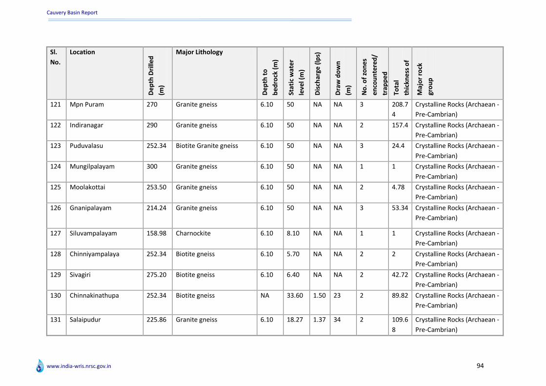
Cauvery Basin Report
www.india-wris.nrsc.gov.in 94
Sl.
No.
Location
De
pth
Dri
lled
(m)
Major Lithology
De
pth
to
be
dro
ck (
m)
Sta
tic
wat
er
leve
l (m
)
Dis
char
ge (
lps)
Dra
w d
ow
n
(m)
No
. of
zon
es
en
cou
nte
red
/
trap
pe
d
Tota
l
thic
kne
ss o
f
zon
es
(m)
Maj
or
rock
gro
up
121 Mpn Puram 270 Granite gneiss 6.10 50 NA NA 3 208.7
4
Crystalline Rocks (Archaean -
Pre-Cambrian)
122 Indiranagar 290 Granite gneiss 6.10 50 NA NA 2 157.4 Crystalline Rocks (Archaean -
Pre-Cambrian)
123 Puduvalasu 252.34 Biotite Granite gneiss 6.10 50 NA NA 3 24.4 Crystalline Rocks (Archaean -
Pre-Cambrian)
124 Mungilpalayam 300 Granite gneiss 6.10 50 NA NA 1 1 Crystalline Rocks (Archaean -
Pre-Cambrian)
125 Moolakottai 253.50 Granite gneiss 6.10 50 NA NA 2 4.78 Crystalline Rocks (Archaean -
Pre-Cambrian)
126 Gnanipalayam 214.24 Granite gneiss 6.10 50 NA NA 3 53.34 Crystalline Rocks (Archaean -
Pre-Cambrian)
127 Siluvampalayam 158.98 Charnockite 6.10 8.10 NA NA 1 1 Crystalline Rocks (Archaean -
Pre-Cambrian)
128 Chinniyampalaya 252.34 Biotite gneiss 6.10 5.70 NA NA 2 2 Crystalline Rocks (Archaean -
Pre-Cambrian)
129 Sivagiri 275.20 Biotite gneiss 6.10 6.40 NA NA 2 42.72 Crystalline Rocks (Archaean -
Pre-Cambrian)
130 Chinnakinathupa 252.34 Biotite gneiss NA 33.60 1.50 23 2 89.82 Crystalline Rocks (Archaean -
Pre-Cambrian)
131 Salaipudur 225.86 Granite gneiss 6.10 18.27 1.37 34 2 109.6
8
Crystalline Rocks (Archaean -
Pre-Cambrian)

Cauvery Basin Report
www.india-wris.nrsc.gov.in 95
Sl.
No.
Location
De
pth
Dri
lled
(m)
Major Lithology
De
pth
to
be
dro
ck (
m)
Sta
tic
wat
er
leve
l (m
)
Dis
char
ge (
lps)
Dra
w d
ow
n
(m)
No
. of
zon
es
en
cou
nte
red
/
trap
pe
d
Tota
l
thic
kne
ss o
f
zon
es
(m)
Maj
or
rock
gro
up
132 Annanagar 259.96 Granite gneiss 6 100 NA NA 1 1 Crystalline Rocks (Archaean -
Pre-Cambrian)
133 Sathyanagar 299.48 Granite gneiss 6 14.36 0.50 28 NA NA NA
134 Perumapalayam 260 Granite gneiss 6.10 100 NA NA 2 20.86 Crystalline Rocks (Archaean -
Pre-Cambrian)
135 Sreenivasapuram 183.76 Granite gneiss 6.10 50.94 NA NA 3 110.6
8
Crystalline Rocks (Archaean -
Pre-Cambrian)
136 Kongalampalli 206.62 Granite gneiss 6.10 38.18 0.50 28 2 14.24 Crystalline Rocks (Archaean -
Pre-Cambrian)
137 Nasiyanur 295 Granite gneiss 12.20 NA NA NA 1 1 Crystalline Rocks (Archaean -
Pre-Cambrian)
138 Erode 126 Biotite gneiss 6.10 6.80 4.38 9 6 108.6
8
Crystalline Rocks (Archaean -
Pre-Cambrian)
139 Erode-vocpark 267.58 Granite gneiss 6.10 267.5
8
NA NA 1 1 Crystalline Rocks (Archaean -
Pre-Cambrian)
140 Chennimalai 229.48 Granite gneiss 14.60 80 NA NA 1 1 Crystalline Rocks (Archaean -
Pre-Cambrian)
141 Padiyur 252.34 Granite gneiss 6.10 80 NA NA 2 38.1 Crystalline Rocks (Archaean -
Pre-Cambrian)
142 Chavadipalayam 221.86 Granite gneiss &
Nephelene Syenite
6.10 80 NA NA 2 58.34 Crystalline Rocks (Archaean -
Pre-Cambrian)
143 Velliankattuval 237.10 Charnockite 6.10 80 NA NA 1 1 Crystalline Rocks (Archaean -
Pre-Cambrian)

Cauvery Basin Report
www.india-wris.nrsc.gov.in 96
Sl.
No.
Location
De
pth
Dri
lled
(m)
Major Lithology
De
pth
to
be
dro
ck (
m)
Sta
tic
wat
er
leve
l (m
)
Dis
char
ge (
lps)
Dra
w d
ow
n
(m)
No
. of
zon
es
en
cou
nte
red
/
trap
pe
d
Tota
l
thic
kne
ss o
f
zon
es
(m)
Maj
or
rock
gro
up
144 Nathakadaiyur(e 267.58 Charnockite 6.10 8.28 0.73 28 2 137.1
6
Crystalline Rocks (Archaean -
Pre-Cambrian)
145 Ponnapuram 252.34 Charnockite 6.10 52.40 NA NA 1 1 Crystalline Rocks (Archaean -
Pre-Cambrian)
146 Ayyansalai 200 Biotite gneiss 6.40 4.06 5.76 1 3 14.57 Crystalline Rocks (Archaean -
Pre-Cambrian)
147 Pudupalayam 260 Charnockite 5.45 13.19 NA NA 2 168.6
4
Crystalline Rocks (Archaean -
Pre-Cambrian)
148 Kambilyampatty 260 Charnockite 6 16.21 NA NA 1 1.62 Crystalline Rocks (Archaean -
Pre-Cambrian)
149 N. Kanjipuram 275.20 Charnockite 6 19.27 NA NA NA NA NA
150 Karattupalayam 130.42 Charnockite 5.50 31.87 1.20 2 4 Crystalline Rocks (Archaean -
Pre-Cambrian)
151 Nallur 252.34 Charnockite 5.40 28.80 5.78 1 3 98.06 Crystalline Rocks (Archaean -
Pre-Cambrian)
152 Kannivadi 107.56 Hornblende Biotite gneiss 5.40 27.10 26.3
2
3 7 69.64 Crystalline Rocks (Archaean -
Pre-Cambrian)
153 Dasanakanpatty 252.34 Charnockite 5.40 252.3
4
NA NA NA NA NA
154 Muthampalayam 153.28 Biotite gneiss 5.50 46.70 1.18 2 4 138.1
6
Crystalline Rocks (Archaean -
Pre-Cambrian)
155 Chinnaripalayam 206.62 Charnockite 5.50 16.62 NA NA 2 56.96 Crystalline Rocks (Archaean -
Pre-Cambrian)
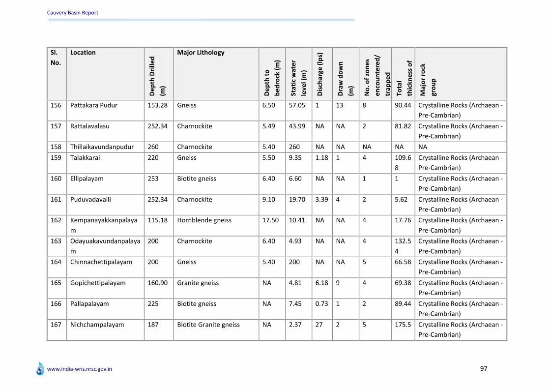
Cauvery Basin Report
www.india-wris.nrsc.gov.in 97
Sl.
No.
Location
De
pth
Dri
lled
(m)
Major Lithology
De
pth
to
be
dro
ck (
m)
Sta
tic
wat
er
leve
l (m
)
Dis
char
ge (
lps)
Dra
w d
ow
n
(m)
No
. of
zon
es
en
cou
nte
red
/
trap
pe
d
Tota
l
thic
kne
ss o
f
zon
es
(m)
Maj
or
rock
gro
up
156 Pattakara Pudur 153.28 Gneiss 6.50 57.05 1 13 8 90.44 Crystalline Rocks (Archaean -
Pre-Cambrian)
157 Rattalavalasu 252.34 Charnockite 5.49 43.99 NA NA 2 81.82 Crystalline Rocks (Archaean -
Pre-Cambrian)
158 Thillaikavundanpudur 260 Charnockite 5.40 260 NA NA NA NA NA
159 Talakkarai 220 Gneiss 5.50 9.35 1.18 1 4 109.6
8
Crystalline Rocks (Archaean -
Pre-Cambrian)
160 Ellipalayam 253 Biotite gneiss 6.40 6.60 NA NA 1 1 Crystalline Rocks (Archaean -
Pre-Cambrian)
161 Puduvadavalli 252.34 Charnockite 9.10 19.70 3.39 4 2 5.62 Crystalline Rocks (Archaean -
Pre-Cambrian)
162 Kempanayakkanpalaya
m
115.18 Hornblende gneiss 17.50 10.41 NA NA 4 17.76 Crystalline Rocks (Archaean -
Pre-Cambrian)
163 Odayuakavundanpalaya
m
200 Charnockite 6.40 4.93 NA NA 4 132.5
4
Crystalline Rocks (Archaean -
Pre-Cambrian)
164 Chinnachettipalayam 200 Gneiss 5.40 200 NA NA 5 66.58 Crystalline Rocks (Archaean -
Pre-Cambrian)
165 Gopichettipalayam 160.90 Granite gneiss NA 4.81 6.18 9 4 69.38 Crystalline Rocks (Archaean -
Pre-Cambrian)
166 Pallapalayam 225 Biotite gneiss NA 7.45 0.73 1 2 89.44 Crystalline Rocks (Archaean -
Pre-Cambrian)
167 Nichchampalayam 187 Biotite Granite gneiss NA 2.37 27 2 5 175.5 Crystalline Rocks (Archaean -
Pre-Cambrian)

Cauvery Basin Report
www.india-wris.nrsc.gov.in 98
Sl.
No.
Location
De
pth
Dri
lled
(m)
Major Lithology
De
pth
to
be
dro
ck (
m)
Sta
tic
wat
er
leve
l (m
)
Dis
char
ge (
lps)
Dra
w d
ow
n
(m)
No
. of
zon
es
en
cou
nte
red
/
trap
pe
d
Tota
l
thic
kne
ss o
f
zon
es
(m)
Maj
or
rock
gro
up
168 Makalpudur 195 Biotite Granite gneiss NA 4.33 0.73 NA 4 36.1 Crystalline Rocks (Archaean -
Pre-Cambrian)
169 Unjakkattu Colony 25 Biotite Granite gneiss NA NA 2.90 NA 2 3.62 Crystalline Rocks (Archaean -
Pre-Cambrian)
170 Kongupalayam 160.90 Charnockite NA 11.51 NA NA 3 122.9 Crystalline Rocks (Archaean -
Pre-Cambrian)
171 Kumarayanur 229.48 Charnockite NA 11.35 1.78 18 5 157 Crystalline Rocks (Archaean -
Pre-Cambrian)
172 Munanchavadi 214.24 Hornblende gneiss NA 32.15 0.08 6 5 28.46 Crystalline Rocks (Archaean -
Pre-Cambrian)
173 Mylampadi 134 Granite Gneiss 8.75 56.34 5.53 3 5 114 Crystalline Rocks (Archaean -
Pre-Cambrian)
174 Chinnapuliyur 300 Granite Gneiss 25.75 11.75 1.79 41 2 76.6 Crystalline Rocks (Archaean -
Pre-Cambrian)
175 Thalabayanur 300 Bio. Gr. Gneiss 27.25 NA 3.01 26 3 96.5 Crystalline Rocks (Archaean -
Pre-Cambrian)
176 Oricheri Colony 300 Bio. Gr. Gneiss 16.30 3.25 1.91 17 4 136 Crystalline Rocks (Archaean -
Pre-Cambrian)
177 Tittakattupudur 300 Bio. Gr. Gneiss 8.60 13.58 3.01 68 2 169.8 Crystalline Rocks (Archaean -
Pre-Cambrian)
178 Sahayapuram 300 Bio. Gr. Gneiss 23.20 17.24 1.21 32 2 167 Crystalline Rocks (Archaean -
Pre-Cambrian)

Cauvery Basin Report
www.india-wris.nrsc.gov.in 99
Sl.
No.
Location
De
pth
Dri
lled
(m)
Major Lithology
De
pth
to
be
dro
ck (
m)
Sta
tic
wat
er
leve
l (m
)
Dis
char
ge (
lps)
Dra
w d
ow
n
(m)
No
. of
zon
es
en
cou
nte
red
/
trap
pe
d
Tota
l
thic
kne
ss o
f
zon
es
(m)
Maj
or
rock
gro
up
179 Madanvalasu 205.20 Bio. Gr. Gneiss 12.60 NA 4.36 39 4 174.6 Crystalline Rocks (Archaean -
Pre-Cambrian)
180 Solakalipalayam 300 Bio. Gr. Gneiss 21.20 11.44 1.79 17 2 203.4 Crystalline Rocks (Archaean -
Pre-Cambrian)
181 Anjatti 300 Granite 1.50 11.20 NA NA 1 2 Crystalline Rocks (Archaean -
Pre-Cambrian)
182 Gopasamudram 238.50 Charnockite 35.50 18.57 1.40 16 1 0.5 Crystalline Rocks (Archaean -
Pre-Cambrian)
183 Denkanikottai 222.60 Granite 12 5.80 2.11 81 2 106.5 Crystalline Rocks (Archaean -
Pre-Cambrian)
184 Papancheri-II 271.27 Sand with Clay Sandstone
& Limestone
NA 4.57 37.9
0
15 5 223.1
1
Un-consolidated Sediments
(Quaternary -Recent)
185 Prataparamapuram 458.11 Sand with Clay Sandstone
& Limestone
NA 3.40 4.72 17 12 263.6
5
Consolidated Sediments
(Pre-Cambrian -Devonian
and other ages)
186 Nalladai 376.24 Sand with Clay Sandstone
& Limestone
NA 0.27 63.2
0
4 8 242.3
2
Un-consolidated Sediments
(Quaternary -Recent)
187 Sirkazhi 448.06 Sandstone & Limestone
with Clay
NA NA NA NA 11 217 Semi-Consolidated
Sediments (Carboniferous -
Pliocene and other ages)
188 Thirumalaivasal 101.49 Sand, Clay & Sandstone NA NA NA NA NA NA NA
189 Tranquebar 265.18 Sand, Clay & Sandstone NA NA NA NA 8 143.2
5
Un-consolidated Sediments
(Quaternary -Recent)

Cauvery Basin Report
www.india-wris.nrsc.gov.in 100
Sl.
No.
Location
De
pth
Dri
lled
(m)
Major Lithology
De
pth
to
be
dro
ck (
m)
Sta
tic
wat
er
leve
l (m
)
Dis
char
ge (
lps)
Dra
w d
ow
n
(m)
No
. of
zon
es
en
cou
nte
red
/
trap
pe
d
Tota
l
thic
kne
ss o
f
zon
es
(m)
Maj
or
rock
gro
up
190 Thalanayar 359.10 Sandstone & Shale with
Sand & Clay
NA NA NA NA 3 236 Semi-Consolidated
Sediments (Carboniferous -
Pliocene and other ages)
191 Voimedu 711 Sandstone & Limestone
with Sand Clay & Lignite
NA NA NA NA 1 6 Semi-Consolidated
Sediments (Carboniferous -
Pliocene and other ages)
192 Thevur 687 Sand, Clay & Sandstone NA 2.91 5.48 2 17 371 Un-consolidated Sediments
(Quaternary -Recent)
193 Vedaranyam 489.70 Sand, Clay Sandstones
Calcareous Sandstones
NA NA NA NA 6 398 Un-consolidated Sediments
(Quaternary -Recent)
194 Valmangalam 300 Clay, Sands, Sandstone
and gravels
NA 3.88 12 6 18 260 Un-consolidated Sediments
(Quaternary -Recent)
195 Melvanjure 300 Clay, Sands, Clayey sands NA 7.94 12.9
3
6 13 264 Un-consolidated Sediments
(Quaternary -Recent)
196 Eravanchery 400 Clay, Sands, Sandstones,
Limestone
NA 6.68 6.14 2 27 365 Un-consolidated Sediments
(Quaternary -Recent)
197 Kiludayathur 300 Clay, Sands & gravels NA 7.42 9.52 4 13 259 Un-consolidated Sediments
(Quaternary -Recent)
198 Puthur 151 Sands, gravels NA NA NA NA 14 131 Un-consolidated Sediments
(Quaternary -Recent)
199 Thiruvaduthurai 150 Sandstone NA 3.85 8.41 2 18 260 Semi-Consolidated
Sediments (Carboniferous -
Pliocene and other ages)

Cauvery Basin Report
www.india-wris.nrsc.gov.in 101
Sl.
No.
Location
De
pth
Dri
lled
(m)
Major Lithology
De
pth
to
be
dro
ck (
m)
Sta
tic
wat
er
leve
l (m
)
Dis
char
ge (
lps)
Dra
w d
ow
n
(m)
No
. of
zon
es
en
cou
nte
red
/
trap
pe
d
Tota
l
thic
kne
ss o
f
zon
es
(m)
Maj
or
rock
gro
up
200 Nallathukudi 300 Sandstone NA 7.73 9.24 3 13 242 Semi-Consolidated
Sediments (Carboniferous -
Pliocene and other ages)
201 Thalai Nayar 300 Standstone NA 7.45 41 2 18 263 Semi-Consolidated
Sediments (Carboniferous -
Pliocene and other ages)
202 Kohur 300 Standstone NA 7.80 60 10 10 191 Semi-Consolidated
Sediments (Carboniferous -
Pliocene and other ages)
203 T. Manalmedu 300 Standstone NA 4.56 18 0 12 264 Semi-Consolidated
Sediments (Carboniferous -
Pliocene and other ages)
204 Vadakalathur 350 Standstone NA 5 18 0 29 308 Semi-Consolidated
Sediments (Carboniferous -
Pliocene and other ages)
205 Agastiampalli 200 Sand, alternate layers of
clay and sandstone.
Calcareous sandstone
with shell fragments,
limestone
NA NA NA NA 11 165 Semi-Consolidated
Sediments (Carboniferous -
Pliocene and other ages)
206 Rasipuram 183.29 Gneiss Charnockite 2.75 55.73 3.08 6 4 126.8
7
Crystalline Rocks (Archaean -
Pre-Cambrian)
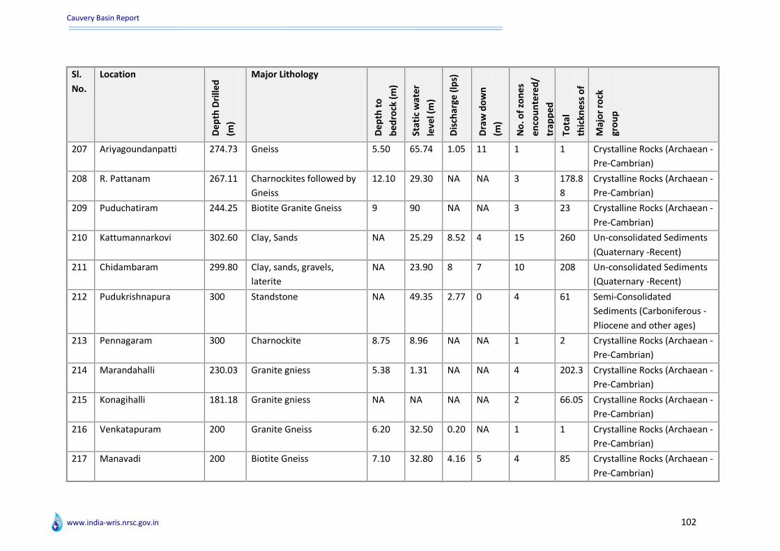
Cauvery Basin Report
www.india-wris.nrsc.gov.in 102
Sl.
No.
Location
De
pth
Dri
lled
(m)
Major Lithology
De
pth
to
be
dro
ck (
m)
Sta
tic
wat
er
leve
l (m
)
Dis
char
ge (
lps)
Dra
w d
ow
n
(m)
No
. of
zon
es
en
cou
nte
red
/
trap
pe
d
Tota
l
thic
kne
ss o
f
zon
es
(m)
Maj
or
rock
gro
up
207 Ariyagoundanpatti 274.73 Gneiss 5.50 65.74 1.05 11 1 1 Crystalline Rocks (Archaean -
Pre-Cambrian)
208 R. Pattanam 267.11 Charnockites followed by
Gneiss
12.10 29.30 NA NA 3 178.8
8
Crystalline Rocks (Archaean -
Pre-Cambrian)
209 Puduchatiram 244.25 Biotite Granite Gneiss 9 90 NA NA 3 23 Crystalline Rocks (Archaean -
Pre-Cambrian)
210 Kattumannarkovi 302.60 Clay, Sands NA 25.29 8.52 4 15 260 Un-consolidated Sediments
(Quaternary -Recent)
211 Chidambaram 299.80 Clay, sands, gravels,
laterite
NA 23.90 8 7 10 208 Un-consolidated Sediments
(Quaternary -Recent)
212 Pudukrishnapura 300 Standstone NA 49.35 2.77 0 4 61 Semi-Consolidated
Sediments (Carboniferous -
Pliocene and other ages)
213 Pennagaram 300 Charnockite 8.75 8.96 NA NA 1 2 Crystalline Rocks (Archaean -
Pre-Cambrian)
214 Marandahalli 230.03 Granite gniess 5.38 1.31 NA NA 4 202.3 Crystalline Rocks (Archaean -
Pre-Cambrian)
215 Konagihalli 181.18 Granite gniess NA NA NA NA 2 66.05 Crystalline Rocks (Archaean -
Pre-Cambrian)
216 Venkatapuram 200 Granite Gneiss 6.20 32.50 0.20 NA 1 1 Crystalline Rocks (Archaean -
Pre-Cambrian)
217 Manavadi 200 Biotite Gneiss 7.10 32.80 4.16 5 4 85 Crystalline Rocks (Archaean -
Pre-Cambrian)
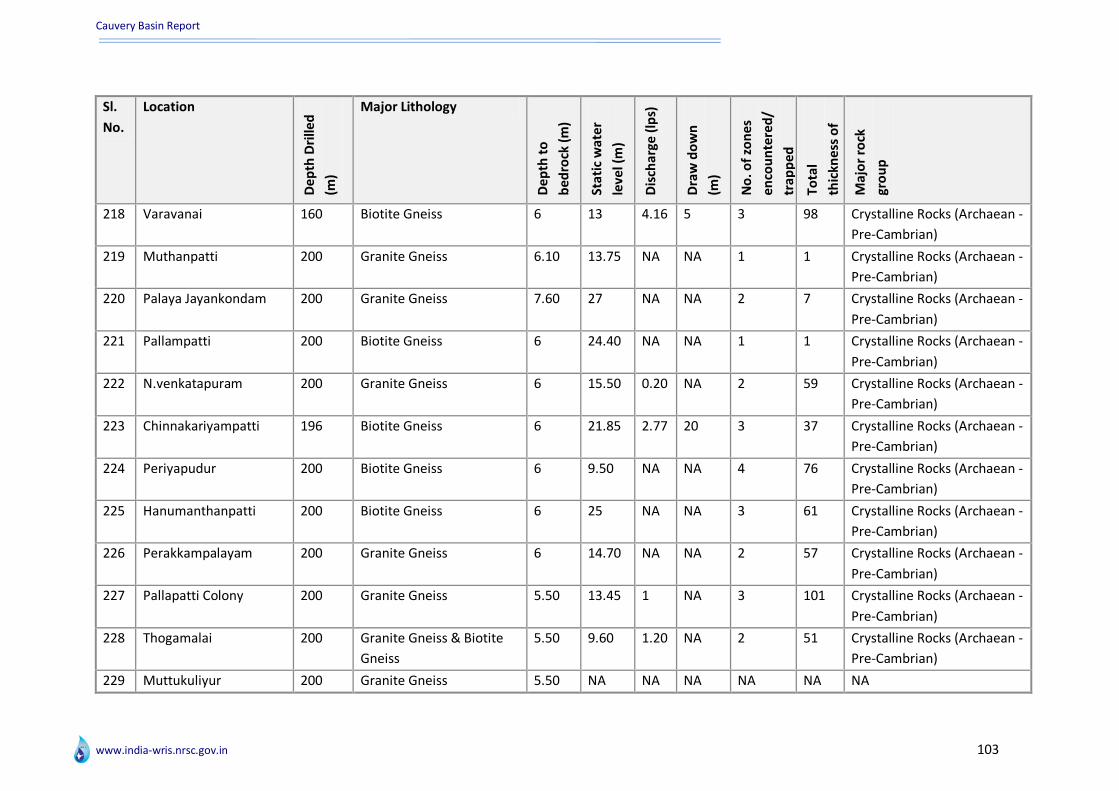
Cauvery Basin Report
www.india-wris.nrsc.gov.in 103
Sl.
No.
Location
De
pth
Dri
lled
(m)
Major Lithology
De
pth
to
be
dro
ck (
m)
Sta
tic
wat
er
leve
l (m
)
Dis
char
ge (
lps)
Dra
w d
ow
n
(m)
No
. of
zon
es
en
cou
nte
red
/
trap
pe
d
Tota
l
thic
kne
ss o
f
zon
es
(m)
Maj
or
rock
gro
up
218 Varavanai 160 Biotite Gneiss 6 13 4.16 5 3 98 Crystalline Rocks (Archaean -
Pre-Cambrian)
219 Muthanpatti 200 Granite Gneiss 6.10 13.75 NA NA 1 1 Crystalline Rocks (Archaean -
Pre-Cambrian)
220 Palaya Jayankondam 200 Granite Gneiss 7.60 27 NA NA 2 7 Crystalline Rocks (Archaean -
Pre-Cambrian)
221 Pallampatti 200 Biotite Gneiss 6 24.40 NA NA 1 1 Crystalline Rocks (Archaean -
Pre-Cambrian)
222 N.venkatapuram 200 Granite Gneiss 6 15.50 0.20 NA 2 59 Crystalline Rocks (Archaean -
Pre-Cambrian)
223 Chinnakariyampatti 196 Biotite Gneiss 6 21.85 2.77 20 3 37 Crystalline Rocks (Archaean -
Pre-Cambrian)
224 Periyapudur 200 Biotite Gneiss 6 9.50 NA NA 4 76 Crystalline Rocks (Archaean -
Pre-Cambrian)
225 Hanumanthanpatti 200 Biotite Gneiss 6 25 NA NA 3 61 Crystalline Rocks (Archaean -
Pre-Cambrian)
226 Perakkampalayam 200 Granite Gneiss 6 14.70 NA NA 2 57 Crystalline Rocks (Archaean -
Pre-Cambrian)
227 Pallapatti Colony 200 Granite Gneiss 5.50 13.45 1 NA 3 101 Crystalline Rocks (Archaean -
Pre-Cambrian)
228 Thogamalai 200 Granite Gneiss & Biotite
Gneiss
5.50 9.60 1.20 NA 2 51 Crystalline Rocks (Archaean -
Pre-Cambrian)
229 Muttukuliyur 200 Granite Gneiss 5.50 NA NA NA NA NA NA

Cauvery Basin Report
www.india-wris.nrsc.gov.in 104
Sl.
No.
Location
De
pth
Dri
lled
(m)
Major Lithology
De
pth
to
be
dro
ck (
m)
Sta
tic
wat
er
leve
l (m
)
Dis
char
ge (
lps)
Dra
w d
ow
n
(m)
No
. of
zon
es
en
cou
nte
red
/
trap
pe
d
Tota
l
thic
kne
ss o
f
zon
es
(m)
Maj
or
rock
gro
up
230 Punampalayam 200 Granite Gneiss 5.50 7.18 NA NA 2 90.5 Crystalline Rocks (Archaean -
Pre-Cambrian)
231 Valaiyur 200 Granite Gneiss 19 13.61 NA NA 2 18.45 Crystalline Rocks (Archaean -
Pre-Cambrian)
232 Kilakkuvadi 200 Granite Gneiss 14 23 NA NA 2 143.2
5
Crystalline Rocks (Archaean -
Pre-Cambrian)
233 Kilkunnupatti 200 Granite Gneiss 5.50 75 NA NA 1 1 Crystalline Rocks (Archaean -
Pre-Cambrian)
234 Vadakilkootam 120 Granite Gneiss 9 16.18 NA NA 2 45.8 Crystalline Rocks (Archaean -
Pre-Cambrian)
235 Maruakkalampatt 175 Granite Gneiss 20.95 20.50 NA NA 2 92.6 Crystalline Rocks (Archaean -
Pre-Cambrian)
236 Musiri 135.35 Granite Gneiss 5.50 20.50 NA NA 2 96.6 Crystalline Rocks (Archaean -
Pre-Cambrian)
237 Kizhakkuchittiaapuram 200 Granite Gneiss 10 18.80 NA NA 1 1 Crystalline Rocks (Archaean -
Pre-Cambrian)
238 M.kalathur 100 Granite Gneiss 8.50 21.35 NA NA 1 0.55 Crystalline Rocks (Archaean -
Pre-Cambrian)
239 Tandalaiputtur 100 Granite Gneiss 9 15.50 NA NA 3 8 Crystalline Rocks (Archaean -
Pre-Cambrian)
240 Muvanur 200 Biotite Gneiss 5.50 16.70 NA NA 4 80.35 Crystalline Rocks (Archaean -
Pre-Cambrian)
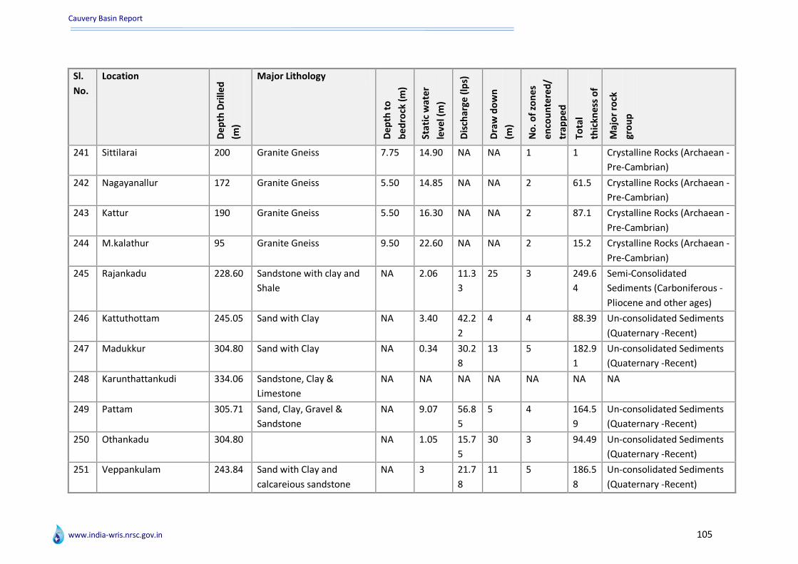
Cauvery Basin Report
www.india-wris.nrsc.gov.in 105
Sl.
No.
Location
De
pth
Dri
lled
(m)
Major Lithology
De
pth
to
be
dro
ck (
m)
Sta
tic
wat
er
leve
l (m
)
Dis
char
ge (
lps)
Dra
w d
ow
n
(m)
No
. of
zon
es
en
cou
nte
red
/
trap
pe
d
Tota
l
thic
kne
ss o
f
zon
es
(m)
Maj
or
rock
gro
up
241 Sittilarai 200 Granite Gneiss 7.75 14.90 NA NA 1 1 Crystalline Rocks (Archaean -
Pre-Cambrian)
242 Nagayanallur 172 Granite Gneiss 5.50 14.85 NA NA 2 61.5 Crystalline Rocks (Archaean -
Pre-Cambrian)
243 Kattur 190 Granite Gneiss 5.50 16.30 NA NA 2 87.1 Crystalline Rocks (Archaean -
Pre-Cambrian)
244 M.kalathur 95 Granite Gneiss 9.50 22.60 NA NA 2 15.2 Crystalline Rocks (Archaean -
Pre-Cambrian)
245 Rajankadu 228.60 Sandstone with clay and
Shale
NA 2.06 11.3
3
25 3 249.6
4
Semi-Consolidated
Sediments (Carboniferous -
Pliocene and other ages)
246 Kattuthottam 245.05 Sand with Clay NA 3.40 42.2
2
4 4 88.39 Un-consolidated Sediments
(Quaternary -Recent)
247 Madukkur 304.80 Sand with Clay NA 0.34 30.2
8
13 5 182.9
1
Un-consolidated Sediments
(Quaternary -Recent)
248 Karunthattankudi 334.06 Sandstone, Clay &
Limestone
NA NA NA NA NA NA NA
249 Pattam 305.71 Sand, Clay, Gravel &
Sandstone
NA 9.07 56.8
5
5 4 164.5
9
Un-consolidated Sediments
(Quaternary -Recent)
250 Othankadu 304.80 NA 1.05 15.7
5
30 3 94.49 Un-consolidated Sediments
(Quaternary -Recent)
251 Veppankulam 243.84 Sand with Clay and
calcareious sandstone
NA 3 21.7
8
11 5 186.5
8
Un-consolidated Sediments
(Quaternary -Recent)
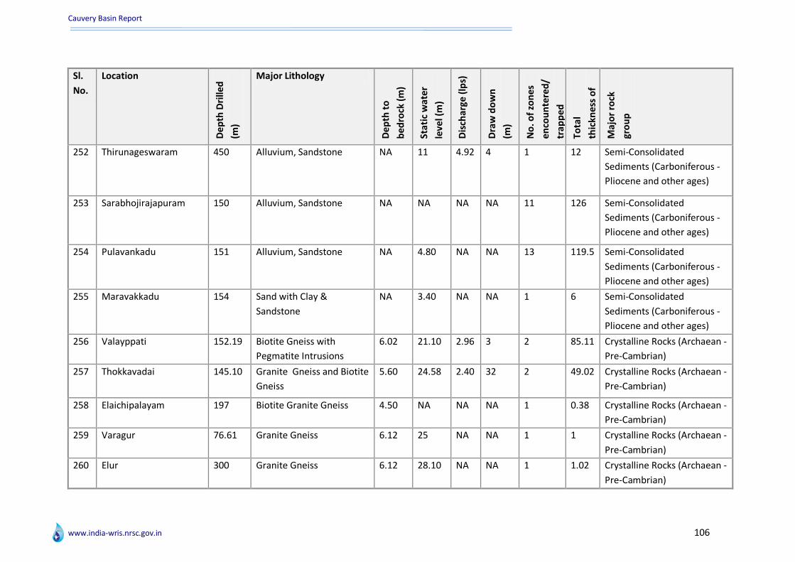
Cauvery Basin Report
www.india-wris.nrsc.gov.in 106
Sl.
No.
Location
De
pth
Dri
lled
(m)
Major Lithology
De
pth
to
be
dro
ck (
m)
Sta
tic
wat
er
leve
l (m
)
Dis
char
ge (
lps)
Dra
w d
ow
n
(m)
No
. of
zon
es
en
cou
nte
red
/
trap
pe
d
Tota
l
thic
kne
ss o
f
zon
es
(m)
Maj
or
rock
gro
up
252 Thirunageswaram 450 Alluvium, Sandstone NA 11 4.92 4 1 12 Semi-Consolidated
Sediments (Carboniferous -
Pliocene and other ages)
253 Sarabhojirajapuram 150 Alluvium, Sandstone NA NA NA NA 11 126 Semi-Consolidated
Sediments (Carboniferous -
Pliocene and other ages)
254 Pulavankadu 151 Alluvium, Sandstone NA 4.80 NA NA 13 119.5 Semi-Consolidated
Sediments (Carboniferous -
Pliocene and other ages)
255 Maravakkadu 154 Sand with Clay &
Sandstone
NA 3.40 NA NA 1 6 Semi-Consolidated
Sediments (Carboniferous -
Pliocene and other ages)
256 Valayppati 152.19 Biotite Gneiss with
Pegmatite Intrusions
6.02 21.10 2.96 3 2 85.11 Crystalline Rocks (Archaean -
Pre-Cambrian)
257 Thokkavadai 145.10 Granite Gneiss and Biotite
Gneiss
5.60 24.58 2.40 32 2 49.02 Crystalline Rocks (Archaean -
Pre-Cambrian)
258 Elaichipalayam 197 Biotite Granite Gneiss 4.50 NA NA NA 1 0.38 Crystalline Rocks (Archaean -
Pre-Cambrian)
259 Varagur 76.61 Granite Gneiss 6.12 25 NA NA 1 1 Crystalline Rocks (Archaean -
Pre-Cambrian)
260 Elur 300 Granite Gneiss 6.12 28.10 NA NA 1 1.02 Crystalline Rocks (Archaean -
Pre-Cambrian)
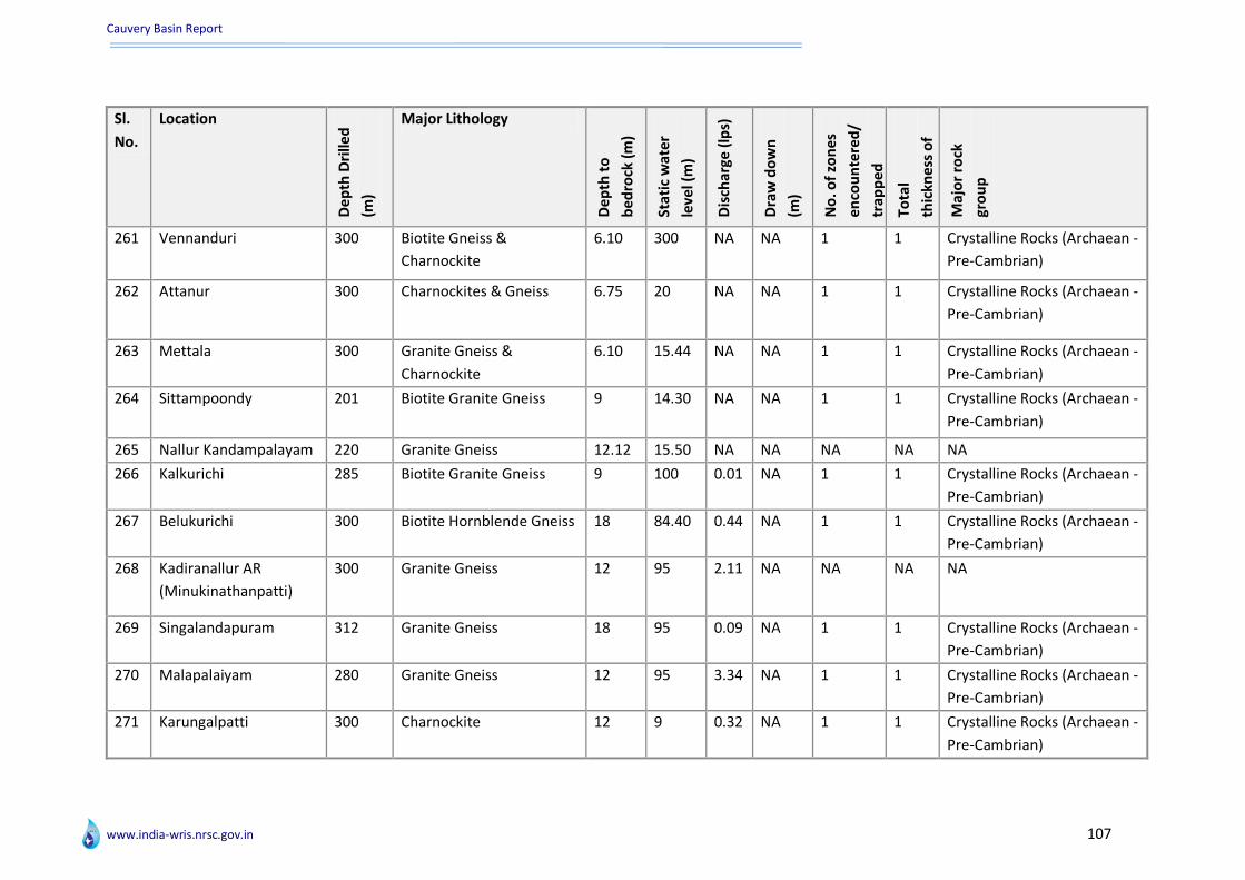
Cauvery Basin Report
www.india-wris.nrsc.gov.in 107
Sl.
No.
Location
De
pth
Dri
lled
(m)
Major Lithology
De
pth
to
be
dro
ck (
m)
Sta
tic
wat
er
leve
l (m
)
Dis
char
ge (
lps)
Dra
w d
ow
n
(m)
No
. of
zon
es
en
cou
nte
red
/
trap
pe
d
Tota
l
thic
kne
ss o
f
zon
es
(m)
Maj
or
rock
gro
up
261 Vennanduri 300 Biotite Gneiss &
Charnockite
6.10 300 NA NA 1 1 Crystalline Rocks (Archaean -
Pre-Cambrian)
262 Attanur 300 Charnockites & Gneiss 6.75 20 NA NA 1 1 Crystalline Rocks (Archaean -
Pre-Cambrian)
263 Mettala 300 Granite Gneiss &
Charnockite
6.10 15.44 NA NA 1 1 Crystalline Rocks (Archaean -
Pre-Cambrian)
264 Sittampoondy 201 Biotite Granite Gneiss 9 14.30 NA NA 1 1 Crystalline Rocks (Archaean -
Pre-Cambrian)
265 Nallur Kandampalayam 220 Granite Gneiss 12.12 15.50 NA NA NA NA NA
266 Kalkurichi 285 Biotite Granite Gneiss 9 100 0.01 NA 1 1 Crystalline Rocks (Archaean -
Pre-Cambrian)
267 Belukurichi 300 Biotite Hornblende Gneiss 18 84.40 0.44 NA 1 1 Crystalline Rocks (Archaean -
Pre-Cambrian)
268 Kadiranallur AR
(Minukinathanpatti)
300 Granite Gneiss 12 95 2.11 NA NA NA NA
269 Singalandapuram 312 Granite Gneiss 18 95 0.09 NA 1 1 Crystalline Rocks (Archaean -
Pre-Cambrian)
270 Malapalaiyam 280 Granite Gneiss 12 95 3.34 NA 1 1 Crystalline Rocks (Archaean -
Pre-Cambrian)
271 Karungalpatti 300 Charnockite 12 9 0.32 NA 1 1 Crystalline Rocks (Archaean -
Pre-Cambrian)

Cauvery Basin Report
www.india-wris.nrsc.gov.in 108
Sl.
No.
Location
De
pth
Dri
lled
(m)
Major Lithology
De
pth
to
be
dro
ck (
m)
Sta
tic
wat
er
leve
l (m
)
Dis
char
ge (
lps)
Dra
w d
ow
n
(m)
No
. of
zon
es
en
cou
nte
red
/
trap
pe
d
Tota
l
thic
kne
ss o
f
zon
es
(m)
Maj
or
rock
gro
up
272 Marudur 154.53 Sand,Clay Cuddalore
Sandstone with
Calcareous nature at
bottom
NA 36.83 38 6 3 60.05 Un-consolidated Sediments
(Quaternary -Recent)
273 Jayamkondacholapura
m
250.24 Cuddalore Sandstone NA 15.04 30.5
0
4 1 18.29 Semi-Consolidated
Sediments (Carboniferous -
Pliocene and other ages)
274 Devamangalam 230.16 Cuddalore Sandstone with
carbona- ceous matter at
depths
NA 30.18 NA NA 1 27.44 Semi-Consolidated
Sediments (Carboniferous -
Pliocene and other ages)
275 Kodangudi 231.34 Cuddalore Sandstone NA 4.29 15 1 2 50.29 Semi-Consolidated
Sediments (Carboniferous -
Pliocene and other ages)
276 Edaikattu 457.50 Cuddalore Sandstone with
mottled Clay
NA 4.29 12.2
0
3 9 448.6
5
Semi-Consolidated
Sediments (Carboniferous -
Pliocene and other ages)
277 Andimadam 198.12 Cuddalore Sandstone Clay
and Gravels
NA 26.61 29.6
0
5 10 184.1 Semi-Consolidated
Sediments (Carboniferous -
Pliocene and other ages)
278 Tularankuruchi 457.20 Cuddalore Sandstone wity
clay, shale and lignite
NA 27.04 30.7
0
5 4 158.5 Semi-Consolidated
Sediments (Carboniferous -
Pliocene and other ages)

Cauvery Basin Report
www.india-wris.nrsc.gov.in 109
Sl.
No.
Location
De
pth
Dri
lled
(m)
Major Lithology
De
pth
to
be
dro
ck (
m)
Sta
tic
wat
er
leve
l (m
)
Dis
char
ge (
lps)
Dra
w d
ow
n
(m)
No
. of
zon
es
en
cou
nte
red
/
trap
pe
d
Tota
l
thic
kne
ss o
f
zon
es
(m)
Maj
or
rock
gro
up
279 Vikramangalam 376.80 Sandstone with Clay &
Charnockite
365 6.10 18.7
7
12 18 246 Semi-Consolidated
Sediments (Carboniferous -
Pliocene and other ages)
280 Ariyalur 450 Alternate layers of Sand
and Clay Limestone
NA 1.98 3.34 8 18 218 Un-consolidated Sediments
(Quaternary -Recent)
281 Kunnam 397 Fossiliferous Sandstone
Limestone
NA NA NA NA 5 135 Semi-Consolidated
Sediments (Carboniferous -
Pliocene and other ages)
282 Kilkolathur 410 Sandstones Shales, Biotite
Gneiss
407.9
0
NA NA NA 1 6 Semi-Consolidated
Sediments (Carboniferous -
Pliocene and other ages)
283 Kulakkalnatham 635.50 Fossiliferrous Sandstone
claystone and shale
NA NA NA NA 2 15 Semi-Consolidated
Sediments (Carboniferous -
Pliocene and other ages)
284 Venkatanarayanapura
m
728.50 Cuddalore Sandstone with
clay intercalations
NA 16.89 689 18 18 472 Semi-Consolidated
Sediments (Carboniferous -
Pliocene and other ages)
285 Kaduvetti 610 Cuddalore Sandstone with
clay intercalations
NA 19.75 21.7
9
1 11 376 Semi-Consolidated
Sediments (Carboniferous -
Pliocene and other ages)
286 Melakudieruppu 450.60 Clay, Cuddalore
sandstone, sands
NA 49 NA NA 27 249 Semi-Consolidated
Sediments (Carboniferous -
Pliocene and other ages)
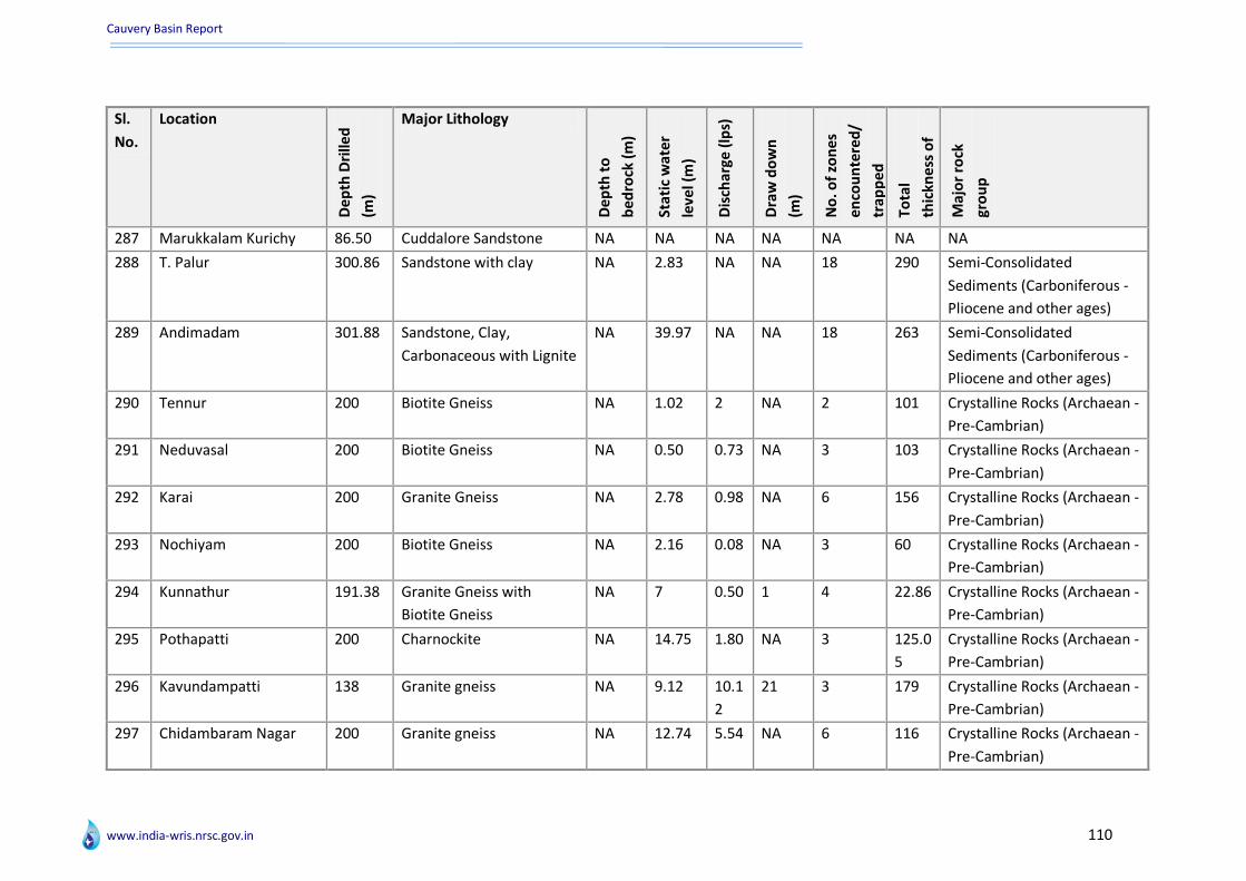
Cauvery Basin Report
www.india-wris.nrsc.gov.in 110
Sl.
No.
Location
De
pth
Dri
lled
(m)
Major Lithology
De
pth
to
be
dro
ck (
m)
Sta
tic
wat
er
leve
l (m
)
Dis
char
ge (
lps)
Dra
w d
ow
n
(m)
No
. of
zon
es
en
cou
nte
red
/
trap
pe
d
Tota
l
thic
kne
ss o
f
zon
es
(m)
Maj
or
rock
gro
up
287 Marukkalam Kurichy 86.50 Cuddalore Sandstone NA NA NA NA NA NA NA
288 T. Palur 300.86 Sandstone with clay NA 2.83 NA NA 18 290 Semi-Consolidated
Sediments (Carboniferous -
Pliocene and other ages)
289 Andimadam 301.88 Sandstone, Clay,
Carbonaceous with Lignite
NA 39.97 NA NA 18 263 Semi-Consolidated
Sediments (Carboniferous -
Pliocene and other ages)
290 Tennur 200 Biotite Gneiss NA 1.02 2 NA 2 101 Crystalline Rocks (Archaean -
Pre-Cambrian)
291 Neduvasal 200 Biotite Gneiss NA 0.50 0.73 NA 3 103 Crystalline Rocks (Archaean -
Pre-Cambrian)
292 Karai 200 Granite Gneiss NA 2.78 0.98 NA 6 156 Crystalline Rocks (Archaean -
Pre-Cambrian)
293 Nochiyam 200 Biotite Gneiss NA 2.16 0.08 NA 3 60 Crystalline Rocks (Archaean -
Pre-Cambrian)
294 Kunnathur 191.38 Granite Gneiss with
Biotite Gneiss
NA 7 0.50 1 4 22.86 Crystalline Rocks (Archaean -
Pre-Cambrian)
295 Pothapatti 200 Charnockite NA 14.75 1.80 NA 3 125.0
5
Crystalline Rocks (Archaean -
Pre-Cambrian)
296 Kavundampatti 138 Granite gneiss NA 9.12 10.1
2
21 3 179 Crystalline Rocks (Archaean -
Pre-Cambrian)
297 Chidambaram Nagar 200 Granite gneiss NA 12.74 5.54 NA 6 116 Crystalline Rocks (Archaean -
Pre-Cambrian)
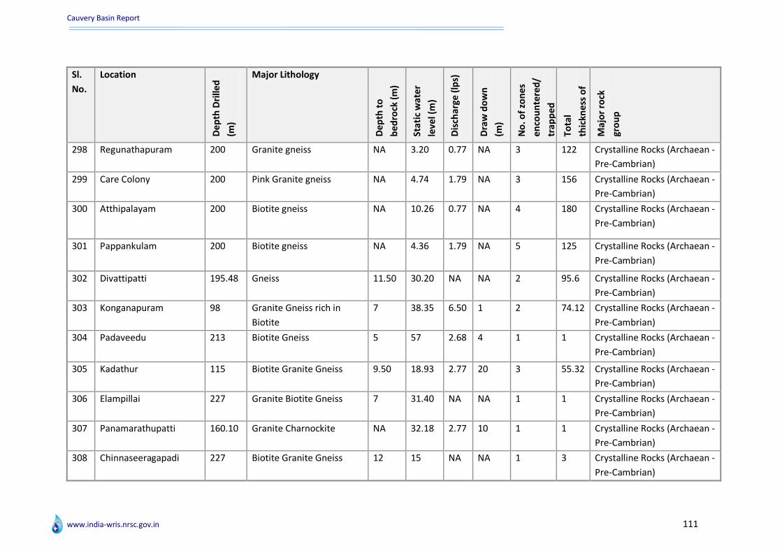
Cauvery Basin Report
www.india-wris.nrsc.gov.in 111
Sl.
No.
Location
De
pth
Dri
lled
(m)
Major Lithology
De
pth
to
be
dro
ck (
m)
Sta
tic
wat
er
leve
l (m
)
Dis
char
ge (
lps)
Dra
w d
ow
n
(m)
No
. of
zon
es
en
cou
nte
red
/
trap
pe
d
Tota
l
thic
kne
ss o
f
zon
es
(m)
Maj
or
rock
gro
up
298 Regunathapuram 200 Granite gneiss NA 3.20 0.77 NA 3 122 Crystalline Rocks (Archaean -
Pre-Cambrian)
299 Care Colony 200 Pink Granite gneiss NA 4.74 1.79 NA 3 156 Crystalline Rocks (Archaean -
Pre-Cambrian)
300 Atthipalayam 200 Biotite gneiss NA 10.26 0.77 NA 4 180 Crystalline Rocks (Archaean -
Pre-Cambrian)
301 Pappankulam 200 Biotite gneiss NA 4.36 1.79 NA 5 125 Crystalline Rocks (Archaean -
Pre-Cambrian)
302 Divattipatti 195.48 Gneiss 11.50 30.20 NA NA 2 95.6 Crystalline Rocks (Archaean -
Pre-Cambrian)
303 Konganapuram 98 Granite Gneiss rich in
Biotite
7 38.35 6.50 1 2 74.12 Crystalline Rocks (Archaean -
Pre-Cambrian)
304 Padaveedu 213 Biotite Gneiss 5 57 2.68 4 1 1 Crystalline Rocks (Archaean -
Pre-Cambrian)
305 Kadathur 115 Biotite Granite Gneiss 9.50 18.93 2.77 20 3 55.32 Crystalline Rocks (Archaean -
Pre-Cambrian)
306 Elampillai 227 Granite Biotite Gneiss 7 31.40 NA NA 1 1 Crystalline Rocks (Archaean -
Pre-Cambrian)
307 Panamarathupatti 160.10 Granite Charnockite NA 32.18 2.77 10 1 1 Crystalline Rocks (Archaean -
Pre-Cambrian)
308 Chinnaseeragapadi 227 Biotite Granite Gneiss 12 15 NA NA 1 3 Crystalline Rocks (Archaean -
Pre-Cambrian)
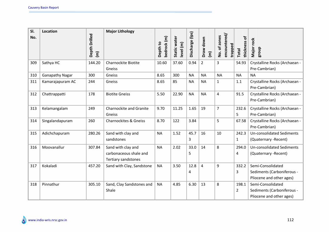
Cauvery Basin Report
www.india-wris.nrsc.gov.in 112
Sl.
No.
Location
De
pth
Dri
lled
(m)
Major Lithology
De
pth
to
be
dro
ck (
m)
Sta
tic
wat
er
leve
l (m
)
Dis
char
ge (
lps)
Dra
w d
ow
n
(m)
No
. of
zon
es
en
cou
nte
red
/
trap
pe
d
Tota
l
thic
kne
ss o
f
zon
es
(m)
Maj
or
rock
gro
up
309 Sathya HC 144.20 Charnockite Biotite
Gneiss
10.60 37.60 0.94 2 3 54.93 Crystalline Rocks (Archaean -
Pre-Cambrian)
310 Ganapathy Nagar 300 Gneiss 8.65 300 NA NA NA NA NA
311 Kamarajapuram AC 244 Gneiss 8.65 85 NA NA 1 1.1 Crystalline Rocks (Archaean -
Pre-Cambrian)
312 Chattrappatti 178 Biotite Gneiss 5.50 22.90 NA NA 4 91.5 Crystalline Rocks (Archaean -
Pre-Cambrian)
313 Kelamangalam 249 Charnockite and Granite
Gneiss
9.70 11.25 1.65 19 7 232.6
5
Crystalline Rocks (Archaean -
Pre-Cambrian)
314 Singalandapuram 260 Charnockites & Gneiss 8.70 122 3.84 5 67.58 Crystalline Rocks (Archaean -
Pre-Cambrian)
315 Adichchapuram 280.26 Sand with clay and
sandstones
NA 1.52 45.7
3
16 10 242.3
1
Un-consolidated Sediments
(Quaternary -Recent)
316 Moovanallur 307.84 Sand with clay and
carbonaceous shale and
Tertiary sandstones
NA 2.02 33.0
5
14 8 294.0
4
Un-consolidated Sediments
(Quaternary -Recent)
317 Kokaladi 457.20 Sand with Clay, Sandstone NA 3.50 12.8
4
4 9 332.2
3
Semi-Consolidated
Sediments (Carboniferous -
Pliocene and other ages)
318 Pinnathur 305.10 Sand, Clay Sandstones and
Shale
NA 4.85 6.30 13 8 198.1
2
Semi-Consolidated
Sediments (Carboniferous -
Pliocene and other ages)
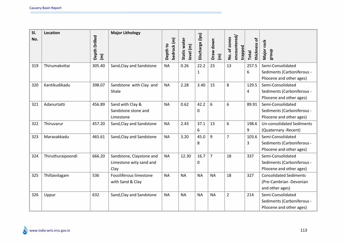
Cauvery Basin Report
www.india-wris.nrsc.gov.in 113
Sl.
No.
Location
De
pth
Dri
lled
(m)
Major Lithology
De
pth
to
be
dro
ck (
m)
Sta
tic
wat
er
leve
l (m
)
Dis
char
ge (
lps)
Dra
w d
ow
n
(m)
No
. of
zon
es
en
cou
nte
red
/
trap
pe
d
Tota
l
thic
kne
ss o
f
zon
es
(m)
Maj
or
rock
gro
up
319 Thirumakottai 305.40 Sand,Clay and Sandstone NA 0.26 22.2
1
23 13 257.5
6
Semi-Consolidated
Sediments (Carboniferous -
Pliocene and other ages)
320 Kantikudikadu 398.07 Sandstone with Clay and
Shale
NA 2.28 3.40 15 8 129.5
4
Semi-Consolidated
Sediments (Carboniferous -
Pliocene and other ages)
321 Adanurtatti 456.89 Sand with Clay &
Sandstone stone and
Limestone
NA 0.62 42.2
0
6 6 89.91 Semi-Consolidated
Sediments (Carboniferous -
Pliocene and other ages)
322 Thiruvarur 457.20 Sand,Clay and Sandstone NA 2.43 37.1
6
13 6 198.6
9
Un-consolidated Sediments
(Quaternary -Recent)
323 Maravakkadu 465.61 Sand,Clay and Sandstone NA 3.20 45.0
8
9 7 103.6
3
Semi-Consolidated
Sediments (Carboniferous -
Pliocene and other ages)
324 Thiruthuraipoondi 666.20 Sandstone, Claystone and
Limestone wity sand and
Clay
NA 12.30 16.7
0
7 18 337 Semi-Consolidated
Sediments (Carboniferous -
Pliocene and other ages)
325 Thillaivilagam 536 Fossiliferous limestone
with Sand & Clay
NA NA NA NA 18 327 Consolidated Sediments
(Pre-Cambrian -Devonian
and other ages)
326 Uppur 632 Sand,Clay and Sandstone NA NA NA NA 2 214 Semi-Consolidated
Sediments (Carboniferous -
Pliocene and other ages)
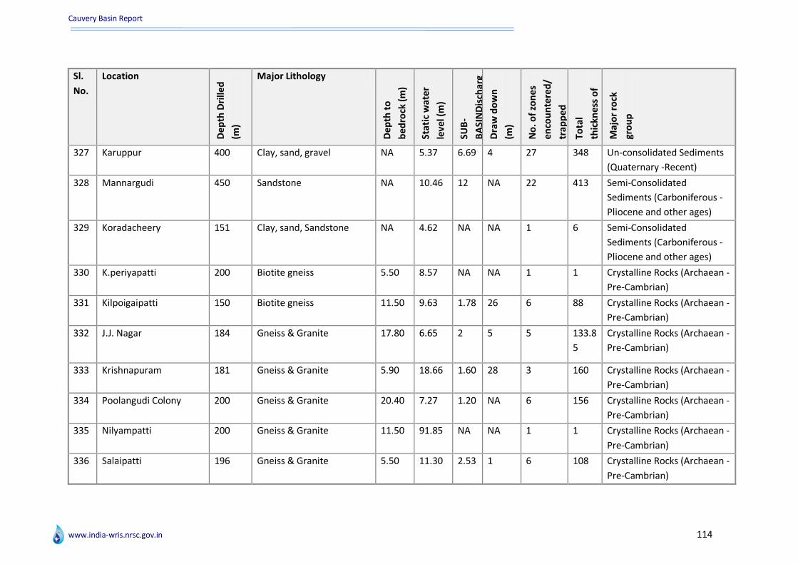
Cauvery Basin Report
www.india-wris.nrsc.gov.in 114
Sl.
No.
Location
De
pth
Dri
lled
(m)
Major Lithology
De
pth
to
be
dro
ck (
m)
Sta
tic
wat
er
leve
l (m
)
SUB
-
BA
SIN
Dis
char
g
e (
lps)
D
raw
do
wn
(m)
No
. of
zon
es
en
cou
nte
red
/
trap
pe
d
Tota
l
thic
kne
ss o
f
zon
es
(m)
Maj
or
rock
gro
up
327 Karuppur 400 Clay, sand, gravel NA 5.37 6.69 4 27 348 Un-consolidated Sediments
(Quaternary -Recent)
328 Mannargudi 450 Sandstone NA 10.46 12 NA 22 413 Semi-Consolidated
Sediments (Carboniferous -
Pliocene and other ages)
329 Koradacheery 151 Clay, sand, Sandstone NA 4.62 NA NA 1 6 Semi-Consolidated
Sediments (Carboniferous -
Pliocene and other ages)
330 K.periyapatti 200 Biotite gneiss 5.50 8.57 NA NA 1 1 Crystalline Rocks (Archaean -
Pre-Cambrian)
331 Kilpoigaipatti 150 Biotite gneiss 11.50 9.63 1.78 26 6 88 Crystalline Rocks (Archaean -
Pre-Cambrian)
332 J.J. Nagar 184 Gneiss & Granite 17.80 6.65 2 5 5 133.8
5
Crystalline Rocks (Archaean -
Pre-Cambrian)
333 Krishnapuram 181 Gneiss & Granite 5.90 18.66 1.60 28 3 160 Crystalline Rocks (Archaean -
Pre-Cambrian)
334 Poolangudi Colony 200 Gneiss & Granite 20.40 7.27 1.20 NA 6 156 Crystalline Rocks (Archaean -
Pre-Cambrian)
335 Nilyampatti 200 Gneiss & Granite 11.50 91.85 NA NA 1 1 Crystalline Rocks (Archaean -
Pre-Cambrian)
336 Salaipatti 196 Gneiss & Granite 5.50 11.30 2.53 1 6 108 Crystalline Rocks (Archaean -
Pre-Cambrian)

Cauvery Basin Report
www.india-wris.nrsc.gov.in 115
Sl.
No.
Location
De
pth
Dri
lled
(m)
Major Lithology
De
pth
to
be
dro
ck (
m)
Sta
tic
wat
er
leve
l (m
)
Dis
char
ge (
lps)
Dra
w d
ow
n
(m)
No
. of
zon
es
en
cou
nte
red
/
trap
pe
d
Tota
l
thic
kne
ss o
f
zon
es
(m)
Maj
or
rock
gro
up
337 Malar Nagar 200 Pink Granite 4.50 200 NA NA 3 80.2 Crystalline Rocks (Archaean -
Pre-Cambrian)
338 Magilambadi H.C. 200 Biotite Gneiss & Pink
Granite
9.90 3.48 NA NA 3 103.6
5
Crystalline Rocks (Archaean -
Pre-Cambrian)
339 Sobhnapuram 196 Granite Gneiss 10.40 19.66 NA NA 3 94.5 Crystalline Rocks (Archaean -
Pre-Cambrian)
340 Ullur 200 Granite Gneiss 5.50 32.30 NA NA 4 80 Crystalline Rocks (Archaean -
Pre-Cambrian)
341 Kavalkaranpatti 171.45 Granite Gneiss 8.50 9.25 1.79 12 3 136.2
5
Crystalline Rocks (Archaean -
Pre-Cambrian)
342 Othakadai 200 Granite Gneiss 12 8.07 4.70 10 4 139.5 Crystalline Rocks (Archaean -
Pre-Cambrian)
343 Gunnur 200 Granite Gneiss 7.25 7.27 4.70 12 6 115 Crystalline Rocks (Archaean -
Pre-Cambrian)
344 Bharathinagar 185 Gneiss 15.50 21 0.78 3 2 132 Crystalline Rocks (Archaean -
Pre-Cambrian)
345 Vengaimandalam 200 Gneiss 24.50 19.50 0.73 NA 1 1 Crystalline Rocks (Archaean -
Pre-Cambrian)
346 Chinna Kattukulam 100 Granite Gneiss 15.50 NA 6.87 1 3 66 Crystalline Rocks (Archaean -
Pre-Cambrian)
347 Kannanurpalayam 215 Granite Gneiss 12.50 215 NA NA NA NA NA
348 Vadakhukoilpatti 150 Gneiss 15.50 28.40 6.88 9 2 10 Crystalline Rocks (Archaean -
Pre-Cambrian)
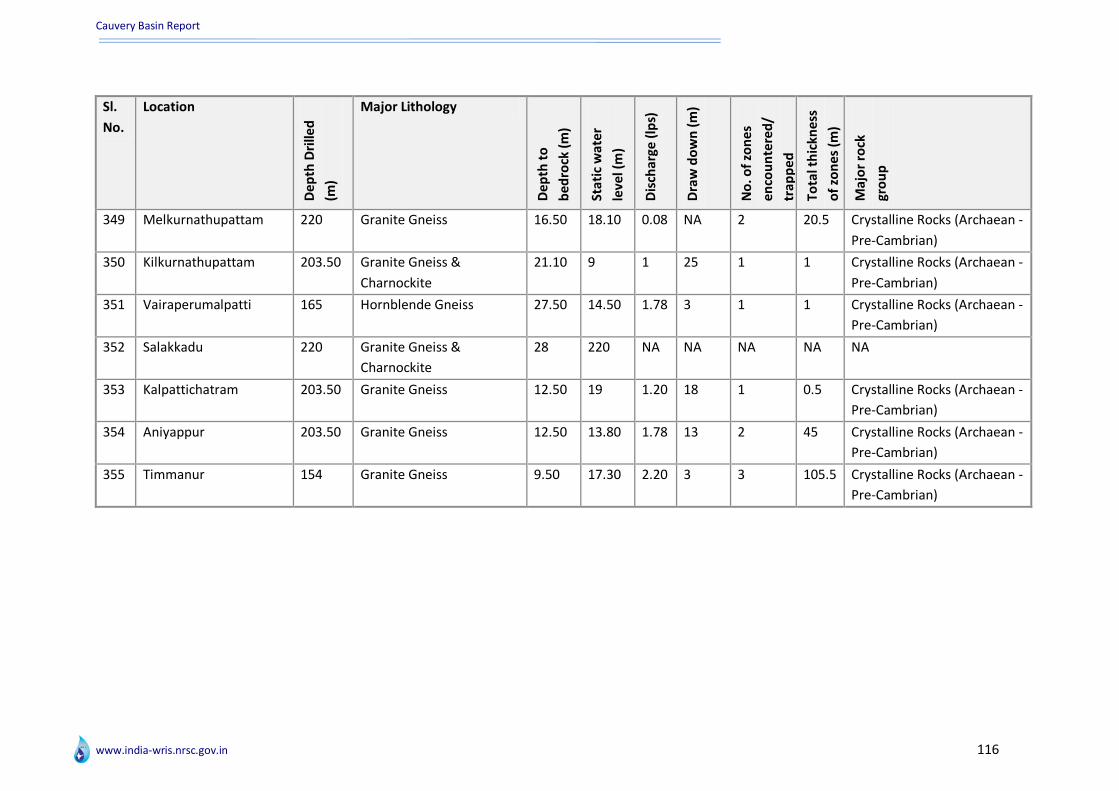
Cauvery Basin Report
www.india-wris.nrsc.gov.in 116
Sl.
No.
Location
De
pth
Dri
lled
(m)
Major Lithology
De
pth
to
be
dro
ck (
m)
Sta
tic
wat
er
leve
l (m
)
Dis
char
ge (
lps)
Dra
w d
ow
n (
m)
No
. of
zon
es
en
cou
nte
red
/
trap
pe
d
Tota
l th
ickn
ess
of
zon
es
(m)
Maj
or
rock
gro
up
349 Melkurnathupattam 220 Granite Gneiss 16.50 18.10 0.08 NA 2 20.5 Crystalline Rocks (Archaean -
Pre-Cambrian)
350 Kilkurnathupattam 203.50 Granite Gneiss &
Charnockite
21.10 9 1 25 1 1 Crystalline Rocks (Archaean -
Pre-Cambrian)
351 Vairaperumalpatti 165 Hornblende Gneiss 27.50 14.50 1.78 3 1 1 Crystalline Rocks (Archaean -
Pre-Cambrian)
352 Salakkadu 220 Granite Gneiss &
Charnockite
28 220 NA NA NA NA NA
353 Kalpattichatram 203.50 Granite Gneiss 12.50 19 1.20 18 1 0.5 Crystalline Rocks (Archaean -
Pre-Cambrian)
354 Aniyappur 203.50 Granite Gneiss 12.50 13.80 1.78 13 2 45 Crystalline Rocks (Archaean -
Pre-Cambrian)
355 Timmanur 154 Granite Gneiss 9.50 17.30 2.20 3 3 105.5 Crystalline Rocks (Archaean -
Pre-Cambrian)

Cauvery Basin Report
www.india-wris.nrsc.gov.in 117
Annexure VI : Salient features of hydro-meteorological stations
Salient features of Hydro- Meteorological Stations
Sl. No.
Station Name
Station type
Independent river
Regional office
Circle Division Sub division
Section office
Dra
inag
e a
rea
(Sq
. km
.)
Zero
of
Gau
ge
(m)
Station bank
Status
1 Hogenakkal
GDQ Cauvery C & S RO, Coimbatore
S.E.(C&SR), Bangalore
Cauvery Division, Bangalore
Upper Cauvery SD, Bangalore
Hogenakkal 1636 252 Left Existing
2 K.M.Vadi GDQ Cauvery C & S RO, Coimbatore
S.E.(C&SR), Bangalore
Cauvery Division, Bangalore
Upper Tunga SD, Devangere
K.M.Vadi 1330 765 Left Existing
3 Kanakpura
GDQ Cauvery C & S RO, Coimbatore
S.E.(C&SR), Bangalore
Cauvery Division, Bangalore
Upper Tunga SD, Devangere
KANAKAPURA 3425 612 Right Closed
4 Gopurajapuram
GDQ Cauvery C & S RO, Coimbatore
S.E.(C&SR), Bangalore
Hydrology Division, Chennai
Cauvery Delta SD, Karaikkal
Gopurajapuram NA 0 Left Existing
5 Kodumudi
GDSQ Cauvery C & S RO, Coimbatore
S.E.(C&SR), Bangalore
SR Division, Coimbatore
Lower Cauvery SD, Trichy
Kodumudi 53233 122 Right Existing
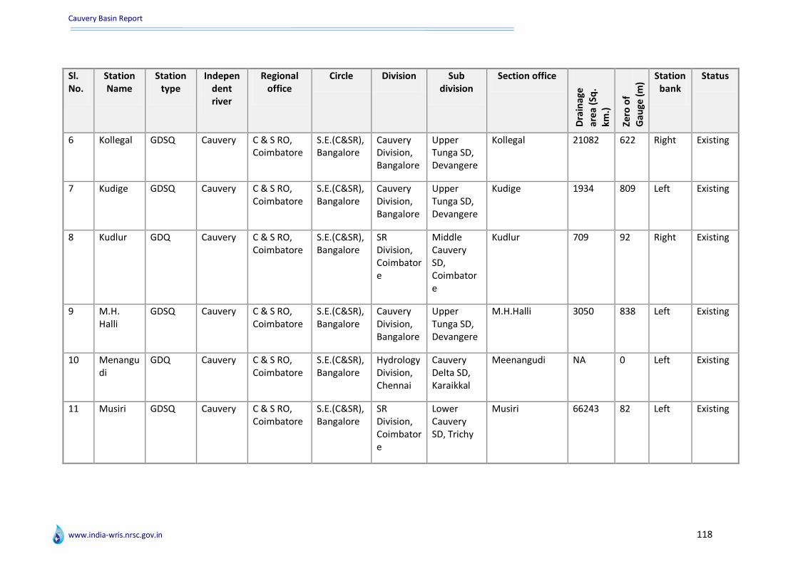
Cauvery Basin Report
www.india-wris.nrsc.gov.in 118
Sl. No.
Station Name
Station type
Independent river
Regional office
Circle Division Sub division
Section office
Dra
inag
e
are
a (S
q.
km.)
Zero
of
Gau
ge (
m)
Station bank
Status
6 Kollegal GDSQ Cauvery C & S RO, Coimbatore
S.E.(C&SR), Bangalore
Cauvery Division, Bangalore
Upper Tunga SD, Devangere
Kollegal 21082 622 Right Existing
7 Kudige GDSQ Cauvery C & S RO, Coimbatore
S.E.(C&SR), Bangalore
Cauvery Division, Bangalore
Upper Tunga SD, Devangere
Kudige 1934 809 Left Existing
8 Kudlur GDQ Cauvery C & S RO, Coimbatore
S.E.(C&SR), Bangalore
SR Division, Coimbatore
Middle Cauvery SD, Coimbatore
Kudlur 709 92 Right Existing
9 M.H. Halli
GDSQ Cauvery C & S RO, Coimbatore
S.E.(C&SR), Bangalore
Cauvery Division, Bangalore
Upper Tunga SD, Devangere
M.H.Halli 3050 838 Left Existing
10 Menangudi
GDQ Cauvery C & S RO, Coimbatore
S.E.(C&SR), Bangalore
Hydrology Division, Chennai
Cauvery Delta SD, Karaikkal
Meenangudi NA 0 Left Existing
11 Musiri GDSQ Cauvery C & S RO, Coimbatore
S.E.(C&SR), Bangalore
SR Division, Coimbatore
Lower Cauvery SD, Trichy
Musiri 66243 82 Left Existing
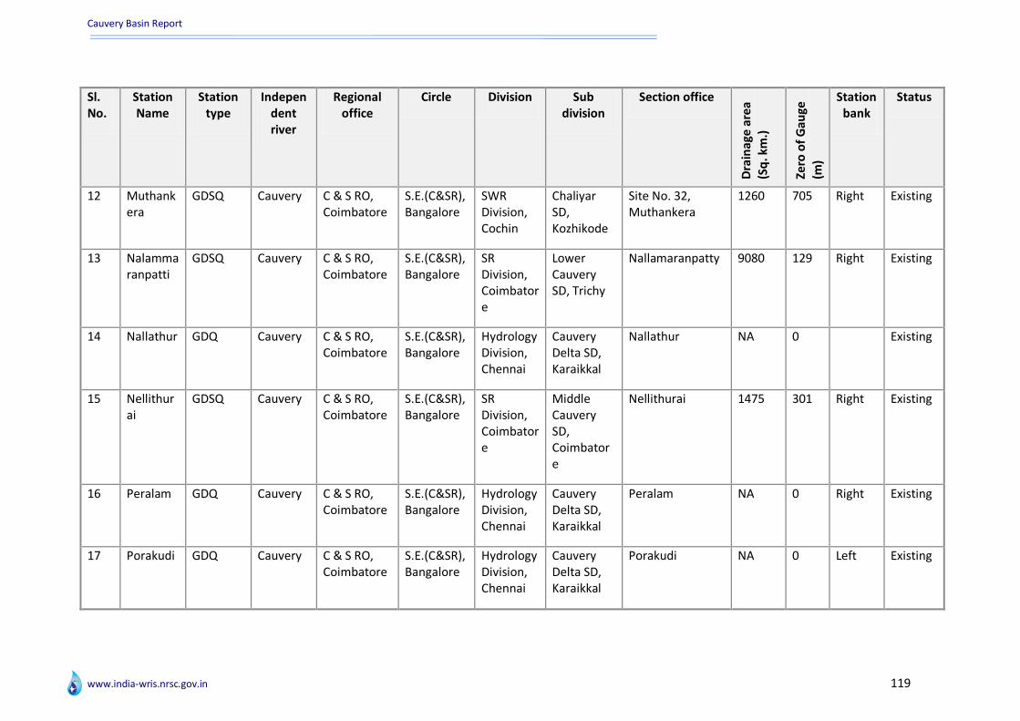
Cauvery Basin Report
www.india-wris.nrsc.gov.in 119
Sl. No.
Station Name
Station type
Independent river
Regional office
Circle Division Sub division
Section office
Dra
inag
e a
rea
(Sq
. km
.)
Zero
of
Gau
ge
(m)
Station bank
Status
12 Muthankera
GDSQ Cauvery C & S RO, Coimbatore
S.E.(C&SR), Bangalore
SWR Division, Cochin
Chaliyar SD, Kozhikode
Site No. 32, Muthankera
1260 705 Right Existing
13 Nalammaranpatti
GDSQ Cauvery C & S RO, Coimbatore
S.E.(C&SR), Bangalore
SR Division, Coimbatore
Lower Cauvery SD, Trichy
Nallamaranpatty 9080 129 Right Existing
14 Nallathur GDQ Cauvery C & S RO, Coimbatore
S.E.(C&SR), Bangalore
Hydrology Division, Chennai
Cauvery Delta SD, Karaikkal
Nallathur NA 0 Existing
15 Nellithurai
GDSQ Cauvery C & S RO, Coimbatore
S.E.(C&SR), Bangalore
SR Division, Coimbatore
Middle Cauvery SD, Coimbatore
Nellithurai 1475 301 Right Existing
16 Peralam GDQ Cauvery C & S RO, Coimbatore
S.E.(C&SR), Bangalore
Hydrology Division, Chennai
Cauvery Delta SD, Karaikkal
Peralam NA 0 Right Existing
17 Porakudi GDQ Cauvery C & S RO, Coimbatore
S.E.(C&SR), Bangalore
Hydrology Division, Chennai
Cauvery Delta SD, Karaikkal
Porakudi NA 0 Left Existing

Cauvery Basin Report
www.india-wris.nrsc.gov.in 120
Sl. No.
Station Name
Station type
Independent river
Regional office
Circle Division Sub division
Section office
Dra
inag
e a
rea
(Sq
. km
.)
Zero
of
Gau
ge
(m)
Station bank
Status
18 Sakleshpur
GDQ Cauvery C & S RO, Coimbatore
S.E.(C&SR), Bangalore
Cauvery Division, Bangalore
SWRSD No. 3, Mangalore
Sakleshpur 617 882 Right Existing
19 Savandapur
GDSQ Cauvery C & S RO, Coimbatore
S.E.(C&SR), Bangalore
SR Division, Coimbatore
Middle Cauvery SD, Coimbatore
Savandapur 5776 0 Right Existing
20 Sevanur GDQ Cauvery C & S RO, Coimbatore
S.E.(C&SR), Bangalore
SR Division, Coimbatore
Middle Cauvery SD, Coimbatore
SEVANUR 258 337 Right Existing
21 T. Bekuppe
GDQ Cauvery C & S RO, Coimbatore
S.E.(C&SR), Bangalore
Cauvery Division, Bangalore
Upper Tunga SD, Devangere
Kanakapura 3500 600 Left Existing
22 T. K. Halli GDSQ Cauvery C & S RO, Coimbatore
S.E.(C&SR), Bangalore
Cauvery Division, Bangalore
Upper Tunga SD, Devangere
T.K.Halli 7890 580 Existing

Cauvery Basin Report
www.india-wris.nrsc.gov.in 121
Sl. No.
Station Name
Station type
Independent river
Regional office
Circle Division Sub division
Section office
Dra
inag
e a
rea
(Sq
. km
.)
Zero
of
Gau
ge
(m)
Station bank
Status
23 T. Narasipur
GDSQ Cauvery C & S RO, Coimbatore
S.E.(C&SR), Bangalore
Cauvery Division, Bangalore
Upper Cauvery SD, Bangalore
T.Narasipur 7000 635 Right Existing
24 Thengudi GDSQ Cauvery C & S RO, Coimbatore
S.E.(C&SR), Bangalore
Hydrology Division, Chennai
Cauvery Delta SD, Karaikkal
Thengudi NA 0 Right Existing
25 Thengumarahada
GDSQ Cauvery C & S RO, Coimbatore
S.E.(C&SR), Bangalore
SR Division, Coimbatore
Middle Cauvery SD, Coimbatore
Thengumarahada 1370 217 Right Existing
26 Thevur GDQ Cauvery C & S RO, Coimbatore
S.E.(C&SR), Bangalore
SR Division, Coimbatore
Middle Cauvery SD, Coimbatore
Thevur 1248 168 Left Existing
27 Thoppur GDQ Cauvery C & S RO, Coimbatore
S.E.(C&SR), Bangalore
SR Division, Coimbatore
Lower Cauvery SD, Trichy
JE,S-Thoppur 362 154 Left Existing
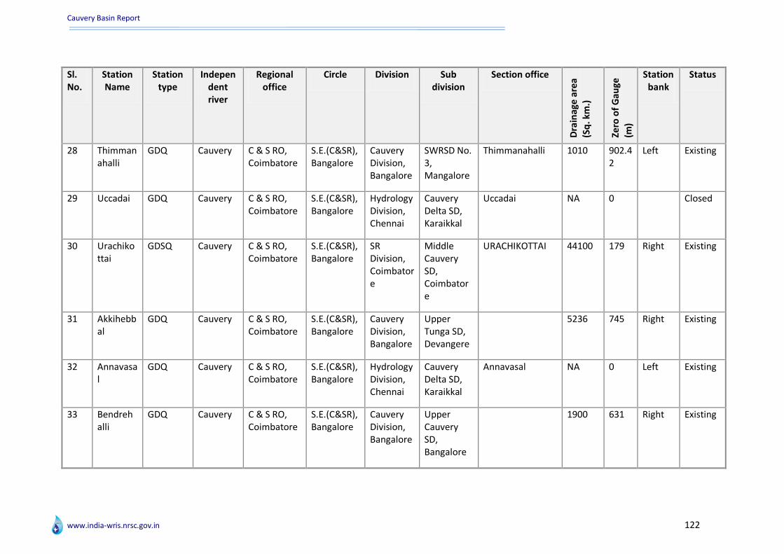
Cauvery Basin Report
www.india-wris.nrsc.gov.in 122
Sl. No.
Station Name
Station type
Independent river
Regional office
Circle Division Sub division
Section office
Dra
inag
e a
rea
(Sq
. km
.)
Zero
of
Gau
ge
(m)
Station bank
Status
28 Thimmanahalli
GDQ Cauvery C & S RO, Coimbatore
S.E.(C&SR), Bangalore
Cauvery Division, Bangalore
SWRSD No. 3, Mangalore
Thimmanahalli 1010 902.42
Left Existing
29 Uccadai GDQ Cauvery C & S RO, Coimbatore
S.E.(C&SR), Bangalore
Hydrology Division, Chennai
Cauvery Delta SD, Karaikkal
Uccadai NA 0 Closed
30 Urachikottai
GDSQ Cauvery C & S RO, Coimbatore
S.E.(C&SR), Bangalore
SR Division, Coimbatore
Middle Cauvery SD, Coimbatore
URACHIKOTTAI 44100 179 Right Existing
31 Akkihebbal
GDQ Cauvery C & S RO, Coimbatore
S.E.(C&SR), Bangalore
Cauvery Division, Bangalore
Upper Tunga SD, Devangere
5236 745 Right Existing
32 Annavasal
GDQ Cauvery C & S RO, Coimbatore
S.E.(C&SR), Bangalore
Hydrology Division, Chennai
Cauvery Delta SD, Karaikkal
Annavasal NA 0 Left Existing
33 Bendrehalli
GDQ Cauvery C & S RO, Coimbatore
S.E.(C&SR), Bangalore
Cauvery Division, Bangalore
Upper Cauvery SD, Bangalore
1900 631 Right Existing
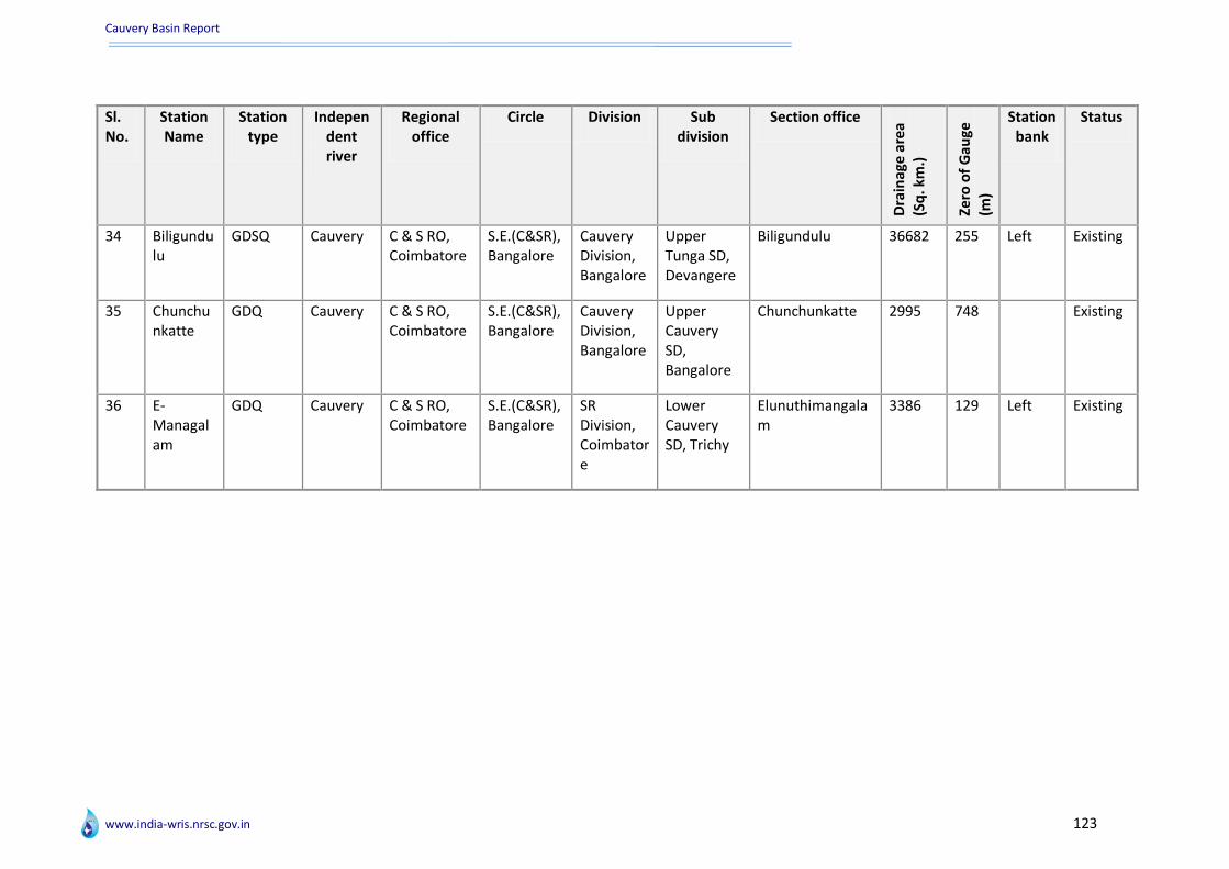
Cauvery Basin Report
www.india-wris.nrsc.gov.in 123
Sl. No.
Station Name
Station type
Independent river
Regional office
Circle Division Sub division
Section office
Dra
inag
e a
rea
(Sq
. km
.)
Zero
of
Gau
ge
(m)
Station bank
Status
34 Biligundulu
GDSQ Cauvery C & S RO, Coimbatore
S.E.(C&SR), Bangalore
Cauvery Division, Bangalore
Upper Tunga SD, Devangere
Biligundulu 36682 255 Left Existing
35 Chunchunkatte
GDQ Cauvery C & S RO, Coimbatore
S.E.(C&SR), Bangalore
Cauvery Division, Bangalore
Upper Cauvery SD, Bangalore
Chunchunkatte 2995 748 Existing
36 E-Managalam
GDQ Cauvery C & S RO, Coimbatore
S.E.(C&SR), Bangalore
SR Division, Coimbatore
Lower Cauvery SD, Trichy
Elunuthimangalam
3386 129 Left Existing

Cauvery Basin Report
www.india-wris.nrsc.gov.in 124
Annexure VII : Inventory of water tourism sites
Water Tourism Sites in the Basin Sl.
No. Name Type Waterbody WB
Relation District State
1 Kodaikanal Lake Lake Kodaikanal lake On Dindigul Tamil Nadu
2 Marayoor Tourist Spot Amaravathi Reservoir Near by Idukki Kerala
3 Velankanni Matha Church Pilgrimage (Church) Bay of Bengal On Nagapattinam Tamil Nadu
4 Velankanni Beach Beach Bay of Bengal On Nagapattinam Tamil Nadu
5 Kodikkarai Beach Beach Bay of Bengal On Nagapattinam Tamil Nadu
6 Nagore Dargha Pilgrimage (Masjid) Bay of Bengal On Nagapattinam Tamil Nadu
7 Banasura Project, Padinjarathara Tourist Spot NA NA Wayanad Kerala
8 Yercaud Lake Lake Yercaud Lake On Salem Tamil Nadu
9 Pazhassi Tomb Museums / Monument
NA NA Wayanad Kerala
10 Kuruvadweep, Mananthavady Island Kabani river On Wayanad Kerala
11 Thirunelli Temple, Mananthavady Pilgrimage (Temple) Kabari River Near by Wayanad Kerala
12 Iruppu Falls Waterfall Iruppu Falls On Kodagu Karnataka
13 Nanjundeshwara Or Srikanteshwara Or Ayappa Temple
Pilgrimage (Temple) Kabini or Kapila River On Mysore Karnataka
14 Hogenakkal Falls Waterfall Kaveri/ Cauvery River On Chamarajanagar Tamil Nadu
15 Somnathpur Pilgrimage (Temple) Cauvery River Near by Mysore Karnataka
16 Chamundi Hill Pilgrimage (Temple) Devi Kere (Lake) Near by Mysore Karnataka
17 Sivasamudram Falls Waterfall Kaveri River Near by Chamarajanagar Karnataka
18 Mysore Zoo Tourist Spot Karanji Lake On Mysore Karnataka
19 Karanji Lake Lake Karanji Lake On Mysore Karnataka
20 Kukkarahalli Lake Lake Kukkarahalli Lake On Mysore Karnataka
21 Lakshmi Kantha Swamy Temple Pilgrimage (Temple) Hebbal Lake On Mysore Karnataka
22 Dubare Forest Reserved Forest Cauvery River On Kodagu Karnataka
23 Bhagamandala Pilgrimage (Temple) Cauvery, Kanika, and Sujyothi
On Kodagu Karnataka

Cauvery Basin Report
www.india-wris.nrsc.gov.in 125
Sl. No.
Name Type Waterbody WB Relation
District State
24 Balamuri Falls Waterfall Cauvery River On Mandya Karnataka
25 Omkareshwara Temple Pilgrimage (Temple) Kodagu Karnataka
26 Nisarga Dham Tourist Spot Cauvery River On Kodagu Karnataka
27 Abbey Falls Waterfall Cauvery River Near by Kodagu Karnataka
28 Brindavan Gardens Tourist Spot Cauvery River On Mandya Karnataka
29 Muthyala Maduvu (Pearl Valley) Waterfalls Waterfall Ponnaiyar and Arkavati Rivers
On Bangalore Karnataka
30 Shettihalli Submerged Church Pilgrimage (Church) Hemavathy River On Hassan Karnataka
31 Karaikal Beach Beach Bay of Bengal On Karaikal Pondicherry
32 Karaikal Pilgrimage (Church) Bay of Bengal On Karaikal Pondicherry
33 Kovai Kuttralam Fall Waterfall Siruvani River Near by Coimbatore Tamil Nadu
34 Poompuhar Tourist Spot Kaveri River Near by Nagapattinam Tamil Nadu
35 Agaya Gangai Falls/ Kolli Falls Waterfall Aiyaru On Namakkal Tamil Nadu
36 Veeranam Lake Lake Cauvery River Near by Cuddalore Tamil Nadu
37 Catherine Falls Waterfall Kallar river On The Nilgiris Tamil Nadu
38 Vyathiri Tourist Spot NA NA Wayanad Kerala
39 Chembra Peak NA NA Wayanad Kerala
40 Ambalavayal Heritage Museum Museums / Monument
NA NA Wayanad Kerala
41 Belur Pilgrimage (Temple) Yagachi river On Hassan Karnataka
42 Mysore Palace Fort Karanji Lake Near by Mysore Karnataka
43 Madikeri Fort Fort NA NA Kodagu Karnataka
44 Srirangapatnam Fort Fort Cauvery River On Mandya Karnataka
45 Tipu's Fort And Palace Fort Cauvery River On Mandya Karnataka
46 Tala Kaveri Pilgrimage (Temple) Kaveri River On Kodagu Karnataka
47 Ooty Hill Station Ooty Lake On The Nilgiris Tamil Nadu

Cauvery Basin Report
www.india-wris.nrsc.gov.in 126
Wildlife Sanctuaries / National Parks in the Basin
Sl. No.
Name Type Waterbody WB Relation
Nearest City
District State
Ye
ar o
f Es
tab
lis
hm
en
t Mammals
Bir
ds
Re
pti
les
1 Chinnar Wildlife Sanctuary
Bird Sanctuary
Amaravathi Reservoir
Near by NA Idukki Kerala NA NA NA NA
2 Bandipur National Park
Tiger Reserve
Kabini and Nugu Reservoir
Near by Mysore 80 kilometers
Chamarajanagar Karnataka NA NA NA NA
3 Biligiri Rangaswamy Temple (Brt) Wildlife Sanctuary
Wildlife Sanctuary
Cauvery River Near by NA Chamarajanagar Karnataka NA Tiger, Leopard, Elephant
NA NA
4 Wayanad Wildlife Sanctuary
Wildlife Sanctuary
Kabari River Near by NA Wayanad Kerala NA NA NA NA
5 Pakshipathalam Bird Sanctuary
Bird Sanctuary
Kabari River Near by NA Wayanad Kerala NA NA NA NA
6 Nagarhole - Rajiv Gandhi National Park
National Park
Lakshmanthirtha River
On NA Kodagu Karnataka NA NA NA NA
7 Ranganathittu Bird Sanctuary
Bird Sanctuary
Cauvery River Near by NA Mysore Karnataka NA NA NA NA
8 Bannerghatta National Park
Tiger Reserve
Ponnaiyar and Arkavati Rivers
Near by Bangalore Bangalore Karnataka 1974 Tiger and Lion,white tigers,Leopard, Elephant
NA NA
9 Adichunhanagiri NA NA NA NA Hassan Karnataka 0 NA NA NA
10 Meikote Temple NA Hemavati River Near by NA Mandya Karnataka 0 NA NA NA
11 Point Calimere NA NA NA NA Nagapattinam Tamil Nadu
0 NA NA NA
12 Nugu NA NA NA NA Chamarajanagar Karnataka 0 NA NA NA
13 Mudumalai Tiger Reserve
Moyar River Near by NA The Nilgiris Tamil Nadu
0 NA NA NA
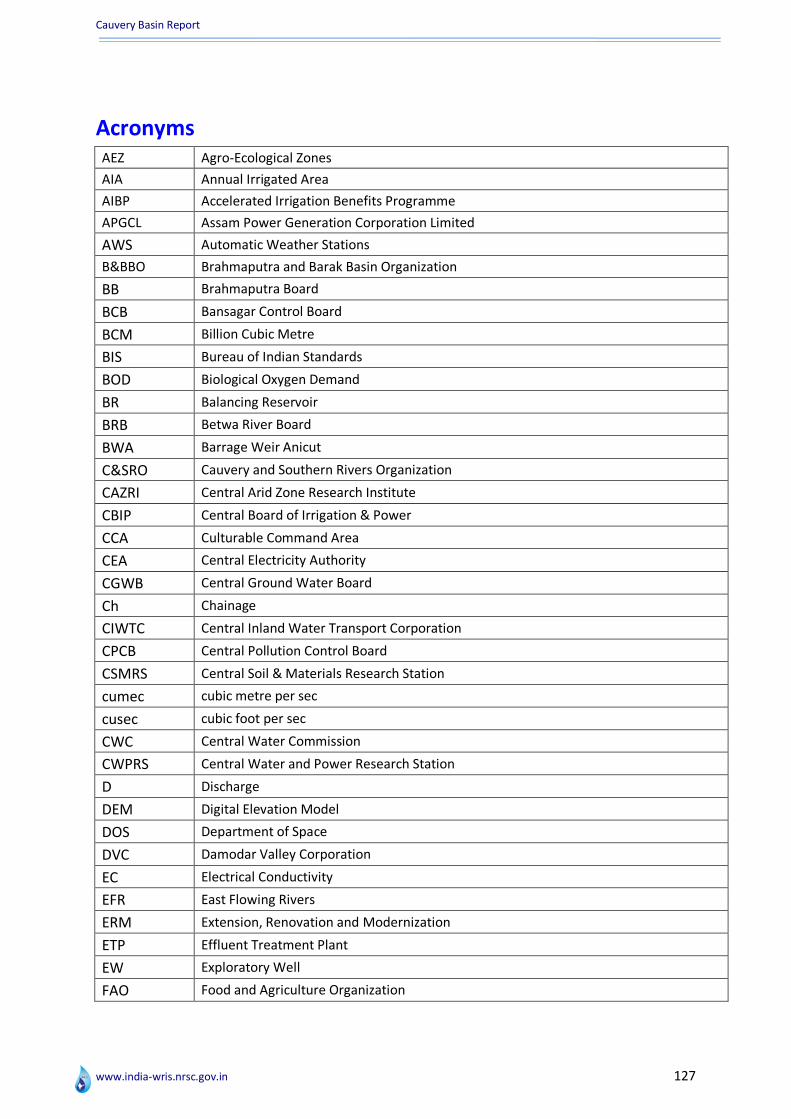
Cauvery Basin Report
www.india-wris.nrsc.gov.in 127
Acronyms AEZ Agro-Ecological Zones
AIA Annual Irrigated Area
AIBP Accelerated Irrigation Benefits Programme
APGCL Assam Power Generation Corporation Limited
AWS Automatic Weather Stations
B&BBO Brahmaputra and Barak Basin Organization
BB Brahmaputra Board
BCB Bansagar Control Board
BCM Billion Cubic Metre
BIS Bureau of Indian Standards
BOD Biological Oxygen Demand
BR Balancing Reservoir
BRB Betwa River Board
BWA Barrage Weir Anicut
C&SRO Cauvery and Southern Rivers Organization
CAZRI Central Arid Zone Research Institute
CBIP Central Board of Irrigation & Power
CCA Culturable Command Area
CEA Central Electricity Authority
CGWB Central Ground Water Board
Ch Chainage
CIWTC Central Inland Water Transport Corporation
CPCB Central Pollution Control Board
CSMRS Central Soil & Materials Research Station
cumec cubic metre per sec
cusec cubic foot per sec
CWC Central Water Commission
CWPRS Central Water and Power Research Station
D Discharge
DEM Digital Elevation Model
DOS Department of Space
DVC Damodar Valley Corporation
EC Electrical Conductivity
EFR East Flowing Rivers
ERM Extension, Renovation and Modernization
ETP Effluent Treatment Plant
EW Exploratory Well
FAO Food and Agriculture Organization
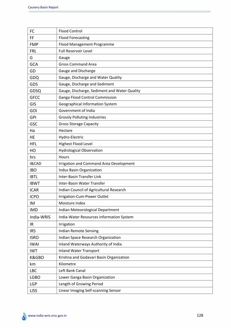
Cauvery Basin Report
www.india-wris.nrsc.gov.in 128
FC Flood Control
FF Flood Forecasting
FMP Flood Management Programme
FRL Full Reservoir Level
G Gauge
GCA Gross Command Area
GD Gauge and Discharge
GDQ Gauge, Discharge and Water Quality
GDS Gauge, Discharge and Sediment
GDSQ Gauge, Discharge, Sediment and Water Quality
GFCC Ganga Flood Control Commission
GIS Geographical Information System
GOI Government of India
GPI Grossly Polluting Industries
GSC Gross Storage Capacity
Ha Hectare
HE Hydro-Electric
HFL Highest Flood Level
HO Hydrological Observation
hrs Hours
I&CAD Irrigation and Command Area Development
IBO Indus Basin Organization
IBTL Inter-Basin Transfer Link
IBWT Inter-Basin Water Transfer
ICAR Indian Council of Agricultural Research
ICPO Irrigation-Cum-Power Outlet
IM Moisture Index
IMD Indian Meteorological Department
India-WRIS India-Water Resources Information System
IR Irrigation
IRS Indian Remote Sensing
ISRO Indian Space Research Organization
IWAI Inland Waterways Authority of India
IWT Inland Water Transport
K&GBO Krishna and Godavari Basin Organization
km Kilometre
LBC Left Bank Canal
LGBO Lower Ganga Basin Organization
LGP Length of Growing Period
LISS Linear Imaging Self-scanning Sensor

Cauvery Basin Report
www.india-wris.nrsc.gov.in 129
lps Litres Per Second
LSC Live Storage Capacity
LULC Land Use Land Cover
m metre
M&ERO Mahanadi and Eastern Rivers Organization
MAF Million Acre Feet
MCM Million Cubic metre
Mcum Million Cubic metre
MDDL Minimum Draw Down Level
mg/l Milligram per Litre
MI Minor Irrigation
MLD Million Liters per Day
mm Millimetres
MMIR Major and Medium Irrigation
MOSDAC Meteorological & Oceanographic Satellite Data Archival Centre
MoU Memorandum of Understanding
MoWR Ministry of Water Resources
MPN Most Probable Number
MSL Mean Sea Level
MU Million Units
MW Mega Watt
N&TBO Narmada and Tapi Basin Organization
NBO Narmada Basin Organization
NBSS & LUP National Bureau of Soil Survey & Land Use Planning
NEEPCO North Eastern Electric Power Corporation Limited
NEIC North Eastern Investigation Circle
NF No Flow
NGRBA National Ganga River Basin Authority
NHPC National Hydro Power Corporation Limited
NRLD National Register of Large Dam
NRSC National Remote Sensing Centre
NW National Waterway
NWDA National Water Development Authority
NWDT Narmada Water Disputes Tribunal
NWMP Northern Water Monitoring Programme
NWP National Water Policy
OW Observatory Well
P Precipitation
PET Potential Evapotranspiration
PH Power House
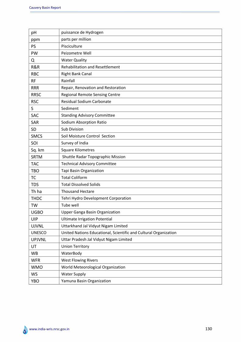
Cauvery Basin Report
www.india-wris.nrsc.gov.in 130
pH puissance de Hydrogen
ppm parts per million
PS Pisciculture
PW Peizometre Well
Q Water Quality
R&R Rehabilitation and Resettlement
RBC Right Bank Canal
RF Rainfall
RRR Repair, Renovation and Restoration
RRSC Regional Remote Sensing Centre
RSC Residual Sodium Carbonate
S Sediment
SAC Standing Advisory Committee
SAR Sodium Absorption Ratio
SD Sub Division
SMCS Soil Moisture Control Section
SOI Survey of India
Sq. km Square Kilometres
SRTM Shuttle Radar Topographic Mission
TAC Technical Advisory Committee
TBO Tapi Basin Organization
TC Total Coliform
TDS Total Dissolved Solids
Th ha Thousand Hectare
THDC Tehri Hydro Development Corporation
TW Tube well
UGBO Upper Ganga Basin Organization
UIP Ultimate Irrigation Potential
UJVNL Uttarkhand Jal Vidyut Nigam Limited
UNESCO United Nations Educational, Scientific and Cultural Organization
UPJVNL Uttar Pradesh Jal Vidyut Nigam Limited
UT Union Territory
WB WaterBody
WFR West Flowing Rivers
WMO World Meteorological Organization
WS Water Supply
YBO Yamuna Basin Organization

Cauvery Basin Report
www.india-wris.nrsc.gov.in 131
References
Agro-climatic zones: planning Commission, 1989.
Central Water commission. 1997. India River Basin Atlas. New Delhi.
Central Water Commission. 1989. Major River Basins of India – An Overview. New Delhi
Central Water Commission. 2012-2013. Annual Report. New Delhi.
Central Water Commission, 2012. Integrated hydrological data Book (Non-classified river
basins). New Delhi.
Ministry of Irrigation and Power. 1972. Report of the Irrigation Commission Volume III (Part 1
& 2). New Delhi.
National Remote Sensing Centre. 2011. Landuse/landcover Atlas of India based on Multi-
temporal Satellite Data of 2005-06. Hyderabad.
National Remote Sensing Centre, RRSC-West. 2012. River Basin Atlas of India. Jaipur: Jaipur
Printers.
National Remote Sensing Centre. December 2011. Assessment of Water Resources at Basin
Scale using Space inputs-a pilot study by NRSC and CWC for Godavari and Brahmani-Baitarni
basins. Hyderabad.
Sehgal, J.L., Mandal, D.K., Mandal, C. and Vadivelu, S. 1992. Agro-Ecological Regions of India.
2nd ed., NBSS Publication. 24, Technical Bulletin. National Bureau of Soil Survey and Land Use
Planning, Nagpur, India
Singh. R.L. et al, India A Regional Geography, 1971. Varansi.
Spate, O.H.K., 1960, India and Pakistan- A general and Regional Geography. New York:
Methuen & Co. Ltd and E.P. Dutton & Co. Inc.
Links:
India-Water Resources Information System: www.india-wris.nrsc.gov.in
Shuttle Radar Topography Mission SRTM) 90 m digital elevation Model: CGIAR. 2006,
http://srtm.sci.cgiar.org

Cauvery Basin Report
www.india-wris.nrsc.gov.in 132
Authors
ISRO Officials CWC Officials
Dr. V.K. Dadhwal Director National Remote Sensing Centre (NRSC) ISRO, Department of Space, Govt. of India Balanagar, Hyderabad
Er. A.Mahendran Member (WP & P) Central Water Commission New Delhi
Dr. J.R. Sharma Project Director, India-WRIS Project & Chief General Manager Regional Remote Sensing Centres - NRSC/ ISRO DOS Branch Secretariat, Loknayak Bhawan New Delhi
Er. W.M. Tembhurney Chief Engineer (EMO) Central Water Commission New Delhi
Dr. S. Rama Subramoniam Scientist/Engineer ‘SE’ Regional Remote Sensing Centre-West NRSC, ISRO, Jodhpur
Er R.K.Jain Chief Engineer (BPMO) Central Water Commission New Delhi
Mr. Vipul Sharma Project Scientist Regional Remote Sensing Centre-West NRSC, ISRO, Jodhpur
Er. YogeshPaithankar Director Remote Sensing Directorate Central Water Commission, New Delhi
Mrs. Deepika Acharya Sharma Research Scientist Regional Remote Sensing Centre-West NRSC, ISRO, Jodhpur
Er. Alok Paul Kalsi Deputy Director Remote Sensing Directorate Central Water Commission, New Delhi
Mr. Deepesh Kumar Jangid Project Scientist Regional Remote Sensing Centre-West NRSC, ISRO, Jodhpur
Cauvery Basin Report
www.india-wris.nrsc.gov.in 133
ISRO Officials
CWC Officials
Project Director Dr. J R Sharma Project In-charge Er. Yogesh Paithankar, Director
Convener (S/W)
Sh. P G Diwakar
Quality Assurance
Team
Sh. V M Bothale, Sh. M V Ravikumar, Dr. S S Rao, Dr. S N Das, Sh. D S P Rao, Ms. A Vijaya Banu, Sh. Chandrasekaran, Sh. D J Chutia
Dy. Project In-charge Er. Alok Paul Kalsi, Dy. Director Er. Prashant Kumar Gupta, Dy. Director
Convener (Database) Dr. A Jeyaram
Quality Assurance
Team
Dr. S Sudhakar, Sh. Uday Raj, Dr. M Kudrat, Ms. Rajashree V Bothale, Dr. D Dutta, Dr. G Ravishankar, Sh. S Pathak, Dr. K K Sarma
Technical Guidance Er. C K Agarwal, Chief Engineer (B & BBO) Er. W M Tembhurney, Chief Engineer EMO
Er R.K. Jain, Chief Engineer (BPMO) Project Coordinators Sh. Shantanu B., Sh.Uday Raj, Dr. A T Jeyaseelan
Project Managers Dr. A K Bera, Dr. B K Bhadra, Sh. S Pathak, Dr. Rakesh Paliwal
Groups and Work Components
Project Leads & Project Scientists at Lead Centre
Research Scientists at Lead Centre
DPDs & Project Scientists
Team
Er. Navin Kumar, Director
Er. S N Abraham, Director
Er. R Azhagesan, Director
Er. Ashish Banerjee, Director
Er. Rajiv Kumar, Director
Er. Piyush Ranjan, Executive Engineer
Er. Pankaj Sharma, Dy. Director
Er. Amarjit Singh, Dy. Director
Er. S K Chaturvedi, Dy. Director
Er. Y S Varshney, Executive Engineer
Er. Manoj Paunikar, Executive Engineer
Er. Amitabh Prabhakar, Executive Engineer
Er. Vishal Garg, Assistant Director
Er. M Sahabdeen, Assistant Director
Er. Ashish Awasthi Assistant Director
Er. R. Bhaskaran, Assistant Director
S/W Design, Architecture, Integration, Data Security, Web Hosting & Website
Sh. Gaurav Kumar
Sh. K S Srinivasan
Sh. Hansraj Meena
Ms. Suman Gurjar Ms. Pragya Chaturvedi Ms. Shilpa Taneja Ms. S V Pravalika Ms. Divya Mishra Ms. Jyotsana Chuchra Mr. Samuel Lourdraj C Mr. Rahul Sharma Mr. Piyush Dubey Mr. V Srinivasa Reddy Ms. Chitra S Pai Ms. Manasa Devi B Mr. Mohamed Ali S Ms. Hemlata Gehlot Mr. Amit Kumar Mr. Devdatta Tengshe Mr. Jai Prakash Jyani Mr. Munish Gorsi Ms. Deepika Acharya Ms. Pratima Tak Mr. Niteen K Bankar Ms. Himani Singh Ms. Sneha Ms. Kamini Yadav Mr. Goutam Bhati Mr. Debhasish Bhakta Mr. Nitin Chauhan Ms. Ila Agnihotri Mr. Vishal Singh Ms. Vineeta Sharma Dr. N Vyjayanthi Dr. Shirsath Paresh B Mr. Sanjay Kumar Ms. Rashmi Rekha Dutta Mr. Brij Kishor Jashal
Sh. Vinod M Bothale Sh. Shantanu B Sh. K Nagajyothi
Sh. S S Rajashekhar
Sh. Harish Karnatak Sh. D Giribabu Dr. A V Suresh Babu
Sh. E Sivasankar
Database Organization & Geo-database Standards
Dr. A K Bera
Dr. Rakesh Paliwal
Dr. M C Gupta
Dr. S N Das Dr. S S Rao Sh. K Abdul Hakeem
Legacy Data ISRO Projects
Dr. Rakesh Paliwal
Sh. Ashish Kumar Jain
Dr. V V Rao Dr. G Ravishankar Dr. A V Suresh Babu Sh. B Simhadhari Rao
Watershed Atlas & Water Resources Projects
Dr. A K Bera
Dr. Rakesh Paliwal
Er. Sagar S Salunkhe
Ms. Rajashree V B Dr. G Sreenivasan Dr. S Ravindranath Dr. K H V Durga Rao
Administrative & Thematic Layers
Dr. B K Bhadra
Dr. Rakesh Paliwal
Sh. S Pathak
Sh. Sushilkumar B Rehpade
Sh. Amanpreet Singh
Dr. D Dutta Dr. V M Choudhary Sh. P V Raju Sh. P Satyanarayana
Environmental Data Dr. S Rama Subramoniam
Dr. Manoj Joseph
Dr. S N Das Sh. John Mathew Sh. M Shanker Sh. B Simhadhari Rao
Capacity Building, Modelling, Value Addition & Report
Sh. S Pathak Dr. P Manavalan Sh. Pramod Kumar Sh. P V Raju Dr. K H V Durga Rao
India-WRIS Project Team
Lead Centre: Regional Remote Sensing Centre - West, NRSC/ISRO, Jodhpur

Cauvery Basin Report
www.india-wris.nrsc.gov.in 134