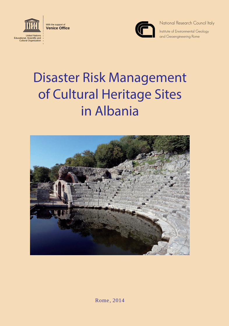
disaster risk management of cultural heritage sites in albania; 2014
TRANSCRIPT
National Research Council Italy
Institute of Environmental Geologyand Geoengineering Rome
Disaster Risk Managementof Cultural Heritage Sites
in Albania
Dis
aste
r Ris
k M
anag
emen
t of C
ultu
ral H
erita
ge S
ites
in A
lban
ia
e international debate concerning the overall capacity in disaster risks mitigation and adaptationstrategies of entire systems, communities and sites has increased significantly during the last decade, mainlydue to the interplay of multiple factors which have worsened the severity of hazards turning them withincreased occurrences into full-fledged disasters. Nowadays, an integrated approach is mandatory in thefield of sustainable development and Disaster Risk Reduction (DRR): the traditional ri between cultureand science, and the subdivisions among disciplines and fields of science have to be overpassed by the needsof our times. ese compel us to interface the advancements in science and technology in DRR with policymakers, emergency responders and local communities. Working in synergy in an integrated manner is notan easy task to undertake. CNR-IGAG, the UNESCO Regional Bureau for Science and Culture in Europeand ICCROM, under the framework of the ONE UN initiative, have endeavored to make this idea a workingconcept: scientific field assessment of geo-vulnerabilities in the World Heritage Sites of Albania have beencombined with the sucessful attempt to train emergency responders and site managers to deal with DRR inthe same sites. e achievements of such activities constitute the narrative of this script.
Rome, 2014
With the support of
Venice Office
United Nations
Cultural Organization
ISBN 978-88-6812-286-7
cover albania v2_2015_Layout 1 13/03/15 17:50 Pagina 1
Disaster Risk Managementof Cultural Heritage Sites
in Albania
Seismological-Geohazard Risk Analysisand Disaster Risk Reduction Guidelines
for Apollonia archaeological park,Historic centres of Berat and Gjirokastra and Butrint
Within the frame of the project:“Building Capacity in Natural Risk-Preparedness
for Cultural Sites in Albania”
funded by:
in collaboration with
National Research Council ItalyInstitute of Environmental Geologyand Geoengineering Rome
Komisioni Kombëtar Shqiptar për UNESCO-n
Albanian National Commission for UNESCO
United Nations
Cultural Organization
Organizatae Kombeve të Bashkuara
për Arsim, Shkencë dhe Kulturë
With the support of
Venice Office
United Nations
Cultural Organization
1 Colophon v4_2015_Layout 1 25/03/15 15:25 Pagina 1
Disaster Risk Management of Cultural Heritage Sites in Albania
2
EDITORS:Mario Scalet1, Davide Poletto1, Gian Paolo Cavinato2, Massimiliano Moscatelli2.
1 UNESCO, Regional Bureau for Science and Culture in Europe, Venice, Italy2 CNR-IGAG, Rome, Italy
Authors:Rohit Jigyasu, Christopher Marrion, Davide Poletto, Mario Scalet (PART I)
Gian Paolo Cavinato, Giuseppe Cosentino, Arian Dimo, Llambro Duni, MassimilianoMoscatelli, Alessandro Pagliaroli, Iris Pojani, Erjona Qilla, Maurizio Simionato, Admir Xhelaj(PART II)
Photo Credits: CNR-IGAG, Llambro Duni, Iris Pojani.
ISBN 978-88-6812-286-7
PUBLISHER: CNR IGAG 2014
CNR - National Research Council, ItalyIGAG - Institute of Environmental Geology and GeoengineeringArea della Ricerca di Roma1 Via Salaria Km 29,300, 00015 Monterotondo (Rome), Italy
DISCLAIMER:e authors are responsible for the choice and the presentation of the facts contained in this book and for the ideas andopinion expressed therein, which are not necessary those of UNESCO and CNR.e designations employed and the presentation of material throughout this publication do not imply the expression ofany opinion whatsoever on the part of UNESCO and CNR-IGAG concerning the legal status of any country, territory, cityor area or of its authorities or concerning the delimitation of its frontiers or boundaries.
1 Colophon v4_2015_Layout 1 25/03/15 15:25 Pagina 2
Disaster Risk Management of Cultural Heritage Sites in Albania
3
ACKNOWLEDGEMENTS
The editors would like to express their gratitude to the Albanian Ministry of Culture andMinistry of Interior, General Directorate of Civil Emergencies, for their support at theinstitutional level within the ONE UN framework, sharing the belief on the necessity to investin Disaster Risk Reduction (DRR) in the cultural heritage sites of Albania.
The project was realized thanks to the ONE UN Coherence funds and additional fundsprovided by the Government of Italy. It benefited of the valuable support of the AlbanianNational Commission for UNESCO and the UNESCO Project Office in Tirana.
Felt appreciation is due to the management authorities and the staff of the Cultural HeritageProperties of Gjirokastra-Berat, Saranda-Butrint and Apollonia archaeological park whichgenerously supported the CNR-IGAG team in their field work on the seismic hazards,geomorphologic risks, seismic and microzonation of the sites.
Special thanks are for the Municipality of Berat for having kindly hosted the DRR training,including the onsite learning sessions, along with the final conference of the project, whichwas successfully conducted in collaboration with the joint support of the EU-funded projectSUSTCULT run by the Municipality of Venice.
A word of appreciation is also due to the enthusiastic and talented interdisciplinary groupof trainees, selected from the Institute of Monuments of Culture, the Regional Directoratefor National Heritage, the General Directorate of Civil Emergencies and the Fire CorpsDepartment, the management authorities of the UNESCO designated sites and theArchaeological Park of Apollonia. Their capacity to work in an interdisciplinary way, theirhard commitment in tough environmental conditions with limited time, was the key elementalong with the skillful training team of the highly successful performance in the trainingsessions.
The editors would like to express sincere appreciation to Elenita Roshi of the AlbanianAmerican Development Foundation (AADF) and to Sadi Petrela of the GjirokastraConservation and Development Organization (GCDO) for the precious logistic supportreceived during the assessment/coaching mission at the World Heritage Sites (WHS) ofGjirokastra and Berat.
Recognition is due to the work done by an excellent multinational group of experts,mentioned in the following pages, who endeavored in this project, regardless of what theirscientific background and affiliation was: they all worked as a single team with dedicationand with a genuine interdisciplinary perspective.
Finally, special thanks go to all the people who gave a significant assistance to the CNR-IGAG team work in the field, through their precious contribution in terms of data,information, logistics and translation service support: Mira Cuberi, Arjan Dimo, StephanDoempke, Spartak Drasa, Marin Haxhimihali, Rajmond Kola, Kreshnik Merxhani, AltinPango, Erjona Qilla, Evjeni Thomagjini, Gerta Veliu and Admir Xhelaj.
1 Colophon v4_2015_Layout 1 25/03/15 15:25 Pagina 3
Disaster Risk Management of Cultural Heritage Sites in Albania
5
INTRODUCTION . . . . . . . . . . . . . . . . . . . . . . . . . . . . . . . . . . . . . . . . . . . . . . . . . . . . . . . . . . . . . . . . . . . . .7
PART INATURAL DISASTER RISK PREPAREDNESS AND MITIGATION GUIDELINES
OF CULTURAL HERITAGE SITES OF ALBANIA
1. PROJECT OVERVIEW: MOTIVATIONS, OBJECTIVES AND STRUCTURE . . . . . . . . . . . . . .13
2. ALBANIAN WORLD HERITAGE SITES . . . . . . . . . . . . . . . . . . . . . . . . . . . . . . . . . . . . . . . . . . . . .17
3. RISK ANALYSIS OF NATURAL HAZARDS . . . . . . . . . . . . . . . . . . . . . . . . . . . . . . . . . . . . . . . . .21
4. GUIDELINES FOR RISK REDUCTION OF WORLD HERITAGE PROPERTIES . . . . . . . . . . .27
ANNEX I. POWER POINT PRESENTATIONS PRODUCED AT THE TRAINING ON NATURAL DISASTER RISK MANAGEMENT IN WORLD HERITAGE SITES OF ALBANIA . . . . . . . . . . . . . . . . . . . . . . . . . . . . . . . . . . . . . . . . . . . . . . . . . . . . . . . . . . . . . . . . . . .33
PART II ASSESSMENT ANALYSIS OF SEISMOLOGICAL RISK AND GEOHAZARD VULNERABILITY
OF FIRST LEVEL IN MAJOR CULTURAL HERITAGE SITES OF ALBANIA
1. GEOLOGICAL SETTING AND REGIONAL SEISMIC HAZARD OF ALBANIA . . . . . . . . . . .71
2. GEOPHYSICAL INVESTIGATION OF THE ALBANIAN CULTURAL HERITAGE SITES . . .91
3. LOCAL SEISMIC HAZARD ASSESSMENT: METHODOLOGY FOR SEISMICMICROZONATION . . . . . . . . . . . . . . . . . . . . . . . . . . . . . . . . . . . . . . . . . . . . . . . . . . . . . . . . . . . . . .99
4. SEISMIC MICROZONATION OF APOLLONIA . . . . . . . . . . . . . . . . . . . . . . . . . . . . . . . . . . . . .103
5. SEISMIC MICROZONATION OF BERAT . . . . . . . . . . . . . . . . . . . . . . . . . . . . . . . . . . . . . . . . . .115
6. SEISMIC MICROZONATION OF BUTRINT . . . . . . . . . . . . . . . . . . . . . . . . . . . . . . . . . . . . . . . .123
7. SEISMIC MICROZONATION OF GJIROKASTRA . . . . . . . . . . . . . . . . . . . . . . . . . . . . . . . . . .137
8. GEOPHYSICAL MEASUREMENTS . . . . . . . . . . . . . . . . . . . . . . . . . . . . . . . . . . . . . . . . . . . . . . .147
ANNEX II. PHYSICAL MEASUREMENT TABLES . . . . . . . . . . . . . . . . . . . . . . . . . . . . . . . . . .151
ANNEX III. MAP OF SEISMIC MICROZONATION OF LEVEL 1 IN APOLLONIA
ANNEX IV. MAP OF SEISMIC MICROZONATION OF LEVEL 1 IN BERAT
ANNEX V. MAP OF SEISMIC MICROZONATION OF LEVEL 1 IN BUTRINT
ANNEX VI. MAP OF SEISMIC MICROZONATION OF LEVEL 1 IN GJIROKASTRA
TABLE OF CONTENTS
1 Colophon v4_2015_Layout 1 25/03/15 15:25 Pagina 5
INTRODUCTION
DISASTER RISK REDUCTION (DRR) AND CULTURAL HERITAGE
The international debate concerning disaster risks has increased significantly during the last decade mainlydue to the interplay of multiple factors which have worsened the severity of hazards, turning them morefrequently into full fledge disasters. Disaster vulnerability is on the rise, due to the wave of profound social environmental changes (SEC). Thehuman agency impact has triggered profound alterations of the functions of many ecosystem servicesprovoking amplified worldwide cascade effects. For instance, the relations between deforestation andlandslides, floods and water management regimes, climate change and the sea level rise, etc, are evident.Moreover, the increased instability of the global economic system and social polarization at the global scale,leave poor population around the globe defenseless to cope with risk. Adequate mitigation strategy costsare also inaccessible to them and the impact of disasters may easily become a fatal blow to their feebleeconomies with long-lasting consequences. It was the world-wide traumatic event of the Indian Ocean Tsunami in 2004 that determined themomentum necessary to set a framework of critical actions to be followed by the international communityin the frame of a new International Strategy for Disaster Reduction (ISDR). UN member states recognisedthat they had to find new terms of commitment on Disaster Reduction. The Hyogo Declaration andFramework for Action (HFA) was therefore agreed upon (Kobe in Japan, January 2005).The HFA five core commitments recognize that besides the need to have national plans for Disaster RiskReduction and Management on paper, the role of education and the role of local communities and authoritiesare equally crucial to achieving relevant results on building societies more resilient to risks. Resilience hasto be implemented on site, at the local level, building capacities and empowering communities, includingthose at the grassroots level. This has recently been recalled and stressed also by the Synthesis report:“Consultations on a post 2015 framework on Disaster Risk Reduction” (HFA2- April 2013) where localaction underpinning community leadership and engagement in DRR is considered a key element in orderto mainstream International DRR principles and guidelines into national and local agendas for action.Furthermore, the socio-cultural traditions of the natives are at the basis of risk-resilience in many parts ofthe world, including UNESCO designated sites, as detectable in the material constructions and buildings.Advancement of science and technology is also a main issue to be considered. The applications and productsat hand today through Earth Observation, Early Warning and are potentially offering solutions which maybring invaluable benefits to local communities and to end users in the entire Disaster Risk Managementcycle. However, product developers and scientists investing in cutting edge technology should find a way toeffectively link and interface with policy-makers and emergency responders in particular in low incomecountries. Moreover, an integrated approach is mandatory in the field of sustainable development and DRR: thetraditional rift between culture and science, and the subdivisions among disciplines and fields have to besurpassed by the needs of our times. All of these innovative impulses from HFA and the very nature of the phenomena to confront has madedisaster risk preparedness an important entry point of UNESCO’s strategy. UNESCO, which deals withcross-cutting issues, has mobilised all its internal resources in building upon a culture of disaster riskresilience through its constitutive components: education, science, culture and communication (DisasterPreparedness and Mitigation UNESCO’s Role, 2007). In particular, UNESCO has a vital role to play inconstructing a global culture of disaster preparedness and mitigation, building in the minds of people a
Disaster Risk Management of Cultural Heritage Sites in Albania
7
2 v2_2015_Layout 1 25/03/15 15:26 Pagina 7

culture of resilience to risk, promoting awareness, education and capacity and foremost a different way toapproach the domain of DRR and preparedness. UNESCO is also the secretariat of the 1972 World Heritage Convention, of which the properties haverecently been the focus of substantial advancement in securing better capacity in risk management andreduction. As we know, the impact of disasters in World Heritage properties may be very significant sinceit could adversely affect their “Outstanding Universal Value” which justified their inscription on the WorldHeritage List; result in loss of lives and assets for the local people; disrupt their communities and threatenthe security of visitors; negatively affect the local economy and tourism.Since UNESCO is engaged in important actions for the protection of cultural heritage; it implementsseveral projects in post disaster scenarios. We may historically record the following samples as internationallyreckoned UNESCO post disaster operations in WHS: flooding in Florence and Venice (1966), earthquakesat the Citadel of Bam in Iran (2003) and at the temples of Prambanan in Indonesia (2006).The World Heritage Centre (WHC) has tried to set a new course in the effort to mainstreaming capacityof reducing risk from disasters at the World Heritage properties. In particular, the World Heritage Committeeadopted in 2007 a Strategy for Reducing Risks from Disasters which encourages all state parties to developdisaster risk management plans for World Heritage properties in their respective countries. In late 2010, aResource Manual for Managing Disaster Risks for World Heritage was published. It focuses on innovativeprinciples, methodology and process for managing disaster risks at cultural and natural World Heritageproperties which are largely inspired by an inclusive and participative approach to risk. However, despitesuch an important conceptual advancement, disaster risk management is still at the preliminary stage amongheritage professionals who need to be introduced to these new methodologies and principles.
THE PROJECT OF DISASTER RISK MANAGEMENT FOR CULTURAL HERITAGE IN ALBANIA
The UNESCO Venice Office (UNESCO Regional Bureau for Science and Culture in Europe), accordingto the priorities set by the government of Albania1 and taking the opportunity offered by the One UNProgramme2, implemented the project “Natural Risk Preparedness and Mitigation - Building capacity inthe field of risk mitigation for Cultural Heritage properties in Albania” during the period 2011-2013. The project aimed to streamline disaster risk management in the Country, using its World Heritageproperties as demonstration sites. The project was conceived to assist the country in order to enhance itscapacity for Disasters Risk Management (DRM) and advancement in seismological and geologicalvulnerability of Cultural Heritage properties.The overall context, the project objectives, its structure and results achieved in terms of capacity buildingand recommendations are described in the first section of this book. In this framework, UNESCO partneredwith ICCROM (International Centre for the Study of the Preservation and the Restoration of CulturalProperty, Rome) in collaboration with the Ministry of Culture, the General Directorate for Civil Emergenciesand the Fire Corps, under the Ministry of Interior of Albania, the management authority of NationalHeritage, the regional departments of Archaeological Parks of Apollonia, Berat, Butrint and Gjirokastra,and the Albanian National Commission for UNESCO.
PART I - CAPACITY BUILDING, RISK ANALYSIS AND GUIDELINES ELABORATION
This activity was conducted in cooperation with ICCROM, by designing and implementing an intensivetraining on Disaster Risk Preparedness and Management at the World Heritage site of Berat in Albania
Disaster Risk Management of Cultural Heritage Sites in Albania
8
2 v2_2015_Layout 1 25/03/15 15:26 Pagina 8
from 19 to 24 November 2011. This brought together heritage professionals from the selected major heritagesites of Albania (Butrint, Berat-Gjirokastra and the archeological park of Apollonia) and civil emergencyresponders. It successfully provided them with knowledge on current thinking, methods and tools availablefor the preparation of Disaster Risk Management plans on the basis of the World Heritage Resource Manualon “Managing Disaster Risks for World Heritage”3. Using the manual and analyzing the specific context of the selected sites, a broader methodologicalframework was developed. This was done to lay the ground for the development of disaster risk managementplans in the selected cultural sites, acting as a model for other sites both in Albania and in the entire Region.The workshop was timely conceived since overall World Heritage properties’ management plans arecurrently under development in Albania4. Special focus was devoted to risk preparedness for earthquakesand fires, through the participation of highly qualified international experts on such fields of expertise. Trainees were also provided with a post-training coaching support and have obtained personal certificatesof attendance upon delivery of a site-based framework presentation highlighting all relevant componentsfor their future management plans. Their outputs which are presented in the ANNEX I of the PART I ofthis publication, were presented along with the CNR-IGAG report, at the final workshop of the project“Disaster Risk Preparedness and Management in Cultural Heritage Sites” held at the WHS of Berat, 8 May2012, organized in cooperation with the EU-funded project SUSTCULT. The workshop showed localstakeholders and representatives of the Cultural sites (among which UNESCO designated sites in SouthEast Europe) how an integrated approach inclusive of risk is necessary for a good management of WorldHeritage sites.The Risk Analysis of natural hazards and the guidelines for the risk reduction of Cultural Heritage inAlbania (chapters 3 and 4) were elaborate by the experts considering the contribute of the local managersand element/data collected in the World Heritage sites visited.The conference was followed by a “site by site” visit of UNESCO-ICCROM team at the World Heritagesites of Gjirokastra/Berat and Butrint. This was on one hand conceived in order to secure a post-trainingcoaching support to the heritage and civil protection professionals, useful to help their efforts in devisingnew management plans for their sites. On the other it provided first-hand knowledge of the most felt riskin the sites upon which the guidelines at PART I (chapter 1) have been developed.
PART II - SCIENCE-BASED SEISMOLOGICAL AND GEO-VULNERABILITIES MAPPING
This activity was done by the launching of a microzonation assessment of level 15 at the World Heritageproperties of Gjirokastra, Berat, Saranda-Butrint and the Apollonia archaeological park. Aninterdisciplinary Italian/Albanian work team composed of engineers, geologists and archeologists led byCNR (Centro Nazionale Ricerche) - IGAG (Istituto di Geologia Ambientale e Geoingegneria) started aspecific geological and geophysical field survey based on micro-zonation in late November 2011. Thisproduced a comprehensive assessment report and related maps of Seismological Risk and Geo-hazardVulnerability based on the first level of investigation, in the above-mentioned selected sites which is dulyreported in PART II, chapter by chapter from 1 to 7 with the inclusion of a dedicated part (chapter 8) onthe methodology adopted for the geophysical investigation. The policy impact on risk may prove highly relevant as reliable scientific data should provide crucialsupport to the decision makers on geo-risk management in UNESCO designated sites. The produceddata is, in fact, considered very sensitive among designated sites managers to adequately tailor actionsaccording to the magnitude and nature of the risk(s) at stake. It represents a tool for site managers andplanners in Albania, bringing out evidence-based findings and providing useful information for:
Disaster Risk Management of Cultural Heritage Sites in Albania
9
2 v2_2015_Layout 1 25/03/15 15:26 Pagina 9
Establishing guidelines and criteria of interventions in urban areas and cultural sites.•defining priorities for interventions.•Finally, the work was framed into an interactive relationship with site managers and integrated into theactivities of capacity building performed in the field of DRM under the same project (see point 1 above),in order to develop appropriate risk management systems, including management guidelines and actionplans for the cultural sites, along with particular provisions to improve ordinary maintenance, retrofittingof existing infrastructures or monuments, enlarge buffer areas, etc. (prevention/mitigation- emergencypreparedness Phase). It is hoped that, despite heavy budget cuts which have impaired the continuation of these project activitiesin Albania, this project has offered a valuable technical support both to site managers and to emergencyresponders, meeting the growth of demand for Disaster Risk Reduction in South East Europe. It is foremost hoped to have successfully delivered a message that DRR in Cultural heritage sites is not forhuman or natural sciences, for technological applications and investigations, for emergency responders orsite managers, for ministries and departments as individual actors but for all of them in an inclusive andintegrated way since their bond improves risk resilience.
Disaster Risk Management of Cultural Heritage Sites in Albania
10
NOTES
1 The most relevant natural hazard risks for Albania include earthquakes, floods and fires. Based on existing knowledge theproject aims at assisting Albania in improving its capacity to prepare for seismologic risk and to mitigate possible effects on itsCultural Heritage, as elements of a more general strategy to reduce the impact of climate change effects as well as to reduce maninduced effects causing natural disasters.2 In 2007, the UN Secretary General launched ONE UN initiative. Albania was amongst seven countries that volunteered to
become a testing ground for the implementation of a reformed UN system.3 http://whc.unesco.org/en/activities/630 4World Heritage Sites Management Systems have been strongly encouraged since the 1990s and an included requisite in 2005
Operational Guidelines for the Implementation of the World Heritage Convention.5 The seismic microzonation map of level 1 identifies the geometry of microzones potentially characterized by specific seismic
effects. The maps, in particular, define the microzones where likely are the occurrence of different types of seismic effects suchas local amplifications, slope instability, differential settlement, liquefaction, on the basis of geological and geomorphologicalobservations and assessment of available lithostratigraphic data.
2 v2_2015_Layout 1 25/03/15 15:26 Pagina 10
PART I
NATURAL DISASTER RISK PREPAREDNESS
AND MITIGATION GUIDELINES
OF CULTURAL HERITAGE SITES OF ALBANIA
Disaster Risk Management of Cultural Heritage Sites in Albania
11
2 v2_2015_Layout 1 25/03/15 15:26 Pagina 11
1. PROJECT OVERVIEW: MOTIVATIONS,OBJECTIVES AND STRUCTURE
“This training changed my perception, I seethings differently now, I am more conscious andaware of risks, I can spot them where once I couldnot”.1
As recalled in the recent Heritage andResilience Publication prepared for the fourthsession of the global platform for Disaster RiskReduction (19/23 May 2013) in Geneva,Switzerland (R. Jigyasu, 2013), therecommendations of the WHC in 2007 onReducing Risks from Disasters that encourageall states parties to develop disaster riskmanagement plans for the World Heritageproperties under their sovereign jurisdiction,have been largely disregarded.
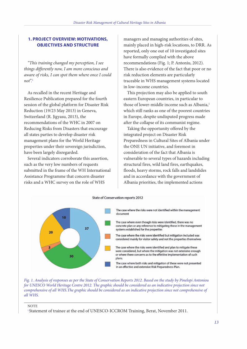
Several indicators corroborate this assertion,such as the very low numbers of requestssubmitted in the frame of the WH InternationalAssistance Programme that concern disasterrisks and a WHC survey on the role of WHS
managers and managing authorities of sites,mainly placed in high-risk locations, to DRR. Asreported, only one out of 10 investigated siteshave formally complied with the aboverecommendations (Fig. 1; P. Antoniu, 2012).there is also evidence of the fact that poor or norisk reduction elements are particularlytraceable in WHS management systems locatedin low-income countries.
this projection may also be applied to southeastern european countries, in particular tothose of lower-middle income such as Albania,1
which still ranks as one of the poorest countriesin europe, despite undisputed progress madeafter the collapse of its communist regime.
taking the opportunity offered by theintegrated project on Disaster RiskPreparedness in Cultural Sites of Albania underthe oNe UN initiative, and foremost inconsideration of the fact that Albania isvulnerable to several types of hazards includingstructural fires, wild land fires, earthquakes,floods, heavy storms, rock falls and landslidesand in accordance with the government ofAlbania priorities, the implemented actions
Disaster Risk Management of Cultural Heritage Sites in Albania
13
Fig. 1. Analysis of responses as per the State of Conservation Reports 2012. Based on the study by Pinelopi Antonioufor UNESCO World Heritage Centre 2012. The graphic should be considered as an indicative projection since notcomprehensive of all WHS.The graphic should be considered as an indicative projection since not comprehensive ofall WHS.
Note1 Statement of trainee at the end of UNeSCo-ICCRoM training, Berat, November 2011.
3 v2_2015_Layout 1 12/04/15 21:01 Pagina 13
were conceived to compound the scientificinvestigations conducted to assess the geohazardvulnerability of the major cultural sites ofAlbania with the need developing thegovernance capacity of the targeted sites inDisaster Risk Reduction.
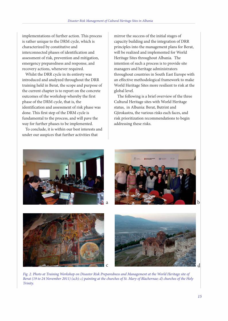
In more details the UNeSCo Venice officeand ICCRoM pioneered a training workshop onDisaster Risk Preparedness and Management atthe World Heritage site of Berat (19 to 24November 2011; Fig. 2 a,b). this broughttogether heritage professionals from theaforementioned selected World Heritageproperties of Albania and provided them withknowledge on current thinking, methods andtools available for the preparation of DisasterRisk Management plans on the basis of the newlyissued World Heritage Resource Manual on“Managing Disaster Risks for World Heritage”(http://whc.unesco.org/en/activities/630/).
Using the manual and analyzing the specificcontext of the selected sites, a broadermethodological framework was developed. thiswas done to lay the ground for the developmentof Disaster Risk Management plans in theselected cultural sites, acting as a model for othersites both in Albania and in the whole region.
this action was therefore designed, plannedand conducted in close collaboration withICCRoM and the World Heritage Centre. Itsobjectives were meant to illustrate the coreprinciples of Disaster Risk Management (DMR)for Heritage Sites and the applied methodologyto identify, assess and mitigate disaster risk inCultural Heritage sites. this was performed by:
training key stakeholders and site managers•selected in collaboration with the governmentof Albania, to reduce risks in their culturalheritage properties;teaching in a demonstrative way how to•prepare a DRM plan for cultural heritageproperties.the Disaster Risk Reduction (DRR) training
was conducted in a timely manner as itcoincided with the development of the DisasterRisk Management (DRM) plans for three World
Heritage Site in Albania, in Berat, Butrint andGjirokastra. Special focus was devoted to riskpreparedness for earthquakes and fires2,through the participation of highly qualifiedinternational experts on such fields of expertise.
trainees relied on post-training coachingsupport from these experts and receivedpersonal certificates of attendance upon deliveryof a site-based framework presentationhighlighting relevant components for theirfuture management plan (15th May 2012). thebenefits of the seeds sown throughout the shortand intensive training and coaching activitiesproduced a lasting legacy that saw DRRprinciples and concepts integrated into theDRM plan for Berat. Projects in Butrint andGjirokastra now have the capacity to also followthis example of good practices. As a general ruleand stressed by prominent scholars andpractitioners in the field, for institutionalarrangements set in place for managing thecommons or, as in our case, to mainstream DRRprinciples, there is a vast distinction between‘rules on paper’ and ‘rules in practice’ (ostrom,1990). the real threshold between the successand failure of a system of governance (regimes)lies in their level of effectiveness. this dependson whether the regime is translated by the socialconstituents (main stakeholders) into everydaypractices or whether the plan is merely fed into‘dead letter documents’ and not utilized
Moreover, whether formalised or not, theimportance and effectiveness of managementplans are dependent on their capacity toembody guiding DRR principles within theoverall management system(s) in force. thisstep is fundamental to ensure the resilience ofheritage sites against disasters and unforeseenevents and also against potential risks to thesite’s authenticity, integrity and theiroutstanding universal value.
taken as a whole, a DRR management planshould be considered as a continuous cycle of anongoing process of revision and change withinputs from monitoring and evaluationmechanisms followed by subsequent
Disaster Risk Management of Cultural Heritage Sites in Albania
14
3 v2_2015_Layout 1 12/04/15 21:01 Pagina 14
implementations of further action. this processis rather unique to the DRM cycle, which ischaracterized by constitutive andinterconnected phases of identification andassessment of risk, prevention and mitigation,emergency preparedness and response, andrecovery actions, whenever required.
Whilst the DRR cycle in its entirety wasintroduced and analyzed throughout the DRRtraining held in Berat, the scope and purpose ofthe current chapter is to report on the concreteoutcomes of the workshop whereby the firstphase of the DRM cycle, that is, theidentification and assessment of risk phase wasdone. this first step of the DRM cycle isfundamental to the process, and will pave theway for further phases to be implemented.
to conclude, it is within our best interests andunder our auspices that further activities that
mirror the success of the initial stages ofcapacity building and the integration of DRRprinciples into the management plans for Berat,will be realized and implemented for WorldHeritage Sites throughout Albania. theintention of such a process is to provide sitemanagers and heritage administratorsthroughout countries in South east europe withan effective methodological framework to makeWorld Heritage Sites more resilient to risk at theglobal level.
the following is a brief overview of the threeCultural Heritage sites with World Heritagestatus, in Albania: Berat, Butrint andGjirokastra, the various risks each faces, andrisk prioritization recommendations to beginaddressing these risks.
Disaster Risk Management of Cultural Heritage Sites in Albania
15
Fig. 2. Photo at Training Workshop on Disaster Risk Preparedness and Management at the World Heritage site ofBerat (19 to 24 November 2011) (a,b); c) painting at the churches of St. Mary of Blachernae; d) churches of the HolyTrinity.
ba
dc
3 v2_2015_Layout 1 12/04/15 21:01 Pagina 15
Disaster Risk Management of Cultural Heritage Sites in Albania
17
2. ALBANIAN WORLD HERITAGE SITES
The city of Berat the city of Berat was inscribed with
Gjirokastra in the World Heritage list under theappellate of Historic Centres of Berat andGjirokastra in 2008. they were inscribed on thebasis of criteria (iii) and (iv) as per Decisions 29CoM 8B.48 and 32 CoM 8B.56.
Criterion (iii): Berat and Gjirokastra bearoutstanding testimony to the diversity of urbansocieties in the Balkans, and to longstandingways of life, which have today almost vanished.the town planning and housing of Gjirokastraare those of a citadel town built by notablelandowners whose interests were directly linkedto those of the central power. Berat bears theimprint of a more independent life-style, linkedto its handicraft and merchant functions.
Criterion (iv): together, the two towns ofGjirokastra and Berat bear outstandingtestimony to various types of monument andvernacular urban housing during the Classicalottoman period, in continuity with the variousMedieval cultures which preceded it, and in astate of peaceful coexistence with a largeChristian minority, particularly in Berat.
Located in central Albania, Berat bearswitness to the peaceful coexistence of variousreligious and cultural communities through thecenturies. It features a castle, locally known asthe “Kala”, most of which was built in the 13th
century, although its origins date back to the 4th
century B.C. the citadel area has manyByzantine churches, mainly from the13th.century, as well as several mosques builtunder the ottoman period. the city iscomprised of urban quarters dated to the15th
through19th century.the settlement is traditionally believed to
have been founded by Cassander, King ofMacedonia, in 314 B.C. and later ended upunder the Roman protectorate.
excavations around the medieval city walls ofBerat have resulted in the identification of partsof the first wall circuit, including the remains of
a major gateway. these wall sections date to the4th century B.C. (Braka, 1990).
the findings from the excavations withinBerat date back to the 7th century B.C., whichsuggests that the city of Antipatrea was possiblyestablished on an existing Illyrian settlement.
In 440 A.D., the city was renamedPulcheropolis by emperor theodosius II (408-450 A.D.) after his sister. Later the city wallswere rebuilt, most probably during the reign ofthe emperor Justinian (527-565 A.D.).
In the 9th century Pulcheropolis fell to theBulgars. the city was renamed Belgrade (fromwhich the modern name of Berat derives) andwas the seat of a bishopric. the Bulgars lost thecity in the 11th century to the Byzantine empire.Under the Despotate, the Muzaka familydominated Berat.
the city was refortified in the 13th century.the city walls were rebuilt, following thecontours of the hill, to form a triangularfortress, enclosing 9.6 hectares. the city wallswere protected by a system of towers. Withinthe city, a castle was constructed on the summitof the hill. It comprised an outer work, fivetowers and an inner work with a large cistern.Alterations and additions were made to thesystem of fortifications throughout thefollowing century, and included an extension ofthe fortified area by the construction of twodefensive walls (Fig. 2c) running from the southside of the city wall to the river. this extensionenclosed a further six hectares. Several churchesdating to the 13th and 14th centuries havesurvived within the city - the churches of St.George, St. Michael and the Holy trinity beingthe best preserved (Fig. 2 d,e).
In 1417, Berat fell under ottoman control.the fortifications were maintained with theaddition of urban quarters at Gorica andMangalem, outside the medieval fortifications.the city prospered under the ottomans andmuch of the historic centre of modern Beratcomprises ottoman-period houses (fine 17th
and 18th century stone-built dwellings) and,close to the river, timber-framed shops of the
3 v2_2015_Layout 1 12/04/15 21:01 Pagina 17
old bazaar. In addition there is an importantgroup of mosques including the late 15th centurySultan’s Mosque (Xhamija e Mbretit), the 16th
century Leaded Mosque (Xhamija e Plumbit)and the 19th century Mosque of the Bachelors(Xhamija e Beqareve). A group of 18th centurybuildings associated with the tekke of theHelvetis also has survived. Many churches werealso constructed in this period and decorated byonufre, a 16th century Albanian painter, and hisschool of painters. A museum of onufre’s workcan be found in Berat.
Threats to the World Heritage Property ofBerat
Since the time of its inscription, the site hasrecorded a combination of human- and natural-induced threats, affecting the property:Natural
seismic threat •fires•floods•landslides, rock falls•
Humanlack of specific monitoring indicators •lack of a program of archaeological•excavations lack of adequate fire suppression facilities and•arrangementslack of a detailed tourism development plan •
Gjirokastra the World Heritage property Museum-City of
Gjirokastra was inscribed on the World HeritageList in 2005, and in 2008 the property wasextended to include the city of Berat andrenamed as Historic Centres of Berat andGjirokastra. they were inscribed on the basis ofcriteria(iii) and (iv) as per Decisions 29 CoM8B.48 and 32 CoM 8B.56.
Criterion (iii): Berat and Gjirokastra bearoutstanding testimony to the diversity of urbansocieties in the Balkans, and to longstandingways of life, which have today almost vanished.the town planning and housing of Gjirokastraare those of a citadel town built by notable
landowners whose interests were directly linkedto those of the central power. Berat bears theimprint of a more independent life-style, linkedto its handicraft and merchant functions.
Criterion (iv): together, the two towns ofGjirokastra and Berat bear outstandingtestimony to various types of monument andvernacular urban housing during the Classicalottoman period, in continuity with the variousMedieval cultures which preceded it, and in astate of peaceful coexistence with a largeChristian minority, particularly in Berat.
over the last thousand years it was invaded byottoman turks, Italians and Germans, and thismixture of prosperity and insecurity has led tothe development of the architecture that it is stillpreserved today.
the town itself was built by big landownersand has a castle that has origins in the 13th
century, named Citadel. this is one of thebiggest castles in Balkan. With the decline of theByzantine empire, it became the residence ofthe very powerful Zenebeshi feudal clan.
the city has some typical dwellings called theturkish kule, typical of the Balkan region.Gjirokastra contains many of them dating backto the 18th century, but even some moreelaborate ones, from the 19th century.
the surrounding historical sites show theearliest evidence of the prehistoric period suchas the Goranxi Gorge. evidence of otherimportant sites of Antigonea and Adrianopolare also testimonies of the importance of theregion even during the Greek and Romanoccupation.
the archaeology of Gjirokastra is relativelyunknown. Due to the proximity of the Classicaland Hellenistic settlement at Jermë (Antigoneia)and the Roman city of Hadrianopolis it hasfrequently been assumed that the medievalfortress represents the first occupation of thesite. However, this has now been challenged bythe results of excavations within the fortress thathave led to the discovery of ceramics from fourdifferent phases of occupation before theottoman period: 5th-2nd centuries B.C., 5th-7th
Disaster Risk Management of Cultural Heritage Sites in Albania
18
3 v2_2015_Layout 1 12/04/15 21:01 Pagina 18
centuries A.D., 9th-10th centuries and 12th-13th
centuries A.D. the medieval fortress, which has been dated
to the second half of the 13th century,encompasses an area of 2.5 hectares. theremains of five towers and three main entrancesof the original fortress can still be seen, thoughthe fortress was substantially rebuilt andextended southwest in 1811-1812 by Ali Pashaof tepelenë. Ali Pasha was also responsible forthe construction of an aqueduct feeding thefortress from a water source on Mt. Sopot, some10 km from Gjirokastra. Complete sections ofthis aqueduct were still visible at the beginningof the 20th century but were destroyed in 1932.the fortress was used as a garrison in the 19th
century. During the communist period, thecastle also served as a prison for dissidents.
Threats to the World Heritage Property ofGjirokastra
the site has recorderd a set of natural threatsaffecting the property:Natural
seismic threat •wildland fires•erosion, landslides, rock falls•
Humanlack of financial support for the monuments•lack of a management plan•uncontrolled urban development of•Gjirokastraabandonment of the site by the inhabitants,•which will contribute to the potential firehazard and general degradation of thebuilding over timemisuse of monument by the owner with the•risk of damaging the authenticity and theintegrity of the building
Butrint the property of Butrint was inscribed on the
World Heritage List in 1992 as an example ofoutstanding universal value, meeting thecultural criterion C (iii), according to theoperational Guidelines (2005), since it bears “a
unique or at least exceptional testimony to acultural tradition or to a civilization which isliving or which has disappeared.”
Butrint is located on a low hill at the end ofthe Ksamil peninsula, which separates theIonian Sea from Lake Butrint (the two areconnected by the Vivari Channel). to the southlies the flat expanse of the Vrina Plain,punctuated by low hills with villages. Butrint isthe best-studied ancient city in Albania, as wellas being a site of extraordinary beauty, and it isin many ways a microcosm of Albanian history.Butrint was an ancient Greek city thateventually became a Roman city in epirus.Currently it is an archaeological site in the
Sarandë District in Albania. It is located on ahill overlooking the Vivari Channel and part ofthe Butrint National Park. Inhabited sinceprehistoric times, it entered into decline in LateAntiquity, before being abandoned during theMiddle Ages.
In 2003, Butrint became a designated siteunder the RAMSAR Convention (1971) due toits lagoon, also known as the lake of Butrint,which is now recognised worldwide as awetland of international importance.
Threats to the World Heritage Property ofButrint
Butrint, like the other sites, is exposed tovarying hazards. the more significant risksrelated to life and cultural heritage includeNatural
seismic threat•wildland fires;•floods and sea-level rise•
Humanlooting •illegal urban sprawling in to the World•Heritage sites;widening and modernization of the road from•Saranda to Butrint within the World Heritagepropertythe property has registered a series of
monitoring/assessment missions carried out byUNeSCo and its advisory bodies since 1997.
Disaster Risk Management of Cultural Heritage Sites in Albania
19
3 v2_2015_Layout 1 12/04/15 21:01 Pagina 19

After the civil strife in the country, a report oflooting of the site was issued by the ButrintFoundation. Following the first missionoutcomes at its 21st session (December 1997),the World Committee decided to includeButrint in the list of the World Heritage sites inDanger.
Following the UNeSCo-ICoMoS-ICCRoMjoint assessment mission on the site in 2005 andits recommendations in consideration of therecorded improvements achieved and uponcondition to finalize the management andconservation plan of the property and toprevent any illegal development orinappropriate construction in the site, inaccordance with an effective application of thelegal provisions of the new law on culturalheritage, the World Heritage Committeedecided to remove Butrint from the list ofWorld Heritage in Danger.
Disaster Risk Management of Cultural Heritage Sites in Albania
20
3 v2_2015_Layout 1 12/04/15 21:01 Pagina 20
3. RISK ANALYSIS OF NATURAL HAZARDS
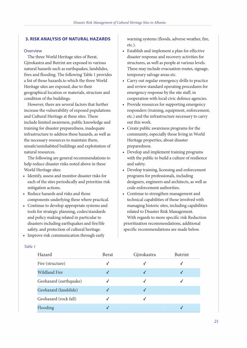
Overviewthe three World Heritage sites of Berat,
Gjirokastra and Butrint are exposed to variousnatural hazards such as earthquakes, landslides,fires and flooding. the following table 1 providesa list of those hazards.to which the three WorldHeritage sites are exposed, due to theirgeographical location or materials, structure andcondition of the buildings.
However, there are several factors that furtherincrease the vulnerability of exposed populationsand Cultural Heritage at these sites. theseinclude limited awareness, public knowledge andtraining for disaster preparedness, inadequateinfrastructure to address these hazards, as well asthe necessary resources to maintain them,unsafe/uninhabited buildings and exploitation ofnatural resources.
the following are general recommendations tohelp reduce disaster risks noted above in theseWorld Heritage sites:
Identify, assess and monitor disaster risks for•each of the sites periodically and prioritize riskmitigation actions.Reduce hazards and risks and those•components underlying these where practical.Continue to develop appropriate systems and•tools for strategic planning, codes/standardsand policy making related in particular todisasters including earthquakes and fire/lifesafety, and protection of cultural heritage.Improve risk communication through early•
warning systems (floods, adverse weather, fire,etc.).establish and implement a plan for effective•disaster response and recovery activities forstructures, as well as people at various levels.these may include evacuation routes, signage,temporary salvage areas etc.Carry out regular emergency drills to practice•and review standard operating procedures foremergency response by the site staff, incooperation with local civic defence agencies.Provide resources for supporting emergency•responders (training, equipment, enforcement,etc.) and the infrastructure necessary to carryout this work.Create public awareness programs for the•community, especially those living in WorldHeritage properties, about disasterpreparedness. Develop and implement training programs•with the public to build a culture of resilienceand safety.Develop training, licensing and enforcement•programs for professionals, includingdesigners, engineers and architects, as well ascode enforcement authorities.Continue to strengthen management and•technical capabilities of those involved withmanaging historic sites, including capabilitiesrelated to Disaster Risk Management.With regards to more specific risk Reduction
prioritization recommendations, additionalspecific recommendations are made below.
Disaster Risk Management of Cultural Heritage Sites in Albania
21
Table 1
Hazard Berat Gjirokastra Butrint
Fire (structure) ✓ ✓ ✓Wildland Fire ✓ ✓ ✓Geohazard (earthquake) ✓ ✓ ✓Geohazard (landslide) ✓ ✓Geohazard (rock fall) ✓ ✓Flooding ✓ ✓
3 v2_2015_Layout 1 12/04/15 21:01 Pagina 21
FIRE
Challengesone of the hazards with a higher probability
of occurrence is fire. A fire in one of the historicresidential structures in Berat for instance, thatgutted the house was witnessed a few monthsback. However with the efforts of the local firebrigade, they were fortunately able to limit thefire to this structure before it could spread.there are many challenges related to fire,including the close proximity of structures toeach other particularly in Berat andGjirokastra which could lead to fire spreading tomultiple buildings, primarily those ofwood/combustible construction. other hazardinclude limited smoke detection withinbuildings, including residential buildings andno automatic notification to emergencyresponders for prompt response, no automaticsuppression systems, very narrow streetsimpacting fire vehicle access, limited/no fire-fighting water infrastructure, old/poor electricalinstallations and poor conditions of electricalequipment that could result in ignition sources,as well as abandoned houses that are notmaintained and could represent fire hazards.there are also limited fire protection measuresincorporated into the religious structures andmuseums that should be reviewed and assessedas to their overall effectiveness and reliability. Atailored fire strategy, should be developed asappropriate to protect these. there alsocurrently appears to be limited awareness andtraining of local residents with regards to firesand protecting lives as well as the historicbuildings.
Risk Reduction RecommendationsCreate a Fire Prevention Awareness campaign•for local residents to raise awareness regardingfire, ignition sources, early detection andalarm, the benefit of smoke detectors in allhomes, the challenges of fires at these sites,and what to do in case of a fire or otheremergency. this should target not only adults
but there also should be educational programsin schools to educate children.Develop and implement Fire/Life Safety•Strategies for various structures, includingreligious structures and museums.Automatically monitor alarms from buildings•in addition to banks so as to initiate earlywarning and notification to the fire brigade toget them to the site and begin suppressionactivities as soon as possible.Revise local codes as necessary to address fire-•related challenges and make these retro-active.Develop, implement and enforce guidelines•for protecting structures from fire duringrenovation work.See also the emergency Responder and•Infrastructure Section for additionalrecommendations regarding fire.
WILDLAND FIRES
ChallengesGiven the close wild land/urban interface for
each of these sites, there is the potential for wildland fires to adversely impact the structures andthe residents, including the archaeological sitesin Butrint and the Berat Castle. these fires canhave an immediate impact on loss of life/injury,as well as loss of structures and culturalheritage, and can adversely impact non-combustible structural components of thevarious buildings including the Castle andarchaeological sites. these fires also destroyvegetation. this in turn can lead to otherhazards including potential landslides if thisvegetation is lost. the local fire brigade trainsfor these events, but additional resources arerecommended for assisting them in undertakingtheir activities as noted below.
Risk Reduction RecommendationsDevelop and implement appropriate policies•and regulations regarding limiting thepotential for ignition of fields, grasslands and
Disaster Risk Management of Cultural Heritage Sites in Albania
22
3 v2_2015_Layout 1 12/04/15 21:01 Pagina 22
wildfires. this includes checking ignitionsources, identifying burning seasons,procedures and permits for burning,interfacing with emergency responders forcontrolled burns, building constructionmaterials, developing a program to work withshepherds to limit/control their burning anddeveloping and implementing early detection,warning and notification systems, etc.Review international perspectives and codes•on wildfires. Develop and implement a planfor wild land management and fuel control tohelp control vegetation and limit the impactshould a fire start, in terms of the extent of thefire, as well as limiting its impact onstructures.Conduct a very thorough review of the wild•land fire situation in Butrint. this includesignition sources (smoking, electricalequipment, lighting, etc.) and control ofcombustible materials including vegetation.Additionally, the proposed fire hydrant systemin Butrint needs to be very carefully reviewedand revised. this should include reviewingwater supplies, piping materials, installation,hydraulic calculations and location ofequipment including pumping stations andwater supplies in a safe and protected area,etc. In addition, the design, layout andintended use needs to also be discussed withthe local emergency responders to obtain theirrecommendations and input on the proposedsystem and how they may use it during anincident.Provide the necessary resources, equipment•and infrastructure for the emergencyresponders to appropriately manage thesefires. this should include vehicles and otherrelated firefighting equipment and personnel,as well as personal protective equipment toprotect the emergency responders as theyundertake their activities.Develop, implement and enforce a public•awareness campaign to help limit the potentialfor wild land fires. (i.e. information andregulations regarding campfires, rubbish
disposal and removal, including that close tothe Castle, no smoking, etc.).
FLOODS
ChallengesBerat lies on the banks of the osum River, and
Butrint is at sea level and thus prone to floods.Some of the challenges, including a lack ofwater-collecting areas, lack of dyke systems anddrainage channels and limited pumpingstations, contribute to flooding.
Risk Reduction RecommendationsUndertake further studies to identify•additional reasons behind flooding.Review the state of existing flood-control•measures and upgrade as needed.Develop and implement flood•prevention/mitigation measures tocontrol.flooding (e.g., improving drainagesystems, channelling of water, dams, pumpingstations, reducing erosion throughreforestation, etc.).Develop an early detection and warning•program, including a system to notifyresidents of potential flooding, as well as plansto relocate these people.Develop an awareness and training program•for residents.
EARTHQUAKES
ChallengesAlbania has a long history of earthquakes. In
June 1905, a devastating earthquake hitnorthern Albania. Subsequently it has beenrocked by several earthquakes. the WorldHeritage Sites of Berat and Gjirokastra arehighly vulnerable to earthquakes because oftheir location near fault lines and rocky terrain,which can trigger landslides and rock falls dueto earthquake.
the primary geohazard affecting the city of
Disaster Risk Management of Cultural Heritage Sites in Albania
23
3 v2_2015_Layout 1 12/04/15 21:01 Pagina 23
Berat is represented by the instability of the rockescarpments overlooking the historic city center.the risk related to this criticality is high in staticconditions and could be even higher if a seismicevent should occur.
the most critical zones in terms of possiblesite amplifications in Gjirokastra include: 1)buried narrow valleys located at the mouth ofmountain streams (zone 4), carrying highvolumes of coarse clastic materials to the DrinoRiver Valley; and 2) narrow ridges bonding theburied valleys, where topographic effectshighlighted by micro-tremors measurementscould induce site amplification. A rigid fracturedlayer of conglomerates generally occupies thetop of the narrow ridges (e.g., where the Castle islocated) and is highly susceptible to rock fallsand toppling of isolated blocks.
the territory of Butrint is heterogeneous interms of susceptibility to seismic amplification,due to extreme geological variability. the mostcritical zone in terms of possible siteamplifications is the coastal plain. Highsusceptibility to geological instability, both fordifferential settlements and rock falls, is relatedto the presence of the fault scarp bounding theAcropolis.
In addition to the above, the historic buildingsappear to have limited design to be earthquakeresistant and as well have suffered vagaries oftime and poor maintenance. they are likely tooweak to bear the lateral forces of an earthquake(CNR-IGAG 2012)3.
Risk Reduction RecommendationsAdequate retrofitting measures should be•undertaken for historic structures so that theyare safer against earthquakes. these measuresshould try, to retain heritage values to themaximum possible extent while ensuringoptimum safety levels.Guidelines for earthquake safety should be•adopted and implemented for any newadditions or alterations to historic structures. Masons and craftsmen should be provided with•adequate training in earthquake-safe
construction practices especially for historicstructures.In Berat, it is recommended to carry out a•detailed study of structural and geo-mechanical settings of the limestone croppingout along the escarpments, if this work hasnot already been undertaken. For Gjirokastra, neither direct observation of•subsoil nor Vs information are generallyavailable for the site. No geotechnicalparameters are available for a properevaluation of the dynamic behavior of soilsand rocks. An additional investigative surveyand the passage to a level 3 of seismicmicrozonation is suggested. the seismic microzonation of level 1 of•Butrint is affected by a high level ofuncertainty because of the lack of informationabout lithology, thickness and shear wavevelocity of the lithotypes. Lithostratigraphicand geometric uncertainty could be pulleddown by means of one deep borehole locatedclose to the Vivari channel, associated withelectrical Resistivity tomographies (eRts)oriented perpendicular to the fault scarp.Shear wave velocity could be detected bymeans of MASW measurements.
LANDSLIDE/ROCK FALL
ChallengesGiven their location at the base of various hills
and mountains, including Berat in the vicinityof the tomorr Mountains, and Gjirokastrawithin the Gjerë mountains, both aresusceptible to landslides and rock falls. Severalof the comments regarding the variousgeological conditions noted above with respectto earthquakes are applicable here as well. Inaddition, there is one very large rock below thefort that needs assessment in the very nearfuture in Gjirokastra. Part of the challengesincluding poor drainage systems, limitedvegetation in areas to help hold the earth, andunstable rocks on the hillside/mountainside. No
Disaster Risk Management of Cultural Heritage Sites in Albania
24
3 v2_2015_Layout 1 12/04/15 21:01 Pagina 24
protection of the people or buildings in closeproximity against the landslides or falling rockscontribute to the potential risk.
Risk Reduction RecommendationsUndertake studies to identify further hazards•of landslides and rock falls and locationswhere this may occur, and exposures shouldthey occur.Develop and implement appropriate•prevention and mitigation measures to limitthe probability of landslides and rock falls.(vegetation management, drainage, stabilizerocks, protection against falling rocks, etc.)Develop an awareness and training program•for residents and staff responsible formaintenance and monitoring.Develop and implement an early warning•system to alert residents at times they may bemore prone to rockslides and landslides (e.g.heavy rainfalls, etc.).
Key Vulnerability factorsA few underlying factors need to be
highlighted that are increasing the vulnerabilityof the three World Heritage properties to theabove-mentioned hazards.
Abandonment of buildings Due to various socio-economic reasons,
historic buildings are being abandonedgradually. this is quite significant inGjirokastra and is also occurring in Berat to acertain extent. over time, there is deteriorationof these properties. they are also used by thehomeless who take up residence and build firesthem. As they are not being maintained, theinteriors are exposed to weather a condition,which creates deterioration of the structure andelectrical systems. these items are adverselyimpacting the cultural heritage components ofthese structures, and also pose a fire hazard tothem, as well as those structures and the peoplein the near vicinity given, the close proximity ofthe houses.
therefore, it is important to develop and
implement a program to address thesechallenges, including either ways toappropriately rehabilitate these structures, orassessing them to review potential fire hazards,shutting down power, etc.
Emergency Responders and Infrastructure the emergency responders should be
commended for what they do with the limitedresources available and the challenges they face.this includes the limited infrastructure for firefighting e.g., no-limited fire hydrants,intermittent water supplies, delayed notificationdue to limited detection/alarm systems, narrowstreets and alleys and the close proximity of thebuildings making it difficult to get fire vehiclesclose to a fire scene. Recommendations toaddress some of these challenges include thosenoted below:
Provide automatic notification to emergency•responders regarding fire and other hazards.Make them aware of the heritage values of the•site so that they take measures to minimizeimpact.Provide appropriate infrastructure for•emergency responders to undertake theirwork and to limit the impact of fires on thehistoric cities (fire hydrant system, reliablewater supply/storage, etc.).Further support the good work of local•emergency responders and provide them withmore resources including equipment(vehicles, personal protective gear, etc.) andcontinued training to help them undertakethe important work they do in protecting thecities and their people.Continue to engage and review with the•emergency responders their particularadditional needs to help protect each of theseWorld Heritage sites and effectively respond tothe varying disasters that each is exposed to.
Lack of Maintenance and Degradation ofStructures
there are several areas where a lack ofmaintenance is adversely impacting the Cultural
Disaster Risk Management of Cultural Heritage Sites in Albania
25
3 v2_2015_Layout 1 12/04/15 21:01 Pagina 25
Heritage at these sites either directly orindirectly. these and others should beaddressed and a program put in place to ensurethey will be properly taken care of in the future.the following Risk Reductionrecommendations are proposed:
Clean up rubbish, particularly surrounding•the Castle in Berat. this is a fire hazard andalso contributes to additional people addingtheir rubbish to the piles.Part of the Castle wall has collapsed. the•cause of this should be identified and repairsmade, as well as additional assessments to seeif this may occur in other areas.Infrastructure should be properly maintained.•this includes the fire hydrants and watersupplies to these, electrical systems andinfrastructure in the cities, etc.
Disaster Risk Management of Cultural Heritage Sites in Albania
26
3 v2_2015_Layout 1 12/04/15 21:01 Pagina 26
4. GUIDELINES FOR RISK REDUCTION OFWORLD HERITAGE PROPERTIES
Disaster management principles need to bedeveloped and made an integral part of the sitemanagement plans (table 2). the impact ofdisasters at World Heritage properties may bevery significant as it could:
Adversely affect their “outstanding Universal•Value” which justified their inscription on theWorld Heritage List;Result in loss of lives and assets for the local•people, disrupt their communities andthreaten the security of visitors; Negatively affect the local economy and•tourism.through this project, UNeSCo Venice office,
ICCRoM and the experts participating in thetraining were able build a shared understandingwith trainees and with the representatives of therelevant governmental agencies in charge ofcultural heritage in Albania upon theimportance of the following:
More coordination between a given World•Heritage property management systems andthe disaster management institutionalframework of the nation and region in whichthe property is located;Prioritization of the risk and their solutions•should be a well-governed process to beshared by all relevant stakeholders on site,without delegating pre-cooked solutions tothe hands of “external technicians”;Multidisciplinary scientific approach is•needed in different fields of risk for athorough risk assessment which shouldencompass multiple settings at a given site.For instance, archeologists should be able tointegrate with geologists and seismicengineers to better understand the magnitudeof geo hazards at stake. Moreover, sitemanagers should also be able to understandscientific-based evidence when they have toconsider Disaster Risk Management beforedisasters occur in order to prevent and/or
mitigate them;Risk management plans are not stand-alone•plans. they need to be integrated into themanagement plans of the site(s);Disaster Risk Management should be able to•both prevent or reduce the impact of disasteron the values of World Heritage siteproperties, and to human lives andlivelihoods;Disaster Risk Management should be able to•
secure resilience to the core value upon whichthe property was inscribed on the WH List.this should be the driving element to riskplans development;Significant considerations should be placed on•the longer-term vulnerability factors (lack ofmaintenance, deterioration etc.) which mayturn a small hazard into a larger scale disaster;Management planning is valuable not just for•World Heritage sites but for any heritage sites.therefore, World Heritage sites can play acatalyst role for enhancing risk resilience ofother sites regardless of their designationstatus.
Disaster Risk Management of Cultural Heritage Sites in Albania
27
3 v2_2015_Layout 1 12/04/15 21:01 Pagina 27
Disaster Risk Management of Cultural Heritage Sites in Albania
28
Key Words: Capacity Building, Disaster Risk Management (DRM) in Cultural Heritage sites,geohazard assessment, Disaster Preparedness and Mitigation, Fire, Wildland Fire.
OBJECTIVES PRIORITY ACTIONS
Action 1.1
Promote cultural and natural heritage, and its potential positive role for disaster reduction as part of sustainable development, within relevant international development institutions, conventions and global forums and with other potential �nancial partners, as a means of raising support for the protection of World Heritage from disasters
1. Strengthen support within relevant global, regional, national and local institutions to reduce risks at World Heritage properties
Global actors for disaster reduction should give more consideration to cultural and natural heritage among the issues to be considered when de�ning their strategic goals and planning their development cooperation activities. At the same time, general disaster reduction strategies at regional, country and local levels must take into account and integrate concern for world cultural and natural heritage in their policies and implementation mechanisms
Action 1.2
Strengthen policies and funding provisions for disaster reduction within the World Heritage system, for instance by including disaster and risk management strategies in the preparation of Tentative Lists, nominations, monitoring, periodic reporting and International Assistance processes
Action 2.1
Develop updated teaching/learning and awareness- raising resource materials (guidelines, training kits, case studies and technical studies, glossaries) on disaster reduction for World Heritage, and disseminate them widely among site managers, local government o�cials and the public at large
2. Use knowledge, innovation and education to build a culture of disaster prevention at WH properties
�e building of a culture of prevention, at all levels, is one of the key elements for a successful disaster reduction strategy. Experience shows that reacting a posteriori, especially as far as heritage is concerned, is an increasingly ine�ective way of responding to the
Training, education and research, on relevant traditional knowledge as well, are the most e�ective ways of developing a culture of preparedness. �is particular area of actions �ts entirely within the broader mandate of UNESCO as the UN intellectual arm, in particular for establishing global knowledge networks
Action 2.2
Strengthen the capacity of World Heritage property managers and community members through �eld-based training programmes, to develop and implement risk management plans at their sites and contribute to regional and national disaster reduction strategies and processes
Action 3.1
Support risk identi�cation and assessment activities at World Heritage properties, including consideration of climate change impact on heritage, consideration of underlying risk factors, all necessary expertise and the involvement of relevant stakeholders as appropriate
3. Identify, assess and monitor disaster risks at WH properties
�e �rst step to reducing disasters and mitigating their impact is the identi�cation of possible risk factors, including risks from global agents such as climate change. �e vulnerabilities from disasters to World Heritage properties must be therefore identi�ed, assessed in their level of priority and closely monitored so as to inform the appropriate risk management strategies
Action 3.2
Develop a World Heritage Risk Map at the global level or at regional levels to assist states’s parties and the committee to develop better responses
needs of people a�ected by disasters.
Table 2. Objectives and Priority Actions recommended.
3 v2_2015_Layout 1 12/04/15 21:01 Pagina 28
Disaster Risk Management of Cultural Heritage Sites in Albania
29
OBJECTIVES PRIORITY ACTIONS
Action 4.1
Give priority within international assistance to helping states’s parties in implementing emergency measures to mitigate signi�cant risks from disasters that are likely to a�ect the Outstanding Universal Value, including the authenticity and/or integrity of World Heritage properties
4. Reduce underlying risk factors at WH properties
When a disaster occurs, there are a number of underlying factors that can signi�cantly aggravate its impact. �ese include land/water and other natural resources management, industrial and urban development, and socio-economic practices. Removing the root causes of vulnerability o�en implies the identi�cation and reduction of underlying risk factors associated with human activities
Action 4.2
Develop social training programmes for communities living within or around World Heritage properties, including consideration of heritage as a resource to mitigate physical and psychological damage of vulnerable populations, particularly children, during and in the a�ermath of disasters
Action 5.1
Ensure that risk management components with identi�ed priorities are integrated within management plans for World Heritage properties, as a matter of urgency. For World Heritage cultural properties, the scope of these plans should address ways of protecting the key assets that contribute towards the Outstanding Universal Value and should also include the protection of any signi�cant original archival records that contribute to their heritage value, whether or not they are located within the boundaries of the World Heritage property. For natural properties, such plans should be oriented to protecting the key values for which the properties were inscribed as well as their integrity
5. Strengthen disaster preparedness at World Heritage properties for e�ective response at all levels
�e worst consequences of natural or human -made disasters can o�en be avoided or mitigated if all those concerned are prepared to act according to well-conceived risk reduction plans, and the necessary human and �nancial resources, and equipment are available
Action 5.2
Ensure that all those concerned with the implementation of disaster reduction plans at World Heritage properties, including community members and volunteers, are aware of their respective roles and are well and systematically trained in the application of their tasks
Table 2. Continued...
NOTES
1 According to the World Bank (2012) ranking. Website: http://data.worldbank.org/country/albania
2 tragically, a few weeks following the training a fire swept through Berat and engulfed unoccupied historical residential housesand apartments in the heart of the town’s historical centre. this happening, was in fact, a hypothetical case scenario developedby our trainees (see Annexes) and this unforeseen event again demonstrated the immense exposure that heritage sites are subjectto everyday. Both natural and man-made events have the power to destroy or severely undermine heritage sites to the extentthat their unique value is irremediably lost.
3 Assessment Analysis of Seismologic Risk and geohazard vulnerability of first level in major Cultural Heritage Sites of Albania.
3 v2_2015_Layout 1 12/04/15 21:01 Pagina 29

PROJECT TEAM:
Mario ScaletUNeSCo Regional Bureau for Science and Culture ineuropeHead of Science Unit4930 Castello - Palazzo Zorzi30122 Venice, Italy,unesco.org/venicetel: + 39 (041) 260.15.16email: [email protected]
Davide PolettoUNeSCo Regional Bureau for Science and Culture ineuropeProgramme officerScience Unit4930 Castello - Palazzo Zorzi30122 Venice, Italyunesco.org/venicetel: + 39 (041) 260.15.26email: [email protected]
INTERNATIONAL TRAINERS
Joseph KingUnit Director Sites UnitICCRoMVia di San Michele 1300153 Rome, Italy tel: +39 (06) 585. 53. 313email: [email protected]: http://www.iccrom.org
Gamini WijesuriyaProject ManagerSites Unit ICCRoMVia di San Michele 1300153 Rome, Italy email: [email protected] Web: http://www.iccrom.org
Rohit JigyasuUNeSCo Chair Professor, Research Center forDisaster Mitigation of Urban Cultural Heritage,Ritsumeikan University, Kyoto, JapanPresident, ICoMoS International ScientificCommittee on Risk Preparedness (ICoRP)email: [email protected]. +91-172-2549478 (India), +81-9051545598 (Japan)
Christopher Marrion, Pe FSFPePrincipal Fire and Risk StrategistMarrion Fire & Risk Consulting Pe, LLC176 West 86th Street, Suite 9aNew York, NY 10024 USAtel. ++1.(646) 642.1265Web: www.marrionconsulting.comemail: [email protected]
REFERENCES
ostrom e. (1990) - Governing the Commons: the evolutionof Institutions for Collective Action. Cambridge, CambridgeUniversity Press.
United Nation office for Disaster Risk Reduction UNISDR(2013) - Synthesis Report Consultations on a Post-2015Framework on Disaster Risk Reduction (HFA2). April 2013,28 pp.
Milutinovic Z., Galperin A. and Spirollari M. (2003) -DISASteR RISK ASSeSSMeNt IN ALBANIA - executiveSummary Report. United Nation Development Programme,Disaster Management and emergency Preparedness Project,tirana, Albania, 107 p.
Antoniou P. (2012) - ‘Concern for Disaster Risk Reduction inthe management of World Heritage Properties: A researchthrough the archives of the World Heritage Centre’,UNeSCo.
WEBSITES
http://www.preventionweb.net/english/professional/publications/v.php?id=25129Historic Centers of Berat and Gjirokastra:http://whc.unesco.org/en/list/569Butrint, Albania: http://whc.unesco.org/en/list/570/
Disaster Risk Management of Cultural Heritage Sites in Albania
30
3 v2_2015_Layout 1 12/04/15 21:01 Pagina 30
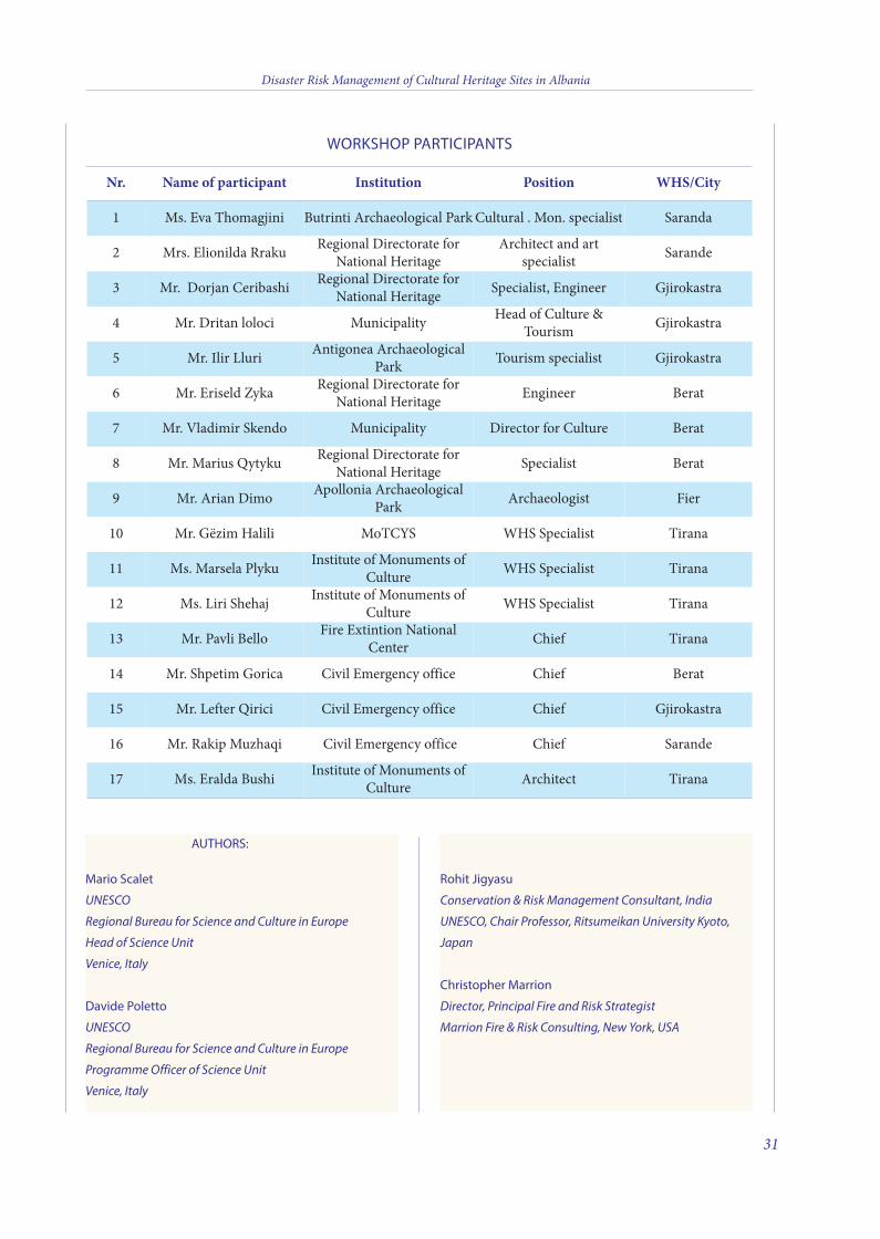
AUTHORS:
Mario Scalet
UNESCO
Regional Bureau for Science and Culture in Europe
Head of Science Unit
Venice, Italy
Davide Poletto
UNESCO
Regional Bureau for Science and Culture in Europe
Programme Officer of Science Unit
Venice, Italy
Rohit Jigyasu
Conservation & Risk Management Consultant, India
UNESCO, Chair Professor, Ritsumeikan University Kyoto,
Japan
Christopher Marrion
Director, Principal Fire and Risk Strategist
Marrion Fire & Risk Consulting, New York, USA
WORKSHOP PARTICIPANTS
Nr. Name of participant Institution Position WHS/City
1 Ms. eva thomagjini Butrinti Archaeological Park Cultural . Mon. specialist Saranda
2 Mrs. elionilda Rraku Regional Directorate forNational Heritage
Architect and artspecialist Sarande
3 Mr. Dorjan Ceribashi Regional Directorate forNational Heritage Specialist, engineer Gjirokastra
4 Mr. Dritan loloci Municipality Head of Culture &tourism Gjirokastra
5 Mr. Ilir Lluri Antigonea ArchaeologicalPark tourism specialist Gjirokastra
6 Mr. eriseld Zyka Regional Directorate forNational Heritage engineer Berat
7 Mr. Vladimir Skendo Municipality Director for Culture Berat
8 Mr. Marius Qytyku Regional Directorate forNational Heritage Specialist Berat
9 Mr. Arian Dimo Apollonia ArchaeologicalPark Archaeologist Fier
10 Mr. Gëzim Halili MotCYS WHS Specialist tirana
11 Ms. Marsela Plyku Institute of Monuments ofCulture WHS Specialist tirana
12 Ms. Liri Shehaj Institute of Monuments ofCulture WHS Specialist tirana
13 Mr. Pavli Bello Fire extintion NationalCenter Chief tirana
14 Mr. Shpetim Gorica Civil emergency office Chief Berat
15 Mr. Lefter Qirici Civil emergency office Chief Gjirokastra
16 Mr. Rakip Muzhaqi Civil emergency office Chief Sarande
17 Ms. eralda Bushi Institute of Monuments ofCulture Architect tirana
Disaster Risk Management of Cultural Heritage Sites in Albania
31
3 v2_2015_Layout 1 12/04/15 21:01 Pagina 31
Disaster Risk Management of Cultural Heritage Sites in Albania
ANNEX I
POWER POINT PRESENTATIONS PRODUCED AT THE TRAINING
ON NATURAL DISASTER RISK MANAGEMENT IN
WORLD HERITAGE SITES OF ALBANIA
33
4 v2_2015_Layout 1 12/04/15 21:07 Pagina 33
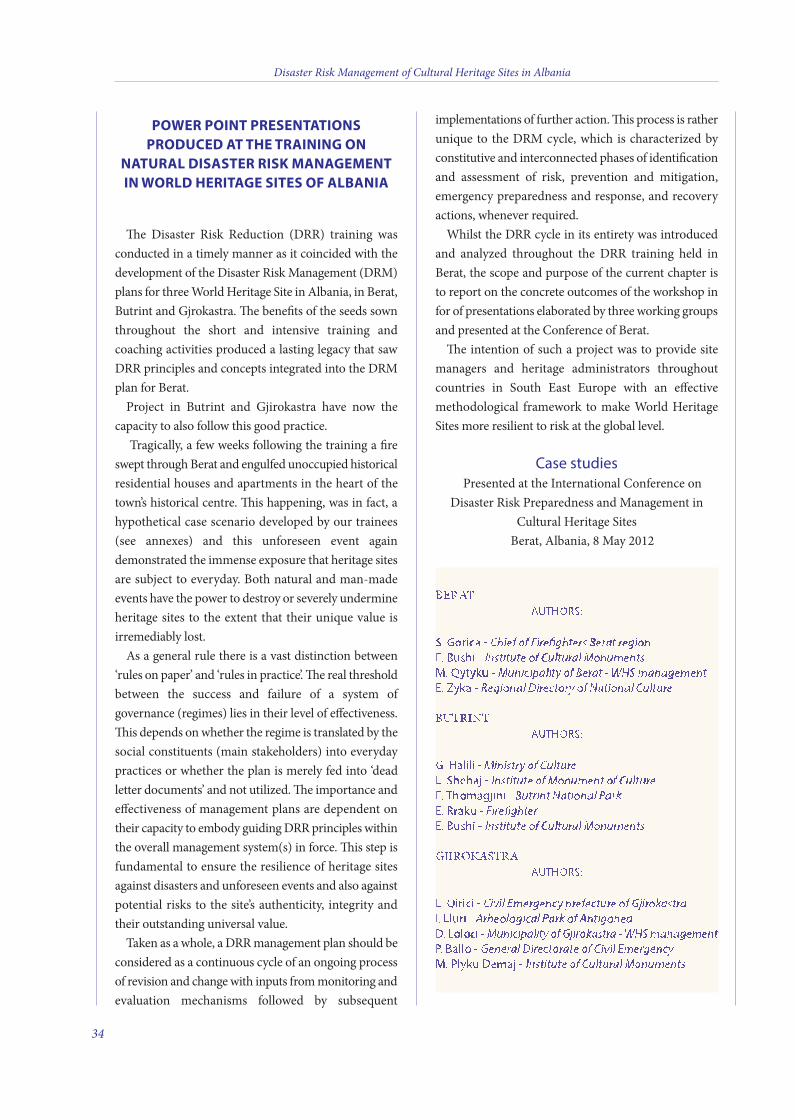
POWER POINT PRESENTATIONSPRODUCED AT THE TRAINING ON
NATURAL DISASTER RISK MANAGEMENTIN WORLD HERITAGE SITES OF ALBANIA
e Disaster Risk Reduction (DRR) training wasconducted in a timely manner as it coincided with thedevelopment of the Disaster Risk Management (DRM)plans for three World Heritage Site in Albania, in Berat,Butrint and Gjrokastra. e benefits of the seeds sownthroughout the short and intensive training andcoaching activities produced a lasting legacy that sawDRR principles and concepts integrated into the DRMplan for Berat.
Project in Butrint and Gjirokastra have now thecapacity to also follow this good practice.
Tragically, a few weeks following the training a fireswept through Berat and engulfed unoccupied historicalresidential houses and apartments in the heart of thetown’s historical centre. is happening, was in fact, ahypothetical case scenario developed by our trainees(see annexes) and this unforeseen event againdemonstrated the immense exposure that heritage sitesare subject to everyday. Both natural and man-madeevents have the power to destroy or severely undermineheritage sites to the extent that their unique value isirremediably lost.
As a general rule there is a vast distinction between‘rules on paper’ and ‘rules in practice’. e real thresholdbetween the success and failure of a system ofgovernance (regimes) lies in their level of effectiveness.is depends on whether the regime is translated by thesocial constituents (main stakeholders) into everydaypractices or whether the plan is merely fed into ‘deadletter documents’ and not utilized. e importance andeffectiveness of management plans are dependent ontheir capacity to embody guiding DRR principles withinthe overall management system(s) in force. is step isfundamental to ensure the resilience of heritage sitesagainst disasters and unforeseen events and also againstpotential risks to the site’s authenticity, integrity andtheir outstanding universal value.
Taken as a whole, a DRR management plan should beconsidered as a continuous cycle of an ongoing processof revision and change with inputs from monitoring andevaluation mechanisms followed by subsequent
implementations of further action. is process is ratherunique to the DRM cycle, which is characterized byconstitutive and interconnected phases of identificationand assessment of risk, prevention and mitigation,emergency preparedness and response, and recoveryactions, whenever required.
Whilst the DRR cycle in its entirety was introducedand analyzed throughout the DRR training held inBerat, the scope and purpose of the current chapter isto report on the concrete outcomes of the workshop infor of presentations elaborated by three working groupsand presented at the Conference of Berat.
e intention of such a project was to provide sitemanagers and heritage administrators throughoutcountries in South East Europe with an effectivemethodological framework to make World HeritageSites more resilient to risk at the global level.
Case studiesPresented at the International Conference on
Disaster Risk Preparedness and Management inCultural Heritage Sites
Berat, Albania, 8 May 2012
BERATAUTHORS:
S. Gorica - Chief of Firefighters Berat regionE. Bushi - Institute of Cultural MonumentsM. Qytyku - Municipality of Berat - WHS management E. Zyka - Regional Directory of National Culture
BuTRInTAUTHORS:
G. Halili - Ministry of CultureL. Shehaj - Institute of Monument of CultureE. Thomagjini - Butrint National Park E. Rraku - FirefighterE. Bushi - Institute of Cultural Monuments
GjIRokASTRAAUTHORS:
L. Qirici - Civil Emergency prefecture of GjirokastraI. Lluri - Arheological Park of AntigoneaD. Loloci - Municipality of Gjirokastra - WHS management P. Ballo - General Directorate of Civil EmergencyM. Plyku Demaj - Institute of Cultural Monuments
Disaster Risk Management of Cultural Heritage Sites in Albania
34
4 v2_2015_Layout 1 12/04/15 21:07 Pagina 34
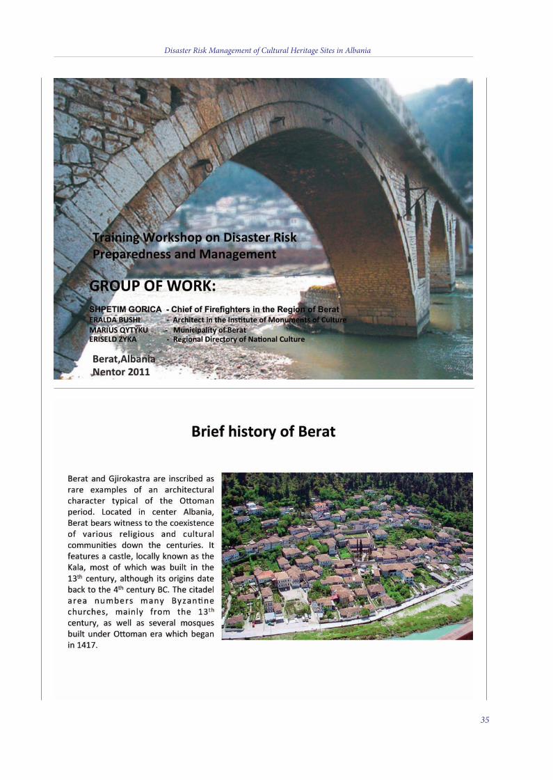
Disaster Risk Management of Cultural Heritage Sites in Albania
35
4 v2_2015_Layout 1 12/04/15 21:07 Pagina 35
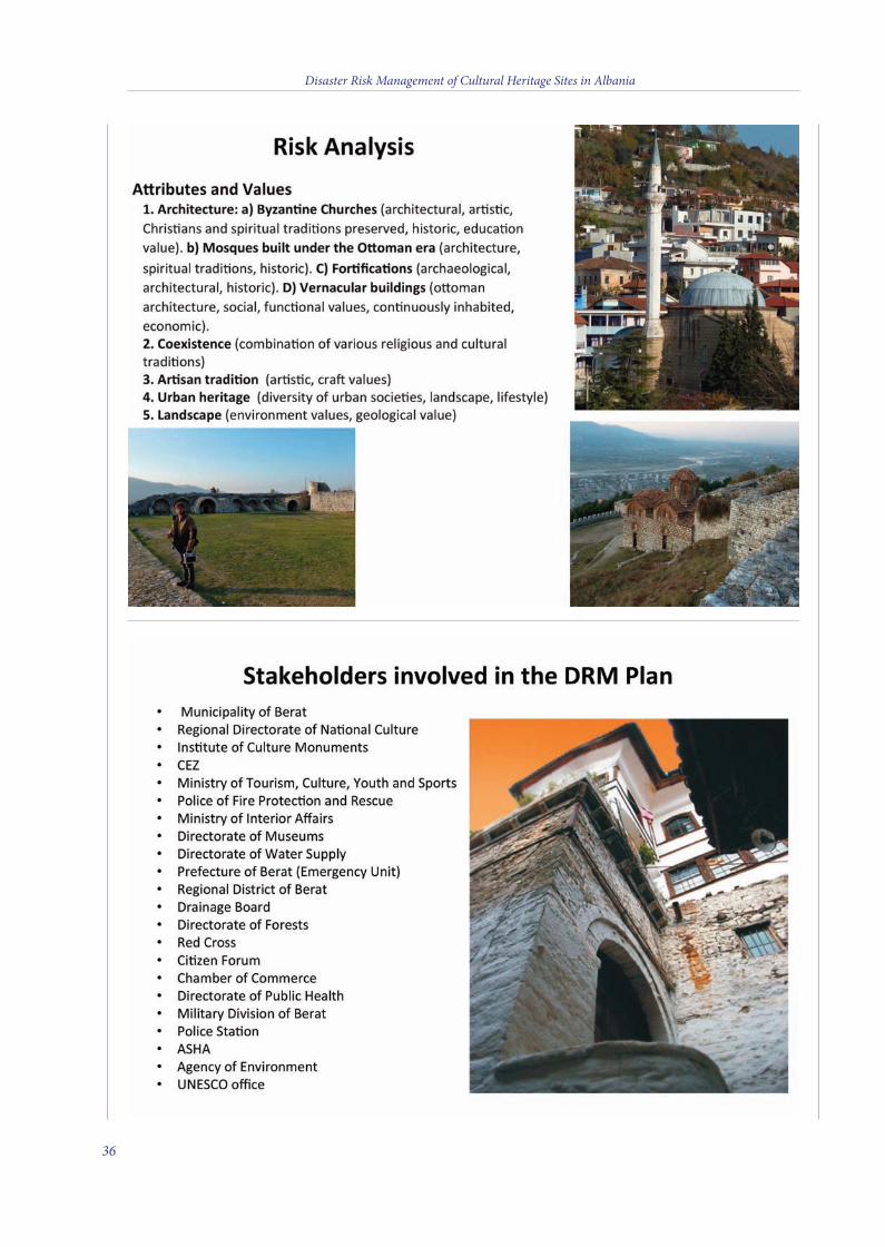
Disaster Risk Management of Cultural Heritage Sites in Albania
36
4 v2_2015_Layout 1 12/04/15 21:07 Pagina 36
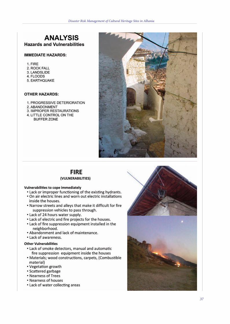
Disaster Risk Management of Cultural Heritage Sites in Albania
37
4 v2_2015_Layout 1 12/04/15 21:07 Pagina 37
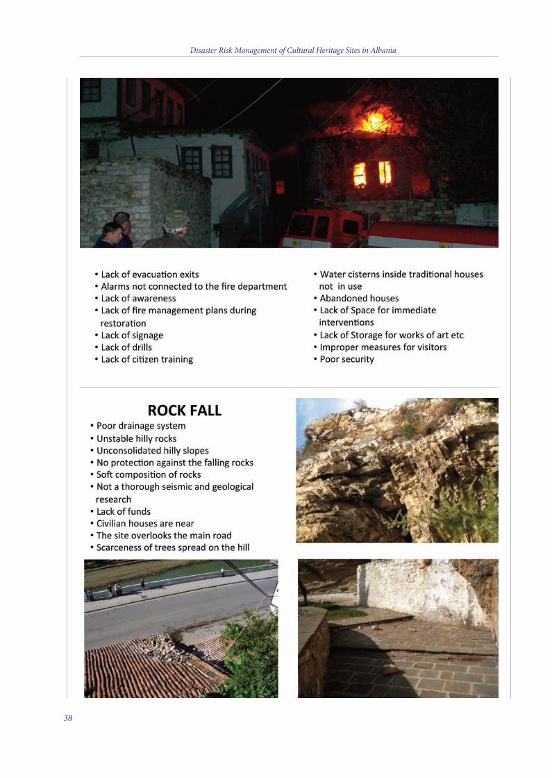
Disaster Risk Management of Cultural Heritage Sites in Albania
38
4 v2_2015_Layout 1 12/04/15 21:08 Pagina 38
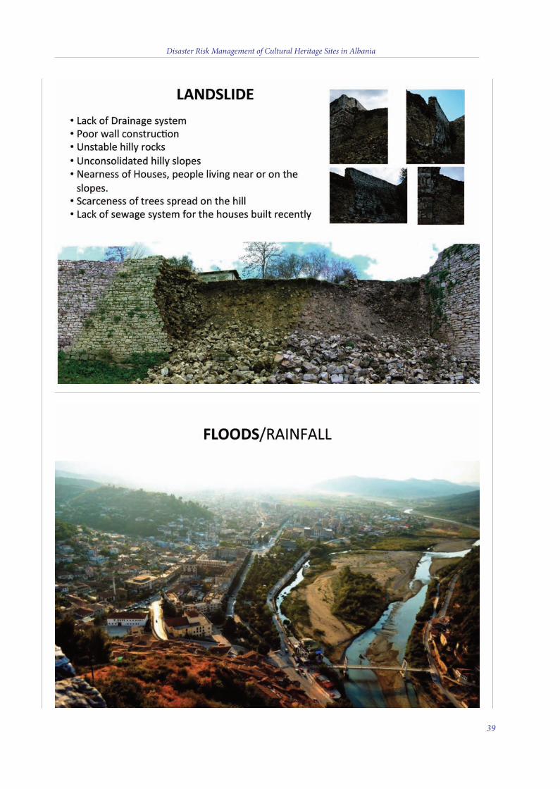
Disaster Risk Management of Cultural Heritage Sites in Albania
39
4 v2_2015_Layout 1 12/04/15 21:08 Pagina 39
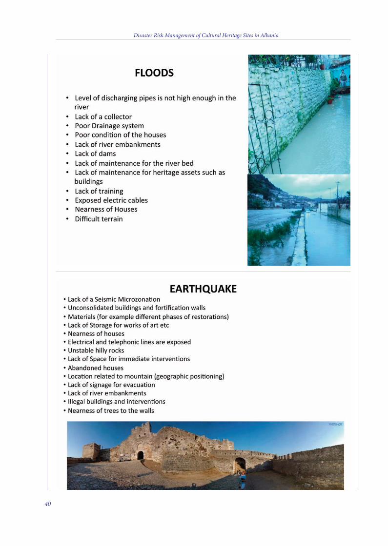
Disaster Risk Management of Cultural Heritage Sites in Albania
40
4 v2_2015_Layout 1 12/04/15 21:08 Pagina 40
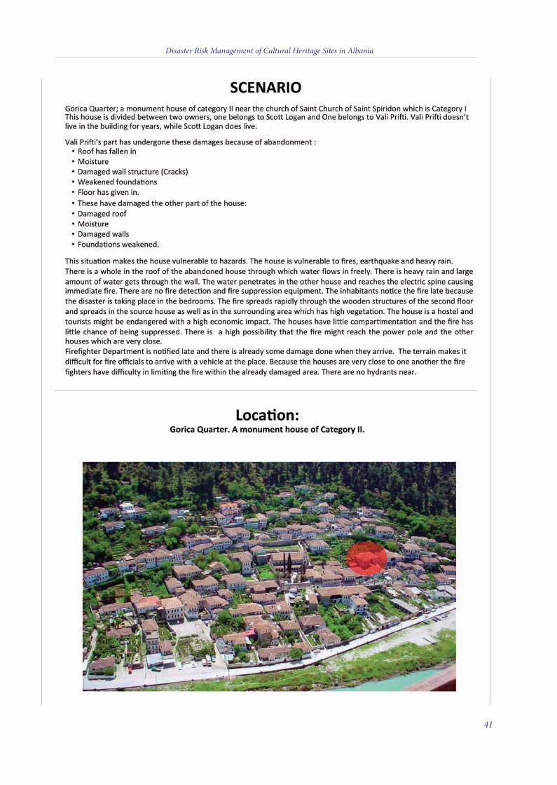
Disaster Risk Management of Cultural Heritage Sites in Albania
41
4 v2_2015_Layout 1 12/04/15 21:08 Pagina 41
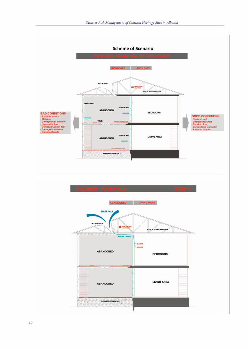
Disaster Risk Management of Cultural Heritage Sites in Albania
42
4 v2_2015_Layout 1 12/04/15 21:08 Pagina 42
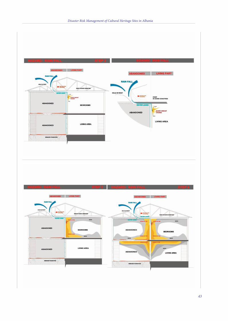
Disaster Risk Management of Cultural Heritage Sites in Albania
43
4 v2_2015_Layout 1 12/04/15 21:08 Pagina 43
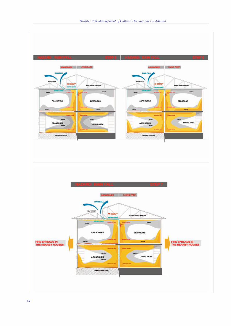
Disaster Risk Management of Cultural Heritage Sites in Albania
44
4 v2_2015_Layout 1 12/04/15 21:08 Pagina 44
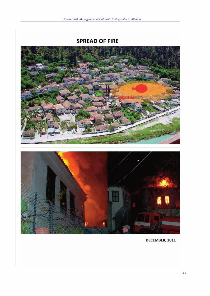
Disaster Risk Management of Cultural Heritage Sites in Albania
45
4 v2_2015_Layout 1 12/04/15 21:08 Pagina 45
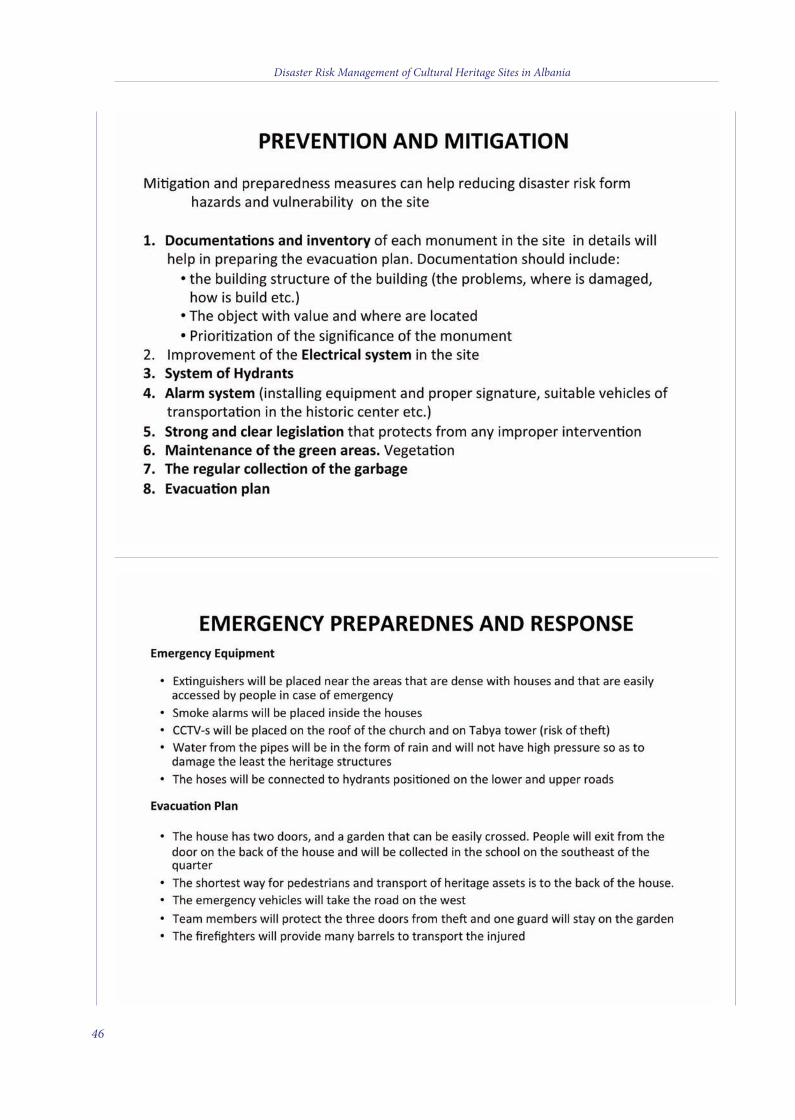
Disaster Risk Management of Cultural Heritage Sites in Albania
46
4 v2_2015_Layout 1 12/04/15 21:08 Pagina 46
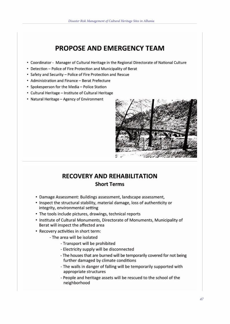
Disaster Risk Management of Cultural Heritage Sites in Albania
47
4 v2_2015_Layout 1 12/04/15 21:08 Pagina 47

Disaster Risk Management of Cultural Heritage Sites in Albania
48
4 v2_2015_Layout 1 12/04/15 21:08 Pagina 48
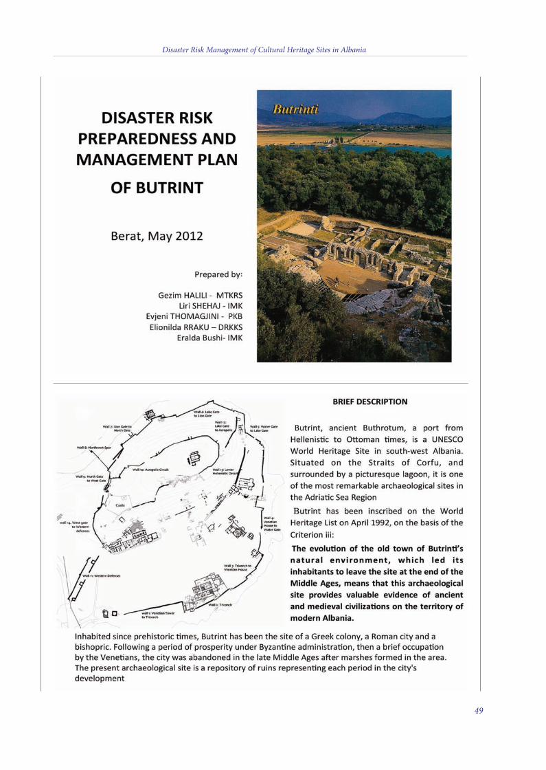
Disaster Risk Management of Cultural Heritage Sites in Albania
49
4 v2_2015_Layout 1 12/04/15 21:08 Pagina 49
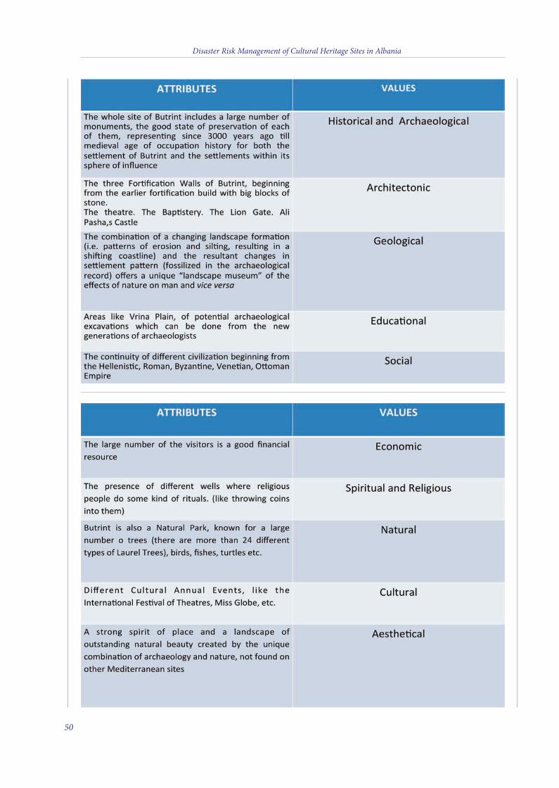
Disaster Risk Management of Cultural Heritage Sites in Albania
50
4 v2_2015_Layout 1 12/04/15 21:08 Pagina 50
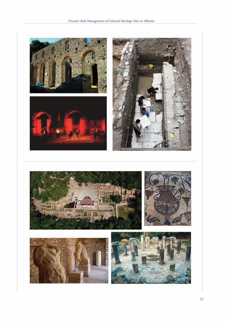
Disaster Risk Management of Cultural Heritage Sites in Albania
51
4 v2_2015_Layout 1 12/04/15 21:08 Pagina 51
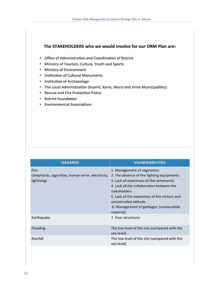
Disaster Risk Management of Cultural Heritage Sites in Albania
52
4 v2_2015_Layout 1 12/04/15 21:08 Pagina 52
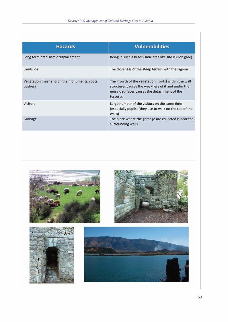
Disaster Risk Management of Cultural Heritage Sites in Albania
53
4 v2_2015_Layout 1 12/04/15 21:08 Pagina 53
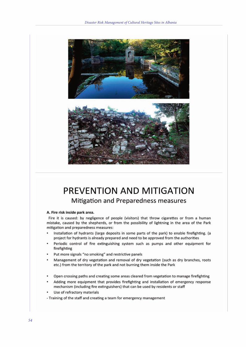
Disaster Risk Management of Cultural Heritage Sites in Albania
54
4 v2_2015_Layout 1 12/04/15 21:08 Pagina 54
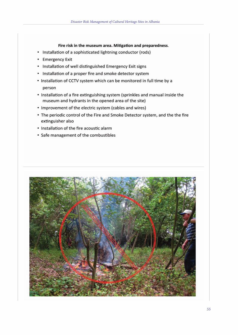
Disaster Risk Management of Cultural Heritage Sites in Albania
55
4 v2_2015_Layout 1 12/04/15 21:08 Pagina 55
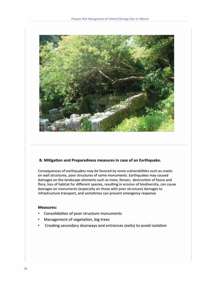
Disaster Risk Management of Cultural Heritage Sites in Albania
56
4 v2_2015_Layout 1 12/04/15 21:08 Pagina 56
Disaster Risk Management of Cultural Heritage Sites in Albania
57
4 v2_2015_Layout 1 12/04/15 21:08 Pagina 57
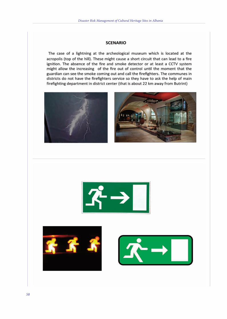
Disaster Risk Management of Cultural Heritage Sites in Albania
58
4 v2_2015_Layout 1 12/04/15 21:08 Pagina 58
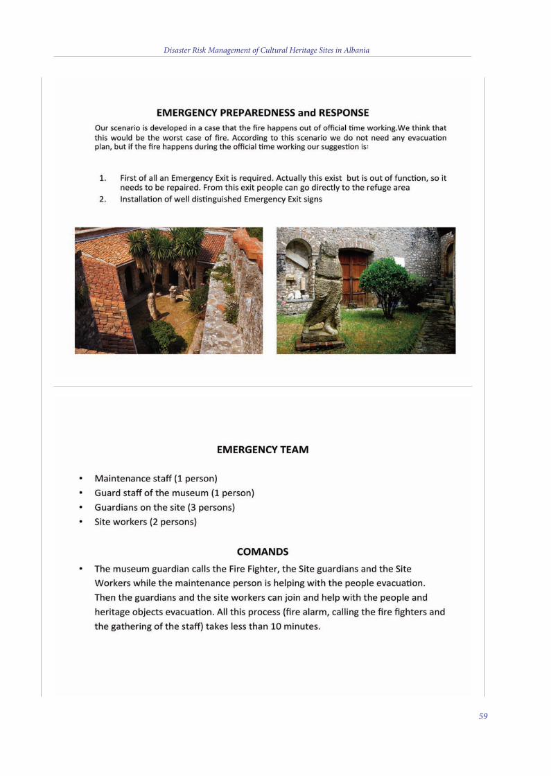
Disaster Risk Management of Cultural Heritage Sites in Albania
59
4 v2_2015_Layout 1 12/04/15 21:08 Pagina 59
Disaster Risk Management of Cultural Heritage Sites in Albania
60
4 v2_2015_Layout 1 12/04/15 21:08 Pagina 60
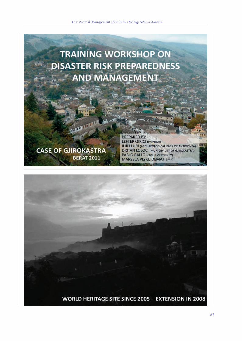
Disaster Risk Management of Cultural Heritage Sites in Albania
61
4 v2_2015_Layout 1 12/04/15 21:08 Pagina 61
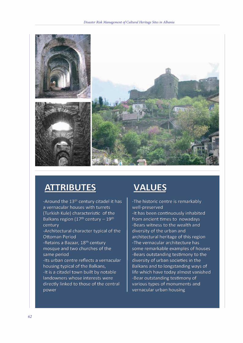
Disaster Risk Management of Cultural Heritage Sites in Albania
62
4 v2_2015_Layout 1 12/04/15 21:08 Pagina 62

Disaster Risk Management of Cultural Heritage Sites in Albania
63
4 v2_2015_Layout 1 12/04/15 21:08 Pagina 63
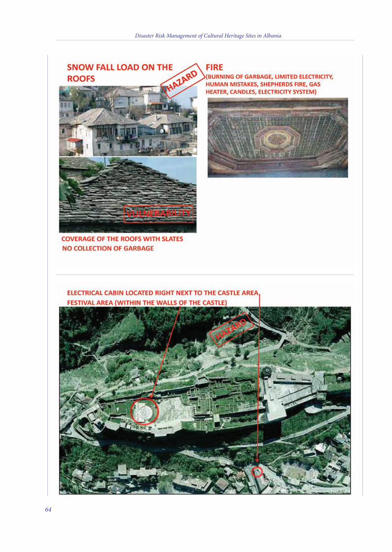
Disaster Risk Management of Cultural Heritage Sites in Albania
64
4 v2_2015_Layout 1 12/04/15 21:08 Pagina 64
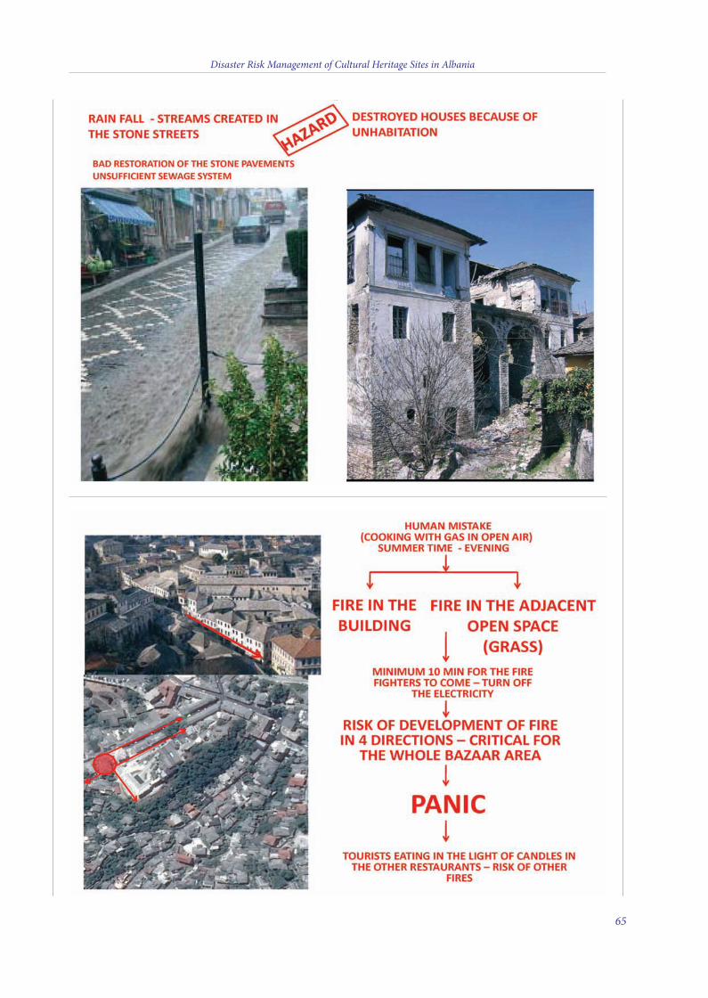
Disaster Risk Management of Cultural Heritage Sites in Albania
65
4 v2_2015_Layout 1 12/04/15 21:08 Pagina 65
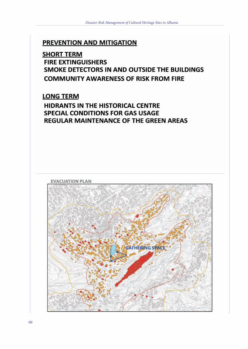
Disaster Risk Management of Cultural Heritage Sites in Albania
66
4 v2_2015_Layout 1 12/04/15 21:08 Pagina 66
Disaster Risk Management of Cultural Heritage Sites in Albania
67
4 v2_2015_Layout 1 12/04/15 21:08 Pagina 67
Disaster Risk Management of Cultural Heritage Sites in Albania
69
PART II
ASSESSMENT ANALYSIS OF SEISMOLOGICAL RISK
AND GEOHAZARD VULNERABILITY OF FIRST LEVEL
IN MAJOR CULTURAL HERITAGE SITES OF ALBANIA
4 v2_2015_Layout 1 12/04/15 21:08 Pagina 69
1. GEOLOGICAL SETTING AND REGIONALSEISMIC HAZARD OF ALBANIA
INTRODUCTION
Seismic hazard analysis is the evaluation ofpotentially damaging-related phenomena towhich a region or a facility may be subjected toduring its useful lifetime. e cultural sitessituated inside an earthquake-prone area aremost vulnerable to this kind of natural hazarddue to the continuous shaking experiencedduring the long period of their existence and, asa consequence, gradual loss of their structuralstability. e continuous improvement ofprocedures to define the seismic hazard at theregional, national and local scale is essential forthe optimum design of earthquake-resistantsstructures, and it is one of the tools whichpermit us to undertake the necessaryinterventions for their rehabilitation. Referencemotion in hard rocks and detailedcharacterization of soil conditions at each siteare the milestones for the appropriate definitionof seismic action in cultural heritage sites inAlbania.
Before the ‘90s, the seismic hazard evaluationin Albania was carried out based on themacroseismic intensities of strong historicalearthquakes of the 20th century, as well as onseismotectonic synthesis (Sulstarova et al.,1980). Methods used were quite empirical andnot based on a rigorous mathematicalmethodology, although the probabilisticapproach (Cornell, 1968) was widely used atthat time in other countries, even in the Balkanarea. Several attempts have been made in thepast few years to express seismic hazard interms of ground acceleration, velocity anddisplacement following both deterministic andprobabilistic approaches (Muço et al., 2001;Muço et al., 2002; Duni & Kuka, 2003; Duni &Kuka, 2004; Kuka et al., 2003; Aliaj et al., 2004;Fundo et al., 2012).
e probabilistic approach yields a
probabilistic description of how likely it is toobserve different levels of ground motion at thesite, not how likely an earthquake is to occur.Typically, this is given in terms of the annualprobability that a given level of ground motion(PGA, SA, intensity, etc.) will be exceeded at asite. Usually, the seismic hazard assessmentprograms specify a 10% exceedance probabilityof some threshold of any ground motionparameter, for 50 years of exposure, whichcorresponds to a 475 year return period. eresult can be expressed as a hazard curve givingthe annual probability of any level of groundshaking being exceeded at the site of interest, orin the form of hazard maps representing spatialvariability of the selected ground motionparameter for a given return period (e.g. 475-year return period).
In this report, first we describe briefly thegeodynamic position and the seismicity ofAlbania. en we concentrate our attention onthe analysis of the seismic hazard of the country,and later on we describe in particular the hazardparameters on hard soil conditions of the majorcultural heritage sites, specifically Apollonia,Berat, Butrint, Gjirokastra and Durres.
GEOLOGICAL SETTING AND GEODYNAMICSOF ALBANIA
Geologically, Albania forms part of theDinaric-Albanic-Hellenic arc of the Alpineorogeny, the formation of which took placemainly in the Tertiary, giving the country itsmountainous relief.
On the worldwide zonation, Albania is on theAlpin-Mediterranean seismic belt. is beltcomprises the wide zone of contact between thelithospheric plates of Africa and Eurasia, fromAzore Islands up to the eastern border of theMediterranean basin (Fig. 3). In this zone, theconcept of plate tectonics is especiallycomplicated because of the presence ofnumerous blocks and the release of stressthrough plastic deformation on a large part of
Disaster Risk Management of Cultural Heritage Sites in Albania
71
5 v2_2015_Layout 1 12/04/15 21:15 Pagina 71
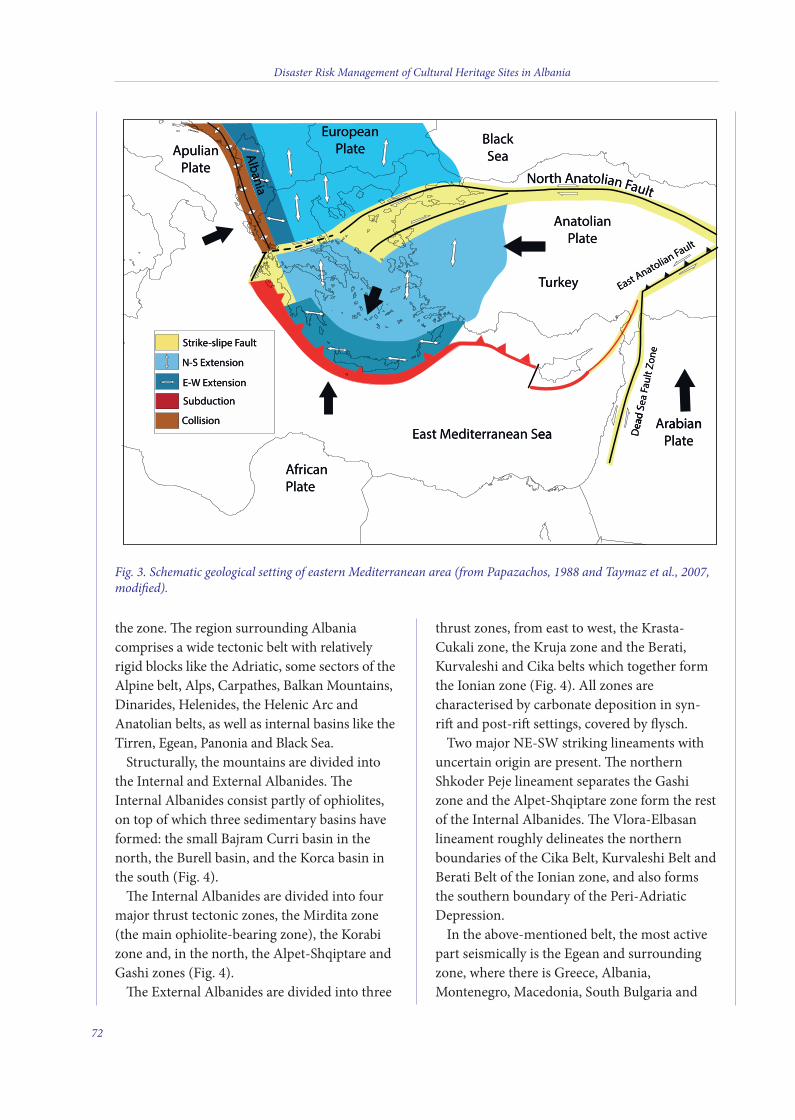
the zone. e region surrounding Albaniacomprises a wide tectonic belt with relativelyrigid blocks like the Adriatic, some sectors of theAlpine belt, Alps, Carpathes, Balkan Mountains,Dinarides, Helenides, the Helenic Arc andAnatolian belts, as well as internal basins like theTirren, Egean, Panonia and Black Sea.
Structurally, the mountains are divided intothe Internal and External Albanides. eInternal Albanides consist partly of ophiolites,on top of which three sedimentary basins haveformed: the small Bajram Curri basin in thenorth, the Burell basin, and the Korca basin inthe south (Fig. 4).
e Internal Albanides are divided into fourmajor thrust tectonic zones, the Mirdita zone(the main ophiolite-bearing zone), the Korabizone and, in the north, the Alpet-Shqiptare andGashi zones (Fig. 4).
e External Albanides are divided into three
thrust zones, from east to west, the Krasta-Cukali zone, the Kruja zone and the Berati,Kurvaleshi and Cika belts which together formthe Ionian zone (Fig. 4). All zones arecharacterised by carbonate deposition in syn-ri and post-ri settings, covered by flysch.
Two major NE-SW striking lineaments withuncertain origin are present. e northernShkoder Peje lineament separates the Gashizone and the Alpet-Shqiptare zone form the restof the Internal Albanides. e Vlora-Elbasanlineament roughly delineates the northernboundaries of the Cika Belt, Kurvaleshi Belt andBerati Belt of the Ionian zone, and also formsthe southern boundary of the Peri-AdriaticDepression.
In the above-mentioned belt, the most activepart seismically is the Egean and surroundingzone, where there is Greece, Albania,Montenegro, Macedonia, South Bulgaria and
Fig. 3. Schematic geological setting of eastern Mediterranean area (from Papazachos, 1988 and Taymaz et al., 2007,modified).
Disaster Risk Management of Cultural Heritage Sites in Albania
72
AnatolianPlate
BlackSea
EuropeanPlate
AfricanPlate
ArabianPlate
East Anatolian Fault
Dea
d Se
a Fa
ult Z
one
ApulianPlate
Albania
East Mediterranean Sea
Turkey
North Anatolian Fault
Albania
Strike-slipe Fault
N-S Extension
E-W Extension
Collision
Subduction
tealPpulianA
lbanianan
AAl
tealPopeanurE
lbaniaanan troN
eaSBlack
ntlltuulaFFanailotanAht
ault
lian FtealP
oliantnaA
tionSubduc
ensiontW ExE-
ensiontN-S Ex
ault-slipe FiketrS
urT
keyur
one
ault
Z Zo
ea F F
a
ead
S
olia
tto
naat
East A An
ollisionC
tealPicanfrA
eaanean SrereditEast M
ea
ead
SD
tealPabianrA
abian
5 v2_2015_Layout 1 12/04/15 21:15 Pagina 72
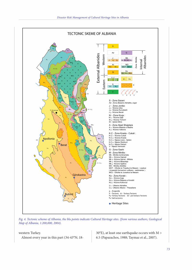
Disaster Risk Management of Cultural Heritage Sites in Albania
western Turkey.Almost every year in this part (34-43°N; 18-
30°E), at least one earthquake occurs with M >6.5 (Papazachos, 1988; Taymaz et al., 2007).
73
Fig. 4. Tectonic scheme of Albania, the blu points indicate Cultural Heritage sites. (from various authors, GeologicalMap of Albania, 1:200,000, 2004).
TECTONIC SKEME OF ALBANIA
Exte
rnal
Alb
anid
esW
este
rnEa
ster
n
Inte
rnal
Alb
anid
es
Apollonia
Heritage Sites
Berat
Butrint
Gjirokastra
TectonicTertiary Tectonic
b1 - Tertiary Tectonicb3 - pre kretacic Tectonic
Salt tectonics
5 v2_2015_Layout 1 12/04/15 21:15 Pagina 73
Leaving apart the Helenic Arc where theAfrican plate sinks under the Eurasian plate inthe subduction form, the other contact betweenthese two plates, and especially that part startingwhere the western wing of the Helenic Arcalready ends and continuing with the westerncoasts of Balkan peninsula, is implementedthrough the Adria microplate. is unit acts as awedge between the Apenines, Alps andDinarides-Albanides-Helenides mountainranges.
e origin of the orogenic systems of westernBalkan as well as those systems surrounding theAdriatic Sea on the north and west, is stronglyconnected to the convergence between theEurasian and African plates (Fig. 3). isprocess, which began on the Upper Jurassic-Lower Cretaceous, influenced the disappearanceof the old ocean Tethys, situated between thetwo continental margins and whose remnantsare today the ophiolites and abyssal sedimentson the nappes of the above mentioned orogenicsystems.
It is still a matter of dispute whether Adria istoday a part of the African plate or should beconsidered as an independent unit. From thefocal mechanism and paleomagnetism studies,it has been revealed that the Adria microplaterotates counterclockwise, with its pole innorthern Italy. e conclusions of many studieson the geodynamics and seismicity of theAegean and generally of eastern Mediterraneanregion, zones where there is Albania, areconverged on the point that mainly theseismicity of Albania is strongly connected tothe contact between the Adria and Albanidesorogen, which is part of a wider collisionbetween the Eurasian and African plates. iscontact, which possibly takes effect through acontinental type of collision, unceasinglyaccumulates deformations and propels thelongitudinal tectonic faults bordering it as wellas transversal tectonic faults cutting it andpenetrating the interior of the peninsula. It isprecisely these continuous accumulations oftectonic deformations that through active faults
as the earthquake cradles give way to seismicenergy release shaping so the seismicity of thecountry (Fig. 5).
THE SEISMICITY OF ALBANIA
Earthquakes are geological phenomena thatclearly demonstrate the dynamics of the planetwe live on. ey most directly express theenormous energy that the Earth hides inside asa new planet. ese phenomena are the causesof sharp changes of the surface of our planetaccompanied by its continuous evolution.
As disastrous phenomena, earthquakes havebrought great damage to humanity during thecenturies. Only during the last 500 years morethan seven million people have been killed byearthquakes worldwide and millions more havelost their living resources.
Nevertheless, these phenomena have been notonly a source of disasters, but also a valuablesource of geological information. e analysis ofseismic waves has given detailed and uniqueinformation on the internal composition of theEarth.
Earthquakes are unavoidable phenomena andpeople try to co-exist with them, seeking themost appropriate ways to make them as lessdangerous as possible during their time-to-timeappearance. e best way to do this to haveprofound knowledge of these phenomena.
e seismicity of a certain region is defined asa function of earthquake size (magnitude,intensity, seismic moment, etc.), as well as thefrequency of their occurrence. On this basis,keeping in mind the well-known classificationof earthquakes according their magnitudes(Hagiwara 1964; Lee et.al., 1981), the seismicityof Albania is characterized by an intensiveseismic microactivity (1.0 < M ≤ 3.0), manysmall earthquakes (3.0 < M ≤ 5.0), raremedium-sized earthquakes (5.0 < M ≤ 7), and,very seldom, strong earthquakes (M > 7.0).
e seismicity of a country is usuallyseparated into two periods: its historical
Disaster Risk Management of Cultural Heritage Sites in Albania
74
5 v2_2015_Layout 1 12/04/15 21:15 Pagina 74

seismicity and instrumental seismicity.Historical seismicity is based on theinformation collected from different sourcesand has to do with that period of history whenearthquakes were not yet recorded with specialinstruments. Instrumental seismicity isidentified with the 20th century because fromthis time in Europe and worldwide theimplementation of seismological stations startedand earthquake records began to be collectedand analyzed systematically.
Historical seismicitye historical seismicity of Albania is
described in some various catalogues like:Mihajlovic, 1951; Shebalin et al., 1974;Sulstarova et al.,1975; Makropoulos et al., 1981;Papazachos & Papazachou, 1989; Papazachos etal., 2000; Guidoboni, 1994; Fundo et al., 2012.
From the evidence we possess today, we cansee that from the period of III-II centuries B.C.
until the present, Albania has been stricken by55 strong earthquakes with intensities Io ≥ VIIIdegree (MSK-64), of which 15 have had theintensity Io ≥ IX degree (MSK-64). Of these 55earthquakes over a period of more than 2000years, 36 of them belong to the 19th centurywhich makes us believe that the number ofdisastrous earthquakes we report has beenunderestimated and other disastrousearthquakes have been hidden in the depths ofhistorical time.
ere is reliable evidence that the old town ofDurres (Dyrrahum) has been stricken severaltimes by strong earthquakes that have causedserious human and economic losses. From oldrecords we can see that this town was almosttotally destroyed in the years 177 B.C., 334 or345 A.C., 506, 1273, 1279, 1869 and 1870. eevidence for the earthquake of March 1273 saysthat the town, inhabited by 25 thousand peopleat that time, was totally destroyed. ere were
Disaster Risk Management of Cultural Heritage Sites in Albania
75
Fig. 5. Seismicity of the eastern Mediterranean region and surroundings reported by USGS–NEIC from 1973-2007with magnitudes for M > 3 superimposed on a shaded relief map derived from the GTOPO-30 Global TopographyData taken from USGS. Bathymetry data are derived from GEBCO/97–BODC, provided by GEBCO (1997) andSmith & Sandwell, 1997 (from Taymaz et al., 2007).
5 v2_2015_Layout 1 12/04/15 21:15 Pagina 75
many casualties and the survivors le the town,seeking other places to live. Since thisearthquake the importance of Durresi as a porton the Adriatic Sea has diminished.
In the centuries III-II B.C., there is evidencethat Apollonia, another ancient town, wasstruck by strong earthquakes which caused largecasualties and damage.
In the year 1153, the town of Butrint (oldButhrot) in the south of Albania, was destroyedby a strong earthquake. Its traces can be foundeven today on the remnants of this old town.
e town of Berat has been hit by strongearthquakes several times. One of the strongest,well evidenced ones is that of October 17, 1851,which caused a lot of destruction. e fortressof the town was damaged and under its ruins400 soldiers were buried. is fact demonstratedthat there were other victims in town of Berat.Cracks on the ground were observed togetherwith fountains of sand and water mixedtogether, and a kind of a sulfur dust, whichmade respiration difficult, was discovered. erewere big landslides as well. e highest intensityfor this earthquake had to be 9.0 degrees (basedmainly on the degree of destruction of thefortress of the town).
Instrumental seismicitye establishment of seismological stations in
Europeon at the end of the 19th and thebeginning of the 20th century made it possible tocollect evidence of earthquakes in Albania andnearby. Depending on the density andmodernization of seismological stations inEurope and worldwide, can say that theearthquakes of Albania and nearby withmagnitude MS ≥ 6.0 (with intensity Io ≥ VIIIdegree (MSK-64)), have been recorded by themsince the beginning of the 20th century; thosewith magnitude MS ≥ 5.5 (intensity Io ≥ VIIdegree (MSK-64)) since 1911; those with MS >5.0 (intensity Io > VI degree (MSK-64)) since1940; those with ML ≥ 4.0 (intensity Io ≥ IV-Vdegree (MSK-64)) since 1968, and those withmagnitude ML ≥ 2.5 since 1976.
e first seismological station in Albania wasset up in August 1968, while the AlbanianSeismological Network (ASN) started in 1975.e ASN is presently composed of 13 stationsequipped with various digital instruments. Anew, fully integrated digital seismograph systemusing the satellite communication (VSAT) isnow under operation as part of ASN. Sevensatellite remote stations have been installed onSRN, PHP, KBN, BCI, PUK, TIR and VLO andtransmit continuous data in real time. e Librasatellite seismograph system includes a centralVSAT Hub (Libra Nanometrics) running theNaqsServer acquisition soware and 7 Cygnusremote sites configured to acquire respectivelythe three-component broadband stations(Trillium 40T and CMG-40T) equipped with 24bits digitizers (Trident).
From the collected and processed data it isproven that during the 20th century Albania washit by many damaging earthquakes. A realpicture of the seismicity of Albania can beclearly seen from Fig. 6.
INPUT FOR SEISMIC HAZARD ASSESSMENT
Earthquake CatalogSeismicity studies depend largely on the
available information, as well as completenessand reliability of earthquake data expressed inthe earthquake catalog used. e bulk of ourknowledge of past seismicity relies on thehistorical record of earthquake damage. In theearly 20th century, recording of the wavesreleased by earthquakes in order to achieve aprecise determination of hypocentral locationsand magnitudes began. Instrumentalobservations complement the macroseismicobservations for larger events, and are the basisfor a homogenous record of the seismicity inAlbania since 1968.
A homogenous earthquake catalog forAlbania was compiled in 1975 and was revisedduring the period 2000-2005 (Kuka et al., 2005).It contains about 700 earthquakes with a
Disaster Risk Management of Cultural Heritage Sites in Albania
76
5 v2_2015_Layout 1 12/04/15 21:15 Pagina 76
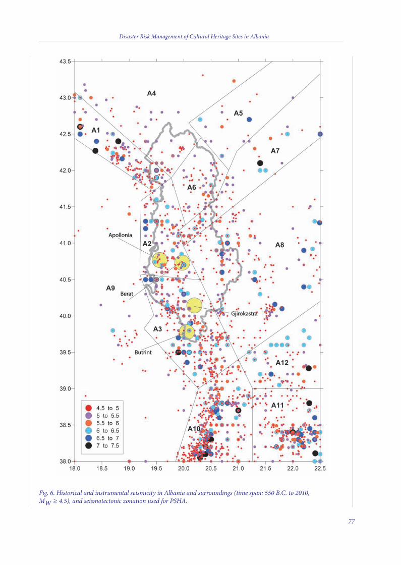
Disaster Risk Management of Cultural Heritage Sites in Albania
77
Fig. 6. Historical and instrumental seismicity in Albania and surroundings (time span: 550 B.C. to 2010, MW ≥ 4.5), and seismotectonic zonation used for PSHA.
5 v2_2015_Layout 1 12/04/15 21:15 Pagina 77
magnitude greater than or equal to 4.5. ecatalog covers a time span from the year 58 B.C.up to 2005, and an area between 18.5°-21.5°Eand 39-43°N. e size of the earthquakes isgiven in terms of surface-wave magnitude MS.
For a better assessment of seismic hazard, aseismicity-working file has been compiled,revising the above catalog, and extending itsgeographical borders by at least 1 degree, alsoincluding events from the neighboring areas.e working file has been produced bycautiously merging the above catalog with theISC bulletins for the period 1964-2010, and theSkopje and essaloniki earthquake catalogs.When different catalogs have differentinterpretations of an event, the highest priorityis generally given to the catalog of the countrywhere the event occurred.
Moment magnitude, MW, has been chosen asthe common measure of earthquake size forboth historically known and instrumentallyrecorded events. In the essaloniki catalog(Papazachos et al., 2000) earthquake size isexpressed in moment magnitude MW scale; ISCbulletins report MW and M , whereas Tiranaand Skopje use the MS scale. Magnitudes MSand mb are converted to MW using the relevantformulas (Scordilis, 2006). Finally, earthquakedata files used in further steps comprises a totalof about 2300 events with MW ≥ 4.5. It coversthe time period from 550 B.C. up to December31, 2010 and the area between 18.0-22.5°E and38-43.5°N. A map which depicts the spatialdistribution of epicenters of earthquakes used inthe present study is demonstrated in Fig. 6. It isobvious that seismicity is not uniformlydistributed within the country.
Data completeness with timeThe modeling of seismicity in every zone
needs estimation of the recurrence parameters,a and b in the Gutenberg-Richter (G-R) relationlogN = a-bM, where N is the cumulative numberof events, the a-value the productivity of avolume, and the b-value the relative sizedistribution.
Its estimation is critically dependent on thecorrect identification of the magnitude ofcompleteness, below which only a fraction of allevents in a magnitude bin are detected. In otherwords, we need to verify and account for thedegree of correspondence of the apparentseismicity, as indicated by the catalog, withactual seismicity, i.e. what actually takes place.Completeness as a function of space and timevaries first of all, country-by-country, accordingto geographical and cultural-historical aspectswhich obviously influence the data compilation.
An analysis of the completeness of the cataloghas been performed by using the cumulativenumber of events versus time graphs, in order toevidence slope changes, assuming that the mostrecent change in slope occurred when the databecame complete for magnitudes above thereference (Gasperini et al., 2000). Thecompleteness test was performed for MW inhalf magnitude classes. By making use of thecumulative number versus time graphs, we haveidentified four magnitude intervals, the point intime from when the data is assumed to becomplete. The catalogue described above can beconsidered complete for MW ≥ 4.5 since 1955,for MW ≥ 5.0 since 1905, for MW ≥ 5.5 since1850 and MW ≥ 6.0 since at least 1550 (Fig. 7).
Declustering the catalogFor most hazard-related studies, the seismicity
must behave in a time-independent fashion inorder to avoid biasing the average-rateassessments with data from, for example,prominent aftershock sequences that may notbe representative of the average behavior of acrustal volume. To model earthquakeoccurrence in time, it is assumed that theyfollow a Poisson process with constantrecurrence rate g. Declustering attempts toseparate the time-independent part of seismicity(background) from the time-dependent orclustered parts (aftershocks, foreshocks andswarm type activity).
First, we investigated whether or not thetemporal distribution of events within our
Disaster Risk Management of Cultural Heritage Sites in Albania
78
5 v2_2015_Layout 1 12/04/15 21:15 Pagina 78
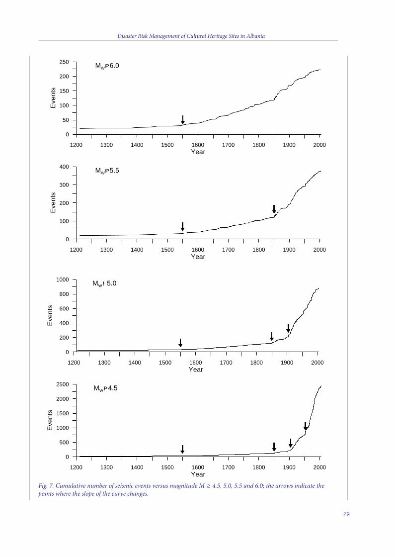
Disaster Risk Management of Cultural Heritage Sites in Albania
79
1200 1300 1400 1500 1600 1700 1800 1900 2000Year
0
100
200
300
400
Eve
nts
MWP5.5
1200 1300 1400 1500 1600 1700 1800 1900 2000Year
0
50
100
150
200
250
Eve
nts
MWP6.0
1200 1300 1400 1500 1600 1700 1800 1900 2000Year
0
200
400
600
800
1000
Eve
nts
MW! 5.0
1200 1300 1400 1500 1600 1700 1800 1900 2000Year
0
500
1000
1500
2000
2500
Eve
nts
MWP4.5
Fig. 7. Cumulative number of seismic events versus magnitude M ≥ 4.5, 5.0, 5.5 and 6.0; the arrows indicate thepoints where the slope of the curve changes.
5 v2_2015_Layout 1 12/04/15 21:15 Pagina 79
catalog is Poissonian, which would argue thatdeclustering may not be necessary. For theevaluation of the earthquake occurrence, theWeibull distribution for the time intervalbetween successive events, T is used very often,with hazard function:
h(t) = t1/r-1
where the hazard profile is determined by thet1/r-1 element. If r = 1, hazard is uniform and thisis the case of the Poissonian process; if r < 1,hazard is increasing; and if r > 1, hazard isdiminishing with time.
So investigating the time interval T betweensuccessive events by using the Weibulldistribution for T, we found that the processcannot be considered as a Poissonian one.Therefore, the catalog has to be purged ofaftershocks and foreshocks prior to modelingthe magnitude frequency distribution and anyfurther analysis.
The seismicity data file was made Poissonianby tagging the main shocks and applying adistance-window and two time-windowssimultaneously for eliminate foreshocks andaftershocks. The window parameters aredependent on the main shock magnitudes.Using a space time magnitude dependentwindow, we identified 1171 independent eventsand removed all aftershocks and foreshocksfrom the sample. The estimate of the rparameter, for all the data groups I-IV, I (eventswith MW ≥ 4.5, 1955-2010), II (MW ≥ 5.0,1905-2010), III (MW ≥ 5.5, 1850-2010) and IV(MW ≥ 6.0, 1550-2010) are already near thevalue 1 (Figs. 8 and 9). In Fig. 9 it is clearly seenthat the difference between the exponential andWeibull distributions is narrowed. This newsubcatalog, purged of aftershocks andforeshocks, is used to adequately estimate theseismicity parameters, and in other calculationsfor seismic hazard assessment.
Estimating seismicity parametersThe parameters currently used for
quantitative evaluation of seismicity are thewell-known statistics which define the
magnitude-frequency relation G-R, such as themean annual rate λ, the b-value of the G-Rrelation, the completeness threshold of seismicdata, Mmin, above which the catalog isconsidered to be complete, and the maximumpossible magnitude Mmax. The reliableestimation of these parameters is of primaryimportance because evaluation of the seismicityrate in a region is directly dependent on them.We used a maximum likelihood approach fortheir estimation, as outlined in Bollinger et al.(1993), Weichert (1980), and Berril and Davis(1980). This method is considered moreappropriate than the least squares to determinethe recurrence parameters, because all availabledata is weighted appropriately, taking intoaccount the data sets of variable completenesswith time.
Another approach to estimate the seismicityparameters is that of Kijko-Selevoll (Kijko andSelevoll, 1989), which considers not only therecent instrumental data, but also the historicalmacroseismic events that occurred over aperiod of more than two thousands years. Inaddition, the uncertainties in earthquakemagnitude can also be considered. Meanactivity rate λ, G-R b-value, and the maximumregional magnitude Mmax are estimated usingthe maximum likelihood procedure by applyingthe Bayesian formalism.
First, based on a model proposed before(Kuka et al., 2004), a seismotectonic model wasdefined consisting only of polygonal zones ofassumed distributed seismicity (Fig. 6). Themain zones were defined to have similargeodynamic behavior and a rather homogenousdistribution of seismicity. Each zone ischaracterized by a frequency-magnitudedistribution, which is derived from jointhistorical and instrumental seismicity data. Weestimated the overall recurrence parameters forall events within Albania and about 100 km ofthe Albanian border (Fig. 6). Then therecurrence parameters in each zone were alsoestimated using the same methodology; resultsare shown in Table 3. Comparing the estimates
Disaster Risk Management of Cultural Heritage Sites in Albania
80
5 v2_2015_Layout 1 12/04/15 21:15 Pagina 80
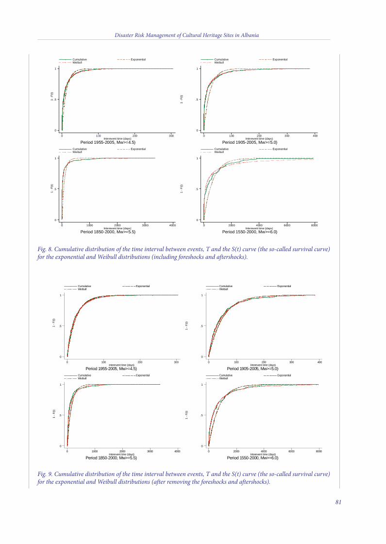
Disaster Risk Management of Cultural Heritage Sites in Albania
81
1 - F
(t)
Period 1955-2005, Mw>=4.5)Interevent time (days)
Cumulative Exponential Weibull
0 100 200 300
0
.5
1
1 - F
(t)
Period 1905-2005, Mw>=5.0)Interevent time (days)
Cumulative Exponential Weibull
0 100 200 300 400
0
.5
1
1 - F
(t)
Period 1850-2000, Mw>=5.5)Interevent time (days)
Cumulative Exponential Weibull
0 1000 2000 3000 4000
0
.5
1
1 - F
(t)
Period 1550-2000, Mw>=6.0)Interevent time (days)
Cumulative Exponential Weibull
0 2000 4000 6000 8000
0
.5
1
1 - F
(t)
Period 1955-2005, Mw>=4.5)Interevent time (days)
Cumulative Exponential Weibull
0 100 200 300
0
.5
1
1 - F
(t)
Period 1905-2005, Mw>=5.0)Interevent time (days)
Cumulative Exponential Weibull
0 100 200 300 400
0
.5
1
1 - F
(t)
Period 1850-2000, Mw>=5.5)Interevent time (days)
Cumulative Exponential Weibull
0 1000 2000 3000 4000
0
.5
1
1 - F
(t)
Period 1550-2000, Mw>=6.0)Interevent time (days)
Cumulative Exponential Weibull
0 2000 4000 6000 8000
0
.5
1
Fig. 8. Cumulative distribution of the time interval between events, T and the S(t) curve (the so-called survival curve)for the exponential and Weibull distributions (including foreshocks and aftershocks).
Fig. 9. Cumulative distribution of the time interval between events, T and the S(t) curve (the so-called survival curve)for the exponential and Weibull distributions (after removing the foreshocks and aftershocks).
5 v2_2015_Layout 1 12/04/15 21:16 Pagina 81
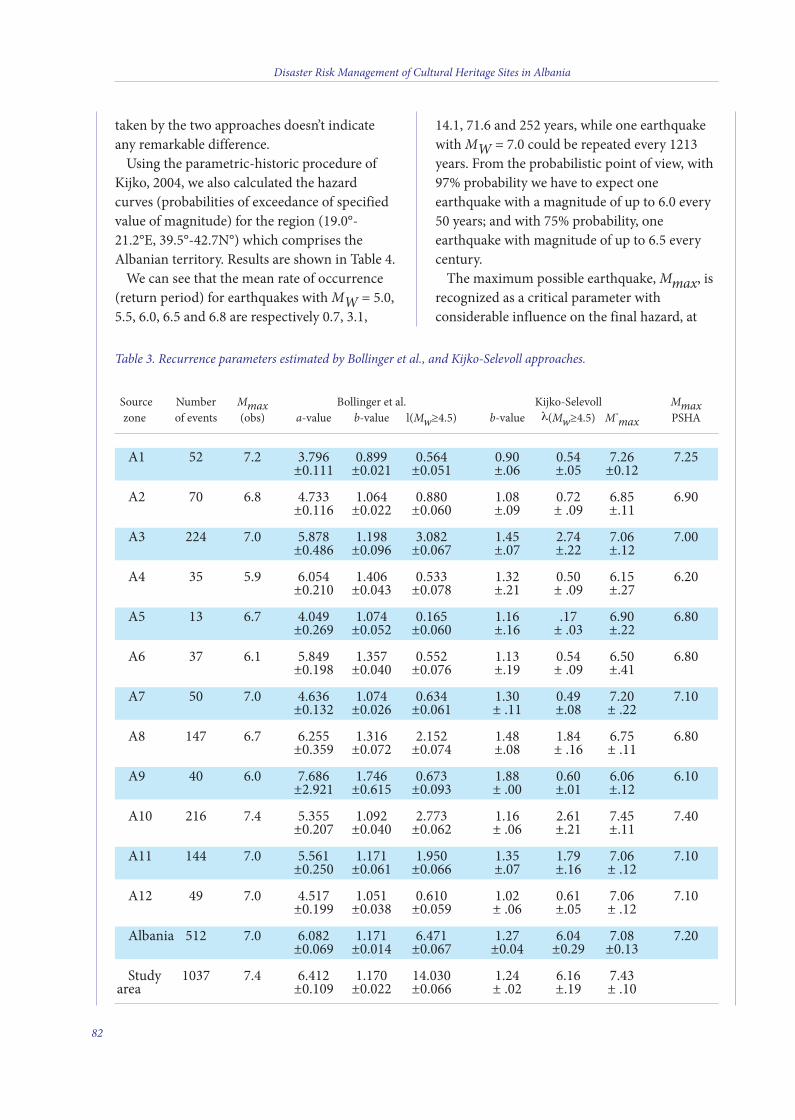
Source Number Mmax Bollinger et al. Kijko-Selevoll Mmaxzone of events (obs) a-value b-value l(Mw≥4.5) b-value l(Mw≥4.5) M*
max PSHA
A1 52 7.2 3.796 0.899 0.564 0.90 0.54 7.26 7.25 ±0.111 ±0.021 ±0.051 ±.06 ±.05 ±0.12
A2 70 6.8 4.733 1.064 0.880 1.08 0.72 6.85 6.90 ±0.116 ±0.022 ±0.060 ±.09 ± .09 ±.11
A3 224 7.0 5.878 1.198 3.082 1.45 2.74 7.06 7.00 ±0.486 ±0.096 ±0.067 ±.07 ±.22 ±.12
A4 35 5.9 6.054 1.406 0.533 1.32 0.50 6.15 6.20 ±0.210 ±0.043 ±0.078 ±.21 ± .09 ±.27
A5 13 6.7 4.049 1.074 0.165 1.16 .17 6.90 6.80 ±0.269 ±0.052 ±0.060 ±.16 ± .03 ±.22
A6 37 6.1 5.849 1.357 0.552 1.13 0.54 6.50 6.80 ±0.198 ±0.040 ±0.076 ±.19 ± .09 ±.41
A7 50 7.0 4.636 1.074 0.634 1.30 0.49 7.20 7.10 ±0.132 ±0.026 ±0.061 ± .11 ±.08 ± .22
A8 147 6.7 6.255 1.316 2.152 1.48 1.84 6.75 6.80 ±0.359 ±0.072 ±0.074 ±.08 ± .16 ± .11
A9 40 6.0 7.686 1.746 0.673 1.88 0.60 6.06 6.10 ±2.921 ±0.615 ±0.093 ± .00 ±.01 ±.12
A10 216 7.4 5.355 1.092 2.773 1.16 2.61 7.45 7.40 ±0.207 ±0.040 ±0.062 ± .06 ±.21 ±.11
A11 144 7.0 5.561 1.171 1.950 1.35 1.79 7.06 7.10 ±0.250 ±0.061 ±0.066 ±.07 ±.16 ± .12
A12 49 7.0 4.517 1.051 0.610 1.02 0.61 7.06 7.10 ±0.199 ±0.038 ±0.059 ± .06 ±.05 ± .12
Albania 512 7.0 6.082 1.171 6.471 1.27 6.04 7.08 7.20 ±0.069 ±0.014 ±0.067 ±0.04 ±0.29 ±0.13
Study 1037 7.4 6.412 1.170 14.030 1.24 6.16 7.43area ±0.109 ±0.022 ±0.066 ± .02 ±.19 ± .10
taken by the two approaches doesn’t indicateany remarkable difference.
Using the parametric-historic procedure ofKijko, 2004, we also calculated the hazardcurves (probabilities of exceedance of specifiedvalue of magnitude) for the region (19.0°-21.2°E, 39.5°-42.7N°) which comprises theAlbanian territory. Results are shown in Table 4.
We can see that the mean rate of occurrence(return period) for earthquakes with MW = 5.0,5.5, 6.0, 6.5 and 6.8 are respectively 0.7, 3.1,
14.1, 71.6 and 252 years, while one earthquakewith MW = 7.0 could be repeated every 1213years. From the probabilistic point of view, with97% probability we have to expect oneearthquake with a magnitude of up to 6.0 every50 years; and with 75% probability, oneearthquake with magnitude of up to 6.5 everycentury.
The maximum possible earthquake, Mmax, isrecognized as a critical parameter withconsiderable influence on the final hazard, at
Disaster Risk Management of Cultural Heritage Sites in Albania
82
Table 3. Recurrence parameters estimated by Bollinger et al., and Kijko-Selevoll approaches.
5 v2_2015_Layout 1 12/04/15 21:16 Pagina 82
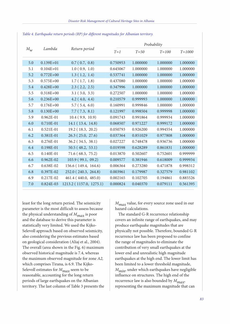
least for the long return period. The seismicityparameter is the most difficult to assess becausethe physical understanding of Mmax is poorand the database to derive this parameter isstatistically very limited. We used the Kijko-Selevoll approach based on observed seismicity,also considering the previous estimates basedon geological consideration (Aliaj et al., 2004).The overall (area shown in the Fig. 6) maximumobserved historical magnitude is 7.4, whereasthe maximum observed magnitude for zone A2,which comprises Tirana, is 6.9. The Kijko-Selevoll estimates for Mmax seem to bereasonable, accounting for the long returnperiods of large earthquakes on the Albanianterritory. The last column of Table 3 presents the
Mmax value, for every source zone used in ourhazard calculations.
The standard G-R recurrence relationshipcovers an infinite range of earthquakes, and mayproduce earthquake magnitudes that arephysically not possible. Therefore, bounded G-Rrecurrence law has been proposed to confinethe range of magnitudes to eliminate thecontribution of very small earthquakes at thelower end and unrealistic high magnitudeearthquakes at the high end. The lower limit hasbeen limited to a lower threshold magnitude,Mmin, under which earthquakes have negligibleinfluence on structures. The high end of therecurrence law is also bounded by Mmax,representing the maximum magnitude that can
Disaster Risk Management of Cultural Heritage Sites in Albania
83
Mw Lambda Return period Probability
T=1 T=50 T=100 T=1000
Table 4. Earthquake return periods (RP) for different magnitudes for Albanian territory.
5.0 0.139E+01 0.7 ( 0.7, 0.8) 0.750953 1.000000 1.000000 1.0000005.1 0.104E+01 1.0 ( 0.9, 1.0) 0.645067 1.000000 1.000000 1.0000005.2 0.772E+00 1.3 ( 1.2, 1.4) 0.537741 1.000000 1.000000 1.0000005.3 0.575E+00 1.7 ( 1.7, 1.8) 0.437080 1.000000 1.000000 1.0000005.4 0.428E+00 2.3 ( 2.2, 2.5) 0.347996 1.000000 1.000000 1.0000005.5 0.318E+00 3.1 ( 3.0, 3.3) 0.272507 1.000000 1.000000 1.0000005.6 0.236E+00 4.2 ( 4.0, 4.4) 0.210579 0.999993 1.000000 1.0000005.7 0.176E+00 5.7 ( 5.4, 6.0) 0.160991 0.999846 1.000000 1.0000005.8 0.130E+00 7.7 ( 7.3, 8.1) 0.121997 0.998504 0.999998 1.0000005.9 0.962E-01 10.4 ( 9.9, 10.9) 0.091743 0.991864 0.999934 1.0000006.0 0.710E-01 14.1 ( 13.4, 14.8) 0.068507 0.971227 0.999172 1.0000006.1 0.521E-01 19.2 ( 18.3, 20.2) 0.050793 0.926200 0.994554 1.0000006.2 0.381E-01 26.3 ( 25.0, 27.6) 0.037364 0.851029 0.977808 1.0000006.3 0.276E-01 36.2 ( 34.5, 38.1) 0.027227 0.748478 0.936736 1.0000006.4 0.198E-01 50.5 ( 48.2, 53.1) 0.019598 0.628289 0.861831 1.0000006.5 0.140E-01 71.6 ( 68.3, 75.2) 0.013870 0.502607 0.752601 0.9999996.6 0.962E-02 103.9 ( 99.1, 09.2) 0.009577 0.381946 0.618009 0.9999346.7 0.638E-02 156.6 ( 149.4, 164.6) 0.006364 0.273280 0.471878 0.9983126.8 0.397E-02 252.0 ( 240.3, 264.8) 0.003961 0.179987 0.327579 0.9811026.9 0.217E-02 461.4 ( 440.0, 485.0) 0.002165 0.102705 0.194861 0.8855267.0 0.824E-03 1213.2 ( 1157.0, 1275.1) 0.000824 0.040370 0.079111 0.561395
5 v2_2015_Layout 1 12/04/15 21:16 Pagina 83
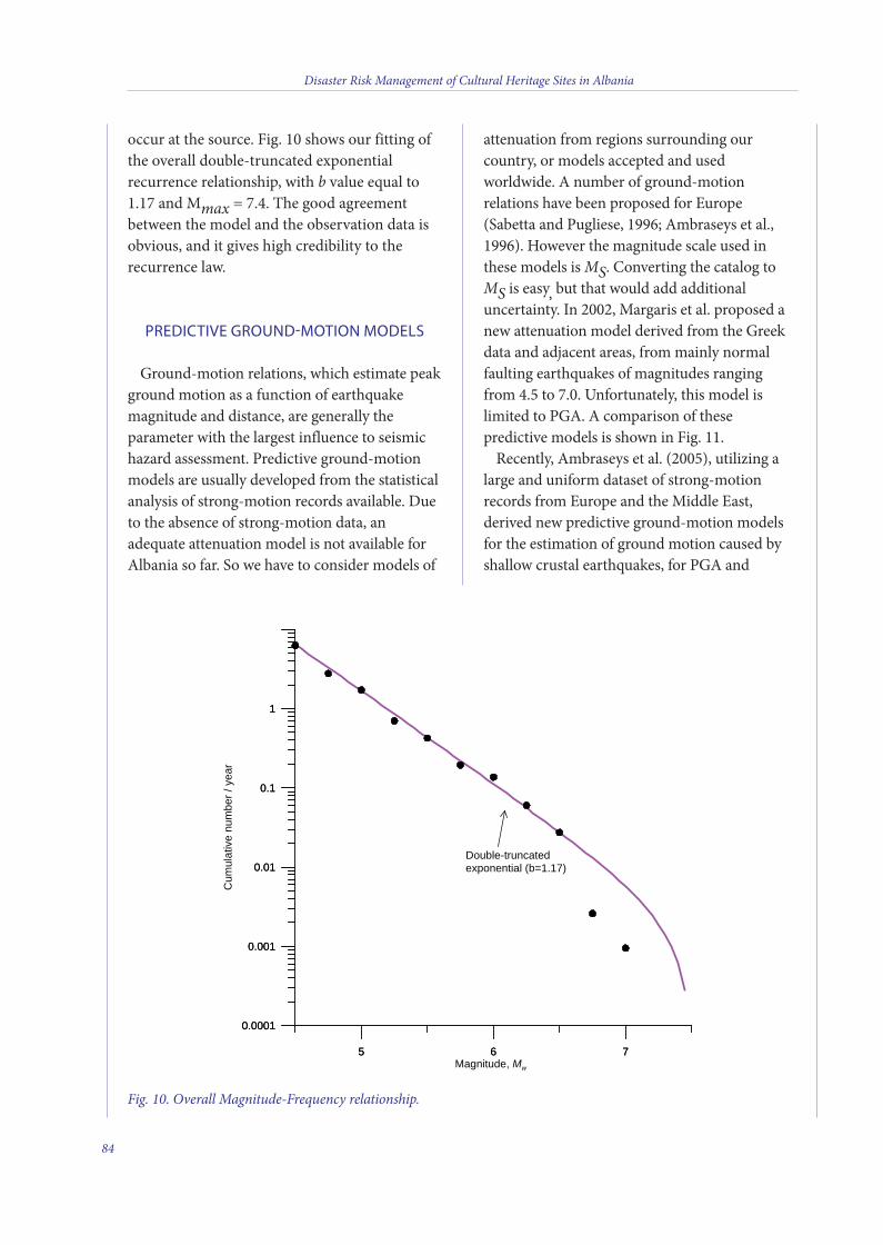
occur at the source. Fig. 10 shows our fitting ofthe overall double-truncated exponentialrecurrence relationship, with b value equal to1.17 and Mmax = 7.4. The good agreementbetween the model and the observation data isobvious, and it gives high credibility to therecurrence law.
PREDICTIVE GROUND-MOTION MODELS
Ground-motion relations, which estimate peakground motion as a function of earthquakemagnitude and distance, are generally theparameter with the largest influence to seismichazard assessment. Predictive ground-motionmodels are usually developed from the statisticalanalysis of strong-motion records available. Dueto the absence of strong-motion data, anadequate attenuation model is not available forAlbania so far. So we have to consider models of
attenuation from regions surrounding ourcountry, or models accepted and usedworldwide. A number of ground-motionrelations have been proposed for Europe(Sabetta and Pugliese, 1996; Ambraseys et al.,1996). However the magnitude scale used inthese models is MS. Converting the catalog toMS is easy, but that would add additionaluncertainty. In 2002, Margaris et al. proposed anew attenuation model derived from the Greekdata and adjacent areas, from mainly normalfaulting earthquakes of magnitudes rangingfrom 4.5 to 7.0. Unfortunately, this model islimited to PGA. A comparison of thesepredictive models is shown in Fig. 11.
Recently, Ambraseys et al. (2005), utilizing alarge and uniform dataset of strong-motionrecords from Europe and the Middle East,derived new predictive ground-motion modelsfor the estimation of ground motion caused byshallow crustal earthquakes, for PGA and
Disaster Risk Management of Cultural Heritage Sites in Albania
84
5 6 7
0.0001
0.001
0.01
0.1
1
5 6 7Magnitude, Mw
0.0001
0.001
0.01
0.1
1
Cum
ulat
ive
num
ber/
year
Double-truncatedexponential (b=1.17)
Fig. 10. Overall Magnitude-Frequency relationship.
5 v2_2015_Layout 1 12/04/15 21:16 Pagina 84
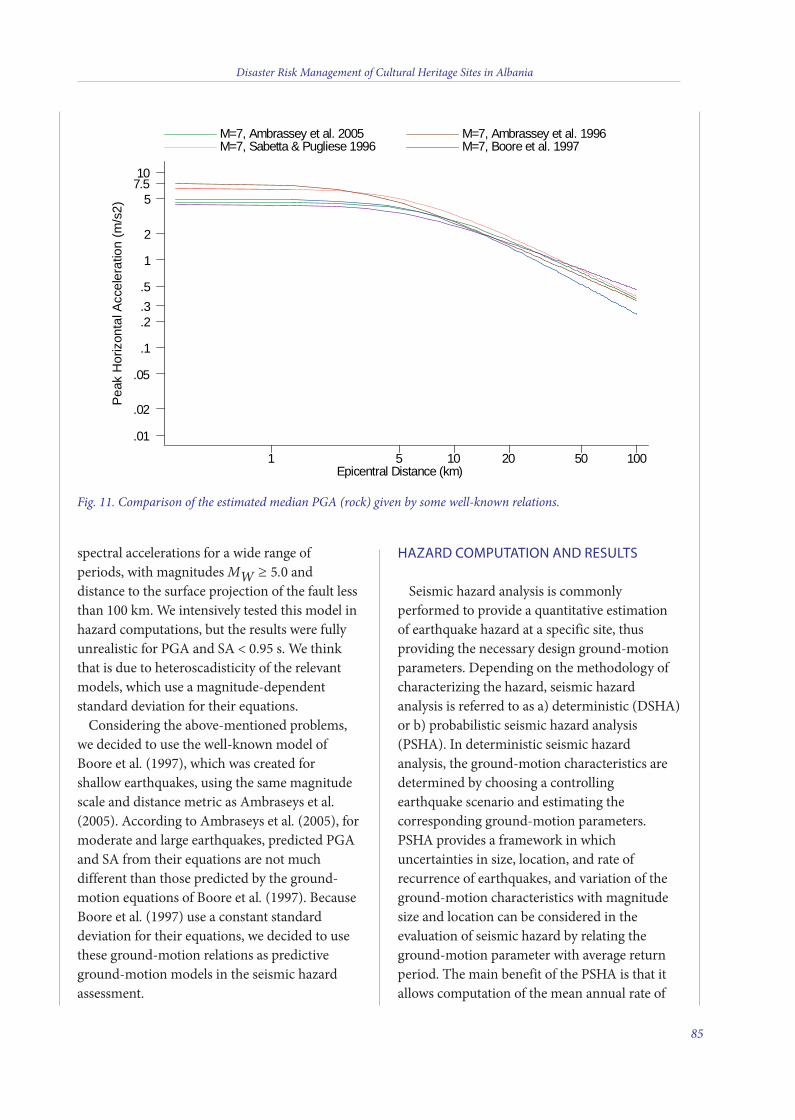
spectral accelerations for a wide range ofperiods, with magnitudes MW ≥ 5.0 anddistance to the surface projection of the fault lessthan 100 km. We intensively tested this model inhazard computations, but the results were fullyunrealistic for PGA and SA < 0.95 s. We thinkthat is due to heteroscadisticity of the relevantmodels, which use a magnitude-dependentstandard deviation for their equations.
Considering the above-mentioned problems,we decided to use the well-known model ofBoore et al. (1997), which was created forshallow earthquakes, using the same magnitudescale and distance metric as Ambraseys et al.(2005). According to Ambraseys et al. (2005), formoderate and large earthquakes, predicted PGAand SA from their equations are not muchdifferent than those predicted by the ground-motion equations of Boore et al. (1997). BecauseBoore et al. (1997) use a constant standarddeviation for their equations, we decided to usethese ground-motion relations as predictiveground-motion models in the seismic hazardassessment.
HAZARD COMPUTATION AND RESULTS
Seismic hazard analysis is commonlyperformed to provide a quantitative estimationof earthquake hazard at a specific site, thusproviding the necessary design ground-motionparameters. Depending on the methodology ofcharacterizing the hazard, seismic hazardanalysis is referred to as a) deterministic (DSHA)or b) probabilistic seismic hazard analysis(PSHA). In deterministic seismic hazardanalysis, the ground-motion characteristics aredetermined by choosing a controllingearthquake scenario and estimating thecorresponding ground-motion parameters.PSHA provides a framework in whichuncertainties in size, location, and rate ofrecurrence of earthquakes, and variation of theground-motion characteristics with magnitudesize and location can be considered in theevaluation of seismic hazard by relating theground-motion parameter with average returnperiod. The main benefit of the PSHA is that itallows computation of the mean annual rate of
Disaster Risk Management of Cultural Heritage Sites in Albania
85
Pea
k H
oriz
onta
l Acc
eler
atio
n (m
/s2)
Epicentral Distance (km)
M=7, Ambrassey et al. 2005 M=7, Ambrassey et al. 1996 M=7, Sabetta & Pugliese 1996 M=7, Boore et al. 1997
1 5 10 20 50 100
.01
.02
.05
.1
.2
.3
.5
1
2
57.510
Fig. 11. Comparison of the estimated median PGA (rock) given by some well-known relations.
5 v2_2015_Layout 1 12/04/15 21:16 Pagina 85
exceedance of a ground-motion parameter at aparticular site based on the aggregate risk frompotential earthquakes of many differentmagnitudes occurring at many different source-site distances.
Of various probabilistic methods in use, wechose the spatially smoothed seismicityapproach, developed by Frankel (1995) andwidely used in the USA today (Frankel et al.,2000, 2002; Petersen et al. 2008). The methodstill follows the basic approach established byCornell in 1968, but no delineation of seismicsources is needed. The observed area is dividedinto grid cells, and in each cell the activity rate(the number of earthquakes above the thresholdmagnitude) is calculated and then spatiallysmoothed with a Gaussian function. The annualrate of exceedance of the specified level for agiven ground-motion parameter and therelevant value corresponding to a given returnperiod are calculated. The adopted approachconsiders different alternatives aboutfundamental hypothesis on input parameters toaccount for and to propagate uncertainties in themodel within a logic-tree framework.
Probabilistic seismic hazard mapsThere is not, in fact, a single parameter which
adequately represents complete information ofseismic hazard. The most popular parameter ispeak ground acceleration (PGA), but it isgenerally associated with a short impulse of veryhigh frequency and, therefore, cannot be easilycorrelated to the damage observed. For thesereasons, spectral response accelerations (SA) fora range of periods with engineering interest haveto be considered as well. The SA 0.2 s isespecially important, because it corresponds tothe portion of the spectrum where local soilconditions are likely to enhance seismic motionand to the resonance frequency of two- to five-story buildings, which represent the largestcontributor to the building stock in Albania.
PSHA was performed for the entire Albanianterritory for return periods of 95, 475, 975, 2475and 5000 years, corresponding to probabilities of
exceedance of 10% in 10 years, and 10%, 5%, 2%and 1% respectively, in 50 years. PGA andspectral accelerations SA 10, 5, 3.3, 2, 1, and 0.5Hz have been targeted in our study.
The seismic hazard was calculated for a grid ofpoints with a spacing of 0.05 degrees in latitudeand longitude, for a total number of 9900computation nodes, which cover the entire area(18.0°-22.5°E, 38.0°-43.5°N). The accelerationvalues contoured are the maximum horizontalcomponent. The reference- site condition is firmrock, defined as having an average shear-wavevelocity of 760 m/sec in the top 30 meters,corresponding site class A of the Eurocode 8provisions.
The doubly-truncated exponential GRrecurrence relation is used, with lower-boundmagnitude MW = 4.5 for all zones, and upper-bound magnitude Mmax different for each zone,according to Table 3. The maximum distanceapplied in the computation is 100 km. As apredictive ground-motion model, we used thatof Boore et al. (1997).
Probabilistic seismic-hazard maps wereprepared for the Albanian territory portrayingPGA with probabilities of exceedance of 10% in10 years and 10% in 50 years. Aside from thesePSHA maps, site-specific PSHA parameters(PGA and SA) for different return periods forBerat, Gjirokastrër, Butrint, Apollonia andDurrësi have also been performed.
The seismic-hazard assessments results (Figs.12 and 13) indicate that very few areas can beconsidered as moderate hazard zones (PGA <0.24 g) according to the GSHAP projectclassification. Acceleration ranges fromapproximately 0.25 g in the entire territory, up to0.33 g in the southwestern part (Himara) of thecountry, with a 10% probability of exceedance in50 years. The lowest hazard is observed innorthern Albania, where values less than 0.20 areexpected. The northwestern part of the country(Shkodra), Tirana-Durres belt, Lushnja-Elbasan-Dibra area, and Pogradec-Korça area also reveala high hazard, with PGA greater than 0.27 g.
A comparison with PSHA in neighboring
Disaster Risk Management of Cultural Heritage Sites in Albania
86
5 v2_2015_Layout 1 12/04/15 21:16 Pagina 86
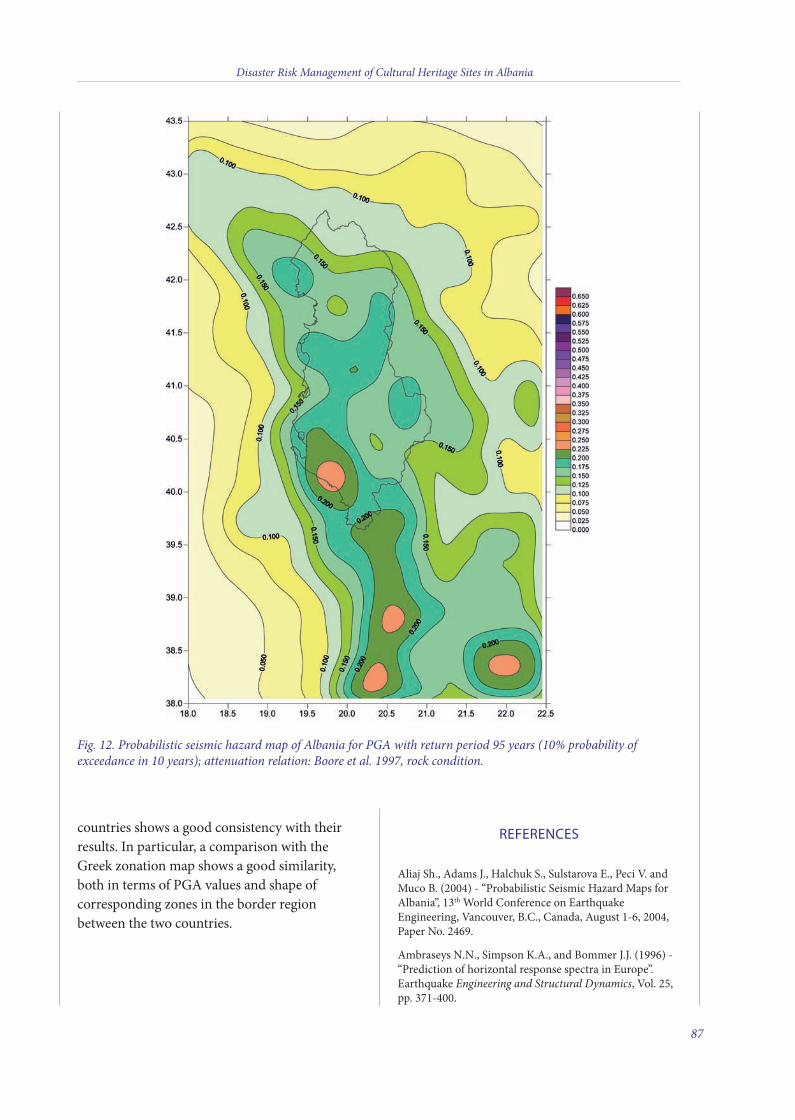
countries shows a good consistency with theirresults. In particular, a comparison with theGreek zonation map shows a good similarity,both in terms of PGA values and shape ofcorresponding zones in the border regionbetween the two countries.
REFERENCES
Aliaj Sh., Adams J., Halchuk S., Sulstarova E., Peci V. andMuco B. (2004) - “Probabilistic Seismic Hazard Maps forAlbania”, 13th World Conference on EarthquakeEngineering, Vancouver, B.C., Canada, August 1-6, 2004,Paper No. 2469.
Ambraseys N.N., Simpson K.A., and Bommer J.J. (1996) -“Prediction of horizontal response spectra in Europe”.Earthquake Engineering and Structural Dynamics, Vol. 25,pp. 371-400.
Disaster Risk Management of Cultural Heritage Sites in Albania
87
Fig. 12. Probabilistic seismic hazard map of Albania for PGA with return period 95 years (10% probability ofexceedance in 10 years); attenuation relation: Boore et al. 1997, rock condition.
5 v2_2015_Layout 1 12/04/15 21:16 Pagina 87
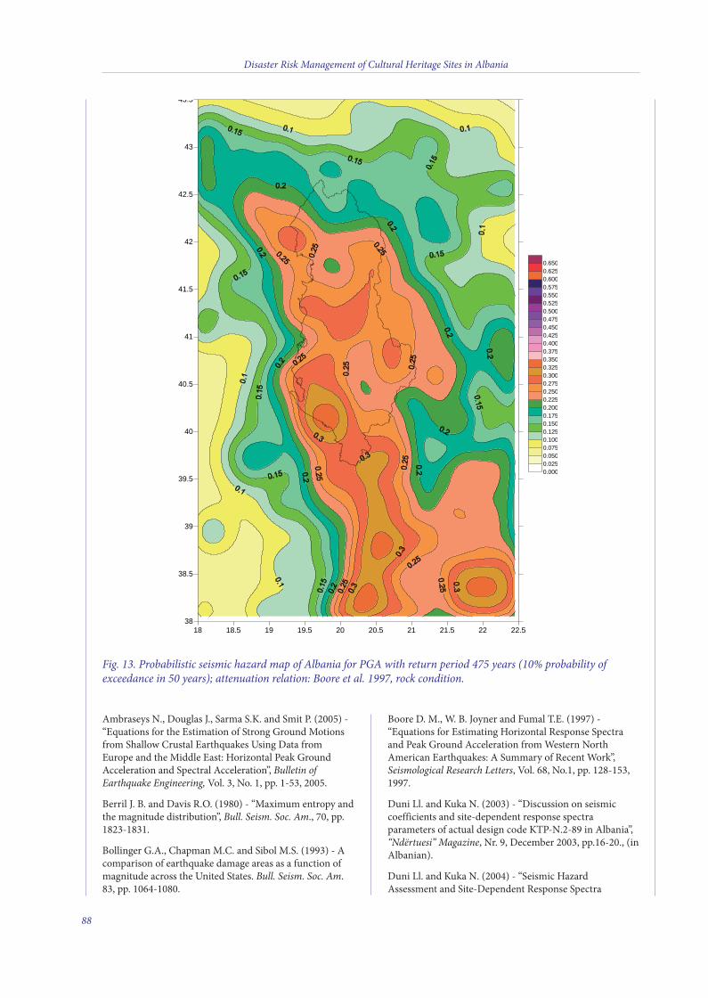
Ambraseys N., Douglas J., Sarma S.K. and Smit P. (2005) -“Equations for the Estimation of Strong Ground Motionsfrom Shallow Crustal Earthquakes Using Data fromEurope and the Middle East: Horizontal Peak GroundAcceleration and Spectral Acceleration”, Bulletin ofEarthquake Engineering, Vol. 3, No. 1, pp. 1-53, 2005.
Berril J. B. and Davis R.O. (1980) - “Maximum entropy andthe magnitude distribution”, Bull. Seism. Soc. Am., 70, pp.1823-1831.
Bollinger G.A., Chapman M.C. and Sibol M.S. (1993) - Acomparison of earthquake damage areas as a function ofmagnitude across the United States. Bull. Seism. Soc. Am.83, pp. 1064-1080.
Boore D. M., W. B. Joyner and Fumal T.E. (1997) -“Equations for Estimating Horizontal Response Spectraand Peak Ground Acceleration from Western NorthAmerican Earthquakes: A Summary of Recent Work”,Seismological Research Letters, Vol. 68, No.1, pp. 128-153,1997.
Duni Ll. and Kuka N. (2003) - “Discussion on seismiccoefficients and site-dependent response spectraparameters of actual design code KTP-N.2-89 in Albania”,“Ndërtuesi” Magazine, Nr. 9, December 2003, pp.16-20., (inAlbanian).
Duni Ll. and Kuka N. (2004) - “Seismic HazardAssessment and Site-Dependent Response Spectra
Disaster Risk Management of Cultural Heritage Sites in Albania
88
18 18.5 19 19.5 20 20.5 21 21.5 22 22.538
38.5
39
39.5
40
40.5
41
41.5
42
42.5
43
43.5
0.0000.0250.0500.0750.1000.1250.1500.1750.2000.2250.2500.2750.3000.3250.3500.3750.4000.4250.4500.4750.5000.5250.5500.5750.6000.6250.650
Fig. 13. Probabilistic seismic hazard map of Albania for PGA with return period 475 years (10% probability ofexceedance in 50 years); attenuation relation: Boore et al. 1997, rock condition.
5 v2_2015_Layout 1 12/04/15 21:16 Pagina 88
Parameters of the Current Seismic Design Code inAlbania”, Acta Geodaetica et Geophysica Hungarica,Budapest, Vol. 39, No. 2-3, pp. 161-176, 2004.
Eurocode 8 (2003) - “Design of structures for earthquakeresistance; Part 1: General rules, seismic actions and rulesfor buildings”, Draft No. 6; Version for translation (Stage49), Doc CEN/TC250/SC8/N335”, European Committeefor Standardization.
Frankel A.D. (1995) - “Mapping seismic hazard in theCentral and Eastern United States”, Seismological ResearchLetters, V. 66, No. 4, p. 8-21.
Frankel A.D., C.S. Mueller, T.P. Barnhard, E.V.Leyendecker R.L. Wesson S.C. Harmsen F.W. Klein D.M.Perkins N.C. Dickman S.L. Hanson and M.G. Hopper(2000) - “USGS National Seismic Hazard Maps,Earthquake Spectra”, Professional Journal of the EarthquakeEngineering Research Institute, Vol. 16, No. 1, February2000.
Frankel A.D., M.D. Petersen C.S., Mueller K.M., HallerR.L., Wheeler E.V., Leyendecker R.L., Wesson S.C.,Harmsen C.H., Cramer D.M., Perkins and K.S. Rukstales(2002) - “Documentation for the 2002 update of thenational seismic hazard maps”, USGS Open-File Report02-420.
Fundo A. Duni Ll., Kuka Sh, Begu E. and Kuka N. (2012) –Probabilistic seismic hazard assessment of Albania. ActaGeodaetica et Geophysica Hungarica, 47, (4), 465-479.
Gasperini P. and Ferrari G. (2000) - “Deriving numericalestimates from descriptive information: the computation ofearthquake parameters”, in Catalogue of Strong ItalianEarthquakes from 461 B.C. to 1997, Annali di Geofisica,Vol. 43, N.4, 729-746, August 2000.
Guidoboni E. (1994) - “Catalogue of ancient earthquakesin the Mediterranean area up to the 10th century”,Published by INGV, Rome, Italy, 504 p.
Hagiwara T. (1964) - “Brief description of the projectproposed by the Earthquake Prediction” Research Groupof Japan. Proc. U.S.-Japan Conf. Res. Relat EarthquakePrediction Probl., 10-12.
Kijko A. and Sellevoll M.A. (1989) - “Estimation ofearthquake hazard parameters from incomplete data files.Part I: Utilization of extreme and complete catalogs withdifferent threshold magnitude”. Bull. Seism. Soc. Am., Vol.79, No.3, pp. 645-654.
Kijko A. (2004) - “Estimation of the Maximum EarthquakeMagnitude, mmax”. Pure and Applied Geophysics, V. 161, 1-27.
Kuka N., Sulstarova E., Duni Ll. and Aliaj A. (2003) -“Seismic Hazard Assessment of Albania by SpatiallySmoothed Seismicity Approach”, International Conferenceon Earthquake Engineering, Ohrid, FYROM, 26-29August, 2003.
Lee W.H.K. and Stewart S.W. (1981) - “Principles andApplications of Microearthquake Networks”, in Academic
Press Inc., 1-266.
Leyendecker E.V., Frankel A.D. and Harmsen S.C. (2002) -“Earthquake Ground Motion for Use in Design in theUnited States”, USGS, 2002, 19 p.
Margaris B., Papazachos C., Papaioannou Ch., TheodulidisN., Kalogeras and Skarlatoudis A. (2002) - “Groundmotion attenuation relations for shallow earthquakes inGreece”, Proceedings of 12th ECEE, Publ. by ElsevierScience Ltd., pp.10.
Macropoulos K. and Burton P.W. (1981) - “A Catalogue ofseismicity in Greece and adjacent areas”, Geophys. J.R. Astr.Soc., 65, 741-762.
Mihajlovic D. (1951) - “Catalogue des tremblements deterre Epiro-Albanais”. Travaux de l’Academie de SciencesSerbe, Beograd.
Muço B., Vaccari F. and Panza G. (2001) - “SeismicZonation of Albania Using Deterministic Approach”,AJNTS, Journal of Academy of Sciences of Albania, 2001(1), pp. 5-19.
Muço B., Kiratzi A., Aliaj Sh., Sulstarova E., Kociu S. andPeçi V. (2002) - “Seismic hazard assessment of Albaniausing probabilistic approach”, in Book of Abstracts, Univ.of Genoa, Italy, 28th General Ass. of ESC, September 1-6,2002.
Papazachos B.C. (1988) - “Active Tectonics in Aegean andSurrounding Area”. In: Seismic Hazard in MediterraneanRegions. J. Bonnin et al. (Eds.), 301-331.
Papazachos B. and Papazachou C. (1989) - “On GreekEarthquakes”, Thessaloniki, Greece, 1-355.
Papazachos B.C., Comninakis P.E., Karakaisis G.F.,Karakostas B.G., Papaioannou Ch.A., Papazachos C.B. andScordilis E.M. (2000) - “A catalogue of earthquakes inGreece and surrounding area for the period 550 B.C.-1999”, Publ. Geoph. Lab., Univ. of Thessaloniki, 1, 333 pp,2000.
Sabetta F. and Pugliese A. (1996) - “Estimation of responsespectra and simulation of nonstationary earthquakeground motions”, Bull. Seism. Soc. Am., Vol. 86 No. 2, pp.337-352, April 1996.
Scordilis E.M. (2006) - “Empirical global relationsconverting Ms and mb to moment magnitude”, Journal ofSeismology 10: 225-236.
Shebalin N.V., Karnik V. and Hadzievski D., (Eds.), (1974)“Balkan Region–Catalogue of Earthquakes”, UNESCOOffice, Skopje.
Sulstarova E. and Koçiaj S. (1975) - “The Catalogue ofAlbanian Earthquakes”, Publication of Seismological Centreof Academy of Sciences (in Albanian), Tirana, 225 p.
Sulstarova E., Koçiaj S. and Aliaj Sh. (1980) - “Seismiczoning of Albania”, “Mihal Duri” Printing-House, Tiranë,297 p.
Taymaz T., Yilmaz Y. and Dilek Y. (eds) (2007) - “The
Disaster Risk Management of Cultural Heritage Sites in Albania
89
5 v2_2015_Layout 1 12/04/15 21:16 Pagina 89
Geodynamics of the Aegean and Anatolia.” GeologicalSociety, London, Special Publications, 291, 1-16.
Various Authors (2004) - Geological Map of Albania (scale1:200.000). Tirana, Albania.
Weichert D.H. (1980). “Estimation of the earthquakerecurrence parameters for unequal observation periods fordifferent magnitudes.” Bull. Seism. Soc. Am, 70: pp. 1337-1346.
AUTHORS:
Llambro Duni
Head of Department of Seismology and Seismological
Engineering, Tirana, Albania
Gian Paolo Cavinato, Massimiliano Moscatelli
CNR-Institute of Environmental Geology and
Geoengineering, Area della Ricerca di Roma1, Rome, Italy
Disaster Risk Management of Cultural Heritage Sites in Albania
90
5 v2_2015_Layout 1 12/04/15 21:16 Pagina 90
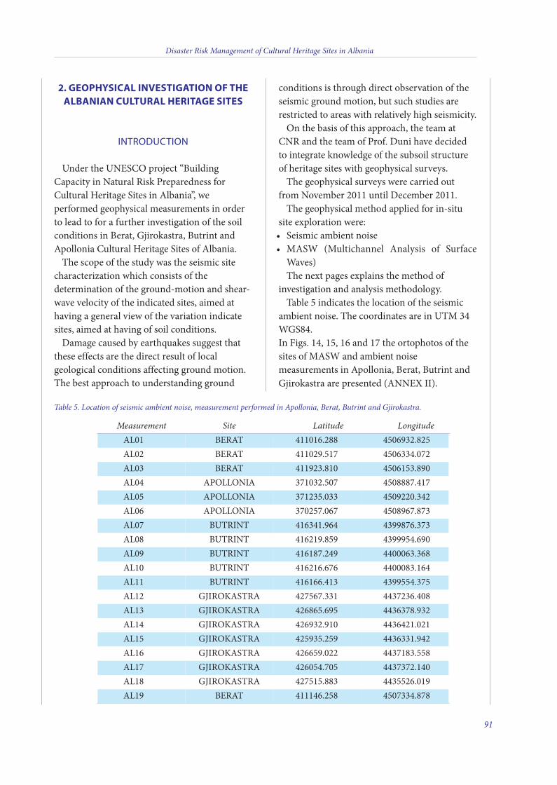
2. GEOPHYSICAL INVESTIGATION OF THEALBANIAN CULTURAL HERITAGE SITES
INTRODUCTION
Under the UNEsCo project “BuildingCapacity in Natural Risk Preparedness forCultural Heritage sites in Albania”, weperformed geophysical measurements in orderto lead to for a further investigation of the soilconditions in Berat, Gjirokastra, Butrint andApollonia Cultural Heritage sites of Albania.
The scope of the study was the seismic sitecharacterization which consists of thedetermination of the ground-motion and shear-wave velocity of the indicated sites, aimed athaving a general view of the variation indicatesites, aimed at having of soil conditions.
Damage caused by earthquakes suggest thatthese effects are the direct result of localgeological conditions affecting ground motion.The best approach to understanding ground
conditions is through direct observation of theseismic ground motion, but such studies arerestricted to areas with relatively high seismicity.
on the basis of this approach, the team atCNR and the team of Prof. Duni have decidedto integrate knowledge of the subsoil structureof heritage sites with geophysical surveys.
The geophysical surveys were carried outfrom November 2011 until December 2011.
The geophysical method applied for in-situsite exploration were:
seismic ambient noise •MAsW (Multichannel Analysis of surface•Waves) The next pages explains the method of
investigation and analysis methodology.Table 5 indicates the location of the seismic
ambient noise. The coordinates are in UTM 34WGs84.in Figs. 14, 15, 16 and 17 the ortophotos of thesites of MAsW and ambient noisemeasurements in Apollonia, Berat, Butrint andGjirokastra are presented (ANNEX ii).
Disaster Risk Management of Cultural Heritage Sites in Albania
91
Table 5. Location of seismic ambient noise, measurement performed in Apollonia, Berat, Butrint and Gjirokastra.
Measurement Site Latitude LongitudeAL01 BERAT 411016.288 4506932.825AL02 BERAT 411029.517 4506334.072AL03 BERAT 411923.810 4506153.890AL04 APoLLoNiA 371032.507 4508887.417AL05 APoLLoNiA 371235.033 4509220.342AL06 APoLLoNiA 370257.067 4508967.873AL07 BUTRiNT 416341.964 4399876.373AL08 BUTRiNT 416219.859 4399954.690AL09 BUTRiNT 416187.249 4400063.368AL10 BUTRiNT 416216.676 4400083.164AL11 BUTRiNT 416166.413 4399554.375AL12 GjiRokAsTRA 427567.331 4437236.408AL13 GjiRokAsTRA 426865.695 4436378.932AL14 GjiRokAsTRA 426932.910 4436421.021AL15 GjiRokAsTRA 425935.259 4436331.942AL16 GjiRokAsTRA 426659.022 4437183.558AL17 GjiRokAsTRA 426054.705 4437372.140AL18 GjiRokAsTRA 427515.883 4435526.019AL19 BERAT 411146.258 4507334.878
6 v2_2015_Layout 1 12/04/15 21:18 Pagina 91
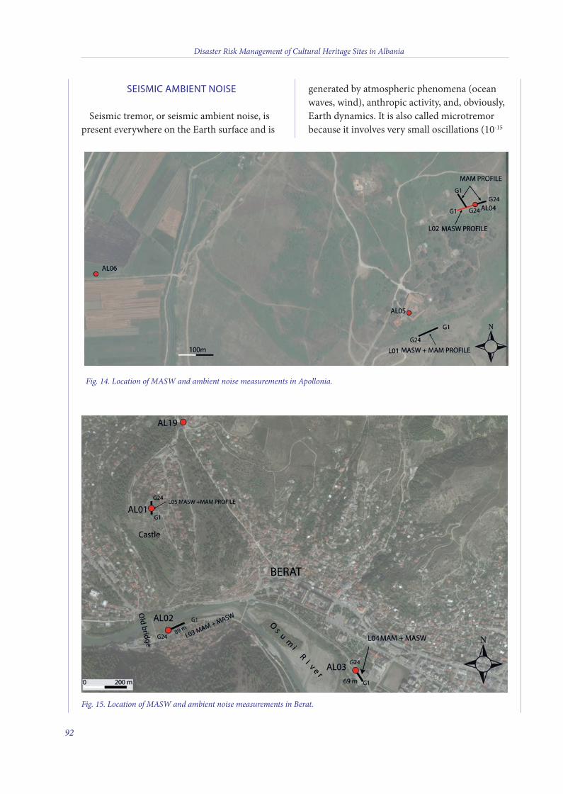
SEISMIC AMBIENT NOISE
seismic tremor, or seismic ambient noise, ispresent everywhere on the Earth surface and is
generated by atmospheric phenomena (oceanwaves, wind), anthropic activity, and, obviously,Earth dynamics. it is also called microtremorbecause it involves very small oscillations (10-15
Disaster Risk Management of Cultural Heritage Sites in Albania
92
Fig. 15. Location of MASW and ambient noise measurements in Berat.
Fig. 14. Location of MASW and ambient noise measurements in Apollonia.
6 v2_2015_Layout 1 12/04/15 21:18 Pagina 92
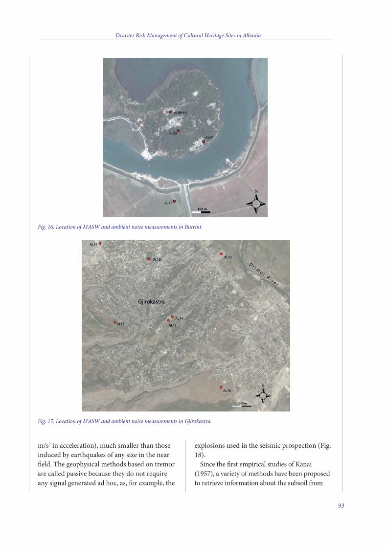
m/s2 in acceleration), much smaller than thoseinduced by earthquakes of any size in the nearfield. The geophysical methods based on tremorare called passive because they do not requireany signal generated ad hoc, as, for example, the
explosions used in the seismic prospection (Fig.18).
since the first empirical studies of kanai(1957), a variety of methods have been proposedto retrieve information about the subsoil from
Disaster Risk Management of Cultural Heritage Sites in Albania
93
Fig. 16. Location of MASW and ambient noise measurements in Butrint.
Fig. 17. Location of MASW and ambient noise measurements in Gjirokastra.
6 v2_2015_Layout 1 12/04/15 21:18 Pagina 93
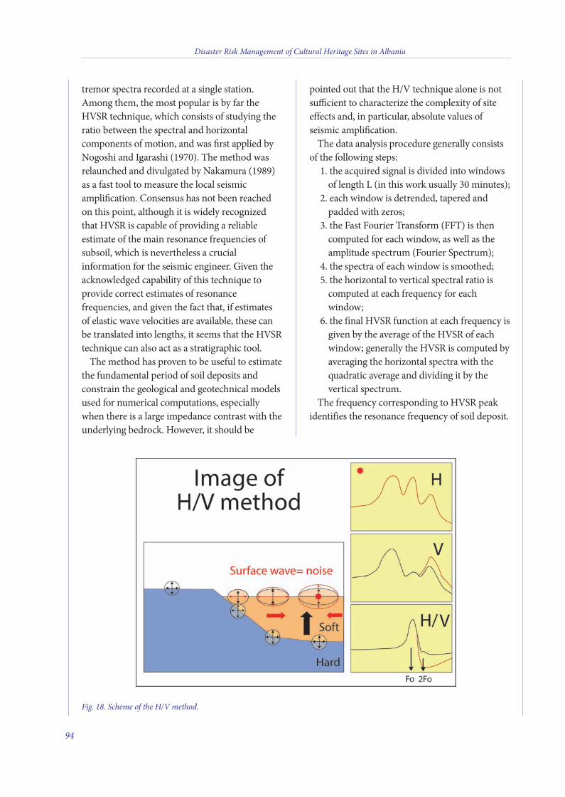
tremor spectra recorded at a single station.Among them, the most popular is by far theHVsR technique, which consists of studying theratio between the spectral and horizontalcomponents of motion, and was first applied byNogoshi and igarashi (1970). The method wasrelaunched and divulgated by Nakamura (1989)as a fast tool to measure the local seismicamplification. Consensus has not been reachedon this point, although it is widely recognizedthat HVsR is capable of providing a reliableestimate of the main resonance frequencies ofsubsoil, which is nevertheless a crucialinformation for the seismic engineer. Given theacknowledged capability of this technique toprovide correct estimates of resonancefrequencies, and given the fact that, if estimatesof elastic wave velocities are available, these canbe translated into lengths, it seems that the HVsRtechnique can also act as a stratigraphic tool.
The method has proven to be useful to estimatethe fundamental period of soil deposits andconstrain the geological and geotechnical modelsused for numerical computations, especiallywhen there is a large impedance contrast with theunderlying bedrock. However, it should be
pointed out that the H/V technique alone is notsufficient to characterize the complexity of siteeffects and, in particular, absolute values ofseismic amplification.
The data analysis procedure generally consistsof the following steps:
1. the acquired signal is divided into windowsof length L (in this work usually 30 minutes);
2. each window is detrended, tapered andpadded with zeros;
3. the Fast Fourier Transform (FFT) is thencomputed for each window, as well as theamplitude spectrum (Fourier spectrum);
4. the spectra of each window is smoothed;5. the horizontal to vertical spectral ratio is
computed at each frequency for eachwindow;
6. the final HVsR function at each frequency isgiven by the average of the HVsR of eachwindow; generally the HVsR is computed byaveraging the horizontal spectra with thequadratic average and dividing it by thevertical spectrum.
The frequency corresponding to HVsR peakidentifies the resonance frequency of soil deposit.
Disaster Risk Management of Cultural Heritage Sites in Albania
94
Fig. 18. Scheme of the H/V method.
6 v2_2015_Layout 1 12/04/15 21:18 Pagina 94
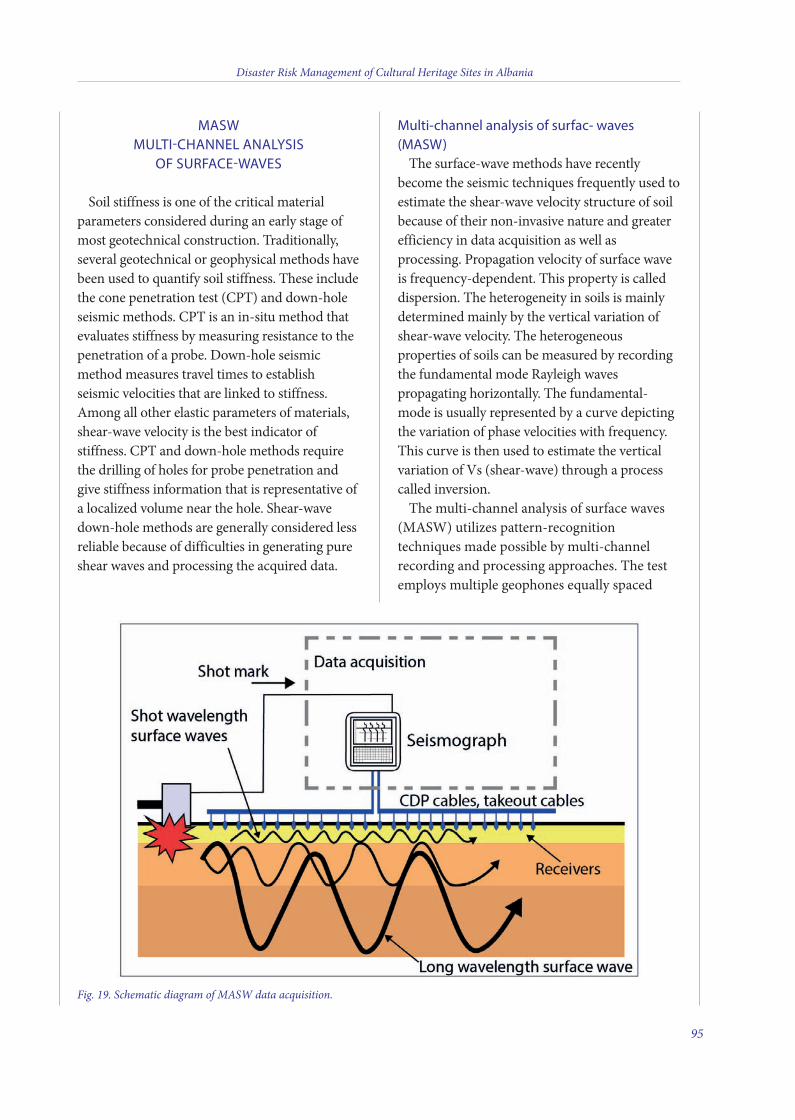
MASW MULTI-CHANNEL ANALYSIS
OF SURFACE-WAVES
soil stiffness is one of the critical materialparameters considered during an early stage ofmost geotechnical construction. Traditionally,several geotechnical or geophysical methods havebeen used to quantify soil stiffness. These includethe cone penetration test (CPT) and down-holeseismic methods. CPT is an in-situ method thatevaluates stiffness by measuring resistance to thepenetration of a probe. Down-hole seismicmethod measures travel times to establishseismic velocities that are linked to stiffness.Among all other elastic parameters of materials,shear-wave velocity is the best indicator ofstiffness. CPT and down-hole methods requirethe drilling of holes for probe penetration andgive stiffness information that is representative ofa localized volume near the hole. shear-wavedown-hole methods are generally considered lessreliable because of difficulties in generating pureshear waves and processing the acquired data.
Multi-channel analysis of surfac- waves(MASW)
The surface-wave methods have recentlybecome the seismic techniques frequently used toestimate the shear-wave velocity structure of soilbecause of their non-invasive nature and greaterefficiency in data acquisition as well asprocessing. Propagation velocity of surface waveis frequency-dependent. This property is calleddispersion. The heterogeneity in soils is mainlydetermined mainly by the vertical variation ofshear-wave velocity. The heterogeneousproperties of soils can be measured by recordingthe fundamental mode Rayleigh wavespropagating horizontally. The fundamental-mode is usually represented by a curve depictingthe variation of phase velocities with frequency.This curve is then used to estimate the verticalvariation of Vs (shear-wave) through a processcalled inversion.
The multi-channel analysis of surface waves(MAsW) utilizes pattern-recognitiontechniques made possible by multi-channelrecording and processing approaches. The testemploys multiple geophones equally spaced
Disaster Risk Management of Cultural Heritage Sites in Albania
95
Fig. 19. Schematic diagram of MASW data acquisition.
6 v2_2015_Layout 1 12/04/15 21:18 Pagina 95
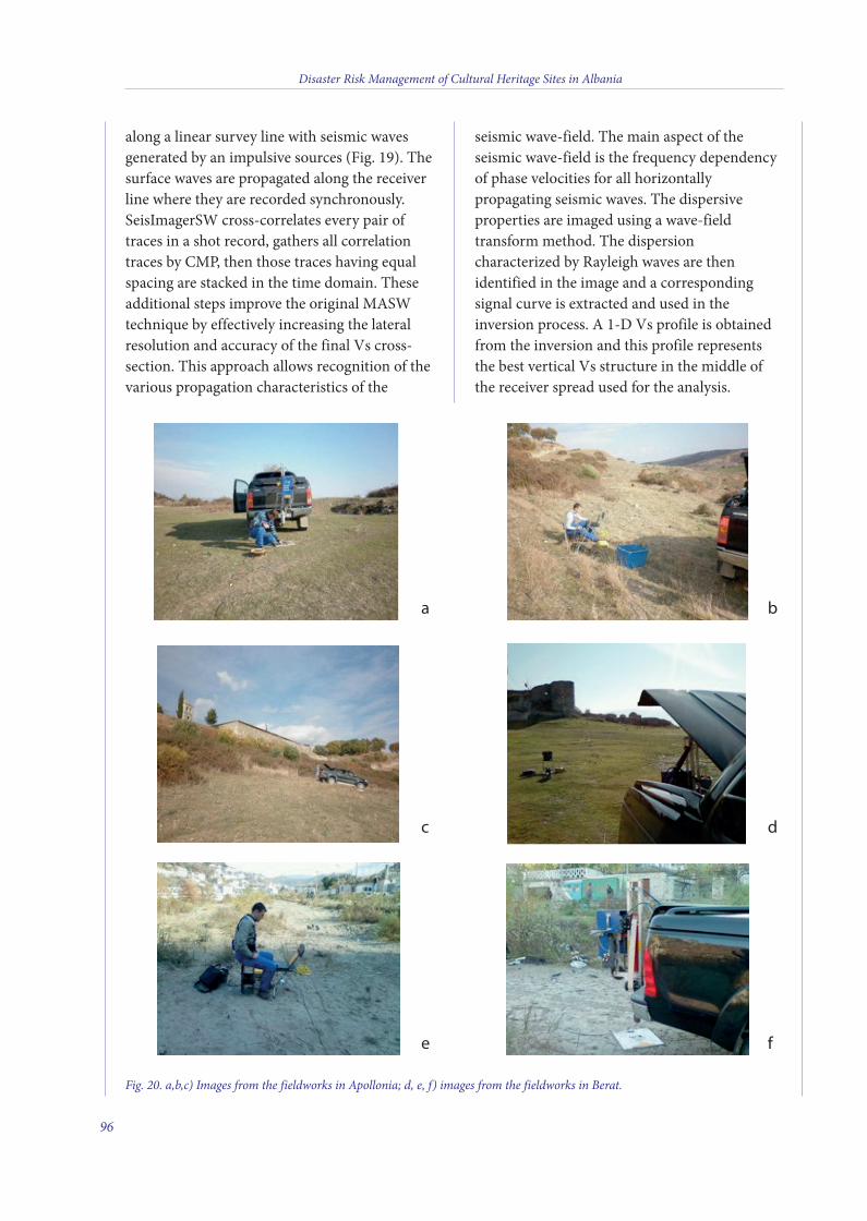
along a linear survey line with seismic wavesgenerated by an impulsive sources (Fig. 19). Thesurface waves are propagated along the receiverline where they are recorded synchronously.seisimagersW cross-correlates every pair oftraces in a shot record, gathers all correlationtraces by CMP, then those traces having equalspacing are stacked in the time domain. Theseadditional steps improve the original MAsWtechnique by effectively increasing the lateralresolution and accuracy of the final Vs cross-section. This approach allows recognition of thevarious propagation characteristics of the
seismic wave-field. The main aspect of theseismic wave-field is the frequency dependencyof phase velocities for all horizontallypropagating seismic waves. The dispersiveproperties are imaged using a wave-fieldtransform method. The dispersioncharacterized by Rayleigh waves are thenidentified in the image and a correspondingsignal curve is extracted and used in theinversion process. A 1-D Vs profile is obtainedfrom the inversion and this profile representsthe best vertical Vs structure in the middle ofthe receiver spread used for the analysis.
Disaster Risk Management of Cultural Heritage Sites in Albania
96
Fig. 20. a,b,c) Images from the fieldworks in Apollonia; d, e, f) images from the fieldworks in Berat.
a b
c d
e f
6 v2_2015_Layout 1 12/04/15 21:18 Pagina 96
in contrast to the “active source” the “passivesource” surveying, also called “microtremorarray measurement” or “MAM”, does notconsider time break and records the motion atvarious locations relative to the geophonespread that is obtained from ambient energygenerated by cultural noise, wind etc. Thefundamental assumption of microtremor dataanalysis using the spatial autocorrelation(sPAC) method of seisimagersW is that thesignal wavefront is planar, stable, and isotropic(coming from all directions) making itindependent of source locations.
in seisimagersW the results from “active” and“passive” source surveys can be combined tomaximize the resolution and overall depthrange of investigations.
The Fig. 20 are some pictures showing aspectsof the fieldwork.
REFERENCES
kanai k. (1957) - The requisite conditions forpredominant vibration of round. Bull. Earthquake Res. Inst.Tokyo Univ., Vol. 31, p. 457.
Nakamura Y. (1989) - A method for dynamiccharacteristics estimates of subsurface using microtremoron the round surface. QR of RTRI, Vol. 30, pp. 25-33.
Nogoshi M. and igarashi T. (1970) - on the propagationcharacteristics of microtremors. J. Seism. Soc. Japan, Vol.23, pp. 264-280.
AUTHORS:
Llambro Duni
Head of Department of Seismology and Seismological
Engineering, Tirana, Albania
Gian Paolo Cavinato, Massimiliano Moscatelli, Alessandro
Pagliaroli, Maurizio Simionato
CNR-Institute of Environmental Geology and
Geoengineering, Area della Ricerca di Roma1, Rome, Italy
Disaster Risk Management of Cultural Heritage Sites in Albania
97
6 v2_2015_Layout 1 12/04/15 21:18 Pagina 97
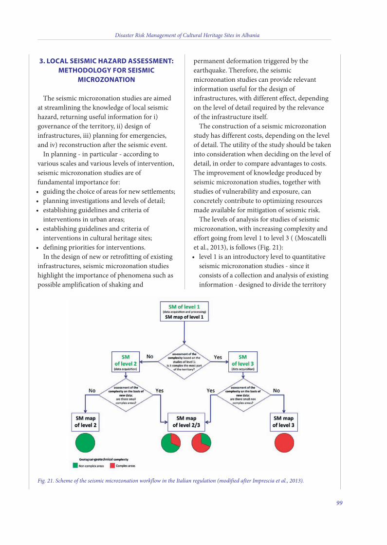
3. LOCAL SEISMIC HAZARD ASSESSMENT:METHODOLOGY FOR SEISMIC
MICROZONATION
The seismic microzonation studies are aimedat streamlining the knowledge of local seismichazard, returning useful information for i)governance of the territory, ii) design ofinfrastructures, iii) planning for emergencies,and iv) reconstruction after the seismic event.In planning - in particular - according to
various scales and various levels of intervention,seismic microzonation studies are offundamental importance for:guiding the choice of areas for new settlements;•planning investigations and levels of detail;•establishing guidelines and criteria of•interventions in urban areas;establishing guidelines and criteria of•interventions in cultural heritage sites;defining priorities for interventions.•In the design of new or retrofitting of existing
infrastructures, seismic microzonation studieshighlight the importance of phenomena such aspossible amplification of shaking and
permanent deformation triggered by theearthquake. Therefore, the seismicmicrozonation studies can provide relevantinformation useful for the design ofinfrastructures, with different effect, dependingon the level of detail required by the relevanceof the infrastructure itself.The construction of a seismic microzonation
study has different costs, depending on the levelof detail. The utility of the study should be takeninto consideration when deciding on the level ofdetail, in order to compare advantages to costs.The improvement of knowledge produced byseismic microzonation studies, together withstudies of vulnerability and exposure, canconcretely contribute to optimizing resourcesmade available for mitigation of seismic risk.The levels of analysis for studies of seismic
microzonation, with increasing complexity andeffort going from level 1 to level 3 ( (Moscatelliet al., 2013), is follows (Fig. 21):level 1 is an introductory level to quantitative•seismic microzonation studies - since itconsists of a collection and analysis of existinginformation - designed to divide the territory
Disaster Risk Management of Cultural Heritage Sites in Albania
99
Fig. 21. Scheme of the seismic microzonation workflow in the Italian regulation (modified after Imprescia et al., 2013).
7 v2_2015_Layout 1 25/03/15 15:56 Pagina 99
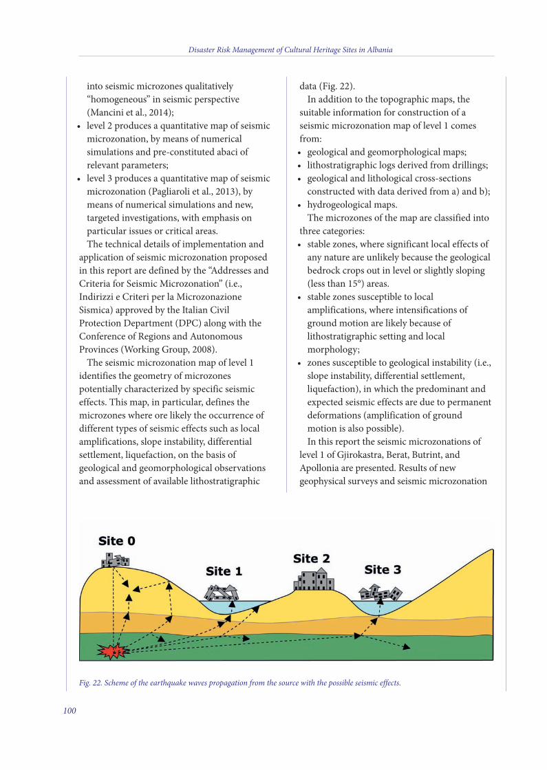
into seismic microzones qualitatively“homogeneous” in seismic perspective(Mancini et al., 2014);level 2 produces a quantitative map of seismic•microzonation, by means of numericalsimulations and pre-constituted abaci ofrelevant parameters;level 3 produces a quantitative map of seismic•microzonation (Pagliaroli et al., 2013), bymeans of numerical simulations and new,targeted investigations, with emphasis onparticular issues or critical areas.The technical details of implementation and
application of seismic microzonation proposedin this report are defined by the “Addresses andCriteria for Seismic Microzonation” (i.e.,Indirizzi e Criteri per la MicrozonazioneSismica) approved by the Italian CivilProtection Department (DPC) along with theConference of Regions and AutonomousProvinces (Working Group, 2008).The seismic microzonation map of level 1
identifies the geometry of microzonespotentially characterized by specific seismiceffects. This map, in particular, defines themicrozones where ore likely the occurrence ofdifferent types of seismic effects such as localamplifications, slope instability, differentialsettlement, liquefaction, on the basis ofgeological and geomorphological observationsand assessment of available lithostratigraphic
data (Fig. 22).In addition to the topographic maps, the
suitable information for construction of aseismic microzonation map of level 1 comesfrom:geological and geomorphological maps;•lithostratigraphic logs derived from drillings;•geological and lithological cross-sections•constructed with data derived from a) and b);hydrogeological maps.•The microzones of the map are classified into
three categories:stable zones, where significant local effects of•any nature are unlikely because the geologicalbedrock crops out in level or slightly sloping(less than 15°) areas. stable zones susceptible to local•amplifications, where intensifications ofground motion are likely because oflithostratigraphic setting and localmorphology;zones susceptible to geological instability (i.e.,•slope instability, differential settlement,liquefaction), in which the predominant andexpected seismic effects are due to permanentdeformations (amplification of groundmotion is also possible).In this report the seismic microzonations of
level 1 of Gjirokastra, Berat, Butrint, andApollonia are presented. Results of newgeophysical surveys and seismic microzonation
Disaster Risk Management of Cultural Heritage Sites in Albania
100
Fig. 22. Scheme of the earthquake waves propagation from the source with the possible seismic effects.
7 v2_2015_Layout 1 25/03/15 15:56 Pagina 100

maps of the study areas are available in theAnnexes.It is noteworthy that no subsoil information
from boreholes are available for any studied CHsite. Because lithostratigraphic data are essentialfor a proper evaluation of site-effects, theproposed seismic microzonation maps could beimproved when new subsurface information ismade available. For this reason, newprospection campaigns are suggested for eachcase study. The measurements comprise both the “active”
and “passive” methods, enabling thecharacterization of a deeper velocity structure ofmore than 30 m.
REFERENCES
Imprescia P., Coltella M., and Naso G. (2013) – Il percorsometodologico per gli studi di microzonazione sismica.Proceeding of the 32th GNGTS National Congress, 19-21November 2013, Trieste, 241-247.
Moscatelli M., Pagliaroli A., Cavinato G.P, Castanetto S.and Naso G. (2013) - Seismic microzonation of Palatinehill, Roman Forum and Coliseum Archaeological Area.Bull. Earthq. Eng. Special issue on “Seismic Microzonationof Palatine hill, Roman Forum and ColiseumArchaeological Area”. DOI 10.1007/s10518-013-9539-z.
Mancini M., Marini M., Moscatelli M., Pagliaroli A.,Cavinato G.P., Di Salvo C., Simionato M., Stigliano F. andCorazza A. (2014) - A physical stratigraphy model forseismic microzonation of the Central Archaeological Areaof Rome (Italy). Bull. Earthq. Eng. Special issue on“Seismic Microzonation of Palatine hill, Roman Forumand Coliseum Archaeological Area” DOI 10.1007/s10518-014-9584-2.
Pagliaroli A., Moscatelli M., Raspa G. and Naso G. (2013) -Seismic microzonation of the Central Archaeological Areaof Rome: results and uncertainties. Bull. Earthq. Eng.Special issue on “Seismic Microzonation of Palatine hill,Roman Forum and Coliseum Archaeological Area” (inpress). doi:10.1007/s10518-013-9480-1.
AUTHORS:
Gian Paolo Cavinato, Massimiliano Moscatelli,
Alessandro Pagliaroli, Maurizio Simionato
CNR-Institute of Environmental Geology and
Geoengineering, Area della Ricerca di Roma1, Rome, Italy
Disaster Risk Management of Cultural Heritage Sites in Albania
101
7 v2_2015_Layout 1 25/03/15 15:56 Pagina 101
4. SEISMIC MICROZONATION OFAPOLLONIA
GENERAL DATA OF THE SITE
Apollonia of Illyria is one of the mostimportant Greek colonies in the lands of Illyria(Prendi. et al., 1965). The city is calledApollonia in honour of Apollo, sun god andprotector of settlers. Based on written sourcesApollonia was founded at the beginning of thesix century B.C. (Amore, by colonists fromCorinth and Corcyra). According toarchaeological finds, the foundation of the citygoes back to the end of seventh century B.C.(Fouilles archéologiques, 1987; Koço, 1987;Dimo, 1992; Amore, 2010). Apollonia waslocated on the first hill, which rises from theMyzeqeja plain approximately 10 km from theAdriatic Sea (Fig. 23), very close to the distancegiven by Strabo, who wrote that Apollonia issixty stadia from the sea. Ten stadia from theCity of Apollonia in antiquity through Myzeqejaplain or Gylachion Pedion. The navigable AosRiver flowed very good connection to the sea.Strabo, says the foundation date of Apollonia588 B.C., Stephanus of Byzantium, called itApollonia of Illyria and said that the Corinthiansettlers founded the local Taulanti tribe andstabilized first an emporium. He adds that thenumber of colonists was 200, first led by thecolonizer Gylax (Prendi et al., 1965).The geographical position favours trading
with Greece, southern Italy and Illyrian citiestoo, Apollonia also developed as an importantartisan centre. The city became a very importanteconomical, political and cultural centre.Throughout history Apollonia is mentioned byancient authors as allies in different conflicts, onof them being the civil war in 48 B.C., when thecity opened its gates to Caesar. In 44 B.C. thefuture emperor Octavian and his friend Agrippaspent several months in Apollonia studyingrhetoric [(Prendi et al., 1965; Pausanias, (Cezari,37, 3), Cezari III, Valer Maksimi, (IX, 8, 2),
Plutarku, Antonius, 16, Apiani, HistoriaRomana, 16; Plutarku, Brutos, 22, 2)]. Octaviangave the city the status of “Civitas libera etimunis”, free of taxes. Apollonia alwaysremained a Greek culture city and used Greeklanguage as well. Cicero called Apollonia“magna urbs et gravis”, but this big andimportant cite like Cicero called it, in themiddle of the fourth and beginning of fifthcentury A.D. was abounded. A strongearthquake at 238 A.D. destroyed Apollonia,which was never rebuilt but declined and step-by-step was abounded. It seems that the AosRiver, a very important connection betweenApollonia and the sea, change its course afterthe earthquake, so the city lost its fluvial port,and with that lost commerce and importance,too (Fouache et al., 2001; Prendi, 1965). FromApollonia a lot of roads like Via Egnatia startedcrossing through Fier, Rroskovec, and also overthe ancient river Apsus at the present Kuçovatown, going northeast and crossing theScampinus River (Fig. 24).From this road Saint Paul arrived to the
Illyrian lands and with him Christian religion.So after the earthquake what remained ofApollonia was an Episcopal centre. Apollonia flourished during classic and
Hellenistic time, becoming a very big city, about120 hectare inside city wall, surrounded by a4.5-km long perimeter walls fortified with manytowers protecting the gates of the city (Blavatski,1958; Ceka, 1963; Dimo, 1984; Koço, 1988). The fortification wall is one of biggest
monuments in Apollonia (Fig. 25a). It was builtin different phases, starting from the archaicand classic periods, also in the Hellenistic andRoman period. The last intervention wasdocumented in Justinian times. However, in thisperiod, it was just religious centre (Ceka, 1982;Ceka, 2005).Built on the hill was needed and planning
very good organization. For that reason theyhad to build terracing walls into the city. Theterracing walls are a testimony of a lot of workremodelling the natural view. The urban plan is
Disaster Risk Management of Cultural Heritage Sites in Albania
103
7 v2_2015_Layout 1 25/03/15 15:56 Pagina 103
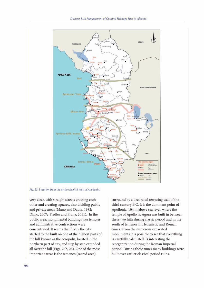
very clear, with straight streets crossing eachother and creating squares, also dividing publicand private areas (Mano and Dauta, 1982;Dimo, 2007; Fiedler and Franz, 2011). In thepublic area, monumental buildings like templesand administrative contractions wereconcentrated. It seems that firstly the citystarted to the built on one of the highest parts ofthe hill known as the acropolis, located in thenorthern part of city, and step by step extendedall over the hill (Figs. 25b, 26). One of the mostimportant areas is the temenos (sacred area),
surround by a decorated terracing wall of thethird century B.C. It is the dominant point ofApollonia, 104 m above sea level, where thetemple of Apollo is. Agora was built in betweenthese two hills during classic period and in thesouth of temenos in Hellenistic and Romantimes. From the numerous excavatedmonuments it is possible to see that everythingis carefully calculated. Is interesting thereorganization during the Roman Imperialperiod. During these times many buildings werebuilt over earlier classical period ruins.
Disaster Risk Management of Cultural Heritage Sites in Albania
104
Fig. 23. Location from the archaeological map of Apollonia.
7 v2_2015_Layout 1 25/03/15 15:56 Pagina 104
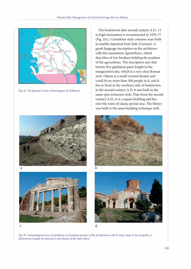
Fig. 25. Archaeological Area of Apollonia: a) Southeast portion of the fortification wall; b) relay ramp to the acropolis; c)Bouleterion temple; d) monastery and church of the Saint Mary.
The bouleterion date second century A.D., 11m high monument is reconstructed in 1976-77(Fig. 25c). Corinthian-style columns were builtin marble imported from Italy (Carrara). Agreek language inscription on the architravecalls this monument Agonothetas, whichdescribes of two brothers holding the positionof the agonothetas. The inscription says thattwenty-five gladiators pairs fought in theinauguration day, which is a very clear Romanstyle. Odeon is a small covered theatre andcould fit no more than 300 people in it, and itlies in front in the northern side of bouleterion,in the second century A.D. It was built in thesame opus testaceum style. Date from the secondcentury A.D., it is a square building and liesover the ruins of classic period stoa. The librarywas built in the same building technique with
Disaster Risk Management of Cultural Heritage Sites in Albania
105
Fig. 24. Via Egnatia (Carte Archeologique de l’Albanie).
7 v2_2015_Layout 1 25/03/15 15:56 Pagina 105
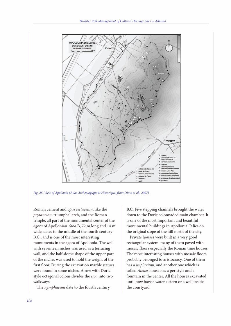
Roman cement and opus testaceum, like theprytaneion, triumphal arch, and the Romantemple, all part of the monumental center of theagora of Apollonian. Stoa B, 72 m long and 14 mwide, dates to the middle of the fourth centuryB.C., and is one of the most interestingmonuments in the agora of Apollonia. The wallwith seventeen niches was used as a terracingwall, and the half-dome shape of the upper partof the niches was used to hold the weight of thefirst floor. During the excavation marble statueswere found in some niches. A row with Doricstyle octagonal colons divides the stoa into twowalkways.The nymphaeum date to the fourth century
B.C. Five stepping channels brought the waterdown to the Doric colonnaded main chamber. Itis one of the most important and beautifulmonumental buildings in Apollonia. It lies onthe original slope of the hill north of the city.Private houses were built in a very good
rectangular system, many of them paved withmosaic floors especially the Roman time houses.The most interesting houses with mosaic floorsprobably belonged to aristocracy. One of themhas a impluvium, and another one which iscalled Atenes house has a peristyle and afountain in the center. All the houses excavateduntil now have a water cistern or a well insidethe courtyard.
Disaster Risk Management of Cultural Heritage Sites in Albania
106
Fig. 26. View of Apollonia (Atlas Archeologique et Historique, from Dimo et al., 2007).
7 v2_2015_Layout 1 25/03/15 15:56 Pagina 106
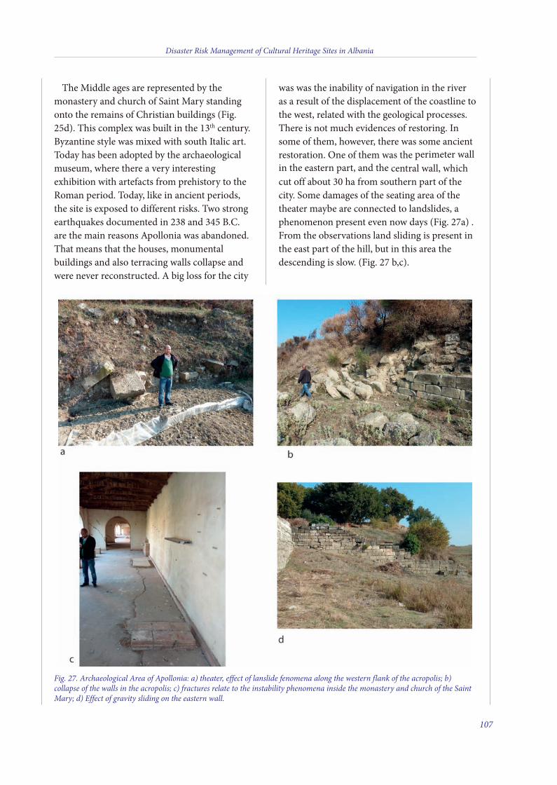
The Middle ages are represented by themonastery and church of Saint Mary standingonto the remains of Christian buildings (Fig.25d). This complex was built in the 13th century.Byzantine style was mixed with south Italic art.Today has been adopted by the archaeologicalmuseum, where there a very interestingexhibition with artefacts from prehistory to theRoman period. Today, like in ancient periods,the site is exposed to different risks. Two strongearthquakes documented in 238 and 345 B.C.are the main reasons Apollonia was abandoned.That means that the houses, monumentalbuildings and also terracing walls collapse andwere never reconstructed. A big loss for the city
was was the inability of navigation in the riveras a result of the displacement of the coastline tothe west, related with the geological processes.There is not much evidences of restoring. Insome of them, however, there was some ancientrestoration. One of them was the perimeter wallin the eastern part, and the central wall, whichcut off about 30 ha from southern part of thecity. Some damages of the seating area of thetheater maybe are connected to landslides, aphenomenon present even now days (Fig. 27a) .From the observations land sliding is present inthe east part of the hill, but in this area thedescending is slow. (Fig. 27 b,c).
Disaster Risk Management of Cultural Heritage Sites in Albania
107
Fig. 27. Archaeological Area of Apollonia: a) theater, effect of lanslide fenomena along the western flank of the acropolis; b)collapse of the walls in the acropolis; c) fractures relate to the instability phenomena inside the monastery and church of the SaintMary; d) Effect of gravity sliding on the eastern wall.
7 v2_2015_Layout 1 25/03/15 15:56 Pagina 107

GEOLOGICAL OVERVIEW OF APOLLONIA AREA
The study area extends over the archaeologicalsite of Apollonia, which is located on the last hillsthat flank the Albanian coastal plain, near thecity of Fier.From a regional perspective, Apollonia lays in
the molasse basin covering the external part ofthe Albanides thrust-fold belt (Velaj et al., 1999),a mountain range developed as a result ofsubduction of a branch of the Tethys ocean(Vardar ocean) and collision of the Apulianpromontory (African Plate) and the Balkans(Euroasian Plate). As such, Albanides represent asegment of the Dinar-Albanian-Hellenic Arch ofthe Alpine Orogen (Velaj et al., 1999), which can
be further subdivided in an internal zone ofocean crust-derived units, Internal Albanides,and an external sector representing the southwestpassive margin of the Vardar Ocean, ExternalAlbanides.Internal Albanides are represented by a pile of
thrust sheets incorporating Jurassic ophiolitesunconformably covered by Cretaceous shallow-water clastic and carbonate sediments (Collaku etal., 1990, 1992; Kodra et al., 1993a,b; Dorre andMalo, 2010), which are overthrusted toward thesouthwest onto the External Albanides.In turn, External Albanides constitute the
southwest passive margin of the Vardar ocean,which consisted of two platform domains, Sazaniand Kruja, separated by the Ionian basin hostingthe deposition of thick shelfal to basinal
Disaster Risk Management of Cultural Heritage Sites in Albania
108
Fig. 28. Geological map and cross-section of the Apollonia area. (from Dorre and Malo, 2010, modified).
7 v2_2015_Layout 1 25/03/15 15:56 Pagina 108
Mesozoic–Cenozoic sedimentary successions. Inthis paleogeographic setting, the Sarzani domainrepresents the autochthonous peripheral part ofthe Apulia platform, whilst the Ionian and Krujadomains constitute allochthonous unitsoverthrusted westwards onto the Apulianforeland. In External Albanides, tectonic deformation
occurred in a foreland-forward thrustingsequence with trends rotating from NNW-SSE toNW-SE along three main phases, the firstinvolving the Kruja domain (Eocene), the second(late Oligocene-Miocene) mainly involving theIonian basinal sediments, and the third(Pliocene) involving the Ionian and the Apulianplatform. In the latter phase the Apulian platformacted as a rigid buttress promoting out-ofsequence thrusting of more internal units (Roureet al., 1995).In terms of structural style, External Albanides
thrust-fold belt is constituted by two main supra-salt tectonic units (Ionian and Kruja units) madeof tick piles of Jurassic to Eocene shelf and slope-to-basin limestones, which are overthrusted overthe Apulian foreland (Sarzani domain) by meansof sole thrust located along Upper Triassicevaporites. In this structural edifice can berecognized both imbricate and duplex styleswhilst triplex style is more rarely observed.The molasse basin develops mainly in front of
the Kruja units and unconformably covers theIonian structures. In the Apollonia area, inparticular, the hill hosting the archaeological siteis constituted by alternating marine clays, sands,and conglomerates Pliocene in age (Fig. 28), witha coarsening and shallowing-upward trendrecorded by the sedimentary succession. ThePliocene succession is deformed with a broadanticline associated with a reverse fault vergingtowards the west (Fig. 28).The Pliocene sedimentary units are in turn
unconformably covered by Quaternarycontinental deposits, that constitute the coastalplain located in front of the Apollonia ridge (Fig.28).
SEISMIC HAZARD OF APOLLONIA CULTURALHERITAGE SITE
In Fig. 29 there is a fragment of the map ofactive faults in Albania for the Apollonia area(Aliaj et al., 2004) with the main earthquakesthat have occurred in this area. The activestructural elements are represented on this mapby the type of deformation (normal fault,reverse fault, thrust and backthrust, strike-slip,flexure, evaporite diapir dome) and theirchronology of activity. They are distinguishedby colors.
Hazard curvesThe relationship between the ground-motion
level and its annual probability of occurrence isdescribed by a hazard curve. In Fig. 30 there arethe hazard curves we developed for PGA andresponse spectral accelerations for a suite ofperiods with engineering interest of Apolloniacultural heritage sites. Then, the annualfrequency of exceedances are plotted (dashedhorizontal lines), which correspond toprobabilities typically used for the design, like10% in 10 years (RP = 95 years), andrespectively 10% (RP = 475 years), 5% (RP =975 years), 2% (RP = 2475 years) and 1% (RP =5000 years) in 50 years.
Uniform Hazard Response Spectrum (UHRS)The decision to use response spectral values
was based on earthquake data obtained duringthe past 20-plus years showing that site-specificspectral values are more appropriate for designinput than the coefficients based on peakground acceleration used with standard spectralshapes. The differences are particularlypronounced in the short-period portion of theresponse spectra (Leyendecker et al., 2004).In this study we considered five hazard levels:
10% of exceedance probability in 10 years, and10%, 5%, 2% and 1%, respectively, in 50 years,corresponding to years = 95, years = 475, years= 975, years = 2475 and 5000 years-returnperiods, respectively. The maximum horizontal
Disaster Risk Management of Cultural Heritage Sites in Albania
109
7 v2_2015_Layout 1 25/03/15 15:56 Pagina 109
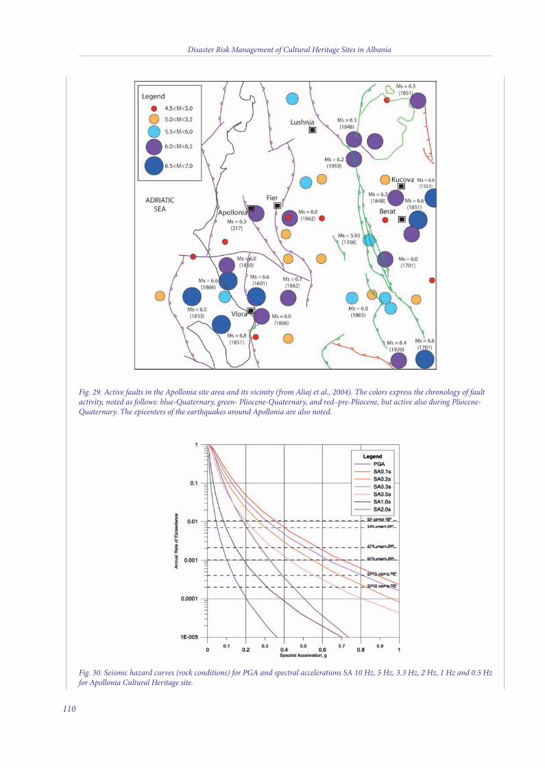
Disaster Risk Management of Cultural Heritage Sites in Albania
110
Fig. 30. Seismic hazard curves (rock conditions) for PGA and spectral accelerations SA 10 Hz, 5 Hz, 3.3 Hz, 2 Hz, 1 Hz and 0.5 Hzfor Apollonia Cultural Heritage site.
Fig. 29. Active faults in the Apollonia site area and its vicinity (from Aliaj et al., 2004). The colors express the chronology of faultactivity, noted as follows: blue-Quaternary, green- Pliocene-Quaternary, and red–pre-Pliocene, but active also during Pliocene-Quaternary. The epicenters of the earthquakes around Apollonia are also noted.
7 v2_2015_Layout 1 25/03/15 15:56 Pagina 110

bedrock PGA and spectral accelerations (SA)for each RP were obtained from PSHA and arelisted in Table 6. The uniform hazard spectra
(UHRS) for each RP for Apollonia culturalheritage sites are plotted in Fig. 31.
Disaster Risk Management of Cultural Heritage Sites in Albania
111
Table 6. Maximum horizontal bedrock PGA and SA for Apollonia Cultural Heritage site.
Period Spectral Acceleration, g
Sec RP=95y RP=475y RP=975y RP=2475y RP=5000y
PGA 0.182 0.274 0.320 0.389 0.442
0.10 0.261 0.439 0.537 0.688 0.812
0.20 0.347 0.569 0.693 0.875 1.031
0.30 0.306 0.506 0.624 0.794 0.949
0.50 0.197 0.337 0.420 0.550 0.667
1.00 0.081 0.146 0.185 0.248 0.309
2.00 0.044 0.078 0.100 0.134 0.165
Fig. 31. Uniform hazard spectra for 1%, 2%, 5% and 10% probability of exceedance in 50 years, and 10% probability ofexceedance in 10 years for Apollonia Cultural Heritage site.
7 v2_2015_Layout 1 25/03/15 15:56 Pagina 111
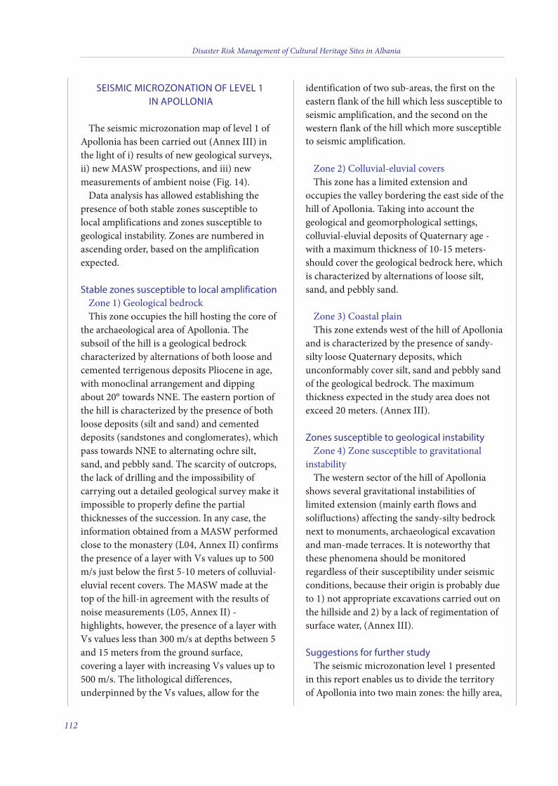
SEISMIC MICROZONATION OF LEVEL 1IN APOLLONIA
The seismic microzonation map of level 1 ofApollonia has been carried out (Annex III) inthe light of i) results of new geological surveys,ii) new MASW prospections, and iii) newmeasurements of ambient noise (Fig. 14).Data analysis has allowed establishing the
presence of both stable zones susceptible tolocal amplifications and zones susceptible togeological instability. Zones are numbered inascending order, based on the amplificationexpected.
Stable zones susceptible to local amplificationZone 1) Geological bedrockThis zone occupies the hill hosting the core of
the archaeological area of Apollonia. Thesubsoil of the hill is a geological bedrockcharacterized by alternations of both loose andcemented terrigenous deposits Pliocene in age,with monoclinal arrangement and dippingabout 20° towards NNE. The eastern portion ofthe hill is characterized by the presence of bothloose deposits (silt and sand) and cementeddeposits (sandstones and conglomerates), whichpass towards NNE to alternating ochre silt,sand, and pebbly sand. The scarcity of outcrops,the lack of drilling and the impossibility ofcarrying out a detailed geological survey make itimpossible to properly define the partialthicknesses of the succession. In any case, theinformation obtained from a MASW performedclose to the monastery (L04, Annex II) confirmsthe presence of a layer with Vs values up to 500m/s just below the first 5-10 meters of colluvial-eluvial recent covers. The MASW made at thetop of the hill-in agreement with the results ofnoise measurements (L05, Annex II) -highlights, however, the presence of a layer withVs values less than 300 m/s at depths between 5and 15 meters from the ground surface,covering a layer with increasing Vs values up to500 m/s. The lithological differences,underpinned by the Vs values, allow for the
identification of two sub-areas, the first on theeastern flank of the hill which less susceptible toseismic amplification, and the second on thewestern flank of the hill which more susceptibleto seismic amplification.
Zone 2) Colluvial-eluvial coversThis zone has a limited extension and
occupies the valley bordering the east side of thehill of Apollonia. Taking into account thegeological and geomorphological settings,colluvial-eluvial deposits of Quaternary age -with a maximum thickness of 10-15 meters-should cover the geological bedrock here, whichis characterized by alternations of loose silt,sand, and pebbly sand.
Zone 3) Coastal plainThis zone extends west of the hill of Apollonia
and is characterized by the presence of sandy-silty loose Quaternary deposits, whichunconformably cover silt, sand and pebbly sandof the geological bedrock. The maximumthickness expected in the study area does notexceed 20 meters. (Annex III).
Zones susceptible to geological instabilityZone 4) Zone susceptible to gravitational
instabilityThe western sector of the hill of Apollonia
shows several gravitational instabilities oflimited extension (mainly earth flows andsolifluctions) affecting the sandy-silty bedrocknext to monuments, archaeological excavationand man-made terraces. It is noteworthy thatthese phenomena should be monitoredregardless of their susceptibility under seismicconditions, because their origin is probably dueto 1) not appropriate excavations carried out onthe hillside and 2) by a lack of regimentation ofsurface water, (Annex III).
Suggestions for further studyThe seismic microzonation level 1 presented
in this report enables us to divide the territoryof Apollonia into two main zones: the hilly area,
Disaster Risk Management of Cultural Heritage Sites in Albania
112
7 v2_2015_Layout 1 25/03/15 15:56 Pagina 112
less susceptible to seismic amplification and thecoastal plain, more susceptible to seismicamplification, given the presence of very softQuaternary sediments. The main uncertaintiesrelated to the subdivision of this territory inzones with different susceptibility to seismicamplification are related to 1) not well-knowndistribution of lithotypes characterizing thegeological bedrock and 2) not well-knownthickness of the Quaternary cover in the lateralvalleys and coastal plains (Annex III). For thisreason is desirable that these uncertainties arereduced through i) a detailed geological-geotechnical survey of the archaeological areaand ii) the use of geophysical methods, whichprovide information on the thicknesses of therecent soft covers.
REFERENCES
Aliaj Sh. (1982) - General features of neotectonic structureof Albania. Earthquake risk reduction in the Balkanregion. Working Group A, A-15 to A-22. UNESCO,Athens.
Aliaj Sh., Adams J., Halchuk S., Sulstarova E., Peci V. andMuco B. (2004) - “Probabilistic Seismic Hazard Maps forAlbania”, 13th World Conference on EarthquakeEngineering, Vancouver, BC, Canada, August 1-6, 2004,Paper No. 2469.
Amore M.G. (2010) - The complex of Tumuli 9, 10 and 11in the Necropolis of Apollonia, BAR International Series2059 I, II.
BAÇE A. and Ceka N. (1981) - Shetitoret e periudhësqytetare. (Les stoas de la periode urbaine illyrienne),“Monumentet”, 2.
Blavatski V. and Islami, S. (1958) - Gërmimet në Apollonidhe Orik gjatë vitit 1958. (Fouilles a Apollonia et aOricum, travaux de 1958), “Buletin i Universitetit Shtetërortë Tiranës, Seria Shkencat Shoqërore” 1960, 1.
Carcaillet J., Mugnier J.L., Koçi R. and Jouanne F. (2009) -Uplift and active tectonics of southern Albania inferredfrom incision of alluvial terraces. Quaternary Research,71(3): 465-473.
Cavinato G.P., et al. (2010) - Assetto geologico eidrogeologico del Colle Palatino - Valutazione dellepericolosità geologiche. In. R. Cecchi (Ed.), Romaarchaeologia. Interventi per la tutela e la fruizione del
patrimonio archeologico; secondo rapporto. MondadoriElecta, Milano, 84-137.
Ceka H. (1960) - Muri rrethues i Apollonisë. (L’anciented’Apollonie /rempart d’Apollonie/), “Buletin i Universitetittë Tiranës, Seria Shkencat Shoqërore” 1963, 3.
Ceka H. (1969) - Fontana e Apollonisë. (La fontained’Apollonie), “Konfèrenca e Dytë e StudimeveAlbanologjike” vëll. II, Tiranë.
Ceka N. (2005) - “Apolonia e Ilirisë”. (“Apollonie d’Illyrie”),Tiranë, 1982. Ceka, N., Apollonia: Its history andmonuments, Tiranë.
Chroston P.N. and Hounslow M. (2005) - The geophysicalsurvey: the extent and structural layout of the suburbs ofButrint on the Vrina Plain. In Byzantine Butrint:Excavations and Surveys 1994-1999, Hodges R, Bowden W,Lako K (eds). Oxbow: Oxford.
Crowson A. and Gilkes O. (2007) - The archaeology of theVrina Plain: an assessment, in Hansen, Hodges, 2007a pp.119-164.
Davis J.L. (1996) - University of Cincinnati, Cincinnati,Ohio, United States of America. M.M. Korkuti, Institute ofArchaeology, Tirana, Albania Projekti Arkeologjik iRajonit Mallakastër, The Mallakastra RegionalArchaeological Project Internet Edition.
Dimo V. (1984) - Nouvelles fouilles aux muraillesd’Apollonia, dans Iliria XIV, 1, p. 199-213.
Dimo V. (1992) - Tuma VI dhe VII të Apollonisë, L. Koço1987: Fouilles archéologiques 1987. Apollonia, murd’enceinte, dans Iliria XVII, 2.
Dimo V., Lenhardt P. and Quantin F. (2007) - Apolloniad’Illyrie. 1, Atlas Archéologique et Historique. Collectionde l’Ecole Française de Rome 391, 362.
Dorre P. and Malo E. (2010) - Harta Gjeologjike e RajonitLevan Plansheti K-34-111-D-d (Levani)-Shkalla 1:25.000.Ministria e Ekonomisë, Tregtisë dhe Energjitikës, SherbimiGjeologjk Shqiptar, Albania.
Fiedler M. and Franz S. (2011)- Bulletino Dell’IstitutoArcheologico Germanico, Sezione Romana,
Fiedler M. and Franz S. (2011) - Bulletino Dell’IstitutoArcheologico Germanico, Sezione Romana.
Fouache É., Gruda G., Mucaj S. and Nikolli P. (2001) -Recent geomorphological evolution of the deltas of theSeman and the Vjosa (Albania), dans Earth SurfaceProcesses and Landforms XXVI-7.
Fouache É., Gruda G., Mucaj S. and Nikolli P. (1997) -L’évolution géomorphologique récente des deltas de laVjosë et du Seman: du rôle croissant de l’actionanthropique de l’Antiquité à nos jours, dans BCH CXXI.
Disaster Risk Management of Cultural Heritage Sites in Albania
113
7 v2_2015_Layout 1 25/03/15 15:56 Pagina 113
Fouache É., Gruda G., Mucaj S. and P. Nikolli (2001) -Recent geomorphological evolution of the deltas of theSeman and the Vjosa (Albania), dans Earth SurfaceProcesses and Landforms XXVI-7, F.Prendi, Ilirët dheIliria tek autorët antikë. Tiranë, Albania.
Fouache É., Gruda G., Mucaj, S. and Nikolli, P. (2001) -Recent geomorphological evolution of the delta of theSeman and the Vjosa (Albania). Earth Surface Processesand Landforms, 26, 793-802.
Fouache É., Vella C., Dimo L., Gruda G. and Mugnier J.L.,le Denèfle M., Monnier O., Hotyat M. and Huth H. (2010)- Shoreline reconstruction since the Middle Holocene inthe vicinity of the ancient city of Apollonia (Albania,Seman and and Vjosa deltas). Quaternary International,216: 118-128.
Fundo A. Duni Ll., Kuka Sh, Begu E. and Kuka N. (2012) -Probabilistic seismic hazard assessment of Albania. ActaGeodaetica et Geophysica Hungarica, 47, (4), 465-479.
Gilkes O. and Lako K. (2004) “Excavations at the TriconchPalace”, in Byzantine Butrint Excavations and Surveys1994-99, edd. R. Hodges, W. Bowden and K. Lako (Oxford,2004) 151-75.
Kavaja V., Nacuci I., Drini F., Reci H. and Vincani F. (1996)- Some result of geophysical prospecting in archaelogicalsites of Butrinti e Apollonia. First Congress of the BalkianGeogphysical Society, 62-63.
Koço L. (1987) - Fouilles archéologiques. Apollonia, laporte Sud, dans Iliria XVIII, 2, p. 256-257.
Mano A. and Dautaj B. Teatri i Apollonisë. (Le theatred’Apollonie), “Iliria” 1982, 1, F. Quantin, Ph. Lenhardt, V.Dimo APOLLONIA D’ILLYRIE, Atlas Archeologique etHistorique, Collection de L’Ecole Francaise de Rome-391,2007.
Mano A. and Dautaj B. (1982) - Teatri i Apollonisë. (Letheatre d’Apollonie), “Iliria”.Prendi F., Ceka H. and IslamiS. (1965) - dhe S. Anamali, Ilirët dhe Iliria tek autorëtantikë Les Illyriens et l’Illyrie ches les auteurs antiques,Tiranë.
Prendi F., Ceka H. and Islami S. (1965) - dhe S. Anamali,Ilirët dhe Iliria tek autorët antikë. Tiranë, Albania.Pausanias, (Cezari, 37,3),Cezari III, Valer Maksimi,(IX,8,2), Plutarku, Antonius, 16, Apiani, Historia Romana,16; Plutarku, Brutos, 22, 2.
Quantin F., Lenhardt Ph. and Dimo V. (2007) -APOLLONIA D’ILLYRIE, Atlas Archeologique etHistorique, Collection de L’Ecole Francaise de Rome-391.
Various Authors (2004) - Geological Map of Albania (scale1:200,000). Tirana, Albania.
AUTHORS:
Gian Paolo Cavinato, , Massimiliano Moscatelli,
Alessandro Pagliaroli, Maurizio Simionato
CNR-Institute of Environmental Geology and
Geoengineering, Area della Ricerca di Roma1, Rome, Italy
Admir Xhelaj
Responsable for the Museum and Archaeologist of
Apollonia Archaelogical National Park
Arjan Dimo
Archaeologist of Apollonia Archaelogical National Park
Llambro Duni
Head of Department of Seismology and Seismological
Engineering, Tirana, Albania.
Disaster Risk Management of Cultural Heritage Sites in Albania
114
7 v2_2015_Layout 1 25/03/15 15:56 Pagina 114
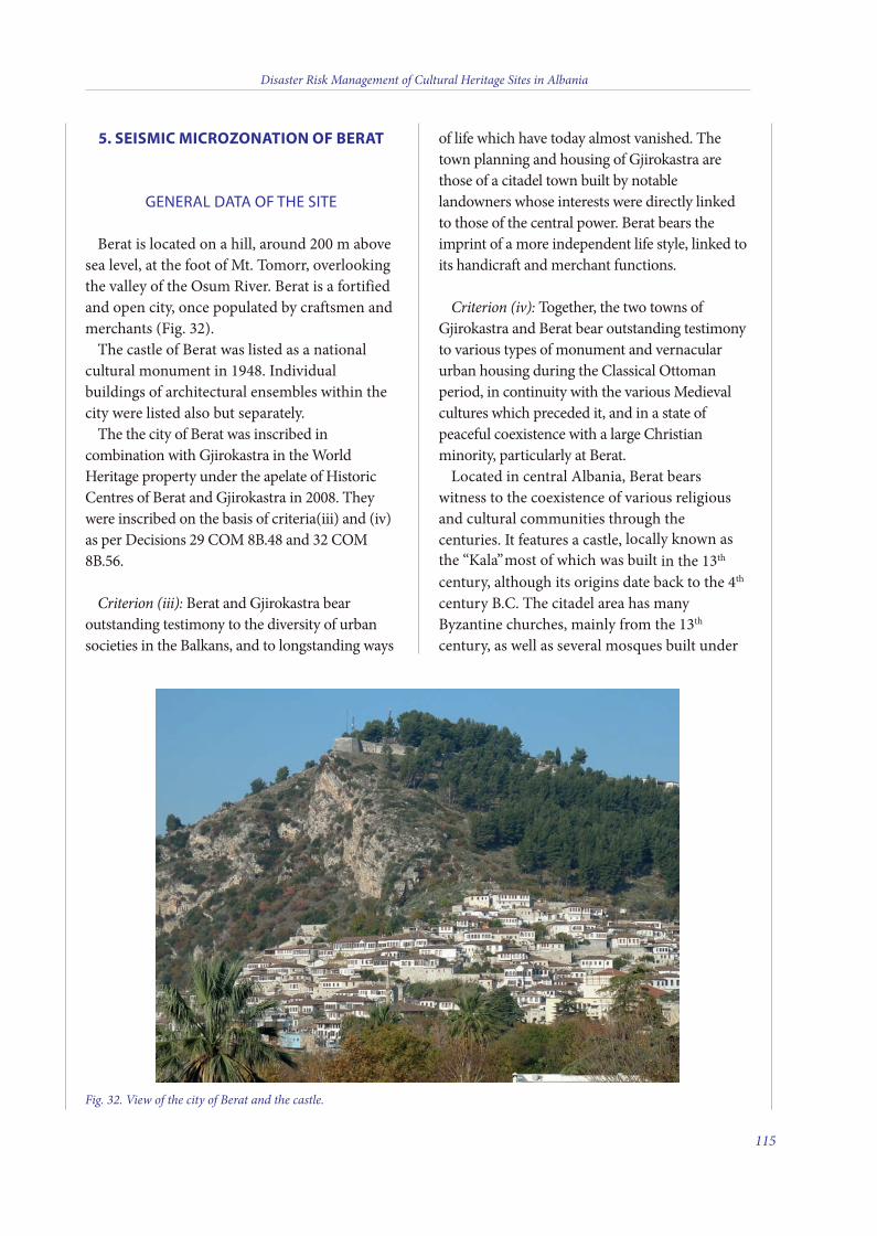
Disaster Risk Management of Cultural Heritage Sites in Albania
115
5. SEISMIC MICROZONATION OF BERAT
GENERAL DATA OF THE SITE
Berat is located on a hill, around 200 m abovesea level, at the foot of Mt. Tomorr, overlookingthe valley of the Osum River. Berat is a fortifiedand open city, once populated by craftsmen andmerchants (Fig. 32).
The castle of Berat was listed as a nationalcultural monument in 1948. Individualbuildings of architectural ensembles within thecity were listed also but separately.
The the city of Berat was inscribed incombination with Gjirokastra in the WorldHeritage property under the apelate of HistoricCentres of Berat and Gjirokastra in 2008. Theywere inscribed on the basis of criteria(iii) and (iv)as per Decisions 29 COM 8B.48 and 32 COM8B.56.
Criterion (iii): Berat and Gjirokastra bearoutstanding testimony to the diversity of urbansocieties in the Balkans, and to longstanding ways
of life which have today almost vanished. Thetown planning and housing of Gjirokastra arethose of a citadel town built by notablelandowners whose interests were directly linkedto those of the central power. Berat bears theimprint of a more independent life style, linked toits handicraft and merchant functions.
Criterion (iv): Together, the two towns ofGjirokastra and Berat bear outstanding testimonyto various types of monument and vernacularurban housing during the Classical Ottomanperiod, in continuity with the various Medievalcultures which preceded it, and in a state ofpeaceful coexistence with a large Christianminority, particularly at Berat.
Located in central Albania, Berat bearswitness to the coexistence of various religiousand cultural communities through thecenturies. It features a castle, locally known asthe “Kala”most of which was built in the 13th
century, although its origins date back to the 4th
century B.C. The citadel area has manyByzantine churches, mainly from the 13th
century, as well as several mosques built under
Fig. 32. View of the city of Berat and the castle.
8 v2_2015_Layout 1 12/04/15 20:21 Pagina 115
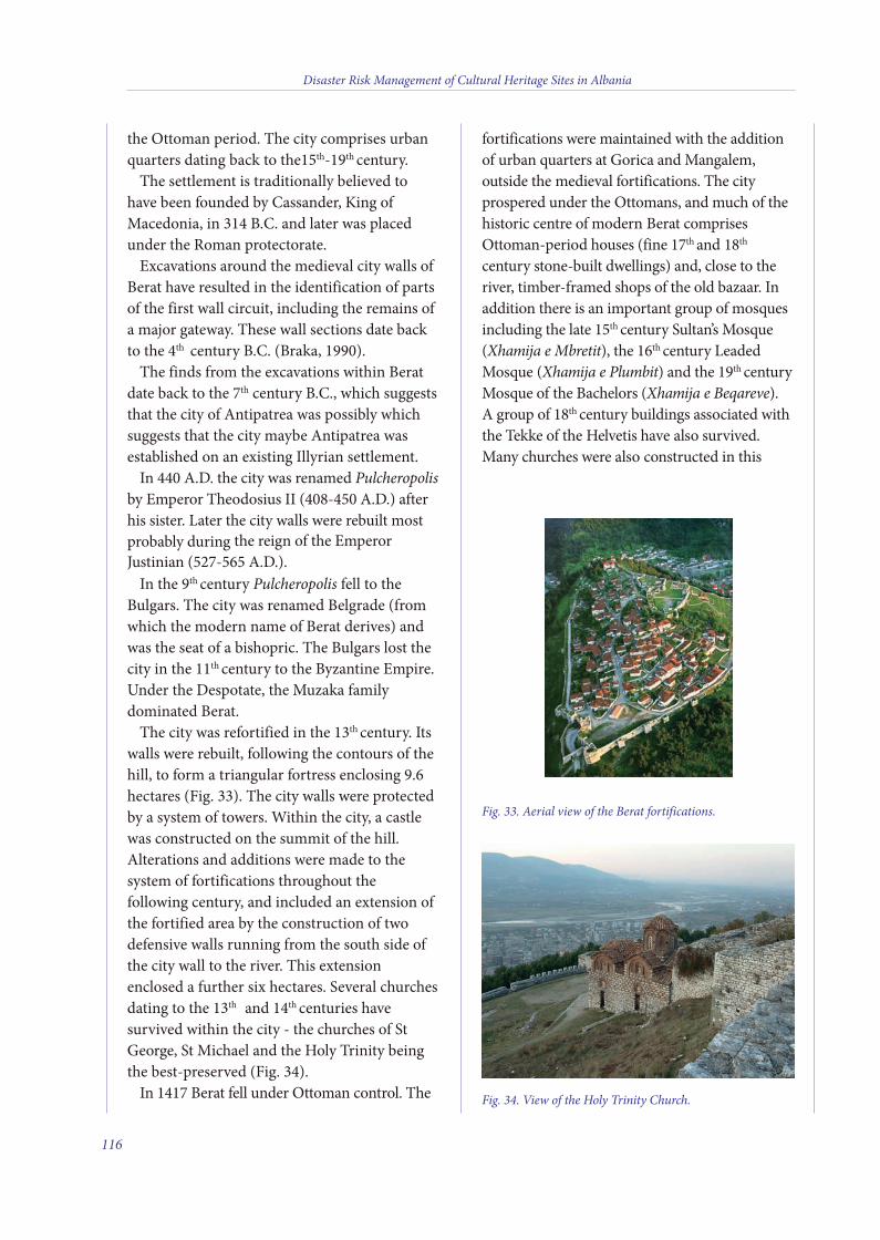
the Ottoman period. The city comprises urbanquarters dating back to the15th-19th century.
The settlement is traditionally believed tohave been founded by Cassander, King ofMacedonia, in 314 B.C. and later was placedunder the Roman protectorate.
Excavations around the medieval city walls ofBerat have resulted in the identification of partsof the first wall circuit, including the remains ofa major gateway. These wall sections date backto the 4th century B.C. (Braka, 1990).
The finds from the excavations within Beratdate back to the 7th century B.C., which suggeststhat the city of Antipatrea was possibly whichsuggests that the city maybe Antipatrea wasestablished on an existing Illyrian settlement.
In 440 A.D. the city was renamed Pulcheropolisby Emperor Theodosius II (408-450 A.D.) afterhis sister. Later the city walls were rebuilt mostprobably during the reign of the EmperorJustinian (527-565 A.D.).
In the 9th century Pulcheropolis fell to theBulgars. The city was renamed Belgrade (fromwhich the modern name of Berat derives) andwas the seat of a bishopric. The Bulgars lost thecity in the 11th century to the Byzantine Empire.Under the Despotate, the Muzaka familydominated Berat.
The city was refortified in the 13th century. Itswalls were rebuilt, following the contours of thehill, to form a triangular fortress enclosing 9.6hectares (Fig. 33). The city walls were protectedby a system of towers. Within the city, a castlewas constructed on the summit of the hill.Alterations and additions were made to thesystem of fortifications throughout thefollowing century, and included an extension ofthe fortified area by the construction of twodefensive walls running from the south side ofthe city wall to the river. This extensionenclosed a further six hectares. Several churchesdating to the 13th and 14th centuries havesurvived within the city - the churches of StGeorge, St Michael and the Holy Trinity beingthe best-preserved (Fig. 34).
In 1417 Berat fell under Ottoman control. The
fortifications were maintained with the additionof urban quarters at Gorica and Mangalem,outside the medieval fortifications. The cityprospered under the Ottomans, and much of thehistoric centre of modern Berat comprisesOttoman-period houses (fine 17th and 18th
century stone-built dwellings) and, close to theriver, timber-framed shops of the old bazaar. Inaddition there is an important group of mosquesincluding the late 15th century Sultan’s Mosque(Xhamija e Mbretit), the 16th century LeadedMosque (Xhamija e Plumbit) and the 19th centuryMosque of the Bachelors (Xhamija e Beqareve).A group of 18th century buildings associated withthe Tekke of the Helvetis have also survived.Many churches were also constructed in this
Disaster Risk Management of Cultural Heritage Sites in Albania
116
Fig. 34. View of the Holy Trinity Church.
Fig. 33. Aerial view of the Berat fortifications.
8 v2_2015_Layout 1 12/04/15 20:21 Pagina 116
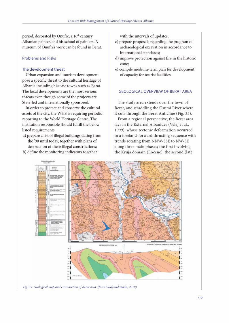
Disaster Risk Management of Cultural Heritage Sites in Albania
117
period, decorated by Onufre, a 16th centuryAlbanian painter, and his school of painters. Amuseum of Onufre’s work can be found in Berat.
Problems and Risks
The development threatUrban expansion and tourism development
pose a specific threat to the cultural heritage ofAlbania including historic towns such as Berat.The local developments are the most seriousthreats even though some of the projects areState-led and internationally sponsored.
In order to protect and conserve the culturalassets of the city, the WHS is requiring periodicreporting to the World Heritage Centre. Theinstitution responsible should fulfill the belowlisted requirements:a) prepare a list of illegal buildings dating from
the ’90 until today, together with plans ofdestruction of these illegal constructions;
b) define the monitoring indicators together
with the intervals of updates;c) prepare proposals regarding the program of
archaeological excavation in accordance tointernational standards;
d) improve protection against fire in the historiczone;
e) compile medium-term plan for developmentof capacity for tourist facilities.
GEOLOGICAL OVERVIEW OF BERAT AREA
The study area extends over the town ofBerat, and straddling the Osumi River whereit cuts through the Berat Anticline (Fig. 35).
From a regional perspective, the Berat arealays in the External Albanides (Velaj et al.,1999), whose tectonic deformation occurredin a foreland-forward thrusting sequence withtrends rotating from NNW-SSE to NW-SEalong three main phases; the first involvingthe Kruja domain (Eocene), the second (late
Fig. 35. Geological map and cross-section of Berat area. (from Velaj and Bakia, 2010).
8 v2_2015_Layout 1 12/04/15 20:21 Pagina 117
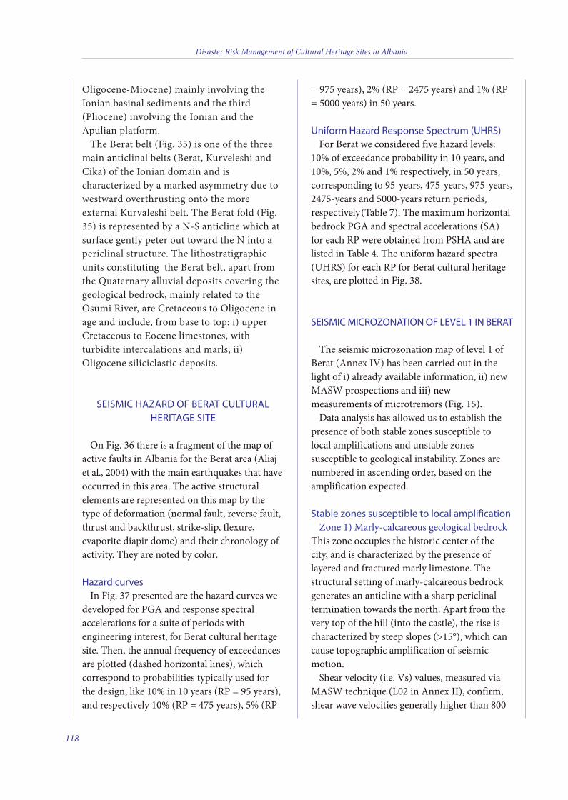
Oligocene-Miocene) mainly involving theIonian basinal sediments and the third(Pliocene) involving the Ionian and theApulian platform.
The Berat belt (Fig. 35) is one of the threemain anticlinal belts (Berat, Kurveleshi andCika) of the Ionian domain and ischaracterized by a marked asymmetry due towestward overthrusting onto the moreexternal Kurvaleshi belt. The Berat fold (Fig.35) is represented by a N-S anticline which atsurface gently peter out toward the N into apericlinal structure. The lithostratigraphicunits constituting the Berat belt, apart fromthe Quaternary alluvial deposits covering thegeological bedrock, mainly related to theOsumi River, are Cretaceous to Oligocene inage and include, from base to top: i) upperCretaceous to Eocene limestones, withturbidite intercalations and marls; ii)Oligocene siliciclastic deposits.
SEISMIC HAZARD OF BERAT CULTURALHERITAGE SITE
On Fig. 36 there is a fragment of the map ofactive faults in Albania for the Berat area (Aliajet al., 2004) with the main earthquakes that haveoccurred in this area. The active structuralelements are represented on this map by thetype of deformation (normal fault, reverse fault,thrust and backthrust, strike-slip, flexure,evaporite diapir dome) and their chronology ofactivity. They are noted by color.
Hazard curvesIn Fig. 37 presented are the hazard curves we
developed for PGA and response spectralaccelerations for a suite of periods withengineering interest, for Berat cultural heritagesite. Then, the annual frequency of exceedancesare plotted (dashed horizontal lines), whichcorrespond to probabilities typically used forthe design, like 10% in 10 years (RP = 95 years),and respectively 10% (RP = 475 years), 5% (RP
= 975 years), 2% (RP = 2475 years) and 1% (RP= 5000 years) in 50 years.
Uniform Hazard Response Spectrum (UHRS)For Berat we considered five hazard levels:
10% of exceedance probability in 10 years, and10%, 5%, 2% and 1% respectively, in 50 years,corresponding to 95-years, 475-years, 975-years,2475-years and 5000-years return periods,respectively (Table 7). The maximum horizontalbedrock PGA and spectral accelerations (SA)for each RP were obtained from PSHA and arelisted in Table 4. The uniform hazard spectra(UHRS) for each RP for Berat cultural heritagesites, are plotted in Fig. 38.
SEISMIC MICROZONATION OF LEVEL 1 IN BERAT
The seismic microzonation map of level 1 ofBerat (Annex IV) has been carried out in thelight of i) already available information, ii) newMASW prospections and iii) newmeasurements of microtremors (Fig. 15).
Data analysis has allowed us to establish thepresence of both stable zones susceptible tolocal amplifications and unstable zonessusceptible to geological instability. Zones arenumbered in ascending order, based on theamplification expected.
Stable zones susceptible to local amplification Zone 1) Marly-calcareous geological bedrock
This zone occupies the historic center of thecity, and is characterized by the presence oflayered and fractured marly limestone. Thestructural setting of marly-calcareous bedrockgenerates an anticline with a sharp periclinaltermination towards the north. Apart from thevery top of the hill (into the castle), the rise ischaracterized by steep slopes (>15°), which cancause topographic amplification of seismicmotion.
Shear velocity (i.e. Vs) values, measured viaMASW technique (L02 in Annex II), confirm,shear wave velocities generally higher than 800
Disaster Risk Management of Cultural Heritage Sites in Albania
118
8 v2_2015_Layout 1 12/04/15 20:21 Pagina 118
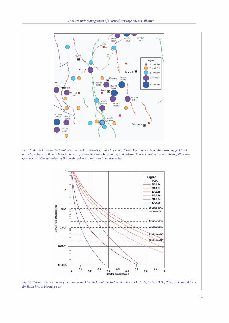
Fig. 37. Seismic hazard curves (rock conditions) for PGA and spectral accelerations SA 10 Hz, 5 Hz, 3.3 Hz, 2 Hz, 1 Hz and 0.5 Hzfor Berat World Heritage site.
Fig. 36. Active faults in the Berat site area and its vicinity (from Aliaj et al., 2004). The colors express the chronology of faultactivity, noted as follows: blue-Quaternary; green-Pliocene-Quaternary, and red-pre-Pliocene, but active also during Pliocene-Quaternary. The epicenters of the earthquakes around Berat are also noted.
Disaster Risk Management of Cultural Heritage Sites in Albania
119
8 v2_2015_Layout 1 12/04/15 20:21 Pagina 119
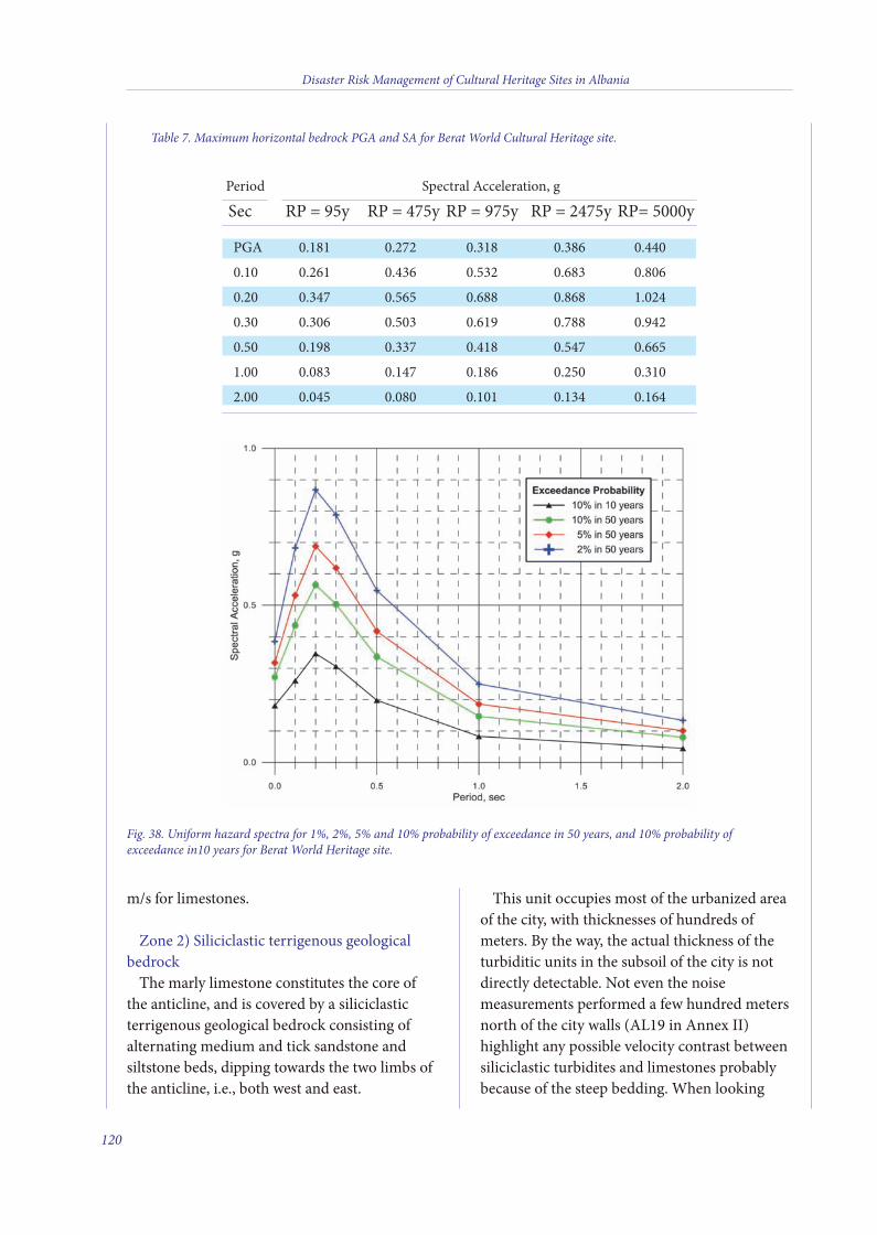
m/s for limestones.
Zone 2) Siliciclastic terrigenous geologicalbedrock
The marly limestone constitutes the core ofthe anticline, and is covered by a siliciclasticterrigenous geological bedrock consisting ofalternating medium and tick sandstone andsiltstone beds, dipping towards the two limbs ofthe anticline, i.e., both west and east.
This unit occupies most of the urbanized areaof the city, with thicknesses of hundreds ofmeters. By the way, the actual thickness of theturbiditic units in the subsoil of the city is notdirectly detectable. Not even the noisemeasurements performed a few hundred metersnorth of the city walls (AL19 in Annex II)highlight any possible velocity contrast betweensiliciclastic turbidites and limestones probablybecause of the steep bedding. When looking
Disaster Risk Management of Cultural Heritage Sites in Albania
120
Table 7. Maximum horizontal bedrock PGA and SA for Berat World Cultural Heritage site.
Period Spectral Acceleration, g
Sec RP = 95y RP = 475y RP = 975y RP = 2475y RP= 5000y
PGA 0.181 0.272 0.318 0.386 0.440
0.10 0.261 0.436 0.532 0.683 0.806
0.20 0.347 0.565 0.688 0.868 1.024
0.30 0.306 0.503 0.619 0.788 0.942
0.50 0.198 0.337 0.418 0.547 0.665
1.00 0.083 0.147 0.186 0.250 0.310
2.00 0.045 0.080 0.101 0.134 0.164
Fig. 38. Uniform hazard spectra for 1%, 2%, 5% and 10% probability of exceedance in 50 years, and 10% probability ofexceedance in10 years for Berat World Heritage site.
8 v2_2015_Layout 1 12/04/15 20:21 Pagina 120
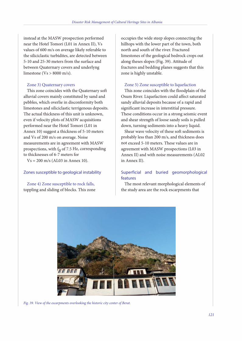
instead at the MASW prospection performednear the Hotel Tomori (L01 in Annex II), Vsvalues of 600 m/s on average likely referable tothe siliciclastic turbidites, are detected between5-10 and 25-30 meters from the surface andbetween Quaternary covers and underlynglimestone (Vs > 8000 m/s).
Zone 3) Quaternary coversThis zone coincides with the Quaternary soft
alluvial covers mainly constituted by sand andpebbles, which overlie in disconformity bothlimestones and siliciclastic terrigenous deposits.The actual thickness of this unit is unknown,even if velocity plots of MASW acquisitionsperformed near the Hotel Tomori (L01 inAnnex 10) suggest a thickness of 5-10 metersand Vs of 200 m/s on average. Noisemeasurements are in agreement with MASWprospections, with f0 of 7.5 Hz, correspondingto thicknesses of 6-7 meters for
Vs = 200 m/s (AL03 in Annex 10).
Zones susceptible to geological instability
Zone 4) Zone susceptible to rock falls,toppling and sliding of blocks. This zone
occupies the wide steep slopes connecting thehilltops with the lower part of the town, bothnorth and south of the river. Fracturedlimestones of the geological bedrock crops outalong theses slopes (Fig. 39). Attitude offractures and bedding planes suggests that thiszone is highly unstable.
Zone 5) Zone susceptible to liquefactionThis zone coincides with the floodplain of the
Osum River. Liquefaction could affect saturatedsandy alluvial deposits because of a rapid andsignificant increase in interstitial pressure.These conditions occur in a strong seismic eventand shear strength of loose sandy soils is pulleddown, turning sediments into a heavy liquid.
Shear wave velocity of these soft sediments isprobably less than 200 m/s, and thickness doesnot exceed 5-10 meters. These values are inagreement with MASW prospections (L03 inAnnex II) and with noise measurements (AL02in Annex II).
Superficial and buried geomorphologicalfeatures
The most relevant morphological elements ofthe study area are the rock escarpments that
Disaster Risk Management of Cultural Heritage Sites in Albania
121
Fig. 39. View of the escarpments overlooking the historic city center of Berat.
8 v2_2015_Layout 1 12/04/15 20:21 Pagina 121
characterize the old center of the city (seeAnnex IV). The escarpment overlooking theright bank of the Osum River (north of theriver) shows a difference in altitude of up to 200meters, and is constituted by stratified andintensely fractured limestone (i.e., the geologicalbedrock). A similar condition, but with lowergradients and extensions, can be found on theleft bank of the river.
Suggestions for further studye main geohazard affecting the city of Berat
is represented by the instability of rockescarpments overlooking the historic city center.e risk related to this criticality is high in staticconditions and is even higher if a seismic eventshould occur. For this reason, it is suggested ifnot already available to carry out a detailedstudy of structural and the geomechanicalsetting of the limestones cropping out along theescarpements.
REFERENCES
Velaj T. and Bakia M. (2010) - Harta Gjeologjike, PlanshetiK-34-112-D-d (Berati). Scale 1:25.000, Tirana.
AUTHORS:
Gian Paolo Cavinato, Massimiliano Moscatelli, AlessandroPagliarioli, Maurizio Simionato
CNR-Institute of Environmental Geology and
Geoengineering, Area della Ricerca di Roma1, Rome, Italy
Llambro Duni
Head of Department of Seismology and Seismological
Engineering, Tirana, Albania
Iris Pojani
Associate Professor of Archaeology and Cultural Heritage
Management, International Centre for Albanian
Archaeology, Tirana, Albania
Disaster Risk Management of Cultural Heritage Sites in Albania
122
8 v2_2015_Layout 1 12/04/15 20:21 Pagina 122
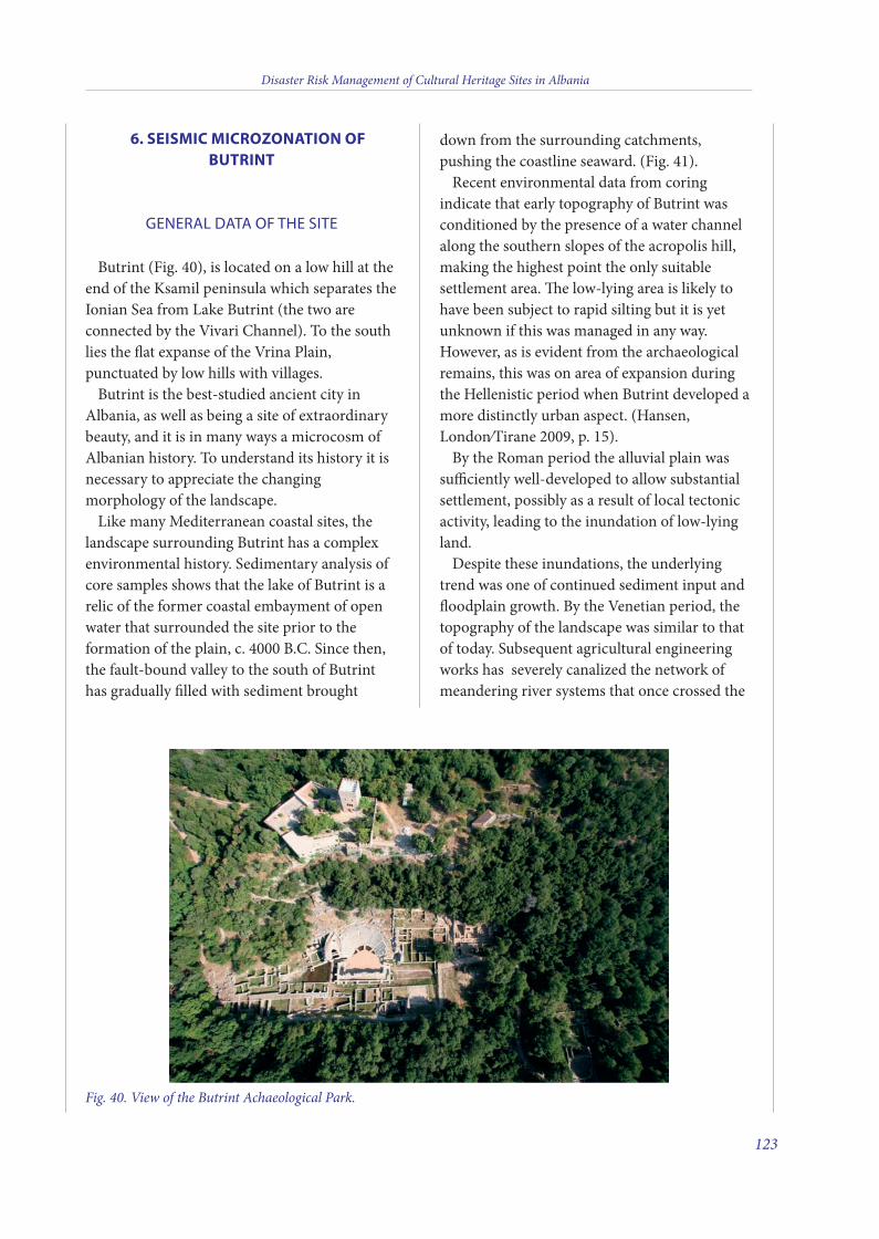
6. SEISMIC MICROZONATION OFBUTRINT
GENERAL DATA OF THE SITE
Butrint (Fig. 40), is located on a low hill at theend of the Ksamil peninsula which separates theIonian Sea from Lake Butrint (the two areconnected by the Vivari Channel). To the southlies the flat expanse of the Vrina Plain,punctuated by low hills with villages.
Butrint is the best-studied ancient city inAlbania, as well as being a site of extraordinarybeauty, and it is in many ways a microcosm ofAlbanian history. To understand its history it isnecessary to appreciate the changingmorphology of the landscape.
Like many Mediterranean coastal sites, thelandscape surrounding Butrint has a complexenvironmental history. Sedimentary analysis ofcore samples shows that the lake of Butrint is arelic of the former coastal embayment of openwater that surrounded the site prior to theformation of the plain, c. 4000 B.C. Since then,the fault-bound valley to the south of Butrinthas gradually filled with sediment brought
down from the surrounding catchments,pushing the coastline seaward. (Fig. 41).
Recent environmental data from coringindicate that early topography of Butrint wasconditioned by the presence of a water channelalong the southern slopes of the acropolis hill,making the highest point the only suitablesettlement area. e low-lying area is likely tohave been subject to rapid silting but it is yetunknown if this was managed in any way.However, as is evident from the archaeologicalremains, this was on area of expansion duringthe Hellenistic period when Butrint developed amore distinctly urban aspect. (Hansen,London/Tirane 2009, p. 15).
By the Roman period the alluvial plain wassufficiently well-developed to allow substantialsettlement, possibly as a result of local tectonicactivity, leading to the inundation of low-lyingland.
Despite these inundations, the underlyingtrend was one of continued sediment input andfloodplain growth. By the Venetian period, thetopography of the landscape was similar to thatof today. Subsequent agricultural engineeringworks has severely canalized the network ofmeandering river systems that once crossed the
Disaster Risk Management of Cultural Heritage Sites in Albania
123
Fig. 40. View of the Butrint Achaeological Park.
9 v2_2015_Layout 1 12/04/15 20:27 Pagina 123
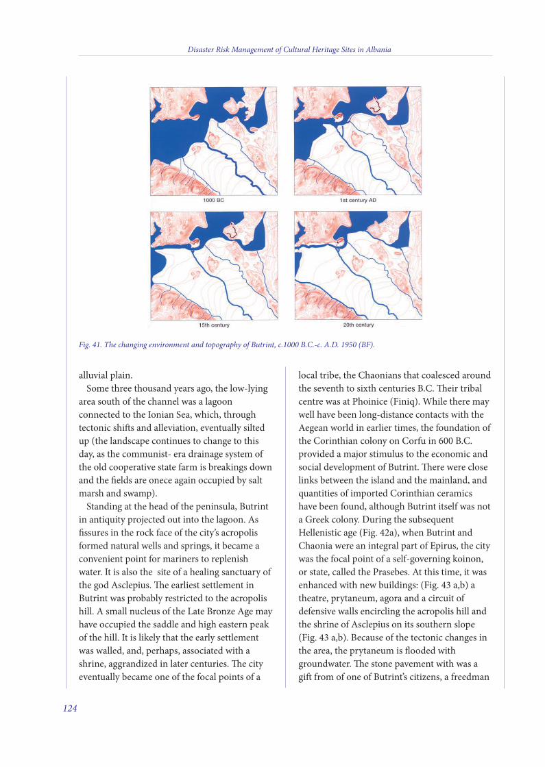
alluvial plain.Some three thousand years ago, the low-lying
area south of the channel was a lagoonconnected to the Ionian Sea, which, throughtectonic shis and alleviation, eventually siltedup (the landscape continues to change to thisday, as the communist- era drainage system ofthe old cooperative state farm is breakings downand the fields are onece again occupied by saltmarsh and swamp).
Standing at the head of the peninsula, Butrintin antiquity projected out into the lagoon. Asfissures in the rock face of the city’s acropolisformed natural wells and springs, it became aconvenient point for mariners to replenishwater. It is also the site of a healing sanctuary ofthe god Asclepius. e earliest settlement inButrint was probably restricted to the acropolishill. A small nucleus of the Late Bronze Age mayhave occupied the saddle and high eastern peakof the hill. It is likely that the early settlementwas walled, and, perhaps, associated with ashrine, aggrandized in later centuries. e cityeventually became one of the focal points of a
local tribe, the Chaonians that coalesced aroundthe seventh to sixth centuries B.C. eir tribalcentre was at Phoinice (Finiq). While there maywell have been long-distance contacts with theAegean world in earlier times, the foundation ofthe Corinthian colony on Corfu in 600 B.C.provided a major stimulus to the economic andsocial development of Butrint. ere were closelinks between the island and the mainland, andquantities of imported Corinthian ceramicshave been found, although Butrint itself was nota Greek colony. During the subsequentHellenistic age (Fig. 42a), when Butrint andChaonia were an integral part of Epirus, the citywas the focal point of a self-governing koinon,or state, called the Prasebes. At this time, it wasenhanced with new buildings: (Fig. 43 a,b) atheatre, prytaneum, agora and a circuit ofdefensive walls encircling the acropolis hill andthe shrine of Asclepius on its southern slope(Fig. 43 a,b). Because of the tectonic changes inthe area, the prytaneum is flooded withgroundwater. e stone pavement with was agi from of one of Butrint’s citizens, a freedman
Disaster Risk Management of Cultural Heritage Sites in Albania
124
Fig. 41. The changing environment and topography of Butrint, c.1000 B.C.-c. A.D. 1950 (BF).
9 v2_2015_Layout 1 12/04/15 20:27 Pagina 124

called Gnaius Domitius Eros, who included hisname in capital letters set into the marblepavement in front of the prytaneum. Eros wasconnected to one of the most influential familiesof the Augustan age.
However, the entire region was soon drawninto the increasingly violent contest between therising power of the Roman Republic and theestablished kingdom of Macedonia. By the early2nd century B.C., Rome had secured control ofCorfu and dominated Chaonia from 168 B.C.,when Macedonia was finally defeated and itsterritory ultimately made into a Romanprovince. Part of Epirus, which had supportedMacedonia, was ravaged and looted, and manycities, such as Antigonea, were destroyed.Butrint and its neighbours, which alliedthemselves with the conquerors, escaped theviolence.
ereaer, Butrint’s history was increasinglyentangled with Roman politics. Epirus became afavorite haunt of many Romans, including, inthe 1rst century B.C., Titus Pomponius Atticus,the friend and correspondent of the politicianCicero. e city was at the fulcrum of two otherconflicts at this time, as Roman politicians tookto arms to seize supreme power in the Republic(Fig. 42b). e war between Caesar and Pompeywas partly fought out along this coastline, with
Butrint playing a secondary role, althoughCaesar himself may have visited briefly in 47B.C. In 44 B.C., aer his victory, Caesarattempted to establish a colony in Butrint, onthe other side of the Vivari channel-aplan thatmet opposition from Atticus and Cicero, butwhich nevertheless came to fruition twodecades later under Augustus. He refunded thecolony to Butrint, and from this time the citybegan to be aggrandized, with the constructionof new buildings and facilities (Fig. 42c). Aforum, aqueduct, villas and bathhouses were allplanned, though their completion seems to haveoccurred over the course of some 60 years, andmany may have been additions of the mid-firstcentury A.D. when there was renewed imperialinterest in the region, at the time of Nero.Cicero provides a picture of a sleepy port town,a description that might apply to Butrintthroughout the Roman Empire and into lateAntiquity. Like other cities, Butrint underwentsignificant changes in this time. In particularthere was a hiatus of activity in the thirdcentury, around A.D. 280 or later, whichresulted in the abandonment of parts of the citycentre and suburbs.
e survey, geophysical and excavation worksince 2001 on the Vrina Plain has clarified theorganisation of the settlement here (Bescoby,
Disaster Risk Management of Cultural Heritage Sites in Albania
125
Fig. 42. The history of Butrint. a) the Hellenistic Butrint; b) the Roman Butrint; c) the late ancient Butrint; d) Butrintin the middle ages.
ba
dc
9 v2_2015_Layout 1 12/04/15 20:27 Pagina 125
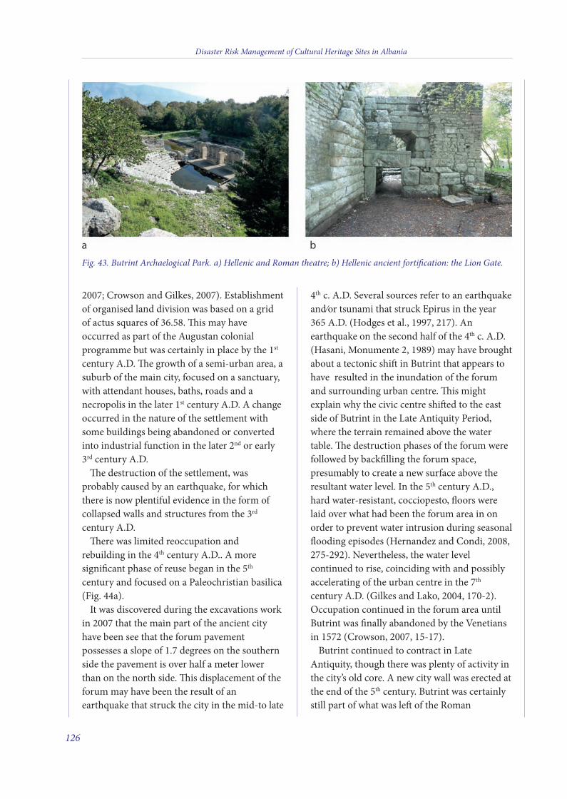
2007; Crowson and Gilkes, 2007). Establishmentof organised land division was based on a gridof actus squares of 36.58. is may haveoccurred as part of the Augustan colonialprogramme but was certainly in place by the 1st
century A.D. e growth of a semi-urban area, asuburb of the main city, focused on a sanctuary,with attendant houses, baths, roads and anecropolis in the later 1st century A.D. A changeoccurred in the nature of the settlement withsome buildings being abandoned or convertedinto industrial function in the later 2nd or early3rd century A.D.
e destruction of the settlement, wasprobably caused by an earthquake, for whichthere is now plentiful evidence in the form ofcollapsed walls and structures from the 3rd
century A.D.ere was limited reoccupation and
rebuilding in the 4th century A.D.. A moresignificant phase of reuse began in the 5th
century and focused on a Paleochristian basilica(Fig. 44a).
It was discovered during the excavations workin 2007 that the main part of the ancient cityhave been see that the forum pavementpossesses a slope of 1.7 degrees on the southernside the pavement is over half a meter lowerthan on the north side. is displacement of theforum may have been the result of anearthquake that struck the city in the mid-to late
4th c. A.D. Several sources refer to an earthquakeand/or tsunami that struck Epirus in the year365 A.D. (Hodges et al., 1997, 217). Anearthquake on the second half of the 4th c. A.D.(Hasani, Monumente 2, 1989) may have broughtabout a tectonic shi in Butrint that appears tohave resulted in the inundation of the forumand surrounding urban centre. is mightexplain why the civic centre shied to the eastside of Butrint in the Late Antiquity Period,where the terrain remained above the watertable. e destruction phases of the forum werefollowed by backfilling the forum space,presumably to create a new surface above theresultant water level. In the 5th century A.D.,hard water-resistant, cocciopesto, floors werelaid over what had been the forum area in onorder to prevent water intrusion during seasonalflooding episodes (Hernandez and Condi, 2008,275-292). Nevertheless, the water levelcontinued to rise, coinciding with and possiblyaccelerating of the urban centre in the 7th
century A.D. (Gilkes and Lako, 2004, 170-2).Occupation continued in the forum area untilButrint was finally abandoned by the Venetiansin 1572 (Crowson, 2007, 15-17).
Butrint continued to contract in LateAntiquity, though there was plenty of activity inthe city’s old core. A new city wall was erected atthe end of the 5th century. Butrint was certainlystill part of what was le of the Roman
Disaster Risk Management of Cultural Heritage Sites in Albania
126
Fig. 43. Butrint Archaelogical Park. a) Hellenic and Roman theatre; b) Hellenic ancient fortification: the Lion Gate.
9 v2_2015_Layout 1 12/04/15 20:27 Pagina 126
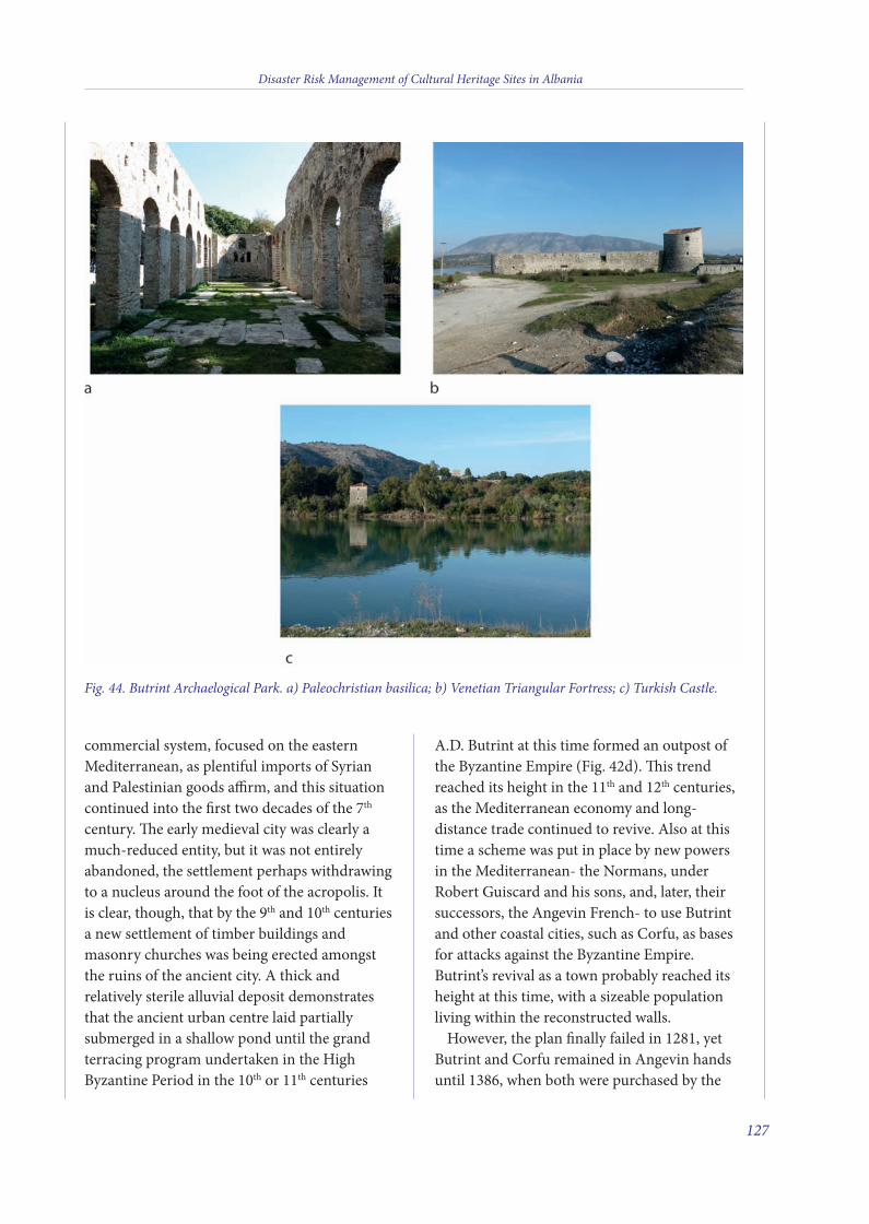
commercial system, focused on the easternMediterranean, as plentiful imports of Syrianand Palestinian goods affirm, and this situationcontinued into the first two decades of the 7th
century. e early medieval city was clearly amuch-reduced entity, but it was not entirelyabandoned, the settlement perhaps withdrawingto a nucleus around the foot of the acropolis. Itis clear, though, that by the 9th and 10th centuriesa new settlement of timber buildings andmasonry churches was being erected amongstthe ruins of the ancient city. A thick andrelatively sterile alluvial deposit demonstratesthat the ancient urban centre laid partiallysubmerged in a shallow pond until the grandterracing program undertaken in the HighByzantine Period in the 10th or 11th centuries
A.D. Butrint at this time formed an outpost ofthe Byzantine Empire (Fig. 42d). is trendreached its height in the 11th and 12th centuries,as the Mediterranean economy and long-distance trade continued to revive. Also at thistime a scheme was put in place by new powersin the Mediterranean- the Normans, underRobert Guiscard and his sons, and, later, theirsuccessors, the Angevin French- to use Butrintand other coastal cities, such as Corfu, as basesfor attacks against the Byzantine Empire.Butrint’s revival as a town probably reached itsheight at this time, with a sizeable populationliving within the reconstructed walls.
However, the plan finally failed in 1281, yetButrint and Corfu remained in Angevin handsuntil 1386, when both were purchased by the
Disaster Risk Management of Cultural Heritage Sites in Albania
127
Fig. 44. Butrint Archaelogical Park. a) Paleochristian basilica; b) Venetian Triangular Fortress; c) Turkish Castle.
9 v2_2015_Layout 1 12/04/15 20:27 Pagina 127
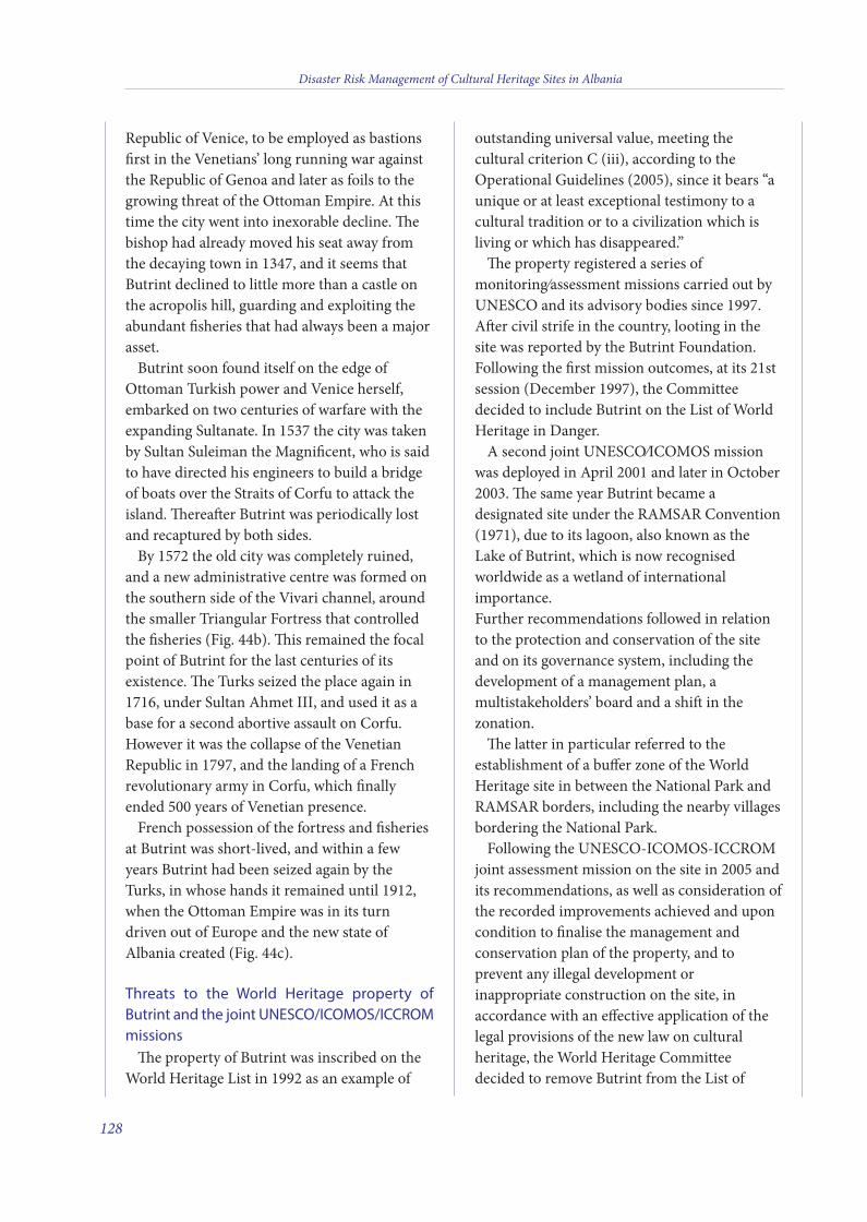
Republic of Venice, to be employed as bastionsfirst in the Venetians’ long running war againstthe Republic of Genoa and later as foils to thegrowing threat of the Ottoman Empire. At thistime the city went into inexorable decline. ebishop had already moved his seat away fromthe decaying town in 1347, and it seems thatButrint declined to little more than a castle onthe acropolis hill, guarding and exploiting theabundant fisheries that had always been a majorasset.
Butrint soon found itself on the edge ofOttoman Turkish power and Venice herself,embarked on two centuries of warfare with theexpanding Sultanate. In 1537 the city was takenby Sultan Suleiman the Magnificent, who is saidto have directed his engineers to build a bridgeof boats over the Straits of Corfu to attack theisland. ereaer Butrint was periodically lostand recaptured by both sides.
By 1572 the old city was completely ruined,and a new administrative centre was formed onthe southern side of the Vivari channel, aroundthe smaller Triangular Fortress that controlledthe fisheries (Fig. 44b). is remained the focalpoint of Butrint for the last centuries of itsexistence. e Turks seized the place again in1716, under Sultan Ahmet III, and used it as abase for a second abortive assault on Corfu.However it was the collapse of the VenetianRepublic in 1797, and the landing of a Frenchrevolutionary army in Corfu, which finallyended 500 years of Venetian presence.
French possession of the fortress and fisheriesat Butrint was short-lived, and within a fewyears Butrint had been seized again by theTurks, in whose hands it remained until 1912,when the Ottoman Empire was in its turndriven out of Europe and the new state ofAlbania created (Fig. 44c).
Threats to the World Heritage property ofButrint and the joint UNESCO/ICOMOS/ICCROMmissions
e property of Butrint was inscribed on theWorld Heritage List in 1992 as an example of
outstanding universal value, meeting thecultural criterion C (iii), according to theOperational Guidelines (2005), since it bears “aunique or at least exceptional testimony to acultural tradition or to a civilization which isliving or which has disappeared.”
e property registered a series ofmonitoring/assessment missions carried out byUNESCO and its advisory bodies since 1997.Aer civil strife in the country, looting in thesite was reported by the Butrint Foundation.Following the first mission outcomes, at its 21stsession (December 1997), the Committeedecided to include Butrint on the List of WorldHeritage in Danger.
A second joint UNESCO/ICOMOS missionwas deployed in April 2001 and later in October2003. e same year Butrint became adesignated site under the RAMSAR Convention(1971), due to its lagoon, also known as theLake of Butrint, which is now recognisedworldwide as a wetland of internationalimportance.Further recommendations followed in relationto the protection and conservation of the siteand on its governance system, including thedevelopment of a management plan, amultistakeholders’ board and a shi in thezonation.
e latter in particular referred to theestablishment of a buffer zone of the WorldHeritage site in between the National Park andRAMSAR borders, including the nearby villagesbordering the National Park.
Following the UNESCO-ICOMOS-ICCROMjoint assessment mission on the site in 2005 andits recommendations, as well as consideration ofthe recorded improvements achieved and uponcondition to finalise the management andconservation plan of the property, and toprevent any illegal development orinappropriate construction on the site, inaccordance with an effective application of thelegal provisions of the new law on culturalheritage, the World Heritage Committeedecided to remove Butrint from the List of
Disaster Risk Management of Cultural Heritage Sites in Albania
128
9 v2_2015_Layout 1 12/04/15 20:27 Pagina 128
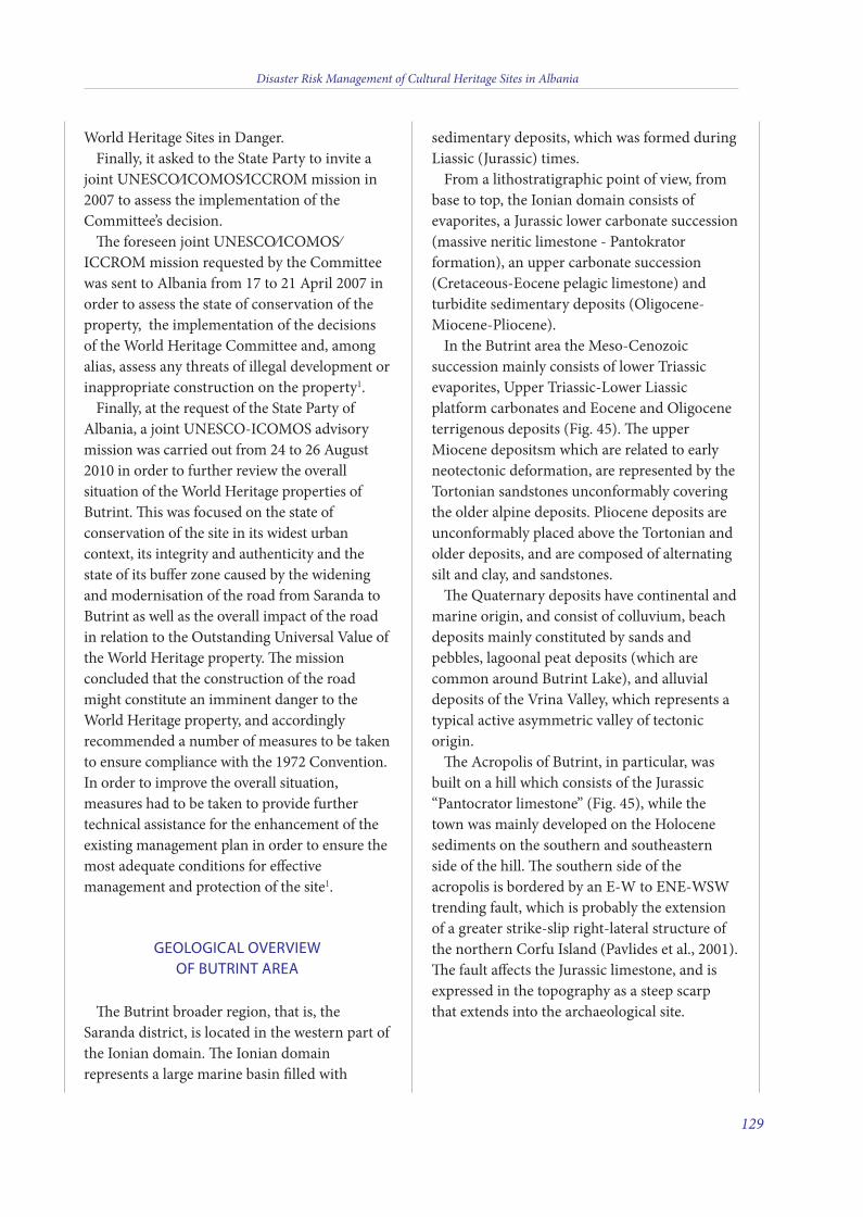
World Heritage Sites in Danger.Finally, it asked to the State Party to invite a
joint UNESCO/ICOMOS/ICCROM mission in2007 to assess the implementation of theCommittee’s decision.
e foreseen joint UNESCO/ICOMOS/ICCROM mission requested by the Committeewas sent to Albania from 17 to 21 April 2007 inorder to assess the state of conservation of theproperty, the implementation of the decisionsof the World Heritage Committee and, amongalias, assess any threats of illegal development orinappropriate construction on the property1.
Finally, at the request of the State Party ofAlbania, a joint UNESCO-ICOMOS advisorymission was carried out from 24 to 26 August2010 in order to further review the overallsituation of the World Heritage properties ofButrint. is was focused on the state ofconservation of the site in its widest urbancontext, its integrity and authenticity and thestate of its buffer zone caused by the wideningand modernisation of the road from Saranda toButrint as well as the overall impact of the roadin relation to the Outstanding Universal Value ofthe World Heritage property. e missionconcluded that the construction of the roadmight constitute an imminent danger to theWorld Heritage property, and accordinglyrecommended a number of measures to be takento ensure compliance with the 1972 Convention.In order to improve the overall situation,measures had to be taken to provide furthertechnical assistance for the enhancement of theexisting management plan in order to ensure themost adequate conditions for effectivemanagement and protection of the site1.
GEOLOGICAL OVERVIEWOF BUTRINT AREA
e Butrint broader region, that is, theSaranda district, is located in the western part ofthe Ionian domain. e Ionian domainrepresents a large marine basin filled with
sedimentary deposits, which was formed duringLiassic (Jurassic) times.
From a lithostratigraphic point of view, frombase to top, the Ionian domain consists ofevaporites, a Jurassic lower carbonate succession(massive neritic limestone - Pantokratorformation), an upper carbonate succession(Cretaceous-Eocene pelagic limestone) andturbidite sedimentary deposits (Oligocene-Miocene-Pliocene).
In the Butrint area the Meso-Cenozoicsuccession mainly consists of lower Triassicevaporites, Upper Triassic-Lower Liassicplatform carbonates and Eocene and Oligoceneterrigenous deposits (Fig. 45). e upperMiocene depositsm which are related to earlyneotectonic deformation, are represented by theTortonian sandstones unconformably coveringthe older alpine deposits. Pliocene deposits areunconformably placed above the Tortonian andolder deposits, and are composed of alternatingsilt and clay, and sandstones.
e Quaternary deposits have continental andmarine origin, and consist of colluvium, beachdeposits mainly constituted by sands andpebbles, lagoonal peat deposits (which arecommon around Butrint Lake), and alluvialdeposits of the Vrina Valley, which represents atypical active asymmetric valley of tectonicorigin.
e Acropolis of Butrint, in particular, wasbuilt on a hill which consists of the Jurassic“Pantocrator limestone” (Fig. 45), while thetown was mainly developed on the Holocenesediments on the southern and southeasternside of the hill. e southern side of theacropolis is bordered by an E-W to ENE-WSWtrending fault, which is probably the extensionof a greater strike-slip right-lateral structure ofthe northern Corfu Island (Pavlides et al., 2001).e fault affects the Jurassic limestone, and isexpressed in the topography as a steep scarpthat extends into the archaeological site.
Disaster Risk Management of Cultural Heritage Sites in Albania
129
9 v2_2015_Layout 1 12/04/15 20:27 Pagina 129
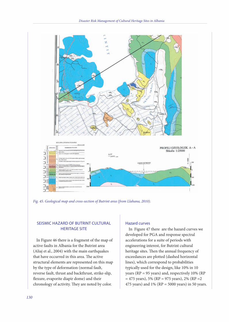
SEISMIC HAZARD OF BUTRINT CULTURALHERITAGE SITE
In Figure 46 there is a fragment of the map ofactive faults in Albania for the Butrint area(Aliaj et al., 2004) with the main earthquakesthat have occurred in this area. e activestructural elements are represented on this mapby the type of deformation (normal fault,reverse fault, thrust and backthrust, strike-slip,flexure, evaporite diapir dome) and theirchronology of activity. ey are noted by color.
Hazard curvesIn Figure 47 there are the hazard curves we
developed for PGA and response spectralaccelerations for a suite of periods withengineering interest, for Butrint culturalheritage sites. en the annual frequency ofexceedances are plotted (dashed horizontallines), which correspond to probabilitiestypically used for the design, like 10% in 10years (RP = 95 years) and, respectively 10% (RP= 475 years), 5% (RP = 975 years), 2% (RP =2475 years) and 1% (RP = 5000 years) in 50 years.
Disaster Risk Management of Cultural Heritage Sites in Albania
130
Fig. 45. Geological map and cross-section of Butrint area (from Llahana, 2010).
9 v2_2015_Layout 1 12/04/15 20:27 Pagina 130
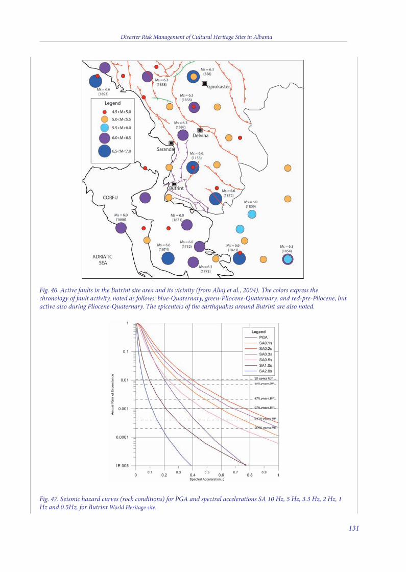
Disaster Risk Management of Cultural Heritage Sites in Albania
131
Fig. 46. Active faults in the Butrint site area and its vicinity (from Aliaj et al., 2004). The colors express thechronology of fault activity, noted as follows: blue-Quaternary, green-Pliocene-Quaternary, and red-pre-Pliocene, butactive also during Pliocene-Quaternary. The epicenters of the earthquakes around Butrint are also noted.
Fig. 47. Seismic hazard curves (rock conditions) for PGA and spectral accelerations SA 10 Hz, 5 Hz, 3.3 Hz, 2 Hz, 1Hz and 0.5Hz, for Butrint World Heritage site.
9 v2_2015_Layout 1 12/04/15 20:27 Pagina 131
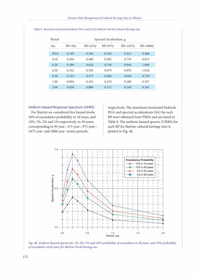
Uniform Hazard Response Spectrum (UHRS)For Butrint we considered five hazard levels:
10% of exceedance probability in 10 years, and10%, 5%, 2% and 1% respectively, in 50 years,corresponding to 95 year-, 475 year-, 975 year-,2475 year- and 5000 year- return periods,
respectively. e maximum horizontal bedrockPGA and spectral accelerations (SA) for eachRP were obtained from PSHA and are listed inTable 8. e uniform hazard spectra (UHRS) foreach RP for Butrint cultural heritage sites isplotted in Fig. 48.
Disaster Risk Management of Cultural Heritage Sites in Albania
132
Table 8. Maximum horizontal bedrock PGA and SA for Butrint World Cultural Heritage site.
Period Spectral Acceleration, g
Sec RP=95y RP=475y RP=975y RP=2475y RP=5000y
PGA 0.199 0.294 0.342 0.412 0.468
0.10 0.294 0.480 0.585 0.739 0.872
0.20 0.389 0.624 0.749 0.944 1.098
0.30 0.342 0.556 0.679 0.859 1.018
0.50 0.223 0.375 0.466 0.604 0.734
1.00 0.094 0.165 0.210 0.280 0.347
2.00 0.050 0.089 0.112 0.149 0.181
Fig. 48. Uniform hazard spectra for 1%, 2%, 5% and 10% probability of exceedance in 50 years, and 10% probabilityof exceedance in10 years for Butrint World Heritage site.
9 v2_2015_Layout 1 12/04/15 20:27 Pagina 132
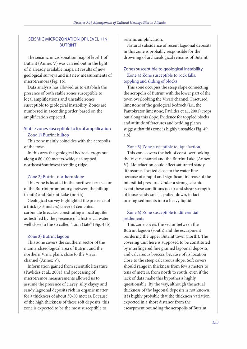
SEISMIC MICROZONATION OF LEVEL 1 INBUTRINT
e seismic microzonation map of level 1 ofButrint (Annex V) was carried out in the lightof i) already available maps, ii) results of newgeological surveys and iii) new measurements ofmicrotremors (Fig. 16).
Data analysis has allowed us to establish thepresence of both stable zones susceptible tolocal amplifications and unstable zonessusceptible to geological instability. Zones arenumbered in ascending order, based on theamplification expected.
Stable zones susceptible to local amplificationZone 1) Butrint hilltopis zone mainly coincides with the acropolis
of the town.In this area the geological bedrock crops out
along a 80-100 meters-wide, flat-toppednortheast/southwest trending ridge.
Zone 2) Butrint northern slopeis zone is located in the northwestern sector
of the Butrint promontory, between the hilltop(south) and Butrint Lake (north).
Geological survey highlighted the presence ofa thick (> 5 meters) cover of cementedcarbonate breccias, constituting a local aquiferas testified by the presence of a historical waterwell close to the so called “Lion Gate” (Fig. 43b).
Zone 3) Butrint lagoonis zone covers the southern sector of the
main archaeological area of Butrint and thenorthern Vrina plain, close to the Vivarichannel (Annex V).
Information gained from scientific literature(Pavlides et al., 2001) and processing ofmicrotremor measurements allowed us toassume the presence of clayey, silty clayey andsandy lagoonal deposits rich in organic matterfor a thickness of about 30-50 meters. Becauseof the high thickness of these so deposits, thiszone is expected to be the most susceptible to
seismic amplification.Natural subsidence of recent lagoonal deposits
in this zone is probably responsible for thedrowning of archaeological remains of Butrint.
Zones susceptible to geological instabilityZone 4) Zone susceptible to rock falls,
toppling and sliding of blocksis zone occupies the steep slope connecting
the acropolis of Butrint with the lower part of thetown overlooking the Vivari channel. Fracturedlimestone of the geological bedrock (i.e., thePantokrator limestone; Pavlides et al., 2001) cropsout along this slope. Evidence for toppled blocksand attitude of fractures and bedding planessuggest that this zone is highly unstable (Fig. 49a,b).
Zone 5) Zone susceptible to liquefaction is zone covers the belt of coast overlooking
the Vivari channel and the Butrint Lake (AnnexV). Liquefaction could affect saturated sandylithosomes located close to the water linebecause of a rapid and significant increase of theinterstitial pressure. Under a strong seismicevent these conditions occur and shear strengthof loose sandy soils is pulled down, in factturning sediments into a heavy liquid.
Zone 6) Zone susceptible to differentialsettlements
is zone covers the sector between theButrint lagoon (south) and the escarpmentbordering the upper Butrint town (north). ecovering unit here is supposed to be constitutedby interfingered fine grained lagoonal depositsand calcareous breccia, because of its locationclose to the steep calcareous slope. So coversshould range in thickness from few a meters totens of meters, from north to south, even if thelack of data make this hypothesis highlyquestionable. By the way, although the actualthickness of the lagoonal deposits is not known,it is highly probable that the thickness variationexpected in a short distance from theescarpment bounding the acropolis of Butrint
Disaster Risk Management of Cultural Heritage Sites in Albania
133
9 v2_2015_Layout 1 12/04/15 20:27 Pagina 133
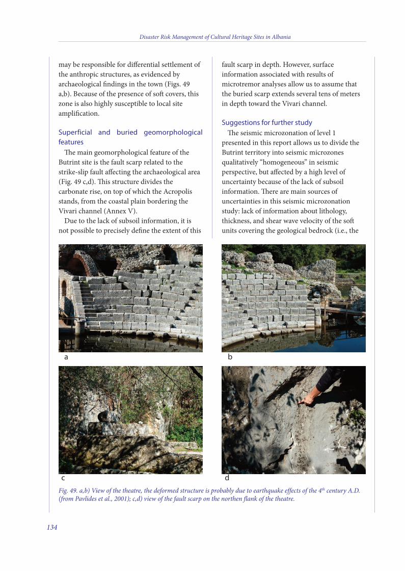
may be responsible for differential settlement ofthe anthropic structures, as evidenced byarchaeological findings in the town (Figs. 49a,b). Because of the presence of so covers, thiszone is also highly susceptible to local siteamplification.
Superficial and buried geomorphologicalfeatures
e main geomorphological feature of theButrint site is the fault scarp related to thestrike-slip fault affecting the archaeological area(Fig. 49 c,d). is structure divides thecarbonate rise, on top of which the Acropolisstands, from the coastal plain bordering theVivari channel (Annex V).
Due to the lack of subsoil information, it isnot possible to precisely define the extent of this
fault scarp in depth. However, surfaceinformation associated with results ofmicrotremor analyses allow us to assume thatthe buried scarp extends several tens of metersin depth toward the Vivari channel.
Suggestions for further studye seismic microzonation of level 1
presented in this report allows us to divide theButrint territory into seismic microzonesqualitatively “homogeneous” in seismicperspective, but affected by a high level ofuncertainty because of the lack of subsoilinformation. ere are main sources ofuncertainties in this seismic microzonationstudy: lack of information about lithology,thickness, and shear wave velocity of the sounits covering the geological bedrock (i.e., the
Disaster Risk Management of Cultural Heritage Sites in Albania
134
a
c
b
d
Fig. 49. a,b) View of the theatre, the deformed structure is probably due to earthquake effects of the 4th century A.D.(from Pavlides et al., 2001); c,d) view of the fault scarp on the northen flank of the theatre.
9 v2_2015_Layout 1 12/04/15 20:27 Pagina 134
Pantokrator limestone). Lithostratigraphic andgeometric uncertainty could be pulled down bymeans of one deep borehole located close to theVivari channel, at the southern margin of thearchaeological area, associated with ElectricalResistivity Tomographies (ERTs) orientedperpendicular to the fault scarp. Shear wavevelocity could be detected by means of MAWSmeasurements.
REFERENCES
Anamali S. (1981) -“Të dhëna për historinë e Butrintit”, inSaranda 1, pp. 16-29.
Andrews R., W. Bowden, Gilkes O. and Martin S. (2004) -“The late antique and medieval fortifications of Butrint”, inByzantine Butrint, Oxford, pp. 126-150.
Bescoby D.J. (2007) - “Geoarchaeological investigation atRoman Butrint”, in I. L. Hansen and R. Hodges, RomanButrint: an Assessment, (Oxford), pp. 95-118.
Bowden W. and Mitchell J. (2004) - “The Christiantopography of Butrint”, in Byzantine Butrint, (Oxford) pp.104-125.
Budina Dh. (1971) - “Harta arkeologjike e bregdetit Jondhe e pellgut të Delvinës’’ in Iliria 1, pp. 275-342.
Cabanes P. (1981) - “Shoqëria dhe institucionet në Epir dheMaqedoni në epokën klasike dhe helenistike”, in Iliria, 2.
Ceka N. (1976) - “Fortifikimi Antik i Butrintit dhe iterritorit të Prasaibëve” in Monumentet, 12, pp. 27-48.
Crowson A and O. J. Gilkes (2007) - “The archaeology ofthe Vrina Plain: an assessment” in Roman Butrint: AnAssessment, (Oxford), pp. 119-164.
Crowson A. (2007) - Venetian Butrint/Butrinti Venecian,London/Tirana.
Çondi Dh. (1989) - “Gërmimet arkeologjike të vitit 1989.Butrint (gjimnazi)”, in Iliria 19 (2), pp. 288-289.
Çondi Dh. (1990) - “Gërmimet arkeologjike të vitit 1990,Butrint”, in Iliria 2, pp. 288-289.
Gilkes O. J. and K. Lako (2004) - “Excavations at theTriconch Palace” in Byzantine Butrint: Excavations andSurveys 1994 - 1999, pp. 151-175.
Gilkes O.J. (2003) - “The Theatre at Butrint, Luigi MariaUgolini’s Excavations at Butrint” 1928-1932 (Albaniaantica IV) (British School at Athens Supplementary
Volume Londra, British School at Athens.
Hansen I.L. (2009) - Hellenistic and RomanButrint/Butrinti Helenistik dhe Romak, London/Tirane2009, pp.15.
Hernandez D.R. and Condi Dh. (2008) - “The Romanforum at Butrint (Epirus) and itsdevelopment fromHellenistic to medieval times”, 275-292, Journal of RomanArchaeology 21, 2008.
Hodges R. (1995) - “Late –antique and Byzantine Butrint:interim report on the port and its hinterland (1994-95)”,Journal of Roman Archaeology, 10, pp. 207-34.
Hodges R., Bowden W., Gilkes O. and Lako K. (2004) -“Introduction” in Byzantine Butrint: Excavation andSurveys 1994-1999. Oxford.
Llhana T.H. (2010) Harta Gjeologjike Plansheti J-34-5-C-c(Mursia), Scale 1:25,000, Tirana
Martin, S. (2004) - “The topography of Butrint”, inByzantine Butrint: Excavations and Surveys 1994-99,(Oxford), pp. 76-103.
Pavlides S., Kociu S., Mukelli P., Hyseni A. and Zouros N.(2001) - Neotectonic of Southwestern Albania andarchaeological evidence for seismic activity in Butrint, 4th
International Symposium on Eastern MediterraneanGeology, Isparta, Turkey, 21-25 May 2001, Proceedings, pp.1-20.
AUTHORS:
Gian Paolo Cavinato, Massimiliano Moscatelli, Alessandro
Pagliarioli, Maurizio Simionato
CNR-Institute of Environmental Geology and
Geoengineering, Area della Ricerca di Roma1, Rome, Italy
Erjona Qilla
Archaeologist of Butrint National Park, Albania
NOTE
1 Report on the UNESCO - ICOMOS advisory mission toButrint, 24 /26 August 2010.
Disaster Risk Management of Cultural Heritage Sites in Albania
135
9 v2_2015_Layout 1 12/04/15 20:27 Pagina 135
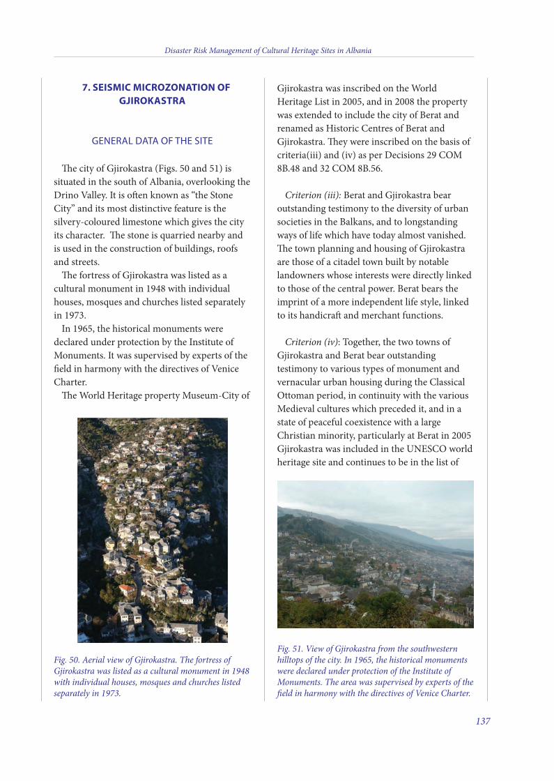
7. SEISMIC MICROZONATION OFGJIROKASTRA
GENERAL DATA OF THE SITE
e city of Gjirokastra (Figs. 50 and 51) issituated in the south of Albania, overlooking theDrino Valley. It is oen known as “the StoneCity” and its most distinctive feature is thesilvery-coloured limestone which gives the cityits character. e stone is quarried nearby andis used in the construction of buildings, roofsand streets.
e fortress of Gjirokastra was listed as acultural monument in 1948 with individualhouses, mosques and churches listed separatelyin 1973.
In 1965, the historical monuments weredeclared under protection by the Institute ofMonuments. It was supervised by experts of thefield in harmony with the directives of VeniceCharter.
e World Heritage property Museum-City of
Gjirokastra was inscribed on the WorldHeritage List in 2005, and in 2008 the propertywas extended to include the city of Berat andrenamed as Historic Centres of Berat andGjirokastra. ey were inscribed on the basis ofcriteria(iii) and (iv) as per Decisions 29 COM8B.48 and 32 COM 8B.56.
Criterion (iii): Berat and Gjirokastra bearoutstanding testimony to the diversity of urbansocieties in the Balkans, and to longstandingways of life which have today almost vanished.e town planning and housing of Gjirokastraare those of a citadel town built by notablelandowners whose interests were directly linkedto those of the central power. Berat bears theimprint of a more independent life style, linkedto its handicra and merchant functions.
Criterion (iv): Together, the two towns ofGjirokastra and Berat bear outstandingtestimony to various types of monument andvernacular urban housing during the ClassicalOttoman period, in continuity with the variousMedieval cultures which preceded it, and in astate of peaceful coexistence with a largeChristian minority, particularly at Berat in 2005Gjirokastra was included in the UNESCO worldheritage site and continues to be in the list of
Disaster Risk Management of Cultural Heritage Sites in Albania
137
Fig. 50. Aerial view of Gjirokastra. The fortress ofGjirokastra was listed as a cultural monument in 1948with individual houses, mosques and churches listedseparately in 1973.
Fig. 51. View of Gjirokastra from the southwesternhilltops of the city. In 1965, the historical monumentswere declared under protection of the Institute ofMonuments. The area was supervised by experts of thefield in harmony with the directives of Venice Charter.
10 v2_2015_Layout 1 12/04/15 20:32 Pagina 137
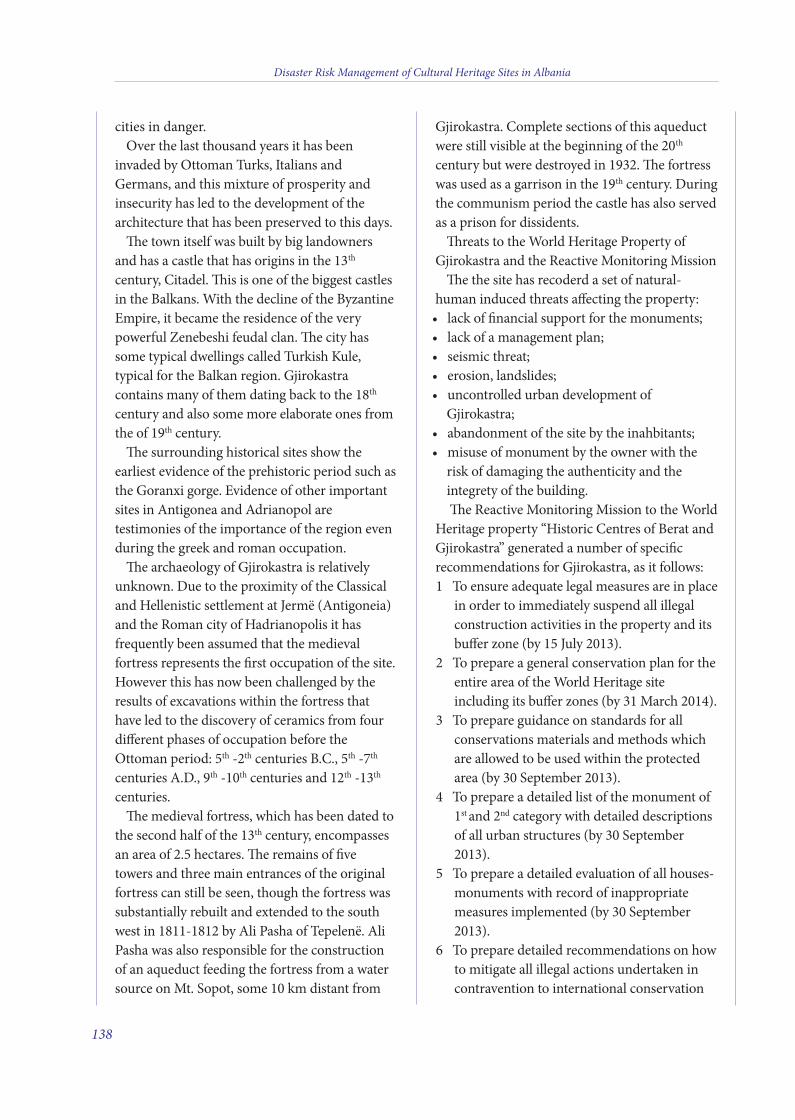
cities in danger.Over the last thousand years it has been
invaded by Ottoman Turks, Italians andGermans, and this mixture of prosperity andinsecurity has led to the development of thearchitecture that has been preserved to this days.
e town itself was built by big landownersand has a castle that has origins in the 13th
century, Citadel. is is one of the biggest castlesin the Balkans. With the decline of the ByzantineEmpire, it became the residence of the verypowerful Zenebeshi feudal clan. e city hassome typical dwellings called Turkish Kule,typical for the Balkan region. Gjirokastracontains many of them dating back to the 18th
century and also some more elaborate ones fromthe of 19th century.
e surrounding historical sites show theearliest evidence of the prehistoric period such asthe Goranxi gorge. Evidence of other importantsites in Antigonea and Adrianopol aretestimonies of the importance of the region evenduring the greek and roman occupation.
e archaeology of Gjirokastra is relativelyunknown. Due to the proximity of the Classicaland Hellenistic settlement at Jermë (Antigoneia)and the Roman city of Hadrianopolis it hasfrequently been assumed that the medievalfortress represents the first occupation of the site.However this has now been challenged by theresults of excavations within the fortress thathave led to the discovery of ceramics from fourdifferent phases of occupation before theOttoman period: 5th -2th centuries B.C., 5th -7th
centuries A.D., 9th -10th centuries and 12th -13th
centuries.e medieval fortress, which has been dated to
the second half of the 13th century, encompassesan area of 2.5 hectares. e remains of fivetowers and three main entrances of the originalfortress can still be seen, though the fortress wassubstantially rebuilt and extended to the southwest in 1811-1812 by Ali Pasha of Tepelenë. AliPasha was also responsible for the constructionof an aqueduct feeding the fortress from a watersource on Mt. Sopot, some 10 km distant from
Gjirokastra. Complete sections of this aqueductwere still visible at the beginning of the 20th
century but were destroyed in 1932. e fortresswas used as a garrison in the 19th century. Duringthe communism period the castle has also servedas a prison for dissidents.
reats to the World Heritage Property ofGjirokastra and the Reactive Monitoring Mission
e the site has recoderd a set of natural-human induced threats affecting the property:
lack of financial support for the monuments;•lack of a management plan;•seismic threat;•erosion, landslides;•uncontrolled urban development of•Gjirokastra;abandonment of the site by the inahbitants;•misuse of monument by the owner with the•risk of damaging the authenticity and theintegrety of the building.e Reactive Monitoring Mission to the World
Heritage property “Historic Centres of Berat andGjirokastra” generated a number of specificrecommendations for Gjirokastra, as it follows:
To ensure adequate legal measures are in place1in order to immediately suspend all illegalconstruction activities in the property and itsbuffer zone (by 15 July 2013).To prepare a general conservation plan for the2entire area of the World Heritage siteincluding its buffer zones (by 31 March 2014). To prepare guidance on standards for all3conservations materials and methods whichare allowed to be used within the protectedarea (by 30 September 2013). To prepare a detailed list of the monument of41st and 2nd category with detailed descriptionsof all urban structures (by 30 September2013). To prepare a detailed evaluation of all houses-5monuments with record of inappropriatemeasures implemented (by 30 September2013). To prepare detailed recommendations on how6to mitigate all illegal actions undertaken incontravention to international conservation
Disaster Risk Management of Cultural Heritage Sites in Albania
138
10 v2_2015_Layout 1 12/04/15 20:32 Pagina 138
standards and to the laws of Albania (by 30November 2013). Define the main attributes that reflect7Outstanding Universal Value - includingstreetscapes, views and also intangibleelements - indicated in lists, photographs andon maps (by 31 October 2013). Prepare a more precise classification of all8historic and other buildings (by 30 November2013). Develop monitoring indicators that fully9reflect the attributes (by 30 November 2013). To prepare a general conservation plan for10the entire area of the World Heritage siteincluding its buffer zones (by 31 March 2014). To prepare guidance on standards for all11conservations materials and methods whichare allowed to be used within the protectedarea (by 30 September 2013).
Problems and Riskse main problems an risks affecting
Gjirokastra can be summarized in:lack of financial support for the monuments;•lack of a management plan for Gjirokastra;•earthquake threat;•erosion.•In particular, risks coming from “legal” threatsare:uncontrolled development of Gjirokastra;•abandonment of the monuments by the•owners;conflict of property between different owners•regarding the property;interference by the owners in a specific•monument considered as a monument of firstcategory;importance without the presence of the•specialists.
is risks of damaging the authenticity of thebuilding and it’s integrity;
illegal purpose of use of monument by the•owner.
GEOLOGICAL OVERVIEW OFGJIROKASTRA AREA
e region of Gjirokastra is located south ofthe Shkoda-Peja fault, which divides the DinaricMountains from the Hellenides Montains,within the territory of which the region falls.e Hellenides Mountains, which in turn can bedivided in internal and external, are part of theDinaric-Albanian-Hellenic thrustbelt, whichwas formed during the Alpine orogeny. eexternal Hellenides, in particular, include thetectonic-sedimentary domains Krasta-Cukali,Kruja, Ionian, Sazani and Durres.
e region of Gjirokastra falls into the Ionianzone. is zone includes areas characterized bysynclines and anticlines with NW-SEorientation (Fig. 52), which from east to westare: Permeti syncline, anticline of Berat, thesyncline of Memaliaj, anticline of Kurveleshi,syncline of Shushica and Cika anticline. esestructures exhibit a westward asymmetry andare complicated by thrust faults located at theirwestern flanks. e amount of tectonictransport of the thrust faults, both in the area ofKruja and in the Ionian zone is estimated to bebetween fieen and fiy km (Xhufi and Canaj,1999; Frasheri et al., 2009).
e historic center of Gjirokastra is located,from a geological point of view, along theeastern flank of the Mali i Gere anticline, whichis connected to the western flank of the Drinosyncline. e deposits identified, mainlyMesozoic carbonates and Paleogene terrigenousunits (Fig. 52), constitute a homoclinal with ageneral NNW-SSE trend, gently dipping to E-NE (ca. 20°). e terrigenous portion of thegeological substrate, which houses the castleand much of the historic city center, lies inunconformity above the underlying carbonateunits (Torresi, 2008; Fig. 52).
Disaster Risk Management of Cultural Heritage Sites in Albania
139
10 v2_2015_Layout 1 12/04/15 20:32 Pagina 139
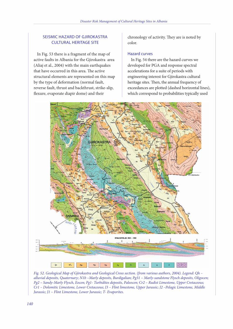
SEISMIC HAZARD OF GJIROKASTRACULTURAL HERITAGE SITE
In Fig. 53 there is a fragment of the map ofactive faults in Albania for the Gjirokastra area(Aliaj et al., 2004) with the main earthquakesthat have occurred in this area. e activestructural elements are represented on this mapby the type of deformation (normal fault,reverse fault, thrust and backthrust, strike-slip,flexure, evaporate diapir dome) and their
chronology of activity. ey are is noted bycolor.
Hazard curvesIn Fig. 54 there are the hazard curves we
developed for PGA and response spectralaccelerations for a suite of periods withengineering interest for Gjirokastra culturalheritage sites. en, the annual frequency ofexceedances are plotted (dashed horizontal lines),which correspond to probabilities typically used
Disaster Risk Management of Cultural Heritage Sites in Albania
140
Fig. 52. Geological Map of Gjirokastra and Geological Cross section. (from various authors, 2004). Legend: Qh –alluvial deposits, Quaternary; N1b –Marly deposits, Burdigalian; Pg31 – Marly-sandstone Flysch deposits, Oligocen;Pg2 – Sandy-Marly Flysch, Eocen; Pg1- Turbidites deposits, Paleocen; Cr2 – Rudist Limestone, Upper Cretaceous;Cr1 – Dolomitic Limestone, Lower Cretaceous; J3 – Flint limestone, Upper Jurassic; J2 –Pelagic Limestone, MiddleJurassic; J1 – Flint Limestone, Lower Jurassic; T- Evaporites.
10 v2_2015_Layout 1 12/04/15 20:32 Pagina 140
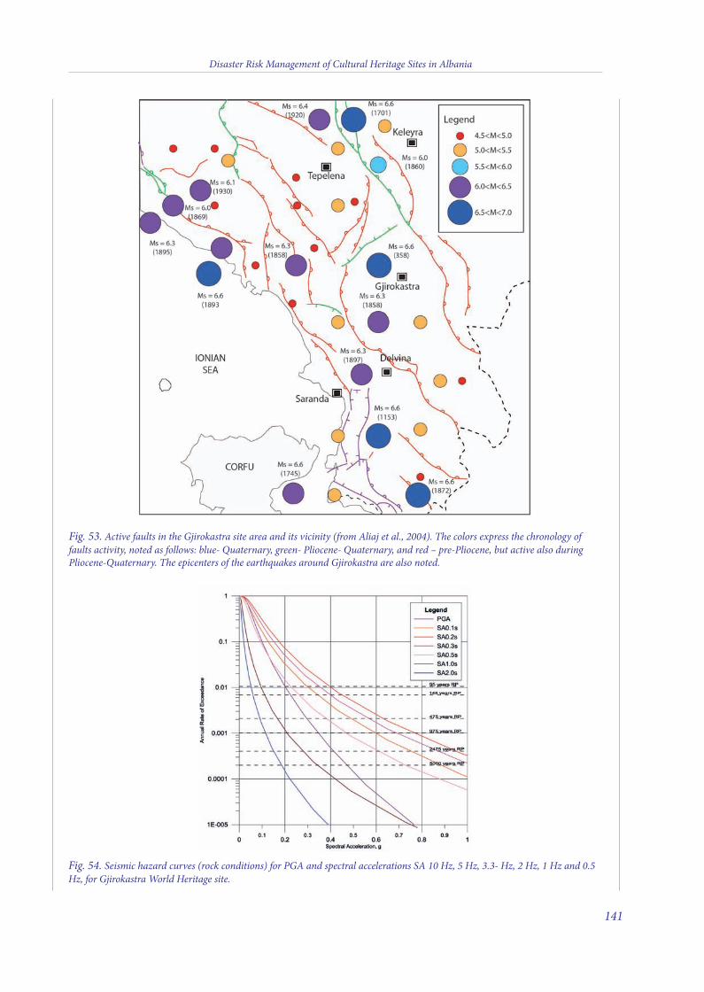
Disaster Risk Management of Cultural Heritage Sites in Albania
141
Fig. 54. Seismic hazard curves (rock conditions) for PGA and spectral accelerations SA 10 Hz, 5 Hz, 3.3- Hz, 2 Hz, 1 Hz and 0.5Hz, for Gjirokastra World Heritage site.
Fig. 53. Active faults in the Gjirokastra site area and its vicinity (from Aliaj et al., 2004). The colors express the chronology offaults activity, noted as follows: blue- Quaternary, green- Pliocene- Quaternary, and red – pre-Pliocene, but active also duringPliocene-Quaternary. The epicenters of the earthquakes around Gjirokastra are also noted.
10 v2_2015_Layout 1 12/04/15 20:32 Pagina 141

for the design, like 10% in 10 years (RP = 95years), and respectively 10% (RP = 475 years), 5%(RP = 975 years), 2% (RP = 2475 years) and 1%(RP =5 000 years) in 50 years.
Uniform Hazard Response Spectrum (UHRS)For Gjirokastra we considered five hazard
levels: 10% of exceedance probability in 10years, and 10%, 5%, 2% and 1% respectively, in
50 years, corresponding to 95 years-, 475 years-,975 years-, 2475 years- and 5000 years- returnperiods, respectively.
e maximum horizontal bedrock PGA andspectral accelerations (SA) for each RP wereobtained from PSHA and are listed in Table 9.e uniform hazard spectra (UHRS) for eachRP for Gjirokastra cultural heritage site isplotted in Fig. 55.
Disaster Risk Management of Cultural Heritage Sites in Albania
142
Fig. 55. Uniform hazard spectra for 1%, 2%, 5% and 10% probability of exceedance in 50 years, and 10% probabilityof exceedance in 10 years for Gjirokastra World Heritage site.
Table 9. Maximum horizontal bedrock PGA and SA for Gjirokastra World Heritage site.
Period Spectral Acceleration, g
Sec RP=95y RP=475y RP=975y RP=2475y RP=5000y
PGA 0.200 0.294 0.341 0.412 0.466
0.10 0.297 0.482 0.587 0.740 0.872
0.20 0.392 0.627 0.752 0.946 1.099
0.30 0.345 0.558 0.681 0.860 1.018
0.50 0.224 0.374 0.464 0.600 0.727
1.00 0.094 0.164 0.207 0.276 0.340
2.00 0.051 0.090 0.113 0.150 0.182
10 v2_2015_Layout 1 12/04/15 20:32 Pagina 142
SEISMIC MICROZONATION OF LEVEL 1 INGJIROKASTRA
e seismic microzonation map of level 1 ofGjirokastra (Annex VI) was been carried out inthe light of i) already available information, andii) new measurements of microtremors (Fig. 17).
Data analysis has allowed us to establish thepresence of both stable zones susceptible tolocal amplifications and unstable zonessusceptible to geological instability. Zones arenumbered in ascending order, based on theamplification expected.
Stable zones susceptible to local amplification
Zone 1) Marly-calcareous bedrockis zone occupies the western sector of the
city and is characterized by the presence ofthick-layered and fractured marly calcareousunits, with dip slope attitude towards thenortheast, locally overlaid in disconformity bycemented calcareous conglomerates. Marlylimestone and overlying conglomerates arelocally covered by a blanket of red earth, severalmeters thick.
e structural setting of marly-calcareousbedrock generates a homocline dipping towardsthe northeast, locally dissected by deep incisionsoccupied by streams that transport hugevolumes of debris downstream (Annex VI).ese narrow valleys are bounded by steepslopes (> 15°), which can cause topographicamplification of seismic motion.
Zone 2) Siliciclastic terrigenous geologicalbedrock
e marly limestone is unconformably coveredby siliciclastic turbidite deposits, consisting ofalternating medium and tick sandstone andsiltstone beds, dipping 15°-20° towards thenortheast. is terrigenous formation constitutesthe geological bedrock of the city together withthe marly limestone.
is unit occupies most of the urbanized area
of the city, exceeding thicknesses of severalhundred meters eastward (Annex VI). eturbidite deposits are locally, disconformablycovered by cemented and fractured calcareousconglomerates (the same deposits that cover themarly-calcareous bedrock to the west), forming alayer a few tens of meters thick.
Turbidite succession and overlyingconglomerates are dissected by deep incisedvalleys that isolate narrow ridges elongated in anortheast-southwest direction (Fig. 15); theseridges are expected to generate topographicamplification of seismic input. is effect wasalso highlighted by microtremor measurementsmade inside the fortress (AL13 and AL14 inAnnex II, VI).
Zone 3) Alluvial fan 1is zone is located in the southern sector of
the study area, just south of the city, and ischaracterized by the presence of alluvial fandeposits that cover the siliciclastic turbidite unit.e alluvial fan deposits consist of uncementedcalcareous conglomerates, in sandy matrix,which develop on the likely thickness of 15 to 20meters, as also evidenced by the results ofmicrotremor measurements (AL18 in Annex II).
Zone 4) Alluvial fan 2is zone is located in the northern sector of
the study area, just north of the city, and ischaracterized by the presence of alluvial fandeposits that cover the marly-calcareous bedrock.e alluvial fan deposits consist of uncementedcalcareous conglomerates in sandy matrix, whichdevelop on the likely thickness of 15 to 20 meters.
Zone 5) Wide- and narrow-incised valleye area of the wide-incised valley covers the
zone which runs between the stadium and thefloodplain of the Drino River, carved into theterrigenous turbiditic unit (Fig. 56a).
e width of the valley, where it merges intothe floodplain of the Drino River, exceeds 300meters. e valley narrows gradually upstream,to form a narrow depression flanked by steep
Disaster Risk Management of Cultural Heritage Sites in Albania
143
10 v2_2015_Layout 1 12/04/15 20:32 Pagina 143
slopes carved into the marly-calcareousbedrock. e filling of the valley is not known,given the lack of drilling. However, themorphological and depositional setting allowsus to assume a fining-upward filling with coarsebasal deposits (sand and pebble) passingupward to silt and sand.
Microtremor measurements performed insidethe stadium (AL16 in Annex II) permit us toestimate a local thickness of the alluvial depositsof 15 to 20 meters for likely shear-wave velocity(Vs) values. e lack of subsurface data,however, does not allow to define the effectivethicknesses of the so covers. e area of thenarrow incised-valleys runs along thenortheastern flank of the relief hosting theurban area; these valley are carved into theterrigenous turbiditic unit (Annex VI).
e width of the valleys at the confluence withthe floodplain of the Drino River does notexceed 150 meters and their filling is notknown, given the lack of drilling. However, it isassumed the presence of few tens of metersthick loose silty and sandy filling.
e unfavourable aspect ratio (i.e.,relationship between height and width) ofincised valleys and the poor quality of theirfilling can induce significant amplification ofground motion.
Zone 6) Alluvial plainis zone is developed primarily west of the
Drino River, along the foothills hosting thealluvial fans fed by rivers flowing from themountains just west of Gjirokastra.
e heterogeneity of the subsoil allows todivide this zone into two areas, one near thehills on which stands the city, the other,represented by the valley of the Drino River.
Regarding the sector close to the hills, thepresence of both alluvial fans and the DrinoRiver allows us to hypothesize the presence ofalternating loose silts, sands and pebbles. esuperimposition of soils with different textureseems confirmed by results of microtremormeasurements (AL12 in Annex II), which
highlight impedance contrasts in filling soils atshallow depths (approximately 5 meters fromground surface).
With regard to the thickness of these deposits,the articulated topography observed on thereliefs just west of the floodplain, suggests asignificant thickness variability perpendicular tothe incised valleys merging from the west to themain watercourse.
e outer sector is located mainly to the eastof the Drino River, in the floodplain. Here thedeposits are thought to be mainly fine-grainedand related to the Drino River depositionalmechanisms; thicknesses are not known, butthey likely exceed 30 meters.
Zones susceptible to geological instabilityZone 7) Zone susceptible to rock falls,
toppling of blocksis zone occupies areas of the city close to
escarpments carved into the marly-calcareousbedrock and adjacent to the conglomeratesoverlying the terrigenous turbidite units (Fig. 56b,c). One of the critical areas in terms ofsusceptibility to rock falls and the toppling ofblocks is occupied by the city’s fortress, where ageological survey documented fallen blocks onboth sides of the relief (Fig. 56d).
Zone 8) Zone susceptible to complexlandslides
e areas of the city located on steep slopescarved into the turbidite unit may be affected bygravitational instability. ese processes arecurrently active in some areas of the city andinvolve structures built near steep slopes.
Superficial and buried geomorphologicalfeatures
In terms of seismic hazard, threemorphological features of the study area arenoteworthy:
the presence of buried narrow valleys filled•with so soils, where enhanced amplificationof seismic effects are presumable because oftheir aspect ratio;
Disaster Risk Management of Cultural Heritage Sites in Albania
144
10 v2_2015_Layout 1 12/04/15 20:32 Pagina 144
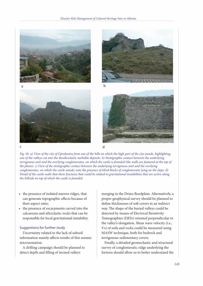
the presence of isolated narrow ridges, that•can generate topographic effects because oftheir aspect ratio;the presence of escarpments carved into the•calcareous and siliciclastic rocks that can beresponsible for local gravitational instability.
Suggestions for further studyUncertainty related to the lack of subsoil
information mainly affects results of this seismicmicrozonation.
A drilling campaign should be planned todetect depth and filling of incised valleys
merging in the Drino floodplain. Alternatively, aproper geophysical survey should be planned todefine thicknesses of so covers in an indirectway. e shape of the buried valleys could bedetected by means of Electrical ResistivityTomographies (ERTs) oriented perpendicular tothe valley’s elongation. Shear wave velocity (i.e.,Vs) of soils and rocks could be measured usingMASW technique, both for bedrock andterrigenous sedimentary covers.
Finally, a detailed geomechanic and structuralsurvey of conglomeratic ridge underlying thefortress should allow us to better understand the
Disaster Risk Management of Cultural Heritage Sites in Albania
145
Fig. 56. a) View of the city of Gjirokastra from one of the hills on which the high part of the city stands, highlightingone of the valleys cut into the thesiliciclastic turbidite deposits. b) Stratigraphic contact between the underlyingterrigenous unit and the overlying conglomerates, on which the castle is founded (the walls are featured at the top ofthe photo). c) View of the stratigraphic contact between the underlying terrigenous unit and the overlyingconglomerates, on which the castle stands; note the presence of tilted blocks of conglomerates lying on the slope. d)Detail of the castle walls that show fractures that could be related to gravitational instabilities that are active alongthe hillside on top of which the castle is founded.
10 v2_2015_Layout 1 12/04/15 20:32 Pagina 145
processes responsible for its gravitationalinstability.
REFERENCES
Frasheri A., Bushati S., and Bare V. (2009) - Geophysicaloutlook on structure of the Albanides: Journal of theBalkan Geophysical Society, v. 12(1), p. 9-30.
Torresi F. (2008) - Rischio Sismico nei centri storici. Ilprogetto TRANSISMIC: analisi sperimentale per lavalutazione e la riduzione del rischio. INTERREG III-A,NPPA Progetto TRANSISMIC, Quaderni di Piano n. 3,177.
Xhufi C. and Canaj B. (1999) - Some aspects of seismic-geologic interpretation in thrusting belts, Albania: 2nd
Congress of the Balkan Geophysical Society.
Various Authors (2004) - Geological Map of Albania (scale1:200,000). Tirana, Albania.
AUTHORS:
Gian Paolo Cavinato, Giuseppe Cosentino, Massimiliano
Moscatelli and Maurizio Simionato
CNR-Institute of Environmental Geology and
Geoengineering, Area della Ricerca di Roma1, Rome, Italy
Disaster Risk Management of Cultural Heritage Sites in Albania
146
10 v2_2015_Layout 1 12/04/15 20:32 Pagina 146
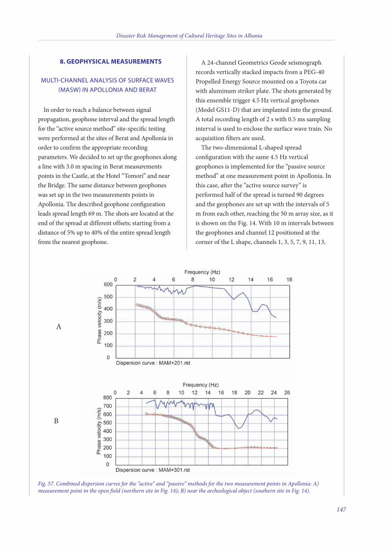
8. GEOPHYSICAL MEASUREMENTS
MULTI-CHANNEL ANALYSIS OF SURFACE WAVES(MASW) IN APOLLONIA AND BERAT
In order to reach a balance between signalpropagation, geophone interval and the spread lengthfor the “active source method” site-specific testingwere performed at the sites of Berat and Apollonia inorder to confirm the appropriate recordingparameters. We decided to set up the geophones alonga line with 3.0 m spacing in Berat measurementspoints in the Castle, at the Hotel “Tomori” and nearthe Bridge. The same distance between geophoneswas set up in the two measurements points inApollonia. The described geophone configurationleads spread length 69 m. The shots are located at theend of the spread at different offsets; starting from adistance of 5% up to 40% of the entire spread lengthfrom the nearest geophone.
A 24-channel Geometrics Geode seismographrecords vertically stacked impacts from a PEG-40Propelled Energy Source mounted on a Toyota carwith aluminum striker plate. The shots generated bythis ensemble trigger 4.5 Hz vertical geophones(Model GS11-D) that are implanted into the ground.A total recording length of 2 s with 0.5 ms samplinginterval is used to enclose the surface wave train. Noacquisition filters are used.The two-dimensional L-shaped spread
configuration with the same 4.5 Hz verticalgeophones is implemented for the “passive sourcemethod” at one measurement point in Apollonia. Inthis case, after the “active source survey” isperformed half of the spread is turned 90 degreesand the geophones are set up with the intervals of 5m from each other, reaching the 50 m array size, as itis shown on the Fig. 14. With 10 m intervals betweenthe geophones and channel 12 positioned at thecorner of the L shape, channels 1, 3, 5, 7, 9, 11, 13,
Disaster Risk Management of Cultural Heritage Sites in Albania
147
Fig. 57. Combined dispersion curves for the “active” and “passive” methods for the two measurement points in Apollonia: A)measurement point in the open field (northern site in Fig. 14); B) near the archeological object (southern site in Fig. 14).
A
B
11 v10_4_2015_Layout 1 10/04/15 16:14 Pagina 147
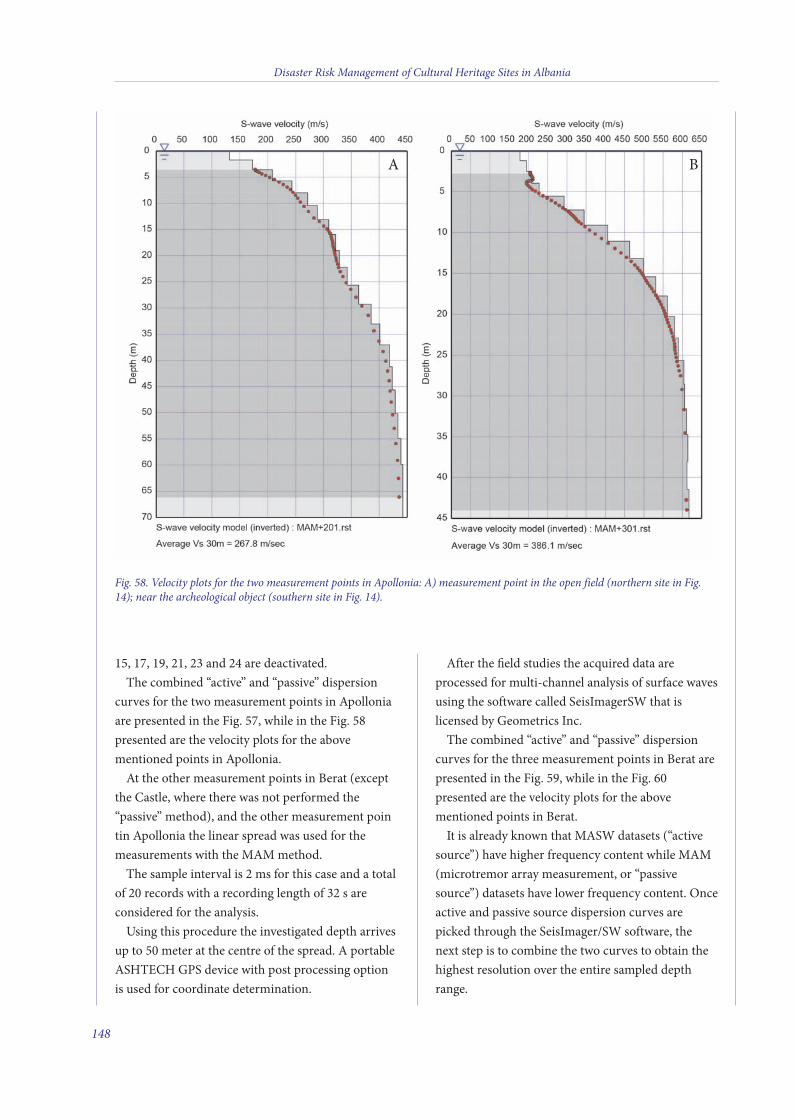
15, 17, 19, 21, 23 and 24 are deactivated.The combined “active” and “passive” dispersion
curves for the two measurement points in Apolloniaare presented in the Fig. 57, while in the Fig. 58presented are the velocity plots for the abovementioned points in Apollonia.At the other measurement points in Berat (except
the Castle, where there was not performed the“passive” method), and the other measurement pointin Apollonia the linear spread was used for themeasurements with the MAM method.The sample interval is 2 ms for this case and a total
of 20 records with a recording length of 32 s areconsidered for the analysis.Using this procedure the investigated depth arrives
up to 50 meter at the centre of the spread. A portableASHTECH GPS device with post processing optionis used for coordinate determination.
After the field studies the acquired data areprocessed for multi-channel analysis of surface wavesusing the software called SeisImagerSW that islicensed by Geometrics Inc.The combined “active” and “passive” dispersion
curves for the three measurement points in Berat arepresented in the Fig. 59, while in the Fig. 60presented are the velocity plots for the abovementioned points in Berat.It is already known that MASW datasets (“active
source”) have higher frequency content while MAM(microtremor array measurement, or “passivesource”) datasets have lower frequency content. Onceactive and passive source dispersion curves arepicked through the SeisImager/SW software, thenext step is to combine the two curves to obtain thehighest resolution over the entire sampled depthrange.
Disaster Risk Management of Cultural Heritage Sites in Albania
148
Fig. 58. Velocity plots for the two measurement points in Apollonia: A) measurement point in the open field (northern site in Fig.14); near the archeological object (southern site in Fig. 14).
A B
11 v10_4_2015_Layout 1 10/04/15 16:14 Pagina 148
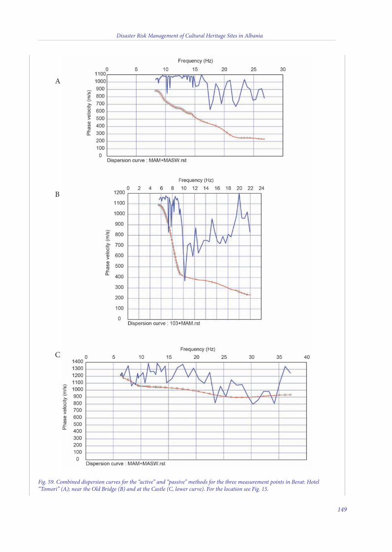
Disaster Risk Management of Cultural Heritage Sites in Albania
149
Fig. 59. Combined dispersion curves for the “active” and “passive” methods for the three measurement points in Berat: Hotel“Tomori” (A); near the Old Bridge (B) and at the Castle (C, lower curve). For the location see Fig. 15.
A
B
C
11 v10_4_2015_Layout 1 10/04/15 16:14 Pagina 149
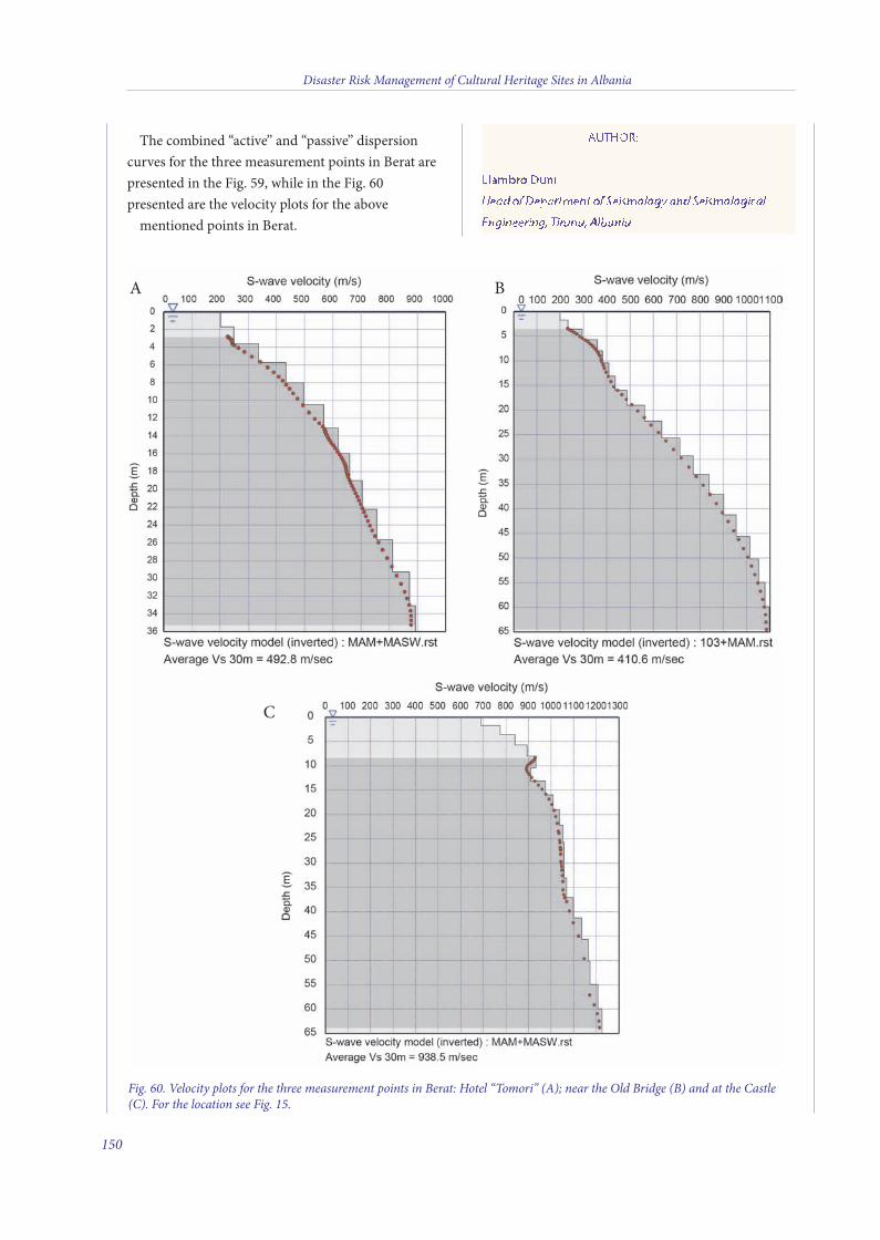
The combined “active” and “passive” dispersioncurves for the three measurement points in Berat arepresented in the Fig. 59, while in the Fig. 60presented are the velocity plots for the above mentioned points in Berat.
AUTHOR:
Llambro Duni
Head of Department of Seismology and Seismological
Engineering, Tirana, Albania
Disaster Risk Management of Cultural Heritage Sites in Albania
150
A
C
B
Fig. 60. Velocity plots for the three measurement points in Berat: Hotel “Tomori” (A); near the Old Bridge (B) and at the Castle(C). For the location see Fig. 15.
11 v10_4_2015_Layout 1 10/04/15 16:14 Pagina 150
ANNEX II
PHYSICAL MEASUREMENT TABLES
Disaster Risk Management of Cultural Heritage Sites in Albania
151
11 v10_4_2015_Layout 1 10/04/15 16:14 Pagina 151
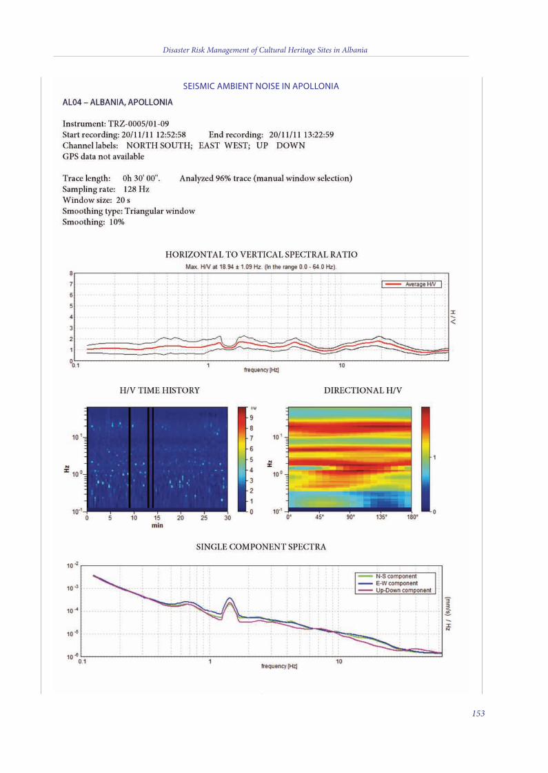
Disaster Risk Management of Cultural Heritage Sites in Albania
153
SEISMIC AMBIENT NOISE IN APOLLONIA
11 v10_4_2015_Layout 1 10/04/15 16:14 Pagina 153

Disaster Risk Management of Cultural Heritage Sites in Albania
154
11 v10_4_2015_Layout 1 10/04/15 16:14 Pagina 154
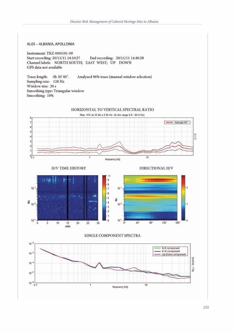
Disaster Risk Management of Cultural Heritage Sites in Albania
155
11 v10_4_2015_Layout 1 10/04/15 16:14 Pagina 155

Disaster Risk Management of Cultural Heritage Sites in Albania
156
11 v10_4_2015_Layout 1 10/04/15 16:14 Pagina 156
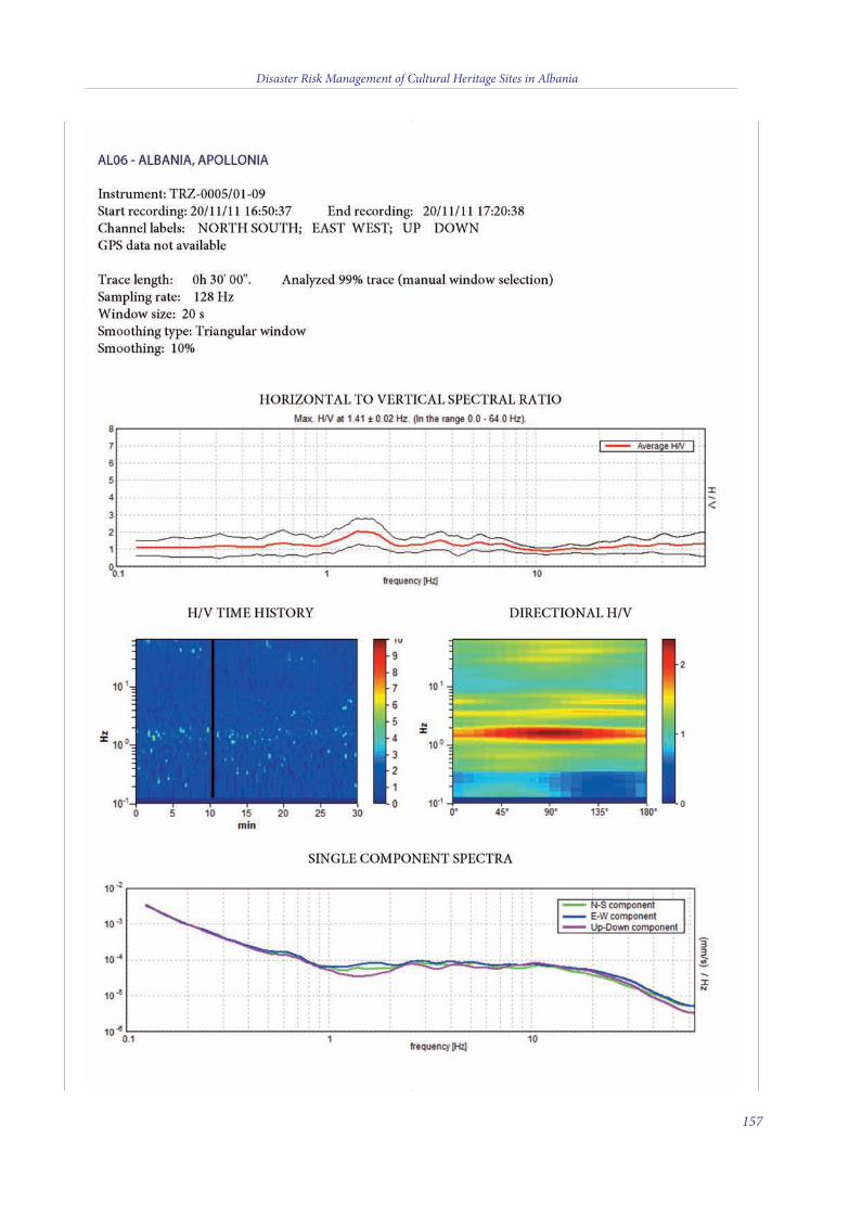
Disaster Risk Management of Cultural Heritage Sites in Albania
157
11 v10_4_2015_Layout 1 10/04/15 16:14 Pagina 157

Disaster Risk Management of Cultural Heritage Sites in Albania
158
11 v10_4_2015_Layout 1 10/04/15 16:14 Pagina 158
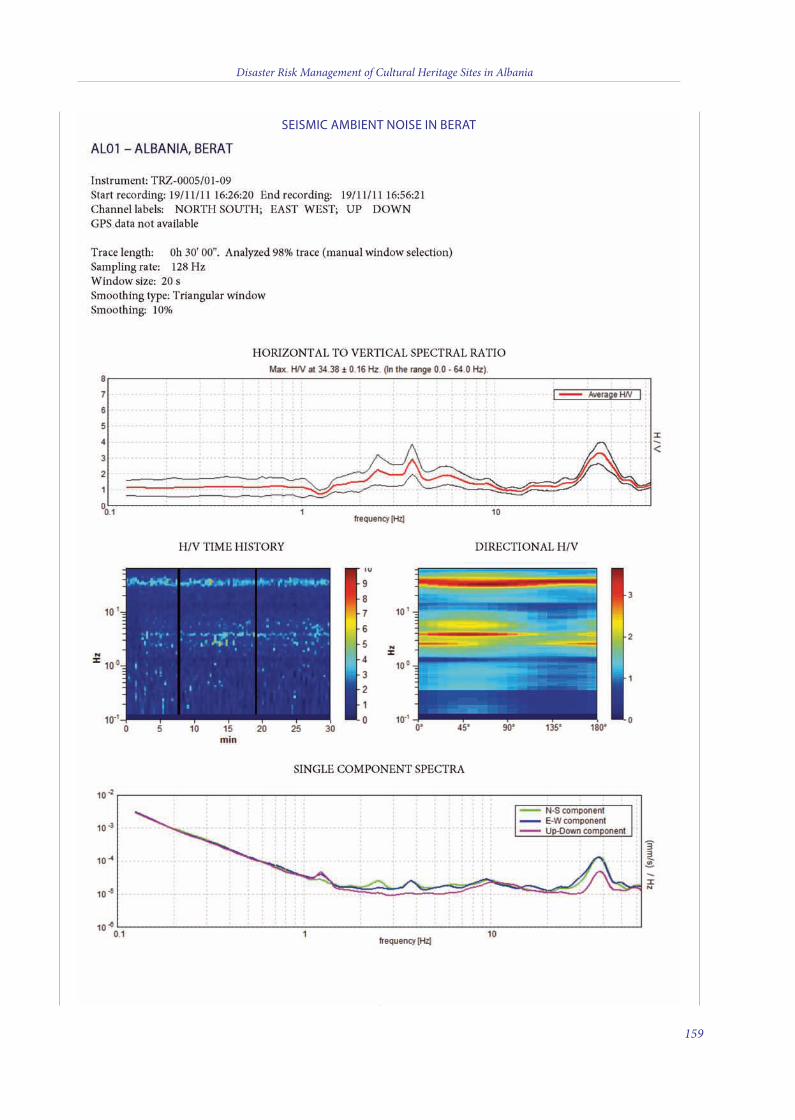
Disaster Risk Management of Cultural Heritage Sites in Albania
159
SEISMIC AMBIENT NOISE IN BERAT
11 v10_4_2015_Layout 1 10/04/15 16:14 Pagina 159

Disaster Risk Management of Cultural Heritage Sites in Albania
160
11 v10_4_2015_Layout 1 10/04/15 16:14 Pagina 160
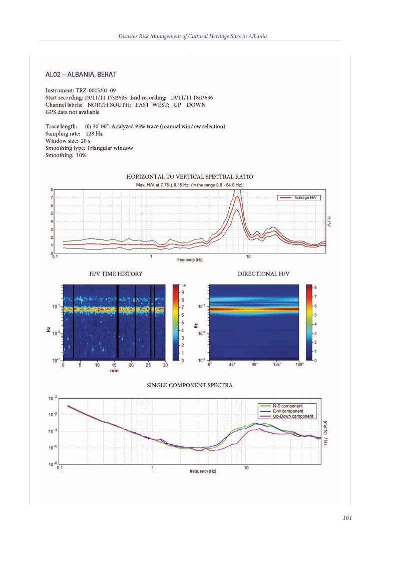
Disaster Risk Management of Cultural Heritage Sites in Albania
161
11 v10_4_2015_Layout 1 10/04/15 16:14 Pagina 161

Disaster Risk Management of Cultural Heritage Sites in Albania
162
11 v10_4_2015_Layout 1 10/04/15 16:14 Pagina 162
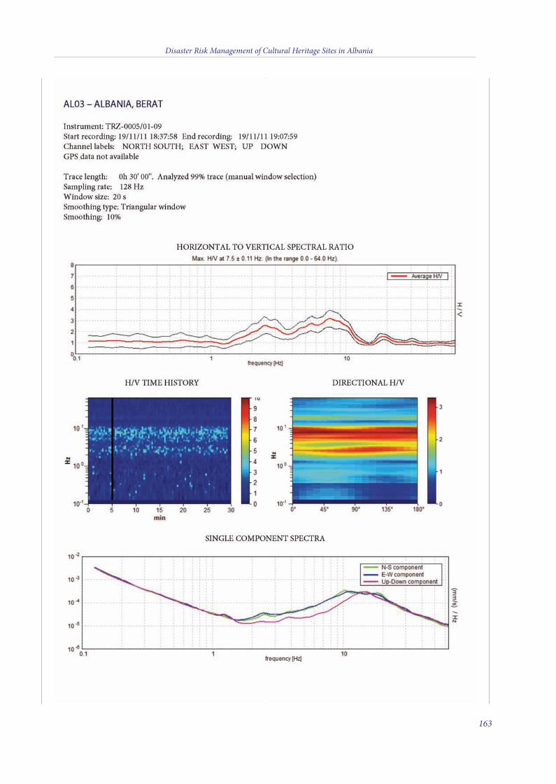
Disaster Risk Management of Cultural Heritage Sites in Albania
163
11 v10_4_2015_Layout 1 10/04/15 16:14 Pagina 163
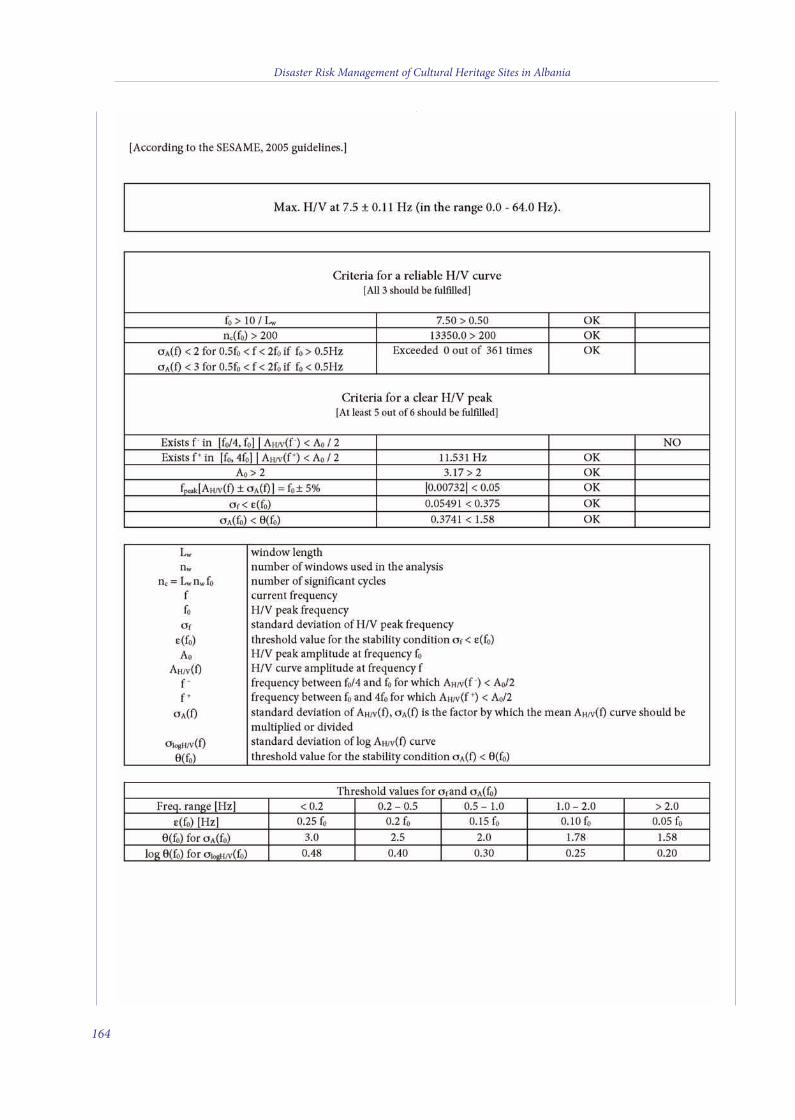
Disaster Risk Management of Cultural Heritage Sites in Albania
164
11 v10_4_2015_Layout 1 10/04/15 16:14 Pagina 164
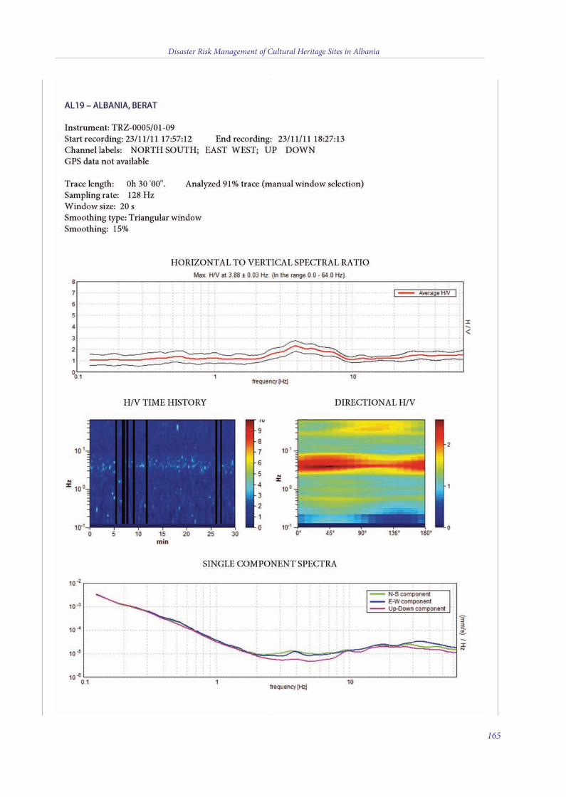
Disaster Risk Management of Cultural Heritage Sites in Albania
165
11 v10_4_2015_Layout 1 10/04/15 16:14 Pagina 165

Disaster Risk Management of Cultural Heritage Sites in Albania
166
11 v10_4_2015_Layout 1 10/04/15 16:14 Pagina 166
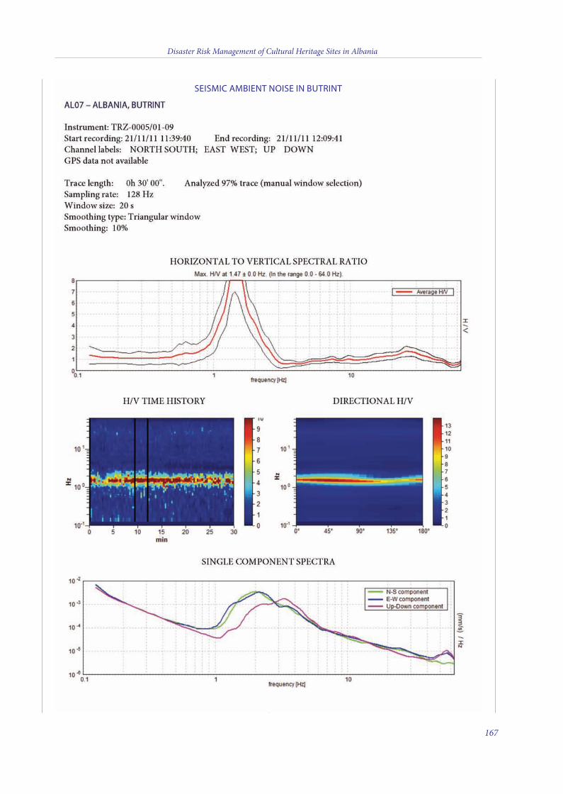
Disaster Risk Management of Cultural Heritage Sites in Albania
167
SEISMIC AMBIENT NOISE IN BUTRINT
11 v10_4_2015_Layout 1 10/04/15 16:14 Pagina 167

Disaster Risk Management of Cultural Heritage Sites in Albania
168
11 v10_4_2015_Layout 1 10/04/15 16:14 Pagina 168
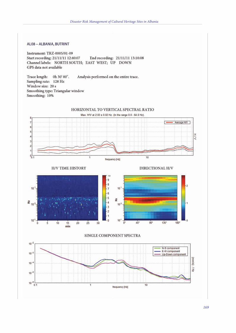
Disaster Risk Management of Cultural Heritage Sites in Albania
169
11 v10_4_2015_Layout 1 10/04/15 16:15 Pagina 169

Disaster Risk Management of Cultural Heritage Sites in Albania
170
11 v10_4_2015_Layout 1 10/04/15 16:15 Pagina 170
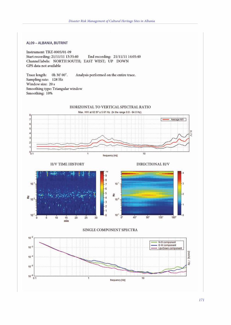
Disaster Risk Management of Cultural Heritage Sites in Albania
171
11 v10_4_2015_Layout 1 10/04/15 16:15 Pagina 171
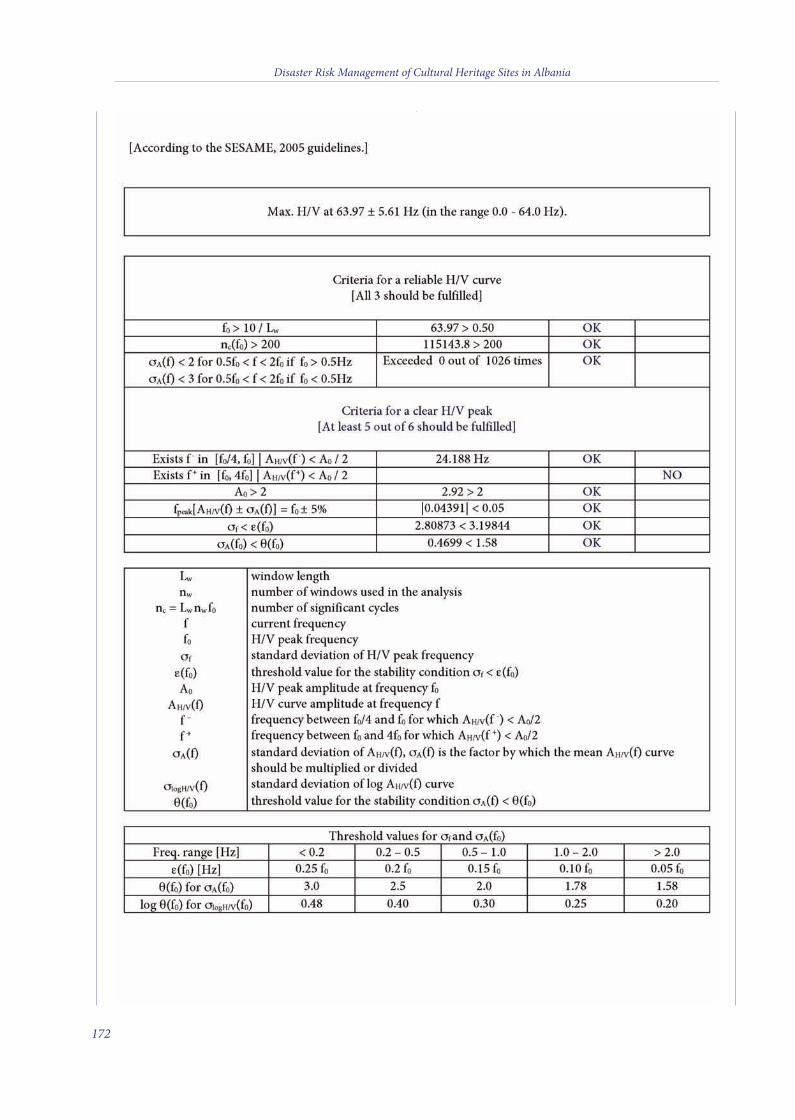
Disaster Risk Management of Cultural Heritage Sites in Albania
172
11 v10_4_2015_Layout 1 10/04/15 16:15 Pagina 172
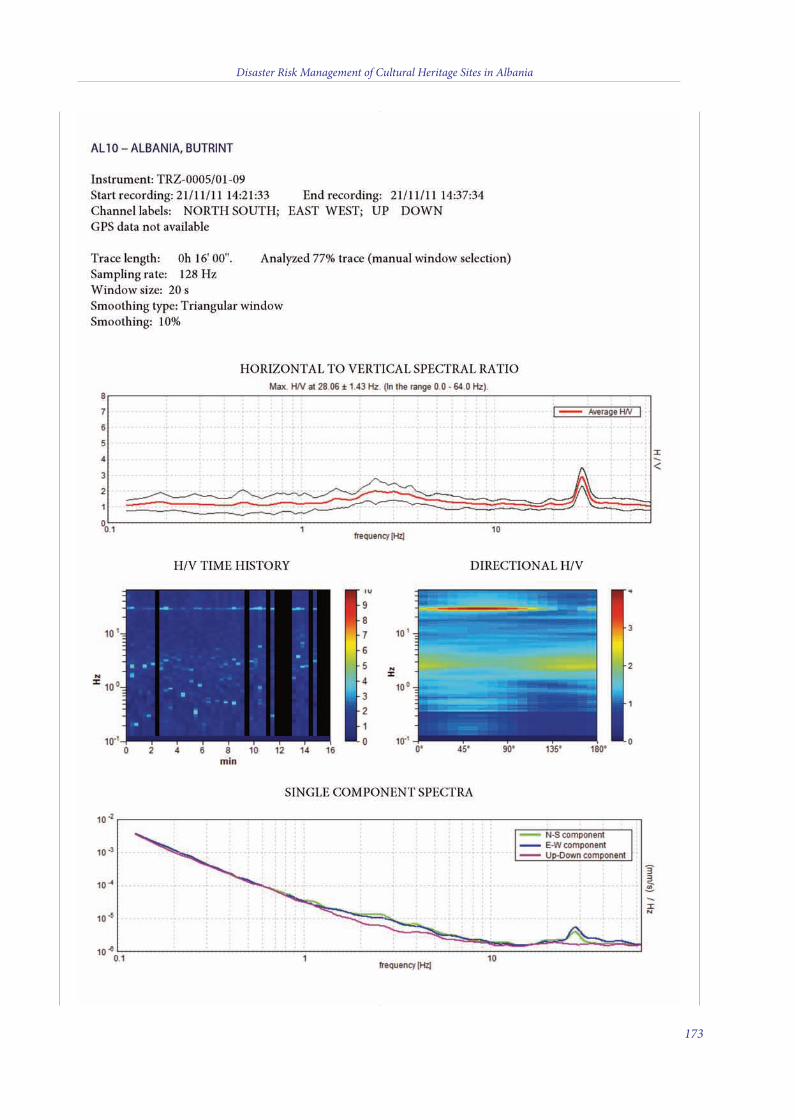
Disaster Risk Management of Cultural Heritage Sites in Albania
173
11 v10_4_2015_Layout 1 10/04/15 16:15 Pagina 173
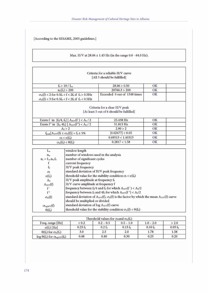
Disaster Risk Management of Cultural Heritage Sites in Albania
174
11 v10_4_2015_Layout 1 10/04/15 16:15 Pagina 174
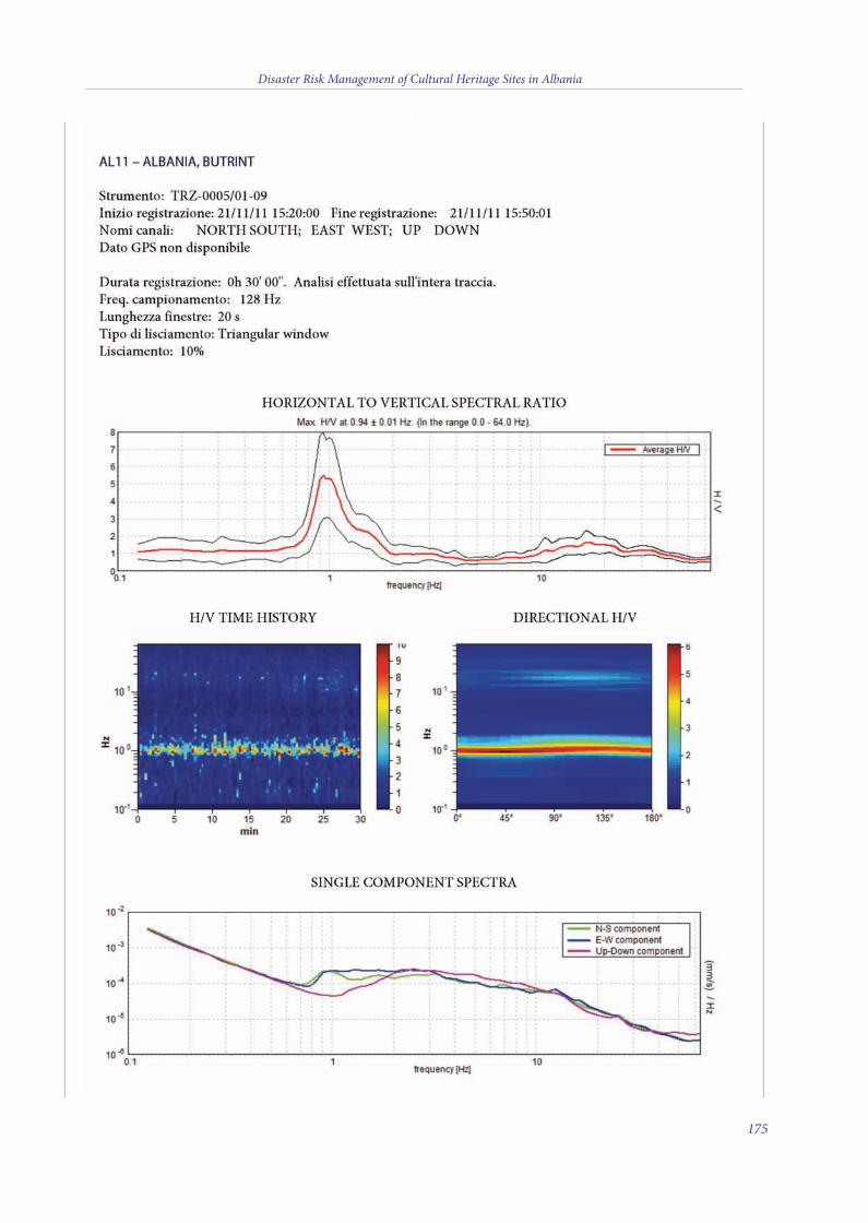
Disaster Risk Management of Cultural Heritage Sites in Albania
175
11 v10_4_2015_Layout 1 10/04/15 16:15 Pagina 175
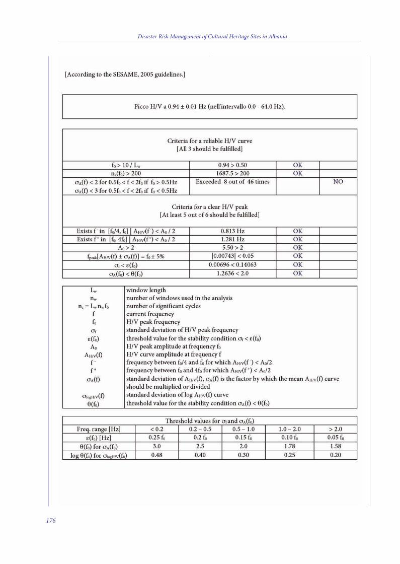
Disaster Risk Management of Cultural Heritage Sites in Albania
176
11 v10_4_2015_Layout 1 10/04/15 16:15 Pagina 176
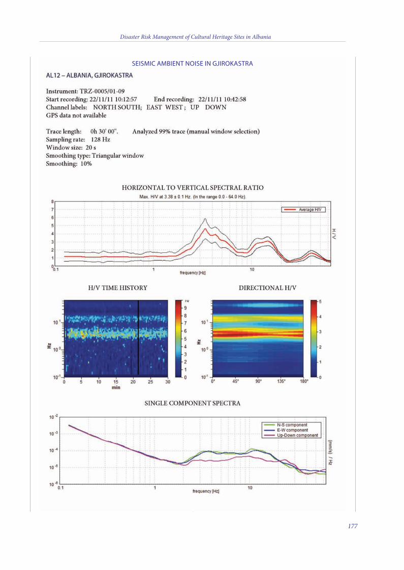
Disaster Risk Management of Cultural Heritage Sites in Albania
177
SEISMIC AMBIENT NOISE IN GJIROKASTRA
11 v10_4_2015_Layout 1 10/04/15 16:15 Pagina 177
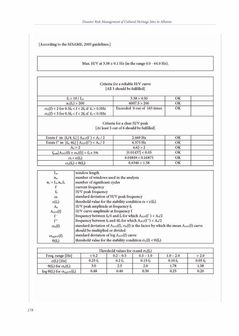
Disaster Risk Management of Cultural Heritage Sites in Albania
178
11 v10_4_2015_Layout 1 10/04/15 16:15 Pagina 178
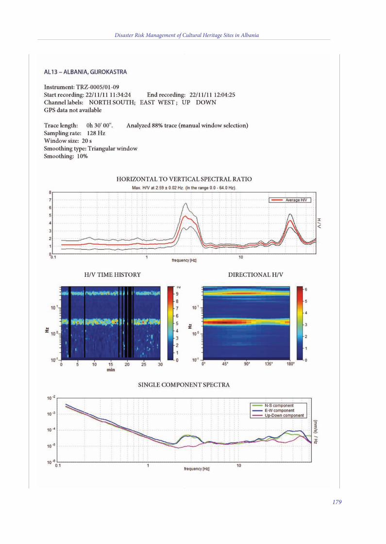
Disaster Risk Management of Cultural Heritage Sites in Albania
179
11 v10_4_2015_Layout 1 10/04/15 16:15 Pagina 179

Disaster Risk Management of Cultural Heritage Sites in Albania
180
11 v10_4_2015_Layout 1 10/04/15 16:15 Pagina 180

Disaster Risk Management of Cultural Heritage Sites in Albania
181
11 v10_4_2015_Layout 1 10/04/15 16:15 Pagina 181

Disaster Risk Management of Cultural Heritage Sites in Albania
182
11 v10_4_2015_Layout 1 10/04/15 16:15 Pagina 182
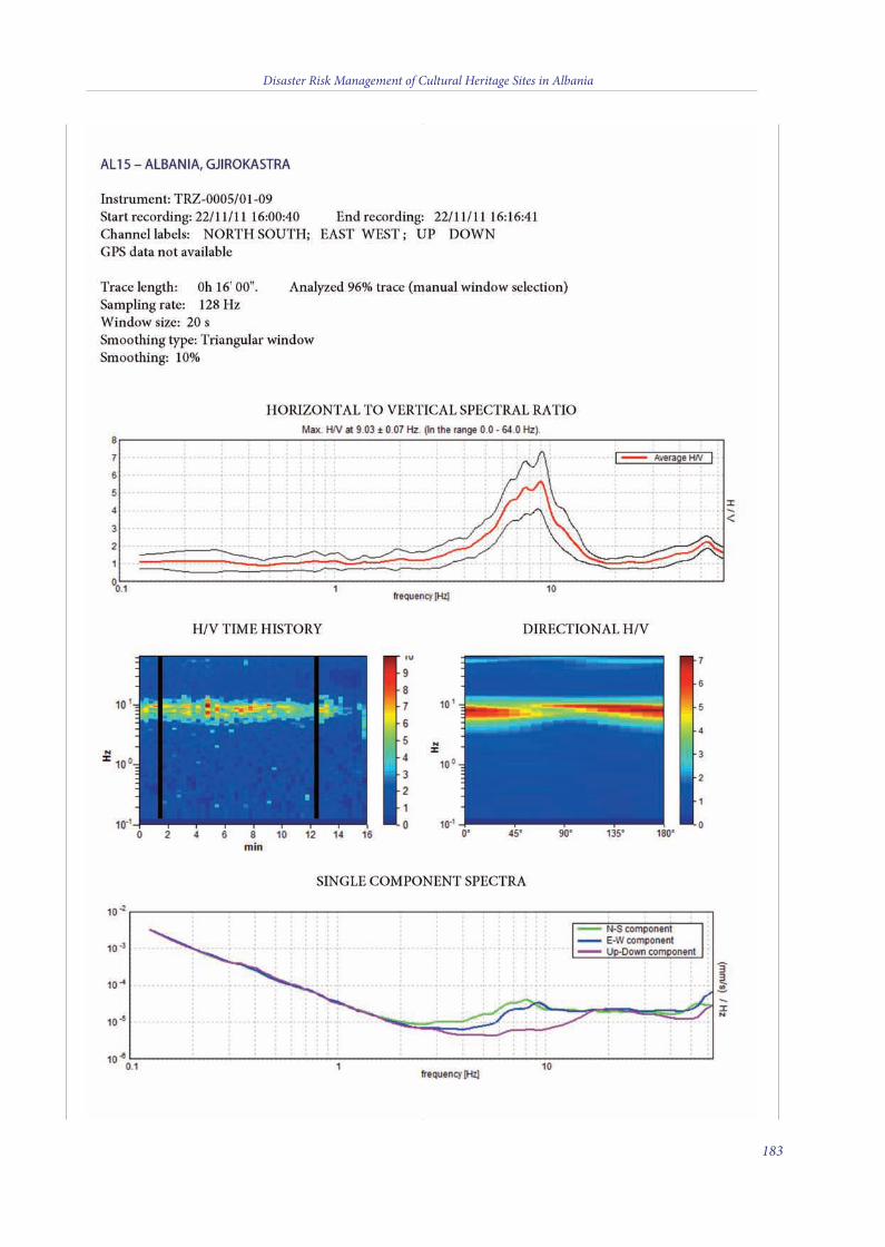
Disaster Risk Management of Cultural Heritage Sites in Albania
183
11 v10_4_2015_Layout 1 10/04/15 16:15 Pagina 183
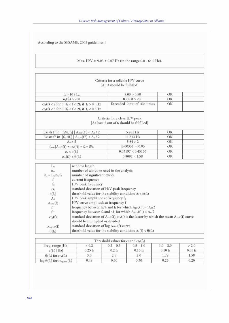
Disaster Risk Management of Cultural Heritage Sites in Albania
184
11 v10_4_2015_Layout 1 10/04/15 16:15 Pagina 184

Disaster Risk Management of Cultural Heritage Sites in Albania
185
11 v10_4_2015_Layout 1 10/04/15 16:15 Pagina 185
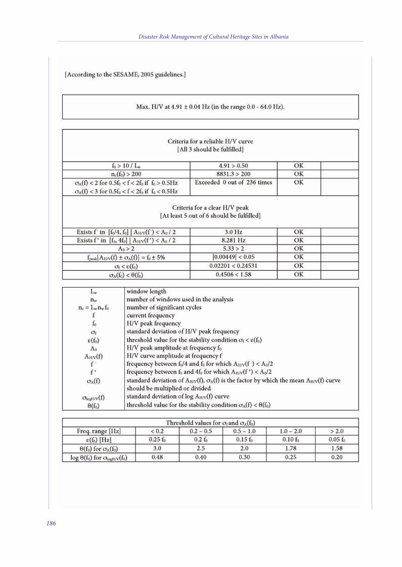
Disaster Risk Management of Cultural Heritage Sites in Albania
186
11 v10_4_2015_Layout 1 10/04/15 16:15 Pagina 186

Disaster Risk Management of Cultural Heritage Sites in Albania
187
11 v10_4_2015_Layout 1 10/04/15 16:15 Pagina 187
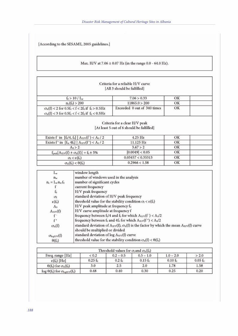
Disaster Risk Management of Cultural Heritage Sites in Albania
188
11 v10_4_2015_Layout 1 10/04/15 16:15 Pagina 188
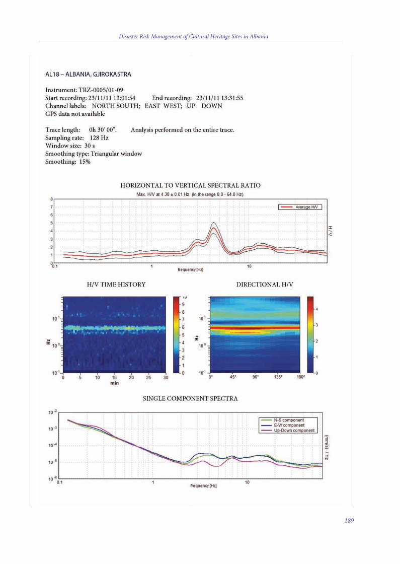
Disaster Risk Management of Cultural Heritage Sites in Albania
189
11 v10_4_2015_Layout 1 10/04/15 16:15 Pagina 189

190
Disaster Risk Management of Cultural Heritage Sites in Albania
11 v10_4_2015_Layout 1 10/04/15 16:15 Pagina 190

Printed in December 2014with the print on demand technology
by “Nuova Cultura” [Int_9788868122867_a4col_LM05]
11 v10_4_2015_Layout 1 10/04/15 16:15 Pagina 192

Cover photo credits: CNR-IGAG
Front coverButrint, eatre
Back coverUpper le - Apollonia, Bouleterion TempleMiddle - BeratLower right - Gjirokastra
ISBN 978-88-6812-286-7
cover albania v2_2015_Layout 1 13/03/15 17:50 Pagina 2

National Research Council Italy
Institute of Environmental Geologyand Geoengineering Rome
Disaster Risk Managementof Cultural Heritage Sites
in Albania
Dis
aste
r Ris
k M
anag
emen
t of C
ultu
ral H
erita
ge S
ites
in A
lban
iae international debate concerning the overall capacity in disaster risks mitigation and adaptation
strategies of entire systems, communities and sites has increased significantly during the last decade, mainlydue to the interplay of multiple factors which have worsened the severity of hazards turning them withincreased occurrences into full-fledged disasters. Nowadays, an integrated approach is mandatory in thefield of sustainable development and Disaster Risk Reduction (DRR): the traditional ri between cultureand science, and the subdivisions among disciplines and fields of science have to be overpassed by the needsof our times. ese compel us to interface the advancements in science and technology in DRR with policymakers, emergency responders and local communities. Working in synergy in an integrated manner is notan easy task to undertake. CNR-IGAG, the UNESCO Regional Bureau for Science and Culture in Europeand ICCROM, under the framework of the ONE UN initiative, have endeavored to make this idea a workingconcept: scientific field assessment of geo-vulnerabilities in the World Heritage Sites of Albania have beencombined with the sucessful attempt to train emergency responders and site managers to deal with DRR inthe same sites. e achievements of such activities constitute the narrative of this script.
Rome, 2014
With the support of
Venice Office
United Nations
Cultural Organization
ISBN 978-88-6812-286-7
cover albania v2_2015_Layout 1 13/03/15 17:50 Pagina 1