diablo mountain north wilderness character evaluation · (pp&l) transmission line: pp&l...
TRANSCRIPT
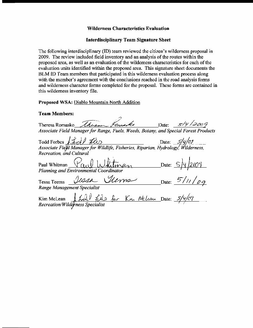
Wilderness Characteristics Evaluation
Interdisciplinary Team Signature Sheet
The following interdisciplinary (lD) team reviewed the citizen's wilderness proposal in 2009. The review included field inventory and an analysis of the routes within the proposed area, as well as an evaluation of the wilderness characteristics for each of the evaluation units identified within the proposed area. This signature sheet documents the BLM ID Team members that participated in this wilderness evaluation process along with the member's agreement with the conclusions reached in the road analysis forms and wilderness character forms completed for the proposal. These forms are contained in this wilderness inventory file.
Proposed WSA: Diablo Mountain North Addition
Team Members: #,
Theresa Romasko ~~ Date: s/;,r /-7a.? 9 Associate Field Manager for Range, Fuels, Weeds, Botany, and Special Forest Products
Todd Forbes lLAf& Date: ~l Associate Fir/jiJ Manager for Wildlife, Fisheries, Riparian, Hydrology, ilderness, Recreation, and Cultural
pauIWhitman_eu\~ IJ~ Date: S}~ hm Planning and Environmental Coordinator I
Tessa Teems ,J/~ ~ Date: ~-//I /tJCj Range Management Specialist
Kim McLean r ~:v\'l r/l{C~ Date: 5/lfJYIRecreationlWild.e1ne~sSpecialist I !
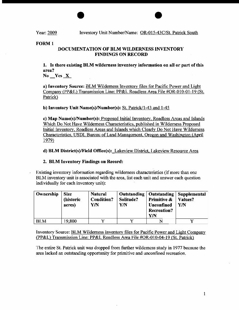
e e Year: 2009 Inventory Unit Number/Name: OR-015-43C/St. Patrick South
FORMl DOCUMENTATION OF BLM WILDERNESS INVENTORY
FINDINGS ON RECORD
1. Is there existing BLM wilderness inventory information on all or part of this area? No_Yes...x..
a) Inventory Source: BLM Wilderness Inventory files for Pacific Power and Light Company (PP&L) Transmission Line: PP&L Roadless Area File #OR-01O-01-19 (St. Patrick)
b) Inventory Unit Name(s)lNumber(s): St. Patrick/I-43 and 1-45
c) Map Name(s)lNumber(s): Proposed Initial Inventory, Roadless Areas and Islands Which Do Not Have Wilderness Characteristics, published in Wilderness Proposed Initial Inventory, Roadless Areas and Islands which Clearly Do Not Have Wilderness Characteristics, USDI, Bureau of Land Management, Oregon and Washington (April 1979)
d) BLM District(s)/Field Office(s): Lakeview District. Lakeview Resource Area
2. BLM Inventory Findings on Record:
Existing inventory information regarding wilderness characteristics (if more than one BLM inventory unit is associated with the area, list each unit and answer each question individually for each inventory unit):
Ownership Size (historic acres)
Natural Condition? YIN
Outstanding Solitude? YIN
Outstanding Primitive & Unconfined Recreation? YIN
Supplemental Values? YIN
BLM 19,800 Y Y N Y
Inventory Source: BLM Wilderness Inventory files for Pacific Power and Light Company (PP&L) Transmission Line: PP&L Roadless Area File #OR-OI0-04-19 (St. Patrick)
The entire St. Patrick unit was dropped from further wilderness study in 1977 because the area lacked an outstanding opportunity for primitive and unconfined recreation.
1
e e
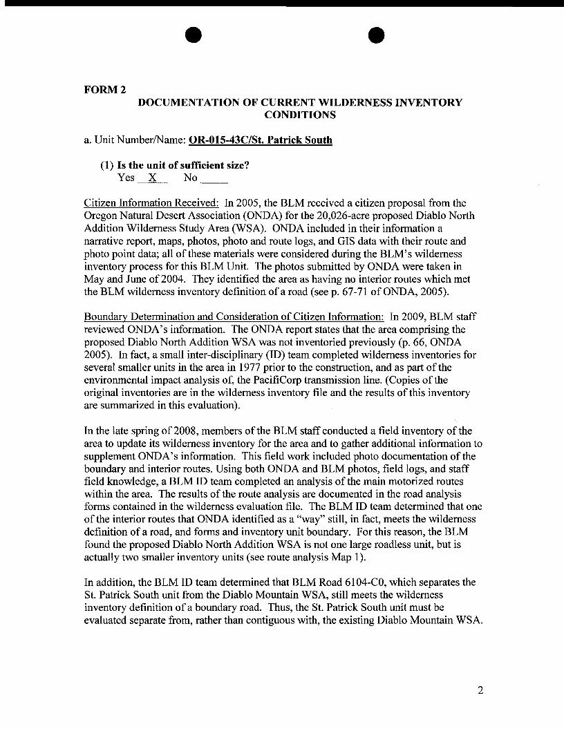
FORM 2 DOCUMENTATION OF CURRENT WILDERNESS INVENTORY
CONDITIONS
a. Unit NumberlName: OR-015-43C/St. Patrick South
(l) Is the unit of sufficient size? Yes X No
Citizen Information Received: In 2005, the BLM received a citizen proposal from the Oregon Natural Desert Association (ONDA) for the 20,026-acre proposed Diablo North Addition Wilderness Study Area (WSA). ONDA included in their information a narrative report, maps, photos, photo and route logs, and GIS data with their route and photo point data; all of these materials were considered during the BLM's wilderness inventory process for this BLM Unit. The photos submitted by ONDA were taken in May and June of 2004. They identified the area as having no interior routes which met the BLM wilderness inventory definition of a road (see p. 67-71 of ONDA, 2005).
Boundary Determination and Consideration of Citizen Information: In 2009, BLM staff reviewed ONDA's information. The ONDA report states that the area comprising the proposed Diablo North Addition WSA was not inventoried previously (p. 66, ONDA 2005). In fact, a small inter-disciplinary (ID) team completed wilderness inventories for several smaller units in the area in 1977 prior to the construction, and as part of the environmental impact analysis of, the PacifiCorp transmission line. (Copies of the original inventories are in the wilderness inventory file and the results of this inventory are summarized in this evaluation).
In the late spring of2008, members of the BLM staff conducted a field inventory of the area to update its wilderness inventory for the area and to gather additional information to supplement ONDA's information. This field work included photo documentation of the boundary and interior routes. Using both ONDA and BLM photos, field logs, and staff field knowledge, a BLM ID team completed an analysis of the main motorized routes within the area. The results of the route analysis are documented in the road analysis forms contained in the wilderness evaluation file. The BLM ID team determined that one of the interior routes that ONDA identified as a "way" still, in fact, meets the wilderness definition of a road, and forms and inventory unit boundary. For this reason, the BLM found the proposed Diablo North Addition WSA is not one large roadless unit, but is actually two smaller inventory units (see route analysis Map 1).
In addition, the BLM ID team determined that BLM Road 6104-CO, which separates the St. Patrick South unit from the Diablo Mountain WSA, still meets the wilderness inventory definition of a boundary road. Thus, the St. Patrick South unit must be evaluated separate from, rather than contiguous with, the existing Diablo Mountain WSA.
2
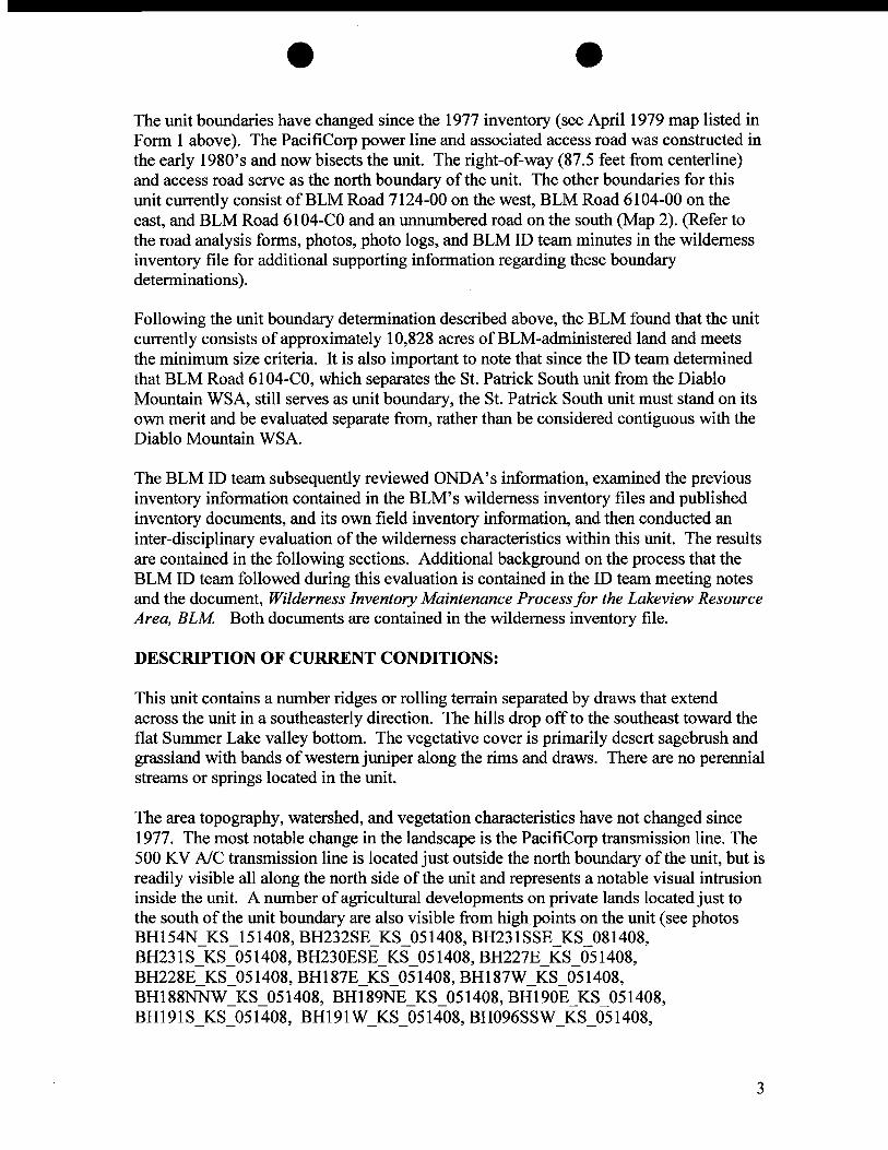
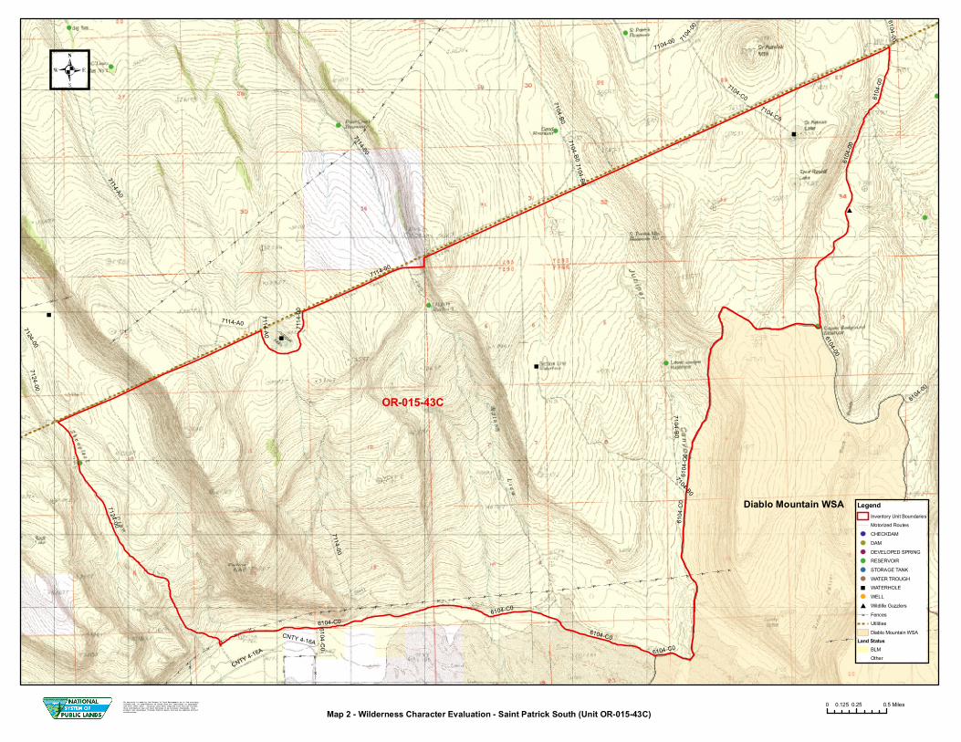
e -The unit boundaries have changed since the 1977 inventory (see April 1979 map listed in Form 1 above). The PacifiCorp power line and associated access road was constructed in the early 1980's and now bisects the unit. The right-of-way (87.5 feet from centerline) and access road serve as the north boundary of the unit. The other boundaries for this unit currently consist ofBLM Road 7124-00 on the west, BLM Road 6104-00 on the east, and BLM Road 6104-CO and an unnumbered road on the south (Map 2). (Refer to the road analysis forms, photos, photo logs, and BLM ID team minutes in the wilderness inventory file for additional supporting information regarding these boundary determinations).
Following the unit boundary determination described above, the BLM found that the unit currently consists of approximately 10,828 acres ofBLM-administered land and meets the minimum size criteria. It is also important to note that since the ID team determined that BLM Road 6104-CO, which separates the St. Patrick South unit from the Diablo Mountain WSA, still serves as unit boundary, the St. Patrick South unit must stand on its own merit and be evaluated separate from, rather than be considered contiguous with the Diablo Mountain WSA.
The BLM ID team subsequently reviewed ONDA's information, examined the previous inventory information contained in the BLM's wilderness inventory files and published inventory documents, and its own field inventory information, and then conducted an inter-disciplinary evaluation of the wilderness characteristics within this unit. The results are contained in the following sections. Additional background on the process that the BLM ID team followed during this evaluation is contained in the ID team meeting notes and the document, Wilderness Inventory Maintenance Process for the Lakeview Resource Area, BLM Both documents are contained in the wilderness inventory file.
DESCRIPTION OF CURRENT CONDITIONS:
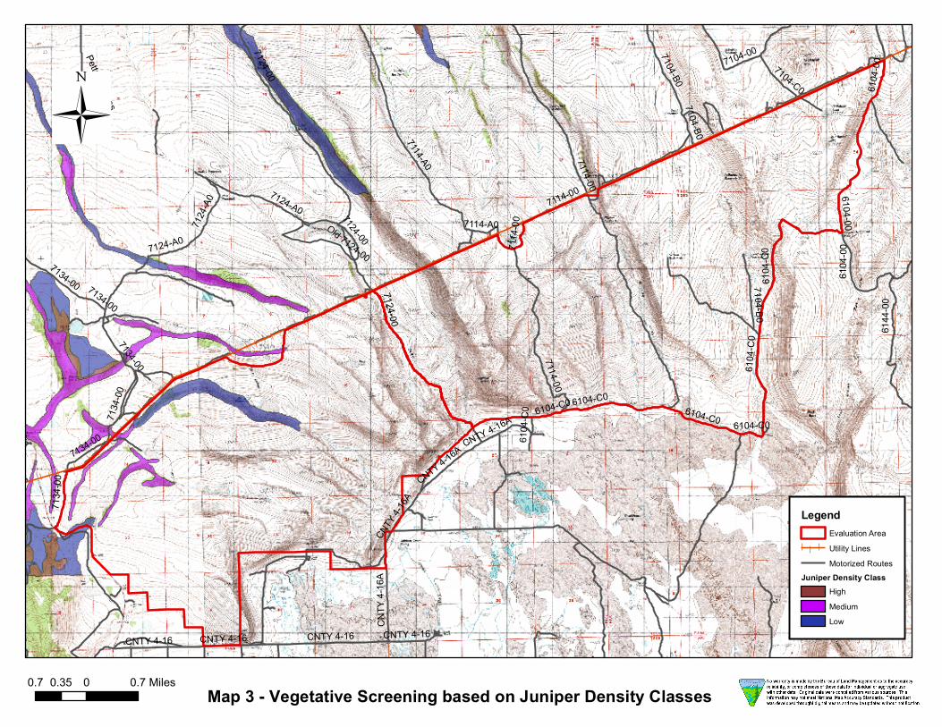
This unit contains a number ridges or rolling terrain separated by draws that extend across the unit in a southeasterly direction. The hills drop off to the southeast toward the flat Summer Lake valley bottom. The vegetative cover is primarily desert sagebrush and grassland with bands of western juniper along the rims and draws. There are no perennial streams or springs located in the unit.
The area topography, watershed, and vegetation characteristics have not changed since 1977. The most notable change in the landscape is the PacifiCorp transmission line. The 500 KV AlC transmission line is located just outside the north boundary of the unit, but is readily visible all along the north side of the unit and represents a notable visual intrusion inside the unit. A number ofagricultural developments on private lands located just to the south of the unit boundary are also visible from high points on the unit (see photos BH154N_KS_151408, BH232SE_KS_051408, BH231 SSE_KS_081408, BH231 S_KS_051408, BH230ESE_KS_051408, BH227E_KS_051408, BH228E_KS_051408, BHI87E_KS_051408, BH187W_KS_051408, BH188NNW_KS_051408, BHI89NE_KS_051408, BHI90E_KS_051408, BHI91S_KS_051408, BH191 W_KS_051408, BH096SSW_KS_051408,
3
e e BH094S_051408, BHI15SE_051408, BHI16E_KS_051408, BHII7NE_KS_051408, BH138SW_KS_051408, BH139SSW_KS_051408, BN024, BN026, BH140SW_KS_051408, BS002, BHI41S_KS_051408, BR035, BR037, BS003, BS004, BH143AW_KS_051408, BH143BW_KS_051408, BH144NNW_KS_051408, BH145AW_KS_051408, BH145BW_KS_051408, BH146W_KS_051408, BH147ASW_KS_051408, BH147BSW_KS_051408, BHI47N]\J"W_KS_051408, BH151W_KS_051408, BHI52EA_KS_051408, BR034, BR033, BH238E_KS_051408, BR030, BR031, BR032, BHI83NE_KS_051408, BHI82E_KS_051408, BH153WNW_KS_051408, BR029, BHI81ENE_KS_051408, BHI84NE_KS_051408, BHI85SE_KS_051408, BHI86_KS_051408, BH236S_KS_051408, and BH237S_KS_0514089).
(2) Is the unit in a natural condition?
Yes X No N/A
1977 Unit Description: The human imprints recorded in the southern portion of the unit during the original inventory included dirt roads, a few livestock waterholes, and a few "ways". These were considered minor intrusions and the ID team concluded the area was primarily in a natural condition.
Current Condition Description:
The current human imprints within the unit include the impacts from about 4.2 miles of allotment boundary fence along the south portions of the unit, 2 constructed livestock waterholes, 3 constructed livestock reservoirs, and about 11.1 miles of primitive motorized routes (Map 2). One can gain a general overview of the natural quality of this unit by examining both ONDA and BLM field photographs contained in the wilderness inventory file.
After considering the current human imprints described above, the BLM ID team concluded that the overall natural quality of this unit has not changed substantially since 1977 and would appear to be natural to the casual observer. For this reason, the unit was determined to meet the naturalness criteria.
(3) Does the unit have outstanding opportunities for solitude?
Yes No N/A
1977 Unit Description: The intrusions identified by the ID team as impacting solitude in 1977 included motorized vehicle activity on the dirt roads and ways in the unit, a few livestock water developments, and agricultural developments on private lands located south of the unit which were readily noticeable from high points within the unit. However, the ID team considered these as minor intrusions to solitude and identified the larger St. Patrick unit (1-43 and 1-45) as having outstanding opportunities for solitude.
4

e -Current Condition Description: Since the 1977 inventory, the PacifiCorp power line was completed and it bisects the former St. Patrick units (1-43 and 1-45) into several smaller units. In addition to the power line, access roads were built or improved. These roads are visible and used by power company employees on a regular basis for power line maintenance. There is also an audible (noise) impact from this line which increases as one gets closer to the towers.
The ID team considered the smaller unit's topography and existing vegetation and felt there were some areas in the bottom of draws where one could avoid the presence of others. However, these opportunities were limited and were not outstanding due to the unit's current narrow shape (3 miles across) and the presence of the power line on the north and private ranches on the south which are readily visible from large portions of the unit (see photos listed above). In addition, the number ofexisting primitive motorized routes within the interior of the unit makes large portions of the area more accessible to people, further limiting the opportunities to avoid the presence of others.
For these reasons, the ID team concluded that solitude opportunities have changed since 1977 and the unit currently does not provide outstanding opportunities for solitude.
(4) Does the unit have outstanding opportunities for primitive and unconfined recreation?
Yes No X N/A
1977 Unit Description: The recreational opportunities identified in the larger St. Patrick units (1-43 and 1-45) in 1977 included medium quality deer and antelope hunting, hiking, backpacking, horseback riding, and dry camping. These activities were not considered to be outstanding and were identified as limited because of the lack of potable water throughout the unit. The ID team also identified the area as being similar to surrounding BLM lands; there was nothing unique about the unit to create an outstanding primitive recreation experience.
Current Condition Description: In addition to the recreation opportunities identified in 1977, the BLM ID team identified trapping as recreational opportunity currently available within the unit. The area is currently managed as open to off-road vehicle use within the Lakeview RMPIROD (Map R-7). There are 11.1 miles of existing internal primitive motorized routes in the central interior of the unit (Map 2). Much of the interior of the unit is readily accessible by motorized vehicle.
The unit does not provide either a single unique primitive recreation opportunity or a unique diversity of primitive recreation opportunities. The landscape and recreation opportunities provided across this unit are similar to BLM lands in the surrounding area. The overall scenic quality and recreation experience available in the northern portion of the unit area is heavily impacted by the presence of the PacifiCorp transmission towers, transmission lines, and associated access roads.
5
- -For these reasons, the BLM ID team concluded the recreation opportunities have not changed substantially since 1977 and the area still does not contain outstanding opportunities for primitive and unconfined recreation.
(5) Does the unit have supplemental values?
Yes No NAl
Description: Supplemental values were not evaluated as the unit did not meet all of required wilderness character criteria.
Summary of Findings and Conclusion
Unit Name and Number: St. Patrick South/OR-015-43C
Results of Analysis:
1. Does the area meet the size requirements? X Yes No
2. Does the area appear to be natural? X Yes No NA
3. Does the area offer outstanding opportunities for solitude or a primitive and unconfined type of recreation? Yes ---.X.- No NA
4. Does the area have supplemental values? Yes No ---.X.-NA
Conclusion (check one):
__ The area-or a portion of the area-has wilderness character.
X The area does not have wilderness character.
ID Team Members (Names and Titles):
Todd Forbes, Associate Field Manager Natural Resources Theresa Romasko, Associate Field Manager Natural Resources Paul Whitman, Planning and Environmental Coordinator Tessa Teems, Range Management Specialist Vern Stofleth, Wildlife Biologist Casey O'Conner, Range Management Specialist Kim Mcl.ean, Recreation and Wilderness Specialist
6
Approved by:
~(~_.~ ck~.r Tom Rasmussen, Field Manager Date
e e
This form documents information that constitutes an inventory finding on wilderness characteristics. It does not represent a formal land use allocation or a final agency decision subject to administrative remedies under either 43 CFRparts 4 or 1610.5-2.
7

Adel
Plush
Paisley
Lakeview
Westside
Fort Rock
Silver Lake
Alkali LakeSummer Lake
Valley Falls
New Pine Creek
Christmas Valley
LegendLakeview Resource AreaMajor Utility CorridorsCities Major RoadsWilderness Unit Boundary
Map 1 - Wilderness Character Evaluation Area
No warranty is made by the Bureau of Land Management as to the accuracy, reliability, or completeness of these data for individual or aggregate use with other data. Original data were compiled from various sources. This information may not meet National Map Accuracy Standards. This product was developed through digital means and may be updated without notification.
0 8 164 Miles
Lake
Cou
nty
Klam
ath C
ounty
Lake County
Diablo Mountain WSA
7114-A0
6144
-00
7104-B07114-00
7104-C0
6104-00
6104-C0
7104-0
0
CNTY 4-16A
7124-007124-00
7114
-00
CNTY 4-16A
7104-B0
7114-00
7114-006104-C0
6104-00
6104-C0
7114-A0
7104-B0 6104
-00
6104-00
6104
-C0
6104-C0
7104-B0
7104-00
7104-C0
6104
-C0
6104
-00
7114-A0
7104-B0
6104-C0
7124-00
OR-015-43C
Map 2 - Wilderness Character Evaluation - Saint Patrick South (Unit OR-015-43C)0 0.25 0.50.125 Miles
LegendInventory Unit BoundariesMotorized RoutesCHECKDAMDAMDEVELOPED SPRINGRESERVOIRSTORAGE TANKWATER TROUGHWATERHOLEWELLWildlife GuzzlersFencesUtilitiesDiablo Mountain WSA
Land StatusBLMOther
No warranty is made by the Bureau of Land Management as to the accuracy, reliability, or completeness of these data for individual or aggregate use with other data. Original data were compiled from various sources. This information may not meet National M ap Accuracy Standards. This product was developed through digital means and may be updated without notification.

7114-00
7104-B0
Pettus Access
7134-00
7124-A0
7104-C0 6104
-00
Old 7124-00
7104-00
CNTY 4-16
7124-00
CNTY 4-1
6A
7114-A061
04-C
0
6144
-00
7124-00
CNTY 4-16
6104
-C0
7104-B0
CNTY 4-16A6104-C0
7124-A0
7104-B0
6104-C0
7114-A0
6104-C0
6104
-C0
6104-C0
7134-00
7114
-007124
-A0
7114-00
7134
-00
7114-00
6104
-00
CNTY 4-16A
7134
-00
CNTY 4-16CNTY 4-16
CNTY
4-16
A
7134-00
7134-00
6104-007124-00
Map 3 - Vegetative Screening based on Juniper Density Classes
LegendEvaluation AreaUtility LinesMotorized Routes
Juniper Density ClassHighMediumLow
0.7 0 0.70.35 Miles
e -Year: 2009 Inventory Unit NumberlName: OR-015-41B/Squaw Lake South
FORMl DOCUMENTATION OF BLM WILDERNESS INVENTORY
FINDINGS ON RECORD
1. Is there existing BLM wilderness inventory information on all or part ofthis area?
No_Yesl
a) Inventory Source: BLM Wilderness Inventory files for Pacific Power and Light Company (PP&L) Transmission Line: PP&L Roadless Area Files #OR-O 10-04-20 (Squaw Lake)
b) Inventory Unit Name(s)lNumber(s): Squaw Lake/l-41
c) Map Name(s)lNumber(s): Proposed Initial Inventory, Roadless Areas and Islands Which Do Not Have Wilderness Characteristics, published in Wilderness Proposed Initial Inventory, Roadless Areas and Islands which Clearly Do Not Have Wilderness Characteristics, USDI, Bureau of Land Management, Oregon and Washington (April 1979)
d) BLM District(s)/Field Office(s): Lakeview District, Lakeview Resource Area.
2. BLM Inventory Findings on Record:
Existing inventory information regarding wilderness characteristics (if more than one BLM inventory unit is associated with the area, list each unit and answer each question individually for each inventory unit):
Ownership Size (historic acres)
Natural Condition? YIN
Outstanding Solitude? YIN
Outstanding Primitive & Unconfined Recreation? YIN
Supplemental Values? YIN
BLM 25,600 Y Y N Y
Inventory Source: BLM Wilderness Inventory files for Pacific Power and Light Company (PP&L) Transmission Line: PP&L Roadless Area Files #OR-01O-04-20 (Squaw Lake).
The entire Squaw Lake unit (1-41) was dropped from further wilderness study in 1977/ because it did not provide outstanding opportunities for primitive and unconfined recreation.
1
e e FORM 2
DOCUMENTATION OF CURRENT WILDERNESS INVENTORY CONDITIONS
a. Unit NumberlName: OR-015-41B/Sguaw Lake South
(1) Is the unit of sufficient size?
Yes X No
Citizen Information Received: In 2005, the BLM received a citizen proposal from the Oregon Natural Desert Association (ONDA) for the 20,026-acre proposed Diablo North Addition Wilderness Study Area (WSA). ONDA included in their information a narrative report, maps, photos, photo and route logs, and GIS data with their route and photo point data; all of these materials were considered during the BLM's wilderness inventory process for this BLM Unit. The photos submitted by ONDA were taken in May and June of 2004. They identified the area as having no interior routes which met the BLM wilderness inventory definition ofa road (see p. 67-71 ofONDA, 2005).
Boundary Determination and Consideration of Citizen Information: In 2009, BLM staff reviewed ONDA's information. The ONDA report states that the area comprising the proposed Diablo North Addition WSA was not inventoried previously (p. 66, ONDA 2005). In fact, a small inter-disciplinary (ID) team completed wilderness inventories for several smaller inventory units in the area in 1977 prior to the construction, and as part of the environmental impact analysis of, the PacifiCorp transmission line. (Copies ofthe original inventories are in the wilderness inventory file and the results of this inventory are summarized in this evaluation).
In the late spring of 2008, BLM staff conducted a field inventory of the area to update its. wilderness inventory for the area and to gather additional information to supplement ONDA's information. This field work included photo documentation of the boundary and interior routes within this unit. Using both ONDA and BLM photos, field logs, and staff field knowledge, a BLM ID team completed an analysis of the main motorized routes within the area. The results of the route analysis are documented in the road analysis forms contained in the wilderness evaluation file. The BLM ID team determined that one of the interior routes that ONDA identified as a "way" still meets the wilderness definition of a road, and forms an inventory unit boundary. For this reason, the BLM found the proposed Diablo North Addition WSA is not one large roadless unit, but is actually two smaller units (see route analysis Map 1).
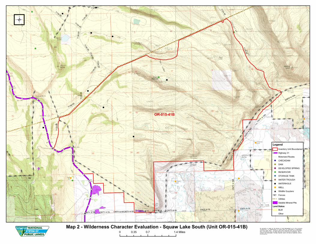
The unit boundaries that were used for the 1977 inventory have changed (see April 1979 map listed in Form 1 above). The PacifiCorp power line and associated access road was constructed in the early 1980's and now bisects the unit. The right-of-way (87.5 feet from centerline) and access road serve as the north boundary of the unit.
2
e -On the west, the unit is bounded by BLM Road 7135-00 on the west, the power line and the State Highway 31 right-of-way boundary (50 feet from centerline). On the south, the unit is bounded by a combination of private lands, County Road 4-16A, and an unnumbered road. On the east, the unit is bounded by BLM Road 7124-00 (Map 2). (Refer to the road analysis forms, photos, photo logs, and BLM ID team minutes in the wilderness inventory file for additional supporting information regarding these boundary determinations).
The inventory unit is currently about 5 miles long and 3 miles wide and contains approximately 8,691 acres ofBLM-administered lands surrounding approximately 160 acres of private (Map 2). Following the boundary determination, the BLM ID team subsequently evaluated the wilderness characteristics within this unit. The results are contained in the following sections. Additional background on the process that the BLM ID team followed during this evaluation is contained in the ID team meeting notes and the document, Wilderness Inventory Maintenance Process for the Lakeview Resource Area, BLM Both documents are contained in the wilderness inventory file.
DESCRIPTION OF CURRENT CONDITIONS:
This unit contains a number ridges or rolling terrain separated by draws that extend across the unit in a southeasterly direction. The hills drop off to the southeast toward the flat Summer Lake valley bottom. The vegetative cover is primarily desert sagebrush and grassland with bands of western juniper along the rims and draws. There are no perennial streams or springs located in the unit.
The area topography, watershed, and vegetation characteristics have not changed substantially since 1977. The most notable change in the landscape is the PacifiCorp transmission line. The 500 KV AlC transmission line is located just outside the north boundary of the unit, but is readily visible all along the north side of the unit and represents a notable visual intrusion inside the unit. A number of agricultural developments on private lands located just to the south of the unit boundary are also readily visible from much of the unit (see photos BH154W_KS_051408, BHI54N_KS_051408, BH229S_KS_051408, BH227W_KS_051408, BH226W_KS_051408, BH226SW_KS_051408, BH225WSW_KS_051408, BH222NE_KS_051408, BH221 W_KS_051408, BH216BNE_KS_051408, BH215WSW_KS_051408, BH179SW_KS_051408, BHI80NNE_KS_051408, and BR026).
(2) Is the unit in a natural condition?
Yes X No N/A
1977 Unit Description: The human imprints recorded in the southern portion of the unit during the original inventory were considered minor and the ID team concluded the area was primarily in a natural condition.
3
- e Current Condition Description:
The current human imprints within the unit include the impacts from about 6 miles of allotment boundary fence along the west and south portions of the unit, 3 constructed livestock waterholes, 1 constructed livestock reservoir, about 0.5 miles of primitive motorized routes, and 160 acres of private land. A couple of small borrow pits (totaling about 4.7 acres) are located along the southwest boundary of the unit (Map 2). One can gain a general overview of the natural quality of this unit by examining both ONDA and BLM field photographs contained in the wilderness inventory file.
After considering the existing human imprints described above, the BLM ID team concluded that the overall natural quality of this unit has not changed substantially since 1977 and would appear natural to the casual observer. For this reason, the unit was determined to meet the naturalness criteria.
(3) Does the unit have outstanding opportunities for solitude?
Yes No X N/A
1977 Unit Description: The intrusions identified as impacting solitude in 1977 included off-road vehicle activity on the ways and motorized trails in the unit and agricultural developments on private lands located south of the unit which were readily noticeable from high points within the unit. The ID team noted some waterholes with ways leading to them as intrusions within the unit. However, the ID team considered these as minor intrusions to solitude and identified the larger Squaw Lake unit (1-41) as having outstanding opportunities for solitude.
Current Condition Description: Since the 1977 inventory, the PacifiCorp power line was completed and it bisects the former Squaw Lake inventory unit (1-41) into several smaller units. The towers and transmission lines are visible throughout the northern portion of the smaller unit. In addition to the power line, access roads were built or improved. These roads are visible and used by power company employees on a regular basis for power line maintenance. There is also an audible (noise) impact from this line which increases as one gets closer to the towers.
Though the majority of the unit has some topographic or vegetative screening which provide limited opportunities for solitude (when looking in a northeast or southeast direction). However, its narrow configuration (about three miles across) allows much of the unit (and private agricultural devlopments located outside the unit) to be readily visible when looking from the north to the south from high spots within the unit. The solitude opportunities are also impacted on the northern half of the unit by the notable presence of the power line (see photos listed above).
For these reasons, the ID team concluded that solitude opportunities have changed since 1977 and the unit currently does not provide outstanding opportunities for solitude.
4
It (4) Does the unit have outstanding opportunities for primitive and unconfined recreation?
Yes No X N/A
1977 Unit Description: The recreational opportunities identified in the larger Squaw Lake (1-41) unit in 1977 included low quality deer and antelope hunting, hiking, horseback riding and dry camping. These activities were not considered to be outstanding and were identified as limited because of the lack of potable water throughout the unit. The ID team also identified the area as being similar to surrounding BLM lands; there was nothing unique about the unit to create an outstanding primitive recreation experience.
Current Condition Description: In addition to the recreation opportunities identified in 1977, the BLM ID team identified trapping as recreational opportunity currently available within the unit. The area is currently managed as open to off-road vehicle use within the Lakeview RMPIROD (Map R-7). There is only one existing internal primitive motorized route (0.5 miles) in the interior of the unit (Map 2). Much of the interior of the unit is not readily accessible by motorized vehicle. For this reason, the unit does provide an opportunity for a primitive (non-motorized) recreation experience.
However, the unit does not provide either a single unique primitive recreation opportunity or a unique diversity of primitive recreation opportunities. The landscape and recreation opportunities provided across the unit are similar to BLM lands in the surrounding area. The overall scenic quality and recreation experience available in the northern portion of the unit area is heavily impacted by the presence of the PacifiCorp transmission towers, transmission lines, and associated access roads.
For these reasons, the BLM ID team concluded the recreation opportunities have not changed substantially since 1977 and the area still does not contain outstanding opportunities for primitive and unconfined recreation. .
(5) Does the unit have supplemental values?
Yes No NAl
Description: Supplemental values were not evaluated as the unit did not meet all of required wilderness character criteria.
Summary of Findings and Conclusion
Unit Name and Number: Squaw Lake South/OR-015-41B
Results ofAnalysis:
5
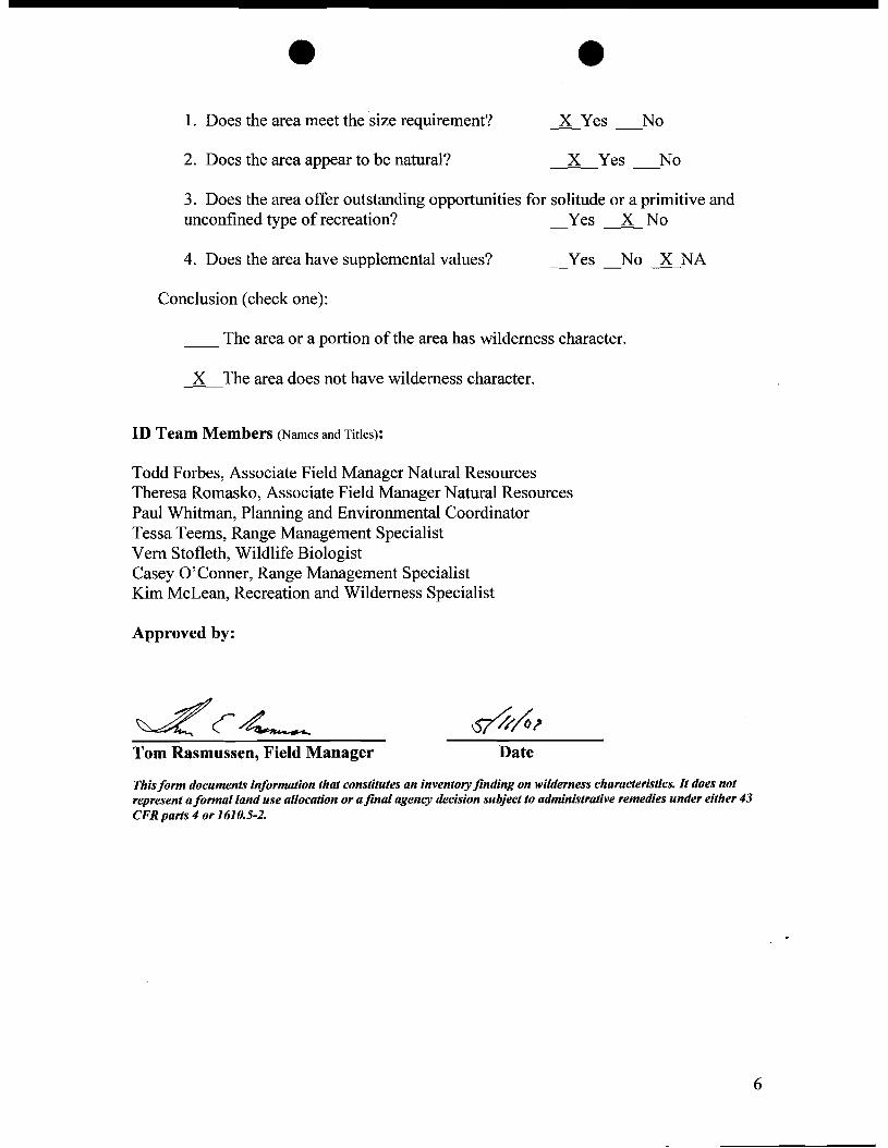
e e 1. Does the area meet the size requirement? lYes No
2. Does the area appear to be natural? X Yes No
3. Does the area offer outstanding opportunities for solitude or a primitive and unconfined type of recreation? _Yes -----.2L No
4. Does the area have supplemental values? Yes No lNA
Conclusion (check one):
__ The area or a portion of the area has wilderness character.
l-The area does not have wilderness character.
ID Team Members (Names and Titles):
Todd Forbes, Associate Field Manager Natural Resources Theresa Romasko, Associate Field Manager Natural Resources Paul Whitman, Planning and Environmental Coordinator Tessa Teems, Range Management Specialist Vern Stofleth, Wildlife Biologist Casey O'Conner, Range Management Specialist Kim McLean, Recreation and Wilderness Specialist
Approved by:
~(4-- ~~? Tom Rasmussen, Field Manager Date
Thisform documentsinformation that constitutesan inventoryfinding on wilderness characteristics. It doesnot represent aformal land use allocation or afinal agencydecision subjectto administrative remediesunder either43 CFR parts 4 or 1610.5-2.
6
Adel
Plush
Paisley
Lakeview
Westside
Fort Rock
Silver Lake
Alkali LakeSummer Lake
Valley Falls
New Pine Creek
Christmas Valley
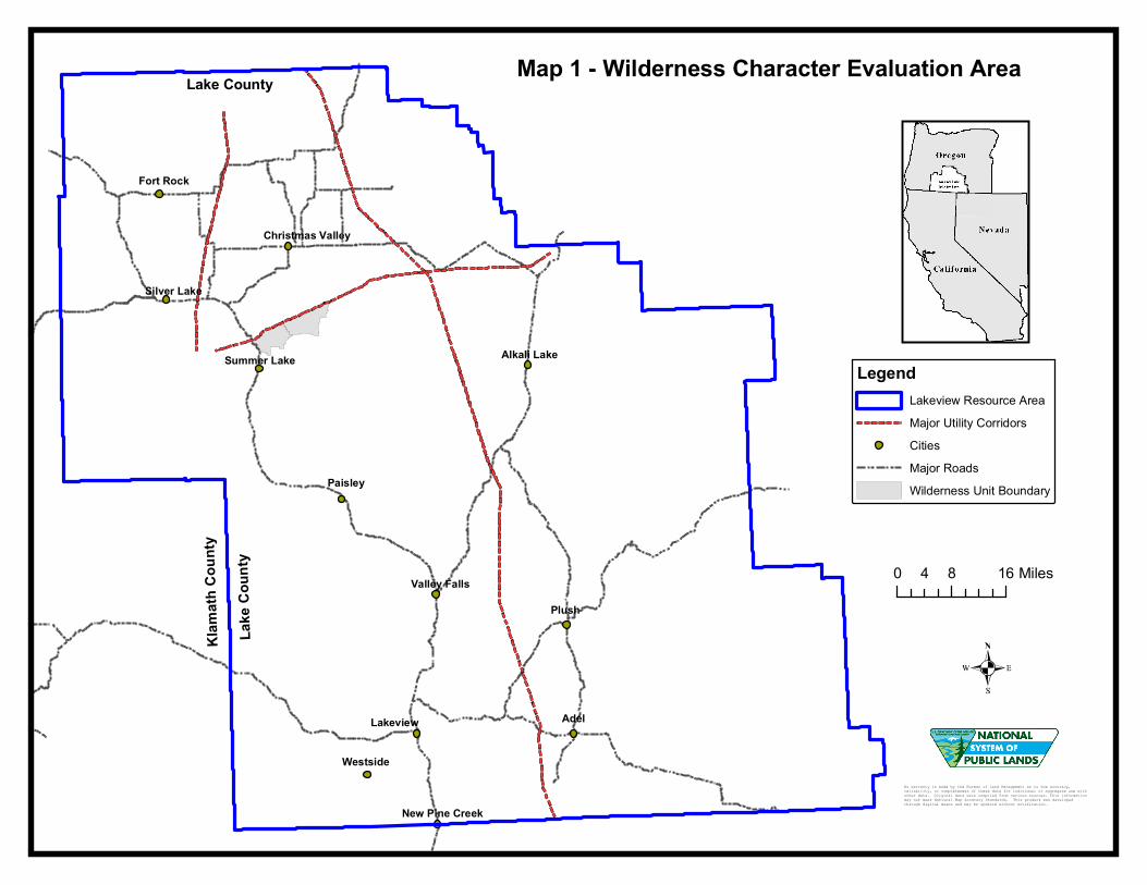
LegendLakeview Resource AreaMajor Utility CorridorsCities Major RoadsWilderness Unit Boundary
Map 1 - Wilderness Character Evaluation Area
No warranty is made by the Bureau of Land Management as to the accuracy, reliability, or completeness of these data for individual or aggregate use with other data. Original data were compiled from various sources. This information may not meet National Map Accuracy Standards. This product was developed through digital means and may be updated without notification.
0 8 164 Miles
Lake
Cou
nty
Klam
ath C
ounty
Lake County
7134-00
7124-00
CNTY 4-16
CNTY 4-
16A
7124-A
0
7124-A0
CNTY 4-16
CNTY
4-16
A
7134
-00
CNTY 4-16A
7134-00
7134
-00
7134-00
CNTY 4-16CNTY 4-16 CNTY 4-16
7134-00
CNTY 4-16
7134
-00
CNTY
4-16
A
7134
-00
7134-00
CNTY 4-16
7124-00
CNTY 4-16CNTY 4-16
7134-00
CNTY 4-1
6A
CNTY 4-16AOR-015-41B
Map 2 - Wilderness Character Evaluation - Squaw Lake South (Unit OR-015-41B)0 0.7 1.40.35 Miles
LegendInventory Unit BoundariesHighway 31Motorized RoutesCHECKDAMDAMDEVELOPED SPRINGRESERVOIRSTORAGE TANKWATER TROUGHWATERHOLEWELLWildlife GuzzlersFencesUtilitiesSalable Mineral Pits
Land StatusBLMOther
No warranty is made by the Bureau of Land Management as to the accuracy, reliability, or completeness of these data for individual or aggregate use with other data. Original data were compiled from various sources. This information may not meet National M ap Accuracy Standards. This product was developed through digital means and may be updated without notification.
7114-00
7104-B0
Pettus Access
7134-00
7124-A0
7104-C0 6104
-00
Old 7124-00
7104-00
CNTY 4-16
7124-00
CNTY 4-1
6A
7114-A061
04-C
0
6144
-00
7124-00
CNTY 4-16
6104
-C0
7104-B0
CNTY 4-16A6104-C0
7124-A0
7104-B0
6104-C0
7114-A0
6104-C0
6104
-C0
6104-C0
7134-00
7114
-007124
-A0
7114-00
7134
-00
7114-00
6104
-00
CNTY 4-16A
7134
-00
CNTY 4-16CNTY 4-16
CNTY
4-16
A
7134-00
7134-00
6104-007124-00
Map 3 - Vegetative Screening based on Juniper Density Classes
LegendEvaluation AreaUtility LinesMotorized Routes
Juniper Density ClassHighMediumLow
0.7 0 0.70.35 Miles